Embed Size (px)
Citation preview
GEN energija Seismic Hazard Analysis Project for Krško 2
Presentation to Slovenian Nuclear Safety Administration 27 January 2015
Click to edit Master title style
2
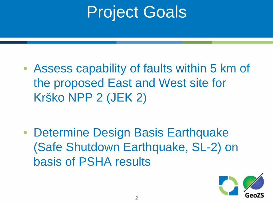
Project Goals
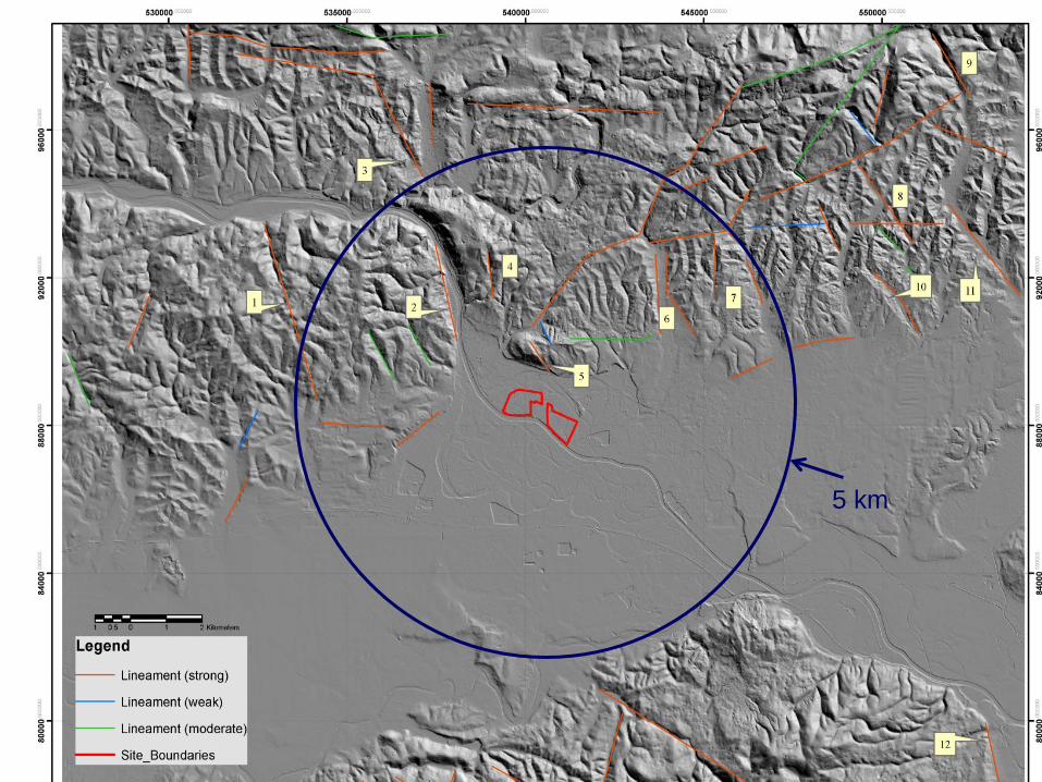
• Assess capability of faults within 5 km of the proposed East and West site for Krško NPP 2 (JEK 2)
• Determine Design Basis Earthquake (Safe Shutdown Earthquake, SL-2) on basis of PSHA results
Click to edit Master title style
3
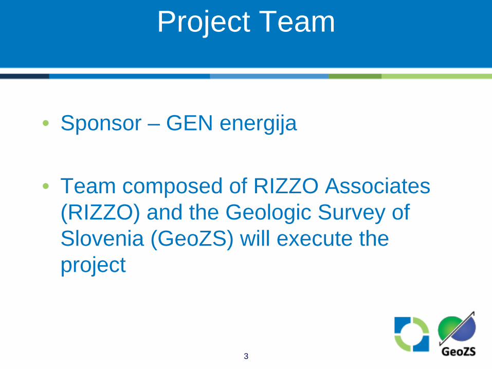
Project Team
• Sponsor – GEN energija
• Team composed of RIZZO Associates (RIZZO) and the Geologic Survey of Slovenia (GeoZS) will execute the project
Click to edit Master title style
4
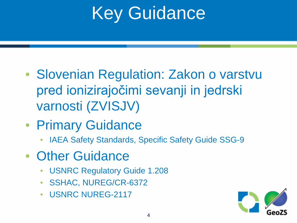
Key Guidance
• Slovenian Regulation: Zakon o varstvu pred ionizirajočimi sevanji in jedrski varnosti (ZVISJV)
• Primary Guidance • IAEA Safety Standards, Specific Safety Guide SSG-9
• Other Guidance • USNRC Regulatory Guide 1.208 • SSHAC, NUREG/CR-6372 • USNRC NUREG-2117

Click to edit Master title style
5
Quality Assurance
• Work will be carried out under the RIZZO Quality, Health, Safety, and Environmental (QHSE) program
• Implements requirements including: • ISO 9001:2008, ISO 14001:2004, ISO/IEC
17025:2005 • US 10 CFR 50, Appendix B; 10 CFR 21 • ASME NQA-1
Click to edit Master title style
6
Framework for Technical Approach
• SSHAC Process for incorporation of uncertainty • Compile information • Evaluate information • Based on evaluations, develop an integrated
representation of the center, body, and range of technically defensible interpretations
• Peer review • Complete documentation of process
Click to edit Master title style
7
SSHAC Study Level
• Krško SHA Project will be carried out as a SSHAC Level 2 study • Interactions with resource and proponent
experts carried out individually and often remotely
• Participatory peer review panel (PPRP) will be used
• Usually associated with SSHAC Level 3 and 4 studies

Click to edit Master title style
8
Framework for Technical Approach
Click to edit Master title style
9
PHASE 1 FIELD INVESTIGATIONS
Click to edit Master title style
10
Phase 1-Field Investigations
• Expand upon previous work • Emphasis on Orlica fault zone (OFZ)
and Artiče Structure (AS) • Identify existence and characterize
capable faults within 5 km of the East and West sites
• Support update of seismotectonic model and SSC models

Click to edit Master title style
11
Phase 1 – Field Investigations
• Integrated and iterative approach • Tectonic geomorphic characterization • Geophysical investigation • Drilling • Paleoseismological investigation • Age dating
• Level of effort will vary depending on what is encountered in these studies
Click to edit Master title style
12
Tectonic Geomorphic Characterization
• Investigate geomorphology of Krško region to identify evidence of most recent tectonic activity • Lineament analysis • Channel profile analysis • Drainage basin morphology • Basin-averaged denudation
Click to edit Master title style
13
Geophysical Investigation
• Shallow high-resolution seismic reflection profiles • Target: top of Pontian, Plio-Quaternary, Quaternary
sediments • High number of active channels, high data fold • Seismic source test prior to acquisition of every HRS
profile • Targets:
• Zones with the projected possibility of paleoseismic trenching
• Zones with open questions on fault presence/geometry
Click to edit Master title style
14
Geophysical Investigation
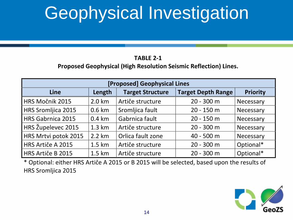
TABLE 2-1 Proposed Geophysical (High Resolution Seismic Reflection) Lines.
[Proposed] Geophysical Lines
Line Length Target Structure Target Depth Range Priority HRS Močnik 2015 2.0 km Artiče structure 20 - 300 m Necessary HRS Sromljica 2015 0.6 km Sromljica fault 20 - 150 m Necessary HRS Gabrnica 2015 0.4 km Gabrnica fault 20 - 150 m Necessary HRS Župelevec 2015 1.3 km Artiče structure 20 - 300 m Necessary HRS Mrtvi potok 2015 2.2 km Orlica fault zone 40 - 500 m Necessary HRS Artiče A 2015 1.5 km Artiče structure 20 - 300 m Optional* HRS Artiče B 2015 1.5 km Artiče structure 20 - 300 m Optional* * Optional: either HRS Artiče A 2015 or B 2015 will be selected, based upon the results of HRS Sromljica 2015
Click to edit Master title style
15
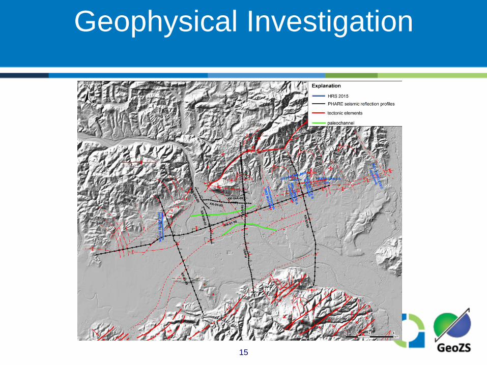
Geophysical Investigation

Click to edit Master title style
16
Drilling
• To support interpretation of high resolution seismic (HRS) data.
• Seismic downhole, fully cored • 2 boreholes necessary*:
* Optional boreholes have also been identified that may be recommended if additional subsurface information is necessary to support the HRS profiles.
Click to edit Master title style
17
Paleoseismological Investigations
• Up to 8 provisional sites to be identified on the OFZ and AS based on other Phase 1 studies
• 5 of these sites will then be studied with geophysical methods to determine their appropriateness for trenching
• 3* sites will be trenched if appropriate conditions are encountered
* If it is determined that the three trenches are not adequate or if excavation problems arise on one of the trenches, a recommendation will be made for selection from the five locations identified for possible trench excavation.
Click to edit Master title style
18
Age Dating
• Goal is to obtain Plio-Quaternary geochronology for the 25-km site vicinity
• Targets for sampling will be determined from other field investigations • Deformed and undeformed sediments • Fault materials • Constraints on landscape evolution
• Multiple appropriate techniques
Click to edit Master title style
19
Age Dating
• Multiple appropriate techniques: • Cosmogenic radionucleides (CRN) • Optically stimulated luminescence (OSL) • Uranium-Thorium (U-Th) • Argon-Argon (40Ar/39Ar) • Radiocarbon (14C)
Click to edit Master title style
20
Phase 1 Reporting
• For each field investigation technique, a report will be prepared
• Phase 1 Summary Report that integrates the results of the studies
• Fault Capability Report • Provide capability assessment per SSG-9 • Peer Review
Click to edit Master title style
21
PHASE 2 FAULT CAPABILITY
AND SEISMIC SOURCE CHARACTERIZATION
Click to edit Master title style
22
• Assess tectonic deformation (fault displacement and surface deformation) within a minimum of 5 km from the proposed JEK 2 sites
• If determined capable assess fault displacement/surface deformation hazard following SSG-9 guidance with respect to the safe operation of the proposed JEK 2
Objectives for Assessing Fault Capability
Click to edit Master title style
23
Fault Capability
• In accordance with IAEA’s SSG 9 a capable fault is defined as:
•
5 km
Click to edit Master title style
24
Basis for Assessing Fault Capability
• Compile sufficient data on the behavior and geometry of faults within 5 km of the sites • Phase 1 investigations
• Develop a robust understanding of level of tectonic activity within the region • Updated and defensible seismotectonic model
• Develop a defensible technical basis for a reasonable time period to evaluate fault capability
• Participation of PPRP
Click to edit Master title style
25
Fault Capability Hazard
• Presence of a capable fault is not necessarily an exclusionary criteria; however, if, based on “reliable evidence” it has the potential to affect the safe operation of the plant, further evaluations may be considered
• A probabilistic fault displacement hazard analysis (PFDHA) may be appropriate • Currently not in scope of work
Click to edit Master title style
26
Seismic Source Characterization (SSC)
• Objective is to characterize seismic sources for input to the Probabilistic Seismic Hazard Analysis (PSHA) • Consider seismic sources (structures and
zones) within the region that may be significant to the two sites
• Develop seismic source model(s)
Click to edit Master title style
27
Click to edit Master title style
28
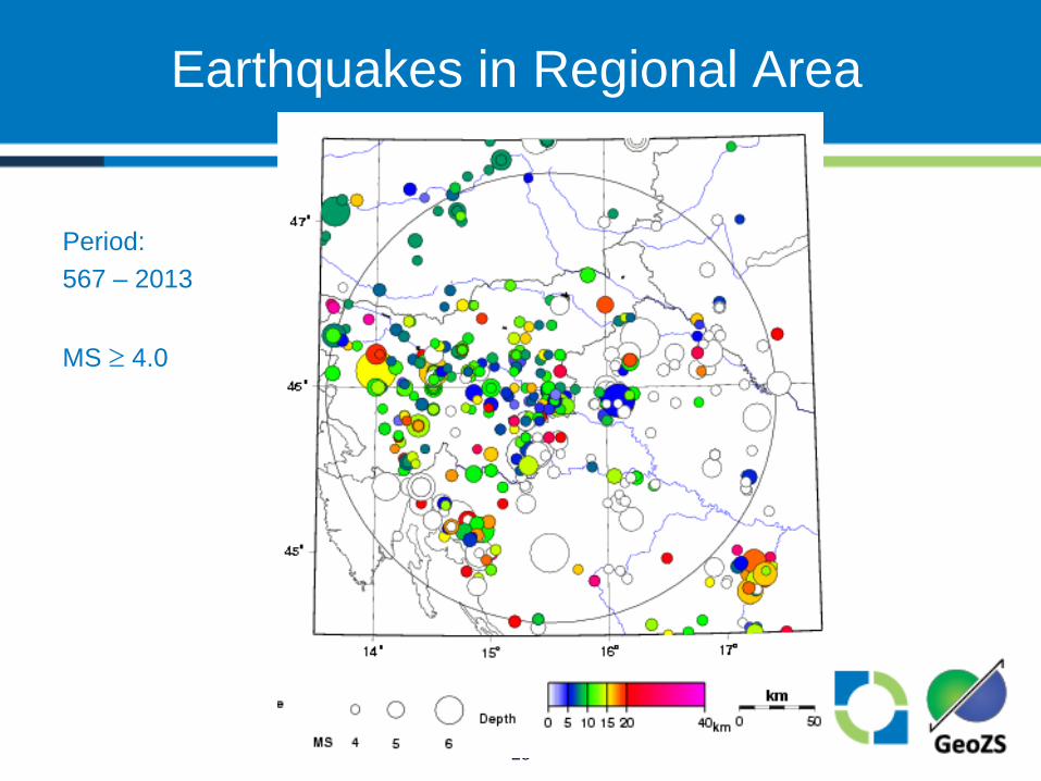
Earthquakes in Regional Area
Period: 567 – 2013 MS ≥ 4.0
Click to edit Master title style
29
Integration Team
• Establish SSC Technical Integration Team to: • Compile and evaluate available data on neotectonic
activity • Update historical seismicity of the region and identify
seismic sources • Update the existing seismotectonic model based on
new data • Interview proponents of neotectonic models
• Develop SSC model(s) • Inputs and model(s) reviewed by PPRP
Click to edit Master title style
30
SSC Model(s)
• SSC model(s) consist of: • Earthquake catalogue • Seismotectonic model • Identification of seismic sources • Maximum magnitude distribution • Recurrence models • Rupture characteristics
Click to edit Master title style
31
SSC Input to PSHA
• Identify and characterize seismic sources based on: • Recurrence • Magnitude frequency distribution • Source geometry (Length, width and depth) • Distance from sites and seismogenic depth • Maximum earthquake
Click to edit Master title style
32
PHASE 3 GROUND MOTION CHARACTERIZATION,
PROBABILISTIC SEISMIC HAZARD ANALYSIS, AND CONTROL POINT GROUND MOTION
Click to edit Master title style
33
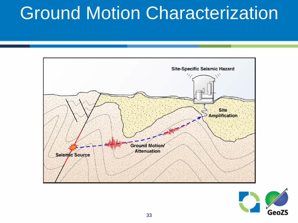
Ground Motion Characterization
Click to edit Master title style
34
Ground Motion Characterization
• Determine reference rock condition for PSHA (Shear-wave velocity, depth, attenuation characteristic)
• Model consists of: • Median ground motion and uncertainty • Ground motion variability (“sigma”)
• PPRP review prior to use in PSHA
Click to edit Master title style
35
Probabilistic Seismic Hazard Analysis
• Use SSC and GMC inputs to develop PSHA results for reference rock condition • Ground motion hazard curves • Uniform hazard response spectra
Click to edit Master title style
36
Probabilistic Seismic Hazard Analysis
• Deaggregation of results (dominant magnitudes and distances) contributing to hazard
• Sensitivity analyses
Click to edit Master title style
37
Site Response Analysis
• Assess information from JEK1 and other studies to develop approximate site response
• Use to adjust ground motion for the PSHA reference rock condition to corresponding ground motion for the control point
Click to edit Master title style
38
Control Point Ground Motion
• Control point at the top of consolidated material beneath the surficial gravels
• Basis for SL-2 ground motion is the uniform hazard response spectrum with a 1E-4 mean annual frequency of exceedance
Click to edit Master title style
39
Control Point Ground Motion
• Vertical control point response spectrum is determined from the horizontal control point response spectrum using an appropriate vertical-to-horizontal ratio function
Click to edit Master title style
40
SUMMARY
Click to edit Master title style
41
Summary
• GEN is implementing an integrated program to address seismological suitability issues and determine SL-2 ground motion response spectra
• Work will be carried out under the RIZZO QHSE program to ensure data are appropriate for nuclear site characterization