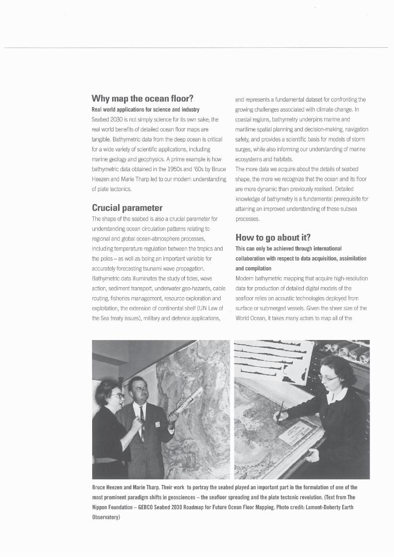
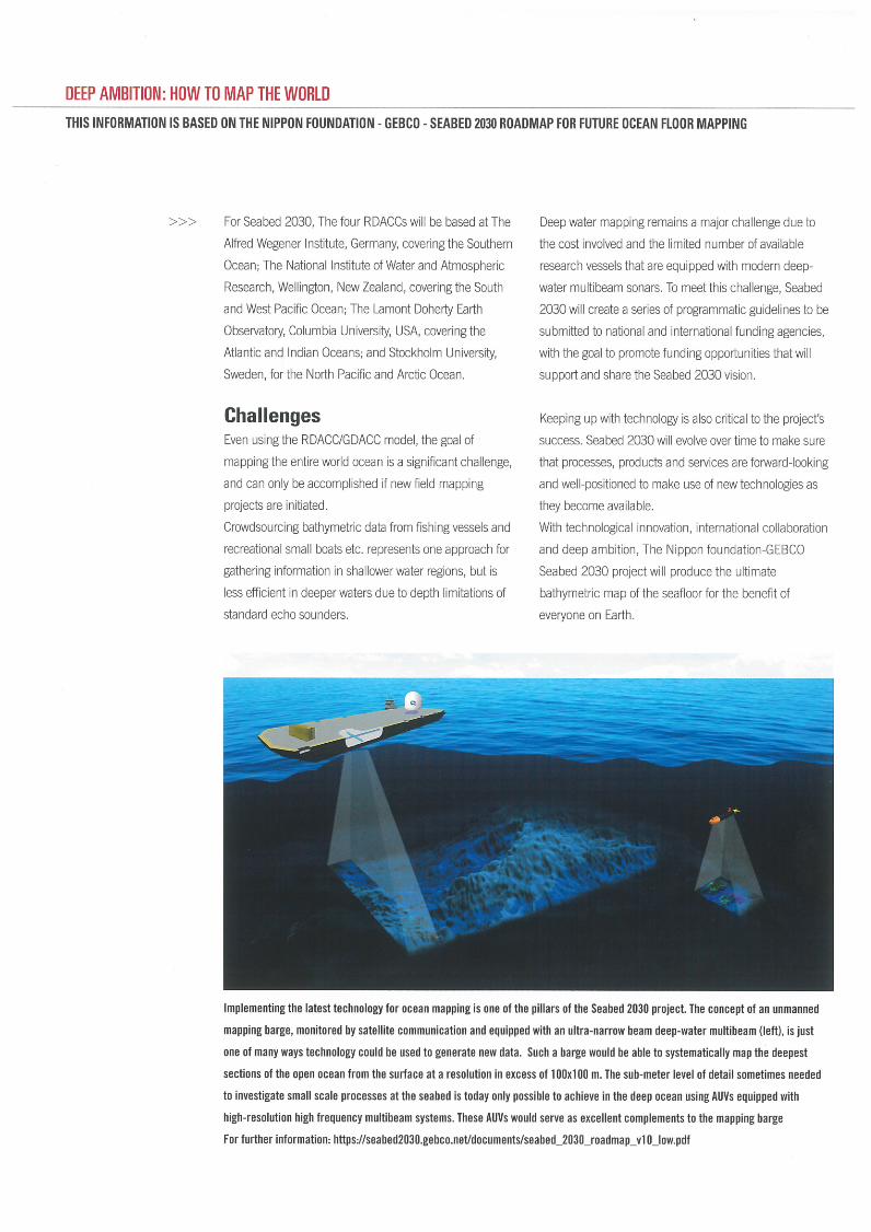
Upload others
View 3
Download 0
Embed Size (px) 344 x 292 429 x 357 514 x 422 599 x 487
Citation preview
BATHYMETRIC SURVEYS IN SUPER- SHALLOW WATER … · 7th GEBCO Science Day 2012 – ... these barriers will protect the city of Venice from extreme events such as the floods and from
Bathymetric Techniques
Seamount Discovery Tool - GEBCO
GEBCO - The General Bathymetric Chart of the Oceans · Coastal geomorphology act as an agent to increase damages at coastal areas. However, some coastal features such as sand barriers
3-20200226 SB2030 for UNGGIM MGIWG2ggim.un.org/meetings/2020/WG-MGI-Rostock/documents/Agenda...Jamie McMichael-Phillips –Project Director 1 GEBCO ‘ The General Bathymetric Chart
Gebco Grid Concepts
Updating GEBCO’s global bathymetric grid - Home | IHO · 2019. 4. 9. · Page 1 of 15 GGC GGC34/2/4 Meeting 34 30th October 2017 Agenda Item 2.4 GEBCO Digital Atlas Manager’s
u REEF TYPES - Living Oceans Foundation...physical features that form underwater mountains, plateaus, plains, volcanoes, trenches, and canyons. We will now look at the bathymetric
Not all bathymetry grids are created equal · The General Bathymetric Charts of the Oceans (GEBCO) grid (British Oceanographic Data Center 2003, see Table 1) is a 1-minute grid prepared
MACHC Ferrini 2018 - IHO Coordination...Seabed 2030 Dr. Vicki Ferrini Head, Seabed 2030 Atlantic/Indian Oceans Regional Data Center Chair, GEBCO Sub-Committee on Regional Under Sea
SCUFN XXIII-Report to GEBCO GC...SCUFN XXVII-Report to GEBCO GC XXXII • Report by the Chairman of the GEBCO Sub-Committee on Undersea Feature Names (SCUFN) • The 27th Meeting of
GEBCO Guiding Committee Minutes 1978...GEBCO Guiding Committee Minutes 1978 Created Date 20110609134547Z
GEBCO Project by 2010-11 GEBCO students · 2018-10-16 · GEBCO Project by 2010-11 GEBCO students - Focusing on GEBCO-SNG (Social Networking Group) - GEBCO meeting October 6, 2011
GEBCO Centenary Conference
Gebco Hawaii 2010 Catalog
Bathymetric map of Oahu Bathymetric Map of Hawaii
General Bathymetric Chart of the Oceans · General Bathymetric Chart of the Oceans – GEBCO – A look at the world from an ocean’s perspective 1On behalf of GEBCO: Boris Dorschel
General Bathymetric Chart of the Oceans (GEBCO) · 2018. 10. 16. · Distribution limited IOC-IHO/GEBCO XXIX Guiding Committee English only 31 August 2013 Final corrected version
Bathymetric Data Management
OPTIMIZACIÓN DE TOMA DE DATOS BATIMETRICOS … · BATIMETRICOS OPTIMITATION OF DATA ACQUISITION BATHYMETRIC SURVEYS XXXIII GEBCO, Valparaiso 12 Oct / 2 / 18 -Oct 16 Novedades Tecnológicas
Bathymetric Compilations of the - GEBCO
GENERAL BATHYMETRIC CHART OF THE OCEANS ......North Indian Ocean Hydrographic Commission (NIOHC) Meeting, Muscat, Oman 26-28 March 2019 What is GEBCO? The General Bathymetric Chart
The GEBCO Digital Atlas · General Bathymetric Chart of the Oceans (GEBCO) GEBCO is an international reference map of the seafloor depth of the world’s oceans. It is produced under
Southwest Indian Ocean Bathymetric Compilation (swIOBC) · Gridded data . GEBCO : Track length [km] 155,700 (61% AWI ) 248,600 : 950 -- Data points ~1,430,114,000 ~141,000 ~260,000
Airborne Bathymetric Lidar
GENERAL BATHYMETRIC CHART OF THE OCEANS ...ggim.un.org/meetings/2019/WG-MGI-Busan/2_IHO-GEBCO...What is GEBCO? The General Bathymetric Chart of the Oceans (GEBCO) (see ) • Aims to
General Bathymetric Chart of the Oceans (GEBCO) - · PDF fileSingle beam bathymetry Bathymetric contours from charts North American Great Lakes bathymetry Spot soundings from charts
General Bathymetric Chart of the Oceans (GEBCO)
Bathymetric map
Presentación de PowerPoint - GEBCO


![Southwest Indian Ocean Bathymetric Compilation (swIOBC) · Gridded data . GEBCO : Track length [km] 155,700 (61% AWI ) 248,600 : 950 -- Data points ~1,430,114,000 ~141,000 ~260,000](https://img.dokumen.tips/doc/110x75/5fdc145e4b048a32c529e59a/southwest-indian-ocean-bathymetric-compilation-swiobc-gridded-data-gebco-track.jpg)