Embed Size (px)
Citation preview

document issue date page
: SD-OMIE-7200-DS-467 : 8 : 3 November 2009 : 1 of 69
© Dutch Space B.V. All rights reserved. Disclosure to third parties of this document or any part thereof, or the use of any information contained therein for purposes other than provided for by this document, is not permitted, except with the prior and express written permission of Dutch Space B.V.
<SD467_IODS_Vol_2_issue8.doc>
security class model psp work package n° DIL n° CI n°
All P.OMIE 47101 07-04-b 7200 title
Ozone Monitoring Instrument for EOS-AURA
GDPS Input/Output Data Specification (IODS) Volume 2
Level 1B Output products and Metadata
summary The GDPS Input/Output Data Specification (IODS) defines the input, intermediate, log- and output data associated with the GDPS. The IODS consists of the following volumes: Volume 1: Overview, Input, Intermediate and Auxillary Output files Volume 2: Level 1B Output products and Metadata Volume 3: Production Rules Volume 4: Operational Parameters File Dutch Space B.V. does not represent or endorse the accuracy or reliability of any of the information, or content (collectively, the "Information") contained in this document. The reader hereby acknowledges that any reliance upon any Information shall be at your sole risk. Dutch Space reserves the right, in its sole discretion and without any obligation, to make improvements to, or correct any error or omissions in any portion of the Information. THE INFORMATION IS PROVIDED BY DUTCH SPACE B.V. ON AN "AS IS" BASIS, AND DUTCH SPACE EXPRESSLY DISCLAIMS ANY AND ALL WARRANTIES, EXPRESS OR IMPLIED, INCLUDING WITHOUT LIMITATION WARRANTIES OF MERCHANTABILITY AND FITNESS FOR A PARTICULAR PURPOSE, WITH RESPECT TO THE INFORMATION. IN NO EVENT SHALL DUTCH SPACE BE LIABLE FOR ANY DIRECT, INDIRECT, INCIDENTAL, PUNITIVE, OR CONSEQUENTIAL DAMAGES OF ANY KIND WHATSOEVER WITH RESPECT TO THE INFORMATION. Copyright (c) Dutch Space B.V., The Netherlands 11/2009 All Rights Reserved.

document issue date page
: SD-OMIE-7200-DS-467 : 8 : 3 November 2009 : 2 of 69
Dutch Space B.V. is domiciled at Leiden, Trade register Leiden, nr. 28086907 Office address: Newtonweg 1, 2333 CP LEIDEN, The Netherlands
<SD467_IODS_Vol_2_issue8.doc> 2
External Distribution List
controlled copies uncontrolled copies
H. Förster NIVR
Change Record
issue date total pages released pages affected brief description of change 1 April 2003 64 T. Watts All Created from SD-OMIE-7200-DS-
275 Issue 2, which was split up into three volumes (SD-OMIE-7200-DS-466, SD-OMIE-7200-DS-467 and SD-OMIE-7200-DS-468), of which this document is the second volume. With this document, the following documents are obsolete: - SD-OMIE-7200-DS-275
GDPS Input/Output Data Specification (IODS)
- SE-OMIE-0562-DS/03 OMI Level 1B Product Format Specification
- SE-OMIE-0645-DS/02 Production Rules for OMI L0-1B GDPS
- RP-OMIE-7000-DS-451 OMI L1B GDPS Metadata List
2 November 2004
67 T. Watts All - Implementation of RIDs: NIVR-9, KNMI-49, NASA-4, NASA-15, NASA-22, NASA-23, NASA-36 - Implementation of DIS 515 - Changed Invalid to Unknown in Table 3.1 - Added Check-out measurement type to 2HTable 3-1 - Updated filename conventions in section 3H3.2 - Updated section 4H3.7 - Added new swath ‘Avg” to Swath Naming for Calibration Product, section 4.3.4 - Added new swath ‘Checkout” to Swath Naming for Calibration Product, section 5H4.3.4 - Updated purpose and scope - Added new dimensions for

document issue date page
: SD-OMIE-7200-DS-467 : 8 : 3 November 2009 : 3 of 69
Dutch Space B.V. is domiciled at Leiden, Trade register Leiden, nr. 28086907 Office address: Newtonweg 1, 2333 CP LEIDEN, The Netherlands
<SD467_IODS_Vol_2_issue8.doc> 3
Calibration Swaths - Added Instrument Configuration Version to swath data fields - Added RegisterOffset, OpticalBenchTemperature, OPBTemperatures, ELU1Temperature, ELU2Temperature and ELUAUXTemperature to Calibration Swaths - Updated chapter 5 to reflect changes in flagging and added more descriptions, as well as newly added parameters. - Updated chapter 6 to reflect changes in flagging Updated file naming in section 6H7 to reflect filename convention - Updated SpatialSearchType in section 7H8.1 - Updated LocalGranuleID, PGEVersion, EquatorCrossingLongitude, EquatorCrossingTime and EquatorCrossingDate in section 8H8.2
3 February 2005
67 T. Watts Section 9H2.2, 3.2, 3.4, 4.4.1, 4.5, 5, 6.1, 6.2, 8.4
- Added WVL_ASSIGN_WARNING flag to the PixelQualityFlags - Added WVL_ASSIGN_WARNING flag to Table 6.1 and updated text below the table. - Implementation of FAR RIDs: KNMI-32: updated note for IrradianceBucketBinned in Table 4.4, KNMI-33: added information on QA statistics, KNMI-37: added reference to HDF-EOS documentation, KNMI-38: added description for fill values usage. - Added Geolocation Warning flag to the GroundPixelQualityFlags
4 13 March 2006
68 T. Watts Section 10H6.1 Upgraded information on SATURATION_POSSIBILITY _WARNING flag in 11HTable 6-1 Changed description of TRANSIENT_PIXEL_WARNING flag in 12HTable 6-1 DIS 516 implemented.
5 Augustus 2006
69 T. Watts
Updated/corrected page numbers in Table of Contents
6 Oktober 2007
69 T. Watts
Section 13H6.3 Added Irradiance measurement azimuth angle clipped flag
Sec. 14H3.4, Sec. 15H4.4.1,
Added descriptions for radiance, irradiance, and calibration

document issue date page
: SD-OMIE-7200-DS-467 : 8 : 3 November 2009 : 4 of 69
Dutch Space B.V. is domiciled at Leiden, Trade register Leiden, nr. 28086907 Office address: Newtonweg 1, 2333 CP LEIDEN, The Netherlands
<SD467_IODS_Vol_2_issue8.doc> 4
and Sec. 16H5 measurement swaths using floats instead of mantissa/exponent.
7 September 2008
68 T. Watts
Sec 3.10, Sec 4.4.1, Sec 4.5, Sec 6.3
Added XtrackQualityFlags
8 November 2009
69 T. Watts Sec 4.4.1, Sec 5. Sec 6.3
Added OrbitPhase, WavelengthFitCoefficient, WavelengthFitCoefficientPrecision WavelengthFitChiSquare WavelengthFitFlags Updated XTrackQualityFlags description. Expanded XTrackQualityFlags definition
List of TBx’s
document issue date page
: SD-OMIE-7200-DS-467 : 8 : 3 November 2009 : 5 of 69
Dutch Space B.V. is domiciled at Leiden, Trade register Leiden, nr. 28086907 Office address: Newtonweg 1, 2333 CP LEIDEN, The Netherlands
<SD467_IODS_Vol_2_issue8.doc> 5
Table of Contents
1. INTRODUCTION ................................................................................................7
1.1 Purpose and Scope ................................................................................................................7
1.2 Applicability Statement ..........................................................................................................8
1.3 Document Structure ...............................................................................................................8
2. DOCUMENT LIST ..............................................................................................9
2.1 Applicable Documents ...........................................................................................................9
2.2 Reference Documents ............................................................................................................9
3. OMI LEVEL 1B PRODUCT OVERVIEW ..........................................................11
3.1 Overview of measurement types.........................................................................................11
3.2 Overview of Data Products ..................................................................................................11 3.2.1 Level 1B Radiance UV Global ......................................................................................12 3.2.2 Level 1B Radiance VIS Global......................................................................................13 3.2.3 Level 1B Radiance UV Zoom-in....................................................................................14 3.2.4 Level 1B Radiance VIS Zoom-in...................................................................................15 3.2.5 Level 1B Irradiance .......................................................................................................16 3.2.6 Level 1B Calibration......................................................................................................17
3.3 L1B Swath Types ..................................................................................................................18
3.4 Measurement Science Data .................................................................................................18
3.5 Small Pixel Columns.............................................................................................................19
3.6 Earth Measurement specific issues....................................................................................20
3.7 Sun Measurement Specific Issues......................................................................................22
3.8 Wavelength Scales for Earth and Sun Measurements......................................................22
3.9 WLS, LED and Dark (Calibration) Measurement Specific Issues.....................................23
3.10 Flags in the L1B Output products2F ................................................................................23
4. DETAILS OF OMI LEVEL 1B PRODUCT FORMATS .....................................25
4.1 OMI L1B Product Contents ..................................................................................................25
4.2 File Attributes........................................................................................................................25

document issue date page
: SD-OMIE-7200-DS-467 : 8 : 3 November 2009 : 6 of 69
Dutch Space B.V. is domiciled at Leiden, Trade register Leiden, nr. 28086907 Office address: Newtonweg 1, 2333 CP LEIDEN, The Netherlands
<SD467_IODS_Vol_2_issue8.doc> 6
4.3 Swath Naming .......................................................................................................................25 4.3.1 Swath Naming for Global Radiance Products ..............................................................25 4.3.2 Swath Naming for Zoom Radiance Products................................................................25 4.3.3 Swath Naming for Irradiance Products .........................................................................26 4.3.4 Swath Naming for Calibration Product..........................................................................26
4.4 Swath Fields ..........................................................................................................................28 4.4.1 Measurement Swaths ...................................................................................................28 4.4.2 Calibration Swaths ........................................................................................................30 4.4.3 Spectral Calibration Swaths..........................................................................................31
4.5 Fill Values ..............................................................................................................................32
5. OMI LEVEL 1B SCIENCE PARAMETER DESCRIPTION ...............................34
6. OMI LEVEL 1B SCIENCE FLAG DESCRIPTION............................................43
6.1 PixelQualityFlags ..................................................................................................................43
6.2 GroundPixelQualityFlags .....................................................................................................44
6.3 XTrackQualityFlags ..............................................................................................................45
6.4 MeasurementQualityFlags ...................................................................................................45
7. CODING EXAMPLES.......................................................................................48
7.1 Read Global Radiance Example (C) ....................................................................................48
7.2 Read Global Radiance Example (Fortran) ..........................................................................51
8. METADATA......................................................................................................54
8.1 Collection Metadata ..............................................................................................................55
8.2 Inventory Metadata ...............................................................................................................62
8.3 Archive Metadata ..................................................................................................................66
8.4 Product Specific Attributes (PSAs).....................................................................................67
document issue date page
: SD-OMIE-7200-DS-467 : 8 : 3 November 2009 : 7 of 69
Dutch Space B.V. is domiciled at Leiden, Trade register Leiden, nr. 28086907 Office address: Newtonweg 1, 2333 CP LEIDEN, The Netherlands
<SD467_IODS_Vol_2_issue8.doc> 7
1. Introduction
1.1 Purpose and Scope
The purpose of the GDPS Input/Output Data Specification (IODS) is to specify: - all input files that are required for the on-ground processing of the OMI L0 data to L1B data - all Level 1B (L1B) Data Products, their formats and the corresponding metadata that are generated by the GDPS - all other output files and intermediate files that are generated - the production rules that are required for nominal, automated processing of Level 0 PDS, EDS and RBDS data The input files, intermediate files and output Data Products are described in terms of their: - Short name and Long name - Filename convention - Description (e.g. purpose) - Format (i.e. HDF-EOS, ASCII) - Source (e.g. KNMI, DAAC, EDOS, OSIPS) (if applicable) - Destination (e.g. KNMI, DAAC, OSIPS) (if applicable) - Granule - (Estimated) size - Contents For Format and Contents, references to documents that contain detailed information are provided where possible or applicable. For the Level 1B products and the Operational Parameters File (OPF) detailed descriptions of the format and contents are provided in Volume 2 and Volume 4 of the IODS respectively. The IODS consists of the following volumes: - Volume 1: Overview, Input, Intermediate and Auxiliary Output files; This volume describes all the input files, the intermediate files (e.g. files that are shared between the executables that make up a PGE), and all output files, except for the OPF and Level 1B output files. The Level 1B output files are described in: - Volume 2: Level 1B Output products and Metadata; This volume describes in detail the format and contents of the Level 1B Output products that are generated by the GDPS. - Volume 3: Production Rules; The Production rules specify for the various operational scenarios which files are required as input, which files will be produced as intermediate as well as output files, which runtime parameters should be supplied and which executable should be run (and how). - Volume 4: Operational Parameters File Specification; This volume describes in detail the format and contents of the Operational Parameters File, which contains settings, conversion and correction parameters for the algorithms in the GDPS. Note that the IODS only covers the normal operational scenarios of the OMI L0 to L1B data processing software. Scenarios for development and testing purposes are not covered by this document. A list of general abbreviations, acronyms, and definitions is included in Volume 1 only. Each Volume provides additional information on purpose and scope as required. Purpose of this volume of the IODS is to provide a clear view of the OMI Level 1B Data Product format for its users, e.g. Level 2 software developers.
The OMI-EOS is an Earth viewing imaging spectrograph. It has two optical channels both having a two dimensional detector (CCD). One dimension of the CCD is used to register a spectrum and the other to register the viewing direction. The field-of-view in the viewing direction is very large (114º) and this is used for swath registration perpendicular to the flight direction of the satellite.

document issue date page
: SD-OMIE-7200-DS-467 : 8 : 3 November 2009 : 8 of 69
Dutch Space B.V. is domiciled at Leiden, Trade register Leiden, nr. 28086907 Office address: Newtonweg 1, 2333 CP LEIDEN, The Netherlands
<SD467_IODS_Vol_2_issue8.doc> 8
The two optical channels cover the UV (270 - 380 nm) and visible (350 - 500 nm) wavelength ranges. The UV channel is optically separated into two sub-channels to decrease stray light in the extreme UV. The sub-channels are UV-1 (270 - 314 nm) and UV-2 (306 - 380 nm). The UV-1 sub-channel is scaled down by a factor two, meaning that both the spectral and spatial sampling distances are larger by a factor two as compared to the UV-2.
The level 1B data set consists of 6 products: 2 global radiance products (one for each channel), 2 zoom-in radiance products (also one for each channel), one irradiance product and one calibration product. All 6 level 1B products are implemented as HDF-EOS files. For nominal (PDS) processing the products have a granule size of one orbit. Each granule starts at S/C Midnight and ends at the next S/C Midnight.
L1B products generated from L0 EDSs or RBDSs may have a different granule size. These L1B files are similar to nominal L1B files although some fields may contain fill values and not all metadata may be present.
This document describes the products from all types of processing (PDS, EDS and RBDS processing) unless denoted otherwise.
1.2 Applicability Statement
This document applies to the Launch Version 1-1-2 of the OMI Level 0-1B data processing software.
1.3 Document Structure
An overview and background of the OMI Level 1B data products are provided in section 67H3. This section also addresses some specific areas that require attention. Section 68H4 describes in detail which data structures and fields are included in the OMI Level 1B data products. Details on the fields are given in section 69H5. The flags that are used in the OMI Level 1B data products are described in a separate section, 70H6.
Example of source code to read the OMI Level 1B data products are provided in section 71H7. This section includes both a Fortran as well as a C code example. Section 72H8 is the metadata specification of the OMI Level 1B data products.

document issue date page
: SD-OMIE-7200-DS-467 : 8 : 3 November 2009 : 9 of 69
Dutch Space B.V. is domiciled at Leiden, Trade register Leiden, nr. 28086907 Office address: Newtonweg 1, 2333 CP LEIDEN, The Netherlands
<SD467_IODS_Vol_2_issue8.doc> 9
2. Document List
2.1 Applicable Documents
Document number Issue Date Document title
[AD_01] RP-OMIE-0000-DS-146 6 February 2005
Algorithm Theoretical Basis Document for Level 0-1B processing
[AD_02] RS-OMIE-7000-FS-186 4 April, 2002
User Requirements Document for the Level 0-1B Data processor
[AD_03] PL-OMIE-7000-DS-187 3 Nov 2004 Software Management Plan for the OMI Level 0 to 1B Dataprocessor
[AD_04] SD-OMIE-7100-DS-251 10 Aug 2006 GDPS Detailed Processing Model and Parameter Data List (DPM/PDL)
[AD_05] TRW D26478 B 13-08-2002
Interface Control Document for the Ozone Monitoring Instrument system
[AD_06] 423-41-64 Draft December, 2000
Interface Requirements Document between EOS Instrument Team Science Data Processing Software and the ECS/DAAC
[AD_07] Litton 990639 Revi sion B
Dec 19, 2000
OMI IAM ICD
[AD_08] SD-OMIE-7200-DS-466 3 Aug 2006 GDPS Input/Output Data Specification (IODS) Volume 1
[AD_09] SD-OMIE-7200-DS-468 3 Aug 2006 GDPS Input/Output Data Specification (IODS) Volume 3
[AD_10] SD-OMIE-7200-DS-488 7 November 2009
GDPS Input/Output Data Specification (IODS) Volume 4
2.2 Reference Documents
Document number Issue Date Document title
[RD_01] GSFC 422-11-12-01 B August 1998
General Interface Requirements Document (GIRD) For EOS Common Spacecraft / Instruments
[RD_02] 423-ICD-EDOS/EGS 3 April 28, 2001
Interface Control Document between the Earth Observing System (EOS) Data and Operations System (EDOS) and the EOS Ground System (EGS) elements CDBRL B301
[RD_03] RP-OMIE-0000-DS-119 7 April 15, 2003
Command and Telemetry Handbook
[RD_04] OBSOLETE - - -
document issue date page
: SD-OMIE-7200-DS-467 : 8 : 3 November 2009 : 10 of 69
Dutch Space B.V. is domiciled at Leiden, Trade register Leiden, nr. 28086907 Office address: Newtonweg 1, 2333 CP LEIDEN, The Netherlands
<SD467_IODS_Vol_2_issue8.doc> 10
Document number Issue Date Document title
[RD_05] 333-CD-600-001 6A November 2000
Release 6A SDP Toolkit Users Guide for the ECS Project
[RD_06] RP-OMIE-0000-FS-040 1 Aug 1998 OMI Glossary of terms and abbreviations
[RD_07] 0Hhttp://nsidc.org/data/docs/daac/nise1_nise.gd.html
March 2004
March 2004
Near Real- Time SSM/ I EASE- Grid Daily Global Ice Concentration and Snow Extent
[RD_08] IC-OMIE-0000-FS-423 1 December 2004
Interface Definition between Operations and Level 1B Software.
[RD_09] SE-OMIE-0614-DS/02 2 14 August, 2002
Implementation of ELU Register 0x02 and 0x03 in the OMI GDPS
[RD_10] RP-OMIE-KNMI-365 1 1 August 2002
OMI GDPS: Use of flags
[RD_11] LE-OMIE-KNMI-367 1 31 July 2002
Input for production rules GDPS
[RD_12] TN-OMIE-KNMI-397 1 25 November 2002
OMI Small Pixel Data
[RD_13] RP-OMIE-KNMI-396 1 22 November 2002
Interpretation flags in OMI Level 1B data products
[RD_14] OMI-SSDG-0.9.9 0.9.9 October 21, 2003
OMI Science Software Delivery Guide for Version 0.9
[RD_15] OMI-ODPS-OMIDAPS-ICD-0.9.10
0.9.10 March 18, 2004
ODPS-OMIDAPS Interface Control Document
[RD_16] RP-OMIE-KNMI-434 1 3 March 2003
Refined OMI L0, L1B, L2 Cloud and L2 Ozone column data volume estimates
[RD_17] SW-NCA-079 1.2 October 3, 2002
HDF-EOS Aura File Format Guidelines
[RD_18] SE-OMIE-0545-FS/01 2 3 May 2002
Definition of OMIS Resources and Modes
[RD_19] RP-OMIE-KNMI-336 1 April 26, 2002
OMIS Nominal Operations Baseline
[RD_20] 1Hhttp://ecsinfo.gsfc.nasa.gov/ECSInfo/ecsmetadata/Training/Training_doc/esdtcomp41.ppt
- March 2003
Earth Science Data Types (ESDTs) (Training / Presentation)
[RD_21] http://hdf.ncsa.uiuc.edu/UG41r3_html/
4.1r3 May 1999 HDF User’s Guide
[RD_22] 170-TP-100-002 1 January 1999
HDF-EOS Library User’s Guide for the ECS Project, Volume 1: Overview and Examples
[RD_23] http://hdfeos.gsfc.nasa.gov
- - HDF-EOS Tools and Information Center

document issue date page
: SD-OMIE-7200-DS-467 : 8 : 3 November 2009 : 11 of 69
Dutch Space B.V. is domiciled at Leiden, Trade register Leiden, nr. 28086907 Office address: Newtonweg 1, 2333 CP LEIDEN, The Netherlands
<SD467_IODS_Vol_2_issue8.doc> 11
3. OMI Level 1B Product Overview
3.1 Overview of measurement types
The OMI L1B Data products are generated by the OMI L0-1B Ground Data Processing Software, GDPS for short. OMI uses two channels, each equipped with a CCD detector for data acquisition. Each two-channel CCD image is processed in the GDPS as a single measurement. As a result of the different modes in which OMI can be operated, the GDPS supports different types of measurements, described in 73HTable 3-1. Measurement Type
Description
Earth Earth radiance measurements. The measurements contain earth radiance spectra (in the CCD column direction) of a line of ground pixels (in the CCD row direction)
Sun Solar irradiance measurements. The measurements contain solar irradiance spectra (in the CCD column direction) for all of the CCD rows.
WLS Calibration measurement using an internal White Light Source. LED Calibration measurement using internal LEDs. Dark Calibration measurement, where the CCDs are not illuminated. Unknown Measurements that could not be categorised as any of the above, for example due
to invalid instrument settings. Check-out Measurements that were taken as part of the instrument check-out and functional
test procedures. Table 3-1 Overview of Measurement Types
3.2 Overview of Data Products
The GDPS can produce 6 types of L1B products:
1. Level 1B Radiance UV Global
2. Level 1B Radiance VIS Global
3. Level 1B Radiance UV Zoom-in
4. Level 1B Radiance VIS Zoom-in
5. Level 1B Irradiance
6. Level 1B Calibration
All of these products are formatted in HDF-EOS 2.7 (see 74H[RD_21], 75H[RD_22] and 76H[RD_23] for format descriptions on HDF 4.1r3 and HDF-EOS 2.7).
In the radiance products (OML1BRUG, OML1BRUZ, OML1BRVG, OML1BRVZ) only data from earth measurements are stored. In the product (OML1BIRR), only data from (averaged) sun measurements are stored. In the calibration product (OML1BCAL), data from all types of measurements (including earth and sun) are stored.
The OMI L1B Calibration product is not intended for general use, but for expert use only, since it requires detailed knowledge about the instrument and the way in which it is operated.
A more detailed overview of the files associated with the different products and their metadata is provided in the following sub-sections.

document issue date page
: SD-OMIE-7200-DS-467 : 8 : 3 November 2009 : 12 of 69
Dutch Space B.V. is domiciled at Leiden, Trade register Leiden, nr. 28086907 Office address: Newtonweg 1, 2333 CP LEIDEN, The Netherlands
<SD467_IODS_Vol_2_issue8.doc> 12
3.2.1 Level 1B Radiance UV Global
Shortname OML1BRUG ECS Shortname Longname OMI Level 1B UV Global Geolocated Earthshine Radiances Filename convention OMI-Aura_L1-OML1BRUG_YYYYmMMDDtHHMM-oNNNNN_vVVV-
YYYYmMMDDtHHMMSS.he4 Where YYYYmMMDDtHHMM denotes the granule start time (from PCF), YYYYmMMDDtHHMMSS denotes the production date and time, NNNNN is the orbit / granule number (from the PCF), VVV is the VersionID field (from the MCF).
Description The OMI Level 1B Radiance UV Global Product contains geolocated earth radiances from the UV channel detector in the wavelength range of 270 to 380 nm. The product contains the measurements that are taken using the global measurement mode and measurements that are rebinned from zoom-in measurement modes.
Format HDF- EOS 2. 7 Source Created by the GDPS executable Destination DAAC for PDS Processing
KNMI for EDS and RBDS Processing Granule 1 Orbit for PDS Processing
1 SCS for EDS and RBDS Processing Size ~ 484 MB (estimated size per orbit), in case the file is generated
~ 483 MB estimated average size per orbit (the average includes orbits for which the product is not generated)
Applicable to PDS Processing EDS Processing RBDS Processing Contents The contents of this file are described in detail in the remaining sections of this
document. Shortname OML1BRUGD ECS Shortname Longname .met file for OMI Level 1B UV Global Geolocated Earthshine Radiances Filename convention OMI-Aura_L1-OML1BRUG_YYYYmMMDDtHHMM-oNNNNN_vVVV-
YYYYmMMDDtHHMMSS.he4.met Where the YYYYmMMDDtHHMM denotes the granule start time (from PCF), YYYYmMMDDtHHMMSS denotes the production date and time, NNNNN is the orbit / granule number (from the PCF), VVV is the VersionID field (from the MCF).
Description Contains the metadata for the corresponding product Format ASCII / ODL Source Created by the GDPS executable Destination DAAC for PDS Processing
KNMI for EDS and RBDS Processing Granule 1 Orbit for PDS Processing
1 SCS for EDS and RBDS Processing Size < 1MB Applicable to PDS Processing EDS Processing RBDS Processing Contents The contents of this file are described in detail in the remaining sections of this
document.

document issue date page
: SD-OMIE-7200-DS-467 : 8 : 3 November 2009 : 13 of 69
Dutch Space B.V. is domiciled at Leiden, Trade register Leiden, nr. 28086907 Office address: Newtonweg 1, 2333 CP LEIDEN, The Netherlands
<SD467_IODS_Vol_2_issue8.doc> 13
3.2.2 Level 1B Radiance VIS Global
Shortname OML1BRVG ECS Shortname Longname OMI Level 1B VIS Global Geolocated Earthshine Radiances Filename convention OMI-Aura_L1-OML1BRVG_YYYYmMMDDtHHMM-oNNNNN_vVVV-
YYYYmMMDDtHHMMSS.he4 Where the YYYYmMMDDtHHMM denotes the granule start time (from PCF), YYYYmMMDDtHHMMSS denotes the production date and time, NNNNN is the orbit / granule number (from the PCF), VVV is the VersionID field (from the MCF).
Description The OMI Level 1B Radiance VIS Global Product contains geolocated earth radiances from the VIS channel detector in the wavelength range of 350 to 500 nm. The product contains the measurements that are taken using the global measurement mode and measurements that are rebinned from zoom-in measurement modes.
Format HDF- EOS 2. 7 Source Created by the GDPS executable Destination DAAC for PDS Processing
KNMI for EDS and RBDS Processing Granule 1 Orbit for PDS Processing
1 SCS for EDS and RBDS Processing Size ~ 565 MB (estimated size per orbit), in case the file is generated
~ 563 MB estimated average size per orbit (the average includes orbits for which the product is not generated)
Applicable to PDS Processing EDS Processing RBDS Processing Contents The contents of this file are described in detail in the remaining sections of
this document. Shortname OML1BRVGD ECS Shortname Longname .met file for OMI Level 1B VIS Global Geolocated Earthshine Radiances Filename convention OMI-Aura_L1-OML1BRVG_YYYYmMMDDtHHMM-oNNNNN_vVVV-
YYYYmMMDDtHHMMSS.he4.met Where YYYYmMMDDtHHMM denotes the granule start time (from PCF), YYYYmMMDDtHHMMSS denotes the production date and time, NNNNN is the orbit / granule number (from the PCF), VVV is the VersionID field (from the MCF).
Description Contains the metadata for the corresponding product Format ASCII / ODL Source Created by the GDPS executable Destination DAAC for PDS Processing
KNMI for EDS and RBDS Processing Granule 1 Orbit for PDS Processing
1 SCS for EDS and RBDS Processing Size < 1MB Applicable to PDS Processing EDS Processing RBDS Processing Contents The contents of this file are described in detail in the remaining sections of this
document.

document issue date page
: SD-OMIE-7200-DS-467 : 8 : 3 November 2009 : 14 of 69
Dutch Space B.V. is domiciled at Leiden, Trade register Leiden, nr. 28086907 Office address: Newtonweg 1, 2333 CP LEIDEN, The Netherlands
<SD467_IODS_Vol_2_issue8.doc> 14
3.2.3 Level 1B Radiance UV Zoom-in
Shortname OML1BRUZ ECS Shortname Longname OMI Level 1B UV Zoom-in Geolocated Earthshine Radiances Filename convention OMI-Aura_L1-OML1BRUZ_YYYYmMMDDtHHMM-oNNNNN_vVVV-
YYYYmMMDDtHHMMSS.he4 Where YYYYmMMDDtHHMM denotes the granule start time (from PCF), YYYYmMMDDtHHMMSS denotes the production date and time, NNNNN is the orbit / granule number (from the PCF), VVV is the VersionID field (from the MCF).
Description The OMI Level 1B Radiance UV Zoom-in Product contains geolocated earth radiances from the UV channel detector in the wavelength range of 270 to 380 nm. The product contains the measurements that are taken using spectral and spatial zoom-in measurement modes.
Format HDF- EOS 2. 7 Source Created by the GDPS executable Destination DAAC for PDS Processing
KNMI for EDS and RBDS Processing Granule 1 Orbit for PDS Processing
1 SCS for EDS and RBDS Processing Size ~ 545 MB (estimated size per orbit), in case the file is generated
~ 18 MB estimated average size per orbit (the average includes orbits for which the product is not generated)
Applicable to PDS Processing EDS Processing RBDS Processing Contents The contents of this file are described in detail in the remaining sections of this
document. Shortname OML1BRUZD ECS Shortname Longname .met file for OMI Level 1B UV Zoom-in Geolocated Earthshine Radiances Filename convention OMI-Aura_L1-OML1BRUZ_YYYYmMMDDtHHMM-oNNNNN_vVVV-
YYYYmMMDDtHHMMSS.he4.met Where the YYYYmMMDDtHHMM denotes the granule start time (from PCF), YYYYmMMDDtHHMMSS denotes the production date and time, NNNNN is the orbit / granule number (from the PCF), VVV is the VersionID field (from the MCF).
Description Contains the metadata for the corresponding product Format ASCII / ODL Source Created by the GDPS executable Destination DAAC for PDS Processing
KNMI for EDS and RBDS Processing Granule 1 Orbit for PDS Processing
1 SCS for EDS and RBDS Processing Size < 1MB Applicable to PDS Processing EDS Processing RBDS Processing Contents The contents of this file are described in detail in the remaining sections of this
document.
document issue date page
: SD-OMIE-7200-DS-467 : 8 : 3 November 2009 : 15 of 69
Dutch Space B.V. is domiciled at Leiden, Trade register Leiden, nr. 28086907 Office address: Newtonweg 1, 2333 CP LEIDEN, The Netherlands
<SD467_IODS_Vol_2_issue8.doc> 15
3.2.4 Level 1B Radiance VIS Zoom-in
Shortname OML1BRVZ ECS Shortname Longname OMI Level 1B VIS Zoom-in Geolocated Earthshine Radiances Filename convention OMI-Aura_L1-OML1BRVZ_YYYYmMMDDtHHMM-oNNNNN_vVVV-
YYYYmMMDDtHHMMSS.he4 Where the YYYYmMMDDtHHMM denotes the granule start time (from PCF), YYYYmMMDDtHHMMSS denotes the production date and time, NNNNN is the orbit / granule number (from the PCF), VVV is the VersionID field (from the MCF).
Description The OMI Level 1B Radiance VIS Zoom-in Product contains geolocated earth radiances from the VIS channel detector in the wavelength range of 350 to 500 nm. The product contains the measurements that are taken using spectral and spatial zoom-in measurement modes.
Format HDF- EOS 2. 7 Source Created by the GDPS executable Destination DAAC for PDS Processing
KNMI for EDS and RBDS Processing Granule 1 Orbit for PDS Processing
1 SCS for EDS and RBDS Processing Size ~ 570 MB (estimated size per orbit), in case the file is generated
~ 18 MB estimated average size per orbit (the average includes orbits for which the product is not generated)
Applicable to PDS Processing EDS Processing RBDS Processing Contents The contents of this file are described in detail in the remaining sections of this
document. Shortname OML1BRVZD ECS Shortname Longname .met file for OMI Level 1B VIS Zoom-in Geolocated Earthshine Radiances Filename convention OMI-Aura_L1-OML1BRVZ_YYYYmMMDDtHHMM-oNNNNN_vVVV-
YYYYmMMDDtHHMMSS.he4.met Where YYYYmMMDDtHHMM denotes the granule start time (from PCF), YYYYmMMDDtHHMMSS denotes the production date and time, NNNNN is the orbit / granule number (from the PCF), VVV is the VersionID field (from the MCF).
Description Contains the metadata for the corresponding product Format ASCII / ODL Source Created by the GDPS executable Destination DAAC for PDS Processing
KNMI for EDS and RBDS Processing Granule 1 Orbit for PDS Processing
1 SCS for EDS and RBDS Processing Size < 1MB Applicable to PDS Processing EDS Processing RBDS Processing Contents The contents of this file are described in detail in the remaining sections of this
document.

document issue date page
: SD-OMIE-7200-DS-467 : 8 : 3 November 2009 : 16 of 69
Dutch Space B.V. is domiciled at Leiden, Trade register Leiden, nr. 28086907 Office address: Newtonweg 1, 2333 CP LEIDEN, The Netherlands
<SD467_IODS_Vol_2_issue8.doc> 16
3.2.5 Level 1B Irradiance
Shortname OML1BIRR ECS Shortname Longname OMI Level 1B Solar Irradiances Filename convention OMI-Aura_L1-OML1BIRR_YYYYmMMDDtHHMM-oNNNNN_vVVV-
YYYYmMMDDtHHMMSS.he4 Where YYYYmMMDDtHHMM denotes the granule start time (from PCF), YYYYmMMDDtHHMMSS denotes the production date and time, NNNNN is the orbit / granule number (from the PCF), VVV is the VersionID field (from the MCF).
Description The OMI Level 1B Irradiance Product contains the averaged measurements of the solar irradiances from both the UV and VIS channel detectors over a single solar observation in the wavelength range of 270 to 500 nm (UV and VIS channel).
Format HDF- EOS 2. 7 Source Created by the GDPS executable Destination DAAC for PDS Processing
KNMI for EDS and RBDS Processing Granule 1 Orbit for PDS Processing
1 SCS for EDS and RBDS Processing Size ~ 2 MB (estimated size per orbit), in case the file is generated
< 1 MB estimated average size per orbit (the average includes orbits for which the product is not generated)
Applicable to PDS Processing EDS Processing RBDS Processing Contents The contents of this file are described in detail in the remaining sections of this
document. Shortname OML1BIRRD ECS Shortname Longname .met file for OMI Level 1B Solar Irradiances Filename convention OMI-Aura_L1-OML1BIRR_YYYYmMMDDtHHMM-oNNNNN_vVVV-
YYYYmMMDDtHHMMSS.he4.met Where the YYYYmMMDDtHHMM denotes the granule start time (from PCF), YYYYmMMDDtHHMMSS denotes the production date and time, NNNNN is the orbit / granule number (from the PCF), VVV is the VersionID field (from the MCF).
Description Contains the metadata for the corresponding product Format ASCII / ODL Source Created by the GDPS executable Destination DAAC for PDS Processing
KNMI for EDS and RBDS Processing Granule 1 Orbit for PDS Processing
1 SCS for EDS and RBDS Processing Size < 1MB Applicable to PDS Processing EDS Processing RBDS Processing Contents The contents of this file are described in detail in the remaining sections of this
document.

document issue date page
: SD-OMIE-7200-DS-467 : 8 : 3 November 2009 : 17 of 69
Dutch Space B.V. is domiciled at Leiden, Trade register Leiden, nr. 28086907 Office address: Newtonweg 1, 2333 CP LEIDEN, The Netherlands
<SD467_IODS_Vol_2_issue8.doc> 17
3.2.6 Level 1B Calibration
Shortname OML1BCAL ECS Shortname Longname OMI Level 1B Calibration Filename convention OMI-Aura_L1-OML1BCAL_YYYYmMMDDtHHMM-oNNNNN_vVVV-
YYYYmMMDDtHHMMSS.he4 Where YYYYmMMDDtHHMM denotes the granule start time (from PCF), YYYYmMMDDtHHMMSS denotes the production date and time, NNNNN is the orbit / granule number (from the PCF), VVV is the VersionID field (from the MCF).
Description The OMI Level 1B Calibration Product contains calibration parameters and measurements from both the UV and VIS channel detectors.
Format HDF- EOS 2. 7 Source Created by the GDPS executable Destination DAAC for PDS Processing
KNMI for EDS and RBDS Processing Granule 1 Orbit for PDS Processing
1 SCS for EDS and RBDS Processing Size ~ 100 MB (estimated size per orbit), in case the file is generated
~ 100 MB estimated average size per orbit (the average includes orbits for which the product is not generated)
Applicable to PDS Processing EDS Processing RBDS Processing Contents The contents of this file are described in detail in the remaining sections of this
document. Shortname OML1BCALD ECS Shortname Longname .met file for OMI Level 1B Calibration Filename convention OMI-Aura_L1-OML1BCAL_YYYYmMMDDtHHMM-oNNNNN_vVVV-
YYYYmMMDDtHHMMSS.he4.met Where YYYYmMMDDtHHMM denotes the granule start time (from PCF), YYYYmMMDDtHHMMSS denotes the production date and time, NNNNN is the orbit / granule number (from the PCF), VVV is the VersionID field (from the MCF).
Description Contains the metadata for the corresponding product Format ASCII / ODL Source Created by the GDPS executable Destination DAAC for PDS Processing
KNMI for EDS and RBDS Processing Granule 1 Orbit for PDS Processing
1 SCS for EDS and RBDS Processing Size < 1MB Applicable to PDS Processing EDS Processing RBDS Processing Contents The contents of this file are described in detail in the remaining sections of this
document.

document issue date page
: SD-OMIE-7200-DS-467 : 8 : 3 November 2009 : 18 of 69
Dutch Space B.V. is domiciled at Leiden, Trade register Leiden, nr. 28086907 Office address: Newtonweg 1, 2333 CP LEIDEN, The Netherlands
<SD467_IODS_Vol_2_issue8.doc> 18
3.3 L1B Swath Types
All scientific data in the OMI Level 1B products are written in the HDF-EOS Swath data type. The HDF-EOS Swath data type is well suited for a series of scans perpendicular to the ground track of the satellite as it moves along that ground track. The Swath data type contains data fields for geolocation, scientific data and attributes.
For the OMI L1B data products, three basic types of swaths are identified: measurement swaths, calibration swaths and spectral calibration swaths. Measurement swaths contain the measured data for Earth (radiances), Sun (irradiances), LED, WLS and Dark measurements. Calibration swaths contain other results that are calculated during the calibration: e.g. offset data. Spectral calibration swaths are used to store the result of the spectral calibration algorithm.
Measurement Swaths are written to all types of OMI L1B Products. Calibrations Swaths and Spectral Calibration Swaths are only written to the OMI L1B Calibration product.
Note that Level 2 developers do not need the Level 1B calibration product to generate Level 2 products.
3.4 Measurement Science Data
For Earth and Sun measurements, the science (pixel) data of the sub-channels UV-1, UV-2 and VIS are written to the products. For the calibration measurements, the complete CCD readouts (including areas on the CCD which are intended for calibration purposes and which are outside the area normally used by the spectrometer) for both channels (UV and VIS) are written to the output product.
Note that measurements within a swath are not required to be time continuous. It is possible that a gap is present between measurements, e.g. due to the instrument being operated in a mode for which measurements will be written to a different output product or swath.
When no data is available for a product it will not be created.
In order to limit the size of the output products, measurement science data can be stored as a 16 bit mantissa and an 8 bit exponent, rather then using a 32 bit floating point variable. This applies to both the signal (i.e. radiance for earth measurements, irradiance for sun measurements and signal for all other measurement types) as well as the precision that is stored with the signal. For the precision, the same exponent is used as the signal. To calculate the signal and precision from the mantissas and exponent, use the following equations:
exponent
exponent
mantissaprecisionprecisionmantissasignalsignal
10_10_
⋅=
⋅=
where: signal The calculated signal precision The calculated precision for the signal signal_mantissa The mantissa for the signal as stored in the output product precision_mantissa The mantissa for the signal as stored in the output product exponent The exponent as stored in the output product
document issue date page
: SD-OMIE-7200-DS-467 : 8 : 3 November 2009 : 19 of 69
Dutch Space B.V. is domiciled at Leiden, Trade register Leiden, nr. 28086907 Office address: Newtonweg 1, 2333 CP LEIDEN, The Netherlands
<SD467_IODS_Vol_2_issue8.doc> 19
IMPORTANT: Note that the GDPS does not support features such as sub-normal numbers and / or gradual underflow, for this type of output. As a result, data with an absolute value of 3277.10-127 or less will be set to zero (stored with mantissa = 0 and exponent = 0) and data with an absolute value of 32760.10127 or more as well as NaN values will be set to fill value (both mantissa and exponent stored with fill value).
For signals that cannot be produced by the GDPS, for example because of processing errors, fill values are used for both the mantissa and the exponent too.
The default output format for the science data is using mantissa/exponent for the Radiance and Calibaration product, and using both mantissa/exponent and float for the Irradiance product. These defaults can be overridden by the runtime parameter ‘1409| OutputOptions’.
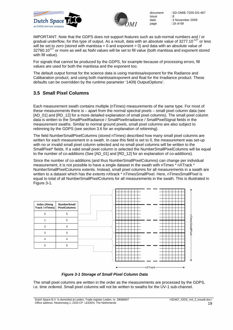
3.5 Small Pixel Columns
Each measurement swath contains multiple (nTimes) measurements of the same type. For most of these measurements there is – apart from the normal spectral pixels – small pixel column data (see 77H[AD_01] and 78H[RD_12] for a more detailed explanation of small pixel columns). The small pixel column data is written to the SmallPixelRadiance / SmallPixelIrradiance / SmallPixelSignal fields in the measurement swaths. Similar to normal ground pixels, small pixel columns are also subject to rebinning by the GDPS (see section 79H3.6 for an explanation of rebinning).
The field NumberSmallPixelColumns (stored nTimes) described how many small pixel columns are written for each measurement in a swath. In case this field is set to 0, the measurement was set-up with no or invalid small pixel column selected and no small pixel columns will be written to the SmallPixel* fields. If a valid small pixel column is selected the NumberSmallPixelColumns will be equal to the number of co-additions (See 80H[AD_01] and 81H[RD_12] for an explanation of co-additions).
Since the number of co-additions (and thus NumberSmallPixelColumns) can change per individual measurement, it is not possible to have a single dataset in the swath with nTimes * nXTrack * NumberSmallPixelColumns extents. Instead, small pixel columns for all measurements in a swath are written to a dataset which has the extents nXtrack * nTimesSmallPixel. Here, nTimesSmallPixel is equal to total of all NumberSmallPixelColumns for all measurements in the swath. This is illustrated in 82HFigure 3-1.
Index (AlongTrack / nTimes)
NumberSmallPixelColumns
0 5
1 5
2 4
4 4
3 0
5 5
nXTrack
nTimesSm
allPixel
Figure 3-1 Storage of Small Pixel Column Data
The small pixel columns are written in the order as the measurements are processed by the GDPS, i.e. time ordered. Small pixel columns will not be written to swaths for the UV-1 sub-channel.

document issue date page
: SD-OMIE-7200-DS-467 : 8 : 3 November 2009 : 20 of 69
Dutch Space B.V. is domiciled at Leiden, Trade register Leiden, nr. 28086907 Office address: Newtonweg 1, 2333 CP LEIDEN, The Netherlands
<SD467_IODS_Vol_2_issue8.doc> 20
3.6 Earth Measurement specific issues
Earth (radiance) measurements are written to the radiance product(s). Each measurement contains spectra for a single "scan-line", a set of ground pixels, cross track. The instrument allows to average several ground pixels into one (called "binning"), to reduce noise and data rates. The number of ground pixels that is averaged is specified by the "binning factor", which is set by the instrument operations team. If an earth measurement is taken with global settings (i.e. binning factor 8), the measurement is written to the OML1BRUG and OML1BRVG products.
If the measurement is a zoom-in measurement (binning factor other than 8), the measurement is written to the OML1BRUZ and OML1BRVZ products. In case of a binning factor of 4, 2 or 1, the measurement will be rebinned by the GDPS to binning factor 8 (by averaging the radiances) and this rebinned measurement will also be written to the global products OML1BRUG and OML1BRVG. The rebinning by the GDPS ensures that the zoom-in measurements are written in the global products with the same spatial sampling as global measurements.
83HFigure 3-2 shows an example of the spatial coverage of measurements before rebinning. In this figure, nTimes is in the direction of along-track (flight direction) and nXtrack (read number cross track) is perpendicular to the flight direction (i.e. comparable to a scan-line). The measurement for nTimes = 0 is the first measurement in the orbit / granule. That is, measurements are written in time-order.
Binning Factor 4Spatial zoom-inmeasurements
Binning Factor 8Normal (global) measurements
Binning Factor 8Normal (global) measurements
60 Ground Pixels
60 Ground Pixels
60 Ground Pixels
nTimes
nXtrack
0
Figure 3-2 Example of Spatial Coverage for Zoom Measurements0F
1
1 In this figure, the extents for nXtrack are examples – in the output products, the number of ground pixels can vary from swath to swath.

document issue date page
: SD-OMIE-7200-DS-467 : 8 : 3 November 2009 : 21 of 69
Dutch Space B.V. is domiciled at Leiden, Trade register Leiden, nr. 28086907 Office address: Newtonweg 1, 2333 CP LEIDEN, The Netherlands
<SD467_IODS_Vol_2_issue8.doc> 21
The rebinning of the spatial zoom-in measurements is further illustrated in 84HFigure 3-3. The 60 ground pixels for these measurements are downscaled to 30 by averaging 2 pixels to 1, as is indicated by the light grey area of 85HFigure 3-3. The pixels are also shifted so that the first ground pixel is always at index 0 of nXtrack in the swath. The remaining 30 pixels are filled with Fill Values and will have the “missing pixel” flag set in the pixel quality flags.
Binning Factor 8Normal (global) measurements
Binning Factor 8Normal (global) measurements
60 Ground Pixels
60 Ground Pixels
Fill Values
nTimes
nXtrack
0
30 Ground Pixels
ReBinned Factor 4Spatial zoom-inmeasurements
Figure 3-3 Example of Rebinned Zoom Measurements1F
2
For spectral zoom-in measurements typically all ground pixels will be available, but not all wavelengths will be present. The unavailable wavelengths will be set with fill values and will have the “missing pixel” flag set in the pixel quality flags. If an entire sub-channel is unavailable, no measurement will be written for that sub-channel.
2 In this figure, the extents for nXTrack are examples – in the output products, the number of ground pixels can vary from swath to swath.

document issue date page
: SD-OMIE-7200-DS-467 : 8 : 3 November 2009 : 22 of 69
Dutch Space B.V. is domiciled at Leiden, Trade register Leiden, nr. 28086907 Office address: Newtonweg 1, 2333 CP LEIDEN, The Netherlands
<SD467_IODS_Vol_2_issue8.doc> 22
3.7 Sun Measurement Specific Issues
During each solar observation a series of Sun measurements is taken. During each of these Sun measurements the Sun illuminates one of the on-board diffusers over a limited elevation range. The azimuth angle is determined by the season. All individual Sun measurements are written to the calibration product (OML1BCAL) both processed (calibrated) as well as unprocessed (raw). At the end of a run the GDPS averages all calibrated Sun measurements. All averaged calibrated Sun measurements are written to the calibration product (OML1BCAL). The averaged calibrated Sun measurements that are taken with Volume Diffuser and Binning factor 4 or 8 are also written to the irradiance product (OML1BIRR).The irradiance product contains nXTrack observation-averaged solar spectra (nTimes will be equal to unity, by definition).
For each of the individual solar irradiance measurements, a single spectrum is calculated from all the rows using a bucket binning algorithm and written to the calibration product (OML1BCAL). This bucket binned average is then averaged over the elevation angles as well, and written with the averaged solar irradiance to the calibration product (OML1BCAL).
3.8 Wavelength Scales for Earth and Sun Measurements
OMI does not have a fixed wavelength scale that is equal for all of the ground pixels. This effect is commonly referred to as the “spectral smile” from OMI and is illustrated by 86HFigure 3-4, which shows the UV-2 sub-channel when illuminated with a Spectral Line Source (SLS). Furthermore, the wavelength scale can change slightly during a granule as the result of temperature changes.
nXtrack
nWavel Figure 3-4 SLS measurement showing the spectral smile of OMI in the UV-2 Sub
Channel
Rather then storing individual wavelengths for each spectral pixel, the GDPS stores polynomial coefficients that describe the wavelength scale for all the spectral pixels for a given ground pixel instead. To calculate a wavelength use the following equation:
∑−
=
−=1
0,, )(
N
qqj
qrefji ciiλ
With the wavelength coefficients, also their precision is stored. To calculate the precision of a wavelength use the following equation:

document issue date page
: SD-OMIE-7200-DS-467 : 8 : 3 November 2009 : 23 of 69
Dutch Space B.V. is domiciled at Leiden, Trade register Leiden, nr. 28086907 Office address: Newtonweg 1, 2333 CP LEIDEN, The Netherlands
<SD467_IODS_Vol_2_issue8.doc> 23
[ ] ( ) [ ]{ }∑−
=
−=1
0
2
,,
N
qqj
qrefji cii σλσ
In above equations: i The index of the spectral pixel in nWavel direction, starting at 0 j The index of the spectral pixel in the nXTrack direction, starting at 0 iref The reference column, as written with each measurement in the swath q Index number of the wavelength polynomial coefficient N The number of wavelength polynomial coefficients, as written with each measurement
in the swath cj,q The wavelength polynomial coefficients, as written with each measurement in the
swath λi,j The wavelength for the spectral pixel (i,j) in nm. σ[λi,j] The precision of the wavelength for spectral pixel (i,j) σ[cj,q] The wavelength coefficient precision, as written with each measurement in the swath
3.9 WLS, LED and Dark (Calibration) Measurement Specific Issues
All calibration measurements (WLS, LED and Dark) are written to the calibration product (OML1BCAL), processed as well as unprocessed (i.e. Raw level 0 ADC counts).
3.10 Flags in the L1B Output products2F
3
The flags in the OMI Level 1B output products serve the following three purposes
1. inform the users of the data about the reliability of the information. This is especially important when the data is used for Level 2 processing.
2. provide the (in-flight) calibration scientist with information to assess at a high-level the performance of the instrument and/or the GDPS.
3. provide information for the purpose of Quality Assessment (QA).
Because of the desire to limit the size of the output product it is impossible to fulfil these three purposes to their full extent. The total amount of information contained in the flags cannot be optimised in the sense that every bit of information is contained in a specific flag. The scientists, who will use the data for Level 2 processing, will make use of highly automated processing flows so that the flags should be designed for that purpose. This implies that the flags should be kept simple to avoid complicated processing options in the Level 2 software.
For data in the Level 1B product the user is mainly interested in the following information:
1. is the data MISSING
2. is the data not to be used (BAD quality).
3. was there an ERROR when the data was generated.
4. was an expected limit exceeded when the data was generated calling for a WARNING to the user.
When for data neither MISSING, BAD, ERROR or WARNING is assigned, a user should fully trust the information contained in the data. Data with BAD or ERROR flags should not be processed to higher-level data products. Data with WARNING flags must be inspected on whether the generated warnings are relevant for a specific use of the data. The check limits for WARNING flags are set in the Operational Parameters File (OPF) of the GDPS.
3 This section is taken from [RD_10] by courtesy of KNMI
document issue date page
: SD-OMIE-7200-DS-467 : 8 : 3 November 2009 : 24 of 69
Dutch Space B.V. is domiciled at Leiden, Trade register Leiden, nr. 28086907 Office address: Newtonweg 1, 2333 CP LEIDEN, The Netherlands
<SD467_IODS_Vol_2_issue8.doc> 24
The flags can be found on four levels:
1. image pixel level (PixelQualityFlags)
2. ground pixel level (GroundpixelQualityFlags, XtrackQualityFlags)
3. measurement level (MeasurementQualityFlags)
4. granule level (Metadata)
For the available flags it is identified whether these fall in the categories MISSING, BAD, ERROR or WARNING and then regrouped them according to these categories.
Chapter 87H6 will describe the PixelQualityFlags, GroundpixelQualityFlags, XtracQualityFlags and the MeasurementQualityFlags. See chapter 88H8 for the Metadata description.

document issue date page
: SD-OMIE-7200-DS-467 : 8 : 3 November 2009 : 25 of 69
Dutch Space B.V. is domiciled at Leiden, Trade register Leiden, nr. 28086907 Office address: Newtonweg 1, 2333 CP LEIDEN, The Netherlands
<SD467_IODS_Vol_2_issue8.doc> 25
4. Details of OMI Level 1B Product Formats
4.1 OMI L1B Product Contents
The OMI Level 1B products are formatted in HDF-EOS 2.7, which is based on HDF 4. Each of the OMI Level 1B products contains a number of File Attributes and a number of Swath Data Sets. Note that Swath Data Sets show up in HDF browsers as Vgroups containing other data sets such as Vtables and Scientific Data Sets (SDS).
4.2 File Attributes
The File Attributes contain data that is written by the HDF-EOS library and Metadata. No Name Data Type Description 1 HDFEOSVersion string Contains the version string of the HDF-EOS library
version, e.g. “HDFEOS_V2.7.2”. Is automatically generated by the HDF-EOS library.
2 StructMetadata.0 string Contains swath structure metadata in ODL format. Is automatically generated by the HDF-EOS library.
3 CoreMetadata.0 string Contains ECS standard core granule metadata in ODL format.
4 ArchiveMetadata.0 string Contains ECS standard archive granule metadata in ODL format.
Table 4-1: File Attributes
4.3 Swath Naming
This section will describe the naming of the swaths for the different output products.
4.3.1 Swath Naming for Global Radiance Products
The swath naming for the global radiance (UV and VIS) products is as follows:
“Earth ” <channel_identifier> “ Swath”
where:
<channel_identifier>: Can be “UV-1”, “UV-2” or “VIS”
Example:
“Earth UV-1 Swath”
4.3.2 Swath Naming for Zoom Radiance Products
The swath naming for the zoom radiance (UV and VIS) products is as follows:
“Earth ” <channel_identifier> “ Swath ” <Size>
where:
<channel_identifier>: Can be “UV-1”, “UV-2” or “VIS”
document issue date page
: SD-OMIE-7200-DS-467 : 8 : 3 November 2009 : 26 of 69
Dutch Space B.V. is domiciled at Leiden, Trade register Leiden, nr. 28086907 Office address: Newtonweg 1, 2333 CP LEIDEN, The Netherlands
<SD467_IODS_Vol_2_issue8.doc> 26
<Size>: Format: “(“ <nXTrack> “x” <nWavel> “x” <binning_factor> “)”
Example:
“Earth UV-1 Swath (121x361x4)”
4.3.3 Swath Naming for Irradiance Products
The swath naming for the irradiance products is as follows:
“Sun Volume ” <channel_identifier> “ Swath”
where:
<channel_identifier>: Can be “UV-1”, “UV-2” or “VIS”
Example:
“Sun Volume UV-1 Swath”
Note that only solar measurements with diffuser type “Volume” will be written to the Irradiance Products.
4.3.4 Swath Naming for Calibration Product
The swath naming for measurement swaths in calibration products is as follows:
“Raw ”opt“Avg ”opt“Checkout ”opt <measurement_type> <fmm_setting>opt <diffuser>opt “Storage ”opt <channel_identifier> “ Swath ” <Size>
where:
“Raw ”: This prefix is used for swaths to which unprocessed data (i.e. ADC counts) is written.
“Avg”: This prefix is used for swaths to which averaged irradiance is written.
“Checkout”: This prefix is used for swaths to which measurements are written that were taken as part of the instrument check-out and functional test procedures.
<measurement_type>: Can be: “Sun ”, “LED ”, “WLS ”, “Dark ” or “Unknown ”.
<fmm_setting>: Denotes the setting of the Folding Mirror Mechanism. Can be: “FM ” or “NoFM ”. Folding Mirror Mechanism settings are only included for Dark measurements.
<diffuser>: Can be “Regular ”, “Backup ” or “Volume ”. Diffuser settings are only included for Sun measurements and for Dark measurements that have a diffuser setting other then “Transmission”.
“storage ”: This is included in names of swaths for Dark measurements in which the contents of the storage area of the CCD are stored.
<channel_identifier>: Can be “UV-1”, “UV-2”, “UV” or “VIS”
<Size>: Format: “(“ <nXTrack> “x” <nWavel> “x” <binning_factor> “)”
Examples:
“Dark FM Storage UV Swath (577x814x1)”
“LED UV Swath (577x814x1)”
The swath naming for calibration swaths in calibration products is as follows:
“Calibration ” <channel_identifier> “ Swath”

document issue date page
: SD-OMIE-7200-DS-467 : 8 : 3 November 2009 : 27 of 69
Dutch Space B.V. is domiciled at Leiden, Trade register Leiden, nr. 28086907 Office address: Newtonweg 1, 2333 CP LEIDEN, The Netherlands
<SD467_IODS_Vol_2_issue8.doc> 27
where:
<channel_identifier>: Can be “UV” or “VIS”
Example:
“Calibration UV Swath”
The swath naming for spectral calibration swaths in calibration products is as follows:
“Spectral Calibration ” <channel_identifier> “ Swath ” <Size>
where:
<channel_identifier>: Can be “UV-1”, “UV-2” or “VIS”
<Size>: Format: “(“ <nXTrack> “x” <nWavel> “x” <binning_factor> “)”. The <nWavel> is equal to the number of wavelength pixels in the specified sub-channel of the measurement. Although this is not really relevant here (no wavelength pixels are written), this value is included here for consistency.
Example:
“Spectral Calibration UV-1 Swath (29x159x8)”

document issue date page
: SD-OMIE-7200-DS-467 : 8 : 3 November 2009 : 28 of 69
Dutch Space B.V. is domiciled at Leiden, Trade register Leiden, nr. 28086907 Office address: Newtonweg 1, 2333 CP LEIDEN, The Netherlands
<SD467_IODS_Vol_2_issue8.doc> 28
4.4 Swath Fields
This section will describe which fields are located in the swaths.
4.4.1 Measurement Swaths
No Name Dim Type Note 1 nTimes unlimited 2 nTimesSmallPixel unlimited 1 3 nXtrack fixed 2 4 nWavel fixed 2 5 nWavelCoef fixed
Table 4-2: Dimensions for Measurement Swaths
Notes for 89HTable 4-2: Note 1: Not in Irradiance product Note 2: The dimensions nXtrack and nWavel are used for all types of measurements, even
though the (type of) measurement may not really contain data for different wavelengths (all types other then Earth and Sun, e.g. WLS, LED, Dark) or different ground pixels cross track (all types other then Earth, e.g. Sun, WLS, LED, Dark). In these cases, the dimensions nWavel and nXtrack denote the number of pixels stored for the direction on the CCD detector that are normally (i.e. for earth measurements) associated with the wavelengths (i.e. CCD columns) or ground pixels cross track (i.e. CCD rows) respectively.
No Name Data Type Dimensions Note 1 Time float64 nTimes 2 SecondsInDay float32 nTimes 3 3 SpacecraftLatitude float32 nTimes 3 4 SpacecraftLongitude float32 nTimes 3 5 SpacecraftAltitude float32 nTimes 3 6 OrbitPhase float32 nTimes 2 7 SolarElevation float32 nTimes 4 8 SolarAzimuth float32 nTimes 4 9 SolarElevationMinimum float32 nTimes 1 10 SolarElevationMaximum float32 nTimes 1 11 SolarAzimuthMinimum float32 nTimes 1 12 SolarAzimuthMaximum float32 nTimes 1 13 Latitude float32 nTimes, nXtrack 2 14 Longitude float32 nTimes, nXtrack 2 15 SolarZenithAngle float32 nTimes, nXtrack 2 16 SolarAzimuthAngle float32 nTimes, nXtrack 2 17 ViewingZenithAngle float32 nTimes, nXtrack 2 18 ViewingAzimuthAngle float32 nTimes, nXtrack 2 19 TerrainHeight int16 nTimes, nXtrack 2 20 GroundPixelQualityFlags uint16 nTimes, nXtrack 2 21 XtrackQualityFlags uint8 nTimes, nXtrack 2
Table 4-3: Geolocation Fields for Measurement Swaths
document issue date page
: SD-OMIE-7200-DS-467 : 8 : 3 November 2009 : 29 of 69
Dutch Space B.V. is domiciled at Leiden, Trade register Leiden, nr. 28086907 Office address: Newtonweg 1, 2333 CP LEIDEN, The Netherlands
<SD467_IODS_Vol_2_issue8.doc> 29
Notes for 90HTable 4-3: Note 1: Only in Sun swath of the Irradiance product and average Sun swath of the calibration
product Note 2: Only in Earth swaths Note 3: Not in raw swaths of calibration product Note 4: Only in Sun swath of the Calibration product, except the “raw” sun swaths and
average Sun swath in the calibration product No Name Data Type Dimensions Note 1 RadianceMantissa
IrradianceMantissa SignalMantissa
int16 nTimes, nXtrack, nWavel 1
2 RadiancePrecisionMantissa IrradiancePrecisionMantissa SignalPrecisionMantissa
int16 nTimes, nXtrack, nWavel 1
3 RadianceExponent IrradianceExponent SignalExponent
int8 nTimes, nXtrack, nWavel 1
4 Radiance Irradiance Signal
int16 nTimes, nXtrack, nWavel 2
5 RadiancePrecision IrradiancePrecision SignalPrecision
int16 nTimes, nXtrack, nWavel 2
6 PixelQualityFlags uint16 nTimes, nXtrack, nWavel 7 WavelengthCoefficient float32 nTimes, nXtrack, nWavelCoef 3 8 WavelengthCoefficentPrecision float32 nTimes, nXtrack, nWavelCoef 3 9 WavelengthReferenceColumn int16 nTimes 3 10 WavelengthFitCoefficient float32 nTimes, nXtrack, nWavelCoef 7 11 WavelengthFitCoefficientPrecision float32 nTimes, nXtrack, nWavelCoef 7 12 WavelengthFitChiSquare float32 nTimes, nXtrack 7 13 WavelengthFitFlags uint16 nTimes, nXtrack 7 14 SmallPixelRadiance
SmallPixelIrradiance SmallPixelSignal
float32 nTimesSmallPixel, nXtrack 4, 5
15 IrradianceBucketBinned float32 nTimes, nWavel 6 16 SmallPixelWavelength float32 nTimesSmallPixel, nXtrack 3, 4 17 MeasurementClass uint8 nTimes 18 InstrumentConfigurationId uint8 nTimes 19 InstrumentConfigurationVersion uint8 nTimes 20 MeasurementQualityFlags uint16 nTimes 21 NumberSmallPixelColumns int8 nTimes 22 ExposureType int8 nTimes 23 MasterClockPeriod float32 nTimes 24 CalibrationSettings uint16 nTimes 25 ExposureTime float32 nTimes 26 ReadoutTime float32 nTimes 27 SmallPixelColumn int16 nTimes 28 GainSwitchingColumn1 int16 nTimes 29 GainSwitchingColumn2 int16 nTimes 30 GainSwitchingColumn3 int16 nTimes 31 GainCode1 int8 nTimes 32 GainCode2 int8 nTimes 33 GainCode3 int8 nTimes 34 GainCode4 int8 nTimes

document issue date page
: SD-OMIE-7200-DS-467 : 8 : 3 November 2009 : 30 of 69
Dutch Space B.V. is domiciled at Leiden, Trade register Leiden, nr. 28086907 Office address: Newtonweg 1, 2333 CP LEIDEN, The Netherlands
<SD467_IODS_Vol_2_issue8.doc> 30
No Name Data Type Dimensions Note 35 DSGainCode int8 nTimes 36 LowerStrayLightAreaBinningFactor int8 nTimes 37 UpperStrayLightAreaBinningFactor int8 nTimes 38 LowerDarkAreaBinningFactor int8 nTimes 39 UpperDarkAreaBinningFactor int8 nTimes 40 SkipRows1 int16 nTimes 41 SkipRows2 int16 nTimes 42 SkipRows3 int16 nTimes 43 SkipRows4 int16 nTimes 44 DetectorTemperature float32 nTimes 45 OpticalBenchTemperature float32 nTimes 46 ImageBinningFactor int8 nTimes 47 BinnedImageRows int16 nTimes 48 StopColumn int16 nTimes
Table 4-4: Data Fields for Measurement Swaths
Notes for 91HTable 4-4: Note 1: Radiance… for earth swaths, Irradiance… for all sun swaths except the “raw” sun
swaths, Signal… for all other swaths. If a switch in the Program Control File is set not to use mantissa/exponent for a
product, this field will not be present in all swaths of that product. Note 2: Radiance… for earth swaths, Irradiance… for all sun swaths except the “raw” sun
swaths, Signal… for all other swaths. By default only present in Irradiance product. If a switch in the Program Control File is set to use floats for a product, this field will be
present for all swaths in that product. Note 3: Only in Sun and Earth swaths, except the “raw” sun swaths Note 4: Not in UV-1 swaths and not in sun swaths except the “raw” sun swaths. Note 5: …Radiance for earth swaths, …Irradiance for all sun swaths except the “raw” sun
swaths, …Signal for all other swaths. Note 6: Only in the Calibration product. Note 7: Only in Earth swaths No Name Data Type 1 NumTimes int32 2 NumTimesSmallPixel int32 3 EarthSunDistance float32
Table 4-5: Swath Attributes for Measurement Swaths
4.4.2 Calibration Swaths
No Name Dim Type 1 nTimes unlimited 2 nGain fixed 3 nWavel fixed 4 nOPBSensors fixed
Table 4-6: Dimensions for Calibration Swaths
No Name Data Type Dimensions 1 Time float64 nTimes
Table 4-7: Geolocation Fields for Calibration Swaths

document issue date page
: SD-OMIE-7200-DS-467 : 8 : 3 November 2009 : 31 of 69
Dutch Space B.V. is domiciled at Leiden, Trade register Leiden, nr. 28086907 Office address: Newtonweg 1, 2333 CP LEIDEN, The Netherlands
<SD467_IODS_Vol_2_issue8.doc> 31
No Name Data
Type Dimensions
1 Offset float32 nTimes, nGain 2 ReadoutNoiseEstimate float32 nTimes, nGain 3 DarkCurrent float32 nTimes 4 DarkCurrentPrecision float32 nTimes 5 InstrumentConfigurationId uint8 nTimes 6 InstrumentConfigurationVersion uint8 nTimes 7 DetectorTemperature float32 nTimes 8 ImageBinningFactor int16 nTimes 9 BinnedImageRows int16 nTimes 10 StopColumn int16 nTimes 11 RegisterOffset float32 nTimes, nWavel 12 OpticalBenchTemperature float32 nTimes 13 OPBSensorTemperatures float32 nTimes, nOPBSensors 14 ELU1Temperature float32 nTimes 15 ELU2Temperature float32 nTimes 14 ELUAUXTemperature float32 nTimes
Table 4-8: Data Fields for Calibration Swaths
No Name Data Type 1 NumTimes int32 2 EarthSunDistance float32 3 GainFactors float32[4]
Table 4-9: Swath Attributes for Calibration Swaths
4.4.3 Spectral Calibration Swaths
No Name Dim Type 1 nTimes unlimited 2 nXtrack fixed 3 nWavelCoef fixed
Table 4-10: Dimensions for Spectral Calibration Swaths
No Name Data Type Dimensions 1 Time float64 nTimes
Table 4-11: Geolocation Fields for Spectral Calibration Swaths
No Name Data Type Dimensions 1 WavelengthFitCoefficient float32 nTimes, nXtrack, nWavelCoef 2 WavelengthFitCoefficientPrecision float32 nTimes, nXtrack, nWavelCoef 3 WavelengthFitChiSquare float32 nTimes, nXtrack 4 WavelengthFitFlags uint16 nTimes, nXtrack 5 WavelengthReferenceRow int16 nTimes 6 WavelengthReferenceColumn int16 nTimes 7 OpticalBenchTemperature float32 nTimes

document issue date page
: SD-OMIE-7200-DS-467 : 8 : 3 November 2009 : 32 of 69
Dutch Space B.V. is domiciled at Leiden, Trade register Leiden, nr. 28086907 Office address: Newtonweg 1, 2333 CP LEIDEN, The Netherlands
<SD467_IODS_Vol_2_issue8.doc> 32
No Name Data Type Dimensions 8 ImageBinningFactor int16 nTimes 9 BinnedImageRows int16 nTimes 10 StopColumn int16 nTimes 11 InstrumentConfigurationId uint8 nTimes 12 InstrumentConfigurationVersion uint8 nTimes
Table 4-12: Data Fields for Spectral Calibration Swaths
No Name Data Type 1 NumTimes int32 2 EarthSunDistance float32
Table 4-13: Swath Attributes for Spectral Calibration Swaths
4.5 Fill Values
Fields that are invalid or not used will have a value that corresponds to the data type in the table below. No Data Type Fill Value 1 int8 -127 2 uint8 255 3 int16 -32767 4 uint16 65535 5 int32 -2147483647 6 uint32 4294967295 7 float32 -0X1P+100 3F
4 8 float64 -0X1P+100 92H
4 Table 4-14: Fill Values
Fill values are not applicable for the data fields listed in 93HTable 4-15.
No Name Description 1 InstrumentConfigurationId Fill value is a valid Id 2 InstrumentConfigurationVersion Fill value is a valid version 3 GroundPixelQualityFlags Fill values should not occur for this data field. At the
start of the measurement this field is initialised with zero. During processing bits are set.
4 XTrackQualityFlags Fill values should not occur for this data field. At the start of the measurement this field is initialised with zero. During processing bits are set.
4 PixelQualityFlags A fill value indicates that all flags are set. 5 MeasurementQualityFlags Fill value should not occur for this data field. At the start
of the measurement this field is initialised with zero. During processing bits are set. Since bit 15 is reserved for future use it is never set. Therefore a fill value should not occur for this field.
6 WavelengthFitFlags A fill value indicates that all flags are set. 7 RadianceMantissa
IrradianceMantissa For this data field a fill value should only be interpreted as a fill value when the MISSING flag is set in the
4 This is equal to -1.0*2100, which is approximately equal to -1.267651*1030. The value -1.0*2100 has an exact representation on IEEE compatible floating point implementations.

document issue date page
: SD-OMIE-7200-DS-467 : 8 : 3 November 2009 : 33 of 69
Dutch Space B.V. is domiciled at Leiden, Trade register Leiden, nr. 28086907 Office address: Newtonweg 1, 2333 CP LEIDEN, The Netherlands
<SD467_IODS_Vol_2_issue8.doc> 33
SignalMantissa PixelQualityFlags. Otherwise the fill value should be read as valid data.
8 RadiancePrecisionMantissa IrradiancePrecisionMantissa SignalPrecisionMantissa
A fill value for this data field should always be read as a fill value since normal precision data can only have a positive value.
9 RadianceExponent IrradianceExponent SignalExponent
For this data field a fill value should only be interpreted as a fill value when the MISSING flag is set in the PixelQualityFlags. Otherwise the fill value should be read as valid data.
Table 4-15: Data Fields without applicable Fill Value

document issue date page
: SD-OMIE-7200-DS-467 : 8 : 3 November 2009 : 34 of 69
Dutch Space B.V. is domiciled at Leiden, Trade register Leiden, nr. 28086907 Office address: Newtonweg 1, 2333 CP LEIDEN, The Netherlands
<SD467_IODS_Vol_2_issue8.doc> 34
5. OMI Level 1B Science Parameter Description
In this section a short description of all parameters is given that are stored in the OMI Level 1B Products. Name Unit Description HDFEOSVersion - Contains the version string of the HDF-EOS library
version, e.g. “HDFEOS_V2.7.2”. Is automatically generated by the HDF-EOS library.
StructMetadata.0 - Contains swath structure metadata in ODL format. Is automatically generated by the HDF-EOS library.
CoreMetadata.0 - Contains ECS standard core granule metadata in ODL format.
ArchiveMetadata.0 - Contains ECS standard archive granule metadata in ODL format.
nTimes - Dimension for the number of measurements. Zero denotes unlimited 4F
5, for the number of used measurements see NumTimes.
nTimesSmallPixel - Dimension for the number of small pixel columns. Zero means unlimited94H
5, for the number of used small pixel columns see NumTimesSmallPixel.
nXtrack - Dimension for the number of pixels in cross track direction.
nWavel - Dimension for the number of wavelengths. This field is fixed at 814 for Calibration swaths. With respect to the number of columns this field is filled with missing values padded with fill values, excess values are not written.
nWavelCoef - Dimension for the number of wavelength coefficients. nGain - Dimension for the number of possible gain settings.
This field is fixed at 4. Datasets that have this dimension will store values in the order of the ELU Gain Codes (i.e. 10x, 40x, 1x, 4x)
nOPBSensors - Dimension for the number of OPB sensor settings. This field is always fixed at 4.
Time - Time in International Atomic Time (TAI-93) format. SecondsInDay s Seconds after UTC midnight. SpacecraftLatitude deg Latitude of the spacecraft sub-satellite point. SpacecraftLongitude deg Longitude of the spacecraft sub-satellite point. SpacecraftAltitude m Altitude of the spacecraft. SolarElevation deg Elevation angle of the sun in the OMI optical
alignment reference frame SolarAzimuth deg Azimuth angle of the sun in the OMI optical alignment
reference frame SolarElevationMinimum deg Minimum elevation angle of the sun in the OMI optical
alignment reference frame for averaged sun measurements
SolarElevationMaximum deg Maximum elevation angle of the sun in the OMI optical alignment reference frame for averaged sun measurements
5 HDF-EOS convention

document issue date page
: SD-OMIE-7200-DS-467 : 8 : 3 November 2009 : 35 of 69
Dutch Space B.V. is domiciled at Leiden, Trade register Leiden, nr. 28086907 Office address: Newtonweg 1, 2333 CP LEIDEN, The Netherlands
<SD467_IODS_Vol_2_issue8.doc> 35
Name Unit Description SolarAzimuthMinimum deg Minimum azimuth angle of the sun in the OMI optical
alignment reference frame for averaged sun measurements
SolarAzimuthMaximum deg Maximum azimuth angle from the sun in the OMI optical alignment reference frame for averaged sun measurements
Latitude deg Latitude at the centre co-ordinate of the ground pixel. Longitude deg Longitude at the centre co-ordinate of the ground
pixel. SolarZenithAngle deg Solar zenith angle at the centre co-ordinate of the
ground pixel. This angle is calculated from the ground pixel centre, using the SDP Toolkit planetary ephemeris file, taken the terrain height into account.
SolarAzimuthAngle deg Solar azimuth angle at the centre co-ordinate of the ground pixel. This angle is calculated from the ground pixel centre, using the SDP Toolkit planetary ephemeris file, taken the terrain height into account.
ViewingZenithAngle deg Viewing zenith angle at the centre co-ordinate of the ground pixel(See note 5).
ViewingAzimuthAngle deg Viewing azimuth angle at the centre co-ordinate of the ground pixel(See note 5).
TerrainHeight m Terrain height at the center co-ordinate of the ground pixel The source for the terrain height is the SDP Toolkit 90 arcsec DEM map (See note 5).
EarthSunDistance m Distance between Sun and Earth. Bit Description (LSB = bit 0) 0-3 Land/Water flags
0=Shallow Ocean 1=Land 2=Shallow Inland Water 3=Ocean coastline / Lake shoreline 4=Ephemeral (intermittent) water 5=Deep Inland Water 6=Continental Shelf Ocean 7=Deep Ocean 8-14=Not used 15=Error flag for Land/Water
4 Sun Glint Possibility flag 5 Solar Eclipse possibility flag 6 Geolocation Error flag 7 Geolocation Warning flag
GroundPixelQualityFlags -
8-14 Snow/Ice flags [based on NISE] 0=Snow-free land 1-100=Sea ice concentration (%) 101=Permanent ice (Greenland, Antarctica) 102=Not used 103=Dry snow 104=Ocean [NISE-255] 105-123=Reserved 124=Mixed pixels at coastline [NISE-252] 125=Suspect ice value [NISE-253] 126=Corners (undefined) [NISE-254] 127=Error

document issue date page
: SD-OMIE-7200-DS-467 : 8 : 3 November 2009 : 36 of 69
Dutch Space B.V. is domiciled at Leiden, Trade register Leiden, nr. 28086907 Office address: Newtonweg 1, 2333 CP LEIDEN, The Netherlands
<SD467_IODS_Vol_2_issue8.doc> 36
Name Unit Description 15 NISE nearest neighbour filling flag See section 95H6.2 for more details on Ground-pixel quality flags. Bit Description (LSB = bit 0) 0-2 Row anomaly correction flags:
0 = Not affected 1 = Affected, Not corrected, do not use 2 = (Slight) affected, not corrected, use with caution 3 = Affected, corrected, use with caution. 4 = Affected, corrected, use pixel. 5-6 = Not used 7 = Error during processing.
3 Reserved for future use. 4 Possibly affected by wavelength shift 5 Possibly affected by blockage 6 Possibly affected by stray sunlight 7 Possibly affected by stray earthshine
XtrackQualityFlags -
See section 6.3 for more details on XTrack quality flags.
RadianceMantissa See Note 1 Mantissa of the earth radiance. See section 97H3.4 on how to calculate the radiance from the mantissa and exponent.
IrradianceMantissa See Note 2 Mantissa of the irradiance. See section 98H3.4 on how to calculate the irradiance from the mantissa and exponent.
SignalMantissa See Note 3 Mantissa of the signal. See section 99H3.4 on how to calculate the signal from the mantissa and exponent.
RadiancePrecisionMantissa See Note 1 Mantissa of the precision of the earthshine radiance. See section 100H3.4 on how to calculate the radiance precision from the mantissa and exponent.
IrradiancePrecision Mantissa
See Note 2 Mantissa of the precision of the irradiance. See section 101H3.4 on how to calculate the irradiance precision from the mantissa and exponent.
SignalPrecisionMantissa See Note 3 Mantissa of the precision of the signal. See section 102H3.4 on how to calculate the signal precision from the mantissa and exponent.
RadianceExponent See Note 1 Radiance exponent. Scaling factor for the radiance and the radiance precision. See section 103H3.4 on how to calculate the radiance and radiance precision from the mantissa and exponent.
IrradianceExponent See Note 2 Irradiance exponent. See section 104H3.4 on how to calculate the irradiance and irradiance precision from the mantissa and exponent.
SignalExponent See Note 3 Signal exponent. Scaling factor for the signal and the signal precision. See section 105H3.4 on how to calculate the signal and signal precision from the mantissa and exponent.
Radiance photons/(s.nm.cm2.sr)
Earth radiance.
Irradiance photons/(s.nm.cm2)
Solar irradiance.
Signal See Note 4 Signal. RadiancePrecision photons/(s.n
m.cm2.sr) The precision of the earthshine radiance.

document issue date page
: SD-OMIE-7200-DS-467 : 8 : 3 November 2009 : 37 of 69
Dutch Space B.V. is domiciled at Leiden, Trade register Leiden, nr. 28086907 Office address: Newtonweg 1, 2333 CP LEIDEN, The Netherlands
<SD467_IODS_Vol_2_issue8.doc> 37
Name Unit Description IrradiancePrecision photons/(s.n
m.cm2) The precision of the irradiance.
SignalPrecision See Note 4 The precision of the signal. Bit Description (LSB = bit 0) 0 MISSING flag 1 BAD_PIXEL flag 2 PROCESSING_ERROR flag 3 TRANSIENT_PIXEL_WARNING flag 4 RTS_PIXEL_WARNING flag 5 SATURATION_POSSIBILITY_WARNING
flag 6 NOISE_CACULATION_WARNING flag 7 DARK_CURRENT_WARNING flag 8 OFFSET_WARNING flag 9 EXPOSURE_SMEAR_WARNING flag 10 STRAY_LIGHT_WARNING flag 11 NON_LIN_WARNING flag 12 OPF_OFFSET_WARNING flag 13 WVL_ASSIGN_WARNING flag 14 DEAD_PIXEL_IDENTIFICATION flag 15 DEAD_PIXEL_IDENTIFICATION _ERROR
flag
PixelQualityFlags -
See section 106H6.2 for more details on pixel quality flags. WavelengthCoefficient - Wavelength polynomial coefficients. For details on
how to calculate the wavelength for a pixel, see section 107H3.8.
WavelengthCoefficient Precision
- Precision of the wavelength polynomial coefficients. For details on how to calculate the wavelength precision for a pixel, see section 108H3.8.
WavelengthReference Column
- Reference column number to be used in the calculation of the wavelengths.
SmallPixelRadiance Photons/ (s.nm.cm2.sr)
Earthshine radiance for the small pixel column.
SmallPixelIrradiance Photons/ (s.nm.cm2)
Solar irradiance for the small pixel column.
SmallPixelSignal See Note 4 Signal for the small pixel column. IrradianceBucketBinned photons/(s.n
m.cm2) Result of BucketBinned. All rows are averaged to one using bucket binning
SmallPixelWavelength nm Wavelength for the small pixel column. MeasurementClass - Value
0 = Earth 1 = Sun 2 = WLS 3 = LED 4 = Dark 5 = Checkout 9 = Unknown 6 - 8, 10-255 = not used
InstrumentConfigurationID - Instrument Configuration ID as defined by OMIS operations.
InstrumentConfigurationVersion
- Instrument Configuration Version as defined by OMIS operations.
document issue date page
: SD-OMIE-7200-DS-467 : 8 : 3 November 2009 : 38 of 69
Dutch Space B.V. is domiciled at Leiden, Trade register Leiden, nr. 28086907 Office address: Newtonweg 1, 2333 CP LEIDEN, The Netherlands
<SD467_IODS_Vol_2_issue8.doc> 38
Name Unit Description NumberSmallPixelColumns - NumberSmallPixelColumns is either 0 (no or invalid
small pixel column selected) or equal to the number of co-additions. Bit Description (LSB = bit 0) 0 Instrument Test Mode flag
0 = Normal Mode 1 = Test Mode
1 Alternative Engineering Data flag 0 = Used Original Engineering Data 1 = Used Alternative Engineering Data
2 Alternating Sequencing Readout flag 0 = Pipeline sequencing readout 1 = Alternating sequencing readout
3 Co-adder Error flag 0 = No Co-adder Error 1 = Co-adder Error
4 Invalid Co-addition Period flag 0 = No Invalid Co-addition Period 1 = Invalid Co-addition Period
5 Co-addition Overflow Possibility flag 0 = No co-addition overflow possibility 1 = Co-addition overflow possibility
6 Measurement Combination flag 0 = No combination of measurements 1 = Combination of measurements
7 Rebinning flag 0 =No rebinning 1 = Rebinning
8 Dark Current Correction Processing Option flag 0 = Corresponding dark image from OPF used for dark subtraction 1 = Synthetic dark constructed from unbinned OPF map used for dark subtraction
9 Detector Smear Calculation 0 = Constant signal approximation used for smear correction 1 = Time-dependent signal approximation used for smear correction
10 SAA Possibility flag 0 = Not in SAA 1 = In SAA
11 Spacecraft Manoeuvre flag 0 = No S/C manoeuvre during measurements 1 = S/C manoeuvre during measurements
12 Geolocation Error flag 0 = No error 1 = Error
13 D/S Gain Offset warning flag 0 = calculated value used 1 = OPF value used
14-15 Reserved for future use
MeasurementQualityFlags -
See section 109H6.2 for more details on measurement quality flags.

document issue date page
: SD-OMIE-7200-DS-467 : 8 : 3 November 2009 : 39 of 69
Dutch Space B.V. is domiciled at Leiden, Trade register Leiden, nr. 28086907 Office address: Newtonweg 1, 2333 CP LEIDEN, The Netherlands
<SD467_IODS_Vol_2_issue8.doc> 39
Name Unit Description ExposureType - Type of the exposure:
0 = Undefined 1 = Single exposure short image 2 = Multi exposure short image 3 = Single read-out long image 4 = Multi read-out long image 5 = Single read-out long storage 6 = Multi read-out long storage
MasterClockPeriod s Master clock period. Bit Description 0-1 Folding Mirror Setting
0 = Earth 1 = Calibration 2 = not used 3 = invalid
2-4 Diffuser Mechanism Setting 0 = transmission 1 = regular 2 = backup 3 = volume 4-6 = not used 7 = invalid
5-6 Solar Aperture Mechanism Setting 0 = closed 1 = open 2 = not used 3 = invalid
7 Reserved for future use 8 WLS
0 = off 1 = on
9 LED 0 = off 1 = on
CalibrationSettings -
10-15 Reserved for future use ExposureTime s CCD exposure time. ReadoutTime s Read out time for one exposure. SmallPixelColumn - Column number on the CCD for which the pixels are
additionally transmitted without co-addition. GainSwitchingColumn1 - First gain switching column on the CCD (only
applicable for the read-out register and the image area).
GainSwitchingColumn2 - Second gain switching column on the CCD (only applicable for the read-out register and the image area).
GainSwitchingColumn3 - Third gain switching column on the CCD (only applicable for the read-out register and the image area).
GainCode1 - First gain setting. GainCode2 - Second gain setting. GainCode3 - Third gain setting. GainCode4 - Fourth gain setting. DSGainCode - Gain setting for Dark and Straylight areas LowerStrayLightArea BinningFactor
- Number of rows binned together in the lower straylight area.

document issue date page
: SD-OMIE-7200-DS-467 : 8 : 3 November 2009 : 40 of 69
Dutch Space B.V. is domiciled at Leiden, Trade register Leiden, nr. 28086907 Office address: Newtonweg 1, 2333 CP LEIDEN, The Netherlands
<SD467_IODS_Vol_2_issue8.doc> 40
Name Unit Description UpperStrayLightArea BinningFactor
- Number of rows binned together in the upper straylight area.
LowerDarkAreaBinning Factor
- Number of rows binned together in the lower dark area.
UpperDarkAreaBinning Factor
- Number of rows binned together in the upper dark area.
SkipRows1 - Number of rows between the lower dark area and the stray light area.
SkipRows2 - Number of rows between the lower stray light area and the image area.
SkipRows3 - Number of rows between the image area and the upper stray light area.
SkipRows4 - Number of rows between the upper stray light area and the upper dark area.
DetectorTemperature K Temperature of the Detector OpticalBenchTemperature K Temperature of the Optical Bench ImageBinningFactor - Number of rows binned together in the image area. BinnedImageRows - Number of image area rows read out. In case of multi
readout images, this number is the total number of rows.
StopColumn - Column number that defines the number of pixels in one row readout.
NumTimes - Number of measurements in the swath. NumTimesSmallPixel - Number of small pixel columns that are written to the
small pixel dataset. Offset V Signal offset that is calculated from the measurement ReadoutNoiseEstimate e Estimate of the read out noise that is calculated from
the measurement DarkCurrent e Dark Current signal that is calculated from the
measurement DarkCurrentPrecision e Precision of the calculated Dark Current signal RegisterOffset V Read out register values. Columns from the excess
pixels contain average values, excluding the read out register.
OPBSensorTemperature K Temperature of the individual Optical Bench Sensors ELU1Temperature K Temperature of the sensor on ELU video channel 1
Printed Circuit Board ELU2Temperature K Temperature of the sensor on ELU video channel 2
Printed Circuit Board ELUAUXTemperature K Temperature of the sensor on ELU auxillary channel
Printed Circuit Board WavelengthFitCoefficient - Wavelength polynomial coefficient(s) that are
calculated using a fit function on the measured spectrum
WavelengthFitCoefficient Precision
- Precision of the wavelength polynomial coefficient(s) that are calculated using a fit function on the measured spectrum
WavelengthFitChiSquare - Error in the fit function for the wavelength polynomial coefficients.
WavelengthFitFlags - Bit Description (LSB = bit 0)

document issue date page
: SD-OMIE-7200-DS-467 : 8 : 3 November 2009 : 41 of 69
Dutch Space B.V. is domiciled at Leiden, Trade register Leiden, nr. 28086907 Office address: Newtonweg 1, 2333 CP LEIDEN, The Netherlands
<SD467_IODS_Vol_2_issue8.doc> 41
Name Unit Description 0-7 Error flags for each of the
WavelengthFitCoefficients, as set by the spectral calibration flagging algorithm. Bit 0 corresponds to coefficient 0, bit 1 to coefficient 1, etc. In case of 9 coefficients or more, only for the first 8 coefficients the flags are stored.
8 Max number of iteration steps exceeded during one of the non-linear fits
9 One of the non-linear fits did not converge 10 Chi-square of one of the non-linear fits
exceeded OPF limit 11 Error in doppler shift correction for the
spectral calibration coefficients from the fit. 12 The row was skipped in spectral calibration 13 The polynomial fit (second fit) was skipped 14 The polynomial fit (second fit) failed 15 Exception handling flag. This flag will be set
in case of unforeseen errors. WavelengthReference Column
- Reference column for the wavelength polynomial coefficient(s) that are calculated using a fit function on the measured spectrum
WavelengthReferenceRow - Reference row for the wavelength polynomial coefficient(s) that are calculated using a fit function on the measured spectrum. This reference row is equal to the bottom CCD row (where the ROR is CCD row 0) of the first (binned) row for which the wavelength fit coefficients are stored.
GainFactors e/V Electronic conversion factor multiplied by the DEM relative gains
Table 5-1: Science Parameter Descriptions
Notes for 110HTable 5-1: Note 1: The unit for radiance and radiance precision, after calculation from mantissa and
exponent according to section 111H3.4, is: photons/(s.nm.cm2.sr) Note 2: The unit for irradiance and irradiance precision, after calculation from mantissa and
exponent according to section 112H3.4, is: photons/(s.nm.cm2) Note 3: The unit for signal and signal precision (if available) , after calculation from mantissa
and exponent according to section 113H3.4, is: co-added ADC counts for “raw” and “unknown” measurements e/s for WLS and LED measurements e for Dark and Checkout measurements
Note 4: The unit for Signal and SmallPixelSignal is: co-added ADC counts for “raw” and “unknown” measurements e/s for WLS and LED measurements e for Dark and Checkout measurements
Note 5: The concept for the geolocation for ground pixels is illustrated by 114HFigure 5.
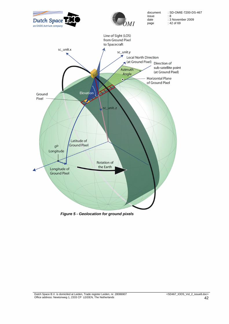
document issue date page
: SD-OMIE-7200-DS-467 : 8 : 3 November 2009 : 42 of 69
Dutch Space B.V. is domiciled at Leiden, Trade register Leiden, nr. 28086907 Office address: Newtonweg 1, 2333 CP LEIDEN, The Netherlands
<SD467_IODS_Vol_2_issue8.doc> 42
Figure 5 - Geolocation for ground pixels

document issue date page
: SD-OMIE-7200-DS-467 : 8 : 3 November 2009 : 43 of 69
Dutch Space B.V. is domiciled at Leiden, Trade register Leiden, nr. 28086907 Office address: Newtonweg 1, 2333 CP LEIDEN, The Netherlands
<SD467_IODS_Vol_2_issue8.doc> 43
6. OMI Level 1B Science Flag Description
In this section a short description of all the quality flags is given that are stored in the OMI Level 1B Products. Large parts of this description are taken from 115H[RD_10] by courtesy of KNMI. A detailed advisory as to how these flags should be interpreted / handled for level 2 programming is beyond the scope of this document, but such an advisory can be found in 116H[RD_13].
6.1 PixelQualityFlags
117HTable 6-1 provides an overview of the Pixel Quality Flags that are stored in the OMI L1B Products. The Pixel Quality Flags are stored for all types of measurement, for each (spectral) pixel in these measurements. Bit Description 0 MISSING flag
Pixel is missing 1 BAD_PIXEL flag
The pixel is classified as a bad pixel due to one or both of the following reasons: 1. the pixel was ADC saturated 2. the pixel is dead according to the dead pixel map in the OPF
2 PROCESSING_ERROR flag A processing error occurred due to one or more of following reasons:
1. a floating point exception handling had to be invoked 2. one of the following algorithms needed exception handling:
a. dark current correction b. exposure smear correction c. relative p2p sensitivity correction d. stray light correction e. (ir)radiance sensitivity correction f. slit irregularity correction g. binning factor division
3 TRANSIENT_PIXEL_WARNING flag The image pixel has been identified as a transient pixel
4 RTS_PIXEL_WARNING flag The image pixel contains one or more pixels showing RTS behaviour as listed in the OPF RTS map
5 SATURATION_POSSIBILITY_WARNING flag The pixel is possibly saturated due to a pixel full well overflow, a register full well overflow, an overflow in the detector module (DEM saturation) or any combination of these
6 NOISE_CALCULATION_WARNING flag During the measurement noise calculation the signal was below zero and was set equal to zero for the purpose of the measurement noise calculation. Note that this flag only indicates a warning for the noise calculation. This flag does not apply to the measured signal.
7 DARK_CURRENT_WARNING flag A check limit was exceeded for the dark current values used for dark current subtraction
8 OFFSET_WARNING flag A check limit was exceeded for the offset value of the applicable gain area for the pixel
9 EXPOSURE_SMEAR_WARNING flag A check limit was exceeded for the exposure smear contribution in the signal
10 STRAY_LIGHT_WARNING flag A check limit was exceeded for the stray light contribution in the signal
11 NON_LIN_WARNING flag The signal is in the non-linear range of the instrument.

document issue date page
: SD-OMIE-7200-DS-467 : 8 : 3 November 2009 : 44 of 69
Dutch Space B.V. is domiciled at Leiden, Trade register Leiden, nr. 28086907 Office address: Newtonweg 1, 2333 CP LEIDEN, The Netherlands
<SD467_IODS_Vol_2_issue8.doc> 44
Bit Description 12 OPF_OFFSET_WARNING flag
The offset correction used a coefficient from the OPF because a dynamic offset value could not be determined.
13 WVL_ASSIGN_WARNING flag Flag indicating that the wavelength assignment does not include the correction for wavelength shifts due to inhomogeneous scenes. 0 = Correction has been applied 1 = Correction could not be applied
14 DEAD_PIXEL_IDENTIFICATION flag (only relevant for Calibration product) Pixel was identified by applicable algorithm as dead pixel in WLS, LED or DARK image
15 DEAD_PIXEL_IDENTIFICATION_ERROR flag (only relevant for Calibration product) The dead pixel identification algorithm could not be applied for this pixel
Table 6-1 Overview of Pixel Quality Flags
From 118HTable 6-1 it is clear that users have available: one MISSING flag, one BAD_PIXEL flag, one PROCESSING_ERROR flag and eleven WARNING flags. Two flags are specifically for the Calibration product.
Each flag shall be set to bit value unity (1) whenever the conditions described in the Table occur. The flags reserved for future use shall be set to bit value zero (0). A value of 0000000000000000 for the PixelQualityFlags indicates that there are no problems.
6.2 GroundPixelQualityFlags
119HTable 6-2 provides an overview of the Ground Pixel Quality Flags. These flags are stored for each ground pixel. For all measurement types other then earth, data is not related to ground pixels, hence there are no ground pixel quality flags. Bit Description 0-3 Land/Water flags
0=Shallow Ocean 1=Land 2=Shallow Inland Water 3=Ocean coastline / Lake shoreline 4=Ephemeral (intermittent) water 5=Deep Inland Water 6=Continental Shelf Ocean 7=Deep Ocean 8-14=Not used 15=Error flag for Land/Water
4 Sun Glint Possibility flag 5 Solar Eclipse possibility flag 6 Geolocation Error flag. The Geolocation Error flag in the GroundPixelQualityFlags indicates
that an error has occurred while determining the value of one or more geolocation fields that are calculated per Ground Pixel, e.g. Latitude and Longitude, Terrain Height, Land / Water and Snow / Ice flags, … Note that there is also a Geolocation Error flag in the MeasurementQualityFlags, which indicates and error while determining the value of one or more geolocation fields that are calculated per measurement or per channel. See section 120H6.3.
7 Geolocation Warning flag. The Geolocation Warning flag indicates that a warning was issued calculating the zenith and azimuth angles. Refraction is not taken into account for the calculation of the line of sight angles or solar angles, therefore these angles are not accurate. Another possibility is a warning issued during calculation of the solar azimuth for the line of sight azimuth. The vector used for calculation is below the horizon and therefore the solar azimuth for the line of sight azimuth could not be calculated.
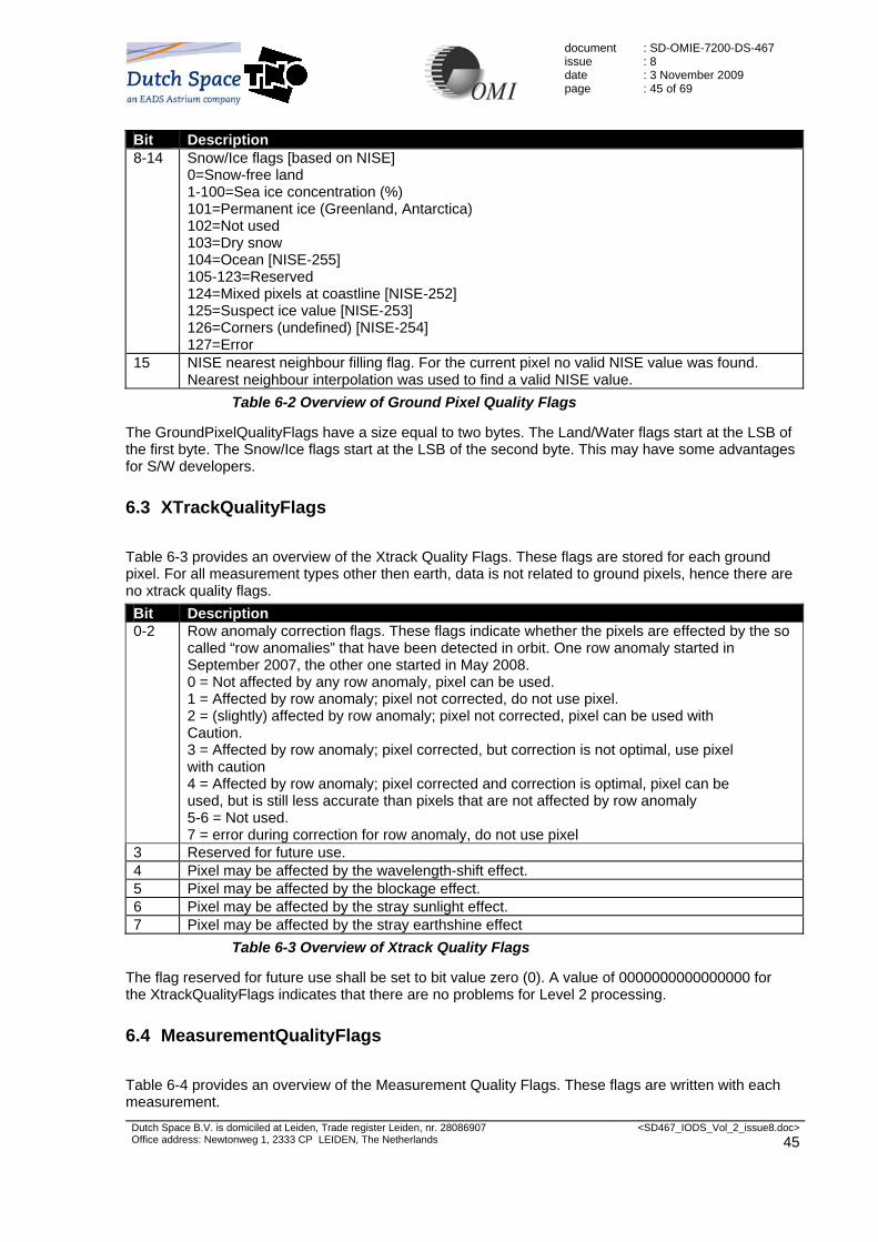
document issue date page
: SD-OMIE-7200-DS-467 : 8 : 3 November 2009 : 45 of 69
Dutch Space B.V. is domiciled at Leiden, Trade register Leiden, nr. 28086907 Office address: Newtonweg 1, 2333 CP LEIDEN, The Netherlands
<SD467_IODS_Vol_2_issue8.doc> 45
Bit Description 8-14 Snow/Ice flags [based on NISE]
0=Snow-free land 1-100=Sea ice concentration (%) 101=Permanent ice (Greenland, Antarctica) 102=Not used 103=Dry snow 104=Ocean [NISE-255] 105-123=Reserved 124=Mixed pixels at coastline [NISE-252] 125=Suspect ice value [NISE-253] 126=Corners (undefined) [NISE-254] 127=Error
15 NISE nearest neighbour filling flag. For the current pixel no valid NISE value was found. Nearest neighbour interpolation was used to find a valid NISE value.
Table 6-2 Overview of Ground Pixel Quality Flags
The GroundPixelQualityFlags have a size equal to two bytes. The Land/Water flags start at the LSB of the first byte. The Snow/Ice flags start at the LSB of the second byte. This may have some advantages for S/W developers.
6.3 XTrackQualityFlags
121HTable 6-3 provides an overview of the Xtrack Quality Flags. These flags are stored for each ground pixel. For all measurement types other then earth, data is not related to ground pixels, hence there are no xtrack quality flags. Bit Description 0-2 Row anomaly correction flags. These flags indicate whether the pixels are effected by the so
called “row anomalies” that have been detected in orbit. One row anomaly started in September 2007, the other one started in May 2008. 0 = Not affected by any row anomaly, pixel can be used. 1 = Affected by row anomaly; pixel not corrected, do not use pixel. 2 = (slightly) affected by row anomaly; pixel not corrected, pixel can be used with Caution. 3 = Affected by row anomaly; pixel corrected, but correction is not optimal, use pixel with caution 4 = Affected by row anomaly; pixel corrected and correction is optimal, pixel can be used, but is still less accurate than pixels that are not affected by row anomaly 5-6 = Not used. 7 = error during correction for row anomaly, do not use pixel
3 Reserved for future use. 4 Pixel may be affected by the wavelength-shift effect. 5 Pixel may be affected by the blockage effect. 6 Pixel may be affected by the stray sunlight effect. 7 Pixel may be affected by the stray earthshine effect
Table 6-3 Overview of Xtrack Quality Flags
The flag reserved for future use shall be set to bit value zero (0). A value of 0000000000000000 for the XtrackQualityFlags indicates that there are no problems for Level 2 processing.
6.4 MeasurementQualityFlags
122HTable 6-4 provides an overview of the Measurement Quality Flags. These flags are written with each measurement.

document issue date page
: SD-OMIE-7200-DS-467 : 8 : 3 November 2009 : 46 of 69
Dutch Space B.V. is domiciled at Leiden, Trade register Leiden, nr. 28086907 Office address: Newtonweg 1, 2333 CP LEIDEN, The Netherlands
<SD467_IODS_Vol_2_issue8.doc> 46
Bit Category Description 0 WARNING Instrument Test Mode flag
This flag implies that OMIS was generating test data and not science data. The output will be in the Calibration product. 0 = Normal Mode 1 = Test Mode
1 ERROR Alternative Engineering Data flag This flag indicates that for the specific measurement the corresponding engineering data were not available so that the GDPS has used alternative engineering data. It cannot be guaranteed that correct engineering data have been used for processing. 0 = Used Original Engineering Data 1 = Used Alternative Engineering Data
2 WARNING Alternating Sequencing Readout flag This flag indicates that the CCD was read out in the alternating mode instead of the pipeline mode that is expected for radiances and irradiances. 0 = Pipeline sequencing readout 1 = Alternating sequencing readout
3 ERROR Co-adder Error flag This flag is set in response to four ELU flags each of which can signal an error. The relevant ELU flags are: Process status, Post process status, Data underflow, Data overflow(s). 0 = No Co-adder Error 1 = Co-adder Error
4 WARNING Invalid Co-addition Period flag This flag indicates that for the specific measurement the MCP does not match an integer times the exposure time. The GDPS has automatically calculated a corrected exposure time and used that calculated time for processing. 0 = No Invalid Co-addition Period 1 = Invalid Co-addition Period
5 WARNING Co-addition Overflow Possibility flag This flag indicates that for the specific measurement the number of co-additions exceeds 16 so that co-adding the 12 bit ROR may cause overflow in the 16 bits AD register. 0 = No co-addition overflow possibility 1 = Co-addition overflow possibility
6 WARNING Measurement Combination flag This flag is set when the output is constructed from multiple measurements. This occurs for unbinned measurements and LONG measurements with LONGEND≠0. In practice this is only relevant for certain measurements written to the Calibration product. 0 = No combination of measurements 1 = Combination of measurements
7 WARNING Rebinning flag Flag indicating that data have been rebinned (spectral/spatial zoom data have been rebinned to match global groundpixels) 0 =No rebinning 1 = Rebinning
8 WARNING Dark Current Correction Processing Option flag Flag indicating whether dark current correction was actually based on a corresponding dark image from the OPF or based on a synthetic dark image. 0 = Corresponding dark image from OPF used for dark subtraction 1 = Synthetic dark constructed from unbinned OPF map used for dark subtraction

document issue date page
: SD-OMIE-7200-DS-467 : 8 : 3 November 2009 : 47 of 69
Dutch Space B.V. is domiciled at Leiden, Trade register Leiden, nr. 28086907 Office address: Newtonweg 1, 2333 CP LEIDEN, The Netherlands
<SD467_IODS_Vol_2_issue8.doc> 47
Bit Category Description 9 WARNING Detector Smear Calculation Processing Option flag
Flag indicating whether the exposure smear correction was based on the assumption of a constant signal during the MCP (using integrated signal over CCD columns) or that the time dependence of the signal was included in an approximate way (using upper/lower smear rows on CCD). 0 = Constant signal approximation used for smear correction measurement 1 = Time-dependent signal approximation used for smear correction measurement
10 WARNING SAA Possibility flag Flag indicating that the sub-satellite point was located within the borders of the South Atlantic Anomaly. This implies that various pixels in the swath, but not necessarily all, may have enhanced noise levels 0 = Not in SAA 1 = In SAA
11 WARNING Spacecraft Maneuver flag Flag indicating that during the measurement the spacecraft was performing a maneuver so that the field-of-view of OMIS deviates from expected 0 = No S/C maneuver during measurements 1 = S/C maneuver during measurements
12 ERROR Geolocation Error flag This flag covers all identified geolocation errors that result from geolocation calculations on measurement level (as opposed to groundpixel level). It applies, e.g., to calculations for the S/C sub-satellite point, SAA-flag, SUN measurements, etc.. 0 = No error 1 = Error Note that there is also a Geolocation Error flag in the GroundPixelQualityFlags, which indicates an error while determining the value of one or more geolocation fields that are calculated for each Ground Pixel. See section 123H6.2.
13 WARNING D/S Gain Offset warning flag Since the offset can drift, dynamically calculated correction coefficients are used when available. When not available, fall-back parameters from the OPF are used instead. The OPF parameters are also used for Long Exposure measurements. 0 = calculated value used 1 = OPF value used
14 WARNING Irradiance measurement azimuth angle clipped flag This flags identifies that the azimuth angle that was used for the delta irradiance algorithm was clipped. Note that the irradiance measurements contain the non-clipped azimuth angle.
15 Reserved for future use Table 6-4 Overview of Measurement Quality Flags
In 124HTable 6-4 the category indicates how the flags should be interpreted for Level 2 processing. Note, however, that the Instrument Operations Team and the calibration team will assign a different interpretation to these flags.
The flag reserved for future use shall be set to bit value zero (0). A value of 0000000000000000 for the MeasurementQualityFlags indicates that there are no problems for Level 2 processing.
Whenever a flag is set in bits 0-4, investigative actions by the Operations and/or Calibration Team are required.

document issue date page
: SD-OMIE-7200-DS-467 : 8 : 3 November 2009 : 48 of 69
Dutch Space B.V. is domiciled at Leiden, Trade register Leiden, nr. 28086907 Office address: Newtonweg 1, 2333 CP LEIDEN, The Netherlands
<SD467_IODS_Vol_2_issue8.doc> 48
7. Coding Examples
7.1 Read Global Radiance Example (C)
The following example is a code fragment in C designed to show users how to read the OMI Level 1B Global Radiance Data Product. #include "hdf.h" #include "HdfEosDef.h" #define FILENAME "OMI-Aura_L1-OML1BRVG_2004m1105t1200-o00123_v001-2004m1105t160000.he4" #define MAX_DIM 3 #define MAX_WAV 1024 int main() { int8 exp[MAX_WAV]; int16 rad[MAX_WAV]; int32 start[MAX_DIM],edges[MAX_DIM], swf_id, sw_id; int32 i, j, k, status, n_times, n_xtrack, n_wavel; float32 lat, lon, radiance[MAX_WAV]; float64 tim; /* open the file and attach the swath * ---------------------------------- */ swf_id = SWopen(FILENAME, DFACC_READ); if (swf_id == FAIL) { fprintf(stderr, "SWopen() failed\n"); exit(-1); } sw_id = SWattach(swf_id, "Earth VIS Swath"); if (sw_id == FAIL) { fprintf(stderr, "SWattach() failed\n"); exit(-1); } /* read the dimensions of the swath * -------------------------------- */ n_xtrack = SWdiminfo(sw_id, "nXtrack"); if (n_xtrack == FAIL) { fprintf(stderr, "SWdiminfo(\"nXtrack\") failed\n"); exit(-1); } n_wavel = SWdiminfo(sw_id, "nWavel"); if (n_wavel == FAIL) { fprintf(stderr, "SWdiminfo(\"nWavel\") failed\n"); exit(-1); }

document issue date page
: SD-OMIE-7200-DS-467 : 8 : 3 November 2009 : 49 of 69
Dutch Space B.V. is domiciled at Leiden, Trade register Leiden, nr. 28086907 Office address: Newtonweg 1, 2333 CP LEIDEN, The Netherlands
<SD467_IODS_Vol_2_issue8.doc> 49
/* the number of measurements (nTimes) is an unlimited * dimension in the swath, therefore we read this number * from the swath attributes * ----------------------------------------------------- */ status = SWreadattr(sw_id, "NumTimes", &n_times); if (status == FAIL) { fprintf(stderr, "SWreadattr() failed\n"); exit(-1); } /* loop over all measurements * -------------------------- */ for (i=0; i<n_times; i++) { /* read the measurement time * ------------------------- */ start[0] = i; edges[0] = 1; status = SWreadfield(sw_id, "Time", start, NULL, edges, &tim); if (status == FAIL) { fprintf(stderr, "SWreadfield(\"Time\") failed\n"); exit(-1); } printf("Time (TAI-93): %f\n", tim); /* loop over all ground pixels * --------------------------- */ for (j=0; j<n_xtrack; j++) { /* read the ground pixel co-ordinates * ---------------------------------- */ start[1] = j; edges[1] = 1; status = SWreadfield(sw_id, "Latitude", start, NULL, edges, &lat); if (status == FAIL) { fprintf(stderr, "SWreadfield(\"Latitude\") failed\n"); exit(-1); } status = SWreadfield(sw_id, "Longitude", start, NULL, edges, &lon); if (status == FAIL) { fprintf(stderr, "SWreadfield(\"Longitude\") failed\n"); exit(-1); } /* read the radiances (mantissa and exponent) * ------------------------------------------ */ start[2] = 0; edges[2] = n_wavel;

document issue date page
: SD-OMIE-7200-DS-467 : 8 : 3 November 2009 : 50 of 69
Dutch Space B.V. is domiciled at Leiden, Trade register Leiden, nr. 28086907 Office address: Newtonweg 1, 2333 CP LEIDEN, The Netherlands
<SD467_IODS_Vol_2_issue8.doc> 50
status = SWreadfield(sw_id, "RadianceMantissa", start, NULL, edges, rad); if (status == FAIL) { fprintf(stderr, "SWreadfield(\"RadianceMantissa\") failed\n"); exit(-1); } status = SWreadfield(sw_id, "RadianceExponent", start, NULL, edges, exp); if (status == FAIL) { fprintf(stderr, "SWreadfield(\"RadianceExponent\") failed\n"); exit(-1); } for (k=0; k<n_wavel; k++) { radiance[k] = rad[k] * pow(10.0, (double)exp[k]); } } } /* detach the swath and close the file * ----------------------------------- */ status = SWdetach(sw_id); if (status == FAIL) { fprintf(stderr, "SWdetach() failed\n"); } status = SWclose(swf_id); if (status == FAIL) { fprintf(stderr, "SWclose() failed\n"); } exit(0); }

document issue date page
: SD-OMIE-7200-DS-467 : 8 : 3 November 2009 : 51 of 69
Dutch Space B.V. is domiciled at Leiden, Trade register Leiden, nr. 28086907 Office address: Newtonweg 1, 2333 CP LEIDEN, The Netherlands
<SD467_IODS_Vol_2_issue8.doc> 51
7.2 Read Global Radiance Example (Fortran)
The following example is a code fragment in Fortran 77 designed to show users how to read the OMI Level 1B Global Radiance Data Product. Note that the order of the dimensions differs from the C version of the example. program readrad implicit none integer*1 int8(8), exp(1024) integer*2 int16(8), rad(1024) integer*4 start(3), stride(3), edges(3), swfid, swid integer*4 i, j, k, status, ntimes, nxtrack, nwavel real*4 lat(8), lon(8), radiance(1024) real*8 tim(8) integer*4 swopen, swattach, swdiminfo, swrdattr integer*4 swrdfld, swdetach, swclose integer DFACC_READ parameter (DFACC_READ = 1) data stride / 1, 1, 1 / C open the file and attach the swath C ----------------------------------
swfid = swopen("OMI-Aura_L1-OML1BRVG_2004m1105t1200-o00123_v001-2004m1105t160000.he4", DFACC_READ)
if (swfid .EQ. -1) then write(*,*) 'swopen() failed' stop endif swid = swattach(swfid, "Earth VIS Swath") if (swid .EQ. -1) then write(*,*) 'swattach() failed' stop endif C read the dimensions of the swath C -------------------------------- nxtrack = swdiminfo(swid, "nXtrack") if (nxtrack .EQ. -1) then write(*,*) 'swdiminfo() failed' stop endif nwavel = swdiminfo(swid, "nWavel") if (nwavel .EQ. -1) then write(*,*) 'swdiminfo() failed' stop endif C the number of measurements (nTimes) is an unlimited C dimension in the swath, therefore we read this number C from the swath attributes C ----------------------------------------------------- status = swrdattr(swid, "NumTimes", ntimes) if (status .EQ. -1) then

document issue date page
: SD-OMIE-7200-DS-467 : 8 : 3 November 2009 : 52 of 69
Dutch Space B.V. is domiciled at Leiden, Trade register Leiden, nr. 28086907 Office address: Newtonweg 1, 2333 CP LEIDEN, The Netherlands
<SD467_IODS_Vol_2_issue8.doc> 52
write(*,*) 'swrdattr() failed' stop endif C loop over all measurements C -------------------------- do i=1, ntimes C read the measurement time C ------------------------- start(1) = i-1 edges(1) = 1 status = swrdfld(swid, "Time", & start, stride, edges, tim) if (status .EQ. -1) then write(*,*) 'swrdfld() failed' stop endif write(*,*) 'Time (TAI-93): ', tim(1) C loop over all ground pixels C --------------------------- do j=1, nxtrack C read the ground pixel co-ordinates C ---------------------------------- start(1) = j-1 edges(1) = 1 start(2) = i-1 edges(2) = 1 status = swrdfld(swid, "Latitude", & start, stride, edges, lat) if (status .EQ. -1) then write(*,*) 'swrdfld() failed' stop endif status = swrdfld(swid, "Longitude", & start, stride, edges, lon) if (status .EQ. -1) then write(*,*) 'swrdfld() failed' stop endif C read the radiances (mantissa and exponent) C ------------------------------------------ start(1) = 0 edges(1) = nwavel start(2) = j-1 edges(2) = 1 start(3) = i-1 edges(3) = 1 status = swrdfld(swid, "RadianceMantissa", & start, stride, edges, rad) if (status .EQ. -1) then write(*,*) 'swrdfld() failed' stop

document issue date page
: SD-OMIE-7200-DS-467 : 8 : 3 November 2009 : 53 of 69
Dutch Space B.V. is domiciled at Leiden, Trade register Leiden, nr. 28086907 Office address: Newtonweg 1, 2333 CP LEIDEN, The Netherlands
<SD467_IODS_Vol_2_issue8.doc> 53
endif status = swrdfld(swid, "RadianceExponent", & start, stride, edges, exp) if (status .EQ. -1) then write(*,*) 'swrdfld() failed' stop endif do k=1, nwavel radiance(k) = rad(k) * 10.0**exp(k) enddo enddo enddo C detach the swath and close the file C ----------------------------------- status = swdetach(swid) if (status .EQ. -1) then write(*,*) 'swdetach() failed' endif status = swclose(swfid) if (status .EQ. -1) then write(*,*) 'swclose() failed' endif end

document issue date page
: SD-OMIE-7200-DS-467 : 8 : 3 November 2009 : 54 of 69
Dutch Space B.V. is domiciled at Leiden, Trade register Leiden, nr. 28086907 Office address: Newtonweg 1, 2333 CP LEIDEN, The Netherlands
<SD467_IODS_Vol_2_issue8.doc> 54
8. Metadata
The OMI Level 1B products that are the result of nominal, PDS processing are created with metadata. For OMI Level 1B products that are the result of EDS and / or RBDS processing, also metadata is written, but not all fields that are described in this section may be filled in. This section describes metadata for Level 1B products from nominal, PDS processing only. For EDS and RBDS processing, metadata will also be generated, but not all fields specified here may be present and / or contain proper values.
The metadata attributes are split up into four categories:
- Inventory level metadata attributes are standard (i.e. defined by ECS) metadata which are typically different for each granule and which are searchable. Inventory metadata are stored in the CoreMetadata.0 file attribute of the OMI Level 1B products.
- PSAs (Product Specific Attributes) are also inventory level metadata, but are non-standard (i.e. defined by the project scientists). PSAs are searchable and are stored in the CoreMetadata.0 file attribute of the OMI Level 1B products.
- Collection level metadata are standard metadata, which do not (or seldom) change during the mission of the instrument. Rather then describing (the contents of) a single product, the collection level metadata describe the contents of all products that are generated during the mission. Collection level metadata are searchable, but since the metadata are static, they are not stored in the OMI Level 1B products.
- Archive level metadata are non-standard metadata. The archive level metadata are not searchable and are stored in the ArchiveMetadata.0 file attribute of the OMI Level 1B products.
The tables contained in this section follow convention used by ECS. Refer to 125H[RD_20] for some more backgrounds on these convention and terminology that is used.

document issue date page
: SD-OMIE-7200-DS-467 : 8 : 3 November 2009 : 55 of 69
Dutch Space B.V. is domiciled at Leiden, Trade register Leiden, nr. 28086907 Office address: Newtonweg 1, 2333 CP LEIDEN, The Netherlands
<SD467_IODS_Vol_2_issue8.doc> 55
8.1 Collection Metadata
126HTable 8-1 provides an overview of the collection metadata for each of the OMI Level 1B products. Note that this data is not stored with the data products themselves, but only for the entire collection of L1B products. All of the fields in the table are present for each of the products, but population of the metadata can differ per product.
ESDT Object or Group Name
Data_Location
Type / Size
Mandatory
Class
NU
M_VA
L
OML1BRUG population OML1BRUZ population OML1BRVG population OML1BRVZ population OML1BIRR population OML1BCAL population Description
Collection metadata DLLName "MCF" VA255 "TRUE" 1 e.g.
"libDsESDTOmOMIPoly.001Sh.so"
e.g. "libDsESDTOmOMIPoly.001Sh.so"
e.g. "libDsESDTOmOMIPoly.001Sh.so"
e.g. "libDsESDTOmOMIPoly.001Sh.so"
e.g. "libDsESDTSyBASIC.001Sh.so"
e.g. "libDsESDTSyBASIC.001Sh.so"
SpatialSearchType "MCF" VA40 "TRUE" 1 "Orbit" "Orbit" "Orbit" "Orbit" "Orbit" "Orbit" ShortName "MCF" A8 "TRUE" 1 "OML1BRUG" "OML1BRUZ" "OML1BRVG" "OML1BRVZ" "OML1BIRR" "OML1BCAL" This name will identify the short name associated with
the collection or granule. This includes the ECS Technical Baseline product names, i.e. CER02, MOD12, etc. This is the official reference name used in identifying the contents of the data collection.
LongName "MCF" VA80 "TRUE" 1 "OMI/Aura Level 1B UV Global Geolocated Earthshine Radiances"
"OMI/Aura Level 1B UV Zoom-in Geolocated Earthshine Radiances"
"OMI/Aura Level 1B VIS Global Geolocated Earthshine Radiances"
"OMI/Aura Level 1B VIS Zoom-in Geolocated Earthshine Radiances"
"OMI/Aura Level 1B Averaged Solar Irradiances"
"OMI/Aura Level 1B UV-VIS Calibration Product"
This attribute will identify the long name associated with the collection.This includes dataset name/product name.This is the reference name used in describing the scientific contents of the data collection;it is not the 'id'of the data.
CollectionDescription "MCF" VA255 "TRUE" 1 "OMI Geolocated Earth Radiances from Ultra Violet Channel (270 - 380 nm)"
"OMI Zoom-in Geolocated Earth Radiances from Ultra Violet Channel (270 - 380 nm)"
"OMI Geolocated Earth Radiances from Visible Channel (350 - 500 nm)"
"OMI Zoom-in Geolocated Earth Radiances from Visible Channel (350 - 500 nm)"
"OMI Solar Irradiances from Ultra Violet and Visible Channels (270 - 500 nm)"
"OMI Corrected and Uncorrected Calibration Data"
This attribute identifies the major emphasis of the content of the collection.Some examples are:'cloud top products generated from instrument X',or 'all products containing the parameter sea surface temperature as skin temp'.
VersionID "MCF" I "TRUE" 1 1 1 1 1 1 1 Version identifier of the data collection. RevisionDate "MCF" D "TRUE" 1 e.g. "2001-10-25" e.g. "2001-10-25" e.g. "2001-10-25" e.g. "2001-10-25" e.g. "2001-10-25" e.g. "2001-10-25" Represents the date and possibly the time that this
directory entry was created or the latest date and time of its modification or update.
SuggestedUsage "MCF" VA500 "TRUE" 1 "Science Research" "Science Research" "Science Research" "Science Research" "Science Research" "Science Research" This attribute describes how this collection or granule may be best used to support earth science/global change research.
ProcessingCenter "MCF" VA20 "TRUE" 1 e.g. "OMI SIPS" e.g. "OMI SIPS" e.g. "OMI SIPS" e.g. "OMI SIPS" e.g. "OMI SIPS" e.g. "OMI SIPS" Center where collection was or is being processed.i.e.name of DAAC or SCF.
ArchiveCenter "MCF" VA20 "TRUE" 1 "GSFC" "GSFC" "GSFC" "GSFC" "GSFC" "GSFC" Center where collection is archived. VersionDescription "MCF" VA255 "TRUE" 1 "Pre-launch test using
simulated and on-ground acquired data"
"Pre-launch test using simulated and on-ground acquired data"
"Pre-launch test using simulated and on-ground acquired data"
"Pre-launch test using simulated and on-ground acquired data"
"Pre-launch test using simulated and on-ground acquired data"
"Pre-launch test using simulated and on-ground acquired data"
A brief description of the differences between this collection version and another collection version.
CitationforExternalPublication
"MCF" VA255 "TRUE" 1 "OMI data contained herein were obtained through joined research between the Netherlands (NIVR/KNMI), Finland (FMI), and the U.S. (NASA) in the Earth Observing System (EOS) Aura Mission"
"OMI data contained herein were obtained through joined research between the Netherlands (NIVR/KNMI), Finland (FMI), and the U.S. (NASA) in the Earth Observing System (EOS) Aura Mission"
"OMI data contained herein were obtained through joined research between the Netherlands (NIVR/KNMI), Finland (FMI), and the U.S. (NASA) in the Earth Observing System (EOS) Aura Mission"
"OMI data contained herein were obtained through joined research between the Netherlands (NIVR/KNMI), Finland (FMI), and the U.S. (NASA) in the Earth Observing System (EOS) Aura Mission"
"OMI data contained herein were obtained through joined research between the Netherlands (NIVR/KNMI), Finland (FMI), and the U.S. (NASA) in the Earth Observing System (EOS) Aura Mission"
"OMI data contained herein were obtained through joined research between the Netherlands (NIVR/KNMI), Finland (FMI), and the U.S. (NASA) in the Earth Observing System (EOS) Aura Mission"
The recommended reference to be used when referring to this collection in publications. Its format is free text, but should include: Orginator (the name of an organization or individual that developed the data set, where Editor(s)' names are followed by (ed.) and Compiler(s)' names are followed by (comp.)); Publication date (the date of publication or release of the data set); Title (the name by which document can be referenced).
CollectionState "MCF" A10 "TRUE" 1 "In Work" "In Work" "In Work" "In Work" "In Work" "In Work" This attribute describes the state of the collection, whether it is planned but not yet existent, partially complete due to continual additions from remotely sensed data/processing/reprocessing, or is considered a complete product/dataset.
MaintenanceandUpdateFrequency
"MCF" VA80 "TRUE" 1 "Continually" "Continually" "Continually" "Continually" "Continually" "Continually" The frequency with which changes and additions are made to the collection after the initial dataset begins to be collected/processed.
SpatialCoverageType "MCF" A10 "TRUE" 1 "Horizontal" "Horizontal" "Horizontal" "Horizontal" "Horizontal" "Horizontal" This attribute denotes whether the locality/coverage requires horizontal, vertical, or both in the spatial domain and coordinate system definitions.

document issue date page
: SD-OMIE-7200-DS-467 : 8 : 3 November 2009 : 56 of 69
Dutch Space B.V. is domiciled at Leiden, Trade register Leiden, nr. 28086907 Office address: Newtonweg 1, 2333 CP LEIDEN, The Netherlands
<SD467_IODS_Vol_2_issue8.doc> 56
ESDT Object or Group Name
Data_Location
Type / Size
Mandatory
Class
NU
M_VA
L
OML1BRUG population OML1BRUZ population OML1BRVG population OML1BRVZ population OML1BIRR population OML1BCAL population Description
WestBoundingCoordinate
"MCF" LF "TRUE" 1 -180 -180 -180 -180 -180 -180 Western-most coordinate of the limit of coverage expressed in longitude.
NorthBoundingCoordinate
"MCF" LF "TRUE" 1 90 90 90 90 90 90 Northern-most coordinate of the limit of coverage expressed in geodetic latitude.
EastBoundingCoordinate
"MCF" LF "TRUE" 1 180 180 180 180 180 180 Eastern-most limit of coverage expressed in longitude.
SouthBoundingCoordinate
"MCF" LF "TRUE" 1 -90 -90 -90 -90 -90 -90 Southern-most limit of coverage expressed in geodetic latitude.
TimeType "MCF" A10 "TRUE" 1 "UTC" "UTC" "UTC" "UTC" "UTC" "UTC" This attribute provides the time system which the values found in temporal subclasses represent.
DateType "MCF" A10 "TRUE" 1 "Gregorian" "Gregorian" "Gregorian" "Gregorian" "Gregorian" "Gregorian" This attribute specifies the type of date represented by the value in the date attributes of the temporal subclasses.
TemporalRangeType "MCF" VA30 "TRUE" 1 "Continuous Range" "Continuous Range" "Continuous Range" "Continuous Range" "Continuous Range" "Continuous Range" This attribute tells the system and ultimately the end user how temporal coverage is specified for the collection, granule, or event.
PrecisionofSeconds "MCF" I "TRUE" 1 1 1 1 1 1 1 EndsatPresentFlag "MCF" A1 "TRUE" 1 "Y" "Y" "Y" "Y" "Y" "Y" This attribute will denote that a data collection which
covers, temporally, a discontinuous range, currently ends at the present date. This way, the granules which comprise the data collection that are continuously being added to inventory need not update the data collection metadata for each one.
RangeBeginningDate "MCF" T "TRUE" 1 "2004-06-01" "2004-06-01" "2004-06-01" "2004-06-01" "2004-06-01" "2004-06-01" The year (and optionally month,or month and day) when the temporal coverage period being described began.
RangeBeginningTime "MCF" T "TRUE" 1 "00:00:00.000000" "00:00:00.000000" "00:00:00.000000" "00:00:00.000000" "00:00:00.000000" "00:00:00.000000" The first hour (and optionally minute, or minute and second) of the temporal coverage period being described.
RangeEndingDate "MCF" D "TRUE" 1 "2004-06-01" "2004-06-01" "2004-06-01" "2004-06-01" "2004-06-01" "2004-06-01" The last year (and optionally month,or month and day) of the temporal coverage period being described.
RangeEndingTime "MCF" D "TRUE" 1 "00:00:00.000000" "00:00:00.000000" "00:00:00.000000" "00:00:00.000000" "00:00:00.000000" "00:00:00.000000" The last hour (and optionally minute,or minute and second) of the temporal coverage period being described for granule or collection.
ContactOrganizationContainer
"NONE" "TRUE" "1"
Role "MCF" VA20 "TRUE" "1" 1 "Archive" "Archive" "Archive" "Archive" "Archive" "Archive" Classification of individuals who are associated with a given data set.
HoursofService "MCF" VA255 "TRUE" "1" 1 "08:00:00 to 18:00:00 EDT (- 0500 GMT)"
"08:00:00 to 18:00:00 EDT (- 0500 GMT)"
"08:00:00 to 18:00:00 EDT (- 0500 GMT)"
"08:00:00 to 18:00:00 EDT (- 0500 GMT)"
"08:00:00 to 18:00:00 EDT (- 0500 GMT)"
"08:00:00 to 18:00:00 EDT (- 0500 GMT)"
Time period when individuals can speak to the organization or individuals.
ContactInstructions "MCF" VA255 "TRUE" "1" 1 "Contact for format/distribution issues"
"Contact for format/distribution issues"
"Contact for format/distribution issues"
"Contact for format/distribution issues"
"Contact for format/distribution issues"
"Contact for format/distribution issues"
Supplemental instructions on how or when to contact the individual or organization.
ContactOrganizationName
"MCF" VA255 "TRUE" "1" 1 "Goddard DAAC User Services"
"Goddard DAAC User Services"
"Goddard DAAC User Services"
"Goddard DAAC User Services"
"Goddard DAAC User Services"
"Goddard DAAC User Services"
The organization and the member of the organization, associated with the data set. Used in cases where the association of the organization to the data set is more significant than the association of the person to the data set.
ContactOrganizationAddress
"1"
ContactOrganizationAddressContainer
"NONE" "TRUE" "1"
StreetAddress "MCF" VA80 "TRUE" "1" 1 "NASA/GSFC Code 902" "NASA/GSFC Code 902" "NASA/GSFC Code 902" "NASA/GSFC Code 902" "NASA/GSFC Code 902" "NASA/GSFC Code 902" An address line for the address, used for mailing or physical addresses of organizations or individuals who serve as points of contact.
City "MCF" VA30 "TRUE" "1" 1 "GREENBELT" "GREENBELT" "GREENBELT" "GREENBELT" "GREENBELT" "GREENBELT" The city of the person or organization. StateProvince "MCF" VA30 "TRUE" "1" 1 "MD" "MD" "MD" "MD" "MD" "MD" The state or province of the address. PostalCode "MCF" VA20 "TRUE" "1" 1 "20771" "20771" "20771" "20771" "20771" "20771" The zip or other postal code of the address. Country "MCF" VA10 "TRUE" "1" 1 "USA" "USA" "USA" "USA" "USA" "USA" The country of the address. OrganizationTelephone "1" OrganizationTelephoneContainer
"NONE" "TRUE" "1"

document issue date page
: SD-OMIE-7200-DS-467 : 8 : 3 November 2009 : 57 of 69
Dutch Space B.V. is domiciled at Leiden, Trade register Leiden, nr. 28086907 Office address: Newtonweg 1, 2333 CP LEIDEN, The Netherlands
<SD467_IODS_Vol_2_issue8.doc> 57
ESDT Object or Group Name
Data_Location
Type / Size
Mandatory
Class
NU
M_VA
L
OML1BRUG population OML1BRUZ population OML1BRVG population OML1BRVZ population OML1BIRR population OML1BCAL population Description
TelephoneNumber "MCF" VA23 "TRUE" "1" 1 "301-614-5473" "301-614-5473" "301-614-5473" "301-614-5473" "301-614-5473" "301-614-5473" Number of organization or individual who is point of contact.The general format of the number includes country, area, and STD codes, as required for the full telephone number. Multi-extensions should be single entries rather than part of a single entry text.
TelephoneNumberType "MCF" A10 "TRUE" "1" 1 "Voice" "Voice" "Voice" "Voice" "Voice" "Voice" The type of telephone number being provided in this instance of the phone number, in order to reach the organization or individual who serves as a point of contact. Voice number is used to speak to the organization or individual, the TDD/TTY number which hearing-impaired can converse with the organization or individual, or the fa(x)csimile number of the organizations or individuals.
OrganizationTelephoneContainer
"NONE" "TRUE" "2"
TelephoneNumber "MCF" VA23 "TRUE" "2" 1 "301-614-5304" "301-614-5304" "301-614-5304" "301-614-5304" "301-614-5304" "301-614-5304" Number of organization or individual who is point of contact.The general format of the number includes country, area, and STD codes,as required for the full telephone number.Multi-extensions should be single entries rather than part of a single entry text.
TelephoneNumberType "MCF" A10 "TRUE" "2" 1 "Facsimile" "Facsimile" "Facsimile" "Facsimile" "Facsimile" "Facsimile" The type of telephone number being provided in this instance of the phone number, in order to reach the organization or individual who serves as a point of contact. Voice number is used to speak to the organization or individual, the TDD/TTY number which hearing-impaired can converse with the organization or individual, or the fa(x)csimile number of the organizations or individuals.
OrganizationEmail "1" ElectronicMailAddress "MCF" VA255 "TRUE" 1 "[email protected]
.ecs.nasa.gov" "[email protected]"
The address of the electronic mailbox of the organization or individual. The address, following NASA Global Change Master Directory format, should be of the form 'network name>network address'. Examples of network names are NSN, SPAN, telemail, ARPANET, and Internet. Examples of network addresses are NSSDCA::NG, MIKEMARTIN/NASA, [email protected], or [email protected].
ContactOrganizationContainer
"NONE" "TRUE" "2"
Role "MCF" VA20 "TRUE" "2" 1 "Producer" "Producer" "Producer" "Producer" "Producer" "Producer" Classification of individuals who are associated with a given data set.
HoursofService "MCF" VA255 "TRUE" "2" 1 "09:00:00 to 17:00:00 CET (+ 0100 GMT)"
"09:00:00 to 17:00:00 CET (+ 0100 GMT)"
"09:00:00 to 17:00:00 CET (+ 0100 GMT)"
"09:00:00 to 17:00:00 CET (+ 0100 GMT)"
"09:00:00 to 17:00:00 CET (+ 0100 GMT)"
"09:00:00 to 17:00:00 CET (+ 0100 GMT)"
Time period when individuals can speak to the organization or individuals.
ContactInstructions "MCF" VA255 "TRUE" "2" 1 "Contact for general questions regarding the OMI project"
"Contact for general questions regarding the OMI project"
"Contact for general questions regarding the OMI project"
"Contact for general questions regarding the OMI project"
"Contact for general questions regarding the OMI project"
"Contact for general questions regarding the OMI project"
Supplemental instructions on how or when to contact the individual or organization.
ContactOrganizationName
"MCF" VA255 "TRUE" "2" 1 "NIVR" "NIVR" "NIVR" "NIVR" "NIVR" "NIVR" The organization and the member of the organization, associated with the data set. Used in cases where the association of the organization to the data set is more significant than the association of the person to the data set.
ContactOrganizationAddress
"2"
ContactOrganizationAddressContainer
"NONE" "TRUE" "1"
StreetAddress "MCF" VA80 "TRUE" "1" 1 "P.O. Box 35" "P.O. Box 35" "P.O. Box 35" "P.O. Box 35" "P.O. Box 35" "P.O. Box 35" An address line for the address, used for mailing or physical addresses of organizations or individuals who serve as points of contact.
City "MCF" VA30 "TRUE" "1" 1 "Delft" "Delft" "Delft" "Delft" "Delft" "Delft" The city of the person or organization. StateProvince "MCF" VA30 "TRUE" "1" 1 "ZH" "ZH" "ZH" "ZH" "ZH" "ZH" The state or province of the address. PostalCode "MCF" VA20 "TRUE" "1" 1 "NL-2600AA" "NL-2600AA" "NL-2600AA" "NL-2600AA" "NL-2600AA" "NL-2600AA" The zip or other postal code of the address. Country "MCF" VA10 "TRUE" "1" 1 "NLD" "NLD" "NLD" "NLD" "NLD" "NLD" The country of the address.

document issue date page
: SD-OMIE-7200-DS-467 : 8 : 3 November 2009 : 58 of 69
Dutch Space B.V. is domiciled at Leiden, Trade register Leiden, nr. 28086907 Office address: Newtonweg 1, 2333 CP LEIDEN, The Netherlands
<SD467_IODS_Vol_2_issue8.doc> 58
ESDT Object or Group Name
Data_Location
Type / Size
Mandatory
Class
NU
M_VA
L
OML1BRUG population OML1BRUZ population OML1BRVG population OML1BRVZ population OML1BIRR population OML1BCAL population Description
OrganizationTelephone "2" OrganizationTelephoneContainer
"NONE" "TRUE" "1"
TelephoneNumber "MCF" VA23 "TRUE" "1" 1 "+31-15-2788025" "+31-15-2788025" "+31-15-2788025" "+31-15-2788025" "+31-15-2788025" "+31-15-2788025" Number of organization or individual who is point of contact.The general format of the number includes country, area, and STD codes, as required for the full telephone number. Multi-extensions should be single entries rather than part of a single entry text.
TelephoneNumberType "MCF" A10 "TRUE" "1" 1 "Voice" "Voice" "Voice" "Voice" "Voice" "Voice" The type of telephone number being provided in this instance of the phone number, in order to reach the organization or individual who serves as a point of contact. Voice number is used to speak to the organization or individual, the TDD/TTY number which hearing-impaired can converse with the organization or individual, or the fa(x)csimile number of the organizations or individuals.
OrganizationTelephoneContainer
"NONE" "TRUE" "2"
TelephoneNumber "MCF" VA23 "TRUE" "2" 1 "+31-15-2623096" "+31-15-2623096" "+31-15-2623096" "+31-15-2623096" "+31-15-2623096" "+31-15-2623096" Number of organization or individual who is point of contact.The general format of the number includes country, area, and STD codes,as required for the full telephone number.Multi-extensions should be single entries rather than part of a single entry text.
TelephoneNumberType "MCF" A10 "TRUE" "2" 1 "Facsimile" "Facsimile" "Facsimile" "Facsimile" "Facsimile" "Facsimile" The type of telephone number being provided in this instance of the phone number, in order to reach the organization or individual who serves as a point of contact. Voice number is used to speak to the organization or individual, the TDD/TTY number which hearing-impaired can converse with the organization or individual, or the fa(x)csimile number of the organizations or individuals.
OrganizationEmail "2" ElectronicMailAddress "MCF" VA255 "TRUE" 1 "[email protected]" "[email protected]" "[email protected]" "[email protected]" "[email protected]" "[email protected]" The address of the electronic mailbox of the organization
or individual. The address, following NASA Global Change Master Directory format, should be of the form 'network name>network address'. Examples of network names are NSN, SPAN, telemail, ARPANET, and Internet. Examples of network addresses are NSSDCA::NG, MIKEMARTIN/NASA, [email protected], or [email protected].
DisciplineTopicParametersContainer
"NONE" "TRUE" "1"
ECSDisciplineKeyword "MCF" VA24 "TRUE" "1" 1 "Earth Science" "Earth Science" "Earth Science" "Earth Science" "Earth Science" "Earth Science" Keyword used to describe the general discipline area of the collection.A collection can conceivably cover several disciplines.
ECSTopicKeyword "MCF" VA32 "TRUE" "1" 1 "Atmosphere" "Atmosphere" "Atmosphere" "Atmosphere" "Atmosphere" "Atmosphere" Keyword used to describe the general topic area of the collection.A collection can conceivably cover several topics.
ECSTermKeyword "MCF" VA50 "TRUE" "1" 1 "Atmospheric Radiation" "Atmospheric Radiation" "Atmospheric Radiation" "Atmospheric Radiation" "Atmospheric Radiation" "Atmospheric Radiation" Keyword used to describe the science parameter area of the collection.A collection can conceivably cover many such parameters.

document issue date page
: SD-OMIE-7200-DS-467 : 8 : 3 November 2009 : 59 of 69
Dutch Space B.V. is domiciled at Leiden, Trade register Leiden, nr. 28086907 Office address: Newtonweg 1, 2333 CP LEIDEN, The Netherlands
<SD467_IODS_Vol_2_issue8.doc> 59
ESDT Object or Group Name
Data_Location
Type / Size
Mandatory
Class
NU
M_VA
L
OML1BRUG population OML1BRUZ population OML1BRVG population OML1BRVZ population OML1BIRR population OML1BCAL population Description
ECSVariableKeyword "MCF" VA80 "TRUE" "1" 1 "Radiative Flux" "Radiative Flux" "Radiative Flux" "Radiative Flux" "Solar Irradiance" "Radiative Flux" Keyword used to describe the specific science parameter content of the collection. A collection can conceivably cover many specific parameters. The keyword valids are the lowest level physical parameter terms which are normally searched by a user; i.e. a user enters a keyword which when found may connect with one or more parameters from collections. The keywords are also the lowest level words which describe product content without being the server specific measurement (held in Parameter class). While there is a controlled list of these parameters held by GCMD, additions can be made by an as yet unspecified configuration control process.
ProcessingLevelDescription
"MCF" VA80 "TRUE" 1 "Level 1B Radiances" "Level 1B Radiances" "Level 1B Radiances" "Level 1B Radiances" "Level 1B Irradiances" "Sensor Measurements" This attribute provides a set of characteristics that can be combined to define science processing levels which do not conform to the standards found in ProcessingLevelID.
ProcessingLevelID "MCF" A6 "TRUE" 1 "1B" "1B" "1B" "1B" "1B" "1B" This attribute reflects the classification of the science data processing level, which defines in general terms the characteristics of the output of the processing performed.
PlatformContainer "NONE" "TRUE" "1" PlatformShortName "MCF" VA20 "TRUE" "1" 1 "Aura" "Aura" "Aura" "Aura" "Aura" "Aura" The unique platform name.(e.g.GOES-8). PlatformLongName "MCF" VA80 "TRUE" "1" 1 "EOS Aura Mission Satellite" "EOS Aura Mission Satellite" "EOS Aura Mission Satellite" "EOS Aura Mission Satellite" "EOS Aura Mission Satellite" "EOS Aura Mission Satellite" The expanded or long name of the platform associated
with an instrument. PlatformType "MCF" VA20 "TRUE" "1" 1 "Spacecraft" "Spacecraft" "Spacecraft" "Spacecraft" "Spacecraft" "Spacecraft" PlatformCharacteristic "1" PlatformCharacteristicContainer
"NONE" "TRUE" "1"
PlatformCharacteristicName
"MCF" VA40 "TRUE" "1" 1 "OrbitInclination" "OrbitInclination" "OrbitInclination" "OrbitInclination" "OrbitInclination" "OrbitInclination" The name of the Platform Characteristic attribute.
PlatformCharacteristicDescription
"MCF" VA80 "TRUE" "1" 1 "Angle between the orbit plane and the Earth's equatorial plane"
"Angle between the orbit plane and the Earth's equatorial plane"
"Angle between the orbit plane and the Earth's equatorial plane"
"Angle between the orbit plane and the Earth's equatorial plane"
"Angle between the orbit plane and the Earth's equatorial plane"
"Angle between the orbit plane and the Earth's equatorial plane"
Description of the Platform Characteristic attribute.
PlatformCharacteristicDataType
"MCF" A8 "TRUE" "1" 1 "float" "float" "float" "float" "float" "float" The datatype of the Platform Characteristic/attribute defined by PlatformCharacteristicName.
PlatformCharacteristicUnit
"MCF" VA20 "TRUE" "1" 1 "Degrees" "Degrees" "Degrees" "Degrees" "Degrees" "Degrees" Units associated with the Platform Characteristic attribute value.
PlatformCharacteristicValueClass
"1"
PlatformCharacteristicValue
"MCF" VA20 "TRUE" "1" 1 "98.2" "98.2" "98.2" "98.2" "98.2" "98.2" The value of the characteristic/attribute defined in PlatformCharacteristic. Attributes must have single values.(e.g. Model Number =209).
Instrument "1" InstrumentContainer "NONE" "TRUE" "1" InstrumentShortName "MCF" VA20 "TRUE" "1" 1 "OMI" "OMI" "OMI" "OMI" "OMI" "OMI" The unique identifier of an instrument (e.g. ASTER,
AVHRR-3, CERES, Human). InstrumentLongName "MCF" VA80 "TRUE" "1" 1 "Ozone Monitoring
Instrument" "Ozone Monitoring Instrument"
"Ozone Monitoring Instrument"
"Ozone Monitoring Instrument"
"Ozone Monitoring Instrument"
"Ozone Monitoring Instrument"
The expanded name of the primary sensory instrument (e.g. Advanced Spaceborne Thermal Emission and Reflective Radiometer, Clouds and the Earth's Radiant Energy System, Human Observation).
InstrumentTechnique "MCF" VA80 "TRUE" "1" 1 "Nadir-Viewing Cross-Track Imaging Spectroradiometry"
"Nadir-Viewing Cross-Track Imaging Spectroradiometry"
"Nadir-Viewing Cross-Track Imaging Spectroradiometry"
"Nadir-Viewing Cross-Track Imaging Spectroradiometry"
"Nadir-Viewing Cross-Track Imaging Spectroradiometry"
"Nadir-Viewing Cross-Track Imaging Spectroradiometry"
The instrument method or procedure (e.g. radiometer, manual enumeration).
NumberofSensors "MCF" I "TRUE" "1" 1 2 2 2 2 2 2 The number of discrete (if any) sensors on an instrument.
Sensor "1" SensorContainer "NONE" "TRUE" "1"
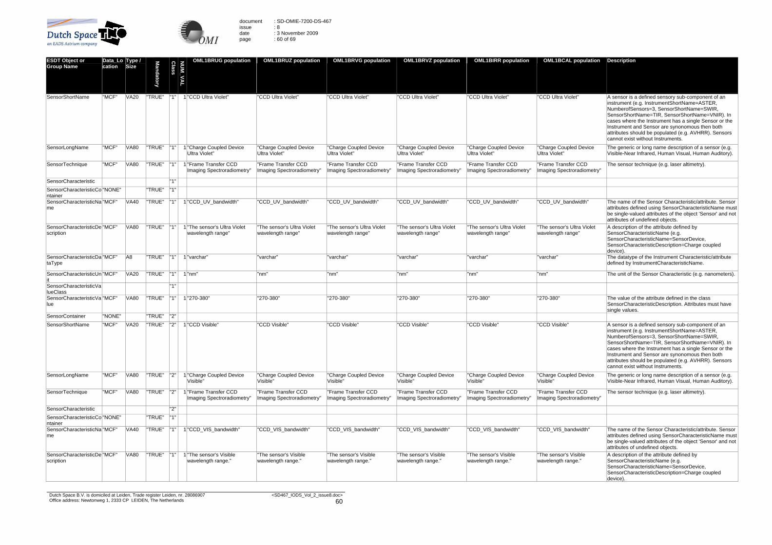
document issue date page
: SD-OMIE-7200-DS-467 : 8 : 3 November 2009 : 60 of 69
Dutch Space B.V. is domiciled at Leiden, Trade register Leiden, nr. 28086907 Office address: Newtonweg 1, 2333 CP LEIDEN, The Netherlands
<SD467_IODS_Vol_2_issue8.doc> 60
ESDT Object or Group Name
Data_Location
Type / Size
Mandatory
Class
NU
M_VA
L
OML1BRUG population OML1BRUZ population OML1BRVG population OML1BRVZ population OML1BIRR population OML1BCAL population Description
SensorShortName "MCF" VA20 "TRUE" "1" 1 "CCD Ultra Violet" "CCD Ultra Violet" "CCD Ultra Violet" "CCD Ultra Violet" "CCD Ultra Violet" "CCD Ultra Violet" A sensor is a defined sensory sub-component of an instrument (e.g. InstrumentShortName=ASTER, NumberofSensors=3, SensorShortName=SWIR, SensorShortName=TIR, SensorShortName=VNIR). In cases where the Instrument has a single Sensor or the Instrument and Sensor are synonomous then both attributes should be populated (e.g. AVHRR). Sensors cannot exist without Instruments.
SensorLongName "MCF" VA80 "TRUE" "1" 1 "Charge Coupled Device Ultra Violet"
"Charge Coupled Device Ultra Violet"
"Charge Coupled Device Ultra Violet"
"Charge Coupled Device Ultra Violet"
"Charge Coupled Device Ultra Violet"
"Charge Coupled Device Ultra Violet"
The generic or long name description of a sensor (e.g. Visible-Near Infrared, Human Visual, Human Auditory).
SensorTechnique "MCF" VA80 "TRUE" "1" 1 "Frame Transfer CCD Imaging Spectroradiometry"
"Frame Transfer CCD Imaging Spectroradiometry"
"Frame Transfer CCD Imaging Spectroradiometry"
"Frame Transfer CCD Imaging Spectroradiometry"
"Frame Transfer CCD Imaging Spectroradiometry"
"Frame Transfer CCD Imaging Spectroradiometry"
The sensor technique (e.g. laser altimetry).
SensorCharacteristic "1" SensorCharacteristicContainer
"NONE" "TRUE" "1"
SensorCharacteristicName
"MCF" VA40 "TRUE" "1" 1 "CCD_UV_bandwidth" "CCD_UV_bandwidth" "CCD_UV_bandwidth" "CCD_UV_bandwidth" "CCD_UV_bandwidth" "CCD_UV_bandwidth" The name of the Sensor Characteristic/attribute. Sensor attributes defined using SensorCharacteristicName must be single-valued attributes of the object 'Sensor' and not attributes of undefined objects.
SensorCharacteristicDescription
"MCF" VA80 "TRUE" "1" 1 "The sensor's Ultra Violet wavelength range"
"The sensor's Ultra Violet wavelength range"
"The sensor's Ultra Violet wavelength range"
"The sensor's Ultra Violet wavelength range"
"The sensor's Ultra Violet wavelength range"
"The sensor's Ultra Violet wavelength range"
A description of the attribute defined by SensorCharacteristicName (e.g. SensorCharacteristicName=SensorDevice, SensorCharacteristicDescription=Charge coupled device).
SensorCharacteristicDataType
"MCF" A8 "TRUE" "1" 1 "varchar" "varchar" "varchar" "varchar" "varchar" "varchar" The datatype of the Instrument Characteristic/attribute defined by InstrumentCharacteristicName.
SensorCharacteristicUnit
"MCF" VA20 "TRUE" "1" 1 "nm" "nm" "nm" "nm" "nm" "nm" The unit of the Sensor Characteristic (e.g. nanometers).
SensorCharacteristicValueClass
"1"
SensorCharacteristicValue
"MCF" VA80 "TRUE" "1" 1 "270-380" "270-380" "270-380" "270-380" "270-380" "270-380" The value of the attribute defined in the class SensorCharacteristicDescription. Attributes must have single values.
SensorContainer "NONE" "TRUE" "2" SensorShortName "MCF" VA20 "TRUE" "2" 1 "CCD Visible" "CCD Visible" "CCD Visible" "CCD Visible" "CCD Visible" "CCD Visible" A sensor is a defined sensory sub-component of an
instrument (e.g. InstrumentShortName=ASTER, NumberofSensors=3, SensorShortName=SWIR, SensorShortName=TIR, SensorShortName=VNIR). In cases where the Instrument has a single Sensor or the Instrument and Sensor are synonomous then both attributes should be populated (e.g. AVHRR). Sensors cannot exist without Instruments.
SensorLongName "MCF" VA80 "TRUE" "2" 1 "Charge Coupled Device Visible"
"Charge Coupled Device Visible"
"Charge Coupled Device Visible"
"Charge Coupled Device Visible"
"Charge Coupled Device Visible"
"Charge Coupled Device Visible"
The generic or long name description of a sensor (e.g. Visible-Near Infrared, Human Visual, Human Auditory).
SensorTechnique "MCF" VA80 "TRUE" "2" 1 "Frame Transfer CCD Imaging Spectroradiometry"
"Frame Transfer CCD Imaging Spectroradiometry"
"Frame Transfer CCD Imaging Spectroradiometry"
"Frame Transfer CCD Imaging Spectroradiometry"
"Frame Transfer CCD Imaging Spectroradiometry"
"Frame Transfer CCD Imaging Spectroradiometry"
The sensor technique (e.g. laser altimetry).
SensorCharacteristic "2" SensorCharacteristicContainer
"NONE" "TRUE" "1"
SensorCharacteristicName
"MCF" VA40 "TRUE" "1" 1 "CCD_VIS_bandwidth" "CCD_VIS_bandwidth" "CCD_VIS_bandwidth" "CCD_VIS_bandwidth" "CCD_VIS_bandwidth" "CCD_VIS_bandwidth" The name of the Sensor Characteristic/attribute. Sensor attributes defined using SensorCharacteristicName must be single-valued attributes of the object 'Sensor' and not attributes of undefined objects.
SensorCharacteristicDescription
"MCF" VA80 "TRUE" "1" 1 "The sensor's Visible wavelength range."
"The sensor's Visible wavelength range."
"The sensor's Visible wavelength range."
"The sensor's Visible wavelength range."
"The sensor's Visible wavelength range."
"The sensor's Visible wavelength range."
A description of the attribute defined by SensorCharacteristicName (e.g. SensorCharacteristicName=SensorDevice, SensorCharacteristicDescription=Charge coupled device).

document issue date page
: SD-OMIE-7200-DS-467 : 8 : 3 November 2009 : 61 of 69
Dutch Space B.V. is domiciled at Leiden, Trade register Leiden, nr. 28086907 Office address: Newtonweg 1, 2333 CP LEIDEN, The Netherlands
<SD467_IODS_Vol_2_issue8.doc> 61
ESDT Object or Group Name
Data_Location
Type / Size
Mandatory
Class
NU
M_VA
L
OML1BRUG population OML1BRUZ population OML1BRVG population OML1BRVZ population OML1BIRR population OML1BCAL population Description
SensorCharacteristicDataType
"MCF" A8 "TRUE" "1" 1 "varchar" "varchar" "varchar" "varchar" "varchar" "varchar" The datatype of the Instrument Characteristic/attribute defined by InstrumentCharacteristicName.
SensorCharacteristicUnit
"MCF" VA20 "TRUE" "1" 1 "nm" "nm" "nm" "nm" "nm" "nm" The unit of the Sensor Characteristic (e.g. nanometers).
SensorCharacteristicValueClass
"1"
SensorCharacteristicValue
"MCF" "TRUE" "1" 1 "350-500" "350-500" "350-500" "350-500" "350-500" "350-500" The value of the attribute defined in the class SensorCharacteristicDescription. Attributes must have single values.
PrimaryCSDT "MCF" VA30 "TRUE" "1" 1 "Simple Swath" "Simple Swath" "Simple Swath" "Simple Swath" "Simple Swath" "Simple Swath" The name of the CSDT type of data organization (data type and sub type). Computer Science Data Types are the physical storage types required to support Earth Science Data Types (ESDTs), the logical objects seen in pyramid views.
Implementation "MCF" VA100 "TRUE" "1" 1 "HDF-EOS" "HDF-EOS" "HDF-EOS" "HDF-EOS" "HDF-EOS" "HDF-EOS" The name of the implemented form of the CSDT (standard formats, industry standards etc.), including lowest level object description.
Table 8-1 Collection Metadata for OMI L1B Products

document issue date page
: SD-OMIE-7200-DS-467 : 8 : 3 November 2009 : 62 of 69
Dutch Space B.V. is domiciled at Leiden, Trade register Leiden, nr. 28086907 Office address: Newtonweg 1, 2333 CP LEIDEN, The Netherlands
<SD467_IODS_Vol_2_issue8.doc> 62
8.2 Inventory Metadata
127HTable 8-2 provides an overview of the inventory metadata that is stored for each of the OMI Level 1B products. In the columns OML1B* is specified for which of the products a field is included in the metadata (X = present for this product).
ESDT Object or Group Name
Level Data_Location
OM
L1BR
UG
O
ML1B
RU
Z O
ML1B
RVG
O
ML1B
RVZ
OM
L1BIR
R
OM
L1BC
AL
NU
M_VA
L
TYPE DATA TYPE
Mandatory
Class
Valids Population method OML1BRUG population
OML1BRUZ population
OML1BRVG population
OML1BRVZ population
OML1BIRR population
OML1BCAL population
Description
Inventory metadata
SizeMBECSDataGranule Granule "DSS" X X X X X X 1 "DOUBLE" F10 "FALSE" N/A N/A N/A N/A N/A N/A N/A The size attribute will indicate the volume of data contained in the granule.
ReprocessingPlanned Granule "DP" X X X X X X 1 "STRING" VA45 "FALSE" "no further update anticipated", "further update anticipated", "further update anticipated using enhanced PGE"
"further update is anticipated"
"further update is anticipated"
"further update is anticipated"
"further update is anticipated"
"further update is anticipated"
"further update is anticipated"
Granule level, stating what reprocessing has been planned on this granule.
ReprocessingActual Granule "PCF" X X X X X X 1 "STRING" VA20 "FALSE" "processed 1 time", "processed 2 times", "processed 3 times", …, "processed 10 times"
From PCF Granule level, stating what reprocessing has been performed on this granule.
LocalGranuleID Granule "PGE" X X X X X X 1 "STRING" VA80 "TRUE" Filename convention as specified in section 128H3.2
Unique identifier for locally produced granule that ECS ingests and is required to capture.
ProductionDateTime Granule "TK" X X X X X X 1 "DATETIME"
DT "TRUE" N/A N/A N/A N/A N/A N/A N/A The date and time a specific granule was produced by a PGE.
MeasuredParameterContainer
"NONE"
"TRUE" "1"
ParameterName Granule "PGE" X X X X X X 1 "STRING" VA40 "TRUE" "1" "Geolocated UV Earth Radiances"
"Geolocated UV Earth Radiances"
"Geolocated VIS Earth Radiances"
"Geolocated VIS Earth Radiances"
"UV and VIS Solar Irradiances"
"UV and VIS Calibration Data"
The measured science parameter expressed in the data granule.
QAFlags "1"
AutomaticQualityFlag Granule "PGE" X X X X X X 1 "STRING" VA64 "TRUE" "Passed", "Failed", "Suspect"
See AutomaticQualityFlagExplanation
The granule level flag applying generally to the granule and specifically to parameters the granule level. When applied to parameter, the flag refers to the quality of that parameter for the granule (as applicable). The parameters determining whether the flag is set are defined by the developer and documented in the Quality Flag Explanation. One flag from QAFlags must exist.

document issue date page
: SD-OMIE-7200-DS-467 : 8 : 3 November 2009 : 63 of 69
Dutch Space B.V. is domiciled at Leiden, Trade register Leiden, nr. 28086907 Office address: Newtonweg 1, 2333 CP LEIDEN, The Netherlands
<SD467_IODS_Vol_2_issue8.doc> 63
ESDT Object or Group Name
Level Data_Location
OM
L1BR
UG
O
ML1B
RU
Z O
ML1B
RVG
O
ML1B
RVZ
OM
L1BIR
R
OM
L1BC
AL
NU
M_VA
L
TYPE DATA TYPE
Mandatory
Class
Valids Population method OML1BRUG population
OML1BRUZ population
OML1BRVG population
OML1BRVZ population
OML1BIRR population
OML1BCAL population
Description
AutomaticQualityFlagExplanation
Granule "PGE" X X X X X X 1 "STRING" VA255 "TRUE" N/A "Define VAL=Maximum(QAStatPctPixBad,QAStatPctPixProcessingError,QAStatPctGeolocationError,QAStatPctMeasError). Flag set to Passed if VAL is less or equal than xx %, to Suspect if VAL is between xx % and yy % and to Failed if VAL greater or equal than yy %"
"Define VAL=Maximum(QAStatPctPixBad,QAStatPctPixProcessingError,QAStatPctGeolocationError,QAStatPctMeasError). Flag set to Passed if VAL is less or equal than xx %, to Suspect if VAL is between xx % and yy % and to Failed if VAL greater or equal than yy %"
"Define VAL=Maximum(QAStatPctPixBad,QAStatPctPixProcessingError,QAStatPctGeolocationError,QAStatPctMeasError). Flag set to Passed if VAL is less or equal than xx %, to Suspect if VAL is between xx % and yy % and to Failed if VAL greater or equal than yy %"
"Define VAL=Maximum(QAStatPctPixBad,QAStatPctPixProcessingError,QAStatPctGeolocationError,QAStatPctMeasError). Flag set to Passed if VAL is less or equal than xx %, to Suspect if VAL is between xx % and yy % and to Failed if VAL greater or equal than yy %"
"Define VAL=Maximum(QAStatPctPixBad,QAStatPctPixProcessingError,QAStatPctGeolocationError,QAStatPctMeasError). Flag set to Passed if VAL is less or equal than xx %, to Suspect if VAL is between xx % and yy % and to Failed if VAL greater or equal than yy %"
"Define VAL=Maximum(QAStatPctPixBad,QAStatPctPixProcessingError,QAStatPctGeolocationError,QAStatPctMeasError). Flag set to Passed if VAL is less or equal than xx %, to Suspect if VAL is between xx % and yy % and to Failed if VAL greater or equal than yy %"
Description of when the AutomaticQualityflag will be raised. Note that the thresholds xx and yy will be obtained from the PCF.
OperationalQualityFlag Granule "PGE" X X X X X X 1 "STRING" VA20 "FALSE" "Passed", "Failed", "Being Investigated", "Not Investigated", "Inferred Passed", "Inferred Failed", "Suspect"
N/A (filled by Processing Facility)
The granule level flag applying both generally to a granule and specifically to parameters at the granule level. When applied to parameter, the flag refers to the quality of that parameter for the granule (as applicable). The parameters determining whether the flag is set are defined by the developers and documented in the QualityFlagExplanation.
OperationalQualityFlagExplanation
Granule "PGE" X X X X X X 1 "STRING" VA255 "FALSE" N/A N/A (filled by Processing Facility)
A text explanation of the criteria used to set operational quality flag; including thresholds or other criteria.
ScienceQualityFlag Granule "DP" X X X X X X 1 "STRING" VA20 "FALSE" "Passed", "Failed", "Being Investigated", "Not Investigated", "Inferred Passed", "Inferred Failed", "Suspect"
"Not Investigated" Granule level flag applying to a granule, and specifically to parameters. When applied to parameter, the flag refers to the quality of that parameter for the granule (as applicable). The parameters determining whether the flag is set are defined by the developers and documented in the Quality Flag Explanation.
ScienceQualityFlagExplanation
Granule "DP" X X X X X X 1 "STRING" VA255 "FALSE" N/A Value = "The current value of the science quality flag is an automatic default burned into every granule during production. After a granule is evaluated by a scientist, an updated science quality flag and explanation can be found in the product's .met file."
A text explanation of the criteria used to set science quality flag; including thresholds or other criteria.
QAStats "M"
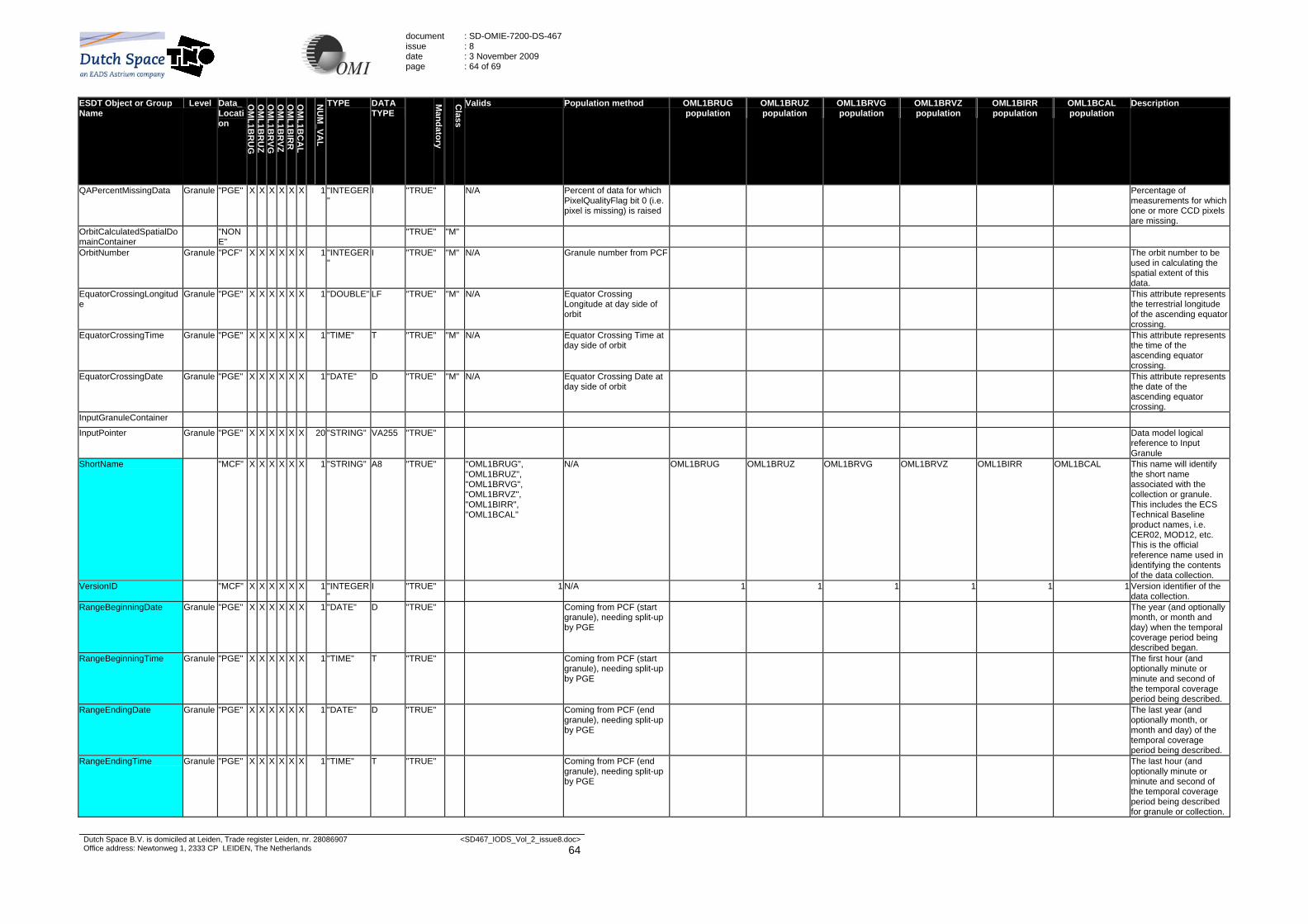
document issue date page
: SD-OMIE-7200-DS-467 : 8 : 3 November 2009 : 64 of 69
Dutch Space B.V. is domiciled at Leiden, Trade register Leiden, nr. 28086907 Office address: Newtonweg 1, 2333 CP LEIDEN, The Netherlands
<SD467_IODS_Vol_2_issue8.doc> 64
ESDT Object or Group Name
Level Data_Location
OM
L1BR
UG
O
ML1B
RU
Z O
ML1B
RVG
O
ML1B
RVZ
OM
L1BIR
R
OM
L1BC
AL
NU
M_VA
L
TYPE DATA TYPE
Mandatory
Class
Valids Population method OML1BRUG population
OML1BRUZ population
OML1BRVG population
OML1BRVZ population
OML1BIRR population
OML1BCAL population
Description
QAPercentMissingData Granule "PGE" X X X X X X 1 "INTEGER"
I "TRUE" N/A Percent of data for which PixelQualityFlag bit 0 (i.e. pixel is missing) is raised
Percentage of measurements for which one or more CCD pixels are missing.
OrbitCalculatedSpatialDomainContainer
"NONE"
"TRUE" "M"
OrbitNumber Granule "PCF" X X X X X X 1 "INTEGER"
I "TRUE" "M" N/A Granule number from PCF The orbit number to be used in calculating the spatial extent of this data.
EquatorCrossingLongitude
Granule "PGE" X X X X X X 1 "DOUBLE" LF "TRUE" "M" N/A Equator Crossing Longitude at day side of orbit
This attribute represents the terrestrial longitude of the ascending equator crossing.
EquatorCrossingTime Granule "PGE" X X X X X X 1 "TIME" T "TRUE" "M" N/A Equator Crossing Time at day side of orbit
This attribute represents the time of the ascending equator crossing.
EquatorCrossingDate Granule "PGE" X X X X X X 1 "DATE" D "TRUE" "M" N/A Equator Crossing Date at day side of orbit
This attribute represents the date of the ascending equator crossing.
InputGranuleContainer
InputPointer Granule "PGE" X X X X X X 20 "STRING" VA255 "TRUE" Data model logical reference to Input Granule
ShortName "MCF" X X X X X X 1 "STRING" A8 "TRUE" "OML1BRUG", "OML1BRUZ", "OML1BRVG", "OML1BRVZ", "OML1BIRR", "OML1BCAL"
N/A OML1BRUG OML1BRUZ OML1BRVG OML1BRVZ OML1BIRR OML1BCAL This name will identify the short name associated with the collection or granule. This includes the ECS Technical Baseline product names, i.e. CER02, MOD12, etc. This is the official reference name used in identifying the contents of the data collection.
VersionID "MCF" X X X X X X 1 "INTEGER"
I "TRUE" 1 N/A 1 1 1 1 1 1 Version identifier of the data collection.
RangeBeginningDate Granule "PGE" X X X X X X 1 "DATE" D "TRUE" Coming from PCF (start granule), needing split-up by PGE
The year (and optionally month, or month and day) when the temporal coverage period being described began.
RangeBeginningTime Granule "PGE" X X X X X X 1 "TIME" T "TRUE" Coming from PCF (start granule), needing split-up by PGE
The first hour (and optionally minute or minute and second of the temporal coverage period being described.
RangeEndingDate Granule "PGE" X X X X X X 1 "DATE" D "TRUE" Coming from PCF (end granule), needing split-up by PGE
The last year (and optionally month, or month and day) of the temporal coverage period being described.
RangeEndingTime Granule "PGE" X X X X X X 1 "TIME" T "TRUE" Coming from PCF (end granule), needing split-up by PGE
The last hour (and optionally minute or minute and second of the temporal coverage period being described for granule or collection.

document issue date page
: SD-OMIE-7200-DS-467 : 8 : 3 November 2009 : 65 of 69
Dutch Space B.V. is domiciled at Leiden, Trade register Leiden, nr. 28086907 Office address: Newtonweg 1, 2333 CP LEIDEN, The Netherlands
<SD467_IODS_Vol_2_issue8.doc> 65
ESDT Object or Group Name
Level Data_Location
OM
L1BR
UG
O
ML1B
RU
Z O
ML1B
RVG
O
ML1B
RVZ
OM
L1BIR
R
OM
L1BC
AL
NU
M_VA
L
TYPE DATA TYPE
Mandatory
Class
Valids Population method OML1BRUG population
OML1BRUZ population
OML1BRVG population
OML1BRVZ population
OML1BIRR population
OML1BCAL population
Description
PGEVersion Granule "PCF" X X X X X X 1 "STRING" A10 "TRUE" N/A Version of PGE, updated whenever any code or any static input file changes in the Delivered Algorithm Package.
AssociatedPlatformInstrumentSensorContainer
"NONE"
"TRUE" "M"
AssociatedPlatformShortName
"MCF" X X X X X X 1 "STRING" VA20 "TRUE" "M" "Aura" "Aura" "Aura" "Aura" "Aura" "Aura" "Aura" The ShortName of the Platform used to generate the data granule
AssociatedInstrumentShortName
"MCF" X X X X X X 1 "STRING" VA20 "TRUE" "M" OMI "OMI" "OMI" "OMI" "OMI" "OMI" "OMI" The ShortName of the Instrument used to generate the data granule
AssociatedSensorShortName
"MCF" X X X X X X 1 "STRING" VA20 "TRUE" "M" "CCD Ultra Violet" or "CCD Visible"
"CCD Ultra Violet" "CCD Ultra Violet" "CCD Visible" "CCD Visible" "CCD Ultra Violet" "CCD Ultra Violet" The ShortName of the Sensor used to generate the data granule
AssociatedPlatformShortName
"MCF" X X 1 "STRING" VA20 "TRUE" "M" "Aura" "Aura" "Aura" The ShortName of the Platform used to generate the data granule
AssociatedInstrumentShortName
"MCF" X X 1 "STRING" VA20 "TRUE" "M" OMI "OMI" "OMI" The ShortName of the Instrument used to generate the data granule
AssociatedSensorShortName
"MCF" X X 1 "STRING" VA20 "TRUE" "M" "CCD Ultra Violet" or "CCD Visible"
"CCD Visible" "CCD Visible" The ShortName of the Sensor used to generate the data granule
Table 8-2 Inventory Metadata for OMI L1B Products

document issue date page
: SD-OMIE-7200-DS-467 : 8 : 3 November 2009 : 66 of 69
Dutch Space B.V. is domiciled at Leiden, Trade register Leiden, nr. 28086907 Office address: Newtonweg 1, 2333 CP LEIDEN, The Netherlands
<SD467_IODS_Vol_2_issue8.doc> 66
8.3 Archive Metadata
129HTable 8-3 provides an overview of the Archive Metadata that is stored for each of the OMI Level 1B products. In the columns OML1B* is specified for which of the products a field is included in the metadata (X = present for this product).
AttributeName AttributeDescription O
ML1B
RU
G
OM
L1BR
UZ
OM
L1BR
VG
OM
L1BR
VZ O
ML1B
IRR
O
ML1B
CA
L
Attribute Data Type
Data_ Location
Data Length
Valids Min Value Max Value Population method
Standard AlgorithmBypassList Runtime parameter containing list of algorithms to bypass X X X X X X varchar "PCF" 200 N/A N/A From PCF ProcessingMode Runtime parameter containing run mode for processor X X X X X X varchar "PCF" 5 "PDS", "EDS", "RBDS" From PCF
OrbitData Indicator as to whether definitive (DEFINITIVE) or predicted (PREDICTED) orbit data was used X X X X X X varchar "PCF" 12 "DEFINITIVE", "PREDICTED" From PCF
SpacecraftMinAltitude Minimum Altitude of spacecraft in granule. X X X X X X float "PGE" From geolocation SpacecraftMaxAltitude Maximum Altitude of spacecraft in granule. X X X X X X float "PGE" From geolocation ProcessingCenter Center where collection was or is being processed. i.e. name of DAAC or SCF X X X X X X varchar "MCF" 20 e.g. "OMI SIPS"
LongName This attribute will identify the long name associated with the collection. This includes dataset name/ product name. This is the reference name used in describing the scientific contents of the data collection; it is not the 'id' of the data.
X X X X X X varchar "MCF" 80 Same as LongName in collection
ESDTDescriptorRevision Version of the ESDT descriptor file X X X X X X varchar "MCF" 255 From MCF OPF OPFSmearSwitchValue Runtime parameter to set the switch option for exposure smear correction X X X X X X varchar "PGE" "STANDARD", "OPTIONAL" From OPF OPFMeasurementStrayFlag Runtime parameter to indicate whether upper and lower straylight areas are used for straylight
calculation. X X X X X X varchar "PGE" "TRUE", "FALSE" From OPF
OPFVersion Version of the Operational Parameters File X X X X X X varchar "PGE" From OPF OPFValid Validity of the Operational Parameters File X X X X X X varchar "PGE" "TRUE", "FALSE" From OPF
Table 8-3 Archive Metadata for OMI L1B Products

document issue date page
: SD-OMIE-7200-DS-467 : 8 : 3 November 2009 : 67 of 69
Dutch Space B.V. is domiciled at Leiden, Trade register Leiden, nr. 28086907 Office address: Newtonweg 1, 2333 CP LEIDEN, The Netherlands
<SD467_IODS_Vol_2_issue8.doc> 67
8.4 Product Specific Attributes (PSAs)
130HTable 8-4 provides an overview of the PSAs that are stored for each of the OMI Level 1B products. The PSAs that are included can differ a lot from product to product. In the columns OML1B* is specified for which of the products a field is included in the metadata (X = present for this product). Furthermore, it is possible that there is a split for a specific field; this is denoted by an X in the “Split into *” columns:
- “Split into UV & VIS for CAL” is only valid for the OML1BCAL product. In case an X is present for a field, for example “NrZoom”, there will be two PSAs in the metadata for this field, namely “NrZoomUV” and “NrZoomVIS”.
- “Split into UV1, UV2 & VIS for (IR)RAD” is valid for the OML1BRUG, OML1BRVG, OML1BRUZ, OML1BRVZ and OML1BIRR products. In case an X is present for a field, for example “QAStatPctMeasError”, the OML1BRUG and OML1BRUZ products will have two PSAs in the metadata for this field, namely “QAStatPctMeasErrorUV1” and “QAStatPctMeasErrorUV2”; the OML1BRVG and OML1BRVZ products will have one PSA in the metadata for this field, namely “QAStatPctMeasErrorVIS”; the OML1BIRR product will have three PSAs in the metadata for this field, namely “QAStatPctMeasErrorUV1”, “QAStatPctMeasErrorUV2” and “QAStatPctMeasErrorVIS”.
- “Split into UV & VIS for IRRAD” is only valid for the OML1BIRR product. In case an X is present for a field, for example “NrZoom”, the OML1BIRR product will have two PSAs in the metadata for this field, namely “NrZoomUV” and “NrZoomVIS”.
For the statistics metadata (e.g. number of measurements for several types; QA statistics; etc.), the following constraints apply:
- For statistics that are calculated per measurement or (sub-)channel, the statistics are updated in case any which type of data is written for a measurement or (sub-channel). That is, in case for a measurement only offset and dark current data but no (spectral) pixel data is written to the calibration product, these statistics will be updated.
- For statistics that are calculated per measurement or (sub-)channel, each of the fields (after split-up) will be updated at most 1 time per measurement. That is, in case for 2 sub-channels, UV1 and UV2 data is written to the OML1BRUG product, the NrMeasurements field (which is not split up), will be increased by only 1. The QAStatPctMeasError field, which is split up for these two sub-channels, will be updated for each of these sub-channels individually.
- For pixel and ground pixel based statistics, only pixels are counted that are actually written to the measurement swaths in the output products, i.e. for radiance and irradiance products only the pixels in the so called "optics region" are taken into account. In the case of irradiance measurements, which are also written to the calibration product (this is the only type of measurement for which the calculation is split up into UV1 and UV2 sub-channels for the calibration product), the UV1 and UV2 counts are merged (added up) into the UV pixel statistics before being written to the output product.
- For pixel and ground pixel based statistics, in case of rebinning in global radiance products, pixel and ground pixel based statistics are calculated on the rebinned pixels. For zoom-in measurements that are rebinned and where the swath cannot be filled to the full extents and the remaining rows and / or columns are written with fill values, the statistics are not updated for these remaining rows and / or columns.
- Small pixels are not taken into account for the QA statistics.
- In case of as long exposure measurement, the Storage section and Image section read-outs will be treated as two separate measurements for the calculation of the QA statistics.
PSAProposed Name (Up to 40 Characters) (Mandatory)
PSADescription (Up to 255 Characters) (Mandatory)
PSAType {Platform, Instrument, Sensor, Additional Attribute} (Mandatory)
PSADataType {int, varchar, float, datetime, time, date}
PSASource (Up to 255 Characters) (Mandatory)
ValidValue Flag {YES, NO} (Mandatory)
DataLength (Mandatory)
AuthorName (Up to 50 Characters) (Mandatory)
MinValue (Optional)
MaxValue (Optional)
Maximum number of values (Mandatory)
ECS Core Attributes or Recommendation of PSA or Archive Level attributes
PSAOrigin OM
L1BR
UG
OM
L1BR
UZ
OM
L1BR
VGO
ML1B
RVZ
OM
L1BIR
RO
ML1B
CA
L
Split into
UV & VIS for
CAL
Split into UV1,
UV2 & VIS for
(IR)RAD
Split into
UV & VIS for
IRRAD
Valids
NrMeasurements Number of measurements in the granule (per output product)
Instrument int OMI NO 1 P. Veefkind / E. Laan
0 9999 1 Measured Parameter group
Standard X X X X X X
NrZoom Number of measurements in zoom modes Sensor int OMI NO 1 P. Veefkind / E. Laan
0 9999 1 PSA Standard X X X X X X X X
NrSpatialZoom Number of measurements in spatial zoom mode Sensor int OMI NO 1 P. Veefkind / E. Laan
0 9999 1 PSA Standard X X X X X X X X
NrSpectralZoom Number of measurements in spectral zoom mode Sensor int OMI NO 1 P. Veefkind / E. Laan
0 9999 1 PSA Standard X X X X X X X X
NrLongMeasurements Number of long measurements Sensor int OMI NO 1 B. van den Oord / P. Veefkind
0 9999 1 PSA Standard X
NrUnbinnedMeasurements Number of unbinned measurements Sensor int OMI NO 1 B. van den Oord / P. Veefkind
0 9999 1 PSA Standard X
NrAlternatingReadOut Number of measurements with Alternating Read Out
Sensor int OMI NO 1 B. van den Oord / P. Veefkind
0 9999 1 PSA Standard X X X X X X X X
NrEarthMeasurements Number of Earth measurements Sensor int OMI NO 1 B. van den Oord / P. Veefkind
0 9999 1 PSA Standard X

document issue date page
: SD-OMIE-7200-DS-467 : 8 : 3 November 2009 : 68 of 69
Dutch Space B.V. is domiciled at Leiden, Trade register Leiden, nr. 28086907 Office address: Newtonweg 1, 2333 CP LEIDEN, The Netherlands
<SD467_IODS_Vol_2_issue8.doc> 68
PSAProposed Name (Up to 40 Characters) (Mandatory)
PSADescription (Up to 255 Characters) (Mandatory)
PSAType {Platform, Instrument, Sensor, Additional Attribute} (Mandatory)
PSADataType {int, varchar, float, datetime, time, date}
PSASource (Up to 255 Characters) (Mandatory)
ValidValue Flag {YES, NO} (Mandatory)
DataLength (Mandatory)
AuthorName (Up to 50 Characters) (Mandatory)
MinValue (Optional)
MaxValue (Optional)
Maximum number of values (Mandatory)
ECS Core Attributes or Recommendation of PSA or Archive Level attributes
PSAOrigin OM
L1BR
UG
OM
L1BR
UZ
OM
L1BR
VGO
ML1B
RVZ
OM
L1BIR
RO
ML1B
CA
L
Split into
UV & VIS for
CAL
Split into UV1,
UV2 & VIS for
(IR)RAD
Split into
UV & VIS for
IRRAD
Valids
NrSolarMeasurements Number of Solar measurements Sensor int OMI NO 1 B. van den Oord / P. Veefkind
0 9999 1 PSA Standard X
NrLEDMeasurements Number of LED measurements Sensor int OMI NO 1 B. van den Oord / P. Veefkind
0 9999 1 PSA Standard X
NrWLSMeasurements Number of WLS measurements Sensor int OMI NO 1 B. van den Oord / P. Veefkind
0 9999 1 PSA Standard X
NrDarkMeasurements Number of Dark measurements Sensor int OMI NO 1 B. van den Oord / P. Veefkind
0 9999 1 PSA Standard X
ExpeditedData Indicator for expedited L0 data Instrument varchar OMI YES 10 P. Veefkind / E. Laan
1 PSA Standard X X X X X X "TRUE"; "FALSE"
SouthAtlanticAnomalyCrossing Flag to indicate that during part of the
measurements the spacecraft was in the SAA Platform varchar OMI YES 10 P. Veefkind /
E. Laan 1 PSA Standard X X X X X X "TRUE";
"FALSE"
SpacecraftManeuverFlag Flag to indicate that during part of the measurements the spacecraft was performing a maneuver
Platform varchar OMI YES 10 P. Veefkind / E. Laan
1 PSA Standard X X X X X X "TRUE"; "FALSE"; "UNKNOWN"
SolarEclipse Flag to indicate that during part of the measurements a solar eclipse occurred
Platform varchar OMI YES 10 P. Veefkind / E. Laan
1 PSA Standard X X X X X X "TRUE"; "FALSE"
InstrumentConfigurationIDs Array containing the Instrument Configuration
Identifiers used for the measurements Instrument int OMI NO 256 P. Veefkind /
E. Laan 0 255 256 PSA CCD X X X X X X
MasterClockPeriods Array containing Master Clocks Periods in [s] used for the measurements
Instrument float OMI NO 256 P. Veefkind / E. Laan
0 10 128 PSA Instrument X X X X X X
ExposureTimes Array containing exposure times in [s] used for the measurements
Sensor float OMI NO 256 P. Veefkind / E. Laan
0 2000 256 PSA CCD X X X X X X X X
QA on measurement level P. Veefkind /
E. Laan
QAStatPctMeasError Percentage of measurements with at least one of the following error flags set: the alternative engineering data flag, the co-adder error flag and the geolocation error flag
Sensor int OMI NO 1 P. Veefkind / E. Laan
0 100 1 PSA Channel X X X X X X X X
QAStatPctMeasWarning Percentage of measurements for which at least one of the MeasurementQualityFlags was set as a warning, excluding the alternative engineering data flag, the co-adder error flag and the geolocation error flag in the count
Sensor int OMI NO 1 P. Veefkind / E. Laan
0 100 1 PSA Channel X X X X X X X X
QA on ground pixel level QAStatPctGeolocationError Percentage of ground pixels for which the
geolocation determination resulted in the GroundPixelQualityFlag for geolocation error being set
Sensor int OMI NO 1 P. Veefkind / E. Laan
0 100 1 PSA Channel X X X X
QA on pixel level QAStatPctPixBad Percentage of image pixels with at least one of
the following PixelQualityFlags set to indicate a bad pixel: the saturated ADC flag and the dead pixel flag
Sensor int OMI NO 1 P. Veefkind / E. Laan
0 100 1 PSA Channel X X X X X X X X

document issue date page
: SD-OMIE-7200-DS-467 : 8 : 3 November 2009 : 69 of 69
Dutch Space B.V. is domiciled at Leiden, Trade register Leiden, nr. 28086907 Office address: Newtonweg 1, 2333 CP LEIDEN, The Netherlands
<SD467_IODS_Vol_2_issue8.doc> 69
PSAProposed Name (Up to 40 Characters) (Mandatory)
PSADescription (Up to 255 Characters) (Mandatory)
PSAType {Platform, Instrument, Sensor, Additional Attribute} (Mandatory)
PSADataType {int, varchar, float, datetime, time, date}
PSASource (Up to 255 Characters) (Mandatory)
ValidValue Flag {YES, NO} (Mandatory)
DataLength (Mandatory)
AuthorName (Up to 50 Characters) (Mandatory)
MinValue (Optional)
MaxValue (Optional)
Maximum number of values (Mandatory)
ECS Core Attributes or Recommendation of PSA or Archive Level attributes
PSAOrigin OM
L1BR
UG
OM
L1BR
UZ
OM
L1BR
VGO
ML1B
RVZ
OM
L1BIR
RO
ML1B
CA
L
Split into
UV & VIS for
CAL
Split into UV1,
UV2 & VIS for
(IR)RAD
Split into
UV & VIS for
IRRAD
Valids
QAStatPctPixProcessingError Percentage of image pixels with the processing error flag set
Sensor int OMI NO 1 P. Veefkind / E. Laan
0 100 1 PSA Channel X X X X X X X X
QAStatPctPixWarning Percentage of image pixels with at least one of the following PixelQualityFlags set as a warning: transient pixel, RTS pixel, saturation possibility, noise calculation, dark current, offset, exposure smear and stray light
Sensor int OMI NO 1 P. Veefkind / E. Laan
0 100 1 PSA Channel X X X X X X X X
SolarElevationAngleMin Minimum solar elevation angle on the diffuser,
with respect to instrument alignment cube Instrument float OMI NO 1 P. Veefkind /
E. Laan -180 180 1 PSA Irradiance X X
SolarElevationAngleMax Maximum solar elevation angle on the diffuser, with respect to instrument alignment cube
Instrument float OMI NO 1 P. Veefkind / E. Laan
-180 180 1 PSA Irradiance X X
SolarAzimuthAngleMin Minimum solar azimuth angle on the diffuser, with respect to instrument alignment cube
Instrument float OMI NO 1 P. Veefkind / E. Laan
-180 180 1 PSA Irradiance X X
SolarAzimuthAngleMax Maximum solar azimuth angle on the diffuser, with respect to instrument alignment cube
Instrument float OMI NO 1 P. Veefkind / E. Laan
-180 180 1 PSA Irradiance X X
Spatial extent (NOSE) PathNr Number of the path within the repeat cycle Platform int OMI NO 1 P. Veefkind 1 466 500 PSA None X X X X X X StartBlockNr Number of the start block along the track Platform int OMI NO 1 P. Veefkind 1 50 500 PSA None X X X X X X EndBlockNr Number of the end block along the track Platform int OMI NO 1 P. Veefkind 1 50 500 PSA None X X X X X X
Table 8-4 PSA Metadata for OMI L1B Products


![GDPS - Confex€¦ · GDPS /PPRC # LPs Number PPRC Volumes Planned HS Suspend [UIT] Unplanned HS [UIT] Number GM Volumes Average Data in Flight (remote RPO) Simulated Regional D/R](https://img.dokumen.tips/doc/110x75/60d9d27e96d32d16710d8cc1/gdps-confex-gdps-pprc-lps-number-pprc-volumes-planned-hs-suspend-uit-unplanned.jpg)