Embed Size (px)
Citation preview

JPL PUBLICATION 83-57
(NAS&-CR-173103) -& FEASIBILITY 5_UD¥:
FOnEST FIRE J EV&NCED SYSTE_ T_CI_NCLOG¥
(FF&ST) (Jet Propulsion La_.) 70 p
BC A0_/MF _.01 CSCL 0 2F Uncl asG3/_3 q2 16 q
A Feasibility Study: Forest FireAdvanced System Technology(FFAST)
Ronald G. McLeodTerry Z. MartinJet Propulsion Laboratory
John WarrenUnited States Department of AgricultureForest Service
Forest Fire Advanced Sy=tem Technololl7
September 1, 1983
Prepared for
National Aeronautics and Space Administration
and
Untied States Department of AgricultureForest Service
by
Jet Propulsion LaboratoryCalifornia Institute of TechnologyPasadena, California
https://ntrs.nasa.gov/search.jsp?R=19830027199 2018-05-12T19:31:05+00:00Z

JPL PUBLICATION 83-57
A Feasibility Study: Forest FireAdvanced System Technology(FFAST)
Ronald G. McLeod
Terry Z. MartinJet Propulsion Laboratory
John Warren
United States Department of AgricultureForest Service
September 1, 1963
Prepared for
NaUonal Aeronautics and Space Administration
and
United States Department of AgricultureForest Service
by
Jet Propulsion LAboratory
California Institute of TechnologyPasadena, California

J
This publication was prepared by the Jet Propulsion
Laboratory, California Institute of Technology, under a
contract with the National Aeronautics and Space
Administration.
Reference to any specific commercial product, process, or
service by trade name or manufacturer does not n_cessarily
constitute an endorsement by the United States Government
or the Jet Propulsion Laboratory, California Institute of
Technology.

P
ACKNOWLEDGMENTS
The fea_ibility study was performed through NASA Task Order RE-170,
Amendment 53, and was sponsored by the National Aeronautics and Space Administra-
tion and the United States Department of Agriculture Forest Service. Although
numerous individuals contributed to this task, several deserve special recogni-
tion. We wish to thank John Chambers of the USDA Forest Service, Aviation and
Fire Management (Washington Office) for his guidance and support; Gary Reisdorf
(Jet Propulsion Laboratory) for his initial contribution to task definition; and
Dr. James Huning for his review of the initial draft. Dr. Christopher Stevens
offered valuable criticism on the several drafts of this report. We gratefully
acknowledge the patience and expertise of Elizabeth Davis in typing the
manuscript.
iii

OHIGINAL PAGE !_1
OF POOR QUALITY
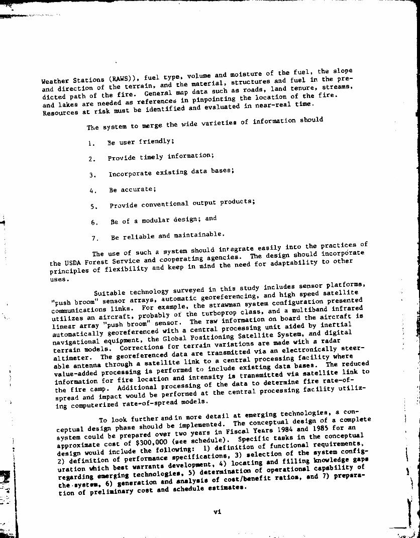
FOREST FIRE ADVANCED SYSTEM TECHNOLOGY
FFAST
STRAWMAN SYSTEM CONFIGURATION
GEO-SYNCHRONOUS SATELLITEFOR COMMUNICATIONS ANDDATA TRANSF E R
E LECTRONICALLYSTEERABLE
GLOBAL
POSITIONING _SATELLITE
HIGH SPEEDAIRCRAFT
PUSHBROOMIR SCANNER
ALTIMETRYFOR TERRAINCORRECTION
ESCAPED FIREDESTINATION OFFI RE INFORMATION
FIRE CAMP
: ii
\GROUND STATIONPROCESSING
IRATE ANCILLARYDATA BASES
MAP INFORMATION
RATE OF SPREAD MOOELS
AUTOMATIC LIGHTNINGDETECTION SYSTEM
REMOTE AUTOMATICWEATHER STATION
NOAA WEATHERINFORMATION
Lf; ........................
Iv

EXECUTIVE SUMMARY
Management of wild and prescribed fires requires timely and accurate
information on fire location and behavior. Current methods in use by the United
States Department of Agriculture (USDA) Forest Service for determining fire loca-
tion frequently employ infrared sensing from aircraft.. Information pertaining
to fire location and intensity is recorded on film and delivered to the fire
camp command post to supplement the information needed for tactical fire fighting
operations. The infrared sensing systems now in use by the USDA Forest Service
are important in fire suppression strategy; however, the sensing units are
becoming increasingly difficult to maintain due to the lac_ of replacement parts.
As a result of this, an infrared sensing system is being upgraded at the Jet
Propulsion Laboratory under project FLAME.
By the 1990's, additional capabilities of a fire surveillance system
will be needed to deal with the complex management task of fire management and
suppression. Ancillary information such as general map data, fire rate-of-spread
models, and BTU output may be needed to enhance the information base required
for allocating resources to fight fires.
In response to the future needs, a joint feasibility study between the
United States Department of Agriculture Forest Service and the National Aeronau-
tics and Space Admlnistration/Jet Propulsion Laboratory was undertaken with the
goal of examining the potential for applying advanced technology to improve the
gathering, integration, and synthesis of information pertaining to forest fire
mapping and detection. The objectives of this task were to understand the
current and future user needs in information requirements for forest fire manage-
ment in the 1990's and to survey and identify what technologies may be available
to meet these future needs. The results of that study are discussed in this
report. In addition, to clearly present the mix of technology and needs, a
strawman system is presented and discussed, and a plan for a more detailed,
follow-on conceptual design of the strawman system is presented.
The approach of the study was to gather data on current and future
information requirements, analyze these user needs, and define a set of func-
tional requirements. In a somewhat concurrent effort, emerging technologies that
may meet these requirements were surveyed. The results of matching the technolo-
gles and user requirements are presented in a "strawman" system configuration.
A plan was then prepared for a detailed, follow-on conceptual design phase.
Officials at various levels in the national and regional offices of
the USDA Forest Service, as well as staff members in the federal and provincial
branches of the Canadian government, were interviewed over a six month period in
1982-83 to identify user information needs in forest fire suppression and manage-ment. The res':its of the interviews showed that information needs include the
following: where the fire is, what is it doing, what is it going to do, and what
can and should be done about it. An integrated information gathering and process-
ing system _s needed to fulfill these requirements. Partlcular factors needed
for a sys;em are exact location of the fire to within a road width as well as the
intensity and areal extent of the burn. Factors influencing the behavior of a
fire are I,eeded and include items such as short term weather forecasts (available
from National Oceanic and Atmospheric Administration (NOAA) and Remote Automatic
V
L
Weather Stations (RAWS)), fuel type, volume and moisture of the fuel, the slope
and direction of the terrain, and the material, structures and fuel in the pre-
dicted path of the fire. General map data such as roads, land tenure, streams,
and lakes are needed as references in pinpointing the location of the fire.
Resources at risk must be identified and evaluated in near-real time.
The system to merge the wide varieties of information should
I. Be user friendly;
2. Provide timely information;
3. Incorporate existing data bases;
4. Be accurate;
5. Provide conventional output products;
6. Be of a modular design; and
7. Be reliable and maintainable.
The use of such a system should integrate easily into the practices of
the USDA Forest Service and cooperating agencies. The design should incorporate
principles of flexibility and keep in mind the need for adaptability to other
USES.
Suitable technology surveyed in this study includes sensor platforms,
"push broom" sensor arrays, automatic georeferencing, and hlgh speed satellite
communications links. For example, the strawman system configuration presented
utilizes an aircraft, probably of the turboprop class, and a multlband infrared
linear array "push broom" sensor. The raw information on board the aircraft is
automatically georeferenced with a central processing unit aided by inertial
navigational equipment, the Global Positioning Satellite System, and digitalterrain models. Corrections for terrain variations are made with a radar
altimeter. The georeferenced data are transmitted via an electronically steer-
able antenna through a satellite llnk to a central processing facility where
value-added processing is performed to include existing data bases. The reduced
information for fire location and intensity is transmitted via satellite link to
the fire camp. Additional processing of the data to determine fire rate-of-
spread and impact would be performed at the central processing facility utiliz-
ing computerized rate-of-spread models.
To look further and in more detail at emerging technologies, a con-
ceptual design phase should be implemented. The conceptual design of a complete
system could be prepared over two years in Fiscal Years 1984 and 1985 for an
approximate cost of $300,000 (see schedule). Specific tasks in the conceptual
design would include the following: I) definition of functional requirements_2) definition of performance specifications, 3) selection of the system config-
uration whlch best warrants development, 4) locating and filling knowledge gaps
regarding emerging technologies, 5) determination of operational capability of
tbe.systn, 6) generation and analysis of cost/beneflt ratios, end 7) prepara-
tion of preliminary cost and schedule estimates.
vl

O_GINAL P_'_E i_POOR QUALIT_,
Conceptual Design P_ase Schedule
TASK
1. SELECT DESIGN TEAM
2. DEFINE FUNCTIONAL REQUIREMENTS
3. DEFINE SYSTEM CONFIGURATION
4. DEFINE PERFORMANCE SPECIFICATIONS
5. RESOLVE TECHNOLOGY UNCERTAINTIES
6. DETERMINE OPERATIONAL CAPABILITY
7. GENERATE PRELIMINARY COST ESIlMATES
8, GENERATE PRELIMINARY SCHEDULE ,
9. GENERATE COST/BENEFIT RATIOS I
10. PREPARE REPORT AND RECOMMENDA'hONS
11, DETAILED DESIGN
FY84 FY85 FY86
._..,._&
A
---iI-._.&
Rec ommenda t ions
Based upon the support of Aviation and Fire Management Directors at
the national meeting in Albuquerque in February, 1983, and the commitment of the
USDA Forest Service to keep abreast of the emerging technologies for use in fire
management, it is recommended that a conceptual design phase as outlined be
undertaken. The strawman system configuration outlined in the study serves to
illustrate what can be designed with technologies that currently are under
development and that will have matured to the extent that they will be available
by the late 1980's. Succeeding phases could involve preparing a detailed plan
for engineering design, costs, schedules, and implementation.
vii

ABSTRACT
The National Aeronautics and Space Administration/Jet Propulsion
Laboratory and the United States Department of Agriculture Forest Service
completed a feasibility study that examined the potential uses of advanced
technology in forest fire mapping and detection. The current and future (1990's)
information needs in forest fire management were determined through interviews.
Analysis shows that integrated information gathering and processing is needed.
The emerging technologies that were surveyed and identified as possible candi-
dates for use in an end-to-end system include "push broom" sensor arrays,
automatic georeferencing, satellite co_municatlon links, near-real or real
time image processing, and data integration. Matching the user requirements and
the technologies yielded a "strawman" system configuration. The feasibility
study recommends and outlines the implementation of the next phase for this
project, a two-year, conceptual design phase to define a system that warrants
continued development.
i
pRECEDIH_ PAGE BLANK NOT
ix
le
o
e
CONTENTS
INTRODUCTION ............................
I.i
1.2
1.3
1.4
BACKGROUND ..........................
FUNDING ............................
PURPOSE ............................
APPROACH ...........................
SURVEY OF USER NEEDS AND ADVANCED TECHNOLOGIES ...........
2.1 USER REQUIREMENTS .......................
2.1.1 Fire Location and Intensity .............
2.1.2 Current Fire Behavior .................
2.1.3 Predicted Flre Behavior ................
2.1.4 Resources Available ..................
2.2 POSSIPLE TECHNOLOGIES ....................
2.2.1 Sensor Platforms ....................
2.2.2 Line and Area Array Sensors .............
2.2.3 Georeferencing Systems ...................
2.2.4 Advanced Satellite Relay Conlnunications ........
2.2.5 Integrating Existing Data Bases ............
2.2.6 Image Processing Techniques ..............
MATCHING TECHNOLOGY AND USER REQUIREMENTS. .............
4. STRAWMAN SYSTEM CONFIGURATION .................
4.1 SENSOR PLATFORM .......................
4.2 SENSOR TYPE .........................
PRECEDING PAGE BLANK NOT FILMED
xl
I
I
2
3
3
5
5
5
5
6
6
7
7
8
13
14
14
15
17
19
2O
2O

4.3
4.4
DATAPROCESSING.....................
4.3.1 On-BoardProcessing ..................
4.3.2 GroundProcessing ...................
COMMUNICATIONS........................
, CONCEPTUAL DESIGN PHASE ......................
5.1
5.2
5.3
5.4
DIRECTION AND FUNDING ....................
DEFINITION .........................
GOALS ............................
DESIGN TEAM .........................
6. SUMMARY ............................
REFERENCES .............................
APPENDIXES
A.
B.
C.
AGENCY PERSONNEL INTERVIEWED .................
CORRESPONDENCE OF USERS REGARDING COMMENTS ..........
ADDITIONAl, RELATED CORRESPONDENCE ..............
20
20
20
22
27
27
27
27
30
31
33
35
43
55
xiJ.
Figures
I.
2.
e
4.
5.
,
7.
8.
9.
Tables
i •
2.
Approach of feasibility study ................
Sensing methods of the llne scanner currently in use
and an advanced "push broom" scanner ............
Airborne imaging spectrometer, "push broom" geometry .....
The 512-element linear array of InSb detectors ........
Strawman system configuration (Forest Fire Advanced
System Technology--FFAST) .................
Thermal imagery for Battle Fire, AZ .............
Map base for Battle Fire ...................
Thermal imagery for Battle Fire, geometrically adjusted . .
Thermal imagery registered with map base ...........
Conceptual Design Phase Schedule ...............
Approximate Cost Contributions ................
xll£
8
9
II
19
22
23
24
25
28
29,
OF POOR QUALITY
xfv
0
J

SECTION 1
INTRODUCTION
ORIGINAL PI_E _
OF POOR QUALITY
Forest fire suppression and management is a complex operation
involving trained professionals in many disciplines. A variety of equipment is
commonly used, ranging from shovels, pulaskis, and other hand tools to infrared
(IR) reconnaissance systems, extensive communlcatioes systems, automatic meteor-
ological stations, and computerized fire spread models. As technology becomes
available, it is applied, where appropriate, to aid fire management staff
manage and suppress fires. It is essential to continue researching and devel-
oping new technologies and methods for detecting and monitoring a fire and,
when a fire escapes, for mapping to minimize the loss of natural resources,
property, and lives.
This document reports the results of a joint National Aeronautics
and Space Administration (NASA)/United States Department of Agriculture (USDA)
Forest Service sponsored feasibility study to evaluate the application of NASA/
Jet Propulsion Laboratory (JPL) technology to forest fire detection and mapping.
I.I BACKGROUND
The current task resulted from a long hi_tory of research and develop-
ment activities conducted by the United States Department of Agriculture ForestService in airborne infrared forest fire surveillance, which began with project
FIRESCAN [i]. The first research, airborne, infrared llne scanner was acquired
by the Forest Service in 1962, and research studies were initiated to examine the
physical problems of detecting very small heat radiation sources obscured by
timber canopy and rugged terrain. Additional items were examined to study and
define performance requirements of infrared hardware, to develop optimal fire
patrol strategies, and to examine the cost effectiveness of airborne infrared
fire detection. Cooperative studies between the USDA Forest Service and the
Department of Defense were conducted to examine problems of common interest, to
gain access to state-of-the-art equipment, and to augment research funds. In the
fall of 1962, the fire mapping capability was discovered. The project soon
divided its effort into two independent but technically overlapping fire surveil-
lance capabilities: fire detection and fire mapping.
From 1964 to 1966, a fire-mapping crew was detailed to the FIRESCAN
project to expedite development of flre-mapplng operational procedures. The
flre-mapping system was transferred to the Division of Fire Control in 1966.
The system provided a badly needed fire intelligence capability but did not have
optimal performance.
The technical requirements for detecting small fires over large areas
of terrain were much more difficult to meet. Nevertheless, by J70 a very
sophisticated fire-surveillance system was developed with the capability to
patrol 2,000 square miles per hour and to detect small fire targets with high
probability. This system als_ had improved fire-mapplng capabilities [2].

The fire surveillance system was operationally tested in 1971and1972with marginal success. In retrospect, the airborne forest fire detection
system was conceived of as a strategic fire detection tool rather than a tactical
mapping tool. It was designed to have a large payoff in dollar terms or in
reduction of numbers of escaped fires. The hardware and operatlonal procedures
were developed accordingly. However, fire detection has traditionally been a
tactical fire control operation--a fire starts, is detected and initially
attacked by fire control personnel. The zesources and plans for implementing a
new strategic fire detection system proved to be prohibitive.
By 1974 procedures and skill in using the IR mapping equipment were
developed, and provision was made to transfer all technical responsibilities to
the Aviation and Fire Management located at Boise Interagency Fire Center (BIFC).
The fire detecting capability is now available nationally and is used in critical
fire danger situations.
The ability to deliver timely IR fire information to fire management
personnel has continued to be a serious problem. Image transmission, processing,
storage, and display systems using the latest technological advances must be
identified and evaluated to meet the critical challenges facing the USDA Forest
Service.
In use today are two surveillance and mapping systems, a Texas Instru-
ments RS-7 scanner mounted in a Beechcraft King Air and a modified Texas Instru-
ments RS-25 scanner mounted in a Sweringen Merlin Aircraft. The two systems are
based at the Boise Interagency Fire Center.
Obsolescence, coupled with the increasing difficulty in maintaining
the scanner units for operational readiness, presents serious problems for the
USDA Forest Service. Replacement parts for the units are difficult to find and
in some cases have to be custom made. As an interim measure to remedy this
situation, a joint effort, the Fire Logistics Airborne Mapping Equipment (FLAME)
project, was initiated between JPL and the USDA Forest Service to update the
electronics components within one of the llne scanning systems. The updated
system has a proposed life-cycle of up to I0 years, at which time replacement
units may be needed if airborne forest fire detection and mapping are to be
maintained.
I.2 FUND ING
The technology generated by NASA programs is an important national
resource with great potential. By congressional mandate, one of NASA's tasks is
to promote the reuse of aerospace and other technologies by assisting potential
users in identifying new ways to employ such technology and assisting them in the
transfer process. It is the commitment to technology utilization that led NASA
to co-sponsor this study.
Funding for this feasibility study was provided by the Technology Utili-
zation and Industry Affairs Division at NASA Headquarters in Washington, D.C. [3].
The funding was used to support technical, administrative, and sanageaent personnel

_ ,%
!
at JPL as well as travel needed to gather user requirements. The USDA Forest Ser-
vice contributed t, _hnical personnel and expertise to advise and provide directionfor the task.
1.3 PURPOSE
The purpose of the phase 0 study was to determine the feasibility of
designing and implementing a forest fire detection and mapping system based upon
the technology that will be established and available by the 1990's and to assess
the expressed needs of the USDA Forest Service in forest fire management. Such
a system should meet the following preliminary requirements:
i. Significant improvement in data availability and analysis over
the system currently in use;
. Significant improvement in fire imagery georeferencing and the
ability to quickly locate points of interest in the imagery;
automatic methods of georeferencing may be indicated here;
. Improved system reliability and maintainability over the current
system;
o Reduced overall costs through modular design and adaptability to
alternate uses.
1.4 APPROACH
Identifying and defining bounds for the forest fire detection and
mapping problem were crucial to insure proper direction for this study. (The
fundamental approach to this task is shown in Figure I.) To do this, the
information needed by fire personnel in the detection, on-golng fire, and mop-up
activities had to be presented in clear and concise terms. Information regarding
tactical fire suppression could best be obtained from the participants and line
management directly involved. To this end, the national and regional offices of
the USDA Forest Service were visited. Canada, llke the United States, has
similar management information requirements with respect to fire suppression;
consequently, the forestry agencies in Canada at the federal and provincial
level were included in the survey of user needs. Appendix A includes the
contacts for each agency visited.
•

ORIGINAL PA_Ii_ mlOF POOR QUALITY
PROBLEMDEFINITION
i[ I
SURVEY OFUSER
NEED6
ANALYZEUSER
REQUIREMENTS
Il I
MATCH TECHNOLOGYWITH USER
REQUIREMENTS
SURVEY OFADVANCED
TECHNOLOGIES
FORMULATESTRAWMAN SYSTEM
CONFIGURATION
I I
DEFINE PLAN FORCONCEPTUAL
DESIGN
PREPARE REPORTAND COORDINATE
WITH USERS
PRESENTFINAL
REPORT
Figure I. Approach of feasibility study.
4

SECTION 2
SURVEY OF USER NEEDS AND ADVANCED TECHNOLOGIES
2.1 USER REQUIREMENTS
In understanding the information needs of the user community, several
significant points were noted. User requirements for information are stated in
terms necessary for fire management and suppression activities. These require-
ments include information about the following:
I. Fire location and intensity;
2. Current fire behavior, at any given moment, within reason;
3. Predicted fire behavior;
4. Resources available to manage or suppress the fire.
All information must be timely in that the earlier the information is
received, the greater the possibility for formulating appropriate management
decisions and the larger the number of management alternatives.
2.1.1 Fire Location and Intensity
In managing and suppressing a fire, fire management first needs infor-
mation about the location and intensity of a fire. Specifically, what is out
there; Is a large fire burning or a small fire Just getting started? Do hold-
over fires remain? And where is the fire? Specific locations of the perimeters
of both the fire and hot spots ahead and behind the advancing llne are needed.
This necessarily requires incorporation of general map data.
2.1.2 Current Fire Behavior
A variety of information is needed to ascertain what a fire is doing.
These types of information might include the following:
I.
2.
3.
.
5.
Speed of advance or retreat;
Fuel type being consumed;
BTU output of the fire, which is related to fuel type and
moisture;
Inhabited areas being threatened;
Factors influencing what the fire is doing such as wind speed
and direction, relative humidity, and temperature.

I
I
I
2.1.3 Predicted Fire Behavior
Short range forecasts and the forecasts for the remainder of the fire
campaign are critically important to suppression activities. Not only do
weather factors influence fire behavior, but ambient air temperature can greatly
affect the performance and endurance of fire crews out on the llne. The predic-
tion of fire behavior is dependent upon the weather, fuel types in the path of
the fire, and terrain.
The consideration for weather factors includes relative humidity,
temperature, and wind speed and direction.
Combustible materials in the path of the fire greatly influence the
rate of spread and the intensity of the burn. Related to the intensity are the
fuel types, volume of each fuel type, and moisture content of each fuel type.
An important parameter influencing a fire's behavior is terrain.
Individual elements of terrain include elevation, slope aspect (direction in
which a slope faces), and, of particular value to the fire strategist, slope
gradient (or steepness of slope).
To help the fire boss estimate the fire's behavior, rate-of-spread
model_ utilizing fuels, terrain, other data bases and dynamic weather information
could be incorporated into the analyses.
Particular attention must be paid to the urban interface. Because
such high value is often placed on structures and associated human safety,
there must be sufficient time to obtain and organize suppression resources to
insure adequate protection.
2.1.4 Resources Available
The fire personnel must have at their disposal information regarding
where the resources are, their availability to fight the fire, and when they can
be in place. Such resources might include crews, ground equipment, and aircraft
support.
Weather factors must be known because of their impact on air opera-
tions and crew safety and performance. Fuel type plays a large role in determin-
ing the method by which the fire is attacked and the resources necessary to
suppress it. BTU output must be known in order to make best use of fire
retardants. The fires that are extremely hot are little influenced by
retardants.
Access to a fire is critical to suppression. If there are many roads
in the immediate area, then it may be relatively easy to preposition and stage
crews and equipment near the fire. Limited access areas generally require air
support. Such support requires adequate scheduling and notification.
Given the available resources and knowledge about the fire, a decision
then has to be made to either control, confine, or contain each wild fire. Pre-
scribed fires must be monitored to assure that they are within prescription.
Cost/beneflts must be examined in near-real time. Many areas have
management direction which is available to determine the need for suppression
activity. Whether a fire is burning under a prescription or not, surveillance
and projection of the fire's future are essential.
2.2
could be slated for an advanced fire detection and mapping system.
technologies may include the following:
POSSIBLE TECHNOLOGIES
A variety of advanced technologies available in the 1990 time frame
The available
i. Sensor platforms;
2. Line and area array sensors;
3. Georeferencing systems;
4. Advanced satellite relay communications;
5. Integration techniques for existing and distributed data bases;
6. Image data processing techniques.
2.2.1 Sensor Platforms
Because satellltes are stationed at altitudes much higher than air-
craft, they have the ability to cover large areas rapidly with less extreme
viewing angles. However, because of the altitude, i_ is difficult to achieve a
high spatial resolution. Either more detectors are required in the instrument
focal plane, or more highly powered optics are needed. Satellites also travel
in predefined orbits which often preclude coverage of a given target for any
given time. Such coverage could be achieved with a geosynchronous orbiting
station, but the requirements for spatial resolution could not be met. Because
of potential cloud obscuration, it is frequently necessary to fly under the cloud
deck to image a target, in which case a satellite platform would not be a viable
option.
NASA has flown U-2 aircraft at 65,000 feet to perform color IR
photography for a variety of applications, including pest/disease survey [4].
From that altitude, very large areas can be covered in short order. However,
the U-2 aircraft are few in number and not necessarily available when needed for
an operational task such as fire management.
Sensor platform selection is driven primarily by cost. Cost/benefit
analysis will most likely be necessary in determining the final sensor platform.
The selection of a high speed aircraft will not adversely influence the overall
performance of the faster, more responsive sensor systems of the 1990's. Faster,
more responsive sensor systems will be compatible with even faster aircraft thanthose now in use.
[ i Ji i I .
ORIGINAL r_,,,,_.,, F"_.
OF POOR QUALITY
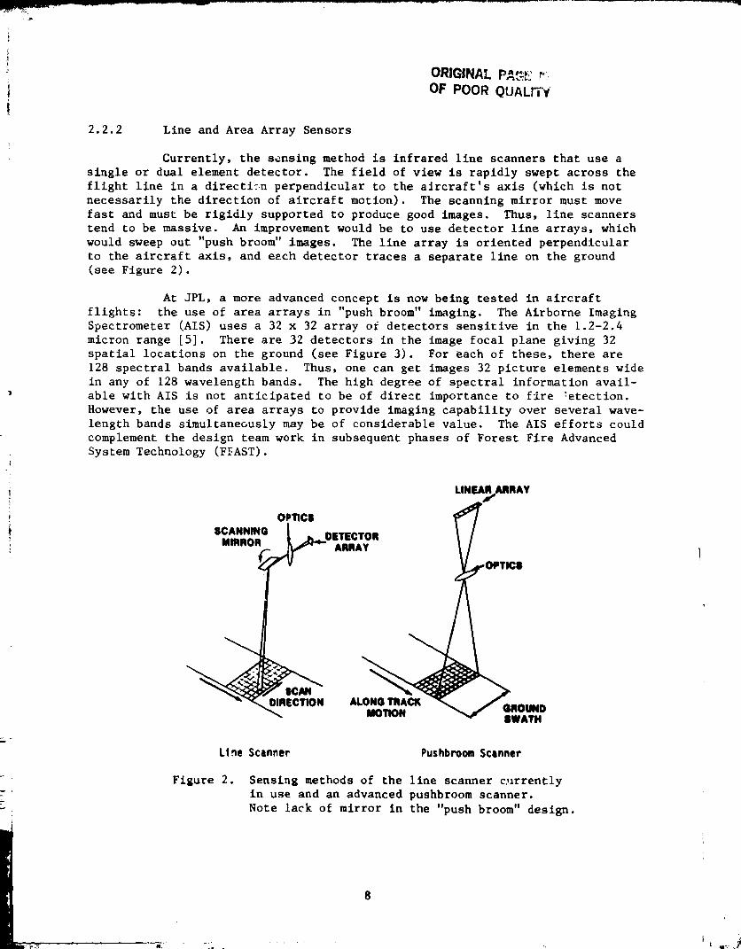
2.2.2 Line and Area Array Sensors
Currently, the sensing method is infrared llne scanners that use a
single or dual element detector. The field of vlew is rapidly swept across the
flight llne in a dlrectl_:n perpendicular to the aJrcraft's axls (which is not
necessarily the direction of aircraft motion). The scanning mirror must move
fast and must be rlgldly supported to produce good images. Thus, llne scanners
tend to be massive. An improvement would be to use detector llne arrays, which
would sweep out "push broom" images. The llne array Is oriented perpendicular
to the alrcraft axis, and each detector traces a separate llne on the ground
(see Flgure 2).
At JPL, a more advanced concept is now being tested in aircraft
flights: the use of area arrays in "push broom" imaging. The Airborne Imaging
Spectrometer (AIS) uses a 32 x 32 array of detectors sensitive In the 1.2-2.4
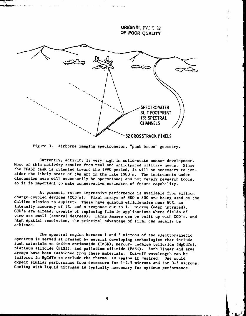
micron range [5]. There are 32 detectors in the image focal plane giving 32
spatial locations on the ground (see Figure 3). For each of these, there are
128 spectral bands available. Thus, one can get images 32 picture elements wide
in any of 128 wavelength bands. The hlgh degree of spectral information avail-
able wlth AIS is not anticipated to be of direct importance to fire _etectlon.
However, the use of area arrays to provide imaging capability over several wave-
length bands simultaneously may be of considerable value. The AIS efforts could
complement the design team work in subsequent phases of Forest Flre Advanced
System Technology (F_AST).
LINEA_ARRAY
SCANNING OPTICS
...... k_ OETECTOR
mmsuR_ ARRAY OPTICS
SWATH
Line Scanner Pushbrooa Scanner
Figure 2. Sensing methods of the llne scanner c_irrently
In use and an advanced pushbroom scanner.
Note lack of mirror In the "push broom" design.
ORIGINAL _'_"_ "-OF POOR QUALITY
"'- I -". \ _SPECTRON_TER I 1
"-. / "-_ SLITFOOTPRINT ) I"'. / ._" 128 SPECTRAL / /
"'"'''" "__'_ 32 cQn 'CHANNELS "//" CROSSTRACK P IXELS
Figure 3. Airborne imaging spectrometer, "push broom" geometry.
Currently, activity is very high in solld-state sensor development.
Most of this activity results from real and anticipated military needs. Since
the FFAST task is oriented toward the 1990 period, it will be necessary to con-sider the likely state of the art in the late 1980's. The instruments under
discussion here will necessarily he operational and not merely research tools,
so it is important to make conservative estimates of future capability.
At present, rather impressive performance is available from silicon
charge-coupled devices (CCD's). Pixel arrays of 800 x 800 are being used on the
Galileo mission to Jupiter. These have quantum efficiencies near 80%, an
intensity accuracy of I%, and a response out to I.I micron (near infrared).
CCD's are already capable of replacing film in applications where fields of
view are small (several degrees). Large images can be built up with CCD's, and
high spatial reso]u=ion, the principal advantage of film, can usually beachieved.
The spectral region between I and 5 microns of the electromagnetic
spectrum Is served at present by several developing technologies that include
such materials _s indium antimonide (InSb), mercury cadmium tellurlde (HgCdTe),platinum silicide (PtSi), and palladium silicide (PdSi). Both linear and area
arrays have been fashioned from these materials. Cut-off wavelength can be
tailored in HgCdTe to exclude the thermal IR region if desired. One could
expect similar performance from detectors for 1-2.5 microns and for 3-5 microns.
Cooling with liquid nitrogen is typically necessary for optimum performance.
9

The InSb linear arrays of 128 and 512 elements are being made with a
multiplexed readout structure (see Figure 4). In scanners, these will produce
images of TV-quality resolution. Area arrays have been made up to 32 elements
x 32 elements. Approximately the same sophistication exists for HgCdTe, which
has somewhat less stringent cooling requirements. It is unclear which detector
material will be favored at the end of the decade, but it is safe to assume that
area arrays offering TV-quallty imaging will be available out to 5 microns.
Existing scanner-type devices producing TV-compatible imagery in the
near IR include rotating mirror systems employing single-element HgCdTe detectors
and pyroelectric vidlcons that operate at room temperature. For some fire-
fighting tasks, these have proven valuable and will continue to be of value.
The new arrays will probably replace the detectors now in use in a way that is
transparent to the buyer and user.
Airborne line scanner technology will probably evolve to make use of
many element line arrays, eliminating the need for scanning mirrors. Even now,
butting several 512 element arrays together could equal the spatial resolutionof the IR line scanners that use one detector.
Infrared detector array technology is the least advanced for those
devices sensitive in the 8-12 microns atmospheric window. HgCdTe seems to be the
most developed material with linear arrays of 32 elements having been constructed
and operating at 77 kelvin with the aid of liquid nitrogen. There is great
interest in these detectors, partly because of the existence of the 10.6 micron
CO2 hlgh-powered laser, and much progress is expected by 1990. Certainly we may
anticipate that llne arrays can be used in airborne scanners. Area arrays are
being planned in HgCdTe, tailoring the cut-off wavelength to the i0 micron region
and employing technology similar to that used for near-IR cut-off HgCdTe arrays.
In the microwave region, detection techniques are rather different.
Antennas are used rather than optics, and spatial resolution is greatly reduced
for a given optic (antenna) diameter, relative to the IR. There is no array
technology so that images must be built up from scanning, much as the current IR
scanners operate. Passive microwave detection is advancing in sensitivity and
sophistication at a rapid rate, however; by the late 1980's it may prove feasible
to get rough images containing fuel moisture information [6].
Thermal infrared sensing of forest fires and related hot spots is
performed in the two prominent atmospheric transmission windows at 3-5 and
8-12 microns. Reflected solar radiation largely can be ignored in the
8-12 micron range but not always for the 3-5 micron range. During the day,
highly reflective rocks can produce strong glint near 3 microns. The radiance in
the 3-5 micron band is a much stronger function of temperature than at longer
wavelengths for hot sources below about 200°C. That means greater contrast
exists in the shortwave band. Consequently, if both bands are used simultaneously,
hot spots smaller than an instrument's field of view can be detected by comparing
the brightness temperatures in the two bands. If there is a mix of temperatures
in the field of view, the shortwave channel will always read a higher temperature.
This principle is used in current IR airborne scanners and will continue to be an
important feature of thermal IR detection systems.
I0

T! OF POOR QUALITY
m
|
m Figure 4. The 512-element linear array of InSb detectors. This
512-element linear array of InSb detectors, made for
JPL by Cincinnati Electronics, was developed as a
follow-up to the detectors designed for the Galileo
mission to Jupiter. Arrays llke thi3 one will replace
scanning mirror systems and improve sensitivity in
many imaging applications.
114_

Hand-held IR viewers operating in both 3-5 and 8-12 micron regions
have been found useful for several fire-fightlng tasks. They can detect hot
spots and fire zones by penetrating smoke and haze, giving the fire fighter and
mop-up crew a powerful tool. However, trying to transfer the thermal informa-
tion to maps can be frustrating, both because the ground is obscured in the
visible portion of the spectrum and because the thermal view of terrain offers
few familiar landmarks. The latter characteristics are also applicable to the
output of airborne IR scanners.
The near-IR region between I and 2 microns offers several possibili-
ties relevant to forest fire detection and mapping. In daylight, the surface
looks much the same in this spectral range as it does in the visible. However,
because of less scattering, penetration of haze and smoke is improved. A near-IR
viewer could aid airborne firefighters dealing with active fires (as opposed to
holdover fires that warm the surface by only a few degrees).
Although the shortwave region is inaccessible at night, combined
near- and thermal-IR viewing may make possible better daytime fire mapping. The
shortwave data can eliminate reflective "glint" signals that confuse interpreta-
tion of daytime thermal images.
The same near-IR region, 1.0-2.5 microns, is of considerable value
both to the forest fire fighting community and the pest/dlsease personnel
because of the presence of surface moisture information in the spectrum. The
entire range is dominated by the influence of strong water bands at 1.4 and
1.9 microns. The bands are much broader for water in the liquid phase as in
plants, than in the gaseous phase, as in the atmosphere. Water abundance in
plants, and even in dead surface material constituting fuels, leads to low
reflectivity in the affected spectral regions. As the fuel dries and as the
vegetation undergoes water stress,,the reflectivity increases. This change
enables, in principle, a remote detection of fuel moisture, initially relevant
to forest fire prediction and also early diagnosis of water stress induced by or
leading to pest/disease damage. However, there are severe problems in the use
of near-IR spectra for moisture sensing. The changes in reflectance are easily
masked by background or foreground spectra (soll or trees) of different
character. Shadows can simulate lower reflectance, and different species differ
in their normal spectra. Atmospheric conditions also influence spectra.
Moisture information will be forthcoming only when differential measurements are
made by comparing adjacent spectral bands and perhaps by comparing spectraobtained for different times and areas.
The microwave region offers potential benefits to the forest manager.
First, microwave radiation, with wavelengths greater than several millimeters,
penetrates smoke and clouds with minimal attenuation. Like the thermal IR, this
radiation depends on surface temperature; thus hot spots and fires can be
detected. Fuel moisture sensing is possible because there are water absorption
bands present in the microwave range [7].
O12
2.2.3 Georeferenclng Systems
In forest fire detection and mapping, the many variables associated
with fire behavior must be compared and contrasted. Perhaps the most obvious
need is the ability to locate fire targets which appear on IR scanner film
output with respect to known geographic positions on the ground. Such compari-
sons can be made if the image is georeferenced.
Georeferencing involves the adjustment of the fire imagery to a
standard geographic base which in turn permits comparisons with ancillary data
items provided that they are adjusted to that same base. Difficulties lie in
obtaining adequate information on how to adjust the image data. Currently, the
raw imagery is examined by a trained photo-interpretation specialist. The inter-
preter identifies common points between the imagery and a map. A grid is com-
posed based on the selected common points and is overlaid on the map and image.
Using the manual information transfer method known as "similar squares," the
specialist sketches the fire perimeter on the map using the grid as control.
This method of transfer is precise although time consuming. A partic-
ularly difficult part of the procedure is selecting accurate common points
between map and image and subsequently composing the translation grid. It is the
control point selection process and automatic transformation of the data to a
common grid that requires advanced technology.
The Global Positioning Satellite System (GPS) has been developed to
provide highly precise position, velocity, and time information to users anywhere
in the vicinity of earth and at any time. The GPS, when fully operational, will
consist of 18 satellites in six orbital planes. These satellites will be at
about 20,O00-km altitude and will have a 12-hour period with orbits inclined at
55 ° . The satellites will transmit L 1 (1575 42-MHz) and L2 (1227.6-MHz) signals.
Navigation information, such as the ephemeris of the satellites and clock model
parameters, and the system data are superimposed on these radio signals. Byreceiving and processing the radio signals from the constellation of satellites
any GPS user can instantaneously determine navigation information (position and
velocity parameters) to an accuracy of about 15 meters in position and 0.I meters/
second in velocity. This radio navigation system is primarily developed for
utilization by the Department of Defense. However, there exists a broad spectrum
of civil users who would benefit from the system [8]. While a 15-meter posi-
tional accuracy will be available from the GPS system, it may not satisfy the
requirement of the USDA Forest Service--an accuracy requirement of one road
width (defined as a 15-foot-wide road). However, it may permit the 15-meter
error data to be automatically registered with the aid of digital terrain modelsand radar altimetry information.
The satellite receiver system will provide signals from which range
information can be obtained and, simultaneously, from which the position and the
bias in the clock relative to the fire fighters can be determined.
There are a number of other radio-based navigation systems available
such as LORAN-C, OMEGA, INS, TACAN, TRANSIT. The TRANSIT is probably closer to
GPS because it is als Itellite based; however, the accuracy degrades in between
orbits. GPS provides , same accuracy globally. In other systems, the errorscan be large.
13 L
_Mv
2.2.4 Advanced Satellite Relay Communications
A satellite placed in equatorial orbit at an altitude of 22,300 miles
will have an orbital period of 24 hours. It will, therefore, appear stationary
from any point on earth. Such satellites are called synchronous or geostationary.
There are several commercial and special-purpose geostationary satellites now in
orbit.
Earth stations may transmit and receive signals to and from a
satellite. The signals may be used to convey voice, video, or other types of
information. Typically, two or more earth stations work in a duplex mode
(simultaneous transmission and reception) using the satellite as a relay.
The electronic components of the earth station can at present be
contained in a small van; attached is a trailer containing a power generator and
a dish antenna. Telephone links can be accommodated; thus, two-way communications
are established from the remote, transportable station via the satellite to the
earth station and into the commercial telephone system. Communications can then
be achieved from a remote site in a national forest to any place in the country
having commercial telephone service. No physical connections at the remote site
are required to telephone or powerlines. The terminal is completely independent
and self-contained [9].
Satellite communications from the IR sensing aircraft to a central
facility may be available by the late 1980_s. On-board data processing could
reduce the information content and hence the data bandwidth required for use of
commercial satellite services. A tracking phased-array antenna would be used on
the aircraft to communicate with the relay satellite and in turn a central
facility. From the central facility, additional processing could be performed
and the results forwarded via a different satellite link to the mobile satellite
terminal located at the fire comm_nd post. The latter satellite communications
capability is commercially available today. The plane to satellite link will
require development [10,11].
2.2.5 Integrating Existing Data Bases
Various data bases at different stages of completion are distributed
throughout the USDA Forest Service. Many of these data bases represent informa-
tion on national forests for land o_ership and timber attributes (including
volume, type, density and fuel capacity) as well as economics and availabi_
resources. It would be beneficial to take advantage of existing data bases,
wherever they may reside, in order to provide additional and supporting data for
forest fire mapping and detection.
Incompatibility of machines and data base formats makes such an
undertaking difficult and costly. Communication networks must be established if
the data bases are distributed over a wide geographic area. With the advent of
distributed computer systems and networks such as the Forest Level Information
Processing System (FLIPS), such a =ask may be less costly and difficult because
a majority of the work will have already been accomplished. The general goal in
SUCh a system is to make all programs, data, and resources available to anyone
14

on the network without regard to physical location of the resource (data base)or user. Sucha system has the potential for providing favorable price/performance ratio, graceful degradation upon failure, and incrementalexpansion [12].
It is c]ear that the trend in computer processing and data handlingis retreating from the large central computer to a network of smaller independentbut linked computers. Developments in networking software will continue to bestrong in the years ahead. Muchwill be learned about the problems of obtainingand processing data such as fuels data from several national forests anddistricts to be used in real time with fire rate-of-spread models by fire-fighting personnel.
2.2.6 image Processing Techniques
Image processing was once the domain of only very large institutions
with large mainframe computers. Minl-computers and stand-alone image processing
systems with fairly sophisticated functions have recently begun to appear in the
governmental and private sectors in significant numbers. The increased use of
spatial data, particularly those gathered by remote sensing methods for resource
inventory and assessment, brought this about.
Several factors combine to indicate a bright future for digital image
processing. A major factor is the declining cost of computer equipment. Both
processing and storage units are becoming less expensive. A second factor is
the increasing availability of equipment for image digitizing and display. Indi-
cations are that costs wil_ continue to decline. Several new technology trends
promise to further promote digital image processing. These include parallel
processing made practical by low cost micro-processors, the use of CCD's for
digitizing and storing during processing and display, and large, low-cost
storage arrays. Thus, with the increasing availability of reasonably inexpensive
hardware and some very important and interesting applications on the horizon,
one can expect image processing to continue its growth and play an increasinglyimportant role in the future [13].
'5

SECTION 3
MATCHING TECHNOLOGY AND USER REQUIREMENTS
J
The technology survey resulted in a wide variety of existing,
fundamental and advanced technologies as well as several promising emerging tech-
nologies that may be suited to aid the information gathering necessary to meet
fire management needs. These technologies range from standard propeller air-
craft used as a sensor platform to automatic georeferencing of imagery gathered
by highly advanced multlband area arrays. Space communications networks using
portable satellite relay stations coupled with advanced ground data processing
may be available in the 1990 time frame. Such technology may well fulfill the
information requirements of the USDA Forest Service for fire management. Basic
user needs and requirements for information include the need to know the location
and intensity of fires and the current and forecasted behavior of fires. These
needs can be met with the measurement and modeling of the local and regional
environment, the functional use of the technology.
A major concern regarding the practical application of advancing tech-
nology to fire mapping and detection is the apparent complexity of the system
that could result. Complex technology could affect the performance of the entire
fire management system in that a high degree of training may be necessary in
order to operate the system and to maintain the system. The reliability of the
system may be reduced if this training is neglected. Such complexity is clearly
not workable in a tactical situation where major decisions would be based on a
system that may or may not be up and working. The design of a system should be
approached from the fundamental requirement for a "user friendly" system with
reliability and maintainability considerations foremost. The advanced technology
must translate into cost savings and improved performance if the system is to
meet the information needs in fire management of the USDA Forest Service.
Matching technology to user requirements was completed by comparing
the capability of each technology to each user need. As an example, timely
information was rated as being very important in fire management, as was the
ability to receive the information. Past experience has shown that local radio
transmissions are often shadowed in mountainous terrain inhibiting information
transfer. A pertable satellite receiving station that could be set up in a matter
of hours would be a likely solution to this problem.
The portable satellite receiving station derives from existing and
well-tested technology. Advanced technology may contribute to a solution of
delivering the fire imagery to the local fire camp in a matter of minutes after
acquisition. Advanced technology may also assist with significant amounts of
on-board processing to produce an image or map that has been automatically
georeferenced with the aid of navigational and positioning systems.
The strawman system configuration in the following section serves as
a sample of the results of matching technology to requirements.
pRECEDiNG PAGE BLANK NOT fiLMED

m !
SECTION 4
STRA_4AN SY STEM CONFIGURATION
()RK_NNAL F_ _.'-_
OF.POOR QUAL_'_",
The strawman system configuration as shown in Figure 5 was prepared
with regard to future information needs and what emerging and available tech-
nologies might be present in the 1990's. The strawman configuration is intended
as a device upon which a subsequent conceptual design may be based. Each
component of the system is discussed in the following.
GEO.SYNCH RONOUS SATELLITE
FOR COMMUNICATIONS ANDDATA TRANSFER
ELECTRONICALLYSTEERABLE
GLOBAL
POSITIONING _SATELLITE
HIGH SPEEDAIRCRAFT
PUSHBROOMALTIMETRYFOR TERRAIN
CORRECTION
ESCAPED FIRE
FIRE CAMP '
DESTINATION OF
FIRE INFORMATION
G ROUND STATIONPROCESSINGCENTER
Figure ,,.
IRATE ANCI LLARY
DATA BASES
MAI INFORMATION
RATE OF SPREAD MODELS
AUTOMATIC LIGHTNINGDETECTION SYSTEM
REMOTE AUTOMATICWEATHER STATION
NOAA WEATHERINFORMATION
Strawman system configuration (Forest Fire Advanced
System Technology--FFAST).
PRECEDING PAGE BLANK NOT FILMED
19

4.1 SENSOR PLATFORM
The li_ely candidate for a sensing platform will be a turboprop
aircraft. Considerations are made here for cost and duty cycle of the aircraft,
as well as alternate uses.
4.2 SENSOR TYPE
Using multilinear and area arrays in several wavelength bands will
provide basic information on fire and related parameters.
4.3 DATA PROCESSING
N
4.3.1 On-Board Processing
A variety of functions may be performed with on-board processing. The
most significant problem affecting aircraft-gathered imagery is that of geometric
distortion. The majority of the distortion can be attributed to aircraft move-
ment during image acquisition. Additional sources of distortion are extreme
viewing angles of the sensor and terrain variations which result in non-
orthogonal images. A second major problem in acquiring imagery from a moving
aircraft is the difficulty in maintaining geographic reference. It may be
possible with the aid of inertial navigational equipment, Global Positioning
Satellites, and digital terrain models to determine the location of a particular
point on the ground accurately enough for Forest Service needs. Current research
indicates that advanced computer chips capable of processing large amounts ofinformation in real time or near-real time will be well established and available
by 1990. Significant on-board processing may be necessary to reduce the data
volume that must be transferred to either a central processing facility or the
fire camp.
4.3.2 Ground Processing
To take advantage of archival and existing data bases regarding forest
attributes, a variety of processing steps may be necessary at a ground facility.
4.3.2.1 Incorporation of General Map Data. Information contained in standardUSGS topographic maps should be used as the convention. Scales at which to
display this information would be determined by the conceptual design team.
4.3.2.2 Cost/Benefit Modeling. Information regarding the impending economic
loss or advantage could _e outlined in a map or graphic form for easy reading.
Tables could be generated and updated to show net dollars gained or lost.
2O
,

4.3.2.3 Fuel Type. Fuel type maps, _nen available, could be integrated in
order to assist the fire boss in prescribing the appropriate action for suppres-
sion or management. Information which might be included with a fuel type mappingare fuel volume and moisture control,
4.3.2.4 Fuel Moisture. Information gathered from RAWS would greatly assist in
determining fuel moisture by gathering timely meteorological data across a pre-
defined grid.
4.3.2.5 Rate of Spread Mgdels. An important component to fire behavior pre-
diction in the future may be the coordinated use of computer fire rate-of-spread
models. Output from developed and well-tested models may be displayed directly
on a map facsimile such as a USGS topographic map.
4.3.2.6 Automatic Lightning Detection System (ALDS). Real-time information
regarding real and likely fire starts from lightning may be integrated into the
processing sequence.
4.3.2.7 Terrain Processing. Information for the United States regarding ter-
rain is available in computer-compatible format. Slope aspect and gradient can be
derived from raw elevation points and displayed in map form. Areas of steep
slope gradient can be calculated, as well as specific directions of slopes.
North facing slopes may contain a higher fuel density than south facing slopes
due to the i_-_er water budget cycle.
4.3.2.8 Suppressio 9 and Management Resources. Location, quantity, and type
of resources available to manage a large fire can be displayed in character and
graphic form on a particular map.
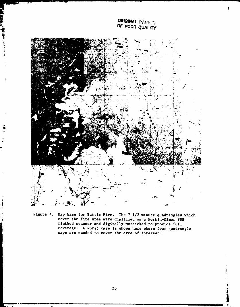
4.3.2.9 Sample Output. Figures 6 through 9 depict the sequence of processing
steps which might take place in the course of value-added image processing. The
sequence of steps entails the initial entry of the thermal imagery into the data
base. The requisite maps are obtained, digitized, and readied for input to the
computer processor. Common points are selected on an interactive display screen
with a trackball cursor by standard photo-interpretation methods and are used to
construct a computer deformation grid. The gridded information is then used to
geometrically adjust the fire image so that it has a one-to-one correspondence
with the map. The final step involves the overlay of the fire image directly on
the map base.
Several time consuming steps would be eliminated in the strawman
system. These steps would be on the intensive analytic interpretation necessary
for selecting common points needed to construct the deformation grid and the
digitizing and mosaicking o_ the fire imagery and map data.
21
•_ 2" _ "_ ......................................................... -_

ORIGINAL t'_'A_. _
OF POOR QUALI'CY
Figure 6. Thermal imagery for Battle Fire, AZ. This thermal imagery of
the Battle Fire in Arizona was acquired on May 18, 1972. The
image was digitized on a Perkin-Elmer PDS flatbed scanner and
formatted for compute_ processing. Dark tones depict areas
of relatively low temperature and light tones depict areas of
relatively high temperatures.
4.4 COMMUNICATIONS
Near-real time communication would be accomplished with aid of
satellite communication links and highly advanced electronically steerable
antennas. The information will be gathered from the ground through the imaging
sensor, transmitted via an electronically steerable antenna to a geosynchronous
communications satellite, and relayed directly to a ground data processing
facility. There, value-added processing would be performed to incorporate fire
behavior simulation models and existing data bases. The enhanced data product
would then be transmitted directly to the fire camp via the satellite communica-
tion link. Voice communication to anywhere in the United States would also be
possible.
22
ORIGINAL w'_*_.,r__,:,__OF POOR QUA',.17Y
/
Figure 7. Map base for Battle Fire. The 7-1/2 minute quadrangles vhtchcover the fire area were digitized on a Perktn-Elmer PDS
flatbed scanner and digitally mosaicked to provide full
coverage. A worst case is shown here where four quadranglemap8 are needed to cover the area of interest.
23
t

Figure 8.
OmGINAL PAGE ISOF POOR QUALITY
Thermal imagery for Battle Fire, geometrically adjusted.
The thermal imagery was geometrically rectified to the
digital map base by using common points selected between
the map and image.
24
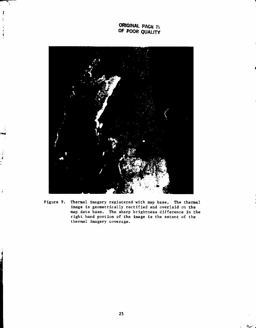
ORIGINAL PAGE" _OF POOR QUALITY
Figure 9. Thermal imagery registered wlth map base. The thermal
image is geometrically rectified and overlaid on the
map data base. The sharp brightness difference in the
right hand portion of the image is the extent of the
thermal imagery coverage.
25

SECTION 5
CONCEPTUAL DESIGN PHASE
5.1 DIRECTION AND FUNDING
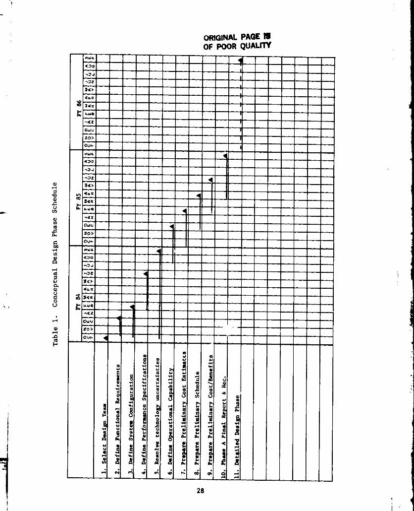
At the February, 1983, Aviation and Fire Director's National Meeting
in Albuquerque, the Directors agreed that the Conceptual Design Phase should be
accomplished during Fiscal Years (FY) 84 and 85 (see Table I).
The estimated cost for the conceptual design phase is $150,000 per
year for each of the two years. The USDA Forest Service would provide the amount
of $75,000 per year and additional funding would be coordinated with interested
agencies such as the National Park Service, Bureau of Land Management, and NASA
(see Table 2). A suggested participation for each of the nine regions and
$12,000 for A&FM, Washington Office (WO) each year was discussed with general
acceptance, except for some uncertainty of Regions about any funding being
available. The conclusion was that we should proceed and funding would be worked
out. Upon completion of the Conceptual Design Phase, the technical report and
recommendations, including cost estimates, will be reviewed prior to proceeding
into the next phase.
Should the conceptual design lead to detailed design and fabrication,
it is envisioned that private industry would participate as subcontractors for
supplying components that make up various parts of the total system. Industry
would contribute the specialized expertise that results from the privately funded
research and development activities. Such expertise may pertain to production
processes, both mechanical and chemical, communications problems, and computer
hardware manufacturing.
5.2 DEFINITION
The phases of the research, development, test and evaluation cycle are
defined i_ the Advanced Electronics Systems Development Team Missions and
Responsibilities document [14]. The conceptual phase is intended to define and
select the system which warrants continued development, to identify major uncer-
tainties with recommendations for resolution during subsequent phases, to deter-
mine operational capability and characteristics, to provide preliminary cost/
schedule estimates, and to examine cost/benefit ratios.
5.3 GOALS
The goals of the conceptual phase primarily will be as defined above,
to develop the concept for a total system. The various elements and functions
of that system will be reviewed and projections of technology availability made
for each. Risk areas and unknowns will be identified. Alternative approaches
may be discussed or proposed for additional study where there are high risks Or
unknowns. At the conc)usion of this phase, a viable approach for subsequent
phases will be documented.
PRECEDING PAGE BLANK NOT FILMED
27
J
ORIGINAL PAGE IIOF POOR QUALITY

Table 2. Approximate Cost Contributions
Phase APhase 0 Phase 1
Conceptual Design Detailed DesignAgency Feasibility Study FY84 FY85
NASA a $ 47K $ 75K b $ 75K b
USDA Forest Service $ 30K d $ 75K $ 75K
I0% c
90%
aTechnology Utilization and Industry Affairs Division.
bsuggested contribution from NASA and other interested agencies.
CSuggested percentage contribution to total cost.
dcost incurred as a function of facility use and manpower.
More specifically, the following questions should be addressed
during the conceptual design phase:
I, How can the system be modularized to minimize obsolescence and
retain capability to use newly developed equipment?
J What image/digital processing functions can reasonably be doneaboard the aircraft and which should be done at a central
facility and/or mobile command post unit?
3. What final products are needed by the fire/forest managers?
e Can the system be made versatile enough for multiple uses
(e.g., fire management, insect and disease management mapping,
etc.), through interchangeability of sensor front-ends or
multiple band sensors?
e How can the system provide inputs to existing/developing computer
models or utilize existing/developing data bases?
0 What are the milestones, decision points, and general schedule
for the succeeding phases?
• What technologies will be available in the late 1980's, and which
should be considered for application?
o What are the communications needs, and what methods _nd systems
should be used?
e What contributions (fiscal, technical) could be made by Canada
or other cooperating agencies in succeeding phases?
29

i
I0. What institutlonal (regulatory, political) issues may be
encountered (e.g., frequency allocations)?
Ii. What system design is recommended for further development?
12. What type and how many aircraft will be needed/available?
13. How should we schedule and phase-in the advanced system?
14. What are the cost/benefit ratios associated with an advanced
system?
5.4 DESIGN TEAM
The design team will be composed of John Warren, Electronics Engineer,
Advanced Electronics Systems Development Group Leader, A&FM, and members of the
Jet Propulsion Laboratory technical staff. Led by Ron McLeod, JPL personnel
will provide the specialized expertise in the variety of technical disciplines
explored and developed. The team will consult with various Regional Aviation
and Fire Management Directors from time to time to obtain user guidance.
Coordination will also be maintained with interested Canadian National and
Provincial Fire personnel, Research, and other agencies as appropriate. Overall
guidance and direction will be provided by John Chambers, Assistant Director,
A&FM, WO. The team will prepare an annual report for review at the National
Aviation and Fire Management Directors' meetings and interim or specialized
reports as needed.
3O

m_?_ -¸, _
y.
SECTION 6
SUMMARY
In order to assure that the information needs and plans presented
here are consistent with the practices of the USDA Forest Service and other
agencies, draft copies of th_s report were sent to those agencies and persons
listed in Appendix A for review and comment. A variety of concerns were Identi-
fied as needed additions and changes to the report. Appendix B includes the
correspondence received from the users regarding the suggested changes and
additions. As well as the cover letter attached to the draft report, Appendix C
includes additlonal related correspondence.
Planning for the arrival of new technology and the application of
existing technology has its obvious advantage. If a two-year planning effort
is undertaken that will foresee future develpments, then when those developments
mature, the planning process secures a two-year head start and the ability to
make use of that technology immediately.
Existing and future technologies promise solutions to fire management
information needs. The strawman configuration is a strong possibility and
appears feasible. With the current expertise at hand and the benefit of past
experience both in fire management and advanced technology, further work in
this area is strongly recommended.
L
31
Ze
REFERENCES
S.N. Hirsch, et al., Project FIRESCAN Fire Mapping Final Report,
Research Paper INT-49. USDA Forest Service, Washington, D.C., 1968.
me R.A. Wilson, et al., Airborne Infrared Forest Fire Detection System:
Final Report, Research Paper INT-93. USDA Forest Service, Washington,
D.C., May, 1971.
. NASA Task Order RE-170, Amendment 53, Oct. i, 1982.
. R.D. Dllman, et al., Operational Test of Panoramic Aerial Photograph7
for Estimating Annual Mortality of Ponderosa Pine Caused by_ MountainPine Beatle. Prepared by Lockheed Engineering and Management Service
Company for U.S. Department of Agriculture Forest Service, Houston, TX,
Nationwide Forestry Application Program, LEMSCO-16377, Sept., 1981.
.
.
,
,
.
I0.
ii.
12.
J.B. Wellman, J.B. Breckinridge, P. Kupferman, R. Salazar, "Imaging
Spectrometer Technology for Advanced Earth Remote Sensing," SPIE
Proceedings, Vol. 345, SPIE Symposium on Advanced Multispectral
Remote Sensing Technology and Applications, Arlington, VA, May, 1982.
E.G. Njoku, J.P. Schieldge, and A.B. Kahle, "Joint Microwave andInfrared Studies for Soil Moisture Determination." JPL Publication
80-57, Jet Propulsion Laboratory, Pasadena, CA, 1980.
J.R. Wang, et al., "Radiometrlc Measurement Over Base and Vegetated
Fields at 1.4 GHz and 5 GHz Frequencies," Remote Sensin_ of theEnvironment, 12:295-311 (1982).
M. Anada, '_AVSTAR/Glohsl Posit_oning System," in Proceedings of the
NASA Workshop in Registration and Rectification. N.A. Bryant, ed.,
JPL Publication 82-23, Jet Propulsion Laboratory, Pasadena, CA,
June i, 1982.
J.R. Warren, "Remote Slte Communication Via Satellite," Flre ManaBe-
ment Notes. USDA Forest Service, Washington, D.C., Spring, 1977.
R.R. Lovel, G.H. Knouse, and W.J. Weber, "An Experiment to Enable
Commercial Mobile Satellite Service." JPL Internal Document, Jet
Propulsion Laboratory, Pasadena, CA, [982.
Land Mobile Satellite Service (LMSS). NASA-JPL Publication 82-19,
Jet Propulsion Laboratory, Pasadena, CA, Feb., 1982.
A.S. Tannenbaum, Computer Networks. Prentlce-Hall, Inc., Englewood
Cliffs, NJ, 1981.
pRECEDiNG PAGE BLANK NOT FIRMED
33 l

13.
14.
K.R. Castleman, Digital Image Processing. Prentice-Hall, Inc.,
Englewood Cliffs, NJ, 1979.
J.R. Warren, "Advanced Electronics Systems Development Team: Mission
and Responsibility." USDA Forest Service, Boise, ID, UnpublishedNational Document.
34

i
APPENDIX A
AGENCY PERSONNEL INTERVIEWED
35

!
United States Department of A_ricultureForest Service Personnel
Oary CargillUSDA Forest Service
Associate Deputy ChletNational Forest SystemP. 0. Box 2417
Washington, D. C. 20013
Joha Chambers
USDA Forest Service
Assistant Director - Fire Suppression
Aviation and Fire ManagementP. O. Box 2_17
Washington, D. C. 20013
Ray P. AllisonUSDA Forest Service
Remote Sensing - Technological ImprovementsEngineering StaffP. 0. Box 2_17Washington, D. C. 20013
William BarrusUSDA Forest Service
Boise Interagenoy Fire Center, IR Operations3905 Vista Avenue
Boise, Idaho 83705
Dong BirdUSDA Forest Service
Director - Aviation and Fire HanagmentRegion _, Intermountaln Region32q Twenty-Fifth StreetOgden, Utah 8qqO1
Robert CarrUSDA Forest Service
Aviation OperationsAviation and Fire Hanage_entBoise Interagenoy Fire Center (BIFC)3905 Vista AvenueBoiSe, Idaho 83705
36

William M. CieslaUSDA Forest ServioeLeader - Methods Applioations GroupForest Pest Management
Suite 350, Drake Executive Plaza2625 Redwing RoadFt. Collins, Colorado 80526
Ken ClarkUSDA Forest ServioeFire Coordinator
Region 5, California630 Sansome StreetSan Francisco, CA 9qlll
Villiam H. Clerke
USDA Forest Service
Remote Sensing Specialist
Forest Pest Management
Southeastern Region State and Private Forest._y1720 Peaohtree Street N. W.
Atlanta, Georgia 30367
Richard Cox's StaffUSDA Forest Se_vioe
Region 8, Atlanta, Georgia1720 Peachtree Street N.W.Atlanta, Georgia 30367
Terry W. Gossar_USDA Forest Ser_ioe
Geometronios Development Group - Chief Engineer
Teohnologioal ImprovementsEnginaerlng StaffP. O. Box 2417
Washington, D. C. 20013
Edward HeilmanUSDA Forest ServioeDirector - Aviation and Fire Management
Region 1, Mlssoula, MontanaFederal BuildingP. O. Box 7669
Missoula, Montana 59807
Riohard L. ListonUSDA Forest Servioe
Development Coordination, Geozetronios Development GroupTeohnologioal ImprovementsEagAneering StaffP. O. Box 2417Washington, D. C. 20013
37/

Bentley LyonUSDA Forest Service
Forest Fire and Atmospheric Sciences Research StaffFire Control TechnologistP. O. Box 2q17Washington, D. C. 20013
Robert J. McDonaldUSDA Forest ServiceDirector - Aviation and Fire ManagementRegion 6, Portland, Oregon319 S. W. Pine StreetP. O. Box 3623Portland, Oregon 97208
Gerald MaukUSDA Forest Service
Director - Aviation and Fire ManagementRegion 2, Denver, Colorado11177 W. Eighth AvenueP. O. Box 25127Lakewood, Colorado 80225
Richard E. MontagueUSDA Forest Service
Director - Avtatlon and Fire ManagementRegion 5, Pacific Southwest Region630 Sansome Street
San Francisco, California 9qi11
Richard J. MyhreUSDA Forest Service
Methods Applications GroupForest Pest ManagementSuite 350, Drake Executive Plaza2625 Redwing RoadFt. Collins, Coloredo 80526
Roger PelletierUSDA Forest Service
Resources Information Display SystemGeometro_os Development CroupTechnolog:.oal ImprovementsEngineering StaffY. O. BO_ 2_17
Washington, D. C. 20013
38

Michael RogersUSDA Forest Service
Fire Prevention and Fuels ManagementFire Suppression, Aviation and Fire ManagementP. O. Box 2417
Washington, D. C. 20013
William T. SommersUSDA Forest Service
Forest Fire and Atmospheric Sciences Research StaffHeteorolo_rP. 0. Box 2_17Washington, D. C. 20013
James L. StewartUSDA Forest Service
Director - Forest Pest ManagementP. O. Box 2417
Washington, D. C. 20013
Harold L. StrioklandUSDA Forest Sorrier
Assistant Director - Technological ImprovementsEngineering StaffP. O. Box 2417
Washington, D. C. 20013
Frederick P. Weber,-Ph.D.USDA Forest Service
Program ManagerNationwide Forestry Applications Program1050 Bay Area Blvd.Houston, Texas 77058
United States Department of InteriorBureau of Land Mana£ament Personnel
John E. Birch
USDI, Bureau of Land Management PersonnelChief, Division of Fire and Aviation ManagementBoard of Trade Building1129 Twenty-Ninth StreetWashington, D. C. 20240
39

Robert Seller
Fire Management SpeelalistNational Pa_k Service
Boise Interasency Fire Center390._ Vista Avenue
Boise, Idaho 83705
Robert Weber
Chief, Field Operations BranchBureau of Land ManagementBoise Interagency Fire Center3905 Vista AvenueBoise, Idaho 83705
Canadian Forestry Personnel
R. Jerry DrysdaleProjects Management SupervisorFire Control Unit
Aviation and Fire Management CentreMinistry of Natural ResourcesBOx 310
Sault Ste. Marie, Ontario P6AfL8Canada
D. E. Gilbert RPF
Staff Specialist
Planning and D_velopmentProtection BranchProvince of British Columbia
Ministry of Forests
Second Floor
31 Bastion SquareVictoria, British Columbia, Canada V8W3E7
P. M. Hall
Forest EntomologistStaff Specialist
Planning and DevelopmentProtection BranchProvince of British Columbia
Ministry of ForestsSecoad Floor
31 Bastion Square
Victoria, British ColumbiaCanada V8W3E7
4O
1

B •
t
Dr. Peter Kourtz
Canadian Forestry Service
Forest Fire and Remote Sensi_ ResearchPetawawa National Forestry InstituteChalk River, OntarioCamda KOJ1J0
D. W. Langridge CETTechnician
Staff SpecialistPlanning and DevelopmentProtection BranchProvince of British ColumbiaMinistry of ForestsSecond Floor
31 Bastion SquareVictoria, British ColumbiaCanada V8W3E7
Joe Niederleltner
Forestry Protection BranchAlberta Forest Service
Energy and Natural Resources10625-120 Avenue
Postal Station M, Box 70_0
Edmonton, Alberta, Canada TSE_S9
P. C. Paul Ward
Researoh and Development ForesterMinistry of Natural ResourcesAviation and Fire Management Centre55 Church St., P. 0. Box 310Seult Ste. Marie, Ontario P6A5L8Canada
• Oo
4!

APPENDIX B
CORRESPONDENCE OF USERS REGARDING COMMENTS
_NECEDING PAGE BLA_K NOT FILME.D
!' 43
b
JET PROPULSION LABORATORY INTEROFFICE MEMORANDUM04S: 7)018}-950M :mhf
16 _Jne 198}
TO:
FROM:
SUBJECT:
R. McLeod
C. M. Stevens _-//
Revlew of FFAST Report by NASA/TU
I met wlth Ray Whltten on Wednesday, 06/15/8), to discuss his comments on thedraft report for the FFAST feasibility study. Ray was impressed with the
document end had only a few suggestions. The followlng concerns wereldentlfled as needed additions to the document:
Io A paragraph discussing the role invisioned for industry should be
included. A brief discussion of who, what and how they would beinvolved is needed.
. Copies of the correspondence from users should be included as anappendix.
. Make a table showing past, present and anticipated future funding
incorporating the cost data on page 27.
_o In the interest of clarity, use pie chart format to incorporate
Information where comparisons ere made of funding, RDT&E, user
involvement, etc.
Please call me If you have questions concerning these comments.
cc: L. Piaseck_A. Smith
44

(_ Ur_tedStates ForestDepartmentof ServiceAgriculture
WashingtonOffice
12th & Independence SWP.O. Box 2417Washington, DC 2.001_)
_,_y,o 4400
o=. May 18, 1983
r
Ronald G. McLeod
Jet Propulsion Laboratory
4800 Oak Grove Drive, 168-514
Pasadena, California 91109
L
Dear Mr. McLeod:
Thanks for sending the draft report for the joint NASA/USDA FS sponsored
feaslbility study. I reviewed it and believe it adequately incorporates
or otherwise covers the input we made during oJr meeting wlth you and
John Warren. We have no concerns you failed to address in the report.
Your report is an excellent reference as to the state of the art and
opportunities for advancement. We appreciate your visit and opportunity
to comment, an_ook forward to the final report.
Sincer
Staff F_de Control TechnologistForest{Fire and Atmospheric
Sciehces Research
45
FS-6290 _I (8-80)
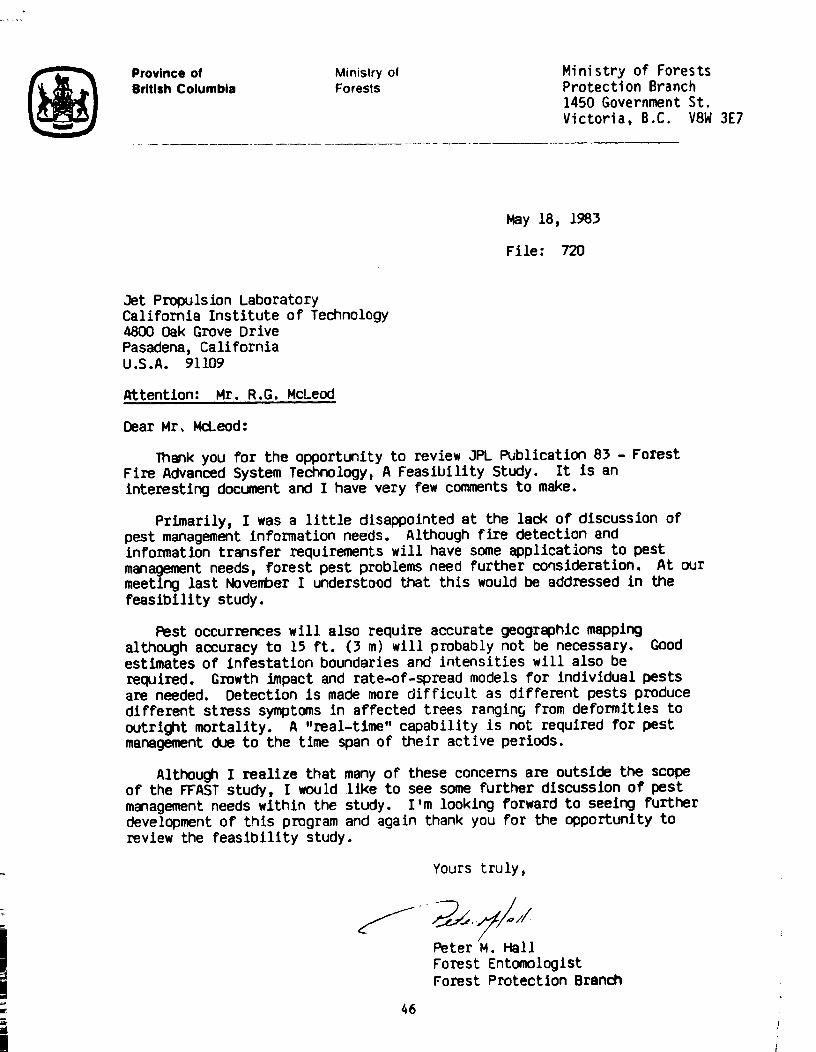
Province of Ministry ofBritish Columbia Forests
Ministry of ForestsProtection Branch
1450 Government St.
Victoria, B.C. V8W 3E7
May 18, 1983
File: 720
Jet Propulsion LaboratoryCalifornia Institute of Technology4800 Oak Grove DrivePasadena, CaliforniaU.S.A. 91109
Attention: Mr. R.G. McLeod
Dear Mr, McLeod:
Thank you for the opportunity to review JR_ Publication 8) - Forest
Fire Advanced System Technology, A Feasibility Study. It Is an
interesting document and I have very few comments to make.
Primarily, I was a little disappointed at the lack of discussion of
pest management information needs. Although fire detection andinformation transfer requirements will have some applications to pest
management needs, forest pest problems need further consideration. At our
meeting last November I understood that this would be addressed in the
feasibility study.
Pest occurrences will also require accurate geographic mappingalthough accuracy to 15 ft. (3 m) wlll pmbably not be necessary. Goodestimates of infestation boundaries and intensities will also berequired. Growth Impact and rate-of-spread models for Individual pestsare needed. Detection ls made more difficult as different pests producedifferent stress symptoms in affected trees rangin_ from deformities tooutright mortality. A "real-time" capability is not required for pestmanagement due to the time span of their active periods.
Although I realize that many of these concerns are outside the scopeof the WAST study, I would llke to see some further discussion of pest
management needs within the study, l'm looking forward to seeing furtherdevelopment of this program and again thank you for the opportunity to
review the feasibility study.
Yours truly,
Peter M. Hall
Forest Entomologist
Forest Protection Branch
46

UNITED STATES DEPARTMENT OF AGRICULTURE
FOREST SERVICE324 25th Street
Ogden, UT 84401
5100
Rod McLeod, Task HanagerForest Fire Advavced System Tedmology
Jet Propulsion LaboratoryCalifornia Institute of Technology
4800 Oak Grove Drive
_szadena, CA 91109
MAY 0 6 1983Q
Dear Rod:
Enclosed are my couments on your draft. I have made notations on the
copy you sent me. I really have no comments of import; Just some
minor editorial suggestions. You have done an excellent Job.
I hope we can continue ¢o keep in touch. I am very interested inthis task and would like to stay abreast of developments as they
O C CUr.
Thanks for the opportunity to comment.
Sincerely,
DOUGQS_.BIRD
Director
Aviation and Fire Management
Enclosure
47 uo_. (I/u) :i

_ UnitedStates Forest Rocky Mountain 11177 W. 8th AvenueDepartment of Service Region P.O. Box 25127Agriculture
Lakewood. CO 80225
.._,_,o 5100
o,,eMay I0, lq83
Mr. Ronald G. McLeod
Jet Propulsion Laboratory
4800 Oak Grove Drive,168-514Pasadena, CA 91109
Dear Mr. McLeod:
We have reviewed your enclosed draft report and have made a few minorcomments for your consideration.
Thank you for the opportunity to provide this review.
Sincerely,
Director, Air, Aviation,
and Fire Management
Enclosure
48
• F_I-(_%0ii(e_)

p
2
UnitedStates ForestDepartmentof Sen_'eAgriculture
,o: 7200
o.,. liL4kY.t 3 1983
r-
Mr. Ronald G. McLeod
Jet Propulsion Laboratory4800 Oak Grove Drive, 168-514
Pasadena, California 91109
L
Dear Ron:
We appreciate the opportunity to review JPL's l_ase 0 Report. It was well
w_itten and complete, i_closed is the draft with our suggestions for
improvement noted. We look forward to the final report and the decisions
necessary at that time.
Sincerely,
Acting Director of Aviationand Fire Management
Enclosure
49
FS-15200 11b f7 6tl

(_ United States ForestDepartment of ServiceAgnculture
RegionalOffice
630 Sansome Street
San Franci sco, CA 94111
q..,,o 5100
o. June 13, 1983
r-
Mr. Ronald G. McLeod
Jet Propulsion Laboratory4800 Oak Grove Drive, 168-514
Pasadena, CA 91109L
Dear Ron:
In response to your April 15 letter, we have reviewed your Feasability Studyfor Forest Fire Advanced System Technology (FFAST), and offer our observations
for your consideration.
The broad issue of timely gathering, transmitting, processing, display, andapplying fire information is a complex one. Your concept is also complex,
and ultimately very expensive. To be responsive to fire managers' legitimate
needs, it must meet objectives that are not yet clearly defined. The questionsyou pose on page 28, to be addressed during the Conceptual Design Phase, are
a step in defining the objectives. A critical determination is what final
products are needed by fire managers? We encourage your team to pursue that
base level determination early in the Conceptual Design Phase.
One of the basic frustrations that fire managers experience on major incidents
that span several days is how to utilize and apply the wealth of fire intelli-gence information already available to them in a timely fashion. With the
infrared imagery, computer models on fire behavior, fuels and weather, andvarious other analytical tools presently available, an Incident Commander is
still obligated to use intuitive judgment in selecting a suppression strategyin a volatile situation for the next shift, without knowing the actual extent
of the success of the current shift's strategy. To wait for more complete
information causes unacceptable delays in articulating and reproducing herd
copies of the strategy, suppression objectives, assigned resources, and
deployed communications equipment. This information is needed by the
Operations personnel ch,Jrged with the suppression assignment for that shift,
as well as the Logistics, Safety, Planning, and Finance personnel who must
support them in that effort.
In developing your concept, it's worth bearing in mind that more sophisticated
methods of gathering and displaying information are of little value unless
they lend themselves to easy reproduction into documents that can be distributed
to key people at a timely briefing. The timely transition from electronics tousable paper is critical. This transition has been a historical bottleneck.
50

Mr. Ronald G. RcLeod
Another key aspect of the concept is the need for rapid and accurate geo-
reference. The emerging geo-loc system offers some potential, but the
capability is not yet here. Fire managers involved in the selection of
suppression alternatives do not have the time to be making adjustments
and corrections in the data they receive.
A usable concept must also minimize the data base development and maintenance
chore. We currently lack the capacity to uniformly input and maintain muchof the resource data currently available, into existing programs. Fuels data,
terrain, fire suppression facilities, and fire history are currently available
for virtually all National Forest System lands, but the digitizing of this
information for electronic programs that are useful in real time emergencysituations has so far proved too formidable for the agency.
These are some observations that you might find useful in development of your
final report. They do not directly address the technological aspects of the
concept, but rather the practical aspects of application. That perspective is
important to your objective of a system that is user friendly, timely, and
reasonable to maintain. Within that perspective lies our area of greatest
expertise.
__Sinc y,
_#A_m Aviation and Fire ManagemC_ r
Lai_ammmmma,,,mw41Nm' _ ,,ram
5L

ENERGY AND
NATURAL RESOURCES
May 13, 1983
Alberta Forest Service Depot
10625. 120 Avenue
Postal Station M. Box 7040
Edmonton, Alberta
"r5E 5S9
Hr. Ronald G. Mcieod
Task ManagerForest Fire Advanced
Systems Technology
Jet Propulsion Laboratory4800 Oak Grove Drive,
Pasadena, Califom-;a 91109
Dear Mr. Mcleod:
Thank you for the opportunity to review the _oint NASA/LSDA Forest Servicedraft report on forest fire detection and mapping.
The report is very close to. the way I see the matter, so very littleexcept a few points can be added.
These are my c(mm_nts :
Page 6 Section 2.0 User r_quir_ments .......
The context of "holdover fire" could be refined. They can be "residual"
smouldering heat sources from a previous season or a previous day. Theycan exist within a large already burned area (wild or prescribed fire) or
outside the fire guard of a going fire as smouldering invisible spotfires.
Further,on the same topic, the user requirements have to be .met oftensimultaneously at possibly far distant locations. The alternatives
of planning for one or a very limited number of highly versatile systems
or a greater number of less sophisticated system may become a consideration.
Also, because of the n_nber of user requirements listed a priorization of
r_qu[rements seems des[reable. Particularly since _0111e r_qui_lllents
can be met bv alternate means and not all requirements are imDortant atall times.
Page 1% Section 2.2.2./ Wave length ........
The dual wave length or bispectral (or multisDectral) aPDr_ach has definitely
its _erits but it seems that the current approach leans too much on the
assumption that small fires are very hot. Of the over I00 smoulderingfires our scanners find each vear onIy a few exceed the a_ient surface
t_mr_rattn_s hv 25000. S_ulder[n_ fires are usually covered with ashes
52

or other ins.,lating substances and the radiation available to the scanner
is not unlike the radiation emitted from sun headed rocks, charcoal orother dark substances.
On pages 17 and 22 I noticed some tyT_os which you have likely discovered by
now.
On page 28 under subsection 5.2.4. Questions to be addressed ......
A question such as:
'%4hat would a fire/forest manager be willing to pay for the services of
such a system?"
would add a greater measure of realism to the pxDject.
We are following the development of this project with great interest.
Yours truly
f J. Niederleitner, Head
Planning Section
JNldt ORIGINAL PAGE I,E
OF POOR QUALITY'
53
r -
i=,o

ORIGINAL PAGE FJ
OF POOR QUALITY
TELEPHONE 20 2571
I PLEASEO00rE IJRB: HJM
(Research Unit)
COUNTRY FIRE AUTHORITY
All cotre$0ondence musl Deaddressed tO the 3ocf,_!a_yand not tO t_dlvl@uel O_(_cers
by Name
MILTON PARAOE
MALVF.RN, VIC., 3144
30th June, 1983.
Mr. Ronald G. McLeod,
Jet Propulsion Laboratory,
4800 Oak Grove Drive, 168-514,
PASADENA, CALIFORNIA 91109.
U.S.A.
-I
Dear Ron,
Thank you for the opportunity to comment on your research
project. I apologise for the delay in reply, due to my
involvement in fire investigation and reports since the
major fires in February, 1983. I have only minor comment
to make (pages 6, 7, 8 and 22).
The feasibility study was most interesting, with the
operational need to obtain timely and accurate information
of a fire's behaviour well set out, and in llne with my
approach. Our problems here in fire suppression and
decislon-maklng are similar, although the concepts youpropose would be in advance of what we foresee here in
the same time frame, nevertheless our research in remote
sensing should be directed alonF the same lines.
I would therefore appreciate maintaining liaison with
you in the research and would be most interested to hear
of your future progress in this regard.
Yours slncerely,
J.R. Barber _.
Assistant Chief Officer
in Charge, Researc h Unit
54
I
APPENDIX C
ADDITIONAL RELATED CORRESPONDENCE

= inl-_ ORIGINAL PAGE IS
_, ,_. OF POOR QUALITY
JFT PROPUI._iON I.ABORA_IORY (',,hi.r,.. /...rtt.t,, ,,[ 7;'(hn,,/,,_.,_,. *I_MJ_m/_ (;r,.,,, I)ru',.. I'._,.t,'.,j, _',d,/,,r,.. '_//_J'_
:J
¢
ERA :384-83-RMC37¢
15 April 1983
Doug Bird
USDA Forest Service
Director - Aviation & Fire Hanagement
Region 4, Intermountain Region
324 Twenty-Fifth Street
Ogden, Utah 84401
Dear Hr. Bird:
Enclosed you will find the draft report for the Joint NASA/USDA Forest Service
sponsored feasibility study that examines the potential for applying advanced
technology to forest fire detection and mapping. The study looks at the
information needs for flre management activities as well as exploring future
methods of gathering, transmitting, processing and displaying the needed
information. The approach to this study was to gather basic data on current and
future information requirements by interviewing the professionals involved in fire
management activities and analyzing those users' needs so as to prepare a _et of
functional requirements. In a concurrent effort, future technologies with the
potential to meet those needs were surveyed and the result of matching the future
technologies with user requirements is presented in a straw man system
configuration.
The draft report enclosed is for your review and comment. Please review this
draft carefully to insure that our assessment of information needs has been
correctly interpreted and presented. Feel free to mark on the draft copy either
in the margin or elsewhere. If you feel information has been left out, or too
much information is included, please note so.
You may return the draft copy with your comments and corrections up to four weeks
after receipt, at which time we will begin incorporating your suggestions. Once
your suggestions have been added, we will prepare, publish and distribute the
final report.
56
1,'l,'ph,,,t, I.'1 Ij t:4 I I.'l I,._ Ulll (_t._t I?r,v I_._ 9111 '_._' .17_4 I,h., _ "'_47_ q

_PRO_ lABORATORY C£ilom_ lmtitute of Technology • 4WO Oah Grow Dye, Pasde,w, C_ifo,_i= 9J109
-2-
We have been most app_eoiative of your enthusiasm and response on this task.Keep in mind that your critical review of the draft is very important and welook forward to hearing from you. Should you need additional Qopte8 of the
draft, please contact Ron HcLoodat FTS 792-_99_ or CommePolal (213) 35_-_99_.
John K. WarrenElectronic Er_lneerBoise lnteragency Wire CenterUSDA Foreot ServiQe
Sincerely,
_onald G. HoLeodTask Manages.Forest Wire Advanced
System Technology (FFAST)
!!
L57

Province of Ministry ofBritish Columbia Forests
Forest Serv=ce
Ministry of ForestsProtection Branch]450 Government St.Victoria, B.C. V8W 3£7
January II, 1983
File: 780-D
]h.-
Hr. Gary L. Reisdorf
Technology Applications ManagerObservational Syst_s DivisionJet Propulsion LaboratoryCalifornia Institute of Technology4800 Oak Groove Drive
Pasadena, CaliforniaU.S.A.9109
Dear Mr. Relsdorf:
My staff have advised me of your most recent visit to discuss the FASTPASS system. The potential capabilities of the system would improve our
forest fire detection activities, fire control mapping activities andpest assessment and surveillance activities..
We offer our encouragement for this project, as we can foresee benefits
in the applications of these technologies to our current and future
operational problems.
We would llke to be kept informed as to the status of thls project ana
are prepared to offer our comments on future systems design.
Yours truly,
H. G. Doerksen
Director
Forest Protect ion
58

ORIGINAL "__ ""'
OF POOR v '-'"-"'" l ,-'.'.
TELEPHONE 20 2571
I PLEASE QUOTE IJRB: HJM
(Research Unit)
COUNTRY FIRE AUTHORITY
Aim co.ospono,,,_o rr, _e
Dy _',Ja rn e
MILTON PARADEMALVERN, VIC 31 44
12th November, 1982.
Mr. R. McLeod,
Jet Propulsion Laboratory,
4800 Oak Grove Drive,
186-134,
PASADENA, CALIFORNIA 91109.
U.S.A.
Dear Ron,
I was very disappointed to _iss your phone call but was
pleased that David Nichols was on hand to talk to you.
I have very happy memories of my visit to your establishment
and our discussions, which were a valuable part of my overall
study tour to America and Canada last year.
I am hopeful that the A_thority wlll approve the Research
Unit's participation in your project as requested and I wlll
be looking forward to Hr. Reisdor_s official letter for
Authority consideration.
With kind regards,
Yours sincerely,
/
/ /_.R. Barber
'_/ Assistant Chief Officer
59

cc: Mr. Ron McLeod
JPL.
J_:_
(_esearch Unit)1291NalvernLoad.
MAL,VERN_ Vic. 3144.Australia. 9th Noveaber, 1982.
Mr. Gary Reisdorf,TeskNanaler,Jet Propulsion Laboratory,4800 Oak Gro_e Drive,186-13A,PkS.._DEN&_ CALIFOIU/1A 91109.U.S.A.
Dear Sir,
I was most £nt_eetsd to receive a phone meeeaKe recently fromMr. Ron M_.Leod, Jet Propulelon LaboretozT, Cal£forn:La, rep_d4"gCountry Fire Authority m_tance £n )'our roe@az_h project re]Latingto remote eene£n8 of fires throueh the "Advanced Forest Fire DetectionMapPin8 S]mta".
X _v£11 be pleased to participate 4. your research in whatever waypossible, but such part£e£pttiou will req_tre £_tt_tl approval ofthe Authority. I uould therefore appreciate an off£cial letter tothe _thor£ty (for attention J.l. Berber) at the above address
raquest£n8 _y partic/4_tion and antt_ba8 out the nature of theresearch, the lanner of our partic_Lpat£on and the infoxlmtion required.
With kind regards,
Your8 fa:Lthfully,
J.l. _rbk'_-"Aeslst_t Chief Officer
Officer in Cha.Tge, geseerch Unit
6O