Embed Size (px)
Citation preview

EARTH SURFACE PROCESSES AND LANDFORMSEarth Surf. Process. Landforms 38, 551–560 (2013)Copyright © 2012 John Wiley & Sons, Ltd.Published online 22 July 2012 in Wiley Online Library(wileyonlinelibrary.com) DOI: 10.1002/esp.3291
From mass-wasting to slope stabilization – puttingconstrains on a tectonically induced transitionin slope erosion mode: a case study in theJudea Hills, IsraelUri Ryb,1* Ari Matmon,1 Naomi Porat2 and Oded Katz21 The Fredy and Nadine Herrmann institute of Earth Sciences, The Hebrew University, Jerusalem, Israel2 Geological Survey of Israel, Jerusalem, Israel
Received 14 September 2011; Revised 18 June 2012; Accepted 20 June 2012
*Correspondence to: Uri Ryb, The Fredy and Nadine Herrmann institute of Earth Sciences, Admond J. Safra Campus, Givat Ram, Jerusalem, 91904, Israel. Email: [email protected]
ABSTRACT: Calcrete-coated remnants of landslide debris and alluvial deposits are exposed along the presently stable hillslopes ofthe Soreq drainage, Judea Hills, Israel. These remnants indicate that a transition from landslide-dominated terrain to dissolution-controlled hillslope erosion had occurred. This transition possibly occurred due to the significant decrease in tectonic uplift duringthe late Cenozoic. The study area is characterized by sub-humid Mediterranean climate. The drainage hillslopes are typicallymantled by thick calcrete crusts overlying Upper Cretaceous marine carbonate rocks. Using TT-OSL dating of aeolian quartz grainsincorporated in the calcrete which cements an ancient landslide deposit, we conclude that incision of ~100 m occurred from1056� 262 to 688� 86 ka due to ~0�3� westward tilt of the region; such incision invoked high frequency of landslide activity inthe drainage. The ages of a younger landslide remnant, alluvial terrace, and alluvial fan, all situated only a few meters above thepresent level of the active streambed, range between 688�86 ka and 244� 25 ka and indicate that since 688� 86 the Soreq baselevel had stabilized and that landslide activity decreased significantly by the middle Pleistocene. Copyright © 2012 John Wiley &Sons, Ltd.
KEYWORDS: hillslope transport; carbonate terrains; TT-OSL; erosion mode; calcrete
Introduction
Erosion of hillslopes occurs by discrete mass wasting eventssuch as landslides and debris-flow, and through gradualdiffusive processes such as soil creep and rock dissolution(Burbank et al., 1996; Bloom, 1998; Roering et al., 2001;Heimsath et al., 2002). Diffusive processes act on various slopegradients while landslides require a minimal critical slopegradient which may vary according to the strength of thesubstrate. Slope failure could be triggered by the removal ofmaterial from the toe of the hillslope (Bigi et al., 2006), increasein the pore pressure during extreme rainfall (Iverson, 2000),ground-acceleration during an earthquake (Keefer, 1994), andloss of vegetation cover due to human activity, grazing, orwildfire (e.g. Wondzell and King, 2003). After slope-failuredebris is deposited at the angle of repose and the slopestabilizes. Base-level lowering maintains critical slopes andenables a continuous erosion of a region through landsliding.Therefore, landslides are a common erosive process intectonically uplifting mountains with high-relief (Burbank et al.,1996; Hovius, 1998; Frankel and Pazzaglia, 2006). Comparedto diffusive processes, hillslope erosion through landslidingdramatically increases the sediment flux to the alluvial network
and the overall drainage erosion. Researchers observe anincrease in sediment flux in response to landsliding in thetectonically active Olympic Mountains, Washington, usingfission-track thermochronometry (Montgomery and Brandon,2002), and in San Bernardino Mountains, California (Binnieet al., 2007) and the Icacos River, Puerto Rico (Brown et al.,1995) using cosmogenic isotopes concentrations in sediment.Measuring erosion-rates over different timescales at themountains of central Idaho, Kirchner et al. (2001) found dramaticvariations which were attributed to temporal transition in theregion’s hillslope mode of erosion.
Conversely, during a transition from landslide to diffusioncontrolled hillslope erosion, the flux of coarse sedimentsdecreases significantly. As a result one should expect theaccumulation of high volumes of alluvial and colluvial depositsto be associated with periods of landslide-controlled hillslopeerosion, and lower volumes (or absence of deposits) associatedwith periods of slope stability. This difference is expected tobe most pronounced in carbonate terrains; carbonate rocksin non-arid climates tend to diffuse through dissolution.Therefore, periods of stable hillslopes are expected to beassociated with very low coarse-sediment flux, and respectively,degradation of existing alluvial and colluvial sediment deposits.

552 U. RYB ET AL.
In such terrains transitions between discrete and diffusive modesof hillslope erosion translate to periods of alluvial and colluvialdeposit buildup or destruction, respectively.In the current paper we discuss the driving mechanism and
the duration of a transition in hillslope mode of erosion in theJudea Hills, Israel. Contrary to previous studies that are basedon variations in basin-scale erosion rates, here we presentnew field observations and chronological data of alluvial andcolluvial deposits that mark different base levels and whichcan be associated with different frequencies of landslides. Wethen use the dates to constrain the drainage-scale geomorphicresponse time to a pause in tectonic uplift. The methods andreasoning we applied here can be used in other locationsto trace phases of tectonic activity or quiescence through thegeomorphic response of hillslopes.
Study Area and Geological Settings
The mountainous backbone of Israel rises up to ~1000 m abovesea level between the Mediterranean and the Dead Sea baselevels (Figure 1). This range is mostly composed of Albian-Turonian marine carbonate rocks (dolomite, limestone, andmarl), flanked by Senonian softer units (mostly chalk and marl)(Bentor et al., 1965). The topography of the range follows afold structure composed of short wavelength (10–20 km)asymmetrical folds superimposed on a long wavelength(~70 km) structural arch which developed as a marginalresponse to the subsidence of the Dead Sea Rift (DSR)(Wdowinski and Zilberman, 1996, 1997) since the lateNeogene.
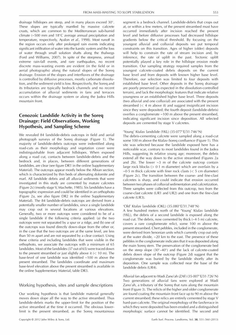
Figure 1. Digital elevation model (DEM) map of the Soreq drainage systemmark the center of single-landslide outcrops. Sampling sites are labeled acco(YKL); 2, ‘Old’ Ktalav landslide (OKL); 3, Zano’ah alluvial fan (ZAF); 4, Alluviaof Figures 3 and 6 are marked with dashed lines in the main frame and inset,hillslopes of the Soreq drainage system. The photograph was taken west offrom streambed to the interfluve in the horizon is 300–400 m. Maps were pavailable in colour online at wileyonlinelibrary.com/journal/espl
Copyright © 2012 John Wiley & Sons, Ltd.
Our study focuses on the central part of the range, alsoknown as the Judea Hills (Figure 1). In contrast to thefairly known Mesozoic and early Cenozoic geologic history(e.g. Saas and Bein, 1978), the stages of mountain uplift, theemergence of the Judea Hills above the sea, and the erosionthat accompanied the uplift remain mostly unknown. Partly,because correlative and datable deposits that may assist inreconstructing landscape evolution are rare and were notinvestigated. Nevertheless, it is widely agreed that the uplift ofthe mountainous backbone in central Israel began during theMiocene (Sneh and Buchbinder, 1984; Begin and Zilberman,1997). Buchbinder et al. (2005) claim that the uplift startedearlier in the Oligocene, based on the incision of canyons inthe coastal plain during that period. Bar (2009) suggestedthat the greater part of the uplift of the Judea Range occurredin two pulses: during early Miocene (~500 m of verticaluplift without regional tilting or short-wave folding) and inthe late Pliocene (~300 m uplift, due to activation of thelarge scale structural arch and westward tilting of the region).Nevertheless, the stages at which the drainage systemsdeveloped as a response to Judea Hills uplift are even lessunderstood in spite of some early studies (e.g. Shatner, 1957;Nir, 1989), mainly due to the lack of ‘classical’ datable markerssuch as volcanic rocks.
The major drainage of the Judea Hills is the Soreq (Figure 1).The Soreq drains the central ridgewestward to theMediterraneanand extends over an area of ~760 km2. The drainage is dividedinto a mountainous segment (800–250 m above sea level) andthe piedmont (250–0 m above sea level). In its mountainoussegment, the Soreq incises some 400 m below the JudeaHills highland through Cretaceous marine carbonate rocks. The
. Dashed red line delineates the Judea Hills mountain front. White dotsrding to the order of description in the text: 1, ‘Young’ Ktalav landslidel terrace at the main Soreq stem (SAT). Locations of topographic profilesrespectively. Photograph in the lower right inset shows the typical steepthe Soreq-Ktalav confluence (35�067�E/31�744N�); elevation differencelotted using Israel Transverse Mercator (ITM) projection. This figure is
Earth Surf. Process. Landforms, Vol. 38, 551–560 (2013)
553FROM MASS-WASTING TO SLOPE STABILIZATION
drainage hillslopes are steep, and in many places exceed 30�.These slopes are typically mantled by massive calcretecrusts, which are common to the Mediterranean sub-humidclimate (~500 mm and 18�C average annual precipitation andtemperature, respectively, Ayalon et al., 1998). Most runoff inthe region occurs only after prolonged rain events indicatingsignificant infiltration of water into the karstic system and the lossof water through small solution shafts along the thalwegs(Ford and Williams, 2007). In spite of the steepness, annualextreme rain-fall events, and rare earthquakes, no recentdiscrete mass-wasting events are evident (in the field or inaerial photographs) along the natural slopes of the Soreqdrainage. Erosion of the slopes and interfluves of the drainageis controlled by diffusive processes, mostly carbonate dissolu-tion, and the sediment yield is low. Respectively, the Soreq andits tributaries are typically bedrock channels and no recentaccumulation of alluvial sediments in fans and terracesoccurs within the drainage system or along the Judea Hillsmountain front.
Cenozoic Landslide Activity in the SoreqDrainage: Field Observations, WorkingHypothesis, and Sampling Scheme
We revealed 84 landslide-debris outcrops in field and aerialphotograph surveys of the Soreq drainage (Figure 1). Themajority of landslide-debris outcrops were indentified alongroad-cuts as their morphology and vegetation cover wereindistinguishable from adjacent hillslopes. When exposedalong a road cut, contacts between landslide-debris and thebedrock and, in places, between different generations oflandslides, are clear (see figure DR1 in the online SupplementaryMaterial). The outcrops appear mostly below the Albian section,which is characterized by thin beds of alternating dolomite andmarl. All landslide debris and all alluvial sediments that wereinvestigated in this study are cemented by mature calcretes(Figure 2c) (mostly stage V,Machette, 1985). Six landslides have atopographic expression and could be identified in an orthophoto(Figure 2a, see also figure DR2 in the online SupplementaryMaterial). The 84 landslide-debris outcrops are derived from apotentially smaller number of landslides, since a single landslidemay crop out in several locations at various elevations.Generally, two or more outcrops were considered to be of asingle landslide if the following criteria applied: (a) the twooutcrops were not separated by a spur or a ridge, and (b) one ofthe outcrops was found directly down-slope from the other or,in the case that the two outcrops are at the same level, are lessthan 50 m apart and are not separated by a clear contact. Usingthese criteria and including landslides that were visible in theorthophoto, we associate the outcrops with a minimum of 65landslides.Most of the landslides (37 out of 65) were traced downto the present streambed or just slightly above it (< 10 m). Thebase-level of one landslide was identified ~100 m above thepresent streambed. The landslides coordinate and maximumbase-level elevation above the present streambed is available inthe online Supplementary Material, table DR3.
Working hypothesis, sites and sample descriptions
Our working hypothesis is that landslide material generallymoves down slope all the way to the active streambed. Thuslandslide-debris marks the upper-limit for the position of theactive streambed at the time it occurred. The obvious lower-limit is the present streambed, as the Soreq mountainous
Copyright © 2012 John Wiley & Sons, Ltd.
segment is a bedrock channel. Landslide-debris that crops outat, or within a few meters, of the present streambed must haveoccurred immediately after incision reached the presentlevel and before diffusive processes had decreased hillslopegradients below the critical threshold. By focusing on theyoungest alluvial and colluvial deposits we put temporalconstraints on this transition. Ages of higher (older) depositswill help to constrain the rate of stream incision and, byinference, the rate of uplift in the past. Tectonic upliftpotentially played a key role in the hillslope erosion modetransition. Our sampling strategy required samples from theyoungest calcrete-coated debris deposits on the currentbase level and from deposits with known higher base level.Therefore, our selection was limited to four deposits withestablished base level. Other deposits in the Soreq drainageare poorly preserved (as expected in the dissolution-controlledterrain), and lack the morphologic features that indicate relativeyoungness or an established higher base level. Three deposits(two alluvial and one colluvial) are associated with the presentstreambed (< 4 m above it) and suggest insignificant incisionsince they were deposited; the fourth deposit (landslide-debris)overlies a conglomerate ~100 m above the present streambed,indicating significant incision since deposition. All selecteddeposits are cemented by stage V calcretes.
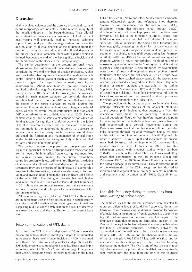
‘Young’ Ktalav landslide (YKL) (35�077�E/31�746�N)The debris-cementing calcrete were sampled along a road-cutsome 100 m above the Ktalav-Soreq confluence (Figure 1). Thissite was selected because the landslide exposed here has anoticeable scar, contrary to most landslides found in the JudeaHills, suggesting its relative young age; moreover, the debrisextend all the way down to the active streambed (Figures 2aand 2b). The lower ~3 m of the calcrete outcrop containlarge rock blocks (> 0�1 m diameter) which are overlain by a~0�5 m thick calcrete with finer rock clasts (< 5 cm diameter)(Figure 2c). The transition between the coarse- and fine-clastcalcretes is sharp, and could indicate that erosion occurredbetween two phases of colluvial sedimentation and calcretization.Three samples were collected from this outcrop, two from thecoarse-clast calcrete (UR1 and UR2) and one from the fine-clastcalcrete (UR3).
‘Old’ Ktalav landslide (OKL) (35.080�E/31.748�N)A few hundred meters north of the ‘Young’ Ktalav landslide(YKL), the debris of a second landslide is exposed along theroad cut. The debris, now cemented by thick (~4�5 m) calcrete,covers a rare conglomerate relict, some 100 m above thepresent streambed. Chert pebbles, included in the conglomerate,were derived from Senonian units which currently crop out onlyat the water divide, ~20 km to the east. The presence of thesepebbles in the conglomerate indicates that it was deposited alongthe main Soreq stem. The preservation of the conglomerate bedon the steep slope (30�–40�) and the lack of calcrete-coateddebris down slope of the outcrop (Figure 2d) suggest that theconglomerate was buried by the landslide shortly after itsdeposition. One sample was collected near the base of thelandslide debris (UR4).
Alluvial fan adjacent toWadi Zano’ah (ZAF) (35�007�E/31�726�N)Two generations of alluvial fans were explored at WadiZano’ah, a tributary of the Soreq that runs along the mountainfront (Figure 3). The relicts of the higher and older conglomerateare found coating the mountain front face up to 90 m above thecurrent streambed; these relics are entirely cemented by stage Vhard-pan calcrete. The original morphology of the fan/terrace inwhich they were deposited has been eroded and a distinguishedmorphologic surface cannot be identified. The second and
Earth Surf. Process. Landforms, Vol. 38, 551–560 (2013)

Figure 2. (a) Orthophoto of the ‘Old’ and ‘Young’ Ktalav landslides sites (OKL and YKL, respectively) and location of the optically stimulatedluminescence (OSL) samples. The boundaries of the YKL are visible and a prominent scarp is found at the top of the landslide. OKL has no apparenttopographic expression. Its debris is exposed only along the road cut. (b) Cross-section through the YKL (marked A–A0 on the orthophoto), the scarp isclearly visible at the top of the slope, additional photograph of the scarp can be found in the online Suppementary Material, figure DR2. (c) YKL debriscrop out along the road cut. A sharp transition between lower coarse-clast calcrete and upper thin-clast calcrete and the location of sample UR1 arehighlighted. (d) Schematic cross-section across the OKL outcrop. OKL debris overlies a conglomerate bed ~100 m above the present Soreq stream.The location of sample UR4 is indicated. This figure is available in colour online at wileyonlinelibrary.com/journal/espl
554 U. RYB ET AL.
younger generation reaches a thickness of up to ~10 m and wasdeposited at the current base level. Its flat top is cemented bythick, stage V calcrete. Relicts of similar conglomerates, whichare situated at the same level, are found along the mountain-front down to the Soreq outlet. Two samples, from the top andbase of the low and young conglomerate were collected (UR5and UR6, respectively).
Alluvial terrace at themain Soreq stem (SAT) (35�117�E/31�757�N)A relict of a small alluvial terrace, 0�5–2 m thick, is exposed~5 km upstream from the Ktalav landslides site (Figure 1). Theterrace rises ~3 m above the present streambed. Formation ofstage V calcrete over the conglomerate bed had contributedto its preservation. Two samples were collected from the centerof the outcrop, ~50 m apart (UR10 and UR11).
Copyright © 2012 John Wiley & Sons, Ltd.
Analytical Methods and Calcrete Dating
Dating the deposition of the colluvial and alluvial sediments atthe study area is based on the age of formation of the pedogeniccalcretes that have evolved on top of the various deposits(Sharp et al., 2003). Therefore the ages are interpreted as anupper-limit to the time of deposition. Pedogenic calcrete formwhen calcium carbonate (CaCO3) accumulates in soil horizons(Machette, 1985). Previous studies applied uranium seriesdisequilibria (Sharp et al., 2003; Candy et al., 2004), radiocarbondating (e.g. Amundson et al., 1994), electron spin resonance(ESR) (Kücükuysal et al., 2011) and cosmogenic chlorine-36(36Cl) (Liu et al., 1994) to date the precipitation of CaCO3 incalcretes. Forming near the surface, CaCO3minerals are inclinedto dissolve and re-precipitate after the initial deposition, a processthat may reset isotopic systems (Sharp et al., 2003). Since
Earth Surf. Process. Landforms, Vol. 38, 551–560 (2013)

Figure 3. Schematic cross-section through the Judea Hill mountainfront, east of Wadi Zano’ah (35�007�E/31�726�N). Two conglomerateunits are present: the higher (older) one, marked by gray background,is cemented by massive calcerete and its original fan morphology haseroded. The lower (younger) one has a hard-pan calcrete evolved onthe top of the outcrop (dashed lines texture), and its fan morphologyis preserved. Location of samples UR5 and UR6 are indicated in thecircular inset.
555FROM MASS-WASTING TO SLOPE STABILIZATION
calcretes (and soils in general) are composed of both authigenic(in situ substrate) and non-authigenic sources such as dust, itsisotopic initial values are hard to constrain (Amundson et al.,1994).Luminescence dating based on burial of the aeolian quartz
grains can overcome these complexities. Aeolian transport islikely to result in the total bleaching of the optically stimulatedluminescence (OSL) (Wintle, 2008) and thermally-transferredOSL (TT-OSL) signals in a quartz grain (Porat et al., 2009).The burial process is expected to be simple: the growth ofcarbonate cement prevents the mixing of the soil andre-exposure of the quartz to sunlight. Hence, luminescenceburial dating provides a robust upper limit age to the depositionof the substrate. Indeed, Shtober-Zisu et al. (2008) and Matmonet al. (2010) have successfully dated the formation of calcretes,in northern Israel, using OSL fast-signal measurements. Inthose cases the low dose rates of calcretes, 0�4–0�7 Gy ka–1,and equivalent doses (De) values ~100–250 Gy, allowed theacquisition of reliable mid-Pleistocene ages.Although OSL dating based on the fast component is widely
accepted (Wintle, 2008), its buildup is usually saturated withina few 105 yr. Furthermore, as the signal approaches saturationthe uncertainty of the calculated age increases significantly.Recent studies explored the potential of the TT-OSL signaland found that it does not seem to be limited by saturation,and therefore may be applied to much older sediments (Wanget al., 2006; Duller and Wintle, 2012). However, it was alsorecently suggested that the thermal stability of the TT-OSLsignal may result in a significant underestimation of the agesand effectively limit this dating technique to the Pleistocene(Adamiec et al., 2010; Shen et al., 2011).Many of the alluvial and colluvial sediments in the Soreq
drainage have low dose rates and are potentially young enoughto be dated by OSL. A limit to the number of samples stemsfrom the low concentration of aeolian quartz fraction in thecalcretes (usually less than 0�1% wt of the calcrete). Low quartzconcentration required the sampling and dissolution of a fewkilograms of calcrete for each sample, a considerable analyticaleffort indeed.
Sample collection, preparation for OSL andchemical analysis
Large calcrete samples (5–8 kg each) were collected to enablethe extraction of sufficient quartz. Sample preparation and
Copyright © 2012 John Wiley & Sons, Ltd.
measurements took place at the Geological Survey of IsraelOSL dating laboratory. The outer centimeter of well-lithifiedsamples that were collected in the daylight was removed inthe dark using a steel-wire brush. Samples were then crushedusing a jaw-crusher and placed in 10% hydrochloric acid(HCl). Samples UR5 and UR10 that were of loose sedimentswere collected into a light-tight bag under a blanket. Next,quartz grains of 74 to 150 mm size fraction were separatedfollowing the procedure described in Porat et al. (2007).
Representative portions of the samples (~0�5 kg) werepulverized, split, and dissolved. Their radioactive elements(uranium (U), potassium (K), thorium (Th)) content wasanalyzed for the calculation of a, b, and g dose rates, withan ELAN DRC II 6000 ICP-MS at the Israel GeologicalSurvey. The calcrete water content was assumed to be 5�2%(Matmon et al., 2010).
OSL and TT-OSL measurement and estimation ofTT-OSL signal loss
For the OSL and TT-OSL measurements 2 mm and 5 mmaliquots were prepared, respectively. Both signals weremeasured with a Risø D-12 TL/OSL reader equipped with blueLED. Due to the expected antiquity of the samples and the longtime needed for De determinations, only a small number ofaliquots were measured for each sample. SAR protocols wereadopted from Murray and Wintle (2000) and Porat et al.(2009) for the OSL and TT-OSL, respectively. TT-OSL wasmeasured for all samples while OSL was also measured forthe three samples from the YKL (samples UR1, UR2, andUR3). The comparison of the De values obtained by OSL andTT-OSL signals in the YKL samples established the reliabilityof the TT-OSL dating technique to the calcretized deposits.De values and their respective errors were calculated for eachsample from the average and standard deviation of the aliquotsDe histogram using ANALYST software (Duller, 2007). Doserates are obtained from radioactive element analysis and theattenuation factors (depth of burial, calcrete density, andwater (H2O) content) of the sediments and ages werecalculated using DataBase software (from G.A.T. Duller,Aberystwyth University). The obtained TT-OSL ages areregarded as minimum for quartz burial, since they are expectedto be effected by the thermal instability of the TT-signal(Adamiec et al., 2010). Underestimation of the TT-OSL agedue to the thermal instability of the TT-OSL traps depends onthe true age of a sample and its surrounding temperature. Agecorrections to the expected TT-OSL signal loss were calculatedbased on TT-OSL trap depth and frequency reported byAdamiec et al. (2010), and assuming a mean glacial–inter-glacial ambient temperature of 15�C (Affek et al., 2008).
Results
Field descriptions, chemical data, and OSL ages of all samplesare presented in Table I. Uncertainties of the TT-OSL basedages tend to be lower than the OSL’s (with the exception ofsample UR2). This difference is due to the fact that the OSLdose response curve (DRC) saturates and the natural signal isinterpolated onto the sub-horizontal exponential + linear partof curve, resulting in large errors on the De (Figure 4a).However, the TT-OSL DRC is linear within the range of givendoses (Figure 4b), and interpolation of the natural dose ontothe curve produces smaller errors.
While theOSL ages are indistinguishable (within uncertainties)from one another at the YKL site, TT-signal dates show a hiatus
Earth Surf. Process. Landforms, Vol. 38, 551–560 (2013)

TableI.
Soreqdrainagecalcretesluminescence
datingresults
Sample
Site
1Dep
th(m
)Cosm
�(mGya–
1)K(%
)U (ppm
)Th
(ppm
)Ext�a
(mGya–
1)
Ext�b
(mGya–
1)
Ext�g
(mGya–
1)
Totald
ose
(mGya–
1)
Numbe
rofa
liquots
De2
(Gy)
Over-
dispersion
3(%
)Prelim
inary
age(ka)
TT-OSL
sign
alloss
4Corrected
TT-OSL
age(ka)
UR1:OSL
YKL
3�3140
0�16
0�80�8
3225
158
526�27
8/9
138�31
24
263�60
11%
354�24
TT-OSL
7/7
169�8
3320�22
UR2:OSL
YKL
2�2160
0�28
0�91�6
4336
233
732�33
9/9
176�38
17
230�52
10%
320�43
TT-OSL
7/7
214�27
10
292�39
UR3:OSL
YKL
0�2243
0�25
0�81�5
3301
211
759�29
9/9
181�36
19
239�48
8%
257�37
TT-OSL
7/7
181�25
12
238�34
UR4:TT-OSL
OKL
4�1128
0�12
0�50�3
2149
95
373�26
3/4
319�75
19
845�210
25%
1056�262
UR5:TT-OSL
ZAF
0�2243
0�07
0�50�8
2128
106
479�26
7/7
242�20
7506�49
16%
587�57
UR6:TT-OSL
ZAF
6�0104
0�12
1�21�2
4258
210
576�25
7/7
335�39
10
582�73
18%
688�86
UR10:T
T-OSL
SAT
1�8168
0�25
0�91�3
3307
212
691�30
9/9
169�16
8245�25
8%
265�27
UR11
:TT-OSL
SAT
0�5210
0�23
0�71�6
2276
200
689�29
9/9
156�14
8227�23
8%
244�25
Note:Lo
catio
nofthesamplin
gsitescanbefoundin
Figu
re1.
1YKL,
YoungKtalavlandslide;
OKL,
Old
Ktalavlandslide;
ZAF,Zan
o’ah
alluvial
fan;SA
T,So
reqalluvial
terrace.
2OSL
Dewas
obtained
on2mm
aliquo
ts,an
dTT-OSL
Dewas
obtained
on8–
9mm
aliquots.
3Over-dispersionindicates
theintra-sample
scatter.
4Sign
alloss
was
calculatedfollo
wingAdam
iecet
al.(2010),assumingam
bient
tempe
rature
of15� C
(Affe
ket
al.,2008)an
drespectiv
eTT-OSL
trap
thermal
lifetim
eof1to
4Ma(Adam
iecet
al.,2010).
igure 4. Typical dose response curves (DRCs) of OSL and TT-OSLignals of single aliquots of sample UR1. Insets present the signal decayver the measurement. The measured OSL and TT-OSL signals (Lx) areormalized to a fixed (10 Gy for OSL and 2�5 Gy for TT-OSL) test-dosecorrect for potential sensitivity changes. Recycling ratio of both TT
nd OSL aliquots measured at 50 Gy were 0�99 and 1�07, respectively.) DRC for OSL equivalent dose (De). The normalized natural (markedith gray solid line) plots on the linear section of the curve whichconsidered to be less reliable and close to saturation; the overall
ncertainty in De, marked by the dashed gray line translate to relativelyrge uncertainty of age. (b) DRC for TT-OSL De for one aliquot ofample UR1. The signal increases linearly and is not saturated in thested irradiation range (0–300 Gy); the overall uncertainty in De, markedy the dashed gray line translates to relatively low uncertainty of age.
556 U. RYB ET AL.
Copyright © 2012 John Wiley & Sons, Ltd.
Fsontoa(awisulasteb
between samples UR1 and UR3 (Table I, see also figure DR4 inthe online Supplementary Material). This hiatus is also expressedby the observed sharp transition between the lower, coarse-clastcalcrete and the upper, thin-clast calcrete. It may reflect erosionthat occurred between the main rock failure event that stabilizedprior to 354� 24 ka and a shallower fine grain mass wastingevent which stabilized after 354� 24 ka but before 257� 37 ka.Alternatively, the overall period defined by the two samplesmay result from a continuous process of calcretization, whichlasted close to 100 ka. Either way, in the relatively low naturaldose rates of the samples, TT-OSL based ages seem to be morereliable for the mid-Pleistocene samples. The two ages derivedfrom the Zano’ah alluvial fan (ZAF) are the same within errors,though obviously the deposition of the conglomerate (sampleUR6, 688� 86 ka) at the base of the fan predates its abandonment(sample UR5, 587� 57 ka).
The ‘Old’ Ktalav landslide (OKL) calcrete yielded a TT-OSL ageof 1056� 262 ka. This age is in agreement with the 100m higherbase level at the time of slope failure of the OKL. With a De ofonly ~320 Gy and low dose rates (0�37 Gy ka–1) due to deepoverburden, this age is considered reliable. The two Soreqalluvial terrace (SAT) samples gave overlapping ages of 268� 27and 244� 25 ka (samples UR9 and UR 10, respectively).
Earth Surf. Process. Landforms, Vol. 38, 551–560 (2013)
557FROM MASS-WASTING TO SLOPE STABILIZATION
Discussion
Highly evolved calcretes and the absence of a typical scar anddebris morphology are indicators for the relative antiquity ofthe landslide deposits in the Soreq drainage. These alluvialand colluvial sediments are circumstantially linked; frequentmass-wasting will ultimately lead to increased sedimentsupply from the slope to the drainage system, and force theaccumulation of alluvial deposits at the mountain front; theposition of many of these alluvial and colluvial deposits atthe present base level associate them with a period which isdefined between the end of the last significant incision andthe stabilization of the slopes in the Soreq drainage.The earlier descriptions of the present erosional mode
(diffusion) and the past erosional mode (discrete mass wasting)constitute the two end members of erosion processes. A shiftfrom one to the other requires a change in the conditions whichcontrol either hillslope gradient (such as stream incision) orpotential triggers for slope failure (climatic, seismic, oranthropogenic). About one hundred thousand years arerequired to develop stage V calcrete cement (Machette, 1985;Candy et al., 2004). Since all the investigated deposits arecoated by such mature calcretes we conclude that thetransition had to occur prior to ~100 ka, and that since thenthe slopes in the Soreq drainage are stable. During thisminimum time of stability at least one inter-glacial–glacialcycle, as well as several major earthquakes at the adjacentDSR occurred (Amiran et al., 1994; Kagan et al., 2005). Hence,climatic changes and seismic events cannot be considered aslimiting factors for significant landslide activity in the JudeaHills. It is therefore expected that the transition in hillslopeerosion mode is the geomorphic response to decrease inincision rates of the Soreq; such decrease would haveprevented the formation and maintenance of critical slopeangles. Incision rates in the Soreq are likely to be controlledby rates and style of tectonic uplift.The contrast between the present and the past erosional
regimes suggests that the Soreq hillslope erosion mode changedfrom a mode of high landslide-frequency, high sediment flux,and alluvial deposit buildup, to the current dissolution-controlled erosion with low sediment flux. Therefore, the datingof alluvial and colluvial sediment deposited at the presentstreambed provides a measure of the timescale of geomorphicresponse to the termination, or significant decrease, in tectonicuplift, and gives an upper limit to the last significant uplift phaseof the Judea Hills. The dating of deposits that mark higher(and older) base levels, such as the landslide that terminates~100 m above the present active stream, constrains the amountand rate of incision and uplift prior to the stabilization of thepresent streambed.All the obtained ages are older than 244� 25 ka. These ages
are in agreement with the field observations in which stage Vcalcretes coat all investigated and dated geomorphic featuressuggesting mid-Pleistocene stabilization as a result of decreasein stream incision and the stabilization of the present baselevel.
Tectonic implications of OKL dating
Apart from the OKL that was deposited ~100 m above thepresent streambed, all other investigated deposits accumulatedat the present base level. Hence, incision of ~100 m occurredlater than 1056�262 ka and prior to the deposition of theZAF at the present streambed at 688� 86 ka. These ages implyan incision rate of 270 m Ma–1, an order of magnitude greaterthan CaCO3 dissolution rates that were measured in the Judea
Copyright © 2012 John Wiley & Sons, Ltd.
Hills (Haviv et al., 2006) and other Mediterranean carbonateterrains (Gabrov�sek, 2009, and references cited therein).Stream incision preference over the rate of the CaCO3
dissolution means that hillslope retreat through CaCO3
dissolution could not have kept pace with the base levellowering. This led to the formation of critical slopes, andhillslope erosion was controlled by landslides. In contrast,since 688�86 ka, incision of the Soreq and its tributaries hasbeen negligible, suggesting significant loss of runoff water intothe karstic system and a major decrease in stream power. Forexample, in a single, rare rainfall event during late Februaryof 2009, ~200 mm (40% of the overall annual average) haddropped within 48 hours. Nevertheless, no flooding and ormass-wasting were reported in the Soreq system and its naturalhillslopes. This suggestion is also supported by several fieldobservations: (1) nearly all longitudinal stream profiles of smalltributaries of the Soreq are not concave (which would haveindicated that they reached steady state), (2) the preservationof zones of increased stream gradient in these streams (Figure 5,profiles of stream gradient are available in the onlineSupplementary Material, item DR5) and, (3) the preservationof steep linear hillslopes. These field phenomena indicate thelack of surface runoff and the present low stream power onthe slopes and channels of the Judea Hills.
The projection of the active stream profile of the Soreqdrainage intersects the profiles of the adjacent interfluvesat the coastal plain indicating that downstream from thisintersection point, stream incision gives way to alluvial andcoastal deposition (Figure 6). We therefore interpret this pointto be in equilibrium with its base level and, respectively, ithad experienced zero vertical movements during thePleistocene. Assuming that the Pleistocene uplift of the JudeaHills occurred through regional westward tilting, we referto this point as the ‘hinge’ of the Judea Hills tilt (Figure 6). Inorder to achieve 100 m of uplift and incision to the presentstreambed, 20 km east of the hinge, only 0�3� westward tilt isrequired from the early Pleistocene to 688� 86 ka. Thiscalculation agrees with previous studies which attribute200–400 m of uplift of the Judea Hills to a<1� westward tiltingphase that commenced in the late Pliocene (Begin andZilberman, 1997; Bar, 2009) and then followed by incision ofthe Soreq drainage to its current level. Early Pleistocene upliftof the western rim of the DSR through arching also led toincision and re-organization of drainage systems in northernand southern Israel (Matmon et al., 1999; Guralnik et al.,2010).
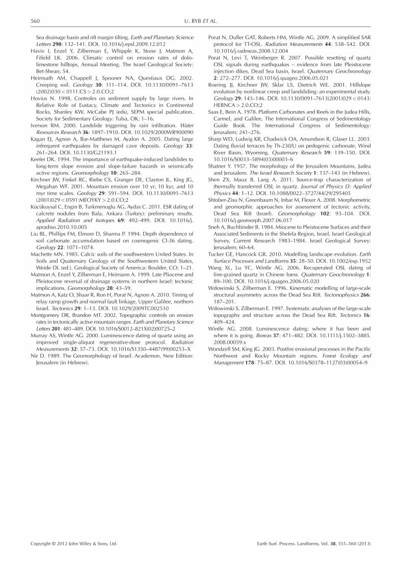
Landslide frequency during the transitions frommass wasting to stable slopes
The sampled sites at the present streambed were selected torepresent different levels of landslide frequencies during thetransition from mass-wasting to diffusive erosion. Depositionof alluvial fans at the mountain front is expected to occur whenhigh flux of sediments is delivered from the slopes to thedrainage system due to frequent landslides. Incision of theZano’ah tributary into the fan sediments became possible whenthe flux of sediment decreased. Therefore, between theaccumulation of the sediment at the base of the fan outcrop(sample UR5; 688� 86 ka) and the abandonment of the topof the fan (sample UR6; 587� 57 ka), sediment flux, and byinference, landslides frequency in the Zano’ah tributarydecreased dramatically. The YKL is one of few (six out of total37) which reached the present streambed that has recognizablescar morphology and may represent one of the youngest
Earth Surf. Process. Landforms, Vol. 38, 551–560 (2013)
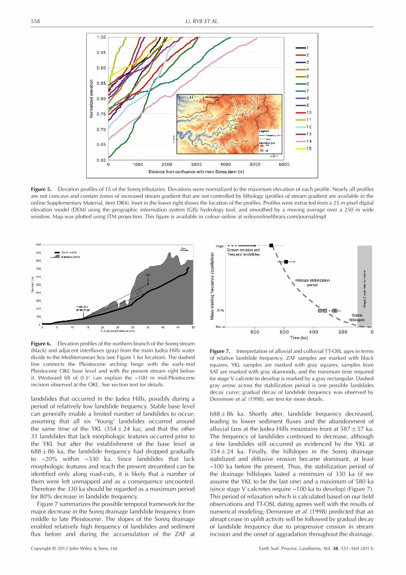
Figure 5. Elevation profiles of 15 of the Soreq tributaries. Elevations were normalized to the maximum elevation of each profile. Nearly all profilesare not concave and contain zones of increased stream gradient that are not controlled by lithology (profiles of stream gradient are available in theonline Supplementary Material, item DR4). Inset in the lower right shows the location of the profiles. Profiles were extracted from a 25 m pixel digitalelevation model (DEM) using the geographic information system (GIS) hydrology tool, and smoothed by a moving average over a 250 m widewindow. Map was plotted using ITM projection. This figure is available in colour online at wileyonlinelibrary.com/journal/espl
Figure 6. Elevation profiles of the northern branch of the Soreq stream(black) and adjacent interfluves (gray) from the main Judea Hills waterdivide to the Mediterranean Sea (see Figure 1 for location). The dashedline connects the Pleistocene arching hinge with the early-midPleistocene OKL base level and with the present stream right belowit. Westward tilt of 0�3� can explain the ~100 m mid-Pleistoceneincision observed at the OKL. See section text for details.
Figure 7. Interpretation of alluvial and colluvial TT-OSL ages in termsof relative landslide frequency. ZAF samples are marked with blacksquares, YKL samples are marked with gray squares, samples fromSAT are marked with gray diamonds, and the minimum time requiredfor stage V calcrete to develop is marked by a gray rectangular. Dashedgray arrow across the stabilization period is one possible landslidesdecay curve; gradual decay of landslide frequency was observed byDensmore et al. (1998), see text for more details.
558 U. RYB ET AL.
landslides that occurred in the Judea Hills, possibly during aperiod of relatively low landslide frequency. Stable base levelcan generally enable a limited number of landslides to occur;assuming that all six ‘Young’ landslides occurred aroundthe same time of the YKL (354� 24 ka), and that the other31 landslides that lack morphologic features occurred prior tothe YKL but after the establishment of the base level at688�86 ka, the landslide frequency had dropped graduallyto ~20% within ~330 ka. Since landslides that lackmorphologic features and reach the present streambed can beidentified only along road-cuts, it is likely that a number ofthem were left unmapped and as a consequence uncounted.Therefore the 330 ka should be regarded as a maximum periodfor 80% decrease in landslide frequency.Figure 7 summarizes the possible temporal framework for the
major decrease in the Soreq drainage landslide frequency frommiddle to late Pleistocene. The slopes of the Soreq drainageenabled relatively high frequency of landslides and sedimentflux before and during the accumulation of the ZAF at
Copyright © 2012 John Wiley & Sons, Ltd.
688� 86 ka. Shortly after, landslide frequency decreased,leading to lower sediment fluxes and the abandonment ofalluvial fans at the Judea Hills mountains front at 587� 57 ka.The frequency of landslides continued to decrease, althougha few landslides still occurred as evidenced by the YKL at354� 24 ka. Finally, the hillslopes in the Soreq drainagestabilized and diffusive erosion became dominant, at least~100 ka before the present. Thus, the stabilization period ofthe drainage hillslopes lasted a minimum of 330 ka (if weassume the YKL to be the last one) and a maximum of 580 ka(since stage V calcretes require ~100 ka to develop) (Figure 7).This period of relaxation which is calculated based on our fieldobservations and TT-OSL dating agrees well with the results ofnumerical modeling; Densmore et al. (1998) predicted that anabrupt cease in uplift activity will be followed by gradual decayof landslide frequency due to progressive cession in streamincision and the onset of aggradation throughout the drainage.
Earth Surf. Process. Landforms, Vol. 38, 551–560 (2013)

559FROM MASS-WASTING TO SLOPE STABILIZATION
Their model employed physical parameters typical to the Basinand Range province, and predicted that a 90% decrease inlandslide activity will occur ~100 ka after uplift had ceased,in the order of our results.Gradual transition from landslide-controlled to dissolution-
controlled hillslope erosion, as documented in the Soreqdrainage, reflects the hillslope response to dramatic weakening,or cessation, of stream incision. Such a response is expected tofollow stabilization of the base level at the piedmont, rather thandistal base level stabilization (the Mediterranean coast islocated ~40 km west to the Judea Hills mountain front) (Frankeland Pazzaglia, 2006). It is suggested that weakening of tectonicuplift rate led to decrease in stream incision to a rate that islower than the erosive capacity of carbonate dissolution in theJudea Hills. At that point carbonate dissolution of the hillslopeskept pace with stream incision and prevented the developmentof critical slopes. The period of 330 to 580 ka between the highlandslides frequency to the stabilization of the hillslopes mayinclude a gradual weakening of the uplift. However, the gradualdecrease in landslide activity can be explained simply by thetime in which the geomorphic signal of base-level stabilizationtraveled across the drainage, supporting the model presented byDensmore et al. (1998).We demonstrate that colluvial deposits may be used as
markers for stream incision and base level stabilization, muchlike alluvial deposits that are commonly used for this purpose.The geomorphic response of hillslopes can be translated tophases of tectonic uplift or quiescence based on the colluvialdeposit archive. The research of colluvial deposits will enablefuture studies to expand to regions that do not preserve alluvialdeposits and therefore were left unstudied. Our study can beregarded as a natural experiment in which the landscaperesponded to a change in tectonic forcing by a change in thecharacter of slope erosion (Tucker and Hancock, 2010).
Conclusions
Combining field observations and TT-OSL dating of alluvial andcolluvial deposits in the Soreq drainage we find the following.(1) Incision of ~100 m occurred from 1056�265 to 688� 86ka due to ~0�3� westward tilt of the Judea Hills; such incisioninvoked high frequency of landslide activity in the drainageand, as a result the deposition of alluvial terraces and fans.(2) Present base level was established after 688� 86 ka, andhillslopes gradually stabilized as a response to a cease ordramatic weakening of the uplift. This process led to a dramaticdecrease in the flux of coarse sediment in the Soreq drainageand the abandonment of alluvial fans at the mountain front.By the time the YKL occurred (354� 24 ka), landslidefrequency dropped below 20%; overall hillslope stabilizationperiod lasted 330–580 ka. (3) The Soreq drainage has beenstable for at least 100 ka and possibly since the YKL occurred;preservation of non-concave stream and hillslope profiles ishence attributed to the lack of sufficient stream-power due tothe loss of runoff water into the karstic system.
Acknowledgments—The authors wish to acknowledge GrezgorzAdamiec for his help with the TT-OSL age calculations, to Yakov Weissand Tamar Ryb that have assisted in the field, and to Lisa S. Walsh andthree anonymous reviewers for their critical review. This study wasfunded by the Israel Science Foundation grant ISF 50/10.
Supporting InformationSupporting information may be found in the online version of
this article.Copyright © 2012 John Wiley & Sons, Ltd.
References
Adamiec G, Duller GAT, Roberts HM, Wintle AG. 2010. Improving theTT-OSL SAR protocol through source trap characterisation. RadiationMeasurements 45: 768–777. DOI. 10.1088/0022–3727/41/13/135503
Affek HP, Bar-Matthews M, Ayalon A, Matthews A, Eiler JM. 2008.Glacial/interglacial temperature variations in Soreq cave speleothemsas recorded by ‘clumped isotope’ thermometry. Geochimica etCosmochimica Acta 72: 5351–5360. DOI. 10.1016/j.gca.2008.06.031
Amiran DHK, Arieh E, Turcotte T. 1994. Earthquakes in Israel andadjacent areas – macroseismic observations since 100 BCE. IsraelExploration Journal 44: 260–305.
Amundson R, Wang Y, Chadwick O, Trumbore S, Mcfadden L,Mcdonald E, Wells S, Deniro M. 1994. Factors and processesgoverning the C-14 content of carbonate in desert soils. Earth andPlanetary Science Letters 125: 385–405.
Ayalon A, Bar-Matthews M, Sass E. 1998. Rainfall–recharge relationshipswithin a karstic terrain in the eastern Mediterranean semi-arid region,Israel: delta O-18 and delta D characteristics. Journal of Hydrology207: 18–31.
Bar O. 2009. The Shaping of the Continental Margin of Central IsraelSince the Late Eocene – Tectonics, Morphology and StratigraphyPhD thesis. Ben-Gurion University of the Negev: Beer-Sheva; 212.
Begin ZB, Zilberman E. 1997. Main Stages and Rate of the ReliefDevelopment in Israel, Geological Survey of Israel, Report No. GSI/24/97. Israel Geological Survey: Jerusalem; 63.
Bentor YK, Vroman A, Zak I. 1965. Geological Map of Israel, SouthernSheet. 1:250000. Israel Geological Survey: Jerusalem.
Bigi A, Hasbargen LE, Montanari A, Paola C. 2006. Knickpoints andhillslope failures: interactions in a steady-state experimental landscape.In Tectonics, Climate, and Landscape Evolution, Willett SD, Hovius N,Brandon MT, Fisher DM (eds), Geological Society of America SpecialPaper. Geological Society of America: Boulder, CO; 295–307. DOI.10.1130/2006.2398(18)
Binnie SA, Phillips WM, Summerfield MA, Fifield LK. 2007. Tectonicuplift, threshold hillslopes, and denudation rates in a developingmountain range. Geology 35: 743–746. DOI. 10.1130/G23641A.1
Bloom AL. 1998. Geomorphology. Prentice Hall: Englewood Cliffs,NJ; 482.
Brown ET, Stallard RF, Larsen MC, Raisbeck GM, Yiou F. 1995.Denudation rates determined from the accumulation of in situ-producedBe-10 in the Luquillo experimental forest, Puerto-Rico. Earth andPlanetary Science Letters 129: 193–202.
Buchbinder B, Calvo R, Siman-Tov R. 2005. The Oligocene in Israel: amarine realm with intermittent denudation accompanied by mass-flow deposition. Israel Journal of Earth Sciences 54: 63–85.
Burbank DW, Leland J, Fielding E, Anderson RS, Brozovic N, Reid MR,Duncan C. 1996. Bedrock incision, rock uplift and thresholdhillslopes in the northwestern Himalayas. Nature 379: 505–510.
Candy I, Black S, Sellwood BW. 2004. Quantifying time scales ofpedogenic calcrete formation using U-series disequilibria. SedimentaryGeology 170: 177–187. DOI. 10.1016/j.sedgeo.2004.07.003
Densmore AL, Ellis MA, Anderson RS. 1998. Landsliding and theevolution of normal-fault-bounded mountains. Journal of GeophysicalResearch – Solid Earth 103: 15203–15219.
Duller GAT. 2007. Analyst 3.24. University of Wales: Newport.Duller GAT, Wintle AG. 2012. A review of the thermally transferredoptically stimulated luminescence signal from quartz for datingsediments. Quaternary Geochronology 7: 6–20. DOI. 10.1016/j.quageo.2011.09.003
Ford D, Williams PW. 2007. Karst Geomorphology and Hydrology.John Wiley & Sons: Chichester.
Frankel KL, Pazzaglia FJ. 2006. Mountain fronts, base level fall, andlandscape evolution insights from the southern Rocky Mountains.In Tectonics, Climate, and Landscape Evolution, Willett SD, HoviusN, Brandon MT, Fisher DM (eds). Geological Society of America:Boulder, CO; 419–434. DOI. 10.1130/2006.2398(26)
Gabrov�sek F. 2009. On concepts and methods for the estimation ofdissolutional denudation rates in karst areas. Geomorphology 106:9–14. DOI. 10.1016/j.geomorph.2008.09.008
Guralnik B, Matmon A, Avni Y, Fink D. 2010. Be-10 exposure ages ofancient desert pavements reveal Quaternary evolution of the Dead
Earth Surf. Process. Landforms, Vol. 38, 551–560 (2013)
560 U. RYB ET AL.
Sea drainage basin and rift margin tilting. Earth and Planetary ScienceLetters 290: 132–141. DOI. 10.1016/j.epsl.2009.12.012
Haviv I, Enzel Y, Zilberman E, Whipple K, Stone J, Matmon A,Fifield LK. 2006. Climatic control on erosion rates of dolo-limestone hilltops, Annual Meeting. The Israel Geological Society:Bet-Shean; 54.
Heimsath AM, Chappell J, Spooner NA, Questiaux DG. 2002.Creeping soil. Geology 30: 111–114. DOI. 10.1130/0091–7613(2002)030<0111:CS>2.0.CO;2
Hovius N. 1998. Controles on sediment supply by large rivers. InRelative Role of Eustacy, Climate and Tectonics in ContinentalRocks, Shanley KW, McCabe PJ (eds), SEPM special publication.Society for Sedimentary Geology: Tulsa, OK; 1–16.
Iverson RM. 2000. Landslide triggering by rain infiltration. WaterResources Research 36: 1897–1910. DOI. 10.1029/2000WR900090
Kagan EJ, Agnon A, Bar-Matthews M, Ayalon A. 2005. Dating largeinfrequent earthquakes by damaged cave deposits. Geology 33:261–264. DOI. 10.1130/G21193.1
Keefer DK. 1994. The importance of earthquake-induced landslides tolong-term slope erosion and slope-failure hazards in seismicallyactive regions. Geomorphology 10: 265–284.
Kirchner JW, Finkel RC, Riebe CS, Granger DE, Clayton JL, King JG,Megahan WF. 2001. Mountain erosion over 10 yr, 10 kyr, and 10myr time scales. Geology 29: 591–594. DOI. 10.1130/0091–7613(2001)029<0591:MEOYKY>2.0.CO;2
Kücükuysal C, Engin B, Turkmenoglu AG, Aydas C. 2011. ESR dating ofcalcrete nodules from Bala, Ankara (Turkey): preliminary results.Applied Radiation and Isotopes 69: 492–499. DOI. 10.1016/j.apradiso.2010.10.005
Liu BL, Phillips FM, Elmore D, Sharma P. 1994. Depth dependence ofsoil carbonate accumulation based on cosmogenic Cl-36 dating.Geology 22: 1071–1074.
Machette MN. 1985. Calcic soils of the southwestern United States. InSoils and Quaternary Geology of the Southwestern United States,Weide DL (ed.). Geological Society of America: Boulder, CO; 1–21.
Matmon A, Enzel Y, Zilberman E, Heimann A. 1999. Late Pliocene andPleistocene reversal of drainage systems in northern Israel: tectonicimplications. Geomorphology 28: 43–59.
Matmon A, Katz O, Shaar R, Ron H, Porat N, Agnon A. 2010. Timing ofrelay ramp growth and normal fault linkage, Upper Galilee, northernIsrael. Tectonics 29: 1–13. DOI. 10.1029/2009TC002510
Montgomery DR, Brandon MT. 2002. Topographic controls on erosionrates in tectonically active mountain ranges. Earth and Planetary ScienceLetters 201: 481–489. DOI. 10.1016/S0012–821X(02)00725–2
Murray AS, Wintle AG. 2000. Luminescence dating of quartz using animproved single-aliquot regenerative-dose protocol. RadiationMeasurements 32: 57–73. DOI. 10.1016/S1350–4487(99)00253–X
Nir D. 1989. The Geomorphology of Israel. Academon, New Edition:Jerusalem (in Hebrew).
Copyright © 2012 John Wiley & Sons, Ltd.
Porat N, Duller GAT, Roberts HM, Wintle AG. 2009. A simplified SARprotocol for TT-OSL. Radiation Measurements 44: 538–542. DOI.10.1016/j.radmeas.2008.12.004
Porat N, Levi T, Weinberger R. 2007. Possible resetting of quartzOSL signals during earthquakes – evidence from late Pleistoceneinjection dikes, Dead Sea basin, Israel. Quaternary Geochronology2: 272–277. DOI. 10.1016/j.quageo.2006.05.021
Roering JJ, Kirchner JW, Sklar LS, Dietrich WE. 2001. Hillslopeevolution by nonlinear creep and landsliding: an experimental study.Geology 29: 143–146. DOI. 10.1130/0091–7613(2001)029<0143:HEBNCA>2.0.CO;2
Saas E, Bein A. 1978. Platform Carbonates and Reefs in the Judea Hills,Carmel, and Galilee, The International Congress of SedimentologyGuide Book. The International Congress of Sedimentology:Jerusalem; 241–276.
Sharp WD, Ludwig KR, Chadwick OA, Amundson R, Glaser LL. 2003.Dating fluvial terraces by Th-230/U on pedogenic carbonate, WindRiver Basin, Wyoming. Quaternary Research 59: 139–150. DOI.10.1016/S0033–5894(03)00003–6
Shatner Y. 1957. The morphology of the Jerusalem Mountains, Judeaand Jerusalem. The Israel Research Society 1: 137–143 (in Hebrew).
Shen ZX, Mauz B, Lang A. 2011. Source-trap characterization ofthermally transferred OSL in quartz. Journal of Physics D: AppliedPhysics 44: 1–12. DOI. 10.1088/0022–3727/44/29/295405
Shtober-Zisu N, GreenbaumN, Inbar M, Flexer A. 2008. Morphometricand geomorphic approaches for assessment of tectonic activity,Dead Sea Rift (Israel). Geomorphology 102: 93–104. DOI.10.1016/j.geomorph.2007.06.017
Sneh A, Buchbinder B. 1984. Miocene to Pleistocene Surfaces and theirAssociated Sediments in the Shefela Region, Israel, Israel GeologicalSurvey, Current Research 1983–1984. Israel Geological Survey:Jerusalem; 60–64.
Tucker GE, Hancock GR. 2010. Modelling landscape evolution. EarthSurface Processes and Landforms 35: 28–50. DOI. 10.1002/esp.1952
Wang XL, Lu YC, Wintle AG. 2006. Recuperated OSL dating offine-grained quartz in Chinese loess. Quaternary Geochronology 1:89–100. DOI. 10.1016/j.quageo.2006.05.020
Wdowinski S, Zilberman E. 1996. Kinematic modelling of large-scalestructural asymmetry across the Dead Sea Rift. Tectonophysics 266:187–201.
Wdowinski S, Zilberman E. 1997. Systematic analyses of the large-scaletopography and structure across the Dead Sea Rift. Tectonics 16:409–424.
Wintle AG. 2008. Luminescence dating: where it has been andwhere it is going. Boreas 37: 471–482. DOI. 10.1111/j.1502–3885.2008.00059.x
Wondzell SM, King JG. 2003. Postfire erosional processes in the PacificNorthwest and Rocky Mountain regions. Forest Ecology andManagement 178: 75–87. DOI. 10.1016/S0378–1127(03)00054–9
Earth Surf. Process. Landforms, Vol. 38, 551–560 (2013)