Embed Size (px)
Citation preview
FORT BELKNAP RESERVATIONList of Topics
?
BACKGROUND
Reservation Overview
Regional Geologic Overview
GEOLOGIC OVERVIEW
Geologic History
Summary of Play Types
CONVENTIONAL PLAY TYPES
Play 1 - Shallow Cretaceous Biogenic Gas Play
Play 2 - Northern Plains Biogenic Gas Play
Plays 3,4,5 - Jurassic/Cretaceous and Mississippian Plays
UNCONVENTIONAL / HYPOTHETICAL PLAY TYPES
Plays 6,7 - Fractured Bakken and Cambrian Sandstone Plays
REFERENCES
MontanaFort Belknap Reservation
OVERVIEW
FORT BELKNAP RESERVATIONAssiniboine and Gros Ventre Tribes
TRIBAL HEADQUARTERS: Fort Belknap Agency, MontanaGEOLOGIC SETTING: Williston Basin
Location and Access The Fort Belknap Reservation is located in southeast Blaine and western Phillips Counties of north-central Montana. The reservation lands are situated 45 miles east of Harve on State Highways 87 and 191 east of Great Falls. Tribal headquarters are located at the Fort Belknap Agency, four miles east of Harlem. The Bureau of Indian Affairs Area Office is located in Billings.
Topography Most of the reservation is located on the northern Great Plains. The southeastern portion, however, is located on the flanks of the Little Rocky Mountains. Most of the available acreage is located on the flat, easily accessible plains. Three prominent buttes dominate the western side. These are Twin Buttes, Wild Horse Butte and Snake Butte. Elevations within the reservation range from 2,300 ft. to 5,000 ft. Principal rivers are the Milk River, which forms the northern reservation boundary, White Bear Creek, in the northwestern corner, and the east-flowing South Fork of Peoples Creek, which roughly divides the reservation in half.
Land Ownership The Fort Belknap Reservation consists of 980 square miles or approximately 627,000 acres, of which, the tribes have mineral interest (BIA Trust Estate) in about 61,000 acres. In addition to the reservation lands, the tribes at Fort Belknap hold mineral interest in 25,5000 acres immediately west of the reservation, referred to as submarginal lands. Approximately 21,000 mineral acres within the boundary of the reservation are under patented-in-fee or state ownership. About 2,000 tribal mineral acres are withdrawn from development activities due to religious significance and 26,800 tribal mineral acres are in the timber reserve. The latter acreage are in the Little Rockies and probably are not of oil and gas interest since Paleozoic rocks outcrop. Available tribal minerals for an oil and gas agreement amount to about 58,000 acres. The Tribal Community Council with BIA concurrence could authorize an agreement for this entire acreage or portions thereof. Individual Indians (Allottees) have a mineral interest in approximately 535,000 acres although their surface interest is about 400,000 acres. The 1982 Indian Mineral Development Act would allow allottees to joint a Tribal Agreement (25 U.S.C. Sec. 210(b)) which equates to possibly upwards of 600,000 available acres. Allottees normally must have their parcels individually offered in an administered lease sale prior to entering direct negotiations with a company. Therefore this proposal offers a unique opportunity for interested companies and mineral owners alike. The conditions of allottee joinders to a Tribal Agreement will be discussed further in the section entitled Tribal Government and Operating Regulations.
Historical Background of theAssiniboine and Gros Ventre Tribes at Fort Belknap The Fort Belknap Indian Reservation was created in 1887 as the home for the Assiniboine and Gros Ventre Indian Tribes. The ancestors of these tribes have lived on the northern plains for several centuries. The Assiniboine were recognized by Europeans as part of the great Sioux Nation and speak a Siouan language. However, their name is taken from a Chippewa word referring to "those who cook with stones." At some point in time the Assiniboine bands broke with the traditional Sioux and allied themselves with the Cree. The tribe settled along the Milk River and hunted between the Yellowstone River and southern Canada. The Assiniboines quickly adopted horses, firearms and a reliance on commerce, thus completing their transition from an agrarian / woodlands to a hunting/trading economic system. The Gros Ventre separated from the Arapaho and may be some of the original inhabitants of the western plains. French Canadian fur trappers gave the tribe their name, which translates to "big bellies", based on the tribal name in the Blackfeet and Shoshone languages. The Gros Ventre used the Blackfeet language in trade and were therefore considered part of the Blackfeet Nation. This association resulted in the inclusion of the Gros Ventre in the Blackfeet Treaty signed in 1855 with Governor Stevens of the Washington Territory. Because of intertribal hostilities the Gros Ventre relocated near the Little Rocky Mountains. Although the federal government opened this new area, the Gros Ventre remained between the Milk River and the Little Rocky Mountains. As indicated above, in 1887 the Gros Ventre were included with the Assiniboine in a treaty establishing the Fort Belknap Indian Reservation.
Competitive Negotiations for Mineral Agreements The Assiniboine and Gros Ventre Tribes of the Fort Belknap Reservation are sincerely interested in working with energy companies and individuals towards the development of the oil and gas resources underlying the reservations. The acquisition of good oil or gas prospects through leasing or other agreements, the diligent exploration of prospects generated, and the ultimate production from the wells drilled are three compatible goals for all the parties. The Tribes may be amenable to a variety of arrangements to see that these goals are reached, and feel that competitive solicitations leading to negotiated contracts offers the maximum flexibility to all parties concerned.
Authority to Negotiate Oil and Gas Agreements The lands described in this Atlas are held in trust by the Bureau of Indian Affairs. Therefore, oil and gas leases must be consummated pursuant to federal regulations. Authority to lease Indian trust lands through a negotiated agreement is provided in the Indian Minerals Development Act of 1982 (P.L. 97-382 ). However, final regulation implementing the 1982 Act have not been promulgated at this writing. The regulations governing the leasing of Indian lands under the 1938 Mineral Leasing Act can be found in the Code of Federal Regulation, Title 25, Part 211 for tribal lands. The July 12, 1984 edition of the Federal Register has proposed regulations for 25 CFR, Part 225 Oil and Gas Mineral Contracts to encompass the 1982 Indian Mineral Development Act. Since the enactment of the Indian Mineral Development Act of 1982, tribes have been afforded the opportunity to directly negotiate leases or other contracts
(i.e. joint ventures) in contrast to procedures and regulatory minimums imposed by the previous 1938 Minerals Leasing Act. The 1982 Act further provides that individual Indian allottees may join agreements negotiated for tribal lands. The section entitled Operating Regulations discusses the procedures for obtaining allottee participance in the negotiated agreement. Principal components for the formal corporate proposal should include the area(s) of interest, type of contract, elaboration of proposed agreement terms, points of potential negotiation, diligence commitments (i.e. drilling), bonus considerations, acreage relinquishments, tribal employment of training, etc. Also an interested company or individual should provide evidence of experience and ability to meet financial or diligence commitments.
Joinder Agreement For Individual Indians Pursuant to the 1982 Indian Minerals Development Act, Indian allottees may join a tribal negotiated agreement. The Fort Belknap Community Council plan to solicit allottee interest once negotiations are underway to minimize company curative land acquisition. The BIA Area Office in Billings is currently developing an administrative process to streamline this effort and yet protect their trustee interest. A joinder agreement was reviewed by the BIA Solicitor's Office in 1984. At that time the Solicitor concluded "-- we see no reason why this agreement would not comply with all legal requirements." The 1982 Act provides for two legal requirements for allottees to join a tribal mineral agreement:
(1) all parties must consent (2) the Secretary must find that it is in the best interest of the individual to participate
The Secretary must evaluate within 180 days to approve or disapprove the terms of any agreement regardless of allottee participation.
Requirement for Environmental Assessment A negotiated contract pursuant to the Indian Mineral Development Act will require an Environmental Assessment (EA) for the area under consideration for oil and gas exploration and development activities. Generally the BIA requires the company to prepare this documentation which can equate to delays in the final review and approval process of the negotiated contract. Numerous previous investigations exist that relate to the needed components of the EA. The tribes and CERT are in the process of assembling these reference studies for use by the company and the BIA. Additionally, the tribes have requested that BIA initiate or fund the duration of this study to expedite the final approval process. For the initial submittal, the company need not concern themselves with the baseline data acquisition but should give the tribe some idea about a plan of operations and precautions that will be taken to insure environmental protection and mitigation of damages to flora, fauna, air, water and property.
RESERVATION OVERVIEW indexmap topicsPAGE 1 of 13

Montana
OVERVIEWFort Belknap Reservation
Operational Regulations
Tribal Government
Fort Belknap Indian Reservation, the home of the Gros Ventre and Assiniboine Tribes was created by treaty on October 17, 1885 and by an Act of Congress on May 1, 1888. The business and governmental affairs of Fort Belknap are conducted under the authority of a constitution and bylaws ratified by members of the Tribes on October 19, 1935, and approved by the Secretary of the Interior on December 13, 1935, pursuant to the Indian Reorganization Act of 1934. Subsequently, a corporate charter for the Fort Belknap Indian Community was ratified by members of the Community on August 25, 1937. The principal decision-making body for the Reservation is the Fort Belknap Community Council, consisting of six Assiniboine and six Gros Ventre members.Each council member serves for a four year term. Every two years, each of the three voting districts--Milk River and Lodge Pole elect an Assiniboine and a Gros Ventre memeber to the Council. On the first Monday in January following each election, a president, vice-president and secretary/treasurer are elected from within the twelve council members. Council officers serve for a period of two years. The current officers were elected January 1984. Any council memeber or officer may serve as long as he/she is re-elected to office. The Tribal President appoints standing committees which meet monthly as needed. Negotiation for an oil and gas agreement would be conducted by the Tribal Community Committee. Any oil and gas development agreement would have to receive final approval from the Tribal Council.
Operating Regulations
The reservation lands available for oil and gas leasing or other types of mineral agreements are largely allotted lands (86.5%) with the Tribes holding mineral rights to 9.8% of the reservation lands and all of the submarginal lands. Therefore, the governmental authorities for the disposition of the contracts will be the tribal councils, allottees, and the trustee, the Bureau of Indian Affairs, acting in behalf of the Secretary of the Interior. Environmental assassments are currently being prepared by the BIA to aid in rapid implementation of a contract after economic analysis and approval by the BIA. The Tribes have not enacted any specific codes, ordinances, regulations nor mineral taxes relating to oil and gas exploration and development, therefore the chief regulations governing oil and gas activities are those of Title 25 of the Code of Federal Regulations (CFR) Subchapter 1 - Energy & Minerals (Part 225 applicable to P.L. 97-382 CFR, Part 216 (applocable to revenue reporting and payments) and Title 43 CFR Part 3160 (applicable to production reporting and operating procedures. The Bureau of Indian Affairs Billings and Aberdeen Area Offices have entered into a memorandum of understanding with Montana State Office of the Bureau of Land Management (BLM) whereby BLM will provide certain oil and gas management operations on Indian lands.
Phillips
Malta
19
191
87
233
87
2
87
89
89
15
15
Shelby
Conrad
Ft. Benton
Great Falls
Lewistown
Havre
Harlem
Grassrange
Blaine
Petroleum
Fergus
Hill
Judith Basin
Liberty
Meagher
Chouteau
Toole
Cascade
200
FORT BELKNAPROCKY BOY'S
CANADAMONTANA
CONTACT
Delmer Bigby, Land Specialist Fort Belknap Indian CommunityGros Ventre & Assiniboine TribesP.O. Box 249Rural Route #1 Box 66Harlem, MT 59526
TEL: 353-2205 x423 Fax: (406) 353-2797
indexmap topicsPAGE 2 of 13
MontanaFort Belknap Reservation
PRODUCING HORIZON LEGEND
Fort Union
Fox Hills
Judith River
Eagle
Niobrara
Greenhorn
Dakota Group
Morrison
Ellis Group
SwiftReirdonPiper
Nesson
Spearfish
Minnekahta
Opeche
Minnelusa
Amsden
Tyler
HeathOtterKibbey
Madison GroupCharles
Lodgepole
BakkenThree ForksNiskuDuperowSouris RiverDawson BayWinnipegosis
Interlake
Stonewall
Stony Mountain
Red River
Winnipeg
Deadwood
Mowry
Muddy
Dakota
Fall River
Lakota
Morrison
Sundance
Canyon Springs
Gypsum Spring
Chugwater
Spearfish
Goose Egg
Minnelusa
Madison
Englewood
Jefferson
Interlake
Big Horn
LanceFox HillsMesaverdeCodyShannonNiobraraFrontier
MowryMuddyBear RiverDakotaCloverly
NuggetChugwaterAnkarehThaynesWoodside
Dinwoody
Phosphoria
Park City
Weber
Tensleep
AmsdenDarwin
Jefferson
Darby
Madison
Mission Canyon
Lodgepole
Big Horn
GallatinGros VentreFlathead
Fort Union
BlackleafBow Island
KootenaiCat CreekMoultonSunburstCut Bank
Amsden
Tyler
Big Snowy GroupHeathOtterKibbey
Madison GroupSun RiverCharlesMission CanyonLodgepole
Three Forks
NiskuDuperow
Souris River
Red River
Emerson
Flathead
Big Snowy Group
Mission Canyon
WESTERN WYOMING
SOUTHERN MONTANA
WESTERN & NORTHERNMONTANA
WILLISTON BASIN
POWDER RIVER BASIN
SE
RIE
S
SY
ST
EM
ER
A
TE
RT
IAR
Y
CE
NO
ZO
IC
CR
ET
AC
EO
US
UP
PE
RL
OW
ER
JUR
AS
SIC
TR
IAS
SIC
PE
RM
IAN
PE
NN
SY
LV
AN
IAN
MIS
SIS
SIP
PIA
ND
EV
ON
IAN
SIL
UR
IAN
OR
DO
VIC
IAN
CA
MB
RIA
N
M E
S O
Z O
I C
P
A
L
E
O
Z
O
I
C
B I O
G E
N I C
S = Source Rock
Gannet
Morrison
Sundance
Stump-Preuss
Twin Creek
MorrisonEllis Group
SwiftReirdonSawtooth
Green RiverWind RiverWasatchFort Union
White River
Wasatch
Fort Union
LanceTecklaMesaverdeTeapotParkmanSussexShannonNiobraraFrontier
Hell CreekJudith RiverClaggetEagleTelegraph CreekNiobraraGreenhornFrontier
Winnipeg
Deadwood
S
S
S
S
BF
BK FP
BR
SR
Weldon-Brockton Fault
Cedar C
reek
Anticline
Miles CityArch
Cat Creek Fault
Syncline
SumatraSyncline
Blood Creek
Willow CreekFault
Lake Basin FaultNye-BowlerFault
BullMountains
Basin
WheatlandSyncline
CrazyMountains
Basin
Sw
eetgrassA
rch
Bowdoin
Dom
e
HinsdaleFault
PorcupineDome
Poplar Fault
PoplarDome
Nes
son
Ant
iclin
e
BASIN
Wind
River
BASIN
BIGHORN
WINDRIVER
Mtns
BighornM
tns
AbsarokaM
tns
OwlCreek
Mtns
BeartoothMtns
PryorMtns
LittleBelt
Mtns
JudithMtnsBig
SnowyMtns
OVERTHRUST
BELT
LittleRocky Mtns
BearpawUplift
Sweetwater
Uplift
Casper MtnFau
lt
Har
tville
Upl
ift
Casper
Arch
REDDESERTBASIN
HANNABASIN
ALLIANCEBASIN
GREENRIVERBASIN
WASHAKEBASIN
RockSpringsUplift
POWDERRIVER
BASIN
BlackHillsUplift
LaramieMtns
Medicine
BowM
tns
Sierra
MadreMtns
Chadron
Arch
WILLISTON
BASIN
Uinta Mtns
HogelandBasin
Alberta Shelf114
112 110 108 106 104 102 10098 49
48
47
46
45
44
43
105 103 101 9997
113 111 109 107
A'A
NORTH DAKOTA
NEBRASKA
MONTANA
IDAHOWYOMING
UTAH
COLORADO
C A N A D A
UNITED STATES
BASINLARAMIE
SOUTH DAKOTA
EXPLANATION
Precambrian Basement Uplifts
Other Uplifts or Basins
Anticline
Syncline
Faults
Cenezoic Volcanic Fields
Reservations
X-sectionA A'
SR - Standing Rock
BR - Fort Berthold
FP - Fort Peck
BK - Fort Belknap
BF - Blackfeet
Base of Colorado Shale RESERVATION
400
500
300
0
100200
200
-500
10000
4000
1000
0
Wild HorseButte
Snake ButteU
U D
D
T31N
T30N
T29N
T28N
T27N
T26N
T25N
2000
400
500
1000
0
2000
3000
T32N
500
0
DU
CO
WC
RE
EK
SY
NC
LIN
E
R 26 ER 25 ER 24 ER 23 E
300
500
BLA
INE
PH
ILLI
PS
CO
UN
TY
CO
UN
TY
UD
UD
DETAILED STRUCTURE MAP FORT BELKNAP
-100
-100
-200
-300
Structure contours100-1000'
Intrusions, Precambrianor Tertiary Syenite PorphyryIntrusions, Tertiary Volcanics
Faults - thrust, normal
Reservation boundary
-400
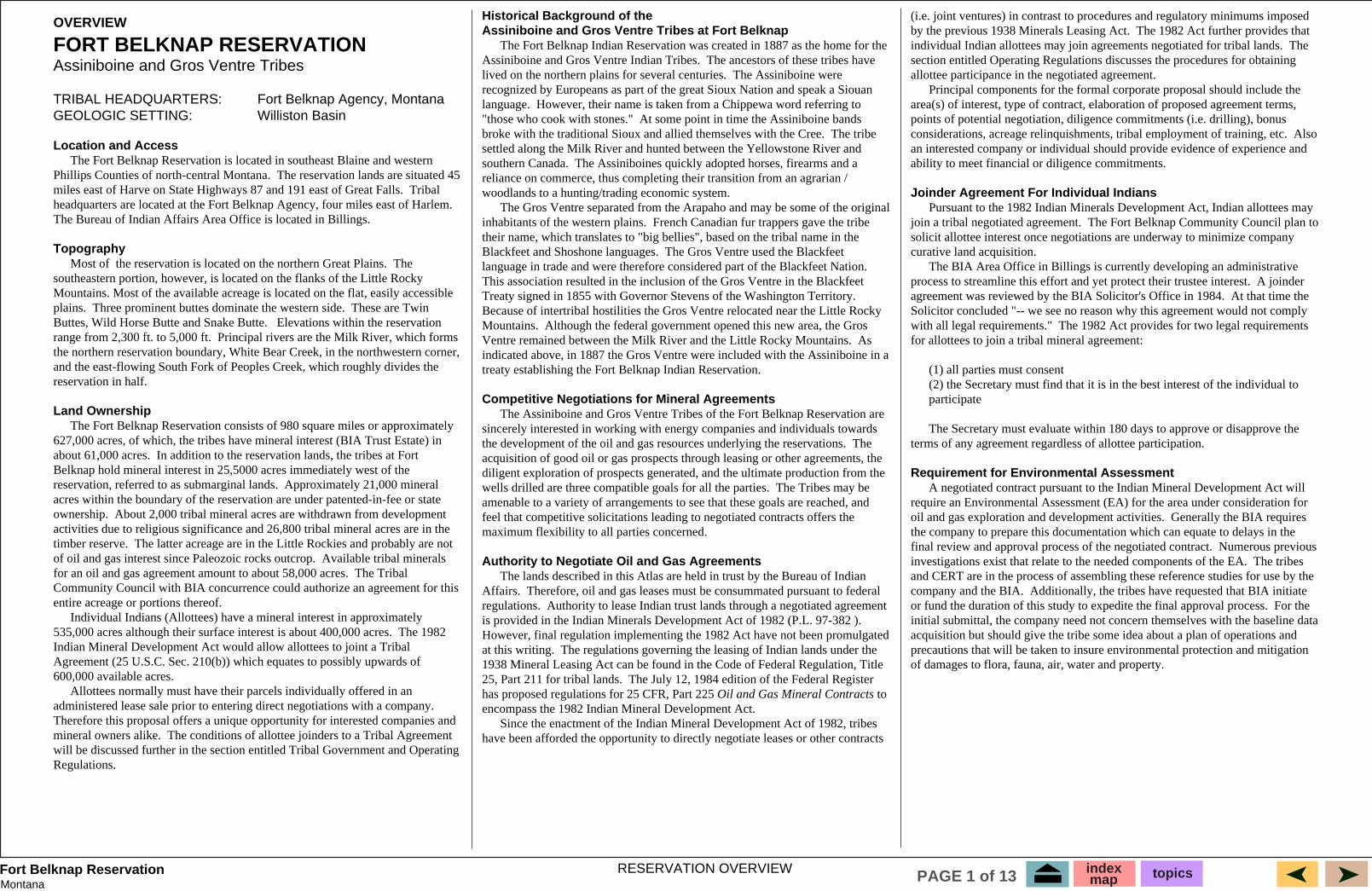
Structural Geology The Fort Belknap Reservation is dominated by the Little Rock Mountains of Paleocene-Eocene age. The Little Rocky Mountains are a series of igneous intrusions (Seyenite Porphyries) that have generated numerous structural domes (over 50) of various sizes (see detailed structure map). Several domes have been breached by erosion and expose the igneous core. Others have Paleozoic rocks exposed at the surface. Dips within the complex area are steeply tilted to vertical. Dip decreases away from the dome to about 80 feet/mile.The southern end consists of several domes, averaging two to three miles in diameter. Small intrusions are present on the western edge of the reservation (Snake Butte, Wild Horse Butte). The Bearpaw Uplift, located west of the reservation, is also Tertiary in age and consists of a series of intrusions and complex thrust and normal faults. As the Bearpaw intrusion was emplaced, the paleo gas field that existed in the Cretaceous sands was broken, carried by landslides into downdip positions. The Bearpaws' contain large, shallow gas fields trapped in these "landslide" fault blocks. The northern part of the reservation is mainly of gentle dip, although a major thrust fault (present at the surface) trends northwest to southeast. It's orientation suggests it is related to the fault systems that were created during the Bearpaw intrusive episode. Smaller folds and faults have been identified from surface geology.
Most Likely Hydrocarbon Zones Based on current gas shows and regional hydrocarbon production, regional cross-sections and depositional maps, the most likely plays to develop on the Fort Belknap Reservation are:1) Cretaceous rocks-Upper Cretaceous section is very thick; gas shows; high potential for Eagle sand biogenic gas accumulations.2) Cretaceous rocks-discontinuous reservoir rocks encased within marine shales; Bowdoin, Virgelle sandstones and Greenhorn Limestone. Biogenic gas accumulations are possible.3) Jurassic and Lower Cretaceous rocks-no shows reported, but lack of well control does not preclude biogenic gas potential.Note: Paleozoic rocks are not considered prospective due to exposure at the surface in the Little Rocky Mountains at the south end of the reservation. Those rocks are open to the atmosphere and would be charged with fresh water. The Mission Canyon Limestone is cavernous where exposed, and is an excellent aquifer. Other Paleozoic units penetrated by well control have been found wet.
Regional Geology The Fort Belknap Reservation is situtuated on the northern flank of the Little Rocky Mountains, an early Tertiary intrusion. (see figure 1 cross-section and map). The reservation is west of the Bowdoin Dome, east of the Bearpaw Uplift and south of the Hogland Basin. The geologic section is represented by Pre-Cambrian metamorphics, Paleozoic carbonates and Jurassic and Cretaceous sandstones. The Paleozoic rocks are mainly dolomites and limestones deposited within the Williston Basin and Alberta Shelf depocenters. Jurassic and Cretaceous rocks vary from continental to marine sandstones and shales. Most of the reservation is overlain by Quaternary alluvium deposits, Cretaceous Bearpaw shale (high bentonite content) and Judith River sandstones and siltstones.
Exploration History Only 10 wells have been drilled to date on the reservation with no commercial success. However, significant gas shows have been encountered in 3-4 wells just outside the reservation boundary.
Figure BK-2.1. Present day structural features in the Rocky Mountain region (after Peterson, 1987).
Figure BK-2.2. Detailed structure map of Fort Belknap Reservation (after Knechtel, 1959).
Figure BK-2.3. Detailed stratigraphic column of Fort Belknap area (after Peterson et al, 1987).
-500
-600
GEOLOGY OVERVIEWRegional, Structural Geology
indexmap topicsPAGE 3 of 13
MontanaFort Belknap Reservation
0
0
0
10
15
12
10
0
2
26
12 1015
8
10
8
10
Cambrian and older rocksexposed at land surface
Shale, Sandstone and MinorLimestone Facies
Green Shale Facies
Sandstone Facies
EXPLANATION
NEBRASKAOil Field, CambrianReservoir
12
0
AA'
Blackfeet
Ft. Belknap Ft. Peck
Ft.Berthold
Standing Rock
MONTANA
WYOMING
SOUTHDAKOTA
NORTHDAKOTA
10
84
6
4
2
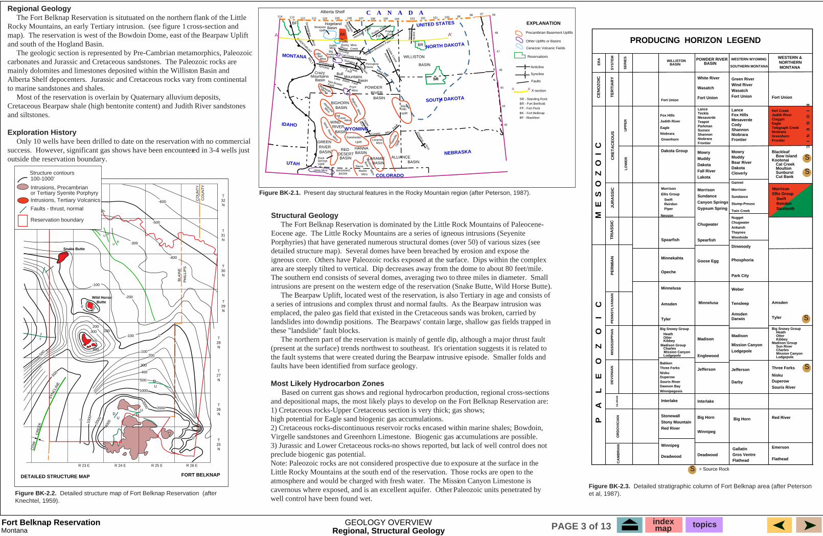
Figure BK-3.2. Generalized cross-section A-A'
Figure BK-3.3. Generalized time-interval cross-section for Cambrian and older rocks along line of section A-A'.
Figure BK-3.1. Thickness in hundreds of feet and rock facies map of Deadwood Formation or equivalent rocks. (Cambrian and Lower Ordovician)
Niobrara and Eagle
Jurassic Rocks
Mississippian Rocks
Niobrara and Eagle
Upper CretaceousRocks
JurassicRocks
Triassic Rocks
Permian RocksDevonian Rocks
Cambrian RocksSands and Shales
Prairie Salt
DevonianRocks
Silurian Rocks
Mississippian Rocks
PennsylvanianRocks
OrdovicianRocks
Williston Basin
Cambrian RocksSands and Shales
Bakken Shale
Tertiary RocksFort Union and Golden Valley
Poplar Dome
Little Rocky Mountains
Early Tertiary Intrusions
Upper CretaceousRocks
Bearpaw Uplift
Lower CretaceousKootenai
Overthrust Belt
Rocky Mountain Trench
Sweetgrass Arch
Mowry
NessonAnticline
PreCambrian Rocks
Cambrian RocksSands and Shales
114 113 112 111 110 109 108 107 106 105 104 103 102 101 1006000
5000
4000
3000
2000
1000
0
- 1000
- 2000
- 3000
- 8000
- 9000
- 10,000
- 11,000
- 12,000
- 13,000
- 4000
- 5000
- 6000
- 7000
Longitude Values (In Degrees) A'
EastWest
A
Ele
vati
on
(in
Fee
t)
Generalized X-Section A-A'Present Day Structure
Datum : Sea Level Scale : 1 deg = about 50 miles
Fort Belknap Reservation
Lower Cretaceous Rocks
Williston Basin
PreCambrian Rocks
Poplar Dome
Little Rocky Mountains
Bearpaw Uplift
Cambrian RocksSands and Shales
Sweetgrass Arch
PreCambrian Rocks2000
3000
4000
5000
6000
1000
0
Rocky Mountain Trench
Overthrust Belt
Thi
ckne
ss o
f Sed
imen
t (fe
et)
Generalized X-Section A-A'
West A
114 113 112 111 110 109 108 107 106 105 104 103 102 101 100
Cambrian RocksSands and Shales
Line of section along 48 degrees latitude withselected points every 1 degree of longitude.
Cambrian and Older Rocks
Datum: Base of Ordovician
Longitude Values (in degrees)
A' EastFort Belknap Reservation
GEOLOGIC HISTORY
One generalized structural cross-section (see cross-section A-A') has been constructed to summarize present day tectonic provinces and older paleostructure. The cross-section uses rock thickness values from each of the geologic periods. Section A runs along the 48 degree latitude line and values were selected at one degree longitude intervals. �The western end of the section, near the Blackfeet Reservation is dominated by high relief (greater than 5000 feet). The Cretaceous and older Paleozoic section is about 11,000 feet thick. Major basement uplifts, such as the Sweetgrass Arch and the Bearpaw Uplift, influenced sedimentation throughout geologic time. The eastern side of the cross-section is dominated by the Williston Basin, a stable cratonic depocenter which contains more than 15,000 feet of sediments. The center part of the illustration is influenced by the Bearpaw Uplift and the Little Rocky Mountains Tertiary intrusions. The southern end of the reservation is located on the Little Rocky Mountain intrusion. To better illustrate the geologic history of the region, which has been influenced by all of these tectonic provinces, a series of paleo cross-sections are shown. Each section summarizes a particular time interval; Cambrian and older rocks, Ordovician to Triassic and Cretaceous to Jurassic. Since Tertiary sediments are present only in the Williston Basin, no paleostructure section is shown. A paleo cross-section attempts to show what the subsurface geology may have looked like within that time interval. For the sake of space, only the particular interval is shown; no rocks older than it are illustrated. The rock units above the interval have not yet been deposited; the top of the section is the datum. The datum is flat, representing the paleo ground surface.
Cambrian and Older Rocks Oldest rocks exposed at the Fort Belknap Reservation are metamorphosed sedimentary and igneous rocks. These rocks are mainly biotite schist and gneiss. Some metavolcanics are present as hornblende gneiss and amphibolite. During Cambrian time, a major seaway existed in western Montana and eastern Idaho. This seaway gradually transgressed from west to east across eastern Montana and the Dakotas. The major source of coarse-grained clastics was to the east (from the Sioux Arch) and graded into shales and limestones to the west. Thickness of the Cambrian rocks varies from over 2000 feet thick in the Montana Disturbed Belt to less than 100 feet thick at the eastern edge of the Williston Basin. Cambrian rocks at the Fort Belknap Reservation are represented by the Flathead Sandstone and are about 1000 to 1100 feet thick. There is no evidence of any structural features at this time.
Line of Section along 48 degrees of latitude with selected points every 1 degree of longitude.
GEOLOGIC OVERVIEWGeologic History
indexmap topicsPAGE 4 of 13
MontanaFort Belknap Reservation
800
12001400
800
Montana
Wyoming
Nebraska
Standing Rock
1000
1800
16001400
1200
1000
800
600
400
NorthDakota
SouthDakota20
040
0
600
1000
800
120014
00
1600
1800
2000
2200
Triassic Rocks
Permian Rocks
Prairie Salt
Silurian Rocks
Cambrian RocksSands and Shales
Ordovician Rocks
Poplar Dome
Ordovician Rocks
Cambrian RocksSands and Shales
Little Rocky Mountains
Pennsylvanian Rocks
Mississippian Rocks
Bakken Shale
Devonian Rocks
Bakken Shale
Bearpaw Uplift
Sweetgrass ArchPreCambrian Rocks
114 113 112 111 110 109 108 107 106 105
AWEST
104 103 102 101 100
Generalized Cross-Section A-A'Triassic through Ordovician
Line of cross section along 48 degreeslatitude with selected points every 1degree of longitude
DATUM: Base of Jurassic - Permian missing
Rocky Mountain Trench
Overthrust Belt
0
1000
2000
3000
4000
5000
6000Thi
ckne
ss o
f Sed
imen
t (in
ft)
7000
8000
EASTA'Longitude Values (in Degrees)
Williston Basin
Ft. Belknap Reservation
3
3
4
43
3 2 1 05
2
EXPLANATION
Pre-Cretaceous rocksexposed at land surface
Tertiary rocks present
30
0
1
3 4
543
21
0
00
56
5
5
6.5
654
3210
012
3
4
3
4.5
1
1
1
0
0
0
00
5
6
32
StandingRock
Gas field (Cretaceous reservoir)
SOUTHDAKOTA
NORTHDAKOTA
Ft.Berthold
Ft. Peck
A'
MONTANAWYOMING
NEBRASKA
A
Blackfeet
Ft. Belknap
Ft. Belknap
0
1000
2000
3000
4000
5000
6000
7000
8000
114 113 112 111 110 109 108 107 106 105
A
WEST
104 103 102 101 100
Rocky Mountain Trench
Overthrust Belt
Thi
ckne
ss o
f Sed
imen
t (in
ft)
EAST
A'
Longitude Values (in Degrees)
Fort BelknapReservation
Volcanics
Mississippian and OlderRocks
Poplar Dome
Upper Cretaceous
(Niobrara and Eagle Formations)
Lower Cretaceous(Mowry)
Lower Cretaceous(Kootenai)
Jurassic Rocks
Sweetgrass Arch
Bearpaw Uplift
Williston Basin
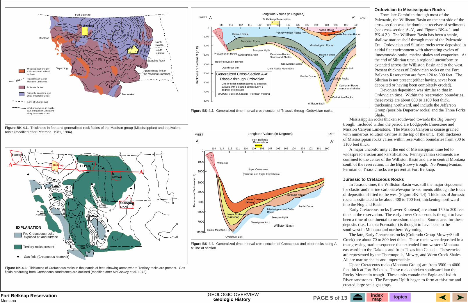
Ordovician to Mississippian Rocks From late Cambrian through most of the Paleozoic, the Williston Basin on the east side of the cross-section was the dominant receiver of sediments (see cross-section A-A', and Figures BK-4.1. and BK-4.2.). The Williston Basin has been a stable, shallow marine shelf through most of the Paleozoic Era. Ordovician and Silurian rocks were deposited in a tidal flat environment with alternating cycles of limestone/dolomite, marine shales and evaporites. At the end of Silurian time, a regional unconformity extended across the Williston Basin and to the west. Present thickness of Ordovician rocks on the Fort Belknap Reservation are from 120 to 300 feet. The Silurian is not present (either having never been deposited or having been completely eroded). Devonian deposition was similar to that in Ordovician time. Within the reservation boundaries, these rocks are about 600 to 1100 feet thick, thickening northward, and include the Jefferson Group (possible Duperow rocks) and the Three Forks Shale.
Figure BK-4.4. Generalized time-interval cross-section of Cretaceous and older rocks along A-A' line of section.
Figure BK-4.3. Thickness of Cretaceous rocks in thousands of feet, showing areas where Tertiary rocks are present. Gas fields producing from Cretaceous sandstones are outlined (modified after McGookey et al. 1972).
Figure BK-4.1. Thickness in feet and generalized rock facies of the Madison group (Mississippian) and equivalent rocks (modified after Peterson, 1981, 1984).
Figure BK-4.2. Generalized time-interval cross-section of Triassic through Ordovician rocks.
Mississippian rocks thicken southward towards the Big Snowy trough. Included within the period are Lodgepole Limestone and Mission Canyon Limestone. The Mission Canyon is coarse grained with numerous solution cavities at the top of the unit. Total thickness of Mississippian rocks varies within reservation boundaries from 700 to 1100 feet thick. A major unconformity at the end of Mississippian time led to widespread erosion and karstification. Pennsylvanian sediments are confined to the center of the Williston Basin and are in central Montana south of the reservation, in the Big Snowy trough. No Pennsylvanian, Permian or Triassic rocks are present at Fort Belknap.
Jurassic to Cretaceous Rocks In Jurassic time, the Williston Basin was still the major depocenter for clastic and marine carbonate/evaporite sediments although the focus of deposition shifted to the west (Figure BK-4.4) Thickness of Jurassic rocks is estimated to be about 400 to 700 feet, thickening northward into the Hogland Basin. Early Cretaceous rocks (Lower Kootenai) are about 150 to 300 feet thick at the reservation. The early lower Cretaceous is thought to have been a time of continental to nearshore deposits. Source area for these deposits (i.e., Lakota Formation) is thought to have been to the southwest in Montana and northern Wyoming. The late, Early Cretaceous rocks (Colorado Group-Mowry/Skull Creek) are about 70 to 800 feet thick. These rocks were deposited in a transgressing marine sequence that extended from western Montana eastward into the Dakotas and from Texas into Canada. These rocks are represented by the Thermopolis, Mowry, and Warm Creek Shales. All are marine shales and impermeable. Upper Cretaceous rocks (Montana Group) are from 3500 to 4000 feet thick at Fort Belknap. These rocks thicken southward into the Rocky Mountain trough. These units contain the Eagle and Judith River sandstones. The Bearpaw Uplift began to form at this time and created large scale gas traps.
Mississippian or older rocks exposed at land surface
Thickness in feet ofMadison Limestone
Dolomite facies
Primarily limestone andshaly limestone facies
Limit of Charles salt
Limit of anhydrite in middlepart of Madison Limestoneshaly limestone facies
Fort Belknap
400
GEOLOGIC OVERVIEWGeologic History
Approximate limit ofthe Madison Limestone
indexmap topicsPAGE 5 of 13
MontanaFort Belknap Reservation
EXPLANATION
Sandstone Shale and sandstone ShaleSiliceous shale Shale and argillaceouslimestone
Limestone and dolomite Syenite porphyryMetamorphic rocks
Kjr Kc Ke Kw
Km
KjrKt
PC
KJKe
MDOC
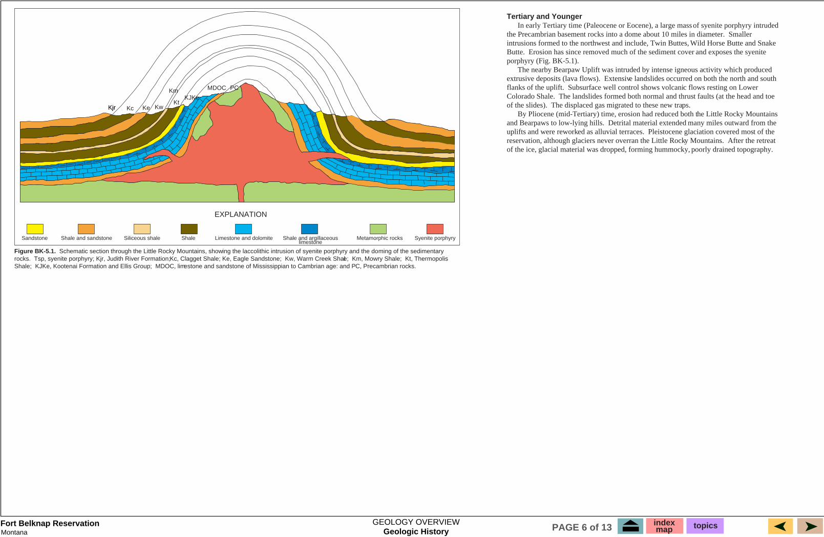
Figure BK-5.1. Schematic section through the Little Rocky Mountains, showing the laccolithic intrusion of syenite porphyry and the doming of the sedimentary rocks. Tsp, syenite porphyry; Kjr, Judith River Formation; Kc, Clagget Shale; Ke, Eagle Sandstone; Kw, Warm Creek Shale; Km, Mowry Shale; Kt, Thermopolis Shale; KJKe, Kootenai Formation and Ellis Group; MDOC, limestone and sandstone of Mississippian to Cambrian age: and PC, Precambrian rocks.
Tertiary and Younger In early Tertiary time (Paleocene or Eocene), a large mass of syenite porphyry intruded the Precambrian basement rocks into a dome about 10 miles in diameter. Smaller intrusions formed to the northwest and include, Twin Buttes, Wild Horse Butte and Snake Butte. Erosion has since removed much of the sediment cover and exposes the syenite porphyry (Fig. BK-5.1). The nearby Bearpaw Uplift was intruded by intense igneous activity which produced extrusive deposits (lava flows). Extensive landslides occurred on both the north and south flanks of the uplift. Subsurface well control shows volcanic flows resting on Lower Colorado Shale. The landslides formed both normal and thrust faults (at the head and toe of the slides). The displaced gas migrated to these new traps. By Pliocene (mid-Tertiary) time, erosion had reduced both the Little Rocky Mountains and Bearpaws to low-lying hills. Detrital material extended many miles outward from the uplifts and were reworked as alluvial terraces. Pleistocene glaciation covered most of the reservation, although glaciers never overran the Little Rocky Mountains. After the retreat of the ice, glacial material was dropped, forming hummocky, poorly drained topography.
Geologic HistoryGEOLOGY OVERVIEW index
map topicsPAGE 6 of 13

MontanaFort Belknap Reservation
Reservation:Geologic Province:Province Area:Reservation Area:
Fort BelknapNorth Central MontanaNorth Central Montana (62,500 sq. miles)947 sq. miles (606,080 acres)
Total Production ( by province-1996) Oil: Gas:
North Central Montana 440 MMBO 1.1 TCFG
Undiscovered resources and numbers of fields arefor Province-wide plays. No attempt has been madeto estimate number of undiscovered fields within theFort Belknap Reservation
Play Type USGS Designation
Unfavorable factorsFavorable factorsDrilling depthsPlay Probability(chance of success)
Undiscovered Resource (MMBOE)Field Size (> 1 MMBOE) min, median, meanKnown AccumulationsOil or GasDescription of Play
Northern and Great PlainsMedium and Low Potential
Biogenic Gas
2
28112812
Accumulations in UpperCretaceous units; tightersiltstones and sandstones.May be equivalent to Eagle and Judith River formations.
10.50-0.70
None known at this time. 700-3000 ft 1) gas shows north and west of reservation, near Tiger Ridge2) structures present; domes, faults. Source rock/ self source
1) no production on reservation2) lack of well control3) reservoir rock unknown4) size of accumulation unknown
Biogenic Gas
Jurassic, CretaceousSandstones
3
2808 stratigraphic traps; discontinuous sands, undippinchouts. Fluvial and nearshore sandstones.
1not estimated
134 MMBO318 BCFG9 MBNGL(Most from Cutbank)
1000-4000 ft 1) Gas shows north and west west of reservation2) structures present; domes, faults3) source rock/ self source
1) no production on reservation2) lack of well control3) reservoir rock unknown4) size of accumulation unknown
Both
1
2809 10.50-0.70
Probably equivalent to accumulations at TigerRidge.
504,000 MMCFfrom numerous fields in Province
700-3000 ft 1) gas shows southern end of reservation2) shallow drilling3) structures present; domes faults4) source rock-self source
1) no production on reservation2) lack of well control 3) reservoir rock unknown4) size of accumulation unknown
Biogenic GasShallow CretaceousBiogenic Gas Play Porous and permeable
sandstones ofUpper Cretaceous age
(Eagle and Judith River)Biogenic gas accumulations.
Judi
th R
iver
Cla
gget
Sha
leE
agle
War
m C
reek
Sha
le
Mow
ry S
hale
Ther
mop
olis
Sha
leK
oote
nai
Jura
ssic
Elli
s
Gravity-Slide Faults
Bearpaw Shale
Little Rocky Mountains
SOUTH NORTH
Seyenite Porphry
No Scale - Drawing is approximate length of Reservation
Precambrian Metamorphic Rocks
3
7
5
4
1
2
65
4
7
2
1
6
3
Hogeland Basin
Ordovician Bighorn Dolomite
Bakken / 3 Forks Shale
Cambrian Flathead Sandstone
Devonian Jefferson Limestone
Mississippian Mission Canyon
+
+
+
++
+ + +
+
+
+
+
+
+
+
+++
+
+
+
+
+
+
+
++
+
+
+
+
+
+
+
+++
+
+
+
+
+
+
+
++
+
+
+
+
+
++
+
+
+
+
+
+
+
+
+
+
+
+
+
+
+
Play Types Explanation(1) Shallow Cretaceous Biogenic Gas Play
(2) Northern Great Plains medium and low potential Biogenic Gas Play
(3) Jurassic / Cretaceous Sandstones
(4) Fractured / Folded Anticlines Mississippian Carbonate Play
(5) Mississippian and Devonian Carbonate Play
(6) Fractured Bakken
(7) Cambrian Sands
Sandstone
Shale
Shales, sands and siltstones
Gas
Oil
Gravity Slide Thrusts
Limestone
Dolomite
Igneous/Metamorphics
Volcanics
Intrusions
SandstoneLenses
+ ++
+ ++
+ ++ + +
Figure BK-6.1. Schematic diagram of play types at Fort Belknap Reservation.
Table BK-1. Play summary chart.
Median gas estimates17,366 BCFG median20,479 BCFG meanLow gas estimates12,409 BCFG median15,353 BCFG mean
Median: 30 MMBO (15 fields @ 2 MMBO)
Field Size (>1 MMBOE)2 MMBO 9 MMBO 2.5 MMBO
# of undiscovered fields (> 1 MMBOE)6 (min) 15 (median) 28 (max) 15.8 (mean)
Median: 280 BCFG (14 fields @ 20 BCFG)
Field Size (>1 MMBOE)20 BCFG median 27.4 BCFG max
# of undiscovered fields (> 1 MMBOE)5 (min) 14 (median) 26 (max) 14 (mean)
Play Summary indexmap topicsPAGE 7 of 13
MontanaFort Belknap Reservation
1not estimated
1not estimated
1,300-7,000 ft. 1) structures exsist; folds, faults, domes2) reservoir rock exists3) regionally thermally mature
1) no production on reservation2) rocks exposed to atmosphere at Little Rocky Mountains: strong hydro. gradient-flushed?3) lack of well control
1,000-6,700 ft. 1) structures exsist; folds faults, domes2) reservoir rock exists3) regionally thermally mature
1) no production on reservation2) rocks exposed to atmosphere at Little Rocky Mountains; strong hydro. gradient-flushed?3) lack of well control
Reservation:Geologic Province:Province Area:Reservation Area:
Fort BelknapNorth Central MontanaNorth Central Montana (62,500 sq. miles)947 sq. miles (606,080 acres)
Total Production ( by province-1996) Oil: Gas:
North Central Montana 440 MMBO 1.1 TCFG
Undiscovered resources and numbers of fields arefor Province-wide plays. No attempt has been madeto estimate number of undiscovered fields within theFort Belknap Reservation
Play Type USGS Designation
Unfavorable factorsFavorable factorsDrilling depthsPlay Probability(chance of success)
Undiscovered Resource (MMBOE)Field Size (> 1 MMBOE) min, median, meanKnown AccumulationsOil or GasDescription of Play
5
2805 1) Jurassic/Mississippianregional unconformity traps2) Devonian Structural Traps
(see numbers from Mississippian)
Both
Fractured Bakken
6
2804 Bakken/Exshaw ShaleHigh organic content, thermally mature; fracturedreservoir
0.250.2
Not applicableNot estimated
18,000 BO / square miles 47,520 / square miles5328 sq. mi. untested
5,000-10,000 ft. 1) Bakken regionally exists 2) thermally mature3) structures and flexures exist
1) no existing production within province2) no Bakken at southern end of reservation3) no deep well control
Oil
4
2807 folded structures, porositycontrolled by matrix orfractures
49.32 MMBO21,506 MMCFG585 MBNGL(numbers includeMississippian andDevonian play)
Both
CambrianSands
7
2802 Coarse sands trapped aspinchouts or on deeperstructures
0.5not estimated
Not applicable 1,700-7,000 ft. 1) structures exist; folds, faults, domes 2) reservoir rock exists
1) no existing production within province2) rocks exposed to atmosphere at Little Rocky Mountains: strong hydro. gradient-flushed?3) source rock unknown4) thermal maturity unknown5) lack of well control
Both
Mississippian and Devonian Carbonates
Fractured, folded anticlines in
Mississippian Carbonates
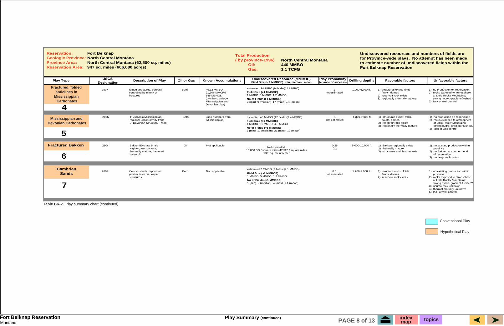
Table BK-2. Play summary chart (continued)
Conventional Play
Hypothetical Play
estimated 9 MMBO (9 fields@ 1 MMBO)
Field Size (>1 MMBOE)1 MMBO 3 MMBO 1.2 MMBO
No of Fields (>1 MMBOE)3 (min) 9 (median) 17 (max) 9.4 (mean)
estimated 48 MMBO (12 fields @ 4 MMBO)
Field Size (>1 MMBOE)4 MMBO 21 MMBO 4.8 MMBO
No of Fields (>1 MMBOE)3 (min) 12 (median) 21 (max) 12 (mean)
estimated 2 MMBO (2 fields @ 1 MMBO)
Field Size (>1 MMBOE)1 MMBO 5 MMBO 1.3 MMBO
No of Fields (>1 MMBOE)1 (min) 2 (median) 4 (max) 1.1 (mean)
Play Summary (continued) indexmap topicsPAGE 8 of 13
Montana Shallow Cretaceous Biogenic Gas PlayFort Belknap Reservation
+2208
+1692
+1960+2365
U
U
D
36
D U+1930 U
U
+2172+2256
+2113
U
U
U
FO
FO
FOFO
U
D
22
T27N
+2202
+1983
D
R 15 E
FO
FO
FO
FO
FO
FO
FOFO
FO
FO
FO
FO
FO
+1500
FO
+1962
+1605
+2113
+2142+2130+2110
FO
FO
FO
FO
FO
FO
FOA'
A
FO
FO
+2171
BULLWACKER FIELDBlaine & Chouteau Counties, Montana
R 15 E
LEGEND
R 15 E
T27N
+2207
+2052
+1966
FO
+1846
+2187
+2212+2092
+1969
+2061
+2157
+1779
+2331
FO
+2039
FO
D
D
D
+1278
DU
DU
FOFO
FO
D
TOP OF EAGLE FORMATION
EAGLE FORMATION FAULTED OUT
IGNEOUS INTRUSIVES
UP THROWNFAULTDOWN THROWN
UD
LINE OF SECTION A - A'
FO
+1692
+1922
+2140+1853
+1480
+1995
+1683
+2134
LINE OFCROSS-SECTION A-A'
+1986
+2168+2189+1566+1611
D
UD
+1855
333131
+2489
+1977
+1471
FO
CH
OU
TE
AU
CO
.
BL
AIN
E C
O.
+2362DU
FO
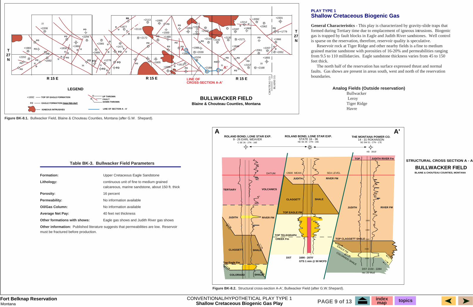
Figure BK-8.1. Bullwacker Field, Blaine & Chouteau Counties, Montana (after G.W. Shepard).
Analog Fields (Outside reservation) Bullwacker Leroy Tiger Ridge Havre
PLAY TYPE 1Shallow Cretaceous Biogenic Gas
General Characteristics - This play is characterized by gravity-slide traps thatformed during Tertiary time due to emplacement of igneous intrusions. Biogenicgas is trapped by fault blocks in Eagle and Judith River sandstones. Well control is sparse on the reservation, therefore, reservoir quality is speculative. Reservoir rock at Tiger Ridge and other nearby fields is a fine to medium grained marine sandstone with porosities of 16-20% and permeabilities ranging from 9.5 to 110 millidarcies. Eagle sandstone thickness varies from 45 to 150 feet thick. The north half of the reservation has surface expressed thrust and normalfaults. Gas shows are present in areas south, west and north of the reservation boundaries.
Figure BK-8.2. Structural cross-section A-A', Bullwacker Field (after G.W. Shepard).
EAGLE FMCOLORADO SHALE
DST 2150 - 2284
rec 20 Mud
SEA LEVEL
CLAGGETT SHALE
TOP EAGLE FM
JUDITH RIVER FM
DATUM: +2600 MEAN
VOLCANICSTERTIARY
JUDITH
COLORADO
RIVER FM
SHALE
STRUCTURAL CROSS SECTION A - A'
BULLWACKER FIELDBLAINE & CHOUTEAU COUNTIES, MONTANA
JUDITH RIVER FM
TOP CLAGGETT SHALE
A A'THE MONTANA POWER CO.
14 - 31 ROKANSONSE SW 31 - 27N - 17E
ROLAND BOND; LONE STAR EXP.STATE 16 - 36
NE SE 36 - 27N - 16E
CLAGGETT SHALE
TOP TELEGRAPH
CREEK Fm
DST 1690 - 2070'GTS 1 min @ 50 MCFD
2000
1900
1800
2100
2200
TOP JUDITH RIVER Fm
KB 3918'
Top Eagle Fm
ROLAND BOND; LONE STAR EXP.9 - 26 EARL WEAVER
C SE 26 - 27N - 16E
Table BK-3. Bullwacker Field Parameters
Formation: Upper Cretaceous Eagle Sandstone
Lithology: continuous unit of fine to medium grained calcareous, marine sandstone, about 150 ft. thick
Porosity: 16 percent
Permeability: No information available
Oil/Gas Column: No information available
Average Net Pay: 40 feet net thickness
Other formations with shows: Eagle gas shows and Judith River gas shows
Other information: Published literature suggests that permeabilities are low. Reservoir must be fractured before production.
CONVENTIONAL/HYPOTHETICAL PLAY TYPE 1 indexmap topicsPAGE 9 of 13
Montana Northern Plains Low Potential Biogenic Gas PlayFort Belknap Reservation
SuffieldBlock
MedicineHat Field
BowdoinFieldTiger Ridge
Field
CANADA
UNITED STATESAlberta Saskatchewan
Montana
113 112 111 110 109 108 107
51
50
49
48
BEARPAWMTNS
DOWDOINDOME
FOX HILLS SS
BEARPAW SHALE
ST MARY RIVER FM
JUDITH RIVER FM
ARDMORE BENTONITE BED
PIERRESHALE
WEST FLANKWILLISTON BASIN
HELL CREEK FM.
CLAGGETT SHALE
EAGLE SS
VIRGELLE SS
MARIAS RIVER SHALE
TELEGRAPHCREEK FM.
GAMMONSHALE
NIOBRARA FM
MOWRY SHALE
CARLILE SHALEBELLE FOURCHE SH
BLACKLEAF FM
VAUGHNMBR
MUDDY SS
SKULLCREEK SHALE
Upper CretaceousLower Cretaceous
GREENHORN FM
TW
O M
ED
ICIN
E F
OR
MA
TIO
NBEARPAW SHALE
HORSETHIEFSANDSTONE FOX
HILLS SS
WILLOW CREEKFM (PART)
NONMARINE ROCKS
COASTAL SANDSTONE
CALCAREOUS SHALECHALK & LIMESTONE
MARINE SHALE &SILTSTONE
90 Mi 150 Mi180 Mi
GLACIER NAT'L PARK
A A'
CretaceousEpeiric Seaway
United States
Mexico Cuba
Canada
Alaska Greenland
CretaceousEpeiric Seaway
CretaceousEpeiric Seaway
0
PLAY TYPE 2
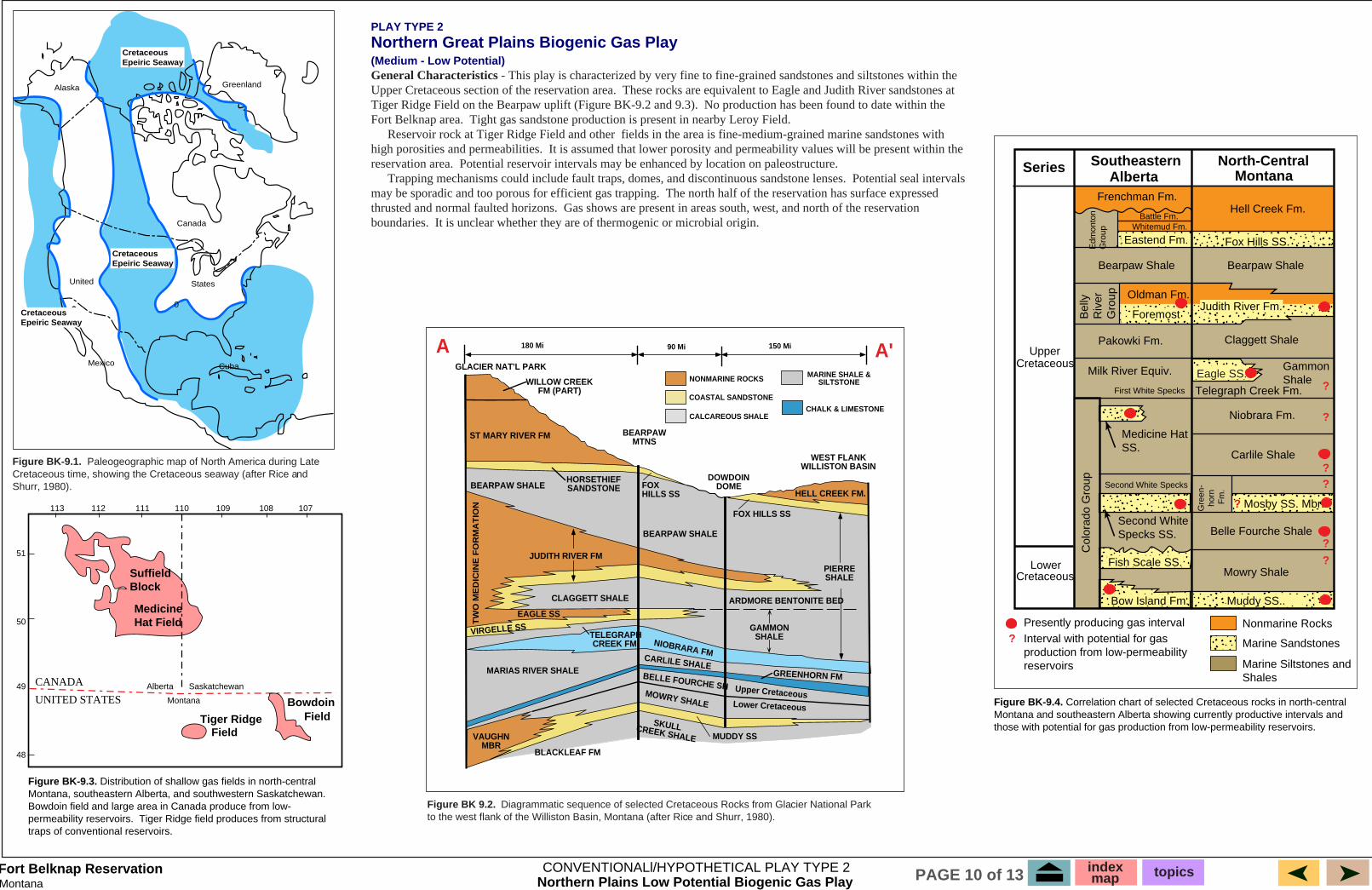
Northern Great Plains Biogenic Gas Play(Medium - Low Potential) General Characteristics - This play is characterized by very fine to fine-grained sandstones and siltstones within the Upper Cretaceous section of the reservation area. These rocks are equivalent to Eagle and Judith River sandstones at Tiger Ridge Field on the Bearpaw uplift (Figure BK-9.2 and 9.3). No production has been found to date within the Fort Belknap area. Tight gas sandstone production is present in nearby Leroy Field. Reservoir rock at Tiger Ridge Field and other fields in the area is fine-medium-grained marine sandstones with high porosities and permeabilities. It is assumed that lower porosity and permeability values will be present within the reservation area. Potential reservoir intervals may be enhanced by location on paleostructure.� Trapping mechanisms could include fault traps, domes, and discontinuous sandstone lenses. Potential seal intervals may be sporadic and too porous for efficient gas trapping. The north half of the reservation has surface expressed thrusted and normal faulted horizons. Gas shows are present in areas south, west, and north of the reservation boundaries. It is unclear whether they are of thermogenic or microbial origin.
Figure BK-9.1. Paleogeographic map of North America during Late Cretaceous time, showing the Cretaceous seaway (after Rice and Shurr, 1980).
Figure BK-9.3. Distribution of shallow gas fields in north-central Montana, southeastern Alberta, and southwestern Saskatchewan. Bowdoin field and large area in Canada produce from low-permeability reservoirs. Tiger Ridge field produces from structural traps of conventional reservoirs.
Figure BK 9.2. Diagrammatic sequence of selected Cretaceous Rocks from Glacier National Park to the west flank of the Williston Basin, Montana (after Rice and Shurr, 1980).
Figure BK-9.4. Correlation chart of selected Cretaceous rocks in north-central Montana and southeastern Alberta showing currently productive intervals and those with potential for gas production from low-permeability reservoirs.
Series SoutheasternAlberta
North-CentralMontana
UpperCretaceous
LowerCretaceous
Col
orad
o G
roup
Bow Island Fm.
Mosby SS. Mbr.
Fish Scale SS.
Muddy SS..
Mowry Shale
Belle Fourche ShaleSecond WhiteSpecks SS.
Second White Specks
Gre
en-
hor
n
Fm
.
Carlile Shale
Niobrara Fm.
Medicine HatSS.
Telegraph Creek Fm.
Eagle SS.Gammon Shale
Milk River Equiv.
First White Specks
Claggett ShalePakowki Fm.
Judith River Fm.Oldman Fm.
Foremost
Bearpaw ShaleBearpaw Shale
Bel
lyR
iver
Gro
up
Fox Hills SS.Eastend Fm.
Hell Creek Fm.Frenchman Fm.
Battle Fm.Whitemud Fm.
Edm
onto
nG
roup
?
?
?
??
?
?
?
Nonmarine Rocks
Marine Sandstones
Marine Siltstones andShales
Presently producing gas intervalInterval with potential for gasproduction from low-permeabilityreservoirs
CONVENTIONALl/HYPOTHETICAL PLAY TYPE 2 indexmap topicsPAGE 10 of 13
MontanaFort Belknap Reservation
500
NORTH DAKOTA
SOUTH DAKOTA
NEBRASKA
WYOMING
MONTANA
750
1000
750
500
500
500
750
500
250 250500
250500
250
1250
FORT PECK
BLACKFEET
FORT BELKNAP
FORTBERTHOLD
STANDING ROCK
EXPLANATION
Jurassic and older rocksexposed at land surface
Sandy facies,Swift Formation
Carbonate facies,Reirdon Formation
Evaporite facies
ALBERTA MANITOBA
42
44
46
48
98100102104106108110112o o o o o o o o
o
o
o
o
800
12001400
800
Montana
Wyoming
Nebraska
Mississippian or olderrocks exposed at landsurface
Thickness in feet ofMadison Limestone
Dolomite facies
Primarily limestone andshaly limestone facies
Limit of Charles salt ofinformal subsurface usageLimit of anhydrite in middlepart of Madison Limestone
Approximate limit ofthe Madison Limestone
1000
1800
16001400
1200
1000
800
600
400
NorthDakota
SouthDakota20
040
0
600
1000
800
120014
00
1600
1800
2000
2200
PLAY TYPE 4Fractured, Folded Anticlines in Mississippian Carbonates
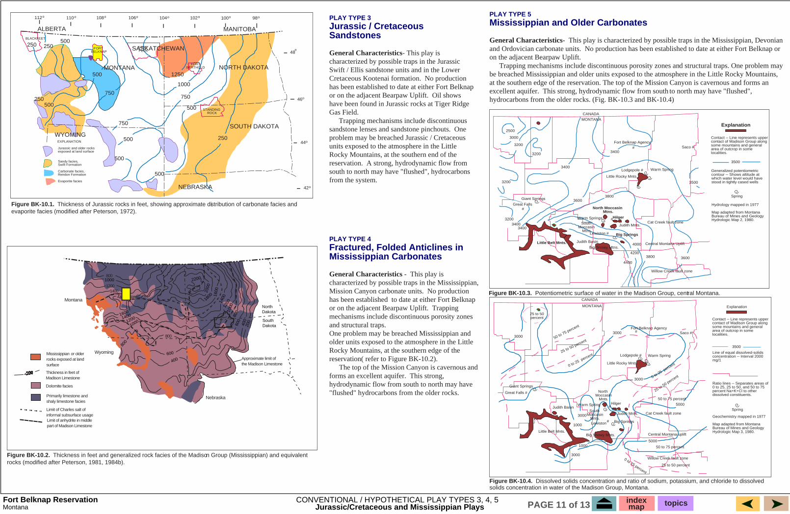
General Characteristics - This play is characterized by possible traps in the Mississippian, Mission Canyon carbonate units. No production has been established to date at either Fort Belknap or on the adjacent Bearpaw Uplift. Trapping mechanisms include discontinuous porosity zones and structural traps.One problem may be breached Mississippian and older units exposed to the atmosphere in the Little Rocky Mountains, at the southern edge of the reservation( refer to Figure BK-10.2). The top of the Mission Canyon is cavernous and forms an excellent aquifer. This strong, hydrodynamic flow from south to north may have "flushed" hydrocarbons from the older rocks.
PLAY TYPE 3 Jurassic / Cretaceous Sandstones
General Characteristics- This play is characterized by possible traps in the Jurassic Swift / Ellis sandstone units and in the Lower Cretaceous Kootenai formation. No production has been established to date at either Fort Belknap or on the adjacent Bearpaw Uplift. Oil shows have been found in Jurassic rocks at Tiger Ridge Gas Field. Trapping mechanisms include discontinuous sandstone lenses and sandstone pinchouts. One problem may be breached Jurassic / Cretaceous units exposed to the atmosphere in the Little Rocky Mountains, at the southern end of the reservation. A strong, hydrodynamic flow from south to north may have "flushed", hydrocarbons from the system.
Cat Creek fault zone
Central Montana Uplift
North Moccasin Mtns.
Judith Mnts.
Hilger
Big Springs
Judith Basin
Big Snowy Mtns.
Lewiston #
Willow Creek fault zone
Warm SpringsSouth
Moccasin Mtns.
Fort Belknap Agency
Lodgepole # Warm Spring
Little Rocky Mnts.
Saco ##
CANADA
MONTANA
2500
3000
3200
3200
3400
3200
3400
3500
38003600
3800
4000
4200
44003600
32003400
3400
Giant Springs
Great Falls
Little Belt Mnts.
#
#
Explanation
Contact -- Line represents upper contact of Madison Group along some mountains and general area of outcrop in some localities.
Generalized potentiometric contour -- Shows altitude at which water level would have stood in tightly cased wells
Hydrology mapped in 1977
Map adapted from Montana Bureau of Mines and Geology Hydrologic Map 2, 1980.
3500
Spring
CANADA
MONTANA
Lodgepole #
Little Rocky Mnts.
Fort Belknap Agency
Warm Spring
Cat Creek fault zone
Central Montana uplift
Willow Creek fault zone
Big Snowy Mnts.
Lewiston Big Springs
North Moccasin
Mnts.Hilger
Judith Mnts.South
MoccasinMnts.
Saco #
Giant Springs
Great Falls #
30003000
3000
1000
3000
3000
1000
5000
5000
25 to 50percent
Little Belt Mnts.
Judith BasinWarm Spring
50 to 75 percent
25 to 50 percent
0 to 25 percent
0 to 25 percent
25 to 50 percent
50 to 75 percent
50 to 75 percent
25 to 50 percent
0 to 25 percent
#
#
#
Explanation
Contact -- Line represents upper contact of Madison Group along some mountains and general area of outcrop in some localities.
Line of equal dissolved-solids concentration -- Interval 2000 mg/1
Geochemistry mapped in 1977
Map adapted from Montana Bureau of Mines and Geology Hydrologic Map 3, 1980.
3500
Spring
Ratio lines -- Separates areas of 0 to 25, 25 to 50, and 50 to 75 percent Na+K+Cl to other dissolved constituents.
Figure BK-10.1. Thickness of Jurassic rocks in feet, showing approximate distribution of carbonate facies and evaporite facies (modified after Peterson, 1972).
Figure BK-10.2. Thickness in feet and generalized rock facies of the Madison Group (Mississippian) and equivalent rocks (modified after Peterson, 1981, 1984b).
Figure BK-10.4. Dissolved solids concentration and ratio of sodium, potassium, and chloride to dissolved solids concentration in water of the Madison Group, Montana.
PLAY TYPE 5Mississippian and Older Carbonates
General Characteristics- This play is characterized by possible traps in the Mississippian, Devonian and Ordovician carbonate units. No production has been established to date at either Fort Belknap or on the adjacent Bearpaw Uplift. Trapping mechanisms include discontinuous porosity zones and structural traps. One problem may be breached Mississippian and older units exposed to the atmosphere in the Little Rocky Mountains, at the southern edge of the reservation. The top of the Mission Canyon is cavernous and forms an excellent aquifer. This strong, hydrodynamic flow from south to north may have "flushed", hydrocarbons from the older rocks. (Fig. BK-10.3 and BK-10.4)
CONVENTIONAL / HYPOTHETICAL PLAY TYPES 3, 4, 5
SASKATCHEWAN
Jurassic/Cretaceous and Mississippian Plays
Figure BK-10.3. Potentiometric surface of water in the Madison Group, central Montana.
indexmap topicsPAGE 11 of 13
MontanaFort Belknap Reservation
West
Nesson Axis
Bakken Formation "Maturity"
?
Hydrocarbon Accumulation
"Maturity"
Fractures
East
Jurassic
Big Snowy Group
Madison Group (L-M Miss.)
Devonian
Mission Canyon Fm.
Triassic
Jurassic
Lodgepole
Nisku Fm.
North Dakota
Wyoming
Silurian and older rocks exposed
Limit of Bakken sourcerocks
110o105o 100o
AA'
South Dakota
Ft. BertholdReservation
Montana
0
contour interval, 200'
Antelope
400
200
200
400
400
200
200600
600800
80010001000
20001200
1400
1600
1800
1200
600
Bear Den
Limit of Prairie salt
FortBelknap
North Dakota
Wyoming
Cambrian and older rocks exposed
sandstone facies
shale, sandstone andminor limestone facies
green shale facies
110¡ 105¡ 100¡
AA'
South Dakota
Ft. BertholdReservation
Montana
0
0
0
0
0
20
20
20
40
40
40
40
60
60
60
80
80
80
100
100
100
100
120
120
120
100
150
Antelope
Taylor
40 contour interval, 20'
Fort
Belknap
PLAY TYPE 7
Cambrian Sandstone Play
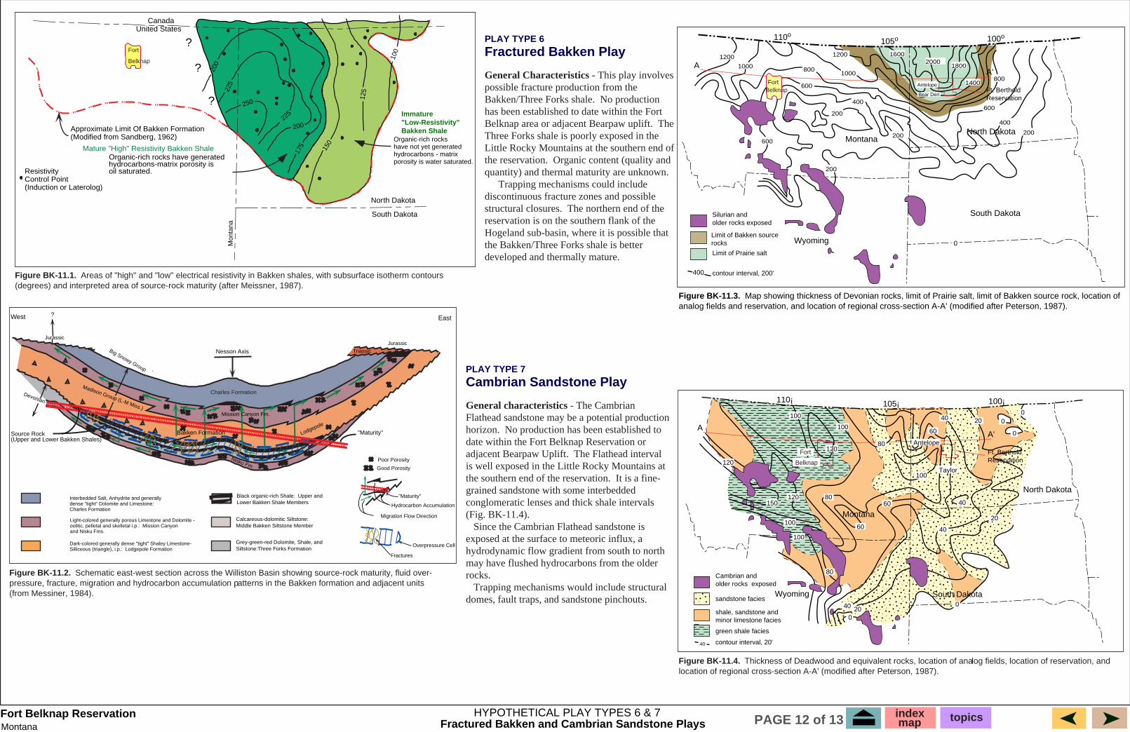
General characteristics - The Cambrian Flathead sandstone may be a potential production horizon. No production has been established to date within the Fort Belknap Reservation or adjacent Bearpaw Uplift. The Flathead interval is well exposed in the Little Rocky Mountains at the southern end of the reservation. It is a fine-grained sandstone with some interbedded conglomeratic lenses and thick shale intervals (Fig. BK-11.4). Since the Cambrian Flathead sandstone is exposed at the surface to meteoric influx, a hydrodynamic flow gradient from south to north may have flushed hydrocarbons from the older rocks. Trapping mechanisms would include structural domes, fault traps, and sandstone pinchouts.
Figure BK-11.1. Areas of "high" and "low" electrical resistivity in Bakken shales, with subsurface isotherm contours (degrees) and interpreted area of source-rock maturity (after Meissner, 1987).
Figure BK-11.2. Schematic east-west section across the Williston Basin showing source-rock maturity, fluid over-pressure, fracture, migration and hydrocarbon accumulation patterns in the Bakken formation and adjacent units (from Messiner, 1984).
Figure BK-11.3. Map showing thickness of Devonian rocks, limit of Prairie salt, limit of Bakken source rock, location of analog fields and reservation, and location of regional cross-section A-A' (modified after Peterson, 1987).
PLAY TYPE 6
Fractured Bakken Play
General Characteristics - This play involves possible fracture production from the Bakken/Three Forks shale. No production has been established to date within the Fort Belknap area or adjacent Bearpaw uplift. The Three Forks shale is poorly exposed in the Little Rocky Mountains at the southern end of the reservation. Organic content (quality and quantity) and thermal maturity are unknown. Trapping mechanisms could include discontinuous fracture zones and possible structural closures. The northern end of the reservation is on the southern flank of the Hogeland sub-basin, where it is possible that the Bakken/Three Forks shale is better developed and thermally mature.
Figure BK-11.4. Thickness of Deadwood and equivalent rocks, location of analog fields, location of reservation, and location of regional cross-section A-A' (modified after Peterson, 1987).
Fractured Bakken and Cambrian Sandstone PlaysHYPOTHETICAL PLAY TYPES 6 & 7
Dark-colored generally dense "tight" Shaley Limestone-Silliceous (triangle), i.p.: Lodgepole Formation
Interbedded Salt, Anhydrite and generallydense "tight" Dolomite and Limestone:Charles Formation
Light-colored generally porous Limestone and Dolomite -oolitic, pelletal and skelletal i.p.: Mission Canyonand Nisku Fms.
?
?
?
CanadaUnited States
North Dakota
South Dakota20
0
200
225
225250
175 150
125
100
Mon
tana
Fort
Belknap
Immature"Low-Resistivity"Bakken Shale
Organic-rich rocks have generatedhydrocarbons-matrix porosity is oil saturated.
Mature "High" Resistivity Bakken Shale
Approximate Limit Of Bakken Formation(Modified from Sandberg, 1962)
ResistivityControl Point(Induction or Laterolog)
Grey-green-red Dolomite, Shale, andSiltstone:Three Forks Formation
Calcareous-dolomitic Siltstone: Middle Bakken Siltstone Member
Black organic-rich Shale: Upper andLower Bakken Shale Members
Migration Flow Direction
Overpressure Cell
Good Porosity
Poor Porosity
Charles Formation
Source Rock(Upper and Lower Bakken Shales)
Organic-rich rockshave not yet generatedhydrocarbons - matrixporosity is water saturated.
indexmap topicsPAGE 12 of 13
MontanaFort Belknap Reservation
Fort Belknap Reservation General References
Anderson, Robert C., 1995, The Oil and Gas Opportunity on Indian Lands-Exploration Policies and Procedures, Bureau of Indian Affairs, Division of Energy and Mineral Resources, General Publication G-95-3, 158 p.
Beeman, William R., et al., 1996, Digital Map Data, Text and Graphical Images in Support of the 1995 Assessment of United States Oil and Gas Resources, United States Geological Survey, Digital Data Series DDS-35, CD ROM.
Charpenteir, Ronald R., et al., 1996, Tubular Data, Text, and Graphical Images in Support of the 1995 National Assessment of United States Oil and Gas Resources, United States Geological Survey, Digital Data Series DDS-36, CD ROM.
Gautier, Donald L., et al., 1996, 1995 National Assessment of United States Oil and Gas Resources - Results, Methodology, and Supporting Data, United States Geological Survey Digital Data Series DDS-30 Release 2.
_______________., et al., 1995, 1995 National Assessment of United States Oil and Gas Resources, Overview of the 1995 National Assessment of Potential Additions to Technically Recoverable Resources of Oil and Gas - Onshore and State Waters of the United States, United States Geological Survey Circular 1118, 20 p.
Mallory, William Wyman, et al., 1972, Geologic Atlas of the Rocky Mountain Region, Rocky Mountain Association of Geologists , 331 p.
Peterson, James A. and MacCary, Lawrence M., 1987, "Regional Stratigraphy and General Petroleum Geology of the U.S. Portion of the Williston Basin and Adjacent Areas", Williston Basin: Anatomy of a Cratonic Oil Province, Rocky Mountain Association of Geologists, pp. 9-43.
Rice, Dudley D. and Shurr, George W., July 1980, "Shallow, Low-Permeability Reservoirs of the Northern Great Plains - Assessment of their Natural Gas Resources", American Association of Petroleum Geologists Bulletin, Volume 64/7, pp. 969-987.
Willette, Donna C., et al., 1996, "Oil and Gas Atlas on Indian Lands", Indian Resources Building Partnerships, Sixth Annual Energy and Minerals Conference, Bureau of Indian Affairs, Division of Energy and Mineral Resources, p. 10.
Fort Belknap - Fields and Articles
Alverson, Douglas C., 1965, "Geology and Hydrology of the Fort Belknap Indian Reservation, Montana", Water Supply of Indian Reservations; Accession Number 65-18877, pp. F1-F59
Bennett, Steve, 1985, "Tiger Ridge Field"; Montana Oil and Gas Field Symposium, Montana Geological Society, Billings, Montana, pp. 1123-1126
Erdmann, C.E. and V.K. Koskinen, 1953, "Preliminary Structure Contour Map of Blaine, Northern Chouteau and Hill Counties ans Adjoining Areas, Montana", Guidebook, 4th Annual Field Conference, Little Rocky Mountains, Montana, Southwestern Saskatchewan, Billings Geological
Society.
Ervin-Cleveland, Malanie and George W. Shepard, 1985, "Bullwacker Field", Montana Oil and Gas Field Symposium, Montana Geological Society, Billings, Montana, pp. 297-300
Feltis, Richard D., 1993, "Hydrogeology of the Madison Group in Central Montana", Energy and Mineral Resources of Central Montana, Montana Geological Society, Billings, Montana, pp. 239-242
Knechtel, Maxwell M., 1959, "Stratigraphy of the Little Rocky Mountains and Encircling Foothills, Montana", Contribution to Economic Geology, USGS Survey Bulliten 1072-N; includes Geologic Map.
____________, et al., 1944, "Oil and Gas Possibilities of the Plains Adjacent to Little Rocky Mountains, Montana", Plains Adjacent to the Little Rocky Mountains, Montana, Oil and Gas Investigation Map, 0004, United Stated Geological Survey.
Maher, Patrick D., 1969, "Eagle Gas Accumulations of the Bearpaw Uplift Area, Montana", Eastern Montana Symposium, Montana Geological Society 20th Anniversary Field Conference Guidebook, pp. 121-127.
Maughan, Edwin K., 1993, "Stratigraphic and Structural Summary for Central Montana", Energy and Mineral Resources of Central Montana, Montana Geological Society, Billings, Montana, 1993, pp. 3-20.
Rice, Dudley D., 1980, "Coastal and Deltaic Sedimentation of Upper Cretaceous Sandstone, Relation to Shallow Gas Accumulations, North-Central Montana", American Association of Petroleum Geologists Bulliten, Volume 64/3, March, pp. 316-338.
Rowley, Arthur E., 1985, "Leroy Field", Montana Oil and Gas Field Symposium, Montana Geological Society, Billings, Montana, pp. 689-692.
Shurr, George W., et al., 1993, "Regional Pressure Patterns as Evidence for Fractured Reservoirs in the Bowdoin and Phillips Sandstones on the Bowdoin Dome, Montana", Energy and Mineral Resources of Central Montana, Montana Geological Society, Billings, Montana.
Fort Belknap - Map References
Executive Reference Map 334, 1985 edition, Extended Area, Northern Rocky Mountains, Geomap Company.
Executive Reference Map 321, 1983 edition, Southern Williston Basin, Geomap Company.
Indian Land Areas, 1992, United States Department of the Interior-Bureau of Indian Affairs.
Clayton, Lee, et al., 1980, Geological Map of North Dakota Survey.
Darton, N.H., et al., 1951, Geologic Map of South Dakota, United States Geological Survey.
Ross, Clyde P., et al., 1958, Geological Map of Montana, Montana Bureau of Mines.
REFERENCES indexmap topicsPAGE 13 of 13


![Fort Ripley: The post and military reservation [by] F. Paul Prucha](https://img.dokumen.tips/doc/110x75/586a22151a28ab427d8bd2d1/fort-ripley-the-post-and-military-reservation-by-f-paul-prucha.jpg)