Embed Size (px)
Citation preview
United States Department of Agriculture Forest Service September 2011
East Fork Meadow Creek
SUPPLEMENTAL
Environmental Assessment
Bonners Ferry Ranger District Idaho Panhandle National Forests

East Fork Meadow Creek EA Supplement
The U.S. Department of Agriculture (USDA) prohibits discrimination in all its programs and activities on the basis of race, color, national origin, age, disability, and where applicable, sex, marital status, familial status, parental status, religion, sexual orientation, genetic information, political beliefs, reprisal, or because all or part of an individual's income is derived from any public assistance program. (Not all prohibited bases apply to all programs.) Persons with disabilities who require alternative means for communication of program information (Braille, large print, audiotape, etc.) should contact USDA's TARGET Center at (202) 720-2600 (voice and TDD). To file a complaint of discrimination, write to USDA, Director, Office of Civil Rights, 1400 Independence Avenue, S.W., Washington, D.C. 20250-9410, or call (800) 795-3272 (voice) or (202) 720-6382 (TDD). USDA is an equal opportunity provider and employer.
Data Accuracy – The US Forest Service uses the most current and complete data available. Geographic Information Systems (GIS) data and product accuracy may vary. They may be developed from sources of differing accuracy, accurate only at certain scales based on modeling or interpretation, incomplete while being created or revised, etc. Using GIS products for purposes other than those for which they were created may yield inaccurate or misleading results. The Forest Service reserves the right to correct, update, modify, or replace GIS products without notification.

East Fork Meadow of Creek Environmental Assessment
USDA Forest Service Idaho Panhandle National Forests
Bonners Ferry Ranger District Boundary County, Idaho
Responsible Official: Forest Supervisor Idaho Panhandle National Forests 3815 Schreiber Way Coeur d’Alene, ID 83815
For Additional Information Contact: Linda McFaddan, District Ranger Doug Nishek, Project Team Leader Bonners Ferry Ranger District 6286 Main Street Bonners Ferry, ID 83805 (208)267-5561
Abstract: This supplemental environmental assessment (SEA) supplements portions of the March 2010 East Fork Meadow Creek Environmental Assessment (EA). This supplemental EA updates the analysis based on new information since the original analysis was completed. The March 2010 East Fork Meadow EA describes the purpose and need for the project, alternatives, affected environment, and environmental consequences. That information is not repeated here unless it is needed to clarify the supplemental analysis.
This supplemental EA and the 2010 EA are based on documents in the project file that are available upon request.

East Fork Meadow Creek EA Supplement
Table of Contents
East Fork Meadow of Creek Environmental Assessment .......................................................... 1
INTRODUCTION ............................................................................................................................ 2
Public Involvement ...................................................................................................................... 2
ALTERNATIVES ............................................................................................................................ 3
ALTERNATIVE 2 – PROPOSED ACTION ............................................................................... 3
ALTERNATIVE 3 ........................................................................................................................ 7
Design Features and Monitoring ................................................................................................ 10
ENVIRONMENTAL EFFECTS ..................................................................................................... 10
FIRE AND FUELS ..................................................................................................................... 10
WATERSHED RESOURCES .................................................................................................... 11
FISHERIES ................................................................................................................................. 11
WILDLIFE.................................................................................................................................. 13
Appendix A - Maps ......................................................................................................................... 15

East Fork Meadow Creek EA Supplement
2
INTRODUCTION In May 2011, a decision notice was issued for the southern half of the East Fork Meadow Creek analysis area that authorized restoration work on approximately 522 acres. Analysis for the southern half of the project area, including consultation with the Idaho State Historic Preservation Office (SHPO), had been completed for that area. Field work and consultation for heritage resources in the northern half of the project was still ongoing and projected to be completed during the summer of 2011, at which time a second decision would be issued.
The May 2011 decision for the southern half of the project was appealed by the Alliance for the Wild Rockies and the Lands Council. The decision was withdrawn by the Forest Supervisor in July 2011. The information in this supplemental analysis will clarify the issues brought up in the appeal and solicit comments from the public. The purpose of this SEA is to update the public with new information and clarify resource management issues in the project area. The resource reports that have been updated with supplemental information and analysis include: Fire and Fuels, Fisheries, Hydrology, and Wildlife. These documents, as well as others cited in the original March 2010 EA and this SEA can be obtained from the Bonners Ferry Ranger District office in Bonners Ferry, Idaho or from the Idaho Panhandle National Forests website (http://fs.usda.gov/goto/ipnf/projects).
The 2010 East Fork Meadow Creek EA describes the purpose and need for the project, alternatives and environmental effects. That information is not repeated here unless it is needed to clarify the supplemental analysis.
All archeological field work has been completed for this analysis and consultation with SHPO is ongoing.
Public Involvement During the fall of 2008, the Boundary County Commissioners asked the Forest Service if there were anything that could be done on the federal lands in the vicinity of the Meadow Creek watershed that would reduce the risk of unwanted forest fires and associated damages to water quality. The headwaters of Meadow Creek provide drinking water for the Beeline Water Association which manages the drinking water for over 100 households. Their intention is to maintain a high quality water source over the long term.
On May 15, 2009, the Bonners Ferry District mailed out a scoping notice to members of the public including adjacent landowners, local government offices, environmental groups and other interested individuals. The scoping letter described the proposed activities, invited interested parties on a field trip, and solicited feedback on the project.
On May 26, the Bonners Ferry Ranger District hosted a field trip to view the project area and gather ideas addressing the proposed action. Attending the field trip were members of the Beeline Water Board, Boundary County Commissioners and members of the Forest Service interdisciplinary team (IDT). During the field trip, the group discussed the fire history in the area, the risk of road failures after a fire, and looked at examples of before and after thinning treatments. The discussion also focused on the local Myrtle Creek Fire of 2003 and the damages it caused to the City of Bonners Ferry water system, a situation that the Beeline Water Association is intending to avoid.
On May 29, 2009 a Notice for Comment was published in the newspaper of record (the Coeur d’ Alene Press). Several comment letters were received and used to identify issues and develop alternatives to the proposed action. In March of 2010 the public was notified of the availability of the East Fork Meadow Creek Environmental Assessment (EA) with the publication of a legal notice in the Coeur d’Alene Press on March 25, 2010. Four comment letters were received, including three letters from regional environmental organizations and one from the Idaho Department of Parks and Recreation. The Kootenai Tribe of Idaho sent a letter of support in November of 2010.
Following the release of the EA to the public, it became apparent that more time was needed to survey cultural resources in the northern half of the project area and to consult with the Idaho State Historic Preservation Office (SHPO). The forest supervisor felt that it was important to start the process of restoring
East Fork Meadow Creek EA Supplement
3
overall forest health and resilience, reducing the risk of sediment entering the Meadow Creek headwaters, and reducing the risk of unwanted fires in the watershed. As a result, a decision was made to implement a modified version of Alternative 2, referred to as Alternative 2- South. Activities included in Alternative 2-South had been cleared by SHPO (project file, Cultural Resources).
The decision to implement selected activities discussed in Alternative 2-South was signed by Forest Supervisor Ranotta McNair on May 23, 2011 and a legal notice was published in the Coeur d’Alene Press on May 27, 2011.Two appeals were received on this decision; one from The Lands Council based in Spokane, Washington, and another from the Alliance for the Wild Rockies based in Montana. Primary appeal points included inadequate and incomplete resource analysis, failure to ensure the viability of management indicator species, grizzly bear habitat, and violation of the Clean Water Act.
In order to further review the analysis, acting Forest Supervisor Maggie Pittman made a decision to withdraw the Alternative 2-South decision. A letter announcing the decision withdrawal was mailed to correspondents on the East Fork Meadow Creek mailing list, including the appellants, on July 18, 2011. A meeting with the Kootenai Tribe of Idaho was held on August 9, 2011 to inform them of the changes.
ALTERNATIVES ALTERNATIVE 2 – PROPOSED ACTION Further analysis of cultural resources, hydrologic concerns with road access, and the depressed lumber market resulted in changes being made to the action alternatives. Changes to Alternative 2 include dropping Unit 9 (Helicopter; 152 acres), Unit 36 (10 acres), Unit 81 (5 acres), Unit 82 (4 acres), Unit 83(25 acres), a portion of Unit 37 (24 acres), and a portion of Unit 69 (3 acres). This modification removes a total of 225 acres of treatment. Changes to proposed road construction includes dropping approximately a quarter mile of proposed new system road (including one stream crossing) in the southeastern corner of unit 2 (see Figure 1). Approximately a quarter mile of FS Trail 32 proposed reconstruction will be re-routed in Unit 31 (see Figure 1).
Modifications to Alternative 3 include dropping Unit 9 (Helicopter; 75 acres).
Although it is currently functional, both action alternatives propose to upgrade the existing undersized culvert on FS Road 2499, where Meadow Creek passes under the road, when funding permits.
The following section replaces “Alternative 2 – Proposed Action” on pages 5 through 6 of the EA.
Alternative 2 proposes vegetation treatments that would restore forest composition and structure through a combination of silvicultural and prescribed burning treatments on approximately 1,297 acres (see Table 1). Even aged silvicultural prescriptions (e.g., seed tree and shelterwood), designed to regenerate long-lived seral species (e.g., western larch and white pine), would treat approximately 113 acres. Intermediate treatments (commercial thin/sanitation salvage and improvement cuts) would treat approximately 1,184 acres. All treatments would be designed to improve the overall health and vigor of the treated stands. They would feature maintenance of the largest and most vigorous trees available, but long-lived seral species would be favored. Approximately 1,179 acres would be harvested using ground based systems (tractor) and approximately 118 acres would be harvested using skyline systems. To improve the health and vigor of aspen clones where they exist, the silvicultural prescriptions would be designed to thin within and around the clones to reduce the competition from encroaching conifers. The aspen clones vary from approximately 1/5 of an acre to 3 acres in size and are interspersed in Units 1, 2, 4, 13, 18, 31, 32, 33, and 69 (refer to the Vegetation Report for more information).
Activity fuels (slash) would be treated using one or a combination of the following methods: prescribed fire, mechanical grapple piling followed by pile burning, and whole-tree yarding.
Approximately nine miles of existing, but overgrown and nearly impassable roads would be reconstructed to improve access to the treatment locations. Of those nine miles, approximately 5.3 miles would be stored following project completion. Approximately 2.8 miles of new roads would be constructed. Following

East Fork Meadow Creek EA Supplement
4
project completion, 0.5 miles of the new road construction would be stored and tracked in the Infra database. Approximately 19 miles of roads would be decommissioned. Alternative 2 also proposes to reroute the existing motorized FS Trail 32, and would reconstruct 1 mile of existing road (currently brushed-in) to trail specifications. This would include replacing the existing low water ford where FS trail 32 crosses Meadow Creek with a structure, such as a bottomless arch or bridge, which would be designed to pass a 100 year flood event and not impede aquatic organism passage. Relocation of the existing trail would avoid sensitive landtypes, would be located more than 1,000 feet from any stream channel, and would incorporate appropriate BMPs. Additionally, approximately 0.8 miles of Forest Service Road (FSR) 2499AUB would be converted to off-highway vehicle (OHV) trail.
Alternative 2 includes entry into 18 acres of allocated dry forest old growth. This includes nine acres of potential old growth (TSMRS code 11) in unit 8, and nine acres of existing old growth (TSMRS code 9) in unit 10. For more detailed information regarding treatments in allocated old growth, refer to the Vegetation Report.

East Fork Meadow Creek EA Supplement
5
The following table replaces Table 3 on page 7 of the EA. Table 1. Alternative 2 – Proposed Action Unit Summary
UNIT ACRES Silvicultural Treatment Equipment Fuel
Treatment PCC Before Treatment
PCC After Treatment
1 89 CT T WT-GP 70-80 40-60 2 137 CT T WT-GP 70-90 40-60 3 241 CT T WT-GP 60-70 50-60 4 148 CT T WT-GP 70-90 50-60 6 25 ST/r T UB 70-80 10-20 7 20 CT S WT-UB 70-80 50-60 8 27 CT T WT-GP 70-80 50-60
10 12 IC S UB 60-80 50-60 11 47 CT S WT-UB 70-80 50-60 12 42 CT T WT-UB 60-80 50-60 13 39 CT T WT-UB 70-80 50-60 14 3 ST T UB 50-60 10-20 15 122 CT T WT-UB 50-60 40-50 17 38 ST/r T UB 30-40 10-20 18 6 CT T WT-GP 60-70 50-60 20 22 CT T WT-UB 60-70 50-60 21 20 CT T WT-GP 60-70 50-60 25 4 SW/r T UB 80-90 30-40 31 85 CT T WT-GP 40-70 40-60 32 19 SW/r T UB 40-60 20-40 33 18 SW/r T UB 40-60 20-40 34 5 CT T WT-GP 60-70 50-60 35 2 CT T WT-GP 60-70 50-60 37 50 CT T WT-GP 60-70 50-60 61 6 ST/r S UB 60-70 10-20 69 37 CT T WT-GP 60-70 50-60 80 33 CT S WT-UB 70-80 50-60
TOTAL 1,297
Rx = Silvicultural prescription UB = Underburn WT = Whole-Tree Yarding GP = Grapple pile PCC = Percent canopy closure SW/r = Shelterwood with reserves CT = Commercial Thin ST/r = Seed Tree with reserves IC = Improvement Cut H = Helicopter S = Skyline T = Tractor

East Fork Meadow Creek EA Supplement
6
The following figure replaces Figure 2 on page 8 of the EA. Figure 1. Alternative 2

East Fork Meadow Creek EA Supplement
7
The following section replaces “Alternative 3” on page 9 of the EA.
ALTERNATIVE 3 In response to public scoping comments, Alternative 3 was designed as a modification of Alternative 2 in order to specifically address road and access issues. To accomplish the purpose and need, Alternative 3 would utilize existing access routes and would not construct new roads. The same vegetation restoration treatments would be applied, but on fewer acres with approximately 76 acres of even aged silvicultural prescriptions and approximately 541 acres of intermediate treatments (see Table 2). Total vegetation treatments would be approximately 617 acres. To improve the health and vigor of aspen clones where they exist, the silvicultural prescriptions would be designed to thin within in and around the clones to reduce the competition from encroaching conifers. The aspen clones vary from approximately 1/5 of an acre to 3 acres in size and are interspersed in Units 1, 4, and 13.
Fuels would be addressed with the same treatments proposed with Alternative 2: prescribed burning, mechanical grapple piling followed by pile burning, whole tree yarding, or a combination of these treatments.
Approximately 7.3 miles of roads would be reconstructed to access treatment units. Of the 7.3 miles that would be reconstructed, approximately 5 miles would be stored following project completion and tracked in the Infra database. Alternative 3 would also decommission approximately 17 miles of road. Approximately 0.8 miles of Forest Service Road (FSR) 2499AUB would be converted to OHV trail. No new roads or trails would be constructed with this alternative.
Alternative 3 includes entry into approximately 9 acres of allocated dry forest old growth. This includes 9 acres of existing old growth (TSMRS code 9) in unit 10. For more detailed information regarding treatments in allocated old growth, refer to the Vegetation Report.
The following table replaces Table 4 on page 9 of the EA. Table 2. Alternative 3 Unit Summary
UNIT ACRES Silvicultural Prescription
Harvest Method
Fuel Treatment
PCC Before Treatment
PCC After Treatment
1 89 CT T WT-GP 70-80 40-60 4 148 CT T WT-GP 70-90 50-60 6 25 ST/r T UB 70-80 10-20 7 20 CT S WT-UB 70-80 50-60 10 12 IC S UB 60-80 50-60 11 47 CT S WT-UB 70-80 50-60 12 42 CT T WT-UB 60-80 50-60 13 39 CT T WT-UB 70-80 50-60 14 3 ST T UB 50-60 10-20 15 122 CT T WT-UB 50-60 40-50 17 38 ST/r T UB 30-40 10-20 20 22 CT T WT-UB 60-70 50-60 25 4 SW/r T UB 80-90 30-40 61 6 ST/r S UB 60-70 10-20
TOTAL 617
Rx = Silvicultural prescription UB = Underburn WT = Whole-Tree Yarding GP = Grapple pile PCC = Percent canopy closure SW/r = Shelterwood with reserves CT = Commercial Thin ST / r= Seed Tree with reserves IC = Improvement Cut H = Helicopter S = Skyline T = Tractor

East Fork Meadow Creek EA Supplement
8
The following figure replaces Figure 3 on page 10 of the EA. Figure 2. Alternative 3

East Fork Meadow Creek EA Supplement
9
The following table replaces Table 5 on page 11 of the EA. Table 3. Alternative Summary
Treatment Type Alt 1 Alt 2 Alt 3 Even-Aged Treatments
Shelterwood with Reserves Seed Tree with Reserves
0 0
41 72
4
72 Intermediate Treatments
Commercial Thin/Sanitation Salvage Improvement Cut
0 0
1172
12
529
12 Total Acres Harvested 0 1297 617 Logging System
Tractor Skyline
0 0
1179 118
532
85 Fuels Treatment
Underburn Grapple Pile
0 0
450 847
380 237
Total Acres Fuels Treatments 0 1297 617 Total Miles or Improvements
Decommissioning Storage Construction Reconstruction
0 0 0 0
19.0 5.8 2.8 8.9
17.1 4.9
0 7.3
Among the differences between this table and Table 5 in the EA is the amount of acres of Improvement Cut prescription under Alternative 2. Table 5 in the EA shows 10 acres of Improvement Cut while this table shows 12 acres. The acres of Improvement Cut prescription did not get larger; this was a typographical discrepancy in the EA.
East Fork Meadow Creek EA Supplement
10
Design Features and Monitoring The following section replaces the design features under “3. Water and Fish – Aquatic Environment” on pages 12 through 13 of the EA.
a. Standards and guidelines established by the Inland Native Fish Strategy (INFS) would be used to protect water quality and fish habitat, including the designation of Riparian Habitat Conservation Areas (RHCAs). These zones include 300-foot (slope distance) protection zones for fish-bearing streams, 150-foot (slope distance) protection zones for permanently flowing (perennial) non-fish bearing streams, ponds, lakes, reservoirs and wetlands greater than one acre, and a 50-foot (slope distance) protection zone for intermittent streams and sensitive landtypes. Commercial timber harvesting would be prohibited in these RHCAs.
b. Protection of RHCAs during Prescribed Burning – There would be no prescribed fire ignitions or fireline construction within any RHCAs.
c. Protection of Aquatic Habitat During In Stream Work – Activities that would take place within perennial streams (e.g. culvert and bridge removal/replacement) would not be allowed from April 1 to July 15 to minimize erosion and sedimentation from these ground-disturbing activities, thereby reducing the risk of effects from sediment during spring runoff and to avoid effects to westslope cutthroat trout redds, eggs, and alevins.
d. Best Management Practices (BMP’s), as outlined in the Hydrology report, would be used during removal and installation of culverts and bridges to minimize sediment delivery into project area streams. BMP’s would also be followed during road construction, reconstruction, and decommissioning to minimize sediment delivery into project area streams.
ENVIRONMENTAL EFFECTS FIRE AND FUELS The following section replaces “Alternative 2 and Alternative 3, Direct and Indirect Effects” on page 25 of the EA.
Alternative 2 would reduce surface flame lengths to less than 4 feet (level of direct attack by ground forces). Canopy cover would be reduced by approximately half (depending on type of overstory removal) within treatment units. This would result in a large increase in canopy base heights and a reduction in canopy bulk densities to a level where the probability of torching approaches zero and the winds necessary to sustain crown fire are near unrealistic. In addition, ladder fuels would be reduced either through biomass utilization or through post-harvest activities (increasing the void between the understory and overstory – effectively increasing canopy base heights), and reduce surface fuels (activities would reduce small woody and coarse woody debris through biomass utilization, grapple-piling, or prescribed underburning). Reducing fuels to modify fire behavior in one area implies fire effects would be ‘ameliorated’ to a greater extent than just the treatment area (Finney, 2001) – as a fire moves into a treated area it slows down or the intensity lessens modifying movement across the landscape and also providing an area where suppression forces can be most effective (Fuels Supplement Report, page E-6).
The initial entry would have an immediate effect on the probability of torching – reducing it to zero in the treatment year for approximately 20 years because the canopy base heights would be increased so dramatically. The increase in the crowning index would remain effective for decades into the future, until regeneration becomes incorporated enough into the mid and overstory as to facilitate fire spread (Fuels Supplement Report, page E-6).
Both of the action alternatives – Alternative 2 (Proposed Action) and Alternative 3 (No New Roads) – would meet the purpose and need, however, Alternative 3 to a lesser degree, as fewer acres would be treated and there would be greater discontinuity of treatments across the landscape.
Alternative 2 would provide fuels treatment and fire hazard reduction across the landscape – modifying the

East Fork Meadow Creek EA Supplement
11
way a larger scale fire would move through the area as a whole. Fires generally move from southwest to northeast and the location of the fuels treatment units offer a ‘protection’ from fire movement in the heading spread under this direction to the upper elevations of the project area. These treatments would not offer fire-proofing – the treated units could still burn in a wildfire – but expected fire behavior would be reduced, generally to a level which would offer assistance to fire suppression (allowing resources to arrive on scene and initiate direct attack) (Fuels Supplement Report, page E-7).
There would be an expected landscape fire regime condition class improvement under Alternative 2. An improvement trend in fire regime condition class from the current condition departure is expected (though it was not analyzed) and would fall somewhere between the original Alternative 2 and Alternative 3 (see below) (Fuels Supplement Report, page E-7).
Overall, the FRCC ratings for the analysis are:
• Current Condition (Alternative 1): Landscape FRCC 2 – Departed 49% • Proposed Action (Alternative 2): Landscape FRCC 1 – Departure 32% • No Roads (Alternative 3): Landscape FRCC 2 – Departure 39%
WATERSHED RESOURCES Add the following text to the end of the first paragraph following “Alternative 2 and Alternative 3, Direct and Indirect Effects” on page 33 of the EA.
All new roads would be designed with comprehensive drainage plans to make all efforts to limit road runoff from entering streams. Examples include installing properly spaced ditch relief culverts near stream crossings to divert flow out of the ditch and onto the forest floor where the rough, vegetated surface can filter out sediment and runoff can infiltrate into the uncompacted soil (Supplemental Hydrology Report, page 21). All required permits would be obtained prior to project implementation (Hydrology Supplement Report, page 31).
FISHERIES The following section replaces “Fisheries” on pages 34 through 35 of the EA.
Alternative 1
Direct, Indirect and Cumulative Effects
The greatest concern would be that the motorized Trail #32 would continue to impact stream substrate habitat and complexity in Meadow Creek by depositing large quantities of sediment into the stream due to several ford crossings and the proximity of the trail to the stream that allows trail erosion to enter the stream. This has lead to a high percentage of detrimental fines in the stream substrate in the area of the crossing and downstream at the Bee Line Water Association water intake (Supplemental Fisheries Report, page 12).
There is currently one known potential human-created barrier on Meadow Creek (culvert on FS Road #2499 where Meadow Creek passes under this road) and this structure would likely remain in place for the near future. Because westslope cutthroat trout may exists in other streams or stream reaches in the project area, plans to improve aquatic organism passage and hydrological function by replacing the culvert with a more appropriately sized structure will be considered as future funding becomes available (Supplemental Fisheries Report, page 13).
There would be no change to road density; it would remain in the high category. Water temperature would fluctuate slowly over time as conifer stands within the riparian zone diminish, change variety, and regrow providing a variety of shading conditions to the streams. Habitat complexity would likely remain consistent over time as the conifers within the riparian zone grow and fall into the stream thus maintaining pool habitat and overall complexity (Supplemental Fisheries Report, pages 12-13).

East Fork Meadow Creek EA Supplement
12
Alternative 2 and Alternative 3
Direct and Indirect Effects
Implementation of the action alternatives would not jeopardize the continued existence of bull trout, the listed species that historically was found in the project area. A biological assessment will be completed when an alternative is selected for implementation (Supplemental Fisheries Report, page 21). All alternatives are compliant with the Endangered Species Act (Supplemental Fisheries Report, page 21), IPNF Forest Plan and Inland Native Fish Strategy (INFISH) guidelines, NFMA regulations, Executive Orders 11988, 11990 and 12962, and the State of Idaho Governer’s Bull Trout Plan (Supplemental Fisheries Report, pages 21-22). The implementation of this project may affect individual westslope cutthroat, but would not lead toward a trend in federal listing. Burbot, interior redband trout, and western pearlshell mussel are not known to be present within the cumulative effects analysis area. Therefore, there would be no impacts to individuals or their habitat (Fisheries Supplement Report, page 19).
Alternative 2 would have the greatest reduction in sediment yield, a total of 16.6 T/yr, as explained in the Hydrology Report, and would therefore be most beneficial to fisheries resources (Fisheries Supplement Report, page 14). A short term (approximately 5 hours) increase in sediment delivery and turbidity levels would be expected from new road construction and road reconstruction activities that occur near stream channels. All specific BMP’s associated with road construction, reconstruction, decommissioning and culvert replacements would be included in this project and would minimize sediment yield from these activities (Fisheries Supplement Report, page 13).
Under Alternative 2, chronic sediment delivery from FS Trail 32 into Meadow Creek would be greatly reduced from existing conditions by replacing the stream ford crossing with a bridge and relocating the existing trail to non-sensitive landtypes over 1,000 feet from any stream channel. In-stream work would not be allowed from April 1 through July 15 to avoid disturbances to spring-spawning westslope cutthroat trout that may potentially use this stream when higher water levels may allow for improved access throughout the drainage. It should be noted that any disturbance as the result of bridge construction would be far outweighed by the benefits to the fishery gained from eliminating motorized use through the stream channel. The end result would be an improvement to both the water quality and fish habitat by reducing sediment production. (Fisheries Supplement Report, pages 13-14).
While not actually part of the road reconstruction components of either alternative, replacement of the Meadow Creek culvert on FS Road #2499 is being analyzed under this project so it can be replaced at a future time when funds become available. Replacement of this culvert would cause an increase of sediment into the stream during the construction phase but following BMP’s (see Hydrology report for specific BMP’s associated with culvert removal and replacement) and in-stream work windows (July 15 through September 1) established for this project would likely minimize sediment quantities to levels not unlike periodic natural events and reduce impacts to aquatic organisms. As with the previously mentioned bridge replacement, BMP’s and in-stream work windows (July 15 through September 1) would be established and followed when the culvert is replaced to reduce impacts to aquatic organisms. Any negative effects of a short term sediment pulse would be far outweighed by the long term benefits of this culvert upgrade (Fisheries Supplement Report, page 14).
Timber harvest activities are not expected to increase sediment yield into streams as INFISH/RHCA buffer guidelines would be implemented (Fisheries Supplement Report, page 14).
Alternative 2 would increase water yield by a predicted 2% while alternative 3 would be predicted to increase water yield by approximately1% over the existing condition. These predicted increases would likely not be detectable in Meadow Creek and likely could not be differentiated from normal climatic fluctuations (Fisheries Supplement Report, page 14).
No effects are expected to stream channel morphology or water temperature and impacts to stream habitat complexity would likely be insignificant (Fisheries Supplement Report, pages 14-15). Road densities would decrease under either action alternative. Lowering road densities within RHCAs would likely result in lower

East Fork Meadow Creek EA Supplement
13
sediment delivery rates as the riparian vegetation is restored and would likely be the most beneficial for the aquatic habitat in Meadow Creek (Fisheries Supplement Report, page 15).
Cumulative Effects
Alternative 2 and Alternative 3, in conjunction with ongoing activities and reasonably foreseeable actions in the cumulative effects area, would increase sediment yield and sediment input to streams in the project area during the construction, reconstruction, decommissioning and maintenance of roads, culvert replacements, and bridge work, but would ultimately result in reduced sediment input from current levels. Additionally, riparian area road densities for the Meadow Creek drainage would also decrease as a result of this project. The increase in sediment associated with road reconstruction and stream crossing improvements would likely be considered inconsequential when compared to the overall long term reduction in sediment yield and resulting benefit to aquatic resources and habitat after completion of the project. As mentioned previously, Alternative 2 would result in the greatest reduction of sediment because it would replace the FS Trail 32 stream ford crossing with a bridge. Under the No Action Alternative or Alternative 3, this crossing would not be replaced and the influx of sediment would continue to threaten aquatic biota and the Bee Line Community Water Association water intake (Fisheries Supplement Report, pages 16-17).
Project implementation, when viewed in conjunction with the cumulative effects of past, ongoing and reasonably foreseeable actions, would maintain stream habitat conditions for fisheries resources within the National Forests lands potentially affected by project activities (Fisheries Supplement Report, page 17).
WILDLIFE GRIZZLY BEAR
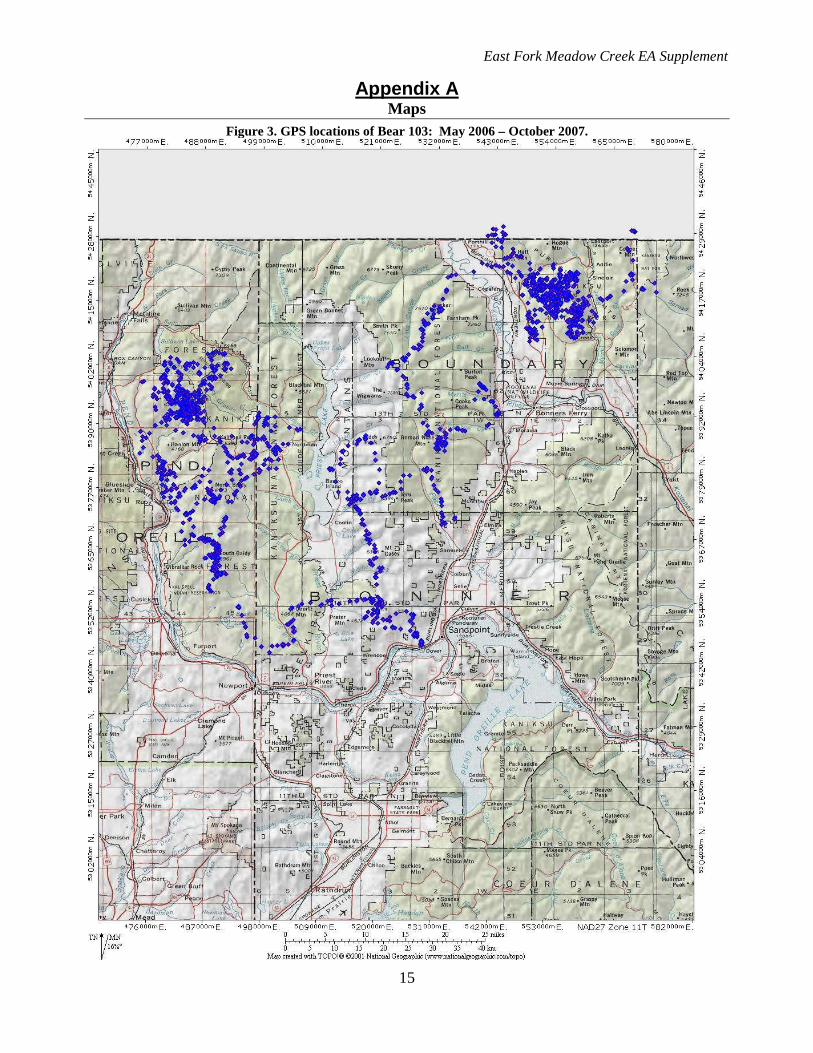
Figure 3 in Appendix A of this document is a map showing the GPS locations of a radio-collared bear from May 2006 through October 2007. The radio collar was worn by a subadult male grizzly bear. This dispersing subadult male (Bear 103) spent part of 2006 between the Kootenai and Moyie river valleys, then crossed into the Selkirks from the Hall Mountain area and denned near Myrtle Creek. In 2007, he wandered south nearly to Sandpoint, then west and north paralleling the Pend Oreille River to the Sullivan Lake area in Washington before moving back south to where he finally lost his collar (Map 3). This episode was noteworthy in that it was the first documented occurrence of a grizzly bear moving between the Cabinet Yak Recovery Zone (CYRZ) and the Selkirk Recovery Zone (SRZ). Since much of the rationale for a no effect determination in the original East Fork Meadow Creek EA was based on a complete absence of substantiated grizzly bear sightings in the project area, the confirmed presence of a grizzly bear (albeit a young, widely-ranging male) prompted the IPNF to revisit this determination (Wildlife Supplement Report, page 3).
While it is accurate to say this bear used the area between the Kootenai and Moyie Rivers during its travels, it does not appear accurate to surmise that the EFM project area was a necessary element of this bear’s route from the CYRZ to the SRZ – since this bear traveled from the Moyie River to Hall Mountain via a more northerly course. The EFM project area would make an unappealing – and unlikely – portion of a travel corridor for a species that generally seeks to avoid human contact. There is no indication that the EFM area is occupied by reproducing grizzly bears, and potential use by this species in the foreseeable future, if any at all, is likely to be additional transient subadult males exploring new areas in search of a home range (Wildlife Supplement Report, pages 3-4).
The following replaces the section after “Alternative 2 and Alternative 3, Direct and Indirect Effects” under the heading Grizzly Bear on page 37 of the EA.
The action area is not within a grizzly bear recovery zone, a recurring use area, or an identified linkage zone. While the action alternatives have the potential to displace grizzly bears if one was present during project implementation, displacement habitat is available, abundant, and likely of higher quality than that being displaced from. Alternative 2 would result in a small increase on paper in motorized route miles in an already motorized portion of the project area, and would also result in a de facto decrease in motorized use by physically preventing current illegal use. Alternative 3 would not permanently change motorized access.

East Fork Meadow Creek EA Supplement
14
The long-term effect of the project on vegetative habitat would be to reduce forested cover (which is currently not limiting in the project area) and increase openings providing forage (which likely is). Consequently, the effects of the project are not expected to rise to a level at which take occurs. Very little substantiated grizzly bear use has been documented in the proposed activity area, and affected habitat is considered of poor quality due to lack of forage species and high levels of human activity. As a result, the displacement effects discussed above are extremely unlikely to occur (Wildlife Supplement Report, pages 7-8).
CANADA LYNX
One of the comments on the East Fork Meadow Creek Decision Notice (Alternative 2 – South) expressed concern that no map of Lynx Analysis Units boundaries, relative to the portion of the East Fork Meadow analysis area included in the decision, was included in the project documentation. Given that the project effects on lynx were of a very limited spatial extent (38 acres of identified lynx habitat would be affected, with less than one acre converted to an early seral condition), a map of lynx habitat was not considered necessary to arrive at an informed decision. However, in response to this particular comment, maps have been produced that display lynx habitat in the Round Prairie LAU (Figure 4) and affected lynx habitat within proposed units in the East Fork Meadow Project Area (Figure 5). These maps are included in Appendix A to this document.
East Fork Meadow Creek EA Supplement
15
Appendix A Maps
Figure 3. GPS locations of Bear 103: May 2006 – October 2007.

East Fork Meadow Creek EA Supplement
16
Figure 4. Canada lynx habitat in the Round Prairie LAU

East Fork Meadow Creek EA Supplement
17
Figure 5. Canada lynx habitat and proposed units in the East Fork Meadow Project Area