Embed Size (px)
Citation preview

FINAL SECOND SUPPLEMENTAL ENVIRONMENTAL IMPACT REPORT
ENVIRONMENTAL ASSESSMENTFOR THE
NORTH PLEASANT VALLEY GROUNDWATER TREATMENT FACILITY
WT-11-01 • SCH NO. 2013091065
Prepared by:
December 2017
T h e C i t y o f C a m a r i l l o h a s i n d e p e n d e n t l y r e v i e w e d a n d a p p r o v e d t h e i n f o r m a t i o n p r e s e n t e d i n t h i s d o c u m e n t .
TABLE OF CONTENTS
Section Page
Introduction 1.......................................................................................................................
Summary 9............................................................................................................................
Project Description 19..........................................................................................................
Alternatives to the New Proposed Action 31...................................................................
Environmental Impact Analysis 33...................................................................................
Aesthetics 35...................................................................................................................
Agricultural and Forestry Resources 41.....................................................................
Air Quality 47.................................................................................................................
Cultural Resources 59...................................................................................................
Greenhouse Gas Emissions 63.....................................................................................
Hazardous Materials 65................................................................................................
Water Resources 71........................................................................................................
Land Use and Planning 79...........................................................................................
Noise 83...........................................................................................................................
Transportation/Circulation 89.....................................................................................
Environmental Justice 93..............................................................................................
Environmental Impact Analysis 95...................................................................................
Final Second Supplemental EIR/EA !i

Table of Contents
Appendices (provided on CD)
Appendix A - Revised Groundwater Monitoring and Contingency Program
Appendix B - Responses to Comments Received on the Draft Second Supplemental EIR/EA
! North Pleasant Valley Groundwater Treatment Facilityii

RESOLUTION NO. 2017-139
A RESOLUTION OF THE CITY COUNCIL OF THE CITY OF CAMARILLO CERTIFYING THE SECOND SUPPLEMENTAL ENVIRONMENTAL IMPACT REPORT (SCH# 2013091065) FOR NORTH PLEASANT VALLEY GROUNDWATER TREATMENT FACILITY (WT-11-01)
The City Council of the City of Camarillo resolves as follows:
SECTION 1: Findings The City Council of the City of Camarillo finds as follows:
A. In 2015 and 2016, the City Council certified a Final and Supplemental Environmental Impact Report (EIR) for the construction and operation of a desalter facility ("project"), pursuant to the State Guidelines for the Implementation of the California Environmental Quality Act (CEQA) and the City's Environmental Guidelines.
B. The City subsequently determined that the three sites previously evaluated in 2015 and 2016 Final and Supplemental EIR are not available for the development and operation of a desalter facility. The City is now proposing the construction and operation of a desalter facility on a 4.7-acre site, located near the northwest intersection of Las Posas and Lewis Roads. The new location was analyzed as an alternative to the original project that was identified in the Initial Study, but was not evaluated in the certified Final EIR. The evaluation of the new location was fully evaluated in a second supplement to the 2015 Final EIR and the 2016 Supplemental EIR (Second Supplemental EIR or Second SEIR).
C. The Draft Second SEIR was completed and circulated for a 45-day public review period from September 28, 2017, to November 13, 2017. Copies of the Draft Second SEIR were distributed to public agencies and interested parties, and displayed on the City's website. A Notice of Completion was submitted with the Draft Second SEIR to the State Clearinghouse. A Notice of Availability (NOA) was distributed to surrounding property owners, homeowners associations (HOAs), and advertised in a newspaper of general circulation within the area (The Ventura County Star). The NOA was also posted at City Hall, Camarillo Library, and the City's website.
D. A duly-noticed public hearing was held by the Planning Commission on November 28, 2017, at which time testimony was heard on the Second SEIR, and at the conclusion of the public hearing the Planning Commission adopted Resolution PC 2017-21 recommending that the City Council certify the Second SEIR.
E. On December 13, 2017, the City Council held a duly-noticed public hearing on the Second SEIR and considered the Second SEIR together with all comments received during the public review process.
F. The City Council finds that the Second SEIR has been completed in compliance with CEQA and reflects the independent judgment and analysis of the City of Camarillo.

G. The City Council for the City of Camarillo hereby finds and determines that on the basis of the Initial Study and the Second SEIR, including all comments received in the public review process and the responses to such comments, that there is no substantial evidence that the proposed desalter project will have a significant adverse effect upon the environment.
SECTION 2: Certification of Second SEIR. The City Council hereby certifies the Second Supplemental EIR (SCH# 2013091065), which is on file with the Department of Community Development, Camarillo City Hall, 601 Carmen Drive, Camarillo, California.
SECTION 3: Filing of NOD. The Public Works Director or the Director's designee is hereby directed to file a Notice of Determination with the County Clerk of the County of Ventura and California Office of Planning and Research - State Clearinghouse.
SECTION 4: The City Clerk is directed certify to the adoption of this resolution, which is effective upon adoption.
PASSED AND ADOPTED December 13, 2017.
Attested to on L:4\ t
1.
City Clerk
I, Jeffrie Mad land, City Clerk of the City of Camarillo, certify Resolution No. 2017-139 was adopted by the City Council of the City of Camarillo at a regular meeting held December 13, 2017, by the following vote:
AYES: Councilmembers: Kildee, McDonald, Morgan, Trembley, Mayor Craven NOES: Councilmembers: None ABSENT: Councilmembers: None
City Clerk OCTOBER 22,
• -
/964 0 ,1110
Resolution No. 2017-139 Page 2 of 2

INTRODUCTIONThis introduction is intended to provide the reader with general information regarding the subject of this Supplemental Environmental Impact Report (EIR)/Environmental Assessment (EA), the purpose for a Supplemental EIR/EA, an introduction to the scope and content of this Supplemental EIR/EA, and the opportunities that will be provided for public participation in the project and Supplemental EIR/EA review process.
SUBJECT OF THIS SUPPLEMENTAL EIR/EA
The City of Camarillo provides drinking water to approximately 65 percent of City residents. In 2016, this water was obtained from local groundwater wells (about 50 percent) and imported water (about 50 percent). The quality of groundwater from two of the City's four wells (Wells A and B) has substantially deteriorated, primarily due to elevated levels of total dissolved solids (TDS), chloride, sulfate, iron and manganese. Due to these water quality issues, the City has placed one of these wells (Well A) on standby, and is blending water from the second well (Well B) with imported water from the Calleguas Municipal Water District (CMWD) in order to meet drinking water quality standards. Due to high salt concentrations in Wells A and B, the City has had to limit pumping in 2016 to about 1,377 acre-feet/year from the North Pleasant Valley (NPV) Groundwater Basin and about 1,731 acre-feet/year from the City’s wells near Camarillo Airport.
For nearly 16 years, the City has been planning the construction and operation of a groundwater treatment facility to increase groundwater pumping to 9,000 acre-feet/year in the NPV Basin and produce 7,500 acre-feet/year of treated water to be served to its customers. During the planning phase, it was determined that the project would be implemented in two phases with Phase 1 providing 4,500 acre-feet/year of new pumping to produce 3,800 acre-feet/year of potable water and Phase 2 providing 4,500 acre-feet/year of pumping to produce an additional 3,700 acre-feet/year of potable water. The treatment facility would be located in the vicinity of Wells A and B to remove TDS, chloride, sulfate, iron and manganese from groundwater produced by these and future well(s). Overall, the purpose of the groundwater treatment facility is to allow the City to utilize its full groundwater allocation, remove brackish groundwater from the NPV Basin, and reduce reliance on imported water.
A Groundwater Treatment Facility Feasibility Study was prepared by Black & Veatch in 2005, in association with Separation Processes, Inc., to determine the appropriate technology and basic configuration of treatment processes to be used. The Feasibility Study identified target concentrations of TDS, chloride, sulfate, iron and manganese to be met by the groundwater treatment facility. The target concentrations of TDS (330 mg/l) and chloride (80 mg/l) were set low, as these constituents would add to the mass loading in wastewater produced during use of supplied potable water. Wastewater is treated by the Camarillo Sanitary District and discharged to Conejo Creek (north of confluence with Calleguas
Final Second Supplemental EIR/EA !1

Introduction
Creek), which has strict limits on TDS, chloride and sulfate. The target concentrations for iron (0.3 mg/l) and manganese (0.05 mg/l) are the drinking water Secondary Maximum Contaminant Levels set in Title 22 of the California Code of Regulations.
A recommendation from the 2005 Feasibility Study was to pilot test various treatment technologies prior to designing the full scale facility. A year-long pilot test was conducted in 2007 and 2008 at Well A and Well B and included the evaluation of four pre-treatment processes (oxidation, regular filtration, green sand filtration, and chemical sequestering) and a different reverse osmosis membrane. The results of the pilot test identified green sand filtration with reverse osmosis (RO) to be the most cost effective treatment process. Iron and manganese are effectively removed by the RO process. However, if iron and/or manganese are present in groundwater in oxidized forms, fouling of the RO membranes may occur. The green sand filtration process would remove the iron and manganese. The filters would be backwashed periodically to remove accumulated iron and manganese solids.
The City’s groundwater treatment facility is included as an implementation project in the Calleguas Creek Watershed Management Plan, 2008 Calleguas Creek Salts TMDL, and the Watershed Coalition of Ventura County Integrated Regional Water Management Plan 2006. These plans found that the groundwater treatment facility is consistent with State-wide objectives and the strategies and objectives of the plans, through increasing water supply reliability, managing groundwater, water quality protection and improvement, preventing further migration of poor quality groundwater to areas not contaminated with salts, facilitate conjuctive use by removing poor quality groundwater and enabling recharge with higher quality storm water flows, desalination, and reducing use of imported water. The City’s groundwater treatment facility is also included in the 2007 Fox Canyon Groundwater Management Plan, and is considered a beneficial strategy to prevent water quality degradation in the NPV Basin.
As part of the planning process for a groundwater treatment facility, the City prepared an Initial Study and Notice of Preparation (NOP) in April 2008 for a very similar project. The IS and NOP were distributed to responsible and trustee agencies and the State Clearinghouse, and the project was assigned State Clearinghouse no. 2008041159. In June 2008, the City initiated preparation of an EIR for the project, but it was never completed.
In September 2013, the City prepared a new NOP for the proposed groundwater treatment facility. As part of the EIR scoping, eight potential facility sites (numbered 1 through 8) were assessed in a new Initial Study, including one site (Site 7) located within the City limits and seven within the adjacent unincorporated area of Ventura County. The locations of these site are shown in Figure 1. Subsequently, three facility sites were selected for analysis in the Draft EIR/EA in order to represent a range of feasible alternative sites to be considered by the City. These sites included the preferred facility site (originally Site 2, but analyzed in the EIR/EA as the Proposed Action facility site), Site 4, and Site 7. A Draft EIR/EA was prepared and circulated for review by public agencies and interested members of the public from March 31 through May 16, 2014. Based on comments received from the Fox Canyon Groundwater Management
! North Pleasant Valley Groundwater Treatment Facility2

Introduction
Agency (FCGMA) and its consultants, the City determined that the water resources impact analysis presented in the 2014 Draft EIR/EA did not utilize an appropriate environmental baseline. The analysis was based on a groundwater study which compared "no mounding" conditions to future + project conditions to identify environmental impacts. Mounding refers to the increasing water levels of brackish groundwater in the North Pleasant Valley Basin. Using "no mounding" as the environmental baseline was determined not to be appropriate because it did not represent present or future conditions.
The City determined that the water resources analysis should be revised to utilize future no project conditions as the environmental baseline and these revisions constitute "significant new information" for the purposes of Section 15088.5(a) of the Guidelines for Implementation of the California Environmental Quality Act (CEQA Guidelines) and recirculation was required. Consistent with Section 15088.5(f)(2) of the CEQA Guidelines only the revised sections (water resources) of the Draft EIR/EA were recirculated.
The revised Draft EIR/EA focused on water resources impacts and was recirculated for public comment from March 2 through April 20, 2015. A Final EIR/EA was prepared in May 2015, including responses to public comments on the 2014 Draft EIR/EA and the 2015 Recirculated Draft EIR/EA. The Camarillo City Council certified the Final EIR/EA on May 27, 2015.
FIGURE 1 - INITIAL STUDY FACILITY SITE LOCATIONS
Final Second Supplemental EIR/EA !3
Introduction
Following the certification of the 2015 Final EIR/EA, the proposed locations of the two new groundwater production wells was changed, in part due to coordination with the adjacent Bell Ranch. One well was changed to be located immediately north of the new Rancho Campana High School and the second would be located just northeast of the Church of Jesus Christ of Latter-day Saints. These new wells would produce brackish groundwater for treatment at the new Facility. Overall, approximately 3,000 gallons per minute (gpm) from Wells A and B, and 3,000 gpm (each) from two new brackish groundwater wells would be treated at the groundwater treatment facility.
In addition, the groundwater modeling conducted in support of the 2015 Recirculated Draft EIR/EA had been revised based on input from the FCGMA and the technical peer review report (2015). The revisions to the modeling mostly involved the use of post-2010 groundwater pumping data, which included increased pumping rates in response to drought conditions. In addition, the modeling was revised to account for the continued pumping of City groundwater pumping, assuming the City would pump it's full allocation (4,500 acre-feet/year prior to FCGMA Ordinance E levels) from the Airport area wells (Airport #3, Well D, and a possible new well).
A Supplemental EIR/EA was prepared to provide additional information and environmental analysis to make the 2015 Final EIR/EA adequate for the revised groundwater treatment facility project. Consistent with Section 15163 of the CEQA Guidelines, a Supplemental EIR (instead of a Subsequent EIR) was prepared because only minor changes or additions to the 2015 Final EIR/EA were required to make it adequately apply to the revised project. Also consistent with Section 15163 of the CEQA Guidelines, the Supplemental EIR/EA contained only that information necessary to make the 2015 Final EIR/EA adequate for the project as revised.
The Supplemental EIR/EA was circulated for public review from March 21 through April 22, 2016. The Camarillo City Council certified the Supplemental EIR/EA on June 20, 2016.
The City has now determined that the three sites evaluated in the 2015 Final EIR/EA and the 2016 Supplemental EIR/EA are not available for development and use of the groundwater treatment facility. The City is now proposing the development of the facility at a property located to the immediate east of the Church of Jesus Christ of Latter-day Saints. This was identified as Site 5 in the 2013 Initial Study. The City will also consider development of the facility at Site 1 from the Initial Study, located near the northeastern corner of Ponderosa Drive and Antonio Avenue, as an alternative. The location of a new groundwater well will be incorporated into the new facility site. The amount of water that is withdrawn from the well and treated at the new facility would also remain unchanged.
PURPOSE OF A SUPPLEMENTAL EIR/EA
In some instances, changes to a proposed project or its surrounding circumstances subsequent to the certification of an initial EIR necessitate the preparation of either a “subsequent EIR” or a “supplement to
! North Pleasant Valley Groundwater Treatment Facility4
Introduction
an EIR” (also commonly known as a “supplemental EIR). This allows projects to be modified without a lead agency having to completely start a new environmental review process from the beginning. As stated in County of Inyo v. City of Los Angeles (3d Dist. 1977) 71 Cal. App. 3d 185, 199 [139 Cal. Rptr. 396], “The CEQA reporting process is not designed to freeze the ultimate proposal in the precise mold of the initial project; indeed, new and unforeseen insights may emerge during investigation, evoking revision of the original proposal.”
Pursuant to Sections 15162 and 15163 of the CEQA Guidelines, a subsequent EIR is required when substantial changes are proposed for a project, substantial changes to the previous EIR are necessary, and previously-identified impacts will be greater and/or new significant impacts would occur. A supplement to a previous EIR may be prepared if any of the changes to a project would require the preparation of a subsequent EIR and only minor additions or changes would be necessary to make the previous EIR adequately apply to the project in the changed condition. A supplement to a previous EIR may be distinguished from a subsequent EIR in that a supplement augments a previously certified EIR to the extent necessary to address the changed conditions of the project and to examine mitigation and project alternatives accordingly. A subsequent EIR, in contrast, is a complete EIR which focuses on the changed conditions that cannot be supplemented with the previous EIR.
In the case of the City’s groundwater treatment facility project, the impacts associated with the development and operations of the facility have been evaluated in the 2015 Final EIR/EA and the 2016 Supplemental EIR/EA for three sites along with a “No Action/No Project Alternative.” The new location that the City is proposing for the facility was included in the Initial Study issued for the project, as was the location for the Site 1 alternative. In essence, these two sites represent two additional alternatives to the original project that were identified in the Initial Study, but were not evaluated in the certified EIR. The evaluation of these alternatives can be evaluated in a second supplement to the 2015 Final EIR/EA and the 2016 Supplemental EIR/EA.
SUPPLEMENTAL EIR/EA SCOPE AND CONTENT
Based on the findings of the Initial Study, National Environmental Policy Act (NEPA) requirements, and concerns identified in comment letters submitted in response to the NOP, the 2015 Final EIR/EA evaluated impacts on the following issue areas:
• Aesthetics;
• Agricultural and Forestry Resources;
• Air Quality;
• Cultural Resources;
Final Second Supplemental EIR/EA !5

Introduction
• Greenhouse Gas Emissions;
• Hazardous Materials;
• Water Quality;
• Land Use and Planning;
• Noise;
• Transportation/Circulation;
• Environmental Justice;
• Socioeconomics; and
• Indian Trust Assets.
The 2016 Supplemental EIR/EA updated and expanded upon the 2015 Final EIR/EA analyses for the following issue areas:
• Agriculture and Forestry Resources
• Water Resources
• Noise
• Land Use and Planning
Each of these issue areas is addressed in this Second Supplemental EIR/EA.
ORGANIZATION OF THE SUPPLEMENTAL EIR/EA
This second Supplemental EIR/EA has been formatted for ease of use and reference. To help the reader locate information of particular interest, a brief summary of the contents of each section of the second Supplemental EIR/EA is provided. The following sections are contained within the second Supplemental EIR/EA:
Introduction - This section introduces the subject of this second Supplemental EIR/EA, the purpose for a Supplemental EIR/EA, an introduction to the scope and content of this Draft EIR, and the opportunities that will be provided for public participation in the project and EIR review process.
Summary - This section provides a summary of the analyses and conclusions presented in the body of this second Supplemental EIR/EA, including the potential environmental impacts of the New Proposed Action and the additional alternative site, the recommended mitigation measures, the level of significance after mitigation, and the unavoidable impacts of the New Proposed Action and new alternative site.
! North Pleasant Valley Groundwater Treatment Facility6

Introduction
Project Description - This section outlines the objectives for the project, describes the project as proposed by the City, outlines the benefits of the project, describes the physical characteristics of the New Proposed Action facility site and the characteristics of the project that would be developed at this new site, and identifies the approvals required by the City of Camarillo and other agencies for project implementation.
Alternatives to the Proposed Action — This section defines the additional alternative to the New Proposed Action that is being considered by the City.
Environmental Impact Analysis — The Environmental Impact Analysis is the primary focus of the second Supplemental EIR. Separate discussions are provided to address the potential environmental impacts of the New Proposed Action and the new alternative. Each section updates the affected environment discussions to address the New Proposed Action facility site and the new alternative facility site, identifies the significance thresholds from the 2015 Final EIR/EA and 2016 Supplemental EIR/EA for that topic, an assessment of the impacts of the project in relation to the thresholds of significance, cumulative impacts, recommended mitigation measures, and a residual impact statement as to the effectiveness of the recommended mitigation measures.
PUBLIC PARTICIPATION
Public participation is an essential part of the CEQA process. To provide full public disclosure of the potential environmental impacts that may occur as a result of the current project, CEQA requires that the Draft Second Supplemental EIR be circulated for a 45-day public review period. During this review period, public agencies and interested organizations and individuals are encouraged to provide written comments addressing their concerns regarding the adequacy and completeness of the Draft Second Supplemental EIR. When providing written comments on the subject matter of the Draft Second Supplemental EIR, the readers are referred to Section 15204(a) of the CEQA Guidelines, which states:
In reviewing draft EIRs, persons and public agencies should focus on the sufficiency of the document in identifying and analyzing the possible impacts on the environment and ways in which the significant effects of the project might be avoided or mitigated. Comments are most helpful when they suggest additional specific alternatives or mitigation measures that would provide better ways to avoid or mitigate the significant environmental effects. At the same time, reviewers should be aware that the adequacy of an EIR is determined in terms of what is reasonably feasible, in light of factors such as the magnitude of the project at issue, the severity of its likely environmental impacts, and the geographic scope of the project. CEQA does not require a lead agency to conduct every test or perform all research, study, and experimentation recommended or demanded by commenters. When responding to comments, lead agencies need only respond to significant environmental issues and do not need to provide all information requested by reviewers, as long as a good faith effort at full disclosure is made in the EIR.
Final Second Supplemental EIR/EA !7

Introduction
All comments or questions regarding the Draft Second Supplemental EIR were addressed to:
Lucia McGovernCity of Camarillo/Camarillo Sanitary District601 Carmen DriveCamarillo, CA 93010-0248Telephone: (805) 383-5334Fax: (805) 388-5387Email: [email protected]
A copy of the Draft EIR was made available for public review by the general public on the City’s website (www.cityofcamarillo.org) and at the City of Camarillo Department of Public Works at the address listed above.
Following the Draft Second Supplemental EIR public review period and receipt of all written comments, the City of Camarillo prepared a Final Second Supplemental EIR. The Final EIR provides additions and revisions to the Draft Second Supplemental EIR as applicable, and written responses to the written comments received by the City during the Draft Second Supplemental EIR review period. Members of the public also had additional opportunities to participate in the review of the proposed project through attendance at the public hearings before the City of Camarillo Planning Commission and City Council.
! North Pleasant Valley Groundwater Treatment Facility8

SUMMARYThis section has been prepared in accordance with the CEQA Guidelines, and is divided into two components. The
first updates the characteristics of the proposed project and alternatives from what was summarized in the 2016
Supplemental EIR/EA, and the second identifies environmental impacts, mitigation measures and residual impacts.
PROJECT SYNOPSIS
Project Development
The proposed groundwater treatment facility would serve existing Wells A and B as well as new brackish groundwater wells (Phase 1 - 4,500 acre-feet/year, and Phase 2 - 4,500 acre-feet/year), and discharge brine to the Calleguas Municipal Water District's Regional Salinity Management Project pipeline. Therefore, an economically feasible project site must be located in close proximity to these facilities. Wells A and B are located adjacent to the northern City limit, and surrounding land uses within the City are residential and commercial, which cannot accommodate the proposed groundwater treatment facility. As part of EIR scoping, eight facility sites (numbered 1 through 8) were assessed in the 2013 Initial Study, including one site (Site 7) located within the City limits and seven within adjacent Ventura County. Subsequently, three facility sites were selected for analysis in the 2015 Final EIR/EA and the 2016 Supplemental EIR/EA to represent a range of feasible alternative sites. These sites include the preferred facility site (former Site 2, now referred to as the Proposed Action), Site 4 and Site 7. The environmental impacts of these alternatives were analyzed at an equal level of detail in compliance with NEPA, as the City is pursuing Federal funding.
The City has now determined that the three sites evaluated in the 2015 Final EIR/EA and the 2016 Supplemental EIR/EA are not available for development and use of the groundwater treatment facility. The City is now proposing the development of the facility described above at a property located to the immediate east of the Church of Jesus Christ of Latter-day Saints. This was identified as Site 5 in the Initial Study. Development and operations of the facility at this location is referred to as the New Proposed Action in this Second Supplemental EIR.
Location
The New Proposed Action facility site (former Site 5 and including the southern new well site), the Site 1 Alternative facility site, and the proposed northern well site are located adjacent to the City limits, west of the Las Posas Road/Lewis Road Intersection.
Final Second Supplemental EIR/EA !9

Summary
Municipal Reorganization
The New Proposed Action facility site is located adjacent to, but outside of, the City’s municipal boundaries and its Sphere of Influence. Because the facility would be serviced by the City of Camarillo Water Division and Camarillo Sanitary District, the City will request approval from the Ventura County Local Agency Formation Commission (LAFCO) for reorganization. The reorganization proposal would include:
• An amendment to the City’s Sphere of Influence boundaries to include the facility site;
• Parcel subdivision to create a legal lot for the facility site;
• Annexation of the facility site to the City and the City of Camarillo water service area;
• An amendment to the Camarillo Sanitary District’s Sphere of Influence to include the facility site;
• Annexation of the facility to the Camarillo Sanitary District;
• Detachment of the facility site from the Ventura County Resource Conservation District, Ventura County Waterworks District No. 19, County Service Area no. 32 (individual sewage disposal), County Service Area no. 33 (recreation and park services), and Cold Coast Transit District; and
• The City of Camarillo would pre-zone the facility site to ensure General Plan consistency.
A subdivision to create a legal lot for the facility site would be requested from the Ventura County Resource Management Agency.
Annexation of the New Proposed Action facility site would create an unincorporated island of the Church of Jesus Christ of Later-day Saints property. In response, the City is proposing to annex the church property to the City of Camarillo and the City of Camarillo water service area along with the New Proposed Action facility site and to cover the church’s costs for the annexation.
Project Components
New Proposed Action
The New Proposed Action facility site would occupy an area of 4.7 acres. A 40-foot wide permanent utility easement would be provided for pipeline and other utility installations as well as vehicular access to the site from Somis Road. The site access would be paved, but the utility easement would not remove existing row crop areas from agricultural production. An existing produce stand is located within the boundaries of the utility easement and would be relocated further to the south when the easement is improved. The utility easement would continue to provide access to the existing use at the Meyerstein property.
! North Pleasant Valley Groundwater Treatment Facility10
Summary
New Wells
The location of a new groundwater well would remain unchanged with the southern well incorporated into the new facility. The amount of water that is withdrawn from the well and treated at the new facility would also remain unchanged.
Alternatives Considered
Three facility sites were selected for analysis in the 2015 Final EIR/EA and the 2016 Supplemental EIR/EA to represent a range of feasible alternative sites. These sites include the preferred facility site (former Site 2, referred to as the Proposed Action in the 2015 Final EIR/EA and the 2016 Supplemental EIR/EA), Site 4 and Site 7. The environmental impacts of these alternatives and the No Action/No Project Alternative were analyzed at an equal level of detail in compliance with NEPA, as the City is pursuing Federal funding.
The City has now determined that the three sites evaluated in the 2015 Final EIR/EA and the 2016 Supplemental EIR/EA are not available for development and use of the groundwater treatment facility. The City is now proposing the development of the facility at the New Proposed Acton site described above. The City will also consider development of the facility at Site 1 from the Initial Study, located near the northeastern corner of Ponderosa Drive and Antonio Avenue, as an alternative.
Site 1 Alternative
This alternative would include the same facilities as the New Proposed Action; however, the groundwater treatment facility would be located at a different site, near the northeastern corner of Ponderosa Drive and Antonio Avenue. One new well site would be the same (referred to as the souther well site). Otherwise, the Site 1 Alternative facility would be same as the New Proposed Action. In addition, the pipeline tie-in locations would be same as the New Proposed Action. However, the pipeline alignments would differ due to the changed facility location.
SUMMARY OF ENVIRONMENTAL IMPACTS, MITIGATION MEASURES, AND
ALTERNATIVES
This section identifies two types of project impacts:
Significant, Unavoidable Adverse Impacts: These are impacts for which specific economic, social or other considerations make infeasible the mitigation measures or project alternatives identified in the EIR/EA. Should the Camarillo City Council decide to approve the project, a Statement of Overriding Considerations must be adopted for any significant unavoidable adverse impacts. The 2015 Final EIR/EA identified short-term noise impacts associated with well drilling at the western well site as a significant, unavoidable adverse impact. The well site locations have been revised since the 2015 Final EIR/EA was
Final Second Supplemental EIR/EA !11

Summary
certified, such that noise-sensitive land uses are located further from the well sites. Therefore, well drilling noise impacts can be mitigated below the level of significance. The project as revised would not result in any significant, unavoidable adverse impacts.
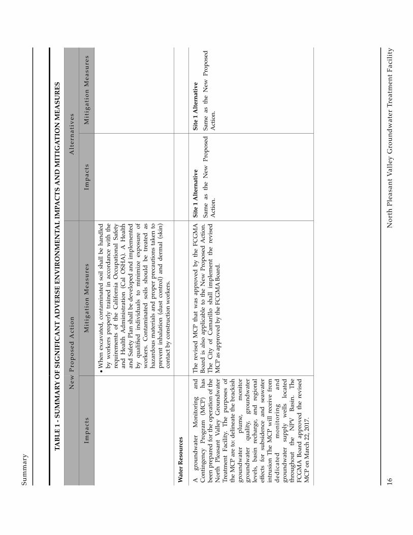
Significant Adverse Impacts: These are significant impacts that can be feasibly mitigated to less than significant levels. Therefore, by definition, residual impacts would be less than significant. Significant adverse impacts associated with the New Proposed Action and alternatives are summarized in Table 1. Note that Table 1 includes a summary of all significant impacts, including those that have not changed since the 2015 Final EIR/EA and 2016 Supplemental EIR/EA were certified.
! North Pleasant Valley Groundwater Treatment Facility12

Sum
mar
y
TABL
E 1
- SU
MM
ARY
OF
SIG
NIF
ICA
NT
AD
VER
SE E
NV
IRO
NM
ENTA
L IM
PAC
TS A
ND
MIT
IGAT
ION
MEA
SUR
ES
New
Pro
pos
ed A
ctio
nA
lter
nat
ives
Imp
acts
Mit
igat
ion
Mea
sure
sIm
pac
tsM
itig
atio
n M
easu
res
Cul
tura
l Res
ourc
es
Base
d o
n t
he r
ecor
ds s
earc
h a
nd
arch
eolo
gica
l fi
eld
sur
vey
res
ults
co
nduc
ted
for
the
2015
Fin
al E
IR/E
A,
the
New
Pro
pose
d A
ctio
n w
ould
not
ad
vers
ely
im
pact
an
y
know
n pr
ehis
toric
or
hist
oric
arc
haeo
logi
cal
reso
urce
. Th
e fa
cilit
y a
nd n
ew w
ell
site
has
bee
n cu
ltiva
ted
for a
t lea
st 1
00
year
s a
nd h
as b
een
ext
ensi
vely
rip
ped,
dis
ked
and
plow
ed; t
here
fore
, no
int
act
depo
sits
are
exp
ecte
d t
o oc
cur
with
in th
e to
p tw
o fe
et o
f so
il.
How
ever
, as
the
faci
lity
site
is lo
cate
d w
ithin
an
activ
e de
posi
tiona
l se
tting
, th
ere
is
a p
ossi
bilit
y t
hat
burie
d ar
chae
olog
ical
m
ater
ials
m
ay
be
pres
ent,
whi
ch c
ould
be
pote
ntia
lly
impa
cted
by
proj
ect
impl
emen
tatio
n.
Such
im
pact
s
are
co
nsid
ered
po
tent
ially
sign
ifica
nt.
The
follo
win
g m
itiga
tion
mea
sure
s id
entifi
ed in
the
20
15 F
inal
EIR
/EA
to m
itiga
te im
pact
s to
any
bur
ied,
in
tact
, an
d p
oten
tially
sig
nific
ant
arc
haeo
logi
cal
reso
urce
s, a
nd to
add
ress
the
Chu
mas
h co
mm
unity
's co
ncer
ns fo
r the
Pro
pose
d A
ctio
n ar
e al
so a
pplic
able
to
the
New
Pro
pose
d A
ctio
n.1.
An
arch
aeol
ogis
t and
Chu
mas
h re
pres
enta
tive
shal
l be
ret
aine
d t
o m
onito
r al
l pr
ojec
t-rel
ated
ear
th
dist
urba
nces
tha
t ex
tend
bel
ow 2
fee
t fr
om t
he
grou
nd s
urfa
ce,
with
in t
he f
acili
ty s
ite a
nd t
he
prop
osed
wel
l si
te,
and
pip
elin
e tr
ench
es lo
cate
d w
ithin
agr
icul
tura
l fiel
ds.
•A
t th
e co
mm
ence
men
t of
pro
ject
con
stru
ctio
n,
the
arch
aeol
ogic
al m
onito
r sh
all g
ive
all w
orke
rs
asso
ciat
ed w
ith e
arth
-dis
turb
ing
proc
edur
es a
n or
ient
atio
n re
gard
ing
the
prob
abili
ty o
f exp
osin
g cu
ltura
l res
ourc
es a
nd d
irect
ions
as t
o w
hat s
teps
ar
e to
be
take
n if
a fin
d is
enc
ount
ered
.
•Th
e ar
chae
olog
ist
shal
l ha
ve t
he a
utho
rity
to
tem
pora
rily
halt
or r
edire
ct p
roje
ct c
onst
ruct
ion
in th
e ev
ent
that
pot
entia
lly s
igni
fican
t cu
ltura
l re
sour
ces
are
exp
osed
. Ba
sed
on
mon
itorin
g ob
serv
atio
ns a
nd t
he a
ctua
l ex
tent
of
proj
ect
dist
urba
nce,
the
lead
arc
haeo
logi
st sh
all h
ave
the
auth
ority
to r
efine
the
mon
itorin
g re
quire
men
ts
as a
ppro
pria
te (i
.e.,
chan
ge to
spot
che
cks
or h
alt
mon
itorin
g) in
cons
ulta
tion
with
the
City
.
•A
mon
itorin
g r
epor
t sh
all
be p
repa
red
upo
n co
mpl
etio
n of
con
stru
ctio
n an
d pr
ovid
ed to
the
City
and
the
SCC
IC.
Site
1 A
ltern
ativ
eSa
me
as t
he N
ew P
ropo
sed
Act
ion.
Site
1 A
ltern
ativ
eSa
me
as t
he N
ew P
ropo
sed
Act
ion.
TABL
E 1
- SU
MM
ARY
OF
SIG
NIF
ICA
NT
AD
VER
SE E
NV
IRO
NM
ENTA
L IM
PAC
TS A
ND
MIT
IGAT
ION
MEA
SUR
ES
New
Pro
pos
ed A
ctio
n
Imp
acts
Fina
l Sec
ond
Supp
lem
enta
l EIR
/EA
!13

Sum
mar
y
2.In
the
une
xpec
ted
eve
nt t
hat
arc
haeo
logi
cal
reso
urce
s ar
e ex
pose
d du
ring
proj
ect
cons
truc
tion,
al
l ear
th d
istu
rbin
g w
ork
with
in th
e vi
cini
ty o
f the
fin
d m
ust
be t
empo
raril
y s
uspe
nded
unt
il a
qu
alifi
ed a
rcha
eolo
gist
has
eva
luat
ed t
he n
atur
e an
d s
igni
fican
ce o
f th
e fin
d. T
he C
ity s
hall
be
notifi
ed o
f any
such
find
. A C
hum
ash
repr
esen
tativ
e sh
ould
mon
itor
any
arc
haeo
logi
cal
field
wor
k as
soci
ated
with
Nat
ive A
mer
ican
mat
eria
ls.
3.If
hum
an re
mai
ns a
re u
near
thed
, Sta
te H
ealth
and
Sa
fety
Cod
e Se
ctio
n 70
50.5
requ
ires
that
no
furt
her
dist
urba
nce
shal
l oc
cur
until
the
Cou
nty
Cor
oner
ha
s m
ade
the
nece
ssar
y fin
ding
s as
to o
rigin
and
di
spos
ition
pur
suan
t to
Pub
lic R
esou
rces
Cod
e Se
ctio
n 50
97.9
8. If
the
rem
ains
are
det
erm
ined
to b
e of
Nat
ive
Am
eric
an d
esce
nt,
the
coro
ner
has
24
hour
s to
not
ify t
he N
ativ
e A
mer
ican
Her
itage
C
omm
issi
on. T
he C
ity s
hall
be n
otifi
ed o
f any
suc
h fin
d.
TABL
E 1
- SU
MM
ARY
OF
SIG
NIF
ICA
NT
AD
VER
SE E
NV
IRO
NM
ENTA
L IM
PAC
TS A
ND
MIT
IGAT
ION
MEA
SUR
ES
New
Pro
pos
ed A
ctio
nA
lter
nat
ives
Mit
igat
ion
Mea
sure
sIm
pac
tsM
itig
atio
n M
easu
res
TABL
E 1
- SU
MM
ARY
OF
SIG
NIF
ICA
NT
AD
VER
SE E
NV
IRO
NM
ENTA
L IM
PAC
TS A
ND
MIT
IGAT
ION
MEA
SUR
ES
New
Pro
pos
ed A
ctio
n
Imp
acts
!N
orth
Ple
asan
t Val
ley
Gro
undw
ater
Tre
atm
ent F
acili
ty14

Sum
mar
y
Haz
ardo
us M
ater
ials
The
proj
ect i
nclu
des e
xcav
atio
n w
ithin
ar
eas
that
hav
e be
en in
agr
icul
tura
l pr
oduc
tion
for
ove
r 60
yea
rs.
It i
s po
ssib
le t
hat
soil
con
tam
inat
ed w
ith
haza
rdou
s
mat
eria
ls
such
as
pe
trol
eum
hyd
roca
rbon
s or
res
idua
l co
ncen
trat
ions
of
or
gano
-chl
orin
e pe
stic
ides
may
be
enco
unte
red,
whi
ch
may
resu
lt in
exp
osur
e of
con
stru
ctio
n w
orke
rs a
nd t
he p
ublic
. El
evat
ed
conc
entr
atio
ns
of
now
-ban
ned
hist
oric
ally
-app
lied
pest
icid
es s
uch
as
DD
T a
re k
now
n to
occ
ur in
soi
ls o
f Pl
easa
nt V
alle
y an
d m
ay o
ccur
at
the
New
Pro
pose
d A
ctio
n f
acili
ty s
ite
and/
or
pipe
line
al
ignm
ents
in
ag
ricul
tura
l ar
eas.
Pub
lic o
r w
orke
r ex
posu
re o
f p
estic
ides
or
oth
er
haza
rdou
s m
ater
ials
in
soi
ls d
urin
g pr
ojec
t ex
cava
tion
is
con
side
red
a
pote
ntia
lly si
gnifi
cant
impa
ct.
The
follo
win
g m
itiga
tion
mea
sure
s id
entifi
ed in
the
20
15 F
inal
EIR
/EA
to m
itiga
te im
pact
s as
soci
ated
with
ha
zard
ous
mat
eria
ls d
urin
g c
onst
ruct
ion
of
the
Pr
opos
ed A
ctio
n a
re a
lso
app
licab
le t
o t
he N
ew
Prop
osed
Act
ion:
•So
il s
ampl
es s
hall
be
obt
aine
d i
n a
ll p
revi
ousl
y cu
ltiva
ted
area
s af
fect
ed b
y pr
ojec
t ex
cava
tion,
prio
r to
pro
ject
-rel
ated
exc
avat
ion.
Pip
elin
e a
lignm
ents
lo
cate
d o
n fa
rmla
nds
shal
l be
sam
pled
eve
ry 1
,000
fe
et. T
he s
oil s
ampl
es s
hall
be c
olle
cted
at a
dep
th o
f on
e-fo
ot a
nd t
hree
-feet
. Th
e nu
mbe
r an
d d
epth
of
sam
ples
at
each
site
may
be
adju
sted
bas
ed o
n fie
ld
cond
ition
s, a
ntic
ipat
ed d
epth
of s
oil d
istu
rban
ce a
nd
prel
imin
ary
anal
ytic
al re
sults
.
•Sa
mpl
es s
hall
be
ana
lyze
d f
or o
rgan
o-ch
lorin
e pe
stic
ides
an
d
tota
l
petr
oleu
m
hydr
ocar
bons
ac
cord
ing
to
U.S
. EP
A m
etho
ds a
ccep
tabl
e to
the
C
alifo
rnia
Dep
artm
ent
of T
oxic
Sub
stan
ces
Con
trol
. So
ils w
ith c
onta
min
ant
conc
entr
atio
ns a
bove
the
ap
plic
able
Pr
elim
inar
y
Rem
edia
tion
G
oals
es
tabl
ishe
d by
U.S
. EPA
for
non-
resi
dent
ial l
and
uses
sh
all b
e co
nsid
ered
con
tam
inat
ed a
nd se
greg
ated
in a
st
ockp
ile.
Con
tam
inat
ed s
oil
shal
l be
cov
ered
with
im
perv
ious
mat
eria
ls t
o pr
even
t w
ind
ero
sion
and
ex
posu
re t
o r
ainf
all
and
sto
rm r
un-o
ff. T
hese
m
ater
ials
may
be
used
as
back
fill,
prov
ided
they
are
co
vere
d w
ith a
t le
ast
one
foot
of
non-
con
tam
inat
ed
soil
or a
spha
lt co
ncre
te.
Site
1 A
ltern
ativ
eSa
me
as t
he N
ew P
ropo
sed
Act
ion.
Site
1 A
ltern
ativ
eSa
me
as t
he N
ew P
ropo
sed
Act
ion.
TABL
E 1
- SU
MM
ARY
OF
SIG
NIF
ICA
NT
AD
VER
SE E
NV
IRO
NM
ENTA
L IM
PAC
TS A
ND
MIT
IGAT
ION
MEA
SUR
ES
New
Pro
pos
ed A
ctio
nA
lter
nat
ives
Mit
igat
ion
Mea
sure
sIm
pac
tsM
itig
atio
n M
easu
res
TABL
E 1
- SU
MM
ARY
OF
SIG
NIF
ICA
NT
AD
VER
SE E
NV
IRO
NM
ENTA
L IM
PAC
TS A
ND
MIT
IGAT
ION
MEA
SUR
ES
New
Pro
pos
ed A
ctio
n
Imp
acts
Fina
l Sec
ond
Supp
lem
enta
l EIR
/EA
!15
Sum
mar
y
•W
hen
exca
vate
d, c
onta
min
ated
soi
l sha
ll be
han
dled
by
wor
kers
pro
perly
trai
ned
in a
ccor
danc
e w
ith th
e re
quire
men
ts o
f th
e C
alifo
rnia
Occ
upat
iona
l Sa
fety
an
d H
ealth
Adm
inis
trat
ion
(C
al O
SHA
). A
Hea
lth
and
Safe
ty P
lan
shal
l be
deve
lope
d an
d im
plem
ente
d by
qua
lified
ind
ivid
uals
to
min
imiz
e ex
posu
re o
f w
orke
rs.
Con
tam
inat
ed s
oils
sho
uld
be
trea
ted
as
haza
rdou
s m
ater
ials
and
pro
per
prec
autio
ns ta
ken
to
prev
ent
inha
latio
n (d
ust
cont
rol)
and
der
mal
(ski
n)
cont
act b
y co
nstr
uctio
n w
orke
rs.
Wat
er R
esou
rces
A
grou
ndw
ater
M
onito
ring
an
d C
ontin
genc
y P
rogr
am (
MC
P)
has
be
en p
repa
red
for t
he o
pera
tion
of th
e N
orth
Ple
asan
t Va
lley
Gro
undw
ater
Tr
eatm
ent
Faci
lity.
The
pur
pose
s of
th
e M
CP
are
to: d
elin
eate
the
brac
kish
gr
ound
wat
er
plum
e,
mon
itor
grou
ndw
ater
qua
lity,
gro
undw
ater
le
vels
, ba
sin
rec
harg
e, a
nd r
egio
nal
effe
cts
for
subs
iden
ce a
nd s
eaw
ater
in
trus
ion
The
MC
P w
ill r
ecei
ve fr
om
dedi
cate
d
mon
itor
ing
an
d gr
ound
wat
er s
uppl
y w
ells
loc
ated
th
roug
hout
the
NPV
Bas
in.
The
FCG
MA
Boa
rd a
ppro
ved
the
revi
sed
MC
P on
Mar
ch 2
2, 2
017.
The
revi
sed
MC
P th
at w
as a
ppro
ved
by
the
FCG
MA
Bo
ard
is a
lso
appl
icab
le to
the
New
Pro
pose
d A
ctio
n.
The
City
of
Cam
arill
o s
hall
im
plem
ent
the
revi
sed
MC
P as
app
rove
d by
the
FCG
MA
Boa
rd.
Site
1 A
ltern
ativ
eSa
me
as t
he N
ew P
ropo
sed
Act
ion.
Site
1 A
ltern
ativ
eSa
me
as t
he N
ew P
ropo
sed
Act
ion.
TABL
E 1
- SU
MM
ARY
OF
SIG
NIF
ICA
NT
AD
VER
SE E
NV
IRO
NM
ENTA
L IM
PAC
TS A
ND
MIT
IGAT
ION
MEA
SUR
ES
New
Pro
pos
ed A
ctio
nA
lter
nat
ives
Mit
igat
ion
Mea
sure
sIm
pac
tsM
itig
atio
n M
easu
res
TABL
E 1
- SU
MM
ARY
OF
SIG
NIF
ICA
NT
AD
VER
SE E
NV
IRO
NM
ENTA
L IM
PAC
TS A
ND
MIT
IGAT
ION
MEA
SUR
ES
New
Pro
pos
ed A
ctio
n
Imp
acts
!N
orth
Ple
asan
t Val
ley
Gro
undw
ater
Tre
atm
ent F
acili
ty16

Sum
mar
y
Noi
se
Noi
se g
ener
ated
by
wel
l dril
ling
at th
e N
ew P
ropo
sed
Act
ion
fac
ility
site
w
ould
exc
eed
the
45
dBA
nig
httim
e no
ise
stan
dard
at t
he n
eare
st re
side
nce
(Pla
cita
San
Lea
ndro
) an
d n
umer
ous
resi
denc
es n
earb
y. T
his
im
pact
is
cons
ider
ed p
oten
tially
sign
ifica
nt.
The
fol
low
ing
mea
sure
s i
dent
ified
in
the
201
6 Su
pple
men
tal E
IR/E
A fo
r the
Pro
pose
d A
ctio
n ar
e al
so
appl
icab
le to
the
New
Pro
pose
d A
ctio
n to
min
imiz
e no
ise
impa
cts a
ssoc
iate
d w
ith w
ell d
rillin
g.
•Av
oid
wel
l dr
illin
g be
twee
n 9
p.m
. an
d 7
a.m
., if
feas
ible
;
•Pr
ovid
e at
lea
st 7
day
s no
tice
of n
ight
time
wel
l dr
illin
g ac
tiviti
es to
all
resi
dent
s lo
cate
d w
ithin
1,0
00
feet
of t
he w
ell s
ite; a
nd
•In
stal
l and
mai
ntai
n te
mpo
rary
noi
se b
arrie
rs a
roun
d th
e w
ell d
rillin
g si
te d
urin
g al
l dril
ling
oper
atio
ns.
Site
1 A
ltern
ativ
eSa
me
as t
he N
ew P
ropo
sed
Act
ion.
Site
1 A
ltern
ativ
eSa
me
as t
he N
ew P
ropo
sed
Act
ion.
TABL
E 1
- SU
MM
ARY
OF
SIG
NIF
ICA
NT
AD
VER
SE E
NV
IRO
NM
ENTA
L IM
PAC
TS A
ND
MIT
IGAT
ION
MEA
SUR
ES
New
Pro
pos
ed A
ctio
nA
lter
nat
ives
Mit
igat
ion
Mea
sure
sIm
pac
tsM
itig
atio
n M
easu
res
TABL
E 1
- SU
MM
ARY
OF
SIG
NIF
ICA
NT
AD
VER
SE E
NV
IRO
NM
ENTA
L IM
PAC
TS A
ND
MIT
IGAT
ION
MEA
SUR
ES
New
Pro
pos
ed A
ctio
n
Imp
acts
Fina
l Sec
ond
Supp
lem
enta
l EIR
/EA
!17

Sum
mar
y
No
si
gnifi
cant
im
pact
s
wer
e id
entifi
ed.
Miti
gatio
n is
not
requ
ired
Site
1 A
ltern
ativ
eTh
e p
ropo
sed
gro
undw
ater
tr
eatm
ent
fa
cilit
y
wou
ld
incl
ude
RO
fee
d p
umps
, de
carb
onat
or
blow
ers,
a
finis
hed
w
ater
pu
mpi
ng
stat
ion
and
oth
er m
echa
nica
l de
vice
s th
at w
ould
gen
erat
e no
ise.
Th
ese
co
mpo
nent
s w
ould
be
en
clos
ed
in
stru
ctur
es
and/
or
soun
d en
clos
ures
w
hich
w
ould
at
tenu
ate
noi
se t
o c
ompl
y w
ith t
he C
ity's
day
time
55
dBA
re
side
ntia
l
nois
e st
anda
rd. H
owev
er, n
ight
time
nois
e le
vels
may
exc
eed
the
45
dB
A
nigh
ttim
e
nois
e st
anda
rd a
t th
e r
esid
ence
s lo
cate
d w
est a
nd s
outh
of t
he
faci
lity
si
te.
A
lthou
gh
nigh
ttim
e
nois
e
leve
ls
gene
rate
d b
y t
he p
ropo
sed
grou
ndw
ater
tr
eatm
ent
faci
lity
may
be
very
sim
ilar t
o ex
istin
g am
bien
t no
ise
leve
ls,
oper
atio
nal n
oise
impa
cts
are
cons
ider
ed
pote
ntia
lly
sign
ifica
nt.
Site
1 A
ltern
ativ
eTh
e
follo
win
g
mea
sure
s id
entifi
ed
in
the
20
16
Supp
lem
enta
l EIR
/EA
for t
he
Prop
osed
Act
ion
are
als
o ap
plic
able
to
the
Site
1
Alte
rnat
ive
to m
inim
ize
nois
e im
pact
s
asso
ciat
ed
with
fa
cilit
y op
erat
ion.
•Pr
ior
to
co
nstr
uctio
n,
cond
uct
an
en
gine
erin
g de
sign
revi
ew to
ens
ure
all
no
ise
-pr
od
uc
ing
com
pone
nts
are
enc
lose
d an
d s
hiel
ded,
to
min
imiz
e no
ise
gen
erat
ion
to
the
ex
tent
feas
ible
;
•C
ompl
ete
a n
oise
stu
dy
with
in 9
0 da
ys o
f th
e st
art
of o
pera
tion
to d
eter
min
e if
nigh
ttim
e
nois
e
leve
ls
asso
ciat
ed
with
fa
cilit
y op
erat
ion
are
det
ecta
ble
at
adja
cent
resi
denc
es; a
nd
•Ba
sed
on th
e fin
ding
s of t
he
nois
e
stud
y,
impl
emen
t ad
ditio
nal
nois
e re
duct
ion
mea
sure
s as
nee
ded
whi
ch
may
in
clud
e
a
faci
lity
perim
eter
soun
d w
all.
TABL
E 1
- SU
MM
ARY
OF
SIG
NIF
ICA
NT
AD
VER
SE E
NV
IRO
NM
ENTA
L IM
PAC
TS A
ND
MIT
IGAT
ION
MEA
SUR
ES
New
Pro
pos
ed A
ctio
nA
lter
nat
ives
Mit
igat
ion
Mea
sure
sIm
pac
tsM
itig
atio
n M
easu
res
TABL
E 1
- SU
MM
ARY
OF
SIG
NIF
ICA
NT
AD
VER
SE E
NV
IRO
NM
ENTA
L IM
PAC
TS A
ND
MIT
IGAT
ION
MEA
SUR
ES
New
Pro
pos
ed A
ctio
n
Imp
acts
!N
orth
Ple
asan
t Val
ley
Gro
undw
ater
Tre
atm
ent F
acili
ty18

PROJECT DESCRIPTIONThe purpose of this project description is to describe the project in a way that will be meaningful to the public, reviewing agencies, and decision-makers. According to CEQA, an adequate project description need not be exhaustive, but should supply the detail that is necessary for project evaluation.
PROJECT APPLICANT
The applicant for the proposed project is the City of Camarillo.
PROJECT OBJECTIVES
As discussed in the 2015 EIR/EA and the 2016 Supplemental EIR/EA, the basic objectives for the City’s groundwater treatment facility project include:
• Restore groundwater production from Wells A and B to past levels (about 3,000 gpm);
• Address the plume of salty groundwater currently migrating into the central portion of the Pleasant Valley Groundwater Basin by increasing pumping in the salt mound area (NPV Basin) by increased pumping in the salt mound area;
• Reduce dependence of the City on imported potable water;
• Reduce salt concentrations in treated wastewater discharged to Conejo Creek; and
• Minimize capital costs by locating new facilities near existing water pipeline.
PROJECT CHARACTERISTICS
Specific information on the project was derived from the 2015 Facilities Plan Study. Some specific information could change during the design phase of the project, but will not generate an environmental effect more substantial than that evaluated in this document.
Groundwater Treatment Facility
The City’s groundwater treatment facility is proposed to have the capacity to treat 4,500 acre-feet/year of groundwater with capacity to expand to 9,000 acre-feet/year of groundwater in future phases, and provide 3,800 acre-feet/year of reverse osmosis (RO)-treated water to the City of Camarillo's customers in the first phase and an additional 3,700 acre-feet/year in a future phase.
Final Second Supplemental EIR/EA !19

Project Description
Structures
A single administration building approximately 3,250 square feet in size would include office space, control room, electrical room, and storage area. A separate building would house an emergency generator (approximately 1,034 square feet). Three separate pumping facilities (RO pumps, finished water pumps, and chemical feed pumps) and the decarbonator blower facility would be housed in structures, and/or sound enclosures for noise control. The RO treatment system would be protected from the sun and rain by a metal canopy or enclosed structure. Parking and driveway space would be provided at the administration building for operations and maintenance personnel, delivery of water treatment chemicals and supplies, and for maintenance activities (e.g. RO membrane replacement) at the facility.
Groundwater Treatment
The planned treatment schematic is shown in Figure 2. The following discussions describe each of planned treatment process.
Pre-Treatment
Groundwater to be treated contains elevated concentrations of iron and manganese. If iron and/or manganese are present in oxidized forms, fouling of the RO membranes may occur. Therefore, pre-treatment of the groundwater prior to RO treatment would be required. Based on the results of a pilot study at Well A, oxidation of the dissolved iron and manganese using sodium hypochlorite was selected at the preferred pre-treatment process. The oxidation process converts the dissolved iron and manganese into a solid precipitate, and would be conducted in a 90,000-gallon contact basin.
The resulting precipitate would be removed by granular media (green sand) filters. The filters would be backwashed periodically to remove accumulated precipitate. The backwash water/precipitate mixture (wash water) would be temporarily stored in a 112,000-gallon equalization basin, then pumped to a package solids settling system to physically separate the solids from the water into a concentrated side-stream. Solids removed from the wash water (primarily iron and manganese) would be disposed of as a
FIGURE 2 - PLANNED TREATMENT SCHEMATIC
!
! North Pleasant Valley Groundwater Treatment Facility20

Project Description
sludge to the local sewer. A 100,000-gallon backwash supply tank would provide water storage needed for filter backwashing.
Reverse Osmosis Treatment
The RO process would be designed for a groundwater feed of 6,000 gallons per minute (gpm) (3,000 gpm for each phase), and produce approximately 2,600 gpm of treated water for each phase using four RO trains (three operating, one standby). The RO process would be used to lower the total dissolved solids (TDS) content of the groundwater supply to make it suitable for potable use. The City's two existing wells (A & B) have capacities of 1,500 gallons per minute (gpm) each for a total combined capacity of 3,000 gpm. An additional 1,500 gpm of feed water would be produced by a new brackish groundwater well to be located within the facility site.
Sodium bisulfite, sulfuric acid, and anti-sealant would be injected into the feed water upstream of the RO trains to remove residual free chlorine, adjust pH, and minimize membrane scaling. Filtered water from the pre-treatment system would be held in a 90,000 gallon RO feed tank and pumped through cartridge filters and then booster pumped into the RO system. The feed tank provides flow equalization so that flows supplied to the RO system can be kept as constant as possible. The pumps would be enclosed for noise control. A flush system with a 3,800 gallon tank and a clean-in-place system with a 4,500 gallon tank would be provided to clean and maintain the RO membranes. The RO facility would be covered by a metal canopy to protect it from sun and rain, or an enclosed structure.
Post-Treatment, Disinfection, and Brine Disposal
Following RO treatment, the treated water would be decarbonated to remove carbon dioxide (CO2). Approximately five to eight percent of the RO influent flow would be bypassed and blended with the treated water. The RO-treated water would be disinfected with aqueous ammonia and sodium hypochlorite. The resulting treated water would meet all drinking water standards, with an estimated concentration of less than 0.1 mg/l iron, less than 0.03 mg/l manganese, 196 mg/l TDS, 20 mg/l chloride, and 70 mg/l sulfate.
The RO process would generate up to 2.1 million gallons per day (mgd) or each phase would produce 1.05 mgd of brine (typically 850 to 1,450 gallons/minute), with a TDS concentration of about 9,000 mg/l. The brine would be discharged to the Calleguas Regional Salinity Management Project Pipeline at Lewis Road, which would transport the brine stream to an existing ocean outfall at Port Hueneme.
Treated Water Delivery to the Distribution System
Treated, blended (finished) water would be collected into a 43,000-gallon pump well located below the finished water pump station. The pumps would be housed in sound enclosures for noise control. The pump station would have the capability to pump all of the water produced either to the City's Zone 1 or Zone 2 distribution system or to a combination of the two zones.
Final Second Supplemental EIR/EA !21

Project Description
Chemical Storage and Feed
Chemicals associated with water treatment would be stored on-site (30 day supply). Storage of a 30-day supply is typical industry standard; storage for a longer period would require larger capacity of all tanks and equipment. Chemicals would be in a liquid diluted solution fully contained and not emitting any gases. These chemicals are:
• 4,500 gallons of sodium hydroxide (25% concentration),
• 5,900 gallons of sodium hypochlorite (25% concentration),
• 1,200 gallons of aqueous ammonia (19% concentration),
• 1,700 gallons of sodium bisulfite (25% concentration),
• 13,000 gallons of sulfuric acid (93% concentration), and
• 530 gallons of anti-scalant (100% concentration).
Chemicals would be delivered about once or twice a week, at the most, on a staggered basis. Deliveries would be scheduled in advance and occur during daytime hours (8 am to 4 pm). Chemical storage and feed equipment would be in an enclosed structure.
The handling of potentially hazardous materials, such as the chemicals that will be used on site to treat the groundwater, is regulated extensively by California Code of Regulations, State Statutes, Federal Code, and Occupational Safety and Health Administration (OSHA) Regulations to name a few.
Some specific regulations governing the safe handling of hazardous materials are codified in California Building Code (CBC) Chapter 50 – Hazardous Materials, which, among other things, requires storage vessels to be braced and anchored (5003.2.8); requires storage vessels larger than 500 gallons to have liquid-level limit controls (5003.2.7); prevents release of hazardous materials (5003.3); requires separation of incompatible materials (5003.9.8); requires secondary containment (5004.2); and, requires approved engineered systems to contain spills (5004.2.1). OSHA Standards exist that require safe handling and notification of hazardous materials, and can be found in OSHA Standard 1910. Specifically, OSHA Standard 19110.120 requires developing and maintaining a written hazard communications program. There are also regulations set forth by the U.S. Environmental Protection Agency that require planning and notification of State Emergency Response Commission (SERC), Local Emergency Planning Commission (LERC), and the local fire department (EPCRA Sections 311-312). This is a sampling of the rules and regulations governing the transportation, storage, and use of hazardous materials. The City will comply with these rules and regulations.
! North Pleasant Valley Groundwater Treatment Facility22

Project Description
As the project moves into design, specific means of meeting these requirements will be developed and a Hazardous Materials Business Plan will be prepared in conformance with applicable rules and regulations. Some specific means of meeting these requirements are highlighted below.
Different fill line couplings prevent pumping the wrong chemicals into incompatible holding tanks. A chemical delivery truck will be physically unable to connect the transfer hose to any chemical storage tank except the chemical the truck is hauling.
Liquid level sensors will detect full tanks and trigger visual and audible alarms if filled to a predetermined set point, which is always less than the actual capacity of the tank.
Pipelines used to transfer the chemicals from the delivery truck to the tank will be double contained and will include leak detection to alarm if primary containment is breached. This will allow the City to repair chemical delivery pipelines well before any chemical leaks into the environment.
Secondary containment will prevent mixing of incompatible chemicals in the event of a spill. Secondary containment typically takes the form of large concrete basins, where the storage tanks are built in the center. The volume of the basin is typically constructed to at least 1.5 times the maximum volume of the storage tank.
Incompatible chemicals and their secondary containments will be physically separated by such a distance to abate probability of mixing.
Storage tanks will be braced and anchored to the concrete foundation to mitigate tank damage from earthquakes.
Lighting
The facility would be lighted to facilitate 24 hours/day operations; however, lighting would be shielded and directed downward to illuminate the project facilities. The administration building would be lighted 24 hours per day, but would be provided with some type of window covering.
Energy Management
Photo-voltaic solar panels would be mounted on the roof of the administration building, and remaining open spaces within the plant. The solar energy produced would reduce energy consumption of the project (up to 28,000 kilowatt-hours per day).
Emergency Power
An emergency generator would be provided at the groundwater treatment facility site to ensure a reliable source of power to the high pressure pumps and other water treatment equipment. The emergency generator would only be used during power outages, and for short periods during maintenance periods.
Final Second Supplemental EIR/EA !23
Project Description
The generator would produce up to 2,000 kilowatt-hours of electricity and would be powered by a diesel engine. The generator would include an integral diesel fuel tank with secondary containment.
If failure occurs with the Calleguas Regional Salinity Management Project Pipeline because of a natural disaster, the treatment facility would not be able to discharge into the pipeline and would not be operational. Operational staff would systematically shut down all treatment processes once they are notified by Calleguas that the brine line is not operational.
Noise Control
The equipment that have the potential to generate noise are pumps, decarbonator blowers, and the emergency generator. Those areas of the facility would be enclosed in structures and/or sound enclosures which would attenuate noise to comply with the City’s daytime 55 dBA residential noise standard. Nighttime noise generated by the facility would not exceed the 45 dBA nighttime noise standard.
Education Component
An education component would be included on site, and located in a manner accessible for general public.
Architectural Features
The groundwater treatment facility would be housed in buildings designed to match the local surroundings.
New Well
The City proposes to install one new well to provide about 1,500 gpm of brackish groundwater. The southern well site would be located with the treatment facility at the northwester corner. Brackish groundwater produced by the new well would be treated at the facility, and would serve to provide an additional source of potable water, and remove salts from the groundwater basin. It is anticipated that the well site would include the following components:
• Wellhead and enclosure;
• Submersible pumps; and
• Piping and electrical gear.
Pipelines
New pipelines would be required to:
• Connect existing Wells A and B to the inlet of the new groundwater treatment facility;
! North Pleasant Valley Groundwater Treatment Facility24

Project Description
• Connect both new wells to the inlet of the new groundwater treatment facility;
• Connect the waste (brine) stream from the RO process to the Calleguas Regional Salinity Management pipeline;
• Connect the wash-water solids settling system to the local sewer; and
• Connect the outlet of the proposed Groundwater Treatment Facility to existing Zone 1 and Zone 2 water service pipelines.
The well feed pipelines would be pressurized and have a diameter of approximately 16 inches. The brine stream pipeline would be approximately 12 inches in diameter and pressurized. Pipelines would be mostly located along roadways within the public right-of-way.
Operation
The groundwater treatment facility and associated wells would be operated 24 hours per day with a crew of two to three, and employ up to nine persons (three eight-hour shifts). However, the night shift may consist of a single person monitoring the facility remotely. Existing City employees would provide a portion of project staffing. The groundwater treatment facility would include a restroom, and wastewater would be piped to the nearest sewer served by the Camarillo Sanitary District. The facility would be served potable water by the City's Water Division.
Construction
Construction of the proposed facilities would be coordinated with funding and would likely be initiated in late 2018 or early 2019. Construction would last approximately 12 to 18 months, including pipeline installation.
Equipment to be used during construction of the groundwater treatment facility may include dozers, excavators, cranes, wheeled loaders and heavy-duty trucks. Cut and fill volumes would be balanced on-site, with no soil export or import anticipated. Constructing the new groundwater well would require drilling the well, and installing the submersible pump and associated piping and control systems.
Generally, the new pipelines would be located in public roadways, and installed using conventional trenching methods. The trench would be about 3 feet wide and 5 feet deep. A concrete slurry would be used as the final backfill over the pipelines, and the pavement replaced. Pipeline installation would be coordinated with planned street repairs and pavement overlays, schedule permitting. Pipelines located in farmlands would be installed using conventional trenching methods. The pipelines would be located at least 5 feet under farmlands, to allow cultivation to occur over the buried pipelines.
Final Second Supplemental EIR/EA !25

Project Description
PROJECT BENEFITS
Based on preliminary analysis conducted during project development, implementation of the groundwater treatment facility project is expected to provide the following benefits:
• The City of Camarillo can beneficially use up to 4,500 acre-feet/year of poor quality groundwater that would not otherwise be used;
• The PV Basin stakeholders would be able to beneficially use up to 4,500 acre-feet/year of brackish groundwater in a future expansion of the treatment facility;
• The facility would remove up to 36 tons of total dissolved solids per day from the first phase of the project from the Calleguas Creek watershed to facilitate meeting the Salts TDML requirements;
• Higher quality groundwater from the facility would produce recycled water (treated wastewater) with lower salt concentrations which may provide more opportunities for use of this recycled water;
• Prevent further migration of the salts plume;
• Expand a local water supply that could be essential if imported water supplies are unavailable during a major earthquake;
• The facility would reduce imported water demands and diversify water supplies in the region; and
• Reducing imported water demand may lower energy demand and greenhouse gas emissions associated with supplying water to the City.
NEW PROPOSED ACTION
The 2015 Final EIR/EA and 2016 Supplemental EIR/EA evaluated the potential environmental impacts of the City’s groundwater treatment facility at Site 2 identified in the Initial Study and referred to this as the Proposed Action). The 2015 Final EIR/EA and 2016 Supplemental EIR/EA also evaluated the potential impacts of the facility at Initial Study Site 4 and Site 7 as alternatives to the Proposed Action. The City has now determined that the three sites evaluated in the 2015 Final EIR/EA and the 2016 Supplemental EIR/EA are not available for development and use of the groundwater treatment facility. The City is now proposing the development of the facility described above at a property located to the immediate east of the Church of Jesus Christ of Latter-day Saints. This was identified as Site 5 in the Initial Study. Development and operations of the facility at this location is referred to as the New Proposed Action in this Second Supplemental EIR.
The New Proposed Action facility site is located to the immediate east of the Church of Jesus Christ of Latter-day Saints located along Las Posas Road and north of an unoccupied commercial commercial development. The site is part of a 40.22-acre agricultural property owned by the Arnold H. Meyerstein
! North Pleasant Valley Groundwater Treatment Facility26

Project Description
Trust that fronts along Somis Road (Assessor’s Parcel Number 156-0-180-28). This site is located adjacent to the City of Camarillo, but within the unincorporated area of Ventura County. It has a County zoning designation of AE-40 ac (Agricultural Exclusive, 40 acre minimum parcel size). The site is currently used for the agricultural production of row crops.
As illustrated in Figure 3, the New Proposed Action facility site would occupy an area of 4.7 acres. A 40-foot wide permanent utility easement would be provided for pipeline and other utility installations as well as vehicular access to the site from Somis Road. The site access would be paved, but, as shown in Figure 3, the utility easement would not remove existing row crop areas from agricultural production. An existing produce stand is located within the boundaries of the utility easement and would be relocated further to the south when the easement is improved. The utility easement would continue to provide access to the existing housing at the Meyerstein property. Also shown in Figure 3 is a one-acre area that would be used as a temporary construction easement during the construction of the groundwater treatment facility.
The locations of the new groundwater well would remain unchanged with the well incorporated into the new facility. The amount of water that is withdrawn from the well and treated at the new facility would also remain unchanged.
FIGURE 3 - NEW PROPOSED ACTION LOCATION
Final Second Supplemental EIR/EA !27

Project Description
Figure 4 shows the proposed pipeline facilities for the New Proposed Action. Table 2 provides information concerning the proposed pipelines for the New Proposed Action.
The New Proposed Action facility site is located adjacent to, but outside of, the City’s municipal boundaries and its Sphere of Influence. Because the facility would be serviced by the Camarillo Water Division and the Camarillo Sanitary District, the City will request approval from the Ventura County Local Agency Formation Commission (LAFCO) for reorganization. The reorganization proposal would include:
• An amendment to the City’s Sphere of Influence boundaries to include the facility site;
• Parcel subdivision to create a legal lot for the facility site;
• Annexation of the facility site to the City and the City of Camarillo water service area;
• An amendment to the Camarillo Sanitary District’s Sphere of Influence to include the facility site;
• Annexation of the facility to the Camarillo Sanitary District;
FIGURE 4 - PROPOSED PIPELINE FACILITIES - NEW PROPOSED ACTION
! North Pleasant Valley Groundwater Treatment Facility28

Project Description
• Detachment of the facility site from the Ventura County Resource Conservation District, Ventura County Waterworks District No. 19, County Service Area no. 32 (individual sewage disposal), County Service Area no. 33 (recreation and park services), and Cold Coast Transit District; and
• The City of Camarillo would pre-zone the facility site to ensure General Plan consistency.
Annexation of the New Proposed Action facility site would create an unincorporated island of the Church of Jesus Christ of Later-day Saints property. In response, the City is proposing to annex the church property to the City of Camarillo and the City of Camarillo water service area along with the New Proposed Action facility site and to cover the church’s costs for the annexation.
The following approvals would be required of the City :
• A General Plan Amendment to reflect a “Quasi Public/Utility” land use designation for the desalter facility site;
• A Zone Change to reflect an R-E (Rural Exclusive) designation for the desalter facility site and the church property; and
• A Conditional Use Permit for the operation of the desalter facility.
A subdivision to create a legal lot for the facility site would be requested from the Ventura County Resource Management Agency.
TABLE 2 - PROPOSED PIPELINE FACILITIES - NEW PROPOSED ACTION
Pipe l ine Purpose Approximate Length ( fee t )
Approximate Diameter ( inches )
Al ignment
Connect Wells A and B to the treatment facility 3,650 12 Antonio Avenue, Las Posas Road,
Mar Vista Drive
Connect new southern off-site well to the treatment facility 0 NA
The southern well would be incorporated into the New Proposed
Action site
Connect treatment facility to the Salinity Management Pipeline 240 12 Utility easement
Connect Treatment Facility to Zone 1 distribution pipelines 260 18 Paved parking lot
Connect Treatment Facility to Zone 2 distribution pipelines 4,060 18 Mar Vista Drive, Antonio Avenue
Total 8,210
Final Second Supplemental EIR/EA !29

Project Description
This page intentionally left blank.
! North Pleasant Valley Groundwater Treatment Facility30
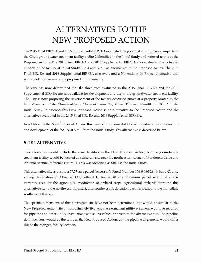
ALTERNATIVES TO THENEW PROPOSED ACTION
The 2015 Final EIR/EA and 2016 Supplemental EIR/EA evaluated the potential environmental impacts of the City’s groundwater treatment facility at Site 2 identified in the Initial Study and referred to this as the Proposed Action). The 2015 Final EIR/EA and 2016 Supplemental EIR/EA also evaluated the potential impacts of the facility at Initial Study Site 4 and Site 7 as alternatives to the Proposed Action. The 2015 Final EIR/EA and 2016 Supplemental EIR/EA also evaluated a No Action/No Project alternative that would not involve any of the proposed improvements.
The City has now determined that the three sites evaluated in the 2015 Final EIR/EA and the 2016 Supplemental EIR/EA are not available for development and use of the groundwater treatment facility. The City is now proposing the development of the facility described above at a property located to the immediate east of the Church of Jesus Christ of Latter Day Saints. This was identified as Site 5 in the Initial Study. In essence, this New Proposed Action is an alternative to the Proposed Action and the alternatives evaluated in the 2015 Final EIR/EA and 2016 Supplemental EIR/EA.
In addition to the New Proposed Action, this Second Supplemental EIR will evaluate the construction and development of the facility at Site 1 from the Initial Study. This alternative is described below.
SITE 1 ALTERNATIVE
This alternative would include the same facilities as the New Proposed Action, but the groundwater treatment facility would be located at a different site near the northeastern corner of Ponderosa Drive and Antonio Avenue (reference Figure 1). This was identified as Site 1 in the Initial Study.
This alternative site is part of a 57.57-acre parcel (Assessor’s Parcel Number 156-0-180-28). It has a County zoning designation of AE-40 ac (Agricultural Exclusive, 40 acre minimum parcel size). The site is currently used for the agricultural production of orchard crops. Agricultural orchards surround this alternative site to the northwest, northeast, and southwest. A detention basin is located to the immediate southeast of this site.
The specific dimensions of this alternative site have not been determined, but would be similar to the New Proposed Action site at approximately five acres. A permanent utility easement would be required for pipeline and other utility installations as well as vehicular access to the alternative site. The pipeline tie-in locations would be the same as the New Proposed Action, but the pipeline alignments would differ due to the changed facility location.
Final Second Supplemental EIR/EA !31
Alternatives to the New Proposed Action
The environmental impacts associated with implementation of the Site 1 Alternative are addressed by issue area in each technical section of this Second Supplemental EIR/EA.
! North Pleasant Valley Groundwater Treatment Facility32

ENVIRONMENTAL IMPACT ANALYSISThis section is the primary component of the Second Supplemental EIR/EA as it provides a forecast of the probable future environment following the development of the New Proposed Action and the Site 1 Alternative. The purpose of this section is to inform readers about the type and magnitude of the potential environmental impacts associated with the project, how such impacts would affect the existing environment, to identify mitigation measures which would reduce the magnitude of significant environmental impacts, and to identify cumulative impacts associated with development of the proposed project as well as other related projects.
SECTION FORMAT
This overall section is actually divided into 12 technical sections based on the environmental issues evaluated in the 2015 Final EIR/EA and the 2016 Supplemental EIR/EA. The 12 technical sections are as follows:
• Aesthetics
• Agricultural and Forestry Resources
• Air Quality
• Cultural Resources
• Greenhouse Gas Emissions
• Hazardous Materials
• Water Resources
• Land Use and Planning
• Noise
• Transportation/Circulation
• Environmental Justice
• Socioeconomics
Each of these sections is organized into several discussions, as follows:
• Affected Environment
• Environmental Consequences
Final Second Supplemental EIR/EA !33

Environmental Impact Analysis
• Significance Thresholds
• New Proposed Action
• Site 1 Alternative
• Mitigation Measures
• Residual Impacts
The purpose of this Second Supplemental EIR/EA is to supplement the information presented in the 2015 Final EIR/EA and 2016 Supplemental EIR/EA as certified by the City of Camarillo. These documents evaluated the impacts associated with the development and operations of the City’s groundwater treatment facility along with the two new groundwater wells. The new actions only involve the relocation of the groundwater treatment facility to a new location and the consideration of an additional alternative site location for the groundwater treatment facility. The location of the a new groundwater well would remain unchanged with the southern well incorporated into the New Proposed Action facility site. The amount of water that is withdrawn from the wells and treated at the new facility would also remain unchanged. The regional setting and regulatory environment identified in the 2015 Final EIR/EA and 2016 Supplemental EIR/EA continue to the applicable to the New Proposed Action. Therefore, the technical sections only update the Affected Environment discussions as necessary to reflect the individual facility sites for the New Proposed Action and the Site 1 Alternative.
! North Pleasant Valley Groundwater Treatment Facility34

AESTHETICS
AFFECTED ENVIRONMENT
Local Setting
Based upon a review of the County of Ventura General Plan Resources Appendix (Ventura County, updated 2011), there are no Ventura County designated scenic resources areas or scenic highway protection areas near the project site. Within the project region, U.S. 101 and State Route (SR) 1 are considered eligible State scenic highways. The City of Camarillo General Plan Community Design Element identifies scenic corridors in the project area, including Las Posas Road/Upland Road and Lewis Road.
The New Proposed Action facility site is largely not visible from Las Posas Road since it is located behind a church, an existing commercial center, and a landscaped perimeter wall. The New Proposed Action facility site is has limited visibility from Somis Road (north of Las Posas Road), but is not visible from Lewis Road (south of Las Posas Road). The Site 1 Alternative facility site is located north of Antonio Avenue and is not visible from any City-designated scenic corridors.
Nighttime lighting in the immediate project area includes streetlights and vehicle headlights on nearby roadways, building facade and interior lighting and landscape lighting associated with the developed urban areas. The New Proposed Action facility site is in agricultural production and is unlit, but is indirectly affected by lighting from the adjacent church and commercial center. The Site 1 Alternative facility site is located within an agricultural orchard and is unlit.
ENVIRONMENTAL CONSEQUENCES/IMPACTS
Significance Thresholds
The evaluation of the project's aesthetic impacts is based upon a review of the project plans, area maps, aerial photographs, and site reconnaissance. For the purposes of this analysis, a significant adverse aesthetic impact would occur if the project would result in a substantial deterioration of the visual quality of the area or cause the obstruction of scenic views.
Final Second Supplemental EIR/EA !35

Aesthetics
New Proposed Action
Project Specific Impacts
Scenic Vistas and Highways
There are no designated scenic vistas in the project area; therefore, the New Proposed Action would not impact scenic views from public vistas. The facility site is not visible from any designated scenic corridors; therefore, impacts would not occur. The facility site would have very limited visibility from Las Posas Road since it would be located behind the adjacent church, existing commercial center, and a landscaped perimeter wall. It would also have limited visibility from Somis Road due to the distance of the site to the road and the trees located at the adjacent commercial center and within the agricultural parcel of which this site is a part.
The Church of Jesus Christ of Latter-day Saints property that would be annexed to the City under the New Proposed Action is located along Las Posas Road and is currently developed with a church building, surface parking lot, and landscaping. There would be no change to the scenic environment with the annexation of this property to the City.
Visual Character and Quality
Most above-ground project components would be housed in a building or enclosed structure. Heights of the structures would vary from one to two stories equivalent. This structure would be compatible with the architecture of the adjacent church and commercial center. The facility would also include numerous industrial-appearing components such as vessels, metal canopies, pumps, filters, basins and tanks. Views of these structures from Somis Road would be screened by a proposed wall (approximate hight six to eight feet) in the eastern portion of the site and proposed landscaping to buffer the site from adjacent agricultural activities.
The Church of Jesus Christ of Latter-day Saints property that would be annexed to the City under the New Proposed Action is located along Las Posas Road and is currently developed with a church building, surface parking lot, and landscaping. There would be no change to the visual character and visual quality of the local area with the annexation of this property to the City.
Lighting and Glare
The proposed treatment facility would include limited night lighting, consisting of interior lighting within the administration building, and spotlights directed to illuminate key facilities and the vehicle entrance. Outside lighting would be shielded and directed downward in order to minimize potential lighting impacts. However, this proposed lighting would be located adjacent to existing lighting associated with Las Posas Road, the adjacent Church of Jesus Christ of Latter-day Saints, and the adjacent
! North Pleasant Valley Groundwater Treatment Facility36

Aesthetics
commercial center, and would not result in a substantial increase in lighting in the project area, and would not significantly degrade nighttime views.
The New Proposed Action includes the installation of solar photo-voltaic panels on the roof of the administration building and remaining open space area of the parcel not utilized by the treatment facility. These solar panels would be constructed of dark, light-absorbing materials and covered with an anti-reflective coating. Typically, photo-voltaic solar panels reflect only two percent of incoming sunlight, as compared to bare soil, which reflects 30 percent (Federal Aviation Administration, 2010). The anti-reflective coating applied to the solar panels would prevent sufficient glare to interfere with adjacent land uses or daytime views. Therefore, light and glare impacts would be less than significant.
The Church of Jesus Christ of Latter-day Saints property that would be annexed to the City under the New Proposed Action is located along Las Posas Road and is currently developed with a church building, surface parking lot, and landscaping. Lighting is provided to the interior and exterior of the building, and the parking lot. There would be no increase in light and glare with the annexation of this property to the City.
Cumulative Impacts
The only cumulative project located in the same viewshed as the New Proposed Action is the recently-completed Rancho Campana High School. The high school is located to the immediate north of the New Proposed Action facility site. The High School is now a primary component of the visual setting in the vicinity of the of the New Proposed Action facility site. As discussed previously, the New Proposed Action would would have very limited visibility from Las Posas Road and limited visibility from Somis Road. The cumulative projects (New Proposed Action and high school) would not substantially degrade the visual character or quality of the project area, including scenic corridors. Therefore, cumulative aesthetics impacts are considered less than significant.
Site 1 Alternative
Project Specific Impacts
Scenic Vistas and Highways
There are no designated scenic vistas in the project area; therefore, the Site 1 Alternative would not impact scenic views from public vistas. The facility site and southern well site are not visible from any designated scenic corridors; therefore, impacts would not occur. The facility site is not visible from Las Posas Road and the southern well site would have very limited visibility it is located behind the adjacent church, existing commercial center, and a landscaped perimeter wall. The facility site is also not visible from Somis Road and the new well site would also have limited visibility from Somis Road due to the
Final Second Supplemental EIR/EA !37

Aesthetics
distance of the well site to the road and the trees located at the adjacent commercial center and within the agricultural parcel along Somis Road.
Visual Character and Quality
Most above-ground project components would be housed in a building or enclosed structure. Heights of the structures would vary from one to two stories equivalent. This structure would be compatible with the architecture of the homes and offices located in the vicinity of this facility site. The facility would also include numerous industrial-appearing components such as vessels, metal canopies, pumps, filters, basins and tanks. Views of these structures from Antonio Avenue would be screened by a proposed wall (approximate hight six to eight feet) in the eastern portion of the site and proposed landscaping to buffer the site from adjacent agricultural activities.
The new well site would involve a small well enclosure that would not degrade the visual character or quality of the surrounding area. Overall, the Site 1 Alternative would not substantially affect the visual quality or character of the project area. Project-specific impacts to visual character and visual quality are considered less than significant.
Lighting and Glare
The proposed treatment facility would include limited night lighting, consisting of interior lighting within the administration building, and spotlights directed to illuminate key facilities and the vehicle entrance. This would be a new source of lighting within a currently un-illuminated orchard area. Outside lighting would be shielded and directed downward in order to minimize potential lighting impacts. However, the proposed facility lighting would be screened by the wall (approximate hight six to eight feet) located along the eastern site of the facility and landscaping around the perimeter. Overall, project-related lighting would not significantly degrade nighttime views.
The Site 1 Alternative includes the installation of solar photo-voltaic panels on the roof of the administration building and remaining open space area of the parcel not utilized by the treatment facility. These solar panels would be constructed of dark, light-absorbing materials and covered with an anti-reflective coating. Typically, photo-voltaic solar panels reflect only two percent of incoming sunlight, as compared to bare soil, which reflects 30 percent. The anti-reflective coating applied to the solar panels would prevent sufficient glare to interfere with nearby land uses or daytime views. Therefore, light and glare impacts would be less than significant.
Cumulative Impacts
The only cumulative project located in the same viewshed as the Site 1 Alternative is the recently-completed Rancho Campana High School. The high school is located to the east of the Site 1 Alternative facility site. and the two facilities do not affect the same view shed areas. Therefore, cumulative aesthetics impacts are considered less than significant.
! North Pleasant Valley Groundwater Treatment Facility38

Aesthetics
MITIGATION MEASURES
New Proposed Action
No significant aesthetic impacts would occur; therefore mitigation measures are not required.
Site 1 Alternative
No significant aesthetic impacts would occur; therefore mitigation measures are not required.
Final Second Supplemental EIR/EA !39

Aesthetics
This page intentionally left blank.
! North Pleasant Valley Groundwater Treatment Facility40

AGRICULTURAL AND FORESTRY RESOURCES
AFFECTED ENVIRONMENT
General Plan Land Use Designation and Zoning
The New Proposed Action facility site and the Site 1 Alternative facility site are both located in the unincorporated area of Ventura County, within areas designated as “Agriculture” in the Ventura County General Plan. Both sites are smaller parts of properties that are zoned AE-40 ac (Agricultural Exclusive, 40 acre minimum parcel size).
Agricultural Viability
Based on the information presented in Figure 5.1-1 of the 2016 Supplemental EIR/EA, the New Proposed Action facility site is designated as Farmland of Statewide Importance. The Site 1 Alternative facility site and the northern well site are designated as Prime Farmland. The New Proposed Action facility site is currently used for the agricultural production of row crops and the Site 1 Alternative facility site is currently used for the agricultural production of orchard crops.
ENVIRONMENTAL CONSEQUENCES/IMPACTS
Significance Thresholds
For the purposes of this project, the City has adopted the following significance thresholds developed by Ventura County (2011) for areas with a General Plan designation of “Agriculture.” Loss of agricultural soils on the project site is considered a significant project-specific impact if any of the following thresholds are equaled or exceeded.
• Prime/Statewide Importance Farmland 5 acres
• Unique Farmland 10 acres
• Local Importance Farmland 15 acres
A non-agricultural project would have a potentially significant land use incompatibility impact if it would be located within 300 feet (without vegetative screening) of classified farmland (Prime/Statewide, Unique, Local Importance). This buffer distance may be waived for projects where individuals are not continuously present.
Final Second Supplemental EIR/EA !41

Agriculture and Forestry Resources
A project that would require a Ventura County General Plan amendment and result in a loss of agricultural soils greater than indicated above is considered as having a substantial contribution to a significant cumulative impact.
New Proposed Action
Project Specific Impacts
Loss of Important Farmlands
The New Proposed Action facility site is 4.7 acres in size. The 1.35 acres of permanent utility easement would provide roadway and pipeline access along routes that currently provide roadway access to the farm property. The 4.7 acres of farmland conversion would not equal or exceed the 5 acre threshold for Prime and Statewide Importance farmland.
The Church of Jesus Christ of Latter-day Saints property that would be annexed to the City under the New Proposed Action is currently developed with a church building, surface parking lot, and landscaping. This property is designated by the California Department of Conservation as Urban and Built-up Land. There would be no conversion of agricultural land with the annexation of this property to the City.
Based on this information, farmland conversion impacts are considered less than significant.
Greenbelt Agreements
Loss of farmland would not occur within a greenbelt, and all open space under the Greenbelt Agreements established within the project area would be retained with no changes in their boundaries. There would be no project-specific impacts to greenbelts.
Land Conservation Act Contracts
No farmlands enrolled in LCA contracts would be affected by the New Proposed Action. Thus, no project-specific impacts to LCA Contracts are expected.
Adverse Effects on Adjacent Agricultural Operations
The New Proposed Action would involve changing the land use on approximately 4.7 acres of land (facility site) on APN 156-0-180-285 to a non-agricultural use. The size of the remaining parcel would be below the 40 acre minimum required by the existing Ventura County zoning designation.
The Ventura County Save Open-Space Agricultural Resources (SOAR) Initiative and the Ventura County Right-to-Farm ordinance would prevent conversion or modification of current agricultural practices on these parcels and adjacent farmlands.
! North Pleasant Valley Groundwater Treatment Facility42

Agriculture and Forestry Resources
The converted farmland area would be located adjacent to existing farmlands, the Church of Jesus Christ of Latter-day Saints, a commercial center, and the new Rancho Campana High School, and would not fragment remaining farmlands. The proposed treatment facility would be provided with a minimum 50-foot-wide buffer between treatment components and adjacent farmlands, including fencing and landscape screening. Therefore, facility operation would not preclude existing agricultural operations an adjacent parcels, including pest management. As a single-use City-operated facility, agreements and notification between parties can easily occur prior to pesticide use. In addition, the groundwater treatment facility could be evacuated for short periods and operated remotely to allow for pesticide application at adjacent farmland. Therefore, the project appears to meet Waiver and Deviation Criteria i (may be closed temporally to allow restricted materials application) from the 300-foot agricultural/urban buffer identified in the County's Initial Study Assessment Guidelines and the Agricultural Commissioner's policy.
Operation of the groundwater treatment facility would not adversely affect existing irrigation water supplies, irrigation practices, micro-climate, agricultural pests/diseases, or pesticide application on adjacent farmlands. A minimum 50-foot buffer area would be provided between the groundwater treatment facility and adjacent agricultural fields to minimize any land use compatibility issues. Overall, the New Proposed Action would not conflict with surrounding agricultural operations, and would not preclude the continuation of farming on APN 156-0-180-285 and adjacent parcels.
Agricultural Conversion Related to Increased Water Supply
Development of the groundwater treatment facility at the New Proposed Action facility site would not change the amount of water available beyond that evaluated in the 2015 Final EIR/EA and the 2016 Supplemental EIR/EA. Therefore, the impacts identified for the Proposed Action in the 2016 Supplemental EIR/EA are also applicable to the New Proposed Action. The potable groundwater and transfer of imported water provided by the New Proposed Action would not remove an impediment to growth, and result in population growth or related conversion of farmland.
Forestry Resources
The nearest forest land (as defined in Public Resources Code Section 12220) or timberland is located within the Los Padres National Forest, approximately 10 miles north of the New Proposed Action facility site. The project may require rezoning of the New Proposed Action facility site to be annexed, but would not cause any forest land or timberlands to be rezoned. The project would not result in the loss or conversion of forest land to non-forest uses.
Cumulative Impacts
The two Ventura County subdivision projects (see Section 3.7.1 of the 2016 Supplemental EIR/EA) would also result in the conversion of agricultural lands. The cumulative loss of agricultural soils was discussed
Final Second Supplemental EIR/EA !43

Agriculture and Forestry Resources
in the Final EIR for the Comprehensive Amendment to the Ventura County General Plan, and found to be significant and unavoidable. The New Proposed Action would incrementally contribute to the cumulative loss of farmland within the County and City. However, the project's incremental effect would not be "cumulatively considerable"; therefore, the project's contribution to cumulative loss of agricultural soils is not considered significant.
Site 1 Alternative
Project Specific Impacts
Loss of Important Farmlands
This alternative site is estimated to be approximately 4.7 acres in size. Along with the 0.2-acre southern well site, the 4.9 acres of farmland conversion would not exceed the 5 acre threshold for Prime and Statewide Importance farmland; therefore, farmland conversion impacts are considered to be less than significant.
Greenbelt Agreements
Loss of farmland would not occur within a greenbelt, and all open space under the Greenbelt Agreements established within the project area would be retained with no changes in their boundaries. There would be no project-specific impacts to greenbelts.
Land Conservation Act Contracts
No farmlands enrolled in LCA contracts would be affected by the Site 1 Alternative. Thus, no project-specific impacts to LCA Contracts are expected.
Adverse Effects on Adjacent Agricultural Operations
The Site 1 Alternative would involve changing the land use on approximately five acres of land (facility site) on APN 156-0-180-14 to a non-agricultural use. The size of the remaining parcel would be above the 40 acre minimum required by the existing Ventura County zoning designation. The Site 1 Alternative includes changing the land use of the 0.2-acre southern well site on APN 156-0-180-285. The size of the remaining parcel would also be above the 40 acre minimum required by the existing Ventura County zoning designation.
The Ventura County Save Open-Space Agricultural Resources (SOAR) Initiative and the Ventura County Right-to-Farm ordinance would prevent conversion or modification of current agricultural practices on these parcels and adjacent farmlands.
The converted farmland area for the facility would be surrounded by agricultural orchards to the northwest, northeast, and southwest and a detention basin to the southeast. The new well site would be
! North Pleasant Valley Groundwater Treatment Facility44

Agriculture and Forestry Resources
located adjacent to the Church of Jesus Christ of Latter-day Saints and a commercial center. The proposed treatment facility would be provided with a minimum 50-foot-wide buffer between treatment components and adjacent farmlands, including fencing and landscape screening. Therefore, facility operation would not preclude existing agricultural operations an adjacent parcels, including pest management. As a single-use City-operated facility, agreements and notification between parties can easily occur prior to pesticide use. In addition, the groundwater treatment facility could be evacuated for short periods and operated remotely to allow for pesticide application at adjacent farmland. Therefore, the project appears to meet Waiver and Deviation Criteria i (may be closed temporally to allow restricted materials application) from the 300-foot agricultural/urban buffer identified in the County's Initial Study Assessment Guidelines and the Agricultural Commissioner's policy.
Operation of the groundwater treatment facility would not adversely affect existing irrigation water supplies, irrigation practices, micro-climate, agricultural pests/diseases, or pesticide application on adjacent farmlands. A minimum 50-foot buffer area would be provided between the groundwater treatment facility and adjacent agricultural fields to minimize any land use compatibility issues. Overall, the Site 1 Alternative would not conflict with surrounding agricultural operations, and would not preclude the continuation of farming on APN 156-0-180-14, -285, and adjacent parcels.
Agricultural Conversion Related to Increased Water Supply
Impacts identified for the New Proposed Action are also applicable to the Site 1 Alternative.
Forestry Resources
The nearest forest land (as defined in Public Resources Code Section 12220) or timberland is located within the Los Padres National Forest, approximately 10 miles north of the Site 1 Alternative facility site. The project may require rezoning of the site to be annexed, but would not cause any forest land or timberlands to be rezoned. The project would not result in the loss or conversion of forest land to non-forest uses.
Cumulative Impacts
The two Ventura County subdivision projects (see Section 3.7.1 of the 2016 Supplemental EIR/EA) would also result in the conversion of agricultural lands. The cumulative loss of agricultural soils was discussed in the Final EIR for the Comprehensive Amendment to the Ventura County General Plan, and found to be significant and unavoidable. The New Proposed Action would incrementally contribute to the cumulative loss of farmland within the County and City. However, the project's incremental effect would not be "cumulatively considerable"; therefore, the project's contribution to cumulative loss of agricultural soils is not considered significant.
Final Second Supplemental EIR/EA !45

Agriculture and Forestry Resources
MITIGATION MEASURES
New Proposed Action
Significant impacts to agricultural or forestry resources were not identified; therefore mitigation measures are not required.
Site 1 Alternative
Significant impacts to agricultural or forestry resources were not identified; therefore mitigation measures are not required.
RESIDUAL IMPACTS
New Proposed Action
Significant impacts to agricultural or forestry resources were not identified; therefore mitigation measures are not required and the residual impacts would be less than significant.
Site 1 Alternative
Significant impacts to agricultural or forestry resources were not identified; therefore mitigation measures are not required and the residual impacts would be less than significant.
! North Pleasant Valley Groundwater Treatment Facility46
AIR QUALITY
AFFECTED ENVIRONMENT
Air Quality Background
The City of Camarillo is located within the South Central Coast Air Basin (Basin), which includes all of Ventura, Santa Barbara, and San Luis Obispo Counties. The regional climate within the Basin is considered semi-arid and is characterized by warm summers, mild winters, infrequent seasonal rainfall, moderate daytime onshore breezes, and moderate humidity. The air quality within the Basin is primarily influenced by a wide range of emissions sources – (population centers, heavy vehicular traffic, and industry) – and meteorology.
Air pollutant emissions within the Basin are generated by stationary and mobile sources. Stationary sources can be divided into two major subcategories: point and area sources. Point sources occur at an identified location and are usually associated with manufacturing and industry. Examples are boilers or combustion equipment that produces electricity or generate heat. Area sources are widely distributed and produce many small emissions. Examples of area sources include residential and commercial water heaters, painting operations, lawn mowers, agricultural fields, landfills, and consumer products such as barbeque lighter fluid and hair spray. Mobile sources refer to emissions from motor vehicles, including tailpipe and evaporative emissions, and are classified as either on-road or off-road. On-road sources may be legally operated on roadways and highways. Off-road sources include aircraft, ships, trains, agricultural equipment, racecars, and self-propelled construction equipment. Mobile sources account for the majority of the air pollutant emissions within the Basin. Air pollutants can also be generated by the natural environment such as when fine dust particles are pulled off the ground surface and suspended in the air during high winds.
Both the federal and state governments establish ambient air quality standards for outdoor concentrations of various pollutants in order to protect public health. The federal and state standards are set at levels at which concentrations could be generally harmful to human health and welfare, and to protect the most sensitive persons from illness or discomfort with a margin of safety. Applicable standards are identified below.
Potential Health Effects of Air Pollutants
Certain air pollutants are recognized to cause notable health problems and consequential damage to the environment either directly or in reaction with other pollutants, due to their presence in elevated concentrations in the atmosphere. Such pollutants are identified and regulated as part of the overall endeavor to prevent further deterioration and facilitate improvement in the prevalent air quality.
Final Second Supplemental EIR/EA !47

Air Quality
The air pollutants for which national and State standards are promulgated and which are most relevant to air quality planning and regulation in the Basin include ozone, carbon monoxide (CO), respirable particulate matter (PM10), fine particulate matter (PM2.5), sulfur dioxide (SO2), and lead. In addition, toxic air contaminants and greenhouse gas (GHG) emissions are of concern in the Basin. Each of these is described briefly below.
Ozone is a gas that is formed when reactive organic compounds (ROC) and nitrogen oxides (NOx)—both byproducts of internal combustion engine exhaust—undergo slow photochemical reactions in the presence of sunlight. Ozone concentrations are generally highest during the summer months when direct sunlight, light wind, and warm temperature conditions are favorable.
An elevated level of ozone irritates the lungs and breathing passages, causing coughing, and pain in the chest and throat thereby increasing susceptibility to respiratory infections and reducing the ability to exercise. Effects are more severe in people with asthma and other respiratory ailments. Long-term exposure may lead to scarring of lung tissue and may lower the lung efficiency.
Carbon Monoxide is a colorless, odorless gas produced by the incomplete combustion of fuels. CO concentrations tend to be the highest during the winter morning, with little to no wind, when surface-based inversions trap the pollutant at ground levels. Because CO is emitted directly from internal combustion engines—unlike ozone—and motor vehicles operating at slow speeds are the primary source of CO in the Basin, the highest ambient CO concentrations are generally found near congested transportation corridors and intersections.
Elevated concentrations of CO weaken the heart's contractions and lower the amount of oxygen carried by the blood. It is especially dangerous for people with chronic heart disease. Inhalation of moderate levels of carbon monoxide can cause nausea, dizziness, and headaches, and can be fatal at high concentrations.
Respirable Particulate Matter (PM10) and Fine Particulate Matter (PM2.5) consists of extremely small, suspended particles or droplets 10 microns and 2.5 microns or smaller in diameter. Some sources of particulate matter, like pollen and windstorms, are naturally occurring. In agricultural areas such as Ventura County, large amount of airborne particulates are generated by plowing and other field work. However, in populated areas, most particulate matter is caused by road dust, diesel soot, combustion products, abrasion of tires and brakes, and construction activities.
The human body naturally prevents the entry of larger particles into the body. However, PM10 and even smaller PM2.5 are trapped in the nose, throat, and upper respiratory tract. These small particulates enter the body and could potentially aggravate existing heart and lung diseases, change the body's defenses against inhaled materials, and damage lung tissue. The elderly, children, and those with chronic lung or heart disease are most sensitive to PM10 and PM2.5. Lung impairment can persist for two to three weeks
! North Pleasant Valley Groundwater Treatment Facility48

Air Quality
after exposure to high levels of particulate matter. Some types of particulate could become toxic after inhalation due to the presence of certain chemicals and their reaction with internal body fluids.
Nitrogen Dioxide (NO2) is byproduct of fuel combustion. The principal form of nitrogen oxide produced by combustion is nitric oxide (NO), which reacts quickly to form NO2, creating the mixture of NO and NO2 commonly called NOx. NO2 absorbs blue light and result is a brownish-red cast to the atmosphere and reduced visibility. NO2 also contributes to the formation of PM10.
Major sources of NOx include power plants, large industrial facilities, and motor vehicles. Nitrogen oxides irritate the nose and throat. It increases susceptibility to respiratory infections, especially in people with asthma. The principal concern of NOx is as a precursor to the formation of ozone.
Sulfur Dioxide (SO2) is a colorless, extremely irritating gas or liquid. It enters the atmosphere as a pollutant mainly as a result of burning high sulfur-content fuel oils and coal, and from chemical processes occurring at chemical plants and refineries.
Major sources of SO2 include power plants, large industrial facilities, diesel vehicles, and oil-burning residential heaters. Emissions of sulfur dioxide aggravate lung diseases, especially bronchitis. It also constricts the breathing passages, especially in asthmatics and people involved in moderate to heavy exercise. Sulfur dioxide potentially causes wheezing, shortness of breath, and coughing. High levels of particulate appear to worsen the effect of sulfur dioxide, and long-term exposures to both pollutants leads to higher rates of respiratory illness.
Lead occurs in the atmosphere as particulate matter. The combustion of leaded gasoline is the primary source of airborne lead in the Basin. The use of leaded gasoline is no longer permitted for on-road motor vehicles so most such combustion emissions are associated with off-road vehicles such as racecars. Other sources of lead include the manufacturing and recycling of batteries, paint, ink, ceramics, ammunition, and secondary lead smelters.
Lead affects the brain and other parts of the body's nervous system. Exposure to lead in very young children impairs the development of the nervous system, kidneys, and blood forming processes in the body.
Toxic Air Contaminants (TACs) refer to a diverse group of air pollutants that can affect human health, but have not had ambient air quality standards established for them. This is not because they are fundamentally different from the pollutants discussed above, but because their effects tend to be local rather than regional.
Regulatory Setting
Air quality within the Basin is addressed through the efforts of various federal, state, regional, and local government agencies. These agencies work jointly, as well as individually, to improve air quality through
Final Second Supplemental EIR/EA !49

Air Quality
legislation, regulations, planning, policy-making, education, and a variety of programs. The agencies responsible for improving the air quality within the Basin are discussed below.
Federal Regulations
The federal Clean Air Act (CAA) establishes national ambient air quality standards. Under the CAA, the U.S. Environmental Protection Agency (U.S. EPA) is responsible for setting and enforcing the federal ambient air quality standards for atmospheric pollutants. It regulates emission sources that are under the exclusive authority of the federal government, such as aircraft, ships, and certain locomotives. The U.S. EPA also has jurisdiction over emissions sources outside state waters (outer continental shelf), and establishes various emissions standards for vehicles sold in states other than California.
As part of its enforcement responsibilities under the CAA, the U.S. EPA requires each state with nonattainment areas to prepare and submit a State Implementation Plan (SIP) that demonstrates the means to attain the federal standards. The SIP must integrate federal, state, and local plan components and regulations to identify specific measures to reduce pollution, using a combination of performance standards and market-based programs within the timeframe identified in the SIP.
Under national standards, Ventura County is currently classified as a nonattainment area for 8-hour ozone concentrations. Ventura County is in attainment or designated as unclassified for all other pollutants under national standards.
California Regulations
The California Clean Air Act (CCAA) requires all areas of the state to achieve and maintain the California Ambient Air Quality Standards (CAAQS) by the earliest practicable date. The California Air Resources Board (ARB), a part of the California Environmental Protection Agency, is responsible for the coordination and administration of both federal and State air pollution control programs within California. In this capacity, the ARB conducts research, sets the CAAQS, compiles emission inventories, develops suggested control measures, provides oversight of local programs, and prepares the SIP. The ARB establishes emissions standards for motor vehicles sold in California, consumer products (such as hair spray, aerosol paints, and barbecue lighter fluid), and various types of commercial equipment. It also sets fuel specifications to further reduce vehicular emissions.
Under state standards, Ventura County is designated as a nonattainment area for ozone and PM10, and an attainment area for all other pollutants.
Regional Regulations
The Ventura County Air Pollution Control District (VCAPCD) is the agency principally responsible for comprehensive air pollution control in the Ventura County portion of the Basin. To that end, the VCAPCD, a regional agency, works directly with the Southern California Association of Governments
! North Pleasant Valley Groundwater Treatment Facility50

Air Quality
(SCAG), the Ventura County Transportation Commission, and local governments, and cooperates actively with all State and federal government agencies. The VCAPCD develops rules and regulations, establishes permitting requirements, inspects emissions sources, and enforces such measures though educational programs or fines, when necessary.
The VCAPCD is directly responsible for reducing emissions from stationary (area and point), mobile, and indirect sources. It has responded to this requirement by preparing a series of Air Quality Management Plans (AQMPs). The most recent of these was adopted by the Governing Board of the VCAPCD on February 14, 2017. This AQMP, referred to as the 2016 AQMP, was prepared to comply with the federal and State Clean Air Acts and amendments, to accommodate growth, to reduce the high pollutant levels of pollutants in the Basin, to meet federal and State air quality standards, and to minimize the fiscal impact that pollution control measures have on the local economy. It identifies the control measures that will be implemented to reduce major sources of pollutants. These planning efforts have substantially decreased the population’s exposure to unhealthful levels of pollutants, even while substantial population growth has occurred within the County.
The future air quality levels projected in the 2016 AQMP are based on several assumptions. For example, the VCAPCD assumes that general new development within the County will occur in accordance with population growth and transportation projections identified by County staff.
Although the VCAPCD is responsible for regional air quality planning efforts, it does not have the authority to directly regulate the air quality issues associated with plans and new development projects within the County. Instead, the VCAPCD has used its expertise and prepared the Ventura County Air Quality Assessment Guidelines (2003) to indirectly address these issues in accordance with the projections and programs of the AQMP. The purpose of the Ventura County Air Quality Assessment Guidelines is to assist Lead Agencies, as well as consultants, project proponents, and other interested parties, in evaluating potential air quality impacts of projects and plans proposed in the Basin. Specifically, the Ventura County Air Quality Assessment Guidelines explains the procedures that the VCAPCD recommends be followed during environmental review processes required by CEQA. The Ventura County Air Quality Assessment Guidelines provides direction on how to evaluate potential air quality impacts, how to determine whether these impacts are significant, and how to mitigate these impacts. The VCAPCD intends that by providing this guidance, the air quality impacts of plans and development proposals will be analyzed accurately and consistently throughout the County, and adverse impacts will be minimized.
Local Air Quality Control
Local jurisdictions, such as the City of Camarillo, have the authority and responsibility to reduce air pollution through its police powers and decision-making authority. Specifically, the City is responsible for the assessment and mitigation of air emissions resulting from its land use decisions. The City of
Final Second Supplemental EIR/EA !51

Air Quality
Camarillo is also responsible for the implementation of transportation control measures as outlined in the AQMP. Examples of such measures include bus turnouts, energy-efficient streetlights, and synchronized traffic signals.
In accordance with CEQA and the CEQA review process, the City assesses the air quality impacts of new development projects, requires mitigation of potentially significant air quality impacts by conditioning discretionary permits, and monitors and enforces implementation of such mitigation. The City does not, however, have the expertise to develop plans, programs, procedures, and methodologies to ensure that air quality within the City and region will meet federal and state standards. Instead, the City relies upon the expertise of the VCAPCD and utilizes the Ventura County Air Quality Assessment Guidelines as the guidance document for the environmental review of plans and development proposals within its jurisdiction.
ENVIRONMENTAL CONSEQUENCES/IMPACTS
Significance Thresholds
The City of Camarillo has adopted significance thresholds recommended in the Air Quality Assessment Guidelines prepared by the Ventura County APCD (2003). The Guidelines indicate that a project would have a significant impact on the environment if it would:
• Result in daily emissions exceeding 25 pounds of ROC or NOx;
• Cause a violation or make a substantial contribution to a violation of an ambient air quality standard;
• Directly or indirectly cause the existing population to exceed the population forecasts in the most recently adopted Air Quality Management Plan (AQMP);
• Be inconsistent with the Ventura County Air Quality Management Plan (AQMP) and emit greater than 2 pounds per day ROC or NOx;
• Create objectionable odors affecting a substantial number of people.
New Proposed Action
Project Specific Impacts
The amount and type of development that would occur under the New Proposed Action would remain unchanged from the scenario that was evaluated in the 2015 Final EIR/EA. As such, the emissions identified for the Proposed Action in the 2015 Final EIR/EA are also applicable to the New Proposed Action.
! North Pleasant Valley Groundwater Treatment Facility52

Air Quality
Construction Emissions
Air pollutant emissions generated by construction activities would include exhaust emissions and wind-blown (fugitive) dust. Construction of the New Proposed Action would involve site preparation and excavation, transportation and erection of mechanical, electrical and fluid systems and installation of piping and electrical connections. Pipeline installation activities would include trenching, pipe laying, trench backfilling, roadway surface repair, and transportation (materials, equipment and workers).
Construction–related activities are generally short-term in duration, and the VCAPCD does not recommend any thresholds of significance for their associated emissions. Instead, the VCAPCD bases the determination of significance on a consideration of the control measures to be implemented. If all appropriate emissions control measures recommended by the Ventura County Air Quality Assessment Guidelines are implemented for a project, then construction emissions are not considered significant.
The following measures will be included in the project’s construction specifications to reduce the potential emissions associated with construction activities to the maximum extent feasible:
• Minimize the area disturbed on a daily basis by clearing, grading, earthmoving, and/or excavation operations.
• Pre-grading/excavation activities shall include watering the area to be graded or excavated before the commencement of grading or excavation operations. Application of water should penetrate sufficiently to minimize fugitive dust during these activities.
• All trucks shall be required to cover their loads as required by California Vehicle Code §23114.
• All graded and excavated material, exposed soil areas, and active portions of the construction site, including unpaved on-site roadways, shall be treated to prevent fugitive dust. Treatment shall include, but not necessarily be limited to, periodic watering, application of environmentally-safe soil stabilization materials, and/or roll-compaction as appropriate. Watering shall be done as often as necessary.
• Material stockpiles shall be enclosed, covered, stabilized, or otherwise treated, to prevent blowing fugitive dust offsite.
• Graded and/or excavated inactive areas of the construction site shall be monitored by a City-designated monitor at least weekly for dust stabilization. Soil stabilization methods, such as water and roll-compaction, and environmentally-safe control materials, shall be periodically applied to portions of the construction site that are inactive for over four days. If no further grading or excavation operations are planned for the area, the area should be seeded and watered until grass growth is evident, or periodically treated with environmentally-safe dust suppressants, to prevent excessive fugitive dust.
• Signs shall be posted on-site limiting on-site traffic to 15 miles per hour or less.
Final Second Supplemental EIR/EA !53

Air Quality
• During periods of high winds (i.e., wind speed sufficient to cause fugitive dust to impact adjacent properties), all clearing, grading, earth moving, and excavation operations shall be curtailed to the degree necessary to prevent fugitive dust created by on-site activities and operations from being a nuisance or hazard, either off-site or on-site. The site superintendent/supervisor shall use his/her discretion in conjunction with the VCAPCD is determining when winds are excessive.
• Adjacent streets and roads shall be swept at least once per day, preferably at the end of the day, if visible soil material is carried over to adjacent streets and roads.
• Personnel involved in grading operations, including contractors and subcontractors should be advised to wear respiratory protection in accordance with California Division of Occupational Safety and Health regulations.
• Maintain all construction equipment in good condition and in proper tune in accordance with manufacturer’s specifications.
• Limit truck and equipment idling time to five minutes or less.
• Minimize the number of vehicles and equipment operating at the same time during the smog season (May through October).
• Use alternatively fueled construction equipment, such as compressed natural gas (CNG), liquefied natural gas (LNG), or electric, to the extent feasible.
Implementation of these measures, as recommended by the VCAPCD, would reduce the construction-related emissions of the project to a less than significant level.
The New Proposed Action would generate short-term diesel exhaust emissions associated with heavy equipment usage, and truck transportation of construction materials. The amount of heavy equipment usage and number of diesel truck trips associated with project construction would be short-term and minimal in a regional context, such that the New Proposed Action would have a less than significant contribution to public health risk. In a local context, the New Proposed Action would represent a short-term contribution to public health risk associated with exposure to toxic air contaminants. Therefore, diesel exhaust emissions and associated toxic air contaminants are considered to be a less than significant impact to air quality.
Operation Emissions
Emissions associated with project operation would be limited to those generated by motor vehicles used by City staff operating and maintaining the groundwater treatment facility. Based on three 3 person shifts and two one-way trips per person, the New Proposed Action would generate up to 18 worker one-way trips per day. In addition, several chemical delivery trips would occur each month. The 2015 Final EIR/EA estimates the peak day operation emissions as 0.6 pound of NOx and 0.1 pound of ROC. These
! North Pleasant Valley Groundwater Treatment Facility54

Air Quality
emissions would not exceed the VCAPCD’s recommended thresholds and the impacts of the New Proposed Action would be less than significant. The Church of Jesus Christ of Latter-day Saints property that would be annexed to the City under the New Proposed Action is currently developed with a church building, surface parking lot, and landscaping. There would be no increase in regional or local air pollutant emissions with the annexation of this property to the City.
Violation of Air Quality Standards
For the purpose of evaluating potential violations of air quality standards, the VCAPCD’s Air Quality Assessment Guidelines recommends the evaluation of localized Co concentrations. Specifically, traffic-congested roadways and intersections have the potential to generate localized concentrations levels of CO. Localized areas where ambient concentrations exceed national and/or state standards for CO are termed CO “hotspots.”
CO hotspots used to be a concern in Ventura County when this area was designated as a nonattainment area for State and national CO standards. The county is now in attainment of all applicable State and national standards for CO and CO concentrations are no longer monitored in the county. This is due to substantial reductions in CO emissions from motor vehicles. The greatest potential for a CO hotspot to occur in Ventura County today is at the roadway edge of a very congested intersection.
In order for a receptor to be exposed to a CO hotspot, that person would have to remain in a location where the total CO concentration exceeds the State and national eight-hour standard for an entire eight-hour period or greater. For that to occur, the ambient (background) CO concentration would have to be very high and an intersection would have to be highly congested for a period of eight-hours or greater.1
All of the intersections in the vicinity of the New Proposed Action facility site operate at Level of Service (LOS) A through B during the AM and PM peak hours. The addition of 18 daily project vehicle trips to the local intersections would not result in a change in LOS at any of the intersections. As such, no sensitive receptors in the vicinity of the study-area intersections would be exposed to CO hotspots with traffic generated by the proposed project.
Air Quality Management Plan Consistency
The 2016 AQMP, discussed previously, was prepared to reduce the high levels of pollutants within Ventura County, return clean air to the region, and minimize the impact on the economy. Projects that are considered to be consistent with the AQMP would not interfere with attainment because they were included in the projections utilized in the formulation of the AQMP.
The New Proposed Action does not include any residential uses and would not result in the direct growth of population within the Camarillo Growth Area. Therefore, it would not not conflict with the 2016
The intersection would have to operate at Level of Service (LOS) F for several hours per day.1
Final Second Supplemental EIR/EA !55
Air Quality
AQMP or jeopardize attainment of state and national ambient air quality standards in Ventura County. The impact of the New Proposed Action would be less than significant.
Odors
The closest residences to the New Proposed Action facility site are located approximately 570 feet across Las Posas Road and Lewis Road. Rancho Campana High School is located adjacent to the New Proposed Action facility site, but this area of the school is a surface parking lot and is the furthest parking area on the campus to the classroom and office buildings. Project-related odors may be detectable by unusually sensitive individuals within within the treatment facility; however, project-related odors are not anticipated to be detected outside of the treatment plant area.
Cumulative Impacts
Cumulative development within the City of Camarillo would continue to implement dust control and equipment emissions reduction measures during construction in accordance with City practices. Consequently, cumulative development within the City is not expected to cause a significant impact associated with construction activities. Since the New Proposed Action would implement all appropriate measures during construction, the contribution of the New Proposed Action to any cumulative air quality impact would not be considerable.
Because Ventura County is currently in nonattainment for ozone, related projects could exceed an air quality standard or contribute to an existing or projected air quality exceedance. With regard to determining the significance of a proposed project contribution, the VCAPCD neither recommends quantified analyses of cumulative operational emissions nor provides methodologies or thresholds of significance to be used to assess cumulative operational impacts. Instead, the VCAPCD recommends that a project’s potential contribution to cumulative impacts should be assessed utilizing the same significance criteria as those for project specific impacts. Therefore, this Second Supplemental EIR/EA assumes that individual development projects that generate operational emissions that exceed the VCAPCD recommended daily thresholds for project-specific impacts would also cause a cumulatively considerable increase in emissions for those pollutants for which the Basin is in nonattainment. As discussed previously, operational daily emissions associated with the New Proposed Action would not exceed VCAPCD significance thresholds for ROC and NOx. Therefore, the emissions generated by New Proposed Action would not be cumulatively considerable.
Site 1 Alternative
Project Specific Impacts
The discussion of project-specific air quality impacts provided for the New Proposed Action is applicable to the Site 1 Alternative.
! North Pleasant Valley Groundwater Treatment Facility56

Air Quality
Cumulative Impacts
The discussion of cumulative air quality impacts provided for the New Proposed Action is applicable to the Site 1 Alternative.
MITIGATION MEASURES
New Proposed Action
No significant air quality impacts have been identified and the construction air emissions reduction measures recommended by the VCAPCD have been incorporated into the project. Therefore, no additional measures are required.
Site 1 Alternative
No significant air quality impacts have been identified and the construction air emissions reduction measures recommended by the VCAPCD have been incorporated into the project. Therefore, no additional measures are required.
FEDERAL FINDINGS
The amount and type of development that would occur under the New Proposed Action would remain unchanged from the scenario that was evaluated in the 2015 Final EIR/EA. As such, the impacts identified for the Proposed Action and alternatives in the 2015 Final EIR/EA are also applicable to the New Proposed Action and Site 1 Alternatives. Construction and operational emissions for the New Proposed Action would be similar to those identified for the Proposed Action and alternatives in the 2015 Final EIR/EA. The 2015 Final EIR/EA demonstrates that the operation-related and construction-related NOx and VOC emissions would not exceed the 50 tons per year de minimis thresholds. Therefore, a conformity determination would not be required and construction emissions would be assumed to be minimal with respect to the emissions budget used to develop the State Implementation Plan.
Final Second Supplemental EIR/EA !57
Air Quality
This page intentionally left blank.
! North Pleasant Valley Groundwater Treatment Facility58

CULTURAL RESOURCES
ENVIRONMENTAL CONSEQUENCES/IMPACTS
Significance Thresholds
Section 15064.5 of the State CEQA Guidelines states that a substantial adverse change in the significance of an historical resource may have a significant effect on the environment. Adverse changes may include demolition, destruction, relocation or alteration of the resource or its immediate surroundings. For the purposes of this document, a substantial adverse change to a historically significant resource is considered a significant impact.
A cultural resource shall be considered to be "historically significant" if the resource meets the criteria for listing on the California Register of Historic Resources (Pub. Res. Code SS5024.1, Title 14 CCR, Section 4852) including the following:
• Is associated with events that have made a significant contribution to the broad patterns of California's history and cultural heritage;
• Is associated with the lives of persons important in our past;
• Embodies the distinctive characteristics of a type, period, region, or method of construction, or represents the work of an important creative individual, or possesses high artistic values; or
• Has yielded, or may be likely to yield, information important in prehistory or history.
New Proposed Action
Based on the records search and archeological field survey results conducted for the 2015 Final EIR/EA, the New Proposed Action would not adversely impact any known prehistoric or historic archaeological resource. The facility and new well site has been cultivated for at least 100 years and has been extensively ripped, disked and plowed; therefore, no intact deposits are expected to occur within the top two feet of soil. However, as the facility site is located within an active depositional setting, there is a possibility that buried archaeological materials may be present, which could be potentially impacted by project implementation. Such impacts are considered potentially significant.
The Church of Jesus Christ of Latter-day Saints property that would be annexed to the City under the New Proposed Action is currently developed with a church building, surface parking lot, and landscaping. There would be no change in the potential effect on cultural resources with the annexation of this property to the City.
Final Second Supplemental EIR/EA !59

Cultural Resources
Cumulative Impacts
Generally, other projects discussed in the 2015 Final EIR/EA are located in previously developed areas and are unlikely to adversely affect intact archeological resources. However, two archeological sites (F-1, CA-VEN-223) may be adversely impacted by build-out of the Springville Specific Plan. In addition, isolated cultural resources may be discovered during construction-related ground disturbance associated with the cumulative projects. Overall, the significance of potential cumulative impacts to cultural resources is unknown.
The New Proposed Action may contribute to this cumulative impact; however, mitigation measures are provided to avoid and minimize potential impacts to archeological resources. Therefore, the incremental contribution of the New Proposed Action would not be cumulatively considerable.
Site 1 Alternative
Based on the records search and archeological field survey results conducted for the 2015 Final EIR/EA, the Site 1 Alternative would not adversely impact any known prehistoric or historic archaeological resource. The facility site and new well site have been cultivated for at least 100 years. The facility site has been in agricultural production for an orchard and the well sites have been extensively ripped, disked and plowed; therefore, no intact deposits are expected to occur within the top two feet of soil. However, as the facility site is located within an active depositional setting, there is a possibility that buried archaeological materials may be present, which could be potentially impacted by project implementation. Such impacts are considered potentially significant.
Cumulative Impacts
The Site 1 Alternative may contribute to cumulative impacts; however, mitigation measures are provided to avoid and minimize potential impacts to archeological resources. Therefore, the incremental contribution of the Site 1 Alternative would not be cumulatively considerable.
MITIGATION MEASURES
New Proposed Action
The following mitigation measures identified in the 2015 Final EIR/EA to mitigate impacts to any buried, intact, and potentially significant archaeological resources, and to address the Chumash community's concerns for the Proposed Action are also applicable to the New Proposed Action.
1. An archaeologist and Chumash representative shall be retained to monitor all project-related earth disturbances that extend below 2 feet from the ground surface, within the facility site and the proposed well site, and pipeline trenches located within agricultural fields.
! North Pleasant Valley Groundwater Treatment Facility60

Cultural Resources
• At the commencement of project construction, the archaeological monitor shall give all workers associated with earth-disturbing procedures an orientation regarding the probability of exposing cultural resources and directions as to what steps are to be taken if a find is encountered.
• The archaeologist shall have the authority to temporarily halt or redirect project construction in the event that potentially significant cultural resources are exposed. Based on monitoring observations and the actual extent of project disturbance, the lead archaeologist shall have the authority to refine the monitoring requirements as appropriate (i.e., change to spot checks or halt monitoring) in consultation with the City.
• A monitoring report shall be prepared upon completion of construction and provided to the City and the SCCIC.
2. In the unexpected event that archaeological resources are exposed during project construction, all earth disturbing work within the vicinity of the find must be temporarily suspended until a qualified archaeologist has evaluated the nature and significance of the find. The City shall be notified of any such find. A Chumash representative should monitor any archaeological field work associated with Native American materials.
3. If human remains are unearthed, State Health and Safety Code Section 7050.5 requires that no further disturbance shall occur until the County Coroner has made the necessary findings as to origin and disposition pursuant to Public Resources Code Section 5097.98. If the remains are determined to be of Native American descent, the coroner has 24 hours to notify the Native American Heritage Commission. The City shall be notified of any such find.
Site 1 Alternative
The mitigation measures identified above for the Proposed Action and the New Proposed Action are also applicable to the Site 1 Alternative.
RESIDUAL IMPACTS
New Proposed Action
Implementation of mitigation measures provided would reduce potential impacts to cultural resources to a less than significant level.
Site 1 Alternative
Implementation of mitigation measures provided would reduce potential impacts to cultural resources to a less than significant level.
Final Second Supplemental EIR/EA !61

Cultural Resources
This page intentionally left blank.
! North Pleasant Valley Groundwater Treatment Facility62

GREENHOUSE GAS EMISSIONS
ENVIRONMENTAL CONSEQUENCES/IMPACTS
Significance Thresholds
To date, GHG thresholds of significance have not been adopted by the City of Camarillo or Ventura County. On November 8, 2011, the Ventura County APCD completed a staff report assessing several options and strategies in developing GHG thresholds for land development projects. Although no GHG thresholds were developed, the November 8, 2011 staff report stated that consistency with any GHG thresholds developed by the South Coast Air Quality Management District (SCAQMD) is preferred. On December 5, 2008, the SCAQMD governing board adopted an interim GHG significance threshold of 10,000 metric tons per year CO2 equivalent (including amortized construction emissions) for industrial projects. Due to the lack of any other applicable threshold, this value will be used in this EIR to determine the significance of the contribution of the project to global climate change.
New Proposed Action
Project Specific Impacts
Total GHG Emissions
The amount and type of development that would occur under the New Proposed Action would remain unchanged from the scenario that was evaluated in the 2015 Final EIR/EA. As such, the impacts identified for the Proposed Action and alternatives in the 2015 Final EIR/EA are also applicable to the New Proposed Action. The emissions for the project, with both phases built, of approximately up to 3,396 metric tons of CO2 (MTCO2E) per year would not exceed the 10,000 MTCO2E per year threshold of significance. These emissions are considered to be less than significant.
The Church of Jesus Christ of Latter-day Saints property that would be annexed to the City under the New Proposed Action is currently developed with a church building, surface parking lot, and landscaping. There would be no increase in GHG emissions with the annexation of this property to the City.
Consistency with Applicable Greenhouse Gas Reduction Plans
The New Proposed Action would not involve any sources of greenhouse gases that are regulated under the State cap and trade program or other plans or policies regulating these emissions.
Final Second Supplemental EIR/EA !63

Greenhouse Gas Emissions
Cumulative Impacts
Other projects would generate both short-term construction GHG emissions and long-term GHG vehicle emissions. However, GHG emissions and their potential effect on global climate change is a cumulative phenomenon. Therefore, project impacts of GHG emissions also represent cumulative impacts and would not be cumulatively considerable.
Site 1 Alternative
Project Specific Impacts
Total GHG Emissions
The discussion of project-specific air quality impacts provided for the New Proposed Action is applicable to the Site 1 Alternative. The emissions for the project, with both phases built, of approximately up to 3,396 metric tons of CO2 (MTCO2E) per year would not exceed the 10,000 MTCO2E per year threshold of significance. These emissions are considered to be less than significant.
Consistency with Applicable Greenhouse Gas Reduction Plans
The Site 1 Alternative would not involve any sources of greenhouse gases that are regulated under the State cap and trade program or other plans or policies regulating these emissions.
Cumulative Impacts
Other projects would generate both short-term construction GHG emissions and long-term GHG vehicle emissions. However, GHG emissions and their potential effect on global climate change is a cumulative phenomenon. Therefore, project impacts of GHG emissions also represent cumulative impacts and would not be cumulatively considerable.
MITIGATION MEASURES
New Proposed Action
No significant GHG impacts have been identified; therefore mitigation measures are not required.
Site 1 Alternative
No significant aesthetic impacts have been identified; therefore mitigation measures are not required.
! North Pleasant Valley Groundwater Treatment Facility64
HAZARDOUS MATERIALS
ENVIRONMENTAL CONSEQUENCES/IMPACTS
Significance Thresholds
For the purposes of the EIR, a potential impact related to the presence of hazardous materials and/or risk of upset impact of hazardous materials is identified as significant based on the following thresholds:
• Create a significant hazard to the public or the environment through the routine transport, use or disposal of hazardous materials;
• Create a significant hazard to the public or the environment through the reasonably foreseeable upset and accident conditions involving the release of hazardous materials into the environment;
• Emit hazardous emissions or handle hazardous or acutely hazardous materials within one-quarter mile of an existing or proposed school; and
• Be located on a site which is included on a list of hazardous materials sites compiled pursuant to Government Code Section 65962.5 (Cortese List) and, as a result, would create a significant hazard to the public or the environment.
New Proposed Action
Construction Impacts
The project includes excavation within areas that have been in agricultural production for over 60 years. It is possible that soil contaminated with hazardous materials such as petroleum hydrocarbons or residual concentrations of organo-chlorine pesticides may be encountered, which may result in exposure of construction workers and the public. Elevated concentrations of now-banned historically-applied pesticides such as DDT are known to occur in soils of Pleasant Valley and may occur at the New Proposed Action facility site and/or pipeline alignments in agricultural areas. Public or worker exposure of pesticides or other hazardous materials in soils during project excavation is considered a potentially significant impact.
Operational Impacts
The New Proposed Action would use treatment-related chemicals, including sulfuric acid, sodium hypochlorite, aqueous ammonia and sodium hydroxide. These treatment chemicals are not acutely hazardous and would be properly contained and used at the site. As discussed in the Project Description, the handling of potentially hazardous materials, such as the chemicals that will be used on site to treat the
Final Second Supplemental EIR/EA !65

Hazardous Materials
groundwater, is regulated extensively by California Code of Regulations, State Statutes, Federal Code, and Occupational Safety and Health Administration (OSHA) Regulations to name a few. Some specific regulations governing the safe handling of hazardous materials are codified in California Building Code (CBC) Chapter 50 – Hazardous Materials, which, among other things, requires storage vessels to be braced and anchored (5003.2.8); requires storage vessels larger than 500 gallons to have liquid-level limit controls (5003.2.7); prevents release of hazardous materials (5003.3); requires separation of incompatible materials (5003.9.8); requires secondary containment (5004.2); and, requires approved engineered systems to contain spills (5004.2.1). OSHA Standards exist that require safe handling and notification of hazardous materials, and can be found in OSHA Standard 1910. Specifically, OSHA Standard 19110.120 requires developing and maintaining a written hazard communications program. There are also regulations set forth by the U.S. Environmental Protection Agency that require planning and notification of State Emergency Response Commission (SERC), Local Emergency Planning Commission (LERC), and the local fire department (EPCRA Sections 311-312). This is a sampling of the rules and regulations governing the transportation, storage, and use of hazardous materials. The City will comply with these rules and regulations.
As the project moves into design, specific means of meeting these requirements will be developed and a Hazardous Materials Business Plan will be prepared in conformance with applicable rules and regulations. Some specific means of meeting these requirements are highlighted below.
Different fill line couplings prevent pumping the wrong chemicals into incompatible holding tanks. A chemical delivery truck will be physically unable to connect the transfer hose to any chemical storage tank except the chemical the truck is hauling.
Liquid level sensors will detect full tanks and trigger visual and audible alarms if filled to a predetermined set point, which is always less than the actual capacity of the tank.
Pipelines used to transfer the chemicals from the delivery truck to the tank will be double contained and will include leak detection to alarm if primary containment is breached. This will allow the City to repair chemical delivery pipelines well before any chemical leaks into the environment.
Secondary containment will prevent mixing of incompatible chemicals in the event of a spill. Secondary containment typically takes the form of large concrete basins, where the storage tanks are built in the center. The volume of the basin is typically constructed to at least 1.5 times the maximum volume of the storage tank.
Incompatible chemicals and their secondary containments will be physically separated by such a distance to abate probability of mixing.
Storage tanks will be braced and anchored to the concrete foundation to mitigate tank damage from earthquakes.
! North Pleasant Valley Groundwater Treatment Facility66
Hazardous Materials
Based on these regulations and the proposed actions to meet these requirements, hazardous emissions would not occur and the transportation and use of these chemicals is unlikely to result in a hazard to the public or the environment. Operational hazardous materials impacts are considered less than significant.
The Church of Jesus Christ of Latter-day Saints property that would be annexed to the City under the New Proposed Action is currently developed with a church building, surface parking lot, and landscaping. There would be no increase in the use of hazardous materials with the annexation of this property to the City.
Cumulative Impacts
Other projects recently approved or under review within the City include excavation of actively or formerly cultivated farmlands, and hazardous materials may be discovered. During the construction period, the proposed project may incrementally contribute to cumulative hazardous materials impacts associated with exposure of the public or construction workers to historic pesticides or other hazardous materials. However, mitigation measures are provided to avoid and minimize these impacts. Therefore, the project contribution to hazardous materials impacts would not be cumulatively considerable.
Site 1 Alternative
Construction Impacts
This alternative would also involve excavation within actively cultivated farmlands, and soil contaminated with hazardous materials such as petroleum hydrocarbons or residual concentrations of organo-chlorine pesticides may be encountered. Public or worker exposure of pesticides or other hazardous materials in soils during project excavation is considered a potentially significant impact.
Operational Impacts
The Site 1 Alternative would have the same operational impacts as the New Proposed Action. Operational hazardous materials impacts are considered less than significant.
Cumulative Impacts
Other projects recently approved or under review within the City include excavation of actively or formerly cultivated farmlands, and hazardous materials may be discovered. During the construction period, the proposed project may incrementally contribute to cumulative hazardous materials impacts associated with exposure of the public or construction workers to historic pesticides or other hazardous materials. However, mitigation measures are provided to avoid and minimize these impacts. Therefore, the project contribution to hazardous materials impacts would not be cumulatively considerable.
Final Second Supplemental EIR/EA !67
Hazardous Materials
MITIGATION MEASURES
New Proposed Action
The following mitigation measures identified in the 2015 Final EIR/EA to mitigate impacts associated with hazardous materials during construction of the Proposed Action are also applicable to the New Proposed Action:
• Soil samples shall be obtained in all previously cultivated areas affected by project excavation, prior to project-related excavation. Pipeline alignments located on farmlands shall be sampled every 1,000 feet. The soil samples shall be collected at a depth of one-foot and three-feet. The number and depth of samples at each site may be adjusted based on field conditions, anticipated depth of soil disturbance and preliminary analytical results.
• Samples shall be analyzed for organo-chlorine pesticides and total petroleum hydrocarbons according to U.S. EPA methods acceptable to the California Department of Toxic Substances Control. Soils with contaminant concentrations above the applicable Preliminary Remediation Goals established by U.S. EPA for non-residential land uses shall be considered contaminated and segregated in a stockpile. Contaminated soil shall be covered with impervious materials to prevent wind erosion and exposure to rainfall and storm run-off. These materials may be used as backfill, provided they are covered with at least one foot of non- contaminated soil or asphalt concrete.
• When excavated, contaminated soil shall be handled by workers properly trained in accordance with the requirements of the California Occupational Safety and Health Administration (Cal OSHA). A Health and Safety Plan shall be developed and implemented by qualified individuals to minimize exposure of workers. Contaminated soils should be treated as hazardous materials and proper precautions taken to prevent inhalation (dust control) and dermal (skin) contact by construction workers.
Site 1 Alternative
The mitigation measures identified above for the Proposed Action and the New Proposed Action are also applicable to the Site 1 Alternative.
RESIDUAL IMPACTS
New Proposed Action
Implementation of mitigation measures provided would reduce potential impacts associated with hazardous materials to a less than significant level.
! North Pleasant Valley Groundwater Treatment Facility68

Hazardous Materials
Site 1 Alternative
Implementation of mitigation measures provided would reduce potential impacts associated with hazardous materials to a less than significant level.
Final Second Supplemental EIR/EA !69

Hazardous Materials
This page intentionally left blank.
! North Pleasant Valley Groundwater Treatment Facility70

WATER RESOURCES
AFFECTED ENVIRONMENT
Floodplain
The New Proposed Action facility site, the Site 1 Alternative facility site, and the northern well site are not located within the 100-year floodplain.
ENVIRONMENTAL CONSEQUENCES/IMPACTS
Significance Thresholds
For the purposes of the EIR, a potential impact related to water quality/water resources is identified as significant based on the following thresholds:
Construction Water Quality. Any project-related exceedance of the water quality objectives of the Water Quality Control Plan is considered a significant impact.
Surface Water Quality. Any project-related exceedance of the water quality objectives of the Water Quality Control Plan is considered a significant impact. By complying with this Plan, it is expected that surface waters are protected for aquatic life, wildlife, water contact recreation, and other designated beneficial uses. In addition, any reduction in water quantity that may threaten beneficial uses is considered a significant impact.
Water quality standards from the California Toxics Rule (Federal Register Vol. 65 No. 97, pp. 31682-31719, May 18, 2000) are used as thresholds of significance for priority toxic pollutants in surface waters.
Surface Water Quantity. Any project-related reduction in surface flow that would substantially reduce the potential for the affected waterbody to support identified beneficial uses is considered a significant impact.
Groundwater Quality. Any project-related exceedance of the water quality objectives of the Water Quality Control Plan is considered a significant impact. By complying with this Plan, it is expected that groundwaters are protected for designated beneficial uses.
Groundwater Quantity. Any project-related activity that would substantially increase groundwater production from an overdrafted basin is considered a significant impact. Overdraft is defined as a long-term decline in groundwater in storage caused by extraction rates exceeding recharge rates.
Final Second Supplemental EIR/EA !71
Water Resources
Flood Control Facilities. Potentially significant impacts include any action that would obstruct, impair, divert, impede or alter the characteristics of the flow of water.
New Proposed Action
Project Specific Impacts
Construction Impacts
Run-off of storm water during construction of the groundwater treatment facility, and during installation of wells and pipelines may transport sediment and other pollutants to Calleguas Creek. The New Proposed Action would be subject to the Statewide General Permit for Storm Water Discharges Associated with Construction Activity, and would need to submit a Storm Water Pollution Prevention Plan to eliminate or reduce non-storm discharges to storm water systems and other waters of the U.S.
Suspended sediment generated by construction activity adjacent to surface waters and storm run-off would result in an increase in turbidity that would likely exceed water quality objectives. The use of concrete near surface waters (trench slurry backfill) may result in discharge of concrete residue or concrete-contaminated run-off to surface waters. Such an event would likely cause an exceedance of the pH water quality objective. Overall, construction activities may result in exceedances of water quality objectives, which is considered a significant water quality impact.
Surface Water Quality
The New Proposed Action would serve to improve potable water quality in the City of Camarillo. However, the project would generate brine as part of the reverse osmosis process, which would be discharged to the Calleguas Regional Salinity Management pipeline and would be ultimately discharged to the Pacific Ocean near Port Hueneme. Project-related brine flows were included in the design flows analyzed in the EIR/EA for the Calleguas Regional Salinity Management Project - Hueneme Outfall Replacement Project (Padre Associates, 2007). This EIR/EA concluded that the ocean outfall diffuser design would provide sufficient dilution of wastewater with ocean water to meet the water quality standards of the California Ocean Plan.
The proposed extraction and treatment of brackish groundwater, and offshore disposal of salts would benefit the Calleguas Creek watershed by removing accumulated salts. The treated groundwater provided to the City's service area would have lower chloride, sulfate and TDS concentrations than existing water. Since source water would have lower chloride, sulfate and TDS concentrations, treated wastewater discharged to Conejo Creek by the Camarillo WRP would also have lower chloride, sulfate and TDS concentrations, and more available for use as recycled water. Overall, the project would improve surface water quality in Conejo Creek, and beneficially contribute to meeting the Salts TMDL in the Calleguas Creek watershed.
! North Pleasant Valley Groundwater Treatment Facility72

Water Resources
The Church of Jesus Christ of Latter-day Saints property that would be annexed to the City under the New Proposed Action is currently developed with a church building, surface parking lot, and landscaping. There would be no change in surface water quality with the annexation of this property to the City.
Surface Water Quantity
Currently, the terminus of base-flow in Arroyo Las Posas has moved downstream as groundwater basins have become full. This trend may continue as the NPV Basin becomes full. The New Proposed Action would harvest groundwater from the NPV Basin and could prevent it from becoming full, and could reverse the trend of base-flow extension in Arroyo Las Posas. However, proposed groundwater production rates are less than current surface flow infiltration rates, and it is anticipated that surface flow rates in Arroyo Las Posas would not be substantially affected by the New Proposed Action.
The Church of Jesus Christ of Latter-day Saints property that would be annexed to the City under the New Proposed Action is currently developed with a church building, surface parking lot, and landscaping. There would be no increase in surface water quantity with the annexation of this property to the City.
Groundwater Quality
The location of the new groundwater well would remain unchanged with the southern well incorporated into the new facility under the New Proposed Action. The amount of water that is withdrawn from the well and treated at the new facility would also remain unchanged from the amount that was evaluated in the 2016 Supplemental EIR/EA except that the project would be built in two phases (Phase 1 - 4,500 acre-feet/year; Phase 2 - 4,500 acre-feet/year). As such, the impacts identified for the Proposed Action in the 2016 Supplemental EIR/EA are also applicable to the New Proposed Action and the New Proposed Action would reduce the potential for further groundwater quality degradation. This is considered to be a beneficial impact of the project. The groundwater extraction allocation for the protect was approved by the FCGMA Board on September 28, 2016. The annexation of the Church of Jesus Christ of Latter-day Saints to the City under the New Proposed Action would have no effect on groundwater quality.
Drinking Water Quality
Most of the groundwater to be pumped and treated originates as surface water in Arroyo Las Posas, which readily percolates into the NPV Basin. Based on the 2012 Calleguas Creek Watershed TMDL Monitoring Program Annual Report, pesticides (DDE, toxaphene, chlorpyrifos, bifenthrin, cyfluthrin, cypermethrin) have been detected in samples of surface water taken from Arroyo Las Posas. Therefore, the potential exists that these pesticides would be present in groundwater treated at the proposed facility, and be present in drinking water supplied to City residents. However, the City is currently pumping this same groundwater from Well B, blending with imported water and serving it as drinking water to City
Final Second Supplemental EIR/EA !73

Water Resources
residents. Note that the majority of the groundwater would be treated using RO prior to use as drinking water, which is highly effective in removing pesticides. In addition, all water would be tested for organic compounds (including pesticides) as required by the existing water supply permit issued by the California Department of Drinking Water. Treated water not meeting pesticide standards would not be served to City residents as drinking water.
The annexation of the Church of Jesus Christ of Latter-day Saints to the City under the New Proposed Action would have no effect on drinking water quality for City customers.
Groundwater Quantity
The location of the new groundwater well would remain unchanged and amount of water that is withdrawn from the well and treated at the new facility would also remain unchanged from the amount that was evaluated in the 2016 Supplemental EIR/EA except that the project would be built in two phases (Phase 1 - 4,500 acre-feet/year; Phase 2 - 4,500 acre-feet/year). The groundwater extraction allocation for the protect was approved by the FCGMA Board on September 28, 2016. The annexation of the Church of Jesus Christ of Latter-day Saints to the City under the New Proposed Action would have no effect on groundwater quantity since this use is already provided with potable water. As such, the impacts identified for the Proposed Action in the 2016 Supplemental EIR/EA are also applicable to the New Proposed Action and the overall impacts of the New Proposed Action would be less than significant.
Subsidence
The location of the new groundwater well would remain unchanged and amount of water that is withdrawn from the wells and treated at the new facility (built in two phases) would also remain unchanged from the amount that was evaluated in the 2016 Supplemental EIR/EA. As such, the impacts identified for the Proposed Action in the 2016 Supplemental EIR/EA are also applicable to the New Proposed Action and the New Proposed Action would not draw down groundwater elevations below historical low levels. The annexation of the Church of Jesus Christ of Latter-day Saints to the City under the New Proposed Action would have no effect on groundwater levels or potential subsidence since this use is already provided with potable water. Therefore, subsidence impacts of the project are considered to be less than significant.
Flooding
The New Proposed Action facility site would not be located within the 100-year floodplain and would not be adversely affected by potential flooding. The Church of Jesus Christ of Latter-day Saints property that would be annexed to the City under the New Proposed Action is currently developed with a church building, surface parking lot, and landscaping and is also not located within the 100-year floodplain.
! North Pleasant Valley Groundwater Treatment Facility74
Water Resources
Flood Control Facilities and Storm Water Infiltration
The New Proposed Action facility site drains through agricultural ditches and buried storm drains to the Somis Drain to Calleguas Creek. Implementation of the New Proposed Action would result in an increase of impervious surfaces, including the treatment facility and new well site. Storm run-off from the well sites would be directed to the adjacent agricultural fields. As required by County's Municipal Separate Storm Sewer System NPDES Permit, storm run-off from the groundwater treatment facility would be detained on-site. Impacts to flood control facilities (project-related increases in storm flows) would be minimal, as virtually all storm run-off would have infiltrated prior to reaching local storm drains and a maintained flood control facility (Somis Drain). In addition, as storm water infiltration would not be substantially affected, the project-related loss of recharge to the aquifer would be less than significant.
The Church of Jesus Christ of Latter-day Saints property that would be annexed to the City under the New Proposed Action is currently developed with a church building, surface parking lot, and landscaping. There would be no in stormwater drainage for this property.
Cumulative Impacts
Water Supply
Other projects recently approved or under review within the City include commercial and residential land uses, which would require potable water service. The New Proposed Action would require potable water for domestic purposes and would incrementally contribute to a cumulative impact to the City's water supply. The City's Water Conservation Ordinance requires new development projects to prepare water impact studies that demonstrate that the new development project will not create an additional demand to the City's water system. Implementation of this Ordinance prevents significant cumulative impacts to water supply.
Surface Water Quality
Cumulative development may increase pollutant concentrations in storm run-off and may adversely affect surface water quality. During the construction period, the New Proposed Action may incrementally contribute to cumulative surface water quality impacts. However, mitigation measures are provided to avoid and minimize impacts to surface water quality.
Surface Water Quantity
Currently, the terminus of base-flow in Arroyo Las Posas has moved downstream as groundwater basins have become full. This trend may continue as the NPV Basin becomes full. The cumulative projects (Proposed Action + Moorpark Desalter) would remove base-flow and reduce the volume and linear extent of dry season surface flow in Arroyo Las Posas. However, most infiltration of surface flow to groundwater occurs in the Las Posas Basin, such that cumulative impacts on the volume and extent of
Final Second Supplemental EIR/EA !75

Water Resources
base-flow would be primarily a result of operation of the proposed Moorpark Desalter. The incremental effect of the New Proposed Action on base-flows in Arroyo Las Posas would not be cumulatively considerable.
Groundwater Quantity
The 2016 Supplemental EIR estimates that baseline groundwater elevations would drop after the Moorpark Desalter begins operation, and cumulative pumping would reduce groundwater levels, potentially below historic levels. Near the proposed pumping well, the incremental cumulative effect of the project would be greatest, as groundwater elevation reductions would be 250 feet (20' reduced to -230') over 25 years as compared to baseline conditions.
The potential exists to interfere with groundwater production in nearby wells (such as 2N/20W-19E1) by drawing down groundwater elevations below historic levels, potentially increasing pumping costs (i.e., electrical consumption) and requiring well modifications. This cumulative impact is considered potentially significant if not mitigated.
Subsidence
Since the New Proposed Action may incrementally contribute to reducing groundwater elevations below historic levels, subsidence may occur. This cumulative impact is considered potentially significant if not mitigated.
Site 1 Alternative
Project Specific Impacts
Groundwater and Surface Water Quality
Impacts identified for the New Proposed Action are also applicable to the Site 1 Alternative.
Flooding
The Site 1 Alternative facility site and well sites would not be located within the 100-year floodplain, and would not be adversely affected by potential flooding.
Surface Water Quality, Groundwater Quality, and Subsidence
Impacts identified for the New Proposed Action are also applicable to the Site 1 Alternative.
! North Pleasant Valley Groundwater Treatment Facility76

Water Resources
Cumulative Impacts
Water Supply
Other projects recently approved or under review within the City include commercial and residential land uses, which would require potable water service. Impacts identified for the New Proposed Action are also applicable to the Site 1 Alternative.
Surface Water Quality
Cumulative development may increase pollutant concentrations in storm run-off and may adversely affect surface water quality. During the construction period, the Site 1 Alternative may incrementally contribute to cumulative surface water quality impacts. However, mitigation measures are provided to avoid and minimize impacts to surface water quality.
Surface Water Quality, Groundwater Quality, and Subsidence
Cumulative impacts identified for the New Proposed Action are also applicable to the Site 1 Alternative.
MITIGATION MEASURES
New Proposed Action
Project Specific Impacts
The following mitigation measures identified in the 2016 Supplemental EIR/EA for the Proposed Action are also applicable to the New Proposed Action.
Construction Stormwater. The following measures shall be included in the Stormwater Pollution Prevention Plan and implemented by the construction contractor in coordination with the City to minimize erosion and siltation of surface waters, and reduce the potential for hydrocarbon discharge from construction equipment.
• De-watering shall be conducted for excavation below the water table and include discharge to a sediment basin (or equivalent) prior to entering storm drains, creeks or other surface water;
• Heavy equipment shall be fueled in a designated area away from creeks, storm drains and culverts. This designated area shall include a drain pan or drop cloth and absorbent materials to clean up spills;
• Vehicles and equipment shall be maintained properly to prevent leakage. If maintenance must occur onsite, a designated area away from creeks, storm drains and culverts shall be used. This designated area shall include a drain pan or drop cloth and adsorbent materials to clean up spills;
• Vegetation adjacent to construction activities shall be preserved when feasible to minimize erosion;
Final Second Supplemental EIR/EA !77

Water Resources
• Adjacent to drainages, concrete shall not be applied during or immediately prior to periods of precipitation; and
• Concrete application shall be limited to areas isolated from surface water, and any groundwater affected by concrete shall not be discharged to surface waters.
Cumulative Impacts
A groundwater Monitoring and Contingency Program (MCP) has been prepared for the operation of the North Pleasant Valley Groundwater Treatment Facility. The purposes of the MCP are to: delineate the brackish groundwater plume, monitor groundwater quality, groundwater levels, basin recharge, and regional effects for subsidence and seawater intrusion The MCP will receive from dedicated monitoring and groundwater supply wells located throughout the NPV Basin. The FCGMA Board approved the revised MCP on March 22, 2017. The revised MCP is included as Appendix A to this Final Second Supplemental EIR/EA. The City of Camarillo shall implement the revised MCP as approved by the FCGMA Board.
Site 1 Alternative
Mitigation measures related to construction storm water, groundwater elevations and subsidence identified for the New Proposed Action are applicable to this alternative.
RESIDUAL IMPACTS
Full implementation of identified mitigation measures would reduce water resources impacts below the level of significance for each of the alternatives.
! North Pleasant Valley Groundwater Treatment Facility78

LAND USE AND PLANNING
AFFECTED ENVIRONMENT
Site Description
The New Proposed Action site is part of a 40.22-acre agricultural property owned by the Arnold H. Meyerstein Trust that fronts along Somis Road (Assessor’s Parcel Number 156-0-180-28). This site is located adjacent to the City of Camarillo, but within the unincorporated area of Ventura County. It has a County zoning designation of AE-40 ac (Agricultural Exclusive, 40 acre minimum parcel size). The site is currently used for the agricultural production of row crops.
The Church of Jesus Christ of Latter-day Saints property that would be annexed to the City under the New Proposed Action is currently developed with a church building, surface parking lot, and landscaping. This site also has a County zoning designation of AE-40 ac. It is designated for Public Uses on the City of Camarillo General Plan Land Use Map.
The Site 1 Alternative site is part of a 57.57-acre parcel (Assessor’s Parcel Number 156-0-180-28), which also has a County zoning designation of AE-40 ac. The Site 1 Alternative site is currently used for the agricultural production of orchard crops. Agricultural orchards surround this alternative site to the northwest, northeast, and southwest. A detention basin is located to the immediate southeast of this site.
Zoning Ordinance Compliance
The New Proposed Action facility site (including the southern well site), Site 1 Alternative facility site, and the northern well site are currently located with the municipal jurisdiction of Ventura County and subject to the County's Non-Coastal Zoning Ordinance. The proposed project (public service/utility office and service yard) is not an allowed use under the current AE-40 ac zoning. The Ventura County Save our Open Space and Agricultural Resources (SOAR) Initiative prevents changing the agricultural zoning without a vote of people, unless the Board of Supervisors makes certain findings regarding the proposed zone change.
Camarillo Urban Restriction Boundary
The New Proposed Action facility site (including the southern well site), Site 1 Alternative facility site, and northern well site are located outside the City's Urban Restriction Boundary, as delineated by the City's SOAR Ordinance. The purpose of this Urban Restriction Boundary is to ensure that the purposes and principles set forth in the Camarillo General Plan relating to Land Use (Chapter IV) and Open Space and Conservation (Chapter IX) are inviolable against transitory short-term political decisions and that agricultural, watershed and open space lands are not prematurely or unnecessarily converted to other
Final Second Supplemental EIR/EA !79

Land Use and Planning
non-agricultural or non-open space uses without public debate and a vote of the people. The proposed project is a potable water facility and exempt from the City's SOAR Ordinance.
ENVIRONMENTAL CONSEQUENCES/IMPACTS
Significance Thresholds
The following thresholds are taken from the Ventura County Initial Study Assessment Guidelines and have been adopted by the City for this project:
•Any project that is inconsistent with a specific environmental policy of the General Plan is considered as
having a significant environmental impact.
•The above criterion is not applicable if the project includes a General Plan Amendment (GPA) that
would eliminate the inconsistency, and the GPA itself would not have a significant impact on any other environmental issue nor be inconsistent with any other environmental policy or goal of the General Plan.
New Proposed Action
Project Specific Impacts
The New Proposed Action facility site (including the southern well site) is located outside the City boundary and the City's Sphere of Influence, but within the City's Area of Interest (see Figure 1). As the New Proposed Action facility site is located outside the City's municipal boundaries and would be served by the Camarillo Sanitary District, the City would request approval from LAFCO for reorganization. Publicly operated wells within AE zoning may require a conditional use permit from Ventura County.
The reorganization proposal would include:
• An amendment to the City's Sphere of Influence boundaries to include the facility site;
• Parcel subdivision to create a legal lot for the facility site;
• Annexation of the facility site to the City and the City of Camarillo water service area;
• An amendment to the Camarillo Sanitary District's Sphere of Influence boundary to include the facility site;
• Annexation of the facility site to the Camarillo Sanitary District;
! North Pleasant Valley Groundwater Treatment Facility80
Land Use and Planning
• Detachment of the facility site from the Ventura County Resource Conservation District, Ventura County Waterworks District No. 19, County Service Area no. 32 (individual sewage disposal), County Service Area no. 33 (recreation and park services) and Gold Coast Transit District; and
• The City of Camarillo would pre-zone the facility site to ensure General Plan consistency.
Annexation of the New Proposed Action facility site would create an unincorporated island of the Church of Jesus Christ of Later-day Saints property. In response, the City is proposing to annex the church property along with the New Proposed Action facility site and to cover the church’s costs for the annexation.
The following approvals would be required of the City :
• A General Plan Amendment to reflect a “Quasi Public/Utility” land use designation for the desalter facility site;
• A Zone Change to reflect an R-E (Rural Exclusive) designation for the desalter facility site and the church property; and
• A Conditional Use Permit for the operation of the desalter facility.
A parcel subdivision to create a legal lot for the facility site would be requested from the Ventura County Resource Management Agency.
The New Proposed Action is consistent with the policies of the City's General Plan. Following implementation of reorganization, change in zoning, and conditional use permit, the proposed project would be consistent with the City and County's Zoning Ordinance and General Plan. Overall, no impacts related to land use or planning are anticipated following the proposed municipal reorganization and conditional use permit issuance.
The New Proposed Action facility site is located in an agricultural area, and would not require the construction of any roads, barriers, or facilities that could potentially physically divide an existing community. No impact of this nature would result.
The Church of Jesus Christ of Later-day Saints property is located along Las Posas Road and is currently developed with a church building, surface parking lot, and landscaping. The annexation of this property would not require the construction of any roads, barriers, or facilities that could potentially physically divide an existing community. No impacts related to land use or planning are anticipated following the proposed annexation of this property to the City.
Cumulative Impacts
Other projects in the area may require a General Plan amendment and/or change in zoning. However, the New Proposed Action would not incrementally contribute to these impacts.
Final Second Supplemental EIR/EA !81

Land Use and Planning
Site 1 Alternative
Project Specific Impacts
The Site 1 Alternative facility site and new well site are located outside the City boundary and the City's Sphere of Influence, but within the City's Area of Interest and not contiguous with the City's municipal boundary. As the facility site is located outside the City's municipal boundaries, the City would request approval from LAFCO for a reorganization. The reorganization proposal would be largely the same as discussed above for the New Proposed Action. However, because this site is not contiguous to the existing municipal boundary, approval of the reorganization would create an island of City land within the unincorporated county area. It is expected that LAFCO would require the City to include additional land as part of the reorganization in order to not create such an island. The two well sites would not require service from public agencies and would not be annexed and would remain within unincorporated Ventura County. Publicly operated wells within AE zoning may require a conditional use permit from Ventura County.
The Site 1 Alternative is consistent with the policies of the City's General Plan. Following implementation of reorganization, change in zoning, and conditional use permit, the Site 1 Alternative would be consistent with the City and County's Zoning Ordinance and General Plan. Overall, no impacts related to land use or planning are anticipated following proposed municipal reorganization and conditional use permit issuance.
The facility site and new well site are located in an agricultural area, and would not require the construction of any roads, barriers, or facilities that could potentially physically divide an existing community. No impact of this nature would result.
Cumulative Impacts
Other projects discussed in the area may require a General Plan amendment and/or change in zoning. However, the Site 1 Alternative would not incrementally contribute to these impacts.
MITIGATION MEASURES
Significant impacts were not identified; therefore, mitigation measures are not necessary for either the New Proposed Action nor the Site 1 Alternative.
! North Pleasant Valley Groundwater Treatment Facility82

NOISE
AFFECTED ENVIRONMENT
Current Noise Environment
Land uses adjacent to the sites under consideration include commercial, institutional (church), educational (adjacent Rancho Campagna High School), and agricultural. As such, existing noise levels can be attributable to a number of sources, including, but not limited to, motor vehicles, air traffic from Camarillo Airport and Naval Base Ventura County, railroad transportation, and agricultural operations. In particular, existing vehicular traffic on Las Posas Road and Lewis Road, and railroad traffic along Lewis Road contribute substantially to existing noise levels in the project area.
ENVIRONMENTAL CONSEQUENCES/IMPACTS
Significance Thresholds
Noise impacts associated with the project would include short-term construction noise, and long-term operation noise within the treatment facility. City of Camarillo Municipal Code Chapter 10.34 establishes noise standards for land use compatibility, but exempts construction activity conducted between 7 a.m. and 7 p.m. Noise generated by construction outside of these hours would be subject to residential exterior noise standards of 55 dBA (daytime, 7 a.m. to 9 p.m.) and 45 dBA (nighttime, 9 p.m. to 7 a.m.). As the City has not established exterior noise standards for institutional, church or school land uses, the residential noise standard is used as a significance threshold for St. John's Pleasant Valley Hospital, the Rancho Campana High School, and the Church of Jesus Christ of Latter-day Saints.
New Proposed Action
Project Specific Impacts
Construction Impacts
The New Proposed Action would generate noise as a result of construction (site preparation, treatment plant erection, building construction, well drilling and pipeline installation) and operation of facilities (treatment plant, new well). Construction noise generation would be generally limited to normal working hours (7 a.m. to 4 p.m.). However, some nighttime work may be required during well drilling. Excluding well drilling, all construction activities would be conducted between 7 a.m. and 7 p.m. and are exempt from the City's noise regulations.
Final Second Supplemental EIR/EA !83

Noise
Well drilling may occur after 7 p.m. and would generate noise levels of 55.0 dBA Leq at Rancho Campana High School and the Church of Jesus Christ of Latter-day Saints, and 47.5 dBA Leq at the nearest residence (see Table 5.3-3 in the 2016 Supplemental EIR/EA). Note that the noise modeling assumes temporary noise barriers would be used during nighttime well drilling. Noise generated by well drilling at the New Proposed Action facility site would exceed the 45 dBA nighttime noise standard at the nearest residence (Placita San Leandro) and numerous residences nearby. This impact is considered potentially significant. Note that the church and high school would not be occupied during nighttime, such that exceedances of the City's nighttime noise standard at these land uses is not a concern.
Excavation and other earthwork at the facility site as part of construction may result in some groundborne noise or vibration. Due to the distance to the nearest structure (greater than 50 feet) and small magnitude of earthmoving activities, these impacts are considered less than significant.
The Church of Jesus Christ of Latter-day Saints property that would be annexed to the City under the New Proposed Action is currently developed with a church building, surface parking lot, and landscaping. There would be construction-related noise levels with the annexation of this property to the City.
Operation
The proposed groundwater treatment facility would include RO feed pumps, decarbonator blowers, a finished water pumping station and other mechanical devices that would generate noise. These components would be enclosed in structures and/or sound enclosures which would attenuate noise to comply with the City's daytime 55 dBA residential noise standard. Due to the lack of nearby noise sensitive land uses, nighttime noise generated by operation of the facility would not exceed the 45 dBA nighttime noise standard, and is considered a less than significant impact. The existing commercial buildings located along Las Posas Road would also help to reduce potential nighttime noise levels at the residential uses located to the south and southwest of the New Proposed Action facility site. Note that Rancho Campana High School would not be occupied during nighttime; therefore, would not be adversely affected by nighttime facility operation.
Operation of the proposed well site would involve noise generated by well pump(s). However, the pump would be submersible (located within the well bore) and the wellhead would be enclosed by a masonry building. Therefore, noise levels are anticipated to comply with the City's exterior noise standards at adjacent church and school land uses.
The Church of Jesus Christ of Latter-day Saints property that would be annexed to the City under the New Proposed Action is currently developed with a church building, surface parking lot, and landscaping. There would be no change in operational noise levels with the annexation of this property to the City.
! North Pleasant Valley Groundwater Treatment Facility84

Noise
Cumulative Impacts
Other projects would generate both short-term construction noise and long-term traffic noise. The New Proposed Action would contribute to traffic noise associated with vehicle trips generated by the cumulative projects, but would not contribute to cumulative construction noise because the proposed project is not located in close proximity to other projects (the Dignity Health project would be completed prior to project construction) and would not have a detectable incremental contribution to impacts at noise sensitive receptors affected by these projects.
The long-term vehicle noise generated by the small number of vehicles associated with project operation would be negligible because project-related traffic would be much less than one percent of existing traffic volumes on affected roadways (primarily Las Posas Road and Somis Road). Therefore, the project's incremental contribution to traffic noise would not be cumulatively considerable.
Site 1 Alternative
Project Specific Impacts
Construction
The Site 1 Alternative would generate noise as a result of construction (site preparation, treatment plant erection, building construction, well drilling and pipeline installation) and operation of facilities (treatment plant, wells). Construction noise generation would be generally limited to normal working hours (7 a.m. to 4 p.m.). However, some nighttime work may be required during well drilling. Excluding well drilling, all construction activities would be conducted between 7 a.m. and 7 p.m. and are exempt from the City's noise regulations.
Well drilling impacts identified for the New Proposed Action are also applicable to the Site 1 Alternative.
Excavation and other earthwork at the facility site as part of construction may result in some groundborne noise or vibration. Due to the distance to the nearest structure (300 feet) and small magnitude of earthmoving activities, these impacts are considered less than significant.
Operation
The proposed groundwater treatment facility would include RO feed pumps, decarbonator blowers, a finished water pumping station and other mechanical devices that would generate noise. These components would be enclosed in structures and/or sound enclosures which would attenuate noise to comply with the City's daytime 55 dBA residential noise standard. However, nighttime noise levels may exceed the 45 dBA nighttime noise standard at the residences located west and south of the facility site. Although nighttime noise levels generated by the proposed groundwater treatment facility may be very similar to existing ambient noise levels, operational noise impacts are considered potentially significant.
Final Second Supplemental EIR/EA !85

Noise
Operation of the proposed well site would involve noise generated by well pump(s). However, the pump would be submersible (located within the well bore) and the wellhead would be enclosed by a masonry building. Therefore, noise levels are anticipated to comply with the City's exterior noise standards at adjacent church and school land uses.
Cumulative Impacts
Other projects would generate both short-term construction noise and long-term traffic noise. The Site 1 Alternative would contribute to traffic noise associated with vehicle trips generated by the cumulative projects, but would not contribute to cumulative construction noise because the proposed project is not located in close proximity to other projects (the Dignity Health project would be completed prior to project construction) and would not have a detectable incremental contribution to impacts at noise sensitive receptors affected by these projects.
The long-term vehicle noise generated by the small number of vehicles associated with project operation would be negligible because project-related traffic would be much less than one percent of existing traffic volumes on affected roadways (primarily Ponderosa Drive and Antonio Avenue). Therefore, the project's incremental contribution to traffic noise would not be cumulatively considerable.
MITIGATION MEASURES
New Proposed Action
The following measures identified in the 2016 Supplemental EIR/EA for the Proposed Action are also applicable to the New Proposed Action to minimize noise impacts associated with well drilling.
• Avoid well drilling between 9 p.m. and 7 a.m., if feasible;
• Provide at least 7 days notice of nighttime well drilling activities to all residents located within 1,000 feet of the well site; and
• Install and maintain temporary noise barriers around the well drilling site during all drilling operations.
Site 1 Alternative
The following measures identified in the 2016 Supplemental EIR/EA for the Proposed Action are also applicable to the Site 1 Alternative to minimize noise impacts associated with well drilling.
• Avoid well drilling between 9 p.m. and 7 a.m., if feasible;
• Provide at least 7 days notice of nighttime well drilling activities to all residents located within 1,000 feet of the well site; and
! North Pleasant Valley Groundwater Treatment Facility86

Noise
• Install and maintain temporary noise barriers around the well drilling site during all drilling operations.
The following measures identified in the 2016 Supplemental EIR/EA for the Proposed Action are also applicable to the Site 1 Alternative to minimize noise impacts associated with facility operation.
• Prior to construction, conduct an engineering design review to ensure all noise-producing components are enclosed and shielded, to minimize noise generation to the extent feasible;
• Complete a noise study within 90 days of the start of operation to determine if nighttime noise levels associated with facility operation are detectable at adjacent residences; and
• Based on the findings of the noise study, implement additional noise reduction measures as needed which may include a facility perimeter sound wall.
RESIDUAL IMPACTS
New Proposed Action
Implementation of mitigation measures provided would reduce construction noise impacts to a less than significant level.
Site 1 Alternative
Implementation of mitigation measures provided would reduce construction and operational noise impacts to a less than significant level.
Final Second Supplemental EIR/EA !87

Noise
This page intentionally left blank.
! North Pleasant Valley Groundwater Treatment Facility88

TRANSPORTATION/CIRCULATION
ENVIRONMENTAL CONSEQUENCES/IMPACTS
Significance Thresholds
The following significance thresholds were taken from the Ventura County Initial Study Assessment Guidelines and have been adopted by the City for this project.
• Cause the existing LOS on a roadway segment to fall to an unacceptable level (LOS F in this case); and
• An increase of one peak hour trip at an intersection operating at LOS F.
New Proposed Action
Project Specific Impacts
Construction Impacts
Construction activities may generate up to 30 round trips per day (light and heavy-duty vehicles) over the 12- to 18-month construction period. Project construction traffic would utilize roadways operating at acceptable LOS. Based on the relatively small number of project-related trips as compared to existing volumes, construction traffic would not cause affected roadways to operate at unacceptable LOS. However, during the construction period, the New Proposed Action may contribute at least one peak hour trip to the SR 118/SR 34 intersection and have no impact. This intersection is at LOS C level.
The Church of Jesus Christ of Latter-day Saints property that would be annexed to the City under the New Proposed Action is currently developed with a church building, surface parking lot, and landscaping. There would be no change in construction-related traffic volumes with the annexation of this property to the City.
Operation
Operation of the proposed facilities would involve employee transportation, periodic maintenance and monitoring of site operations, and deliveries of chemical supplies. It is estimated that project operations would generate up to approximately 18 daily vehicle one-way trips, and is not considered a substantial increase in traffic volumes. Based on the relatively small number of project-related trips as compared to existing volumes, operational traffic would not cause affected roadways to operate at unacceptable LOS. However, operation of the New Proposed Action may contribute at least one peak hour trip to the SR 118/SR 34 intersection, which currently operates at LOS C level. This impact is considered to be less than significant.
Final Second Supplemental EIR/EA !89

Transportation/Circulation
The Church of Jesus Christ of Latter-day Saints property that would be annexed to the City under the New Proposed Action is currently developed with a church building, surface parking lot, and landscaping. There would be no change in operational traffic volumes with the annexation of this property to the City.
Cumulative Impacts
The cumulative projects listed in Section 3.6 of the 2015 Final EIR/EA are relatively small and dispersed, such that substantial traffic volume increases on regional roadways are not anticipated. However, these projects may also contribute at least one peak hour trip to the SR 34/SR 118 intersection, resulting in a significant cumulative impact. Following implementation of mitigation, the project’s incremental contribution to this impact would not be cumulatively considerable.
Site 1 Alternative
Project Specific Impacts
Construction
Similar to the New Proposed Action, construction of the Site 1 Alternative may contribute at least one peak hour trip to the SR 118/SR 34 intersection and have no impact. This intersection operates at LOS C level.
Operation
Similar to the New Proposed Action, operation of the Site 1 Alternative may contribute at least one peak hour trip to the SR 118/SR 34 intersection, which currently operates at LOS C level. This impact is considered to be less than significant.
Cumulative Impacts
The cumulative projects listed in Section 3.6 of the 2015 Final EIR/EA are relatively small and dispersed, such that substantial traffic volume increases on regional roadways are not anticipated. However, these projects may also contribute at least one peak hour trip to the SR 34/SR 118 intersection, resulting in a significant cumulative impact. Following implementation of mitigation, the project’s incremental contribution to this impact would not be cumulatively considerable.
! North Pleasant Valley Groundwater Treatment Facility90

Transportation/Circulation
MITIGATION MEASURES
New Proposed Action
The following measures identified in the 2015 Final EIR/EA for the Proposed Action are also applicable to the New Proposed Action to minimize impacts to congested intersections :
Construction. The intent of these mitigation measures is to avoid or offset the project-related contribution to existing traffic congestion. Therefore, two mitigation options are considered:
1. The City shall pay Traffic Impact Mitigation fees to the Ventura County Transportation Department based on the projected number of average daily trips and the rates ($/trip) in effect at the time construction is implemented. These fees would be used for roadway improvements to offset the contribution of the project to level of service impacts.
2. The project specifications shall limit the construction contractor to off-peak trips only, through the scheduling of worker hours and materials deliveries.
Operation. The City shall pay Traffic Impact Mitigation fees to the Ventura County Transportation Department based on the projected number of average daily trips and the rates ($/trip) in effect at the time operation of the facility is initiated. These fees would be used for roadway improvements to offset the contribution of the project to level of service impacts.
Site 1 Alternative
The mitigation measures identified above for the Proposed Action and the New Proposed Action are also applicable to the Site 1 Alternative.
RESIDUAL IMPACTS
New Proposed Action
Implementation of mitigation measures provided above would mitigate traffic impacts to a less than significant level.
Site 1 Alternative
Implementation of mitigation measures provided above would mitigate traffic impacts to a less than significant level.
Final Second Supplemental EIR/EA !91
Transportation/Circulation
This page intentionally left blank.
! North Pleasant Valley Groundwater Treatment Facility92

ENVIRONMENTAL JUSTICE
ENVIRONMENTAL CONSEQUENCES/IMPACTS
Significance Thresholds
The following thresholds used in this analysis were taken from the Federal Highway Administration and documented in the Caltrans Standard Environmental Reference Handbook:
A disproportionally high and adverse effect on minority and low income populations is considered an effect that would be:
• Predominantly borne by a minority population and/or low income population;
• Suffered by the minority and/or low income population and is appreciably more severe or greater in magnitude than suffered by the non-minority and/or non-low income population.
New Proposed Action
Project Specific Impacts
As indicated by 2010 Census data presented in the 2015 Final EIR/EA, the local population affected by the New Proposed Action (primarily the City of Camarillo) has substantially lower percentages of Hispanics, minorities and persons living below the property level, as compared to Ventura County as a whole. Therefore, the affected population is not considered minority or low income, such that disproportional effects would not occur.
Cumulative Impacts
The New Proposed Action would not incrementally contribute to cumulative environmental justice impacts (if any) associated with the projects listed in the 2015 Final EIR/EA.
Site 1 Alternative
Project Specific Impacts
Implementation of this alternative would affect the same population and result in very similar impacts as the New Proposed Action. Therefore, the discussion for the New Proposed Action applies to the Site 1 Alternative, and disproportional effects would not occur.
Final Second Supplemental EIR/EA !93

Environmental Justice
Cumulative Impacts
The Site 1 Alternative would not incrementally contribute to cumulative environmental justice impacts (if any) associated with the projects listed in the 2015 Final EIR/EA.
MITIGATION MEASURES
New Proposed Action
No significant impacts related to environmental justice would occur; therefore mitigation measures are not required.
Site 1 Alternative
No significant impacts related to environmental justice would occur; therefore mitigation measures are not required.
! North Pleasant Valley Groundwater Treatment Facility94

SUMMARY OF MITIGATION MEASURES/ENVIRONMENTAL
CONSEQUENCESThe following is a summary of mitigation measures and environmental commitments made on behalf of the New Proposed Action. This Section also comprises a Mitigation Monitoring and Reporting Program as required by Section 15097 of the State CEQA Guidelines and Section 21081.6 of the Public Resources Code. The City of Camarillo would be responsible for implementation of each measure/commitment.
Measure TimingResponsible
Par ty /Methods
Cultural Resources
1. An archaeologist and Chumash representative shall be retained to monitor all project-related earth disturbances that extend below 2 feet from the ground surface, within the facility site and the proposed well site, and pipeline trenches located within agricultural fields.
• At the commencement of project construction, the archaeological monitor shall give all workers associated with earth-disturbing procedures an orientation regarding the probability of exposing cultural resources and directions as to what steps are to be taken if a find is encountered.
• The archaeologist shall have the authority to temporarily halt or redirect project construction in the event that potentially significant cultural resources are exposed. Based on monitoring observations and the actual extent of project disturbance, the lead archaeologist shall have the authority to refine the monitoring requirements as appropriate (i.e., change to spot checks or halt monitoring) in consultation with the City.
• A monitoring report shall be prepared upon completion of construction and provided to the City and the SCCIC.
2. In the unexpected event that archaeological resources are exposed during project construction, all earth disturbing work within the vicinity of the find must be temporarily suspended until a qualified archaeologist has evaluated the nature and significance of the find. The City shall be notified of any such find. A Chumash representative should monitor any archaeological field work associated with Native American materials.
These measures would be implemented during construction
The City of Camarillo would be responsible for implementation by qualified archeologists. Compliance would be verified by field inspections and review of monitoring reports.
Final Second Supplemental EIR/EA !95

Environmental Impact Analysis
3. If human remains are unearthed, State Health and Safety Code Section 7050.5 requires that no further disturbance shall occur until the County Coroner has made the necessary findings as to origin and disposition pursuant to Public Resources Code Section 5097.98. If the remains are determined to be of Native American descent, the coroner has 24 hours to notify the Native American Heritage Commission. The City shall be notified of any such find.
Hazardous Materials
• Soil samples shall be obtained in all previously cultivated areas affected by project excavation, prior to project-related excavation. Pipeline alignments located on farmlands shall be sampled every 1,000 feet. The soil samples shall be collected at a depth of one-foot and three-feet. The number and depth of samples at each site may be adjusted based on field conditions, anticipated depth of soil disturbance and preliminary analytical results.
• Samples shall be analyzed for organo-chlorine pesticides and total petroleum hydrocarbons according to U.S. EPA methods acceptable to the California Department of Toxic Substances Control. Soils with contaminant concentrations above the applicable Preliminary Remediation Goals established by U.S. EPA for non-residential land uses shall be considered contaminated and segregated in a stockpile. Contaminated soil shall be covered with impervious materials to prevent wind erosion and exposure to rainfall and storm run-off. These materials may be used as backfill, provided they are covered with at least one foot of non- contaminated soil or asphalt concrete.
• When excavated, contaminated soil shall be handled by workers properly trained in accordance with the requirements of the California Occupational Safety and Health Administration (Cal OSHA). A Health and Safety Plan shall be developed and implemented by qualified individuals to minimize exposure of workers. Contaminated soils should be treated as hazardous materials and proper precautions taken to prevent inhalation (dust control) and dermal (skin) contact by construction workers.
These measures would be implemented during construction
The City of Camarillo would be responsible for implementation by qualified hazardous materials specialists. Compliance would be verified by field inspections and review of laboratory testing results.
Water Resources - Construction
The following measures shall be included in the Stormwater Pollution Prevention Plan and implemented by the construction contractor in coordination with the City to minimize erosion and siltation of surface waters, and reduce the potential for hydrocarbon discharge from construction equipment.
• De-watering shall be conducted for excavation below the water table and include discharge to a sediment basin (or equivalent) prior to entering storm drains, creeks or other surface water;
These measures would be implemented during construction
The City of Camarillo would be responsible for implementation by qualified storm water specialists. Compliance would be verified by field inspections.
Measure TimingResponsible
Par ty /Methods
! North Pleasant Valley Groundwater Treatment Facility96

Environmental Impact Analysis!
• Heavy equipment shall be fueled in a designated area away from creeks, storm drains and culverts. This designated area shall include a drain pan or drop cloth and absorbent materials to clean up spills;
• Vehicles and equipment shall be maintained properly to prevent leakage. If maintenance must occur onsite, a designated area away from creeks, storm drains and culverts shall be used. This designated area shall include a drain pan or drop cloth and adsorbent materials to clean up spills;
• Vegetation adjacent to construction activities shall be preserved when feasible to minimize erosion;
• Adjacent to drainages, concrete shall not be applied during or immediately prior to periods of precipitation; and
• Concrete application shall be limited to areas isolated from surface water, and any groundwater affected by concrete shall not be discharged to surface waters.
Water Resources - Operation
The City of Camarillo shall implement the revised groundwater Monitoring and and Contingency Program (MCP) as approved by the FCGMA Board.
The MCP would be implemented throughout operation of the groundwater treatment facility
The City of Camarillo would be responsible for implementation by qualified groundwater specialists. Compliance would be verified by review of monitoring reports.
Noise - Well Drilling
• Avoid well drilling between 9 p.m. and 7 a.m., if feasible;
• Provide at least 7 days notice of nighttime well drilling activities to all residents located within 1,000 feet of the well site; and
• Install and maintain temporary noise barriers around the well drilling site during all drilling operations.
These measures would be implemented during well drilling
The City of Camarillo would be responsible for implementation by the construction contractor. Compliance would be verified by field inspections.
Transportation - Construction
1. The City shall pay Traffic Impact Mitigation fees to the Ventura County Transportation Department based on the projected number of average daily trips and the rates ($/trip) in effect at the time construction is implemented. These fees would be used for roadway improvements to offset the contribution of the project to level of service impacts.
2. The project specifications shall limit the construction contractor to off-peak trips only, through the scheduling of worker hours and materials deliveries.
These measures would be implemented prior to construction
The City of Camarillo would be responsible for payment of traffic impact fees and/or preventing peak hour trips. Compliance would be verified by field inspections.
Transportation - Construction
Measure TimingResponsible
Par ty /Methods
!TT-5812, Springville LLC 2nd Administrative Draft EIR 97

Environmental Impact Analysis
The City shall pay Traffic Impact Mitigation fees to the Ventura County Transportation Department based on the projected number of average daily trips and the rates ($/trip) in effect at the time operation of the facility is initiated. These fees would be used for roadway improvements to offset the contribution of the project to level of service impacts.
This measure would be implemented prior to operation
The City of Camarillo would be responsible for payment of traffic impact fees.
Measure TimingResponsible
Par ty /Methods
! North Pleasant Valley Groundwater Treatment Facility98

APPENDIX A - REVISED GROUNDWATER
MONITORING AND CONTINGENCY PROGRAM
North Pleasant Valley Groundwater Treatment Facility Final Second Supplemental EIR/EA A

Attachment No. 1NORTH PLEASANT VALLEY GROUNDWATER DESALTER PROJECT
MONITORING AND CONTINGENCY PLAN - REVISED
This revised Monitoring and Contingency Plan (MCP) is included as an attachment to FoxCanyon Groundwater Management Agency's (FCGMA's) Resolution No. 2016-04 (Resolution).In the final Resolution, adopted on September 28th, 2016, the City of Camarillo (City) was directedto update the MCP within six (6) months of the Resolution's adoption. This revised MCP isupdated in response to Resolution 16-04 and is intended for a maximum extraction of 4,500 acre-feet per year (AFY) for operation of the Desalter Project.
The purposes of the MCP are to: delineate the brackish groundwater plume, monitorgroundwater quality, groundwater levels, basin recharge, and regional effects for subsidence andseawater intrusion. The monitoring program will receive input from dedicated monitoring andgroundwater supply wells, located throughout the Pleasant Valley basin. The monitoring wells aregrouped by location and parameter sampled. Wells will be monitored in the following generalgroups (Figure 1): northern portion of the Pleasant Valley basin area, wells in the project area,project extraction wells, and regional wells for groundwater trend evaluation. The details on themonitoring and contingency program are described in the following sections.
MONITORING
Ugend« v ■ ,
■I F"iofKr!*1 TfeaWKnl Pi-inlVenHor l rs jVVt l l Ar ias9 VMfs to ProtKi Are*.m MomtMMCton ."-*
Rtyuna * '••■■. >•9 QWW ''•••• >'* I hw i
% **)■■■:* . mam
:•
I
A i mt> - 2 M» k*<17J6
Well Site B
34G3 35 12
1961:1962
.SM6 ™19F4
19e 19L5
20E2(UteralWeill
• »Wen '
Site A
WellSileC* "
Figure 1: Monitoring Well Locations and Identification
version 3/14/17 Item 9B - Page 1 of 12

Groundwater Monitoring: Northern Portion of the Pleasant Valley Basin Area. Fourdedicated nested monitoring well sites will be used - three new nested monitoring wells and oneexisting USGS nested monitoring well site, 02N21W34G03. The purpose of the monitoring wellsis two-fold: establishing baseline information and tracking the progress of the desalter project asit pulls salts from the basin. The recommended approximate locations of the dedicated monitoringwells are indicated in Figure 1 as well sites "A", "B" and UC". The precise locations of the newmonitoring wells shall be identified by a qualified hydrogeologist. The monitoring wells shall be inoperation prior to project-related groundwater pumping to allow baseline groundwater data to becollected.
Table 1: Northern Portion of the Pleasant Valley Basin Area Well Information.
MCPWell ID State Well ID Owner
WellDepth (ft
BGS)
Perf.(ft BGS) Aquifer
Well SiteA1 U reassigned City of Camarillo 1100
70-170420-640680-1040
Upper AquiferSystem, Hueneme,
Fox Canyon
Well SiteB1 Unassigned City of Camarillo 1150 70-110
620-740830-1090
Upper AquiferSystem
HuenemeFox Canyon
Well SiteC1 Unassigned City of Camarillo 1150
60-140440-560650-1080
Upper AquiferSystem Hueneme
Fox Canyon34G3 02N21W34G03S USGS/United Water 860 800-860 Fox Canyon
1Wells have not been constructed yet and therefore do not have a State Well ID number. The screened perforationsshall be determined after a geophysical log is run, however, anticipated screen depths have been provided.
The nested monitoring wells shall be completed at multiple depths (e.g., typical U.S.Geological Survey monitoring well), with each sampled zone sealed from the rest of the well.Recommended monitoring well depths and screen intervals are provided for each new nestedmonitoring well site in Table 1. The actual screened intervals shall be determined after ageophysical log is run, between the time the well is drilled and it is cased. Each screened intervalshall be continuously gravel-packed from 10 to 20 feet below the screen to 10 to 20 feet abovethe screen. A bentonite seal shall be placed at the bottom of the hole and between each screenedinterval.
The monitoring wells shall be designed such that a transducer can be installed and asubmersible pump temporarily lowered in each well for sampling. A transducer/data logger shallbe installed in each screened casing, with data downloaded periodically. Table 2 lists data to becollected at each Northern Pleasant Valley basin monitoring well.
version 3/14/17
OCT 2 7 20:;
Item «U8ta'§e\tf QFte

Table 2: Northern Pleasant Valley Basin Monitoring Well Data Collection
Parameter Sample Type FrequencyTDS (mg/l) Grab QuarterlyChloride (mg/l) Grab QuarterlySulfate (mg/l) Grab QuarterlyManganese (mg/l) Grab QuarterlyGroundwater level (eachzone) Grab Quarterly
Groundwater level (eachzone)
Continuous transducer (3hour intervals)
Download data eachquarter
Conductivity (each zone) Grab Quarterly
Conductivity (each zone)Continuous transducer (3hour intervals)
Download data eachquarter
Groundwater Monitoring: Wells in Project Area. The groundwater elevation andwater quality of existing groundwater production wells near the project wells shall also bemonitored, including downgradient Pleasant Valley Mutual Water Company wells(02N20W19M06 or -19E01), a Bell Ranch well (02N20W19B01), an OUHSD well(02N20W19B02S) and lateral well to the east (02N20W20E02). Well information for the Wells inProject Area are provided in Table 3. Data to be collected at each Weil in Project Area is providedin Table 4.
Table 3: Wells in Project Area Well information
MCPWell ID State Well ID Owner
WellDepth (ft
BGS)
Perf.(ft BGS) Aquifer
19E1 02N20W19E01S Pleasant ValleyMutual 884 564-864 Fox Canyon
19M6 02N20W19M06S Pleasant ValleyMutual 800 540-800 Fox Canyon
19B1 02N20W19B01S Bell Ranch 660 400-650 Fox Canyon19B2 02N20W19B02S OUHSD 650 400-650 Fox Canyon20E2
(LateralWell)
02N20W20E02S St. John Seminary1 875 479-875 Fox Canyon
transducer to be installed if allowed by the well owner. If the City is unable to execute an Agreement with the wellowner, then the City will drill a monitoring well that has a location, and design which is agreeable to the FCGMA.
version 3/14/17 Item 9B - Page 3 of 12

Table 4: Wells in Project Area Data Collection
Parameter Sample Type Frequency
TDS (mg/l) Grab Semi-annually (April andOctober)
Chloride (mg/l) Grab Semi-annually (April andOctober)
Sulfate (mg/l) Grab Semi-annually (April andOctober)
Manganese (mg/l) Grab Semi-annually (April andOctober)
Groundwater level (eachzone)
Grab Semi-annually (April andOctober)
Groundwater level (eachzone)
Continuous transducer* (3hour intervals) Download data quarterly
Conductivity (each zone) Grab Semi-annually (April andOctober)
Conductivity (each zone) Continuous transducer* (3hour intervals) Download data quarterly
Groundwater Monitoring: Project Extraction Wells. The groundwater elevationand water quality of project extraction wells shall also be monitored. Well information for theProject Extraction Wells are provided in Table 5. Data to be collected at each Project ExtractionWell is provided in Table 6.
Table 5: Project Extraction Wells Well Information
MCPWell ID State Well ID Owner
WellDepth (ft
BGS)
Pert,(ft. BGS) Aquifer
19F4 02N20W19F04S City of Camarillo 759 459-759 Fox Canyon
19L5 02N20W19L05S City of Camarillo 830 467-830 Fox Canyon
version 3/14/17
REOEOWEP
OCT 2 7 2017
ltemtt0BlR6gW€SK*.2

Table 6: Project Extraction Well Data Collection
Parameter Sample Type FrequencyTDS (mg/l) Grab MonthlyChloride (mg/l) Grab MonthlySulfate (mg/l) Grab MonthlyManganese (mg/l) Grab MonthlyGroundwater level (static) Grab MonthlyConductivity Grab Monthly
Monitoring consistent with DDW permit
Groundwater Monitoring: Regional Wells for Groundwater Trend Evaluation.Regional monitoring shall be conducted to detect regional trends (e.g., drought conditions,regional water quality changes) that may affect groundwater conditions at wells affected by theproject. Wells 02N21W35M02 and 02N21W34G03 shall be used for regional monitoring. Datato be collected includes semi-annual (April and October) grab samples for groundwater level andconductivity. Well information for the Regional Weils for Groundwater Trend Evaluation areprovided in Table 7.
Table 7: Regional Wells for Groundwater Trend Evaluation Well Information
MCPWell ID State Well ID Owner
WellDepth (ft
BGS)
Perf.(ft BGS) Aquifer
34G3 02N21W34G03S USGS 860 800-860 Fox Canyon
35M2 02N21W35M02S PV County 1100 700-1100 Fox Canyon
Surface Water Monitoring: Monthly review of the amount of base flow into thePleasant Valley (PV) Basin along Arroyo Las Posas is important to the project's operation.Because this baseflow is the source of the brackish water that infiltrates into the PV Basin, theamount of baseflow in the future will determine whether the PV Basin will continue to be degradedor, if upstream desalters capture much of this water, when the degradation may cease and theNPV desalter project can complete its extraction and remediation of the brackish mound.
Monitoring baseflow leaving the East Las Posas Basin is of interest, both to proponents of thisproject and future desalter projects in the East Las Posas Basin. Calleguas MWD has fundedsurface flow monitoring studies, conducted by Larry Walker Associates, of the Arroyo Las Posasin 2012, 2013, 2014 and 2015.
In 2014, following extensive stream flow monitoring in 2012 and 2013, Calleguas MWD beganmonitoring only the stream flow terminus. The City will partner with Calleguas MWD to continue
version 3/14/17 item 9B - Page 5 of 12

monitoring and mapping the stream flow terminus. Calleguas MWD monitors stream flowterminus during the dry months from May to December. The City will continue monthly monitoringof the terminus during the wet months, from January through April to create a continuous datasetof the Arroyo Las Posas terminus. Visual observations are recommended for monitoring in thearea to determine whether surface flows from East Las Posas Basin are entering PV Basin. Inthe event Calleguas MWD discontinues monitoring, the City will continue with year-round monthlymonitoring of the stream flow terminus.
Following extensive stream flow monitoring, the studies have found that installation of apermanent gauging station in this portion of the Arroyo Las Posas is not feasible. Problemsinclude a wandering flowing channel, variable flow terminus, extensive vegetation management,sediment management and other difficulties prohibit gauge installation. The City will estimatebase and storm flow into the PV Basin using the methodology established in the NPV DesalterGroundwater Analysis & Modeling (Bachman, 2016). The City will use two permanent gaugesites: one at Hitch Blvd (Gauges #841, 841a, located in East Las Posas Basin), and the otherdownstream near Highway 101 (Gauges #806, 806a, located in PV Basin). Flows subtractedfrom each station could provide rough estimates of surface/groundwater flows entering PV Basin.Monitoring at these gauge sites in conjunction with monitoring the stream flow terminus will helpfurther basin recharge understanding.
Subsurface Inflow. Calleguas MWD recently installed a shallow monitoring well(02N20W17J06) at the edge of the East Las Posas/Pleasant Valley basin. This well is heavilyinfluenced by flow of the Arroyo Las Posas, evidenced by the well going completely dry in 2016.The shallow well is approximately 200-ft deep with perforations between 62-ft and 142-ft. Wellinformation for the shallow well is provided in Table 8. A permanent transducer in the wells logsgroundwater level, temperature and conductivity every half-hour. The City will have access to thewell data and will download data from the well quarterly. Well data will be used to estimatesubsurface flow using Darcy's Law equation, if a correlation can be developed.
Table 8: Subsurface Inflow Well Information
MCPWell
IDState Well ID Owner
WellDepth
(ft BGS)
Perf.(ft BGS) Aquifer
17J6 02N20W17J06S Calleguas MWD 142 62-142 Shallow/UpperAquifer System
Monitoring for Subsidence. The proposed groundwater elevation contingencymeasures would avoid groundwater elevations from dropping below historic levels in both projectareas, the northern portion of the Pleasant Valley Basin and the southwestern potion of the Basin,such that subsidence would be avoided. The City shall monitor surface elevations to detectsubsidence and ensure contingency measures are effective.
The location and elevation of the project and City extraction wells, new and existingmonitoring wells shall be surveyed (traditional survey or LIDAR) to serve as a baseline to detectsubsidence. To ensure detection of any subsidence, both the wellhead and the nearby ground
OCT 2 7version 3/14/17 Item 9B - Page 6 of 12
PUBLIC WOrtKS

surface shall be surveyed. The monitoring wells and adjacent ground surfaces shall beresurveyed every 5 years to detect any changes in elevation related to subsidence.
CONTINGENCIESGroundwater Elevation Contingency Measures. These measures are based on
numerical values/ groundwater elevations (triggers) as measured at specified wells (State WellNumbers (SWNs) 02N20W19E01S, or 02N20W19M06S at which action would be taken to avoidapproaching and dropping below historic low groundwater elevations. For the wells in thenorthern portion of the PV Basin, when static (non-pumping) groundwater elevations reach 126feet below mean sea level in the specified well, reductions in pumping from project extractionwells would be implemented. The amount of pumping reduction shall be based on waterelevations observed at the extraction wells in the sequence indicated in Table 9. If water levelsrecover, pumping can then be increased using the same sequence.Groundwater modeling indicates implementation of these contingency measures would avoidreducing groundwater elevations below historic lows under cumulative conditions (Bachman,2016).
Table 9: Groundwater Pumping Reduction Contingency Triggers In North Pleasant Valley
Measured Static GroundwaterElevation (ft msl) at 19E01 or
19M06Pumping
Reduction (%)
-126 10-140 20-150 30-153 40-157 50-160 75-168 100
Contingency Plan for Water Quality. A purpose of the Desalter Project is to pumpbrackish water, treat it to remove salts, and discharge the salts from the watershed. With theadoption of Resolution No. 2016-04 the FCGMA has provided a project specific extractionallocation to pump and treat the brackish water and remediate the brackish water plume withoutthe use of City's groundwater extraction allocation or credits. The movement of salts can be morecomplex than modeled for this Project - particle tracking assumes plug flow (no dispersion ordilution) - and the aquifer is very likely to be more complex in its geometry and internal beddingthan can be modeled. In reality, the water extracted for desalting may vary in salt content fromday-to-day and month-to-month. Such variation is expected/cannot be avoided, and does notdetract from the goals of the Project or the benefits of the Project to the aquifer.
version 3/14/17 Item 9B - Page 7 of 12

As the Project matures and the travel paths of brackish water become more complex as thesalts are recovered from aquifer areas further away from Project pumping, there are likely to beepisodic periods when individual wells pump fresh water. Although this cannot be avoided whenattempting to clean up the entire area of brackish groundwater, a contingency plan for FCGMAallocations and credits is prudent. The purpose of this section of the contingency plan is todifferentiate between extended pumping of fresh groundwater (which would require the use ofFCGMA allocations and/or credits) and pumping of primarily brackish groundwater (which wouldfit under the FCGMA policy related to pumping and treating brackish groundwater).
Analytical test results can be variable, and single water quality test results cannot characterizethe duration, magnitude, or frequency of the measured quality. Therefore, it is recommended thata weighted average of single water quality test results collected from the extraction wells shouldbe used as triggers to initiate a response, rather than only as a means to determine whetherbrackish water is being pumped.
As discussed previously, the salt content of brackish groundwater pumped by the Project islikely to vary episodically with time. Thus, the determination of primarily brackish groundwatermust take this into account. For purposes of defining primarily brackish groundwater, fourcomponents were examined - manganese, chloride, sulfate, and Total Dissolved Solids (TDS).In all cases, concentrations were lower prior to the influence of the brackish water andconsiderably higher after the introduction of brackish water. Water Quality Objectives1 and/ordrinking water MCLs are currently being exceeded for all four constituents.
High sulfate concentrations are problematic for municipal drinking water, whereas high chlorideconcentrations are problematic for agricultural irrigation. As the most reliable constituent to useas an index of fresh and brackish water, Manganese is used here as the benchmark for projectwater quality. It is recommended that the criteria for brackish water be a threshold of 50 ug/L forManganese to reflect historical concentrations and the secondary drinking water MCL. Using thisthreshold, pumped groundwater with Manganese concentrations above 50 ug/L would beconsidered brackish water and its removal beneficial to the aquifers.
At some time in the future, Project wells will likely start pumping a mixture of brackish andambient groundwater as the brackish water is removed. It is unlikely that the transition frombrackish to ambient groundwater will be a sharp break - it is most likely to be transitional, withperiods of pumping brackish and fresher water. Given this scenario, there must be criteria fordetermining how this transition is considered. It is recommended that when Manganeseconcentrations drop below 50 ug/L in any project extraction well, a verification period would beginto ensure that brackish water has indeed been removed from the portion of the aquifer supplyingwater to the well. This verification period would be one year in duration, with water quality testingincreased to monthly during the period. If, after one year, Manganese remained below 50 ug/L,then subsequent pumping would be debited against the City's extraction allocation.
1 Water Quality Control Plan Los Angeles Region, 1995, Los Angeles Regional Water Quality ControLBQard.j)»J-1 9 . R l O E l w E P
OCT 2 7 20i/v e r s i o n 3 / 1 4 / 1 7 I t e m 9 B - P a g e 8 o f 1 2PUBLIC WORKS

If future pumping of water from a Project well that has transitioned from brackish to fresh waterreturns to a brackish water condition, then the verification period would be reversed - it wouldrequire one year of verified pumping of groundwater above 50 ug/L for Manganese to return thewell to a brackish water status. These criteria are summarized in the table below. The operationaltriggers for groundwater quality can be found in Table 10.
Table 10: Groundwater Quality Contingency Triggers
ContingencyProject well pumpingbrackish water has
Manganese drop below 50ug/L
Project well pumping freshwater has Manganese
increase to above 50 ug/L
Action Begin one year verification period Begin one year verification periodConsideredFresh Water
Monthly testing remains 50 ug/L forManganese during verification
period
Any monthly test is below 50 ug/LManganese
Addt'lEvaluation
Evaluate whether regionalconditions contributed to drop
Any monthly test exceeds 50 ug/LManganese
Evaluate whether regionalconditions contributed to increase
ConsideredBrackish Water
Monthly tests remain above 50ug/L Manganese for verification
period _
Termination ofAction
One year of pumping below 50ug/L Manganese (reverts to freshwater) or any monthly test greaterthan 50 ug/L Manganese (remains
brackish water)
One year of pumping above 50ug/L Manganese (reverts to
brackish water) or any test lessthan 50 ug/L Manganese (remains
fresh water)FCGMAAllocation
Project specific allocation Prorated use of City's allocation*
SunsetProvision
If well pumps fresh water for 24 consecutive months, well permanentlyreverts to fresh water status
Contingency Plan for Seawater Intrusion. Although significant impacts related toseawater intrusion are not anticipated, these contingency measures are provided to addressunforeseen conditions that may cause extension of the pumping depression towards the projectarea. These contingency measures are based on maintaining a seaward groundwater gradientbetween the project and the pumping depression located along the southern and western edgeof the PV basin. The depressions in the groundwater surface of the Upper and Lower Aquifersystems are associated with seawater intrusion. The critical area for this gradient is where thereis currently a sharp groundwater gradient towards the pumping depression which minimizes thepotential for the pumping depression to expand eastward and increase the size and depth of thedepression.
To calculate this gradient, two wells were selected - one an existing USGS monitoring well(2N/21W-34G3) and the other a new nested monitoring well to be constructed as part of thisproject (project Monitoring Well B, located near City Hall). The locations of the two wells areshown in Figure 1 and Figure 2. The groundwater elevations will be compared using the
version 3/14/17 Item 9B - Page 9 of 12

equivalent aquifer strata at each location. The current estimated gradient between the twomonitoring wells is southwestward with a hydraulic head difference of 85 feet over a distance ofapproximately one (1) mile.
When the static (non-pumping) groundwater elevation differential between these two locationsdecreases to 15 feet or less between the two wells (elevation in Monitoring Well B minus elevationin 34G3 well), automatic cutbacks in project pumping would be implemented and the FCGMAwould be informed of the trigger exceedance. The mitigation would be that project pumping wouldbe reduced as indicated in Table 11. If this action does not mitigate the problem, then pumpingwould be reduced an additional percentage based on Table 11. This step-wise reduction wouldcontinue until either the difference in groundwater elevations stabilizes or project production hasbeen eliminated.
Table 11: Seawater Gradient Contingency Triggers
Groundwater Elevation Difference BetweenMonitoring Wells B and 34G3 (ft) (Elev Bminus Elev 34G3)
Percent Pumping Reduction(%)
15 10%10 20%7 30%4 40%2 50%
0 or negative 100%
REGEIIV&'
OCT 2 7version 3/14/17 Item 9B-Page 10 of 12
PUBLIC WORKS

Figure 2: Seawater Intrusion Gradient Monitoring WellsThe opposite would occur rf the difference in groundwater elevations between the two wells
increases. For each step-wise increase in the difference, Table 11 would be used to increase thepercentage of project pumping. When the difference increases to above 15 feet, full projectproduction would resume.
This seawater contingency trigger method is similar to the water level contingency method tobe used in the project area, where the reduction is progressive and based on the differencebetween heads in the two monitoring wells.
Contingency Plan for Subsidence. In order to minimize subsidence caused by theproject, the City will monitor for impacts related to subsidence in the following manner.
(1) The subsidence monitoring will occur in the project area by survey (traditionalsurvey or LIDAR) every 5 years to detect possible changes in elevation related tosubsidence.
(2) Subsidence will be measured at the project extraction well sites.
(3) If the subsidence is five inches or more in elevation (as part of routine five yearmonitoring program) from that detected prior to project operation, then the Citywill implement the following actions:
(a) Annual survey monitoring; and(b) Reduce pumping by 10%
(4) The procedures during the annual survey monitoring will be as follows;
version 3/14/17 Item 9B- Page 11 of 12

(a) For each year that the subsidence is greater than one inch the City will reducepumping by 5%.
(b) If subsidence is less than one inch per year for two consecutive years, thenthe City may increase pumping up to the maximum pumping level as originallyauthorized by this Resolution.
Annual Report. An Annual Report shall be prepared summarizing data collected eachcalendar year and submitted to FCGMA and interested parties by April 1. The Annual Reportshall include the following information:
•
•
A summary of project monthly groundwater extraction, treatment, and disposal(brineline) volumes, as well as volume of treated water delivered to City ofCamarillo customers.
Groundwater elevation and water quality data obtained from extraction wells,monitoring wells, wells near project area, regional monitoring wells, as well asanalyses and conclusions formed from the analyses. A discussion regardingthe health of the basin and region, and regional water quantity and water qualitytrends will be included, as well as recommendations for future operations andmonitoring.Vertical and lateral delineation of the brackish water plume as well as asummary of observed changes in the location and elevation of the salt plume,using information obtained from the extraction wells and monitoring wells.
• Summary of basin recharge from the East Las Posas Basin including resultsand supporting documentation for surface water and baseflow monitoringprograms, along with calculated surface flow and groundwater inflow from theEast Las Posas Basin
• Subsidence monitoring including results of any regional land survey program.
• Regional maps of groundwater elevation contours to document any effects ofthe project on the wider Pleasant Valley Basin.
• Summary of any contingency measures implemented and observed effect ongroundwater elevations.
In addition to the annual reporting, the FCGMA shall be notified within one month ofany unexpected or critical results from project monitoring. Examples of such results includerapidly dropping water levels, approach of target groundwater elevations, any contingencytriggers reached or exceeded, any implemented pumping reductions or increases, andunexpected water quality analyses.
RECEIVED •
OCT 2 7 ZOI?v e r s i o n 3 / 1 4 / 1 7 I t e m 9 B - P a g e 1 2 o f 1 2
PUBLIC WORKS

APPENDIX B - RESPONSES TO COMMENTS
RECEIVED ON THE DRAFT SECOND SUPPLEMENTAL EIR/EA
North Pleasant Valley Groundwater Treatment Facility Final Second Supplemental EIR/EA B

RESPONSES TO COMMENTS RECEIVED ON THE DRAFT SECOND SUPPLEMENTAL EIR/EA
INTRODUCTION
The Draft Second Supplemental EIR/EA for the North Pleasant Valley Groundwater Treatment Facility was circulated for public review on September 28, 2017. The public review period, during which public agencies, organizations, and the pubic in general were afforded the opportunity to review the Draft Second Supplemental EIR/EA and submit written comments regarding the Draft Second Supplemental EIR/EA and the New Proposed Action in accordance with Section 15087 of the CEQA Guidelines. The public review period ended on November 13, 2017. By the end of the public review period, the City of Camarillo had received four letters commenting on the Draft Second Supplemental EIR/EA.
Written comment letters were received from the following public agencies:
PUBLIC COMMENTS AND RESPONSES
The following pages provide the written comment letters, the specific comments regarding the Draft Second Supplemental EIR/EA, and the City’s responses to these comments. The comments resulted in minor revisions to the text of the Draft Second Supplemental EIR/EA, but no changes to the conclusions of the Draft Second Supplemental EIR/EA. The textual changes were determined by the City to not constitute a “substantial revision” as defined in Section 15088.5 of the CEQA Guidelines. Therefore, recirculation of the Draft Second Supplemental EIR/EA is not required.
LIST OF COMMENTING AGENCIES
Comment ing Agency Let ter Date
State of California Governor’s Office of Planning and Research, State Clearinghouse and Planning Unit November 14, 2017
State of California, Natural Resources Agency, Department of Fish and Wildlife November 9, 2017
Fox Canyon Groundwater Management Agency October 25, 2017
Southern California Gas Company November 13, 2017
Final Second Supplemental EIR/EA B- !1

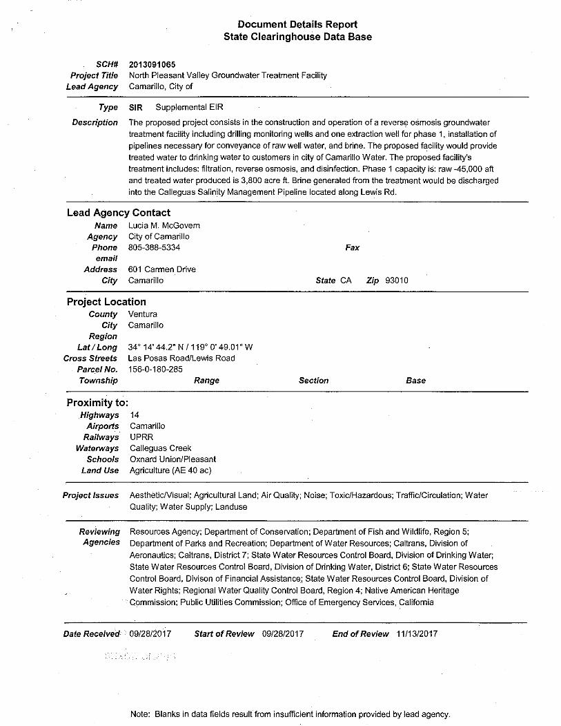

Responses to Comments
Letter from the State of California Governor’s Office of Planning and Research, State
Clearinghouse and Planning Unit dated November 14, 2017
Comment Clearinghouse-1
The State Clearinghouse submitted the above named Supplemental EIR to selected state agencies for review. The review period closed on November 13, 2017, and no state agencies submitted comments by that date. This letter acknowledges that you have complied with the State Clearinghouse review requirements for draft environmental documents, pursuant to the California Environmental Quality Act.
Response to Comment Clearinghouse-2
This letter also acknowledges that the City of Camarillo has complied with the State Clearinghouse review requirements for draft environmental documents, pursuant to CEQA. The letters does not question the content or conclusions of the Draft Second Supplemental EIR/EA. No formal response on the part of the City is required.
B- ! North Pleasant Valley Groundwater Treatment Facility4

g State of California - Natural Resources Agency EDMUND G. BROWN JR., GovernorDEPARTMENT OF FISH AND WILDLIFESouth Coast Region3883 Ruffin RoadSan Diego, CA 92123(858) 467-4201www.wildlife.ca.gov
CHARLTON H. BONHAM, Director
November 9, 2017
Ms. Lucia McGovernCity of CamarilloCamarillo Sanitation District Wastewater Treatment Facility601 Carmen DriveCamarillo, CA 93010-5387I m eg o ve rn @cityof ca m a ri 11 o. o rg
Dear Ms. McGovern:
Subject: Draft Second Supplemental Environmental Impact Report EnvironmentalAssessment for the North Pleasant Valley Groundwater Treatment FacilitySCH No. 2013091065.
The California Department of Fish and Wildlife (CDFW) received a Notice of Availability of aDraft Supplemental Environmental Impact Report (DSEIR) circulated by the City of Camarillo(Lead Agency). The Lead Agency's DSEIR is for Groundwater Treatment Facility titled the NorthPleasant Valley (NPV) Groundwater Treatment Facility (Project), pursuant to the CaliforniaEnvironmental Quality Act (CEQA) and CEQA Guidelines.
Thank you for the opportunity to provide comments and recommendations regarding thoseactivities involved in the Project that may affect California fish and wildlife. Likewise, weappreciate the opportunity to provide comments regarding those aspects of the Project thatCDFW, by law, may be required to carry out or approve through the exercise of its ownregulatory authority under the Fish and Game Code.
CDFW ROLE
CDFW is California's Trustee Agency for fish and wildlife resources, and holds those resourcesin trust by statute for all the people of the state. (Fish & G. Code, §§ 711.7, subd. (a) & 1802;Pub. Resources Code, § 21070; CEQA Guidelines § 15386, subd. (a)). CDFW, in its trusteecapacity, has jurisdiction over the conservation, protection, and management offish, wildlife,native plants, and habitat necessary for biologically sustainable populations of those species(Id., § 1802). Similarly, for purposes of CEQA, the law charges CDFW to provide as available,biological expertise during public agency environmental review efforts, focusing specifically onprojects and related activities that have the potential to adversely affect fish and wildliferesources.
CDFW is also submitting comments as a Responsible Agency under CEQA, (Pub. ResourcesCode, § 21069; CEQA Guidelines, § 15381). CDFW expects that it may need to exerciseregulatory authority as provided by the Fish and Game Code. As proposed, for example, theProject may be subject to CDFW's lake and streambed alteration regulatory authority, (Fish &G. Code, § 1600 et seq.). Likewise, to the extent implementation of the Project as proposedmay result in "take", as defined by State law as any species protected under the CaliforniaEndangered Species Act (CESA; Fish & G. Code, § 2050 et seq.), or state-listed rare plant
Conserving California s VJildtife Since 1870

Ms. Lucia McGovernCity of CamarilloNovember 9, 2017Page 2 of 7
pursuant to the Native Plant Protection Act (NPPA; Fish and Game Code §1900 et seq.), relatedauthorization as provided by the Fish and Game Code will be required.
PROJECT DESCRIPTION
Proponent:City of CamarilloCamarillo Sanitation District Wastewater Treatment Facility601 Carmen DriveCamarillo, California 91310
Project Summary:The Lead Agency circulated DSEIR analyzed Phase 1 of the proposed Project. The proposedProject includes the construction of the North Pleasant Valley Groundwater Treatment Facilityand installation of a new well on an identified 4.25-acre site (previously identified as Site-5).The well will pump 4,500 acre-feet of brackish water annually. Phase 2 of the project will besimilar in nature and will be proposed at a future date.
Project Objectives:1. Installation of the North Pleasant Valley Groundwater Treatment Facility.2. Installation of one new groundwater wells.3. Production and treatment of 6,000 gallons per minute (gpm) of pumped brackish water
combined from Well A and B.4. Installation of underground 36" pipelines to transport water from wells to the treatment
facility and from the treatment facility to the dedicated brine line.5. Continued pumping of 4,500 acre-feet per year of fresh water, non-contaminated by
salts from the Camarillo Airport Well and Well D.6. Production and treatment of 3,000 gallons per minute (gpm) of pumped brackish water
from a not yet named drilled well to be located at the newly constructed Project.
Location:The City of Camarillo is located in the eastern portion of the Oxnard Plain with the SantaSusana Mountains to the north, the Camarillo Hills to the northwest, the Conejo Valley to theeast, and the western reaches of the Santa Monica Mountains to the south. The Project site islocated on 4.25-acre at the northwest intersection of Las Posas and Lewis Roads in VenturaCounty, Assessor Parcel No. 156-0-180-285. The site is the new preferred alternative, alsoknown as Site 5.
Project Background:The Project backdates to 2005 when the Lead Agency conducted a feasibility study todetermine the acceptable levels of total dissolved solids (TDS), chloride, sulfate, iron, andmanganese necessary for potable consumption. The Lead Agency established standards forTDS at 330 milligrams per liter and chloride at 80 milligrams per liter; these standards describethe minimal levels to prevent mass loading in wastewater produced after potable consumption.The 2005 feasibility study also identified green sand filtration with reverse osmosis to be themost effective treatment process.
The Project is included in the 2008 Calleguas Creek Watershed Management Plan, 2008Calleguas Creek Salts Total Milligrams Dissolved per Liter (TMDL), and the 2006 WatershedCoalition of Ventura County Integrated Regional Water Management Plan. The Lead Agency

Ms. Lucia McGovernCity of CamarilloNovember 9, 2017Page 3 of 7
asserts that the Project is consistent with the above-mentioned Plans. The Lead Agencyadditionally states that the Project is included in the 2007 Fox Canyon GroundwaterManagement Plan and proposed an overall benefit to the prevention of water qualitydegradation in the North Pleasant Valley Basin (NPVB) aquifer.
COMMENTS AND RECOMMENDATIONS
CDFW offers the following mitigation recommendations below to assist the Lead Agency inadequately identifying and/or mitigating the Project's significant or potentially significant, directand indirect impacts on fish and wildlife (biological) resources. CDFW recommends the NewProposed Action, Site 5, as the least environmentally impactful location for the proposedProject.
I. Project Description and Shortcoming:
Issue #1: The Lead Agency's DSEIR describes the pumping of the wells (Well A and Well B) at3,000 gallons per minute (gpm) of ground water; a total of 6,000 gpm (3.54789 per year (billion)).This is in addition to the continuous pumping of 4,700 acre-feet (1.5316 GA (billion)) of waterfrom the Camarillo Airport well. The Lead Agency is proposing a future fourth well, not yetanalyzed.
Specific impact: The pumping of 3.54789GA plus 1.5316 GA (billion) of brackish groundwaterper year from the NPVB aquifer.
Why impact would occur: The removal of brackish water from the NPVB aquifer wouldremove the mounding of the brackish water, support Camarillo residents and other end-users byreducing the reliance of the City of Camarillo on imported water supplies, and prevent furtherseawater intrusion into the NPVB aquifer.
Evidence impact would be significant: The report prepared by Steven Bachman, 2016, forthe Project, stated that a reduction in the fresh water aquifer is certain, because of the Project;but necessary to eliminate the brackish water mound. Griffin and Anchukaitis (2014) stated "thecurrent [drought] event is the most severe drought in the last 1200 years, with single year (2014)and accumulated moisture deficits worse than any previous continuous span of dry years (Page9017). Due to the unprecedented drought, many riparian areas along the primary watershedswithin the Project area are stressed, or decimated, and have attributed to the decline invulnerable biological resources (Coates, Dennison, Roberts, Roth, 2015; Pratt et al., 2014). Thetrade-off the Lead Agency is proposing is less reliance on imported water by increased pumpingof groundwater from the NPVB aquifer to eliminate the brackish water mound and increasewater quality to end-users in the NPVB. However, the Lead Agency has not adequatelyanalyzed how the drawdown of the freshwater may affect deep-rooted trees, such as coast liveoaks (Quercus agrifolia) located within the NPVB. Specifically, CDFW is concerned that manyriparian and in-stream wetland biological resources within the Arroyo Las Posas, Calleguas, andConjeo watersheds may be unable to reach freshwater as it is drawn down and their taprootsunable to obtain sufficient water for their continued viability. Absent substantial evidence in therecord and or the incorporation of avoidance, minimization, or mitigation the impacts remainsignificant.
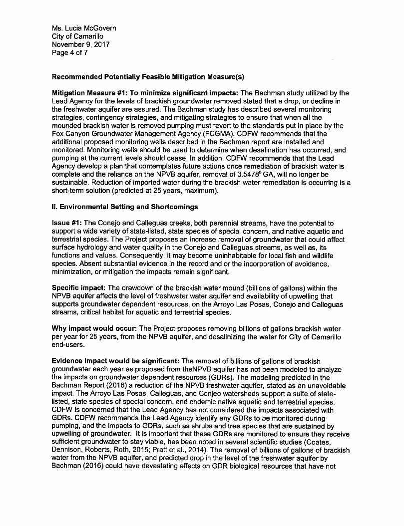
Ms. Lucia McGovernCity of CamarilloNovember 9, 2017Page 4 of 7
Recommended Potentially Feasible Mitigation Measure(s)
Mitigation Measure #1: To minimize significant impacts: The Bachman study utilized by theLead Agency for the levels of brackish groundwater removed stated that a drop, or decline inthe freshwater aquifer are assured. The Bachman study has described several monitoringstrategies, contingency strategies, and mitigating strategies to ensure that when all themounded brackish water is removed pumping must revert to the standards put in place by theFox Canyon Groundwater Management Agency (FCGMA). CDFW recommends that theadditional proposed monitoring wells described in the Bachman report are installed andmonitored. Monitoring wells should be used to determine when desalination has occurred, andpumping at the current levels should cease. In addition, CDFW recommends that the LeadAgency develop a plan that contemplates future actions once remediation of brackish water iscomplete and the reliance on the NPVB aquifer, removal of 3.54789 GA, will no longer besustainable. Reduction of imported water during the brackish water remediation is occurring is ashort-term solution (predicted at 25 years, maximum).
II. Environmental Setting and Shortcomings
Issue #1: The Conejo and Calleguas creeks, both perennial streams, have the potential tosupport a wide variety of state-listed, state species of special concern, and native aquatic andterrestrial species. The Project proposes an increase removal of groundwater that could affectsurface hydrology and water quality in the Conejo and Calleguas streams, as well as, itsfunctions and values. Consequently, it may become uninhabitable for local fish and wildlifespecies. Absent substantial evidence in the record and or the incorporation of avoidance,minimization, or mitigation the impacts remain significant.
Specific impact: The drawdown of the brackish water mound (billions of gallons) within theNPVB aquifer affects the level of freshwater water aquifer and availability of upwelling thatsupports groundwater dependent resources, on the Arroyo Las Posas, Conejo and Calleguasstreams, critical habitat for aquatic and terrestrial species.
Why impact would occur: The Project proposes removing billions of gallons brackish waterper year for 25 years, from the NPVB aquifer, and desalinizing the water for City of Camarilloend-users.
Evidence impact would be significant: The removal of billions of gallons of brackishgroundwater each year as proposed from theNPVB aquifer has not been modeled to analyzethe impacts on groundwater dependent resources (GDRs). The modeling predicted in theBachman Report (2016) a reduction of the NPVB freshwater aquifer, stated as an unavoidableimpact. The Arroyo Las Posas, Calleguas, and Conjeo watersheds support a suite of state-listed, state species of special concern, and endemic native aquatic and terrestrial species.CDFW is concerned that the Lead Agency has not considered the impacts associated withGDRs. CDFW recommends the Lead Agency identify any GDRs to be monitored duringpumping, and the impacts to GDRs, such as shrubs and tree species that are sustained byupwelling of groundwater. It is important that these GDRs are monitored to ensure they receivesufficient groundwater to stay viable, has been noted in several scientific studies (Coates,Dennison, Roberts, Roth, 2015; Pratt et al., 2014). The removal of billions of gallons of brackishwater from the NPVB aquifer, and predicted drop in the level of the freshwater aquifer byBachman (2016) could have devastating effects on GDR biological resources that have not

Ms. Lucia McGovernCity of CamarilloNovember 9, 2017Page 5 of 7
been adequately studied by the Lead Agency. Absent substantial evidence in the record and orthe incorporation of avoidance, minimization, or mitigation the impacts remain significant.
Recommended Potentially Feasible Mitigation Measure(s)
Mitigation Measure #1: To minimize significant impacts: The Lead Agency has notconsidered impacts to GDRs. CDFW recommends at least three reference sites, one at each ofthe three watersheds impacted by the Project (Arroyo Las Posas, Callegaus, and Conejo) beidentified and monitored long-term. The monitoring program should create identifiablemeasurable indicators of declining habitat quality with the GDRs. If it becomes apparent that theremoval of groundwater is having detrimental impacts on the GDRs then contingency oradaptive management plan should be created to monitor, modify pumping to remediate thoseimpacts. Wholesale losses of riparian ecosystems reliant on groundwater would be a significantimpact that the Lead Agency must consider in its environmental review for the Project.
Mitigation Measure #2: The amount of water removed from the NPVB aquifer far exceeds theamount of water returned to the NPVB aquifer. CDFW recommends the City of Camarilloconsider experimental wetlands as another potential remediation use for the pumping ofbrackish water. The adjacent Arroyo Las Posas would make an excellent proposed location ofsuch an experimental wetland. This would also allow for the removal of salts and replenishmentinto the freshwater aquifer through recharge. Experimental wetlands have proven to be aneffective beneficial use for saline water and allow increased habitat for biological resources. Aone-acre in-stream wetland could easily be achieved in the Arroyo Las Posas with a dedicatedoutflow from the well to be constructed on-site at the NPVGWTF.
Issue #2: The Lead Agency has proposed to stop the flow of excess water from the CamarilloSanitation District Wastewater Treatment Facility outfalls into Conejo creek. Downstreambiological resources could be severely impacted by the loss of this dedicated excess watersupply that they have currently received for many years from the Camarillo Sanitation DistrictWastewater Treatment Facility.
Specific impact: The pumping of 3.54789GA (billion) of brackish water per year from Wells A,B, and unnamed well located at NPVGTF from the NPBV aquifer. Additionally, 1.5316 GA(Billion) of fresh groundwater per year from the NPVB aquifer.
Why impact would occur: The Project proposes stopping the release of treated water from theCamarillo Sanitation District Wastewater Treatment Facility into Conjeo Creek.
Evidence impact would be significant: The Lead Agency has not fully evaluated the impactsassociated with the loss of this dedicated excess water sources to downstream that havebecome acclimated to the presence of this dedicated water source. Therefore, the Lead Agencydoes not avoid, minimize, or fully offset potential significant Project-related impacts on biologicalresources. Regularly scheduled releases of treated water from the Camarillo Sanitation DistrictWastewater Treatment Facility may be necessary to support downstream biological resourcesthat have become dependent on the historical dedicated excess water releases from theCamarillo Sanitation District Wastewater Treatment Facility.

Ms. Lucia McGovernCity of CamarilloNovember 9, 2017Page 6 of 7
Recommended Potentially Feasible Mitigation Measure(s)
Mitigation Measure #1: To minimize significant impacts: Conejo Creek, which entersCalleguas Creek downstream at the confluence of the two streams. The Arroyo Las Posas,Calleguas, and Conjeo watersheds support a suite of state-listed, state species of specialconcern, and endemic native aquatic and terrestrial species. CDFW recommends a rigorouswater quality-monitoring program, including monitoring stations, placed at the outfalls from theCamarillo Sanitation District Wastewater Treatment Facility. The purposes of these monitoringstation would be to determine when scheduled releases exceeds maximum TDS and Sulfatestandards, and the scheduled release of excess water should be suspended. The nextmonitoring report would indicate when excess water is necessary to provided additional waterresources to support riparian systems actively monitored on the Arroyo Las Posas, Calleguas,and Conejo creeks.
Mitigation Measure #2: To minimize significant impacts: CDFW has regulatory authoritywith regard to activities occurring in streams and/or lakes that could adversely affect any fish orwildlife resource. For any activity that will substantially divert or obstruct the natural flow, orchange the bed, channel, or bank (which may include associated riparian resources) of a riveror stream or use material from a streambed, the Project applicant must provide writtennotification to CDFW pursuant to Section 1602 of the Fish and Game Code. Based on thisnotification and other information, CDFW then determines whether a Lake and StreambedAlteration (LSA) Agreement is required. CDFW's issuance of an LSA Agreement is a projectsubject to CEQA. To facilitate issuance of a LSA Agreement, if necessary, the environmentaldocument should fully identify the potential impacts to the lake, stream or riparian resources andprovide adequate avoidance, mitigation, monitoring and reporting commitments for issuance ofthe LSA Agreement. Early consultation is recommended, since modification of the proposedproject may be required to avoid or reduce impacts to fish and wildlife resources. Again, thefailure to include this analysis in the Project's environmental document could preclude CDFWfrom relying on the Lead Agency's analysis to issue a LSA Agreement without CDFW firstconducting its own, separate Lead Agency subsequent or supplemental analysis for the Project.Information on submitting a Notification for a LSA Agreement, the current fee schedule, andtimelines required in obtaining an Agreement and found using the following URL:https://www.wildlife.ca.qov/Conservation/LSA.
ENVIRONMENTAL DATA
CEQA requires that information developed in environmental impact reports and negativedeclarations be incorporated into a database, which may be used to make subsequent orsupplemental environmental determinations (Pub. Resources Code, § 21003, subd (e)).Accordingly, please report any special status species and natural communities detected duringProject surveys to the California Natural Diversity Database (CNDDB). The CNNDB field surveyform located at the following link:http://www.dfq.ca.qov/bioaeodata/cnddb/pdfs/CNDDB FieldSurvevForm.pdf. The completedform mailed electronically to CNDDB at the following email address: [email protected] types of information reported to CNDDB located at the following link:http://www.dfq.ca.gov/bioqeodata/cnddb/plants and animals.asp.
FILING FEESThe Project, as proposed, would have an impact on fish and/or wildlife, and assessment of filingfees is necessary. Fees are payable upon filing of the Notice of Determination by the Lead

Ms. Lucia McGovernCity of CamarilloNovember 9, 2017Page 7 of 7
Agency and serve to help defray the cost of environmental review by CDFW. Payment of the feeis required in order for the underlying project approval to be operative, vested, and final (Cal.Code Regs, tit. 14, § 753.5; Fish & G. Code, § 711.4; Pub. Resources Code, § 21089).
CONCLUSIONCDFW appreciates the opportunity to comment on the DSEIR to assist the Lead Agency inidentifying and mitigating Project impacts on biological resources. Direct questions regardingthis letter, or further coordination, to Ms. Jamie Jackson, Senior Environmental Scientist(Specialist) at (805) 382-6906 [email protected].
Sincerely,
Betty J. CourtneyEnvironmental Program Manager ISouth Coast Region
ec: Ms. Christine Found-Jackson, CDFW, Newbury ParkMs. Jamie Jackson, CDFW, OxnardMr. Brock Warmuth, CDFW, Santa BarbaraOffice of Planning and Research, State Clearinghouse, SacramentoRoger Root, UFWS, [email protected] Carrillo-Zara, RWQCB, [email protected] Phelps, California Coastal Commission, [email protected]
References
Bachman, Steven. "Northern Pleasant Valley Desalter Groundwater Analyses and ModelingReport to Desalter Working Group". Technical Report SDEIR (2016). 1-118
Coates, Austin R., Philip E. Dennison, Dar A. Roberts, and Keely L. Roth. "Monitoring theimpacts of severe drought on southern California chaparral species using hyperspectraland thermal infrared imagery." Remote Sensing 7, no. 11 (2015): 14276-14291.
Griffin, Daniel, and Kevin J. Anchukaitis. "How unusual is the 2012-2014 Californiadrought?" Geophysical Research Letters 41, no. 24 (2014): 9017-9023.
Pratt, R. Brandon, Anna L. Jacobsen, Aaron R. Ramirez, Anjel M. Helms, Courtney A. Traugh,Michael F. Tobin, Marcus S. Heffner, and Stephen D. Davis. "Mortality of resproutingchaparral shrubs after a fire and during a record drought: physiological mechanisms anddemographic consequences." Global change biology 20, no. 3 (2014): 893-907.
Responses to Comments
Letter from the State of California, Natural Resources Agency, Department of Fish
and Wildlife (CDFW) dated November 9, 2017
Comment CDFW-1
I. Project Description and Shortcoming:
Issue #1: The Lead Agency's DSEIR describes the pumping of the wells (Well A and Well B) at 3,000 gallons per minute (gpm) of ground water; a total of 6,000 gpm (3.54789 per year (billion)). This is in addition to the continuous pumping of 4,700 acre-feet (1.5316 GA (billion)) of water from the Camarillo Airport well. The Lead Agency is proposing a future fourth well, not yet analyzed.
Specific impact: The pumping of 3.54789 GA plus 1.5316 GA (billion) of brackish groundwater per year from the NPVB aquifer.
Why impact would occur: The removal of brackish water from the NPVB aquifer would remove the mounding of the brackish water, support Camarillo residents and other end-users by reducing the reliance of the City of Camarillo on imported water supplies, and prevent further seawater intrusion into the NPVB aquifer.
Evidence impact would be significant: The report prepared by Steven Bachman, 2016, for the Project, stated that a reduction in the fresh water aquifer is certain, because of the Project; but necessary to eliminate the brackish water mound. Griffin and Anchukaitis (2014) stated "the current [drought] event is the most severe drought in the last 1200 years, with single year (2014) and accumulated moisture deficits worse than any previous continuous span of dry years (Page 9017). Due to the unprecedented drought, many riparian areas along the primary watersheds within the Project area are stressed, or decimated, and have attributed to the decline in vulnerable biological resources (Coates, Dennison, Roberts, Roth, 2015; Pratt et al., 2014). The trade-off the Lead Agency is proposing is less reliance on imported water by increased pumping of groundwater from the NPVB aquifer to eliminate the brackish water mound and increase water quality to end-users in the NPVB. However, the Lead Agency has not adequately analyzed how the drawdown of the freshwater may affect deep-rooted trees, such as coast live oaks (Quercus agrifolia) located within the NPVB. Specifically, CDFW is concerned that many riparian and in-stream wetland biological resources within the Arroyo Las Posas, Calleguas, and Conjeo watersheds may be unable to reach freshwater as it is drawn down and their taproots unable to obtain sufficient water for their continued viability. Absent substantial evidence in the record and or the incorporation of avoidance, minimization, or mitigation the impacts remain significant.
Recommended Potentially Feasible Mitigation Measure(s)
Mitigation Measure #1: To minimize significant impacts: The Bachman study utilized by the Lead Agency for the levels of brackish groundwater removed stated that a drop, or decline in the freshwater aquifer are assured. The Bachman study has described several monitoring strategies, contingency strategies, and mitigating strategies to ensure that when all the mounded brackish water is removed pumping must revert to the standards put in place by the Fox Canyon Groundwater Management Agency (FCGMA).
B- ! North Pleasant Valley Groundwater Treatment Facility12

Responses to Comments
CDFW recommends that the additional proposed monitoring wells described in the Bachman report are installed and monitored. Monitoring wells should be used to determine when desalination has occurred, and pumping at the current levels should cease. In addition, CDFW recommends that the Lead Agency develop a plan that contemplates future actions once remediation of brackish water is complete and the reliance on the NPVB aquifer, removal of 3.54789 GA, will no longer be sustainable. Reduction of imported water during the brackish water remediation is occurring is a short-term solution (predicted at 25 years, maximum).
Response to Comment CDFW-1
This comment pertains to the overall North Pleasant Valley Groundwater Treatment Facility project and not the subject of the Draft Second Supplemental EIR/EA. The impacts associated with groundwater extraction were addressed in the 2015 Final EIR/EA and the 2016 Supplemental EIR/EA. The commenter submitted comments on the 2015 EIR/EA, but CDFW staff did not provide comments on the 2016 Supplemental EIR/EA. The groundwater extraction allocation for the project was approved by the Fox Canyon Groundwater Management Agency Board on September 28, 2016.
The Draft Second Supplemental EIR/EA evaluates the impacts associated with the development of the groundwater treatment facility at two new sites that were not addressed in the 2015 Final EIR/EA and the 2016 Supplemental EIR/EA. The amount of water and the locations of the groundwater production wells would remain unchanged from what was evaluated in the 2016 Supplemental EIR/EA.
That being said, the North Pleasant Valley Groundwater Treatment Facility would obtain groundwater from the Fox Canyon Aquifer. This aquifer is located at least 400 feet below the ground surface. It is also located below the shallow aquifer at the ground surface, followed by the upper aquifer system and then by the Hueneme Aquifer. The live oak trees referenced in this comment have roots extending to a depth of approximately 39 feet. The wetland and riparian resources referenced in this comment have shorter roots than the oak trees. All of these resources obtain their water from the shallow aquifer. Therefore, the North Pleasant Valley Groundwater Treatment Facility would not be expected to reduce shallow aquifer water levels for native and riparian resources.
The 2015 EIR/EA concluded that the proposed groundwater production rates are less than the current surface flow rates in the Arroyo Las Posas. Therefore, mitigation measures such as the recommended monitoring of riparian habitat are not necessary for the North Pleasant Valley Groundwater Treatment Facility project.
Comment CDFW-2
II. Environmental Setting and Shortcomings
Issue #1: The Conejo and Calleguas creeks, both perennial streams, have the potential to support a wide variety of state-listed, state species of special concern, and native aquatic and terrestrial species. The Project proposes an increase removal of groundwater that could affect surface hydrology and water quality in the Conejo and Calleguas streams, as well as, its functions and values. Consequently, it may
Final Second Supplemental EIR/EA !13

Responses to Comments
become uninhabitable for local fish and wildlife species. Absent substantial evidence in the record and or the incorporation of avoidance, minimization, or mitigation the impacts remain significant.
Specific impact: The drawdown of the brackish water mound (billions of gallons) within the NPVB aquifer affects the level of freshwater water aquifer and availability of upwelling that supports groundwater dependent resources, on the Arroyo Las Posas, Conejo and Calleguas streams, critical habitat for aquatic and terrestrial species.
Why impact would occur: The Project proposes removing billions of gallons brackish water per year for 25 years, from the NPVB aquifer, and desalinizing the water for City of Camarillo end-users.
Evidence impact would be significant: The removal of billions of gallons of brackish groundwater each year as proposed from theNPVB aquifer has not been modeled to analyze the impacts on groundwater dependent resources (GDRs). The modeling predicted in the Bachman Report (2016) a reduction of the NPVB freshwater aquifer, stated as an unavoidable impact. The Arroyo Las Posas, Calleguas, and Conjeo watersheds support a suite of state-listed, state species of special concern, and endemic native aquatic and terrestrial species. CDFW is concerned that the Lead Agency has not considered the impacts associated with GDRs. CDFW recommends the Lead Agency identify any GDRs to be monitored during pumping, and the impacts to GDRs, such as shrubs and tree species that are sustained by upwelling of groundwater. It is important that these GDRs are monitored to ensure they receive sufficient groundwater to stay viable, has been noted in several scientific studies (Coates, Dennison, Roberts, Roth, 2015; Pratt et al., 2014). The removal of billions of gallons of brackish water from the NPVB aquifer, and predicted drop in the level of the freshwater aquifer by Bachman (2016) could have devastating effects on GDR biological resources that have not been adequately studied by the Lead Agency. Absent substantial evidence in the record and or the incorporation of avoidance, minimization, or mitigation the impacts remain significant.
Recommended Potentially Feasible Mitigation Measure(s)
Mitigation Measure #1: To minimize significant impacts: The Lead Agency has not considered impacts to GDRs. CDFW recommends at least three reference sites, one at each of the three watersheds impacted by the Project (Arroyo Las Posas, Callegaus, and Conejo) be identified and monitored long-term. The monitoring program should create identifiable measurable indicators of declining habitat quality with the GDRs. If it becomes apparent that the removal of groundwater is having detrimental impacts on the GDRs then contingency or adaptive management plan should be created to monitor, modify pumping to remediate those impacts. Wholesale losses of riparian ecosystems reliant on groundwater would be a significant impact that the Lead Agency must consider in its environmental review for the Project.
Mitigation Measure #2: The amount of water removed from the NPVB aquifer far exceeds the amount of water returned to the NPVB aquifer. CDFW recommends the City of Camarillo consider experimental wetlands as another potential remediation use for the pumping of brackish water. The adjacent Arroyo Las Posas would make an excellent proposed location of such an experimental wetland. This would also allow for the removal of salts and replenishment into the freshwater aquifer through recharge. Experimental wetlands have proven to be an effective beneficial use for saline water and allow increased
B- ! North Pleasant Valley Groundwater Treatment Facility14

Responses to Comments
habitat for biological resources. A one-acre in-stream wetland could easily be achieved in the Arroyo Las Posas with a dedicated outflow from the well to be constructed on-site at the NPVGWTF.
Response to Comment CDFW-2
Please see the Response to Comment CDFW-1. The North Pleasant Valley Groundwater Treatment Facility project is not expected to affect groundwater dependent resources. Therefore, mitigation measures such as the recommended monitoring of riparian habitat or the creation of experimental wetlands are not necessary for the North Pleasant Valley Groundwater Treatment Facility project.
Comment CDFW-3
Issue #2: The Lead Agency has proposed to stop the flow of excess water from the Camarillo Sanitation District Wastewater Treatment Facility outfalls into Conejo creek. Downstream biological resources could be severely impacted by the loss of this dedicated excess water supply that they have currently received for many years from the Camarillo Sanitation District Wastewater Treatment Facility.
Specific impact: The pumping of 3.54789 GA (billion) of brackish water per year from Wells A, B, and unnamed well located at NPVGTF from the NPBV aquifer. Additionally, 1.5316 GA (Billion) of fresh groundwater per year from the NPVB aquifer.
Why impact would occur: The Project proposes stopping the release of treated water from the Camarillo Sanitation District Wastewater Treatment Facility into Conjeo Creek.
Evidence impact would be significant: The Lead Agency has not fully evaluated the impacts associated with the loss of this dedicated excess water sources to downstream that have become acclimated to the presence of this dedicated water source. Therefore, the Lead Agency does not avoid, minimize, or fully offset potential significant Project-related impacts on biological resources. Regularly scheduled releases of treated water from the Camarillo Sanitation District Wastewater Treatment Facility may be necessary to support downstream biological resources that have become dependent on the historical dedicated excess water releases from the Camarillo Sanitation District Wastewater Treatment Facility.
Recommended Potentially Feasible Mitigation Measure(s)
Mitigation Measure #1: To minimize significant impacts: Conejo Creek, which enters Calleguas Creek downstream at the confluence of the two streams. The Arroyo Las Posas, Calleguas, and Conjeo watersheds support a suite of state-listed, state species of special concern, and endemic native aquatic and terrestrial species. CDFW recommends a rigorous water quality-monitoring program, including monitoring stations, placed at the outfalls from the Camarillo Sanitation District Wastewater Treatment Facility. The purposes of these monitoring station would be to determine when scheduled releases exceeds maximum TDS and Sulfate standards, and the scheduled release of excess water should be suspended. The next monitoring report would indicate when excess water is necessary to provided additional water resources to support riparian systems actively monitored on the Arroyo Las Posas, Calleguas, and Conejo creeks.
Final Second Supplemental EIR/EA !15
Responses to Comments
Mitigation Measure #2: To minimize significant impacts: CDFW has regulatory authority with regard to activities occurring in streams and/or lakes that could adversely affect any fish or wildlife resource. For any activity that will substantially divert or obstruct the natural flow, or change the bed, channel, or bank (which may include associated riparian resources) of a river or stream or use material from a streambed, the Project applicant must provide written notification to CDFW pursuant to Section 1602 of the Fish and Game Code. Based on this notification and other information, CDFW then determines whether a Lake and Streambed Alteration (LSA) Agreement is required. CDFW's issuance of an LSA Agreement is a project subject to CEQA. To facilitate issuance of a LSA Agreement, if necessary, the environmental document should fully identify the potential impacts to the lake, stream or riparian resources and provide adequate avoidance, mitigation, monitoring and reporting commitments for issuance of the LSA Agreement. Early consultation is recommended, since modification of the proposed project may be required to avoid or reduce impacts to fish and wildlife resources. Again, the failure to include this analysis in the Project's environmental document could preclude CDFW from relying on the Lead Agency's analysis to issue a LSA Agreement without CDFW first conducting its own, separate Lead Agency subsequent or supplemental analysis for the Project. Information on submitting a Notification for a LSA Agreement, the current fee schedule, and timelines required in obtaining an Agreement and found using the following URL: https://www.wildlife.ca.qov/Conservation/LSA.
Response to Comment CDFW-3
Please see the Response to Comment CDFW-1 The North Pleasant Valley Groundwater Treatment Facility project is not expected to reduce surface water levels in Conejo Creek. The North Pleasant Valley Groundwater Treatment Facility would not withdraw any water from this creek. The North Pleasant Valley Groundwater Treatment Facility project also does not include any components that would divert or obstruct flow or change the bed, channel or bank of any stream. Therefore, a streambed alteration agreement is not required. The potential for the City of Camarillo to reduce the amount of water from the Camarillo Sanitation District Wastewater Treatment Facility is a separate action that is unrelated to the North Pleasant Valley Groundwater Treatment Facility project. The North Pleasant Valley Groundwater Treatment Facility project would have no project-specific or cumulative impacts regarding the amount of water released to Conejo Creek.
Comment CDFW-4
CEQA requires that information developed in environmental impact reports and negative declarations be incorporated into a database, which may be used to make subsequent or supplemental environmental determinations (Pub. Resources Code, § 21003, subd (e)). Accordingly, please report any special status species and natural communities detected during Project surveys to the California Natural Diversity Database (CNDDB). The CNNDB field survey form located at the following link: http://www.dfq.ca.qov/bioaeodata/cnddb/pdfs/CNDDB FieldSurvevForm.pdf. The completed form mailed electronically to CNDDB at the following email address: [email protected]. The types of information reported to CNDDB located at the following link: http://www.dfq.ca.gov/bioqeodata/cnddb/plants and animals.asp.
B- ! North Pleasant Valley Groundwater Treatment Facility16

Responses to Comments
Response to Comment CDFW-4
All proposed facilities (including pipelines) would be located in agricultural areas (row crops) or roadway right-of-ways, with no removal of vegetation (including landscaping). The immediate project area does not provide suitable habitat for special status species. Therefore, field surveys for special status species and natural communities were not required for the 2015 Final EIR/EA, the 2016 Supplemental EIR/EA, or the Draft Second Supplemental EIR/EA.
Comment CDFW-5
The Project, as proposed, would have an impact on fish and/or wildlife, and assessment of filing fees is necessary. Fees are payable upon filing of the Notice of Determination by the Lead Agency and serve to help defray the cost of environmental review by CDFW. Payment of the fee is required in order for the underlying project approval to be operative, vested, and final (Cal. Code Regs, tit. 14, § 753.5; Fish & G. Code, § 711.4; Pub. Resources Code, § 21089).
Response to Comment CDFW-5
The City of Camarillo will pay all applicable fees as required.
Final Second Supplemental EIR/EA !17

.0' i0*ATE„
F O X C A N Y O N f \G R O U N D W A T E R M A N A G E M E N T A G E N C Y |A STATE Of CALIFORNIA WATER AGENCY
B O A R D O F D I R E C T O R S E X E C U T I V E O F F I C E RE u g e n e F . W e s t , C h a i r , D i r e c t o r , C a m r o s a W a t e r D i s t r i c t J e f f P r a t t , P . E .David Borchard, Vice Chair, Farmer, Agricultural RepresentativeSteve Bennett, Supervisor, County of VenturaCharlotte Craven, Councilperson, City of CamarilloRobert Eranio, Director, United Water Conservation District
October 25,2017
Lucia McGovern, Project ManagerCity of Camarillo - City Hall601 Carmen DriveCamarillo, CA 93010
SUBJECT: REVIEW OF CITY OF CAMARILLO'S (CITY) DRAFT SECOND SUPPLEMENTALENVIRONMENTAL IMPACT REPORT (DSEIR) ENVIRONMENTAL ASSESSMENT FOR THENORTH PLEASANT VALLEY GROUNDWATER TREATMENT FACILITY, SCH NO.2013091065
Dear Ms. McGovern:
Thank you for submitting the Draft Second Supplemental Environmental Impact Report (DSSEIR), prepared byCadence Environmental Consultants for the City of Camarillo (City) dated September 2017. The DSSEIRreflects changes in the locations of the groundwater treatment facility and proposed alternate groundwatertreatment facility. The monitoring and contingency portion of the Water Resources Section (pages 90 through98) of the DSSEIR is inconsistent with the revised Monitoring and Contingency Plan (attached) approved by theFox Canyon Groundwater Management Agency (FCGMA) Board on March 22, 2017.
The City petitioned the FCGMA to grant a groundwater extraction allocation for the project, separate from theCity's regular groundwater extraction allocation. The FCGMA Board on September 28,2016 adopted ResolutionNo. 2016-04 (Resolution) which grants a groundwater extraction allocation for the project. The Resolutionincluded a Monitoring and Contingency Plan. In accordance with the requirements of the Resolution, the Cityprepared a revised Monitoring and Contingency Plan to replace the original Monitoring and Contingency Plan.The FCGMA Board approved the revised Monitoring and Contingency Plan on March 22, 2017.
The DSSEIR should be revised to be consistent with the revised Monitoring and Contingency Plan prepared bythe City and approved by the FCGMA Board.
If you have any questions, please contact me at (805) 654-2954.
Sincerely,
Kathleen Riedel, P.G.Groundwater Specialist
Attachment: Revised Monitoring and Contingency Plan, version 3/14/17
800 South Victoria Avenue, Ventura, CA 93009-1610(805) 654-2014 FAX: (805) 654-3350
Website: ww w. fen ma. ori>
F:\gma\BusinessAdministration\Correspondence\2017\171005_ReviewofDSSEIR_Cily_of_Camarillo_GW_Desalter_Project.docx

Attachment No. 1NORTH PLEASANT VALLEY GROUNDWATER DESALTER PROJECT
MONITORING AND CONTINGENCY PLAN - REVISED
This revised Monitoring and Contingency Plan (MCP) is included as an attachment to FoxCanyon Groundwater Management Agency's (FCGMA's) Resolution No. 2016-04 (Resolution).In the final Resolution, adopted on September 28th, 2016, the City of Camarillo (City) was directedto update the MCP within six (6) months of the Resolution's adoption. This revised MCP isupdated in response to Resolution 16-04 and is intended for a maximum extraction of 4,500 acre-feet per year (AFY) for operation of the Desalter Project.
The purposes of the MCP are to: delineate the brackish groundwater plume, monitorgroundwater quality, groundwater levels, basin recharge, and regional effects for subsidence andseawater intrusion. The monitoring program will receive input from dedicated monitoring andgroundwater supply wells, located throughout the Pleasant Valley basin. The monitoring wells aregrouped by location and parameter sampled. Wells will be monitored in the following generalgroups (Figure 1): northern portion of the Pleasant Valley basin area, wells in the project area,project extraction wells, and regional wells for groundwater trend evaluation. The details on themonitoring and contingency program are described in the following sections.
MONITORING
Ugend« v ■ ,
■I F"iofKr!*1 TfeaWKnl Pi-inlVenHor l rs jVVt l l Ar ias9 VMfs to ProtKi Are*.m MomtMMCton ."-*
Rtyuna * '••■■. >•9 QWW ''•••• >'* I hw i
% **)■■■:* . mam
:•
I
A i mt> - 2 M» k*<17J6
Well Site B
34G3 35 12
1961:1962
.SM6 ™19F4
19e 19L5
20E2(UteralWeill
• »Wen '
Site A
WellSileC* "
Figure 1: Monitoring Well Locations and Identification
version 3/14/17 Item 9B - Page 1 of 12

Groundwater Monitoring: Northern Portion of the Pleasant Valley Basin Area. Fourdedicated nested monitoring well sites will be used - three new nested monitoring wells and oneexisting USGS nested monitoring well site, 02N21W34G03. The purpose of the monitoring wellsis two-fold: establishing baseline information and tracking the progress of the desalter project asit pulls salts from the basin. The recommended approximate locations of the dedicated monitoringwells are indicated in Figure 1 as well sites "A", "B" and UC". The precise locations of the newmonitoring wells shall be identified by a qualified hydrogeologist. The monitoring wells shall be inoperation prior to project-related groundwater pumping to allow baseline groundwater data to becollected.
Table 1: Northern Portion of the Pleasant Valley Basin Area Well Information.
MCPWell ID State Well ID Owner
WellDepth (ft
BGS)
Perf.(ft BGS) Aquifer
Well SiteA1 U reassigned City of Camarillo 1100
70-170420-640680-1040
Upper AquiferSystem, Hueneme,
Fox Canyon
Well SiteB1 Unassigned City of Camarillo 1150 70-110
620-740830-1090
Upper AquiferSystem
HuenemeFox Canyon
Well SiteC1 Unassigned City of Camarillo 1150
60-140440-560650-1080
Upper AquiferSystem Hueneme
Fox Canyon34G3 02N21W34G03S USGS/United Water 860 800-860 Fox Canyon
1Wells have not been constructed yet and therefore do not have a State Well ID number. The screened perforationsshall be determined after a geophysical log is run, however, anticipated screen depths have been provided.
The nested monitoring wells shall be completed at multiple depths (e.g., typical U.S.Geological Survey monitoring well), with each sampled zone sealed from the rest of the well.Recommended monitoring well depths and screen intervals are provided for each new nestedmonitoring well site in Table 1. The actual screened intervals shall be determined after ageophysical log is run, between the time the well is drilled and it is cased. Each screened intervalshall be continuously gravel-packed from 10 to 20 feet below the screen to 10 to 20 feet abovethe screen. A bentonite seal shall be placed at the bottom of the hole and between each screenedinterval.
The monitoring wells shall be designed such that a transducer can be installed and asubmersible pump temporarily lowered in each well for sampling. A transducer/data logger shallbe installed in each screened casing, with data downloaded periodically. Table 2 lists data to becollected at each Northern Pleasant Valley basin monitoring well.
version 3/14/17
OCT 2 7 20:;
Item «U8ta'§e\tf QFte

Table 2: Northern Pleasant Valley Basin Monitoring Well Data Collection
Parameter Sample Type FrequencyTDS (mg/l) Grab QuarterlyChloride (mg/l) Grab QuarterlySulfate (mg/l) Grab QuarterlyManganese (mg/l) Grab QuarterlyGroundwater level (eachzone) Grab Quarterly
Groundwater level (eachzone)
Continuous transducer (3hour intervals)
Download data eachquarter
Conductivity (each zone) Grab Quarterly
Conductivity (each zone)Continuous transducer (3hour intervals)
Download data eachquarter
Groundwater Monitoring: Wells in Project Area. The groundwater elevation andwater quality of existing groundwater production wells near the project wells shall also bemonitored, including downgradient Pleasant Valley Mutual Water Company wells(02N20W19M06 or -19E01), a Bell Ranch well (02N20W19B01), an OUHSD well(02N20W19B02S) and lateral well to the east (02N20W20E02). Well information for the Wells inProject Area are provided in Table 3. Data to be collected at each Weil in Project Area is providedin Table 4.
Table 3: Wells in Project Area Well information
MCPWell ID State Well ID Owner
WellDepth (ft
BGS)
Perf.(ft BGS) Aquifer
19E1 02N20W19E01S Pleasant ValleyMutual 884 564-864 Fox Canyon
19M6 02N20W19M06S Pleasant ValleyMutual 800 540-800 Fox Canyon
19B1 02N20W19B01S Bell Ranch 660 400-650 Fox Canyon19B2 02N20W19B02S OUHSD 650 400-650 Fox Canyon20E2
(LateralWell)
02N20W20E02S St. John Seminary1 875 479-875 Fox Canyon
transducer to be installed if allowed by the well owner. If the City is unable to execute an Agreement with the wellowner, then the City will drill a monitoring well that has a location, and design which is agreeable to the FCGMA.
version 3/14/17 Item 9B - Page 3 of 12

Table 4: Wells in Project Area Data Collection
Parameter Sample Type Frequency
TDS (mg/l) Grab Semi-annually (April andOctober)
Chloride (mg/l) Grab Semi-annually (April andOctober)
Sulfate (mg/l) Grab Semi-annually (April andOctober)
Manganese (mg/l) Grab Semi-annually (April andOctober)
Groundwater level (eachzone)
Grab Semi-annually (April andOctober)
Groundwater level (eachzone)
Continuous transducer* (3hour intervals) Download data quarterly
Conductivity (each zone) Grab Semi-annually (April andOctober)
Conductivity (each zone) Continuous transducer* (3hour intervals) Download data quarterly
Groundwater Monitoring: Project Extraction Wells. The groundwater elevationand water quality of project extraction wells shall also be monitored. Well information for theProject Extraction Wells are provided in Table 5. Data to be collected at each Project ExtractionWell is provided in Table 6.
Table 5: Project Extraction Wells Well Information
MCPWell ID State Well ID Owner
WellDepth (ft
BGS)
Pert,(ft. BGS) Aquifer
19F4 02N20W19F04S City of Camarillo 759 459-759 Fox Canyon
19L5 02N20W19L05S City of Camarillo 830 467-830 Fox Canyon
version 3/14/17
REOEOWEP
OCT 2 7 2017
ltemtt0BlR6gW€SK*.2

Table 6: Project Extraction Well Data Collection
Parameter Sample Type FrequencyTDS (mg/l) Grab MonthlyChloride (mg/l) Grab MonthlySulfate (mg/l) Grab MonthlyManganese (mg/l) Grab MonthlyGroundwater level (static) Grab MonthlyConductivity Grab Monthly
Monitoring consistent with DDW permit
Groundwater Monitoring: Regional Wells for Groundwater Trend Evaluation.Regional monitoring shall be conducted to detect regional trends (e.g., drought conditions,regional water quality changes) that may affect groundwater conditions at wells affected by theproject. Wells 02N21W35M02 and 02N21W34G03 shall be used for regional monitoring. Datato be collected includes semi-annual (April and October) grab samples for groundwater level andconductivity. Well information for the Regional Weils for Groundwater Trend Evaluation areprovided in Table 7.
Table 7: Regional Wells for Groundwater Trend Evaluation Well Information
MCPWell ID State Well ID Owner
WellDepth (ft
BGS)
Perf.(ft BGS) Aquifer
34G3 02N21W34G03S USGS 860 800-860 Fox Canyon
35M2 02N21W35M02S PV County 1100 700-1100 Fox Canyon
Surface Water Monitoring: Monthly review of the amount of base flow into thePleasant Valley (PV) Basin along Arroyo Las Posas is important to the project's operation.Because this baseflow is the source of the brackish water that infiltrates into the PV Basin, theamount of baseflow in the future will determine whether the PV Basin will continue to be degradedor, if upstream desalters capture much of this water, when the degradation may cease and theNPV desalter project can complete its extraction and remediation of the brackish mound.
Monitoring baseflow leaving the East Las Posas Basin is of interest, both to proponents of thisproject and future desalter projects in the East Las Posas Basin. Calleguas MWD has fundedsurface flow monitoring studies, conducted by Larry Walker Associates, of the Arroyo Las Posasin 2012, 2013, 2014 and 2015.
In 2014, following extensive stream flow monitoring in 2012 and 2013, Calleguas MWD beganmonitoring only the stream flow terminus. The City will partner with Calleguas MWD to continue
version 3/14/17 item 9B - Page 5 of 12
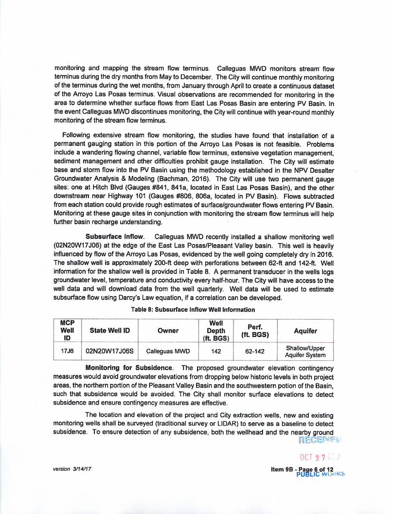
monitoring and mapping the stream flow terminus. Calleguas MWD monitors stream flowterminus during the dry months from May to December. The City will continue monthly monitoringof the terminus during the wet months, from January through April to create a continuous datasetof the Arroyo Las Posas terminus. Visual observations are recommended for monitoring in thearea to determine whether surface flows from East Las Posas Basin are entering PV Basin. Inthe event Calleguas MWD discontinues monitoring, the City will continue with year-round monthlymonitoring of the stream flow terminus.
Following extensive stream flow monitoring, the studies have found that installation of apermanent gauging station in this portion of the Arroyo Las Posas is not feasible. Problemsinclude a wandering flowing channel, variable flow terminus, extensive vegetation management,sediment management and other difficulties prohibit gauge installation. The City will estimatebase and storm flow into the PV Basin using the methodology established in the NPV DesalterGroundwater Analysis & Modeling (Bachman, 2016). The City will use two permanent gaugesites: one at Hitch Blvd (Gauges #841, 841a, located in East Las Posas Basin), and the otherdownstream near Highway 101 (Gauges #806, 806a, located in PV Basin). Flows subtractedfrom each station could provide rough estimates of surface/groundwater flows entering PV Basin.Monitoring at these gauge sites in conjunction with monitoring the stream flow terminus will helpfurther basin recharge understanding.
Subsurface Inflow. Calleguas MWD recently installed a shallow monitoring well(02N20W17J06) at the edge of the East Las Posas/Pleasant Valley basin. This well is heavilyinfluenced by flow of the Arroyo Las Posas, evidenced by the well going completely dry in 2016.The shallow well is approximately 200-ft deep with perforations between 62-ft and 142-ft. Wellinformation for the shallow well is provided in Table 8. A permanent transducer in the wells logsgroundwater level, temperature and conductivity every half-hour. The City will have access to thewell data and will download data from the well quarterly. Well data will be used to estimatesubsurface flow using Darcy's Law equation, if a correlation can be developed.
Table 8: Subsurface Inflow Well Information
MCPWell
IDState Well ID Owner
WellDepth
(ft BGS)
Perf.(ft BGS) Aquifer
17J6 02N20W17J06S Calleguas MWD 142 62-142 Shallow/UpperAquifer System
Monitoring for Subsidence. The proposed groundwater elevation contingencymeasures would avoid groundwater elevations from dropping below historic levels in both projectareas, the northern portion of the Pleasant Valley Basin and the southwestern potion of the Basin,such that subsidence would be avoided. The City shall monitor surface elevations to detectsubsidence and ensure contingency measures are effective.
The location and elevation of the project and City extraction wells, new and existingmonitoring wells shall be surveyed (traditional survey or LIDAR) to serve as a baseline to detectsubsidence. To ensure detection of any subsidence, both the wellhead and the nearby ground
OCT 2 7version 3/14/17 Item 9B - Page 6 of 12
PUBLIC WOrtKS
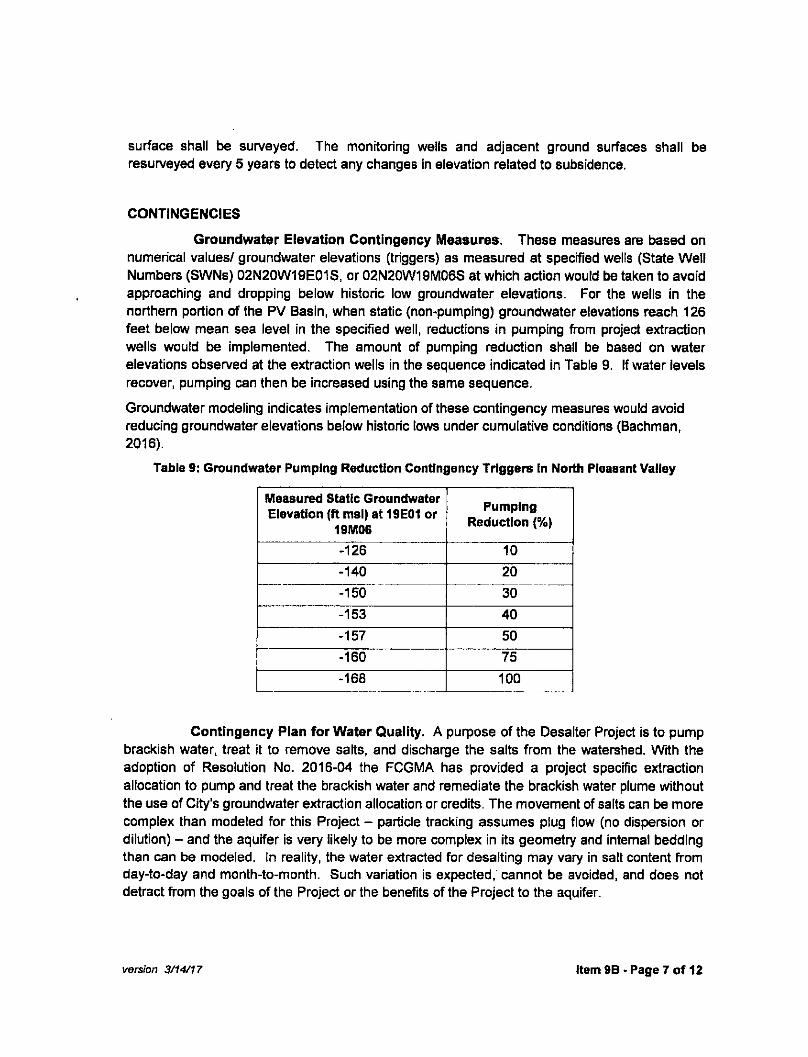
surface shall be surveyed. The monitoring wells and adjacent ground surfaces shall beresurveyed every 5 years to detect any changes in elevation related to subsidence.
CONTINGENCIESGroundwater Elevation Contingency Measures. These measures are based on
numerical values/ groundwater elevations (triggers) as measured at specified wells (State WellNumbers (SWNs) 02N20W19E01S, or 02N20W19M06S at which action would be taken to avoidapproaching and dropping below historic low groundwater elevations. For the wells in thenorthern portion of the PV Basin, when static (non-pumping) groundwater elevations reach 126feet below mean sea level in the specified well, reductions in pumping from project extractionwells would be implemented. The amount of pumping reduction shall be based on waterelevations observed at the extraction wells in the sequence indicated in Table 9. If water levelsrecover, pumping can then be increased using the same sequence.Groundwater modeling indicates implementation of these contingency measures would avoidreducing groundwater elevations below historic lows under cumulative conditions (Bachman,2016).
Table 9: Groundwater Pumping Reduction Contingency Triggers In North Pleasant Valley
Measured Static GroundwaterElevation (ft msl) at 19E01 or
19M06Pumping
Reduction (%)
-126 10-140 20-150 30-153 40-157 50-160 75-168 100
Contingency Plan for Water Quality. A purpose of the Desalter Project is to pumpbrackish water, treat it to remove salts, and discharge the salts from the watershed. With theadoption of Resolution No. 2016-04 the FCGMA has provided a project specific extractionallocation to pump and treat the brackish water and remediate the brackish water plume withoutthe use of City's groundwater extraction allocation or credits. The movement of salts can be morecomplex than modeled for this Project - particle tracking assumes plug flow (no dispersion ordilution) - and the aquifer is very likely to be more complex in its geometry and internal beddingthan can be modeled. In reality, the water extracted for desalting may vary in salt content fromday-to-day and month-to-month. Such variation is expected/cannot be avoided, and does notdetract from the goals of the Project or the benefits of the Project to the aquifer.
version 3/14/17 Item 9B - Page 7 of 12

As the Project matures and the travel paths of brackish water become more complex as thesalts are recovered from aquifer areas further away from Project pumping, there are likely to beepisodic periods when individual wells pump fresh water. Although this cannot be avoided whenattempting to clean up the entire area of brackish groundwater, a contingency plan for FCGMAallocations and credits is prudent. The purpose of this section of the contingency plan is todifferentiate between extended pumping of fresh groundwater (which would require the use ofFCGMA allocations and/or credits) and pumping of primarily brackish groundwater (which wouldfit under the FCGMA policy related to pumping and treating brackish groundwater).
Analytical test results can be variable, and single water quality test results cannot characterizethe duration, magnitude, or frequency of the measured quality. Therefore, it is recommended thata weighted average of single water quality test results collected from the extraction wells shouldbe used as triggers to initiate a response, rather than only as a means to determine whetherbrackish water is being pumped.
As discussed previously, the salt content of brackish groundwater pumped by the Project islikely to vary episodically with time. Thus, the determination of primarily brackish groundwatermust take this into account. For purposes of defining primarily brackish groundwater, fourcomponents were examined - manganese, chloride, sulfate, and Total Dissolved Solids (TDS).In all cases, concentrations were lower prior to the influence of the brackish water andconsiderably higher after the introduction of brackish water. Water Quality Objectives1 and/ordrinking water MCLs are currently being exceeded for all four constituents.
High sulfate concentrations are problematic for municipal drinking water, whereas high chlorideconcentrations are problematic for agricultural irrigation. As the most reliable constituent to useas an index of fresh and brackish water, Manganese is used here as the benchmark for projectwater quality. It is recommended that the criteria for brackish water be a threshold of 50 ug/L forManganese to reflect historical concentrations and the secondary drinking water MCL. Using thisthreshold, pumped groundwater with Manganese concentrations above 50 ug/L would beconsidered brackish water and its removal beneficial to the aquifers.
At some time in the future, Project wells will likely start pumping a mixture of brackish andambient groundwater as the brackish water is removed. It is unlikely that the transition frombrackish to ambient groundwater will be a sharp break - it is most likely to be transitional, withperiods of pumping brackish and fresher water. Given this scenario, there must be criteria fordetermining how this transition is considered. It is recommended that when Manganeseconcentrations drop below 50 ug/L in any project extraction well, a verification period would beginto ensure that brackish water has indeed been removed from the portion of the aquifer supplyingwater to the well. This verification period would be one year in duration, with water quality testingincreased to monthly during the period. If, after one year, Manganese remained below 50 ug/L,then subsequent pumping would be debited against the City's extraction allocation.
1 Water Quality Control Plan Los Angeles Region, 1995, Los Angeles Regional Water Quality ControLBQard.j)»J-1 9 . R l O E l w E P
OCT 2 7 20i/v e r s i o n 3 / 1 4 / 1 7 I t e m 9 B - P a g e 8 o f 1 2PUBLIC WORKS

If future pumping of water from a Project well that has transitioned from brackish to fresh waterreturns to a brackish water condition, then the verification period would be reversed - it wouldrequire one year of verified pumping of groundwater above 50 ug/L for Manganese to return thewell to a brackish water status. These criteria are summarized in the table below. The operationaltriggers for groundwater quality can be found in Table 10.
Table 10: Groundwater Quality Contingency Triggers
ContingencyProject well pumpingbrackish water has
Manganese drop below 50ug/L
Project well pumping freshwater has Manganese
increase to above 50 ug/L
Action Begin one year verification period Begin one year verification periodConsideredFresh Water
Monthly testing remains 50 ug/L forManganese during verification
period
Any monthly test is below 50 ug/LManganese
Addt'lEvaluation
Evaluate whether regionalconditions contributed to drop
Any monthly test exceeds 50 ug/LManganese
Evaluate whether regionalconditions contributed to increase
ConsideredBrackish Water
Monthly tests remain above 50ug/L Manganese for verification
period _
Termination ofAction
One year of pumping below 50ug/L Manganese (reverts to freshwater) or any monthly test greaterthan 50 ug/L Manganese (remains
brackish water)
One year of pumping above 50ug/L Manganese (reverts to
brackish water) or any test lessthan 50 ug/L Manganese (remains
fresh water)FCGMAAllocation
Project specific allocation Prorated use of City's allocation*
SunsetProvision
If well pumps fresh water for 24 consecutive months, well permanentlyreverts to fresh water status
Contingency Plan for Seawater Intrusion. Although significant impacts related toseawater intrusion are not anticipated, these contingency measures are provided to addressunforeseen conditions that may cause extension of the pumping depression towards the projectarea. These contingency measures are based on maintaining a seaward groundwater gradientbetween the project and the pumping depression located along the southern and western edgeof the PV basin. The depressions in the groundwater surface of the Upper and Lower Aquifersystems are associated with seawater intrusion. The critical area for this gradient is where thereis currently a sharp groundwater gradient towards the pumping depression which minimizes thepotential for the pumping depression to expand eastward and increase the size and depth of thedepression.
To calculate this gradient, two wells were selected - one an existing USGS monitoring well(2N/21W-34G3) and the other a new nested monitoring well to be constructed as part of thisproject (project Monitoring Well B, located near City Hall). The locations of the two wells areshown in Figure 1 and Figure 2. The groundwater elevations will be compared using the
version 3/14/17 Item 9B - Page 9 of 12
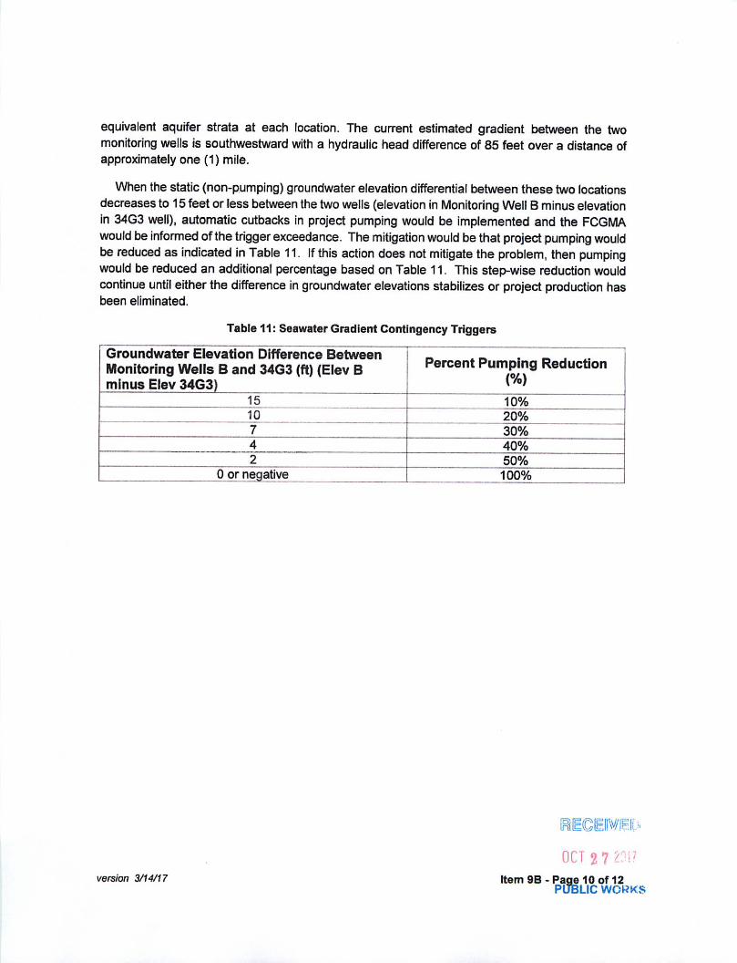
equivalent aquifer strata at each location. The current estimated gradient between the twomonitoring wells is southwestward with a hydraulic head difference of 85 feet over a distance ofapproximately one (1) mile.
When the static (non-pumping) groundwater elevation differential between these two locationsdecreases to 15 feet or less between the two wells (elevation in Monitoring Well B minus elevationin 34G3 well), automatic cutbacks in project pumping would be implemented and the FCGMAwould be informed of the trigger exceedance. The mitigation would be that project pumping wouldbe reduced as indicated in Table 11. If this action does not mitigate the problem, then pumpingwould be reduced an additional percentage based on Table 11. This step-wise reduction wouldcontinue until either the difference in groundwater elevations stabilizes or project production hasbeen eliminated.
Table 11: Seawater Gradient Contingency Triggers
Groundwater Elevation Difference BetweenMonitoring Wells B and 34G3 (ft) (Elev Bminus Elev 34G3)
Percent Pumping Reduction(%)
15 10%10 20%7 30%4 40%2 50%
0 or negative 100%
REGEIIV&'
OCT 2 7version 3/14/17 Item 9B-Page 10 of 12
PUBLIC WORKS

Figure 2: Seawater Intrusion Gradient Monitoring WellsThe opposite would occur rf the difference in groundwater elevations between the two wells
increases. For each step-wise increase in the difference, Table 11 would be used to increase thepercentage of project pumping. When the difference increases to above 15 feet, full projectproduction would resume.
This seawater contingency trigger method is similar to the water level contingency method tobe used in the project area, where the reduction is progressive and based on the differencebetween heads in the two monitoring wells.
Contingency Plan for Subsidence. In order to minimize subsidence caused by theproject, the City will monitor for impacts related to subsidence in the following manner.
(1) The subsidence monitoring will occur in the project area by survey (traditionalsurvey or LIDAR) every 5 years to detect possible changes in elevation related tosubsidence.
(2) Subsidence will be measured at the project extraction well sites.
(3) If the subsidence is five inches or more in elevation (as part of routine five yearmonitoring program) from that detected prior to project operation, then the Citywill implement the following actions:
(a) Annual survey monitoring; and(b) Reduce pumping by 10%
(4) The procedures during the annual survey monitoring will be as follows;
version 3/14/17 Item 9B- Page 11 of 12

(a) For each year that the subsidence is greater than one inch the City will reducepumping by 5%.
(b) If subsidence is less than one inch per year for two consecutive years, thenthe City may increase pumping up to the maximum pumping level as originallyauthorized by this Resolution.
Annual Report. An Annual Report shall be prepared summarizing data collected eachcalendar year and submitted to FCGMA and interested parties by April 1. The Annual Reportshall include the following information:
•
•
A summary of project monthly groundwater extraction, treatment, and disposal(brineline) volumes, as well as volume of treated water delivered to City ofCamarillo customers.
Groundwater elevation and water quality data obtained from extraction wells,monitoring wells, wells near project area, regional monitoring wells, as well asanalyses and conclusions formed from the analyses. A discussion regardingthe health of the basin and region, and regional water quantity and water qualitytrends will be included, as well as recommendations for future operations andmonitoring.Vertical and lateral delineation of the brackish water plume as well as asummary of observed changes in the location and elevation of the salt plume,using information obtained from the extraction wells and monitoring wells.
• Summary of basin recharge from the East Las Posas Basin including resultsand supporting documentation for surface water and baseflow monitoringprograms, along with calculated surface flow and groundwater inflow from theEast Las Posas Basin
• Subsidence monitoring including results of any regional land survey program.
• Regional maps of groundwater elevation contours to document any effects ofthe project on the wider Pleasant Valley Basin.
• Summary of any contingency measures implemented and observed effect ongroundwater elevations.
In addition to the annual reporting, the FCGMA shall be notified within one month ofany unexpected or critical results from project monitoring. Examples of such results includerapidly dropping water levels, approach of target groundwater elevations, any contingencytriggers reached or exceeded, any implemented pumping reductions or increases, andunexpected water quality analyses.
RECEIVED •
OCT 2 7 ZOI?v e r s i o n 3 / 1 4 / 1 7 I t e m 9 B - P a g e 1 2 o f 1 2
PUBLIC WORKS

Responses to Comments
Letter from the Fox Canyon Groundwater Management Agency (FCGMA) dated
November 9, 2017
Comment FCGMA-1
Thank you for submitting the Draft Second Supplemental Environmental Impact Report (DSSEIR), prepared by Cadence Environmental Consultants for the City of Camarillo (City) dated September 2017. The DSSEIR reflects changes in the locations of the groundwater treatment facility and proposed alternate groundwater treatment facility. The monitoring and contingency portion of the Water Resources Section (pages 90 through 98) of the DSSEIR is inconsistent with the revised Monitoring and Contingency Plan (attached) approved by the Fox Canyon Groundwater Management Agency (FCGMA) Board on March 22, 2017.
The City petitioned the FCGMA to grant a groundwater extraction allocation for the project, separate from the City's regular groundwater extraction allocation. The FCGMA Board on September 28, 2016 adopted Resolution No. 2016-04 (Resolution) which grants a groundwater extraction allocation for the project. The Resolution included a Monitoring and Contingency Plan. In accordance with the requirements of the Resolution, the City prepared a revised Monitoring and Contingency Plan to replace the original Monitoring and Contingency Plan. The FCGMA Board approved the revised Monitoring and Contingency Plan on March 22, 2017.
The DSSEIR should be revised to be consistent with the revised Monitoring and Contingency Plan prepared by the City and approved by the FCGMA Board.
Response to Comment FCGMA-1
The Draft Second Supplemental EIR/EA mistakenly incorporated the groundwater mitigation from the 2016 Supplemental EIR/EA. The text of the Final Second Supplemental EIR/EA will be revised to reference the revised Monitoring and Contingency Plan that was prepared by the City and approved by the FCGMA Board on March 22, 2017. The revised Monitoring and Contingency Plan will be included as Appendix A to the Final Second Supplemental EIR/EA.
Final Second Supplemental EIR/EA !31

IDJames Chuang
Senior Environmental Specialist
SoCalGas#
Southern California Gas CompanySempra Energy utilities
GT17E2555 Fifth Street
Los Angeles, Ca. 90013S e m p r a E n e r g y u t i l i t y T e l : 2 1 3 - 2 4 4 - 5 8 1 7
Far 323 5182324
11/13/2017
Ms. Lucia McGovernProject ManagerCity of Camarillo City Hall601 Carmen DriveCamarillo, CA 93010
Re: North Pleasant Valley Groundwater Treatment Facility Project
Dear Ms. McGovern:
Southern California Gas Company (SoCalGas) appreciates the opportunity to review and respond to the DraftSecond Supplemental Environmental Impact Report (SEIR) for the North Pleasant Valley Groundwater TreatmentFacility Project. SoCalGas understands that the SEIR is for Phase I of the proposed project, which would involve theconstruction and operation of a groundwater treatment facility and one new well to treat up to 4,500 acre-feet/year ofbrackish groundwater and provide up to 3,800 acre-feet/year of treated water to the City Water Division's servicearea. Phase II would be constructed in the future, as needed, with similar sizing and treated water production.Reverse osmosis would be used to treat the water, with the resulting brine discharged to the Calleguas RegionalSalinity Management Pipeline. Both phases of the project would be situated within a 4.7 acre area of an existingagricultural parcel. We respectfully request that the following comments be incorporated in the SEIR.
• SoCalGas has a 4-inch high pressure distribution pipeline underneath Las Posas Drive that traverses alongthe southern boundary of the project site.
• SoCalGas recommends that the project proponent call Underground Service Alert at 811 at least twobusiness days prior to performing any excavation work for the proposed project. Underground ServiceAlert will coordinate with SoCalGas and other Utility owners in the area to mark the locations of buriedutility-owned lines.
• Should it be determined that the proposed project may require SoCalGas to abandon and/or relocate orotherwise modify any portion of its existing natural gas lines, SoCalGas respectfully requests that theproject proponent coordinate with us by calling (800) 427-2000 for Non-residential to follow-up on thismatter.
Once again, we appreciate the opportunity to comment on the Draft Second SEIR. If you have any questions, pleasefeel free to contact SoCalGas Environmental Review at [email protected] or (213) 244-5817.
Sincerely,
les Chuang>enior Environmental SpecialistSouthern California Gas Company

Responses to Comments
Letter from the Southern California Gas Company (SoCalGas) dated November 13,
2017
Comment SoCalGas-1
SoCalGas has a 4-inch high pressure distribution pipeline underneath Las Posas Drive that traverses along the southern boundary of the project site.
SoCalGas recommends that the project proponent call Underground Service Alert at 811 at least two business days prior to performing any excavation work for the proposed project. Underground Service Alert will coordinate with SoCalGas and other Utility owners in the area to mark the locations of buried utility-owned lines.
Should it be determined that the proposed project may require SoCalGas to abandon and/or relocate or otherwise modify any portion of its existing natural gas lines, SoCalGas respectfully requests that the project proponent coordinate with us by calling (800) 427-2000 for Non-residential to follow-up on this matter.
Response to Comment SoCalGas-1
Prior to the initiation of any ground disturbing activities, the City of Camarillo will survey the affected areas for natural gas and other utility/infrastructure facilities. All utility/infrastructure facilities will be avoided throughout project construction.
Final Second Supplemental EIR/EA !33

Responses to Comments
This page intentionally left blank.
B- ! North Pleasant Valley Groundwater Treatment Facility34


![second supplemental ordinance [Ordinance]](https://img.dokumen.tips/doc/110x75/624f64d15eb5d005704c21d1/second-supplemental-ordinance-ordinance.jpg)