Embed Size (px)
Citation preview

Montana Forest Insect and Disease Conditions and Program Highlights 2014
Forest Health Protection
Montana Department of Natural Resources and Conservation Forestry Division
Forest Service Region 1
Northern Region
guigui
R1-15-11 March 2015
United Stated Department of Agriculture
“The U.S. Department of Agriculture (USDA) prohibits discrimination in all its programs and activities on the basis of race, color, national origin, age, disability, and where applicable, sex, marital status, familial status, parental status, religion, sexual orientation, genetic information, political beliefs, reprisal, or because all of part of an individual’s income is derived from any public assistance program. (Not all prohibited bases apply to all programs.) Persons with disabilities who require alternative means for communication of program information (Braille, large prints, audiotape, etc.) should contact USDA’s TARGET Center at (202) 720-2600 (voice and TDD). To file a complaint of discrimination, write to USDA, Director, Office of Civil Rights, 1400 Independence Avenue, S.W., Washington, DC 20250-9410, or call (800) 795-3272 (voice) or (202) 720-6382 (TDD). USDA is an equal opportunity provider and employer.”
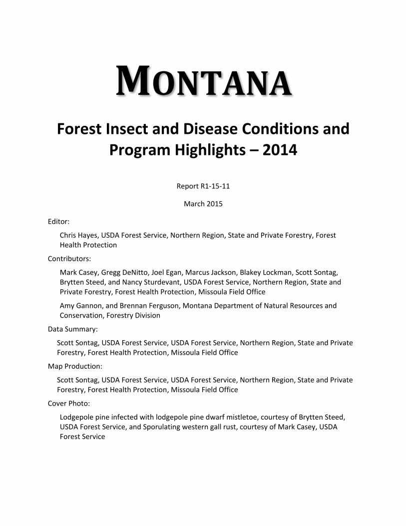
MONTANA
Forest Insect and Disease Conditions and Program Highlights – 2014
Report R1-15-11
March 2015
Editor:
Chris Hayes, USDA Forest Service, Northern Region, State and Private Forestry, Forest Health Protection
Contributors:
Mark Casey, Gregg DeNitto, Joel Egan, Marcus Jackson, Blakey Lockman, Scott Sontag, Brytten Steed, and Nancy Sturdevant, USDA Forest Service, Northern Region, State and Private Forestry, Forest Health Protection, Missoula Field Office
Amy Gannon, and Brennan Ferguson, Montana Department of Natural Resources and Conservation, Forestry Division
Data Summary:
Scott Sontag, USDA Forest Service, USDA Forest Service, Northern Region, State and Private Forestry, Forest Health Protection, Missoula Field Office
Map Production:
Scott Sontag, USDA Forest Service, USDA Forest Service, Northern Region, State and Private Forestry, Forest Health Protection, Missoula Field Office
Cover Photo:
Lodgepole pine infected with lodgepole pine dwarf mistletoe, courtesy of Brytten Steed, USDA Forest Service, and Sporulating western gall rust, courtesy of Mark Casey, USDA Forest Service


i
Table of Contents ABBREVIATIONS .................................................................................................................... ii HIGHLIGHTS ........................................................................................................................... 1 SUMMARY OF CONDITIONS ................................................................................................. 2 Bark Beetles ....................................................................................................................... 2 Defoliators .......................................................................................................................... 3 Exotic/Invasive Insects ....................................................................................................... 3 Root Diseases .................................................................................................................... 3 Foliage Diseases ................................................................................................................ 4 Dwarf Mistletoes ................................................................................................................. 4 White Pine Blister Rust ....................................................................................................... 4 Quaking Aspen Damage .................................................................................................... 5 Abiotic Damage .................................................................................................................. 6 ANNUAL AERIAL DETECTION SURVEY ................................................................................ 7 INSECT AND DISEASE CONDITIONS BY COUNTY .............................................................. 8 PUBLICATIONS 2014 ............................................................................................................ 49 COMMON AND SCIENTIFIC NAMES ................................................................................... 53 DIRECTORY OF PERSONNEL ............................................................................................. 55
TABLES
Table 1 Forest Mortality, Defoliation, and Other Damage on Montana National Forests, National Parks, and Tribal Lands, 2014 ..................................................................................................................... 37 Table 2 Host Type Infested by Bark Beetles on All Ownerships, Statewide, 2014 (Acres) ........................................................................................................ 43 Table 3 Bark Beetle Infestations Statewide, 2012−2014 .................................................... 43 Table 4 Douglas-fir Beetle-Caused Mortality on All Ownerships, Statewide, 2012−2014 (Acres) ............................................................................................... 44 Table 5 Mountain Pine Beetle-Caused Mortality on State and Private Lands, Statewide, 2012–2014 (Acres) ...................................................... 45 Table 6 Mountain Pine Beetle-Caused Mortality on All Federal Ownerships, Statewide, 2012–2014 (Acres) ......................................................... 46 Table 7 Additional Bark Beetle-Caused Mortality on All Ownerships, 2012–2014 (Acres) ............................................................................................... 47 Table 8 Western Spruce Budworm Defoliation by Reporting Area on All Ownerships, Statewide, 2012-2014 (Acres) .............................................................................. 48
FIGURES
Figure 1 Reporting Areas and National Forest Lands in Montana ..................................... 57 Figure 2 Areas Surveyed in 2014 by Forest Health Protection Aerial Detection Survey in Montana .............................................................................. 58 Figure 3 2014 Mountain Pine Beetle Infestations in Montana ........................................... 59 Figure 4 2014 Douglas-fir Beetle Infestations in Montana ................................................. 60 Figure 5 2014 Fir Engraver Beetle Infestations in Montana .............................................. 61 Figure 6 2014 Subalpine Fir Mortality Complex in Montana .............................................. 62 Figure 7 2014 Western Spruce Budworm Infestations in Montana .................................... 63 Figure 8 Balsam Woolly Adelgid Detection in Montana, 2010-2013 Survey ...................... 64

ii
ABBREVIATIONS
*The following abbreviations are used throughout this document:
Beetles DFB = Douglas-fir beetle FE = Fir engraver PE = Pine engraver MPB = Mountain pine beetle RTB = Red turpentine beetle SB = Spruce beetle WBBB = Western balsam bark beetle WPB = Western pine beetle Defoliators DFTM = Douglas-fir tussock moth LCB = Larch casebearer PB = Pine butterfly
WSBW
= Western spruce budworm
Exotic Insects BWA = Balsam woolly adelgid
Pathogens LPPDM
= Lodgepole pine dwarf mistletoe
LPDM = Limber pine dwarf mistletoe DFDM = Douglas-fir dwarf mistletoe WLDM = Western larch dwarf mistletoe WPBR = White pine blister rust
Hosts DF = Douglas-fir ES = Engelmann spruce GF = Grand fir LP = Limber pine LPP = Lodgepole pine PP = Ponderosa pine QA = Quaking aspen SAF = Subalpine fir WBP = Whitebark pine WL = Western larch WWP = Western white pine Other ADS = Aerial Detection Survey BLM = Bureau of Land Management FIA = Forest Inventory and Analysis FHP = Forest Health Protection FS = Forest Service MT = Montana NF = National Forest NP = National Park IR = Indian Reservation RA = Reporting Area

iii
RD = Ranger District TPA = Trees per acre
*For a list of scientific names see Common and Scientific Names, page 52.

iv

1
HIGHLIGHTS
Mountain pine beetle continues to cause significant tree mortality in many high elevation
five-needle pine stands. Most notable tree mortality was found in the Beaverhead, Flint
Creek, Gallatin, Madison, and Beartooth Mountains.
Mountain pine beetle-caused mortality in lodgepole and ponderosa pine was low across
much of the state. It is still, however, causing extensive tree mortality in both ponderosa
and lodgepole pine in some areas, most notably on the Bitterroot and Beaverhead-
Deerlodge National Forests.
Western spruce budworm defoliation increased in the number of acres affected from 596,000 in 2013, to just over 878,000 acres in 2014.
Balsam wooly adelgid continues to damage subalpine and grand fir and has now been recorded by aerial detection survey. Its presence has been confirmed through ground surveys in Broadwater, Flathead, Gallatin, Granite, Lewis and Clark, Lincoln, Mineral, Park, Ravalli, and Sanders Counties.
Root disease fungi are currently causing damage and mortality on nearly 3 million acres
of National Forest lands in western Montana, while almost 8.5 million acres across all
ownerships have some level of hazard from root disease.
In northwestern Montana, larch needle cast was mapped on 16,556 acres and an
unknown needle disease of ponderosa pine was mapped on 14,380 acres during the
2014 ADS. Most of these acres were in Lincoln County.

2
SUMMARY OF CONDITIONS
Bark Beetles
Mountain pine beetle
Mortality of pine species attributed to MPB was detected across the region in 2014, although
most areas of past activity continue to decline in intensity. In landscapes with few remaining
host trees, mortality was often found as scattered trees across a landscape. Some areas of
significant mortality were noted including areas with increased mortality 10-15 years after the
initial outbreak began. LPP remains the principal host and accounts for approximately 90% of
all mortality detected.
In Montana, acres affected by MPB increased somewhat with more significant increases
suggested by the total number of trees estimated killed. The Beaverhead-Deerlodge NF
experienced over 2/3 of total mortality (acres and numbers of trees) within the state recorded for
both LPP and high elevation five-needle pine (WBP and LP) host types. High mortality in LPP
was also noted around the Lolo NF, and significant increases in high elevation five-needle pine
mortality were found on the Gallatin NF. In PP, the Bitterroot NF continued to experience high
levels of mortality with approximately 2/3rds of the acres and trees per acre of PP mortality
detected in the state. Greatest decreases in mortality are indicated around the Lewis and Clark
NF in all three host types. Some changes in mortality detected in 2014 are due to increased
survey of the most active areas of MPB on the Beaverhead-Deerlodge NF, many of which had
not been surveyed in 2013.
Douglas-fir beetle
Pockets of DFB-caused mortality in Montana were detected at similar levels in 2014 when
compared to 2013. DFB-caused mortality was found on all land ownership types including
federal, state, tribal, and private lands. Tree mortality occurred in spatially isolated pockets
scattered throughout the state, and was often associated with prior WSBW-caused defoliation.
Acres of DFB-caused mortality may be under-reported across Montana due to difficulties
associated with detecting DFB activity in trees with prior defoliation. Of note, a DFB outbreak
erupted on the Rocky Boy’s IR in Chouteau County. This outbreak occurred following a severe
wind event that blew down many stems infected with root and butt rot in 2011. Much of the
Douglas-fir host type throughout MT has experienced severe WSBW defoliation for the better
part of the last decade. This defoliation, if coupled with unusually warm and dry weather or
another outbreak catalyst, could promote increased DFB activity in subsequent years.
Other Bark Beetles
Spruce Beetle: SB-caused mortality remained at low levels throughout Montana in 2014. In the
two locations that had elevated activity in recent years, outbreak populations of SB declined
sharply to low levels; these include federally managed lands within the Gravelly Mountains,
Beaverhead-Deerlodge NF, and Rock Creek drainage, Custer NF. SB populations are not
expected to erupt again as the prevalence of susceptible, large-diameter spruce host has been
substantially reduced in these locations.

3
Pine engraver: PE populations and associated tree mortality continued at low, endemic levels in
2014, with total acres and number of trees estimated killed largely unchanged from 2013.
Nearly all mortality was in PP as scattered spots across the Region. In Montana, over half of
the PP mortality attributed to PE was noted in the southeastern portion of the state on the Crow
and Northern Cheyenne IRs and Custer NF. PE beetle populations have remained fairly static
throughout the state. If weather continues to provide near or above normal precipitation
patterns and barring large areas of improper slash management, we expect populations will
continue at or near endemic levels.
Defoliators
Area defoliated by WSBW increased over 45 percent in 2014 compared to 2013, to over
878,000 acres in counties both east and west of the Continental Divide. WSBW defoliation was
recorded in most counties in which ADS was conducted and host trees occur. In 2014,
defoliation intensity remained high in some areas, especially on forests east of the Continental
Divide where WSBW has been recorded for several years. However, in most counties WSBW
defoliation intensity decreased. Counties with significant WSBW defoliation include Flathead,
Lewis & Clark, Missoula, and Powell Counties. This includes NF lands intermingled with
surrounding lands of other ownerships.
No defoliation from DFTM, PB or LCB was recorded in 2014.
Exotic/Invasive Insects
Balsam wooly adelgid: BWA was detected on SAF or GF through ground surveys in Montana
for the first time in 2010. In 2013, extensive ground surveys conducted throughout the state by
Montana Department of Natural Resources and Conservation and R1 FHP found BWA in
Broadwater, Flathead, Gallatin, Granite, Lewis and Clark, Lincoln, Mineral, Missoula, Park,
Ravalli, and Sanders Counties. In 2014, BWA was observed for the first time by ADS. New
detections being observed through aerial survey are likely due to aerial observers learning the
visual signature and increases in tree damage that makes BWA easier to detect from the air.
BWA is an exotic pest that causes branch dieback and can cause tree mortality. The most
obvious indicator of its presence is the white “wool” covered females on the bark of stems and
branches of trees during summer months. To-date, BWA infections have been observed
causing branch dieback and overall stress in host trees within Montana. Direct mortality caused
by BWA has not been documented thus far in MT; however, we expect BWA infections to make
trees highly susceptible to other mortality agents.
Root Diseases
Root diseases are diseases of the site and do not change drastically from one year to the next.
Based on a recent assessment using USDA FS, FIA plots (http://www.fia.fs.fed.us), root disease
fungi are estimated to cause damage and mortality on nearly 3 million acres of NF lands in
western Montana. Root disease hazard, as derived from the FIA root disease data, occurs at
some level on over 8.5 million acres in western Montana across all ownerships. Root disease-
caused mortality is more common west of the Continental Divide. We currently do not have an

4
assessment of root disease distribution and impact east of the Continental Divide. In general,
large areas of root disease can be found east of the Divide, but it tends to occur in more
discrete patches rather than being ubiquitous throughout an area. Also, root diseases can be
commonly found in riparian areas east of the Continental Divide, often in spruce and subalpine
fir. The most impacting root diseases are armillaria root disease, laminated root rot, annosus
root disease, schweinitzii root and butt rot, and to a lesser extent tomentosus root rot.
Foliage Diseases and Tip Blights
In northwestern Montana, larch needle cast was mapped on 16,556 acres. This is an overall
increase from the 12,363 acres mapped in 2013, with nearly 90% of the 2014 acres mapped in
Lincoln County. It was also detected in Flathead, Glacier, and Sanders counties.
An unknown needle disease of PP was mapped on 14,380 acres, with nearly 85% of it detected
in Lincoln County. This unknown disease was also detected in Flathead, Lake, and Sanders
counties. Field surveys will be conducted in 2015 to identify the disease.
ADS detected damage to PP attributed to both Elytroderma needle disease and western gall
rust on 1,848 acres in Flathead and Lake Counties. Over 95% of those acres were scattered
across northwest areas of Lake County.
Dwarf Mistletoes
Historical assessments of dwarf mistletoe stands in Montana show that about 16% of DF, 33%
of LPP, and 30% of WL stands are infected with dwarf mistletoe. More recent assessments
using FIA data collected on over 50,000 trees across Montana show that only about 1% of DF,
3.2% of LPP, and 3.9% of WL trees are infected. The clumpy nature and protracted disease-
cycle of dwarf mistletoes allow for impacts across an individual stand to range from none to
severe. This is likely the reason for differences between these two measurements; the first is
measuring infected stands and the second is measuring infected trees.
White Pine Blister Rust
WWP, WBP, and LP are all susceptible to WPBR.
Western white pine
Mature WWP continues to be lost due to a combination of WPBR and MPB. Lack of suitable
sites, either man-made or natural, limits natural regeneration, and WPBR kills a high proportion
of natural seedlings. Rust-resistant stock is planted operationally on suitable WWP sites on
federal, state, industrial, and private forest lands throughout northwestern Montana. In addition
to planting rust-resistant stock, pruning of the lower bole at a young age is an important tool
used in WPBR management.
Realized-gain trial: In the fall of 2014, personnel from the Montana DNRC assisted the Inland
Empire Tree Improvement Cooperative (University of Idaho) with data collection on the
Woodward Point WWP realized-gain trial. A realized-gain trial is a test of the actual gain of a
breeding program, in this case the U.S. Forest Service’s rust-resistance breeding program for

5
WWP where selected (rust resistant) materials are evaluated alongside non-selected
(woodsrun) materials in operational field tests (Mahalovich 2010). The Woodward Point
realized-gain study was established in 2012 and has a total of 6,600 WWP. Initial results from
the 2014 measurement show a 96% seedling-survival rate. Only one tree had a definite WPBR
canker, while a handful of others may be showing early bark reactions in response to infection.
The next measurement will take place in 2016.
Whitebark pine
WPBR has been impacting WBP ecosystems since the 1920’s. In addition, recent outbreaks of
MPB have caused widespread mortality in many WBP stands already impacted by WPBR. The
combination of WPBR, bark beetle outbreaks, and lack of natural regeneration due to fire
suppression has raised concerns about the long-term viability of WBP ecosystems.
Standardized methodology is now being used to establish monitoring plots in WBP stands
throughout the West. These plots are designed to provide a statistically-based assessment of
the incidence of WPBR in the ecosystem and the condition of WBP. Whitebark and Limber Pine
Information System, WLIS, is a database which was developed (http://www.fs.fed.us/r1-
r4/spf/fhp/prog/programs2.html) to compile and provide results of surveys in both WBP and LP.
WLIS has been expanded to include four other high elevation five-needle pines and has been
re-named the High Elevation 5-Needle Pine Database (Hi5Db). It will be available soon as a live
web-based system.
Limber pine
LP is found at elevations ranging from 2,700 feet near the community of Terry in far eastern
Montana to around 9,000 feet in and around the Beaverhead-Deerlodge NF in southwestern
Montana. West of the Continental Divide, LP is largely confined to limited areas adjacent to the
Divide, while scattered populations of LP can be found across much of eastern Montana.
WPBR is found throughout the distribution of LP, but there are a few areas where LP remains
apparently free of the disease, including locations southwest of Ennis and south of Billings.
Unique damage
Pine leaf adelgid (Pineus pinifoliae Fitch) was identified as the causal agent significantly
impacting several plantings of WWP in Lincoln County (MFO-TR-14-31). Damage was very
reminiscent of WPBR branch cankers and included branch flagging; swollen branch ends; red
needles much like a needle disease, except multiple years involved; numerous cohorts of red
needles remaining attached; and resin droplets on affected branches.
Quaking Aspen Damage
QA damage is mapped occasionally by aerial surveyors when other damage activity is low and
QA damage is striking. In most counties, total mapped acres in 2014 were well under 50.
However, in six counties approximately 150 to 250 acres were mapped (Beaverhead, Big Horn,
Madison, Meagher, and Teton), with nearly 1,600 acres mapped in Glacier County on the
western edge of the Blackfeet IR. Based on past visits to scattered QA stands across the state
much of this damage is likely due to old age (80-120 years is age of rotation for QA in northern

6
part of the western U.S.) and related fire suppression. However, conifer encroachment also
plays a role where QA stands are mixed with evergreens.
Abiotic Damage
Windthrow damage detected by ADS has been similar over the last three years with about 245
acres detected in 2014. It was detected in Beaverhead, Flathead, Lake, and Sweet Grass
Counties in 2014. Fifty-three acres of avalanche damage was detected in Powell and Teton
Counties.

7
ANNUAL AERIAL DETECTION SURVEY
Aerial detection surveys are an overview assessment designed to locate and document forest
change events, as seen from the air. It is a form of data collection that allows the observer to
survey large tracts of forested land in a relatively short period of time. Single engine, high-wing
aircraft flying at speeds of approximately 90 to 130 mph at an average altitude of 1,500 feet
above ground level are used to fly either contour or grid patterns within a Reporting Area. The
damage extents, or polygons, of the aerially detected signatures of recently killed or defoliated
trees are marked on a digital sketch mapping system or on paper 1:100,000 scale topographic
maps. These polygons are given a code for the agent that likely caused the damage, which is
inferred from the size and species of trees affected as well as the color and pattern of the
damage. The agent code is followed by the total number of trees affected, TPA affected, or an
intensity of the damage (L for light and H for heavy). Areas burned by wildfire are not surveyed
until the third year following a fire, as it can be difficult to distinguish mortality caused by fire
from that caused by insect or disease activity. The actual amount of mortality from tree
diseases, dwarf mistletoes, and WPBR are greatly underestimated with ADS because
symptoms from these agents can be difficult and, in some instances, impossible to identify from
the air.
The annual ADS in Montana was conducted from June 30 to September 26, 2014. The survey
encompassed approximately 30.7 million acres of mixed ownership forested lands, excluding
most designated wilderness areas (Figure 2). Four FHP observers, using three contract aircraft,
conducted the 2014 ADS and identified approximately 1.5 million acres of forest damage within
Montana.
The data summarized in this report are a product of the annual ADS, as well as ground surveys
and biological evaluations. The digital data files, data summaries, and ADS damage maps are
available from the Missoula FHP Field Office, in both paper and digital GIS format. Data may
also be downloaded at http://www.fs.usda.gov/detail/r1/forest-grasslandhealth/?cid=stelprdb5182976.

8
INSECT AND DISEASE CONDITIONS BY
COUNTY
County Results
For each county, damage by ownership is noted and, to the extent possible, we have indicated
areas affected and estimated extent of damage. Counties that are not included had no reported
information. Forestland data in the following tables are from the annualized surveys performed
by USDA Forest Service, FIA (http://www.fia.fs.fed.us). In some of our tables acres of damage
are reported for some ownership where there is no forestland reported by FIA. Because of the
limited forestland within ownerships of some counties, the density of FIA plots may not have
been sufficient at the county level to identify forested acres (i.e. forestland exists but was
missed in the FIA sample resulting in an estimate of zero acres). This discrepancy is within
their standard of error. Acres flown include areas of non-forest covered during the survey.
Beaverhead County
Forestland, Mortality, and Defoliation Acres by Ownership (2,566,940 ac flown)
National Forest Other Federal Private State Total
Forestland 1,094,801 119,288 46,602 29,751 1,290,444 DFB 146 89 178 37 450 SB 76 0 0 2 78 MPB-LPP 236,010 3,168 7,396 645 247,219 MPB-PP 42 2 26 2 72 MPB-High Elevation 19,210 168 89 68 19,535 SAF Mortality 86 34 3 10 133 WSBW 6,139 19,682 3,438 3,349 32,608 QA Damage 14 89 54 0 157 Windthrow 92 0 0 0 92
Nearly all forested lands were surveyed in 2014 resulting in 50% more area surveyed over
2013. The majority of increase was due to full coverage of the Pioneer Mountains in 2014.
Beaverhead County continues to be one of the remaining hot spots of MPB activity in the state.
Significant levels of mortality were noted in LPP in the Beaverhead Mountains and western
Pioneer Mountains, constituting not only a 50% increase in acres affected but nearly a four-fold
increase in numbers of trees killed. The increase in area surveyed in 2014 accounts for much
of this increase in detected activity, although density of mortality (i.e. trees per acre killed) also
increased within polygons of MPB activity. The majority of mortality, as well as the greatest
increase in mortality, occurred on Forest Service lands.
High elevation five-needle pine mortality also increased four to five-fold in acres and five to six-
fold in numbers of trees killed from that detected in 2013. Mortality increased not only in areas
that had experienced minimal mortality in the past (Pioneer Mountains), but also in areas that
had significant mortality 5-10 years in the past (Beaverhead Mountains along the Continental
Divide, Tendoy Mountains, Blacktail Mountains).
DFB activity in Beaverhead County was limited in 2013 to no more than 100 acres. A 4.5-fold
increase in acres damaged by DFB (and >10-fold increase in number of trees) in 2014 was due,

9
in part, to the increase in survey area. However, mortality increases were evident in areas
surveyed both years. The largest concentration of activity appeared in the northeast edge of the
Pioneer Mountains, although mortality was present as scattered trees throughout the west and
east Pioneers. Polygons of mortality were also delineated from Polaris south to Lemhi Pass,
and southeast along the Continental Divide, as well as throughout the Blacktail Range. One
strip of scattered polygons extended along the route into Mussigbrod Lake.
WSBW defoliation increased in 2014 over 2013 levels. A significant portion of acres were noted
in the Centennial Mountains, but scattered polygons were detected in all mountain ranges
including the Gravelly/Snow Crest/Greenhorn, Tobacco Root, and Ruby Ranges, as well as
portions of the Madison Range, and areas between Glenn and Twin Bridges north of the Big
Hole River.
Dwarf mistletoe, comandra blister rust, and western gall rust are impacting LPP in developed
recreation sites along the Pioneer Byway (MFO-TR-14-43). ADS detected about a dozen
polygons (from 2 to 45 acres) of QA damage in the southeast portion of the county totaling 157
acres. In addition, ADS detected a 92 acre area of LPP windthrow about 10 miles east
southeast of Jackson.
WPBR is common in WBP in this county. In addition, LPDM is found here.
Big Horn County
Forestland, Mortality, and Defoliation Acres by Ownership (666,677 ac flown)
National Forest Other Federal Private State Total
Forestland 0 8,296 329,239 26,278 363,814 DFB 0 0 24 0 24 SB 0 0 2 0 2 MPB-LPP 0 0 18 0 18 MPB-PP 0 0 16 0 16 MPB-High Elevation 0 0 8 0 8 PE 0 10 732 10 752 SAF Mortality 0 0 4 0 4 WSBW 0 0 1,347 0 1,347 QA Damage 0 0 168 0 168
In 2014, aerial surveys were conducted in the Pryor and Wolf Mountains on the Crow IR and on
areas of the Northern Cheyenne IR that lie within Bighorn County. Numerous scattered pockets
of Ips spp.-caused PP mortality (ranging from 30-150 trees per group) were located throughout
the eastern portion of the county within the Northern Cheyenne IR. Field assessments found a
complex of Ips species causing the tree mortality. Ips calligraphus (six-spined ips) appeared to
have caused the most mortality, while lesser amounts of PE and Ips emarginatus (emarginate
ips) attacked PP as well (MFO-TR-14-21). This outbreak was triggered by severe drought
conditions during the spring of 2012 and in early part of 2013. While geographically widespread,
mortality was isolated to areas with dense stand conditions and marginal, dry growing
environments. MPB activity that was identified in this area in 2013 may actually have been
caused by this complex of Ips spp.

10
Small amounts of DFB activity and SAF decline were detected in the county as well. WSBW
activity increased throughout the northern portion of the Pryor Mountains on the Crow IR,
primarily within DF host.
LPPDM was found significantly impacting stands of LPP on the Crow IR in the Pryor Mountains
(MFO-TR-14-26). WPBR is present in LP in this county. LPPDM and LPDM are present in this
county. ADS detected 126 acres of QA damage about 29 miles south southeast of Billings and
eight polygons (from 2 to 13 acres) of QA damage in the south-central portion of the county.
Blaine County
Forestland, Mortality, and Defoliation Acres by Ownership (59,255 ac flown)
National Forest Other Federal Private State Total
Forestland 0 74,871 56,036 4,579 135,488 DFB 0 0 28 0 28 MPB-LPP 0 0 29 5 34 MPB-PP 0 0 64 0 64 SAF Mortality 0 0 2 0 2 WSBW 0 0 15 0 15
The southwest portions of Blaine County where forested areas within the Fort Belknap IR occur
were surveyed in 2014. Approximately 42% fewer acres were flown in 2014. Despite this,
number of acres killed by MPB slightly increased in LPP but decreased in PP forests. DFB
activity slightly decreased in 2014 and WSBW activity significantly decreased across the Fort
Belknap IR.
Western gall rust and comandra blister rust are common in PP on the Fort Belknap IR causing
stem deformities, branch mortality, top kill, and occasional whole tree mortality. Armillaria root
disease is found on the Fort Belknap IR, in the Mission Canyon area, with large pockets
developing in DF and QA. LPPDM is present in the county.
Broadwater County
Forestland, Mortality, and Defoliation Acres by Ownership (508,821 ac flown)
National Forest Other Federal Private State Total
Forestland 163,148 29,996 90,744 0 283,889 DFB 438 0 77 2 517 SB 4 0 0 0 4 MPB-LPP 14 0 2 0 16 MPB-PP 10 0 10 2 22 MPB-High Elevation 2 0 0 0 2 PE 0 0 2 0 2 SAF Mortality 10 0 0 0 10 WPB-PP 2 0 0 0 2 WSBW 11,588 0 335 0 11,923
Nearly four times the area was surveyed in 2014 as compared to 2013, accounting for most of
the increased bark beetle and defoliator activity. Despite the increased survey area and
damage agent detection, MPB activity was still under 50 acres total (all hosts), with SB, PE,
WPB, and SAF mortality each no more than 10 acres of damage. The only damage agents with
over 500 acres of activity included DFB (approximately 500 acres mostly on the Big Belt
Mountains south of Diamond City) and WSBW (nearly 12,000 acres on the Big Belt Mountains

11
north of Diamond City). Very little change in damage agent activity was noted in the southern
Elkhorn Mountains that was surveyed in both years.
Stem decay, as well as root and butt rots, are concerns in hardwoods and conifers in Skidway
Campground (MFO-TR-14-10).
WPBR has been found in LP in this county. Armillaria root disease is present, and schweinitzii
root and butt rot is quite common, especially causing significant decay in butt logs of larger,
older DF. LPPDM is also present in this county.
Carbon County
Forestland, Mortality, and Defoliation Acres by Ownership (327,480 ac flown)
National Forest Other Federal Private State Total
Forestland 170,199 89,996 44,890 6,188 311,273 DFB 204 27 87 11 329 SB 16 0 2 0 18 MPB-LPP 564 3 432 267 1,266 MPB-PP 24 2 5 0 31 MPB-High Elevation 2,163 4 8 0 2,175 SAF Mortality 218 0 0 0 218 WSBW 76 0 29 0 105
Aerial surveys primarily occurred within non-designated wilderness areas of the Beartooth
Mountains in the western portion of the county near Red Lodge and within the Pryor Mountains
in the southeast portion of the county. In the Beartooth Mountains, MPB activity increased
within LPP and WBP. Ground surveys indicated pockets of mortality were widespread and
ranged up to 30 stems per group in the Hellroaring Gulch area and up to 100 stems per group
throughout the Rock Creek drainage (MFO-TR-14-21). The SB outbreak that occurred within
the Rock Creek drainage in recent years has subsided. Small, scattered pockets of MPB in
LPP and DFB were detected in the southern Pryor Mountains on the Crow IR in the eastern
portion of the county.
Spruce broom rust and tomentosus root disease in ES are prevalent in various campgrounds in
this county. WPBR is common in WBP and LP, and LPPDM and LPDM are present in the
county.
Carter County
Forestland, Mortality, and Defoliation Acres by Ownership (249,029 ac flown)
National Forest Other Federal Private State Total
Forestland 65,752 0 37,515 0 103,268 PE 31 1 18 0 50
In 2014, aerial surveys were conducted on the limited acres of forested land in Carter County
near Ekalaka. In this area, small pockets of PE activity were observed in PP.

12
Cascade County
Forestland, Mortality, and Defoliation Acres by Ownership (492,908 ac flown)
National Forest Other Federal Private State Total
Forestland 182,999 26,439 94,601 14,143 318,182 DFB 130 7 59 8 204 SB 8 2 2 2 14 MPB-LPP 998 2 42 2 1,044 MPB-PP 12 2 42 0 56 SAF Mortality 14 0 0 0 14 WSBW 38 709 4,257 846 5,850 QA Damage 0 0 43 0 43 Unidentified Defoliator
0 1 5 0 6
Area surveyed within Cascade County was nearly identical in 2014 and 2013, and included the
northern portions of the Big Belt and Little Belt Mountains, and the southwest corner of the
Highwood Range. Mortality due to MPB continued to drop in all hosts, often with a five to 10-
fold decrease or greater. The approximately 1,000 acres of LPP mortality was almost
exclusively in the Little Belt Range between Monarch and Neihart. Some increased mortality
was detected for DFB to over 200 acres; most as scattered trees across the Little Belt and
Highland Mountains. Defoliation by WSBW also increased to over 5,850 acres, almost entirely
noted on the Big Belt Mountains.
Elytroderma needle disease, a rare occurrence on LPP in Montana, was found on LPP in Aspen
Campground (MFO-TR-14-15). LPP regeneration in Many Pines Campground is affected by
western gall rust and LPPDM and is expected to be highly impacted if adjacent overstory is left
untreated, while spruce broom rust is having a large impact on ES regeneration in this
campground (MFO-TR-14-15). ADS detected a total of 43 acres of QA damage in four
polygons (one in southwest corner, two in southeast corner, and one along east central edge of
county).
WPBR is common in LP in this county. Armillaria root disease is present in the southeastern
portion of the county, and schweinitzii root and butt rot is quite common, causing significant
decay in butt logs of larger, older DF. Tomentosus root rot is known to occur in several areas,
including Kings Hill Campground.
Chouteau County
Forestland, Mortality, and Defoliation Acres by Ownership (222,644 ac flown)
National Forest Other Federal Private State Total
Forestland 13,289 10,273 33,979 1,338 58,880 DFB 43 2 271 0 316 SB 4 0 2 0 6 MPB-LPP 58 0 2 0 60 MPB-PP 0 2 4 2 8 WSBW 0 12 305 0 317
In 2014, forested areas in the Highwood Mountains and on the Rocky Boy’s IR were surveyed,
similar to what was surveyed in 2013. MPB-caused LPP mortality declined substantially within
this area after being elevated in recent years, and typically occurred only within drainage

13
bottoms. DFB activity increased substantially within the Rocky Boy’s IR, especially in stands
near Bailey Peak and within the Sandy Creek drainage. Numerous green-infested trees were
detected in these areas through ground surveys indicating populations are increasing (MFO-TR-
14-19). This outbreak started following a severe wind event that blew over numerous trees in
areas known to have DF infected with schweinitzii root and butt rot. Trees impacted are
generally the older, large-diameter stems (exceeding 15” DBH).
Defoliation caused by WSBW persisted at very low levels in 2014 after a dramatic reduction in
2013.
Armillaria root disease was found in several locations in the Big Sandy Creek drainage (MFO-
TR-14-40). Armillaria root disease is present in various locations on the Rocky Boy’s IR, but
appears to be uncommon. Also, butt rot and stem breakage caused by the decay fungus
Ganoderma applanatum (artist conk) has been observed in QA on the Rocky Boy’s IR.
Deer Lodge County
Forestland, Mortality, and Defoliation Acres by Ownership (445,390 ac flown)
National Forest Other Federal Private State Total
Forestland 202,800 6,404 34,386 41,855 285,447 DFB 820 13 193 12 1,038 SB 0 0 6 2 8 MPB-LPP 13,234 111 1,400 4,264 19,009 MPB-PP 3 0 3 0 6 MPB-High Elevation 797 0 971 22 1,790 SAF 2 0 0 0 2 WSBW 31 0 0 0 31
Significantly more acres were flown by ADS in 2014 versus 2013. The majority of tree mortality
in the county was caused by MPB. Number of acres killed by MPB and the intensity increased
by 10-fold in LPP, remained at low levels in PP, but increased in high elevation five-needle
pines especially along the northern border. MPB is still very active along the Mill Creek
drainage just southwest of Anaconda and south of Mud Lake.
Low and scattered amounts of defoliation from WSBW was found in the county during ground
surveys. Very little visible defoliation from WSBW was recorded via ADS. DFB activity
increased especially in the southwest part of the county.
WPBR has been found in LP in this county. Schweinitzii root and butt rot is common in DF,
causing decay in butt logs but not acting as an aggressive root pathogen. LPPDM and LPDM
are also present in the county.

14
Fergus County
Forestland, Mortality, and Defoliation Acres by Ownership (710,501 ac flown)
National Forest Other Federal Private State Total
Forestland 86,810 176,801 251,019 11,558 526,189 DFB 143 38 95 2 278 SB 2 0 2 0 4 MPB-LPP 4 6 10 4 24 MPB-PP 2,152 152 2,416 17 4,737 PE 0 0 4 0 4 SAF 4 2 0 0 6 WSBW 14,884 571 4,178 67 19,700 QA Damage 0 0 28 11 39
In 2014, ADS was conducted over similar areas as 2013 and included the Snowy, Moccasin,
and Judith Mountains. MPB-caused mortality decreased again in 2014 to one-third 2013
levels—from around 16,000 acres to under 5,000 acres—despite a nominal decrease of 14% in
acres surveyed. This decrease in MPB activity occurred principally in the Little Snowy
Mountains and the southern edge of the Big Snowy Mountains in the PP host type, although all
host types are present and experiencing mortality in the county. The DFB activity detected also
decreased, but remained an active and scattered agent in both the Snowy and Judith Mountains
(and surrounding forested islands). Defoliation by WSBW increased over 2013 levels to 19,700
acres and was located mostly in the Big Snowy Mountains.
ADS detected six polygons (from two to 20 acres and totaling approximately 40 acres) of QA
damage about 13 miles south of Lewistown. Armillaria root disease occurs in the Moccasin
Mountains north of Lewistown and near Crystal Lake. LPPDM is also present in this county.

15
Flathead County
Forestland, Mortality, and Defoliation Acres by Ownership (2,774,015 ac flown)
National Forest
Other Federal
Private State Total
Forestland 1,726,776 507,120 422,938 132,807 2,789,642 BWA 2 0 0 0 2 DFB 901 187 280 95 1,463 Elytroderma 0 0 67 0 67 SB 0 8 2 0 10 FE 88 1 41 2 132 Larch Needle Diseases 1,186 0 7 0 1,193 Unknown Needle Disease-PP 1,332 0 0 0 1,332 MPB-LPP 924 2,123 288 9 3,344 MPB-PP 9 2 83 16 110 MPB-WP 0 0 2 0 2 MPB-High Elevation 2 0 0 0 2 PE 0 0 6 0 6 SAF 419 102 17 15 553 WSBW 228,664 54,143 14,433 13,371 310,611 Western Gall Rust 0 0 67 0 67 QA Damage 23 0 0 0 23 Flooding 2 0 0 0 2 Windthrow 0 16 0 0 16
Most of the county was flown in 2014 with the exception of the wilderness areas. The insect
causing the most damage in the county again was WSBW. Acres with defoliation from WSBW
almost doubled in 2014 and were scattered throughout the county, especially in the Whitefish
and Flathead Mountain Ranges and near Upper Stillwater and Tally Lakes. No defoliation from
DFTM was recorded via ground or ADS surveys in 2014. DFB activity remained elevated and at
similar levels as in 2013.
MPB activity significantly increased in LPP, both in acres affected and intensity. MPB activity
decreased in PP, WWP, and high elevation five-needle pines in 2014.
SB significantly decreased in 2014, while FE and PE activity remained low and at similar levels
as in 2013. Several acres affected by BWA were recorded by ADS for the first time in this
county. This introduced insect causes gouting of tree tips and branches and can cause tree
mortality when insect population levels are high. SAF mortality was also recorded.
ADS detected 23 acres of QA damage five miles east of West Glacier and 16 acres of LPP
windthrow about eight miles west-southwest of East Glacier. PP with damage attributed to both
Elytroderma needle disease and western gall rust was identified by ADS about six miles west-
northwest of Elmo. ADS detected 1,192 acres of larch needle cast along the northwest and
west-central border with Lincoln County. This is less than one-third of the acres mapped in
2013 which was a substantial decrease from 2012. ADS also detected 1,332 acres of unknown
foliar damage to PP across five widely scattered polygons in west-central and southwest areas
of the county.
Indian paint fungus was found causing extensive decay leading to stem failure of SAF in the
Devil's Corkscrew Campground along the east side of Hungry Horse Reservoir (MFO-TR-14-
16
45). Pruning reduced WPBR losses in genetically improved WWP near the Hungry Horse
Reservoir (MFO-TR-14-38).
Armillaria root disease, as well as other root diseases and stem decays, are damaging DF, true
fir, and spruce in and around Lost Johnny Point Campground (MFO-TR-14-05). On the north
end of McGregor Lake Campground LPPDM is damaging LPP (MFO-TR-14-27).
WPBR is common in both WWP and WBP in this county. Root diseases are common in
counties west of the Continental Divide. The more common ones known to occur in this county
are s-type annosus root disease, Armillaria root disease, and schweinitzii root and butt rot. The
tree species most affected by all root diseases are DF and true firs. P-type annosus root
disease is known to occur in PP in this county. DFDM, LPPDM, and WLDM are present and
common in this county as well.
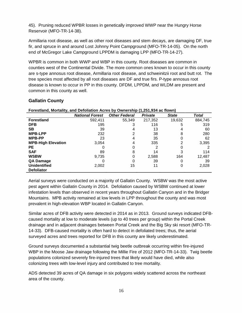
Gallatin County
Forestland, Mortality, and Defoliation Acres by Ownership (1,251,934 ac flown)
National Forest Other Federal Private State Total
Forestland 592,411 55,349 217,352 19,632 884,745 DFB 195 3 116 5 319 SB 39 4 13 4 60 MPB-LPP 232 2 38 8 280 MPB-PP 23 4 35 0 62 MPB-High Elevation 3,054 4 335 2 3,395 PE 0 0 2 0 2 SAF 89 8 14 3 114 WSBW 9,735 0 2,588 164 12,487 QA Damage 0 0 39 0 39 Unidentified Defoliator
2,002 15 11 0 2,028
Aerial surveys were conducted on a majority of Gallatin County. WSBW was the most active
pest agent within Gallatin County in 2014. Defoliation caused by WSBW continued at lower
infestation levels than observed in recent years throughout Gallatin Canyon and in the Bridger
Mountains. MPB activity remained at low levels in LPP throughout the county and was most
prevalent in high-elevation WBP located in Gallatin Canyon.
Similar acres of DFB activity were detected in 2014 as in 2013. Ground surveys indicated DFB-
caused mortality at low to moderate levels (up to 40 trees per group) within the Portal Creek
drainage and in adjacent drainages between Portal Creek and the Big Sky ski resort (MFO-TR-
14-33). DFB-caused mortality is often hard to detect in defoliated trees; thus, the aerial
surveyed acres and trees reported for DFB in this county are likely underestimated.
Ground surveys documented a substantial twig beetle outbreak occurring within fire-injured
WBP in the Moose Jaw drainage following the Millie Fire of 2012 (MFO-TR-14-33). Twig beetle
populations colonized severely fire-injured trees that likely would have died, while also
colonizing trees with low-level injury and contributed to tree mortality.
ADS detected 39 acres of QA damage in six polygons widely scattered across the northeast
area of the county.

17
Significant levels of schweinitzii root and butt rot and decay caused by tomentosus root disease
in DF and ES occur in campgrounds and other portions of the Gallatin NF. Black stain root
disease has been identified from DF, but is considered of minor importance.
LPPDM is a management concern in various areas, especially on flat land with obsidian sand
soils. LPDM is present in the county, and WPBR is common in WBP and LP in this county.
Glacier County
Forestland, Mortality, and Defoliation Acres by Ownership (561,893 ac flown)
National Forest Other Federal Private State Total
Forestland 27,009 205,890 162,649 0 395,548 DFB 12 544 32 0 588 SB 0 94 4 0 98 Larch Needle Cast 0 87 194 0 281 MPB-LPP 0 216 0 0 216 SAF 2 547 20 0 569 WSBW 7 13,102 3,382 0 16,491 QA Damage 0 0 359 1,232 1,591
In 2014, aerial surveys were conducted in the mountainous, western portions of Glacier County.
In this area WSBW activity continued, although the acres with defoliation detected were slightly
reduced relative to 2013. Acres with DFB-caused mortality increased three-fold in 2014 relative
to 2013 and primarily occurred in the northwestern portion of the county. Also of note, pockets
of QA damage and SAF decline were detected near Saint Mary north and southwest of the city,
respectively. The pockets of SAF decline decreased, while QA damage increased relative to
2013 levels.
ADS identified 281 acres of larch needle cast in five polygons spread across the northern half of
the county from about six miles north of East Glacier almost to the Canadian border. In
addition, ADS detected nearly 1,600 acres of QA damage beginning about 12 miles west-
northwest of Browning and extending north to about half way between Babb and the Canadian
border.
WPBR is common in WBP and LP. Armillaria root disease is known to be a significant
pathogen in DF in the western portion of the county on the Blackfeet IR and the Lewis and Clark
NF. LPPDM and WLDM are present in this county.
Golden Valley County
Forestland, Mortality, and Defoliation Acres by Ownership (84,646 ac flown)
National Forest Other Federal Private State Total
Forestland 17,111 5,704 58,463 0 81,278 DFB 2 0 4 0 6 MPB-PP 802 225 1,056 127 2,209 MPB-High Elevation 10 0 0 0 10 WSBW 5,376 854 820 28 7,078
A small area of forested lands in the far northern edge of the county that includes a portion of
the Little and Big Snowy Mountains was surveyed by ADS in 2014 and was similar to the area
flown in 2013. Acres with MPB-caused tree mortality in PP decreased compared to 2013, but

18
were still found scattered throughout the PP type on the south side of the Snowy Mountains.
WSBW-caused defoliation increased 10-fold over 2013 and was found in the Big Snowy
Mountains.
Granite County
Forestland, Mortality, and Defoliation Acres by Ownership (1,057,034 ac flown)
National Forest Other Federal Private State Total
Forestland 589,764 25,819 171,533 30,582 817,700 DFB 650 16 154 7 827 EBS 34 0 8 0 42 MPB-LPP 115,838 2,206 6,561 196 124,801 MPB-PP 197 7 46 6 256 MPB-High Elevation 10,064 6 1,151 0 11,221 SAF 38 0 2 0 40 WSBW 21,224 5,600 5,744 928 33,496
A majority of Granite County was flown in both 2013 and 2014. MPB activity slightly increased
in both LPP and PP, however, the intensity or trees per acre killed increased by four to five-fold
in many areas. Large areas of LPP have been killed in both the Flint Creek and Sapphire
Mountains. Ground surveys confirmed that MPB is still active in and near the Anaconda-Pintler
Wilderness. Barring an unusual weather event, MPB activity will continue to increase in
intensity for at least another year where host trees are available. Host depletion will contribute
to a decline in MPB activity over the next few years, across many areas in the county where
activity has been high for many years.
Number of acres of WSBW-caused defoliation significantly increased in the county and was
detected from ADS and ground surveys. DFB activity increased four-fold in acres affected and
intensity in 2014, while SB remained at low levels.
Common root diseases found in this county include s-type annosus, Armillaria root disease,
schweinitzii root and butt rot, and tomentosus root rot. DF and true firs are most affected by the
first three root diseases and ES, SAF, and DF are most affected by tomentosus root rot. P-type
annosus is known to occur in PP. Schweinitzii root and butt rot is contributing to mortality and
structural tree failure of older DF in old growth areas of the Flint Foothills Project Area (MFO-
TR-14-16).
Elytroderma needle disease occurs in the Barton Springs PP area (MFO-TR-14-18) and is a
significant agent in PP in localized areas.
LPPDM and WLDM are present in this county. While LPPDM is an important agent to address,
as much of Piney Campground is being regenerated due to MPB-caused mortality (MFO-TR-14-
43).

19
Hill County
Forestland, Mortality, and Defoliation Acres by Ownership (68,890 ac flown)
National Forest Other Federal Private State Total
Forestland 0 0 30,788 1,535 32,323 DFB 0 4 26 0 30 MPB-LPP 0 4 348 1 353 MPB-PP 0 0 2 0 2 WSBW 0 0 15 0 15
The area in Hill County that was surveyed contains forested lands within the Rocky Boy’s IR.
MPB activity on the reservation significantly decreased in 2014, primarily in LPP. WSBW
activity also significantly declined across the reservation.
Schweinitzii root and butt rot was found to be impacting DF stands near Bailey Peak,
contributing to blow down in the area (MFO-TR-14-19, MFO-TR-14-40). Armillaria root disease
and tomentosus root rot were also found in this same area (MFO-TR-14-40). Schweinitzii root
and butt rot and low levels of Armillaria root disease can be found in stands near Bailey
Mountain and in the general area of West Fork of Beaver Creek in the southern portion of Rocky
Boy’s IR. Red ray rot is very common in PP on private lands bordering the reservation. LPPDM
is common in many stands. Elytroderma needle disease is impacting LPP in the West Fork
Beaver Creek drainage.
Jefferson County
Forestland, Mortality, and Defoliation Acres by Ownership (840,415 ac flown)
National Forest Other Federal Private State Total
Forestland 423,676 65,261 140,117 12,595 641,649 DFB 36 7 13 0 56 SB 34 0 4 0 38 MPB-LPP 125 3 37 0 165 MPB-PP 31 8 39 4 82 MPB-High Elevation 16 0 0 0 16 PE 18 12 2 0 32 WPB 2 2 0 0 4 SAF 62 2 2 0 66 WSBW 1,034 0 21 0 1,055
Most forested area in Jefferson County was surveyed by ADS in 2014, with slightly more acres
flown in 2014 compared to 2013. Despite a nominal increase of 13% more acres surveyed,
MPB activity decreased across the county, with the greatest decrease detected in high elevation
five-needle pines along the Continental Divide. In PP, a slight increase in both MPB and PE
activity resulted in just over 100 acres of PP mortality. Mortality due to DFB, SB, and SAF
complex was detected but each had less than 70 acres as scattered trees across the county.
Defoliation by WSBW also decreased to approximately one quarter of 2013 levels.
WPBR has been found on LP in this county.

20
Judith Basin County
Forestland, Mortality, and Defoliation Acres by Ownership (494,145 ac flown)
National Forest Other Federal Private State Total
Forestland 274,980 0 21,438 5,875 302,294 DFB 78 2 8 2 90 SB 16 0 0 0 16 MPB-LPP 321 0 8 0 329 MPB-PP 59 0 8 13 80 MPB-High Elevation 419 0 239 0 658 PE 0 0 27 0 27 SAF 22 0 0 0 22 WSBW 18,680 313 917 171 20,081 QA Damage 0 0 16 0 16
A similar number of acres were flown between 2013 and 2014, which included portions of the
Little Belt and Highwood Mountains. Declines in MPB activity (acres and total numbers of trees)
in all host types continued into 2014. Decreases were two to five-fold or larger. Nearly 2/3 of
the just over 1,000 acres of MPB affected acres were high elevation five-needle pine, with most
of the remaining in LPP and approximately 80 acres in PP. Mortality due to DFB increased
slightly, as did SAF mortality, but overall levels remained low. Defoliation from WSBW
increased nearly seven-fold but was still less than half of levels detected in 2012; most was
detected south of Sapphire Village and east of Hughesville.
ADS detected QA damage on 14 acres on the western side of the county and two acres on the
northern end of the county.
Armillaria root disease and tomentosus root rot are significantly impacting ES, DF, and SAF in
Dry Wolf campground (MFO-TR-13-10). WPBR is common in LP. Tomentosus root rot is
known to be significant in some campgrounds. LPPDM is present in this county.
21
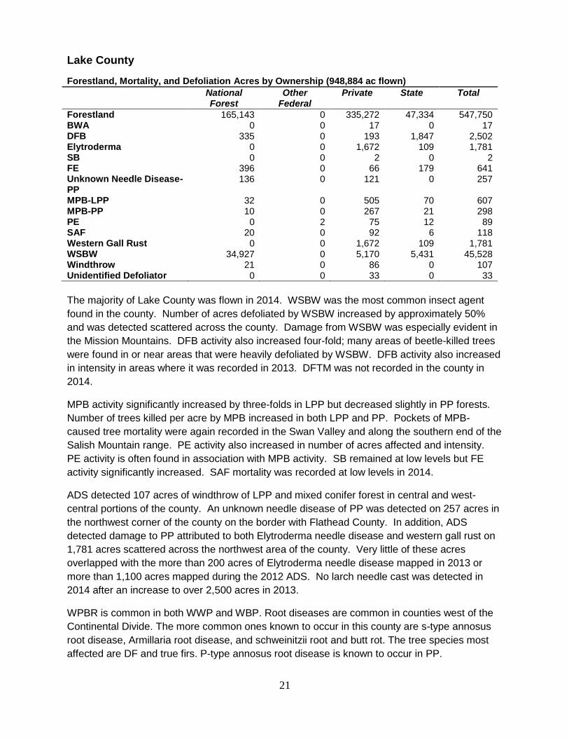
Lake County
Forestland, Mortality, and Defoliation Acres by Ownership (948,884 ac flown)
National Forest
Other Federal
Private State Total
Forestland 165,143 0 335,272 47,334 547,750 BWA 0 0 17 0 17 DFB 335 0 193 1,847 2,502 Elytroderma 0 0 1,672 109 1,781 SB 0 0 2 0 2 FE 396 0 66 179 641 Unknown Needle Disease-PP
136 0 121 0 257
MPB-LPP 32 0 505 70 607 MPB-PP 10 0 267 21 298 PE 0 2 75 12 89 SAF 20 0 92 6 118 Western Gall Rust 0 0 1,672 109 1,781 WSBW 34,927 0 5,170 5,431 45,528 Windthrow 21 0 86 0 107 Unidentified Defoliator 0 0 33 0 33
The majority of Lake County was flown in 2014. WSBW was the most common insect agent
found in the county. Number of acres defoliated by WSBW increased by approximately 50%
and was detected scattered across the county. Damage from WSBW was especially evident in
the Mission Mountains. DFB activity also increased four-fold; many areas of beetle-killed trees
were found in or near areas that were heavily defoliated by WSBW. DFB activity also increased
in intensity in areas where it was recorded in 2013. DFTM was not recorded in the county in
2014.
MPB activity significantly increased by three-folds in LPP but decreased slightly in PP forests.
Number of trees killed per acre by MPB increased in both LPP and PP. Pockets of MPB-
caused tree mortality were again recorded in the Swan Valley and along the southern end of the
Salish Mountain range. PE activity also increased in number of acres affected and intensity.
PE activity is often found in association with MPB activity. SB remained at low levels but FE
activity significantly increased. SAF mortality was recorded at low levels in 2014.
ADS detected 107 acres of windthrow of LPP and mixed conifer forest in central and west-
central portions of the county. An unknown needle disease of PP was detected on 257 acres in
the northwest corner of the county on the border with Flathead County. In addition, ADS
detected damage to PP attributed to both Elytroderma needle disease and western gall rust on
1,781 acres scattered across the northwest area of the county. Very little of these acres
overlapped with the more than 200 acres of Elytroderma needle disease mapped in 2013 or
more than 1,100 acres mapped during the 2012 ADS. No larch needle cast was detected in
2014 after an increase to over 2,500 acres in 2013.
WPBR is common in both WWP and WBP. Root diseases are common in counties west of the
Continental Divide. The more common ones known to occur in this county are s-type annosus
root disease, Armillaria root disease, and schweinitzii root and butt rot. The tree species most
affected are DF and true firs. P-type annosus root disease is known to occur in PP.

22
Elytroderma needle disease is a significant agent in PP in localized areas in this county, as
noted by the ADS. DFDM, LPPDM, and WLDM are also present in this county.
Lewis and Clark County Forestland, Mortality, and Defoliation Acres by Ownership (1,427,562 ac flown)
National Forest Other Federal Private State Total
Forestland 947,135 66,144 337,858 35,384 1,386,522 DFB 330 19 91 80 520 SB 4 0 12 2 18 Larch Needle Cast 8 0 0 79 87 MPB-LPP 344 6 125 0 475 MPB-PP 30 29 137 19 215 MPW-High Elevation 10 0 2 0 12 PE 0 0 2 0 2 SAF 64 0 2 2 68 WPB 0 0 2 0 2 WSBW 59,945 1,131 13,842 1,896 76,814
Area covered by ADS was similar between 2013 and 2014, and covered most all forested area
of the county. MPB-caused tree mortality in LPP, PP, and high elevation five-needle pines
decreased again in 2014. Decreases of three to over 10-fold, by acres and numbers of trees
killed, resulted in little more than 700 acres impacted by MPB. DFB activity changed little from
2013 levels but remains important at over 500 acres concentrated from Marysville to Rogers
Pass, with more polygons scattered across the county. Defoliation by WSBW remains high—
approximately 77,000 acres, compared with around 57,000 in 2013 and 65,000 in 2012—with
concentrations of defoliation occurring north of highway 200 and near the Meagher County
border.
Armillaria root disease is present in the southeastern portion of the county, and schweinitzii root
and butt rot is quite common, causing significant decay in butt logs of larger, older DF. Root
and butt rots are common near Indian Flats Rental Cabin (MFO-TR-14-10). Stem decay and
schweinitzii root and butt rot are present and expected to become a greater concern as trees in
Vigilante Campground grow older (MFO-TR-14-10). WPBR is common in WBP and LP.
LPPDM is common in the county and impacting LPP in developed recreation sites (MFO-TR-14-
09).
Liberty County
A visit to East Butte of the Sweetgrass Hills in 2013 documented WPBR in LP and WBP
(Lockman, unpublished data). LPPDM is also present in this county.
23
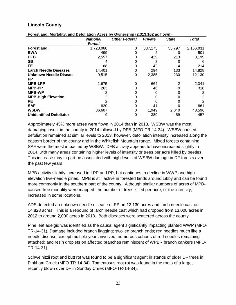
Lincoln County
Forestland, Mortality, and Defoliation Acres by Ownership (2,313,162 ac flown)
National Forest
Other Federal Private State Total
Forestland 1,723,060 0 387,173 55,797 2,166,031 BWA 499 0 2 0 501 DFB 2,557 0 429 213 3,199 SB 4 0 2 0 6 FE 168 0 42 4 214 Larch Needle Diseases 14,401 0 294 133 14,828 Unknown Needle Disease-PP
9,515 0 2,385 230 12,130
MPB-LPP 1,675 0 664 2 2,341 MPB-PP 263 0 46 9 318 MPB-WP 2 0 0 0 2 MPB-High Elevation 2 0 0 0 2 PE 2 0 0 0 2 SAF 820 0 41 0 861 WSBW 36,607 0 1,949 2,040 40,596 Unidentified Defoliator 9 0 389 59 457
Approximately 45% more acres were flown in 2014 than in 2013. WSBW was the most
damaging insect in the county in 2014 followed by DFB (MFO-TR-14-34). WSBW caused-
defoliation remained at similar levels to 2013, however, defoliation intensity increased along the
eastern border of the county and in the Whitefish Mountain range. Mixed forests containing
SAF were the most impacted by WSBW. DFB activity appears to have increased slightly in
2014, with many areas containing higher levels of intensity or trees per acre killed by beetles.
This increase may in part be associated with high levels of WSBW damage in DF forests over
the past few years.
MPB activity slightly increased in LPP and PP, but continues to decline in WWP and high
elevation five-needle pines. MPB is still active in forested lands around Libby and can be found
more commonly in the southern part of the county. Although similar numbers of acres of MPB-
caused tree mortality were mapped, the number of trees killed per acre, or the intensity,
increased in some locations.
ADS detected an unknown needle disease of PP on 12,130 acres and larch needle cast on
14,828 acres. This is a rebound of larch needle cast which had dropped from 13,000 acres in
2012 to around 2,000 acres in 2013. Both diseases were scattered across the county.
Pine leaf adelgid was identified as the causal agent significantly impacting planted WWP (MFO-
TR-14-31). Damage included branch flagging; swollen branch ends; red needles much like a
needle disease, except multiple years involved; numerous cohorts of red needles remaining
attached; and resin droplets on affected branches reminiscent of WPBR branch cankers (MFO-
TR-14-31).
Schweinitzii root and butt rot was found to be a significant agent in stands of older DF trees in
Pinkham Creek (MFO-TR-14-34). Tomentosus root rot was found in the roots of a large,
recently blown over DF in Sunday Creek (MFO-TR-14-34).
24
Armillaria root disease and schweinitzii root and butt rot were found to be impacting stands of
mixed conifer in the Lower Yaak, O’Brien, Sheep (OLY) Project Area (MFO-TR-14-36). Also
present and impacting stand health were WLDM and pini rot (MFO-TR-14-36). Elytroderma
needle disease and Armillaria root disease were found severely impacting older planted PP in
the OLY Project Area, indicating the trees may be from offsite stock (MFO-TR-14-36).
Schweinitzii root and butt rot was found impacting individual trees at the Murphy Lake RS
compound and the Bunchgrass Site on the Kootenai NF, contributing to swollen butts and tree
failure (MFO-TR-14-39). An unidentified root and butt rot was found severely impacting several
large spruce trees at the Murphy Lake RS Compound and The Ant Flat Historical Site,
contributing to tree failure (MFO-TR-14-39). Fruiting bodies of Phellinus pini, causal agent of
pini rot, were identified on DF at the Bunchgrass Site on the Kootenai NF (MFO-TR-14-39).
A site visit to a stand in the Warland Creek drainage (MFO-TR-14-42) showed that schweinitzii
root and butt rot is contributing to mortality of older DF and will increasingly contribute to
structural stem failures along with pini rot if left untreated. WLDM is established in the western
larch within this Warland Creek stand.
Root diseases are common in counties west of the Continental Divide. The more common ones
known to occur in this county are s-type annosus root disease, armillaria root disease,
laminated root disease, and schweinitzii root and butt rot. The tree species most affected are
DF and true firs. P-type annosus root disease is known to occur in PP.
Atropellis cankers are present in many LPP east of Lake Koocanusa, reducing vigor of
individual trees and contributing to stem failure. WPBR is common in both WWP and WBP.
DFDM, LPPDM, and WLDM are present in this county.
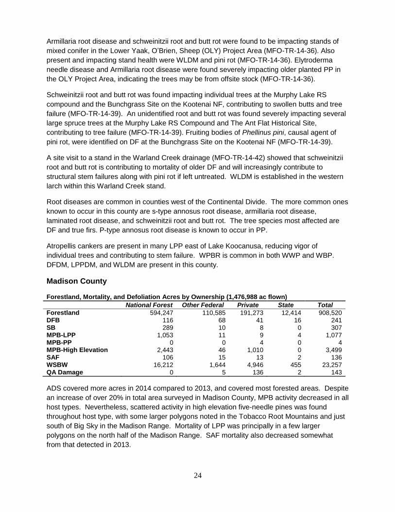
Madison County
Forestland, Mortality, and Defoliation Acres by Ownership (1,476,988 ac flown)
National Forest Other Federal Private State Total
Forestland 594,247 110,585 191,273 12,414 908,520 DFB 116 68 41 16 241 SB 289 10 8 0 307 MPB-LPP 1,053 11 9 4 1,077 MPB-PP 0 0 4 0 4 MPB-High Elevation 2,443 46 1,010 0 3,499 SAF 106 15 13 2 136 WSBW 16,212 1,644 4,946 455 23,257 QA Damage 0 5 136 2 143
ADS covered more acres in 2014 compared to 2013, and covered most forested areas. Despite
an increase of over 20% in total area surveyed in Madison County, MPB activity decreased in all
host types. Nevertheless, scattered activity in high elevation five-needle pines was found
throughout host type, with some larger polygons noted in the Tobacco Root Mountains and just
south of Big Sky in the Madison Range. Mortality of LPP was principally in a few larger
polygons on the north half of the Madison Range. SAF mortality also decreased somewhat
from that detected in 2013.

25
Although numbers are still low, some increase in activity was detected in both DFB and SB to
over 300 trees killed by each, and approximately 250 and 300 acres affected, respectively.
WSBW-caused defoliation also increased back up to levels detected in 2012; defoliation was
noted in all mountain ranges with most detected in the Gravelly and Ruby Mountains.
ADS detected QA damage on 143 acres in west-central area of the county. WPBR is common
in WBP and LP. LPDM is present in this county. Schweinitzii root and butt rot is locally
damaging to old DF stands.
Meagher County
Forestland, Mortality, and Defoliation Acres by Ownership (1,220,287 ac flown)
National Forest Other Federal Private State Total
Forestland 441,444 6,093 205,985 12,196 665,719 DFB 179 0 143 7 329 SB 32 0 2 0 34 MPB-LPP 193 0 21 0 214 MPB-PP 50 0 68 6 124 MPB-High Elevation 28 0 2 0 30 SAF 62 2 2 0 66 WSBW 9,313 242 12,069 280 21,904 QA Damage 20 0 204 6 230 Unidentified Defoliator 25 0 0 0 25
Most of the forested areas of Meagher County were surveyed in 2014, similar to what was
surveyed in 2013. Acres with WSBW defoliation within the county increased three-fold from the
prior year. Defoliation occurred primarily in the northwestern portion of the county, with lesser
amounts in the southeastern and eastern areas. Limited amounts of MPB-caused mortality in
LPP and DFB-caused mortality in DF were detected throughout the county as well.
QA decline was noted as mostly 2 to 30 acre polygons in the Castle Mountains (including one,
100-acre polygon) and Little Belt Mountains for a total of over 230 acres in the county.
A foliar scorch within the Wet Park LPP plantation appears to be related to a one-time
environmental event, while comandra blister rust is an ongoing problem which is causing
extensive damage within this performance test plantation (MFO-TR-14-11).
Jumping Creek Campground remains closed due to tree failures associated with tomentosus
root disease and schweinitzii root and butt rot (MFO-TR-14-15).
WPBR is common in WBP and LP. LPPDM is present and damaging LPP in this county, as are
comandra blister rust and atropellis canker.

26
Mineral County
Forestland, Mortality, and Defoliation Acres by Ownership (783,036 ac flown)
National Forest Other Federal Private State Total
Forestland 647,176 0 48,570 30,406 716,152 BWA 14 0 0 0 14 DFB 211 0 17 5 233 SB 42 0 0 0 42 FE 20 0 2 0 22 MPB-LPP 3,914 0 64 1 3,979 MPB-PP 118 0 22 4 144 SAF 220 0 2 0 222 WSBW 848 0 0 0 848
A similar area was surveyed by ADS between 2013 and 2014. MPB increased in number of
acres affected and intensity for LPP, especially along the Montana-Idaho border. Scattered
pockets of trees killed by MPB can be found throughout the county. Pockets of 20-30 trees can
be found between Tarkio and the southwest county border. MPB activity decreased in PP
forests.
WSBW activity decreased by about 50% in the county and was mostly found in the southern
portion. SB and FE were recorded at similar low levels between 2013 and 2014. A few acres
with BWA damage were recorded via ADS for the second year. Several hundred acres of SAF
mortality were recorded in 2014.
No larch needle cast was detected by ADS in 2014, down from nearly 1,000 acres detected in
2013.
WPBR is common in WWP and WBP. The more common root diseases known to occur in this
county are s-type annosus root disease, Armillaria root disease, laminated root disease, and
schweinitzii root and butt rot. The species most affected are DF and true firs. Tomentosus root
disease has been found impacting western larch trees heavily infected with larch dwarf
mistletoe. P-type annosus root disease is known to occur in PP. DFDM, LPPDM, and WLDM
are also present in this county.

27
Missoula County
Forestland, Mortality, and Defoliation Acres by Ownership (1,525,028 ac flown)
National Forest Other Federal Private State Total
Forestland 680,716 19,018 555,568 158,257 1,413,561 BWA 40 0 0 0 40 DFB 1,933 6 427 60 2,426 SB 14 0 8 2 24 FE 2 0 4 0 6 MPB-LPP 15,086 2 1,958 45 17,091 MPB-PP 408 4 429 136 977 MPB-High Elevation 4 0 0 0 4 PE 587 0 32 0 619 SAF 85 0 21 18 124 WPB 0 0 2 0 2 WSBW 35,302 2,433 29,939 7,801 75,475 Unidentified Defoliator 171 0 48 20 239
Approximately the same number of acres was flown in 2013 and 2014. WSBW was the most
commonly found insect in the county in 2014. Defoliation from WSBW could be found across
most of the eastern portion of the county, but also continues to be found at high levels
especially along the chain of lakes north of Seeley Lake and in the Rock Creek drainage.
Number of acres recorded defoliated by WSBW increased by about 30%. Ground surveys
confirmed that in some areas north of Seeley Lake WSBW caused significant defoliation and
damage to overstory fir and outright killing understory trees.
Acres affected by MPB activity increased in LPP forests, but intensity decreased. In 2014,
areas with significant levels of MPB activity were found along the west-side of the county
between Lolo Hot Springs and Alberton; south of Lolo; and along the Blackfoot river from
Bonner east to the county line. Acres affected by PE increased by about five-fold. SB and
WPB remained at low and scattered levels throughout the county. BWA was recorded via ADS
in the county for the first time in 2014. Low levels of SAF mortality were recorded in 2014.
No larch needle cast was detected by ADS in 2014, down from over 1,500 acres detected in
2013.
Root diseases are common in counties west of the Continental Divide. The more common ones
known to occur in this county are s-type annosus root disease, Armillaria root disease,
laminated root disease, and schweinitzii root and butt rot. The tree species most affected are
DF and true firs. P-type annosus root disease is known to occur in PP.
WPBR is common in both WWP and WBP. Elytroderma needle disease is a significant agent in
PP in localized areas in this county. Comandra blister rust is common in PP in this county.
DFDM, LPPDM, and WLDM are present in this county.
28
Musselshell County
Forestland, Mortality, and Defoliation Acres by Ownership (20,856 ac flown)
National Forest Other Federal Private State Total
Forestland 0 21,620 285,429 9,837 316,887 MPB-PP 0 0 70 0 70
Aerial surveys were limited to a small area in the northwestern portion of Musselshell County.
In this location, MPB activity caused low levels of LPP mortality between Mineral and Willow
Creeks.
Park County
Forestland, Mortality, and Defoliation Acres by Ownership (945,024 ac flown)
National Forest Other Federal Private State Total
Forestland 736,273 70,245 192,643 23,514 1,022,675 DFB 112 2 192 2 308 SB 8 0 10 0 18 MPB-LPP 50 60 103 0 213 MPB-PP 0 0 14 2 16 MPB-High Elevation 844 32 392 0 1,268 PE 2 0 0 0 2 SAF 63 6 11 0 80 WSBW 8,545 211 8,377 270 17,403 QA Damage 3 0 13 0 16
Within Park County, similar areas were aerially surveyed in 2014 as in 2013, with most forested
areas outside designated wilderness surveyed. WSBW-caused defoliation continued within DF
in the county, although fewer acres were detected in 2014 relative to 2013. Similarly, MPB
activity declined and was active at low levels within isolated locations in WBP and, to a lesser
extent, LPP host. Ground surveys indicated MPB activity near Gardiner, along Bear Creek
drainage that was substantial in recent years, generally subsided in 2014 (MFO-TR-14-29).
ADS detected 15 acres of QA damage in three polygons spread across the northern half of the
county.
WPBR is common in WBP and LP stands. Tomentosus root disease is known to be significant
in some campgrounds, and LPPDM is present in the county. Tomentosus root rot and
schweinitzii root and butt rot continue to contribute to the failure of ES in and around Snowbank
Campground (MFO-TR-14-29).
Phillips County
Forestland, Mortality, and Defoliation Acres by Ownership (118,493 ac flown)
National Forest Other Federal Private State Total
Forestland 0 93,686 33,282 3,025 129,994 DFB 0 14 8 2 24 MPB-LPP 0 2 0 0 2 MPB-PP 0 40 31 0 71 Flood Damage 0 0 2 0 2

29
The western forested portions of Phillips County located on the Fort Belknap IR were surveyed
in 2014. Defoliation from WSBW was not recorded on the reservation. MPB activity remained
at similar and low levels in LPP and declined in PP forests.
ADS detected approximately eight trees killed by flooding in the southwest corner of the county.
Western gall rust and comandra blister rust are common in PP on the Fort Belknap IR causing
stem deformities, branch mortality, top kill, and occasional whole tree mortality. In 2014,
comandra blister rust, western gall rust, and isolated pockets of Dothistroma needle blight were
found within several PP stands on the Fort Belknap IR, just east of Zortman (MFO-TR-14-14).
Armillaria root disease can be found on the Fort Belknap IR, in the Mission Canyon area, with
large pockets developing in DF and QA. LPPDM is present in the county.
Pondera County
Forestland, Mortality, and Defoliation Acres by Ownership (135,642 ac flown)
National Forest Other Federal Private State Total
Forestland 120,956 0 11,589 0 132,545 DFB 28 0 0 2 30 SB 37 0 0 0 37 MPB-LPP 10 0 0 0 10 SAF 122 0 0 0 122 WSBW 234 0 0 0 234 QA Damage 0 0 35 8 43
The forested western portion of the county was flown with 1/4 fewer acres surveyed than in
2013. Overall, insect activity continued to decrease with only a few, scattered polygons of MPB
in LPP, DFB, SB, and SAF mortality noted. WSBW defoliation decreased in 2014 and was
found on a small number of acres in a few, scattered larger polygons.
ADS detected 44 acres of QA damage in the southwest corner of the county. WPBR is
common in WBP and LP in this county.
Powder River County
Forestland, Mortality, and Defoliation Acres by Ownership (359,154 ac flown)
National Forest Other Federal Private State Total
Forestland 261,469 64,537 160,913 10,525 497,445 PE 112 0 12 2 126
In 2014, aerial surveys were conducted in the west-central portion of Powder River County
primarily in the forested areas within the Custer NF. Numerous scattered pockets of Ips spp.-
caused mortality (ranging from 30-150 trees per group) were located throughout the eastern
portion of the county within Ashland Ranger District of the Custer NF. Field assessments found
a complex of Ips species causing the tree mortality. Ips calligraphus (six-spined ips) appeared
to have caused the most mortality, while lesser amounts of PE and Ips emarginatus (emarginate
ips) attacked pines as well (MFO-TR-14-21). This outbreak was triggered by severe drought
conditions during the spring of 2012 and in early part of 2013. While geographically widespread,
mortality was isolated to areas with dense stand conditions and marginal, dry growing
environments.
30
Powell County
Forestland, Mortality, and Defoliation Acres by Ownership (1,211,992 ac flown)
National Forest Other Federal Private State Total
Forestland 645,154 71,518 238,550 38,356 993,578 DFB 99 22 117 18 256 SB 8 0 4 2 14 MPB-LPP 1,359 16 29 6 1,410 MPB-PP 136 5 116 14 271 MPB-High Elevation 2,245 0 0 0 2,245 SAF 168 10 6 2 186 WPB 0 0 2 0 2 WSBW 34,017 21,342 18,337 2,406 76,102 QA Damage 0 0 16 0 16 Avalanche 37 0 0 0 37 Unidentified Defoliator 0 0 2 0 2
In 2014, ADS surveyed slightly more acres than in 2013, which covered most forested areas.
WSBW defoliation was found throughout most of the county in 2014. Twenty-five percent more
acres were defoliated by WSBW. Significant defoliation from WSBW was recorded along the
eastern border of the county and in the Swan Mountain Range. DFB activity increased slightly
in number of acres affected, with intensity increased in the Swan Mountains. Some of the DFB
activity was in or near areas that have been defoliated by WSBW over several years.
MPB activity remained at similar levels in LPP forests but increased in intensity; approximately
five TPA killed on average. Most of the activity was recorded in the Flint Creek range and along
the Continental Divide. MPB activity declined in PP forests, while the intensity remained the
same at approximately four TPA. SB and WPB remained at low levels in 2014. Low levels of
SAF mortality were recorded in 2014.
ADS detected 37 acres of trees damaged by a landslide in the southeast corner of the county
and 16 acres of QA damage scattered across the southern half of the county.
Tomentosus root rot and schweinitzii root and butt rot were causing minimal impacts on a stand
in the Cottonwood drainage, east of Seeley Lake (MFO-TR-14-07). Fruiting bodies of
Fomitopsis officianalis were also found near this stand (MFO-TR-14-07).
The small patch of overstory LPP remained on the south end of Kading Campground after
extensive MPB mortality in trees infested with dwarf mistletoe (MFO-TR-14-10). In addition,
most of the smaller LPP in the campground were infected with lodgepole pine needle cast.

31
Ravalli County
Forestland, Mortality, and Defoliation Acres by Ownership (1,292,795 ac flown)
National Forest Other Federal Private State Total
Forestland 1,057,620 0 105,505 35,514 1,198,942 DFB 134 0 74 5 213 SB 90 0 8 2 100 MPB-LPP 80,386 0 951 27 81,364 MPB-PP 17,884 0 2,676 2,168 22,728 MPB-High Elevation 2,076 0 0 0 2,076 PE 6 0 0 0 6 SAF 147 0 3 0 150 WPB 0 0 4 0 4 WSBW 6,170 0 121 655 6,946 Dwarf Mistletoe 2 0 75 0 77
MPB was the most prevalent insect found throughout the county again. Number of acres
affected by MPB decreased by approximately 30% for LPP; intensity decreased from nine to
three TPA killed by beetles.
MPB activity remained at similar levels in PP forests but decreased in intensity. MPB activity
decreased by approximately 50% in high-elevation WBP; the intensity also decreased
significantly. The majority of MPB activity was mapped south of Hamilton where activity has
been increasing over the past few years. MPB activity is expected to continue but overall
mortality may decline over the next few years, especially in areas where suitable host trees
remain (MFO-TR-14-02; MFO-TR-14-44).
DFB activity decreased in acres affected and intensity. WPB and PE remained at low and
scattered levels throughout the county. In 2014, ADS recorded about 100 acres affected by
SB; none were recorded in 2013. Low levels of SAF mortality were recorded in 2014.
Number of acres mapped that were defoliated by WSBW increased by approximately 30%
between 2013 and 2014 (MFO-TR-14-13). Most of the WSBW activity was mapped in the
northern part of the county along the Continental Divide.
Root diseases are common in counties west of the Continental Divide. The more common ones
known to occur in this county are: s-type annosus root disease, Armillaria root disease,
laminated root disease, and schweinitzii root and butt rot. The tree species most affected are
DF and true firs. P-type annosus root disease is known to occur in PP in the foothills of both the
Bitterroot and Sapphire Mountains. In Black Bear Campground, schweinitzii root and butt rot
and tomentosus root rot are problems in DF and ES, respectively (MFO-TR-14-35). Armillaria
root disease and stem decays are problems near the Canyon Creek Trailhead (MFO-TR-14-35).
WPBR is common in WBP. Notable levels of comandra blister rust cause top kill in PP in the
foothills of the Bitterroot Mountains.
Elytroderma needle disease is a significant agent in PP in localized areas in this county; high
levels continue to exist in the area around Lake Como. DFDM, LPPDM, and WLDM are present
in this county, with DFDM being quite common in the lower elevations of the Sapphire and
Bitterroot Mountains.

32
Rosebud County
Forestland, Mortality, and Defoliation Acres by Ownership (379,182 ac flown)
National Forest Other Federal Private State Total
Forestland 70,060 31,019 279,489 36,862 417,430 PE 87 0 173 0 260
Aerial surveys were limited to the southern portion of Rosebud County in 2014. Numerous
scattered pockets of Ips spp.-caused mortality (ranging from 30-150 trees per group) were
located throughout the eastern portion of the county within the Northern Cheyenne IR and
Ashland Ranger District of the Custer NF. Field assessments found a complex of Ips species
causing the tree mortality. Ips calligraphus (six-spined ips) appeared to have caused the most
mortality, while lesser amounts of PE and Ips emarginatus (emarginate ips) attacked pines as
well (MFO-TR-14-21). This outbreak was triggered by severe drought conditions during the
spring of 2012 and in early part of 2013. While geographically widespread, mortality was
isolated to areas with dense stand conditions and marginal, dry growing environments.
Sanders County
Forestland, Mortality, and Defoliation Acres by Ownership (1,763,252 ac flown)
National Forest
Other Federal Private State Total
Forestland 906,765 5,888 464,325 62,362 1,439,339 BWA 106 0 0 0 106 DFB 2,511 2 463 172 3,148 SB 41 0 19 8 68 FE 33 0 6 0 39 Larch Needle Diseases 221 0 34 0 255 Unknown Needle Disease-PP
660 0 2 0 662
MPB-LPP 3,803 2 1,102 157 5,064 MPB-PP 106 12 310 16 444 MPB-High Elevation 2 0 0 0 2 PE 2 0 43 0 45 SAF 202 0 38 2 242 WPB 2 0 0 0 2 WSBW 1,806 0 110 0 1,916 Unidentified Defoliator 43 0 0 0 43
MPB can be found killing trees in almost all parts of the county. Acres of MPB-killed LPP
increased by approximately 25% between 2013 and 2014 and the intensity, or trees per acre
killed, also significantly increased in some areas. Number of acres of PP killed by MPB
decreased by approximately 50% but the intensity significantly increased. MPB-caused
mortality in high elevation five-needle pine significantly decreased in acres killed and intensity.
Defoliation from WSBW significantly decreased in 2014 and is limited to the central and
northwestern part of the county. DFB-caused tree mortality increased by approximately 50% in
acres killed and intensity and is widely distributed across the county. Other bark beetles
remained at low and scattered levels throughout the county.
BWA was recorded for the second consecutive year via ADS; number of acres detected
increased by four-fold. Several hundred acres of SAF mortality were recorded.

33
ADS detected an unknown foliar disease on 661 acres of PP in the northwest area of the
county. Larch needle cast was detected by ADS on 242 acres about 10 miles northwest of
Plains and 13 acres about three miles northwest of Fishtrap Lake. This continues the decline in
larch needle cast from over 11,000 acres in 2012 to about 1,300 in 2013, to a further 80%
reduction in 2014.
Rhabdocline needle cast continues to be a problem in the Plains Tree Improvement Area, but
with fungicide treatment the severity has been lessened significantly from 2013 (MFO-TR-14-
12).
Root diseases are common in counties west of the Continental Divide. The more common ones
known to occur in this county are s-type annosus root disease, Armillaria root disease,
laminated root disease, and schweinitzii root and butt rot. The tree species most affected are
DF and true firs. P-type annosus root disease is known to occur in PP, while tomentosus root
disease is known to occur in localized areas in the county, affecting DF and ES. Armillaria root
disease, schweinitzii root and butt rot, and DFDM are limiting health and longevity of DF in
portions of the Little Eddy Project (MFO-TR-14-08).
WPBR is common in both WWP and WBP. DFDM, LPPDM, and WLDM are present and
common in this county.
Silver Bow County
Forestland, Mortality, and Defoliation Acres by Ownership (447,785 ac flown)
National Forest Other Federal Private State Total
Forestland 141,487 25,719 74,189 11,669 253,065 DFB 70 16 6 10 102 SB 10 0 0 0 10 MPB-LPP 219 8 4 6 237 MPB-PP 0 2 4 0 6 MPB-High Elevation 886 0 0 0 886 SAF 6 0 0 0 6 WSBW 2,258 0 20 0 2,278
Nearly the entire county was surveyed in both 2013 and 2014. Striking was the continued sharp
decline in MPB activity in LPP (one third of 2013 levels to under 250 acres), with an equally
impressive increase in high elevation five-needle pine mortality (five-fold increase over 2013
levels to nearly 900 acres). Whereas LPP mortality was scattered throughout both the Highland
and Fleecer Mountains, high elevation five-needle pine mortality was concentrated in a couple,
larger polygons along the Deerlodge County border. Defoliation due to WSBW was detected at
levels roughly equal to damage detected in 2012, an increase from a low in 2013. Also
scattered through host type, most acres were concentrated on less than half a dozen polygons
in the southeast Fleecers and northeast Highlands.
Several LPP stands within the Boulder-Lowlands Farm Bill project area are infested with dwarf
mistletoe (MFO-TR-14-17).
WPBR is common in WBP and LP.

34
Stillwater County
Forestland, Mortality, and Defoliation Acres by Ownership (118,657 ac flown)
National Forest Other Federal Private State Total
Forestland 116,026 5,336 130,074 5,336 256,773 DFB 24 0 8 0 32 SB 10 0 0 0 10 MPB-LPP 73 0 44 0 116 MPB-PP 3 0 13 0 16 MPB-High Elevation 14 0 2 0 16 SAF 6 0 0 0 6 WSBW 389 0 332 0 721 QA Damage 9 0 16 0 25
In Stillwater County, forested areas south of Interstate 90, excluding designated wilderness,
were aerially surveyed in 2014. In this area, WSBW defoliation of DF increased three-fold
relative to 2013. MPB activity within LP was also detected at low levels in sporadic groups of
mortality.
ADS detected 26 acres of QA damage about 1.5 miles east of Limestone.
Sweet Grass County
Forestland, Mortality, and Defoliation Acres by Ownership (436,610 ac flown)
National Forest Other Federal Private State Total
Forestland 240,872 9,647 147,138 3,361 401,288 DFB 208 2 19 0 229 SB 30 0 2 0 32 MPB-LPP 782 0 63 0 845 MPB-PP 8 0 10 0 18 MPB-High Elevation 2,787 0 16 0 2,803 SAF 28 0 4 0 32 WSBW 3,244 25 2,473 0 5,742 Windthrow 4 0 26 0 30
Similar areas—forested areas south of Interstate 90 outside of designated wilderness and
forested areas in the Crazy Mountains that reside in Sweet Grass County—were aerially
surveyed in the northwestern and southern portions of Sweet Grass County in 2013 and 2014.
MPB-caused mortality increased two-fold in 2014, relative to 2013. MPB caused mortality in
WBP and lesser amounts of LPP within the southern portion of the county. WSBW populations
continued to cause DF defoliation within the northwestern portion of the county within the Crazy
Mountains, at levels similar to those observed in 2013.
ADS detected 30 acres of LPP windthrow about 17 miles northwest of Big Timber. WPBR has
been found in WBP and LP in this county. Tomentosus root rot, schweinitzii root and butt rot,
and stem decays affect overmature conifers in this county.

35
Teton County
Forestland, Mortality, and Defoliation Acres by Ownership (190,630 ac flown)
National Forest Other Federal Private State Total
Forestland 188,000 24,247 18,928 7,789 238,965 DFB 64 6 4 0 74 SB 36 6 0 0 42 MPB-LPP 148 0 5 0 153 MPB-PP 0 0 4 2 6 MPB-High Elevation 2 0 0 15 17 SAF 56 2 0 2 60 WSBW 10 115 85 6 216 QA Damage 0 0 119 42 161 Avalanche 16 0 0 0 16
Much of the same area along the Rocky Mountain Front was flown in both 2013 and 2014,
although 20% fewer acres were surveyed in total. Overall, insect activity continued to decrease
with only a few, scattered polygons of MPB (in LPP, PP, and high elevation five-needle pine),
DFB, SB, and SAF mortality noted. An increase in WSBW defoliation to over 200 acres was
also detected but appears tied to a few, scattered large polygons at the southeast end of the
Front Range.
ADS detected 16 acres of trees damaged by an avalanche about 26 miles west of Choteau and
161 acres of QA damage in the northwest corner of the county.
WPBR is common in WBP and LP in this county. While Armillaria root disease kills conifers and
QA, and Tomentosus root disease and schweinitzii root and butt rot are causing damage in
overmature conifers in parts of this county.
Toole County
WPBR occurs in WBP and LP in this county. A visit to West Butte of the Sweetgrass Hills in
2013 documented WPBR in LP.

36
Wheatland County
Forestland, Mortality, and Defoliation Acres by Ownership (197,431 ac flown)
National Forest Other Federal Private State Total
Forestland 49,411 0 27,794 6,176 83,381 DFB 28 0 10 0 38 SB 4 0 0 0 4 MPB-PP 159 0 68 2 229 MPB-High Elevation 12 0 0 0 12 SAF 2 0 0 0 2 WSBW 8,193 96 783 0 9,072
Portions of the southeast Little Belt Mountains and northeast corner of the Crazy Mountains
were surveyed in 2013 and 2014; over 1/3 more acres were covered in 2014. Despite the
increased coverage, most insect damage agents showed a continued decrease in activity.
Mortality of PP due to MPB and PE were both down, with no PE detected and MPB down over
10-fold to less than 250 total acres affected. Defoliation due to WSBW, however, was up six-
fold to over 9,000 acres, mostly across the Little Belts.
WPBR occurs in LP in this county.

37
Table 1. Forest Mortality, Defoliation, and Other Damage on Montana National
Forests, National Parks, and Tribal Lands, 2014
BEAVERHEAD NF
BITTERROOT NF
DILLON RD Acres Trees
DARBY RD Acres Trees
Douglas-fir Beetle 80 101
Douglas-fir Beetle 35 41
Spruce beetle 26 53 Spruce beetle 26 29
Mountain Pine Beetle (PP) 4 6 Pine Engraver Beetle 2 40
Mountain Pine Beetle (LPP) 30,671 293,088 Mountain Pine Beetle (PP) 10,738 12,468
Subalpine Fir Mortality 50 71
Mountain Pine Beetle (LPP) 23,632 62,114
MPB (High Elev 5-needle Pines) 6,600 17,841
Subalpine Fir Mortality 35 26
Western Spruce Budworm 1,694 0
MPB (High Elev 5-needle Pines) 546 412
Windthrow 92 0
Western Spruce Budworm 981 0
MADISON RD
STEVENSVILLE RD
Douglas-fir Beetle 60 95 Douglas-fir Beetle 17 38
Spruce beetle 102 178 Spruce beetle 12 19
Mountain Pine Beetle (LPP) 10 28
Mountain Pine Beetle (PP) 1,729 2,143
Subalpine Fir Mortality 50 165
Mountain Pine Beetle (LPP) 22,843 84,624
MPB (High Elev 5-needle Pines) 388 363
Subalpine Fir Mortality 57 20
Western Spruce Budworm 11,753 0
MPB (High Elev 5-needle Pines) 14 31
QA Damage 14 0
Western Spruce Budworm 2,956 0
SHERIDAN RD
SULA RD
Douglas-fir Beetle 52 66
Douglas-fir Beetle 19 54
Spruce beetle 68 78
Spruce beetle 12 18
Mountain Pine Beetle (LPP) 20 107
Mountain Pine Beetle (PP) 4,514 9,254
Subalpine Fir Mortality 56 190
Mountain Pine Beetle (LPP) 26,111 45,719
MPB (High Elev 5-needle Pines) 826 2,854
Subalpine Fir Mortality 6 3
Western Spruce Budworm 5,288 0
MPB (High Elev 5-needle Pines) 1,187 1,281
WISDOM RD
Western Spruce Budworm 467 0
Douglas-fir Beetle 12 24
WEST FORK RD
Spruce beetle 12 22
Douglas-fir Beetle 62 66
Mountain Pine Beetle (PP) 37 725
Spruce beetle 40 33
Mountain Pine Beetle (LPP) 195,110 2,612,477
Mountain Pine Beetle (PP) 4 35
Subalpine Fir Mortality 4 7
Mountain Pine Beetle (LPP) 756 1,562
MPB (High Elev 5-needle Pines) 8,094 28,677
Western Pine Beetle 8,096 12,675
Western Spruce Budworm 1,320 0
Subalpine Fir Mortality 50 60
WISE RIVER RD
MPB (High Elev 5-needle Pines) 330 320
Douglas-fir Beetle 835 3,970 Western Spruce Budworm 1,766 0
Spruce beetle 26 35
CUSTER NF
Mountain Pine Beetle (PP) 1 3
ASHLAND RD
Mountain Pine Beetle (LPP) 21,301 106,218
Pine Engraver Beetle (PP) 199 373
Subalpine Fir Mortality 16 83
BEARTOOTH RD
MPB (High Elev 5-needle Pines) 5,580 15,653
Douglas-fir Beetle 250 402

38
Acres Trees
Acres Trees
Spruce beetle 30 58
Western Spruce Budworm 8,989 0
Mountain Pine Beetle (PP) 26 36
FLATHEAD NF
Mountain Pine Beetle (LPP) 774 1,495
GLACIER VIEW RD
Subalpine Fir Mortality 234 457
Douglas-fir Beetle 20 31
MPB (High Elev 5-needle Pines) 2,964 7,832
Mountain Pine Beetle (PP) 2 2
Western Spruce Budworm 696 0
Mountain Pine Beetle (LPP) 6 15
QA Damage 9 0
Fir Engraver Beetle 12 60
SIOUX RD
Subalpine Fir Mortality 299 743
Pine Engraver Beetle (PP) 47 39
MPB (High Elev 5-needle Pines) 2 2
DEERLODGE NF
Balsam Woolly Adelgid 2 0
BUTTE RD
Western Spruce Budworm 50,582 0
Douglas-fir Beetle 46 172
Larch Needle Cast 92 0
Mountain Pine Beetle (LPP) 126 436
HUNGRY HORSE RD
Subalpine Fir Mortality 10 24
Douglas-fir Beetle 184 642
MPB (High Elev 5-needle Pines) 162 912
Mountain Pine Beetle (PP) 1 1
Western Spruce Budworm 2,446 0
Mountain Pine Beetle (LPP) 141 994
DEER LODGE RD
Fir Engraver Beetle 33 107
Douglas-fir Beetle 60 188
Subalpine Fir Mortality 48 149
Spruce beetle 6 7
Western Spruce Budworm 68,988 0
Mountain Pine Beetle (PP) 15 20
Flooding 2 5
Mountain Pine Beetle (LPP) 4,144 20,215
QA Damage 23 0
Subalpine Fir Mortality 24 51
SPOTTED BEAR RD
MPB (High Elev 5-needle Pines) 8,048 37,323
Douglas-fir Beetle 30 75
Western Spruce Budworm 340 0
Mountain Pine Beetle (LPP) 742 6,547
Avalanche 11 0
Fir Engraver Beetle 31 45
JEFFERSON RD
Subalpine Fir Mortality 9 21
Douglas-fir Beetle 20 30
Western Spruce Budworm 57,544 0
Spruce beetle 86 48
SWAN LAKE RD
Pine Engraver Beetle (PP) 18 105
Douglas-fir Beetle 817 3,145
Mountain Pine Beetle (PP) 12 15
Mountain Pine Beetle (PP) 41 93
Mountain Pine Beetle (LPP) 124 399
Mountain Pine Beetle (LPP) 224 1,924
Subalpine Fir Mortality 42 82
Fir Engraver Beetle 408 1,020
MPB (High Elev 5-needle Pines) 66 226
Subalpine Fir Mortality 40 138
Western Spruce Budworm 1,814 0
MPB (High Elev 5-needle Pines) 2 5
PHILIPSBURG RD
Western Spruce Budworm 51,163 0
Douglas-fir Beetle 523 2,331
Unknown Needle Disease (PP) 304 0
Spruce beetle 22 24
Windthrow 21 0
Mountain Pine Beetle (PP) 29 95
TALLY LAKE RD
Mountain Pine Beetle (LPP) 96,242 415,857
Douglas-fir Beetle 183 690
Subalpine Fir Mortality 22 53 Mountain Pine Beetle (PP) 3 5
MPB (High Elev 5-needle Pines) 4,618 25,520 Mountain Pine Beetle (LPP) 6 15

39
Acres Trees
Acres Trees
Fir Engraver Beetle 4 11
LIVINGSTON RD
Subalpine Fir Mortality 21 66
Douglas-fir Beetle 89 125
Western Spruce Budworm 47,866 0
Spruce beetle 9 6
Unknown Needle Disease (PP) 100 0
Mountain Pine Beetle (LPP) 52 133
Larch Needle Cast 1 0
Subalpine Fir Mortality 28 50
GALLATIN NF MPB (High Elev 5-needle Pines) 1,338 1,302
BIG TIMBER RD
Western Spruce Budworm 2,980 0
Douglas-fir Beetle 203 149
QA Damage 3 0
Spruce beetle 28 71
HELENA NF
Mountain Pine Beetle (PP) 8 4
HELENA RD
Mountain Pine Beetle (LPP) 650 898
Douglas-fir Beetle 133 105
Subalpine Fir Mortality 30 66
Spruce beetle 22 15
MPB (High Elev 5-needle Pines) 2,001 1,233
Mountain Pine Beetle (PP) 41 22
Western Spruce Budworm 2,934 0
Mountain Pine Beetle (LPP) 92 351
Windthrow 4 0
Western Pine Beetle 2 1
BOZEMAN RD
Subalpine Fir Mortality 40 25
Douglas-fir Beetle 179 203
MPB (High Elev 5-needle Pines) 15 27
Spruce beetle 98 61
Western Spruce Budworm 22,082 0
Mountain Pine Beetle (PP) 23 14
Avalanche 26 0
Mountain Pine Beetle (LPP) 1,231 2,634
LINCOLN RD
Subalpine Fir Mortality 34 30
Douglas-fir Beetle 210 400
MPB (High Elev 5-needle Pines) 2,953 2,241
Spruce beetle 2 1
Western Spruce Budworm 6,116 0
Mountain Pine Beetle (PP) 12 6
GARDINER RD
Mountain Pine Beetle (LPP) 14 80
Douglas-fir Beetle 10 15
Subalpine Fir Mortality 22 23
Spruce beetle 6 5
Western Spruce Budworm 42,295 0
Mountain Pine Beetle (LPP) 2 5
TOWNSEND RD
Subalpine Fir Mortality 21 46
Douglas-fir Beetle 463 583
MPB (High Elev 5-needle Pines) 659 757
Spruce beetle 14 8
Western Spruce Budworm 3,894 0
Mountain Pine Beetle (PP) 16 11
HEBGEN LAKE RD
Mountain Pine Beetle (LPP) 18 82
Douglas-fir Beetle 22 23
Western Pine Beetle 2 1
Spruce beetle 8 5
Subalpine Fir Mortality 30 54
Mountain Pine Beetle (LPP) 23 62
MPB (High Elev 5-needle Pines) 11 33
Subalpine Fir Mortality 68 131
Western Spruce Budworm 15,730 0
MPB (High Elev 5-needle Pines) 120 178
QA Damage 2 0
Western Spruce Budworm 6,283 0
KOOTENAI NF
Unidentified Defoliator 2,001 0
CABINET RD
Douglas-fir Beetle 2,091 7,869
Mountain Pine Beetle (PP) 22 58
Mountain Pine Beetle (LPP) 3,408 20,871

40
Acres Trees
Acres Trees
Fir Engraver Beetle 23 65
Mountain Pine Beetle (PP) 120 74
Subalpine Fir Mortality 58 160
Mountain Pine Beetle (LPP) 10 40
MPB (High Elev 5-needle Pines) 2 5
Fir Engraver Beetle 2 5
Balsam Woolly Adelgid 54 0
Subalpine Fir Mortality 144 282
Western Spruce Budworm 1,946 0
Balsam Woolly Adelgid 45 0
Unknown Needle Disease (PP) 647 0
Western Spruce Budworm 6,488 0
FISHER RIVER RD
Unknown Needle Disease (PP) 1,476 0
Douglas-fir Beetle 969 2,620
Larch Needle Cast 2,527 0
Mountain Pine Beetle (PP) 41 54
THREE RIVERS RD
Mountain Pine Beetle (LPP) 1,298 8,744
Douglas-fir Beetle 768 2,411
Fir Engraver Beetle 31 92
Spruce beetle 2 2
Subalpine Fir Mortality 65 199
Mountain Pine Beetle (PP) 50 57
Western Spruce Budworm 11,100 0
Mountain Pine Beetle (LPP) 226 1,518
Unknown Needle Disease (PP) 3,964 0
Fir Engraver Beetle 16 32
Larch Needle Cast 2,876 0
Subalpine Fir Mortality 259 818
FORTINE RD
MPB (High Elev 5-needle Pines) 2 2
Douglas-fir Beetle 164 289
Balsam Woolly Adelgid 436 15
Mountain Pine Beetle (PP) 4 8
Western Spruce Budworm 1,755 0
Mountain Pine Beetle (LPP) 36 55
Unknown Needle Disease (PP) 2,645 0
Fir Engraver Beetle 4 20
Larch Needle Cast 8,430 0
Subalpine Fir Mortality 294 746
LEWIS and CLARK NF
MPB (High Elev 5-needle Pines) 2 3
JUDITH RD
Western Spruce Budworm 13,626 0
Douglas-fir Beetle 258 486
Unknown Needle Disease (PP) 2,323 0
Spruce beetle 22 17
Larch Needle Cast 1,542 0
Mountain Pine Beetle (PP) 59 58
LIBBY RD
Mountain Pine Beetle (LPP) 332 558
Douglas-fir Beetle 602 1,140
Subalpine Fir Mortality 26 21
Pine Engraver Beetle (PP) 2 3
MPB (High Elev 5-needle Pines) 419 240
Mountain Pine Beetle (PP) 47 56
Western Spruce Budworm 26,333 0
Mountain Pine Beetle (LPP) 82 251
KINGS HILL RD
Fir Engraver Beetle 109 205
Douglas-fir Beetle 249 180
Subalpine Fir Mortality 71 202
Spruce beetle 16 9
Balsam Woolly Adelgid 2 0
Mountain Pine Beetle (PP) 46 28
Western Spruce Budworm 3,047 0
Mountain Pine Beetle (LPP) 1,203 1,478
Unidentified Defoliator 9 0
Subalpine Fir Mortality 42 29
Unknown Needle Disease (PP) 275 0
MPB (High Elev 5-needle Pines) 2 1
Larch Needle Cast 119 0
Western Spruce Budworm 50 0
REXFORD RD
Unidentified Defoliator 25 0
Douglas-fir Beetle 99 220 QA Damage 18 0
Spruce beetle 2 2 MUSSELSHELL RD
Mountain Pine Beetle (WP) 2 3 Douglas-fir Beetle 69 209

41
Acres Trees
Acres Trees
Spruce beetle 15 9
Fir Engraver Beetle 6 3
Mountain Pine Beetle (PP) 3,116 4,153
Subalpine Fir Mortality 67 78
Mountain Pine Beetle (LPP) 29 89
Unknown Needle Disease (PP) 13 0
Subalpine Fir Mortality 26 48
Larch Needle Cast 221 0
MPB (High Elev 5-needle Pines) 48 75
Unidentified Defoliator 43 0
Western Spruce Budworm 25,054 0 SEELEY LAKE RD
ROCKY RD
Douglas-fir Beetle 1,691 143
Douglas-fir Beetle 154 155
Mountain Pine Beetle (PP) 137 619
Spruce beetle 73 150
Mountain Pine Beetle (LPP) 708 2,240
Mountain Pine Beetle (LPP) 480 1,439
Subalpine Fir Mortality 146 262
Subalpine Fir Mortality 216 293
MPB (High Elev 5-needle Pines) 2 2
MPB (High Elev 5-needle Pines) 12 17
Balsam Woolly Adelgid 2 0
Western Spruce Budworm 8,494 0
Western Spruce Budworm 40,430 0
Larch Needle Cast 8 0 SUPERIOR RD
Avalanche 16 0
Douglas-fir Beetle 162 173
LOLO NF
Spruce beetle 34 19
MISSOULA RD
Pine Engraver Beetle (PP) 48 37
Douglas-fir Beetle 265 633
Mountain Pine Beetle (LPP) 735 1,772
Spruce beetle 12 11
Fir Engraver Beetle 16 10
Pine Engraver Beetle (PP) 587 1,013
Subalpine Fir Mortality 125 86
Mountain Pine Beetle (PP) 444 534
Western Spruce Budworm 805 0
Mountain Pine Beetle (LPP) 31,934 100,202
THOMPSON FALLS RD
Subalpine Fir Mortality 35 101
Douglas-fir Beetle 210 275
MPB (High Elev 5-needle Pines) 80 63
Spruce beetle 14 13
Western Spruce Budworm 13,882 0
Pine Engraver Beetle (PP) 2 1
NINEMILE RD
Mountain Pine Beetle (PP) 42 23
Douglas-fir Beetle 126 132
Mountain Pine Beetle (LPP) 64 183
Spruce beetle 20 16
Fir Engraver Beetle 4 2
Mountain Pine Beetle (PP) 143 177
Subalpine Fir Mortality 90 103
Mountain Pine Beetle (LPP) 3,922 13,752
BLACKFEET IR
Fir Engraver Beetle 4 4
Douglas-fir Beetle 17 41
Subalpine Fir Mortality 129 226
Spruce beetle 4 6
Balsam Woolly Adelgid 51 0
Subalpine Fir Mortality 20 30
Western Spruce Budworm 43 0
Western Spruce Budworm 3,056 0
Unidentified Defoliator 171 0
Larch Needle Cast 180 0
PLAINS RD
QA Damage 1,232 0
Douglas-fir Beetle 193 197
CROW IR
Spruce beetle 25 25
Douglas-fir Beetle 24 17
Mountain Pine Beetle (PP) 35 28 Spruce beetle 2 1
Mountain Pine Beetle (LPP) 352 709 Mountain Pine Beetle (PP) 12 7
Western Pine Beetle 2 1 Mountain Pine Beetle (LPP) 18 58

42
Acres Trees
Acres Trees
Mountain Pine Beetle (WP) 2 5 Western Spruce Budworm 67,212 0
Pine Engraver Beetle (PP) 290 1,259 Larch Needle Cast 82 0
Subalpine Fir Mortality 4 4 Flooding 2 5
MPB (High Elev 5-needle Pines) 8 20 Windthrow 16 0
Western Spruce Budworm 1,347 0 YELLOWSTONE NP
QA Damage 144 0 Douglas-fir Beetle 26 36
FLATHEAD IR Spruce beetle 210 235
Douglas-fir Beetle 2,126 7,464 Mountain Pine Beetle (LPP) 406 456
Spruce beetle 2 2 MPB (High Elev 5-needle Pines) 256 414
Pine Engraver Beetle (PP) 103 183 Subalpine Fir Mortality 212 329
Mountain Pine Beetle (PP) 380 703 Western Spruce Budworm 1,823 0
Mountain Pine Beetle (LPP) 790 2,442 Balsam Woolly Adelgid 177 0
Fir Engraver Beetle 2 3 Unidentified Defoliator 2,372 0
Subalpine Fir Mortality 124 332
Western Spruce Budworm 1,769 0
Balsam Woolly Adelgid 17 0
Larch Needle Cast 25 0
Western Gall Rust 1,525 0
Windthrow 86 0
Elytroderma 1,525 0
FORT BELKNAP IR
Douglas-fir Beetle 32 55
Mountain Pine Beetle (PP) 91 199
Mountain Pine Beetle (LPP) 29 43
Western Spruce Budworm 15 0
Subalpine Fir Mortality 2 1
Flooding 2 8
NORTHERN CHEYENNE IR
Pine Engraver Beetle (PP) 387 1,004
ROCKY BOY’S IR
Douglas-fir Beetle 68 115
Mountain Pine Beetle (PP) 4 2
Mountain Pine Beetle (LPP) 337 530
Western Spruce Budworm 207 0
GLACIER NP
Douglas-fir Beetle 731 3,898
Spruce beetle 102 294
Mountain Pine Beetle (PP) 2 1
Mountain Pine Beetle (LPP) 2,339 17,145
Subalpine Fir Mortality 649 1,601
43
Table 2. Host Type Infested by Bark Beetles on All Ownerships Statewide, 2014 (Acres)2
Insect1 USFS Other Fed Private State Total
DFB 12,737 3,364 3,273 1,092 20,466 SB 893 132 117 24 1,166 FE 706 3 158 185 1,052 PE 845 804 351 24 2,024 MPB-LPP 477,449 9,124 21,086 5,719 513,378 MPB-PP 22,539 987 7,654 2,589 33,769 MPB-5-NP 47,091 268 4,217 107 51,683 MPB-WP 2 2 2 0 6 MPB-ALL 547,081 10,381 32,959 8,415 598,836 SAF 3,143 880 168 44 4,235 WPB 6 4 12 0 22
1DFB = Douglas-fir beetle; SB = spruce beetle; FE = fir engraver beetle; PE = pine engraver beetle;
MPB LPP = mountain pine beetle in lodgepole pine; MPB PP = mountain pine beetle in ponderosa pine; MPB 5-NP = mountain pine beetle in 5-Needle pines (WBP & LP); MPB WP = mountain pine beetle in western white pine; MPB All = mountain pine beetle in all pines; SAF = Subalpine fir mortality complex; WPB = western pine beetle 2Includes areas surveyed in Yellowstone NP within WY
Table 3. Bark Beetle Infestations Statewide, 2012–20141
Insects2
2012
2013
2014
Acres Trees Acres Trees Acres Trees
DFB 3,012 3,651 15,901 39,034 20,466 54,071 SB 323 465 571 437 1,166 1,478 FE 84 72 382 1,018 1,052 3,795 MPB 666,336 1,443,184 526,458 2,570,042 598,836 4,306,984 PE 119 141 618 1,178 2,024 5,674 SAF 2,908 4,392 6,973 19,383 4,235 9,229 WPB 6 3 36 18 22 20 Total 672,788 1,451,908 550,939 2,631,110 627,801 4,381,251
1Includes areas surveyed in Yellowstone NP within WY
2DFB = Douglas-fir beetle; SB = Spruce beetle; FE = fir engraver beetle; PE = pine engraver beetle;
MPB = mountain pine beetle; SAF = subalpine fir mortality complex; WPB = western pine beetle.

44
Table 4. Douglas-fir Beetle-Caused Mortality on All Ownerships Statewide, 2012− 2014 2012 2013 2014
Reporting Area Acres Trees Acres Trees Acres Trees
Beaverhead 87* 97* 257* 252* 1,702 7,309 Bitterroot 194* 6* 1,497 7,012 252 359 Custer 1,660* 4,986* 382 531 Deerlodge 60* 87* 305* 406* 872 3,451 Flathead 223 251 1,513 3,111 1,831 6,592 Gallatin 209* 354* 3,233* 10,954* 859 929 Garnets 44 64 62 69 112 151 Helena 101* 93* 695* 1,227* 1,232 1,729 Kootenai 653 752 3,171* 6,366* 5,503 16,816 Lewis and Clark 122* 137* 887 1,257 1,077 1,508 Lolo 736 689 1,398* 1,983* 3,136 2,218 Blackfeet IR 20 41 39 38 32 84 Crow IR 16 9 24 17 Flathead IR 171 217 545 581 2,382 8,093 Fort Belknap IR 16 19 106 503 52 92 No. Cheyenne IR 0 0 0 0 Rocky Boy’s IR 8 10 6 5 267 238 Glacier NP 364 830 509* 275* 728 3,909 Yellowstone NP1
12* 10* 26 36
Total 3,008 3,648 15,901 39,034 20,469 54,062
= Not surveyed *= Partially surveyed 1Yellowstone NP includes acres in MT, ID, and WY

45
Table 5. Mountain Pine Beetle-Caused Mortality on State and Private Lands, Statewide, 2012−2014 (Acres)
2012 2013 2014
Reporting Area LPP PP 5-NP WWP LPP PP 5-NP WWP LPP PP 5-NP WWP
Beaverhead 9,090* 32* 27* 0* 9,792* 7* 407* 0* 12,332 31 223 0
Bitterroot 4,944* 7,397* 0* 0* 2,320 3,175 0 0 984 4,907 0 0
Custer 109* 230* 94* 0* 742 17 10 0
Deerlodge 16,417* 1,298* 217* 0* 10,124* 126* 1,124* 0* 8,018 61 2,144 0
Flathead 531 623 0 2 228 75 9 5 504 118 0 0
Gallatin 1,662* 12* 650* 0* 1,326* 16* 511* 0* 220 67 1,688 0
Garnets 3,615 5,238 0 0 66 253 0 0 21 181 0 0
Helena 4,020* 8,999* 2* 0* 580* 1,318* 4* 0* 178 308 4 0
Kootenai 1,025 107 0 52 427* 23* 2* 144* 746 67 0 2
Lewis and Clark 4,401* 30,528* 46* 0* 1,026 14,999 137 0 89 3,852 254 0
Lolo 5,147 4,583 0 0 194* 816* 4* 2* 2,854 463 0 0 Blackfeet IR 86 0 2 0 14 0 0 0 0 0 0 0 Crow IR 472 49 294 0 18 16 8 2 Flathead IR 44 156 2 0 243 872 0 0 870 540 0 0 Fort Belknap IR 6 53 0 0 6 548 0 0 34 96 0 0 No. Cheyenne IR 0 108 0 0 0 0 0 0 Rocky Boy’s IR 504 419 0 0 2,759 36 0 0 324 6 0 0 Glacier NP 22 0 0 0 2* 0* 0* 0* 19 0 0 0 Yellowstone NP
1 1,549* 0* 56* 0* 0 0 0 0
Total 51,514 59,445 946 54 31,237 22,651 2,642 151 27,953 10,730 4,331 4
1 LPP = lodgepole pine; PP = ponderosa pine; 5-NP = 5-needle pines (WBP & LP); WWP = western white pine
= Not surveyed; * = Partially surveyed; 1Yellowstone NP includes MT, ID, and WY acres

46
Table 6. Mountain Pine Beetle-Caused Mortality on All Federal Ownerships, Statewide, 2012−2014 (Acres)
2012 2013 2014
Reporting Area LPP PP 5-NP WWP LPP PP 5-NP WWP LPP PP 5-NP WWP
Beaverhead 69,551* 67* 8,447* 0* 157,217* 21* 8,101* 0* 250,589 45 21,703 0
Bitterroot 138,396* 38,232* 1,425* 0* 120,693 15,523 4,423 0 80,687 17,890 2,076 0
Custer 953* 365* 1,340* 0* 777 28 2,968 0
Deerlodge 92,093* 1,047* 668* 0* 97,647* 59* 5,385* 2* 102,837 68 12,899 0
Flathead 5,876 118 6 0 710 599 93 345 997 46 4 0
Gallatin 2,416* 2* 4,134* 0* 4,046* 0* 5,672* 0* 2,018 35 7,071 0
Garnet 8,151 968 0 0 74 9 0 0 45 9 0 0
Helena 14,319* 6,209* 503* 0* 1,885* 424* 151* 0* 135 110 26 0
Kootenai 10,639 451 112 1,211 3,995* 181* 1,094* 114* 5,062 285 4 2
Lewis and Clark 52,792* 35,129* 6,120* 0* 12,971 15,408 4,842 0 2,050 3,609 481 0
Lolo 38,651 7,858 4 0 4,463* 1,450* 108* 2* 37,720 857 82 0 Blackfeet IR 486 0 0 0 0 0 0 0 0 0 0 0 Crow IR 0 0 0 0 0 0 0 0 Flathead IR 904 662 2 0 1 2 0 0 2 12 0 0 Fort Belknap IR 157 1,189 0 0 45 382 0 0 2 40 0 0 No. Cheyenne IR 0 0 0 0 0 0 0 0 Rocky Boy’s IR 946 103 0 0 46 0 0 0 4 0 0 0 Glacier NP 4,325 2 0 0 323* 6* 0* 0* 2,474 2 0 0 Yellowstone NP
1 1,549* 0* 56* 0* 404 0 220 0
Total 439,702 92,037 21,421 1,211 406,618 34,429 31,265 463 485,803 23,036 47,534 2
1
= Not surveyed; * = Partially surveyed; 1Yellowstone NP includes MT, ID, and WY acres
LPP = Lodgepole pine; PP = Ponderosa pine; 5-NP = 5-needle pines (WBP & LP); WWP = Western white pine

47
Table 7. Additional Bark Beetle-Caused Mortality on All Ownerships, Statewide, 2012−2014 (Acres)
Spruce Beetle Fir Engraver Pine Engraver Subalpine Fir Mortality Western Pine Beetle
Reporting Area 2012 2013 2014 2012 2013 2014 2012 2013 2014 2012 2013 2014 2012 2013 2014
Beaverhead 20* 98* 248 0* 0* 0 0* 0* 0 48* 194* 251 0* 0* 0
Bitterroot 0* 0 100 0* 0 0 0* 4 6 26* 120 150 0* 12 4
Custer 21* 32 0* 0 0* 266 1,170* 235 0* 0
Deerlodge 2* 34* 132 0* 2* 0 0* 0* 30 6* 88* 102 0* 2* 2
Flathead 2 128 2 6 189 767 0 243 6 274 1,687 463 0 0 0
Gallatin 8* 6* 187 0* 0* 0 0* 0* 2 307* 957* 216 0* 0* 0
Garnets 2 4 0 0 0 0 2 0 0 0 18 12 0 6 0
Helena 0* 4* 66 0* 0* 0 0* 48* 6 38* 66* 108 2* 0* 8
Kootenai 86 91* 6 58 0* 233 2 0* 2 702 207* 898 0 10* 0
Lewis and Clark 4* 44 138 0* 0 0 111* 153 31 141* 690 316 0* 0 2
Lolo 22 102* 142 0 18* 36 2 6* 632 501 546* 624 2 6* 4 Blackfeet IR 32 8 4 0 0 0 0 0 0 63 18 20 0 0 0 Crow IR 2 2 168 0 0 471 4 4 0 0 Flathead IR 0 8 2 0 6 10 2 0 121 89 94 124 2 0 0 Fort Belknap IR 0 0 0 0 0 0 0 0 0 0 0 0 0 0 0 No. Cheyenne IR 0 0 0 0 0 452 0 0 0 2 Rocky Boy’s IR 0 0 0 0 0 0 0 0 0 0 0 0 0 0 0 Glacier NP 142 0* 102 2 0* 0 0 0* 0 664 1,111* 649 0 0* 0 Yellowstone NP
1 0* 4 0* 0 0* 0 2* 212 0* 0
Total 320 571 1,167 66 382 1,046 119 618 2,025 2,859 6,973 4,384 6 36 22
= Not surveyed * = Partially surveyed 1Yellowstone NP includes MT, ID, and WY acres

48
Table 8. Western Spruce Budworm Defoliation by Reporting Area on All Ownerships, Statewide, 2012-2014 (Acres)
Reporting Area 2012 2013 2014
Beaverhead 99,381* 19,720* 53,401 Bitterroot 12,552* 4,521 7,382 Custer 4,945 1,059 Deerlodge 26,754* 434* 15,327 Flathead 152,511 201,008 320,468 Gallatin 229,189* 78,285* 35,268 Garnets 13,833 21,684 59,470 Helena 309,579* 85,261* 116,120 Kootenai 24,576 42,921* 39,796 Lewis and Clark 336,229* 31,339 71,603 Lolo 70,746 64,817* 82,636 Blackfeet IR 28,598 6,794 3,407 Crow IR 0 1,347 Flathead IR 20,472 868 17 Fort Belknap IR 242 1,471 0 No. Cheyenne IR 0 0 Rocky Boy’s IR 14,523 1,973 207 Glacier NP 151,568 29,251 68,728 Yellowstone NP1 0 2,269 1,825
Total 1,490,753 597,561 878,061
= Not surveyed * = Partially surveyed 1Yellowstone NP includes MT, ID, and WY acres

49
PUBLICATIONS - 2014
Egan, J.; Lockman, B. 2014. Assessment of insect and disease presence and impacts within silviculture certification stand on the Fort Belknap Indian Reservation. MFO-TR-14-14. Missoula, MT: U.S. Department of Agriculture, Forest Service, Northern Region, Forest Health Protection. 17p.
Egan, J M. 2014. Assessment of insect activity and projects proposed for FY15 FHP funding on the east zone
of the Lolo National Forest. MFO-TR-14-46. Missoula, MT: U.S. Department of Agriculture, Forest Service, Northern Region, Forest Health Protection. 16p.
Egan, J. 2014. Assessment of insect activity and projects proposed for FY15 FHP funding on the Rocky Boy’s
Indian Reservation. MFO-TR-14-19. Missoula, MT: U.S. Department of Agriculture, Forest Service, Northern Region, Forest Health Protection. 18p.
Egan, J. 2014. Assessment of insect activity and projects proposed for FY15 FHP funding on the Fort Belknap
Indian Reservation. MFO-TR-14-20. Missoula, MT: U.S. Department of Agriculture, Forest Service, Northern Region, Forest Health Protection. 12p.
Egan, J. 2014. Assessment of ponderosa pine mortality throughout the Northern Cheyenne Indian Reservation
and Ashland Ranger District, Custer National Forest. MFO-TR-14-21. Missoula, MT: U.S. Department of Agriculture, Forest Service, Northern Region, Forest Health Protection. 13p.
Egan, J. 2014. Insect activity and disease occurrence in the Pryor and Wolf Mountains, Crow Indian
Reservation . MFO-TR-14-26. Missoula, MT: U.S. Department of Agriculture, Forest Service, Northern Region, Forest Health Protection. 6p.
Egan, J. 2014. Assessment of insect activity and projects proposed for FY15 FHP funding on the Custer
National Forest. MFO-TR-14-28. Missoula, MT: U.S. Department of Agriculture, Forest Service, Northern Region, Forest Health Protection. 9p.
Egan, J. 2014. Insect activity and projects proposed for FY15 FHP funding on the East Zone, Gallatin National
Forest. MFO-TR-14-29. Missoula, MT: U.S. Department of Agriculture, Forest Service, Northern Region, Forest Health Protection. 6p.
Egan, J M. 2014. Assessment of insect activity and projects proposed for FY15 FHP funding on the west zone
of the Gallatin National Forest. MFO-TR-14-33. Missoula, MT: U.S. Department of Agriculture, Forest Service, Northern Region, Forest Health Protection. 11p.
Egan, J. 2014. Assessment of insect activity and projects proposed for FY15 funding on the west zone of the
Lolo National Forest. MFO-TR-14-37. Missoula, MT: U.S. Department of Agriculture, Forest Service, Northern Region, Forest Health Protection. 15p.
Egan, J.M. 2014. Mountain pine beetle status and mortality trends from 2012 to 2013 in Montana and northern
Idaho subwatersheds. Numbered Report 14-06. Missoula, MT: U.S. Department of Agriculture, Forest Service, Northern Region, Forest Health Protection. 17p.
Egan, J.M.; Kegley, S.; Blackford, D.; Jorgensen, C.L., tech. eds. 2014. Effectiveness of direct and indirect
mountain pine beetle control treatments as implemented by the USDA Forest Service. Numbered Report 14-03. Missoula, MT: U.S. Department of Agriculture, Forest Service, Northern Region, Forest Health Protection. 13p.
Hayes, C.,ed.. 2014. Montana Forest Insect and Disease Conditions and Program Highlights – 2013.
Numbered Report 14-2. Missoula, MT: U.S. Department of Agriculture, Forest Service, Northern Region, Forest Health Protection.59p.

50
Jackson, M. 2014. Flathead Reservation dwarf mistletoe program review. MFO-TR-14-06. Missoula, MT: U.S. Department of Agriculture, Forest Service, Northern Region, Forest Health Protection. 5p.
Jackson, M. 2014. Diseases at Black Bear Campground and Canyon Creek Trailhead, Bitterroot NF. MFO-TR-
14-35. Missoula, MT: U.S. Department of Agriculture, Forest Service, Northern Region, Forest Health Protection. 4p.
Jackson, M. 2014. Western white pine pruning projects on Spotted Bear Ranger District. MFO-TR-14-38.
Missoula, MT: U.S. Department of Agriculture, Forest Service, Northern Region, Forest Health Protection. 6p.
Jackson, M; Egan, J; Lockman, B. 2014. Forest insect and disease assessment in Center Horse Units 148 and
149. MFO-TR-14-07. U.S. Department of Agriculture, Forest Service, Northern Region, Forest Health Protection. 9p.
Jackson, M; Steed, B. 2014. Insect and disease concerns on Lincoln Ranger District, Helena National Forest,
2014. MFO-TR-14-09. Missoula, MT: U.S. Department of Agriculture, Forest Service, Northern Region, Forest Health Protection. 8p.
Jackson, M; Steed, B; DeNitto, G. 2014. Insect and disease concerns-Little Eddy project. MFO-TR-14-08. Missoula, MT: U.S. Department of Agriculture, Forest Service, Northern Region, Forest Health Protection. 8p.
Jackson, M.; Sturdevant, N. 2014. Disease and insect assessment for Lost Johnny Point CG, Flathead NF.
MFO-TR-14-05. Missoula, MT: U.S. Department of Agriculture, Forest Service, Northern Region, Forest Health Protection. 3p.
Jackson, M.; Sturdevant, N. 2014. Forest insect and disease assessment for McGregor Lake Campground.
MFO-TR-14-27. Missoula, MT: U.S. Department of Agriculture, Forest Service, Northern Region, Forest Health Protection. 7p.
Kegley, S; Sturdevant, N. 2014. Cone and seed insects and tree health at Big Fork Tree Improvement Area.
CFO-TR-14-004. Coeur d’Alene, ID: U.S. Department of Agriculture, Forest Service, Northern Region, Forest Health Protection. 5p.
Lockman, B. 2014. 2014 monitoring of WWP pruning program, Kootenai NF. MFO-TR-14-31. Missoula, MT:
U.S. Department of Agriculture, Forest Service, Northern Region, Forest Health Protection. 13p. Lockman, B. 2014. Root disease in the OLY project area, Three Rivers RD, Kootenai NF. MFO-TR-14-36.
Missoula, MT: U.S. Department of Agriculture, Forest Service, Northern Region, Forest Health Protection. 4p.
Lockman, B.. 2014. Root disease evaluation on Rocky Boys IR. MFO-TR-14-40. Missoula, MT: U.S.
Department of Agriculture, Forest Service, Northern Region, Forest Health Protection. 8p. Lockman, B. 2014. WBP daylight thinning at Vermillion Pass, Plains RD, Lolo NF. MFO-TR-14-41. U.S.
Department of Agriculture, Forest Service, Northern Region, Forest Health Protection. 4p. Lockman, B.; Jackson, M. 2014. Plains TIA, Lolo NF-Rhabdocline needlecast. MFO-TR-14-12. Missoula, MT:
U.S. Department of Agriculture, Forest Service, Northern Region, Forest Health Protection. 3p. Lockman, B.; Sturdevant, N. 2014. Insect and disease input into VMPs, Murphy Lake RS, Ant Flat, and
Bunchgrass Site, Fortine RD, Kootenai NF. MFO-TR-14-39. Missoula, MT: U.S. Department of Agriculture, Forest Service, Northern Region, Forest Health Protection. 14p.

51
Lockman, B. 2014. Probable herbicide damage on private land east of Trout Creek. MFO-TR-14-48. Missoula, MT: U.S. Department of Agriculture, Forest Service, Northern Region, Forest Health Protection. 2p.
Mahalovich, M.F. 2010. U.S.A. Inland Northwest Western White Pine Breeding and Restoration Program:
history, current and future directions. Pages 50-74 in: Proceedings of the 3rd Western White Pine Management Conference; June 17-18, 2008; Vernon, B.C. Cleary, M.; ed. British Columbia Ministry of Forests and Range, Kamloops, British Columbia. 116 p.
Randall, C. 2014. U.S. Fish and Wildlife National Bison Range weed biological control trip report. MFO-TR-14-23. Missoula, MT: U.S. Department of Agriculture, Forest Service, Northern Region, Forest Health Protection. 13p.
Randall, C. 2014. Lewis and Clark National Forest biological control service trip. MFO-TR-14-24. Missoula,
MT: U.S. Department of Agriculture, Forest Service, Northern Region, Forest Health Protection. 14p. Randall, C. 2014. Bitterroot National Forest weed biological control trip report. MFO-TR-14-25. Missoula, MT:
U.S. Department of Agriculture, Forest Service, Northern Region, Forest Health Protection. 18p. Randall, C. 2014. U.S. Fish and Wildlife Lost Trail National Wildlife Refuge weed biological control trip report.
MFO-TR-14-30. Missoula, MT: U.S. Department of Agriculture, Forest Service, Northern Region, Forest Health Protection. 23p.
Randall, C. 2014. Biological control on the Superior Ranger District, Lolo NF. MFO-TR-14-32. Missoula, MT:
U.S. Department of Agriculture, Forest Service, Northern Region, Forest Health Protection. 12p. Randall, C.; Egan, J. 2014. St. Johnswort biocontrol on the Superior Ranger District, Lolo NF. MRO-TR-14-03.
Missoula, MT: U.S. Department of Agriculture, Forest Service, Northern Region, Forest Health Protection. 17p.
Steed, B. and M. Jackson. 2014. Insect and Disease Concerns – FHP funded projects FY 2014, Helena and
Townsend Districts, Helena NF. Trip Report MFO-TR-14-10. Missoula, MT: U.S. Department of Agriculture, Forest Service, Northern Region, Forest Health Protection. 16 pp.
Steed, B. and M. Jackson. 2014. Insect and disease assessment of Wet Park and Adams Creek plantations,
Lewis and Clark NF 2014. MFO-TR-14-11. Missoula, MT: U.S. Department of Agriculture, Forest Service, Northern Region, Forest Health Protection. 6p.
Steed, B.; Jackson, M. 2014. FHP-funded projects on the Lewis and Clark, and revisit of four Scenic Byway
campgrounds, Lewis and Clark NF 2014. MFO-TR-14-15. Missoula, MT: U.S. Department of Agriculture, Forest Service, Northern Region, Forest Health Protection. 14p.
Steed, B.; Jackson, M. 2014. Insect and disease considerations within the Flint Foothills project area,
Beaverhead-Deerlodge NF. MFO-TR-14-16. Missoula, MT: U.S. Department of Agriculture, Forest Service, Northern Region, Forest Health Protection. 14p.
Steed, B.; Jackson, M. 2014. Insect and disease considerations within the proposed Boulder-Lowlands Farm
Bill project area, Beaverhead-Deerlodge NF. MFO-TR-14-17. Missoula, MT: U.S. Department of Agriculture, Forest Service, Northern Region, Forest Health Protection. 5p.
Steed, B. and M. Jackson. 2014. Re-evaluation of insect and disease concerns at Barton Springs ponderosa
pine area, Beaverhead-Deerlodge NF. MFO-TR-14-18. Missoula, MT: U.S. Department of Agriculture, Forest Service, Northern Region, Forest Health Protection. 7p.
Steed, B.; Jackson, M. 2014. Review of select FHP-funded projects: Beaverhead-Deerlodge NF 2014. MFO-
TR-14-43. U.S. Department of Agriculture, Forest Service, Northern Region, Forest Health Protection. 29p.

52
Sturdevant, N. 2014. Douglas-fir and spruce beetle activity in Price and Bean Creek, BLM Dillon Field Office, Montana. MFO-TR-14-22. Missoula, MT: U.S. Department of Agriculture, Forest Service, Northern Region, Forest Health Protection. 6p.
Sturdevant, N. 2014. Evaluation of insect activity in the Meadow Vapor project area. MFO-TR-14-13. Missoula,
MT: U.S. Department of Agriculture, Forest Service, Northern Region, Forest Health Protection. 7p. Sturdevant, N. 2014. Mountain pine beetle activity in Guide and Swift Creek ponderosa pine plantations,
Bitterroot NF. MFO-TR-14-02. Missoula, MT: U.S. Department of Agriculture, Forest Service, Northern Region, Forest Health Protection. 7p.
Sturdevant, N. 2014. Mountain pine beetle activity on the Bitterroot National Forest. MFO-TR-14-44. Missoula,
MT: U.S. Department of Agriculture, Forest Service, Northern Region, Forest Health Protection. 5p. Sturdevant, N. 2014. Insect activity and a review of current and proposed Forest Health Protection-funded
PSR projects on the Flathead National Forest. MFO-TR-14-45. Missoula, MT: U.S. Department of Agriculture, Forest Service, Northern Region, Forest Health Protection. 4p.
Sturdevant, N. 2014. Insect activity and a review of current and proposed Forest Health Protection-funded
projects on the Kootenai National Forest. MFO-TR-14-47. Missoula, MT: U.S. Department of Agriculture, Forest Service, Northern Region, Forest Health Protection. 4p.
Sturdevant, N.; Hayes, C. 2014. Evaluating Douglas-fir beetle and western spruce budworm impacts at Bridger
Bowl Ski Area. MFO-TR-14-04. Missoula, MT: U.S. Department of Agriculture, Forest Service, Northern Region, Forest Health Protection. 5p.
Sturdevant, N.; Jackson, M. 2014. Insect and disease conditions in Warland Creek, Anne Weber’s silvicultural
certification stand. MFO-TR-14-42. U.S. Department of Agriculture, Forest Service, Northern Region, Forest Health Protection. 5p.
Sturdevant, N.; Kegley, S. 2014. Cone and seed insects and forest health at Plains Tree Improvement Area.
MFO-TR-14-01. Missoula, MT: U.S. Department of Agriculture, Forest Service, Northern Region, Forest Health Protection. 4p.
Sturdevant, N.; Lockman, B. 2014. Forest insect and disease assessment for Pinkam-Meadow project and
Sunday Creek. MFO-TR-14-34. Missoula, MT: U.S. Department of Agriculture, Forest Service, Northern Region, Forest Health Protection. 4p.
53
COMMON AND SCIENTIFIC NAMES
Common Name Pathogens Primary Hosts
Annosus root disease (S-Type) (P-Type)
Heterobasidion occidentale Otrosina & Garbelotto Heterobasidion irregulare Garbelotto & Otrosina
DF, GF, SAF
PP
Armillaria root disease Armillaria ostoyae (Romagn.) Herink DF, GF, SAF, saplings of all conifers
Aspen heart rot Phellinus tremulae (Bond.) Bond. & Borisov.
QA
Aspen shoot blight Venturia macularis (Fr.) E. Muller & Arx QA Atropellis canker Atropellis piniphila (Weir) Lohman & Cash LPP Black canker Ceratocystis fimbriata Ellis & Halst. QA Black stain root disease Ophiostoma wageneri (Goheen & F.W.
Cobb ) Harrington DF, PP
Comandra rust Cronartium comandrae Pk. LPP, PP Diplodia shoot blight Diplodia pinea (Desmaz.) J. Kickx fil. PP
Dothistroma needle blight Mycosphaerella pini Rost. In Munk PP, LPP, LP
Dutch Elm Disease Ophiostoma ulmi (Buisman) Nannf. Elms Dwarf mistletoes Arceuthobium spp. DF, LP, LPP, WL Elytroderma needle disease
Elytroderma deformans (Weir) Darker PP
Ganoderma Ganoderma applanatum (Pers.) Pat. QA Indian paint fungus Echinodontium tinctorium (Ell. & Ev.) Ell.
& Ev. GF, WH
Laminated root rot Phellinus weirii (Murrill) R.L. Gilbertson. DF, GF, SAF, WH Larch needle blight Hypodermella laricis Tub. WL Larch needle cast Meria laricis Vuill. WL Marsonnina leaf spot Marsonnina populi (Lib.) Magn. QA Red ray rot Dichomitus squalens (P. Karst.) D.A. Reid PP Red ring rot Phellinus pini (Thore :Fr.) A.Ames DF, ES, PP, WL Rhabdocline needle blight Rhabdocline pseudotsugae Syd. DF Schweinitzii root and butt rot
Phaeolus schweinitzii (Fr. :Fr.) Pat. Mainly DF, all conifers
Spruce broom rust Chrysomyxa arctostaphyli Diet. ES Tomentosus root disease Onnia tomentosa (Fr.) P. Karst. ES, DF, LPP, SAF,
WL Western gall rust Endocronartium harknessii (J.P. Moore)
Y. Hiratsuka PP, LPP
White pine blister rust Cronartium ribicola J.C. Fisch. LP, WBP, WWP
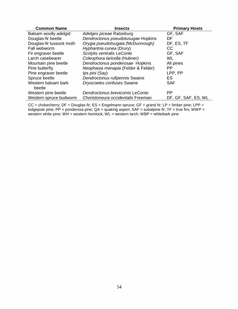
54
Common Name Insects Primary Hosts
Balsam woolly adelgid Adelges piceae Ratzeburg GF, SAF Douglas-fir beetle Dendroctonus pseudotusugae Hopkins DF Douglas-fir tussock moth Orygia pseudotsugata (McDunnough) DF, ES, TF Fall webworm Hyphantria cunea (Drury) CC Fir engraver beetle Scolytis ventralis LeConte GF, SAF Larch casebearer Coleophora laricella (Hubner) WL Mountain pine beetle Dendroctonus ponderosae Hopkins All pines Pine butterfly Neophasia menapia (Felder & Felder) PP Pine engraver beetle Ips pini (Say) LPP, PP Spruce beetle Dendroctonus rufipennis Swaine ES Western balsam bark beetle
Dryocoetes confuses Swaine SAF
Western pine beetle Dendroctonus brevicomis LeConte PP Western spruce budworm Choristoneura occidentalis Freeman DF, GF, SAF, ES, WL
CC = chokecherry; DF = Douglas-fir; ES = Engelmann spruce; GF = grand fir; LP = limber pine; LPP = lodgepole pine; PP = ponderosa pine; QA = quaking aspen; SAF = subalpine fir; TF = true firs; WWP = western white pine; WH = western hemlock; WL = western larch; WBP = whitebark pine

55
DIRECTORY OF PERSONNEL Montana Department of Natural Resources and Conservation
Phone: (406) 542-4300
Bob Harrington State Forester [email protected] (406) 542-4301 Paula Short Chief, Service Forestry Bureau [email protected] (406) 542-4303 Amy Gannon Forest Pest Management Specialist [email protected] (406) 542-4283 Brennan Ferguson Forest Pathologist [email protected] (406) 542-4330
Montana Department of Natural Resources and Conservation, Forestry Division 2705 Spurgin Road, Missoula, Montana 59804
USDA Forest Service Regional Office
Phone: (406) 329-3277
Mike Dudley1 Director, S&PF [email protected] (801) 625-5253 John Shannon Deputy Director, S&PF [email protected] (406) 329-3280 Rob Cruz 1 Forest Health Monitoring Coordinator [email protected] (801) 625-5162 Todd Neel Pesticide Use Coordinator [email protected] (406) 329-3133
USDA Forest Service, Northern Region, Federal Building, 200 East Broadway, P.O. Box 7669, Missoula, Montana 59807
1 USDA Forest Service, Intermountain Region 324 25th Street, Ogden, UT 84401

56
DIRECTORY OF PERSONNEL, continued
USDA Forest Service Missoula Field Office
Phone: (406) 329-3277
Gregg DeNitto Group Leader [email protected] (406) 329-3637 Mark Casey Bio. Sci. Tech., Aerial Surveyor [email protected] (406) 329-3136 Chris Hayes Bio. Sci. Tech., Aerial Surveyor [email protected] (406) 329-3130 Joel Egan Entomologist [email protected] (406) 329-3278 Marcus Jackson Plant Pathologist [email protected] (406) 329-3282 Blakey Lockman Plant Pathologist [email protected] (406) 329-3189 Scott Sontag Bio. Sci. Tech., Aerial Surveyor [email protected] (406) 329-3323 Brytten Steed Entomologist [email protected] (406) 329-3142 Nancy Sturdevant Entomologist [email protected] (406) 329-3281
USDA Forest Service, Northern Region, Federal Building, 200 East Broadway, P.O. Box 7669, Missoula, Montana 59807

57
Figure 1. Reporting Area Boundaries and National Forest Lands in Montana

58
Figure 2. Areas Surveyed In 2014 by Forest Health Protection Aerial Detection Survey in Montana
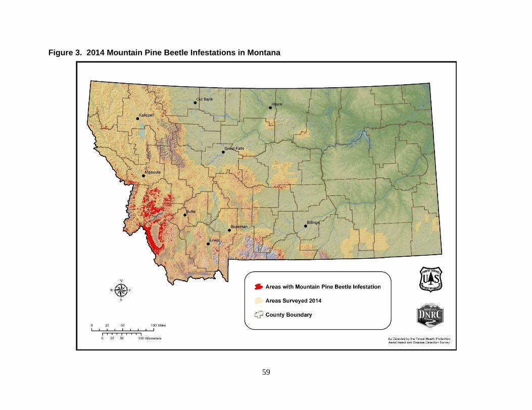
59
Figure 3. 2014 Mountain Pine Beetle Infestations in Montana

60
Figure 4. 2014 Douglas-fir Beetle Infestations in Montana
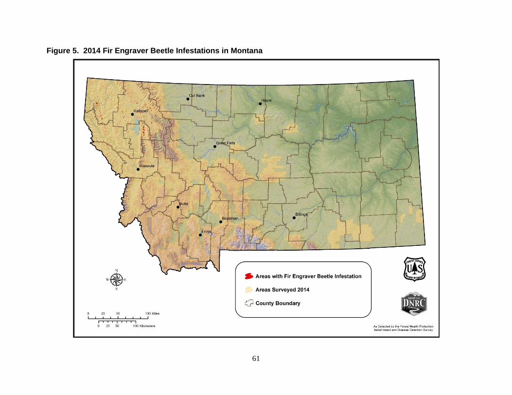
61
Figure 5. 2014 Fir Engraver Beetle Infestations in Montana

62
Figure 6. 2014 Subalpine Fir Mortality Complex in Montana
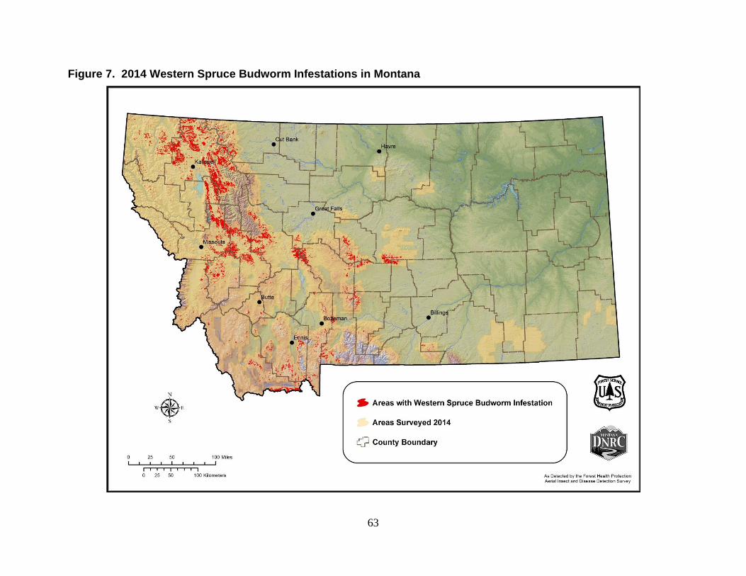
63
Figure 7. 2014 Western Spruce Budworm Infestations in Montana

64
Figure 8. Balsam Woolly Adelgid Detection in Montana, 2010-2013 Ground Survey