Embed Size (px)
Citation preview

Cole Easdon Consultants Limited
Civ il En gi neerin g ~ Highways ~ Transpo rtation ~ Flood Risk
Bristol & Swindon
Incorporated in UK as Cole Easdon Consultants Ltd No. 202 7005
Head Office:
Unit 2
York House
Edison Park
Dorcan Way
Swindon
Wiltshire
SN3 3RB
Tel. 01793 619965
Email: [email protected]
www.ColeEasdon.com
FLOOD RISK ASSESSMENT
FOR PROPOSED RESIDENTIAL DEVELOPMENT
THAMES FARM, SHIPLAKE, HENLEY-ON-THAMES ON BEHALF OF
MRS CLAIRE ENGBERS
MARCH 2016
[ISSUE 4]
FLOOD RISK ASSESSMENT PROPOSED RESIDENTIAL DEVELOPMENT, THAMES FARM, LOWER SHIPLAKE, OXFORDSHIRE
____________________________________________________________________________________
___________________________________________________________________________ QMF 12.25
ISSUE 5
Cole Easdon Consultants (CEC) MARCH 2016
Cole Easdon Consultants (CEC)
DOCUMENT ISSUE RECORD
Client: Mrs Claire Engbers Project: Proposed Residential Development, Thames Farm, Lower Shiplake,
Oxfordshire Job Number: 3537 Document Title: Flood Risk Assessment Issuing Office: Swindon
Issue / Revision: Issue 1 Issue 2 Issue 3 Issue 4
Description / Status: Draft for Comment Planning Issue Revised Formal Issue Revised Formal Issue
Date: March 2013 March 2013 March 2016 March 2016
Prepared: S. Starr BSc (Hons)
S. Starr BSc (Hons)
S. Starr BSc (Hons)
S. Starr BSc (Hons)
Signature:
Document Check:
S. Coates BA (Hons)
S. Coates BA (Hons)
S. Coates BA (Hons)
S. Coates BA (Hons)
Signature:
Technical Check:
R. Bowley BSc CEng MCIWEM
R. Bowley BSc CEng MCIWEM
R. Bowley BSc CEng MCIWEM
R. Bowley BSc CEng MCIWEM
Signature:
Authorised: R. Bowley BSc CEng MCIWEM
R. Bowley BSc CEng MCIWEM
R. Bowley BSc CEng MCIWEM
R. Bowley BSc CEng MCIWEM
Signature:
File Reference: 3537 FRA Issue 1 3537 FRA Issue 2 3537 – Thames Farm,
Lower Shiplake – FRA - Issue 3
3537 – Thames Farm, Lower Shiplake – FRA -
Issue 4

FLOOD RISK ASSESSMENT PROPOSED RESIDENTIAL DEVELOPMENT, THAMES FARM, LOWER SHIPLAKE, OXFORDSHIRE
____________________________________________________________________________________
___________________________________________________________________________ QMF 12.25
ISSUE 5
Cole Easdon Consultants (CEC) MARCH 2016
CONTENTS
SECTION HEADING PAGE NO.
1.0 INTRODUCTION 1
2.0 THE EXISTING SITE 3
3.0 FLOOD RISK ISSUES 5
4.0 PROPOSED SURFACE WATER DRAINAGE STRATEGY 8
5.0 PROPOSED FOUL WATER DRAINAGE STRATEGY 12
6.0 SUMMARY AND CONCLUSIONS 13
FLOOD RISK ASSESSMENT PROPOSED RESIDENTIAL DEVELOPMENT, THAMES FARM, LOWER SHIPLAKE, OXFORDSHIRE
____________________________________________________________________________________
___________________________________________________________________________ QMF 12.25
ISSUE 5
Cole Easdon Consultants (CEC) MARCH 2016
APPENDICES
Appendix 1 – CEC Figures
CEC Figure 3537/500/Figure 1 Site Location Plan
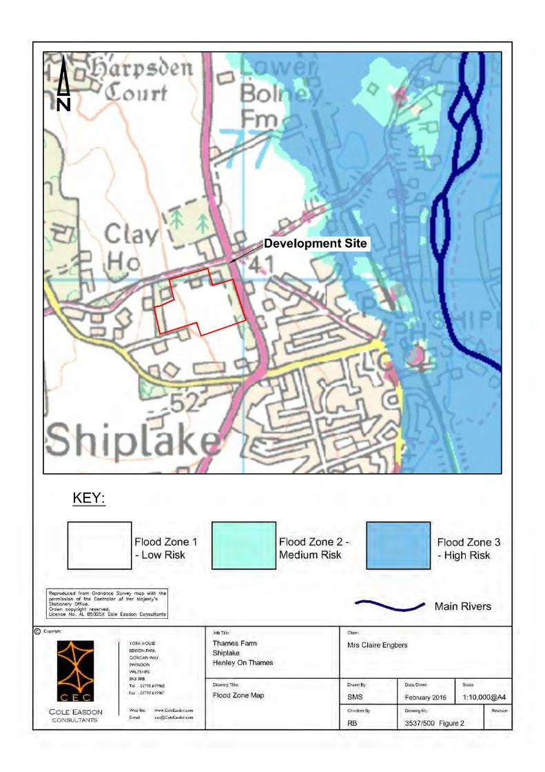
CEC Figure 3537/500/Figure 2 Flood Zone Map
Appendix 2 – Borehole Data
Appendix 3 – SFRA Excerpts
Appendix 4 –Calculations
Appendix 5 – Public Sewer Records & Thames Water Correspondence
Appendix 6 – CEC Plans & Drawings by Others
CEC Plan 3537/500 Existing Site Plan
CEC Plan 3537/501 Proposed Drainage Strategy
Drawing No. C11748.16.700 Site Layout (by DPDS Architects)

FLOOD RISK ASSESSMENT PROPOSED RESIDENTIAL DEVELOPMENT, THAMES FARM, LOWER SHIPLAKE, OXFORDSHIRE
____________________________________________________________________________________
___________________________________________________________________________ QMF 12.25
ISSUE 5
Cole Easdon Consultants (CEC) 1 MARCH 2016
1.0 INTRODUCTION
1.1 This Flood Risk Assessment has been prepared by Cole Easdon Consultants (CEC) on behalf
of Mrs Claire Engbers in respect of an outline planning application for residential
redevelopment at Thames Farm, Reading Road (A4155), Shiplake, Henley-on-Thames,
Oxfordshire. National Grid Reference SU 76911 80059. Refer to CEC Figure
3537/500/Figure 1 [Site Location Plan] in Appendix 1.
Development Proposals
1.2 The development proposal comprises 95 dwellings with associated highways, parking and
landscaping. Refer to Drawing No. C11748.16.700 [Site Layout] by DPDS Architects in
Appendix 6. This drawing forms the basis of CEC Plan 3537/501 [Proposed Drainage
Strategy] also in Appendix 6.
Need for Study
1.3 The purpose of this assessment is to demonstrate that the proposals outlined above can be
satisfactorily accommodated without worsening flood risk for the area, in accordance with
the National Planning Policy Framework Document (NPPF).
1.4 Accordingly, this study has been prepared to:
i) Assess flood risk to the development from fluvial sources;
ii) Assess flood risk to the development from other potential sources, including ditches,
sewers, groundwater and overland surface water flow;
iii) Ensure that the development proposed will fully comply with the requirements of the
EA's policy on the safeguarding of floodplains;
iv) Provide a SUDS surface water drainage strategy for the site; and
v) Identify a foul drainage strategy for the development.
1.5 A site topographical survey (referenced to Ordnance datum) has been provided to CEC and
has been reviewed as part of this study. Refer to CEC Plan 3537/500 [Existing Site Plan] in
Appendix 6.
Scope of Study
1.6 In Section 2.0, we describe the characteristics of the development site and surrounding
area. In Section 3.0, we assess flood risk issues. Surface and foul drainage strategies are
discussed in Sections 4.0 and 5.0. Finally, conclusions are presented in Section 6.0.
FLOOD RISK ASSESSMENT PROPOSED RESIDENTIAL DEVELOPMENT, THAMES FARM, LOWER SHIPLAKE, OXFORDSHIRE
____________________________________________________________________________________
___________________________________________________________________________ QMF 12.25
ISSUE 5
Cole Easdon Consultants (CEC) 2 MARCH 2016
1.7 The following resources have been used for this study:
Flood Zone Map – Environment Agency (EA);
Groundwater Source Protection Zones Map - Environment Agency (EA);
Geological Map - British Geological Survey (BGS);
Topographical Survey Drawings by BDS; and
Thames Water Public Sewer Records.
1.8 The following publicly available documents have been reviewed as part of this assessment:
South Oxfordshire & Vale Of The White Horse Strategic Flood Risk Assessment JBA (JBA
2013);
National Planning Policy Framework (NPPF) (March 2012);
Technical Guidance to the NPPF (March 2012);
Sewers for Adoption, 7th Edition – A Design and Construction Guide for Developers (SFA
7) ( March 2006);
CIRIA C697 The SUDS Manual; and
Building Regulations 2010 – Approved Document H (Drainage and Waste Disposal).
1.9 The following abbreviations are used in this report:
AOD – Above Ordnance Datum;
EA – Environment Agency;
SUDS – Sustainable Urban Drainage Systems;
HA – Highway Authority;
FZM – Flood Zone Map prepared by the Environment Agency;
NPPF – National Planning Policy Framework;
LPA – Local Planning Authority;
1% event – 1 in 100 Year return period storm;
1% + CC event – 1 in 100 Year return period storm including a 30% allowance for climate
change; and
SFRA - South Oxfordshire & Vale Of The White Horse Strategic Flood Risk Assessment
JBA (JBA 2013).
FLOOD RISK ASSESSMENT PROPOSED RESIDENTIAL DEVELOPMENT, THAMES FARM, LOWER SHIPLAKE, OXFORDSHIRE
____________________________________________________________________________________
___________________________________________________________________________ QMF 12.25
ISSUE 5
Cole Easdon Consultants (CEC) 3 MARCH 2016
2.0 THE EXISTING SITE
Refer to CEC Figure 3537/500/Figure 1 [Site Location Plan] in Appendix 1 and CEC Plan
3537/500 [Existing Site Plan] in Appendix 6.
2.1 The site is located on Reading Road (A4155), on the western edge of the village of Shiplake,
near Henley-on-Thames, Oxfordshire. Refer to CEC Figure 3537/500/Figure 1 [Site Location
Plan] in Appendix 1.
2.2 The site covers 5.6ha and currently comprises a large open grassed field with 3 No. barns,
formerly used as poultry houses, near its northern boundary. A hardcore track provides
access from Reading Road.
2.3 The site is a roughly rectangular parcel of land bounded to the north by a private farm
access road, and to the east by Reading Road. Gardens and paddocks form the site’s
southern and western boundaries. Hedges line the site’s southern and western boundaries,
and mature trees are present along its northern and eastern edges.
2.4 Land use to the south and east of the site of the site is predominantly residential, with
agricultural land use prevalent to the north and west.
2.5 The land in the locality falls toward the River Thames, which is located some 750m east of
the site. The topography of the land within the site also falls in an easterly direction, at a
gradient of approximately 1 in 30. Existing ground levels within the site vary from
56.00mAOD at its western boundary, to 42.00mAOD at its most northerly corner, adjacent
to Reading Road.
Nearby Watercourses/Drainage Features
2.6 The River Thames, a designated Main River, drains the local catchment, and is the nearest
watercourse to the site. The River is located some 750m east of the site and follows a
roughly northerly course beyond the eastern edge of Shiplake. A number of tributary
watercourses join the Thames in the vicinity of Shiplake, including the Lash Brook, the
Hennerton Backwater and several unnamed drains.
Existing Surface Water Drainage
2.7 The existing buildings in the northern part of the site are drained to soakaways. There is
no formal drainage system serving the majority of the site, which is at present drained by
means of infiltration, evaporation and greenfield runoff.
FLOOD RISK ASSESSMENT PROPOSED RESIDENTIAL DEVELOPMENT, THAMES FARM, LOWER SHIPLAKE, OXFORDSHIRE
____________________________________________________________________________________
___________________________________________________________________________ QMF 12.25
ISSUE 5
Cole Easdon Consultants (CEC) 4 MARCH 2016
2.8 Public sewer records obtained from Thames Water Utilities (TWU) confirm that there are no
public surface water sewers in the vicinity of the site. Refer to Appendix 5 for sewer
records. It is therefore assumed that surface water in the locality is disposed of by
soakaway.
Existing Ground Conditions
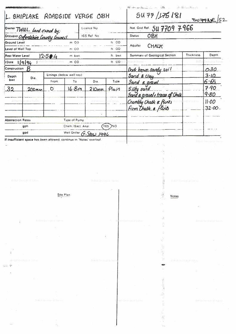
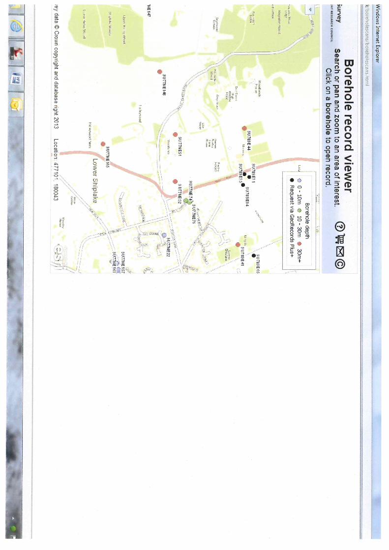
Refer to BGS Borehole logs in Appendix 2.
2.9 An intrusive site investigation is yet to be undertaken. Borehole logs relating to the land
adjacent to the site have been obtained from the British Geological Survey (BGS) website.
The logs indicate that ground conditions in the vicinity of the site are characterised by a
thin surface layer of topsoil, underlain by Taplow Gravel deposits comprising a mixture of
clays, gravels and sands to a depth of 2 – 3m below ground level. Below 2 – 3m depth the
sand content of this material increases to a depth of approximately 10m below ground
level. The Taplow Gravel is underlain by Upper Chalk strata to depth.
2.10 Resting groundwater levels were recorded at between 12 – 16m below ground level.
2.11 According to the EA Aquifer Map, the bedrock chalk strata at the site is classified as a
Principal Aquifer. As such the aquifer may support water supply or river base flow on a
strategic scale. The gravels underlying the site have minor aquifer status. The vulnerability
of these aquifers to pollution is considered to be ‘Intermediate’.
2.12 The EA Groundwater Source Protection Zone Map confirms that the site lies within Zones 1
and 2 and is therefore in the proximity of a ground water abstraction point. Thames Water
records confirm that a potable water abstraction and pumping station is located on the
eastern side of Reading Road, near the north-eastern corner of the site.
FLOOD RISK ASSESSMENT PROPOSED RESIDENTIAL DEVELOPMENT, THAMES FARM, LOWER SHIPLAKE, OXFORDSHIRE
____________________________________________________________________________________
___________________________________________________________________________ QMF 12.25
ISSUE 5
Cole Easdon Consultants (CEC) 5 MARCH 2016
3.0 FLOOD RISK ISSUES
Flood History
3.1 The Strategic Flood Risk Assessment (SFRA) for South Oxfordshire District Council contains
records of flooding within the village of Shiplake, to the east of the site. There are however
no recorded instances of flooding occurring within, or in the vicinity of, the development
site. Refer to Appendix 3 for SFRA excerpts.
Fluvial/Tidal Flood Risk
3.2 The Flood Zone Map (FZM) produced by the EA indicates that the site lies within Flood Zone
1 (Low Risk). ccording to the FZM, the nearest floodplain is located approximately 350m
east of the site and emanates from the River Thames. Refer to CEC Figure 3537/500 Figure
2 [Flood Zone Map] in Appendix 1.
3.3 In accordance with Technical Guidance to the NPPF Table 2: Flood Risk Vulnerability
Classification, the proposed site usage (residential) is classified as 'more vulnerable'.
Technical Guidance to the NPPF Table 3: Flood Risk Vulnerability and Flood Zone
Compatibility relates that less vulnerable land use is acceptable in Flood Zones 1, 2 and 3a.
As such, the flood vulnerability of the proposed site use is compatible with the fluvial/tidal
flood risks associated with the site.
3.4 Fluvial/tidal flood risk to the site is therefore low.
Assessment of Flood Risk from Existing Sewers/Drains
3.5 TWU records confirm that there are no public surface or foul water sewers located in the
immediate vicinity of the site. Refer to Public Sewer Records in Appendix 5.
3.6 The presence of gullies on Reading Road indicates that a highway drain is located beneath
the carriageway. Flood risk from this drain is negligible, as it is located at a lower level
than the development site.
3.7 Note that there will be no increase in surface water flows to the existing sewer network as
a result of the proposed development, as discussed in Section 4 below.
3.8 Sewer flood risk is therefore considered low.

FLOOD RISK ASSESSMENT PROPOSED RESIDENTIAL DEVELOPMENT, THAMES FARM, LOWER SHIPLAKE, OXFORDSHIRE
____________________________________________________________________________________
___________________________________________________________________________ QMF 12.25
ISSUE 5
Cole Easdon Consultants (CEC) 6 MARCH 2016
Assessment of Flood Risk from Overland Flow
3.9 The development site falls in an easterly direction at a gradient of 1 in 30. Based on the
existing topography, although surface water from the rural catchment to the west could
flow onto the site, it would be limited to minor greenfield runoff. Furthermore, the sloping
nature of the site would prevent overland flow accumulating to a significant depth within
the site.
3.10 Mapping contained within the South Oxfordshire District Council Strategic Flood Risk
Assessment shows an overland flow route running east through the site. The flow route
originates near the boundary of the site, with the majority of the flow generated by the
land within the site. Under the proposals the proposed surface water drainage system will
capture this flow and retain it within the site. This will significantly reduce flood risk to
Reading Road and Shiplake, which are located down–slope of the site. The proposed
drainage strategy for the redevelopment will provide additional on site storage for events
up to and including the 1% + CC storm. This will ensure that even during heavy rainfall,
runoff from the site will not impact upon neighbouring land or any receiving drainage
system. Refer to Section 4.0.
3.11 Refer to CEC Plan 3537/500 [Existing Site Plan] in Appendix 6 for overland flow routes.
3.12 Flood risk from this source is considered low.
Overland Flow Flood Risk Mitigation Measures
3.13 FFLs will be set at a minimum of 150mm above external levels. This will prevent flooding
from surface water flows.
3.14 Any runoff generated by the development itself will be accommodated within the proposed
surface water drainage system, as discussed in Section 4 of the report. Refer to CEC Plan
3537/501 [Proposed Drainage Strategy] in Appendix 6.
Assessment of Flood Risk from Groundwater
3.15 The borehole data in Appendix 2 suggest that the water table lies at considerable depth
(approximately 10m below ground level) in the locality. Mapping within the SFRA indicates
that the site lies in an area which is not considered susceptible to ground water flooding.
Refer to Appendix 3. In the unlikely event that groundwater levels rose sufficiently to cause
flooding, water would follow the existing topography and flow off site to the east.
FLOOD RISK ASSESSMENT PROPOSED RESIDENTIAL DEVELOPMENT, THAMES FARM, LOWER SHIPLAKE, OXFORDSHIRE
____________________________________________________________________________________
___________________________________________________________________________ QMF 12.25
ISSUE 5
Cole Easdon Consultants (CEC) 7 MARCH 2016
3.16 Flood risk to the site from groundwater is therefore considered low.
FLOOD RISK ASSESSMENT PROPOSED RESIDENTIAL DEVELOPMENT, THAMES FARM, LOWER SHIPLAKE, OXFORDSHIRE
____________________________________________________________________________________
___________________________________________________________________________ QMF 12.25
ISSUE 5
Cole Easdon Consultants (CEC) 8 MARCH 2016
4.0 PROPOSED SURFACE WATER DRAINAGE STRATEGY
Refer to CEC Plan 3537/501 [Proposed Drainage Strategy] in Appendix 6.
4.1 The introduction of roof and road areas associated with the proposed development will
result in an increase in the impermeable area of the site.
4.2 Runoff from this catchment will be disposed of at source by means of infiltration based
SUDS facilities. This will ensure that the proposals do not increase flood risk to the
locality, in accordance with NPPF requirements.
4.3 The following SuDS are proposed:
Infiltration Basins
o 2 No. infiltration basins will be provided to drain runoff from the highways within
the site, which form a catchment of 0.81ha. Preliminary sizing calculations indicate
that a total volume of approximately 400m³ will be required to accommodate the
1% +CC event from this catchment. A minimum 500mm freeboard will incorporated
into the ponds to mitigate residual risk and design exceedance.
o The basins will be located in the lower lying eastern part of the site, adjacent to
Reading Road. Indicative basin locations are shown on CEC Plan 3537/501
[Proposed Drainage Strategy] in Appendix 6
Permeable Pavements
o Permeable pavements will be installed in private drives and parking areas and will
drain the parking areas themselves, and, where necessary, can also accept roof
water from adjacent houses and garages. CEC Plan 3537/501 [Proposed Drainage
Strategy] in Appendix 6 demonstrates that up to 3,000m² permeable paving could
be accommodated at the site; however, the extent of permeable paving needed
should be confirmed at the detailed design stage.
Trench Soakaways
o Trench soakaways will be provided in rear gardens to drain roof water. Trench
soakaways have been included throughout the development layout wherever the
necessary 5m buffer is available between a soakaway and any building/foundation.
A 3m long x 1.5m wide x 1.5m deep soakaway will be required per 75m2 roof area.
4.4 All SuDs have been designed to accommodate the 1% + CC storm, in accordance with EA
guidance.
FLOOD RISK ASSESSMENT PROPOSED RESIDENTIAL DEVELOPMENT, THAMES FARM, LOWER SHIPLAKE, OXFORDSHIRE
____________________________________________________________________________________
___________________________________________________________________________ QMF 12.25
ISSUE 5
Cole Easdon Consultants (CEC) 9 MARCH 2016
4.5 British Geological Survey borehole data confirm that the locality is underlain by Head
Deposits (Taplow Gravel) characterised by gravels and sand with clay. A representative soil
infiltration rate of 2.7x10⁻⁵ m/s has therefore been used in the preliminary design of the
proposed infiltration systems. In due course, infiltration testing should be carried out in
accordance with BRE365 guidance.
4.6 Preliminary storage design calculations have been undertaken using MicroDrainage
software. Refer to Appendix 4.
4.7 A 5m buffer has been provided between the proposed soakaways buildings in order to
prevent damage to foundations.
4.8 Infiltration basins, permeable pavements and soakaways are recognised by the EA and CIRIA
as Sustainable Urban Drainage Systems (SUDS).
Adoption
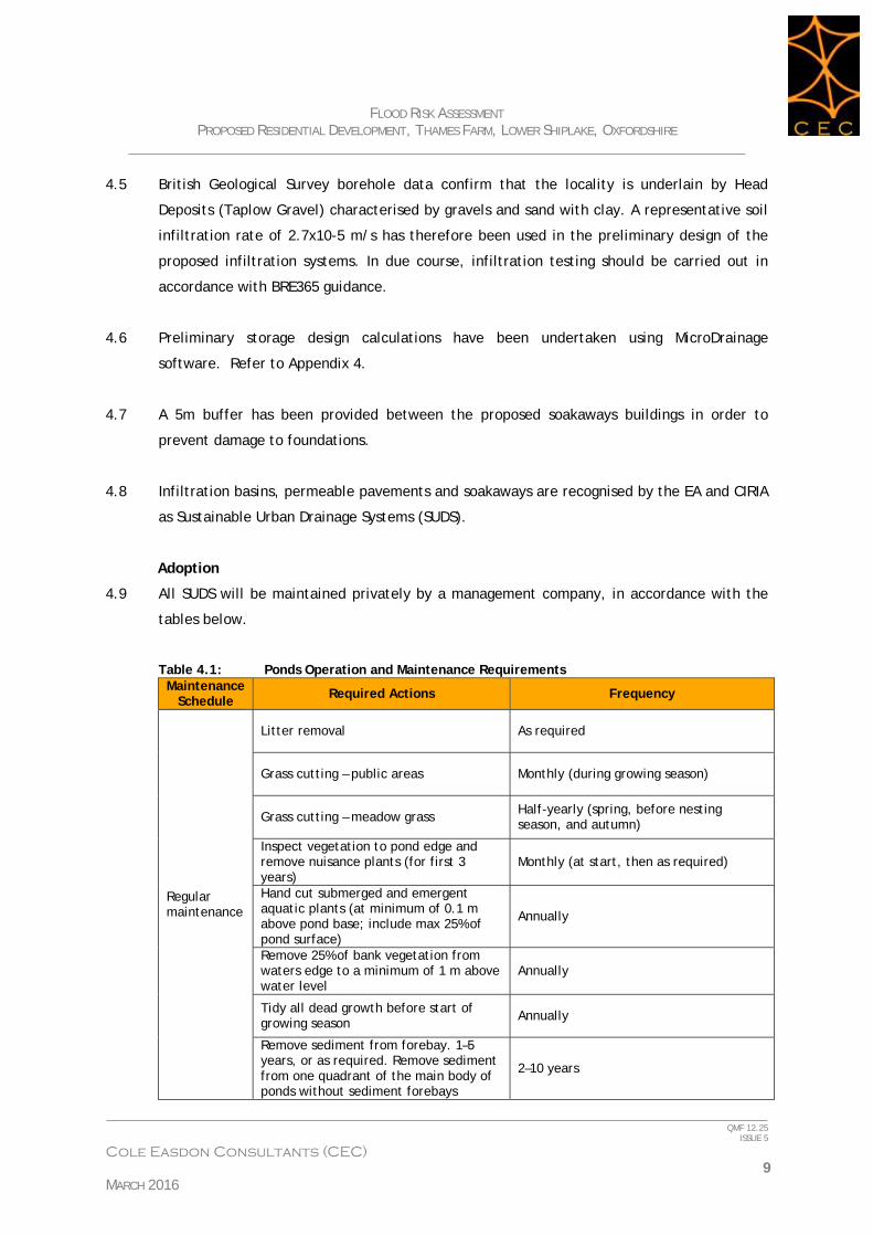
4.9 All SUDS will be maintained privately by a management company, in accordance with the
tables below.
Table 4.1: Ponds Operation and Maintenance Requirements Maintenance
Schedule Required Actions Frequency
Regular maintenance
Litter removal As required
Grass cutting – public areas Monthly (during growing season)
Grass cutting – meadow grass Half-yearly (spring, before nesting season, and autumn)
Inspect vegetation to pond edge and remove nuisance plants (for first 3 years)
Monthly (at start, then as required)
Hand cut submerged and emergent aquatic plants (at minimum of 0.1 m above pond base; include max 25% of pond surface)
Annually
Remove 25% of bank vegetation from waters edge to a minimum of 1 m above water level
Annually
Tidy all dead growth before start of growing season Annually
Remove sediment from forebay. 1–5 years, or as required. Remove sediment from one quadrant of the main body of ponds without sediment forebays
2–10 years
FLOOD RISK ASSESSMENT PROPOSED RESIDENTIAL DEVELOPMENT, THAMES FARM, LOWER SHIPLAKE, OXFORDSHIRE
____________________________________________________________________________________
___________________________________________________________________________ QMF 12.25
ISSUE 5
Cole Easdon Consultants (CEC) 10 MARCH 2016
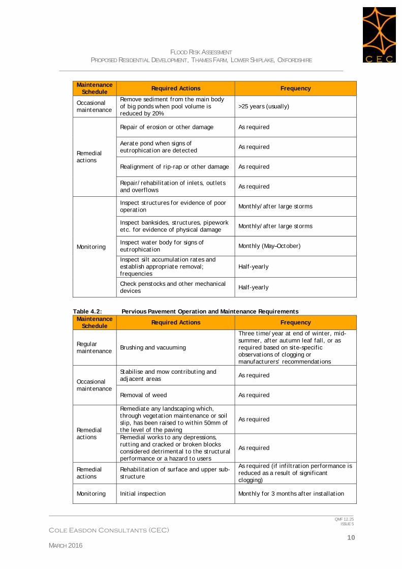
Maintenance Schedule Required Actions Frequency
Occasional maintenance
Remove sediment from the main body of big ponds when pool volume is reduced by 20%
>25 years (usually)
Remedial actions
Repair of erosion or other damage As required
Aerate pond when signs of eutrophication are detected As required
Realignment of rip-rap or other damage As required
Repair/rehabilitation of inlets, outlets and overflows
As required
Monitoring
Inspect structures for evidence of poor operation Monthly/after large storms
Inspect banksides, structures, pipework etc. for evidence of physical damage Monthly/after large storms
Inspect water body for signs of eutrophication
Monthly (May–October)
Inspect silt accumulation rates and establish appropriate removal; frequencies
Half-yearly
Check penstocks and other mechanical devices Half-yearly
Table 4.2: Pervious Pavement Operation and Maintenance Requirements Maintenance
Schedule Required Actions Frequency
Regular maintenance
Brushing and vacuuming
Three time/year at end of winter, mid-summer, after autumn leaf fall, or as required based on site-specific observations of clogging or manufacturers’ recommendations
Occasional maintenance
Stabilise and mow contributing and adjacent areas As required
Removal of weed As required
Remedial actions
Remediate any landscaping which, through vegetation maintenance or soil slip, has been raised to within 50mm of the level of the paving
As required
Remedial works to any depressions, rutting and cracked or broken blocks considered detrimental to the structural performance or a hazard to users
As required
Remedial actions
Rehabilitation of surface and upper sub-structure
As required (if infiltration performance is reduced as a result of significant clogging)
Monitoring Initial inspection Monthly for 3 months after installation
FLOOD RISK ASSESSMENT PROPOSED RESIDENTIAL DEVELOPMENT, THAMES FARM, LOWER SHIPLAKE, OXFORDSHIRE
____________________________________________________________________________________
___________________________________________________________________________ QMF 12.25
ISSUE 5
Cole Easdon Consultants (CEC) 11 MARCH 2016
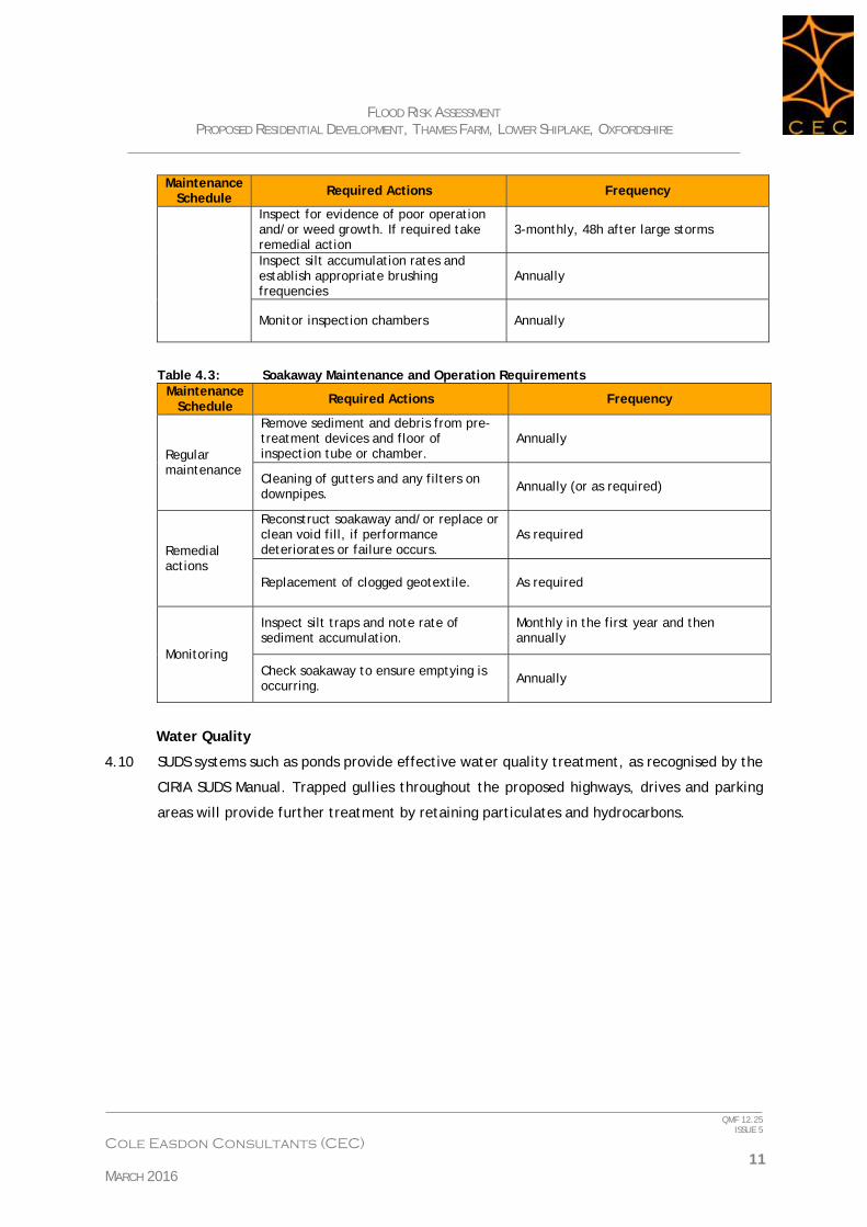
Maintenance Schedule Required Actions Frequency
Inspect for evidence of poor operation and/or weed growth. If required take remedial action
3-monthly, 48h after large storms
Inspect silt accumulation rates and establish appropriate brushing frequencies
Annually
Monitor inspection chambers Annually
Table 4.3: Soakaway Maintenance and Operation Requirements Maintenance
Schedule Required Actions Frequency
Regular maintenance
Remove sediment and debris from pre-treatment devices and floor of inspection tube or chamber.
Annually
Cleaning of gutters and any filters on downpipes. Annually (or as required)
Remedial actions
Reconstruct soakaway and/or replace or clean void fill, if performance deteriorates or failure occurs.
As required
Replacement of clogged geotextile. As required
Monitoring
Inspect silt traps and note rate of sediment accumulation.
Monthly in the first year and then annually
Check soakaway to ensure emptying is occurring. Annually
Water Quality
4.10 SUDS systems such as ponds provide effective water quality treatment, as recognised by the
CIRIA SUDS Manual. Trapped gullies throughout the proposed highways, drives and parking
areas will provide further treatment by retaining particulates and hydrocarbons.

FLOOD RISK ASSESSMENT PROPOSED RESIDENTIAL DEVELOPMENT, THAMES FARM, LOWER SHIPLAKE, OXFORDSHIRE
____________________________________________________________________________________
___________________________________________________________________________ QMF 12.25
ISSUE 5
Cole Easdon Consultants (CEC) 12 MARCH 2016
5.0 PROPOSED FOUL WATER DRAINAGE STRATEGY
5.1 Based on Sewers for Adoption guidance, the proposed development of 95 units will
generate peak foul flow rate of 4.4 l/s.
5.2 Thames Water records confirm that there are no public foul sewers in the immediate
proximity of the development site, therefore an off-site connection to the existing sewer at
the junction of Reading Road and Station road in Lower Shiplake will be necessary. As a
gravity connection is not possible, an on-site pumping station will be required. The location
of the pumping station is a reserved feature. One possible location is indicated on CEC Plan
3537/501 [Proposed Drainage Strategy] in Appendix 6.
5.3 A sewer capacity check and Impact Study undertaken by Thames Water confirm that the
existing public foul sewer network in the vicinity of the site does not have sufficient
capacity to accommodate the predicted development foul flows.
5.4 The Thames Water Impact Study identifies the foul sewer improvements required to ensure
that foul flows from the site can be discharged to the public sewer system without
detriment to the network. The improvement works comprise upgrading a 168 linear metres
of 150mm diameter sewer to 525mm diameter. The proposed upgrade is located in Station
Road, downstream of the proposed connection point at the junction of Reading Road and
Station road. Refer to Appendix 5 for Thames Water correspondence.
5.5 A budget estimate of the cost of the sewer upgrade is £250,000.

FLOOD RISK ASSESSMENT PROPOSED RESIDENTIAL DEVELOPMENT, THAMES FARM, LOWER SHIPLAKE, OXFORDSHIRE
____________________________________________________________________________________
___________________________________________________________________________ QMF 12.25
ISSUE 5
Cole Easdon Consultants (CEC) 13 MARCH 2016
6.0 SUMMARY AND CONCLUSIONS
6.1 Flood risk to the proposed development from fluvial sources, overland flow, sewers and
groundwater has been considered in this study. No significant risks have been identified.
6.2 The site lies within Flood Zone 1 (Low Risk) according to the FZM produced by the EA. As
such, the flood vulnerability of the proposed site use is compatible with the fluvial/tidal
flood risks associated with the site.
6.3 Surface water runoff from the redeveloped site will be discharged at source by means of
infiltration basins, permeable pavements and soakaway SuDS. Disposing of post
development runoff at source will ensure that the proposals do not increase flood risk to
the locality, in accordance with NPPF requirements. Indicative locations for the proposed
SuDS features are shown on CEC Plan 3537/501 [Proposed Drainage Strategy] in Appendix 6.
6.4 Foul water will be drained to the existing public foul sewer in Station Road. The foul sewer
upgrading works designed by Thames Water will be undertaken as part of the development.
6.5 This study has been undertaken in accordance with the principles of the NPPF document.
We conclude that providing the development adheres to the conditions advised within this
report, the proposals can be accommodated without increasing flood risk within the locality
in accordance with objectives set by Central Government and the EA.
Cole Easdon Consultants Limited
March 2016

Appendix 1

Scale: 1:20,000
Scale: 1:100,000
Client:
Checked By Drawing No. Revision
Drawn By Date Drawn Scale
Job Title:
Drawing Title:
C Copyright
www.ColeEasdon.com
Web Site
E-mailCOLE EASDON
CONSULTANTS
DORCAN WAY
SN3 3RB
WILTSHIRE
SWINDON
EDISON PARK
YORK HOUSE
Fax
Tel
: 01793 619967
: 01793 619965
Mrs Claire EngbersThames FarmShiplakeHenley - on -Thames
Site Location Plan SMS
RB 3537/500/Figure 1
February 2016 As shown @A4
Development Site
Development Site
Henley - on - Thames
Appendix 2


Appendix 3
South Oxfordshire District Council & Vale of White Horse District Council Strategic Flood Risk Assessment Level 1 & 2 FINAL
JBA Consulting www.jbaconsulting.co.uk C:\#WORKING\2007s2705\2007s2705 SODC_VOWH SFRA Level 1&2 FINAL APPENDICES.doc: 18/06/2009 C-81
C.2.20 Shiplake
Local Authority South Oxfordshire District Council
Fluvial Flood Risk
Watercourse Flood Zone Coverage
Model Type
Channel Survey
Flood risk
Climate change Impact
Thames Complete ISIS / Flood Zone
Complete Flood Zone 3 contains large numbers of properties within the village, including the railway station.
Some additional properties in Shiplake fall into Flood Zone 3.
Fluvial Flooding History
Several Thames floods mapped, outlines fall within Flood Zone 3. 60 sandbag requests on SODC records in Shiplake and Lower Shiplake. History of highway drainage problems in Station Road, Shiplake.
Sewer Flooding Zero incidents of sewer flooding reported within RG9 3 and RG9 4 postcodes.
Surface Water Flooding Low Minor flow paths.
Groundwater Flooding
No incidents mapped in Defra report for 2000/1 and 2002/3 events. No incidents on Environment Agency records.
Comments
South Oxfordshire District Council & Vale of White Horse District Council Strategic Flood Risk Assessment Level 1 & 2 FINAL
JBA Consulting www.jbaconsulting.co.uk C:\#WORKING\2007s2705\2007s2705 SODC_VOWH SFRA Level 1&2 FINAL APPENDICES.doc: 18/06/2009 C-82
Fluvial Flood Risk Map
Key to Fluvial Flood Risk Maps
Outlines from SFRA models and other detailed EA models
Functional floodplain (Flood Zone 3b). Within modelled area boundaries, 1 in 20. Outside of these areas, 1 in 20 outlines are not available so the 1 in 100 year outline is used as an initial, precautionary approach
1 in 100 year (Flood Zone 3a)
1 in 100 year + climate change
1 in 1000 year (Flood Zone 2)
Detailed model built for SFRA but outline unchanged due to DTM issues

South Oxfordshire District Council & Vale of White Horse District Council Strategic Flood Risk Assessment Level 1 & 2 FINAL
JBA Consulting www.jbaconsulting.co.uk C:\#WORKING\2007s2705\2007s2705 SODC_VOWH SFRA Level 1&2 FINAL APPENDICES.doc: 18/06/2009 C-83
Other Sources Flood Risk Map
Key to Other Sources Flood Risk Maps
SODC Sandbag Requests 2000-8
Requests by settlement
1 - 5
6 - 5
6 - 10
11 - 20
21 - 30
31 - 40
41 - 100
" Reported Groundwater flooding
Groundwater Flood locations 2001
Historic Flooding - Other Sources
Surface Water Flooding 1 in 100 year
Max depth in metres
0.0
0.0 - 0.1
0.1 - 0.2
0.2 - 0.3
0.3 - 0.4
0.4 - 0.5
0.5 - 0.6
0.6 - 0.7
0.7 - 0.8
0.8 - 32.0


![Thames Region Land Drainage - gov.uk · Thames Water Authority LAND DRAINAGE BYELAWS 1981 [as amended by the Thames Region FLOOD DEFENCE BYELAWS 1991] The Thames Water Authority,](https://img.dokumen.tips/doc/110x75/5ead899913c7690cc165ecc9/thames-region-land-drainage-govuk-thames-water-authority-land-drainage-byelaws.jpg)