Embed Size (px)
Citation preview

CHARFORD LODGE
ROCK HILL
BROMSGROVE
WORCS B61 7LH
CONSULTING CIVIL & STRUCTURAL ENGINEERS
TEL: +44(0) 1527 832307 FAX: +44(0) 1527 832711
email :[email protected]
16‐6953Phase2and3,CorinthianParkCheltenham.GL516UP. FloodRiskAssessment&SurfaceWaterManagementPlan
Hinton Properties Plc
Prepared by: Mark Bellringer Checked by: Charl Koorts Approved by: John Blackhall Date: 01/08/2017 Reference: FRA‐16‐6953
Issue 2

16‐6953 Corinthian Park Cheltenham
Complete Design Partnership Ltd. Registration No. 3866200
Issue 2 i 01/08/2017
ContentsContents ................................................................................................................................................... i
Figures ...................................................................................................................................................... i
Executive Summary ................................................................................................................................. 1
1. Introduction .................................................................................................................................... 4
2. Background to the site .................................................................................................................... 6
3. Proposed Development ................................................................................................................ 12
4. Surface Water Management Plan ................................................................................................. 16
5. Flood Risk Assessment .................................................................................................................. 17
6. Conclusions and Recommendations ............................................................................................. 18
7. References .................................................................................................................................... 19
Appendix A: Supporting drawings ......................................................................................................... 20
Appendix B: TPA Phase 1 and highway works FRA & Drainage Strategy’s ........................................... 21
Appendix C: Storage Volume Calculations (Windes) ............................................................................ 22
Appendix D: Severn Trent Sewer Record Mapping............................................................................... 23
FiguresNo table of figures entries found.
Tables
Table 1: Reference Data .......................................................................................................................... 4
Table 2: PPG Table 2 contingency allowances for climate change ......................................................... 5

16‐6953 Corinthian Park Cheltenham
Complete Design Partnership Ltd. Registration No. 3866200
Issue 2 1 01/08/2017
ExecutiveSummary
This combined Flood Risk Assessment (FRA) and Surface Water Management Plan (SWMP) has been
prepared in support of Hinton Properties proposed development of Phase 2 and 3 of their ongoing
development site located at Corinthian Park, Grovefield Way, Cheltenham. GL51 6UP. The Phase 1
development consisted of the construction of a flagship BMW dealership approved under planning
application number 14_00656‐Ful. It is intended to follow the approach previously accepted by the
Lead Local Flood Authority (LLFA) put forward by Transport Planning Associates (TPA) in their
previous report reference number 1303‐30/FRA/01/A dated June 2013 and 1402‐01SWP/01 dated
September 2015 (contained within Appendix B of this report for reference).
It should be noted that the latter report deals with the drainage of the new access road off
Grovefield Way which serves both a Flagship BMW Dealership, comprising a car showroom, servicing
building with a 3000m² footprint plus car parking and the main access to the future Phase 2 and 3
development sites beyond. The developed Phase 1 site provided approximately 1.65 ha of
impermeable area, and the access road will provide approximately 0.374ha of impermeable area.
This FRA is carried out in accordance with BS 8533:2011 1, National Planning Policy Framework
(NPPF), Planning Practice Guidance (PPG), Environment Agency (EA) Advice for Development, and
following the guidance in CIRIA C624, C697 & C753. Reference is also made to the now replaced
Planning Policy Statement 25 (PPS 25) and Planning Policy Statement 25 Practice Guide, which
provided comprehensive tools for assessing and mitigating flood risk.
The proposed development site is a low risk (Zone 1) for fluvial or pluvial flooding; as shown on the
EA’s Risk of flood mapping.
The surface water drainage arising from the impermeable areas associated with Phase 2
development and its parking areas and access road is circa 1.825ha in area. Its proposed that these
flows will discharge on an attenuated basis, to an existing Highway balancing pond system located
along the northern boundary of the site which was constructed as part of the Phase 1 works via the
existing gravity drainage system.
The surface water discharges associated with the Phase 2 development, will be contained on the site
via a porous paving system together with cellular storage structures, subject to a restricted discharge
of 8.4 l/s being accommodated within the existing Highway balancing pond arrangements located
along the northern boundary of the development. The proposed outflow from the balancing pond
will remain set at 10.2/s as per the agreed Phase 1 works. (with a further separate attenuation based
drainage system being provided to service the remainder of the Phase 3 site).
It is considered that this development will not increase the risk of flooding in the wider catchment as
the surface water generated from the site will be contained within the proposed drainage systems,
and released on a controlled basis.
Any foul discharge from the new buildings and associated infrastructure will be connected to an
existing private foul drain which crosses the Phase 2 development site, which will require a localised

16‐6953 Corinthian Park Cheltenham
Complete Design Partnership Ltd. Registration No. 3866200
Issue 2 2 01/08/2017
diversion. before out falling to an adopted 225mm diameter foul sewer located within the south
west corner of the site, at STW Manhole reference 4400 which then discharges to public system
located within North Road West.
Site Location: The parcel of land as identified on the site location
plan (Appendix A) is located approximately 2
kilometres west of Cheltenham town centre,
approached by Grovefield Way, a major access road
which joins the A40 approximately 800m north from
the site. The existing site is located within the business
sector of Cheltenham and is surrounded by either
agricultural land or business buildings.
There are no main rivers running through or in the
immediate vicinity of the site, although there is an
unnamed ordinary watercourse which runs along the
northern boundary of the site before being culverted
where it crosses beneath the A40.
Size and Current Land Use: The Phase 2 commercial scheme area consists of
approximately 2.45 hectares of green fields.
The Phase 2 site has a level difference of up to 5m
from approximately 41m AOD on the south‐east
boundary, to approximately 36m AOD in the north‐
west corner of the development site.
The Phase 3 commercial scheme area consists of
approximately 1.67 hectares of green fields.
The Phase 3 site has a level difference of up to 2m
from approximately 33.75m AOD on the south‐east
boundary, to approximately 31.75m AOD in the north‐
west corner of the development site.
The existing 1250mm diameter ditch course outfall
beneath the A40 has a recorded invert level of 31.25m
AOD.
Proposed Development: Proposed development of a Costa Coffee retail outlet,
Aldi Store, Day Nursery and two new high
specification office buildings and associated car
parking / access road infrastructure.
The following Phase 3 development will most likely
consist of a further two number office buildings and
associated infrastructure, the schematic for Phase 3 is

16‐6953 Corinthian Park Cheltenham
Complete Design Partnership Ltd. Registration No. 3866200
Issue 2 3 01/08/2017
indicative of the future proposals but may be subject
to change
EA Flood Zone Classification: Flood Risk Zone 1 – EA classification of less than 1 in
1000‐year probability of flooding from rivers or seas in
any given year.
Lead Local Flood Authority &
SFRA:
Gloucestershire County Council (GCC) ‐ Strategic Flood
Risk Assessment Level 1, and Gloucestershire SuDS
Design and Maintenance Guide.
Fluvial Flood Risk: None
Tidal Flood Risk: None
Surface Water Pluvial Flood Risk:
Low risk ‐ small area recorded to be vulnerable to 1 in
1000‐year event to a depth not exceeding 300mm,
this is related to a local low spot which is to be
removed during the Phase 2 development works.
Artificial Sources None
Sewers None
Groundwater Flood Risk: None
Historical Flooding: None
Flood Risk Vulnerability
Classification:
More vulnerable (applicable to the Phase 2 Day
Nursery building only) – Less vulnerable to the
remainder of phase 2 and 3 development.
Sequential and Exception Test: Not Required

16‐6953 Corinthian Park Cheltenham
Complete Design Partnership Ltd. Registration No. 3866200
Issue 2 4 01/08/2017
1. Introduction
This FRA is for the parcel of land as identified on the site location plan (Appendix A). The site is
located approximately 2 kilometres west of Cheltenham town centre, accessed by Grovefield Way, a
major access road which joins the A40 approximately 800m north from the site. The existing site is
located within the business sector of Cheltenham and is surrounded by either agricultural land or
business buildings.
There are no main rivers running through or in the immediate vicinity of the site, although there is an
unnamed ordinary watercourse which runs along the northern boundary of the site before being
culverted where it crosses beneath the A40.
The Phase 2 scheme area consists of approximately 2.45 hectares of green fields and is bounded by
tree lined hedgerows. The site has a level difference of up to 5m from approximately 41mAOD on
the south‐east boundary, to approximately 36mAOD in the north‐west corner of the development
site. The site also falls circa 3.0m across its width from south to north.
The Phase 3 scheme area consists of approximately 1.67 hectares of green fields. The site has a level
difference of up to 2m from approximately 35mAOD on the south‐east boundary, to approximately
31.5mAOD in the north‐west corner of the development site.
The FRA is carried out in accordance with BS 8533:20111, National Planning Policy Framework
(NPPF)5, Planning Practice Guidance (PPG)9 the guidance in CIRIA C6242, C6973 & C7534. Reference is
also made to the now replaced Planning Policy Statement 25 (PPS 25) and Planning Policy Statement
25 Practice Guide, which provide comprehensive tools for assessing and mitigating flood risk7,8
Complete Design Partnership Ltd. has been instructed by Hinton Properties Plc, to produce the FRA
and SWMP to support an ongoing planning application which is to be made to Cheltenham Borough
Council.
The proposed development site is located within Flood Zone 1 on the EA Risk of Flooding from Rivers
and Sea Flood map.
1.1 ReferenceData
The following documents form part of this assessment (Table 1):
Table 1: Reference Data
Document Prepared by: Reference/No.
Site plan Design Development Partnership 178‐96
Site location plan Design Development Partnership 178‐70
Existing site survey Design Development Partnership 178‐71
16‐6953 Corinthian Park Cheltenham
Complete Design Partnership Ltd. Registration No. 3866200
Issue 2 5 01/08/2017
Flood Mapping /
Data
Environment Agency and GOV Web site
Local Flood Risk
management
strategy
Gloucestershire County Council (LLFA) Flood Risk Management (Strategic Infrastructure)
Strategic Flood
Risk
Halcrow on behalf of Cheltenham Borough
Council (CBC)
Level 2 SFRA – 2013
Level 1 SFRA ‐ 2007
SWMP ‐ Drainage
Strategy
Complete Design Partnership Ltd 16‐6953‐100‐ Rev P1
Site Investigation
Report
Structural Soils Ltd July 2008 report no. 729381R2
Existing site levels are shown upon the topographical survey. A copy of the drawing is included
within Appendix A. For information, the site has a level difference of up to 8.5m from approximately
41mAOD on the south‐east boundary, to approximately 31.5mAOD in the north‐west corner of the
development site.
The site is covered by Cheltenham Borough Council (CBC) Level 1 and later level 2 (2013) Strategic
Flood Risk Assessment.
1.2 Climatechange
Research by the Environment Agency (EA) shows that the probability of occurrence of severe
flooding will increase. PPG sets out recommendations for contingency allowances for climate
change. Table 2 summarises the relevant surface water increases that should be considered for an
increase in peak rainfall intensity for developments with a design life horizon up to 2115:
Table 2: PPG Table 2 contingency allowances for climate change
Parameter Total potential
change anticipated
for 2010‐2039
Total potential
change anticipated
for 2040‐2069
Total potential
change anticipated
for 2070‐2115
Peak rainfall intensity 10% 20% 40%
The design life of the development is assumed to be around 100 years. Therefore, a climate change
allowance of 40% on rainfall should be included in the design for the development.
(https://www.gov.uk/guidance/flood‐risk‐assessments‐climate‐change‐allowances)

16‐6953 Corinthian Park Cheltenham
Complete Design Partnership Ltd. Registration No. 3866200
Issue 2 6 01/08/2017
2. Backgroundtothesite
2.1 General
The parcel of land as identified on the site location plan (Appendix A) is located approximately 2
kilometres west of Cheltenham town centre, approached by Grovefield Way, a major access road
which joins the A40 approximately 800m north from the site. The existing site is located within the
business sector of Cheltenham and is surrounded by either agricultural land or business buildings.
There are no main rivers running through or in the immediate vicinity of the site, although there is an
unnamed ordinary watercourse which runs along the northern boundary of the site before being
culverted where it crosses beneath the A40.
The Phase 2 scheme area consists of approximately 2.46 hectares and the Phase 3 site a further 1.67
hectares. The British Geological Survey and Environment Agency Maps have been studied to identify
the site’s Geological and Hydrogeological properties. The following figures show the information
shown within them.
Figure 1a British Geological Survey Data – Bedrock Map
As can be seen in Figure 1a the British Geological Survey ‘Bedrock Map’, the site is underlain by the
Charmouth Mudstone formation classification of bedrock material, a sedimentary bedrock formed
approximately 190 to 202 million years ago, in the Jurassic Period, where the local environment was

16‐6953 Corinthian Park Cheltenham
Complete Design Partnership Ltd. Registration No. 3866200
Issue 2 7 01/08/2017
previously dominated by shallow seas. There is no evidence of superficial deposits located within this
area.
Figure 1b British Geological Survey Data – UK Hydrogeology Map
Figure 1b the British Geological Survey Data ‘UK Hydrogeology Map’ shows the potential for the
ground to hold water. The area surrounding the development in Cheltenham is over the Lias group of
bedrock material where the ground essentially has no groundwater. As shown on the map some
local intrusions of Limestone provide localised aquifers with low yielding capacity.
Further to the map information in figures 1a and 1b above, an assessment of the site’s infiltration
properties is required to identify the site specific hydrological properties and storage capabilities.
Although the map information provided in Figures 1a and 1b shows the ground to have little or no
infiltration properties.
A ‘Site Investigation Report’ carried out by Structural Soils Ltd in July 2008, covering the Phase 1
development provided information on three infiltration tests carried out across random locations on
site. The results showed no measurable infiltration for the duration of the tests, which were carried

16‐6953 Corinthian Park Cheltenham
Complete Design Partnership Ltd. Registration No. 3866200
Issue 2 8 01/08/2017
out in accordance with BRE365 (see Appendix B containing previous TPA Phase 1 and highway FRA
Data) therefore, we conclude that the use of soakaways would not be practical to use within this
development site.
2.2 StrategicFloodRiskAssessment(SFRA)
The CBC level 1 SFRA and later level 2 SFRA denote that the site is partially at risk of surface water
flooding during a 1 in 1000‐year event, this is thought to be due to a localised, low lying area located
along the southern boundary of the Phase 2 site, and is not thought to be of relevance due to
proposed earthworks alterations within that area effectively removing the low spot.
Figure 2, Flood mapping received from GCC/LLFA
2.2.1 FluvialfloodingThe proposed development site is located in Flood Zone 1 at low risk of fluvial flooding from rivers
and sea. Figure 3 shows the site in relation to the EA Flood Map for planning;
Phase 2 & 3
1 in 1000‐year flooding –
local low spot

16‐6953 Corinthian Park Cheltenham
Complete Design Partnership Ltd. Registration No. 3866200
Issue 2 9 01/08/2017
Figure 3 EA website mapping.
2.2.2 HistoricalfloodingHistorical flooding incidents within the area are: ‐
Cheltenham Borough – July 1967 & summer 2007.
Cotswold District – March 1947, July 1968, August 1977, Sept 1992, Oct 1993, April 1998,
Dec 2000, Summer 2007, Jan 2008.
Forest of Dean – March 1947, July 1968, Dec 1981, Dec 2000, summer 2007.
Gloucester City – Jan 1939, March 1947, July 1968, Dec 1981, Jan 1990, Dec 2000, Summer
2007.
Stroud – Jan 1939, March 1947, Dec 1965, July 1968, Dec 1981, Jan 1990, Dec 2000, Summer
2007.
Tewkesbury Borough – Jan 1939, March 1947, July 1968, Dec 1981, 1985, Jan 1990, April
1998, Dec 2000, Summer 2007.
Cheltenham is mentioned in the historic flooding part of the CBC report as having over 600
properties being flooded by the summer 2007 floods. Cheltenham suffered from Fluvial (River Chelt,
Wymans Brook, Hatherley Brook, Mill Stream), surface runoff and exceedance from highway drains
and public sewers. The areas mainly affected were Charlton Kings (70 properties), River Chelt (230
properties), Hatherley (100 properties), Prestbury (70 properties) and Whaddon (250 properties).
Although there were several areas severely affected by flooding as mentioned above, the population
densities within these areas were not high enough to make it to the Environment Agency’s Flood Risk
Areas.
Historic flood map information provided to us identified two areas close to the development site as
suffering flooding during the July 1968 floods, one approximately 50m north‐west of the site on the
Phase 2 & 3

16‐6953 Corinthian Park Cheltenham
Complete Design Partnership Ltd. Registration No. 3866200
Issue 2 10 01/08/2017
opposite side of the A40, the other approximately 100m southwest of the site on the Reddings. The
historic flood map also shows areas along Hatherley Brook which suffered flooding during the
summer 2007 floods, the nearest being approximately 200m east of the site next to the roundabout
junction with the A40.
The information found within this report identified that although the development site itself was not
subject to flooding historically and is not predicted to suffer flooding in the future, consideration will
need to be made towards both Hatherley Brook and the Reddings, two areas which have historically
suffered flooding.
The asset location plans provided by Severn Trent Water show s surface water sewer within
Grovefield Way to the east and a foul water sewer to the south within North Road West.
STWL were not able to provide any recorded evidence of flooding from public sewers that would
have opportunity to cause a flood risk to the future development sites.
The STWL mapping information is provided within Appendix D.
2.2.3 Surfacewater(Pluvial)floodingThe EA Surface Water Flood Map shows a very low risk of surface water flooding.
Figure 5 EA (Surface Water) flood mapping.

16‐6953 Corinthian Park Cheltenham
Complete Design Partnership Ltd. Registration No. 3866200
Issue 2 11 01/08/2017
2.3 Groundconditions&groundwater
The ground conditions indicated by BGS data and previous site investigation works would indicate
that the use of infiltration based SuDS systems is not practicable within the proposed development,
which was confirmed during the 2008 site investigation works undertaken by Structural Soils.
2.4 Existingdrainage
The Asset Location maps, provided by Severn Trent Water, show the location of a public Foul Water
sewer within North Road West which runs along the southern boundary of the site. And a surface
water system running in a northerly direction along the length of Grovefield Way to the eastern
boundary of the site.
Foul Water sewers from the development can connect to the existing public Foul Water Sewer under
a Section 104/106 agreement with Severn Trent Water, via new connections to an existing private
foul water drain which crosses the Phase 2 site, this drain was provided during the construction of
the Phase 1 works and it was intended for the Phase 2 and 3 works to be connected to this drain,
which currently remains un‐adopted, and will be subject to a local diversion.
2.5 Existingimpermeablearea
The existing Phase 2 site is effectively greenfield, except for a small area (0.347ha) access road previously constructed to serve the remainder of the development during the construction of the adjacent Phase 1 BMW dealership project, which has the benefit of its own Highway balancing pond facility.
2.6 SequentialTest
The majority of the proposed development is classified as “less vulnerable” and is located in Flood
Zone 1. It therefore meets the compatibility requirements set out in PPG Table 3 (Figure 2); however
the Day nursery is classified as “More Vulnerable” this being the higher classification to which the
Phase 2 development will need to be tested against.
Table 3 ‐ Flood risk vulnerability and flood zone compatibility

16‐6953 Corinthian Park Cheltenham
Complete Design Partnership Ltd. Registration No. 3866200
Issue 2 12 01/08/2017
It is considered that the proposals satisfy the requirements of the sequential test, and is therefore
appropriate for the proposed location.
3. ProposedDevelopmentThe majority of the proposed Phase 2 and 3 development is classified in PPG Table 3 as “Less
Vulnerable” and is located in Flood Zone 1; however the Day nursery is classified as “More
Vulnerable” this being the higher classification to which the development will need to be tested
against.
3.1 Description
The proposed Phase 2 and 3 developments are shown on the Architect’s drawings (located within
Appendix A), comprising of a proposed access road (partially constructed within the Phase 1 works),
Costa Coffee, Aldi store, Nursery and two new office buildings with their associated parking areas
and public realm / landscaping areas.
The proposed Phase 3 development is shown on the Architect’s drawings (located within Appendix
A), comprising of a proposed access road, two new office buildings with their associated parking
areas and public realm / landscaping areas. Note: the later Phase 3 development is currently shown
indicatively upon these drawings, and has been used to calculate the overall site discharge from the
remaining Phase 3 development area.
Access to the site is via the existing access road arrangement.
3.2 Impermeablearea
The proposed impermeable area contributing to the new network has been measured from the
revised Architect’s layout (car park, access road and buildings) totalling an area of circa 18,253m² or
(1.82ha) or 74.2% of the gross Phase 2 site area.
The proposed impermeable area contributing to the new network has been measured from the
Architect’s layout (car park, access road and buildings) totalling an area of circa 11050m² or (1.67ha)
or circa 66% of the gross Phase 3 site area.
3.3 Proposedlevels
Proposed levels for the external areas and finished floor level are to tie into external levels with the
new access road provided to serve the existing BMW site and paved areas around the site, whilst the
proposed levels will be adjusted to minimise the need for material removal.
3.4 Proposeddrainage
It is envisaged that the drainage arising from roofs shall enter into a combination of porous paving
and piped attenuation systems.
Permeable paved areas and cellular attenuation structures to be located within the parking areas of
each Phase which will attenuate flows generated by the parking court itself as well as from the hard‐
16‐6953 Corinthian Park Cheltenham
Complete Design Partnership Ltd. Registration No. 3866200
Issue 2 13 01/08/2017
surfaced circulation areas and roofs, for storm events up to and including the 1 in 100 +40% CC year
storm event.
The access road will use a piped traditional drainage network. The drains will be sized to
accommodate the 1 in 100 +40% CC year storm event before entering a second highway balancing
pond (previously constructed to serve the access road only) located adjacent the northern boundary,
which is currently limited to a discharge rate of 1.8l/s.
All of the proposed Phase 2 and following Phase 3 drainage systems will discharge into the ditch
running along the northern boundary via a balancing pond and flow control chamber, which will be
designed to limit discharge to Greenfield runoff rate of Qbar 8.4l/s for Phase 2 and Qbar of 5.7l/s for
Phase 3, whilst the original flow control for the highway system regulated to 1.8l/s will be removed
and replaced with a new unit set to limit flows to 10.2l/s @1.1m head (this represents the allowable
discharge from Phase 2 at 8.4l/s and the Phase 1 highway area at 1.8l/s combined).
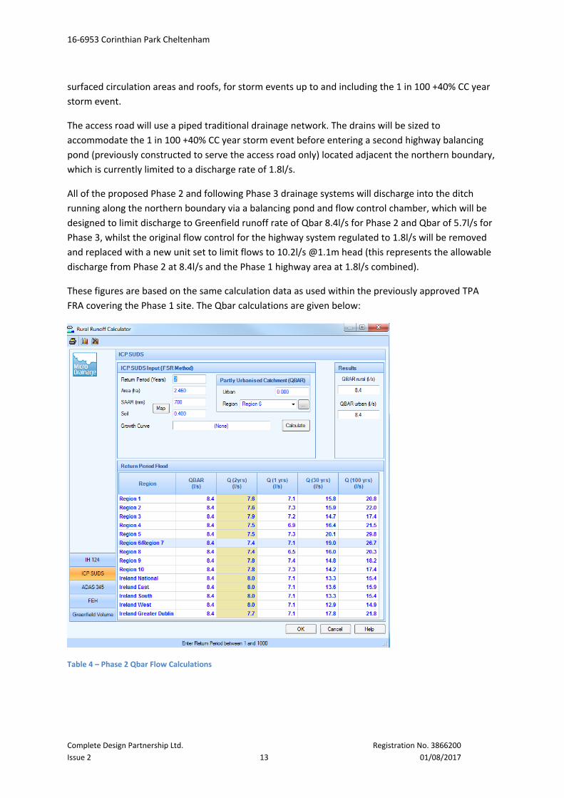
These figures are based on the same calculation data as used within the previously approved TPA
FRA covering the Phase 1 site. The Qbar calculations are given below:
Table 4 – Phase 2 Qbar Flow Calculations

16‐6953 Corinthian Park Cheltenham
Complete Design Partnership Ltd. Registration No. 3866200
Issue 2 14 01/08/2017
Table 5 – Phase 3 Qbar Flow Calculations
A Windes Quick Storage Estimate showed that for the 1 in 100‐year return period plus 40% Climate
change storm, and assuming there are no infiltration properties through the ground (based upon
hydrology map information from the British Geological Survey website and historic soakage testing
carried out in 2008 for Phase 1), a volume of circa 2000m³ of attenuation would be need to be
included for within the onsite surface water management proposals for the Phase 2 area.
It is proposed that the Phase 2 parking areas be constructed using a permeable paving system to
accommodate runoff from itself as well as from the hard‐surfaced circulation roads and adjacent
roof areas. Based on an area of 4890m² being provided with an approximately 400mm deep depth of
filter material below and allowing for a 30% void ratio, a total of 586m³ volume of attenuation can be
provided.
The remaining attenuation requirement of 1414m³ shall be accommodated by the provision of
cellular storage structures located within the curtilage of the Phase 2 carparking and public realm
areas, with the discharge rate controlled via suitable flow control devices. The exact layout and
volume of the attenuation tanks will be confirmed during the detail design of the project. (For
detailed Windes calculations refer to Appendix C).
The existing highway drainage and associated highway balancing pond will be able to cope with the
additional 8.4l/s base flow, (refer to Appendix C for Windes simulation calculations) the results of
this additional volume are that the existing highway balancing pond does not need to be extended
physically to accommodate the additional flow arising from Phase 2, assuming Phase 3 provides a

16‐6953 Corinthian Park Cheltenham
Complete Design Partnership Ltd. Registration No. 3866200
Issue 2 15 01/08/2017
separate controlled outfall to the existing watercourse; however the existing flow control device will
need to be replaced and upsized to accommodate the revised highway and Phase 2 outflow of
10.2l/s.
With regard to the future Phase 3 area a Windes Quick Storage Estimate showed that for the 1 in
100‐year return period plus 40% Climate change storm, assuming there are no infiltration properties
through the ground (based upon hydrology map information from the British Geological Survey
website and historic soakage testing carried out in 2008 for Phase 1), a volume of circa 454‐650m³ of
attenuation would need to be included for within the onsite surface water management proposals
for the Phase 3 area.
It is proposed that the Phase 3 parking areas be constructed using a permeable paving system to
accommodate runoff from itself as well as from the hard‐surfaced circulation roads and adjacent
roof areas. Based on an area of 4225m² being provided with approximately 400mm depth of filter
material below and allowing for a 30% void ratio, a total of 507m³ volume of attenuation can be
provided.
The remaining attenuation requirement of circa 100m³ shall be accommodated by the provision of
cellular storage structures located within the curtilage of the Phase 3 car parking and public realm
areas, with the discharge rate of 5.7l/s controlled via a suitable flow control device. The exact layout
and volume of the attenuation tanks will be confirmed during the detail design of the project. (For
detailed Windes calculations refer to Appendix C).
The site has the capacity to manage the storage requirements of the 1 in 100‐year + 40% climate
change event, and we note the requirement that surface water management plans should account
for exceedances where, for example, storm events exceed the 1 in 100‐year return period.
Foul drainage will also be served by new connections to the existing private drain which crosses the
Phase 2 site, this drain will require a local diversion, before out falling to the public sewer system via
existing manhole reference 4400 located in the western corner of the site to the boundary of Elm
Farm.
It is believed this private foul drain is capable of dealing with the foul flows arising from the
remainder of the development, and that this capacity was provided for within the original Phase 1
design, noting that this drain will require a local diversion.

16‐6953 Corinthian Park Cheltenham
Complete Design Partnership Ltd. Registration No. 3866200
Issue 2 16 01/08/2017
4. SurfaceWaterManagementPlan
4.1 SuDSstormwatermanagementandstoragevolume
It is envisaged that the drainage from roofs shall enter into a combination of porous paving and
piped attenuation systems. Permeable paved areas linked to cellular attenuation structures which
are to be located within the parking courts will attenuate flows generated by the development, for
storm events up to and including the 1 in 100 +40% CC year storm event.
Highways will use an existing piped system sized to accommodate the 1 in 100 +40% CC year storm
event before entering an existing Highway balancing pond located adjacent the northern boundary,
limited to a revised discharge rate of 10.2l/s. (For detailed Windes calculations refer to Appendix C).
All of the proposed Phase 2 and 3 drainage systems will discharge into the minor watercourse
running along the northern boundary via a Flow Control Chambers, which will be designed to limit
the total Phase 2 and 3 discharges to a Greenfield runoff rate of 14.1l/s. (i.e. 8.4l/s from Phase 2 and
5.7l/s from Phase 3).
The proposed foul water drainage will be designed to connect to the existing private drainage system
crossing the Phase 2 site, this system then discharges to the public sewer located to the south west
of the site at manhole reference 4400, which is located within the Phase 3 site at the junction of Elm
Farm and North Road West.
4.2 PollutionPrevention
Class 2 Oil/ petrol interceptors will be used in the Pollution Prevention train as detailed in the EA
guideline PPG3, prior to discharging to the balancing pond and existing watercourse.

16‐6953 Corinthian Park Cheltenham
Complete Design Partnership Ltd. Registration No. 3866200
Issue 2 17 01/08/2017
5. FloodRiskAssessmentThe following sources of flooding have been considered for the site:
Fluvial flooding from streams, springs, sewers and culverts
Pluvial/surface water flooding
Groundwater flooding
Tidal Flooding
5.1 Riskoffluvialflooding,andfloodingfromreservoirs,canalsandotherartificialsourcestotheproposeddevelopment
The proposed development site is located primarily in Flood Zone 1 at low risk of flooding from rivers
and sea.
5.2 Riskofpluvialfloodingtotheproposeddevelopment
The EA Surface Water Flood Map shows a very small area along the southern boundary line to be at
low risk of surface water flooding. This small area is shown to flood to a depth of less than 300mm
during the 1000‐year event, it is thought that this is the result of a local low spot which will be
removed during the Phase 2 developments proposed earthworks remodelling.
5.3 Riskofgroundwaterfloodingtotheproposeddevelopment
No historic groundwater flooding was found to be recorded and ground water is expected to be 5m
below the existing ground level. Based on this information it is considered that the risk of flooding
from this source is low.
5.4 Riskoftidalfloodingtotheproposeddevelopment
The proposed development site lies in an area shown on the EA indicative flood map as Flood Zone 1
at low risk of tidal flooding.
5.5 Effectofdevelopmentonwidercatchment
The development will generate an increase over the existing discharge volumes received to the
wider catchment, following the provision of suitable storage and attenuation volumes it is
considered a low risk of surface water flooding in the wider catchment, and a betterment in terms of
water quality can be expected.
5.6 Mitigationofresidualfloodrisk
There is no residual flood risk to be mitigated for the proposed development.

16‐6953 Corinthian Park Cheltenham
Complete Design Partnership Ltd. Registration No. 3866200
Issue 2 18 01/08/2017
6. ConclusionsandRecommendations
The Flood Risk Assessment identifies that the proposed development site is within Flood Zone 1
therefore posing a low risk of flooding. The flooding problem areas near to the site should benefit
from the on‐site attenuation provided by the SWMP.
The asset location plans provided by Severn Trent Water show a surface water sewer located within
Grovefield Way and a foul water sewer located within North Road West. There is no recorded
evidence of public sewers flooding in the area of the site that would cause a flood risk to the
development site.
The topography of the development site shows overland flows directing towards the northwest
boundary. By using permeable paving linked to traditional attenuation systems, the peak runoff
volumes are reduced to that of the calculated greenfield runoff rates.
By using SuDS features such as permeable paving, cellular storage structures and the existing
highway balancing pond to attenuate flows up to the 1 in 100 year + 40%CC storm event, thereby
actively creating betterment to the existing downstream areas.
The Surface Water Management Plan identifies that although the impermeable area will be
increased on site from that of the existing greenfield scenario, using a combination of SuDS systems
for attenuation as well as water cleansing, runoff from the site is not increased and its water quality
is improved.
Pollution control measures in the form of Class 2 petrol interceptors will be provided in accordance
with recommendations of PPG3.
Foul Water from the site will be discharged (via an existing private drain, which requires diverting)
into public foul water sewers off site under agreement with the adopting water authority, Severn
Trent Water.
The impermeable area will increase for this development; however the adoption of SUDS and the
provision of on‐site storage capacity will not increase the risk of flooding in the wider catchment,
indeed it may produce a long‐term benefit to the receiving downstream catchment.
The drainage strategy proposed will provide extensive mitigation against the potential for off‐site
flooding relating to overland flows, resulting in a benefit to the wider downstream catchment.

16‐6953 Corinthian Park Cheltenham
Complete Design Partnership Ltd. Registration No. 3866200
Issue 2 19 01/08/2017
7. References
1. BS 8533:2011 Assessing and Managing flood risk in development – Code of practice.
2. CIRIA C624 development and flood risk guidance for the construction industry. CIRIA. London
2004.
3. CIRIA C697 The SuDS Manual. London 2007.
4. CIRIA C753 The SuDS Manual. London 2015
5. National Planning Policy Framework 2012. Department for Communities and Local Government.
March 2012.
6. Planning Policy Statement 25: development and Flood Risk, Communities and Local Government,
TSO, March 2010.
7. Planning Policy Statement 25: Development and Flood Risk Practice Guide, Communities and
Local Government, TSO, December 2009.
8. Planning Practice Guidance. Department for Communities and Local Government. March 2014
9. PPG3 Pollution Prevention Guidelines. Environment Agency. 2006.

16‐6953 Corinthian Park Cheltenham
Complete Design Partnership Ltd. Registration No. 3866200
Issue 2 01/08/2017
AppendixA:Supportingdrawings
Drawing Prepared by: No.
Proposed Site Plan Design Development
Partnership
178‐96
Site location plan Design Development
Partnership
178‐70
Existing site survey Design Development
Partnership
178‐71
Drainage Strategy Complete Design Partnership
Ltd
16‐6953‐100‐P2


COSTA POLE SIGN
O4
O3
COMMUNAL SIGNAGE ZONE
TH
RU
DRIVE
THRU
DRIVE
ESTATE SIGN
9m x 120m
visibility splay
9m x 59m
tangential visibility splay
9m x 66m
tangential visibility splay
Phase 1Balancing Pond
HighwayBalancing Pond
Site outfall
EXISTING 225Ø STORM DRAINAGE
EXISTING FOUL DRAINAGETO BE DIVERTED
CELLULAR STORAGE STRUCTURE98.0x6.0x1.2m DEEP IL 33.15m =670m³ (ACTUAL VOLUMEREQUIREMENTS TO BEDETERMINED DURING DETAILDESIGN).
CELLULAR STORAGESTRUCTURE 75.5 x 6.0m +15.5 x8.5m x1.2m DEEP, IL 33.95m 666m³(ACTUAL VOLUMEREQUIREMENTS TO BEDETERMINED DURING DETAILDESIGN).
NEW FLOW CONTROL REFERENCEMD-SHE-0147-1040-1100-1040 ISDESIGNED TO LIMIT SURFACEWATER DISCHARGE TO 10.2l/sDURING 1 IN 100+40% CC STORMEVENT.
EXISTING 225Ø STORM DRAINAGE
EXISTING 450Ø STORM DRAINAGE
FLOW CONTROL TO LIMITOUTFLOW TO 4.2 L/SMAXIMUM, AND PETROLINTERCEPTOR
PETROLINTERCEPTOR
EXISTING PHASE 1 BMWDEALERSHIP DEVELOPMENT
EXISTING 225Ø STORM DRAINTO BE EXTENDED / DIVERTEDAS SHOWN.
PHASE 3 FLOW CONTROL TOLIMIT OUTFLOW TO 5.7 L/SMAXIMUM
CELLULAR STORAGESTRUCTURE 23 x13.0m x0.8mDEEP, IL 33.95m(ACTUAL VOLUMEREQUIREMENTS TO BEDETERMINED DURING DETAILDESIGN).
EXISTING FOUL DRAINAGETO BE DIVERTED
PETROLINTERCEPTOR
PETROLINTERCEPTOR
FLOW CONTROL TO LIMITOUTFLOW TO 4.2 L/SMAXIMUM.
MH 4301
EXISTING FOUL WATERCONNECTION TO EXISTINGPUBLIC GRAVITY SEWER
CELLULAR STORAGE STRUCTURE98.0x6.0x1.2m DEEP IL 33.15m =670m³ (ACTUAL VOLUMEREQUIREMENTS TO BEDETERMINED DURING DETAILDESIGN).
FLOW CONTROL TO LIMITOUTFLOW TO 4.2 L/SMAXIMUM, AND PETROLINTERCEPTOR
MH 4400
Dimensions provided are indicative only, and should be confirmed and read in conjunction with theArchitect's construction drawings at such times as they are available, and/or from site measurement.All setting out to be in accordance with the Architect's drawings, any ambiguities to be raised prior toconstruction.
DO NOT SCALE DRAWING
(P=Preliminary, T=Tender, C=Construction, R=Record)Rev Details Date
copyright CDP Ltdã
CONSULTING CIVIL &STRUCTURAL ENGINEERS
CHARFORD LODGEROCK HILL
BROMSGROVEWORCS B61 7LH
TEL: +44 (0)1527 832307FAX: +44 (0)1527 832711
E-mail [email protected]
Date:
Scale:
Drawn:
Chkd:
Client:
Project:
Drawing Title:
Drawing No. IssueRev.
Notes:
COMPLETE DESIGNPARTNERSHIP LTD
By
Hinton Properties Ltd.
Corinthian ParkCheltenham - Phase 2 & 3
Drainage Strategy
Nov 16
1/500 @ A1
MB16-6953-100 P
2
P1 MB Preliminary Issue 29.11.16
Notes:
1. All dimensions in metres unless stated otherwise.2. This drawing has been prepared for the exclusive use of the commissioning
party and unless agreed in writing by Complete Design Partnership Ltd noother party may use or rely on its contents. No liability is accepted by CDPLimited for any use of this drawing other than for the purpose for which itwas originally prepared.
3. It should be noted that this drawing may include data provided by thirdparties. No liability is accepted by CDP Limited as to the accuracy of thisdata.
4. Levels in m AOD.
Drainage Notes:
Proposed site area: 2.46 ha
Existing impermeable area: 0ha (Greenfield)
Proposed impermeable area: 1.82 ha (74.2% of whole site)
1. Drawing should be read with accompanying Windes calculations
2. The proposed storm water drainage strategy is based on the Flood RiskAssessment completed by CDP in July 2017. All storage will outfall bygravity to the existing ditch course
3. The design has been carried out to ensure that no surface flooding occursfrom the sewer network during a 30 year storm event, as per the statutoryundertakers requirements. Due to the use of balancing ponds, theadditional flows during a 1:100 year (+40%) storm event are also heldwithin the network with no surface water flooding.
4. The proposed landscaping scheme and tree locations are to becoordinated with the location of the sewer, and cellular storage areas.
Existing Storm Drainage
Existing Foul Drain
Drain to be Diverted
Cellular Storage Structure
Porous paving car parking areas(Phase 2 / 3)
Drainage Key
New Foul Water Gravity Sewer
Proposed Storm Drainage
P2 AM Amended Layout inserted and drainage amended to suit 31.07.17

16‐6953 Corinthian Park Cheltenham
Complete Design Partnership Ltd. Registration No. 3866200
Issue 2 01/08/2017
Appendix B: TPA Phase 1 and highway works FRA & DrainageStrategy’s