Embed Size (px)
Citation preview

USL Reference No. 0655.0157.01November 2011
Sidewalk & Pedestr ian Connectiv it y
Plan

iDISTRICT OF PEACHLAND - SIDEWALK AND PEDESTRIAN CONNECTIVITY PLAN iSIDEWALK AND PEDESTRIAN CONNECTIVITY PLAN
S IDEWALK AND PEDESTRIAN CONNECTIV ITY PLAN
DISTRICT OF PEACHLAND
Prepared byUrban Systems Ltd.304-1353 Ellis StreetKelowna, BC V1Y 1Z9T: 250.762.2517W: www.urban-systems.com
November, 2011
This report has been prepared for the sole use of the District of Peachland. No representati ons of any kind are made by Urban Systems Ltd. or its employees to any party with whom Urban Systems Ltd. does not have a contract. Copyright 2011 Urban Systems Ltd.

iiDISTRICT OF PEACHLAND - SIDEWALK AND PEDESTRIAN CONNECTIVITY PLAN
EXECUTIVE SUMMARY
Urban Systems Ltd. is pleased to present the Sidewalk and Pedestrian Connecti vity Plan for the District of Peachland. The Plan is in keeping with a wide-range of District plans and policies, including the District’s Offi cial Community Plan and its vision towards sustainability.
The Sidewalk and Pedestrian Connecti vity Plan provides guidance for the planning of pedestrian connecti ons that suit the needs of all who enjoy Peachland. Community consultati on was a fundamental part of the planning process. Also, driving the development of the Sidewalk and Pedestrian Connecti vity Plan is the reality that sidewalks are not always constructed where they connect to a desti nati on or form part of a pedestrian connecti vity network. Map A shows the proposed pedestrian connecti vity network that is an outcome of the planning and public consultati on process.
Map A shows three types of connecti ons, as follows:
Off -street1. Conceptual2. Within road right of way3.
The connecti vity network (Map A) does not propose sidewalks and pedestrian connecti ons to all areas of Peachland. This is due to the signifi cant cost associated with constructi on. The length of new connecti ons - not including existi ng DCC projects - is approximately 24 km. The total cost of the new pedestrian connecti ons - not including DCC projects - is esti mated to be approximately $12 million dollars. DCC projects within the connecti vity network are esti mated to be $2 million. The total cost of the connecti vity network - including DCC projects - is esti mated to be $14 million.
The planning of the connecti vity network was informed by public input. A Community Open House was held on March 9th, 2011. The meeti ng was att ended by approximately 40 residents from a wide range of Peachland neighbourhoods. The purpose of this open house was to gather informati on from the att endees about the important connecti on points in the community and the pedestrian routes that are being uti lized today. Another Community Open House was held on June 22nd, 2011. The main purpose of the second open house was to present the Draft Sidewalk and Pedestrian Connecti vity map for feedback and input and provide another opportunity for att endees to record connecti ons (current or future) in the community.
The biggest theme we heard during our public consultati on process was that residents want to be able to have clear routes, specifi cally ones that provide “loops”. This was expressed by residents and local business owners, both for purposes of their own use and enjoyment as well as the enjoyment of visitors and tourists. Not surprisingly, the community’s preference is for a pedestrian network that suits the needs of all who enjoy Peachland.
Map B shows the proposed priority order for constructi ng the connecti vity network. The priority order considers current development applicati ons and DCC projects as well as informati on gathered at the Community Open Houses. The priority order does not have specifi c ti meframes assigned to priority 1, 2, 3 or DCC projects. A wide-range of factors determines when a project could get constructed, and identi fying these factors is outside the scope of this project. The priority order is intended to serve as a guideline for future initi ati ves, such as updates to DCC’s or grant applicati ons. Table A provides the associated length and cost for the connecti vity network priority map (map B).

SIDEWALK AND PEDESTRIAN CONNECTIVITY PLAN
THE ACCURACY & COMPLETENESS OF INFORMATION SHOWN ON THIS DRAWING IS NOT GUARANTEED. IT WILL BE THE RESPONSIBILITY OF THE USER OF THE INFORMATION SHOWN ON THIS DRAWING TO LOCATE & ESTABLISH THE PRECISE LOCATION OF ALL EXISTING INFORMATION WHETHER SHOWN OR NOT.
CO
NN
EC
TIV
ITY
NE
TW
OR
K
I
MAP
°
Okanagan Lake
Pincushion Mountain Trail
$+P
$+P
$+P
$+P
$+P
$+P$+P
$+P
$+P
$+P
$+P
$+P
$+P
$+P
$+P
$+P
$+P$+P
$+P$+P
$+P
$+P
$+P
$+P
$+P$+P
$+P
$+P
$+P
$+P
$+P
$+P
$+P
$+P
$+P
^
^^
-±°̄
å
Æa Æa
Æa
ï
^
^
^
^
^
KJ
^
^
^
^
^
^
Æa
Æa
Æa
^
^
^
^
^
^
^
KJ
^
^^ ^
Æa
Æa
Æa
ÆaÆa
ÆaÆaÆa
ÆaÆa
ÆaÆa
Æa
ÆaÆaÆa
Æa Æa
Æa
Æa
Æa
Æa Bus Stop
Æa Covered Bus Stop
ï Cemetery
å Elementary School
^ Key Point of Interest
-±°̄ Shopping Centre
KJ Water Reservoir
$+P Current Parks
Pedestrian ConnectionsWithin road Right of WayOff-street
Conceptual
Trail 2000
Trialhead
Existing Highway Crossing
Potential Highway Crossing
Symbols
Note: Bus Stops along Beach Avenue are notshown due to their close proximity and the mapping scale. Bus Stops along Beach Avenueare located in both directions from Hwy 97 to13th Street.
Hwy 97 Beach Ave
Princeton Ave
Turner
Hwy 97
Trepanier Benc
h Rd
Ponderosa
Clarence Rd
Dryden Rd
Hwy 97Beach Ave
Buchanan Rd
13th St5th St3rd St1st St
Somerset Ave
Lipsett Ave
Renfrew Rd
Ellison Ave Min to St
VictoriaSt
Ave
Hardy St
Hwy 97
District of Peachland Municipal Boundary
District of Peachland Municipal BoundaryDr
A

SIDEWALK AND PEDESTRIAN CONNECTIVITY PLAN
THE ACCURACY & COMPLETENESS OF INFORMATION SHOWN ON THIS DRAWING IS NOT GUARANTEED. IT WILL BE THE RESPONSIBILITY OF THE USER OF THE INFORMATION SHOWN ON THIS DRAWING TO LOCATE & ESTABLISH THE PRECISE LOCATION OF ALL EXISTING INFORMATION WHETHER SHOWN OR NOT.
CO
NN
EC
TIV
ITY
NE
TW
OR
K
I
MAP
°
Okanagan Lake
Connectivity Network PriorityExisting ConnectionPriority 1
Priority 2
Prioirty 3
Future Crossing Consideration
Current DCC Project
Priority Crossing
Hwy 97 Beach Ave
Princeton Ave
Turner
Hwy 97
Trepanier Benc
h Rd
Ponderosa
Clarence Rd
Dryden Rd
Hwy 97Beach Ave
Buchanan Rd
13th St5th St3rd St1st St
Somerset Ave
Lipsett Ave
Renfrew Rd
Ellison Ave Min to St
VictoriaSt
Ave
Hardy St
Hwy 97
District of Peachland Municipal Boundary
District of Peachland Municipal BoundaryDr
B
CO
NN
EC
TIV
ITY
NE
TW
OR
K P
RIO
RIT
Y

vDISTRICT OF PEACHLAND - SIDEWALK AND PEDESTRIAN CONNECTIVITY PLAN
Table A - Connecti vity Network Priority and Esti mated Cost
Considering the constrained fi scal climate that municipaliti es face, the fi nancing of constructi on and maintenance of sidewalk and pedestrian faciliti es associated with the network was a key guiding principle in the development of the Plan. The need for funding from senior levels of government and other organizati ons is paramount because, in almost all cases, funds from municipal taxes are not allocated to sidewalk constructi on or pedestrian connecti vity. This Plan examined other fi nancial tools and polices, some of which are already uti lized.
Development cost charges (DCC) are the most • commonly used tool available to municipaliti es for funding of infrastructure associated with growth. A DCC is most appropriate for projects that increase capacity or expand on existi ng infrastructure, such as a roadway. Beginning in November 2010, District of Peachland • Staff have worked on the process of amending the OCP to include an Amenity Contributi on policy. The Local Government Act (LGA) provides municipaliti es in BC this tool to fund important community ameniti es not directly associated with development. One innovati ve alternati ve available to • Peachland may be the establishment of a fund for the provision of sidewalks and pedestrian connecti ons. The implementati on of this fund could involve Staff negoti ati on with the owner or occupant of the land or building for donati ons to the fund as an alternati ve to constructi ng frontage improvements required at the ti me of building permit or subdivision approval. It should be noted that this voluntary process may require certain incenti ves or concessions by the municipality in order to be successful.
Priority Length (m)Estimated Total
Cost1 5,065 $3,278,9292 9,707 $5,056,9643 9,126 $4,433,613
DCCProject 2,723 $2,075,828

viDISTRICT OF PEACHLAND - SIDEWALK AND PEDESTRIAN CONNECTIVITY PLAN
The provision of pedestrian connecti vity, through sidewalks, off -street pathways, and trails is vital to creati ng a liveable and walkable community. This is especially important in a community like Peachland that:
has a higher proporti on of seniors than the provincial average;is a growing municipality; andis transforming from a semi-rural to a semi-urban community (with this comes an expectati on from residents to accommodate pedestrian movement).
The mapping for this Plan was created in ESRI ArcGIS™, which is consistent with other mapping informati on soft ware used by the Regional District of Central Okanagan (who provides mapping services for the District). To ensure the Plan remains as up-to-date as possible, the data and maps should be regularly updated, as projects are completed and as conditi ons change in the community. Integrati on of the Plan into existi ng maps should occur where applicable, following the completi on of this planning process. The outcome of this Plan should be incorporated into the District’s future documents, including but not limited to:
Land use planning bylaws such as the Offi cial Community Plan;Road plans such as the Roadway Network Master Plan;The Parks and Recreati on Master Plan or Trails Master Planning;Development standards such as the Subdivision and Development Servicing Bylaw;Financial cost recovery bylaws such as Development Cost Charges; and,Other bylaws such as the Fees and Charges Bylaw.
The specifi c acti on items that the District could undertake to implement this Plan are as follows:
Establish a dedicated fund for sidewalk constructi on, and consider what concessions the District is willing to give to developers or land owners before waiving the requirements for sidewalks - as part of Subdivision approval - in favour of a donati on to the fund.Update the Development Cost Charge Bylaw to incorporate additi onal sidewalk and connecti vity projects.Seek funding and work with other agencies to provide connecti ons across Highway 97.Work to construct the District of Peachland porti on of Trail 2000 by considering the project in all short and long range plans, as well as, considering the appropriate means to support community groups such as the Gellatly Bay Trails and Parks Society.Consider regular updates to this Sidewalk and Pedestrian Connecti vity Plan, in parti cular the connecti vity network.Consider sidewalk requirements during the next update of the Road Network Plan, including where to provide sidewalks on both sides of the street.Ensure this Plan is refl ected in the next update of the Offi cial Community Plan, including the considerati on to adopt a map schedule focusing specifi cally on pedestrian connecti ons (sidewalks, trails, pathways).
DISTRICT OF PEACHLAND - SIDEWALK AND PEDESTRIAN CONNECTIVITY PLAN SIDEWALK AND PEDESTRIAN CONNECTIVITY PLAN
1.0. INTRODUCTION ........................................................1
2.0. GUIDING PRINCIPLES ..........................................3
3.0. PLAN PROCESS AND CONSIDERATIONS ........4
4.0. THE SIDEWALK AND PEDESTRIAN
CONNECTIVITY PLAN..........................................11
5.0. CURRENT STATE OF THE SIDEWALK
NETWORK .................................................................14
6.0. FINANCIAL POLICY CONSIDERATIONS ........16
7.0. OTHER POLICY CONSIDERATIONS .................20
8.0. RECOMMENDATIONS ...........................................23
APPENDIX A - MAPS
APPENDIX B - BACKGROUND
APPENDIX C - COMMUNITY FEEDBACK
TABLE OF CONTENTS

1DISTRICT OF PEACHLAND - SIDEWALK AND PEDESTRIAN CONNECTIVITY PLAN
1.0 . INTRODUCTION
Urban Systems Ltd. is pleased to present the Sidewalk and Pedestrian Connecti vity Plan for the District of Peachland. The provision of pedestrian connecti vity, through sidewalks, off -street pathways, and trails is vital to creati ng a liveable, walkable community. This is especially important in a community like Peachland that:
has a higher proporti on of seniors than the provincial average;is a growing municipality; andis transforming from a semi-rural to a semi-urban community (with this comes an expectati on from residents to accommodate pedestrian movement).
The Plan is in keeping with a wide-range of District plans and policies, including the District’s Offi cial Community Plan and its vision towards sustainability. The District’s Roadway Network Master Plan states that pedestrian connecti ons are a key considerati on for the community. The recently completed Parks and Recreati on Master Plan identi fi es residenti al walk ways, bett er connecti ons and a variety of route diffi culti es (fl at, steep, paved, natural etc.) as key needs within the community. The success of the Beach Avenue walkway gives a strong indicati on that walking is a big part of life in Peachland.
Driving the development of this Plan is the reality that sidewalks are not always constructed where they connect to a desti nati on or form part of a pedestrian connecti vity network. The goal of the Plan is to provide pedestrian connecti ons that are worthwhile and useful for residents. The Plan also provides a number of considerati ons related to planning, design and operati ons, such as: maintenance on steep slopes; constructability in existi ng developed areas; and, required frontage improvements for development.
The biggest theme we heard during our public consultati on process was that residents want to be able to have clear routes, specifi cally ones that provide "loops". This was expressed by residents and local business owners, both for purposes of their own use and enjoyment as well as the enjoyment of visitors and tourists. Not surprisingly, the community’s preference is for a pedestrian network that suits the needs of all who enjoy Peachland.
The majority of pedestrian connecti ons identi fi ed in this Plan are within the existi ng public road right of way. Several important off -street and trail connecti ons are included. The planning process for the Sidewalk and Pedestrian Connecti vity Plan collected a wide range of acti ve transportati on data, which was recorded in the GIS format. To ensure the Plan remains as up-to-date as possible, the data and maps should be regularly updated, as projects are completed and as conditi ons change in the community.

2DISTRICT OF PEACHLAND - SIDEWALK AND PEDESTRIAN CONNECTIVITY PLAN
The outcome of this Plan should be incorporated into the District’s future documents, including but not limited to:
Land use planning bylaws such as the Offi cial Community Plan;Road plans such as the Roadway Network Master Plan;The Parks and Recreati on Master Plan or Trails Master Planning;Development standards such as the Subdivision and Development Servicing Bylaw;Financial cost recovery bylaws such as Development Cost Charges; and,Other bylaws such as the Fees and Charges Bylaw.
The mapping for this Plan was created in ESRI ArcGIS™, which is consistent with other mapping informati on soft ware used by the Regional District of Central Okanagan (who provides mapping services for the District). Integrati on of the Plan into existi ng maps should occur where applicable, following the completi on of this planning process.

3DISTRICT OF PEACHLAND - SIDEWALK AND PEDESTRIAN CONNECTIVITY PLAN
2.0 . GUIDING PRINCIPLES
A set of guiding principles were developed for the sidewalk and pedestrian connecti vity planning process, and endorsed by District staff . The Guiding Principles are as follows:
Creating Connections
The provision of sidewalks and off -street pedestrian pathways that connect residenti al neighborhoods with points of interest, community ameniti es, commercial areas, and outside areas is vital to creati ng a liveable and walkable community.
Pedestrian Safety
As Peachland transforms from a semi-rural to semi-urban municipality, the increased populati on will in turn mean more pedestrians and vehicles will have to share the District roadways. Improving pedestrian safety is key to creati ng a community where residents are willing to walk. Of parti cular importance is ensuring safe pedestrian connecti ons across Highway 97.
Financial
Allocati ng limited fi nancial resources for pedestrian connecti vity improvements in coordinati on with other projects, development and plans will ensure that Peachland has the fi nancial means to achieve its vision of a liveable and walkable community.
Increased Health
Awareness of health and environmental benefi ts of acti ve living is increasing at a rapid pace. Peachland is to provide its residents with the ability to realize these benefi ts through pedestrian ameniti es, such as sidewalks, off -street pathways and trails.
Accessibility
Ensuring universal accessibility of sidewalks and off -street pedestrian pathways is vital to the success of a liveable and walkable community. This is especially true in Peachland, where there is a higher than average proporti on of senior citi zens. However, there are instances where, due to steep topography, stairs or steep slopes are necessary which limit the type of user.

4DISTRICT OF PEACHLAND - SIDEWALK AND PEDESTRIAN CONNECTIVITY PLAN
3.0 . PLAN PROCESS AND CONSIDERATIONS
This secti on provides an overview of the planning process, including brief descripti ons of the public consultati on acti viti es and results. The various factors that were considered during the Plan development are also presented.
3.1 Planning Process
The planning process included the following tasks:
Background review and data preparati on1. Staff workshop #12. Community Open House #13. Draft Plan Development4. Staff Workshop #25. Community Open House #26. Final Plan Development7. Presentati on to the Committ ee of the Whole8.
3.2 Community Consultation
Community Consultati on was a key part of the Plan development. The planning process included two Community Open Houses, the purpose and results of which are provided in this secti on.
3.2.1 Community Open House #1
A Community Open House was held on March 9th, 2011. The meeti ng was att ended by approximately 40 residents from a wide range of neighbourhoods (see map 3.1). The purpose of the Community Open House was to gather informati on from the att endees about the important connecti on points in the community and the pedestrian routes that are being uti lized today. This informati on was uti lized in forming the existi ng network and the basis of future connecti ons.
3.2.2 Community Open House #2
A Community Open House was held on June 22nd, 2011. The main purpose of the Community Open House was to present the Draft Sidewalk and Pedestrian Connecti vity map to the public for input and provide another opportunity for att endees to record connecti ons (current or future) in the community.
3.3 Plan Development
This secti on describes the considerati ons that were incorporated into the development of the Sidewalk and Pedestrian Connecti vity Plan. The considerati ons are the result of the planning process, including public consultati on and meeti ngs with staff . The considerati ons are as follows:
Desti nati on Characteristi cs1. Proximity to Other Pedestrian Ameniti es (on-2. street and off -road)Pedestrian Trip Generators3. Recreati onal Use4. Proximity to Road Classifi cati on5. Cross-Secti on Characteristi cs6.

5DISTRICT OF PEACHLAND - SIDEWALK AND PEDESTRIAN CONNECTIVITY PLAN
3.3.1 Desti nati on Characteristi cs
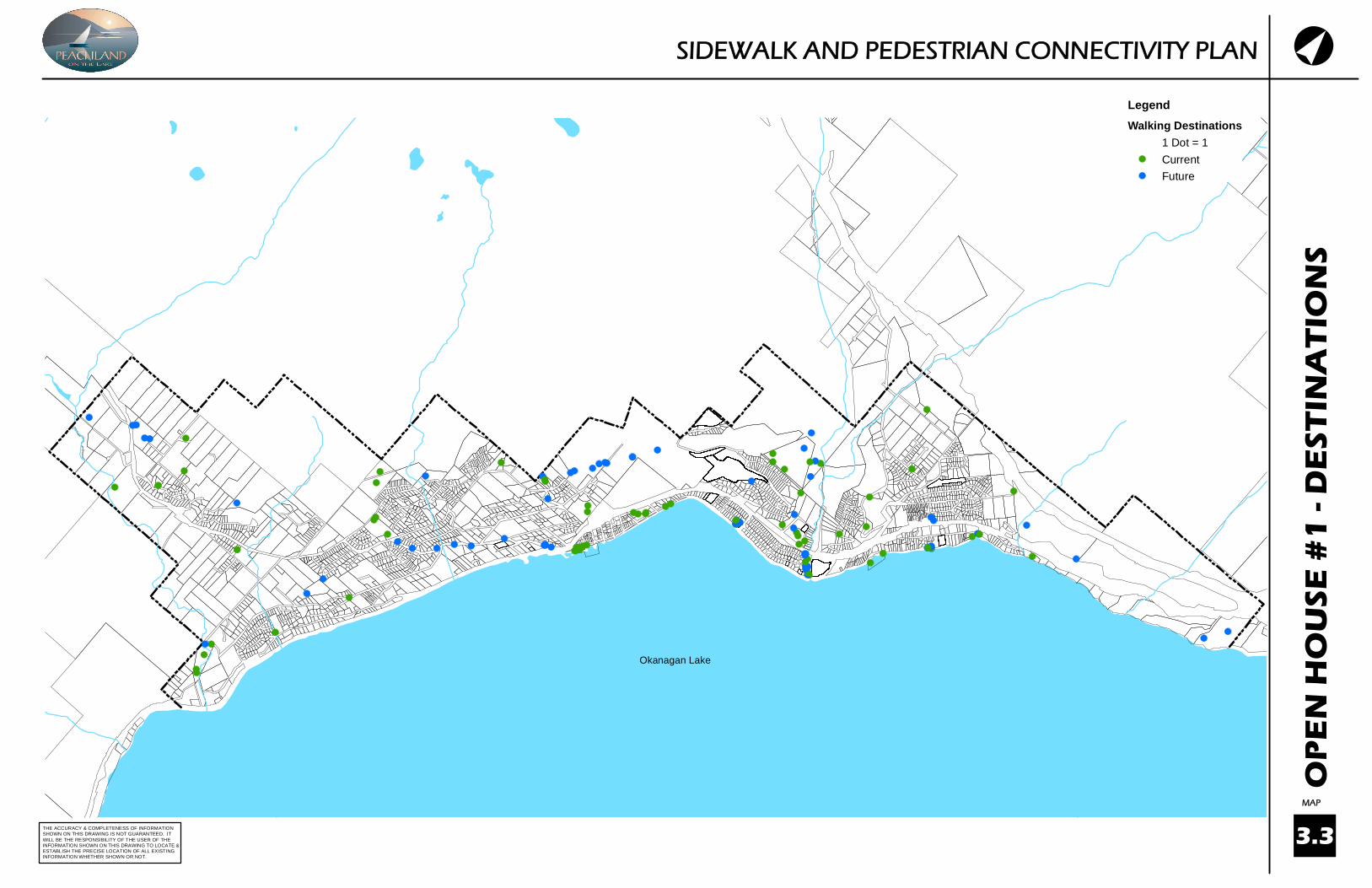
We asked att endees at the March 9, 2011 Open House to identi fy current and future pedestrian desti nati ons, such as transit stops, shopping, schools, and off -road trailheads. The desti nati on Peachland residents walk to currently and might walk to in the future were an important considerati on in the development of pedestrian connecti ons for this Plan. The desti nati ons that were identi fi ed during the planning process are shown on map 3.2, while the desti nati ons of att endees at the Open House is shown on map 3.3.
3.3.2 Proximity to Other Pedestrian Ameniti es (on-street and off -road)
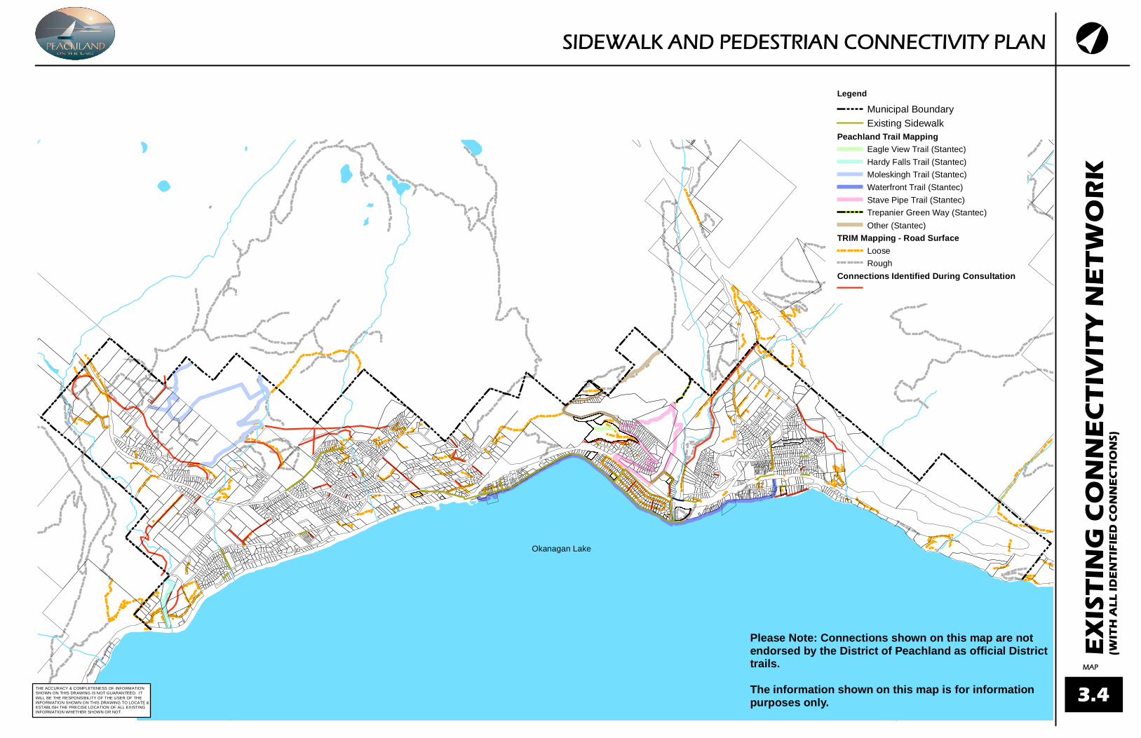
A number of ameniti es, other than sidewalks, make up the pedestrian network in Peachland. The public was asked to recorded these ameniti es, that include pathways or trails, on maps provided during community open house held in March and July. The Pedestrian Connecti vity Network links to some of these pedestrian ameniti es, however incorporati on of the off -road trails and pathways were outside the scope of the project. The informati on is useful for future initi ati ves, such as a trails master plan. Map 3.4 shows the on-street and off -road ameniti es recorded during the Planning Process.
It must be noted that this map is not offi cially endorsed by the District of Peachland as some trails and pathways are located on private property. The map is for informati on purposes only.
3.3.3 Pedestrian Generators
To ensure proper pedestrian connecti ons are provided, parti cular characteristi cs of land use must be considered. These characteristi cs include a mixture of land uses, density and a compact built form. For example, Beach Avenue - which features a mixture of residenti al and commercial land uses in a dense and compact built form - is a major pedestrian contributor as each parcel fronti ng onto the street has a use that potenti ally generates pedestrian traffi c.
Map 3.5 shows the District’s Land Use Map. The land uses that meet the greatest potenti al for Pedestrian Generati on are :
Medium-Density Residenti al;Core Commercial;Insti tuti onal;Integrated Residenti al; andGateway.
Public transit stops are another pedestrian generator. Transit routes that travel in both directi ons down a parti cular street also increase pedestrian traffi c in comparison to streets where transit only travels in one directi on. Figure 1, shows the BC Transit Route #22 map, while the approximate locati on of transit stops is shown on map 3.2 (Please note that bus stops along Beach Avenue are not shown on map 3.2. due to their close proximity and the mapping scale).

6DISTRICT OF PEACHLAND - SIDEWALK AND PEDESTRIAN CONNECTIVITY PLAN
3.3.4 Recreati onal Use
Feedback from the community, and the fact that a large majority of pedestrian trips in Peachland are for recreati onal purposes, were also considered. The Plan endeavours to provide walking loops that off er users the ability to start and end their walk at the same locati on, but not have to walk the same linear route back and forth.
3.3.5 Proximity to Road Classifi cati on
Map 3.6a, the Roadway Classifi cati on Map from the Subdivision and Development Servicing Bylaw (SDS) and Map 3.6b the Roadway Network Plan, show the road hierarchy and planned road network. The proximity to the type of road - i.e. road classifi cati on - is an important considerati on for safety and how enjoyable a sidewalk may be to use. The Road Classifi cati on is determined by the Roadway Network Master Plan and the Subdivision SDS Bylaw. These documents identi fy a range of characteristi cs that impact walking such as on street parking and sidewalk requirements. A selecti on of Roadway design guidelines are provided in table 1.
Table 1: Selected Road Design Guidelines
In additi on to the table 1, the SDS states that walkways are to be a minimum of 3.0 meters.
Considering the impact of sidewalks on one, or both, sides of the street was outside the scope of this project. However, some discussion to consider is provided for future considerati ons as follows:
A local road generally creates the most pedestrian traffi c as each parcel fronti ng onto the street is a connecti on. However, traffi c speed and volume are low and transit stops generally do not exist.
A collector road is typically the backbone of the residenti al street system. This is because a collector is within a suitable distance that pedestrians are willing to walk. As a result, the likelihood of transit routes that travel down both sides of the street is higher.
Arterial road classes have higher vehicle speeds and unless pedestrian crossings, reduced speed, or traffi c calming are incorporated they may not provide enough safe crossings to require sidewalks on both sides of the street.
BeachAvenueArterial
Arterial Collector Local
Design Speed(km/h)
30 50 60 50 30
MaximumGrade (%)
8 8 10 12
On streetParking
Shared no site specific site specific
Pedestrians
Sidewalk (oneside),
waterfrontwalkway
Sidewalk (oneside),
optional (twosides)
Sidewalk (oneside),
sidewalk (oneside)
Figure 1 - BC Transit Route #22 (source: BC Transit)

7DISTRICT OF PEACHLAND - SIDEWALK AND PEDESTRIAN CONNECTIVITY PLAN
3.3.6 Development Cost Charge Projects
The District has adopted a DCC Bylaw. Funds collected through DCCs are put into predetermined projects identi fi ed in the DCC Bylaw. Roads identi fi ed as DCC projects will include pedestrian amenity improvements. DCC road projects are shown on Map 3.7.
3.3.7 Future Development
The District is currently evaluati ng a number of major development proposals within the municipality. The master plans of these developments will guide the pedestrian faciliti es that are constructed. This Sidewalk and Pedestrian Plan considers these future developments by showing connecti ons along major roads within close proximity to these developments. The developers will be encouraged to preserve the connecti vity proposed in this Plan when designing the internal pedestrian ameniti es within their development.
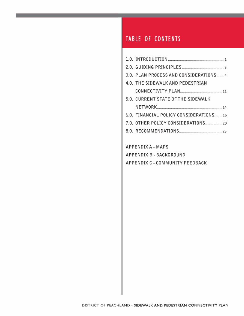
3.3.8 Cross-Secti ons
Sidewalk and pathway cross-secti ons show the type of pedestrian ameniti es to be provided on a street. The cross-secti on considers topography, cost, as well as, use and locati on. The eight cross-secti ons developed for this Plan are as follows:
Opti on 1 - Rural to Urban1. Opti on 2a - Rural to Rural Asphalt Pathway (at 2. grade)Opti on 2b - Rural to Rural Asphalt Pathway (steep 3. slope)Opti on 3a - Off Road Pathway (steep slope)4. Opti on 3b - Off Road Gravel Pathway (at grade)5. Opti on 4 - Pedestrian Trail6. Opti on 5 - Stairs7. Opti on 6 - Beach Avenue (13th to Todd Road)8.

8DISTRICT OF PEACHLAND - SIDEWALK AND PEDESTRIAN CONNECTIVITY PLAN
CLPL PL
OPTION #2a - RURAL TO RURAL ASPHALT PATHWAY (AT GRADE)
3m Asphalt Pathway(At grade)
Existing Rural Road Existing Rural Road
PL CL PL
OPTION #1 - RURAL TO URBAN
Asphalt Patch
Sidewalk
SwaleCatch BasinStorm Main
Existing Rural Road
Curb & Gutter
CLPL PL
OPTION #2b - RURAL TO RURAL ASPHALT PATHWAY (STEEP SLOPE)
3m Asphalt Pathway(Steep Slope)
Existing Rural Road Existing Rural Road
9DISTRICT OF PEACHLAND - SIDEWALK AND PEDESTRIAN CONNECTIVITY PLAN
OPTION #3a - OFF-ROAD ASPHALT PATHWAY (STEEP SLOPE)
PL PL
3m Asphalt Pathway(Steep Slope)
Gravel Pathway-width varies(At grade)
OPTION #4 - OFF-ROAD PEDESTRIAN TRAIL (AT GRADE)
PL PL
3m Gravel Pathway(At grade)
OPTION #3b - OFF-ROAD GRAVEL PATHWAY (AT GRADE)

10DISTRICT OF PEACHLAND - SIDEWALK AND PEDESTRIAN CONNECTIVITY PLAN
OPTION #5 - STAIRS
2m Stairs
150x300mm P.T. timbers anchored with 15mm Dia. Galv. Steel Pipe
50mm dense graded aggregate
100mm aggregate base
Compacted subgrade
CLPL
OPTION #6 - BEACH AVENUE (13th to TODD)
3m Asphalt Pathway(At grade)
Existing Road Existing Road Bioswale

11DISTRICT OF PEACHLAND - SIDEWALK AND PEDESTRIAN CONNECTIVITY PLAN
4.0 . THE SIDEWALK AND PEDESTRIAN PLAN
The processes, outcomes and considerati ons outlined in Secti on 3 and Appendix A of this Plan have been used to develop the Pedestrian Connecti vity Network. This secti on provides a comprehensive descripti on of the network.
4.1 The Pedestrian Connection Map
Map 4.1 shows the proposed pedestrian connecti vity network that is an outcome of the planning and public consultati on process. The total length of the connecti vity network shown on map 4.1 is approximately 34 km (see table 2). The length of new connecti ons - not including existi ng DCC projects - is approximately 24 km (see table 2).
Map 4.1 shows three types of connecti ons, as follows:
Off -street1. Examples of existi ng off -street connecti ons are the Trepanier Linear Park and asphalt walkway through Lambley Park. Proposed new off -street connecti ons include Minto Road, and porti ons of the Stave Pipe Trail.
Conceptual2. One example of a conceptual connecti on is the road through the Ponderosa/Pincushion Ridge development (Somerset to Ponderosa Drive). Another example is the connecti on from Robinson Place to the boundary of Peachland and West Kelowna (i.e. Trail 2000). Conceptual connecti ons are important pieces of the network, but the scope of this project limited the defi niti on of exact locati ons for these connecti ons.
Within road Right Of Way3. Connecti ons in the road right of way (ROW) make up the majority of the network.
The connecti vity network (map 4.1) intenti onally does not propose sidewalks and pedestrian connecti ons to all areas of Peachland, due to the signifi cant cost associated with constructi on. Each pedestrian connecti on, identi fi ed in Map 4.1 has an associated cross-secti on and cost, described in further detail in the next sub-secti on.
4.2 Cross - Sections Map
Map 4.2 shows the proposed cross-secti ons - i.e. sidewalks, stairs, on-and off -street paths - corresponding to Map 4.1. The constructi on cost esti mate (Class D) and descripti on of each cross-secti on opti on are as follows.
Opti on 1 - Rural to Urban - $900/m1. This opti on involves the installati on of a concrete curb, gutt er and 1.8m wide concrete sidewalk. The surface drainage will be collected by the gutt er and transmitt ed to a catchbasin and a piped storm sewer system. The opti on is primarily uti lized in the downtown core, along arterial and collector roads, and on local roads in an urban setti ng.
Opti on 2a - Rural to Rural Asphalt Pathway (at 2. grade) - $230/mThis opti on involves the installati on of a separated 3m wide asphalt pathway installed at grade (no walls or signifi cant excavati on required) adjacent to a roadway. The opti on is primarily uti lized in rural setti ngs where the land use, drainage and topography promote the use of this secti on. This secti on provides a safe facility for both pedestrians and non-motorized vehicles alike.

12DISTRICT OF PEACHLAND - SIDEWALK AND PEDESTRIAN CONNECTIVITY PLAN
Opti on 2b - Rural to Rural Asphalt Pathway (steep 3. slope) - $780/mThis opti on involves the installati on of a separated 3m wide asphalt pathway adjacent to a roadway which requires the installati on of a wall to retain the side slope of the proposed pathway. This opti on is similar to Opti on 2a but primarily uti lized in rural setti ngs with steeper slopes.
Opti on 3a - Off Road Pathway (steep slope) - 4. $490/mThis opti on involves the installati on of a 3m wide asphalt pathway which requires the installati on of a retaining wall to retain the pathway's side slope. The opti on is primarily uti lized in rural setti ngs with steeper slopes not adjacent to existi ng road corridors which allows for pedestrian connecti vity where a road corridor is not present.
Opti on 3b - Off Road Gravel Pathway (at grade) 5. - $130/mThis opti on involves the installati on of a 3m wide gravel pathway installed at grade (no walls or signifi cant excavati on required). The opti on is primarily uti lized in rural setti ngs where the land use, drainage and topography promote the use of this secti on. This secti on allows for effi cient pedestrian connecti vity in areas not adjacent to existi ng road corridors.
Opti on 4 - Pedestrian Trail - $110/m6. This opti on involves the installati on of a variable width gravel pathway installed at grade (no walls or signifi cant excavati on required). The opti on uti lizes the existi ng terrain to create pedestrian connecti vity across steep topography not adjacent to existi ng road corridors.
Opti on 5 - Stairs - $200/m7. This opti on involves the installati on of landscape ti mber style stairs (similar to the Lang Trail). The opti on is primarily uti lized in urban and rural setti ngs with very steep topography which allows for effi cient pedestrian movement away from the road corridor.
Opti on 6 - Beach Avenue (13th to Todd Road) - 8. $1,450/mThis opti on involves a conti nuati on of the 3m wide asphalt multi -use pathway and bio swale on Beach Avenue ( similar to Beach Avenue from 6th Street to 13th Street).
13DISTRICT OF PEACHLAND - SIDEWALK AND PEDESTRIAN CONNECTIVITY PLAN
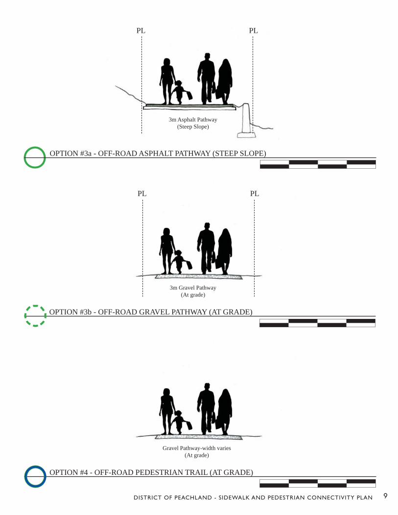
Table 2 shows the total length (meters) of each proposed cross-secti on, as well as existi ng sidewalk and DCC projects, that are within the connecti vity network (map 4.1).
Table 2 - Esti mated Total Length of Connecti vity Network
Table 3 calculates the esti mated total cost of the Pedestrian Connecti vity Network (shown on map 4.1). The total cost of the new connecti ons - not including DCC projects - is esti mated to be approximately $12 million dollars. DCC projects within the connecti vity network are esti mated to cost $2 million (see secti on 3.3 and map 3.7). The total cost of the connecti vity network including DCC projects is esti mated to be $14 million.
Table 3 - Esti mated Total Cost of Connecti vity Network
Cross SectionEstimatedLength (m)
Option 1 Rural to Urban 8,200Option 2a Rural to Rural Asphalt Pathway (at grade) 6,330Option 2b Rural to Rural Asphalt Pathway (steep slope) 2,800Option 3a Off Road Gravel Pathway (steep slope) 400Option 3b Off Road Gravel Pathway (at grade) 1,500Option 4 Off Road Trail 4,600
New Connections Total 23,830Existing Sidewalk 7,773DCC Projects 2,723
Total 34,394
Cross Section (Non DCCs)EstimatedLength (m)
Estimatedcost/meter
Estimated TotalCost
Option 1 Rural to Urban 8,200 $900 $7,380,000Option 2a Rural to Rural Asphalt Pathway (at grade) 6,330 $230 $1,455,900Option 2b Rural to Rural Asphalt Pathway (steep slope) 2,800 $780 $2,184,000Option 3a Off Road Gravel Pathway (steep slope) 400 $490 $196,000Option 3b Off Road Gravel Pathway (at grade) 1,500 $130 $195,000Option 4 Off Road Trail 4,600 $110 $506,000
Non DCC Sub Total 23,830 $11,916,900Cross Section (DCCs)
DCC Project Option 1 Rural to Urban* 2,163 $900 $1,946,700DCC Project Option 2a Rural to Rural Asphalt Pathway (at grade)** 560 $230 $128,800
DCC Sub Total 26,621 $2,075,500Total $13,992,400
* DCC Projects - RD 1 Princeton Avenue Upgrade (Hwy 97 to Ellison), RD 5 Hardy Road Upgrade, RD 6 Cousins Road Upgrade, & RD 8 Princeton Avenue Upgrade (Ellison to Turner). **DCC Projects - RD 4 Renfrew Road Upgrade

14DISTRICT OF PEACHLAND - SIDEWALK AND PEDESTRIAN CONNECTIVITY PLAN
5.0 . CURRENT STATE OF THE SIDEWALK NETWORK
This secti on provides a brief analyti cal overview of the current context of sidewalks and pedestrian connecti vity in Peachland.
5.1 Sidewalk Use
The 2006 Census indicates that pedestrian trips account for under 2% of all trips to work by Peachland residents. However, Peachland has a high number of reti rees, and a large majority of residents sti ll in the work force, commute to the surrounding communiti es. The distance between Peachland and the surrounding communiti es limits a commuters’ ability to walk to work. As a result, it is reasonable to assume that sidewalk use in Peachland is focused on recreati onal use rather than commuti ng.
The recently completed Parks and Recreati on Master Plan included a public survey that gives additi onal insight into the recreati onal aspects of the current sidewalk system. According to this survey, 83% of respondents used pedestrian trails below Highway 97 and 65% used trails above the highway.
The scope of this project did not include conducti ng a pedestrian count to determine current sidewalk usage in Peachland.
5.1.1 Existi ng Sidewalk Network
The current sidewalk network is provided on Map 5.1
As of 2008, nearly 5.7 kilometres of sidewalk existed in Peachland, with a replacement cost esti mated at just under $2 million dollars (2008 dollars). The District's geographic informati on system (GIS) indicates that 64 kilometres of roadway existed in the District (in 2008), meaning that over 90% of roadways are absent of sidewalks.
Existi ng sidewalks are not evenly distributed among the community, with about 5 kilometres, or 87%, located below Highway 97. There are two locati ons to cross the highway via pedestrian underpasses (see map 5.1).
The Beach Avenue Multi Use Pathway, shown on map 3.1, is one of the most signifi cant pedestrian connecti ons in Peachland. Located along Okanagan Lake, this corridor has been a major success for the District due to observed high level of usage and positi ve community feedback. In additi on to the Beach Avenue Multi Use Pathway, off -trails make up another major component of the pedestrian network.

15DISTRICT OF PEACHLAND - SIDEWALK AND PEDESTRIAN CONNECTIVITY PLAN
5.1.2 Sidewalk Funding
The District currently does not allocate funds in their fi nancial plans specifi cally for sidewalk improvements or maintenance. Sidewalks are only constructed as part of a developer's frontage improvement requirements at the ti me of subdivision or as part of the District's capital or Development Cost Charge road program.
The capital road program is provided by the 20-year Capital Plan. The road improvements in the Capital Plan are guided by the Road Network Plan (see Map 3.6A and 3.6B). The Road Network Plan, together with the Subdivision and Development Servicing Bylaw, inform the road standard (including sidewalks) for each segment. Development Cost Charge (DCC) projects are also included in the Capital Plan. The 20-year Capital Plan is as follows:
2011
DCC projects - $335,450 (13th Street upgrade)Non DCC projects - $337,430 (road replacement program)
2012DCC projects - $4,036,300 (#1-Princeton Avenue, Hwy 97 to Ellison; #2-Somerset/Princeton Intersecti on)Non DCC projects - $337,430 (road replacement program)
2013DCC projects - $1,682,900 (#1- Turner/Princeton Intersecti on; #2-Princeton Avenue Upgrade, Ellison to Turner)Non DCC projects - $337,430 (road replacement program)
2014Non DCC projects - $337,430 (road replacement program)
2015-2019DCC projects - $3,974,050 (#1-Beach Avenue - 13th to Todd; #2-Renfrew Road; #3-Hardy Street; #4-Cousins Road)
The roads identi fi ed as DCC projects in the list above are arterial and collector roads that will have sidewalks constructed in accordance with the Roadway Network Master Plan and Subdivision and Development Servicing Bylaw.

16DISTRICT OF PEACHLAND - SIDEWALK AND PEDESTRIAN CONNECTIVITY PLAN
6.0 . FINANCIAL POLICY CONSIDERATIONS
A key guiding principle of the Sidewalk and Pedestrian Connecti vity Plan is fi nancing the constructi on and maintenance of sidewalk and pedestrian faciliti es associated with the network. Once approved, the Plan will allow the District to seek grants, inform other documents such as the Development Cost Charge Bylaw and Roadway Network Plan. It will provide Staff and Council with a strategic guide to negoti ate required frontage improvements and costs with landowners and developers. This secti on describes diff erent fi nancial opti ons for Peachland, including:
Development Cost Charges;1. Amenity Contributi ons;2. Grant Programs; and,3. Cash In Lieu. 4.
6.1 Development Cost Charges (DCC)
Development cost charges are one opti on available to municipaliti es for funding of infrastructure associated with growth. A DCC is most appropriate for projects that increase capacity or expand on existi ng infrastructure, such as a roadway.
The District of Peachland's DCC road projects, as well a comparison of the DCC Year and 2011 Financial Plan Year, are shown in table 4.
Table 4: DCC Road Projects
* Not included in Financial Plan
Sidewalk connecti ons along roads not identi fi ed in the DCC program do not receive money from DCCs. Other opti ons to fi nance sidewalk constructi on are provided in the following subsecti ons.
6.2 Amenity Contributions
Beginning in November 2010, the District's Staff have worked on the process of amending the OCP to include an Amenity Contributi on policy. The next step in this process is a Public Hearing.
The Local Government Act (LGA) (s.904 & s.905) provides municipaliti es in BC this tool to fund important community ameniti es not directly associated with development. Secti on 904 enables the establishment of a bonus density zone, that allows for increased density as part of a rezoning applicati on (above what is allowed by the zone) in exchange for a contributi on to a Reserve Fund for specifi c purposes. Secti on 905 enables the municipality to require community amenity contributi ons to be paid by development that will be constructed in phases. Phased development is typically large-scale, meaning a dramati c increase in populati on size. A community may not have suffi cient ameniti es to support large populati ons, hence the need for the legislati on included in secti on 905.
id # Project Name DCC Year2011 Financial
Plan Year
RD1Princeton Avenue Upgrade Hwy 97to Ellison
2010 2012
RD4 Renfrew Road Upgrade 2018 *RD5 Hardy Street Upgrade 2018 *RD6 Cousins Road Upgrade 2018 *RD7 13th Street Upgrade 2010 2011
RD8Princeton Avenue Upgrade Ellison toTurner
2013 2013
RD10Beach Avenue Upgrade 13th Streetto Todd Road (not including walkway)
2015 2015 2019

17DISTRICT OF PEACHLAND - SIDEWALK AND PEDESTRIAN CONNECTIVITY PLAN
The community ameniti es relevant to this Plan that were identi fi ed by the District of Peachland are provided below.
Waterfront Enhancement - Beach Avenue13th St. to Todd Rd. (48% of the total cost is o eligible to be funded by DCCs)Todd Rd. to Davis Cove (48% of the total o cost is eligible to be funded by DCCs)
25,000 meters of Future Trail Development.
The amenity charges proposed by the District are as follows:
per residenti al unit = $1,877.40per square foot of non-residenti al fl oor area = $26.80
6.3 Grant Programs
Funds from municipal taxes are oft en not allocated to sidewalk constructi on or pedestrian connecti vity. In the constrained fi scal climate that municipaliti es face today, the need for funding from senior levels of government and other organizati ons is paramount. Examples of previous grant funding programs include:
Local Moti on;Building Canada Fund;Towns For Tomorrow;Gas Tax Grants such as the General Strategic Prioriti es Fund - Capital Projects and Innovati ons Fund;Recreati on Infrastructure Canada.; andGreen Municipal Fund - Sustainable Transportati on Projects.
6.4 Cash in Lieu
Secti on 938 of the Local Government Act (LGA) enables municipaliti es to regulate and require, as a conditi on of subdivision approval or building permit, the provision of works and services associated with the development. The standards for these works and services are defi ned in the District of Peachland Subdivision and Development Servicing Bylaw.
Secti on 938 (6)(a) of the LGA restricts the municipality from requiring cash in lieu for works and services that are not immediately adjacent to the site being developed or subdivided. (i.e. the requirement to provide sidewalk must be directly associated to the subdivision or development). In other words, the LGA does not enable the municipality to require sidewalks, or cash in lieu of sidewalks, to be provided elsewhere in the municipality as a conditi on to the approval of the subdivision or the development.
Secti on 938 (8) (b) states that the municipality cannot include specifi c services as a conditi on of subdivision or development that are included in the calculati on of DCC's unless the owner agrees to provide the services. Therefore, the LGA does not enable the municipality to require cash in lieu for a pedestrian connecti on where the developer has already paid DCC's for the same connecti on.
In summary, no legislati on in BC specifi cally enables a municipality to require the owner of land to pay money for the provision of sidewalks or pedestrian connecti ons as a conditi on of subdivision or development, where the connecti ons are not directly related to the land or development in questi on.

18DISTRICT OF PEACHLAND - SIDEWALK AND PEDESTRIAN CONNECTIVITY PLAN
Furthermore, the legislati on clearly restricts the municipality from asking for cash in lieu of specifi c services or improvements, such as sidewalks, for which the owner of land has already paid DCCs. In other words, the municipality cannot collect DCCs and Cash in Lieu for the same project.
One innovati ve alternati ve available to Peachland may be the establishment of a fund for the provision of sidewalks. A fund such as this has - for the purpose of implementi ng a 5 year Sidewalk Plan - has been implemented by the City of Colwood, on Vancouver Island. The fund is internally restricted meaning Council has adopted the fund for the specifi c purpose of holding monies to implement the 5 year Sidewalk Plan. The monies collected are credited as a liability on the balance sheet. In other words, the monies are essenti ally unearned revenue.
Staff will negoti ate with the owner or occupier of the land or building - or other structure - at the ti me of building permit or subdivision approval for donati ons to the fund as an alternati ve to constructi ng frontage improvements. This works similar to a Cash in Lieu process, but may include sidewalks, curb, gutt er, paving, storm sewer systems, streetlights or others as seen fi t by Staff and Council.
A telephone interview with the Chief Financial Offi cer at the City revealed that the fund was set up in 2008 but has not accumulated enough funds to see any completed sidewalk projects. Additi onal correspondence to the City's engineering department has been sent, but at this ti me no reply has been received.
It should be noted that this voluntary process may require certain incenti ves or concessions by the municipality in order to be successful.
6.4.1 Cash in lieu of parking
The LGA enables the municipality to include parking and off street loading space as part of approving a subdivision of land or development. As an alternati ve the LGA allows municipaliti es to receive cash instead of requiring constructi on of the parking amenity.
The LGA s. 906 statutes are summarized below:
The local government must state in a bylaw the amount payable as an alternati ve to the constructi on of parking or off -street loading.The opti on to pay is that of the owner or occupier of the land or building or other structure.The money received by the municipality must be credited into a reserve fund for the purpose of providing off -street parking or transportati on infrastructure that supports walking, bicycling, public transit or other alternati ve forms of transportati on.
In summary, if suffi cient parking is deemed to exist, a municipality may use these powers to build sidewalks. In most cases, funds collected by secti on 906 powers are accumulated to provide future parking structures, not sidewalks.
The District of Peachland has a cash in lieu of parking policy. The policy identi fi es areas between 1st and 8th Street and Beach Avenue from Princeton to 1st Street as eligible locati ons. The cash in lieu payment is identi fi ed at the rate of $6,000 per stall.

19DISTRICT OF PEACHLAND - SIDEWALK AND PEDESTRIAN CONNECTIVITY PLAN
6.4.2 Cash in Lieu of Park Land
Secti on 941 (1) of the LGA requires the owner of land to provide park land at the ti me of subdivision. Alternati vely, secti on 941 (1)(b) enables the owner of land, at the owner's opti on, to pay an amount to the municipality equal to the market value of land that would be required for park land purposes.
Secti on 941 (12) states that the money paid for park land must be deposited into a reserve fund established for the purposes of acquiring park land.

20DISTRICT OF PEACHLAND - SIDEWALK AND PEDESTRIAN CONNECTIVITY PLAN
7.0 . OTHER POLICY CONSIDERATIONS
The additi onal policy areas for considerati on as part of this Plan are as follows:
Sidewalk Characteristi cs and Connecti onsOperati ons and Maintenance
7.1 Sidewalk Characteristics and Connections
Secti on 6.0 of this Plan provided fi nancial policy considerati ons. It is important to note the relati onship between the ease of design and constructi on of each connecti on (cross-secti on) and decreased costs, which in turn directly impacts fi nancial policy considerati ons.
7.1.1 Sidewalk Connecti ons in Greenfi eld Development
The District's Subdivision and Development Servicing Bylaw (SDS) requires frontage improvements to include the constructi on of sidewalks. In general terms, the District should conti nue to require sidewalks as per the current subdivision standards for new development. However, aft er this Sidewalk and Pedestrian Connecti vity Plan has been adopted, greenfi eld development applicati ons should demonstrate a considerati on for the broader goals of the District. In this way, new development areas contribute, where it makes sense, to overall pedestrian connecti vity. In some cases, it may make sense to negoti ate a donati on or amenity contributi on to achieve connecti vity elsewhere.
Prior to approving a development applicati on, the District should explore the opti on of requiring a community-led, pedestrian-oriented audit of the development. Guidelines should be adopted to deal with urban design features such as maximum block lengths, maximum block sizes, limiti ng cul-de-sacs and ensuring that pedestrian breezeways at the end of cul-de-sacs are provided.
7.1.2 Sidewalk Connecti ons in Infi ll Development
Infi ll development is also subject to the District's SDS Bylaw requirements of frontage improvements to include the constructi on of sidewalks. For infi ll development, the requirement of sidewalks for all applicati ons may not achieve the goals of this Plan. Map 3.1, which shows the existi ng sidewalks in the District, is evidence of this observati on.
As infi ll development may occur in any areas, both those that see more or less amounts of development acti vity, a sidewalk might be constructed along a street where no other sidewalk currently exist. The District should follow the directi on of this plan when considering frontage improvements related to new infi ll development. If a sidewalk does not achieve the goals of this Plan, the District should seek a donati on or amenity contributi on instead of requiring the infi ll development to provide sidewalk.

21DISTRICT OF PEACHLAND - SIDEWALK AND PEDESTRIAN CONNECTIVITY PLAN
7.1.3 Connecti ons to off -road trails and other areas
The topography of Peachland makes for great hiking and off -road pedestrian trails that lead to lookouts and viewpoints of Okanagan Lake and the valley. Off -road trails can provide pedestrian connecti ons, increased health, tourism generators and other factors that follow the Guiding Principles of this Plan. While off -road trails are not part of this plan, the public consultati on process gathered a signifi cant amount of informati on about off -road connecti ons and use (See Appendix C).
The Parks and Recreati on Master Plan recommended bett er connecti ons, signage and maps of off -road trails. Where ever possible, connecti ons to off -road trailheads within the District should be developed and promoted.
The Regional District of Central Okanagan’s (RDCO) Greenway Master Plan includes a policy for the provision of off -road trail connecti ons to municipal parks and trails. The Regional District is also implementi ng its Legacy Program of acquiring Crown Land for park and greenway development.
The Trail 2000 connecti on from the W.R. Bennett Bridge, through West Kelowna and Peachland to Hardy Falls, is a long-term regional initi ati ve. A route to the Northern most boundary of the District of Peachland should be identi fi ed.
7.2 Operations and Maintenance
7.2.1 Create a 5 year Connecti vity Plan
A strategic District wide map updated in 5 to 10 year cycles will ensure that new sidewalk constructi on is recorded from the District's Asset Management Program and that new prioriti es for pedestrian connecti ons are identi fi ed on an ongoing basis.
7.2.2 Adopt a Sidewalk or Pathway
The provision of sidewalks is a public good that benefi ts the enti re community. Similar to creeks and other roadways, one potenti al way to shift ownership of sidewalk maintenance is through a program of adopti ng a sidewalk. If this type of program was implemented, residents would apply to the District for the parti cular segment that they wish to maintain.
Adopted sidewalks would be maintained in good conditi on so that problems would be prevented - from cracks, uneven surfaces or drainage problems. In the winter, these sidewalks would be cleared regularly by the adoptee.
7.2.3 Signalized Intersecti on
The District should examine a policy for pedestrian controlled signalized crossings. This could include a ti me to cross standard, countdown warning signals and pedestrian controlled crossing locati ons.
7.2.4 Improve Winter Walkability
The District currently requires that owners or occupiers of a parcel shall remove all ice and snow from all sidewalks adjacent to that parcel so that the
sidewalks are not covered by snow or ice between the hours of 8:00am and 8:00pm.
Additi onal enforcement by Bylaw offi cers may be required to ensure compliance with the District Bylaw. An alternati ve could be to allocate one-ti me funding for a community building eff ort that establishes a volunteer or fundraising program for snow removal. Such a program would enable those who are physically unable to remove snow in a ti mely manner to meet District Bylaws.

22DISTRICT OF PEACHLAND - SIDEWALK AND PEDESTRIAN CONNECTIVITY PLAN
7.2.5 Pedestrian Security
In additi on to ensuring sidewalks are well maintained and cleared during the winter, personal pedestrian security is also an important considerati on. Security means freedom from risk of assault or theft ; these risks discourage walking. As these crimes are oft en opportunity driven, the problems can be addressed through various programs and designs.
Ensuring natural surveillance of pedestrian faciliti es is possible by carefully considering:
Sightlines;Adequate lighti ng;Maintaining the growth of vegetati on adjacent to pathways;Locati ons for gathering areas such as bus stops and benches; andMinimizing hiding places during design.
7.2.6 Update Existi ng Bylaws
The District should ensure that as funding is made available, bylaws and plans are conti nually updated to follow the District's vision for sustainability of the pedestrian system. This includes:
the Offi cial Community Plan;the Development Cost Charges Bylaw;the Roadway Network Master Plan;the Parks and Recreati on Master Plan; and,the Zoning Bylaw.

23DISTRICT OF PEACHLAND - SIDEWALK AND PEDESTRIAN CONNECTIVITY PLAN
8.0 . RECOMMENDATIONS
The previous secti ons have described the proposed connecti vity network and associated policy considerati ons. This secti on provides the recommendati ons that have come out of this planning process. These recommendati ons are included because residents of Peachland feel walking and pedestrian connecti ons are important. This understanding is based on the popularity of the Beach Avenue multi -use walkway, survey results from the Parks and Recreati on Master Plan and feedback from the public consultati on process as part of this Plan process.
8.1 Connectivity Network Priority
Map 8.1 shows the proposed priority order for constructi ng the connecti vity network. The priority order considers current development applicati ons and DCC projects as well as considerati on gathered throughout the planning process - e.g. feedback from the public.
The priority order does not have specifi c ti meframes assigned to priority 1, 2, 3 or DCC projects. A wide-range of factors determine when a project could get constructed, and identi fying these factors is outside the scope of this project. The priority order is intended to serve as a guideline for future initi ati ves, such as updates to DCC's or grant applicati ons.
Table 5 provides the associated length and cost for the connecti vity network priority map (map 8.1). Costs are calculated based on the cross-secti ons described in secti on 5.
Table 5 - Connecti vity Network Priority and Esti mated Cost
8.2 Recommended Next Steps
The recommended next steps provide specifi c acti on items that the District could undertake to implement this Plan.
Establish a dedicated fund for sidewalk constructi on, and consider what concessions the District is willing to give to developers or land owners before waiving the requirements for sidewalks - as part of Subdivision approval - in favour of a donati on to the fund;Ensure that sidewalk and connecti vity projects in this plan are considered during any potenti al future updates to the Development Cost Charge Bylaw;Seek funding and work with other agencies to provide pedestrian connecti ons as per map 5.1a, connecti ons across Highway 97.Work to construct the District of Peachland porti on of Trail 2000 by considering the project in all short and long range plans, as well as, considering the appropriate means to support community groups such as the Gellatly Bay Trails and Parks Society.Consider regular updates to this Sidewalk and Pedestrian Connecti vity Plan, in parti cular the connecti vity network (map 4.1);Consider sidewalk requirements during the next update of the Road Network Plan, including where to provide sidewalks on both sides of the street.Ensure this Plan refl ected in the next update of the Offi cial Community Plan, including the considerati on to adopt a map schedule focusing specifi cally on pedestrian connecti ons (sidewalks, trails, pathways).
Priority Length (m)Estimated Total
Cost1 5,065 $3,278,9292 9,707 $5,056,9643 9,126 $4,433,613
DCCProject 2,723 $2,075,828

24DISTRICT OF PEACHLAND - SIDEWALK AND PEDESTRIAN CONNECTIVITY PLAN
APPENDIX A - MAPS

!(
!(
!(!(
!(
!(!(
!(!(
!(
!(
!(!(
!(!( !(
!(
!(
!( !(
!(!( !(!(
!(
!(
!(
SIDEWALK AND PEDESTRIAN CONNECTIVITY PLAN
THE ACCURACY & COMPLETENESS OF INFORMATIONSHOWN ON THIS DRAWING IS NOT GUARANTEED. ITWILL BE THE RESPONSIBILITY OF THE USER OF THEINFORMATION SHOWN ON THIS DRAWING TO LOCATE &ESTABLISH THE PRECISE LOCATION OF ALL EXISTINGINFORMATION WHETHER SHOWN OR NOT.
OP
EN
HO
USE
#1
- A
TT
EN
DE
ES
3.1
MAP
°Legend
!( Where do you live?
Okanagan Lake

$+P
$+P
$+P
$+P
$+P
$+P$+P
$+P
$+P
$+P
$+P
$+P
$+P
$+P
$+P
$+P
$+P$+P
$+P$+P
$+P
$+P
$+P
$+P
$+P$+P
$+P
$+P
$+P
$+P
$+P
$+P
$+P
$+P
$+P ")ú ")ú
^
^^
-±°̄
å
Æa Æa
Æa
ï
^
^
^
^
^
KJ
^
^
^
^
^
^
Æa
Æa
Æa
^
^
^
^
^
^
^
KJ
^
^^ ^
Æa
Æa
Æa
ÆaÆa
ÆaÆaÆa
ÆaÆa
ÆaÆa
Æa
ÆaÆaÆa
Æa Æa
Æa
Æa
Æa
SIDEWALK AND PEDESTRIAN CONNECTIVITY PLAN
THE ACCURACY & COMPLETENESS OF INFORMATIONSHOWN ON THIS DRAWING IS NOT GUARANTEED. ITWILL BE THE RESPONSIBILITY OF THE USER OF THEINFORMATION SHOWN ON THIS DRAWING TO LOCATE &ESTABLISH THE PRECISE LOCATION OF ALL EXISTINGINFORMATION WHETHER SHOWN OR NOT.
CO
MM
UN
ITY
AM
EN
ITIE
S
3.2
MAP
°Legend
Æa Bus StopÆa Covered Bus Stopï Cemeteryå Elementary School^ Key Point of Interest")ú Pedestrian Underpass-±°̄ Shopping CentreKJ Water Reservoir$+P Current Parks
Okanagan Lake
Note: Bus Stops along Beach Avenueare not shown due to their close proximityand the mapping scale.
Beach Avenue (from Hwy 97 to 13th Street)has Bus Stops on both side of the street.
SIDEWALK AND PEDESTRIAN CONNECTIVITY PLAN
THE ACCURACY & COMPLETENESS OF INFORMATIONSHOWN ON THIS DRAWING IS NOT GUARANTEED. ITWILL BE THE RESPONSIBILITY OF THE USER OF THEINFORMATION SHOWN ON THIS DRAWING TO LOCATE &ESTABLISH THE PRECISE LOCATION OF ALL EXISTINGINFORMATION WHETHER SHOWN OR NOT.
OP
EN
HO
USE
#1
- D
EST
INA
TIO
NS
3.3
MAP
°LegendWalking Destinations
1 Dot = 1CurrentFuture
Okanagan Lake
SIDEWALK AND PEDESTRIAN CONNECTIVITY PLAN
THE ACCURACY & COMPLETENESS OF INFORMATIONSHOWN ON THIS DRAWING IS NOT GUARANTEED. ITWILL BE THE RESPONSIBILITY OF THE USER OF THEINFORMATION SHOWN ON THIS DRAWING TO LOCATE &ESTABLISH THE PRECISE LOCATION OF ALL EXISTINGINFORMATION WHETHER SHOWN OR NOT.
EX
IST
ING
CO
NN
EC
TIV
ITY
NE
TW
OR
K
3.4
MAP
°Legend
Municipal BoundaryExisting Sidewalk
Peachland Trail MappingEagle View Trail (Stantec)Hardy Falls Trail (Stantec)Moleskingh Trail (Stantec)Waterfront Trail (Stantec)Stave Pipe Trail (Stantec)Trepanier Green Way (Stantec)Other (Stantec)
TRIM Mapping - Road SurfaceLooseRough
Connections Identified During Consultation
Okanagan Lake
(WIT
H A
LL
ID
EN
TIF
IED
CO
NN
EC
TIO
NS)
Please Note: Connections shown on this map are notendorsed by the District of Peachland as official Districttrails.
The information shown on this map is for informationpurposes only.

District of Peachland
File Path: U:\Projects_KEL\0655\_ClientInfo\Maps\Composites\planning\ocp\OCP-2008-Update\Maps\F00-OCP-ScheduleB.mxd.............MXD DATE: (2008-02-19)
THE ACCURACY & COMPLETENESS OF INFORMATIONSHOWN ON THIS DRAWING IS NOT GUARANTEED. ITWILL BE THE RESPONSIBILITY OF THE USER OF THEINFORMATION SHOWN ON THIS DRAWING TO LOCATE &ESTABLISH THE PRECISE LOCATION OF ALL EXISTINGINFORMATION WHETHER SHOWN OR NOT.
0 250 500 750 1,000Meters
Official Community PlanSchedule B: Land Use DesignationsScale: 1:30,000Date: 2008-02-19
Legend
Low Density Residential
Medium-Density Residential
Core Commercial
Highway Commercial
Resort Commercial
Tourist Commercial
Institutional
Integrated Residential
Gateway
Blue Waters
Industrial
Farmland
Rural
Parks/Rec/Natural Areas
Potential Park Areas
Sector Plan Areas
Lower Princeton Sector Plan Area
Upper Princeton Sector Plan Area
New Monaco Sector Plan Area
Pincushion Sector Plan Area
Trails and Walkways
Major Water Course
12
3
4
1
2
3
4
Number Date Bylaw # Description1 03/12 n/a Add Revision Block and Disclaimer2 04/12 1741 Lot 55, Plan 117, DL 1183, Rural to LDR3 n/a 1600 Town Centre replaced with Core Commercial4 08/02/19 1802 Lot 1, Plan 26239, DL 1174, Rural to Resort Commercial5 08/02/20 1823 Lot A, Plan 30459 & Lot 1, Blk. 7, DL 490, LDR to MDR6 08/02/21 1847 Lot B, Plan 25185, DL 221, Highway Commercial to MDR78910
Revisions and Amendments
P
MAP 3.5source: O cial Community Plan

FIGURE 3.6Asource: SDS Bylaw

MAP 3.6Bsource: Roadway Network Master Plan

SIDEWALK AND PEDESTRIAN CONNECTIVITY PLAN
THE ACCURACY & COMPLETENESS OF INFORMATIONSHOWN ON THIS DRAWING IS NOT GUARANTEED. ITWILL BE THE RESPONSIBILITY OF THE USER OF THEINFORMATION SHOWN ON THIS DRAWING TO LOCATE &ESTABLISH THE PRECISE LOCATION OF ALL EXISTINGINFORMATION WHETHER SHOWN OR NOT.
DE
VE
LO
PM
EN
T C
OST
CH
AR
GE
PR
OJE
CT
S
3.7
MAP
°Legend
DCC Project
Okanagan Lake

DR
PL
DR
PL
ST
ST
ST
ST
4TH
3RD
AVE
AVE
AVE
AVE
PL.
AVE
AVE
RO
AD
WITT
ROAD
RO
AD
ROAD
ROAD
ROAD
HILL
ROA
D
LAN
E
LAN
E
ROAD
ROAD
ROAD
RO
AD
ROAD
LANE
DRIV
E
PLAC
E
PLACE
FIRST
DRIVEPLACE
PLACE DRIVE
DRIVE
DRIVE
PLAC
E
CRESC
CRES
.
MINTO
CO
UR
T
MINTO
BEACH
BEACH
CRES
C
COURT
PLACE
PLACE
PLACE
AVENUEAVENUE
AVENUE
HUSTON GREATA
AVENUE
STREET
BU
LYE
A
MIL
LER
GUM
MO
W
DAVIESGILLAM
STRE
ET
EHLERS
AVENUE
BUTLER
8TH ST
1ST ST
2ND ST
3RD ST
4TH ST
6TH STNASH
ST
ELLI
SON
HIGHWAY
BRADBURY
THOMPSON
HEI
GH
WAY
LOGAN RD
SOM
ERS
ET
BROWN P
L
COLUMBIA
11TH
ST
CRESCENT
LAKEVIE
W
PONDEROSA
PONDEROSA
TRE
PANIER
SMIT
H W
AY
TREPANIER
BENC
H RD
.M
acK
INN
ON
SHAW
RO
AD
SHAW ROAD
PINERID
GE
PRINCETON
MA
CK
RO
AD
HAWKES
ST LILLEY ST
McCALL
PL
PEACHLAND
LAKE AVE
LAKE AVE
YORK
LAN
E
Mac KINNON
DRY
DEN
RD
HIGHWAY 97
KEY
ES
AV
E
LAW
STR
EET
HIG
HWAY
97
TUR
NE
R A
VE
McKAY LANE
6TH AVENUE
WALKER ROAD
INGA STREET
VER
NO
N A
VE
THO
RN
E R
OA
D
THORNE ROAD
THO
RNE
ROAD
LIPS
ETT
AVE
WIL
SON
ROAD
SOMERSET PL
12TH
S
T
HIGHWAY 9
7
INGLIS PLA
CE
CO
US
INS
RO
AD
DROUGHT ROAD
PIE
RC
E P
LAC
E
HA
CK
ER P
LAC
E
FER
GUS
ON P
L. RENF
REW R
OAD
GA
RR
AW
AY P
L.
SAN CLEMENTE
COUSINS ROAD
LORNELL CR
SHER
BU
RN
RO
AD
PRIN
CETO
N AV
E
PRIN
CETON AVE
JAC
KSO
N C
RE
SC
MELDRUM PLACE
BEAT
RICE
RO
AD
SOMERSET A
VE
TAILYOUR LANE
MACNEILL COURT
MORRISON R
OAD
PIERCE STREET
WH
INTO
N C
RES
C
PRIN
CESS
ST
SAN
DER
SO
N A
VE
MACGREGOR R
OAD
LAMBLY PARK ROBINSON PLACE
POND
ERO
SA D
RIVE
PONDEROSA DRIVE SUTHERLAND ROAD
McDOUGALD ROAD
STUA
RT C
RESC
ENT
VICTORIA STREET
WILLIA
MS STREET
DESERT PINES AVE
PINERIDGE RD.
ELLIOTT AVENUE
DESER
T PINES AVE.
PRINCETON AVENUE
SAN CLEMENTE AVE
SIDEWALK AND PEDESTRIAN CONNECTIVITY PLAN
THE ACCURACY & COMPLETENESS OF INFORMATIONSHOWN ON THIS DRAWING IS NOT GUARANTEED. ITWILL BE THE RESPONSIBILITY OF THE USER OF THEINFORMATION SHOWN ON THIS DRAWING TO LOCATE &ESTABLISH THE PRECISE LOCATION OF ALL EXISTINGINFORMATION WHETHER SHOWN OR NOT.
CO
NN
EC
TIV
ITY
NE
TW
OR
K
4.1
MAP
°Municipal Boundary
Pedestrian Connectivity Plan NetworkPedestrian Connection (off-street)Pedestrian Connection (conceptual)Pedestrian Connection (in road ROW)
Okanagan Lake

SIDEWALK AND PEDESTRIAN CONNECTIVITY PLAN
THE ACCURACY & COMPLETENESS OF INFORMATIONSHOWN ON THIS DRAWING IS NOT GUARANTEED. ITWILL BE THE RESPONSIBILITY OF THE USER OF THEINFORMATION SHOWN ON THIS DRAWING TO LOCATE &ESTABLISH THE PRECISE LOCATION OF ALL EXISTINGINFORMATION WHETHER SHOWN OR NOT.
CO
NN
EC
TIV
ITY
CR
OSS
-SE
CT
ION
S
4.2
MAP
°
Cross Section Option12a2b3a3b456
Okanagan Lake
0 1,000 2,000Meters

")ú ")ú
DR
PL
DR
PL ST
ST
ST
ST
4TH
3RD
AVE
AVE
AVE
AVE
PL.
AVE
AVE
ROA
DWITT
ROAD
RO
AD
ROAD
ROAD
ROAD
HILL
ROA
D
LANE
LAN
E
ROAD
ROAD
ROAD
RO
AD
ROAD
LANE
DRIV
E
PLAC
E
PLACE
FIRST
DRIVEPLACE
PLACE DRIVE
DRIVE
DRIVE
PLAC
E
CRESC
CRES
.
MINTOC
OU
RT
MINTO
BEACH
BEACH
CRES
C
COURT
PLACE
PLACE
PLACE
AVENUEAVENUE
AVENUE
HUSTON GREATA
AVENUE
STREET
BUL
YEA
MIL
LER
GUM
MOW
DAVIESGILLAM
STRE
ET
EHLERS
AVENUE
BUTLER
8TH ST
1ST ST
2ND ST
3RD ST
4TH ST
6TH STNASH
ST
ELLI
SON HIGHWAY
BRADBURY
THOMPSON
HEI
GH
WAY
LOGAN RD
SOM
ERS
ET
BROWN P
L
COLUMBIA
11TH
ST
CRESCENT
LAKEVI
EW
PONDEROSA
PONDEROSA
TRE
PAN
IER
SMIT
H W
AY
TREPANIER
BEN
CH R
D.M
acK
INN
ON
SHAW
RO
AD
SHAW ROAD
PINERIDGE
PRINCETON
MA
CK
RO
AD
HAWKE
S ST LILLEY ST
McCALL
PL
PEACHLAND
LAKE AVE
LAKE AVE
YORK
LAN
E
Mac KINNON
DRY
DEN
RD
HIGHWAY 97
KEY
ES
AVE
LAW
STR
EET
HIG
HWAY
97
TUR
NER
AVE
McKAY LANE
6TH AVENUE
WALKER ROAD
INGA STREET
VER
NO
N A
VE
THO
RN
E R
OA
D
THORNE ROAD
THO
RNE
RO
AD
LIPS
ETT
AVE
WIL
SON
ROAD
SOMERSET PL
12TH
S
T
HIGHWAY 9
7
ING
LIS PLACE
CO
US
INS
RO
AD
DROUGHT ROAD
PIE
RC
E P
LAC
E
HA
CK
ER P
LAC
E
FER
GUS
ON
PL. RE
NFREW
RO
AD
GA
RR
AW
AY P
L.
SAN CLEMENTE
COUSINS ROAD
LORNELL CR
SHER
BU
RN
RO
AD
PRIN
CETO
N AV
E
PRINCETO
N AVE
JAC
KSO
N C
RE
SC
MELDRUM PLACE
BEAT
RICE
RO
AD
SOMER
SET A
VE
TAILYOUR LANE
MACNEILL COURT
MORRISON ROAD
PIERCE STREET
WHI
NTO
N C
RESC
PRIN
CESS ST
SAN
DER
SO
N A
VE
MACGREGOR ROAD
LAMBLY PARK ROBINSON PLACE
POND
EROSA
DRI
VE
PONDEROSA DRIVE SUTHERLAND ROAD
McDOUGALD ROAD
STUA
RT C
RESC
ENT
VICTORIA STREET
WILLIAM
S STREET
DESERT PIN
ES AVE
PINERIDGE RD.
ELLIOTT AVENUED
ESER
T PINES A
VE.
PRINCETON AVENUE
SAN CLEMENTE AVE
SIDEWALK AND PEDESTRIAN CONNECTIVITY PLAN
THE ACCURACY & COMPLETENESS OF INFORMATIONSHOWN ON THIS DRAWING IS NOT GUARANTEED. ITWILL BE THE RESPONSIBILITY OF THE USER OF THEINFORMATION SHOWN ON THIS DRAWING TO LOCATE &ESTABLISH THE PRECISE LOCATION OF ALL EXISTINGINFORMATION WHETHER SHOWN OR NOT.
CU
RR
EN
T S
IDE
WA
LK
NE
TW
OR
K
5.1
MAP
°")ú Pedestrian Underpass
Beach Avenue Multi Use PathwayExisting Sidewalk
Okanagan Lake
Data Source: Tangible Capital Assets Inventory (2009)
DR
AVE
AVE
AVE
ROAD
FIRST
CRES
C
SECOND
AVENUE
AVENUE
VICARY
8TH ST
1ST ST
2ND ST
3RD ST
4TH ST
5TH ST
6TH ST
BRANDON
LOGAN RD
SOM
ERSE
T
11TH
ST
LAKE AVE
LAKE AVE
SOMERSET PL
12TH
S
T
Mac
KEN
ZIE
RD
SAN CLEMENTE
13TH
ST
BEACH AVENUE
GLADSTONE ROAD
Okanagan Lake
See Inset Map
Inset Map0 100 200
Meters
0 1,000 2,000Meters

SIDEWALK AND PEDESTRIAN CONNECTIVITY PLAN
THE ACCURACY & COMPLETENESS OF INFORMATIONSHOWN ON THIS DRAWING IS NOT GUARANTEED. ITWILL BE THE RESPONSIBILITY OF THE USER OF THEINFORMATION SHOWN ON THIS DRAWING TO LOCATE &ESTABLISH THE PRECISE LOCATION OF ALL EXISTINGINFORMATION WHETHER SHOWN OR NOT.
CO
NN
EC
TIV
ITY
NE
TW
OR
K P
RIO
RIT
Y
8.1
MAP
°Existing Connection
Priority123DCC Project
L:\USL_STANDARDS\GIS\GIS_Standards\GIS_Templates\Exeter_Station_Road_Map.mxd Last revised by: WTurner on 05/10/2010 at 11:09:43 AM
Okanagan Lake
0 1,000 2,000Meters

25DISTRICT OF PEACHLAND - SIDEWALK AND PEDESTRIAN CONNECTIVITY PLAN
APPENDIX B - BACKGROUND
Background Review
District of Peachland ‐ Official Community Plan
The District of Peachland OCP includes objectives and policies related to Parks, Trails, Recreation and
Natural Areas. The OCP objectives and policies are summarized below:
The term trails is interpreted as the entire system of paths for pedestrians and cyclists built in
parks, natural areas and residential streets.
The OCP supports development of trail systems within the District and links to the areas outside
its boundaries.
District of Peachland ‐ Roadway Network Plan
The Roadway Network Plan describes the road hierarchy, design guidelines, improvements and how to
accommodate pedestrians and cyclists. Of particular relevance to the Sidewalk and Pedestrian
Connectivity Plan is the fact that pedestrian connections are identified as a key consideration in the Plan.
The Roadway Network Plan recommends the following potential off‐street walkways and pedestrian
connections:
Lang Road lane, from Huston Road to Dryden Road, crossing Trepanier Bench Road. A walkway
along the Lang Road right‐of‐way would provide direct access for pedestrians to Greata,
Clarence, Sutherland and Dryden Roads.
Additional access to Crown Lands from Victoria Street (in addition to the current stairway)
Vernon Street to Renfrew (through cemetery through park dedicated area on Unearth
development)
Access to Sanderson Park from Turner Avenue
Somerset to Ponderosa (i.e. Pincushion development)
Trepanier to Ponderosa – over Trepanier Creek
District of Peachland ‐ Beach Avenue Neighbourhood Plan
The Beach Avenue Neighbourhood is located between Highway 97 and Lake Okanagan. The
neighbourhood has seen ongoing progress towards one of its goals identified in the Neighbourhood Plan,
of enhancing mobility and pedestrian movement in this area.

The Plan also identifies as one of its goals, to ensure traffic circulation does not conflict with the
pedestrian orientated nature of the neighbourhood.
District of Peachland – Parks and Recreation Master Plan
The relevant pieces of the Parks and Recreation Master Plan, as they relate to the Sidewalk and
Pedestrian Connectivity Plan are provided in this subsection.
The community survey, carried out as part of the work for Parks and Recreation Master Plan, resulted in
the following outcomes:
the most requested amenities were trails for hiking, cycling and residential walk ways.
trail improvements were identified as better signage, trail maps, connectivity of trails, and
variety in the difficulty of trails.
The current trail network, as described in the Plan is as follows:
In general overview terms, the Waterfront Trail is a “commuter and scenic trail” that extends from
Heritage Park to Burdekin Park to the northeast, and beyond on the lakefront. This trail is not a hiking
trail, but a scenic trail promenade for all ages ‐ an easy and flat trail. Along its length are many amenities
– shops, eateries, playgrounds, beaches, swim bays and picnic areas.
There are two formative “loops” or branch networks off the Waterfront Trail. The first, is heading up the
Trepanier Creek Linear Park Trail to Lambley Park, then through the 97 underpass, and connecting to the
Stave Pipe Trail. This trail loops up to the Trepanier Forest Trail, which in turn gives access to the
Pincushion Mountain Trail, then down Ponderosa Drive and back to Lambley Park. Within this loop,
Peachland Volkssport Club describes three challenging walks/hikes with significant hill climbing on difficult
terrain that are primarily within the District of Peachland: the Stave Pipe Walk; the Trepanier Forest Walk;
and the Pincushion Mountain Hike. The Pincushion Mountain Hike stretches out into Pincushion Park and
Central Okanagan Regional District areas. The Peachland Volkssport Club also describes three existing
walks that have little incline and easy terrain – the Beach Avenue (or Waterfront) Walk, the Hardy Falls
Walk, and the Heritage Walk. A key in this system is the commitment of the Ponderosa‐Pincushion
Development to maintain and connect trails in their development with this network.
The second branch network has more need for connectivity, but with imagination, one can head‐up (by
walking or car) Princeton Ave. and into Forest Hills Park, from which the Muleskinner Trail loop leads. This

trail has connections to Lookout Ridge Trail and the Bedford Trail, and the McCall Forest Road Trail. Note
that the last four trails are outside of the Peachland boundaries.
source: District of Peachland Parks and Recreation Master Plan (PERC, 2010) page 43.
The Preliminary Trail Location Map and Trail Recommendation are provided as attachments (attachment
A and B).
District of West Kelowna ‐ Parks and Recreation Master Plan
The District of West Kelowna recently adopted a Parks and Recreation Master Plan. Of most relevance to
Peachland is the recommendation for a Lakeside Trail (Trail 2000) from the W.R.Bennett Bridge to
Peachland. The trail would utilize multi‐use paths, road ROW, Boardwalk and Sidewalks.
The Plan suggests eight classes of trails as components of the parks and recreation system and the
transportation network:
Multi use trail (parks and recreation);
Rural trail (parks and recreation);
Boardwalk (parks and recreation);
Bridges (parks and recreation);
Urban trail (transportation);
Sidewalk (transportation);
Wide shoulder (transportation); and,
Cycling lanes (transportation).
The Trail Network and Recommendations are provided in Attachment C.
Regional District of Central Okanagan – Regional Parks System
The Regional District’ Regional Parks System includes parks, trails and greenways that function as part of a
larger network owned and maintained by different jurisdictions. Hardy Falls, Antler's Beach and Trepanier
Greenway are within close proximity to Peachland. The system is guided by the following:
Official Regional Parks Plan (ORPP)
Regional Parks and Greenways Plan
Regional Parks Legacy Program
o Trepanier Creek Greenway Crown Land Acquisition PLan
Official Regional Parks Plan
The purpose of the Regional Parks System is to establish and conserve a network of regional parks and
trails in perpetuity. The ORPP framework, that includes trails defined as greenways, is summarized below:
Objectives include connecting regional parks to other provincial and major municipal parks and
trails.
Policies include:
The establishment of greenways (trails) that serve as the link between municipal, regional and
provincial parks;
Greenways (trails) are for non‐motorized use by the general public use;
Trails administered by local jurisdictions will supplement Greenways (trails).
Regional Parks and Greenways Plan
The Regional Parks and Greenways Plan provides strategic directions for future acquisition and
implementation of parks and greenways as well as management of the Regional Park System. One of the
goals of the Plan is to:
Provide and protect regionally significant park and trail opportunities that cross jurisdictional boundaries
(RDCO, Regional Parks and Greenways Plan for the Central Okanagan (2008‐2020)).
Regional Parks Legacy Program
In 2007, the Regional District adopted the Regional Parks Legacy Program‐Ten Year (2007‐2017) Park
Acquisition Strategy to support the Official Regional Parks Plan (ORPP). The Legacy Program provides
RDCO with a strategic tool for future parkland acquisition. The acquisition interests include trails and
greenways.
Trepanier Creek Greenway Crown Land Acquisition Plan
The Trepanier Creek Greenway Crown Land Acquisition Plan is one example of RDCO's Legacy Program at
work. The Regional District wishes to establish a greenway from the existing Trepanier Regional Park (see
figure 1) to Okanagan Lake. The proposed greenway would be adjacent to and/or in close proximity to a
variety of land uses.

Figure 1 source: Trepanier Creek Greenway Crown Land Acquisition Plan (Timberline,2009)
The proposed Greenway Trail is described in the Crown Land Acquisition Plan and provided below:
The proposed Greenway Trail as approximately 2 km in length. The trail would originate at about the
Trepanier Creek / Highway 97C overpass running south as part of the Trepanier Creek Greenway Regional
Park for 1km, then joining an existing trail on crown land that ends approximately 175 m north of 6th
Avenue in Peachland. The trail then continues from 6th Avenue, descends the slope exiting on Clement
Avenue next to Peachland Elementary, then following Clement Avenue and passing under a Highway 97
heading towards Okanagan Lake and ending at Beach Avenue in Peachland. The portion of the Greenway
Trail between Beach Avenue and Highway 97 is currently operated and maintained by the District of
Peachland.
source: Trepanier Creek Greenway Crown Land Acquisition Plan (Timberline,2009) page 20.
BC Transit

The District of Peachland is serviced by one bus route, shown on Figure 2.
Figure 2 ‐ source: BC Transit
Provincial Parks
Eneas Lake Provincial Park is 1,036 hectares in size and is located approximately 20 kilometers from the
District of Peachland. Eneas Lake is accessed from Munro Lake Forest Service Road.

P a g e | 48
TRAIL SYSTEM RECOMMENDATIONS
• Fund and implement a Trails Master Planning process. The Plan can address bike
lanes, inline skating, commuter trails, scenic trails and wilderness hiking and winter snowshoeing trails, signage, standards, maintenance and support amenities. The trails can be envisioned as the Peachland Trail Network.
o Detail a Peachland Trail Network, with a phased plan for new trail development, integration to the new sidewalk improvement plan, linear park development along the Network, utilizing private development public use spaces, trail head parks, and designs to minimize conflict by various trail users (i.e. horse-riders, motorized, and walkers).
• Implement the capital recommendations of the Trail Master Plan over the next ten years.
• With a Trails Master Plan in place that includes consultation with stakeholders, work cooperatively with private landowners, the Regional District, community organizations and community groups to establish continuous trail connections to enhance and provide connectivity in the Peachland Trail Network.
• Integrate the current sidewalk improvement project into any projected Peachland trail networks.
• Develop a Trails Committee of active community residents and the business community to help guide the development of trail system planning.
• Work with the Trails Committee regarding trail accessibility, identification, and both three season and winter trail marking.
• Encourage partnership agreements with community groups, and private developers, for building new trails, maintaining these trails, and maintaining existing trails.
• Develop a set of trail standards that the District will use, and that can be consistent with trails developed by developers and community groups.
o Work cooperatively with “the builders of trails” to continually develop and upgrade trail standards for the benefit of all users.
o Ensure these trail standards address facilitating public use, handicapped accessibility, biking, and the protection of greenways and wildlife corridors.
o Integrate in these by-laws standards pertaining to the development of “commuter and scenic trails”, eg the Waterfront Trail. “Commuter” trails refer to high volume multi- use trails that accommodate a variety of users (pedestrians, cyclists, roller-skates, in-line-skaters, roller-skis, scooters, skateboards, motorized wheelchairs, etc). “Scenic” trails refer to lower volume / low key trails primarily used for a social walk, run, or leisurely cycling – the Trepanier Creek Linear Park for example.
• Provide accessibility for people with disabilities in all District parks, concentrating initially on the Waterfront trail.
• Work with the Trails Committee and Visitors Centre (possibly soon to be located in the adjacent Primary School) to have a “ hiking hub” around the community centre expansion and Primary School Visitor bureau campus . Again, this is another starting point with safe parking, lockers and, key, information and guidance.

P a g e | 44
Figure Twelve : District of Peachland – Preliminary Trail Map (2008)
FINAL PLAN District of West Kelowna July 2010 Parks & Recreation Master Plan
36
Waterfront Path
Boat Launches
In addition to municipal facilities, multiple privately-owned and operated recreation facilities are also available in the City of Kelowna. Kelowna has recently seen development of private recreation centres that are an asset to the overall recreation available to the community.
It may not be desirable or realistic to duplicate facilities that are efficiently operated in neighbouring communities. Currently the District of West Kelowna does not have the tax base to invest in large-scale facilities offered in more urban centres. However, the District may wish to seek out unique recreation opportunities that would attract residents and visitors that are not available in neighbouring communities.
3.2 Trails & Greenways
Trail linkages and greenways are key components of parks and recreation planning. Trails provide opportunities for both recreation and transportation. A trails network should consider multiple modes of travel where appropriate: walking, cycling, wheelchairs, strollers, skateboards, rollerblades and horses. It is neither necessary nor desirable for all trails to accommodate all types of uses; rather, decisions should be based on anticipated users, terrain, potential conflicts and level of use.
DWK trails planning should focus on providing safe connections to:
Schools;
Town Centre(s);
West Kelowna Parks;
Recreation destinations including Mount Boucherie Complex, JBMAC, Seniors Centre, Youth Centre, Gellatly lake shore and Sports Fields;
Institutional uses such as the District Offices, Library, etc.
In addition, greenway linkages that protect key corridors should be a priority to ensure these corridors are preserved for ecological and recreation values.
Currently, data on existing trails in the District of West Kelowna is limited. A priority for future trails planning will include completing an inventory and mapping all existing linkages.
3.2.1 Rationale for a Trails & Greenways System Trails can provide many benefits to the community including:
Recreation, Health and Social Benefits: Trails promote healthy lifestyles and provide opportunities for walking, jogging and cycling.
Transportation: Trails provide safe, attractive and efficient routes for commuting.
Trail development has a very powerful cost-to-benefit ratio; trails require relatively small investments with high benefits to nearly all community residents.
District of West Kelowna FINAL PLAN Parks & Recreation Master Plan July 2010
37
Land Values: Trail linkages and greenways increase land values as they are considered quality of life indicators when people select places to live and work.
Conservation: Greenways protect corridors for wildlife, preserve water quality, reduce erosion along waterways, protect steep slopes and provide viable opportunities to helping people minimize their ecological footprint.
Public input through the community survey and open house shows a strong interest in improved connectivity for pedestrians & cyclists.
3.2.2 Trail Classification & Rating Trails suggested for the District of West Kelowna can be divided into eight classes. The first four classes are components of the parks and recreation system. The second four classes should be considered integral components of the transportation network.
1. Multi-use Trail: Multi-use trails are wide, off-road trails ideal for heavily-used routes accessible and suitable for a wide variety of uses. These trails are generally wide enough for bi-directional traffic and separated uses where needed. Urban multi-use trails generally incorporate smooth surfaces, wide cross-sections and flat grades; rural multi-use trails tend toward granular surfaces, narrower cross-sections and varied grades.
2. Rural Trail: Rural trails are routes that are used mostly for hiking, biking and equestrian outside urban core areas. These trails vary widely in character based on the location in which they are developed.
3. Boardwalk: Boardwalks are used in areas such as shorelines or sensitive areas where it is ideal to be elevated above grade.
4. Bridges: Bridges provide connections over water courses or steep terrains to complete trail linkages.
Note: The four following trail types are considered integral components of the transportation network and are a component of transportation infrastructure planning. These trails should not be included as components of park dedication. These routes are discussed in the Parks & Recreation Master Plan as they form key connections to be completed during future transportation planning.
5. Urban Trail: Urban trails make pedestrian connections throughout the trails network. The cross-sections of urban trails will vary based on neighbourhood and application – for example, wide, hard-surfaced promenades would be used in high-density urban areas; gravel road connectors may form pedestrian connections between streets in suburban neighbourhoods. Urban trails generally accommodate pedestrians, as well as in-line skaters, skateboarders and cyclists where appropriate.
6. Sidewalk: Sidewalks parallel roadways and offer safe, separated multi-modal access. Sidewalks are necessary to complete vital pedestrian linkages.
7. Wide Shoulder: Wide shoulders are pedestrian and cyclist routes that share paved roadways with separation from vehicle traffic provided by a painted shoulder line. Wide shoulders are used mainly in residential areas with low vehicular traffic volumes and speeds.

FINAL PLAN District of West Kelowna July 2010 Parks & Recreation Master Plan
38
8. Cycling Lanes: Dedicated, marked cycling lanes provide routes for bicycles as part of road design or upgrades.
Each trail type varies by character, surfacing, construction, maintenance, type of use and level of use. Success of new trail development is based on quality planning, design and construction. For the purpose of trails planning, Appendix C: Trails Information provides a guideline of distinguishing characteristics when considering trail development.
3.3 Programs
The municipal role in the provision of recreation programs is recognized as important for the enhancement of quality of life. DWK, in partnership with both not-for-profit and private sector organizations, provides programs for a wide audience at reasonable cost – due in part to subsidy of user fees by general tax dollars.
3.3.1 Existing Programs Current programs offered in the District of West Kelowna, listed by facility include:
Mount Boucherie Complex Programming for Mount Boucherie is developed by DWK.
Skating Lessons for Children, Parent and Tot Recreational Skating Hockey – Hockey skills development, Special needs,
Children, Adult Men’s, Women’s and Seniors’ (55+) Ringette Figure Skating
Health & Fitness Indoor Walking, Pole Walking
The Benefits of Recreation as outlined in Section 1 of the plan clearly provides the rationale for parks and recreation as an essential service. Recreation programs benefit people in all ages and stages of life.

District of West Kelowna FINAL PLAN Parks & Recreation Master Plan July 2010
73
Recommendation 3: Lakeside Trail (Trail 2000) CR#3
Develop a trail that completes a connection along the District of West Kelowna’s lakeside from Bennett Bridge to Peachland.
Rationale
The District of West Kelowna has almost 22 km of shoreline within its boundaries, much of it privately developed. The Gellatly Waterfront Trail provides over 1 km of waterfront trail and is a popular destination in the community. Public response indicated that a top trail priority for DWK should be expanding the lakeside route from Bennett Bridge to Peachland.
The development of a linked lakeside trail route will be a long-term goal for the District of West Kelowna, and it will be necessary to utilize a variety of trail types to be considered including:
o Multi-use Trail o Boardwalk
o Separated Trail in Road ROW o Cycling Lanes/Sidewalks
Route development will need to address private land issues, connections at WFN lands and future development. In areas where private property restricts waterfront access, the trail can move away from the shoreline.
Objectives
Celebrate West Kelowna’s Lake by creating a trail that allows people to walk or cycle the entire length of Okanagan Lake from Bennett Bridge to Peachland, providing a community resource and an attraction for tourism and economic development.
Actions Timeline Dep’t
DWK Capital
Estimate
Other Contri-butions
Address detailed waterfront trail routing and development in the Waterfront Plan.
Short Planning Staff --
Investigate the potential use of the Trails 2000 name to recognize previous work and planning related to this trail initiative.
Short Planning Staff --
Require trail route development in all subdivision or rezoning of land along the waterfront trail corridor as part of transportation planning.
Ongoing Planning Engineering
Staff --
Require a 10m Statutory ROW adjacent to all Creek Corridors and the waterfront for trail access, in addition to required RAR setbacks.
Ongoing Planning Staff --
Consult with WFN on the possibility of providing waterfront trail connections through Tsinstikeptum 9 & 10.
Short Planning Staff --
When asked if they are in favour of a community trail along the waterfront, 77.66% of respondents replied “Yes”.
Trail 2000 was a partnership initiative undertaken by the RDCO and community members in the 1990s. The vision was to complete a trail that connected the entire lakeshore from Bennett Bridge to Peachland. Limited funds and land availability precluded extensive trail development or property acquisition, and the identified trail route mainly utilizes existing roads.

District of West Kelowna FINAL PLAN Parks & Recreation Master Plan July 2010
79
Recommendation 7: Greenways & Greenbelt Master Plan CR#7
Develop a connected network of greenways and trail connections throughout the District of West Kelowna.
Rationale
A main desire expressed by the West Kelowna community is to develop a linked, safe trails system that facilitates walking and cycling. In addition to major trail projects proposed in this plan, bridging neighbourhoods is an ongoing task for the District. Beyond transportation, greenway development is an opportunity to preserve existing ecological corridors such as streams, riparian corridors, ridgelines and shorelines which are vital wildlife habitat components. The OCP recommends development of a Greenbelt and Greenways Master Plan for the community to provide a long-term, detailed plan for developing a linked community. A successful Greenways and Greenbelt system should be an interconnected system of linear routes that benefit both people and the environment.
Walkable communities encourage residents to adopt more sustainable lifestyles, promote healthy living, increase safety and are shown to be a consideration when people are selecting a community for business, tourism or living.
Trails in new neighbourhoods should be required for dedication as an integral part of the transportation network during development. Greenways should be considered as components of parks and recreation planning for communities. In existing neighbourhoods, the District of West Kelowna should seek opportunities to develop greenway and trail linkages in existing parks, ROWs, or other public routes. New trail development should consider the trail guidelines provided in Appendix C: Trails Information.
Map D: Trails Analysis provides an overview of key destinations and desire lines for trail routes. Detailed route planning is needed to define appropriate connections.
Objectives
Work towards making the District of West Kelowna a walkable community.
Protect significant ecological corridors.
Next to Waterfront/Beach Parks, Trail Connections received the most votes for additions to the parks system (41.5% of respondents felt trails should be a top priority.)
Trails have a relatively small infrastructure cost related to function and longevity.
Greenways are linear connections that protect ecological connections and habitat corridors. Greenways may incorporate pedestrian and cycling connections.

FINAL PLAN District of West Kelowna July 2010 Parks & Recreation Master Plan
80
Actions Timeline Dep’t
DWK Capital
Estimate
Other Contri-butions
Develop a Greenways and Greenbelt Master Plan that: o Identifies and accurately maps all existing components of
the pedestrian and cyclist network including trails, greenways, sidewalks, cycling routes, shared roadways and other connections.
o Reviews and integrates the Parks & Recreation Master Plan, the Transportation Master Plan and the OCP.
o Identifies potential greenway corridors.
o Identifies all key destinations for trail linkages.
o Proposes cross-sections for trail development.
o Consults with WFN to cooperatively identify potential greenway and trail routes between communities.
o Defines specific greenway and trail routes.
o Develops budgets and timelines for implementation.
Map D: Trails Analysis provides an overview of conceptual connections from this Master Plan’s consultations.
Short Planning Eng.
$41,000 $20,000
Develop cross-sections for trail types in DWK. Short Planning Eng.
Staff --
Require new developments to provide neighbourhood trails as an integral part of the transportation system. Trail connections should not be considered part of the required 5% park dedication at time of subdivision.
Ongoing Planning Eng.
Staff --
Require all road upgrades to consider pedestrian and cyclist linkages through trails, cycling lanes and sidewalks. Consider reducing sidewalk requirements in favour of neighbourhood trail development.
Ongoing Eng. Staff --
Strive to develop at least 1 km of new local off-road trail per year. Trail development should be equitable through all neighbourhoods.
Short Medium Long
Planning $49,000 $49,000 $49,000
$49,000 $49,000 $49,000
If required, consider purchase of key linear park areas through DCCs, CACs, reserve funds or parks decommissioning.
Ongoing Planning Finance
-- Refer to FS#3 & #6
Ensure trail additions are matched by increases to maintenance and operations budgets to ensure new trails are adequately maintained.
Ongoing Operations Staff --
Related Recommendations:
o CR#3: Lakeside Trail (Trail 2000)
o CR#13: Westbank Centre, JBMAC & Okanagan Lake Connection
o CR#25: Neighbourhood Park Dedication
o OR#4: Staffing Levels
Master Plan Reference Sections: o Section 3.2: Trails

APPENDICES District of West Kelowna July 2010 Parks & Recreation Master Plan
30
APPENDIX C: TRAILS GUIDELINE TABLE
C.1 Trail Planning and Design Considerations
Proper trail planning and design can impact the long-term success and maintenance requirements of a trail. The following criteria should be considered when designing and building a trail to ensure its long-term success:
Routing: The layout of a trail system depends on site conditions, soil types, areas of interest, biophysical characteristics, cultural data, construction costs and connections to the rest of the trail system. Trail routing will vary in accordance with the objectives, needs and target user groups for the project. For example, a commuter trail typically has a direct, flat and wide surface whereas a recreational hiking trail can be winding and narrow.
Surfacing: Surfacing impacts trail use and maintenance requirements. There are a number of options for trail surfaces, and should be determined by the location and expected use of the trail. For example, hard surfacing such as asphalt is appropriate for multi-use trails where the surface is flat and wide and trail use is suitable for all types of users; soft surfaces such as gravel are more appropriate for natural areas primarily used by pedestrians.
Grading and Drainage: If grading and drainage is not addressed during trail construction, unnecessary maintenance can become an issue. Trails should be sited to minimize cut and fill, protect natural drainage patterns and optimize drainage. Optimal grades will vary depending on the trail type and user group. In most cases, the grade and surrounding terrain will determine drainage requirements
Environment: People enjoy being close to natural or aquatic areas and West Kelowna offers many unique natural experiences. Trails can help provide access to these areas; however, trail design and construction in and around natural areas should minimize impact on the surrounding environment. Well-designed and constructed trails can help deter people from treading on sensitive areas by providing a properly designated route.
Buffers: Buffers are often required between trails and adjacent uses. Physical elements such as roads and fences could require a buffer to provide safety and physical comfort. Buffers between trails and private property help to deter trespassing. Buffer width will vary depending on the type and location of the trail and the adjacent element.
Barriers: Barriers are intended to allow free flowing passage by permitted trail user groups and prohibit access by non-permitted user groups. Universally accessible barriers such as bollards and gates can be used to direct pedestrians and preclude inappropriate users.
Fences: Fences along trails may be used to define setbacks, protect environmentally sensitive areas and separate private property. Structure, style, materials and height of fence will vary based on its intended purpose. For example, a low wood fence can help define circulation and prevent

District of West Kelowna APPENDICES Parks & Recreation Master Plan July 2010
31
encroachment on environmentally sensitive areas; alternately, chain link fencing may be used where higher security is needed to eliminate trespassing.
Vegetation: Vegetation along a trail enhances aesthetics and can provide a physical buffer between the trail and adjacent land uses. Safe clearance and adequate site lines are required to ensure user safety and security.
Stairs and Ramps: Stairs are commonly used at beach access points or on steep slopes. Stairs should be well-constructed out of quality materials such as concrete or timber to ensure safety and longevity. Ramps are able to provide access for a greater number of people and should be used in community parks and high-use pedestrian areas.
Bridges and Boardwalks: Bridges or boardwalks may be required to provide access around environmentally sensitive areas, over watercourses or crossing steep terrain. The design of these features should meet existing standards used in West Kelowna. Every proposed bridge or boardwalk should be carefully assessed to ensure it is designed for the intended users. Pedestrians, cyclists, horses and vehicles all have different requirements.
Trailheads: Trailheads are major access points to a trail and typically occur at road intersections, parking lots or trail intersections. Trailheads help establish an identity for the trail system, provide information about trail users and orient users to the system. Major trailheads may be equipped with parking, bike racks, trail/vehicle barriers, picnic facilities, seating, waste receptacles, washrooms, doggy stations, drinking fountains and trail maps.
Rest Areas: Rest areas provide opportunities for sitting, socializing, passive recreation, wildlife and scenery viewing. The design of these areas differs depending on location. For example, in urban settings, rest areas tend to be close together and may contain more facilities and structures; rest areas along nature trails tend to be further apart and use a more rustic standard.
Users: Different trail uses may at times conflict. For example, bicycles, skateboards and pedestrians may not be compatible on narrow trails. Trail planning and design should carefully consider what user groups are expected to use trails. Certain trail use can be limited or prohibited through signage and enforcement. Proper user etiquette information also helps different user groups share trails.
Signage: Trail signs are important elements that can provide the users with various types of information. Typical signs include: entry signs, information maps, direction and distance markers, interpretive and educational signs, pavement markings, regulatory signs or warning signs.
Accessibility: Consistent accessibility standards should be used in the design, construction and maintenance of trails. Accessibility is neither warranted nor appropriate on all types of trails, however routes to major destinations, within key parks and along important desire lines should maximize accessibility.
Intersections: Intersections where the trail meets the road are a critical safety concern for both trail users and vehicles. Measures can be taken to ensure the safety such as signed or lit signals, painted crosswalks, overpasses or underpasses and median refuge islands. The type of intersection will differ depending on the trail type, road volume and road design.
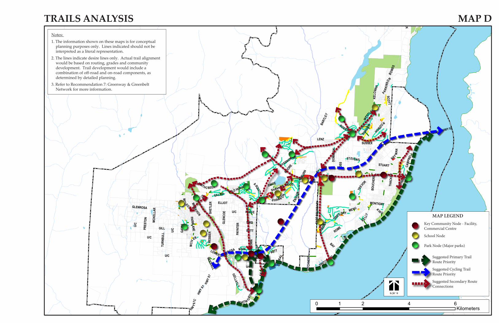
GLENROSA
HWY 97
BOUC
HERI
E
ELLIOT
U/C
WES TSIDE
BEAR CREEK
WEB
BER
THAC
KER
BART
LEY
ROSS
GATE
S
WESTL
AKESCO
TT
BROW
N
STEVEN S
SHANNON LK
SMITH C REEK
GELLATL
Y
GLEN
COE
MAIN
BYLANDTU
RNBU
LL
MENU
PAYN
TER
GILLPRES
TON
BUTT
WITT
CAMP
BELL
GREGORY
AUBURN
MCKE
LLAR
HAY
MAN
ANG
US
RIDG
E
BAY
HUDSON
ASQUITH
KELO
WNA
SUNVIEW
PARKI
NSON
STUART
HORIZO
N
ANDERS
REECE
MCLEOD
SHET
LER
PRITCHA RD
S HANN ONSALISH
LOWER G LENROSA
ROS EWOOD
KE LLY
ENSI
GN
HWY
97C
MCIV
ER
LENZ
W HITW ORTH
EAST
BOU
NDAR
Y
HITC
HNER
SHANNON RIDGE
MCMAHON
CARR
AL
WILD HORSE
K IN G
WOODELL
DOUGMAC
BOWES
INGRAM
MOORE
ROME
MONTIGNY
DOMI
NION
SUSSEX
SMID
TREV
OR
WIIG
PARKLANE
BENE
DICK
TWIN
SWITE
U/C
HWY 97
U/C
HWY 97
HWY
97
U/C
U/C
U/C
HWY 9
7
TRAILS ANALYSIS MAP DNotes:
1. The information shown on these maps is for conceptual planning purposes only. Lines indicated should not be interpreted as a literal representation.
2. The lines indicate desire lines only. Actual trail alignment would be based on routing, grades and community development. Trail development would include a combination of off-road and on-road components, as determined by detailed planning.
3. Refer to Recommendation 7: Greenway & Greenbelt Network for more information.
0 2 4 61Kilometers
Suggested Primary Trail Route Priority
Suggested Cycling Trail Route Priority
Suggested Secondary Route Connections
MAP LEGENDKey Community Node - Facility, Commercial Centre
School Node
Park Node (Major parks)

26DISTRICT OF PEACHLAND - SIDEWALK AND PEDESTRIAN CONNECTIVITY PLAN
APPENDIX C - COMMUNITY FEEDBACK

www.urban-systems.com CALGARY | EDMONTON | FORT ST. JOHN | KAMLOOPS | KELOWNA | NELSON | RICHMOND
#304 - 1353 Ellis Street, Kelowna BC V1Y 1Z9 Telephone: 250-762-2517
title: SIDEWALK AND PEDESTRIAN CONNECTIVITY PLAN - PUBLIC MEETING #1 COMMENTS
date: March 10, 2011 file no.: 0655.0157.01
I like the idea of a pedestrian overpass at McKay Lane
We need more connectivity down the hills and across the highway. Princeton and Trepanier are major
hinderances to pedestrian travel.
Access from heritage park to doggy beach
Tunnel/crosswalk from tennis courts to IGA centre.
Walkway from Princeton up treeline to Somerset/Minto
Trepanier Creek Linear (RDCO) Connection through Golf Course to Ponderosa
Trail/walkway access to Hardy Falls and Antlers Beach
For any new subdivisions/development it should be manditory that a connectivity sidewalk/trail if feasible
be part of approval process
Great to see effort put into planning new trails and sidewalks. Very Important, thanks.
Pedestrian safety - unsafe where Buchanan Road joins Hwy 97 up to Stonewater Development. Narrow -
poor visibility
We look forward to your comments :)
Trepanier to Cousins to Dryden to Coldham to Desert Pines - popular area but restricted with walking
space. Would be nice to tie in this area with walking paths.
Use larger more visible signs showing park locations and wall maps in Peachland Info Centre, Wellness
Centre etc showing locations. Include maps in annual booklet that residents receive each year.
Extend Beach Avenue walkway at least as far north as Trepanier Creek

www.urban-systems.com CALGARY | EDMONTON | FORT ST. JOHN | KAMLOOPS | KELOWNA | NELSON | QUESNEL | RICHMOND
SIDEWALK AND PEDESTRIAN CONNECTIVITY PLAN - PUBLIC MEETING #1 COMMENTS March 10, 2011 0655.0157.01 Page 2 of 3
Provide access from Somerset to Ponderosa, include sidewalks
Horizontal trails for biking
Combine Clements, Ponderosa, 13th street and new access to Pincushion development into 1 light at 97.
Slow 97 to 70k North to bottom of Drought Hill to ease access from Huston and Buchanan.
**Princeton Sidewalks**
Trail 2000 there is nowhere to rollerblade or bike in Peachland without going in a circle (the new walkway
is a fabulous start)
Sidewalks - Princeton, Trepanier, Ponderosa
Reserve one knoll or Golf Course to be accessable for handicapped
Beach Avenue curve beside Davis Cove, poor visibility around corner, narrow shoulder
Sidewalks required along main routes up the hill (Trepanier Bench, Ponderosa, Princeton)
Trail from Sanderson Park to Seymour
Extend new walkway along beach from 13th north to Trepanier Creek
Increase #'s of clear signs so pathways can be followed easily
Extension of new pathways all the way to Davis Cove - present new portion so well designed and used
Trail maps for Tourists
Sidewalks up Princeton even just on one side of the road
Sidewalks up Princeton
Princeton is a natural connector from much of Peachland to downtown. As it is now pedestrian traffic is at
risk because of narrow roadways and high speed and trucks

www.urban-systems.com CALGARY | EDMONTON | FORT ST. JOHN | KAMLOOPS | KELOWNA | NELSON | QUESNEL | RICHMOND
SIDEWALK AND PEDESTRIAN CONNECTIVITY PLAN - PUBLIC MEETING #1 COMMENTS March 10, 2011 0655.0157.01 Page 3 of 3
Crossing highway from south end of Buchanan Road and walkway to IGA shops
We need a walkway from Davis Cove to Burdikin Lane along the beach. Need right of ways
From Blizz to the Creek
Would like to see an extension of the new pathway to Davis Cove along the lake. So well used.
Trail from end of Chidley Rd through Trepanier Manor development to MacKinnon - N.B. there must be a
legal walkway through Trepanier Manor
Sidewalk up Princeton, Columbia to Somerset
Need sidewalk or widened protected shoulder area for walking down Princeton from the Vernon Road
area down, at least.
U:\Projects_KEL\0655\0157\01\M-Meeting-Notes\Open House #1\Post - it note comments March 9, 2011 open house.doc

URBAN SYSTEMS LTD304-1353 ELLIS STREETKELOWNA, BC V1Y 1Z9T: 250.762.2517www.urban-sys tems .com
0655.0157.01
GREAT PEOPLE. GREAT SERVICE. GREAT CLIENTS.