Embed Size (px)
Citation preview

FINAL REPORT
Feasibility of integrated surface water management on agricultural land in Manitoba Tobacco Creek Model Watershed c/o Deerwood Soil and Water Management Association Inc March 1 2012 – July 31 2012

Executive Summary
This project was a short feasibility study run between March and July 2012, to identify the potential for on-farm systems to store flood water, and to use the nutrients in the water for crops. Topographical information (LiDAR) was used to identify potential areas to store water in three geographically and hydrologically distinct areas in Manitoba – South Tobacco Creek, the Red River Valley and the Icelandic River. A model was developed using MATLAB to predict the volume and duration of water stored, and another to predict the growth rate of cattails (Typha spp.) under different rainfall and temperature conditions. Producers helped to shape the project and the scenarios investigated. The time available for this project limited what could be achieved, but the research team were able to thoroughly test new models that can be applied more widely across Manitoba (where LiDAR data are available), and that can be applied to other crops, and to other water storage designs such as back-flooding, modified ditches and small reservoirs. The results were presented to producers, farm advisors and government representatives at a facilitated workshop in July. These showed that there are significant public and private benefits to be gained from storing water, harvesting cattails, and removing phosphorus from the environment.

1). SUMMARY
(a) Title; The feasibility of integrated surface water management on agricultural land in Manitoba
(b) Name of Applicant(s); Tobacco Creek Model Watershed c/o Deerwood Soil and Water Management Association Inc
(c) Name of Institution or Organization; Tobacco Creek Model Watershed c/o Deerwood Soil and Water Management Association Inc
(d) Project duration (date of Project start up and completion); March 1 2012 – July 31 2012
(e) Project Objectives;
Identify the current research gaps in understanding farmland surface water
management systems in Manitoba;
Generate information on the factors to consider to construct effective water
storage and management systems;
Identify different potential uses for water storage systems in Manitoba and how
they impact on design and management, such as retention of surface run-off on
farmland in constructed multi-use wetlands or ponds, and re-use of the water for
irrigation;
Identify some candidate sites for trials of different drainage scenarios;
Inform future research projects that deliver enhanced surface drainage on
farmland;
Establish the means to disseminate the research findings to the farming
community.
(f) Activities carried out (a brief one or two page description of the accomplishments and a listing of project outputs, eg. business plan, thesis, conference paper, journal publication.); and,
This study involved a number of different activities to accomplish the objectives.
Objective 1: Identify the current research gaps in understanding farmland
surface water management systems in Manitoba;
Through discussions with researchers, farm advisors, producers, and government
representatives, the gaps in knowledge were identified as falling into the following
areas:
1) A lack of understanding of the farmland, and other areas (eg municipal
or provincial drains) that have the potential to store water under a

surface water management system. This could be addressed if LiDAR
was completed across the province.
2) A lack of collective knowledge of the surface water management
systems in place currently. Throughout the project, schemes already
underway were identified across the province. These include flood
storage schemes in rural municipalities, wetland management and
forage harvesting schemes supported by conservation districts, tile
drainage and irrigation systems on farm. Some of the federal and
provincial government staff were aware of schemes that had been big
enough to require permits or licenses and researchers were aware of
the schemes they were involved in researching. However, information
about these schemes was not stored in a way that it could be
retrieved, catalogued and factored into a Manitoba wide water
management strategy.
3) The need for further research into i) the design and operation of
surface water management structures; ii) the crops that would best
utilize the nutrients and water either by growing in flooded areas or
would benefit from the irrigation; and iii) the processing and end use
potential of crops grown in flooded areas or irrigated.
4) The economic benefits to farm producers of surface water
management systems and crop management.
5) The ecological goods and services that would be achieved through a
surface water management strategy, and the social aspects of
achieving such benefits (reduced flooding in Winnipeg, improved water
quality in Lake Winnipeg).
Generate information on the factors to consider to construct effective water
storage and management systems;
Through workshop sessions with landowners, farm advisors, regulators and
researchers the factors to consider in the design, construction and operation of
water storage systems were captured. These are set out in detail in the
workshop feedback in Appendix 1. The feedback covered the drainage factors,
potential uses, design factors, maintenance issues, environmental goods and
services, possible candidate sites and pre-existing examples.
Identify different potential uses for water storage systems in Manitoba and how
they impact on design and management, such as retention of surface run-off on
farmland in constructed multi-use wetlands or ponds, and re-use of the water for
irrigation;
This study explored the potential to store excess water on agricultural land,
subsequently grow cattail on that same land, and estimate both private and public
benefits from the stored water, harvested biomass, and the phosphorus contained
within the harvested biomass at three agricultural locations in Manitoba. A simple
cattail growth model and a two-dimensional hydrologic model were employed to
simulate cattail growth and the water balance during a 90 day period at three
physiographically distinct sites in Manitoba. Model simulations were performed
under four different climatological scenarios (dry and hot, dry and cold, wet and hot,
wet and cold) for hypothetical storage reservoirs identified from topographical
analyses of LiDAR data.

Results indicate large private and public benefits from storing water, harvesting
cattails, and removing phosphorus from the environment. The unavailability of
LIDAR data eliminates the possibility of performing simulations throughout much of
Manitoba, but the storage simulation model could be modified to deal with the three
scenarios of interest - backflooding, using modified ditches and creating small
reservoirs. The biomass production model can be changed to simulate growth of
other plants.
Outputs from the study include a report on the scenario development and modelling
(appendix 3); workshop reports (appendices 1 and 2); and presentations.
(g) A copy of project outputs as per (f) are provided in the appendices to this report. Copies of the presentations are available on request.

2.) RESOURCES
(a) Summarize the project contributions for the entire project by source, as follows:
CAAP Applicant/ Industry Cash
Applicant In kind
Provincial/ Municipal Cash
Federal Cash
$16,500
$3,500
$1,850
(b) If possible, provide an estimate of the potential financial impact on the sector (e.g., amount of increased investment, sales, exports, cost savings) if widely adopted or applied, or fully implemented.
This study was a feasibility study, which will lead to further research and analysis of
the options before any on-farm investment can be made. Full economic analysis was
beyond the scope of the project, but should be a significant part of the next phase.
3). REACH AND DISSEMINATION
Indicate who were the ultimate beneficiaries of the project and what level of contact was there with them (eg. 150 producers, 70 representatives of government, 25 members of academia).
The primary beneficiaries of this project are the agricultural producers in the Red
River Valley and Tobacco Creek Watershed in particular.
The secondary beneficiary of this project would be any producers who have a need to
manage water on their agricultural land, which includes cropland or improved
pasture land experiencing in-season excess moisture, or overland flooding events
There are 44 farm producers within South Tobacco Creek, and about 500 within the
Tobacco Creek Watershed, and many more throughout the lower Red River Valley
who will be interested in the project.
Indicate vehicles used to disseminate the information to the ultimate beneficiaries and any feedback/uptake where applicable.
The main method of communication about this project was through workshops to
which farmers in the interested areas were invited. This was done through producer
groups, the conservation districts and through farm advisor contacts in MAFRI.
The workshops were designed to seek feedback from the producers. In the first
workshop in March, soon after the project started, feedback was requested on the
priorities for the project and this shaped the research. At this workshop we also
requested input into the development of a communication strategy. At the second
workshop, when results were provided, feedback was again requested through
facilitated working groups, and attendees were invited to comment on the process as
a whole. The outcomes from both of these workshops are included in appendices to
this report.
The project team also gave presentations at a number of meetings that included:
Conservation Districts Managers meeting Jan 2012
Red River Basin Commission South Chapter Feb 2012
Red River Basin Commission North Chapter Feb 2012
University of Manitoba Visionary Conversation Feb 2012
Biomass workshop, Winnipeg Mar 2012
Project workshop, Carman Mar 2012
Water Management Strategy Workshop Apr 2012
Water Security Summit, Winnipeg May 2012
Living Lakes 2012 Gathering, Winnipeg May 2012
Project workshop, Winnipeg July 2012
4). RESULTS
(a) Provide conclusions of the project including the significance of results and discussion of the project results including an explanation or interpretation of such results and indication of any unanticipated factors that affected the results of the project; The project was carried out over short timescales and with a limited
budget, which limited what could be achieved. However, the outcome is
working water storage and biomass growth models that are transferable
to different climate and physiographic areas.
The physiographic areas investigated were those of interest to the
applicants and other partners, and the extension to other areas is limited
by the availability of LiDAR data to develop digital elevation models.
The biomass model was limited to cattails for the purposes of this study.
It showed that in the example scenarios an economic crop of cattails
could be grown, and would provide a reasonable return for producers
from marginal land. Further work is needed to incorporate other plant
types and consider the application of water stored through irrigation to
conventional crops.
(b) What are the short-term outcome(s) expected at the end of the project
(select one of the following):
- Improved knowledge of potential innovative products, processes or technologies
- Improved knowledge of solutions/strategies analyzed/tested to
address issues/opportunities
Based on your selection above, describe the actual outcomes of the project.
The project has provided good background information to apply to the
next phase of research which will cover in more detail: i) the design
and operation of surface water management structures; ii) the crops
that would best utilize the nutrients and water either by growing in
flooded areas or would benefit from the irrigation; and iii) the
processing and end use potential of crops grown in flooded areas or
irrigated.
Where there any other planned outcome(s)? If yes, describe.
(c) Next steps (if applicable);
The next steps are already underway. A proposal has been submitted to
Manitoba Conservation and Water Stewardship to carry out a full
feasibility study which will consider i) the design and operation of surface
water management structures; ii) the crops that would best utilize the
nutrients and water either by growing in flooded areas or would benefit
from the irrigation; and iii) the processing and end use potential of crops
grown in flooded areas or irrigated.
The Watershed Systems Research Program is also proactively seeking
partners for pilot projects to take designs forward to researching and
testing on-farm. These include producer partners and research partners
across Canada.
(d) Include any publications, documents or materials for communications
and all promotional activities as well as any and all other material for public distribution generated by the project, or which will be disseminated in the future. Now that the project is nearing completion, and following the advice of
workshop attendees on a communications strategy a series of
communications are planned in addition to the presentations made and
outlined in this report. These include the development of a simple
factsheet to be available from the Watershed Systems Research Program
website wsrp.ca and which can be handed out to producers and others at
events. The Research Development Coordinator for the Research Program
will coordinate writing of a press release and editorials for farm press. In
consultation with the Communications Advisor in the Faculty of
Agricultural and Food Sciences at University of Manitoba these will be
targeted to the appropriate producer newspapers and magazines. The
factsheet and editorials will be provided to MAFRI contacts in the
provincial knowledge transfer offices, and to producer groups eg KAP.
Which of the following describe the potential long-term benefits from this project? --- reduced production of processing costs --- improved product quality --- improved market share --- preserving market share --- other (specify)

5). FOLLOW UP (a) Indicate any project follow-up that is planned (e.g., dissemination of
results, full implementation of project, etc)
The outputs from the workshop held in July will be shared with those who
attended the workshop, and made available to others through the Watershed
Systems Research Program website wsrp.ca.
The results will form background information in a study to begin shortly
funded by Manitoba Conservation and Water Stewardship at University of
Manitoba titled 'Feasibility of innovative water and crop management
practices to reduce nutrient loading from agricultural watersheds'.
(b) Indicate questions on implementation/commercial impact that may
be appropriate to include in a follow-up survey to your organization one year after project completion. As this was a feasibility study, that was not expected to lead to
implementation or immediate commercial impact it would be
inappropriate to survey the organization in 1 year's time.
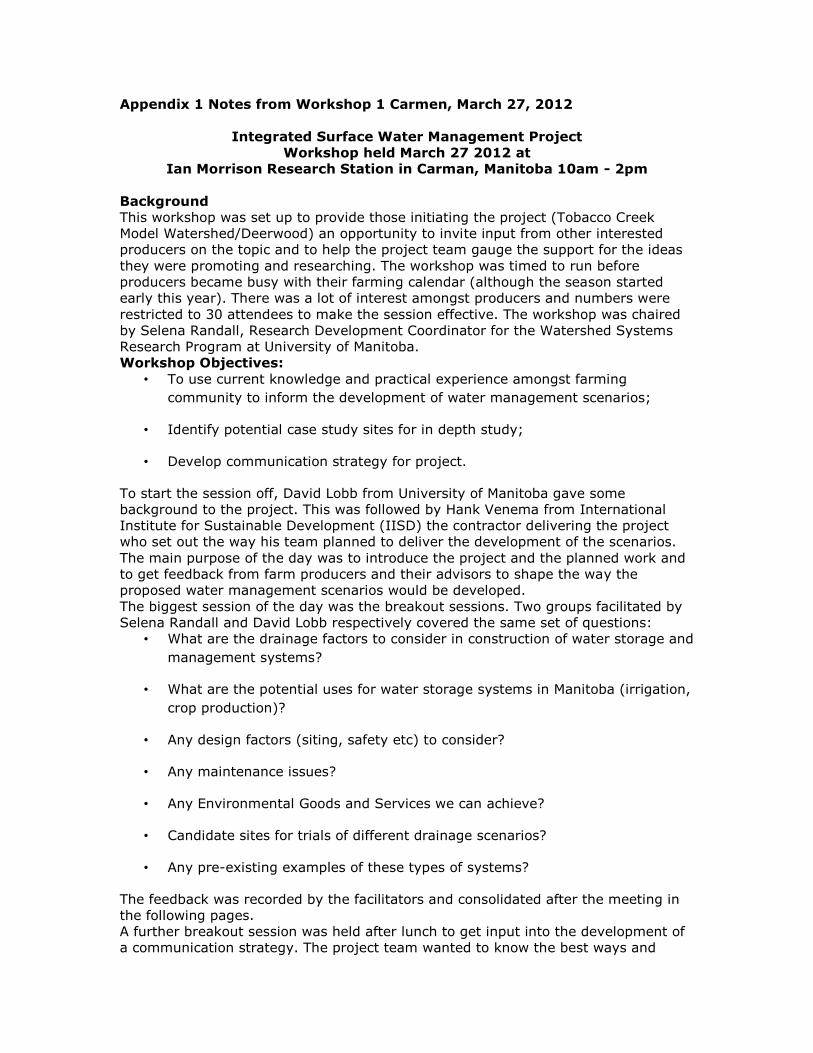
Appendix 1 Notes from Workshop 1 Carmen, March 27, 2012
Integrated Surface Water Management Project
Workshop held March 27 2012 at
Ian Morrison Research Station in Carman, Manitoba 10am - 2pm
Background
This workshop was set up to provide those initiating the project (Tobacco Creek
Model Watershed/Deerwood) an opportunity to invite input from other interested
producers on the topic and to help the project team gauge the support for the ideas
they were promoting and researching. The workshop was timed to run before
producers became busy with their farming calendar (although the season started
early this year). There was a lot of interest amongst producers and numbers were
restricted to 30 attendees to make the session effective. The workshop was chaired
by Selena Randall, Research Development Coordinator for the Watershed Systems
Research Program at University of Manitoba.
Workshop Objectives:
• To use current knowledge and practical experience amongst farming
community to inform the development of water management scenarios;
• Identify potential case study sites for in depth study;
• Develop communication strategy for project.
To start the session off, David Lobb from University of Manitoba gave some
background to the project. This was followed by Hank Venema from International
Institute for Sustainable Development (IISD) the contractor delivering the project
who set out the way his team planned to deliver the development of the scenarios.
The main purpose of the day was to introduce the project and the planned work and
to get feedback from farm producers and their advisors to shape the way the
proposed water management scenarios would be developed.
The biggest session of the day was the breakout sessions. Two groups facilitated by
Selena Randall and David Lobb respectively covered the same set of questions:
• What are the drainage factors to consider in construction of water storage and
management systems?
• What are the potential uses for water storage systems in Manitoba (irrigation,
crop production)?
• Any design factors (siting, safety etc) to consider?
• Any maintenance issues?
• Any Environmental Goods and Services we can achieve?
• Candidate sites for trials of different drainage scenarios?
• Any pre-existing examples of these types of systems?
The feedback was recorded by the facilitators and consolidated after the meeting in
the following pages.
A further breakout session was held after lunch to get input into the development of
a communication strategy. The project team wanted to know the best ways and

times to communicate about the project to farm producers. The session was
facilitated in two groups by Selena Randall and David Lobb respectively and each
group was asked to consider the following questions:
• Who should our target audience be?
• What are the preferred methods for communications?
• When is the best time to communicate?
– To tell producers this project is happening
– To tell producers about the outcomes
The feedback and ideas were recorded by the facilitators and consolidated after the
meeting in the following pages.

Integrated Surface Water Management on Farmland in Manitoba
Breakout session 1
Objectives
• What are the drainage factors to consider in construction of effective water
storage and management systems?
• What are the potential uses for water storage systems in Manitoba (irrigation,
crop production)?
• Any design factors (siting, safety etc) to consider?
• Any maintenance issues?
• Any Environmental Goods and Services we can achieve?
• Candidate sites for trials of different drainage scenarios?
• Any pre-existing examples of these types of systems?
Guiding principles:
Technically feasible;
Agriculturally practical;
Economically feasible;
Environmentally acceptable.
General comments:
Need tax breaks or carbon credits or insurance credits
Need to find way to show system generates money back to provinces
How to get policy makers to table to discuss other options
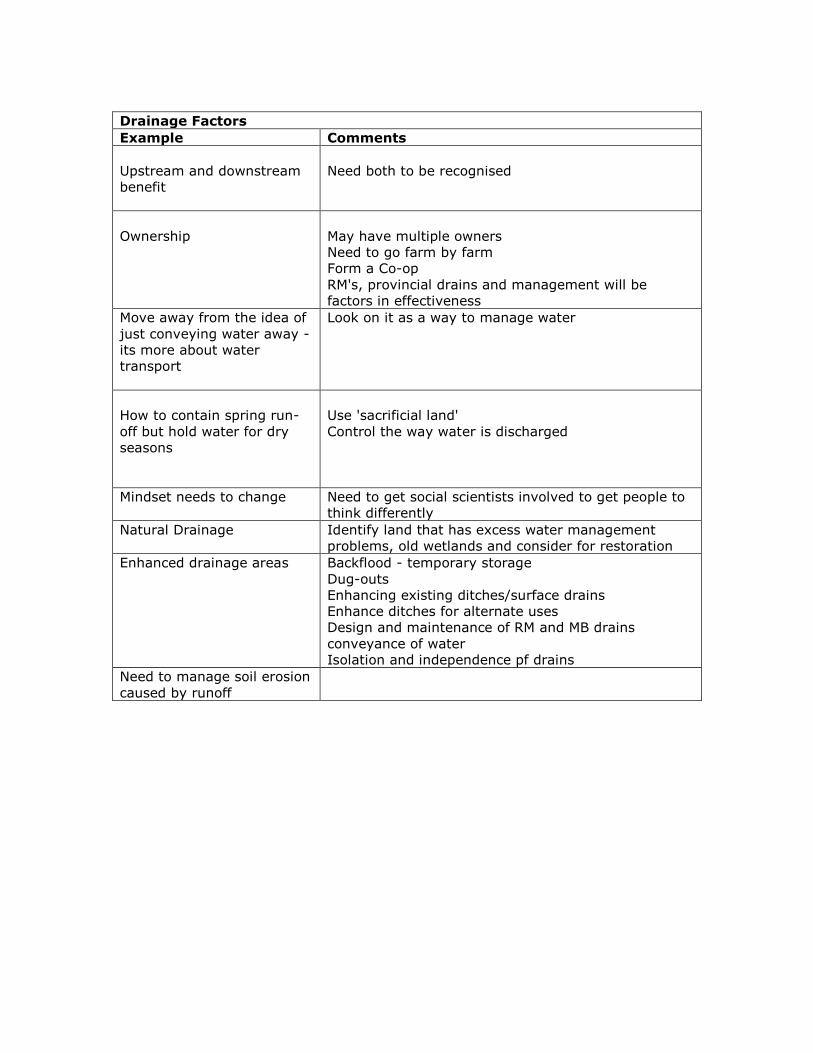
Drainage Factors
Example Comments
Upstream and downstream
benefit
Need both to be recognised
Ownership
May have multiple owners
Need to go farm by farm
Form a Co-op
RM's, provincial drains and management will be
factors in effectiveness
Move away from the idea of
just conveying water away -
its more about water
transport
Look on it as a way to manage water
How to contain spring run-
off but hold water for dry
seasons
Use 'sacrificial land'
Control the way water is discharged
Mindset needs to change Need to get social scientists involved to get people to
think differently
Natural Drainage Identify land that has excess water management
problems, old wetlands and consider for restoration
Enhanced drainage areas Backflood - temporary storage
Dug-outs
Enhancing existing ditches/surface drains
Enhance ditches for alternate uses
Design and maintenance of RM and MB drains
conveyance of water
Isolation and independence pf drains
Need to manage soil erosion
caused by runoff

Potential water uses
Example Comments
Irrigation
Eg potatoes in RRV
Water supply for spraying
Storing and pumping for
grain production
Land application to offset aquifer use. Reduce the
need to take surface water tanks to surface water
drains
Native grasses, willows
algae
These do well under water for 2 years - vegetation
can be used for forage, spread to land, composted
Can be scraped off ponds/tanks - used for fertilizer,
biodiesel, pharmaceuticals
Lots of research on uses of algae in USA
Watering livestock
Need to consider design.
Can be used to intensively manage grass
Can be used to wash barns and parlours
Recreation All water uses
Aquaculture fisheries
Wildlife Eg Ducks Unlimited approach, restoration of wetlands
Hunting, fishing, ecotourism
Maintenance Factors
Example Comments
Natural systems easier to
maintain
Or not maintain - let nature do its thing?
Bank stability
Siltation
Eventually a pond fills up
Salinity/ nutrient
concentrations
Need management
Dry retention area Culvert or gate operated - who maintains it and how
do you protect it
Landowners change hands How to manage and keep memory of reasons why
things are managed this way
Decision making Needs to be integrated between CDs/RMs and DFO
etc
How to take account of off-
site impact
What is the net benefit? Is benefit limited to on-farm?

Design Factors
Example Comments
Culverts have a finite life
Need something more passive, but this still has
maintenance and security issues.
2-stage ditches?
Can we use natural processes
Take advantage of the
naturally wet areas
Willows, wet areas
Tend to be distributed around farm area - minimal
maintenance
What about if you want to use the vegetation for
biomass - view was it was better not to do anything
large- scale that required much maintenance
Hold back water in one area
improve drainage elsewhere
Overall benefit needs to be clear and demonstrable
Needs to be upstream of
urban areas and reap
multiple benefits
Eg. water uses, recreational benefits around urban
areas
Natural retention ponds
How does money become
available to design and
build?
Water table How to manage sub-surface flow
Rainfall and snowmelt
Topography
Existing drainage
Water quality and quantity
Environmental Goods and Services
Example Comments
Need comprehensive
strategy
Integrated - assess net benefits
Managing soils
Reducing soil loss and nutrients
Nutrient remediation
Wet land construction, utilize biomasses from each,
perrennial crops (cattails, grass), algae
Concern about salt with retention
Flood control
Increase water efficiency in crops, flooding
management
Less demand for fossil fuels
Carbon neutral, less inputs
On-site and downstream EGS Valuation of holding?
Balance between real on-
farm benefits with EGS

Candidate sites
Site Contact
Deerwood - 12 possibles
Les McEwan
RM Rosser - infrastructure in
place to flood 100 acres of
land
Scott Corbett
6 in EICD
Armand Belanger
Other options Blind miles, crown land, low-lying areas, willing
landowners
For each participating site
Need to know the objectives for that location
Existing examples
Site Details Contact
Lizard Lake
backflooding
Pembina Valley CD
S of Miami
Base of escarpment 70-80
acre watershed, 13 acre feet
of water for irrigation with
managed discharge
Pembina Valley
BiFrost
Project underway in Interlake
Identifying potential sites on
higher ground
Len Loewen
Pelly Lakes Wetland with harvesting La Salle Redboine CD
DSWMA-STCW/TCMW Small headwater dams Deerwood
Stead Glenmore Project Farmer group Steve Dalen
Crown land - forest
wetlands
Marginal land eg RM
DeSaleberry, Ginoux Bog
Klassen Retention
Project
Forestry Road #3 St Anne Seine-Rat CD
Carrot River RM Kelsey

Integrated Surface Water Management on Farmland in Manitoba
Communications Strategy
• Who should our target audience be?
• What are the preferred methods for communications?
• When is the best time to communicate?
– To tell producers this project is happening
– To tell producers about the outcomes
Key message:
There are farmers in Manitoba who are considering novel methods to manage
surface water differently.
Main communication activities - opportunities identified
Workshops - structured days with a targeted group of farmers, but open to
attendance by farmers from across the province. MAFRI and Conservation District
staff will assist in communicating to farmers and gaining support for the workshops.
Written communication activities - The project and outcomes will be featured on the
University Soil Science and IISD websites, Tobacco Creek Model Watershed website
and regional and provincial media outlets. Outcomes will be communicated through
existing extension program outputs. The final technical report and scientific
publications will be completed if appropriate.
Other opportunities - throughout the project we will seek to promote the project
principles and communicate the outcomes through other opportunities as they arise
for example, during field tours and at stakeholder events where the researchers are
invited. Project work may be able to be featured at/in:
- The Annual MAFRI Soil and Manure Management field clinic in August
- The Annual MB Agronomists Conference in Dec
- Farming for Tomorrow – a 2-3 times/year publication focusing on agri-
environmental topics. Released to about 3000 farm mail boxes across the
province and GO offices across Manitoba.
- The Co-operator or Western Producer may take interest in an interview /
article for their readers
- Prairies East Sustainable Agricultural Initiative annual meeting or summer
field tour – can highlight the work here.
- Can be presented to the KAP “Environment Committee” for discussion and
could be featured in the “KAP Alert” for producers.
- May be potential to be featured as a BMP “mini-series” presentation in
Environmental Farm Plan workshops
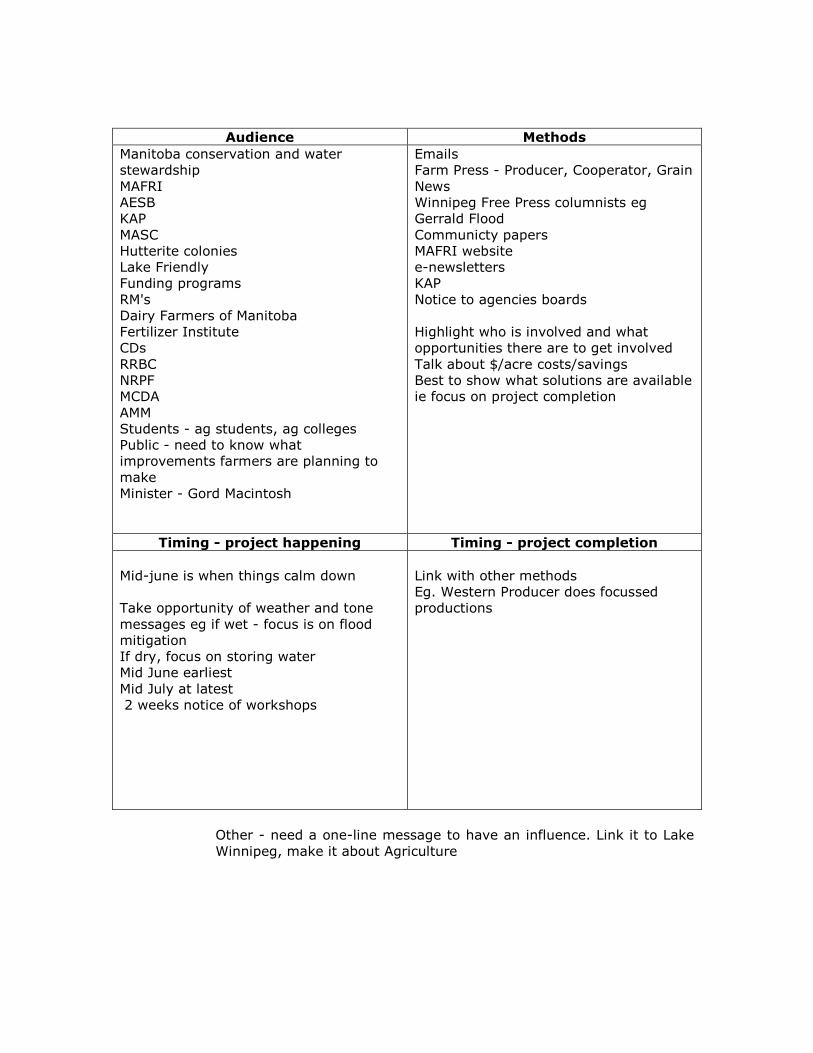
Audience Methods
Manitoba conservation and water
stewardship
MAFRI
AESB
KAP
MASC
Hutterite colonies
Lake Friendly
Funding programs
RM's
Dairy Farmers of Manitoba
Fertilizer Institute
CDs
RRBC
NRPF
MCDA
AMM
Students - ag students, ag colleges
Public - need to know what
improvements farmers are planning to
make
Minister - Gord Macintosh
Emails
Farm Press - Producer, Cooperator, Grain
News
Winnipeg Free Press columnists eg
Gerrald Flood
Communicty papers
MAFRI website
e-newsletters
KAP
Notice to agencies boards
Highlight who is involved and what
opportunities there are to get involved
Talk about $/acre costs/savings
Best to show what solutions are available
ie focus on project completion
Timing - project happening Timing - project completion
Mid-june is when things calm down
Take opportunity of weather and tone
messages eg if wet - focus is on flood
mitigation
If dry, focus on storing water
Mid June earliest
Mid July at latest
2 weeks notice of workshops
Link with other methods
Eg. Western Producer does focussed
productions
Other - need a one-line message to have an influence. Link it to Lake
Winnipeg, make it about Agriculture
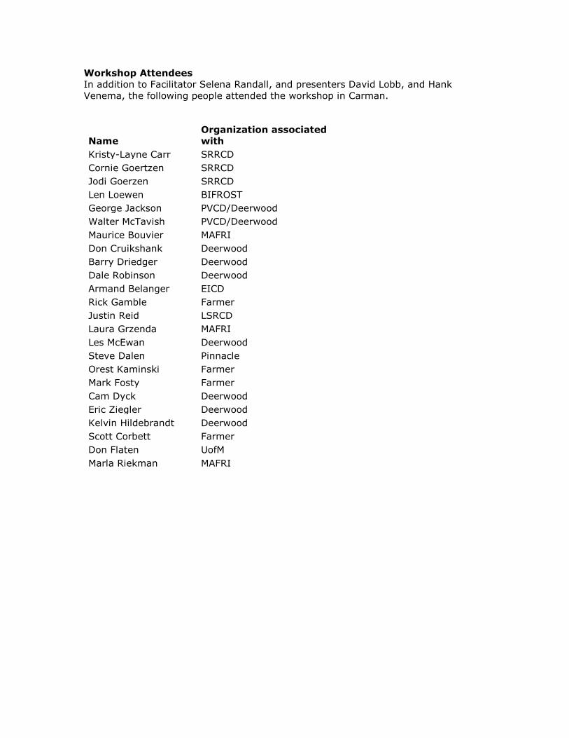
Workshop Attendees
In addition to Facilitator Selena Randall, and presenters David Lobb, and Hank
Venema, the following people attended the workshop in Carman.
Name
Organization associated
with
Kristy-Layne Carr SRRCD
Cornie Goertzen SRRCD
Jodi Goerzen SRRCD
Len Loewen BIFROST
George Jackson PVCD/Deerwood
Walter McTavish PVCD/Deerwood
Maurice Bouvier MAFRI
Don Cruikshank Deerwood
Barry Driedger Deerwood
Dale Robinson Deerwood
Armand Belanger EICD
Rick Gamble Farmer
Justin Reid LSRCD
Laura Grzenda MAFRI
Les McEwan Deerwood
Steve Dalen Pinnacle
Orest Kaminski Farmer
Mark Fosty Farmer
Cam Dyck Deerwood
Eric Ziegler Deerwood
Kelvin Hildebrandt Deerwood
Scott Corbett Farmer
Don Flaten UofM
Marla Riekman MAFRI

Appendix 2
July 6, 2012
Prepared By: Catie Harasym and Christina Kostera - SLMcLeod Consulting Prepared For: University of Manitoba and Deerwood Soil and Water Management Association
Integrated Surface Water Management: Workshop 2 Report

Table of Contents 1.0 Background .......................................................................................................................................... 23
2.0 Goals and Objectives ............................................................................................................................ 24
2.1 Workshop Goal .............................................................................................................................. 24
2.2 Workshop Objectives ..................................................................................................................... 24
3.0 Workshop Process ................................................................................................................................ 24
3.1 Facilitation Used in Workshop ....................................................................................................... 24
3.2 Process Strengths ........................................................................................................................... 25
3.3 Process Recommendations ............................................................................................................ 25
3.4 IISD Decision Making Theatre ........................................................................................................ 26
4.0 Summary of Les McEwans’ (Deerwood) Presentation: ........................................................................ 26
5.0 Summary of Dr. David Lobb’s (University of Manitoba) Presentation: Integrated Surface
Water Management – Taking Control of Challenges and Opportunities ............................................ 26
6.0 Dr. Hank Venema’s (IISD) Presentation: ............................................................................................... 27
7.0 Approaches to Manage On-farm Excess Water ................................................................................... 27
7.1 Use or Modification of the Drainage System to Accommodate Storage ....................................... 27
7.2 Use of On-Farm Storage ................................................................................................................. 27
7.3 Use of Back-Flood Dams ................................................................................................................ 27
8.0 Participant Group Work ....................................................................................................................... 28
8.1 Technical ........................................................................................................................................ 28
8.2 Implementation ............................................................................................................................. 30
8.3 Enabling Policy and Procedures ..................................................................................................... 32
9.0 Discussion and Outcomes ..................................................................................................................... 34
10.0 Conclusion .......................................................................................................................................... 35
11.0 Next Steps ........................................................................................................................................... 36
12.0 Appendix 1: List of Attendees ............................................................................................................ 37
13.0 Appendix II: Integrated Surface Water Management of Farmland and Current Work
presentation ............................................................................................. Error! Bookmark not defined.
13.1 Les McEwan –................................................................................... Error! Bookmark not defined.
13.2 Dr. David Lobb – Integrated Surface Water Management – Taking Control of Challenges
and Opportunities .................................................................................... Error! Bookmark not defined.
13.3 Dr. Hank Venema - ........................................................................... Error! Bookmark not defined.
1.0 Background
The purpose of the workshop was to develop a sustainable approach to managing farmland surface water and associated nutrients in Manitoba and provide an opportunity for interested landowners to learn more about the contractor-developed scenarios and determine which ones to pursue in case studies. This half-day workshop held on July 6, 2012 at the Radisson Hotel in Winnipeg, Manitoba convened landowners and farm advisors who attended the initial workshop in Carman, others from Rural Municipalities known to have an interest in the project and potential case study sites to offer, researchers and representatives from federal and provincial bodies interested in water management. The project is led by Deerwood Soil and Water Management Association with the Watershed System Research Program at the University of Manitoba and the International Institute for Sustainable Development (IISD), with funding from the Manitoba Rural Adaptation Council (MRAC), Canadian Agricultural Adaptation Program (CAAP). Sheldon McLeod of SLMcLeod Consulting and Selena Randall of Watershed Systems Research Program from the University of Manitoba facilitated the workshop. The workshop commenced with introductions and presentations of current and future research initiatives, followed by facilitated working group (technical group, implementation group, enabling group) discussions examining three proposed scenarios and concluded with a presentation highlighting the workshop’s outcomes and next steps.
2.0 Goals and Objectives
2.1 Workshop Goal
To bring landowners/producers, researchers and those preparing policy and programming supports together to explore the possibilities of on-farm surface water management, with a view of enhancing water quality and land use profitability.
2.2 Workshop Objectives
Increase awareness and understanding of current activity and research on on-farm
surface water management practices,
Examine three approaches to managing on-farm excess water with a view of
identifying both practical and technical challenges as well as bio-physical
advantages,
Identify any additional approaches which could accomplish the same ends,
Develop sufficient conceptual-level information to enable the establishment of some
pilot projects to determine the feasibility of the identified approaches,
Identify the next steps in implementing pilot projects; and
Introduce participants to aspects of the decision theatre technology and obtain
perspectives on its potential application
3.0 Workshop Process
3.1 Facilitation Used in Workshop
The process followed a logical progression consisting of introductions, presentations, group work, lunch and a closing presentation; components were allotted suitable time allowances and transitioned smoothly. Sheldon facilitated the workshop by conducting opening and closing remarks, introducing presenters and ensuring each agenda item remained on schedule. The planning prior to the workshop was evident both in the presence of all interests groups and the effective execution of the workshop. The process was communicated to participants in advance via an agenda, informing them of the environmental problem being addressed, the groups of participants, the group work process and overall goals and objectives of the workshop.

3.2 Process Strengths
The reaction to the workshop was positive, with many participants eager to express their evaluations and reflections. It was collectively agreed that facilitators were necessary in the process, especially during group work where they maintained focused conversation, answered or re-directed questions, summarized responses into concise points, encouraged equal participation and ensured all the questions were addressed within the allotted time. Facilitators were also responsible for designating a note-taker(s) for the group, which was important in ensuring the information was communicated back to the larger group during the final presentation and for further analysis. Separating participants into the three working groups had visible advantages. After conversing with several producers, it was evident the small group setting allowed them to speak more comfortably with others who “spoke the same language” and could relate to similar issues. One landowner even made the comment that this was the first workshop that he felt his contributions were valued and will work towards the project’s goals, which he was extremely satisfied with. Aiding in the process was the spacious conference room, complete with a microphone podium, excellent sound system, circular tables and a separate area for refreshments. The circular tables were accommodating for group work as participants were in clear view of one another and could easily direct their comments to the group. The room also enabled the use of the decision-theatre, which required ample space for the three display screens.
3.3 Process Recommendations
Background information or a summary of key points from the first workshop would have been beneficial, as a refresher to those present and to bring those absent up to date. Participants had mixed feelings regarding the length of the workshop. While most felt the half-day workshop was accommodating to their schedules and was a sufficient timeframe to address to workshop’s goals and objectives, several landowners could have benefitted from additional time for questions and group discussion.

3.4 IISD Decision Making Theatre
An innovative component integrated into the workshop process was the trial of IISD’s decision-theatre. Using large display screens and projection equipment, the theatre aims to provide participants with interactive visualizations which aid in the decision-making process. The theatre consisted of three wrap-around screens intended to demonstrate the scenarios and the anticipated outcomes as if implemented in Manitoba; unfortunately due to technical issues only the centre screen was operable, therefore only providing participants a glimpse of its full capabilities. After speaking with participants it was collectively agreed that aside from the technical disadvantages, the decision-theatre was an engaging approach for information presentation, would have allowed for greater comprehension of the scenarios and would have been valuable in the overall decision-making process. Participants were eager to witness the theatre’s full capabilities and support its use in future workshops.
4.0 Summary of Les McEwans’ (Deerwood) Presentation:
The Deerwood Soil and Water Management Association in conjunction with several government bodies, rural municipalities, and organizations created a community-based initiative to develop a watershed management plan surrounding the South Tobacco Creek area. Tobacco Creek Model Watershed (TCMW) is striving towards creating an integrated watershed management plan that incorporates a balance between environmental and economic sustainability. Please refer to Appendix II (13.1) for the complete presentation.
5.0 Summary of Dr. David Lobb’s (University of Manitoba) Presentation:
Integrated Surface Water Management – Taking Control of Challenges and
Opportunities
The University of Manitoba under the direction of Dr. David Lobb has been pursuing various options for nutrient water management on agricultural lands. Dr. Lobb advocates that the status quo of traditional farming techniques is unacceptable and that without human intervention nutrient management will continue to intensify and create even worse conditions. The University of Manitoba in partnership with MRAC and IISD is proposing an integrated surface water management plan where three model scenarios are proposed to better handle nutrient runoff from agricultural practices. Please refer to Appendix II (13.2) for the complete presentation.
6.0 Dr. Hank Venema’s (IISD) Presentation:
The International Institute for Sustainable Development presented the potential of an integrated surface water management plan coupled with biomass production. The idea of incorporating on-farm storage, alternative drainage systems or back-flood dams to grow cattails or other marsh crops as a fuel source for biomass production and to intercept nutrients/recycle phosphorous was examined. MATLAB demonstrations were used to illustrate how each modal scenario would be effective within Dr. Lobb’s previous presentation. Please refer to Appendix II (13.3) for the complete presentation.
7.0 Approaches to Manage On-farm Excess Water
7.1 Use or Modification of the Drainage System to Accommodate Storage
This model scenario uses the concept of expanding current established drainage systems surrounding agricultural lands. The approach involves expanding the ditches and various other forms of drainage systems to capture larger amounts on runoff and nutrients that would be recycled for irrigating purposes in agricultural production. Cattails or other crops would grow for biomass production around the ditches to capture the nutrients (phosphorous) and for purifying the nutrient-rich runoff.
7.2 Use of On-Farm Storage
This model scenario promotes the creation of large retention ponds on farmland to capture nutrient-rich runoff. The runoff captured in the retention ponds would be recycled on agricultural lands, as well as promote biomass the growth of biomass fuel sources such as cattails around the ponds.
7.3 Use of Back-Flood Dams
This model scenario requires agriculture producers to build berms around the perimeter of the agricultural lands. These berms capture the nutrient-rich spring runoff, and dependent on the season and the amount of moisture, allow the field boundaries to hold in the excess water to either drain to support livestock or soak back into the soil.

8.0 Participant Group Work
8.1 Technical
This group was focused on how the models work, data sources and assumptions, and model outputs. Feedback on the model scenarios effectiveness and evaluation of the decision theatre for the developers were the primary task of this group. Q: Review of the model scenarios from the perspectives of the data used, the assumptions inherent in the model, other strengths and weaknesses in the model. The data used in the model scenarios had to account for specific crop choices; it was suggested the model should be broadened to account for more crop types, especially those that may have a greater effect on soil moisture. Data would not account for local knowledge available in the areas, which could be a beneficial resource for the pilot programs. Additionally, the data would have to differentiate between the early nutrient rich water and the later, less nutrient-rich runoff water. Assumptions that would have to be made in the model scenarios would be as follows:
- Location of where the cattails would germinate, - Soil types of the agricultural land, - LiDar exists in the area of proposed pilot projects, - The water released would be a quantitative not qualitative value, - The local/provincial government’s willingness to support these scenarios, - Disparity between value to apply and value to remove; and - Market size and the profitability of the biomass market.
The assumed economic data values account for the pricing associated with biomass processing plants, engineering substitution costs and storage cost. These prices are assumed and are not concrete in the model, creating uncertainty on the profitability of the biomass market. Strengths in the model scenarios were identified as:
- Adaptable model for deep storage, ravine options, water utilization options, low energy moving options and to moisture deficit areas; and
- Intense detail in the report especially in the environmental initiatives. Weaknesses in the model scenarios were identified as:
- Time frame of the model scenarios was limited to April to June only, also excluding high water events in the summer,
- LiDar data is limited, - Economics data for storing water need verification, - Only one “crop” scenario; and - Local knowledge was not used in the scenarios
Q: Comments on the usability of the model from the perspective of the contents and the outputs. The usability of the models in regards to the hydrological, meteorological, and biological outputs are considered to be sound. There is little change in respect of
pursuing water storage, but the economic vision of water storage is considered to be a great output of the proposed scenarios (water storage economics). An interaction to consider in the usability of the water storage is the phosphorous release into the water/soil types. Some soils may release 15 fold, while others have no change. Inorganic phosphorous sources will be a greater concern in these situations. Q: Ideas for the implementation or application of the decision theatre technique from the perspective of accessibility and behavioural traits which might make it more or less easy to apply. The following suggestions were made for implementation/application perspectives to increase better accessibility and behavioural traits to apply in future workshops:
- Wetland conservation - Phosphorous release model - Use of passive natural systems - Deep water dugout storage - Opportunity for larger storage
It was suggested the decision-making theatre could be used for potential bridging outreach/partnerships with government, landowners, and rural municipalities for future programs.
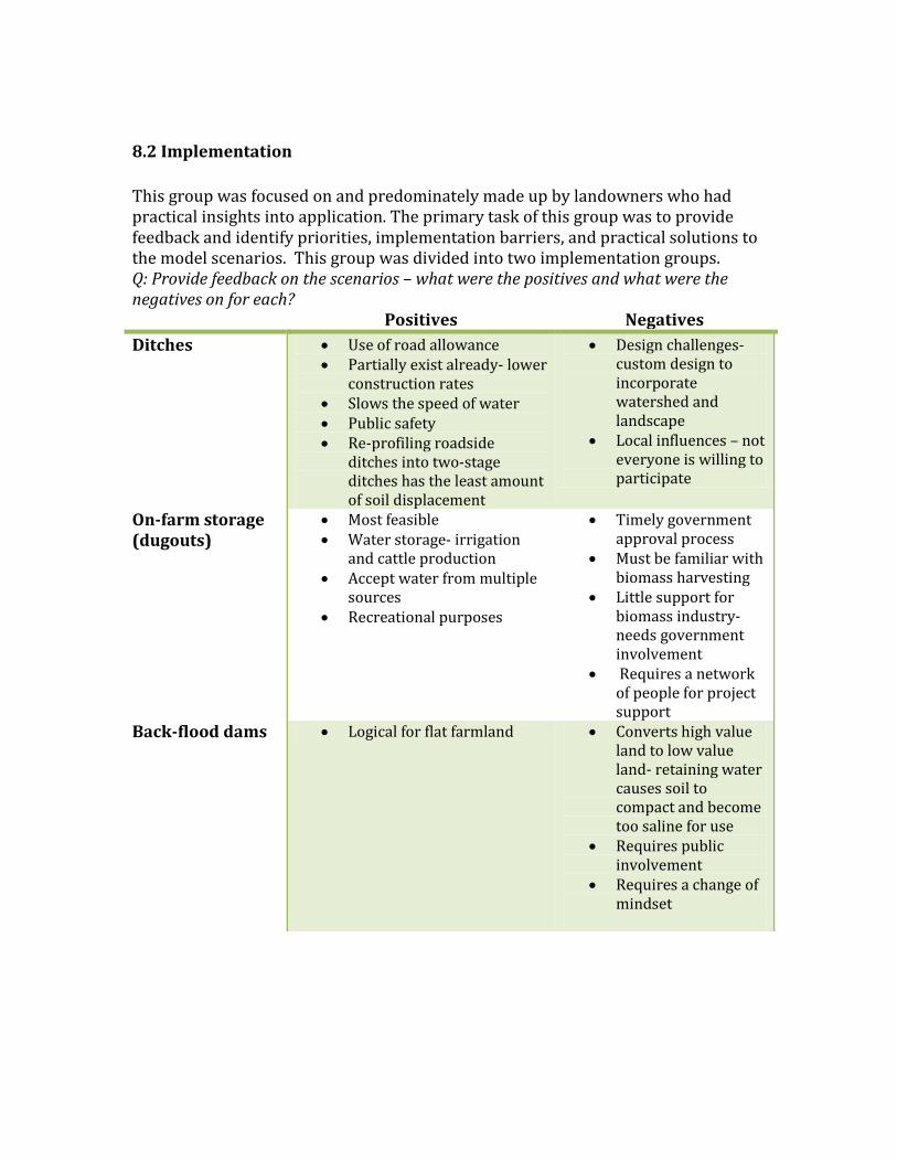
8.2 Implementation This group was focused on and predominately made up by landowners who had practical insights into application. The primary task of this group was to provide feedback and identify priorities, implementation barriers, and practical solutions to the model scenarios. This group was divided into two implementation groups. Q: Provide feedback on the scenarios – what were the positives and what were the negatives on for each? Positives Negatives
Ditches Use of road allowance Partially exist already- lower
construction rates Slows the speed of water Public safety Re-profiling roadside
ditches into two-stage ditches has the least amount of soil displacement
Design challenges- custom design to incorporate watershed and landscape
Local influences – not everyone is willing to participate
On-farm storage (dugouts)
Most feasible Water storage- irrigation
and cattle production Accept water from multiple
sources Recreational purposes
Timely government approval process
Must be familiar with biomass harvesting
Little support for biomass industry- needs government involvement
Requires a network of people for project support
Back-flood dams Logical for flat farmland Converts high value land to low value land- retaining water causes soil to compact and become too saline for use
Requires public involvement
Requires a change of mindset

Q: Are there other approaches which the scenarios did not encompass to some extent? Please describe and identify advantages and disadvantages. The backflooding scenario was identified as the approach with the largest footprint and the least amount of return. It did not account for the loss of production or the chances of increased salinity. Biomass production was raised as an economic concern. It would be beneficial but concrete evidence is needed to ensure it will be used, transport costs will be covered and there is a demand for the biomass market. Rights of way were discussed, and that short term agreements need to be made with the rural municipalities in order to create any of these scenarios. A high cost for irrigation systems and implementation of the scenarios is a concern among the landowners. Who will cover the costs or provide funding? Is the removal of phosphorous a province-wide initiative for all citizens? Does this mean that all of the province should be contributing towards the removal of phosphorous from Lake Winnipeg? There are producers interested in the concept but it will come down to value of the land and crop values to determine what payments producers will require to carry out these scenarios. Q: Which approach emerges as a priority? Why? The linear ditches and on-farm storage were identified as the preferred approaches/scenarios. These approaches were the best uses of agricultural land, lowest risks for saline land, promoted sustainable agricultural practices by creating the smallest footprint and made the most sense in regards to the variability of water availability throughout the growing season. Q: For the identified priority, what barriers does one need to be ready for? How would one overcome those particular barriers? The primary barrier that was identified was the challenge to promote these scenarios, as it would be a change in mentality and traditional ways of farming. To counteract resistance to these scenarios, economics behind these scenarios must be verified and proven. If there is a proven return on the changes required, it would encourage more sustainable agriculture practices. Economic feasibility of the pilot projects was highlighted as a large concern by the implementation group. To address these concerns, it was indicated by both working groups that the government and policy makers need to step up. Additionally, getting funding programs/organizations involved will ease the financial concerns of the land owners. To ease the barriers identified above, it was suggested that education is provided to the agricultural producers on the economic and environmental benefits of surface water management. By demonstrating scientific evidence prior to starting the pilot projects, current concerns will be addressed. Q: In terms of shaping the proposal going forward, what should be highlighted for the funders to see? What are the positives which should be emphasized? How would you rank the approach in terms of the likely appetite for adopting it among producers? Some selling points for possible funders were identified as follows:
- Environmental benefits
- Recreational benefits
- Flood mitigation

- Water quality
- Public health and safety
8.3 Enabling Policy and Procedures
This group was focused on individuals involved with strategic or policy knowledge and interest. They considered whether the scenarios could be implemented across Manitoba now, what the barriers and solutions might be and how the scenarios presented could fit within provincial strategic priorities. Q: How would you assess the existing capacities for implementing each of the scenarios now? Does the answer to that question cause one of the scenarios to rise to the top, as being more easily done right now? The existing capacities of the scenarios were all determined to be feasible on a site-by-site basis. The enabling group identified that it would be ideal to pursue all the model scenarios in a pilot study context. This group identified that the on-farm storage in the form of retention ponds or dugouts are the highest priority; as they are the least complicated and landowners would be the primary player. The modification of existing drainage systems was ranked as the lowest priority. The approvals and stakeholders involved would be the most complex. Concern was expressed in regards to the integrity of the roads and roadsides. Q: What are the policy and programming barriers to implementation of each of the scenarios? What are the solutions to those barriers? The following barriers were identified for the model scenarios:
- Data gaps for identifying adaption areas (ex. LiDar and current water storage)
- Licensing capacity of the province
- Subsidizing the cost of fuel options (cattail pellets vs. coal or other dense forms)
- Difficulty to motivate downstream population to pay for upstream management
- Jurisdictional complexity (Municipal vs. Provincial (inter-provincial)
The following solutions were proposed to the above listed barriers: - Streamlining the drainage licensing process to ease licensing capacity of the
province
- Legislative framework to encourage alternative fuel sources
- Opportunities for agricultural producers to realize economic benefits to enable
local motivations for adoption rather than the entire watershed
Q: What are the next steps for making policy and programming adjustments to enable these approaches to go forward? How will these happen? Who will do what? The next steps were identified with in the group as follows:
- Integrate the integrated surface water management into broader initiatives including the provincial surface water strategy
- Develop framework that include incentives - Outreach to landowners by MAFRI - Key players guide in developing designs including the engineering aspects

- Economic modeling surrounding the scenarios to demonstrate benefits
9.0 Discussion and Outcomes
Selena provided a final presentation summarizing the group’s responses and how they will be incorporated into the project’s next steps. Pilot projects are vital in better understanding flood mitigation, nutrient management, crop diversification, biomass generation and economic farming measures. In moving forward, the following steps were determined- identifying sites for study for multiple purposes, developing proposals for pilot/demonstration sites, identifying sites that have more than one focus (flood control, water management, water quality management, crop production, end use), identifying new sites and focusing the approach for blue box aspects (site selection for the correct water storage options) and green box aspects (crop selection). The technical group discussed the model scenarios in terms of depicting water’s multiple uses and downstream impacts, recognized the model should include multiple scenarios and crop types and that the water storage data needs verification. The implementation groups established the modification of drainage systems and on-farm storage were the preferred scenarios, as back flooding causes soil compaction and increased salinity after being drained. Projects will be most successful by implementing scenarios on a cooperative scale rather than each landowner managing their own water. The enabling group determined on-farm storage as being the most feasible and least complicated scenario for approvals and ditch expansion as being the most complex. As each pilot project is site specific, the scenario will be determined by the technical suitability. Factors to consider include the model’s usability, data gaps and licensing capacity in the province. A funding scheme and evidence that cattails will produce economic payback need to be addressed. As well, downstream landowners should be encouraged to fund the project as they are receiving flood mitigation and water quality benefits.
10.0 Conclusion The workshop was a success with the following outcomes established:
- On-farm storage and modification of current drainage systems were the
preferred approaches. They were considered the least complicated and most
economically feasible with the least environmental impact. Economic benefits
are still to be confirmed with the technical group to help encourage funders and
landowners involvement in the pilot programs.
- These initiatives require a community-based approach involving multi-
stakeholders including funding programs, all levels government, agricultural
producers and the scientific researchers. Through effective communication, the
pilot programs can demonstrate the economic and environmental viability to
the community, spreading the concept and promoting sustainable agriculture
practices.
- Education and outreach is a fundamental component is incorporating a
technically feasible, agriculturally practical, economically viable and
environmentally acceptable solution.

11.0 Next Steps
While research may be inhibited initially, information collection and collaboration among interested parties can begin immediately. The aim is to move this process along- establish case study sites and begin research within the 2012 year. The following is a proposed timeline:

12.0 Appendix 1: List of Attendees
Family name First name Organization Working Group
Ali Genevieve UofM T
Bouvier Maurice MAFRI E
Canart Ryan UARCD I
Carr Kristy-Layne SRRCD I
Chen Xi IISD T
Corbett Scott UofM I
Cruikshank Don Deerwood I
Flaten Don UofM T
Fox Elaine MCWS E
Fridfinnson Eric BiFrost I
Goertzen Jodi SRRCD I
Goertzen Cornie SRRCD I
Greenfield Cliff PVCD I
Grzenda Laura MAFRI I
Harasym Catie Contractor I
Jackson George PVCD/Deerwood I
Kostera Christina Contractor I
Lobb David UofM E
Loro Petra MAFRI E
Manaigre Jason IISD T
Mazier Dan KAP I
McCandless Matthew IISD T
McEwan Les Deerwood I
McLeod Sheldon Contractor I
McTavish Walter PVCD/Deerwood I
North April MCWS E
Pankratz Rhonda MCWS E
Randall Selena UofM I
Richardson Ron MIT E
Rideout Yvonne KAP I
Riekman Marla MAFRI I
Rossnagel L KAP I
Salvano Esther MAFRI E
Shewfelt Bruce AESB I
Swanson Darren IISD T
Swynstun Kyle IISD T
Timmerman Mitch MAFRI E
Vanrobaeys Jason AESB T
Venema Hank IISD T
Wilson Brian MAFRI E
Ziegler Eric Deerwood I

Appendix 3 Project report
Water Storage and Cattail Biomass Production
Author?
IISD
Date
1. Introduction
This study explored the potential to store excess water on agricultural land, subsequently
grow cattail on that same land, and estimate both private and public benefits from the
stored water, harvested biomass, and the phosphorus contained within the harvested
biomass at three agricultural locations in Manitoba. A simple cattail growth model and a
two-dimensional hydrologic model were employed to simulate cattail growth and the
water balance during a 90 day period at three physiographically distinct sites in
Manitoba. Model simulations were performed under four different climatological
scenarios. 2. Methods
Three physiographically distinct sites were selected:
1: South Tobacco Creek Site
2 miles SW from corner of 240 & 23
RM Thompson
Latitude: 49.353 Longitude: -98.383
Area: 86,000 m2
Max simulation volume: 48,585 m3
Max simulation depth: 5.10 m
2: Icelandic River Watershed Site
15 miles west of Riverton
RM Bifrost
Latitude: 50.989 Longitude: -97.355
Area: 155,736 m2
Max simulation volume: 69,541 m3
Max simulation depth: 0.46 m
3: Red River Valley Site
1 mile north of Canada-US border and 8 miles west of HWY 75
RM Rhineland
Latitude: 49.007 Longitude: -97.408
Area: 63,900 m2
Max simulation volume: 17,027 m3
Max simulation depth: 0.53 m
A small rectangular area at each site was defined as the water storage reservoir. LIDAR
datasets were available for each site and were used to construct digital elevation models
(Figure 2). Four model simulations were performed corresponding to the four different
climatological scenarios (Figure 1). Each model simulation was performed on each of
the three location sites for a grand total of 12 model simulations. All model simulations
were executed using numerical analysis software (MATLAB).

Figure 1. Climate scenarios
2.1. MATLAB Modeling
2.1.1. Reservoir Modeling
Figure 2. Digital Elevation Model (DEM) for Red River Valley reservoir
High resolution topographic data (LIDAR) was used to generate a digital elevation model
(DEM) for each site (eg. Figure 2). A volume-area curve was calculated for each site
reservoir (Figure 3). A set of reference water levels were defined starting from the lowest
elevation in the reservoir to the highest elevation in the reservoir. Reference water levels
increased by 1 mm and were used to generate the volume – area curve. For each 1 mm
increment increase in water level, pixels were identified as either being under or above
water. Water surface area was calculated by adding those pixels under water and
multiplying them by the area of each pixel. Total water volume was calculated by
summing the volumes of each increment. Incremental water volume was calculated
using the following equation:
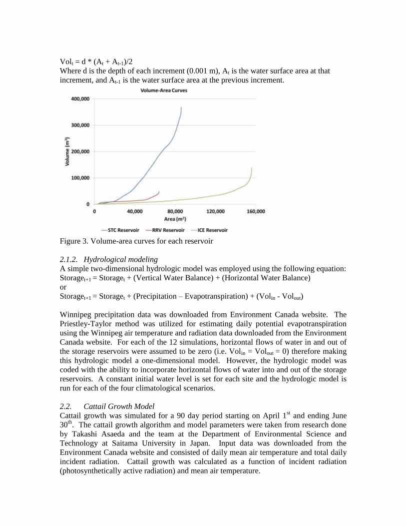
Volt = d * (At + At-1)/2
Where d is the depth of each increment (0.001 m), At is the water surface area at that
increment, and At-1 is the water surface area at the previous increment.
Figure 3. Volume-area curves for each reservoir
2.1.2. Hydrological modeling
A simple two-dimensional hydrologic model was employed using the following equation:
Storaget+1 = Storaget + (Vertical Water Balance) + (Horizontal Water Balance)
or
Storaget+1 = Storaget + (Precipitation – Evapotranspiration) + (Volin - Volout)
Winnipeg precipitation data was downloaded from Environment Canada website. The
Priestley-Taylor method was utilized for estimating daily potential evapotranspiration
using the Winnipeg air temperature and radiation data downloaded from the Environment
Canada website. For each of the 12 simulations, horizontal flows of water in and out of
the storage reservoirs were assumed to be zero (i.e. Volin = Volout = 0) therefore making
this hydrologic model a one-dimensional model. However, the hydrologic model was
coded with the ability to incorporate horizontal flows of water into and out of the storage
reservoirs. A constant initial water level is set for each site and the hydrologic model is
run for each of the four climatological scenarios.
2.2. Cattail Growth Model
Cattail growth was simulated for a 90 day period starting on April 1st and ending June
30th
. The cattail growth algorithm and model parameters were taken from research done
by Takashi Asaeda and the team at the Department of Environmental Science and
Technology at Saitama University in Japan. Input data was downloaded from the
Environment Canada website and consisted of daily mean air temperature and total daily
incident radiation. Cattail growth was calculated as a function of incident radiation
(photosynthetically active radiation) and mean air temperature.
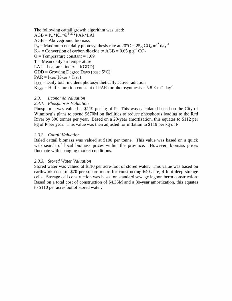
The following cattail growth algorithm was used:
AGB = Pm*Kco*ΘT-20
*PAR*LAI
AGB = Aboveground biomass
Pm = Maximum net daily photosynthesis rate at 20°C = 25g CO2 m-2
day-1
Kco = Conversion of carbon dioxide to AGB = 0.65 g g-1
CO2
Θ = Temperature constant = 1.09
T = Mean daily air temperature
LAI = Leaf area index = f(GDD)
GDD = Growing Degree Days (base 5°C)
PAR = IPAR/(KPAR + IPAR)
IPAR = Daily total incident photosynthetically active radiation
KPAR = Half-saturation constant of PAR for photosynthesis = 5.8 E m-2
day-1
2.3. Economic Valuation
2.3.1. Phosphorus Valuation
Phosphorus was valued at $119 per kg of P. This was calculated based on the City of
Winnipeg’s plans to spend $670M on facilities to reduce phosphorus loading to the Red
River by 300 tonnes per year. Based on a 20-year amortization, this equates to $112 per
kg of P per year. This value was then adjusted for inflation to $119 per kg of P
2.3.2. Cattail Valuation
Baled cattail biomass was valued at $100 per tonne. This value was based on a quick
web search of local biomass prices within the province. However, biomass prices
fluctuate with changing market conditions.
2.3.3. Stored Water Valuation
Stored water was valued at $110 per acre-foot of stored water. This value was based on
earthwork costs of $70 per square metre for constructing 640 acre, 4 foot deep storage
cells. Storage cell construction was based on standard sewage lagoon berm construction.
Based on a total cost of construction of $4.35M and a 30-year amortization, this equates
to $110 per acre-foot of stored water.
3. Results
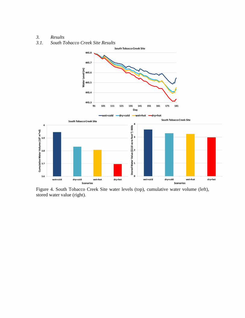
3.1. South Tobacco Creek Site Results
Figure 4. South Tobacco Creek Site water levels (top), cumulative water volume (left),
stored water value (right).

Figure 5. South Tobacco Creek Site cattail biomass yield (top left), cattail biomass value
(top right), phosphorus contained within harvested cattail (bottom left), and phosphorus
value (bottom right).

3.2. Red River Valley Site Results
Figure 6. Red River Valley Site water levels (top), cumulative water volume (left), stored
water value (right).
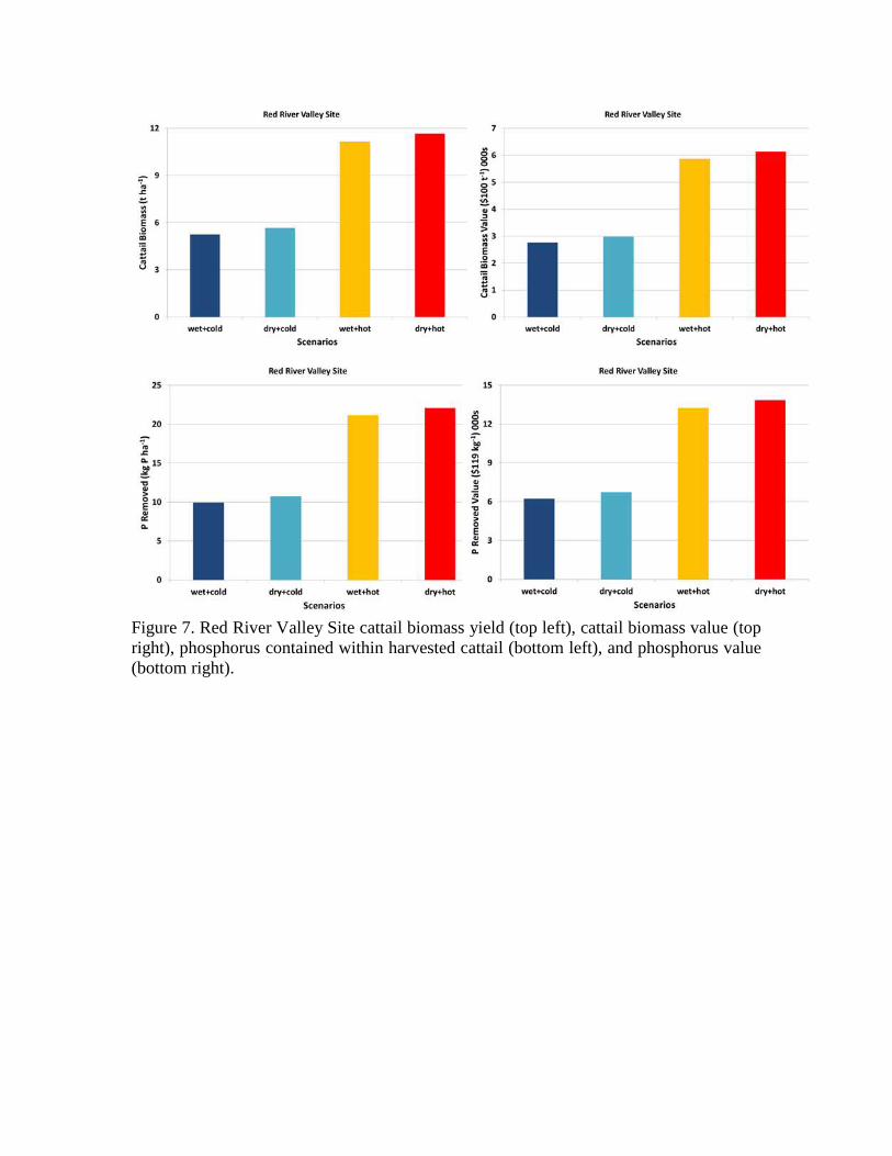
Figure 7. Red River Valley Site cattail biomass yield (top left), cattail biomass value (top
right), phosphorus contained within harvested cattail (bottom left), and phosphorus value
(bottom right).

3.3 Icelandic River Watershed Site Results
Figure 8. Icelandic River Watershed Site water levels (top), cumulative water volume
(left), stored water value (right).

Figure 9. Icelandic River Watershed Site cattail biomass yield (top left), cattail biomass
value (top right), phosphorus contained within harvested cattail (bottom left), and
phosphorus value (bottom right).

Figure 10. Private and public benefits from South Tobacco Creek (STC), Red River
Valley (RRV), and Icelandic River Watershed (ICE) sites for harvested cattail biomass,
phosphorus contained within harvested cattail biomass, and stored water.
4. Conclusion
A simple cattail growth model and two-dimensional hydrologic model were used to
simulate biomass production and water storage during four climatological scenarios at
three physiographic distinct sites in Manitoba. Results indicate large private and public
benefits from storing water, harvesting cattails, and removing phosphorus from the
environment. The unavailability of LIDAR data eliminates the possibility of performing
simulations throughout much of Manitoba. The biomass production model can be
changed to simulate growth of other plants.

Bibliography
Tanaka,N., Asaeda, T., Hasegawa, A., Tanimoto, K. 2004. Modelling of the long-term
competition between Typha angustifolia and Typha latifolia in shallow water—effects of
eutrophication, latitude and initial advantage of belowground organs. Aquatic Botany
(79) 295-310.
Asaeda, T., Van Bon, T. 1997. Modelling the effects of macrophytes on algal blooming
in eutrophic shallow lakes. Ecological Modelling (104) 261-287.
Asaeda, T., Hung Nam, L., Hietz, P., Tanaka, N., Karunaratne, S. 2002. Seasonal
fluctuations in live and dead biomass of Phragmites australis as described by a growth
and decomposition model: implications of duration and aerobic conditions for litter
mineralization and sedimentation. Aquatic Botany (73) 223-239.
Asaeda et al. 2005. Latitudinal characteristics of below- and above-ground biomass of
Typha: a modelling approach. Annals of Botany (96) 299-312.
D.N. Hai et al. 2006. Latitudinal effect on the growth dynamics of harvested stands of
Typha: a modelling approach. Estuarine Coastal and Shelf Science (70) 613-620.
Knapp, Alan & Yavitt, Joseph. 1995. Gas characteristics of Typha latifolia L. from nine
sites across North America. Aquatic Botany (49) 203-215.
Sharma et al. 2006. Nutrient cycling in a natural stand of Typha angustifolia. Journal of
Freshwater Ecology (21) 431-438.
Allirand, J. & Gosse, G. 1995. An above-ground biomass production model for a
common reed (Phragmites communis Trin.) stand. Biomass and Bioenergy (9) 441-448.


![[DRAFT, PRE-FINAL OR FINAL] REPORT - OECD](https://img.dokumen.tips/doc/110x75/5ec770f8c7c9f9670a3f7375/-draft-pre-final-or-final-report-.jpg)

