Embed Size (px)
Citation preview

Fault linkage in continental rifts: structure and evolution of a large relay ramp
in Zavarotny; Lake Baikal (Russia)
R. Hus a,*, M. De Batist a, J. Klerkx b, C. Matton c
a Renard Centre of Marine Geology (RCMG), University of Gent, B-9000 Gent, Belgiumb International Bureau for Environmental Studies (IBES), B-1090 Tervuren, Belgium
c LISEC Antwerpen, B-2000 Antwerpen, Belgium
Received 4 December 2004; received in revised form 5 February 2006; accepted 23 March 2006
Available online 8 May 2006
Abstract
The internal structure of a large (10!40 km) relay ramp has been described between two border faults of the Baikal Rift Zone. The relay ramp,
which is located partly onshore and partly offshore, has been investigated using a dense grid of high resolution seismic profiles and a digital terrain
model containing topographic as well as bathymetric data.
The structure of the relay ramp in Zavarotny is characterised by the development of secondary faults striking approximately parallel to the main
faults. In combination with this, breaching occurred through the development of a new connecting fault. The breaching in Zavarotny has not lead
to the destruction of the relay ramp, but a clear further evolution has been observed (e.g. a similar morphology of the lake floor and the basement
inside the relay ramp, as well as the development of a second connecting fault). The strike direction of the secondary faults in the relay ramp has
likely been influenced by the pre-existing basement fabric in the area.
q 2006 Elsevier Ltd. All rights reserved.
Keywords: Relay ramp; Fault linkage; Fault interaction; Baikal; Baikal Rift Zone
1. Introduction
A property of many major faults is that they have irregular
traces, showing certain jogs along their path (e.g. dePolo et al.,
1991; Cartwright et al., 1996; Jackson et al., 2002). This is
believed to be a result of the growth and connection of different
fault segments (Segall and Pollard, 1980; Peacock and
Sanderson, 1991; Davison, 1994). Such fault segments can
initially be isolated structures (e.g. Peacock and Sanderson,
1991, 1994; Cartwright et al., 1996), or they can be interrelated
from their initiation and for example result from the bifurcation
at depth of a single fault (e.g. Huggins et al., 1995; Childs et al.,
1996; Walsh et al., 2003).
In the isolated fault model, a physical connection between
two off-set faults is only a final stage in the linking process (e.g.
Peacock and Sanderson, 1991, 1994; Cartwright et al., 1996,
amongst others). At the first stage, segments exist as isolated
0191-8141/$ - see front matter q 2006 Elsevier Ltd. All rights reserved.
doi:10.1016/j.jsg.2006.03.031
* Corresponding author. Present address: FrOG Tech (From Oil to
Groundwater), PO Box 250, Deakin West ACT 2600, Australia. Tel.: C61 2
6283 4800; fax: C61 2 6283 4801.
E-mail address: [email protected] (R. Hus).
structures. While they are growing, segments will approach
each other closely enough to allow a mechanical interaction.
This interference of the stress fields of the two approaching
segments starts in the underlapped geometry of the faults.
Elastic fracture mechanical modelling of fault interaction
suggests that segments with such an underlapped geometry will
tend to grow further, whereas when segments overlap they will
tend not to propagate (Aydin and Schultz, 1990; Willemse
et al., 1996; Crider and Pollard, 1998).
Walsh et al. (2003) have suggested, however, that relay
zones between normal faults are most commonly segments of a
single kinematically coherent system. In such cases, relay
zones at a free surface can be formed almost instantaneously on
a geological timescale as a result of the upward propagation of
for example a single bifurcated fault and not necessarily as a
result of the lateral propagation of two isolated faults.
When two overlapping synthetic normal faults are linked by
an area of tilted bedding, the transfer zone is called a relay
ramp (Larsen, 1988; Peacock and Sanderson, 1991; Peacock
et al., 2000a) or a synthetic transfer zone (Morley et al., 1990).
Within a relay ramp there is a reorientation of bedding, due to
the progressive increase of fault displacement gradients
towards the fault tips (Peacock and Sanderson, 1994). This
rotation often involves bending and the formation of minor
Journal of Structural Geology 28 (2006) 1338–1351
www.elsevier.com/locate/jsg
R. Hus et al. / Journal of Structural Geology 28 (2006) 1338–1351 1339
faults within the relay ramp (Peacock and Sanderson, 1994;
Cartwright et al., 1996; Crider and Pollard, 1998). At a certain
critical limit, a through-going fault may develop to accomplish
a plane-to-plane linkage (e.g. Peacock and Parfitt, 2002), or one
or both of the major fault segments may propagate towards the
other fault and connect to obtain tip-to-plane linkage (e.g.
Peacock and Sanderson, 1991, 1994; Childs et al., 1995;
Cartwright et al., 1996).
Because the main basin geometries of rift systems (half-
graben or full-graben) are controlled by major faults (e.g.
Morley, 1995), transfer zones associated with such faults—
intra-basin transfer zones according to Gawthorpe and Hurst
(1993)—have a considerable structural importance, as they are
commonly responsible for changes in border fault geometry.
On a larger scale, inter-basin transfer zones link major
boundary faults that are located on opposite sides of rifts
(Gawthorpe and Hurst, 1993) and can therefore cause
Fig. 1. Shaded relief image of Lake Bai
variations in rift segment geometry (Rosendahl et al., 1986;
Morley et al., 1990; Nelson et al., 1992; Upcott et al., 1996).
Transfer zones also have considerable influence on
hydrocarbon migration and trapping in rift systems (Morley
et al., 1990; Peacock and Sanderson, 1994; Coskun, 1997; Dou
and Chang, 2003), as well as on basin formation and
depositional patterns (Gawthorpe and Hurst, 1993; Morley,
1999; Leeder et al., 2002; Jackson et al., 2002).
Notwithstanding the importance of large relay ramps in rift
basins, their internal structure has mainly been investigated
from small scale (metres to tens of metres) (e.g. Peacock and
Sanderson, 1994; Huggins et al., 1995) or meso scale (a few
hundred metres) (e.g. Trudgill and Cartwright, 1994; Ferrill
et al., 1999) examples. The internal structure of large relay
ramps has only rarely been described (e.g. Peacock et al.,
2000b). In this study we have investigated the internal structure
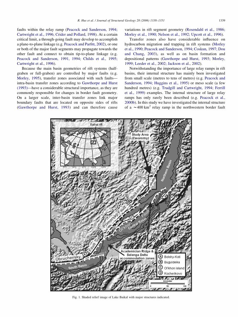
of a w400 km2 relay ramp in the northwestern border fault
kal with major structures indicated.
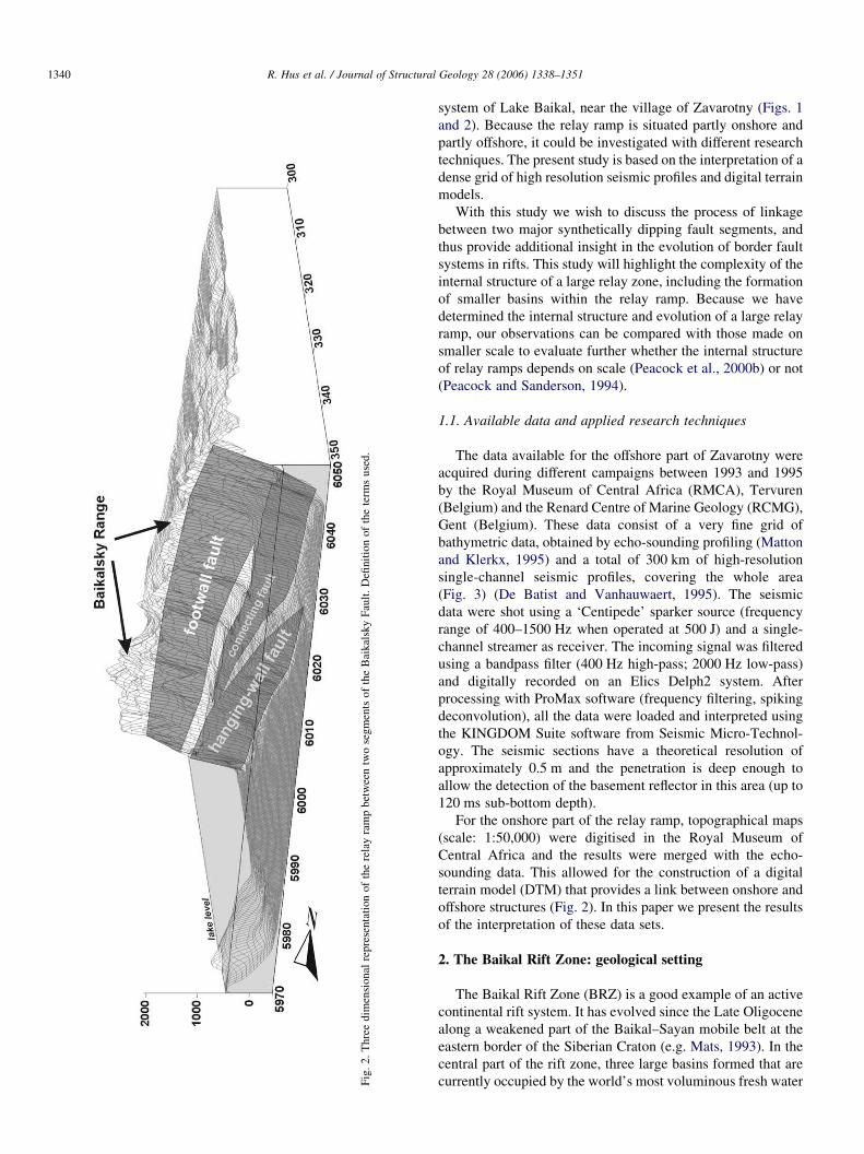
Fig.2.Threedim
ensional
representationoftherelayrampbetweentwosegmentsoftheBaikalskyFault.Definitionoftheterm
sused.
R. Hus et al. / Journal of Structural Geology 28 (2006) 1338–13511340
system of Lake Baikal, near the village of Zavarotny (Figs. 1
and 2). Because the relay ramp is situated partly onshore and
partly offshore, it could be investigated with different research
techniques. The present study is based on the interpretation of a
dense grid of high resolution seismic profiles and digital terrain
models.
With this study we wish to discuss the process of linkage
between two major synthetically dipping fault segments, and
thus provide additional insight in the evolution of border fault
systems in rifts. This study will highlight the complexity of the
internal structure of a large relay zone, including the formation
of smaller basins within the relay ramp. Because we have
determined the internal structure and evolution of a large relay
ramp, our observations can be compared with those made on
smaller scale to evaluate further whether the internal structure
of relay ramps depends on scale (Peacock et al., 2000b) or not
(Peacock and Sanderson, 1994).
1.1. Available data and applied research techniques
The data available for the offshore part of Zavarotny were
acquired during different campaigns between 1993 and 1995
by the Royal Museum of Central Africa (RMCA), Tervuren
(Belgium) and the Renard Centre of Marine Geology (RCMG),
Gent (Belgium). These data consist of a very fine grid of
bathymetric data, obtained by echo-sounding profiling (Matton
and Klerkx, 1995) and a total of 300 km of high-resolution
single-channel seismic profiles, covering the whole area
(Fig. 3) (De Batist and Vanhauwaert, 1995). The seismic
data were shot using a ‘Centipede’ sparker source (frequency
range of 400–1500 Hz when operated at 500 J) and a single-
channel streamer as receiver. The incoming signal was filtered
using a bandpass filter (400 Hz high-pass; 2000 Hz low-pass)
and digitally recorded on an Elics Delph2 system. After
processing with ProMax software (frequency filtering, spiking
deconvolution), all the data were loaded and interpreted using
the KINGDOM Suite software from Seismic Micro-Technol-
ogy. The seismic sections have a theoretical resolution of
approximately 0.5 m and the penetration is deep enough to
allow the detection of the basement reflector in this area (up to
120 ms sub-bottom depth).
For the onshore part of the relay ramp, topographical maps
(scale: 1:50,000) were digitised in the Royal Museum of
Central Africa and the results were merged with the echo-
sounding data. This allowed for the construction of a digital
terrain model (DTM) that provides a link between onshore and
offshore structures (Fig. 2). In this paper we present the results
of the interpretation of these data sets.
2. The Baikal Rift Zone: geological setting
The Baikal Rift Zone (BRZ) is a good example of an active
continental rift system. It has evolved since the Late Oligocene
along a weakened part of the Baikal–Sayan mobile belt at the
eastern border of the Siberian Craton (e.g. Mats, 1993). In the
central part of the rift zone, three large basins formed that are
currently occupied by the world’s most voluminous fresh water
320.000 330.000 340.000
6.030.000
6.020.000
6.010.000
6.000.000
5.990.000
320.000 330.000 340.000
6.030.000
6.020.000
6.010.000
6.000.000
5.990.000
Northern BaikalBasin
Approximatelocation of Hanging-
wall fault
Approximatelocation of footwall
fault
Lake Shore
0 10
kilometer
Seismicprofile
UTM #49 projection (WGS-84)
Location of topographic profilediscussed in next figures
Baik
alsk
yRa
nge
Approximatelocation of
connecting fault
Fig. 3. Grid of high-resolution seismic sparker profiles in the area of Zavarotny. The approximate locations of the faults bordering the relay ramp are included. The
total length of the profiles is 300 km. The dashed lines show the location of the topographic profiles in Fig. 4.
R. Hus et al. / Journal of Structural Geology 28 (2006) 1338–1351 1341
body: Lake Baikal. The three basins are separated from each
other by two basement highs: the Academician Ridge
Accommodation Zone between the northern and the central
basins and the Selenga Delta Accommodation Zone between
the central and the southern basins (Fig. 1). The relative
position and orientation of these sub-basins has resulted in the
segmented geometry of Lake Baikal, a property that is also
recognised in other extensional terrains like the East African
Rift System (e.g. Bosworth, 1985; Rosendahl et al., 1986) and
the Basin and Range Province (e.g. Faulds and Varga, 1998).
Despite its long history (about 35 Ma) the Baikal Rift Zone
is currently at a rather young stage in the classification of

R. Hus et al. / Journal of Structural Geology 28 (2006) 1338–13511342
Rosendahl (1987); this is mainly due to the small stretching
factor bZ1.15–1.20 (Zonenshain et al., 1992).
All three of the Baikal basins are delimited at their western
border by major, large displacement faults, sharply contrasting
with the morphology of the eastern side that resembles a
smooth bend of the basement, occasionally cut by small normal
faults (Logatchev, 1993; Mats, 1993). The result of this is a
clear asymmetrical geometry of the basins (Hutchinson et al.,
1992; Scholz et al., 1993; Logatchev, 1993, amongst others).
Field investigations indicate that the western border faults have
oblique movements (Mats, 1993; Delvaux et al., 1997), which
is also confirmed by the study of earthquake focal mechanisms
(Doser, 1991). However, it is clear that the character of these
main faults was not constant during the whole evolution of
Baikal (Scholz et al., 1993; Delvaux et al., 1997).
2.1. Recent tectonic evolution
Generally it is agreed that the BRZ evolved in at least two
major stages: a slow and a fast rifting phase (Hutchinson et al.,
1992; Logatchev, 1993). The slow rifting stage lasted from ca.
30 Ma till about 3.5 Ma (e.g. Mats, 1993) or 2.5 Ma (Kuzmin
et al., 2000) and led to the formation of large depressions, mainly
as a result of a relatively slow subsidence and an unimportant
uplift of the rift shoulders (Mats, 1993). The fast rifting stage,
from 3.5–2.5 Ma to present, started with an increased rate of
subsidence of the basins and the uplift of especially the western
rift flank. All three Baikal basins started to evolve in the slow
rifting phase, but due to a difference in syn-rift sediment thickness
between the south and central basins (ca. 10 km) compared with
the northern basin (ca. 4 km), the latter is believed to be
considerably younger (Hutchinson et al., 1992;Mats et al., 2000).
2.2. Western border deflection
The orientation of the border faults along the western side of
Lake Baikal changes from an ENE direction along the southern
basin to an approximately NNE orientation in the northern
basin. This deflection reveals the different distinct segments of
the western border fault system.
The Obruchevsky Fault is the northwestern border of the
southern Baikal basin. Despite its sharp bend near Bolshy-Koti
and a split of the fault with an eastern segment prolongating in
the basin as the Posolsky Fault, it is usually traced to the mouth
of the Buguldeika River. Here it splays into an eastern branch,
the Ol’khon Fault, and a western branch, the Primorsky Fault,
the main boundary of the central Baikal Basin (Fig. 1). The
Ol’khon Fault (or Morsky Fault according to Agar and Klitgord
(1995)) cross-cuts Lake Baikal, delimiting the southern side of
the Ol’khon Island and the submerged Academician Ridge, two
major blocks of the Academician Ridge Accommodation Zone
(Mats et al., 2000). Farther to the north, near Kocherikovo, the
Primorsky Fault dies out and is replaced by the Baikalsky
Fault, which has a slightly different orientation and borders the
northern basin.
Within these major fault segments, a smaller scale
segmentation can be identified, see for example Agar and
Klitgord (1995) for a description of the Primorsky Fault. For
the northern Baikalsky Fault, a relay structure is found in the
area of Zavarotny (Matton and Klerkx, 1995; Delvaux et al.,
2000). Here a southern segment dies out in Lake Baikal and its
displacement is transferred to an onshore segment to the north.
Both segments partly overlap and a clear relay ramp structure
has developed in between (Matton and Klerkx, 1995) (Fig. 2).
3. Morphology of the Zavarotny Area
The area of Zavarotny is a w40 km!10 km tilted relay
ramp structure between two fault segments of a major large
displacement rift boundary fault (Baikalsky Fault). The
segment of the Baikalsky Fault in the south of Zavarotny has
a different orientation from that in the north (respectively,
N458E and N158E), but they are almost parallel within the zone
of overlap (N358E). The southern segment (hanging-wall fault)
terminates in the lake where it dies out towards the north after
35 km. The main fault on land (footwall fault) corresponds to
the leading border fault farther to the north. Both faults dip
towards the southeast.
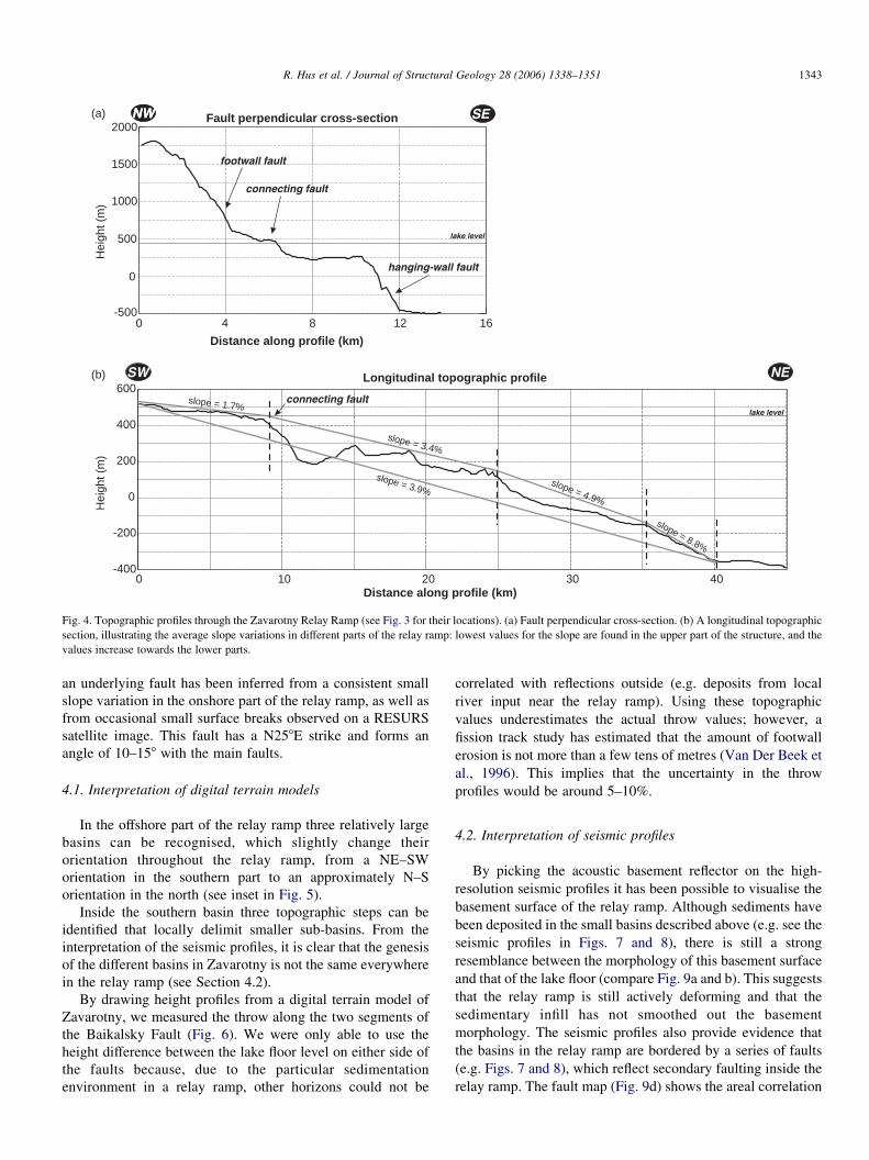
A topographical cross-section (Fig. 4a) shows the 10-km-
wide platform that formed between the two main faults. The
surface of the platform is slightly tilted towards the hanging-
wall fault. The cross-section also reveals the presence of a
topographic step inside the platform (at a distance of around
7000–8000 m in the profile), which is small compared with the
main faults. This topographic step corresponds approximately
to the present-day lake border (Fig. 2) and connects the
footwall fault with the hanging-wall fault.
A longitudinal elevation profile shows that the highest part
of the relay ramp (w50 m above the lake level) is located at its
southwestern limit (Fig. 4b). The depth of the relay ramp
gradually increases towards the northeast, where it eventually
reaches a value of w800 m below lake level (Fig. 4). The
longitudinal profile can be roughly subdivided into four zones,
characterised by slightly different average slope values. As
seen in Fig. 4, average elevation gradients are lowest in the
southwestern part of the relay ramp (1.7%) and they increase
towards the northeast (respectively, 3.4, 4.9 and 8.8%). On a
smaller scale, local topographic variations are superimposed on
the overall elevation change and this results in a rough surface
morphology of the relay ramp.
As a result of the onshore deposition of coarse clastic
sediments, derived from the nearby Baikalsky Range, the
morphology of the onshore part of the relay ramp is more
smoothed than that of the offshore part. During field
investigations in this onshore area, small surface breaks have
been reported, which are caused by movements on faults with
orientations oblique to the main faults of the Zavarotny relay
ramp (Matton and Klerkx, 1995).
4. Structural interpretation
Although the actual shape of the topographic step that
connects the hanging-wall and the footwall faults in Zavarotny
is determined to a large extent by sedimentary processes,
Fault perpendicular cross-section
0 4 8 12 16-500
0
500
1000
1500
2000
lake level
NWNW SE
connecting fault
footwall fault
hanging-wall fault
(a)
(b)
0 10 20 30 40-400
-200
0
200
400
600
Hei
ght (
m)
Distance along profile (km)
Longitudinal topographic profile
slope = 3.9%
slope = 3.4%
slope = 1.7%
slope = 4.9%
slope = 8.8%
SW NE
lake level
Hei
ght (
m)
Distance along profile (km)
connecting fault
Fig. 4. Topographic profiles through the Zavarotny Relay Ramp (see Fig. 3 for their locations). (a) Fault perpendicular cross-section. (b) A longitudinal topographic
section, illustrating the average slope variations in different parts of the relay ramp: lowest values for the slope are found in the upper part of the structure, and the
values increase towards the lower parts.
R. Hus et al. / Journal of Structural Geology 28 (2006) 1338–1351 1343
an underlying fault has been inferred from a consistent small
slope variation in the onshore part of the relay ramp, as well as
from occasional small surface breaks observed on a RESURS
satellite image. This fault has a N258E strike and forms an
angle of 10–158 with the main faults.
4.1. Interpretation of digital terrain models
In the offshore part of the relay ramp three relatively large
basins can be recognised, which slightly change their
orientation throughout the relay ramp, from a NE–SW
orientation in the southern part to an approximately N–S
orientation in the north (see inset in Fig. 5).
Inside the southern basin three topographic steps can be
identified that locally delimit smaller sub-basins. From the
interpretation of the seismic profiles, it is clear that the genesis
of the different basins in Zavarotny is not the same everywhere
in the relay ramp (see Section 4.2).
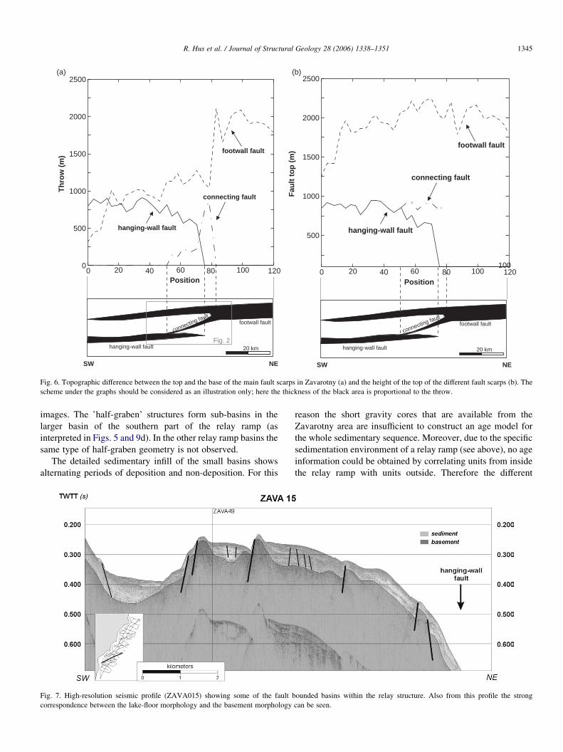
By drawing height profiles from a digital terrain model of
Zavarotny, we measured the throw along the two segments of
the Baikalsky Fault (Fig. 6). We were only able to use the
height difference between the lake floor level on either side of
the faults because, due to the particular sedimentation
environment in a relay ramp, other horizons could not be
correlated with reflections outside (e.g. deposits from local
river input near the relay ramp). Using these topographic
values underestimates the actual throw values; however, a
fission track study has estimated that the amount of footwall
erosion is not more than a few tens of metres (Van Der Beek et
al., 1996). This implies that the uncertainty in the throw
profiles would be around 5–10%.
4.2. Interpretation of seismic profiles
By picking the acoustic basement reflector on the high-
resolution seismic profiles it has been possible to visualise the
basement surface of the relay ramp. Although sediments have
been deposited in the small basins described above (e.g. see the
seismic profiles in Figs. 7 and 8), there is still a strong
resemblance between the morphology of this basement surface
and that of the lake floor (compare Fig. 9a and b). This suggests
that the relay ramp is still actively deforming and that the
sedimentary infill has not smoothed out the basement
morphology. The seismic profiles also provide evidence that
the basins in the relay ramp are bordered by a series of faults
(e.g. Figs. 7 and 8), which reflect secondary faulting inside the
relay ramp. The fault map (Fig. 9d) shows the areal correlation

Fig. 5. Shaded relief representation of the digital terrain model in Zavarotny. The model was constructed by combining bathymetric data from echo-sounding profiles
with digitised topographic maps (1:50,000). The inset illustrates the general structural interpretation of the area.
R. Hus et al. / Journal of Structural Geology 28 (2006) 1338–13511344
of the most important faults that displace the basement in the
relay ramp. Many of these faults have a lake floor expression.
In the northern part of the relay ramp, a topographic step is
produced by a NS-oriented fault, dipping towards the east
(Fig. 9d). This fault links up with the major hanging-wall fault
in the south, whereas towards the north it dies out, not revealing
any linkage with the footwall fault. The fact that it splays from
one of the major faults, and propagates towards the other,
strongly suggests that it is a developing breaching fault, but has
not yet caused the final hard linkage stage of the relay ramp.
The largest ‘embryonic’ basin of the relay ramp is bordered in
the west by this fault. The eastern limit of the basin is formed
by an elevated basement-high near the hanging-wall fault.
On seismic profile number 49, which strikes normal to the
major faults in the southern part of the relay ramp, a graben
structure is observed, which is bounded by multiple conjugate
faults (Fig. 8). In the eastern half of the profile these faults
cause a clear tilted block geometry. This block tilting is
responsible for the formation of the small sub-basins in this
part of the relay ramp (as described in Section 4.1). The strike
of these faults (being approximately NNE) corresponds to
a pre-existing basement fabric observed onshore on satellite
0 40 80 12020 60 100Position
0
500
1000
1500
2000
2500
Th
row
(m
)
hanging-wall fault
footwall fault
Connecting fault
SW NE
hanging-wall fault
footwall faultconnecting fault
20 km
SW NE
hanging-wall fault
footwall faultconnecting fault
100
20 km
0 40 80 12020 60 100Position
500
1000
1500
2000
2500
Fau
lt t
op
(m
)
Hanging-wall fault
footwall fault
Connecting fault
(a) (b)
Fig. 2
hanging-wall fault
connecting fault
footwall fault
hanging-wall fault
connecting fault
footwall fault
Fig. 6. Topographic difference between the top and the base of the main fault scarps in Zavarotny (a) and the height of the top of the different fault scarps (b). The
scheme under the graphs should be considered as an illustration only; here the thickness of the black area is proportional to the throw.
R. Hus et al. / Journal of Structural Geology 28 (2006) 1338–1351 1345
images. The ’half-graben’ structures form sub-basins in the
larger basin of the southern part of the relay ramp (as
interpreted in Figs. 5 and 9d). In the other relay ramp basins the
same type of half-graben geometry is not observed.
The detailed sedimentary infill of the small basins shows
alternating periods of deposition and non-deposition. For this
Fig. 7. High-resolution seismic profile (ZAVA015) showing some of the fault b
correspondence between the lake-floor morphology and the basement morphology
reason the short gravity cores that are available from the
Zavarotny area are insufficient to construct an age model for
the whole sedimentary sequence. Moreover, due to the specific
sedimentation environment of a relay ramp (see above), no age
information could be obtained by correlating units from inside
the relay ramp with units outside. Therefore the different
ounded basins within the relay structure. Also from this profile the strong
can be seen.
Fig. 8. Seismic profile ZAVA049, showing the tilted block geometry of the southern sub-basin.
R. Hus et al. / Journal of Structural Geology 28 (2006) 1338–13511346
deformation stages of the relay ramp could not be dated
(absolutely or relatively), nor correlated to other events in the
evolution of the Baikalsky Fault Zone.
5. Discussion
5.1. Determining fault interaction in Zavarotny
In Fig. 6 we presented the throw profiles of the main faults
in Zavarotny. Drawing such throw profiles along the strike of
faults is an effective technique to visualise fault interaction
(Peacock and Sanderson, 1991; Dawers and Anders, 1995).
Peacock and Sanderson (1991, 1994), for example, noticed that
the displacement gradient of a fault increases in the zone where
it overlaps with another fault and that the displacement
maximum is no longer in the centre of the trace, but rather
located closer to the zone of overlap. Moreover, increasing
displacement gradients seem to occur with increasing fault
interaction (Peacock and Sanderson, 1994; Gupta and Scholz,
2000).
Studies of displacement profiles in natural fault systems
have revealed that only a small portion of the faults is
completely unrestricted (e.g. 2% from a study in the Timor Sea
(Nicol et al., 1996) and 4% from a study in Afar (Manighetti
et al., 2001)). Such fault restriction results from a fault tip that
does not propagate laterally, whereas fault displacement
increases further (Nicol et al., 1996). From the strong decrease
of displacement of the main faults in Zavarotny in the area of
the relay ramp we can conclude that their throw profiles are at
least ’tip restricted’ and that this is most likely the result of
their mutual interaction.
In some studies also the separation between faults and the
degree of overlap were used to evaluate a possible interaction
(e.g. Huggins et al., 1995; An, 1997). For Zavarotny the
distance of overlap is 40 km and the separation distance is
10 km, with a ratio of 4 we can assume fault interaction in this
case (e.g. Willemse, 1997).
5.2. Comparison with existing models for relay ramp evolution
Based on the data and interpretations presented so far, a
possible evolution scheme has been drawn for the Zavarotny
relay ramp (Fig. 10). Because the segments of the Baikalsky
Fault were formed by the reactivation of older structures, their
formation might be characterised by a component of out-of-
plane propagation. As a result, the initial relay ramp geometry
could have formed in a relative short time period (see Section 1),
and therefore the importance of the first evolution stage
(Fig. 10a) in the model is unclear. In the presented evolution
model, the development of the first connecting fault has been
interpreted as marking the onset of the submergence below lake
level of the current offshore part of the relay ramp (Fig. 10b
and c). From the seismic profiles, it has been observed that
sedimentation in the different sub-basins did occur during the
formation of the basins, i.e. during the development of new
secondary faults in the relay ramp. This implies that at that stage,
the relay ramp had been submerged and as such the formation of
the first connecting fault (Fig. 10b) pre-dated the development
of the smaller secondary faults offshore (Fig. 10c and d), as well
as the development of the second connecting fault. We do,
however, have no information on the actual timing of the linkage
between the first connecting fault and the hanging-wall fault of
the relay ramp in Zavarotny. In Fig. 10 this connection has been
drawn between stages c and d; however, it is possible that the
linkage had been achieved before the formation of the secondary
faults, which would imply that all observed deformation in the
offshore part of the relay ramp has occurred in the post-
breaching stage.
At least some of the characteristics of this relay ramp do not
correspond to observations made in other, small scale, natural
relay ramps (e.g. Peacock and Sanderson, 1991, 1994; Huggins
et al., 1995); these are discussed below. It must, however, be
said that Peacock et al. (2000b) already found some deviating
structures in the large Hold With Hope relay ramp and
concluded that there is not a complete scale independency for
what concerns the internal structure of a relay ramp. The main
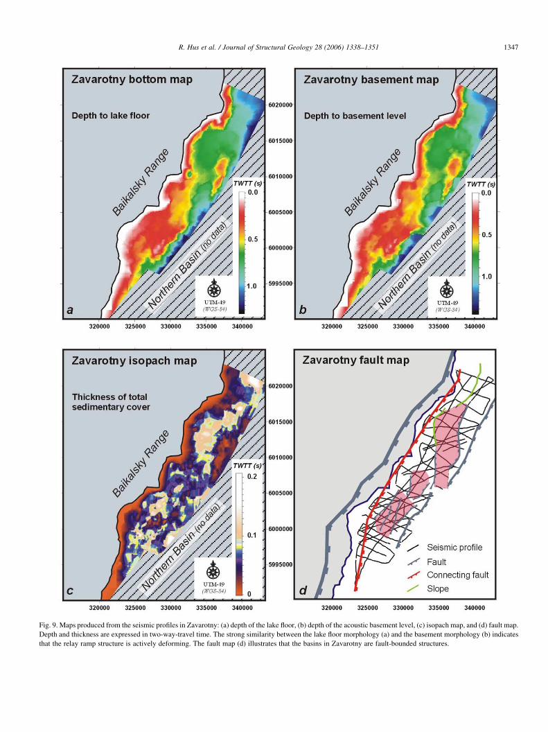
Fig. 9. Maps produced from the seismic profiles in Zavarotny: (a) depth of the lake floor, (b) depth of the acoustic basement level, (c) isopach map, and (d) fault map.
Depth and thickness are expressed in two-way-travel time. The strong similarity between the lake floor morphology (a) and the basement morphology (b) indicates
that the relay ramp structure is actively deforming. The fault map (d) illustrates that the basins in Zavarotny are fault-bounded structures.
R. Hus et al. / Journal of Structural Geology 28 (2006) 1338–1351 1347
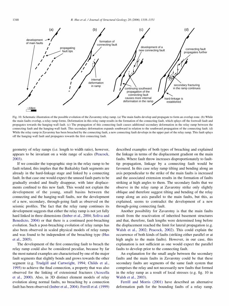
developmentof main faults
propagatingfault tips
formation ofconnecting fault
internaldeformation
in rampcontinuing southward
propagation of theconnecting fault
causes more internaldeformation in the ramp
development of anew connecting fault
hard-linkage isestablished
connecting faultpropagates further
secondary fracturingin the ramp continues
~10km
(a) (b) (c) (d)
Fig. 10. Schematic illustration of the possible evolution of the Zavarotny relay ramp. (a) The main faults develop and propagate to form an overlap zone. (b) While
the main faults overlap, a relay ramp forms. Deformation in this relay ramp results in the formation of the connecting fault, which splays off the footwall fault and
propagates towards the hanging-wall fault. (c) The propagation of this connecting fault causes additional secondary deformation in the relay ramp between the
connecting fault and the hanging-wall fault. This secondary deformation expands southward in relation to the southward propagation of the connecting fault. (d)
While the relay ramp in Zavarotny has been breached by the connecting fault, a new connecting fault develops in the upper part of the relay ramp. This fault splays
off the hanging-wall fault and propagates towards the first connecting fault.
R. Hus et al. / Journal of Structural Geology 28 (2006) 1338–13511348
geometry of relay ramps (i.e. length to width ratio), however,
appears to be invariant on a wide range of scales (Peacock,
2003).
If we consider the topographic step in the relay ramp to be
fault related, this implies that the Baikalsky fault segments are
already in the hard-linkage stage and linked by a connecting
fault. In that case one would expect the unused fault-parts to be
gradually eroded and finally disappear, with later displace-
ments confined to this new fault. This would not explain the
development of the young, small basins between the
connecting and the hanging-wall faults, nor the development
of a new, secondary, through-going fault as observed on the
seismic profiles. The fact that the relay ramp continues its
development suggests that either the relay ramp is not yet fully
hard linked in three dimensions (Imber et al., 2004; Soliva and
Benedicto, 2004) or that there is a continued post-breaching
evolution. Such a post-breaching evolution of relay ramps has
also been observed in scaled physical models of relay ramps
and was found to be independent of the breaching type (Hus
et al., 2005).
The development of the first connecting fault to breach the
relay ramp could also be considered peculiar, because by far
the most natural examples are characterised by one of the major
fault segments that slightly bends and grows towards the other
segment (e.g. Trudgill and Cartwright, 1994; Childs et al.,
1995) to achieve the final connection, a property that was also
observed for the linking of extensional fractures (Acocella
et al., 2000). Also, in 3D distinct element models of relay
evolution along normal faults, no breaching by a connection
fault has been observed (Imber et al., 2004). Ferrill et al. (1999)
described examples of both types of breaching and explained
the linkage in terms of the displacement gradient on the main
faults. Where fault throw increases disproportionately to fault-
tip propagation, linkage by a connecting fault would be
favoured. In this case relay ramp tilting and bending along an
axis perpendicular to the strike of the main faults is increased
and the associated extension results in the formation of faults
striking at high angles to them. The secondary faults that we
observe in the relay ramp at Zavarotny strike only slightly
oblique and therefore suggest tilting and bending of the relay
ramp along an axis parallel to the main faults, but this, as
explained, seems to contradict the development of a new
through-going connecting fault.
Another possibility for Zavarotny is that the main faults
result from the reactivation of inherited basement structures
and that, therefore, fault lengths were determined long before
the displacement reached the limit for lateral propagation (e.g.
Walsh et al., 2002; Peacock, 2002). This could explain the
occurrence of both kinds of faults (striking either parallel or at
high angle to the main faults). However, in our case, this
explanation is not sufficient as one would expect the parallel
faults to develop prior to the connecting fault.
An explanation for the small angle between the secondary
faults and the main faults in Zavarotny could be that these
secondary faults are segments of the same fault system that
comprises the relay and not necessarily new faults that formed
in the relay ramp as a result of local stresses (e.g. fig. 10 in
Walsh et al., 2003).
Ferrill and Morris (2001) have described an alternative
deformation path for the bounding faults of a relay ramp.
R. Hus et al. / Journal of Structural Geology 28 (2006) 1338–1351 1349
During this deformation fault tip propagation is arrested in an
early stage of overlap, but fault displacement increases further.
This early stage is subsequently followed by a period of rapid
fault propagation. In such a deformation path, initial extension
inside the relay ramp may be expressed as faults striking
strongly oblique to the main faults, whereas in a later stage of
overlap the faults may develop that strike almost parallel to the
main faults.
In the cases explained by Cartwright et al. (1996) and Ferrill
et al. (1999), the connecting fault is not a single, well expressed
fault, but rather a fault system resulting from the interconnec-
tion of different fault clusters in the relay ramp. In Zavarotny,
the first connecting fault—although buried by sediments—as
well as the second (developing) fault seem to consist of a
single, well defined, trace. Also, Young et al. (2001) observed a
single, well expressed fault that links up two fault segments in
the Murchison–Statfjord North Fault Zone.
Peacock et al. (2000b) noted previously that the secondary
faults developed in the Hold With Hope relay ramp are mostly
synthetic to the main faults and as such have an opposite dip
direction compared with secondary faults in smaller relay
ramps. In the Zavarotny relay ramp, the strike directions of the
secondary faults are similar to the observations from the Hold
With Hope relay ramp; however, they dip mainly antithetically
to the main faults.
Probably the most important factor that influences the
architecture of the Zavarotny relay ramp is the presence of pre-
existing basement fabric in the area. Possibly this fabric limits
the amount of bending in the relay ramp (along an axis parallel
to the main faults) that is required to form secondary faults
in the relay ramp, which strike parallel to these main faults.
This mechanism could also explain the relatively small angle
between the connecting fault and the main faults (10–158), as
well as the development of the well-defined connecting fault.
This would imply that pre-existing basement structures can
substantially complicate the internal deformation inside large
relay ramps.
6. Conclusions
Based on the interpretation of several detailed data sets, we
have described the internal structure of a relative large scale
relay ramp (w10!40 km) in the western border fault system
of Lake Baikal and we have proposed a possible evolutionary
scheme. It is the first time that the internal structure of a large
relay ramp between large displacement boundary faults in a
narrow rift has been described. Moreover, from the inferred
evolution, it has been possible to reconstruct the linkage
process between two segments of the major Baikalsky Fault in
Lake Baikal.
The deformation inside the Zavarotny relay ramp has been
through the development of fault controlled sub-basins. We
have observed an uncommon combination of secondary fault
development in the relay ramp (with fault strikes that are
almost parallel or at low angle to the main faults) and breaching
of the relay ramp by a newly formed connecting fault. This
observation can be explained by the presence of pre-existing
basement fabric in the area, which has influenced secondary
fault development within the relay ramp.
We have found evidence for a post-breaching continued
evolution of the relay ramp in Zavarotny, confirming earlier
observations from sandbox models, which showed that relay
ramp breaching is not an instantaneous process (Hus et al.,
2005). From the observed continuing post-breaching defor-
mation of the relay ramp, we conclude that the structure in
Zavarotny results from a combination of soft as well as hard
linked displacement transfer.
Acknowledgements
Reviews by Andy Nicol and David Peacock have been very
helpful and greatly improved the paper. An earlier review by
D.J. Sanderson has also been greatly appreciated, as well as the
comments and suggestions from Valerio Acocella. We used a
free academic license for The Kingdom Suite software from
Seismic Micro-Technology. All onshore parts of the digital
terrain models were digitised in the Royal Museum for Central
Africa, Tervuren (Belgium) by Annie Diericks and processed
by Damien Delvaux. At the time of research, R. Hus was
funded through an IWT-grant.
References
Acocella, V., Gudmundsson, A., Funiciello, R., 2000. Interaction and linkage
of extension fractures and normal faults: examples from the rift zone of
Iceland. Journal of Structural Geology 22, 1233–1246.
Agar, S.M., Klitgord, K.D., 1995. Rift flank segmentation, basin initiation and
propagation: a neotectonic example from Lake Baikal. Journal of the
Geological Society of London 152, 849–860.
An, L., 1997. Maximum link distance between strike-slip faults: observations
and constraints. Pure and Applied Geophysics 150, 19–36.
Aydin, A., Schultz, R., 1990. Effect of mechanical interaction on the
development of strike-slip faults with echelon patterns. Journal of
Structural Geology 12, 123–129.
Bosworth, W., 1985. Geometry of propagating rifts. Nature 316, 625–627.
Cartwright, J.A., Mansfield, C., Trudgill, B., 1996. The growth of normal faults
by segment linkage. In: Buchanan, P.G., Nieuwland, D.A. (Eds.), Modern
Developments in Structural Geology, Interpretation, Validation and
Modelling Geological Society Special Publication 99, pp. 163–177.
Childs, C., Watterson, J., Walsh, J.J., 1995. Fault overlap zones within
developing normal fault systems. Journal of the Geological Society of
London 152, 535–549.
Coskun, B., 1997. Oil and gas fields—transfer zone relationships, Thrace
Basin, NW Turkey. Marine and Petroleum Geology 14, 401–416.
Crider, J.G., Pollard, D.D., 1998. Fault linkage: three-dimensional mechanical
interaction between echelon normal faults. Journal of Geophysical
Research 103, 24373–24391.
Davison, I., 1994. Linked fault systems; extensional, strike-slip and
contractional. In: Hancock, P.L. (Ed.), Continental Deformation. Pergamon
Press, pp. 121–141.
Dawers, N.H., Anders, M.H., 1995. Displacement–length scaling and fault
linkage. Journal of Structural Geology 17, 607–614.
De Batist, M., Vanhauwaert, P., 1995. Lake Baikal 1995: Expedition Report.
Internal Note of the Renard Centre of Marine Geology, Ghent University.
Delvaux, D., Moeys, R., Stapel, G., Petit, C., Levi, K., Miroshnichenko, A.,
Ruzhich, V., San’kov, V., 1997. Paleostress recontstructions and
geodynamics of the Baikal region, Central Asia, Part 2. Cenozoic rifting.
Tectonophysics 282, 1–38.
R. Hus et al. / Journal of Structural Geology 28 (2006) 1338–13511350
Delvaux, D., Fronhoffs, A., Hus, R., Poort, J., 2000. Normal fault splays, relay
ramps and transfer zones in the central part of the Baikal rift basin: insight
from digital topography and bathymetry. Bulletin des Centres de
Recherches Exploration—Production Elf Aquitaine 22, 341–358.
dePolo, C.M., Clark, D.G., Burton Slemmons, D., Ramelli, A.R., 1991.
Historical surface faulting in the Basin and Range province, western North
America: implications for fault segmentation. Journal of Structural
Geology 13, 123–136.
Doser, D., 1991. Faulting within the western Baikal rift as characterised by
earthquake studies. Tectonophysics 196, 87–107.
Dou, L., Chang, L., 2003. Fault linkage patterns and their control on the
formation of the petroleum systems of the Erlian Basin, Eastern China.
Marine and Petroleum Geology 20, 1213–1224.
Faulds, J.E., Varga, R.J., 1998. The role of accommodation zones and transfer
zones in the regional segmentation of extended terranes. In: Faulds, J.E.,
Stewart, J.H. (Eds.), Accommodation Zones and Transfer Zones; the
Regional Segmentation of the Basin and Range Province Geological
Society of America, Special Paper 323, pp. 1–45.
Ferrill, D.A., Morris, A.P., 2001. Displacement gradient and deformation in
normal fault systems. Journal of Structural Geology 23, 619–638.
Ferrill, D.A., Stamatakos, J.A., Sims, D., 1999. Normal fault corrugation:
implications for growth and seismicity of active normal faults. Journal of
Structural Geology 21, 1027–1038.
Gawthorpe, R.L., Hurst, J.M., 1993. Transfer zones in extensional basins: their
structural style and influence on drainage development and stratigraphy.
Journal of the Geological Society of London 150, 1137–1152.
Gupta, A., Scholz, C.H., 2000. A model of normal fault interaction based on
observations and theory. Journal of Structural Geology 22, 865–879.
Huggins, P., Watterson, J.J., Walsh, J.J., Childs, C., 1995. Relay zone geometry
and displacement transfer between normal faults recorded in coal-mine
plans. Journal of Structural Geology 17, 1741–1755.
Hus, R., Acocella, V., Funiciello, R., De Batist, M., 2005. Sandbox models
of relay ramp structure and evolution. Journal of Structural Geology 27,
459–473.
Hutchinson, D.R., Golmshtok, A.J., Zonenshain, L.P., Moore, T.C.,
Scholtz, C.A., Klitgord, K.D., 1992. Depositional and tectonic framework
of the rift basins of Lake Baikal from multichannel seismic data. Geology
20, 589–592.
Imber, J., Tuckwell, G.W., Childs, C., Walsh, J.J., Manzocchi, T., Heath, A.E.,
Bonson, C.G., Strand, J., 2004. Three-dimensional distinct element
modelling of relay growth and breaching along normal faults. Journal of
Structural Geology 26, 1897–1911.
Jackson, C.A.L., Gawthorpe, R.L., Sharp, I.A., 2002. Growth and linkage of the
East Tanka fault zone, Suez rift: structural style and syn-rift stratigraphic
response. Journal of the Geological Society of London 159, 175–187.
Kuzmin, M.I., Karabanov, E.B., Prokopenko, A.A., Gelety, V.F., Antipin, V.S.,
Williams, D.F., Gvozdkov, A.N., 2000. Sedimentation processes and new
age constraints on rifting stages in Lake Baikal: results of deep-water
drilling. International Journal of Earth Sciences 89, 183–192.
Larsen, P.H., 1988. Relay structures in a Lower Permian basement-involved
extension system, East Greenland. Journal of Structural Geology 10, 3–8.
Leeder, M.R., Collier, R.E.L., Abdul Aziz, L.H., Trout, M., Ferentinos, G.,
Papatheodorou, G., Lyberis, E., 2002. Tectono-sedimentary processes
along an active marine/lacustrine half-graben margin: Alkyonides Gulf, E.
Gulf of Corinth, Greece. Basin Research 14, 25–41.
Logatchev, N.A., 1993. History and geodynamics of the Lake Baikal Rift in the
context of the Eastern Rift System: a review. Bulletin des Centres de
Recherches Exploration—Production Elf Aquitaine 17, 353–370.
Manighetti, I., King, G.C.P., Gaudemer, Y., Scholz, C.H., Doubre, C., 2001.
Slip accumulation and lateral propagation of active normal faults in Afar.
Journal of Geophysical Research 106, 13667–13696.
Mats, V.D., 1993. The structure and development of the Baikal rift depression.
Earth-Science Reviews 34, 81–118.
Mats, V.D., Khlystov, O.M., De Batist, M., Ceramicola, S., Lomonosova, T.K.,
Klimansky, A., 2000. The evolution of the Akademichesky Ridge
Accommodation Zone in the central part of the Baikal Rift, from high-
resolution reflection seismic profiling and geological field investigations.
International Journal of Earth Sciences 89, 229–250.
Matton, C., Klerkx, J., 1995. Basin structure in the Western part of Northern
Lake Baikal: the Zavarotny Area. Russian Geology and Geophysics 36,
168–174.
Morley, C.K., 1995. Developments in the structural geology of rifts over the
last decade and their impact on hydrocarbon exploration. In: Lambiase, J.J.
(Ed.), Hydrocarbon Habitat in Rift Basins Geological Society Special
Publication 80, pp. 1–32.
Morley, C.K., 1999. Aspects of transfer zone geometry and evolution in East
African Rifts. In: Morley, C.K. (Ed.), Geoscience of Rift Systems—
Evolution of East Africa AAPG Studies in Geology 44, pp. 161–171.
Morley, C.K., Nelson, R.A., Patton, T.L., Munn, S.G., 1990. Transfer zones in
the East African Rift System and their relevance to hydrocarbon
exploration in rifts. Bulletin of the American Association of Petroleum
Geologists 74, 1234–1253.
Nelson, R.A., Patton, T.L., Morley, C.K., 1992. Rift-segment interaction and its
relation to hydrocarbon exploration in continental rift systems. Bulletin of
the American Association of Petroleum Geologists 76, 1153–1169.
Nicol, A., Watterson, J., Walsh, J.J., Childs, C., 1996. The shapes, major axis
orientations and displacement patterns of fault surfaces. Journal of
Structural Geology 18, 235–248.
Peacock, D.C.P., 2002. Propagation, interaction and linkage in normal fault
systems. Earth-Science Reviews 58, 121–142.
Peacock, D.C.P., 2003. Scaling of transfer zones in the British Isles. Journal of
Structural Geology 25, 1561–1567.
Peacock, D.C.P., Parfitt, E.A., 2002. Active relay ramps and normal fault
propagation on Kilauea Volcano, Hawaii. Journal of Structural Geology 24,
729–742.
Peacock, D.C.P., Sanderson, D.J., 1991. Displacements, segment linkage
and relay ramps in normal fault zones. Journal of Structural Geology 13,
721–733.
Peacock, D.C.P., Sanderson, D.J., 1994. Geometry and development of relay
ramps in normal fault systems. Bulletin of the American Association of
Petroleum Geologists 78, 147–165.
Peacock, D.C.P., Knipe, R.J., Sanderson, D.J., 2000a. Glossary of normal
faults. Journal of Structural Geology 22, 291–305.
Peacock, D.C.P., Price, S.P., Whitham, A.G., Pickles, C.S., 2000b. TheWorld’s
biggest relay ramp: Hold With Hope, NE Greenland. Journal of Structural
Geology 22, 843–850.
Rosendahl, R.B., 1987. Architecture of continental rifts with special reference
to East Africa. Annual Review of Earth and Planetary Sciences 15,
445–503.
Rosendahl, B.R., Reynolds, D.J., Lorber, P.M., Burgess, C.F., McGill, J.,
Scott, D., Lambiase, J.J., Derksen, S.J., 1986. Structural expression of
rifting: lessons from Lake Tanganyika, Africa. In: Frostick, L.E.,
Renaut, R.W., Reid, I., Tiercelin, J.J. (Eds.), Sedimentation in the African
Rifts Geological Society Special Publication 25, pp. 29–43.
Scholz, C.A., Klitgord, K.D., Hutchinson, D.R., Ten Brink, U.S.,
Zonenshain, L.P., Golmshtok, A.Y., Moore, T.C., 1993. Results of 1992
Seismic Reflection Experiment in Lake Baikal. Eos Transactions of the
American Geophysical Union 74, 465–470.
Segall, P., Pollard, D.D., 1980. Mechanics of discontinuous faults. Journal of
Geophysical Research 85, 4337–4350.
Soliva, R., Benedicto, A., 2004. A linkage criterion for segmented normal
faults. Journal of Structural Geology 26, 2251–2267.
Trudgill, B.D., Cartwright, J.A., 1994. Relay ramp forms and normal fault
linkages—Canyonlands National Park, Utah. Bulletin of the Geological
Society of America 106, 1143–1157.
Upcott, N.M., Mukasa, R.K., Ebinger, C.J., 1996. Along-axis segmentation and
isostasy in the Western rift, East Africa. Journal of Geophysical Research
101, 3247–3268.
Van Der Beek, P.A., Delvaux, D., Andriessen, P.A.M., Levi, K.G., 1996. Early
Cretaceous denudation related to convergent tectonics in the Baikal region,
SE Siberia. Journal of the Geological Society, London 153, 515–523.
Walsh, J.J., Nicol, A., Childs, C., 2002. An alternative model for the growth of
faults. Journal of Structural Research 24, 1669–1675.
Walsh, J.J., Bailey, W.R., Childs, C., Nicol, A., Bonson, C.G., 2003. Formation
of segmented normal faults: a 3-D perspective. Journal of Structural
Geology 25, 1251–1262.

R. Hus et al. / Journal of Structural Geology 28 (2006) 1338–1351 1351
Willemse, E.J.M., 1997. Segmented normal faults: correspondence between
three-dimensional mechanical models and field data. Journal of Geophy-
sical Research 102, 675–692.
Willemse, E.J.M., Pollard, D.D., Aydin, A., 1996. Three-dimensional analyses
of slip distributions on normal fault arrays with consequences for fault
scaling. Journal of Structural Geology 18, 295–309.
Young, M.J., Gawthorpe, R.L., Hardy, S., 2001. Growth and linkage of a
segmented normal fault zone: the Late Jurassic Murchison Statfjord
North Fault, northern North Sea. Journal of Structural Geology 23,
1933–1952.
Zonenshain, L.P., Golmshtok, A.Y., Hutchinson, D., 1992. Baikal rift structure.
Geotectonics 26, 396–407.