Embed Size (px)
Citation preview

2011 Livability Action Agenda for Far NortheastSeptember 2011
Far Northeast Livability StudyFar Northeast Livability StudyLivability Action Agenda for Far Northeast
October 2011


Far Northeast Livability StudyLivability Action Agenda for Far Northeast October 2011
Vincent C. Gray, Mayor Terry Bellamy, Director
Prepared for: District of Columbia Department of Transportation Gabe Onyeador, Project Manager 2000 14th Street NW Washington, DC 20009 (202) 671-0590
Prepared by: Kittelson & Associates, Inc. 36 South Charles Street, Suite 1920 Baltimore, Maryland 21201 (410) 347-9610
Samuel Jordan


contents
executive summary ...........................................................................1
introduction ......................................................................................17
planning context ..............................................................................21
public involvement ...........................................................................25
prioritization process ........................................................................31
recommendations, funding & implementation ................................43
performance measures .....................................................................84
6
Far Northeast Livability Studyd
figures
Far Northeast Study Area ......................................................................................................................................................................... 4Priority Intersections ................................................................................................................................................................................. 11Priority Ranking: Corridors ........................................................................................................................................................................ 12Project Recommendations ........................................................................................................................................................................ 13Project Recommendations ........................................................................................................................................................................ 14Livability Study Corridors and Intersections ............................................................................................................................................ 32Priority Corridors ....................................................................................................................................................................................... 40Priority Intersections ................................................................................................................................................................................. 41Sheriff Road: 43rd Place to 48th Street ................................................................................................................................................... 45Sheriff Road: 48th Place to East of 50th Street ........................................................................................................................................ 46Sheriff Road: 51st Street to Eastern Avenue ............................................................................................................................................ 4749th Street: East Capitol South to Fitch Place .......................................................................................................................................... 4949th Street: Fitch Place to Jay Street ........................................................................................................................................................ 5049th Street: Jay Street to Quarles Street .................................................................................................................................................. 51Priority Corridors ....................................................................................................................................................................................... 60Benning Road/East Capitol Street/Central Avenue ................................................................................................................................. 63Minnesota Avenue/48th Street and Minnesota Avenue/Nash Street (Deanwood Community Center) ................................................. 68Eastern Avenue/Sheriff Road/Division Avenue ........................................................................................................................................ 71Eastern Avenue/Sherriff Road/Division Avenue ....................................................................................................................................... 72Sheriff Road/45th Street/45th Place ......................................................................................................................................................... 7449th Street/Quarles Street ........................................................................................................................................................................ 76Minnesota Avenue/Quarles Street (Deanwood Community Center) ....................................................................................................... 78Priority Intersections ................................................................................................................................................................................. 83

livabilityP R O G R A Md
October 2011
acknowledgements
PPSA - Planning, Policy and Sustainability Administration, DDOTIMPA- Infrastructure Project Management Administration, DDOTOP - Office of Planning, DDOTMTA - MassTransit Administration, DDOT
MPD - Metropolitan Police DepartmentWMATA - Washington Metropolitan Area Transit AuthorityPTSA - Progressive Transportation Services Administration, DDOTTOA - Transportation Operations Administration, DDOT
Livability Technical Advisory Committee (LTAC)
Yusuf AdenGizachew Andargeh, OPJames Austrich, MPDReginald Arno, IPMASara Benson, WMATAGloria Bosse-Kouabo, TOAGeorge Branyan, PPSAJames M. Cheeks Jr., TOANikeya CunninghamTravis DavidsonChristopher Delfs, PPSAMesfin Lakew, IMPAYizgoul Menbeni, TOAKendrick Miles, IPMA
Asnake Negussie, IPMAGabe Onyeador, PPSAOla Igho-Osagie, IPMALevon PetrosianMarti ReinfeldAaron Rhones, OPJim Sebastian, PPSACharles E. Thomas, PPSACirce Torruellas, MTAConnie Wheeler, IPMATerraine Wiggins, IPMAMaduabuchi Udeh, IPMAWaiching Wong, PTSA
Livability Community Outreach Advisors (LCOA)
Consultant Team:
Neha BhattSylvia BrownKia ChatmonDennis ChestnutFajr ChestnuttKhaliq ElhillaliRemetter FreemanMary GaffneyDelores MylesJoAnne PrueGregg RhettWillette SeawardGregori StewartRonnie StreffAlisa Woods
Kittelson & Associates, Inc.Caitlin DoolinTom GonzalesPete JeniorEd MyersConor SemlerYolanda TakesianAdam Vest
Samuel Jordan
Toole Design Group, LLCBob PattenCarrie RaineyBill Schultheiss


livabilityP R O G R A Md 1
October 2011
executive summary
The Far Northeast Livability Study was prepared as a partnership that included District Department of Transportation (DDOT) and Office of Planning (OP) staff, members of the 12 neighborhoods and 7 Single Member Advisory Neighborhood Commissions (ANC) within the Far Northeast Study area, and the consultant team consisting of Kittelson and Associates, Toole Design Group and Samuel Jordan.
The policy direction and financial resources of the District Department of Transportation permitted the perspectives of residents living within and near the Far Northeast study area to offer significant direction in the various stages of development of the recommendations proposed in this study. These include:
1. Range of issues identified and addressed in this plan,
2. Location needs for observation, data collection and
analysis,
3. Prioritization criteria for final project selection,
4. Approaches for communicating and exchanging
information, and
5. Outreach methods including assisting in outreach.

2
Far Northeast Livability Studyd
DDOT Livability StudiesThe DC Department of Transportation (DDOT) has engaged in a series of “livability studies” to take a big picture look at its street network. These studies were derived from the DDOT Action Agenda, which outlined the following principles:
• Ensure safe passages for all users of the street network. This involves special attention to the most vulnerable users of the system (pedestrians, bicyclists, children, and the elderly); and taming traffic while maintaining overall mobility.
• Prioritize sustainable living in DC communities. This means providing a robust set of transportation choices and designing streets to encourage physical activity. It also means designing streets in ways that help preserve, protect, and/or restore ecological systems.
• Foster prosperous places by building and operating streets as unique urban places that support retail and employment districts. Enhancing prosperous places also may entail the expansion of civic open spaces within transportation rights of way.
Livability is a term that refers to community quality of life as experienced by the people who live, work, and recreate there. Livable communities rely on the interplay among key development areas including transportation, public health, housing, cultural resources, and the natural environment.
DDOT began its Livability Program with studies in three multi-neighborhood areas, including Far Northeast. These studies
begin with the recognition that automobile operations on DC streets cannot be the one and only priority governing improvements to streets. Many intersections and roadways in Far Northeast, including East Capitol Street, Benning Road, and Sheriff Road, have been designed to accommodate vehicles driving in from Maryland. Wide open roads with long green-phase signals encourage speeding, provide fewer pedestrian crossings and discourage pedestrian compliance to crossing locations and control devices. They also negatively impact the street as part of the public realm and reduce walking, bicycling, and residential living along its edges. DDOT recognizes this and aims to use the livability studies to reverse these trends and encourage investment in walkable places.

livabilityP R O G R A Md 3
October 2011
Livability Approach in Far NortheastThe goals of DDOT’s Livability Program to “Create Safe Passages, Support Sustainable Living, and Promote Prosperous Places” helped to guide the team’s approach to problem identification and assessment. In addition to access to goods, services and opportunity, The program’s focus recognizes that transportation facilities and services affect the quality of neighborhood and personal health, household budgets, cultural preservation and the natural environment. This was seen by the Far Northeast participants as a new and welcomed change in the city’s approach to thinking about transportation in the area. The various ANCs and civic leaders within the Far Northeast also recognized that this study could be catalytic to improve the effectiveness of transportation resource application within the study area and worked not only to advise of issues and concerns but also to get the word out to their neighbors to raise awareness of the opportunity.
The work of the Far Northeast Livability Study is presented in two parts: the August, 2010 Existing Conditions Report and this document, the Livability Action Agenda for Far Northeast. The presentation of the study’s analysis and recommendations are organized as follows:
1. Review the geographical and demographic context of the
area and related transportation issues,
2. Discuss the public outreach activities and the solutions
toolbox created to raise awareness of options and
tradeoffs for particular problems,
3. Present project identification and location prioritization
approach developed to include livability factors as
measures of need,
4. Description of recommended improvements at specific
locations within the study area; and
5. Proposed actions for follow up including monitoring of
performance measures, project implementation, and
ongoing participation of community leadership in a
DDOT partnership.

4
Far Northeast Livability StudydFar Northeast Study Area
livabilityP R O G R A Md 5
October 2011
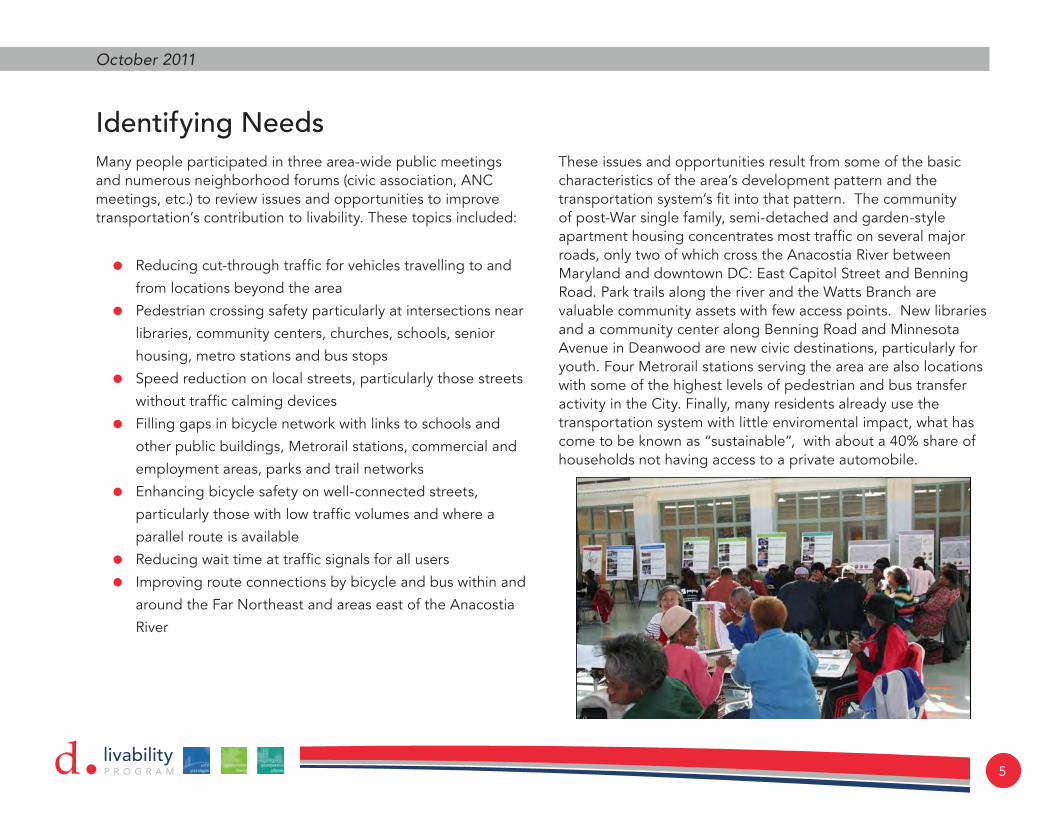
Identifying NeedsMany people participated in three area-wide public meetings and numerous neighborhood forums (civic association, ANC meetings, etc.) to review issues and opportunities to improve transportation’s contribution to livability. These topics included:
• Reducing cut-through traffic for vehicles travelling to and
from locations beyond the area
• Pedestrian crossing safety particularly at intersections near
libraries, community centers, churches, schools, senior
housing, metro stations and bus stops
• Speed reduction on local streets, particularly those streets
without traffic calming devices
• Filling gaps in bicycle network with links to schools and
other public buildings, Metrorail stations, commercial and
employment areas, parks and trail networks
• Enhancing bicycle safety on well-connected streets,
particularly those with low traffic volumes and where a
parallel route is available
• Reducing wait time at traffic signals for all users
• Improving route connections by bicycle and bus within and
around the Far Northeast and areas east of the Anacostia
River
These issues and opportunities result from some of the basic characteristics of the area’s development pattern and the transportation system’s fit into that pattern. The community of post-War single family, semi-detached and garden-style apartment housing concentrates most traffic on several major roads, only two of which cross the Anacostia River between Maryland and downtown DC: East Capitol Street and Benning Road. Park trails along the river and the Watts Branch are valuable community assets with few access points. New libraries and a community center along Benning Road and Minnesota Avenue in Deanwood are new civic destinations, particularly for youth. Four Metrorail stations serving the area are also locations with some of the highest levels of pedestrian and bus transfer activity in the City. Finally, many residents already use the transportation system with little enviromental impact, what has come to be known as “sustainable”, with about a 40% share of households not having access to a private automobile.

6
Far Northeast Livability StudydIdentifying Projects and Prioritizing Needs
In the analysis phase of the project, the team visited locations specifically identified by staff, community participants and derived from data. A “solutions toolbox” and companion questionnaire was created for the second public meeting to bring data and possible corrective actions back to the community for discussion and project development. The team’s approach to determine the most appropriate solutions and priority projects recognized livability program goals. Data and information was organized in categories among which the most important considerations were as follows:
• All locations
• CommunityConcern
• Safety/Crashes
• PedestrianGenerators
• PedestrianFacilities
• Corridors
• Presenceoftrafficcalmingelements
• Bicycleusepotential
• TrafficSpeeds
• TrafficVolume
• Intersections
• Geometryoftheintersection
• Visibilityofapproachingtraffic
• Trafficoperationsinformationincludinglevelof
congestionandtrafficcontrol
• Bicycle network
• Highdemandconnections
• Easeofaccommodationthroughdedicatedspace
• CompatibletrafficconditionThese considerations where used to create a set of ranking criteria to help identify priority projects for the earliest funding available. These prioritization criteria and ranking results are presented in the Prioritization Process section of this report. The areas of greatest need were located within existing Great Streets Projects on Minnesota Avenue, Nannie Helen Burroughs Road, and Benning Road. Numerous other locations were also rated. Of these locations, organized as intersections or corridors, those that rose to the top as priorities for early attention were:
• Benning Branch Library Signal
• Minnesota Avenue at Allen House Pedestrian signal
• Sheriff Road Traffic Calming & Bicycle Accommodation
• 49th Street Traffic Calming & Bicycle Accommodation
• East Capitol Street, Benning Road, Texas Street & Central
Avenue Intersection
Following the priority project descriptions are figures and tables that summarize all recommendations for study corridors and intersections. Great Streets and other DDOT project corridors/intersections are included, but refer only to additional recommendations identified through the Livability study. Concept designs are also provided in the recommendations, funding and implementation chapter of this document.

livabilityP R O G R A Md 7
October 2011
Benning Branch Library Signal
Improve pedestrian environment, crossing safety
Medium Term
• Install full signal and crosswalks
Minnesota Avenue at Allen House Pedestrian Signal
Short Term
• Traffic SignalMedium Term
• Reconstruct intersection as part of the Minnesota Avenue Great Streets project

8
Far Northeast Livability StudydSheriff Road Traffic Calming & Bicycle Accommodation

livabilityP R O G R A Md 9
October 2011
49th Street Traffic Calming & Bicycle Accommodation
10
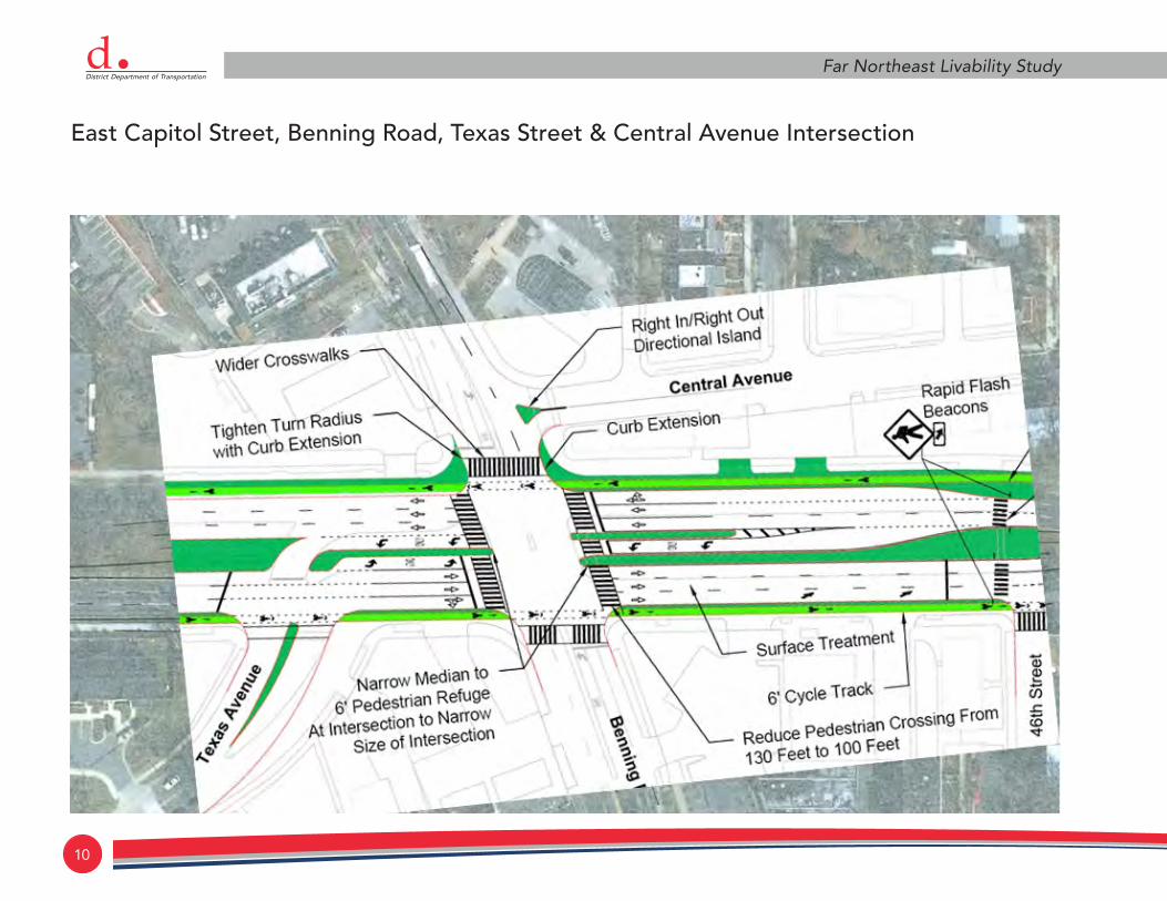
Far Northeast Livability StudydEast Capitol Street, Benning Road, Texas Street & Central Avenue Intersection

livabilityP R O G R A Md 11
October 2011
Priority Ranking: Intersections
Intersection Pedestrian Facilities Traffic Transit
Cross-walks
Curb Extensions
Median Refuge
Rapid Flash Beacons
Signal Re-timing
Add Protected
Left Movement New Signal
Traffic Circle
Round-about
Bus Stop Consol-idation
Bus Stop Relocation
Benning Rd/E. Capitol St/Central Ave
Benning Rd/39th St (Benning Branch Library)
Minnesota Ave/48th St (Deanwood Community Center)
E. Capitol St/Central Ave/50th St
Eastern Ave/Minnesota Ave
Eastern Ave/Sheriff Rd/Division Ave
Sheriff Rd/45th St/45th Pl
49th St/Quarles St (Deanwood Community Center)
Minnesota Ave/Quarles St (Deanwood Community Center)
E. Capitol St/Southern Ave/61st St
Eastern Ave/61st St/Eads St
Great Streets/DDOT Project Intersections
Benning Rd/Minnesota Ave
Nannie Helen Burroughs Ave/Minnesota Ave
Minnesota Ave/Grant St
Minnesota Ave/Blaine St
Nannie Helen Burroughs Ave/44th St
Nannie Helen Burroughs Ave/50th St
Nannie Helen Burroughs Ave/48th St
E. Capitol St/Minnesota Ave

12
Far Northeast Livability Studyd
Pedestrian Facilities Traffic Calming Bicycle Transit
CrosswalksCurb
ExtensionsRaised
CrosswalkMedian Refuge
Rapid Flash Beacons
Raised Intersec-
tionParking
EdgelinesRemove
Centerline Sharrows Bike Lanes Cycle Track
Bus Stop Consolida-
tionBus Stop
Relocation
Sheriff Road
49th Street
Grant Street
Division Avenue
Hunt Place
42nd Street
44th Street
Gault Place
Hayes Street
Jay Street
Lee Street
Minnesota Avenue
E. Capitol Street
Benning Road
Nannie Helen Burroughs Ave
Priority Ranking: Corridors

livabilityP R O G R A Md 13
October 2011
Project Recommendations
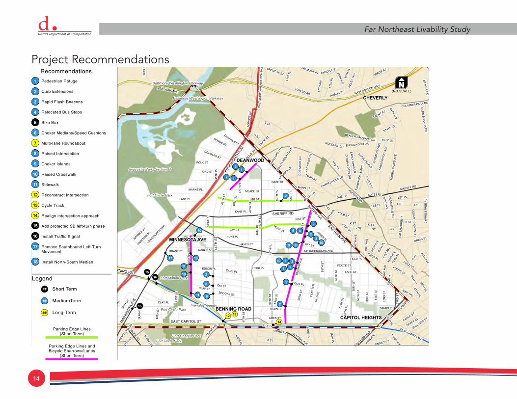
14
Far Northeast Livability StudydProject Recommendations

livabilityP R O G R A Md 15
October 2011
Ongoing Community EngagementThe process by which the Far Northeast Livability Study evolved created a communications platform permitting residents of the neighborhoods and DDOT staff to move projects through the various stages of design and planning a with particularly deliberate, interactive and transparent exchange of information. Through the study, DDOT has helped to shape and validate a model of cooperation that can engage a broad base of residents in its project development activities. The model allows all parties to recognize the tradeoffs and constraints as well as the opportunities and benefits of transportation investment and design decisions. This effort should continue as the projects discussed here are funded, designed and built. The Livability Community Outreach Advisors (LCOA) or other form of local representation that works across neighborhoods, including ANCs, can assist to keep residents informed of progress and to help bring interested residents to meetings where projects that affect them are discussed. We also recommend that the project website continue to be maintained with the latest information on projects and activities that are the subject of this study as well as other DDOT activities affecting the Far Northeast neighborhoods.


livabilityP R O G R A Md 17
October 2011
introduction
Far Northeast DC consists of 12 distinct but interrelated neighborhoods east of the Anacostia River and north of East Capitol Street in Ward 7. These neighborhoods are home to approximately 30,000 residents.

18
Far Northeast Livability StudydTransportation in its various forms plays a critical role in the livability of Far Northeast, affecting access to education and opportunity, goods and services, and worship and recreation. Circulation patterns and behaviors also affect the quality of residential streets and the safety and walkability of the area’s major streets. Physically and spatially separated from downtown and the metropolitan region’s job centers south and west of the city, both the pressures and advantages of redevelopment in the District have eluded the area.
Far Northeast’s road network is very much influenced by its post- Second World War settlement pattern when people migrated into the District to fill the jobs created by a growing federal government. Many early residents came from farming communities in the south and settled on leafy, unpaved streets in single family and duplex houses. Many of the roads in Far Northeast were not paved until the 1950’s and only recently has DDOT’s effort to increase walkability filled the many sidewalk gaps that existed. Urban policy for locating and concentrating public housing on the fringes of cities introduced a number of public and subsidized housing complexes. Today about 13% of area households are subsidized, comprising about 23% of the city’s total public and Section 8 housing stock. Seniors and disabled residents make up about 14% of the area population. Car ownership is low, with 40 percent of the area’s 11,000 households reporting no access to a vehicle in 2000.
In recent years as historically African American neighborhoods within the District became more expensive; the area has once again become attractive to the city’s workforce. Clerical workers, educators, police, entrepreneurs and mid-level federal employees have come in search of convenient affordable housing options “east of the river.” Most jobs, services, and consumer goods still lie west of the river and in Maryland and so require daily trips to places outside of the area.
Metrorail’s blue and orange line began service to the area at four stations in 1978. However, its cost per ride, about twice that of the bus service, makes bus the mode of choice for the transit-dependent and budget conscious households. On one hand, the introduction of Metro was a major boon to the communities of Far Northeast, connecting its resident to major employment, education and commercial centers around the region with much faster access to places just across the river. On the other hand, the construction of four Metrorail stations was a mixed blessing for bus riders, due to reduced or changed bus service and forced transfers at Metro. This combination of a high reliance on public transportation and its relatively high cost in time and convenience makes transportation a fundamental indicator of livability. Reliable and convenient public transportation, a complete and safe network of pedestrian-friendly routes and bus stops, bicycle links to schools, parks and Metro, and the ability to live on a quiet neighborhood street are critically important to the livability of Far Northeast residents.

livabilityP R O G R A Md 19
October 2011
Development of this PlanThe planning process for the Far Northeast Livability Study included background data collection and analysis, a review of previous and ongoing plans and road improvement projects, and detailed field work. The Study also involved considerable communication and coordination with interested residents and civic leaders and agency staff within DDOT and the Office of Planning (OP).
The project team’s public engagement approach built upon community knowledge gained during the planning of completed and ongoing projects. That planning helped create a group of people familiar with and fully engaged in public facilities planning. These community leaders and advocates were brought together by the project team to form the Livability Community Outreach Advisors (LCOA). The group included several Advisory
Neighborhood Commissioners (ANCs) familiar with the particular concerns and preoccupations of residents. Their first-hand and recent knowledge of what had worked and not worked to engage their neighbors helped to ensure that the process of the FNE Livability Study was effective at raising issues of greatest importance to residents and that materials provided to inform residents about the possibilities for improvement facilitated a proactive three-way education, resident-to-resident, resident-to-staff and consultants, and staff and consultants-to-residents.


livabilityP R O G R A Md 21
October 2011
planning context
This chapter provides a broad overview of the previous plans, studies, and guidelines related to Far Northeast. It highlights existing conditions for all transportation modes and outlines key transportation issues and challenges in the area. For additional information and a more detailed discussion of the items below, see the Existing Conditions Report.
Data CollectionMany sources contributed to knowledge of the present condition of the transportation system in Far Northeast. The team performed a thorough review of nearly forty documents, many of which were previous studies focusing on all or part of Far Northeast. Others were plans or guidelines developed by various agencies for the entire District or greater metropolitan area. The literature review provided an understanding of guidelines applicable to the project area, previously examined aspects of the transportation system, issues, and recommendations.
Data collected through numerous sources (e.g., DDOT, WMATA, DC GIS Clearinghouse, US Census, etc) also informed on the state of the transportation network. This data included traffic volumes, bus and rail ridership, rail station access mode shares, vehicle and pedestrian crashes, existing and proposed pedestrian and bicycle facilities, and sidewalk

22
Far Northeast Livability Studydconnectivity. Data from the US Census Bureau, including vehicle ownership, employment density, and areas of interest helped to establish an understanding of the Far Northeast community and its important neighborhood destinations.
Community participants provided another valuable source of information. The project provided several opportunities for the public to identify concerns and issues with the transportation system, including three community meetings and an interactive project mapping website. Website and meeting contributions were reviewed and synthesized to develop a more detailed and accurate image of the existing conditions in Far Northeast, with considerable emphasis on issues identified in previous studies and by the community. Maps, such as the example corridor and intersection locations at the end of this section, helped to graphically illustrate the issues discussed for ground truthing data with user experience of locations studied.
Existing Transportation ConditionsThe transportation system in Far Northeast is defined by its physical barriers, the Anacostia River, the Anacostia Freeway and Metro rail line, and psychological barriers such as large streets like East Capital Street and the Watts Branch Park with few safe crossing points. Far Northeast’s major arterial streets are places where all modes of transport meet and negotiate space within the limits of what is available. Managing that allocation of space to better accommodate all modes, particularly pedestrians
and bicyclists, as well as growing traffic demand, became an important focus of the work of this study.
Increasing volumes and driver behavior of cut-through traffic on local streets has been a concern to residents in areas affected by Metro access, Maryland commuters, as well as residents seeking to avoid congested intersections. DDOT has responded on a case-by-case basis with speed humps and “Yield to Pedestrian” panels at high demand crossing points where other traffic control is not warranted.
During this study, the area’s considerable transit service with its four Metrorail stations and numerous bus routes, while important to residents, was being treated through other planning efforts within WMATA and DDOT. Those efforts included the following projects.

livabilityP R O G R A Md 23
October 2011
1. Expansion of the 2X as part of WMATA’s growing Priority
Corridor Network for MetroExtra service was introduced
during the study.
2. Development of a City-wide plan for Circulator service,
specifically address community concerns for better transit
connectivity east of the river.
3. Long-range planning for future streetcar service along
Benning Road and Minnesota Avenue to create high
quality rail alternatives to popular bus service routes.
Improvements underway or completed during this study include replacement of the Eastern Avenue Bridge over the Anacostia Freeway and the Nannie Helen Burroughs interchange, the Nannie Helen Burroughs Great Streets Project and the Benning Road Great Streets Project.
Planned and Recent Major Improvements Recommended Expansion
Phase I: Near-Term (FY 2012-2015)
• Union Station – Navy Yard –East of the River Expansion
• Union Station—Navy Yard extension to NoMa
• Dupont Circle-Georgetown-Rosslyn extension to U St/Howard University
• North Mall—Union Station to Georgetown
• South Mall—Union Station to Arlington Cemetery
• Dupont Circle—Southwest Waterfront – Navy Yard
Phase II: Mid-Term (FY 2016-2018)
• Adams Morgan—H St NE
• St. Elizabeth’s Campus/Congress Heights—H St NE
• Tenleytown—Brookland
Phase III: Long-Term (FY 2019-2020)
• Tenleytown—Silver Spring
• Minnesota Avenue to Skyland

24
Far Northeast Livability StudydWithin Far Northeast Neighborhoods
Far Northeast has seen important changes in the past several years, including significant new investment and engagement in the community. A new state-of-the-art community center, two new libraries, several major housing developments, and transformation of Minnesota Avenue are among the investments occurring in the neighborhood.
In planning for these changes, the Washington, DC government undertook a significant number of studies and published reports. Our work began with a comprehensive review of all known previous studies of the area, as well as a status review of major projects.
New development, particularly planned transit-oriented development, has largely assumed that the road system provides adequate capacity for vehicular traffic. New projects referenced in these reviewed plans suggest that city projects and private developer investment can add to the area’s pedestrian and bicycle safety, circulation and level of service. They can also contribute to better conditions and service for transit. Recent projects had varying degrees of success at leveraging this investment for needed companion projects in transportation. Engaging residents and staff to raise awareness is potentially valuable so these opportunities are realized.
Great Streets and Other DDOT Projects
The Great Streets program consists of streetscape, pedestrian safety, and public space enhancements on three arterials in
the area: Minnesota Avenue, Benning Road, and Nannie Helen Burroughs Avenue. Substantial community involvement and roadway design has already been completed for these Great Streets corridors, so for this study, particular focus was placed on non-Great Streets projects. However, in some instances additional recommendations were made based on community interaction and additional traffic analysis. Similar to the non-Great Streets corridors, the Great Streets corridors were also prioritized according to the numerous factors outlined in this report. Furthermore, a traffic evaluation and striping plan is currently underway for the East Capitol Street corridor. While all of these study corridors were evaluated under their proposed design, additional recommendations were made, but they were specific to intersections along these corridors.

livabilityP R O G R A Md 25
October 2011
public involvement
Communications Methods
Communications with the public relied on a project web site and public meetings that included City staff and consultants, and informal neighbor to neighbor discussions and planning sessions. The three public meetings were advertised in the local East of the River monthly newspaper, through fliers and posters at Metro and businesses areas, and through email blasts, word-of-
mouth, and meeting/church announcements. The Livability Outreach Advisors (LCOA) was established as a group of residents representing numerous areas of the study area, various interests and perspectives on transportation, with a familiarity of previous planning efforts. They met formally about five times during the study and communicated regularly.

26
Far Northeast Livability Studyd
Working Principles of the Livability Study ProcessThe underlying principles of the study team’s approach helped to guide actions and decision-making throughout the process. Always mindful of these principles, team members were able to work independently while assuring agreement on direction and shared project values presented below.
• Recognize and promote the value of resident perspectives
to develop a list of data collection needs and arrive at
potential solutions,
• Promote greater collaboration among community
participants and DDOT for long-term productive
partnership to address community needs,
• Engage transportation staff at DDOT and WMATA with
community residents as much as possible to foster
understanding and trust,
• Promote and advance department goals for the program,
• Identify short and long-term action agenda specific to the
study area,
• Provide replicable model tools for successful Livability
Programs, including:
• Consistentlymeaningfulcommunityengagement
processthatenhancesthecollectivecapacityof
residentstoassess,monitorandinfluencethepathof
developmentinthecommunity,
• Educationaltoolsandactivitiesdesignedtoidentify
solutionsappropriatetoparticularareachallenges,
• “Livabilityfactorsinventory”,thatisdataandanalysis
reflectingcommunityqualityoflifeissuessuchasaccess
toschoolsandtransit,tohelpprioritizeprojectsasthey
competeforcommunitysupportwithintheprojectarea
andlimitedfundsavailableforprojectsDistrict-wide.
Livability Community Outreach Advisors.
Prior to the Livability Study, the City had undertaken several planning and reinvestment initiatives in Far Northeast. Noteworthy plans included The Great Streets program of streetscape, pedestrian safety and public space enhancements on the area’s three major arterials. The District facilitated the building of a new Department of Employment Services mixed use complex, bringing 450 jobs and a valuable city service to the Ward. Two new libraries – one, part of a multi-services community center – also came on line. These projects enjoyed varying degrees of community involvement in decision-making and achieved equally varying degrees of community satisfaction with the process.
Previous projects and numerous federal and municipal planning programs saw the involvement of community-conscious residents who became familiar with and fully engaged in public facilities planning. From among them, were chosen FNE’s Livability Community Outreach Advisors (LCOA). The LCOA had first-hand and recent knowledge of what had worked and not worked to engage their neighbors. Many of them held elected office as Advisory Neighborhood Commissioners (ANC)

livabilityP R O G R A Md 27
October 2011
and were, therefore familiar with the particular concerns and preoccupations of residents.
The team established selection criteria for the LCOA, their role as an extension of the larger technical team, and the importance of their participation to bring people within the community together around the project’s planning. The selection criteria established required that members would have been:
• Recently active and effective in community long term and
facilities planning,
• Representative of the full range of geographic and interest
group perspectives within the community, and
• Committed to volunteer time as part of an appointed
advisory group
The LCOA’s responsibilities in their advisory role included the following:
• Share experience of effective outreach strategies
• Review process and materials for informing and educating
participants in the broader community
• Corroborate project issues and opportunities to ensure
completeness of inventory and appropriate data
investigations (i.e. time-of-day and location for counts and
observations)
• Organize to announce and disseminate meeting
invitations, and
• Host workshop tables and boards as event facilitators to:
• reinforceconceptofpublicmeetingasacommunity
activity
• ensurerecordingandaccuracyofinformationreceived
• improvetheireffectivenessascommunityadvisorsOutreach activities performed by members of the LCOA in preparation for meetings and agency decisions included the following:
• Provide email and contact lists of residents,
• Announce events and speak at community meetings,
• Organize door-to-door and place-of-business literature
drops
• Organize phone trees for follow up calls,
• Promote use of web-site for project communications, and
• Assist with recruitment of Summer Youth participation in
outreachRegistration table hosted by LCOA

28
Far Northeast Livability Studyd
Milestone Activities in the Livability Planning ProcessThe project evolved to bring the appropriate information to the community so that decisions points of the project could be informed by community participants. Key activities included:
• A clear set of project benchmarks so everyone understood
when and on what topic to engage,
• Flexibility in process and timeline to ensure that activities
and timing of events were compatible with meaningful
outreach:
• Aplanforacommunitywalkwasshelveduponthe
adviceofLivabilityCommunityOutreachAdvisors
(LCOA)infavorofamorecomprehensivecommunity
technicaltrainingduringthesecondpublicmeeting
• A standing committee of community advisors to act as an
extension of the Project Team and become familiar with
staff resource personnel:
• ProjectcommitteesincludedtheLivabilityCommunity
OutreachAdvisorsaswellasanagencyTechnical
AdvisoryCommittee
• Established potential for ongoing community engagement
will continue to be sought once the study is concluded:
• Performancemeasuresweredesignedtobepartofthe
projectoutcomes
• Provided the means for two-way education: raising
technical understanding of community participants,
raising agency awareness of community perceptions and
preoccupations:
• OfferedToolboxofSolutionstiedtoQuestionnaire
regardingprioritylocationsandimprovementoptions
(Sampleshownonthenextpage)

livabilityP R O G R A Md 29
October 2011
Catalogued public comments, data and field observations (detailed in Existing Conditions Report)
• June-September 2010
Developed list of focus potential locations
• September-December 2010
Community workshop to discuss locations & possible solutions
• November 13, 2010
Reviewed priorities & applied solutions
• December 2010 - March 2011
Presented results of study to community
• April 2011 - August 2011
Getting to a comprehensive improvements list
Solutions Toolbox identifies measures, their advantages, challenges and locations

30
Far Northeast Livability Studyd
Please provide additional information on locations or issues here:
Transportation modes most used: o Walk o Bicycle o Bus o Metro o Auto
I can be reached by o email o US Mail
Name _________________________________________________________________________
Address ___________________________________ Zip _________________________________
Telephone _________________________________ Email ______________________________
Prio
rity
Loca
tion
Focus Location
Pavement Markings/Striping:
Wayfinding/Signage, Shared-Lane Sharrows,
Advanced Pavement Markings/Striping: Bike Lane Markings,
Bike Box
Innovative Physical Treatments: Bicycle Boulevard, Cycle
Track, Multiuse Path
Bicycle Parking: Bike Racks, Locked
Storage, Covered Racks
Example Location #1 Bicycle Boulevard Covered Racks
Example Location #2 Wayfinding/Signage Bike Lane Markings
49th Street
Division Avenue
Blaine Street
Brooks Street
44th Street
Benning Road
East Capitol Street
Branch Trail
Fort Circle Park to Fort Mahan Park
Metro Stations
Minnesota Avenue
Nannie Helen Burroughs Avenue
Wayfinding/Signage, Sharrows
Bike Lane Markings
Benning Road
Bicycle Treatments
Programmed DDOT Design Projects
FAR NORTHEAST LIVABILITY STUDYPARTICIPANT PRIORITIES SURVEY
BICYCLE TREATMENTS 1. Select your top five (5) focus locations in order of your preference. 2. Check the type of treatment that you prefer and note any specific treatments. 3. Add any locations that are missing in the blank rows. Your Solutions Toolbox can help to clarify how
each of the treatments works.
High Traffic Volume
Treatments
Prio
rity
Loca
tion
Focus Locations: Corridors
Paint/Pavement Markings:
In-Street "Yield" forPedestrian Signs,
High Visibility Crosswalks,
Painted Median, etc.
Raised Street Elements:
Raised Crosswalks, Curb Extensions, Raised Median Islands/
Pedestrian Refuge Area
Pedestrian Activated
Flashing Lights:
Rapid Flash Beacons,
Pedestrian Hybrid Signal
(HAWK)
Travel Lanes:
Reduce # of Travel Lanes,
Reduce Size of Travel Lanes. Make Parking
Permanent
Raised Pavement:
Rumble Strips, Speed Humps, Speed Bumps, Speed Tables
Street Narrowings:
Chicane, Choker, Bulb Out, Traffic
Circle, Raised Intersection,
Reduced Curb Radii (i.e.,
sharper curves)
Road Closures:
Half Closure, Diagonal Diverter,
Forced Turn, Median Barrier,
Full Closure
Example Corridor #1Pedestrian Hybrid Signal
(HAWK)
Reduce # of Travel Lanes
Speed Tble
Example Corridor #2 In-Street "Yield" for Ped Signs
Raised Median/Ped Refuge Area
Choker, Traffic Circle
Sheriff Road
49th Street
Division Avenue
Jay Street
Lee Street
Hunt Pl/Hayes St/Gault Pl/Grant Street
44th St/45th St/46th Street
42nd Street
Ames Street
E. Capitol Street
Minnesota Avenue High Visibility Crosswalks
Raised Median Islands/ Pedestrian Refuge Areas, Curb Extensions
Reduce Travel Lanes (south of Benning Rd)
Reduced Curb Radii
Nannie Helen Burroughs Avenue
High Visibility Crosswalks
Raised Median Islands/ Pedestrian Refuge Areas, Curb Extensions
Reduce # of Travel Lanes
Reduced Curb Radii
Benning Road High Visibility Crosswalks
Raised Median Islands/ Pedestrian Refuge Areas, Curb Extensions
Reduced Curb Radii
Programmed DDOT Design Projects
Crossing Treatments (at uncontrolled crossings) stnemtaerT deepS elciheV hgiH
Forced Turn
Prio
rity
Loca
tion
Focus Locations: Intersections
Enforcement:
Prohibit Right-Turns on Red
Traffic Signal:
Signal
Timing Changes, Protected Left-Turns
Pedestrian Signal:
Leading Pedestrian Phase, Push Button
Retrofits, Pedestrian Countdown Signals
Physical Improvements:
Reduce Lanes, Add Turn Lanes, Modify
Geometry, Roundabout
Example Intersection #1Prohibit Right-Turns on Red
Signal Timing Modification
Example Intersection #2 Protected Left-TurnsPedestrian Countdown Signals
Minnesota Ave/48th St (Deanwood Community Center)
Minnesota Ave/Quarles St (Deanwood Community Center)
49th St/Quarles St (Deanwood Community Center)
Eastern Ave/Sheriff Rd/Division Ave
Sheriff Rd/45th St/45th Pl
Eastern Ave/Minnesota Ave
Eastern Ave/61st St
Benning Rd/39th St (Benning Branch Library)
Benning Rd/E. Capitol St/Central Ave
E. Capitol St/Central Ave/50th St
E. Capitol St/Southern Ave/61st St
Benning Rd/Minnesota AveSignal Timing Changes
Pedestrian Countdown Signals
Modify Geometry
Nannie Helen Burroughs Ave/Minnesota Ave
Signal Timing Changes
Pedestrian Countdown Signals
Add Turn Lanes; Modify Geometry
Minnesota Avenue/Grant Street
Modify Geometry
tS enialB/evA atosenniM
E. Capitol St/Minnesota AveSignal Timing Changes
Pedestrian Countdown Signals
Reduce Lanes, Modify Geometry
Nannie Helen Burroughs Ave/44th St/Hunt Pl
Modify Geometry
Nannie Helen Burroughs Ave/48th St
Reduce Lanes, Modify Geometry
Nannie Helen Burroughs Ave/50th St
Reduce Lanes, Modify Geometry
Intersection Treatments
Programmed DDOT Design Projects
Modify Geometry
INTERSECTION TREATMENTSCORRIDOR TREATMENTS1. Select your top five (5) focus locations in order of your preference. 2. Check the type of treatment that you prefer and note any specific treatments. 3. Add any locations that are missing in the blank rows. Your Solutions Toolbox can help to clarify
how each of the treatments works.
1. Select your top five (5) focus locations in order of your preference. 2. Check the type of treatment that you prefer and note any specific treatments. 3. Add any locations that are missing in the blank rows. Your Solutions Toolbox can help to clarify
how each of the treatments works.
Please provide additional information on locations or issues here:
Transportation modes most used: o Walk o Bicycle o Bus o Metro o Auto
I can be reached by o email o US Mail
Name _________________________________________________________________________
Address ___________________________________ Zip _________________________________
Telephone _________________________________ Email ______________________________
Prio
rity
Loca
tion
Focus Location
Pavement Markings/Striping:
Wayfinding/Signage, Shared-Lane Sharrows,
Advanced Pavement Markings/Striping: Bike Lane Markings,
Bike Box
Innovative Physical Treatments: Bicycle Boulevard, Cycle
Track, Multiuse Path
Bicycle Parking: Bike Racks, Locked
Storage, Covered Racks
Example Location #1 Bicycle Boulevard Covered Racks
Example Location #2 Wayfinding/Signage Bike Lane Markings
49th Street
Division Avenue
Blaine Street
Brooks Street
44th Street
Benning Road
East Capitol Street
Branch Trail
Fort Circle Park to Fort Mahan Park
Metro Stations
Minnesota Avenue
Nannie Helen Burroughs Avenue
Wayfinding/Signage, Sharrows
Bike Lane Markings
Benning Road
Bicycle Treatments
Programmed DDOT Design Projects
FAR NORTHEAST LIVABILITY STUDYPARTICIPANT PRIORITIES SURVEY
BICYCLE TREATMENTS 1. Select your top five (5) focus locations in order of your preference. 2. Check the type of treatment that you prefer and note any specific treatments. 3. Add any locations that are missing in the blank rows. Your Solutions Toolbox can help to clarify how
each of the treatments works.
Color-coded questionnaires matched to toolbox were used by residents to identify location priorities and desired measures for consideration

livabilityP R O G R A Md 31
October 2011
prioritization process
The Far Northeast livability study process identified a significant number of potential livability projects. A project prioritization approach was developed to determine project feasibility, public need, potential funding sources, and construction timeframe. The process was designed to provide both objective (i.e., safety data) and subjective criteria (i.e., destinations valuable to community members). These criteria were organized and weighted to establish a list of priority intersections and corridors for implementation of
recommended and designed improvements. Community participants provided guidance on problematic transportation issues that directly affected livability in the study area. Several site visits were conducted by the consultant team to verify community issues, while also identifying additional problem locations. Using this preliminary information, data collection was undertaken to verify community claims and develop potential solutions.

32
Far Northeast Livability Studyd
Please provide additional information on locations or issues here:
Transportation modes most used: o Walk o Bicycle o Bus o Metro o Auto
I can be reached by o email o US Mail
Name _________________________________________________________________________
Address ___________________________________ Zip _________________________________
Telephone _________________________________ Email ______________________________
Prio
rity
Loca
tion
Focus Location
Pavement Markings/Striping:
Wayfinding/Signage, Shared-Lane Sharrows,
Advanced Pavement Markings/Striping: Bike Lane Markings,
Bike Box
Innovative Physical Treatments: Bicycle Boulevard, Cycle
Track, Multiuse Path
Bicycle Parking: Bike Racks, Locked
Storage, Covered Racks
Example Location #1 Bicycle Boulevard Covered Racks
Example Location #2 Wayfinding/Signage Bike Lane Markings
49th Street
Division Avenue
Blaine Street
Brooks Street
44th Street
Benning Road
East Capitol Street
Branch Trail
Fort Circle Park to Fort Mahan Park
Metro Stations
Minnesota Avenue
Nannie Helen Burroughs Avenue
Wayfinding/Signage, Sharrows
Bike Lane Markings
Benning Road
Bicycle Treatments
Programmed DDOT Design Projects
FAR NORTHEAST LIVABILITY STUDYPARTICIPANT PRIORITIES SURVEY
BICYCLE TREATMENTS 1. Select your top five (5) focus locations in order of your preference. 2. Check the type of treatment that you prefer and note any specific treatments. 3. Add any locations that are missing in the blank rows. Your Solutions Toolbox can help to clarify how
each of the treatments works.
Livability Study Corridors and Intersections
livabilityP R O G R A Md 33
October 2011
The developed priority measures emphasized issues and variations of those issues identified by the community, such as unsafe pedestrian conditions, arterial and collector streets with high speeds, and local streets with cut-through traffic, to name a few. Some prioritization measures were used for all focus areas, while other measures were specific to either study intersections or corridors. The following prioritization measures were considered for both study intersections and corridors:
• Community Concerns: tallied from website comments,
surveys, petitions, and hands-on workshop sessions.
• Safety and crash history: the number of all crashes over a
three-year span. Intersection crashes focused on the total
number of all crash types, while corridor crashes focused
on pedestrian-only crashes.
• Pedestrian generators: the number of expected
pedestrians within ¼ mile of a facility, broken into major
generators (e.g., schools, community centers, major retail,
etc.), minor generators (e.g., churches, small retail, libraries,
etc.), and Metro Station and bus stop boardings.
• Pedestrian facilities: the number of crossing facilities
and the intersection cycle length were considered for
intersections, while sidewalk coverage and the number of
marked crossings per mile were considered for corridors.
While the four aforementioned prioritization measures were considered for both intersections and corridors, other measures are only applicable for corridors or intersections. The following prioritization measures were considered for study corridors:
• Traffic Speeds: average and 85th percentile speeds were
measured and then compared to the existing posted
speed limit.
• Traffic Volumes: traffic volumes were collected and then
compared to typical daily volumes for various street
classifications. The directionality of the traffic was also
evaluated to determine whether cut-through traffic was
prevalent along study corridors.
• Existing traffic calming: a comparison of corridors that
have traffic calming measures today and corridors with no
traffic calming measures.
• Bicycle use potential: considers elements that are crucial
to the comfort and safety of bicyclists, including traffic
speeds and volumes, outside lane width, and a bicycle
level of service measure.
The following prioritization measures were considered for study intersections:
• Geometry: considered the crossing distance per leg
and the number of intersection legs where a marked
pedestrian crossing is in place.
• Operations: considered the traffic volume-capacity ratio
at key intersection movements, traffic queuing, and the
availability of minimum signal controlled pedestrian
crossing time.

34
Far Northeast Livability Studyd
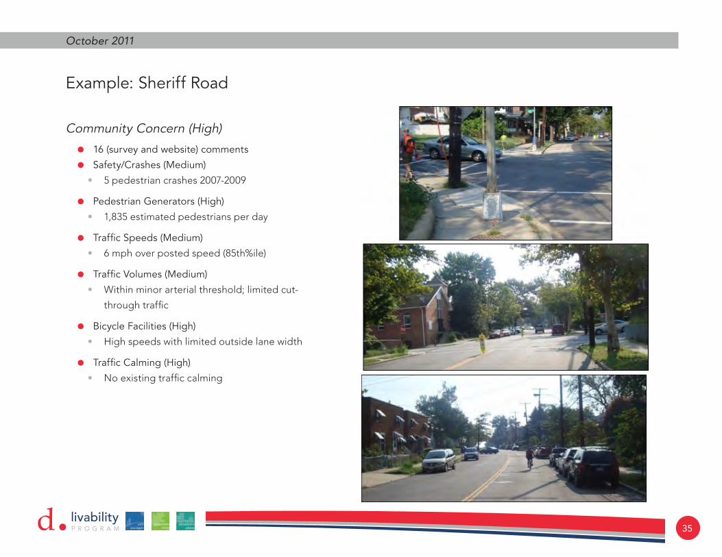
Sheriff Road CorridorA more specific representation of how data was used for the discussed corridor priority measures can be described by reviewing data along Sheriff Road.
• Sheriff Road received 16 separate community comments through the team’s outreach efforts, which scored high when compared to other study corridors.
• There were five pedestrian crashes along the corridor between 2007 and 2009. This total scored as a medium priority, with larger arterials such as Minnesota Avenue and E. Capitol Street warranting a higher priority.
• The number of pedestrian generators along the corridor was scored as a low priority, as Sheriff Road is more residential in nature with limited retail and lack of a Metro Station within walking distance. It could be argued though, that in an area where 40% of residents do not have access to an automobile, that a majority of the study area has an abnormally high level of pedestrian traffic.
• The 85th percentile speed, the speed at which 85% of motorists drive at or below, was measured at 6 mph over the posted speed limit of 30 mph. (The 85th percentile speed is also a measure used to determine speed limits.) A measured speed of 6 mph over the posted speed limit was scored as a medium priority.
• The traffic volumes along Sheriff Road were scored as a medium priority. Sheriff Road is a unique example in the study area, as it is a minor arterial that carries traffic from
suburban Maryland into the District, yet is predominantly residential in nature with few traffic control devices.
• Bicycling was considered a high priority along Sheriff Road due to the higher speeds and limited outside lane width. In other words, Sheriff Road is an uncomfortable experience for cyclists and would warrant some type(s) of bicycle accommodation.
livabilityP R O G R A Md 35
October 2011
Community Concern (High)
• 16 (survey and website) comments
• Safety/Crashes (Medium)
• 5pedestriancrashes2007-2009
• Pedestrian Generators (High)
• 1,835estimatedpedestriansperday
• Traffic Speeds (Medium)
• 6mphoverpostedspeed(85th%ile)
• Traffic Volumes (Medium)
• Withinminorarterialthreshold;limitedcut-
throughtraffic
• Bicycle Facilities (High)
• Highspeedswithlimitedoutsidelanewidth
• Traffic Calming (High)
• Noexistingtrafficcalming
Example: Sheriff Road

36
Far Northeast Livability StudydCorridor Locations
livabilityP R O G R A Md 37
October 2011
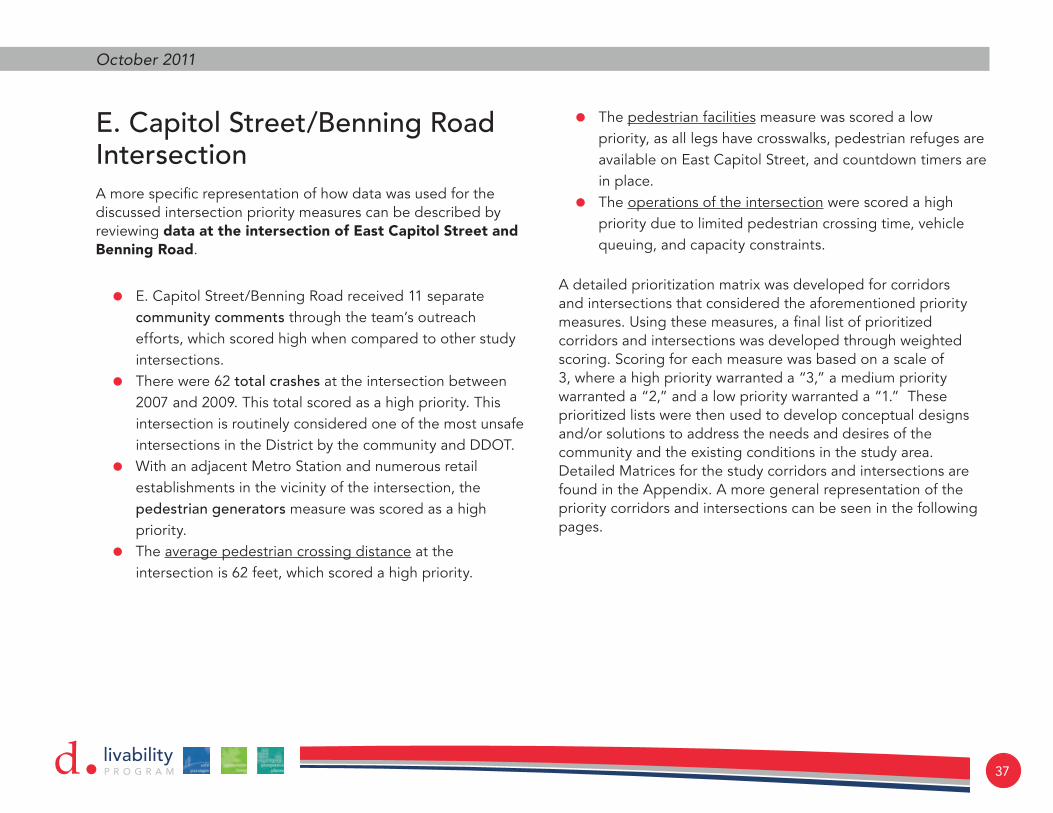
E. Capitol Street/Benning Road IntersectionA more specific representation of how data was used for the discussed intersection priority measures can be described by reviewing data at the intersection of East Capitol Street and Benning Road.
• E. Capitol Street/Benning Road received 11 separate community comments through the team’s outreach efforts, which scored high when compared to other study intersections.
• There were 62 total crashes at the intersection between 2007 and 2009. This total scored as a high priority. This intersection is routinely considered one of the most unsafe intersections in the District by the community and DDOT.
• With an adjacent Metro Station and numerous retail establishments in the vicinity of the intersection, the pedestrian generators measure was scored as a high priority.
• The average pedestrian crossing distance at the intersection is 62 feet, which scored a high priority.
• The pedestrian facilities measure was scored a low priority, as all legs have crosswalks, pedestrian refuges are available on East Capitol Street, and countdown timers are in place.
• The operations of the intersection were scored a high priority due to limited pedestrian crossing time, vehicle queuing, and capacity constraints.
A detailed prioritization matrix was developed for corridors and intersections that considered the aforementioned priority measures. Using these measures, a final list of prioritized corridors and intersections was developed through weighted scoring. Scoring for each measure was based on a scale of 3, where a high priority warranted a “3,” a medium priority warranted a “2,” and a low priority warranted a “1.” These prioritized lists were then used to develop conceptual designs and/or solutions to address the needs and desires of the community and the existing conditions in the study area. Detailed Matrices for the study corridors and intersections are found in the Appendix. A more general representation of the priority corridors and intersections can be seen in the following pages.

38
Far Northeast Livability Studyd
Community Concerns (High)
• 11 survey and website comments
• Safety/Crashes (High)
• 62 total crashes from 2007-2009
• Pedestrian Generators (High)
• 2,358 estimated pedestrians per day
• Intersection Geometry (High)
• Average of 75 feet to cross the street
• Pedestrian Facilities (Low)
• Marked crossings on each leg with pedestrian refuge
• Intersection Operations (High)
• Capacity and queuing issues; limited pedestrian crossing time
Example – E. Capitol Street/Benning Road

livabilityP R O G R A Md 39
October 2011
Intersection Locations

40
Far Northeast Livability StudydPriority Corridors

livabilityP R O G R A Md 41
October 2011
Priority Intersections


livabilityP R O G R A Md 43
October 2011
recommendations, funding, and implementation
Recommended improvements have been identified for all study corridors and intersections, while conceptual designs were completed for three corridors and numerous intersections. The recommendations vary in timing (short, medium, and long-term) and costs. Some improvements will require little additional design and/or preparation (e.g., basic striping), while others will
require detailed design plans and must go through numerous approval processes (e.g., intersection reconstruction). The DDOT Livability Program has some immediate funding that can be used for identified project improvements, while the remaining project improvements must receive funding through more traditional funding mechanisms.

44
Far Northeast Livability StudydThe following corridors and intersections are organized from highest to lowest priority, as seen in the previous matrices. Explanation of treatments proposed is found in the glossary of terms.
Corridors
Sheriff Road
Sheriff Road, a minor arterial that is approximately one-mile in length within the Far Northeast study area, received the highest priority ranking of all corridors in the study area (i.e., it tied with 49th Street). Furthermore, it received the highest number of community comments throughout the duration of this project. Sheriff Road is one of the few roadways in the study area that provides direct access into the District from suburban Maryland. The peak commuting traffic (westbound in the morning and eastbound in the evening) brings with it high traffic volumes and speeds, significant concerns for the neighboring community. Measured 85th percentile speeds were measured at 6 mph over the posted 30 mph speed limit, with daily traffic volumes of approximately 9,000 vehicles. Speeds in past DDOT studies measured 85th percentile speeds exceeding the posted speed limit by 10 mph. Additional concern for the community is the safety of pedestrians along the corridor. With high speeds and limited controlled crossings, pedestrians are often faced with few opportunities to cross Sheriff Road, particularly during the morning and evening peak periods.
Recommendations
Because Sheriff Road is a minor arterial and facilitates the movement of commuter traffic, recommendations must balance the need to move people effectively (e.g., motorists, pedestrian, bicyclists, and buses), while also providing a safe environment for non-motorized traffic to navigate the area. The corridor recommendations, which can be seen in the following figures, provide an array of conceptual designs that aim to improve safety along the corridor. Vertical traffic calming (e.g., speed humps, raised intersections, raised crosswalks) is not recommended along Sheriff Road, particularly because as an arterial street it also serves buses, trucks, and emergency vehicles.
Reduce speeds and improve pedestrian & bicycle safety
Short Term:
• Add shared bicycle lane markings
• Add parking edge linesMedium Term:
• Install pedestrian refuge medians
• Install curb extensions
• Install rapid flash beacons
• Relocate and consolidate bus stops
• Install choker medians with speed cushions
• Install a bike lane and sharrows.

livabilityP R O G R A Md 45
October 2011
Sheriff Road: 43rd Place to 48th Street

46
Far Northeast Livability StudydSheriff Road: 48th Place to East of 50th Street

livabilityP R O G R A Md 47
October 2011
Sheriff Road: 51st Street to Eastern Avenue

48
Far Northeast Livability Studyd49th Street
49th Street, a collector street that is approximately 1.3 miles in length within the Far Northeast study area, also received the highest priority of all corridors in the study area (i.e., it tied with Sheriff Road). Despite it being a collector street, 49th Street experiences a high volume of pedestrians in its periphery, primarily related to the number of schools. 49th Street is unique in that it is the only roadway in the study area that provides access from the southern (E. Capitol Street) to the northern boundary (Minnesota Avenue) of the study area. The street also provides direct connections to the Benning Road Metro Station to the south, the Deanwood Community Center and Deanwood Metro Station to the north, and several major east-west roadways (i.e., Sheriff Road, Nannie Helen Burroughs Avenue, E. Capitol Street). 85th percentile speeds were measured at 6 mph over the posted 25 mph speed limit, with daily traffic volumes of approximately 4,800 vehicles. Similar to Sherrif Road, community concern on 49th Street is primarily related to high traffic speeds and volumes.
Recommendations
The recommendations for 49th Street include a balance of measures to slow vehicle traffic, the addition of pedestrian facilities, and the improvement of pedestrian safety, particularly in the vicinity of schools.
Reduce speeds and improve pedestrian and bicyclist safety
Short Term:
• Add shared lane bicycle marking
• Add bike lanes
• Add parking edge lines
• Add bike boxMedium Term:
• Install curb extension
• Install rapid flash beacons
• Install raised crosswalks
• Install pedestrian refuge mediansLong Term:
• Install mini-roundabout
• Install raised intersection and choker islands

livabilityP R O G R A Md 49
October 2011
49th Street: East Capitol South to Fitch Place

50
Far Northeast Livability Studyd49th Street: Fitch Place to Jay Street

livabilityP R O G R A Md 51
October 2011
49th Street: Jay Street to Quarles Street

52
Far Northeast Livability StudydGrant Street
Although Grant Street is just over two blocks in length, the local street is a significant cut-through route between Minnesota Avenue and Nannie Helen Burroughs Avenue. During the peak hours when congestion occurs along the major arterials, Grant Street offers relief and allows motorists to bypass the consistently congested intersection of Nannie Helen Burroughs Avenue/Minnesota Avenue. Unfortunately, Grant Street should be used for local traffic and commuter traffic should stay on the more significant streets. In addition to cut-through traffic, a general concern by the community was high speed traffic on Grant Street. However, measured 85th percentile speeds on the street were 6 mph below the posted 25 mph speed limit. Some attempts at reducing speeds and cut-through traffic have already been made with the installation of speed humps.
Recommendations
Recommendations to reduce cut-through traffic include the elimination of the southbound left-turning movement at the intersection of Grant Street/Minnesota Avenue. Furthermore, adding a north-south median at the intersection of Grant Street/42nd Street would force all motorists on Grant Street to make a right-turn, thus eliminating much of the cut-through traffic.
Reduce cut-through traffic and reduce speeds
Short Term:
• Eliminate southbound left-turning movement at Minnesota Avenue
Medium Term:
• Install North-South median at 42nd Street

livabilityP R O G R A Md 53
October 2011
Hunt Place
Hunt Place, a relatively short east-west local street parallel to Nannie Helen Burroughs Avenue, experiences a high number of cut-through motorists on a daily basis. In fact, the measured 3,450 daily traffic volume is the highest of any reviewed local street in the study area (the second highest is Grant Street with a measured daily volume of 1,375). Hunt Place’s proximity to the heavily congested intersection of Nannie Helen Burroughs Avenue/Minnesota Avenue means motorists can easily bypass this intersection with little delay. Conversely, there is little residential activity on this street in comparison to adjacent local streets (e.g., no residences are located on the north side of the street).
Recommendations
Because few homes are located on this street, no major traffic calming measures are recommended. The expansion of the intersection of Nannie Helen Burroughs Avenue/Minnesota Avenue under the Nannie Helen Burroughs Avenue and Minnesota Avenue Great Streets projects will assist in reducing the congestion experienced today.
Reduce speeds and improve pedestrian & bicycle safety
Medium Term:
• Install raised crosswalk at Midblock Park access
Division Avenue
Division Avenue, a collector street that is approximately 1 mile in length within the Far Northeast study area, received one of the higher priorities of corridors in the study area. While Division Avenue has fewer schools along the corridor than 49th Street, there are still numerous bus stops with over 1,800 daily bus boardings, thus generating a good deal of pedestrian traffic. Division Avenue provides good north-south connectivity in the study area, providing a direct connection between East Capitol Street to Nannie Helen Burroughs Avenue to Sheriff Road. 85th percentile speeds were measured at 8 mph over the posted 25 mph speed limit, with daily traffic volumes of approximately 4,600 vehicles. Similar to 49th Street, community concern on Division Avenue is primarily related to high traffic speeds and volumes.
Recommendations
This study does not provide detailed design concepts similar to those completed for Sheriff Road, 49th Street, and Minnesota Avenue. However, identified problems along Division Avenue relate very closely to those identified and addressed on 49th Street. A network of curb extensions, improved pedestrian crossings, parking edge lines, raised crosswalks and intersections, pedestrian refuge medians, rapid flash beacons, and bicycle facilities will provide a safer environment for pedestrians and bicyclists, as well as improve the experience for transit users.

54
Far Northeast Livability Studyd
Reduce Speeds and Improve Pedestrian & Bicyclist Safety
Short Term:
• Add parking edge lines (narrow travel lanes)
• Add bike lanes and shared bicycle lane markingsMedium Term:
• Install pedestrian refuge medians
• Install curb extensions
• Install raised crosswalks
• Install rapid flash beaconsLong Term:
• Install raised intersections and choker islands
Division Avenue

livabilityP R O G R A Md 55
October 2011
42nd Street
42nd Street is a north-south local street that is approximately 0.65 miles in length within the Far Northeast study area. The street connects Hunt Place to the north with Ames Street to the south. The only major arterial that 42nd Street intersects is Benning Road. Over half of 42nd Street forms the eastern boundary of Fort Mahan Park, and thereby has no residential property along the west side of the street adjacent to the park. Likewise, parking is restricted on the west side of the street north of Benning Road (approximately ½ mile). Primary community concern regarding 42nd Street relates to speeding and cut-through traffic. Measured 85th percentile speeds were measured at 2 mph under the posted 25 mph speed limit, with daily traffic volumes of approximately 2,100 vehicles. Although measured speeds were below the posted speed limit, directionality of the measured volumes did indicate a good deal of cut-through traffic. Observations and evaluation of the collected roadway volumes indicate a bulk of cut-through traffic consists of westbound motorists on Benning Road wishing to avoid the intersection of Benning Road/Minnesota Avenue, as well as motorists using Grant Street to avoid the intersection of Nannie Helen Burroughs Avenue/Minnesota Avenue.
Recommendations
While cut-through traffic was observed on 42nd Street, improvements to the intersections of Benning Road/Minnesota Avenue and Nannie Helen Burroughs Avenue/Minnesota Avenue (discussed elsewhere in this report) will reduce the number of cut-through motorists. Likewise, the proposed right-turn only median recommended at the intersection of Grant Street/42nd Street should also reduce the number of cut-through traffic. Additional recommendations for 42nd Street include parking edge lines to reduce lane width, shared bicycle pavement markings, marked pedestrian crosswalks to Fort Mahan Park, and the installation of a sidewalk along the west side of the street.

56
Far Northeast Livability Studyd42nd Street
Reduce Speeds and Cut-Through Traffic; Provide North-South Bicycle Connection; Improve Pedestrian Facilities
Short Term:
• Add parking edge lines (narrow travel lanes)
• Add shared bicycle lane markingMedium Term:
• Install sidewalk on west side of street from Grant Street to Benning Road
• Install raised crosswalk at Eads Street

livabilityP R O G R A Md 57
October 2011
44th Street
44th Street is a north-south collector street that is approximately 0.95 miles in length within the Far Northeast study area. The street connects Lee Street to the north with Benning Road to the south. Primary community concern regarding 44th Street relates to speeding and cut-through traffic. 85th percentile speeds were measured at 7 mph over the posted 25 mph speed limit, with daily traffic volumes of approximately 6,500 vehicles. Directionality of the measured volumes did indicate a good deal of cut-through traffic. Observations and evaluation of the collected roadway volumes indicate a bulk of cut-through traffic consists of motorists avoiding the intersection of Benning Road/Minnesota Avenue, either from Kenilworth Avenue to East Capitol Street or East Capitol Street to Kenilworth Avenue.
Recommendations
While cut-through traffic was observed on 44th Street, improvements to the intersections of Benning Road/Minnesota Avenue and Nannie Helen Burroughs Avenue/Minnesota Avenue are likely to reduce the number of cut-through motorists.
Medium Term:
• Install curb extensions
Long Term:
• Install raised intersections near Smothers Elementary School
Gault Place
Gault Place is an east-west local street, approximately 0.6 miles in length, connecting Minnesota Avenue to the west with Nannie Helen Burroughs Avenue to the east. Primary community concern relates to high speeds and cut-through traffic. However, measured volumes were relatively low and measured 85th percentile speeds were 5 mph lower than the posted 25 mph speed limit. The street is one-way in the eastbound direction between 42nd Street and 44th Street, thus reducing significantly the potential for cut-through traffic in the eastbound westbound direction.
Recommendations
Due to the low speeds and volumes, no other action is recommended for Gault Place.

58
Far Northeast Livability StudydHayes Street
Hayes Street is an east-west local street with two locations where it dead ends, one between 42nd Street and 44th Street at the Marvin Gaye Trail and one at the intersection of 46th Street where it does not connect to Nannie Helen Burroughs Avenue. Primary community concern relates to high speeds and cut-through traffic. However, measured volumes were relatively low and 85th percentile speeds were 6 mph lower than the posted 25 mph speed limit. The low volumes and speeds are likely due to the dead ends, where traffic in unable to use the street as a cut-through street between Minnesota Avenue and Nannie Helen Burroughs Avenue.
Recommendations
Due to the low speeds and volumes, no recommendations have been made for Hayes Street.
Jay Street
Jay Street is an east-west local street, approximately 1.0 mile in length, connecting 44th Street to the west with Hunt Place to the east. Primary community concern relates to high speeds and cut-through traffic. However, measured volumes were relatively low and 85th percentile speeds were 1 mph lower than the posted 25 mph speed limit. The street currently has a system of speed humps.
Recommendations
While measured traffic speeds and volumes were relatively low, facilities such as curb extensions and striped parking edge lines can calm traffic and reduce crossing distances for pedestrians.
Lee Street
Lee Street is an east-west local street, approximately ¾ mile in length, connecting 44th Street to the west with Eastern Avenue to the east. Primary community concern relates to high speeds and cut-through traffic. However, measured volumes were relatively low and measured 85th percentile speeds were near than the posted 25 mph speed limit. The street currently has a system of speed humps.
Recommendations
While measured traffic speeds and volumes were relatively low, facilities such as curb extensions and striped parking edge lines can calm traffic and reduce crossing distances for pedestrians.

livabilityP R O G R A Md 59
October 2011
Short Term:
• Add parking edge lines (narrow travel lanes)Medium Term:
• Install curb extensions
Reduce Speeds; Improve Pedestrian Safety; Increase Motorist Awareness of Pedestrians
Jay Street and Lee Street

60
Far Northeast Livability StudydPriority Corridors

livabilityP R O G R A Md 61
October 2011
Intersections
Benning Road/East Capitol Street/ Central Avenue
Benning Road/East Capitol Street/Central Avenue received the highest priority of all study intersections in Far Northeast. Benning Road and East Capitol Street are both classified as urban arterials, and therefore accommodate large volumes of commuter and local traffic. The intersection in its current form includes high commuter volumes, the adjacent Benning Road Metro Station, closely spaced adjacent intersections (Central Avenue and Texas Avenue), long pedestrian crossing distances, and unorthodox geometry. As a result of these numerous factors, over 60 crashes occurred between 2007 and 2009. Negotiating the intersection as a pedestrian is very uncomfortable, and the size of the intersection (specifically the oversize median) and the time it takes to cross the street become deterrents to following basic laws. Likewise, many pedestrians do not obey existing traffic controls and often make mid-block crossings east of the intersection to and from the Metro Station. The geometry and size of the intersection, the current signal phasing configuration, the proximity of adjacent intersections, and the unusual placement of a concrete median in the center of the intersection also make for a congested, unsafe experience for motorists.
Recommendations
Based on community feedback, observations in the field, existing data, and an operations analysis, a large-scale redesign is recommended for this intersection. A complete reconstruction is the best way to improve conditions for pedestrians, motorists, transit riders, and bicyclists. The underlying problem with the intersection that permeates all modal issues is the size of the intersection. The current size however, is not all attributed to lanes of pavement. Much of the issue lies is the 50-foot median that separates eastbound and westbound traffic on East Capitol Street. A significant reduction in the size of the median would allow for improved pedestrian crossing distances and times, while also improving vehicle operations.
The proposed redesign shifts the westbound direction of traffic south, closer to the eastbound direction of travel. The redesign will also allow for a more traditional signal phasing scheme of opposing protected left-turns in the north-south and east-west directions. It also reduces the north-south crossing distance of pedestrians by over 30 feet. Furthermore, the proposal provides curb extensions at each corner in order to slow turning motorists, thus reducing high speed impacts between motorists and pedestrians. In concert with the DC Pedestrian Master Plan, an improved pedestrian crossing is provided approximately 350 feet east of the intersection. This crossing will accommodate the heavy pedestrian traffic at this location, by allowing shorter crossing distances controlled by appropriate signing and rapid flash beacons. Lastly, bicycles are accommodated in both directions with a six-foot cycle track and a two-foot buffer from the travel lane. The following figure provides a conceptual design of the study intersection.

62
Far Northeast Livability StudydFunding and Implementation
Estimated costs associated with this improvement are in excess of $6.8 million (including 20% for engineering, 25% potential contingency, and 20% for potential utility relocation). An improvement of such a large scale is not a short- or medium-term solution. Long-term, costly solutions will enter into the Transportation Improvements Program (TIP) and await funding based on DDOT priority and available federal funds. However, the Federal Highway Administration (FHWA) awarded DDOT $1,065,400 on August 17, 2011 help fund the reconstruction.

livabilityP R O G R A Md 63
October 2011
Long Term:
• Relocated westbound lanes south and reduce median width
• Modify existing lane assignments
• Modify signal timing, phasing
• Add protected left-turns
• Add leading pedestrian intervals
• Add pedestrian countdown signals
• Add bicycle facilities
• Right-in/Right-out only at Central Avenue
Intersection Redesign
Benning Road/East Capitol Street/Central Avenue

64
Far Northeast Livability StudydBenning Road/East Capitol Street/Central Avenue

livabilityP R O G R A Md 65
October 2011
Benning Road/39th Street/Benning Neighborhood Library
The Benning Road/39th Street/Benning Neighborhood Library intersection received the second highest priority of study intersections. The Library, located in the southeast corner of the intersection, was recently constructed, thereby increasing pedestrian activity in the area. The Library driveway is also shared with a retail center, which includes a Safeway supermarket. The biggest community concern at this location is the lack of pedestrian facilities to allow safe pedestrian crossing of Benning Road, as well as limited opportunities to cross due to heavy traffic (i.e., available gaps in the Benning Road traffic flow). A traffic signal warrant evaluation was completed at this location (using 12-hour turning movement counts from September 15, 2010). Based on the evaluation, a full traffic signal is warranted at the intersection of Benning Road/39th Street/Benning Neighborhood Library.
Recommendations
Based on community feedback, observations in the field, existing data, an operations analysis, and a signal warrant evaluation, a full traffic signal is recommended for this intersection. Further, it is recommended that the 39th Street approach should be converted to a right-in/right-in movement to prevent delayed conflicts between potential southbound left-turning vehicles and pedestrians crossing Benning Road. A signal warrant evaluation memorandum and intersection operations analysis are located in the Appendices.
Medium Term:
• Install full traffic signal
• Convert 39th Street to right-in/right-out movement
Funding and Implementation
As previously discussed, Benning Road is a “Great Street” and may include construction of this signal to efficiently and economically realize this important safety improvement.
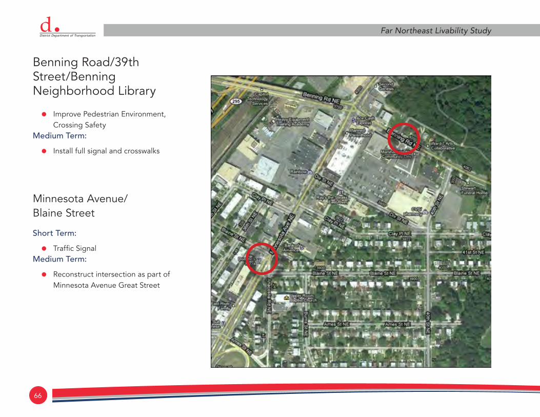
66
Far Northeast Livability StudydBenning Road/39th Street/Benning Neighborhood Library
• Improve Pedestrian Environment, Crossing Safety
Medium Term:
• Install full signal and crosswalks
Minnesota Avenue/ Blaine Street
Short Term:
• Traffic SignalMedium Term:
• Reconstruct intersection as part of Minnesota Avenue Great Street

livabilityP R O G R A Md 67
October 2011
Minnesota Avenue/48th Street
The Minnesota Avenue/48th Street intersection is adjacent to the newly constructed Deanwood Community Center and Library, and across Minnesota Avenue from the Deanwood Metro Station. The Deanwood Community Center has become a significant place of interest for the community (and the City) since its construction and thus, pedestrian activity has greatly increased recently. The study intersection also serves as the main gateway to the Center from the Metro Station. In its current state, the geometry of the intersection has a skewed angle which results in long pedestrian crossing distances (nearly 100 feet across 49th Street), poor visibility, and high motorist speeds, particularly from 49th Street to Minnesota Avenue in the northbound direction.
Recommendations
The intersection of Minnesota Avenue/48th Street is part of a larger corridor plan of traffic calming and bicycle facilities from Meade Street to the south and Quarles Street to the north. The intersection recommendations include a large curb extension at the northeast corner of the intersection (i.e., the corner closest to the Community Center), pedestrian refuge areas on the north and south approach of Minnesota Avenue, buffered bike lanes, and restriped pedestrian crossings on all approaches (currently there is not a marked crossing on the north approach). The most prominent feature, the large curb extension, will help to realign the intersection and reduce the large turning radii. The curb extension will force motorists to make slower turns on to Minnesota Avenue and will also greatly shorten the crossing distance for pedestrians on 48th Street. The median refuge areas
on Minnesota Avenue will allow pedestrians to cross Minnesota Avenue in two stages if necessary and will slow traffic, thus greatly improving the overall pedestrian safety in the area.
Improve pedestrian environment, crossing safety
Short Term:
• Add bike lanesMedium Term:
• Install curb extensions and pedestrian refuge
Funding and Implementation
The recommended improvements will require dedicated funds for the Livability program. Improvements such as the buffered bike lanes and parking edge lines can likely be completed on a shorter time frame, while the physical improvements (i.e., curb extension and pedestrian refuge areas) will require more detailed design and will also be more costly.

68
Far Northeast Livability Studyd
Improve Pedestrian Facilities
Short Term:
• Install additional marked crossings
• Install parking edge lines along Minnesota Avenue (narrow travel lanes)
• Add bike lanesMedium Term:
• Realign (i.e., “square up”) intersection
• Add curb extensions
• Add pedestrian refuge islands, reduce crossing distances
• Reduce curb radii
Minnesota Avenue/48th Street and Minnesota Avenue/Nash Street (Deanwood Community Center)

livabilityP R O G R A Md 69
October 2011
East Capitol Street/Central Avenue/ 50th Street
The intersection of East Capitol Street/Central Avenue/50th Street has been studied in the past through the DC Pedestrian Master Plan and is currently being studied by DDOT as part of a corridor-wide pedestrian and bicycle plan. The intersection has unusual geometry with Central Avenue, crossing at a significant angle on the south and then again to the north, but further downstream west. The eastbound right-turning movement also includes a high-speed free flow movement with inadequate pedestrian facilities and no pedestrian crossings on the west side of the intersection. The intersection experienced 14 motor vehicle crashes between 2007 and 2009.
Recommendations
Recommendations for the intersection mirror what was proposed in the Pedestrian Master Plan:
• Realign the south approach of 50th
• Eliminate the free flow eastbound right turn lane
• Provide sidewalks and crosswalks where missing.
• DDOT’s ongoing study is investigating the feasibility in the reduction of lanes from six to four, addition of on-street parking, and bicycle lanes.
Funding and Implementation
DDOT currently has funding available to implement a striping plan per the previously discussed ongoing study. Funding for the additional recommendations (i.e., sidewalks, crosswalks and intersection realignment) must be acquired through traditional means of entering the Transportation Improvement Program (TIP).

70
Far Northeast Livability StudydEastern Avenue/Minnesota Avenue
The intersection of Eastern Avenue/Minnesota Avenue is a four-approach intersection that lies on the District of Columbia-Maryland border. Eastern Avenue provides direct access to the Anacostia Freeway to the west, and thus accommodates a good deal of commuter traffic. The current issues, as expressed by the community, relate to the signal timing, lack of adequate pedestrian facilities, and standing water during heavy rain. The intersection is also constrained by Metro Rail and CSX railways that travel over Eastern Avenue immediately to the west of the intersection. The intersection does not have any dedicated left-turn lanes. In the last three years, 35 crashes occurred at this intersection.
Recommendations
• Revised signal timing and signal hardware
• Improved sidewalk, crosswalk, and pedestrian ramp facilities on all approaches. Unfortunately, because the intersection is located so closely to the railway (Metro Rail and CSX), the addition of intersection capacity through dedicated left-turns is not feasible due to the existing walls and overpasses.
Eastern Avenue/Sheriff Road/ Division Avenue
The intersection of Eastern Avenue/Sheriff Road/Division Avenue is a five-approach intersection that lies on the District
of Columbia-Maryland border. Sheriff Road, classified as a minor arterial, serves as one of the few access points into the District from suburban Maryland, despite its relatively residential characteristics. Several businesses are located adjacent to the intersection, as well as numerous driveways. As with any intersection of five approaches, the intersection is challenging for pedestrians and bus riders (there are four bus stops in the immediate vicinity of the intersection). Moreover, intersections with more than four approaches are more likely to experience above average crash rates.
Recommendations
Long Term
A roundabout is recommended for this intersection, due in part to its challenging geometry. A roundabout, while requiring a good deal of space and right-of-way, will reduce the number of vehicle conflicts, improve pedestrian safety, reduce speeds on all approaches, and will serve as a gateway into the District from Prince George’s County. The intersection recommendation is included in the Sheriff Road corridor improvements provided earlier in the report.
Funding and Implementation
A roundabout would be a large and expensive undertaking, and would require a traditional funding mechanism through the TIP process. The number of existing driveways will require consolidation and additional right-of-way may be required.

livabilityP R O G R A Md 71
October 2011
Improve Pedestrian and Vehicle Safety; Reduce Congestion
Short Term:
• Provide curb extensions and crosswalk markingsLong Term:
• Install roundabout and consolidate driveways
Eastern Avenue/Sheriff Road/Division Avenue

72
Far Northeast Livability StudydEastern Avenue/Sheriff Road/Division Avenue

livabilityP R O G R A Md 73
October 2011
Sheriff Road/45th Street/45th Place
Sheriff Road/45th Street/45th Place is an offset four-approach intersection and is located adjacent to the IDEA Public Charter High School, Randall Memorial United Methodist Church, First Baptist Church of Deanwood, and New Beginning Christian Church. Sheriff Road, classified as a minor arterial, serves as one of the few access points into the District from suburban Maryland, and therefore experiences much of commuter traffic. 45th Street, a local street, currently has three speed humps just north of the study intersection in front of the IDEA Public Charter High School. Due to its proximity to the school and adjacent religious establishments, the study intersection experiences a high number of pedestrian (approximately 20 pedestrians were counted crossing Sheriff Road during the a.m. peak hour on November 4, 2010). Intersection operations analyses show no significant signal timing, queuing, or capacity issues. However, the offset nature of the intersection and the crosswalk across Sheriff Road located between 45th Street and 45th Place do present challenges to pedestrians.
Recommendations
The intersection of Sheriff Road/45th Street/45th Place is part of a larger corridor plan of traffic calming, bicycle facilities, and pedestrian improvements from Minnesota Avenue to Eastern Avenue. The intersection recommendations include:
• Addition of pedestrian refuge medians on Sheriff Road on the west and east approaches of the intersection
• Relocation of the crosswalk that is currently across Sheriff Road between 45th Street and 45th Place to the east approach pedestrian refuge median
• The relocation and consolidation of the bus stops to the west and east of the intersection closer to the proposed crosswalks and pedestrian refuge medians.
Funding and ImplementationThe recommended improvements will require dedicated funds for the Livability program. Improvements such as striping (e.g., parking edge lines, bicycle sharrows, bus stop consolidation and relocation) can likely be completed on a shorter time frame, while the physical improvements (i.e., pedestrian refuge medians) will require more detailed design and will also be more costly.

74
Far Northeast Livability Studyd
Improve Pedestrian Safety; Reduce Crossing Distances
Medium Term:
• Add pedestrian refuge islands
• Remove middle crosswalk
• Adjust pedestrian timing
• Relocate Bus Stops
Sheriff Road/45th Street/45th Place

livabilityP R O G R A Md 75
October 2011
49th Street/Quarles Street
The intersection of 49th Street/Quarles Street has three stop-controlled approaches and sits adjacent right to the Deanwood Community Center and Library. Pedestrian volumes have increased in the vicinity of the intersection since the construction of the Deanwood Community Center, and the community has expressed concern with the high speeds through the intersection and poor adherence to the existing stop signs.
Recommendations
The intersection of 49th Street/Quarles Street is part of a larger corridor plan of traffic calming, bicycle facilities, and pedestrian improvements from East Capitol Street to Quarles Street. The intersection recommendations include:
• Install mini-roundabout
• Install curb extensions
• Eliminate some parking
Funding and Implementation
The recommended improvements will require dedicated funds for the Livability program. Improvements such as striping (e.g., parking edge lines, bicycle sharrows) can likely be completed on a shorter time frame, while the physical improvements (i.e., curb extension, traffic circle) will require more detailed design and will also be more costly.

76
Far Northeast Livability Studyd
Reduce Stop-Sign Running; Slow Vehicle Speeds
Medium Term:
• Install mini-roundabout
• Add curb extensions
49th Street/Quarles Street

livabilityP R O G R A Md 77
October 2011
Minnesota Avenue/Quarles Street
The Minnesota Avenue/Quarles Street intersection lies just north of the newly constructed Deanwood Community Center and Library, and across Minnesota Avenue from the Deanwood Metro Station. The Deanwood Community Center has become a significant place of interest for the community (and the City) since its construction and thus, pedestrian activity has greatly increased recently. The intersection currently has poor pedestrian facilities to accommodate the increased pedestrian traffic associated with the Deanwood Community Center. Furthermore, sight distance issues were identified for the south approach (Quarles Street).
Recommendations
The intersection of Minnesota Avenue/Quarles Street is part of a larger corridor plan of traffic calming, bicycle facilities, and realigned intersections from Meade Street to the south and Quarles Street to the north. The intersection recommendation includes a pedestrian refuge median on the southeast approach of Quarles Street. The pedestrian refuge median on Quarles Street will allow pedestrians to cross Quarles Street in two stages if necessary and will slow traffic, thus improving the overall pedestrian safety in the area. The recommendations for this intersection are provided below.
Funding and Implementation
The recommended improvement will require dedicated funds for the Livability program. Improvements such as a pedestrian refuge median will require a more detailed design than the conceptual design provided within this report.

78
Far Northeast Livability Studyd
Reduce Crossing Distances; Increase Motorist Awareness of Pedestrians & Bicyclists
Medium Term:
• Add pedestrian refuge islands
• Improve sight distance on east approach
Minnesota Avenue/Quarles Street (Deanwood Community Center)

livabilityP R O G R A Md 79
October 2011
East Capitol Street/Southern Avenue/ 61st Street
The intersection of East Capitol Street/Southern Avenue/61st Street lies on the District of Columbia-Maryland border and serves as a major commuter gateway into and out of the District. The intersection experiences the second highest intersection traffic volume in the study area (Benning Road/East Capitol Street/Central Avenue has the highest) and has an unorthodox geometry with Southern Avenue running in a northeast-southwest direction. Furthermore, the location of the Capitol Heights Metro Station in the southeast corner (Maryland) adds numerous pedestrians to the area. In addition to the high volumes and skewed intersection geometry, the pedestrian facilities are substandard in some locations (namely the northeast corner).
Recommendations
The following recommendations are designed to improve pedestrian conditions in the vicinity of the intersection:
Medium:
• Provide sidewalks in the northeast corner of the intersection.
• Improve the existing pedestrian refuge medians on each approach.
• Provide a curb extension in the northwest corner to reduce the existing curb radii to slow turning motorists.
• Extend the median on the west approach of East Capitol Street to eliminate the left turn onto 61st Street.
Long Term:
• Realign the westbound right-turn lane so that it more directly aligns with Southern Avenue and provides less of a “free flow” movement. This will ultimately slow turning motorists, thus improving the safety of crossing pedestrians.
• Eliminate the median opening into the Metro Station on the south approach of Southern Avenue.
Funding and Implementation
The recommended improvements range from medium-term solutions (i.e., provide sidewalks in the northeast corner) to longer term solutions (i.e., realign the westbound right-turn lane, construct and/or modify medians). Short-term solutions can be completed through existing maintenance funds, while larger modifications will likely need to enter the Transportation Improvement Program and await funding based on DDOT priority and available federal funds. Some of the improvements to the intersection will also need to be worked out with the State of Maryland, as it lies on the District-State border. Lastly, proposed development in the vicinity of the intersection (e.g., Wal-Mart and/or others), can help to mitigate traffic impacts on the community.

80
Far Northeast Livability StudydIntersections – Great Streets
As previously discussed, the Great Streets program consists of streetscape, pedestrian safety, and public space enhancements on three arterials in the area: Minnesota Avenue, Benning Road, and Nannie Helen Burroughs Avenue. Substantial community involvement and roadway design has already been completed for these Great Streets corridors (and the respective intersections along the corridors), so particular focus was placed on non-Great Streets projects. However, in some instances additional recommendations were made based on community interaction and additional traffic analysis. Similar to the non-Great Streets intersections, the Great Streets intersections were also prioritized according to the numerous factors outlined in the previous section of this report. While all Great Streets intersections were evaluated under their proposed design, additional recommendations were only made for the following intersections:
• Minnesota Avenue/Benning Road
• Minnesota Avenue/Grant Street
• Minnesota Avenue/Blaine Street
• Benning Road/39th Street
Minnesota Avenue/Benning Road
The intersection of Benning Road/Minnesota Avenue (a principal and minor arterial respectively) has long been debated regarding improvements and the timing of these improvements. The intersection is arguably the busiest intersection in the study area (considering the vehicle and pedestrian volumes and bus ridership), as well as the most dangerous with 79 total crashes
occurring in the last three years. Alighting bus patrons at the intersection often ignore pedestrian accommodations, while motorists traveling at high speeds often have little regard for the pedestrians in and around the intersection. The Far Northeast community has continued to express their dissatisfaction and concern over the safety of the intersection. The reconstruction of the intersection through the Great Streets program is set to occur by 2013 and will include the following attributes:
• Realign the intersection approaches to eliminate the current skewed intersection angle
• Reconstruct all curbs to provide shorter turning radii
• Expand pedestrian refuge medians on the Benning Road approaches
• Eliminate the westbound left-turning movement
• Consolidate driveways near the intersection
• Relocate the existing bus stops
Recommendations
While the aforementioned improvements are documented in the design plans, the community has also expressed concern over the lack of a protected southbound left-turn movement.
Short Term:
• Convert the current permissive left-turn movement on the north approach of Minnesota Avenue to a permissive/protected left-turn movement for implementation as soon as possible. Operational analyses for the a.m. and

livabilityP R O G R A Md 81
October 2011
p.m. peak hours under existing and proposed conditions demonstrate the improvement can be implemented with improved operational characteristics.
Funding and Implementation
The recommended improvement for protected southbound left-turning movement should be evaluated as part of the final design plan for Minnesota Avenue Great Streets Projets. Installing a new signal head and revising the signal timing of the intersection are minimal costs however, and can be implemented sooner.
Minnesota Avenue/Grant Street
The intersection of Minnesota Avenue/Grant Street is located directly across from the bus entrance to the Minnesota Avenue Metro Station. The reconstruction of the intersection through the Great Streets program is set to occur by 2013 and will include the following attributes:
• Provide curb extensions on Grant Street to reduce the existing turning radii and reduce the pedestrian crossing distance across Grant Street
• Reconstruct the existing pedestrian refuge median on the north approach of Minnesota Avenue
• Provide crosswalks on all four approaches
Recommendations
While the aforementioned improvements are documented in the design plans, the community has also expressed concern over cut-through traffic on Grant Street.
Short Term:
• Eliminate the southbound left-turning movement from Minnesota Avenue onto Grant Street to provide some reduction in cut through traffic and remove a cumbersome movement. Southbound left turning vehicles currently turn from a shared left/through lane which ultimately leads to congestion and poor vehicle operations.
• Provide a north-south median island at the intersection of 42nd Street/Grant Street one block to the east of the subject intersection to decrease cut-through traffic.
Funding and Implementation
This area is included in the Minnesota Great Streets Projects. The recommended improvement to eliminate the southbound left-turning movement and install a north-south median island to the east at 42nd Street/Grant Street would be evaluated as part of the street reconstruction plan.

82
Far Northeast Livability StudydMinnesota Avenue/Blaine Street
The intersection of Minnesota Avenue/Blaine Street is located midway between Benning Road and East Capitol Street, while Anacostia Road, a north-south local street, intersects Blaine Street NE just east of Minnesota Avenue. The intersection is currently unsignalized and offers a marked pedestrian crosswalk on the south approach and pedestrian activated rapid flash beacons on each side of Minnesota Avenue. Minnesota Avenue is a four-lane undivided principal arterial with p.m. peak hour restricted on-street parking and a posted speed limit of 30 mph. The Blaine Street and Anacostia Road approaches are both stop controlled. The Great Streets design for Minnesota Avenue consolidates the Blaine Street and Anacostia Road approaches into one approach (essentially eliminating the Anacostia Road approach), shifts the existing crosswalk from the south side of the intersection to the north side of the intersection, and reduces the approach width of Blaine Street considerably.
Through online outreach, community meetings, and work through community outreach advisors, the public identified this location as being a dangerous location for pedestrians crossing Minnesota Avenue NE, particularly for elderly members of Allen House Senior Citizens Housing. Currently pedestrian activated rapid flash beacons are located at the existing crosswalk on the south approach; however, motorist compliance at this location is particularly low and provides limited, safe crossing opportunities. Anecdotal observations suggest compliance of less than 30 percent during site visits to the study intersection. With the poor motorist compliance of the existing pedestrian flashing beacons and the advanced age of many users from Allen
House, the community requested a more substantial crossing device, specifically a pedestrian signal.
Recommendations
Short Term:
• Remove existing rapid flash beacons
• The proposed placement of the signal will provide direct access to the Allen House and its residents, and will also eliminate any confusion or conflicting vehicular movements that could arise if the pedestrian signal were located at the Blaine intersection
• Install traffic signal 100 feet of existing crosswalk on Minnesota Avenue
• Shift existing crosswalk to signal location
• Extend existing curb on west side of Minnesota Avenue
Funding and Implementation
Funding for the signal will be provided through a DDOT pedestrian budget. Implementation should occur by the end of 2012 at the latest.

livabilityP R O G R A Md 83
October 2011
Priority Intersections

84
Far Northeast Livability Studyd
performance measures
State and city departments of transportation throughout the country increasingly use performance management to make data-driven decisions, measure program outcomes, and demonstrate progress to key constituencies. The District Department of Transportation’s Far Northeast Livability Study provides an excellent opportunity to further integrate performance measures into DDOT planning efforts. An effective set of performance measures for this study will not only help ensure that the study’s objectives are met, but also serve as a model for incorporating performance management into subsequent DDOT plans.
Transportation performance management is an emerging topic, and there are no standard guidelines to follow. In general, there are three key components to consider in developing a performance management system:
1. Determining the performance measures most appropriate
for a given situation. The set of performance measures
will depend both on agency/plan objectives and available
data (existing and/or expected).
2. Developing a data collection plan to support selected
performance measures. Note that performance measures
and data collection should be planned together to ensure
that the required data collecting effort is realistic.
3. Setting performance standards (i.e., targets) for specific
measures. Depending on the application, standards may
be set for only some or none of the measures.

livabilityP R O G R A Md 85
October 2011
Performance Measures and Data AvailabilityIdeally, performance measures relate to outcomes rather than actions, allowing them to measure not simply whether an action was taken but how well that action addressed a given issue. For instance, an agency interested in reducing speeding may install speed humps on certain streets. Using “Number of Speed Humps Installed” as a performance measure demonstrates the agency’s responsiveness, but “85th Percentile Traffic Speed” describes the results. Such outcome-oriented performance measures allow agencies to tailor responses over time to focus resources on the most effective treatments. Continuing with the example above, measuring speed could allow an agency to compare the effectiveness of speed humps and curb extensions to inform subsequent traffic calming investment decisions.
While outcome-oriented measures are preferred, supporting data may not always be available or easily collected. In these cases, action-oriented performance measures can also be valuable. This is particularly true if other research links the actions being measured to specific results. For instance, pedestrian countdown signals may be installed to reduce the number of pedestrians stranded in the crosswalk after the clearance interval ends; thus, the “Number of Stranded Pedestrians” is the ideal performance measure to track. However, because previous research on pedestrian countdown signals shows significant reductions in stranded pedestrians, and because collecting comprehensive data on pedestrian crossing behavior is infeasible, the “Number of Countdown Signals Installed” may be an appropriate measure in this situation.
Performance Standards
Performance standards are a valuable way to measure progress and evaluate how well an agency is meeting its core objectives. To be valuable, however, targets must carefully strike a balance between aggressive (to ensure that the agency challenges itself) and achievable (to ensure that success is possible). Targets that are too aggressive can lead to frustration from staff who feel they have been given an impossible task, while targets that do not require an agency to improve on past practices may encourage complacency.
In addition, standards should only be set for performance measures over which agencies have substantial control. Otherwise, variations unrelated to agency actions will lead to artificial judgments regarding agency effectiveness. For instance, this problem often occurs in crime statistics, which fluctuate for a number of reasons unrelated to police effectiveness. Giving the police too much blame during crime waves and too much credit during lulls is not only inaccurate, but can also lead to poor decisions (e.g., mistakenly believing certain actions to be more (or less) effective than they actually are).
For the reasons stated above, it is best to set performance targets only after a good deal is known about the performance measures in question (e.g., average values, typical fluctuations, elasticity, etc.). Thus, performance management systems commonly start out by simply reporting performance measures, and then gradually set specific targets for key measures as knowledge increases.
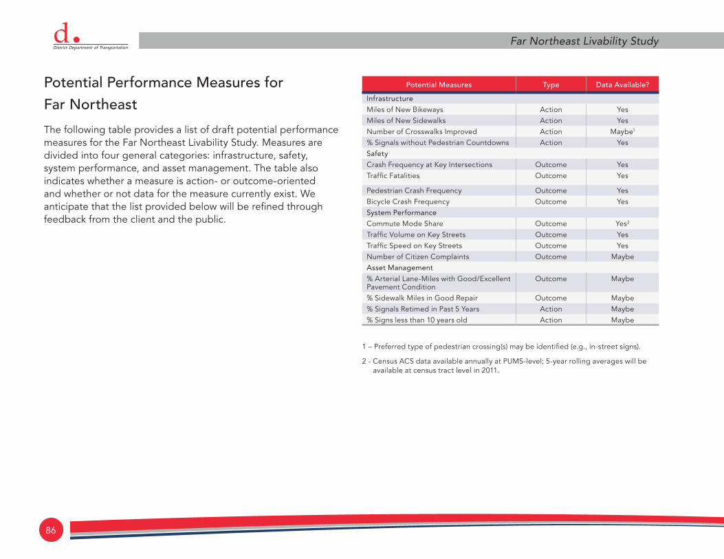
86
Far Northeast Livability StudydPotential Performance Measures for Far Northeast
The following table provides a list of draft potential performance measures for the Far Northeast Livability Study. Measures are divided into four general categories: infrastructure, safety, system performance, and asset management. The table also indicates whether a measure is action- or outcome-oriented and whether or not data for the measure currently exist. We anticipate that the list provided below will be refined through feedback from the client and the public.
Potential Measures Type Data Available?
Infrastructure
Miles of New Bikeways Action YesMiles of New Sidewalks Action YesNumber of Crosswalks Improved Action Maybe1
% Signals without Pedestrian Countdowns Action YesSafety
Crash Frequency at Key Intersections Outcome YesTraffic Fatalities Outcome Yes
Pedestrian Crash Frequency Outcome YesBicycle Crash Frequency Outcome YesSystem Performance
Commute Mode Share Outcome Yes2
Traffic Volume on Key Streets Outcome YesTraffic Speed on Key Streets Outcome YesNumber of Citizen Complaints Outcome MaybeAsset Management
% Arterial Lane-Miles with Good/Excellent Pavement Condition
Outcome Maybe
% Sidewalk Miles in Good Repair Outcome Maybe% Signals Retimed in Past 5 Years Action Maybe% Signs less than 10 years old Action Maybe
1 – Preferred type of pedestrian crossing(s) may be identified (e.g., in-street signs).
2 - Census ACS data available annually at PUMS-level; 5-year rolling averages will be available at census tract level in 2011.

livabilityP R O G R A Md 87
October 2011
glossary of terms
• Pedestrian refuge medians: provides a protected area in the middle of a crosswalk for pedestrians to stop while crossing the street. These medians are commonly used in areas with high volume traffic conflicts or high pedestrian crash locations. They transform one-stage crossings into two-stage crossings, allowing pedestrians to cross half-way before crossing the second lane of traffic. For the most part, these medians have been proposed at uncontrolled intersection locations (i.e., no stop sign on Sheriff Road).
• Curb extensions: an extension of the curb or the sidewalk into the street (in the form of a bulb), usually at an intersection, that narrows the vehicle path, inhibits fast turns, and shortens the crossing distance for pedestrians. Many of the recommended curb extensions also include rapid flash beacons.
• Rapid flash beacons: signs with a pedestrian-activated “strobe-light” flashing pattern that attracts attention and notifies motorists that pedestrians are crossing. Rapid
flash beacons are always used with curb extensions, which pushes them closer to the travel way than if they were located on the street curb.
• Bus stop relocation and consolidation: Bus stop relocation can put bus stops in more convenient locations for riders (e.g., where there is a signalized crossing, curb extension, or pedestrian refuge median). Bus stop consolidation eliminates bus stops that are not needed or are too close to other bus stops, thus improving bus operations.
• Shared lane bicycle markings (i.e., sharrows): pavement markings that can be used where space does not allow for a bike lane. Sharrows remind motorists of the presence of bicycles and indicate to cyclists where to safely ride within the roadway.
• Raised intersections: raising the entire area of an intersection above normal pavement surface level to reduce vehicle speed through the intersection and provide a better view of pedestrians and motorists in the intersection. Raised

88
Far Northeast Livability Studydintersections have been recommended on 49th Street at all intersections adjacent to schools. These are particularly useful near schools, as it allows a better view of young children to motorists.
• Choker Islands: islands used to narrow a street, sometimes near an intersection. The choker islands have been recommended at approaches to intersections where raised intersections are recommended.
• Centerline Removal: removal of the centerline in non-intersection locations. The lack of centerline often gives a roadway more of a local street feel, as there is less guidance for vehicle placement.
• Speed cushions: similar to speed humps but shorter in length, thus forcing motorists to slow down, while vehicles with wider axles (e.g., emergency vehicles) are able to straddle the cushions without slowing down.
• Bike Boxes: marked areas in front of the stop bar at signalized intersections that allow cyclists to correctly position themselves for turning movements during the red signal phase by pulling ahead of the queue.
• Traffic Circle: a small circular island used in the middle of intersections intended to force vehicular traffic to slow and negotiate around it.

livabilityP R O G R A Md 89
October 2011
Appendix