Embed Size (px)
Citation preview

Historic Preservation Memo, Far Northeast District Plan. Philadelphia Historical Commission, 2016 1
Philadelphia2035: Far Northeast District Plan Existing Conditions, Issues, and Opportunities – 2016 HISTORIC PRESERVATION Philadelphia2035 Citywide Vision Goal: Preserve culturally, historically, and architecturally significant buildings, sites, structures, and districts. INTRODUCTION
The Philadelphia City Planning Commission has requested that the Philadelphia Historical Commission review the historical development of the Far Northeast Planning District and ongoing historic preservation initiatives in the area and then offer recommendations for enhancing those initiatives that might be incorporated into the plan. The Upper and Lower Far Northeast Districts will be analyzed as together and completed as one of the 17 district plans that will accompany the overall Comprehensive City Plan, Philadelphia2035. In response to the request, the staff of the Historical Commission offers the following informal recommendations that have not been vetted by the 14-member Historical Commission itself. The review of the National Register properties was undertaken by the staff of the Pennsylvania Historical and Museum Commission, the state‘s historic preservation agency.
THE FAR NORTHEAST PLANNING DISTRICT The Far Northeast Planning District is located between the Montgomery and Bucks County lines to the northeast and northwest; the northern boundary of the Pennypack Creek Park to the south and southwest; and Frankford Avenue to the southeast. The District encompasses the neighborhoods of Bustleton, Somerton, Byberry, Winchester, Winchester Park, Pennypack Woods, Holme Circle, Ashton, Academy Gardens, Morrell Park, Crestmont Farms, Millbrook, Normandy, Walton Park, and Parkwood, as well as portions of East and West Torresdale and Upper Holmesburg.
Historic Preservation Memo, Far Northeast District Plan. Philadelphia Historical Commission, 2016 2
BRIEF HISTORY OF THE DEVELOPMENT OF THE FAR NORTHEAST PLANNING DISTRICT Until the Act of Consolidation in 1854, the area encompassed by the Far Northeast Planning District included parts of Lower Dublin (1693), Byberry (1703), and Moreland (1718) Townships. Unlike other parts of Philadelphia, the Far Northeast remained largely rural well into the twentieth century, when the suburban development that characterizes the area today began.
Like much of Philadelphia, the Far Northeast Planning District was originally inhabited by members of the Lenni Lenape tribe before being colonized by the Swedes in the 1640s and the English in the 1680s. In the third quarter of the seventeenth century, the Walton brothers (Nathaniel, Thomas, Daniel, and William) purchased 400 acres of land along the Poquessing Creek, having made their way north from New Castle, Delaware. The Quaker brothers named the land Byberry, after their hometown of Bibury, England. The Waltons established a Quaker community in Byberry, which went on to flourish as a center of social activism and learning through the next several centuries.
Another early landowner in the Far Northeast was Nicholas Moore, an associate of William Penn and one of the founders of the Free Society of Traders. Moore purchased an approximately 10,000 acre tract of land bridging the present-day county line between Philadelphia and Montgomery Counties, which he named Moreland Manor. There he established Green Spring, a country seat near present-day Somerton.
Early development in the area was largely limited to subsistence farms and small crossroads communities along the early roads of the King’s Highway (later the Frankford-Bristol Turnpike, now Frankford Avenue), Bustleton and Smithfield Turnpike (now Bustleton Avenue), Attleborough Road (now Haldeman Avenue and Roosevelt Boulevard), Academy Road, Welsh Road, and Knights Road. These routes were used by travelers between Philadelphia and towns to the north in Bucks and Montgomery Counties, as well as New Jersey and New York. The tight-knit villages of Bustleton, Smithfield (later called Somerton), Byberry, and Mechanicsville were established by the turn of the nineteenth century, and, despite consolidation into the City of Philadelphia in 1854, functioned as individual small towns well into the twentieth century. To provide some perspective, although only one-quarter mile in length along the Bustleton and Somerton Turnpike, Somerton was described as the largest village in the township when its history was written in 1867.1
While most of the land in the Far Northeast was dedicated to farming, the presence of numerous creeks and the proximity to the city proper made the Northeast suitable for light industrial development. Small mills were scattered throughout the Far Northeast.
1 Joseph C. Martindale, A History of the Townships of Byberry and Moreland in Philadelphia, PA, From Their Earliest Settlement by
the Whites to the Present Time (Philadelphia: T. Wllwood Zell, 1867).
1792 Howell Map of the State of Pennsylvania. Courtesy of the Historical Society of Frankford, via the Greater Philadelphia GeoHistory Network.

Historic Preservation Memo, Far Northeast District Plan. Philadelphia Historical Commission, 2016 3
After remaining relatively unchanged for over two centuries, the Far Northeast witnessed a rapid transformation from a land of small farm villages to suburban development following the construction of Roosevelt Boulevard before World War I, and especially in the post-World War II era. This suburbanization was spurred in large part by the “white flight” that impacted nearly all of the country’s major urban areas. Between the 1940s and 1960s, new developments sprang up all over the northeast. Among these were: Pennypack Woods, designed by the architectural firm of Louis Kahn, and Oxford Village I, which were developed with funding from the federal Lanham Defense Act; Northeast Village, a post-war military housing project operated by the Philadelphia Housing Authority; Morrell Park, a “total concept” residential development planned by the City Planning Commission and overseen by Ed Bacon; and Greenbelt Knoll, the first integrated suburban development in the city. According to studies by the Philadelphia City Planning Commission, between 1950 and 1960, the number of new houses in the Far Northeast grew by 169%, while the population grew by 81%. As the school-age population in the Far Northeast swelled, so too did the need for amenities such as schools, libraries, shopping, and transportation.
During World War II, the United States Army Air Corps had begun construction of a 545 acre airbase in Northeast Philadelphia, but the project was never completed, and the land was turned over to the City. The Philadelphia Northeast Airport (later called North Philadelphia Airport, and now the Northeast Philadelphia Airport) opened in 1945 on land formerly occupied by multiple farms. Photographs of many of the demolished buildings are available through the Department of Records. Today the Far Northeast is largely characterized by the suburban development that began in the postwar period and continued through the second half of the twentieth century.
The area now encompassed by West Torresdale, Morrell Park, and the Northeast Philadelphia Airport as it appeared in 1910, divided up into individual farms.

Historic Preservation Memo, Far Northeast District Plan. Philadelphia Historical Commission, 2016 4
By 1942, some small areas of suburban development had begun to arrive in the area.
By 1962, the Northeast Philadelphia Airport (which opened in 1945), and Morrell Park had been constructed, signaling the Far Northeast’s transition to the suburban character it has today.

Historic Preservation Memo, Far Northeast District Plan. Philadelphia Historical Commission, 2016 5
SUMMARY OF EXISTING CONDTIONS Current Historic Preservation Activities in the Far Northeast Planning District
PHILADELPHIA REGISTER OF HISTORIC PLACES Created by City Council ordinance in 1955, reorganized in 1985, and reorganized again under Section 14-1000 of the Philadelphia Code in 2012, the Philadelphia Historical Commission is responsible for ensuring the preservation of historically significant buildings, structures, sites, objects, interiors, and districts in the city. The Commission identifies and designates historic resources, listing them on the Philadelphia Register of Historic Places, and then regulates those resources for preservation through the City’s building and other permitting processes. Within the Far Northeast Planning District, there are eight individually-designated buildings (excluding condominium units), one site, and one historic district listed on the Philadelphia Register. There are approximately 12,000 properties (23,000 if condominium units are included) in total on the Philadelphia Register of Historic Places. Although the Far Northeast contains relatively few designated properties, it features some of the earliest and most significant religious and social institutions in the City. In addition to the significant institutions, four of the designated properties are residential. Of those, three of the designations were owner-initiated in the 1960s, and the information present in the Historical Commission files is minimal. The following properties are listed on the Philadelphia Register of Historic Places:
3001 Byberry Road, Byberry Meeting House (c. 1808), designated 9/12/1974 The Byberry Friends Meeting was established in 1683, and a meeting house constructed nine years later. Byberry Friends Meeting has a rich history, both as one of Pennsylvania's earliest Quaker meetings--Quaker settlers began meeting for worship in Byberry in 1683--and as a center of learning and social and community activism. Noted abolitionist Robert Purvis (1810-1898) settled in Byberry and was active in the community from the 1840s to the 1870s.
(images courtesy of Bryn Mawr; Betsy Manning, via Hidden City)
3003 Byberry Road, Byberry Hall (1846-47), designated 9/12/1974: Byberry Hall was constructed in 1846-47 adjacent to Byberry Friends Meeting by renowned African American abolitionist Robert Purvis and others to facilitate public discussion of slavery and other social issues. The 1847 deed by which Purvis conveyed the property to the Trustees of Byberry Hall to construct the hall stipulated that it was “to be dedicated to free discussion, to be independent of, and untrammeled by, any sect or party, to subserve the interest or caprise of no bigot, dogmatist, or tyrant, but in the fullest and freest sense to give ample scope and a fair field for the utterance of free speech.” While also used as a meeting place for local organizations, Byberry Hall became well known for hosting anti-slavery activities. Many famous abolitionists and social activists spoke there, including Lucretia Mott, William Lloyd Garrison, and Susan B. Anthony.

Historic Preservation Memo, Far Northeast District Plan. Philadelphia Historical Commission, 2016 6
Byberry Township African American Burial Ground (site), Townsend Rd & Burling Ave, designated 10/9/2015: The African-American burial ground was established by the Byberry Quakers in 1780 for African Americans who had been freed from slavery. It has remained largely undisturbed and may have potential to yield archaeological resources.
8800 and 8871 Krewstown Road, Pennepack Baptist Church (1805), designated 11/29/1960: Identified as the oldest Baptist church in Pennsylvania, the Pennepack Baptist Church was founded in 1688 by Elias Keach, son of famous English Pastor, Benjamin Keach. The church congregation was formed mostly of Baptists from England and Wales who settled in Philadelphia County in the second half of the seventeenth century. The current church building was constructed in 1805 on the site of two earlier church buildings dating back to 1707.
8838 Ashton Road, Bethany A.M.E. Church, founded c. 1817, designated 3/4/1976 Constructed c. 1817, the Bethany A.M.E Church is one of the earliest African American congregations in what is now Philadelphia. The modest church was built by Elias Chase in what was then a rural community near the village of Holmesburg. The congregation survives, but uses another building nearby at 8898 Ashton Road as its main address.

Historic Preservation Memo, Far Northeast District Plan. Philadelphia Historical Commission, 2016 7
8600 Krewstown Road, Eaton-Henderson House (c. 1740), designated 6/2/1983 The Eaton-Henderson House dates to around 1740, making it one of the oldest documented residences in Northeast Philadelphia. It represents rural colonial architecture in size, scale, and materials, and stands as an example of the type of structure routinely inhabited by the yeoman stock who founded most of the villages in the Northeast and formed the backbone of its population for nearly three centuries.
9431 Bustleton Avenue, designated 6/28/1966
415 Byberry Road, designated 5/28/1968
9647-49 Pine Road, designated 6/23/1969 The following designations were owner-initiated in the 1960s, at a time when the Historical Commission only required photographs and a chain of title in order to designate a property. These properties warrant additional research into their history and significance.
Greenbelt Knoll Historic District, Longford Street (at Holme Avenue), designated 6/8/2006 Planned and built from 1952 to 1957, Greenbelt Knoll is notable as the first planned racially-integrated development in Philadelphia, and among the first in the United States. The developer, Morris Milgram, a leader of the open housing movement, required that 55% of the homes be sold to white people, and 45% sold to non-white residents. The neighborhood is composed of 18 (originally 19) one-story, single-family homes arranged on a heavily-wooded cul-de-sac. The mid-century Modern houses were designed by prominent firm Montgomery & Bishop, with architect Harry Duncan, landscape architect Margaret Lancaster Duncan, and consultant Louis I. Kahn, one of the most important architects of the twentieth century.

Historic Preservation Memo, Far Northeast District Plan. Philadelphia Historical Commission, 2016 8
NATIONAL REGISTER OF HISTORIC PLACES The federal government in tandem with the Pennsylvania Historical and Museum Commission, a state agency, maintains the National Register of Historic Places in the Commonwealth of Pennsylvania. The state and federal governments protect historic resources by factoring historic preservation into their decision-making whenever they are involved with construction projects directly or through funding, permits, licenses, or other indirect means that may impact historic resources listed on and eligible for the National Register.
Properties Listed in the National Register of Historic Places
Within the Far Northeast Planning District there are three individual buildings, one structure and one district listed in the National Register of Historic Places.
All three of the individually listed buildings are current or former public schools listed in the late
1980s. These schools were resurveyed in 2014 as part of a PHMC-led project to verify the status
and condition of previously listed schools and document post-1938 schools Citywide. The Fayette
School (083466) was the subject of speculation regarding proposed demolition in 2012 and has
been heavily altered since it listing in 1986.
Greenbelt Knoll is notable as an example of a mid-20th century designed community.
KEY # Address Historic Name Resource
Type Construction
Date Listing/Survey
Date
000308 Holme Ave. Holme Ave. Bridge Structure 1921 1988
083422 3146 Mechanicsville Rd. Mechanicsville School Building 1865 1986
083466 9225 Old Bustleton Ave. Fayette School Building 1854;1855 1986;2014
095019 13250 Trevose Rd. Comly, Watson, School Building C1892;1893 1988;2014
156202 1 – 19 Longford St. Greenbelt Knoll District 1956;1957 2010
Properties Listed in the National Register of Historic Places
Properties Determined Eligible for the National Register of Historic Places
The Pennsylvania State Historic Preservation Office (SHPO) regularly evaluates properties for the eligibility to be listed in the National Register of Historic Places. These evaluations are often undertaken as part of the planning and permitting of projects that are funded, permitted, or sponsored by State or Federal agencies, but may also occur in connection with grant applications, advocacy efforts, or planning processes, or simply when a proud property owner wishes to recognize the importance of their property. An opinion of eligibility means that in the professional opinion of the SHPO staff, the property appears to meet one or more of the National Register eligibility criteria and integrity requirements and would likely be listed by the National Park Service if a formal nomination process were undertaken.
To date, only three resources in the Far Northeast Planning District have been evaluated and determined Eligible for listing in the National Register of Historic Places. Of these, Cranaleith Spiritual Center/Mill-Rae is particularly notable and a National Register nomination is pending review at the Fall 2016 State Historic Preservation Board meeting. It is anticipated that listing of the property will occur in late 2016. Mill-Rae was the home of Rachel Foster Avery, the corresponding secretary for the committee that raised the pension to support Susan B. Anthony following her retirement from the women’s suffrage movement.

Historic Preservation Memo, Far Northeast District Plan. Philadelphia Historical Commission, 2016 9
KEY # Address Historic Name Resource
Type Construction
Date Listing/Survey Date
137668 SR 1011
Bridge over Wooden
Bridge Run Structure 1953 2007
156304
13475 Proctor
Rd.
Cranaleith Spiritual
Center/Mill-Rae Building C1891;C1892 2010;2016
157512
4600
Southampton Rd.
Nurses' and Female
Attendants' Quarters at
Byberry Building 1929;1949 2013
Properties Determined Eligible for the National Register of Historic Places
Properties That Have Been Identified But Not Evaluated for National Register Eligibility
Many resources are recorded in PHMC’s database with only minimal information about location, age, and
possibly materials. These details are entered into the SHPO’s Cultural Resources GIS database (CRGIS)
without evaluating the property’s eligibility for the National Register, as the documentation submitted is
generally lacking in the information necessary to make an informed assessment. These resources should
be viewed as potentially eligible and targeted for additional recordation in order to assess eligibility. Other
as-yet unidentified properties may be eligible, but have not yet been brought to the SHPO’s attention
through a systematic survey effort or owner initiative. Twenty-nine (29) properties have been recorded in
CRGIS, but the records do not contain sufficient documentation for an eligibility evaluation.
Many of the earliest survey records were generated in conjunction with the extension of Woodhaven Rd. in 1993 and subsequent studies and phases of work. Fourteen (14) of the resources are post-1938 current or former public schools surveyed by PA SHPO in 2014.
KEY # Address Historic Name Resource
Type Construction
Date Listing/Survey
Date
000092 801 Byberry Rd. Building 1790;1840 1993
000123 716 Byberry Rd. Building 1907 1993
000162 709 Byberry Rd. Building 1880 1993
000163 509 Byberry Rd. Building 1885 1993
000164 505 Byberry Rd. Building 1993
000165 415 Byberry Rd. Building 1790 1993
000257 Somerton Hills Cemetery Structure 1899 1993;2000
000317 770 Byberry Rd. Building 1914 1993
000328 725 Byberry Rd. Building 1904 1993
086842 Rush, Benjamin, Birthplace Site C1700 2002
123510
13400 Philmont
Ave. Somerton Animal Hospital 2002
123512 250 Byberry Rd. Premier Products Company 2002
140992 3001 Byberry Rd.
Byberry Friends Meeting
house Building 1808 2005
144475
8732 Krewstown
Rd. Pennypack Baptist Church Building C1685 1998
156627 Red Lion Rd. John Hart Burial Yard Site 1763;1928 2011
201167 3700 Morrell Ave. John Hancock Public School Building 1967 2014

Historic Preservation Memo, Far Northeast District Plan. Philadelphia Historical Commission, 2016 10
201168 9125 Academy Rd
Thomas Holme Elementary
School Building 1950 2014
201169 2750 Red Lion Rd. Swenson Skills Center Building 1976 2014
201170 2000 Bowler St. Anne Frank Elementary School Building 1961 2014
201171 600 Sharon Ln.
Joseph Greenburg Public
School Building 1965 2014
201172 8801 Verree Rd. C.C.A. Baldi Middle School Building 1971 2014
201173
10175 Bustleton
Ave
George Washington High
School Building 1960 2014
201174 595 Tomlinson Rd.
William H. Loesche
Elementary School Building 1967 2014
201605 2875 Welsh Rd.
Robert Blair Pollock Public
School Building C1962 2014
201609
3801 Woodhaven
Rd.
Shallcross Public School for
Boys Building C1922 2014
201610 11061 Knights Rd. Fitzpatrick School Building 1959 2014
201611 3500 Academy Rd. Stephen Decatur Public School Building C1960 2014
201612 11081 Knights Rd.
Benjamin Rush Junior High
School Building C1968 2014
201613 10800 Hawley Rd.
General J. H. LaBrum Middle
School Building 1973 2014
Properties That Have Been Identified but Not Evaluated for National Register Eligibility
Archaeological Resources within the North Delaware Planning District
The Far Northeast Planning District contains twenty-seven (27) recorded archaeological sites, most of
which are located in the Woodhaven Road corridor. The clustering of these sites in this area and the
corresponding lack of identified sits in other parts of the district is more a function of the intentional
testing and identification that has occurred in conjunction with state and federally funded road projects
rather than a confirmed absence of resources in other areas. These sites include both Prehistoric and
Historic period resources and reflect both Native American and European activity. The majority of the sites
are historic era domestic sites, likely related to farms and rural settlements along the Bucks and
Montgomery County borders.
Site # Site Name Site Type NR Status Meters To Water
36PH0023 SHPO: Not Eligible 10
36PH0024 Open Habitation, Prehistoric SHPO: Not Eligible 70
36PH0053 PIDC Historic Site 1
Historic- Unknown/
Other/Multiple Types Insufficient Information to Evaluate 189
36PH0054 Woodhaven Site 2
Open Prehistoric Site,
Unknown Function Insufficient Information to Evaluate 10
36PH0055 Woodhaven Site 3 Open Habitation, Prehistoric Insufficient Information to Evaluate 10
36PH0056 Colbert's Run
Open Prehistoric Site,
Unknown Function Insufficient Information to Evaluate 0

Historic Preservation Memo, Far Northeast District Plan. Philadelphia Historical Commission, 2016 11
36PH0092
Byberry Meeting
African-American
Cemetery Cemetery Insufficient Information to Evaluate 70
36PH0093 H20 Historic Commercial Site Insufficient Information to Evaluate 90
36PH0094 H19 Historic Domestic Site Insufficient Information to Evaluate 106
36PH0095 H16 Historic Domestic Site Insufficient Information to Evaluate 0
36PH0096 H15 Historic Domestic Site Insufficient Information to Evaluate 79
36PH0097 H13 Historic Domestic Site Insufficient Information to Evaluate 0
36PH0098 H12 Historic Domestic Site Insufficient Information to Evaluate 0
36PH0099 H10 Historic Domestic Site Insufficient Information to Evaluate 0
36PH0100 H11 Historic Domestic Site Insufficient Information to Evaluate 0
36PH0101 H6 Historic Domestic Site Insufficient Information to Evaluate 101
36PH0102 H5 Historic Domestic Site Insufficient Information to Evaluate 34
36PH0103 H1 Historic and Prehistoric Insufficient Information to Evaluate 112
36PH0111 HP3 Historic Domestic Site Insufficient Information to Evaluate 62
36PH0112 HP1 Historic Domestic Site Insufficient Information to Evaluate 95
36PH0113 HP2 Historic Domestic Site Insufficient Information to Evaluate 92
36PH0114 H9 Historic and Prehistoric Insufficient Information to Evaluate 90
36PH0127 S126 Historic Domestic Site SHPO: Not Eligible 424
36PH0134
Philadelphia Northeast
Site 1
Historic - Unknown/
Other/Multiple Types Insufficient Information to Evaluate 0
36PH0148 Byberry Crossroads Farmstead Insufficient Information to Evaluate 275
36PH0149 Carver Farmstead Insufficient Information to Evaluate 216
36PH0150 Myers Farmstead Insufficient Information to Evaluate 183
Archaeological Resources within the Far Northeast Planning District

Historic Preservation Memo, Far Northeast District Plan. Philadelphia Historical Commission, 2016 12
KEY ISSUES
The following are important historic preservation challenges facing the Far Northeast District:
Lack of previous comprehensive survey informationo For this memo, the staff of the Philadelphia Historical Commission attempted to
accumulate information from as many existing sources as possible, to utilize historic and current map information, as well as street and aerial photography, to identify previously-unidentified and potentially significant resources. However, no previous comprehensive survey of historic properties existed for the planning district, and this document should not be considered a complete survey of all potentially significant resources in the Far Northeast district.
Dispersed nature of historic resources in the districto Owing to the rural nature of development in the Far Northeast until the mid-twentieth
century, historic resources in the district are widely dispersed. Many of the historic resources of the district were located along major corridors and were demolished to make way for mid-twentieth century suburban development and shopping, as well as for the Northeast Philadelphia airport.
Questionable integrity of properties along historic corridorso In addition to individual farmsteads, historic development in the Far Northeast was
characterized by small crossroads communities. Many of these communities and the historic properties that composed them still exist (for example, in Bustleton, Somerton, and Mechanicsville), however many of these properties have been altered with inappropriate materials and signage.
Limited number of locally designated resourceso Within the Far Northeast Planning District, there are only nine individually-designated
buildings (excluding condominium units), three sites, and one historic district listed on the Philadelphia Register. There are approximately 12,000 properties (23,000 if condominium units are included) in total on the Philadelphia Register of Historic Places.
MAJOR OPPORTUNITIES Historic preservation opportunities in the Far Northeast District include:
Many significant communities, institutional, commercial/industrial, religious, andresidential sites
o The staff of the Historical Commission has preliminarily surveyed the Planning Districtand finds that there are many sites that likely satisfy one or more Criteria for Designationto the Philadelphia Register of Historic Places as outlined in the historic preservationordinance, Section 14-1000 of the Philadelphia Code. Given the cursory nature of thissurvey, priorities for consideration for designation have not been assigned to thepotential historic resources. Additional survey work is recommended within the FarNortheast Planning District to fully assess the extant historic resources in the district;areas of particular interest are described below.

Historic Preservation Memo, Far Northeast District Plan. Philadelphia Historical Commission, 2016 13
HISTORIC PRESERVATION (SPECIFIC TOPICS) Historic Districts Goal: Evaluate eligibility of local historic or conservation districts in Mechanicsville, Bustleton, and Somerton.
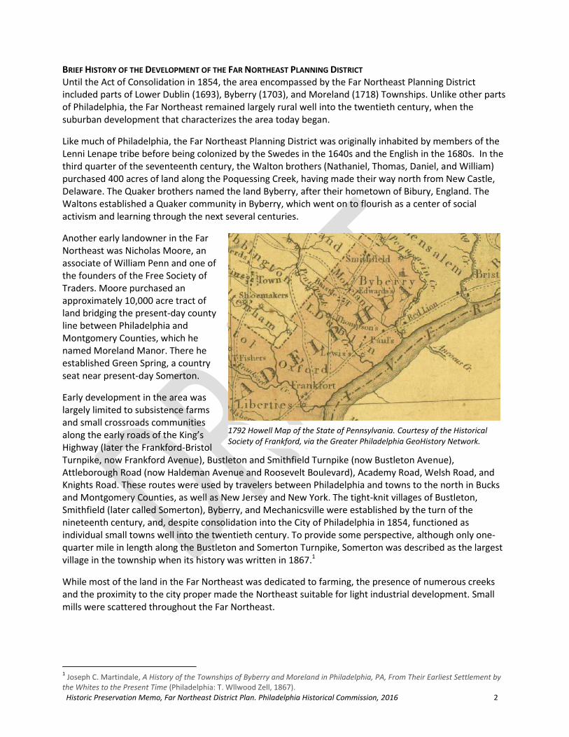
Mechanicsville Historic District: Originally settled by the Walton brothers in 1648, by 1700, the area was known as Mechanicsville for the trades people who came to settle there. A mill for sawing lumber and grinding feed was erected by Evan Townsend in 1774. Mechanicsville Road was laid out in 1816.
1843 Ellet map of Philadelphia County | 1862 Smedley atlas of Philadelphia
View north along Mechanicsville Road
Historic Preservation Memo, Far Northeast District Plan. Philadelphia Historical Commission, 2016 14
Top row: 3124, 3142, & 3130 Mechanicsville Rd; Bottom row: 3126, 3135, & 3110 Mechanicsville Rd
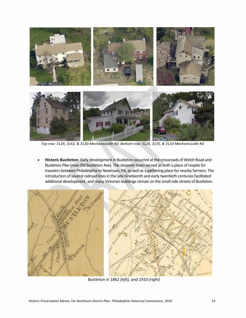
Historic Bustleton: Early development in Bustleton occurred at the crossroads of Welsh Road and Bustleton Pike (now Old Bustleton Ave). The stopover town served as both a place of respite for travelers between Philadelphia to Newtown, PA, as well as a gathering place for nearby farmers. The introduction of several railroad lines in the late nineteenth and early twentieth centuries facilitated additional development, and many Victorian buildings remain on the small side streets of Bustleton.
Bustleton in 1862 (left), and 1910 (right)

Historic Preservation Memo, Far Northeast District Plan. Philadelphia Historical Commission, 2016 15
2
Above (left to right): 1714 and 1708 Welsh Road; Below (left to right): 1730, 1728, and 1714 Welsh Rd
Above (left to right): 1917 & 1923 Welsh Road; Below (left to right): 1937, -39, -43, -45, -51, & -53 Welsh Rd)
2 http://nephillyhistory.com/hnep1994/bustleton.htm
Historic Preservation Memo, Far Northeast District Plan. Philadelphia Historical Commission, 2016 16
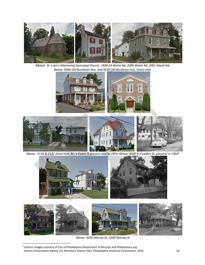
Above: St. Luke’s (Memorial) Episcopal Church, 1930-54 Welsh Rd; 2000 Welsh Rd; 2001 Welsh Rd,
Below: 9304 Old Bustleton Ave, and 9230 Old Bustleton Ave, Union Hall.
Above: 2136 & 2132 Grant Ave; 9514 Evans St present day/in 1954. Below: 9500 bl Cowden St, present/ in 1954
3
Above: 2026 Murray St, 2100 Murray St
3 Historic images courtesy of City of Philadelphia Department of Records and Phillyhistory.org

Historic Preservation Memo, Far Northeast District Plan. Philadelphia Historical Commission, 2016 17
Historic Somerton: The village of Somerton (or Smithfield) developed along the Bustleton and Somerton Turnpike, partly in Moreland and partly in Byberry townships prior to the consolidation of the townships into the City of Philadelphia in 1854. When the town was surveyed by Thomas Livesey in 1758, it contained approximately 10 buildings, including a store, tavern, and blacksmith shop. With the advent of the railroad in the third quarter of the nineteenth century, Somerton began to spread north. While speculative developers began planning new residential communities with winding street layouts as early as 1891, it was not until the post-World War II period that the area truly witnessed a boom of development.
Early properties along the west side of Bustleton Avenue, south of Byberry Road. Although many have been altered or have had unsympathetic signage installed, the basic forms of these nineteenth century properties is still visible.
These properties made up the historic core of the village of Smithfield/Somerton.
The Somerton General Store at 601 Maple Avenue, used as a general store for over 100 years, was described in a 1992 Philadelphia Inquirer article as a neighborhood landmark.

Historic Preservation Memo, Far Northeast District Plan. Philadelphia Historical Commission, 2016 12
The Italianate style Washington House Hotel at 14000 Bustleton Avenue was constructed sometime between 1855 and 1887 (according to historic map research). The hotel was well-positioned adjacent to the Somerton Station of the Philadelphia & Reading Rail Road, which cut through the north of Somerton in the third quarter of the nineteenth century and encouraged speculative development in the community. Bustleton Avenue has since seen a raise in grade, and the property has been altered incompatibly, but it retains its distinguishing low hipped roof with deeply overhanging eaves. Its many original window openings are also visible on the property.
Residential (or formerly residential) properties along Byberry Road, to the southeast of the intersection of Bustleton Avenue. Top row: 625; 700, 702, & 704; and 709 Byberry Rd. Bottom row: 716; 770; and 801 Byberry Rd. The Worthington/Lindsay residence at 801 Byberry Rd is one of the earliest houses in the village of Somerton.

Historic Preservation Memo, Far Northeast District Plan. Philadelphia Historical Commission, 2016 13
Residential properties along Byberry Road, northwest of Bustleton Ave, constructed in the second half of the nineteenth century. Top row: 521; 505 and 507 Byberry Rd./ Second row: 528-30 & 532-34; 531 Byberry Rd.
Residential properties near/ north of the intersection of Bustleton Avenue and Trevose Road, constructed in the second half of the nineteenth century. Top row: 13073 & 13081 Bustleton Ave; 13057, 13063, & 13069 Bustleton Ave.

Historic Preservation Memo, Far Northeast District Plan. Philadelphia Historical Commission, 2016 14
Institutional Buildings Goal: Consider nomination of the following potentially-eligible institutional buildings to the Philadelphia Register of Historic Places
Byberry Mental Hospital/Philadelphia State Hospital (2708 Commerce Way, and 2650 Southampton Rd): The Byberry Mental Hospital, which began as a small work farm for the mentally ill, opened in 1907 as a cottage plan asylum. The hospital initially followed the theory of physician Benjamin Rush that mental illness was a disease which could be cured with proper treatment, but that the mentally ill should be separated from ordinary citizens until they were cured. The institution was renamed several times, becoming known as the Philadelphia State Hospital at Byberry when the hospital was turned over to the state in 1936. The primary buildings were constructed between 1907 and the mid-1920s, with new buildings being constructed between 1940 and 1953. The majority of the more than fifty buildings that once formed the expansive hospital, which housed a population of over 7,000 at its peak in 1960, have been demolished. One building of the former Male Group of dormitories, and the Nurses’ and Female Attendants’ Quarters remain.
1927 Atlas of the City of Philadelphia, 25
th Ward showing “Byberry Farms,” later renamed the Philadelphia State
Hospital at Byberry. The two buildings outlined in red are the only surviving buildings of the once enormous complex.

Historic Preservation Memo, Far Northeast District Plan. Philadelphia Historical Commission, 2016 15
o 2708 Commerce Way, Male Group, Building E-6 (c. 1920): Building C/E-6 was part of a a tidy complex of buildings that housed and served the male patients at Byberry Hospital. Building E-6 was one of six identical dormitories, in a complex that also featured a laundry, cafeteria, and O.T. shop.
o 2650 Southampton Rd, Nurses’ and Female Attendants’ Quarters at Byberry, (c. 1925-1929 and c. 1950): The building in the image to the left , which fronts on Southampton Road, was present in the 1927 atlas. It was added to shortly thereafter, with the addition of the buildings in the upper righthand corner of the image on the right. An additional wing (seen in the lower lefthand corner of the image on the right) was added to the Nurses’ and Female Attendants’ Quarters around 1950.
Academy Road and Red Lion Road, Maple Grove School (1854): The Maple Grove school building was constructed in 1854 on a lot donated by Silas and Phoebe Walton. The school replaced an earlier Moreland and Byberry school building that had been present on the site since 1800.4 The school, constructed by Joseph K. Vangergriff, was described in an early publication as “one story stone building. Wood construction. *Shingle roof, sod yard and sidewalk paving. Detached Unheated toilets. *The shingle roof was later replaced with tin.”5
4 https://www.philadelphiabuildings.org/pab/app/pj_display.cfm/134562
5 https://archive.org/stream/publicschoolbuil00edmu/publicschoolbuil00edmu_djvu.txt

Historic Preservation Memo, Far Northeast District Plan. Philadelphia Historical Commission, 2016 16
3322 Willits Road, Lower Dublin Academy (c. 1798): The Lower Dublin Academy traces its historyto money designated for the education of local youth in the 1695 will of Holmesburg residentThomas Holme (1625-1695), in what was then Lower Dublin Township. Holme’s bequest was notcarried out until 1723, when his estate was divided following the death of his daughter, and anacre and a half of the estate was set aside for the construction of a log schoolhouse. In 1798, thelog schoolhouse was replaced with the existing structure. The building was ravaged by fire in 2006,but still retains much of its historic appearance. Academy Road, one of the primary thoroughfaresin the Far Northeast, takes its name from the Lower Dublin Academy. DESIGNATED 10/14/2016
9230 Old Bustleton Ave, Union Hall (c. 1847): Social halls filled an important role in nineteenthand twentieth-century lives. Built in 1847 for a stock company composed mostly of Odd Fellowsand Sons of Temperance, this Union Hall was home to many lodge meetings (including Grangers,Knights of the Mystic Chain, and the Improved Order of Red Men), as well as two churches, andthe Building and Loan Association.6 From 1942-1960, the Bustleton Branch of the Free Library ofPhiladelphia operated out of the Union Hall building, and it was later used by the SettlementMusic School. It has been occupied by Ss. Peter and Paul Orthodox Church since the late 1970s.
6 S.F. Hotchkin, The York Road: Old and New (Philadelphia, PA: Binder & Kelly, 1892), 472.

Historic Preservation Memo, Far Northeast District Plan. Philadelphia Historical Commission, 2016 17
3146 Mechanicsville Road, Mechanicsville School (1866), NR Listed: 1986: Constructed in 1866,the Mechanicsville School is a noteworthy example ofthe variation in school design occurring in the 1851 to1904 period. Rural in character and retardataire indesign, this small one room schoolhouse epitomizesthe rural village nature of Mechanicsville. Its smallscale and Greek Revival detailing recall vernacularschool architecture of the Pennsylvania countryside,and serve as a reminder of the rural nature of much ofPhiladelphia throughout the nineteenth century.
13250 Trevose Road, Watson Comly Consolidated School (1892), architect: Joseph Anshutz,builder: L. Dieterich (NR listed 1988): The Watson Comly Public School, built in 1892, was thethird school in Somerton. The building was designed by local architect Joseph Anschutz, whodesigned approximately 75 schools during his tenure as Assistant Architect and then SupervisingArchitect for the Philadelphia Board of Education. It served as a school for the surrounding ruralcommunity until 1928, when it was replaced by a larger school on Byberry Road. The building wassubsequently used as the Somerton Masonic Hall for many years.
7
1001 Byberry Road, Watson Comly Elementary School (1929) architect: Irwin T. Catharine: TheWatson Comly Elementary School was designed by Irwin T. Catharine, the chief architect ofPhiladelphia Public Schools from 1920 until his retirement in 1937. Catharine adoptedarchitectural styles popular in Philadelphia and the nation at the time, including Jacobean andGothic Revivals, as well as Art Deco.
7 Custis, John Trevor. The Public Schools of Philadelphia, Historical, Biographical, Statistical. Philadelphia: Burk & McFetridge Co.,
1897., p. 531, 539, 543

Historic Preservation Memo, Far Northeast District Plan. Philadelphia Historical Commission, 2016 18
1140 Byberry Road, Engine 58/Byberry Firehouse (c. 1915) architect: Rankin, Kellogg & Crane:The Byberry Firehouse was designed by Rankin, Kellogg & Crane, a highly successful firm thatfrequently gained government commissions. While the firm was known for monumental designsof federal buildings, they were also capable of producing smaller-scale, architecturally significantbuildings, such as the Byberry Firehouse and the Falls of the Schuylkill branch of the Free Library.
1701 Bowler Street/9845 Bustleton Ave, Bustleton Police & Fire Department (Bustleton AvenueMunicipal Building) (1955), architect: Oskar Stonorov: This property was constructed in 1955 forthe City of Philadelphia with a design by architect Oskar Stonorov. Oskar Stonorov was amodernist architect, sculptor, writer, and historian who emigrated to the United States fromGermany in 1929. Although most famous for his residential designs, particularly of housingprojects, Stonorov occasionally strayed from the norm, as in the case of the Bustleton AvenueMunicipal Building. The rendering on the left, below, shows the design as presented in thePhiladelphia Art Commission Annual Report, vol. 45, from 1955.

Historic Preservation Memo, Far Northeast District Plan. Philadelphia Historical Commission, 2016 19
Commercial/Industrial Buildings Goal: Consider nomination of the following potentially-eligible commercial or industrial buildings to the Philadelphia Register of Historic Places
12000 E. Roosevelt Boulevard, Nabisco Plant (c. 1955): Constructed in the early 1950s for theNational Biscuit Company (Nabisco)—which had formed in 1898 from a merger of roughly 40smaller, independent bakeries—this bakery employed workers of the Far Northeast for over 75years. Until its closure in early 2016, the bakery’s production filled the air of the community withthe smell of cookies. Its nine-story tower is considered a landmark in the community.

Historic Preservation Memo, Far Northeast District Plan. Philadelphia Historical Commission, 2016 20
Religious Buildings Goal: Consider nomination of the following potentially-eligible religious buildings to the Philadelphia Register of Historic Places
1930-54 Welsh Rd, St. Luke’s Memorial Episcopal Church (and chapel) (1861), architect: Richard Upjohn: St. Luke’s Memorial Episcopal Church was constructed in 1861 in memory of naval surgeon Bernard Henry who was lost at sea. British-born American architect Richard Upjohn is considered one of the most influential architects of his time, particularly in the area of church design. His extensive use of Gothic Revival church designs throughout the country is credited as part of the force that launched the popularity of the Gothic Revival movement in the United States. Upjohn is further significant as the founder and first president of the American Institute of Architects. DESIGNATED 11/10/2017
9554 Bustleton Avenue, Pennepack/Lower Dublin Baptist Church (now Lifeway BaptistChurch) architect: Hazelhurst & Huckle (1886):From its construction in 1886 until its sale in2006, this church building was occupied by thePennepack Baptist Church, founded in 1688, theoldest Baptist congregation in Pennsylvania andone of the oldest in the country. The prominentarchitectural firm of Hazelhurst & Huckledesigned the church for the congregation, whichhad outgrown its old church building onKrewstown Road, a few blocks away. Even after it constructed the Bustleton church, thecongregation retained ownership of theKrewstown church, which it used for ceremonialpurposes. When it sold the Bustleton church in2006, Pennepack Baptist Church moved back tointo the Krewstown church building.

Historic Preservation Memo, Far Northeast District Plan. Philadelphia Historical Commission, 2016 21
8500 Frankford Avenue, St. Dominic’s Roman Catholic Church, School, Parish, and Cemetery(1849-1896): St. Dominic Church was established in the village of Holmesburg in 1849 to serve arelatively small community of Catholics in the area. In 1896, the original church building wasdestroyed by fire. Construction on the present building began almost immediately. In addition tothe brownstone church, the site boasts several auxiliary buildings, and a large cemetery.
510 Somerton Avenue, St. Andrew’s-In-The-Field Episcopal Church Chapel (now SomertonInterfaith Food Bank) (1899): In 1897, the Bishop of Pennsylvania gave his consent for theestablishment of a Mission at Somerton, a growing crossroads community. During the first year,the congregation grew from ten to 61 persons, necessitating the construction of a chapel.Money was collected for the chapel the following year, and construction began in 1899. Thepopulation boom in the Far Northeast following World War II increased the number of Episcopalfamilies in the Somerton area, and services were held more regularly at the Chapel.

Historic Preservation Memo, Far Northeast District Plan. Philadelphia Historical Commission, 2016 22
• 10800 Knights Road, St. Michael’s Chapel, Shrine of the True Cross (1931), architect: George Lovatt: Now part of the Aria Health System’s Torresdale Campus, St. Michael’s Chapel was built as part of aCatholic pilgrimage center and retreat that Louise Drexel Morrell and Saint Katharine Drexel establishedon the property of their family’s summer home, San Michel.8 The chapel, along with the mansionhouse, is among the few extant structures associated with one of Northeast Philadelphia’s mostsignificant families, and with the beloved Saint Katharine Drexel.
13200 Trevose Rd, Chapel at Somerton United MethodistChurch (1836): Constructed in 1836 for the rural communityof Somerton, the chapel was used by the Somerton UnitedMethodist Church until it moved services to the adjoiningbuilding in the mid-twentieth century.
3330 Byberry Road, Byberry Baptist Chapel (nowBerean Bible Church) (c. 1872): The Byberry BaptistChapel formed in 1872 from an offshoot ofapproximately two dozen members of the HolmesburgBaptist Church.
8 http://www.northeasttimes.com/2013/aug/7/ne-historic-buildings-will-be-preserved2/#.V6TrjfkrJD8
http://www.pahrc.net/tag/shrine-of-st-michael-of-the-true-cross/

Historic Preservation Memo, Far Northeast District Plan. Philadelphia Historical Commission, 2016 23
Residential Buildings Goal: Consider nomination of the following potentially-eligible residential buildings to the Philadelphia Register of Historic Places
10800 Knights Road, San Michel (1870), architect: Addison HuttonIn 1870, Francis Drexel purchased a 90-acre farm at Red Lion and Knights Roads for use as his family’ssummer estate. He commissioned notable architect Addison Hutton to design the home, which henamed San Michel, in honor of his family’s devout Catholic faith. After his death in 1885, the estatepassed to the three Drexel daughters, Elizabeth, Katharine, and Louise. In 1889, Louise marriedEdward de Veaux Morrell, a wealthy and politically connected attorney from an influential family. Theypurchased the property adjoining San Michel, naming it San Jose. It is now the site of Morrell Park.Louise’s sister Katharine Drexel had always been deeply spiritual, and the deaths of her parents andsister, Elizabeth, further motivated her to pursue her devotion. In 1891, Katharine took vows as thefounder of the Sisters of the Blessed Sacrament for Indians and Colored People, a religious order sheestablished to minister specifically to Native American and African American people. Katharineconverted the estate of San Michel into the temporary novitiate of the new religious order, moving intoSan Michel with 13 novices and three postulants of the Sisters of the Blessed Sacrament. The orderquickly outgrew the space, moving to a new convent in nearby Andalusia in 1897. Over the next severaldecades, Louise Drexel Morrell oversaw the conversion of the property into a Catholic pilgrimagecenter, and the construction of a large chapel on the site. Retreats continued at the property until 1966(following the deaths of Louise in 1945, and Mother Katharine in 1955), and the mission centerremained open until 1974.9
13475 Proctor Road, Mill-Rae (now Cranaleith Spiritual Center) (1890), architect: MinervaParker Nichols:Built in 1890 as a private residence for suffragistRachel Foster Avery and her family, Mill-Rae issignificant for its association with the women’ssuffrage movement in the United States. The homewas designed by local architect Minerva ParkerNichols, the first woman in the United States topractice architecture independently, and featuredseveral bedrooms, large parlors, and sitting rooms, alldesigned with the intention of hosting meetings forvarious women’s associations. In the late nineteenthcentury, such accommodations and gathering spacesfor women’s organizations were rare.
9 http://www.northeasttimes.com/2013/aug/7/ne-historic-buildings-will-be-preserved2/#.V6T4MvkrJD8
Historic Preservation Memo, Far Northeast District Plan. Philadelphia Historical Commission, 2016 24
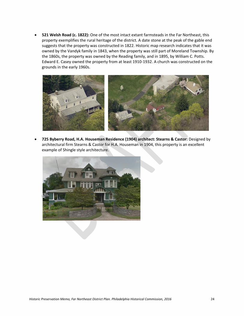
521 Welsh Road (c. 1822): One of the most intact extant farmsteads in the Far Northeast, thisproperty exemplifies the rural heritage of the district. A date stone at the peak of the gable endsuggests that the property was constructed in 1822. Historic map research indicates that it wasowned by the Vandyk family in 1843, when the property was still part of Moreland Township. Bythe 1860s, the property was owned by the Reading family, and in 1895, by William C. Potts.Edward E. Casey owned the property from at least 1910-1932. A church was constructed on thegrounds in the early 1960s.
725 Byberry Road, H.A. Houseman Residence (1904) architect: Stearns & Castor: Designed byarchitectural firm Stearns & Castor for H.A. Houseman in 1904, this property is an excellentexample of Shingle style architecture.

Historic Preservation Memo, Far Northeast District Plan. Philadelphia Historical Commission, 2016 25
Sites/Structures Goal: Consider nomination of the following potentially-eligible historic sites to the Philadelphia Register of Historic Places
Holme Avenue & Convent Avenue, Holme-Crispin Cemetery (c. 1694-1863): This cemetery is the burial site of Thomas Holme, William Penn’s Surveyor General, who laid out the famous grid of Philadelphia streets. In the seventeenth century, Holme maintained an estate, known as the Well Spring Plantation, in Lower Dublin Township near Pennypack Creek. When Holme died in May 1695, his son-in-law Silas Crispin was named executor of the estate. As Quakers, theHolme/Crispin family cemetery primarily featured graves marked with a small stone carved only with the initials of the deceased. In 1863, the Lower Dublin Academy, which Holme’s will helped establish, dedicated an obelisk monument in the cemetery to their patron. DESIGNATED 3/9/2018
10725 and 10751 Knights Road, Byberry Township Public Burial Ground/Hart Burial Yard(c.1683): The former Byberry Township Public Burial Ground, also known as Hart Burial Ground, isa one-acre public burial ground located on Red Lion Road. It contains an unknown number ofburials, and there have been no records found of disinterment. At least one broken gravestonewas recently documented. It is considered to be the first and oldest known public burial ground inexistence in Philadelphia, established circa 1683 by John Hart, an important legislator ofPennsylvania. The burial ground is owned by the City of Philadelphia and has recently beenproposed for historic designation. DESIGNATED 1/13/2017

Historic Preservation Memo, Far Northeast District Plan. Philadelphia Historical Commission, 2016 26
Century Lane Bridge over Poquessing Creek (1853): Constructed in 1853, the two-span, closed-spandrel stone bridge was built to connect the villages of Mechanicsville (now part ofPhiladelphia) and Elizabethtown. The bridge is located on the county line.
Frankford Avenue/Bristol Pike Bridge over Poquessing Creek (1904): Constructed in 1904, theFrankford Avenue bridge over Poquessing Creek is significant for its early use of concrete. The firstreinforced-concrete bridge in the United States was built in 1889, but the material remained in anexperimental phase through the early 1900s.
Old Lincoln Bridge over Poquessing Creek (abandoned—Benjamin Rush State Park) (1805):Travelers between Bucks County and Philadelphia entered Far Northeast Philadelphia via the now-abandoned Poquessing Creek Bridge, which was constructed in 1805 to carry the King’s Highway,and later the Byberry and Bensalem Turnpike, across the Poquessing Creek. The double stone archbridge was improved in 1917 to carry Lincoln Highway, but was bypassed by Roosevelt Boulevardin 1921. The bridge is in extremely poor condition.
1999 photograph of the bridge, courtesy of the Library of Congress

Historic Preservation Memo, Far Northeast District Plan. Philadelphia Historical Commission, 2016 27
Recommended Follow-Up
Perform additional survey and research to produce a more comprehensive survey of historicresources in the Far Northeast District.
Consider nomination of the most important historic sites to the Philadelphia Register of HistoricPlaces.
Request that the Pennsylvania Historical and Museum Commission evaluate the PhiladelphiaHistorical Commission’s list of potentially-eligible resources to determine if they are eligible forthe National Register. This would be particularly useful for commercial and other income-producing properties as it would qualify them for tax credits.
Encourage sensitive renovations of existing historically significant and potentially significantbuildings, and the removal of materials and elements (such as large signage or vinyl siding) thatobscure historic features.