Embed Size (px)
Citation preview

Home Learning Packs by
Family Home Learning Pack
MAPS AND DIRECTIONS
Notes for parents and carers:
These home learning packs have been compiled by the Young People’s Trust for the Environment to support you whilst your children are at home during the Covid-19 lockdown.Each week, we will include suggestions for activities you can do alongside your children, as well as those that they can do independently, whilst you are working from home. We will attempt to suggest activities which require no special materials other than those you may find around the house. It may be possible to pick up some resources during your occasional shop for essentials but please do not aim to shop specifically for listed supplies! We will also attempt to minimise the need to print out any materials.
We’d love to hear your suggestions for making the packs more useful for you, or your children’s ideas for future topics. You can follow us on Facebook at https://www.facebook.com/WeAreYPTE/ or on Instagram @weareypte. You can share your pictures with us using #yptelearning
In your pack each week:
* Open ended project ideas and research topics
* Activities to explore independently or together
* Games to play
* Ideas for science experiments
* Art and craft ideas
* Links to other learning resources
* A use each week for toilet roll tubes… ypte.org.uk Registered charity number 1153740 [email protected]
Image: SK53 OSM
Equipe Integrada

Home Learning Packs by
ACTIVITY IDEAS
Even though we are all staying very close to home at the moment, map making can be a great way to think about your environment in a different way. Whether it is reading maps in order to explore the local area, giving and following directions, or even making layout plans for rooms in your house, mapping skills help develop spatial awareness and can be great fun to learn.
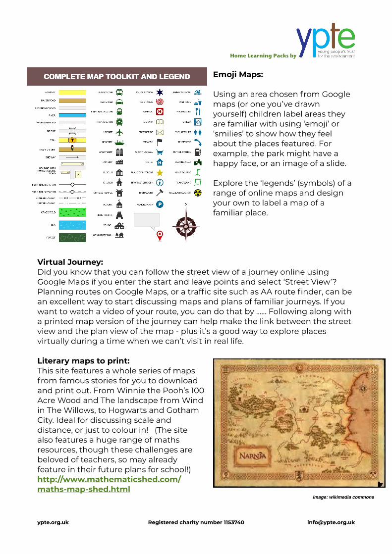
Symbols:
Maps often use symbols (called ‘legends’) to represent features in the environment. It can be interesting to explore the types of symbols that are used. Older children may enjoy looking at road maps and exploring the ‘key’ to see which features are marked and what symbols are used. To help very young children understand the idea of a map as a representation of a real place, try starting by mapping something very obvious: Place setting maps:
Put a piece of paper down on the table before laying out a plate, cup, knife and fork. Encourage your child to draw round the items using a pen or crayon. Lift the items up an look at the ‘symbols’ that have been left behind. These shapes show where the items go. Put everything back into place, using the table ‘map’.
Bird’s Eye View:
Generally, the items on a map are seen from above, as if we were flying over them like a bird. We can’t see all the features of the house on a map, such as the windows on the houses. What do some other items look like from above? Challenge children to draw round familiar household items for each other, then guess what the symbols they have made show. Can they guess what the shapes are?
ypte.org.uk Registered charity number 1153740 [email protected]
Photo: Richard BH
Image: Pixabay

Home Learning Packs by
Making maps:
My walk to the park / shop / round the block: It can be interesting to start map making by asking your child to draw their representation of a familiar route, such as a walk to the park, or their journey to school, back in the day… Which features do they remember? How would they represent them on a map?
Road set floor map: If your children have toy cars or a train set, they can set up their own layout, adding buildings to visit, then draw maps of this. You might like to help by taking a photograph of the layout from above so they can compare the bird’s eye (plan) view with the view they can see from the side (the oblique view). Lego bedroom / house maps: Lego bricks make great representations of features on a map, from buildings, to individual pieces of furniture in a room plan. Try making a map of a room in your house using lego and then drawing a map of the model that you have made! This can be a great time to talk about scale (the size of objects in relation to each other and in relation to what they represent).
Right: Hilary in London made this great map of her bedroom, showing where all the pieces of furniture are.
Below: Sally and Beth in Berkshire made this amazing Lego representation of their house and garden:
ypte.org.uk Registered charity number 1153740 [email protected]
Photo: K. Shimada
Home Learning Packs by
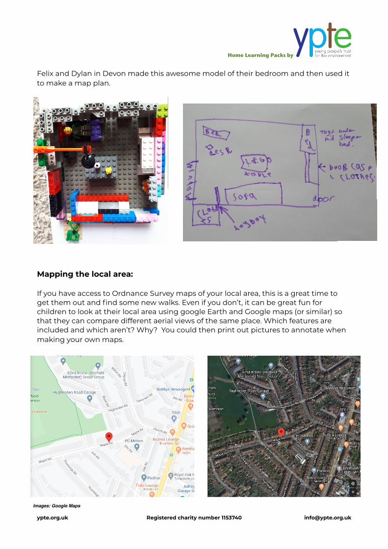
Felix and Dylan in Devon made this awesome model of their bedroom and then used it to make a map plan.
Mapping the local area:
If you have access to Ordnance Survey maps of your local area, this is a great time to get them out and find some new walks. Even if you don’t, it can be great fun for children to look at their local area using google Earth and Google maps (or similar) so that they can compare different aerial views of the same place. Which features are included and which aren’t? Why? You could then print out pictures to annotate when making your own maps.
ypte.org.uk Registered charity number 1153740 [email protected]
Images: Google Maps
Home Learning Packs by
Emoji Maps:
Using an area chosen from Google maps (or one you’ve drawn yourself) children label areas they are familiar with using ‘emoji’ or ‘smilies’ to show how they feel about the places featured. For example, the park might have a happy face, or an image of a slide.
Explore the ‘legends’ (symbols) of a range of online maps and design your own to label a map of a familiar place.
Virtual Journey: Did you know that you can follow the street view of a journey online using Google Maps if you enter the start and leave points and select ‘Street View’? Planning routes on Google Maps, or a traffic site such as AA route finder, can be an excellent way to start discussing maps and plans of familiar journeys. If you want to watch a video of your route, you can do that by …… Following along with a printed map version of the journey can help make the link between the street view and the plan view of the map - plus it’s a good way to explore places virtually during a time when we can’t visit in real life.
Literary maps to print: This site features a whole series of maps from famous stories for you to download and print out. From Winnie the Pooh’s 100 Acre Wood and The landscape from Wind in The Willows, to Hogwarts and Gotham City. Ideal for discussing scale and distance, or just to colour in! (The site also features a huge range of maths resources, though these challenges are beloved of teachers, so may already feature in their future plans for school!) http://www.mathematicshed.com/maths-map-shed.html
ypte.org.uk Registered charity number 1153740 [email protected]
Image: wikimedia commons

Home Learning Packs by
Compass directions:
Following maps involves needing to be able to understand directions. Making a compass is a great way to start discussing the idea of the cardinal directions: North, South East and West.
It’s easy to make a simple model of a compass using paper plates (or any disc of cardboard) and a split pin or opened out paper clip to attach an arrow for turning.
Make a magnetised compass:
The earliest magnetised compass was invented in China around 206 BCE and was used by travellers who had previously found their way using the position of the stars. It was discovered that lodestone, a magnetised rock was always pulled towards a direction known as ‘magnetic north’ (due to the Earth’s magnetic field). This meant that compass directions could be labelled on maps to help people navigate with precision. You can make your own working compass by magnetising a needle and floating it in water so that the magnetised end is drawn towards the north. With thanks to Alex in Durham for making an amazing compass for us!
You will need:
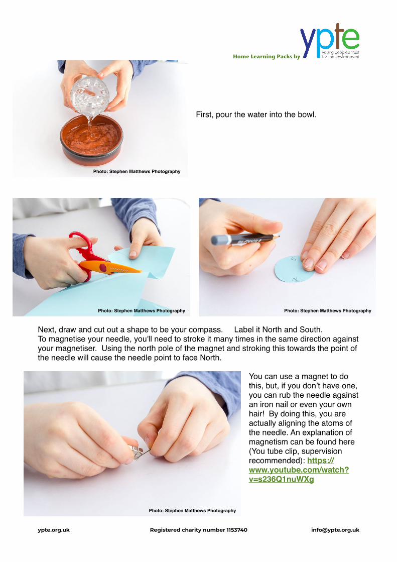
*A shallow bowl *A needle (or other piece of metal that can be magnetised such as a in or hair grip) *A magnet *Cardboard (or a piece of cork) *Scissors *A pen or pencil *Some water
ypte.org.uk Registered charity number 1153740 [email protected]
Photo: Stephen Matthews Photography
Home Learning Packs by
First, pour the water into the bowl.
Next, draw and cut out a shape to be your compass. Label it North and South.To magnetise your needle, you'll need to stroke it many times in the same direction against your magnetiser. Using the north pole of the magnet and stroking this towards the point of the needle will cause the needle point to face North.
You can use a magnet to do this, but, if you don’t have one, you can rub the needle against an iron nail or even your own hair! By doing this, you are actually aligning the atoms of the needle. An explanation of magnetism can be found here (You tube clip, supervision recommended): https://www.youtube.com/watch?v=s236Q1nuWXg
ypte.org.uk Registered charity number 1153740 [email protected]
Photo: Stephen Matthews Photography
Photo: Stephen Matthews Photography Photo: Stephen Matthews Photography
Photo: Stephen Matthews Photography

Home Learning Packs by
You can test the needle to see if it is magnetised by seeing whether small, steel items such as another needle or a paper clip are attracted to it.
Next, insert the needle into your piece of card, with the magnetised end pointing North.
When you float your magnet in the water, the needle’s point will be attracted to the direction North by the Earth’s magnetic field!
You can check this by lining your own compass up and checking it against a ‘real’ compass, if you have one. Now you can label the maps you make in your home with compass directions!
A video of this experiment, plus explanations for older children, can be found here: https://www.bbc.co.uk/bitesize/topics/zrvbkqt/articles/zfb6pbk
ypte.org.uk Registered charity number 1153740 [email protected]
Photo: Stephen Matthews Photography
Photo: Stephen Matthews Photography
Photo: Stephen Matthews Photography

Home Learning Packs by
RESEARCH IDEAS
Learning about disease from Maps.
(Not recommended if children are already anxious about the current pandemic)
In the 1800s, cholera was a serious disease that caused many deaths. People were not sure how the disease was spreading.
A map, made in 1854 by a man called John Snow, helped to prove a new theory - the idea that this disease was a result of contaminated water.
His map showed the households that were getting sick and the position of the water pumps that they were using.
Find out:
* How did John Snow’s map help show what was causing cholera?
* Why did the workers in the local brewery not get ill?
* What actions were taken as a result of John Snow’s findings?
We still use maps to study the spread of diseases and they can help us understand why people in certain areas are more affected than others. If children are interested to study the spread of the current pandemic in this way, a live map developed by the Johns Hopkins University can be found here: https://www.arcgis.com/apps/opsdashboard/index.html#/bda7594740fd40299423467b48e9ecf6
ypte.org.uk Registered charity number 1153740 [email protected]
Image: Wikimedia Commons

Home Learning Packs by
MATHS CHALLENGESChallenge 1
A caterpillar climbed up a pile of leaves.
It always starts at the bottom and moves upwards. The first time, it
travelled like this: Left, right, left, right.
Find 5 other ways that the caterpillar can travel up the leaves.
Challenge 2
36 people live in these 8 houses. Each house has a different number of people living in it. Each line of 3 houses has 15 people living in it.
How many people live in each house?
Question adapted from Mathematical Challenges for Able Pupils, DFE, 2000. Solution at end of the pack!
ypte.org.uk Registered charity number 1153740 [email protected]
DFE, 2000
DFE, 2000

Home Learning Packs by
WORD CHALLENGES Never Eat Shredded Wheat:
Sometimes people find it easier to remember things if they make up a ‘mnemonic’ which is a sequence or pattern of words or other ideas that help form associations. The 4 main compass directions are North, East, South and West. Some people find it easier to make up a ‘silly sentence’ such as “Never Eat Shredded Wheat” to help them remember the order of the compass points. See if you can use the letters N,E, S, W to make up your own!
Where, oh Where is Mr. Bear?:
In order to give directions, young children need help to develop their positional language. Use a teddy bear and a chair or bow that he can be positioned in relation with. Move the bear and ask the question, “Where, oh where is Mr. Bear?” Children answer using language to describe the bear’s location. “He’s on top of the chair.” “He’s underneath the chair.” You can extend this by adding in terms such as left and right. So, “He’s next to the chair” could also become, “He’s to the left of the chair.”
Directions Card Game:
Encourage children to think up as many different directions as possible, such as ‘left’, ‘right’, ‘forwards’ ‘straight on for 3 steps’ etc. Write these on to cards and place them in a bowl. Choosing cards, children can either move in the given directions, or use them to invent journeys and maps on paper. ypte.org.uk Registered charity number 1153740 [email protected]

Home Learning Packs by
ART AND CRAFTDrawing compass stars:
The compass directions shown on old maps were often provided using ornate drawings of compass stars. Have a go at drawing your own version by following these steps, drawn for us by Alice in London:
ypte.org.uk Registered charity number 1153740 [email protected]

Home Learning Packs by
This great compass star was drawn by Alex in Durham:
Make a story map:
Making a story map can be a great way for children to retell a familiar story whilst helping them to represent environmental features from the book. ‘Rosie’s Walk’ by Pat Hutchins is a classic story for mapping with young children, or the much beloved ‘We’re Going on A Bear Hunt’ by Michael Rosen. Here’s are some wonderful story maps made by Henry and Charlie in St. Albans. Can you recognise which story they have mapped out?
ypte.org.uk Registered charity number 1153740 [email protected]

Home Learning Packs by
This week’s use for a toilet roll tube:
Make a Treasure Map: Why not use your toilet roll tubes this week to roll maps and scrolls, such as this treasure map! You could make a map that shows directions to somewhere in your house or garden, so that you could really hide some buried treasure.
Dabbing your paper with a tea bag that has been soaked in boiling water will make your paper look old. Don’t forget to let the tea bag cool down before you dab it over the paper!
Leave your paper to dry thoroughly, then draw on your map design.
Finally, roll your map round your toilet roll tubes (you could stick 2 together if you need a wider roll, or add one at each end for a scroll effect!
ypte.org.uk Registered charity number 1153740 [email protected]

Home Learning Packs by
GAMES Programme the robot grid game:
Use masking tape or string to mark out a grid of squares on the floor, or in the garden, with each square being large enough for a child to stand in.
Choose a start square and then place an object to be retrieved in one of the other squares. A child acts as the ‘robot’ who has to be ‘programmed’ by the others, who decide which directions to give in order to reach the object (and to return again, if they like!). The steps can be made simple, such as ‘forward’ ‘up’ ‘across’ or can include diagonals, left and right as appropriate.
Directions can be given one at a time, or in a sequence, such as ‘take 3 steps forwards, one to the left, then 2 up’
The Macarena:
With a small change to the lyrics, the Macarena dance becomes a really useful way of learning about the degrees in a circle when turning through compass points! Explain the fact that there are 360 degrees in a complete turn and that each quarter turn has 90 degrees. This is called ‘a right angle’. You might wanted to label your walls N, E, S and W as well. Now instead of calling ‘Hey Macarena!’ before jumping, sing ‘Turn a right angle!” instead. You can then start to build in questions such as ‘How many degrees do you need to turn to face north, if you are currently facing West? How many right angles would you jump if you wanted to face South, but you are currently facing North?
Cha-cha Slide:
Another dancing classic, the cha-cha slide has taught many a child the difference between their left and right! A feature of many a dance video and computer game, you can challenge the who family to learn it from the original video here (Youtube link, supervisions recommended): https://www.youtube.com/watch?v=wZv62ShoStY
ypte.org.uk Registered charity number 1153740 [email protected]
Photo: Olivier Benny

Home Learning Packs by
LEARNING LINKS There are a large number of resources available for online learning at this time. We’d always recommend that you support your child with this and only follow links from reputable names. Any links provided here have been checked for suitability.
These 4 simple maps, produced by National Geographic, are ideal for printing out and discussing with younger children. Tips for discussing the different features of the maps are included on the page: https://www.nationalgeographic.org/maps/maps-and-models/?utm_source=BibblioRCM_Row
This amazing site from Ordnance Survey helps older children to develop their map reading skills via a series of interesting games, challenges and quizzes. (It’s quite loud! You may want to suggest headphones, or turn the volume down for this one!) https://www.ordnancesurvey.co.uk/mapzone/
For older children (the site is aimed at Y7 and above, but would suit a keen geographer at KS2), this site offers a huge range of challenges to complete on numerous aspects of mapping from contour lines and 6 figure grid references to map symbols and the countryside code. http://www.geographypods.com/map-skills.html
Escape from Hogwarts! Not strictly a mapping activity, but plenty of logical challenges to tackle in this versions of a digital escape room. (Will require explanation or at least a secure reader as part of the team to help work through the clues - previous experience of escape rooms a bonus) https://docs.google.com/forms/d/e/1FAIpQLSflNxNM0jzbZJjUqOcXkwhGTfii4CM_CA3kCxImbY8c3AABEA/viewform
Answers to Maths Challenges:
ypte.org.uk Registered charity number 1153740 [email protected]
Challenge 2:
A variety of arrangement such as:
Challenge 1:
The caterpillar can take the following routes:
left, left, right, right, left, right, right, left left, right, left, right (as shown) right, left, right, left
right, right, left, left
right, left, left, right DFE, 2000