Embed Size (px)
Citation preview
FIGURE 2.1 PROPOSED SITE LAYOUT WITH LANDSCAPING ...................................................................... 2-4 FIGURE 2.2 SITE LOCATION ....................................................................................................................... 2-7 FIGURE 2.3 SITE CONTEXT ........................................................................................................................ 2-7 FIGURE 2.4 VIEW OF THE EXTERIOR OF THE EXISTING BUILDINGS WITHIN THE SITE ........................................ 2-8 FIGURE 2.5 VIEW OF THE INTERIOR OF THE EXISTING BUILDINGS WITHIN THE SITE ......................................... 2-8 FIGURE 2.6 VIEW OF OPEN SPACE AND RIVER SANTRY ACROSS THE NORTHERN PART OF THE SITE ............... 2-8 FIGURE 2.7 FACILITIES WITHIN 2KM OF THE DEVELOPMENT SITE (SOURCE: SIA BY MHP) ............................ 2-9 FIGURE 2.8 BUS TRANSPORT ACCESSIBILITY (SOURCE: TRAFFIC AND TRANSPORTATION ASSESSMENT (TTA)
BY AECOM) ..................................................................................................................................... 2-10
TABLE 2.1 DEVELOPMENT STATISTICS ....................................................................................................... 2-4
This chapter has been prepared by McCutcheon Halley Chartered Planning Consultants. It provides
a detailed description of the project together with details of the existing environment. In accordance
with Article 5(1)(a) of the 2011 Directive as amended by Directive 2014/52/EU the description of the
proposal should comprise “…information on the site, design, size and other relevant features of the
project”.
A description of the site and its surrounding is presented, together with the proposed design
parameters. A summary of the demolition and construction phases of the development is also
presented. This description sets the basis against which the specialist assessments presented in
this EIAR have been undertaken.
The lead author involved in drafting was Nathan Smith of McCutcheon Halley Chartered Planning
Consultants, who graduated from Oxford Brookes University with a BA Hons in Planning Studies in
1997 and a Diploma in Planning in 1998. Nathan has over 20 years professional experience in the
field of planning and development consultancy, which has included providing consultancy services
in respect of several major urban regeneration projects including EIA. Nathan is currently a Senior
Planning Consultant in the Practice of McCutcheon Halley Chartered Planning Consultants.
The development rationale is to demolish all existing structures on the site to make way for the
development of the residential led scheme, including residential accommodation, amenity space and
facilities, as well as a service building including a creche, café and gym. It is proposed to deliver the
development in 4 no. phases and this subject application comprises, including the demolition and
redevelopment of the site at phase I.
The proposed development will consist of the following phases of development:
a) Phase 1 includes the demolition of all existing buildings, existing boundary fences,
removal of existing trees, breaking up and crushing the existing hard standing area,
excavation and all associated site works;
b) Phase 2 includes the development of a basement, measuring c. 11,707 square metres
to accommodate 181 car parking, 634 bicycle spaces and 16 motorbike spaces, plant
rooms, bin storage, attenuation tanks and circulation;
c) Phase 3 includes the redevelopment of the site to include:
i. 495 no. build to rent residential units (comprising 61 no. studio, 150 no. 1
bedroom, 178 no. 2-bedroom, and 106 no. 3 bedroom apartments), residential
support facilities, amenities and services in 4 no. blocks which comprise:
(i) Phase 3a – Block A1 – includes 98 build to rent units (comprising 16 no.
studio, 33 no. 1 bedroom, 39 no. 2 bedroom, and 10 no. 3 bedroom
apartments), resident support facilities including entrance / concierge,
resident services and amenities including function room, with heights
proposed as 6 no. storeys (19.175m above ground level), 9 no. storeys
(27.8m above ground level) and 10 no. storeys (30.745m above ground
level);
(ii) Phase 3b – Block A1 – includes 98 build to rent units (comprising 16 no.
studio, 33 no. 1 bedroom, 39 no. 2 bedroom, and 10 no. 3 bedroom
apartments), resident support facilities including entrance / concierge,
resident services and amenities including function room, with heights
proposed as 6 no. storeys (19.175m above ground level), 9 no. storeys
(27.8m above ground level) and 10 no. storeys (30.745m above ground
level);
(iii) Phase 3c – Block B – includes 173 build to rent units (comprising 18 no.
studio, 38 no. 1 bedroom, 54 no. 2-bedroom, and 63 no. 3 bedroom
apartments), resident support facilities including entrance / concierge,
resident services and amenities including Games Room, Dining Area,
Study Hub, with heights proposed as 3 no. storeys (10.4m above ground
level), 4 no. storeys (13.175m above ground level), 5 no. storeys (16.1m
above ground level), 6 no. storeys (19.175m above ground level) and 7
no. storeys (21.95m above ground level);
(iv) Phase 3d – Block C – includes 126 build to rent units (comprising 11 no.
studio, 46 no. 1 bedroom, 46 no. 2-bedroom, and 23 no. 3 bedroom
apartments), resident support facilities including entrance / concierge,
resident services and amenities including Homework Club, Communal
Work Area with heights proposed as 3 no. storeys (10.4m above ground
level), 4 no. storeys (13.175m above ground level), 5 no. storeys (16.1m
above ground level), 6 no. storeys (19.175m above ground level) and 7
no. storeys (21.95m above ground level);
ii. Ground floor car parking (215 spaces) and bicycle parking (16 spaces);
iii. Service building including 1 no. creche, café and gym; and
iv. All associated ancillary development works including drainage, 4 no. electricity
substations, access and roads within the site, pavements, new boundary walls,
fencing, public open space, communal amenity space, tree planting, vehicle and
pedestrian access and all associated site works.
d) Phase 4 - Highway and pedestrian improvements including:
i. Upgrading of the site and signals at the junction of Coolock Drive and Oscar
Traynor Road;
ii. Provision of a signalised pedestrian crossing to the south of the site entrance on
Coolock Drive; and
iii. Provision of a signalised pedestrian crossing at the proposed pedestrian entrance
to the park off Greencastle Road.

FIGURE 2.1 PROPOSED SITE LAYOUT WITH LANDSCAPING
The principle development statistics of the proposal are as shown below:
Development Statistic Proposed Development
No. of Build to Rent Apartments • 495 no. as follows: o 61 no. studio o 150 no. 1 bed o 178no. 2 bed o 106 no. 3 bed
Site Area Red Line: 3.86 ha. Net site area: 3.61 ha.
Gross Demolition Area 8,824 sq.m
Number of Residential Units 495no.
Plot Ratio 1.8
Site Coverage 42%
Building Height 3 – 10 storeys
Aspect 65% dual aspect
Public Open Space 15,660 sq.m
TABLE 2.1 DEVELOPMENT STATISTICS

The proposed development will comprise a mix of studio, one, two and three bed apartments located
in 4 no. blocks ranging from 4 to 10 storeys in height. A total of 495 no. apartments will be provided
with 61no. studios (c 12%), 150 no. 1 beds (c. 30%), 178 no. 2 beds (c. 36%) and 106 no. 3 beds
(c.21%). A range of resident’s amenity spaces will be provided which will contribute to the quality of
residential accommodation proposed whilst also serving to activate the streetscape and public realm.
A service building is proposed at the entrance of the proposed site, comprising a creche of c. 357
sqm will be located within the building in the first and second floors and will cater for approximately
80 children. This facility will be designed and fitted out to best practice standards with a dedicated
area of private open space for the use of staff and children. In addition, the service building also
includes a café (34 sq.m) and gym of 412 sq.m at the ground floor.
The proposal is led by a strong landscaping rationale based on the provision of green infrastructure
and sustainability. High quality street trees and planting will contribute to a sense of place whilst
semi-private courtyards within the blocks will provide active and passive recreational opportunities
for residents. A range of intensive and extensive green roofs are provided throughout the scheme
which will act as a visual amenity in addition to contributing to the surface water drainage system of
the scheme.
It is proposed to retain the existing vehicular access arrangements at the site, this will result in a
staggered T-junction with Adare Road. The vehicular access / egress will be formalised by the
introduction of Stop signs and line to ensure that vehicles approach to a stop and perform the
necessary checks for an acceptable gap in traffic before completing their movement to join Coolock
Drive, in accordance with DMURS recommendations. It is proposed to provide dropped kerbing with
tactile paving for pedestrians to cross the new accesses.
A secondary access has also been included within the southwestern corner of the site. The access
will be predominately for pedestrians and cyclists accessing the site and will be prohibited to
vehicular movements with the exception of emergency access.
A total of 396 no. car parking spaces are proposed to serve the development at ground and
basement level. As part of the overall car parking strategy it is proposed to allocate residential car
parking spaces for all the 2 and 3 bedroom units, which can be summarised as follows:
• 1 space per 3 bed units (106 units);
• 1 space per 2 bed units (178 units).
Therefore 284 spaces will be allocated for the 2 and 3 bedroom units. The remaining 107 no.
residential car parking spaces will be allocated to 107 no. of the 150 no. 1-bedroom units.
Consequently 43 no. 1-bedroom units will not have a parking space, and no car parking will be
allocated to the studio apartments.
A total of 650 bicycle parking spaces are proposed to serve the development, with 634 proposed in
the basement and 16no. at the ground floor. It is considered that the proposed bicycle parking is
appropriate, given the location of the site and existing public transport provision serving this site.
A full overview of the rationale for car and cycle parking is provided with the accompanying
documents provided by Aecom..
The following works are proposed as part of the overall planning application:
• Upgrading of the site and signals at the junction of Coolock Drive and Oscar
Traynor Road;
• Provision of a signalised pedestrian crossing to the south of the site entrance on
Coolock Drive; and
• Provision of a signalised pedestrian crossing at the proposed pedestrian entrance
to the park off Greencastle Road.
The details of the proposed works have been subject to consultation with Dublin City Council
The design intent is to follow the requirements of the E.P.B.D. (Energy Performance of Buildings
Directive), Building Regulations Technical Guidance Document (TGD) Part L and the Dublin City
Development Plan 2016-2022 which are the current drivers for sustainable building design in Ireland.
The building services design strategy for the proposed development utilises as many sustainable
design options and energy efficient systems that are technically, environmentally and economically
viable for the project to achieve a low energy and environmentally friendly development, while also
providing suitable dwellings to meet current market demands.
Air source heat pumps will be utilised to provide heating to the apartments, this will reduce
greenhouse gas emissions associated with conventional fossil fuel heating systems.
The design intent is to provide ventilation to the apartments via high efficiency Mechanical Ventilation
with Heat Recovery (MVHR) units. These units will provide a filtered and balanced supply of fresh
air. Additionally, all apartments will have openable windows therefore natural ventilation will also be
possible.
The total site area (i.e. the land included in the planning application red line boundary) is located at
Coolock Drive, Coolock, Dublin, and comprises c. 3.86 hectares. The application site is split into
two parts, namely the Former Chivers Factory site and land beyond this within the ownership of
Dublin City Council.
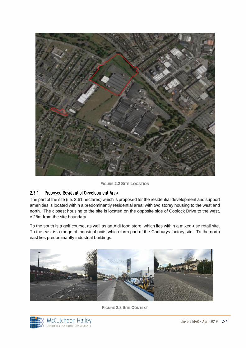
FIGURE 2.2 SITE LOCATION
The part of the site (i.e. 3.61 hectares) which is proposed for the residential development and support
amenities is located within a predominantly residential area, with two storey housing to the west and
north. The closest housing to the site is located on the opposite side of Coolock Drive to the west,
c.28m from the site boundary.
To the south is a golf course, as well as an Aldi food store, which lies within a mixed-use retail site.
To the east is a range of industrial units which form part of the Cadburys factory site. To the north
east lies predominantly industrial buildings.
FIGURE 2.3 SITE CONTEXT
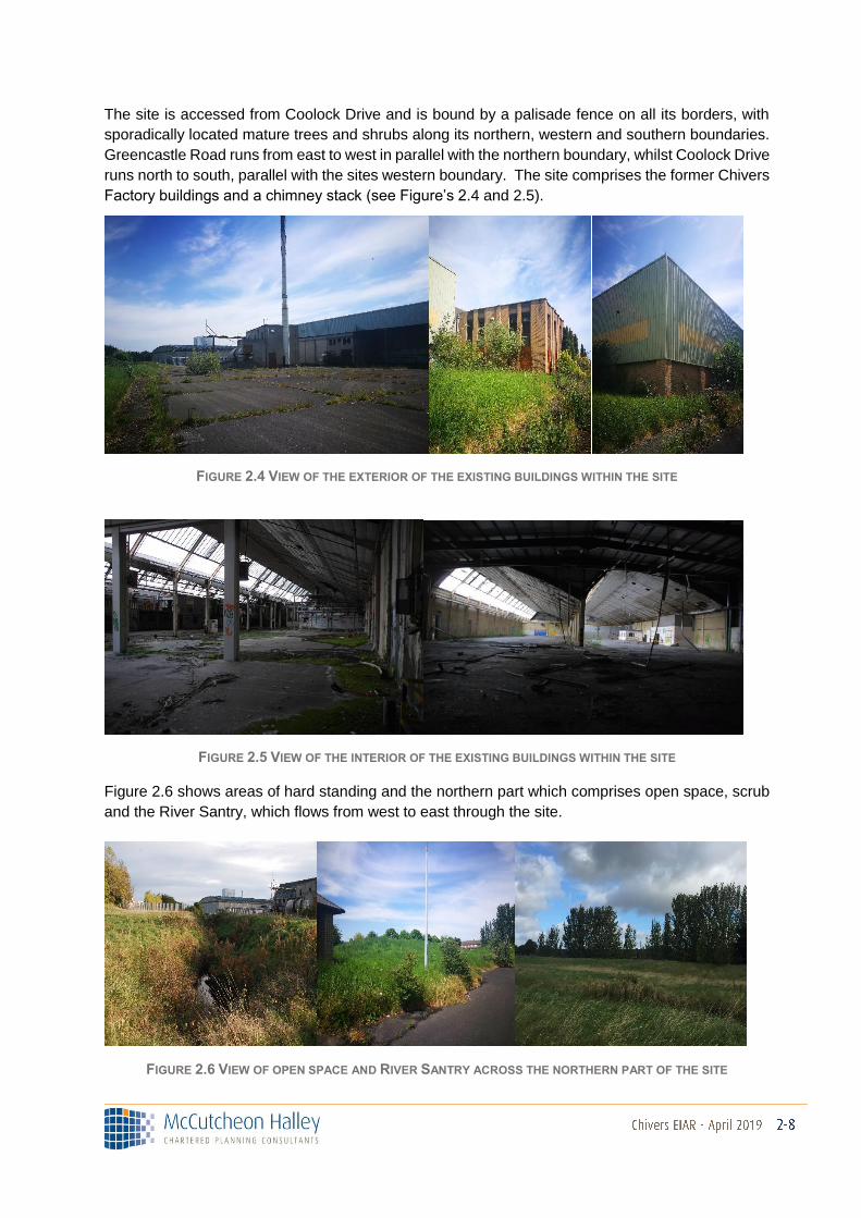
The site is accessed from Coolock Drive and is bound by a palisade fence on all its borders, with
sporadically located mature trees and shrubs along its northern, western and southern boundaries.
Greencastle Road runs from east to west in parallel with the northern boundary, whilst Coolock Drive
runs north to south, parallel with the sites western boundary. The site comprises the former Chivers
Factory buildings and a chimney stack (see Figure’s 2.4 and 2.5).
FIGURE 2.4 VIEW OF THE EXTERIOR OF THE EXISTING BUILDINGS WITHIN THE SITE
FIGURE 2.5 VIEW OF THE INTERIOR OF THE EXISTING BUILDINGS WITHIN THE SITE
Figure 2.6 shows areas of hard standing and the northern part which comprises open space, scrub
and the River Santry, which flows from west to east through the site.
FIGURE 2.6 VIEW OF OPEN SPACE AND RIVER SANTRY ACROSS THE NORTHERN PART OF THE SITE
Topographically, the site is broadly level on the areas occupied by the buildings and hard standing
areas, whilst the levels in the open space area to the north fluctuate.
This part of the application site measures c. 0.25 hectares, which is in two distinct areas. The first
comprises lands at Greencastle Road and Coolock Drive that includes the existing public highway
and footpath, located immediately adjacent to the Former Chivers Factory site. This is included for
pedestrian improvements, which form part of this planning application.
A further area is located c. 220m to the south of the proposed residential / local pedestrian
improvements area. The land currently comprises the existing Oscar Traynor Road / Coolock Drive
Road, as well as the connecting junction area.
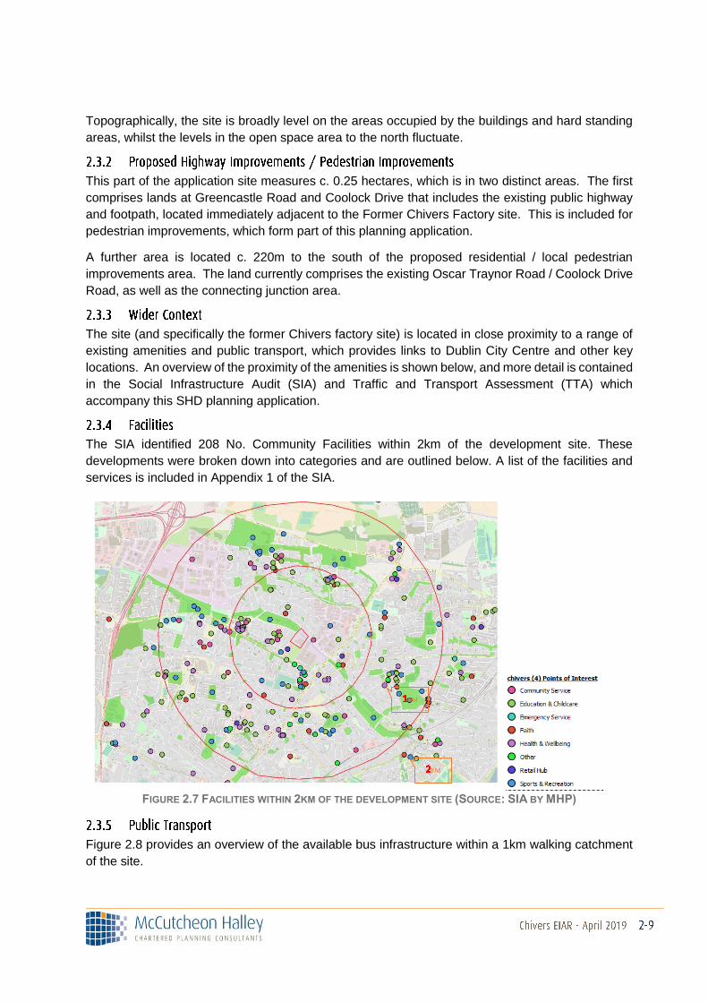
The site (and specifically the former Chivers factory site) is located in close proximity to a range of
existing amenities and public transport, which provides links to Dublin City Centre and other key
locations. An overview of the proximity of the amenities is shown below, and more detail is contained
in the Social Infrastructure Audit (SIA) and Traffic and Transport Assessment (TTA) which
accompany this SHD planning application.
The SIA identified 208 No. Community Facilities within 2km of the development site. These
developments were broken down into categories and are outlined below. A list of the facilities and
services is included in Appendix 1 of the SIA.
FIGURE 2.7 FACILITIES WITHIN 2KM OF THE DEVELOPMENT SITE (SOURCE: SIA BY MHP)
Figure 2.8 provides an overview of the available bus infrastructure within a 1km walking catchment
of the site.
KM
KM
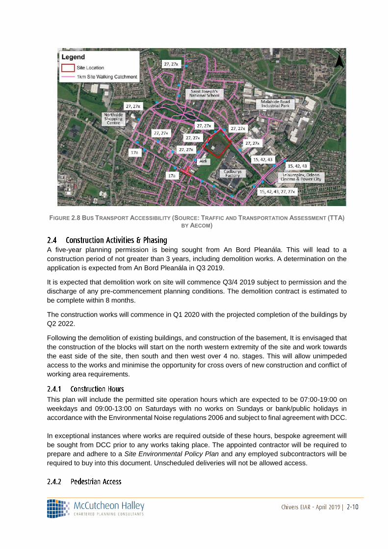
FIGURE 2.8 BUS TRANSPORT ACCESSIBILITY (SOURCE: TRAFFIC AND TRANSPORTATION ASSESSMENT (TTA) BY AECOM)
A five-year planning permission is being sought from An Bord Pleanála. This will lead to a
construction period of not greater than 3 years, including demolition works. A determination on the
application is expected from An Bord Pleanála in Q3 2019.
It is expected that demolition work on site will commence Q3/4 2019 subject to permission and the
discharge of any pre-commencement planning conditions. The demolition contract is estimated to
be complete within 8 months.
The construction works will commence in Q1 2020 with the projected completion of the buildings by
Q2 2022.
Following the demolition of existing buildings, and construction of the basement, It is envisaged that
the construction of the blocks will start on the north western extremity of the site and work towards
the east side of the site, then south and then west over 4 no. stages. This will allow unimpeded
access to the works and minimise the opportunity for cross overs of new construction and conflict of
working area requirements.
This plan will include the permitted site operation hours which are expected to be 07:00-19:00 on
weekdays and 09:00-13:00 on Saturdays with no works on Sundays or bank/public holidays in
accordance with the Environmental Noise regulations 2006 and subject to final agreement with DCC.
In exceptional instances where works are required outside of these hours, bespoke agreement will
be sought from DCC prior to any works taking place. The appointed contractor will be required to
prepare and adhere to a Site Environmental Policy Plan and any employed subcontractors will be
required to buy into this document. Unscheduled deliveries will not be allowed access.

Pedestrian access will be strictly controlled. Only Safepass accredited personnel will be permitted
on site and daily in-out attendance records will be maintained. Safe pedestrian access points will be
provided based on the stage of works and layout of the construction site.
Construction traffic will access the site via the existing access off Coolock Drive so as to minimise
disruption on other routes as illustrated below. The routing will be strictly managed and controlled,
and details will be incorporated into the traffic management plan.
On-site parking provision will be minimised to ensure travel by car is not encouraged while
simultaneously being aware of the need to facilitate vehicle travel due to the nature of the work and
seeking to avoid any potential overspill parking into the local area. Adequate numbers of cycle
parking will be provided for site personnel and personnel will be encouraged to use public transport
which is widely available in the surrounding area. A limited number of spaces will be provided for
visitors.
Based on a construction contract value of €100 million over a 150-week construction period, it is
estimated that 30,000-man weeks of onsite labour will be required for the project. Based on industry
standard figures it is likely that a peak of 300 construction personnel will be on site on a daily basis.
Based again on a construction contract value of €100 million over a 150-week construction period,
it is estimated that maximum construction vehicle flows will be of the order of 84 no. two way HGV
movements and 20 no. two way standard vehicle movements spread across the course of the day,
which is considerably less than the traffic expected to be generated by the operational stage of
development.
It is noted that a traffic management plan will be developed for the scheme. All works on the public
road will be carried out in accordance with the “Guidelines for Managing Openings in the Public
Road” published by the Department of Transport (2017).
There are two main types of construction waste – Hazardous and Non-hazardous. Non-hazardous
wastes typically generated at construction sites include;
• Timber Waste
• Scrap Metal
• Plastic
• Paper / Cardboard
• Canteen Waste
• Litter
Hazardous Wastes are defined as wastes which can have a harmful effect to the environment and
human health.
Non-hazardous wastes typically generated at construction sites include;
• Timber Waste
• Scrap Metal
• Plastic
• Paper / Cardboard
• Canteen Waste
• Litter
The hazardous wastes that may be experienced at a development of this nature are as follows:
• Adhesives and Sealants
• Asbestos
• Aerosols
• Batteries
• Chemicals
• Cleaning Products
• Oil (Contaminated absorbent Material or debris)
• Paints and Thinner
• Fuels, (hydrocarbons such as diesel)
The scheme will result in waste generation from the following activities;
• Demolition of the existing buildings
• Removal of the existing boundaries
• Removal of the existing hard standing areas
• Removal of soil to make way for construction
• Removal of Concrete foundations and similar
• Removal of existing landscaping
Emphasis has been put on the reuse and recycling throughout the design, construction and
operational phases and a whole life cycle approach to the selection of materials used in the building
with specific regard to the impact on the carbon footprint. Over 90% of the refuse on site and
demolition material will be recycled. If materials can be reused on site, they will.
The appointed contractor will be required to prepare a Construction Management Plan in advance
of works commencing on site. This will incorporate all mitigation measures proposed within this EIAR
for the protection of the environment and human health. Relevant conditions of planning will also be
included within the plan.
Monitoring will be undertaken during the demolition and construction phase in line with the
recommendations contained within Volume II of the EIAR.
Appropriate Air Quality and Dust monitoring will be carried out and records will be kept of all such
monitoring. Construction and demolition works will be carried out in such a way as to limit the
emissions to air of pollutants (particularly dust and fine particles (PM10)), employing Best Practicable
Means.
Noise monitoring will be carried out in accordance in accordance with Safety, Health and Welfare at
Work (Construction) Regulations 2006 – 2012 Safety, Health and Welfare at Work Act 2005, BS
6187:2011 - Code of Practice for Full & Partial Demolition, BS 5228:2009 Code of Practice for Noise
& Vibration Control on Construction & Open Sites.
Vibration monitoring will be carried out in accordance with BS 5228-1, 2009, Code of Practice for
Noise & Vibration Control on Construction & Open Sites.
Health & Safety issues will be the primary concern for the appointed Contractors. This will apply in
respect of persons working on the site and in respect of passing pedestrians, motorists or other
transport carriers. In this regard the highest possible care will be taken in providing a detailed
Construction Stage Health and Safety Plan in advance of works commencing on site.
It is intended to operate a Health, Safety & Environmental Management System in line with ISO
18001 & ISO 14001. This Management System translates the company policy into processes to
ensure safety, health and environmental responsibilities and performance can be monitored,
reported and improved.
A suitably qualified and competent Project Supervisor Design Process (PSDP) has been appointed
and a suitably qualified and competent Project Supervisor Construction Stage (PSCS) will be
appointed in line with those requirements laid down in the Safety, Health and Welfare at Work
Construction Regulations 2013.