Embed Size (px)
Citation preview
EXCAVATION OF THE PLACE 16 (MOUND 1)
In December 2015, it was established that place 16 "corresponds to a mound structure
made of stones and mortar, sometimes reinforced by the application of bahareque or baked clay".
Also, "the areas that make up the mound” were clearly established, and likewise it was
hypothesized that "its functionality was related to the production of salt”.
For a better understanding of the structure of the site, and therefore its functionality, it
was proceeded to perform controlled excavation of the site through surveys of stratigraphic
control of 2x2m, by artificial or arbitrary levels of 20 cm, while respecting the existing cultural
and natural strata; photographic documentation was previously made, and the grids of the area
to be disturbed were established, which would facilitate the excavation process and a better
control of the spatial distribution of evidences within the site (Image 2).
Image 1. Different views of Place 16 (Mound 1). Before archaeological excavations were carried out.
Southwest-Northeast view Northeast–Southwest view
Northwest-Southeast view Initial cleaning, general.

An excavation trench parallel to the north side of Structure E was considered; this was
given the measures of 12m long by 2m wide; in turn, this was divided into stratigraphic surveys
of 2x2m. In this trench, three squares of 2x2m were prioritized, which are S1D1, S1D4 and
S1D6, although other areas of the mound were also excavated. This would enable us to
compare internal and external stratigraphy on the slopes of Mound 1 (Image 2). In this way,
the thickness given to the construction of the mound and the natural stratigraphy that existed
prior to its construction can be known. Location of prioritized surveys:
- S1D1, located on the eastern side of the mound.
- S1D4, located on the north side of the structure E, top of the mound.
- S1D6, located on the
western side of the
mound.
Each square reflected in Image 2,
measures 2x2m. Based on this
order, the findings were
controlled and drawings were
made.
Image 2. The drawing shows a grid made for the excavation of place 16. The shaded area shows the 2x2m surveys that were excavated. The
dashed red Line indicates the sector with the structures.
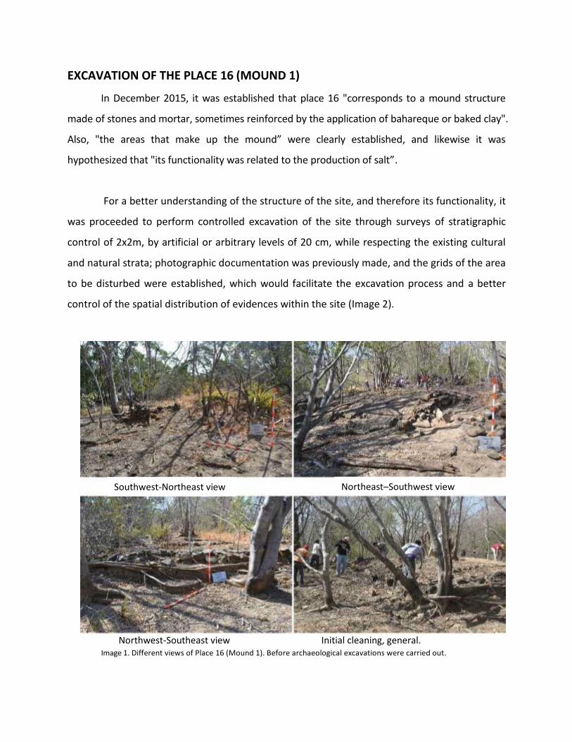
Through this research process, it was established that place 16 corresponds to a mound that
was built and used for ritual purposes in pre-Hispanic times, between 800- 1520 AD; later, long
after the European contact in the second half of the twentieth century, the site was reused to
develop a workshop where salt was processed in a traditional way.
The proximity to the mangrove, and variations in terrain height, facilitated the development
of craft workshops of salt in that area. The total area of the mound is 338 m2, which includes
three structures built of stones and mortar, measuring 18m in length in the NW-SE axis, 8m in
the NE-SW axis and 1.1m high with respect to the immediate surface of the land.
The excavation strategy implemented was explained in Methodology section.
Image 3. Distribution of spaces made in Sector 1, of the Mound 1 (place16). The red letters reflect the alphabetical order that was assigned to the space, in ascending order from Northwest to Southeast.
Place 16
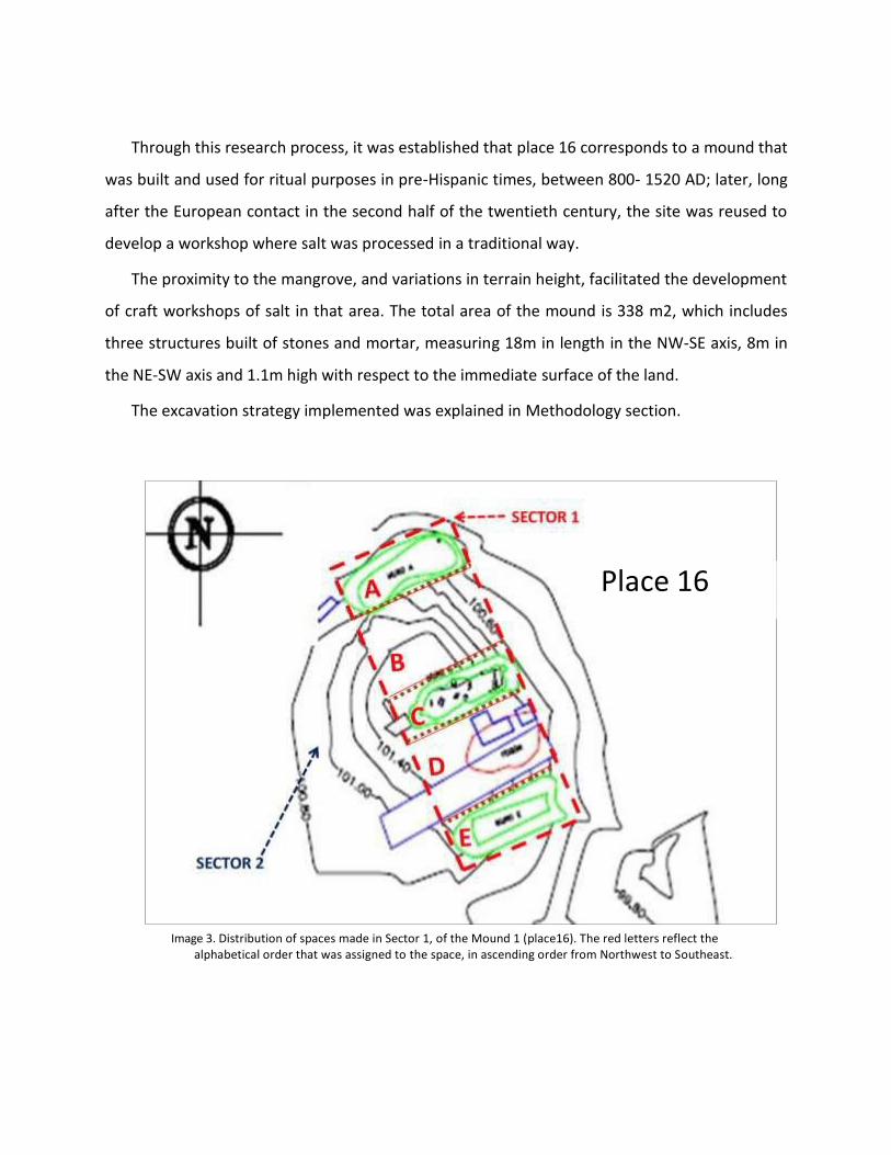
Three structures built of calcareous rocks, sandstone and sedimentary rocks, consolidated
with a mixture of lime, sand and soil have been identified in this site; according to the plan
view, all are U-shaped, arranged in parallel from NW to SE, and NE-SW oriented, with mouth
opening towards the northeast, coinciding with the mangrove area (Image 3). These structures
correspond to furnaces that were used for salt production by cooking brine in the second half
of the twentieth century.
Inside each of the structures, and along the same, very rusty metal debris was identified,
clear evidence of metal containers or pots that were used in baking brine. Five pairs of
elements that served as handles and circular caps that served as mouths to drain fluids into
the mangroves were found.
1- MODERN STRUCTURES (late occupation of the site):
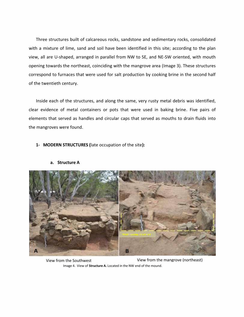
a. Structure A
Image 4. View of Structure A. Located in the NW end of the mound.
View from the Southwest View from the mangrove (northeast)
Mouth opening , structure A
It is located on the northwest end of the mound 1, is U-shaped with mouth or mouth
opening of the furnace facing the mangrove; is through this place where the combustible raw
material (firewood) for cooking salt was introduced. It is 8m long in the southwest-northeast
axis, 2 m wide at the NE end (furnace mouth) and 1.80m at the SW end. The depth of this
furnace is 0.80m at the NE end and 0.60 at the NW end (Image 4).
Differences can be observed in the construction of the side walls. The wall located on the
left side (according to image 4A) is 85cm deep in the highest part, made from calcareous rocks,
sandstone and sedimentary rocks, where mortar made of lime and sand was used to its
compaction; instead, the wall on the right side showed only 30cm deep, only to level the field,
because it was built basically with modern bricks and compacted with lime and sand.
Approximately 40% of the structure was excavated.
This reflects the adaptation of the walls to level the structure that would be built with
respect to the highest part of the NW slope of the mound. The original gradient of the mound
descends toward the NW end, so it became necessary to invest more raw materials and
greater effort in the construction of the wall at that end.
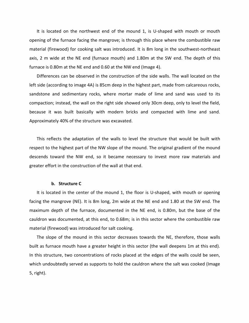
b. Structure C
It is located in the center of the mound 1, the floor is U-shaped, with mouth or opening
facing the mangrove (NE). It is 8m long, 2m wide at the NE end and 1.80 at the SW end. The
maximum depth of the furnace, documented in the NE end, is 0.80m, but the base of the
cauldron was documented, at this end, to 0.68m; is in this sector where the combustible raw
material (firewood) was introduced for salt cooking.
The slope of the mound in this sector decreases towards the NE, therefore, those walls
built as furnace mouth have a greater height in this sector (the wall deepens 1m at this end).
In this structure, two concentrations of rocks placed at the edges of the walls could be seen,
which undoubtedly served as supports to hold the cauldron where the salt was cooked (Image
5, right).
Soportes
Image 5. Structure C. Located in the central area of the mound. Note the metallic elements inside the construction system of this furnace.
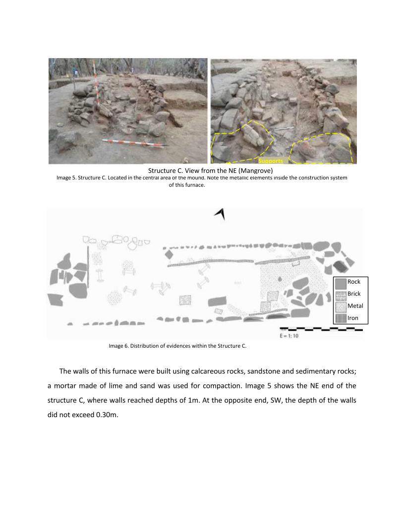
Image 6. Distribution of evidences within the Structure C.
The walls of this furnace were built using calcareous rocks, sandstone and sedimentary rocks;
a mortar made of lime and sand was used for compaction. Image 5 shows the NE end of the
structure C, where walls reached depths of 1m. At the opposite end, SW, the depth of the walls
did not exceed 0.30m.
Structure C. View from the NE (Mangrove) NENN(northeast)
Supports
Rock
Brick
Metal
Iron
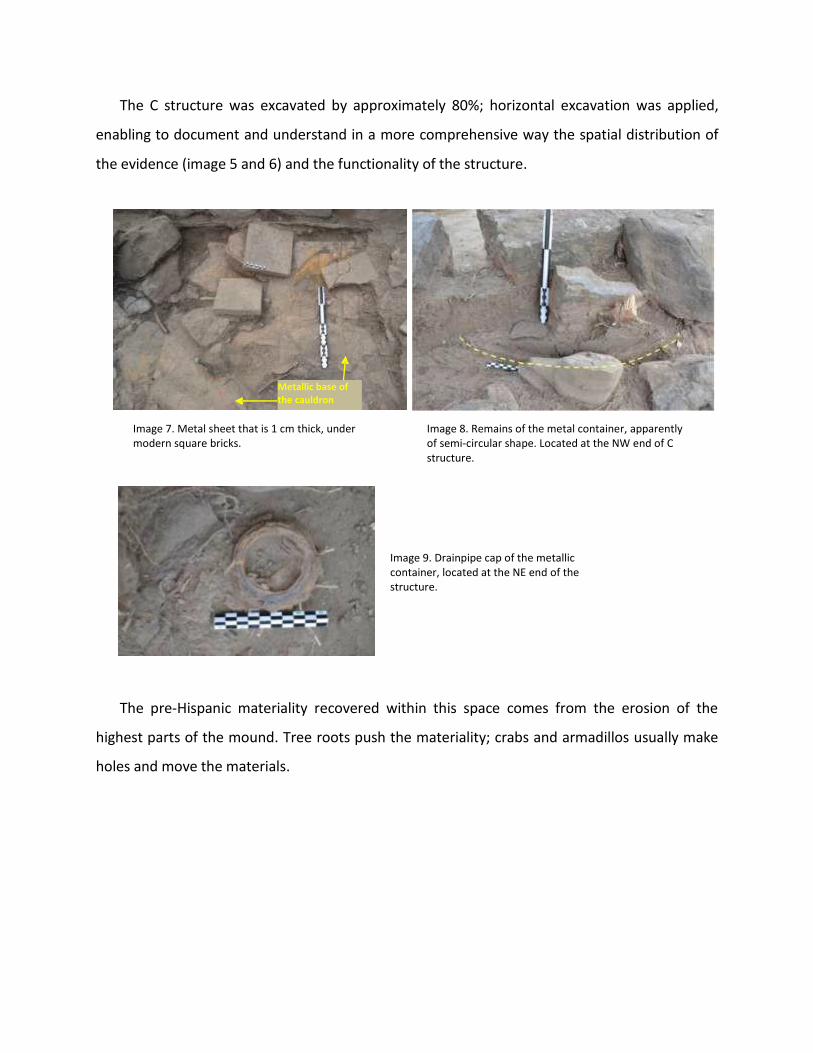
The C structure was excavated by approximately 80%; horizontal excavation was applied,
enabling to document and understand in a more comprehensive way the spatial distribution of
the evidence (image 5 and 6) and the functionality of the structure.
Base metálica del Caldero
Imagen 7. Plancha metálica de 1cm de grosor, debajo de ladrillos cuadrados modernos.
Imagen 8. Restos del contenedor metálico, de aparente forma semi circular. Localizado en el extremo NW de la
estructura C.
Imagen 9. Tapa de desagüe del contenedor metálico localizado en el extremo NE la estructura.
The pre-Hispanic materiality recovered within this space comes from the erosion of the
highest parts of the mound. Tree roots push the materiality; crabs and armadillos usually make
holes and move the materials.
Image 9. Drainpipe cap of the metallic container, located at the NE end of the structure.
Image 8. Remains of the metal container, apparently of semi-circular shape. Located at the NW end of C structure.
Image 7. Metal sheet that is 1 cm thick, under modern square bricks.
Metallic base of the cauldron

Image 10. Distribution of evidences within Structure C. Central Image corresponds to a representation by means of Photogrammetry.
Image 11. Construction system of structure C. NE End.
Metal handles
Remains of cylindrical metal container. Southwest end of the structure A.
Metal plate Bottom of the container

c. Structure E.
It is located in the southeast end of the mound 1, as in the two previous cases, it has an U-
shaped floor, with the mouth or opening towards the mangrove (NE). It is 8m long, 1.80m wide
at the NE end and 1.80 at the SW end. The depths of this furnace are not known, because the
structure was not excavated. But the characteristics and component elements are similar to
those documented in the other two structures. Note the mangrove area, which is next to the
site, at the back of the Image 12 (right).
The structure E was not excavated, as a preventive measure, because it was considered
important to at least one sector of the site intact, with the possibility of future interventions.
Image 12. Structure E. Located in the south end of the mound. At the back (right picture) the mangrove is observed.
Materiality of the structures
The material recovered inside the structures corresponds to small rusted metal plates that
have been detached from the decomposition or deterioration caused for having been subject to
fire, and then due to the effects of biotic natural agents and the passage of time. Fragments of
edges, bases and handles of metal cauldrons that existed there have been identified.
View from the Northeast (Mangrove) NENN(northeast)
Structure E. View from the Southwest. The mangroves at the back. (Mangrove) NENN(northeast)
In all structures, square bricks made in the mid-twentieth century (of 23 x 23 x 4cm), an
element that was used to form and level the walls that would hold the cauldron, have been
documented; some bricks were cut into two parts to facilitate its location on the walls.
There is little archaeological material within these structures, mostly ceramic material
provided by the erosion of the site, from the highest parts.
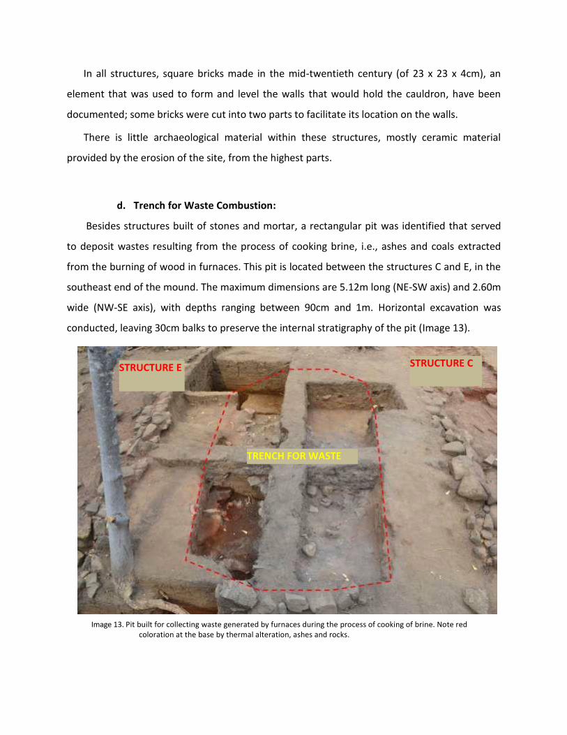
d. Trench for Waste Combustion:
Besides structures built of stones and mortar, a rectangular pit was identified that served
to deposit wastes resulting from the process of cooking brine, i.e., ashes and coals extracted
from the burning of wood in furnaces. This pit is located between the structures C and E, in the
southeast end of the mound. The maximum dimensions are 5.12m long (NE-SW axis) and 2.60m
wide (NW-SE axis), with depths ranging between 90cm and 1m. Horizontal excavation was
conducted, leaving 30cm balks to preserve the internal stratigraphy of the pit (Image 13).
Image 13. Pit built for collecting waste generated by furnaces during the process of cooking of brine. Note red coloration at the base by thermal alteration, ashes and rocks.
TRENCH FOR WASTE
STRUCTURE C STRUCTURE E

For the preparation of this, only one pit was opened on the existing pre-Hispanic mound
and the base of the pit was arranged with calcareous rocks (Image 13, 14 and 15). This would
enable the collection of ash waste and coal generated by the burning in furnaces in order to
avoid the dispersion of this
waste in the space used
for processing salt in its
various stages.
’
The sedimentary
matrix of this pit
consisted of
ashes, coals, a
level of thermal-
altered sand and
associated to the
rocks base,
oxidized metal
debris.
Image 14. Floor scale drawing corresponding to the pit or waste collection area.
’
’
Image 15. Profile or South section of the pit for waste. Cross Section E-W.
Little archaeological material (especially ceramic) integrated into this space as a result of the
erosion of the site and by the strong biological activity (crabs and roots) that easily move
materials. Notice in the image 13, 15 and 16, the stratigraphy and slope of the field in the waste
pit area.
Fire pit No. 1 Square S1. D2. B3. D4
South profile Fire pit Nº1 Square: D8/D9
Humus
Ash
Sand
Rocks
Burrow

’
’ ’
Image 16. Scale drawing of Profile or East section of the waste pit. North South cut.
Image 17. Hypothetical reconstruction of one of the furnaces represented on the place 16.
Based on the evidence recovered in situ.
Image 18. Artisan furnace used in the twentieth century
for salt processing in communities of Colombia.
Humus
Ash and coal
Sand and Ash
East profile Fire pit Nº1 Square: D2/D8
It is worth noting at this point that after conducting consultations among the inhabitants of
the territory, it was known that there was a man named Germán Bermúdez who carried out salt
extraction works in the study area. Bermúdez is 57 years old and at the age of 14 he worked
extracting salt using traditional methods with Don Celestino Flores (qnpd), a local salt producer,
in 1973.
Bermudez (personal communication April 2016) described in detail the process of extracting
salt as it was carried out in this site:
1- The three furnaces were built with mouth or opening towards the mangroves, so that
the wind would help in the combustion of wood.
2- A large cauldron was placed where the water extracted from the mangrove would be cooked.
3- Rectangular basins for brackish water catchment were built, at the edge of the mound,
by gravity, these basins were filled with water from the mangrove and once heavy
minerals had settled, it was moved to the cauldron with the support of a water engine.
4- Subsequently, the brine was cooked and crystallized salt was gradually placed in a suitable space between the structure A and C.
5- Furnace waste (ashes and coals) were dumped into a pit built between structure C and E,
to avoid polluting the basins spaces.
6- It is not the only existing structure, there are other at the banks of the mangrove, located
in some of the existing hills. The information matched in part the evidence reported in
the 2015 survey (for example, the stone access documented in place 14).
7- He noted that fragments of clay pots already existed before they began to work in the
area. When excavating the trenches to build the walls of the furnaces, many little pots
broken out there. It was always said that these pots had been made by very ancient
people.
The information provided by Mr. Germán allowed to clarify many of the elements identified in
this archaeological context, a better understanding of the formation of the site and determine

the factors that have deteriorated it. In fact, the materiality found and analyzed, in addition to
the interview with Germán, made possible to determine that the last occupation of the site
occurs in the mid-twentieth century.
2- PRE-HISPANIC FINDINGS (the oldest occupations):
The first occupation of this site, and therefore the oldest one, corresponds to pre-Hispanic
societies that made use of that space between 800 and 1520 AD, according to the
archaeological materiality recovered and analyzed. It is in this period when the mound is built
with materials from the environment, basically sand and soil, which incidentally suggests,
according to materiality recovered, a not so complex functionality linked with ritual spaces,
possibly funeral.
Image 19. Scale drawing, profile or section on the west slope of Mound 1 (S1D6). It is outstanding the area of ceramic concentration and the paleosol on which the mound was built. It is defined as sterile level due to the absence of archaeological material.
’
’
Area of ceramic concentration
Sterile level or Paleosol
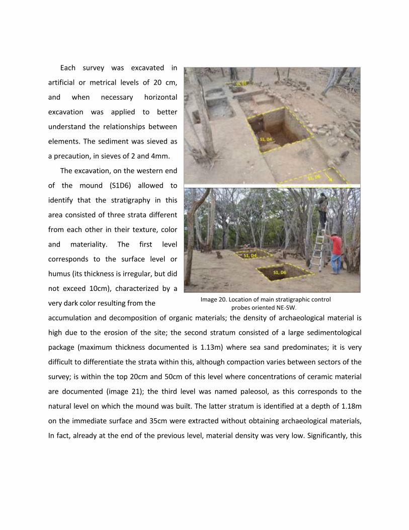
Each survey was excavated in
artificial or metrical levels of 20 cm,
and when necessary horizontal
excavation was applied to better
understand the relationships between
elements. The sediment was sieved as
a precaution, in sieves of 2 and 4mm.
The excavation, on the western end
of the mound (S1D6) allowed to
identify that the stratigraphy in this
area consisted of three strata different
from each other in their texture, color
and materiality. The first level
corresponds to the surface level or
humus (its thickness is irregular, but did
not exceed 10cm), characterized by a
very dark color resulting from the
Image 20. Location of main stratigraphic control probes oriented NE-SW.
accumulation and decomposition of organic materials; the density of archaeological material is
high due to the erosion of the site; the second stratum consisted of a large sedimentological
package (maximum thickness documented is 1.13m) where sea sand predominates; it is very
difficult to differentiate the strata within this, although compaction varies between sectors of the
survey; is within the top 20cm and 50cm of this level where concentrations of ceramic material
are documented (image 21); the third level was named paleosol, as this corresponds to the
natural level on which the mound was built. The latter stratum is identified at a depth of 1.18m
on the immediate surface and 35cm were extracted without obtaining archaeological materials,
In fact, already at the end of the previous level, material density was very low. Significantly, this
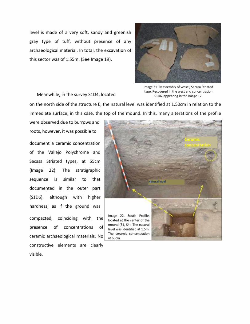
level is made of a very soft, sandy and greenish
gray type of tuff, without presence of any
archaeological material. In total, the excavation of
this sector was of 1.55m. (See Image 19).
Meanwhile, in the survey S1D4, located
Image 21. Reassembly of vessel, Sacasa Striated type. Recovered in the west end concentration
S1D6, appearing in the image 17.
on the north side of the structure E, the natural level was identified at 1.50cm in relation to the
immediate surface, in this case, the top of the mound. In this, many alterations of the profile
were observed due to burrows and
roots, however, it was possible to
document a ceramic concentration
of the Vallejo Polychrome and
Sacasa Striated types, at 55cm
(Image 22). The stratigraphic
sequence is similar to that
documented in the outer part
(S1D6), although with higher
hardness, as if the ground was
compacted, coinciding with the
presence of concentrations of
ceramic archaeological materials. No
constructive elements are clearly
visible.
Image 22. South Profile, located at the center of the mound (S1, S4). The natural level was identified at 1.5m. The ceramic concentration at 60cm.
Natural level
Ceramic concentration
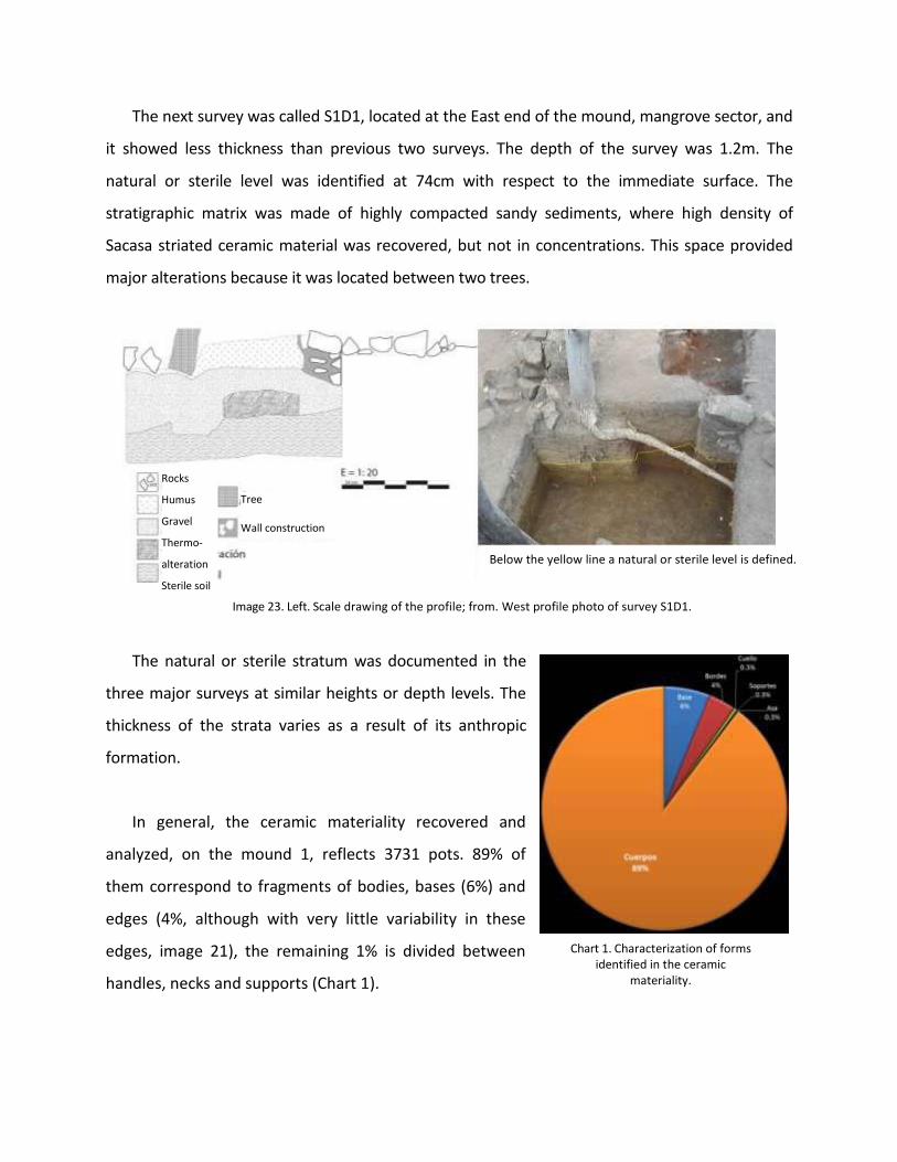
The next survey was called S1D1, located at the East end of the mound, mangrove sector, and
it showed less thickness than previous two surveys. The depth of the survey was 1.2m. The
natural or sterile level was identified at 74cm with respect to the immediate surface. The
stratigraphic matrix was made of highly compacted sandy sediments, where high density of
Sacasa striated ceramic material was recovered, but not in concentrations. This space provided
major alterations because it was located between two trees.
’ ’
Below the yellow line a natural or sterile level is defined. ’
Image 23. Left. Scale drawing of the profile; from. West profile photo of survey S1D1.
The natural or sterile stratum was documented in the
three major surveys at similar heights or depth levels. The
thickness of the strata varies as a result of its anthropic
formation.
In general, the ceramic materiality recovered and
analyzed, on the mound 1, reflects 3731 pots. 89% of
them correspond to fragments of bodies, bases (6%) and
edges (4%, although with very little variability in these
edges, image 21), the remaining 1% is divided between
handles, necks and supports (Chart 1).
Chart 1. Characterization of forms identified in the ceramic
materiality.
Rocks
Humus
Gravel
Thermo-
alteration
Sterile soil
Tree
Wall construction

The typological analysis showed that 49% of the ceramic material corresponds to diagnostic
elements of the Sacasa Striated type, 3% Rivas Red, 1% Papagayo Polychrome and 1% Vallejo
Polychrome (Graph 2). These elements are commonly found in archaeological contexts of the
Nicaraguan Pacific, associated with funeral customs;
however it is worth noting that no bones were found
associated with the major concentrations of
ceramic materials, or dispersed materials, i.e., there is an
absence of bones, but the biological and environmental
factors of degradation must be taken into account. The
remaining 46% comprises non-diagnostic sherds.
The main concentrations were located between 30 and Graph 2. Ceramic typology identified on the place 16.
50 cm deep, with respect to the immediate ground surface. In some of them it was possible to
carry out reassemblies (Image 18, 21 and 22), which shows that there was a deposit of
complete vessels there. In other cases there was variability in the pieces that made up the
concentration, probably due to post-depositions alterations, as can seen in Image 22; in
addition to Sacasa Striated ceramics, a small highly fragmented ceramic concentration of the
Vallejo Polychrome type has been identified, which is associated with a very well documented
funeral pattern in the Nicaraguan Pacific.
Image 25. Ceramic concentration located in the eastern sector of the mound. At the banks of the structure C. 40 cm
deep with respect to the immediate surface.
Istmo Common 46%
Sacasa Striated 49%
Rivas Red 3% Papagayo Polychrome 1%
Vallejo Polychrome 1%
Vallejo polychrome concentration
Sacasa Striated concentration

In image 26 (dashed red circle)
one of the many existing
concentrations on the mound 1 can
be observed; this was located 30cm
below the wall and was impacted by
the construction of Structure A, to
the same depth as the other
documented concentrations; the
level of the ceramic deposits found
is clearly marked.
Image 26. Documented concentration under the walls that make up the structure A. In the back of the picture, the mangrove area can be seen, which corresponds to white salt remaining as a result of
the evaporation caused by the sun.
The variety of decorations on the ceramic materiality is reduced to body elements with
with linear appliques on which nail imprints
were made (Image 27). Most appliques were
made on Sacasa Striated-type pots. The
fragments painted, mostly, belong to the Vallejo
Polychrome and Papagayo Polychrome type
(Image 28), although ceramic elements of the
Luna Polychrome, Black Lake and Castillo
Engraved type were also identified, all of them
chronologically located between the periods
Sapoá and Ometepe (800 to 1550 AD,
respectively). The presence of earlier
periods is minimum (1 Tola Trichrome pot
and 1 Segovia Naranja).
Reassemblable ceramic concentration, Sacasa Striated type, 30 cm under the base of the wall
Image 27. Shows variety of appliques and imprints identified on the place 16.

Image 28. It shows painted elements, which belong to later periods. Left. Vallejo Polychrome; Right, Papagayo polychrome.
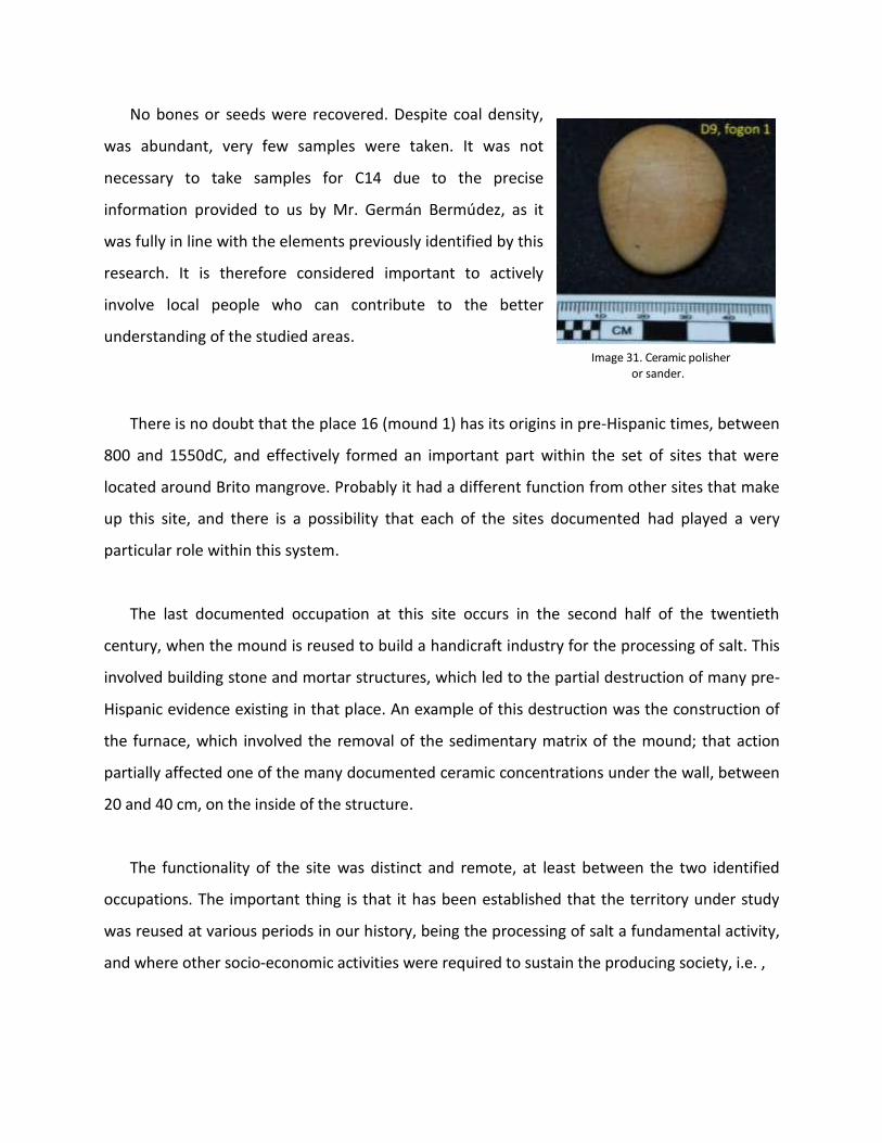
The lithic industry is very scarce. In total, 8 artifacts
made in andesite and calcite. Some pieces with the shape
of scrapers, modified by bifacial and unifacial retouches
(image 29, 30 and 31) were identified; an element with
micro-polished surface by the use to which it was
subjected, polisher or ceramic sanders; also a core with
multiple extractions and fragments generated as debris of
the carving were recovered.
Image 29. Possible scrapers.
Image 30. Left, core and right, debris of carving.
No bones or seeds were recovered. Despite coal density,
was abundant, very few samples were taken. It was not
necessary to take samples for C14 due to the precise
information provided to us by Mr. Germán Bermúdez, as it
was fully in line with the elements previously identified by this
research. It is therefore considered important to actively
involve local people who can contribute to the better
understanding of the studied areas.
Image 31. Ceramic polisher or sander.
There is no doubt that the place 16 (mound 1) has its origins in pre-Hispanic times, between
800 and 1550dC, and effectively formed an important part within the set of sites that were
located around Brito mangrove. Probably it had a different function from other sites that make
up this site, and there is a possibility that each of the sites documented had played a very
particular role within this system.
The last documented occupation at this site occurs in the second half of the twentieth
century, when the mound is reused to build a handicraft industry for the processing of salt. This
involved building stone and mortar structures, which led to the partial destruction of many pre-
Hispanic evidence existing in that place. An example of this destruction was the construction of
the furnace, which involved the removal of the sedimentary matrix of the mound; that action
partially affected one of the many documented ceramic concentrations under the wall, between
20 and 40 cm, on the inside of the structure.
The functionality of the site was distinct and remote, at least between the two identified
occupations. The important thing is that it has been established that the territory under study
was reused at various periods in our history, being the processing of salt a fundamental activity,
and where other socio-economic activities were required to sustain the producing society, i.e. ,

a variety of everyday activities were performed, in parallel with the processing of salt (hunting,
eating, cooking, grinding, rituals, trade, etc.).
The environmental conditions of this area are not favorable to the preservation of organic
remains, which has been evidenced in the absence of bones, seeds and high degree of
deterioration of the ceramic material surface. The relative proximity to the beach and the
location of the site in the surroundings of the mangrove generate high humidity and salinity of
water resources; also intense biological activity typical of the environment (roots, crabs, reptiles,
etc.).