Embed Size (px)
Citation preview

Evaluation of Conservation Performance in
Cropland Regions of the United States Using
Process-Based Models
HO-YOUNG KWON1, CARMEN M. UGARTE1, SUSAN S. ANDREWS2, AND MICHELLE M. WANDER1
1. DEPART. OF NATURAL RESOURCES & ENVIRONMENTAL SCIENCES, UIUC 2. NATIONAL SOIL QUALITY AND ECOSYSTEMS BRANCH , LINCOLN, NE
1

Conservation Stewardship Program (CSP)
• A comprehensive conservation program of USDA-NRCS
Address particular resource concerns related to various ecosystem
services provided by a given farm management practice
Encourage producers to manage, maintain, and expand
conservation activities on their lands by rewarding payments to them
• Application procedures
Verify program eligibility and submit an application form to local
NRCS
Score the applicant’s current and planned conservation practices
using Conservation Measurement Tool (CMT)
Determine the payments that the producer will receive if the
applicant ranks for funding
2
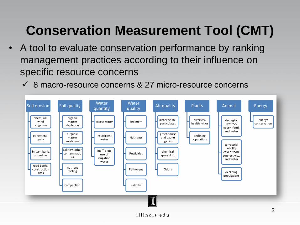
Conservation Measurement Tool (CMT)
• A tool to evaluate conservation performance by ranking
management practices according to their influence on
specific resource concerns
8 macro-resource concerns & 27 micro-resource concerns
3

4
sheet,
rill
, w
ind,
irrigation,
ephem
era
l, g
ully
str
eam
bank,
shore
line*
road b
anks,
constr
uction
sites*
1 Enter the length of your rotation in “years” .
Based on your rotation, enter the number of your harvested crops that are included in each residue
category (a-e). These questions have crops grouped based on residue quality and quantity. Do not include
cover crops in your responses.
a) Enter the number of years in your rotation that include the following conditions: bare fallow crop
periods (both chemical and tilled fallow), idle bare fields, or harvested sod. -5 -5 0 0
b) Enter the number of harvested crops in your rotation that are included in the list below or included
in the comments (or are similar to those listed if not listed): Asparagus, Beans dry edible, Beets, Broccoli,
Cabbage, Carrots, Strawberries, Vegetables, or similar crops. -3 -3 0 0
c) Enter the number of harvested crops in your rotation that are included in the list below (or are
similar to the list below if not listed): Buckwheat, Canola, Chicory, Coffee, Corn silage, Cotton, Flaxseed, Guar,
Hops, Lentils, Peanuts, Pineapples, Potatoes, Safflower, Soybeans, Sugarbeets, Sunflower, Tobacco, or
similar crops (see list). 0 0 0 0
d) Enter the number of harvested crops in your rotation that are included in the list below (or are
similar to the list below if not listed): Amaranth, Berry/Fruit Crops (Trees and Shrubs), Corn Grain/Popcorn,
Cranberries, Mint all for oil, Mushrooms, Nut Trees, Rapeseed, Rice, Small Grains, Sorghum all, Sugarcane,
or similar crops (see list). 3 3 0 0
e) Enter the number of harvested crops in your rotation that are included in the list below (or are
similar to the list below if not listed): Dichondra, Grass Hay/Seed, Legume Hay /Seed, Lotus root, or similar
herbaceous perennial crops. 5 5 0 0
Soil Erosion Concerns
2
macro-concern
micro-
concerns
scores

• Like other expert systems relied on expert judgment and
available technical information, some factors are simplified
while others are emphasized
Are including local information (e.g. local soil and climatic
characteristics) better?
Are weights correct?
5
Improvement of the CMT needed?
Questions, enhancements, and
conservation practices
Soil Erosion
Concerns
Soil Quality
Functions
sheet, rill, wind,
irrigation
organic matter
depletion (habitat,
compaction,
water
partitioning)
Score
Residue management practices 3 3
Contouring 2 1
Strip cropping 2 2
Terraces 1 0
Contour buffer strips 3 3

• Develop an evaluation framework to investigate the
performance of the CMT in US cropland regions by
utilizing process-based models
Generate county-specific scenarios for key conservation
practices related to proxies for soil erosion and soil quality
resources concerns that considered by CMT
Simulate these scenarios using RUSLE2 for soil erosion rate,
the soil conditioning index and surrogate CENTURY for soil C
sequestration rates
Analyze the influence of regions and practices on model
predictions
6
Objective
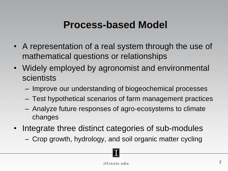
• A representation of a real system through the use of
mathematical questions or relationships
• Widely employed by agronomist and environmental
scientists
– Improve our understanding of biogeochemical processes
– Test hypothetical scenarios of farm management practices
– Analyze future responses of agro-ecosystems to climate
changes
• Integrate three distinct categories of sub-modules
– Crop growth, hydrology, and soil organic matter cycling
Process-based Model
7

8
• Phenology • Leaf area dynamics • Radiation interception • C and nutrient partitioning
Crop growth
• Evapotranspiration • Runoff • Drainage and irrigation
Hydrology
• SOM decomposition • Allocation of C and nutrients to SOM
pools
Soil organic matter (SOM) cycling
• Climate data
o Precipitation,
temperature, and solar
radiation
• Soil characteristics
o Texture, water holding
capacity, and saturated
hydrologic conductivity
• Management options
o Crop cultivar, planting date
and density, fertilizer
application rate, and tillage
Soil Organic Matter Cycling
Crop growth
Hydrologic process
o Crop yields
o Agronomic indices
(harvest index and
root to shoot ratio)
o Soil C sequestration
o Greenhouse gas
emissions
o Nutrient leaching

1. Select process-based models to generate model’s
predictions varied with specific field conditions
• Model’s predictions can be related to soil erosion and
soil quality macro-concerns
• RUSLE2 (Revised Universal Soil Loss Equation 2)
Estimate water erosion rates (Mg soil lost ha-1 yr-1) and soil
conditioning index (SCI )
• Surrogate CENTURY
Predict soil C sequestration rate (Mg C ha-1 yr-1)
9
Evaluation Framework

• Predict soil erosion using information about topography,
weather, soil type, soil cover management, and soil
erosion reducing practices
• Also calculate soil conditioning index (SCI)
Expresses the effects of the system on organic matter trends as a
primary indicator of soil condition
Provides a means to evaluate and design conservation systems
that maintain or improve soil condition
OM accounts for organic material returned to the soil, FO
represents field operation effects, ER is the sorting and removal
of surface soil material by sheet, rill and/or wind erosion
10
RUSLE2
0.4 0.4 0.4SCI OM FO ER

11
• Applied across wide
biogeographical
ranges and spatial
scales
• Adapt multiple “pool”
structure to model
soil C changes as a
function of land use
history, weather, soil
texture, and
management
practices
CENTURY soil organic matter model

Surrogate CENTURY
• Mass balance and decomposition kinetics equations for
CENTURY’s pools and C flows are coded and solved
using the PROC MODEL of SAS
Efficiently run simultaneous CENTURY simulations for various
scenarios
• Important differences are
Decoupled from models of plant growth, nutrient cycling, and
hydrologic processes described within the CENTURY and
variants
Capable of accounting for soil erosion and compaction
12

13
2. Select key conservation practices modeled
Questions,
enhancements, and
conservation practices
Definition
Residue management
practices (no tillage)
Soil and residue is left undisturbed from harvest to planting except for nutrient
injection. Planting, drilling or nutrient application is done in a narrow seedbed or
slot created by coulters, row cleaners, or disk openers. No full-width tillage
operations are done
Contouring
A practice preparing the soil, planting and cultivating crops around a hill rather
than up and down the hill. Contour rows run around a slope nearly n the level. The
rows form hundreds of small dams to slow runoff
Strip cropping
A system of growing crops in approximately even width strips or bands on the
contour to reduce soil erosion. The crops are arranged so that a strip of meadow or
close growing crop is alternated with a strip of row crop
Terraces
Terraces are earthen structures that intercept runoff on moderate to steep slopes.
They transform long slopes into a series of shorter slopes. Terraces reduce the rate
of runoff and allow soil particles to settle out. The resulting cleaner water is then
carried off the field in a non-erosive manner.
Contour buffer strips
Strips of perennial vegetation alternated down the slope with wider cultivated
strips that are farmed on the contour. Contour buffers strips are usually narrower
than the cultivated strips. Vegetation in strips consists of adapted species of
grasses or a mixture of grasses and legumes.

3. Develop county-specific scenarios with or without
conservation practices
Scenarios represent dominant soil type and crop rotation at 60
selected counties
Utilize national statistics and remote sensing databases
14
State County Crop rotation Dominant soil type
Land
resource
region
State County Crop rotation Dominant soil type
California Monterey citrus-grapes Chualar loam, 0 to 2 % slopes
M Iowa Muscatine corn-soybean Walford silt loam, 0 to 2 percent slopes
California Yolo corn-corn Sacramento clay
M Iowa O'Brien corn-soybean Galva silty clay loam, 2 to 5 percent slopes
Colorado Larimer continuous corn Nunn clay loam, 1 to 3 % slopes
M Iowa Story corn-soybean Clarion loam, 2 to 5 % slopes
Montana Hill spring wheat-winter
wheat Telstad-Hillon loams, 0 to 4 % slopes
M Kansas Brown corn-soybean Wymore silty clay loam, 3 to 6 % slopes
North
Dakota Morton spring wheat-wheat Chama-Cabba silt loams, 3 to 6 % slopes
M Minnesota Dakota corn-soybean Waukegan silt loam, 0 to 1 % slopes
Kansas Clark continuous winter wheat Harney silt loam, 0 to 1 percent slopes
M Nebraska Saunders corn-soybean Yutan, eroded-Judson complex, 6 to 11 % slopes
Kansas Republic corn-soybean Crete silt loam, 1 to 3 % slopes
M South
Dakota Brookings corn-soybean Parnell silty clay loam, 0 to 1 % slopes
Kansas Riley corn-soybean Wymore silty clay loam, 1 to 3 % slopes
M Wisconsin Jefferson corn-soybean Wacousta silty clay loam
Texas Cochran continous cotton Amarillo fine sandy loam, 0 to 1 % slopes
N Alabama Dekalb corn-soybean Hartsells fine sandy loam, eroded, undulating
Texas Crosby continous cotton Pullman silty clay loam, 0 to 1 % slopes
N Alabama Limestone winter wheat-soybean Decatur silt loam slightly eroded undulating
Texas Hockley continous cotton Amarillo fine sandy loam, 0 to 1 % slopes
N Kentucky Caldwell corn-soybean Crider silt loam, 2 to 6 % slopes, eroded
Texas Howard continous cotton Acuff loam, 0 to 1 % slopes
N Ohio Clark corn-soybean Kokomo silty clay loam
Texas Lubbock continous cotton Acuff loam, 0 to 1 % slopes
N Ohio Jackson corn-soybean Doles silt loam, 0 to 3 % slopes
Wisconsin Barron corn-corn Santiago silt loam, 2 to 6 % slopes
N Ohio Madison corn-soybean Kokomo silty clay loam
Wisconsin Columbia corn-corn Wacousta mucky silt loam
N Ohio Pickaway corn-soybean Kokomo silty clay loam
Michigan Barry corn-soybean Marlette fine sandy loam, 2 to 8 % slopes
N Ohio Scioto corn-soybean Nolin silt loam, occasionally flooded
Michigan Monroe corn-soybean Pewamo clay loam
N Ohio Vinton corn-soybean Tioga fine sandy loam, frequently flooded
Illinois Champaign corn-soybean Drummer silty clay loam, 0 to 2 % slopes
N Ohio Wayne corn-soybean Canfield silt loam, 2 to 6 % slopes
Illinois Christian corn-soybean Virden silty clay loam, 0 to 2 % slopes
N Pennsylvania Somerset continous corn Berks-Weikert channery silt loams, 8 to 15 %
slopes
Illinois Macon corn-soybean Flanagan silt loam, 0 to 2 % slopes
P Alabama Henry cotton-peanut Dothan fine sandy loam, 0 to 2 % slopes
Illinois Pope corn-soybean Grantsburg silt loam, 4 to 7 % slopes
P Alabama Lee soybean-cotton Marvyn loamy sand, 1 to 6 % slopes
Illinois Warren corn-soybean Muscatune silt loam, 0 to 2 percent slopes
P Georgia Oconee hay Cecil sandy loam, 2 to 6 % slopes, eroded
Illinois Dekalb corn-soybean Elpaso silty clay loam, 0 to 2 % slopes
P Mississippi Lee continoous soybean Marietta loam
Indiana Tipppecanoe corn-soybean Drummer silty clay loam
P North
Carolina Iredell corn-soybean Tomlin sandy clay loam, 2 to 6 % slopes
Iowa Adair corn-soybean Colo-Ely silty clay loams, 2 to 5 % slopes
P Tennessee Madison continous corn Memphis silt loam, 2 to 5 % slopes
Iowa Boone corn-soybean Canisteo silty clay loam, 0 to 2 % slopes
R New York Clinton corn-corn Muskellunge silty clay loam, 0 to 3 % slopes
Iowa Chickasaw corn-soybean Clyde clay loam, 0 to 3 % slopes
S Maryland Prince
George corn-soybean Marr-Dodon complex, 5 to 10 % slopes
Iowa Floyd corn-soybean Clyde silty clay loam, 0 to 3 % slopes
S Pennsylvania Berks corn-corn Bedington-Berks complex, 8 to 15 % slopes
Iowa Hancock corn-soybean Canisteo clay loam, 0 to 2 % slopes
T South
Carolina Florence corn-soybean Goldsboro loamy sand
Iowa Jasper corn-soybean Tama silty clay loam, 2 to 5 percent slopes
1

4. Run scenarios
• RUSLE2 model runs
Use NRCS national RUSLE2 databases of climate, soil,
topography, and land use
• Surrogate CENTURY model runs
Reconstruct farming management history prior to the present
[pristine (before 1880), early-agricultural (1880-1950), modern-
agricultural (1951-2010), and projected period (2011-2015)]
Estimate C input rates to soil by using historical records of crop
yields and agronomic indices
Estimate weather effects on soil C decay from monthly
temperature and precipitation
Account for soil C loss due to soil erosion
15

16
5. Analyze model’s predictions
• Soil erosion rates, SCI, and soil C sequestration rates
modeled were sorted by Land Resource Region (LRRs)
to expedite a statistical analysis
LRR: a geographical area aggregated by particular patterns of
soils, geology, climate, water resources, and land use
• Statistically analyze the rates from conservation
practices by 4 LRRs
P (South Atlantic and gulf slope cash crops, forest, and livestock
region), H (Central great plains winter wheat and range region),
M (Central feed grains and livestock region), and N (East and
central farming and forest region)

17

ANOVA on modeled soil erosion rate
18
• Significant effects of LRR and practices on soil erosion
• No significant effect of interaction between the two LRR H
(KS, TX)
M
(IL, IN, IA, KS,
MN, NE, SD,
WI)
N
(AL, KY, OH, PA)
P
(AL, GA, MS,
NC, TN)
# counties studied 8 21 11 6
Mean rate
(Mg soil lost ha-1 yr-1)
1.87 2.78 3.41 8.85
Mean comparison A A A B
Practice No tillage Contouring Terrace Buffer strip Strip
cropping
Conventional
tillage
Mean rate
(Mg soil lost ha-1 yr-1)
1.77 3.02 4.45 4.52 5.25 6.36
Mean comparison A AB AC AD BD CD

ANOVA on modeled SCI
19
• Significant effects of LRR and practices on soil erosion
• No significant effect of interaction between the two LRR H
(KS, TX)
M
(IL, IN, IA, KS,
MN, NE, SD,
WI)
N
(AL, KY, OH, PA)
P
(AL, GA, MS,
NC, TN)
# counties studied 8 21 11 6
Mean (unitless) -0.11 0.24 -0.07 -0.65
Mean comparison B C B A
Practice No tillage Contouring Terrace Buffer strip Strip
cropping
Conventional
tillage
Mean (unitless) 0.38 -0.12 -0.23 -0.24 -0.29 -0.38
Mean comparison B A A A A A

ANOVA on modeled soil C sequestration
20
• Significant effects of LRR and practices on soil erosion
• No significant effect of interaction between the two LRR H
(KS, TX)
M
(IL, IN, IA, KS,
MN, NE, SD,
WI)
N
(AL, KY, OH, PA)
P
(AL, GA, MS,
NC, TN)
# counties studied 8 21 11 6
Mean rate
(Mg soil C ha-1 yr-1)
-0.02 0.03 0.01 -0.03
Mean comparison A B AB A
Practice No tillage Contouring Terrace Buffer strip Strip
cropping
Conventional
tillage
Mean rate
(Mg soil lost ha-1 yr-1)
0.12 -0.02 -0.02 -0.02 -0.02 -0.03
Mean comparison B A A A A A
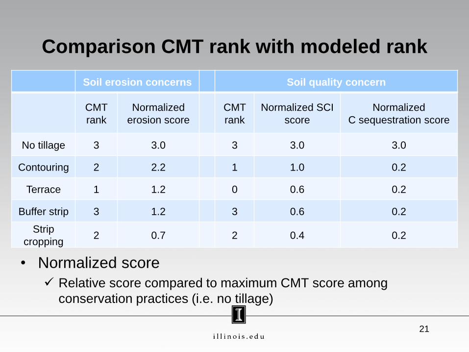
Comparison CMT rank with modeled rank
21
Soil erosion concerns Soil quality concern
CMT
rank
Normalized
erosion score
CMT
rank
Normalized SCI
score
Normalized
C sequestration score
No tillage 3 3.0 3 3.0 3.0
Contouring 2 2.2 1 1.0 0.2
Terrace 1 1.2 0 0.6 0.2
Buffer strip 3 1.2 3 0.6 0.2
Strip
cropping 2 0.7 2 0.4 0.2
• Normalized score
Relative score compared to maximum CMT score among
conservation practices (i.e. no tillage)

Summary
• The RUSLE2 predicted
Higher erosion rates for LRR P (South Atlantic and Gulf Slope Cash
Crops, Forest, and Livestock Region) than H (Central Great Plains
Winter Wheat and Range), M (Central Feed Grains and Livestock), N (East and Central Farming and Forest Regions)
Lower erosion rates for no tillage practice than other practices
• The RUSLE2 and CENTURY predicted
Higher SCI and soil C sequestration rates for M than P, H, and N
Higher SCI and soil C sequestration rates for no tillage practice
than other practices
• CMT scoring might be improved by higher weighting on
residue management and regionalizing weighting
22

Further studies
• Investigate other LRR whether our conclusion could
be applied to other regions
• Develop strategies and modeling frameworks akin to
the one outlined here to permit the agency to estimate
the effects of precision conservation that are currently
rewarded by CMT
23