Embed Size (px)
Citation preview

Evacuating Floridain 2004
Hurricane Evacuation Transportation Workshop
April 5, 2004
Paul Clark
FDOT - Tallahassee
Emergency Management Coordinator
paul.clark @dot.state.fl.us

DOT Traffic Counter Website
Traffic counter data on website: www3.dot.state.fl.us/ trafficinformation
FDOT and DEM selected the 50 sensor locations specifically to support evacuation needs

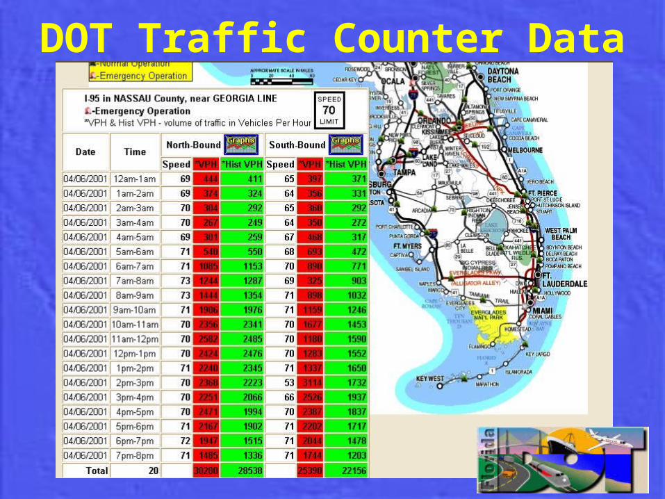
DOT Traffic Counter Data
• Provides hourly vehicle counts, average speed, historical numbers for that specific day and time
• Each counter senses vehicles in both directions to support the five designated contra-flow plans
• 15 can be activated at one time• Some will have live video camera view
capability
DOT Traffic Counter Data

DOT Traffic Counter Data• Operational Uses:
– Alert host counties and communities upstream of evacuating areas to the arrival time and numbers of potential evacuees on roadways and shelters
– Public information to inform evacuees and others of areas experiencing traffic congestion
– Monitor the actual status of evacuations relative to predicted clearance times

DOT Traffic Counter Data• Operational Uses:
– Evacuation shutdown planning - determining when to divert traffic or shut down interstate interchanges based on:
• average vehicle speed at the sensor and • the time needed to clear predicted vehicle queues
before the arrival time of tropical storm force winds

Interstate 10Jacksonville to Tallahassee
Begin: I-295
End: US 19
Total Length: 131 miles

Florida’s TurnpikeFort Pierce to Orlando
Begin: SR 70End: SR 50Total Length: 114 miles

Bee Line ExpresswaySR 520 to SR 417
Begin: SR 520End: SR 417Total Length: 22 miles

Interstate 4Tampa to Orlando
Begin: I-275End: SR 417Total Length: 63 miles

Interstate 75 – Alligator AlleyEast and West Bound
EastboundBegin: CR 951End: US 27Total Length: 78 miles
WestboundBegin: US 27End: Corkscrew RdTotal Length: 105 miles

Interstate 75Shoulder Use Plan
Begin: Toledo Blade BlvdEnd: SR 681Total Length: 21 miles
Partnerships
• Know who all the stakeholders are!– Local Cities and Counties– Florida DOT– Florida Highway Patrol – Florida Division of Emergency Management– Florida National Guard– Florida Department of Law Enforcement– Florida Department of Health– Florida Public Radio– Volunteer Agencies– And the list goes on

Future for Florida
• Exercises– Statewide Hurricane Exercise (May 3-7, 2004)– FDOT Hurricane Exercise (TBD)
• Continue to look to technology and its uses
• Plan, Plan, and Plan some more!