Embed Size (px)
Citation preview

1Centre for Ecology and Hydrology, Winfrith Technology Centre, Winfrith Newburgh, Dorchester, Dorset DT2 8ZD, UK
2 Dorian Ecological Information Ltd., 21 Stapleford Road,
Whissendine, Oakham, Rutland LE15 7HF, UK
3Centre for Ecology and Hydrology, Monks Wood, Abbots Ripton, Huntingdon PE28 2LS, UK
Report to: EUROPEAN ENVIRONMENT AGENCY EUROPEAN TOPIC CENTRE ON NATURE PROTECTION AND BIODIVERSITY
Date: October 2004
EUNIS HABITAT CLASSIFICATION
REVISED 2004
Cynthia E Davies1
Dorian Moss2
Mark O Hill3

ii
EUNIS Habitat Classification Revised 2004 by Cynthia E Davies, Dorian Moss and Mark O Hill Abstract The habitat classification forms an integral part of the European Nature Information System (EUNIS), developed and managed by the European Topic Centre for Nature Protection and Biodiversity (ETC/NPB in Paris) for the European Environment Agency (EEA) and the European Environmental Information Observation Network (EIONET). The EUNIS habitat system consists of a database together with explanatory documentation. EUNIS habitats are arranged in a hierarchy, starting at level 1. They provide a comprehensive typology for the habitats of Europe and its adjoining seas. This report provides full documentation of EUNIS habitats to level 4 for marine habitats and to level 3 for terrestrial and freshwater habitats. Marine habitats, their descriptions, and the criteria for deriving them, were extensively revised following an expert workshop in Helsinki in July 2004. Terrestrial and freshwater habitats were critically reviewed by us in 2004. Many new definitions were added and most of the existing definitions were revised. A few names were changed. The results of these changes are presented as a set of factsheets for habitats at levels 1 to 4 (marine) and levels 1 to 3 (terrestrial and freshwater), accompanied by a key and a glossary. In an annex, the names and index numbers of all EUNIS habitats are listed, including the higher levels.

iii
CONTENTS
1 INTRODUCTION.............................................................................................................1 1.1 Habitats in the context of the European Nature Information System (EUNIS) ..............1 1.2 Definition and scale of EUNIS habitats ..........................................................................2 1.3 The EUNIS habitat type classification: Description of level 1 habitats ..........................3 1.4 EUNIS habitat classification: Description of marine level 2 habitats .............................4 1.5 Development of the classification ...................................................................................5 1.6 Development of the marine part of the classification......................................................6
2 KEY TO THE CLASSIFICATION TO LEVEL 2 ........................................................8
A Criteria for marine habitats................................................................................................................... 13 B Criteria for coastal habitats ................................................................................................................... 28 C Criteria for inland surface waters........................................................................................................ 33 D Criteria for mires, bogs and fens......................................................................................................... 40 E Criteria for grasslands and lands dominated by forbs, mosses or lichens ............................... 48 F Criteria for heathland, scrub and tundra ............................................................................................ 59 G Criteria for woodland, forest and other wooded land ................................................................... 72 H Criteria for inland unvegetated or sparsely vegetated habitats................................................... 83 I Criteria for regularly or recently cultivated agricultural, horticultural and domestic
habitats....................................................................................................................................................... 90 J Criteria for constructed, industrial and other artificial habitats (J) to Level 2 ........................ 93
3 HABITAT DEFINITIONS AND FACTSHEETS......................................................100 A Marine habitats ................................................................................................................101 B Coastal habitats ...............................................................................................................181 C Inland surface waters.......................................................................................................189 D Mires, bogs and fens........................................................................................................198 E Grasslands and lands dominated by forbs, mosses or lichens.........................................206 F Heathland, scrub and tundra............................................................................................221 G Woodland, forest and other wooded land........................................................................236 H Inland unvegetated or sparsely vegetated habitats ..........................................................253 I Regularly or recently cultivated agricultural, horticultural and domestic habitats .........267 J Constructed, industrial and other artificial habitats ........................................................270
4 GLOSSARY...................................................................................................................279
5 ACKNOWLEDGEMENTS..........................................................................................297
6 REFERENCES..............................................................................................................306 ANNEX 1 Index numbers and names of all EUNIS Habitats 2004 (in a separate
document)

1
1 INTRODUCTION 1.1 Habitats in the context of the European Nature Information System (EUNIS) Since the inception of the European Environment Agency there has been a continuous work programme to develop a comprehensive framework for classification of European habitats and to provide descriptions of European habitat types within the framework. The framework includes habitat attributes, which in this context are called ‘parameters’, of which defining parameters are used to distinguish between habitats and descriptive parameters are used to describe the range of geomorphology, salinity, human impacts and so forth that are encompassed within the habitat. The habitat classification forms an integral part of the European Nature Information System (EUNIS), developed and managed by the European Topic Centre for Nature Protection and Biodiversity (ETC/NPB in Paris) for the European Environment Agency (EEA) and the European Environmental Information Observation Network (EIONET). The EUNIS web application (http://eunis.eea.eu.int/index.jsp) (EEA 2004) provides access to publicly available data in a consolidated database. The information includes:
• Data on Species, Habitats and Sites compiled in the framework of NATURA2000 (EU Habitats and Birds Directives),
• Data collected from frameworks such as EIONET, data sources or material published by ETC/NPB (formerly the European Topic Centre for Nature Conservation).
• Information on Species, Habitats and Sites taken into account in relevant international conventions or from International Red Lists.
• Specific data collected in the framework of the EEA's reporting activities, which also constitute a core set of data to be updated periodically.
This report presents the EUNIS habitat classification and key updated in October 2004. 1.2 Definition and scale of EUNIS habitats For the purposes of EUNIS, a ‘habitat’ is defined as: ‘a place where plants or animals normally live, characterized primarily by its physical features (topography, plant or animal physiognomy, soil characteristics, climate, water quality etc.) and secondarily by the species of plants and animals that live there’. Habitats are necessarily defined at a given scale. Some EUNIS habitats such as moss and lichen tundra or deep-sea mud may be of vast extent. Others such as cave entrances or springs, spring brooks and geysers are much smaller. Most but not all EUNIS habitats are in effect ‘biotopes’, that is to say ‘areas with particular environmental conditions that are sufficiently uniform to support a characteristic assemblage of organisms’. A few EUNIS habitats such as glaciers and highly artificial non-saline standing waters may be devoid of living organisms other than microbes. These features, although not strictly habitats, are included for completeness. The EUNIS habitat classification is comprehensive. It covers the whole of the European land and sea area, i.e. the European mainland as far east as the Ural Mountains, including offshore islands (Cyprus; Iceland but not Greenland), and the archipelagos of the European Union

2
Member States (Canary Islands, Madeira and the Azores), Anatolian Turkey and the Caucasus. In general, the scale selected for the EUNIS habitat classification is that occupied by small vertebrates, large invertebrates, and vascular plants. It is the same as that generally adopted by other European-scale typologies, for example by the Palaearctic habitat classification (Devillers & Devillers-Terschuren, 1996) and is comparable to the scale applied to the classification of vegetation in traditional phytosociology. All but the smallest EUNIS habitats occupy at least 100 m2; there is no upper limit to the scale of the largest. At the smaller scale, ‘microhabitats’ (features generally occupying less than 1 m2 that are important for some smaller invertebrates and lower plants) can be described. Examples are decaying wood, found in mature forests and required by invertebrates whose function is decomposition, or animal dung in grassland environments. At the larger scale, habitats can be grouped as ‘habitat complexes’, which are frequently-occurring combinations or mosaics of individual habitat types, usually occupying at least 10 ha, which may be inter-dependent. Estuaries, combining tidal water, mud flats, saltmarshes and other littoral habitats, are a good example. 1.3 The EUNIS habitat type classification: Description of level 1 habitats The EUNIS habitat types are arranged in a hierarchy. Level 1 is the highest. There are 10 level 1 categories, the definitions of which are given below. In the enumeration given here, marine habitats are listed down to level 4, and terrestrial and freshwater habitats to level 3. The reason for this discrepancy is that the original focus of EUNIS was terrestrial, so that the vast range of marine habitats were included in a single level 1 category. Marine habitats at level 2 are broadly equivalent to terrestrial and freshwater habitats at level 1. They are described below in section 1.4. A Marine habitats Marine habitats are directly connected to the oceans, i.e. part of the continuous body of water which covers the greater part of the earth’s surface and which surrounds its land masses. Marine waters may be fully saline, brackish or almost fresh. Marine habitats include those below spring high tide limit (or below mean water level in non-tidal waters) and enclosed coastal saline or brackish waters, without a permanent surface connection to the sea but either with intermittent surface or sub-surface connections (as in lagoons). Rockpools in the supralittoral zone are considered as enclaves of the marine zone. Includes marine littoral habitats which are subject to wet and dry periods on a tidal cycle including tidal saltmarshes; marine littoral habitats which are normally water-covered but intermittently exposed due to the action of wind or atmospheric pressure changes; freshly deposited marine strandlines characterised by marine invertebrates. Waterlogged littoral saltmarshes and associated saline or brackish pools above the mean water level in non-tidal waters or above the spring high tide limit in tidal waters are included with marine habitats. Includes constructed marine saline habitats below water level as defined above (such as in marinas, harbours, etc) which support a semi-natural community of both plants and animals. The marine water column includes bodies of ice. B Coastal habitats Coastal habitats are those above spring high tide limit (or above mean water level in non-tidal waters) occupying coastal features and characterised by their proximity to the sea, including coastal dunes and wooded coastal dunes, beaches and cliffs. Includes free-draining supralittoral habitats adjacent to marine habitats which are normally only affected by spray or

3
splash, strandlines characterised by terrestrial invertebrates and moist and wet coastal dune slacks and dune-slack pools. Excludes supralittoral rock pools and habitats adjacent to the sea which are not characterised by salt spray, wave or sea-ice erosion. C Inland surface waters Inland surface waters are non-coastal above-ground open fresh or brackish waterbodies (e.g. rivers, streams, lakes and pools, springs), including their littoral zones. Includes constructed inland freshwater, brackish or saline waterbodies (such as canals, ponds, etc) which support a semi-natural community of both plants and animals; seasonal waterbodies which may dry out for part of the year (temporary or intermittent rivers and lakes and their littoral zones). Freshwater littoral zones include those parts of banks or shores that are sufficiently frequently inundated to prevent the formation of closed terrestrial vegetation. Excludes permanent snow and ice. Note that habitats that intimately combine waterlogged mires and vegetation rafts with pools of open water are considered as complexes. D Mires, bogs and fens Wetlands, with the water table at or above ground level for at least half of the year, dominated by herbaceous or ericoid vegetation. Includes inland saltmarshes and waterlogged habitats where the groundwater is frozen. Excludes the water body and rock structure of springs (C2.1) and waterlogged habitats dominated by trees or large shrubs (F9.2, G1.4, G1.5, G3.D, G3.E). Note that habitats that intimately combine waterlogged mires and vegetation rafts with pools of open water are considered as complexes. E Grasslands and lands dominated by forbs, mosses or lichens Non-coastal land which is dry or only seasonally wet (with the water table at or above ground level for less than half of the year) with greater than 30% vegetation cover. The vegetation is dominated by grasses and other non-woody plants, including mosses, macrolichens, ferns, sedges and herbs. Includes semiarid steppes with scattered Artemisia scrub. Includes successional weedy vegetation and managed grasslands such as recreation fields and lawns. Excludes regularly tilled habitats (I1) dominated by cultivated herbaceous vegetation such as arable fields. F Heathland, scrub and tundra Non-coastal land which is dry or only seasonally inundated (with the water table at or above ground level for less than half of the year) with greater than 30% vegetation cover. Tundra is characterised by the presence of permafrost. Heathland and scrub are defined as vegetation dominated by shrubs or dwarf shrubs of species that typically do not exceed 5 m maximum height. Includes shrub orchards, vineyards, hedges (which may have occasional tall trees). Also includes stands of climatically-limited dwarf trees (krummholz) < 3 m high, such as occur in extreme alpine conditions. Includes Salix and Frangula carrs. Excludes Alnus and Populus swamp woodland. G Woodland, forest and other wooded land Woodland and recently cleared or burnt land where the dominant vegetation is, or was until very recently, trees with a canopy cover of at least 10%. Trees are defined as woody plants, typically single-stemmed, that can reach a height of 5 m at maturity unless stunted by poor climate or soil. Includes lines of trees, coppices, regularly tilled tree nurseries, and tree-crop plantations. Includes Alnus and Populus swamp woodland and riverine Salix woodland. Excludes Corylus avellana scrub and Salix and Frangula carrs. Excludes stands of climatically-limited dwarf trees (krummholz) < 3 m high, such as occur at the arctic or alpine

4
tree limit. Excludes parkland and dehesa with canopy less than 10%, which are listed under sparsely wooded grasslands E7. H Inland unvegetated and sparsely vegetated habitats Non-coastal habitats with less than 30% vegetation cover (other than where the vegetation is chasmophytic or on scree and or cliff) which are dry or only seasonally wet (with the water table at or above ground level for less than half of the year). Subterranean non-marine caves and passages including underground waters. Habitats characterised by the presence of permanent snow and surface ice other than marine ice bodies. I Regularly or recently cultivated agricultural, horticultural and domestic habitats Habitats maintained solely by frequent tilling or arising from recent abandonment of previously tilled ground such as arable land and gardens. Includes tilled ground subject to inundation. Excludes shrub orchards, tree nurseries and tree-crop plantations. J Constructed, industrial and other artificial habitats Primarily human settlements, buildings, industrial developments, the transport network, waste dump sites. Includes highly artificial saline and non-saline waters with wholly constructed beds or heavily contaminated water (such as industrial lagoons and saltworks) which are virtually devoid of plant and animal life. 1.4 EUNIS habitat classification: Description of marine level 2 habitats Marine habitats at level 2 are roughly equivalent in the hierarchy to terrestrial habitats at level 1. A1 Littoral rock and other hard substrata Littoral rock includes habitats of bedrock, boulders and cobbles which occur in the intertidal zone (the area of the shore between high and low tides) and the splash zone. The upper limit is marked by the top of the lichen zone and the lower limit by the top of the laminarian kelp zone. A2 Littoral sediment Littoral sediment includes habitats of shingle (mobile cobbles and pebbles), gravel, sand and mud or any combination of these which occur in the intertidal zone. Littoral sediment is defined further using descriptions of particle sizes - mainly gravel (16-4 mm), coarse sand (4-1 mm), medium sand (1-0.25 mm), fine sand (0.25-0.063 mm) and mud (less than 0.063 mm) and various admixtures of these (and coarser) grades - muddy sand, sandy mud and mixed sediment (cobbles, gravel, sand and mud together). A3 Infralittoral rock and other hard substrata Infralittoral rock includes habitats of bedrock, boulders and cobbles which occur in the shallow subtidal zone and typically support seaweed communities. The upper limit is marked by the top of the kelp zone whilst the lower limit is marked by the lower limit of kelp growth or the lower limit of dense seaweed growth. Infralittoral rock typically has an upper zone of dense kelp (forest) and a lower zone of sparse kelp (park), both with an understorey of erect seaweeds.

5
A4 Circalittoral rock and other hard substrata Circalittoral rock is characterised by animal dominated communities (a departure from the algae dominated communities in the infralittoral zone). The circalittoral zone can itself be split into two sub-zones; upper circalittoral (foliose red algae present) and lower circalittoral (foliose red algae absent). The depth at which the circalittoral zone begins is directly dependent on the intensity of light reaching the seabed; in highly turbid conditions, the circalittoral zone may begin just below water level at mean low water springs (MLWS). A5 Sublittoral sediment Sediment habitats in the sublittoral near shore zone (i.e. covering the infralittoral and circalittoral zones), typically extending from the extreme lower shore down to the edge of the bathyal zone (200 m). Sediment ranges from boulders and cobbles, through pebbles and shingle, coarse sands, sands, fine sands, muds, and mixed sediments. A6 Deep-sea bed The sea bed beyond the continental shelf break. The shelf break occurs at variable depth, but is generally over 200 metres. The upper limit of the deep-sea zone is marked by the edge of the shelf. Includes areas of the Mediterranean Sea which are deeper than 200 m but not of the Baltic Sea which is a shelf sea. A7 Pelagic water column The water column of shallow or deep sea, or enclosed coastal waters. Note that because of the strong temporal nature of the pelagic environment, the water column at a given location will be classified differently at different times of the year. A8 Ice-associated marine habitats Sea ice, icebergs and other ice-associated marine habitats. 1.5 Development of the classification The EUNIS habitat classification is a common reporting language on habitat types at European level, sponsored by the European Environment Agency. It originated from a combination of several habitat classifications - marine, terrestrial and freshwater. The terrestrial and freshwater classification builds upon previous initiatives, notably the CORINE biotopes classification (Devillers & Devillers-Terschuren 1991), the Palaearctic habitats classification (Devillers & Devillers-Terschuren 1996), Annex I of the EU Habitats Directive 92/43/EEC, the CORINE Land Cover nomenclature (Bossard et al. 2000), and the Nordic habitat classification (Nordic Council of Ministers 1994). The marine part of the classification was originally based on the BioMar classification (Connor et al 1997), covering the North-East Atlantic. The EUNIS habitat classification introduced agreed criteria for the identification of each habitat unit, while providing a correspondence with these earlier classification systems. Several of the earlier classifications, notably the CORINE biotopes classification, were strongly based on traditional phytosociology. While phytosociological classifications are well understood by ecologists in many parts of Europe, they are not readily accessible to other biologists and nature conservationists. A valuable step in making phytosociology more accessible to the wider community was the publication of The Diversity of European Vegetation (Rodwell et al. 2002). However, many habitats are not vegetated, particularly in the marine environment, so that a comprehensive enumeration of habitats cannot be based on

6
vegetation alone. In updating the EUNIS classification, we have therefore aimed to rely on simple, often physical, descriptions of habitats. The early process of development of the classification was documented in previous reports by Davies & Moss (1998, 1999). Work at this time concentrated on the development of consistent criteria to distinguish habitats at levels 1, 2 and 3. Habitats which did not fit the criteria were transferred to different parts of the classification to ensure consistency. This stage of the work, which had been developed with a team of experts drawn from different biogeographic regions, was completed with a wide-ranging consultation process in 1998-1999. An internet version of the classification, hosted in the Walloon region of Belgium, was released in 2000. In 2003 EUNIS was mounted on the European Community Clearing House Mechanism website, including the 2003 version of the habitat classification and new functionalities. However, at the beginning of 2004, many terrestrial and freshwater habitats still lacked descriptions in the EUNIS database. Some of the existing descriptions were unclear. Others were verbose or contained difficult technical jargon. For the 2004 edition, the descriptions have been comprehensively revised, down to level 3. In the process of revision, it was decided to change the names of a few units to include habitats (e.g. ice caps) that were not present in the geographical area originally covered by CORINE biotopes. Some further revisions were made, in order to correct some inconsistencies, especially for constructed, industrial and other artificial habitats. The resulting system of classification is still somewhat transitional. Down to level 3 (terrestrial and freshwater) and level 4 (marine), EUNIS habitats are now based on physiognomic and physical attributes, together with some floristic criteria. Below these levels, habitats have largely been adopted from other systems with little or no modification. Terrestrial habitats have been little altered from their previous state, mostly based on the Palaearctic Habitats Classification (Devillers & Devillers-Terschuren, 1996) which is strongly phytosociological in its basis. Other terrestrial habitats have been added to ensure that all habitats listed in Annex I of the Habitats Directive (European Commission 2003) find a correspondence somewhere in EUNIS habitats. Clearly to bring the lower levels into a consistent EUNIS framework, they should also be revised, preferably without the numerous minor regional variants. Such minor variants, if noted at all, are best handled by crosswalks, linking regional habitat systems to EUNIS. 1.6 Development of the marine part of the classification The marine part of the classification has been heavily revised since its inception in 1998 (Davies & Moss 1998), first with the addition of Baltic and Mediterranean marine habitats listed by the Helsinki and Barcelona Conventions respectively (Davies & Moss 1999, Helsinki Convention 1998, Barcelona Convention 1998). Further revisions were made in response to proposals made at international workshops concentrating on marine habitats. Workshops were organised in September 1999 and September 2000 by the OSPAR Commission, the International Council for the Exploration of the Sea (ICES) and the European Environment Agency (EEA). The ICES Marine Habitats Mapping Working Group met in April 2001 and again in April 2002. Further amendments were made in response to comments from a number of users of the classification, and in order to update the direct links between the EUNIS classification and other initiatives, notably the Palaearctic habitat classification (Devillers & Devillers-Terschuren 1996), CORINE Land Cover nomenclature (Bossard et al. 2000) and Annex I of the EU Habitats Directive 92/43/EEC (European Commission 1999, 2003).

7
The classification in its present form results from discussion of proposals for revision made by the EEA (Davies & Moss 2004) in response to proposals received from the OSPAR Biodiversity Committee, and also includes a revision of the UK marine habitat classification (Connor et al 2004). To ensure that the EUNIS Habitat classification meets the needs of in the Baltic Sea areas, a series of meetings with Baltic Sea experts was held. The EEA proposals (Davies & Moss 2004) and a paper from workers in the Baltic Sea area were discussed fully in a meeting held in July, 2004. The present classification includes the results of these discussions. The Baltic experts’ meeting concluded that further work is required in order to describe Baltic marine habitats to the same level of detail as that available in the North-East Atlantic, so the October 2004 version of EUNIS habitats represents only a starting point in this process. For the Mediterranean Sea, habitats listed as threatened by the Barcelona Convention (Barcelona Convention 1998) are worked into the classification as appropriate, but these lack any descriptions, neither is there any information on other Mediterranean marine habitats. Information specific to the Black Sea is currently lacking. The full classification will be posted on the EUNIS website (http://eunis.eea.eu.int/index.jsp), together with keys for identification of all habitat types at levels 1, 2 and 3 of the hierarchy, the glossary of terms and background information on the rationale of the classification and history of its development.

8
2 KEY TO THE CLASSIFICATION TO LEVEL 2 Defining parameters for the units comprising the EUNIS Habitat Classification are held in a database. These defining parameters have been used to develop a key to habitats to level 3, presented on the following pages. 2.1 Use of the key Criteria diagrams for levels 1 to 3 of the proposed revision of the EUNIS Habitat Classification units are presented with additional detailed explanatory notes accompanying each grey 'decision box'. These numbered notes explain how the decision box is to be applied, and form an integral and essential part of the criteria. Criteria have been developed for all units to level 3. Criteria have also been developed for saltmarshes at level 4. A Glossary of terms is included in this report (Chapter 4). The complete key is available on the website together with a bibliography and the glossary of terms to aid in the interpretation of terminology in the classification.

9
EUNIS Habitat Classification: criteria for Level 1 (number) refers to explanatory notes to the key (see following page)
I REGULARLY OR
RECENTLY CULTIVATED AGRICULTURAL,
HORTICULTURAL AND DOMESTIC HABITATS
B COASTAL HABITATS
Note: Complex habitats may not readily be located as an entity, as they comprise a number of different habitat units. Complexes are listed under code X.
shrubs
Yes
shrubs or dwarf shrubs
permafrost
other
Yes
No
other
No
No
Yes
>30%
<30%
No
Yes
No
waterlogged
Humidity (7)
Constructed or extremely artificial or
regularly tilled habitat?
(1)
A MARINE HABITATS
Marine? (3)
C INLAND SURFACE
WATERS
No
Yes Regularly tilled? (11)
J CONSTRUCTED,
INDUSTRIAL AND OTHER ARTIFICIAL
HABITATS
Yes G
WOODLAND, FOREST AND
OTHER WOODED LAND
F HEATHLAND, SCRUB AND
TUNDRA
% vegetation cover
(9)
D MIRES, BOGS AND
FENS
Open water? (5)
E GRASSLANDS AND
LANDS DOMINATED BY FORBS, MOSSES OR
LICHENS
H (above ground part) INLAND
UNVEGETATED OR SPARSELY
VEGETATED HABITATS
Subterranean? (2)
H (subterranean part) INLAND
UNVEGETATED OR SPARSELY
VEGETATED HABITATS
Dominated by trees?
(6)
Aquatic? (13)
Vegetation type? (12)
shrubs
herbs
No
A (part) MARINE HABITATS
C (part) INLAND SURFACE
WATERS
Yes
Start here
F (part) HEATHLAND, SCRUB AND
TUNDRA
Coastal influence?
(4)
Yes
Marine? (15)
Dominant vegetation
(10) trees
Yes
other
Dominant vegetation
(8)
No Semi-natural aquatic
fauna or flora? (14)
Yes
No No

10
Note: Complex habitats may not readily be located as an entity, as they comprise combinations of a number of different habitat units. Complexes are listed under code X. Explanatory notes to the key 1. Is the habitat highly artificial, i.e. either constructed or with a man-made substrate; industrial; maintained solely by frequent tilling; or if recently
abandoned, then either bare or with pioneer and ruderal vegetation with cover < 30%, (path = Yes)? All other habitats follow path = No. Note that habitats which originated through extractive industries (quarries, mines, peat diggings etc) or disused constructed surfaces, which have been colonised by natural or semi-natural plant and/or animal communities, including pioneer or ruderal communities with vegetation cover > 30%, follow path = No.
2. The criterion separates subterranean non-marine caves and passages and underground waters (path = Yes). 3. Marine habitats including marine littoral habitats (path = Yes) are distinguished. Note that marine habitats are directly connected to the oceans,
i.e. part of the continuous body of water which covers the greater part of the earth’s surface and which surrounds its land masses. Marine waters may be fully saline, brackish or almost fresh. Marine habitats include those below spring high tide limit (or below mean water level in non-tidal waters), coastal saltmarshes, and also enclosed coastal saline or brackish waters, without a permanent surface connection to the sea but either with intermittent surface or sub-surface connections (as in lagoons). Waterlogged littoral zones of the sea above the spring high tide limit in tidal waters are included with marine habitats (path = Yes). Rockpools in the supralittoral zone are considered as enclaves of the marine zone and follow the marine path. Waterlogged saltmarsh habitats and saline or brackish pools above the mean water level of non-tidal marine waters (parts of the geolittoral) are included with marine habitats and follow path = Yes; non-saline habitats above the mean water level in non-tidal waters follow path = No. Free-draining supralittoral habitats adjacent to marine habitats normally only affected by spray or splash and old strandlines characterised by terrestrial invertebrates follow path = No.
4. Habitats occupying coastal features and characterised by their proximity to the sea (salt spray, wave or ice erosion), including beaches, cliffs, coastal dunes and wooded coastal dunes and dune-slack pools, are separated (path = Yes) from other habitats (path = No). Note that habitats occupying coastal features but not characterised by salt spray, wave or ice erosion follow path = No. Note also that habitats which are characterised primarily by temperature (such as garrigues and phryganas) rather than by their proximity to the sea also follow path = No.
5. Habitats with open water (e.g. rivers, streams, lakes and pools) and the littoral zones of the waterbodies (path = Yes) are separated from other terrestrial habitats including those with the water table permanently at or near the surface, but normally without free-standing water. Note that waterlogged habitats with integral pools of open water are considered as complexes. Enclosed coastal saline or brackish waters, without a permanent surface connection to the sea but either with intermittent surface or sub-surface connections (as in lagoons) are categorised under A Marine habitats; dune-slack pools characterised by their proximity to the sea are categorised under B Coastal habitats.
6. Habitats where the dominant vegetation is, or was until very recently, trees, with a canopy cover of at least 10% are distinguished (path = Yes) from habitats dominated by other types of vegetation or without vegetation or dominated by animal communities. Trees are typically single-

11
stemmed and are normally able to reach a height of 5 m at maturity but this height may be lower at high latitudes or altitudes. Note that lines of trees, coppices, and very recently clear-felled areas with pre-existing ground cover, not yet re-stocked and with no succession to weedy vegetation follow path = Yes. Occasionally tall shrubs, especially some riverine alders (Alnus) and willows (Salix) may have a woodland-type structure and follow path = Yes. Tree heaths, for example tree-like formations of Erica arborea, also follow path = Yes. Sparsely wooded areas of grassland with canopy cover of 5 - 10%, including parkland, and clear-felled areas with successional weedy communities follow path = No and are categorised under E, Grasslands and lands dominated by forbs, mosses or lichens. Hedges which may have occasional tall trees follow path = No, and are categorised under F, Heathland, scrub and tundra. Dwarf trees at the arctic and alpine tree limit (i.e. krummholz under conditions where mature individuals are less than 3 m high) follow path = No; these are categorised under F, Heathland, scrub and tundra. Canopy cover 10% and height 5 m are taken from the FAO TBFRA 2000 definitions (Temperate and Boreal Forest Resource Assessment 2000). It should be noted that in some areas e.g. the Boreal zone, the normal dividing point is 30%. Statistics produced at a regional scale might reflect this divergence.
7. The criterion separates habitats which are waterlogged; those which are characterised by the presence of permafrost; and other. Waterlogged refers to habitats which are saturated, with the water table at or above ground level for at least half of the year, e.g. bogs, marshes, carr vegetation. Permafrost relates to habitats where the soil is at a temperature of less than 0oC throughout the year (see glossary). The other path should be followed in the case of: habitats which are: always dry; mesic, moist or humid; only seasonally wet; regularly but infrequently flooded or occasionally flooded by extreme weather conditions but which are free-draining; wet but not waterlogged; permanent snow and ice.
8. Waterlogged terrestrial habitats are divided according to the type of dominant vegetation: shrubs; or other. Note that shrubs refers to larger species such as some willows (Salix spp.) but dwarf shrub species (for example ericoid species) follow path = other. Note also that habitats dominated by trees (G) are separated earlier (note 6).
9. Habitats with less than 30% vegetation cover are separated from those with greater than 30% vegetation cover. Note that chasmophytic, scree and cliff vegetation follow path = <30%.
10. Habitats with greater than 30% vegetation cover are divided according to the type of dominant vegetation: shrubs or dwarf shrubs; or other grasses and non-woody vegetation (including bryophytes and lichens where cover is greater than 30%). Note that habitats dominated by trees (G) are separated earlier (note 6).
11. Habitats maintained solely by frequent tilling or arising from recent abandonment of previously tilled ground such as arable land and gardens (path = Yes) are distinguished from completely artificial habitats (path = No), which are primarily human settlements, industrial developments, transport or waste dump sites or highly artificial waters with wholly constructed beds or heavily contaminated water.
12. Regularly tilled habitats are separated according to dominant vegetation type: shrub orchards; tree nurseries and tree-crop plantations; and habitats dominated by cultivated herbaceous vegetation (path = herbs).
13. Constructed aquatic freshwater, brackish or saline habitats such as marinas, harbours, industrial lagoons, saltworks, canals, ponds and highly artificial waters follow path = Yes. Constructed terrestrial habitats including buildings and the transport network follow path = No.

12
14. Constructed aquatic habitats (such as marinas, harbours, canals and ponds etc) which support a semi-natural aquatic fauna and flora follow path = Yes. Constructed aquatic habitats which are virtually devoid of plant and animal life or which have an un-naturally restricted species list or which are dominated by exotic species follow path = No. Highly artificial saline habitats such as industrial lagoons and saltworks or habitats with heavily contaminated water follow path = No.
15. Constructed marine habitats with semi-natural fauna or flora (path = Yes), are separated from inland constructed non-marine surface water habitats with semi-natural fauna or flora (path = No). (See note 3 for definition of marine).

13
A: EUNIS Habitat Classification: criteria for marine habitats (A) to Level 2 Note that the key to Level 1 shows two pathways to reach habitat type A: these are recombined here. (number) refers to explanatory notes to the key (see following page).
No
Yes
non-mobile
A5 Sublittoral sediment
water column
bed Stratum
(Ai)
A MARINE
HABITATS
A7 Pelagic water
column
Substrate (Av)
Shelf? (Aiv)
Permanently water-covered?
(Aii)
A6 Deep-sea bed
Yes
ice-associated
A8 Ice-associated marine habitats No mobile
Characterised by macro-
algae? (Avi)
A3 Infralittoral rock and other hard substrata
A4 Circalittoral rock and other hard substrata
No
Yes
A2 Littoral sediment mobile
non-mobile
Substrate (Aiii)
A1 Littoral rock and
other hard substrata
Note: For mapping purposes it may be necessary to map combined A3/A4 where the presence of algae cannot be detected by the survey method.

14
The criterion distinguishes between strata: the sea bed of non-tidal, inter-tidal and sub-tidal waters; the water column of shallow or deep sea, or enclosed coastal waters; and ice or ice-associated marine habitats. Ai. Is the bed permanently covered by water (path = Yes), or either regularly exposed at some stage in the tidal cycle (littoral / inter-tidal), subjected
to frequent non-tidal change in water level, or above the high water mark but with a high water table (path = No)? Note that under extreme conditions the uppermost fringe of the ‘permanently water-covered’ zone may be exposed. Note that saltmarsh pools, rockpools (filled by splash and spray) located in the supralittoral and permanent brackish pools affected by spray in the waterlogged Baltic geolittoral zone follow path = No.
Aii. Non-mobile substrates include continuous hard and soft bedrock and also non-mobile boulders, rocks and consolidated cobbles, non-mobile artificial substrates and compacted soft substrates such as clay and peat; mobile substrates include substrates such as mobile cobbles, pebbles, sand and mud. Non-mobile rock which is overlain by some deposited sediments follows path = non-mobile. Biogenic reefs on sediment follow path = mobile. Mosaics of mobile and non-mobile substrates should be considered as complex X31 comprising units from A2 and A1.
Aiii. This criterion separates sublittoral zones of the shelf (including infralittoral and circalittoral zones) (path = Yes), from the deep seabed, beyond the shelf break (path = No). The shelf break occurs at variable depth, but is generally over 200 m. The upper limit of the deep-sea zone is marked by the edge of the shelf. The Baltic Sea is a shelf sea and follows path = Yes. Areas of the Mediterranean Sea which are deeper than 200 m follow path = No. Note that all sublittoral caves follow path = Yes irrespective of depth.
Aiv. Non-mobile substrates include continuous hard and soft bedrock and also non-mobile boulders, rocks and consolidated cobbles, non-mobile artificial substrates and compacted soft substrates such as clay and peat; mobile substrates include substrates such as mobile cobbles, pebbles, sand and mud. Non-mobile rock which is overlain by some deposited sediments follows path = non-mobile. Biogenic reefs on sub-littoral sediment follow path = mobile. Sub-littoral mosaics of mobile and non-mobile substrates should be considered as complex X32 or X33 comprising units from A5 and A3 and/or A4.
Av. Infralittoral zones characterised by foliose or filamentous macro-algae, within the euphotic zone in relatively shallow sub-tidal or non-tidal water, are separated (path = Yes) from deeper animal-dominated circalittoral zones (path = No). Circalittoral zones are below deeper sub-tidal or non-tidal water with insufficient light penetration to allow algae to dominate; however encrusting algae and very sparse foliose or filamentous algae may be present in the upper circalittoral. Note that habitats in the euphotic zone, normally dominated by foliose or filamentous macro-algae but which as a result of storm damage or heavy grazing are characterised by encrusting algae, follow path = Yes. Note also that sublittoral caves or overhangs physically located within the infralittoral zone but where conditions are the same as at deeper levels of the seabed (i.e. total darkness, no hydrodynamic action and constant temperature) should follow path = No. Note: for mapping purposes it may be necessary to map combined A3/A4 where the presence of algae cannot be detected by the survey method.

15
A1: EUNIS Habitat Classification: criteria for littoral rock and other hard substrata (A1) to Level 3 (number) refers to explanatory notes to the key
a1. Habitats subject to irregular disturbance and thus dominated by annual species (ephemeral or opportunistic algae such as Enteromorpha or annual vascular plants) are separated (path = Yes). ‘Irregular disturbance’ includes: irregularly fluctuating water levels in non-tidal water (e.g. Baltic hydrolittoral); considerable freshwater run-off; unstable rock; sand-scoured rock. Habitats with more perennial communities, for example where water levels fluctuate on a regular cycle (tidal littoral) follow path = No.
a2. Habitats developed either in littoral rock caves or underneath overhangs are separated (path = Yes). a3. Rock pools (depressions filled by standing water left when tide recedes or by splash and spray, including those located in the supralittoral or
geolittoral zone) (path = Yes) are distinguished from areas which are periodically submerged and drained. a4. The criterion separates out habitats which have high energy status caused by wave action, currents or tidal streams from those with moderate
energy or low to negligible energy. The energy status is that impacting on the area concerned at the relevant scale. Thus there may be enclaves of different energy status caused by localised variation in relief (e.g. steeper rock in more moderately exposed or even sheltered areas). Note that ‘high energy’ includes wave exposure classes extremely exposed, very exposed or exposed OR tidal streams/currents classes very strong or strong; ‘moderate energy’ includes wave exposure class moderately exposed OR tidal streams/currents class moderately strong; and ‘low to negligible energy’ includes wave exposure classes sheltered, very sheltered, extremely sheltered or ultra sheltered OR tidal streams/currents classes weak or very weak or without any tidal stream or current. (See glossary.)
Note: Rockpools (filled by splash and spray) located in the supralittoral zone and permanent brackish pools in the geolittoral zone are classified within A1.4
Yes
No
high energy
No A1 Littoral rock and
other hard substrata
Energy level (a4)
Cave / overhang? (a2)
A1.4 Features of littoral rock
Standing water left when tide
recedes or from splash / spray?
(a3)
moderate energy
A1.1 High energy littoral rock
A1.2 Moderate energy
littoral rock
A1.3 Low energy littoral rock
Yes low to negligible energy
Annual and opportunistic plant
species? (a1)
No
Yes

16
A2: EUNIS Habitat Classification: criteria for littoral sediment (A2) to Level 3 (number) refers to explanatory notes to the key (see following page).
aquatic terrestrial
fine sand or muddy sand
biogenic
mud
combination of substrates
No
Yes
A2.6 Littoral sediments
dominated by aquatic angiosperms
No
Dominant angiosperm species
(a9)
A2.5 Coastal saltmarshes and
saline reedbeds
A2 Littoral
sediment Substrate
(a10) A2.3
Littoral mud
A2.4 Littoral mixed
sediments
A2.1 Littoral coarse
sediment
A2.2 Littoral sand and
muddy sand
A2.7 Littoral biogenic
reefs
gravel or coarse sand
With angiosperms?
(a8)
A2.8 Features of littoral
sediment
No Developed at seeps?
(a6)
Annual and opportunistic
algae? (a7)
Yes Yes Yes
No Hydrolittoral? (a5)

17
a5. Sedimentary shores of non-tidal, reduced salinity waters which are below the mean water level and normally water-covered, but which are
regularly or occasionally exposed by the action of wind (hydrolittoral zone in the Baltic) are separated (path = Yes) from littoral habitats below the high water mark in tidal water (path = No).
a6. Littoral habitats characterised by the presence of gases or liquids bubbling or seeping through sediments are distinguished (path = Yes). a7. Areas which are characterised by pioneer or ephemeral red and green algae because of variations in salinity and/or siltation (path = Yes) are
separated. a8. Habitats dominated by aquatic (e.g. Zostera spp.) or terrestrial (e.g. Salicornia spp.) angiosperms, (path = Yes) are distinguished from those
dominated by algae or animal communities. a9. Angiosperm-dominated habitats are differentiated between those whose dominant species are entirely aquatic but which can tolerate
occasional emersion (e.g. Zostera spp., Ruppia spp., Posidonia), and those which are primarily terrestrial but can tolerate varying amounts of immersion (e.g. Salicornia spp., Spartina spp.).
a10. Habitats are divided on the basis of the dominating particle size of the substrate. Gravel or coarse sand > 1 mm grain size (including shingle and mobile cobbles); fine sand or muddy sand <= 1 mm with <=30% silt (less than 0.063 mm grain size); mud >30% less than 0.063 mm grain size; combination of substrates – veneers or intimate mixtures of mobile substrates with different particle size; or biogenic structures on sediment (e.g. Sabellaria reefs and mussel beds). Note that mosaics of mobile and non-mobile substrates are considered as complex X31 comprising units from A2 and A1.

18
A2.5: EUNIS Habitat Classification: criteria for coastal saltmarshes and saline reedbeds (A2.5) to Level 4 (number) refers to explanatory notes to the key
a11. Saltmarsh habitats are separated according to the water regime (determined by the position on the shore), between those frequently submerged, with soil moisture and salinity relatively constant, and infrequently submerged, with soil moisture and salinity variable.
a12. Habitats with pioneer vegetation dominated by annual or perennial species with <30% vegetation cover (path = scattered vegetation) are separated from those with more-or-less continuous swards.
a13. Driftline vegetation of saltmarshes (the highest zone, characterised by annual nitrophiles) is separated (path = Yes). a14. Species-poor saltmarshes and reedbeds (pure stands or those dominated by a few species) are distinguished from those which are species-
rich, with a wide range of communities, and a rich flora, not dominated by any one species.
species-rich
Yes
A2.5 Coastal saltmarshes and
saline reedbeds
Water regime (a11)
frequently submerged
Vegetation cover (a12)
continuous swards
scattered vegetation
A2.54 Low-mid saltmarshes
A2.55 Pioneer saltmarshes
Species composition
(a14)
species-poor
A2.52 Upper saltmarshes
A2.53 Mid-upper saltmarshes and saline and brackish
reed, rush and sedge beds
Driftline? (a13)
No
A2.51 Saltmarsh driftlines
infrequently submerged

19
A3: EUNIS Habitat Classification: criteria for infralittoral rock and other hard substrata (A3) to Level 3 (number) refers to explanatory notes to the key (see following page).
moderately exposed
exposed sheltered
A3 Infralittoral rock and other hard
substrata
No
Yes
Developed at seeps? (a15)
Yes
Recently colonised artificial substrata?
(a16)
No
A3.6 Baltic sheltered infralittoral rock
A3.5 Baltic moderately
exposed infralittoral rock
A3.4 Baltic exposed
infralittoral rock
Exposure (a19)
No
Cave, overhang or surge gully?
(a17)
A3.7 Features of
infralittoral rock
Yes
moderate energy
high energy low to negligible energy
A3.3 Atlantic and
Mediterranean low energy infralittoral rock
A3.2 Atlantic and
Mediterranean moderate energy infralittoral rock
A3.1 Atlantic and
Mediterranean high energy infralittoral rock
Energy level (a20)
Baltic? (a18)
No
Yes

20
a15. Habitats in hard substrata in the infralittoral zone characterised by the presence of seeping or bubbling gases, oils or water are distinguished
(path = Yes). a16. Recently colonised artificial hard substrata in the infralittoral zone are distinguished (path = Yes). a17. Habitats developed in rock caves, underneath wave or tide-disturbed overhangs in the infralittoral zone or in wave-scoured surge gullies are
separated (path = Yes). a18. Infralittoral habitats in the Baltic Sea (as defined by the Helsinki Convention, from and including the Kattegat eastward to the Bothnian Bay,
Gulf of Finland and Gulf of Riga) are separated (path = Yes) from other geographical sea areas. The Baltic Sea is effectively a vast estuary with sills, characterised by a stable reduced salinity gradient, lack of tides and reduced fetch energy.
a19. The criterion separates out habitats in the Baltic infralittoral zone which are exposed to wave action, currents or ice scouring from those only moderately exposed or sheltered. The exposure status is that impacting on the area concerned at the relevant scale. Thus there may be enclaves of different exposure status caused by localised variation in relief (e.g. steeper rock in more moderately exposed or even sheltered areas). Note that ‘exposed’ has an effective fetch of greater than 25 km; ‘moderately exposed’ has an effective fetch of 5 – 25 km; and ‘sheltered’ has an effective fetch less than 5 km.
a20. The criterion separates out habitats in the infralittoral which have high energy status caused by wave action, currents or tidal streams from those with moderate energy or low to negligible energy. The energy status is that impacting on the area concerned at the relevant scale. Thus there may be enclaves of different energy status caused by localised variation in relief (e.g. steeper rock in more moderately exposed or even sheltered areas). Note that ‘high energy’ includes wave exposure classes extremely exposed, very exposed or exposed OR tidal streams/currents classes very strong or strong; ‘moderate energy’ includes wave exposure class moderately exposed OR tidal streams/currents class moderately strong; and ‘low to negligible energy’ includes wave exposure classes sheltered, very sheltered, extremely sheltered or ultra sheltered OR tidal streams/currents classes weak or very weak or without any tidal stream or current. (See glossary.)

21
A4: EUNIS Habitat Classification: criteria for circalittoral rock and other hard substrata (A4) to Level 3 (number) refers to explanatory notes to the key (see following page).
moderately exposed
moderate energy
high energy
A4.3 Atlantic and Mediterranean
low energy circalittoral rock
A4.2 Atlantic and
Mediterranean moderate energy circalittoral rock
A4.1 Atlantic and
Mediterranean high energy circalittoral rock
Energy level (a26)
A4.7 Features of
circalittoral rock
Cave or overhang?
(a23)
Developed at seeps? (a21)
Recently colonised artificial
substrata? (a22)
A4 Circalittoral rock
and other hard substrata
low to negligible energy
Yes Yes
Yes
No No
No
exposed sheltered
A4.6 Baltic sheltered circalittoral rock
A4.5 Baltic moderately
exposed circalittoral rock
A4.4 Baltic exposed
circalittoral rock
Exposure (a25)
Baltic? (a24)
No
Yes

22
a21. Habitats in hard substrata in the circalittoral zone characterised by the presence of seeping or bubbling gases, oils or water are distinguished
(path = Yes). a22. Recently colonised artificial hard substrata in the circalittoral zone are distinguished (path = Yes). a23. Habitats developed in rock caves or underneath overhangs in the circalittoral zone are separated (path = Yes). a24. Circalittoral habitats in the Baltic Sea (as defined by the Helsinki Convention, from and including the Kattegat eastward to the Bothnian Bay,
Gulf of Finland and Gulf of Riga) are separated (path = Yes) from other geographical sea areas. The Baltic Sea is effectively a vast estuary with sills, characterised by a stable reduced salinity gradient, lack of tides and reduced fetch energy.
a25. The criterion separates out habitats in the Baltic circalittoral zone which are exposed to wave action or currents from those only moderately exposed or sheltered. The exposure status is that impacting on the area concerned at the relevant scale. Thus there may be enclaves of different exposure status caused by localised variation in relief (e.g. steeper rock in more moderately exposed or even sheltered areas). Note that ‘exposed’ has an effective fetch of greater than 25 km; ‘moderately exposed’ has an effective fetch of 5 – 25 km; and ‘sheltered’ has an effective fetch less than 5 km.
a26. The criterion separates out habitats in the circalittoral which have high energy status caused by wave action, currents or tidal streams from those with moderate energy or low to negligible energy. The energy status is that impacting on the area concerned at the relevant scale. Thus there may be enclaves of different energy status caused by localised variation in relief (e.g. steeper rock in more moderately exposed or even sheltered areas). Note that ‘high energy’ includes wave exposure classes extremely exposed, very exposed or exposed OR tidal streams/currents classes very strong or strong; ‘moderate energy’ includes wave exposure class moderately exposed OR tidal streams/currents class moderately strong; and ‘low to negligible energy’ includes wave exposure classes sheltered, very sheltered, extremely sheltered or ultra sheltered OR tidal streams/currents classes weak or very weak or without any tidal stream or current. (See glossary.)

23
A5: EUNIS Habitat Classification: criteria for sublittoral sediment (A5) to Level 3 (number) refers to explanatory notes to the key
a27. Sublittoral habitats characterised by the presence of gases or liquids bubbling or seeping through sediments are distinguished (path = Yes). a28. Sublittoral sediments which are organically-enriched or permanently or periodically anoxic are separated (path = Yes). a29. Habitats dominated by aquatic angiosperm or algal macrophytes (path = Yes) are distinguished from those dominated by animal
communities, with or without algae. a30. Habitats are divided on the basis of the dominating particle size of the substrate. Gravel or coarse sand > 1 mm grain size (including shingle
and mobile cobbles); fine sand or muddy sand <= 1 mm with <=30% silt (less than 0.063 mm grain size); mud >30% less than 0.063 mm grain size; combination of substrates - veneers or intimate mixtures of mobile substrates with different particle size; or biogenic structures on sediment. Note that sublittoral mosaics of mobile and non-mobile substrates are considered as complex X32 or X33 comprising units from A5 and A3 and/or A4.
Note: In some marine areas a clear distinction can be made between infralittoral and circalittoral sediments, but this has proved difficult to formalise in this key as a consistent criterion applicable across the whole area covered by EUNIS. In A5.1 to A5.4, when it is possible to separate sediment habitats in shallower and deeper waters, this separation is at level 4.
No Organically
enriched or anoxic conditions?
(a28)
No
Yes
Yes
No mud
gravel or coarse sand
fine sand or muddy sand
combination of substrates
Substrate (a30)
A5.3 Sublittoral mud
A5.4 Sublittoral mixed
sediments
A5.1 Sublittoral coarse
sediment
A5.2 Sublittoral sand
Macrophyte-dominated?
(a29)
A5.5 Sublittoral
macrophyte-dominated sediment
Yes
A5 Sublittoral sediment
Seepage? (a27)
A5.7 Features of
sublittoral sediments
biogenic
A5.6 Sublittoral biogenic
reefs

24
A6: EUNIS Habitat Classification: criteria for the deep-sea bed (A6) to Level 3 (number) refers to explanatory notes to the key
a31. Deep-sea habitats characterised by chemical conditions are separated (path = Yes): these include the presence of seeping or bubbling gases or liquids, hypoxic and/or anoxic conditions in the water column above and interface habitats on the deep-sea bed where reducing conditions exist, not generally associated with drastically elevated temperatures, including the carcasses of large cetaceans.
a32. Habitats on the deep-sea bed are separated according to their relief: regions with significant elevation (>200 m) in relation to their surroundings (path = raised); those significantly below the deep-sea bed (such as deep ocean trenches, often greater than 6000 m depth with an active margin reduction zone) and downslope or along-slope channels on the deep-sea bed (path = lowered); and the deep-sea bed plain (path = plain).
a33. Deep-sea benthic habitats are separated into those with substrates predominantly rock (or artificial hard substrates); of mixed particle size or predominantly gravel (mixed/gravel); sand; muddy sand; mud; or biogenic (e.g. coral reefs and sponge beds).
A6.6 Deep-sea bioherms
A6.3 Deep-sea sand
A6.1 Deep-sea rock and
artificial hard substrata
A6.5 Deep-sea mud
A6.2 Deep-sea mixed
substrata
A6.4 Deep-sea muddy sand
muddy sand
mixed/gravel
mud
sand
rock
biogenic
Yes
A6 Deep-sea bed
Characterised by chemical
conditions? (a31)
No Substrate (a33)
lowered
Features of significant relief?
(a32)
A6.7 Raised features of the
deep-sea bed
raised
plain
A6.9 Vents, seeps, hypoxic and anoxic habitats of
the deep sea
A6.8 Deep-sea trenches and canyons,
channels, slope failures and slumps on the continental slope

25
A7: EUNIS Habitat Classification: criteria for pelagic water column (A7) to Level 3 (number) refers to explanatory notes to the key (see following page).
vertical
No
short
Yes
Yes
No
Gradient (a39)
Interface? (a34)
Yes Whole water column actively mixed?
(a35)
A7 Pelagic water
column
No
air / water
Water column influenced by freshwater?
(a36)
horizontal
(substrate / water)
X30 Bentho-pelagic
habitats
A7.2 Completely mixed water column with
reduced salinity
A7.3 Completely mixed water column with
full salinity
A7.7 Fronts in reduced
salinity water column
A7.6 Vertically stratified water
column with reduced salinity
No
none A7.5 Unstratified water column
with reduced salinity
Reduced salinity? (a37)
A7.4 Partially mixed water column with reduced
salinity and medium or long residence time
Gradient (a40)
horizontalvertical
none
A7.A Fronts in full salinity
water column
A7.9 Vertically stratified
water column with full salinity
Residence time (a38)
medium or long
A7.8 Unstratified water column with full
salinity
A7.1 Neuston
Note: Because of the strong temporal nature of the pelagic environment, the water column at a given location will be classified differently at different times of the year.

26
a34. Is the habitat developed at the interface between air / water; or in the main water column (path = No)? Note that where the habitat is
developed at the interface between the substrate and water it is best described as complex X30 - a combination of units from A1 to A6 with units from A7.
a35. Is the water column completely and actively mixed, usually due to its relatively shallow nature, (Path = Yes), or is it unmixed or only partially mixed because the depth of the water body is greater than the depth of mixing (Path = No)?
a36. Is the water column influenced by freshwater i.e. is the salinity reduced relative to the adjacent fully marine seawater (Path = Yes)? These units are usually found in relatively shallow, coastal situations, and are the result of river inflow or ice melt. Note that some discretion should be used in the interpretation of ‘adjacent’, for example in the Baltic Sea, ‘adjacent’ fully marine seawater is reached only in the Kattegat.
a37. Water columns which are not fully mixed and which have reduced salinity relative to the adjacent fully marine seawater are separated (Path = Yes). These units are usually found in deeper coastal water situations and are the result of river inflow or ice melt. Note that some discretion should be used in the interpretation of ‘adjacent’, for example in the Baltic Sea, ‘adjacent’ fully marine seawater is reached only in the Kattegat.
a38. Partially mixed reduced salinity waters with a short residence time are separated from those with medium or long residence times. Short residence time is defined as changing diurnally, medium residence time is greater than daily and up to about 14 days (based on the time required for the phytoplankton population to double) and long residence time lasting longer than 14 days.
a39. Reduced salinity habitats with short residence time are distinguished by the type and degree of gradient: those with pronounced vertical stratification (e.g. caused by seasonal temperature changes, river discharge influence or ice-melt); horizontal gradients giving rise to fronts; and those with very weak gradients or none. Note that units with vertical stratification are separated at level 4 by the cause and degree of persistence of the gradient – e.g. seasonal temperature gradients or persistent salinity gradients etc. Units with horizontal stratification are separated at level 4 by the degree of persistence of the stratification.
a40. Full salinity habitats characterised by the degree and direction of gradient are distinguished: those with pronounced vertical stratification (e.g. caused by atmospheric temperature); horizontal gradients giving rise to fronts; and those with very weak gradients or none. Note that units with horizontal stratification are separated at level 4 by the degree of persistence of the stratification – ephemeral such as eddies, gyres and upwellings; seasonal upwellings; or persistent water mass interfaces.

27
A8: EUNIS Habitat Classification: criteria for ice-associated marine habitats (A8) to Level 3 (number) refers to explanatory notes to the key
a41. Is the habitat developed at the interface between the lower surface of the ice and the water column below (path = Yes), or is it on the upper surface of or within the ice itself (path = No)?
a42. Is the habitat developed within the ice matrix in a three-dimensional network of tubes and channels containing brine solution, characterised by low light intensity, low temperature and high salinity (path = Yes)?
a43. Is the ice of freshwater origin, originating from a glacier (path = freshwater ice), or is it frozen seawater (path = sea ice)?
Yes
No
freshwater ice
Interface? (a41)
A8 Ice-associated marine habitats
A8.1 Sea ice sea ice
A8.3 Brine channels
A8.4 Under-ice habitat
A8.2 Freshwater ice
Origin of ice(a43)
Yes
Brine channel within ice?
(a42)
No

28
B: EUNIS Habitat Classification: criteria for coastal habitats (B) to Level 2 (number) refers to explanatory notes to the key
Bi. Coastal habitats are divided on the basis of underlying substrate (which may be overlain with superficial deposits): sand substrates form coastal
dune and sand habitats; shingle substrates form mobile or stable shingle beaches and banks; rock substrates (which include non-mobile boulders) comprise sea and coastal lagoon cliffs and rocky sea shores including the supra-littoral spray zone. Note that dune-slack pools follow path = sand.
shingle
sand
rock
B COASTAL HABITATS
Underlying substrate type
(Bi)
B1 Coastal dunes and
sandy shores
B2 Coastal shingle
B3 Rock cliffs, ledges and shores, including the
supralittoral Note: coastal saltmarshes are
categorised under A2.5

29
B1: EUNIS Habitat Classification: criteria for coastal dunes and sandy shores (B1) to Level 3 (number) refers to explanatory notes to the key (see following page).
Yes
dunes Surface topography
(b2)
more or less level
Humidity (b3)
dry
moist or wet
No
Yes
Above driftline?
(b6)
No
Mobile? (b4)
Vegetation stratum
(b5) shrubs
dwarf shrubs
herbs
Wind-blown sand over peat?
(b1)
No
Yes
trees
B1.2 Sand beaches above the
driftline
B1.3 Shifting coastal dunes
B1.8 Moist and wet dune
slacks
B1.4 Coastal stable dune
grassland (grey dunes)
B1 Coastal dunes and
sandy shores
B1.1 Sand beach driftlines
B1.5 Coastal dune heaths
B1.7 Coastal dune woods
B1.9 Machair
B1.6 Coastal dune scrub

30
b1. Machair (characterised by wind-blown calcareous sand with a predominance of shell fragments usually over peat, a low proportion of sand-
binding vegetation and a long history of agricultural use) (path = Yes), is distinguished from other coastal sand habitats. Note that a machair complex is defined comprising units from B1, C and I.
b2. The topography of the surface distinguishes the abrupt mounds and hollows of sand dunes from more or less level sand beach habitats. b3. Dry sand dunes are distinguished from moist or wet dune slacks including dune-slack pools. b4. Unvegetated mobile sand dunes (path = Yes) are separated from dunes which have become stabilised by vegetation. b5. Predominant vegetation type is used to distinguish between: dune grassland (herbs); dune heath (predominantly ericaceous dwarf shrubs); dune
scrub (shrubs); and dune woodland (trees). b6. Driftline habitats characterised by lines of wave-deposited organic material colonised by annual angiosperms are distinguished (path = No) from
mobile sand beaches above the driftline. Note that freshly deposited driftlines characterised by marine invertebrates and without annual vegetation are included in A2.

31
B2: EUNIS Habitat Classification: criteria for coastal shingle (B2) to Level 3 (number) refers to explanatory notes to the key b7. Driftline habitats characterised by lines of wave-deposited organic material are distinguished (path = Yes) from mobile or stabilised shingle
beaches above the driftline. b8. Unvegetated mobile shingle beaches (path = No) are separated from more stable vegetated coastal shingle habitats. b9. Fixed shingle habitats with vegetation of grasses or heaths (path = Yes) are distinguished from more open communities dominated by other
herbaceous species on substrates which may be more mobile. b10. Predominant vegetation type is used to distinguish between: shingle and gravel beach grassland, (herbs); shingle and gravel beach scrub
(shrubs); and shingle and gravel beach woodland (trees).
trees herbsshrub
Yes
Vegetated? (b8)
No
Shingle fixed by vegetation?
(b9)
Yes
No
Driftline? (b7)
No
Yes B2.2
Unvegetated mobile shingle beaches above
the driftline
B2.4 Fixed shingle beaches,
with herbaceous vegetation
B2.3 Upper shingle beaches with open vegetation
B2 Coastal shingle
B2.1 Shingle beach driftlines
B2.5 Shingle and gravel beaches with scrub
B2.6 Shingle and gravel beach woodland
Vegetation stratum (b10)

32
B3: EUNIS Habitat Classification: criteria for rock cliffs, ledges and shores, including the supralittoral (B3) to Level 3 (number) refers to explanatory notes to the key b11. The lichen or spray zone above the high tide mark (or above the mean water level where non-tidal) (path = Yes) is distinguished from rock
habitats not regularly affected by spray. Note that rock pools in the supralittoral are classified in A with littoral rock pools. b12. Hard rock cliffs and ledges (path = Yes) are distinguished from cliffs of relatively soft, unconsolidated material. b13. Unvegetated coastal hard rock cliffs and ledges (path = No) are separated from rocky habitats with angiosperm vegetation (path = Yes).
No
Hard rock? (b12)
Yes Vegetated?
(b13)
Yes
No
No
Yes
B3.2 Unvegetated rock
cliffs, ledges, shores and islets
B3.4 Soft sea-cliffs, often
vegetated
B3.3 Rock cliffs, ledges and
shores, with angiosperms
B3 Rock cliffs, ledges and shores, including the
supralittoral
B3.1 Supralittoral rock
(lichen or splash zone)
Spray zone? (b11)

33
C: EUNIS Habitat Classification: criteria for inland surface waters (C) to Level 2 Note that the key to Level 1 shows two pathways to reach habitat type C: these are recombined here. (number) refers to explanatory notes to the key
Ci. Periodically inundated shores adjacent to surface water habitats (without vegetation or with ephemeral or amphibious herbs), littoral zones with
high humidity which may be due to steam or spray, or narrow (< 5 m wide) bands of permanent water fringing emergent vegetation (path = Yes) are separated from the fully aquatic components of waterbodies (path = No). Note that temporary streams with no defined boundaries, completely covered by littoral-type vegetation follow path = Yes. Note also that sedge or reed beds normally without free-standing water are categorised under D5.
Cii. Is the waterbody standing (with no perceptible flow such as lakes, ponds, or extremely slow-moving parts of rivers etc.); or running (with perceptible flow, such as rivers, streams, springs, etc.)? Note that standing waters include semi-natural canals, temporary standing waters and seasonally dry lake beds; running waters include temporary or intermittent streams.
C INLAND SURFACE
WATERS
C2 Surface running
waters
running
standing
Shallow water with water-fringing emergent
vegetation, periodically inundated or high humidity
shores? (Ci)
C1 Surface standing
waters Standing or running
water? (Cii)
C3 Littoral zone of inland surface waterbodies
Yes
No
Note: rich fens, and extensive species-poor sedge
and reed beds, normally without free-standing water
are categorised under D5

34
C1: EUNIS Habitat Classification: criteria for surface standing waters (C1) to Level 3 (number) refers to explanatory notes to the key (see following page).
No
wet phase
Temporary? (c2)
Yes
C1.6 Temporary lakes, ponds
and pools
C1 Surface standing
waters
C1.2 Permanent mesotrophic lakes, ponds and pools
Trophic status (c4)
oligotrophic
mesotrophic eutrophic
dystrophic
No
C1.1 Permanent oligotrophic lakes, ponds and pools
C1.3 Permanent eutrophic
lakes, ponds and pools
C1.4 Permanent dystrophic lakes, ponds and pools
C1.5 Permanent inland saline
and brackish lakes, ponds and pools
Saline? (c3)
No
Yes
C3 Littoral zone of inland surface waterbodies
dry phase
Ice-cover? (c1)
C1.7 Permanent lake ice
Yes

35
c1. Permanent or almost permanent ice formations of lakes (continuous ice sheets that cover the entire surface for all of the year or which recede to
part of the lake during summer accompanied or replaced by floating ice blocks, rafts and hummocks) (path = Yes) are distinguished from waterbodies with open water, which may or may not have occasional ice cover.
c2. Seasonal and otherwise temporarily-filled lakes, ponds and pools (path = Yes) are separated from surface water of more permanent character. Note that the wet phase only of temporary standing waters is characterised here. The habitat in its dry phase is normally characterised under C3. Note that temporarily flooded meadows and riverine forests are characterised as grassland and forest respectively.
c3. Inland saline and brackish lakes and pools are separated (path = Yes) from waterbodies with freshwater. c4. Standing waters are separated on the basis of their trophic status; oligotrophic waters, of low nutrient status, usually on hard, acid rock with
high oxygen concentration in the hypolimnion; mesotrophic waters, intermediate between oligotrophic and eutrophic waters; eutrophic waters with high productivity and potentially low oxygen concentration in the hypolimnion; dystrophic waters which are rich in humus, often with a brown colour.

36
C2: EUNIS Habitat Classification: criteria for surface running waters (C2) to Level 3 (number) refers to explanatory notes to the key (see following page).
Tidal water? (c8)
Yes
Temporary? (c5)
No
Yes
No
Up-welling? (c6)
Yes
No
Flow (c9)
slower and tending towards laminar
C2 Surface running
waters
C2.3 Permanent non-tidal,
smooth-flowing watercourses
C2.4 Tidal rivers, upstream
from the estuary
C2.5 Temporary running
waters
C2.1 Springs, spring brooks
and geysers
C2.2 Permanent non-tidal,
fast, turbulent watercourses
C2.6 Films of water flowing over rocky watercourse
margins
No
Water in thin sheets over rock?
(c7)
fast and turbulent
Yes
C1 Surface standing
waters
no perceptible
flow

37
c5. Seasonal and otherwise temporary running surface waters (path = Yes) are separated from surface running waters of more permanent character. c6. Springs and geysers where the flow is caused by up-welling from the substrate and the stream immediately below, where the temperature
regime is similar to the source water and significantly different from the surroundings, are distinguished (path = Yes). c7. Habitats characterised by thin layers of moving water over rock surfaces adjacent to open water are distinguished (path = Yes) from the main
open waterbody with which they are associated. c8. Tidal rivers and streams (which may or may not be brackish) upstream of the estuary are distinguished (path = Yes) from running water not
affected by tides. Note that estuarine waters, with variable salinity usually greater than 0.5 ppt, are categorised under A and estuaries as complex X01.
c9. Watercourses where the flow-rate is fast and turbulent are distinguished from rivers where flow is slower and tending towards becoming laminar. Note that where flow is fast and turbulent, the oxygen concentration is high, and the bed usually composed of rocks, stones or gravel with only occasional sandy and silty patches; where flow is slower, oxygen concentration deficits may occur at times, and normally the substrate is mainly sand and mud. Rivers that are fast but with laminar flow follow path = slower and tending towards becoming laminar.

38
C3: EUNIS Habitat Classification: criteria for littoral zone of inland surface waterbodies (C3) to Level 3 (number) refers to explanatory notes to the key (see following page).
No
canes
other
Yes
Yes
low
high
C3.5 Periodically inundated shores with pioneer and ephemeral vegetation
C3.7 Unvegetated or sparsely
vegetated shores with non-mobile substrates
C3.6 Unvegetated or sparsely
vegetated shores with soft or mobile sediments
Permanent water-fringing
vegetation? (c11)
No Ephemeral vegetation?
(c15)
Substrate (c16)
Species diversity (c12)
No
non-mobile mobile sediments
rapid succession
C3.1 Species-rich helophyte
beds
C3.2 Water-fringing
reedbeds and tall helophytes other than
canes
C3.3 Water-fringing beds of
tall canes
C3 Littoral zone of inland surface waterbodies
Growth form (c14)
Dominant species (c13)
C3.4 Species-poor beds of low-growing water-
fringing or amphibious vegetation
tall
low Yes
Dependent on spray or steam?
(c10)
C3.8 Inland spray- and steam-dependent
habitats

39
c10. Habitats dependent on spray or steam alongside waterfalls, geysers, and hot springs are separated (path = (Yes). Note that the spray zone of the
supralittoral marine zone is categorised under B. c11. Areas with significant cover by permanent water-fringing or amphibious vegetation normally in shallow water, but which may occasionally be
subject to drying out (path = Yes) are separated from periodically inundated shores which are either unvegetated or characterised by ephemeral, seasonal or very sparse vegetation.
c12. Habitats with amphibious or helophytic vegetation of reeds or other graminoids and other helophytes (plants rooted in, but emergent from, mud or water) which may be dominated by a single species, but which also have associated layers of diverse smaller herbaceous species (species diversity = high), are distinguished from habitats which are dominated by one or two plant species and whose species diversity is relatively low.
c13. Habitats with low species diversity where the dominant species are canes (e.g. Arundo sp., Saccharum ravennae) are separated from those with reeds or other helophytes.
c14. Species-poor water-fringing beds of tall emergent vegetation with no associated lower herb layer are separated from species-poor habitats with lower-growing emergent or amphibious vegetation
c15. Areas with pioneer vegetation and ephemeral annual vegetation (path = Yes) are separated from more or less unvegetated emergent banks and shores subject to periodic inundation.
c16. Unvegetated periodically inundated shores and emergent banks are separated according to their substrate. Mobile sediments (such as mud, sand and mobile gravel) are distinguished from non-mobile hard or firm substrates including rock, boulders, artificial hard, consolidated clay and peat. Note that rapid succession between the habitat comprising unvegetated mobile sediment (C3.7) and ephemeral vegetation (C3.6) is likely and periods of inundation or submersion may cause reversal of the succession.

40
D: EUNIS Habitat Classification: criteria for mires, bogs and fens (D) to Level 2 Note that mire bog, and fen habitats do not include wet heaths, moist grasslands, and riverine or swamp woodlands, which follow separate paths at Level 1. (number) refers to explanatory notes to the key (see following page).
Yes No No
rainwater only
D5 Sedge and reedbeds,
normally without free-standing water
D1 Raised and blanket
bogs
D2 Valley mires, poor fens and transition
mires
Acid? (Div)
D4 Base-rich fens and calcareous spring
mires
other
Dominated by few species of tall helophytes?
(Dvi)
D MIRES, BOGS
AND FENS Source of water
(Di)
Frost or ice dependent?
(Dii)
No
Yes
Yes
D3 Aapa, palsa and polygon mires
D6 Inland saline and brackish marshes
and reedbeds
No
Saline or brackish?
(Dv)
Yes
Note: reed and sedge beds of the littoral zone
are categorised under C3
Note: swamp woodlands are
categorised under G and fen carr under F9
Peat formation at water surface?
(Diii)
Yes No
Note: raised bog and blanket bog complexes
are defined as combinations of units
from D1

41
Di. The criterion separates habitats on the basis of the source of their water supply: completely or primarily ombrogenous (rainwater only) from
other sources which are combinations of ombrogenous, soligenous (run-off) and topogenous (groundwater) but where the ombrogenous water supply is of less importance.
Dii. Mires whose formation and maintenance is completely dependent on the action of frost or ice are separated (path = Yes). Diii. Transition mires in which the water table is at or near the surface and peat forms a floating raft at the water surface are distinguished (path =
Yes). Div. Mires in which the peat formation occurs in waterlogged ground are separated if they have a predominantly acid water supply (path = Yes). Dv. Marshes and reedbeds with a saline or brackish water supply (> 0.5 parts per thousand salt) (path = Yes) are distinguished from freshwater
habitats (path = No). Dvi. Separates topogenous and soligenous habitats dominated by few species of tall helophytes (plants rooted below the water table but with
emergent aerial shoots), typically species-poor extensive sedge and reed beds (path = Yes), from habitats dominated by low-growing vegetation on shallow organic or mineral substrates, which is typically species-rich vegetation of fens (path = No). Note: reed and sedge beds of the littoral zone (usually less than 5 m wide) rooted in open water with associated aquatic species are categorised under C3.

42
D1: EUNIS Habitat Classification: criteria for raised and blanket bogs (D1) to Level 3 (number) refers to explanatory notes to the key d1. The criterion separates blanket bogs which follow but do not depend upon the topography, developing on flat or gently sloping ground with
poor surface drainage (path = No) from raised bogs which are dependent upon the topography for their initial development, forming over depressions or on slopes (path = Yes). Raised bogs include a number of topographic types such as saddle and sloping bogs, and also condensation mires1 (classified as D1.13).
1There are about 20 examples of condensation mires, an outstanding mire type, in the Alps and the Jura mountains, some of them up to 5 ha in size. They have developed on rock slides where, due to the cold air efflux from the cave system inside the rock slide, the water condenses on the surface. This condensation water is the basis for the formation of big Sphagnum capillifolium hummocks which merge together and thus form a peat layer of about 2 m depth. Being only supplied by atmospheric water it belongs to D1.
Relief-dependent?
(d1)
Yes
No
D1 Raised and blanket
bogs
D1.2 Blanket bogs
D1.1 Raised bogs Note: the complete raised bog
system is treated as a complex (X04). The vegetation of the raised bog is included within D1.1, and the open water elements (raised bog pools and lagg) within C1.4. A blanket bog complex (X28) has been defined comprising elements of D and C.

43
springs and localised flushes at ground
level
Water source (d3)
D2.2 Poor fens and soft-water
spring mires
D2.1 Valley mires
ground and river water
D2 Valley mires, poor fens and transition
mires
Water table (d2)
D2.3 Transition mires and
quaking bogs
below ground level
Water flow (d4)
springs and localised flushes
waterlogged
D2: EUNIS Habitat Classification: criteria for valley mires, poor fens and transition mires (D2) to Level 3 (number) refers to explanatory notes to the key d2. Transition mires where the water table is at ground level, where peat forms mostly in water, are distinguished from valley bogs and poor fens,
where the water table is below ground level and peat forms in more-or-less saturated conditions. d3. Poor fens (acid flushes dominated by small sedges and often sphagna) developing on a slope and fed with water flowing laterally from springs
and localised flushes are distinguished from valley mires (peat areas maintained by ground and river water). d4. Transition mires and quaking bogs where the ground is waterlogged are distinguished from poor fens fed with water flowing laterally from
springs and localised flushes.

44
D3: EUNIS Habitat Classification: criteria for aapa, palsa and polygon mires (D3) to Level 3 (number) refers to explanatory notes to the key d5. Mires developing in permafrost zones where ice is present as a central solid ice core in a raised butte (path = Yes), are separated. d6. Patterned frost-dependent mires are separated between aapa mires consisting of ridges and hummocks with alternating hollows, transverse to
the slope, and mires characterised by structures of large polygons, 10 to 30 m in diameter, formed by the juxtaposition of dry ridges, 0.3 to 0.5 m high, and wet hollows.
D3.1 Palsa mires
D3.2 Aapa mires
Ice perpetually present?
(d5)
Yes
No D3 Aapa, palsa and polygon mires
D3.3 Polygon mires
Pattern type (d6)
polygons
ridges and hummocks

45
Arctic-montane flora? (d7)
D4.2 Basic mountain flushes and streamsides, with a
rich arctic-montane flora
D4.1 Rich fens, including
eutrophic tall-herb fens and calcareous flushes
and soaks
Yes
No
D4 Base-rich fens and calcareous spring
mires
D4: EUNIS Habitat Classification: criteria for base-rich fens and calcareous spring mires (D4) to Level 3 (number) refers to explanatory notes to the key d7. Habitats with small sedge fen and related vegetation of mountains maintained in an open condition by water movement and / or freeze thaw
action are separated (path = Yes). Note that the habitat type may extend to lower altitudes in colder, northern parts of Europe.

46
D5: EUNIS Habitat Classification: criteria for sedge and reedbeds, normally without free-standing water (D5) to Level 3 (number) refers to explanatory notes to the key d8. Species-poor sedge and reed beds are separated according to the dominant vegetation type: reeds (including e.g. Phragmites, Scirpus and Typha);
sedges (Carex and Cyperus); and rushes (Juncus).
Dominant vegetation
(d8)
D5.2 Beds of large sedges
normally without free-standing water
D5.1 Reedbeds normally
without free-standing water
D5.3 Swamps and marshes dominated by Juncus effusus or other large
Juncus spp.
reeds
sedges
rushes
D5 Sedge and reedbeds,
normally without free-standing water

47
D6 Inland saline and brackish marshes
and reedbeds
Yes
D6.2 Inland saline or brackish species-poor helophyte beds normally without
free-standing water
Tall vegetation?
(d9)
D6.1 Inland saltmarshes
No
D6: EUNIS Habitat Classification: criteria for inland saline and brackish marshes and reedbeds (D6) to Level 3 (number) refers to explanatory notes to the key d9. Vegetation dominated by few species of tall-growing graminoid macrophytes tolerant of saline or brackish conditions (path = Yes) are
distinguished from habitats characterised by salt-dependent low-growing vegetation.

48
E: EUNIS Habitat Classification: criteria for grasslands and lands dominated by forbs, mosses or lichens (E) to Level 2 (number) refers to explanatory notes to the key (see following page).
Yes Yes
tall forbs and ferns
other
No
other
dry
mesic E2 Mesic grasslands
alpine
E GRASSLANDS AND
LANDS DOMINATED BY
FORBS, MOSSES OR LICHENS
Climate zone (Ev)
E4 Alpine and subalpine
grasslands Moisture
(Evi)
wet E3 Seasonally wet and
wet grasslands
E1 Dry grasslands
Note: waterlogged non-wooded habitats are categorised under D
(mires, bogs and fens)
Saline? (Eii)
E6 Inland salt steppes
Dominant species (Eiii)
E5 Woodland fringes and clearings and tall forb
stands
Note that grassland may include moss-, lichen-, fern- and sedge-dominated communities
E7 Sparsely wooded
grasslands
Significant tree presence?
(Ei) No
Very dry with unpalatable
species? (Eiv)
No
Yes

49
Ei. Grasslands which have a significant tree presence, i.e. canopy cover between 5 - 10%, are separated (path = Yes). Eii. Grasslands and herb-dominated habitats on saline soils (path = Yes) are distinguished. Eiii. Habitats dominated by tall forbs or ferns are distinguished from habitats where the dominant vegetation type is other low-growing herbs,
especially grasses, but also bryophytes and lichens (where cover is greater than 30%). Note that land colonised by weeds follows path = tall forbs or ferns.
Eiv. Very dry over-grazed Mediterranean habitats (ermes), characterised by unpalatable tall herb species, are distinguished (path = Yes). Ev. Climate zone separates alpine grasslands from other grassland habitats which are more typical of montane, collinar or lowland levels. Alpine
grasslands are typically found towards or beyond the forest limit but below permanent snow generally at higher altitudes in the mountains of Europe, although they may penetrate to lower altitudes, especially at higher latitudes and in the oceanic parts of Europe. (See figure 1.)
Evi. Seasonally wet and wet grasslands which have some affinities with wetlands, but which are not permanently waterlogged (Level 1, criterion note 7) are distinguished from predominantly dry grasslands and from mesic grasslands (including non-alpine bracken fields) which are usually mesotrophic or eutrophic.

50
NORTH
c Sedges, rushes and snow-tolerant mosses
e Open woods of stunted birch, hazel and Scots pine and tall scrub; ericaeous dwarf-shrub heaths and tall herbs
d Juniper, willow, prostrate ericaceous dwarf-shrubs, dwarf-herbs, moss-heaths and snow-bed grassland
f Closed woodlands of Scots pine, oak, ash and alder; ericaeous dwarf-shrub heaths, grassland and bracken
a Rock, snow, scattered mosses, lichens and cushion plants
b Open vegetation, unstable, raw soils
SOUTH
FORESTf
SUBALPINEe
LOW ALPINE dMIDDLE ALPINE c
HIGH ALPINE b
NIVAL a
ALTITUDE Potential tree-line
LATITUDE
Figure 1

51
E1: EUNIS Habitat Classification: criteria for dry grasslands (E1) to Level 3 (number) refers to explanatory notes to the key (see following page).
No
other
short
No
No
other
Heavy metal soil? (e1)
Soil reaction (e3)
Yes
base-deficient
base-rich
Yes
No
E1.5 Mediterranean-montane
grassland
E1.6 Subnitrophilous annual
grassland
E1.4 Mediterranean tall-grass and Artemisia
steppes
E1.9 Non-Mediterranean dry acid and neutral
open grassland, including inland dune
grassland E1.3
Mediterranean xeric grassland
E1.8 Mediterranean dry acid
and neutral closed grassland
nemoral and steppe
Nitrophilous annuals?
(e6)
No
Yes
Mediterranean
Montane? (e7)
Yes
Vegetation height (e8)
tall
Open? (e9)
Yes Biogeographic region (e11)
Mediterranean
Embryonic soil, open
vegetation? (e4)
E1.1 Inland sand and rock with open
vegetation
E1.2 Perennial calcareous grassland and basic
steppes
E1.B Heavy-metal
grassland
E1.7 Non-Mediterranean dry acid and neutral closed
grassland
E1 Dry grasslands
Note: habitats with <30% vegetation
cover are categorised under H
Note: Wooded steppes are treated as complex X18
Geographical region
(e5)
Note: habitats with <30% vegetation cover are categorised
under H
Biogeographic region (e10)
E1.A Mediterranean dry
acid and neutral open grassland
Mediterranean
Mediterranean, arid and
overgrazed? (e2)
Yes
E1.C Dry mediterranean lands
with unpalatable non-vernal herbaceous
vegetation
No

52
e1. Grasslands with metalliferous soils are separated (path = Yes) from those on calcareous, neutral or acid soils without a high heavy metal
content. e2. Very dry over-grazed Mediterranean habitats (ermes), characterised by unpalatable tall herb species, are distinguished (path = Yes). e3. Base-rich grasslands are distinguished from base-deficient dry grassland habitats. e4. Habitats on embryonic sandy or detritic soil with open pioneer vegetation (path = Yes) are distinguished from those on more developed soils.
Note that very sparsely vegetated scree habitats are categorised under H2 and sparsely vegetated sandy ground under H5.3. e5. Perennial grasslands, often nutrient-poor and species-rich, on calcareous and other basic soils of the nemoral and steppe zones and of adjacent
parts of the subboreal and submediterranean zones are separated from grasslands of the Mediterranean zone. e6. Mediterranean grasslands dominated by annuals on somewhat enriched soils are separated (path = Yes) from perennial grasslands and xeric
annual grasslands on poor dry soils (path = No). e7. Open perennial grasslands of the montane thermophilous oak level of the Mediterranean climatic zone are separated (path = Yes). e8. Short xerophile Mediterranean grasslands, typically composed of grasses less than 60 cm high, are distinguished from tall Mediterranean
grasslands and Artemisia steppes. e9. Open acid and neutral grasslands, usually pioneer formations developing on sand, including inland dunes, are separated (path = Yes). Note that
habitats with <30% vegetation cover are categorised under H. e10. Mediterranean dry open acid and neutral grasslands are separated from those in other biogeographic regions. e11. Mediterranean dry closed acid and neutral grasslands are separated from those in other biogeographic regions.
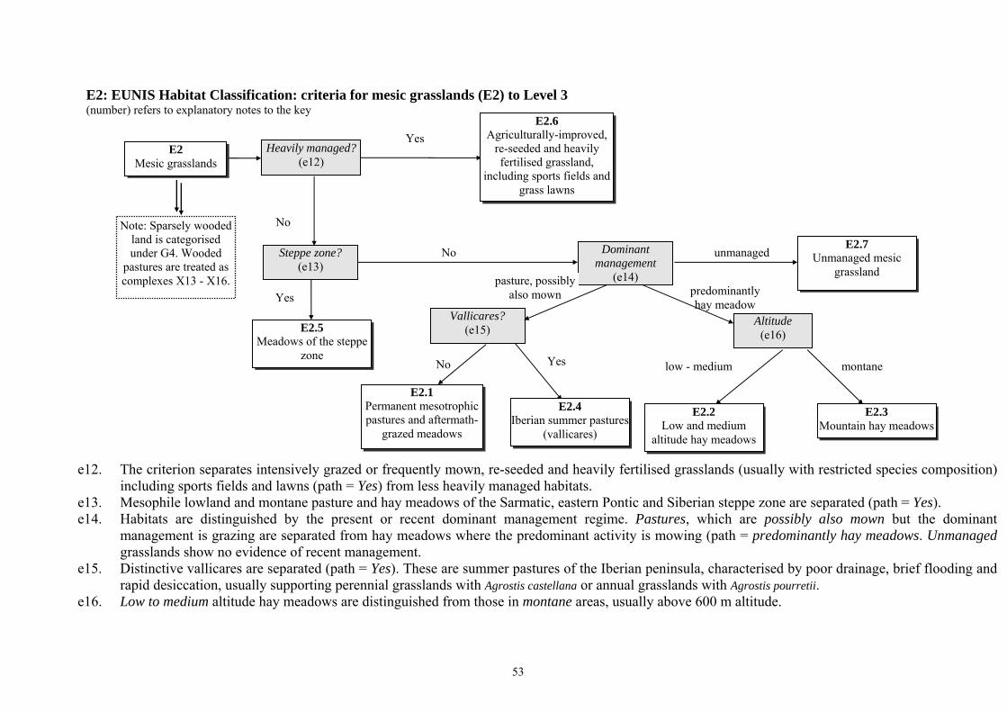
53
predominantly hay meadow
No
Dominant management
(e14) pasture, possibly also mown
Vallicares? (e15)
Yes
Altitude (e16)
low - medium montane
No
Yes
Steppe zone? (e13)
No
Heavily managed? (e12)
Yes
E2.5 Meadows of the steppe
zone
unmanaged
E2: EUNIS Habitat Classification: criteria for mesic grasslands (E2) to Level 3 (number) refers to explanatory notes to the key
e12. The criterion separates intensively grazed or frequently mown, re-seeded and heavily fertilised grasslands (usually with restricted species composition) including sports fields and lawns (path = Yes) from less heavily managed habitats.
e13. Mesophile lowland and montane pasture and hay meadows of the Sarmatic, eastern Pontic and Siberian steppe zone are separated (path = Yes). e14. Habitats are distinguished by the present or recent dominant management regime. Pastures, which are possibly also mown but the dominant
management is grazing are separated from hay meadows where the predominant activity is mowing (path = predominantly hay meadows. Unmanaged grasslands show no evidence of recent management.
e15. Distinctive vallicares are separated (path = Yes). These are summer pastures of the Iberian peninsula, characterised by poor drainage, brief flooding and rapid desiccation, usually supporting perennial grasslands with Agrostis castellana or annual grasslands with Agrostis pourretii.
e16. Low to medium altitude hay meadows are distinguished from those in montane areas, usually above 600 m altitude.
E2.2 Low and medium
altitude hay meadows
E2.1 Permanent mesotrophic pastures and aftermath-
grazed meadows
E2.4 Iberian summer pastures
(vallicares)
E2.3 Mountain hay meadows
E2.6 Agriculturally-improved,
re-seeded and heavily fertilised grassland,
including sports fields and grass lawns
E2 Mesic grasslands
Note: Sparsely wooded land is categorised under G4. Wooded
pastures are treated as complexes X13 - X16.
E2.7 Unmanaged mesic
grassland

54
E3: EUNIS Habitat Classification: criteria for seasonally wet and wet grasslands (E3) to Level 3 (number) refers to explanatory notes to the key e17. The criterion separates out habitats with mediterranean; sub-mediterranean; or other climate types. e18. Short-herb communities subject to alternating extreme conditions of inundation and summer desiccation (path = Yes) are distinguished from
tall grassland in permanently humid conditions. e19. Nutrient-poor (often acid) grasslands (path = Yes) are separated from meso- and eutrophic habitats. Note that nutrient-poor grasslands may be
rich in chalk.
Climate (e17)
Oligotrophic? (e19)
other
Yes
mediterranean
No
Summer desiccation?
(e18)
Yes
No
sub-mediterranean
E3.5 Moist or wet
oligotrophic grassland
E3.3 Sub-mediterranean
humid meadows
E3.1 Mediterranean tall humid grassland
E3.2 Mediterranean short
humid grassland
E3 Seasonally wet and
wet grasslands
E3.4 Moist or wet eutrophic
and mesotrophic grassland

55
No
Yes Late-lying snow? (e20)
acid
Soil type (e23)
Enriched? (e22)
Yes
No
base-rich
Moss and lichen dominated?
(e21)
Yes No
E4: EUNIS Habitat Classification: criteria for alpine and subalpine grasslands (E4) to Level 3 (number) refers to explanatory notes to the key e20. Grassland habitats of areas that retain late-lying snow (i.e. areas retaining snow for longer than usual for that latitude and altitude) are
separated (path = Yes). Note that permanently snow or ice covered habitats are categorised under H4. e21. Relatively snow-free exposed summits, slopes and ridges dominated by mosses and lichens are separated (path = Yes). e22. Enriched (fertilised or manured) alpine and sub-alpine grassland habitats are separated (path = Yes). Note that manuring can be by
concentrations of grazing animals. e23. Acid alpine grasslands are distinguished from alpine grassland habitats on base-rich soils.
E4.4 Calcareous alpine and subalpine grassland
E4.5 Alpine and subalpine
enriched grassland
E4.3 Acid alpine and
subalpine grassland
E4.1 Vegetated snow-patch
E4 Alpine and subalpine
grasslands
Note: Snow patch habitats are treated as
complex X05 comprising units of
E4.1 and F2.1
E4.2 Moss and lichen
dominated mountain summits, ridges and
exposed slopes

56
E5: EUNIS Habitat Classification: criteria for woodland fringes and clearings and tall forb stands (E5) to Level 3 (number) refers to explanatory notes to the key e24. Habitats with moist loamy soils typically at subalpine altitudes, but occasionally extending to alpine or montane levels are separated (path =
Yes). e25. Habitats dominated by bracken (Pteridium aquilinum) are separated (path = Yes). e26. Anthropogenic forb-rich, often nitrate-enriched habitats colonised by or planted with weeds or forbs such as nettles and willow herbs (Urtica
dioica, Epilobium spp.), other ruderal species or legumes (which are not on cropland) are separated (path = Yes). e27. Tall herb and fern habitats of boreal, alpine and nemoral climates with humid soils e.g. on stream sides or in damp meadows, or with shade,
are separated (path = mesophile) from those of woodland edges with more thermophilous character, in which Geranium sanguineum, Origanum vulgare and Vincetoxicum hirundinaria are commonly present.
E5.1 Anthropogenic herb
stands
E5 Woodland fringes and clearings and tall forb
stands
E5.4 Moist or wet tall-herb and fern fringes and
meadows
E5.5 Subalpine moist or
wet tall-herb and fern stands
E5.3 Pteridium aquilinum
fields
E5.2 Thermophile woodland
fringes
Subalpine, moist loamy soils?
(e24)
Yes
No
Bracken-dominated?
(e25)
thermophile
Temperature regime(e27)
No
mesophile
Nitrate-enriched? (e26)
No
Yes
Yes

57
E6: EUNIS Habitat Classification: criteria for inland salt steppes (E6) to Level 3 (number) refers to explanatory notes to the key e28. Inland saline grassland and herb-dominated habitats characteristic of two climate types are distinguished: mediterranean; and continental or
sub-continental.
mediterranean
continental or sub-continental
Climate type (e28)
E6.1 Mediterranean inland
salt steppes
E6 Inland salt steppes
E6.2 Continental inland salt
steppes

58
E7: EUNIS Habitat Classification: criteria for sparsely wooded grasslands (E7) to Level 3 (number) refers to explanatory notes to the key e29. Sparsely wooded grasslands (canopy cover 5 - 10% trees) characteristic of three climate types are distinguished: atlantic; sub-continental; and
mediterranean.
E7 Sparsely wooded
grasslands
mediterranean
atlantic
Climate type (e29)
E7.1 Atlantic parkland
E7.3 Dehesa
E7.2 Sub-continental
parkland
sub-continental

59
F: EUNIS Habitat Classification: criteria for heathland, scrub and tundra (F) to Level 2 Note that the key to Level 1 shows two pathways to reach habitat type F: these are recombined here. (number) refers to explanatory notes to the key (see following page).
Yes
spiny, cushion-forming shrubs
No
other
other
cold to cold-temperate
temperate or mediterraneo-
montane
Yes
No
FA Hedgerows
No
Regularly tilled or planted?
(Fii)
Dominant vegetation
stratum (Fv)
F2 Arctic, alpine and subalpine scrub
F5 Maquis, arborescent matorral and thermo-
Mediterranean brushes
F3 Temperate and
mediterranean-montane scrub
F6 Garrigue
Climate (Fvi)
F4 Temperate shrub
heathland
F HEATHLAND, SCRUB AND
TUNDRA
F7 Spiny Mediterranean heaths (phrygana, hedgehog-heaths
and related coastal cliff vegetation)
F8 Thermo-Atlantic xerophytic scrub
succulents and composites
FB Shrub plantations
Permafrost? (Fiii)
Yes
F1 Tundra
mediterranean or sub-desert
Dominant vegetation type
(Fvii)
Structure (Fviii)
ericoid
closed
open
Narrow belt of shrubs?
(Fi)
Either on waterlogged ground or
fringing water? (Fiv)
No
Yes
F9 Riverine and fen
scrubs
sclerophyllous

60
Fi. Hedgerows, comprising narrow linear belts of shrubs, which may or may not be managed, with or without occasional trees, are distinguished
(path = Yes). Note that shrubby habitats of forest edges are classified under G. Fii. Shrub plantations which are cultivated regularly, but not necessarily annually (vineyards, fruit orchards and tea plantations), are distinguished
(path = Yes). Fiii. Tundra habitats characterised by the presence of permafrost are separated (path = Yes). Fiv. Scrubs and thickets on waterlogged ground or fringing temporary or permanent rivers and streams are separated (path = Yes) from other shrub
habitats in drier areas. Fv. Habitats are separated on the basis of the vegetation type: succulents and composites (members of the family Compositae); and spiny,
cushion-forming shrubs; and other shrubs and low trees. Note that ‘low trees’ are defined as tree species when they are restricted in their growth form (and which may be prostrate).
Fvi. This criterion separates habitats characterised by their temperature regime, but this may operate at a variety of geographical and altitudinal scales: cold to cold-temperate climate in the arctic, alpine or subalpine zones; temperate or mediterraneo-montane climate in warmer areas in the arctic or alpine and subalpine zones or cooler areas of the mediterranean region (i.e. warm temperate areas of the mountains of the mediterranean region); and mediterranean or sub-desert climates in the Mediterranean zone.
Fvii. Habitats with a temperate or mediterraneo-montane climate are separated according to their dominant vegetation type: ericoid shrubs; sclerophyllous shrubs; or other broadleaved deciduous or coniferous shrubs and low trees.
Fviii. Garrigue is distinguished from maquis and matorral: garrigue always has an open vegetation and some bare ground, usually with many annuals and geophytes and dominated by vernal species, usually with some patches of shrubs (e.g. Cistus, Lavendula, Rosmarinus and Stoechas) and there may be some larger shrubs and scattered trees present; maquis and matorral comprise more closed vegetation, usually with 100% cover, mainly shrubs with few annuals and some geophytes, trees are nearly always present, some of which may be in shrub form.

61
F1: EUNIS Habitat Classification: criteria for tundra (F1) to Level 3 (number) refers to explanatory notes to the key f1. Tundra habitats are distinguished by their dominant vegetation types: shrubs or moss and lichens.
moss and lichens
F1.1 Shrub tundra
F1 Tundra
F1.2 Moss and lichen tundra
Dominant vegetation
(f1)
shrubs

62
F2: EUNIS Habitat Classification: criteria for arctic, alpine and subalpine scrub (F2) to Level 3 (number) refers to explanatory notes to the key f2. Habitats characterised by species tolerant of snow cover for most of the year are distinguished (path = Yes). f3. Habitats in the subalpine zone dominated by dwarf needle-leaved trees (primarily Pinus mugo) are separated (path = Yes). f4. Evergreen vegetation largely dominated by ericoids is separated (path = Yes) from deciduous scrubs developed in areas sheltered by snow from
wind and frost. These latter areas are normally characterised by the permanent presence of moving water, allowing turnover of nutrients and preventing accumulation of mor.
Yes
No
Snow-covered for 8 - 10 months?
(f2)
F2.2 Evergreen alpine and subalpine heath and
scrub
F2.1 Subarctic and alpine dwarf willow scrub
F2 Arctic, alpine and subalpine scrub
Note: Snow patch habitats are treated as
complex X05 comprising units of
E4.1and F2.1
Yes
No
Pine dominated? (f3)
F2.3 Subalpine deciduous
scrub
F2.4 Conifer scrub close to
the tree limit
Ericaceous and other evergreen
vegetation? (f4)
No Yes

63
F3: EUNIS Habitat Classification: criteria for temperate and mediterranean-montane scrub (F3) to Level 3 (number) refers to explanatory notes to the key f5. Habitats in temperate and warmer mediterraneo-montane climatic zones are distinguished. Note that localised microclimate conditions may
allow the temperate unit to appear in the Mediterranean zone, in which case follow path = temperate.
Climate (f5)
F3.1 Temperate thickets and
scrub
F3 Temperate and
mediterranean-montane scrub
F3.2 Submediterranean
deciduous thickets and brushes
temperate
mediterraneo-montane

64
F4: EUNIS Habitat Classification: criteria for temperate shrub heathland (F4) to Level 3 (number) refers to explanatory notes to the key f6. The criterion separates temperate heaths of the Macaronesian biogeographic region from those occurring in Atlantic, Continental, Boreal or
Alpine zones (path = other). f7. Heathlands are distinguished by the soil moisture: humid or damp (usually peaty soils); or dry (usually podzolic soils, but may be peat).
Macaronesian
other Biogeographic
region (f6)
humid or damp
dry
Soil moisture (f7)
F4.3 Macaronesian heaths
F4.1 Wet heaths
F4.2 Dry heaths
F4 Temperate shrub
heathland

65
F5: EUNIS Habitat Classification: criteria for maquis, arborescent matorral and thermo-Mediterranean brushes (F5) to Level 3 (number) refers to explanatory notes to the key f8. Matorral characterised by arborescent species is separated (path = Yes). f9. Habitats dominated by Spanish broom (Spartium) are distinguished (path = Yes). f10. Brush habitats characteristic of the thermo-Mediterranean altitudinal belt are distinguished (path = Yes). f11. Pseudomaquis (broadleaved or deciduous species found together with sclerophyllous species) is distinguished (path = Yes).
No
Yes
Dominated by Spanish broom?
(f9)
Arborescent? (f8)
Yes
No
Broadleaved species present?
(f11)
Yes
No
No
Yes
F5.4 Spartium junceum fields
F5.3 Pseudomaquis
F5.2 Maquis
F5.1 Arborescent matorral
F5 Maquis, arborescent matorral and thermo-
Mediterranean brushes F5.5
Thermo-Mediterranean scrub
Thermo-Mediterranean?
(f10)

66
F6: EUNIS Habitat Classification: criteria for garrigue (F6) to Level 3 (number) refers to explanatory notes to the key f12. Scrub habitats with species characteristic of very dry, saline soils are separated (path = Yes). f13. Garrigues occupying gypsum-rich soils, characterised floristically by the presence of numerous gypsophilous species, and usually very open,
are distinguished (path = Yes). f14. Garrigues of the supra-Mediterranean altitudinal belt (degradation stage of thermophile deciduous forest) are separated from other garrigue
formations. f15. Garrigues are distinguished on the basis of their geographical location, which is related to their species composition. The five groups are:
western Mediterranean found in Iberia, France, Italy and large western islands; eastern Mediterranean found in Greece, Cyprus and western Anatolia; Illyrian found in the northern Balkan peninsula from Albania northwards; Black Sea in the Pontic region; and Macaronesian in the Canary Islands, Azores and Madeira.
Gypsic soil? (f13)
Saline soil? (f12)
Yes
No
Yes
No
F6 Garrigue
F6.7 Mediterranean gypsum
scrubs
F6.8 Xero-halophile scrubs
F6.1 Western garrigues
Altitudinal belt
(f14)
F6.2 Eastern garrigues
F6.4 Black Sea garrigues
F6.3 Illyrian garrigues
F6.6 Supra-Mediterranean
garrigues
Distribution (f15)
other
supra-Mediterranean eastern Mediterranean western
Mediterranean
Illyrian
Black Sea
F6.5 Macaronesian garrigues
Macaronesian

67
F7: EUNIS Habitat Classification: criteria for spiny Mediterranean heaths (phrygana, hedgehog-heaths and related coastal cliff vegetation) (F7) to Level 3 (number) refers to explanatory notes to the key f16. Habitats are separated by the species composition characteristic of thermo-Mediterranean lowland areas and of high dry mountains. Thermo-
Mediterranean phryganas are sclerophyllous scrubs and are often summer-deciduous. f17. ‘Phrygana’ habitats are separated according to the species composition characteristic of different parts of the Mediterranean biogeographic
region: west Mediterranean phryganas are usually characterised by Astragalus massiliensis or Anthyllis hermanniae; central Mediterranean phryganas may be dominated by a variety of species; east Mediterranean phryganas are widespread and diverse.
high dry mountains
thermo-Mediterranean
lowlands Altitude (f16)
west Mediterranean
Distribution (f17)
central Mediterranean
east Mediterranean
F7.4 Hedgehog-heaths
F7.3 East Mediterranean
phrygana
F7.2 Central Mediterranean
spiny heaths
F7.1 West Mediterranean
spiny heaths
F7 Spiny Mediterranean heaths (phrygana, hedgehog-heaths
and related coastal cliff vegetation)
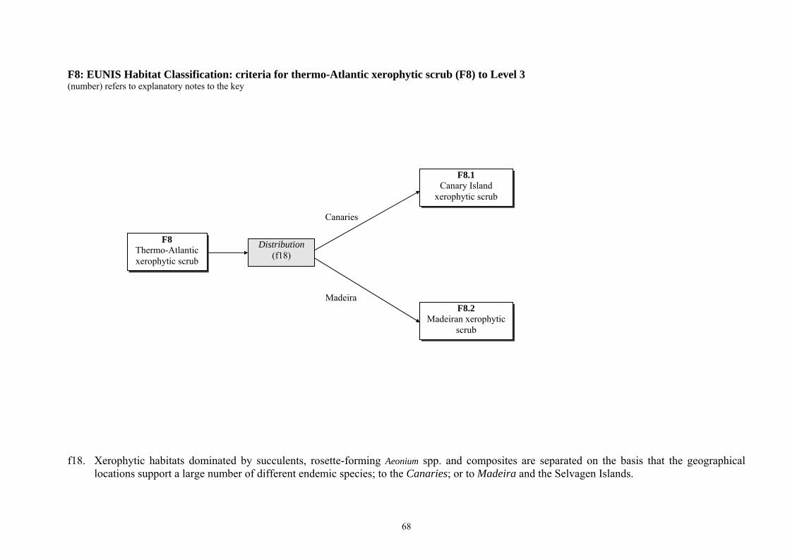
68
F8: EUNIS Habitat Classification: criteria for thermo-Atlantic xerophytic scrub (F8) to Level 3 (number) refers to explanatory notes to the key f18. Xerophytic habitats dominated by succulents, rosette-forming Aeonium spp. and composites are separated on the basis that the geographical
locations support a large number of different endemic species; to the Canaries; or to Madeira and the Selvagen Islands.
Madeira
Canaries
Distribution (f18)
F8.2 Madeiran xerophytic
scrub
F8.1 Canary Island
xerophytic scrub
F8 Thermo-Atlantic xerophytic scrub

69
F9: EUNIS Habitat Classification: criteria for riverine and fen scrubs (F9) to Level 3 (number) refers to explanatory notes to the key f19. Scrub habitats on poorly drained waterlogged ground such as fens (path = Yes) are separated from scrubs alongside permanent or temporary
waterbodies. f20. Scrubs usually alongside alpine or lowland permanent or temporary waterbodies and comprising mainly willows (includes Salix spp) (sometimes
with Myricaria germnanica, Hippophaea rhamnoides, Myrica gale and Frangula alnus) are separated from riverine scrubs more typical of the thermo-Mediterranean climate, such as tamarisk (includes Tamarix) or Nerium oleander, Vitex agnus-castus, Securinegia, Prunus or Viburnum. Note that the willow scrubs may occur in warmer climates as well.
includes Tamarix
includes Salix
Species (f20)
F9.1 Riverine scrub
F9 Riverine and fen
scrubs
F9.3 Southern riparian
galleries and thickets
Waterlogged soil? (f19)
No
Yes
F9.2 Salix carr and fen scrub

70
FA: EUNIS Habitat Classification: criteria for hedgerows (FA) to Level 3 (number) refers to explanatory notes to the key f21. Hedgerows are separated between those mainly composed of species exotic to their location (e.g. Californian Leyland Cypress x Cupressocyparis
leylandii) (path = mainly exotic), and those mainly consisting of native species (path = mainly native). f22. Hedgerows mainly of native species managed intensively (e.g. by regular trimming) (path = high) are separated from those subject to little or no
management (path = low). f23. Hedges which are rich in shrub species and ground flora (path = many) are separated from those dominated by one or two shrub species (path =
few).
low
high
Management intensity
(f22)
few
many
Species number (f23)
mainly native
mainly exotic
Species composition
(f21)
FA.1 Hedgerows of non-
native species
FA Hedgerows
FA.2 Highly-managed
hedgerows of native species
FA.4 Species-poor hedgerows
of native species
FA.3 Species-rich
hedgerows of native species

71
FB: EUNIS Habitat Classification: criteria for shrub plantations (FB) to Level 3 (number) refers to explanatory notes to the key f24. Shrub plantations are separated on the basis of their usage: for whole plant harvesting, such as horticultural shrub nurseries; for leaf or branch
harvest, such as osiers or tea; for ornamental purposes e.g. flowers, or fruit other than vines (path = other fruit or ornamental); vines, usually for wine production (path = viticulture).
leaf or branch
whole plant
viticulture
Usage (f24)
FB.1 Shrub plantations for whole-plant
harvesting
FB Shrub plantations
FB.2 Shrub plantations for leaf or branch harvest
FB.4 Vineyards
FB.3 Shrub plantations for
ornamental purposes or for fruit, other than
vineyards
other fruit or ornamental

72
G: EUNIS Habitat Classification: criteria for woodland, forest and other wooded land (G) to Level 2 (number) refers to explanatory notes to the key (see following page).
broadleaved deciduous
coniferous
broadleaved evergreen
Characterising tree types (Gii)
G3 Coniferous woodland
G1 Broadleaved
deciduous woodland
G WOODLAND, FOREST AND
OTHER WOODED LAND
Woodland type (Gi)
G5 Lines of trees, small
anthropogenic woodlands, recently felled woodland, early-stage woodland and
coppice
‘forest’
other G2
Broadleaved evergreen woodland
mixed
G4 Mixed broadleaved
and coniferous woodland
The dividing criterion of 10% crown cover is based on FAO definitions. It should be noted that in some areas e.g. the Boreal zone, the normal dividing point is 30%. Statistics produced at a regional scale might reflect this divergence.

73
Gi. ‘Forest’ habitats are separated from other wooded habitats. ‘Forest’ habitats are defined as: natural stands of area greater than 0.5 ha and crown
cover greater than 10% and tree height greater than 5 m; natural stands of area less than 0.5 ha and crown cover greater than 10% and tree height greater than 5 m with more or less natural ground flora (i.e. not heavily influenced by man through management or damage); plantations of area greater than 0.5 ha and crown cover greater than 10% and tree height greater than 5 m. Other wooded land includes: natural stands of area less than 0.5 ha and crown cover greater than 10% and tree height greater than 5 m heavily influenced by man through management or damage (small, intensively managed woods and small woods strongly influenced by anthropogenic activities); young natural stands with trees of height less than 5 m and potential crown cover of greater than 10%; plantations of young trees with potential crown cover of greater than 10% and tree height less than 5 m; plantations of area less than approximately 0.5 ha with potential crown cover of greater than 10% and tree height greater than 5 m; areas normally part of the forest area but temporarily unstocked as a result of human intervention or natural causes; coppice; narrow lines of mature trees, such as avenues and windbreaks. Note that Dwarf trees at the arctic and alpine tree limit (i.e. krummholz under conditions where mature individuals are less than 3 m high) are included in F, Heathland scrub and tundra. Note that areas of grassland with trees where the crown cover is 5 -10 % are categorised under E7.
Gii. Forest is characterised by the dominant tree types, which may be mixtures of species within the categories broadleaved deciduous; mixed broadleaved and coniferous; broadleaved evergreen; and coniferous. Note that broadleaved woodland is defined as wooded land on which more than 75% of the tree crown cover consists of broadleaved species and that coniferous woodland is defined as wooded land on which more than 75% of the tree crown cover consists of coniferous species (based on FAO definition). Mixed woodland is defined as wooded land on which neither coniferous, nor broadleaved species account for more than 75% of the crown cover.

74
G1: EUNIS Habitat Classification: criteria for broadleaved deciduous woodland (G1) to Level 3 (number) refers to explanatory notes to the key (see following page).
waterlogged
Yes
willow, alder or birch
riparian or alluvial
Usage (g2)
dry or seasonally wet
Dominant species (g5)
Dominant species
(g7)
other
timber production
tree orchards
No
Riparian zone? (g4)
No
Hydrology (g3)
On acid peat? (g6)
YesNo
Highly artificial?
(g1)
G1.4 Broadleaved swamp
woodland not on acid peat
G1.1 Riparian and gallery
woodland, with dominant Alnus, Betula, Populus or
Salix
G1.2 Mixed riparian
floodplain and gallery woodland
G1 Broadleaved
deciduous woodland
G1.C Highly artificial
broadleaved deciduous forestry plantations
G1.D Fruit and nut tree
orchards
G1.3 Mediterranean riparian
woodland
Yes
G1.5 Broadleaved
swamp woodland on acid peat
birch, aspen or rowan
Yes
beech
No
Thermophilous? (g8)
G1.6 Fagus woodland
G1.7 Thermophilous
deciduous woodland
G1.9 Non-riverine woodland with Betula, Populus
tremula or Sorbus aucuparia
G1.8 Acidophilous Quercus- dominated woodland
G1.A Meso- and eutrophic Quercus,
Carpinus, Fraxinus, Acer, Tilia, Ulmus and related
woodland
Oligotrophic? (g9)
other
No
Yes
alder
G1.B Non-riverine Alnus
woodland

75
g1. Highly artificial broadleaved deciduous forests (often of exotic species) of uniform age and structure, completely dependent on man’s
operations and with impoverished associated communities (path = Yes) are separated from less highly managed habitats. g2. Highly artificial forestry plantations normally used primarily for timber production (including for fibre and wood-pulp) are separated from fruit
and nut tree orchards. Note that shrub orchards are categorised under FB. g3. Three hydrological regimes are distinguished: waterlogged (permanently wet, with the water table at or close to the surface), riparian or
alluvial (dependent on flowing water, giving rise to a high water table and subject to occasional flooding) and dry or seasonally wet. g4. Riparian woods with one or few dominant species, typically alder, birch, poplar or willow (Alnus spp., Betula spp., Populus spp. or Salix spp.) (path =
Yes) are distinguished from mixed flood-plain and river-terrace forests, sometimes structurally complex and species-rich, often including ash, oak or elm (Fraxinus spp., Quercus spp., Ulmus spp.).
g5. Riparian woodlands dominated by willow, alder and birch (Salix spp., Alnus spp., Betula spp.) are separated from riparian woodland habitats characteristic of the Mediterranean climate dominated by other species including ash, plane and elm (Fraxinus spp., Platanus spp., Ulmus spp.). Note that Mediterranean willow woods follow path = willow, alder or birch.
g6. Broadleaved swamp woodlands are distinguished between those growing on acid peat (path = Yes) and those formed under neutral or basic conditions (path = No).
g7. Dry and seasonally wet woodland habitats are separated according to their dominant species: beech (Fagus spp.); alder (Alnus spp.); birch (Betula spp.), aspen (Populus tremula) or rowan (Sorbus aucuparia); and other.
g8. Woodlands characterised by thermophilous species, e.g. downy oak Quercus pubescens, eastern hornbeam Carpinus orientalis, chestnut Castanea sativa, hop hornbeam Ostrya carpinifolia (path = Yes) are distinguished from those of other climatic types.
g9. Woodlands characteristic of oligotrophic soils, usually with acidophilous species, are separated (path = Yes) from those on more meso- to eutrophic substrates. Note that birch may be present but never dominant in habitat units in G1.8. More or less pure stands of birch are included under G1.9.

76
other
Dominant species (g12)
olive or carob
palms
laurels
holly
oaks
Biogeographic region (g13)
other
G2.6 Ilex aquifolium woods
G2.8 Highly artificial
broadleaved evergreen forestry plantations
No G2.1
Mediterranean evergreen Quercus
woodland
G2.5 Phoenix groves
G2.2 Eurasian continental
sclerophyllous woodland
G2.3 Macaronesian Laurus
woodland
G2.4 Olea europaea - Ceratonia siliqua
woodland
G2 Broadleaved
evergreen woodland
Macaronesian
Yes
Usage (g11)
G2.9 Evergreen orchards and
groves
timber production
Highly artificial?
(g10)
other
G2.7 Canary Island heath
woodland
G2: EUNIS Habitat Classification: criteria for broadleaved evergreen woodland (G2) to Level 3 (number) refers to explanatory notes to the key g10. Highly artificial broadleaved evergreen forests (often of exotic species) of uniform age and structure, completely dependent on man’s
operations and with impoverished associated communities (path = Yes) are separated from less highly managed habitats. g11. Highly artificial evergreen forestry plantations normally primarily used for timber production are separated from those used for other purposes
(including olive groves and palm plantations). g12. Habitats are separated according to their dominant species: evergreen oaks (Quercus); laurels (Laurus); holly (Ilex); palms (Phoenix); olive (Olea
europea) or carob (Ceratonia siliqua); and other very tall, forest-like formations dominated by Erica arborea, Myrica faya, Arbutus canariensis or Visnea mocanera.
g13. Laurel (Laurus)-dominated habitats characteristic of the Macaronesian biogeographic region are separated from those of the Mediterranean and Atlantic regions (path = other).

77
G3: EUNIS Habitat Classification: criteria for coniferous woodland (G3) to Level 3 (number) refers to explanatory notes to the key (see following page).
No G3.E
Nemoral bog conifer woodland
spruce pine
Yes No
Yes
Hydrology (g15)
Highly artificial?
(g14)
Dominant species (g18)
wet
mesic or dry
larch and/or Arolla
fir or spruce
other lowland and montane
Macaronesian
Mediterranean
cypresses including Tetraclinis and juniper,
or yew
pine or pine-juniper
(excluding P. nigra)
lowland to montane
Boreal? (g17)
Yes
G3.A Picea taiga woodland
No
Biogeographic region (g19)
Boreal? (g16)
Altitude zone (g20)
subalpine
Altitude zone (g21)
Pinus nigra group
subalpine G3.6 Subalpine
mediterranean Pinus woodland
Dominant species (g22)
G3.B Pinus taiga woodland
larch
G3.C Larix taiga woodland
G3.F Highly artificial
coniferous plantations
G3.5 Pinus nigra woodland
G3 Coniferous woodland
G3.4 Pinus sylvestris
woodland south of the taiga
G3.3 Pinus uncinata
woodland
G3.2 Alpine Larix - Pinus
cembra woodland
G3.9 Coniferous woodland
dominated by Cupressaceae or Taxaceae
G3.1 Abies and Picea
woodland
G3.7 Lowland to montane mediterranean Pinus woodland (excluding
Pinus nigra)
G3.8 Canary Island Pinus
canariensis woodland
G3.D Boreal bog
conifer woodland

78
g14. Highly artificial coniferous forests (often of exotic species) of uniform age and structure, completely dependent on man’s operations and with
impoverished associated communities (path = Yes) are separated from less highly managed habitats. g15. Two hydrological regimes are distinguished: wet (with the water table at or close to the surface for at least half the year); and mesic or dry. g16. Wet coniferous woodland habitats characteristic of the Boreal zone are distinguished (path = Yes). g17. Mesic or dry coniferous woodland habitats characteristic of the Boreal zone are distinguished (path = Yes). g18. Mesic and dry non-Boreal habitats are separated according to their dominant species groups: fir (Abies spp.) or spruce (Picea spp.); larch (Larix
spp.) and/or Arolla (Pinus cembra); Pinus nigra group (Pinus nigra, Pinus dalmatica, Pinus laricio, Pinus pallasiana); cypresses (Cupressus and Tetraclinis), juniper (Juniperus) or yew (Taxus baccata); pine or pine-juniper (excluding P. nigra).
g19. Pine (Pinus) and juniper (Juniperus)-dominated woodlands are separated between biogeographic region: Mediterranean; Macaronesian and other (Atlantic, Continental, Alpine, etc.)
g20. Pine woodlands in the subalpine altitude zone (usually dominated by Pinus uncinata) are distinguished from those in the lowland and montane altitude zones usually dominated by Pinus sylvestris. Note that Pinus sylvestris forests may occur in the subalpine zone but follow path = lowland and montane.
g21. Mediterranean pine woodlands other than of Pinus nigra are separated by altitude into a group in the montane and subalpine zones close to the tree-line (dominated by Pinus heldreichii (=Pinus leucodermis), Pinus peuce) and thermophilous pine woodlands in lowland to montane situations (dominated by Pinus halepensis, P. pinea and P. pinaster).
g22. Coniferous woodlands of the taiga zone are separated between those dominated by spruce; by pine; and by larch.

79
G4: EUNIS Habitat Classification: criteria for mixed deciduous and coniferous woodland (G4) to Level 3 (number) refers to explanatory notes to the key (see following page).
with beech
with birch No
No
Boreal
Yes
No
other
Yes
Cupressaceae or Taxaceae
other Species composition
(g26)
Distribution (g25)
pines other than Black
pine
with oak
including broadleaved evergreens
including Scots pine
Waterlogged? (g24)
G4.3 Mixed sub-taiga woodland with
acidophilous Quercus
G4 Mixed deciduous and coniferous
woodland
G4.1 Mixed swamp
woodland
NoHighly artificial?
(g23)
Yes
G4.F Mixed forestry
plantations
G4.E Mixed mediterranean pine - evergreen oak
woodland
G4.A Mixed woodland with
Cupressaceae, Taxaceae and evergreen oak
G4.D Mixed Pinus nigra - evergreen Quercus
woodland
G4.7 Mixed Pinus sylvestris - acidophilous Quercus
woodland G4.4 Mixed Pinus sylvestris -
Betula woodland G4.5 Mixed Pinus sylvestris -
Fagus woodland G4.C Mixed Pinus sylvestris - thermophilous Quercus
woodland
Coniferous element (g27)
Black pine (Pinus nigra)
Deciduous element (g28)
Thermophilous? (g29)
Yes
Thermophilous? (g31)
With Cupressaceae or Taxaceae?
(g30)
Yes G4.9
Mixed deciduous woodland with
Cupressaceae or Taxaceae
G4.B Mixed mediterranean Pinus - thermophilous
Quercus woodland
G4.8 Mixed non-riverine
deciduous and coniferous woodland
G4.6 Mixed Abies - Picea -
Fagus woodland
With only beech and fir or spruce?
(g32) Yes No
Boreo-nemoral
G4.2 Mixed taiga
woodland with Betula

80
g23. Highly artificial mixed broadleaved deciduous and coniferous forests (often of exotic species and of uniform age and structure), completely
dependent on man’s operations and with impoverished associated communities (path = Yes) are separated from less highly managed habitats. g24. Habitats which are waterlogged (permanently wet, with the water table at or close to the surface) are separated (path = Yes) from those with
other hydrological regimes. g25. Coniferous woodland characteristic of the Boreal zone with an admixture of birch; or of the Boreo-nemoral zone with an admixture of other
deciduous species (usually oaks); are separated from other mixed woodlands. g26. The dominant species or species type separates three categories of mixed woodlands: those including broadleaved evergreens; those including
Scots pine (Pinus sylvestris); and those where the species composition comprises other species. g27. Mixed woodland habitats including broadleaved evergreen species are separated according to the main coniferous species present: with
cypresses and yews (Cupressaceae or Taxaceae); with mixed pines other than Black pine (Pinus nigra); and those including Black pine (Pinus nigra).
g28. Mixed woodland habitats including Scots pine (Pinus sylvestris) are separated according to the main deciduous species present: those with oaks; those with beech; and those with birch.
g29. Woodland habitats characterised by a mixture of Scots pine and thermophilous oak species are separated (Path = Yes). g30. Habitats characterised by a mixture of deciduous tree species and cypresses or yews (Cupressaceae or Taxaceae) are distinguished (path = Yes). g31. Habitats characterised by a mixture of pines, juniper and thermophilous oak species are separated (Path = Yes). g32. Other mixed coniferous and deciduous woodland habitats are separated according to their species composition: those with only beech and fir or
spruce are separated (path = Yes) from those with combinations of the deciduous species birch, aspen or rowan and occasionally some beech together with fir, spruce or pine.

81
G5: EUNIS Habitat Classification: criteria for lines of trees, small anthropogenic woodlands, recently felled woodland, early-stage woodland and coppice (G5) to Level 3 (number) refers to explanatory notes to the key (see following page).
no trees other
trees over 5 m height
linear
Dominant tree type
(g36)
Woodland width (g35)
coniferous
broadleaved deciduous
mixed broadleaved and
coniferous
broadleaved evergreen
trees under 5 m height
G5.7 Coppice and early-stage
plantations
Dominant vegetation type
(g33)
G5.8 Recently felled areas
G5.1 Lines of trees
G5.2 Small broadleaved
deciduous anthropogenic woodlands
G5.4 Small coniferous
anthropogenic woodlands
G5 Lines of trees, small
anthropogenic woodlands, recently
felled woodland, early-stage woodland and
coppice
G5.3 Small broadleaved evergreen
anthropogenic woodlands
G5.5 Small mixed broadleaved
and coniferous anthropogenic woodlands
Note: lines of shrub species are categorised
under FA. Sparsely wooded grassland with canopy cover 5-10% is categorised under E7.
Heavily managed or planted?
(g34)
G5.6 Early-stage natural and semi-natural woodlands
and regrowth
No
Yes

82
g33. The dominant vegetation type separates three categories of these miscellaneous woodlands: trees under 5 m height (including young stages of
forest re-growth or early colonisation by tree species, trees planted for early whole tree harvesting, such as Christmas trees, and coppice, where tree species are artificially maintained in the shrub phase); areas normally part of the forest area but very recently clear-felled and not yet re-stocked and with no succession to weedy vegetation or temporarily unstocked due to natural causes such as wind-throw, (path = no trees); or trees over 5 m height.
g34. Young plantations and woodlands maintained in the young stage through coppicing are separated (path = Yes) from stands of young trees arising from natural colonisation or forest regrowth.
g35. More or less continuous lines of trees and linear plantations comprising one to three distinct lines of trees, such as windbreaks and avenues, are separated from other small, intensively managed woods, small woods strongly influenced by anthropogenic activities and small plantations. Small woodlands are those up to about 0.5 ha in extent. Tree cover may often comprise completely or partially non-native species.
g36. Small anthropogenic woods and small plantations (less than about 0.5 ha in extent) are characterised by the dominant tree types, which may be mixtures of species within the categories broadleaved deciduous; broadleaved evergreen; coniferous; and mixed broadleaved and coniferous. Small natural and semi-natural woodlands are characterised with their larger counterparts in G1 – G4. Note that broadleaved woodland is defined as wooded land on which more than 75% of the tree crown cover consists of broadleaved species and that coniferous woodland is defined as wooded land on which more than 75% of the tree crown cover consists of coniferous species (based on FAO definition). Mixed woodland is defined as wooded land on which neither coniferous, nor broadleaved species account for more than 75% of the crown cover.

83
H: EUNIS Habitat Classification: criteria for inland unvegetated or sparsely vegetated habitats (H) to Level 2 Note that the key to Level 1 shows two pathways to reach parts of habitat type H: these are recombined here. (number) refers to explanatory notes to the key Hi. Natural underground systems are separated from surface habitats irrespective of other criteria. Note that disused man-made underground
systems which have been colonised by natural or semi-natural communities are also included here. Note also that caves in glaciers follow path = surface.
Hii. Habitats with unvegetated or sparsely vegetated surfaces are separated on the nature of the dominating substrate type. Three types are distinguished: snow and ice; recent volcanic origin; and other substrates. Note that non-permanent snow patches are included with alpine grasslands (E4).
Hiii. Cliffs and rock pavements comprising exposed horizontal or vertical bedrock are separated (path = Yes). Hiv. Screes consisting of mobile rocks and rock fragments on steep slopes are separated (path = Yes) from all other unvegetated or sparsely
vegetated inland habitats.
underground
H1 Terrestrial underground
caves, cave systems, passages and waterbodies
recent volcanic origin
snow and ice
H INLAND
UNVEGETATED OR SPARSELY
VEGETATED HABITATS
surface Surface or underground?
(Hi) Substrate
(Hii) H3 Inland cliffs, rock
pavements and outcrops
H5 Miscellaneous inland
habitats with very sparse or no vegetation
H2 Screes
H4 Snow or ice-
dominated habitats
H6 Recent volcanic
features
Bedrock? (Hiii)
Steep slope and mobile rock?
(Hiv)
Yes
Yes No
No
other

84
No
No H1.2
Cave interiors Restricted cross-
section? (h5)
No
Yes
H1: EUNIS Habitat Classification: criteria for terrestrial underground caves, cave systems, passages and waterbodies (H1) to Level 3 (number) refers to explanatory notes to the key h1. Underground waterbodies whether or not within caves are distinguished (path = Yes). h2. Disused mines and man-made passages, including tunnels, often with smoothed or constructed surfaces (path = Yes) are distinguished from
natural subterranean habitats. Note that active mines are characterised under J3.1 h3. Caves formed from hollow basaltic tubes which result from the cooling of the surface of lava flows whose molten interior continued to flow are
separated (path = Yes) from systems resulting from the action of water. h4. Cave entrances which are influenced by light, and subject to fluctuating temperature, and which are unlikely to support a specialised fauna are
separated (path = Yes) from cave interiors and passages beyond the reach of light and with a stable temperature. h5. Passages restricted in cross-section in comparison with the spaces which they connect are separated (path = Yes). h6. Standing waterbodies are separated from flowing waterbodies.
H1.3 Dark underground
passages
Yes
standing
Waterbody ? (h1)
No
Yes Water flow?
(h6)
flowing
H1.1 Cave entrances
Light-influenced and fluctuating temperature?
(h4)
H1.6 Underground running
waterbodies
H1 Terrestrial underground
caves, cave systems, passages and waterbodies
H1.5 Underground standing
waterbodies
Man-made? (h2)
H1.7 Disused underground
mines and tunnels Yes
No Volcanic origin?
(h3)
H1.4 Lava tubes
Yes

85
H2: EUNIS Habitat Classification: criteria for screes (H2) to Level 3 (number) refers to explanatory notes to the key h7. Screes are separated according to the climatic zone: arctic-boreal; or temperate-mediterranean. h8. Screes with a warm microclimate such as on south-facing exposures are distinguished from those with a cooler microclimate. h9. Acid siliceous rocks in the temperate-mediterranean climatic zones but with a cool microclimate are distinguished from basic rock habitats.
Note that basic includes calcareous, ultra-basic (serpentine) and dolomitic rocks. h10. Acid siliceous rocks in the temperate-mediterranean climatic zones and with a warm microclimate are distinguished from basic rock habitats.
Note that basic includes calcareous, ultra-basic (serpentine) and dolomitic rocks. h11. Acid siliceous rocks in the boreal climatic zone are distinguished from basic rock habitats. Note that basic includes calcareous, ultra-basic
(serpentine) and dolomitic rocks.
acid
Rock type (h10)
Climatic zone (h7)
basic
arctic - boreal
temperate - mediterranean
warm
acid
Rock type (h9)
basic
acid
Rock type (h11)
basic
Microclimate (h8)
cool
H2.5 Acid siliceous screes of
warm exposures
H2.4 Temperate-montane calcareous and ultra-
basic screes
H2.3 Temperate-montane acid siliceous screes
H2 Screes
H2.6 Calcareous and ultra-basic screes of warm
exposures
H2.1 Cold siliceous screes
H2.2 Cold limestone screes

86
H3: EUNIS Habitat Classification: criteria for inland cliffs, rock pavements and outcrops (H3) to Level 3 (number) refers to explanatory notes to the key h12. Rock outcrops are separated from more or less horizontal rock pavements and more or less vertical cliffs. h13. Very wet cliffs, usually with characteristic vegetation, are distinguished from other cliffs. h14. Cliffs with chasmophytic vegetation characteristic of the Macaronesian biogeographic region are distinguished from others. h15. Inland cliffs including their chasmophytic vegetation are separated according to rock type: acid siliceous, and basic (comprising calcareous and
ultra-basic) types are distinguished.
outcrop
cliff
pavement
Landform (h12)
acid
Rock type (h15)
basic
Macaronesian
Moisture (h13)
other
very wet
Biogeographic region (h14)
other
H3 Inland cliffs, rock
pavements and outcrops
H3.3 Macaronesian inland
cliffs
H3.5 Almost bare rock
pavements, including limestone pavements
H3.4 Wet inland cliffs
H3.1 Acid siliceous inland cliffs
H3.2 Basic and ultra-basic
inland cliffs
H3.6 Weathered rock and
outcrop habitats

87
H4: EUNIS Habitat Classification: criteria for snow or ice-dominated habitats (H4) to Level 3 (number) refers to explanatory notes to the key h16. Habitats dominated by snow and ice are separated according to the substrate type: more or less permanent complete snow cover (névé, Firn);
moving ice; or ice-dominated rock (path = rock and ice). Note that unvegetated glacial moraines where ice is no longer dominant are categorised under H5.2.
ice Substrate (h16)
snow
H4.1 Snow packs
H4.2 Ice caps and true
glaciers
H4 Snow or ice-
dominated habitats
H4.3 Rock glaciers and unvegetated ice-
dominated moraines
rock and ice H5.2 Glacial moraines with
very sparse or no vegetation
moraine without ice

88
H5: EUNIS Habitat Classification: criteria for miscellaneous inland habitats with very sparse or no vegetation (H5) to Level 3 (number) refers to explanatory notes to the key h17. Habitats created by fire which are unvegetated or sparsely vegetated are distinguished (path = Yes) from those created by other means. h18. Habitats which are unvegetated or sparsely vegetated because of frequent trampling or compaction by occasional vehicles are distinguished
(path = Yes). h19. Substrates sorted by current or recent freeze-thaw; or arising from current or recent glacial activity comprising ice-deposited debris (but where
ice is no longer dominant) (recent ice-deposition) are separated from those of other origin. Note that glacial moraines where ice is still dominant are categorised under H4.3.
h20. Other inland unvegetated habitats are distinguished according to the nature of their substrate: mineral; and organic (peat).
ice-dominated
sorted by freeze-thaw
Yes
mineral
other Parent
material (h20)
No
recent ice-deposition
Recently burnt? (h17)
H5.5 Burnt areas with very
sparse or no vegetation
H5.4 Dry organic substrates with very sparse or no
vegetation
H5.3 Sparsely- or un-vegetated
habitats on mineral substrates not resulting from recent ice
activity
H5 Miscellaneous inland
habitats with very sparse or no vegetation
Note: Coastal unvegetated or sparsely vegetated habitats are categorised under B; littoral zone habitats of inland surface waters under C; unvegetated habitats of wetlands under D; habitats on embryonic soil with >30% vegetation cover under E1.1, E1.9 or E1.A.
H5.2 Glacial moraines with
very sparse or no vegetation
H5.1 Fjell fields and other freeze-thaw features
with very sparse or no vegetation
Origin (h19)
Yes
H5.6 Trampled areas
Frequently trampled?
(h18)
No
organic
H4.3 Rock glaciers
and unvegetated ice-dominated
moraines

89
H6: EUNIS Habitat Classification: criteria for recent volcanic features (H6) to Level 3 (number) refers to explanatory notes to the key h21. Hot or cold gas or vapour vents are distinguished (path = Yes).
Yes
Gas or vapour vent? (h21)
No
H6.2 Inactive recent
volcanic features
H6.1 Active volcanic
features
H6 Recent volcanic
features

90
I: EUNIS Habitat Classification: criteria for regularly or recently cultivated agricultural, horticultural and domestic habitats (I) to Level 2 (number) refers to explanatory notes to the key
Ii. Land used for purposes of commercial agriculture or horticulture, usually large plots with few or no buildings, is distinguished from other
regularly or recently cultivated habitats which are usually of smaller size, often in close proximity to buildings or which are highly ornamental (path = ornamental, or close proximity to housing). Note that allotments follow path = commercial agriculture or horticulture.
ornamental, or close proximity to housing
I1 Arable land and market gardens
I2 Cultivated areas of gardens and parks
Usage (Ii)
commercial agriculture or horticulture I
REGULARLY OR RECENTLY CULTIVATED
AGRICULTURAL, HORTICULTURAL AND DOMESTIC HABITATS
Note: domestic and other gardens, parks and city squares are treated as complexes comprising combinations of units from any other level 1 unit.

91
I1: EUNIS Habitat Classification: criteria for arable land and market gardens (I1) to Level 3 (number) refers to explanatory notes to the key i1. Land under crops is separated (path = Yes). i2. Habitats comprising land regularly flooded as part of crop cultivation are distinguished (path = Yes). (Note that water cress beds are categorised
under C3.5) i3. Crops (agricultural, horticultural and industrial) grown in monoculture on large, unbroken surfaces in open field landscapes are distinguished
(path = Yes) from cultivation of alternating strips of different crops (including vegetables, flowers, small fruits, path = No). i4. Intensive cultivation with high use of pesticides and/or high use of fertilisers is distinguished from extensively cultivated unmixed crops with or
without low inputs of natural organic fertiliser.
Yes
Intensity (i4)
Under present cultivation?
(i1)
No
Yes
extensive
Regularly flooded?
(i2) Monoculture?
(i3) No No
Yes
intensive
I1.4 Inundated or
inundatable croplands, including rice fields
I1.3 Arable land with
unmixed crops grown by low-intensity
agricultural methods
I1.1 Intensive unmixed
crops
I1.2 Mixed crops of
market gardens and horticulture
I1 Arable land and market gardens
I1.5 Bare tilled, fallow or recently abandoned
arable land

92
I2: EUNIS Habitat Classification: criteria for cultivated areas of gardens and parks (I2) to Level 3 (number) refers to explanatory notes to the key i5. Previously cultivated but recently abandoned gardens colonised by weedy communities are distinguished (path = Yes). i6. Large scale ornamental gardens, including botanic gardens with a high proportion of non-native and/or non-food species are separated from
small-scale cultivated domestic or public garden areas often in close proximity to buildings.
large
small
NoScale (i6)
Yes
Weed communities?
(i5)
I2.2 Small-scale ornamental
and domestic garden areas
I2.3 Recently abandoned
garden areas
I2 Cultivated areas of gardens and parks
I2.1 Large-scale ornamental
garden areas
Note: Gardens, such as small-scale domestic gardens, often with very mixed species-rich flora and fauna (crops, lawns, shrubs, flowerbeds etc., frequently interspersed with paths and small buildings) in close proximity to human dwellings, urban green spaces (usually species-poor) and parks, are treated as complexes, comprising combinations of several level 1 units. Note that lawns are categorised under E2.7. Note also that waste organic material (such as garden compost, old straw and haystacks, and dung heaps) is categorised under J6.3 and J6.4

93
J: EUNIS Habitat Classification: criteria for constructed, industrial and other artificial habitats (J) to Level 2 (number) refers to explanatory notes to the key
Ji. Highly artificial waterbodies, with wholly-constructed beds or heavily contaminated water, and associated conduits and containers (path = Yes)
are separated from non-aquatic artificial habitats. Jii. Artificially constructed habitats comprising waste matter (such as slag heaps, landfill, agricultural waste) are separated (path = Yes). Note that
ruderal or pioneer communities invading these habitats are included with E5.1 Anthropogenic herb stands. Jiii. Habitats are distinguished according to current or recent usage: extractive industries (quarries, mines etc); transport networks, including paved
footpaths, recreation areas (hard surfaces constructed for recreational purposes) and the constructed parts of cemeteries (all including the immediately associated land but excluding the buildings thereon) (path = transport, recreation, cemetery); all other buildings. Note also that ruderal or pioneer communities invading these habitats are included with E5.1 Anthropogenic herb stands, but habitats which originated through man’s activities, but which have reverted to occupation by natural or semi-natural plant and animal communities are categorised with their counterparts elsewhere.
Jiv. Habitats comprising buildings are differentiated according to their density; medium to high density building as in cities, towns and villages is distinguished from low density (isolated) housing, agricultural, commercial and non-extractive industrial buildings and sites in a rural setting (surrounded by more natural habitats).
transport, recreation, cemetery
Yes
low other No No
Yes
medium to high
extractive industries
J4 Transport networks and other constructed hard-
surfaced areas
J CONSTRUCTED,
INDUSTRIAL AND OTHER ARTIFICIAL
HABITATS
J1 Buildings of cities,
towns and villages
Aquatic? (Ji)
J5 Highly artificial
man-made waters and associated
structures
Waste? (Jii)
J3 Extractive industrial
sites
J2 Low density
buildings
J6 Waste deposits
Usage (Jiii)
Density (Jiv)
Note that derelict spaces are categorised according to the nature of the surrounding areas.

94
J1: EUNIS Habitat Classification: criteria for buildings of cities, towns and villages (J1) to Level 3 (number) refers to explanatory notes to the key j1. Buildings are distinguished according to the amount and type of use: residential; industrial or commercial; or other. j2. Other non-residential and non-industrial buildings, often with public access (including churches, public halls, libraries etc) are separated from
disused buildings (including disused paved areas between buildings) and those in the process of construction or demolition. j3. Permanent residential units are distinguished from high density temporary residential units. Note that isolated caravans are categorised under
J2.1. j4. Residential buildings of high density (densely populated urban areas within a medium to large size built-up ensemble, heavily interspersed with
roads and footways, with limited access to surrounding rural areas) are distinguished from areas with moderate density housing (smaller groups of houses in rural areas and the periphery of more densely populated areas, with strong interconnections between the fauna of the built-up and countryside habitats, i.e. easy access to surrounding rural areas).
disused
Permanent or temporary structures?
(j3)
industrial or commercial
limited
easy
Usage (j1)
other residential
construction or demolition
J1.2 Residential buildings of
villages and urban peripheries
J1 Buildings of cities, towns and villages
J1.1 Residential buildings of
city and town centres
J1.4 Urban and suburban
industrial and commercial sites still in active use
J1.3 Urban and suburban
public buildings
J1.5 Disused constructions
of cities, towns and villages
J1.6 Urban and suburban
construction and demolition sites
Status (j2)
other
J1.7 High density temporary
residential units
Accessibility to rural areas (j4)
temporary
permanent
Note that buildings include the associated constructed boundaries.
95
J2: EUNIS Habitat Classification: criteria for low density buildings (J2) to Level 3 (number) refers to explanatory notes to the key j5. Buildings in rural areas are distinguished according to the amount and type of use: residential; public access (including churches, public halls,
libraries etc); industrial or commercial; structures connected with agriculture or horticulture (including greenhouses); constructed boundaries; disused (including disused paved areas); structures in the process of construction or demolition. Note that constructed boundaries include constructed boundaries of other vegetated areas such as woodland but that constructed boundaries closely associated with buildings are classified together with the buildings. Note that farm buildings used solely for human habitation follow path = residential, but farm buildings of mixed residential and agricultural use follow path = agriculture or horticulture.
industrial or commercial
residential
agricultural or horticultural
construction or demolition
boundary feature
Usage (j5)
disused
public
J2.7 Rural construction and
demolition sites
J2.2 Rural public buildings
J2.4 Agricultural constructions
J2.5 Constructed boundaries
J2 Low density
buildings
J2.6 Disused rural constructions
J2.3 Rural industrial and
commercial sites still in active use
J2.1 Scattered residential
buildings

96
J3: EUNIS Habitat Classification: criteria for extractive industrial sites (J3) to Level 3 (number) refers to explanatory notes to the key j6. Subterranean extractive industrial sites are distinguished (path = Yes) from open-cast mining and quarrying carried out at the ground surface.
Note that detritus heaps and dump sites associated with extractive industries are categorised under J6 and disused subterranean sites are classified under H1.
j7. Above-ground mineral extraction sites in active use are distinguished (path = Yes) from recently abandoned sites. Note that disused quarries and other above-ground extractive sites with natural or semi-natural communities are characterised elsewhere. Note also that ruderal or pioneer communities invading these habitats are included with E5.1 Anthropogenic herb stands.
Yes
Subterranean? (j6)
No
J3.2 Active opencast
mineral extraction sites, including quarries
J3.3 Recently abandoned
above-ground spaces of extractive industrial
sites
Active? (j7)
Yes
No
J3.1 Active underground
mines
J3 Extractive industrial
sites

97
J4: EUNIS Habitat Classification: criteria for transport networks and other constructed hard-surfaced areas (J4) to Level 3 (number) refers to explanatory notes to the key j8. Transport networks and other constructed hard-surfaced areas which have fallen into disuse are separated (path = Yes). These may have <30%
cover by ruderal or pioneer vegetation. Note that hard-surfaced habitats with ruderal or pioneer vegetation having >30% cover are included with E5.1 Anthropogenic herb stands.
j9. Six types of usage are distinguished: roads (including car parks and the immediate environment adjacent to roadways which is highly disturbed); railways (including the immediate environment which is highly disturbed); airports (constructed runways and aprons only); ports (terrestrial parts only); pavements and recreation areas; and the constructed parts of cemeteries. Note that associated buildings are categorised under J1 or J2 as appropriate.
J4.7 Constructed parts of
cemeteries
pavements and recreation areas
J4 Transport networks
and other constructed hard-
surfaced areas ports
airports Usage
(j9)
roads railways
J4.5 Hard-surfaced areas
of ports
J4.2 Road networks
J4.3 Rail networks
J4.1 Disused road, rail and other constructed hard-
surfaced areas
J4.4 Airport runways and
aprons
J4.6 Pavements and recreation areas
cemeteriesYes
Disused? (j8)
No

98
J5: EUNIS Habitat Classification: criteria for highly artificial man-made waters and associated structures (J5) to Level 3 (number) refers to explanatory notes to the key j10. Highly artificial saline or brackish waterbodies and their associated conduits or containers (path = Yes) are distinguished from non-saline
waters. Note that ‘highly artificial’ is defined as very artificial waters with wholly constructed beds or heavily contaminated water. Man-made but semi-natural water-bodies are categorised under C, and constructed habitats which support a semi-natural aquatic fauna and flora under A or C as appropriate (see level 1, note 13).
j11. Highly artificial saline or brackish waterbodies with no perceptible flow, together with their associated containers, are distinguished from those with perceptible flow, together with their associated conduits (path = flowing).
j12. Highly artificial non-saline waters with no perceptible flow, together with their associated containers, are distinguished from those with perceptible horizontal flow, together with their associated conduits and from those with vertical flow such as fountains and artificial cascades with wholly constructed substrates.
no perceptible flow
horizontal flow
No
Saline? (j10)
Yes
J5.1 Highly artificial saline and brackish standing
waters
J5.3 Highly artificial non-saline standing waters
J5 Highly artificial
man-made waters and associated
structures
Water movement
(j11)
flowing
no perceptible flow
J5.2 Highly artificial saline and brackish running
waters
J5.4 Highly artificial non-saline running waters
J5.5 Highly artificial non-saline fountains and
cascades
Water movement
(j12)
vertical flow

99
J6: EUNIS Habitat Classification: criteria for waste deposits (J6) to Level 3 (number) refers to explanatory notes to the key j13. Habitats are distinguished by the origin of the waste material: household refuse; human waste; agricultural and horticultural; industrial waste;
materials used for building or arising from their demolition. Note that ruderal or pioneer communities invading these habitats are included with E5.1 Anthropogenic herb stands.
Origin (j13)
household
agricultural and horticultural
human
industrial
J6.4 Agricultural and
horticultural waste
building
J6.2 Household waste and
landfill sites
J6.1 Waste resulting from
building construction or demolition
J6 Waste deposits
J6.3 Non-agricultural
organic waste
J6.5 Industrial waste

100
3 HABITAT DEFINITIONS AND FACTSHEETS
The EUNIS Habitat Classification database contains definitions of the habitat types and parameters used to define and distinguish them. The following pages contain extracts from that database, for marine habitats to level 4 in the hierarchy, and for terrestrial habitats to level 3.
For each habitat type, the following information is given: • Scientific name (i.e. using scientific names of species), and English name where
different; • Description of the habitat; • Source of the description; • Legal instruments which include the habitat type; • Descriptive or diagnostic parameters, under several headings; • Related phytosociological units, from Rodwell et al (2002). The legal instruments included are Annex I of the EU Habitats Directive (92/43/EEC) as amended in 2003 (European Commission 2003) and Bern Convention Resolution No. 4 (1996) listing endangered natural habitats requiring specific conservation measures (Council of Europe, 1996). When a legal instrument is given, the EUNIS habitat type either includes, is included within, or overlaps the legally designated habitat(s) mentioned. The parameters given relate to the key to the classification (Chapter 2), and therefore are primarily the parameters which separate the given habitat type from similar habitats. Although other descriptive parameters are included, these are not exhaustive. For example, “Characteristics of wetness or dryness: Dry” is not repeated for all dry terrestrial habitats, only for those which must be distinguished from wet habitats. More complete information, including all habitat types in the classification, and equivalents in a number of international and national habitat classifications, is available on the EUNIS website, http://eunis.eea.eu.int/index.jsp.

101
A MARINE HABITATS Description Marine habitats are directly connected to the oceans, i.e. part of the continuous body of water which covers the greater part of the earth’s surface and which surrounds its land masses. Marine waters may be fully saline, brackish or almost fresh. Marine habitats include those below spring high tide limit (or below mean water level in non-tidal waters) and enclosed coastal saline or brackish waters, without a permanent surface connection to the sea but either with intermittent surface or sub-surface connections (as in lagoons). Rockpools in the supralittoral zone are considered as enclaves of the marine zone. Includes marine littoral habitats which are subject to wet and dry periods on a tidal cycle including tidal saltmarshes; marine littoral habitats which are normally water-covered but intermittently exposed due to the action of wind or atmospheric pressure changes; freshly deposited marine strandlines characterised by marine invertebrates. Waterlogged littoral saltmarshes and associated saline or brackish pools above the mean water level in non-tidal waters or above the spring high tide limit in tidal waters are included with marine habitats. Includes constructed marine saline habitats below water level as defined above (such as in marinas, harbours, etc) which support a semi-natural community of both plants and animals. The marine water column includes bodies of ice. Source Hill, M.O., Moss, D. & Davies, C.E. (2004b) Descriptive or diagnostic parameters Parameter Value(s) Altitude zones (terrestrial and marine): Bathyal; Offshore circalittoral; Circalittoral (marine); Infralittoral (marine);
Littoral (marine) Human activities and impacts: Urbanised areas, human habitation, constructed artificial surfaces; Other
industrial / commercial areas; Port areas Geomorphology or landform: Beach; Coastal flat; Lagoon; Reef; Submerged flanks of oceanic islands;
Open sea; Sea cave; Marine overhang; Surge gully; Submarine channels; Deep ocean trenches; Elongated submarine ridges; Submarine gas, oil or water vents and seeps; Isolated raised seabed features; Rockpools
Characteristics of wetness or dryness: Aquatic; Frequently submerged _______________________________________________________________________ EUNIS habitat code and names A1 Littoral rock and other hard substrata Description Littoral rock includes habitats of bedrock, boulders and cobbles which occur in the intertidal zone (the area of the shore between high and low tides) and the splash zone. The upper limit is marked by the top of the lichen zone and the lower limit by the top of the laminarian kelp zone. There are many physical variables affecting rocky shore communities - wave exposure, salinity, temperature and the diurnal emersion and immersion of the shore. Wave exposure is most commonly used to characterise littoral rock, from 'extremely exposed' on the open coast to 'extremely sheltered' in enclosed inlets. Exposed shores tend to support faunal-dominated communities of barnacles and mussels and some robust seaweeds. Sheltered shores are most notable for their dense cover of fucoid seaweeds, with distinctive zones occurring down the shore. In between these extremes of wave exposure, on moderately exposed shores, mosaics of seaweeds and barnacles are more typical. Source Connor, D.W., Allen, J.H., Golding, N., Howell, K.L., Lieberknecht, L.M., Northen, K.O. & Reker, J.B. (2004) Descriptive or diagnostic parameters Parameter Value(s) Altitude zones (terrestrial and marine): Littoral (marine) Depth zones (for marine habitats): Upper shore; Mid-shore; Lower shore Human activities and impacts: Urbanised areas, human habitation, constructed artificial surfaces; Other
industrial / commercial areas; Port areas Exposure characteristics: Extremely exposed to wind action; Very exposed to wind action; Exposed to
wind action; Moderately exposed to wind action; Sheltered from wind action; Very sheltered from wind action; Extremely sheltered from wind action; Extremely exposed to wave action; Very exposed to wave action; Exposed to wave action; Moderately exposed to wave action; Sheltered from wave action; Very sheltered from wave action; Extremely sheltered from wave action
Geomorphology or landform: Coastal flat; Lagoon; Reef; Sea cave; Marine overhang; Rockpools Characteristics of wetness or dryness: Aquatic; Frequently submerged Substrate types: Bedrock; Clay; Chalk; Hard; Artificial hard; Boulders (undefined); Very large
non-mobile boulders; Large non-mobile boulders; Small non-mobile boulders; Non-mobile cobbles; Mixed
Salinity levels: Fully saline; Reduced salinity; Variable salinity _______________________________________________________________________ EUNIS habitat code and names A1.1 High energy littoral rock Description

102
Extremely exposed to moderately exposed or tide-swept bedrock and boulder shores. Extremely exposed shores dominated by mussels and barnacles, occasionally with robust fucoids or turfs of red seaweed. Tide-swept shores support communities of fucoids, sponges and ascidians on the mid to lower shore. Three biological subtypes have been described: Communities on very exposed to moderately exposed upper and mid eulittoral bedrock and boulders dominated by the mussel Mytilus edulis, barnacles Chthamalus spp. and/or Semibalanus balanoides and the limpets Patella spp. (A1.11); red and brown seaweeds able to tolerate the extreme conditions of exposed rocky shores, primarily the physical stresses caused by wave action (A1.12), and tide-swept shores in more sheltered areas (such as narrow channels in sea loch) with canopy forming fucoids and a rich filter-feeding community (A1.15). Source Connor, D.W., Allen, J.H., Golding, N., Howell, K.L., Lieberknecht, L.M., Northen, K.O. & Reker, J.B. (2004) Legal instruments Legal instrument Legally designated habitat Code EU Habitats Directive Annex I Large shallow inlets and bays 1160 Reefs 1170 Descriptive or diagnostic parameters Parameter Value(s) Altitude zones (terrestrial and marine): Littoral (marine) Depth zones (for marine habitats): Upper shore; Mid-shore; Lower shore Human activities and impacts: Urbanised areas, human habitation, constructed artificial surfaces; Other
industrial / commercial areas; Port areas Exposure characteristics: Extremely exposed to wind action; Very exposed to wind action; Exposed to
wind action; Tidal action; Very strong tidal stream; Strong tidal stream; Moderately strong tidal stream; Extremely exposed to wave action; Very exposed to wave action; Exposed to wave action
Geomorphology or landform: Coastal flat; Reef Characteristics of wetness or dryness: Aquatic; Frequently submerged Substrate types: Bedrock; Hard; Artificial hard; Boulders (undefined); Very large non-mobile
boulders; Large non-mobile boulders; Small non-mobile boulders; Non-mobile cobbles
Salinity levels: Fully saline; Reduced salinity; Low salinity _______________________________________________________________________ EUNIS habitat code and names A1.11 English name: Mussel and/or barnacle communities; Scientific name: Mytilus edulis and/or barnacle communities Description Communities on very exposed to moderately exposed upper and mid eulittoral bedrock and boulders dominated by the mussel Mytilus edulis (A1.111), barnacles Chthamalus spp. and/or Semibalanus balanoides and limpets Patella spp. (A1.112, A1.113). Several variants are identified. Some shores are characterised by dense bands of the barnacle Semibalanus balanoides and the limpet Patella vulgata (A1.113). The barnacles may be covered by Porphyra umbilicalis on the upper shore of exposed sites. Cracks and crevices in the rock provide a refuge for small individuals of the mussel M. edulis, winkles Littorina saxatilis and the whelk Nucella lapillus. Red seaweeds also frequently occupy damp crevices, particularly Ceramium shuttleworthianum, Corallina officinalis, Osmundea pinnatifida and encrusting coralline algae, but the non-vesiculate form of the wrack Fucus vesiculosus might be present (A1.1132). Large numbers of the winkle Littorina littorea often dominate fields of large boulders or shores with a more mixed substratum (A1.1133). There is much regional variation affecting the zonation of barnacles in the British Isles. In the north-west C. montagui and/or C. stellatus can form a distinct band above S. balanoides. In the south-west C. montagui and/or C. stellatus can be the dominant barnacles throughout the eulittoral zone (A1.1121). On the east coasts S. balanoides is able to extend to the upper shore due to the absence of Chthamalus spp. and thereby any competition. The lichen Lichina pygmaea may be prominent, especially in the south, where it can form distinct patches or even a separate zone among the Chthamalus spp. (A1.1122). In areas of soft rock (e.g. shales), the barnacles may be scarce or absent and the rock dominated by P. vulgata. Situation: This habitat type is found in the mid to upper eulittoral on very to moderately exposed shores below the lichen dominated biotopes (B3.11) and is typically characterised by patches of mussels M. edulis interspersed with barnacles. Below A1.11 is a community dominated by the wrack Himanthalia elongata and red seaweeds such as C. officinalis, Mastocarpus stellatus and O. pinnatifida (A1.12). With decreasing wave exposure F. vesiculosus is able to survive, gradually replacing the barnacles and P. vulgata biotope (A1.213). On such moderately exposed shores A1.11 may occur on steep and vertical faces, while fucoids dominate the flatter areas (A1.1132, A1.213).
Source Connor, D.W., Allen, J.H., Golding, N., Howell, K.L., Lieberknecht, L.M., Northen, K.O. & Reker, J.B. (2004) Legal instruments Legal instrument Legally designated habitat Code Council of Europe Bern Convention Sublittoral organogenic concretions 11.25 Res. No. 4 1996
Descriptive or diagnostic parameters

103
Parameter Value(s) Altitude zones (terrestrial and marine): Littoral (marine) Depth zones (for marine habitats): Upper shore; Mid-shore; Lower shore Exposure characteristics: Extremely exposed to wind action; Very exposed to wind action; Exposed to
wind action; Moderately exposed to wind action; Extremely exposed to wave action; Very exposed to wave action; Exposed to wave action; Moderately exposed to wave action
Substrate types: Bedrock; Large non-mobile boulders Salinity levels: Fully saline _______________________________________________________________________ EUNIS habitat code and names A1.12 Robust fucoid and/or red seaweed communities Description This habitat type encompasses those seaweeds that are able to tolerate the extreme conditions of very exposed to moderately exposed rocky shores. The physical stresses caused by wave action often results in dwarf forms of the individual seaweeds. The strong holdfasts and short tufts structure of the wracks Fucus distichus and Fucus spiralis f. nana allow these fucoids to survive on extremely exposed shores in the north and north-west (A1.121). Another seaweed able to tolerate the wave-wash is the red seaweed Corallina officinalis, which can form a dense turf on the mid to lower shore (A1.122). The wrack Himanthalia elongata occurs on the lower shore and can extend on to moderately exposed shores (A1.123). The red seaweed Mastocarpus stellatus is common on both exposed and moderately exposed shores, where it may form a dense turf (particularly on vertical or overhanging rock faces, A1.125). Very exposed to moderately exposed lower eulittoral rock can support a pure stand of the red seaweed Palmaria palmata. It is found either as a dense band or in large patches above the main sublittoral fringe (A1.124). Exposed to moderately exposed lower eulittoral rock characterised by extensive areas or a distinct band of Osmundea pinnatifida (A1.126). Outcrops of fossilised peat in the eulittoral are soft enough to allow a variety of piddocks, such as Barnea candida and Petricola pholadiformis, to bore into them (A1.127). This biotope is rare. Other species such as the anemone Halichondria panicea, the barnacle Semibalanus balanoides, the limpet Patella vulgata, the mussel Mytilus edulis and the whelk Nucella lapillus can be present as well, but they are never dominant as in A1.11. There is also a higher number of seaweeds present including the red Palmaria palmata, Lomentaria articulata, Ceramium spp. and the brown seaweeds Laminaria digitata and Fucus serratus. The green seaweeds Enteromorpha intestinalis, Ulva lactuca and Cladophora rupestris are occasionally present. Situation: This habitat type is present on extremely exposed to moderately exposed upper to lower shores. Source Connor, D.W., Allen, J.H., Golding, N., Howell, K.L., Lieberknecht, L.M., Northen, K.O. & Reker, J.B. (2004) Descriptive or diagnostic parameters Parameter Value(s) Altitude zones (terrestrial and marine): Littoral (marine) Depth zones (for marine habitats): Upper shore; Mid-shore; Lower shore Exposure characteristics: Extremely exposed to wind action; Very exposed to wind action; Exposed to
wind action; Extremely exposed to wave action; Very exposed to wave action; Exposed to wave action
Substrate types: Bedrock Salinity levels: Fully saline _______________________________________________________________________ EUNIS habitat code and names A1.13 Mediterranean communities of upper mediolittoral rock Description No description available. Source Barcelona Convention (1998) Descriptive or diagnostic parameters Parameter Value(s) Altitude zones (terrestrial and marine): Littoral (marine) Salinity levels: Fully saline _______________________________________________________________________ EUNIS habitat code and names A1.14 Mediterranean communities of lower mediolittoral rock very exposed to wave action Description No description available. Source Barcelona Convention (1998) Descriptive or diagnostic parameters Parameter Value(s)
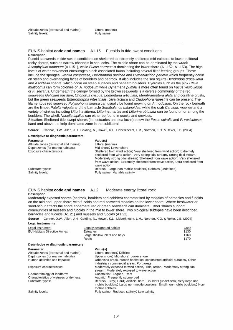
104
Altitude zones (terrestrial and marine): Littoral (marine) Salinity levels: Fully saline _______________________________________________________________________ EUNIS habitat code and names A1.15 Fucoids in tide-swept conditions Description Fucoid seaweeds in tide-swept conditions on sheltered to extremely sheltered mid eulittoral to lower eulittoral rocky shores, such as narrow channels in sea lochs. The middle shore can be dominated by the wrack Ascophyllum nodosum (A1.151), while Fucus serratus is dominating the lower shore (A1.152, A1.153). The high levels of water movement encourages a rich associated fauna including several filter-feeding groups. These include the sponges Grantia compressa, Halichondria panicea and Hymeniacidon perleve which frequently occur on steep and overhanging faces of boulders and bedrock. It also includes the sea squirts Dendrodoa grossularia and Ascidiella scabra, which occur on steep surfaces and beneath boulders. Hydroids such as the pink Clava multicornis can form colonies on A. nodosum while Dynamena pumila is more often found on Fucus vesiculosus or F. serratus. Underneath the canopy formed by the brown seaweeds is a diverse community of the red seaweeds Gelidium pusillum, Chondrus crispus, Lomentaria articulata, Membranoptera alata and coralline crusts, but the green seaweeds Enteromorpha intestinalis, Ulva lactuca and Cladophora rupestris can be present. The filamentous red seaweed Polysiphonia lanosa can usually be found growing on A. nodosum. On the rock beneath are the limpet Patella vulgata and the barnacle Semibalanus balanoides, while the crab Carcinus maenas and a variety of winkles including Littorina littorea, Littorina mariae and Littorina obtusata can be found on or among the boulders. The whelk Nucella lapillus can either be found in cracks and crevices. Situation: Sheltered tide-swept shores (i.e. estuaries and sea lochs) below the Fucus spiralis and F. vesiculosus band and above the kelp dominated zone in the sublittoral. Source Connor, D.W., Allen, J.H., Golding, N., Howell, K.L., Lieberknecht, L.M., Northen, K.O. & Reker, J.B. (2004) Descriptive or diagnostic parameters Parameter Value(s) Altitude zones (terrestrial and marine): Littoral (marine) Depth zones (for marine habitats): Mid-shore; Lower shore Exposure characteristics: Sheltered from wind action; Very sheltered from wind action; Extremely
sheltered from wind action; Very strong tidal stream; Strong tidal stream; Moderately strong tidal stream; Sheltered from wave action; Very sheltered from wave action; Extremely sheltered from wave action; Ultra sheltered from wave action
Substrate types: Bedrock; Large non-mobile boulders; Cobbles (undefined) Salinity levels: Fully saline; Variable salinity _______________________________________________________________________ EUNIS habitat code and names A1.2 Moderate energy littoral rock Description Moderately exposed shores (bedrock, boulders and cobbles) characterised by mosaics of barnacles and fucoids on the mid and upper shore; with fucoids and red seaweed mosaics on the lower shore. Where freshwater or sand-scour affects the shore ephemeral red or green seaweeds can dominate. Other shores support communities of mussels and fucoids in the mid to lower shore. Two biological subtypes have been described: barnacles and fucoids (A1.21) and mussels and fucoids (A1.22). Source Connor, D.W., Allen, J.H., Golding, N., Howell, K.L., Lieberknecht, L.M., Northen, K.O. & Reker, J.B. (2004) Legal instruments Legal instrument Legally designated habitat Code EU Habitats Directive Annex I Estuaries 1130 Large shallow inlets and bays 1160 Reefs 1170 Descriptive or diagnostic parameters Parameter Value(s) Altitude zones (terrestrial and marine): Littoral (marine); Driftline Depth zones (for marine habitats): Upper shore; Mid-shore; Lower shore Human activities and impacts: Urbanised areas, human habitation, constructed artificial surfaces; Other
industrial / commercial areas; Port areas Exposure characteristics: Moderately exposed to wind action; Tidal action; Moderately strong tidal
stream; Moderately exposed to wave action Geomorphology or landform: Coastal flat; Lagoon; Reef Characteristics of wetness or dryness: Aquatic; Frequently submerged Substrate types: Bedrock; Clay; Hard; Artificial hard; Boulders (undefined); Very large non-
mobile boulders; Large non-mobile boulders; Small non-mobile boulders; Non-mobile cobbles
Salinity levels: Fully saline; Reduced salinity; Low salinity

105
_______________________________________________________________________ EUNIS habitat code and names A1.21 Barnacles and fucoids on moderately exposed shores Description Moderately exposed rocky shores characterised by a mosaic of fucoids and barnacles on bedrock and boulders, where the extent of the fucoid cover is typically less than the blanket cover associated with sheltered shores. Other species are normally present as well in this habtat including the winkle Littorina littorea, the whelk Nucella lapillus and the red seaweed Mastocarpus stellatus. Beneath the band of yellow and grey lichens at the top of the shore is a zone dominated by the wrack Pelvetia canaliculata, scattered barnacles, while the black lichen Verrucaria maura covers the rock surface (A1.211). Below, on the mid shore the wrack Fucus vesiculosus generally forms a mosaic with the barnacle Semibalanus balanoides and the limpet Patella vulgata (A1.213). Finally, the wrack Fucus serratus, dominates the lower shore, while a variety of red seaweeds can be found underneath the F. serratus canopy (A1.214). A number of variants have been described: lower shore bedrock and boulders characterised by mosaics of F. serratus and turf-forming red seaweeds (A1.2141); where the density of F. serratus is greater (typically Common - Superabundant) and the abundance of red seaweeds less, A1.3151 should be recorded. The presence of boulders and cobbles on the shore can increase the micro-habitat diversity, which often results in greater species richness. Although the upper surface of the boulders may bear very similar communities to A1.3151 there is often an increase in fauna (crabs, tube-forming polychaetes, sponges and bryozoans) and A1.2142 should be recorded. Sand-influenced exposed to moderately exposed lower shore rock can be characterised by dense mats of Rhodothamniella floridula (A1.215). Situation: Mid and lower eulittoral moderately exposed bedrock with a lichen zone above and a kelp dominated community below in the sublittoral zone. Source Connor, D.W., Allen, J.H., Golding, N., Howell, K.L., Lieberknecht, L.M., Northen, K.O. & Reker, J.B. (2004) Descriptive or diagnostic parameters Parameter Value(s) Altitude zones (terrestrial and marine): Littoral (marine) Depth zones (for marine habitats): Upper shore; Mid-shore; Lower shore Exposure characteristics: Moderately exposed to wind action; Moderately exposed to wave action Substrate types: Bedrock; Boulders (undefined) Salinity levels: Fully saline _______________________________________________________________________ EUNIS habitat code and names A1.22 English name: Mussels and fucoids on moderately exposed shores; Scientific name: Mytilus edulis and fucoids on moderately exposed shores Description Mid and lower eulittoral exposed to moderately exposed bedrock, often with nearby sediment, may be densely covered by large individuals of the mussel Mytilus edulis. Three biotopes have been described: In the mid eulittoral, the mussels may form a band or large patches with scattered bladder wrack Fucus vesiculosus (A1.221). In the lower eulittoral a range of red seaweeds including Mastocarpus stellatus and Palmaria palmata occur amongst the mussels (in higher abundance than the mid eulittoral) (A1.222). Clay outcrops in the mid to lower eulittoral may be bored by a variety of piddocks including Pholas dactylus, Barnea candida and Petricola pholadiformis, while the surface is characterised by small clumps of the mussel M. edulis, the barnacle Elminius modestus and the winkle Littorina littorea (A1.223). Ephemeral green seaweeds such as Enteromorpha intestinalis and Ulva lactuca commonly occur on the shells of the mussels. Barnacles are common on both the mussel valves and on patches of bare rock, where the limpet Patella vulgata is found as well, often at high abundance. The whelk Nucella lapillus and a range of littorinids also occur within the mussel bed. A dense M. edulis community may be found on more sheltered coasts on mixed substrata (A2.721). Situation: Above this habitat type is a M. edulis and S. balanoides dominated zone or a F. vesiculosus dominated biotope (A1.213). In the lower eulittoral zone below is a zone dominated by the wrack Fucus serratus, M. edulis and a variety of red seaweeds (A1.21) while kelp dominate the sublittoral fringe. Source Connor, D.W., Allen, J.H., Golding, N., Howell, K.L., Lieberknecht, L.M., Northen, K.O. & Reker, J.B. (2004) Legal instruments Legal instrument Legally designated habitat Code EU Habitats Directive Annex I Reefs 1170 Council of Europe Bern Convention Sublittoral organogenic concretions 11.25 Res. No. 4 1996
Descriptive or diagnostic parameters Parameter Value(s) Altitude zones (terrestrial and marine): Littoral (marine) Depth zones (for marine habitats): Mid-shore; Lower shore Exposure characteristics: Exposed to wind action; Moderately exposed to wind action; Exposed to wave
action; Moderately exposed to wave action Substrate types: Bedrock; Large non-mobile boulders Salinity levels: Fully saline

106
_______________________________________________________________________ EUNIS habitat code and names A1.23 Mediterranean communities of lower mediolittoral rock moderately exposed to wave action Description No description available. Source Barcelona Convention (1998) Descriptive or diagnostic parameters Parameter Value(s) Altitude zones (terrestrial and marine): Littoral (marine) Salinity levels: Fully saline _______________________________________________________________________ EUNIS habitat code and names A1.3 Low energy littoral rock Description Sheltered to extremely sheltered rocky shores with very weak to weak tidal streams are typically characterised by a dense cover of fucoid seaweeds which form distinct zones (the wrack Pelvetia canaliculata on the upper shore through to the wrack Fucus serratus on the lower shore). Where salinity is reduced (such as at the head of a sea loch or where streams run across the shore) Fucus ceranoides may occur. Fucoids also occur on less stable, mixed substrata (cobbles and pebbles on sediment) although in lower abundance and with fewer associated epifaunal species; beds of mussels Mytilus edulis are also common. In summer months, dense blankets of ephemeral green and red seaweeds can dominate these mixed shores. Two biological subtypes have been described: Dense blankets of fucoid seaweeds dominating sheltered, fully marine littoral rocky shores (A1.31) and fucoids dominating variable salinity rocky shores (A1.32). Source Connor, D.W., Allen, J.H., Golding, N., Howell, K.L., Lieberknecht, L.M., Northen, K.O. & Reker, J.B. (2004) Legal instruments Legal instrument Legally designated habitat Code EU Habitats Directive Annex I Estuaries 1130 Coastal lagoons 1150 Large shallow inlets and bays 1160 Reefs 1170 Descriptive or diagnostic parameters Parameter Value(s) Altitude zones (terrestrial and marine): Littoral (marine) Depth zones (for marine habitats): Upper shore; Mid-shore; Lower shore Human activities and impacts: Urbanised areas, human habitation, constructed artificial surfaces; Other
industrial / commercial areas; Port areas Exposure characteristics: Sheltered from wind action; Very sheltered from wind action; Extremely
sheltered from wind action; Tidal action; Weak tidal stream; Very weak or no tidal stream; Sheltered from wave action; Very sheltered from wave action; Extremely sheltered from wave action; Ultra sheltered from wave action
Geomorphology or landform: Coastal flat; Lagoon; Reef Characteristics of wetness or dryness: Aquatic; Frequently submerged Substrate types: Bedrock; Clay; Hard; Artificial hard; Boulders (undefined); Very large non-
mobile boulders; Large non-mobile boulders; Small non-mobile boulders; Non-mobile cobbles; Cobbles (undefined); Pebbles; Mixed
Salinity levels: Fully saline; Reduced salinity; Low salinity; Variable salinity _______________________________________________________________________ EUNIS habitat code and names A1.31 Fucoids on sheltered marine shores Description Dense blankets of fucoid seaweeds dominating sheltered to extremely sheltered rocky shores and/or in locally sheltered patches on exposed to moderately exposed rocky shores. Typically, the wrack Pelvetia canaliculata (A1.311) occurs on the upper shore, with the wrack Fucus spiralis (A1.312) below. The middle shore is dominated by vast areas of the wrack Ascophyllum nodosum or the wrack Fucus vesiculosus (A1.313, A1.314) or a mixture of both. The wrack Fucus serratus covers lower shore bedrock and boulders (A1.315). Sheltered to very sheltered mixed substrata (pebbles and cobbles overlying muddy sand and gravel) shores can support fucoid communities (A1.3122; A1.3132; A1.3142; A1.3152). Situation: Sheltered shores (i.e. estuaries and sea lochs) below the lichen dominated zone and above the kelp dominated zone in the sublittoral or sheltered patches on more wave exposed shores. Source Connor, D.W., Allen, J.H., Golding, N., Howell, K.L., Lieberknecht, L.M., Northen, K.O. & Reker, J.B. (2004) Descriptive or diagnostic parameters Parameter Value(s)

107
Altitude zones (terrestrial and marine): Littoral (marine) Depth zones (for marine habitats): Upper shore; Mid-shore; Lower shore Exposure characteristics: Sheltered from wind action; Very sheltered from wind action; Extremely
sheltered from wind action; Sheltered from wave action; Very sheltered from wave action; Extremely sheltered from wave action
Substrate types: Bedrock; Large non-mobile boulders; Cobbles (undefined) Salinity levels: Fully saline; Variable salinity _______________________________________________________________________ EUNIS habitat code and names A1.32 Fucoids in variable salinity Description Blankets of fucoid seaweeds dominating sheltered to extremely sheltered rocky shores with variable salinity. The wrack Pelvetia canaliculata (A1.321) occurs on the upper shore, with the wrack Fucus spiralis (A1.322) below. The middle shore is dominated by vast areas of the wrack Ascophyllum nodosum or the wrack Fucus vesiculosus (A1.323, A1.324) or a mixture of both. The wrack Fucus serratus covers lower shore bedrock and boulders (A1.326). Fucus ceranoides can be found on extremly sheltered shores with variable or low salinity (A1.327). The variable salinity communities are species impoverished compared to fucoids in full salinity or in tide-swept conditions as red seaweeds and sponges are usually absent. Underneath the canopy are a few green seaweeds including Enteromorpha intestinalis and Cladophora spp., while the red seaweed Polysiphonia lanosa can be found as an epiphyte on A. nodosum. On the rock and among the boulders are the winkles Littorina littorea and Littorina saxatilis, the crab Carcinus maenas, the barnacles Semibalanus balanoides and Elminius modestus and even the occasional mussel Mytilus edulis. Situation: On sheltered eulittoral rocky shores with variable salinity conditions, such as sea loch or estuaries. Source Connor, D.W., Allen, J.H., Golding, N., Howell, K.L., Lieberknecht, L.M., Northen, K.O. & Reker, J.B. (2004) Descriptive or diagnostic parameters Parameter Value(s) Altitude zones (terrestrial and marine): Littoral (marine) Depth zones (for marine habitats): Upper shore; Mid-shore; Lower shore Exposure characteristics: Sheltered from wind action; Very sheltered from wind action; Extremely
sheltered from wind action; Moderately strong tidal stream; Weak tidal stream; Very weak or no tidal stream; Sheltered from wave action; Very sheltered from wave action; Extremely sheltered from wave action
Substrate types: Bedrock; Boulders (undefined); Cobbles (undefined) Salinity levels: Reduced salinity; Low salinity; Variable salinity _______________________________________________________________________ EUNIS habitat code and names A1.33 Red algal turf in lower eulittoral, sheltered from wave action
Description Proposed new level 4 unit. More information required. Source OSPAR/ICES/EEA (2000) Descriptive or diagnostic parameters Parameter Value(s) Altitude zones (terrestrial and marine): Littoral (marine) Depth zones (for marine habitats): Lower shore _______________________________________________________________________ EUNIS habitat code and names A1.34 Mediterranean communities of lower mediolittoral rock sheltered from wave action Description No description available. Source Barcelona Convention (1998) Descriptive or diagnostic parameters Parameter Value(s) Altitude zones (terrestrial and marine): Littoral (marine) Depth zones (for marine habitats): Lower shore Salinity levels: Fully saline _______________________________________________________________________ EUNIS habitat code and names A1.4 Features of littoral rock Description

108
Littoral rock features include rockpools (A1.41, A1.42), ephemeral algae (A1.45) and caves (A1.44) in the intertidal zone (the area of the shore between high and low tides). These features are present throughout the littoral rock zone from the upper limit at the top of of the lichen zone and the lower limit by the top of the laminarian kelp zone. These features can be found on most rocky shores regardless of wave exposure. Lichens can be found in the supralittoral zone on shores with suitable substratum. The lichen band is wider and more distinct on more exposed shores. Rockpools occur where the topography of the shore allows seawater to be retained within depressions in the bedrock producing 'pools' on the retreat of the tide. As these rockpool communities are permanently submerged they are not directly affected by height on the shore and normal rocky shore zonation patterns do not apply allowing species from the sublittoral to survive. Ephemeral seaweeds occur on disturbed littoral rock in the lower to upper shore. The shaded nature of caves and overhangs diminishes the amount of desiccation suffered by biota during periods of low tides which allows certain species to proliferate. In addition, the amount of scour, wave surge, sea spray and penetrating light determines the unique community assemblages found in upper, mid and lower shore caves, and on overhangs on the lower shore. Non-tidal areas irregularly exposed by wind action (hydrolittoral) with hard substrata are also included here. Note that lichens and algae crusts in the supralittoral zone are coastal habitats (B3.11). Source Connor, D.W., Allen, J.H., Golding, N., Howell, K.L., Lieberknecht, L.M., Northen, K.O. & Reker, J.B. (2004) Legal instruments Legal instrument Legally designated habitat Code EU Habitats Directive Annex I Estuaries 1130 Large shallow inlets and bays 1160 Reefs 1170 Submerged or partially submerged sea caves 8330 Descriptive or diagnostic parameters Parameter Value(s) Altitude zones (terrestrial and marine): Littoral (marine); Driftline Depth zones (for marine habitats): Upper shore; Mid-shore; Lower shore Exposure characteristics: Extremely exposed to wind action; Very exposed to wind action; Exposed to
wind action; Moderately exposed to wind action; Sheltered from wind action; Very sheltered from wind action; Extremely sheltered from wind action; Tidal action; Extremely exposed to wave action; Very exposed to wave action; Exposed to wave action; Moderately exposed to wave action; Sheltered from wave action; Very sheltered from wave action; Extremely sheltered from wave action
Geomorphology or landform: Coastal flat; Sea cave; Marine overhang; Rockpools Substrate types: Bedrock; Clay; Boulders (undefined); Very large non-mobile boulders; Large
non-mobile boulders; Small non-mobile boulders; Non-mobile cobbles Salinity levels: Fully saline; Reduced salinity; Low salinity; Variable salinity _______________________________________________________________________ EUNIS habitat code and names A1.41 Communities of littoral rockpools Description Rockpools occur where the topography of the shore allows seawater to be retained within depressions in the bedrock producing 'pools' on the retreat of the tide. As these rockpool communities are permanently submerged they are not directly affected by height on the shore and normal rocky shore zonation patterns do not apply. For this reason rockpools have been dealt with as a separate habitat type, apart from the scheme of wave exposure and shore height. Four main rockpool biotopes have been described, and although it is accepted that an enormous variety of rockpool communities exist, it is hoped that these biotope descriptions are broad enough to adequately encompass most types. It would be meaningless to include the characterising species in a description at the habitat type level. Rockpools on the upper shore which are subject to rainwater influence and wide fluctuations in temperature are included in A1.42. Shallow rockpools in the mid to upper shore characterised by encrusting coralline algae and Corallina officinalis (A1.411); several variants of these coralline pools occur in south-west Britain and Ireland (A1.4112, A1.4113 and A1.4114). Deeper rockpools on the mid to lower shore can support fucoids and some sublittoral species such as kelp (A1.412). Those rockpools influenced by the presence of sand are characterised by sand-tolerant seaweed such as Furcellaria lumbricalis and Polyides rotundus (A1.413). Where more stable sand occurs in the base of the rockpool sea-grass beds can occur. Shallow rockpools on mixed cobbles, pebbles, gravel and sand may be characterised by hydroids (A1.414). A very rough guideline to the terms "shallow" and "deep" rockpools: "shallow" rockpools do not support kelp, whereas "deep" rockpools do. A1.41 does not include shallow standing water on compacted sediment or mixed substrata. Situation: Rockpools occur in the littoral zone where the topography of the shore allows seawater to be retained within depressions in the bedrock producing 'pools' on the retreat of the tide. Source Connor, D.W., Allen, J.H., Golding, N., Howell, K.L., Lieberknecht, L.M., Northen, K.O. & Reker, J.B. (2004) Descriptive or diagnostic parameters Parameter Value(s) Altitude zones (terrestrial and marine): Littoral (marine) Depth zones (for marine habitats): Upper shore; Mid-shore; Lower shore Exposure characteristics: Very exposed to wind action; Exposed to wind action; Moderately exposed to

109
wind action; Sheltered from wind action; Very exposed to wave action; Exposed to wave action; Moderately exposed to wave action; Sheltered from wave action
Geomorphology or landform: Rockpools Substrate types: Bedrock Salinity levels: Fully saline; Variable salinity _______________________________________________________________________ EUNIS habitat code and names A1.42 Communities of rockpools in the supralittoral zone Description Rockpools in the littoral fringe or upper eulittoral zone subject to widely fluctuating temperatures and salinity due to rainwater influence are characterised by ephemeral green alga of the genus Enteromorpha, along with Cladophora spp. and Ulva lactuca. Source Connor, D.W., Allen, J.H., Golding, N., Howell, K.L., Lieberknecht, L.M., Northen, K.O. & Reker, J.B. (2004) Descriptive or diagnostic parameters Parameter Value(s) Altitude zones (terrestrial and marine): Littoral (marine) Depth zones (for marine habitats): Upper shore Exposure characteristics: Very exposed to wind action; Exposed to wind action; Moderately exposed to
wind action; Sheltered from wind action; Very exposed to wave action; Exposed to wave action; Moderately exposed to wave action; Sheltered from wave action
Salinity levels: Fully saline; Variable salinity _______________________________________________________________________ EUNIS habitat code and names A1.43 Brackish permanent pools in the geolittoral zone Description No description available. Source Helsinki Commission (1998) Descriptive or diagnostic parameters Parameter Value(s) Altitude zones (terrestrial and marine): Littoral (marine) Characteristics of wetness or dryness: Infrequently submerged Salinity levels: High salinity in a brackish water body; Medium salinity in a brackish water
body; Low salinity in a brackish water body; Very low salinity in a brackish water body
_______________________________________________________________________ EUNIS habitat code and names A1.44 Communities of littoral caves and overhangs Description Where caves and overhangs occur on rocky shores, the shaded nature of the habitat diminishes the amount of desiccation suffered by biota during periods of low tides which allows certain species to proliferate. In addition, the amount of scour, wave surge, sea spray and penetrating light determines the unique community assemblages found in upper, mid and lower shore caves and overhangs on the lower shore. Biotopes from the surrounding shore such as A1.111, A1.113 or any of the fucoid communities occasionally extend into cave entrances. A1.113 often extends some way into the cave. Other open shore biotopes may also be found within caves, such as the green seaweed Prasiola stipitata on cave roofs where birds roost (B3.112), and localised patches of green algae where freshwater seepage influences the rock (A1.451). Rockpools containing encrusting coralline algae (A1.411), fucoids and kelp (A1.412) and hydroids and littorinid molluscs may occur also on the floor of cave entrances. The cave biotope descriptions are largely based on data obtained from surveys of Berwickshire caves (ERT,2000), chalk caves from the Thanet coast (Tittley et al, 1998; Tittley & Spurrier 2001) and data from Wales (CCW Phase 1 data). In general, the biomass and diversity of algal species found in upper and mid-shore littoral caves decreases with increasing depth into the cave as the light levels diminish. Fucoids are usually only found at the entrances to caves, but red algae, and filamentous and encrusting green algae are able to penetrate to lower light intensities towards the back of the cave, and mats of the turf forming red seaweed Audouinella purpurea and/or patches of the green seaweed Cladophora rupestris may occur on the upper walls (A1.444). Brownish velvety growths of the brown algae Pilinia maritima occurring in mats with the red alga A. purpurea on cave walls and upper littoral levels of cliffs (A1.443) should not be confused with the green (A1.442) or golden brown algal stains often found above this zone on the ceilings of the caves (A1.443; A1.441). Below is a zone of Verrucaria mucosa and/or Hildenbrandia rubra on the inner and outer reaches (A1.445). Fauna usually only occur on the lower and mid walls of the caves and generally comprise barnacles, anemones and tube-forming polychaetes (A1.448; A1.449) depending on the level of boulder scour or wave surge. Where the floors of caves consist of mobile cobbles and small boulders, little algae and fauna occur due to the effects of scouring (A1.44A). Vertical or steeply sloping cave walls and overhangs on the mid and lower shore, subject to wave-

110
surge but without scour, support a rich biota of sponges, hydroids, ascidians and shade-tolerant red algae (A1.447, A1.446 or A1.4461). Situation: Caves and overhangs in the littoral zone in hard rock and limestone (including chalk). Source Connor, D.W., Allen, J.H., Golding, N., Howell, K.L., Lieberknecht, L.M., Northen, K.O. & Reker, J.B. (2004) Legal instruments Legal instrument Legally designated habitat Code EU Habitats Directive Annex I Submerged or partially submerged sea caves 8330 Descriptive or diagnostic parameters Parameter Value(s) Altitude zones (terrestrial and marine): Littoral (marine); Supralittoral Depth zones (for marine habitats): Upper shore; Mid-shore; Lower shore Exposure characteristics: Very exposed to wind action; Exposed to wind action; Moderately exposed to
wind action; Sheltered from wind action; Very sheltered from wind action; Very exposed to wave action; Exposed to wave action; Moderately exposed to wave action; Sheltered from wave action; Very sheltered from wave action
Substrate types: Bedrock Salinity levels: Fully saline; Variable salinity _______________________________________________________________________ EUNIS habitat code and names A1.45 Ephemeral green or red seaweeds (freshwater or sand- influenced) on non-mobile substrata Description Ephemeral seaweeds on disturbed littoral rock in the lower to upper shore. Dominant green seaweeds include Enteromorpha intestinalis, Ulva lactuca and the red seaweeds Rhodothamniella floridula and Porphyra purpurea. Winkles such as Littorina littorea and Littorina saxatilis, the limpet Patella vulgata and the barnacles Semibalanus balanoides can occur, though usually in low abundance. The crab Carcinus maenas can be found where boulders are present, while the barnacle Elminius modestus is usually present on sites subject to variable salinity. On moderately exposed shores, the biotope is Enteromorpha spp. on freshwater-influenced or unstable upper shore rock (A1.451) or P. purpurea and/or Enteromorpha spp. on sand-scoured mid to lower eulittoral rock (A1.452). These are biotopes with a low species diversity and the relatively high number of species in the characterising species list are due to a variation in the species composition from site to site, not to high species richness on individual sites. Situation: This habitat type occurs the splash zone, sometimes on cliff faces, and throughout the main intertidal zone. Note: Connor et al (2004) classify this habitat type together with A2.43 and A2.82 as LR.ELR.Eph. Source Connor, D.W., Allen, J.H., Golding, N., Howell, K.L., Lieberknecht, L.M., Northen, K.O. & Reker, J.B. (2004) Descriptive or diagnostic parameters Parameter Value(s) Altitude zones (terrestrial and marine): Littoral (marine) Depth zones (for marine habitats): Upper shore; Mid-shore Exposure characteristics: Very exposed to wind action; Exposed to wind action; Moderately exposed to
wind action; Sheltered from wind action; Very sheltered from wind action; Extremely sheltered from wind action; Very exposed to wave action; Exposed to wave action; Moderately exposed to wave action; Sheltered from wave action; Very sheltered from wave action; Extremely sheltered from wave action
Substrate types: Bedrock; Boulders (undefined) Salinity levels: Fully saline; Variable salinity _______________________________________________________________________ EUNIS habitat code and names A1.46 Hydrolittoral soft rock Description No description available. Source Helsinki Commission (1998) Descriptive or diagnostic parameters Parameter Value(s) Altitude zones (terrestrial and marine): Littoral (marine) Salinity levels: Low salinity _______________________________________________________________________ EUNIS habitat code and names A1.47 Hydrolittoral solid rock (bedrock) Description No description available. Source Helsinki Commission (1998)

111
Descriptive or diagnostic parameters Parameter Value(s) Altitude zones (terrestrial and marine): Littoral (marine) Salinity levels: Low salinity _______________________________________________________________________ EUNIS habitat code and names A1.48 Hydrolittoral hard clay Description No description available. Source Helsinki Commission (1998) Descriptive or diagnostic parameters Parameter Value(s) Altitude zones (terrestrial and marine): Littoral (marine) Salinity levels: Low salinity _______________________________________________________________________ EUNIS habitat code and names A1.49 Hydrolittoral mussel beds Description No description available. Source Helsinki Commission (1998) Descriptive or diagnostic parameters Parameter Value(s) Altitude zones (terrestrial and marine): Littoral (marine) Salinity levels: Low salinity _______________________________________________________________________ EUNIS habitat code and names A1.4A Hydrolittoral peat Description No description available. Source Helsinki Commission (1998) Descriptive or diagnostic parameters Parameter Value(s) Altitude zones (terrestrial and marine): Littoral (marine) Salinity levels: Low salinity _______________________________________________________________________ EUNIS habitat code and names A2 Littoral sediment Description Littoral sediment includes habitats of shingle (mobile cobbles and pebbles), gravel, sand and mud or any combination of these which occur in the intertidal zone. Littoral sediment is defined further using descriptions of particle sizes - mainly gravel (16-4 mm), coarse sand (4-1 mm), medium sand (1-0.25 mm), fine sand (0.25-0.063 mm) and mud (less than 0.063 mm) and various admixtures of these (and coarser) grades - muddy sand, sandy mud and mixed sediment (cobbles, gravel, sand and mud together). Littoral sediments support communities tolerant to some degree of drainage at low tide and often subject to variation in air temperature and reduced salinity in estuarine situations. Very coarse sediments tend to support few macrofaunal species because these sediments tend to be mobile and subject to a high degree of drying when exposed at low tide. Finer sediments tend to be more stable and retain some water between high tides, and therefore support a greater diversity of species. Medium and fine sand shores usually support a range of oligochaetes, polychaetes, and burrowing crustaceans, and even more stable muddy sand shores also support a range of bivalves. Very fine and cohesive sediment (mud) tends to have a lower species diversity, because oxygen cannot penetrate far below the sediment surface. A black, anoxic layer of sediment develops under these circumstances, which may extend to the sediment surface and in which few species can survive. Some intertidal sediments are dominated by angiosperms, e.g. eelgrass (Zostera noltii) beds on the mid and upper shore of muddy sand flats, or saltmarshes which develop on the extreme upper shore of sheltered fine sediment flats. Situation: Littoral sediments are found across the entire intertidal zone, including the strandline. Sediment biotopes can extend further landwards (dune systems, marshes) and further seawards (sublittoral sediments). Sediment shores are generally found along relatively more sheltered stretches of coast compared to rocky shores. Muddy shores or muddy sand shores occur mainly in very sheltered inlets and along estuaries, where wave exposure is low enough to allow fine sediments to settle. Sandy shores and coarser sediment (gravel, pebbles, cobbles) shores are found in areas subject to higher wave exposures. Temporal variation: Littoral sediment environments can change markedly over seasonal cycles, with sediment

112
being eroded during winter storms and accreted during calmer summer months. The particle size structure of the sediment may change from finer to coarser during winter months, as finer sediment gets resuspended in seasonal exposed conditions. This may affect the sediment infauna, with some species only present in summer when sediments are more stable. These changes are most likely to affect sandy shores on relatively open shores. Sheltered muddy shores are likely to be more stable throughout the year, but may have a seasonal cover of green seaweeds during the summer period, particularly in nutrient enriched areas or where there is freshwater input. Source Connor, D.W., Allen, J.H., Golding, N., Howell, K.L., Lieberknecht, L.M., Northen, K.O. & Reker, J.B. (2004) Descriptive or diagnostic parameters Parameter Value(s) Altitude zones (terrestrial and marine): Littoral (marine) Depth zones (for marine habitats): Upper shore; Mid-shore; Lower shore Exposure characteristics: Very exposed to wind action; Exposed to wind action; Moderately exposed to
wind action; Sheltered from wind action; Very sheltered from wind action; Extremely sheltered from wind action; Very exposed to wave action; Exposed to wave action; Moderately exposed to wave action; Sheltered from wave action; Very sheltered from wave action; Extremely sheltered from wave action
Geomorphology or landform: Beach; Coastal flat; Lagoon Characteristics of wetness or dryness: Aquatic; Frequently submerged Substrate types: Mobile; Mobile cobbles; Pebbles; Gravel; Mobile shingle; Sand; Muddy sand;
Mud, Silt; Biogenic; Peat; Shells; Mixed; Rock, Sand, Gravel; Pebbles, Cobbles; Sand, Gravel; Mud, Sand, Gravel; Mud, Gravel; Mud, Sand; Sand, Organic
Salinity levels: Fully saline; Reduced salinity; Low salinity; Variable salinity _______________________________________________________________________ EUNIS habitat code and names A2.1 Littoral coarse sediment Description Littoral coarse sediments include shores of mobile pebbles, cobbles and gravel, sometimes with varying amounts of coarse sand. The sediment is highly mobile and subject to high degrees of drying between tides. As a result, few species are able to survive in this environment. Beaches of mobile cobbles and pebbles tend to be devoid of macroinfauna, while gravelly shores may support limited numbers of crustaceans, such as Pectenogammarus planicrurus. Situation: Littoral coarse sediments are found along relatively exposed open shores, where wave action prevents finer sediments from settling. Coarse sediments may also be present on the upper parts of shores where there are more stable, sandy biotopes on the lower and mid shore. Temporal variation: The sediment particle size structure may vary seasonally, with relatively finer sediments able to settle during calmer conditions in summer. Where the sediment grain size is very large (at the interface between sediment and boulder shores), cobbles may be mobile during exposed winter conditions, but stable enough during summer months to support limited juvenile rocky shore epifauna (e.g. juvenile barnacles). Source Connor, D.W., Allen, J.H., Golding, N., Howell, K.L., Lieberknecht, L.M., Northen, K.O. & Reker, J.B. (2004) Legal instruments Legal instrument Legally designated habitat Code EU Habitats Directive Annex I Estuaries 1130 Mudflats and sandflats not covered by seawater at low tide 1140 Large shallow inlets and bays 1160 Descriptive or diagnostic parameters Parameter Value(s) Altitude zones (terrestrial and marine): Littoral (marine) Depth zones (for marine habitats): Upper shore; Mid-shore; Lower shore Exposure characteristics: Exposed to wind action; Moderately exposed to wind action; Tidal action;
Exposed to wave action; Moderately exposed to wave action Geomorphology or landform: Beach; Coastal flat; Lagoon Characteristics of wetness or dryness: Aquatic; Frequently submerged Substrate types: Mobile; Mobile cobbles; Pebbles; Gravel; Mobile shingle; Sand Salinity levels: Fully saline; Reduced salinity; Low salinity; Variable salinity _______________________________________________________________________ EUNIS habitat code and names A2.11 Shingle (pebble) and gravel shores Description Shores of shingle (mobile cobbles and pebbles) or coarse gravel, typically deposited as a result of onshore wave action and long-shore drift. The particle size tends to increase along the shore in the direction of the long-shore drift. As the sediment is very coarse and often quite mobile, it typically supports little marine life, other than opportunist amphipods and oligochaete worms. Summer growths of ephemeral green algae (Enteromorpha spp.) may develop. Source Connor, D.W., Brazier, D.P., Hill, T.O., & Northen, K.O. (1997)

113
Descriptive or diagnostic parameters Parameter Value(s) Altitude zones (terrestrial and marine): Littoral (marine) Depth zones (for marine habitats): Upper shore; Mid-shore; Lower shore Exposure characteristics: Exposed to wind action; Moderately exposed to wind action; Exposed to wave
action; Moderately exposed to wave action Substrate types: Gravel; Mobile shingle Salinity levels: Fully saline _______________________________________________________________________ EUNIS habitat code and names A2.12 Estuarine coarse sediment shores Description Shores of coarse sediments (shingle, gravels and coarse sand) in the upper reaches of estuaries and other inlets (e.g. sealochs) which are subject to variable and reduced salinity conditions. The outflow of riverine freshwater at the heads of the inlets results in the washing out of fine particulate matter, leaving coarse sediments. These are typically species-poor and characterised by oligochaete worms (cf. A2.222). Source Connor, D.W., Brazier, D.P., Hill, T.O., & Northen, K.O. (1997) Legal instruments Legal instrument Legally designated habitat Code EU Habitats Directive Annex I Estuaries 1130 Council of Europe Bern Convention Estuaries 13.2 Res. No. 4 1996
Descriptive or diagnostic parameters Parameter Value(s) Altitude zones (terrestrial and marine): Littoral (marine) Depth zones (for marine habitats): Upper shore; Mid-shore; Lower shore Exposure characteristics: Very sheltered from wind action; Extremely sheltered from wind action; Very
strong tidal stream; Strong tidal stream; Moderately strong tidal stream; Very sheltered from wave action; Extremely sheltered from wave action
Substrate types: Gravel; Mobile shingle Salinity levels: Reduced salinity; Variable salinity _______________________________________________________________________ EUNIS habitat code and names A2.13 Mediterranean communities of mediolittoral coarse detritic bottoms Description No description available. Source Barcelona Convention (1998) Descriptive or diagnostic parameters Parameter Value(s) Altitude zones (terrestrial and marine): Littoral (marine) Salinity levels: Fully saline _______________________________________________________________________ EUNIS habitat code and names A2.2 Littoral sand and muddy sand Description Shores comprising clean sands (coarse, medium or fine-grained) and muddy sands with up to 25% silt and clay fraction. Shells and stones may occasionally be present on the surface. The sand may be duned or rippled as a result of wave action or tidal currents. Littoral sands exhibit varying degrees of drying at low tide depending on the steepness of the shore, the sediment grade and the height on the shore. The more mobile sand shores are relatively impoverished (A2.22), with more species-rich communities of amphipods, polychaetes and, on the lower shore, bivalves developing with increasing stability in finer sand habitats (A2.23). Muddy sands (A2.24), the most stable within this habitat complex, contain the highest proportion of bivalves. Situation: A strandline of talitrid amphipods (A2.211) typically develops at the top of the shore where decaying seaweed accumulates. Fully marine sandy shores occur along stretches of open coast, whilst muddy sands are often present in more sheltered lower estuarine conditions and may be subject to some freshwater influence. Temporal variation: Littoral sandy shore environments can change markedly over seasonal cycles, with sediment being eroded during winter storms and accreted during calmer summer months. The particle size structure of the sediment may change from finer to coarser during winter months, as finer sediment gets resuspended in seasonal exposed conditions. This may affect the sediment infauna, with some species only present in summer when sediments are more stable. More sheltered muddy sand shores are likely to be more stable throughout the year, but may have a seasonal cover of green seaweeds during the summer period, particularly in nutrient

114
enriched areas or where there is freshwater input. Source Connor, D.W., Allen, J.H., Golding, N., Howell, K.L., Lieberknecht, L.M., Northen, K.O. & Reker, J.B. (2004) Legal instruments Legal instrument Legally designated habitat Code EU Habitats Directive Annex I Estuaries 1130 Mudflats and sandflats not covered by seawater at low tide 1140 Coastal lagoons 1150 Large shallow inlets and bays 1160 Council of Europe Bern Convention Soft sediment littoral communities 11.27 Res. No. 4 1996 MUD FLATS AND SAND FLATS 14 Descriptive or diagnostic parameters Parameter Value(s) Altitude zones (terrestrial and marine): Littoral (marine); Driftline Depth zones (for marine habitats): Upper shore; Mid-shore; Lower shore Exposure characteristics: Exposed to wind action; Moderately exposed to wind action; Sheltered from
wind action; Very sheltered from wind action; Tidal action; Exposed to wave action; Moderately exposed to wave action; Sheltered from wave action; Very sheltered from wave action
Geomorphology or landform: Beach; Coastal flat; Lagoon Characteristics of wetness or dryness: Aquatic; Frequently submerged Substrate types: Mobile; Mobile shingle; Sand; Muddy sand Salinity levels: Fully saline; Variable salinity _______________________________________________________________________ EUNIS habitat code and names A2.21 Strandline Description The strandline is the shifting line of decomposing seaweed and debris which is typically left behind on sediment (and some rocky shores) at the upper extreme of the intertidal at each high tide. These ephemeral bands of seaweed often shelter communities of sandhoppers. A fauna of dense juvenile mussels may be found in sheltered firths, attached to algae on shores of pebbles, gravel, sand, mud and shell debris with a strandline of fucoid algae. Situation: Strandlines may occur in bands along the upper extreme of any sediment shore and some rocky shores. Temporal variation: Strandlines tend to be mobile, as they consist of driftlines of decomposing seaweed and other debris, which will decompose, and be shifted by the tide. The amount of debris washed up on strandlines, and hence the extent of the strandline, may vary significantly depending on factors such as recent storms or high tides. Source Connor, D.W., Allen, J.H., Golding, N., Howell, K.L., Lieberknecht, L.M., Northen, K.O. & Reker, J.B. (2004) Legal instruments Legal instrument Legally designated habitat Code Council of Europe Bern Convention Soft sediment littoral communities 11.27 Res. No. 4 1996 MUD FLATS AND SAND FLATS 14 Descriptive or diagnostic parameters Parameter Value(s) Altitude zones (terrestrial and marine): Littoral (marine); Driftline Depth zones (for marine habitats): Upper shore; Mid-shore Exposure characteristics: Exposed to wind action; Moderately exposed to wind action; Sheltered from
wind action; Very sheltered from wind action; Tidal action; Very strong tidal stream; Strong tidal stream; Moderately strong tidal stream; Exposed to wave action; Moderately exposed to wave action; Sheltered from wave action; Very sheltered from wave action
Substrate types: Mobile shingle; Sand Salinity levels: Fully saline; Variable salinity _______________________________________________________________________ EUNIS habitat code and names A2.22 Barren or amphipod-dominated mobile sand shores Description Shores consisting of clean mobile sands (coarse, medium and some fine-grained), with little very fine sand, and no mud present. Shells and stones may occasionally be present on the surface. The sand may be duned or rippled as a result of wave action or tidal currents. The sands are non-cohesive, with low water retention, and thus subject to drying out between tides, especially on the upper shore and where the shore profile is steep. Most of these shores support a limited range of species, ranging from barren, highly mobile sands to more stable clean sands supporting communities of isopods, amphipods and a limited range of polychaetes. Species which can characterise mobile sand communities include Scolelepis squamata, Pontocrates arenarius, Bathyporeia pelagica, B. pilosa, Haustorius arenarius and Eurydice pulchra.Situation: Mobile sand shores are typically

115
situated along open stretches of coastline, with a relatively high degree of wave exposure. Bands of gravel and shingle may be present on the upper shore of exposed beaches. Where the wave exposure is less, and the shore profile more shallow, mobile sand communities may also be present on the upper part of the shore, with more stable fine sand communities present lower down. A strandline of talitrid amphipods (A2.211) typically develops at the top of the shore where decaying seaweed accumulates. Temporal variation: Mobile sand shores may show significant seasonal changes, with sediment accretion during calm summer periods and beach erosion during more stormy winter months. There may be a change in sediment particle size structure, with finer sediment grains washed out during winter months, leaving behind coarser sediments. Source Connor, D.W., Allen, J.H., Golding, N., Howell, K.L., Lieberknecht, L.M., Northen, K.O. & Reker, J.B. (2004) Legal instruments Legal instrument Legally designated habitat Code Council of Europe Bern Convention Soft sediment littoral communities 11.27 Res. No. 4 1996 MUD FLATS AND SAND FLATS 14 Descriptive or diagnostic parameters Parameter Value(s) Altitude zones (terrestrial and marine): Littoral (marine) Depth zones (for marine habitats): Upper shore; Mid-shore; Lower shore Exposure characteristics: Exposed to wind action; Moderately exposed to wind action; Exposed to wave
action; Moderately exposed to wave action Substrate types: Sand Salinity levels: Fully saline; Variable salinity _______________________________________________________________________ EUNIS habitat code and names A2.23 Polychaete/amphipod-dominated fine sand shores Description Shores of clean, medium to fine and very fine sand, with no coarse sand, gravel or mud present. Shells and stones may occasionally be present on the surface. The sand may be duned or rippled as a result of wave action or tidal currents. The degree of drying between tides is limited, and the sediment usually remains damp throughout the tidal cycle. Typically, no anoxic layer is present. Fine sand shores support a range of species including amphipods and polychaetes. On the lower shore, and where sediments are stable, bivalves such as Angulus tenuis may be present in large numbers. An exceptionally rich fine sand community has been recorded from very sheltered reduced salinity shores in Poole Harbour. Species recorded include Anaitides maculata, Hediste diversicolor, Scoloplos armiger, Pygospio elegans, Tharyx killariensis, oligochaetes, Gammarus locusta, Hydrobia ulvae, Cerastoderma edule and Mya truncata. Situation: Fine sand communities may be present throughout the intertidal zone on moderately exposed beaches, or they may be present on the lower parts of the shore with mobile sand communities present along the upper shore. A strandline of talitrid amphipods (A2.211) typically develops at the top of the shore where decaying seaweed accumulates. Temporal variation: Fine sand shores may show seasonal changes, with sediment accretion during calm summer periods and beach erosion during more stormy winter months. There may be a change in sediment particle size structure, with finer sediment grains washed out during winter months, leaving behind coarser sediments. Source Connor, D.W., Allen, J.H., Golding, N., Howell, K.L., Lieberknecht, L.M., Northen, K.O. & Reker, J.B. (2004) Legal instruments Legal instrument Legally designated habitat Code Council of Europe Bern Convention Soft sediment littoral communities 11.27 Res. No. 4 1996 MUD FLATS AND SAND FLATS 14 Descriptive or diagnostic parameters Parameter Value(s) Altitude zones (terrestrial and marine): Littoral (marine); Driftline Depth zones (for marine habitats): Upper shore; Mid-shore; Lower shore Exposure characteristics: Moderately exposed to wind action; Sheltered from wind action; Moderately
exposed to wave action; Sheltered from wave action Substrate types: Sand Salinity levels: Fully saline; Variable salinity _______________________________________________________________________ EUNIS habitat code and names A2.24 Polychaete/bivalve-dominated muddy sand shores Description Muddy sand or fine sand, often occurring as extensive intertidal flats on open coasts and in marine inlets. The sediment generally remains water-saturated during low water. The habitat may be subject to variable salinity conditions in marine inlets. An anoxic layer may be present below 5 cm of the sediment surface, sometimes seen in the worm casts on the surface. The infauna consists of a diverse range of amphipods, polychaetes, bivalves and gastropods.

116
Situation: Muddy sand communities are found predominantly on the mid and lower shore, though they may span the entire intertidal. Fine sand or mobile sand communities may be present on the upper shore with muddy sand communities present lower down. In sheltered mid estuarine conditions, muddy sand communities may be present on the upper part of the shore with mid estuarine muddy shore communities (A2.31) lower down. Source Connor, D.W., Allen, J.H., Golding, N., Howell, K.L., Lieberknecht, L.M., Northen, K.O. & Reker, J.B. (2004) Legal instruments Legal instrument Legally designated habitat Code EU Habitats Directive Annex I Mudflats and sandflats not covered by seawater at low tide 1140 Council of Europe Bern Convention Soft sediment littoral communities 11.27 Res. No. 4 1996 MUD FLATS AND SAND FLATS 14 Descriptive or diagnostic parameters Parameter Value(s) Altitude zones (terrestrial and marine): Littoral (marine); Driftline Depth zones (for marine habitats): Upper shore; Mid-shore; Lower shore Exposure characteristics: Moderately exposed to wind action; Sheltered from wind action; Very sheltered
from wind action; Extremely sheltered from wind action; Moderately exposed to wave action; Sheltered from wave action; Very sheltered from wave action; Extremely sheltered from wave action
Substrate types: Sand; Muddy sand Salinity levels: Fully saline; Reduced salinity; Variable salinity _______________________________________________________________________ EUNIS habitat code and names A2.25 Mediterranean communities of mediolittoral sands Description No description available. Source Barcelona Convention (1998) Descriptive or diagnostic parameters Parameter Value(s) Depth zones (for marine habitats): Mid-shore Salinity levels: Fully saline _______________________________________________________________________ EUNIS habitat code and names A2.3 Littoral mud Description Shores of fine particulate sediment, mostly in the silt and clay fraction (particle size less than 0.063 mm in diameter), though sandy mud may contain up to 40% sand (mostly very fine and fine sand). Littoral mud typically forms extensive mudflats, though dry compacted mud can form steep and even vertical structures, particularly at the top of the shore adjacent to saltmarshes. Little oxygen penetrates these cohesive sediments, and an anoxic layer is often present within millimetres of the sediment surface. Littoral mud can support communities characterised by polychaetes, bivalves and oligochaetes. Most muddy shores are subject to some freshwater influence, as most of them occur along the shores of estuaries. Mudflats on sheltered lower estuarine shores can support a rich infauna, whereas muddy shores at the extreme upper end of estuaries and which are subject to very low salinity often support very little infauna. Situation: Muddy shores are principally found along the shores of estuaries where there is enough shelter from wave action to allow fine sediment to settle. Muddy shores may also be present in sheltered inlets, straits and embayments which are not part of major estuarine systems. Temporal variation: Enteromorpha spp. and Ulva lactuca may form mats on the surface of the mud during the summer months, particularly in areas of nutrient enrichment or where there is significant freshwater influence. Source Connor, D.W., Allen, J.H., Golding, N., Howell, K.L., Lieberknecht, L.M., Northen, K.O. & Reker, J.B. (2004) Legal instruments Legal instrument Legally designated habitat Code EU Habitats Directive Annex I Estuaries 1130 Mudflats and sandflats not covered by seawater at low tide 1140 Coastal lagoons 1150 Large shallow inlets and bays 1160 Council of Europe Bern Convention Soft sediment littoral communities 11.27 Res. No. 4 1996 MUD FLATS AND SAND FLATS 14 Descriptive or diagnostic parameters Parameter Value(s) Altitude zones (terrestrial and marine): Littoral (marine) Depth zones (for marine habitats): Upper shore; Mid-shore; Lower shore Exposure characteristics: Sheltered from wind action; Very sheltered from wind action; Extremely
sheltered from wind action; Tidal action; Sheltered from wave action; Very sheltered from wave action; Extremely sheltered from wave action
Geomorphology or landform: Coastal flat; Lagoon

117
Characteristics of wetness or dryness: Aquatic; Frequently submerged Substrate types: Mobile; Muddy sand; Mud, Silt Salinity levels: Fully saline; Reduced salinity; Low salinity; Variable salinity _______________________________________________________________________ EUNIS habitat code and names A2.31 Polychaete/bivalve-dominated mid estuarine mud shores Description Mid estuarine shores of fine sediment, mostly in the silt and clay fraction (particle size less than 0.063 mm in diameter), though sandy mud may contain up to 40% sand (mostly very fine and fine sand). Littoral mud typically forms extensive mudflats, though dry compacted mud can form steep and even vertical structures, particularly at the top of the shore adjacent to saltmarshes. Little oxygen penetrates these cohesive sediments, and an anoxic layer is often present within millimetres of the sediment surface. Most mid estuarine muddy shores are subject to some freshwater influence, though at some locations more or less fully marine conditions may prevail. Mid estuarine muds support rich communities characterised by polychaetes, bivalves and oligochaetes. Situation: Principally along mid estuarine shores. The mid estuarine communities may also be present in sheltered inlets, straits and embayments which are not part of major estuarine systems, though usually there is some freshwater influence. Temporal variation: Enteromorpha spp. and Ulva lactuca may form mats on the surface of the mud during the summer months, particularly in areas of nutrient enrichment or where there is significant freshwater influence. Source Connor, D.W., Allen, J.H., Golding, N., Howell, K.L., Lieberknecht, L.M., Northen, K.O. & Reker, J.B. (2004) Legal instruments Legal instrument Legally designated habitat Code EU Habitats Directive Annex I Mudflats and sandflats not covered by seawater at low tide 1140 Council of Europe Bern Convention Soft sediment littoral communities 11.27 Res. No. 4 1996 MUD FLATS AND SAND FLATS 14 Descriptive or diagnostic parameters Parameter Value(s) Altitude zones (terrestrial and marine): Littoral (marine) Depth zones (for marine habitats): Upper shore; Mid-shore; Lower shore Exposure characteristics: Sheltered from wind action; Very sheltered from wind action; Extremely
sheltered from wind action; Sheltered from wave action; Very sheltered from wave action; Extremely sheltered from wave action
Substrate types: Muddy sand; Mud, Silt Salinity levels: Fully saline; Reduced salinity; Variable salinity _______________________________________________________________________ EUNIS habitat code and names A2.32 Polychaete/oligochaete-dominated upper estuarine mud shores Description Upper estuarine sandy mud and mud shores, in areas with significant freshwater influence. Littoral mud typically forms mudflats, though dry compacted mud can form steep and even vertical structures, particularly at the top of the shore adjacent to saltmarshes. Little oxygen penetrates these cohesive sediments, and an anoxic layer is often present within millimetres of the sediment surface. The upper estuarine mud communities support few infaunal species and are principally characterised by a restricted range of polychaetes and oligochaetes. Situation: There are three oligochaete dominated upper estuarine mud biotopes. Of these three, A2.321 occurs the furthest towards the mid estuary, and possibly lower on the shore than the other two. A2.323 is the most extreme upper estuarine biotope, occurring at the head of estuaries where there is no strong river flow and hence conditions are very sheltered, and there is a very strong freshwater influence. Further towards the mid estuary, this biotope may occur at the top of the shore, with A2.3223 and A2.321 further down the shore. Temporal variation: Enteromorpha spp. and Ulva lactuca may form mats on the surface of the mud during the summer months, particularly in areas of nutrient enrichment. Source Connor, D.W., Allen, J.H., Golding, N., Howell, K.L., Lieberknecht, L.M., Northen, K.O. & Reker, J.B. (2004) Legal instruments Legal instrument Legally designated habitat Code EU Habitats Directive Annex I Mudflats and sandflats not covered by seawater at low tide 1140 Council of Europe Bern Convention Soft sediment littoral communities 11.27 Res. No. 4 1996 MUD FLATS AND SAND FLATS 14 Descriptive or diagnostic parameters Parameter Value(s) Altitude zones (terrestrial and marine): Littoral (marine) Depth zones (for marine habitats): Upper shore; Mid-shore; Lower shore Exposure characteristics: Sheltered from wind action; Very sheltered from wind action; Extremely
sheltered from wind action; Sheltered from wave action; Very sheltered from wave action; Extremely sheltered from wave action
Substrate types: Muddy sand; Mud, Silt

118
Salinity levels: Reduced salinity; Variable salinity _______________________________________________________________________ EUNIS habitat code and names A2.33 Marine mud shores Description Proposed new level 4 habitat to account for fully marine habitats in the Waddensea and elsewhere. Source OSPAR (2004) Descriptive or diagnostic parameters Parameter Value(s) Altitude zones (terrestrial and marine): Littoral (marine) Depth zones (for marine habitats): Mid-shore; Lower shore Substrate types: Mud, Silt Salinity levels: Fully saline _______________________________________________________________________ EUNIS habitat code and names A2.34 English name: Mud shrimps in soft mud shores; Scientific name: Corophium spp. in soft mud shores Description Proposed new unit. No description available. Source OSPAR/ICES/EEA (2000) _______________________________________________________________________ EUNIS habitat code and names A2.4 Littoral mixed sediments Description Shores of mixed sediments ranging from muds with gravel and sand components to mixed sediments with pebbles, gravels, sands and mud in more even proportions. By definition, mixed sediments are poorly sorted. Stable large cobbles or boulders may be present which support epibiota such as fucoids and green seaweeds more commonly found on rocky and boulder shores. Mixed sediments which are predominantly muddy tend to support infaunal communities which are similar to those of mud and sandy mud shores. Situation: It is probable that there are broad transition areas between areas of mudflat or sandy mudflat, and mixed sediment biotopes where the sediment consists principally of mud but has significant proportions of gravel and sand mixed in. Gravelly mud may occur in patches on mudflats. Similarly, there is unlikely to be an easily defined boundary between areas of mixed sediment with stable cobbles and boulders, and boulder fields which fall into the rocky shore category. Source Connor, D.W., Allen, J.H., Golding, N., Howell, K.L., Lieberknecht, L.M., Northen, K.O. & Reker, J.B. (2004) Legal instruments Legal instrument Legally designated habitat Code EU Habitats Directive Annex I Estuaries 1130 Mudflats and sandflats not covered by seawater at low tide 1140 Coastal lagoons 1150 Large shallow inlets and bays 1160 Council of Europe Bern Convention Soft sediment littoral communities 11.27 Res. No. 4 1996 MUD FLATS AND SAND FLATS 14 Descriptive or diagnostic parameters Parameter Value(s) Altitude zones (terrestrial and marine): Littoral (marine); Driftline Depth zones (for marine habitats): Upper shore; Mid-shore; Lower shore Exposure characteristics: Moderately exposed to wind action; Sheltered from wind action; Very sheltered
from wind action; Extremely sheltered from wind action; Tidal action; Moderately exposed to wave action; Sheltered from wave action; Very sheltered from wave action; Extremely sheltered from wave action
Geomorphology or landform: Beach; Coastal flat; Lagoon Characteristics of wetness or dryness: Aquatic; Frequently submerged Substrate types: Mobile; Pebbles; Gravel; Mixed; Rock, Sand, Gravel; Pebbles, Cobbles;
Sand, Gravel; Mud, Sand, Gravel; Mud, Gravel; Mud, Sand; Sand, Organic Salinity levels: Fully saline; Reduced salinity; Low salinity; Variable salinity _______________________________________________________________________ EUNIS habitat code and names A2.41 English name: Ragworm dominated gravelly sandy mud shores; Scientific name: Hediste diversicolor dominated gravelly sandy mud shores

119
Description Sheltered gravelly sandy mud, subject to reduced salinity, mainly on the mid and lower shore. The infaunal community is dominated by abundant ragworms Hediste diversicolor. Other species of the infauna vary for the sub-biotopes described. They include polychaetes such as Pygospio elegans, Streblospio shrubsolii, and Manayunkia aestuarina, oligochaetes such as Heterochaeta costata and Tubificoides spp., the mud shrimp Corophium volutator, the spire shell Hydrobia ulvae, the baltic tellin Macoma balthica and the peppery furrow shell Scrobicularia plana. Sub-biotopes described in A2.411 have equivalent communities in soft muddy sediments, but the sediment here is much firmer due to the gravel component. There are relatively few records in each sub-type, leading to uncertainty over the precise nature of the habitat, particularly regarding sediment type and salinity regime. Situation: It is probable that there are broad transition areas between the sub-biotopes of A2.411, and the corresponding muddy sediment biotopes. The boundaries may be very indistinct, with the A2.411 groups present in patches of gravelly mud on areas of mudflat where the main biotopes are their corresponding mud or sandy mud biotopes. Given the small number of records for each of the sub-biotopes, their spatial distribution is still uncertain. Source Connor, D.W., Allen, J.H., Golding, N., Howell, K.L., Lieberknecht, L.M., Northen, K.O. & Reker, J.B. (2004) Legal instruments Legal instrument Legally designated habitat Code Council of Europe Bern Convention Soft sediment littoral communities 11.27 Res. No. 4 1996 MUD FLATS AND SAND FLATS 14 Descriptive or diagnostic parameters Parameter Value(s) Altitude zones (terrestrial and marine): Littoral (marine); Driftline Depth zones (for marine habitats): Upper shore; Mid-shore; Lower shore Exposure characteristics: Sheltered from wind action; Very sheltered from wind action; Extremely
sheltered from wind action; Sheltered from wave action; Very sheltered from wave action; Extremely sheltered from wave action
Substrate types: Mixed; Mud, Sand, Gravel Salinity levels: Fully saline; Reduced salinity; Variable salinity _______________________________________________________________________ EUNIS habitat code and names A2.42 Species-rich mixed sediment shores Description Sheltered mixed sediments, usually subject to variable salinity conditions. The infauna is very diverse, dominated by a range of polychaetes including Exogone naidina, Sphaerosyllis taylori, Pygospio elegans, Chaetozone gibber, Cirriformia tentaculata, Aphelochaeta marioni, Capitella capitata, Mediomastus fragilis, and Melinna palmata. The oligochaete worms Tubificoides benedii and T. pseudogaster are abundant, as is the cockle Cerastoderma edule. A large range of amphipods may occur, including Melita palmata, Microprotopus maculatus, Aora gracilis and Corophium volutator. The bivalves Abra alba and A. nitida may occur. The barnacle Elminius modestus may be abundant where the sediment has stones on the surface. Situation: Mid shore, lower shore, as extension of shallow sublittoral biotope. Source Connor, D.W., Allen, J.H., Golding, N., Howell, K.L., Lieberknecht, L.M., Northen, K.O. & Reker, J.B. (2004) Legal instruments Legal instrument Legally designated habitat Code Council of Europe Bern Convention Soft sediment littoral communities 11.27 Res. No. 4 1996 MUD FLATS AND SAND FLATS 14 Descriptive or diagnostic parameters Parameter Value(s) Altitude zones (terrestrial and marine): Littoral (marine) Depth zones (for marine habitats): Mid-shore; Lower shore Exposure characteristics: Very sheltered from wind action; Extremely sheltered from wind action; Very
sheltered from wave action; Extremely sheltered from wave action Substrate types: Mixed Salinity levels: Variable salinity _______________________________________________________________________ EUNIS habitat code and names A2.43 Species-poor mixed sediment shores Description Eulittoral mixed substrata where the substratum is too mobile or disturbed to support a seaweed community (A2.431). This is a biotope with a low species diversity and the relatively high number of species in the characterising species list are due to a variation in the species composition from site to site, not to high species richness on individual sites. Note: Connor et al (2004) classify this habitat type together with A1.45 and A2.82 as LR.ELR.Eph. Source Connor, D.W., Allen, J.H., Golding, N., Howell, K.L., Lieberknecht, L.M., Northen, K.O. & Reker, J.B. (2004)

120
Descriptive or diagnostic parameters Parameter Value(s) Altitude zones (terrestrial and marine): Littoral (marine) Depth zones (for marine habitats): Upper shore; Mid-shore; Lower shore Exposure characteristics: Sheltered from wind action; Very sheltered from wind action; Extremely
sheltered from wind action; Sheltered from wave action; Very sheltered from wave action; Extremely sheltered from wave action
Substrate types: Mixed Salinity levels: Fully saline; Variable salinity _______________________________________________________________________ EUNIS habitat code and names A2.5 Coastal saltmarshes and saline reedbeds Description Angiosperm-dominated stands of vegetation, occurring on the extreme upper shore of sheltered coasts and periodically covered by high tides. The vegetation develops on a variety of sandy and muddy sediment types and may have admixtures of coarser material. The character of the saltmarsh communities is affected by height up the shore, resulting in a zonation pattern related to the degree or frequency of immersion in seawater. Source Hill, M.O., Moss, D. & Davies, C.E. (2004b) Legal instruments Legal instrument Legally designated habitat Code EU Habitats Directive Annex I Estuaries 1130 Coastal lagoons 1150 Large shallow inlets and bays 1160 Salicornia and other annuals colonizing mud and sand 1310 Spartina swards (Spartinion maritimae) 1320 Atlantic salt meadows (Glauco-Puccinellietalia maritimae) 1330 Mediterranean salt meadows (Juncetalia maritimi) 1410 Mediterranean and thermo-Atlantic halophilous scrubs (Sarcocornetea 1420 fruticosi) Boreal Baltic coastal meadows 1630 Descriptive or diagnostic parameters Parameter Value(s) Altitude zones (terrestrial and marine): Littoral (marine); Driftline Depth zones (for marine habitats): Upper shore; Mid-shore; Lower shore Exposure characteristics: Sheltered from wind action; Very sheltered from wind action; Extremely
sheltered from wind action; Tidal action; Sheltered from wave action; Very sheltered from wave action; Extremely sheltered from wave action
Geomorphology or landform: Coastal flat; Lagoon Dominant life forms: Angiosperms (in aquatic habitats); Terrestrial angiosperms (in aquatic
habitats); Halophile species Characteristics of wetness or dryness: Aquatic; Frequently submerged Substrate types: Muddy sand; Mud, Silt; Mud, Sand, Gravel; Mud, Gravel; Mud, Sand Salinity levels: Fully saline; Reduced salinity; Low salinity; Variable salinity Related phytosociological units: Aegopodion podagrariae; Agropyrion pungentis; Agropyro-Artemision
coerulescentis; Armerion maritimae; Arthrocnemion glauci; Atriplicion littoralis; Caricion fuscae; Crypsidetalia aculeatae; Cypero-Spergularion salinae; Eleocharition uniglumis; Frankenion pulverulentae; Glauco maritimae-Juncion maritimi; Glauco-Puccinellietalia; Honckenyo-Crambion maritimae; Hordeion marini; Juncion maritimi; Limoniastrion monopetali; Limonion ferulacei; Plantaginion crassifoliae; Puccinellion limosae; Puccinellion maritimae; Puccinellion phryganodis; Puccinellio-Spergularion salinae; Romulion; Saginetalia maritimae; Saginetea maritimae; Saginion maritimae; Salicornietalia fruticosae; Salicornion fruticosae; Salicornion herbaceae; Salicornion patulae; Salicornio-Puccinellion; Spartinion maritimae; Suaedion braun-blanqueti; Suaedion verae; Thero-Atriplicion; Thero-Salicornietalia; Thero-Salicornietea; Thero-Salicornion; Thero-Suaedion; Trifolion squamosi
_______________________________________________________________________ EUNIS habitat code and names A2.51 Saltmarsh driftlines Description The top level of saltmarsh, not covered by all tides. Vigorous Atriplex spp., Beta vulgaris, Elymus spp., Matricaria maritima may be fertilized by drift decomposition. Source Hill, M.O., Moss, D. & Davies, C.E. (2004b) Descriptive or diagnostic parameters Parameter Value(s) Altitude zones (terrestrial and marine): Driftline Geomorphology or landform: Driftline Dominant life forms: Annual nitrophiles

121
Characteristics of wetness or dryness: Infrequently submerged _______________________________________________________________________ EUNIS habitat code and names A2.52 Upper saltmarshes Description Salt scrubs with Arthrocnemum, Halocmnemum, Suaeda. Stands, sometimes rather open of Juncus acutus, Juncus maritimus. Numerous other salt-tolerant species, some communities being quite species-rich. Source Hill, M.O., Moss, D. & Davies, C.E. (2004b) Descriptive or diagnostic parameters Parameter Value(s) Altitude zones (terrestrial and marine): Littoral (marine) Depth zones (for marine habitats): Upper shore Species richness (when used in criteria): Species rich Characteristics of wetness or dryness: Infrequently submerged _______________________________________________________________________ EUNIS habitat code and names A2.53 Mid-upper saltmarshes and saline and brackish reed, rush and sedge beds Description Closed saltmarsh meadows, more species-rich than in low-mid saltmarsh, dominated by graminoids Blysmus rufus, Carex extensa, Festuca rubra, Juncus gerardii, Puccinellia spp.; also Armeria maritima, Artemisia maritima, Frankenia laevis. Saline or brackish beds of Hippuris tetraphylla, Juncus maritimus, Phragmites australis. Source Hill, M.O., Moss, D. & Davies, C.E. (2004b) Descriptive or diagnostic parameters Parameter Value(s) Altitude zones (terrestrial and marine): Littoral (marine) Depth zones (for marine habitats): Upper shore; Mid-shore Species richness (when used in criteria): monospecific; species poor Characteristics of wetness or dryness: Infrequently submerged _______________________________________________________________________ EUNIS habitat code and names A2.54 Low-mid saltmarshes Description Saltmarshes with more or less closed angiosperm vegetation. Included are grassy salt meadows dominated by Puccinellia festuciformis or Aeluropus littoralis in the Mediterranean and by Puccinellia maritima in northern Europe. Also characteristic are Glaux maritima, Halimone portulacoides, Limonium vulgare, Plantago maritima. Source Hill, M.O., Moss, D. & Davies, C.E. (2004b) Descriptive or diagnostic parameters Parameter Value(s) Altitude zones (terrestrial and marine): Littoral (marine) Depth zones (for marine habitats): Mid-shore; Lower shore Cover characteristics (when used as criteria): Vegetation >30% Characteristics of wetness or dryness: Frequently submerged _______________________________________________________________________ EUNIS habitat code and names A2.55 Pioneer saltmarshes Description Saltmarshes at the lowest level of non-aquatic angiosperms; vegetation open and very species-poor, typically with Salicornia spp. or Spartina spp., less often with Arthrocnemum spp., Aster tripolium, Sagina maritima, Salsola kali or Suaeda spp. Source Hill, M.O., Moss, D. & Davies, C.E. (2004b) Descriptive or diagnostic parameters Parameter Value(s) Altitude zones (terrestrial and marine): Littoral (marine) Depth zones (for marine habitats): Upper shore Cover characteristics (when used as criteria): Vegetation <30% Characteristics of wetness or dryness: Frequently submerged _______________________________________________________________________

122
EUNIS habitat code and names A2.6 Littoral sediments dominated by aquatic angiosperms Description Dominants are Eleocharis acicularis, Eleocharis parvula, Zostera spp. Source Hill, M.O., Moss, D. & Davies, C.E. (2004b) Legal instruments Legal instrument Legally designated habitat Code EU Habitats Directive Annex I Estuaries 1130 Mudflats and sandflats not covered by seawater at low tide 1140 Large shallow inlets and bays 1160 Descriptive or diagnostic parameters Parameter Value(s) Altitude zones (terrestrial and marine): Littoral (marine) Exposure characteristics: Sheltered from wind action; Very sheltered from wind action; Extremely
sheltered from wind action; Tidal action; Sheltered from wave action; Very sheltered from wave action; Extremely sheltered from wave action
Geomorphology or landform: Coastal flat; Lagoon Dominant life forms: Angiosperms (in aquatic habitats); Aquatic angiosperms; Halophile species Characteristics of wetness or dryness: Aquatic; Frequently submerged Substrate types: Mobile; Mobile cobbles; Pebbles; Gravel; Sand; Muddy sand; Mud, Silt;
Biogenic; Peat; Shells; Mixed Salinity levels: Fully saline; Reduced salinity; Variable salinity Related phytosociological units: Cymodoceion nodosae; Ruppietea maritimae; Ruppion maritimae; Scirpion
parvulae; Zosterion marinae _______________________________________________________________________ EUNIS habitat code and names A2.61 Seagrass beds on littoral sediments Description Dominants are Zostera spp. Source Hill, M.O., Moss, D. & Davies, C.E. (2004b) Legal instruments Legal instrument Legally designated habitat Code EU Habitats Directive Annex I Mudflats and sandflats not covered by seawater at low tide 1140 Council of Europe Bern Convention Sea-grass meadows 11.3 Res. No. 4 1996
Descriptive or diagnostic parameters Parameter Value(s) Altitude zones (terrestrial and marine): Littoral (marine) Depth zones (for marine habitats): Mid-shore; Lower shore Exposure characteristics: Sheltered from wind action; Very sheltered from wind action; Extremely
sheltered from wind action; Sheltered from wave action; Very sheltered from wave action; Extremely sheltered from wave action
Substrate types: Muddy sand Salinity levels: Fully saline; Variable salinity _______________________________________________________________________ EUNIS habitat code and names A2.62 English name: Marine sedge beds; Scientific name: Marine Cyperaceae beds Description Dominants are Eleocharis acicularis, Eleocharis parvula. Source Hill, M.O., Moss, D. & Davies, C.E. (2004b) _______________________________________________________________________ EUNIS habitat code and names A2.7 Littoral biogenic reefs Description The Littoral Biogenic Reefs habitat contains two biological subtypes, littoral Sabellaria reefs (A2.71) and mixed sediment shores with mussels (A2.72), encompassing the littoral biotope dominated by the honeycomb worm Sabellaria alveolata, and littoral Mytilus edulis- dominated communities. S. alveolata can form honeycomb reefs on mid to lower shore on exposed coasts, where there is a plentiful supply of sediment. The underlying substratum may consist primarily of rock or stable cobbles and boulders, or of cobbles and boulders on sand. Mixed sediment shores characterised by beds of adult mussels Mytilus edulis occur principally on mid and lower eulittoral mixed substrata (mainly cobbles and pebbles on muddy sediments) in a wide range of exposure conditions. In high densities the mussels bind the substratum and provide a habitat for many infaunal and epifaunal species.

123
Temporal variation: S. alveolata reefs may be susceptible to storm damage in the winter, although they can regenerate remarkably quickly in a season as long as some adults are left as they facilitate the larval settlement. S. alveolata is tolerant to burial under sand for several weeks. Changes in desiccation over a period of time can cause part of the population to die. One of the mussel-dominated subtypes, A2.7212, could change to A2.7213 over time as pseudofaeces build up forming a layer of mud. This cannot happen where wave action or tidal streams wash away pseudofaeces and prevent a build up. In areas where mussel spat ("mussel crumble") settles on the surface shell layer of cockle beds, the mussel cover may be ephemeral. Source Connor, D.W., Allen, J.H., Golding, N., Howell, K.L., Lieberknecht, L.M., Northen, K.O. & Reker, J.B. (2004) Legal instruments Legal instrument Legally designated habitat Code EU Habitats Directive Annex I Estuaries 1130 Large shallow inlets and bays 1160 Reefs 1170 Descriptive or diagnostic parameters Parameter Value(s) Altitude zones (terrestrial and marine): Littoral (marine) Depth zones (for marine habitats): Mid-shore; Lower shore Exposure characteristics: Exposed to wind action; Moderately exposed to wind action; Sheltered from wind action; Very sheltered from wind action; Tidal action; Moderately strong current; Weak current; Exposed to wave action; Moderately exposed to wave action; Sheltered from wave action; Very sheltered from wave action Geomorphology or landform: Beach; Coastal flat; Lagoon Characteristics of wetness or dryness: Aquatic; Frequently submerged Substrate types: Biogenic; Peat; Shells; Mixed Salinity levels: Fully saline; Variable salinity _______________________________________________________________________ EUNIS habitat code and names A2.71 English name: Littoral honeycomb worm reefs; Scientific name: Littoral Sabellaria reefs Description The sedentary polychaete Sabellaria alveolata (honeycomb worm) builds tubes from sand and shell. On exposed shores, where there is a plentiful supply of sediment, S. alveolata can form honeycomb reefs on boulders and low-lying bedrock on the mid to lower shore. These S. alveolata reefs are quite distinct from the mosaic of seaweeds and barnacles or red seaweeds (A1.2) generally associated with moderately exposed rocky shores though many of the same species are present. These include the anemone Actinia equina, the barnacles Semibalanus balanoides and Elminius modestus, the limpet Patella vulgata, the top shell Gibbula cineraria and the winkle Littorina littorea. The whelk Nucella lappilus and the mussel Mytilus edulis is also present on the boulders whereas the polychaete Lanice conchilega is restricted to the associated sediment areas. Scour resistent red seaweeds including Palmaria palmata, Corallina ifficinalis, Mastocarpus stellatus, Chondrus crispus, Ceramium nodulosum, Osmundea pinnatifida, Polysiphonia spp. and coralline crusts can also be present where suitable substrata exsist. Brown and green seaweeds also present include Fucus serratus, Fucus vesioculosus, Cladostephus spongiosus, Enteromorpha intestinalis and Ulva lactuca. Situation: Above A2.71 are biotopes dominated either by ephemeral seaweeds, such as Enteromorpha spp. and Porphyra spp. or the perennial wrack Fucus vesiculosus on mixed substrata (A1.213; A1.3132; A2.821; A1.452). Rockpool biotopes dominated by the red seaweed Corallina officinalis (A1.411), by wracks such as Fucus spp. or by kelp such as Laminaria spp. (A1.412) can usually be found above this biotope. Beneath this biotope is a community consisting of mixed scour-tolerant like the kelp Laminaria digitata and opportunistic foliose red seaweeds such as Polyides rotundus and Ahnfeltia plicata (A3.2111; A3.125; A3.127). Source Connor, D.W., Allen, J.H., Golding, N., Howell, K.L., Lieberknecht, L.M., Northen, K.O. & Reker, J.B. (2004) Descriptive or diagnostic parameters Parameter Value(s) Altitude zones (terrestrial and marine): Littoral (marine) Depth zones (for marine habitats): Mid-shore; Lower shore Exposure characteristics: Exposed to wind action; Moderately exposed to wind action; Exposed to wave
action; Moderately exposed to wave action Substrate types: Bedrock; Boulders (undefined); Cobbles (undefined); Pebbles; Sand Salinity levels: Fully saline _______________________________________________________________________ EUNIS habitat code and names A2.72 English name: Littoral mussel beds on sediment; Scientific name: Littoral Mytilus edulis beds on sediment Description Sediment shores characterised by beds of adult mussels Mytilus edulis occur principally on mid and lower

124
eulittoral mixed substrata (mainly cobbles and pebbles on muddy sediments) in a wide range of exposure conditions. In high densities the mussels bind the substratum and provide a habitat for many infaunal and epifaunal species. This biotope is also found in lower shore tide-swept areas, such as in the tidal narrows of Scottish sealochs. A fauna of dense juvenile mussels may be found in sheltered firths, attached to algae on shores of pebbles, gravel, sand, mud and shell debris with a strandline of fucoid algae. Situation: High densities of juvenile mussels attached to seaweed have been recorded from sheltered shores of the Dornoch Firth and Moray Firth. Adult mussel beds can be found below a band of ephemeral green seaweeds (A2.821) on more exposed, predominantly rocky shores. On sheltered, predominantly rocky shores either a F. vesiculosus dominated biotope or a biotope dominated by the wrack Ascophyllum nodosum (A1.3132; A1.3142) can be found above or the barnacle dominated biotope (A1.1133). Temporal variation: The temporal stability of mussel beds can vary a lot. Some beds are permanent, maintained by recruitment of spat in amongst adults. Other beds are ephemeral, an example of which are beds ocurring at South America Skear where large amounts of spat settle intermittently on a cobble basement. The mussels rapidly build up mud, and are unable to remain attached to the stable cobbles. They are then liable to be washed away during gales. A second example of ephemeral mussel dominated biotopes occurs when mussel spat ("mussel crumble") settles on the superficial shell of cockle beds, such as is known to occur in the Burry Inlet. Source Connor, D.W., Allen, J.H., Golding, N., Howell, K.L., Lieberknecht, L.M., Northen, K.O. & Reker, J.B. (2004) Legal instruments Legal instrument Legally designated habitat Code Council of Europe Bern Convention Sublittoral organogenic concretions 11.25 Res. No. 4 1996
Descriptive or diagnostic parameters Parameter Value(s) Altitude zones (terrestrial and marine): Littoral (marine) Depth zones (for marine habitats): Mid-shore; Lower shore Exposure characteristics: Exposed to wind action; Moderately exposed to wind action; Sheltered from
wind action; Very sheltered from wind action; Extremely sheltered from wind action; Exposed to wave action; Moderately exposed to wave action; Sheltered from wave action; Very sheltered from wave action; Extremely sheltered from wave action
Substrate types: Boulders (undefined); Mud, Silt; Shells; Mixed; Rock, Sand, Gravel; Pebbles, Cobbles
Salinity levels: Fully saline; Variable salinity _______________________________________________________________________ EUNIS habitat code and names A2.8 Features of littoral sediment Description Features of littoral sediment include littoral habitats characterised by the presence of gases or liquids bubbling or seeping through sediments (A2.81); areas which are characterised by pioneer or ephemeral red and green algae because of variations in salinity and/or siltation (A2.82); and sedimentary shores of non-tidal, reduced salinity waters which are below the mean water level and normally water-covered, but which are regularly or occasionally exposed by the action of wind (hydrolittoral zone in the Baltic) (A2.83-A2.87). Source Hill, M.O., Moss, D. & Davies, C.E. (2004b) Descriptive or diagnostic parameters Parameter Value(s) Altitude zones (terrestrial and marine): Littoral (marine) Depth zones (for marine habitats): Upper shore; Mid-shore; Lower shore Exposure characteristics: Sheltered from wind action; Very sheltered from wind action; Extremely
sheltered from wind action; Sheltered from wave action; Very sheltered from wave action; Extremely sheltered from wave action
Salinity levels: Low salinity; Variable salinity _______________________________________________________________________ EUNIS habitat code and names A2.81 Methane seeps in littoral sediments Description Proposed new unit. No description available. Source OSPAR/ICES/EEA (2000) _______________________________________________________________________ EUNIS habitat code and names A2.82 Ephemeral green or red seaweeds (freshwater or sand- influenced) on mobile substrata Description Eulittoral mixed substrata subject to variations in salinity and/or siltation characterised by dense blankets of

125
ephemeral green and red seaweeds (A2.821). This is a biotope with a low species diversity and the relatively high number of species in the characterising species list are due to a variation in the species composition from site to site, not to high species richness on individual sites. Note: Connor et al (2004) classify this habitat type together with A1.45 and A2.43 as LR.ELR.Eph. Source Connor, D.W., Allen, J.H., Golding, N., Howell, K.L., Lieberknecht, L.M., Northen, K.O. & Reker, J.B. (2004) Descriptive or diagnostic parameters Parameter Value(s) Altitude zones (terrestrial and marine): Littoral (marine) Depth zones (for marine habitats): Mid-shore Exposure characteristics: Sheltered from wind action; Very sheltered from wind action; Extremely
sheltered from wind action; Sheltered from wave action; Very sheltered from wave action; Extremely sheltered from wave action
Substrate types: Bedrock; Boulders (undefined) Salinity levels: Fully saline; Variable salinity _______________________________________________________________________ EUNIS habitat code and names A2.83 Hydrolittoral stony substrata Description No description available. Source Helsinki Commission (1998) Descriptive or diagnostic parameters Parameter Value(s) Altitude zones (terrestrial and marine): Littoral (marine) Salinity levels: Low salinity _______________________________________________________________________ EUNIS habitat code and names A2.84 Hydrolittoral gravel substrata Description No description available. Source Helsinki Commission (1998) Descriptive or diagnostic parameters Parameter Value(s) Altitude zones (terrestrial and marine): Littoral (marine) Salinity levels: Low salinity _______________________________________________________________________ EUNIS habitat code and names A2.85 Hydrolittoral sandy substrata Description No description available. Source Helsinki Commission (1998) Descriptive or diagnostic parameters Parameter Value(s) Altitude zones (terrestrial and marine): Littoral (marine) Salinity levels: Low salinity _______________________________________________________________________ EUNIS habitat code and names A2.86 Hydrolittoral muddy substrata Description No description available. Source Helsinki Commission (1998) Descriptive or diagnostic parameters Parameter Value(s) Altitude zones (terrestrial and marine): Littoral (marine) Salinity levels: Low salinity _______________________________________________________________________ EUNIS habitat code and names A2.87 Hydrolittoral mixed sediment substrata; Description No description available.

126
Source Helsinki Commission (1998) Descriptive or diagnostic parameters Parameter Value(s) Altitude zones (terrestrial and marine): Littoral (marine) Salinity levels: Low salinity _______________________________________________________________________ EUNIS habitat code and names A3 Infralittoral rock and other hard substrata Description Infralittoral rock includes habitats of bedrock, boulders and cobbles which occur in the shallow subtidal zone and typically support seaweed communities. The upper limit is marked by the top of the kelp zone whilst the lower limit is marked by the lower limit of kelp growth or the lower limit of dense seaweed growth. Infralittoral rock typically has an upper zone of dense kelp (forest) and a lower zone of sparse kelp (park), both with an understorey of erect seaweeds. In exposed conditions the kelp is Laminaria hyperborea whilst in more sheltered habitats it is usually Laminaria saccharina; other kelp species may dominate under certain conditions. On the extreme lower shore and in the very shallow subtidal (sublittoral fringe) there is usually a narrow band of dabberlocks Alaria esculenta (exposed coasts) or the kelps Laminaria digitata (moderately exposed) or L. saccharina (very sheltered). Areas of mixed ground, lacking stable rock, may lack kelps but support seaweed communities. In estuaries and other turbid-water areas the shallow subtidal may be dominated by animal communities, with only poorly developed seaweed communities. Source Connor, D.W., Allen, J.H., Golding, N., Howell, K.L., Lieberknecht, L.M., Northen, K.O. & Reker, J.B. (2004) Legal instruments Legal instrument Legally designated habitat Code Council of Europe Bern Convention Sublittoral rocky seabeds and kelp forests 11.24 Res. No. 4 1996
Descriptive or diagnostic parameters Parameter Value(s) Altitude zones (terrestrial and marine): Infralittoral (marine) Depth zones (for marine habitats): 0 - 5m; 5 - 10m; 10 - 20m; 20 - 30m Human activities and impacts: Urbanised areas, human habitation, constructed artificial surfaces; Other
industrial / commercial areas; Port areas Exposure characteristics: Extremely exposed to wind action; Very exposed to wind action; Exposed to
wind action; Moderately exposed to wind action; Sheltered from wind action; Very sheltered from wind action; Extremely sheltered from wind action; Tidal action; Very strong tidal stream; Strong tidal stream; Moderately strong tidal stream; Weak tidal stream; Very weak or no tidal stream; Extremely exposed to wave action; Very exposed to wave action; Exposed to wave action; Moderately exposed to wave action; Sheltered from wave action; Very sheltered from wave action; Extremely sheltered from wave action
Geomorphology or landform: Coastal flat; Reef; Open sea; Sea cave; Marine overhang; Surge gully; Submarine gas, oil or water vents and seeps
Substrate types: Bedrock; Clay; Hard; Artificial hard; Boulders (undefined); Very large non-mobile boulders; Large non-mobile boulders; Small non-mobile boulders; Non-mobile cobbles; Cobbles (undefined); Mixed
Salinity levels: Fully saline; Reduced salinity; Low salinity; Variable salinity _______________________________________________________________________ EUNIS habitat code and names A3.1 Atlantic and Mediterranean high energy infralittoral rock Description Rocky habitats in the infralittoral zone subject to exposed to extremely exposed wave action or strong tidal streams. Typically the rock supports a community of kelp Laminaria hyperborea with foliose seaweeds and animals, the latter tending to become more prominent in areas of strongest water movement. The depth to which the kelp extends varies according to water clarity, exceptionally (e.g. St Kilda) reaching 45 m. The sublittoral fringe is characterised by dabberlocks Alaria esculenta. Source Connor, D.W., Allen, J.H., Golding, N., Howell, K.L., Lieberknecht, L.M., Northen, K.O. & Reker, J.B. (2004) Legal instruments Legal instrument Legally designated habitat Code EU Habitats Directive Annex I Large shallow inlets and bays 1160 Reefs 1170 Council of Europe Bern Convention Sublittoral rocky seabeds and kelp forests 11.24 Res. No. 4 1996
Descriptive or diagnostic parameters Parameter Value(s) Altitude zones (terrestrial and marine): Infralittoral (marine) Depth zones (for marine habitats): 0 - 5m; 5 - 10m; 10 - 20m; 20 - 30m

127
Human activities and impacts: Urbanised areas, human habitation, constructed artificial surfaces; Other industrial / commercial areas; Port areas
Exposure characteristics: Extremely exposed to wind action; Very exposed to wind action; Exposed to wind action; Moderately exposed to wind action; Moderately strong tidal stream; Weak tidal stream; Very weak or no tidal stream; Very strong current; Strong current; Extremely exposed to wave action; Very exposed to wave action; Exposed to wave action; Moderately exposed to wave action
Geomorphology or landform: Reef; Open sea Dominant life forms: Foliose algae Characteristics of wetness or dryness: Aquatic Substrate types: Bedrock; Clay; Hard; Artificial hard; Boulders (undefined); Very large non-
mobile boulders; Large non-mobile boulders; Small non-mobile boulders; Non-mobile cobbles
Salinity levels: Fully saline _______________________________________________________________________ EUNIS habitat code and names A3.11 Kelp with cushion fauna and/or foliose red seaweeds Description Rocky habitats in the infralittoral zone subject to exposed to extremely exposed wave action or strong tidal streams. Typically the rock supports a community of kelp Laminaria hyperborea with foliose seaweeds and animals, the latter tending to become more prominent in areas of strongest water movement (A3.113, A3.115 and A3.1152). The depth to which the kelp extends varies according to water clarity, exceptionally (e.g. St Kilda) reaching 45 m. In some areas, there may be a band of dense foliose seaweeds (reds or browns) below the main kelp zone (A3.116). The sublitttoral fringe is characterised by dabberlocks Alaria esculenta (A3.111). In very strong wave action the sublittoral fringe A. esculenta zone extends to 5 to 10 m depth, whilst at Rockall A. esculenta replaces L. hyperborea as the dominant kelp in the infralittoral zone (A3.112). Situation: Very exposed rocky coasts, from low water to depths up to 45m. Temporal variation: Winter storms may remove patches of kelp, and fast-growing annuals may form a temporary forest (A3.122). Source Connor, D.W., Allen, J.H., Golding, N., Howell, K.L., Lieberknecht, L.M., Northen, K.O. & Reker, J.B. (2004) Legal instruments Legal instrument Legally designated habitat Code Council of Europe Bern Convention Sublittoral rocky seabeds and kelp forests 11.24 Res. No. 4 1996
Descriptive or diagnostic parameters Parameter Value(s) Altitude zones (terrestrial and marine): Infralittoral (marine) Depth zones (for marine habitats): 0 - 5m; 5 - 10m; 10 - 20m; 20 - 30m Exposure characteristics: Extremely exposed to wind action; Very exposed to wind action; Exposed to
wind action; Moderately exposed to wind action; Moderately strong tidal stream; Weak tidal stream; Very weak or no tidal stream; Extremely exposed to wave action; Very exposed to wave action; Exposed to wave action; Moderately exposed to wave action
Substrate types: Bedrock; Boulders (undefined); Large non-mobile boulders Salinity levels: Fully saline _______________________________________________________________________ EUNIS habitat code and names A3.12 Sediment-affected or disturbed kelp and seaweed communities Description Infralittoral rock habitats, subject to disturbance through mobility of the substratum (boulders or cobbles) or abrasion/covering by nearby coarse sediments or suspended particulate matter (sand). The associated communities can be quite variable in character, depending on the particular conditions, which prevail. The typical Laminaria hyperborea and red seaweed communities of stable open coast rocky habitats (A3.21) are replaced by those, which include more ephemeral species or those tolerant of sand and gravel abrasion. As such Laminaria saccharina, Saccorhiza polyschides or Halidrys siliquosa may be prominant components of the community. Source Connor, D.W., Allen, J.H., Golding, N., Howell, K.L., Lieberknecht, L.M., Northen, K.O. & Reker, J.B. (2004) Legal instruments Legal instrument Legally designated habitat Code Council of Europe Bern Convention Sublittoral rocky seabeds and kelp forests 11.24 Res. No. 4 1996
Descriptive or diagnostic parameters Parameter Value(s) Altitude zones (terrestrial and marine): Infralittoral (marine) Depth zones (for marine habitats): 0 - 5m; 5 - 10m; 10 - 20m Exposure characteristics: Exposed to wind action; Moderately exposed to wind action; Sheltered from

128
wind action; Moderately strong tidal stream; Weak tidal stream; Very weak or no tidal stream; Exposed to wave action; Moderately exposed to wave action; Sheltered from wave action
Substrate types: Bedrock; Mobile rock Salinity levels: Fully saline _______________________________________________________________________ EUNIS habitat code and names A3.13 Mediterranean communities of infralittoral algae very exposed to wave action Description No description available. Source Barcelona Convention (1998) Legal instruments Legal instrument Legally designated habitat Code Council of Europe Bern Convention Sublittoral rocky seabeds and kelp forests 11.24 Res. No. 4 1996
Descriptive or diagnostic parameters Parameter Value(s) Altitude zones (terrestrial and marine): Infralittoral (marine) Salinity levels: Fully saline _______________________________________________________________________ EUNIS habitat code and names A3.14 Encrusting algal communities Description Proposed new unit. No description available. Source OSPAR/ICES/EEA (2000) Descriptive or diagnostic parameters Parameter Value(s) Altitude zones (terrestrial and marine): Infralittoral (marine) _______________________________________________________________________ EUNIS habitat code and names A3.15 Frondose algal communities (other than kelp) Description Proposed new unit. No description available. Source OSPAR/ICES/EEA (2000) Descriptive or diagnostic parameters Parameter Value(s) Altitude zones (terrestrial and marine): Infralittoral (marine) _______________________________________________________________________ EUNIS habitat code and names A3.2 Atlantic and Mediterranean moderate energy infralittoral rock Description Predominantly moderately wave-exposed bedrock and boulders, subject to moderately strong to weak tidal streams. On the bedrock and stable boulders there is typically a narrow band of kelp Laminaria digitata in the sublittoral fringe which lies above a Laminaria hyperborea forest and park. Associated with the kelp are communities of seaweeds, predominantly reds and including a greater variety of more delicate filamentous types than found on more exposed coasts (cf. A3.11). Source Connor, D.W., Allen, J.H., Golding, N., Howell, K.L., Lieberknecht, L.M., Northen, K.O. & Reker, J.B. (2004) Legal instruments Legal instrument Legally designated habitat Code EU Habitats Directive Annex I Estuaries 1130 Large shallow inlets and bays 1160 Reefs 1170 Council of Europe Bern Convention Sublittoral rocky seabeds and kelp forests 11.24 Res. No. 4 1996
Descriptive or diagnostic parameters Parameter Value(s) Altitude zones (terrestrial and marine): Infralittoral (marine) Depth zones (for marine habitats): 0 - 5m; 5 - 10m; 10 - 20m Human activities and impacts: Urbanised areas, human habitation, constructed artificial surfaces; Other

129
industrial / commercial areas; Port areas Exposure characteristics: Exposed to wind action; Moderately exposed to wind action; Sheltered from
wind action; Moderately strong tidal stream; Weak tidal stream; Very weak or no tidal stream; Moderately strong current; Exposed to wave action; Moderately exposed to wave action; Sheltered from wave action
Geomorphology or landform: Reef; Open sea Dominant life forms: Foliose algae Characteristics of wetness or dryness: Aquatic Substrate types: Bedrock; Clay; Hard; Artificial hard; Boulders (undefined); Very large non-
mobile boulders; Large non-mobile boulders; Small non-mobile boulders; Non-mobile cobbles
Salinity levels: Fully saline; Variable salinity _______________________________________________________________________ EUNIS habitat code and names A3.21 Kelp and red seaweeds (moderate energy infralittoral rock)
Description Infralittoral rock subject to moderate wave exposure, or moderately strong tidal streams on more sheltered coasts. On bedrock and stable boulders there is typically a narrow band of kelp Laminaria digitata in the sublittoral fringe which lies above a Laminaria hyperborea forest and park. Associated with the kelp are communities of seaweeds, predominantly reds and including a greater variety of more delicate filamentous types than found on more exposed coasts (A3.11). The faunal component of the understorey is also less prominant than in A3.11. Source Connor, D.W., Allen, J.H., Golding, N., Howell, K.L., Lieberknecht, L.M., Northen, K.O. & Reker, J.B. (2004) Legal instruments Legal instrument Legally designated habitat Code Council of Europe Bern Convention Sublittoral rocky seabeds and kelp forests 11.24 Res. No. 4 1996
Descriptive or diagnostic parameters Parameter Value(s) Altitude zones (terrestrial and marine): Infralittoral (marine) Depth zones (for marine habitats): 0 - 5m; 5 - 10m; 10 - 20m Exposure characteristics: Exposed to wind action; Moderately exposed to wind action; Sheltered from
wind action; Moderately strong tidal stream; Weak tidal stream; Very weak or no tidal stream; Exposed to wave action; Moderately exposed to wave action; Sheltered from wave action
Substrate types: Bedrock; Boulders (undefined) Salinity levels: Fully saline _______________________________________________________________________ EUNIS habitat code and names A3.22 Kelp and seaweed communities in tide-swept sheltered conditions Description Sheltered infralittoral rock exposed to strong tidal streams. In the sublittoral fringe dense Laminaria digitata is found together with erect seaweeds, sponges, ascidians and bryozoans (A3.221). Below this, on bedrock and stable boulders a canopy of mixed kelp (primarily Laminaria hyperborea and Laminaria saccharina) occurs with foliose red seaweeds, sponges and ascidians (A3.222). This biotope is typically found in the sheltered narrows and sills of Scottish sealochs. Mixed substrata of boulders, cobbles, pebbles and gravel, that also occurs in the tidal rapids of Scottish sealochs, supports a reduced kelp canopy (L. hyperborea and L. saccharina; typically Frequent), with a rich red seaweed component and maerl at some sites (A3.223). In south-west Britain, sheltered, tide-swept rock is restricted to estuarine conditions where variable salinity and increased turbidity of the water have a significant effect on the biota, limiting the infralittoral zone to very shallow depths. Unlike the tide-swept channels in sealochs, the rock in these estuaries is characterised by a relatively low abundance of L. saccharina (< Common) with foliose red seaweeds, sponges and ascidians (A3.224). L. hyperborea is rarely present. Source Connor, D.W., Allen, J.H., Golding, N., Howell, K.L., Lieberknecht, L.M., Northen, K.O. & Reker, J.B. (2004) Descriptive or diagnostic parameters Parameter Value(s) Altitude zones (terrestrial and marine): Infralittoral (marine) Depth zones (for marine habitats): 0 - 5m; 5 - 10m; 10 - 20m Exposure characteristics: Sheltered from wind action; Very sheltered from wind action; Extremely
sheltered from wind action; Strong tidal stream; Moderately strong tidal stream; Weak tidal stream; Sheltered from wave action; Very sheltered from wave action; Extremely sheltered from wave action
Substrate types: Bedrock; Boulders (undefined); Cobbles (undefined)

130
Salinity levels: Fully saline; Variable salinity _______________________________________________________________________ EUNIS habitat code and names A3.23 Mediterranean communities of infralittoral algae moderately exposed to wave action Description No description available. Source Barcelona Convention (1998) Legal instruments Legal instrument Legally designated habitat Code EU Habitats Directive Annex I Reefs 1170 Council of Europe Bern Convention Sublittoral rocky seabeds and kelp forests 11.24 Res. No. 4 1996
Descriptive or diagnostic parameters Parameter Value(s) Altitude zones (terrestrial and marine): Infralittoral (marine) Salinity levels: Fully saline _______________________________________________________________________ EUNIS habitat code and names A3.24 Faunal communities on moderate energy infralittoral rock Description Added by CEH to accommodate level 5 units proposed at Southampton workshop Source Davies, C.E. & Moss, D. (2002) Descriptive or diagnostic parameters Parameter Value(s) Altitude zones (terrestrial and marine): Infralittoral (marine) _______________________________________________________________________ EUNIS habitat code and names A3.3 Atlantic and Mediterranean low energy infralittoral rock Description Infralittoral rock in wave and tide-sheltered conditions, supporting silty communities with Laminaria hyperborea and/or Laminaria saccharina (A3.31). Associated seaweeds are typically silt-tolerant and include a high proportion of delicate filamentous types. In turbid-water estuarine areas, the kelp and seaweeds (A3.32) may be replaced by animal-dominated communities (A3.36) whilst stable hard substrata in lagoons support distinctive communities (A3.34). Source Connor, D.W., Allen, J.H., Golding, N., Howell, K.L., Lieberknecht, L.M., Northen, K.O. & Reker, J.B. (2004) Legal instruments Legal instrument Legally designated habitat Code EU Habitats Directive Annex I Estuaries 1130 Coastal lagoons 1150 Large shallow inlets and bays 1160 Reefs 1170 Council of Europe Bern Convention Sublittoral rocky seabeds and kelp forests 11.24 Res. No. 4 1996
Descriptive or diagnostic parameters Parameter Value(s) Altitude zones (terrestrial and marine): Infralittoral (marine) Depth zones (for marine habitats): 0 - 5m; 5 - 10m; 10 - 20m Human activities and impacts: Urbanised areas, human habitation, constructed artificial surfaces; Other
industrial / commercial areas; Port areas Exposure characteristics: Sheltered from wind action; Very sheltered from wind action; Extremely
sheltered from wind action; Ultra sheltered from wind action; Moderately strong tidal stream; Weak tidal stream; Very weak or no tidal stream; Weak current; Very weak or no current; Sheltered from wave action; Very sheltered from wave action; Extremely sheltered from wave action; Ultra sheltered from wave action
Geomorphology or landform: Reef; Open sea Dominant life forms: Foliose algae Characteristics of wetness or dryness: Aquatic Substrate types: Bedrock; Clay; Hard; Artificial hard; Boulders (undefined); Non-mobile
cobbles Salinity levels: Fully saline; Variable salinity _______________________________________________________________________

131
EUNIS habitat code and names A3.31 Silted kelp on low energy infralittoral rock with full salinity
Description Infralittoral rock in wave and tide-sheltered conditions, supporting silty communities with Laminaria hyperborea and/or Laminaria saccharina. Associated seaweeds are typically silt-tolerant and include a high proportion of delicate filamentous types. Some areas, particularly in the lower infralittoral zone, are subject to intense grazing by urchins and chitons and may have poorly developed seaweed communities. Source Connor, D.W., Allen, J.H., Golding, N., Howell, K.L., Lieberknecht, L.M., Northen, K.O. & Reker, J.B. (2004) Legal instruments Legal instrument Legally designated habitat Code Council of Europe Bern Convention Sublittoral rocky seabeds and kelp forests 11.24 Res. No. 4 1996
Descriptive or diagnostic parameters Parameter Value(s) Altitude zones (terrestrial and marine): Infralittoral (marine) Depth zones (for marine habitats): 0 - 5m; 5 - 10m; 10 - 20m Exposure characteristics: Sheltered from wind action; Very sheltered from wind action; Extremely
sheltered from wind action; Moderately strong tidal stream; Weak tidal stream; Very weak or no tidal stream; Sheltered from wave action; Very sheltered from wave action; Extremely sheltered from wave action
Substrate types: Bedrock; Boulders (undefined); Cobbles (undefined); Mixed Salinity levels: Fully saline; Variable salinity _______________________________________________________________________ EUNIS habitat code and names A3.32 Kelp in variable salinity on low energy infralittoral rock Description Very wave-sheltered bedrock, boulders and cobbles subject to only weak tidal streams in the sublittoral fringe and infralittoral zone, in areas of variable/reduced salinity. This habitat type is characterised by the kelp Laminaria saccharina and coralline crusts such as Lithothamnion glaciale. Grazers such as the urchins Psammechinus miliaris and Echinus esculentus, and the gastropods Gibbula cineraria and Buccinum undatum may be present. The tube-dwelling polychaete Pomatoceros triqueter, the ascidians Ciona intestinalis, Corella parallelogramma and Ascidiella scabra, the barnacle Balanus crenatus, the starfish Asterias rubens and the brittlestar Ophiothrix fragilis may also be present. Red algal communities are composed primarily of Phycodrys rubens. The crabs Carcinus maenas and Pagurus bernhardus, and the bivalve Modiolus modiolus may also be observed. Source Connor, D.W., Allen, J.H., Golding, N., Howell, K.L., Lieberknecht, L.M., Northen, K.O. & Reker, J.B. (2004) Legal instruments Legal instrument Legally designated habitat Code Council of Europe Bern Convention Sublittoral rocky seabeds and kelp forests 11.24 Res. No. 4 1996
Descriptive or diagnostic parameters Parameter Value(s) Altitude zones (terrestrial and marine): Infralittoral (marine) Depth zones (for marine habitats): 0 - 5m; 5 - 10m Exposure characteristics: Sheltered from wind action; Very sheltered from wind action; Extremely sheltered from wind action; Ultra sheltered from wind action; Weak tidal stream; Very weak or no tidal stream; Sheltered from wave action; Very sheltered from wave action; Extremely sheltered from wave action; Ultra sheltered from wave action Substrate types: Bedrock; Boulders (undefined); Cobbles (undefined) Salinity levels: Fully saline; Reduced salinity; Low salinity; Variable salinity _______________________________________________________________________ EUNIS habitat code and names A3.33 Mediterranean submerged fucoids, green or red seaweeds on full salinity infralittoral rock Description No description available. Source Barcelona Convention (1998) Legal instruments Legal instrument Legally designated habitat Code Council of Europe Bern Convention Sublittoral rocky seabeds and kelp forests 11.24 Res. No. 4 1996

132
Descriptive or diagnostic parameters Parameter Value(s) Altitude zones (terrestrial and marine): Infralittoral (marine) Salinity levels: Fully saline _______________________________________________________________________ EUNIS habitat code and names A3.34 Submerged fucoids, green or red seaweeds (low salinity infralittoral rock) Description Very shallow submerged rocky habitats in lagoons, subject to reduced or permanently low salinity conditions. These particular conditions lead to a variety of seaweed-dominated communities, which include fucoids and green filamentous species. The fucoids, more typical of intertidal habitats, penetrate into the subtidal under the reduced salinity conditions which are not tolerated by kelps. Source Connor, D.W., Allen, J.H., Golding, N., Howell, K.L., Lieberknecht, L.M., Northen, K.O. & Reker, J.B. (2004) Legal instruments Legal instrument Legally designated habitat Code EU Habitats Directive Annex I Coastal lagoons 1150 Council of Europe Bern Convention Sublittoral rocky seabeds and kelp forests 11.24 Res. No. 4 1996
Descriptive or diagnostic parameters Parameter Value(s) Altitude zones (terrestrial and marine): Infralittoral (marine) Depth zones (for marine habitats): 0 - 5m Exposure characteristics: Extremely sheltered from wind action; Weak tidal stream; Very weak or no
tidal stream; Extremely sheltered from wave action Geomorphology or landform: Lagoon Substrate types: Bedrock; Hard; Boulders (undefined); Cobbles (undefined); Pebbles Salinity levels: Reduced salinity; Low salinity; Variable salinity _______________________________________________________________________ EUNIS habitat code and names A3.35 Faunal communities on low energy infralittoral rock Description Added by CEH to accommodate level 5 units proposed at Southampton workshop Source Davies, C.E. & Moss, D. (2002) Descriptive or diagnostic parameters Parameter Value(s) Altitude zones (terrestrial and marine): Infralittoral (marine) _______________________________________________________________________ EUNIS habitat code and names A3.36 Faunal communities on variable or reduced salinity infralittoral rock Description Shallow subtidal rocky habitats which support faunal-dominated communities, with seaweed communities only poorly developed or absent. In some sealochs dense mussel Mytilus edulis beds (A3.361) develop in tide-swept channels, whilst upper estuarine rocky habitats in the south-west coast rias may support particular brackish-water tolerant faunas (A3.362; A3.363). Source Connor, D.W., Allen, J.H., Golding, N., Howell, K.L., Lieberknecht, L.M., Northen, K.O. & Reker, J.B. (2004) Legal instruments Legal instrument Legally designated habitat Code EU Habitats Directive Annex I Estuaries 1130 Council of Europe Bern Convention Sublittoral rocky seabeds and kelp forests 11.24 Res. No. 4 1996 Estuaries 13.2 Descriptive or diagnostic parameters Parameter Value(s) Altitude zones (terrestrial and marine): Infralittoral (marine) Depth zones (for marine habitats): 0 - 5m Exposure characteristics: Very sheltered from wind action; Extremely sheltered from wind action; Ultra
sheltered from wind action; Strong tidal stream; Moderately strong tidal stream; Weak tidal stream; Very weak or no tidal stream; Very sheltered from wave action; Extremely sheltered from wave action; Ultra sheltered from wave action
Substrate types: Bedrock; Artificial hard; Boulders (undefined); Mud, Silt; Shells Salinity levels: Reduced salinity; Low salinity; Variable salinity

133
_______________________________________________________________________ EUNIS habitat code and names A3.4 Baltic exposed infralittoral rock Description Rock habitats in the Baltic infralittoral zone which are exposed to wave action, currents or ice scouring. The exposure status is that impacting on the area concerned at the relevant scale. Thus there may be enclaves of different exposure status caused by localised variation in relief (e.g. steeper rock in more moderately exposed or even sheltered areas). Note that it has been proposed that ‘exposed’ has an effective fetch of greater than 25 km: this requires verification across the Baltic. Source Hill, M.O., Moss, D. & Davies, C.E. (2004b) Legal instruments Legal instrument Legally designated habitat Code EU Habitats Directive Annex I Reefs 1170 Descriptive or diagnostic parameters Parameter Value(s) Altitude zones (terrestrial and marine): Infralittoral (marine) Depth zones (for marine habitats): 0 - 5m; 5 - 10m; 10 - 20m Exposure characteristics: Exposed to wind action; Moderately exposed to wind action; Exposed to wave
action; Moderately exposed to wave action Geomorphology or landform: Reef; Open sea Characteristics of wetness or dryness: Aquatic Substrate types: Bedrock; Clay; Hard; Artificial hard; Boulders (undefined); Very large non-
mobile boulders; Large non-mobile boulders; Small non-mobile boulders; Non-mobile cobbles
Salinity levels: Reduced salinity; Low salinity _______________________________________________________________________ EUNIS habitat code and names A3.5 Baltic moderately exposed infralittoral rock Description Rock habitats in the Baltic infralittoral zone which are moderately exposed to wave action, currents or ice scouring. The exposure status is that impacting on the area concerned at the relevant scale. Thus there may be enclaves of different exposure status caused by localised variation in relief (e.g. steeper rock in sheltered areas). Note that it has been proposed that ‘exposed’ has an effective fetch of 5 – 25 km: this requires verification across the Baltic. Source Hill, M.O., Moss, D. & Davies, C.E. (2004b) Legal instruments Legal instrument Legally designated habitat Code EU Habitats Directive Annex I Reefs 1170 Descriptive or diagnostic parameters Parameter Value(s) Altitude zones (terrestrial and marine): Infralittoral (marine) Depth zones (for marine habitats): 0 - 5m; 5 - 10m; 10 - 20m Exposure characteristics: Moderately exposed to wind action; Sheltered from wind action; Moderately
exposed to wave action; Sheltered from wave action Geomorphology or landform: Reef; Open sea Characteristics of wetness or dryness: Aquatic Substrate types: Bedrock; Clay; Hard; Artificial hard; Boulders (undefined); Very large non-
mobile boulders; Large non-mobile boulders; Small non-mobile boulders; Non-mobile cobbles
Salinity levels: Reduced salinity; Low salinity _______________________________________________________________________ EUNIS habitat code and names A3.6 Baltic sheltered infralittoral rock Description Rock habitats in the Baltic infralittoral zone which are sheltered from wave action, currents or ice scouring. The exposure status is that impacting on the area concerned at the relevant scale. Thus there may be enclaves of different exposure status caused by localised variation in relief (e.g. sheltered areas within exposed or moderately exposed areas). Note that it has been proposed that ‘exposed’ has an effective fetch less than 5 km: this requires verification across the Baltic. Source Hill, M.O., Moss, D. & Davies, C.E. (2004b) Legal instruments Legal instrument Legally designated habitat Code EU Habitats Directive Annex I Reefs 1170

134
Descriptive or diagnostic parameters Parameter Value(s) Altitude zones (terrestrial and marine): Infralittoral (marine) Depth zones (for marine habitats): 0 - 5m; 5 - 10m; 10 - 20m Exposure characteristics: Very sheltered from wind action; Extremely sheltered from wind action; Ultra
sheltered from wind action; Very sheltered from wave action; Extremely sheltered from wave action; Ultra sheltered from wave action
Geomorphology or landform: Reef; Open sea Characteristics of wetness or dryness: Aquatic Substrate types: Bedrock; Clay; Hard; Artificial hard; Boulders (undefined); Non-mobile
cobbles Salinity levels: Reduced salinity; Low salinity _______________________________________________________________________ EUNIS habitat code and names A3.7 Features of infralittoral rock Description Includes surge gulleys (A3.71), which are found throughout the infralittoral rock zone, and usually consist of vertical bedrock walls, occasionally with overhanging faces, and support communities, which reflect the degree of wave surge they are subject to and any scour from mobile substrata on the cave/gully floors. The larger cave and gully systems, such as found in Shetland, Orkney, the Western Isles and St Kilda, typically show a marked zonation from the entrance to the rear of the gully/cave as wave surge increases and light reduces. Also includes habitats in hard substrata in the infralittoral zone characterised by the presence of seeping or bubbling gases, oils or water (A3.73) and recently colonised artificial hard substrata in the infralittoral zone (A3.72). Source Connor, D.W., Allen, J.H., Golding, N., Howell, K.L., Lieberknecht, L.M., Northen, K.O. & Reker, J.B. (2004) Legal instruments Legal instrument Legally designated habitat Code EU Habitats Directive Annex I Estuaries 1130 Large shallow inlets and bays 1160 Reefs 1170 Submerged or partially submerged sea caves 8330 Council of Europe Bern Convention Sea-caves 12.7 Res. No. 4 1996
Descriptive or diagnostic parameters Parameter Value(s) Altitude zones (terrestrial and marine): Infralittoral (marine) Depth zones (for marine habitats): 0 - 5m; 5 - 10m; 10 - 20m Exposure characteristics: Extremely exposed to wind action; Very exposed to wind action; Exposed to
wind action; Moderately exposed to wind action; Moderately strong tidal stream; Weak tidal stream; Very weak or no tidal stream; Extremely exposed to wave action; Very exposed to wave action; Exposed to wave action; Moderately exposed to wave action
Geomorphology or landform: Reef; Sea cave; Marine overhang; Surge gully Light intensity (when used in criteria): beyond limit of light Substrate types: Bedrock; Clay; Hard; Boulders (undefined); Non-mobile cobbles Salinity levels: Fully saline _______________________________________________________________________ EUNIS habitat code and names A3.71 Robust faunal cushions and crusts in surge gullies and caves Description Infralittoral rocky habitats subject to strong wave surge conditions, as found in surge gullies and shallow caves, and typically colonised by faunal communities of encrusting or cushion sponges, colonial ascidians, short turf-forming bryozoans, anthozoans, barnacles and, where there is sufficient light, red seaweeds. These features usually consist of vertical bedrock walls, occasionally with overhanging faces, and support communities which reflect the degree of wave surge they are subject to, and any scour from mobile substrata on the cave/gully floors. The larger cave and gully systems, such as found in Shetland, Orkney, the Western Isles and St Kilda, typically show a marked zonation from the entrance to the rear of the gully/cave as wave surge increases and light reduces. This is reflected in communities of anthozoans, ascidians, bryozoans and red seaweeds near the entrance, leading to sponge crust-dominated communities and finally barnacle and spirorbid worm communities in the most severe surge conditions. Gully/cave floors usually have mobile boulders, cobbles, pebbles or coarse sediment. The mobile nature of the gully/cave floors leads to communities of encrusting species, tolerant of scour and abrasion or fast summer-growing ephemeral species. The lower zone of the gully side walls are also often scoured, and typically colonised by coralline crusts and barnacles. Situation: On open rocky coasts with moderate or greater wave action. Temporal variation: Unknown, although winter storms likly to yield scouring on gully/cave walls; some ephemeral growth likely in calmer summer months.

135
Source Connor, D.W., Allen, J.H., Golding, N., Howell, K.L., Lieberknecht, L.M., Northen, K.O. & Reker, J.B. (2004) Legal instruments Legal instrument Legally designated habitat Code EU Habitats Directive Annex I Submerged or partially submerged sea caves 8330 Council of Europe Bern Convention Sublittoral cave communities 11.26 Res. No. 4 1996
Descriptive or diagnostic parameters Parameter Value(s) Altitude zones (terrestrial and marine): Infralittoral (marine) Depth zones (for marine habitats): 0 - 5m; 5 - 10m; 10 - 20m Exposure characteristics: Extremely exposed to wind action; Very exposed to wind action; Exposed to
wind action; Moderately exposed to wind action; Moderately strong tidal stream; Weak tidal stream; Very weak or no tidal stream; Extremely exposed to wave action; Very exposed to wave action; Exposed to wave action; Moderately exposed to wave action
Substrate types: Bedrock; Boulders (undefined); Cobbles (undefined); Pebbles Salinity levels: Fully saline _______________________________________________________________________ EUNIS habitat code and names A3.72 Infralittoral fouling seaweed communities Description Moderately exposed to wave-sheltered artificial substrata (such as steel wrecks/concrete pilings/cable debris etc.) subject to moderately strong to weak tidal streams in the infralittoral zone. This habitat type is characterised by a dense covering of filamentous and foliose algae on vertical as well as the upper faces of the substrata. Although there are no biotopes currently defined under this biotope, due to the low number of records, it is suspected that this has been highly 'under-recorded', and that additional records will be added in the near future, leading to the definition of biotopes. Source Connor, D.W., Allen, J.H., Golding, N., Howell, K.L., Lieberknecht, L.M., Northen, K.O. & Reker, J.B. (2004) Descriptive or diagnostic parameters Parameter Value(s) Altitude zones (terrestrial and marine): Infralittoral (marine) Depth zones (for marine habitats): 0 - 5m; 5 - 10m; 10 - 20m Exposure characteristics: Moderately exposed to wind action; Sheltered from wind action; Very sheltered
from wind action; Extremely sheltered from wind action; Ultra sheltered from wind action; Moderately strong tidal stream; Weak tidal stream; Very weak or no tidal stream; Moderately exposed to wave action; Sheltered from wave action; Very sheltered from wave action; Extremely sheltered from wave action; Ultra sheltered from wave action
Substrate types: Artificial hard Salinity levels: Fully saline; Variable salinity _______________________________________________________________________ EUNIS habitat code and names A3.73 Vents and seeps in infralittoral rock Description No description available. Source OSPAR/ICES/EEA (2000) Legal instruments Legal instrument Legally designated habitat Code EU Habitats Directive Annex I Submarine structures made by leaking gases 1180 Descriptive or diagnostic parameters Parameter Value(s) Altitude zones (terrestrial and marine): Infralittoral (marine) Depth zones (for marine habitats): 0 - 5m; 5 - 10m; 10 - 20m Geomorphology or landform: Reef; Open sea; Submarine gas, oil or water vents and seeps Substrate types: Bedrock; Hard; Boulders (undefined); Non-mobile cobbles _______________________________________________________________________ EUNIS habitat code and names A4 Circalittoral rock and other hard substrata Description Circalittoral rock is characterised by animal dominated communities (a departure from the algae dominated communities in the infralittoral zone). The circalittoral zone can itself be split into two sub-zones; upper circalittoral (foliose red algae present but not dominant) and lower circalittoral (foliose red algae absent). The depth at which the circalittoral zone begins is directly dependent on the intensity of light reaching the seabed; in highly turbid conditions, the circalittoral zone may begin just below water level at mean low water springs
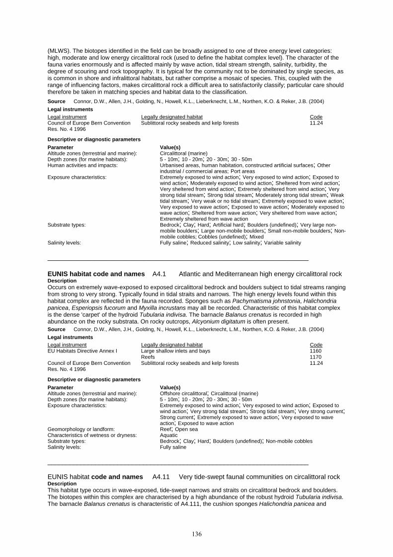
136
(MLWS). The biotopes identified in the field can be broadly assigned to one of three energy level categories: high, moderate and low energy circalittoral rock (used to define the habitat complex level). The character of the fauna varies enormously and is affected mainly by wave action, tidal stream strength, salinity, turbidity, the degree of scouring and rock topography. It is typical for the community not to be dominated by single species, as is common in shore and infralittoral habitats, but rather comprise a mosaic of species. This, coupled with the range of influencing factors, makes circalittoral rock a difficult area to satisfactorily classify; particular care should therefore be taken in matching species and habitat data to the classification. Source Connor, D.W., Allen, J.H., Golding, N., Howell, K.L., Lieberknecht, L.M., Northen, K.O. & Reker, J.B. (2004) Legal instruments Legal instrument Legally designated habitat Code Council of Europe Bern Convention Sublittoral rocky seabeds and kelp forests 11.24 Res. No. 4 1996
Descriptive or diagnostic parameters Parameter Value(s) Altitude zones (terrestrial and marine): Circalittoral (marine) Depth zones (for marine habitats): 5 - 10m; 10 - 20m; 20 - 30m; 30 - 50m Human activities and impacts: Urbanised areas, human habitation, constructed artificial surfaces; Other
industrial / commercial areas; Port areas Exposure characteristics: Extremely exposed to wind action; Very exposed to wind action; Exposed to
wind action; Moderately exposed to wind action; Sheltered from wind action; Very sheltered from wind action; Extremely sheltered from wind action; Very strong tidal stream; Strong tidal stream; Moderately strong tidal stream; Weak tidal stream; Very weak or no tidal stream; Extremely exposed to wave action; Very exposed to wave action; Exposed to wave action; Moderately exposed to wave action; Sheltered from wave action; Very sheltered from wave action; Extremely sheltered from wave action
Substrate types: Bedrock; Clay; Hard; Artificial hard; Boulders (undefined); Very large non-mobile boulders; Large non-mobile boulders; Small non-mobile boulders; Non-mobile cobbles; Cobbles (undefined); Mixed
Salinity levels: Fully saline; Reduced salinity; Low salinity; Variable salinity _______________________________________________________________________ EUNIS habitat code and names A4.1 Atlantic and Mediterranean high energy circalittoral rock Description Occurs on extremely wave-exposed to exposed circalittoral bedrock and boulders subject to tidal streams ranging from strong to very strong. Typically found in tidal straits and narrows. The high energy levels found within this habitat complex are reflected in the fauna recorded. Sponges such as Pachymatisma johnstonia, Halichondria panicea, Esperiopsis fucorum and Myxilla incrustans may all be recorded. Characteristic of this habitat complex is the dense 'carpet' of the hydroid Tubularia indivisa. The barnacle Balanus crenatus is recorded in high abundance on the rocky substrata. On rocky outcrops, Alcyonium digitatum is often present. Source Connor, D.W., Allen, J.H., Golding, N., Howell, K.L., Lieberknecht, L.M., Northen, K.O. & Reker, J.B. (2004) Legal instruments Legal instrument Legally designated habitat Code EU Habitats Directive Annex I Large shallow inlets and bays 1160 Reefs 1170 Council of Europe Bern Convention Sublittoral rocky seabeds and kelp forests 11.24 Res. No. 4 1996
Descriptive or diagnostic parameters Parameter Value(s) Altitude zones (terrestrial and marine): Offshore circalittoral; Circalittoral (marine) Depth zones (for marine habitats): 5 - 10m; 10 - 20m; 20 - 30m; 30 - 50m Exposure characteristics: Extremely exposed to wind action; Very exposed to wind action; Exposed to
wind action; Very strong tidal stream; Strong tidal stream; Very strong current; Strong current; Extremely exposed to wave action; Very exposed to wave action; Exposed to wave action
Geomorphology or landform: Reef; Open sea Characteristics of wetness or dryness: Aquatic Substrate types: Bedrock; Clay; Hard; Boulders (undefined); Non-mobile cobbles Salinity levels: Fully saline _______________________________________________________________________ EUNIS habitat code and names A4.11 Very tide-swept faunal communities on circalittoral rock Description This habitat type occurs in wave-exposed, tide-swept narrows and straits on circalittoral bedrock and boulders. The biotopes within this complex are characterised by a high abundance of the robust hydroid Tubularia indivisa. The barnacle Balanus crenatus is characteristic of A4.111, the cushion sponges Halichondria panicea and

137
Myxilla incrustans are characteristic of A4.1121 and Alcyonium digitatum is characteristic of A4.1122. The anemones Sagartia elegans, Actinothoe sphyrodeta, Urticina felina, Corynactis viridis and Metridium senile are all found within this complex. Other species present in this high-energy complex are the sponges Esperiopsis fucorum and Pachymatisma johnstonia, the bryozoans Alcyonidium diaphanum and Flustra foliacea, Cancer pagurus, Sertularia argentea and Asterias rubens. Source Connor, D.W., Allen, J.H., Golding, N., Howell, K.L., Lieberknecht, L.M., Northen, K.O. & Reker, J.B. (2004) Legal instruments Legal instrument Legally designated habitat Code Council of Europe Bern Convention Sublittoral rocky seabeds and kelp forests 11.24 Res. No. 4 1996
Descriptive or diagnostic parameters Parameter Value(s) Altitude zones (terrestrial and marine): Circalittoral (marine) Depth zones (for marine habitats): 10 - 20m; 20 - 30m Exposure characteristics: Extremely exposed to wind action; Very exposed to wind action; Exposed to
wind action; Very strong tidal stream; Strong tidal stream; Very strong current; Strong current; Extremely exposed to wave action; Very exposed to wave action; Exposed to wave action
Substrate types: Bedrock; Boulders (undefined) Salinity levels: Fully saline _______________________________________________________________________ EUNIS habitat code and names A4.12 Sponge communities on deep circalittoral rock Description This habitat type typically occurs on deep (commonly below 30m depth), wave-exposed circalittoral rock subject to negligible tidal streams. The sponge component of this biotope is the most striking feature, with similar species to the bryozoan and erect sponge habitat type (A4.131) although in this case, the sponges Phakellia ventilabrum, Axinella infundibuliformis, Axinella dissimilis and Stelligera stuposa dominate. Other sponge species frequently found on exposed rocky coasts are also present in low to moderate abundance. These include Cliona celata, Polymastia boletiformis, Haliclona viscosa, Pachymatisma johnstonia, Dysidea fragilis, Suberites carnosus, Stelligera rigida, Hemimycale columella and Tethya aurantium. The cup coral Caryophyllia smithii and the anemone Corynactis virdis may be locally abundant in some areas, along with the holothurian Holothuria forskali. The soft corals Alcyonium digitatum and Alcyonium glomeratum are frequently observed. The bryozoans Pentapora foliacea and Porella compressa are also more frequently found in this deep-water habitat type. Bryozoan crusts such as Parasmittina trispinosa are also occasionally recorded. Isolated clumps of large hydroids such as Nemertesia antennina, Nemertesia ramosa and Sertularella gayi may be seen on the tops of boulders and rocky outcrops. Large echinoderms such as Echinus esculentus, Luidia ciliaris, Marthasterias glacialis, Strichastrella rosea, Henricia oculata and Aslia lefevrei may also be present. The sea fan Eunicella verucosa may be locally common but to a lesser extent than in A4.1311. The top shell Calliostoma zizyphinum is often recorded as present. Source Connor, D.W., Allen, J.H., Golding, N., Howell, K.L., Lieberknecht, L.M., Northen, K.O. & Reker, J.B. (2004) Legal instruments Legal instrument Legally designated habitat Code Council of Europe Bern Convention Sublittoral rocky seabeds and kelp forests 11.24 Res. No. 4 1996
Descriptive or diagnostic parameters Parameter Value(s) Altitude zones (terrestrial and marine): Offshore circalittoral; Circalittoral (marine) Depth zones (for marine habitats): 20 - 30m; 30 - 50m Exposure characteristics: Extremely exposed to wind action; Very exposed to wind action; Exposed to
wind action; Moderately strong tidal stream; Weak tidal stream; Very weak or no tidal stream; Very strong current; Strong current; Extremely exposed to wave action; Very exposed to wave action; Exposed to wave action
Geomorphology or landform: Open sea Substrate types: Bedrock Salinity levels: Fully saline _______________________________________________________________________ EUNIS habitat code and names A4.13 Mixed faunal turf communities on circalittoral rock Description This habitat type occurs on wave-exposed circalittoral bedrock and boulders, subject to tidal streams ranging from strong to moderately strong. This complex is characterised by its diverse range of hydroids (Halecium halecinum, Nemertesia antennina and Nemertesia ramosa), bryozoans (Alcyonidium diaphanum, Flustra foliacea, Bugula flabellata and Bugula plumosa) and sponges (Scypha ciliata, Pachymatisma johnstonia, Cliona

138
celeta, Raspailia ramosa, Esperiopsis fucorum, Hemimycale columella and Dysidea fragilis) forming an often dense, mixed faunal turf. Other species found within this complex are Alcyonium digitatum, Urticina felina, Sagartia elegans, Actinothoe sphyrodeta, Caryophyllia smithii, Pomatoceros triqueter, Balanus crenatus, Cancer pagurus, Necora puber, Asterias rubens, Echinus esculentus and Clavelina lepadiformis. Source Connor, D.W., Allen, J.H., Golding, N., Howell, K.L., Lieberknecht, L.M., Northen, K.O. & Reker, J.B. (2004) Legal instruments Legal instrument Legally designated habitat Code Council of Europe Bern Convention Sublittoral rocky seabeds and kelp forests 11.24 Res. No. 4 1996
Descriptive or diagnostic parameters Parameter Value(s) Altitude zones (terrestrial and marine): Circalittoral (marine) Depth zones (for marine habitats): 5 - 10m; 10 - 20m; 20 - 30m Exposure characteristics: Extremely exposed to wind action; Very exposed to wind action; Exposed to
wind action; Moderately exposed to wind action; Strong tidal stream; Moderately strong tidal stream; Extremely exposed to wave action; Very exposed to wave action; Exposed to wave action; Moderately exposed to wave action
Substrate types: Bedrock; Boulders (undefined) Salinity levels: Fully saline _______________________________________________________________________ EUNIS habitat code and names A4.2 Atlantic and Mediterranean moderate energy circalittoral rock Description Mainly occurs on exposed to moderately wave-exposed circalittoral bedrock and boulders, subject to moderately strong and weak tidal streams. This habitat type contains a broad range of biological subtypes, from echinoderms and crustose communties (A4.21) to Sabellaria reefs (A4.22) and circalittoral mussel beds Source Connor, D.W., Allen, J.H., Golding, N., Howell, K.L., Lieberknecht, L.M., Northen, K.O. & Reker, J.B. (2004) Legal instruments Legal instrument Legally designated habitat Code EU Habitats Directive Annex I Estuaries 1130 Large shallow inlets and bays 1160 Reefs 1170 Council of Europe Bern Convention Sublittoral rocky seabeds and kelp forests 11.24 Res. No. 4 1996
Descriptive or diagnostic parameters Parameter Value(s) Altitude zones (terrestrial and marine): Offshore circalittoral; Circalittoral (marine) Depth zones (for marine habitats): 10 - 20m; 20 - 30m; 30 - 50m Exposure characteristics: Exposed to wind action; Moderately exposed to wind action; Moderately strong
tidal stream; Weak tidal stream; Moderately strong current; Exposed to wave action; Moderately exposed to wave action
Geomorphology or landform: Reef; Open sea Characteristics of wetness or dryness: Aquatic Substrate types: Bedrock; Clay; Hard; Boulders (undefined); Non-mobile cobbles; Mixed Salinity levels: Fully saline; Variable salinity _______________________________________________________________________ EUNIS habitat code and names A4.21 Echinoderms and crustose communities on circalittoral rock Description This habitat type occurs on wave-exposed, moderately strong to weakly tide-swept, circalittoral bedrock and boulders. Echinoderms, faunal (Parasmittina trispinosa) and algal crusts (red encrusting algae) dominate this biotope, giving a sparse appearance. Typical echinoderms present are the starfish Asterias rubens, the brittlestar Ophiothrix fragilis and the sea urchin Echinus esculentus. There may be isolated clumps of the hydroids Nemertesia antennina and Abietinaria abietina, Alcyonium digitatum, the anemone Urticina felina and the cup coral Caryophyllia smithii. Other species present may include the polychaete Pomatoceros triqueter and the top shell Calliostoma zizphinum. Source Connor, D.W., Allen, J.H., Golding, N., Howell, K.L., Lieberknecht, L.M., Northen, K.O. & Reker, J.B. (2004) Legal instruments Legal instrument Legally designated habitat Code Council of Europe Bern Convention Sublittoral rocky seabeds and kelp forests 11.24 Res. No. 4 1996

139
Descriptive or diagnostic parameters Parameter Value(s) Altitude zones (terrestrial and marine): Circalittoral (marine) Depth zones (for marine habitats): 10 - 20m; 20 - 30m; 30 - 50m Exposure characteristics: Extremely exposed to wind action; Very exposed to wind action; Exposed to
wind action; Moderately exposed to wind action; Moderately strong tidal stream; Weak tidal stream; Extremely exposed to wave action; Very exposed to wave action; Exposed to wave action; Moderately exposed to wave action
Substrate types: Bedrock; Boulders (undefined) Salinity levels: Fully saline _______________________________________________________________________ EUNIS habitat code and names A4.22 English name: Ross worm reefs on circalittoral rock; Scientific name: Sabellaria reefs on circalittoral rock Description This habitat type occurs on moderately wave-exposed, circalittoral bedrock, boulders and cobbles subject to moderately strong tidal streams. It is characterised by dense crusts of the polychaete Sabellaria spinulosa covering the substratum. Other fauna present in many cases reflects the biotopes found on nearby rock, so to a certain extent, is quite variable. Species typically present include the bryozoans Flustra foliacea, Alcyonidium diaphanum and Pentapora foliacea, the hydroid Nemertesia antennina, the sponges Tethya aurantium and Phorbas fictitius, the anemones Urticina felina and Sagartia elegans, and the ascidians Distomus variolosus, Polycarpa pomaria and Polycarpa scuba. The barnacle Balanus crenatus, the polychetes Pomatoceros triqueter and Salmacina dysteri, the starfish Crossaster papposus, and Alcyonium digitatum may also be recorded. Source Connor, D.W., Allen, J.H., Golding, N., Howell, K.L., Lieberknecht, L.M., Northen, K.O. & Reker, J.B. (2004) Legal instruments Legal instrument Legally designated habitat Code Council of Europe Bern Convention Sublittoral rocky seabeds and kelp forests 11.24 Res. No. 4 1996
Descriptive or diagnostic parameters Parameter Value(s) Altitude zones (terrestrial and marine): Circalittoral (marine) Depth zones (for marine habitats): 10 - 20m; 20 - 30m Exposure characteristics: Exposed to wind action; Moderately exposed to wind action; Moderately strong
tidal stream; Exposed to wave action; Moderately exposed to wave action Substrate types: Bedrock; Boulders (undefined); Cobbles (undefined); Pebbles Salinity levels: Fully saline _______________________________________________________________________ EUNIS habitat code and names A4.23 Communities on soft circalittoral rock Description This habitat type occurs on moderately wave-exposed, circalittoral soft bedrock subject to moderately strong tidal streams. As this complex is found in highly turbid water conditions, the circalittoral zone may begin at the low water mark, due to poor light penetration. This complex is dominated by the piddock Pholas dactylus. Other species typical of this complex include the polychaete Polydora and Bispira volutacornis, the sponges Cliona celata and Suberites ficus, the bryozoan Flustra foliacea, Alcyonium digitatum, the starfish Asterias rubens, the mussel Mytilus edulis and the crab Necora puber and Cancer pagurus. Foliose red algae may also be present. Please note: in areas subject to very high turbidity, biotopes within this habitat type may occur in the infralittoral and even the littoral zone. Source Connor, D.W., Allen, J.H., Golding, N., Howell, K.L., Lieberknecht, L.M., Northen, K.O. & Reker, J.B. (2004) Legal instruments Legal instrument Legally designated habitat Code Council of Europe Bern Convention Sublittoral rocky seabeds and kelp forests 11.24 Res. No. 4 1996
Descriptive or diagnostic parameters Parameter Value(s) Altitude zones (terrestrial and marine): Circalittoral (marine) Depth zones (for marine habitats): 0 - 5m; 5 - 10m; 10 - 20m Exposure characteristics: Moderately exposed to wind action; Moderately strong tidal stream;
Moderately exposed to wave action Substrate types: Bedrock Salinity levels: Fully saline _______________________________________________________________________

140
EUNIS habitat code and names A4.24 Mussel beds on circalittoral rock Description This habitat type occurs on moderately wave-exposed upper circalittoral bedrock subject to strong or moderately strong tidal streams. This complex is characterised by dense aggregations of the mussels Mytilus edulis or Musculus discors carpeting the underlying substrata. Sponges that may be recorded in this complex are Scypha ciliata, Tethya aurantium, Pachymatisma johnstonia, Dysidea fragilis and Cliona celata. A sparse hydroid/bryozoan turf composed primarily of Nemertesia antennina, Alcyonidium diaphanum and Flustra foliacea is often recorded. Anemones present are Urticina felina and Sagartia elegans. Other species recorded are the crabs Cancer pagurus, Carcinus maenas and Necora puber, the starfish Crossaster papposus and Asterias rubens, and Alcyonium digitatum and in this upper circalittoral complex, algae species such as Dictyota dichotoma, Cryptopleura ramosa and Plocamium cartilagineum. Source Connor, D.W., Allen, J.H., Golding, N., Howell, K.L., Lieberknecht, L.M., Northen, K.O. & Reker, J.B. (2004) Legal instruments Legal instrument Legally designated habitat Code EU Habitats Directive Annex I Reefs 1170 Council of Europe Bern Convention Sublittoral organogenic concretions 11.25 Res. No. 4 1996
Descriptive or diagnostic parameters Parameter Value(s) Altitude zones (terrestrial and marine): Circalittoral (marine) Depth zones (for marine habitats): 5 - 10m; 10 - 20m Exposure characteristics: Moderately exposed to wind action; Strong tidal stream; Moderately strong
tidal stream; Moderately exposed to wave action Substrate types: Bedrock Salinity levels: Fully saline _______________________________________________________________________ EUNIS habitat code and names A4.25 Circalittoral faunal communities in variable salinity Description This habitat type occurs on wave-sheltered, variable salinity bedrock and cobbles, subject to moderately strong to weak tidal streams. This complex contains a suite of sponges able to tolerate the variable salinity conditions like Hymeniacidon perleve, Suberites ficus, Halichondria panicea, Halichondria bowerbanki, Cliona celata and Leucosolenia botryoides. The barnacle Balanus crenatus is frequently recorded in this complex. A sparse hydroid/bryozoan turf composed primarily of Nemertesia antennina, Nemerteis ramosa, Plumularia setacea, Alcyonidium diaphanum and Bugula plumosa is often recorded. Other species recorded are the ascidians Clavelina lepadiformis, Morchellium argus and Dendrodoa grossularia, the anemones Metridium senile and Sagartia troglodytes, the starfish Asterias rubens and the crab Carcinus maenas. Source Connor, D.W., Allen, J.H., Golding, N., Howell, K.L., Lieberknecht, L.M., Northen, K.O. & Reker, J.B. (2004) Legal instruments Legal instrument Legally designated habitat Code Council of Europe Bern Convention Sublittoral rocky seabeds and kelp forests 11.24 Res. No. 4 1996
Descriptive or diagnostic parameters Parameter Value(s) Altitude zones (terrestrial and marine): Circalittoral (marine) Depth zones (for marine habitats): 0 - 5m; 5 - 10m; 10 - 20m Exposure characteristics: Sheltered from wind action; Very sheltered from wind action; Extremely
sheltered from wind action; Ultra sheltered from wind action; Moderately strong tidal stream; Weak tidal stream; Sheltered from wave action; Very sheltered from wave action; Extremely sheltered from wave action; Ultra sheltered from wave action
Substrate types: Bedrock; Cobbles (undefined) Salinity levels: Fully saline; Variable salinity _______________________________________________________________________ EUNIS habitat code and names A4.26 Mediterranean coralligenous communities moderately exposed to hydrodynamic action Description Communities forming and colonizing corallogenic concretions of calcified red algae in the circalittoral zone of the Mediterranean. Source Devillers, P., Devillers-Terschuren, J. and Vander Linden, C. (2001) Legal instruments Legal instrument Legally designated habitat Code Council of Europe Bern Convention Sublittoral organogenic concretions 11.25

141
Res. No. 4 1996
Descriptive or diagnostic parameters Parameter Value(s) Altitude zones (terrestrial and marine): Circalittoral (marine) Salinity levels: Fully saline _______________________________________________________________________ EUNIS habitat code and names A4.27 Faunal communities on deep moderate energy circalittoral rock Description No description available. Source Davies, C.E. & Moss, D. (2002) Legal instruments Legal instrument Legally designated habitat Code Council of Europe Bern Convention Sublittoral rocky seabeds and kelp forests 11.24 Res. No. 4 1996
Descriptive or diagnostic parameters Parameter Value(s) Depth zones (for marine habitats): 20 - 30m; 30 - 50m _______________________________________________________________________ EUNIS habitat code and names A4.3 Atlantic and Mediterranean low energy circalittoral rock Description Occurs on wave-sheltered circalittoral bedrock and boulders subject to mainly weak/very weak tidal streams. The biotopes identified within this habitat type are often dominated by encrusting red algae, brachiopods (Neocrania anomala) and ascidians (Ciona intestinalis and Ascidia mentula). Source Connor, D.W., Allen, J.H., Golding, N., Howell, K.L., Lieberknecht, L.M., Northen, K.O. & Reker, J.B. (2004) Legal instruments Legal instrument Legally designated habitat Code EU Habitats Directive Annex I Estuaries 1130 Large shallow inlets and bays 1160 Reefs 1170 Council of Europe Bern Convention Sublittoral rocky seabeds and kelp forests 11.24 Res. No. 4 1996
Descriptive or diagnostic parameters Parameter Value(s) Altitude zones (terrestrial and marine): Offshore circalittoral; Circalittoral (marine) Depth zones (for marine habitats): 5 - 10m; 10 - 20m; 20 - 30m Exposure characteristics: Sheltered from wind action; Very sheltered from wind action; Weak tidal
stream; Very weak or no tidal stream; Weak current; Very weak or no current; Sheltered from wave action; Very sheltered from wave action
Geomorphology or landform: Reef; Open sea Characteristics of wetness or dryness: Aquatic Substrate types: Bedrock; Clay; Hard; Boulders (undefined); Non-mobile cobbles Salinity levels: Fully saline; Reduced salinity _______________________________________________________________________ EUNIS habitat code and names A4.31 Brachiopod and ascidian communities on circalittoral rock
Description This habitat type occurs on the wave-sheltered, circalittoral bedrock and boulders subject to weak tidal streams. The biotopes within this complex are typically found in the Scottish sealochs (with the exception of A4.312, recorded off Ireland) and are characterised by brachipod and ascidian communities. Ascidians often recorded in this complex are Ciona intestinalis, Ascidia mentula, Ascidia virginea and Clavelina lepadiformis. The brachiopod Neocrania anomala is also characteristic of the biotopes within this complex recorded in Scottish sealochs. The polychaete Pomatoceros triqueter, the saddle oyster Pododesmus patelliformis, the cup coral Caryophyllia smithii and encrusting red algae are frequently recorded on the rocky substrata. Echinoderms such as the brittlestars Ophiothrix fraglis, Ophiocomina nigra and Ophiura albida, the starfish Asterias rubens, Crossaster papposus and Henricia oculata, the crinoid Antedon bifida and the urchin Echinus esculentus are all found in this complex. Other species present include the squat lobster Munida rugosa, the hermit crab Pagurus bernhardus, Alcyonium digitatum, the anemone Protanthea simplex and the hydroid Kirchenpaueria pinnata.

142
Source Connor, D.W., Allen, J.H., Golding, N., Howell, K.L., Lieberknecht, L.M., Northen, K.O. & Reker, J.B. (2004) Legal instruments Legal instrument Legally designated habitat Code Council of Europe Bern Convention Sublittoral rocky seabeds and kelp forests 11.24 Res. No. 4 1996
Descriptive or diagnostic parameters Parameter Value(s) Altitude zones (terrestrial and marine): Circalittoral (marine) Depth zones (for marine habitats): 5 - 10m; 10 - 20m; 20 - 30m Exposure characteristics: Sheltered from wind action; Very sheltered from wind action; Weak tidal
stream; Very weak or no tidal stream; Sheltered from wave action; Very sheltered from wave action
Substrate types: Bedrock; Boulders (undefined) Salinity levels: Fully saline; Reduced salinity _______________________________________________________________________ EUNIS habitat code and names A4.32 Mediterranean coralligenous communities sheltered from hydrodynamic action Description Communities forming and colonizing corallogenic concretions of calcified red algae in the circalittoral zone of the Mediterranean. Source Devillers, P., Devillers-Terschuren, J. and Vander Linden, C. (2001) Legal instruments Legal instrument Legally designated habitat Code Council of Europe Bern Convention Sublittoral organogenic concretions 11.25 Res. No. 4 1996
Descriptive or diagnostic parameters Parameter Value(s) Altitude zones (terrestrial and marine): Circalittoral (marine) Salinity levels: Fully saline _______________________________________________________________________ EUNIS habitat code and names A4.33 Faunal communities on deep low energy circalittoral rock Description Added by CEH to accommodate level 5 units proposed at Southampton workshop Source Davies, C.E. & Moss, D. (2002) Descriptive or diagnostic parameters Parameter Value(s) Depth zones (for marine habitats): 20 - 30m; 30 - 50m _______________________________________________________________________ EUNIS habitat code and names A4.4 Baltic exposed circalittoral rock Description Rock habitats in the Baltic infralittoral zone which are exposed to wave action, currents or ice scouring. The exposure status is that impacting on the area concerned at the relevant scale. Thus there may be enclaves of different exposure status caused by localised variation in relief (e.g. steeper rock in more moderately exposed or even sheltered areas). Note that it has been proposed that ‘exposed’ has an effective fetch of greater than 25 km: this requires verification across the Baltic. Source Hill, M.O., Moss, D. & Davies, C.E. (2004b) Legal instruments Legal instrument Legally designated habitat Code EU Habitats Directive Annex I Reefs 1170 Council of Europe Bern Convention Sublittoral rocky seabeds and kelp forests 11.24 Res. No. 4 1996
Descriptive or diagnostic parameters Parameter Value(s) Altitude zones (terrestrial and marine): Offshore circalittoral; Circalittoral (marine) Depth zones (for marine habitats): 5 - 10m; 10 - 20m; 20 - 30m; 30 - 50m Exposure characteristics: Exposed to wind action; Moderately exposed to wind action; Exposed to wave
action; Moderately exposed to wave action Geomorphology or landform: Reef; Open sea Characteristics of wetness or dryness: Aquatic

143
Substrate types: Bedrock; Clay; Hard; Boulders (undefined); Non-mobile cobbles Salinity levels: Reduced salinity; Low salinity _______________________________________________________________________ EUNIS habitat code and names A4.5 Baltic moderately exposed circalittoral rock Description Rock habitats in the Baltic infralittoral zone which are moderately exposed to wave action, currents or ice scouring. The exposure status is that impacting on the area concerned at the relevant scale. Thus there may be enclaves of different exposure status caused by localised variation in relief (e.g. steeper rock in sheltered areas). Note that it has been proposed that ‘exposed’ has an effective fetch of 5 – 25 km: this requires verification across the Baltic. Source Hill, M.O., Moss, D. & Davies, C.E. (2004b) Legal instruments Legal instrument Legally designated habitat Code EU Habitats Directive Annex I Reefs 1170 Council of Europe Bern Convention Sublittoral rocky seabeds and kelp forests 11.24 Res. No. 4 1996
Descriptive or diagnostic parameters Parameter Value(s) Altitude zones (terrestrial and marine): Offshore circalittoral; Circalittoral (marine) Depth zones (for marine habitats): 10 - 20m; 20 - 30m; 30 - 50m Exposure characteristics: Moderately exposed to wind action; Sheltered from wind action; Moderately
exposed to wave action; Sheltered from wave action Geomorphology or landform: Reef; Open sea Characteristics of wetness or dryness: Aquatic Substrate types: Bedrock; Clay; Hard; Boulders (undefined); Non-mobile cobbles; Mixed Salinity levels: Reduced salinity; Low salinity _______________________________________________________________________ EUNIS habitat code and names A4.6 Baltic sheltered circalittoral rock Description Rock habitats in the Baltic infralittoral zone which are sheltered from wave action, currents or ice scouring. The exposure status is that impacting on the area concerned at the relevant scale. Thus there may be enclaves of different exposure status caused by localised variation in relief (e.g. sheltered areas within exposed or moderately exposed areas). Note that it has been proposed that ‘exposed’ has an effective fetch less than 5 km: this requires verification across the Baltic. Source Hill, M.O., Moss, D. & Davies, C.E. (2004b) Legal instruments Legal instrument Legally designated habitat Code EU Habitats Directive Annex I Reefs 1170 Council of Europe Bern Convention Sublittoral rocky seabeds and kelp forests 11.24 Res. No. 4 1996
Descriptive or diagnostic parameters Parameter Value(s) Altitude zones (terrestrial and marine): Offshore circalittoral; Circalittoral (marine) Depth zones (for marine habitats): 5 - 10m; 10 - 20m; 20 - 30m Exposure characteristics: Very sheltered from wind action; Extremely sheltered from wind action; Ultra
sheltered from wind action; Very sheltered from wave action; Extremely sheltered from wave action; Ultra sheltered from wave action
Geomorphology or landform: Reef; Open sea Characteristics of wetness or dryness: Aquatic Substrate types: Bedrock; Clay; Hard; Boulders (undefined); Non-mobile cobbles Salinity levels: Reduced salinity; Low salinity _______________________________________________________________________ EUNIS habitat code and names A4.7 Features of circalittoral rock Description Circalittoral rock features include circalittoral fouling communities (A4.72) and circalittoral caves and overhangs (A4.71). These features are present throughout the circalittoral zone in a variety of wave exposures and tidal streams. Two fouling subtypes have also been identified: A4.722 has been recorded from disused fishing nets and other artificial substrata, and is characterised by aggregations of Ascidiella aspersa whilst A4.721 has been recorded from steel wrecks, and is characterised by dense aggregations of Alcyonium digitatum and Metridium senile. Habitats in hard substrata in the circalittoral zone characterised by the presence of seeping or bubbling gases, oils or water are also included (A4.73).

144
Source Connor, D.W., Allen, J.H., Golding, N., Howell, K.L., Lieberknecht, L.M., Northen, K.O. & Reker, J.B. (2004) Legal instruments Legal instrument Legally designated habitat Code EU Habitats Directive Annex I Large shallow inlets and bays 1160 Reefs 1170 Submerged or partially submerged sea caves 8330 Descriptive or diagnostic parameters Parameter Value(s) Altitude zones (terrestrial and marine): Offshore circalittoral; Circalittoral (marine) Depth zones (for marine habitats): 10 - 20m; 20 - 30m; 30 - 50m Exposure characteristics: Extremely exposed to wind action; Very exposed to wind action; Exposed to
wind action; Moderately exposed to wind action; Sheltered from wind action; Moderately strong tidal stream; Weak tidal stream; Very weak or no tidal stream; Extremely exposed to wave action; Very exposed to wave action; Exposed to wave action; Moderately exposed to wave action; Sheltered from wave action
Geomorphology or landform: Sea cave; Marine overhang Light intensity (when used in criteria): Beyond limit of light Characteristics of wetness or dryness: Aquatic Substrate types: Bedrock; Clay; Hard; Artificial hard; Boulders (undefined); Non-mobile cobbles Salinity levels: Fully saline _______________________________________________________________________ EUNIS habitat code and names A4.71 Communities of circalittoral caves and overhangs Description Caves and overhanging rock in the circalittoral zone, away from significant influence of strong wave action (compare A3.71). This habitat may be colonised by a wide variety of species, with sponges such as Dercitus bucklandi, anemones Parazoanthus spp. and the cup corals Caryophyllia inornatus, Hoplangia durotrix and others particularly characteristic. Source Connor, D.W., Allen, J.H., Golding, N., Howell, K.L., Lieberknecht, L.M., Northen, K.O. & Reker, J.B. (2004) Legal instruments Legal instrument Legally designated habitat Code EU Habitats Directive Annex I Large shallow inlets and bays 1160 Reefs 1170 Submerged or partially submerged sea caves 8330 Council of Europe Bern Convention Sea-caves 12.7 Res. No. 4 1996
Descriptive or diagnostic parameters Parameter Value(s) Altitude zones (terrestrial and marine): Circalittoral (marine) Depth zones (for marine habitats): 10 - 20m; 20 - 30m; 30 - 50m Exposure characteristics: Very exposed to wind action; Exposed to wind action; Moderately exposed to
wind action; Sheltered from wind action; Weak tidal stream; Very weak or no tidal stream; Very exposed to wave action; Exposed to wave action; Moderately exposed to wave action; Sheltered from wave action
Substrate types: Bedrock Salinity levels: Fully saline _______________________________________________________________________ EUNIS habitat code and names A4.72 Circalittoral fouling faunal communities Description This habitat type contains two biotopes which, although have different physical habitat characteristics, share the fact that they colonise new areas of artificial substrata relatively quickly. The Ascidiella aspersa fouling biotope (A4.722) is found on wave-sheltered artificial substrata such as discarded fishing nets/mooring lines. A separate fouling biotope (A4.721) is described for open coast wrecks. This biotope has a characteristic faunal community of Alcyonium digitatum and the anemone Metridium senile. Other species recorded in this complex (primarily under the AdigMsen biotope) include the hydroid Nemertesia antennina, the anemones Actinothoe sphyrodeta and Sagartia elegans, the cup coral Caryophyllia smithii, the bryozoans Flustra foliacea and Bugula plumosa, the crabs Necora puber, Cancer pagurus and Maja squinado and the lobster Homarus gammarus. Source Connor, D.W., Allen, J.H., Golding, N., Howell, K.L., Lieberknecht, L.M., Northen, K.O. & Reker, J.B. (2004) Descriptive or diagnostic parameters Parameter Value(s) Altitude zones (terrestrial and marine): Circalittoral (marine) Depth zones (for marine habitats): 5 - 10m; 10 - 20m; 20 - 30m Exposure characteristics: Moderately exposed to wind action; Extremely sheltered from wind action; Ultra
sheltered from wind action; Moderately strong tidal stream; Moderately

145
exposed to wave action; Extremely sheltered from wave action; Ultra sheltered from wave action
Substrate types: Artificial hard Salinity levels: Fully saline; Variable salinity _______________________________________________________________________ EUNIS habitat code and names A4.73 Vents and seeps in circalittoral rock Description No description available. Source OSPAR/ICES/EEA (2000) Legal instruments Legal instrument Legally designated habitat Code EU Habitats Directive Annex I Submarine structures made by leaking gases 1180 Descriptive or diagnostic parameters Parameter Value(s) Depth zones (for marine habitats): 10 - 20m; 20 - 30m; 30 - 50m _______________________________________________________________________ EUNIS habitat code and names A5 Sublittoral sediment Description Sediment habitats in the sublittoral near shore zone (i.e. covering the infralittoral and circalittoral zones), typically extending from the extreme lower shore down to the edge of the bathyal zone (200 m). Sediment ranges from boulders and cobbles, through pebbles and shingle, coarse sands, sands, fine sands, muds, and mixed sediments. Those communities found in or on sediment are described within this broad habitat type. Source Connor, D.W., Allen, J.H., Golding, N., Howell, K.L., Lieberknecht, L.M., Northen, K.O. & Reker, J.B. (2004) Legal instruments Legal instrument Legally designated habitat Code Council of Europe Bern Convention Sublittoral soft seabeds 11.22 Res. No. 4 1996
Descriptive or diagnostic parameters Parameter Value(s) Altitude zones (terrestrial and marine): Offshore circalittoral; Circalittoral (marine); Infralittoral (marine) Depth zones (for marine habitats): 0 - 5m; 5 - 10m; 10 - 20m; 20 - 30m; 30 - 50m; 50 - 100m Exposure characteristics: Very exposed to wind action; Exposed to wind action; Moderately exposed to
wind action; Sheltered from wind action; Very sheltered from wind action; Extremely sheltered from wind action; Strong tidal stream; Moderately strong tidal stream; Weak tidal stream; Very weak or no tidal stream; Very exposed to wave action; Exposed to wave action; Moderately exposed to wave action; Sheltered from wave action; Very sheltered from wave action; Extremely sheltered from wave action
Geomorphology or landform: Reef; Open sea Characteristics of wetness or dryness: Aquatic Substrate types: Mobile; Mobile rock; Cobbles (undefined); Mobile cobbles; Pebbles; Gravel;
Sand; Muddy sand; Mud, Silt; Biogenic; Peat; Shells; Mixed; Rock, Sand, Gravel; Pebbles, Cobbles; Sand, Gravel; Mud, Sand, Gravel; Mud, Gravel; Mud, Sand; Sand, Organic
Salinity levels: Fully saline; Reduced salinity; Low salinity; Variable salinity _______________________________________________________________________ EUNIS habitat code and names A5.1 Sublittoral coarse sediment Description Coarse sediments including coarse sand, gravel, pebbles, shingle and cobbles which are often unstable due to tidal currents and/or wave action. These habitats are generally found on the open coast or in tide-swept channels of marine inlets. They typically have a low silt content and a lack of a significant seaweed component. They are characterised by a robust fauna including venerid bivalves. Source Connor, D.W., Allen, J.H., Golding, N., Howell, K.L., Lieberknecht, L.M., Northen, K.O. & Reker, J.B. (2004) Legal instruments Legal instrument Legally designated habitat Code EU Habitats Directive Annex I Sandbanks which are slightly covered by sea water all the time 1110 Estuaries 1130 Coastal lagoons 1150 Large shallow inlets and bays 1160 Council of Europe Bern Convention Sublittoral soft seabeds 11.22 Res. No. 4 1996

146
Descriptive or diagnostic parameters Parameter Value(s) Altitude zones (terrestrial and marine): Offshore circalittoral; Circalittoral (marine); Infralittoral (marine) Depth zones (for marine habitats): 0 - 5m; 5 - 10m; 10 - 20m; 20 - 30m Exposure characteristics: Exposed to wind action; Moderately exposed to wind action; Sheltered from
wind action; Strong tidal stream; Moderately strong tidal stream; Weak tidal stream; Very weak or no tidal stream; Exposed to wave action; Moderately exposed to wave action; Sheltered from wave action
Geomorphology or landform: Open sea Characteristics of wetness or dryness: Aquatic Substrate types: Mobile; Mobile rock; Cobbles (undefined); Mobile cobbles; Pebbles; Gravel;
Mobile shingle; Sand; Shells Salinity levels: Fully saline; Variable salinity _______________________________________________________________________ EUNIS habitat code and names A5.11 Infralittoral coarse sediment in reduced salinity Description Clean gravels that occur in the upper reaches of marine inlets, especially estuaries, where water movement is sufficiently strong to remove the silt content of the sediment. The habitat typically lacks a significant seaweed component and is characterised by a sparse but very robust brackish-water tolerant fauna. Source Connor, D.W., Allen, J.H., Golding, N., Howell, K.L., Lieberknecht, L.M., Northen, K.O. & Reker, J.B. (2004) Legal instruments Legal instrument Legally designated habitat Code Council of Europe Bern Convention Sublittoral soft seabeds 11.22 Res. No. 4 1996
Descriptive or diagnostic parameters Parameter Value(s) Altitude zones (terrestrial and marine): Circalittoral (marine); Infralittoral (marine) Depth zones (for marine habitats): 0 - 5m; 5 - 10m; 10 - 20m Exposure characteristics: Moderately exposed to wind action; Sheltered from wind action; Very sheltered
from wind action; Strong tidal stream; Moderately strong tidal stream; Weak tidal stream; Very weak or no tidal stream; Moderately exposed to wave action; Sheltered from wave action; Very sheltered from wave action
Substrate types: Pebbles; Gravel Salinity levels: Reduced salinity; Variable salinity _______________________________________________________________________ EUNIS habitat code and names A5.12 Infralittoral coarse sediment Description Moderately exposed habitats with coarse sand, gravelly sand, shingle and gravel in the infralittoral, are subject to disturbance by tidal steams and wave action. Such habitats found on the open coast or in tide-swept marine inlets are characterised by a robust fauna of infaunal polychaetes such as Chaetozone setosa and Lanice conchilega, cumacean crustacea such as Iphinoe trispinosa and Diastylis bradyi, and venerid bivalves. Source Connor, D.W., Allen, J.H., Golding, N., Howell, K.L., Lieberknecht, L.M., Northen, K.O. & Reker, J.B. (2004) Legal instruments Legal instrument Legally designated habitat Code Council of Europe Bern Convention Sublittoral soft seabeds 11.22 Res. No. 4 1996
Descriptive or diagnostic parameters Parameter Value(s) Altitude zones (terrestrial and marine): Infralittoral (marine) Depth zones (for marine habitats): 0 - 5m; 5 - 10m; 10 - 20m Exposure characteristics: Exposed to wind action; Moderately exposed to wind action; Sheltered from
wind action; Strong tidal stream; Moderately strong tidal stream; Weak tidal stream; Very weak or no tidal stream; Exposed to wave action; Moderately exposed to wave action; Sheltered from wave action
Substrate types: Sand; Sand, Gravel; Mud, Sand, Gravel Salinity levels: Fully saline _______________________________________________________________________ EUNIS habitat code and names A5.13 Circalittoral coarse sediment Description Tide-swept circalittoral coarse sands, gravel and shingle generally in depths of over 15-20m. This habitat may be found in tidal channels of marine inlets, along exposed coasts and offshore. This habitat, as with shallower coarse sediments, may be characterised by robust infaunal polychaetes, mobile crustacea and bivalves. Certain

147
species of sea cucumber (e.g. Neopentadactyla) may also be prevalent in these areas along with the lancelet Branchiostoma lanceolatum. Source Connor, D.W., Allen, J.H., Golding, N., Howell, K.L., Lieberknecht, L.M., Northen, K.O. & Reker, J.B. (2004) Legal instruments Legal instrument Legally designated habitat Code Council of Europe Bern Convention Sublittoral soft seabeds 11.22 Res. No. 4 1996
Descriptive or diagnostic parameters Parameter Value(s) Altitude zones (terrestrial and marine): Circalittoral (marine) Depth zones (for marine habitats): 5 - 10m; 10 - 20m; 20 - 30m Exposure characteristics: Exposed to wind action; Moderately exposed to wind action; Moderately strong
tidal stream; Weak tidal stream; Very weak or no tidal stream; Exposed to wave action; Moderately exposed to wave action
Substrate types: Gravel; Sand Salinity levels: Fully saline _______________________________________________________________________ EUNIS habitat code and names A5.14 Deep circalittoral coarse sediment Description Offshore (deep) circalittoral habitats with coarse sands and gravel or shell. This habitat may cover large areas of the offshore continental shelf although there is relatively little quantitative data available. Such habitats are quite diverse compared to shallower versions of this habitat and generally characterised by robust infaunal polychaete and bivalve species. Animal communities in this habitat are closely related to offshore mixed sediments and in some areas settlement of Modiolus modiolus larvae may occur and consequently these habitats may occasionally have large numbers of juvenile M. Modiolus. In areas where the mussels reach maturity their byssus threads bind the sediment together, increasing stability and allowing an increased deposition of silt leading to the development of the biotope A5.622. Source Connor, D.W., Allen, J.H., Golding, N., Howell, K.L., Lieberknecht, L.M., Northen, K.O. & Reker, J.B. (2004) Legal instruments Legal instrument Legally designated habitat Code Council of Europe Bern Convention Sublittoral soft seabeds 11.22 Res. No. 4 1996
Descriptive or diagnostic parameters Parameter Value(s) Altitude zones (terrestrial and marine): Offshore circalittoral Depth zones (for marine habitats): 20 - 30m; 30 - 50m; 50 - 100m Exposure characteristics: Moderately exposed to wind action; Sheltered from wind action; Very sheltered
from wind action; Moderately strong tidal stream; Weak tidal stream; Very weak or no tidal stream; Moderately exposed to wave action; Sheltered from wave action; Very sheltered from wave action
Substrate types: Gravel; Sand Salinity levels: Fully saline _______________________________________________________________________ EUNIS habitat code and names A5.2 Sublittoral sand Description Clean medium to fine sands or non-cohesive slightly muddy sands on open coasts, offshore or in estuaries and marine inlets. Such habitats are often subject to a degree of wave action or tidal currents which restrict the silt and clay content to less than 15%. This habitat is characterised by a range of taxa including polychaetes, bivalve molluscs and amphipod crustacea. Source Connor, D.W., Allen, J.H., Golding, N., Howell, K.L., Lieberknecht, L.M., Northen, K.O. & Reker, J.B. (2004) Legal instruments Legal instrument Legally designated habitat Code EU Habitats Directive Annex I Sandbanks which are slightly covered by sea water all the time 1110 Estuaries 1130 Coastal lagoons 1150 Large shallow inlets and bays 1160 Council of Europe Bern Convention Sublittoral soft seabeds 11.22 Res. No. 4 1996
Descriptive or diagnostic parameters Parameter Value(s) Altitude zones (terrestrial and marine): Offshore circalittoral; Circalittoral (marine); Infralittoral (marine) Depth zones (for marine habitats): 0 - 5m; 5 - 10m; 10 - 20m; 20 - 30m; 30 - 50m Exposure characteristics: Moderately exposed to wind action; Sheltered from wind action; Very sheltered

148
from wind action; Moderately strong tidal stream; Weak tidal stream; Very weak or no tidal stream; Moderately exposed to wave action; Sheltered from wave action; Very sheltered from wave action
Geomorphology or landform: Open sea Characteristics of wetness or dryness: Aquatic Substrate types: Mobile; Sand; Muddy sand; Mixed Salinity levels: Fully saline; Reduced salinity; Low salinity; Variable salinity _______________________________________________________________________ EUNIS habitat code and names A5.21 Sublittoral sand in low or reduced salinity Description Shallow sand and muddy sand in areas of low or reduced, although relatively stable salinity (may vary annually), with largely ephemeral faunal communities. The species are often similar to that found in A5.31 and are characterised by Arenicola marina with other species, including mysids, tubificoid and enchytraeid oligochaetes, Corophium volutator, Hediste diversicolor, Pygospio elegans, Hydrobia ulvae and Cerastoderma glaucum, which commonly occur in lagoons. Filamentous green algae such as Chaetomorpha linum may also be present. In some examples of this biotope the polychaete Fabricia sabella may be super-abundant and the isopod Sphaeroma hookeri common. Source Connor, D.W., Allen, J.H., Golding, N., Howell, K.L., Lieberknecht, L.M., Northen, K.O. & Reker, J.B. (2004) Legal instruments Legal instrument Legally designated habitat Code Council of Europe Bern Convention Sublittoral soft seabeds 11.22 Res. No. 4 1996
Descriptive or diagnostic parameters Parameter Value(s) Altitude zones (terrestrial and marine): Circalittoral (marine); Infralittoral (marine) Depth zones (for marine habitats): 0 - 5m; 5 - 10m; 10 - 20m Exposure characteristics: Ultra sheltered from wind action; Very weak or no tidal stream; Ultra sheltered
from wave action Substrate types: Sand Salinity levels: Reduced salinity; Low salinity _______________________________________________________________________ EUNIS habitat code and names A5.22 Sublittoral sand in variable salinity (estuaries) Description Clean sands that occur in the upper reaches of marine inlets, especially estuaries, where water movement is moderately strong, allowing the sedimentation of sand but not the finer silt fraction. The habitat typically lacks a significant seaweed component and is characterised by brackish-water tolerant fauna, particularly amphipods, polychaetes and mysid shrimps. Source Connor, D.W., Allen, J.H., Golding, N., Howell, K.L., Lieberknecht, L.M., Northen, K.O. & Reker, J.B. (2004) Legal instruments Legal instrument Legally designated habitat Code EU Habitats Directive Annex I Estuaries 1130 Council of Europe Bern Convention Sublittoral soft seabeds 11.22 Res. No. 4 1996
Descriptive or diagnostic parameters Parameter Value(s) Altitude zones (terrestrial and marine): Circalittoral (marine) Depth zones (for marine habitats): 0 - 5m; 5 - 10m; 10 - 20m Exposure characteristics: Moderately exposed to wind action; Sheltered from wind action; Very sheltered
from wind action; Strong tidal stream; Moderately strong tidal stream; Weak tidal stream; Moderately exposed to wave action; Sheltered from wave action; Very sheltered from wave action
Substrate types: Sand Salinity levels: Variable salinity _______________________________________________________________________ EUNIS habitat code and names A5.23 Infralittoral fine sand Description Clean sands which occur in shallow water, either on the open coast or in tide-swept channels of marine inlets. The habitat typically lacks a significant seaweed component and is characterised by robust fauna, particularly amphipods (Bathyporeia) and robust polychaetes including Nephtys cirrosa and Lanice conchilega. Source Connor, D.W., Allen, J.H., Golding, N., Howell, K.L., Lieberknecht, L.M., Northen, K.O. & Reker, J.B. (2004) Legal instruments

149
Legal instrument Legally designated habitat Code Council of Europe Bern Convention Sublittoral soft seabeds 11.22 Res. No. 4 1996
Descriptive or diagnostic parameters Parameter Value(s) Altitude zones (terrestrial and marine): Infralittoral (marine) Depth zones (for marine habitats): 0 - 5m; 5 - 10m; 10 - 20m Exposure characteristics: Exposed to wind action; Moderately exposed to wind action; Sheltered from
wind action; Strong tidal stream; Moderately strong tidal stream; Weak tidal stream; Very weak or no tidal stream; Exposed to wave action; Moderately exposed to wave action; Sheltered from wave action
Substrate types: Sand Salinity levels: Fully saline _______________________________________________________________________ EUNIS habitat code and names A5.24 Infralittoral muddy sand Description Non-cohesive muddy sand (with 5% to 20% silt/clay) in the infralittoral zone, extending from the extreme lower shore down to more stable circalittoral zone at about 15-20 m. The habitat supports a variety of animal-dominated communities, particularly polychaetes (Magelona mirabilis, Spiophanes bombyx and Chaetozone setosa), bivalves (Fabulina fibula and Chamelea gallina) and the urchin Echinocardium cordatum. Source Connor, D.W., Allen, J.H., Golding, N., Howell, K.L., Lieberknecht, L.M., Northen, K.O. & Reker, J.B. (2004) Legal instruments Legal instrument Legally designated habitat Code Council of Europe Bern Convention Sublittoral soft seabeds 11.22 Res. No. 4 1996
Descriptive or diagnostic parameters Parameter Value(s) Altitude zones (terrestrial and marine): Infralittoral (marine) Depth zones (for marine habitats): 0 - 5m; 5 - 10m; 10 - 20m Exposure characteristics: Moderately exposed to wind action; Sheltered from wind action; Moderately
strong tidal stream; Weak tidal stream; Very weak or no tidal stream; Moderately exposed to wave action; Sheltered from wave action
Substrate types: Sand; Muddy sand Salinity levels: Fully saline; Variable salinity _______________________________________________________________________ EUNIS habitat code and names A5.25 Circalittoral fine sand Description Clean fine sands with less than 5% silt/clay in deeper water, either on the open coast or in tide-swept channels of marine inlets in depths of over 15-20 m. The habitat may also extend offshore and is characterised by a wide range of echinoderms (in some areas including the pea urchin Echinocyamus pusillus), polychaetes and bivalves. This habitat is generally more stable than shallower, infralittoral sands and consequently supports a more diverse community. Source Connor, D.W., Allen, J.H., Golding, N., Howell, K.L., Lieberknecht, L.M., Northen, K.O. & Reker, J.B. (2004) Descriptive or diagnostic parameters Parameter Value(s) Altitude zones (terrestrial and marine): Circalittoral (marine) Depth zones (for marine habitats): 10 - 20m; 20 - 30m; 30 - 50m Exposure characteristics: Moderately exposed to wind action; Sheltered from wind action; Very sheltered
from wind action; Weak tidal stream; Very weak or no tidal stream; Moderately exposed to wave action; Sheltered from wave action; Very sheltered from wave action
Substrate types: Sand Salinity levels: Fully saline; Variable salinity _______________________________________________________________________ EUNIS habitat code and names A5.26 Circalittoral muddy sand Description Circalittoral non-cohesive muddy sands with the silt content of the substratum typically ranging from 5% to 20%. This habitat is generally found in water depths of over 15-20 m and supports animal-dominated communities characterised by a wide variety of polychaetes, bivalves such as Abra alba and Nucula nitidosa, and echinoderms such as Amphiura spp and Ophiura spp., and Astropecten irregularis. These circalittoral habitats tend to be more stable than their infralittoral counterparts and as such support a richer infaunal community.

150
Source Connor, D.W., Allen, J.H., Golding, N., Howell, K.L., Lieberknecht, L.M., Northen, K.O. & Reker, J.B. (2004) Legal instruments Legal instrument Legally designated habitat Code Council of Europe Bern Convention Sublittoral soft seabeds 11.22 Res. No. 4 1996
Descriptive or diagnostic parameters Parameter Value(s) Altitude zones (terrestrial and marine): Circalittoral (marine) Depth zones (for marine habitats): 10 - 20m; 20 - 30m; 30 - 50m Exposure characteristics: Exposed to wind action; Moderately exposed to wind action; Moderately strong
tidal stream; Weak tidal stream; Very weak or no tidal stream; Exposed to wave action; Moderately exposed to wave action
Substrate types: Sand Salinity levels: Fully saline _______________________________________________________________________ EUNIS habitat code and names A5.27 Deep circalittoral sand Description Offshore (deep) circalittoral habitats with fine sands or non-cohesive muddy sands. Very little data is available on these habitats however they are likely to be more stable than their shallower counterparts and characterised by a diverse range of polychaetes, amphipods, bivalves and echinoderms. Source Connor, D.W., Allen, J.H., Golding, N., Howell, K.L., Lieberknecht, L.M., Northen, K.O. & Reker, J.B. (2004) Legal instruments Legal instrument Legally designated habitat Code Council of Europe Bern Convention Sublittoral soft seabeds 11.22 Res. No. 4 1996
Descriptive or diagnostic parameters Parameter Value(s) Altitude zones (terrestrial and marine): Offshore circalittoral Substrate types: Sand; Muddy sand Salinity levels: Fully saline _______________________________________________________________________ EUNIS habitat code and names A5.28 Mediterranean communities of superficial muddy sands in sheltered waters Description No description available. Source Barcelona Convention (1998) Legal instruments Legal instrument Legally designated habitat Code Council of Europe Bern Convention Sublittoral soft seabeds 11.22 Res. No. 4 1996
Descriptive or diagnostic parameters Parameter Value(s) Altitude zones (terrestrial and marine): Circalittoral (marine); Infralittoral (marine) Salinity levels: Fully saline _______________________________________________________________________ EUNIS habitat code and names A5.3 Sublittoral mud Description Sublittoral mud and cohesive sandy mud extending from the extreme lower shore to offshore, circalittoral habitats. This biotope is predominantly found in sheltered harbours, sealochs, bays, marine inlets and estuaries and stable deeper/offshore areas where the reduced influence of wave action and/or tidal streams allow fine sediments to settle. Such habitats are often by dominated by polychaetes and echinoderms, in particular brittlestars such as Amphiura spp. Seapens such as Virgularia mirabilis and burrowing megafauna including Nephrops norvegicus are common in deeper muds. Estuarine muds tend to be characterised by infaunal polychaetes and oligochaetes. Source Connor, D.W., Allen, J.H., Golding, N., Howell, K.L., Lieberknecht, L.M., Northen, K.O. & Reker, J.B. (2004) Legal instruments Legal instrument Legally designated habitat Code EU Habitats Directive Annex I Estuaries 1130

151
Coastal lagoons 1150 Large shallow inlets and bays 1160 Boreal Baltic narrow inlets 1650 Council of Europe Bern Convention Sublittoral soft seabeds 11.22 Res. No. 4 1996
Descriptive or diagnostic parameters Parameter Value(s) Altitude zones (terrestrial and marine): Offshore circalittoral; Circalittoral (marine); Infralittoral (marine) Depth zones (for marine habitats): 0 - 5m; 5 - 10m; 10 - 20m; 20 - 30m Exposure characteristics: Moderately exposed to wind action; Sheltered from wind action; Very sheltered
from wind action; Extremely sheltered from wind action; Ultra sheltered from wind action; Moderately strong tidal stream; Weak tidal stream; Very weak or no tidal stream; Moderately exposed to wave action; Sheltered from wave action; Very sheltered from wave action; Extremely sheltered from wave action; Ultra sheltered from wave action
Geomorphology or landform: Open sea Characteristics of wetness or dryness: Aquatic Substrate types: Muddy sand; Mud, Silt Salinity levels: Fully saline; Reduced salinity; Low salinity; Variable salinity _______________________________________________________________________ EUNIS habitat code and names A5.31 Sublittoral mud in low or reduced salinity (lagoons) Description Shallow, typically anoxic, muddy and sandy mud sediments in areas of low or reduced, although stable, salinity (may vary annually) with largely ephemeral faunal communities. Characterised by Arenicola marina and blue-green algae with other species, including mysids, Carcinus maenas and Corophium volutator which commonly occur in lagoons. Important infaunal species may include Hediste diversicolor, Heterochaeta costata and chironomids; however infaunal records for this biotope are limited. Source Connor, D.W., Allen, J.H., Golding, N., Howell, K.L., Lieberknecht, L.M., Northen, K.O. & Reker, J.B. (2004) Legal instruments Legal instrument Legally designated habitat Code EU Habitats Directive Annex I Coastal lagoons 1150 Council of Europe Bern Convention Sublittoral soft seabeds 11.22 Res. No. 4 1996
Descriptive or diagnostic parameters Parameter Value(s) Altitude zones (terrestrial and marine): Infralittoral (marine) Depth zones (for marine habitats): 0 - 5m Exposure characteristics: Extremely sheltered from wind action; Ultra sheltered from wind action; Weak
tidal stream; Very weak or no tidal stream; Extremely sheltered from wave action; Ultra sheltered from wave action
Substrate types: Muddy sand Salinity levels: Reduced salinity; Low salinity _______________________________________________________________________ EUNIS habitat code and names A5.32 Sublittoral mud in variable salinity (estuaries) Description Shallow sublittoral muds, extending from the extreme lower shore into the subtidal in variable salinity (estuarine) conditions. Such habitats typically support communities characterised by oligochaetes, and polychaetes such as Aphelochaeta marioni. In lowered salinity conditions the sediments may include a proportion of coarser material, where the silt content is sufficient to yield a similar community to that found in purer muds. Source Connor, D.W., Allen, J.H., Golding, N., Howell, K.L., Lieberknecht, L.M., Northen, K.O. & Reker, J.B. (2004) Legal instruments Legal instrument Legally designated habitat Code EU Habitats Directive Annex I Estuaries 1130 Council of Europe Bern Convention Sublittoral soft seabeds 11.22 Res. No. 4 1996
Descriptive or diagnostic parameters Parameter Value(s) Altitude zones (terrestrial and marine): Infralittoral (marine) Depth zones (for marine habitats): 0 - 5m; 5 - 10m Exposure characteristics: Moderately exposed to wind action; Sheltered from wind action; Very sheltered
from wind action; Extremely sheltered from wind action; Strong tidal stream; Moderately strong tidal stream; Weak tidal stream; Very weak or no tidal stream; Moderately exposed to wave action; Sheltered from wave action; Very sheltered from wave action; Extremely sheltered from wave action

152
Substrate types: Muddy sand; Mud, Silt Salinity levels: Variable salinity _______________________________________________________________________ EUNIS habitat code and names A5.33 Infralittoral sandy mud Description Infralittoral, cohesive sandy mud, typically with over 20% silt/clay, in depths of less than 15-20 m. This habitat is generally found in sheltered bays or marine inlets and along sheltered areas of open coast. Typical species include a rich variety of polychaetes including Melinna palmate, tube building amphipods (Ampelisca spp.) and deposit feeding bivalves such as Macoma balthica and Mysella bidentata. Sea pens such as Virgularia mirabilis and brittlestars such as Amphiura spp. may be present but not in the same abundances as found in deeper circalittoral waters. Source Connor, D.W., Allen, J.H., Golding, N., Howell, K.L., Lieberknecht, L.M., Northen, K.O. & Reker, J.B. (2004) Legal instruments Legal instrument Legally designated habitat Code Council of Europe Bern Convention Sublittoral soft seabeds 11.22 Res. No. 4 1996
Descriptive or diagnostic parameters Parameter Value(s) Altitude zones (terrestrial and marine): Infralittoral (marine) Depth zones (for marine habitats): 0 - 5m; 5 - 10m; 10 - 20m Exposure characteristics: Sheltered from wind action; Very sheltered from wind action; Extremely
sheltered from wind action; Moderately strong tidal stream; Weak tidal stream; Very weak or no tidal stream; Sheltered from wave action; Very sheltered from wave action; Extremely sheltered from wave action
Substrate types: Muddy sand; Mud, Silt Salinity levels: Fully saline; Variable salinity _______________________________________________________________________ EUNIS habitat code and names A5.34 Infralittoral fine mud Description Shallow sublittoral muds, extending from the extreme lower shore to about 15-20 m depth in fully marine or near marine conditions, predominantly in extremely sheltered areas with very weak tidal currents. Such habitats are found in sealochs and some rias and harbours. Populations of the lugworm Arenicola marina may be dense, with anemones, the opisthobranch Philine aperta and synaptid holothurians also characteristic in some areas. The extent of the oxidised layer may be shallow with some areas being periodically or permanently anoxic. In these areas bacterial mats may develop on the sediment surface. Infaunal records for this habitat type are limited encompassing only one biotope. They are therefore not representative of the full suite of infaunal species found in this biotope. Source Connor, D.W., Allen, J.H., Golding, N., Howell, K.L., Lieberknecht, L.M., Northen, K.O. & Reker, J.B. (2004) Legal instruments Legal instrument Legally designated habitat Code Council of Europe Bern Convention Sublittoral soft seabeds 11.22 Res. No. 4 1996
Descriptive or diagnostic parameters Parameter Value(s) Altitude zones (terrestrial and marine): Infralittoral (marine) Depth zones (for marine habitats): 0 - 5m; 5 - 10m; 10 - 20m Exposure characteristics: Sheltered from wind action; Very sheltered from wind action; Extremely
sheltered from wind action; Weak tidal stream; Very weak or no tidal stream; Sheltered from wave action; Very sheltered from wave action; Extremely sheltered from wave action
Substrate types: Mud, Gravel Salinity levels: Fully saline; Variable salinity _______________________________________________________________________ EUNIS habitat code and names A5.35 Circalittoral sandy mud Description Circalittoral, cohesive sandy mud, typically with over 20% silt/clay, generally in water depths of over 10 m, with weak or very weak tidal streams. This habitat is generally found in deeper areas of bays and marine inlets or offshore from less wave exposed coasts. Sea pens such as Virgularia mirabilis and brittlestars such as Amphiura spp. are particularly characteristic of this habitat whilst infaunal species include the tube building polychaetes Lagis koreni and Owenia fusiformis, and deposit feeding bivalves such as Mysella bidentata and Abra spp.

153
Source Connor, D.W., Allen, J.H., Golding, N., Howell, K.L., Lieberknecht, L.M., Northen, K.O. & Reker, J.B. (2004) Legal instruments Legal instrument Legally designated habitat Code Council of Europe Bern Convention Sublittoral soft seabeds 11.22 Res. No. 4 1996
Descriptive or diagnostic parameters Parameter Value(s) Altitude zones (terrestrial and marine): Circalittoral (marine) Depth zones (for marine habitats): 10 - 20m; 20 - 30m; 30 - 50m; 50 - 100m Exposure characteristics: Exposed to wind action; Moderately exposed to wind action; Sheltered from
wind action; Very sheltered from wind action; Moderately strong tidal stream; Weak tidal stream; Very weak or no tidal stream; Exposed to wave action; Moderately exposed to wave action; Sheltered from wave action; Very sheltered from wave action
Substrate types: Mud, Silt Salinity levels: Fully saline _______________________________________________________________________ EUNIS habitat code and names A5.36 Circalittoral fine mud Description Sublittoral muds, occurring below moderate depths of 15-20 m, either on the open coast or in marine inlets such as sealochs. The seapens Virgularia mirabilis and Pennatula phosphorea are characteristic of this habitat type together with the burrowing anemone Cerianthus lloydii and the ophiuroid Amphiura spp. The relatively stable conditions often lead to the establishment of communities of burrowing megafaunal species, such as Nephrops norvegicus. Source Connor, D.W., Allen, J.H., Golding, N., Howell, K.L., Lieberknecht, L.M., Northen, K.O. & Reker, J.B. (2004) Legal instruments Legal instrument Legally designated habitat Code Council of Europe Bern Convention Sublittoral soft seabeds 11.22 Res. No. 4 1996
Descriptive or diagnostic parameters Parameter Value(s) Altitude zones (terrestrial and marine): Circalittoral (marine) Depth zones (for marine habitats): 10 - 20m; 20 - 30m; 30 - 50m Exposure characteristics: Moderately exposed to wind action; Sheltered from wind action; Very sheltered
from wind action; Extremely sheltered from wind action; Weak tidal stream; Very weak or no tidal stream; Moderately exposed to wave action; Sheltered from wave action; Very sheltered from wave action; Extremely sheltered from wave action
Substrate types: Mud, Silt Salinity levels: Fully saline; Variable salinity _______________________________________________________________________ EUNIS habitat code and names A5.37 Deep circalittoral mud Description In mud and cohesive sandy mud in the offshore circalittoral zone, typically below 50-70 m, a variety of faunal communities may develop, depending upon the level of silt/clay and organic matter in the sediment. Communities are typically dominated by polychaetes but often with high numbers of bivalves such as Thyasira spp., echinoderms and foraminifera. Source Connor, D.W., Allen, J.H., Golding, N., Howell, K.L., Lieberknecht, L.M., Northen, K.O. & Reker, J.B. (2004) Legal instruments Legal instrument Legally designated habitat Code Council of Europe Bern Convention Sublittoral soft seabeds 11.22 Res. No. 4 1996
Descriptive or diagnostic parameters Parameter Value(s) Altitude zones (terrestrial and marine): Offshore circalittoral Depth zones (for marine habitats): 50 - 100m Exposure characteristics: Weak tidal stream; Very weak or no tidal stream Substrate types: Muddy sand Salinity levels: Fully saline _______________________________________________________________________ EUNIS habitat code and names A5.38 Mediterranean communities of muddy detritic bottoms

154
Description No description available. Source Barcelona Convention (1998) Legal instruments Legal instrument Legally designated habitat Code Council of Europe Bern Convention Sublittoral soft seabeds 11.22 Res. No. 4 1996
Descriptive or diagnostic parameters Parameter Value(s) Altitude zones (terrestrial and marine): Circalittoral (marine); Infralittoral (marine) Salinity levels: Fully saline _______________________________________________________________________ EUNIS habitat code and names A5.39 Mediterranean communities of coastal terrigenous muds Description No description available. Source Barcelona Convention (1998) Legal instruments Legal instrument Legally designated habitat Code Council of Europe Bern Convention Sublittoral soft seabeds 11.22 Res. No. 4 1996
Descriptive or diagnostic parameters Parameter Value(s) Altitude zones (terrestrial and marine): Circalittoral (marine); Infralittoral (marine) Salinity levels: Fully saline _______________________________________________________________________ EUNIS habitat code and names A5.4 Sublittoral mixed sediments Description Sublittoral mixed (heterogeneous) sediments found from the extreme low water mark to deep offshore circalittoral habitats. These habitats incorporate a range of sediments including heterogeneous muddy gravelly sands and also mosaics of cobbles and pebbles embedded in or lying upon sand, gravel or mud. There is a degree of confusion with regard nomenclature within this complex as many habitats could be defined as containing mixed sediments, in part depending on the scale of the survey and the sampling method employed. The BGS trigon can be used to define truly mixed or heterogeneous sites with surficial sediments which are a mixture of mud, gravel and sand. However, another 'form' of mixed sediment includes mosaic habitats such as superficial waves or ribbons of sand on a gravel bed or areas of lag deposits with cobbles/pebbles embedded in sand or mud and these are less well defined and may overlap into other habitat or biological subtypes. These habitats may support a wide range of infauna and epibiota including polychaetes, bivalves, echinoderms, anemones, hydroids and Bryozoa. Mixed sediments with biogenic reefs or macrophyte dominated communities are classified separately in A5.6 and A5.5 respectively. Source Connor, D.W., Allen, J.H., Golding, N., Howell, K.L., Lieberknecht, L.M., Northen, K.O. & Reker, J.B. (2004) Legal instruments Legal instrument Legally designated habitat Code EU Habitats Directive Annex I Sandbanks which are slightly covered by sea water all the time 1110 Estuaries 1130 Coastal lagoons 1150 Large shallow inlets and bays 1160 Council of Europe Bern Convention Sublittoral soft seabeds 11.22 Res. No. 4 1996
Descriptive or diagnostic parameters Parameter Value(s) Altitude zones (terrestrial and marine): Offshore circalittoral; Circalittoral (marine); Infralittoral (marine) Depth zones (for marine habitats): 0 - 5m; 5 - 10m; 10 - 20m; 20 - 30m; 30 - 50m Exposure characteristics: Moderately exposed to wind action; Sheltered from wind action; Very sheltered
from wind action; Extremely sheltered from wind action; Ultra sheltered from wind action; Moderately strong tidal stream; Weak tidal stream; Very weak or no tidal stream; Moderately exposed to wave action; Sheltered from wave action; Very sheltered from wave action; Extremely sheltered from wave action; Ultra sheltered from wave action
Geomorphology or landform: Open sea Characteristics of wetness or dryness: Aquatic Substrate types: Mobile; Shells; Mixed; Rock, Sand, Gravel; Pebbles, Cobbles; Sand, Gravel;
Mud, Sand, Gravel; Mud, Gravel; Mud, Sand; Sand, Organic Salinity levels: Fully saline; Reduced salinity; Low salinity; Variable salinity

155
_______________________________________________________________________ EUNIS habitat code and names A5.41 Sublittoral mixed sediment in low or reduced salinity (lagoons) Description Shallow, muddy mixed sediments in areas of low or reduced, although stable, salinity (may vary annually) with largely ephemeral faunal communities. Characterised infaunally by oligochaetes, including Heterochaeta costata and members of the Enchytraeidae, polychaetes such as Hediste diversicolor, Polydora ciliata and Pygospio elegans,and bivalves such as Mya arenaria and the lagoon cockle Cerastoderma glaucum. These bivalve species may also form conspicuious members of the epifauna together with more ubiquitous species like the common goby Pomatoschistus microps. Source Connor, D.W., Allen, J.H., Golding, N., Howell, K.L., Lieberknecht, L.M., Northen, K.O. & Reker, J.B. (2004) Legal instruments Legal instrument Legally designated habitat Code EU Habitats Directive Annex I Coastal lagoons 1150 Council of Europe Bern Convention Sublittoral soft seabeds 11.22 Res. No. 4 1996
Descriptive or diagnostic parameters Parameter Value(s) Altitude zones (terrestrial and marine): Infralittoral (marine) Depth zones (for marine habitats): 0 - 5m; 5 - 10m Exposure characteristics: Ultra sheltered from wind action; Weak tidal stream; Ultra sheltered from wave
action Substrate types: Mixed Salinity levels: Low salinity _______________________________________________________________________ EUNIS habitat code and names A5.42 Sublittoral mixed sediment in variable salinity (estuaries) Description Shallow sublittoral mixed sediments in estuarine conditions, often with surface shells or stones, enabling the development of diverse epifaunal communities, e.g. Crepidula fornicata (A5.422), as well as infaunal communities. This habitat type is therefore often quite species rich, compared with purer sediments. Source Connor, D.W., Allen, J.H., Golding, N., Howell, K.L., Lieberknecht, L.M., Northen, K.O. & Reker, J.B. (2004) Legal instruments Legal instrument Legally designated habitat Code EU Habitats Directive Annex I Estuaries 1130 Council of Europe Bern Convention Sublittoral soft seabeds 11.22 Res. No. 4 1996
Descriptive or diagnostic parameters Parameter Value(s) Altitude zones (terrestrial and marine): Infralittoral (marine) Depth zones (for marine habitats): 0 - 5m; 5 - 10m Exposure characteristics: Sheltered from wind action; Very sheltered from wind action; Extremely
sheltered from wind action; Moderately strong tidal stream; Weak tidal stream; Very weak or no tidal stream; Sheltered from wave action; Very sheltered from wave action; Extremely sheltered from wave action
Substrate types: Mud, Sand, Gravel Salinity levels: Reduced salinity; Low salinity; Variable salinity _______________________________________________________________________ EUNIS habitat code and names A5.43 Infralittoral mixed sediments Description Shallow mixed (heterogeneous) sediments in fully marine or near fully marine conditions, supporting various animal-dominated communities, with relatively low proportions of seaweeds. This habitat may include well mixed muddy gravelly sands or very poorly sorted mosaics of shell, cobbles and pebbles embedded in mud, sand or gravel. Due to the quite variable nature of the sediment type, a widely variable array of communities may be found, including those characterised by bivalves (A5.433, A5.431, and A5.435), polychaetes (A5.432) and file shells (A5.434). This has resulted in many species being described as characteristic of this habitat type all contributing only a small percentage to the overall similarity (see below). This habitat type may also include a newly proposed Chaetopterus biotope (Rees pers com.) recently found in the eastern English Channel. This biotope is characterised by an undescribed Chaetopterus sp. and small Lanice conchilega. Further sampling is need in order to assess and fully characterise this potential biotope. As a result, the Chaetopterus biotope has not been included in this revision. Infaunal data for this habitat type are limited to that described in the biotope

156
A5.433 and so are not representative of the infaunal component of the whole habitat type. Source Connor, D.W., Allen, J.H., Golding, N., Howell, K.L., Lieberknecht, L.M., Northen, K.O. & Reker, J.B. (2004) Legal instruments Legal instrument Legally designated habitat Code Council of Europe Bern Convention Sublittoral soft seabeds 11.22 Res. No. 4 1996
Descriptive or diagnostic parameters Parameter Value(s) Altitude zones (terrestrial and marine): Infralittoral (marine) Depth zones (for marine habitats): 0 - 5m; 5 - 10m; 10 - 20m; 20 - 30m Exposure characteristics: Moderately exposed to wind action; Sheltered from wind action; Very sheltered
from wind action; Strong tidal stream; Moderately strong tidal stream; Weak tidal stream; Moderately exposed to wave action; Sheltered from wave action; Very sheltered from wave action
Substrate types: Mixed Salinity levels: Fully saline; Variable salinity _______________________________________________________________________ EUNIS habitat code and names A5.44 Circalittoral mixed sediments Description Mixed (heterogeneous) sediment habitats in the circalittoral zone (generally below 15-20 m) including well mixed muddy gravelly sands or very poorly sorted mosaics of shell, cobbles and pebbles embedded in or lying upon mud, sand or gravel. Due to the variable nature of the seabed a variety of communities can develop which are often very diverse. A wide range of infaunal polychaetes, bivalves, echinoderms and burrowing anemones such as Cerianthus lloydii are often present in such habitat and the presence of hard substrata (shells and stones) on the surface enables epifaunal species to become established, particularly hydroids such as Nemertesia spp and Hydrallmania falcata. The combination of epifauna and infauna can lead to species rich communities. Coarser mixed sediment communities may show a strong resemblance, in terms of infauna, to biotopes within the A5.1. However, infaunal data for this habitat type is limited to that described under the biotope A5.443, and so are not representative of the infaunal component of this habitat type. Source Connor, D.W., Allen, J.H., Golding, N., Howell, K.L., Lieberknecht, L.M., Northen, K.O. & Reker, J.B. (2004) Legal instruments Legal instrument Legally designated habitat Code Council of Europe Bern Convention Sublittoral soft seabeds 11.22 Res. No. 4 1996
Descriptive or diagnostic parameters Parameter Value(s) Altitude zones (terrestrial and marine): Circalittoral (marine) Depth zones (for marine habitats): 5 - 10m; 10 - 20m; 20 - 30m; 30 - 50m Exposure characteristics: Moderately exposed to wind action; Sheltered from wind action; Very sheltered
from wind action; Moderately strong tidal stream; Weak tidal stream; Very weak or no tidal stream; Moderately exposed to wave action; Sheltered from wave action; Very sheltered from wave action
Substrate types: Mixed Salinity levels: Fully saline _______________________________________________________________________ EUNIS habitat code and names A5.45 Deep mixed sediments Description Offshore (deep) circalittoral habitats with slightly muddy mixed gravelly sand and stones or shell. This habitat may cover large areas of the offshore continental shelf although there is relatively little data available. Such habitats are often highly diverse with a high number of infaunal polychaete and bivalve species. Animal communities in this habitat are closely related to offshore gravels and coarse sands and in some areas populations of the horse mussel Modiolus modiolus may develop in these habitats (see A5.622). Source Connor, D.W., Allen, J.H., Golding, N., Howell, K.L., Lieberknecht, L.M., Northen, K.O. & Reker, J.B. (2004) Legal instruments Legal instrument Legally designated habitat Code Council of Europe Bern Convention Sublittoral soft seabeds 11.22 Res. No. 4 1996
Descriptive or diagnostic parameters Parameter Value(s) Altitude zones (terrestrial and marine): Offshore circalittoral Depth zones (for marine habitats): 20 - 30m; 30 - 50m; 50 - 100m Exposure characteristics: Moderately exposed to wind action; Sheltered from wind action; Moderately
exposed to wave action; Sheltered from wave action

157
Substrate types: Muddy sand Salinity levels: Fully saline _______________________________________________________________________ EUNIS habitat code and names A5.46 Mediterranean communities of coastal detritic bottoms Description No description available. Source Barcelona Convention (1998) Legal instruments Legal instrument Legally designated habitat Code Council of Europe Bern Convention Sublittoral soft seabeds 11.22 Res. No. 4 1996
Descriptive or diagnostic parameters Parameter Value(s) Altitude zones (terrestrial and marine): Circalittoral (marine); Infralittoral (marine) Salinity levels: Fully saline _______________________________________________________________________ EUNIS habitat code and names A5.47 Mediterranean communities of shelf-edge detritic bottoms
Description No description available. Source Barcelona Convention (1998) Legal instruments Legal instrument Legally designated habitat Code Council of Europe Bern Convention Sublittoral soft seabeds 11.22 Res. No. 4 1996
Descriptive or diagnostic parameters Parameter Value(s) Salinity levels: Fully saline _______________________________________________________________________ EUNIS habitat code and names A5.5 Sublittoral macrophyte-dominated sediment Description This habitat type includes maerl beds, seaweed dominated mixed sediments (including kelps such as Laminaria saccharina and filamentous/foliose red and green algae), seagrass beds, and lagoonal angiosperm communities. These communities develop in a range of habitats from exposed open coasts to lagoons and are found in a variety of sediment types and salinity regimes. Source Connor, D.W., Allen, J.H., Golding, N., Howell, K.L., Lieberknecht, L.M., Northen, K.O. & Reker, J.B. (2004) Legal instruments Legal instrument Legally designated habitat Code EU Habitats Directive Annex I Sandbanks which are slightly covered by sea water all the time 1110 Posidonia beds (Posidonion oceanicae) 1120 Estuaries 1130 Coastal lagoons 1150 Large shallow inlets and bays 1160 Descriptive or diagnostic parameters Parameter Value(s) Altitude zones (terrestrial and marine): Infralittoral (marine) Depth zones (for marine habitats): 0 - 5m; 5 - 10m; 10 - 20m Exposure characteristics: Moderately exposed to wind action; Sheltered from wind action; Very sheltered
from wind action; Extremely sheltered from wind action; Moderately strong tidal stream; Weak tidal stream; Very weak or no tidal stream; Moderately exposed to wave action; Sheltered from wave action; Very sheltered from wave action; Extremely sheltered from wave action
Geomorphology or landform: Open sea Dominant life forms: Aquatic angiosperms Characteristics of wetness or dryness: Aquatic Substrate types: Mobile; Cobbles (undefined); Gravel; Sand; Muddy sand; Mud, Silt; Biogenic;
Peat; Shells; Mixed Salinity levels: Fully saline; Reduced salinity; Variable salinity Related phytosociological units: Charion canescentis; Cymodoceion nodosae; Posidonion oceanicae;

158
Ruppietea maritimae; Ruppion maritimae; Zannichellion pedicellatae; Zosterion marinae
_______________________________________________________________________ EUNIS habitat code and names A5.51 Maerl beds Description Beds of maerl in coarse clean sediments of gravels and clean sands, which occur either on the open coast or in tide-swept channels of marine inlets (the latter often stony). In fully marine conditions the dominant maerl is typically Phymatolithon calcareum (A5.511), whilst under variable salinity conditions in some sealochs beds of Lithothamnion glaciale (A5.512) may develop. Source Connor, D.W., Allen, J.H., Golding, N., Howell, K.L., Lieberknecht, L.M., Northen, K.O. & Reker, J.B. (2004) Legal instruments Legal instrument Legally designated habitat Code Council of Europe Bern Convention Sublittoral soft seabeds 11.22 Res. No. 4 1996
Descriptive or diagnostic parameters Parameter Value(s) Altitude zones (terrestrial and marine): Circalittoral (marine); Infralittoral (marine) Depth zones (for marine habitats): 0 - 5m; 5 - 10m; 10 - 20m Exposure characteristics: Moderately exposed to wind action; Sheltered from wind action; Very sheltered
from wind action; Extremely sheltered from wind action; Moderately strong tidal stream; Weak tidal stream; Very weak or no tidal stream; Moderately exposed to wave action; Sheltered from wave action; Very sheltered from wave action; Extremely sheltered from wave action
Substrate types: Gravel; Sand; Biogenic; Mud, Gravel Salinity levels: Fully saline; Variable salinity _______________________________________________________________________ EUNIS habitat code and names A5.52 Kelp and seaweed communities on sublittoral sediment Description Shallow sublittoral sediments which support seaweed communities, typically including the kelp Laminaria saccharina, the bootlace weed Chorda filum and various red and brown seaweeds, particularly filamentous types. The generally sheltered nature of these habitats enables the seaweeds to grow on shells and small stones which lie on the sediment surface; some communities develop as loose-lying mats on the sediment surface. Source Connor, D.W., Allen, J.H., Golding, N., Howell, K.L., Lieberknecht, L.M., Northen, K.O. & Reker, J.B. (2004) Legal instruments Legal instrument Legally designated habitat Code Council of Europe Bern Convention Sublittoral soft seabeds 11.22 Res. No. 4 1996
Descriptive or diagnostic parameters Parameter Value(s) Altitude zones (terrestrial and marine): Infralittoral (marine) Depth zones (for marine habitats): 0 - 5m; 5 - 10m; 10 - 20m Exposure characteristics: Moderately exposed to wind action; Sheltered from wind action; Very sheltered
from wind action; Extremely sheltered from wind action; Moderately strong tidal stream; Weak tidal stream; Very weak or no tidal stream; Moderately exposed to wave action; Sheltered from wave action; Very sheltered from wave action; Extremely sheltered from wave action
Substrate types: Shells; Mixed Salinity levels: Fully saline; Reduced salinity; Variable salinity _______________________________________________________________________ EUNIS habitat code and names A5.53 Sublittoral seagrass beds Description Beds of submerged marine angiosperms in the genera Cymodocea, Halophila, Posidonia, Ruppia, Thalassia, Zostera. Source Hill, M.O., Moss, D. & Davies, C.E. (2004b) Legal instruments Legal instrument Legally designated habitat Code EU Habitats Directive Annex I Sandbanks which are slightly covered by sea water all the time 1110 Posidonia beds (Posidonion oceanicae) 1120 Council of Europe Bern Convention Sea-grass meadows 11.3 Res. No. 4 1996
Descriptive or diagnostic parameters

159
Parameter Value(s) Altitude zones (terrestrial and marine): Infralittoral (marine) Depth zones (for marine habitats): 0 - 5m; 5 - 10m Exposure characteristics: Sheltered from wind action; Very sheltered from wind action; Extremely
sheltered from wind action; Moderately strong tidal stream; Weak tidal stream; Very weak or no tidal stream; Sheltered from wave action; Very sheltered from wave action; Extremely sheltered from wave action
Substrate types: Muddy sand Salinity levels: Fully saline; Reduced salinity; Variable salinity _______________________________________________________________________ EUNIS habitat code and names A5.54 Angiosperm communities in reduced salinity Description Beds of submerged or slightly emergent vascular vegetation of brackish seas, sea inlets, estuaries, permanent pools of mud or sand flats, and coastal lagoons. Source Hill, M.O., Moss, D. & Davies, C.E. (2004b) Legal instruments Legal instrument Legally designated habitat Code EU Habitats Directive Annex I Sandbanks which are slightly covered by sea water all the time 1110 Descriptive or diagnostic parameters Parameter Value(s) Altitude zones (terrestrial and marine): Infralittoral (marine) Depth zones (for marine habitats): 0 - 5m Exposure characteristics: Extremely sheltered from wind action; Very weak or no tidal stream; Extremely
sheltered from wave action Substrate types: Muddy sand Salinity levels: Reduced salinity; Low salinity; Variable salinity _______________________________________________________________________ EUNIS habitat code and names A5.6 Sublittoral biogenic reefs Description This habitat type includes polychaete reefs, bivalve reefs (e.g. mussel beds) and cold water coral reefs. These communities develop in a range of habitats from exposed open coasts to estuaries, marine inlets and deeper offshore habitats and may be found in a variety of sediment types and salinity regimes. Source Connor, D.W., Allen, J.H., Golding, N., Howell, K.L., Lieberknecht, L.M., Northen, K.O. & Reker, J.B. (2004) Legal instruments Legal instrument Legally designated habitat Code EU Habitats Directive Annex I Estuaries 1130 Coastal lagoons 1150 Large shallow inlets and bays 1160 Reefs 1170 Council of Europe Bern Convention Sublittoral soft seabeds 11.22 Res. No. 4 1996 Sublittoral rocky seabeds and kelp forests 11.24 Descriptive or diagnostic parameters Parameter Value(s) Altitude zones (terrestrial and marine): Circalittoral (marine); Infralittoral (marine) Depth zones (for marine habitats): 0 - 5m; 5 - 10m; 10 - 20m; 20 - 30m; 30 - 50m; 50 - 100m Exposure characteristics: Moderately exposed to wind action; Sheltered from wind action; Very sheltered
from wind action; Strong tidal stream; Moderately strong tidal stream; Weak tidal stream; Very weak or no tidal stream; Moderately exposed to wave action; Sheltered from wave action; Very sheltered from wave action
Geomorphology or landform: Reef; Open sea Characteristics of wetness or dryness: Aquatic Substrate types: Biogenic; Peat; Shells Salinity levels: Fully saline; Variable salinity _______________________________________________________________________ EUNIS habitat code and names A5.61 Sublittoral polychaete worm reefs on sediment Description Sublittoral reefs of polychaete worms in mixed sediments found in a variety of hydrographic conditions. Such habitats may range from extensive structures of considerable size to loose agglomerations of tubes. Such communities often play an important role in the structural composition or stability of the seabed and provide a wide range of niches for other species to inhabit. Consequently polychaete worm reefs often support a diverse flora and fauna.

160
Source Connor, D.W., Allen, J.H., Golding, N., Howell, K.L., Lieberknecht, L.M., Northen, K.O. & Reker, J.B. (2004) Descriptive or diagnostic parameters Parameter Value(s) Altitude zones (terrestrial and marine): Circalittoral (marine); Infralittoral (marine) Depth zones (for marine habitats): 5 - 10m; 10 - 20m; 20 - 30m Exposure characteristics: Exposed to wind action; Moderately exposed to wind action; Sheltered from
wind action; Very sheltered from wind action; Strong tidal stream; Moderately strong tidal stream; Weak tidal stream; Exposed to wave action; Moderately exposed to wave action; Sheltered from wave action; Very sheltered from wave action
Substrate types: Pebbles; Mud, Sand, Gravel Salinity levels: Fully saline _______________________________________________________________________ EUNIS habitat code and names A5.62 Sublittoral mussel beds on sediment Description Sublittoral mussel beds comprised of either the horse mussel Modiolus modiolus or the common mussel Mytilus edulis. These communities may be sublittoral extensions of littoral reefs or exist independently. Found in a variety of habitats ranging from sheltered estuaries and marine inlets to open coasts and offshore areas they may occupy a range of substrata, although due to the stabilising effect such communities have on the substratum muddy mixed sediments are typical. A diverse range of epibiota and infauna often exists in these communities. Source Connor, D.W., Allen, J.H., Golding, N., Howell, K.L., Lieberknecht, L.M., Northen, K.O. & Reker, J.B. (2004) Descriptive or diagnostic parameters Parameter Value(s) Altitude zones (terrestrial and marine): Circalittoral (marine); Infralittoral (marine) Depth zones (for marine habitats): 0 - 5m; 5 - 10m; 10 - 20m; 20 - 30m; 50 - 100m Exposure characteristics: Exposed to wind action; Moderately exposed to wind action; Sheltered from
wind action; Very sheltered from wind action; Extremely sheltered from wind action; Strong tidal stream; Moderately strong tidal stream; Weak tidal stream; Very weak or no tidal stream; Exposed to wave action; Moderately exposed to wave action; Sheltered from wave action; Very sheltered from wave action; Extremely sheltered from wave action
Substrate types: Biogenic; Shells; Pebbles, Cobbles; Mud, Sand, Gravel Salinity levels: Fully saline _______________________________________________________________________ EUNIS habitat code and names A5.63 Circalittoral coral reefs Description The coral reef structures in UK waters are found in cold, largely aphotic waters, generally along the shelf edge and in offshore waters down to 2000 m. In the north east Atlantic, Lophelia pertusa is the dominant colonial coral and is the characterising species of the biotope described under this habitat type. Lophelia and its deep-water allies lack the symbiotic algae of their tropical relatives, so can live in the permanent darkness of the deep sea. These corals form colonies and can aggregate into patches and banks which may be described as reefs. These deep-sea corals can support and shelter hundreds of other species, including sponges, polychaete worms, echinoderms (starfish, sea urchins, brittle stars) and bryozoans (sea mats). Some 200-300 species can be found in one of these coral habitats, a number comparable to that found in other important deep-water habitats. Unlike tropical coral reef systems, they are dominated by only a few hard-coral species, and there are far fewer fish species. Source Connor, D.W., Allen, J.H., Golding, N., Howell, K.L., Lieberknecht, L.M., Northen, K.O. & Reker, J.B. (2004) Descriptive or diagnostic parameters Parameter Value(s) Altitude zones (terrestrial and marine): Offshore circalittoral Depth zones (for marine habitats): 50 - 100m; 100 - 200m Exposure characteristics: Ultra sheltered from wind action; Moderately strong tidal stream; Weak tidal
stream; Ultra sheltered from wave action Substrate types: Mud, Silt Salinity levels: Fully saline _______________________________________________________________________ EUNIS habitat code and names A5.7 Features of sublittoral sediments Description Features of sublittoral sediments include sublittoral habitats characterised by the presence of gases or liquids bubbling or seeping through sediments (A5.71) and sublittoral sediments which are organically-enriched or permanently or periodically anoxic (A5.72).

161
Source Hill, M.O., Moss, D. & Davies, C.E. (2004b) Legal instruments Legal instrument Legally designated habitat Code EU Habitats Directive Annex I Submarine structures made by leaking gases 1180 Council of Europe Bern Convention Sublittoral soft seabeds 11.22 Res. No. 4 1996
Descriptive or diagnostic parameters Parameter Value(s) Altitude zones (terrestrial and marine): Offshore circalittoral; Circalittoral (marine); Infralittoral (marine) Geomorphology or landform: Reef; Open sea; Submarine gas, oil or water vents and seeps Chemical attributes: Anoxic/Hypoxic Substrate types: Mobile; Mobile cobbles; Pebbles; Gravel; Sand; Muddy sand; Mud, Silt;
Biogenic; Peat; Shells; Mixed; Rock, Sand, Gravel; Pebbles, Cobbles; Sand, Gravel; Mud, Sand, Gravel; Mud, Gravel; Mud, Sand; Sand, Organic
_______________________________________________________________________ EUNIS habitat code and names A5.71 Seeps and vents in sublittoral sediments Description No description available. Source OSPAR/ICES/EEA (2000) Legal instruments Legal instrument Legally designated habitat Code EU Habitats Directive Annex I Submarine structures made by leaking gases 1180 Council of Europe Bern Convention Sublittoral soft seabeds 11.22 Res. No. 4 1996
Descriptive or diagnostic parameters Parameter Value(s) Characteristics of wetness or dryness: Aquatic _______________________________________________________________________ EUNIS habitat code and names A5.72 Organically-enriched or anoxic sublittoral habitats Description No description available. Source OSPAR/ICES/EEA (2000) Legal instruments Legal instrument Legally designated habitat Code Council of Europe Bern Convention Sublittoral soft seabeds 11.22 Res. No. 4 1996
Descriptive or diagnostic parameters Parameter Value(s) Altitude zones (terrestrial and marine): Circalittoral (marine); Infralittoral (marine) _______________________________________________________________________ EUNIS habitat code and names A6 Deep-sea bed Description The sea bed beyond the continental shelf break. The shelf break occurs at variable depth, but is generally over 200 m. The upper limit of the deep-sea zone is marked by the edge of the shelf. Includes areas of the Mediterranean Sea which are deeper than 200 m but not of the Baltic Sea which is a shelf sea. Excludes caves in the deep sea which are classified in A4.71 irrespective of depth. Source Hill, M.O., Moss, D. & Davies, C.E. (2004b) Descriptive or diagnostic parameters Parameter Value(s) Altitude zones (terrestrial and marine): Bathyal Depth zones (for marine habitats): >200m Geomorphology or landform: Open sea; Submarine channels; Deep ocean trenches Characteristics of wetness or dryness: Aquatic Substrate types: Bedrock; Hard; Mobile; Biogenic; Mixed _______________________________________________________________________ EUNIS habitat code and names A6.1 Deep-sea rock and artificial hard substrata

162
Description Deep-sea benthic habitats with substrates predominantly of bedrock, immobile boulders or artificial hard substrates. Source Hill, M.O., Moss, D. & Davies, C.E. (2004b) Legal instruments Legal instrument Legally designated habitat Code EU Habitats Directive Annex I Reefs 1170 Descriptive or diagnostic parameters Parameter Value(s) Altitude zones (terrestrial and marine): Bathyal Depth zones (for marine habitats): >200m Geomorphology or landform: Open sea Characteristics of wetness or dryness: Aquatic Substrate types: Bedrock; Hard; Artificial hard; Boulders (undefined); Non-mobile cobbles;
Mobile rock; Cobbles (undefined) _______________________________________________________________________ EUNIS habitat code and names A6.11 Deep-sea bedrock Description No description available. Source OSPAR/ICES/EEA (2000) Descriptive or diagnostic parameters Parameter Value(s) Depth zones (for marine habitats): >200m _______________________________________________________________________ EUNIS habitat code and names A6.12 Deep-sea artificial hard substrata Description No description available. Source OSPAR/ICES/EEA (2000) Descriptive or diagnostic parameters Parameter Value(s) Depth zones (for marine habitats): >200m _______________________________________________________________________ EUNIS habitat code and names A6.13 Deep-sea manganese nodules Description No description available. Source OSPAR/ICES/EEA (2000) Descriptive or diagnostic parameters Parameter Value(s) Depth zones (for marine habitats): >200m _______________________________________________________________________ EUNIS habitat code and names A6.14 Boulders on the deep-sea bed Description No description available. Source Davies, C.E. & Moss, D. (2002) Descriptive or diagnostic parameters Parameter Value(s) Depth zones (for marine habitats): >200m _______________________________________________________________________ EUNIS habitat code and names A6.2 Deep-sea mixed substrata Description Deep-sea benthic habitats with substrates predominantly of mixed particle size or gravel. Includes habitats with mobile substrates of biogenic origin but no longer living, and of allochthonous material such as macrophyte debris. Deep-sea habitats with living biogenic substrates are included in A6.6. Source Hill, M.O., Moss, D. & Davies, C.E. (2004b)

163
Descriptive or diagnostic parameters Parameter Value(s) Altitude zones (terrestrial and marine): Bathyal Depth zones (for marine habitats): >200m Geomorphology or landform: Open sea Characteristics of wetness or dryness: Aquatic Substrate types: Shells; Mixed _______________________________________________________________________ EUNIS habitat code and names A6.21 Deep-sea lag deposits Description No description available. Source OSPAR/ICES/EEA (2000) Descriptive or diagnostic parameters Parameter Value(s) Depth zones (for marine habitats): >200m _______________________________________________________________________ EUNIS habitat code and names A6.22 Deep-sea biogenic gravels (shells, coral debris) Description No description available. Source OSPAR/ICES/EEA (2000) Descriptive or diagnostic parameters Parameter Value(s) Depth zones (for marine habitats): >200m _______________________________________________________________________ EUNIS habitat code and names A6.23 Deep-sea calcareous pavements Description No description available. Source OSPAR/ICES/EEA (2000) Descriptive or diagnostic parameters Parameter Value(s) Depth zones (for marine habitats): >200m _______________________________________________________________________ EUNIS habitat code and names A6.24 Communities of allochthonous material Description No description available. Source OSPAR/ICES/EEA (2000) Descriptive or diagnostic parameters Parameter Value(s) Depth zones (for marine habitats): >200m _______________________________________________________________________ EUNIS habitat code and names A6.3 Deep-sea sand Description Deep-sea benthic habitats with substrates predominantly of sand. Source Hill, M.O., Moss, D. & Davies, C.E. (2004b) Descriptive or diagnostic parameters Parameter Value(s) Altitude zones (terrestrial and marine): Bathyal Depth zones (for marine habitats): >200m Geomorphology or landform: Open sea Characteristics of wetness or dryness: Aquatic Substrate types: Sand _______________________________________________________________________

164
EUNIS habitat code and names A6.31 Communities of bathyal detritic sands with Grypheus vitreus Description No description available. Source Barcelona Convention (1998) Descriptive or diagnostic parameters Parameter Value(s) Depth zones (for marine habitats): >200m _______________________________________________________________________ EUNIS habitat code and names A6.4 Deep-sea muddy sand Description Deep-sea benthic habitats with substrates predominantly of muddy sand. Source Hill, M.O., Moss, D. & Davies, C.E. (2004b) Descriptive or diagnostic parameters Parameter Value(s) Altitude zones (terrestrial and marine): Bathyal Depth zones (for marine habitats): >200m Geomorphology or landform: Open sea Characteristics of wetness or dryness: Aquatic Substrate types: Muddy sand _______________________________________________________________________ EUNIS habitat code and names A6.5 Deep-sea mud Description Bathyal and abyssal benthic habitats with substrates predominantly of mud. Source Hill, M.O., Moss, D. & Davies, C.E. (2004b) Descriptive or diagnostic parameters Parameter Value(s) Altitude zones (terrestrial and marine): Bathyal Depth zones (for marine habitats): >200m Geomorphology or landform: Open sea Characteristics of wetness or dryness: Aquatic Substrate types: Mud, Silt _______________________________________________________________________ EUNIS habitat code and names A6.51 Mediterranean communities of bathyal muds Description No description available. Source Barcelona Convention (1998) Descriptive or diagnostic parameters Parameter Value(s) Depth zones (for marine habitats): >200m _______________________________________________________________________ EUNIS habitat code and names A6.52 Communities of abyssal muds Description No description available. Source Barcelona Convention (1998) Descriptive or diagnostic parameters Parameter Value(s) Depth zones (for marine habitats): >200m _______________________________________________________________________ EUNIS habitat code and names A6.6 Deep-sea bioherms Description A bioherm is a mound, dome, or reef-like mass of rock that is composed almost exclusively of the remains of sedentary marine organisms and is embedded in rock of different physical character. This habitat type includes deep-sea coral reefs (A6.61) and sponge beds (A6.62).

165
Source Hill, M.O., Moss, D. & Davies, C.E. (2004b) Legal instruments Legal instrument Legally designated habitat Code EU Habitats Directive Annex I Reefs 1170 Descriptive or diagnostic parameters Parameter Value(s) Altitude zones (terrestrial and marine): Bathyal Depth zones (for marine habitats): >200m Geomorphology or landform: Open sea Characteristics of wetness or dryness: Aquatic Substrate types: Biogenic _______________________________________________________________________ EUNIS habitat code and names A6.61 Communities of deep-sea corals Description The only community described is Lophelia pertusa, a cold water, reef-forming coral, which has a wide geographic distribution ranging from 55°S to 70°N, where water temperatures typically remain between 4-8°C. These reefs are generally subject to moderate current velocities (0.5 knots). The majority of records occur in the north-east Atlantic. The extent of L. pertusa reefs varies, with examples off Norway several km long and more than 20 m high. These reefs occur within a depth range of 200 - >2000 m on the continental slope, and in shallower waters in Norwegian fjords and Swedish west coast. In Norwegian waters, L. pertusa reefs occur on the shelf and shelf break off the western and northern parts on local elevations of the sea floor and on the edges of escarpments. The biological diversity of the reef community is approximately three times as high as the surrounding soft sediment (ICES, 2003), suggesting that these cold-water coral reefs may be biodiversity hotspots. Characteristic species include other hard corals, such as Madrepora oculata and Solenosmilia variabilis, the redfish Sebastes viviparous and the squat lobster Munida sarsi. L. pertusa reefs occur on hard substrata; this may be Lophelia rubble from an old colony or on glacial deposits. For this reason, L. pertusa reefs can be associated with iceberg plough-mark zones. Source OSPAR (2004) Descriptive or diagnostic parameters Parameter Value(s) Depth zones (for marine habitats): >200m _______________________________________________________________________ EUNIS habitat code and names A6.62 Deep-sea sponge aggregations Description Deep sea sponge aggregations are principally composed of sponges from two classes: Hexactinellida and Desmospongia. They are known to occur between water depths of 250 m to 1300 m (Bett & Rice, 1992), where the water temperature ranges from 4-10°C and there is moderate current velocity (0.5 knots). Deep sea sponge aggregations may be found on soft substrata or hard substrata, such as boulders and cobbles which may lie on sediment. Iceberg plough-mark zones provide an ideal habitat for sponges because stable boulders and cobbles, exposed on the seabed, provide numerous attachment/settlement points (B. Bett, pers comm.). However, with 3.5 kg of pure siliceous spicule material per m2 reported from some sites (Gubbay, 2002), the occurrence of sponge fields can alter the characteristics of surrounding muddy sediments. Densities of occurrence are hard to quantify, but sponges in the class Hexactinellida have been reported at densities of 4-5 per m2, whilst ‘massive’ growth forms of sponges from the class Desmospongia have been reported at densities of 0.5 to 1 per m2 (B. Bett, pers comm.). Deep sea sponges have similar habitat preferences to cold-water corals, and hence are often found at the same location. Research has shown that the dense mats of spicules present around sponge fields may inhibit colonisation by infaunal animals, resulting in a dominance of epifaunal elements (Gubbay, 2002). Sponge fields also support ophiuroids, which use the sponges as elevated perches. Source OSPAR (2004) Descriptive or diagnostic parameters Parameter Value(s) Depth zones (for marine habitats): >200m _______________________________________________________________________ EUNIS habitat code and names A6.7 Raised features of the deep-sea bed Description Habitats on the deep-sea bed with significant elevation (typically >200m) in relation to their surroundings. Includes permanently submerged flanks of oceanic islands (A6.71), seamounts, knolls and banks (A6.72), oceanic ridges (A6.73), abyssal hills (A6.74) and carbonate mounds (A6.75).

166
Source Hill, M.O., Moss, D. & Davies, C.E. (2004b) Descriptive or diagnostic parameters Parameter Value(s) Geomorphology or landform: Submerged flanks of oceanic islands; Open sea; Open sea; Open sea;
Elongated submarine ridges; Isolated raised seabed features; Isolated raised seabed features
_______________________________________________________________________ EUNIS habitat code and names A6.71 Permanently submerged flanks of oceanic islands Description No description available. Source OSPAR/ICES/EEA (2000) Descriptive or diagnostic parameters Parameter Value(s) Characteristics of wetness or dryness: Aquatic _______________________________________________________________________ EUNIS habitat code and names A6.72 Seamounts, knolls and banks Description Seamounts are defined as undersea mountains, with a crest that rises more than 1,000 m above the surrounding sea floor (Menard, 1964 in Rogers, 1994). Seamounts can be a variety of shapes, but are generally conical with a circular, elliptical or more elongate base. Seamounts are volcanic in origin, and are often associated with seafloor ‘hot-spots’; thinner areas of the earth’s crust where magma can escape. Seamounts, often with a slope inclination of up to 60°, provide a striking contrast to the surrounding ‘flat’ abyssal plain. Their relief has profound effects on the surrounding oceanic circulation, with the formation of trapped waves, jets, eddies and closed circulations known as Taylor columns (Taylor, 1917 in Rogers, 1994). Seamounts occur frequently within the OSPAR Maritime Area. Analysis of narrow beam bathymetric data by the US Naval Oceanographic office from 1967-1989 identified more than 810 seamounts within the North Atlantic. The majority occur along the Mid-Atlantic ridge between Iceland and the Hayes fracture zone (Gubbay, 2002).The enhanced currents that occur around seamounts provide ideal conditions for suspension feeders. Gorgonian, scleratinian and antipatharian corals may be particularly abundant, and other suspension feeders such as sponges, hydroids and ascidians are also present. Concentrations of commercially important fish species, such as Hoplostethus atlanticus (orange roughy), aggregate around seamounts and live in close association with the benthic communities (Gubbay, 2002). Source OSPAR (2004) Descriptive or diagnostic parameters Parameter Value(s) Characteristics of wetness or dryness: Aquatic _______________________________________________________________________ EUNIS habitat code and names A6.73 Oceanic ridges Description No description available. Source OSPAR/ICES/EEA (2000) Descriptive or diagnostic parameters Parameter Value(s) Characteristics of wetness or dryness: Aquatic _______________________________________________________________________ EUNIS habitat code and names A6.74 Abyssal hills Description No description available. Source OSPAR/ICES/EEA (2000) _______________________________________________________________________ EUNIS habitat code and names A6.75 Carbonate mounds Description Carbonate mounds are very steep-sided mounds of variety of shapes, which may be up to 350 m high and 2 km wide at their base (Weering et al, 2003). They occur offshore in water depths of 500 m-1100 m with examples present in the Porcupine Seabight and Rockall Trough (Kenyon et al, 2003). Carbonate mounds may have a

167
sediment veneer, typically composed of carbonate sands, muds and silts. The cold-water reef-building corals Lophelia pertusa and Madrepora oculata, as well as echiuran worms are characteristic fauna of carbonate mounds. Where cold-water corals (such as Lophelia) are present on the mound summit, coral debris may form a significant component of the overlying substratum.There is currently speculation on the origin of carbonate mounds, with possible associations with fault-controlled methane seepage from deep hydrocarbon reservoirs, or gas-hydrate dissociation (Henriet et al, 1998) through to the debris from ‘cold-water’ coral colonies such as Lophelia. Source OSPAR (2004) _______________________________________________________________________ EUNIS habitat code and names A6.8 Deep-sea trenches and canyons, channels, slope failures and slumps on the continental slope Description Habitats on the deep-sea bed significantly below the deep-sea bed, including deep ocean trenches, often greater than 6000 m depth with an active margin reduction zone (A6.82), and downslope or along-slope channels on the deep-sea bed (A6.81). Source Hill, M.O., Moss, D. & Davies, C.E. (2004b) Descriptive or diagnostic parameters Parameter Value(s) Altitude zones (terrestrial and marine): Bathyal Geomorphology or landform: Open sea; Open sea; Submarine channels; Deep ocean trenches _______________________________________________________________________ EUNIS habitat code and names A6.81 Canyons, channels, slope failures and slumps on the continental slope Description No description available. Source OSPAR/ICES/EEA (2000) Descriptive or diagnostic parameters Parameter Value(s) Characteristics of wetness or dryness: Aquatic _______________________________________________________________________ EUNIS habitat code and names A6.82 Deep-sea trenches Description Benthic communities of the oceanic trenches, deep elongated subduction troughs of the ocean floor. Source Devillers, P., Devillers-Terschuren, J. and Vander Linden, C. (2001) Descriptive or diagnostic parameters Parameter Value(s) Characteristics of wetness or dryness: Aquatic _______________________________________________________________________ EUNIS habitat code and names A6.9 Vents, seeps, hypoxic and anoxic habitats of the deep sea Description Deep-sea habitats characterised by chemical conditions. Includes interface habitats on the deep-sea bed where reducing conditions exist (A6.91), not generally associated with drastically elevated temperatures, including the carcasses of large cetaceans (A6.913). These habitats are often indicated by the presence of seeping or bubbling gases or liquids, hypoxic and/or anoxic conditions in the water column above. Also includes vents in the deep-sea bed (A6.94). Source Hill, M.O., Moss, D. & Davies, C.E. (2004b) Descriptive or diagnostic parameters Parameter Value(s) Altitude zones (terrestrial and marine): Bathyal Depth zones (for marine habitats): >200m Geomorphology or landform: Open sea; Open sea; Open sea; Submarine gas, oil or water vents and seeps Chemical attributes: Anoxic/Hypoxic; Reducing conditions

168
_______________________________________________________________________ EUNIS habitat code and names A6.91 Deep-sea reducing habitats Description No description available. Source OSPAR/ICES/EEA (2000) Descriptive or diagnostic parameters Parameter Value(s) Depth zones (for marine habitats): >200m Characteristics of wetness or dryness: Aquatic _______________________________________________________________________ EUNIS habitat code and names A6.92 Deep-sea bed influenced by hypoxic water column Description No description available. Source OSPAR/ICES/EEA (2000) Descriptive or diagnostic parameters Parameter Value(s) Depth zones (for marine habitats): >200m Characteristics of wetness or dryness: Aquatic _______________________________________________________________________ EUNIS habitat code and names A6.93 Isolated ‘oceanic’ features influenced by hypoxic water column Description No description available. Source OSPAR/ICES/EEA (2000) Descriptive or diagnostic parameters Parameter Value(s) Depth zones (for marine habitats): >200m Characteristics of wetness or dryness: Aquatic _______________________________________________________________________ EUNIS habitat code and names A6.94 Vents in the deep sea Description Hydrothermal vents occur along spreading ridges (such as the mid-Atlantic ridge), subduction zones, fracture zones and back-arc basins (Gage & Tyler, 1991), and are caused by seawater penetrating the upper levels of the Earth’s crust through channels formed in cooling lava flows, reacting chemically with hot basalt in the Earth’s crust and then rising back to the sea-bed to vent as superheated water containing compounds such as sulphides, metals, CO2 and methane (Tunnicliffe et al, 1998 in Gubbay, 2002). The water may trickle out from cracks and crevices on the seabed as hot springs (5-250°C), or as very concentrated jets of superheated water (270-380°C). As these concentrated jets of water cool, minerals dissolved in the water precipitate out in black clouds, giving them their common name of ‘black smokers’. At lower temperatures, sulphides are mostly precipitated within the rocks, making the venting fluids appear cloudier. These are known as ‘white smokers’ (Gage & Tyler, 1991). Hydrothermal vent fields cover relatively small areas of the seabed in water depths of 850 - 4000 m. The biological communities associated with hydrothermal vents are unusual as they are able to derive energy under conditions where photosynthesis is not possible. These habitats contain a huge diversity of chemoautotrophic bacteria, which form the core of the trophic structure around the vent. Characteristic species include the giant vent clam Calyptogena magnifica, the mussel Bathymodiolus thermophilus, the tube worm Riftia pachyptila, the crabs Cyanograea praedator and Bythograea thermydron and the shrimp Charocaris fortunate. Source OSPAR (2004) Descriptive or diagnostic parameters Parameter Value(s) Depth zones (for marine habitats): >200m Characteristics of wetness or dryness: Aquatic _______________________________________________________________________ EUNIS habitat code and names A7 Pelagic water column Description The water column of shallow or deep sea, or enclosed coastal waters. Note that because of the strong temporal

169
nature of the pelagic environment, the water column at a given location will be classified differently at different times of the year. Source Hill, M.O., Moss, D. & Davies, C.E. (2004b) Descriptive or diagnostic parameters Parameter Value(s) Geomorphology or landform: Open sea Characteristics of wetness or dryness: Aquatic Substrate types: Water _______________________________________________________________________ EUNIS habitat code and names A7.1 Neuston Description The interface between air and sea water, inhabited by communities of minute or microscopic organisms. Source Hill, M.O., Moss, D. & Davies, C.E. (2004b) Legal instruments Legal instrument Legally designated habitat Code EU Habitats Directive Annex I Estuaries 1130 Coastal lagoons 1150 Large shallow inlets and bays 1160 Descriptive or diagnostic parameters Parameter Value(s) Geomorphology or landform: Open sea Characteristics of wetness or dryness: Aquatic Substrate types: Water; Water and air interface _______________________________________________________________________ EUNIS habitat code and names A7.11 Temporary neuston layer Description No description available. Source OSPAR/ICES/EEA (2000) _______________________________________________________________________ EUNIS habitat code and names A7.12 Permanent neuston layer Description No description available. Source OSPAR/ICES/EEA (2000) _______________________________________________________________________ EUNIS habitat code and names A7.2 Completely mixed water column with reduced salinity Description A water column which is completely and actively mixed, and influenced by freshwater so that the salinity is reduced relative to the adjacent fully marine seawater. This habitat type is usually found in relatively shallow, coastal situations, and is the result of river inflow or ice melt. Note that some discretion should be used in the interpretation of “adjacent”, for example in the Baltic Sea, “adjacent” fully marine seawater is reached only in the Kattegat. Source Hill, M.O., Moss, D. & Davies, C.E. (2004b) Legal instruments Legal instrument Legally designated habitat Code EU Habitats Directive Annex I Estuaries 1130 Coastal lagoons 1150 Large shallow inlets and bays 1160 Descriptive or diagnostic parameters Parameter Value(s) Geomorphology or landform: Open sea Characteristics of wetness or dryness: Aquatic Characteristics of water flow, source & quality: Mixed water column Substrate types: Water Salinity levels: Reduced salinity relative to adjacent water; Low salinity _______________________________________________________________________

170
EUNIS habitat code and names A7.21 Completely mixed water column with reduced salinity and short residence time Description No description available. Source ICES (2001) _______________________________________________________________________ EUNIS habitat code and names A7.22 Completely mixed water column with reduced salinity and medium residence time Description No description available. Source ICES (2001) _______________________________________________________________________ EUNIS habitat code and names A7.23 Completely mixed water column with reduced salinity and long residence time Description No description available. Source ICES (2001) _______________________________________________________________________ EUNIS habitat code and names A7.3 Completely mixed water column with full salinity Description A water column which is completely and actively mixed, not influenced by freshwater, so that the salinity is the same as that in adjacent seawater. This habitat type is usually found in relatively shallow, coastal situations, without river inflow or ice melt. Source Hill, M.O., Moss, D. & Davies, C.E. (2004b) Legal instruments Legal instrument Legally designated habitat Code EU Habitats Directive Annex I Estuaries 1130 Coastal lagoons 1150 Large shallow inlets and bays 1160 Descriptive or diagnostic parameters Parameter Value(s) Geomorphology or landform: Open sea Characteristics of wetness or dryness: Aquatic Characteristics of water flow, source & quality: Mixed water column Substrate types: Water Salinity levels: Fully saline _______________________________________________________________________ EUNIS habitat code and names A7.31 Completely mixed water column with full salinity and short residence time Description No description available. Source ICES (2001) _______________________________________________________________________ EUNIS habitat code and names A7.32 Completely mixed water column with full salinity and medium residence time Description No description available. Source ICES (2001) _______________________________________________________________________

171
EUNIS habitat code and names A7.33 Completely mixed water column with full salinity and long residence time Description No description available. Source ICES (2001) _______________________________________________________________________ EUNIS habitat code and names A7.4 Partially mixed water column with reduced salinity and medium or long residence time Description A water column which is unmixed or only partially mixed because the depth of the water body is greater than the depth of mixing. Salinity is reduced relative to the adjacent fully marine seawater. This habitat type is usually found in deeper coastal water situations and is the result of river inflow or ice melt. Note that some discretion should be used in the interpretation of “adjacent”, for example in the Baltic Sea, “adjacent” fully marine seawater is reached only in the Kattegat. Medium residence time is defined as changing over time preiods greater than daily and up to about 14 days (based on the time required for the phytoplankton population to double) and long residence time lasting longer than 14 days. Source Hill, M.O., Moss, D. & Davies, C.E. (2004b) Legal instruments Legal instrument Legally designated habitat Code EU Habitats Directive Annex I Estuaries 1130 Coastal lagoons 1150 Descriptive or diagnostic parameters Parameter Value(s) Geomorphology or landform: Open sea Temporal characteristics (when used in criteria):Medium residence time; Long residence time Characteristics of wetness or dryness: Aquatic Substrate types: Water Salinity levels: Reduced salinity; Reduced salinity relative to adjacent water; Low salinity; High
salinity in a brackish water body; Medium salinity in a brackish water body; Low salinity in a brackish water body; Very low salinity in a brackish water body
_______________________________________________________________________ EUNIS habitat code and names A7.41 Partially mixed water column with reduced salinity and medium residence time Description No description available. Source ICES (2001) _______________________________________________________________________ EUNIS habitat code and names A7.42 Partially mixed water column with reduced salinity and long residence time Description No description available. Source ICES (2001) _______________________________________________________________________ EUNIS habitat code and names A7.5 Unstratified water column with reduced salinity Description A water column which is unmixed or only partially mixed because the depth of the water body is greater than the depth of mixing, and with short residence time, defined as changing diurnally. Salinity is reduced relative to the adjacent fully marine seawater. This habitat type is usually found in deeper coastal water situations and is the result of river inflow or ice melt. Note that some discretion should be used in the interpretation of “adjacent”, for example in the Baltic Sea, “adjacent” fully marine seawater is reached only in the Kattegat. Unstratified water columns have very weak or no horizontal or vertical gradients. Source Hill, M.O., Moss, D. & Davies, C.E. (2004b) Legal instruments Legal instrument Legally designated habitat Code EU Habitats Directive Annex I Estuaries 1130 Coastal lagoons 1150

172
Descriptive or diagnostic parameters Parameter Value(s) Geomorphology or landform: Open sea Temporal characteristics (when used in criteria):Short residence time Characteristics of wetness or dryness: Aquatic Temperature attributes (when used in criteria): Thermally unstratified Substrate types: Water Salinity levels: Reduced salinity; Reduced salinity relative to adjacent water; Low salinity; High
salinity in a brackish water body; Medium salinity in a brackish water body; Low salinity in a brackish water body; Very low salinity in a brackish water body
_______________________________________________________________________ EUNIS habitat code and names A7.51 Euphotic (epipelagic) zone in unstratified reduced salinity water Description No description available. Source ICES (2001) _______________________________________________________________________ EUNIS habitat code and names A7.52 Mesopelagic zone in unstratified reduced salinity water Description No description available. Source ICES (2001) _______________________________________________________________________ EUNIS habitat code and names A7.53 Bathypelagic zone in unstratified reduced salinity water Description No description available. Source ICES (2001) _______________________________________________________________________ EUNIS habitat code and names A7.54 Abyssopelagic zone in unstratified reduced salinity water Description No description available. Source ICES (2001) _______________________________________________________________________ EUNIS habitat code and names A7.6 Vertically stratified water column with reduced salinity Description A water column which is unmixed or only partially mixed because the depth of the water body is greater than the depth of mixing, and with short residence time, defined as changing diurnally. Salinity is reduced relative to the adjacent fully marine seawater. This habitat type is usually found in deeper coastal water situations and is the result of river inflow or ice melt. Note that some discretion should be used in the interpretation of “adjacent”, for example in the Baltic Sea, “adjacent” fully marine seawater is reached only in the Kattegat. This habitat type shows pronounced vertical stratification (e.g. caused by seasonal temperature changes, river discharge influence or ice-melt). The subtypes are separated at level 4 by the cause and degree of persistence of the gradient – e.g. seasonal temperature gradients or persistent salinity gradients. Source Hill, M.O., Moss, D. & Davies, C.E. (2004b) Descriptive or diagnostic parameters Parameter Value(s) Geomorphology or landform: Open sea Temporal characteristics (when used in criteria):Short residence time Characteristics of wetness or dryness: Aquatic Temperature attributes (when used in criteria): Thermally stratified vertically Substrate types: Water Salinity levels: Reduced salinity; Reduced salinity relative to adjacent water; Low salinity; High
salinity in a brackish water body; Medium salinity in a brackish water body; Low salinity in a brackish water body; Very low salinity in a brackish water body; Vertically stratified salinity
_______________________________________________________________________

173
EUNIS habitat code and names A7.61 Water column with ephemeral thermal stratification and reduced salinity Description No description available. Source ICES (2001) _______________________________________________________________________ EUNIS habitat code and names A7.62 Water column with seasonal thermal stratification and reduced salinity Description No description available. Source ICES (2001) _______________________________________________________________________ EUNIS habitat code and names A7.63 Water column with permanent thermal stratification and reduced salinity Description No description available. Source ICES (2001) _______________________________________________________________________ EUNIS habitat code and names A7.64 Water column with ephemeral halocline and reduced salinity Description No description available. Source ICES (2001) _______________________________________________________________________ EUNIS habitat code and names A7.65 Water column with seasonal halocline and reduced salinity
Description No description available. Source ICES (2001) _______________________________________________________________________ EUNIS habitat code and names A7.66 Water column with permanent halocline and reduced salinity Description No description available. Source ICES (2001) _______________________________________________________________________ EUNIS habitat code and names A7.67 Water column with ephemeral oxygen stratification and reduced salinity Description No description available. Source ICES (2001) _______________________________________________________________________ EUNIS habitat code and names A7.68 Water column with seasonal oxygen stratification and reduced salinity Description No description available. Source ICES (2001)

174
_______________________________________________________________________ EUNIS habitat code and names A7.69 Water column with permanent oxygen stratification and reduced salinity Description No description available. Source ICES (2001) _______________________________________________________________________ EUNIS habitat code and names A7.7 Fronts in reduced salinity water column Description A water column which is unmixed or only partially mixed because the depth of the water body is greater than the depth of mixing, and with short residence time, defined as changing diurnally. Salinity is reduced relative to the adjacent fully marine seawater. This habitat type is usually found in deeper coastal water situations and is the result of river inflow or ice melt. Note that some discretion should be used in the interpretation of “adjacent”, for example in the Baltic Sea, “adjacent” fully marine seawater is reached only in the Kattegat. Horizontal gradients give rise to fronts, which are separated at level 4 by the degree of persistence of the stratification. Source Hill, M.O., Moss, D. & Davies, C.E. (2004b) Descriptive or diagnostic parameters Parameter Value(s) Geomorphology or landform: Open sea Temporal characteristics (when used in criteria): Short residence time Characteristics of wetness or dryness: Aquatic Temperature attributes (when used in criteria): thermally stratified horizontally Substrate types: Water Salinity levels: Reduced salinity; Reduced salinity relative to adjacent water; Low salinity; High
salinity in a brackish water body; Medium salinity in a brackish water body; Low salinity in a brackish water body; Very low salinity in a brackish water body; Horizontally stratified salinity
_______________________________________________________________________ EUNIS habitat code and names A7.71 Ephemeral fronts in reduced salinity water column Description No description available. Source ICES (2001) _______________________________________________________________________ EUNIS habitat code and names A7.72 Seasonal fronts in reduced salinity water column Description No description available. Source ICES (2001) _______________________________________________________________________ EUNIS habitat code and names A7.73 Persistent fronts in reduced salinity water column Description No description available. Source ICES (2001) _______________________________________________________________________ EUNIS habitat code and names A7.8 Unstratified water column with full salinity Description A water column which is unmixed or only partially mixed because the depth of the water body is greater than the depth of mixing. Salinity is the same as that in adjacent seawater. Unstratified water columns have very weak or no horizontal or vertical gradients. Source Hill, M.O., Moss, D. & Davies, C.E. (2004b) Legal instruments Legal instrument Legally designated habitat Code EU Habitats Directive Annex I Estuaries 1130 Coastal lagoons 1150 Large shallow inlets and bays 1160

175
Descriptive or diagnostic parameters Parameter Value(s) Geomorphology or landform: Open sea Characteristics of wetness or dryness: Aquatic Temperature attributes (when used in criteria): thermally unstratified Substrate types: Water Salinity levels: Fully saline; Fully saline in a brackish water body _______________________________________________________________________ EUNIS habitat code and names A7.81 Euphotic (epipelagic) zone in unstratified full salinity water
Description No description available. Source ICES (2001) _______________________________________________________________________ EUNIS habitat code and names A7.82 Mesopelagic zone in unstratified full salinity water Description Waters situated over the continental slope, the steep descent from the continental shelf to the ocean bottom, an area where upwellings, water mixing or shearing and other anomalies often develop. Source Devillers, P., Devillers-Terschuren, J. and Vander Linden, C. (2001) _______________________________________________________________________ EUNIS habitat code and names A7.83 Bathypelagic zone in unstratified full salinity water Description No description available. Source ICES (2001) Descriptive or diagnostic parameters Parameter Value(s) _______________________________________________________________________ EUNIS habitat code and names A7.84 Abyssopelagic zone in unstratified full salinity water Description Waters beyond the continental shelf. They occupy the greatest part of the Arctic and Atlantic oceans, the Mediterranean Sea, the Ligurian Sea, the Tyrrhenian Sea, the Ionian Sea, as well as the central part of the Aegean Sea, the Black Sea, the southern Adriatic Sea, the eastern part of the northern North Sea. They are absent from the Baltic Sea. Source Hill, M.O., Moss, D. & Davies, C.E. (2004a) _______________________________________________________________________ EUNIS habitat code and names A7.9 Vertically stratified water column with full salinity Description A water column which is unmixed or only partially mixed because the depth of the water body is greater than the depth of mixing. Salinity is the same as that in adjacent seawater. This habitat type shows pronounced vertical stratification (e.g. caused by atmospheric temperature). The subtypes are separated at level 4 by the cause and degree of persistence of the gradient – e.g. seasonal temperature gradients or persistent salinity gradients. Source Hill, M.O., Moss, D. & Davies, C.E. (2004b) Legal instruments Legal instrument Legally designated habitat Code EU Habitats Directive Annex I Large shallow inlets and bays 1160 Descriptive or diagnostic parameters Parameter Value(s) Geomorphology or landform: Open sea Characteristics of wetness or dryness: Aquatic Temperature attributes (when used in criteria): thermally stratified vertically Substrate types: Water Salinity levels: Fully saline; Fully saline in a brackish water body; Vertically stratified salinity _______________________________________________________________________

176
EUNIS habitat code and names A7.91 Water column with ephemeral thermal stratification and full salinity Description No description available. Source ICES (2001) _______________________________________________________________________ EUNIS habitat code and names A7.92 Water column with seasonal thermal stratification and full salinity Description No description available. Source ICES (2001) _______________________________________________________________________ EUNIS habitat code and names A7.93 Water column with permanent thermal stratification and full salinity Description No description available. Source ICES (2001) _______________________________________________________________________ EUNIS habitat code and names A7.94 Water column with ephemeral halocline and full salinity Description No description available. Source ICES (2001) _______________________________________________________________________ EUNIS habitat code and names A7.95 Water column with seasonal halocline and full salinity Description No description available. Source ICES (2001) _______________________________________________________________________ EUNIS habitat code and names A7.96 Water column with permanent halocline and full salinity Description No description available. Source ICES (2001) _______________________________________________________________________ EUNIS habitat code and names A7.97 Water column with ephemeral oxygen stratification and full salinity Description No description available. Source ICES (2001) _______________________________________________________________________ EUNIS habitat code and names A7.98 Water column with seasonal oxygen stratification and full salinity Description No description available. Source ICES (2001)

177
_______________________________________________________________________ EUNIS habitat code and names A7.99 Water column with permanent oxygen stratification and full salinity Description No description available. Source ICES (2001) _______________________________________________________________________ EUNIS habitat code and names A7.A Fronts in full salinity water column Description A water column which is unmixed or only partially mixed because the depth of the water body is greater than the depth of mixing. Salinity is the same as that in adjacent seawater. Horizontal gradients give rise to fronts, which are separated at level 4 by the degree of persistence of the stratification – ephemeral such as eddies, gyres and upwellings; seasonal upwellings; or persistent water mass interfaces. Source Hill, M.O., Moss, D. & Davies, C.E. (2004b) Descriptive or diagnostic parameters Parameter Value(s) Characteristics of wetness or dryness: Aquatic Temperature attributes (when used in criteria): thermally stratified horizontally Substrate types: Water Salinity levels: Fully saline; Fully saline in a brackish water body; Horizontally stratified salinity _______________________________________________________________________ EUNIS habitat code and names A7.A1 Ephemeral fronts in full salinity water column Description No description available. Source ICES (2001) _______________________________________________________________________ EUNIS habitat code and names A7.A2 Seasonal fronts in full salinity water column Description No description available. Source ICES (2001) _______________________________________________________________________ EUNIS habitat code and names A7.A3 Persistent fronts in full salinity water column Description No description available. Source ICES (2001) _______________________________________________________________________ EUNIS habitat code and names A8 Ice-associated marine habitats Description Sea ice, icebergs and other ice-associated marine habitats. Source Hill, M.O., Moss, D. & Davies, C.E. (2004b) Descriptive or diagnostic parameters Parameter Value(s) Geomorphology or landform: Open sea Characteristics of wetness or dryness: Aquatic Substrate types: Ice; Water and ice interface _______________________________________________________________________ EUNIS habitat code and names A8.1 Sea ice Description Ice formations floating on sea water, usually constituting an incomplete cover, variable in form and structure, unstable and dynamic under the influence of surface air and water currents. Source Devillers, P., Devillers-Terschuren, J. and Vander Linden, C. (2001)

178
Descriptive or diagnostic parameters Parameter Value(s) Geomorphology or landform: Open sea Substrate types: Ice Salinity levels: Fully saline; Reduced salinity; Low salinity _______________________________________________________________________ EUNIS habitat code and names A8.11 Seasonal pack-ice Description Semi-continuous ice sheets forming on the sea for part of the year, characteristic of the Arctic Ocean, the Norwegian Sea, Bothnia Bay, the Bothnia Sea, and coastal areas of the Åland Sea, the Gulf of Finland and the Gulf of Riga, exceptional in other areas. Source Hill, M.O., Moss, D. & Davies, C.E. (2004a) _______________________________________________________________________ EUNIS habitat code and names A8.12 Permanent pack-ice Description Semicontinuous ice sheets covering the sea throughout the year, limited to the Arctic Ocean. Source Devillers, P., Devillers-Terschuren, J. and Vander Linden, C. (2001) _______________________________________________________________________ EUNIS habitat code and names A8.13 Ice floes Description Discontinuous formations of floating ice blocks, rafts and hummocks detached from the sea pack, remaining after the break-up of seasonal ice packs or drifting to more southern regions. Source Devillers, P., Devillers-Terschuren, J. and Vander Linden, C. (2001) _______________________________________________________________________ EUNIS habitat code and names A8.2 Freshwater ice Description Floating and drifting blocks of ice detached from coastal glaciers (H4.2). These are separated by size at level 4. Source Devillers, P., Devillers-Terschuren, J. and Vander Linden, C. (2001) Descriptive or diagnostic parameters Parameter Value(s) Geomorphology or landform: Open sea Substrate types: Ice Salinity levels: Freshwater _______________________________________________________________________ EUNIS habitat code and names A8.21 Large tabular iceberg Description Proposed new habitat type (CEH, May 2001), qualifying previous unspecified 'icebergs'. Source Davies, C.E. & Moss, D. (2002) _______________________________________________________________________ EUNIS habitat code and names A8.22 Medium iceberg Description Proposed new habitat type (CEH, May 2001), qualifying previous unspecified 'icebergs'. Source Davies, C.E. & Moss, D. (2002) _______________________________________________________________________ EUNIS habitat code and names A8.23 Small iceberg Description Proposed new habitat type (CEH, May 2001), qualifying previous unspecified 'icebergs'. Source Davies, C.E. & Moss, D. (2002) _______________________________________________________________________

179
EUNIS habitat code and names A8.24 Bergy bit Description Proposed new habitat type (CEH, May 2001), qualifying previous unspecified 'icebergs'. Source Davies, C.E. & Moss, D. (2002) _______________________________________________________________________ EUNIS habitat code and names A8.25 Growler Description Proposed new habitat type (CEH, May 2001), qualifying previous unspecified 'icebergs'. Source Davies, C.E. & Moss, D. (2002) _______________________________________________________________________ EUNIS habitat code and names A8.3 Brine channels Description During freezing of seawater, salt is rejected from the ice crystals. The remaining brine solution forms a three-dimensional network of tubes and channels with typical diameters of 200 µm within the ice matrix. Despite the harsh environmental conditions (low light intensities, low temperature, high salinity), a specialised community has developed and adapted to live within the brine channel system. Minute unicellular algae like diatoms are the dominant primary producers. Source Hill, M.O., Moss, D. & Davies, C.E. (2004b) Descriptive or diagnostic parameters Parameter Value(s) Geomorphology or landform: Open sea Light intensity (when used in criteria): Low intensity light Characteristics of wetness or dryness: Aquatic Temperature attributes (when used in criteria): Super-cooled Substrate types: Ice Salinity levels: Fully saline; Hypersaline _______________________________________________________________________ EUNIS habitat code and names A8.31 Brine channels in first year ice Description No description available. Source OSPAR/ICES/EEA (2000) _______________________________________________________________________ EUNIS habitat code and names A8.32 Brine channels in multi-year ice Description No description available. Source OSPAR/ICES/EEA (2000) _______________________________________________________________________ EUNIS habitat code and names A8.4 Under-ice habitat Description The boundary layer between sea ice and the water column with special abiotic (e.g. temperature, salinity) and biotic (e.g. food resources) factors, which also vary with season and region. This habitat is colonized by autochthonous under-ice amphipods (Apherusa glacialis, Onisimus spp., Gammarus wilkitzkii), which live directly at the ice underside and complete their entire life-cycle here, and allochthonous sub-ice fauna, organisms originating either from the ice interior or the pelagic realm, which are found in this boundary layer temporarily, e.g. for feeding or during certain life stages. There is some evidence that the first metres below the ice are strongly stratified, particularly during the melt period in summer. Source: http://www.awi-bremerhaven.de/Climate/WorkingGroups/ofis/ARK-19-1/sea-ice-biology.htm. Source Hill, M.O., Moss, D. & Davies, C.E. (2004b) Descriptive or diagnostic parameters Parameter Value(s) Geomorphology or landform: Open sea Characteristics of wetness or dryness: Aquatic Substrate types: Ice; Water and ice interface _______________________________________________________________________

180
EUNIS habitat code and names A8.41 Under-ice habitat in first-year ice Description No description available. Source OSPAR/ICES/EEA (2000) _______________________________________________________________________ EUNIS habitat code and names A8.42 Under-ice habitat in multi-year ice Description No description available. Source OSPAR/ICES/EEA (2000) _______________________________________________________________________

181
B COASTAL HABITATS Description Coastal habitats are those above spring high tide limit (or above mean water level in non-tidal waters) occupying coastal features and characterised by their proximity to the sea, including coastal dunes and wooded coastal dunes, beaches and cliffs. Includes free-draining supralittoral habitats adjacent to marine habitats which are normally only affected by spray or splash, strandlines characterised by terrestrial invertebrates and moist and wet coastal dune slacks and dune-slack pools. Excludes supralittoral rock pools and habitats adjacent to the sea which are not characterised by salt spray, wave or sea-ice erosion. Source Hill, M.O., Moss, D. & Davies, C.E. (2004b) Descriptive or diagnostic parameters Parameter Value(s) Altitude zones (terrestrial and marine): Driftline; Supralittoral; Coastal _______________________________________________________________________ EUNIS habitat code and names B1 Coastal dunes and sandy shores Description Sand-covered shorelines of the oceans, their connected seas and associated coastal lagoons, fashioned by the action of wind or waves. They include gently sloping beaches and beach-ridges, formed by sands brought by waves, longshore drift and storm waves, as well as dunes, formed by aeolian deposits, though sometimes re-fashioned by waves. Source Hill, M.O., Moss, D. & Davies, C.E. (2004a) Descriptive or diagnostic parameters Parameter Value(s) Altitude zones (terrestrial and marine): Driftline; Supralittoral; Coastal Geomorphology or landform: Embryonic dune; Mobile dune; Fixed dune; Beach (upper); Driftline Substrate types: Sand _______________________________________________________________________ EUNIS habitat code and names B1.1 Sand beach driftlines Description The lowest level of the supralittoral, just above the normal tide limit, where drift material accumulates and the sand may be rich in nitrogenous organic matter. Vegetation, if present at all, is very open and composed of annuals, e.g. Atriplex spp., Cakile spp., Salsola kali, Polygonum spp. Source Hill, M.O., Moss, D. & Davies, C.E. (2004a) Legal instruments Legal instrument Legally designated habitat Code EU Habitats Directive Annex I Annual vegetation of drift lines 1210 Boreal Baltic sandy beaches with perennial vegetation 1640 Descriptive or diagnostic parameters Parameter Value(s) Altitude zones (terrestrial and marine): Driftline; Coastal Geomorphology or landform: Driftline Dominant life forms: Angiosperms (in aquatic habitats); Terrestrial angiosperms (in aquatic
habitats); Halophile species Substrate types: Sand Related phytosociological units: Atriplici laciniatae-Salsolion kali; Atriplicion littoralis; Cakiletea maritimae;
Cakilion edentulae; Cakilion euxinae; Elymion gigantei; Euphorbion peplis; Honckenyo-Crambion maritimae; Thero-Salicornion; Thero-Suaedion
_______________________________________________________________________ EUNIS habitat code and names B1.2 Sand beaches above the driftline Description Gently sloping sand-covered shorelines fashioned by wind action along coasts and beside associated coastal lagoons. Source Hill, M.O., Moss, D. & Davies, C.E. (2004a) Legal instruments Legal instrument Legally designated habitat Code EU Habitats Directive Annex I Baltic esker islands with sandy, rocky and shingle beach vegetation 1610 and sublittoral vegetation Boreal Baltic sandy beaches with perennial vegetation 1640

182
Descriptive or diagnostic parameters Parameter Value(s) Altitude zones (terrestrial and marine): Supralittoral; Coastal Geomorphology or landform: Beach (upper) Characteristics of wetness or dryness: Dry Substrate types: Sand Related phytosociological units: Ammophiletalia; Ammophilion arundinaceae; Atriplicion littoralis; Cakilion
edentulae; Honckenyo-Elymion arenarii _______________________________________________________________________ EUNIS habitat code and names B1.3 Shifting coastal dunes Description Mobile sands of the coasts of the boreal, nemoral, steppe, Mediterranean and warm-temperate humid zones, unvegetated or occupied by open grasslands; they may form tall dune ridges or, particularly along the Mediterranean and the Black Sea, be limited to a fairly flat upper beach, still subject in part to inundation. Source Devillers, P., Devillers-Terschuren, J. and Vander Linden, C. (2001) Legal instruments Legal instrument Legally designated habitat Code EU Habitats Directive Annex I Boreal Baltic sandy beaches with perennial vegetation 1640 Embryonic shifting dunes 2110 Shifting dunes along the shoreline with Ammophila arenaria ('white 2120 dunes') Council of Europe Bern Convention Dunes 16.2 Res. No. 4 1996
Descriptive or diagnostic parameters Parameter Value(s) Altitude zones (terrestrial and marine): Coastal Geomorphology or landform: Embryonic dune; Mobile dune Characteristics of wetness or dryness: Dry Substrate types: Sand Related phytosociological units: Agropyrion juncei; Agropyro-Minuartion peploidis; Ammophiletalia;
Ammophilion arundinaceae; Elymion gigantei; Honckenyo-Elymion arenarii; Ononido ramosissimae-Polycarpion niveae; Traganion moquinii; Verbascion pinnatifidii
_______________________________________________________________________ EUNIS habitat code and names B1.4 Coastal stable dune grassland (grey dunes) Description Fixed or semifixed dunes of the coasts of the boreal, nemoral, steppe, mediterranean and warm-temperate humid zones, with the perennial grasslands, chamaephyte-dotted grasslands, forblands, subshrub or succulent communities that stabilise them and the therophyte communities that may occupy the grassland Source Hill, M.O., Moss, D. & Davies, C.E. (2004a) Legal instruments Legal instrument Legally designated habitat Code EU Habitats Directive Annex I Fixed coastal dunes with herbaceous vegetation ('grey dunes') 2130 Crucianellion maritimae fixed beach dunes 2210 Dunes with Euphorbia terracina 2220 Malcolmietalia dune grasslands 2230 Brachypodietalia dune grasslands with annuals 2240 Council of Europe Bern Convention Dunes 16.2 Res. No. 4 1996
Descriptive or diagnostic parameters Parameter Value(s) Altitude zones (terrestrial and marine): Coastal Geomorphology or landform: Fixed dune Dominant life forms: Herbs Characteristics of wetness or dryness: Dry Substrate types: Sand Related phytosociological units: Ammophiletalia; Anthyllido hamosae-Malcolmion lacerae; Artemisio-
Koelerietalia; Bromion erecti; Corynephorion canescentis; Crucianelletalia maritimae; Crucianellion maritimae; Euphorbio portlandicae-Helichrysion stoechadis; Festucion beckeri; Galio littoralis-Geranion sanguinei; Geranion sanguinei; Helianthemion guttati; Helichrysion picardii; Hyperico perforati-Scleranthion perennis; Juncion squarrosi; Koelerion arenariae; Linarion pedunculatae; Plantagini-Festucion ovinae; Potentillion anserinae; Scabiosion ucranicae; Thero-Airion; Traganion moquinii; Violion caninae

183
_______________________________________________________________________ EUNIS habitat code and names B1.5 Coastal dune heaths Description Stable dunes with a leached surface and vegetation dominated by Calluna vulgaris, Empetrum nigrum or Erica spp. Source Hill, M.O., Moss, D. & Davies, C.E. (2004b) Legal instruments Legal instrument Legally designated habitat Code EU Habitats Directive Annex I Decalcified fixed dunes with Empetrum nigrum 2140 Atlantic decalcified fixed dunes (Calluno-Ulicetea) 2150 Council of Europe Bern Convention Dunes 16.2 Res. No. 4 1996
Descriptive or diagnostic parameters Parameter Value(s) Altitude zones (terrestrial and marine): Coastal Geomorphology or landform: Fixed dune Dominant life forms: Dwarf shrubs Characteristics of wetness or dryness: Dry Substrate types: Sand Related phytosociological units: Empetrion nigri; Ericion cinereae; Ericion umbellatae; Genistion pilosae;
Genisto-Vaccinion; Ulicion minoris _______________________________________________________________________ EUNIS habitat code and names B1.6 Coastal dune scrub Description Stable dunes with scrub, e.g. Hippophae rhamnoides, Salix repens in the north, or Juniperus spp. or sclerophyllous shrubs in the south. Source Hill, M.O., Moss, D. & Davies, C.E. (2004b) Legal instruments Legal instrument Legally designated habitat Code EU Habitats Directive Annex I Dunes with HippophaÙ rhamnoides 2160 Dunes with Salix repens ssp argentea (Salicion arenariae) 2170 Coastal dunes with Juniperus spp 2250 Cisto-Lavenduletalia dune sclerophyllous scrubs 2260 Council of Europe Bern Convention Dunes 16.2 Res. No. 4 1996
Descriptive or diagnostic parameters Parameter Value(s) Altitude zones (terrestrial and marine): Coastal Geomorphology or landform: Fixed dune Dominant life forms: Arborescent shrubs; Tall shrubs Characteristics of wetness or dryness: Dry Substrate types: Sand Related phytosociological units: Berberidion vulgaris; Cisto-Lavanduletea; Juniperion turbinatae; Ligustro-
Hippophaeion; Oleo-Ceratonion siliquae; Pruno-Rubion radulae; Pruno-Rubion ulmifolii; Quercetea ilicis; Rosmarinetea officinalis; Salicion arenariae
_______________________________________________________________________ EUNIS habitat code and names B1.7 Coastal dune woods Description Coastal dunes colonised by woodland or riparian thickets. Source Hill, M.O., Moss, D. & Davies, C.E. (2004a) Legal instruments Legal instrument Legally designated habitat Code EU Habitats Directive Annex I Wooded dunes of the Atlantic, Continental and Boreal region 2180 Wooded dunes with Pinus pinea and/or Pinus pinaster 2270 Council of Europe Bern Convention Dunes 16.2 Res. No. 4 1996
Descriptive or diagnostic parameters Parameter Value(s) Altitude zones (terrestrial and marine): Coastal Geomorphology or landform: Fixed dune Dominant life forms: Trees Characteristics of wetness or dryness: Dry Substrate types: Sand

184
Related phytosociological units: Dicrano-Pinion; Quercetea ilicis; Querco-Fagetea _______________________________________________________________________ EUNIS habitat code and names B1.8 Moist and wet dune slacks Description Moist or wet depressions in coastal dune systems, sometimes with permanent water but more often only seasonally moist or flooded by fresh water. Dune-slacks are extremely rich and specialised habitats, very threatened by the lowering of water tables. Source Hill, M.O., Moss, D. & Davies, C.E. (2004a) Legal instruments Legal instrument Legally designated habitat Code EU Habitats Directive Annex I Humid dune slacks 2190 Council of Europe Bern Convention Humid dune-slacks 16.3 Res. No. 4 1996
Descriptive or diagnostic parameters Parameter Value(s) Altitude zones (terrestrial and marine): Coastal Geomorphology or landform: Fixed dune Characteristics of wetness or dryness: Waterlogged; Moist / mesic Substrate types: Sand Related phytosociological units: Caricion davallianae; Caricion fuscae; Hyperico elodis-Sparganion;
Nanocyperetalia; Phragmito-Magnocaricetea; Potentillion anserinae; Preslion cervinae; Saginion maritimae
_______________________________________________________________________ EUNIS habitat code and names B1.9 Machair Description Short-turf grasslands formed on dry and seasonally waterlogged, relatively flat and low-lying sand plains, where windblown calcareous sand overlies peat or impermeable bedrock. Machair grasslands are machair in the strict sense, and form part of the machair complex (X27), characteristic of the Outer Hebrides and western Ireland, with dunes (B1.3, B1.4), shallow lochs (C1) and land cultivated on a strip rotation (I1). They support a flower-rich, and correspondingly insect-rich, dune grassland studded with shallow lochs and cultivated on a strip rotation. The grassland is dominated by Poa pratensis and Festuca rubra, accompanied by Thalictrum minus ssp. arenarium, Thymus praecox ssp. arcticus (Thymus drucei), Bellis perennis, Prunella vulgaris, Erodium cicutarium, Trifolium spp., Euphrasia spp. and many orchids, among which Dactylorhiza fuchsii ssp. hebridensis, Dactylorhiza purpurella, Gymnadenia conopsea, Coeloglossum viride, Platanthera chlorantha and Orchis mascula are the most prominent. This grassland harbours a plant community of very restricted distribution comprising vulnerable species; Cochlearia scotica, Euphrasia marshallii and Dactylorhiza fuchsii ssp. hebridensis are endemic. As a whole, machair is an essential habitat for breeding waders such as Haematopus ostralegus, Vanellus vanellus, Charadrius hiaticula, Calidris alpina, Tringa totanus and Gallinago gallinago; it supports the healthiest western European population of the threatened corncrake Crex crex. Source Hill, M.O., Moss, D. & Davies, C.E. (2004b) Legal instruments Legal instrument Legally designated habitat Code EU Habitats Directive Annex I Machairs (* in Ireland) 21A0 Council of Europe Bern Convention Machair 1A.1 Res. No. 4 1996
Descriptive or diagnostic parameters Parameter Value(s) Altitude zones (terrestrial and marine): Coastal Human activities and impacts: Agricultural use Exposure characteristics: Wind action Chemical attributes: Base-rich; Calcareous Substrate types: Sand, Organic Related phytosociological units: Plantagini-Festucion ovinae _______________________________________________________________________ EUNIS habitat code and names B2 Coastal shingle Description Beaches of the oceans, of their connected seas and of their associated coastal lagoons, covered by pebbles, or sometimes boulders, usually formed by wave action. Source Devillers, P., Devillers-Terschuren, J. and Vander Linden, C. (2001) Descriptive or diagnostic parameters

185
Parameter Value(s) Altitude zones (terrestrial and marine): Driftline; Coastal Geomorphology or landform: Shingle bank; Beach (upper); Driftline Substrate types: Mobile rock; Cobbles (undefined); Mobile cobbles; Pebbles; Gravel; Mobile
shingle _______________________________________________________________________ EUNIS habitat code and names B2.1 Shingle beach driftlines Description The lowest level of the supralittoral, just above the normal tide limit, where drift material accumulates and the shingle may be rich in nitrogenous organic matter. Vegetation, if present at all, is very open and composed of annuals or, particularly by the Mediterranean, especially the east Mediterranean, of annuals and perennials, occupying accumulations of drift material and gravels rich in nitrogenous organic matter; characteristic are Cakile maritima, Salsola kali, Atriplex spp., Polygonum spp., Euphorbia peplis, Mertensia maritima, and, particularly in Mediterranean formations, Glaucium flavum, Matthiola sinuata, Matthiola tricuspidata, Euphorbia paralias, Eryngium maritimum. Source Hill, M.O., Moss, D. & Davies, C.E. (2004a) Legal instruments Legal instrument Legally designated habitat Code EU Habitats Directive Annex I Annual vegetation of drift lines 1210 Baltic esker islands with sandy, rocky and shingle beach vegetation 1610 and sublittoral vegetation
Descriptive or diagnostic parameters Parameter Value(s) Altitude zones (terrestrial and marine): Driftline; Coastal Geomorphology or landform: Driftline Substrate types: Mobile rock; Cobbles (undefined); Mobile cobbles; Pebbles; Gravel; Mobile
shingle Related phytosociological units: Atriplicetalia littoralis; Atriplici laciniatae-Salsolion kali; Cakilion edentulae;
Euphorbietalia peplis _______________________________________________________________________ EUNIS habitat code and names B2.2 Unvegetated mobile shingle beaches above the driftline Description Shingle beaches lacking vegetation. Source Hill, M.O., Moss, D. & Davies, C.E. (2004b) Descriptive or diagnostic parameters Parameter Value(s) Altitude zones (terrestrial and marine): Coastal Geomorphology or landform: Shingle bank; Beach (upper) Cover characteristics (when used as criteria): Vegetation <10% Characteristics of wetness or dryness: Dry Substrate types: Mobile rock; Cobbles (undefined); Mobile cobbles; Pebbles; Gravel; Mobile
shingle _______________________________________________________________________ EUNIS habitat code and names B2.3 Upper shingle beaches with open vegetation Description The upper beach of large shingle bars, with open perennial vegetation mostly formed by Crambe maritima, Honkenya peploides, Lathyrus japonica and a few other specialised species. Mainly in northwest Europe, from the Atlantic to the Baltic. Source Hill, M.O., Moss, D. & Davies, C.E. (2004a) Legal instruments Legal instrument Legally designated habitat Code EU Habitats Directive Annex I Perennial vegetation of stony banks 1220 Baltic esker islands with sandy, rocky and shingle beach vegetation 1610 and sublittoral vegetation Council of Europe Bern Convention Sea kale communities 17.3 Res. No. 4 1996
Descriptive or diagnostic parameters Parameter Value(s) Altitude zones (terrestrial and marine): Coastal Geomorphology or landform: Shingle bank; Beach (upper) Cover characteristics (when used as criteria): Vegetation >10%; Vegetation <30%

186
Characteristics of wetness or dryness: Dry Substrate types: Mobile rock; Mobile cobbles; Pebbles; Gravel; Mobile shingle; Pebbles,
Cobbles Related phytosociological units: Honckenyo-Crambion maritimae _______________________________________________________________________ EUNIS habitat code and names B2.4 Fixed shingle beaches, with herbaceous vegetation Description Vegetated landward expanses of large coastal shingle banks, dominated by grasses or with other herbaceous vegetation. Source Hill, M.O., Moss, D. & Davies, C.E. (2004a) Descriptive or diagnostic parameters Parameter Value(s) Altitude zones (terrestrial and marine): Coastal Geomorphology or landform: Shingle bank Dominant life forms: Herbs Cover characteristics (when used as criteria): Vegetation >30% Characteristics of wetness or dryness: Dry Substrate types: Cobbles (undefined); Pebbles; Gravel _______________________________________________________________________ EUNIS habitat code and names B2.5 Shingle and gravel beaches with scrub Description Coastal gravel banks with scrub. Included are dense thermo-mediterranean brushes on gravel banks beside the Mediterranean and heaths on shingle in the nemoral zone. Source Hill, M.O., Moss, D. & Davies, C.E. (2004a) Descriptive or diagnostic parameters Parameter Value(s) Altitude zones (terrestrial and marine): Coastal Geomorphology or landform: Shingle bank Dominant life forms: Shrubs Cover characteristics (when used as criteria): Vegetation >30% Characteristics of wetness or dryness: Dry Substrate types: Cobbles (undefined); Pebbles; Gravel _______________________________________________________________________ EUNIS habitat code and names B2.6 Shingle and gravel beach woodland Description Coastal gravel banks, colonised by woodland or riparian thickets, in particular, Mediterranean gravel banks colonized by Quercus ilex low woods, by Tamarix africana or Vitex agnus-castus. Source Hill, M.O., Moss, D. & Davies, C.E. (2004a) Descriptive or diagnostic parameters Parameter Value(s) Altitude zones (terrestrial and marine): Coastal Geomorphology or landform: Shingle bank Dominant life forms: Trees Cover characteristics (when used as criteria): Vegetation >30% Characteristics of wetness or dryness: Dry Substrate types: Cobbles (undefined); Pebbles; Gravel _______________________________________________________________________ EUNIS habitat code and names B3 Rock cliffs, ledges and shores, including the supralittoral Description Rock exposures adjacent to the oceans, their connected seas and associated coastal lagoons, or separated from them by a narrow shoreline. The faces, ledges and caves of sea-cliffs and the expanses of rocky shore are important as reproduction, resting and feeding sites for seabirds, sea-mammals and a few groups of terrestrial birds. Sea-cliffs may also harbour highly distinctive, specialised salt-tolerant vegetation with associated terrestrial fauna. Source Hill, M.O., Moss, D. & Davies, C.E. (2004a) Descriptive or diagnostic parameters Parameter Value(s) Altitude zones (terrestrial and marine): Supralittoral; Coastal Geomorphology or landform: Rocky coast; Coastal cliff; Rock stack

187
Substrate types: Bedrock; Hard; Hard rock; Artificial hard; Boulders (undefined); Very large non-mobile boulders; Large non-mobile boulders; Small non-mobile boulders; Non-mobile cobbles
Related phytosociological units: Agropyro-Artemision coerulescentis; Crithmo-Staticion _______________________________________________________________________ EUNIS habitat code and names B3.1 Supralittoral rock (lichen or splash zone) Description Cliffs and rocks of the supralittoral spray zone, mostly occupied by lichens such as Caloplaca spp. and Verrucaria spp. Source Hill, M.O., Moss, D. & Davies, C.E. (2004a) Descriptive or diagnostic parameters Parameter Value(s) Altitude zones (terrestrial and marine): Supralittoral; Coastal Geomorphology or landform: Rocky coast; Coastal cliff; Rock stack Substrate types: Bedrock; Hard; Hard rock; Artificial hard; Boulders (undefined); Very large non-
mobile boulders; Large non-mobile boulders; Small non-mobile boulders; Non-mobile cobbles
Related phytosociological units: Crithmo-Staticetea _______________________________________________________________________ EUNIS habitat code and names B3.2 Unvegetated rock cliffs, ledges, shores and islets Description Hard-rock sea-cliffs, their faces, ledges and associated caves, rocky shores and isolated seaside rocks, their associated seabird, sea mammal, wader and, in a few cases, terrestrial passerine, communities. Vascular plant cover is by definition very low or absent, but lichens are normally present. Source Hill, M.O., Moss, D. & Davies, C.E. (2004a) Legal instruments Legal instrument Legally designated habitat Code EU Habitats Directive Annex I Boreal Baltic islets and small islands 1620 Descriptive or diagnostic parameters Parameter Value(s) Altitude zones (terrestrial and marine): Coastal Geomorphology or landform: Rocky coast; Coastal cliff; Rock stack Cover characteristics (when used as criteria): Vegetation <10% Substrate types: Bedrock; Hard; Hard rock; Artificial hard; Boulders (undefined); Non-mobile
cobbles _______________________________________________________________________ EUNIS habitat code and names B3.3 Rock cliffs, ledges and shores, with angiosperms Description Sea-cliffs, or parts of sea-cliffs, and rocky shores colonized by disjunct assemblages of salt-tolerant crevice plants (chasmophytes) or by more or less closed salt-tolerant grasslands with associated terrestrial invertebrate and vertebrate faunal communities. Source Hill, M.O., Moss, D. & Davies, C.E. (2004a) Legal instruments Legal instrument Legally designated habitat Code EU Habitats Directive Annex I Vegetated sea cliffs of the Atlantic and Baltic Coasts 1230 Vegetated sea cliffs of the Mediterranean coasts with endemic 1240 Limonium spp Vegetated sea cliffs with endemic flora of the Macaronesian coasts 1250 Descriptive or diagnostic parameters Parameter Value(s) Altitude zones (terrestrial and marine): Coastal Geomorphology or landform: Rocky coast; Coastal cliff; Rock stack Cover characteristics (when used as criteria): Vegetation >10% Substrate types: Bedrock; Hard; Hard rock; Artificial hard; Boulders (undefined); Non-mobile
cobbles Related phytosociological units: Cochleario officinalis-Armerion maritimae; Crithmo-Armerion maritimae;
Crithmo-Staticetalia; Crithmo-Staticion; Festucion petraeae; Frankenio-Astydamietalia; Frankenio-Astydamion latifoliae; Kochio prostratae-Limonion meyeri; Silenion maritimae
_______________________________________________________________________

188
EUNIS habitat code and names B3.4 Soft sea-cliffs, often vegetated Description Sea-cliffs composed of relatively soft, unconsolidated or uncompacted mineral particle deposits, carved by wind and wave action. They may support scrub similar to that on dunes (B1.6), with Hippophae rhamnoides, Salix repens, Sorbus aucuparia. Source Hill, M.O., Moss, D. & Davies, C.E. (2004a) Descriptive or diagnostic parameters Parameter Value(s) Altitude zones (terrestrial and marine): Coastal Geomorphology or landform: Coastal cliff Substrate types: Bedrock; Chalk; Boulders (undefined); Non-mobile cobbles Related phytosociological units: Juncetea maritime _______________________________________________________________________

189
C INLAND SURFACE WATERS Description Inland surface waters are non-coastal above-ground open fresh or brackish waterbodies (e.g. rivers, streams, lakes and pools, springs), including their littoral zones. Includes constructed inland freshwater, brackish or saline waterbodies (such as canals, ponds, etc) which support a semi-natural community of both plants and animals; seasonal waterbodies which may dry out for part of the year (temporary or intermittent rivers and lakes and their littoral zones). Freshwater littoral zones include those parts of banks or shores that are sufficiently frequently inundated to prevent the formation of closed terrestrial vegetation. Excludes permanent snow and ice. Note that habitats that intimately combine waterlogged mires and vegetation rafts with pools of open water are considered as complexes. Source Hill, M.O., Moss, D. & Davies, C.E. (2004b) Descriptive or diagnostic parameters Parameter Value(s) Altitude zones (terrestrial and marine): Littoral (non-marine); Sublittoral (non-marine) Human activities may include: Urbanised areas, human habitation, constructed artificial surfaces; Other
industrial / commercial areas; Port areas Characteristics of wetness or dryness: Aquatic; Frequently submerged _______________________________________________________________________ EUNIS habitat code and names C1 Surface standing waters Description Lakes, ponds and pools of natural origin containing fresh (i.e. nonsaline), brackish or salt water. Manmade freshwater bodies, including artificially created lakes, reservoirs and canals, provided that they contain seminatural aquatic communities. Source Hill, M.O., Moss, D. & Davies, C.E. (2004a) Descriptive or diagnostic parameters Parameter Value(s) Altitude zones (terrestrial and marine): Sublittoral (non-marine) Human activities may include: Urbanised areas, human habitation, constructed artificial surfaces; Other
industrial / commercial areas; Port areas Characteristics of wetness or dryness: Aquatic Characteristics of water flow, source & quality: Still _______________________________________________________________________ EUNIS habitat code and names C1.1 Permanent oligotrophic lakes, ponds and pools Description Waterbodies with a low nutrient (nitrogen and phosphorus) content, mostly acid (pH 4-6). Includes oligotrophic waters of medium or high pH, e.g. calcareous and basic unpolluted nutrient-poor lakes and pools, which are rare in much of Europe and noted as a habitat of charophytes (C1.14). Excludes peaty, dystrophic waters (C1.4). Because of the low nutrient status, beds of vascular plants, including Callitriche spp., Potamogeton spp. and isoetids are often sparse and open. Source Hill, M.O., Moss, D. & Davies, C.E. (2004b) Legal instruments Legal instrument Legally designated habitat Code EU Habitats Directive Annex I Humid dune slacks 2190 Oligotrophic waters containing very few minerals of sandy plains 3110 (Littorelletalia uniflorae) Oligothrophic waters containing very few minerals generally on sandy 3120 soils of the West Mediterranean, with Isoetes spp Hard oligo-mesotrophic waters with benthic vegetation of Chara spp 3140 Council of Europe Bern Convention Lime-deficient oligotrophic waterbodies 22.11 Res. No. 4 1996
Descriptive or diagnostic parameters Parameter Value(s) Altitude zones (terrestrial and marine): Sublittoral (non-marine) Human activities may include: Urbanised areas, human habitation, constructed artificial surfaces; Other
industrial / commercial areas; Port areas Temporal characteristics (when used in criteria):1 year; 2 - 5 years; 5 - 10 years; 10 - 20 years; 20 - 100 years; >100 years;
Permanent Characteristics of wetness or dryness: Aquatic Characteristics of water flow, source & quality: Still Chemical attributes: Oligotrophic

190
Related phytosociological units: Charetalia hispidae; Charion fragilis; Charion vulgaris; Hyperico elodis-Sparganion; Nelumboion nuciferae; Nitelletalia flexilis; Nitellion flexilis; Nitellion syncarpae-tenuissimae; Nymphaeion albae; Oenanthion aquaticae; Parvopotamion; Potametalia; Potametea; Potamion; Potamion graminei; Ranunculion aquatilis; Ranunculion fluitantis; Scorpidio-Utricularion minoris; Sphagno-Utricularion; Utricularietalia intermedio-minoris; Zannichellion pedicellatae
_______________________________________________________________________ EUNIS habitat code and names C1.2 Permanent mesotrophic lakes, ponds and pools Description Lakes and pools with waters fairly rich in nutrients (nitrogen and phosphorus) and dissolved bases (pH often 6-7). Many unpolluted lowland lakes and ponds are naturally mesotrophic, and support dense beds of macrophytes, which are absent in polluted waters. Beds of charophytes can occur in mesotrophic (C1.25) as well as in oligotrophic (C1.14) waters. Source Hill, M.O., Moss, D. & Davies, C.E. (2004a) Legal instruments Legal instrument Legally designated habitat Code EU Habitats Directive Annex I Oligotrophic to mesotrophic standing waters with vegetation of the 3130 Littorelletea uniflorae and/or of the Isoeto-Nanojuncetea Hard oligo-mesotrophic waters with benthic vegetation of Chara spp 3140 Lakes of gypsum karst 3190 Descriptive or diagnostic parameters Parameter Value(s) Altitude zones (terrestrial and marine): Sublittoral (non-marine) Human activities may include: Urbanised areas, human habitation, constructed artificial surfaces; Other
industrial / commercial areas; Port areas Temporal characteristics (when used in criteria):1 year; 2 - 5 years; 5 - 10 years; 10 - 20 years; 20 - 100 years; >100 years;
Permanent Characteristics of wetness or dryness: Aquatic Characteristics of water flow, source & quality: Still Chemical attributes: Mesotrophic Related phytosociological units: Charetalia hispidae; Charion fragilis; Charion vulgaris; Hyperico elodis-
Sparganion; Lemnion minoris; Lemnion trisulcae; Lemno minoris-Hydrocharition morsus-ranae; Nelumboion nuciferae; Nitelletalia flexilis; Nitellion flexilis; Nitellion syncarpae-tenuissimae; Nymphaeion albae; Parvopotamion; Potametalia; Potametea; Potamion; Potamion graminei; Ranunculion aquatilis; Ranunculion fluitantis; Scorpidio-Utricularion minoris; Sphagno-Utricularion; Utricularietalia intermedio-minoris; Zannichellion pedicellatae
_______________________________________________________________________ EUNIS habitat code and names C1.3 Permanent eutrophic lakes, ponds and pools Description Lakes and pools with mostly dirty grey to blue-green, more or less turbid, waters, particularly rich in nutrients (nitrogen and phosphorus) and dissolved bases (pH usually > 7). Moderately eutrophic waters can support dense beds of macrophytes, but these disappear when pollution causes nutrient levels to rise further. Source Hill, M.O., Moss, D. & Davies, C.E. (2004a) Legal instruments Legal instrument Legally designated habitat Code EU Habitats Directive Annex I Natural eutrophic lakes with Magnopotamion or Hydrocharition -type 3150 vegetation
Descriptive or diagnostic parameters Parameter Value(s) Altitude zones (terrestrial and marine): Sublittoral (non-marine) Human activities may include: Urbanised areas, human habitation, constructed artificial surfaces; Other
industrial / commercial areas; Port areas Temporal characteristics (when used in criteria):1 year; 2 - 5 years; 5 - 10 years; 10 - 20 years; 20 - 100 years; >100 years;
Permanent Characteristics of wetness or dryness: Aquatic Characteristics of water flow, source & quality: Still Chemical attributes: Eutrophic Related phytosociological units: Hyperico elodis-Sparganion; Lemnetea; Lemnion minoris; Lemnion trisulcae;
Lemno minoris-Hydrocharition morsus-ranae; Nelumboion nuciferae; Nymphaeion albae; Parvopotamion; Potametalia; Potametea; Potamion; Potamion graminei; Ranunculion aquatilis; Ranunculion fluitantis; Zannichellion pedicellatae

191
_______________________________________________________________________ EUNIS habitat code and names C1.4 Permanent dystrophic lakes, ponds and pools Description Lakes and pools with acidic waters of high humus content and often brown tinted (pH often 3-5). Source Devillers, P., Devillers-Terschuren, J. and Vander Linden, C. (2001) Legal instruments Legal instrument Legally designated habitat Code EU Habitats Directive Annex I Natural dystrophic lakes and ponds 3160 Active raised bogs 7110 Descriptive or diagnostic parameters Parameter Value(s) Altitude zones (terrestrial and marine): Sublittoral (non-marine) Human activities may include: Urbanised areas, human habitation, constructed artificial surfaces; Other
industrial / commercial areas; Port areas Temporal characteristics (when used in criteria):1 year; 2 - 5 years; 5 - 10 years; 10 - 20 years; 20 - 100 years; >100 years;
Permanent Characteristics of wetness or dryness: Aquatic Characteristics of water flow, source & quality: Still Chemical attributes: Dystrophic Related phytosociological units: Caricion fuscae; Caricion lasiocarpae; Charetalia hispidae; Charion fragilis;
Charion vulgaris; Hyperico elodis-Sparganion; Nelumboion nuciferae; Nitelletalia flexilis; Nitellion flexilis; Nitellion syncarpae-tenuissimae; Nymphaeion albae; Parvopotamion; Potametalia; Potametea; Potamion; Potamion graminei; Ranunculion aquatilis; Ranunculion fluitantis; Rhynchosporion albae; Scorpidio-Utricularion minoris; Sphagno-Utricularion; Utricularietalia intermedio-minoris; Zannichellion pedicellatae
_______________________________________________________________________ EUNIS habitat code and names C1.5 Permanent inland saline and brackish lakes, ponds and pools Description Non-coastal brackish, saline or hypersaline lakes, ponds or pools and their pelagic vertebrates and plankton. Source Hill, M.O., Moss, D. & Davies, C.E. (2004a) Legal instruments Legal instrument Legally designated habitat Code EU Habitats Directive Annex I Coastal lagoons 1150 Council of Europe Bern Convention Athalassal saline lakes 23.1 Res. No. 4 1996
Descriptive or diagnostic parameters Parameter Value(s) Altitude zones (terrestrial and marine): Sublittoral (non-marine) Human activities may include: Urbanised areas, human habitation, constructed artificial surfaces; Other
industrial / commercial areas; Port areas Temporal characteristics (when used in criteria):1 year; 2 - 5 years; 5 - 10 years; 10 - 20 years; 20 - 100 years; >100 years;
Permanent Characteristics of wetness or dryness: Aquatic Characteristics of water flow, source & quality: Still Chemical attributes: Saline; Brackish Related phytosociological units: Charion canescentis; Ranunculion aquatilis; Ruppion maritimae; Zannichellion
pedicellatae _______________________________________________________________________ EUNIS habitat code and names C1.6 Temporary lakes, ponds and pools Description Freshwater lakes, ponds, pools, or parts of such freshwater bodies that become periodically dry, with their associated animal and algal pelagic and benthic communities. Habitats of the dry phase are listed under C3.5, C3.6 and 3.7. Source Hill, M.O., Moss, D. & Davies, C.E. (2004a) Legal instruments Legal instrument Legally designated habitat Code EU Habitats Directive Annex I Turloughs 3180 Descriptive or diagnostic parameters Parameter Value(s) Altitude zones (terrestrial and marine): Sublittoral (non-marine) Human activities may include: Urbanised areas, human habitation, constructed artificial surfaces; Other

192
industrial / commercial areas; Port areas Temporal characteristics (when used in criteria):1 season; 2-4 seasons; Temporary; Seasonal Characteristics of wetness or dryness: Aquatic Characteristics of water flow, source & quality: Still Related phytosociological units: Charion fragilis; Hyperico elodis-Sparganion; Isoëtion lacustris; Littorellion
uniflorae; Nelumboion nuciferae; Nymphaeion albae; Parvopotamion; Potamion graminei; Potentillion anserinae; Ranunculion aquatilis; Ranunculion fluitantis; Zannichellion pedicellatae
_______________________________________________________________________ EUNIS habitat code and names C1.7 Permanent lake ice Description Permanent or almost permanent ice formations of lakes, constituting continuous ice sheets that may cover the entire surface for all of the year or recede to part of the lake during summer and be accompanied or replaced by floating ice blocks, rafts and hummocks. They may, locally, seasonally or permanently, extend to the whole depth of the lake. They are characteristic of high latitude and high altitude lakes. Source Devillers, P., Devillers-Terschuren, J. and Vander Linden, C. (2001) Descriptive or diagnostic parameters Parameter Value(s) Characteristics of water flow, source & quality: Still Substrate types: Ice _______________________________________________________________________ EUNIS habitat code and names C2 Surface running waters Description Running waters, including springs, streams and temporary water courses. Source Hill, M.O., Moss, D. & Davies, C.E. (2004b) Descriptive or diagnostic parameters Parameter Value(s) Altitude zones (terrestrial and marine): Sublittoral (non-marine) Human activities may include: Urbanised areas, human habitation, constructed artificial surfaces; Other
industrial / commercial areas; Port areas Characteristics of wetness or dryness: Aquatic Characteristics of water flow, source & quality: Running; Slow or laminar flow; Fast and turbulent flow; Variable flow;
Intermittent flow; Vertical flow; Vertical flow downwards; Vertical flow upwards _______________________________________________________________________ EUNIS habitat code and names C2.1 Springs, spring brooks and geysers Description Springs and resurgences, together with animal and plant communities dependent on the peculiar microclimatic and hydrological situation created by them. Excludes vegetated spring mires (D2.2, D4.1), where springs emerge through a (usually small) expanse of vegetation with little or no open water. Source Hill, M.O., Moss, D. & Davies, C.E. (2004a) Legal instruments Legal instrument Legally designated habitat Code EU Habitats Directive Annex I Water courses of plain to montane levels with the Ranunculion 3260 fluitantis and Callitricho-Batrachion vegetation Fennoscandian mineral-rich springs and springfens 7160 Petrifying springs with tufa formation (Cratoneurion) 7220 Descriptive or diagnostic parameters Parameter Value(s) Altitude zones (terrestrial and marine): Sublittoral (non-marine) Geomorphology or landform: Geyser, spring, flush Temporal characteristics (when used in criteria):1 year; 2 - 5 years; 5 - 10 years; 10 - 20 years; 20 - 100 years; >100 years;
Permanent Characteristics of wetness or dryness: Aquatic Characteristics of water flow, source & quality: Running; Fast and turbulent flow; Variable flow; Intermittent flow; Vertical flow;
Vertical flow upwards Related phytosociological units: Adiantion; Cardamino nymannii-Saxifragion foliolosae; Cardamino-Montion;
Caricion atrofusco-saxatilis; Caricion remotae; Cratoneurion commutati; Dermatocarpion; Doronicion corsici; Epilobio nutantis-Montion; Lycopodo-Cratoneurion commutati; Montio-Cardaminetea; Myosotidion stoloniferae; Nanocyperion; Nymphaeion albae; Philonotidion seriatae; Ranunculion aquatilis; Ranunculion fluitantis

193
_______________________________________________________________________ EUNIS habitat code and names C2.2 Permanent non-tidal, fast, turbulent watercourses Description Permanent water courses with fast-flowing turbulent water and their associated animal and microscopic algal pelagic and benthic communities. Rivers, streams, brooks, rivulets, rills, torrents, waterfalls, cascades and rapids are included. The bed is typically composed of rocks, stones or gravel with only occasional sandy and silty patches. Features of the river bed, uncovered by low water or permanently emerging, such as gravel or rock islands and bars are treated as the littoral zone (C3). Includes high, mid and low-altitude, usually small to medium-sized streams as defined by the Water Framework Directive. Source Hill, M.O., Moss, D. & Davies, C.E. (2004a) Legal instruments Legal instrument Legally designated habitat Code EU Habitats Directive Annex I Fennoscandian natural rivers 3210 Water courses of plain to montane levels with the Ranunculion 3260 fluitantis and Callitricho-Batrachion vegetation
Descriptive or diagnostic parameters Parameter Value(s) Altitude zones (terrestrial and marine): Sublittoral (non-marine) Human activities may include: Urbanised areas, human habitation, constructed artificial surfaces; Other
industrial / commercial areas Temporal characteristics (when used in criteria):1 year; 2 - 5 years; 5 - 10 years; 10 - 20 years; 20 - 100 years; >100 years;
Permanent Characteristics of wetness or dryness: Aquatic Characteristics of water flow, source & quality: Running; Fast and turbulent flow Related phytosociological units: Nymphaeion albae; Ranunculion aquatilis; Ranunculion fluitantis _______________________________________________________________________ EUNIS habitat code and names C2.3 Permanent non-tidal, smooth-flowing watercourses Description Permanent water courses with non-turbulent water and their associated animal and microscopic algal pelagic and benthic communities. Slow-flowing rivers, streams, brooks, rivulets and rills; also fast-flowing rivers with laminar flow. The bed is typically composed of sand or mud. Features of the river bed, uncovered by low water or permanently emerging, such as sand or mud islands and bars are treated as the littoral zone (C3). Includes mid and low-altitude streams as defined by the Water Framework Directive. Source Hill, M.O., Moss, D. & Davies, C.E. (2004a) Legal instruments Legal instrument Legally designated habitat Code EU Habitats Directive Annex I Water courses of plain to montane levels with the Ranunculion 3260 fluitantis and Callitricho-Batrachion vegetation
Descriptive or diagnostic parameters Parameter Value(s) Altitude zones (terrestrial and marine): Sublittoral (non-marine) Human activities may include: Urbanised areas, human habitation, constructed artificial surfaces; Other
industrial / commercial areas; Port areas Temporal characteristics (when used in criteria):1 year; 2 - 5 years; 5 - 10 years; 10 - 20 years; 20 - 100 years; >100 years;
Permanent Characteristics of wetness or dryness: Aquatic Characteristics of water flow, source & quality: Running; Slow or laminar flow Related phytosociological units: Nymphaeion albae; Ranunculion fluitantis _______________________________________________________________________ EUNIS habitat code and names C2.4 Tidal rivers, upstream from the estuary Description Portions of rivers subject to the tide, upstream from the estuary. Source Hill, M.O., Moss, D. & Davies, C.E. (2004a) Descriptive or diagnostic parameters Parameter Value(s) Altitude zones (terrestrial and marine): Sublittoral (non-marine) Human activities may include: Urbanised areas, human habitation, constructed artificial surfaces; Other
industrial / commercial areas; Port areas Geomorphology or landform: Tidal river Temporal characteristics (when used in criteria):1 year; 2 - 5 years; 5 - 10 years; 10 - 20 years; 20 - 100 years; >100 years;
Permanent Characteristics of wetness or dryness: Aquatic

194
Characteristics of water flow, source & quality: Running; Slow or laminar flow _______________________________________________________________________ EUNIS habitat code and names C2.5 Temporary running waters Description Watercourses that cease to flow for part of the year, leaving a dry bed or pools. Habitats of the dry phase are treated under C3.5, C3.6 and C3.7. Source Hill, M.O., Moss, D. & Davies, C.E. (2004a) Legal instruments Legal instrument Legally designated habitat Code EU Habitats Directive Annex I Intermittently flowing Mediterranean rivers of the Paspalo-Agrostidion 3290 Descriptive or diagnostic parameters Parameter Value(s) Altitude zones (terrestrial and marine): Sublittoral (non-marine) Temporal characteristics (when used in criteria):1 season; 2-4 seasons; Temporary; Seasonal Characteristics of wetness or dryness: Aquatic Characteristics of water flow, source & quality: Intermittent flow _______________________________________________________________________ EUNIS habitat code and names C2.6 Films of water flowing over rocky watercourse margins Description Flowing water that is not contained within a channel but oozes over rocks. Source Hill, M.O., Moss, D. & Davies, C.E. (2004b) Descriptive or diagnostic parameters Parameter Value(s) Geomorphology or landform: Thin film of water over rock Temporal characteristics (when used in criteria):1 year; 2 - 5 years; 5 - 10 years; 10 - 20 years; 20 - 100 years; >100 years;
Permanent Characteristics of wetness or dryness: Aquatic Characteristics of water flow, source & quality: Running _______________________________________________________________________ EUNIS habitat code and names C3 Littoral zone of inland surface waterbodies Description Reedbeds and other water-fringing vegetation by lakes, rivers and streams; exposed bottoms of dried up rivers and lakes; rocks, gravel, sand and mud beside or in the bed of rivers and lakes. Source Hill, M.O., Moss, D. & Davies, C.E. (2004b) Descriptive or diagnostic parameters Parameter Value(s) Altitude zones (terrestrial and marine): Littoral (non-marine) Human activities may include: Urbanised areas, human habitation, constructed artificial surfaces; Other
industrial / commercial areas; Port areas Characteristics of wetness or dryness: Aquatic; Frequently submerged; Waterlogged _______________________________________________________________________ EUNIS habitat code and names C3.1 Species-rich helophyte beds Description Water-fringing stands of vegetation by lakes, rivers and streams, with mixed species composition. Source Hill, M.O., Moss, D. & Davies, C.E. (2004b) Descriptive or diagnostic parameters Parameter Value(s) Altitude zones (terrestrial and marine): Littoral (non-marine) Dominant life forms: Low-growing emergent vegetation Cover characteristics (when used as criteria): Vegetation >10% Species richness (when used in criteria): Species rich Temporal characteristics (when used in criteria):2 - 5 years; 5 - 10 years; 10 - 20 years; 20 - 100 years; >100 years; Permanent Characteristics of wetness or dryness: Aquatic; Frequently submerged; Waterlogged Related phytosociological units: Glycerio-Sparganion; Phragmito-Magnocaricetea _______________________________________________________________________ EUNIS habitat code and names C3.2 Water-fringing reedbeds and tall helophytes other than

195
canes Description Water-fringing stands of tall vegetation by lakes (including brackish lakes), rivers and brooks, usually species-poor and often dominated by one species. Includes stands of Carex spp., Cladium mariscus, Equisetum fluviatile, Glyceria maxima, Hippuris vulgaris, Phragmites australis, Sagittaria sagittifolia, Schoenoplectus spp., Sparganium spp. and Typha spp. Excludes terrestrialized reed and sedge beds which are not at the water's edge (D5.1, D5.2). Source Hill, M.O., Moss, D. & Davies, C.E. (2004a) Descriptive or diagnostic parameters Parameter Value(s) Altitude zones (terrestrial and marine): Littoral (non-marine) Dominant life forms: Tall graminoids/grasses; Tall emergent vegetation / helophytes Cover characteristics (when used as criteria): Vegetation >10% Species richness (when used in criteria): Monospecific; Species poor Temporal characteristics (when used in criteria):2 - 5 years; 5 - 10 years; 10 - 20 years; 20 - 100 years; >100 years; Permanent Characteristics of wetness or dryness: Aquatic; Frequently submerged; Waterlogged Related phytosociological units: Cirsio brachycephali-Bolboschoenion; Magnocaricion elatae; Nasturtio-
Glycerietalia; Oenanthion aquaticae; Phalaridion arundinaceae; Phragmitetalia; Phragmition communis; Scirpetalia maritimi; Scirpion maritime
_______________________________________________________________________ EUNIS habitat code and names C3.3 Water-fringing beds of tall canes Description Mediterranean beds of tall canes lining permanent or temporary water courses and water bodies. Included are beds of Arundo donax (C3.32) and Saccharum ravennae (C3.31). Source Hill, M.O., Moss, D. & Davies, C.E. (2004a) Descriptive or diagnostic parameters Parameter Value(s) Altitude zones (terrestrial and marine): Littoral (non-marine) Dominant life forms: Tall emergent vegetation / helophytes Cover characteristics (when used as criteria): Vegetation >10% Species richness (when used in criteria): Monospecific; Species poor Temporal characteristics (when used in criteria):2 - 5 years; 5 - 10 years; 10 - 20 years; 20 - 100 years; >100 years; Permanent Characteristics of wetness or dryness: Aquatic; Frequently submerged; Waterlogged Related phytosociological units: Imperato-Erianthion ravennae; Molinio-Holoschoenion; Pruno-Rubion ulmifolii _______________________________________________________________________ EUNIS habitat code and names C3.4 Species-poor beds of low-growing water-fringing or amphibious vegetation Description Includes isoetids of the shores of oligotrophic lakes, Nasturtium aquaticum by streams, mediterranean dwarf Scirpus swards, and other species-poor but dissimilar types of vegetation. Source Hill, M.O., Moss, D. & Davies, C.E. (2004b) Legal instruments Legal instrument Legally designated habitat Code EU Habitats Directive Annex I Coastal lagoons 1150 Oligotrophic waters containing very few minerals of sandy plains 3110 (Littorelletalia uniflorae) Oligothrophic waters containing very few minerals generally on sandy 3120 soils of the West Mediterranean, with Isoetes spp Oligotrophic to mesotrophic standing waters with vegetation of the 3130 Littorelletea uniflorae and/or of the Isoeto-Nanojuncetea Mediterranean temporary ponds 3170 Descriptive or diagnostic parameters Parameter Value(s) Altitude zones (terrestrial and marine): Littoral (non-marine) Dominant life forms: Amphibious vegetation; Low-growing emergent vegetation Cover characteristics (when used as criteria): Vegetation >10% Species richness (when used in criteria): Monospecific; Species poor Temporal characteristics (when used in criteria):2 - 5 years; 5 - 10 years; 10 - 20 years; 20 - 100 years; >100 years; Permanent Characteristics of wetness or dryness: Aquatic; Frequently submerged; Waterlogged Related phytosociological units: Deschampsion litoralis; Eleocharition acicularis; Eleocharition soloniensis;
Hyperico elodis-Sparganion; Isoëtion; Isoëtion lacustris; Isoëto-Littorelletea; Isoëto-Nanojuncetea; Littorelletalia; Littorellion uniflorae; Molinio-Holoschoenion; Nanocyperion; Nasturtio-Glycerietalia; Preslion cervinae; Scirpion parvulae; Verbenion supinae

196
_______________________________________________________________________ EUNIS habitat code and names C3.5 Periodically inundated shores with pioneer and ephemeral vegetation Description Muddy, sandy and gravelly shores and dried-up bottoms of lakes and rivers, with moderate cover of vascular plants. These include annuals (e.g. Bidens spp., Cyperus spp., Persicaria spp.), developing during the exposure phase as well as perennials tolerant of temporary total immersion. Source Hill, M.O., Moss, D. & Davies, C.E. (2004a) Legal instruments Legal instrument Legally designated habitat Code EU Habitats Directive Annex I Oligotrophic to mesotrophic standing waters with vegetation of the 3130 Littorelletea uniflorae and/or of the Isoeto-Nanojuncetea Alpine rivers and the herbaceous vegetation along their banks 3220 Constantly flowing Mediterranean rivers with Glaucium flavum 3250 Rivers with muddy banks with Chenopodion rubri pp and Bidention pp 3270 vegetation
Descriptive or diagnostic parameters Parameter Value(s) Altitude zones (terrestrial and marine): Littoral (non-marine) Dominant life forms: Pioneer vegetation; Ephemeral annual vegetation Temporal characteristics (when used in criteria):Ephemeral; 1 season; Temporary; Seasonal Characteristics of wetness or dryness: Aquatic; Frequently submerged; Waterlogged Related phytosociological units: Agrostion salmanticae; Bidentetea tripartiti; Bidention tripartitae;
Calamagrostion pseudophragmitis; Caricion davallianae; Chenopodion rubri; Eleocharition soloniensis; Epilobietalia fleischeri; Glaucion flavi; Isoëto-Nanojuncetea; Nanocyperion; Phalaridion arundinaceae; Preslion cervinae; Saginion maritimae; Salicion incanae
_______________________________________________________________________ EUNIS habitat code and names C3.6 Unvegetated or sparsely vegetated shores with soft or mobile sediments Description Banks of sand, gravel and mud in or by rivers. Gravel by mountain streams. Mud bottoms of dried-up rivers and lakes, including saline lakes. Exposed sand, gravel and mud at the edge of lakes. Source Hill, M.O., Moss, D. & Davies, C.E. (2004b) Descriptive or diagnostic parameters Parameter Value(s) Altitude zones (terrestrial and marine): Littoral (non-marine) Temporal characteristics (when used in criteria):1 season; 2-4 seasons; Temporary; Seasonal Characteristics of wetness or dryness: Aquatic; Frequently submerged; Waterlogged Substrate types: Mobile; Mobile cobbles; Pebbles; Gravel; Mobile shingle; Sand; Muddy sand;
Mud, Silt _______________________________________________________________________ EUNIS habitat code and names C3.7 Unvegetated or sparsely vegetated shores with non-mobile substrates Description Periodically exposed rocks, pavements and blocks beside rivers and lakes, and in the draw-down zone of reservoirs. Source Hill, M.O., Moss, D. & Davies, C.E. (2004b) Descriptive or diagnostic parameters Parameter Value(s) Altitude zones (terrestrial and marine): Littoral (non-marine) Human activities may include: Urbanised areas, human habitation, constructed artificial surfaces; Other
industrial / commercial areas; Port areas Temporal characteristics (when used in criteria):1 season; 2-4 seasons; Temporary; Seasonal Characteristics of wetness or dryness: Aquatic; Frequently submerged; Waterlogged Substrate types: Bedrock; Clay; Hard; Hard rock; Artificial hard; Boulders (undefined); Non-
mobile cobbles; Peat Related phytosociological units: Epilobietalia fleischeri; Koelerio-Corynephoretea
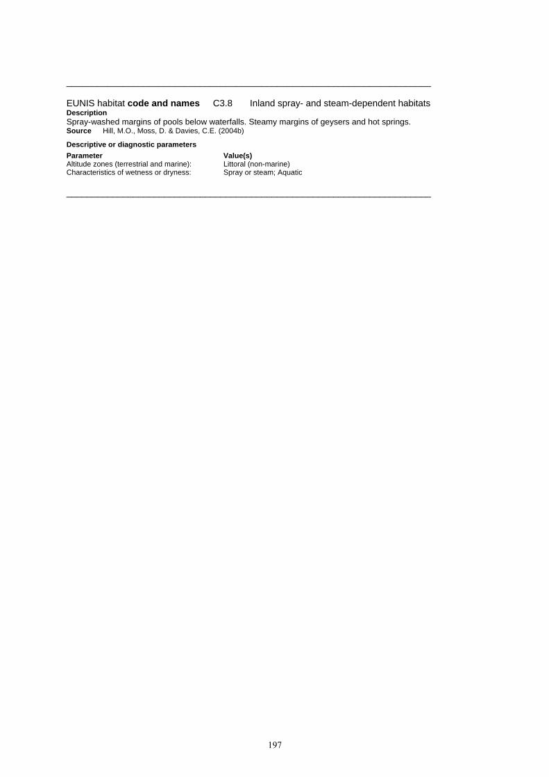
197
_______________________________________________________________________ EUNIS habitat code and names C3.8 Inland spray- and steam-dependent habitats Description Spray-washed margins of pools below waterfalls. Steamy margins of geysers and hot springs. Source Hill, M.O., Moss, D. & Davies, C.E. (2004b) Descriptive or diagnostic parameters Parameter Value(s) Altitude zones (terrestrial and marine): Littoral (non-marine) Characteristics of wetness or dryness: Spray or steam; Aquatic _______________________________________________________________________

198
D MIRES, BOGS AND FENS Description Wetlands, with the water table at or above ground level for at least half of the year, dominated by herbaceous or ericoid vegetation. Includes inland saltmarshes and waterlogged habitats where the groundwater is frozen. Excludes the water body and rock structure of springs (C2.1) and waterlogged habitats dominated by trees or large shrubs (F9.2, G1.4, G1.5, G3.D, G3.E). Note that habitats that intimately combine waterlogged mires and vegetation rafts with pools of open water are considered as complexes. Source Hill, M.O., Moss, D. & Davies, C.E. (2004b) Descriptive or diagnostic parameters Parameter Value(s) Dominant life forms: Tall emergent vegetation / helophytes; Bryophytes Characteristics of wetness or dryness: Waterlogged _______________________________________________________________________ EUNIS habitat code and names D1 Raised and blanket bogs Description Peatlands formed by ombrotrophic acid peat, which is (or was while actively growing) capable of growth fed by rainfall rather than by the inflow of water from higher ground in the vicinity. Source Hill, M.O., Moss, D. & Davies, C.E. (2004b) Descriptive or diagnostic parameters Parameter Value(s) Geomorphology or landform: Raised bog; Blanket bog Dominant life forms: Bryophytes Characteristics of wetness or dryness: Waterlogged Characteristics of water flow, source & quality: Rainwater Substrate types: Peat; Waterlogged peat _______________________________________________________________________ EUNIS habitat code and names D1.1 Raised bogs Description The mire surface and underlying peat of highly oligotrophic, strongly acidic peatlands with a raised centre from which water drains towards the edges. The peat is composed mainly of sphagnum remains. Raised bogs form on nearly flat ground and derive moisture and nutrients only from rainfall (ombrotrophic). Raised bog complexes (X04) include larger bog pools (C1.46) and a marginal lagg (C1.47), as well as the main mire surface (D1.1), which in actively-growing raised bogs typically comprises a complex of low hummocks, small pools and their associated vegetation. Raised bogs form only in cool climates with high rainfall. They are most widespread in the boreal zone and in the mountains and hills of the nemoral zone; they occur locally in the lowlands of the nemoral zone. They are characteristic of lowlands and hills of northwestern and northern Europe, the adjacent Hercynian ranges, the Jura, the Alps and the Carpathians. Bogs harbour, in addition to sphagna, which are often abundant, a small number of vascular plants such as Eriophorum vaginatum, Scirpus cespitosus (Trichophorum cespitosum), Carex pauciflora, Carex paupercula, Ledum palustre, Vaccinium oxycoccos, Andromeda polifolia and Drosera rotundifolia, and lichens. Animal species are not numerous but those that are adapted to bogs are highly specialised. Among typical invertebrates figure dragonflies (Leucorrhinia dubia, Aeshna subarctica, Aeshna caerulea, Aeshna juncea, Somatochlora arctica, Somatochlora alpestris), lepidopterans (Colias palaeno, Boloria aquilonaris, Coenonympha tullia, Vacciniina optilete, Hypenodes turfosalis, Eugraphe subrosea), beetles, ants (Formica exsecta), bugs and spiders (Pardosa sphagnicola, Glyphesis cottonae). Most of the species that bogs harbour are rare and their populations fragmented into isolated relictual elements; several are threatened. The remaining intact or nearly intact communities are exceptional. Source Hill, M.O., Moss, D. & Davies, C.E. (2004a) Legal instruments Legal instrument Legally designated habitat Code EU Habitats Directive Annex I Active raised bogs 7110 Degraded raised bogs still capable of natural regeneration 7120 Council of Europe Bern Convention Near-natural raised bogs 51.1 Res. No. 4 1996 Descriptive or diagnostic parameters Parameter Value(s) Geomorphology or landform: Raised bog Dominant life forms: Bryophytes Characteristics of wetness or dryness: Waterlogged Characteristics of water flow, source & quality: Rainwater

199
Substrate types: Peat; Waterlogged peat Related phytosociological units: Betulion pubescentis; Caricion lasiocarpae; Ericion tetralicis; Eriophorion
vaginati; Oxycocco-Ericion tetralicis; Rhynchosporion albae; Salicion cinereae; Sphagnion medii
_______________________________________________________________________ EUNIS habitat code and names D1.2 Blanket bogs Description The mire surface and underlying peat of ombrotrophic peatlands, formed on flat or gently sloping ground with poor surface drainage, in oceanic climates with high rainfall. The mire surface may on flatter ground be very similar to that of a raised bog, with a complex of small pools and terrestrial hummocks. In the strictest sense, blanket bogs are a habitat endemic to northwestern Europe, characteristic of the western and northern British Isles, the Faeroe Islands and the western seaboard of Scandinavia. They often cover extensive areas with local topographic features supporting distinct communities. Sphagna (Sphagnum papillosum, Sphagnum tenellum, Sphagnum compactum, Sphagnum magellanicum, Sphagnum rubellum, Sphagnum fuscum) play an important role in all of them, accompanied by Narthecium ossifragum, Molinia caerulea, Scirpus cespitosus, Schoenus nigricans, Eriophorum angustifolium, Eriophorum vaginatum and Calluna vulgaris. Blanket bog complexes (X28) include dystrophic pools (C1.4) and acidic flushes (D2.2) as well as the mire surface (D1.2). Source Hill, M.O., Moss, D. & Davies, C.E. (2004a) Legal instruments Legal instrument Legally designated habitat Code EU Habitats Directive Annex I Blanket bogs (if active bog) 7130 Council of Europe Bern Convention BLANKET BOGS 52 Res. No. 4 1996
Descriptive or diagnostic parameters Parameter Value(s) Geomorphology or landform: Blanket bog Dominant life forms: Bryophytes Characteristics of wetness or dryness: Waterlogged Characteristics of water flow, source & quality: Rainwater Substrate types: Peat; Waterlogged peat Related phytosociological units: Ericion tetralicis; Oxycocco-Ericion tetralicis; Rhynchosporion albae _______________________________________________________________________ EUNIS habitat code and names D2 Valley mires, poor fens and transition mires Description Weakly to strongly acid peatlands, flushes and vegetated rafts formed in situations where they receive water from the surrounding landscape or are intermediate between land and water. Included are quaking bogs and vegetated non-calcareous springs. Excluded are calcareous fens (D4), and reedbeds (C3, D5). Source Hill, M.O., Moss, D. & Davies, C.E. (2004a) Descriptive or diagnostic parameters Parameter Value(s) Dominant life forms: Bryophytes Characteristics of wetness or dryness: Waterlogged Characteristics of water flow, source & quality: Ground or river water Chemical attributes: Acid Substrate types: Floating peat _______________________________________________________________________ EUNIS habitat code and names D2.1 Valley mires Description Topogenous wetlands in which the peat-forming vegetation depends on water draining from the surrounding landscape. Most valley mires are habitat complexes including poor fens, transition mires and pools. Acid valley mires (D2.11) often have vegetation resembling that of bogs (D1), especially in those parts relatively distant from flowing water. Basic and neutral valley mires (D2.12) support mainly poor-fen vegetation (D2.2), but in large mire systems, this is accompanied by acid wet grassland (E3.5), large sedges (D5.2) and reeds (D5.1). Sphagnum hummocks form locally and transition mires (D2.3) or littoral (C3.2) and spring (D2.2C) communities colonize small depressions. Excluded are rich-fen valley mires (D4.1). Source Hill, M.O., Moss, D. & Davies, C.E. (2004b) Descriptive or diagnostic parameters Parameter Value(s) Dominant life forms: Bryophytes Characteristics of wetness or dryness: Waterlogged; Wet and very wet

200
Characteristics of water flow, source & quality: Ground or river water Chemical attributes: Acid Related phytosociological units: Oxycocco-Ericion tetralicis _______________________________________________________________________ EUNIS habitat code and names D2.2 Poor fens and soft-water spring mires Description Peatlands, flushes and vegetated springs with moderately acid ground water, within valley mires or on hillsides. As in the rich fens, the water level is at or near the surface of the substratum and peat formation depends on a permanently high watertable. Poor-fen vegetation is typically dominated by small sedges (Carex canescens, Carex echinata, Carex nigra, Eriophorum angustifolium, Eriophorum scheuchzeri, Trichophorum cespitosum), with pleurocarpous mosses (Calliergonella cuspidata, Calliergon sarmentosum, Calliergon stramineum, Drepanocladus exannulatus, Drepanocladus fluitans) or sphagna (Sphagnum cuspidatum, Sphagnum papillosum, Sphagnum recurvum agg., Sphagnum russowii, Sphagnum subsecundum agg.). Other characteristic vascular plants are Agrostis canina, Cardamine pratensis, Juncus filiformis, Ranunculus flammula and Viola palustris. Soft-water spring mires (D2.2C) are often dominated by Montia fontana or bryophytes (Bryum spp., Philonotis spp., Pohlia spp.). Excluded are the water body of soft-water springs (C2.1), and incompletely terrestrialized fringing vegetation (C3.2) or vegetation rafts (D2.3). Source Hill, M.O., Moss, D. & Davies, C.E. (2004a) Descriptive or diagnostic parameters Parameter Value(s) Dominant life forms: Bryophytes Characteristics of wetness or dryness: Waterlogged; Wet and very wet Characteristics of water flow, source & quality: Vertical flow; Vertical flow upwards Chemical attributes: Acid Related phytosociological units: Bellidio-Bellion nivali; Caricion atrofusco-saxatilis; Caricion davallianae;
Caricion fuscae; Ericion tetralicis; Magnocaricion elatae; Narthecion scardici; Oxycocco-Ericion tetralicis; Saginetea piliferae; Salicion cinereae; Sphagno warnstorfiani-Tomenthypnion
_______________________________________________________________________ EUNIS habitat code and names D2.3 Transition mires and quaking bogs Description Incompletely terrestrialized wetlands occupied by peat-forming vegetation with acid groundwater or (for vegetation rafts) acid underlying pool or lake water. Characteristic species are Calla palustris, Carex chordorrhiza, Carex diandra, Carex heleonastes, Carex lasiocarpa, Carex limosa, Carex rostrata, Menyanthes trifoliata, Potentilla palustris, Rhynchospora alba, Scheuchzeria palustris. Included are rafts of Sphagnum and Eriophorum (D2.38) and quaking rafts of Molinia caerulea (D2.3D). Excluded are stands of vegetation fringing water bodies (C3.2) unless the vegetation raft is sufficiently extensive to count as a habitat in its own right. Source Hill, M.O., Moss, D. & Davies, C.E. (2004b) Legal instruments Legal instrument Legally designated habitat Code EU Habitats Directive Annex I Transition mires and quaking bogs 7140 Depressions on peat substrates of the Rhynchosporion 7150 Council of Europe Bern Convention Transition mires 54.5 Res. No. 4 1996
Descriptive or diagnostic parameters Parameter Value(s) Dominant life forms: Bryophytes Characteristics of wetness or dryness: Waterlogged Characteristics of water flow, source & quality: Water in mires, bogs and fens Chemical attributes: Acid Substrate types: Floating peat Related phytosociological units: Caricion davallianae; Caricion fuscae; Caricion lasiocarpae; Carici-Rumicion
hydrolapathi; Erico mackaianae-Sphagnion papillosi; Magnocaricion elatae; Rhynchosporion albae; Scheuchzerio-Caricetea fuscae
_______________________________________________________________________ EUNIS habitat code and names D3 Aapa, palsa and polygon mires Description Patterned mire complexes of the arctic, subarctic and northern boreal zones. Source Hill, M.O., Moss, D. & Davies, C.E. (2004a) Descriptive or diagnostic parameters Parameter Value(s)

201
Exposure characteristics: Frost; Ice Geomorphology or landform: Mire ridges and hummocks; Mire polygons Dominant life forms: Bryophytes Characteristics of wetness or dryness: Waterlogged Substrate types: Frozen subsoil _______________________________________________________________________ EUNIS habitat code and names D3.1 Palsa mires Description Mires of the subarctic and northern boreal regions formed by elevated frozen mounds or ridges (palsas), 0.5 to 8 m high and up to 50 m in diameter, interspersed wet hollows of similar area. Palsa mires are distributed in the discontinuous permafrost zone of Iceland, northern Fennoscandia and arctic Russia, in areas experiencing subzero temperatures for at least 200 days per year. Source Hill, M.O., Moss, D. & Davies, C.E. (2004a) Legal instruments Legal instrument Legally designated habitat Code EU Habitats Directive Annex I Palsa mires 7320 Council of Europe Bern Convention Palsa mires 54.9 Res. No. 4 1996
Descriptive or diagnostic parameters Parameter Value(s) Exposure characteristics: Frost; Ice Dominant life forms: Bryophytes Substrate types: Frozen subsoil _______________________________________________________________________ EUNIS habitat code and names D3.2 Aapa mires Description Mire complexes of the central and northern boreal zones, often extensive, with a concave or flat, gently to very slightly sloping surface patterned by an alternation of slightly to substantially raised ridges and hummocks (strings), with minerotrophic or ombrotrophic characteristics, and of minerotrophic pools and hollows (flarks), arranged perpendicularly to the slope direction. In Europe, the main area of distribution is subatlantic and subcontinental Fennoscandia and subarctic and arctic Russia. Source Hill, M.O., Moss, D. & Davies, C.E. (2004a) Legal instruments Legal instrument Legally designated habitat Code EU Habitats Directive Annex I Aapa mires 7310 Council of Europe Bern Convention Aapa mires 54.8 Res. No. 4 1996
Descriptive or diagnostic parameters Parameter Value(s) Geomorphology or landform: Mire ridges and hummocks Dominant life forms: Bryophytes _______________________________________________________________________ EUNIS habitat code and names D3.3 Polygon mires Description Complex mires of the arctic and subarctic patterned by surface microrelief of large, 10 to 30 m in diameter, low-centre or high-centre polygons formed by the juxtaposition of dry, 0.3 to 0.5 m high, ridges covered by shrubs, hypnoid mosses and sphagna, and of wet hollows occupied by grasses, sedges, mosses and sphagna. Polygon mires occur mainly outside Europe, in tundra where the mean annual temperature is below -1°C. Source Hill, M.O., Moss, D. & Davies, C.E. (2004a) Legal instruments Legal instrument Legally designated habitat Code Council of Europe Bern Convention Polygon mires 54.A Res. No. 4 1996
Descriptive or diagnostic parameters Parameter Value(s) Geomorphology or landform: Mire polygons Dominant life forms: Bryophytes _______________________________________________________________________

202
EUNIS habitat code and names D4 Base-rich fens and calcareous spring mires Description Peatlands, flushes and vegetated springs with calcareous or eutrophic ground water, within river valleys, alluvial plains, or on hillsides. As in poor fens, the water level is at or near the surface of the substratum and peat formation depends on a permanently high watertable. Excluded are reedbeds (C3, D5). Source Hill, M.O., Moss, D. & Davies, C.E. (2004a) Descriptive or diagnostic parameters Parameter Value(s) Dominant life forms: Low-growing herbs; Bryophytes Species richness (when used in criteria): Species rich Characteristics of wetness or dryness: Waterlogged Characteristics of water flow, source & quality: Ground or river water Chemical attributes: Base-rich; Calcareous Substrate types: Peat; Waterlogged peat _______________________________________________________________________ EUNIS habitat code and names D4.1 Rich fens, including eutrophic tall-herb fens and calcareous flushes and soaks Description Wetlands and spring-mires, seasonally or permanently waterlogged, with a soligenous or topogenous base-rich, often calcareous water supply. Peat formation, when it occurs, depends on a permanently high watertable. Rich fens may be dominated by small or larger graminoids (Carex spp., Eleocharis spp., Juncus spp., Molinia caerulea, Phragmites australis, Schoenus spp., Sesleria spp.) or tall herbs (e.g. Eupatorium cannabinum). Where the water is base-rich but nutrient-poor, small sedges usually dominate the mire vegetation, together with a "brown moss" carpet. Hard-water spring mires (D4.1N) often contain tufa cones and other tufa deposits. Excluded is the water body of hard-water springs (C2.1); calcareous flushes of the alpine zone are a separate category (D4.2). Rich fens are exceptionally endowed with spectacular, specialised, strictly restricted species. They are among the habitats that have undergone the most serious decline. They are essentially extinct in several regions and gravely endangered in much of central and western Europe. Source Hill, M.O., Moss, D. & Davies, C.E. (2004a) Legal instruments Legal instrument Legally designated habitat Code EU Habitats Directive Annex I Alkaline fens 7230 Council of Europe Bern Convention Rich fens 54.2 Res. No. 4 1996
Descriptive or diagnostic parameters Parameter Value(s) Species richness (when used in criteria): Species rich Characteristics of wetness or dryness: Waterlogged Characteristics of water flow, source & quality: Ground or river water Chemical attributes: Base-rich; Calcareous Substrate types: Peat; Waterlogged peat Related phytosociological units: Caricetalia davallianae; Caricion atrofusco-saxatilis; Caricion davallianae;
Caricion fuscae; Caricion lasiocarpae; Phragmitetalia; Salicion cinereae; Sphagno warnstorfiani-Tomenthypnion
_______________________________________________________________________ EUNIS habitat code and names D4.2 Basic mountain flushes and streamsides, with a rich arctic-montane flora Description Rare Alpine, peri-Alpine, northern British and periarctic pioneer communities colonizing gravelly, sandy, stony, sometimes somewhat argilous or peaty, calcareous sedimentary substrates soaked by cold water, in moraines and on the edge of springs, rivulets, glacial torrents of the alpine or subalpine levels, or on alluvial sands of pure, cold, slow-flowing rivers and calm backwaters. The highly characteristic constituents, with a boreoarctic or glacial relict distribution, are Carex bicolor, Carex microglochin, Carex maritima, Carex atrofusca, Carex vaginata, Kobresia simpliciuscula, Scirpus pumilus, Juncus arcticus, Juncus alpinoarticulatus, Juncus castaneus, Juncus triglumis, Typha minima, Typha lugdunensis, Typha shuttleworthii, Tofieldia pusilla; they are often accompanied by Carex davalliana, Carex dioica, Carex capillaris, Carex panicea, Carex nigra, Blysmus compressus, Eleocharis quinqueflora, Scirpus cespitosus, Primula farinosa, Equisetum variegatum, Drepanocladus intermedius, Campylium stellatum. Source Devillers, P., Devillers-Terschuren, J. and Vander Linden, C. (2001) Legal instruments Legal instrument Legally designated habitat Code

203
EU Habitats Directive Annex I Alpine pioneer formations of the Caricion bicoloris-atrofuscae 7240 Council of Europe Bern Convention Arcto-alpine riverine swards 54.3 Res. No. 4 1996
Descriptive or diagnostic parameters Parameter Value(s) Altitude zones (terrestrial and marine): Montane (sensu lato) Climate zones: Arctic Species richness (when used in criteria): Species rich Characteristics of wetness or dryness: Waterlogged Characteristics of water flow, source & quality: Ground or river water Chemical attributes: Base-rich; Calcareous Substrate types: Peat; Waterlogged peat Related phytosociological units: Caricion atrofusco-saxatilis; Caricion davallianae; Caricion fuscae _______________________________________________________________________ EUNIS habitat code and names D5 Sedge and reedbeds, normally without free-standing water Description Sedge and reedbeds forming terrestrial mire habitats, not closely associated with open water. Excluded are reedbeds and sedges where they form emergent or fringing vegetation beside water bodies (C3.2). Source Hill, M.O., Moss, D. & Davies, C.E. (2004b) Descriptive or diagnostic parameters Parameter Value(s) Dominant life forms: Tall graminoids/grasses; Tall emergent vegetation / helophytes Species richness (when used in criteria): Species poor Characteristics of wetness or dryness: Waterlogged Characteristics of water flow, source & quality: Ground or river water _______________________________________________________________________ EUNIS habitat code and names D5.1 Reedbeds normally without free-standing water Description Terrestrialized stands of tall helophyte Poaceae, Schoenoplectus spp., Typha spp., horsetails or forbs, usually species-poor and often dominated by one species, growing on waterlogged ground. They are classified according to dominant species which give them a distinctive appearance. These species also grow as emergents and fringing vegetation beside water bodies (C3.2). Source Hill, M.O., Moss, D. & Davies, C.E. (2004a) Descriptive or diagnostic parameters Parameter Value(s) Dominant life forms: Tall graminoids/grasses; Tall emergent vegetation / helophytes Species richness (when used in criteria): Species poor Characteristics of wetness or dryness: Waterlogged Characteristics of water flow, source & quality: Ground or river water Related phytosociological units: Cirsio brachycephali-Bolboschoenion; Oenanthion aquaticae; Phalaridion
arundinaceae; Phragmition communis; Scirpion maritime _______________________________________________________________________ EUNIS habitat code and names D5.2 Beds of large sedges normally without free-standing water
Description Terrestrialized stands of tall Carex, Cladium and Cyperus, usually species-poor and often dominated by one species, growing on waterlogged ground. These species also grow as emergents and fringing vegetation beside water bodies (C3.2). Source Hill, M.O., Moss, D. & Davies, C.E. (2004b) Legal instruments Legal instrument Legally designated habitat Code EU Habitats Directive Annex I Calcareous fens with Cladium mariscus and species of the Caricion 7210 davallianae Council of Europe Bern Convention Fen-sedge beds 53.3 Res. No. 4 1996
Descriptive or diagnostic parameters Parameter Value(s) Dominant life forms: Tall graminoids/grasses; Tall emergent vegetation / helophytes

204
Species richness (when used in criteria): Species poor Characteristics of wetness or dryness: Waterlogged Characteristics of water flow, source & quality: Ground or river water Related phytosociological units: Armerion maritimae; Calthion palustris; Caricion broterianae; Caricion
davallianae; Carici-Rumicion hydrolapathi; Filipendulion; Magnocaricion elatae; Molinio-Holoschoenion; Phragmitetalia; Phragmition communis
_______________________________________________________________________ EUNIS habitat code and names D5.3 English name: Swamps and marshes dominated by soft rush or other large rushes Scientific name: Swamps and marshes dominated by Juncus effusus or other large Juncus spp. Description Stands of large Juncus spp. invading heavily grazed and trampled marshes or fens or (with Juncus effusus) eutrophicated poor fens and bogs, e.g. in the vicinity of bird colonies. Excludes stands of rushes in wet grassland (E3.4), where the ground is waterlogged for less than half the year. Source Hill, M.O., Moss, D. & Davies, C.E. (2004a) Descriptive or diagnostic parameters Parameter Value(s) Dominant life forms: Tall graminoids/grasses; Tall emergent vegetation / helophytes Species richness (when used in criteria): Species poor Characteristics of wetness or dryness: Waterlogged Characteristics of water flow, source & quality: Ground or river water Related phytosociological units: Agropyro-Rumicion; Caricion fuscae; Molinietalia _______________________________________________________________________
EUNIS habitat code and names D6 Inland saline and brackish marshes and reedbeds Description Saline wetlands, with closed or open vegetation, which are the non-coastal analogue of coastal saltmarshes and saline reedbeds (A2.5). Drier saline habitats are classified as inland salt steppe (E6) or saline scrubland (F6.8). Source Hill, M.O., Moss, D. & Davies, C.E. (2004b) Descriptive or diagnostic parameters Parameter Value(s) Dominant life forms: Tall emergent vegetation / helophytes; Halophile species Characteristics of wetness or dryness: Waterlogged Characteristics of water flow, source & quality: Ground or river water Chemical attributes: Saline; Brackish _______________________________________________________________________ EUNIS habitat code and names D6.1 Inland saltmarshes Description Salt meadows and swards of Salicornia and other Chenopodiaceae of inland salt basins of the nemoral zone. Inland saltmarshes of middle Europe are remarkable, extremely threatened communities occurring in a few isolated stations of Saxony and Lower Saxony, Schleswig-Holstein, Thuringia, Hesse, Lorraine, Auvergne, the Midlands and southeastern Poland (lower Nida valley). Source Hill, M.O., Moss, D. & Davies, C.E. (2004a) Legal instruments Legal instrument Legally designated habitat Code EU Habitats Directive Annex I Inland salt meadows 1340 Descriptive or diagnostic parameters Parameter Value(s) Dominant life forms: Tall graminoids/grasses; Tall emergent vegetation / helophytes; Halophile
species Species richness (when used in criteria): Species poor Characteristics of wetness or dryness: Waterlogged Characteristics of water flow, source & quality: Ground or river water Chemical attributes: Saline; Brackish Related phytosociological units: Armerion maritimae; Halo-Trichophorion pumili; Potentillion anserinae;
Puccinellion limosae; Puccinellion maritimae; Puccinellio-Spergularion salinae; Scorzonero-Juncion gerardii
_______________________________________________________________________

205
EUNIS habitat code and names D6.2 Inland saline or brackish species-poor helophyte beds normally without free-standing water Description Terrestrialized stands of tall salt-tolerant helophytes, notably Phragmites australis and Cyperus laevigatus. These species also grow as emergents and fringing vegetation beside saline water bodies (C3.27). Source Hill, M.O., Moss, D. & Davies, C.E. (2004b) Legal instruments Legal instrument Legally designated habitat Code EU Habitats Directive Annex I Mediterranean salt meadows (Juncetalia maritimi) 1410 Descriptive or diagnostic parameters Parameter Value(s) Dominant life forms: Low-growing herbs; Low-growing emergent vegetation; Halophile species Species richness (when used in criteria): Species poor Characteristics of wetness or dryness: Waterlogged Characteristics of water flow, source & quality: Ground or river water Chemical attributes: Saline; Brackish Related phytosociological units: Limonion catalaunico-viciosoi; Lygeo sparti-Limonion furfuracei; Lygeo-
Lepidion cardaminis; Puccinellion caespitosae _______________________________________________________________________

206
E GRASSLANDS AND LANDS DOMINATED BY FORBS, MOSSES OR LICHENS Description Non-coastal land which is dry or only seasonally wet (with the water table at or above ground level for less than half of the year) with greater than 30% vegetation cover. The vegetation is dominated by grasses and other non-woody plants, including mosses, macrolichens, ferns, sedges and herbs. Includes semiarid steppes with scattered Artemisia scrub. Includes successional weedy vegetation and managed grasslands such as recreation fields and lawns. Excludes regularly tilled habitats (I1) dominated by cultivated herbaceous vegetation such as arable fields. Source Hill, M.O., Moss, D. & Davies, C.E. (2004b) Descriptive or diagnostic parameters Parameter Value(s) Dominant life forms: Herbs; Forbs; Grasses; Bryophytes; Lichens Cover characteristics (when used as criteria): Vegetation >30% _______________________________________________________________________ EUNIS habitat code and names E1 Dry grasslands Description Well-drained or dry lands dominated by grass or herbs, mostly not fertilized and with low productivity. Included are Artemisia steppes. Excluded are dry mediterranean lands with shrubs of other genera where the shrub cover exceeds 10%; these are listed as garrigue (F6). Source Hill, M.O., Moss, D. & Davies, C.E. (2004b) Descriptive or diagnostic parameters Parameter Value(s) Dominant life forms: Herbs; Low-growing herbs; Forbs; Grasses; Lower plants; Bryophytes and
lichens; Bryophytes; Lichens Cover characteristics (when used as criteria): Vegetation >30% Characteristics of wetness or dryness: Dry; Arid _______________________________________________________________________ EUNIS habitat code and names E1.1 Inland sand and rock with open vegetation Description Open, thermophile vegetation of sands or rock debris in the nemoral zone and locally, in boreal or submediterranean lowland to montane areas of Europe. Included are open grasslands on strongly to slightly calcareous inland sands, and vegetation formed mostly by annuals and succulents or semisucculents on decomposed rock surfaces of edges, ledges or knolls, with calcareous or siliceous soils. Source Hill, M.O., Moss, D. & Davies, C.E. (2004a) Legal instruments Legal instrument Legally designated habitat Code EU Habitats Directive Annex I Rupicolous calcareous or basophilic grasslands of the Alysso-Sedion 6110 Xeric sand calcareous grasslands 6120 Descriptive or diagnostic parameters Parameter Value(s) Dominant life forms: Herbs; Low-growing herbs; Grasses; Lower plants Cover characteristics (when used as criteria): Vegetation >30%; bare ground >30% Characteristics of wetness or dryness: Dry; Arid Chemical attributes: Base-rich Substrate types: Sandy soils; Detritic soils Related phytosociological units: Alysso alyssoidis-Sedion albi; Bromo pannonici-Festucion pallentis; Diantho
lumnitzeri-Seslerion albicantis; Helianthemo-Globularion; Hyperico perforati-Scleranthion perennis; Koelerion arenariae; Koelerion glaucae; Sedion anglici; Sedo albi-Veronicion dillenii; Sedo-Cerastion; Sedo-Scleranthion biennis
_______________________________________________________________________ EUNIS habitat code and names E1.2 Perennial calcareous grassland and basic steppes Description Perennial grasslands, often nutrient-poor and species-rich, on calcareous and other basic soils of the nemoral and steppe zones and of adjacent parts of the subboreal and submediterranean zones. Includes the calcareous grasslands of central and western Europe, alvar grasslands of the Baltic region, and basic grasslands of the steppe zone.

207
Source Hill, M.O., Moss, D. & Davies, C.E. (2004b) Legal instruments Legal instrument Legally designated habitat Code EU Habitats Directive Annex I Semi-natural dry grasslands and scrubland facies on calcareous 6210 substrates (Festuco-Brometalia) (* important orchid sites) Sub-Pannonic steppic grasslands 6240 Pannonic loess steppic grasslands 6250 Pannonic sand steppes 6260 Nordic alvar and precambrian calcareous flatrocks 6280 Council of Europe Bern Convention Dense perennial grasslands and middle European steppes 34.3 Res. No. 4 1996 Continental steppes 34.9 Sand steppes 34.A Descriptive or diagnostic parameters Parameter Value(s) Altitude zones (terrestrial and marine): Planar; Collinar; Montane (sensu lato); Submontane Dominant life forms: Herbs; Low-growing herbs; Forbs; Grasses Cover characteristics (when used as criteria): Vegetation >30% Characteristics of wetness or dryness: Dry Chemical attributes: Base-rich; Calcareous Substrate types: Immature soil Related phytosociological units: Agropyrion pectinati; Agropyro-Kochion; Alyssion bertolonii; Alysso alyssoidis-
Sedion albi; Alysso saxatilis-Festucion pallentis; Amygdalion nanae; Asplenio septentrionali-Festucion pallentis; Asplenion serpentini; Avenulo adsurgentis-Festucion pallentis; Brachypodion phoenicoidis; Bromion erecti; Bromion tectorum; Bromo pannonici-Festucion pallentis; Centaurion sumensis; Chrysopogoni-Saturejon; Chrysopogono-Danthonion; Chrysopogono-Festucion dalmaticae; Cirsio-Brachypodion pinnati; Cynodonto-Teucrion polii; Danthonio-Brachypodion; Danthonio-Stipion tirsae; Diantho lumnitzeri-Seslerion albicantis; Diplachnion; Festucetalia valesiacae; Festucion beckeri; Festucion vaginatae; Festucion valesiacae; Galio campanulatae-Poion versicoloris; Halacsyetalia sendtneri; Helianthemo cani-Festucion pallentis; Helianthemo-Globularion; Helictotricho desertori-Stipion rubentis; Helictotricho-Stipetalia; Koelerion arenariae; Koelerion glaucae; Koelerio-Phleion phleoidis; Orostachyion spinosae; Pimpinello-Thymion zygoidi; Plantagini-Festucion ovinae; Potentillo montanae-Brachypodion rupestris; Salsolion ruthenicae; Scabiosion ucranicae; Scorzonero austriacae-Koelerion sclerophyllae; Sedo-Cerastion; Sedo-Scleranthetalia; Seslerion rigidae; Seslerio-Xerobromion; Stipion lessingianae; Stipo pulcherrimae-Festucetalia pallentis; Stipo-Poion carniolicae; Stipo-Poion xerophilae; Thymo cretacei-Hyssopetalia cretacei; Verbascion pinnatifidii; Xerobromion
_______________________________________________________________________ EUNIS habitat code and names E1.3 Mediterranean xeric grassland Description Meso- and thermo-Mediterranean xerophile, mostly open, short-grass perennial grasslands rich in therophytes; therophyte communities of oligotrophic soils on base-rich, often calcareous substrates. Source Devillers, P., Devillers-Terschuren, J. and Vander Linden, C. (2001) Legal instruments Legal instrument Legally designated habitat Code EU Habitats Directive Annex I Pseudo-steppe with grasses and annuals of the Thero-Brachypodietea 6220 Council of Europe Bern Convention Mediterranean xeric grasslands 34.5 Res. No. 4 1996
Descriptive or diagnostic parameters Parameter Value(s) Climate zones: Mediterranean Dominant life forms: Herbs; Low-growing herbs; Grasses; Short grasses Cover characteristics (when used as criteria): Vegetation >30% Characteristics of wetness or dryness: Dry; Arid Chemical attributes: Base-rich Related phytosociological units: Armerion girardii; Brachypodietalia phoenicoidis; Bromopsietalia cappadocicae;
Cymbopogoni-Brachypodietalia; Cymbopogoni-Brachypodion ramosi; Dauco-Catananchion luteae; Diantho humilis-Velezion rigidae; Helianthemetalia guttati; Moricandio-Lygeion sparti; Omphalodion commutatae; Plantagini-Catapodion marini; Poetalia bulbosae; Sedo-Ctenopsion gypsophilae; Stipion retortae; Thero-Brachypodietalia; Thero-Brachypodion; Trachynion distachyae
_______________________________________________________________________ EUNIS habitat code and names E1.4 English name: Mediterranean tall-grass and wormwood

208
(Artemisia) steppes; Scientific name: Mediterranean tall- grass and Artemisia steppes Description Meso-, thermo- and sometimes supra-Mediterranean formations of the Mediterranean basin, physiognomically dominated by tall grasses, between which may grow communities of annuals or sometimes chamaephytes. They include silicicolous as well as basiphile formations. In the Mediterranean region proper, they are most characteristic of the Iberian peninsula and of the Mediterranean rim of Anatolia, with local representations in southern Provence, Sardinia, southern peninsular Italy, Sicily and Greece. In the semiarid regions between the Mediterranean and the deserts of western Asia, they dominate the landscape, forming a major steppe belt in which low scrub of Artemisia may be prominent. Source Hill, M.O., Moss, D. & Davies, C.E. (2004a) Descriptive or diagnostic parameters Parameter Value(s) Climate zones: Mediterranean Dominant life forms: Herbs; Forbs; Grasses; Tall graminoids/grasses Cover characteristics (when used as criteria): Vegetation >30% Characteristics of wetness or dryness: Dry Chemical attributes: Base-rich Related phytosociological units: Agropyro pectinati-Lygeion sparti; Dactylorhizo-Juncion striati; Festucion
scariosae; Holoschoenetalia; Hyparrhenion hirtae; Paspalo-Agrostidion semiverticillati; Stipion tenacissimae
_______________________________________________________________________ EUNIS habitat code and names E1.5 Mediterranean-montane grassland Description Open perennial grasslands, often rich in chamaephytes, most characteristic of the thermophilous oak level of Iberia, southern France, southern Italy, Greece and the Balkans. Some of the largest remaining expanses of unbroken grasslands in Europe, of evident importance as faunal habitats, belong to this division. Source Devillers, P., Devillers-Terschuren, J. and Vander Linden, C. (2001) Descriptive or diagnostic parameters Parameter Value(s) Altitude zones (terrestrial and marine): Montane (sensu lato) Climate zones: Mediterraneo-montane Dominant life forms: Herbs; Low-growing herbs; Forbs; Grasses Cover characteristics (when used as criteria): Vegetation >30%; bare ground >30% Characteristics of wetness or dryness: Dry Chemical attributes: Base-rich Related phytosociological units: Aphyllanthion; Festucion burnatii; Genistion lobelii; Minuartio-Poion ligulatae;
Ononidion striatae; Phleo ambigui-Bromion erecti; Plantagini discoloris-Thymion mastigophori; Scorzonero-Chrysopogonetalia; Seslerion elegantissimae
_______________________________________________________________________ EUNIS habitat code and names E1.6 Subnitrophilous annual grassland Description Land dominated by annual grasses and herbs, on soils slightly enriched in nitrates, in the meso- and thermo-Mediterranean zones. Characteristic are Bromus, Aegilops, Avena, Vulpia, crucifers and leguminous plants. These annuals occur as pioneers of bare soils slightly nitrified by aeration or organic addition, along roads, on land-fills and in interstitial spaces of cultivation. They also replace the oligotrophic annual vegetation of Mediterranean xeric grasslands (E1.3) under the influence of pastoral activities. Subnitrophilous annual grassland is widespread as a successional stage after cultivation. Woody recolonisation may lead to maquis (F5) or garrigues (F6). Source Hill, M.O., Moss, D. & Davies, C.E. (2004a) Descriptive or diagnostic parameters Parameter Value(s) Human activities and impacts: Fertilisation Dominant life forms: Herbs; Forbs; Grasses Cover characteristics (when used as criteria): Vegetation >30% Characteristics of wetness or dryness: Dry Chemical attributes: Base-rich; Nitrate-enriched Related phytosociological units: Alysso granatensis-Brassicion barrelieri; Geranio-Cardaminetalia hirsutae;
Resedo lanceolatae-Moricandion; Taeniathero-Aegilopion geniculatae; Thero-Brometalia
_______________________________________________________________________
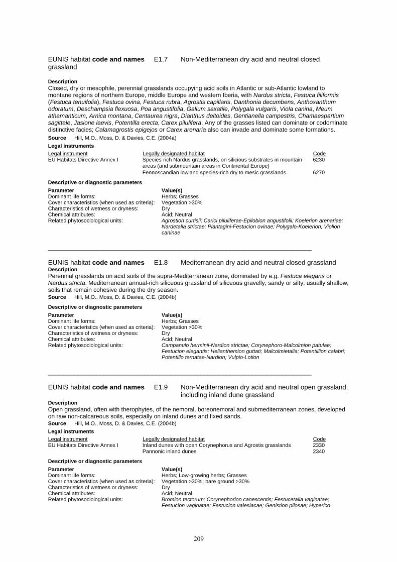
209
EUNIS habitat code and names E1.7 Non-Mediterranean dry acid and neutral closed grassland
Description Closed, dry or mesophile, perennial grasslands occupying acid soils in Atlantic or sub-Atlantic lowland to montane regions of northern Europe, middle Europe and western Iberia, with Nardus stricta, Festuca filiformis (Festuca tenuifolia), Festuca ovina, Festuca rubra, Agrostis capillaris, Danthonia decumbens, Anthoxanthum odoratum, Deschampsia flexuosa, Poa angustifolia, Galium saxatile, Polygala vulgaris, Viola canina, Meum athamanticum, Arnica montana, Centaurea nigra, Dianthus deltoides, Gentianella campestris, Chamaespartium sagittale, Jasione laevis, Potentilla erecta, Carex pilulifera. Any of the grasses listed can dominate or codominate distinctive facies; Calamagrostis epigejos or Carex arenaria also can invade and dominate some formations. Source Hill, M.O., Moss, D. & Davies, C.E. (2004a) Legal instruments Legal instrument Legally designated habitat Code EU Habitats Directive Annex I Species-rich Nardus grasslands, on silicious substrates in mountain 6230 areas (and submountain areas in Continental Europe) Fennoscandian lowland species-rich dry to mesic grasslands 6270 Descriptive or diagnostic parameters Parameter Value(s) Dominant life forms: Herbs; Grasses Cover characteristics (when used as criteria): Vegetation >30% Characteristics of wetness or dryness: Dry Chemical attributes: Acid; Neutral Related phytosociological units: Agrostion curtisii; Carici piluliferae-Epilobion angustifolii; Koelerion arenariae;
Nardetalia strictae; Plantagini-Festucion ovinae; Polygalo-Koelerion; Violion caninae
_______________________________________________________________________ EUNIS habitat code and names E1.8 Mediterranean dry acid and neutral closed grassland Description Perennial grasslands on acid soils of the supra-Mediterranean zone, dominated by e.g. Festuca elegans or Nardus stricta. Mediterranean annual-rich siliceous grassland of siliceous gravelly, sandy or silty, usually shallow, soils that remain cohesive during the dry season. Source Hill, M.O., Moss, D. & Davies, C.E. (2004b) Descriptive or diagnostic parameters Parameter Value(s) Dominant life forms: Herbs; Grasses Cover characteristics (when used as criteria): Vegetation >30% Characteristics of wetness or dryness: Dry Chemical attributes: Acid; Neutral Related phytosociological units: Campanulo herminii-Nardion strictae; Corynephoro-Malcolmion patulae;
Festucion elegantis; Helianthemion guttati; Malcolmietalia; Potentillion calabri; Potentillo ternatae-Nardion; Vulpio-Lotion
_______________________________________________________________________ EUNIS habitat code and names E1.9 Non-Mediterranean dry acid and neutral open grassland, including inland dune grassland Description Open grassland, often with therophytes, of the nemoral, boreonemoral and submediterranean zones, developed on raw non-calcareous soils, especially on inland dunes and fixed sands. Source Hill, M.O., Moss, D. & Davies, C.E. (2004b) Legal instruments Legal instrument Legally designated habitat Code EU Habitats Directive Annex I Inland dunes with open Corynephorus and Agrostis grasslands 2330 Pannonic inland dunes 2340 Descriptive or diagnostic parameters Parameter Value(s) Dominant life forms: Herbs; Low-growing herbs; Grasses Cover characteristics (when used as criteria): Vegetation >30%; bare ground >30% Characteristics of wetness or dryness: Dry Chemical attributes: Acid; Neutral Related phytosociological units: Bromion tectorum; Corynephorion canescentis; Festucetalia vaginatae;
Festucion vaginatae; Festucion valesiacae; Genistion pilosae; Hyperico

210
perforati-Scleranthion perennis; Jasiono sessiliflorae-Koelerietalia crassipedis; Koelerion arenariae; Koelerion glaucae; Koelerio-Phleion phleoidis; Malcolmietalia; Plantagini-Festucion ovinae; Sedo-Cerastion; Thero-Airion; Thero-Brometalia
_______________________________________________________________________ EUNIS habitat code and names E1.A Mediterranean dry acid and neutral open grassland Description Sandy open ground with vernal therophytes, not necessarily grasses, in the Mediterranean region. Open perennial grasslands and pastures on siliceous, usually skeletal, soils of the supra-Mediterranean zone. Source Hill, M.O., Moss, D. & Davies, C.E. (2004b) Descriptive or diagnostic parameters Parameter Value(s) Dominant life forms: Herbs; Low-growing herbs; Grasses Cover characteristics (when used as criteria): Vegetation >30%; bare ground >30% Characteristics of wetness or dryness: Dry Chemical attributes: Acid; Neutral Related phytosociological units: Agrostio castellanae-Stipion giganteae; Corynephoro-Malcolmion patulae;
Hieracio castellani-Plantaginion radicatae; Malcolmietalia _______________________________________________________________________ EUNIS habitat code and names E1.B Heavy-metal grassland Description Dry, short grasslands, often rich in lichens and mosses, colonizing western and central European soils with a high content in heavy metals such as zinc and lead, and comprising uniquely adapted species, ecotypes or populations mostly related to, or derived from, otherwise montane, boreomontane or steppic species; heavy metal grasslands of distinctly alpine affinities, though spanning an altitudinal range that extends from the montane level and lowland dealpine stations to the subalpine and alpine levels, are included. Source Devillers, P., Devillers-Terschuren, J. and Vander Linden, C. (2001) Legal instruments Legal instrument Legally designated habitat Code EU Habitats Directive Annex I Calaminarian grasslands of the Violetalia calaminariae 6130 Council of Europe Bern Convention Lowland heavy metal grasslands 34.2 Res. No. 4 1996
Descriptive or diagnostic parameters Parameter Value(s) Dominant life forms: Herbs; Low-growing herbs; Grasses; Lower plants; Bryophytes and lichens;
Bryophytes; Lichens Cover characteristics (when used as criteria): Vegetation >30% Characteristics of wetness or dryness: Dry; Arid Chemical attributes: Heavy metal-rich Related phytosociological units: Armerion halleri; Plantagini-Festucion ovinae; Thlaspietalia rotundifolii;
Thlaspion calaminariae; Thlaspion rotundifolii _______________________________________________________________________ EUNIS habitat code and names E1.C Dry mediterranean lands with unpalatable non-vernal herbaceous vegetation Description Dry lands with shrub cover < 10%, and with a large component of non-vernal unpalatable plants, including geophytes (Asphodelus, Urginea), thistles (Carthamus, Carlina, Centaurea, Onopordum), Ferula and Phlomis, especially characteristic of the drier parts of the Mediterranean basin. These habitats usually result from over-grazing of garrigue, which eliminates the shrubs. Source Hill, M.O., Moss, D. & Davies, C.E. (2004a) Descriptive or diagnostic parameters Parameter Value(s) Climate zones: Mediterranean Human activities and impacts: Grazing Levels of habitat usage (when used in criteria): Overuse Dominant life forms: Shrubs; Forbs; Grasses Characteristics of wetness or dryness: Dry; Arid Related phytosociological units: Artemisietea vulgaris; Brachypodion phoenicoidis; Carthametalia lanati; Cisto-
Micromerietea julianae; Cymbopogoni-Brachypodietalia; Silybo-Urticion _______________________________________________________________________

211
EUNIS habitat code and names E2 Mesic grasslands Description Lowland and montane mesotrophic and eutrophic pastures and hay meadows of the boreal, nemoral, warm-temperate humid and mediterranean zones. They are generally more fertile than dry grasslands (E1), and include sports fields and agriculturally improved and reseeded pastures. Source Hill, M.O., Moss, D. & Davies, C.E. (2004a) Descriptive or diagnostic parameters Parameter Value(s) Dominant life forms: Herbs; Low-growing herbs; Forbs; Grasses; Lower plants; Bryophytes and
lichens; Bryophytes; Lichens Cover characteristics (when used as criteria): Vegetation >30% Characteristics of wetness or dryness: Moist / mesic _______________________________________________________________________ EUNIS habitat code and names E2.1 Permanent mesotrophic pastures and aftermath-grazed meadows Description Regularly grazed mesotrophic pastures of Europe, fertilised and on well-drained soils, with Lolium perenne, Cynosurus cristatus, Poa spp., Festuca spp., Trifolium repens, Leontodon autumnalis, Bellis perennis, Ranunculus repens, Ranunculus acris, Cardamine pratensis; they are most characteristic of the nemoral and boreonemoral zones Europe, but extend to the Cordillera Central, the Apennines and the supra-Mediterranean zone of the Balkan peninsula and Greece. Source Hill, M.O., Moss, D. & Davies, C.E. (2004a) Legal instruments Legal instrument Legally designated habitat Code EU Habitats Directive Annex I Macaronesian mesophile grasslands 6180 Descriptive or diagnostic parameters Parameter Value(s) Human activities and impacts: Grazing Levels of habitat usage (when used in criteria): Active management Dominant life forms: Herbs; Low-growing herbs; Grasses Cover characteristics (when used as criteria): Vegetation >30% Characteristics of wetness or dryness: Moist / mesic Chemical attributes: Mesotrophic Related phytosociological units: Alopecurion pratensis; Arrhenatherion; Calthion palustris; Cynosurion cristati;
Poion alpinae; Potentillion anserinae _______________________________________________________________________ EUNIS habitat code and names E2.2 Low and medium altitude hay meadows Description Mesotrophic hay meadows of low altitudes of Europe, fertilised and well-drained, with Arrhenatherum elatius, Trisetum flavescens, Anthriscus sylvestris, Heracleum sphondylium, Daucus carota, Crepis biennis, Knautia arvensis, Leucanthemum vulgare, Pimpinella major, Trifolium dubium, Geranium pratense; they are most characteristic of the nemoral and boreonemoral zones of Europe, but extend to the Cordillera Central, the Apennines and the supra-Mediterranean zone of the Balkan peninsula and Greece. Source Hill, M.O., Moss, D. & Davies, C.E. (2004a) Legal instruments Legal instrument Legally designated habitat Code EU Habitats Directive Annex I Fennoscandian lowland species-rich dry to mesic grasslands 6270 Lowland hay meadows (Alopecurus pratensis, Sanguisorba 6510 Descriptive or diagnostic parameters Parameter Value(s) Altitude zones (terrestrial and marine): Planar; Collinar Human activities and impacts: Mowing / cutting Levels of habitat usage (when used in criteria): Active management Dominant life forms: Herbs; Low-growing herbs; Grasses Cover characteristics (when used as criteria): Vegetation >30% Characteristics of wetness or dryness: Moist / mesic Related phytosociological units: Alopecurion pratensis; Arrhenatherion; Cynosurion cristati; Gaudinio fragilis-
Cynosurion cristati; Glycyrrhizion echinatae; Glycyrrhizion glabrae; Phyteumo-Trisetion; Plantaginion cupanii; Triseto-Polygonion bistortae
_______________________________________________________________________

212
EUNIS habitat code and names E2.3 Mountain hay meadows Description Often species-rich hay meadows of the montane and subalpine levels of higher mountains of the nemoral and southern boreal zones. Source Hill, M.O., Moss, D. & Davies, C.E. (2004a) Legal instruments Legal instrument Legally designated habitat Code EU Habitats Directive Annex I Mountain hay meadows 6520 Descriptive or diagnostic parameters Parameter Value(s) Altitude zones (terrestrial and marine): Montane (sensu stricto) Human activities and impacts: Mowing / cutting Levels of habitat usage (when used in criteria): Active management Dominant life forms: Herbs; Low-growing herbs; Grasses Cover characteristics (when used as criteria): Vegetation >30% Characteristics of wetness or dryness: Moist / mesic Related phytosociological units: Phyteumo-Trisetion; Triseto-Polygonion bistortae _______________________________________________________________________ EUNIS habitat code and names E2.4 Iberian summer pastures (vallicares) Description Summer pastures of the Iberian peninsula, subject to poor drainage, brief flooding and rapid desiccation with the first heat, composed of perennial and annual grasses, most commonly by Agrostis castellana, Agrostis pourretii (Agrostis salmantica), Gaudinia fragilis, Festuca ampla, Periballia involucrata, Vulpia ciliata, Vulpia myuros, Vulpia bromoides, Holcus setiglumis, Molineriella minuta, Anthoxanthum aristatum, Anthoxanthum ovatum and often with Juncus capitatus and clovers such as Trifolium campestre. Source Hill, M.O., Moss, D. & Davies, C.E. (2004a) Descriptive or diagnostic parameters Parameter Value(s) Human activities and impacts: Grazing Levels of habitat usage (when used in criteria): Active management Dominant life forms: Herbs; Low-growing herbs; Grasses Cover characteristics (when used as criteria): Vegetation >30% Characteristics of wetness or dryness: Intermittent flooding; Intermittent desiccation Related phytosociological units: Agrostion castellanae _______________________________________________________________________ EUNIS habitat code and names E2.5 Meadows of the steppe zone Description Lowland and montane mesotrophic pastures and hay meadows of the steppe zone of eastern Europe and Anatolia. Source Hill, M.O., Moss, D. & Davies, C.E. (2004a) Descriptive or diagnostic parameters Parameter Value(s) Dominant life forms: Herbs; Low-growing herbs; Grasses Cover characteristics (when used as criteria): Vegetation >30% Characteristics of wetness or dryness: Moist / mesic Related phytosociological units: Agrostion vinealis; Artemision ponticae; Polygonion krascheninnikovii; Seselion
libanotis; Trifolion montani _______________________________________________________________________ EUNIS habitat code and names E2.6 Agriculturally-improved, re-seeded and heavily fertilised grassland, including sports fields and grass lawns Description Land occupied by heavily fertilised or reseeded permanent grasslands, sometimes treated by selective herbicides, with very impoverished flora and fauna, used for grazing, soil protection and stabilization, landscaping or recreation. Source Devillers, P., Devillers-Terschuren, J. and Vander Linden, C. (2001) Descriptive or diagnostic parameters Parameter Value(s) Human activities and impacts: Large-scale, high intensity agricultural use; Small-scale, high intensity
agricultural use; Fertilisation; Grazing; Mowing / cutting; Sports pitch;

213
Anthropogenic impacts Levels of habitat usage (when used in criteria): Intensive use / disturbance Dominant life forms: Herbs; Low-growing herbs; Grasses Cover characteristics (when used as criteria): Vegetation >30% Species richness (when used in criteria): Species poor Characteristics of wetness or dryness: Moist / mesic Related phytosociological units: Cynosurion cristati; Potentillion anserinae _______________________________________________________________________ EUNIS habitat code and names E2.7 Unmanaged mesic grassland Description Mesic grassland that is not currently mown or used for pasture. Source Hill, M.O., Moss, D. & Davies, C.E. (2004b) Descriptive or diagnostic parameters Parameter Value(s) Levels of habitat usage (when used in criteria): No human use Dominant life forms: Herbs; Low-growing herbs; Forbs; Grasses Cover characteristics (when used as criteria): Vegetation >30% Characteristics of wetness or dryness: Moist / mesic _______________________________________________________________________ EUNIS habitat code and names E3 Seasonally wet and wet grasslands Description Unimproved or lightly improved wet meadows and tall herb communities of the boreal, nemoral, warm-temperate humid, steppic and mediterranean zones. Source Hill, M.O., Moss, D. & Davies, C.E. (2004a) Descriptive or diagnostic parameters Parameter Value(s) Dominant life forms: Herbs; Low-growing herbs; Forbs; Grasses; Lower plants; Bryophytes and
lichens; Bryophytes; Lichens Cover characteristics (when used as criteria): Vegetation >30% Characteristics of wetness or dryness: Intermittent flooding; Wet and very wet; Seasonally wet; Intermittent
desiccation _______________________________________________________________________ EUNIS habitat code and names E3.1 Mediterranean tall humid grassland Description Mediterranean humid grasslands of tall grasses and rushes with Scirpus holoschoenus (Holoschoenus vulgaris), Agrostis stolonifera, Agrostis reuteri, Calamagrostis epigejos, Galium debile, Molinia caerulea, Briza minor, Melica cupanii, Cyperus longus, Linum tenue, Trifolium resupinatum, Schoenus nigricans, Peucedanum hispanicum, Carex mairii, Juncus maritimus, Juncus acutus, Asteriscus aquaticus, Hypericum tomentosum, Hypericum tetrapterum, Inula viscosa, Oenanthe pimpinelloides, Oenanthe lachenalii, Eupatorium cannabinum, Prunella vulgaris, Pulicaria dysenterica, Tetragonolobus maritimus, Orchis laxiflora, Dactylorhiza elata, Succisa pratensis, Sonchus maritimus ssp. aquatilis, Silaum silaus, Sanguisorba officinalis, Serratula tinctoria, Genista tinctoria, Cirsium monspessulanum, Cirsium pyrenaicum, Senecio doria, Dorycnium rectum, Erica terminalis, Euphorbia pubescens, Lysimachia ephemerum, widespread in the entire Mediterranean basin, extending, along the coasts of the Black Sea, in particular in dune systems, north to the Dobrogea and the Danube Delta, and, in valleys of the Balkan peninsula, north to the Banat. Source Hill, M.O., Moss, D. & Davies, C.E. (2004a) Legal instruments Legal instrument Legally designated habitat Code EU Habitats Directive Annex I Mediterranean tall humid grasslands of the Molinio-Holoschoenion 6420 Peat grasslands of Troodos 6460 Council of Europe Bern Convention Mediterranean tall humid grasslands 37.4 Res. No. 4 1996
Descriptive or diagnostic parameters Parameter Value(s) Climate zones: Mediterranean Dominant life forms: Herbs; Tall herbs; Forbs; Grasses Cover characteristics (when used as criteria): Vegetation >30% Characteristics of wetness or dryness: Wet and very wet; Seasonally wet Related phytosociological units: Molinio-Holoschoenion _______________________________________________________________________

214
EUNIS habitat code and names E3.2 Mediterranean short humid grassland Description Very short grasslands of impermeable compact soils or marls, wet for a large part of the year, and desiccated in summer, characteristic of the Mediterranean basin, with irradiations north to the Illyrian zone of the northwestern Balkan peninsula, with Deschampsia media, Centaurium pulchellum, Lotus tenuis, Trifolium lappaceum, Prunella hyssopifolia, Plantago maritima ssp. serpentina, Centaurea timbali. Source Devillers, P., Devillers-Terschuren, J. and Vander Linden, C. (2001) Descriptive or diagnostic parameters Parameter Value(s) Climate zones: Mediterranean Dominant life forms: Herbs; Low-growing herbs; Grasses Cover characteristics (when used as criteria): Vegetation >30% Characteristics of wetness or dryness: Intermittent flooding; Intermittent desiccation Related phytosociological units: Deschampsion mediae _______________________________________________________________________ EUNIS habitat code and names E3.3 Sub-mediterranean humid meadows Description Humid meadows rich in clover (Trifolium spp.) of sub- and supramediterranean regions remote from Atlantic influence, in particular, of the Balkan peninsula, of the Apennines and of Mediterranean Anatolia, mostly developed above the lowlands but below the montane level. Source Hill, M.O., Moss, D. & Davies, C.E. (2004a) Descriptive or diagnostic parameters Parameter Value(s) Altitude zones (terrestrial and marine): Collinar Climate zones: Sub-Mediterranean Dominant life forms: Herbs; Low-growing herbs; Grasses Cover characteristics (when used as criteria): Vegetation >30% Characteristics of wetness or dryness: Intermittent flooding; Wet and very wet; Seasonally wet Related phytosociological units: Alopecurion pratensis; Molinio-Arrhenatheretea; Molinio-Hordeion secalini;
Ranunculion velutini; Trifolion pallidi; Trifolion resupinati _______________________________________________________________________ EUNIS habitat code and names E3.4 Moist or wet eutrophic and mesotrophic grassland Description Wet eutrophic and mesotrophic grasslands and flood meadows of the boreal and nemoral zones, dominated by grasses Poaceae, rushes Juncus spp. or club-rush Scirpus sylvaticus. Source Hill, M.O., Moss, D. & Davies, C.E. (2004b) Legal instruments Legal instrument Legally designated habitat Code EU Habitats Directive Annex I Alluvial meadows of river valleys of the Cnidion dubii 6440 Northern boreal alluvial meadows 6450 Council of Europe Bern Convention Eutrophic humid grasslands 37.2 Res. No. 4 1996
Descriptive or diagnostic parameters Parameter Value(s) Dominant life forms: Herbs; Low-growing herbs; Forbs; Grasses Cover characteristics (when used as criteria): Vegetation >30% Characteristics of wetness or dryness: Intermittent flooding; Wet and very wet; Seasonally wet Chemical attributes: Mesotrophic; Eutrophic Related phytosociological units: Agropyro-Rumicion; Agrostio stoloniferae-Beckmannion eruciformis;
Alopecurion pratensis; Arrhenatherion; Calthion palustris; Caricion davallianae; Caricion fuscae; Cnidion venosi; Cynosurion cristati; Deschampsion cespitosae; Festucion beckeri; Festucion vaginatae; Filipendulion; Glycyrrhizion glabrae; Juncion acutiflori; Lythro-Euphorbion; Molinion caeruleae; Plantagini-Prunellion; Potentillion anserinae
_______________________________________________________________________ EUNIS habitat code and names E3.5 Moist or wet oligotrophic grassland Description Grasslands on wet, nutrient-poor, often peaty soils, of the boreal, nemoral and steppe zones. Includes coarse acid grassland dominated by Molinia caerulea and shorter wet heathy grasslands with Juncus squarrosus, Nardus stricta and Scirpus cespitosus.

215
Source Hill, M.O., Moss, D. & Davies, C.E. (2004a) Legal instruments Legal instrument Legally designated habitat Code EU Habitats Directive Annex I Molinia meadows on calcareous, peaty or clayey-silt-laden soils 6410 (Molinion caeruleae) Council of Europe Bern Convention Oligotrophic humid grasslands 37.3 Res. No. 4 1996
Descriptive or diagnostic parameters Parameter Value(s) Dominant life forms: Herbs; Low-growing herbs; Forbs; Grasses Cover characteristics (when used as criteria): Vegetation >30% Characteristics of wetness or dryness: Intermittent flooding; Wet and very wet; Seasonally wet Chemical attributes: Oligotrophic Related phytosociological units: Juncion acutiflori; Juncion squarrosi; Junco-Molinion; Molinion caeruleae _______________________________________________________________________ EUNIS habitat code and names E4 Alpine and subalpine grasslands Description Primary and secondary grass- or sedge- dominated formations of the alpine and subalpine levels of boreal, nemoral, mediterranean, warm-temperate humid and Anatolian mountains. Source Hill, M.O., Moss, D. & Davies, C.E. (2004a) Descriptive or diagnostic parameters Parameter Value(s) Altitude zones (terrestrial and marine): Subalpine; Alpine; Nival Climate zones: Alpine Dominant life forms: Herbs; Low-growing herbs; Forbs; Grasses; Lower plants; Bryophytes and
lichens; Bryophytes; Lichens Cover characteristics (when used as criteria): Vegetation >30% _______________________________________________________________________ EUNIS habitat code and names E4.1 Vegetated snow-patch Description Vegetated areas that retain late-lying snow. Dominants may be mosses, liverworts, macrolichens, graminoids, ferns and small herbs. Snow patches are well developed in boreal and arctic mountains and in subarctic lowlands; they are well represented, though of much smaller extent, above the tree limit in the Alps, Pyrenees, Carpathians and Caucasus. They are found very locally in the Paeonian mountains, Sierra Nevada, Cordillera Central, Monti Sibillini, Abruzzi, Scottish Highlands and Sudeten. Source Hill, M.O., Moss, D. & Davies, C.E. (2004a) Descriptive or diagnostic parameters Parameter Value(s) Altitude zones (terrestrial and marine): Alpine; Nival Climate zones: Alpine Exposure characteristics: Snow Dominant life forms: Herbs Cover characteristics (when used as criteria): Vegetation >30% Related phytosociological units: Adenostylion alliariae; Arabidion caeruleae; Deschampsio-Anthoxanthion;
Luzulion nivalis; Mucizonion sedoidis; Potentillo-Polygonion vivipari; Salicetalia herbaceae; Salicion herbaceae; Saxifrago-Ranunculion nivalis
_______________________________________________________________________ EUNIS habitat code and names E4.2 Moss and lichen dominated mountain summits, ridges and exposed slopes Description Includes fjell fields in which mosses and lichens are dominant, often with low cover of Carex bigelowii. Fjell fields are best developed in boreal and arctic mountains and in subarctic lowlands. Source Hill, M.O., Moss, D. & Davies, C.E. (2004b) Descriptive or diagnostic parameters Parameter Value(s) Exposure characteristics: Frost; Extremely exposed to wind action; Very exposed to wind action;
Exposed to wind action Dominant life forms: Bryophytes and lichens Related phytosociological units: Juncion trifidi; Loiseleurio-Diapension; Saxifrago stellaris-Oxyrion digynae

216
_______________________________________________________________________ EUNIS habitat code and names E4.3 Acid alpine and subalpine grassland Description Alpine and subalpine grasslands developed over crystalline rocks and other lime-deficient substrates or on decalcified soils of mountains. On boreal mountains, Carex bigelowii and Juncus trifidus often dominate. The acid alpine grasslands of central Europe are more mixed, with Armeria alpina, Armeria alliacea (Armeria montana), Euphrasia minima, Gentiana alpina, Geum montanum, Juncus trifidus, Lychnis alpina, Pedicularis pyrenaica, Phyteuma hemisphaericum, Pulsatilla alpina ssp. sulphurea, Ranunculus pyrenaeus, Sempervivum montanum, Botrychium lunaria. Source Hill, M.O., Moss, D. & Davies, C.E. (2004a) Legal instruments Legal instrument Legally designated habitat Code EU Habitats Directive Annex I Siliceous Pyrenean Festuca eskia grasslands 6140 Siliceous alpine and boreal grasslands 6150 Oro-Iberian Festuca indigesta grasslands 6160 Alpine and subalpine calcareous grasslands 6170 Species-rich Nardus grasslands, on silicious substrates in mountain 6230 areas (and submountain areas in Continental Europe)
Descriptive or diagnostic parameters Parameter Value(s) Dominant life forms: Herbs Chemical attributes: Acid Related phytosociological units: Achilleo-Arnicion; Agrostion schraderanae; Campanulo herminii-Nardion
strictae; Caricetalia curvulae; Caricion curvulae; Deschampsio-Anthoxanthion; Festucetalia spadiceae; Festucion eskiae; Festucion spadiceae; Festucion supinae; Festucion variae; Hieracio castellani-Plantaginion radicatae; Jasionion orbiculatae; Juncion trifidi; Loiseleurio-Diapension; Minuartio-Festucion curvifoliae; Nardion strictae; Nardo-Agrostion tenuis; Nardo-Caricion rigidae; Plantaginion insularis; Plantaginion thalackeri; Poion violaceae; Potentillion calabri; Potentillo ternatae-Nardion; Ptilotrichion purpurei; Sedo-Phleion brachystachyi; Sesamoido-Poion violaceae; Seslerietalia comosae; Seslerion comosae; Teesdaliopsio-Luzulion caespitosae; Trifolietalia parnassii; Trifolion parnassii
_______________________________________________________________________ EUNIS habitat code and names E4.4 Calcareous alpine and subalpine grassland Description Alpine and subalpine grasslands of base-rich soils of the high mountains of the nemoral, submediterranean and supramediterranean zones. Characteristic species of the Alps include Dryas octopetala, Gentiana nivalis, Gentiana campestris, Alchemilla hoppeana, Alchemilla conjuncta, Alchemilla flabellata, Anthyllis vulneraria, Astragalus alpinus, Aster alpinus, Draba aizoides, Globularia nudicaulis, Helianthemum nummularium ssp. grandiflorum, Helianthemum oelandicum ssp. alpestre, Pulsatilla alpina ssp. alpina, Phyteuma orbiculare, Astrantia major and Polygala alpestris. Source Hill, M.O., Moss, D. & Davies, C.E. (2004a) Legal instruments Legal instrument Legally designated habitat Code EU Habitats Directive Annex I Alpine and subalpine calcareous grasslands 6170 Descriptive or diagnostic parameters Parameter Value(s) Dominant life forms: Herbs Chemical attributes: Base-rich; Calcareous Related phytosociological units: Agrostion alpinae; Armerion cantabricae; Avenion montanae; Avenion
sempervirentis; Campanulion linifoliae; Carici rupestris-Kobresietea bellardii; Caricion austroalpinae; Caricion curvulae; Caricion ferrugineae; Caricion firmae; Caricion nardinae; Crepidetalia dinaricae; Edraiantho-Seslerion; Festucion pungentis; Festucion scopariae; Festuco-Knaution longifoliae; Laserpitio-Ranunculion thorae; Onobrychido-Seslerietalia; Ononidion cenisiae; Oxytropidion urumovii; Oxytropido-Elynion; Primulion intricatae; Seslerietalia albicantis; Seslerietalia tenuifoliae; Seslerio-Festucion xanthinae; Seslerion albicantis; Seslerion bielzii; Seslerion nitidae; Seslerion rigidae; Seslerion tatrae; Seslerion tenuifoliae
_______________________________________________________________________ EUNIS habitat code and names E4.5 Alpine and subalpine enriched grassland

217
Description Enriched pastures of the subalpine and lower alpine levels of mountains. Enriched hay meadows are listed under E2.3. Source Hill, M.O., Moss, D. & Davies, C.E. (2004a) Descriptive or diagnostic parameters Parameter Value(s) Human activities and impacts: Fertilisation; Grazing; Manuring Dominant life forms: Herbs Chemical attributes: Nitrate-enriched Related phytosociological units: Nardion strictae; Poion alpinae; Triseto-Polygonion bistortae _______________________________________________________________________ EUNIS habitat code and names E5 Woodland fringes and clearings and tall forb stands Description Stands of tall herbs or ferns, occuring on disused urban or agricultural land, by watercourses, at the edge of woods, or invading pastures. Stands of shorter herbs forming a distinct zone (seam) at the edge of woods. Source Hill, M.O., Moss, D. & Davies, C.E. (2004b) Descriptive or diagnostic parameters Parameter Value(s) Dominant life forms: Herbs; Tall herbs; Forbs; Tall forbs; Grasses; Ferns; Tall ferns; Bracken Cover characteristics (when used as criteria): Vegetation >30% _______________________________________________________________________ EUNIS habitat code and names E5.1 Anthropogenic herb stands Description Stands of herbs developing on abandoned urban or agricultural land, on land that has been reclaimed, on transport networks, or on land used for waste disposal. Source Hill, M.O., Moss, D. & Davies, C.E. (2004b) Descriptive or diagnostic parameters Parameter Value(s) Human activities and impacts: Fertilisation; Anthropogenic impacts Dominant life forms: Forbs Chemical attributes: Nitrate-enriched _______________________________________________________________________ EUNIS habitat code and names E5.2 Thermophile woodland fringes Description Woodland edge (seam) vegetation of the nemoral, boreo-nemoral and submediterranean zones, composed of warmth-requiring drought-resistant herbaceous perennials and shrubs, which form a belt between dry or mesophile grasslands and the shrubby forest mantle, on the sunny side, where the nutrient supply is limited, or, sometimes, pioneering the woodland colonization into the grasslands. Source Hill, M.O., Moss, D. & Davies, C.E. (2004a) Descriptive or diagnostic parameters Parameter Value(s) Dominant life forms: Herbs; Tall forbs Temperature attributes (when used in criteria): Thermophile Related phytosociological units: Dictamno-Ferulagion galbaniferae; Galio littoralis-Geranion sanguinei;
Geranion sanguinei; Linarion triornithophorae; Melampyrion pratensis; Origanion virentis; Potentillo erectae-Holcion mollis; Trifolion medii
_______________________________________________________________________ EUNIS habitat code and names E5.3 English name: Bracken fields; Scientific name: Pteridium aquilinum fields Description Atlantic, sub-Atlantic, sub-Mediterranean and Macaronesian communities dominated by the large fern Pteridium aquilinum, extensive and often closed. Source Devillers, P., Devillers-Terschuren, J. and Vander Linden, C. (2001) Descriptive or diagnostic parameters Parameter Value(s) Dominant life forms: Bracken Species richness (when used in criteria): Species poor

218
Related phytosociological units: Potentillo erectae-Holcion mollis; Pruno-Rubion radulae; Pruno-Rubion ulmifolii; Quercion roboris
_______________________________________________________________________ EUNIS habitat code and names E5.4 Moist or wet tall-herb and fern fringes and meadows Description Tall-herb and fern vegetation of the nemoral and boreal zones, including stands of tall herbs on hills and mountains below the montane level. Tall herbs are often dominant along watercourses, in wet meadows and in shade at the edge of woodlands. Source Hill, M.O., Moss, D. & Davies, C.E. (2004a) Legal instruments Legal instrument Legally designated habitat Code EU Habitats Directive Annex I Constantly flowing Mediterranean rivers with Paspalo-Agrostidion 3280 species and hanging curtains of Salix and Populus alba Hydrophilous tall herb fringe communities of plains and of the montane 6430 to alpine levels
Descriptive or diagnostic parameters Parameter Value(s) Dominant life forms: Tall herbs; Ferns Characteristics of wetness or dryness: Moist / mesic Temperature attributes (when used in criteria): Mesophile Related phytosociological units: Aegopodion podagrariae; Bidentetea tripartiti; Filipendulion; Fimbristylion
dichotomae; Galio-Alliarion; Impatienti noli-tangere-Stachyion sylvaticae; Lythro-Euphorbion; Paspalo-Agrostidion semiverticillati; Senecionion fluviatilis; Verbenion supinae; Veronico longifoliae-Lysimachion vulgaris
_______________________________________________________________________ EUNIS habitat code and names E5.5 Subalpine moist or wet tall-herb and fern stands Description Luxuriant tall herb formations of deep, humid soils in the montane to alpine, but mostly subalpine, levels of the higher mountains, with Cicerbita alpina, Cicerbita alpina plumieri, Cirsium helenioides, Cirsium spinosissimum, Cirsium flavispina, Geranium sylvaticum, Polygonatum verticillatum, Ranunculus platanifolius, Aconitum vulparia, Aconitum napellus, Aconitum nevadense, Adenostyles alliariae, Senecio elodes, Veratrum album, Trollius europaeus, Peucedanum ostruthium, Doronicum austriacum, Pedicularis foliosa, Eryngium alpinum, Leuzea rhapontica (Centaurea rhapontica), Valeriana pyrenaica, Tozzia alpina. Source Hill, M.O., Moss, D. & Davies, C.E. (2004a) Legal instruments Legal instrument Legally designated habitat Code EU Habitats Directive Annex I Hydrophilous tall herb fringe communities of plains and of the montane 6430 to alpine levels
Descriptive or diagnostic parameters Parameter Value(s) Altitude zones (terrestrial and marine): Montane (sensu stricto); Subalpine; Alpine Dominant life forms: Tall herbs; Ferns Characteristics of wetness or dryness: Moist / mesic Substrate types: Loamy soils Related phytosociological units: Adenostyletalia alliariae; Adenostyletalia briquetii; Adenostylion alliariae;
Adenostylion pyrenaicae; Aegopodion podagrariae; Calamagrostion arundinaceae; Calamagrostion villosae; Calthion palustris; Cirsion appendiculati; Cirsion flavispinae; Doronicion corsici; Dryopterido-Athyrion; Festucion carpaticae; Filipendulion; Poo chaixii-Deschampsion caespitosae; Rumicion alpini; Seslerion bielzii
_______________________________________________________________________ EUNIS habitat code and names E6 Inland salt steppes Description Saline land with dominant salt-tolerant grasses and herbs. Excludes saline scrubland, listed under F6.8 xero-halophile scrubs. Source Hill, M.O., Moss, D. & Davies, C.E. (2004b) Descriptive or diagnostic parameters Parameter Value(s) Dominant life forms: Herbs; Low-growing herbs; Forbs; Grasses Cover characteristics (when used as criteria): Vegetation >30% Chemical attributes: Saline

219
_______________________________________________________________________ EUNIS habitat code and names E6.1 Mediterranean inland salt steppes Description Vegetated saline land of Mediterranean coastal regions and of the fringes of semiarid salt basins that lack drainage to the sea; often dominated by perennial, rosette-forming Limonium spp. or esparto grass, Lygeum spartum. The soils are temporarily permeated (though not inundated) by saline water and subject to extreme summer drying, with formation of salt efflorescences. Source Hill, M.O., Moss, D. & Davies, C.E. (2004a) Legal instruments Legal instrument Legally designated habitat Code EU Habitats Directive Annex I Mediterranean salt steppes (Limonietalia) 1510 Council of Europe Bern Convention Mediterranean salt steppes 15.8 Res. No. 4 1996
Descriptive or diagnostic parameters Parameter Value(s) Climate zones: Mediterranean Dominant life forms: Herbs; Grasses Chemical attributes: Saline Related phytosociological units: Frankenion pulverulentae; Hordeion marini; Limonion gmelinii; Lygeo sparti-
Limonion furfuracei; Lygeo-Lepidion cardaminis; Puccinellio-Spergularion salinae; Romulion; Thero-Salicornion
_______________________________________________________________________ EUNIS habitat code and names E6.2 Continental inland salt steppes Description Salt steppes and their associated salt-tolerant herbaceous communities outside the Mediterranean zone. In Europe they are found in the substeppe and steppe zones eastwards from the Hungarian Plain. Source Hill, M.O., Moss, D. & Davies, C.E. (2004a) Legal instruments Legal instrument Legally designated habitat Code EU Habitats Directive Annex I Pannonic salt steppes and salt marshes 1530 Council of Europe Bern Convention Continental salt steppes and saltmarshes 15.A Res. No. 4 1996
Descriptive or diagnostic parameters Parameter Value(s) Climate zones: Continental; Subcontinental Dominant life forms: Herbs; Grasses Chemical attributes: Saline Related phytosociological units: Agropyro-Artemision coerulescentis; Armerion maritimae; Beckmannion
eruciformis; Crypsidetalia aculeatae; Cypero-Spergularion salinae; Festucion pseudovinae; Festuco-Limonietalia; Festuco-Limonion gmelinii; Glycyrrhizetalia glabrae; Glycyrrhizion echinatae; Juncion maritimi; Lepidietalia latifolii; Limonion gmelinii; Malvion neglectae; Peucedano officinalis-Asterion sedifolii; Potentillion anserinae; Puccinellietalia; Puccinellion limosae; Puccinellion peisonis; Puccinellio-Spergularion salinae; Salicornion herbaceae; Scorzonero-Juncetalia gerardii; Scorzonero-Juncion gerardii; Thero-Salicornion
_______________________________________________________________________ EUNIS habitat code and names E7 Sparsely wooded grasslands Description Grasslands with a wooded overstorey that normally has less than 10% cover. Source Hill, M.O., Moss, D. & Davies, C.E. (2004b) Descriptive or diagnostic parameters Parameter Value(s) Human activities and impacts: Agriculture/Horticulture; Grazing Dominant life forms: Trees; Herbs; Low-growing herbs; Forbs; Grasses Cover characteristics (when used as criteria): Vegetation >30%; trees 5-10% _______________________________________________________________________ EUNIS habitat code and names E7.1 Atlantic parkland Description

220
Extensive surfaces of Atlantic regions of nemoral Europe occupied by grassland dotted with widely planted trees, characteristic of the British Isles, where they are usually enclosed, used for cattle or deer grazing. Source Devillers, P., Devillers-Terschuren, J. and Vander Linden, C. (2001) Descriptive or diagnostic parameters Parameter Value(s) Climate zones: Atlantic Human activities and impacts: Agriculture/Horticulture Dominant life forms: Herbs _______________________________________________________________________ EUNIS habitat code and names E7.2 Sub-continental parkland Description Grassland dotted with widely planted trees, to the east of the Atlantic zone of nemoral Europe. Source Hill, M.O., Moss, D. & Davies, C.E. (2004b) Descriptive or diagnostic parameters Parameter Value(s) Climate zones: Subcontinental Human activities and impacts: Agriculture/Horticulture Dominant life forms: Herbs _______________________________________________________________________ EUNIS habitat code and names E7.3 Dehesa Description A characteristic landscape of the southwestern quadrant of the Iberian peninsula in which crops, pasture land or Mediterranean scrub, in juxtaposition or rotation, are shaded by a fairly closed to very open canopy of native oaks, Quercus suber, Quercus rotundifolia, Quercus pyrenaica, Quercus faginea. It is an important habitat of raptors, including the threatened Iberian endemic eagle Aquila adalberti, of the crane Grus grus, of large insects and their predators and of the endangered Iberian lynx Lynx pardinus. Source Hill, M.O., Moss, D. & Davies, C.E. (2004a) Legal instruments Legal instrument Legally designated habitat Code EU Habitats Directive Annex I Dehesas with evergreen Quercus spp 6310 Council of Europe Bern Convention Dehesa 91.2 Res. No. 4 1996
Descriptive or diagnostic parameters Parameter Value(s) Climate zones: Mediterranean Human activities and impacts: Grazing Dominant life forms: Herbs _______________________________________________________________________

221
F HEATHLAND, SCRUB AND TUNDRA Description Non-coastal land which is dry or only seasonally inundated (with the water table at or above ground level for less than half of the year) with greater than 30% vegetation cover. Tundra is characterised by the presence of permafrost. Heathland and scrub are defined as vegetation dominated by shrubs or dwarf shrubs of species that typically do not exceed 5 m maximum height. Includes shrub orchards, vineyards, hedges (which may have occasional tall trees). Also includes stands of climatically-limited dwarf trees (krummholz) < 3 m high, such as occur in extreme alpine conditions. Includes Salix and Frangula carrs. Excludes coppice (G5.7) and Alnus and Populus swamp woodland (G1.4). Source Hill, M.O., Moss, D. & Davies, C.E. (2004b) Descriptive or diagnostic parameters Parameter Value(s) Human activities may include: Horticulture; Large-scale, high intensity horticultural use; Large-scale, low
intensity horticultural use; Small-scale, high intensity horticultural use; Small-scale, low intensity horticultural use; Whole plant harvesting; Fruit and nut orchards; Fruit other than vines; Vines; Leaf or branch cultivation
Dominant life forms: Shrubs; Dwarf shrubs; Bryophytes; Lichens Cover characteristics (when used as criteria): Vegetation >30% Characteristics of wetness or dryness: Waterlogged Substrate types: Frozen subsoil _______________________________________________________________________ EUNIS habitat code and names F1 Tundra Description Vegetated land with graminoids, shrubs, mosses or macrolichens overlying permafrost. European tundras are limited to Spitzbergen and northern Russia. Vegetation with the same species also occurs on boreal mountains and in the low arctic remote from the main permafrost region, notably in Fennoscandia and Iceland; these oroboreal and low arctic habitats are listed under alpine and subalpine grassland E4 or arctic, alpine and subalpine scrub F2. Source Hill, M.O., Moss, D. & Davies, C.E. (2004a) Descriptive or diagnostic parameters Parameter Value(s) Dominant life forms: Bryophytes; Lichens Cover characteristics (when used as criteria): Vegetation >30% Substrate types: Frozen subsoil _______________________________________________________________________ EUNIS habitat code and names F1.1 Shrub tundra Description Tundras of the southernmost tundra belt, characterized by an abundance of medium small and small shrubs, =including 1-2 m tall Alnus fruticosa, 0.5-0.8 m tall Salix lanata, Betula nana, Betula exilis, Salix reptans, Salix pulchra, and of dwarf shrubs, in particular, Vaccinium uliginosum, Vaccinium vitis-idaea, Ledum decumbens, Rubus chamaemorus, Empetrum hermaphroditum, Empetrum nigrum, Arctostaphylos alpina. They extend south to the wooded taiga belt. Source Hill, M.O., Moss, D. & Davies, C.E. (2004a) Descriptive or diagnostic parameters Parameter Value(s) Dominant life forms: Shrubs _______________________________________________________________________ EUNIS habitat code and names F1.2 Moss and lichen tundra Description Tundras of the middle tundra belt, characterized by a thick cover of mosses, formed notably by Hylocomium splendens, Aulacomnium turgidum, Tomentypnum nitens, Ptilidium ciliare, with dwarf shrubs, particularly Dryas octopetala, Cassiope tetragona, Salix reptans, Vaccinium vitis-idaea, sedges, among which the often dominant Carex ensifolia. Drier stands alternate in mosaic fashion with wetter areas dominated by sedges, in particular, Carex stans, Eriophorum angustifolium, Eriophorum scheuchzeri, and grasses, notably Arctophila fulva, Dupontia fischeri. Source Hill, M.O., Moss, D. & Davies, C.E. (2004a)
222
Descriptive or diagnostic parameters Parameter Value(s) Dominant life forms: Bryophytes; Lichens Related phytosociological units: Juncetea trifidi; Loiseleurio-Vaccinion; Salicetea herbaceae _______________________________________________________________________ EUNIS habitat code and names F2 Arctic, alpine and subalpine scrub Description Scrub occurring north of or above the climatic tree limit, but outside the permafrost zone. Scrub occurring close to but below the climatic tree limit, where trees are suppressed either by late-lying snow or by wind or repeated browsing. Source Hill, M.O., Moss, D. & Davies, C.E. (2004b) Descriptive or diagnostic parameters Parameter Value(s) Climate zones: Cold; Cold-temperate Dominant life forms: Shrubs; Dwarf shrubs; Ericoid shrubs; Evergreen shrubs; Mixed deciduous and
evergreen shrubs; Broadleaved deciduous shrubs Cover characteristics (when used as criteria): Vegetation >30% _______________________________________________________________________ EUNIS habitat code and names F2.1 Subarctic and alpine dwarf willow scrub Description Salix scrub composed of species that rarely exceed 1.5 m in height. Dwarf willow scrub is well developed in boreal and arctic mountains and in subarctic lowlands. In mountains of the nemoral and warm-temperate zones, stands of dwarf willow scrub are of much smaller extent and are charactistic of late-lying snow patches. They occur in the Alps, Pyrenees, Carpathians and Caucasus, and very locally to the south in the Paeonian mountains, Sierra Nevada, Cordillera Central, Monti Sibillini and Abruzzi. They occur locally in the Scottish Highlands and in the Sudeten. Source Hill, M.O., Moss, D. & Davies, C.E. (2004a) Descriptive or diagnostic parameters Parameter Value(s) Exposure characteristics: Snow Dominant life forms: Dwarf shrubs Related phytosociological units: Adenostylion alliariae; Arabidion caeruleae; Deschampsio-Anthoxanthion;
Salicetalia herbaceae; Salicion herbaceae; Saxifrago-Ranunculion nivalis _______________________________________________________________________ EUNIS habitat code and names F2.2 Evergreen alpine and subalpine heath and scrub Description Small, dwarf or prostrate shrub formations of the alpine and subalpine zones of mountains, dominated by ericaceous species, Dryas octopetala, dwarf junipers, brooms or greenweeds; Dryas heaths of the British Isles. Source Hill, M.O., Moss, D. & Davies, C.E. (2004a) Legal instruments Legal instrument Legally designated habitat Code EU Habitats Directive Annex I Alpine and Boreal heaths 4060 Descriptive or diagnostic parameters Parameter Value(s) Exposure characteristics: Frost Dominant life forms: Ericoid shrubs; Evergreen shrubs Related phytosociological units: Berberidion vulgaris; Bruckenthalion spiculifoliae; Caricion firmae; Caricion
nardinae; Chrysopogoni-Saturejon; Cymbalarion hepaticifoliae; Cytision oromediterranei; Ericion carneae; Erico-Pinion sylvestris; Genistion pilosae; Genisto-Vaccinion; Juniperion nanae; Loiseleurio-Diapension; Loiseleurio-Vaccinion; Oxytropido-Elynion; Phyllodoco-Vaccinion myrtilli; Piceion excelsae; Pino mugo-Ericion; Pino sylvestris-Juniperion sabinae; Rhododendro-Vaccinion; Seslerietalia albicantis; Seslerietalia tenuifoliae
_______________________________________________________________________ EUNIS habitat code and names F2.3 Subalpine deciduous scrub Description Subalpine scrubs of Alnus, Betula, Salix and Rosaceae (Amelanchier, Potentilla, Rubus, Sorbus), less than 5 m tall, often accompanied by tall herbs that in the absence of scrub would be classified as E5.5. Excludes dwarf

223
Salix scrub (F2.1), which is composed of species that rarely exceed 1.5 m in height, and scrub on waterlogged soils (F9.2). Source Hill, M.O., Moss, D. & Davies, C.E. (2004a) Legal instruments Legal instrument Legally designated habitat Code EU Habitats Directive Annex I Sub-Arctic Salix spp scrub 4080 Descriptive or diagnostic parameters Parameter Value(s) Exposure characteristics: Sheltered from frost ; Sheltered from wind action; Very sheltered from wind
action; Extremely sheltered from wind action; Ultra sheltered from wind action Dominant life forms: Broadleaved deciduous shrubs Related phytosociological units: Adenostyletalia alliariae; Adenostylion alliariae; Alnion viridis; Calamagrostion
arundinaceae; Calamagrostion villosae; Cymbalarion hepaticifoliae; Juniperion nanae; Linarion filicaulis; Piceion excelsae; Rhododendro-Vaccinion; Salicion helveticae; Salicion pentandrae; Salicion silesiacae; Sambuco racemosae-Salicion capreae
_______________________________________________________________________ EUNIS habitat code and names F2.4 Conifer scrub close to the tree limit Description Scrubland with dwarf conifers (krummholz), often with incomplete canopy cover, close to the tree limit. At the arctic tree limit, the trees are of species that can grow to large stature under favourable conditions. However Pinus mugo of central and southern Europe is often genetically fixed as a shrub. Excluded are stands of forest conifers with height > 3 m (G3). Source Hill, M.O., Moss, D. & Davies, C.E. (2004a) Legal instruments Legal instrument Legally designated habitat Code EU Habitats Directive Annex I Bushes with Pinus mugo and Rhododendron hirsutum (Mugo- 4070 Rhododendretum hirsuti)
Descriptive or diagnostic parameters Parameter Value(s) Dominant life forms: Evergreen shrubs Related phytosociological units: Ledo-Pinion; Piceion excelsae; Pinion mugo; Pino mugo-Ericion;
Rhododendro-Vaccinion _______________________________________________________________________ EUNIS habitat code and names F3 Temperate and mediterranean-montane scrub Description Shrub communities of nemoral affinities. They include deciduous and evergreen scrubs or brushes of the nemoral zone, and deciduous scrubs of the submediterranean and supramediterranean zones. Excluded are heathlands with dominant Ericaceae F4, and the typically mediterranean maquis F5, garrigue F6 and phrygana F7. Source Hill, M.O., Moss, D. & Davies, C.E. (2004a) Descriptive or diagnostic parameters Parameter Value(s) Climate zones: Mediterraneo-montane; Temperate Dominant life forms: Trees < =5m / low trees; Shrubs; Dwarf shrubs; Evergreen shrubs; Mixed
deciduous and evergreen shrubs; Broadleaved deciduous shrubs Cover characteristics (when used as criteria): Vegetation >30% _______________________________________________________________________ EUNIS habitat code and names F3.1 Temperate thickets and scrub Description Successional and plagioclimax scrub, mostly deciduous, of Atlantic, sub-Atlantic or subcontinental affinities, characteristic of the nemoral zone, but also colonizing cool, moist or disturbed stations of the mediterranean evergreen forest zone. Included are thickets of Buxus sempervirens, Corylus avellana, Cytisus scoparius, Juniperus communis, Prunus spinosa, Rubus fruticosus and Ulex europaeus. Source Hill, M.O., Moss, D. & Davies, C.E. (2004a) Legal instruments Legal instrument Legally designated habitat Code EU Habitats Directive Annex I Stable xerothermophilous formations with Buxus sempervirens on 5110 rock slopes (Berberidion pp) Juniperus communis formations on heaths or calcareous grasslands 5130

224
Descriptive or diagnostic parameters Parameter Value(s) Climate zones: Temperate Dominant life forms: Shrubs; Mixed deciduous and evergreen shrubs; Broadleaved deciduous
shrubs Related phytosociological units: Adenocarpion decorticantis; Berberidion vulgaris; Carpinion betuli; Carpinion
orientalis; Carpino-Prunion; Dicrano-Pinion; Frangulo alni-Pyrion cordatae; Genistion floridae; Genistion polygaliphyllae; Prunetalia spinosae; Pruno-Rubion radulae; Rhamno-Prunetea; Sambucetalia racemosae; Tilio-Acerion; Ulicetalia minoris
_______________________________________________________________________ EUNIS habitat code and names F3.2 Submediterranean deciduous thickets and brushes Description Successional and plagioclimax scrub, mostly deciduous, of the submediterranean and supramediterranean zones, but also colonizing cool, moist or disturbed stations of the mediterranean evergreen forest zone. Included are some non-leafy brushes, for example Cytisus purgans and Genista aetnensis. Source Hill, M.O., Moss, D. & Davies, C.E. (2004a) Legal instruments Legal instrument Legally designated habitat Code EU Habitats Directive Annex I Mountain Cytisus purgans formations 5120 Descriptive or diagnostic parameters Parameter Value(s) Climate zones: Mediterraneo-montane Dominant life forms: Shrubs; Mixed deciduous and evergreen shrubs; Broadleaved deciduous
shrubs Related phytosociological units: Berberidion vulgaris; Carpinion orientalis; Cytision oromediterranei; Fagion
sylvaticae; Fraxino orni-Cotinion; Genistion floridae; Genistion polygaliphyllae; Lonicero-Berberidion hispanicae; Paliuro-Carpinion orientalis; Pruno tenellae-Syringion; Pruno-Rubion ulmifolii; Sambuco racemosae-Salicion capreae; Syringo-Carpinion orientalis
_______________________________________________________________________ EUNIS habitat code and names F4 Temperate shrub heathland Description Shrub communities of nemoral affinities, in which Ericaceae are dominant or at least prominent. Such heaths are best developed on acid soils in the Atlantic zone and also in sub-Atlantic Europe. Source Hill, M.O., Moss, D. & Davies, C.E. (2004a) Descriptive or diagnostic parameters Parameter Value(s) Climate zones: Mediterraneo-montane; Temperate Dominant life forms: Shrubs; Dwarf shrubs; Ericoid shrubs; Evergreen shrubs Cover characteristics (when used as criteria): Vegetation >30% _______________________________________________________________________ EUNIS habitat code and names F4.1 Wet heaths Description Wet or humid ericoid-shrub dominated heaths of the Atlantic and sub-Atlantic zones, developed on peaty or semipeaty soils, waterlogged for at least part of the year, sometimes temporarily inundated, and usually moist even in summer. Source Hill, M.O., Moss, D. & Davies, C.E. (2004a) Legal instruments Legal instrument Legally designated habitat Code EU Habitats Directive Annex I Northern Atlantic wet heaths with Erica tetralix 4010 Temperate Atlantic wet heaths with Erica ciliaris and Erica tetralix 4020 Council of Europe Bern Convention European wet heaths 31.1 Res. No. 4 1996
Descriptive or diagnostic parameters Parameter Value(s) Dominant life forms: Ericoid shrubs Characteristics of wetness or dryness: Seasonally wet; Moist / mesic Related phytosociological units: Daboecion cantabricae; Ericion tetralicis; Genistion micrantho-anglicae;
Oxycocco-Ericion tetralicis; Ulici-Ericion ciliaris; Ulicion minoris

225
_______________________________________________________________________ EUNIS habitat code and names F4.2 Dry heaths Description Heaths on siliceous, podsolic, rarely- or never-waterlogged soils in moist Atlantic and sub-Atlantic climates of the plains and low mountains of Western and Central Europe. Source Hill, M.O., Moss, D. & Davies, C.E. (2004a) Legal instruments Legal instrument Legally designated habitat Code EU Habitats Directive Annex I Dry sand heaths with Calluna and Genista 2310 Dry sand heaths with Calluna and Empetrum nigrum 2320 European dry heaths 4030 Dry Atlantic coastal heaths with Erica vagans 4040 Council of Europe Bern Convention European dry heaths 31.2 Res. No. 4 1996
Descriptive or diagnostic parameters Parameter Value(s) Dominant life forms: Shrubs; Ericoid shrubs Characteristics of wetness or dryness: Dry Related phytosociological units: Daboecion cantabricae; Dactylido maritimae-Ulicion maritimi; Ericion cinereae;
Ericion umbellatae; Genistion micrantho-anglicae; Genistion pilosae; Genisto-Vaccinion; Koelerio-Phleion phleoidis; Loiseleurio-Diapension; Loiseleurio-Vaccinion; Ulici-Ericion ciliaris; Ulicion minoris; Violion caninae
_______________________________________________________________________ EUNIS habitat code and names F4.3 Macaronesian heaths Description Heaths of the Canary Islands, Azores and Madeira. Source Devillers, P., Devillers-Terschuren, J. and Vander Linden, C. (2001) Legal instruments Legal instrument Legally designated habitat Code EU Habitats Directive Annex I Endemic macaronesian heaths 4050 Council of Europe Bern Convention Macaronesian heaths 31.3 Res. No. 4 1996
Descriptive or diagnostic parameters Parameter Value(s) Dominant life forms: Shrubs; Ericoid shrubs Related phytosociological units: Myrico fayae-Ericion arboreae; Pruno-Lauretea azoricae _______________________________________________________________________ EUNIS habitat code and names F5 Maquis, arborescent matorral and thermo-Mediterranean brushes Description Evergreen sclerophyllous or lauriphyllous shrub vegetation, with a closed or nearly closed canopy structure, having nearly 100% cover of shrubs, with few annuals and some vernal geophytes; trees are nearly always present, some of which may be in shrub form. Shrubs, sometimes tall, of Arbutus, Cistus, Cytisus, Erica, Genista, Lavandula, Myrtus, Phillyrea, Pistacia, Quercus and Spartium are typical. Included is pseudomaquis, in which the dominants are mixed deciduous and evergreen shrubs. Source Hill, M.O., Moss, D. & Davies, C.E. (2004a) Descriptive or diagnostic parameters Parameter Value(s) Climate zones: Mediterranean; Sub-desert Dominant life forms: Shrubs; Evergreen shrubs; Sclerophyllous shrubs; Mixed deciduous and
evergreen shrubs; Broadleaved deciduous shrubs Cover characteristics (when used as criteria): Vegetation >30%; bare ground negligible Characteristics of wetness or dryness: Dry _______________________________________________________________________ EUNIS habitat code and names F5.1 Arborescent matorral Description Successional and plagioclimax evergreen sclerophyllous or lauriphyllous vegetation of mediterranean or warm-temperate humid affinities with a more or less dense, broken or low arborescent cover and with a usually thick, high evergreen shrub stratum. Arborescent matorral derives mostly from degradation or regrowth of broad-leaved

226
evergreen forests (G2) or is intermediate between them and maquis (F5.2); some derives from thermophilous deciduous (G1.7) or conifer (G3.7) forests. Source Hill, M.O., Moss, D. & Davies, C.E. (2004a) Legal instruments Legal instrument Legally designated habitat Code EU Habitats Directive Annex I Arborescent matorral with Juniperus spp 5210 Arborescent matorral with Zyziphus 5220 Arborescent matorral with Laurus nobilis 5230 Dehesas with evergreen Quercus spp 6310 Descriptive or diagnostic parameters Parameter Value(s) Dominant life forms: Arborescent shrubs Characteristics of wetness or dryness: Dry Related phytosociological units: Acero sempervirenti-Cupression sempervirentis; Arbuto andrachnae-Quercion
cocciferae; Arbuto unedonis-Laurion nobilis; Asterion creticae; Carpinion betuli; Ceratonio-Rhamnion oleoidis; Cisto-Ericion; Juniperion turbinatae; Periplocion angustifoliae; Pistacio lentisci-Rhamnetalia alaterni; Quercetalia ilicis; Quercetea ilicis; Quercion confertae; Quercion ilicis; Rosmarinetalia officinalis; Verbascion spinosi
_______________________________________________________________________ EUNIS habitat code and names F5.2 Maquis Description Evergreen sclerophyllous or lauriphyllous shrub vegetation, with a more or less closed canopy structure, and with few annuals, some geophytes and often scattered trees, some of which may be in shrub form. Unlike arborescent matorral, maquis is typically dominated by species that do not have the potential to grow into tall trees. In high maquis these may be Arbutus spp., Erica arborea, Erica scoparia, Juniperus oxycedrus, Phillyria spp. In low maquis, Cistus spp., Erica spp., Genista spp., Lavandula spp. may predominate. Source Hill, M.O., Moss, D. & Davies, C.E. (2004b) Descriptive or diagnostic parameters Parameter Value(s) Dominant life forms: Shrubs; Evergreen shrubs; Sclerophyllous shrubs Characteristics of wetness or dryness: Dry Related phytosociological units: Asparago albi-Rhamnion oleoidis; Ceratonio-Rhamnion oleoidis; Cistion
ladaniferi; Cistion laurifolii; Cisto-Ericion; Coremion albi; Cytisetalia scopario-striati; Ericion arboreae; Ericion umbellatae; Juniperion turbinatae; Lavanduletalia stoechadis; Oleo-Ceratonion siliquae; Periplocion angustifoliae; Quercetea ilicis; Quercion ilicis; Rhamno lycioidis-Quercion cocciferae; Stauracanthion boivinii; Ulicetalia minoris; Ulici argentei-Cistion ladaniferi
_______________________________________________________________________ EUNIS habitat code and names F5.3 Pseudomaquis Description Mixed sclerophyllous evergreen and deciduous shrub thickets of the periphery of the range of Mediterranean sclerophyllous scrublands. They include, in particular, shrub formations of the Balkan and Italian peninsulas intermediate between Mediterranean maquis and schibljak, resulting from the degradation of thermophilous deciduous woodland G1.7, with a mixture of evergreen and deciduous bushes including Quercus coccifera, Juniperus oxycedrus, Quercus trojana, Carpinus orientalis, Ostrya carpinifolia, Pistacia terebinthus, Buxus sempervirens, Berberis cretica, Paliurus spina-christi, Pyrus spinosa, Rosa spp., similar Iberian formations with Amelanchier ovalis, Prunus lusitanica, Ilex aquifolium, French and Italian formations with Quercus pubescens and Quercus ilex, formations of Mediterranean Asia Minor and the Levant dominated by mixed deciduous and evergreen shrubs or small trees, in particular, Quercus coccifera (Quercus calliprinos) and Pistacia palaestina. Source Hill, M.O., Moss, D. & Davies, C.E. (2004a) Descriptive or diagnostic parameters Parameter Value(s) Dominant life forms: Mixed deciduous and evergreen shrubs Characteristics of wetness or dryness: Dry Related phytosociological units: Carpinion orientalis; Junipero excelsae-Quercion pubescentis; Paliuro-
Carpinion orientalis; Pruno-Rubion radulae; Quercetea pubescentis; Quercion petraeae; Querco rotundifoliae-Oleion sylvestris; Syringo-Carpinion orientalis
_______________________________________________________________________ EUNIS habitat code and names F5.4 English name: Spanish-broom (Spartium junceum)

227
fields; Scientific name: Spartium junceum fields Description Thickets and brushes of Spanish broom, Spartium junceum, widespread in mediterranean and sub-mediterranean areas of western Europe. Source Hill, M.O., Moss, D. & Davies, C.E. (2004a) Descriptive or diagnostic parameters Parameter Value(s) Dominant life forms: Shrubs; Sclerophyllous shrubs Characteristics of wetness or dryness: Dry Related phytosociological units: Artemisietea vulgaris; Brometalia erecti; Quercetea ilicis; Quercetea
pubescentis; Rhamno-Prunetea _______________________________________________________________________ EUNIS habitat code and names F5.5 Thermo-Mediterranean scrub Description Shrub formations characteristic of the thermo-Mediterranean zone. Included here are those formations, for the most part indifferent to the siliceous or calcareous nature of the substrate, that reach their greatest extent or optimal development in the thermo-Mediterranean zone, typically with abundant Pistacia lentiscus, Myrtus communis, Phillyrea spp., Erica manipuliflora, Styrax officinalis, Genista fasselata, Euphorbia dendroides, Calicotome villosa and Sarcopoterium spinosum. Also included are the numerous, strongly characterized, thermophile formations endemic to the south of the Iberian peninsula, mostly thermo-Mediterranean but sometimes meso-Mediterranean; in their great local diversity they are a western counterpart of, and sometimes approach in appearance, the mostly eastern Mediterranean phryganas F7. Source Hill, M.O., Moss, D. & Davies, C.E. (2004a) Legal instruments Legal instrument Legally designated habitat Code EU Habitats Directive Annex I Cistus palhinhae formations on maritime wet heaths 5140 Laurus nobilis thickets 5310 Low formations of Euphorbia close to cliffs 5320 Thermo-Mediterranean and pre-desert scrub 5330 Descriptive or diagnostic parameters Parameter Value(s) Climate zones: Thermo-Mediterranean Dominant life forms: Shrubs; Sclerophyllous shrubs Characteristics of wetness or dryness: Dry Related phytosociological units: Adenocarpion decorticantis; Anthyllido terniflorae-Salsolion papillosae;
Asparago albi-Rhamnion oleoidis; Ceratonio-Rhamnion oleoidis; Coremion albi; Cymbopogoni-Brachypodietalia; Cytisetea scopario-striati; Ericion umbellatae; Eryngio trifidi-Ulicion erinacei; Genistion floridae; Genistion micrantho-anglicae; Genistion polygaliphyllae; Genisto spartioidis-Phlomidion almeriensis; Juniperion turbinatae; Oleo-Ceratonion siliquae; Periplocion angustifoliae; Pistacio lentisci-Rhamnetalia alaterni; Pruno-Rubion radulae; Retamion sphaerocarpae; Rhamno lycioidis-Quercion cocciferae; Rosmarinion officinalis; Sideritidion bourgaeanae; Staehelino-Ulicion baetici; Stauracanthion boivinii; Teucrion mari; Thymo moroderi-Sideritidion leucanthae; Ulici argentei-Cistion ladaniferi; Ulici europaei-Cytision striate
_______________________________________________________________________ EUNIS habitat code and names F6 Garrigue Description Evergreen sclerophyllous or lauriphyllous shrub vegetation, with an open canopy structure and some bare ground, usually with many winter annuals and vernal geophytes. Low shrubs of Cistus, Lavandula, Rosmarinus and Stoechas are usually present, and there may be some larger shrubs and scattered trees. Garrigue is found mostly in the Mediterranean, Macaronesian and Pontic regions, where it typically derives from degradation or regrowth of broad-leaved evergreen forests (G2), but it extends into deciduous forest areas in the supra-Mediterranean zone and sub-Mediterranean zones and into steppe areas in Anatolia. Includes scrubby land with mainly herbaceous vegetation and a large component of unpalatable non-vernal monocots (Asphodelus, Urginia) and thistles, provided that shrub cover exceeds 10%. Source Hill, M.O., Moss, D. & Davies, C.E. (2004a) Descriptive or diagnostic parameters Parameter Value(s) Climate zones: Mediterranean; Sub-desert Dominant life forms: Evergreen shrubs; Sclerophyllous shrubs; Mixed deciduous and evergreen
shrubs; Broadleaved deciduous shrubs

228
Cover characteristics (when used as criteria): Vegetation >30%; bare ground >30% Characteristics of wetness or dryness: Dry _______________________________________________________________________ EUNIS habitat code and names F6.1 Western garrigues Description Shrubby formations, often low, on mostly calcareous soils of the meso-mediterranean zone of the Iberian peninsula, France, Italy and the large western Mediterranean islands, notably the Balearics, Corsica, Sardinia, Sicily and Malta. Included here are those formations that reach their optimal development within the meso-mediterranean zone although they often enter the thermo- or supra-mediterranean levels. Source Hill, M.O., Moss, D. & Davies, C.E. (2004a) Descriptive or diagnostic parameters Parameter Value(s) Dominant life forms: Evergreen shrubs; Sclerophyllous shrubs; Mixed deciduous and evergreen
shrubs; Broadleaved deciduous shrubs Characteristics of wetness or dryness: Dry Related phytosociological units: Anthyllion hermanniae; Aphyllanthion; Crithmo-Staticetea; Helichryso
stoechadis-Santolinetalia squarrosae; Hypericion balearici; Hypericion ericoidis; Ononidetalia striatae; Quercion ilicis; Rhamno lycioidis-Quercion cocciferae; Rosmarinetalia officinalis; Rosmarinetea officinalis; Rosmarinion officinalis; Sideritido incanae-Salvion lavandulifoliae; Thero-Brachypodion
_______________________________________________________________________ EUNIS habitat code and names F6.2 Eastern garrigues Description Shrubby formations, often low, of the meso-, thermo- and occasionally supramediterranean zones of Greece, southern Albania, Cyprus and southern Anatolia. Included here are all sclerophyllous formations, regardless of substrate, except those with conspicuous spiny cushion structure (F7), those with abundant thermo-Mediterranean scrub species (F5.5) and high maquis with Erica arborea and Arbutus spp. (F5.2). Source Hill, M.O., Moss, D. & Davies, C.E. (2004a) Descriptive or diagnostic parameters Parameter Value(s) Dominant life forms: Evergreen shrubs; Sclerophyllous shrubs; Mixed deciduous and evergreen
shrubs; Broadleaved deciduous shrubs Characteristics of wetness or dryness: Dry Related phytosociological units: Arbuto andrachnae-Quercion cocciferae; Cisto-Hypericion bithynici; Cisto-
Micromerietea julianae; Dorycnio-Coridothymion capitati; Hyparrhenion hirtae; Hyperico empetrifolii-Micromerion graecae; Paliuro-Carpinion orientalis; Pistacio lentisci-Rhamnetalia alaterni
_______________________________________________________________________ EUNIS habitat code and names F6.3 Illyrian garrigues Description Shrubby formations, often low, of the meso- and occasionally supra-Mediterranean zones of the Adriatic lowlands of the Balkan peninsula from Istria to southern Albania. Included here are all sclerophyllous formations, regardless of substrate, except high maquis (F5.2) with Erica arborea and Arbutus spp. Source Hill, M.O., Moss, D. & Davies, C.E. (2004a) Descriptive or diagnostic parameters Parameter Value(s) Dominant life forms: Evergreen shrubs; Sclerophyllous shrubs; Mixed deciduous and evergreen
shrubs; Broadleaved deciduous shrubs Characteristics of wetness or dryness: Dry Related phytosociological units: Cisto-Ericion; Cisto-Hypericion bithynici; Cisto-Micromerietea julianae; Paliuro-
Carpinion orientalis; Pistacio lentisci-Rhamnetalia alaterni; Quercion ilicis _______________________________________________________________________ EUNIS habitat code and names F6.4 Black Sea garrigues Description Shrubby formations of the Mediterranean enclaves of the Black Sea coasts, in Crimea, southern Bulgaria, Turkey-in-Europe and northern Anatolia, as well as of the Mediterraneo-steppic zone of southern Thrace. Included here are all sclerophyllous formations, regardless of substrate, except high maquis (F5.2) with Erica arborea and Arbutus spp. and Phryganas (F7). Source Hill, M.O., Moss, D. & Davies, C.E. (2004a)

229
Descriptive or diagnostic parameters Parameter Value(s) Dominant life forms: Evergreen shrubs; Sclerophyllous shrubs; Mixed deciduous and evergreen
shrubs; Broadleaved deciduous shrubs Characteristics of wetness or dryness: Dry Related phytosociological units: Cisto-Micromerietea julianae; Ptilostemonion _______________________________________________________________________ EUNIS habitat code and names F6.5 Macaronesian garrigues Description Low shrub vegetation with an open canopy, of the Canary Islands, Azores and Madeira. Source Hill, M.O., Moss, D. & Davies, C.E. (2004b) Descriptive or diagnostic parameters Parameter Value(s) Dominant life forms: Evergreen shrubs; Sclerophyllous shrubs; Mixed deciduous and evergreen
shrubs; Broadleaved deciduous shrubs Characteristics of wetness or dryness: Dry _______________________________________________________________________ EUNIS habitat code and names F6.6 Supra-Mediterranean garrigues Description Low shrub formations with pronounced Mediterranean affinities formed as a degradation stage of thermophilous deciduous woodland (G1.7) or sometimes of evergreen Quercus woodland (G2.1) in the supra-Mediterranean belt of the Mediterranean region. Included here are only those formations that are characteristic of the supra-Mediterranean level; formations, particularly of the lower supra-Mediterranean, that are closely related to meso-Mediterranean communities have been included under F6.1, F6.2, F6.3 or F6.4. Source Hill, M.O., Moss, D. & Davies, C.E. (2004a) Descriptive or diagnostic parameters Parameter Value(s) Climate zones: Supra-Mediterranean Dominant life forms: Evergreen shrubs; Sclerophyllous shrubs; Mixed deciduous and evergreen
shrubs; Broadleaved deciduous shrubs; Thermophile species Characteristics of wetness or dryness: Dry Related phytosociological units: Aphyllanthion; Calluno-Ulicetea; Lavandulo lanatae-Genistion boissieri;
Ononidetalia striatae; Ononidion striatae; Paliuro-Carpinion orientalis; Prunetalia spinosae; Rosmarinetea officinalis
_______________________________________________________________________ EUNIS habitat code and names F6.7 Mediterranean gypsum scrubs Description Garrigues occupying gypsum-rich soils of the Iberian peninsula, usually very open and floristically characterised by the presence of numerous gypsophilous species, among which Gypsophila struthium, Gypsophila hispanica, Centaurea hyssopifolia, Teucrium libanitis, Ononis tridentata, Lepidium subulatum, Herniaria fruticosa, Reseda stricta, Helianthemum squamatum. They are often rich in thymes (Thymus), germanders (Teucrium), rockroses (Helianthemum), composites (Centaurea, Jurinea, Santolina), Frankenia. Source Hill, M.O., Moss, D. & Davies, C.E. (2004a) Legal instruments Legal instrument Legally designated habitat Code EU Habitats Directive Annex I Iberian gypsum vegetation (Gypsophiletalia) 1520 Council of Europe Bern Convention Mediterranean gypsum scrubs 15.9 Res. No. 4 1996
Descriptive or diagnostic parameters Parameter Value(s) Dominant life forms: Evergreen shrubs; Sclerophyllous shrubs; Mixed deciduous and evergreen
shrubs; Broadleaved deciduous shrubs; Gypsophile species Cover characteristics (when used as criteria): Bare ground >30% Characteristics of wetness or dryness: Dry Chemical attributes: Gypsum-rich Related phytosociological units: Lepidion subulati; Thymo-Teucrion verticillati _______________________________________________________________________ EUNIS habitat code and names F6.8 Xero-halophile scrubs

230
Description Salt-tolerant shrub formations of dry ground in low-precipitation areas of the mediterranean zone, in particular, the Iberian peninsula and Sicily, and of the Macaronesian Islands. Source Hill, M.O., Moss, D. & Davies, C.E. (2004a) Legal instruments Legal instrument Legally designated habitat Code EU Habitats Directive Annex I Halo-nitrophilous scrubs (Pegano-Salsoletea) 1430 Council of Europe Bern Convention Mediterraneo-Canarian xero-halophile scrubs 15.7 Res. No. 4 1996
Descriptive or diagnostic parameters Parameter Value(s) Dominant life forms: Evergreen shrubs; Sclerophyllous shrubs; Mixed deciduous and evergreen
shrubs; Broadleaved deciduous shrubs; Halophile species Characteristics of wetness or dryness: Dry; Arid Chemical attributes: Saline Related phytosociological units: Chenoleion tomentosae; Cisto monspeliensis-Micromerietalia hyssopifoliae;
Forsskaoleo angustifoliae-Rumicetalia lunariae; Helichryso stoechadis-Santolinetalia squarrosae; Oleo cerasiformis-Rhamnetea crenulatae; Oleo-Rhamnetalia crenulatae; Polycarpaeo niveae-Traganetea moquini; Salsolo vermiculatae-Peganetalia harmalae
_______________________________________________________________________ EUNIS habitat code and names F7 Spiny Mediterranean heaths (phrygana, hedgehog-heaths and related coastal cliff vegetation) Description Shrublands with dominant low spiny shrubs, widespread in Mediterranean and Anatolian regions with a summer-dry climate, occurring from sea level to high altitudes on dry mountains. Source Hill, M.O., Moss, D. & Davies, C.E. (2004b) Legal instruments Legal instrument Legally designated habitat Code Council of Europe Bern Convention Hedgehog-heaths 31.7 Res. No. 4 1996 PHRYGANA 33 Descriptive or diagnostic parameters Parameter Value(s) Dominant life forms: Sclerophyllous shrubs; Spiny cushion-forming shrubs Cover characteristics (when used as criteria): Vegetation >30% Characteristics of wetness or dryness: Dry _______________________________________________________________________ EUNIS habitat code and names F7.1 West Mediterranean spiny heaths Description Spiny shrublands, mainly on coastal cliffs, of the western Mediterranean region. Source Hill, M.O., Moss, D. & Davies, C.E. (2004b) Legal instruments Legal instrument Legally designated habitat Code EU Habitats Directive Annex I West Mediterranean clifftop phryganas (Astragalo-Plantaginetum 5410 subulatae) Endemic phryganas of the Euphorbio-Verbascion 5430 Council of Europe Bern Convention PHRYGANA 33 Res. No. 4 1996
Descriptive or diagnostic parameters Parameter Value(s) Altitude zones (terrestrial and marine): Coastal; Planar; Collinar Dominant life forms: Sclerophyllous shrubs; Spiny cushion-forming shrubs Characteristics of wetness or dryness: Dry Related phytosociological units: Crithmo-Staticetalia; Crithmo-Staticion; Launaeion cervicornis; Pistacio lentisci-
Rhamnetalia alaterni _______________________________________________________________________ EUNIS habitat code and names F7.2 Central Mediterranean spiny heaths Description Spiny shrublands, mainly coastal, of the central Mediterranean region.

231
Source Hill, M.O., Moss, D. & Davies, C.E. (2004b) Legal instruments Legal instrument Legally designated habitat Code EU Habitats Directive Annex I Endemic phryganas of the Euphorbio-Verbascion 5430 Council of Europe Bern Convention PHRYGANA 33 Res. No. 4 1996
Descriptive or diagnostic parameters Parameter Value(s) Altitude zones (terrestrial and marine): Coastal; Planar; Collinar Dominant life forms: Sclerophyllous shrubs; Spiny cushion-forming shrubs Characteristics of wetness or dryness: Dry Related phytosociological units: Anthyllion hermanniae; Crithmo-Staticion; Erico-Pinion sylvestris; Hypericion
balearici; Piceion excelsae; Pinion mugo; Pino mugo-Ericion; Rhododendro-Vaccinion; Rosmarinion officinalis
_______________________________________________________________________ EUNIS habitat code and names F7.3 East Mediterranean phrygana Description Spiny shrublands, widespread at low and middle altitudes in the eastern Mediterranean and Anatolian regions. Sarcopoterium spinosum is a common dominant in the Aegean region. Source Hill, M.O., Moss, D. & Davies, C.E. (2004b) Legal instruments Legal instrument Legally designated habitat Code EU Habitats Directive Annex I Sarcopoterium spinosum phryganas 5420 Endemic phryganas of the Euphorbio-Verbascion 5430 Council of Europe Bern Convention PHRYGANA 33 Res. No. 4 1996
Descriptive or diagnostic parameters Parameter Value(s) Altitude zones (terrestrial and marine): Coastal; Planar; Collinar Dominant life forms: Sclerophyllous shrubs; Spiny cushion-forming shrubs Characteristics of wetness or dryness: Dry Related phytosociological units: Dorycnio-Coridothymion capitati; Micromerion julianae; Poterietalia spinosi;
Verbascion spinosi _______________________________________________________________________ EUNIS habitat code and names F7.4 Hedgehog-heaths Description Primary cushion heaths of the high, dry mountains of the Mediterranean region and Anatolia, with low, cushion-forming, often spiny shrubs, in particular of genera Acantholimon, Astragalus, Erinacea, Vella, Bupleurum, Ptilotrichum, Genista, Echinospartum, Anthyllis, and various composites and labiates; secondary, zoogenic cushion heaths of the same regions, either downslope extensions of the high-altitude formations, and dominated by the same species, or specifically montane or steppic, often Genista-dominated in the Mediterranean region. Excluded are cushion-heaths of thermo-Mediterranean lowlands (F7.1, F7.2 and F7.3). Source Hill, M.O., Moss, D. & Davies, C.E. (2004a) Legal instruments Legal instrument Legally designated habitat Code EU Habitats Directive Annex I Endemic oro-Mediterranean heaths with gorse 4090 Council of Europe Bern Convention Hedgehog-heaths 31.7 Res. No. 4 1996
Descriptive or diagnostic parameters Parameter Value(s) Altitude zones (terrestrial and marine): Montane (sensu stricto); Oromontane Dominant life forms: Sclerophyllous shrubs; Spiny cushion-forming shrubs Characteristics of wetness or dryness: Dry Related phytosociological units: Andryalion agardhii; Anthyllion hermanniae; Aphyllanthion; Armerion
nebrodensis; Asterion creticae; Astragalo angustifolii-Seslerion coerulantis; Campanulion jacquinii; Cerastio-Astragalion nebrodensis; Cistion ladaniferi; Cytision oromediterranei; Cytiso-Bromion caprini; Daphno-Festucetea; Echinospartion horridi; Eryngio multifidi-Bromion fibrosi; Festuco-Armerion sardoae; Genistion lobelii; Genistion occidentalis; Genistion polygaliphyllae; Hypericion balearici; Lavandulo lanatae-Genistion boissieri; Ononidetalia striatae; Poterietalia spinosi; Rumici-Astragalion siculi; Saturejo-Scutellarietalia; Seslerietalia tenuifoliae; Spartocytision nubigeni; Stipo pulcherrimae-Morinion persicae; Teucrio pyrenaici-Bromion erecti; Thlaspietalia rotundifolii; Verbascion spinosi; Xeroacantho-Erinaceion

232
_______________________________________________________________________ EUNIS habitat code and names F8 Thermo-Atlantic xerophytic scrub Description Xerophytic scrub formations of the lower slopes of the Canary Islands and Madeira, rich in succulents, in particular cactiform or dendroid spurges Euphorbia spp., rosette-forming Aeonium spp. and composites. Source Hill, M.O., Moss, D. & Davies, C.E. (2004a) Descriptive or diagnostic parameters Parameter Value(s) Dominant life forms: Succulents and composites Cover characteristics (when used as criteria): Vegetation >30% Characteristics of wetness or dryness: Dry _______________________________________________________________________ EUNIS habitat code and names F8.1 Canary Island xerophytic scrub Description Xerophytic scrub of the Canary Islands. Varied types include stem succulents, leaf succulents and woody sclerophyllous shrubs. Source Hill, M.O., Moss, D. & Davies, C.E. (2004b) Descriptive or diagnostic parameters Parameter Value(s) Dominant life forms: Succulents and composites Characteristics of wetness or dryness: Dry Related phytosociological units: Aeonio-Euphorbion canariensis; Greenovion aureae; Launaeo arborescentis-
Schizogynion sericeae; Soncho-Sempervivion _______________________________________________________________________ EUNIS habitat code and names F8.2 Madeiran xerophytic scrub Description Xerophytic scrub of Madeira. Source Hill, M.O., Moss, D. & Davies, C.E. (2004b) Descriptive or diagnostic parameters Parameter Value(s) Dominant life forms: Succulents and composites Characteristics of wetness or dryness: Dry Related phytosociological units: Aeonio-Euphorbion canariensis; Forsskaoleo angustifoliae-Rumicetalia
lunariae; Soncho-Sempervivion _______________________________________________________________________ EUNIS habitat code and names F9 Riverine and fen scrubs Description Riversides, lakesides, fens and marshy floodplains dominated by woody vegetation less than 5 m high. Source Hill, M.O., Moss, D. & Davies, C.E. (2004b) Descriptive or diagnostic parameters Parameter Value(s) Dominant life forms: Shrubs Cover characteristics (when used as criteria): Vegetation >30% Characteristics of wetness or dryness: Fringing watercourses / riparian; Waterlogged; Wet and very wet _______________________________________________________________________ EUNIS habitat code and names F9.1 Riverine scrub Description Scrub of broad-leaved willows, e.g. Salix aurita, Salix cinerea, Salix pentandra, beside rivers. Scrub of Alnus spp. and narrow-leaved willows, e.g. Salix eleagnos, where these are less than 5 m tall. Riverside scrub of Hippophae rhamnoides and Myricaria germanica. Excludes riversides dominated by taller narrow-leaved willows Salix alba, Salix purpurea, Salix viminalis (G1.1). Source Hill, M.O., Moss, D. & Davies, C.E. (2004b) Legal instruments Legal instrument Legally designated habitat Code EU Habitats Directive Annex I Alpine rivers and their ligneous vegetation with Myricaria germanica 3230

233
Alpine rivers and their ligneous vegetation with Salix elaeagnos 3240 Council of Europe Bern Convention Riparian willow formations 44.1 Res. No. 4 1996
Descriptive or diagnostic parameters Parameter Value(s) Dominant life forms: Shrubs; Broadleaved deciduous shrubs Characteristics of wetness or dryness: Fringing watercourses / riparian Related phytosociological units: Salicetalia purpureae; Salicion albae; Salicion eleagno-daphnoidis; Salicion
incanae; Salicion salviifoliae; Salicion triandrae; Salicion triandro-neotrichae; Tamaricion parviflorae
_______________________________________________________________________ EUNIS habitat code and names F9.2 English name: Willow carr and fen scrub; Scientific name: Salix carr and fen scrub Description Low woods and scrubs colonizing fens, marshy floodplains and fringes of lakes and ponds, dominated by large or medium sized shrubby willows, generally Salix aurita, Salix cinerea, Salix atrocinerea, Salix pentandra, alone or in association with Frangula alnus, Rhamnus cathartica, Alnus glutinosa or Betula pubescens, any of which may dominate the upper canopy. In boreal regions and on cold subboreal plateaux, small shrubs may dominate, e.g. dwarf Salix spp. associated with Betula humilis or Betula nana. Excludes boreal and subalpine lakeside scrub on well drained soils (F2). Source Hill, M.O., Moss, D. & Davies, C.E. (2004a) Descriptive or diagnostic parameters Parameter Value(s) Dominant life forms: Shrubs; Broadleaved deciduous shrubs Characteristics of wetness or dryness: Waterlogged; Wet and very wet Related phytosociological units: Salicion cinereae _______________________________________________________________________ EUNIS habitat code and names F9.3 Southern riparian galleries and thickets Description Tamarisk, oleander, chaste tree galleries and thickets and similar low woody vegetation of permanent or temporary streams and wetlands of the thermo-Mediterranean zone and southwestern Iberia. Source Hill, M.O., Moss, D. & Davies, C.E. (2004a) Legal instruments Legal instrument Legally designated habitat Code EU Habitats Directive Annex I Southern riparian galleries and thickets (Nerio-Tamaricetea and 92D0 Securinegion tinctoriae) Council of Europe Bern Convention Southern riparian galleries and thickets 44.8 Res. No. 4 1996
Descriptive or diagnostic parameters Parameter Value(s) Dominant life forms: Shrubs Characteristics of wetness or dryness: Fringing watercourses / riparian Related phytosociological units: Arbuto unedonis-Laurion nobilis; Nerion oleandri; Pruno-Lauretalia azoricae;
Salicion cinereae; Securinegion buxifoliae; Tamaricetalia africanae; Tamaricion africanae; Tamaricion boveano-canariensis
_______________________________________________________________________ EUNIS habitat code and names FA Hedgerows Description Woody vegetation forming strips within a matrix of grassy or cultivated land or along roads, typically used for controlling livestock, marking boundaries or providing shelter. Hedgerows differ from lines of trees (G5.1) in being composed of shrub species, or if composed of tree species then being regularly cut to a height less than 5 m. Source Hill, M.O., Moss, D. & Davies, C.E. (2004a) Descriptive or diagnostic parameters Parameter Value(s) Dominant life forms: Shrubs Cover characteristics (when used as criteria): Vegetation >30% Spatial characteristics (when used in criteria): Linear feature _______________________________________________________________________

234
EUNIS habitat code and names FA.1 Hedgerows of non-native species Description Hedges planted with species not native in the vicinity. They may be exotics such as Ligustrum ovalifolium or European species outside their native range. Source Hill, M.O., Moss, D. & Davies, C.E. (2004b) Descriptive or diagnostic parameters Parameter Value(s) Human activities and impacts: Anthropogenic impacts Dominant life forms: Shrubs Species richness (when used in criteria): Exotic species _______________________________________________________________________ EUNIS habitat code and names FA.2 Highly-managed hedgerows of native species Description Regularly clipped hedges composed of native species that were planted as a hedge. Source Hill, M.O., Moss, D. & Davies, C.E. (2004b) Descriptive or diagnostic parameters Parameter Value(s) Human activities and impacts: Hedge trimming; Anthropogenic impacts Levels of habitat usage (when used in criteria): Intensive use / disturbance Dominant life forms: Shrubs Species richness (when used in criteria): Native species _______________________________________________________________________ EUNIS habitat code and names FA.3 Species-rich hedgerows of native species Description Hedgerows composed mainly of native species, with on average at least five native woody species per 25 m length, excluding undershrubs such as Rubus fruticosus or climbers such as Clematis vitalba or Hedera helix. In western Europe, many such hedges are thought to be medieval in origin. Source Hill, M.O., Moss, D. & Davies, C.E. (2004b) Descriptive or diagnostic parameters Parameter Value(s) Levels of habitat usage (when used in criteria): Low level use / disturbance; No human use Dominant life forms: Shrubs; Herbs Species richness (when used in criteria): Species rich; native species _______________________________________________________________________ EUNIS habitat code and names FA.4 Species-poor hedgerows of native species Description Hedgerows composed mainly of native species, not neatly clipped or obviously planted as a hedge, with on average less than five woody species per 25 m length, excluding undershrubs such as Rubus fruticosus or climbers such as Clematis vitalba or Hedera helix. Source Hill, M.O., Moss, D. & Davies, C.E. (2004b) Descriptive or diagnostic parameters Parameter Value(s) Levels of habitat usage (when used in criteria): Low level use / disturbance; No human use Dominant life forms: Shrubs Species richness (when used in criteria): Monospecific; species poor; native species _______________________________________________________________________ EUNIS habitat code and names FB Shrub plantations Description Plantations of dwarf trees, shrubs, espaliers or perennial woody climbers, mostly cultivated for fruit or flower production, either intended to have permanent cover of woody plants when mature, or else for wood or small tree production with a regular whole-plant harvesting regime. Source Hill, M.O., Moss, D. & Davies, C.E. (2004a) Descriptive or diagnostic parameters Parameter Value(s) Human activities and impacts: Horticulture; Large-scale, high intensity horticultural use; Large-scale, low
intensity horticultural use; Small-scale, high intensity horticultural use; Small-
235
scale, low intensity horticultural use; Whole plant harvesting; Fruit and nut orchards; Fruit other than vines; Vines; Leaf or branch cultivation; Anthropogenic impacts
Dominant life forms: Shrubs Cover characteristics (when used as criteria): Vegetation >30% _______________________________________________________________________ EUNIS habitat code and names FB.1 Shrub plantations for whole-plant harvesting Description Includes shrub nurseries. Excludes tree nurseries and plantations of Christmas trees (G5.7). Source Hill, M.O., Moss, D. & Davies, C.E. (2004b) Descriptive or diagnostic parameters Parameter Value(s) Human activities and impacts: Whole plant harvesting; Anthropogenic impacts Levels of habitat usage (when used in criteria): Active management Dominant life forms: Shrubs _______________________________________________________________________ EUNIS habitat code and names FB.2 Shrub plantations for leaf or branch harvest Description Includes tea Camellia sinensis plantations, and osier Salix viminalis beds grown for basket-making. Source Hill, M.O., Moss, D. & Davies, C.E. (2004b) Descriptive or diagnostic parameters Parameter Value(s) Human activities and impacts: Leaf or branch cultivation; Anthropogenic impacts Levels of habitat usage (when used in criteria): Active management Dominant life forms: Shrubs _______________________________________________________________________ EUNIS habitat code and names FB.3 Shrub plantations for ornamental purposes or for fruit, other than vineyards Description Plantations of dwarf trees, shrubs, espaliers or perennial woody climbers other than grapevines, cultivated for fruit or flower production. They include, among others, berry-bearing bushes of Ribes and Rubus. Source Hill, M.O., Moss, D. & Davies, C.E. (2004b) Descriptive or diagnostic parameters Parameter Value(s) Human activities and impacts: Fruit other than vines; Anthropogenic impacts Levels of habitat usage (when used in criteria): Active management Dominant life forms: Shrubs Species richness (when used in criteria): Exotic species _______________________________________________________________________ EUNIS habitat code and names FB.4 Vineyards Description Plantations of grapevine Vitis vinifera. Source Hill, M.O., Moss, D. & Davies, C.E. (2004a) Descriptive or diagnostic parameters Parameter Value(s) Human activities and impacts: Vines; Anthropogenic impacts Levels of habitat usage (when used in criteria): Active management Dominant life forms: Shrubs _______________________________________________________________________

236
G WOODLAND, FOREST AND OTHER WOODED LAND Description Woodland and recently cleared or burnt land where the dominant vegetation is, or was until very recently, trees with a canopy cover of at least 10%. Trees are defined as woody plants, typically single-stemmed, that can reach a height of 5 m at maturity unless stunted by poor climate or soil. Includes lines of trees, coppices, regularly tilled tree nurseries, and tree-crop plantations. Includes Alnus and Populus swamp woodland and riverine Salix woodland. Excludes Corylus avellana scrub and Salix and Frangula carrs. Excludes stands of climatically-limited dwarf trees (krummholz) < 3m high, such as occur at the arctic or alpine tree limit. Excludes parkland and dehesa with canopy less than 10%, which are listed under sparsely wooded grasslands E7. Source Hill, M.O., Moss, D. & Davies, C.E. (2004b) Descriptive or diagnostic parameters Parameter Value(s) Human activities may include: Forest planting; Artificial planting; Forest replanting Dominant life forms: Trees _______________________________________________________________________ EUNIS habitat code and names G1 Broadleaved deciduous woodland Description Woodland, forest and plantations dominated by summer-green non-coniferous trees that lose their leaves in winter. Includes woodland with mixed evergreen and deciduous broadleaved trees, provided that the deciduous cover exceeds that of evergreens. Excludes mixed forests (G4) where the proportion of conifers exceeds 25% Source Hill, M.O., Moss, D. & Davies, C.E. (2004b) Descriptive or diagnostic parameters Parameter Value(s) Human activities may include: Forestry practices; Forest planting; Artificial planting; Forest replanting Levels of habitat usage (when used in criteria): Low level use / disturbance; No human use Dominant life forms: Trees; Trees > 5m / tall trees; Broadleaved deciduous trees Cover characteristics (when used as criteria): Trees >10% _______________________________________________________________________ EUNIS habitat code and names G1.1 English name: Riparian and gallery woodland, with dominant alder, birch, poplar or willow; Scientific name: Riparian and gallery woodland, with dominant Alnus, Betula, Populus or Salix Description Riparian woods of the boreal, boreo-nemoral, nemoral and submediterranean and steppe zones, with one or few dominant species, typically Alnus, Betula, Populus or Salix. Includes woods dominated by narrow-leaved willows Salix alba, Salix eleagnos, Salix purpurea, Salix viminalis in all zones including the mediterranean. Excludes riverine scrub of broad-leaved willows, e.g. Salix aurita, Salix cinerea, Salix pentandra (F9.1). Source Hill, M.O., Moss, D. & Davies, C.E. (2004b) Legal instruments Legal instrument Legally designated habitat Code EU Habitats Directive Annex I Natural forests of primary succession stages of landupheaval coast 9030 Alluvial forests with Alnus glutinosa and Fraxinus excelsior (Alno- 91E0 Padion, Alnion incanae, Salicion albae) Salix alba and Populus alba galleries 92A0 Riparian formations on intermittent Mediterranean water courses with 92B0 Rhododendron ponticum, Salix and others
Descriptive or diagnostic parameters Parameter Value(s) Levels of habitat usage (when used in criteria): Low level use / disturbance; No human use Dominant life forms: Trees; Trees > 5m / tall trees; Broadleaved deciduous trees Cover characteristics (when used as criteria): Trees >10% Spatial characteristics (when used in criteria): Linear feature Characteristics of wetness or dryness: Fringing watercourses / riparian; Intermittent flooding Related phytosociological units: Alnion incanae; Fraxinion angustifoliae; Osmundo-Alnion; Populetalia albae;
Populion albae; Salicetea purpureae; Salicion albae; Salicion canariensis; Salicion cinereae
_______________________________________________________________________

237
EUNIS habitat code and names G1.2 Mixed riparian floodplain and gallery woodland Description Mixed riparian forests, sometimes structurally complex and species-rich, of floodplains and of galleries beside slow- and fast-flowing rivers of the nemoral, boreo-nemoral, steppe and submediterranean zones. Gallery woods with Acer, Fraxinus, Prunus or Ulmus, together with species listed for G1.1. Floodplain woodland characterized by mixtures of Alnus, Fraxinus, Populus, Quercus, Ulmus, Salix. Source Hill, M.O., Moss, D. & Davies, C.E. (2004b) Legal instruments Legal instrument Legally designated habitat Code EU Habitats Directive Annex I Alluvial forests with Alnus glutinosa and Fraxinus excelsior (Alno- 91E0 Padion, Alnion incanae, Salicion albae) Riparian mixed forests of Quercus robur, Ulmus laevis and Ulmus 91F0 minor, Fraxinus excelsior or Fraxinus angustifolia, along the great rivers (Ulmenion minoris)
Descriptive or diagnostic parameters Parameter Value(s) Levels of habitat usage (when used in criteria): Low level use / disturbance; No human use Dominant life forms: Trees; Trees > 5m / tall trees; Broadleaved deciduous trees Cover characteristics (when used as criteria): Trees >10% Characteristics of wetness or dryness: Fringing watercourses / riparian; Intermittent flooding Related phytosociological units: Alnion glutinosae; Alnion incanae; Carpinion betuli; Fraxinion angustifoliae _______________________________________________________________________ EUNIS habitat code and names G1.3 Mediterranean riparian woodland Description Alluvial forests and gallery woods of the mediterranean region. Dominance may be of a single species, of few species or mixed with many species including Fraxinus, Liquidambar, Platanus, Populus, Salix, Ulmus. Excludes mediterranean Salix woods (G1.1) and shrubby riparian vegetation (F9.3). Source Hill, M.O., Moss, D. & Davies, C.E. (2004b) Legal instruments Legal instrument Legally designated habitat Code EU Habitats Directive Annex I Salix alba and Populus alba galleries 92A0 Platanus orientalis and Liquidambar orientalis woods (Platanion 92C0 orientalis)
Descriptive or diagnostic parameters Parameter Value(s) Levels of habitat usage (when used in criteria): Low level use / disturbance; No human use Dominant life forms: Trees; Trees > 5m / tall trees; Broadleaved deciduous trees Cover characteristics (when used as criteria): Trees >10% Spatial characteristics (when used in criteria): Linear feature Characteristics of wetness or dryness: Fringing watercourses / riparian; Intermittent flooding Related phytosociological units: Alnion glutinosae; Alnion incanae; Carpinion orientalis; Fraxinion angustifoliae;
Platanetalia orientalis; Platanion orientalis; Populion albae; Salicion albae _______________________________________________________________________ EUNIS habitat code and names G1.4 Broadleaved swamp woodland not on acid peat Description Broadleaved swamp woodland not on acid peat. Includes Alnus, Populus, Quercus swamp woods. Excludes Salix carr, with shrubby willows, e.g. Salix aurita, Salix cinerea, Salix pentandra (F9.2). Source Hill, M.O., Moss, D. & Davies, C.E. (2004b) Descriptive or diagnostic parameters Parameter Value(s) Levels of habitat usage (when used in criteria): Low level use / disturbance; No human use Dominant life forms: Trees; Trees > 5m / tall trees; Broadleaved deciduous trees Cover characteristics (when used as criteria): Trees >10% Characteristics of wetness or dryness: Waterlogged Chemical attributes: Neutral; Base-rich Related phytosociological units: Alnetea glutinosae; Alnion glutinosae; Carpinion betuli; Osmundo-Alnion _______________________________________________________________________ EUNIS habitat code and names G1.5 Broadleaved swamp woodland on acid peat Description Broadleaved woodland on wet acid peat, dominated by Betula pubescens or rarely Alnus glutinosa, sometimes with an admixture of conifers or shrubby Salix species. Sphagnum spp. are normally prominent in the ground

238
vegetation. Source Hill, M.O., Moss, D. & Davies, C.E. (2004b) Legal instruments Legal instrument Legally designated habitat Code EU Habitats Directive Annex I Fennoscandian deciduous swamp woods 9080 Bog woodland 91D0 Descriptive or diagnostic parameters Parameter Value(s) Levels of habitat usage (when used in criteria): Low level use / disturbance; No human use Dominant life forms: Trees; Trees > 5m / tall trees; Broadleaved deciduous trees Cover characteristics (when used as criteria): Trees >10% Characteristics of wetness or dryness: Waterlogged Chemical attributes: Acid Substrate types: Peat Related phytosociological units: Alnion glutinosae; Betulion pubescentis; Osmundo-Alnion; Salicion cinereae _______________________________________________________________________ EUNIS habitat code and names G1.6 English name: Beech woodland; Scientific name: Fagus woodland Description Forests dominated by beech Fagus sylvatica in western and central Europe, and Fagus orientalis and other Fagus species in southeastern Europe and the Pontic region. Many montane formations are mixed beech-fir or beech-fir-spruce forests, which are listed under G4.6 Source Hill, M.O., Moss, D. & Davies, C.E. (2004a) Legal instruments Legal instrument Legally designated habitat Code EU Habitats Directive Annex I Luzulo-Fagetum beech forests 9110 Atlantic acidophilous beech forests with Ilex and sometimes also 9120 Taxus in the shrublayer (Quercion robori-petraeae or Ilici-Fagenion) Asperulo-Fagetum beech forests 9130 Medio-European subalpine beech woods with Acer and Rumex 9140 Medio-European limestone beech forests of the Cephalanthero-Fagion 9150 Apeninne beech forests with Taxus and Ilex 9210 Apennine beech forests with Abies alba and beech forests with 9220 Abies nebrodensis Hellenic beech forests with Abies borisii-regis 9270 Quercus frainetto woods 9280 Council of Europe Bern Convention Beech forests 41.1 Res. No. 4 1996
Descriptive or diagnostic parameters Parameter Value(s) Levels of habitat usage (when used in criteria): Low level use / disturbance; No human use Dominant life forms: Trees; Trees > 5m / tall trees; Broadleaved deciduous trees Cover characteristics (when used as criteria): Trees >10% Characteristics of wetness or dryness: Seasonally wet; Moist / mesic; Dry Related phytosociological units: Aremonio-Fagion; Carpinion betuli; Cephalanthero-Fagion; Doronico orientalis-
Fagion moesiaci; Erythronio-Carpinion; Fagion sylvaticae; Geranio nodosi-Fagion; Geranio striati-Fagion; Ilici-Fagion; Lonicero alpigenae-Fagion; Luzulo-Fagion; Quercion confertae; Quercion roboris; Rhododendro pontici-Fagion orientalis; Scillo lilio-hyacinthi-Fagion; Symphyto cordati-Fagion; Tilio-Acerion
_______________________________________________________________________ EUNIS habitat code and names G1.7 Thermophilous deciduous woodland Description Forests or woods of submediterranean climate regions and supramediterranean altitudinal levels, and of western Eurasian steppe and substeppe zones, dominated by deciduous or semideciduous thermophilous Quercus species or by other southern trees such as Carpinus orientalis, Castanea sativa or Ostrya carpinifolia. Thermophilous deciduous trees may, under local microclimatic or edaphic conditions, replace the evergreen oak forests in mesomediterranean or thermomediterranean areas, and occur locally to the north in central and western Europe. Source Hill, M.O., Moss, D. & Davies, C.E. (2004a) Legal instruments Legal instrument Legally designated habitat Code EU Habitats Directive Annex I Thermophilous Fraxinus angustifolia woods 91B0 Pannonian woods with Quercus pubescens 91H0 Euro-Siberian steppic woods with Quercus spp 91I0

239
Galicio-Portuguese oak woods with Quercus robur and Quercus 9230 pyrenaica Quercus faginea and Quercus canariensis Iberian woods 9240 Quercus trojana woods 9250 Castanea sativa woods 9260 Aegean Quercus brachyphylla woods 9310 Quercus macrolepis forests 9350 Council of Europe Bern Convention Thermophilous and supra-Mediterranean oak woods 41.7 Res. No. 4 1996
Descriptive or diagnostic parameters Parameter Value(s) Climate zones: Mediterranean; Warm non-mediterranean Levels of habitat usage (when used in criteria): Low level use / disturbance; No human use Dominant life forms: Trees; Trees > 5m / tall trees; Broadleaved deciduous trees; Thermophile
species Cover characteristics (when used as criteria): Trees >10% Characteristics of wetness or dryness: Seasonally wet; Moist / mesic; Dry Related phytosociological units: Aceri granatensis-Quercion fagineae; Aceri tatarici-Quercion; Alnion incanae;
Aremonio-Fagion; Carpinion betuli; Carpinion orientalis; Fraxino orni-Cotinion; Genisto germanicae-Quercion; Junipero excelsae-Quercion pubescentis; Lathyrion veneti; Melitto-Quercion; Quercetalia pubescenti-petraeae; Quercetalia roboris; Quercion broteroi; Quercion confertae; Quercion ilicis; Quercion petraeae; Quercion pubescenti-sessiliflorae; Quercion pyrenaicae; Quercion roboris; Querco rotundifoliae-Oleion sylvestris; Salicion albae; Syringo-Carpinion orientalis; Tilio-Acerion
_______________________________________________________________________ EUNIS habitat code and names G1.8 English name: Acidophilous oak-dominated woodland; Scientific name: Acidophilous Quercus-dominated woodland Description Forests of Quercus robur or Quercus petraea on acid soils with an herb layer mostly constituted by the ecological groups of Deschampsia flexuosa, Vaccinium myrtillus, Pteridium aquilinum, Lonicera periclymenum, Holcus mollis, and of Maianthemum bifolium, Convallaria majalis, Hieracium sabaudum, Hypericum pulchrum, Luzula pilosa, and the mosses Polytrichum formosum and Leucobryum glaucum. Source Devillers, P., Devillers-Terschuren, J. and Vander Linden, C. (2001) Legal instruments Legal instrument Legally designated habitat Code EU Habitats Directive Annex I Old acidophilous oak woods with Quercus robur on sandy plains 9190 Old sessile oak woods with Ilex and Blechnum in the British Isles 91A0 Council of Europe Bern Convention Acidophilous oak forests 41.5 Res. No. 4 1996
Descriptive or diagnostic parameters Parameter Value(s) Levels of habitat usage (when used in criteria): Low level use / disturbance; No human use Dominant life forms: Trees; Trees > 5m / tall trees; Broadleaved deciduous trees; Acidophile species Cover characteristics (when used as criteria): Trees >10% Characteristics of wetness or dryness: Seasonally wet; Moist / mesic; Dry Chemical attributes: Acid; Oligotrophic Related phytosociological units: Alnion incanae; Carpinion betuli; Genisto germanicae-Quercion; Ilici-Fagion;
Pino-Quercion; Quercion petraeae; Quercion pyrenaicae; Quercion roboris _______________________________________________________________________ EUNIS habitat code and names G1.9 English name: Non-riverine woodland with birch, aspen or rowan; Scientific name: Non-riverine woodland with Betula, Populus tremula or Sorbus aucuparia Description Forests or woods dominated by Betula, Populus tremula or Sorbus aucuparia. Excludes swamp woods (G1.4), woods on wet peat (G1.5) and riparian woods (G1.1). Source Hill, M.O., Moss, D. & Davies, C.E. (2004b) Legal instruments Legal instrument Legally designated habitat Code EU Habitats Directive Annex I Western Taïga 9010 Natural forests of primary succession stages of landupheaval coast 9030 Nordic subalpine/subarctic forests with Betula pubescens ssp 9040

240
czerepanovii
Descriptive or diagnostic parameters Parameter Value(s) Levels of habitat usage (when used in criteria): Low level use / disturbance; No human use Dominant life forms: Trees; Trees > 5m / tall trees; Broadleaved deciduous trees Cover characteristics (when used as criteria): Trees >10% Characteristics of wetness or dryness: Seasonally wet; Moist / mesic; Dry Related phytosociological units: Adenostyletalia alliariae; Alnion incanae; Betulion fontquerio-celtibericae;
Corylo-Populion tremulae; Dicrano-Pinion; Fagion sylvaticae; Genisto germanicae-Quercion; Luzulo-Fagion; Phyllodoco-Vaccinion myrtilli; Piceion excelsae; Prunetalia spinosae; Quercetalia pubescenti-petraeae; Quercion confertae; Quercion pubescenti-sessiliflorae; Quercion pyrenaicae; Quercion roboris; Sambuco racemosae-Salicion capreae
_______________________________________________________________________ EUNIS habitat code and names G1.A English name: Meso- and eutrophic oak, hornbeam, ash, sycamore, lime, elm and related woodland; Scientific name: Meso- and eutrophic Quercus, Carpinus, Fraxinus, Acer, Tilia, Ulmus and related woodland
Description Woods, typically with mixed canopy composition, on rich and moderately rich soils. Includes woods dominated by Acer, Carpinus, Fraxinus, Quercus (especially Quercus petraea and Quercus robur), Tilia and Ulmus. Excludes acid Quercus woodland (G1.8) and woodland with a large representation of southern species such as Fraxinus ornus or Quercus pubescens (G1.7). Source Hill, M.O., Moss, D. & Davies, C.E. (2004b) Legal instruments Legal instrument Legally designated habitat Code EU Habitats Directive Annex I Fennoscandian hemiboreal natural old broad-leaved deciduous 9020 forests (Quercus, Tilia, Acer, Fraxinus or Ulmus) rich in epiphytes Sub-Atlantic and medio-European oak or oak-hornbeam forests of the 9160 Carpinion betuli Galio-Carpinetum oak-hornbeam forests 9170 Tilio-Acerion forests of slopes, screes and ravines 9180 Pannonic woods with Quercus petraea and Carpinus betulus 91G0 Descriptive or diagnostic parameters Parameter Value(s) Levels of habitat usage (when used in criteria): Low level use / disturbance; No human use Dominant life forms: Trees; Trees > 5m / tall trees; Broadleaved deciduous trees Cover characteristics (when used as criteria): Trees >10% Characteristics of wetness or dryness: Seasonally wet; Moist / mesic; Dry Chemical attributes: Mesotrophic; Eutrophic Related phytosociological units: Aceri tatarici-Quercion; Alnion incanae; Alno-Quercion roboris; Aremonio-
Fagion; Berberidion vulgaris; Carpinion betuli; Carpinion orientalis; Castaneo-Quercion petraeae; Cephalanthero-Fagion; Erythronio-Carpinion; Fagion sylvaticae; Junipero excelsae-Quercion pubescentis; Prunetalia spinosae; Pulmonario longifoliae-Quercion roboris; Quercetalia pubescenti-petraeae; Querco roboris-Tilion cordatae; Salicion albae; Tilio-Acerion
_______________________________________________________________________ EUNIS habitat code and names G1.B English name: Non-riverine alder woodland; Scientific name: Non-riverine Alnus woodland Description Nonriparian, nonmarshy woods dominated by Alnus spp. Source Hill, M.O., Moss, D. & Davies, C.E. (2004a) Legal instruments Legal instrument Legally designated habitat Code EU Habitats Directive Annex I Western Taïga 9010 Natural forests of primary succession stages of landupheaval coast 9030 Descriptive or diagnostic parameters Parameter Value(s) Levels of habitat usage (when used in criteria): Low level use / disturbance; No human use Dominant life forms: Trees; Trees > 5m / tall trees; Broadleaved deciduous trees Cover characteristics (when used as criteria): Trees >10%

241
Characteristics of wetness or dryness: Seasonally wet; Moist / mesic; Dry Related phytosociological units: Alnion incanae; Fagion sylvaticae _______________________________________________________________________ EUNIS habitat code and names G1.C Highly artificial broadleaved deciduous forestry plantations
Description Cultivated deciduous broad-leaved tree formations planted for the production of wood, composed of exotic species, of native species out of their natural range, or of native species planted in clearly unnatural stands, often as monocultures. Source Hill, M.O., Moss, D. & Davies, C.E. (2004a) Descriptive or diagnostic parameters Parameter Value(s) Human activities and impacts: Forestry practices; Forest planting; Artificial planting; Forest replanting;
Forestry clearance; Removal of forest undergrowth; Removal of dead and dying trees; Forest exploitation without replanting; Anthropogenic impacts
Levels of habitat usage (when used in criteria): Intensive use / disturbance; Active management Dominant life forms: Trees; Trees > 5m / tall trees; Broadleaved deciduous trees Cover characteristics (when used as criteria): Trees >10% Spatial characteristics (when used in criteria): > 0.5 ha _______________________________________________________________________ EUNIS habitat code and names G1.D Fruit and nut tree orchards Description Stands of trees cultivated for fruit or flower production, providing permanent tree cover once mature. Source Hill, M.O., Moss, D. & Davies, C.E. (2004a) Descriptive or diagnostic parameters Parameter Value(s) Human activities and impacts: Fruit and nut orchards; Forest planting; Artificial planting; Forest replanting;
Anthropogenic impacts Levels of habitat usage (when used in criteria): Intensive use / disturbance; Active management Dominant life forms: Trees; Trees > 5m / tall trees; Broadleaved deciduous trees Cover characteristics (when used as criteria): Trees >10% Spatial characteristics (when used in criteria): > 0.5 ha _______________________________________________________________________ EUNIS habitat code and names G2 Broadleaved evergreen woodland Description Temperate forests dominated by broad-leaved sclerophyllous or lauriphyllous evergreen trees, or by palms. They are characteristic of the Mediterranean and warm-temperate humid zones. Source Hill, M.O., Moss, D. & Davies, C.E. (2004a) Descriptive or diagnostic parameters Parameter Value(s) Human activities may include: Forestry practices; Forest planting; Artificial planting; Forest replanting Levels of habitat usage (when used in criteria): Low level use / disturbance; No human use Dominant life forms: Trees; Trees > 5m / tall trees; Broadleaved evergreen trees Cover characteristics (when used as criteria): Trees >10% _______________________________________________________________________ EUNIS habitat code and names G2.1 English name: Mediterranean evergreen oak woodland; Scientific name: Mediterranean evergreen Quercus woodland Description Woodland with dominant evergreen arborescent Quercus, e.g. Quercus alnifolia, Quercus coccifera, Quercus ilex, Quercus rotundifolia, Quercus suber. Source Hill, M.O., Moss, D. & Davies, C.E. (2004b) Legal instruments Legal instrument Legally designated habitat Code EU Habitats Directive Annex I Quercus suber forests 9330 Quercus ilex and Quercus rotundifolia forests 9340 Council of Europe Bern Convention TEMPERATE BROAD-LEAVED EVERGREEN FORESTS 45

242
Res. No. 4 1996
Descriptive or diagnostic parameters Parameter Value(s) Levels of habitat usage (when used in criteria): Low level use / disturbance; No human use Dominant life forms: Trees; Trees > 5m / tall trees; Broadleaved evergreen trees Cover characteristics (when used as criteria): Trees >10% Related phytosociological units: Aceri granatensis-Quercion fagineae; Arbuto andrachnae-Quercion cocciferae;
Cistion laurifolii; Lathyrion veneti; Oleo-Ceratonion siliquae; Paeonio broteroi-Abietion pinsapo; Quercetalia ilicis; Quercion broteroi; Quercion ilicis; Quercion pubescenti-sessiliflorae; Quercion pyrenaicae; Querco rotundifoliae-Oleion sylvestris
_______________________________________________________________________ EUNIS habitat code and names G2.2 Eurasian continental sclerophyllous woodland Description Lauriphyllous and mixed lauriphyllous-xerophyllous evergreen forests of the Warm-Temperate Humid zones of the Eurasian continent and continental shelf islands and of humid enclaves within the Mediterranean zones. Lauriphyllous forests of the oceanic Macaronesian archipelagoes are listed separately under G2.3. Source Hill, M.O., Moss, D. & Davies, C.E. (2004a) Legal instruments Legal instrument Legally designated habitat Code Council of Europe Bern Convention TEMPERATE BROAD-LEAVED EVERGREEN FORESTS 45 Res. No. 4 1996
Descriptive or diagnostic parameters Parameter Value(s) Levels of habitat usage (when used in criteria): Low level use / disturbance; No human use Dominant life forms: Trees; Trees > 5m / tall trees; Broadleaved evergreen trees Cover characteristics (when used as criteria): Trees >10% Related phytosociological units: Quercion ilicis _______________________________________________________________________ EUNIS habitat code and names G2.3 English name: Macaronesian laurel woodland; Scientific name: Macaronesian Laurus woodland Description Humid to hyper-humid, mist-bound, luxuriant, evergreen, lauriphyllous forests of the cloud belt of the Macaronesian islands, extremely rich in floral and faunal species, among which many are restricted to these communities. Genera such as Picconia, Semele, Gesnouinia, Lactucosonchus, Ixanthus are entirely endemic to these communities, while others, such as Isoplexis, Visnea and Phyllis reach in them their maximum development; in addition, each of the formations of the various archipelagoes harbours distinctive endemic species. Laurel forests are the most complex and remarkable relict of the humid sub-tropical vegetation of the Mioceno-Pliocene late Tertiary of southern Europe. Areas of intact forests have been drastically reduced to a level below which the preservation of their elements could not be sustained. Source Hill, M.O., Moss, D. & Davies, C.E. (2004a) Legal instruments Legal instrument Legally designated habitat Code EU Habitats Directive Annex I Macaronesian laurel forests (Laurus, Ocotea) 9360 Council of Europe Bern Convention TEMPERATE BROAD-LEAVED EVERGREEN FORESTS 45 Res. No. 4 1996
Descriptive or diagnostic parameters Parameter Value(s) Levels of habitat usage (when used in criteria): Low level use / disturbance; No human use Dominant life forms: Trees; Trees > 5m / tall trees; Broadleaved evergreen trees Cover characteristics (when used as criteria): Trees >10% Related phytosociological units: Ixantho-Laurion azoricae; Pruno-Lauretea azoricae; Sibthorpio peregrinae-
Clethrion arboreae _______________________________________________________________________ EUNIS habitat code and names G2.4 English name: Olive - carob woodland; Scientific name: Olea europaea - Ceratonia siliqua woodland Description Thermo-Mediterranean or thermo-Canarian woodland dominated by arborescent Olea europaea var. sylvestris,

243
Ceratonia siliqua, Pistacia lentiscus, Myrtus communis or, in the Canary Islands, by Olea europaea ssp. cerasiformis and Pistacia atlantica. Most formations will be listed as arborescent matorral F5.1, but a few stands have a sufficiently tall, closed canopy to qualify for this unit. Source Hill, M.O., Moss, D. & Davies, C.E. (2004a) Legal instruments Legal instrument Legally designated habitat Code EU Habitats Directive Annex I Olea and Ceratonia forests 9320 Council of Europe Bern Convention TEMPERATE BROAD-LEAVED EVERGREEN FORESTS 45 Res. No. 4 1996
Descriptive or diagnostic parameters Parameter Value(s) Levels of habitat usage (when used in criteria): Low level use / disturbance; No human use Dominant life forms: Trees; Trees > 5m / tall trees; Broadleaved evergreen trees Cover characteristics (when used as criteria): Trees >10% Related phytosociological units: Ceratonio-Rhamnion oleoidis; Mayteno-Juniperion canariensis; Oleo-
Ceratonion siliquae _______________________________________________________________________ EUNIS habitat code and names G2.5 English name: Palm groves; Scientific name: Phoenix groves Description Woods, often riparian, formed by palm trees of the Mediterranean and Macaronesian zones, Phoenix theophrasti of Crete and western Anatolia, and Phoenix canariensis of the Canary Islands. Source Devillers, P., Devillers-Terschuren, J. and Vander Linden, C. (2001) Legal instruments Legal instrument Legally designated habitat Code EU Habitats Directive Annex I Palm groves of Phoenix 9370 Council of Europe Bern Convention TEMPERATE BROAD-LEAVED EVERGREEN FORESTS 45 Res. No. 4 1996
Descriptive or diagnostic parameters Parameter Value(s) Levels of habitat usage (when used in criteria): Low level use / disturbance; No human use Dominant life forms: Trees; Trees > 5m / tall trees; Broadleaved evergreen trees Cover characteristics (when used as criteria): Trees >10% Related phytosociological units: Kleinio neriifoliae-Euphorbietea canariensis; Oleo cerasiformis-Rhamnetea
crenulatae; Quercion ilicis _______________________________________________________________________ EUNIS habitat code and names G2.6 English name: Holly woods; Scientific name: Ilex aquifolium woods Description Woods dominated by tall arborescent Ilex aquifolium. They occur in the supra-Mediterranean level of Sardinia and Corsica and in Atlantic mountains of northwestern Spain, mostly as a facies of relict yew-holly forests G3.9. Other scattered occurrences exist in the nemoral zone of western Europe, as facies of beech forest G1.6 or acidophilous oak forest G1.8. Source Hill, M.O., Moss, D. & Davies, C.E. (2004a) Legal instruments Legal instrument Legally designated habitat Code EU Habitats Directive Annex I Forests of Ilex aquifolium 9380 Council of Europe Bern Convention TEMPERATE BROAD-LEAVED EVERGREEN FORESTS 45 Res. No. 4 1996
Descriptive or diagnostic parameters Parameter Value(s) Levels of habitat usage (when used in criteria): Low level use / disturbance; No human use Dominant life forms: Trees; Trees > 5m / tall trees; Broadleaved evergreen trees Cover characteristics (when used as criteria): Trees >10% Related phytosociological units: Carpinion betuli; Fagion sylvaticae; Quercion ilicis; Quercion roboris _______________________________________________________________________ EUNIS habitat code and names G2.7 Canary Island heath woodland Description Very tall, forest-like, formations dominated by Erica arborea, Myrica faya, Arbutus canariensis or Visnea

244
mocanera, occurring naturally in the most wind-exposed and the driest stations within the "monte verde" of the Canary Island cloud belt; they also occur extensively as degradation stages of the Laurus woodland G2.3 or as secondary colonists. Source Hill, M.O., Moss, D. & Davies, C.E. (2004a) Legal instruments Legal instrument Legally designated habitat Code Council of Europe Bern Convention TEMPERATE BROAD-LEAVED EVERGREEN FORESTS 45 Res. No. 4 1996
Descriptive or diagnostic parameters Parameter Value(s) Levels of habitat usage (when used in criteria): Low level use / disturbance; No human use Dominant life forms: Trees; Trees > 5m / tall trees; Broadleaved evergreen trees Cover characteristics (when used as criteria): Trees >10% Related phytosociological units: Myrico fayae-Ericion arboreae _______________________________________________________________________ EUNIS habitat code and names G2.8 Highly artificial broadleaved evergreen forestry plantations
Description Cultivated evergreen broad-leaved tree formations planted for the production of wood, composed of exotic species, of native species out of their natural range, or of native species planted in clearly unnatural stands, often as monocultures. Source Hill, M.O., Moss, D. & Davies, C.E. (2004a) Descriptive or diagnostic parameters Parameter Value(s) Human activities and impacts: Forestry practices; Forest planting; Artificial planting; Forest replanting;
Forestry clearance; Removal of forest undergrowth; Removal of dead and dying trees; Forest exploitation without replanting; Anthropogenic impacts
Levels of habitat usage (when used in criteria): Intensive use / disturbance; Active management Dominant life forms: Trees; Trees > 5m / tall trees; Broadleaved evergreen trees Cover characteristics (when used as criteria): Trees >10% Spatial characteristics (when used in criteria): > 0.5 ha _______________________________________________________________________ EUNIS habitat code and names G2.9 Evergreen orchards and groves Description In Europe these are mostly olives and citrus. Source Hill, M.O., Moss, D. & Davies, C.E. (2004b) Descriptive or diagnostic parameters Parameter Value(s) Human activities and impacts: Fruit and nut orchards; Artificial planting; Forest replanting; Anthropogenic
impacts Levels of habitat usage (when used in criteria): Intensive use / disturbance; Active management Dominant life forms: Trees; Trees > 5m / tall trees; Broadleaved evergreen trees Cover characteristics (when used as criteria): Trees >10% Spatial characteristics (when used in criteria): > 0.5 ha _______________________________________________________________________ EUNIS habitat code and names G3 Coniferous woodland Description Woodland, forest and plantations dominated by coniferous trees, mainly evergreen (Abies, Cedrus, Picea, Pinus, Taxus, Cupressaceae) but also deciduous Larix. Excludes mixed forests (G4) where the proportion of broadleaved trees exceeds 25%. Source Hill, M.O., Moss, D. & Davies, C.E. (2004b) Descriptive or diagnostic parameters Parameter Value(s) Human activities and impacts: Forestry practices; Forest planting; Artificial planting; Forest replanting Levels of habitat usage (when used in criteria): Low level use / disturbance; No human use Dominant life forms: Trees; Trees > 5m / tall trees; Coniferous trees Cover characteristics (when used as criteria): Trees >10% _______________________________________________________________________

245
EUNIS habitat code and names G3.1 English name: Fir and spruce woodland; Scientific name: Abies and Picea woodland Description Woodland dominated by Abies or Picea. Source Hill, M.O., Moss, D. & Davies, C.E. (2004b) Legal instruments Legal instrument Legally designated habitat Code EU Habitats Directive Annex I Hellenic beech forests with Abies borisii-regis 9270 Acidophilous Picea forests of the montane to alpine levels (Vaccinio- 9410 Piceetea) Southern Apennine Abies alba forests 9510 Abies pinsapo forests 9520 Descriptive or diagnostic parameters Parameter Value(s) Levels of habitat usage (when used in criteria): Low level use / disturbance; No human use Dominant life forms: Trees; Trees > 5m / tall trees; Coniferous trees; Pine trees Cover characteristics (when used as criteria): Trees >10% Characteristics of wetness or dryness: Moist / mesic; Dry Related phytosociological units: Abietion cephalonicae; Abieti-Piceion; Aremonio-Fagion; Carpinion betuli;
Chrysanthemo rotundifolii-Piceion; Doronico orientalis-Fagion moesiaci; Fagetalia sylvaticae; Fagion sylvaticae; Geranio striati-Fagion; Lonicero alpigenae-Fagion; Piceion excelsae; Pinion mugo; Quercion ilicis; Rhododendro pontici-Fagion orientalis; Symphyto cordati-Fagion
_______________________________________________________________________ EUNIS habitat code and names G3.2 English name: Alpine larch - Arolla woodland; Scientific name: Alpine Larix - Pinus cembra woodland Description Forests of the subalpine and sometimes montane levels of the Alps and the Carpathians, dominated by Larix decidua or Pinus cembra; the two species may form either pure or mixed stands, and may be associated with Picea abies or, in the western Alps, Pinus uncinata. Source Devillers, P., Devillers-Terschuren, J. and Vander Linden, C. (2001) Legal instruments Legal instrument Legally designated habitat Code EU Habitats Directive Annex I Alpine Larix decidua and/or Pinus cembra forests 9420 Descriptive or diagnostic parameters Parameter Value(s) Levels of habitat usage (when used in criteria): Low level use / disturbance; No human use Dominant life forms: Trees; Trees > 5m / tall trees; Coniferous trees; Pine trees Cover characteristics (when used as criteria): Trees >10% Characteristics of wetness or dryness: Moist / mesic; Dry Related phytosociological units: Erico-Pinion sylvestris; Piceion excelsae; Pinion mugo; Pino mugo-Ericion;
Quercion pubescenti-sessiliflorae; Rhododendro-Vaccinion _______________________________________________________________________ EUNIS habitat code and names G3.3 English name: Mountain pine (Pinus uncinata) woodland; Scientific name: Pinus uncinata woodland Description Mostly subalpine forests of the Alps, the Jura, the Pyrenees and the Iberian Range, dominated by Pinus uncinata, usually open and with a very developed shrubby understory. Source Devillers, P., Devillers-Terschuren, J. and Vander Linden, C. (2001) Legal instruments Legal instrument Legally designated habitat Code EU Habitats Directive Annex I Subalpine and montane Pinus uncinata forests (if on gypsum or 9430 limestone)
Descriptive or diagnostic parameters Parameter Value(s) Altitude zones (terrestrial and marine): Subalpine Levels of habitat usage (when used in criteria): Low level use / disturbance; No human use Dominant life forms: Trees; Trees > 5m / tall trees; Coniferous trees; Pine trees Cover characteristics (when used as criteria): Trees >10% Characteristics of wetness or dryness: Moist / mesic; Dry Related phytosociological units: Cytision oromediterranei; Erico-Pinion sylvestris; Juniperion nanae; Junipero

246
intermediae-Pinion catalaunicae; Pinion uncinatae; Pino mugo-Ericion; Pino sylvestris-Juniperion sabinae; Rhododendro-Vaccinion
_______________________________________________________________________ EUNIS habitat code and names G3.4 English name: Scots pine woodland south of the taiga; Scientific name: Pinus sylvestris woodland south of the taiga Description Forests of Pinus sylvestris ssp. sylvestris and Pinus sylvestris ssp. hamata of the Nemoral and Mediterranean zones and of their transitions to the Steppe zone. Included are, in particular, the forests of Scotland, of the Alpine system, of the Mediterranean peninsulas, of the lowlands of Central Europe, of the East European Nemoral zone and its adjacent wooded steppes, formed by Pinus sylvestris ssp. sylvestris, as well as those of Anatolia, of the Caucacus and of Crimea, formed by Pinus sylvestris ssp. hamata. Excluded are the formations situated within the range of natural lowland occurrence of Picea abies. Source Hill, M.O., Moss, D. & Davies, C.E. (2004a) Legal instruments Legal instrument Legally designated habitat Code EU Habitats Directive Annex I Caledonian forest 91C0 Descriptive or diagnostic parameters Parameter Value(s) Altitude zones (terrestrial and marine): Planar; Collinar; Submontane; Montane (sensu stricto) Levels of habitat usage (when used in criteria): Low level use / disturbance; No human use Dominant life forms: Trees; Trees > 5m / tall trees; Coniferous trees; Pine trees Cover characteristics (when used as criteria): Trees >10% Characteristics of wetness or dryness: Moist / mesic; Dry Related phytosociological units: Betulion pubescentis; Cytision oromediterranei; Cytiso ruthenici-Pinion;
Dicrano-Pinion; Erico-Pinetalia; Erico-Pinetea; Erico-Pinion sylvestris; Festuco vaginatae-Pinion; Fraxino orni-Ericion; Fraxino orni-Pinion nigrae; Ononido-Pinion; Piceion excelsae; Pinion kochianae; Pino sylvestris-Juniperion sabinae; Pino-Juniperetalia; Pino-Juniperetea; Pino-Quercion; Pyrolo-Pinetea; Quercetalia pubescenti-petraeae; Quercion roboris
_______________________________________________________________________ EUNIS habitat code and names G3.5 English name: Black pine (Pinus nigra) woodland; Scientific name: Pinus nigra woodland Description Forests dominated by pines of the Pinus nigra group. Source Devillers, P., Devillers-Terschuren, J. and Vander Linden, C. (2001) Legal instruments Legal instrument Legally designated habitat Code EU Habitats Directive Annex I (Sub-) Mediterranean pine forests with endemic black pines 9530 Descriptive or diagnostic parameters Parameter Value(s) Levels of habitat usage (when used in criteria): Low level use / disturbance; No human use Dominant life forms: Trees; Trees > 5m / tall trees; Coniferous trees; Pine trees Cover characteristics (when used as criteria): Trees >10% Characteristics of wetness or dryness: Moist / mesic; Dry Related phytosociological units: Abietion cephalonicae; Aceri granatensis-Quercion fagineae; Erico-Pinion
sylvestris; Fagion sylvaticae; Fraxino orni-Pinion nigrae; Juniperion thuriferae _______________________________________________________________________ EUNIS habitat code and names G3.6 English name: Subalpine mediterranean pine woodland; Scientific name: Subalpine mediterranean Pinus woodland Description Woods of Pinus heldreichii, Pinus leucodermis or Pinus peuce. Source Devillers, P., Devillers-Terschuren, J. and Vander Linden, C. (2001) Legal instruments Legal instrument Legally designated habitat Code Council of Europe Bern Convention High oro-Mediterranean pine forests 42.7 Res. No. 4 1996
Descriptive or diagnostic parameters

247
Parameter Value(s) Altitude zones (terrestrial and marine): Montane (sensu stricto); Subalpine Levels of habitat usage (when used in criteria): Low level use / disturbance; No human use Dominant life forms: Trees; Trees > 5m / tall trees; Coniferous trees; Pine trees Cover characteristics (when used as criteria): Trees >10% Characteristics of wetness or dryness: Moist / mesic; Dry Related phytosociological units: Pinion heldreichii; Pinion peucis _______________________________________________________________________ EUNIS habitat code and names G3.7 English name: Lowland to montane mediterranean pine woodland (excluding black pine Pinus nigra); Scientific name: Lowland to montane mediterranean Pinus woodland (excluding Pinus nigra) Description Mediterranean and thermo-Atlantic forests of thermophilous pines, mostly appearing as successional stages or plagioclimax replacements of Mediterranean evergreen broadleaved woodland G2.1 or G2.4. Long-established plantations of these pines, within their natural area of occurrence, and with an undergrowth basically similar to that of G2.1 and G2.4, are included. Source Hill, M.O., Moss, D. & Davies, C.E. (2004a) Legal instruments Legal instrument Legally designated habitat Code EU Habitats Directive Annex I Wooded dunes with Pinus pinea and/or Pinus pinaster 2270 Mediterranean pine forests with endemic Mesogean pines 9540 Descriptive or diagnostic parameters Parameter Value(s) Altitude zones (terrestrial and marine): Planar; Collinar; Submontane; Montane (sensu stricto) Levels of habitat usage (when used in criteria): Low level use / disturbance; No human use Dominant life forms: Trees; Trees > 5m / tall trees; Coniferous trees; Pine trees; Thermophile
species Cover characteristics (when used as criteria): Trees >10% Characteristics of wetness or dryness: Moist / mesic; Dry Related phytosociological units: Ceratonio-Rhamnion oleoidis; Cisto-Ericion; Cisto-Lavanduletea; Fagion
sylvaticae; Junipero excelsae-Quercion pubescentis; Junipero intermediae-Pinion catalaunicae; Oleo-Ceratonion siliquae; Quercetalia ilicis; Quercetea ilicis; Quercion ilicis
_______________________________________________________________________ EUNIS habitat code and names G3.8 English name: Canary Island pine (Pinus canariensis) woodland; Scientific name: Canary Island Pinus canariensis woodland Description Forests of endemic Pinus canariensis, of the dry montane level at around 800 to 2000 m (locally down to 500 and up to 2500 m) in Tenerife, La Palma, Gran Canaria and Hierro, with Chamaecytisus proliferus, Adenocarpus foliolosus, Cistus symphytifolius, Lotus campylocladus, Lotus hillebrandii, Lotus spartioides, Daphne gnidium, Juniperus cedrus, Micromeria spp.; these forests, of which well-preserved examples have become rare, are the only habitat of Fringilla teydea, Dendrocopos major canariensis and Dendrocopos major thanneri. Source Devillers, P., Devillers-Terschuren, J. and Vander Linden, C. (2001) Legal instruments Legal instrument Legally designated habitat Code EU Habitats Directive Annex I Canarian endemic pine forests 9550 Council of Europe Bern Convention Canary Island pine forests 42.9 Res. No. 4 1996
Descriptive or diagnostic parameters Parameter Value(s) Levels of habitat usage (when used in criteria): Low level use / disturbance; No human use Dominant life forms: Trees; Trees > 5m / tall trees; Coniferous trees; Pine trees Cover characteristics (when used as criteria): Trees >10% Characteristics of wetness or dryness: Moist / mesic; Dry Related phytosociological units: Cisto-Pinion canariensis; Juniperion brevifoliae; Myrico fayae-Ericion arboreae;
Rubio periclymeni-Rubion ulmifolii _______________________________________________________________________ EUNIS habitat code and names G3.9 Coniferous woodland dominated by Cupressaceae or

248
Taxaceae Description Woods dominated by Cupressus sempervirens, Juniperus spp. or Taxus baccata of the nemoral and Mediterranean mountains and hills. Source Hill, M.O., Moss, D. & Davies, C.E. (2004a) Legal instruments Legal instrument Legally designated habitat Code EU Habitats Directive Annex I Taxus baccata woods of the British Isles 91J0 Cupressus forests (Acero-Cupression) 9290 Endemic forests with Juniperus spp 9560 Tetraclinis articulata forests 9570 Mediterranean Taxus baccata woods 9580 Council of Europe Bern Convention Western Palaearctic cypress, juniper and yew forests 42.A Res. No. 4 1996
Descriptive or diagnostic parameters Parameter Value(s) Levels of habitat usage (when used in criteria): Low level use / disturbance; No human use Dominant life forms: Trees; Trees > 5m / tall trees; Coniferous trees; Cupressus trees; Yew trees Cover characteristics (when used as criteria): Trees >10% Characteristics of wetness or dryness: Moist / mesic; Dry Related phytosociological units: Acero sempervirenti-Cupression sempervirentis; Fagion sylvaticae; Juniperion
brevifoliae; Juniperion excelsae; Juniperion thuriferae; Junipero excelsae-Quercion pubescentis; Mayteno-Juniperion canariensis; Oleo-Ceratonion siliquae; Periplocion angustifoliae; Quercetea pubescentis; Quercion ilicis
_______________________________________________________________________ EUNIS habitat code and names G3.A English name: Spruce taiga woodland; Scientific name: Picea taiga woodland Description Boreal spruce or spruce-pine forests of Fennoscandia, northeastern Poland, the Baltic States, Belarus and European Russia, with G3.B constituting the westernmost section of the continuous Eurasian northern taiga belt. Source Hill, M.O., Moss, D. & Davies, C.E. (2004a) Legal instruments Legal instrument Legally designated habitat Code EU Habitats Directive Annex I Western Taïga 9010 Fennoscandian herb-rich forests with Picea abies 9050 Descriptive or diagnostic parameters Parameter Value(s) Climate zones: Boreal Levels of habitat usage (when used in criteria): Low level use / disturbance; No human use Dominant life forms: Trees; Trees > 5m / tall trees; Coniferous trees; Pine trees Cover characteristics (when used as criteria): Trees >10% Characteristics of wetness or dryness: Moist / mesic; Dry Related phytosociological units: Aconito septentrionalis-Piceion obovatae; Athyrio-Piceetalia; Piceion excelsae;
Vaccinio-Piceetea _______________________________________________________________________ EUNIS habitat code and names G3.B English name: Pine taiga woodland; Scientific name: Pinus taiga woodland Description Boreal pine forests of Fennoscandia, northeastern Poland, the Baltic States, Belarus and European Russia, with G3.A constituting the westernmost section of the continuous Eurasian northern taiga belt. Source Hill, M.O., Moss, D. & Davies, C.E. (2004a) Legal instruments Legal instrument Legally designated habitat Code EU Habitats Directive Annex I Western Taïga 9010 Descriptive or diagnostic parameters Parameter Value(s) Climate zones: Boreal Levels of habitat usage (when used in criteria): Low level use / disturbance; No human use Dominant life forms: Trees; Trees > 5m / tall trees; Coniferous trees; Pine trees Cover characteristics (when used as criteria): Trees >10% Characteristics of wetness or dryness: Moist / mesic; Dry Related phytosociological units: Aconito septentrionalis-Piceion obovatae; Athyrio-Piceetalia; Cytiso ruthenici-
Pinion; Dicrano-Pinion; Phyllodoco-Vaccinion myrtilli
249
_______________________________________________________________________ EUNIS habitat code and names G3.C English name: Larch taiga woodland; Scientific name: Larix taiga woodland Description Boreal larch, forests of Fennoscandia, the Baltic States, Belarus and European Russia, occuring in limited, edaphic pockets within the area dominated by G3.A and G3.B. Source Hill, M.O., Moss, D. & Davies, C.E. (2004a) Descriptive or diagnostic parameters Parameter Value(s) Climate zones: Boreal Levels of habitat usage (when used in criteria): Low level use / disturbance; No human use Dominant life forms: Trees; Trees > 5m / tall trees; Coniferous trees; Pine trees Cover characteristics (when used as criteria): Trees >10% Characteristics of wetness or dryness: Moist / mesic; Dry _______________________________________________________________________ EUNIS habitat code and names G3.D Boreal bog conifer woodland Description Woods of Pinus spp. or Picea spp., sometimes mixed with Betula pubescens, colonizing bogs and fens in the boreal and boreonemoral zones. Source Hill, M.O., Moss, D. & Davies, C.E. (2004a) Legal instruments Legal instrument Legally designated habitat Code EU Habitats Directive Annex I Bog woodland 91D0 Council of Europe Bern Convention Birch and conifer mire woods 44.A Res. No. 4 1996
Descriptive or diagnostic parameters Parameter Value(s) Climate zones: Boreal Levels of habitat usage (when used in criteria): Low level use / disturbance; No human use Dominant life forms: Trees; Trees > 5m / tall trees; Coniferous trees Cover characteristics (when used as criteria): Trees >10% Characteristics of wetness or dryness: Waterlogged; Wet and very wet; Seasonally wet _______________________________________________________________________ EUNIS habitat code and names G3.E Nemoral bog conifer woodland Description Woods of Pinus spp. or Picea spp., sometimes mixed with Betula pubescens, colonizing bogs and fens in the nemoral zone. Conifer-dominated bog woodland occurs mainly in the boreal and boreonemoral zones, but extends into the nemoral, wooded steppe and steppe zones. Source Hill, M.O., Moss, D. & Davies, C.E. (2004a) Legal instruments Legal instrument Legally designated habitat Code EU Habitats Directive Annex I Bog woodland 91D0 Council of Europe Bern Convention Birch and conifer mire woods 44.A Res. No. 4 1996
Descriptive or diagnostic parameters Parameter Value(s) Levels of habitat usage (when used in criteria): Low level use / disturbance; No human use Dominant life forms: Trees; Trees > 5m / tall trees; Coniferous trees Cover characteristics (when used as criteria): Trees >10% Characteristics of wetness or dryness: Waterlogged; Wet and very wet; Seasonally wet Related phytosociological units: Betulion pubescentis; Dicrano-Pinion; Piceion excelsae; Salicion cinereae;
Sphagnion medii; Sphagno-Betuletalia _______________________________________________________________________ EUNIS habitat code and names G3.F Highly artificial coniferous plantations Description Plantations of exotic conifers or of European conifers out of their natural range, or of native species planted in clearly unnatural stands, typically as monocultures in situations where other species would naturally dominate. Source Hill, M.O., Moss, D. & Davies, C.E. (2004a)

250
Descriptive or diagnostic parameters Parameter Value(s) Human activities and impacts: Forest planting; Artificial planting; Forest replanting; Anthropogenic impacts Levels of habitat usage (when used in criteria): Intensive use / disturbance Dominant life forms: Trees; Trees > 5m / tall trees; Coniferous trees Cover characteristics (when used as criteria): Trees >10% Spatial characteristics (when used in criteria): > 0.5 ha _______________________________________________________________________ EUNIS habitat code and names G4 Mixed deciduous and coniferous woodland Description Forest and woodland of mixed broad-leaved deciduous or evergreen and coniferous trees of the nemoral, boreal, warm-temperate humid and mediterranean zones. They are mostly characteristic of the boreonemoral transition zone between taiga and temperate lowland deciduous forests, and of the montane level of the major mountain ranges to the south. Neither coniferous, nor broadleaved species account for more than 75% of the crown cover. Deciduous forests with an understorey of conifers or with a small admixture of conifers in the dominant layer are included in unit G1. Conifer forests with an understorey of deciduous trees or with a small admixture of deciduous trees in the dominant layer are included in unit G3. Source Hill, M.O., Moss, D. & Davies, C.E. (2004a) Descriptive or diagnostic parameters Parameter Value(s) Human activities and impacts: Forestry practices; Forest planting; Artificial planting; Forest replanting Levels of habitat usage (when used in criteria): Low level use / disturbance; No human use Dominant life forms: Trees; Trees > 5m / tall trees; Mixed broadleaved and coniferous trees Cover characteristics (when used as criteria): Trees >10% _______________________________________________________________________ EUNIS habitat code and names G4.1 Mixed swamp woodland Description Broadleaved swamp woodland (G1.4 or G1.5) in combination with bog conifer woodland (G3.D or G3.E). Includes Pinus spp. or Picea spp. mixed with Betula pubescens, Alnus, Populus or Quercus. Source Hill, M.O., Moss, D. & Davies, C.E. (2004b) Descriptive or diagnostic parameters Parameter Value(s) Levels of habitat usage (when used in criteria): Low level use / disturbance; No human use Dominant life forms: Trees; Trees > 5m / tall trees; Mixed broadleaved and coniferous trees Characteristics of wetness or dryness: Waterlogged _______________________________________________________________________ EUNIS habitat code and names G4.2 English name: Mixed taiga woodland with birch; Scientific name: Mixed taiga woodland with Betula Description Boreal taiga conifer woodland (G3.A, G3.B or G3.C) mixed with a significant component of Betula woodland (G1.91). Source Hill, M.O., Moss, D. & Davies, C.E. (2004b) Descriptive or diagnostic parameters Parameter Value(s) Levels of habitat usage (when used in criteria): Low level use / disturbance; No human use Dominant life forms: Trees; Trees > 5m / tall trees; Mixed broadleaved and coniferous trees Cover characteristics (when used as criteria): Trees >10% _______________________________________________________________________ EUNIS habitat code and names G4.3 English name: Mixed sub-taiga woodland with acidophilous oak; Scientific name: Mixed sub-taiga woodland with acidophilous Quercus Description The boreo-nemoral southern fringe of the taiga conifer woodland (G3.A, G3.B or G3.C) mixed with a significant component of acidophilous Quercus robur or Quercus petraea woodland (G1.8). Source Hill, M.O., Moss, D. & Davies, C.E. (2004b)

251
Descriptive or diagnostic parameters Parameter Value(s) Levels of habitat usage (when used in criteria): Low level use / disturbance; No human use Dominant life forms: Trees; Trees > 5m / tall trees; Mixed broadleaved and coniferous trees Cover characteristics (when used as criteria): Trees >10% Related phytosociological units: Aconito septentrionalis-Piceion obovatae; Fagetalia sylvaticae; Fagion
sylvaticae _______________________________________________________________________ EUNIS habitat code and names G4.4 English name: Mixed Scots pine - birch woodland; Scientific name: Mixed Pinus sylvestris - Betula woodland Description Pinus sylvestris woodland south of the taiga (G3.4) intimately mixed with Betula woodland (G1.9). Source Hill, M.O., Moss, D. & Davies, C.E. (2004b) Descriptive or diagnostic parameters Parameter Value(s) Levels of habitat usage (when used in criteria): Low level use / disturbance; No human use Dominant life forms: Trees; Trees > 5m / tall trees; Mixed broadleaved and coniferous trees Cover characteristics (when used as criteria): Trees >10% _______________________________________________________________________ EUNIS habitat code and names G4.5 English name: Mixed Scots pine - beech woodland; Scientific name: Mixed Pinus sylvestris - Fagus woodland Description Pinus sylvestris woodland south of the taiga (G3.4) intimately mixed with Fagus woodland (G1.6). Source Hill, M.O., Moss, D. & Davies, C.E. (2004b) Descriptive or diagnostic parameters Parameter Value(s) Levels of habitat usage (when used in criteria): Low level use / disturbance; No human use Dominant life forms: Trees; Trees > 5m / tall trees; Mixed broadleaved and coniferous trees Cover characteristics (when used as criteria): Trees >10% _______________________________________________________________________ EUNIS habitat code and names G4.6 English name: Mixed fir - spruce - beech woodland; Scientific name: Mixed Abies - Picea - Fagus woodland
Description Forests in which Fagus sylvatica in western and central Europe or other Fagus species including Fagus orientalis in southeastern Europe and Pontic Asia (G1.6), is associated in the main canopy with fir Abies spp. and/or spruce Picea spp. (G3.1), sometimes with an admixture of other conifers, in particular, pines Pinus spp. Characteristic of the montane level of the major European mountains south of the boreal zone. Source Hill, M.O., Moss, D. & Davies, C.E. (2004a) Descriptive or diagnostic parameters Parameter Value(s) Levels of habitat usage (when used in criteria): Low level use / disturbance; No human use Dominant life forms: Trees; Trees > 5m / tall trees; Mixed broadleaved and coniferous trees Cover characteristics (when used as criteria): Trees >10% Related phytosociological units: Abieti-Piceion; Fagion sylvaticae _______________________________________________________________________ EUNIS habitat code and names G4.7 English name: Mixed Scots pine - acidophilous oak woodland; Scientific name: Mixed Pinus sylvestris - acidophilous Quercus woodland Description Pinus sylvestris woodland south of the taiga (G3.4) intimately mixed with acidophilous Quercus woodland (G1.8). Source Hill, M.O., Moss, D. & Davies, C.E. (2004b) Descriptive or diagnostic parameters

252
Parameter Value(s) Levels of habitat usage (when used in criteria): Low level use / disturbance; No human use Dominant life forms: Trees; Trees > 5m / tall trees; Mixed broadleaved and coniferous trees;
Acidophile species Cover characteristics (when used as criteria): Trees >10% Related phytosociological units: Cytiso ruthenici-Pinion _______________________________________________________________________ EUNIS habitat code and names G4.8 Mixed non-riverine deciduous and coniferous woodland Description Mixed non-riverine woodland without a significant Pinus component, comprising elements of Fagus, Betula, Populus tremula or Sorbus aucuparia (G1.6 or G1.9) together with Abies and Picea woodland (G3.1). Source Hill, M.O., Moss, D. & Davies, C.E. (2004b) Descriptive or diagnostic parameters Parameter Value(s) Levels of habitat usage (when used in criteria): Low level use / disturbance; No human use Dominant life forms: Trees; Trees > 5m / tall trees; Mixed broadleaved and coniferous trees Cover characteristics (when used as criteria): Trees >10% _______________________________________________________________________ EUNIS habitat code and names G4.9 Mixed deciduous woodland with Cupressaceae or Taxaceae Description Mixed non-riverine woodland without a significant Pinus component, comprising elements of meso- and eutrophic Quercus, Carpinus, Fraxinus, Acer, Tilia, Ulmus and related woodland (G1.A) together with Cupressaceae or Taxaceae woodland (G3.9). Source Hill, M.O., Moss, D. & Davies, C.E. (2004b) Descriptive or diagnostic parameters Parameter Value(s) Levels of habitat usage (when used in criteria): Low level use / disturbance; No human use Dominant life forms: Trees; Trees > 5m / tall trees; Cupressus trees; Yew trees; Mixed broadleaved
and coniferous trees Cover characteristics (when used as criteria): Trees >10% _______________________________________________________________________ EUNIS habitat code and names G4.A Mixed woodland with Cupressaceae, Taxaceae and evergreen oak Description Mediterranean evergreen oak woodland (G2.1) in combination with Cupressaceae or Taxaceae woodland (G3.9). Source Hill, M.O., Moss, D. & Davies, C.E. (2004b) Descriptive or diagnostic parameters Parameter Value(s) Levels of habitat usage (when used in criteria): Low level use / disturbance; No human use Dominant life forms: Broadleaved evergreen trees; Cupressus trees; Yew trees; Mixed broadleaved
and coniferous trees _______________________________________________________________________ EUNIS habitat code and names G4.B English name: Mixed mediterranean pine - thermophilous oak woodland; Scientific name: Mixed mediterranean Pinus - thermophilous Quercus woodland
Description Mediterranean and thermo-Atlantic forests of thermophilous pines (G3.7) in combination with deciduous or semideciduous thermophilous Quercus species or by other southern trees such as Carpinus orientalis, Castanea sativa or Ostrya carpinifolia (G1.7). Source Hill, M.O., Moss, D. & Davies, C.E. (2004b) Descriptive or diagnostic parameters Parameter Value(s) Climate zones: Mediterranean; Warm non-mediterranean

253
Levels of habitat usage (when used in criteria): Low level use / disturbance; No human use Dominant life forms: Trees; Trees > 5m / tall trees; Mixed broadleaved and coniferous trees;
Thermophile species Cover characteristics (when used as criteria): Trees >10% _______________________________________________________________________ EUNIS habitat code and names G4.C English name: Mixed Scots pine - thermophilous oak woodland; Scientific name: Mixed Pinus sylvestris - thermophilous Quercus woodland Description Forests or woods of sub-Mediterranean climate regions and supra-Mediterranean altitudinal levels, and of western Eurasian steppe and substeppe zones, in which deciduous or semideciduous thermophilous Quercus species, or sometimes Carpinus spp., Ostrya carpinifolia, share the main canopy with Pinus sylvestris, Pinus pallasiana, Pinus saltzmannii, Pinus nigra, thermophilous pines, junipers or cypresses. They constitute pine-oak facies of thermophilous deciduous woodland (G1.7). Source Hill, M.O., Moss, D. & Davies, C.E. (2004a) Descriptive or diagnostic parameters Parameter Value(s) Climate zones: Mediterranean; Warm non-mediterranean Levels of habitat usage (when used in criteria): Low level use / disturbance; No human use Dominant life forms: Trees; Trees > 5m / tall trees; Mixed broadleaved and coniferous trees;
Thermophile species Cover characteristics (when used as criteria): Trees >10% Related phytosociological units: Abietion cephalonicae; Carpinion orientalis; Erico-Pinion sylvestris; Fraxino
orni-Ericion; Fraxino orni-Pinion nigrae; Juniperion excelsae; Pinion heldreichii; Pinion kochianae
_______________________________________________________________________ EUNIS habitat code and names G4.D English name: Mixed Black pine (Pinus nigra) - evergreen oak woodland; Scientific name: Mixed Pinus nigra - evergreen Quercus woodland Description Mediterranean evergreen oak woodland (G2.1) in combination with Pinus nigra woodland (G3.5). Source Hill, M.O., Moss, D. & Davies, C.E. (2004b) Descriptive or diagnostic parameters Parameter Value(s) Levels of habitat usage (when used in criteria): Low level use / disturbance; No human use Dominant life forms: Trees; Trees > 5m / tall trees; Broadleaved evergreen trees; Mixed
broadleaved and coniferous trees Cover characteristics (when used as criteria): Trees >10% _______________________________________________________________________ EUNIS habitat code and names G4.E Mixed mediterranean pine - evergreen oak woodland Description Mediterranean evergreen oak woodland (G2.1) in combination with lowland to montane mediterranean pine woodland (excluding woodland with significant Pinus nigra (G3.7)) Source Hill, M.O., Moss, D. & Davies, C.E. (2004b) Descriptive or diagnostic parameters Parameter Value(s) Levels of habitat usage (when used in criteria): Low level use / disturbance; No human use Dominant life forms: Trees; Trees > 5m / tall trees; Broadleaved evergreen trees; Mixed
broadleaved and coniferous trees Cover characteristics (when used as criteria): Trees >10% _______________________________________________________________________ EUNIS habitat code and names G4.F Mixed forestry plantations Description Mixed plantations of coniferous and deciduous species where at least one constituent is exotic or outside its

254
natural range, or if composed of native species then planted in clearly unnatural stands. Source Hill, M.O., Moss, D. & Davies, C.E. (2004b) Descriptive or diagnostic parameters Parameter Value(s) Human activities and impacts: Forest planting; Artificial planting; Forest replanting; Anthropogenic impacts Levels of habitat usage (when used in criteria): Intensive use / disturbance Dominant life forms: Trees; Trees > 5m / tall trees; Mixed broadleaved and coniferous trees Cover characteristics (when used as criteria): Trees >10% Spatial characteristics (when used in criteria): > 0.5 ha _______________________________________________________________________ EUNIS habitat code and names G5 Lines of trees, small Anthropogenic woodlands, recently felled woodland, early-stage woodland and coppice Description Stands of trees greater than 5 m in height or with the potential to achieve this height, either in more or less continuous narrow strips or in small (less than about 0.5 ha) plantations or small (less than about 0.5 ha) intensively-managed woods. Woodland and coppice that is temporarily in a successional or non-woodland stage but which can be expected to develop into woodland in the future. Excludes parkland (E7.1, E7.2). Source Hill, M.O., Moss, D. & Davies, C.E. (2004b) Descriptive or diagnostic parameters Parameter Value(s) Human activities and impacts: Forestry practices; Forest planting; Artificial planting; Forest replanting;
Forestry clearance; Coppicing Levels of habitat usage (when used in criteria): Intensive use / disturbance Dominant life forms: Trees; Trees > 5m / tall trees; Trees < =5m / low trees Cover characteristics (when used as criteria): Trees >10% Spatial characteristics (when used in criteria): < 0.5 ha; linear feature _______________________________________________________________________ EUNIS habitat code and names G5.1 Lines of trees Description More or less continuous lines of trees forming strips within a matrix of grassy or cultivated land or along roads, typically used for shelter or shading. Lines of trees differ from hedgerows (FA) in being composed of species that can grow to at least 5 m in height and are not regularly cut down to a height below 5 m. Source Hill, M.O., Moss, D. & Davies, C.E. (2004a) Descriptive or diagnostic parameters Parameter Value(s) Dominant life forms: Trees > 5m / tall trees Cover characteristics (when used as criteria): Trees >10% Spatial characteristics (when used in criteria): Linear feature _______________________________________________________________________ EUNIS habitat code and names G5.2 Small broadleaved deciduous Anthropogenic woodlands Description Plantations and small intensively-managed woods of deciduous broadleaved trees less than about 0.5 ha in area. If evergreen broadleaved species are present, they have a lower canopy cover than deciduous species. Source Hill, M.O., Moss, D. & Davies, C.E. (2004b) Descriptive or diagnostic parameters Parameter Value(s) Human activities and impacts: Forestry practices; Anthropogenic impacts Levels of habitat usage (when used in criteria): Intensive use / disturbance Dominant life forms: Trees; Trees > 5m / tall trees; Broadleaved deciduous trees Cover characteristics (when used as criteria): Trees >10% Spatial characteristics (when used in criteria): < 0.5 ha _______________________________________________________________________ EUNIS habitat code and names G5.3 Small broadleaved evergreen Anthropogenic woodlands Description Plantations and small intensively-managed woods of broadleaved evergreen trees less than about 0.5 ha in area. If deciduous broadleaved species are present, they have a lower canopy cover than evergreen species. Source Hill, M.O., Moss, D. & Davies, C.E. (2004b)

255
Descriptive or diagnostic parameters Parameter Value(s) Human activities and impacts: Forestry practices; Anthropogenic impacts Levels of habitat usage (when used in criteria): Intensive use / disturbance Dominant life forms: Trees; Trees > 5m / tall trees; Broadleaved evergreen trees Cover characteristics (when used as criteria): Trees >10% Spatial characteristics (when used in criteria): < 0.5 ha _______________________________________________________________________ EUNIS habitat code and names G5.4 Small coniferous Anthropogenic woodlands Description Plantations and small intensively-managed woods of coniferous trees less than about 0.5 ha in area. If broadleaved species present, they have canopy cover less than 25%. Source Hill, M.O., Moss, D. & Davies, C.E. (2004b) Descriptive or diagnostic parameters Parameter Value(s) Human activities and impacts: Forestry practices; Anthropogenic impacts Levels of habitat usage (when used in criteria): Intensive use / disturbance Dominant life forms: Trees > 5m / tall trees; Coniferous trees Cover characteristics (when used as criteria): Trees >10% Spatial characteristics (when used in criteria): < 0.5 ha _______________________________________________________________________ EUNIS habitat code and names G5.5 Small mixed broadleaved and coniferous Anthropogenic woodlands Description Plantations and small intensively-managed woods less than about 0.5 ha in area, with mixed of coniferous and broadleaved trees. The proportion of conifers is in the range 25-75%. Source Hill, M.O., Moss, D. & Davies, C.E. (2004b) Descriptive or diagnostic parameters Parameter Value(s) Human activities and impacts: Forestry practices; Anthropogenic impacts Levels of habitat usage (when used in criteria): Intensive use / disturbance Dominant life forms: Trees; Trees > 5m / tall trees; Mixed broadleaved and coniferous trees Cover characteristics (when used as criteria): Trees >10% Spatial characteristics (when used in criteria): < 0.5 ha _______________________________________________________________________ EUNIS habitat code and names G5.6 Early-stage natural and semi-natural woodlands and regrowth Description Early stages of woodland regrowth or newly-colonizing woodland composed predominantly of young individuals of high-forest species that are still less than 5 m in height. Includes young native woodland replanted with indigenous trees and naturally-colonizing stands of non-native trees. Source Hill, M.O., Moss, D. & Davies, C.E. (2004b) Legal instruments Legal instrument Legally designated habitat Code EU Habitats Directive Annex I Active raised bogs 7110 Descriptive or diagnostic parameters Parameter Value(s) Human activities and impacts: Whole plant harvesting Levels of habitat usage (when used in criteria): No human use Dominant life forms: Trees < =5m / low trees Cover characteristics (when used as criteria): Trees >10% Related phytosociological units: Betulion pubescentis; Ledo-Pinion; Quercetea pubescentis; Querco-Fagetea;
Rhamno-Prunetea; Vaccinio-Piceetea _______________________________________________________________________ EUNIS habitat code and names G5.7 Coppice and early-stage plantations Description Woodland treated as coppice without standards. Plantations with a dominant canopy of young trees that are still less than 5 m in height. Plantations of dwarf trees or shrubs cultivated for wood or small-tree production, with a

256
regular whole-plant harvesting regime, including short-rotation Salix beds for biomass production, Christmas tree crops, tree nurseries. Source Hill, M.O., Moss, D. & Davies, C.E. (2004b) Descriptive or diagnostic parameters Parameter Value(s) Human activities and impacts: Whole plant harvesting; Forestry practices; Forest planting; Artificial planting;
Forest replanting; Coppicing; Anthropogenic impacts Levels of habitat usage (when used in criteria): Intensive use / disturbance Dominant life forms: Trees; Trees < =5m / low trees Cover characteristics (when used as criteria): Trees >10% _______________________________________________________________________ EUNIS habitat code and names G5.8 Recently felled areas Description Land that recently has supported deciduous or coniferous woodland after the trees have been clear-felled or burnt. Includes woodland with successional vegetation dominated by tall herbs, grasses or shrubs, provided that these will soon be overtopped by a tree canopy. Source Hill, M.O., Moss, D. & Davies, C.E. (2004a) Descriptive or diagnostic parameters Parameter Value(s) Human activities and impacts: Forestry practices; Forestry clearance; Forest exploitation without replanting;
Anthropogenic impacts Levels of habitat usage (when used in criteria): Active management Related phytosociological units: Atropion; Carici piluliferae-Epilobion angustifolii; Sambuco racemosae-Salicion
capreae _______________________________________________________________________

257
H INLAND UNVEGETATED OR SPARSELY VEGETATED HABITATS Description Non-coastal habitats with less than 30% vegetation cover (other than in crevices of rocks, screes or cliffs) which are dry or only seasonally wet (with the water table at or above ground level for less than half of the year). Subterranean non-marine caves and passages including underground waters and disused underground mines. Habitats characterised by the presence of permanent snow and surface ice other than marine ice bodies. Source Hill, M.O., Moss, D. & Davies, C.E. (2004b) Descriptive or diagnostic parameters Parameter Value(s) Geomorphology or landform: Underground river and lake; Grotto, cave; Underground passage or tunnel Cover characteristics (when used as criteria): Vegetation <30% _______________________________________________________________________ EUNIS habitat code and names H1 Terrestrial underground caves, cave systems, passages and waterbodies Description Natural caves, cave systems, underground waters and subterranean interstitial spaces. Caves and their associated waters harbour varied, but paucispecific, communities of animals, fungi and algae that are restricted to them (troglobiont organisms), or are physiologically and ecologically capable of conducting their entire life cycle within them (troglophile organisms), or are dependent on them for part of the life cycle (subtroglophile organisms). Underground waters not associated with caves (stygon) and interstitial spaces harbour distinctive faunas. Source Hill, M.O., Moss, D. & Davies, C.E. (2004a) Descriptive or diagnostic parameters Parameter Value(s) Human activities and impacts: Disused mine Geomorphology or landform: Underground river and lake; Grotto, cave; Underground passage or tunnel _______________________________________________________________________ EUNIS habitat code and names H1.1 Cave entrances Description The exterior part of caves, including the twilight zone where light penetrating from the outer world is sufficient to permit human vision. Source Hill, M.O., Moss, D. & Davies, C.E. (2004b) Legal instruments Legal instrument Legally designated habitat Code EU Habitats Directive Annex I Caves not open to the public 8310 Council of Europe Bern Convention CAVES 65 Res. No. 4 1996
Descriptive or diagnostic parameters Parameter Value(s) Geomorphology or landform: Grotto, cave Light intensity (when used in criteria): Low intensity light Temperature attributes (when used in criteria): Fluctuating temperature _______________________________________________________________________ EUNIS habitat code and names H1.2 Cave interiors Description The interior part of caves, lacking light, with or without troglobiont or troglophile organisms. Excludes dark underground passages (H1.3). Source Hill, M.O., Moss, D. & Davies, C.E. (2004b) Legal instruments Legal instrument Legally designated habitat Code EU Habitats Directive Annex I Caves not open to the public 8310 Council of Europe Bern Convention CAVES 65 Res. No. 4 1996
Descriptive or diagnostic parameters

258
Parameter Value(s) Geomorphology or landform: Grotto, cave Light intensity (when used in criteria): Beyond limit of light Temperature attributes (when used in criteria): Thermally stable _______________________________________________________________________ EUNIS habitat code and names H1.3 Dark underground passages Description Cavities within cave systems that are much longer than wide or high and may join larger cavities. Source Hill, M.O., Moss, D. & Davies, C.E. (2004b) Descriptive or diagnostic parameters Parameter Value(s) Geomorphology or landform: Underground passage or tunnel Spatial characteristics (when used in criteria): Linear feature Light intensity (when used in criteria): Beyond limit of light Temperature attributes (when used in criteria): Thermally stable _______________________________________________________________________ EUNIS habitat code and names H1.4 Lava tubes Description Caves formed in lava flows by open-ended tubes or passages resulting from the cooling of the surface whose molten interior continued to flow. Near the coast, they may contain salt water not connected to the sea and be colonized by specialized (anchihaline) communities. Source Hill, M.O., Moss, D. & Davies, C.E. (2004a) Legal instruments Legal instrument Legally designated habitat Code EU Habitats Directive Annex I Fields of lava and natural excavations 8320 Descriptive or diagnostic parameters Parameter Value(s) Geomorphology or landform: Lava tube _______________________________________________________________________ EUNIS habitat code and names H1.5 Underground standing waterbodies Description Undergound waterbodies, without perceptible flow, which may be permanent or temporary, and may or may not be part of a cave system. Source Hill, M.O., Moss, D. & Davies, C.E. (2004b) Descriptive or diagnostic parameters Parameter Value(s) Human activities and impacts: Disused mine Geomorphology or landform: Underground river and lake; Grotto, cave; Underground passage or tunnel Characteristics of water flow, source & quality: Still _______________________________________________________________________ EUNIS habitat code and names H1.6 Underground running waterbodies Description Undergound waterbodies, with perceptible flow, which may be permanent or temporary, and may or may not be part of a cave system. Source Hill, M.O., Moss, D. & Davies, C.E. (2004b) Descriptive or diagnostic parameters Parameter Value(s) Human activities and impacts: Disused mine Geomorphology or landform: Underground river and lake; Grotto, cave; Underground passage or tunnel Characteristics of water flow, source & quality: Slow or laminar flow; Fast and turbulent flow; Variable flow; Intermittent flow _______________________________________________________________________ EUNIS habitat code and names H1.7 Disused underground mines and tunnels Description Artificial underground spaces. They may constitute important substitution habitats for cave-dwelling bats and for significant subterranean invertebrates such as crustaceans, planarians etc.

259
Source Devillers, P., Devillers-Terschuren, J. and Vander Linden, C. (2001) Descriptive or diagnostic parameters Parameter Value(s) Human activities and impacts: Disused mine Levels of habitat usage (when used in criteria): Disused / abandoned Geomorphology or landform: Underground passage or tunnel _______________________________________________________________________ EUNIS habitat code and names H2 Screes Description Accumulations of boulders, stones, rock fragments, pebbles, gravels or finer material, of non-aeolian depositional origin, unvegetated, occupied by lichens or mosses, or colonized by sparse herbs or shrubs. Included are screes and scree slopes produced by slope processes, moraines and drumlins originating from glacial deposition, sandar, eskers and kames resulting from fluvio-glacial deposition, block slopes, block streams and block fields constructed by periglacial depositional processes of downslope mass movement, ancient beach deposits constituted by former coastal constructional processes. Deposits originating from aeolian depositional processes (dunes) or from eruptive volcanic activity are not included; they are included in H5 and H6 respectively. High mountain, boreal and mediterranean unstable screes are colonized by highly specialised plant communities. They or their constituting species may also inhabit moraines and other depositional debris accumulations in the same areas. A very few communities form in lowland areas elsewhere. Source Hill, M.O., Moss, D. & Davies, C.E. (2004a) Descriptive or diagnostic parameters Parameter Value(s) Geomorphology or landform: Scree Cover characteristics (when used as criteria): Vegetation <30% Characteristics of wetness or dryness: Dry Substrate types: Mobile rock Related phytosociological units: Arenarion norvegicae; Veronico-Poion glaucae _______________________________________________________________________ EUNIS habitat code and names H2.1 Cold siliceous screes Description Noncalcareous screes of the mountains and uplands of the boreal zone, developed on siliceous substrates including basic to ultrabasic igneous or metamorphic substrates. Included are the screes of northern Europe including Iceland. Source Hill, M.O., Moss, D. & Davies, C.E. (2004a) Descriptive or diagnostic parameters Parameter Value(s) Climate zones: Arctic; Boreal Geomorphology or landform: Scree Cover characteristics (when used as criteria): Vegetation <30% Characteristics of wetness or dryness: Dry Chemical attributes: Acid Substrate types: Granite; Gneiss; Quartzite; Sandstone; Slate; Shale; Mobile rock Related phytosociological units: Antitrichio-Rhodiolion roseae; Cerastio-Saxifragion cernuae; Salicion
herbaceae; Saxifrago-Ranunculion nivalis; Veronico-Poion glaucae _______________________________________________________________________ EUNIS habitat code and names H2.2 Cold limestone screes Description Unstable, gravelly, humus-poor, highly calcareous screes of the subalpine, low alpine and middle alpine levels of boreal and arctic mountains. Characteristic plants are Arenaria norvegica and a number of endemic species or species of restricted range, including Arenaria humifusa, Arenaria pseudofrigida, Artemisia norvegica, Papaver species of the Papaver radicatum group, Papaver relictum, Papaver laestadianum, Braya linearis. Source Hill, M.O., Moss, D. & Davies, C.E. (2004a) Descriptive or diagnostic parameters Parameter Value(s) Climate zones: Arctic; Boreal Geomorphology or landform: Scree Cover characteristics (when used as criteria): Vegetation <30% Characteristics of wetness or dryness: Dry Chemical attributes: Base-rich Substrate types: Limestone; Chalk; Serpentine; Mobile rock

260
Related phytosociological units: Arenarion norvegicae _______________________________________________________________________ EUNIS habitat code and names H2.3 Temperate-montane acid siliceous screes Description Siliceous screes of high altitudes and cool sites in mountain ranges of the nemoral zone, including the Alps, Pyrenees and Caucasus. Source Hill, M.O., Moss, D. & Davies, C.E. (2004a) Legal instruments Legal instrument Legally designated habitat Code EU Habitats Directive Annex I Siliceous scree of the montane to snow levels (Androsacetalia 8110 alpinae and Galeopsietalia ladani) Medio-European upland siliceous screes 8150 Descriptive or diagnostic parameters Parameter Value(s) Climate zones: Mediterranean; Temperate Exposure characteristics: Exposed to north Geomorphology or landform: Scree Cover characteristics (when used as criteria): Vegetation <30% Characteristics of wetness or dryness: Dry Chemical attributes: Acid Temperature attributes (when used in criteria): Relatively cool microclimate Substrate types: Granite; Gneiss; Quartzite; Sandstone; Slate; Shale; Mobile rock Related phytosociological units: Allosuro-Athyrion alpestris; Androsacion alpinae; Festucion pictae; Galeopsion
segetum; Salicion herbaceae _______________________________________________________________________ EUNIS habitat code and names H2.4 Temperate-montane calcareous and ultra-basic screes Description Calcareous and calcschist screes of high altitudes and cool sites in mountain ranges of the nemoral zone, including the Alps, Pyrenees and Caucasus. Source Hill, M.O., Moss, D. & Davies, C.E. (2004a) Legal instruments Legal instrument Legally designated habitat Code EU Habitats Directive Annex I Calcareous and calcshist screes of the montane to alpine levels 8120 (Thlaspietea rotundifolii)
Descriptive or diagnostic parameters Parameter Value(s) Climate zones: Mediterranean; Temperate Exposure characteristics: Exposed to north Geomorphology or landform: Scree Cover characteristics (when used as criteria): Vegetation <30% Characteristics of wetness or dryness: Dry Chemical attributes: Base-rich; Calcareous Temperature attributes (when used in criteria): relatively cool microclimate Substrate types: Limestone; Chalk; Serpentine; Mobile rock Related phytosociological units: Drabion hoppeanae; Papaverion tatrici; Papavero-Thymion pulcherrimi;
Petasition paradoxi; Thlaspion rotundifolii; Veronico-Papaverion degenii _______________________________________________________________________ EUNIS habitat code and names H2.5 Acid siliceous screes of warm exposures Description Siliceous screes of warm exposures in mountain ranges of the nemoral zone, including the Alps, Pyrenees and Caucasus, and of Mediterranean mountains, hills and lowlands and, locally, of warm, sunny middle European upland or lowland sites. Source Hill, M.O., Moss, D. & Davies, C.E. (2004a) Legal instruments Legal instrument Legally designated habitat Code EU Habitats Directive Annex I Western Mediterranean and thermophilous scree 8130 Descriptive or diagnostic parameters Parameter Value(s) Climate zones: Mediterranean; Temperate Exposure characteristics: Exposed to south Geomorphology or landform: Scree

261
Cover characteristics (when used as criteria): Vegetation <30% Characteristics of wetness or dryness: Dry Chemical attributes: Acid Temperature attributes (when used in criteria): Relatively warm microclimate Substrate types: Granite; Gneiss; Quartzite; Slate; Shale; Mobile rock Related phytosociological units: Holcion caespitosi; Linario saxatilis-Senecionion carpetani; Linarion filicaulis;
Senecionion leucophylli _______________________________________________________________________ EUNIS habitat code and names H2.6 Calcareous and ultra-basic screes of warm exposures Description Calcareous and calcschist screes of warm exposures in mountain ranges of the nemoral zone, including the Alps, Pyrenees and Caucasus, and of Mediterranean mountains, hills and lowlands and, locally, of warm, sunny middle European upland or lowland sites. Source Hill, M.O., Moss, D. & Davies, C.E. (2004b) Legal instruments Legal instrument Legally designated habitat Code EU Habitats Directive Annex I Western Mediterranean and thermophilous scree 8130 Eastern Mediterranean screes 8140 Medio-European calcareous scree of hill and montane levels 8160 Descriptive or diagnostic parameters Parameter Value(s) Climate zones: Mediterranean; Temperate Exposure characteristics: Exposed to south Geomorphology or landform: Scree Cover characteristics (when used as criteria): Vegetation <30% Characteristics of wetness or dryness: Dry Chemical attributes: Base-rich; Calcareous Temperature attributes (when used in criteria): Relatively warm microclimate Substrate types: Limestone; Chalk; Serpentine; Mobile rock Related phytosociological units: Bunion alpini; Campanulion hawkinsianae; Dryopteridion oreadis; Drypidetalia
spinosae; Galio-Parietarietalia officinalis; Iberidion spathulatae; Iberido-Linarion propinquae; Leontodontion hyoseroidis; Linario-Festucion dimorphae; Linarion filicaulis; Linarion purpureae; Peltarion alliaceae; Petasition paradoxi; Pimpinello-Gouffeion; Platycapno saxicolae-Iberidion granatensis; Saxifragion praetermissae; Saxifragion prenjae; Scrophularion juratensis; Scrophularion sciophilae; Silenion caesiae; Silenion marginatae; Stipion calamagrostis; Teucrion montani; Thlaspietalia rotundifolii; Thlaspion rotundifolii; Thlaspion stylosi
_______________________________________________________________________ EUNIS habitat code and names H3 Inland cliffs, rock pavements and outcrops Description Unvegetated, sparsely vegetated, and bryophyte- or lichen-vegetated cliffs, rock faces and rock pavements, not presently adjacent to the sea, and not resulting from recent volcanic activity. Parts of seacliffs free from the influence of wave or wind transported marine salt are included. Rock accumulations resulting from depositional processes are excluded and listed under H2 or H5. Source Hill, M.O., Moss, D. & Davies, C.E. (2004a) Descriptive or diagnostic parameters Parameter Value(s) Cover characteristics (when used as criteria): Vegetation <30% Substrate types: Bedrock _______________________________________________________________________ EUNIS habitat code and names H3.1 Acid siliceous inland cliffs Description Dry non-calcareous inland cliffs. Specific plant associations colonize montane and Mediterranean cliffs. Most of the subdivisions refer to them. Northern lowland cliffs usually support fragments of other less specialized communities. Source Hill, M.O., Moss, D. & Davies, C.E. (2004a) Legal instruments Legal instrument Legally designated habitat Code EU Habitats Directive Annex I Siliceous rocky slopes with chasmophytic vegetation 8220 Descriptive or diagnostic parameters

262
Parameter Value(s) Geomorphology or landform: Inland cliff Chemical attributes: Acid Substrate types: Bedrock; Granite; Gneiss; Quartzite; Sandstone; Slate; Shale Related phytosociological units: Androsacetalia vandellii; Androsacion vandellii; Antirrhinion asarinae;
Asplenion septentrionalis; Asplenion serpentini; Cheilanthion hispanicae; Dianthion gratianopolitani; Hypno-Polypodion vulgaris; Koelerio-Corynephoretea; Phagnalo saxatilis-Cheilanthion maderensis; Potentillion crassinerviae; Pruno-Rubion radulae; Saxifragion nevadensis; Saxifragion pedemontanae; Saxifragion willkommianae; Silenion lerchenfeldianae
_______________________________________________________________________ EUNIS habitat code and names H3.2 Basic and ultra-basic inland cliffs Description Dry, calcareous inland cliffs. Specific plant associations colonize montane and Mediterranean cliffs. Most of the subdivisions refer to them. Northern lowland cliffs usually support fragments of other less specialized communities. Source Hill, M.O., Moss, D. & Davies, C.E. (2004a) Legal instruments Legal instrument Legally designated habitat Code EU Habitats Directive Annex I Calcareous rocky slopes with chasmophytic vegetation 8210 Descriptive or diagnostic parameters Parameter Value(s) Geomorphology or landform: Inland cliff Chemical attributes: Base-rich Substrate types: Bedrock; Limestone; Chalk; Serpentine Related phytosociological units: Agropyretalia repentis; Amphoricarpetalia; Androsacetalia vandellii;
Androsacion vandellii; Androsaco-Drabion tomentosae; Anomodonto-Polypodietalia; Arenarion bertolonii; Asperulion garganicae; Asplenietalia glandulosi; Asplenion glandulosi; Brassicion insularis; Brassico balearicae-Helichrysion rupestris; Campanulion versicoloris; Capparo-Amaracion; Centaureo-Campanuletalia; Centaureo-Campanulion; Centaureo-Portenschlagiellion; Cirsietalia chamaepeucis; Cymbalario-Asplenion; Cystopteridion; Dianthion rupicolae; Edraianthion; Edraiantho graminifolii-Erysimion comati; Galion degenii; Gypsophilion petraeae; Inulion heterolepidis; Jasionion foliosae; Micromerion croaticae; Micromerion pulegii; Moltkeetalia petraeae; Onopordetalia acanthii; Onosmetalia frutescentis; Parietarietalia; Petromaruletalia pinnati; Petromarulo-Centaurion argenteae; Polypodion serrati; Potentilletalia caulescentis; Potentilletalia speciosae; Potentillion caulescentis; Ramondion nathaliae; Salicion incanae; Saxifragion australis; Saxifragion camposii; Saxifragion lingulatae; Saxifragion mediae; Saxifragion scardicae; Saxifragion trifurcato-canaliculatae; Scutellarion sieberi; Silenion auriculatae; Sisymbrietalia; Teucrion buxifolii
_______________________________________________________________________ EUNIS habitat code and names H3.3 Macaronesian inland cliffs Description Inland cliffs of the Canary Islands, Madeira and the Azores, extremely rich in endemic species of both plants and animals, including vertebrates (the endangered Pterodroma madeira). The genus Aeonium is particularly representative. Source Devillers, P., Devillers-Terschuren, J. and Vander Linden, C. (2001) Descriptive or diagnostic parameters Parameter Value(s) Geomorphology or landform: Inland cliff Substrate types: Bedrock Related phytosociological units: Aeonio-Greenovietea; Bartramio-Polypodion serrate _______________________________________________________________________ EUNIS habitat code and names H3.4 Wet inland cliffs Description Very wet, dripping, overhanging or vertical rocks of hills, mountains and Mediterranean lowlands. Source Devillers, P., Devillers-Terschuren, J. and Vander Linden, C. (2001) Descriptive or diagnostic parameters Parameter Value(s) Geomorphology or landform: Inland cliff Characteristics of wetness or dryness: Wet and very wet

263
Substrate types: Bedrock Related phytosociological units: Adiantetea; Anomodonto-Polypodietalia; Asplenio celtiberici-Saxifragion
cuneatae; Cystopteridion; Potentilletalia caulescentis _______________________________________________________________________ EUNIS habitat code and names H3.5 Almost bare rock pavements, including limestone pavements Description More or less level surfaces of rock exposed by glacial erosion, by weathering processes, or by aeolian scouring, bare or colonized by mosses, algae or lichens. The hard rock surface may be exposed or partially covered by erosional rock debris, in particular, those produced by frost weathering, heaving, thrusting or cracking. Included are rock surfaces in karst landscapes, rock dome tops, whaleback, roche moutonné, flyggberg and rock basin formations of periglacial areas, golec and felsenmeer formations, level surfaces of dykes and old lava flows. Vascular plant communities may colonize cracks and weathered surfaces. Source Hill, M.O., Moss, D. & Davies, C.E. (2004a) Descriptive or diagnostic parameters Parameter Value(s) Geomorphology or landform: Limestone pavement; Rock pavement (not limestone) Cover characteristics (when used as criteria): Vegetation <30% Substrate types: Bedrock; Limestone Related phytosociological units: Koelerio-Corynephoretea _______________________________________________________________________ EUNIS habitat code and names H3.6 Weathered rock and outcrop habitats Description Rocks and outcrops colonized by pioneer communities, especially of Crassulaceae. The substrates are mostly siliceous, occurring in the alpine or montane levels of higher mountains of the nemoral zone. The communities are dominated by succulent Sempervivum arachnoideum ssp. arachnoideum, Sempervivum arachnoideum ssp. tomentosum, Sempervivum montanum ssp. montanum, Sempervivum montanum ssp. stiriacum, Sempervivum wulfenii, Jovibarba arenaria, Sedum montanum, Sedum anglicum ssp. pyrenaicum, Sedum sexangulare, Sedum album, Sedum annuum, Saxifraga aspera, accompanied by Silene rupestris, Scleranthus polycarpos, Veronica fruticans, Thymus praecox ssp. polytrichus, Viola tricolor ssp. saxatilis, by small crucifers, lichens and mosses. Source Hill, M.O., Moss, D. & Davies, C.E. (2004a) Legal instruments Legal instrument Legally designated habitat Code EU Habitats Directive Annex I Siliceous rock with pioneer vegetation of the Sedo-Scleranthion or of 8230 the Sedo albi-Veronicion dillenii
Descriptive or diagnostic parameters Parameter Value(s) Geomorphology or landform: Rocky outcrop Cover characteristics (when used as criteria): Vegetation <30% Related phytosociological units: Androsacion vandellii; Sedion pyrenaici; Sedo-Scleranthion biennis _______________________________________________________________________ EUNIS habitat code and names H4 Snow or ice-dominated habitats Description High mountain zones and high latitude land masses occupied by glaciers or by perennial snow. They may be inhabited by algae and invertebrates. Source Devillers, P., Devillers-Terschuren, J. and Vander Linden, C. (2001) Descriptive or diagnostic parameters Parameter Value(s) Geomorphology or landform: Glaciers and glacial formations; Glacier; Moraine; Snow pack; Rock glacier Cover characteristics (when used as criteria): Vegetation <30% Substrate types: Snow; Ice _______________________________________________________________________ EUNIS habitat code and names H4.1 Snow packs Description Near-permanent snow packs, in particular in avalanche corridors. Source Hill, M.O., Moss, D. & Davies, C.E. (2004a)

264
Descriptive or diagnostic parameters Parameter Value(s) Geomorphology or landform: Snow pack Cover characteristics (when used as criteria): Vegetation <30% Substrate types: Snow _______________________________________________________________________ EUNIS habitat code and names H4.2 Ice caps and true glaciers Description Permanent and near-permanent ice. Includes ice sheets, ice caps, cirque glaciers, valley glaciers, and small ice masses (glacierets) that are either permanent or persist for a few years. Source Hill, M.O., Moss, D. & Davies, C.E. (2004b) Legal instruments Legal instrument Legally designated habitat Code EU Habitats Directive Annex I Permanent glaciers 8340 Descriptive or diagnostic parameters Parameter Value(s) Geomorphology or landform: Glaciers and glacial formations; Glacier Substrate types: Ice _______________________________________________________________________ EUNIS habitat code and names H4.3 Rock glaciers and unvegetated ice-dominated moraines Description Mixtures of ice and rocks in which the rocks ride on top of the ice (rock glaciers), or form ridges or mounds of morainic material containing buried ice (ice-core moraines), or are in the process of losing the ice to become glacial moraines. Excludes unvegetated glacial moraines where ice is no longer dominant (H5.2). Source Hill, M.O., Moss, D. & Davies, C.E. (2004b) Legal instruments Legal instrument Legally designated habitat Code EU Habitats Directive Annex I Permanent glaciers 8340 Descriptive or diagnostic parameters Parameter Value(s) Geomorphology or landform: Glaciers and glacial formations; Moraine; Rock glacier Substrate types: Ice _______________________________________________________________________ EUNIS habitat code and names H5 Miscellaneous inland habitats with very sparse or no vegetation Description Miscellaneous bare habitats, including glacial moraines, freeze-thaw features, inland sand dunes, burnt ground and trampled areas. Vegetation, if present, is dominated by algae, lichens or bryophytes, with vascular plants absent or very sparse. Source Hill, M.O., Moss, D. & Davies, C.E. (2004a) Descriptive or diagnostic parameters Parameter Value(s) Cover characteristics (when used as criteria): Vegetation <30% _______________________________________________________________________ EUNIS habitat code and names H5.1 Fjell fields and other freeze-thaw features with very sparse or no vegetation Description Bare or very sparsely vegetated terrain in which freeze-thaw cycles result in patterned ground with much rock debris. Excludes moss- and lichen-dominated fjell-field (E4.2). Source Hill, M.O., Moss, D. & Davies, C.E. (2004b) Descriptive or diagnostic parameters Parameter Value(s) Geomorphology or landform: Fjell field Cover characteristics (when used as criteria): Vegetation <30%

265
_______________________________________________________________________ EUNIS habitat code and names H5.2 Glacial moraines with very sparse or no vegetation Description Glacial moraines that have lost their ice and which have not yet revegetated. Excludes moraines where ice is still dominant (H4.3). Source Hill, M.O., Moss, D. & Davies, C.E. (2004b) Descriptive or diagnostic parameters Parameter Value(s) Geomorphology or landform: Moraine Cover characteristics (when used as criteria): Vegetation <30% Related phytosociological units: Androsacetalia alpinae _______________________________________________________________________ EUNIS habitat code and names H5.3 Sparsely- or un-vegetated habitats on mineral substrates not resulting from recent ice activity Description Accumulations of sand, boulders, stones, rock fragments, pebbles or gravels, unvegetated, occupied by lichens or mosses, or colonized by sparse herbs or shrubs. Included are inland dunes, moraines and drumlins originating from glacial deposition, sandar, eskers and kames resulting from fluvio-glacial deposition, block slopes, block streams and block fields constructed by periglacial depositional processes of downslope mass movement, ancient beach deposits constituted by former coastal constructional processes. Excludes mobile screes (H2) and deposits originating from eruptive volcanic activity (H6). Source Hill, M.O., Moss, D. & Davies, C.E. (2004a) Descriptive or diagnostic parameters Parameter Value(s) Cover characteristics (when used as criteria): Vegetation <30% Related phytosociological units: Honckenyo-Elymion arenarii; Potentillion anserinae _______________________________________________________________________ EUNIS habitat code and names H5.4 Dry organic substrates with very sparse or no vegetation Description Unvegetated raw humus that is not the result of burning. Source Hill, M.O., Moss, D. & Davies, C.E. (2004b) Descriptive or diagnostic parameters Parameter Value(s) Cover characteristics (when used as criteria): Vegetation <30% Characteristics of wetness or dryness: Dry Substrate types: Organic; Peat; Dry peat _______________________________________________________________________ EUNIS habitat code and names H5.5 Burnt areas with very sparse or no vegetation Description Burnt ground that has not yet developed cover of vascular plants. Excludes recently burnt woodland (G5.8). Source Hill, M.O., Moss, D. & Davies, C.E. (2004b) Descriptive or diagnostic parameters Parameter Value(s) Human activities and impacts: Burning Cover characteristics (when used as criteria): Vegetation <30% _______________________________________________________________________ EUNIS habitat code and names H5.6 Trampled areas Description Bare ground resulting from trampling by humans or by other vertebrates including birds. Source Hill, M.O., Moss, D. & Davies, C.E. (2004b) Descriptive or diagnostic parameters Parameter Value(s) Human activities and impacts: Paths, tracks; Trampling; Anthropogenic impacts Cover characteristics (when used as criteria): Vegetation <30%

266
_______________________________________________________________________ EUNIS habitat code and names H6 Recent volcanic features Description Hard rock surfaces, rock jumbles, loose material deposits, soils, water bodies resulting from recent or present volcanic activity, unvegetated, occupied by lichens or mosses, or colonized by specialised, relatively sparse herb- or shrub-dominated communities. Source Devillers, P., Devillers-Terschuren, J. and Vander Linden, C. (2001) Descriptive or diagnostic parameters Parameter Value(s) Geomorphology or landform: Volcanoes and volcanic features; Crater, cone; Lava outflow; Lava debris;
Volcanic dome, plug, neck; Terrestrial gas or vapour vent; Lava tube Cover characteristics (when used as criteria): Vegetation <30% Substrate types: Volcanic lava _______________________________________________________________________ EUNIS habitat code and names H6.1 Active volcanic features Description Orifices in volcanic areas emitting hot or cold gases and vapours. Their very extreme environment is colonized by highly distinct communities with few species. Included are steam vents (fumaroles), vapour and hot sulphurous gas vents (solfatares), paint pots, porridge pots and mud volcanoes, as well as cold carbon dioxide, methane and nitrogen vents (mofettes), that emit directly into the open atmosphere. Excludes marine (A6.9) and subterranean (H1.4) vents. Source Hill, M.O., Moss, D. & Davies, C.E. (2004a) Legal instruments Legal instrument Legally designated habitat Code EU Habitats Directive Annex I Fields of lava and natural excavations 8320 Descriptive or diagnostic parameters Parameter Value(s) Geomorphology or landform: Volcanoes and volcanic features; Crater, cone; Terrestrial gas or vapour vent Cover characteristics (when used as criteria): Vegetation <30% Substrate types: Volcanic lava Related phytosociological units: Helianthemion guttati _______________________________________________________________________ EUNIS habitat code and names H6.2 Inactive recent volcanic features Description Features of active volcanoes where emissions of hot or cold gases are absent. Includes barren lava flows, fields of volcanic ash and summits of dormant volcanoes. Source Hill, M.O., Moss, D. & Davies, C.E. (2004b) Legal instruments Legal instrument Legally designated habitat Code EU Habitats Directive Annex I Fields of lava and natural excavations 8320 Descriptive or diagnostic parameters Parameter Value(s) Geomorphology or landform: Volcanoes and volcanic features; Crater, cone; Lava outflow; Lava debris;
Volcanic dome, plug, neck; Lava tube Cover characteristics (when used as criteria): Vegetation <30% Substrate types: Volcanic lava Related phytosociological units: Greenovion aureae; Rumici-Astragalion siculi; Spartocytision nubigeni

267
I REGULARLY OR RECENTLY CULTIVATED AGRICULTURAL, HORTICULTURAL AND DOMESTIC HABITATS Description Habitats maintained solely by frequent tilling or arising from recent abandonment of previously tilled ground such as arable land and gardens. Includes tilled ground subject to inundation. Excludes lawns and sports fields (E2.6), shrub orchards (FB), tree nurseries (G5.7) and tree-crop plantations (G3.F etc.). Source Hill, M.O., Moss, D. & Davies, C.E. (2004b) Descriptive or diagnostic parameters Parameter Value(s) Human activities and impacts: Agriculture/Horticulture; Agricultural use; Large-scale, high intensity agricultural
use; Large-scale, low intensity agricultural use; Small-scale, high intensity agricultural use; Small-scale, low intensity agricultural use; Arable practices; Horticulture; Large-scale, high intensity horticultural use; Large-scale, low intensity horticultural use; Small-scale, high intensity horticultural use; Small-scale, low intensity horticultural use; Whole plant harvesting; Leaf or branch cultivation; Bare tilled; Anthropogenic impacts
Dominant life forms: Herbs _______________________________________________________________________ EUNIS habitat code and names I1 Arable land and market gardens Description Croplands planted for annually or regularly harvested crops other than those that carry trees or shrubs. They include fields of cereals, of sunflowers and other oil seed plants, of beets, legumes, fodder, potatoes and other forbs. Croplands comprise intensively cultivated fields as well as traditionally and extensively cultivated crops with little or no chemical fertilisation or pesticide application. Faunal and floral quality and diversity depend on the intensity of agricultural use and on the presence of borders of natural vegetation between fields. Source Hill, M.O., Moss, D. & Davies, C.E. (2004a) Descriptive or diagnostic parameters Parameter Value(s) Human activities and impacts: Agriculture/Horticulture; Agricultural use; Large-scale, high intensity agricultural
use; Large-scale, low intensity agricultural use; Small-scale, high intensity agricultural use; Arable practices; Horticulture; Large-scale, high intensity horticultural use; Large-scale, low intensity horticultural use; Small-scale, high intensity horticultural use; Whole plant harvesting; Leaf or branch cultivation; Bare tilled; Anthropogenic impacts
Levels of habitat usage (when used in criteria): Intensive use / disturbance; Active management Dominant life forms: Herbs Species richness (when used in criteria): Monospecific; Species poor _______________________________________________________________________ EUNIS habitat code and names I1.1 Intensive unmixed crops Description Cereal and other crops grown on large, unbroken surfaces in open field landscapes. Source Devillers, P., Devillers-Terschuren, J. and Vander Linden, C. (2001) Descriptive or diagnostic parameters Parameter Value(s) Human activities and impacts: Agriculture/Horticulture; Agricultural use; Large-scale, high intensity agricultural
use; Arable practices; Large-scale, high intensity horticultural use; Fertilisation; Use of pesticides ; Anthropogenic impacts
Levels of habitat usage (when used in criteria): Active use; Intensive use / disturbance; Active management Dominant life forms: Herbs Species richness (when used in criteria): Monospecific _______________________________________________________________________ EUNIS habitat code and names I1.2 Mixed crops of market gardens and horticulture Description Intensive cultivation of vegetables, flowers, small fruits, usually in alternating strips of different crops. Includes allotments and small-scale market gardens. Source Hill, M.O., Moss, D. & Davies, C.E. (2004a) Descriptive or diagnostic parameters

268
Parameter Value(s) Human activities and impacts: Agriculture/Horticulture; Agricultural use; Arable practices; Horticulture;
Anthropogenic impacts Levels of habitat usage (when used in criteria): Active use; Intensive use / disturbance; Active management Dominant life forms: Herbs _______________________________________________________________________ EUNIS habitat code and names I1.3 Arable land with unmixed crops grown by low-intensity agricultural methods Description Traditionally and extensively cultivated crops, in particular, of cereals, harbouring a rich and threatened flora of field weeds including Agrostemma githago, Centaurea cyanus, Legousia speculum-veneris, Chrysanthemum segetum, Calendula arvensis, Adonis spp., Consolida spp., Nigella spp., Papaver spp. Source Hill, M.O., Moss, D. & Davies, C.E. (2004a) Descriptive or diagnostic parameters Parameter Value(s) Human activities and impacts: Agriculture/Horticulture; Agricultural use; Large-scale, low intensity agricultural
use; Arable practices; Large-scale, low intensity horticultural use; Anthropogenic impacts
Levels of habitat usage (when used in criteria): Active use; Low level use / disturbance Dominant life forms: Herbs Species richness (when used in criteria): Monospecific Related phytosociological units: Roemerion hybridae; Stellarietea mediae _______________________________________________________________________ EUNIS habitat code and names I1.4 Inundated or inundatable croplands, including rice fields Description Inundated or inundatable fields used for the cultivation of rice (Oryza sativa). When not too heavily treated, they may provide substitution habitats for some wetland faunal elements, in particular, birds, including ducks, rails and herons. Source Devillers, P., Devillers-Terschuren, J. and Vander Linden, C. (2001) Descriptive or diagnostic parameters Parameter Value(s) Human activities and impacts: Agriculture/Horticulture; Agricultural use; Large-scale, high intensity agricultural
use; Large-scale, low intensity agricultural use; Small-scale, high intensity agricultural use; Arable practices; Flooding; Management of water levels; Anthropogenic impacts
Levels of habitat usage (when used in criteria): Active use; Intensive use / disturbance; Active management Dominant life forms: Herbs Species richness (when used in criteria): Monospecific; species poor Characteristics of wetness or dryness: Intermittent flooding _______________________________________________________________________ EUNIS habitat code and names I1.5 Bare tilled, fallow or recently abandoned arable land Description Fields abandoned or left to rest, and other interstitial spaces on disturbed ground. Set-aside or abandoned arable land with forbs planted for purposes of soil protection, stabilization, fertilisation or reclamation. Abandoned fields are colonised by numerous pioneering, introduced or nitrophilous plants. They sometimes provide habitats that can be used by animals of open spaces. Source Hill, M.O., Moss, D. & Davies, C.E. (2004a) Descriptive or diagnostic parameters Parameter Value(s) Human activities and impacts: Agriculture/Horticulture; Arable practices; Bare tilled; Anthropogenic impacts Levels of habitat usage (when used in criteria): Active management Related phytosociological units: Artemisietea vulgaris; Oryzo sativae-Echinochloion oryzoidis; Stellarietea
mediae _______________________________________________________________________ EUNIS habitat code and names I2 Cultivated areas of gardens and parks Description Cultivated areas of small-scale and large-scale gardens, including kitchen gardens, ornamental gardens and small parks in city squares. Excludes allotment gardens (I1.2). Source Hill, M.O., Moss, D. & Davies, C.E. (2004b)

269
Descriptive or diagnostic parameters Parameter Value(s) Human activities and impacts: Agriculture/Horticulture; Small-scale, low intensity agricultural use; Small-scale,
low intensity horticultural use; Leaf or branch cultivation; Anthropogenic impacts
Levels of habitat usage (when used in criteria): Intensive use / disturbance; Active management Species richness (when used in criteria): Exotic species _______________________________________________________________________ EUNIS habitat code and names I2.1 Large-scale ornamental garden areas Description Cultivated areas of large-scale recreational gardens. The vegetation, usually composed mainly of introduced species or cultivars, can nevertheless include many native plants and supports a varied fauna when not intensively managed. Large-scale gardens are treated as habitat complexes (X23). Source Hill, M.O., Moss, D. & Davies, C.E. (2004a) Descriptive or diagnostic parameters Parameter Value(s) Human activities and impacts: Agriculture/Horticulture; Large-scale, high intensity horticultural use; Large-
scale, low intensity horticultural use; Anthropogenic impacts Levels of habitat usage (when used in criteria): Active management Species richness (when used in criteria): Exotic species _______________________________________________________________________ EUNIS habitat code and names I2.2 Small-scale ornamental and domestic garden areas Description Cultivated areas of ornamental gardens and small parks beside houses or in city squares. Kitchen gardens in the immediate vicinity of dwelling places. Excludes allotment gardens (I1.2). Small gardens are treated as habitat complexes (X22, X24, X25). Source Hill, M.O., Moss, D. & Davies, C.E. (2004b) Descriptive or diagnostic parameters Parameter Value(s) Human activities and impacts: Agriculture/Horticulture; Small-scale, high intensity horticultural use; Small-
scale, low intensity horticultural use; Anthropogenic impacts Levels of habitat usage (when used in criteria): Active management Species richness (when used in criteria): Exotic species _______________________________________________________________________ EUNIS habitat code and names I2.3 Recently abandoned garden areas Description Abandoned flowerbeds and vegetable plots in gardens are rapidly colonized by abundant weeds (E5.1). Source Hill, M.O., Moss, D. & Davies, C.E. (2004b) Descriptive or diagnostic parameters Parameter Value(s) Human activities and impacts: Agriculture/Horticulture; Abandoned cultivation; Anthropogenic impacts Levels of habitat usage (when used in criteria): Disused / abandoned Related phytosociological units: Artemisietea vulgaris; Galio-Urticetea; Stellarietea mediae _______________________________________________________________________

270
J CONSTRUCTED, INDUSTRIAL AND OTHER ARTIFICIAL HABITATS Description Primarily human settlements, buildings, industrial developments, the transport network, waste dump sites. Includes highly artificial saline and non-saline waters with wholly constructed beds or heavily contaminated water (such as industrial lagoons and saltworks) which are virtually devoid of plant and animal life. Excludes disused underground mines (H1.7). Source Hill, M.O., Moss, D. & Davies, C.E. (2004b) Descriptive or diagnostic parameters Parameter Value(s) Human activities and impacts: Mining and extraction activities; Extractive industries (general); Sand and
gravel extraction; Quarries; Open cast mining; Mines; Urbanised areas, human habitation, constructed artificial surfaces; Continuous urbanisation; Discontinuous urbanisation; Dispersed habitation; Industrial or commercial areas; Public non-industrial buildings; Factory; Industrial stockage ; Other industrial / commercial areas; Agricultural structures; Paved areas; Constructed boundaries; Paths, tracks; Demolition or construction; Disused buildings; Communication networks; Paths, tracks, cycling tracks with man-made surface; Roads, motorways, tracks; Railway lines, TGV; Port areas; Airport; Aerodrome, heliport; Bridge, viaduct; Tunnel; Paths, tracks, cycling tracks with soil surface; Camping and caravans (general); Camping and caravans (high density); Camping and caravans (low density); Disposal of inert materials; Disposal of industrial waste; Disposal of household waste; Agricultural/horticultural wastes; Non-agricultural organic wastes (human); Non-agricultural organic waste; Anthropogenic impacts
Dominant life forms: No dominant lifeform Species richness (when used in criteria): Exotic species; Species absent Characteristics of wetness or dryness: Aquatic; Frequently submerged _______________________________________________________________________ EUNIS habitat code and names J1 Buildings of cities, towns and villages Description Buildings in built-up areas where buildings, roads and other impermeable surfaces occupy at least 30% of the land. Includes agricultural building complexes where the built area exceeds 1 ha. Source Hill, M.O., Moss, D. & Davies, C.E. (2004b) Descriptive or diagnostic parameters Parameter Value(s) Human activities and impacts: Urbanised areas, human habitation, constructed artificial surfaces; Continuous
urbanisation; Discontinuous urbanisation; Dispersed habitation; Industrial or commercial areas; Public non-industrial buildings; Factory; Industrial stockage ; Other industrial / commercial areas; Agricultural structures; Disused buildings; Camping and caravans (general); Camping and caravans (high density); Anthropogenic impacts
Levels of habitat usage (when used in criteria): Intensive use / disturbance _______________________________________________________________________ EUNIS habitat code and names J1.1 Residential buildings of city and town centres Description Buildings in urban areas where buildings, roads and other impermeable surfaces occupy at least 80% of the land, and with continuous or nearly continuous buildings, which may be houses, flats or buildings occupied for only part of the day. Source Hill, M.O., Moss, D. & Davies, C.E. (2004a) Descriptive or diagnostic parameters Parameter Value(s) Human activities and impacts: Urbanised areas, human habitation, constructed artificial surfaces; Continuous
urbanisation; Discontinuous urbanisation; Camping and caravans (high density); Anthropogenic impacts
Levels of habitat usage (when used in criteria): Intensive use / disturbance _______________________________________________________________________ EUNIS habitat code and names J1.2 Residential buildings of villages and urban peripheries Description Residential buildings in suburbs and villages where buildings and other impermeable surfaces occupy between

271
30% and 80% of the land area. Source Hill, M.O., Moss, D. & Davies, C.E. (2004b) Descriptive or diagnostic parameters Parameter Value(s) Human activities and impacts: Urbanised areas, human habitation, constructed artificial surfaces; Continuous
urbanisation; Discontinuous urbanisation; Anthropogenic impacts Levels of habitat usage (when used in criteria): Intensive use / disturbance _______________________________________________________________________ EUNIS habitat code and names J1.3 Urban and suburban public buildings Description Buildings with public access, such as hospitals, schools, churches, cinemas, government buildings, shopping complexes and other places of public resort. Source Hill, M.O., Moss, D. & Davies, C.E. (2004b) Descriptive or diagnostic parameters Parameter Value(s) Human activities and impacts: Urbanised areas, human habitation, constructed artificial surfaces; Continuous
urbanisation; Discontinuous urbanisation; Public non-industrial buildings; Anthropogenic impacts
Levels of habitat usage (when used in criteria): Intensive use / disturbance; Disused / abandoned _______________________________________________________________________ EUNIS habitat code and names J1.4 Urban and suburban industrial and commercial sites still in active use Description Buildings in sites with current industrial or commercial use. Includes office blocks, factories, industrial units, large (greater than 1 ha) greenhouse complexes, large animal-rearing batteries and large farm units. Source Hill, M.O., Moss, D. & Davies, C.E. (2004b) Descriptive or diagnostic parameters Parameter Value(s) Human activities and impacts: Urbanised areas, human habitation, constructed artificial surfaces; Continuous
urbanisation; Industrial or commercial areas; Factory; Industrial stockage ; Other industrial / commercial areas; Anthropogenic impacts
Levels of habitat usage (when used in criteria): Intensive use / disturbance _______________________________________________________________________ EUNIS habitat code and names J1.5 Disused constructions of cities, towns and villages Description Disused factories, houses, offices, factories or other buildings; these structures would, while in use, have been classified as J1.1, J1.2, J1.3 or J1.4. Source Hill, M.O., Moss, D. & Davies, C.E. (2004b) Descriptive or diagnostic parameters Parameter Value(s) Human activities and impacts: Urbanised areas, human habitation, constructed artificial surfaces; Continuous
urbanisation; Discontinuous urbanisation; Public non-industrial buildings; Disused buildings; Anthropogenic impacts
Levels of habitat usage (when used in criteria): Disused / abandoned _______________________________________________________________________ EUNIS habitat code and names J1.6 Urban and suburban construction and demolition sites Description Non-rural sites in which buildings are being constructed or demolished; this land, when in use, would have been or will be classified as J1.1, J1.2, J1.3 or J1.4. Source Hill, M.O., Moss, D. & Davies, C.E. (2004b) Descriptive or diagnostic parameters Parameter Value(s) Human activities and impacts: Urbanised areas, human habitation, constructed artificial surfaces; Continuous
urbanisation; Discontinuous urbanisation; Public non-industrial buildings; Demolition or construction; Anthropogenic impacts
Levels of habitat usage (when used in criteria): Intensive use / disturbance
272
_______________________________________________________________________ EUNIS habitat code and names J1.7 High density temporary residential units Description Residential buildings that are not intended to be present for more than 10 years. Source Hill, M.O., Moss, D. & Davies, C.E. (2004b) Descriptive or diagnostic parameters Parameter Value(s) Human activities and impacts: Urbanised areas, human habitation, constructed artificial surfaces; Continuous
urbanisation; Discontinuous urbanisation; Camping and caravans (general); Camping and caravans (high density); Anthropogenic impacts
Levels of habitat usage (when used in criteria): Intensive use / disturbance _______________________________________________________________________ EUNIS habitat code and names J2 Low density buildings Description Buildings in rural and built-up areas where buildings, roads and other impermeable surfaces are at a low density, typically occuping less than 30% of the ground. Excludes agricultural building complexes where the built area exceeds 1 ha (J1.4). Source Hill, M.O., Moss, D. & Davies, C.E. (2004b) Descriptive or diagnostic parameters Parameter Value(s) Human activities and impacts: Discontinuous urbanisation; Dispersed habitation; Agricultural structures;
Constructed boundaries; Disused buildings; Camping and caravans (general); Camping and caravans (low density); Anthropogenic impacts
Levels of habitat usage (when used in criteria): Low level use / disturbance _______________________________________________________________________ EUNIS habitat code and names J2.1 Scattered residential buildings Description Houses or flats in areas where buildings, roads and other impermeable surfaces are at a low density. Source Hill, M.O., Moss, D. & Davies, C.E. (2004b) Descriptive or diagnostic parameters Parameter Value(s) Human activities and impacts: Dispersed habitation; Anthropogenic impacts Levels of habitat usage (when used in criteria): Low level use / disturbance _______________________________________________________________________ EUNIS habitat code and names J2.2 Rural public buildings Description Rural buildings with public access, such as government buildings, schools, shops or places of worship. Source Hill, M.O., Moss, D. & Davies, C.E. (2004b) Descriptive or diagnostic parameters Parameter Value(s) Human activities and impacts: Public non-industrial buildings; Camping and caravans (general); Camping and
caravans (low density); Anthropogenic impacts Levels of habitat usage (when used in criteria): Low level use / disturbance _______________________________________________________________________ EUNIS habitat code and names J2.3 Rural industrial and commercial sites still in active use Description Rural buildings used for industry, offices, warehousing etc. Excludes high concentrations of buildings on sites greater than 1 ha (J1.4). Source Hill, M.O., Moss, D. & Davies, C.E. (2004b) Descriptive or diagnostic parameters Parameter Value(s) Human activities and impacts: Industrial or commercial areas; Factory; Industrial stockage ; Other industrial /
commercial areas; Anthropogenic impacts Levels of habitat usage (when used in criteria): Low level use / disturbance

273
_______________________________________________________________________ EUNIS habitat code and names J2.4 Agricultural constructions Description Structures dispersed within the rural or natural environment established for the purpose of agricultural activities, permanent or temporary residences, small-scale commercial, artisanal or industrial activities, recreation, research, environmental protection. They include isolated greenhouses, animal shelters, harvest-drying structures, sheds and huts, field and pasture enclosures. Excludes high concentrations of buildings on sites greater than 1 ha (J1.4). Source Hill, M.O., Moss, D. & Davies, C.E. (2004a) Descriptive or diagnostic parameters Parameter Value(s) Human activities and impacts: Agricultural structures; Anthropogenic impacts Levels of habitat usage (when used in criteria): Low level use / disturbance _______________________________________________________________________ EUNIS habitat code and names J2.5 Constructed boundaries Description Walls and fences in areas where buildings are at low density. Includes sea walls. Source Hill, M.O., Moss, D. & Davies, C.E. (2004b) Descriptive or diagnostic parameters Parameter Value(s) Human activities and impacts: Constructed boundaries; Anthropogenic impacts Levels of habitat usage (when used in criteria): Low level use / disturbance _______________________________________________________________________ EUNIS habitat code and names J2.6 Disused rural constructions Description Disused constructions that while in use would have been classified as J2.1, J2.2, J2.3 or J2.4. Source Hill, M.O., Moss, D. & Davies, C.E. (2004b) Descriptive or diagnostic parameters Parameter Value(s) Human activities and impacts: Disused buildings; Anthropogenic impacts Levels of habitat usage (when used in criteria): Low level use / disturbance Related phytosociological units: Agropyretalia repentis; Carthametalia lanati; Onopordetalia acanthii;
Sisymbrietalia; Thero-Brometalia _______________________________________________________________________ EUNIS habitat code and names J2.7 Rural construction and demolition sites Description Rural sites in which buildings are being constructed or demolished. Source Hill, M.O., Moss, D. & Davies, C.E. (2004b) Descriptive or diagnostic parameters Parameter Value(s) Human activities and impacts: Demolition or construction; Anthropogenic impacts Levels of habitat usage (when used in criteria): Low level use / disturbance _______________________________________________________________________ EUNIS habitat code and names J3 Extractive industrial sites Description Sites in which minerals are extracted. Includes quarries, open-cast mines and active underground mines. Excludes disused underground mines (H1.7). Source Hill, M.O., Moss, D. & Davies, C.E. (2004b) Descriptive or diagnostic parameters Parameter Value(s) Human activities and impacts: Mining and extraction activities; Extractive industries (general); Sand and
gravel extraction; Quarries; Open cast mining; Anthropogenic impacts Levels of habitat usage (when used in criteria): Active use _______________________________________________________________________

274
EUNIS habitat code and names J3.1 Active underground mines Description Artificial underground spaces. They may constitute important substitution habitats for cave-dwelling bats and for significant subterranean invertebrates such as crustaceans, planarians etc. Excludes disused mines Source Hill, M.O., Moss, D. & Davies, C.E. (2004a) Descriptive or diagnostic parameters Parameter Value(s) Human activities and impacts: Mining and extraction activities; Anthropogenic impacts Levels of habitat usage (when used in criteria): Active use Geomorphology or landform: Underground mines _______________________________________________________________________ EUNIS habitat code and names J3.2 Active opencast mineral extraction sites, including quarries Description Areas used for open-sky mining and quarrying activities and presently in operation. Source Devillers, P., Devillers-Terschuren, J. and Vander Linden, C. (2001) Descriptive or diagnostic parameters Parameter Value(s) Human activities and impacts: Mining and extraction activities; Extractive industries (general); Sand and
gravel extraction; Quarries; Open cast mining; Anthropogenic impacts Levels of habitat usage (when used in criteria): Active use _______________________________________________________________________ EUNIS habitat code and names J3.3 Recently abandoned above-ground spaces of extractive industrial sites Description Disused sites that were formerly quarries or open-cast mines of type J3.2. Source Hill, M.O., Moss, D. & Davies, C.E. (2004b) Descriptive or diagnostic parameters Parameter Value(s) Human activities and impacts: Mining and extraction activities; Extractive industries (general); Sand and
gravel extraction; Quarries; Open cast mining; Anthropogenic impacts _______________________________________________________________________ EUNIS habitat code and names J4 Transport networks and other constructed hard-surfaced areas Description Includes roads, car parks, railways, paved footpaths and hard-surfaced areas of airports, water ports and recreational areas. Source Hill, M.O., Moss, D. & Davies, C.E. (2004b) Descriptive or diagnostic parameters Parameter Value(s) Human activities and impacts: Paved areas; Communication networks; Paths, tracks, cycling tracks with man-
made surface; Roads, motorways, tracks; Railway lines, TGV; Port areas; Airport; Aerodrome, heliport; Bridge, viaduct; Tunnel; Paths, tracks, cycling tracks with soil surface; Anthropogenic impacts
Levels of habitat usage (when used in criteria): Active use _______________________________________________________________________ EUNIS habitat code and names J4.1 Disused road, rail and other constructed hard-surfaced areas Description Disused land that when in use was of type J4.2, J4.3, J4.4, J4.5 or J4.6. Such land can be colonised by herbaceous weed vegetation (E5.1) or by trees (G5.6). Source Hill, M.O., Moss, D. & Davies, C.E. (2004b) Descriptive or diagnostic parameters Parameter Value(s)

275
Human activities and impacts: Anthropogenic impacts Dominant life forms: Weed species _______________________________________________________________________ EUNIS habitat code and names J4.2 Road networks Description Road surfaces and car parks, together with the immediate highly-disturbed environment adjacent to roads, which may consist of roadside banks or verges. Source Hill, M.O., Moss, D. & Davies, C.E. (2004b) Descriptive or diagnostic parameters Parameter Value(s) Human activities and impacts: Paved areas; Communication networks; Roads, motorways, tracks;
Anthropogenic impacts Levels of habitat usage (when used in criteria): Active use; Intensive use / disturbance; Low level use / disturbance _______________________________________________________________________ EUNIS habitat code and names J4.3 Rail networks Description Railway tracks, and the immediate highly-disturbed environment adjacent to railways, which may consist of banks or verges. Source Hill, M.O., Moss, D. & Davies, C.E. (2004b) Descriptive or diagnostic parameters Parameter Value(s) Human activities and impacts: Communication networks; Railway lines, TGV; Anthropogenic impacts Levels of habitat usage (when used in criteria): Active use; Intensive use / disturbance; Low level use / disturbance _______________________________________________________________________ EUNIS habitat code and names J4.4 Airport runways and aprons Description In airports, hard surfaces other than buildings. Source Hill, M.O., Moss, D. & Davies, C.E. (2004b) Descriptive or diagnostic parameters Parameter Value(s) Human activities and impacts: Paved areas; Communication networks; Airport; Anthropogenic impacts Levels of habitat usage (when used in criteria): Active use; Intensive use / disturbance; Low level use / disturbance _______________________________________________________________________ EUNIS habitat code and names J4.5 Hard-surfaced areas of ports Description In ports, hard surfaces other than buildings. Source Hill, M.O., Moss, D. & Davies, C.E. (2004b) Descriptive or diagnostic parameters Parameter Value(s) Human activities and impacts: Paved areas; Communication networks; Port areas; Anthropogenic impacts Levels of habitat usage (when used in criteria): Active use; Intensive use / disturbance; Low level use / disturbance _______________________________________________________________________ EUNIS habitat code and names J4.6 Pavements and recreation areas Description Paved areas, city squares and hard-surfaced recreation areas where the traffic is on foot or if wheeled then does not use the hard-surfaced area as a route. Source Hill, M.O., Moss, D. & Davies, C.E. (2004b) Descriptive or diagnostic parameters Parameter Value(s) Human activities and impacts: Paved areas; Sports pitch; Anthropogenic impacts Levels of habitat usage (when used in criteria): Active use; Intensive use / disturbance; Low level use / disturbance _______________________________________________________________________

276
EUNIS habitat code and names J4.7 Constructed parts of cemeteries Description Hard-surfaced areas within cemeteries. Source Hill, M.O., Moss, D. & Davies, C.E. (2004b) Descriptive or diagnostic parameters Parameter Value(s) Human activities and impacts: Paved areas; Anthropogenic impacts Levels of habitat usage (when used in criteria): Intensive use / disturbance _______________________________________________________________________ EUNIS habitat code and names J5 Highly artificial man-made waters and associated structures Description Inland artificial waterbodies with wholly-constructed beds or heavily contaminated water, and their associated conduits and containers. Includes saltworks by the coast. Excludes man-made but semi-natural waterbodies (C1, C2, C3). Source Hill, M.O., Moss, D. & Davies, C.E. (2004b) Descriptive or diagnostic parameters Parameter Value(s) Human activities and impacts: Urbanised areas, human habitation, constructed artificial surfaces; Other
industrial / commercial areas; Port areas; Anthropogenic impacts Dominant life forms: No dominant lifeform Species richness (when used in criteria): Exotic species; species absent Characteristics of wetness or dryness: Aquatic; Frequently submerged _______________________________________________________________________ EUNIS habitat code and names J5.1 Highly artificial saline and brackish standing waters Description Highly artificial inland saline or brackish waterbodies with no perceptible flow, together with their associated containers. Includes saltworks with active or recently abandoned salt-extraction evaporation basins. Source Hill, M.O., Moss, D. & Davies, C.E. (2004b) Descriptive or diagnostic parameters Parameter Value(s) Human activities and impacts: Other industrial / commercial areas; Port areas; Anthropogenic impacts Dominant life forms: No dominant lifeform Species richness (when used in criteria): species absent Characteristics of wetness or dryness: Aquatic; Frequently submerged Characteristics of water flow, source & quality: Still Chemical attributes: Saline; Brackish _______________________________________________________________________ EUNIS habitat code and names J5.2 Highly artificial saline and brackish running waters Description Highly artificial inland saline or brackish waterbodies with perceptible flow. Source Hill, M.O., Moss, D. & Davies, C.E. (2004b) Descriptive or diagnostic parameters Parameter Value(s) Human activities and impacts: Other industrial / commercial areas; Anthropogenic impacts Dominant life forms: No dominant lifeform Species richness (when used in criteria): species absent Characteristics of wetness or dryness: Aquatic; Frequently submerged Characteristics of water flow, source & quality: Slow or laminar flow; Fast and turbulent flow; Variable flow; Intermittent flow;
Vertical flow upwards Chemical attributes: Saline; Brackish _______________________________________________________________________ EUNIS habitat code and names J5.3 Highly artificial non-saline standing waters Description Artificial watercourses and basins, together with their associated containers, holding fresh water with no perceptible flow. Includes ponds and lakes with completely man-made substrate, water storage tanks, intensively managed fish ponds, and standing waterbodies of extractive industries. Source Hill, M.O., Moss, D. & Davies, C.E. (2004a)

277
Descriptive or diagnostic parameters Parameter Value(s) Human activities and impacts: Other industrial / commercial areas; Port areas; Anthropogenic impacts Dominant life forms: No dominant lifeform Species richness (when used in criteria): Exotic species; species absent Characteristics of wetness or dryness: Aquatic; Frequently submerged Characteristics of water flow, source & quality: Still _______________________________________________________________________ EUNIS habitat code and names J5.4 Highly artificial non-saline running waters Description Artificial watercourses and basins, together with their associated containers, carrying fresh water with perceptible flow. Includes sewers, running discharges from extractive industrial sites, subterranean artificial watercourses, and channels with completely man-made substrate. Excludes fountains and cascades. Source Hill, M.O., Moss, D. & Davies, C.E. (2004a) Descriptive or diagnostic parameters Parameter Value(s) Human activities and impacts: Other industrial / commercial areas; Anthropogenic impacts Dominant life forms: No dominant lifeform Species richness (when used in criteria): Exotic species; species absent Characteristics of wetness or dryness: Aquatic; Frequently submerged Characteristics of water flow, source & quality: Slow or laminar flow; Fast and turbulent flow; Variable flow; Intermittent flow _______________________________________________________________________ EUNIS habitat code and names J5.5 Highly artificial non-saline fountains and cascades Description Artificial watercourses and basins, together with their associated containers, with fresh water that spurts or splashes. Source Hill, M.O., Moss, D. & Davies, C.E. (2004b) Descriptive or diagnostic parameters Parameter Value(s) Human activities and impacts: Anthropogenic impacts Dominant life forms: No dominant lifeform Species richness (when used in criteria): Species absent Characteristics of wetness or dryness: Aquatic Characteristics of water flow, source & quality: Vertical flow _______________________________________________________________________ EUNIS habitat code and names J6 Waste deposits Description Tips, landfill sites and slurries produced as byproducts, usually unwanted, of human activity. Source Hill, M.O., Moss, D. & Davies, C.E. (2004b) Descriptive or diagnostic parameters Parameter Value(s) Human activities and impacts: Disposal of inert materials; Disposal of industrial waste; Disposal of household
waste; Agricultural/horticultural wastes; Non-agricultural organic wastes (human); Non-agricultural organic waste; Anthropogenic impacts
_______________________________________________________________________ EUNIS habitat code and names J6.1 Waste resulting from building construction or demolition Description Dumps of building waste when not forming a part of construction or demolition sites, or when so large as to constitute a separate habitat. Source Hill, M.O., Moss, D. & Davies, C.E. (2004b) Descriptive or diagnostic parameters Parameter Value(s) Human activities and impacts: Disposal of inert materials; Anthropogenic impacts _______________________________________________________________________ EUNIS habitat code and names J6.2 Household waste and landfill sites

278
Description Sites used for disposal of household waste, including landfill sites that may be used for several types of waste. Source Hill, M.O., Moss, D. & Davies, C.E. (2004b) Descriptive or diagnostic parameters Parameter Value(s) Human activities and impacts: Disposal of household waste; Anthropogenic impacts _______________________________________________________________________ EUNIS habitat code and names J6.3 Non-agricultural organic waste Description Sewage waste, sewage slurries. Source Hill, M.O., Moss, D. & Davies, C.E. (2004b) Descriptive or diagnostic parameters Parameter Value(s) Human activities and impacts: Non-agricultural organic wastes (human); Anthropogenic impacts _______________________________________________________________________ EUNIS habitat code and names J6.4 Agricultural and horticultural waste Description Dung heaps, slurry lagoons, decaying straw, dumps of unwanted produce. Source Hill, M.O., Moss, D. & Davies, C.E. (2004b) Descriptive or diagnostic parameters Parameter Value(s) Human activities and impacts: Agricultural/horticultural wastes; Anthropogenic impacts _______________________________________________________________________ EUNIS habitat code and names J6.5 Industrial waste Description Heaps, tips and mounds formed as byproducts of industrial activities. Includes slag heaps, mine waste, dumped quarry waste, and mineral wastes resulting from chemical processes. Source Hill, M.O., Moss, D. & Davies, C.E. (2004a) Descriptive or diagnostic parameters Parameter Value(s) Human activities and impacts: Disposal of industrial waste; Anthropogenic impacts _______________________________________________________________________

279
4 GLOSSARY
Glossary
aapa mire Minerotrophic mires with a shallow peat layer and a depressed centre. In late spring floods, the centres of aapa mires are often covered in water, which may prevent sphagnum moss from becoming dominant. The surface of an aapa mire is distinctive, consisting of high strings and low pools. These patterns are unstable, and the strings may move several tens of centimetres a year, probably pushed by hydrostatic pressure from the pools.
abandoned No longer managed or used. abandonment The cessation of management. abiotic factor Physical, chemical and other non-living environmental factors, including climate, soil parent
material and sediment lithology. abyssal Relating to ocean depths from 2000 to 5000 m. abyssal hill Relatively low-relief hill rising up from an abyssal plain. abyssal zone Applied to the deepest part of the ocean, below about 2000 m. The abyssal zone lies seaward
of, and deeper than, the bathyal zone, and covers approximately 75% of the ocean floor. It is the most extensive Earth environment, cold, dark, with slow-moving currents (less than a few centimetres per second), supporting fauna that are typically black or grey, delicately structures and not streamlined. (cf. neritic. See also bathyal zone, hadal zone.)
acid soil Soil that has a pH less than 6.5. Degrees of soil acidity are recognised. Soil is regarded as ‘very acid’ when the reaction is less than pH 5.0. The Nordic Vegetation Classification defines soils with a reaction of less than pH 4.5 as highly acid; pH 4.5-5.5, acid; and pH 5.6-6.5, moderately acid. Soils with a reaction between pH 6.5 and 7.2 are regarded as neutral. Surface soil horizons of acid brown earths have a reaction of pH 5.0 or less. (See also alkaline soil.)
acid water Water with a pH less than 6.5 is regarded as acid. Degrees of acidity are recognised. Water with a reaction less than pH 5 is regarded as highly acid; and 5.0-6.5, moderately acid. Water with a reaction between pH 6.5 and 7.5 is regarded as neutral. (See also alkaline water.)
acidophile An organism that thrives in a relatively acid environment. acidophilous Growing well in an acid medium. aerobic 1. Of an environment: one in which oxygen is present. 2. Of an organism: one requiring the
presence of oxygen for its existence. afforestation Establishment of a new forest by seeding or planting of nonforested land. The planting of
trees on land which was previously used for other purposes than forestry. aggregate species A group of species that are so closely related that they are regarded as a single species. agriculture The science or practice of cultivating the soil or rearing animals; farming. (See also
horticulture.) algae A large assemblage of lower plants, formerly regarded as a single group, but now usually classified
in eight separate divisions or phyla, including the blue-green algae (Cyanobacteria), green algae (Chlorophyta), brown algae (Phaeophyta), red algae (Rhodophyta) and diatoms and their allies (Chrysophyta). Marine algae are commonly known as seaweeds.
alkaline soil Soil with a pH greater than 7.2. Degrees of soil alkalinity are recognised. The Nordic Vegetation Classification lists soils with pH 7.2-8.5 as slightly alkaline; 8.5-9.5 as alkaline; and more than 9.5 as highly alkaline. The full range of the pH scale (0-14) is not used in soils, as the reaction of most soils is between pH 3.5 and pH 10.0. A base saturation of 100% indicates a pH of about 7.0 or higher. (See also acid soil.)
alkaline water Water with a pH greater than 7.5. Degrees of alkalinity are recognised. Water with a reaction between pH 7.5 and 8.5 is defined as moderately alkaline; 8.5-9.5, alkaline; and >9.5, highly alkaline. Water with a reaction between 6.5 and 7.5 is regarded as neutral. (See also acid water.)
alliance A group of plant associations classed together on the basis of similarities in floristic and sociological characters.
allochthonous Not indigenous; acquired. Applied to material which did not originate in its present position (e.g. plant material in a deposit, such as a lake or marine sediment, which did not grow at that location but was introduced by some process).
alluvial Pertaining to clay or silt or gravel carried by rushing streams and deposited where the stream slows down.
alluvial plain A level or gently sloping tract or a slightly undulating land surface produced by extensive deposition of alluvium, usually adjacent to a river that periodically overflows its banks; it may be situated on a flood plain, a delta, or an alluvial fan.

280
Glossary
alluvium Fine particles of soil or rock washed down by rain or river water and deposited in a valley or estuary. Alluvial soils are highly fertile.
Alpine (biogeographic region) Of, or pertaining to, high mountains. As defined for the purposes of the Habitats Directive, the region covers parts of Austria, Finland, France, Germany, Italy, Spain and Sweden.
Alpine (climate zone) A region that occurs above the tree line and below the (permanent) snow line on temperate and tropical mountains. The vegetation is characterised by an absence of trees and varies greatly with its aspect, the greatest contrasts being between the wet side and the dry leeward side of the mountains concerned. The elevation of the lower limit of the zone increases from about 1000 m above sea level in Scotland to over 2000 m in the Swiss Alps.
Alpine / alpine 1. (Alpine). Characteristic of or related to the Alps. 2. (Alpine). Geological term referring to an episode of mountain building in the Cenozoic. 3. (alpine). The parts of a mountain above the treeline and below permanent snow, or the plants and animals living in that zone.
Alps Central European and eastern Western European range of the Alpides, extending over south-eastern France, northern Italy, southern Germany, Switzerland, Liechtenstein, Austria and northern Slovenia, with foothills entering western Hungary. The main break between the Alps and the Dinarides is in mid-Slovenia, from the Soca Valley in the west to the Dravinja Valley in the east, so that the Julian Alps (Julijske Alpe), the Karawanken, the Steiner Alps and the Pohorje belong to the Alps, while the Slovenian karst mountains, the Jorjanci and the Velika Kapela are part of the Dinarides.
alti-Mediterranean Of, relating to or inhabiting the altitudinal level of Mediterranean mountains corresponding to the subalpine and alpine levels of medio-Mediterranean mountains.
altitude In general, a term used to describe a topographic eminence. A specific altitude or height above a given level.
altitude zone Conditions usually become cooler and damper with increased altitude, so that the vegetation of mountains of considerable elevation shows a corresponding zonation. The elevation of lines dividing altitude zones varies with latitude and oceanic influence. In progressively higher latitudes the elevation of the tree line gradually descends, eventually to sea level.
anaerobic Of an organism: one able to exist in the absence of oxygen (i.e. an anaerobe). angiosperms The class of seed plants that includes all the flowering plants, characterised by the possession
of flowers. The ovules, which become seeds after fertilisation, are enclosed in ovaries. The xylem contains true vessels. The Angiospermae are divided into two subclasses: Monocotyledoneae and Dicotyledoneae.
anoxic The condition of oxygen deficiency or absence of oxygen. Anoxic sediments and anoxic bottom waters are commonly produced where there is a deficiency of oxygen, owing to very high organic productivity, and a lack of oxygen replenishment to the water or sediment, as in the case of stagnation or stratification of the body of water.
aquatic Growing or living in or near water. aquatic habitat Water-covered by either marine or fresh waters and including littoral zones. aquatic plant Plants adapted for a partially or completely submerged life. archipelago An island group consisting of numerous islands, islets and skerries of various sizes and
substratum types, usually close to a mainland. arctic (climate zone) Of or pertaining to the north pole, or the north polar regions. Characterised by or
typical of the very cold climate of the polar region. Arctic-montane (biome) Species with their main distribution either to the north of or (on mountains)
above the tree line, or both. arid land Lands characterised by low annual rainfall of less than 250 mm, by evaporation exceeding
precipitation and a sparse vegetation. artificial habitat Primarily human settlements, industrial developments, transport or waste dump sites or
highly artificial waters with wholly constructed beds or heavily contaminated water. athalassic Non-marine, antonym of thalassic; qualifies waterbodies not under the direct influence of the
present day world ocean and its connected seas. Atlantic (biogeographic region) Of, in, near or pertaining to the Atlantic Ocean. As defined for the
purposes of the Habitats Directive, the region covers Ireland, the Netherlands and the UK and parts of Belgium, Denmark, France, Germany, Portugal and Spain.
atlantic (climate zone) Characterised by relatively high rainfall and high winter temperatures. Difference between mean temperature of the warmest and of the coldest month less than 18°C.
atroglozoocoenotic Qualifies a cave harbouring no specialised organisms. basiphilous Refers to organisms which have adapted for life in alkaline soil or other medium.

281
Glossary
bathyal zone The oceanic zone at depths of 200-2000 m, lying to seaward of the shallower neritic zone, and landward of the deeper abyssal zone. The upper limit of the bathyal zone is marked by the edge of the continental shelf. In marine ecology, it is the region of the continental slope and rise. It may be geologically active, and includes trenches and submarine canyons, with under-water erosion producing avalanches. (See also abyssal zone, hadal zone.)
beach The unconsolidated material that covers a gently sloping zone, typically with a concave profile, extending landward from the low-water line to the place where there is a definite change in material or physiographic from (such as a cliff), or to the line of permanent vegetation (usually the effective limit of the highest storm waves); a shore of body of water, formed and washed by waves or tides, usually covered by sand or gravel, and lacking a bare rocky surface.
bedrock Unweathered rock. Includes very soft rock-types such as chalk and clay. benthic Of or relating to or happening on the bottom under a body of water (cf. pelagic). benthic zone The lowermost region of a freshwater or marine profile in which the benthos resides. In
bodies of deep water where little light penetrates to the bottom the zone is referred to as the benthic abyssal region and productivity is relatively low. In shallower (i.e. coastal) regions where the benthic zone is well lit, the zone is referred to as the benthic littoral region and it supports some of the world’s most productive ecosystems.
benthos Those organisms attached to, living on, in or near the sea bed, river bed or lake floor. Bern Convention Name given to the Convention on the Conservation of European Wildlife and Natural
Habitats. It aims to protect all forms of endangered wildlife in specified parts of Europe. biocoenosis A community or natural assemblage of organisms; often used as an alternative to ecosystem
but strictly is the fauna/flora association excluding physical aspects of the environment. biodiversity Genetic diversity: the variation between individuals and between populations within a species;
species diversity: the different types of plants, animals and other life forms within a region; community or ecosystem diversity: the variety of habitats found within an area (grassland, marsh, and woodland for instance).
biogenic Resulting from the actions of living organisms. biogenic reef A structure formed by the aggregation or concretion of individuals or the development of
colonies into a structure which is firm or solid and distinct from the surrounding seabed. The reef may be composed almost entirely of the reef building species and its tubes or shells, or it may be intermixed with sediments, stones and shells bound together by the reef building species. The reef provides a relatively stable surface upon which an epibiota community may develop. (cf. reef.)
biogenic rock An organic rock produced by the physiological activities of plant or animal organisms. biogeographic region Area of the Earth's surface defined by the species of fauna and flora it contains. bioherm A mound, dome, or reef-like mass of rock that is composed almost exclusively of the remains of
sedentary marine organisms and is embedded in rock of different physical character . biome A biological subdivision that reflects the ecological and physiognomic character of the vegetation.
Biomes are the largest geographical biotic communities that it is convenient to recognise. They broadly correspond with climatic regions, although other environmental controls are sometimes important. They are the equivalent to the concept of major plant formations in plant ecology, but are defined in terms of all living organisms and of their interaction with the environment (and not only with the dominant vegetation type). Typically, distinctive biomes are recognised for all the major climatic regions of the world, emphasising the adaptation of living organisms to their environment.
biotic factor The influence upon the environment of organisms owing to the presence and activities of other organisms (e.g. the casting of shade and competition), as distinct from a physical, abiotic environmental factor.
biotope An area of relatively uniform environmental conditions, occupied by a given plant community and its associated animal community.
bocage The wooded countryside characteristic of northern France, with small irregular-shaped fields and many hedges and copses.
bog A plant community of acidic, wet areas. Decomposition rates in it are slow, favouring peat development. In Britain and high northern latitudes typical plants include bog-mosses (Sphagnum spp.), sedges (e.g. Eriophorum spp), and heathers (e.g. Calluna vulgaris and Erica tetralix). Insectivorous plants (e.g. sundews, Drosera spp.) are especially characteristic; they compensate for low nutrient levels by trapping and digesting insects. Different types of bog community are recognised reflecting the different physiographic and climatic conditions that may give rise to bog formation.

282
Glossary
Bonn Convention Convention of the Conservation of Migratory Species of Wild Animals, which was drawn up to protect all migratory species considered to be endangered through all or part of their range. The Convention came into effect in 1983 and imposes strict conservation responsibilities. Hunting or trapping of 51 species threatened with extinction, half of them birds, is strictly prohibited. The Convention also aims to encourage countries along migration routes to draw up agreements to protect another 2000 threatened species.
Boreal (biogeographic region) Pertaining to the north; northern; circumpolar. As defined for the purposes of the Habitats Directive, the region covers parts of Finland and Sweden.
boreal (climate zone) The boreal (taiga) forest zone of Eurasia, where it extends to 65-70° N in the west and 50° N in the east, and North America, where it extends from the fringe of the tundra southwards to 55° N in the east. Winters are long and cold, with temperatures below 6°C for 6-9 months, and summers short, with temperatures averaging more than 10°C. Precipitation, as snow in winter, typically amounts to 380-635 mm per annum.
Boreal-montane (biome) Species with their main distribution in the coniferous forest zone. They may occur in the Boreal zonobiome, and/or in the coniferous forest zone of mountains to the south. This zone also includes subalpine or subarctic forests of birch (Betula pubescens).
Boreo-nemoral (biome) Zone in which boreal coniferous and temperate broadleaved tree species are intermixed.
botanical garden A garden maintained for the study of plants or conservation of ex-situ specimens. (See also garden.)
boulder Mineral substrate with dominant particle size > 256 mm. Very large boulders (>1024 mm), large boulders (512-1024 mm), small boulders (256-512 mm). (Wentworth scale of particle sizes.)
brackish water Water with a salt concentration between 5-18 ppt (dividing point from Surface Water Directive (75/440/EEC) Annex II). (See also saline, oligohaline, mesohaline, euhaline, polyhaline.)
broadleaved tree Trees other than conifers, not quite co-terminous with deciduous trees because on the one hand the deciduous larch is a conifer and on the other a few broad-leaved trees such as holly are evergreen.
broadleaved woodland Wooded land on which more than 75% of the tree crown cover consists of broadleaved species. (See also coniferous woodland, mixed woodland.)
brushwood A type of degraded vegetation composed of shrubs, usually not exceeding three meters in height, the majority having small, hard, leathery, often spiny or needle-like drought-resistant leaves and occurring in areas with a Mediterranean climate.
bryophytes A major grouping or phylum of green lower plants, comprising the mosses, liverworts and hornworts.
calcareous Applied to substances containing calcium carbonate. calcareous soil Soil that contains enough free calcium carbonate to effervesce visibly, releasing carbon
dioxide gas, when treated with cold 0.1N hydrochloric acid, and which could also be regarded as an alkaline soil.
calcicolous Applied to an organism that prefers to grow in, or can only grow in habitats rich in calcium. calcifuge A plant species not usually found on soils containing free calcium carbonate. canal A man-made waterway or artificially improved river used for irrigation, shipping or travel. carr Low woods and scrubs colonizing fens, with neutral (not extremely acidic) waters and good nutrient
status. Typically comprises Frangula sp., willow (Salix spp.), Rhamnus sp., Alnus spp. or Betula spp. cave / cavern A natural cavity, chamber or recess which leads beneath the surface of the earth, generally in
a horizontal or obliquely inclined direction. It may be in the form of a passage or a gallery, its shape depending in part on the joint pattern or structure of the rock and partly on the type of process involved in its excavation. Thus, caves worn by subterranean rivers may be different in character from, and of considerably greater extent than, a sea-cave eroded by marine waves. / A natural underground open space, generally with a connection to the surface and large enough for a person to enter. The most common type of cave is formed in a limestone by dissolution.
chasmophytic Plants growing in crevices. chionophilous Snow loving; refers to species growing in localities where snow lingers, or at the limit of
permanent snow. circalittoral Sub-tidal or non-tidal water, with insufficient light penetration to allow algae to dominate.
May have some wave action, and tidal currents may exert a strong influence. (See also littoral, infralittoral, supralittoral.)
cliff A steep rock face.

283
Glossary
climate The long-term prevalent weather conditions of an area. / The average weather condition in a region of the world. Many aspects of the Earth's geography affect the climate. Equatorial, or low, latitudes are hotter than the polar latitudes because of the angle at which the rays of sunlight arrive at the Earth's surface. The difference in temperature at the equator and at the poles has an influence on the global circulation of huge masses of air. Cool air at the poles sinks and spreads along the surface of the Earth towards the equator. Cool air forces its way under the lower density warmer air in the lower regions, pushing the lighter air up and toward the poles, where it will cool and descend.
climate type Continental climate, desert climate, equatorial climate, microclimate, oceanic climate, temperate climate, tropical climate (list from GEMET v.1.0.)
climate zone A region or zone that is characterised by a generally consistent climate. Climatic zones approximate to distinct latitude belts around the earth. The elevation of the lower limit of a zone increases with decreasing latitude.
climax A botanical term referring to the terminal community said to be achieved when a sere (a sequential development of a plant community or group of plant communities on the same site over a period of time) achieves dynamic equilibrium with its environment and in particular with its prevailing climate. Each of the world's major vegetation climaxes is equivalent to a biome. Many botanists believe that climate is the master factor in a plant environment and that even if several types of plant succession occur in an area they will all tend to converge towards a climax form of vegetation.
coarse sand Mineral substrate with dominant particle size 1-4 mm. (Wentworth scale of particle sizes.) coastal area / coastal environment The areas where the land masses meet the seas. Coastal areas
throughout the world are under enormous environmental stress, which is caused by a wide range of factors, including pollution and the destruction and deterioration of marine habitats. The areas of land and sea bordering the shoreline and extending seaward through the breaker zone.
cobble Mineral substrate with dominant particle size 64-256 mm. (Wentworth scale of particle sizes.) compensation level The depth at which light penetration in aquatic ecosystems is so reduced that oxygen
production by photosynthesis just balances oxygen consumption by respiration. Generally this implies a light intensity of about 1% of full daylight.
coniferous woodland Coniferous woodland is defined as wooded land on which more than 75% of the tree crown cover consists of coniferous species. (See also broadleaved woodland, mixed woodland.)
conifers (Gymnospermae: Coniferae). Monoecious trees or shrubs. Continental (biogeographic region) Of, pertaining to or characteristic of mainland Europe. As defined for
the purposes of the Habitats Directive, the region covers Luxembourg and parts of Austria, Belgium, Denmark, France, Germany and Italy.
continental (climate zone) Designating a climate characteristic of large land masses, with hot summers, cold winters and low rainfall. Difference between mean temperature of the warmest and of the coldest month greater than 18°C.
continental shelf The gently seaward-sloping seabed surface that extends between the shoreline and the top of the continental slope at about 150 m depth. The average gradient of the shelf is between 1:500 and 1:1000 and, although it varies greatly, the average width is approximately 70 km.
continental slope The relatively steeply-sloping surface that extends from the outer edge of a continental shelf down to the continental rise. The total relief is substantial, ranging from 1 km to 10 km, but the slope is not precipitous and ranges from 10 to 150 of slope (average 40). Along many coasts of the world the slope is furrowed by deep submarine canyons, terminating as fan-shaped deposits at the base.
coppice 1. A traditional European method of woodland management and wood production in which shoots are allowed to grow up from the base of a felled tee. Trees are felled in a rotation, commonly of 12-15 years. A coppice may be large, in which case trees, usually ash (Fraxinus) or maple (Acer), are cut, leaving a massive stool from which up to 10 trunks arise; or small, in which case trees, usually hazel (Corylus), hawthorn (Crataegus), or sallow (Salix), are cut to leave small, underground stools producing many short stems. 2. The smaller trees and bushes that regenerate from cut stumps and occasionally (in Ulmus species) from root suckering.
coppice-with-standards A coppice system in which scattered trees, typically oak (Quercus spp.) are allowed to grow to their full height (standards) for use as structural timber, while the understorey, commonly of hazel (Corylus sp.), is coppiced.
crenon Ecological environment formed by a spring. Upstream waters of the fluvial ecosystem. cultivation Tilling the soil by ploughing, digging, draining and/or smoothing. It is done in the course of
seeding, transplanting, loosening soil, controlling weeds, or incorporating residues.

284
Glossary
dealpine Qualifies low-altitude populations of high-altitude species or low-altitude representatives of high-altitude communities that have migrated downslope from their characteristic range along the rivers issued from the Alps or other major Alpides.
deciduous forest Forests composed of trees which shed their leaves at maturity or at certain seasons. The temperate forests comprised of trees that seasonally shed their leaves, located in the east of the USA, in Western Europe from the Alps to Scandinavia, and in the eastern Asia. The trees of deciduous forests usually produce nuts and winged seeds. A relatively small number of mammals live in the forests, including bears, badgers, deer, wild pigs and squirrels, but their seed and nut-gathering activities have a considerable effect on the distribution of seed and, therefore, the survival of deciduous forest trees.
deciduous tree Applied to trees that sheds their leaves seasonally. deep seabed Generally over 200 m in depth. dehesa Landscape where crops, pasture land or Mediterranean scrub, in juxtaposition or rotation, are
shaded by a fairly closed to very open canopy of native oaks, Quercus suber, Quercus rotundifolia, Quercus pyrenaica, Quercus faginea. Characteristic of the southwestern quadrant of the Iberian peninsula.
desert A wide, open, comparatively barren tract of land with few forms of life and little rainfall. ditch A long, narrow excavation artificially dug in the ground; especially an open and usually unpaved
waterway, channel, or trench for conveying water for drainage or irrigation, and usually smaller than a canal. Some ditches may be natural watercourses.
dolomite 1. A light-tinted, especially yellowish, brownish or white mineral, essentially CaMg(CO3)2. 2. A type of limestone consisting largely of the mineral dolomite. Also called ‘dolomitic limestone’, ‘magnesian limestone’.
driftline High tide line on the sea shore characterised by lines of wave-deposited organic material. dune A hill or ridge of wind-blown sand, especially one barren of vegetation. Also called ‘sand-dune’. dune slack A flat-bottomed, hollow zone within a sand-dune system that has developed over impervious
strata. The slack may result from erosion or blow-out of the dune system, and the flat base level is therefore close to or at the permanent water-table level. Characteristically, dune slacks have a rich, marshy flora, with Salix species (willow) as typical woody colonisers.
dwarf shrubs Low-growing shrub species, including ericaceous species and cushion-forming and often thorny shrubs.
dystrophic Applied to a lake that is usually shallow, rich in humus giving its water a brown colour, with variable amounts of nutrients, and with the deeper water often depleted of oxygen. (See also oligotrophic, mesotrophic, eutrophic.)
early-stage woodland Young stages of forest re-growth or early colonisation by tree species, and coppice, where tree species are artificially maintained in the shrub phase. (See also forest habitat, other wooded land, tree-lines.)
embryonic soil The zone of weathering of mineral substrates constituting the very early stages of soil development.
endemism The situation in which a species or other taxonomic group is restricted to a particular geographic region, owing to factors such as isolation or response to soil or climatic conditions. Such a taxon is said to be endemic to that region. The size of the region in this context will usually depend on the status of the taxon: thus a family will be endemic to a much larger area than a species, all other things being equal.
epilimnion The upper, warm, circulating water in a thermally stratified lake or sea in summer. Usually it forms a layer that is thin compared to the hypolimnion.
epipotamal Of, related to or living in the upper part of the potamon, lower zone of a river, where the slope is less than 1% and where the current is the slowest.
epipotamon The upper part of the potamon, lower zone of a river, where the slope is less than 1% and where the current is the slowest.
epirhitral (epirithral / epirhithral) Of, relating to or living in the upper part of the upper zone of a stream (brooks and small rivers) with a slope of more than 2%, and with fast flowing, summer-cool, well-oxygenated waters.
epirhitron (epirithron / epirhithral) Upper part of the upper zone of a stream (brooks and small rivers) with a slope of more than 2%, and with fast flowing, summer-cool, well-oxygenated waters. Epi-, meta- et hyporhitral zones are generally distinguished.
ericaceous Of or pertaining to the family Ericaceae, which comprises chiefly shrubs and small trees and includes the heaths, heather, rhododendron and azalea.

285
Glossary
ericoid Belonging to plants of the genus Erica and allied genera; resembling such plants, especially in respect of their narrow revolute leaves.
ermes Very dry over-grazed Mediterranean habitats, characterised by unpalatable tall herb species, for example asphodels, thistles, Jerusalem sage or fennel.
euhaline Water with a salt content of 30 to 40 ppt. (See also brackish, saline water, oligohaline, mesohaline, polyhaline.)
euhydrophyte A plant that is completely submerged, except for its inflorescences, or is anchored to the substratum and has floating leaves, or has floating and submerged leaves. The definition includes submerged, free-floating plants. Euhydrophytes occupy bodies of water in the euphotic zone not taken over by emergent plants or shaded out by more permanent surface-floating vegetation.
eulittoral The marine intertidal zone subject to wave action; the shore of a lake between high and low water marks.
euphotic zone The upper, illuminated zone of aquatic ecosystems: it is above the compensation level and therefore the zone of effective photosynthesis. In marine ecosystems it is much thinner than the deeper aphotic zone (below the level of effective light penetration), typically reaching 30 m in coastal waters but extending to 100-200 m in open ocean waters.
euryhaline Able to tolerate a wide range of degrees of salinity. eurythermal Able to tolerate a wide temperature range. eutrophic Originally applied to nutrient-rich waters with high primary productivity but now also applied to
soils. Typically, eutrophic lakes are shallow, with a dense plankton population and well-developed littoral vegetation. The high organic content may mean that in summer, when there is stagnation caused by thermal stratification, oxygen supplies in the hypolimnion become limiting for some fish species (e.g. trout). (See also mesotrophic, oligotrophic, dystrophic.)
eutrophication Over-enrichment of a waterbody with nutrients, resulting in excessive growth of organisms and depletion of oxygen concentration. / A process of pollution that occurs when a lake or stream becomes over-rich in plant nutrient. It becomes overgrown in algae and other aquatic plants. The plants die and decompose. In decomposing the plants rob the water of oxygen and the lake, river or stream becomes lifeless. Nitrate fertilisers which drain from the fields, nutrients from animal wastes and human sewage are the primary causes of eutrophication. They have high biological oxygen demand (BOD). This is the figure showing how much oxygen is needed to purify water affected by a particular form of contamination.
exposed Prevailing wind is onshore although there is a degree of shelter because of extensive shallow areas offshore, offshore obstructions, a restricted (>90 deg) window to open water. Not generally exposed to strong or regular swell. Also refers to open coasts facing away from prevailing winds but where strong winds with a long fetch are frequent. (See also extremely exposed, very exposed, moderately exposed.)
extractive industries The removal of mineral matter from the ground; quarries, mines etc. extremely exposed Applied to the few open coastlines which face into prevailing wind and receive ocean
swell without any offshore breaks (such as islands or shallows) for several thousand km and where deep water is close to the shore (50 m depth contour within about 300 m, e.g. Rockall). (See also very exposed, exposed, moderately exposed.)
extremely sheltered Fully enclosed with a fetch no greater than about 3 km. (See also sheltered, very sheltered, ultra sheltered.)
fallow area Pertaining to land normally used for crop production but left unsown for one or more growing seasons.
fauna The entire animal life of a given region, habitat or geological stratum. fayal From the Spanish faya, Myrica faya. Canary Island tall forest-like heath dominated by Myrica faya. fen An area of wet peat that is typically alkaline in reaction, or sometimes neutral or only slightly acidic.
Alkalinity is due to groundwater draining from surrounding calcareous rocks. Usually characterised by reeds.
fern Any of a large number of vascular plants composing the division Polypodiophyta, without flowers and fruits.
field (A piece of) land, appropriated to pasture or tillage or some particular use, and usually bounded by hedges, fences, etc.
fine sand Mineral substrate with dominant particle size 0.063-0.25 mm. (Wentworth scale of particle sizes.)

286
Glossary
fjell (fjäll / fell) field An area within the tundra belt of frost-shattered stony debris with interstitial fine particles, which supports various plant species in a mixed community. The vegetation is sparse, however, and typically occupies less than half the ground. Frequently fjell fields display patterned-ground phenomena due to freeze-thaw activity in the soil.
flora (biology) The plant life characterising a specific geographic region or environment. flow Flow categories for aquatic systems. forb A non-grassy, herbaceous species (e.g. legumes and composites). (See also herb.) forest A continuous tract over a large area where the dominant organisms are trees. Trees are of height >5
m, tree crown cover of >10%, area >0.5 ha and width >20 m. (See also early-stage woodland, other wooded land, tree-lines.)
forestry The management of forest lands for wood, forages, water, wildlife, and recreation. / Forestry is defined as the "art and science of growing forests". Current ecological and social problems suggests that the quality of both art and science has been rather lacking. The human-created forest estate around the world provides a living statement of the poor criteria applied. The present stock of man-made forests comprises an uncomfortable short list of species. Although these forests provide timber and wind or erosion control, they do not provide social or environmental stability and biodiversity conservation.
freshwater Water with a salt concentration less than 5 ppt. freshwater ecosystem The living organisms and nonliving materials of an inland aquatic environment. fringe forests Ribbon-like tracts of trees on flood plains near rivers. (See also riparian gallery forests.) garden A piece of ground (often enclosed) where fruits, flowers, herbs or vegetables are cultivated;
especially one adjoining a house or other residential building. garrigue A low-growing, secondary vegetation which is widespread in the Mediterranean basin and is
derived from the original evergreen mixed forest. The dominant plants are aromatic herbs and prickly dwarf shrubs, with drought resistant foliage, many belonging to the families Labiatae or Leguminosae. (See also maquis, matorral). Always with some bare ground and dominated by vernal species.
geolittoral The terrestrial part of the shore of the Baltic Sea that is flooded episodically. geophyte Land plants that survive an unfavourable period by means of underground food storage organs,
e.g. rhizomes, tubers and bulbs. Buds arise from these to produce new aerial shoots when favourable growth conditions return.
Germano- As a prefix in compound geographical expressions, characteristic of or related to, in particular, the North Sea (Mare Germanica) and its basin. Notably, in the expression Germano-Baltic, characteristic of or related to the North Sea, the southern Baltic and/or the lowland regions that surround them.
glacier Slow moving masses of ice which have accumulated either on mountains or in polar regions. They are found where warm, moist air or warm water meets cold air or water. They move, influenced by the force of gravity and the pressure of the ice, above the underlying slush layers and slide downhill, eventually melting at lower levels to form rivers or reaching sea-level, where they form ice shelves or fall into the water as icebergs.
graminoid Grasses and other grass-like plants, especially in the families Cyperaceae and Juncaceae. grasses Monocotyledons: Poaceae. Flowering plants with very narrow leaves and small greenish petal-less
flowers in heads or spikes. grassland Ground covered by herbaceous vegetation that is usually dominated by grasses. gravel Mineral substrate with dominant particle size 4-16 mm. (Wentworth scale of particle sizes.) green space A plot of vegetated land separating or surrounding areas of intensive residential or industrial
use and devoted to recreation or park uses. gypsophilous Applied to plants which prefer to grow or only grow on gypsic soils. gypsum A white mineral , hydrated calcium sulphate (CaSO4.2H2O). habitat Plant and animal communities as the characterising elements of the biotic environment, together
with abiotic factors (soil, climate, water availability and quality, and others), operating together at a particular scale.
hadal zone The part of the ocean that lies in very deep trenches below the general level of the deep-ocean floor (the abyssal zone). Deep ocean trenches over 6 km deep. (See also bathyal zone, abyssal zone.)
halocline A zone in which there are rapid, vertical changes in the salinity. In low latitudes the halocline usually represents a decrease in salinity with increasing depth; in high latitudes it may represent the opposite. The halocline is usually well-developed in coastal regions where there is much freshwater input from rivers producing surface waters of low salinity, a zone where salinity increases rapidly with depth (the halocline) and a deeper zone of more saline, denser waters.

287
Glossary
halophile Applied to organisms that grow best in, or can only grow in salty environments. halophyte A terrestrial plant that is adapted morphologically and / or physiologically to grow in salt-rich
soils and salt-laden air (e.g. Salicornia spp, glassworts). heathland A community dominated by dwarf shrubs most typically belonging to the family Ericaceae. hedge Narrow linear belts of shrubs with or without occasional trees. helocrene Seepage or swamp spring where the water seeps up through the ground forming a swamp. helophyte A plant typical of marshy or lake-edge environments, in which the perennating organ lies in soil
or mud below the water table, but the aerial shoots protrude above the water (e.g. Phragmites australis, the common reed).
herb A small non-woody, seed-bearing plant. herbivore An animal that feeds on grass and other plants. Hercynian Characteristic of or related to mountains and hills of the Hercynian orogeny. The great
Hercynian ranges include the Central Massif, the western Hercynian Vosges and Black Forest, the Harz and the eastern Hercynian Bohemian Quadrangle formed of the Erzgebirge (Krusne Hory, Metallic Mountains), the Bohmmer-Wald (Sumava) and Bayerisher Wald, the Sudeten (Sudetes, Krkonose-Jesenik, Riesengebirge) and the Czecho-Moravian Hills. The lesser Hercynian ranges include the Morvan, the Ardenne-Eifel and the mid-German hills (Westerwald, Hunsrück, Spessart, Taunus, Vogelsberg and volcanic Rhön, Thuringer Wald). In the Iberian peninsula, Hercynian ranges include the Iberian Range, the Central Cordillera, the Sierra Morena, the Montes de Toledo, and a number of lesser ranges in particular the Leonese and Galician mountains and hills.
highly artificial water Very artificial waters with wholly constructed beds or heavily contaminated water or virtually devoid of plant and animal life.
horticulture The science or art of cultivating plants, especially those for ornamental use, or fruit and vegetables for food. (See also agriculture.)
hydrolittoral The shores of non-tidal waters which lie below the mean water level and which are regularly or occasionally exposed by the action of wind.
hypolimnion The lower, cooler, non-circulating water in a thermally stratified lake or sea in summer. If, as often occurs, the thermocline is below the compensation level, the dissolved oxygen supply of the hypolimnion depletes gradually; replenishment by photosynthesis and by contact with the atmosphere is prevented. Re-oxygenation is possible only when the thermal stratification breaks down in autumn.
hypopotamon The upper part of the potamon, lower zone of a river, where the slope is less than 1% and where the current is the slowest.
hypopotomal Of, related to or living in the lower part of the potamon, lower zone of a river, where the slope is less than 1% and where the current is the slowest.
hyporhitral (hyporithral / hyporhithral) Of, relating to or living in the lower part of the upper zone of a stream (brooks and small rivers) with a slope of more than 2%, and with fast flowing, summer-cool, well-oxygenated waters.
hyporhitron (hyporithron / hyporhithral) Lower part of the upper zone of a stream (brooks and small rivers) with a slope of more than 2%, and with fast flowing, summer-cool, well-oxygenated waters. Epi-, meta- et hyporhitral zones are generally distinguished.
ice pack Large areas of floating ice, usually occurring in polar seas, consisting of separate pieces that have become massed together.
Illyrian Characteristic of or related to a region of south-eastern Central Europe formerly occupied by the Roman province of Illyricum, situated between the Sava, the Drina and the Adriatic, in the present territories of Slovenia, Croatia, Yugoslavia, Bosnia-Hercegovina, northern Albania, mostly occupied by the Dinarides.
immature soil Soil (e.g. recent alluvial or aeolian deposits) where there has been insufficient time for soil-forming processes (such as physical and chemical weathering and vertical translocation of soil constituents by water movement) to have reached equilibrium.
Infra-Canarian Of, relating to or living in the lowest altitudinal belt of the Macaronesian Islands. The mean annual temperature is 19°C to 20°C. The infracanarian zone extends to 200-300 m on the north-facing slopes of the wettest islands and to 400-500 m on the south-facing slopes of dry islands.
infralittoral Shallow sub-tidal or non-tidal water below the mean water level, wave disturbed or algal-dominated or within the euphotic zone (q.v.). (See also littoral, circalittoral, supralittoral).
intertidal zone The area between land and sea which is regularly exposed to the air by the tidal movement of the sea. Marine organisms that inhabit the intertidal zones have to adapt to periods of exposure to air and to the waves created by wind, which makes it the most physically demanding of the marine habitats. The shore zone between the highest and lowest tides.

288
Glossary
krummholz Scrubby, dwarfish growth of trees, often forming a distinctive zone at the tree line of mountains.
lagoon Enclosed coastal saline or brackish waters, without a permanent surface connection to the sea but either with intermittent surface or sub-surface connections.
landfill The oldest method of waste disposal for the solid matter discarded in the domestic dustbin, along with the packaging material and paper from high street shops and offices. Landfill sites are usually disused quarries and gravel pits.
lichens Composite organisms formed by the symbiosis between species of fungi and an alga. They are either crusty patches or bushy growths on rocks, bare ground, tundra, tree trunks, stone walls, roofs or garden paths. Because they have no actual roots they get their sustenance from the atmosphere and rainwater. Lichens play an important role in the detection and monitoring of pollution, especially sulphur dioxide, as they are highly sensitive to pollution and different species disappear if pollution reaches specific levels.
limestone A sedimentary rock consisting chiefly of calcium carbonate, primarily in the form of the mineral calcite and with or without magnesium carbonate. Limestones are formed by either organic or inorganic processes, and may be detrital, chemical, oolitic, earthy, crystalline, or recrystallised; many are highly fossiliferous and clearly represent ancient shell banks or coral reefs.
limnocrene Spring basin in which the water wells up from below. lines of trees Belts of trees, width less than 20 m. (See also forest habitat, early-stage woodland, other
wooded land.) littoral zone 1. Non-marine ecosystems: the area in and adjacent to shallow, fresh water, where light
penetration extends to the bottom sediments, giving a zone colonised by rooted plants (helophytes). 2. Marine ecosystems: the shore area or intertidal zone, where periodic exposure and submersion by tides is normal, or in non-tidal marine ecosystems, habitats which are normally water-covered but intermittently exposed due to the action of wind or atmospheric pressure changes (see hydrolittoral). Since the precise physical limits of tidal range vary constantly, a biological definition of the zone, which essentially reflects typical physical conditions rather than more rarely experienced events, is generally more useful. Thus in Britain, for example, the littoral zone is defined as the region between the upper limit of species of the seaweed Laminaria and the upper limit of Littorina (periwinkles) or of the lichen Verrucaria. (See also eulittoral, infralittoral, circalittoral, supralittoral).
low trees Tree species when they are restricted in their growth form or of prostrate habit. Macaronesian (biogeographic region) Of, or characteristic of Macaronesia, (the Canaries, Madeira and the
Azores). As defined for the purposes of the Habitats Directive, the zone covers offshore parts of Portugal and Spain.
machair 1. An area of low, undulating tracts, supporting stable, herb-rich grassland growing on shell sand, which has developed over a long period by the accumulation of blown sand behind coastal sand-dunes, occurring most typically in the Hebrides and along the north-west coast of Scotland. 2. Characterised by wind-blown calcareous sand with a predominance of shell fragments over peat, a low proportion of sand-binding vegetation and a long history of agricultural use.
macrophyte A large plant, especially a large aquatic angiosperm, or alga such as kelp (variety of large brown seaweed which is a source of iodine and potash).
maquis Drought-resistant Mediterranean scrub, taller than garrigue, and composed of evergreen shrubs and small trees with thick, leathery leaves (sclerophylls) or spiny foliage e.g. Olea europea (wild olive), Cistus spp. (cistus), Erica spp (heather), and Genista spp. (broom). For the most part this sclerophyllous formation has been derived by a combination of burning and grazing from the original mixed evergreen Mediterranean forest.
marine Of, or pertaining to, the sea (the continuous body of water covering most of the earth’s surface and surrounding its land masses). Marine waters may be fully saline, brackish or almost fresh.
market gardening The business of growing fruit and vegetables on a commercial scale. marsh A more or less permanently wet area of mineral soil, as opposed to a peaty area, e.g. around the
edges of a lake or on a flood-plain of a river. marshland see ‘marsh’. matorral see ‘maquis’. meadow Strictly a term for a field of permanent grass used for hay, but also applied to rich, waterside
grazing areas that are not suitable for arable cultivation. mediolittoral Of, relating to or inhabiting the part of the depth gradient along the shore of a sea or ocean in
which there is an alternation of immersion and emergence due to tides and waves.

289
Glossary
Mediterranean 1. Characteristic of or related to the Mediterranean sea and/or its basin. 2. Characteristic of or related to regions of mediterranean climate regime, with mild wet winters and dry summers.
Mediterranean (biogeographic region) Of, pertaining to, or characteristic of the Mediterranean Sea and the countries bordering it. As defined for the purposes of the Habitats Directive, the region covers Greece and parts of France, Italy, Portugal and Spain.
mediterranean (climate zone) The distinctive climatic type which occurs around latitude 35° N and 35° S, and is associated with warm-temperate west coasts. Summers generally are hot and dry, winters mild to cool and rainy. The climate is strongly influenced by westerly air-streams in winter, and sub-tropical high pressure in summer. In the type area, the Mediterranean basin, there is a variety of climatic regions owing to the complex configuration of seas and mountainous peninsulas in the 3000 km incursion into Eurasia. Annual rainfall is broadly 500-900 mm, but less in more continental locations.
mediterranean forest Type of forest found in the Mediterranean area comprising mainly xerophilous evergreen trees.
mediterranean wood see ‘Mediterranean forest’. medium sand Mineral substrate with dominant particle size 0.25-1 mm. (Wentworth scale of particle
sizes.) mesic Applied to an environment that is neither extremely wet (hydric) nor extremely dry (xeric). meso-Canarian Of, relating to or living in the mid-montane, dry and cool, altitudinal zone of the central
Canarian islands (Gran Canaria, Tenerife, La Palma), characterised by a mean annual temperature of 11°C to 15°C and the prevalence of pine forests.
mesohaline Water with a salt content of 5 to 18 ppt. (See also brackish, saline water, oligohaline, euhaline, polyhaline.)
meso-Mediterranean Of, relating to or living in the altitudinal and latitudinal belts of sclerophyllous evergreen oak forests, situated between sea level and 400-500 m a.s.l., locally 900 m a.s.l., in regions devoid of a thermo-Mediterranean level, between 100-300 m and 600-800 m a.s.l., locally 1200 m a.s.l., in regions with a thermo-Mediterranean level, characterised by January temperatures comprised between 6° and 9°C, July temperatures comprised between 20° and 25°C and a potential evapotranspiration of 1200-1300.
mesophile Species that thrive in environments with intermediate temperatures. mesophyte A plant adapted to environments that are neither extremely wet nor extremely dry. mesotrophic Applied to waters or soils having levels of plant nutrients intermediate between those of
oligotrophic and eutrophic waters or soils. (See also oligotrophic, eutrophic, dystrophic). metapotamal Of, related to or living in the middle part of the potamon, lower zone of a river, where the
slope is less than 1% and where the current is the slowest. metapotamon The middle part of the potamon, lower zone of a river, where the slope is less than 1% and
where the current is the slowest. metarhitral (metarithral / metarhithral) Of, relating to or living in the middle part of the upper zone of a
stream (brooks and small rivers) with a slope of more than 2%, and with fast flowing, summer-cool, well-oxygenated waters.
metarhitron (metarithron / metarhithron) Middle part of the upper zone of a stream (brooks and small rivers) with a slope of more than 2%, and with fast flowing, summer-cool, well-oxygenated waters. Epi-, meta- et hyporhitral zones are generally distinguished.
micro-organism A microscopic organism, including bacteria, protozoans, yeast, viruses, and algae. mire A general term for a wetland area and its associated ecosystem, applied most often to peaty areas. mixed woodland Wooded land on which neither coniferous, nor broadleaved species account for more
than 75% of the crown cover. (See also broadleaved woodland, coniferous woodland.) moderately exposed Open coasts facing away from prevailing winds and without a long fetch but where
strong winds can be frequent. (See also extremely exposed, very exposed, exposed.) moderately strong current The maximum tidal stream/current strength affecting the habitat is 1-3 knots
(0.5-1.5 m/sec). This may differ considerably from tidal streams present nearby. montane Refers to the middle altitudinal level of high mountains and the upper altitudinal level of high
hills where the average temperature is at least 3°C lower than in the lowlands, but where the cold air at night is flowing down; this leads to a temperature reversal and less danger of frost. In Central Europe the lower boundary of the montane belt lies between 500 m (in the north) and 900 m above sea level. The upper limit is formed by the subalpine belt. In Western and Central Europe this level is characterised by the prevalence of forests of Fagus sylvatica or Fagus sylvatica and Abies alba, locally (Pyrenees) of Pinus sylvestris.

290
Glossary
mor A type of surface humus (soil) horizon that is acid in reaction, low in microbial activity except that of fungi, and composed of several layers of organic matter in different degrees of decomposition. It forms beneath conifer forest and open heath and moorland in cool, moist climates, and is very acidic.
mosses Any plant of the class Bryophyta, occurring in nearly all damp habitats. mud Wet mineral sediment with dominant particle size .004 to .063 mm. (Wentworth scale of particle
sizes.) (See also silt.) mud (sediment) A mixture of water and mineral particles (predominantly clay and/or silt, having particle
size below 0.06 mm diameter) forming an unconsolidated plastic mass. It is deposited in low-energy environments in lakes, estuaries and lagoons and deep-sea environments.
mud flat A relatively level area of fine silt along a shore (as in a sheltered estuary) or around an island, alternately covered and uncovered by the tide, or covered by shallow water.
nemoral Of, relating to or living in the broadleaved deciduous forest vegetation zones of the world. neritic The shallow-water, or near-shore, marine zone extending from low-tide level to a depth of 200 m.
This zone covers about 8% of the total ocean floor and is the area most populated by benthic organisms owing to the penetration of sunlight to these shallow depths.
neustal The surface layer of a water body which is inhabited by minute swimming or floating organisms. nival Of, relating to or living in the altitudinal level of mountains situated near permanent snowcover and
the upper limit of growth of superior plants, in which the vegetation adopts a prostrate, compact appearance.
nutrient Chemical elements which are involved in the construction of living tissue and which are needed by both plant and animal. The most important in terms of bulk are carbon, hydrogen and oxygen, with other essential ones including nitrogen, potassium, calcium, sulphur and phosphorus.
oaks Trees of the genus Quercus. oligohaline Water with a salt content of 0.05 to 5 ppt. (See also brackish, saline water, mesohaline,
euhaline, polyhaline.) oligotrophic Applied to waters or soils that are poor in nutrients and with low primary productivity.
Typically, oligotrophic lakes are deep, with the hypolimnion (cooler, lower, non-circulating waters) much more extensive than the epilimnion (upper, warm, circulating waters). The low nutrient content means that plankton blooms are rare and littoral plants are scarce. The low organic content means that dissolved oxygen levels are high. By comparison with eutrophic lakes, oligotrophic lakes are considered geologically young, or little modified by weathering and erosion products. (See also mesotrophic, eutrophic, dystrophic).
ombrogenous peat A peat-forming vegetation community lying above groundwater level: it is separated from the ground flora and the mineral soil, and is thus dependent on rain water for mineral nutrients. The resulting lack of dissolved bases gives strongly acidic conditions and only specialised vegetation predominantly Sphagnum spp. (bog mosses), will grow.
ombrotrophic Applied to a mire system that is fed by rainwater. (See also soligenous, topogenous.) ornamental Of, pertaining to, or serving as an ornament; especially, decorative but inessential. oroboreal Of, relating to or inhabiting the boreal (taiga) forest zone. oro-Canarian Of, relating to or living in the upper altitudinal level of the mountains of the Macaronesian
Islands, limited to Tenerife, above 3100 m, characterised by a mean annual temperature of less than 6°C and the dominance of herbaceous vegetation.
orogenesis The formation of mountain ranges by intense upward displacement of the earth's crust. oro-Mediterranean Of, relating to or inhabiting the altitudinal level of Mediterranean mountains
corresponding to the montane level of medio-European mountains. It is characterised by the prevalence of forests of Fagus sylvatica and Abies spp.
other wooded land Young natural stands and all plantations which have yet to reach crown density of 10% or tree height of 5 m; areas normally part of the forest area but temporarily unstocked as a result of human intervention or natural causes; coppice; areas having cover as specified for forest, but area <0.5 ha.; lines of mature trees. (See also forest habitat, early-stage woodland, tree-lines.)
outcrop Rock exposed at the earth’s surface which is not in the form of a more or less vertical cliff or more or less horizontal pavement.

291
Glossary
overgrazing Intensive grazing by animals, for example cattle, sheep or goats, on an area of pasture. It has become a serious threat to the world's rangelands and grasslands. Several factors have led to overgrazing, which leads to the soil being degraded and becoming liable to erosion by wind and rain, and even to desertification. The main pressures leading to widespread overgrazing have been the need to increase the size and numbers of herds to produce more food for an increasing human population, and the transformation of traditional pasture land into plantations to grow cash crops. Throughout the dry tropics, where traditionally herds ranged over vast areas, intensive livestock-rearing schemes have taken over, mostly to provide meat for the export market. Well-digging operations have also led to heavy concentrations of animals in small areas.
Pannonic Characteristic of or related to the Central European basin situated between the Alps, the Carpathians and the Dinarides, on the territories of Hungary, western Romania, northern Serbia, northern Croatia, eastern Austria and southern Slovakia, formerly occupied in part by the Roman province of Pannonia.
pasture A grass field used for grazing domestic livestock such as- cattle, sheep or horses. pavement Rock exposed at the earth’s surface in the form of a more or less horizontal surface, usually with
crevices or joints. peat Unconsolidated soil material consisting largely of undecomposed or slightly decomposed organic
matter accumulated under conditions of excessive moisture. peat bog A bog in which peat has formed under conditions of acidity. pebbles Mineral substrate with dominant particle size 16-63 mm. (Wentworth scale of particle sizes.) pelagic Of or in open waters of lakes or seas (cf. benthic.) pelagic water The open-water environment, or water column, as distinct from the bed or shore, inhabited
by swimming marine or freshwater organisms. peri- From the Greek element "peri", around; referring to a zone on the periphery of a region, a sea or a
mountain massif. photosynthesis The process by which plants tap the sun's energy. The organic compounds produced are
various types of sugars, needed for building new plant tissues, food storage and the respiration needed to generate the energy to keep the plant cells operating. Synthesis of chemical compounds in light, especially the manufacture of organic compounds from carbon dioxide and a hydrogen source (water), with simultaneous liberation of oxygen, by chlorophyll-containing plant cells.
phreatic water Water that occupies pores, cavities, cracks and other spaces in the crustal rocks. It includes water precipitated from the atmosphere which has percolated through the soil, water that has risen from deep magmatic sources liberated during igneous activity and fossil water retained in sedimentary rocks since their formation. The presence of groundwater in necessary for virtually all weathering processes to operate. Phreatic water is synonymous with groundwater and is the most important source of any water supply.
phrygana Cushion-forming thermo-Mediterranean sclerophyllous formations, often thorny and summer deciduous.
phytobenthos Vascular plants, fungi and photosynthetic algae (including cyanobacteria) other than macrophytes living on or attached to the substrate or other organisms in surface waters. (cf. phytoplankton; macrophyte.)
phytoplankton Unicellular algae (e.g. diatoms and dinoflagellates) and cyanobacteria, both solitary and colonial, that live, at least for part of their lifecycle, drifting in the water (cf. phytobenthos.)
phytosociology The study of vegetation, including the organisation, interdependence, development, geographical distribution and classification of plant communities.
plankton Small organisms (animals, plants, or microbes) passively floating in water. plant community A recognisably distinct group of plants growing together in the same habitat and with
some degree of interdependence. polyhaline Water with a salt content of 18 to 30 ppt. (See also brackish, saline water, oligohaline,
mesohaline, euhaline.) polynya A large expanse of water that is surrounded by ice; usually found near the shore, often at the
mouth of a large river. Pontic Characteristic of or related to the Black Sea (Pontus-Euxinus) and/or its basin. potamal Of, related to or living in the lower zone of a river, where the slope is less than 1% and where the
current is the slowest. Epi-, meta- and hypopotomal zones are generally distinguished. potamon The lower zone of a river, where the slope is less than 1% and where the current is the slowest.
Epi-, meta- and hypopotomal zones are generally distinguished. psychrophilous Also, psychrophilic. Qualifies an organism showing optimal growth at low temperatures.

292
Glossary
quarry An open or surface working or excavation for the extraction of building stone, ore, coal, gravel, or minerals.
quarrying The surface exploitation and removal of stone or mineral deposits from the earth's crust. reeds Tall, firm-stemmed water or marsh grasses e.g. Phragmites australis (common reed), Calamagrostis
spp., (small-reed) or Phalaris sp., (reed-grass). reef Submarine, or exposed at low tide, rocky substrates and biogenic concretions, which arise from the
sea floor in the sublittoral zone but may extend into the littoral zone where there is an uninterrupted zonation of plant and animal communities. These reefs generally support a zonation of benthic communities of algae and animal species including concretions, encrustations and corallogenic concretions. In northern Baltic areas, the upper shallow water filamentous algal-zone with great annual succession is normally well developed on gently sloping shores. (cf. biogenic reef.)
reforestation The planting of trees in forest areas which have been cleared. relief (land) The physical shape, configuration or general unevenness of a part of the Earth's surface,
considered with reference to variation of height and slope or to irregularities of the land surface; the elevation or difference in elevation, considered collectively, of a land surface.
rheocrene Gushing spring in which the water spurts out of horizontal or downward sloping strata and immediately races down into the valley.
rhitral (rithral / rhithral) Of, relating to or living in the upper zone of a stream (brooks and small rivers) with a slope of more than 2%, and with fast flowing, summer-cool, well-oxygenated waters.
rhitron (rithron / rhithron) Upper zone of a stream (brooks and small rivers) with a slope of more than 2%, and with fast flowing, summer-cool, well-oxygenated waters. Epi-, meta- et hyporhitral zones are generally distinguished.
riparian Riverine. Pertaining to a river bank. riparian gallery forests Ribbon-like tracts of trees on flood plains near rivers. (See also fringe forests.) riparian zone The terrestrial area adjacent to freshwater bodies, watercourses, and surface-emergent
aquifers (e.g., springs, seeps, oases), the waters of which provide soil moisture significantly in excess of that otherwise available through local precipitation. The vegetation of the zone depends on these elevated soil moisture levels.
river bed The channel containing or formerly containing the water of a river. rock Any relatively hard naturally formed mass of mineral or petrified matter; stone; any naturally formed
mass of mineral mass or aggregate that forms a significant part of the earth’s crust. Includes continuous bedrock and also non-mobile boulders and rocks and artificial substrata.
rock pool Standing water left when tide recedes. ruderal A plant, or applied to a plant that is associated with human dwellings or agriculture, or that
colonises waste ground. Ruderals are often weeds which have high demands for nutrients and/or are intolerant of competition.
saline soil Soil that contains enough soluble salt to reduce its fertility. The lower limit is usually defined to be when the conductivity of water in a saturated soil paste is 0.4 siemens per meter (4 mmhos/cm).
saline water Water with a salt concentration greater than 18 ppt. (See also brackish, oligohaline, mesohaline, euhaline, polyhaline.)
salinity A measure of the total quantity of dissolved solids in water, in parts per thousand (ppt) (per mille) by weight, when all organic matter has been completely oxidised, all carbonate has been converted to oxide, and bromide and iodide to chloride. The salinity of ocean water is in the range 33-38 ppt, with an average of 35 ppt.
salt meadow A meadow subject to overflow by salt water. salt water Water of the seas, distinguished by high salinity. saltmarsh Vegetation often found on mud banks formed at river mouths, showing regular zonation
reflecting the length of time different areas are inundated by tides. Sea water has a high salt content, which produces problems of osmotic pressure for the vegetation, so that only plants adapted to this environment (halophytes) can survive. There are also inland marshes in arid areas where the water has a high salt level because of evaporation.
sand Mineral sediment with dominant particle size 0.063 to 4 mm. (Wentworth scale of particle sizes.) sand flat A sandy tidal flat barren of vegetation. A tidal flat is an extensive, nearly horizontal, marshy or
barren tract of land that is alternately covered and uncovered by the tide, and consisting of unconsolidated sediment (mostly mud and sand). It may form the top surface of a deltaic deposit.
sand pit An excavation dug in sand, especially as a source of sand for construction materials.

293
Glossary
sclerophyllous vegetation Typically scrub, but also forest, in which the leaves of the trees and shrubs are evergreen, hard, thick, leathery, and usually small. These adaptations allow the plants to survive the pronounced hot, dry season of the Mediterranean-type climate in which sclerophyllous vegetation is best developed.
scree An accumulation of coarse rock debris that rests against the base of an inland cliff, produced by the weathering and release of fragments from the cliff face. Screes are widely found in upland areas affected by past or present peri-glacial conditions and in hot, rocky deserts.
sea The continuous body of salt water covering most of the earth’s surface. sea ball A mass of living or dead vegetation that has been compacted into a spherical shape by wave
movement in shallow water. sea bed The floor of the sea or the ocean. sea water Aqueous solution of salts in more or less constant ratio, whose composition depends on several
factors among which predominate living organisms, detrital sedimentation and the related chemical reactions. Sea-water accounts for more than 98% of the mass of the hydrosphere and covers just over 70% of the globe.
seamount An upward projection of the sea floor with an elevation of 1000 m or more and having either a flat or peaked top; found in all the major ocean basins; generally formed in the earth’s crust and in the centre of oceanic plates.
seasonally dry Normally saturated, with the water table at or above ground level, but subject to occasional dry periods for less than half of the year. (See also waterlogged, seasonally wet.)
seasonally wet Normally with the water table below ground level , but subject to occasional periods of higher water table for less than half of the year. (See also waterlogged, seasonally dry.)
sediment Any material transported by water which will ultimately settle to the bottom after the water loses its transporting power. Fine waterborne matter deposited or accumulated in beds. Includes mobile or soft substrates such as cobbles, pebbles, sand and mud.
seep Places where gas (mainly methane) or liquid, including freshwater, bubble or pass slowly through fine pores or small openings in the substrate, often giving rise to the aggregation of sandstone by a carbonate cement resulting from microbial oxidation of gaseous emissions.
serpentine A greenish, brownish, or spotted mineral, Mg6(Si4O10) (OH)8. On weathering these rocks release an excess of magnesium into the soil, and this often inhibits the development of the natural climax in the areas concerned.
sheltered Restricted fetch and/or open water window. Coasts can face prevailing wind but with a short fetch (say <20 km) or extensive shallow areas offshore or may face away from prevailing winds. (See also very sheltered, extremely sheltered, ultra sheltered.)
shrub A woody perennial plant, smaller than a tree, with several major branches arising from near the base of the main stem.
siliceous Contains silica, a white or colourless crystalline compound, SiO2, occurring naturally as quartz, sand, flint, agate and many other minerals.
silicicolous Applied to an organism that prefers to grow, or can grow only in habitats rich in silica. silt Mineral sediment with dominant particle size .004 to .063 mm. (Wentworth scale of particle sizes.)
(See also mud.) soil The top layer of the land surface of the earth that is composed of disintegrated rock particles, humus,
water and air. soil moisture / soil water Water stored in soils. soligenous Water supply from groundwater arising from surface or sub-surface run-off. Of a bog,
dependent upon ground water for its formation. (See also ombrogenous, topogenous). sparsely vegetated Less than 30% vegetation cover. species-poor Usually dominated by a single species, with very few associated species. species-poor vegetation Dominated by one or two plant species and with no associated lower herb layer. species-rich A variety of species present, although one or more species may dominate. species-rich vegetation A variety of plant species present, which may be dominated by a single species,
but which also has associated layers of smaller herbaceous species. spring (waters) A place where ground water flows naturally from a rock or the soil onto the land surface or
into a body of surface water. stenohaline Very sensitive to changes in salinity; unable to tolerate a wide range of osmotic pressures. stenothermal Unable to tolerate a wide temperature range. steppe A vast, semi-arid grass-covered plain, such as that found in south-eastern Europe and Siberia.

294
Glossary
strong current The maximum tidal stream/current strength affecting the habitat is 3-6 knots (1.5-3 m/sec). This may differ considerably from tidal streams present nearby.
subalpine The belt between the upper boundary of beech (Fagus sylvatica) (montane belt) and the potential upper boundary of tree growth (limit of alpine belt). When it is well developed the belt is of approximately 600 to 700 m altitudinal width, varying from around 1700-2400 m in the western Alps (Brianconnais) to 1400-2000 m in Bavaria. Mean annual temperature is between 0.5 to 4°C. Precipitation varies between 1000 and 3000 mm with more than 50% falling as snow. Due to humidity there is a significant acidification of the soils on all lithologies which can cause the formation if podsols at an extreme.
sub-continental (climate zone) Mainly in the east of Central Europe and the adjoining parts of Eastern Europe. Situated between the (sub-)atlantic/oceanic and the continental zone.
sublittoral (Marine habitats) The sea-shore zone lying immediately below the littoral (inter-tidal) zone and extending to a depth of about 200 m or the edge of the continental shelf. Red and brown algae are characteristic of this area. Typical animals include sea anemones and corals on rocky shores, and shrimps, crabs and flounders on sandy shores. In non-tidal marine waters, the zone below the littoral, always covered by water.
sub-mediterranean (climate zone) Zone to the north of the mediterranean zone. submontane The submontane belt starts at an altitude of 200-300 m in the northern part of Central Europe
but not lower than 500-600 m in the south. subterranean Situated or operating beneath the Earth’s surface; underground. (Excluding caves beneath
the ocean). Supra-Canarian Of, relating to or living in the altitudinal belt of the Macaronesian islands, dominated by
cushiony shrub formations. It is present only on Tenerife and La Palma, above 2000 m, with a mean annual temperature is of 6°C to 11°C.
supralittoral The seashore zone immediately above the littoral fringe and beyond the reach of tidal submergence, though affected by sea spray. (See also littoral, infralittoral, circalittoral.)
supra-Mediterranean Of, relating to or living in the altitudinal belt of Mediterranean mountains corresponding to the montane level of middle European mountains, with a mean annual temperature of 8°C to 15°C. The supra-Mediterranean level is characterised by the predominance of forests dominated by deciduous oaks (Quercus pubescens, Quercus pyrenaica, Quercus faginea, Quercus cerris, Quercus frainetto) by Fagus sylvatica or by conifers (Juniperus thurifera, Pinus nigra s.l.)
surge gully A narrow marine inlet on a small scale, usually formed by erosion of a rocky shoreline on exposed coasts. Their aspect, facing into waves, and their funnel effect, means that waves entering them become higher and of shorter wavelength, causing back-and-forth or multi-directional water movement of considerable force.
swamp A general term for an area that is waterlogged and covered with abundant vegetation, especially trees and shrubs.
taiga The region of boreal forest, the largely evergreen forest vegetation of northern areas of the Northern Hemisphere, below the arctic and subarctic tundra regions. Includes the more open, park-like tracts along the northern fringe of the boreal forest, otherwise known as lichen woodland.
tectonic ridge A ridge or rock structure directly attributable to earth movements involved in folding and faulting.
Temperate (biome) Species with their main distribution in the cool-temperate, broadleaved deciduous forest zone, often called the nemoral zone by European authors. These species may occur on mountains to the south or in cool steppes in continental interiors.
temperate (climate zone) A climate zone between the boreal in the north and the mediterranean in the south. A mid-latitude climate influenced from time to time by both tropical and polar air masses. Temperature criteria provide subdivisions into warm- or cold-temperate climates.
terrigenous deposit / sediment An accumulation of sedimentary material derived from land erosion and deposited in shallow ocean areas.
tethyan Of or pertaining to the Tethyan Ocean area (a large sea between Laurasia and Gondwanaland during Palaeozoic times.)
thermo-Atlantic The Atlantic regions of Iberia, the Canaries, Madeira and North Africa. thermo-Canarian Of, relating to or living in the altitudinal belt of the Macaronesian islands, situated
immediately below and at the level of clouds, between the infra-Canarian and meso-Canarian zones. It is the level in which develop laurisylvas and heaths.

295
Glossary
thermocline Generally, a gradient of temperature change, but applied more particularly to the zone of rapid temperature change between the warm surface waters (epilimnion) and cooler deep waters (hypolimnion) in a thermally stratified lake or sea in summer. In the oceans this zone of rapid temperature change starts 10-500 m below the surface and can extend down to more than 1500 m. In polar regions the thermocline is generally absent, because the oceans surface is covered with ice in winter and solar radiation is small in summer.
thermo-Mediterranean Of, relating to or living in the altitudinal belt occupying the warmest regions of the peninsulas, archipelagos and southern shores of the Mediterranean Sea. The mean January temperatures are of the order of 9°C to 12°C, the mean July temperatures are of the order of 25°C to 28°C, the potential evapotranspiration of the order of 1300 mm or more. The natural climactic vegetation, almost everywhere destroyed, is the olive-carob forest with Olea sylvestris, Pistacia lentiscus, Ceratonia siliqua, Myrtus communis as characteristic plants.
thermophile Species that thrive in environments where the temperature is high, typically up to 60°C. thermophilous Warmth loving; characteristic of very high temperatures. therophyte A plant which completes its life cycle within a single season, being dormant as seed during
unfavourable periods i.e. an annual. tidal cycle The periodic rise and fall of the earth’s oceans, caused by the relative gravitational attraction of
the sun, moon and earth. During a tidal day (24 hours and 50 minutes) semi-diurnal tides have two high and two low waters and diurnal tides one high and one low water. The effect of the moon is about twice that of the sun, giving rise to the spring-neap cycle of tides. Spring tides are those of greater than the mean range; neap tides are of smaller range, i.e. 10-30% less than the mean tidal range. Variation in tides is caused by: a) changes in the relative positions of the sun, moon and earth; b) uneven distribution of water on the earth’s surface; and c) variation in the seabed topography.
tidal stream / current The maximum tidal stream or current strength at the surface affecting the habitat. (See also very strong tidal stream, strong tidal stream, moderately strong tidal stream, weak tidal stream, very weak tidal stream.)
tidal water Any water whose level changes periodically due to tidal action. tide The periodic rise and fall of the water resulting from gravitational interaction between the sun, moon
and earth. In each lunar day of 24 hours and 49 minutes there are two high tides and two low tides. topogenous mire A mire that develops in such places as depressions and coastal plains, where local relief
results in a permanently high water table. (See also ombrogenous, soligenous.) transition mire Mire developed around bodies of open water. Formed by the terrestrialisation (hydroseral)
process in areas where the water table is at or near the surface and peat forms a floating raft at the water surface.
tree A woody plant with a single main stem (the trunk), that is unbranched near the ground; some trees (e.g. oak, (Quercus) and ash (Fraxinus)) have multi-trunked forms. At the end of each growing season there is no die-back of aerial parts, apart from the loss of foliage. Trees which are able to reach a height of 5 m at maturity. (See also ‘low trees’.)
tundra A zone between the perpetual snow and ice of Arctic regions and the tree line (boreal taiga), having a permanently frozen sub-soil and supporting low-growing vegetation such as lichens, mosses, dwarf shrubs and stunted trees.
ultra sheltered With a fetch of a few tens or at most 100’s of meters. (See also sheltered, very sheltered, extremely sheltered.)
ultra-basic Igneous rocks consisting essentially of ferromagnesian minerals to the virtual exclusion of quartz, feldspar, and feldspathoids. Most ultra-basic rocks occur in association with basic types, especially in layered igneous structures, and there are few examples of purely ultra-basic masses.
urban area Areas within the legal boundaries of cities and towns; suburban areas developed for residential, industrial or recreational purposes.
valley mire Elongated mire developed on the lower slopes and floors of small valleys and channels with a marked, though sometimes dispersed, throughflow of water along the main drainage axis, The water table is maintained, in part at least, by springs and seepage along the valley side, and there is some lateral water movement down the slopes. The topography of the valley helps maintain a high water level.
vallicares Summer pastures of the Iberian peninsula, submitted to poor drainage, brief flooding and rapid desiccation, constituted by perennial and annual grasses.
vegetation The plants of an area considered in general or as communities, but not taxonomically; the total plant cover in a particular area or on the Earth as a whole. The total mass of plant life that occupies a given area.

296
Glossary
vegetation cover Amount of the ground surface in contact with, or directly beneath, vegetation. very exposed Applied to open coastlines which face into prevailing wind and receive ocean swell without
any offshore breaks (such as islands or shallows) for several thousand km but where deep water is not close (>300 m) to the shore. They can be adjacent to extremely exposed sites but face away from prevailing winds (here swell and wave action will refract towards these shores) or where, although facing away from prevailing winds, strong winds and swell often occur (e.g. the east coast of Fair Isle). (See also extremely exposed, exposed, moderately exposed.)
very sheltered Unlikely to have a fetch greater than 20 km, the exception being through a narrow (<30 deg) open water window. They face away from prevailing wind or have obstructions, such as reefs, offshore. (See also sheltered, extremely sheltered, ultra sheltered.)
very strong current The maximum tidal stream/current strength affecting the habitat is >6 knots (>3 m/sec). This may differ considerably from tidal streams present nearby.
very weak current The maximum tidal stream/current strength affecting the habitat is negligible. This may differ considerably from tidal streams present nearby.
volcano A vent in the surface of the Earth through which magma and associated gases and ash erupt; also, the form or structure, usually conical, that is produced by the ejected material.
water column The open-water environment, as distinct from the bed or shore, which may be inhabited by swimming marine or freshwater organisms. (See pelagic water, waterbody.)
waterbody Also ‘waters’. Landscape features comprising any body of water, standing or flowing, including the water column, littoral zones and bed, such as the sea, lakes, river or stream etc., (cf. water column.)
waterlogged Saturated, with the water table at or above ground level for at least half of the year. (See also seasonally wet, seasonally dry.)
weak current The maximum tidal stream/current strength affecting the habitat is <1 knot (<0.5 m/sec). This may differ considerably from tidal streams present nearby.
woodland See ‘forest’. xeric 1. A dry, as opposed to a wet (hydric) or intermediate (mesic) environment. 2. Of, characterised by,
or adapted to an extremely dry habitat. xero-halophile Applied to organisms that grow best in, or can only grow in dry, salty environments. xerophilous Flourishing in or able to withstand a dry, hot environment. xerophyte A plant (usually a xeromorph i.e. morphologically adapted to withstand drought) that can grow
in very dry conditions and is able to withstand periods of drought. The adaptations include an ability to store water, waxy leaves and leaves reduced to spines to avoid water loss through transpiration, and short life cycles (ephemeral) that can be completed when sufficient water is available.

297
5 ACKNOWLEDGEMENTS Cassie Hoyland of CEH Monks Wood (UK) has helped us greatly in the later stages of editing this document. She meticulously read and commented on bits of text, arranged and rearranged some of the material for the criteria, and helped to produce an excellent solution to the technical problem of italicizing scientific species names extracted from the database. LIST OF CONTRIBUTORS TO THE DEVELOPMENT OF THE CLASSIFICATION COUNTRY Last name First name ORGANISATION AUSTRIA Grabherr Georg Universität Wien Petersil Johannes Institute of Ecology & Conservation Biology Tzatzanis Michalis Institute of Ecology & Conservation Biology Wrbka Thomas Institute of Ecology and Conservation Biology BELARUS Zhoomar Pavel BELGIUM de Blust Geert Institute of Nature Conservation Degraer Steven University of Ghent Devillers Pierre Institut Royal des Sciences Naturelles Devillers-Terschuren Jean Institut Royal des Sciences Naturelles Dufrêne Marc MRW/DGRNE/Centre scientifique de Gembloux Gulinck Hubert Katholieke Universiteit Leuven Haelters Jan Management Unit of the North Sea Mathematical Models (MUMM) Marchant Brian European Commission, Protection of Nature, coastal zones and tourism Moerkerke Geert Sedimentary Geology & Engineering Geology, University of Ghent van Lancker Vera Renard Centre of Marine Geology, Ghent University Vigin Laurence Management Unit of the North Sea Mathematical Models, Brussels Vincx Magda State University of Gent, Marine Biological Section Yourassowsky Catherine Ministère de la Région Wallone BULGARIA Chipev Nesho Central Laboratory of General Ecology Meshinev Tenyo Institute of Botany

298
COUNTRY Last name First name ORGANISATION Uzunov Yordan Central Laboratory of General Ecology CANADA Anderson John Northwest Atlantic Fisheries Centre, Department of Fisheries & Oceans Boudreau Paul Bedford Institute of Oceanography Munro Jean Maurice-Lamontagne Institute Pickrill Richard Geological Survey of Canada (Atlantic) Todd Brian Bedford Institute of Oceanography CZECH REPUBLIC
Lipský Zdeněk Charles University Prague Podhajska Zdenka Agency for Nature Conservation and Landscape Protection DENMARK Brandt Jesper Roskilde University Groom Geoff NERI Helmig Stig The National Forest and Nature Agency Holmes Esbern Roskilde University Jarre Astrid Danish Institute for Fisheries Research, North Sea Centre Künitzer Anita European Environment Agency Norden Anderson Ole The National Forest and Nature Agency Pinborg Ulla European Environment Agency Ragborg Anne-Grethe The National Forest and Nature Agency Reker Johnny The Danish Forest and Nature Agency Woehlk Birgitte Nordic Council of Ministers ESTONIA Mander Ülo University of Tartu Palo Anneli Environmental Protection Institute, Tartu FAROE ISLANDS Nørrevang Arne University of the Faroes FINLAND Backer Hermanni Alleco Oy Ekebom Jan Natural Heritage Services Kontula Tytti Finnish Environment Institute (SYKE)

299
COUNTRY Last name First name ORGANISATION Leinikki Jouni Alleco Oy Mäkinen Anita WWF-Finland Oulasvirta Panu Alleco Oy Piekäinen Henna Finnish Environment Institute (SYKE) Toivonen Heikki Finnish Environment Institute (SYKE) FRANCE Bellan Gérard Station Marine d'Endoume Bellan-Santini Denise Station Marine d'Endoume Boillot François European Topic Centre on Nature Conservation Dauvin Jean-Claude Station Marine de Wimereux de Benito Juan Manuel European Topic Centre on Nature Conservation de Feraudy Edwige Service du Patrimoine Naturel Dewarumez Jean-Marie Station Marine de Wimereux Duhautois Laurent Institut Français de l'Environnement Evans Doug European Topic Centre on Nature Protection and Biodiversity Fernandez Galiano Eladio Environment Conservation and Management Division Glémarec Michel Institute Universitaire European de la Mer Guillaumont Brigitte IFREMER DELIAO Leveque Laurent ENR/Observatoire de L’environment littoral et marin Loubersac Lionel IFREMER- Centre de Brest Maire Philippe Ministere de l’amenagement du territoire et de l’environment Massin Jean-Marie Ministère de l’amémagement du territoire Muller Serge Université de Metz Richard Dominique European Topic Centre on Nature Conservation Roekaerts Marc European Topic Centre on Nature Conservation Romao Carlos European Topic Centre on Nature Protection and Biodiversity Sibuet Myriam IFREMER - Centre de Brest GERMANY Boedeker Dieter Bundesamt für Naturschutz Christiansen Sabine WWF International (North-east Atlantic Programme) Dinter Wolfganf Bundesamt für Naturschutz Jerosch Kerstin Humboldt-University of Berlin

300
COUNTRY Last name First name ORGANISATION Marencic Harald Common Wadden Sea Secretariat (CWSS) Posch Alois Ministerium Landwirtschaft Rachor Eike Alfred-Wegener-Institute for Polar and Marine Research Rumohr Heye IfM-GEOMAR Ssymank Axel Bundesamt für Naturschutz von Nordheim Henning Bundesamt fur Naturschutz, Internationale Naturschutzakademie Insel Vilm GREECE Papastergiadou Eva The Goulandris Natural History Museum HUNGARY Horváth Ferenc Institute of Ecology and Botany Kovács-Láng Edit Institute of Ecology and Botany Molnar Zsolt Institute of Ecology and Botany Sánta Antal National Authority for Nature Conservation IRELAND Ball Brendan National University of Ireland, Galway Brown Colin National University of Ireland, Galway Doyle Jacqueline Marine Institute, Fisheries Research Centre Grehan Anthony Martin Ryan Institute Ó Críódáin Colmán National Parks and Wildlife Service O’Beirn Francis Marine Institute Galway O’Connor Brendan Aquafact Sides Liz Duchas - The Heritage Service ITALY Blasi Carlo Dipartimento di Biologia Vegetale, Universita di Roma "La Sapienza" Pignatti Alessandro Dipartimento di Biologia Vegetale, Universita di Roma "La Sapienza" LATVIA Ikauniece Anda Institute of Aquatic Ecology, University of Latvia Jermakovs Vadims Institute of Aquatic Ecology, University of Latvia NORWAY Alvsvag John Institute of Marine Research Bratli Harald Norwegian Institute of Land Inventory (NIJOS)

301
COUNTRY Last name First name ORGANISATION Cochrane Sabine Polar Environment Centre Fossa Jan Helge Institute of Marine Research Kroglund Tone Norwegian Institute for Water Research (NIVA) Noji Thomas Institute of Marine Research Skjodal Hein Rune Institute of Marine Research Stokland Jogeir POLAND Dyduch-Falniowska Anna Institute of Nature Conservation Kamienski Zbigniew State Inspectorate for Environmental Protection Leczynski Leszek Institute of Oceanography, University of Gdansk Osowiecki Andrzej Maritime Institute in Gdansk PORTUGAL Alho Jose Portuguese League for Nature Conservation (NGO) Avelar Teresa Ministry of Agriculture, Rural development & fisheries Brito Maria Fatima Direcçao Geral do Ambiente Carvalho Lurdes Ministry of Environment Freitas Helena University Coimbra Goncalves Joao Departmento de Oceanografia e Pescas, Universidade dos Azores Ivo Arriegas Pedro Instituti da Conservaçao da Natureza Joao Pinto Manuel Museo Botanico Morais Carlos Ministry of Agriculture, Rural development & fisheries Moreira Fransisco Centro de Ecologia Aplicada "Baeta Neves" Moreira Ilidio Technical University of Lisbon Pinto Correia Teresa Portuguese Association for Landscape Ecology (APEP) Pitta Groz Maria Jose Direccao de Servicos da Conservacao da Natureza Ramos Isabel Romão Carlos Instituto da Conservação da Natureza (ICN) Santos Ricardo Department of Oceanography and Fisheries, University of the Azores Sequeira Marina Instituto de Conservacao da Natureza Verbeek Monica WWF International (North-east Atlantic Programme) ROMANIA Oltean Mircea Romanian Academy RUSSIA

302
COUNTRY Last name First name ORGANISATION Solomeszh Ayzik Institute of Biology Ufa Sci. Ctr. SLOVAKIA Feranec Jan Institute of Geography Gajdos Peter Institute of Landscape Ecology Halada Lubos Institute of Landscape Ecology Kramárik Jozef Ministerstvo Zivotného Prostredia Oszlanyi Julius Institute of Landscape Ecology Valachovic Milan Institute of Botany SPAIN Alcorlo Paloma Universidad Autónoma de Madrid Bascones Juan Carlos Servicio de Conservación de la Biodiversidad Escobar Victor Ministerio de Medio Ambiente
Garcia del Barrio José Manuel Forest Research Centre, National Institute for Agriculture and Food Research and Technology (CIFOR-INIA)
Gil Teresa Environmental Research Centre of Madrid "Fernando Gonzáles Bernáldez" Gomez Sal Antonio University of Alcalá Martinez Alandi Carlota University of Alcalá Morillo Fernandez Cosme Direccion General de Conservacion de la Naturaleza Olaso Ignacio Instituto Espanol de Oceanografia, Centro Oceanografico de Santander
Pantoja Trigueros Javier Direccion General de Conservacion de la Naturaleza, Ministerio de Medio Ambiente
Rosello Ramon Elena University of Madrid,Forestry Departament Sagarminaga Yolanda AZTI Foundation Sastre Pablo Museo Nacional de Ciencias Naturales SWEDEN Abenius Johan Swedish Environment Protection Agency (SEPA) Glimskär Anders Swedish University of Agricultural Sciences (SLU) Lindblad Cecilia Swedish Environmental Protection Agency (SEPA) Mattisson Annelie County Administrative Board of Stockholm Nellbring Sture Swedish Environment Protection Agency (SEPA) Påhlsson Lars The County Administration of Scania Rappe Christina Swedish Environmental Protection Agency (SEPA) Skånes Helle StockholUniversitet

303
COUNTRY Last name First name ORGANISATION Thorell Lars Swedish Environmental Protection Agency (SEPA) SWITZERLAND Delarze Raymond Bureau d'etudes biologiques Hofer Gabriëla FAL Klingl Thomas Swiss Agency for the Environment, Forests and Landscape Kohli Erich Swiss Agency for the Ewnvironment, Forests and Landscape Walther Gian-Reto Geobotanisches Institut ETH THE NETHERLANDS
Baretta-Bekker Hanneke National Institute for Coastal and Marine Management (RIKZ) Bunce Bob Alterra de Boois Ingeborg Netherlands Institute for Fisheries research (RIVO) de Jong Dick National Institute for Coastal and Marine Management (RIKZ) de Leeuw Joep Netherlands Institute for Sea Research Duineveld Gerard Netherlands Institute for Sea Research Elbersen Berien Alterra Essink Karel National Institute for Coastal and Marine Management (RIKZ) Jagtman Eric National Institute for Coastal and Marine Management (RIKZ) Jongman Rob Alterra Meyer Ute Seas at Risk Secretariat Mücher Sander Alterra Nowicki Peter The European Centre for Nature Conservation (ECNC)
Offringa Henk Ministry of Transport, Public Works and Water Management, North Sea Directorate
Osieck Eduard Vogelbescherming Pedroli Bas Alterra Perez-Soba Marta Alterra Piet Gerjan RIVO (Netherland Institute for Fisheries Research)
Post Folkert Ministry of Transport, Public Works and Water Management, North Sea Directorate
Smeets Peter Alterra van Duuren Lodewÿk Statistics Netherlands, Dept. of the Natural Environment

304
COUNTRY Last name First name ORGANISATION Wascher Dirk Alterra UK Baxter John Scottish Natural Heritage Bett Brian Southampton Oceanography Centre Billett David DEEPSEAS Benthic Biology Group, Southampton Oceanography Centre Boyd Siân The Centre for Environment, Fisheries and Aquaculture Science (CEFAS) Bradley Martin Environment and Heritage Service (DoE NI) Brazier Paul Joint Nature Conservation Committee
Brown Craig The Centre for Environment, Fisheries and Aquaculture Science (CEFAS) / Scottish Association of Marine Science (SAMS)
Connor David Joint Nature Conservation Committee Crossley Theresa DETR, Marine, Land and Liability Division Davies Cynthia Centre for Ecology and Hydrology Dipper Frances Independent marine consultant Gage John Scottish Association for Marine Science (SAMS) Gerard France Centre for Ecology and Hydrology Hall Jane Centre for Ecology and Hydrology Harper David Department of Biology Harvey Robin Scottish Association for Marine Sciences (SAMS) Heath Melanie BirdLife International Hill Mark Centre for Ecology and Hydrology Hopkins John Joint Nature Conservation Committee Howard David Centre for Ecology and Hydrology Huggett Duncan Royal Society for the Protection of Birds Jackson Deborah Joint Nature Conservation Committee Jones Leigh Joint Nature Conservation Committee Kirby Keith English Nature Laffoley Dan English Nature Limpenny Dave CEFAS Fisheries Laboratory Luxmoore Richard World Conservation Monitoring Centre Massey James The Marine Technology Centre, University of Glasgow McMath Mandy Countryside Council for Wales

305
COUNTRY Last name First name ORGANISATION Mitchley Jonathan Imperial College University of London Moss Dorian Centre for Ecology and Hydrology/ Dorian Ecological Information Ltd. Northen Kate Marine Environmental Consultant Pearson Tom Scottish Association for Marine Science Petit Sandrine Centre for Ecology and Hydrology Rees Hubert CEFAS Rees Ivor University of Wales, Bangor Robertson Mike FRS Marine Laboratory Rodwell John Unit of Vegetation Science Rogers Stuart CEFAS Salmon Trevor DETR, European Wildlife Division Service Matt Department of Agriculture (NI) Service Matt Department of Agriculture (NI), Aquatic Science Research Division Simpson Tom DETR, Minerals and Waste Planning Division Stott Andrew DEFRA Tasker Mark Joint Nature Conservation Committee Tyler-Walters Harvey Marine Biological Association of the UK USA Allee Rebecca Office of Habitat Conservation, Watershed Division OTHER Bolaños Francesco Ortega Marta Petrik Petr Pirnat Janez Rey Benayas José-Maria Vojta Jaroslav

306
6 REFERENCES Backer H., Leinikki J., & Oulasvirta P. (2004). Baltic Marine Biotope Classification System (BMBCS) – definitions, methods and EUNIS compatibility. Technical report, Alleco Ltd., Helsinki, May 2004 Barcelona Convention (1998). Revised Draft Classification of Benthic Marine Habitat Types for the Mediterranean Region. UNEP(OCA)/MED WG.149/5, Annex III. Bossard, M., Feranec, J. & Otahel, J. (2000) CORINE land cover technical guide - Addendum 2000. European Environment Agency, Copenhagen. Connor, D.W., Brazier, D.P., Hill, T.O., & Northen, K.O. (1997). Marine Nature Conservation Review: marine biotope classification for Britain and Ireland. Vol. 1, Littoral biotopes; Vol. 2, Sublittoral biotopes. Joint Nature Conservation Committee, Peterborough. Connor D.W., Allen J.H., Golding N., Howell K.L., Lieberknecht L.M., Northen K.O. & Reker J.B. (2004) Marine Habitat Classification for Britain and Ireland Version 04.05. JNCC, Peterborough. www.jncc.gov.uk/MarineHabitatClassification Council of Europe (1996). Bern Convention Resolution No. 4 (1996) listing endangered natural habitats requiring specific conservation measures. Strasbourg. Davies C.E. & Moss, D. (1998). EUNIS Habitat Classification. Final Report to the European Topic Centre on Nature Conservation, European Environment Agency, with further revisions to marine habitats. November 1998. Davies, C.E. & Moss, D. (1999). EUNIS Habitat Classification. Final Report to the European Topic Centre on Nature Conservation, European Environment Agency. November 1999. Davies, C.E. & Moss, D. (2002). EUNIS Habitat Classification, February 2002. European Topic Centre on Nature Protection and Biodiversity, Paris. Davies, C.E. & Moss, D. (2004). EUNIS Habitat Classification. Marine Habitat Types: Proposals for Revised Criteria, July 2004. Report to the European Topic Centre on Nature Protection and Biodiversity, European Environment Agency. July 2004. Devillers, P., Devillers-Terschuren, J. & Ledant, J.-P. (1991) CORINE biotopes manual. Vol. 2. Habitats of the European Community. Office for Official Publications of the European Communities, Luxembourg. Devillers, P. & Devillers-Terschuren, J. (1996). A classification of Palaearctic habitats. Council of Europe, Strasbourg: Nature and environment, No 78. Devillers, P., Devillers-Terschuren, J. and Vander Linden, C. (2001). Palaearctic Habitats. PHYSIS Data Base. (1996), last updated 1999. Royal Belgian Institute of Natural Sciences website, www.naturalsciences.be/cb. EEA (2004). EUNIS web application. http://eunis.eea.eu.int/index.jsp

307
European Commission (1999). Interpretation Manual of European Union Habitats, Version EUR 15 / 2. DG Environment, Brussels. European Commission (2003). Interpretation Manual of European Union Habitats, EUR 25. DG Environment, Brussels. Helsinki Commission (1998). Red List of Marine and Coastal Biotopes and Biotopes Complexes of the Baltic Sea, Belt Sea and Kattegat Baltic Sea Environment Proceedings, No. 75 Baltic Marine Environment Protection Commission, Helsinki. Hill, M.O., Moss, D. & Davies, C.E. (2004a). Revision of habitat descriptions originating from Devillers et al (2001). European Topic Centre on Nature Protection and Biodiversity, Paris. Hill, M.O., Moss, D. & Davies, C.E. (2004b). EUNIS habitat classification descriptions. European Topic Centre on Nature Protection and Biodiversity, Paris. ICES (2001). Report of the Working Group on Marine Habitat Mapping, Galway, Ireland, 3-6 April 2001. ICES CM 2000/E:08. International Council for the Exploration of the Sea. Nordic Council of Ministers (1994) Vegetation types of the Nordic Countries. Nordic Council of Ministers, Copenhagen OSPAR/ICES/EEA (2000). Second OSPAR/ICES/EEA Workshop on Marine Habitat Classification, Southampton, 18-22 September 2000. CLAS 00/8/1 – E. OSPAR Convention for the Protection of the Marine Environment of the North-East Atlantic. OSPAR (2004). Proposed amendments to the EUNIS classification of marine habitats (levels 2-4 only). Meeting of the Biodiversity Committee, Bruges, 16-20 February 2004, Annex 8. OSPAR Convention for the Protection of the Marine Environment of the North-East Atlantic. Rodwell, J.S., Schamineé, J.H.J., Mucina, L., Pignatti, S., Dring, J. & Moss, D. (2002). The Diversity of European Vegetation. An overview of phytosociological alliances and their relationships to EUNIS habitats. National Reference Centre for Agriculture, Nature and Fisheries, Wageningen.