Embed Size (px)
Citation preview

This project has received funding from the European Union's Horizon 2020 research and innovation programme under grant agreement No 687275
D1.1 Use Case scenarios v1
WP1 – Wildlife Scenarios
Deliverable Lead: CLS
Dissemination Level: Public
Deliverable due date: 30/04/2016
Actual submission date: 28/04/2016
Version 1.0
D1.1 Use Case scenarios v1 Public
EO4wildlife.eu Copyright © EO4wildlife Project Consortium Page 2 of 38
Document Control Page
Title D1.1 Use Case scenarios v1
Creator Garance Weller (CLS)
Description This document is the first deliverable of WP1: Wildlife scenario. It is the most possible exhaustive transcription of Use Case Leaders feedbacks in terms of requirements for the EO4wildlife platform.
Publisher EO4wildlife Consortium
Contributors Jean Michel Zigna (CLS), Elizabeth Lambert (CLS)
Creation date 25/03/2016
Type Text
Language en-GB
Rights copyright “EO4wildlife Consortium”
Audience
☒ Public
☐ Confidential
☐ Classified
Status
☐ In Progress
☐ For Review
☐ For Approval
☒ Approved
Disclaimer
This deliverable is subject to final acceptance by the European Commission.
The results of this deliverable reflect only the author's view and the Commission is not responsible for any use that may be made of the information it contains.
Statement for open documents
(c) 2016 EO4wildlife Consortium
The EO4wildlife Consortium (http://eo4wildlife.eu) grants third parties the right to use and distribute all or parts of this document, provided that the EO4wildlife project and the document are properly referenced.

D1.1 Use Case scenarios v1 Public
EO4wildlife.eu Copyright © EO4wildlife Project Consortium Page 3 of 38
Table of Contents
EO4wildlife Project Overview ............................................................................................................................ 5 Executive Summary ........................................................................................................................................... 6 1 Scenarios requirements ............................................................................................................................. 7
1.1 Data requirements ........................................................................................................................................... 7 1.2 Geographical coverage .................................................................................................................................... 9 1.3 Wildlife scenarios............................................................................................................................................. 9
1.3.1 Bird scenario ............................................................................................................................................... 9 1.3.2 Marine mammal scenario ......................................................................................................................... 10 1.3.3 Marine turtle scenario .............................................................................................................................. 11 1.3.4 Fish scenario ............................................................................................................................................. 11
2 System and service description ................................................................................................................ 13 2.1 Actors ............................................................................................................................................................. 13 2.2 Use cases ....................................................................................................................................................... 13
2.2.1 Use cases overview ................................................................................................................................... 13 2.2.2 Nomenclature ........................................................................................................................................... 14
2.2.2.1 Use case Nomenclature ..................................................................................................................... 14 2.2.2.2 Requirement nomenclature ............................................................................................................... 15
2.2.3 General requirements ............................................................................................................................... 15 2.2.4 Description and upload Use cases ............................................................................................................ 16
2.2.4.1 Use case Describe Product: UC-DescProd .......................................................................................... 16 2.2.4.2 Use case Describe Service UC-DescServ ............................................................................................. 18 2.2.4.3 Use case Upload Service UC-UplServ ................................................................................................. 20
2.2.5 Discover, run and display use cases .......................................................................................................... 20 2.2.5.1 Use case Discover Product UC-DiscProd ............................................................................................ 21 2.2.5.2 Use Case Discover Service UC-DiscServ ............................................................................................. 22 2.2.5.3 Use Case Run Service UC-RunServ ..................................................................................................... 23 2.2.5.4 Use Case Display and on-line tools UC-Display .................................................................................. 26
2.2.6 Administration use cases .......................................................................................................................... 28 2.2.6.1 Use case Validate Product or Service metadata UC-ValMeta ............................................................ 29 2.2.6.2 Use case Invalidate Product or Service metadata UC-InvMeta ......................................................... 29 2.2.6.3 Use case Test the uploaded service UC-TstServ ................................................................................. 30 2.2.6.4 Use case Manage the users UC-ManUser .......................................................................................... 30
2.3 Metadata and Service State diagram ............................................................................................................ 31 2.3.1 Metadata state diagram ........................................................................................................................... 31 2.3.2 Service deployment state diagram ........................................................................................................... 32
2.4 Traceability matrix ......................................................................................................................................... 33 References ....................................................................................................................................................... 36 Annex 1: EO data description .......................................................................................................................... 37
D1.1 Use Case scenarios v1 Public
EO4wildlife.eu Copyright © EO4wildlife Project Consortium Page 4 of 38
List of Figures
Figure 1: Bird scenario ..................................................................................................................................... 10 Figure 2: From the estimated locations (crosses) to the track ....................................................................... 12 Figure 3: Description and Upload Use case diagram....................................................................................... 16 Figure 4: Discover, run and display Use case diagram .................................................................................... 21 Figure 5: Administration Use case diagram .................................................................................................... 28 Figure 6: Metadata state diagram ................................................................................................................... 31 Figure 7: Service deployment state diagram ................................................................................................... 32
List of Tables
Table 1: Earth observation data and derived products ..................................................................................... 8 Table 2: In situ observation data ....................................................................................................................... 8 Table 3: Areas of Interest .................................................................................................................................. 9 Table 4: Bird scenario keywords ..................................................................................................................... 10 Table 5: Marine mammal scenario keywords ................................................................................................. 11 Table 6: Marine turtle scenario keywords ...................................................................................................... 11 Table 7: Fish scenario keywords ...................................................................................................................... 12 Table 8: Traceability matrix ............................................................................................................................. 35 Table 9: List and details of most requested EO data ....................................................................................... 37 Table 10: List and details of complementary EO data .................................................................................... 38

D1.1 Use Case scenarios v1 Public
EO4wildlife.eu Copyright © EO4wildlife Project Consortium Page 5 of 38
EO4wildlife Project Overview
EO4wildlife main objective is to bring large number of multidisciplinary scientists such as biologists, ecologists and ornithologists around the world to collaborate closely together while using European Sentinel Copernicus Earth Observation more heavily and efficiently.
In order to reach such important objective, an open service platform and interoperable toolbox will be designed and developed. It will offer high level services that can be accessed by scientists to perform their respective research. The platform front end will be easy-to-use, access and offer dedicated services that will enable them process their geospatial environmental simulations using Sentinel Earth Observation data that are intelligently combined with other observation sources.
Specifically, the EO4wildlife platform will enable the integration of Sentinel data, ARGOS archive databases and real time thematic databank portals, including Wildlifetracking.org, Seabirdtracking.org, and other Earth Observation and Met Ocean databases; locally or remotely, and simultaneously.
EO4wildlife research specialises in the intelligent management big data, processing, advanced analytics and a Knowledge Base for wildlife migratory behaviour and trends forecast. The research will lead to the development of web-enabled open services using OGC standards for sensor observation and measurements and data processing of heterogeneous geospatial observation data and uncertainties.
EO4wildlife will design, implement and validate various scenarios based on real operational use case requirements in the field of wildlife migrations, habitats and behaviour. These include:
Management tools for regulatory authorities to achieve real-time advanced decision-making on the protection of protect seabird species;
Enhancing scientific knowledge of pelagic fish migrations routes, reproduction and feeding behaviours for better species management; and
Setting up tools to assist marine protected areas and management.
Abbreviations and Glossary
A common glossary of terms for all EO4wildlife deliverables, as well as a list of abbreviations, can be found in the public document “EO4wildlife Glossary” available at EO4wildlife.eu.
In this case, it has been updated with the terminology used to describe the EO4wildlife system and service (Section 2).

D1.1 Use Case scenarios v1 Public
EO4wildlife.eu Copyright © EO4wildlife Project Consortium Page 6 of 38
Executive Summary
The goal of this document is to describe the user’s requirements of the EO4wildlife system as a result of the first phase of the task T1.1 Scenario requirement.
During this phase, representatives of final end users of different scientific communities have been interviewed in order to collect information and build dedicated scenarios. Each of those scenarios being later implemented in the EO4wildlife platform and validated.
The challenge was mainly to understand, compile and organize feedbacks from four Use Case Leaders. Although all of them are involved in wildlife tracking and animal behaviour, feedbacks could be heterogeneous. Thus, in order to guide them and with the objectives of being able to retrieve the common requests as well as keeping specifics ones, a guideline was distributed at early stage of this phase.
This document is composed of two main parts: the first one is organized in verbal scenarios from each Use Case Leader while the second part is a system and service oriented translation of the user’s requirements using the Unified Modelling Language use case.
It addresses the following main aspects of the use cases:
What do users want to do?
With which data?
What type of results do they need?
In order to simplify the text in the following paragraphs, it is agreed that:
the bird scenario is the one expressed by Birdlife International, representative of a wide community of ornithologists;
the marine turtle scenario is the one expressed by University of Exeter, representative of a wide community of biologists involved in marine turtles studies;
the marine mammal scenario is the one expressed by l’Agence des Aires Marines Protégées;
the fish scenario is the one expressed by CLS, representative of an important community of scientists involved in light based geo location of pelagic species.
It is agreed as well that the marine mammal scenario will be developed further, during the second phase of task T1.1 in early 2017.
In terms of collaborative work, a preliminary version of the scenarios has been discussed during a project meeting session at mid phase. This document written by CLS - leader of the work package WP1 Wildlife Scenario and leader of the task T1.1 Scenario requirement - has been reviewed by all Use Case Leaders as well as other partners involved in the development of the platform and the tools for behaviour analytics.

D1.1 Use Case scenarios v1 Public
EO4wildlife.eu Copyright © EO4wildlife Project Consortium Page 7 of 38
1 Scenarios requirements
As mentioned above, a list of topics to be assessed was released to the Use Case Leaders, covering the following characteristics of the EO4wildlife platform:
User objectives
Data requirements o Must have o Nice to have o Geographical area
Data discovery
Data manipulation o Basic tools o Advanced functionalities
Advanced functionalities for gridded EO data Functionalities for tracks and positions Functionalities for any other data
Fusion-Cross correlation
Enrichment
Extraction
Thematic analytics
Getting results o Downloading functionalities o Reports o Maps
Visualisation
The feedbacks from topics “User Objectives” and “Thematic analytics tools” of the guideline were quite specific to each Use Case Leaders and constituted the most part of the scenarios to be implemented. Other topics will contribute to the scenarios as well but much more as common functionalities of the EO4wildlife platform.
The scenarios requirements are identified in brackets along the description by an identifier which nomenclature is Xn where X is the scenario identifier, B for bird, F for Fish, M for marine mammals, T for turtle.
1.1 Data requirements
A list of existing and available products has been prepared and released to help Use Case Leaders in the description of their requirements. This list is containing a description of the type of products (satellite, instrument, physical parameter retrieved), the provider, the geographical coverage and the temporal coverage available on the portals.
Preference was made for data from EU satellite missions, Sentinel’s mission, and from the EU Copernicus Services (Marine, Atmosphere or Land). Some specific data of interest were listed as well, available from owner data base or private operators.
This list of products and corresponding details is in Annex 2 of the document.
Below, the first table summarises the feedback from Use Case Leaders in terms of satellite EO data for the EO4wildlife platform. This is a compilation of physical parameters, usually retrieved directly from raw satellite measurements and derived products.

D1.1 Use Case scenarios v1 Public
EO4wildlife.eu Copyright © EO4wildlife Project Consortium Page 8 of 38
Parameter/scenario Fish Marine Turtles Marine mammals Birds
Sea surface temperature X X X X
Chlorophyl-a X X X X
Bathymetry X X X X
Sea Surface Height X X
Wind intensity X
Wind pressure X
Wind direction X
Convergence zones X
Eddies X X X
Frontal structures X X X
Primary production X X X X
Salinity X X
Dissolved Oxygen X
Chorophyll persistence X X
Micronekton biomass X
Magnetic field intensity X
Ice coverage X
Sea currents X X
HR optical imagery X X X
Table 1: Earth observation data and derived products
The following table summarises the list of in situ observation data that are required from Use Case Leaders.
Observation/scenario Fish Marine Turtles Marine mammals Birds
ARGOS tracking data X X X X
Other tracking data X X X
Aerial observations X X
Sighting observations X X
Table 2: In situ observation data
The following table resumes the list of areas of interest/delineations requested by Use Case Leaders.

D1.1 Use Case scenarios v1 Public
EO4wildlife.eu Copyright © EO4wildlife Project Consortium Page 9 of 38
Areas/scenario Fish Marine Turtles Marine mammals Birds
EEZ X X X X
MPAs X X
Proposed protected sites X X
Marine renewable sites X X
Table 3: Areas of Interest
1.2 Geographical coverage
It is agreed between all Use Case Leaders that EO4wildlife platform must handle downloading and manipulation of all types of data at global scale (worldwide geographical coverage). Individual scenarios are implemented at regional scale mainly due to the availability of regional dataset of tracking data.
1.3 Wildlife scenarios
The following paragraphs describe the four wildlife scenarios implemented in the EO4wildlife platform, as expressed by the Use Case Leaders in this requirement phase.
Each scenario shows some specificity in terms of tracking data and locations data to manipulate, geographical area covered, Earth Observation parameters to correlate and models to implement (species orientated). Besides those specificities, many functionalities as well as output results to produced are common to all scenarios and are described further in part 2 of the document.
Interoperability of EO4wildlife platform with other platforms (SeaTurtle.org, SeabirdTracking.org, ARGOS, Track&Loc, PELAGIS) is required and thus mentioned below. Discussions have already started on what is expected and a White Paper will state in details expectations from users respectively with commitments, led by ATOS Fr.
1.3.1 Bird scenario
General objective of this scenario is to be able to predict distribution [B1] and abundance [B2] of species of birds in order to develop effective management frameworks taking into consideration threats and pressure. To reach this goal, it is crucial to understand the factors that influence their distribution and habitat preferences [B3], and thus be able to detect change over space and time.
In terms tracking data, it is expected to manipulate ARGOS tracking data of course but as well other data from different technologies (geo locators from data logger, GPS/GSM locator) [B4]. While ARGOS database can be interoperable with EO4wildlife platform, the other sources of tracking data must be uploaded by scientists on EO4wildlife platform.
Another option to consider is to launch processing from SeaBirdTracking platform hosting those tracking data [B5].

D1.1 Use Case scenarios v1 Public
EO4wildlife.eu Copyright © EO4wildlife Project Consortium Page 10 of 38
Figure 1: Bird scenario
The Bird Model Application is the result of the above workflow [B6], which shows the different phases of model development. At each stage decisions are required to help achieve the best model output.
The bird scenario will focus on the Atlantic ocean where extensive single species tracking datasets are available. These include about 10 years of data and tens of thousands of bird locations [B7]. Potential study species include the Cory’s Shearwater and Black-browed Albatross. This scenario will then experiment big data solutions for scientists involved in wildlife tracking and animal behaviour analysis. Corresponding space and time satellite Earth Observation dataset should be available in order to assess EO4wildlife performance on big dataset.
A range of models [B8] to analyse animal behaviour should be explored and implemented in EO4wildlife platform:
Kernel analysis to identify areas of greatest use and significance
Time spent per cell (AOI) as a measure of importance
State Space Model to determine different behaviours based on track characteristic
B1 B2 B3 B4 B5 B6 B7 B8
Distribution Abundance Habitat preferences
Non Argos birds geolocation data
Services accessible from SeabirdTracking.org
Bird workflow
Big data Models
Table 4: Bird scenario keywords
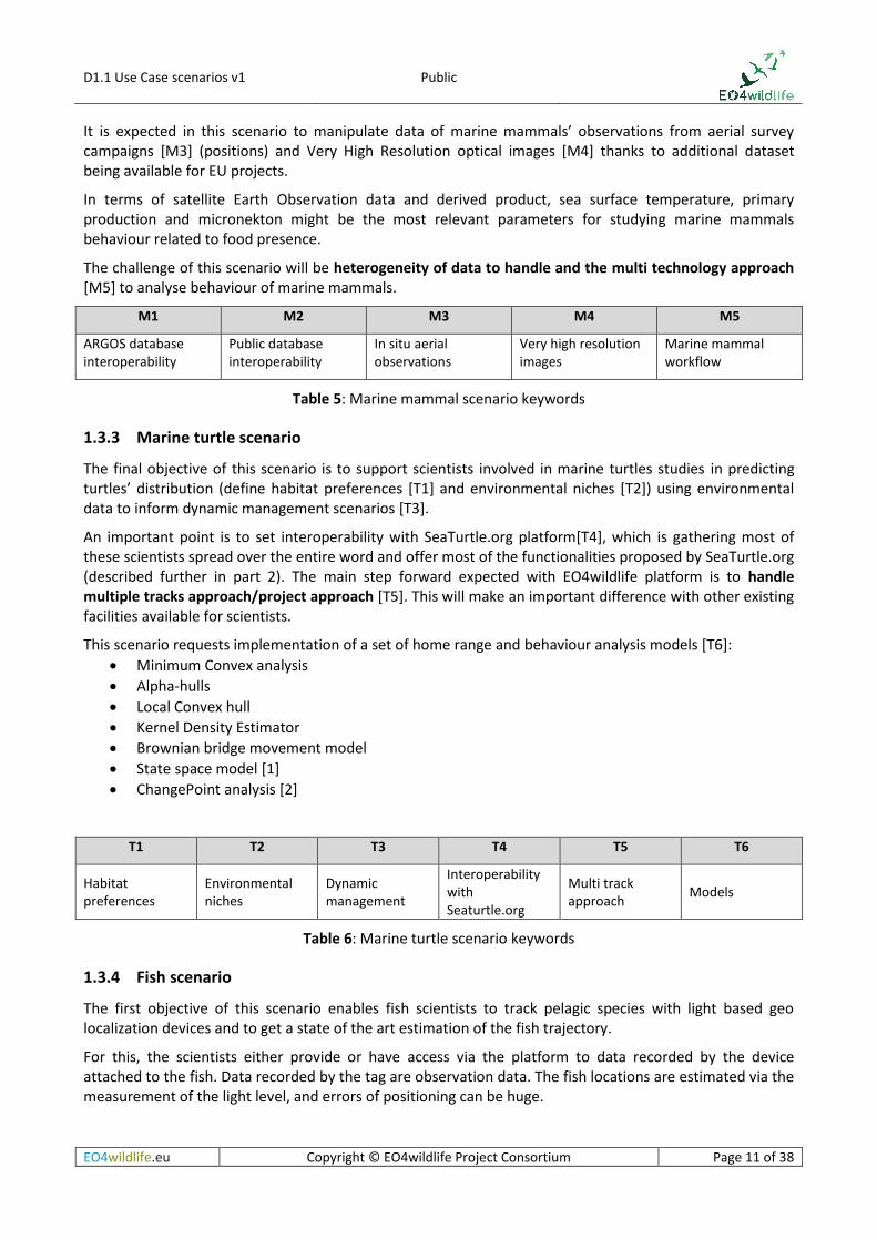
1.3.2 Marine mammal scenario
This scenario takes place in some of the Marine Protected Areas in French EEZ. The final objective of the scenario is not yet decided and will be ready for task WP1.2.
An important dataset of tracking data from ARGOS system and other technologies could be available for the scenario. It will mainly be tracks of marine mammals. Once again ARGOS database will be interoperable [M1] with EO4wildlife platform while other tracking data should be uploaded by scientists on the platform. Interoperability with a public platform from French University of La Rochelle might be evaluated [M2].
D1.1 Use Case scenarios v1 Public
EO4wildlife.eu Copyright © EO4wildlife Project Consortium Page 11 of 38
It is expected in this scenario to manipulate data of marine mammals’ observations from aerial survey campaigns [M3] (positions) and Very High Resolution optical images [M4] thanks to additional dataset being available for EU projects.
In terms of satellite Earth Observation data and derived product, sea surface temperature, primary production and micronekton might be the most relevant parameters for studying marine mammals behaviour related to food presence.
The challenge of this scenario will be heterogeneity of data to handle and the multi technology approach [M5] to analyse behaviour of marine mammals.
M1 M2 M3 M4 M5
ARGOS database interoperability
Public database interoperability
In situ aerial observations
Very high resolution images
Marine mammal workflow
Table 5: Marine mammal scenario keywords
1.3.3 Marine turtle scenario
The final objective of this scenario is to support scientists involved in marine turtles studies in predicting turtles’ distribution (define habitat preferences [T1] and environmental niches [T2]) using environmental data to inform dynamic management scenarios [T3].
An important point is to set interoperability with SeaTurtle.org platform[T4], which is gathering most of these scientists spread over the entire word and offer most of the functionalities proposed by SeaTurtle.org (described further in part 2). The main step forward expected with EO4wildlife platform is to handle multiple tracks approach/project approach [T5]. This will make an important difference with other existing facilities available for scientists.
This scenario requests implementation of a set of home range and behaviour analysis models [T6]:
Minimum Convex analysis
Alpha-hulls
Local Convex hull
Kernel Density Estimator
Brownian bridge movement model
State space model [1]
ChangePoint analysis [2]
T1 T2 T3 T4 T5 T6
Habitat preferences
Environmental niches
Dynamic management
Interoperability with Seaturtle.org
Multi track approach
Models
Table 6: Marine turtle scenario keywords
1.3.4 Fish scenario
The first objective of this scenario enables fish scientists to track pelagic species with light based geo localization devices and to get a state of the art estimation of the fish trajectory.
For this, the scientists either provide or have access via the platform to data recorded by the device attached to the fish. Data recorded by the tag are observation data. The fish locations are estimated via the measurement of the light level, and errors of positioning can be huge.

D1.1 Use Case scenarios v1 Public
EO4wildlife.eu Copyright © EO4wildlife Project Consortium Page 12 of 38
Figure 2: From the estimated locations (crosses) to the track
A range of correlations, constraints, models and filters associated to comparative data from satellite Earth Observation enable to optimize the estimation of the fish trajectory. The purpose of this scenario is to provide to the scientists the possibility to run such algorithms themselves directly from the EO4wildlife platform [F1] and to generate a set of results. Such algorithms will be provided by CLS to EO4Wildlife platform.
For this, the platform needs to access and manipulate daily satellite Earth Observation data of sea surface temperature, as well as a high resolution bathymetry file and a magnetic field intensity model output [F2]. Users of the platform for this scenario will have to provide some essential parameters [F3] online via a dedicated interface to compute the processing.
The second objective of this scenario is to enable analysing and understanding blue fin tuna behaviour [F4] or appearance [F5] correlated to environmental of salinity, primary production and sea surface temperature during spawning season in the Mediterranean Sea (summer season). An important dataset of tagged blue fin tunas is available during the project in order to implement and validate relevance of a range of dedicated models [F6] such as:
Kernel analysis: areas of greatest use
Time sent per cell/highest density cell
Home range estimation methods
A list of references is available in References ([3] to [10]).
F1 F2 F3 F4 F5 F6
Automation of service
Parameters Fish behavior Interoperability with Seaturtle.org
Fish appearance Models
Table 7: Fish scenario keywords
D1.1 Use Case scenarios v1 Public
EO4wildlife.eu Copyright © EO4wildlife Project Consortium Page 13 of 38
2 System and service description
The UML method is used for the functional and dynamic modelling of the EO4wildlife system.
In this context a use case is like a function of a system.
There are four sub sections:
Presentation of the actors of the EO4wildlife system, users who are interacting with the system
Presentation of the use cases: the main functions of the system
Presentation of the dynamic modelling of product/service metadata and service deployment
Traceability matrix between scenarios and user requirements
2.1 Actors
Here below are identified the actors of the EO4wildlife system:
User: is any user of the different scientific communities (biologists, ecologists, scientists, ornithologists, etc) who has an access to the EO4wildlife system. The access to the system is the same for all users, whether they are specialized in certain field or not.
Service provider: describes and uploads services into the EO4wildlife system
Product provider: describes the product he makes available in the system and the services to access them.
Administrator: validates the product and service metadata and tests the uploaded services. He also monitors the EO4wildlife system and users.
It should be noted that the service provider, the product provider and administrator are also users.
2.2 Use cases
2.2.1 Use cases overview
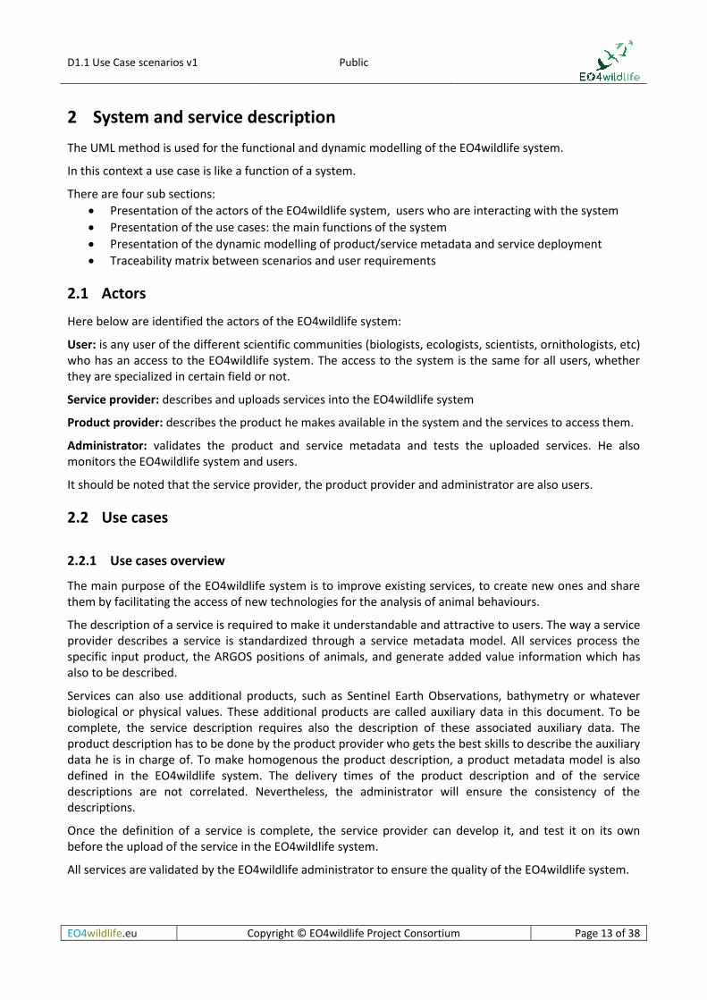
The main purpose of the EO4wildlife system is to improve existing services, to create new ones and share them by facilitating the access of new technologies for the analysis of animal behaviours.
The description of a service is required to make it understandable and attractive to users. The way a service provider describes a service is standardized through a service metadata model. All services process the specific input product, the ARGOS positions of animals, and generate added value information which has also to be described.
Services can also use additional products, such as Sentinel Earth Observations, bathymetry or whatever biological or physical values. These additional products are called auxiliary data in this document. To be complete, the service description requires also the description of these associated auxiliary data. The product description has to be done by the product provider who gets the best skills to describe the auxiliary data he is in charge of. To make homogenous the product description, a product metadata model is also defined in the EO4wildlife system. The delivery times of the product description and of the service descriptions are not correlated. Nevertheless, the administrator will ensure the consistency of the descriptions.
Once the definition of a service is complete, the service provider can develop it, and test it on its own before the upload of the service in the EO4wildlife system.
All services are validated by the EO4wildlife administrator to ensure the quality of the EO4wildlife system.
D1.1 Use Case scenarios v1 Public
EO4wildlife.eu Copyright © EO4wildlife Project Consortium Page 14 of 38
Thus ‘Description and upload’ use cases are the preliminary steps required before a user can go ahead in the use of the EO4wildlife system.
The user can then discover the services and the associated auxiliary data, and brings new intelligence by defining a new service as a combination of existing services, and run several times a service to fine-tune the expected result. The ‘Discover, run and display’ use case describes in details how is realized this possibility.
The functional modelling of the system is decomposed in 3 main parts:
1. First we have the integration of products and services in the EO4wildlife system, which contains 3 use cases:
The description of a product: that means the creation of the metadata product
The description of a service: that means the creation of the metadata service
The upload of a service in the EO4wildlife platform
2. Then we have the main functions of the platform concerning all users: discovery, service run and display:
Discover product : the search of a product in the catalogue of products
Discover service : the search of a service in the catalogue of services
Run Service : define and run of a service, or a set of services
Display and on-line tools: the display of products and service outputs
3. Finally we have the administrative functions of the EO4wildlife system:
Validate or invalidate the product or service metadata
Test and uploaded service
Invalidate a service
Manage the users : create/modify/delete
We consider the possibility for the user to register to the EO4wildlife system through a registration form out of the scope of system since it is not a valuable function for EO4wildlife business model. Be aware that it could be of interest for an operational implementation of the EO4wildlife system.
2.2.2 Nomenclature
2.2.2.1 Use case Nomenclature
The following nomenclature, UC-XXX-NNN is used in the use cases description:
UC means Use Case
XXX is the abbreviation of the use case name
NNN is optional and is a scenario identifier for the use case: BIRD for birds, FISH for fishes, TURT for turtles, AAMP for marine protected areas
The use cases and their abbreviation are:
DiscProd for Discover Product
DiscServ for Discover Service
RunServ for Run Service
Display for Display and on-line tools
DescProd for Describe Product
DescServ for Describe Service
UplServ for Upload Service
ValMeta for Validate Product or Service Metadata
InvMeta for Invalidate Product or Service Metadata
TestServ for Test the uploaded Service
D1.1 Use Case scenarios v1 Public
EO4wildlife.eu Copyright © EO4wildlife Project Consortium Page 15 of 38
InvServ for Invalidate a Service
ManUser for Manage the Users
2.2.2.2 Requirement nomenclature
The requirements will have the following nomenclature: sss-ttt-xxx-yyyy/V
sss = System, EO4, for EO4WildLife System
ttt: Type of the requirement
INT: Interface FCT: Functional IMP: Design / Implementation PRF: Performance DFM: Availability/Reliability/Maintainability SEC: Safety OPE: operational
xxx: the use case abbreviation, or GEN If the requirement is general with the system
yyyy: number with 4 digits which is allocated to a requirement when created and never modified nor used for any other requirement.
V: mode requirement verification method: (T = Test, A = Analysis or I = Inspection)
o Test: a test of validation makes it possible to check the requirement
For the requirements which cannot be checked by a test: o Inspection: activity of control per examination, observation or audit (example: the data access path
is customizable)
o Analysis: activity which requires a study to validate the respect of the requirement. For example calculation of performance.
2.2.3 General requirements
EO4-FCT-GEN-0010/T
The user has to be connected to the EO4wildlife system with credentials before any interaction with it.
EO4-FCT-GEN-0020/T
There are 4 user profiles in the EO4wildlife system: user, product provider, service provider and administrator. Each one has access authorization as mentioned in the use cases.
The administrator has access to all functionalities.
The product provider has access to the user rights, plus specific rights for product provider
The service provider has access to the user rights, plus specific rights for service provider
EO4-FCT-GEN-0030/T
During the description of a product or a service, the user can save temporarily its form, and complete it later in another session.
D1.1 Use Case scenarios v1 Public
EO4wildlife.eu Copyright © EO4wildlife Project Consortium Page 16 of 38
EO4-FCT-GEN-0040/T
In case of an error on a field (bad format, mandatory field missing, etc), an error message is displayed and the error field is marked in red
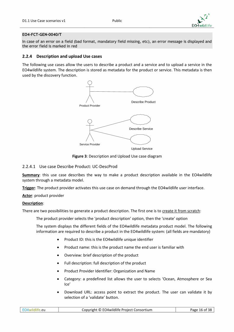
2.2.4 Description and upload Use cases
The following use cases allow the users to describe a product and a service and to upload a service in the EO4wildlife system. The description is stored as metadata for the product or service. This metadata is then used by the discovery function.
Figure 3: Description and Upload Use case diagram
2.2.4.1 Use case Describe Product: UC-DescProd
Summary: this use case describes the way to make a product description available in the EO4wildlife system through a metadata model.
Trigger: The product provider activates this use case on demand through the EO4wildlife user interface.
Actor: product provider
Description:
There are two possibilities to generate a product description. The first one is to create it from scratch:
The product provider selects the ‘product description’ option, then the ‘create’ option
The system displays the different fields of the EO4wildlife metadata product model. The following information are required to describe a product in the EO4wildlife system: (all fields are mandatory)
Product ID: this is the EO4wildlife unique identifier
Product name: this is the product name the end user is familiar with
Overview: brief description of the product
Full description: full description of the product
Product Provider Identifier: Organization and Name
Category: a predefined list allows the user to selects ‘Ocean, Atmosphere or Sea Ice’
Download URL: access point to extract the product. The user can validate it by selection of a ‘validate’ button.
Service Provider
Product Provider
Describe Service
Upload Service
Describe Product

D1.1 Use Case scenarios v1 Public
EO4wildlife.eu Copyright © EO4wildlife Project Consortium Page 17 of 38
Display URL: access point to display the product, when available. The user can validate it by selection of a ‘validate’ button.
GetDescription: access point to get the dataset description, when available. The user can validate it by selection of a ‘validate’ button. If the response is successful, the system asks the product provider if he wants to import automatically the description: variables, time coverage, temporal resolution, geographical coverage, spatial resolution. If the product provider services do not expose such a service, the product provider has to complete manually the product description.
Product level: L2, L3, L4, ..
The projection, when needed.
The updating frequency and time if any
GetSize: access point to get the estimated size of an extraction. If such an URL does not exist, the product provider enters a default typical size for an extraction.
Credentials: login and password to extract product (when required)
The product provider has also to upload a quicklook
The product provider validates the creation and the product metadata is pushed into the product catalogue.
The second option is to retrieve the product description from an existing catalogue. In such case:
The product provider selects the ‘harvest’ option,
The product provider enters the catalogue URL to harvest and the product identifier for the product, with credentials when required
The product provider validates the request to the external catalogue and gets the available information in the form which includes all the fields of the creation from scratch described just above.
The product provider completes the missing information when not available in the external catalogue
The product provider validates the information and the product metadata is pushed by the system into the product catalogue
The system generates automatically a creation date/time of the metadata. The update date/time of the metadata is equal to the creation date/time the first time. The metadata product status is set to ‘To validate’ (see Metadata State Diagram chapter 2.3.1). It is not accessible by the product discovery.
When a product is updated according to a predefined frequency and time, the system updates automatically the time coverage of the product in the metadata.
Variations
The product provider can modify the product metadata: all fields can be modified. The metadata returns to the state “to validate” and the modification date is updated in such case. The update is possible if the product provider has the required access rights (either the creator of the metadata, or a product provider of same organization).
The product provider cannot delete a metadata product since he cannot be aware of all the services that are processing the product. But he can turn it to ‘invalid’.
Requirements

D1.1 Use Case scenarios v1 Public
EO4wildlife.eu Copyright © EO4wildlife Project Consortium Page 18 of 38
EO4-FCT-DescProd-0050/T
The product provider can describe a new product in the EO4wildlife system, according to the EO4wildlife metadata product model
EO4-FCT-DescProd-0060/T
There are 2 options for the metadata product creation: creation from scratch (entry fields manually), or creation from an existing catalogue (harvest from an external catalogue and complete the creation manually)
EO4-FCT-DescProd-0070/T
Once the metadata product is created, the system set it to the “to validate” state.
EO4-FCT-DescProd-0080/T
The product provider (creator, or same organization) can modify the metadata product.
EO4-FCT-DescProd-0090/T
The product provider can turn the metadata state to ‘invalid’.
EO4-FCT-DescProd-0100/T
The system updates automatically the time coverage information when the product is regularly updated.
2.2.4.2 Use case Describe Service UC-DescServ
Summary: this use case describes the way to make a service description available in the EO4wildlife system through a service metadata model.
Trigger: The service provider activates this use case on demand through the EO4wildlife user interface.
Actor: service provider
Description:
The service provider selects the ‘service description’ option, then the ‘create’ option
The system displays the different fields of the EO4wildlife service metadata model. The following information are required to describe a service in the EO4wildlife system: (all fields are mandatory)
Service ID: this is the EO4wildlife unique identifier
Service name: this is the service name the end user is familiar with
Input product: ARGOS or in situ locations (CSV or XML file, or URL for extraction)
Parameters: Any value required to process the input product (threshold values for a filter, interpolation step or selection of the ARGOS location class to consider for a track computation for instance),
Available output products and associated formats:
o File: CSV, netcdf, KML, PDF report
o URL: HTTP/WMS, HTTP/WFS, HTTP/WCS to visualize the result,

D1.1 Use Case scenarios v1 Public
EO4wildlife.eu Copyright © EO4wildlife Project Consortium Page 19 of 38
Auxiliary data: identifier of any additional product with a list of:
o Protocol used to access the service
o URL access when dynamic auxiliary data have to be loaded by the service
o Login/password to access the product
o If an auxiliary data is static, as a configuration file, it could be just mentioned in the description of the service.
Overview : The service provider describes briefly the service steps, inputs and outputs,
Full description: the service provider details the steps of the process and the auxiliary data
Category: predefined values from the catalogue (turtle, birds, marine mammals, fish, protected areas TBC )
Type of service: track processing, filter, behaviour monitoring, thematic (TBC).
Required Resources
o Physical resources required to run the service: memory, disk, OS, software
Operational service level : on demand, on line, replicated
o On demand: when a user runs the service
o On line: the service is deployed to be accessible quickly
o Replicated: a high level of availability is required
Target : EO4wildlife platform or server URL (Scientist server) where is deployed the service
Nominal duration in seconds: this information provides the nominal elapsed time for a typical amount of input.
Service Provider Identifier: Organization and Name
Once the user validates the creation, the system generates automatically a creation date/time of the metadata. The update date/time of the metadata is equal to the creation date/time. The service metadata status is set to ‘To validate’ (See Metadata State Diagram chapter 2.3.1). The service metadata is saved in the service catalogue. It is not accessible by the service discovery.
The service provider uploads the service in an independent way in the EO4wildlife system (described in “upload service” use case).
Variations
The service provider can modify the service metadata: all fields can be modified. The service metadata returns to the state “to validate” and the modification date is updated. The update is possible if the service provider has the access rights to do so (either the creator of the metadata, or a service provider of a same organization).
The service provider cannot delete a metadata service but can turn it to ‘invalid’ if he detects any issue in the service execution.
Requirements
EO4-FCT-DescServ-0110/T
The service provider can describe a new service in the EO4wildlife system, according to the EO4wildlife service metadata model.
D1.1 Use Case scenarios v1 Public
EO4wildlife.eu Copyright © EO4wildlife Project Consortium Page 20 of 38
EO4-FCT-DescServ-0120/T
Once the service metadata created, its state is “to validate”.
EO4-FCT-DescServ-0130/T
The service provider (creator, or same organization) can modify the service metadata.
EO4-FCT-DescServ-0140/T
The service provider cannot delete the service metadata but can turn it to ‘invalid’.
EO4-OPE-DescServ-0150/A
Services level agreements are defined according to the service level:
On demand : 99% of runs are successful
On line : 95% availability over one month
Replicated : 99% availability over one month
2.2.4.3 Use case Upload Service UC-UplServ
Summary: this use case describes the way to upload a service in the EO4wildlife system.
Trigger: the service can be uploaded independently of its description. Generally, the service is described first (use case UC-DescServ), and then uploaded. But it is also possible to upload it first (for example for testing purposes), and then to describe it.
Actor: service provider
Description:
The service provider describes the deployment plan of the service in the EO4wildlife system, provides the service implementation (software delivery package).
Then, the system deploys automatically the uploaded service.
If the upload is run without error, the service switches to the “uploaded” state. (see Service deployment State Diagram chapter 0).
The service provider also describes a test case and uploads the input product to test with and the expected outputs products so that the administrator can run the service and validate it (see Test the uploaded service UC-TstServ).
Requirements
EO4-FCT-UplServ-0160/T
The service provider can upload a new service in the EO4wildlife: if the upload is run without error, the service switches to the “uploaded” state.
2.2.5 Discover, run and display use cases
Any user (user, service provider, product provider, administrator) has access to the ‘discover, run and display’ use cases.
The user browses the catalogue via the discover functions. He can consult a product or a service via the display function.
He can run a service in the catalogue but can also create and run its own service defined by a combination of a set of services. He can then access not only to the final outputs but also to intermediate results or

D1.1 Use Case scenarios v1 Public
EO4wildlife.eu Copyright © EO4wildlife Project Consortium Page 21 of 38
auxiliary data implied in the service with the display function. He can also use on-line tools to improve the quality of the display or post-process the results.
The use cases are shown in the following picture.
Figure 4: Discover, run and display Use case diagram
2.2.5.1 Use case Discover Product UC-DiscProd
Summary: this use case describes the way to discover a product in the EO4wildlife system catalogue.
Trigger: The user activates this use case on demand through the EO4wildlife user interface
Actor: Any actor
Description:
The user can enter one or several criteria to request the product catalogue:
Product type: ocean, atmosphere, sea ice
Variable: physical or biological identifier
Temporal resolution: frequency at which are computed the product instances
Geographical resolution: product grid resolution
Product level: L2, L3, L4, etc
Period: begin and end dates
Geographical area: min/max longitude, min/max latitude
Only the validated products are displayed in the results of the search query. The search results consist in the display of the search criteria and number of matching products, and for each matching product:
The product name
A brief description of the product
The time coverage
A quick look of the product if available
The Display option to display the product
User
Discover Product
Discover Service
Run Service
Display and on-line tools
D1.1 Use Case scenarios v1 Public
EO4wildlife.eu Copyright © EO4wildlife Project Consortium Page 22 of 38
The download option to access the product
A “More Info” option gives access to the full description of the product
A sort function by time coverage or by product name is available.
The system will provide a single extraction interface which is in charge of the extraction management. The user can then save the extracted product locally or in the platform with a retention duration
The user can visualize the product: see “Display and on-line tool” use case.
Requirements
EO4-FCT-DiscProd-0170/T
Any user of the EO4wildlife system can discover products by selection of search criteria: product type, variable, temporal resolution, geographical resolution, product level, period, geographical area. The results of the search query are display in a friendly way to allow sorts by name, time coverage.
EO4-FCT-DiscProd-0180/T
Only the validated products of the catalogue are available to the users
EO4-FCT-DiscProd-0190/T
After the discovery, the user can extract part of the data product and display it.
EO4-FCT-DiscProd-0200/T
The extracted data should be less than 1 Gb.
2.2.5.2 Use Case Discover Service UC-DiscServ
Summary: this use case describes the way to discover a service in the EO4wildlife system.
Trigger: The user activates this use case on demand through the EO4wildlife user interface
Actor: user
Description:
Only the validated services are available to the users.
The user can enter one or several fields:
Category: turtle, birds, marine mammals, fish, protected marine area
Service type: track processing, filter, behaviour monitoring, thematic (TBC)
Service Provider: body in charge of the delivery of the service: IT Innovation, CLS, ATOS, …
Output Protocol/Formats : wms, wfs, ftp, netcdf, pdf
The results are displayed in a list with the search criteria and the number of matching services.
For each service are displayed:
The service ID and name
The description of the service
The target to access the service: EO4wildlife platform or server URL

D1.1 Use Case scenarios v1 Public
EO4wildlife.eu Copyright © EO4wildlife Project Consortium Page 23 of 38
A “More Info” button to access to the detailed description of the service
The user can select one or several service he would like to run: see “run service” use case and save them into a cart or as a bookmark.
Requirements
EO4-FCT-DiscServ-0210/T
Any user of the EO4wildlife system can discover service by choosing one or several selection criteria: category, type, provider, output protocol
EO4-FCT-DiscServ-0220/T
Only the validated services of the catalogue are available to the users
EO4-FCT-DiscServ-0230/T
The user can save a service in a cart or in a bookmark.
2.2.5.3 Use Case Run Service UC-RunServ
Summary: this use case describes the way to run a service in the EO4wildlife system
Trigger: The user activates this use case on demand through the EO4wildlife user interface
During the “product and services discovery” use cases, the user has already identified the services of interest he would like to run putting them into his cart.
Actor: user
Description:
If the user discovered the right service to run and put it in his cart, he just has to run the service by selecting from the cart.
Otherwise the user can also create a workflow for a selection of services in his cart. The user orders the selected services according to the process he defines. At each step of this workflow definition, the user enters the parameters required by the current selected service. The system checks that the output of a current step is compliant as an input of the following steps, otherwise an error message is displayed.
Once all the steps of the workflow are validated, the user can save it as a new service, so as to reuse the workflow definition for any new run. The user can add this new service to his list of bookmarks.
The user can also select the service to run from his bookmarks. In such case, the system asks him if he wants to update the parameters. If yes, all the parameters are displayed for any update. If no, the current values of the parameters are used in the run.
Then, the user runs the service for an instance of the input ARGOS data product. The time of interest is computed by the system as the time period made of the timestamp of the first ARGOS location and the latest one. The area of interest is processed automatically by the system as a rectangular area including all the ARGOS locations.
Then the system checks the availability of auxiliary data. If several instances of the same auxiliary data (radar scenes for instance) are available for the run within the time of interest and the area of interest, the system displays them to the user and the user has to select the one to process with. If any auxiliary data is missing, no matching between the criteria of interest (AOI, TOI) and the available auxiliary data, the user is not entitled to go further in the workflow execution and the missing auxiliary data are listed. If any product or service is no more valid in the catalogue, a specific error message is also displayed. When everything is

D1.1 Use Case scenarios v1 Public
EO4wildlife.eu Copyright © EO4wildlife Project Consortium Page 24 of 38
ready, the user confirms the execution of the run. A typical execution time is displayed to the user as the sum of the nominal durations of the involved services.
Once executed, the user can save the results of the run with a run identifier. He can easily adjust any parameter and process a new run for the input data.
When all the required auxiliary data are selected, the user selects the ‘run workflow’ button to start the execution. At the end of the execution, the user receives a mail describing the status of execution for each step of the workflow and including the way to access to the steps outputs he selected (WMS, PDF report...). When several auxiliary data are used during the process, the EO4wildlife platform allows the user to select and display them in distinct layers. If the user wants to display several auxiliary data at the same time, he can use transparency options (see “display and on-line tools” use case).
A history of all executions is available so that the user can quickly visualize the different runs he made and results he got.
Typical steps of a workflow definition can be thematic or global.
The identified global steps are (TBC):
Filter ARGOS product:
By ARGOS location class,
By speed from previous point
By distance from previous point,
By change of direction
Landmask to select or unselect position on land
Daily best locations
Clean and transform process
Track processing:
Kalman filtering
Spline filtering
Interpolate missing positions using different algorithms
Distance to
Compute the distance to the shore
Compute the distance to area ( e.g the colony area, a thermal front for instance)
Behaviour monitoring:
Compute speed, angle and distance between successive locations
The thematic steps are (TBC):
Calculate density maps:
Number of animal, (tracked vs extrapolation to wider population)
Number of animal days, in a specified time period (e.g. days hours, weeks, months)
Average of animal per area
Kernel analysis: area of greatest use
Fusion-Cross correlation:
Calculate time within physical parameter window (temperature, depth, chlor-a, barometric level...)

D1.1 Use Case scenarios v1 Public
EO4wildlife.eu Copyright © EO4wildlife Project Consortium Page 25 of 38
Behaviour monitoring:
Behaviour per location
Behaviour changes
Home range,
Habitat
Delta between travel direction and current direction
Calculate time spent per cell/AOI
Minimum displacement rate
Movement monitoring / alarm trigger
Compute fish location algorithm
Scenario Any thematic platform can call for a service of the EO4wildlife system.
Requirements
EO4-FCT-RunServ-0240/T
The user can run a service, providing parameters, input and a selection of auxiliary products
EO4-FCT-RunServ-0250/T
The user can create a service as a workflow, which is an ordered combination of services, providing parameters required for each service. This new service can be saved in his bookmark.
EO4-FCT-RunServ-0260/T
The EO4WildLife system checks the validity of the workflow:
The output of a step has to be compliant with the input of the following step
All required parameters and auxiliary data should be available
All auxiliary data and service steps should be declared as valid in the catalogue.
EO4-FCT-RunServ-0270/T
Typical steps of a workflow definition can be thematic or global.
EO4-FCT-RunServ-0280/T
The user can run a workflow (instance ready to run): a complete status of execution is sent to the user. The user can access to the step outputs and the auxiliary data involved in the process
EO4-FCT-RunServ-0290/T
The user can save the run results with a run identifier.
EO4-FCT-RunServ-0300/T
The user can easily reuse a workflow definition and execute new runs changing inputs products or parameters.
D1.1 Use Case scenarios v1 Public
EO4wildlife.eu Copyright © EO4wildlife Project Consortium Page 26 of 38
EO4-FCT-RunServ-0310/T
The user can visualize a history of all the runs he made
EO4-FCT-RunServ-0320/T
Any thematic platform can call for a service of the EO4wildlife system
EO4-PRF-RunServ-0330/T
A run can be executed for 100 millions of input positions (TBC).
2.2.5.4 Use Case Display and on-line tools UC-Display
Summary: this use case describes the way the user can display the process outputs and use additional on-line tools to be able to prepare the next service definitions or new runs to perform.
Trigger:
The display function is available after the discovery of product (use case “Discover product”, or after the run of service (use case “run Service”).
In the case of a service run, the user has received a mail with links to access to the display of the inputs, outputs and auxiliary data of the run. He can also look for a run in the history of run, select one of them to display the mail content of the run to access to the associated results.
Actor: user
Description:
The outputs of the service can be displayed in a web interface. The user selects the results to display. He can ask a display in distinct tabs, or in a single tab with an overlay of layers.
For each layer, additional tools can be used to perform the following actions:
Select a colour map for the display
Adjust automatically the min-max value of the colour map to the displayed data
Use a linear or logarithm scale in the colour map
Define the transparency level
Select a location and retrieve the physical value for the layer on this location
Draw a transect polyline when 3D data are displayed, and get the associated transect
Draw polylines when 2D data are displayed and get the associated curve
Define a mask with a min max value definition. All mismatching data will be made transparent
The ARGOS input product can be displayed as a track for an animal. The user has the possibility to select a maximal duration of the display of the track, for instance, display the track only for the last 24 hours. When several mobiles are included in the input, the user can select the mobile or set of mobiles to display. The user can ask for an animation of the mobiles along a time bar and can define the track duration of the mobile to optimize the displayed information. For instance, if a position at a one hour rate over a month is provided for 10 mobiles, only the last 6 hours of each track are displayed for all animals during the animation.
When the location errors of the positions are provided, the user can activate the display of the elliptic error along the track. The user can also apply filters on the track and see the filtered track.
D1.1 Use Case scenarios v1 Public
EO4wildlife.eu Copyright © EO4wildlife Project Consortium Page 27 of 38
The user can also ask for an extraction of the displayed data:
along the complete or a part of a track
in the area defined by the elliptic errors around the track
over an area he creates as a rectangle
For the extraction of data, the user has to define the expected spatial resolution. The system will interpolate if necessary the values. The export can generate:
a netCDF grid with a variable per layer. During the extraction, an interpolation will be performed when the input data is at a lower resolution
a CSV export of each variable
A KML/KMZ output of each variable
A PNG/JPEG output of each variable
A PDF report including all the results
The user can also apply thematic tools to:
Determine convergence zones/frontal zones for the displayed layer
Determine front for the displayed layer
Filter the input locations on line thanks to the different track processing services
Then the user can also use generic tools to:
Measure the distance between 2 locations, or to an area
Generate an area from a pattern created thanks to a wizard tool and compute a surface of this area
Requirements
EO4-FCT-Display-0340/T
The user can visualize products, auxiliary data and service outputs in a web interface. He can ask a display in distinct tabs, or in a single tab with an overlay of layers.
EO4-FCT-Display-0350/T
For each layer, the user can be configure the display selecting a specific colour map, a linear or logarithmic scale, a transparency level, assign the dynamic of the colour map to the min-max displayed values.
EO4-FCT-Display-0360/T
The user can apply a mask on data to make transparent all data out of a min-max interval
EO4-FCT-Display-0370/T
The system can display data values on a location, along the track, along a polyline, along a transect for 3D data
EO4-FCT-Display-0380/T
The user can display the track of a mobile or set of mobiles, he can apply filters on the track, he can ask for an animation of the mobiles.

D1.1 Use Case scenarios v1 Public
EO4wildlife.eu Copyright © EO4wildlife Project Consortium Page 28 of 38
EO4-FCT-Display-0390/T
When the location error of the positions are provided, the user can activate the display of the elliptic error along the track
EO4-FCT-Display-0400/T
The user can ask for an extraction of data values along the track, buy definition of a polyline, within the elliptic error or by definition of an area.
EO4-FCT-Display-0410/T
The user can generate a report of a complete or a part of the displayed data in different formats: netCDF, CSV, KML/KMZ, PNG/JPEG, PDF
EO4-FCT-Display-0420/T
Generic tools are used to compute the distance between two points or to an area.
EO4-FCT-Display-0430/T
More specific tools allow the user to identify areas of interest such as fronts and convergences
2.2.6 Administration use cases
The following diagram shows the functionalities accessible only to administrators.
Figure 5: Administration Use case diagram
The administrator has all the rights on the EO4wildlife system. He has to validate product or service metadata before their publication in the catalogue. He has to test the uploaded service, which becomes validated and thus accessible in the catalogue. He is the only actor who can invalidate metadata and service. He manages the users and their profile.
Validate Product or Service
Metadata
Test the uploaded service
Manage the users
Invalidate Product or Service
Metadata
Administrator
Invalidate a Service

D1.1 Use Case scenarios v1 Public
EO4wildlife.eu Copyright © EO4wildlife Project Consortium Page 29 of 38
2.2.6.1 Use case Validate Product or Service metadata UC-ValMeta
Summary: this use case describes the way to validate a product or service metadata in the EO4wildlife system.
Trigger: The EO4wildlife system administrator activates this use case on demand through the EO4wildlife user interface. The metadata has been created by the product or service provider (use case “describe product” and “describe service”). The metadata is in the state “to validate”.
The administrator can also validate a metadata which is in a state “invalid” (see metadata state diagram chapter 2.3.1)
Actor: administrator
Description:
The EO4wildlife system displays the list of metadata to validate. The administrator can access to the content of the metadata. If everything is ok for him, he validates the metadata, which switches to the state “validated”. If not, he does not validate and the metadata returns to the state “in progress”.
If the metadata is validated, it is then automatically added to the EO4wildlife catalogue and available to any user.
Requirements
EO4-FCT-ValMeta-0440/T
Only the administrator can validate the product or service metadata: it is then available to any users.
EO4-FCT-ValMeta-0450/T
The administrator will check the use of shared vocabularies, like skos vocabularies, and conventions, like COARDS-CF to insure the coherence in descriptions.
2.2.6.2 Use case Invalidate Product or Service metadata UC-InvMeta
Summary: this use case describes the way to invalidate a product or service metadata in the EO4wildlife system.
Trigger: The EO4wildlife system administrator activates this use case on demand through the EO4wildlife user interface. The metadata has been validated (use case “validate product or service metadata”). The administrator has the possibility to invalidate it for example if a critical issue was raised and not yet fixed in a service.
The metadata state diagram is described in chapter 2.3.1.
Actor: administrator
Description:
The administrator has access to the list of all metadata validated of the EO4wildlife system. He can select one and invalidate it. The metadata switches to the state “invalid”. The product or service is then not accessible by others users.
Requirements
EO4-FCT-InvMeta-0460/T
Only the administrator can invalidate a product or service metadata: it is then not available to others users.

D1.1 Use Case scenarios v1 Public
EO4wildlife.eu Copyright © EO4wildlife Project Consortium Page 30 of 38
2.2.6.3 Use case Test the uploaded service UC-TstServ
Summary: this use case describes the way to test a service uploaded by a service provider.
Trigger: The EO4wildlife system administrator activates this use case on demand through the EO4wildlife user interface. The service provider has uploaded a service in the EO4wildlife system (use case upload service)
The administrator can also validate a service which has been invalidated (in the state “invalid”)
See service deployment state diagram in chapter 0.
Actor: administrator
Description:
The administrator access to the service and input products: he can run the service and compare results with results provided by the service provider. If the execution is OK and if the service metadata is also validated, the service is ready and available in the catalogue service to be run by users.
Requirements
EO4-FCT-InvMeta-0470/T
The administrator test a service uploaded in the EO4wildlife system. Once the test is OK, and the service metadata is validated, the service is ready for run.
2.2.6.4 Use case Manage the users UC-ManUser
Summary: this use case describes the way to create/modify/delete a user of the EO4wildlife system.
Trigger: The EO4wildlife system administrator activates this use case on demand through the EO4wildlife user interface.
Actor: administrator
Description:
The user has
An identifier and a name
An organization : company, or association
A profile : user or service provider or product provider or administrator
A unique login/password
The administrator can create a user.
He can modify one of the attributes of a user: for example he can change the profile of a user. A user can become a service provider for example.
He can delete a user.
Requirements
EO4-FCT-manUser-0480/T
The administrator manages (create/modify/delete) the users in the EO4wildlife platform. A user has an identifier, a name, an organization, a profile (ID, Name, Organization, Profile, login/Password)
D1.1 Use Case scenarios v1 Public
EO4wildlife.eu Copyright © EO4wildlife Project Consortium Page 31 of 38
2.3 Metadata and Service State diagram
2.3.1 Metadata state diagram
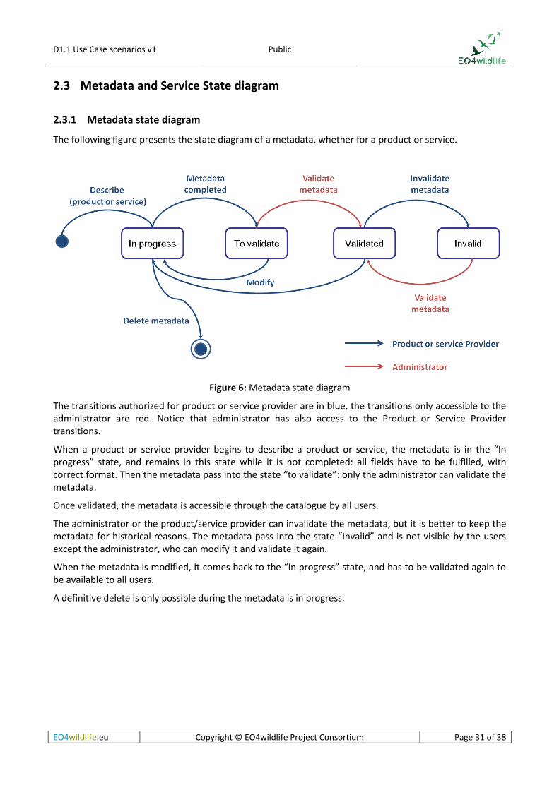
The following figure presents the state diagram of a metadata, whether for a product or service.
Figure 6: Metadata state diagram
The transitions authorized for product or service provider are in blue, the transitions only accessible to the administrator are red. Notice that administrator has also access to the Product or Service Provider transitions.
When a product or service provider begins to describe a product or service, the metadata is in the “In progress” state, and remains in this state while it is not completed: all fields have to be fulfilled, with correct format. Then the metadata pass into the state “to validate”: only the administrator can validate the metadata.
Once validated, the metadata is accessible through the catalogue by all users.
The administrator or the product/service provider can invalidate the metadata, but it is better to keep the metadata for historical reasons. The metadata pass into the state “Invalid” and is not visible by the users except the administrator, who can modify it and validate it again.
When the metadata is modified, it comes back to the “in progress” state, and has to be validated again to be available to all users.
A definitive delete is only possible during the metadata is in progress.

D1.1 Use Case scenarios v1 Public
EO4wildlife.eu Copyright © EO4wildlife Project Consortium Page 32 of 38
2.3.2 Service deployment state diagram
Figure 7: Service deployment state diagram
When the service provider ask to upload a service, the service is in the “to upload” state. Then the service pass into the state “uploaded”.
The administrator has to test it by running it. The service is ready for run once the metadata is validated by the administrator and once the service run is OK.
The administrator or the service provider can invalidate a service, which pass into the state “Invalid” and is not visible by the users except the administrator, who can modify it and validate it again.
If the test is not OK, the service comes back to the “to upload” state, and has to be uploaded and tested again to be available to all users.
A definitive delete is only possible during the service is “to upload”.
D1.1 Use Case scenarios v1 Public
EO4wildlife.eu Copyright © EO4wildlife Project Consortium Page 33 of 38
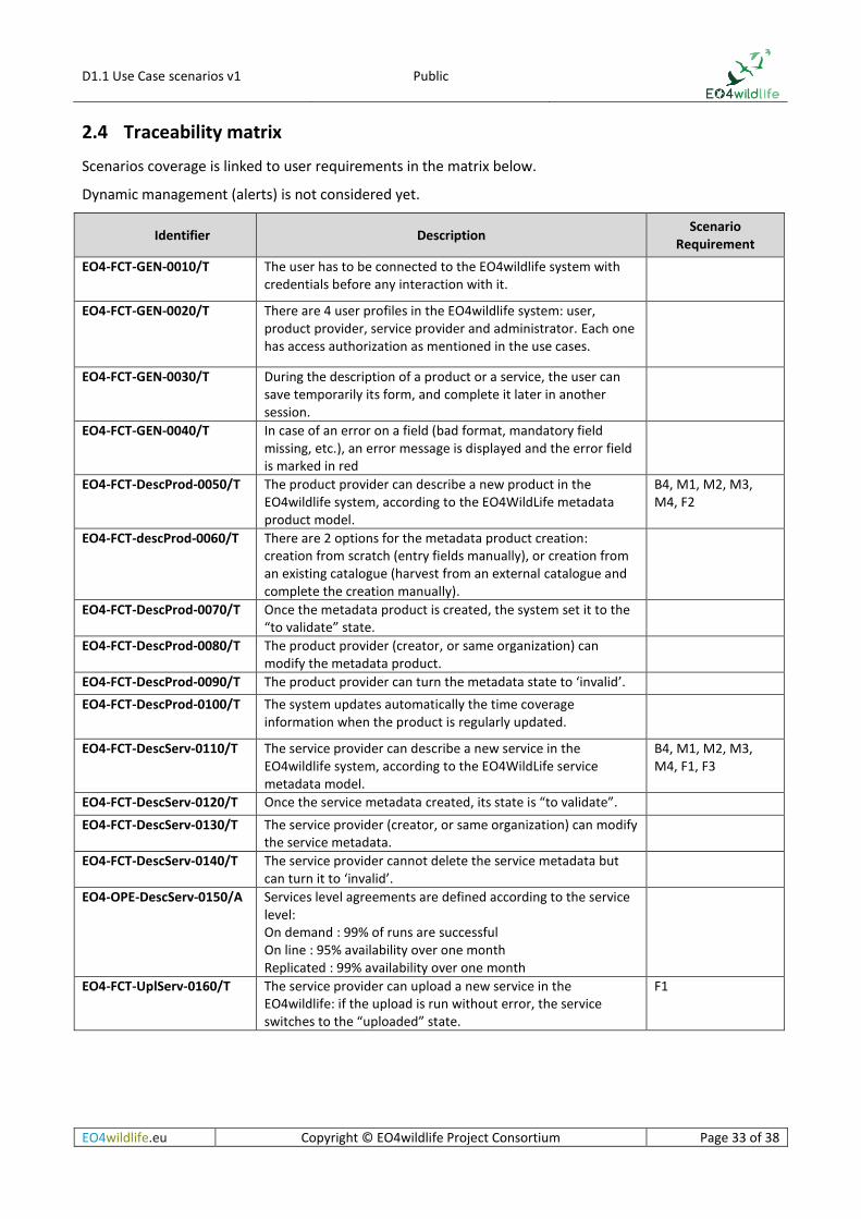
2.4 Traceability matrix
Scenarios coverage is linked to user requirements in the matrix below.
Dynamic management (alerts) is not considered yet.
Identifier Description Scenario
Requirement
EO4-FCT-GEN-0010/T The user has to be connected to the EO4wildlife system with credentials before any interaction with it.
EO4-FCT-GEN-0020/T There are 4 user profiles in the EO4wildlife system: user, product provider, service provider and administrator. Each one has access authorization as mentioned in the use cases.
EO4-FCT-GEN-0030/T During the description of a product or a service, the user can save temporarily its form, and complete it later in another session.
EO4-FCT-GEN-0040/T In case of an error on a field (bad format, mandatory field missing, etc.), an error message is displayed and the error field is marked in red
EO4-FCT-DescProd-0050/T The product provider can describe a new product in the EO4wildlife system, according to the EO4WildLife metadata product model.
B4, M1, M2, M3, M4, F2
EO4-FCT-descProd-0060/T There are 2 options for the metadata product creation: creation from scratch (entry fields manually), or creation from an existing catalogue (harvest from an external catalogue and complete the creation manually).
EO4-FCT-DescProd-0070/T Once the metadata product is created, the system set it to the “to validate” state.
EO4-FCT-DescProd-0080/T The product provider (creator, or same organization) can modify the metadata product.
EO4-FCT-DescProd-0090/T The product provider can turn the metadata state to ‘invalid’.
EO4-FCT-DescProd-0100/T The system updates automatically the time coverage information when the product is regularly updated.
EO4-FCT-DescServ-0110/T The service provider can describe a new service in the EO4wildlife system, according to the EO4WildLife service metadata model.
B4, M1, M2, M3, M4, F1, F3
EO4-FCT-DescServ-0120/T Once the service metadata created, its state is “to validate”.
EO4-FCT-DescServ-0130/T The service provider (creator, or same organization) can modify the service metadata.
EO4-FCT-DescServ-0140/T The service provider cannot delete the service metadata but can turn it to ‘invalid’.
EO4-OPE-DescServ-0150/A Services level agreements are defined according to the service level: On demand : 99% of runs are successful On line : 95% availability over one month Replicated : 99% availability over one month
EO4-FCT-UplServ-0160/T The service provider can upload a new service in the EO4wildlife: if the upload is run without error, the service switches to the “uploaded” state.
F1
D1.1 Use Case scenarios v1 Public
EO4wildlife.eu Copyright © EO4wildlife Project Consortium Page 34 of 38
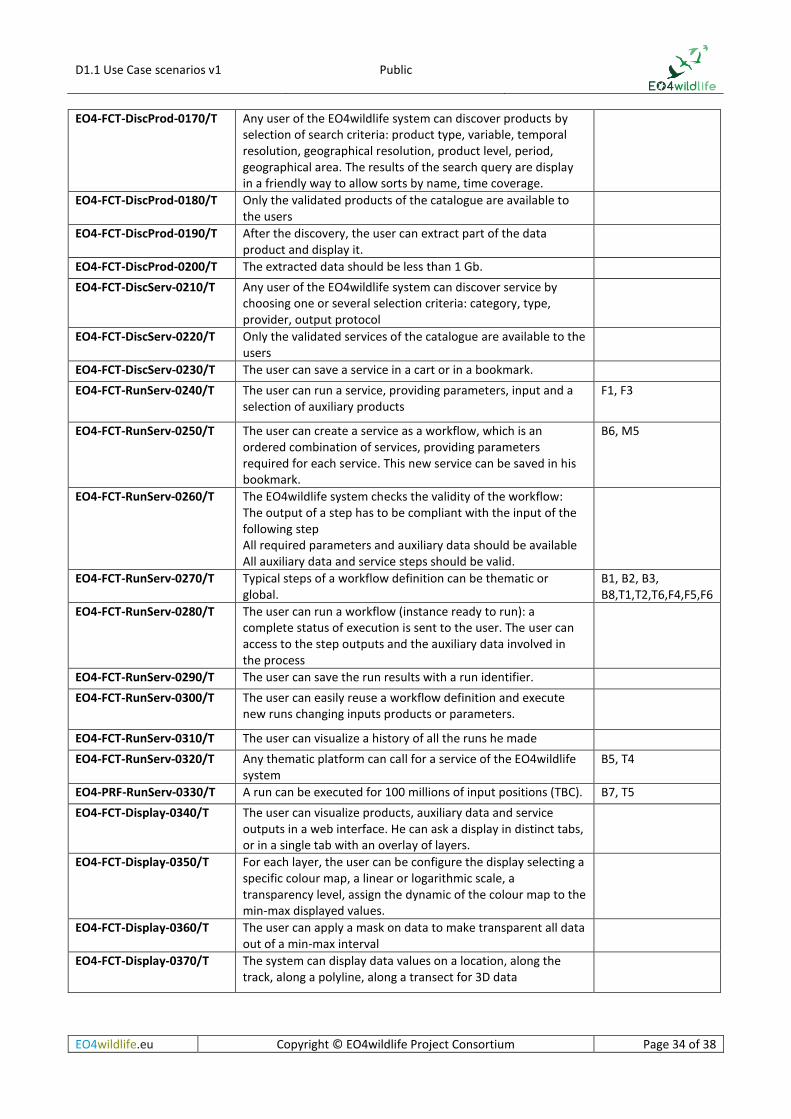
EO4-FCT-DiscProd-0170/T Any user of the EO4wildlife system can discover products by selection of search criteria: product type, variable, temporal resolution, geographical resolution, product level, period, geographical area. The results of the search query are display in a friendly way to allow sorts by name, time coverage.
EO4-FCT-DiscProd-0180/T Only the validated products of the catalogue are available to the users
EO4-FCT-DiscProd-0190/T After the discovery, the user can extract part of the data product and display it.
EO4-FCT-DiscProd-0200/T The extracted data should be less than 1 Gb.
EO4-FCT-DiscServ-0210/T Any user of the EO4wildlife system can discover service by choosing one or several selection criteria: category, type, provider, output protocol
EO4-FCT-DiscServ-0220/T Only the validated services of the catalogue are available to the users
EO4-FCT-DiscServ-0230/T The user can save a service in a cart or in a bookmark.
EO4-FCT-RunServ-0240/T The user can run a service, providing parameters, input and a selection of auxiliary products
F1, F3
EO4-FCT-RunServ-0250/T The user can create a service as a workflow, which is an ordered combination of services, providing parameters required for each service. This new service can be saved in his bookmark.
B6, M5
EO4-FCT-RunServ-0260/T The EO4wildlife system checks the validity of the workflow: The output of a step has to be compliant with the input of the following step All required parameters and auxiliary data should be available All auxiliary data and service steps should be valid.
EO4-FCT-RunServ-0270/T Typical steps of a workflow definition can be thematic or global.
B1, B2, B3, B8,T1,T2,T6,F4,F5,F6
EO4-FCT-RunServ-0280/T The user can run a workflow (instance ready to run): a complete status of execution is sent to the user. The user can access to the step outputs and the auxiliary data involved in the process
EO4-FCT-RunServ-0290/T The user can save the run results with a run identifier.
EO4-FCT-RunServ-0300/T The user can easily reuse a workflow definition and execute new runs changing inputs products or parameters.
EO4-FCT-RunServ-0310/T The user can visualize a history of all the runs he made
EO4-FCT-RunServ-0320/T Any thematic platform can call for a service of the EO4wildlife system
B5, T4
EO4-PRF-RunServ-0330/T A run can be executed for 100 millions of input positions (TBC). B7, T5
EO4-FCT-Display-0340/T The user can visualize products, auxiliary data and service outputs in a web interface. He can ask a display in distinct tabs, or in a single tab with an overlay of layers.
EO4-FCT-Display-0350/T For each layer, the user can be configure the display selecting a specific colour map, a linear or logarithmic scale, a transparency level, assign the dynamic of the colour map to the min-max displayed values.
EO4-FCT-Display-0360/T The user can apply a mask on data to make transparent all data out of a min-max interval
EO4-FCT-Display-0370/T The system can display data values on a location, along the track, along a polyline, along a transect for 3D data

D1.1 Use Case scenarios v1 Public
EO4wildlife.eu Copyright © EO4wildlife Project Consortium Page 35 of 38
EO4-FCT-Display-0380/T The user can display the track of a mobile or set of mobiles, he can apply filters on the track, he can ask for an animation of the mobiles.
EO4-FCT-Display-0390/T When the location error of the positions are provided, the user can activate the display of the elliptic error along the track
EO4-FCT-Display-0400/T The user can ask for an extraction of data values along the track, buy definition of a polyline, within the elliptic error or by definition of an area.
EO4-FCT-Display-0410/T The user can generate a report of a complete or a part of the displayed data in different formats: netCDF, CSV, KML/KMZ, PNG/JPEG, PDF
EO4-FCT-Display-0420/T Generic tools are used to compute the distance between two points or to an area.
EO4-FCT-Display-0430/T More specific tools allow the user to identify areas of interest such as fronts and convergences
EO4-FCT-ValMeta-0440/T Only the administrator can validate the product or service metadata: it is then available to any users.
EO4-FCT-ValMeta-0450/T The administrator will check the use of shared vocabularies, like skos, and conventions
EO4-FCT-InvMeta-0460/T Only the administrator can invalidate a product or service metadata: it is then not available to others users.
EO4-FCT-InvMeta-0470/T The administrator test a service uploaded in the EO4wildlife system. Once the test is OK, and the service metadata is validated, the service is ready for run.
EO4-FCT-manUser-0480/T The administrator manages (create/modify/delete) the users in the EO4wildlife platform. A user has an identifier, a name, an organization, a profile (ID, Name, Organization, Profile, login/Password)
Table 8: Traceability matrix

D1.1 Use Case scenarios v1 Public
EO4wildlife.eu Copyright © EO4wildlife Project Consortium Page 36 of 38
References
[1] Maxwell SM, Breed GA, Nickel BA, Makanga-Bahouna J, Pemo-Makaya E, Parnell RJ, Formia A, Ngouessono S, Godley BJ, Costa DP, Witt MJ, Coyne MS (2011) Using satellite tracking to optimize protection of long- lived marine species: olive ridley sea turtle conservation in central Africa. PLoSOne 6:e19905
[2] Patel SH, Morreale SJ, Panagopoulou A, Bailey H, Robinson NJ, Paladino FV, Margaritoulis D, Spotila JR (2015) Changepoint analysis: a new approach for revealing animal movements and behaviors from satellite telemetry data. Ecosphere 6
[3] Worton B.J, 1989, Kernel methods for estimating the utilization distribution in home range studies, Ecology, Vol 70, 164-168
[4] Bullard, F. 1999. Estimating the home range of an animal: a Brownian bridge approach. Johns Hopkins University. Master thesis
[5] Horne, J.S., Garton, E.O., Krone, S.M. and Lewis, J.S. 2007. Analyzing animal movements using Brownian bridges. Ecology, 88, 2354-2353
[6] Benhamou, S. and Cornelis, D. 2010. Incorporating movement behavior and barriers to improve kernel home range space use estimates. Journal of Wildlife Management, 74, 1353-1360
[7] Benhamou, S. 2011. Dynamic approach to space and habitat use based on biased random bridges. PLOS ONE, 6, 1-8
[8] Keating, K. and Cherry, S. 2009. Modeling utilization distributions in space and time Ecology, 90, 1971-1980
[9] Kenward, R., Clarke, R., Hodder, K. and Walls, S. 2001. Density and linkage estimators of home range: nearest neighbor clustering defines multinuclear cores. Ecology, 82, 1905-1920
[10] Getz, W., Fortmann-Roe, S., Cross, P., Lyons, A., Ryan, S. and Wilmers, C. 2007. LoCoH: Nonparameteric Kernel Methods for Constructing Home Ranges and Utilization Distributions. PloS one, 2, e207

D1.1 Use Case scenarios v1 Public
EO4wildlife.eu Copyright © EO4wildlife Project Consortium Page 37 of 38
Annex 1: EO data description
Table 9: List and details of most requested EO data
parameter product name coverage satellite date-start date-end granularity frequency resolution type catalogue/URL
Ocean Sea surface height Absolute Dynamic Topography (aka Sea Surface Height above geoid) Global: 72S - 72N, 180W - 180E multi ( soon Sentinel-3) 01/01/1993 11/09/2015 daily quarterly 0.25°x0.25° grid FTP, WMS http://www.aviso.altimetry.fr/en/data/products/sea-surface-height-products/global/madt-h-uv.html
Ocean Sea surface height Absolute Dynamic Topography (aka Sea Surface Height above geoid) Global: 72S - 72N, 180W - 180E multi ( soon Sentinel-3) 08/04/2014 - daily daily 0.25°x0.25° grid FTP, WMS http://www.aviso.altimetry.fr/en/data/products/sea-surface-height-products/global/madt-h-uv.html
Ocean bathymetry Bathymetry ETOPO1 Global: 90S - 90N, 180W - 180E N/A (some altimetry in it) - - - - 1' grid https://www.ngdc.noaa.gov/mgg/global/global.html
Ocean Chlorophyll Concentration Global Ocean, Ocean Colour Chlorophyll (daily observation) Global: 90S - 90N, 180W - 180E MODIS/AQUA, VIIRS/Suomi-NPP ( soon Sentinel-3)01/01/2012 - daily daily 4 km L3 FTP, WMS http://marine.copernicus.eu/web/69-interactive-catalogue.php?option=com_csw&view=details&product_id=OCEANCOLOUR_GLO_CHL_L3_NRT_OBSERVATIONS_009_032
Ocean Chlorophyll Concentration Global Ocean, Ocean Colour Chlorophyll (Optimal Interpolation) Global: 90S - 90N, 180W - 180E MODIS/AQUA, VIIRS/Suomi-NPP ( soon Sentinel-3)06/03/2013 - daily daily 4 km grid FTP, WMS http://marine.copernicus.eu/web/69-interactive-catalogue.php?option=com_csw&view=details&product_id=OCEANCOLOUR_GLO_CHL_L4_NRT_OBSERVATIONS_009_033
Ocean Chlorophyll Concentration Global Surface Chlorophyll Concentration from Satellite observations (daily average) Reprocessed L3 (ESA-CCI) (1997-2012)Global: 90S - 90N, 180W - 180E MERIS/Envisat, MODIS/AQUA, VIIRS/Suomi-NPP and SeaWiFS04/09/1997 31/07/2012 daily annual 4 km L3 FTP, WMS http://marine.copernicus.eu/web/69-interactive-catalogue.php?option=com_csw&view=details&product_id=OCEANCOLOUR_GLO_CHL_L3_REP_OBSERVATIONS_009_065
Ocean ocean biology Net Primary Production Global: 90S - 90N, 180W - 180E derived CLS ? Or http://www.science.oregonstate.edu/ocean.productivity/standard.product.php
Ocean ocean currents "Filaments" (convergence/divergence) Global: 72S - 72N, 180W - 180E derived 01/01/1993 22/10/2014 3-daily annual 0.04° Grid FTP http://www.aviso.altimetry.fr/en/data/products/value-added-products/fsle-finite-size-lyapunov-exponents.html
Ocean ocean currents currents (geostrophic) from Sea Level Anomalies Global: 72S - 72N, 180W - 180E derived multi ( soon Sentinel-3) 01/01/1993 11/09/2015 daily quarterly 0.25°x0.25° grid FTP, WMS http://www.aviso.altimetry.fr/en/data/products/sea-surface-height-products/global/msla-uv.html
Ocean ocean currents currents (geostrophic) from Sea Level Anomalies Global: 72S - 72N, 180W - 180E derived multi ( soon Sentinel-3) 08/04/2014 - daily daily 0.25°x0.25° grid FTP, WMS http://www.aviso.altimetry.fr/en/data/products/sea-surface-height-products/global/msla-uv.html
Ocean ocean currents currents (geostrophic) from Absolute Dynamic Topography Global: 72S - 72N, 180W - 180E derived multi ( soon Sentinel-3) 01/01/1993 11/09/2015 daily quarterly 0.25°x0.25° grid FTP, WMS http://www.aviso.altimetry.fr/en/data/products/sea-surface-height-products/global/madt-h-uv.html
Ocean ocean currents currents (geostrophic) from Absolute Dynamic Topography Global: 72S - 72N, 180W - 180E multi ( soon Sentinel-3) 08/04/2014 - daily daily 0.25°x0.25° grid FTP, WMS http://www.aviso.altimetry.fr/en/data/products/sea-surface-height-products/global/madt-h-uv.html
Ocean ocean currents, Sea surface salinity, sea temperatureGlobal Observed Ocean Physics Temperature Salinity and Currents Reprocessing (1993-2012) (Armor 3D dataset)Global: 90S - 90N, 180W - 180E derived multi techniques 01/01/1933 31/12/2012 weekly weekly 0.25° grid FTP, WMS http://marine.copernicus.eu/web/69-interactive-catalogue.php?option=com_csw&view=details&product_id=GLOBAL_REP_PHYS_001_013
Ocean ocean currents, Sea surface salinity, sea temperatureGlobal Observed Ocean Physics Temperature Salinity Heights and Currents Processing (Armor 3D dataset)Global: 90S - 90N, 180W - 180E derived multi techniques 01/10/2014 - weekly weekly 0.25° grid FTP, WMS http://marine.copernicus.eu/web/69-interactive-catalogue.php?option=com_csw&view=details&product_id=GLOBAL_ANALYSIS_PHYS_001_016
Ocean Ocean Temperature Global Ocean OSTIA Diurnal Skin Sea Surface Temperature Global: 90S - 90N, 180W - 180E multi IR satellites (AVHRR from NOAA satellites, SEVIRI, GOES-West, MTSAT-2 ; soon Sentinel-3)24/02/2015 - Hourly daily 0.25° grid FTP, WMS http://marine.copernicus.eu/web/69-interactive-catalogue.php?option=com_csw&view=details&product_id=SST_GLO_SST_L4_NRT_OBSERVATIONS_010_014
Ocean Ocean Temperature Global Ocean OSTIA Sea Surface Temperature and Sea Ice Analysis Global: 90S - 90N, 180W - 180E multi techniques 01/01/2007 - daily daily 0.05° grid FTP, WMS http://marine.copernicus.eu/web/69-interactive-catalogue.php?option=com_csw&view=details&product_id=SST_GLO_SST_L4_NRT_OBSERVATIONS_010_001
Ocean Ocean Temperature Global Ocean OSTIA Sea Surface Temperature and Sea Ice Reprocessed (1985-2007) Global: 90S - 90N, 180W - 180E multi techniques 01/01/1985 31/12/2007 daily 0.05° grid FTP, WMS http://marine.copernicus.eu/web/69-interactive-catalogue.php?option=com_csw&view=details&product_id=SST_GLO_SST_L4_REP_OBSERVATIONS_010_011
Ocean Ocean Temperature Global Ocean Sea Surface Temperature L3 Observations Global: 90S - 90N, 180W - 180E multi (IR and MW satellites: (NOAA-18 & NOAAA-19/AVHRR, METOP-A/AVHRR, ENVISAT/AATSR, AQUA/AMSRE, TRMM/TMI soon Sentinel-3) and geostationary (MSG/SEVIRI, GOES-11))30/08/2010 - daily daily 0.1° L3 FTP, WMS http://marine.copernicus.eu/web/69-interactive-catalogue.php?option=com_csw&view=details&product_id=SST_GLO_SST_L3S_NRT_OBSERVATIONS_010_010
Ocean Ocean Winds Blended Level 4 Gridded Mean Wind Fields Global: 80S - 80N, 180W - 180E multi 01/04/2004 22/11/2009 6-hourly 0.25° Grid FTP, WMS http://products.cersat.fr/details/?id=CER_WND_GLO_6H_025_BLD_QS
Ocean ocean winds Global Ocean Daily Gridded Sea Surface Winds from Scatterometer Global: 80S - 80N, 180W - 180E ASCAT on MetOp-A and MetOp-B, OSCAT on Oceansat-2 01/04/2007 - daily daily 0.25° Grid FTP, WMS http://products.cersat.fr/details/?id=CER_WND_GLO_1D_025_MWF_MA
Ocean ocean winds Global Ocean Wind L4 Near real Time 6 hourly Observations Global: 80S - 80N, 180W - 180E multi 15/11/2012 - 6-hourly daily 0.25° grid FTP, WMS http://marine.copernicus.eu/web/69-interactive-catalogue.php?option=com_csw&view=details&product_id=WIND_GLO_WIND_L4_NRT_OBSERVATIONS_012_004
Ocean Sea surface height Sea Level Anomalies (aka Sea Surface Height above a mean sea surface) Global: 72S - 72N, 180W - 180E multi 24/03/2014 - daily 0.25°x0.25° grid FTP, WMS http://marine.copernicus.eu/web/69-interactive-catalogue.php?option=com_csw&view=details&product_id=SEALEVEL_GLO_SLA_MAP_L4_NRT_OBSERVATIONS_008_026
Ocean Sea surface height Sea Level Anomalies (aka Sea Surface Height above a mean sea surface) Global: 72S - 72N, 180W - 180E multi 01/01/1993 22/04/2015 daily ~4 months 0.25°x0.25° grid FTP, WMS http://marine.copernicus.eu/web/69-interactive-catalogue.php?option=com_csw&view=details&product_id=SEALEVEL_GLO_SLA_MAP_L4_REP_OBSERVATIONS_008_027
Atmosphere winds 10 metre U wind component Global: 90S - 90N, 180W - 180E ECMWF ERA-interim model 01/01/1979 31/12/2015 daily 2 months grid http://apps.ecmwf.int/datasets/data/interim-full-daily/levtype=sfc/
Atmosphere winds 10 metre V wind component Global: 90S - 90N, 180W - 180E ECMWF ERA-interim model 01/01/1979 31/12/2015 daily 2 months grid http://apps.ecmwf.int/datasets/data/interim-full-daily/levtype=sfc/
Atmosphere pressure Mean sea level pressure Global: 90S - 90N, 180W - 180E ECMWF ERA-interim model 01/01/1979 31/12/2015 daily 2 months grid http://apps.ecmwf.int/datasets/data/interim-full-daily/levtype=sfc/
Atmosphere winds U wind component at pressure levels Global: 90S - 90N, 180W - 180E ECMWF ERA-interim model 01/01/1979 31/12/2015 daily 2 months grid http://apps.ecmwf.int/datasets/data/interim-full-daily/levtype=pl/
Atmosphere winds V wind component at pressure levels Global: 90S - 90N, 180W - 180E ECMWF ERA-interim model 01/01/1979 31/12/2015 daily 2 months grid http://apps.ecmwf.int/datasets/data/interim-full-daily/levtype=pl/
Atmosphere winds U wind component at model levels Global: 90S - 90N, 180W - 180E ECMWF ERA-interim model 01/01/1979 31/12/2015 daily 2 months grid http://apps.ecmwf.int/datasets/data/interim-full-daily/levtype=ml/
Atmosphere winds V wind component at model levels Global: 90S - 90N, 180W - 180E ECMWF ERA-interim model 01/01/1979 31/12/2015 daily 2 months grid http://apps.ecmwf.int/datasets/data/interim-full-daily/levtype=ml/
Optical image specific areas sentinel-2 https://peps.cnes.fr/

D1.1 Use Case scenarios v1 Public
EO4wildlife.eu Copyright © EO4wildlife Project Consortium Page 38 of 38
Table 10: List and details of complementary EO data
parameter product namecoverage satellite date-start date-end granularity frequency resolution type catalogue/URL
Ocean bathymetry Bathymetry GEBCOGlobal: 90S - 90N, 180W - 180E - - - - 30", 1' Grid WMS http://www.gebco.net/ https://www.bodc.ac.uk/data/online_delivery/gebco/gebco_30_second_grid/
Ocean Sea surface salinitySea Surface SalinityGlobal: 90S - 90N, 180W - 180ESMOS 01/01/2010 31/12/2014 10-daily 1°x1° Grid L3 http://products.cersat.fr/details/?id=CER-SSS-GLO-10D-100-CAT-SMOS
Ocean Sea surface salinitySea Surface SalinityGlobal: 90S - 90N, 180W - 180ESMOS 01/01/2010 31/12/2014 10-daily 0.5°x0.5° Grid L3 http://products.cersat.fr/details/?id=CER-SSS-GLO-10D-050-CAT-SMOS
Ocean Sea surface salinitySea Surface SalinityGlobal: 90S - 90N, 180W - 180ESMOS 01/01/2010 31/12/2014 10-daily 0.25°x0.25° Grid L3 http://products.cersat.fr/details/?id=CER-SSS-GLO-10D-025-CAT-SMOS
Ocean Sea surface salinitySea Surface SalinityGlobal: 90S - 90N, 180W - 180ESMOS 01/01/2010 31/12/2014 monthly 0.5°x0.5° Grid L3 http://products.cersat.fr/details/?id=CER-SSS-GLO-1M-050-CAT-SMOS
Ocean Sea surface salinitySea Surface SalinityGlobal: 90S - 90N, 180W - 180ESMOS 01/01/2010 31/12/2014 monthly 1°x1° Grid L3 http://products.cersat.fr/details/?id=CER-SSS-GLO-1M-100-CAT-SMOS
Ocean Sea surface salinitySea Surface SalinityGlobal: 90S - 90N, 180W - 180ESMOS 01/01/2010 31/12/2014 monthly 0.25°x0.25° Grid L3 http://products.cersat.fr/details/?id=CER-SSS-GLO-1M-025-CAT-SMOS
Ocean Sea surface salinitySea Surface SalinityGlobal: 90S - 90N, 180W - 180ESMOS 01/01/2010 31/12/2014 weekly 0.5°x0.5° Grid L3 http://products.cersat.fr/details/?id=CER-L4A-SSS-GLO-7D-050-CAT-SMOS
Ocean Ocean WavesSignificant Wave Height SWHGlobal: 72S - 72N, 180W - 180Emulti daily 1°x1° grid FTP, WMS www.aviso.altimetry.fr
sea ice Sea Ice concentrationGlobal Ocean Sea Ice Concentration Time Series REPROCESSED (1978-2009)Global: 90S - 90N, 180W - 180Emulti 25/10/1978 31/10/2009 daily annual 10 km polar-stereographicFTP, WMS OSI SAF http://marine.copernicus.eu/web/69-interactive-catalogue.php?option=com_csw&view=details&product_id=SEAICE_GLO_SEAICE_L4_REP_OBSERVATIONS_011_009
sea ice Sea Ice concentrationSea-Ice concentrationArctic SSM/I 03/12/1991 - daily < 24 h 1° Grid http://products.cersat.fr/details/?id=OCF_ICE_GLO_1M_100_MGD_SSMI
sea ice Sea Ice concentrationSea-Ice concentrationArctic SSM/I 03/12/1991 - daily < 24 h 12.5 km Polar Grid http://products.cersat.fr/details/?id=CER_PSI_ARC_1D_012_PSI_SS
sea ice Sea Ice concentrationSea-Ice concentrationAntarctic SSM/I 03/12/1991 - daily < 24 h 12.5 km Polar Grid http://products.cersat.fr/details/?id=CER_PSI_ANT_1D_012_PSI_SS
sea ice Sea Ice Concentration, Sea Ice Edge, Sea Ice Type, Sea Ice DriftGlobal Ocean - Arctic and Antarctic - Sea Ice Concentration, Edge, Type and DriftGlobal: 90S - 90N, 180W - 180Emulti 01/03/2005 - daily daily 10.0 km polar stereographic projection FTP, WMS OSI SAF, http://marine.copernicus.eu/web/69-interactive-catalogue.php?option=com_csw&view=details&product_id=SEAICE_GLO_SEAICE_L4_NRT_OBSERVATIONS_011_001
sea ice sea ice drift Arctic Ocean Sea Ice Drift REPROCESSED (1999-ongoing)Arctic multi 01/10/1999 30/04/2012 Weekly mean, Monthly meanannually 0.5° grid FTP, WMS http://marine.copernicus.eu/web/69-interactive-catalogue.php?option=com_csw&view=details&product_id=SEAICE_ARC_SEAICE_L3_REP_OBSERVATIONS_011_010
sea ice sea ice drift Global Ocean - High Resolution SAR Sea Ice DriftGlobal: 90S - 90N, 180W - 180E Sentinel-1 SAR, Envisat ASAR WSM swath data or RADARSAT ScanSAR03/09/2010 - irregular daily 10 km polar-stereographicFTP, WMS http://marine.copernicus.eu/web/69-interactive-catalogue.php?option=com_csw&view=details&product_id=SEAICE_GLO_SEAICE_L4_NRT_OBSERVATIONS_011_006
sea ice sea ice edge Global Sea Ice Edge http://osisaf.met.no/p/ice/
sea ice sea ice temperature, ocean temperature, sea ice concentrationArctic Ocean - Sea and Ice Surface TemperatureArctic AVHRR on Metop-A10/12/2014 - daily daily 0.05° grid FTP, WMS http://marine.copernicus.eu/web/69-interactive-catalogue.php?option=com_csw&view=details&product_id=SEAICE_ARC_SEAICE_L4_NRT_OBSERVATIONS_011_008
Ocean ocean currentseddy detection (derived)Global: 72S - 72N, 180W - 180Ederived to be published on www.aviso.altimetry.fr in 2016 ; currently on http://cioss.coas.oregonstate.edu/eddies/nc_data.html