Embed Size (px)
Citation preview
ENVIRONMENTAL ASSESSMENT/FONSI
INITIAL STUDY/MITIGATED NEGATIVE DECLARATION
Honolulu Bar Floodplain Enhancement Project
Prepared by
FISHBIO Environmental
For
U.S. Fish and Wildlife Service and Oakdale Irrigation District
Honolulu Bar Floodplain Habitat Enhancement Project March 2011 Initial Study/Mitigated Negative Declaration
ii
FINDING OF NO SIGNIFICANT IMPACT Honolulu Bar Floodplain Enhancement Project
Lead Federal Agency:
U.S. Fish and Wildlife Service 2800 Cottage Way, Room W-2605
Sacramento, Ca 95825
The Proposed Action is within and adjacent to the Honolulu Bar Recreation Area (between RM 49 and RM 50.5) in the lower Stanislaus River, a tributary to the San Joaquin River, in Stanislaus County, California. The lower Stanislaus River is defined as the stretch of river between Goodwin Dam (RM 58.4) and the river’s confluence with the San Joaquin River (RM 0). Both Chinook salmon (Oncorhynchus tshawytscha) and Central Valley steelhead (O. mykiss) are found in the lower Stanislaus River, which is listed as essential fish habitat for fall-run Chinook salmon and critical habitat for steelhead.
Studies suggest that loss of rearing and spawning habitat may limit juvenile Chinook salmon production in the lower Stanislaus River (SRFG 2004) and restoration of instream and riparian habitat are priority actions (AFRP 2001). Therefore, there is a need to increase juvenile salmonid rearing opportunities and reduce the potential for adult stranding by improving the quality and quantity of accessible salmonid habitat.
The Proposed Action is designed to create or restore several habitat elements in the Stanislaus River including 2.4 acres of floodplain habitat on the inside edge of a mid-channel island, 0.7 acres of floodplain bench in the south side of the river upstream of the mid-channel island, 0.4 acres of spawning riffle in the river adjacent to the mid-channel island, 3.85+ acres of native vegetation, and increased frequency and duration of flow connectivity in one mile of side channel habitat. Objectives of the Project include: (1) restoring seasonally inundated floodplain habitat, (2) restoring year-round rearing habitat, (3) addressing an existing adult stranding issue, (4) increasing usable spawning habitat area, (5) increasing hiding cover, velocity refugia, habitat complexity, and instream habitat types, and (6) restoring native vegetation.
An Environmental Assessment/Initial Study (EA/IS) was prepared that evaluates the potential impacts, beneficial and adverse, associated with the Proposed Action and a No Action Alternative. The EA/IS is attached for reference. In accordance with the National Environmental Policy Act of 1969, as amended, the U.S. Fish and Wildlife Service (USFWS) has found that the Proposed Action will not result in a significant adverse impact on the environment. Therefore, an Environmental Impact Statement (EIS) is not required.

Honolulu Bar Floodplain Habitat Enhancement Project March 2011 Initial Study/Mitigated Negative Declaration
iii
Alternatives
The EA addresses two alternatives: 1) the No Action alternative whereby the project is not conducted, and 2) the Proposed Action alternative that would provide the proposed benefits to salmonid habitat.
The No Action alternative was not chosen because lack of action would continue to limit the available rearing habitat for juvenile salmonids, reducing the potential to recover naturally reproducing salmon and steelhead populations within the Stanislaus River.
The Proposed Action alternative was selected over No Action because implementation of the project would restore historical juvenile salmonid rearing habitat, and reduce stranding of adult salmon under the existing hydrograph. Improvement of juvenile salmonid rearing habitat and restoration of functional floodplain processes have been identified as priority actions by the AFRP and CalFed.
Environmental Impacts
The USFWS’s finding that implementation of the Proposed Action will result in no significant impact to the quality of the human environment is supported by the following factors:
1. Aesthetics - The Proposed Action will not adversely impact visual resources because activities would be nearly indistinguishable from existing conditions. All modifications would occur at existing aquatic features and the alignment of the river channel would not be altered.
2. Land Use Planning and Agricultural Resources - The Proposed Action will occur on public land and will not adversely impact land management or agricultural practices within Stanislaus County. Construction activities will be limited to areas within the 100-year floodplain and river channel.
3. Air Quality, Noise, Geology and Soils, Hazardous and Toxic Materials, Hydrology and Water Quality, and Transportation - Due to the short duration and location of proposed construction activities, minimal area of ground disturbance, and implementation of best management practices (BMPs), the Proposed Action will not have significant adverse impacts on Air Quality, Geology and Soils, Hazardous and Toxic Materials, Hydrology and Water Quality, Noise, and Transportation.
4. Biological Resources - The Proposed Action will not result in any adverse physical changes to the environment nor will it result in significant adverse impacts to biological resources. No listed species under USFWS jurisdiction are anticipated to be affected. However, elderberry shrubs (host plant species for threatened Valley Elderberry Longhorn Beetle) are within the vicinity of the Project area and may be discovered within the Project footprint during pre-construction vegetation removal. If elderberry shrubs are discovered, the USFWS will determine whether mitigation is necessary and mitigation would be

Honolulu Bar Floodplain Habitat Enhancement Project March 2011 Initial Study/Mitigated Negative Declaration
iv
conducted in accordance with USFWS VELB guidelines (USFWS 1999). Oakdale Irrigation District (OID) and the USFWS are completing Endangered Species Act (ESA) Section 7 informal consultation for Central Valley steelhead, their critical habitat, and Chinook salmon essential fish habitat with the National Marine Fisheries Service (NMFS) on the Proposed Action. NMFS’ concurrence with OID and USFWS’ determination that the Proposed Action is not likely to adversely affect any special status anadromous fish species or critical habitats will be obtained prior to finalization of the EA/IS and Finding of No Significant Impact (FONSI).
5. Cultural and Historical Resources - An inventory of the area of potential effects was conducted in 1984 for the Corps’ Stanislaus River Park Operational Management Plan (McGuire 1984). The USFWS will use this inventory to enter into consultation with the California State Historic Preservation Office (SHPO) on a finding of no historic properties affected. USFWS will complete the Section 106 process prior to implementing the Proposed Action.
6. Mineral Resources - The absence of mining and mineral resource recovery sites in the area affected by construction activities precludes any impact to this resource.
7. Population Growth and Housing - The Proposed Action consists of improving existing aquatic features within the Stanislaus River channel that are within or adjacent to a public recreation area, which will not directly or indirectly increase population growth and will not displace housing units or people.
8. Public Services and Utilities - The Proposed Action will not construct any new, or make physical alterations to governmental facilities (fire, police, school, park, or other public facilities), nor will it create the need for new or physically altered governmental facilities.
9. Recreation -The Proposed Action consists of improving existing aquatic features within the Stanislaus River channel that are within or adjacent to a public recreation area. Improvements in fisheries habitat will not necessitate the construction of new recreational facilities or the expansion of existing facilities.
10. Indian Trust Assets - The absence of Indian Trust Assets in the areas affected by construction and operation activities precludes any impact to this resource.
11. Environmental Justice - No minority or disadvantaged populations or communities will be adversely impacted by the Proposed Action.
12. Cumulative Effects - The Proposed Action will not contribute to a cumulatively significant adverse impact given the short-term and temporary nature of construction actions associated with improvement of aquatic features. The Proposed Action is intended to provide long-term benefits to aquatic and terrestrial resources.

Honolulu Bar Floodplain Habitat Enhancement Project March 2011 Initial Study/Mitigated Negative Declaration
v
Therefore, the Service, as lead federal agency for the Honolulu Bar Floodplain Enhancement
Project, has determined that the proposal does not constitute a major federal action significantly affecting the quality of the human environment under the meaning of section 102(2)(c) of the National Environmental Policy Act of 1969 (as amended). As such, and Environmental Impact Statement is not required. An Environmental Assessment has been prepared in support of this finding and is available upon request to the U.S. Fish & Wildlife Service, Stockton Fish and Wildlife Office, 4001 North Wilson Way, Stockton, California 95205.
Signature Date
U.S. Fish and Wildlife Service Printed Name For

Honolulu Bar Floodplain Habitat Enhancement Project March 2011 Initial Study/Mitigated Negative Declaration
vi
INITIAL STUDY/MITIGATED NEGATIVE DECLARATION
1. Project Title:
Honolulu Bar Floodplain Enhancement Project
2. Lead Agency Name and Address: Oakdale Irrigation District 1205 East F Street Oakdale, CA 95361
3. Contact Person and Phone Number: John B. Davids, P.E. 209-840-5537
4. Project Location: Honolulu Bar Recreation Area, Lower Stanislaus River, Stanislaus County, CA
5. Project Sponsor’s Name and Address: John B. Davids, P.E. District Engineer Oakdale Irrigation District 1205 East F Street Oakdale, CA 95361
J.D. Wikert Anadromous Fish Restoration Program U.S. Fish and Wildlife Service 4001 N. Wilson Way Stockton, CA 95205
6. General Plan Designation: Agriculture
7. Zoning: A-2-5 Agriculture
8. Description of Project: See attached EA/IS
9. Surrounding Land Uses and Setting: See attached EA/IS
10. Other Public Agencies Whose Approval or Input May be Needed:
NOAA Fisheries Service, California Department of Fish and Game, California Regional Water Quality Control Board (Central Valley Region), U.S. Army Corps of Engineers, State Water Resource Control Board, Stanislaus County, State Lands Commission, and State Historic Preservation Office
Honolulu Bar Floodplain Habitat Enhancement Project March 2011 Initial Study/Mitigated Negative Declaration
vii
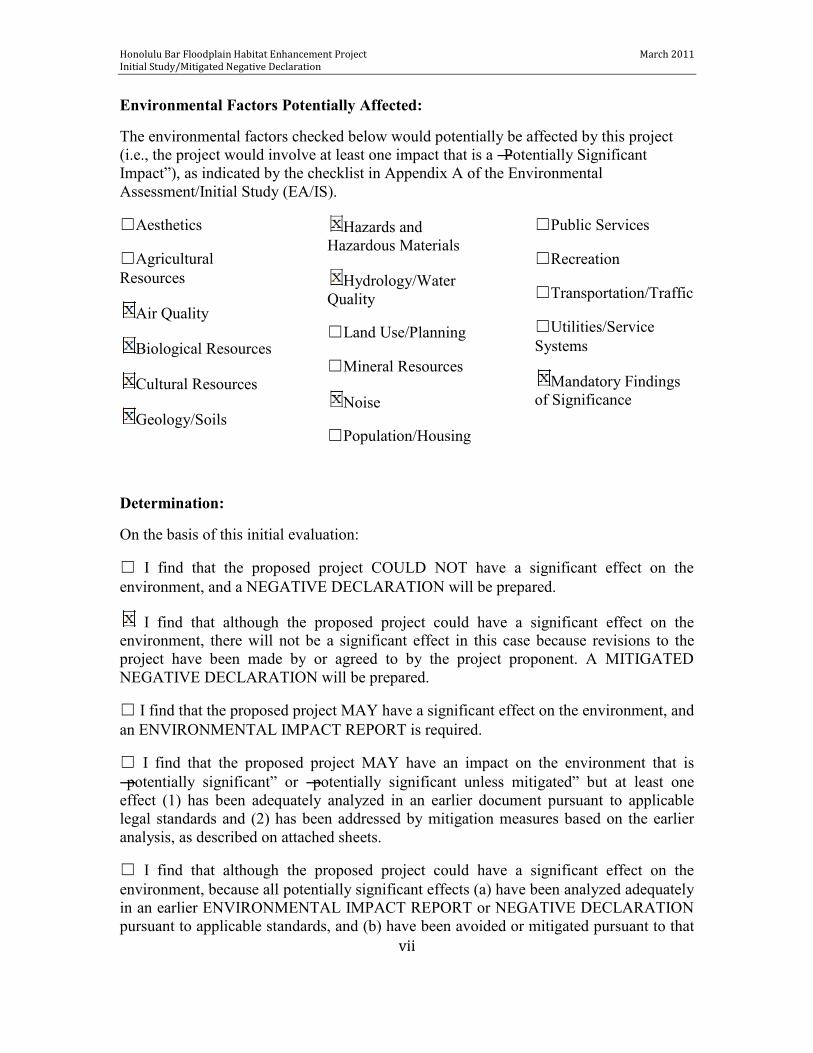
Environmental Factors Potentially Affected:
The environmental factors checked below would potentially be affected by this project (i.e., the project would involve at least one impact that is a ―Potentially Significant Impact‖), as indicated by the checklist in Appendix A of the Environmental Assessment/Initial Study (EA/IS).
☐Aesthetics
☐Agricultural Resources
Air Quality
Biological Resources
Cultural Resources
Geology/Soils
Hazards and Hazardous Materials
Hydrology/Water Quality
☐Land Use/Planning
☐Mineral Resources
Noise
☐Population/Housing
☐Public Services
☐Recreation
☐Transportation/Traffic
☐Utilities/Service Systems
Mandatory Findings of Significance
Determination:
On the basis of this initial evaluation:
☐ I find that the proposed project COULD NOT have a significant effect on the environment, and a NEGATIVE DECLARATION will be prepared.
I find that although the proposed project could have a significant effect on the environment, there will not be a significant effect in this case because revisions to the project have been made by or agreed to by the project proponent. A MITIGATED NEGATIVE DECLARATION will be prepared.
☐ I find that the proposed project MAY have a significant effect on the environment, and an ENVIRONMENTAL IMPACT REPORT is required.
☐ I find that the proposed project MAY have an impact on the environment that is ―potentially significant‖ or ―potentially significant unless mitigated‖ but at least one effect (1) has been adequately analyzed in an earlier document pursuant to applicable legal standards and (2) has been addressed by mitigation measures based on the earlier analysis, as described on attached sheets.
☐ I find that although the proposed project could have a significant effect on the environment, because all potentially significant effects (a) have been analyzed adequately in an earlier ENVIRONMENTAL IMPACT REPORT or NEGATIVE DECLARATION pursuant to applicable standards, and (b) have been avoided or mitigated pursuant to that
Honolulu Bar Floodplain Habitat Enhancement Project March 2011 Initial Study/Mitigated Negative Declaration
vii
earlier ENVIRONMENTAL IMPACT REPORT or NEGATIVE DECLARATION, including revisions or mitigation measures that are imposed upon the project, nothing further is required.
Signature Date
Steve Knell, P.E., General Manager Oakdale Irrigation District Printed Name For

Honolulu Bar Floodplain Habitat Enhancement Project March 2011 Initial Study/Mitigated Negative Declaration
viii
MITIGATED NEGATIVE DECLARATION Honolulu Bar Floodplain Enhancement Project
Project Description:
The Proposed Action is within the lower Stanislaus River, a tributary to the San Joaquin River, in Stanislaus County, California. The lower Stanislaus River is defined as the stretch of river between Goodwin Dam (RM 58.4) and the river’s confluence with the San Joaquin River (RM 0). Both Chinook salmon (Oncorhynchus tshawytscha) and Central Valley steelhead (O. mykiss) are found in the lower Stanislaus River, which is listed as essential fish habitat for fall-run Chinook salmon and critical habitat for steelhead.
Studies suggest that loss of rearing and spawning habitat may limit juvenile salmonid production in the lower Stanislaus River (SRFG 2004) and restoration of instream and riparian habitat are priority actions (AFRP 2001). Therefore, there is a need to increase juvenile salmonid rearing opportunities and reduce the potential for adult stranding by improving the quality and quantity of accessible salmonid habitat.
The Proposed Action is designed to create or restore several aquatic and riparian habitat elements in the Stanislaus River including 2.4 acres of floodplain habitat on the inside edge of a mid-channel island, 0.7 acres of floodplain bench in the south side of the river upstream of the mid-channel island, 0.4 acres of spawning riffle in the river adjacent to the mid-channel island, 3.85+ acres of native vegetation, and increased frequency and duration of flow connectivity in one mile of side channel habitat. Objectives of the Project include (1) restoring seasonally inundated floodplain habitat, (2) restoring year-round rearing habitat, (3) addressing an existing adult stranding issue, (4) increasing usable spawning habitat area, (5) increasing hiding cover, velocity refugia, habitat complexity, and instream habitat types, and (6) restoring native vegetation.
A portion of the Proposed Action (2.4 acres of floodplain habitat and associated native vegetation restoration) is a mitigation project that was chosen to compensate for 0.6 acres (at a ratio of 4:1) of seasonal wetlands/vernal pools that has been adversely impacted by the construction of the Oakdale Irrigation District’s (OID) North Side Regulating Reservoir Project, which is located approximately 0.5 mile east of 28-Mile Road and 0.5 mile south of Frankenheimer Road, northeast of the City of Oakdale, California. Based on the terms and conditions of the final 404 Permit, OID is responsible for the restoration of 2.4 acres of seasonal wetland/floodplain and riparian habitat. OID was unable to obtain in-kind mitigation of 2.4 acres of vernal pool creation credits for the North Side Regulating Reservoir Project to the satisfaction of the U. S. Army Corps of Engineers (Corps). To meet the requirement of the Corps Individual Permit, out-of-kind mitigation for floodplain and side channel habitat restoration at Honolulu Bar Recreation Area (RM 49 to RM 50) was proposed and accepted. The Honolulu Bar Recreation Area is owned and operated by the Corps’ Stanislaus River Parks.

Honolulu Bar Floodplain Habitat Enhancement Project March 2011 Initial Study/Mitigated Negative Declaration
ix
Partial funding (50% cost-share) for the Honolulu Bar Floodplain Enhancement Project has been provided by the U.S. Fish and Wildlife Service Anadromous Fish Restoration Program (AFRP). Finding:
Although the Proposed Action may have the potential to cause minor short-term impacts on air quality, biological resources, cultural resources, hazardous materials, noise, soils, and water quality, the measures that will be incorporated into the project to avoid significant impacts will reduce such impacts to less-than-significant levels (see attached Environmental Assessment/Initial Study).
Basis for the Finding:
Based on the Environmental Assessment/Initial Study prepared for this Project, it was determined that there would not be significant adverse environmental effects resulting from implementing the Proposed Action. The Project is expected to achieve a net benefit to the environment by increasing salmonid rearing and spawning habitat at Honolulu Bar, and reducing the potential for adult salmonid stranding.
The Oakdale Irrigation District finds that implementing the Proposed Action will have no significant environmental impact with incorporation of the identified mitigation measures.
This Mitigated Negative Declaration is filed pursuant to the California Environmental Quality Act Guidelines.
Signature Date
Steve Knell, P.E., General Manager Oakdale Irrigation District Printed Name For

Honolulu Bar Floodplain Habitat Enhancement Project March 2011 Initial Study/Mitigated Negative Declaration
x
Table of Contents
1.0 INTRODUCTION ......................................................................................................................... 1
1.1 Purpose and Need ...................................................................................................................... 1
1.2 Link to Regional Water Management Programs ............................................................. 7
1.2.1 CALFED Bay-Delta Program ...................................................................................... 7
1.2.2 Central Valley Project Improvement Act ................................................................. 7
2.0 ALTERNATIVES ........................................................................................................................ 7
2.1 No Action Alternative ................................................................................................................. 7
2.2 Proposed (Preferred) Action/Project Description ............................................................ 8
3.0 AFFECTED ENVIRONMENT/ENVIRONMENTAL SETTING AND ENVIRONMENTAL CONSEQUENCES ......................................................................... 15
3.1 Environmental Setting ......................................................................................................... 16
3.2 Resources Eliminated from Detailed Analysis ............................................................. 16
3.2.1 Aesthetics ............................................................................................................................. 16
3.2.2 Agricultural Resources..................................................................................................... 17
3.2.3 Land Use and Planning .................................................................................................... 17
3.2.4 Mineral Resources ............................................................................................................. 17
3.2.5 Population and Housing................................................................................................... 17
3.2.6 Public Services ................................................................................................................... 17
3.2.7 Recreation ............................................................................................................................ 18
3.2.8 Socioeconomics ................................................................................................................. 18
3.2.9 Transportation and Traffic .............................................................................................. 18
3.2.10 Utilities and Service Systems ...................................................................................... 18
3.2.11 Environmental Justice .................................................................................................... 19
3.2.12 Indian Trust Assets ......................................................................................................... 19
3.3 Air Quality ................................................................................................................................... 19

Honolulu Bar Floodplain Habitat Enhancement Project March 2011 Initial Study/Mitigated Negative Declaration
xi
3.4 Biological Resources ................................................................................................................ 22
3.5 Cultural Resources..................................................................................................................... 35
3.6 Geology and Soils ...................................................................................................................... 36
3.7 Hazards and Hazardous Materials ........................................................................................ 38
3.8 Hydrology and Water Quality ................................................................................................ 39
3.9 Noise .............................................................................................................................................. 44
3.10 Comparison of Impacts .......................................................................................................... 45
4.0 CUMULATIVE EFFECTS .................................................................................................... 46
5.0 CONSULTATION/COORDINATION/PUBLIC INVOLVEMENT ........................ 46
6.0 CONCLUSIONS ........................................................................................................................ 46
7.0 LIST OF PREPARERS ............................................................................................................ 47
8.0 REFERENCES ........................................................................................................................... 48
Appendix A. CEQA CHECKLIST ................................................................................................. A-1
Appendix B. Revegetation Plan ...................................................................................... B-1
Appendix C. Mitigation Monitoring and Reporting Plan ............................................... C-1
Appendix D. Physical and Biological Resources Monitoring Plan ................................ D-1

Honolulu Bar Floodplain Habitat Enhancement Project March 2011 Initial Study/Mitigated Negative Declaration
xii
Tables
Table 1. Best Management Practices .............................................................................................. 12
Table 2. Attainment Status of Criteria Pollutants in the San Joaquin Valley ...................... 20
Table 3. Comparison of Impacts among Alternatives ................................................................ 45
Figures
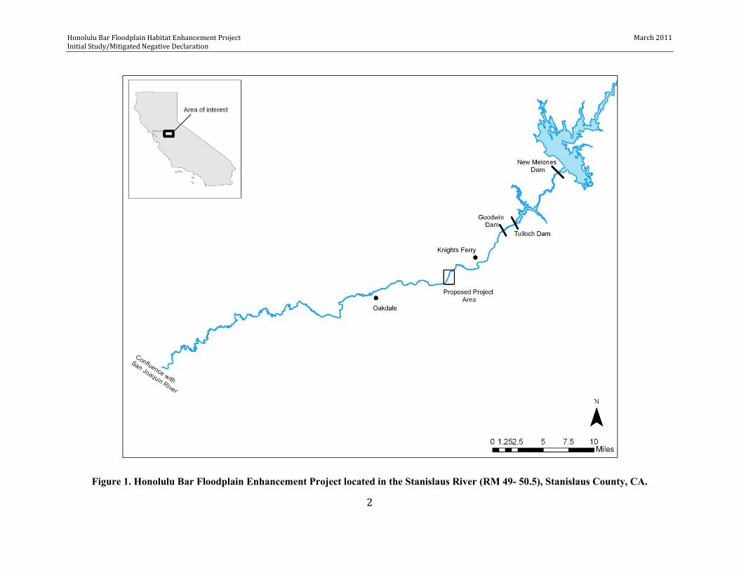
Figure 1. Honolulu Bar Floodplain Enhancement Project located between RM 49 and
RM 50.5 in the Stanislaus River, San Joaquin County, CA .............................................. 2
Figure 2. Honolulu Bar Floodplain Enhancement Project area and vicinity roadways .............................................................................................................................................................. 4
Figure 3. Honolulu Bar Floodplain Enhancement Project existing topography conditions ......................................................................................................................................... 5
Figure 4. Honolulu Bar Floodplain Enhancement Project general grading plan ........... 6
Figure 5. Potential wetland identified adjacent to the footprint of the Honolulu Bar Floodplain Enhancement Project ......................................................................................... 30
Figure 6. Floodplain inundation frequency in vicinity of Honolulu Bar Floodplain Enhancement Project ................................................................................................................ 42

Honolulu Bar Floodplain Habitat Enhancement Project March 2011 Initial Study/Mitigated Negative Declaration
1
1.0 INTRODUCTION This Environmental Assessment/Initial Study (EA/IS) evaluates the potential environmental effects associated with implementation of the Proposed Action, which is to improve the quality and quantity of salmonid habitat within the lower Stanislaus River. The EA portion of this document is prepared pursuant to the National Environmental Policy Act, 42 U.S.C. § 4431 et seq. (NEPA), with the United States Fish and Wildlife Service (USFWS) serving as the federal lead agency. The IS portion of this document is prepared pursuant to the California Environmental Quality Act, California Public Resource Code § 21000 et seq. (CEQA), with Oakdale Irrigation District (OID) serving as the lead agency for the CEQA analysis. The U.S. Army Corps of Engineers (Corps) owns and maintains the property where the Project addressed by this EA/IS analysis will be implemented.
The Proposed Action seeks to increase improve the quality and quantity of available salmonid habitat in the lower Stanislaus River through enhancement of floodplain, spawning, and side-channel habitat along approximately 1.5 miles of river within and adjacent to Honolulu Bar Recreation Area (RM 49 to RM 50.5)(Figure 1). The Stanislaus River is a tributary to the San Joaquin River, in Stanislaus County, California and the lower river is defined as the stretch of river between Goodwin Dam (RM 58.4) and the river’s confluence with the San Joaquin River (RM 0). This EA/IS evaluates the potential impacts from construction and maintenance associated with the following activities:
Creating seasonally inundated floodplain habitat Restoring year-round side channel rearing habitat Restoring self-sustaining native riparian vegetation Augmenting gravel into the mainstem
The ES/IS identifies mitigation measures that have been incorporated into the Project design to reduce impacts to a less than significant level. The conclusion from the evaluation of this EA/IS is that the Proposed Action, with mitigation incorporated, will not result in any significant direct or indirect impacts to the human environment.
1.1 Purpose and Need The lower Stanislaus River between Goodwin Dam (RM 58.4) and the confluence with the San Joaquin River has been designated as essential fish habitat for species of concern fall-run Chinook salmon (Oncorhynchus tshawytscha) and critical habitat for federally threatened Central Valley steelhead (O. mykiss). Spawning may occur from Goodwin Dam to Orange Blossom Bridge (RM 46.9) for steelhead and to Riverbank (RM 33) for salmon. However, the majority of salmonid spawning and juvenile rearing takes place in the ten-mile stretch below Goodwin Dam (RM 58.3 to RM 48), which encompasses the Project area.
Honolulu Bar Floodplain Habitat Enhancement Project March 2011 Initial Study/Mitigated Negative Declaration
2
Figure 1. Honolulu Bar Floodplain Enhancement Project located in the Stanislaus River (RM 49- 50.5), Stanislaus County, CA.
Honolulu Bar Floodplain Habitat Enhancement Project March 2011 Initial Study/Mitigated Negative Declaration
3
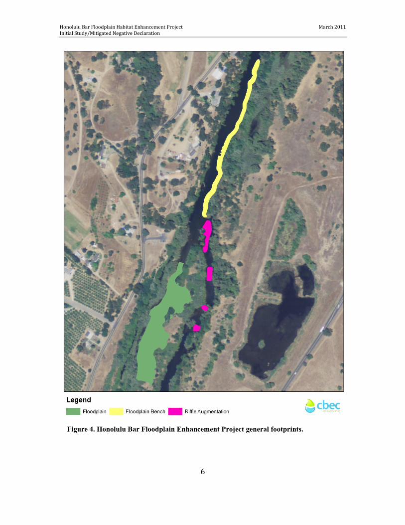
Studies suggest that loss of rearing and spawning habitat may limit juvenile Chinook salmon production in the lower Stanislaus River (SRFG 2004) and restoration of instream and riparian habitat are priority actions (AFRP 2001). The Project site (Figures 2, 3, and 4) currently has a limited amount of floodplain habitat and is fully inundated only under rare flood level events (i.e., > 5,000 cfs); therefore, it provides little functional salmon rearing habitat under the current flow regime. The current side-channel provides rearing habitat for salmon and steelhead under higher flow conditions, but is dewatered at flows under 250 cfs and connectivity between habitats within the side channel is reduced at flows under 350 cfs. The side-channel is also a known area for stranding of adult salmon that attempt to utilize the side-channel for spawning. Therefore, there is a need to create seasonally inundated floodplain habitat and restore side-channel habitat, which will increase opportunities for steelhead and salmon to access quality rearing habitat and to reduce the potential for adult stranding. The purpose of the Proposed Action is to create or restore several aquatic and riparian habitat elements in the Stanislaus River 2.4 acres of floodplain habitat on the inside edge of a mid-channel island, 0.7 acres of floodplain bench in the south side of the river upstream of the mid-channel island, 0.4 acres of spawning riffle in the river adjacent to the mid-channel island, 3.85+ acres of native vegetation, and increased frequency and duration of flow connectivity in one mile of side channel habitat (Figure 4). Objectives of the Project include: (1) restoring seasonally inundated floodplain habitat, (2) restoring year-round rearing habitat, (3) addressing an existing adult stranding issue, (4) increasing usable spawning habitat area, (5) increasing hiding cover, velocity refugia, habitat complexity, and instream habitat types, and (6) restoring native vegetation. Stanislaus River aquatic and riparian habitat improvement actions are deemed an important component to contribute to the USFWS AFRP’s salmonid restoration efforts. These would contribute toward the implementation goals of several existing Central Valley fish and wildlife restoration plans to create a healthier, more-natural functioning ecosystem; enhance and restore aquatic and riparian habitats; protect and/or recover threatened and endangered species; and augment cumulative efforts to at least double populations of anadromous fish in Central Valley streams. In addition, the 2.4 acre floodplain and native vegetation restoration components will serve as a mitigation project to compensate for 0.6 acres (at a ratio of 4:1) of seasonal wetlands/vernal pools that has been adversely impacted by the construction of OID’s North Side Regulating Reservoir Project, which is located approximately 0.5 mile east of 28-Mile Road and 0.5 mile south of Frankenheimer Road, northeast of the City of Oakdale, California. OID was unable to obtain in-kind mitigation of 2.4 acres of vernal pool creation credits for the reservoir project to the satisfaction of the Corps; therefore, out-of-kind mitigation for a floodplain habitat restoration project (i.e., the Proposed Action) in the lower Stanislaus River at Honolulu Bar Recreation Area (RM 49 to RM 50) was proposed and accepted. Based on the terms and conditions of the final 404 Permit for the reservoir project, OID is responsible for the restoration of 2.4 acres of seasonal wetland/floodplain and riparian habitat at Honolulu Bar Recreation Area.

Honolulu Bar Floodplain Habitat Enhancement Project March 2011 Initial Study/Mitigated Negative Declaration
4
Figure 2. Honolulu Bar Floodplain Enhancement Project area and vicinity roadways.

Honolulu Bar Floodplain Habitat Enhancement Project March 2011 Initial Study/Mitigated Negative Declaration
5
Figure 3. Honolulu Bar Floodplain Enhancement Project existing topography conditions.
Honolulu Bar Floodplain Habitat Enhancement Project March 2011 Initial Study/Mitigated Negative Declaration
6
Figure 4. Honolulu Bar Floodplain Enhancement Project general footprints.
Honolulu Bar Floodplain Habitat Enhancement Project March 2011 Initial Study/Mitigated Negative Declaration
7
1.2 Link to Regional Water Management Programs The Proposed Action is also directly tied to the objectives of the CALFED Bay-Delta Program and the Central Valley Project Improvement Act Anadromous Fish Restoration Program (AFRP), both through project funding and the primary project objective of improving the steelhead and salmon fishery. 1.2.1 CALFED Bay-Delta Program The Proposed Action is explicitly linked to the CALFED ecosystem quality goal of achieving recovery of at-risk native species. In part, the objective of the CALFED Ecosystem Restoration Program (ERP) is to improve and increase aquatic habitat and improve ecological functions in the Bay-Delta watershed and its tributaries (e.g. Stanislaus River) to support sustainable populations of valuable species. The lower Stanislaus River supports fall-run Chinook and a population of rainbow/steelhead trout. Several studies have suggested that loss of rearing habitat and degraded spawning habitat may limit juvenile salmon production in the lower Stanislaus River (SRFG 2004). As a result, a number of gravel enhancement and restoration initiatives have been identified and are being conducted to improve spawning and rearing habitat for anadromous fish in the lower Stanislaus River. 1.2.2 Central Valley Project Improvement Act The Central Valley Project Improvement Act directed the Secretary of the Interior to establish a program to make all reasonable efforts to at least double the natural production of anadromous fish in California’s Central Valley streams. This direction resulted in the establishment of the AFRP and development of a restoration plan. The Proposed Action will address the Central Valley Project Improvement Act priority to ―protect and restore natural channel and riparian habitat values through habitat restoration actions‖ and AFRP purposes and funding priorities to (1) improve habitat for all life stages of anadromous fish through improved physical habitat, (2) collect fish population, health, and habitat data to facilitate evaluation of restoration actions, and (3) involve partners in the implementation and evaluation of restoration actions. Partial funding (50% cost-share) for the Proposed Action has been provided by the AFRP. 2.0 ALTERNATIVES 2.1 No Action Alternative Under this alternative, no habitat enhancement or restoration would be implemented. As a result, functional floodplain habitat at Honolulu Bar would only be inundated at flows above 5,000 cfs and the side-channel would continue to become disconnected at flows less than 350 cfs, which would limit the amount of functional rearing habitat available and adult salmonid stranding could potentially occur in the side-channel. In addition, non-native invasive vegetation would not be removed and would continue to outcompete native vegetation on the gravel bar and riverbanks.
Honolulu Bar Floodplain Habitat Enhancement Project March 2011 Initial Study/Mitigated Negative Declaration
8
2.2 Proposed (Preferred) Action/Project Description Under this alternative, several aquatic and riparian habitat elements would be created or restored including 2.4 acres of floodplain habitat on the inside edge of a mid-channel island, 0.7 acres of floodplain bench in the south side of the river upstream of the mid-channel island, 0.4 acres of spawning riffle in the river adjacent to the mid-channel island, 3.85+ acres of native vegetation, and increased frequency and duration of flow connectivity in one mile of side channel habitat. Improvements in aquatic habitat features will improve the function and value of existing fish rearing habitats. The floodplain habitat created, both on the mid-channel island and in the mainstem, will provide seasonal juvenile salmon rearing opportunities under the expected Stanislaus River flow regime. Juvenile rearing opportunities within the side-channel and mainstem will be improved by increasing the amount of quality habitat available over a wider range of river flows. Restoration of native vegetation will promote shade and support invertebrate food supply for juvenile salmonid rearing. Native vegetation will also provide habitat and food source benefits to a suite of songbirds, native pollinators, and other wildlife.
The Proposed Action consists of the following components:
Constructing improvements (i.e., clearing vegetation) to two existing access paths to reach Project area. Improvements to this area will allow equipment access for project construction and long-term maintenance, as well as provide a place to conduct interpretative tours.
Extracting an estimated 10,800 cubic yards of sediment (i.e., cobbles, coarse gravels, sand, and finer materials) from the Project site by excavating roughly 2.4 acres from the west side of the mid-channel island located at Honolulu Bar Recreation Area. Due to limited open space on the mid-channel island, sediment stockpiling will be minimal. Rather, sediments will be screened, sorted, and cleaned at variable locations within the cut and fill footprints of the mid-channel island and made available for immediate placement into other areas of the Project. Up to 3,000 cubic yards of fine materials will be moved to the south side of the river channel within the Honolulu Bar Recreation Area, and placed outside of the 8,000 cfs flood channel. This will decrease the potential amount of fine materials introduced to the river, as well as increase the potential for future floodplain restoration on the mid-channel island. All sediment materials that are excavated will be used within the Project area. No excavated materials will be transported or sold off the project site.
Grading and removing encroached vegetation in 0.39 acres of side channel to increase the frequency and duration that the entire side channel is wetted under a wider range of flows and to enhance floodplain inundation.
Gravel processing will be performed to sort materials into several size ranges including 1) cobbles and larger rocks for reuse on the mid-channel floodplain; 2) gravels within a preferred particle size distribution suitable for spawning purposes for use in the mainstem; and 3) fine material and excess fine gravels to be used as onsite fill outside the floodplain footprint, and placed on the south side of the river channel within the Honolulu Bar Recreation Area, with the exception of the cutslope. Spawning sized

Honolulu Bar Floodplain Habitat Enhancement Project March 2011 Initial Study/Mitigated Negative Declaration
9
gravels that will be placed in waterways (e.g., mainstem floodplain bench and select riffles) will be cleaned to reduce potential water quality problems.
Placing roughly 8,100 cubic yards of gravels (generated from extraction activities) into south side of river upstream of the mid-channel island between RM 49.7 and RM 50.5 to create a floodplain bench. The gravels will be screened and sorted to produce a preferred gravel mix (also suitable for augmentation of spawning riffles) with d16 = 0.5 inch, d50 = 1.0 inch, and d84 = 2.0 inch. The floodplain bench will be approximately sloped 10:1 from the left bank down to the 200 cfs water surface profile with a 2:1 fill slope. The constructed bench will be 22 feet wide and will be approximately 1,660 linear feet. Bench construction may be delayed until the following summer, dependent on one or more factors (e.g., excavation and/or screening delays, funding constraints). In this event, screened material will be stockpiled on the south side of the river channel within the Honolulu Bar Recreation Area, and outside of the 8,000 cfs flood channel. This location is outside of public access within the park and is not visible by recreational users.
Contouring of mid-channel island floodplain and associated side channel, contouring mainstem floodplain bench, augmenting spawning riffles, and placing fill materials onsite will be conducted according to approved final designs.
Revegetating the site with native plant species will be conducted according to details provided in Appendix B.
A Mitigation Monitoring and Reporting Plan (Appendix C) will be implemented to ensure compliance during project implementation.
The Proposed Action will be accomplished through implementation of the following activities:
A. Preconstruction Activities
1. Tree and shrub removal will be conducted prior to construction. However, to protect nesting raptors or other birds, no trees or shrub removal will occur from March 1 through July 1. Removed vegetation will be temporarily stockpiled in the staging area and subsequently disposed of offsite at approved landfill area.
2. Pre-construction amphibian and reptile surveys will be performed in the work area no more than 10 days prior to the beginning of construction, and results submitted to the CDFG and FWS prior to commencement of construction, if any animals are observed, OID’s Engineer shall contact CDFG and FWS and mitigation specific to each incident shall be developed.
3. Erect clearly visible construction tape as fencing in the following areas: 20 feet in diameter from the outer edge of the dripline of elderberry plants, and attach signs every 50 feet as needed.
4. Educate construction personnel regarding avoidance of special status species (e.g., elderberry plants, fish, amphibians and reptiles) and archeological resources. Train personnel to stop work upon observation of a special status species or archeological resource within the work area, and notify OID’s Engineer of their discovery. The Engineer shall stop work to confirm if the resource could be avoided and consult with a qualified biologist or archeologist.
5. Prior to construction, equipment will be brought to a staging area consisting of an open area located in the upper section of the recreation area and adjacent to the west side of the

Honolulu Bar Floodplain Habitat Enhancement Project March 2011 Initial Study/Mitigated Negative Declaration
10
parking lot. The staging area would be used as a place to off load equipment (e.g., hydraulic excavator, bulldozer, and backhoe loader) from trucks and to park vehicles (e.g., cars and small/medium trucks). All refueling and maintenance of equipment will occur in the staging area to avoid spillage of fluids into or near the river.
6. Prior to construction, two existing park access roads will be improved to accommodate equipment. The main access point (~ 15 feet wide) will be along an existing path that is adjacent to the east side of the parking lot. Improvements to the main access path will require some trimming of overhanging tree branches but will avoid removing any trees; this trail will be graded to a 4:1 slope to allow equipment access to the grading area. The secondary access path (~ 6 feet wide) will be along an existing path at the lower end of the Recreation Area; improvements to this path will require a minimal amount of vegetation trimming. Fill material from the excavation site may be used to re-contour access paths.
7. Prior to construction, a temporary water-filled bladder dam will be installed at the upstream end of the side channel to ensure that river flows do not enter the work area, specifically the side channel lowering footprint. This dam will ensure that conditions within the side channel are similar to those that typically occur under existing low summer flow conditions (i.e., flows are generally below 300 cfs which result in disconnection of the upstream and downstream end of the side channel from the river, with only a few isolated pools located throughout the side channel). The water bladder will be removed at the end of construction.
8. During installation of the water-filled bladder dam, a qualified biologist will be onsite to relocate any aquatic vertebrates according to Best Management Practices (BMPs).
9. Preconstruction monitoring will be conducted to provide baseline information for evaluating the relative success of created/improved habitat according to details provided in Appendix D (Physical, Fisheries, Invertebrates, Revegetation, and Photopoint).
B. Construction Activities
Construction activities will be implemented during the summer months when river flows are typically low (i.e., less than 300 cfs). Construction activities will begin no earlier than July 2 and end no later than September 30. The summer timeframe was chosen for the lower Stanislaus River because it minimizes the potential for impacts to listed species by occurring outside of salmonid spawning and primary migratory periods and outside of the nesting season for raptors and other birds; no other special status species (e.g., bats, fish, mammals, amphibians and reptiles) are anticipated to be within the Project area either due to geographic location or the timeframe selected.
1. Equipment operation (e.g., excavating, screening, washing, gravel placement, contouring) shall be limited to 7:00 am to 5:00 pm Monday through Saturday. Equipment may include, but is not limited to, a hydraulic excavator, bulldozer, backhoe loader, wheel loader, and hand tools.
2. The Honolulu Bar Recreation Area will be closed to the public during the time of construction activities. Signs will be placed at the Honolulu Bar Recreation Area parking lot, upstream of the Project area, at boat ramps, and at the Corps’ Stanislaus River Parks office. During construction activities in the main channel, spotters will be located at the
Honolulu Bar Floodplain Habitat Enhancement Project March 2011 Initial Study/Mitigated Negative Declaration
11
upstream end of the area where work is occurring to assist rafters to safely navigate through the Project area. In-channel activities will be suspended when recreational river users are within 200 feet of project activities.
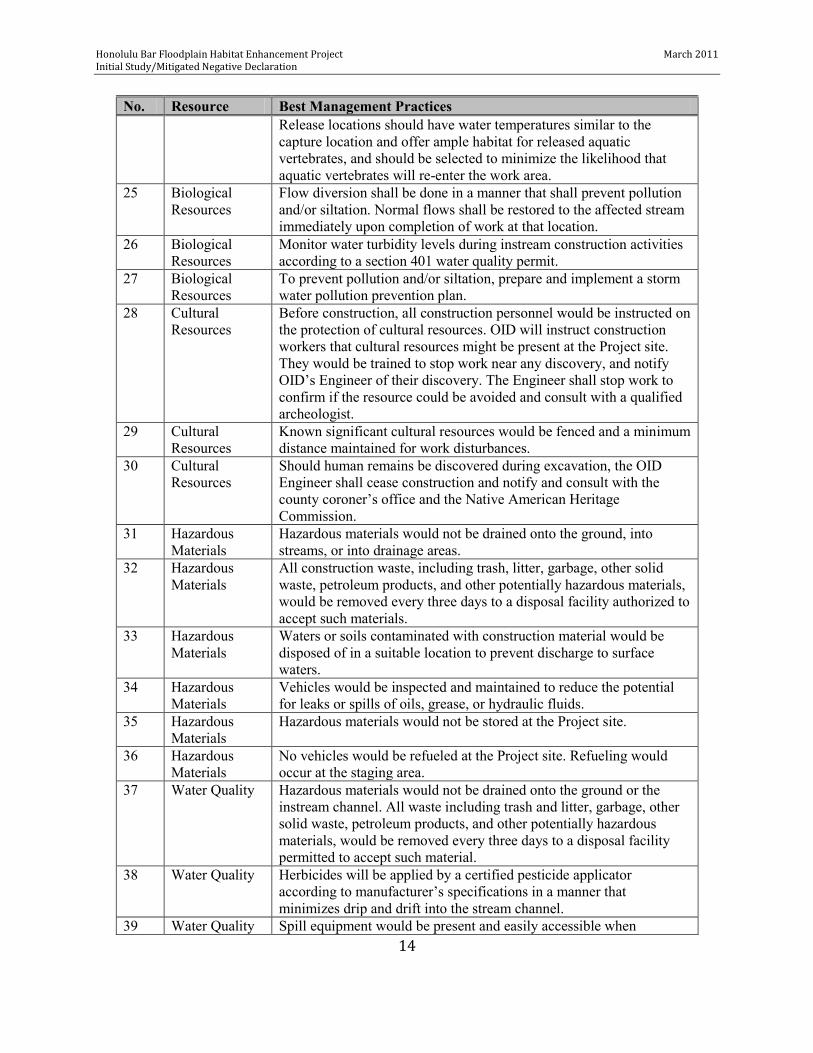
3. OID has developed BMPs to reduce environmental consequences associated with construction of floodplain and side-channel habitat (Table 1). All work shall be conducted in accordance with BMPs and any additional terms and conditions established by various permits and authorizations.
C. Post-Construction Activities
1. Demobilizing and clean up would be conducted as soon as possible after construction and before the rainy season begins (October 15) in the construction year. Construction equipment would be moved to the staging area, from which it would be trucked back to the Operator’s storage yard. Upon removal of the equipment, the construction, staging areas, and access paths would be ―cleaned‖ and contoured to the satisfaction of the Corps’ Stanislaus River Parks (SRP) Manager. Fill material from excavation site may be used to re-contour access paths.
2. Revegetating the site will be conducted initially in the fall after construction is completed. Active vegetation management with native plant species will enhance habitats and restore riparian vegetation on site. The planting design for vegetation restoration on the site includes implementation plan and specifications (e.g. schedule; species composition and quantity; plant protection); site maintenance (e.g., weed control, replanting); performance standards; and monitoring (Appendix B). Once planted, the site would be intensively managed (maintenance, irrigation, weed control, etc) until the plants are established and have a high likelihood of unaided survival, typically three years based on experience at other restoration areas in the Stanislaus River watershed.
3. Post-construction monitoring will be conducted to compare with preconstruction monitoring to evaluate the relative success of created/improved habitat according to details provided in Appendices D (Physical, Fisheries, Invertebrates, Revegetation, and Photopoint). Monitoring will be conducted for 10 years after project completion or until success criteria have been met, whichever is greater. Additionally, continued success without human intervention must be demonstrated for three consecutive years once the success criteria have been met.
D. Outreach and Education
Existing outreach and educational tools implemented by OID and FISHBIO (e.g., electronic newsletter and previously established sanjoaquinbasin.com) will continue to be used as needed to inform and educate public stakeholders regarding the Proposed Action’s goals and performance.

Honolulu Bar Floodplain Habitat Enhancement Project March 2011 Initial Study/Mitigated Negative Declaration
12
Table 1. Best Management Practices
No. Resource Best Management Practices 1 Air Quality All requirements of San Joaquin Valley Air Pollution Control District
(SJVAPCD) Rules 8011 and 8021 would be adhered to and any permits or training needed for construction activities would be obtained.
2 Air Quality Open burning of construction waste would not be allowed. 3 Air Quality Project participant would use reasonably practicable methods and
devices to control, prevent, and otherwise minimize atmospheric emissions or discharges of air contaminants.
4 Air Quality Visible emissions from diesel-powered equipment would be controlled.
5 Air Quality Equipment and vehicles that show excessive emissions of exhaust gases due to poor engine adjustments or other inefficient operating conditions would not be operated until corrective repairs or adjustments were made.
6 Air Quality Vehicles and equipment used in construction of the Project would maintain appropriate emissions control equipment and be permitted, if required.
7 Air Quality Construction would follow the recommended measures outlined in the Project’s dust control plan. Measures include watering and other approved suppressing agents for limiting dust generation during construction.
8 Air Quality Fill material storage piles would include dust-control measures such as water.
9 Air Quality Ground surfaces outside of bankfull channel, which have been significantly disturbed, will be seeded to prevent wind dispersion of soil, as needed.
10 Air Quality Removal of vegetation and ground disturbance would be limited to the minimum necessary to complete construction activities. Vegetative cover would be maintained in appropriate areas to reduce dust.
11 Air Quality Regular watering of exposed soils and unpaved access roads would be conducted during the construction period.
12 Air Quality Grading activities would cease during periods of high winds (greater than 25 miles per hour [mph] averaged over one hour).
13 Air Quality Trucks transporting loose material would be covered or maintain at least two feet of freeboard and not create any visible dust emissions.
14 Biological Resources
Construction activities would be conducted between July 2 and September 30, when flows are lowest and the side-channel is disconnected. This construction timeframe would be outside primary salmonid migration/spawning period and outside of the nesting season for raptor and other birds.
15 Biological Resources
Before construction, all construction personnel would be instructed on the protection of biological resources. OID will instruct construction workers about the special status species that might be present at the Project site. They would be trained to stop work upon observation of a special status species within the work area, and notify OID’s

Honolulu Bar Floodplain Habitat Enhancement Project March 2011 Initial Study/Mitigated Negative Declaration
13
No. Resource Best Management Practices Engineer of their discovery. The Engineer shall stop work to confirm if the resource could be avoided and consult with a qualified biologist.
16 Biological Resources
A wetland area adjacent to the project site will not be disturbed. To prevent accidental impacts to wetlands from equipment and personnel, the wetland area shall be clearly marked with highly visible construction tape prior to, and marking shall be maintained for the full duration of construction.
17 Biological Resources
To prevent the spread of noxious weeds, construction personnel will be educated regarding weed control and spread prevention, equipment will be rinsed prior to use at the Project site; and native plant species and certified weed free materials will be used for replanting and erosion control.
18 Biological Resources
All elderberry plants will not be disturbed within the project site; elderberry plants shall be clearly marked with highly visible construction tape and signage prior to, and maintained for the full duration of construction.
19 Biological Resources
Herbicide use will be restricted to the minimum needed to ensure adequate control of invasive non-native vegetation. Where other effective means of control are available, these will be prioritized. Herbicide use will conform to label instructions and be undertaken by a certified pesticide applicator.
20 Biological Resources
On completion of the work, disturbed areas would be left in a condition that would facilitate natural or appropriate vegetation, provide for proper drainage, and prevent erosion or be revegetated.
21 Biological Resources
To prevent aquatic vertebrates (fish, amphibians, and reptiles) from entering the wetted Project area within and adjacent to the side channel, flows will be diverted from the work area prior to construction. Pre-construction aquatic vertebrate surveys will be performed in the work area no more than 10 days prior to the beginning of flows being diverted, any aquatic vertebrates present in the work area will be relocated under the supervision of a qualified biologist and NMFS, FWS and CDFG will be notified.
22 Biological Resources
Pre-construction special status species surveys will be performed in the non-wetted portion of the work area no more than 10 days prior to the beginning of construction, any special status species present in the work area will be relocated under the supervision of a qualified biologist upon notification and approval of CDFG and FWS.
23 Biological Resources
Before diverting flows, the Project Engineer and a qualified biologist will identify the best means to bypass flow around the work area to minimize disturbance to the channel and avoid mortality of fish and other aquatic vertebrates. Flow will be incrementally diverted at the upstream boundary of the work area to allow aquatic vertebrates in the area to move downstream. Any aquatic vertebrates present in the work area following flow diversion will be relocated under the supervision of a qualified biologist.
24 Biological Resources
Before aquatic vertebrate removal and relocation begins, a qualified biologist will identify the most appropriate release location(s).
Honolulu Bar Floodplain Habitat Enhancement Project March 2011 Initial Study/Mitigated Negative Declaration
14
No. Resource Best Management Practices Release locations should have water temperatures similar to the capture location and offer ample habitat for released aquatic vertebrates, and should be selected to minimize the likelihood that aquatic vertebrates will re-enter the work area.
25 Biological Resources
Flow diversion shall be done in a manner that shall prevent pollution and/or siltation. Normal flows shall be restored to the affected stream immediately upon completion of work at that location.
26 Biological Resources
Monitor water turbidity levels during instream construction activities according to a section 401 water quality permit.
27 Biological Resources
To prevent pollution and/or siltation, prepare and implement a storm water pollution prevention plan.
28 Cultural Resources
Before construction, all construction personnel would be instructed on the protection of cultural resources. OID will instruct construction workers that cultural resources might be present at the Project site. They would be trained to stop work near any discovery, and notify OID’s Engineer of their discovery. The Engineer shall stop work to confirm if the resource could be avoided and consult with a qualified archeologist.
29 Cultural Resources
Known significant cultural resources would be fenced and a minimum distance maintained for work disturbances.
30 Cultural Resources
Should human remains be discovered during excavation, the OID Engineer shall cease construction and notify and consult with the county coroner’s office and the Native American Heritage Commission.
31 Hazardous Materials
Hazardous materials would not be drained onto the ground, into streams, or into drainage areas.
32 Hazardous Materials
All construction waste, including trash, litter, garbage, other solid waste, petroleum products, and other potentially hazardous materials, would be removed every three days to a disposal facility authorized to accept such materials.
33 Hazardous Materials
Waters or soils contaminated with construction material would be disposed of in a suitable location to prevent discharge to surface waters.
34 Hazardous Materials
Vehicles would be inspected and maintained to reduce the potential for leaks or spills of oils, grease, or hydraulic fluids.
35 Hazardous Materials
Hazardous materials would not be stored at the Project site.
36 Hazardous Materials
No vehicles would be refueled at the Project site. Refueling would occur at the staging area.
37 Water Quality Hazardous materials would not be drained onto the ground or the instream channel. All waste including trash and litter, garbage, other solid waste, petroleum products, and other potentially hazardous materials, would be removed every three days to a disposal facility permitted to accept such material.
38 Water Quality Herbicides will be applied by a certified pesticide applicator according to manufacturer’s specifications in a manner that minimizes drip and drift into the stream channel.
39 Water Quality Spill equipment would be present and easily accessible when

Honolulu Bar Floodplain Habitat Enhancement Project March 2011 Initial Study/Mitigated Negative Declaration
15
No. Resource Best Management Practices refueling any equipment.
40 Water Quality Fueling, cleaning, and maintenance of any equipment would not be allowed except in designated areas located as far from the instream channel as possible.
41 Water Quality Grading activities would implement erosion and sediment control measures.
42 Water Quality OID would prepare a Storm Water Pollution Prevention Plan (SWPPP) and implement appropriate measures.
43 Water Quality Stream crossings shall be limited to those identified on the project site plan
44 Water Quality All gravels shall be cleaned before being placed in the river. 45 Water Quality All gravel processing areas (cleaning, sorting, screening, stockpiling)
shall occur a minimum of 20 feet from the river channel. 46 Land Use Construction operations would be conducted to prevent unnecessary
destructing, scaring or defacing of the natural surroundings to preserve the natural landscape to the extent practicable.
47 Noise Construction would be restricted to the hours between 7:00 a.m. and 5:00 p.m.
48 Soils In construction areas where ground disturbance is substantial or where re-contouring is required, surface restoration would occur.
49 Soils Any vehicles used during construction would enter/exit project site on existing access road/paths.
50 Soils Erosion of soil would be minimized by installation of straw wattles around planting zones above the high water mark, straw mulch or erosion control blankets over bare soil areas, and silt fences, as needed
51 Soils Compaction of soil would be minimized by limiting the areas requiring heavy equipment during construction.
52 Soils To prevent the spread of noxious weeds, certified weed free materials will be used for replanting and erosion control.
3.0 AFFECTED ENVIRONMENT/ENVIRONMENTAL SETTING AND ENVIRONMENTAL CONSEQUENCES The NEPA and CEQA baseline typically encompass physical environmental conditions in the vicinity of the Project, as they exist at the time environmental analysis is commenced, representing the impacts of past and present actions. CEQA Guidelines Section 15125(a); American Rivers, 201 F.3d at 1199.
This section discusses the existing environment in the study area and identifies environmental resources that may be affected by the Proposed Action. Section 3.1 discusses the environmental setting. Section 3.2 discusses the environmental resources that were found to have no effect while preparing the CEQA Checklist (Appendix A) and were eliminated from further detailed analysis. Sections 3.3 through 3.9 include each of the environmental resources that were considered to potentially have an effect and were analyzed to determine whether there would be
Honolulu Bar Floodplain Habitat Enhancement Project March 2011 Initial Study/Mitigated Negative Declaration
16
any significant effects. Effects for these environmental resources assume that the BMPs specified in Table 1 are fully implemented.
3.1 Environmental Setting The Proposed Action is located within and adjacent to the Honolulu Bar Recreation Area between RM 49 and RM 50.5 within the lower Stanislaus River, a tributary to the San Joaquin River, and is located seven miles east of the City of Oakdale and three miles west of Knights Ferry. The lower Stanislaus River is defined as the stretch of river between Goodwin Dam (RM 58.4) and the river’s confluence with the San Joaquin River (RM 0). The Honolulu Bar Recreation Area is owned by the Corps’ SRP and the area adjacent to the Project area is also owned by the Corps’ SRP or has a riparian easement. The Project area includes portions of a mid-channel island and its associated side channel, as well as portions of the mainstem Stanislaus River adjacent to and immediately upstream of the mid-channel island (Figure 4). Gravel and gold mining, in conjunction with reduced flows and decreased coarse sediment transport as a result of dams, has resulted in deterioration of the lower Stanislaus River below the Goodwin Canyon (RM 58- RM 54) into a homogenous, incised channel with few functional floodplains or other off-channel rearing areas (SRFG 2004). Nonetheless, the lower river supports populations of rainbow/steelhead trout (O. mykiss) and Chinook salmon (Oncorhynchus
tshawytscha). The lower Stanislaus River is within the threatened Central Valley steelhead DPS (distinct population segment) and species of special concern fall-run Chinook salmon ESU (evolutionarily significant unit). The lower river is also designated critical habitat for Central Valley steelhead and essential habitat for fall-run Chinook salmon. 3.2 Resources Eliminated from Detailed Analysis The sections below were eliminated from further detailed analysis because the Proposed Action would not affect them. 3.2.1 Aesthetics The Project is located in a rural area dominated by agricultural land uses and most of the adjacent land is also owned by the Corps or has a riparian easement. The Proposed Action would take place within the Honolulu Bar Recreation Area (which will be temporarily closed for construction) and is not within view of nearby residences or within view of a scenic vista. Modifications will only be made to existing natural features in the river channel and alignment of the river channel will not be altered. Modifications will be visually and aesthetically compatible with their surroundings. Therefore, there will be no significant impact to views surrounding the Stanislaus River at Honolulu Bar to scenic resources, to the visual character or quality of the site and its surroundings, and the view as a result of increased light or glare; and a detailed aesthetic analysis for the Project is not warranted.
Honolulu Bar Floodplain Habitat Enhancement Project March 2011 Initial Study/Mitigated Negative Declaration
17
3.2.2 Agricultural Resources The Proposed Action will take place within a public recreation area owned by the Corps, so the proposed Project would not have the potential to convert prime farmland, unique farmland, or farmland of statewide importance to non-agricultural uses, nor to conflict with agricultural zoning or with a Williamson Act contract. Therefore, there will be no significant impact to farmland and a detailed land use and planning analysis for the Project is not warranted. 3.2.3 Land Use and Planning The Proposed Action within a public recreation area owned by the Corps. Construction associated with the Project does not have the potential to divide an established community or conflict with any applicable land use plan, habitat conservation plan or natural community conservation plan. Therefore, there will be no significant impact to land use and a detailed land use and planning analysis for the Project is not warranted. 3.2.4 Mineral Resources The Proposed Action would take place within a public recreation area owned by the Corps. No mineral resource recovery sites are delineated and no mining occurs within this area. Also, the Corps does not have contracts with parties for instream mineral rights (e.g., sand and gravel mining permits) at this location that would be affected by or could affect any of the Project activities. Therefore, there will be no significant impact to mineral resources and a detailed mineral resource analysis for the Project is not warranted. 3.2.5 Population and Housing The Proposed Action consists of improving existing aquatic features within the Stanislaus River channel that are within or adjacent to a public recreation area, which will not directly or indirectly increase population growth and will not displace housing units or people. Therefore, there will be no significant impact to population or housing and a detailed population and housing analysis for the Project is not warranted. 3.2.6 Public Services The Proposed Action consists of improving existing aquatic features within the Stanislaus River channel that are within or adjacent to a public recreation area and will not construct any new, or make physical alterations to governmental facilities (fire, police, school, park, or other public facilities), nor will it create the need for new or physically altered governmental facilities. Therefore, there will be no significant impact to governmental facilities and a detailed public service analysis for the Project is not warranted.

Honolulu Bar Floodplain Habitat Enhancement Project March 2011 Initial Study/Mitigated Negative Declaration
18
3.2.7 Recreation The Proposed Action consists of improving existing aquatic features within the Stanislaus River channel that are within or adjacent to a public recreation area. Habitat restoration for fisheries will not change the existing recreational use in the area, nor necessitate the construction of new recreational facilities or the expansion of existing facilities. Therefore, there will be no impact to recreation and a detailed recreation analysis for the Project is not warranted. 3.2.8 Socioeconomics The Proposed Action consists of improving existing aquatic features within the Stanislaus River channel that are within or adjacent to a public recreation area and there would be no impacts to businesses, minority populations, or other interests. Therefore, there will be no impact to socioeconomics and a detailed socioeconomic analysis for the Project is not warranted. 3.2.9 Transportation and Traffic The Proposed Action is located within a public recreation area (Corps’ SRP Honolulu Bar Recreation Area) that is located in a rural setting located three (3) miles from nearest town (i.e., Knights Ferry, population 98; Moran 2008) and seven (7) miles from Oakdale, Stanislaus County, California. General transportation patterns in this area are typical of lightly populated rural communities where roads are used by residents, recreationists, and light commercial/delivery trucks. Access to and from the public recreation area will be via local roads from Oakdale (i.e., Orange Blossom Road) and will occur primarily by passenger vehicles (cars and medium trucks) transporting construction personnel to heavy equipment that will be stored onsite. Heavy equipment will remain onsite for duration of Project. Once at the public recreation area, the Project site will be accessed through the existing parking lot and access roads. The recreation area is typically open from sun up to sun down but will likely be closed during construction (Corps’ SRP Manager, pers comm. December 2009). Due to the low number of vehicle trips per day (which will be within the typical range of use for area) and the short duration of the project, there will be no significant impact to transportation and traffic and a detailed analysis for the Project is not warranted. 3.2.10 Utilities and Service Systems The Proposed Action would not increase population in the Project area, nor would it alter the distribution of population in the Project area, either temporarily or permanently. Thus, it would not alter the need for wastewater treatment or potable water in the County. The Proposed Action would not modify existing stormwater drainage facilities, nor would it construct new facilities. Land use will not be altered in such a way that would increase residential or commercial solid waste generation. Therefore, there will be no significant impact to utilities and service systems and a detailed analysis for the Project is not warranted.
Honolulu Bar Floodplain Habitat Enhancement Project March 2011 Initial Study/Mitigated Negative Declaration
19
3.2.11 Environmental Justice Executive Order 12898 (February 11, 1994) mandates Federal agencies to identify and address disproportionately high and adverse human health or environmental effects of its programs, policies, and activities on minority and low-income populations. This Proposed Action would not be expected to disproportionately affect low-income, minority, or subsistence populations in the Project area. Therefore, there will be no impact to environmental justice and a detailed environmental justice analysis for the Project is not warranted. 3.2.12 Indian Trust Assets Indian Trusts Assets (ITAs) are legal interests in property rights held in trust by the United States for Indian tribes or individuals. Trust status originates from rights imparted by treaties, statutes, or executive orders. The Proposed Action will not affect ITAs because none exist within the study area and a detailed ITA analysis for the Project is not warranted. 3.3 Air Quality Setting. Emissions of particulate matter or visible emissions are regulated by the San Joaquin Valley Air Pollution Control District (SJVAPCD) under regulation 6 ―Particulate Matter and Visible Emissions.‖ Specifically, visible particulate emissions are prohibited where the particulates are deposited on real property other than that of the person responsible for the emissions and cause annoyance. Non-attainment Area for Federal PM2.5 Standards. The Proposed Action is within a non-attainment area for federal PM2.5 standards (Table 2). Therefore, per 40 CFR Part 93 analyses are required for conformity purposes. However, the EPA does not require hot-spot analyses, quantitative or qualitative, for projects that are not listed in section 93.123(b)(1) as an air quality concern. It was determined that the Proposed Action will not contribute to a PM2.5 hot spot that will cause or contribute to a violation of the federal PM2.5 standards. Naturally Occurring Asbestos (NOA) is prevalent in at least 42 of California’s 58 counties. Asbestos is the name for a group of naturally occurring silicate materials, and may be found in Serpentine rock, the California state rock, other ultramafic rock, and volcanic rock. When rock containing NOA is broken or crushed, asbestos may be released from the rock and may become airborne, potentially causing a health hazard. Asbestos is not known to occur in the Project area.
Odorous Emissions. In addition to the criteria pollutants, concern about odorous compounds has increased in recent years. Odorous compounds include those that can be detected by the human olfactory system, such as hydrogen sulfide and other sulfurous compounds. Odorous emissions are typically regulated by local air districts under nuisance prohibitory rules. Because odor is generally a subjective phenomenon that effect people differently, development of odor emissions standards has proven impractical. Therefore, regulators have relied on a ―nuisance‖ standard (i.e., number of odor complaints received during an ―odor episode‖) to assist in enforcing control of odorous emissions.
Honolulu Bar Floodplain Habitat Enhancement Project March 2011 Initial Study/Mitigated Negative Declaration
20
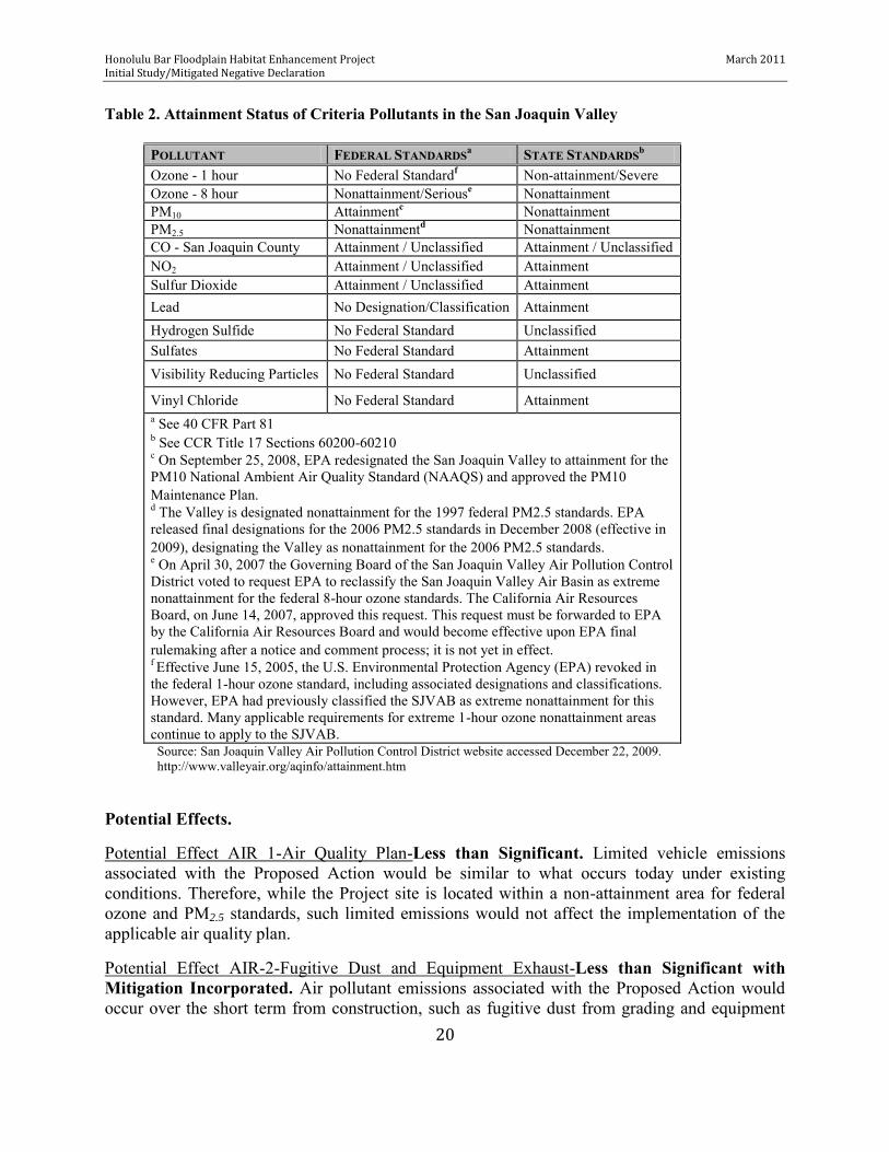
Table 2. Attainment Status of Criteria Pollutants in the San Joaquin Valley
POLLUTANT FEDERAL STANDARDSa STATE STANDARDSb Ozone - 1 hour No Federal Standardf Non-attainment/Severe Ozone - 8 hour Nonattainment/Seriouse Nonattainment PM10 Attainmentc Nonattainment PM2.5 Nonattainmentd Nonattainment CO - San Joaquin County Attainment / Unclassified Attainment / Unclassified NO2 Attainment / Unclassified Attainment Sulfur Dioxide Attainment / Unclassified Attainment Lead No Designation/Classification Attainment Hydrogen Sulfide No Federal Standard Unclassified Sulfates No Federal Standard Attainment Visibility Reducing Particles No Federal Standard Unclassified
Vinyl Chloride No Federal Standard Attainment a See 40 CFR Part 81 b See CCR Title 17 Sections 60200-60210 c On September 25, 2008, EPA redesignated the San Joaquin Valley to attainment for the PM10 National Ambient Air Quality Standard (NAAQS) and approved the PM10 Maintenance Plan. d The Valley is designated nonattainment for the 1997 federal PM2.5 standards. EPA released final designations for the 2006 PM2.5 standards in December 2008 (effective in 2009), designating the Valley as nonattainment for the 2006 PM2.5 standards. e On April 30, 2007 the Governing Board of the San Joaquin Valley Air Pollution Control District voted to request EPA to reclassify the San Joaquin Valley Air Basin as extreme nonattainment for the federal 8-hour ozone standards. The California Air Resources Board, on June 14, 2007, approved this request. This request must be forwarded to EPA by the California Air Resources Board and would become effective upon EPA final rulemaking after a notice and comment process; it is not yet in effect. f Effective June 15, 2005, the U.S. Environmental Protection Agency (EPA) revoked in the federal 1-hour ozone standard, including associated designations and classifications. However, EPA had previously classified the SJVAB as extreme nonattainment for this standard. Many applicable requirements for extreme 1-hour ozone nonattainment areas continue to apply to the SJVAB. Source: San Joaquin Valley Air Pollution Control District website accessed December 22, 2009. http://www.valleyair.org/aqinfo/attainment.htm
Potential Effects.
Potential Effect AIR 1-Air Quality Plan-Less than Significant. Limited vehicle emissions associated with the Proposed Action would be similar to what occurs today under existing conditions. Therefore, while the Project site is located within a non-attainment area for federal ozone and PM2.5 standards, such limited emissions would not affect the implementation of the applicable air quality plan.
Potential Effect AIR-2-Fugitive Dust and Equipment Exhaust-Less than Significant with Mitigation Incorporated. Air pollutant emissions associated with the Proposed Action would occur over the short term from construction, such as fugitive dust from grading and equipment

Honolulu Bar Floodplain Habitat Enhancement Project March 2011 Initial Study/Mitigated Negative Declaration
21
exhaust associated with heavy equipment used for this construction. In the context of existing practices, the small disturbance area and brief nature of work, the emissions from the construction activities will be negligible.
Because of its short duration, health risks from construction emissions of diesel particulate would result in a less than significant impact. No new, long-term regional emissions would result from implementation of the proposed Project. Implementation of BMPs (Mitigation Measure AIR-2) would reduce impacts to a less-than-significant level.
Potential Effect AIR 3-Naturally Occurring Asbestos (NOA) –No Impact. Serpentinite and ultramafic rocks have been commonly used for unpaved gravel roads, landscaping, fill projects and other improvement projects in some localities. Asbestos may be released to the atmosphere due to vehicular traffic on unpaved roads and during grading for various construction projects. The proposed Project area does not contain any known serpentine or ultramafic rock; therefore, there would be no impact. Potential Effect AIR 4-Sensitive Receptors-Less than Significant with Mitigation Incorporated. The Project site is in a rural area where there are only 12 residences within the vicinity (i.e., 300- 1,000 feet away) and is not near any schools or hospitals. In the context of existing practices, small disturbance areas, and brief nature of the work, the emissions from the maintenance activities will be negligible.
Implementation of BMPs (Mitigation Measure AIR-2) would reduce impacts to a less-than-significant level.
Potential Effect AIR 5-Odors- No Impact. Implementation of the Proposed Action would not create objectionable odors affecting a substantial number of people or subject people to objectionable odors. Therefore, there would be no impact.
Summary of Environmental Effects. Less than Significant with Mitigation Incorporated.
Mitigation.
Mitigation Measure AIR-2 – Fugitive Dust and Equipment Exhaust. Compliance with San Joaquin Valley Air Pollution Control District (SJVAPCD) Rules and Regulations during construction will reduce construction-related air quality impacts from fugitive dust emissions from construction and grading operations and construction equipment emissions to a less than significant impact when performing construction activities. These regulations will include the following BMPs:
Cover all trucks hauling soil, sand, and other loose materials.
Apply water three times daily, or apply (non-toxic) soil stabilizers on all unpaved access roads, parking areas and staging areas at construction sites.
Honolulu Bar Floodplain Habitat Enhancement Project March 2011 Initial Study/Mitigated Negative Declaration
22
3.4 Biological Resources Setting. The Project area is located within and adjacent to the Honolulu Bar Recreation Area (between RM 49 and RM 50.5) in the lower Stanislaus River. This area consists of a large mid-channel island, its associated side channel and mainstem, and riparian vegetation along the banks of both the river and the mid-channel island.
There are a number of special-status species that have been documented to occur or have the potential to occur in the lower Stanislaus River watershed (Table 3). Some of these species occupy riparian habitats and may occur near the Project area.
Chinook Salmon and Steelhead. Historic estimates indicate that the Stanislaus River supported up to 35,000 fall-run Chinook. Declines were first associated with commercial fisheries, followed by stream blockage and degradation from mining practices and by the reduction of salmon habitat and stream flows by dams and water diversions. In the last decade, between 400 and 8,500 Chinook salmon have returned to the Stanislaus River each year to spawn. The fall-run Chinook salmon currently remains far below its historical abundance and therefore, is considered a species of concern by state and federal governing agencies. Rainbow/steelhead trout have also declined over the years due to loss of habitat and are now listed as a federally threatened species. Resident rainbow trout rear in the upper reaches below Goodwin Dam, and adult steelhead are occasionally observed in upstream and downstream fish sampling. Valley Elderberry Longhorn Beetle. Eleven elderberry shrubs ranging in size from 8 to 15 feet in height were identified within the vicinity of the Project site. These shrubs may provide habitat for the Valley Elderberry Longhorn Beetle (VELB), a federally threatened species. However, past surveys conducted in 1991 and 2006 at Honolulu Bar indicate that VELB were not present (Rentner 2009, River Partners 2007) and a restoration ecologist recently stated that it is very unlikely that the bar hosts VELB (Rentner 2009).
Vegetation. Non-native trees and shrubs dominate the banks of the existing mid-channel island (Appendix B). Himalayan blackberry, Arundo donax, Scarlett wisteria, and Chinese tree of heaven occur from the wetted margins to approximately 12 feet up the banks. Other vegetation types present consist of non-native annual grasslands dominated by brome grasses (Bromus
hordeaceous, B. diandrus), with occasional shrubs or perennial herbs (Lupinus albifrons,
Brickellia californica, Aster chilensis, and Heterotheca grandiflora) and some sapling stage native trees (Salix exigua, Sambucus mexicanus, Alnus rhombifolia, and Quercus lobata). Some riparian forest (S. goodinggii, S. lasiolepis, Acer negundo, Q. lobata, and Q. berberidifolia) with significant understory dominated by Himalayan blackberry, non-native vervain (Verbena
bonariensis), and other non-native species occurs around the far eastern and western edges of the bar. The highest areas of the gravel bar are devoid of shrubs and trees and dominated by star thistle and non-native annuals.

Honolulu Bar Floodplain Habitat Enhancement Project March 2011 Initial Study/Mitigated Negative Declaration
23
Table 3. Special-status species potentially located within the Project area.
Common Name Scientific Name Status Federal/State/CNPS
Primary Habitat and Critical Seasonal Periods
Likelihood for Occurrence at Project Site
Birds
Tricolored blackbird Agelaius tricolor --/SC/--
Foraging occurs in grassland and agricultural fields. Seeks cover in emergent wetland vegetation such as cattails, tule, and bulrush. Breeding season is mid-April to late July.
Low. Some foraging habitat is found adjacent to Project site but site lacks open grassland habitat adjacent to cover.
Great blue heron Ardea herodias --/SA/--
Typically found in shallow estuaries and fresh and saline emergent wetlands. Less common along riverine shores, in croplands, and pastures. Breeding season is February to August.
Low. Some foraging habitat is found within and adjacent to Project site. No nesting colonies identified near Project.
California horned lark Eremophila alpestris actia --/*/--
Frequents grasslands and other open habitats with low, sparse vegetation. Breeds from March through July.
Low. Some foraging habitat is found adjacent to Project site. Construction would occur outside of breeding season.
Merlin Falco columbarius --/*/--
Frequents coastlines, open grasslands, savannahs, woodlands, lakes, wetlands, edges, and early successional stages. Uncommon winter migrant from September to May.
None. Emigrates from area in summer when construction will occur.
Prarie falcon Falco mexicanus
--/*/--
In California, prairie falcons are uncommon year round residents. Nesting territories are established in late-February through March in most of the breeding range. The breeding season extends from mid-February through mid-September, peaking between April and early August.
Low. Minimal foraging habitat is found adjacent to Project site. Project is outside of identified summer range.
Bald eagle Haliaeetus leucocephalus --/SFP/--
A permanent resident along many of the major lakes and riverine habitats associated with forested landscapes. The breeding season of bald eagles in California extends primarily from February through July, peaking in March to June. Most eagle nesting territories are now found in mountainous habitat in ponderosa pine and mixed conifer forests. Bald Eagles require large bodies of water or free flowing rivers that support an abundance of fish, waterfowl, or other waterbird prey.
Low. Uncommon in area in summer when construction will occur.
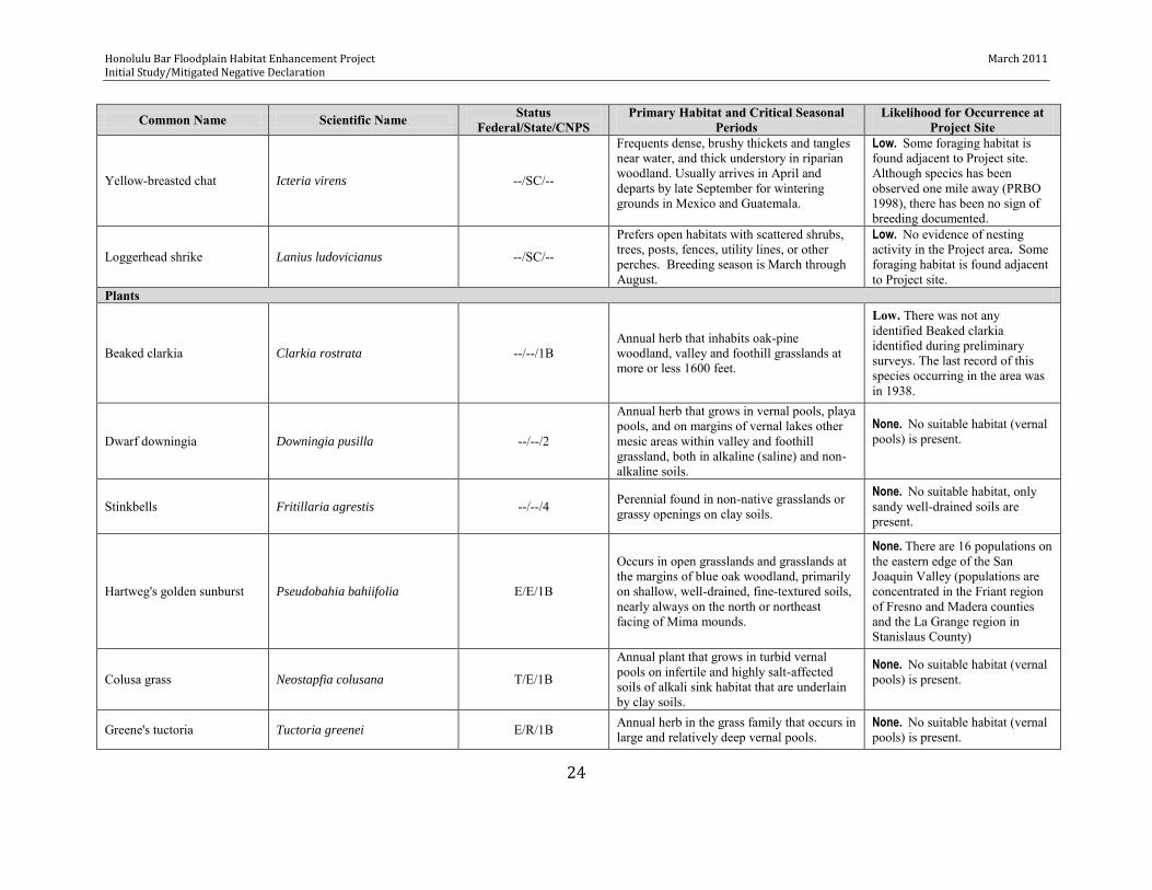
Honolulu Bar Floodplain Habitat Enhancement Project March 2011 Initial Study/Mitigated Negative Declaration
24
Common Name Scientific Name Status Federal/State/CNPS
Primary Habitat and Critical Seasonal Periods
Likelihood for Occurrence at Project Site
Yellow-breasted chat Icteria virens --/SC/--
Frequents dense, brushy thickets and tangles near water, and thick understory in riparian woodland. Usually arrives in April and departs by late September for wintering grounds in Mexico and Guatemala.
Low. Some foraging habitat is found adjacent to Project site. Although species has been observed one mile away (PRBO 1998), there has been no sign of breeding documented.
Loggerhead shrike Lanius ludovicianus --/SC/--
Prefers open habitats with scattered shrubs, trees, posts, fences, utility lines, or other perches. Breeding season is March through August.
Low. No evidence of nesting activity in the Project area. Some foraging habitat is found adjacent to Project site.
Plants
Beaked clarkia Clarkia rostrata --/--/1B Annual herb that inhabits oak-pine woodland, valley and foothill grasslands at more or less 1600 feet.
Low. There was not any identified Beaked clarkia identified during preliminary surveys. The last record of this species occurring in the area was in 1938.
Dwarf downingia Downingia pusilla --/--/2
Annual herb that grows in vernal pools, playa pools, and on margins of vernal lakes other mesic areas within valley and foothill grassland, both in alkaline (saline) and non-alkaline soils.
None. No suitable habitat (vernal pools) is present.
Stinkbells Fritillaria agrestis --/--/4 Perennial found in non-native grasslands or grassy openings on clay soils.
None. No suitable habitat, only sandy well-drained soils are present.
Hartweg's golden sunburst Pseudobahia bahiifolia E/E/1B
Occurs in open grasslands and grasslands at the margins of blue oak woodland, primarily on shallow, well-drained, fine-textured soils, nearly always on the north or northeast facing of Mima mounds.
None. There are 16 populations on the eastern edge of the San Joaquin Valley (populations are concentrated in the Friant region of Fresno and Madera counties and the La Grange region in Stanislaus County)
Colusa grass Neostapfia colusana T/E/1B
Annual plant that grows in turbid vernal pools on infertile and highly salt-affected soils of alkali sink habitat that are underlain by clay soils.
None. No suitable habitat (vernal pools) is present.
Greene's tuctoria Tuctoria greenei E/R/1B Annual herb in the grass family that occurs in large and relatively deep vernal pools.
None. No suitable habitat (vernal pools) is present.

Honolulu Bar Floodplain Habitat Enhancement Project March 2011 Initial Study/Mitigated Negative Declaration
25
Common Name Scientific Name Status Federal/State/CNPS
Primary Habitat and Critical Seasonal Periods
Likelihood for Occurrence at Project Site
Nuttall's scrub oak Quercus dumosa --/--/1B
A perennial oak tree; most active growth period in the spring; a long life span relative to most other plant species and a slow growth rate; maximum height at 20 years of 9 feet; high tolerance to drought and restricted water conditions.
High. Some trees were recently identified in the project vicinity.
Mammals
Pallid bat
Antrozous pallidus
--/SC/--
Occupies grasslands, shrublands, and woodlands. Needs drinking water. Day roosts are in caves, crevices, mines, and occasionally in hollow trees and buildings.
Low. There is no suitable roosting habitat in the vicinity of the Project. Some suitable foraging habitat (open ground) is present adjacent to the Project area.
Townsend's big-eared bat
Corynorhinus townsendii
--/SC/--
Requires caves, mines, tunnels, buildings, or other human-made structures for roosting.
Low. There is no suitable roosting habitat in the vicinity of the Project. Recent literature shows that there are no know colonies in the area.
Western mastiff bat
Eumops perotis californicus
--/SC/--
Inhabits arid and semiarid lowlands in the lower sonoran life zone of California. They primarily roost in crevices in vertical cliffs, usually granite or consolidated sandstone, and in broken terrain with exposed rock faces; they may also be found occasionally in high buildings, trees and tunnels.
Low. There is no suitable roosting habitat in the vicinity of the Project. The only documented occurrence of the Western mastiff bat is approximately 7 miles northeast of the project site.
Western red bat
Lasiurus blossevillii
--/SC/--
Roosting habitat includes forests and woodlands from sea level up through mixed conifer forests. Feeds over a wide variety of habitats including grasslands, shrublands, open woodlands and forests, and croplands.
Low. There are recent records of western red bats foraging near the Project area (> ¼ mile away; Pierson et al 2006). No roosting is expected in Project area due to sparse distribution of potential habitat (mature cottonwood/ sycamore trees)
Riparian woodrat Neotoma fuscipes riparia E/--/--
The riparian woodrat inhabits riparian communities along the lower portions of the San Joaquin and Stanislaus rivers in the northern San Joaquin Valley. Most numerous where shrub cover is dense and least abundant in open areas. In riparian areas, highest densities of woodrats and their houses are often encountered in willow thickets with an oak overstory.
None. Only known populations are confined to Caswell Memorial State Park on the Stanislaus River and along an overflow channel of the San Joaquin River.

Honolulu Bar Floodplain Habitat Enhancement Project March 2011 Initial Study/Mitigated Negative Declaration
26
Common Name Scientific Name Status Federal/State/CNPS
Primary Habitat and Critical Seasonal Periods
Likelihood for Occurrence at Project Site
San Joaquin kit fox Vulpes macrotis mutica E /T/—
Historically found in several San Joaquin Valley native plant communities including Valley Sink Scrub, Valley Saltbush Scrub, Upper Sonoran Subshrub Scrub, and Annual Grassland.
None. The Project area is outside of the species documented range. CNDDB reports six occurrences in southeast San Joaquin County; however, none have been documented within several miles of the Project area.
Fish
Delta smelt Hypomesus transpacificus T/T/—
Spends most of its life in the Sacramento–San Joaquin estuary. Spawns in shallow, fresh or slightly brackish water upriver from the mixing zone, including in the Sacramento River, Mokelumne River system, Cache Slough region, San Francisco Bay Delta, and Montezuma Slough area.
None. Delta smelt are not known to occur in the lower Stanislaus River.
Central Valley Steelhead trout Oncorhynchus mykiss T/SC/--
Anadromous species using freshwater, estuarine, and saltwater habitat. Migration potentially occurs year-round. Lower Stanislaus River is designated critical habitat for this species.
Low. Construction will occur during period when most juveniles are not present in this reach and will occur outside of the spawning season.
Central Valley spring-run Chinook salmon Oncorhynchus tshawytscha T/T/—
Anadromous species using freshwater, estuarine, and saltwater habitat. Migration potentially occurs from January through May.
None. Construction will occur outside of potential migration timeframe. Any oversummering adults will be constrained to pools outside the project area.
Sacramento River winter-run Chinook salmon Oncorhynchus tshawytscha E/E/--
Anadromous species using freshwater, estuarine, and saltwater habitat. Migration potentially occurs from January through May.
None. Construction will occur outside of potential migration timeframe.
Central Valley Chinook salmon, fall/late fall-run Oncorhynchus tshawytscha AC/--/--
Anadromous species using freshwater, estuarine, and saltwater habitat. Adult migration occurs mainly from September through December but has been observed as late as June. Primary juvenile outmigration occurs from January through June. Lower Stanislaus River is designated Essential Fish Habitat for this species.
Low. Construction will occur during period when most juveniles are no longer present in the river and will occur outside of the spawning season.
Amphibians/Reptiles
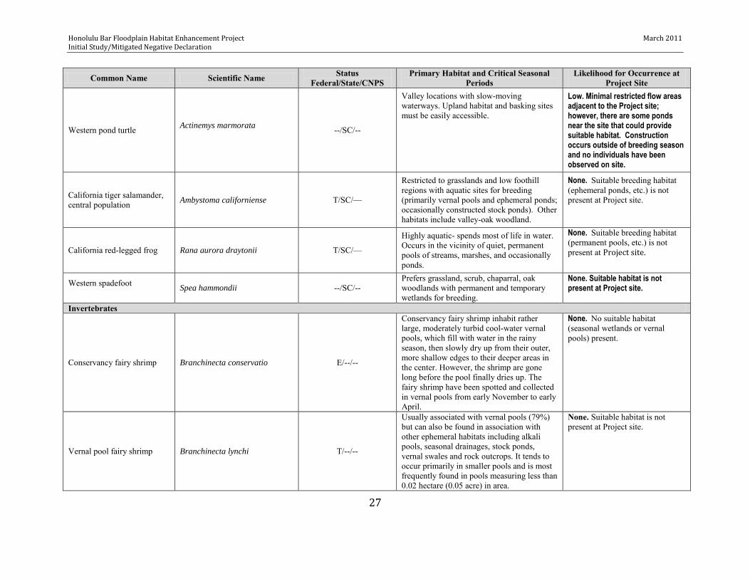
Honolulu Bar Floodplain Habitat Enhancement Project March 2011 Initial Study/Mitigated Negative Declaration
27
Common Name Scientific Name Status Federal/State/CNPS
Primary Habitat and Critical Seasonal Periods
Likelihood for Occurrence at Project Site
Western pond turtle Actinemys marmorata
--/SC/--
Valley locations with slow-moving waterways. Upland habitat and basking sites must be easily accessible.
Low. Minimal restricted flow areas adjacent to the Project site; however, there are some ponds near the site that could provide suitable habitat. Construction occurs outside of breeding season and no individuals have been observed on site.
California tiger salamander, central population Ambystoma californiense T/SC/—
Restricted to grasslands and low foothill regions with aquatic sites for breeding (primarily vernal pools and ephemeral ponds; occasionally constructed stock ponds). Other habitats include valley-oak woodland.
None. Suitable breeding habitat (ephemeral ponds, etc.) is not present at Project site.
California red-legged frog Rana aurora draytonii T/SC/—
Highly aquatic- spends most of life in water. Occurs in the vicinity of quiet, permanent pools of streams, marshes, and occasionally ponds.
None. Suitable breeding habitat (permanent pools, etc.) is not present at Project site.
Western spadefoot Spea hammondii --/SC/--
Prefers grassland, scrub, chaparral, oak woodlands with permanent and temporary wetlands for breeding.
None. Suitable habitat is not present at Project site.
Invertebrates
Conservancy fairy shrimp Branchinecta conservatio E/--/--
Conservancy fairy shrimp inhabit rather large, moderately turbid cool-water vernal pools, which fill with water in the rainy season, then slowly dry up from their outer, more shallow edges to their deeper areas in the center. However, the shrimp are gone long before the pool finally dries up. The fairy shrimp have been spotted and collected in vernal pools from early November to early April.
None. No suitable habitat (seasonal wetlands or vernal pools) present.
Vernal pool fairy shrimp Branchinecta lynchi T/--/--
Usually associated with vernal pools (79%) but can also be found in association with other ephemeral habitats including alkali pools, seasonal drainages, stock ponds, vernal swales and rock outcrops. It tends to occur primarily in smaller pools and is most frequently found in pools measuring less than 0.02 hectare (0.05 acre) in area.
None. Suitable habitat is not present at Project site.

Honolulu Bar Floodplain Habitat Enhancement Project March 2011 Initial Study/Mitigated Negative Declaration
28
Common Name Scientific Name Status Federal/State/CNPS
Primary Habitat and Critical Seasonal Periods
Likelihood for Occurrence at Project Site
Valley elderberry longhorn beetle
Desmocerus californicus
dimorphus T/--/--
Endemic with patchy distribution. Valley elderberry longhorn beetles are completely dependent on their host plant, the elderberry shrub. Adult active period is from March to June.
Low. Elderberry shrubs present in the Project vicinity, but no VELB have been observed and there is a low likelihood that they would be present (Rentner 2009). Construction will avoid plants and occur outside of adult active period.
Vernal pool tadpole shrimp Lepidurus packardi E/--/--
Found in California’s vernal pools. These unique, seasonal aquatic habitats form when winter rains fill shallow depressions. Lined with impervious clay, the pools persist for several months, then gradually evaporate during spring.
None. No suitable habitat (seasonal wetlands or vernal pools) present.
Sources: Federal Endangered and Threatened Species for the Knights Ferry (459C) USGS 7 ½ Minute Quad was obtained from the Sacramento Fish and Wildlife Office on January 22,
2010. at: http://www.fws.gov/sacramento/es/spp_lists/auto_letter.cfm. State Special Status Species 7½ minute Knights Ferry quad available (January 2009)
at http://imaps.dfg.ca.gov/viewers/cnddb_quickviewer/app.asp.
Key to Status Codes:
Federal Status: C: Candidate for listing E: Endangered T: Threatened
State Status: E: Endangered T: Threatened SC: California species of special concern SFP: State fully protected SA: Special animal R: Rare species
CNPS- California Native Plant Society Status: 1B = Rare, threatened or endangered in California and elsewhere and are rare throughout their range. According to CNPS, all of the plants constituting List 1B meet the definitions of Sec. 1901. 2 = Rare in California, but not elsewhere.
* Watch List or Species of Local Concern
Honolulu Bar Floodplain Habitat Enhancement Project Initial Study/Mitigated Negative Declaration
29
Invasive weeds present on site that will provide significant management challenges in the near and long term include Himalayan blackberry, red sesbania (Sesbania punicea), tree of heaven (Ailanthus altissimus), giant reed (Arundo donax), and yellow star thistle (Centaurea solstitialis).
Wetlands. A small, potential wetland (1,642 sq ft) was also identified on the northwest side of the side channel outside of, but adjacent to, the project footprint (Figure 5) during a wetland delineation survey conducted according to Corps’ guidelines.
Other Non-Special Status Species
Other non-special status species that may be found within the vicinity of the Project include various native and non-native fishes, amphibians and reptiles, mammals, and birds as follows:
Fish: hardhead (Mylopharodon conocephalus), Sacramento pikeminnow (Ptychochelius
grandis), Sacramento sucker (Catostomus occidentalis), lampreys (Lampetra spp),
threespine stickelback (Gasterosteus aculeatus), sculpins (Cottus spp), American shad
Alosa sapidissima, sunfish (Lepomis spp), crappies (Pomoxis spp), common carp (Cyprinus carpio), goldfish (Carassius auratus), catfish (Ictalurus spp), bigscale logperch (Percina caprodes), western mosquitofish (Gambusia affinis), red shiner (Cyprinella lutrennsis), bass (Micropterus spps), and striped bass (Morone saxatilis),
Amphibians/Reptiles: Western toad (Bufo boreas), Pacific tree frog (Hyla regilla),
bullfrog (Rana catesbeiana), western fence lizard (Sceloporus occidentalis), gopher snake (Pituophis melanoleucus), and garter snakes (Thamnophis spp)
Mammals: beaver (Castor canadensis), porcupine (Erethizon dorsatum), raccoon (Procyon lotor), ringtail (Bassariscus astutus), long-tailed weasel (Mustela frenata),
mink (Mustela vison), badger (Taxidea taxus), skunks), river otter (Lutra canadensis),
coyote (Canis latrans), and mule deer (Odocoileus hemionous), and several other species including various lagomorphs and rodents, moles, and foxes.
Birds: numerous species including various ducks and geese; hawks and falcons; swifts
and hummingbirds; kingfishers; herons and egrets; woodpeckers; vultures; owls; and passerines.
Potential Effects.
Potential Effect BIO 1—Steelhead and Salmon— Less than Significant Impact/Less than Significant Impact with Mitigation Incorporated. The Proposed Action is designed to benefit salmonids but temporary, short-term impacts could occur during construction. However, construction activities are not expected to have a significant adverse effect on steelhead and salmon due to implementation during the summer (July 2-September 30) when most salmonids have migrated out of the area and adults are not spawning. However, some take could occur from direct injury or mortality, turbidity increases that may occur for short periods of time just downstream of the Project site, and increased sedimentation.

Honolulu Bar Floodplain Habitat Enhancement Project January 2010 Initial Study/Mitigated Negative Declaration
30
Figure 5. Potential wetland identified adjacent to the footprint of the Honolulu Bar Floodplain Enhancement Project.

Honolulu Bar Floodplain Habitat Enhancement Project March 2011 Initial Study/Mitigated Negative Declaration
31
Gravel washing during construction and plant irrigation for three (3) years following construction will require pumping water from the river channel, which could result in take from entrainment or impingement.
Since the Proposed Action will increase the quantity and quality of spawning and rearing habitat, the project will not adversely affect critical habitat or essential fish habitat.
Implementation of BMPs (Mitigation Measures BIO-1a through BIO-1d) would reduce impacts to a less-than-significant level.
Potential Effect BIO 2—VELB— Less than Significant Impact/Less than Significant Impact with Mitigation Incorporated. No VELB have been observed; however, 11 elderberry shrubs are known to be located in the vicinity of areas designated for excavation. To prevent accidental disturbance, elderberry shrubs will be clearly marked as areas to avoid. Although no shrubs were found within the project footprint, there is a possibility that one or more shrubs may be discovered once thickets of Himalayan blackberry are removed during pre-construction vegetation removal. Any previously unidentified elderberry shrubs that cannot be avoided during construction will be mitigated according to USFWS guidelines for VELB (USFWS 1999)
Implementation of BMPs (Mitigation Measures BIO-2a through BIO-2b) would reduce impacts to a less-than-significant level.
Potential Effect BIO 3—Other Special-Status Wildlife Species (i.e., Non-Salmonid and non-VELB)—Less than Significant Impact/Less than Significant Impact with Mitigation Incorporated. Construction is not expected to have a significant adverse effect on any non-salmonid or non-VELB wildlife species due to lack of suitable habitat, the low likelihood of occurrence of these species within the Project area, and Project timing. However, some take could occur from stranding of amphibians or reptiles during dewatering of a portion of the side channel and injury or mortality associated with heavy equipment.
Implementation of BMPs (Mitigation Measure BIO-3) would reduce impacts to a less-than-significant level.
Potential Effect BIO 4—Native Plants and Pollinators—Less than Significant Impact with Mitigation Incorporated. The Project area contains primarily non-native vegetation, which will be removed to facilitate floodplain improvements and to facilitate natural colonization, and establishment of newly installed native plantings. This action will benefit native plants and pollinators. However, it may be necessary to remove some native vegetation in locations where earthwork is required. Mature vegetation will be left undisturbed to the extent possible. Where mature and overstory vegetation is removed to accommodate restoration, it may be necessary to use heavy equipment to remove stumps and rootwads.
Riparian vegetation would be planted in the fall, permitting some establishment of new plantings before the onset of high temperatures and drier conditions in the late spring and summer. Site preparation and planting would rely primarily on hand techniques.
Implementation of BMPs (Mitigation Measures BIO-4) would reduce impacts to a less-than-significant level.

Honolulu Bar Floodplain Habitat Enhancement Project March 2011 Initial Study/Mitigated Negative Declaration
32
Potential Effect BIO 5—Wetlands— Less than Significant Impact/Less than Significant Impact with Mitigation Incorporated. A wetland delineation conducted in 2009 indicates the presence of a small, potential wetland area (1,642 sq ft) adjacent to the project site. This wetland area is not within the project footprint and will not be purposefully disturbed during construction activities. To protect from accidental disturbance, the wetland will be clearly marked as an area to avoid.
The Proposed Action consists of habitat improvements within jurisdictional waters. Temporary riverine impacts would naturally return to pre-project conditions after construction is complete.
Implementation of BMPs (Mitigation Measures BIO-5) would reduce impacts to a less-than-significant level.
Potential Effect BIO 6—Policies/Ordinances/Plans—No Impact. The Proposed Action is not located within an area where local policies or ordinances protecting biological resources (e.g., a tree preservation policy or ordinance) are established. Therefore, there would be no impact.
Potential Effect BIO 7—Habitat Conservation/Natural Community Plans—No Impact. The Proposed Action is not located within an area where a Habitat Conservation/Natural Community Plan exists. Therefore, there would be no impact.
Mitigation.
Mitigation Measure Bio-1a—Steelhead and Salmon—Direct Loss of Juveniles During Construction. To reduce the likelihood of adverse impacts on salmonids, instream construction will be limited to the summer time period (July 2-September 30) when most juveniles have left the system and adults have not yet entered the spawning reaches.
Work in the mainstem will be conducted under existing stream flows; no flows will be diverted. Snorkel observations have revealed that during past gravel placement projects in the Stanislaus River, trout have been attracted by the activity and feed heavily just downstream of the site where food particles are often abundant. Based on feeding activity observed downstream of these projects, it appears that the levels of turbidity generated during gravel placement and presence of heavy equipment instream do not negatively affect the fish in the river.
During typical summer flows, the side channel would be disconnected and fish would not have access to the construction area. To ensure that there is no opportunity for salmonids to enter the side channel work area, a water-filled bladder dam will be installed at the upstream end of the side channel. This dam will ensure that conditions within the side channel are similar to those that typically occur under existing low summer flow conditions (i.e., flows are generally below 300 cfs which result in disconnection of the upstream and downstream end of the side channel from the river, with only a few isolated pools located throughout the side channel) so that salmonids will be avoided. The water bladder will be removed at the end of construction.
Before diverting the flow from the side channel, the Project Engineer and a qualified fisheries biologist will identify the best means to minimize disturbance to the channel and avoid mortality of fish and other aquatic vertebrates. Flow will be incrementally diverted at the upstream boundary of the work area to allow fish in the area to move downstream.

Honolulu Bar Floodplain Habitat Enhancement Project March 2011 Initial Study/Mitigated Negative Declaration
33
Any salmonids present in the side channel work area will be relocated under the supervision of a qualified fisheries biologist according to the following guidelines:
Before fish removal and relocation begins, a qualified fisheries biologist will identify the most appropriate release location(s). Release locations should have water temperatures similar to the capture location and offer ample habitat for released fish, and should be selected to minimize the likelihood that fish will re-enter the work area.
Fish will be held temporarily in cool, shaded water containers. Overcrowding in containers will be avoided. Aeration will be provided with a battery-powered external bubbler. Fish will not be held for more than 30 minutes.
Fish will not be anesthetized or measured. However, they will be enumerated, visually identified to species, and year classes will be estimated and recorded.
Reports on fish relocation activities will be submitted to CDFG, FWS and NMFS in a timely fashion.
If mortality during relocation exceeds 5%, relocation will cease and CDFG, FWS and NMFS will be contacted immediately or as soon as feasible.
If feasible, initial relocation efforts will be performed several days prior to scheduled start of construction. The fisheries biologist will perform a survey on the same day before construction begins to verify that no fish have moved back into the Project area.
Mitigation Measure Bio-1b—Steelhead and Salmon—Increased Turbidity Impacts. Monitor water turbidity levels during instream construction activities. Monitoring would ensure that increases in turbidity over background conditions would not exceed levels specified by the Central Valley Water Board. OID will obtain a Section 401 water quality permit with the Central Valley Water Board through the Section 404 permitting process, which will require preparation of an erosion control plan and/or a stormwater pollution prevention plan (SWPPP).
Mitigation Measure Bio-1c—Steelhead and Salmon—Sedimentation Impacts to Salmonid Life Stages. An erosion control plan (and/or a SWPPP, if applicable) will be prepared through the Section 401 permitting process the Central Valley Water Board. Provisions of the erosion control plan and SWPPP (if required) would be included in conditions of the Streambed Alteration Agreement pursuant to Sections 1600-1606 of the Fish and Game Code. At a minimum, the plan would meet the requirements of the Central Valley Water Board and would contain the following types of BMPs:
Stabilization of disturbed soils in the project footprint, including stream banks, and revegetation according to plan presented in Appendix B.
Implementation of Central Valley Water Board-approved BMPs for sediment catch basins or traps to prevent sediment from being transported away from construction sites. These would be designed to minimize impacts to riparian, wetland, and open-water areas. Traps to be considered could include filter berms, straw-bale barriers, filter inlets, vegetative filter strips, culvert risers, coir and straw logs, and other erosion control BMPs as approved by the Central Valley Water Board.
Honolulu Bar Floodplain Habitat Enhancement Project March 2011 Initial Study/Mitigated Negative Declaration
34
Mitigation Measure Bio-1d—Steelhead and Salmon—Water Pumping Impacts. Water pumps will have the hose end protected by a NMFS approved fish screen to block entry by juvenile fish. Large rock will cover the hose/filter to reduce velocity and avoid injury to fish.
Mitigation Measure Bio-2a—VELB—Direct Loss of Elderberry Plants during Construction Elderberry shrubs will be avoided. Construction personnel will be educated regarding the need to avoid elderberry plants and to stop work upon discovery of an unmarked plant within the work area, followed by notification of OID’s Engineer of their discovery. The Engineer shall stop work to confirm if the resource could be avoided and consult with a qualified biologist. To prevent accidental impacts to known elderberry shrubs from equipment and personnel, shrubs will be clearly marked with highly visible construction tape as fencing in the following areas: 20 feet in diameter from the outer edge of the dripline of elderberry plants with signs posted every 50 feet as needed.
In the event that unmarked elderberry shrubs are found within the project footprint and complete avoidance of them is infeasible, mitigation would be conducted according to USFWS guidelines for VELB (USFWS 1999).
Mitigation Measure Bio-2a—VELB— Dust Control during Construction. The construction area will be regularly watered to control dust and possible negative impacts to elderberry plants or other native vegetation.
Mitigation Measure BIO-3— Direct Loss of Other Special-Status Wildlife Species (i.e., Non-Salmonid and non-VELB) during Construction. Conduct pre-construction surveys for special status species prior to construction.
To prevent amphibians and reptiles from entering the Project area within and adjacent to the side channel, flows will be diverted from the work area during construction (see Mitigation Measure BIO-1c). Pre-construction aquatic vertebrate surveys will be performed in the work area no more than 10 days prior to the beginning of flows being diverted, and any aquatic vertebrates present in the work area will be relocated under the supervision of a qualified biologist upon notification and approval of CDFG.
In areas outside of the wetted channel, pre-construction special status species surveys will be performed in the work area no more than 10 days prior to the beginning of construction, and any special status species present in the work area will be relocated under the supervision of a qualified biologist upon notification and approval of CDFG.
To protect raptors or other birds, no tree or shrub removal will occur from March 1 through July 1.
Mitigation Measure BIO-4—Direct Loss of Native Vegetation during Construction. To the extent possible, impacts to areas of native vegetation would be avoided. Where temporary disturbance of native vegetation areas could not be avoided during construction, native vegetation would be planted to restore the habitat according to the Revegetation Plan (Appendix B) after construction.

Honolulu Bar Floodplain Habitat Enhancement Project March 2011 Initial Study/Mitigated Negative Declaration
35
Mitigation Measure BIO-5—Disturbance of Wetland Habitats. To prevent accidental impacts to the small wetland adjacent to the site from equipment and personnel, the wetland area shall be clearly marked with highly visible construction tape prior to, and maintained for the full duration of construction.
3.5 Cultural Resources Setting. A full archeological review of the entire lower Stanislaus River from Goodwin Dam to the confluence was prepared previously for the Corps’ SRP Operational Management Plan during 1976 and 1981 (Swernoff 1982). The report states
No cultural resources have been previously recorded in Tract 210, Honolulu Bar. In addition, no cultural resources were found during the field reconnaissance of these areas.
Potential Effects. Potential Effect CULT 1— Historic/Archaeological/Paleontological Resources—Less than Significant Impact with Mitigation Incorporated. The Project area has the potential to contain prehistoric and historic-period archaeological resources. However, since gravel extraction has occurred at the Project site similar to that at the nearby Lovers Leap site (described under Setting section above), it is likely that any archeological or historical resources that may have occurred at Honolulu Bar are no longer present. Proposed Action activities (excavation) would result in less-than-significant effects to cultural resources because BMPs would be implemented (Mitigation Measure CULT-1). Potential Effect CULT 3— Human Remains—No Impact/Less than Significant Impact with Mitigation Incorporated. The likelihood of finding human remains is low, particularly since no formal cemeteries were identified within the Project area, so no impacts are anticipated. However, there is a potential that human remains associated with settlements/homesteads within the vicinity but not interred in cemeteries could be uncovered during excavation. Proposed Action activities (excavation) would result in less-than-significant effects to cultural resources because BMPs would be implemented (Mitigation Measure CULT-2). Summary of Environmental Effects. Less than Significant with Mitigation Incorporated. Mitigation. Mitigation Measure CULT-1a— Historic/Archaeological/Paleontological Resources. Before construction, all construction personnel would be instructed on the protection of cultural resources. OID would instruct construction workers that cultural resources might be present at the Project site. They would be trained to stop work near any discovery, and notify OID’s Engineer of their discovery. The Engineer would stop work to confirm if the resource could be avoided and consult with a qualified archeologist.

Honolulu Bar Floodplain Habitat Enhancement Project March 2011 Initial Study/Mitigated Negative Declaration
36
Mitigation Measure CULT-1ba— Historic/Archaeological/Paleontological Resources. Known significant cultural resources would be fenced and a minimum distance maintained for work disturbances. Mitigation Measure CULT-2— Human Remains. Should human remains be discovered, OID shall cease construction and notify and consult with the county coroner's office and the Native American Heritage Commission. 3.6 Geology and Soils Setting. The Project area is within the lower Stanislaus River in the San Joaquin Valley. Most of the soils located in the San Joaquin Valley consist of sand, silt, loamy clay alluvium, peat, and other organic sediments. These soils are the result of long-term natural soil deposition and decomposition of marshland vegetation. The Project area is located in an area of relatively flat terrain with a slight slope. Surface elevations range from about 135 feet up to 153 feet NAVD88. Soils in the area are classified predominantly as Columbia sandy loam, drained, 0 to 2 percent slopes and rarely flooded (USDA 2009). The restoration area includes a mid-channel island and long pool area within the channel of the Stanislaus River. Controlled releases from Goodwin Dam limit the frequency of flows capable of moving course sediments and cobbles. The bar is considered stable, and has appeared in its current situations in aerial photos dating to the 1930s. Excavations of the bar were done in several locations during December 2009 to determine the composition of bar deposits at depth. Pits excavated on the low elevation portions of the bar near the existing degraded side channel showed characteristics of the mapped soil type: Columbia sandy loam. Excavations on the high bar revealed a deep depositional layer of cobble and/or sand overlaying the native soil. The origin of this material is unknown, however their size and height of cobble and sand deposits indicate that they are the result of human activities (e.g., dredging, dam and road construction), and not natural river processes.
The Alquist-Priolo Earthquake Fault Zoning Act of 1972 (prior to January 1, 1994 called the Alquist-Priolo Special Studies Zones Act – CCR, Title 14, Section 3600) sets forth the policies and Criteria of the State Mining and Geology Board that governs the exercise of governments’ responsibilities to prohibit the location of developments and structures for human occupancy across the trace of active faults. Potential Effects. Potential Effect GEO 1— Geologic Hazards—No Impact. The Alquist-Priolo Earthquake Fault Zoning Act of 1972 (prior to January 1, 1994 called the Alquist-Priolo Special Studies Zones Act – CCR, Title 14, Section 3600) sets forth the policies and Criteria of the State Mining and Geology Board that governs the exercise of governments’ responsibilities to prohibit the location of developments and structures for human occupancy across the trace of active faults. The Proposed Action does not include constructing any developments or structures for human occupancy; therefore, there would be no impact.
Honolulu Bar Floodplain Habitat Enhancement Project March 2011 Initial Study/Mitigated Negative Declaration
37
Potential Effect GEO 2— Soil Erosion—Less than Significant with Mitigation Incorporated. Construction activities (e.g., excavation) have the potential to cause soil erosion and increased turbidity. However, this impact would not be substantial and would be controlled through construction BMPs as identified below. Excavated coarse sediments that will be placed in the Stanislaus River are large enough (up to 5 inches, d50 = 1 inch) that they will not be readily eroded. Modeling suggests that mobilization of the median particle size (i.e., d50) of the gravel bench is infrequent. After excavation, the floodplain will contoured to approximately a 10:1 slope from the left bank down to the 200 cfs water surface profile with a 2:1 fill slope, which will promote slope stability. All materials excavated from the project site will be used on the project site. No excavated materials will be transported or sold off the project site. Excavated gravels and cobbles will be temporarily stockpiled, sorted for size, and cleaned prior to placement in the river. Cleaning will reduce the magnitude of a temporary turbidity increase that may be generated by placement of gravels into the river. Implementation of BMPs (Mitigation Measure GEO-2a and GEO-2b) would reduce impacts to a less-than-significant level. Potential Effect GEO 3— Unstable or Expansive Soil—No Impact. The Proposed Action is not located in areas of unstable or expansive soils. Therefore, there would be no impact. Potential Effect GEO 4— Wastewater— No Impact. The Proposed Action is not located in areas where wastewater facilities are or will be located. Therefore, there would be no impact. Summary of Environmental Effects. Less than Significant with Mitigation Incorporated. Mitigation. Mitigation Measure GEO-2a—Soil Erosion. To avoid or minimize impacts related to increased erosion and sedimentation, an erosion control plan will be developed which, at a minimum, would contain the following BMPs:
Supervisory construction personnel would be informed of environmental concerns, pertinent laws and regulations, and final rehabilitation specifications and design.
Environmental protection measures would be enforced in the field during construction. Small sediment catch basins or traps would be provided to prevent sediment from being
transported away from project site. The location and size of these basins would be designed to minimize impacts to riparian and wetlands areas. Types of sediment traps to be considered include filter berms, straw-bale barriers, filter inlets, vegetative filter strips, and culvert risers.
Disturbed soils would be revegetated and stabilized. Reseeding and mulching work would be performed following completion of the project. If erosion control practices were not installed 1 year after completion, exposed soils could require additional treatment following seasonal rains and subsequent erosion.

Honolulu Bar Floodplain Habitat Enhancement Project March 2011 Initial Study/Mitigated Negative Declaration
38
Non-noxious weed competition would be discouraged and noxious weeds would be controlled.
Details regarding seed material, fertilizer, and mulching would be provided. The seed material would include native plant species and be approved by a revegetation specialist or erosion control specialist. Special emphasis would be given to native plant assemblages characteristic of the site prior to construction.
Mitigation Measure GEO-2b— Increased Turbidity. If applicable (i.e., there is flowing water), OID will monitor turbidity levels upstream and downstream of the point of construction activities, as required by the Central Valley Water Board. Measurements would be taken four times daily when construction activities potentially have the greatest water quality impact. If turbidity increases exceeded 20 percent, actions would be implemented immediately to reduce and maintain turbidity below the 20 percent level. Actions could include use of suspended silt curtains, cessation of construction activities, or reduction of construction activities until turbidity standards are achieved. 3.7 Hazards and Hazardous Materials Setting. The Project area is located within and adjacent to the Honolulu Bar Recreation Area (between RM 49 and RM 50.5) in the lower Stanislaus River. There is no evidence of hazardous wastes, pesticides, herbicides and fertilizer, solid waste, drums and containers, underground or aboveground storage tanks at the Project site. Potential Effects. Potential Effect HAZ-1—Transport/Use/Disposal of Hazardous Materials—No Impact. Petroleum products such as diesel fuel, oil, and unleaded gasoline are the primary hazardous materials associated with construction equipment that may be used within the Project site. There would be no significant hazard to the public or the environment through the routine transport, use, or disposal of these hazardous materials. Therefore, there would be no impact. Potential Effect HAZ-2—Potential Spills of Hazardous Materials—Less than Significant with Mitigation Incorporated. There is a low potential that a release of hazardous material may occur during construction activities. Petroleum products such as diesel fuel, oil, and unleaded gasoline are the primary hazardous materials associated with construction equipment that may be used within the Project sites. Implementation of BMPs (Mitigation Measure HAZ-1) would reduce impacts to a less-than significant level. Potential Effect HAZ-3—School Proximity to Hazardous Materials—No Impact. The Project site is not located within one-quarter mile of an existing or proposed school. Therefore, there would be no impact.
Honolulu Bar Floodplain Habitat Enhancement Project March 2011 Initial Study/Mitigated Negative Declaration
39
Potential Effect HAZ-4—Pre-existing Hazardous Materials—No Impact. The Project site is not located within areas identified pursuant to Government Code Section 65962.5. Therefore, there would be no impact. Potential Effect HAZ-5—Airport/Airstrip Safety Hazard—No Impact. The Project site is not located within areas that may affect public airport, public use airport, or private airstrips. Therefore, there would be no impact. Potential Effect HAZ-6—Emergency Response/Evacuation Plan—No Impact. Construction equipment will access the Project site via rural roads and will not impair implementation of or physically interfere with an adopted emergency response plan or emergency evacuation plan. Therefore, there would be no impact. Potential Effect HAZ-7—Wildland Fire—No Impact. The Project site is located in a rural area that can be susceptible to wildland fires. Construction will occur primarily on a point bar surrounded by water or instream so there will be little potential for creating additional exposure to wildfire as a result. Removal of non-native vegetation in excavated areas will assist in reducing any wildland fire hazard at the project site. Therefore, there would be no impact. Summary of Environmental Effects. Less than Significant with Mitigation Incorporated. Mitigation. Mitigation Measure HAZ-2—Potential Spills of Hazardous Materials. A hazardous materials management and spill prevention plan will be developed and implemented that will contain, at a minimum, the following BMPs:
Hazardous materials would not be drained onto the ground, into streams, or into drainage areas.
All construction waste, including trash and litter, garbage, other solid waste, petroleum products, and other potentially hazardous materials, would be removed to a disposal facility authorized to accept such materials.
Waters or soils contaminated with construction material would be disposed of in a suitable location to prevent discharge to surface waters.
Vehicles would be inspected and maintained to reduce the potential for leaks or spills of oils, grease, or hydraulic fluids.
Hazardous materials would not be stored at the Project site. No vehicles would be refueled at Project sites; refueling would occur in staging area.
3.8 Hydrology and Water Quality Setting. The Stanislaus River, located in Stanislaus County, California, is the northernmost of three major tributaries to the San Joaquin River. Its 1,100 square mile watershed produces approximately 21% of the average unimpaired runoff to the San Joaquin River basin (SRFG 2003). The lower Stanislaus River is defined as the stretch of river between Goodwin Dam (RM 58.4; constructed in 1912) and the river’s confluence with the San Joaquin River (RM 0).

Honolulu Bar Floodplain Habitat Enhancement Project March 2011 Initial Study/Mitigated Negative Declaration
40
New Melones Dam (RM 78; completed in 1979), located 20 miles upstream of Goodwin Dam, is part of the Central Valley Project and has a storage capacity of 2,400,000 acre-feet and was designed to control floods up to the 100-year-flood (Kondolf and others 2001). The operating criteria for New Melones Reservoir are governed by water rights, instream fish and wildlife flow requirements (including AFRP objectives), Bay-Delta flow requirements, dissolved oxygen requirements, Vernalis water quality, CVP contracts, and flood control considerations. Water released from New Melones Dam and Powerplant is re-regulated at Tulloch Reservoir, and is either diverted at Goodwin Dam or released from Goodwin Dam to the lower Stanislaus River. Operations of New Melones Dam have reduced the 2-year maximum daily mean flow below Goodwin Dam from about 4,300 cfs to 2,600 cfs. The maximum flow allowed below Goodwin Dam under the existing flood control criteria is 8,000 cfs. When possible, Goodwin releases are maintained at levels that would not result in downstream flows in excess of 1,500 cfs because of potential damage to permanent crops in the floodplain that may occur at flows above this level. Changes to the lower river since the construction of New Melones Dam include: (1) large scale vegetation encroachment in the active channel, primarily by willow and blackberry; (2) reduced reproduction of cottonwoods; and (3) substantial encroachment by urban and agricultural development, particularly orchards, in floodplain areas, thereby altering the natural river channel-floodplain connection (SRFG 2004). Loss of alternating bar sequences and incision within the active channel has been speculated to be the result of New Melones Dam (Kondolf and others 2001) or by gravel mining in the active channel prior to 1980 (CMC in Appendix 2 of CMC, SPCA, and CRRF 2003). CMC agrees with Kondolf and others (2001) that encroachment of the riparian vegetation and reduced gravel recruitment has led to the coarsening of the bed material, particularly within spawning habitat in the unmined reaches between Goodwin Dam and Honolulu Bar. As a result of gravel and gold mining in conjunction with reduced river flows and decreased coarse sediment transport, the river has experienced channel incision and reduced channel diversity through loss of alternating bar sequences in areas below Goodwin Canyon. Multiple dams, reduced peak flows, vegetation encroachment in the active channel, and urban/agricultural encroachment in floodplain areas have resulted in a sediment starved river with an armored and immobile river bed and have altered the natural channel-floodplain connection in parts of the river below Goodwin Canyon including at Honolulu Bar. Historically, the hydrology in the stretch of the Stanislaus River at Honolulu Bar was influenced by winter rains in January and February and snowmelt that provided consistently high flows from March to June. The Honolulu Bar mid-channel island would have experienced periodic inundation during the winter and spring months, supporting a mosaic of forest, scrub, and herbaceous vegetation communities. Periodic high flows would have discouraged riparian vegetation encroachment into the channel on either side of the bar. Today, the water flow in the side channel is constricted by sediment and vegetation. Based on the daily exceedance probability, the side channel becomes disconnected 24% of the year, and 16% of the time during the spring juvenile salmonid rearing period (Feb-May). In general, the width of the side channel ranges from approximately 3-20 feet during low volume summer flows, and up to 35 feet during

Honolulu Bar Floodplain Habitat Enhancement Project March 2011 Initial Study/Mitigated Negative Declaration
41
ordinary high water events. Based on the current Corps flood easement (Corps 1999), the 100-year flood for this reach of the Stanislaus River is 8,000 cfs. Currently, the mid-channel island at Honolulu Bar receives infrequent inundation only during large flood events, and over only a portion of its area. The highest flow recorded since 1979 when New Melones was completed is 7,350 cfs. The 2.4 acres proposed to be graded as a means to generate seasonally inundated floodplain currently does not become fully inundated until flows reach >5,000 cfs (Figure 6). Water quality on the Stanislaus River is considered to be high quality containing low levels of salts, total dissolved solids and other trace elements (Markiewicz et. al. 2002).
Potential Effects.
Potential Effect HYDRO-1—Water Quality—No Impact/Less than Significant Impact with Mitigation Incorporated. Construction activities in the side channel and on the mid-channel island will occur when the side channel is typically disconnected so there would be no impacts to water quality within the side channel. To ensure that no flows enter the side channel work area, a water-filled bladder dam will be installed at the upstream end of the side channel. This dam will ensure that conditions within the side channel are similar to those that typically occur under existing low summer flow conditions (i.e., flows are generally below 300 cfs which result in disconnection of the upstream and downstream end of the side channel from the river, with only a few isolated pools located throughout the side channel). The water bladder will be removed at the end of construction.
Placement of gravels within the mainstem may result in temporary increases in turbidity or sedimentation. However, the duration of potential increases in turbidity and sedimentation will not be enough to cause significant impacts. Also, river flows at the time of gravel placement in the river would be low enough (< 500 cfs) to allow disturbed fine sediment to quickly settle out of the water column. During weed control activities, herbicide use will be restricted to the minimum needed to ensure adequate control of invasive non-native vegetation. Where other effective means of control are available, these will be prioritized. Herbicides will be applied according to manufacturer’s specifications in a manner that minimizes drip and drift into the stream channel.

Honolulu Bar Floodplain Habitat Enhancement Project Initial Study/Mitigated Negative Declaration
42
Figure 6. Floodplain inundation frequency in vicinity of Honolulu Bar Floodplain Enhancement Project.

Honolulu Bar Floodplain Habitat Enhancement Project Initial Study/Mitigated Negative Declaration
43
Implementation of BMPs (Mitigation Measures HYDRO-1a through HYDRO-1c) would reduce impacts to a less-than-significant level.
Potential Effect HYDRO-2—Groundwater Supplies—No Impact. The proposed project will not deplete groundwater supplies or interfere substantially with groundwater recharge. Therefore, there would be no impact. Potential Effect HYDRO-3—Drainage Pattern — Less than Significant Impact. The proposed Project will be contained within the existing river alignment. Modeling indicates that the project is not likely to encroach upon the 100-year design water surface profile or significantly alter local channel hydraulic conditions. Construction activities will not substantially alter the existing flow/drainage patterns, alter the course of the lower Stanislaus River, or increase the rate or amount of surface runoff in a manner that would result in flooding. Therefore, there will be a less than significant impact. Potential Effect HYDRO-4—Structures—No Impact. The proposed project would not place housing in the 100-year flood hazard area. Therefore, there will be no impact. Potential Effect HYDRO-5—Levees and Dams—No Impact. The proposed project would not affect the integrity of any levees or dams. Therefore, there will be no impact. Potential Effect HYDRO-6—Inundation—No Impact. The proposed project would not contribute to inundation by seiche, tsunami, or mudflow. Therefore, there will be no impact. Summary of Environmental Effects. Less than Significant with Mitigation Incorporated. Mitigation.
Mitigation Measure HYDRO-1a—Water Quality. Instream work will be restricted to the minimum necessary to support restoration success and will be limited to the summer season (July 2 through September 30) when minimal numbers of adult salmonids and juveniles are present.
Mitigation Measure HYDRO-1b—Water Quality. To the extent feasible, instream work will be carried out by equipment operating from dry areas outside the channel. Silt fences, fiber rolls, and other appropriate sediment control measures will be used to minimize sediment input to the active channel, consistent with the Stormwater Pollution Prevention Plan (SWPPP; see below).
Mitigation Measure HYDRO-1c—Water Quality. OID will prepare a construction SWPPP and will implement appropriate measures. A copy of the SWPPP will be available at OID office. The SWPPP will include, but is not limited to, the following information and stipulations:
A description of site characteristics, including runoff and drainage characteristics and soil erosion hazard.
A description of proposed construction procedures and construction-site housekeeping practices.

Honolulu Bar Floodplain Habitat Enhancement Project Initial Study/Mitigated Negative Declaration
44
A description of measures that will be implemented for erosion and sediment control, including requirements to:
o Conduct major construction activities involving excavation during the summer season;
o Conduct all construction work in accordance with site-specific construction plans that minimize the potential for increased sediment inputs to surface waters; and
o Implement erosion control measures as appropriate to prevent sediment from entering surface waters.
o Construction materials would not be stockpiled or deposited in location where they could be washed away by high water or storm runoff or can encroach, in any way, upon the watercourse.
A Spill Prevention and Response Plan (SPRP) that identifies any hazardous materials to be used during construction; describes measures to prevent, control, and minimize the spillage of hazardous substances; describes transport, storage, and disposal of these substances; and outlines procedures to be followed in case of a spill of a hazardous material. The SPRP will include, but is not limited to, the following information and stipulations:
o Hazardous materials would not be drained onto the ground, recharge cells, the instream channel, or into drainage areas. All waste, including trash and litter, garbage, other solid waste, petroleum products, and other potentially hazardous materials, would be removed to a disposal facility permitted to accept such materials.
o Fueling, cleaning, and maintenance of equipment would not be allowed except in designated areas located as far from the instream channels as possible.
o A stipulation that construction will be monitored by qualified personnel to ensure adherence to all provisions relevant to state and federal stormwater discharge requirements, and that the construction site will be shut down in the event of noncompliance.
3.9 Noise The Proposed Action is located in a rural area dominated by agricultural land uses and most of the adjacent land is also owned by the Corps or has a riparian easement. It is located in a sparsely populated area (i.e., 12 residences) and the main Project site (i.e., excavation, gravel cleaning and processing site) is at least 500 feet away from the nearest residence. Some Potential Effects.
Potential Effect NOISE-1—Noise—Less than Significant Impact with Mitigation Incorporated. While a temporary increase in noise is expected to be generated by equipment, vehicles, and personnel during construction activities, this impact would be temporary in nature and would be limited to typical construction equipment (e.g., backhoe, bulldozer, grader, loader, truck) noise levels which range from 80-89 dBA 50 feet from the source (FTA 2006). Based on basic sound level drop-off rate of 6.0 dBA per doubling of distance from a point source such as

Honolulu Bar Floodplain Habitat Enhancement Project Initial Study/Mitigated Negative Declaration
45
construction equipment, noise levels at 500 ft would range from 61-70 dBA. Restricting the hours of equipment operation can alleviate this short-term impact.
In addition, instream work is not located within an airport land use plan area, or, where such a plan has not been adopted, within two miles of a public airport or public use airport and do not expose people residing or working in the Project area to excessive noise levels. The project is also not located in the vicinity of a private airstrip and does not expose people residing or working in the Project area to excessive noise levels.
Implementation of BMP (Mitigation Measure Noise-1) would reduce impacts to a less-than-significant level.
Summary of Environmental Effects. Less than Significant with Mitigation Incorporated.
Mitigation.
Mitigation Measure NOISE-1a—Noise. Construction would only be conducted from Mondays to Saturdays between 7:00 a.m. and 5:00 p.m. 3.10 Comparison of Impacts Table 3 below is a comparison of the impacts of the proposed action and alternatives.
Table 3. Comparison of Impacts among Alternatives
Alternative Is Need and Purpose Satisfied?
Principle Environmental
Effects Feasibility
Proposed Action Yes. This is the preferred alternative because it will improve salmonid rearing opportunities and reduce adult stranding, which will allow salmonid population abundance to increase. It also fulfills mitigation for loss of 0.6 acres of wetland habitat.
Benefits from improvement of fisheries habitat through the construction of floodplain and side channel improvements. Community involvement will create a better understanding of the need for and benefits of better fishery conditions.
Yes
Alternative 1: No Action
No. It would not increase the quantity and quality of salmonid habitat and would not fulfill mitigation for loss of 0.6 acres of wetland habitat.
No reductions in harm to listed and species of concern species would occur.
Impracticable because of unresolved conflict with Corps’ 404 permit.
Honolulu Bar Floodplain Habitat Enhancement Project Initial Study/Mitigated Negative Declaration
46
4.0 CUMULATIVE EFFECTS Cumulative impacts are defined as environmental effects that are greater in magnitude, extent, or duration than the direct and indirect effects of the proposed action when combined with the effects of other current and future actions, regardless of the proponent. Cumulative effects are those that result from incremental impacts of a project when added to other past, present, and reasonably foreseeable future actions. Cumulative effects can result from individually minor, but collectively significant actions that take place over a period of time. The magnitude, geographic scope, and duration of potential adverse impacts associated with the Proposed Action are small and would not contribute substantially to any impacts associated with past projects in the area, and no present or future projects are anticipated. All potential adverse impacts associated with the proposed action are expected to be less than significant, or have mitigation and project design elements that will reduce them to less than significant. However, beneficial cumulative impacts may be considerable in combination with similar past and future habitat restoration projects. Habitat restoration projects are designed to increase the quantity and quality of salmonid spawning and rearing habitat. Therefore, cumulative impacts of multiple restoration projects are progressively more beneficial for salmonids.
5.0 CONSULTATION/COORDINATION/PUBLIC INVOLVEMENT This EA/IS has been prepared in accordance with the requirements of NEPA and CEQA. USFWS and OID are also complying with other applicable laws including the Clean Water Act of 1977, Clean Air Act of 1970, Endangered Species Act, Fish and Wildlife Coordination Act, National Historic Preservation Act of 1966, Executive Order 11988 - Flood Plain Management, Executive Order 11990 - Protection of Wetlands, Executive Order 13112 –Invasive Species, and the Council of Environmental Quality Memorandum - Analysis of Prime or Unique Farmlands. Pursuant to CEQA, this EA/IS and Negative Declaration are being circulated for a 30-day public review period through the State Clearinghouse. The review period will begin on March 1, 2010. Furthermore, this public review period fulfills the early public review requirements of Executive Order 11988 regarding any plans or proposals for Federal actions in floodplains.
6.0 CONCLUSIONS The Proposed Action is designed to create or restore several habitat elements in the Stanislaus River including 2.4 acres of floodplain habitat on the inside edge of a mid-channel island, 0.7 acres of floodplain bench in the south side of the river upstream of the mid-channel island, 0.4 acres of spawning riffle in the river adjacent to the mid-channel island, 3.85+ acres of native vegetation, and increased frequency and duration of flow connectivity in one mile of side channel habitat. BMPs would be used to minimize effects from the Proposed Action. Design criteria for floodplain habitat are based on CDFG’s and NMFS’ recommendations for depth (0.7-

Honolulu Bar Floodplain Habitat Enhancement Project Initial Study/Mitigated Negative Declaration
47
2 feet) and velocity (0.2-0.7 f/s) for salmonids. The Proposed Action would not result in significant effects on the environment. The USFWS and OID have made a preliminary determination that a FONSI/ Mitigated Negative Declaration is appropriate for the Proposed Action and that preparation of an EIS/EIR is unnecessary. A final determination for a FONSI/ Mitigated Negative Declaration would be made after the public review period and when all comments have been addressed in the Final EA/IS.
7.0 LIST OF PREPARERS Michele Palmer, Senior Scientist, FISHBIO Environmental, LLC
Jason Guignard, Fish Biologist, FISHBIO Environmental, LLC
Jim Inman, Wildlife Biologist, FISHBIO Environmental, LLC
Chrissy Sonke, Database Manager, FISHBIO Environmental, LLC
Honolulu Bar Floodplain Habitat Enhancement Project Initial Study/Mitigated Negative Declaration
8.0 REFERENCES AFRP [Anadromous Fish Restoration Program]. 2001. Final Restoration Plan for the AFRP. Prepared for the Secretary of the Interior by the United States Fish and Wildlife Service. CMC, SPCA, and CRRF [Carl Mesick Consultants, S.P. Cramer & Associates, and California Rivers Restoration Fund]. 2003. A plan to restore anadromous fish habitat in the lower Stanislaus River: A consensus-based plan to direct the long-term
implementation of prioritized restoration and research in the Stanislaus River below
Goodwin Dam. Prepared on behalf of the Stanislaus River Fish Group. Corps (United States Army Corps of Engineers). 1999. Post-flood assessment of 1983, 1986, 1995 and 1997 in the Central Valley, California. The Army Corps of Engineers’ Sacramento and San Joaquin Basins Comprehensive Study, Available for the U.S. Army Corps of Engineers, Sacramento District, 1325 J Street, Sacramento, CA 95814-2922. KDH [KDH Environmental Services]. 2007. Lovers Leap Restoration Project Salmon Habitat Restoration on the Lower Stanislaus River Initial Study/Environmental Assessment. 35 pp. Kondolf, G.M., A. Falzone, and K.S. Schneider. 2001. Reconnaissance-level assessment of channel change and spawning habitat on the Stanislaus River below Goodwin Dam. Report to the U.S. Fish and Wildlife Service, Sacramento, CA. 22 March 2001.
Markiewicz, D., K. Goding, V. de Vlaming, and J. Rowan. 2002. Benthic Macroinvertebrate Bioassessment of San Joaquin River Tributaries: Spring and Fall 2002. Aquatic Toxicology Laboratory, School of Veterinary Medicine: University of California at Davis, and California Regional Water Quality Control Board, Rancho Cordova, California. McGuire, K.E. 1984. An Intensive Cultural Resource Survey of Four Tracts, Lower Stanislaus River, Stanislaus County. Final Report submitted to the U.S. Army Corps of Engineers by Far Western Anthropological Research Group, Inc. September 1984. Pierson, E.D., W.E. Rainey and C. Corben. 2006. Distribution and status of Western red bats in California. Calif. Dept. Fish and Game, Habitat Conservation Planning Branch, Species Conservation and Recovery Program Report 2006-04, Sacramento, CA 45 pp. PRBO.1998. D. Gifford pers. comm. (as referenced in: Shuford, W. D., and Gardali, T., editors. 2008. California Bird Species of Special Concern: A ranked assessment of species, subspecies, and distinct populations of birds of immediate conservation concern in California. Studies of Western Birds 1. Western Field Ornithologists, Camarillo, California, and California Department of Fish and Game, Sacramento.) Rentner, Julie. River Partners. December 7, 2009. Personal Communication. Stated that

Honolulu Bar Floodplain Habitat Enhancement Project Initial Study/Mitigated Negative Declaration
VELB was surveyed for and not found at Honolulu Bar in 1991 and 2006. And that It is very unlikely that the bar hosts VELB. River Partners. 2007. VELB Habitat and Colonization of Remnant and Planted Elderberry along the Stanislaus and San Joaquin Rivers. Prepared for: Bureau of Reclamation. May 10, 2007. Schneider, K. 1999. Channel adjustments downstream of Goodwin Dam, Stanislaus River: an examination of river morphology and hydrology from 1996-1999. Prepared for LA 227: Restoration of rivers and streams, U.C. Berkeley, December 15, 1999. SRFG [Stanislaus River Fish Group]. 2004 (working draft). A Summary of Fisheries Research in the Lower Stanislaus River. http://www.delta.dfg.ca.gov/srfg/ Swernoff, M. 1982. Archeological investigations at the lower Stanislaus River recreation areas, Calaveras, Tuolumne, Stanislaus, and San Joaquin counties, California. Final report submitted to the Interagency Archeological Services, National Park Service, Washington, D.C. 20240. Contract No. CX-0001-1-0077. Funded by the Bureau of Reclamation, U.S. Department of Interior. Prepared under the supervision of Dr. Elliott A. Gehr, Principal Investigator. Professional Analysts, 1195 City View, Eugene, Oregon 97402. August 1982. USDA (United States Department of Agriculture). 2009. Custom Soil Resource Report for eastern Stanislaus Area, California; and Stanislaus County, California, Northern Part. September 3, 2009. USFWS [U.S. Fish and Wildlife Service]. 1999. Conservation Guidelines for Valley Elderberry Longhorn Beetle, 9 July 1999. Sacramento Fish and Wildlife Office, Sacramento, California

Honolulu Bar Floodplain Habitat Enhancement Project Initial Study/Mitigated Negative Declaration
APPENDIX A
CEQA CHECKLIST
for
ENVIRONMENTAL ASSESSMENT/INITIAL STUDY- HONOLULU BAR FLOODPLAIN ENHANCEMENT PROJECT
Honolulu Bar Floodplain Habitat Enhancement Project Initial Study/Mitigated Negative Declaration
A-1
Appendix A. CEQA Checklist
I. Aesthetics
Potentially Significant
Impact
Less Than Significant
with Mitigation
Incorporation
Less Than Significant
Impact
No Impact
Would the project:
a) Have a substantial adverse effect on a scenic vista?
b) Substantially damage scenic resources, including, but not limited to, trees, rock outcroppings, and historic buildings within a state scenic highway?
c) Substantially degrade the existing visual character or quality of the site and its surroundings?
d) Create a new source of substantial light or glare which would adversely affect day or nighttime views in the area?
a-d. See main document page 16 for a brief explanation regarding the effects determination for each question.

Honolulu Bar Floodplain Habitat Enhancement Project Initial Study/Mitigated Negative Declaration
A-2
II. Agricultural Resources
Potentially Significant
Impact
Less Than Significant
with Mitigation
Incorporation
Less Than Significant
Impact
No Impact
In determining whether impacts to agricultural resources are significant environmental effects, lead agencies may refer to the California Agricultural Land Evaluation and Site Assessment Model (1997) prepared by the California Dept. of Conservation as an optional model to use in assessing impacts on agriculture and farmland. Would the project:
a) Convert Prime Farmland, Unique Farmland, or Farmland of Statewide Importance (Farmland), as shown on the maps prepared pursuant to the Farmland Mapping and Monitoring Program of the California Resources Agency, to non-agricultural use?
b) Conflict with existing zoning for agricultural use, or a Williamson Act contract?
c) Involve other changes in the existing environment which, due to their location or nature, could result in conversion of Farmland, to non-agricultural use?
a-c. See main document page 17 for a brief explanation regarding the effects determination for each question.
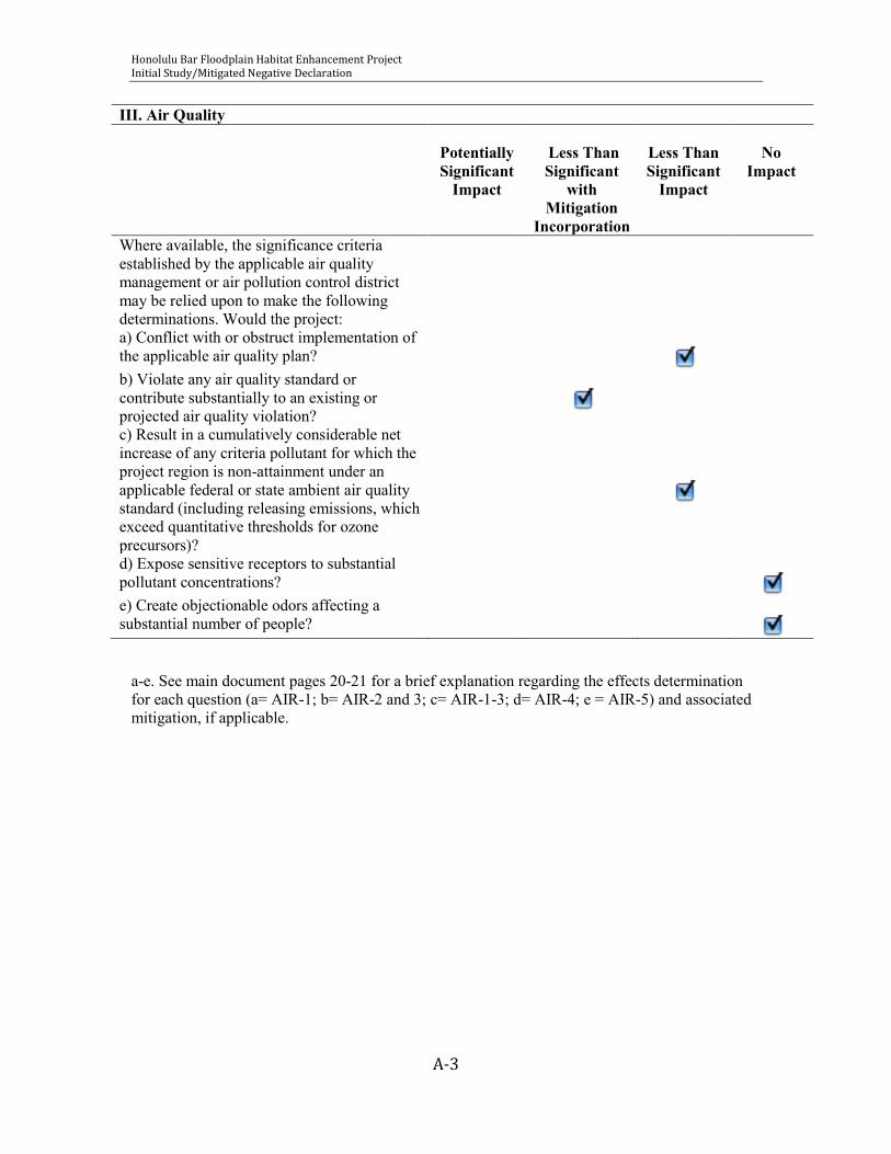
Honolulu Bar Floodplain Habitat Enhancement Project Initial Study/Mitigated Negative Declaration
A-3
III. Air Quality
Potentially Significant
Impact
Less Than Significant
with Mitigation
Incorporation
Less Than Significant
Impact
No
Impact
Where available, the significance criteria established by the applicable air quality management or air pollution control district may be relied upon to make the following determinations. Would the project:
a) Conflict with or obstruct implementation of the applicable air quality plan?
b) Violate any air quality standard or contribute substantially to an existing or projected air quality violation?
c) Result in a cumulatively considerable net increase of any criteria pollutant for which the project region is non-attainment under an applicable federal or state ambient air quality standard (including releasing emissions, which exceed quantitative thresholds for ozone precursors)?
d) Expose sensitive receptors to substantial pollutant concentrations?
e) Create objectionable odors affecting a substantial number of people?
a-e. See main document pages 20-21 for a brief explanation regarding the effects determination for each question (a= AIR-1; b= AIR-2 and 3; c= AIR-1-3; d= AIR-4; e = AIR-5) and associated mitigation, if applicable.

Honolulu Bar Floodplain Habitat Enhancement Project Initial Study/Mitigated Negative Declaration
A-4
IV. Biological Resources
Potentially Significant
Impact
Less Than Significant
with Mitigation
Incorporation
Less Than Significant
Impact
No
Impact
Would the project: a) Have a substantial adverse effect, either directly or through habitat modifications, on any species identified as a candidate, sensitive, or special status species in local or regional plans, policies, or regulations, or by the California Department of Fish and Game or U.S. Fish and Wildlife Service?
b) Have a substantial adverse effect on any riparian habitat or other sensitive natural community identified in local or regional plans, policies, regulations or by the California Department of Fish and Game or US Fish and Wildlife Service?
c) Have a substantial adverse effect on federally protected wetlands as defined by Section 404 of the Clean Water Act (including, but not limited to, marsh, vernal pool, coastal, etc.) through direct removal, filling, hydrological interruption, or other means?
d) Interfere substantially with the movement of any native resident or migratory fish or wildlife species or with established native resident or migratory wildlife corridors, or impede the use of native wildlife nursery sites?
e) Conflict with any local policies or ordinances protecting biological resources, such as a tree preservation policy or ordinance? a substantial number of people?
f) Conflict with the provisions of an adopted Habitat Conservation Plan, Natural Community Conservation Plan, or other approved local, regional, or state habitat conservation plan?
a-f. See main document pages 29-35 for a brief explanation regarding the effects determination for each question (a, b and d= BIO-1 through BIO 4; c= BIO_5,; e= BIO 6; and f= BIO 7) and associated mitigation measures, if applicable.

Honolulu Bar Floodplain Habitat Enhancement Project Initial Study/Mitigated Negative Declaration
A-5
V. Cultural Resources
Potentially Significant
Impact
Less Than Significant
with Mitigation
Incorporation
Less Than Significant
Impact
No
Impact
Would the project: a) Cause a substantial adverse change in the significance of a historical resource as defined in '15064.5?
b) Cause a substantial adverse change in the significance of an archaeological resource pursuant to '15064.5?
c) Directly or indirectly destroy a unique paleontological resource or site or unique geologic feature?
d) Disturb any human remains, including those interred outside of formal cemeteries?
a-d. See main document pages 35-36 for a brief explanation regarding the effects determination for each question (a-c= CULT 1; d= CULT 3) and associated mitigation measures, if applicable.

Honolulu Bar Floodplain Habitat Enhancement Project Initial Study/Mitigated Negative Declaration
A-6
VI. Geology and Soils
Potentially Significant
Impact
Less Than Significant
with Mitigation
Incorporation
Less Than Significant
Impact
No
Impact
Would the project:
a) Expose people or structures to potential substantial adverse effects, including the risk of loss, injury, or death involving:
i) Rupture of a known earthquake fault, as delineated on the most recent Alquist-Priolo Earthquake Fault Zoning Map issued by the State Geologist for the area or based on other substantial evidence of a known fault? Refer to Division of Mines and Geology Special Publication 42.
ii) Strong seismic ground shaking? iii) Seismic-related ground failure, including liquefaction?
iv) Landslides?
b) Result in substantial soil erosion or the loss of topsoil?
c) Be located on a geologic unit or soil that is unstable, or that would become unstable as a result of the project, and potentially result in on- or off-site landslide, lateral spreading, subsidence, liquefaction or collapse?
d) Be located on expansive soil, as defined in Table 18-1-B of the Uniform Building Code (1994), creating substantial risks to life or property? formal cemeteries?
e) Have soils incapable of adequately supporting the use of septic tanks or alternative waste water disposal systems where sewers are not available for the disposal of waste water?
a-e. See main document pages 36-38 for a brief explanation regarding the effects determination for each question (a= GEO-1; b= GEO 2; c and d= GEO 3; e= GEO 4) and associated mitigation measures, if applicable.

Honolulu Bar Floodplain Habitat Enhancement Project Initial Study/Mitigated Negative Declaration
A-7
VII. Hazards and Hazardous Materials Potentially
Significant Impact
Less Than Significant
with Mitigation
Incorporation
Less Than Significant
Impact
No Impact
Would the project: a) Create a significant hazard to the public or the environment through the routine transport, use, or disposal of hazardous materials?
b) Create a significant hazard to the public or the environment through reasonably foreseeable upset and accident conditions involving the release of hazardous materials into the environment?
c) Emit hazardous emissions or handle hazardous or acutely hazardous materials, substances, or waste within one-quarter mile of an existing or proposed school?
e) For a project located within an airport land use plan or, where such a plan has not been adopted, within two miles of a public airport or public use airport, would the project result in a safety hazard for people residing or working in the Project area?
f) For a project within the vicinity of a private airstrip, would the project result in a safety hazard for people residing or working in the Project area?
g) Impair implementation of or physically interfere with an adopted emergency response plan or emergency evacuation plan?
h) Expose people or structures to a significant risk of loss, injury or death involving wildland fires, including where wildlands are adjacent to urbanized areas or where residences are intermixed with wildlands?
a-h. See main document pages 38-39 for a brief explanation regarding the effects determination for each question (a= HAZ-1; b= HAZ-2; c= HAZ 3; d= HAZ 4; e and f= HAZ 5; g= HAZ-6; h= HAZ-7) and associated mitigation measures, if applicable.

Honolulu Bar Floodplain Habitat Enhancement Project Initial Study/Mitigated Negative Declaration
A-8
VIII. Hydrology and Water Quality
Potentially Significant
Impact
Less Than Significant
with Mitigation Incorporation
Less Than Significant
Impact
No
Impact
Would the project: a) Violate any water quality standards or waste discharge requirements?
b) Substantially deplete groundwater supplies or interfere substantially with groundwater recharge such that there would be a net deficit in aquifer volume or a lowering of the local groundwater table level (e.g., the production rate of pre-existing nearby wells would drop to a level which would not support existing land uses or planned uses for which permits have been granted)?
c) Substantially alter the existing drainage pattern of the site or area, including through the alteration of the course of a stream or river, in a manner which would result in substantial erosion or siltation on- or off-site?
d) Substantially alter the existing drainage pattern of the site or area, including through the alteration of the course of a stream or river, or substantially increase the rate or amount of surface runoff in a manner which would result in flooding on- or off-site?
e) Create or contribute runoff water which would exceed the capacity of existing or planned stormwater drainage systems or provide substantial additional sources of polluted runoff?
f) Otherwise substantially degrade water quality?
g) Place housing within a 100-year flood hazard area as mapped on a federal Flood Hazard Boundary or Flood Insurance Rate Map or other flood hazard delineation map?
h) Place within a 100-year flood hazard area structures which would impede or redirect flood flows?
i) Expose people or structures to a significant risk of loss, injury or death involving flooding, including flooding as a result of the failure of a levee or dam?
j) Inundation by seiche, tsunami, or mudflow? a-f. See main document pages 41-44 for a brief explanation regarding the effects determination for each question (a= HYDRO-1; b= HYDRO-2; c-e= HYDRO 3; f= HYDRO 1-3; g and h= HYDRO-4; i= HYDRO-5; j= Hydro 6) and associated mitigation measures, if applicable.

Honolulu Bar Floodplain Habitat Enhancement Project Initial Study/Mitigated Negative Declaration
A-9
IX. Land Use and Planning
Potentially Significant
Impact
Less Than Significant
with Mitigation
Incorporation
Less Than Significant
Impact
No
Impact
Would the project: a) Physically divide an established community?
b) Conflict with any applicable land use plan, policy, or regulation of an agency with jurisdiction over the project (including, but not limited to the general plan, specific plan, local coastal program, or zoning ordinance) adopted for the purpose of avoiding or mitigating an environmental effect?
c) Conflict with any applicable habitat conservation plan or natural community conservation plan?
a-c. See main document page 17 for a brief explanation regarding the effects determination for each question.

Honolulu Bar Floodplain Habitat Enhancement Project Initial Study/Mitigated Negative Declaration
A-10
X. Mineral Resources
Potentially Significant
Impact
Less Than Significant
with Mitigation
Incorporation
Less Than Significant
Impact
No
Impact
Would the project: a) Result in the loss of availability of a known mineral resource that would be of value to the region and the residents of the state?
b) Result in the loss of availability of a locally-important mineral resource recovery site delineated on a local general plan, specific plan or other land use plan?
a-b. See main document page 17 for a brief explanation regarding the effects determination for each question.

Honolulu Bar Floodplain Habitat Enhancement Project Initial Study/Mitigated Negative Declaration
A-11
XI. Noise
Potentially Significant
Impact
Less Than Significant
with Mitigation
Incorporation
Less Than Significant
Impact
No
Impact
Would the project: a) Exposure of persons to or generation of noise levels in excess of standards established in the local general plan or noise ordinance, or applicable standards of other agencies?
b) Exposure of persons to or generation of excessive groundborne vibration or groundborne noise levels?
c) A substantial permanent increase in ambient noise levels in the project vicinity above levels existing without the project?
d) A substantial temporary or periodic increase in ambient noise levels in the project vicinity above levels existing without the project?
e) For a project located within an airport land use plan or, where such a plan has not been adopted, within two miles of a public airport or public use airport, would the project expose people residing or working in the Project area to excessive noise levels?
f) For a project within the vicinity of a private airstrip, would the project expose people residing or working in the Project area to excessive noise levels?
a-f. See main document pages 44-45 for a brief explanation regarding the effects determination for each question.

Honolulu Bar Floodplain Habitat Enhancement Project Initial Study/Mitigated Negative Declaration
A-12
XII. Population and Housing
Potentially Significant
Impact
Less Than Significant
with Mitigation
Incorporation
Less Than Significant
Impact
No Impact
Would the project:
a) Induce substantial population growth in an area, either directly (for example, by proposing new homes and businesses) or indirectly (for example, through extension of roads or other infrastructure)?
b) Displace substantial numbers of existing housing, necessitating the construction of replacement housing elsewhere?
c) Displace substantial numbers of people, necessitating the construction of replacement housing elsewhere?
a-c. See main document page 17 for a brief explanation regarding the effects determination for each question.

Honolulu Bar Floodplain Habitat Enhancement Project Initial Study/Mitigated Negative Declaration
A-13
XIII. Public Services
Potentially Significant
Impact
Less Than Significant
with Mitigation
Incorporation
Less Than Significant
Impact
No Impact
Would the project:
a) Would the project result in substantial adverse physical impacts associated with the provision of new or physically altered governmental facilities, need for new or physically altered governmental facilities, the construction of which could cause significant environmental impacts, in order to maintain acceptable service ratios, response times or other performance objectives for any of the public services:
Fire protection?
Police protection?
Schools?
Parks?
Other public facilities?
a. See main document page 17 for a brief explanation regarding the effects determination for each question.
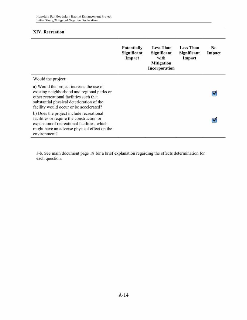
Honolulu Bar Floodplain Habitat Enhancement Project Initial Study/Mitigated Negative Declaration
A-14
XIV. Recreation
Potentially Significant
Impact
Less Than Significant
with Mitigation
Incorporation
Less Than Significant
Impact
No Impact
Would the project:
a) Would the project increase the use of existing neighborhood and regional parks or other recreational facilities such that substantial physical deterioration of the facility would occur or be accelerated?
b) Does the project include recreational facilities or require the construction or expansion of recreational facilities, which might have an adverse physical effect on the environment?
a-b. See main document page 18 for a brief explanation regarding the effects determination for each question.
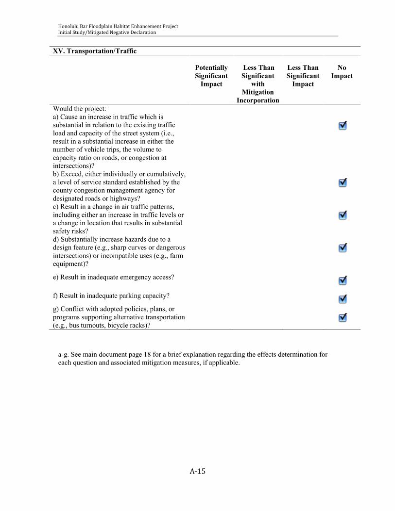
Honolulu Bar Floodplain Habitat Enhancement Project Initial Study/Mitigated Negative Declaration
A-15
XV. Transportation/Traffic
Potentially Significant
Impact
Less Than Significant
with Mitigation
Incorporation
Less Than Significant
Impact
No
Impact
Would the project: a) Cause an increase in traffic which is substantial in relation to the existing traffic load and capacity of the street system (i.e., result in a substantial increase in either the number of vehicle trips, the volume to capacity ratio on roads, or congestion at intersections)?
b) Exceed, either individually or cumulatively, a level of service standard established by the county congestion management agency for designated roads or highways?
c) Result in a change in air traffic patterns, including either an increase in traffic levels or a change in location that results in substantial safety risks?
d) Substantially increase hazards due to a design feature (e.g., sharp curves or dangerous intersections) or incompatible uses (e.g., farm equipment)?
e) Result in inadequate emergency access?
f) Result in inadequate parking capacity?
g) Conflict with adopted policies, plans, or programs supporting alternative transportation (e.g., bus turnouts, bicycle racks)?
a-g. See main document page 18 for a brief explanation regarding the effects determination for each question and associated mitigation measures, if applicable.
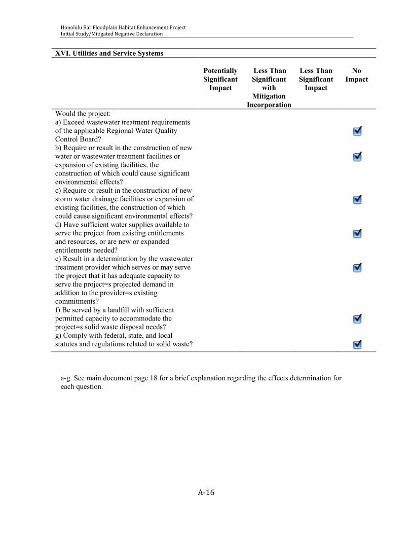
Honolulu Bar Floodplain Habitat Enhancement Project Initial Study/Mitigated Negative Declaration
A-16
XVI. Utilities and Service Systems
Potentially Significant
Impact
Less Than Significant
with Mitigation
Incorporation
Less Than Significant
Impact
No
Impact
Would the project: a) Exceed wastewater treatment requirements of the applicable Regional Water Quality Control Board?
b) Require or result in the construction of new water or wastewater treatment facilities or expansion of existing facilities, the construction of which could cause significant environmental effects?
c) Require or result in the construction of new storm water drainage facilities or expansion of existing facilities, the construction of which could cause significant environmental effects?
d) Have sufficient water supplies available to serve the project from existing entitlements and resources, or are new or expanded entitlements needed?
e) Result in a determination by the wastewater treatment provider which serves or may serve the project that it has adequate capacity to serve the project=s projected demand in addition to the provider=s existing commitments?
f) Be served by a landfill with sufficient permitted capacity to accommodate the project=s solid waste disposal needs?
g) Comply with federal, state, and local statutes and regulations related to solid waste?
a-g. See main document page 18 for a brief explanation regarding the effects determination for each question.

Honolulu Bar Floodplain Habitat Enhancement Project Initial Study/Mitigated Negative Declaration
A-17
XVII. Mandatory Findings of Significance
Potentially Significant
Impact
Less Than Significant
with Mitigation
Incorporation
Less Than Significant
Impact
No
Impact
Would the project: a) Does the project have the potential to degrade the quality of the environment, substantially reduce the habitat of a fish or wildlife species, cause a fish or wildlife population to drop below self-sustaining levels, threaten to eliminate a plant or animal community, reduce the number or restrict the range of a rare or endangered plant or animal or eliminate important examples of the major periods of California history or prehistory?
b) Does the project have impacts that are individually limited, but cumulatively considerable? ("Cumulatively considerable" means that the incremental effects of a project are considerable when viewed in connection with the effects of past projects, the effects of other current projects, and the effects of probable future projects)?
c) Does the project have environmental effects which will cause substantial adverse effects on human beings, either directly or indirectly?

Honolulu Bar Floodplain Habitat Enhancement Project Initial Study/Mitigated Negative Declaration
a. The Proposed Action is a habitat restoration project designed to provide long-term benefits for fisheries and terrestrial resources. Although long-term effects are beneficial, there is a potential to temporarily impact several resources (e.g., biological resources, water quality, air quality). Impacts would be reduced to Less than Significant with implementation of mitigation measures.
b. The Proposed Action is a habitat restoration project designed to provide long-term benefits for fisheries and terrestrial resources. There would be no cumulatively considerable impacts associated with the project.
c. The Proposed Action does not have environmental effects that will cause substantial adverse effects on human beings, either directly or indirectly. There is no impact.

Honolulu Bar Floodplain Habitat Enhancement Project Initial Study/Mitigated Negative Declaration
APPENDIX B
REVEGETATION PLAN
for
ENVIRONMENTAL ASSESSMENT/INITIAL STUDY- HONOLULU BAR FLOODPLAIN ENHANCEMENT PROJECT

Honolulu Bar Floodplain Habitat Enhancement Project Initial Study/Mitigated Negative Declaration
REVEGETATION PLAN FOR HONOLULU BAR FLOODPLAIN ENHANCEMENT PROJECT
Stanislaus River Mile 49 to 50.5
Stanislaus County, California
Prepared For:
FISHBIO Environmental Inc.

Honolulu Bar Floodplain Habitat Enhancement Project Initial Study/Mitigated Negative Declaration
B-i
TABLE OF CONTENTS
I. EXECUTIVE SUMMARY ................................................................................................................. 1
A. Impacted versus Created Vegetation & Habitat Type .................................................... 1
B. Project Goals ................................................................................................................................... 1
C. Summary Schedule ....................................................................................................................... 1
II. PROJECT DESCRIPTION .............................................................................................................. 1
A. Location and Size .......................................................................................................................... 1
B. Current and Proposed Uses ...................................................................................................... 3
C. Owner, Land Manager, other Involved Parties.................................................................. 3
D. Project Summary and Schedule .............................................................................................. 3
E. Parties Responsible for Project ............................................................................................... 4
F. Required Permits .......................................................................................................................... 4
G. .............................................................................................................................................................. 4
H. Environmental Setting ................................................................................................................ 5
1. Climate, Aspect ....................................................................................................................... 5
2. Configuration and Topography ....................................................................................... 5
3. Hydrology (Surface and Groundwater), Water Quality ......................................... 5
4. Geology/Geomorphology ................................................................................................... 8
5. Soils, Testing and Descriptions ........................................................................................ 8
6. Vegetation/Habitat Maps and Descriptions ............................................................ 12
7. Sensitive/Target Species and Habitats ...................................................................... 12
I. Site Access and Accessibility ................................................................................................... 12
J. Site Constraints ............................................................................................................................ 12
K. Rehabilitation Potential .......................................................................................................... 12
III. GOALS ............................................................................................................................................ 13
A. Mitigation Goals ......................................................................................................................... 13

Honolulu Bar Floodplain Habitat Enhancement Project Initial Study/Mitigated Negative Declaration
B-ii
B. Drainage & Hydrology ............................................................................................................. 13
C. Substrate Stability ..................................................................................................................... 13
D. Erosion and Sedimentation ................................................................................................... 15
E. Sensitive/Target Species and Habitats .............................................................................. 15
F. Time Lapse .................................................................................................................................... 16
IV. IMPLEMENTATION PLAN AND SPECIFICATIONS ....................................................... 16
A. Responsible Parties .................................................................................................................. 16
B. Schedule ........................................................................................................................................ 16
C. Ingress/Egress ............................................................................................................................ 18
D. Ground Preparation .................................................................................................................. 18
E. Protections for Extant Vegetation ....................................................................................... 18
F. Planting Substrate ...................................................................................................................... 18
1. Testing .................................................................................................................................... 18
2. Decompaction ...................................................................................................................... 19
3. Amending and Fertilizing ............................................................................................... 19
4. Mulching ................................................................................................................................ 19
5. Weed Eradication ............................................................................................................... 19
6. Slope Protection, and Erosion and Sediment Control .......................................... 19
G. Plant Materials ............................................................................................................................ 19
1. Species Selections, Plant Materials, and Quantities .............................................. 20
2. Propagule source (e.g., commercial, custom collect) ........................................... 24
3. Plant Handling ..................................................................................................................... 25
4. Planting Rates, Densities, Spacing ............................................................................... 25
5. Planting Methods ............................................................................................................... 25
6. Planting Locations ............................................................................................................. 25
7. Plant Protection .................................................................................................................. 25
8. Planting and Seeding Schedule ..................................................................................... 25
Honolulu Bar Floodplain Habitat Enhancement Project Initial Study/Mitigated Negative Declaration
B-iii
9. Irrigation, Frequency, Duration, Source and Water Quality ............................. 26
10. Inspections During Implementation, Frequency ................................................. 26
11. Long-term Maintenance ................................................................................................ 26
V. SITE MAINTENANCE ................................................................................................................. 26
A. Schedule of Activities (during implementation phase) .............................................. 26
B. Description of Activities .......................................................................................................... 27
1. Weed Control ....................................................................................................................... 27
2. Irrigation/Supplemental Watering ............................................................................. 27
3. Replanting ............................................................................................................................. 27
4. Erosion Control ................................................................................................................... 27
5. Control of Anthropogenic Effects (e.g., fencing, signing) .................................... 28
C. Evaluation and Reporting of Maintenance Activities .................................................. 28
VI. PERFORMANCE STANDARDS .............................................................................................. 28
A. Year 1 Survival ............................................................................................................................ 28
B. Years 2 and 3 Aerial Cover ..................................................................................................... 28
VII. REFERENCES............................................................................................................................. 30

Honolulu Bar Floodplain Habitat Enhancement Project Initial Study/Mitigated Negative Declaration
B-iv
LIST OF TABLES
Table 1. Soil excavation notes for soil pits 11-16 .................................................................... 10
Table 2. Design considerations for target wildlife species .................................................. 15
Table 3. Proposed project schedule .............................................................................................. 17
Table 4. Recommended species composition and seeding rate or plant spacing for Honolulu Bar Floodplain Enhancement Project ............................................................... 22
Table 5. Performance standards for Honolulu Bar Floodplain Enhancement Project .............................................................................................................................................................. 29
LIST OF FIGURES
Figure 1. Location Map ......................................................................................................................... 2
Figure 2. Soil Pit Locations and Elderberry Shrub Locations at Honolulu Bar ............... 6
Figure 3. Existing Vegetation at Honolulu Bar ......................................................................... 14
Figure 4. Proposed Planting Plan ................................................................................................... 21
ATTACHMENT
Attachment A – Observed Species List
Recommended citation:
River Partners. 2009. Revegetation Plan for Honolulu Bar Floodplain Enhancement Project, Stanislaus County. Prepared for FISHBIO Environmental Inc. Oakdale, California
Honolulu Bar Floodplain Habitat Enhancement Project Initial Study/Mitigated Negative Declaration
B-1
I. EXECUTIVE SUMMARY
A. Impacted versus Created Vegetation & Habitat Type The Honolulu Bar Floodplain Enhancement Project will provide out-of-kind habitat mitigation for unavoidable impacts to 0.6 acres of seasonal wetlands/vernal pools related to the construction of a new regulating reservoir at the confluence of three Oakdale Irrigation District (OID) facilities. The total acreage of the Honolulu Bar is 21.9 acres. Approximately 1,000 linear feet of side channel will be graded to elevation suitable for provision of seasonally inundated floodplain rearing habitat for salmonids and to provide reconnection of an historic side channel to the main channel of the Stanislaus River. Revegetation of the graded area is described in this plan. The minimum mitigation ratio of 4:1 will result in at least 2.4 acres of restored floodplain riparian habitat. OID intends to use any additional acreage of riparian mitigation for future projects as the need arises.
B. Project Goals The goal of this revegetation project is to establish dense cover of native riparian and wetland plant communities on areas to be graded for rearing salmonid habitat enhancement at Honolulu Bar along the Stanislaus River. The riparian plant community will be resistant to weed competition and self-sustaining after the initial establishment period. Additional goals of the revegetation project include controlling invasive weeds within the restoration area, discouraging undesirable vegetation encroachment in restored salmonid floodplain areas, promoting diversity and abundance of native pollinators and enhancing habitat components for valley elderberry longhorn beetle (VELB, Desmocerus californicus dimorphus), and riparian songbirds and mammals. Should unavoidable impacts to VELB host plants (blue elderberry Sambucus mexicanus) arise during project implementation, this plan will serve as a mitigation strategy for impacts to VELB habitat as well.
C. Summary Schedule Revegetation is expected to take three years. If mitigation for VELB impacts is required, the site will be maintained and monitored through the required timeline (10 years) as described in the VELB guidelines (USFWS 1999). Initial planting will begin after final grading and site preparation in or around fall of 2010, and maintenance and monitoring will continue through November 1, 2013 (or 2020 as required for VELB habitat impacts).
II. PROJECT DESCRIPTION
A. Location and Size The Honolulu Bar Floodplain Enhancement Project (37˚47’58.42”N, 120˚43’34.00”W) is located within the active channel at Stanislaus River Mile 49 to 50.5, in Stanislaus County, California (Figure 1). Approximately 1,000 linear feet of side channel will be graded to elevation suitable for provision of seasonally inundated floodplain rearing habitat for salmonids and to provide reconnection of

Honolulu Bar Floodplain Habitat Enhancement Project Initial Study/Mitigated Negative Declaration
B-2
Figure 1. Location Map
Honolulu Bar Floodplain Habitat Enhancement Project Initial Study/Mitigated Negative Declaration
B-3
an historic side channel to the main channel of the Stanislaus River. Revegetation of the graded area is described in this plan. The minimum mitigation ratio of 4:1 will result in at least 2.4 acres of restored floodplain riparian habitat.
B. Current and Proposed Uses The restoration area is owned by the U.S. Army Corps of Engineers (Corps) and is managed as a public recreation area as one of the Stanislaus River Parks. There are no proposed changes to land use. The property is within the 100-year flood zone as delineated by the California Department of Water Resources (DWR) which precludes the possibility of development in the future.
C. Owner, Land Manager, other Involved Parties The restoration area is owned and managed by the Corps. The Project is jointly funded by the U.S. Fish and Wildlife Services Anadrmous Fish Restoration Program and by OID. FISHBIO Environmental, Inc. will manage the planning, permitting, and implementation of this revegetation plan. River Partners prepared this plan and will provide supporting consulting services to FISHBIO as requested.
D. Project Summary and Schedule Planting: Revegetation of the mitigation area will commence following the completion of grading activities. Grading activities will leave behind a prepared bed suitable for planting native riparian trees, shrubs and herbs. Plant materials will be collected from the site for propagation and out planting. Species propagated from seed will be planted from purchased container-grown stock in fall, following the first substantial rains of the season. Species propagated from live cuttings will be installed in winter immediately following cuttings harvest. Replants will be installed after the second growing season for any species showing greater than 30% mortality (or less than 70% survival) during the first annual monitoring event. In fall of the second project year, an herbaceous understory will be seeded around the planted trees and shrubs. Maintenance: Following installation, plants will be irrigated through one growing season (approximately April through October) as determined necessary by a qualified biologist. The site will be kept weed-free throughout the first growing season through repeated mowing, spot treatment with approved aquatic herbicide, or hand removal as determined necessary by a qualified biologist. Maintenance will continue through two additional growing seasons (three growing seasons total) as determined necessary by a qualified biologist. Performance standards are proposed by community type for both woody and herbaceous species. Monitoring: Project activities will be monitored throughout the project year by a qualified restoration biologist. Permanent photopoints will be established throughout the project site to document the development of the vegetation visually. At the end of each growing season (August), the site will be monitored for quantitative results (see Appendix E).
Honolulu Bar Floodplain Habitat Enhancement Project Initial Study/Mitigated Negative Declaration
B-4
E. Parties Responsible for Project
Applicant / Permittee: Applicant’s Designated Agent: Property Owner / Long-term Management Preparer of this plan:
John B. Davids, P.E. District Engineer Oakdale Irrigation District 1205 East F Street Oakdale, California 95361 Michele Palmer Senior Scientist FISHBIO Environmental Inc. 599 Hi Tech Parkway Oakdale, California 95361 U.S. Army Corps of Engineers Stanislaus River Parks 17968 Covered Bridge Road Oakdale, CA 95361-9510 Julie Rentner Restoration Ecologist River Partners 1301 L Street Suite 4 Modesto, California 95354
F. Required Permits Work within the Designated Floodway requires an encroachment permit from the California Department of Water Resources (DWR). The entirety of Honolulu Bar is within the Designated Floodway. Work within the banks of a stream requires a California Department of Fish and Game Code Section 1600 Lake and Streambed Alteration Permit. Work within Clean Water Act Section 404 Navigable Waters of the U.S. requires a Nationwide or Individual Permit from the Corps. Work within Corps Jurisdiction also requires approval from the California Regional Water Quality Control Board under Section 401 of the Clean Water Act. Project impacts to an anadromous fish-bearing stream require consultation with NOAA’s National Marine Fisheries Service (NMFS). Consultation may be initiated by the Corps. Potential project impacts to an elderberry shrub(s)(Sambucus mexicanus) require consultation with the U.S. Fish and Wildlife Service (USFWS) under the Endangered Species Act.
Honolulu Bar Floodplain Habitat Enhancement Project Initial Study/Mitigated Negative Declaration
B-5
G. Environmental Setting The following sections describe the restoration area current conditions. This description is the result of site assessments performed by FISHBIO, and River Partners (October and December 2009). The condition of vegetation on the site is limited to those plants observed during the site visits. Soil excavation locations and existing elderberry shrubs are presented in Figure 2.
1. Climate, Aspect
The restoration area is located at approximately 140 feet elevation in the western foothills of the Sierra Nevada. Rainfall is 13 to 15 inches per year. Precipitation falls only as rainfall and is concentrated in the winter months (November through February). The site generally slopes to the south with the Stanislaus River channel, and receives direct sunlight throughout the day. The growing season in this region, calculated as the average frost-free day to average first frost is 230 to 250 days (March to October).
2. Configuration and Topography
The restoration area is a point bar in the channel of the Stanislaus River (Honolulu Bar). It is oriented with the main channel in a north- to south direction. The main channel of the Stanislaus River is located along the eastern edge of the bar, and a side channel with limited connectivity is located on the western edge of the bar. Elevation of the bar ranges from 130 to 160 feet (based on USBR 2008 LiDAR and bathymetry provided by Cbec Environmental LLC.).
3. Hydrology (Surface and Groundwater), Water Quality
Historically, this stretch of the Stanislaus River’s hydrology was influenced by winter rains in January and February and snowmelt that provided consistently high flows from March to June. The vegetative communities of the lower Stanislaus River are adapted to this seasonal pulsing, with seed production, germination and establishment relying upon the periodic clearing of streamside vegetation and exposure of bare mineral soil. Prior to construction of Goodwin Dam, Honolulu Bar would have experienced periodic inundation during the winter and spring months, supporting a mosaic of forest, scrub, and herbaceous vegetation communities. Periodic high flows would have discouraged riparian vegetation encroachment into the channel on either side of the bar. The regulated hydrology of the Stanislaus River has been shown to promote riparian vegetation encroachment into seasonal side channels, limiting habitat conditions suitable for rearing fish.
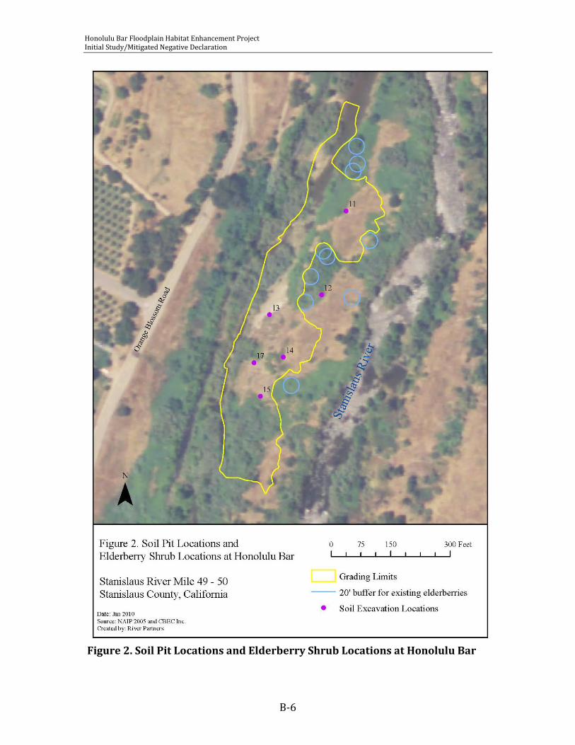
Honolulu Bar Floodplain Habitat Enhancement Project Initial Study/Mitigated Negative Declaration
B-6
Figure 2. Soil Pit Locations and Elderberry Shrub Locations at Honolulu Bar

Honolulu Bar Floodplain Habitat Enhancement Project Initial Study/Mitigated Negative Declaration
B-7
Donald Maltz and Peter Moyle (Maltz and Moyle 1984) describe the effects of altered hydrology on riparian vegetation and its interaction with fish communities:
Variation in stream flow may affect fish populations directly by changing the amount and quality of instream habitat available to fishes, or indirectly through interactions with the riparian community. Indirect effects of natural or unnatural variation in stream flow include changing the temperature, substrate, or availability of cover. At flood stage the water flowing through the riparian vegetation is slowed enough to provide refuge to fishes from excessively high velocities. During low flow, the riparian vegetation may further reduce flows through water removal via transpiration. Transpiration rates by riparian vegetation along small streams at low elevations may be high enough that flows become intermittent during late summer, confining the fish to isolated pools. Natural variation in stream flow strikes a long-term balance in riparian communities, whereas reduced and stabilized flows often result in drastically modified systems. In small, regulated streams the encroaching riparian vegetation may reduce stream width and shade the stream enough to significantly reduce production.
In its Final Environmental Impact Report for The San Joaquin River Agreement 1999-2010 (commonly referred to as VAMP – Vernalis Adaptive Management Plan), the San Joaquin River Group Authority describes the Stanislaus River from Knight’s Ferry to the confluence with the San Joaquin River as being impaired by riparian vegetation encroachment into the channel, with sandbar (also known as narrowleaf) willow (Salix exigua) mentioned specifically. They note that the effects of flow regulation are most notable in this river (relative to the entire San Joaquin system). They also describe the stretch of river between Oakdale and Knight’s Ferry as the first significant infestation of giant reed (Arundo donax) as you move upstream from the confluence with the San Joaquin River. Giant reed was observed along the boundaries of the existing side channel at Honolulu Bar, and is expected to continue to encroach into shallow or seasonally flooded areas with sandbar willow, limiting the long-term habitat benefits of floodplain areas for rearing fish. As these pioneering species encroach into aquatic habitats, shade and higher rates of transpiration limit the productivity of the aquatic habitat and enhance potential for sedimentation and eventual isolation of the channel as has occurred historically. These considerations have prompted the project team to promote a sparsely vegetated floodplain with isolated pockets of herbaceous and woody vegetation to provide appropriate temperatures, a productive food base, and long-term habitat sustainability for rearing fish. Currently, the bar receives infrequent inundation only during large flood events, and over only a portion of its area. Flows strong enough to clear bare mineral seed beds are rare. Active restoration is required to promote disturbance-adapted phreatophytic species such as cottonwood (Populus fremontii) and black willow (Salix gooddingii) quickly, and to discourage encroachment and establishment of
Honolulu Bar Floodplain Habitat Enhancement Project Initial Study/Mitigated Negative Declaration
B-8
sandbar willow and giant reed. The planting zone identified in this plan is designed for targeted inundation at 400 cubic feet per second (Chris Campbell, pers. comm. December 2009). Under the targeted flow regime, these terraces would be inundated 73% of days between February and June in an average year. The terrace bottom, thus will be planted with sparse clusters of flood tolerant herbaceous species providing foraging habitat for salmonids, while the high terrace and surrounding uplands will be planted with phreatophytic woody species capable of reaching perennial water at depth and providing shade and eventually large woody debris to the channel. Perennial groundwater is within 20 feet of the highest elevation of the bar year round. Water quality on the Stanislaus River is considered to be high quality containing low levels of salts, total dissolved solids and other trace elements (Markiewicz et.al. 2001).
4. Geology/Geomorphology
The restoration area is a gravel bar within the channel of the Stanislaus River. Controlled releases from Goodwin Dam limit the frequency of flows capable of moving course sediments and cobbles. The bar is considered stable, and has appeared in its current situations in aerial photos dating to the 1930s. Excavations were done in several locations during December 2009 to determine the composition of bar deposits at depth (Figure 2). Excavations on the high bar (sample points 11, 12, 14, and 15) revealed a deep depositional layer of cobble and/or sand overlaying the native soil. The origin of this material is unknown, however their size and height of cobble and sand deposits indicate that they are the result of human activities (dredging, dam and road construction), and not natural river processes. The results of these excavations are summarized in Table 1 below.
5. Soils, Testing and Descriptions
The soil survey of Stanislaus County, California, Northern Part (USDA 2007) identifies one soil type within the restoration area: Columbia sandy loam, drained, 0-2 percent slopes, rarely flooded. In a typical profile, the top 13 inches is sandy loam overlaying up to 60 inches of stratified sand with depth to restrictive layer over 80 inches. The parent material is coarse loamy alluvium derived from igneous metamorphic and sedimentary rock. This map unit is classified as somewhat poorly drained. Soil pits were excavated on December 17 2009 to collect gravel samples for engineering analysis. Six of the soil pits were observed by River Partners biologists to determine expected rooting conditions for desired plant communities. The results of these excavations are presented in Table 1. Soil pit locations are presented in Figure 2. In general, pits excavated on the high elevation areas of the bar (11, 12, 14 and 15) comprised a thin layer of gravelly sand with many fine roots overlaying a thick layer
Honolulu Bar Floodplain Habitat Enhancement Project Initial Study/Mitigated Negative Declaration
B-9
of cobble, gravel and sand. Excavations in two of these pits could not reach groundwater as the substrate is prone to collapse. These areas support mostly herbaceous vegetation and we suspect they are the result of human-induced disturbance (either direct deposits of material, or large flushing events that deposited bed load in this location). It is expected that the mapped soil type (Columbia sandy loam) may be found below excavated depths. The availability of ground water in the late summer and fall in the high elevation areas of the bar is likely limited for shallow rooting species, thus deep-rooted phreatophytes are suggested for planting. Irrigation during the first two to three years will be necessary to train roots of newly planted species to reach the deep water table. Grading of the side channel will likely cause ponding in these areas during wet years, enhancing conditions for establishment of riparian herbaceous species, and possibly discouraging encroachment by woody vegetation. Pits excavated on the low elevation portions of the bar near the existing degraded side channel (13 and 17) showed characteristics of the mapped soil type: Columbia sandy loam. Large woody roots were observed throughout the profile to a depth of four feet where the permanent water table was observed. Grading of these areas may cause intersection with permanent groundwater which will discourage encroachment by woody vegetation and enhance the side channel’s habitat value for fish.

Honolulu Bar Floodplain Habitat Enhancement Project Initial Study/Mitigated Negative Declaration
B-10
Table 1. Soil excavation notes for soil pits 11-16 (other soil excavations were planned and/or completed for gravel size analysis and were not observed by River Partners’ biologists).
Pit Texture Rooting depth
Depth to water table: existing and at target
grade
Existing vegetation and notes
11
Sand to 19”
Coarse sand, gravel and cobble to 96”
Sand below 96”
Many fine and very fine roots to 20”
108” existing
40” at grade
80% cover: annual grasses and Himalayan blackberry
Limited water holding capacity of gravel and sand layers limits woody and herbaceous riparian vegetation establishment. Grading will enhance water availability to riparian herbaceous plants considerably.
12
Sand to 10”
Coarse sand, gravel and cobble to 77”
Unable to excavate > 77”
Many fine and very fine roots to 10”
none observed, location out of grading footprint
80-90% cover: annual grasses and Himalayan blackberry
The limited water holding capacity of the gravel layer likely limits woody and herbaceous riparian vegetation establishment here. Phreatophytic trees and shrubs are recommended and will require 2-3 years irrigation to train roots to grow deep.
13
Coarse sand, gravel, cobble, and stones to 26”
Coarse sand, gravel and cobble below 26”
Many fine and very fine roots to 26”
Few fine and medium roots to 40”
40” existing
14” at grade
20 to 30% cover: occasional riparian herbs and shrubs including verbena, sedges, rushes and brickellbush.
Pit was excavated in an existing swale. Similar wetland herbaceous plant species and coverage are recommended.
14
Coarse sand, gravel, cobble, and stones to 12”
Coarse sand, gravel and cobble to 72”
Sand below 72”
Unable to excavate > 84”
Many fine and very fine roots to 12”
Few fine and medium roots to 40”
None observed,
Target grade is 78” below existing surface
80-90% cover: annual grasses and Himalayan blackberry
Limited water holding capacity of gravel and sand layers limits woody and herbaceous riparian vegetation establishment. Grading will enhance water availability to riparian herbaceous plants considerably.

Honolulu Bar Floodplain Habitat Enhancement Project Initial Study/Mitigated Negative Declaration
B-11
15
Coarse sand, gravel, cobble and stones to 8”
Coarse sand, gravel and cobble to 72”
Oxidized sand below 72”
Many fine and very fine roots to 8”
90” existing
28” at grade
80% cover: annual grasses and Himalayan blackberry
Limited water holding capacity of gravel and sand layers limits woody and herbaceous riparian vegetation establishment. Oxidized sand layer indicates that the water table may intersect the surface during the period of target inundation (February through June) following grading. Grading will enhance water availability to riparian herbaceous plants considerably, and also may limit encroachment by woody species.
17
Coarse sand and gravel to 16”
Sandy loam, gravel and cobble to 48”
Many fine roots to 12”
Common medium and coarse roots 40-48”
48” existing
12” at grade
90% cover: riparian trees and shrubs including Himalayan blackberry, black willow, sandbar willow and white alder
Pit was excavated in native soil as described in the soil survey. Color change below 36” indicates that the water table may intersect the surface during the period of target inundation (February through June) following grading. Grading will enhance water availability to riparian herbaceous plants considerably, and also may limit encroachment by woody species.

Honolulu Bar Floodplain Habitat Enhancement Project Initial Study/Mitigated Negative Declaration
B-12
6. Vegetation/Habitat Maps and Descriptions
Vegetation types present on Honolulu Bar consist of non-native annual grasslands dominated by brome grasses (Bromus hordeaceous, B. diandrus), with occasional shrubs or perennial herbs (Lupinus albifrons, Brickellia californica, Aster chilensis, and Heterotheca grandiflora) and Himalayan blackberry thickets containing few sapling stage native trees (Salix exigua, Sambucus mexicanus, Alnus rhombifolia, and Quercus lobata)(Figure 3). Some riparian forest (S. goodinggii, S. lasiolepis, Acer negundo, Q. lobata, and Q. berberidifolia) with significant understory domination by Himalayan blackberry, non-native vervain (Verbena bonariensis), and other non-native species occurs around the far eastern and western edges of the bar. Near the side channel on the west side of the bar, the plant communities shift to wetland associations including Typha herbaceous alliance, Juncus herbaceous alliance as described by Sawyer et.al. (2009) and stands of non-native vervain. Invasive weeds present on site that will provide significant management challenges in the near and long term include Himalayan blackberry, red sesbania (Sesbania punicea), tree of heaven (Ailanthus altissimus), giant reed (Arundo donax), and yellow star thistle (Centaurea solstitialis).
7. Sensitive/Target Species and Habitats
The Stanislaus River hosts fall-run Chinook salmon (Oncorhynchus tshawyfscha) and federally-threatened steelhead trout (O. mykiss) as well as resident rainbow. This project is designed to improve habitat for these species. A survey of Honolulu Bar for VELB was performed by River Partners in 2006. Surveyed elderberries were not found to have evidence of beetle presence (River Partners 2007). The site is not expected to host any protected plant species, and generally hosts a weedy, non-native plant community. The riparian corridor of the Stanislaus River provides an important migratory corridor for many riparian-dependent species, and numerous riparian birds may use the habitats of the project area for foraging, nesting, or resting.
H. Site Access and Accessibility The site is accessed from Orange Blossom Road, and is open from sun up to sun down as a recreation area managed by the Corps. The restoration area is disconnected from dry land by the river channel on the east and a side channel on the west.
I. Site Constraints The site is accessible to the public, thus has limitations for infrastructure and security. A pump used for irrigation must be removable from the site as vandalism is possible.
J. Rehabilitation Potential The restoration area hosts a degraded plant community that is the result of altered hydrology, weed seed sources upstream, and prior disturbance in the river itself

Honolulu Bar Floodplain Habitat Enhancement Project Initial Study/Mitigated Negative Declaration
B-13
(mining and dredging). The water table is or will be high following grading, and water quality is excellent. In areas where the depth to ground water is greater than 10 feet, supplemental deep irrigations will aid in the establishment of woody species. Based on River Partners’ previous experience along the Stanislaus River, the site has ample opportunity to be rehabilitated to native riparian habitat.
III. GOALS
A. Mitigation Goals The grading and planting of 2.4 acres of Honolulu Bar serves as out-of-kind mitigation for unavoidable impacts to jurisdictional wetlands under the Clean Water Act. Additionally, impacts to riparian vegetation protected under California Fish and Game Code will be mitigated on site. Should unavoidable impacts to VELB host plants (blue elderberry Sambucus mexicanus) arise during project implementation, this plan will serve as a mitigation strategy for impacts to VELB habitat as well.
B. Drainage & Hydrology Final grading will result in improved connectivity between the side channel on the west side of Honolulu Bar and the river channel. The lowest terrace will be inundated during flows greater than 400 cubic feet per second which generally occur 73% of days between February and June. Drainage will be gradual as groundwater will likely intersect the surface of the enhanced channel. The improved duration of inundation in the side channel will help to discourage riparian vegetation encroachment into the side channel.
C. Substrate Stability Flows large enough to mobilize the planting area are infrequent at this point along the Stanislaus River, and the planting substrate is expected to be relatively stable. Coarse materials will be used for the terrace bottom with the exception of areas targeted for herbaceous species establishment. Areas targeted for herbaceous species establishment on the terrace bottom and along the slopes at the edge of the terrace will be covered with 6 to 12 inches of fine material stockpiled from on site sources. Proper erosion control measures will be undertaken to ensure fine materials are not washed away during pulse or high flows.

Honolulu Bar Floodplain Habitat Enhancement Project Initial Study/Mitigated Negative Declaration
B-14
Figure 3. Existing Vegetation at Honolulu Bar
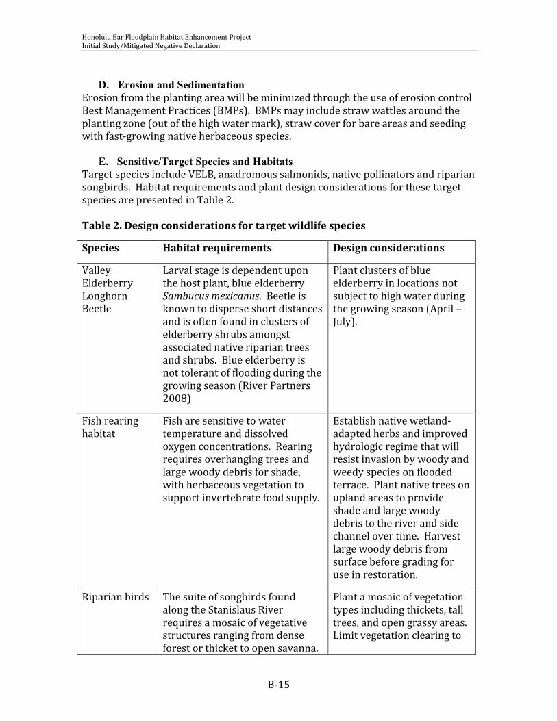
Honolulu Bar Floodplain Habitat Enhancement Project Initial Study/Mitigated Negative Declaration
B-15
D. Erosion and Sedimentation
Erosion from the planting area will be minimized through the use of erosion control Best Management Practices (BMPs). BMPs may include straw wattles around the planting zone (out of the high water mark), straw cover for bare areas and seeding with fast-growing native herbaceous species.
E. Sensitive/Target Species and Habitats Target species include VELB, anadromous salmonids, native pollinators and riparian songbirds. Habitat requirements and plant design considerations for these target species are presented in Table 2. Table 2. Design considerations for target wildlife species
Species Habitat requirements Design considerations
Valley Elderberry Longhorn Beetle
Larval stage is dependent upon the host plant, blue elderberry Sambucus mexicanus. Beetle is known to disperse short distances and is often found in clusters of elderberry shrubs amongst associated native riparian trees and shrubs. Blue elderberry is not tolerant of flooding during the growing season (River Partners 2008)
Plant clusters of blue elderberry in locations not subject to high water during the growing season (April – July).
Fish rearing habitat
Fish are sensitive to water temperature and dissolved oxygen concentrations. Rearing requires overhanging trees and large woody debris for shade, with herbaceous vegetation to support invertebrate food supply.
Establish native wetland-adapted herbs and improved hydrologic regime that will resist invasion by woody and weedy species on flooded terrace. Plant native trees on upland areas to provide shade and large woody debris to the river and side channel over time. Harvest large woody debris from surface before grading for use in restoration.
Riparian birds The suite of songbirds found along the Stanislaus River requires a mosaic of vegetative structures ranging from dense forest or thicket to open savanna.
Plant a mosaic of vegetation types including thickets, tall trees, and open grassy areas. Limit vegetation clearing to
Honolulu Bar Floodplain Habitat Enhancement Project Initial Study/Mitigated Negative Declaration
B-16
Species Habitat requirements Design considerations
Nesting season (April – July) is a sensitive time for vegetation disturbance.
the non-breeding season.
Native pollinators
Native pollinators benefit from a diversity of flowering times for food supply and may benefit from regionally specific plant adaptations.
Plant herbaceous and woody species with a diversity of flowering times, only from locally derived native plant material.
F. Time Lapse The planting design presented here is expected to mature rapidly, with native herbaceous species, large shrubs and mid-size trees being thoroughly established in 3 years. The initial forest community will be dominated by fast-growing early-successional species such as cottonwood and black willow. Long term plant community succession in the absence of scouring flood flows is expected to produce a valley oak dominated riparian forest canopy within 20 – 30 years. The terrace bottom is expected to resist encroachment by riparian vegetation over time as a result of improved surface hydrology (inundation during the growing season). Weed control will be required over the long term but is expected to require substantially less mechanical and chemical treatment than the unrestored site over time.
IV. IMPLEMENTATION PLAN AND SPECIFICATIONS
A. Responsible Parties FishBio Environmental Inc. will be responsible for implementation of this planting plan.
B. Schedule The following is a summary of the project schedule. This information is presented graphically in Table 2.
Clearing of non-native vegetation will occur after July 1, 2010 to avoid impacts to potentially-present breeding birds.
Grading and site preparation will occur following the completion of non-native vegetation clearing.
Planting will occur in fall 2010 for container stock and plugs, and winter 2011 for species propagated vegetatively (from cuttings). Replants of dead or dying species will occur following the first growing season, with container stock being planted in fall 2011, and cuttings in winter 2012.

Honolulu Bar Floodplain Habitat Enhancement Project Initial Study/Mitigated Negative Declaration
B-17
Seeding of herbaceous species will occur in fall 2011, following one growing season of weed control.
Maintenance of the planting area (irrigation and weed control) will begin in summer 2010 and continue for a period of no fewer than 3 years (ending fall 2013), depending upon project success and mitigation requirements.
Monitoring of project success will begin at the start following initial vegetation clearing to ensure plant materials and installation procedures are satisfactory. Monitors will visit the site at least monthly to document development of the vegetation. Annual monitoring will include quantitative assessment of vegetative characteristics to ensure mitigation goals are met. Project monitoring will continue for a period of no fewer than 5 years (ending fall 2015), depending upon project success and mitigation requirements.
Annual reports will be submitted to the stakeholders no later than October 1 of each year to ensure adequate time for management changes. Annual reports will be due in 2011, 2012, 2013, 2014, and 2015.
Table 4. Proposed project schedule.
J F M A M J J A S O N D J F M A M J J A S O N D
2011 2012
Planning and
Permitting
Non-native Vegetation Removal
Grading
Plant Material
Collection
Planting
Understory seeding
Maintenance
Monitoring
Reporting
J F M A M J J A S O N D J F M A M J J A S O N D
2013 2014
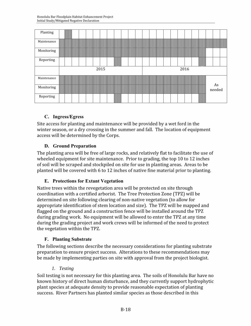
Honolulu Bar Floodplain Habitat Enhancement Project Initial Study/Mitigated Negative Declaration
B-18
Planting
Maintenance
Monitoring
Reporting
2015 2016
Maintenance
As needed
Monitoring
Reporting
C. Ingress/Egress Site access for planting and maintenance will be provided by a wet ford in the winter season, or a dry crossing in the summer and fall. The location of equipment access will be determined by the Corps.
D. Ground Preparation The planting area will be free of large rocks, and relatively flat to facilitate the use of wheeled equipment for site maintenance. Prior to grading, the top 10 to 12 inches of soil will be scraped and stockpiled on site for use in planting areas. Areas to be planted will be covered with 6 to 12 inches of native fine material prior to planting.
E. Protections for Extant Vegetation Native trees within the revegetation area will be protected on site through coordination with a certified arborist. The Tree Protection Zone (TPZ) will be determined on site following clearing of non-native vegetation (to allow for appropriate identification of stem location and size). The TPZ will be mapped and flagged on the ground and a construction fence will be installed around the TPZ during grading work. No equipment will be allowed to enter the TPZ at any time during the grading project and work crews will be informed of the need to protect the vegetation within the TPZ.
F. Planting Substrate The following sections describe the necessary considerations for planting substrate preparation to ensure project success. Alterations to these recommendations may be made by implementing parties on site with approval from the project biologist.
1. Testing
Soil testing is not necessary for this planting area. The soils of Honolulu Bar have no known history of direct human disturbance, and they currently support hydrophytic plant species at adequate density to provide reasonable expectation of planting success. River Partners has planted similar species as those described in this

Honolulu Bar Floodplain Habitat Enhancement Project Initial Study/Mitigated Negative Declaration
B-19
planting plan on over 100 acres of riparian floodplain on the Stanislaus River, and we expect that the soils of Honolulu Bar do not differ significantly from those planted already (Buffington and Mohler tracts of the San Joaquin River National Wildlife Refuge and McHenry Park).
2. Decompaction
Decompaction is not expected to be necessary at this time. The necessity of decompaction will be determined following completion of grading activities and in cooperation with the landscaping contractor.
3. Amending and Fertilizing
Soil amendment and fertilization is not recommended for this site.
4. Mulching
Covering bare soil with straw mulch during the first growing season is recommended to reduce the potential of soil erosion from higher-elevation areas. Once native herbaceous seed is installed throughout the planting area, coverage with straw mulch is not required.
5. Weed Eradication
Non-native vegetation will be cleared manually to reveal the location and extent of existing native riparian trees and shrubs within the existing thickets of Himalayan blackberry. Grading will effectively remove or disturb the root systems of many of the perennial weeds present on site. Giant reed, red sesbania, Himalayan blackberry and tree of heaven will be mechanically removed and remaining stumps will be treated with approved aquatic herbicide. Other annual weeds, including yellow star thistle, ripgut brome (B. diandrus), and medusa-head grass (Taeniantherum caput-medusae) will be removed mechanically or through a combination of herbicide treatment and mechanical removal prior to planting.
6. Slope Protection, and Erosion and Sediment Control
Best Management Practices (BMPs) will be used throughout the project to reduce potential soil erosion into the graded side channel, or the Stanislaus River. BMPs may include installation of straw wattles around the planting zone above the high water mark, straw mulch or erosion control blankets over bare soil areas within the planting zone, and silt fence as needed. Erosion control recommendations will be made by a qualified biologist and field-fit to the planting area following completion of grading activities.
G. Plant Materials The following section describes considerations for the establishment of a self-sustaining native riparian plant community that is resilient to weed outbreaks, and free from maintenance requirements after the initial establishment period. The considerations presented here will ensure that target wildlife will benefit from the proposed project in the short- and long- term.

Honolulu Bar Floodplain Habitat Enhancement Project Initial Study/Mitigated Negative Declaration
B-20
7. Species Selections, Plant Materials, and Quantities
Four plant communities are recommended for the Honolulu Bar Floodplain Enhancement Project: wetland herbaceous, riparian scrub, riparian forest and native grassland. The wetland herbaceous community will be established on approximately 30% of the terrace and is designed to provide food sources for rearing anadromous fish. This community will be established from live plugs or container plants in the fall of 2011. Planting islands will be established on the terrace following observations of the first winter and spring flows to allow for field fitting of appropriate locations and sizes. Planting islands will require approximately 6 to 8 inches of fine soil material (from stockpiles on site) to provide suitable substrate for live plantings. Planting islands should be constructed after the final fall pulse flows to reduce the chances of scour and loss of fine materials. Plants should be installed immediately after construction of planting islands to promote root establishment before winter and spring flows completely flood the terrace. Plant materials for this planting must be contracted well in advance of planting to ensure the quantity and sizes are appropriate. Plants should be ordered no later than June 2011. The riparian scrub community will be established in areas outside the grading footprint currently dominated by Himalayan blackberry, or over areas where fill is deposited on the bar. This community will be planted with woody species in fall 2010. Herbaceous species will be seeded in the understory after the first growing season in fall 2011. Planting areas will require significant weed removal before planting, and may also require supplemental deposits of fine material to promote plant establishment. The depth of these deposits will be determined on site by a qualified biologist, but may range from 0 to 12 inches in depth. The riparian forest community will be established along the edges of the graded terrace and in areas currently dominated by native and non-native trees and shrubs. This community will be planted with woody species in fall 2010. Herbaceous species will be

Honolulu Bar Floodplain Habitat Enhancement Project Initial Study/Mitigated Negative Declaration
B-21
Figure 4. Proposed Planting Plan
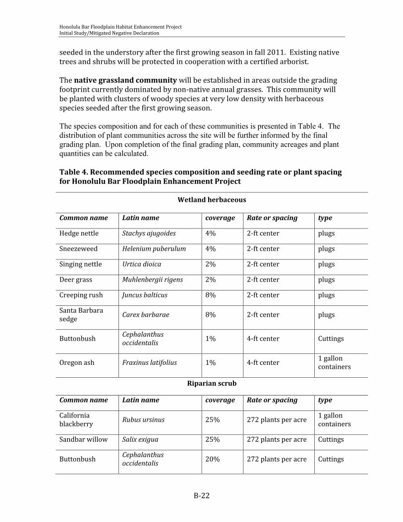
Honolulu Bar Floodplain Habitat Enhancement Project Initial Study/Mitigated Negative Declaration
B-22
seeded in the understory after the first growing season in fall 2011. Existing native trees and shrubs will be protected in cooperation with a certified arborist. The native grassland community will be established in areas outside the grading footprint currently dominated by non-native annual grasses. This community will be planted with clusters of woody species at very low density with herbaceous species seeded after the first growing season. The species composition and for each of these communities is presented in Table 4. The distribution of plant communities across the site will be further informed by the final grading plan. Upon completion of the final grading plan, community acreages and plant quantities can be calculated. Table 4. Recommended species composition and seeding rate or plant spacing for Honolulu Bar Floodplain Enhancement Project
Wetland herbaceous
Common name Latin name coverage Rate or spacing type
Hedge nettle Stachys ajugoides 4% 2-ft center plugs
Sneezeweed Helenium puberulum 4% 2-ft center plugs
Singing nettle Urtica dioica 2% 2-ft center plugs
Deer grass Muhlenbergii rigens 2% 2-ft center plugs
Creeping rush Juncus balticus 8% 2-ft center plugs
Santa Barbara sedge
Carex barbarae 8% 2-ft center plugs
Buttonbush Cephalanthus occidentalis
1% 4-ft center Cuttings
Oregon ash Fraxinus latifolius 1% 4-ft center 1 gallon containers
Riparian scrub
Common name Latin name coverage Rate or spacing type
California blackberry
Rubus ursinus 25% 272 plants per acre 1 gallon containers
Sandbar willow Salix exigua 25% 272 plants per acre Cuttings
Buttonbush Cephalanthus occidentalis
20% 272 plants per acre Cuttings

Honolulu Bar Floodplain Habitat Enhancement Project Initial Study/Mitigated Negative Declaration
B-23
California rose Rosa californica 10% 272 plants per acre 1 gallon containers
Coyote brush Baccharis pilularis 10% 272 plants per acre 1 gallon containers
Mulefat Baccharis salicifolius 10% 272 plants per acre Cuttings
Riparian forest
Common name Latin name coverage Rate or spacing type
White alder Alnus rhombifolia 5% 272 plants per acre 1 gallon containers
Box elder Acer negundo 15% 272 plants per acre 1 gallon containers
Oregon ash Fraxinus latifolius 15% 272 plants per acre 1 gallon containers
Valley oak Quercus lobata 10% 272 plants per acre Acorns
Elderberry Sambucus mexicanus 13% 272 plants per acre 1 gallon containers
Golden currant Ribes aureum 15% 272 plants per acre Cuttings
Black willow Salix gooddingii 15% 272 plants per acre Cuttings
Sandbar willow Salix exigua 10% 272 plants per acre Cuttings
Cottonwood Populus fremontii 2% 272 plants per acre Cuttings
Riparian scrub and forest herbaceous species
Common name Latin name coverage Rate or spacing type
Creeping wildrye Leymus triticoides 33% 6 lbs PLS/acre Seed mix A
Mugwort Artemisia douglasiana 33% 3 lbs PLS/acre Seed mix B
Gumplant Grindelia camporum 33% 3 lbs PLS/acre Seed mix C
Evening primrose Oenothera elata (100%) 0.5 lbs PLS/acre Seed mix A, B, and C
Meadow barley Hordeum brachyantherum
(100%) 3 lbs PLS/acre Seed mix A, B, and C
Common Centromadia pungens (100%) 0.5 lbs PLS/acre Seed mix A, B,
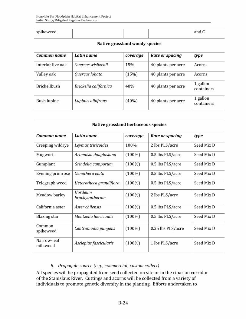
Honolulu Bar Floodplain Habitat Enhancement Project Initial Study/Mitigated Negative Declaration
B-24
spikeweed and C
Native grassland woody species
Common name Latin name coverage Rate or spacing type
Interior live oak Quercus wislizenii 15% 40 plants per acre Acorns
Valley oak Quercus lobata (15%) 40 plants per acre Acorns
Brickellbush Brickelia californica 40% 40 plants per acre 1 gallon containers
Bush lupine Lupinus albifrons (40%) 40 plants per acre 1 gallon containers
Native grassland herbaceous species
Common name Latin name coverage Rate or spacing type
Creeping wildrye Leymus triticoides 100% 2 lbs PLS/acre Seed Mix D
Mugwort Artemisia douglasiana (100%) 0.5 lbs PLS/acre Seed Mix D
Gumplant Grindelia camporum (100%) 0.5 lbs PLS/acre Seed Mix D
Evening primrose Oenothera elata (100%) 0.5 lbs PLS/acre Seed Mix D
Telegraph weed Heterotheca grandiflora (100%) 0.5 lbs PLS/acre Seed Mix D
Meadow barley Hordeum brachyantherum
(100%) 2 lbs PLS/acre Seed Mix D
California aster Aster chilensis (100%) 0.5 lbs PLS/acre Seed Mix D
Blazing star Mentzelia laevicaulis (100%) 0.5 lbs PLS/acre Seed Mix D
Common spikeweed
Centromadia pungens (100%) 0.25 lbs PLS/acre Seed Mix D
Narrow-leaf milkweed
Asclepias fascicularis (100%) 1 lbs PLS/acre Seed Mix D
8. Propagule source (e.g., commercial, custom collect)
All species will be propagated from seed collected on site or in the riparian corridor of the Stanislaus River. Cuttings and acorns will be collected from a variety of individuals to promote genetic diversity in the planting. Efforts undertaken to

Honolulu Bar Floodplain Habitat Enhancement Project Initial Study/Mitigated Negative Declaration
B-25
promote genetic diversity and local source plant material will be described in the annual report for project years 1 and 2. Should adequate source be unavailable from this location, the planting plan will be amended to exclude unavailable species while maintaining target planting densities.
9. Plant Handling
Container stock will be planted on site according to nursery standards as described in the American Standards for Nursery Stock (ANSI Z60.1). Cuttings will be collected and installed in one planting effort to avoid cuttings storage.
10. Planting Rates, Densities, Spacing
Planting rates, densities, and spacing are described in Table 4. Should adequate source material be unavailable to plant at recommended spacing or rates for individual species, adjustments can be made to supplement the seeding mix or planting design to retain the total seeding rate (in PLS), or the total planting density (in plants per acre) .
11. Planting Methods
Plants will be installed according to nursery standards (ANSI Z60.1) and best professional judgment of experienced landscapers or biologists. Plants will be installed at the appropriate timing per the planting schedule.
12. Planting Locations
The extent and distribution of plant communities will be finalized following completion of final grading plans. Locations of individual plants will be determined in the field based upon irrigation layout and efficiency in maintenance. Woody species will not be planted at spacing denser than 8-foot centers, and are generally recommended for uniform distribution throughout the community type. An exception to this uniform distribution is in the grassland community where woody species will be planted in a clustered fashion, while maintaining the desired minimum 8-foot spacing.
13. Plant Protection
Woody plants will be installed in a milk carton or other paper protector to allow for herbicide application or mowing in proximity to the plant. Milk cartons will be partially filled with wood shavings to act as mulch. Further plant protection including cages to protect trees from deer browse may be necessary pending results of first year monitoring. If mortality caused by excessive browse exceeds 30%, protective measures will be required.
14. Planting and Seeding Schedule
Container plants will be installed in fall 2010 to take advantage of the first winter rains. Cuttings will be installed in winter 2011. Herbaceous seeding will occur in fall 2011, following the first winter rains. Replanting of dead or missing plants will

Honolulu Bar Floodplain Habitat Enhancement Project Initial Study/Mitigated Negative Declaration
B-26
occur following the first growing season in fall 2011 for container species, or winter 2012 for cuttings.
15. Irrigation, Frequency, Duration, Source and Water Quality
Irrigation will be required for the first three growing seasons for planted woody species. River Partners has successfully established woody riparian plants on over 1500 acres of riparian floodplains in Stanislaus and San Joaquin Counties, and has found that three years of irrigation is sufficient to train plant roots to grow deep and reach permanent water at depth. The wetland herbaceous community will not require irrigation.
Woody plantings will be irrigated through drip irrigation. Each plant will be serviced by one ½ gallon per hour drip emitter. The frequency of drip emitters may be increased if excessive wilting is observed during the first growing season. The drip irrigation system will be serviced by a removable pump that draws water from the Stanislaus River and is protected by a fish screen that maintains approach velocities less than 1 cubic foot per second. Water quality in the Stanislaus River is generally regarded as excellent.
Irrigation should occur for approximately 24 hours once per week during the first growing season, and adjusted according to plant success. In subsequent growing seasons, the frequency of irrigation may be decreased to promote deep rooting.
16. Inspections During Implementation, Frequency
The site will be visited at least monthly by a qualified biologist familiar with the plant species and horticultural restoration methods. The monitor will communicate at least monthly with the implementation contractor to relate project developments and track challenges throughout the year.
17. Long-term Maintenance
This planting is designed to be self sustaining after three years. Weed control and riparian vegetation encroachment into the restored channel will require passive monitoring in the long term. All occurrences of giant reed should be treated immediately. Coverage of yellow star thistle should be kept below 10% total absolute cover, and maintenance should discourage seed set (through repeated mowing or aggressive herbicide treatment). Red sesbania and tree of heaven should be removed within one year of detection on site.
V. SITE MAINTENANCE
A. Schedule of Activities (during implementation phase) The site will be irrigated once per week during the growing season (April – October) or as needed as determined by the project biologist. During the first growing

Honolulu Bar Floodplain Habitat Enhancement Project Initial Study/Mitigated Negative Declaration
B-27
season, the spaces between plantings are to be maintained weed free (< 30% cover by weeds species listed as moderate or high on Cal-IPC’s 2006 Invasive Plant Inventory). Seed set will be avoided through constant maintenance during this time. After installation of the native herbaceous species, maintenance will include irrigation and selective treatment of problematic weeds.
B. Description of Activities
18. Weed Control
During the first growing season, weeds will be controlled through aggressive mechanical and chemical methods. The spaces between plantings are to be maintained weed free during this period. Seed set will be avoided through constant maintenance during this time. After installation of the native herbaceous species, weed control will be less aggressive, with selective treatment of problematic weeds as necessary during the growing season. Repeated mowing may be used during this time to discourage seed set from problematic weeds and encourage establishment of native perennials. All occurrences of giant reed, red sesbania, Himalayan blackberry, tree of heaven, and yellow star thistle will be treated immediately. Other weedy species may be present at low coverage (< 30% absolute coverage) before remedial action is taken.
19. Irrigation/Supplemental Watering
Woody plantings will be irrigated through drip irrigation. Each plant will be serviced by one ½ gallon per hour drip emitter. The frequency of drip emitters mat be increased in excessive wilting is observed during the first growing season. Irrigation should occur for approximately 24 hours once per week during the first growing season, and adjusted according to plant success. In subsequent growing seasons, the frequency of irrigation may be decreased to promote deep rooting.
20. Replanting
Species showing less than 70% survival after the first growing season will be replanted in-kind. Survival will not be monitored after the first growing season, thus replants will be recommended based upon aerial coverage goals in project year 3 and beyond. Should a species show particularly poor performance relative to other species planted, the species may be considered for out-of –kind replacement by the reporting biologist. Recommendations for out-of-kind replacement must be made with ample lead time to allow for local-source plant material collection.
21. Erosion Control
The planting zone will be protected with straw wattles or silt fence above the high water mark. Erosion will be monitored at least monthly, and recommendations will be made by the reporting biologist regarding poor performance and corrective actions.
Honolulu Bar Floodplain Habitat Enhancement Project Initial Study/Mitigated Negative Declaration
B-28
22. Control of Anthropogenic Effects (e.g., fencing, signing)
The planting zone is protected from most human trespass by wet channels on the east and west sides. Should monitors notice vandalism or other anthropogenic effects with potential to adversely impact the planting, corrective measures such as signage or fencing will be recommended to the implementing organization and the Corps.
C. Evaluation and Reporting of Maintenance Activities The maintenance contractor will report maintenance activities to the monitoring biologist monthly, with summary reports due by the 15th of the month for the previous month. The reporting biologist will collate maintenance reports and summarize maintenance activities in the annual report. The site will be visited at least monthly by a qualified biologist familiar with the plant species and horticultural restoration methods. The monitor will communicate at least monthly with the implementation contractor to relate project developments and track challenges throughout the year.
VI. PERFORMANCE STANDARDS
A. Year 1 Survival Species showing survival of less than 70% after the first growing season will be replanted in-kind. Species showing survival of less than 60% will be considered for replanting out-of-kind (meaning that they will be replanted with a species that performs well at this site). Performance standards for Project Years 1-3 are presented in Table 5.
B. Years 2 and 3 Aerial Cover Following the 2nd and 3rd growing seasons, aerial cover will be used to evaluate project success. Target aerial coverage of native species for each community type is presented in Table 5.
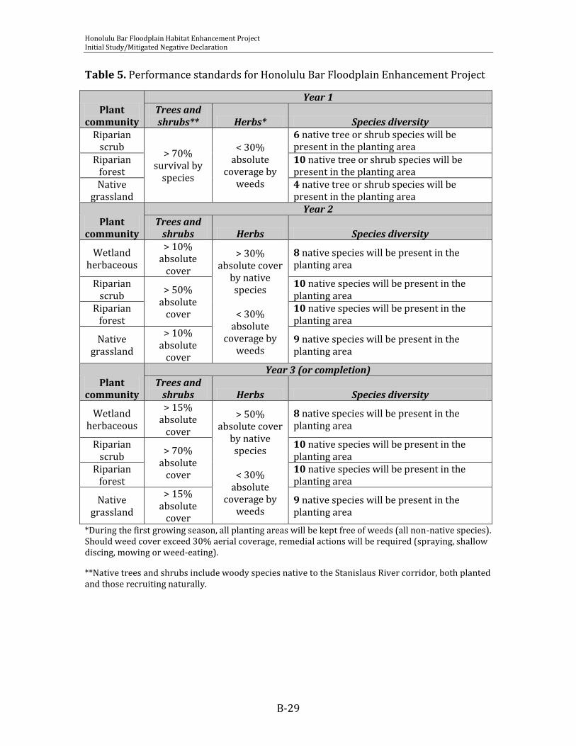
Honolulu Bar Floodplain Habitat Enhancement Project Initial Study/Mitigated Negative Declaration
B-29
Table 5. Performance standards for Honolulu Bar Floodplain Enhancement Project
Plant community
Year 1 Trees and shrubs** Herbs* Species diversity
Riparian scrub
> 70% survival by
species
< 30% absolute
coverage by weeds
6 native tree or shrub species will be present in the planting area
Riparian forest
10 native tree or shrub species will be present in the planting area
Native grassland
4 native tree or shrub species will be present in the planting area
Plant community
Year 2 Trees and
shrubs Herbs Species diversity
Wetland herbaceous
> 10% absolute
cover
> 30% absolute cover
by native species
< 30%
absolute coverage by
weeds
8 native species will be present in the planting area
Riparian scrub
> 50% absolute
cover
10 native species will be present in the planting area
Riparian forest
10 native species will be present in the planting area
Native grassland
> 10% absolute
cover
9 native species will be present in the planting area
Plant community
Year 3 (or completion) Trees and
shrubs Herbs Species diversity
Wetland herbaceous
> 15% absolute
cover
> 50% absolute cover
by native species
< 30%
absolute coverage by
weeds
8 native species will be present in the planting area
Riparian scrub
> 70% absolute
cover
10 native species will be present in the planting area
Riparian forest
10 native species will be present in the planting area
Native grassland
> 15% absolute
cover
9 native species will be present in the planting area
*During the first growing season, all planting areas will be kept free of weeds (all non-native species). Should weed cover exceed 30% aerial coverage, remedial actions will be required (spraying, shallow discing, mowing or weed-eating).
**Native trees and shrubs include woody species native to the Stanislaus River corridor, both planted and those recruiting naturally.
Honolulu Bar Floodplain Habitat Enhancement Project Initial Study/Mitigated Negative Declaration
B-30
VII. REFERENCES American National Standards Institute. 2004. American Standard for Nursery Stock
ANSI Z60.1 - 2004. American Nursery and Landscape Association, Washington D.C. Available www.anla.org
Baltz D.A. and P.B. Moyle. The Influence of Riparian Vegetation on Stream Fish Communities in California, in: California Riparian Systems: Ecology, Conservation, and Productive Management. Berkeley: University of California Press, c1984 1984. http://ark.cdlib.org/ark:/13030/ft1c6003wp/
Cal-IPC. 2006. California Invasive Plant Inventory. Cal-IPC Publication 2006-02. California Invasive Plant Council: Berkeley, CA. Available: www.cal-ipc.org.
Markiewicz, D., K. Goding, V. de Vlaming, and J. Rowan. 2002. Benthic Macroinvertebrate Bioassessment of San Joaquin River Tributaries: Spring and Fall 2002. Aquatic Toxicology Laboratory, School of Veterinary Medicine: University of California at Davis, and California Regional Water Quality Control Board, Rancho Cordova, California
Newton, G.A. and V.P. Claassen. 2003. Rehabilitation of Disturbed Lands in California: A Manual for Decision-Making. California Department of Conservation. 228 pp.
River Partners. 2007. VELB Habitat and Colonization of Remnant and Planted Elderberry along the Stanislaus and San Joaquin Rivers. San Joaquin, Stanislaus and Tuolumne Counties, California. Sara Taylor, Tom Griggs, and Lauren Singleton. Modesto, California.
San Joaquin River Group Authority. 1999. Meeting Flow Objectives for the San Joaquin River Agreement 1999-2010 Environmental Impact Statement and Environmental Impact Report. Davis, California. http://www.sjrg.org/EIR/contents.htm
Sawyer, J.O., T. Keeler-Wolf, and J.M. Evans. 2009. A Manual of California Vegetation, second edition. California Native Plant Society in collaboration with California Department of Fish and Game, Sacramento, California
U.S.D.A. Natural Resource Conservation Service. 2007. Soil Survey for Stanislaus County, California, Northern Part. 341 pp.
U.S. Fish and Wildlife Service. 1999. Conservation Guidelines for Valley Elderberry Longhorn Beetle, 9 July 1999. Sacramento Fish and Wildlife Office, Sacramento, California

ATTACHMENT A
Observed Species Lists

Honolulu Bar Floodplain Habitat Enhancement Project Initial Study/Mitigated Negative Declaration
OBSERVED PLANT SPECIES AT HONOLULU BAR (December 2009)
Family Scientific Name Common Name
Invasive weeds
Asteraceae Centaurea solstitialis yellow-star thistle
Brassicaceae Cardaria draba hoary cress
Brassicaceae Lepidium latifolium peppergrass
Fabaceae Trifolium hirtum rose clover
Poaceae Arundo donax giant reed
Poaceae Avena fatua wild oat
Poaceae Brachypodium distachyon purple false brome
Poaceae Bromus diandrus ripgut brome
Poaceae Cynodon dactylon Bermuda grass
Poaceae Hordeum murinum barley
Poaceae Taeniantherum caput-medusae Medusa head grass
Poaceae Vulpia myuros rattail fescue
Rosaceae Rubus armeniacus Himalayan blackberry
Simaroubaceae Ailanthus altissima Chinese tree of heaven
Native Species
Aceraceae Acer negundo box elder
Apiaceae Hydrocotyle verticillata pennywort
Asclepiadaceae Asclepias fascicularis narrow-leaf milkweed
Asteraceae Ambrosia psilostachya western ragweed
Asteraceae Artemisia douglasiana California mugwort
Asteraceae Baccharis pilularis coyote bush
Asteraceae Baccharis salicifolia mule fat
Asteraceae Brickelia californica brickellbush

Honolulu Bar Floodplain Habitat Enhancement Project Initial Study/Mitigated Negative Declaration
OBSERVED PLANT SPECIES AT HONOLULU BAR (December 2009)
Family Scientific Name Common Name
Asteraceae Centromadia pungens spikeweed
Asteraceae Euthamia occidentalis western goldenrod
Asteraceae Gnaphalium californica California cudweed
Asteraceae Grindelia camporum Great Valley gumplant
Asteraceae Helenium puberulum sneezeweed
Asteraceae Helianthus annuus common sunflower
Asteraceae Heterotheca grandiflora telegraph weed
Asteraceae Symphyotrichum chilense (=Aster chilensis) aster
Asteraceae Xanthium strumarium cocklebur
Betulaceae Alnus rhombifolia white alder
Boraginaceae Heliotropium curassavicum seaside heliotrope
Caprifoliaceae Sambucus mexicana elderberry
Cuscutaceae Cuscuta indecora dodder
Cyperaceae Carex bararae Santa Barbara sedge
Cyperaceae Cyperus eragrostis umbrella sedge
Cyperaceae Cyperus esculentus yellow nutsedge
Cyperaceae Scirpus californicus tule
Euphorbiaceae Eremocarpus setigerus turkey mullein
Fabaceae Cercis occidentalis western redbud
Fabaceae Glycyrrhiza lepidota wild licorice
Fabaceae Lupinus albifrons bush lupine
Fagaceae Quercus berberidifolia scrub oak
Fagaceae Quercus lobata valley oak
Fagaceae Quercus wislizenii interior live oak
Geraniaceae Geranium carolinianum cranesbill
Juncaceae Juncus balticus wire rush
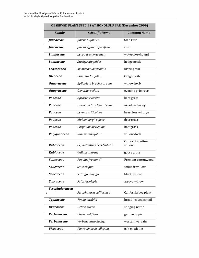
Honolulu Bar Floodplain Habitat Enhancement Project Initial Study/Mitigated Negative Declaration
OBSERVED PLANT SPECIES AT HONOLULU BAR (December 2009)
Family Scientific Name Common Name
Juncaceae Juncus bufonius toad rush
Juncaceae Juncus effuscus pacificus rush
Lamiaceae Lycopus americanus water-horehound
Lamiaceae Stachys ajugoides hedge nettle
Loasaceaea Mentzelia laevicaulis blazing star
Oleaceae Fraxinus latifolia Oregon ash
Onagraceae Epilobium brachycarpum willow herb
Onagraceae Oenothera elata evening primrose
Poaceae Agrostis exarata bent grass
Poaceae Hordeum brachyantherum meadow barley
Poaceae Leymus triticoides beardless wildrye
Poaceae Muhlenbergii rigens deer grass
Poaceae Paspalum distichum knotgrass
Polygonaceae Rumex salicifolius willow dock
Rubiaceae Cephalanthus occidentalis California button willow
Rubiaceae Galium aparine goose grass
Salicaceae Populus fremontii Fremont cottonwood
Salicaceae Salix exigua sandbar willow
Salicaceae Salix goodinggii black willow
Salicaceae Salix lasiolepis arroyo willow
Scrophulariaceae Scrophularia californica California bee plant
Typhaceae Typha latifolia broad-leaved cattail
Urticaceae Urtica dioica stinging nettle
Verbenaceae Phyla nodiflora garden lippia
Verbenaceae Verbena lasiostachys western vervain
Viscaceae Phoradendron villosum oak mistletoe

Honolulu Bar Floodplain Habitat Enhancement Project Initial Study/Mitigated Negative Declaration
OBSERVED PLANT SPECIES AT HONOLULU BAR (December 2009)
Family Scientific Name Common Name
Vitaceae Vitis californica California wild grape
Apiaceae Anthriscus caucalis bur-chervil
Asteraceae Lactuca serriola prickly lettuce
Asteraceae Silybum marianum milk thistle
Asteraceae Sonchus asper prickly sow thistle
Brassicaceae Brassica rapa field mustard
Brassicaceae Capsella bursa-pastoris shepherd's purse
Convolvulaceae Convolvulus arvensis bindweed
Cyperaceae Cyperus rotundus purple nutsedge
Fabaceae Lotus corniculatus birdsfoot trefoil
Fabaceae Melilotus albus white sweet clover
Fabaceae Vicia sativa field vetch
Geraniaceae Erodium cicutarium storksbill
Juglandaceae Juglans hindsii walnut
Lamiaceae Marrubium vulgare common horehound
Lamiaceae Mentha spicata spearmint
Plantaginaceae Plantago major common plantain
Poaceae Bromus hordeaceus soft chess
Poaceae Crypsis schoenoides swamp grass
Poaceae Polypogon monspeliensis annual beard grass
Polygonaceae Polygonum arenastrum common knotweed
Polygonaceae Rumex crispus curly dock
Rosaceae Prunus dulcis almond
Scrophulariaceae Verbascum thapsus moth mullein
Scrophulariaceae Veronica anagallis-aquatica water speedwell
Verbenaceae Verbena bonariensis purple-top vervain
C-1
APPENDIX C
MITIGATION MONITORING AND REPORTING PLAN
for
ENVIRONMENTAL ASSESSMENT/INITIAL STUDY-
HONOLULU BAR FLOODPLAIN ENHANCEMENT PROJECT

Honolulu Bar Floodplain Habitat Enhancement Project March 2011 Initial Study/Mitigated Negative Declaration
C-2
MITIGATION MONITORING AND REPORTING PLAN
A Mitigation Monitoring and Reporting Plan (MMRP) for the Honolulu Bar Floodplain
Habitat Enhancement Project (Project) has been prepared in tabular format (Table 1) by Oakdale Irrigation District (OID) to fulfill Section 21081.6 of the California Environmental Quality Act (CEQA), which states that when adopting a mitigated negative declaration
the public agency shall adopt a reporting or monitoring program for the changes made to the project or conditions of project approval, adopted in order to mitigate or avoid significant effects on the environment. The reporting or monitoring program shall be designed to ensure compliance during project implementation.
This MMRP has also been prepared and will be implemented by OID according to the CEQA Guidelines Section 15097(c), which states that
―the Lead Agency may choose whether its program will monitor mitigation, report on mitigation, or both. Reporting generally consists of a written compliance review that is presented to the decision making body or authorized staff person. A report may be required at various stages during project implementation or upon completion of the mitigation measure. Monitoring is generally an ongoing or periodic process of project oversight. There is often no clear distinction between monitoring and reporting and the program best suited to ensuring compliance in any given instance will usually involve elements of both.‖
As part of the Final Mitigated Negative Declaration (MND) for the Project, best management practices (BMP) were developed and presented in Section 2.2. BMPs were designed to avoid, minimize, or reduce any potentially significant environmental impacts associated with the range of activities identified in the Environmental Assessment/Initial Study (PEA/IS) for the Project.
According to CEQA Guidelines Section 15126.4(a)(2), ―mitigation measures must be fully enforceable through permit conditions, agreements, or other legally-binding instruments.‖ Therefore, OID has adopted all best management practices (mitigation measures) from the certified Final Mitigated Negative Declaration (MND) for the Project (Table 1). OID is also responsible for ensuring that mitigation measures are implemented according to the certified MND. Therefore, OID will implement all applicable mitigation measures from Table 1 and will include these mitigation measures as terms and conditions within any contract(s) issued to designated contractors for each project. The MMRP table will be used as a reference for OID to identify applicable mitigation measures and to document mitigation measure compliance for each project. For each mitigation measure, the MMRP table identifies the:
Resource Affected; Best Management Practice (Mitigation Measure); Timing;

Honolulu Bar Floodplain Habitat Enhancement Project March 2011 Initial Study/Mitigated Negative Declaration
C-3
Implementation Responsibility; Monitoring Responsibility; and Implementation Verification
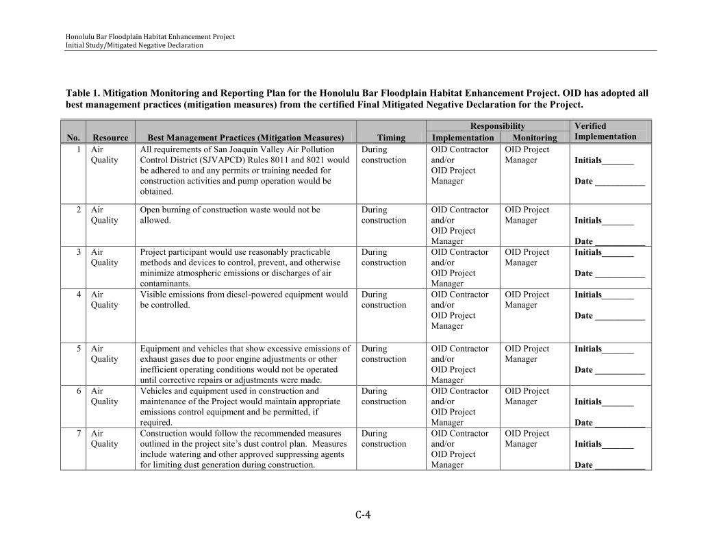
Honolulu Bar Floodplain Habitat Enhancement Project Initial Study/Mitigated Negative Declaration
C-4
Table 1. Mitigation Monitoring and Reporting Plan for the Honolulu Bar Floodplain Habitat Enhancement Project. OID has adopted all best management practices (mitigation measures) from the certified Final Mitigated Negative Declaration for the Project.
No. Resource Best Management Practices (Mitigation Measures) Timing Responsibility Verified
Implementation Implementation Monitoring 1 Air
Quality All requirements of San Joaquin Valley Air Pollution Control District (SJVAPCD) Rules 8011 and 8021 would be adhered to and any permits or training needed for construction activities and pump operation would be obtained.
During construction
OID Contractor and/or OID Project Manager
OID Project Manager
Initials_______ Date ___________
2 Air Quality
Open burning of construction waste would not be allowed.
During construction
OID Contractor and/or OID Project Manager
OID Project Manager
Initials_______ Date ___________
3 Air Quality
Project participant would use reasonably practicable methods and devices to control, prevent, and otherwise minimize atmospheric emissions or discharges of air contaminants.
During construction
OID Contractor and/or OID Project Manager
OID Project Manager
Initials_______ Date ___________
4 Air Quality
Visible emissions from diesel-powered equipment would be controlled.
During construction
OID Contractor and/or OID Project Manager
OID Project Manager
Initials_______ Date ___________
5 Air Quality
Equipment and vehicles that show excessive emissions of exhaust gases due to poor engine adjustments or other inefficient operating conditions would not be operated until corrective repairs or adjustments were made.
During construction
OID Contractor and/or OID Project Manager
OID Project Manager
Initials_______ Date ___________
6 Air Quality
Vehicles and equipment used in construction and maintenance of the Project would maintain appropriate emissions control equipment and be permitted, if required.
During construction
OID Contractor and/or OID Project Manager
OID Project Manager
Initials_______ Date ___________
7 Air Quality
Construction would follow the recommended measures outlined in the project site’s dust control plan. Measures include watering and other approved suppressing agents for limiting dust generation during construction.
During construction
OID Contractor and/or OID Project Manager
OID Project Manager
Initials_______ Date ___________

Honolulu Bar Floodplain Habitat Enhancement Project Initial Study/Mitigated Negative Declaration
C-5
No. Resource Best Management Practices (Mitigation Measures) Timing Responsibility Verified
Implementation Implementation Monitoring 8 Air
Quality Fill material storage piles would include dust-control measures such as water.
During construction
OID Contractor and/or OID Project Manager
OID Project Manager
Initials_______ Date ___________
9 Air Quality
Ground surfaces outside of bankfull channel, which have been significantly disturbed, would be seeded to prevent wind dispersion of soil, as needed.
Post-construction
OID Contractor and/or OID Project Manager
OID Project Manager
Initials_______ Date ___________
10 Air Quality
Removal of vegetation and ground disturbance would be limited to the minimum area necessary to complete construction activities. Vegetative cover would be maintained in appropriate areas to reduce dust.
During construction
OID Contractor and/or OID Project Manager
OID Project Manager
Initials_______ Date ___________
11 Air Quality
Regular watering of exposed soils and unpaved access roads would be conducted during the construction period.
During construction
OID Contractor and/or OID Project Manager
OID Project Manager
Initials_______ Date ___________
12 Air Quality
Grading activities would cease during periods of high winds (greater than 25 miles per hour [mph] averaged over one hour).
During construction
OID Contractor and/or OID Project Manager
OID Project Manager
Initials_______ Date ___________
13 Air Quality
Trucks transporting loose material would be covered or maintain at least two feet of freeboard and not create any visible dust emissions.
During construction
OID Contractor and/or OID Project Manager
OID Project Manager
Initials_______ Date ___________
14 Biological Resources
Construction activities would be conducted between July 2 and September 30, when flows are lowest and the side-channel is disconnected. This construction timeframe would be outside primary salmonid migration/spawning period and outside of the nesting season for raptor and other birds.
During construction
OID Contractor and/or OID Project Manager
OID Project Manager
Initials_______ Date ___________
15 Biological Resources
Before construction, all construction personnel would be instructed on the protection of biological resources. OID will instruct construction workers about the special status species that might be present at the Project site. They would be trained to stop work upon observation of a
OID Contractor and/or OID Project Manager
OID Project Manager
Initials_______ Date ___________

Honolulu Bar Floodplain Habitat Enhancement Project Initial Study/Mitigated Negative Declaration
C-6
No. Resource Best Management Practices (Mitigation Measures) Timing Responsibility Verified
Implementation Implementation Monitoring special status species within the work area, and notify
OID’s Engineer of their discovery. The Engineer shall stop work to confirm if the resource could be avoided and consult with a qualified biologist.
16 Biological Resources
A wetland area adjacent to the project site will not be disturbed. To prevent accidental impacts to wetlands from equipment and personnel, the wetland area shall be clearly marked with highly visible construction tape prior to, and maintained for the full duration of construction.
Prior to and during construction
OID Contractor and/or OID Project Manager
OID Project Manager
Initials_______ Date ___________
17 Biological Resources
To prevent the spread of noxious weeds, construction personnel will be educated regarding weed control and spread prevention, equipment will be rinsed prior to use at the Project site; and native plant species and certified weed free materials will be used for replanting and erosion control.
During and post-construction
OID Contractor and/or OID Project Manager
OID Project Manager
Initials_______ Date ___________
18
Biological Resources
All elderberry plants will not be disturbed within the project site; elderberry plants shall be clearly marked with highly visible construction tape prior to, and maintained for the full duration of construction.
Prior to and during construction
OID Contractor and/or OID Project Manager
OID Project Manager
Initials_______ Date ___________
19 Biological Resources
Herbicide use will be restricted to the minimum needed to ensure adequate control of invasive non-native vegetation. Where other effective means of control are available, these will be prioritized.
Post-construction
OID Contractor and/or OID Project Manager
OID Project Manager
Initials_______ Date ___________
20 Biological Resources
On completion of the work, disturbed areas would be left in a condition that would facilitate natural or appropriate vegetation, provide for proper drainage, and prevent erosion.
Post-construction
OID Contractor and/or OID Project Manager
OID Project Manager
Initials_______ Date ___________
21 Biological Resources
To prevent aquatic vertebrates (fish, amphibians, and reptiles) from entering the wetted Project area within and adjacent to the side channel, flows will be diverted from the work area prior to construction. Pre-construction aquatic vertebrate surveys will be performed in the work
Prior to construction
OID Contractor and/or OID Project Manager
OID Project Manager
Initials_______ Date ___________

Honolulu Bar Floodplain Habitat Enhancement Project Initial Study/Mitigated Negative Declaration
C-7
No. Resource Best Management Practices (Mitigation Measures) Timing Responsibility Verified
Implementation Implementation Monitoring area no more than 10 days prior to the beginning of flows
being diverted, any aquatic vertebrates present in the work area will be relocated under the supervision of a qualified biologist and NMFS and CDFG will be notified.
22 Biological Resources
Pre-construction special status species surveys will be performed in the non-wetted portion of the work area no more than 10 days prior to the beginning of construction, any special status species present in the work area will be relocated under the supervision of a qualified biologist upon notification and approval of CDFG.
Prior to construction
OID Contractor and/or OID Project Manager
OID Project Manager
Initials_______ Date ___________
23 Biological Resources
Before diverting flows, the Project Engineer and a qualified biologist will identify the best means to bypass flow around the work area to minimize disturbance to the channel and avoid mortality of fish and other aquatic vertebrates. Flow will be incrementally diverted at the upstream boundary of the work area to allow aquatic vertebrates in the area to move downstream. Any aquatic vertebrates present in the work area following flow diversion will be relocated under the supervision of a qualified biologist.
Prior to construction
OID Contractor and/or OID Project Manager
OID Project Manager
Initials_______ Date ___________
24 Biological Resources
Before aquatic vertebrate removal and relocation begins, a qualified biologist will identify the most appropriate release location(s). Release locations should have water temperatures similar to the capture location and offer ample habitat for released aquatic vertebrates, and should be selected to minimize the likelihood that aquatic vertebrates will re-enter the work area.
Prior to construction
OID Contractor and/or OID Project Manager
OID Project Manager
Initials_______ Date ___________
25 Biological Resources
Flow diversion shall be done in a manner that shall prevent pollution and/or siltation. Normal flows shall be restored to the affected stream immediately upon completion of work at that location.
Prior to construction
OID Contractor and/or OID Project Manager
OID Project Manager
Initials_______ Date ___________
26 Biological Resources
Monitor water turbidity levels during instream construction activities according to a section 401 water quality permit.
During construction
OID Contractor and/or OID Project
OID Project Manager
Initials_______

Honolulu Bar Floodplain Habitat Enhancement Project Initial Study/Mitigated Negative Declaration
C-8
No. Resource Best Management Practices (Mitigation Measures) Timing Responsibility Verified
Implementation Implementation Monitoring Manager Date ___________
27 Biological Resources
To prevent pollution and/or siltation, prepare and implement a storm water pollution prevention plan.
During construction
OID Contractor and/or OID Project Manager
OID Project Manager
Initials_______ Date ___________
28
Cultural Resources
Before construction, all construction personnel would be instructed on the protection of cultural resources. OID would instruct construction workers that cultural resources might be present at the Project site. They would be trained to stop work near any discovery, and notify OID’s Engineer of their discovery. The Engineer would stop work to confirm if the resource could be avoided and consult with a qualified archeologist.
Prior to and during construction
OID Contractor and/or OID Project Manager
OID Project Manager
Initials_______ Date ___________
29 Cultural Resources
Known significant cultural resources would be fenced and a minimum distance maintained for work disturbances.
Prior to and during construction
OID Contractor and/or OID Project Manager
OID Project Manager
Initials_______ Date ___________
30 Cultural Resources
Should human remains be discovered during excavation, OID’s Engineer shall cease construction and notify and consult with the county coroner's office and the Native American Heritage Commission.
During construction
OID Contractor and/or OID Project Manager
OID Project Manager
Initials_______ Date ___________
31 Hazardous Materials
Hazardous materials would not be drained onto the ground, into streams, or into drainage areas.
During construction
OID Contractor and/or OID Project Manager
OID Project Manager
Initials_______ Date ___________
32 Hazardous Materials
All construction waste, including trash and litter, garbage, other solid waste, petroleum products, and other potentially hazardous materials, would be removed to a disposal facility authorized to accept such materials.
During construction
OID Contractor and/or OID Project Manager
OID Project Manager
Initials_______ Date ___________
33 Hazardous Materials
Waters or soils contaminated with construction material would be disposed of in a suitable location to prevent discharge to surface waters.
During construction
OID Contractor and/or OID Project Manager
OID Project Manager
Initials_______ Date ___________
34 Hazardous Vehicles would be inspected and maintained to reduce During OID Contractor OID Project

Honolulu Bar Floodplain Habitat Enhancement Project Initial Study/Mitigated Negative Declaration
C-9
No. Resource Best Management Practices (Mitigation Measures) Timing Responsibility Verified
Implementation Implementation Monitoring Materials the potential for leaks or spills of oils, grease, or
hydraulic fluids. construction and/or
OID Project Manager
Manager Initials_______ Date ___________
35 Hazardous Materials
Hazardous materials would not be stored at the Project sites.
During construction
OID Contractor and/or OID Project Manager
OID Project Manager
Initials_______ Date ___________
36 Hazardous Materials
No vehicles would be refueled at the Project sites. During construction
OID Contractor and/or OID Project Manager
OID Project Manager
Initials_______ Date ___________
37 Water Quality
Hazardous materials would not be drained onto the ground, recharge cells, the instream channel, or into drainage areas. All waste, including trash and litter, garbage, other solid waste, petroleum products, and other potentially hazardous materials, would be removed to a disposal facility permitted to accept such materials.
During construction
OID Contractor and/or OID Project Manager
OID Project Manager
Initials_______ Date ___________
38 Water Quality
Herbicides will be applied according to manufacturer’s specifications in a manner that minimizes drip and drift into the stream channel.
Post- construction
OID Contractor and/or OID Project Manager
OID Project Manager
Initials_______ Date ___________
39 Water Quality
Spill equipment would be present and easily accessible when refueling any equipment.
During construction
OID Contractor and/or OID Project Manager
OID Project Manager
Initials_______ Date ___________
40 Water Quality
Fueling, cleaning, and maintenance of any equipment would not be allowed except in designated areas located as far from the instream channel as possible.
During construction
OID Contractor and/or OID Project Manager
OID Project Manager
Initials_______ Date ___________
41 Water Quality
Grading activities would implement erosion and sediment control measures.
During construction
OID Contractor and/or OID Project Manager
OID Project Manager
Initials_______ Date ___________
42 Water OID would prepare a construction Storm Water Pollution Prior to, during, OID Contractor OID Project

Honolulu Bar Floodplain Habitat Enhancement Project Initial Study/Mitigated Negative Declaration
C-10
No. Resource Best Management Practices (Mitigation Measures) Timing Responsibility Verified
Implementation Implementation Monitoring Quality Prevention Plan (SWPPP) and implement appropriate
measures. and post- construction, as applicable
and/or OID Project Manager
Manager Initials_______ Date ___________
43 Water Quality
Stream crossings shall be limited to those identified on the project site plan
During construction
OID Contractor and/or OID Project Manager
OID Project Manager
Initials_______ Date ___________
44 Water Quality
All gravels shall be cleaned before being placed in the river.
During construction
OID Contractor and/or OID Project Manager
OID Project Manager
Initials_______ Date ___________
45 Water Quality
All gravel processing areas (cleaning, sorting, screening, stockpiling) shall occur a minimum of 20 feet from the river channel.
During construction
OID Contractor and/or OID Project Manager
OID Project Manager
Initials_______ Date ___________
46 Land Use Construction operations would be conducted to prevent unnecessary destructing, scaring, or defacing of the natural surroundings to preserve the natural landscape to the extent practicable.
During construction
OID Contractor and/or OID Project Manager
OID Project Manager
Initials_______ Date ___________
47 Noise Construction would be restricted to the hours between 7:00 a.m. and 5:00 p.m.
During construction
OID Contractor and/or OID Project Manager
OID Project Manager
Initials_______ Date ___________
48 Soils In construction areas where ground disturbance is substantial or where recontouring is required, surface restoration would occur.
During construction
OID Contractor and/or OID Project Manager
OID Project Manager
Initials_______ Date ___________
49 Soils Any vehicles used during operation and maintenance would drive on existing roads.
During construction
OID Contractor and/or OID Project Manager
OID Project Manager
Initials_______ Date ___________
50 Soils Erosion of soil would be minimized by installation of straw wattles around planting zones above the high water
During and post-
OID Contractor and/or
OID Project Manager
Initials_______

Honolulu Bar Floodplain Habitat Enhancement Project Initial Study/Mitigated Negative Declaration
C-11
No. Resource Best Management Practices (Mitigation Measures) Timing Responsibility Verified
Implementation Implementation Monitoring mark, straw mulch or erosion control blankets over bare
soil areas, and silt fences, as needed construction OID Project
Manager
Date ___________
51 Soils Compaction of soil would be minimized by limiting the areas requiring heavy equipment during construction.
During construction
OID Contractor and/or OID Project Manager
OID Project Manager
Initials_______ Date ___________
52 Soils To prevent the spread of noxious weeds, certified weed free materials will be used for replanting and erosion control.
Post- construction
OID Contractor and/or OID Project Manager
OID Project Manager
Initials_______ Date ___________

Honolulu Bar Floodplain Habitat Enhancement Project January 2010 Initial Study/Mitigated Negative Declaration
D-1
APPENDIX D
PHYSICAL AND BIOLOGICAL RESOURCES MONITORING PLAN
for
ENVIRONMENTAL ASSESSMENT/INITIAL STUDY-
HONOLULU BAR FLOODPLAIN ENHANCEMENT PROJECT
Honolulu Bar Floodplain Habitat Enhancement Project January 2010 Initial Study/Mitigated Negative Declaration
D-2
Honolulu Bar Floodplain Enhancement Project Physical And Biological Resources
Monitoring Plan
A Floodplain Enhancement Project (Project) within and adjacent to the Honolulu Bar Recreation Area (between RM 49 and RM 50.5) in the lower Stanislaus River is scheduled for construction during summer 2010. The Project area consists of a mid-channel island, its associated side channel and adjacent mainstem, along with riparian vegetation along the banks of both the river and the gravel point bar. Funded jointly by the U.S. Fish and Wildlife Service’s (USFWS) Anadromous Fish Restoration Program and Oakdale Irrigation District, the Project is designed to create or restore several habitat elements in the Stanislaus River including 2.4 acres of floodplain habitat on the inside edge of a mid-channel island, 0.7 acres of floodplain bench in the south side of the river upstream of the mid-channel island, 0.4 acres of spawning riffle in the river adjacent to the mid-channel island, 3.85+ acres of native vegetation, and increased frequency and duration of flow connectivity in one mile of side channel habitat. Objectives of the Project include: (1) restoring seasonally inundated floodplain habitat, (2) restoring year-round rearing habitat, (3) addressing an existing adult stranding issue, (4) increasing usable spawning habitat area, (5) increasing hiding cover, velocity refugia, habitat complexity, and instream habitat types, and (6) restoring native vegetation. Pre- and post-Project monitoring is necessary to quantify the benefits associated with this enhancement effort. CONCEPTUAL MODEL Gravel and gold mining, in conjunction with reduced flows and decreased coarse sediment transport as a result of dams, has resulted in deterioration of the lower Stanislaus River below Goodwin Canyon (RM 58- RM 54) into a homogenous, incised channel with few functional floodplains or other off-channel rearing areas (SRFG 2004). Studies suggest that loss of rearing and spawning habitat may limit juvenile Chinook salmon production in the lower Stanislaus River (SRFG 2004) and restoration of instream and riparian habitat are priority actions (AFRP 2001). The mid-channel island currently has a limited amount of floodplain habitat and is inundated only under rare flood level events (i.e., > 5,000 cfs); therefore, it does not provide functional salmon rearing habitat under the current flow regime. The current side-channel provides rearing habitat for salmon and steelhead under higher flow conditions, but is dewatered at flows under 250 cfs and connectivity between habitats within the side channel is reduced at flows under 350 cfs. The side-channel is also a known area for stranding of adult salmon that attempt to utilize the side-channel for spawning. The mainstem above the mid-channel island is a highly degraded stretch of river that lacks habitat complexity and shallow water rearing habitat. Therefore, there is a need to create seasonally inundated floodplain habitat and restore side-channel habitat, which will increase opportunities for steelhead and salmon to access quality rearing habitat and to reduce the potential for adult stranding. Stanislaus River aquatic and riparian habitat improvement actions are deemed an important component to contribute to the USFWS AFRP’s salmonid restoration efforts.
Honolulu Bar Floodplain Habitat Enhancement Project January 2010 Initial Study/Mitigated Negative Declaration
D-3
These would contribute toward the implementation goals of several existing Central Valley fish and wildlife restoration plans to create a healthier, more-natural functioning ecosystem; enhance and restore aquatic and riparian habitats; protect and/or recover threatened and endangered species; and augment cumulative efforts to at least double populations of anadromous fish in Central Valley streams. According to CMARP (1998),
inundation of floodplains expands aquatic habitat area and complexity, provides additional velocity refuges, allows aquatic species access to terrestrial food resources (i.e., drowned vegetation and invertebrates) and provides spawning habitat for some species. When inundation occurs, use of floodplains can decrease competition and predation from other aquatic species, first through the increase in available habitat area and second because many aquatic species tend not to venture far from permanent watercourses; others do not move much until the water warms in the spring. During high flows many resident fish species move inshore or a short distance into riparian zones seeking slower water to avoid dislocation. Depending upon water temperature and their physiology, these fishes may or may not feed during this period. Several resident and anadromous species (e.g., Chinook salmon, Sacramento pikeminnow, channel and white catfish, carp and splittail) move farther onto floodplains to forage and in the case of carp, goldfish and splittail to spawn. Within the riparian zone, water velocity is reduced and turbidity declines as heavier particles drop out of suspension. Beyond the riparian zone if tree canopy is reduced and structure remains high, water velocity and turbidity decrease further and water temperature increases resulting in less export of nutrients, phytoplankton, zooplankton and fish larvae, and more suitable conditions for growth and reproduction of these organisms. Slow and standing water on floodplains is attractive habitat for species of aquatic flies (Order Diptera) and other insect groups such as water boatman (Order Hemiptera, Family Corixidae) which can provide add to the food resources of larval and juvenile fishes.
APPROACH A monitoring study has been developed to document the changes and anticipated benefits associated with the Project. Objectives of the monitoring study (Study) for the Project include:
Measure the functionality of newly created floodplain habitat for providing fish habitat (addresses Project objectives 1-5);
Measure changes in diversity and composition of plant community (addresses
Project objective 6); Measure salmonid habitat utilization of newly created floodplain habitat and
restored side channel (addresses Project objectives 1-2, and 5); and

Honolulu Bar Floodplain Habitat Enhancement Project January 2010 Initial Study/Mitigated Negative Declaration
D-4
Measure availability of food resources for salmonids associated with newly created floodplain habitat and restored side channel (addresses Project objectives 1-2, and 5).
The Study will document Project-related changes for several indicators including:
Physical habitat (inundation frequency, depth, timing and duration, water temperature, channel conditions, substrate);
Native vegetation; Juvenile salmonid habitat utilization; and Invertebrate community structure and sources.
A. PHYSICAL HABITAT MONITORING
To quantify the success of the project in meeting physical design criteria, physical monitoring will be conducted including 1) continuous water level monitoring; 2) transect and longitudinal profile surveys; and 3) surficial sediment characterization. Each monitoring element is described in more detail below. Water level monitoring
At present, there are four (4) continuous water level loggers deployed at the project site (Figure 1). The data collected with these loggers was used to inform the project design by characterizing inundation patterns and channel hydraulics within a 2D model under existing conditions up to a discharge level of 1500 cfs. The water level loggers in the side channel will need to be removed during construction, but will be redeployed in the same locations post-construction (and before the fall pulse flow). During this redeployment, four (4) additional loggers will be deployed to continuously monitor side channel and floodplain water levels. All water level loggers will be surveyed to project control. The water level data will be correlated with project discharge measurements collected at established transects and Goodwin Dam releases to ascertain the frequency, depth, and duration of inundation over time in the side channel and floodplain. Deployment (and redeployment) of water level loggers will be performed post-construction and before the fall pulse flow. The fall pulse flow will be the baseline monitoring event to characterize as-built project performance, which should closely mimic the inundation design criteria.
Transect and longitudinal profile surveys
Following construction, fifteen transects and one longitudinal profile (#10; Figure 1) will be surveyed using a top set wading rod (e.g., Marsh-McBirney, FlowTracker, or similar) according to USGS accepted methods and a total station (or similar) referenced to local control. The local control will be established post-construction and referenced to project control. Water depths and velocities will be measured at each transect and along the longitudinal profile for the purposes of 1) characterizing the discharge in the side channel (transect #2 and 9) relative to the main channel (transect #1) and Goodwin Dam releases, and 2) characterizing the depths and velocities on the floodplain (transects #4-8) and floodplain bench (transects #11-16) relative to the design criteria.
Honolulu Bar Floodplain Habitat Enhancement Project January 2010 Initial Study/Mitigated Negative Declaration
D-5
Transects and the longitudinal profile will be surveyed immediately following construction and prior to the fall pulse flow to provide as-built conditions. Additional monitoring events will be conducted in subsequent years. Any baseline and long-term deviations from the design will be noted and could be attributed to high flow scour/deposition and/or field fitting of the grading plan (i.e., as-built implementation of the grading plan).
Surficial sediment characterization
Surficial sediments will be characterized at select locations per Figure 1 (e.g., side channel entrance, side channel riffles adjacent to and downstream of the floodplain, and augmented main channel riffles) using the Wolman Pebble Count (1954) procedure. Three (3) replicates will be taken per sampling location to account for spatial heterogeneity, and preferably all sampling will be conducted by the same person to minimize operator variance. Sediments will be sampled immediately after the first fall pulse flow following construction and then during low flows preceding the fall pulse flow at the end of Years 1, 2, 3, and 5. Statistical analyses and reporting
Significant differences from baseline post-construction conditions will be quantitatively determined with a Kolmogorov-Smirnov test. Annual data reports and a final Project Monitoring Report will be completed and submitted to USFWS, OID and U.S. Army Corps of Engineers. Reports will be posted on the AFRP website and data will be readily available to the public.

Honolulu Bar Floodplain Habitat Enhancement Project January 2010 Initial Study/Mitigated Negative Declaration
D-6
Figure 1. Locations of continuous water level loggers, transects, longitudinal profile, and surifical sediment monitoring at Honolulu Bar.
Honolulu Bar Floodplain Habitat Enhancement Project January 2010 Initial Study/Mitigated Negative Declaration
D-7
B. VEGETATION MONITORING Vegetation will be monitored using a combination of visual observations and photopoints to document survival of planted individuals and extent of natural recruitment. Permanent photopoints will be established throughout the project site to document the development of the vegetation visually. At the end of each growing season (August), the site will be monitored for quantitative results regarding plant development (e.g., number of species per plant community type including riparian scrub, riparian forest, native grassland, wetland herbaceous; percent survival by species; and percent absolute cover); relevant maintenance challenges that may have influenced project performance; and anticipated future challenges.
Year 1 Census
Following the first growing season, the site will be monitored for overall survival by species. Planted individuals will be identified by their protective milk carton or other paper protector. The number of live individuals per species at the end of Year 1 will be compared to the number of individuals of each species planted. Care should be taken to document as-built conditions following the initial planting. The first year census will be performed during August of 2011.
Years 2 and 3 Aerial Coverage
Following the second and third growing seasons, aerial coverage of native species will be assessed for woody and herbaceous vegetation. Sampling may be used to facilitate accurate data analysis; however, samples must be of sufficient frequency to allow for statistical analyses. Aerial coverage will be presented by community type and characterized as native / non-native and herbaceous / woody.
Photopoints
At least four permanent photopoints will be established throughout the planting area to visually document the development of each of the four plant community types. Photopoints will be located in an area with a permanent fixture for reference (such as a large tree or boulder). Photos will be taken during the same season (spring) and from the same location each year and presented in the annual report. To the extent possible, pre-project photopoints will be taken to document non-native plant removal and grading.
Reporting
Annual data reports will include permanent photopoint images, raw data, and data analysis. Annual data reports will also include a summary of maintenance activities, a narrative of project challenges and obstacles, and any recommendations for future short and long-term maintenance. Annual data reports and a final Project Monitoring Report will be completed and submitted to USFWS, OID and U.S. Army Corps of Engineers. Reports will be posted on the AFRP website and data will be readily available to the public.
Honolulu Bar Floodplain Habitat Enhancement Project January 2010 Initial Study/Mitigated Negative Declaration
D-8
C. SALMONID MONITORING
Fish species composition and abundance will be documented by direct sampling (seining, electriofishing, fyke nets) in the project area to determine fish use in the side channel and floodplain areas before and after habitat enhancement. Also, data will be collected during bi-weekly snorkel surveys conducted in the Project reach and during redd surveys in the fall to document fish use in the mainstem (baseline data is available for these surveys since 2000).
Seining will be the primary method of capture, but backpack electrofishing will also be a necessary technique to target fish in areas where use of a seine is not feasible (i.e., due to substrate vegetation, etc.). Fyke nets may also be used to document fish movement into and out of the side channel.
Several sampling locations will be selected based on field reconnaissance during pre-project sampling and the same general areas will be sampled each time by the method selected as the most effective for the habitat type. Sampling may occur up to twice per month from January through June when juvenile salmonids may be rearing in the sampled area. During the sampling season (January through June), sampling will be dependent on floodplain inundation duration, where sampling will begin as soon as possible after water enters the floodplain and will continue until the floodplain is no longer inundated. If fyke nets are used, they would be monitored a minimum of once daily while in operation.
At each location sampled by seine, three passes will be made using 6-ft high, 1/8-inch mesh nylon seine nets in lengths of 20 or 30 feet. Backpack electrofishing will be conducted using a battery powered Smith-Root unit in accordance with the National Marine Fisheries Service’s (NOAA Fisheries) Electrofishing Guidelines- Suggested Protocol for the Use of Backpack Electrofishing. Electrofisher settings will vary depending upon water quality conditions. All fish captured by either method will be placed in buckets, and will be segregated according to size class to avoid stress and predation. Fish will be anesthetized with MS-222 identified to species, a subsample of up to 50 of each species will be measured to the nearest millimeter (forklength; standard length) and weighed. Individuals in excess of the subsample will be enumerated. Reasonable efforts will be made to process salmonids first to minimize stress. Smolt indices will be recorded for subsampled salmonids according to standard protocols. All fish will be allowed to recover before being returned to the location where they were captured. In addition to biological data, other data recorded at each seining location will include the maximum depth, average velocity, area sampled (determined based on estimated average width and length sampled), minutes sampled, electrofisher settings, time of day, weather conditions, mesohabitat type (pool, riffle, run), cover type (annual vegetation (grasses, cockle burrs, herbaceous plants etc.), woody debris, woody vegetation (bushes and trees), aquatic vegetation (floating and submerged recorded separately), filamentous algae, and emergent vegetation), cover amount (classified on a 3 point scale with 0 = none, 1= some

Honolulu Bar Floodplain Habitat Enhancement Project January 2010 Initial Study/Mitigated Negative Declaration
D-9
(<50%), 2 = dense (>50%)), dominant substrate type (cobble, gravel, sand, silt), water temperature, turbidity, conductivity, and dissolved oxygen. Statistical analyses and reporting
Seining and electrofishing capture data and the associated environmental measurements will be entered in an Excel spread sheet for analysis. Monthly succession of species will be documented graphically. The relationship between species abundance and environmental variables will be explored using Canonical Correspondence Analysis (CCA). All environmental data will be ln(x + 1) transformed prior to analysis. Annual data reports and a final Project Monitoring Report will be completed and submitted to USFWS and OID. Reports will be posted on the AFRP website and data will be readily available to the public.
C. INVERTEBRATE MONITORING
Invertebrates are an important food source for fish; therefore, monitoring will be conducted to evaluate the response of invertebrate assemblage to creation of floodplain habitat at Honolulu Bar. Two sample sites will be selected: one within the newly created Honolulu Bar floodplain and one at Lovers Leap (RM 52). Lovers Leap is a previously restored floodplain that will be used as a reference site for comparison.
Since the project site will not be inundated under existing conditions, no pre-project monitoring will be conducted. At a minimum, two sampling events will occur post-project construction. The first sampling event will occur within one week of initial inundation of the Honolulu Bar floodplain to document potential dispersal of invertebrates in the floodplain and the second sampling event would be conducted in April during the typical spring peak invertebrate emergence period consistent with previous invertebrate sampling conducted in the river (Hall et al 2006).
Additional sampling events may be conducted but will be dependent upon either volunteer efforts from local college students or receipt of additional funding for monitoring. Efforts will be made to obtain student support from local instructors and to obtain grant funding for invertebrate research.
Invertebrate Collection and Sample Analysis
Standard Operating Procedures for invertebrate sampling will be similar to California Rapid Bioassessment Procedures (CSBP 2003). At each sample site, invertebrate samples will be collected using a D frame kick net beginning at the most downstream location and proceeding upstream to avoid disrupting areas prior to sampling. At each site, a worksheet will be used to collect all of the necessary station information. First, the length of the sampling site will be measured and a random number table used to randomly establish three points along the sampling area where transects will be established perpendicular to stream flow. Three locations along each transect that are representative of habitat diversity will be sampled and combined into a composite transect sample. Each composite sample will be transferred into a 1 quart, wide-mouth plastic jar containing approximately 300 ml of 95% ethanol. This technique will be repeated for each of the
Honolulu Bar Floodplain Habitat Enhancement Project January 2010 Initial Study/Mitigated Negative Declaration
D-10
three transects in each reach; thus, three composite transect samples will be collected for each site.
Invertebrates will be counted and identified to lowest practicable taxonomic level, and a taxonomic list of all invertebrates identified in each sample will be generated in a Microsoft Excel spreadsheet. A description of the biological metrics that will likely be used to describe characteristics of the invertebrate community and their response to impairment is shown in Table 1. Metric groups include Richness Measures, Composition Measures, Tolerance/Intolerance Measures, Functional Feeding Group, and Abundance Measures which are defined according to Harrington and Born (2000), as follows:
Richness Measures - These metrics reflect the diversity of the aquatic assemblage where increasing diversity correlates with increasing health of the assemblage and suggests that niche space, habitat, and food sources are adequate to support survival and propagation of a variety of species.
Composition Measures - These metrics reflect the relative contribution of the population of individual taxa to the total fauna. Choice of a relevant taxon is based on the knowledge of the individual taxa and their associated ecological patterns and environmental requirements such as those that are environmentally sensitive or a nuisance species.
Tolerance/Intolerance Measures - These metrics reflect the relative sensitivity of the invertebrate community to aquatic perturbations. The taxa used are usually pollution tolerant and intolerant taxa, but are generally nonspecific to the type of stressors. Percent Hydropsychidae and Baetidae (tolerant families) are regional metrics that have evolved to be particularly useful in California. The metric values usually increase as the effects of pollution in the form of organics and sedimentation increases.
Functional Feeding Groups- These metrics provide information on the balance of feeding strategies in the aquatic assemblage. The FFG composition is a surrogate for complex processes of trophic interaction, production and food source availability. An imbalance of the functional feeding groups reflects unstable food dynamics and indicates a stressed condition.
Abundance- This metric provides information about the overall abundance of macroinvertebrates.
Assessment of Physical and Chemical Habitat Parameters
Physical and chemical habitat parameters will be assessed to aid in interpretation of the invertebrate sample data. This type of information can be particularly useful in explaining anomalies that might occur in the data. Physical/Habitat quality will be assessed based on a nationally standardized method developed by the EPA (2003) and adopted by the CDFG to measure the physical integrity of a stream. Visual interpretation of the environment’s appearance will include the habitat parameters identified in Table 2. Habitat parameters will be rated on a scale of 0-20.

Honolulu Bar Floodplain Habitat Enhancement Project January 2010 Initial Study/Mitigated Negative Declaration
D-1
Table 1. Bioassessment metrics used to describe characteristics of the benthic macroinvertebrate (BMI) community in the lower Stanislaus River. Harrington and Born 2000.
BMI Metric Description Response to Impairment
Richness Measures Taxa Richness Number of individual taxa collected from each sample Decrease
EPT taxa
Number of taxa in the Ephemeroptera (mayfly), Plecoptera (stonefly), and Trichoptera (caddisfly) orders Decrease
Ephemeroptera taxa Number of mayfly families Decrease Plecoptera taxa Number of stonefly families Decrease Trichoptera taxa Number of caddisfly families Decrease Composition Measures
EPT Index Percent composition of mayfly, stonefly, and caddisfly larvae Decrease
Sensitive EPT index Percent composition of mayfly, stonefly, and caddisfly larvae with tolerance values between 0 and 3 Decrease
Percent Hydropsychidae
Percent composition of the caddisflies in the more tolerant family Hydropsychidae Increase
Percent Baetidae Percent composition of the mayflies in the more tolerant family Baetidae Increase
Shannon Diversity General measure of sample diversity that incorporates richness and evenness (Shannon and Weaver 1963) Decrease
Tolerance/Intolerance Measures
Tolerance Value
Weighted tolerance value for whole sample (number of organisms per taxa times t-value for taxa; sum this value for all taxa in sample; divide by total number of organisms in sample) Increase
Percent Intolerant Organisms
Percent of organisms in sample that are highly intolerant to impairment as indicated by a CTV of 0, 1, or 2 Decrease
Percent Tolerant Organisms
Percent of organisms in sample that are highly tolerant to impairment as indicated by a CTV of 8,9, or 10 Increase
Percent Dominant Taxa Percent composition of the single most abundant taxon Increase Functional Feeding Groups (FFG)
Percent Collectors Percent of macrobenthos that collect/gather fine particulates Increase
Percent Filterers Percent of macrobenthos that filter fine particulates Increase Percent Scrapers Percent of macrobenthos that graze upon periphyton Variable Percent Predators Percent of macrobenthos that feed on other organisms Variable Percent Shredders Percent of macrobenthos that shreds coarse particulates Decrease Abundance
Estimated Abundance
Estimated number of macroinvertebrates in sample calculated by extrapolations from the proportion of organisms in each sample Variable
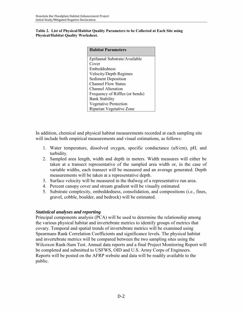
Honolulu Bar Floodplain Habitat Enhancement Project January 2010 Initial Study/Mitigated Negative Declaration
D-2
Table 2. List of Physical/Habitat Quality Parameters to be Collected at Each Site using Physical/Habitat Quality Worksheet.
Habitat Parameters
Epifaunal Substrate/Available Cover Embeddedness Velocity/Depth Regimes Sediment Deposition Channel Flow Status Channel Alteration Frequency of Riffles (or bends) Bank Stability Vegetative Protection Riparian Vegetative Zone
In addition, chemical and physical habitat measurements recorded at each sampling site will include both empirical measurements and visual estimations, as follows:
1. Water temperature, dissolved oxygen, specific conductance (uS/cm), pH, and turbidity.
2. Sampled area length, width and depth in meters. Width measures will either be taken at a transect representative of the sampled area width or, in the case of variable widths, each transect will be measured and an average generated. Depth measurements will be taken at a representative depth.
3. Surface velocity will be measured in the thalweg of a representative run area. 4. Percent canopy cover and stream gradient will be visually estimated. 5. Substrate complexity, embeddedness, consolidation, and compositions (i.e., fines,
gravel, cobble, boulder, and bedrock) will be estimated.
Statistical analyses and reporting
Principal components analysis (PCA) will be used to determine the relationship among the various physical habitat and invertebrate metrics to identify groups of metrics that covary. Temporal and spatial trends of invertebrate metrics will be examined using Spearmans Rank Correlation Coefficients and significance levels. The physical habitat and invertebrate metrics will be compared between the two sampling sites using the Wilcoxon Rank-Sum Test. Annual data reports and a final Project Monitoring Report will be completed and submitted to USFWS, OID and U.S. Army Corps of Engineers. Reports will be posted on the AFRP website and data will be readily available to the public.

Honolulu Bar Floodplain Habitat Enhancement Project January 2010 Initial Study/Mitigated Negative Declaration
D-3
REFERENCES
AFRP [Anadromous Fish Restoration Program]. 2001. Final Restoration Plan for the AFRP. Prepared for the Secretary of the Interior by the United States Fish and Wildlife Service. CDFG [California Department of Fish and Game]. 2003. California Stream Bioassessment Procedure (Protocol Brief for Biological and Physical/Habitat Assessment in Wadeable Streams). Prepared by Aquatic Bioassessment Laboratory, CDFG, Sacramento, CA. 11 pp. Available at www.dfg.ca.gov/abl/Field/professionals.PDF CMARP. 1998. Preliminary Draft: Research Proposal to Investigate Fish Use of Floodplain Habitat. Prepared by CMARP Fluvial/Geomorphologic and Riparian Issues workgroup. Available at www.iep.water.ca.gov/cmarp/groups/scwt/toc/geofishpht0930.doc EPA [United States Environmental Protection Agency]. 2003. Guidance for Pacific Northwest State and Tribal temperature water quality standards. EPA Region 10; EPA 910-B-03-002. Harrington, J. and M. Born. 2000. Measuring the Health of California Streams and Rivers: A methods manual for resource professionals, citizen monitors and natural resources students, second edition. Sustainable Land Stewardship International Institute, Sacramento, CA. SRFG [Stanislaus River Fish Group]. 2004 (working draft). A Summary of Fisheries Research in the Lower Stanislaus River. Available at http://www.delta.dfg.ca.gov/srfg/