Embed Size (px)
Citation preview

EA THAMES
Enhancing the environment
Case studies from Thames Region
April 1 9 9 9
E n v ir o n m e n t A g e n c y

T H A M (= S
Foreword
T h e Tow n and C ou ntry P lanning system enables the
Environm ent A gency to m ake sign ificant
en v iron m en tal en h an cem en ts to developm ent
proposals. It gives us the op p ortu n ity to work closely
w ith o u r partners in local p lanning au thorities and the
d evelop m en t industry w ith the o b jectiv e o f achieving
su stainab le developm ent. T he sta ff w orking in our
local Area o ffices are dedicated to securing
en v iron m en tal en h an cem en ts throu gh the
develop m en t process.
O ften their successes do not
receiv e th e full re co g n itio n they
deserve. I am therefore
d elig h ted to present this series
o f case studies w h ich am ply
d em o n stra te th e ir effectiveness.
In p u blish in g this d o cu m en t I
h op e that ou r partners in this
w ork w ill be able to recogn ise
the w id e scop e that exists for
b u ild in g a w ide range o f en h an cem en ts into their
develop m ent proposals. For ou r part w e will w ork to
m ake effective partnerships a con tin u in g reality in
T h am es R eg ion .
C hris Birks
Regional General Manager

Introduction
The role o f the Environment Agency in the Town and
Country Planning system is that of a statutory consultee. It
has the right to be consulted on a range o f categories of
planning applications. These are set out in the Agency’s
'Liaison with Local Planning Authorities’ Manual together
with their statutory sources. The Agency is entided to
comment but the local planning authorities take the final
decision. Accordingly there is a premium on persuasion and
influence to ensure that environmental issues are properly
addressed. The Environment Agency takes a proactive
approach towards its involvement in the planning system
and we see this as an integral part of our work to protect
and enhance the environment.
The protection and enhancement o f the environment
relies on good working relationships between the
Environment Agency, local planning authorities and the
developers. The Agency is keen to work closely with both of
them in promoting its plans and proposals. Cooperation can
offer significant benefits to the environment and to the
community at large. Developers can likewise benefit from
an enhanced environment. Such partnerships can therefore
be an efficient and effective method for promoting die
interest of all parties.
One of the primary pressures on the Agency will
continue to be the environmental impact o f new
development. It is therefore essential for Agency staff to
identify at the planning stages - be it pre-planning or
consent enquiries, planning applications, land drainage
consent applications or development plans - how the
Environment Agency’s interests can be protected and
furthered through partnerships with external bodies
including local authorities, industry and environment
groups. This has resulted in the achievement of a wide
range o f environmental enhancements, that the
Environment Agency has secured dirough the planning and
land drainage consenting systems.
The following selection of case studies illustrate all the
kinds o f enhancements listed opposite. Many o f the case
studies illustrate more than one category. Our partners are
encouraged to look at these examples as an illustration o f
the range o f possibilities for environmental enhancements
and to treat individual development proposals as an
opportunity for securing better standards o f development
rather than as a constraint on the development o f the site.
T he rang e of
enhancements co v e r
the following:
• river restorations and
channel enhancem ents;
• surface water ru n o ff
attenuation and source
control;
• reed bed treatm ent for
surface water;
• conservation, fish e rie s
and landscape
enhancements;
• enhanced recreation and
education provisions;
• flood plain com pensation
schemes;
• river bank enhancem ent
works;
• clean up of contam inated
land.

Case studies
Case StudyDevelopment Type Enhancement Type
OM 40 m otorw ay service area, O xfordmotorway service area
• surface water runoff/source
control
• reed beds for water treatment
eFairford Leys, Aylesburyresidential development
• river diversion and
enhancements
• flood storage
• landscaping
OSafew ays, High W ycom besupermarket development
• opening o f culverted
watercourse
• clean up o f contaminated site
• groundwater protection
OSoho M ill, W ooburn G reenwarehouse/office development
• river diversion and
enhancements
• conservation enhancements
(including fish pass)
• bank works
• clean up o f contaminated
land
• landscaping
©A34 N ewbury Bypasstrunk road
• surface water drainage and
storage
• reedbed treatment o f
highway runoff
OThe Green, Aspendenresidential development
• surface water runoff/source
control
• conservation enhancement
QM l Link Road, W atfordroad development
• river enhancements and
bankworks
• conservauon enhancem ents
OCow ley Business Park, Uxbridgecom mercial development
• river enhancement
• conservation and landscape
enhancements
QCow ley Retail Park, Uxbridgeretail development
• river diversion and
enhancement
• opening up o f culverted
watercourse
<E>Prospect Park and W aterside, H arm ondsw orthcommercial development
• conservation and landscape
enhancements
• recreation provision
• river enhancement
• clean up o f contaminated
land/containment o f waste
Two Rivers Retail Park, Stainesretail development
• river diversion and
enhancements
• conservation enhancements
• clean up o f contaminated
land
Tham es Valley Park, Readingc o m m e r c ia l d e v e lo p m e n t
• conservation enhancement
• recreation provision
<DLoddon Mill, Twyfordresidential development
• riv er en h an cem en ts
• co n serv atio n en h a n cem en t
• bank w orks
• land scaping
<£>Tesco, Wokinghamsupermarket development
• surface w ater ru n o ff/ so u rce
co n tro l
• reed beds fo r treatm en t
Blackwater Valley Road, near Frim leyroad development
• riv er d iv ersion and
en h an cem en ts
• co n serv atio n en h an cem en ts
©Teddington W harf, Teddingtonresidential development and
tidal defences
• en h a n ced tidal d efen ces
• co n se rv atio n en h an cem en ts
• flo o d storage
®Barn Elms, South West Londonresidential development
• co n serv atio n en h an cem en t
• recreatio n provision
©Mill Lane, Carshaltonresidential development
• river d iv ersion and
en h an cem en ts (in clu d in g de
cu lv ertin g )
©South Norwood Country Park, Elmers Endlight railway system
• riv er d iv ersion and
en h a n cem en ts
• co n serv atio n en h an cem en ts
• recreation provision

•Claxo-Wellcome Site, Beckenhamcommercial and residential
development
• river diversion and
enhancements
• conservation enhancements
• landscaping
Bell Green Gas Works, Sydenhamretail development
• river diversion and
enhancements
• conservation enhancements
(including fish pass)
• clean-up o f contaminated
land
0Brookmill Park, LewishamUght railway system
• river diversion and
enhancements
• conservation and landscape
enhancements
$Bullhead Dock and Bellamy's Wharf, Rotherhitheresidential development and
tidaJ defences
• enhanced tidal defences
• conservation enhancements
• recreation provision
©Victoria W harf, Limehouseresidential development and
tidal defences
• enhanced tidal defences
• conservation enhancements
• recreation provision
©Millennium site, Greenwich Peninsularresidential/leisure/
commercial development and
tidal defences
• enhanced tidal defences
• conservation enhancements
• recreation provision
• clean-up o f contaminated
land

Case study M40 Motorway Service Area, Oxford
Project title:M 40 m otorw ay
service area
Location:O xford Services,
W hradey. O xford
River/catchment:River Tham e (Tham e
catchm ent)
Date completed:July 1 9 9 8
Developmenttype:M otorway service area
Types of enhancem ent:• surface watet
runoff/source
control
• reedbeds foi watei treatm ent
Developer:W elcom e Break
Local authority:South O xfordshire District Council
Contact details:C ustom er Services West Area O ffice
Environm ent Agency Isis House
H ow bery Park
W allingford O xon
0 X 1 0 8 B D
The surface water management system at this site
incorporates many aspects of best management
practice which the environment agency is trying to
promote on a wider basis.
mobilisation of naturally
occurring arsenic by
increased infiltration.
Description of SchemeThe developer decided to
provide Best Management
Practices (BMPs) for surface
water management on the site
and discharge to a local stream
rather than,as had been
originally proposed,
discharging via a requisitioned
surface water sewer to the
River Thame some distance
from the site, which had
originally been considered.
Infiltration o f water into
the subsoil was not permitted
by the Environment Agency on
the majority o f the
site because of
concerns about the
natural levels o f
arsenic and the
Site H istoryThe W elcome Break company
has built a new motorway
service station at Wheatley,
Oxfordshire which opened in
summ er 1998. The site,
adjacent to the existing
motorway had been used
previously for the dumping o f
spoil from the construction o f
the road. The development has
standard motorway facilities,
including fuel filling area, car
and HGV parking areas, an
amenity building and a travel
lodge. The total site area is
1 Oha, o f which approximately
6ha was being developed,
w hich normally would have
incorporated approximately
4 .5 ha o f ‘impermeable’
surfaces.
Environm ent Agency Interests• Promotion o f Best
Management Practices for
surface water management.
• Concerns about the potential
concentration and enhances
water quality through microbial
action in the stone layer.
The majority o f the rest of
the site is positively drained via
lined French drains trenched to
outfalls that combine with the
car park outfalls. These
discharge to a ‘first flush' pond
which has been designed to
contain the first 1 Omm o f
rainfall for slow release. The
discharge from the pond travels
via a sub-surface flow reedbed
and thence to a final storage
pond before release to a small
local watercourse.
In conditions o f high
rainfall, when the ‘first flush’
pond is full an overspill weir
will convey the higher flows
down a swale which will
bypass the reedbed directly to
the main storage pond. The
design o f these systems raised
some interesting issues because
possibility of
mobilising through
increased soakage.
The chosen option
discharges rainfall runoff at a carefully
controlled rate, after
treatment, to a small
watercourse on the site
boundary.
Permeable block surfaces
over a stone base on an
impermeable membrane were
used for the car parks. This
achieves a measure o f water
storage, delays the time o f
of the differences in the times
o f concentration. Fortunately
there was sufficient flexibility
to take a 'belt and braces'
approach to the restriction to
the final runoff from the site.
Close liaison was essential
between the Environment
Agency, local authority, site
developers and the downstream
landowner to ensure that all
opportunities were taken to
resolve any problems that arose.

Case study Fairford Leys, Aylesbury
This large housing development provided the
opportunity to restore the heavily engineered rivers
that crossed the site.
A tn tl trim of lift M o tt dmrlopmrnt
Site HistoryThe total area o f this site is
some 21 7ha in total and is
being developed to provide a
golf course, sports field, public
open space and approximately
70ha of mainly residential
development on the edge o f
the River Thame floodplain.
The residential development
area is crossed by Bear Brook
(the main arterial watercourse
taking surface water from
Aylesbury) and Southcourt
Brook, Stoke Brook and
Hartwell Ditch, all o f which
have associated floodplain.
Sue pnoi re rfuhjnrami and raba&ctmni
Environment AgencyInterests• Flood storage compensation
for the area lost to the
residential development.
• Restoration o f the heavily
engineered watercourses to
provide ecological, landscape
and recreational benefits.
Description of SchemeIn addition to the large flood
compensation area to be
excavated and landscaped on
the edge o f the Thame
floodplain, considerable work
has been carried out to restore
the heavily engineered main
rivers to a more natural state.
This involved reforming the
watercourses as multi-staged
channels within enhanced river
corridors varying in width
between 35 and 90 metres. The
low-flow channels have been
aligned with a restored sinuosity and provided with
pools and riffles.
This scheme has been a
major milestone for the Agency
Silt ( fu r Jodopm rm lomplflrd
as it is the first major river
restoration project achieved in
cooperation with, and with
funding from, private
development.
The watercourse corridors
have been enhanced by
planting o f native vegetation
including meadow grasslands,
trees, reedbeds and marginal
aquatic vegetation. The
corridors also provide routes
for pedestrians, avoiding
highways through the
development.
The two stage channels
allow the transmission o f
floodwater safely through the
development without
compromising the degree o f
flood protection offered to
existing residential
development upstream.
Project title:Fairford Leys
Location:Aylesbury, Bucks
River/catchment:Bear Brook, Soudicotirt Brook. Stoke Brook and
Hartwell D itch (River Tham e catchm ent)
Date completed:O ngoing, Phase 1
com pleted summer
1998
Developmenttype:Residential (plus go lf
course, sports fields
and public open
space)
Types of enhancement:•
enhancem ents
• flood storage• landscaping
Length of enhancement:3km
Developer:C oldlurbour Farm
Consortium
Local authority:Aylesbury Vale District Council
Contact details:Custom er Services
West Area O ffice
Environment Agency
Lsis H ouse
How bery Park
Wallingford
O xon
0 X 1 0 8B D

Case study Safeways, High Wycombe
Project title:Safeways
Location:High W ycom be.
Buckingham shire
River/catchment:H ugheuden Stream
(R iver Wye catchm ent)
Date completed:April 1 9 9 8
Developmenttype:Superm arket
Types of enhancem ent:• opening < >f
culverted
w atercourse• d e an up o f
contam inated site
• groundwater protection
Length of enhancem ent:I 50m
Developer:Safeways
Local authority:W ycom be District
Council
Contact details:Custom er Services
West Area O ffice
Environment Agency
Lsts House
H ow bery Park
W allingford O xon 0 X 1 0 8B D
The redevelopment of this site for a supermarket
enabled the culverted watercourse to be opened-up
and the contaminated land to be remediated.
Site H istoryThis is a new store constructed
at the edge o f High W ycombe
town centre, on a former
tim ber yard and factory site.
The store is also located within
a sensitive groundwater
protection area. The
Hughenden Stream, a tributary
o f the River Wye passed
through the site in a culvert
and also included a small weir.
Environm ent Agency Interests• Culverted section o f
watercourse with resulting
poor habitat and ecology.
• Clean up o f contaminated
site.
• Protection measures for petrol filling station within
groundwater protection zone.
Description of SchemeNegotiations were carried out
between Safeways, the
Environment Agency and the
Local Authority over
redevelopment o f this site. Key
issues were the future o f the
Hughenden Stream which
passed through ihe site in a
culvert partly under the site o f
the main building, the clean up
o f contamination arising from
previous industrial use o f the
site, and protection measures
for underground fuel tanks, as
the site lies within the
protection zone o f a major
public supply borehole.
The resulting scheme
included reopening
approximately 70 metres o f
watercourse, with landscaped
banks within concrete ‘boxes’
to provide structural stability
for buildings alongside, and
prevent possible
contamination.
The Hughenden Stream
was diverted o ff its previous
line and the weir was removed
to allow a consistent gradient
along the stream's route, away
from the shop building.
Contaminated material in the
ground was treated in
accordance with an agreed
programme, including some
recycling o f materials. Finally
the petrol station fuel tanks
were fitted with a system of
liners and detection systems to
ensure that any leakage could
not pass into surrounding
groundwater and potentially
affecting the public supply.

Case study Soho Mill, Wooburn Green
The redevelopment of this former mill site
incorporated significant enhancements to the
river channel.
Site HistorySoho Mill was one o f the many
mills on River Wye. The
buildings at Soho Mill were
finally demolished in the
1980s. Speculative development
Site Wort drafapmcnl
proposals were put forward in
the late 1980s. but were never
implemented. The site was
acquired by Simon Elvin Ltd
(greeting card manufacturers),
a local company whose
headquarters is next door to the
mill site. They put forward a
proposal for a warehouse/
office development to extend
their existing business. All
parties involved in the scheme
recognised the need to improve
the appearance and safety o f
the mill and the river channel
passing through the site.
Environment Agency Interests• Weir o f restricted flood
capacity in dangerous
condition.
• Blockage to free movement o f
fish up and down stream
caused by height o f weir.
• Residual contamination o f
groundwater on the site from
previous industrial use.
• Existing hard bank protection
in very poor condition.
Description of SchemeThe agreed scheme comprised
separating the existing weir
into two smaller drops, and
constructing a pool and
traverse fish pass around a
wildlife refuge
island. The
channel works
design was
influenced by
the subsequent
discovery o f
contaminated
ground in the
building
location. All river works were
therefore carried out in a
concrete channel sealed against
groundwater intrusion, with
landscaping inside this.
Groundwater contamination
was dealt with by localised
pumping to the foul sewer, and
removal o f contaminated soil,
however the residual risk was
felt to be too great to allow an
unlined channel.
Significant to the success of
the scheme was the support of
Wycombe District Council in
agreeing to the landscaping on
the site in the river corridor
and the commitment to
improvement o f the site by a
sympathetic developer. Both
were committed to achieving
the best solution to improve
the site, recognising the
restricted size o f the site and
the complex technical issues to
be resolved.
The success o f this scheme
also led to the development of
ideas first set out in the Local
Authority's River Wye Study,
and the Environment Agency’s
Catchment Management Plans
aijd Local Environment Agency
Plans. This resulted in
production o f a joint River Wye
Development Advice Note,
setting out guidelines for
development near the river.
A subsequent smaller
development at Lower Glory
Mill has followed these
principles, and further
enhancements are expected at
other redevelopments.
Project title:Soho Mill
Location:Soho Mill Industrial
Estate, W ooburn
Green.
Bui kinghamshire
River/catchment:River Wye (River Wye
catchm ent)
Date completed:October 1994
Developmenttype:Warehouse/ office development
Types of enhancement:• river diversion and
en h an cem en t
•
enhancem ents
(including fish
pass)
• bank wt >rks
• i lean up < >1
contaminated land• landscaping
Length of enhancement:100m .
Developer:Sim on Elvin Ltd
Local authority:W ycom be District Council
Contact details:Customer Services
West Area O ffice
Environment Agency
Isis House Howbcry Park Wallingford
Oxon
0 X 1 0 8B D
Site aha tadofm ni

Case Study A34 Newbury Bypass
Project title:A 34 New bury Byjw ^
Location:Newbury. Berk-shire
River/catchment:River Enborne. River Kennet and River L am boum (Kennel
catchm ent)
Date completed:Autumn 1 9 9 8
Developmenttype.Trunk road
Types of enhancement:• surface W lie t
drainage and storage
• reedbed treatment o f highway runofl
Developer:Highways Agency
Local authority:W est Berkshire
Contact details:C ustom er Services
West Area O ffice Environm ent Agency
Isis H ouse
H ow bery Park W allingford
O xo n 0 X 1 0 8 B D
The management system for surface water from the
bypass adopts best management practices and
includes reedbeds to treat runoff which is being
monitored as part of an R&D project.
Site H istoryThe Newbury bypass drainage
works were finalised in 1992
following the Public Inquiry.
Storage ponds were proposed
to control rates o f runoff from
the new road to the local
reedbed as part o f an
Environment Agency. Thames
Region R&D project to
investigate the performance o f
these facilities. The aim o f the
project was to produce
guidelines for the design,
The Environment Agency
and the Highways Agency have
worked closely in connection
writh this work and it is likely
that design guidance will be
reflected in future documents
published by both
organisations.
From experimental results
already available from other
studies it is clear that
constructed wetlands widiin
storage ponds can significantly
watercourses. They were
originally designed as ‘wet
ponds' planted with a range o f
aquatic plants working on the
'surface flow’ principle to
improve water quality and
enhance their environmental
value.
Environm ent Agency Interests• Promotion o f Best
Management Practices for
surface water management.
• Flood Storage compensation
for the area o f developed
land.
• Improvement o f the quality
o f road runoff prior to
discharge into watercourses.
Description of SchemeThe design o f one o f the ponds
was modified prior to
construction to incorporate a
'sub-surface' flow constructed
construction, operation
and maintenance o f
constructed wetlands
for highway runoff,
particularly as part o f
surface water storage
ponds.
An interim guidance
manual is about to be made
generally available, and should
be published as a national
report from the Environment
Agency. Monitoring o f the
research facility and another
pond for comparison purposes
commenced when the new
bypass opened to traffic in
Autumn 1998.
The interim manual will be
updated as necessary in light o f
the Agency’s research
programme and also with
input from associated research
being carried out on the
sewage drainage provisions at
Newbury.
improve water quality prior to
the discharge to natural
watercourses. However
improved guidance is essential
if their use is to be extended as
part o f future surface water
drainage management. This
R&D study and report should
assist this process.

Case study The Green, Aspenden
This case study illustrates how the surface water from
a small housing development can be managed in a
sustainable manner which deals with runoff as close
as possible to where the water falls.
Project title:The Green
Location:Aspeadcn, nearBuntingford,
Hertfordshire
River and catchment:Aspenden Brook.
River Rib (Upper Lee
catchm ent)
Date completed:1998
Developmenttype:Residential
development
Types of enhancement:•
runoff/source
control
enhancements
Developer:Leach Hotnes
Local authority:East Herts District
Council
Contact details:Customer Services
N orth East Area
O ffice
Environment Agency Apollo Court 2 Bishop Square
Business Park St Albans Road West
Hatfield, Herts
ALIO 9 EX
Drainage from the road and
driveways runs o ff naturally
and is either directed towards
the pond or to shingle soakage
strips. When the pond is full, it
spills into an adjacent hollow
which in turn soaks into the
underlying gravel sub strata.
The roof water from the
rear o f the properties is
collected in 1000 litre water butts. When these are full the
water is diverted into a
standard soakaway, French
drain or perforated pipe
connected to the pond. As the
houses are fitted water meters,
like most new houses, the use
o f water butts makes sense
both financially and
environmentally.
Site HistoryAspenden is a small
village about ten miles
east o f Stevenage in
Hertfordshire.
Aspenden Brook, a
small tributary o f the
River Rib. flows
through the village.
This is a typical
‘bourne’ in the upper
part o f the Lee
catchment and it is not
unusual for it to be
dry for most of the
year.
The site was first
brought to the
Environment Agency’s
notice when the developer
discussed the disposal o f
surface water from the
development via a pipe
running across a field to the
Aspenden Brook. However, the
location was appropriate for
source control via a soakaway
system and this option was
promoted to the developer.
Environment Agency Interests• Promotion o f Best Practice
Management Practices for
surface water management.
• Opportunity for habitat
creation.
Description of SchemeThe development comprises of
five large detached houses. The
surface water drainage from
the front roof areas is
connected via a perforated pipe
to a pond. The pond provides a
focal point at the front o f the
site and a new habitat.

Case study fvll Link Road, Watford
Project title:M l Link Road
Location:W atford,
Hertfordshire
River and catchm ent:River Colne (Colne
catchm ent)
Date completed:19 9 6 .
Developmenttype:Road developm ent
Types of enhancem ent:• riyw eniunt etnents
and hank works• i ons< rvatior
enhancements
Length of enhancem ent:approximately 1km
Developer:H ertfordshire Comity Council
Local authorities:W atford District
Council and Hert.smere District
Council
Contact details:C ustom er Services N orth East Area
O ffice
Environm ent Agency A pollo Court
2 Bishop Square
Business Park St Albans Road West
Hatfield, Herts
ALIO 9 EX
This case study describes how a length of river was
restored following its realignment as part of a road
scheme and the habitat of lakes designed to store
runoff from the road were enhanced.
Site H istoryThe River Colne was realigned
between 1989 and 1990 in
order to facilitate the
construction o f the Watford M 1
Link Road. As a result the
channel became trapezoidal,
relatively straight and over
wide (by up to 2m ) for the
predicted minimum flows. The
bed (deepened by nearly 1 m )
was uniform and silty and
marginal vegetation was very-
sparse. This resulted most
notably in a drastic reduction
in fish numbers (2 7 0 recorded
in O ctober 1988, 3 recorded in
O ctober 1992) following the
general loss o f habitat diversity.
Three balancing ponds were
also constructed as part o f the
road scheme, to store excess river water during high flows.
Environm ent Agency Interests• Poor habitat and fishery as a
result o f heavily engineered
watercourse.
• Flood risk due to die size o f
the catchment and the speed
o f runoff from the
urban/clay catchment.
D escrip tion of SchemeAfter an assessment o f the
reach by then National Rivers
Authority (N RA), Hertfordshire
County C ouncil and the NRA
jointly funded a
number o f
instream measures
in 1993, designed
to enhance the
reach.
Realignment o f
the river was not
possible. These
works reversed the
effects o f the
previous works by
establishing
marginal and aquatic
vegetation. They also developed
varying flow characteristics
absent d ue to the previous
overw idening and deepening.
The w orks carried out included
and prevent them from drying
out in hot summers. These
were not serving any useful
ecological or water quality
purpose. This was seen as an
opportunity to increase shelter
for fish by creating good
backwater habitat. Works
included reprofiling the banks
to form wetland shelves,
replacing the inlets with
downstream angled inlets to
prevent polluted water entering
the ponds and planting the
backwaters with marginal
species.
The scheme has been very
successful and the in-channel
and marginal habitats have
become well established. Fish
numbers, biomass and species
have all improved beyond that
recorded prior to the
construction o f the road
scheme.
placing groynes in the channel,
creating riffles and importing
gravel for the river bed.
Further works were carried
out in 1996 to reprofile and
reconnect the adjacent lakes

Case study Cowley Business Park, Uxbridge
The protection and enhancement of a wide buffer
zone was realised as a result of the development of
this large business park.
Site HistoryThe site is located between the
River Frays and the Grand
Union Canal and therefore the
protection o f the river corridor
was a high priority for die
Environment Agency.
Environment Agency Interests• Protection o f a buffer strip
between the watercourse and
development.
• Opportunity for habitat and
landscape enhancement.
Description of SchemeThis commercial development
consisted o f over 10,000m 1 of
high tech office and laboratory
space. The Environment Agency
ensured that a wide buffer strip
was maintained between the
development and the River
Frays. This 20m wide strip
provided an opportunity to
enhance existing habitats and
to create new habitats. The
developer landscaped the strip
and planted trees, shrubs and
grassland.
The landscaping
contribution o f the existing
trees, scrubs and hedges was
identified prior to the
commencement o f the
development. This was
supplemented with additional planting to enhance the
landscaping.
Attenuation
o f the site
surface water
runoff with a
controlled rate
discharge to the
River Frays was
a fundamental
element o f the
drainage
strategy. This
was to ensure
the development
did not increase the risk o f
flooding from the River Frays.
Project title:Cowley Business Park
Location:High Street, Cowley.
U xbndge, Middlesex
River/catchment:River Frays (Colne
catchm ent)
Date completed:1998
Developmenttype:Commercialdevelopment
Types of enhancement:•
• conservation and landscape
enhancem ent*
Length of enhancement:390m
Developer:Kyle Stewart Properties
Ltd/Cowley Park Developments Ltd
Local authority:London Borough o f Hillingdon
Contact details:Customer Service*
North East Area Office
Environment Agency
Apollo Court
2 Bishop Square Business Park
St Albans Road West
Hatfield, Herts AL10 9EX

Case study Cow ley Retail Park, Uxbridge9
Project title:Cowley Retail Park
Location:High Road. Cowley, U xbrid ge. M iddlesex
River and catchm ent:River Pinn (Colne catchm ent)
Date completed:1997
Developmenttype:Retail developm ent
Types of enhancem ent:• nver diversion and
enhancem ents
• opening up < >1
culverted
w atercourse
Length of enhancem ent:1 iOm
Developer:LowndesQueensway/Hadrian D evelopment Ltd
Local authority:London Borough o f
H illingdon
Contact details:C ustom er Services
N orth East Area O ffice
Environm ent Agency A pollo Court
2 Bishop Square
Business Park
St Albans Road West Hatfield. Herts.
ALIO 9 EX
The redevelopment of this site for a retail park
allowed the culverted section of the watercourse to
be restored to an open channel to provide an
improved environment and a visually attractive
solution.
Site H istoryThe River Pinn was in a twin
box culvert under most o f this
site, with short open sections at
either end. Downstream o f the
site the River Pinn is siphoned
under the Grand Union Canal
before it ’s confluence with the
River Frays.
the culvert under the site and
be diverted along the south
eastern boundary o f th e site.
The banks o f the new
channel were form ed as
naturally as possible. The
design includes: new marginal
aquatic planting in localised
areas along river banks to
site boundary and trailing
plants to grow over and soften
hard edges.
In addition, other
environmental and landscape
improvements were carried out
along the frontage o f the High
Road to enhance the visual
appearance o f the site and the
area generally by providing a
continuation o f the landscape
scheme established by the
adjoining development site to
the south east.
Environm ent Agency Interests• Cuverted section o f
watercourse with resulting
poor habitat and ecology.
• Opportunity for habitat and
landscape improvements.
Description of SchemeThe redevelopment o f the site,
to include four retail
warehouse units, allowed the
River Pinn to be removed from
soften edges and
to encourage
meandering
river course; the
use o f gabion
steps to create
areas for
planting faced
with willow
hurdles, including'som e ‘live’
willow hurdles; and shrubs
used to naturalise the river
bank within th e limits o f the
VWitercourse cu lw trd ocross m e Wore redevelopment W atercourse opened up along tile edge of (be Me alter rafevelopmoit

Case study Prospect Park and Waterside, Harmondsworth
The reclamation of an area of semi-derelict land
adjacent to British Airways' new office complex at
Harmondsworth and the building of flood defences
provided the opportunity for creating parkland
landscape with valuable recreation opportunities.
Site HistoryThe new British Airways
headquarters within its
parkland setting near Headirow
Airport and is bounded by the
M25, M4 and A4. The whole
site extends for 108.Sha and is
crossed by several rivers,
including the River Colne,
Wraysbury River, Duke o f
Northumberland's River.
Historically the area, which is
in the Green Belt, has been
filled with waste. Only a small
proportion o f the site was
developed for the office
buildings and in return the
surrounding area of parkland
was cleaned up. landscaped,
habitats created and opened up
for public access.
Environment Agency Interests• Protection o f watercourses
and groundwater from
pollution and disturbance
during construction.• Clean up o f contaminated
land.
• Need to increase the flood
defence standards o f service.
• Opportunity for habitat
* enhancement and creation.
• Opportunity to promote
access and education
initiatives.
Description of SchemeThe main objective in creating
the parkland was to reclaim
and reshape the site as an
attractive landscape that is safe
and suitable for public access,
casual recreation and where
appropriate, active recreation.
This necessitated substantial
earth works, including the
excavation o f waste and its
redisposal in fully engineered
tips
conforming to
appropriate
standards,
with the
placement of
appropriate
capping and
soil forming layers and the
establishment o f vegetation.
Areas for nature
conservation were created in
various sites within the
parkland. Most notably the
enhancement o f the riverbanks and restoration o f the lakes
with suitable shoreline and
bankside treatments native
planting and the formation of
islands. Additionally,
opportunities to create areas of
interest, such as a small pond,
the restoration o f flood
meadows and woodlands and
copses all contribute to the
diversity o f the site.
The parkland is
predominately for casual and
informal countryside access
and recreation with the
creation o f a network of
footpaths and pedestrian ways
throughout the site. Other
facilities include picnic areas,
new pedestrian bridges and
informal cycleways.
Project title:Prospect Park and
Waterside
Location:Harmondsworth. West London
Rivers/catchment:River Colne, Wraysbury River. Duke ofNorthumberland's River (Colne catchment)
Date completed:1997/9
Developmenttype:Commercialdevelopment
Types of enhancement:•
landscapeenhancements
•
• t leac ip o f
contaminated land/conialiunent
of waste
Developer:British Airways
Local authority:London Borough of Hillingdon
Contact details:Customer Services
North East Area
Office
Environment Agency Apollo Court 2 Bishop Square Business Park S» Albans Road West Hatfield. Herts ALIO 9EX
Case study Two Rivers Retail Park, Staines
Project title:Two Rivers Retail
Park
Location:Su in es. Surrey
River/catchment:River Colne and W raysbury River
(C olne catchm ent)
Date completed:1 998
Developmenttype:Retail developm ent
Types of enhancem ent:• m c-r diversion and
enhancem ents
•
enhancem ents
• t lean up o i
contam inated land
Length of enhancem ent:55 0 m
Developer:MEPC’ Developments
Ltd
Local authority:Sp elth om e Borough
Council
Contact details:Custom er Services
North East Area
O ffice
Environm ent Agency
Apollo Court
2 Bishop Square
Business Park
St Albans Road West Hatfield, Herts
ALIO ?EX
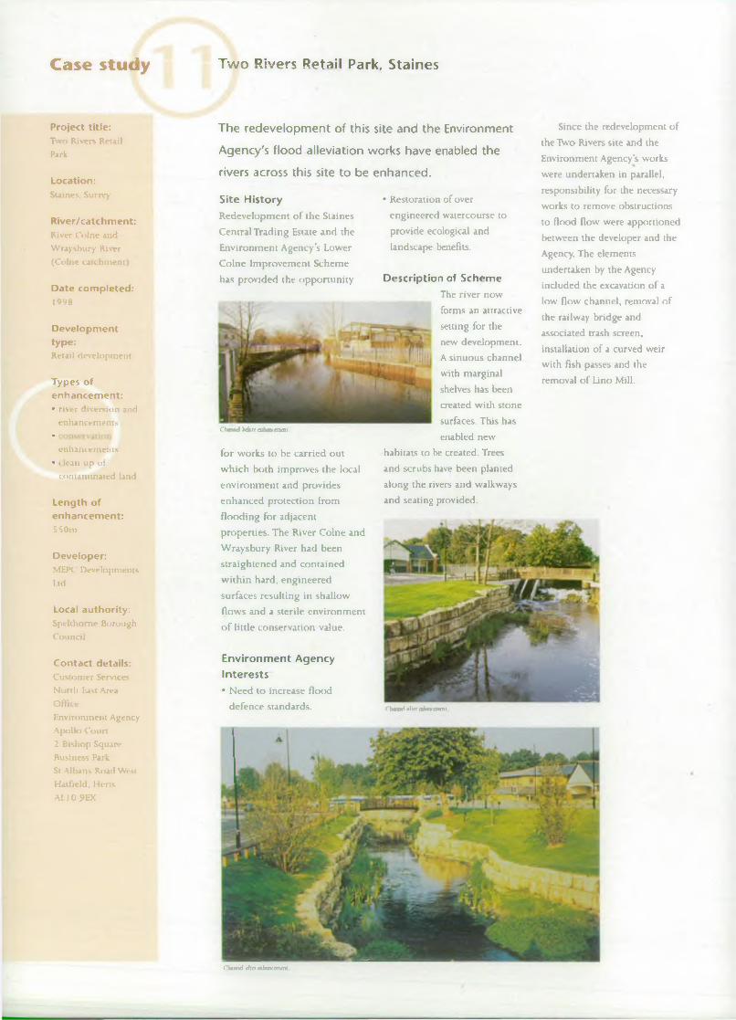
The redevelopment of this site and the Environment
Agency's flood alleviation works have enabled the
rivers across this site to be enhanced.
Site H istoryRedevelopment o f the Staines
Central Trading Estate and the
Environment Agency’s Lower
Colne Improvement Scheme
has provided the opportunity
Channel bdurt mhancrmmt
for works to be carried out
w hich both improves the local
environment and provides
enhanced protection from
flooding for adjacent
properties. The River Colne and
Wraysbury River had been
straightened and contained
within hard, engineered
surfaces resulting in shallow
flows and a sterile environment
o f little conservation value.
Environm ent Agency Interests• Need to increase flood
defence standards.
• Restoration of over
engineered watercourse to
provide ecological and
landscape benefits.
Description of SchemeThe river now
forms an attractive
setting for the
new development.
A sinuous channel
with marginal
shelves has been
created with stone
surfaces. This has
enabled new
habitats to be created. Trees
and scrubs have been planted
along the rivers and walkways
and seating provided.
Since the redevelopment o f
the Two Rivers site and the
Environment Agency’s works
were undertaken in parallel,
responsibility for the necessary
works to remove obstructions
to flood flow were apportioned
between the developer and the
Agency. The elements
undertaken by the Agency
included the excavation o f a
low flow channel, removal o f
the railway bridge and
associated trash screen,
installation o f a curved weir with fish passes and the
removal o f Lino Mill.
Cbannri a im a h ca ca n m l
Channel irflo aihaxanail

Case Study Thames Valley Park, Reading
The development of this large business park enabled
the creation of a country park and nature reserve,
improved public assess and realise flood defence
benefits.
Site HistoryThis site forms a large triangle
o f land north east o f Reading
bounded by the River Thames
to the north and the London-
Bristol railway line to the
south. The total area
o f the application site
is 69ha. Part o f this
site was proposed for
development in the
relevant local
authority
development plans.
The site included
the former coal fired
North Earley Power
Station, which was
demolished some
time ago, and a gas
turbine station which
was demolished in the mid
1980’s. There were several
outfalls from the power
stations to the River Thames.
The rest o f the site comprised
floodplain meadows adjacent
to the river, an area o f
approximately 16ha which was
used as a tip for pulverised fuel
ash and an area o f other
generally dilapidated industrial
premises.
Environment Agency Interests• Provision o f flood storage and
improved flood routes across
the floodplain.
• Opportunity for habitat and
landscape improvements.
• Opportunity to promote
access and recreation.
Description of SchemeThe Business Park incorporated
some 28ha of the site, with
strategic highways incorporating a further 4.6ha.
The Business Park provides a
low density campus style
development with extensive
landscaping, including wetland
planting with reedbeds and
other appropriate vegetation.
The earthworks on the site
were also carried out to order
to compensate for loss o f flood
storage and to open up flood
flow routes.
The rest o f the area
adjacent to the river, the
country park, was seeded with
a wildflovver grass seed mix
and is managed for a variety of
features, providing
corporate premises
for companies such as
BG pic and Oracle.
The Business Park
includes in the region
o f 93 ,000m ’ o f office
space and
incorporates essential
services for the large
number o f
employees, including shops,
sporting and leisure facilities,
restaurants, hotel and
conference facilities.
The site was prepared for
development by removing the
original top soil, digging the
gravel out and burying the
pulverised fuel ash in a cell and
then replacing the original soil
on top. In the approximate area
o f the power station a nature
reserve was established. This
involved creating lakes, islands
and wetland areas and then
conservation and low-key
recreation purposes. The
former cooling water channel
has also been enhanced. The
footpath along the river is part
o f the Thames Path. The
country park and nature
reserve cover an area o f 3 7 ha.
Project title:Tham es Valley Park
Location:North Earley.
Reading. Berkshire
River/catchment:River Tham es
Date completed:Since com pletion o f
business park
infrastructure in mid
I9 9 0 's , companies have been developing
different plots within
the site.
Developmenttype:Com mercial
development
Types of enhancement:• conservation and
landscape
enhancem ent
• floodplain compensation/
storage
Developer:Speyhawk Land &Ecutes Lid/Thames
Valley Park Ltd (plus developers o f ihe
different plots)
Local authority:W okingham District
Council
Contact details:Custom er Service*
South East Area O ffice
Environment Agency
Swift House
Frim ley Business Park
Frimley
Camberiey
SurreyG U 16 5SQ

Case study Loddon Mill, Twyford
Project title:Loddon Mill
Location:Tw yford. Berkshire
River/catchment:River Loddon (Loddon catchm ent)
Date completed:1 9 9 9
Developmenttype:Residential
developm ent
Types of enhancem ent:• river enhain emems • .. >nservad< >n
enhancem ents• bank w o rk s
• landscaping
Length of enhancem ent:6 0 0 m
Developer:Berkeley Hom es
Local authority:Wokingham District Council
Contact details:Custom er Services
South East Area
O ffice
Environm ent Agency-Swift House
Frim ley Business Park
Frim ley
Cam berley
Surrey
G U I 6 SSQ
W irf Pool Court
The redevelopment of this former mill site for
housing provided the opportunity to create and
manage the bankside habitats.• O pportunity to promote
access and recreation.
D escrip tion of SchemeThe development
consists o f a mixture
o f large detached
houses and apartment
blocks. T h e developer,
follow ing discussions
with the Environment
Agency, has made
provisions for
extensivewarehouses, offices
and hard standing.
The Victorian mill
buildings had been
replaced in the
1 9 6 0 ’s following a
fire. In addition to
the River Loddon,
the site is also
crossed by the mill
leat and therefore
the site has a
considerable
length o f riverbank.
Environm ent Agency Interests• Opportunity for habitat and
landscape improvements.
• Opportunity to enhance and
restore heavily engineered
river banks.
enhancem ent works to the
banks and buffer zone along
the river. This reflects the high
conservation value o f the Riyer
Loddon.The works to the banks
include the creation o f a
Kingfisher nesting bank,
regrading o f steep and artificial
B dorr d o rlo fw ail
Site H istoryThe site occupies land in the
north west area o f Twyford on
die north banks o f the River
Loddon. The site area is
approximately 1.4ha and was
occupied by mill buildings,
banks and the repair of
damaged banks. Other works
include: tree management,
including a programme o f
pollarding willows and
coppicing alders; the creation
o f new riverside habitats and
planting o f marginal
vegetation;
provision o f
bat and bird
boxes; tree
planting; and
general
landscape
maintenance.
Public
access is
provided to
the banks o f
the Loddon. where this does
not conflict with nature
conservation objectives.
Existing footpaths have been
enhanced, safety provisions installed where appropriate and
interpretation signs
sympathetically located.
■

Case Study Tesco, Wokingham
The surface water management system at this site
incorporates many aspects of best management
practice which the environment agency is trying to
promote on a wider basis.
Site HistoryThe hard, impermeable areas
associated with development
can lead to undesirable
consequences relating to the
rapid runoff o f surface water.
source as possible. The car park
at this new superstore
demonstrates several aspects o f
this and is an excellent
example o f a more sustainable
approach to development.
This can result in water o f poor
quality entering watercourses
and a risk o f flooding. The
Environment Agency is
therefore promoting a range o f
measures for dealing with
surface water as close to its
The Environment Agency
can advise planning authorities
and developers about
catchment-wide source control
measures such as appropriate
design and layout o f new
developments, on-site water
attenuation and
permeable surfaces.
These measures offer
a variety o f benefits:
they can alleviate
flood risk, improve
water quality and
promote groundwater
recharge.
Environm ent Agency Interests•The control o f the quantity
and quality o f runoff from
the site.
• Promotion o f Best
Management Practices for
suface water management.
Description o f Schem eThe car park at this superstore
demonstrates several aspects o f
source control. A permeable
pavement prevents the rapid
runoff o f surface water th at is
collected through pipes in the
sub base on top o f an
impermeable membrane. All
water is then directed to an
outfall, which discharges via a
constructed wetland for
filtration through a reed b ed .
A two-stage channel restricts
the rate o f discharge into th e local stream.
It is also proposed to
monitor the quality and
quantity o f runoff from this
site with general research in to
the effectiveness o f these
techniques.
Project title:Tesco
Location:W okingham,Berkshire
River/catchment:River Loddon
(Loddon Catchment)
Date completed:
Developmenttype:Supermarket
Types of enhancement:• surface water
runoff/ source
control• n fed bed* fix
treatment
Developer:Tesco
Local authority:Wokingham District Council
Contact details:Customer Services
South Hast Area Office
Environment Agency
Swift HouseFrimley Business Park
FrimleyCamberlcy
Surrey
G U I6 SSQ

Case study Blackwater Valley Road, near Frim ley
Project title:Blackw ater Va lley
Road
Location:Near Frimley, H am pshire
River/catchment:Blackw ater (Loddon
catchm ent)
Date completed:1996
Developm enttype:Road developm ent
Types of enhancem ent:
■ dtvenii '!i and
enhancem ents• conservzft >n
enhancem ents
Developer:County Highway
A uthorities
Local authority:H am pshire and
Surrey County
Councils
Contact details:Custom er Services
South East Area
O ffice
Environm ent Agency
Sw ift H ouse •Frimley Business ParkFrim leyCam ber ley
Surrey
G U 16 SSQ
This case study describes how a length of river was
restored following its realignment and enhanced as
part of a road.
Site H istoryThe River Blackwater flows
through an area o f alluvial
gravels and drift deposits,
overlain by silts and fine clays.
The gradient is fairly fiat,
approximately 1:1 .0 0 0 . The
hydrology o f the river is flashy
as a result o f the clay soils and
the high percentage o f urban
runoff entering the system.
Baseflows are high, due in part
to outfalls from sewage
treatment works. Urban runoff
and effluent discharges also
affect river quality.
The river had been
degraded by various gravel
extraction works and channel
diversions. The upstream
section had a problem with
excessive growth o f
Potamogeton natans. (broad
leaf pondweed). In the late
19 8 0 s construction o f a new
road began, joining the A3 I to
the M3. Due to the heavily
urbanised nature o f this area.
the road followed th e
Blackwater valley along the course o f the River Blackwater.
The road necessitated the
diversion o f the r iv er at several
locations.
Environm ent Agency Interests•Minimising and mitigating the
impact o f the ro ad scheme.
• Opportunity to
introduce/increase
geom orphological diversity
within the channel.
• Opportunity fo r conservation
enhancements.
Description o f SchemeThe road and r iv er works were
com pleted in tw o stages; the
northern section and central
section. Work w as undertaken
by both H ampshire and Surrey
County C ouncils, with the
obligation to incorporate
habitat enhancem ent in the
design o f the diverted reaches.
In the Northern Section
previous w orks to the river had
left much o f this section
straight and deepened with
little flow o r bed diversity.
Some o f the original sinuous
plan-form remained, though
this had been deepened and
divorced from the floodplain.
In this section a two stage
meandering channel was
created with a gravel bed and
riffles were introduced at
various locations. In addition, a
new' backwater was created.
In the Central Section the
Blackwater retained a fairly
diverse river corridor, which
gave greater impetus to the
council to enhance the
ecological value o f the site. In
this section the upstream reach
was diverted adjacent to an
area o f lakes (Spring Lakes),
whilst the downstream reach
had to be diverted under the
new road and through a
wooded area. A two stage
channel, gravel riffles,
secondary channel/backwater
and reed bed retention ponds
planted with reeds were also
incorporated into this section
o f the scheme.

C ase study Teddington Wharf, Teddington
This site illustrates how the Environment Agency is
working in partnership with riparian developers along
the tidal Thames to achieve environmental
enhancements and increased flood protection.
Site HistoryThis site adjacent to the River
Thames in Teddington was a
famous boatyard for several
decades having even built boats
for the Normandy landings. A
mixed development was
proposed on this site. However,
part o f the development is in
the floodplain. In consultation
with the Environment Agency
it was decided to set the flood
defences away from the river
frontage and part o f the
ground floor o f one building
has been left 'open' to the tide.
These measures enable the
flood storage on the
redevelopment site to be
unchanged from the original
site.
Environment Agency Interests• Compensation for loss o f
flood storage.
• Poor condition o f flood
defences.
Description of SchemeBefore the redevelopment o f
the site, there were four
floodgate openings on the
flood defence walls providing
access to a slipway, pontoon
and moorings. As part o f the
redevelopment, three o f these
floodgates have been dosed
permanently thereby reducing
the flood risk on the site.
A section o f river wall
which was in poor state o f
repair was replaced, at no cost
to the Environment Agency,
and on the same line as the
exiting river wall. Therefore
there was no encroachment o f
the foreshore as a result o f the
new river wall or flood defence
walls.
The provision o f a riverside
walkway and planting between
the river edge and the
buildings have gready
increased the visual amenity
and recreational value o f the
site. At the same time, new
assets (the river wall and flood
defence walls) were created
and ensuring the flood storage
capacity on the site remained
unaltered.
Project title:Teddington W harf
Location:TeddingtonMiddlesex
River/catchment:Tidal Thames (Thames tidess j \
cau h m cnt)
Date completed:O ngoing
Developmenttype:Residential development and
tidal defences
Types of enhancement:•
defences
enhancem ents
•
Developer;St. George West London Ltd
Local authority:London Borough o f Richm ond upon
Tham es
Contact:Customer Services South East Area
O ffice
Environment Agency
Wah Kwnng House
1 0 / 1 1 Albert
Emhankment London
SEI 7TG

Case study Barn Elms, South West London
Project title:Barn Elms
Location:So u th w est London
River/catchment:Tidal Thames (Thames tideway catchment)
Date completed:ongom g
Developmenttype:H ousing
developm ent
Types of enhancem ent:• conservation
enhancem ents• p i read* m
provisions
Developer:Berkeley H om es
Local authority:London Borough o f R ich m ond upon
Tham es
Contact details:C ustom er Services
South East Area O ffice
Environm ent Agency
Wall Kwong House 10/11 Albert
Em bankm ent
London SEI 7TG
A housing development has provided the
opportunity to create a major new wetland habitat
on the site of this former water works.by a new housing development
o f part o f the site. In total, 321
residential u n its are being
built. -
The m ain engineering
works com m enced on site in
November 1 9 9 5 and were
completed in 1997. The
original concrete and brick-
edged reservoirs were broken
up and the reservoir banks
lowered, separating different
soil types in to stock piles. Clay
cu t-o ff w alls and blankets were
built to separate each of the
hydrological/habitats units,
followed b y detailed land
Site H istoryThe new Wildlife and Wetland
Trust nature reserve at Barnes is
a good example o f how' the
development planning process
can lead to habitat
enhancement on a significant
scale. The site consisted o f the
reservoir and filter beds that
originally supplied South West
London and were made
redundant by the Thames Water
Ring Main. The large expanse
o f water had attracted flocks o f
water birds which led to the
site being designated a Site o f
Special Scientific Interest.
Once the detailed land-
forming and planting was
complete, various monitoring
and surveys projects were
carried out. These were jointly
funded by the Environment
Agency, English Nature and the
Wildfowl and Wetland Trust.
Experimental work using trial
plots on grass seed
establishment on soil profiles
o f various compositions o f
sub-soil, topsoil and sewage
cake were established.
Arrangements have also been
made to initiate a large
programme o f collaborative
research at Barn Elms between
the Wildfowl and Wetland Trust
and other academic research
institutes.
Environm ent Agency Interests• Opportunity for wetland
habitat creation.
• Opportunity for the provision
o f recreation facilities.
Description of SchemeThe new wetland
centre at Barn Elms is
a collaborative
venture between the
Wildfowl and
Wedand Trust,Thames Water and
Berkeley Homes. The
project involves the
creation o f a 40
hectare complex o f
wetland habitats and
visitor centre funded
form ing, surface profiling and
surface treatment to create the
desired landform, including
open w ater lakes, reed bed and
seasonally inundated wetlands.

Case study Mill Lane, Carshalton
The redevelopment of this former industrial site for
housing incorporated the deculverting, realignment
and enhancement of the River Wandle across the site.
Site HistoryThe River Wandle rail in. a
culvert through a former BP
Chemicals site at Carshalton.
The site was previously
contaminated by heavy metals
and Volatile Organic
Compounds (VOCs) and
therefore remedial work was
required.
Environment Agency Interest• Culverted section o f
watercourse with resulting
poor habitat and ecology.
• Opportunity for habitat and
landscape improvements.
• Conveyance o f sufficient
flood flows.
• Clean up o f contaminated
land.
• sufficient flood
capacity;
• a staged channel
design;
• riffles and pools
and a rough bed in
the low flow
channel;
• creation o f gently
sloping more
natural banks;
• increased sinuosity; and
• creation o f habitats with
appropriate planting.
A buffer zone was provided
along each bank and a riverside
walkway.
Description of SchemeThe redevelopment o f the site
involved the construction o f
121 residential units. Part o f
the proposals allowed the River
Wandle to be restored to a
more natural state, enhancing
the quality o f the new
residential development and
the environment.
To safeguard against any
future river pollution
problems, the Wandle was
diverted away from the
contaminated area. The
creation o f a new semi-natural
channel incorporated:
Project title:Mill Line
Location:Carshalton. Surrey
River/catchment;River Wandle
Date completed:mid 1990s
Developmenttype:Residt-nUaldevelopment
Types of enhancement:•
enhancem ents
(including de-
cul verting)
• i oaservadon enhancement
Length of enhancement:approximately 3S0in
Developer:Rydon Construction
Ltd
Local authority:London Borough o f
Sutton
Contact details:Customer Services
South East Area
O fficeEnvironment Agency
Wah Kwong House
10/11 Albert
Embankment
London SEI 7TG

Case study South Norwood Country Park, Elmers End
Project title:South N orw ood
Country Park
Location:Elm er* End. South
London
River/catchment:C haffinch Br<x>k -
West Branch (Ravensbourne
catchm ent)
Date completed:1 9 9 9
Developmenttype:Light railway system
Types of enhancem ent:• river diversion and
enhancem ents
• ret teuton pmvisb >n• conservadt >n
enhancem ents
Length of enhancem ent:I 10m
Developer:London Borough o f
Croydon and London U nderground
Local authority:London Borough o f
Bromley-
Contact details:C ustom er Services
South East Area
O ffice
Environm ent Agency
Wah Kwong House 10/11 Albert
Em bankm ent
London SE1 7TG
The development of the Croydon Tramlink has
enabled a section of over engineered watercourse to
be diverted and restored to a semi-natural channel.
Site H istoryThe London Borough o f
Croydon and London Transport
are the joint partners in the
operation o f Croydon Tramlink,
a light rail system covering a
total length o f 28km which is
focused on Croydon Town
Centre with three branch lines
to W im bledon, Beckenham and New Addington. The former
National Rivers Authority
opposed the culverting o f the
open concrete channel carrying
the Chaffinch Brook within the
form er sewage treatment works
at South Norwood Country
Park to carry a section o f track
to Elmers End BR station. The
brook was therefore diverted
away from the track in a 1 10m
long geomorphologically
Description of SchemeThe new channel is designed
for a flood defence standard of
a 50-year return period. The
design comprises o f a main
channel with a low flow
channel. The low flow channel
contains a series o f shallow
stone groynes extending
laterally to the channel mid
section. Flow variability has
been encouraged by the
introduction of gravel to the
low flow channel thus creating
a series o f shallow riffles and
pools. The gravels were selected
w hich approximate those
found in semi-naturalised
sections downstream. The
shallow stone groynes provide
a basis for bed stability and
prevent the gravels from being
stable, naturalised channel
incorporating diverse native
landscaping.
Environm ent Agency Interests• Opposition to the culverting
o f an open channel.
• Restoration o f a heavily
engineered watercourse to
provide ecological, landscape
and recreational benefits.
washed out during higher
flows. The sedimentation o f
fines and the establishment o f
within channel vegetation
upon the berms will encourage
the stability o f the gravels. The
gravel placement will also
benefit channel stability by
providing a degree o f bed
armouring against excessive
flows.
The establishment o f
vegetation is an important
component in the stability o f
the channel. Vegetation will
increase bank strength, aid
drainage and provide shade to
the watercourse. Landscaping
will be continuous along the
western bank and the bund
between the channel and
tramway. The eastern bank will
be partially vegetated to allow
access to the water for
maintenance and amenity.
Impounding weirs were not
used because o f their
inhibiting effect on fish
migration. The value o f the
diversion is not limited to the
enhancement o f the
geomorphological and
ecological integrity o f the
channel. The aesthetic and
educational potential o f die
diversion can be appreciated
from the nearby public
footpath.

Case study Glaxo-Wellcome Site, Beckenham
The redevelopment of the site allowed a culverted
watercourse to be opened up and diverted to create,
along with other works, wildlife habitats.
Site HistoryThe former culverted East Beck
running through the former
Glaxo-Wellcome site was
diverted in 1990 into an open
channel to allow further
building works on the site and
to act as an overflow via a side
weir into a balancing lake. The
new course formed part o f the
Langley Park Nature Trail,
which includes wedands
created between the Beck and
the lake. The flood defence
standard was increased and
maintenance access improved.
The old culvert continued to
take flows from the site. Laing
Homes are currently
developing the site and the
culvert is to be backfilled with
all surface water being
discharged into sewers or
soakaways.
Environment Agency Interests• Need to increase the flood
defence standards o f service.
• Restoration o f culverted
watercourse to provide
ecological, landscape and
recreational benefits.
Description of SchemeThe diverted channel is
designed for a flood defence
standard o f a 50-year return
period. Because o f geotechnical
considerations the banks had to
be constrained by timber
boarding and gabions,
however, the banks were turfed
and landscaped to minimise
the impact. An off-line
balancing lake was constructed
adjacent to the new diversion.
This is fed by a
control
structure on the
diverted East
Beck, where a
triangular weir
causes flood
flows to overtop
the side weir
and pass into
storage in the
wetlands and
lake. In order to
maintain the
quality o f water in the lake and
feed the wedands during low
flows, a trickle inlet is provided
from the diversion. The
spillway o f the lake discharges
into the main Beck.
The diverted East Beck
forms part o f the Langley Park
Nature Trail, which was created
for the benefit o f the Wellcome
Foundation’s employees. This
includes woodland.
meadowland, wetland and
mounded areas. D uring a crash
tree-planting programme,
following the 1 9 8 7 , gale over
30 0 0 trees were planted. These
include ash, oak, alder, larch
and pine as well as double that
number o f mainly indigenous
hardy shrubs. All have become
well established as first
generation woodland. O f the
two rivers within th e site. East
Beck supports a far w ider
range o f plant and invertebrate
life, due to the varying degrees
o f water purity governed by
off-site conditions. Because o f
the current redevelopment o f
the site, the future o f the
natural trail is uncertain.
The scheme is an early
example o f engineers w orking
with ecologists in the creation
o f naturalised channels and the
lessons learned were applied to
subsequent projects.
Project title:Glaxo-W ellcom e site
Location:South Eden Park
Road, Beckenham. South East London
River/catchment:The Beck - Main and
East branched
(Ravembourne catchm ent)
Date completed:1991
Developmenttype:Commercial and
residential
development
Types of enhancement:• nver diversion and
enhancem ents
•
enhancem ents• landscaping
Length of enhancement:700m
Developer:W ellcome
Foundation Ltd
Local authority:London B*trough o f
Bromley
Contact details:Customer Services
South East Area
O fficeEnvironment Agency
Wah Kvvong House
JO/1 I Albert Embankment
London
SE1 7TG

Case study Bell Greers Gas Works, Sydenham
Project title:Bell Green Gas Works
Location:Sydenham , South East
London
River/catchment:River Pool
(Ravensbourne catchm ent)
Date completed:19 9 5
Developm enttype:Retail developm ent
Types of enhancem ent:• riv er diversion and
enhancem ents
• conservatti m enhancem ents (in clu ding fish pass)
• ( lean tip . A contam inated land
Length of enhancem ent:5 0 0 m
Developer:British Gas
Local authority:London Borough o f
Lewisham
Contact details:C ustom er Services
South East Area
O ffice
Environm ent Agency
Wah Kwong House
10/11 Albert
Em bankm ent
London
SE1 7TG
The redevelopment of this former gas works
provided the opportunity to divert and enhance a
previously culverted and heavily engineered
watercourse.
Site H istoryThe form er Bell Green Gas
Works at Sydenham was
redeveloped for retail usage in
the m id -19 9 0 s by British Gas.
The form er culverted and
channelled course o f the Pool
River was abandoned and
backfilled, with flows being
diverted into a naturalised
channel within a landscaped
linear park. The works
increased the flood defence
standard in the area and
created a public landscaped
open space with improved
maintenance access. Because o f
existing contamination o f the
site a benonite cut o ff barrier
was placed around the site.
Environm ent Agency Interests• Need to increase the flood
defence standards o f service.
• Restoration o f heavily
engineered and culverted
watercourse to provide
ecological, landscape and
recreational benefits.
• Contamination on th e site
from previous industrial use.
Description of Schem eThe 500m long new 3 -stage
channel is designed fo r a flood
defence standard o f a 50-year
return period. The channel was
diverted through a ‘clean zone’
so that it no longer traversed
the contaminated gasworks
site. The design o f th e channel
was constrained by
geotechnical requirements
relating to potential bank
instability associated with
failure planes w ith in the
London Clay. Therefore the
proposals incorporated the use
o f piled walls and a reinforced
concrete base slab. However,
the channel was designed to
incorporate such key features
as environmentally enhanced
cross-sections including a
gravel bed, pool-riffle
sequences and in-channel
planting. A cascade was
introduced at the downstream
end to minimise the problems
created by the significant level
difference between the bottom
o f the channel and the adjacent
ground levels. The channel bed
gradient upstream o f the
cascade is 1 in 800 which
reduces the channel velocities
during storm events
minimising the possibility of
flushing out fish stocks
through the Linear park.
The new channel meanders
through a 35m wide linear
park landscaped with native
species. Footpaths and
cycleways traverse the park
with bridges crossing over the
new channel which also
provide maintenance access. A
wetland area with restricted
access was constructed at the
downstream end o f the park
within a retained part o f the
old Pool river
course. The
area
incorporates a pond planted
with aquatic,
emergent and
marginal
plants.
Choroid briorr divrroan

Case study Brookmill Park, Lewisham
The extension of the Docklands Light Railway has
enabled a section of over engineered watercourse to
be divered and restored to a semi-natural channel.
Site HistoryThe concrete flood channel of
the River Ravensbourne at
Brookmill Park in Lewisham is
rhanorl More diwnxm.
to be used as the route of the
Docklands Light Railway. This
location was chosen to
minimise tree loss and reduce
the visual impact o f the railway
on the park and surrounding
area. The river has been
diverted along a 300 metre
meandering course featuring a.
realistic gravel bed, native
landscaping on sloping river
terraces and wildlife features.
The standard o f flood
protection has been increased
and a waterproof membrane
has been laid to prevent
pollution o f groundwater. An
ornamental lake within the
park has been reconstructed as
a more natural feature.
Environment Agency Interests• Restoration o f a heavily
engineered flood channel to
provide ecological, landscape
and recreational benefits.
• Need to increase flood
defence standards o f service.
• Potential risk o f groundwater
contamination.
Description of SchemeThe new channel is designed
for a flood defence standard o f
a 100-year return period. The
design comprises o f a
3-stage channel
^ providing for habitat
diversity, both aquatic
■ and terrestrial. The
stages include a low
flow notch with a
sinuous alignment
located within a 7.5m
wide gravel/rock
channel, which will
accommodate normal
river flows. This second stage is
bounded by a narrow marginal
strip, which will sustain
marginal plants and will be
subject to frequent flooding
due to high flows and the tidal
influence. The higher stage
widens out to create a flood
notch to provide a n acceptable
depth of water. Large fish
shelters have been provided at
the mid-point of e a c h pool.
The gravel/rock bed material
used will provide th e voids
necessary to encourage
invertebrate and fish life.
Stone deflectors have been
provided to enhance habitat diversification by providing a
hard substrate for algae and
associated invertebrates. The
deflectors will also create a
cleansing velocity through the
pools to protect the banks from
erosion.
Native aquatic, em ergent
and riverside landscaping is
being undertaken using species
capable o f withstanding
relatively hostile variable water
flows. The steeper slopes will
be covered with reeds and
vigorous grass species tall
enough to obscure the harder
engineered aspects of th e
scheme.
meadow with grassed banks. A
polypropylene membrane liner
has been laid at least 1 m deep
to protect the chalk aquifer
beneath the river diversion.
Provision has been made to
provide sustainable habitats for
fish and invertebrates. These
include the creation o f a series
o f pools (up to 20m long) and
ri files above the low flow
Project title:Brookmill Park
Location:Lewisham, South East
London
River/catchment:River Ravensbourne (Ravensbourne
catchm ent)
Date completed:1998
Development type:Light railway system
Types of enhancement:• rivci dtvenb>a and
enhancem ents
• conservation tndlandscape
enhancem ents
Length of enhancement:300m
Developer:DLR Ltd. CGL Rail & LRG Contractors
Local authority:London Borough o f
Lewisham
Contact details:Customer Services
Soudi East Area
Office
Environment Agency Wah Kwong House
10/11 Albert Embankment
London SE1 7TG

Case study Bullhead Dock and Bellamy's Wharf, Rotherhithe
Project title:Bullhead D ock and
Bellam y's W harf
Location:Rotherhithe. East
London
River/catchment:Tidal Tham es
(Tham es tideway
catchm ent)
Date completed:199S
Developmenttype:Residential
developm ent and
tidal defences
Types of enhancem ent:• c chanced tidal
defences
• < onset vafl* m enhancem ents
• re* reation pr<>\ lsi< m
Length of enhancem ent:Total frontage 3 25 m
Developer:Barratts
Local authority:London Borough o f Southwark
Contact details:Custom er Services
South East Area O ffice
Environm ent Agency Wall Kwong House
10/11 Albert
Em bankm ent
London SE1 7T G .
This case study illustrates how the Environment
Agency works in partnership with developers and
local authorities to prevent encroachment by
development and promotes environmental and
access improvements.
Site H istoryThis site is adjacent to the
River Thames in Rotherhithe.
Bellamy’s W harf and Bullhead
Dock were a sand and gravel
unloading facility with a high
jetty. Barges were able to moor
alongside the jetty, as well as
being brought under the jetty
through an opening for cranes
to unload the ballast.
The initial proposal was to
infill not only Bullhead Dock,
but also another dock adjacent
to Bellamy's Wharf. However,
after several meetings between
the Environment Agency and
the developer’s representatives
only a small encroachment was
allowed to enable the
rebuilding o f a new river wall
at the other dock, at no cost to
the Agency, but at Bullhead
Dock no encroachment was
allowed.
Environm ent Agency Interests• Poor condition o f the tidal
defences.
• Minimisation o f
encroachment onto the
foreshore.
• Improvement o f public
access.
Description of Schem eThis represents one o f the
earliest examples o f th e
Environment Agency’s
successes with development
involving ‘encroachm ent’, the
Agency resists non riv er related
development that encroaches
onto the foreshore. As
compensation for th e small
encroachment resulting from
rebuilding the river wall, the
developer agreed to :
• clean up the ex istin g
foreshore;
• create a new sh in g le beach;
• attach horizontal and vertical
timbers to p ro m o te algal
growth;
• carryout reed planting in
Bullhead Dock;
• reduce the size o f a large
derelict jetty thereby
increasing direct light to the
foreshore. Consequently
increasing the future habitat
improvement potential on the
new areas o f exposed
foreshore.
The public walkway to the
jetty from the adjacent site over
the river and around Bullhead
Dock and Bellamy’s Wharf
greatly improved the amenity
and recreation value at this
once derelict site. It is
proposed that this walkway
will become part o f the Thames
Path National Trail.
The total frontage is 325
metres long and the new
residential developments at
both sites are now complete.

Case study Victoria Wharf, Limehouse
This case study illustrates how the Environment
Agency works in partnership with developers,
riparian owners and local authorities to prevent
encroachment by development onto the tidal
Thames foreshore and promotes environmental and
access improvements.
Site HistoryThe site is on the Thames
adjacent to the Limehouse
Basin entrance at Wapping. The
initial proposal for the housing
development included an
encroachment into the Thames
by 7 metres as the foreshore
has already been ‘purchased* by
the developer from the PLA.
When our encroachment
policy was explained, the
developer withdrew and
another developer decided to
proceed with the housing
development widi no
encroachment o f the foreshore.
basement car park. The total
length ofThames frontage is
130 metres.
Bronze Age timber steps
and river wall were found on
the site. The engineering works
were carried out carefully to
ensure no damage occurred to
this important archaeological
find.
Environment Agency Interests• Poor condition o f the tidal
defences.
• Avoidance o f encroachment
onto the foreshore.
• Improvement o f public
Description of SchemeThe final proposal for the site
included a clever design by the
Consulting Engineers, in
partnership with the
Environment Agency, resulting
in the retention o f an existing
jetty. This was refurbished and
convened into a public
walkway and it is proposed
that it will become part o f the
Thames Path National Trail.
The old river wall was
strengthened with additional
ties and vertical piles through
it to accommodate the
Project title:Victoria W harf
Location:Narrow Street.
Limchouse. East London
R iver/catchmen t;Tidal Thames
(Thames Tideway
catchm ent)
Date completed:July 1996
Developmenttype:Residential
development and tidal defences
Types of enhancement:• enlian< ed tidal
defences• 11 imenrauioc
enhancem ents•vision
Length of frontage:Total frontage 130ni
Developer:Barratts
Local authority:Loudon Borough o f
Tower Hamlets
Contact details:Custom er Sendees
South East Area O fficeEnvironment Agency
Wah Kwung House
10/11 Albert
Embankment Ix>udon
SE1 7TC

Case study Millennium Site, Greenwich Peninsular
Project title:M illennium site
Location:G reenw ich
Peninsular. London
River/catchment:Tidal Tham es
(Tham es tideway
catchm ent)
Date completed:19 9 8 (tidai defences)
Developmenttype:Residential/leisure/
com m ercial
developm ent and
tidal defences
Types of enhancem ent:•. nhawed tidal
defences• conservation
enhancements• m rtatii *n pn rri&ion• dean up «>t
contam inated land
Length of enhancem ent:Total frontage 1.7 km
Developer:British Gas/English Partnerships
Local authority:L-ondon Borough o f G reenw ich
Contact details:Custom er Services South East Area
O ffice
Environm ent Agency
Wah Kwong House 10/11 Em bankment
London
SE1 7TG
The unique opportunity presented by the
Millennium site has enabled the Environment
Agency to demonstrate best practice approaches
to flood defence works.\ f, r
retreating a 130 m length
inland to create an additional
10m o f intertidal habitat;
boardwalks for public access;
viewing points; an area o f salt
marsh with a series o f terraces
over a width o f 7m between the site and existing flood wall;
planting o f newly created
habitats; and the use o f timber
fenders to improve the
appearance o f the wall and
Site H istoryIn the year 2 0 0 0 , Greenwich
will host the Millennium
Exhibition on the Greenwich
Peninsular site. Bounded by the
River Thames to the north and
north east, the highly
contaminated and largely
derelict site has a total o f 2 ,2 0 0
metres o f river frontage.
More than 1 1 million
visitors are expected to visit the
exhibition, which presents a
unique opportunity for the
Environment Agency to
demonstrate a best practice
model in urban flood defence
works. The aim is to maximise
the recreational and landscape
potential o f the site whilst
preserving and enhancing the
conservation options.
Environm ent Agency Interests• Contaminated land from
previous industrial uses.
• Poor condition o f tidal
defences and threat o f
encroachment.
• Opportunity to promote
innovative riverbank design.
• Opportunity to promote
access and education
initiatives.
Description of SchemeBritish Gas and English
Partnerships have been
working dosely with the
m i
: <̂r~
Environment Agency to create
the best practice riverbank
schem e at th e Millennium site.
A length o f 1.24km o f the
existing riv er site frontage was
known to b e in bad condition
with an estimated life
expectancy of less than 5 years
and w ould need to be replaced
as part o f any redevelopment.
The Environment Agency
encouraged die developer to provide a n innovative flood
defence wall, incorporating
some setting back to create
enlarged beaches, an
‘ecological sculpture', tidal
terraces, timber fendering on
vertical flood defence walls,
beach replenishment/creation
and improved habitats for a
potential multitude o f wildlife.
As part o f the riverside
schem e, education signage,
riverside paths and cydeways
will b e a permanent feature o f
the site.
T h e design of the tidal
defences incorporated
provide some habitat for
estuarine animals and plants.
The Millennium site is a
unique illustration o f the new
approach to riverside design
that the Environment Agency is
striving to promote. Here the
competing demands o f a large
scale commercial riverside
development had to be
effectively balanced with
ecological considerations,
providing a site which is both
commercially and
environmentally beneficial.
The cost o f the terrace
flood defences are lower than
traditional sheet pile walls and
the land value o f the site has
improved as a result o f the
ecological enhancements.

The Way Forward
These 25 case studies are a selection o f examples o f the
every' day work being carried out in the Thames Region and
demonstrate the effectiveness o f the staff in the three Area
offices. They are evidence of the proactive involvement of
the Environment Agency in the planning system. The cases
described here do not represent the whole picture
regarding this work. There are many other schemes where
the Agency has had a significant input, several o f which are
either incomplete or have not yet been implemented.
There are. for example, several major redevelopment
sites as yet unimplemented in the Region. These brownfield
sites are mainly in urban locations. The Environment
Agency has been able to negotiate significant improvements
and has provided technical advice to the benefit o f the
developer, the local planning authority and the Environment
Agency alike. Several o f these are in the regeneration areas
o f London, such as the Wandle and Lea Valleys. Elsewhere in
the Region, the use o f Best Management Practices for
surface water management is an important issue that the
Environment Agency is now promoting. As illustrated by
some of the case studied in this document, this approach
can be equally relevant to smaller scale schemes in more
rural locations.
This report. Enhancing the Environment - 25 Case Studies from Thames Region, has been produced by the Technical Planning Section in Reading.
Project ManagerHugh R Howes
Project TeamRichard Eiles Consultant
Lorraine Hutt
ContributorsBridget Anderson
Clin.s Bedford
Ian Blackburn
Trevor Brawn
Janies Burstuw
George Cambell Ros Deeming
Alistair Driver
Helen Hancock Man Hayes
Matt Kean
Ray Kemp Jim Linwood John M eeh m
Caragh Salisbury
Ann Symonds
Ian Tiller
Martin Townsend Michelle Webber
Lucky Wehalle
Additional photography by:
Richard Km%rnby

T H A M E S R E G I O N A D D R E S S E S
R EG IO N A L O FF IC E Environment Agency Kings Meadow House Kings M eadow Road ReadingBerkshire RGI 8DQ Tel: 0118 953 5000 Fax: 0118 950 0388
NORTH EAST AREA OFFICE Environment Agency Apollo Court 2 Bishop Square Business Park St Albans Road West Hatfield, Herts AL10 9EX Tel: 01 707 632 300 Fax: 01 707 632 500
SOUTH EAST AREA O FFIC E Environment Agency Swift House Frimley Business Park FrimleySurrey G U I 6 5SQ Tel: 01276 454 300 Fax: 01276 454 301
W EST AREA O FFIC E Environment Agency Isis House Howbery Park Crowmarsh Gifford WallingfordOxfordshire OXIO 8BD Tel: 01491832 801 Fax: 01491 834 703
— Area Administrative Boundaries
— Regional Boundary
• Area Office
a Regional Headquarters
For general enquiries please call your local Environment Agency office. If you are unsure who to contact, or whicn is your local office, please call our general enquiry line.
The 24-hour emergency hotline number for reporting all environmental incidents relating to air, land and water.
E N V I R O N M E N T A G E N C Y G E N E R A L E N Q U I R Y L I N E
0645 333 111E N V I R O N M E N T A G E N C Y E M E R G E N C Y H O T L I N E
0800 80 70 60
E n v ir o n m e n t Ag e n c y