Embed Size (px)
Citation preview

2nd Annual California Aerospace Week
12 - 13 March 2013
State Capitol Building, Sacramento, CA.
Enhancing our Nation’s Wildfire
Management Capabilities Through
Application of NASA Science and
Technology
Vince Ambrosia
Earth Science Division. Biospherics Branch
NASA-Ames Research Center

Importance of Wildfires in California / Nation
• 15-20 year trend of increasing mega-fires (more acreage consumed)!!
• Population infringement at the Wildland-Urban Interface (WUI) results in
increased fire threat to infrastructure, property and lives.
• Fire management agencies (USFS, CALFIRE, BLM, etc.) need improved
information to manage / mitigate fire effects at WUI and in our public lands.
• NASA working in partnership with CALFIRE and USFS to find solutions to
improve capacity and reduce data access barriers.
CA Five-Year Fire Averages (2007-2011): • Annually 6,687 Fires
• Acres Burned: 785,816 ac.
National 10-Year Averages: (2003-2012): •Annually: 74,551 Fires
•Acres Burned: 7,286,123 ac.

Wildfire Observations: Spaceborne Assets
• Repeatable, 2-4 observations a day
• 1 km pixel spatial resolution
(thermal)
• NASA-developed fire detection
product (Rapid Response),
operational by USFS;
• Used to provide synoptic fire event
information in U.S.
• Limitations:
• Too coarse for tactical use;
• Too infrequent for tactical use
Moderate Resolution Imaging Spectrometer (MODIS)

NASA Airborne Wildfire Support Heritage
1970’s – early 2000’s
• NASA-ARC collaboration with CA to
support disaster events with “as-
needed” / available airborne sensor data
(agreements date to mid-1970’s).
• NASA Earth Science Research Aircraft
with thermal sensing systems supported
over 100 fires in period with digital
imagery on fire locations
• NASA C130
• Supported Oakland Hills Fire
• Supported Yellowstone NP complex
• NASA U2 / ER-2
• Supported numerous CA fires
• Yellowstone NP complex

NASA Wildfire Research and Applications
Partnership (WRAP)
Partners:
NASA, USDA-Forest Service, CALFIRE, National Interagency Fire Center (NIFC), BLM, CSU-Monterey Bay,
UC-Santa Cruz, Industry: General Atomics, Xiomas, Inc.,
Objectives:
• Evaluate, test, mature and implement into operational utility: emerging technology, instrumentation,
models, and airborne systems (UAS) to dramatically improve capabilities to observe / manage wildfires.
• Identify the capability / technology gaps; Mature high technology readiness level (TRL) capabilities to fill
those gaps.
Gaps:
• Time-critical (real-time) data collection, modeling and delivery.
• Long-duration platforms to allow multiple data observations / lingering
• COP system to integrate disparate data sets for “battlefield” assessment of wildfire incidents
• Improved sensor systems to reliably gather pertinent fire information.

Western States UAS Fire Imaging Missions
NASA Ikhana UAS
AMS Sensor
GCS @ NASA-DFRC Ku satellite antenna link
2008
2007
California Wildfire Support 2006: Esperanza Fire
2007: Zaca, Tar, Babcock, Colby, Butler, North, Fairmont, Grouse, Lick,
Bald, Moonlight, So. CA Firestorm: Harris, McCoy, Witch, Poomacha,
Horno / Ammo, Slide, Grass Valley, Buckweed, Ranch, Magic, Santiago,
Rice
2008: Piute, Clover, Silver, North Mtn., American River, Cub Complex,
Canyon Complex, Basin, Gap, Camp, Cascadel, Hidden
2009: Station and Piute Fires (post-fire assessment)
2011: Lion, Eagle, Great, Coe Prescribed Science Burn
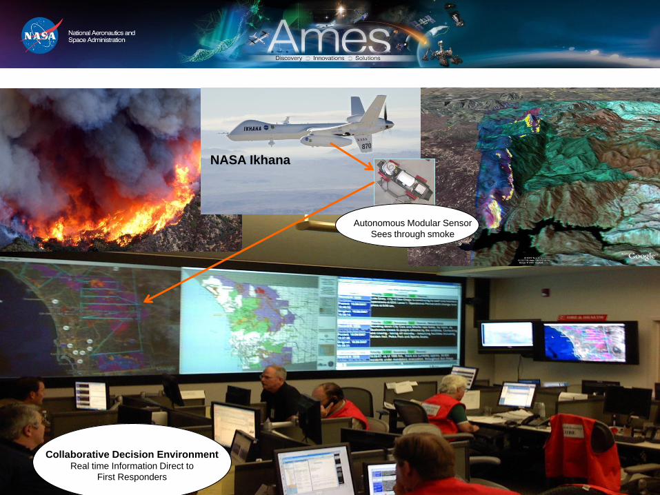
NASA Ikhana
Autonomous Modular Sensor
Sees through smoke
Collaborative Decision Environment Real time Information Direct to
First Responders

NASA Wildfire Efforts: Research to Operations
Operational Capabilities Derived from Partnership
• CDE (Used in various incidents by USFS, CALFIRE and others);
• On-Board Processing to derive real-time products (employed by NIFC-
NIROPS aircraft / sensors);
• Real-time data delivery via air / ground comms. link (AirCell used by NIFC-
NIROPS);
• Sensor “loan” of AMS from NASA to USFS to support wildfire observations in
2013. Operated on a Citation jet.
• Continued evaluation of sUAS to support fire teams and augment manned
aircraft assets. USFS UAS Working Group to evaluate and develop
operational guidelines for UAS use.
These technology adoptions have improved national
wildfire decision support systems, resulting in
significant time-savings in intelligence delivery, and
simplified the analysis of the data

NASA Sensor on USFS Aircraft:
Supporting National Operations in 2013!!
USFS Citation Jet AMS Instrument Install
1 March 2013 First Test Flight Collections
Salt Lake City, UT

EXTRA SLIDES