Embed Size (px)
Citation preview

AIP SUPPLEMENT TEL: (675) 3121581 AFTN: AYPMYNYX FAX: (675) 3121593 Email: [email protected]
AERONAUTICAL INFORMATION SERVICES
P.O.BOX 273 BOROKO, NCD 111 PAPUA NEW GUINEA
AIRAC 2/2012
23RD AUGUST
EFFECTIVE DATE: 24 AUGUST 2012
COMMISSIONING OF NEW KAVIENG DVOR/DME
1. PURPOSE 1.1 The purpose of this AIP Supplement is to provide details of the new and revised IAL procedures due to the planned commissioning of KVG DVOR/DME replacing KAV VOR/DME and the establishment of revised planned routes to enhance air traffic management safety and efficiency. 2. LOCATION AND DETAILS OF NEW RADIO NAVIGATION AID 2.1 The Location and details of the new KVG DVOR/DME that will replace the existing KAV VOR/DME are as follows:
Type of navigation aid
ID Frequency Hours of operation
Coordinates (WGS‐84)
Antenna Elevation
DVOR/DME KVG 117.1Mhz CH118X
H24
02 35 07.86S 150 48 50.28E
23FT (7M) AGL
3. NEW AND REVISED AERODROME DATA (Refer Old Format AIP AGA 3‐10 Attachment). (Refer New Format AIP AD 3; AYKV AD 3‐1/5; Attachment).

4. NEW AND REVISED IAL CHARTS (Refer AIP Flight Supplement, IAL attachments, Kavieng (AYKV) Aerodrome).
‐ DME or GNSS Arrival ‐ GPS RWY 12 ‐ VOR/DME RWY ‐ Aerodrome Chart ‐ DME or GNSS Departure
5. REVISED TRACK CHANGES TO/FROM AYKV – KVG DVOR/DME (Refer PNG RNC 1 dated 30 NOV 2004) 5.1 A summary of the revised track changes are as follows:
TRACK
Current Track Details Revised Track Details
IN/OUT DIST/LSALT IN/OUT DIST/LSALT
MANDA KVG 093 / 272 104 / 4300 093 / 273 102 / 4300 BUTYO KVG 076 / 255 145 / 4300 076 / 256 143 / 4300 SIBIN KVG 056 / 236 110 / 4300 1500 056 / 236 110 / 4300 1500 HIPEL KVG 030 / 210 103 / 4300 030 / 210 103 / 4300 HKN NDB KVG 001 / 181 173 / 5400 002 / 182 173 / 5400 TOK VOR/DME KVG
311 / 131
140 / 4700
312 / 132
142 / 4700
VERON KVG 299 / 120 143 / 6800 301 / 121 144 / 6800 LHR NDB KVG 276 / 097 111 / 4400 278 / 098 112 / 4400
6. EFFECTIVE DATE 6.1 This AIP Supplement will become effective on 24 August 0000 UTC.
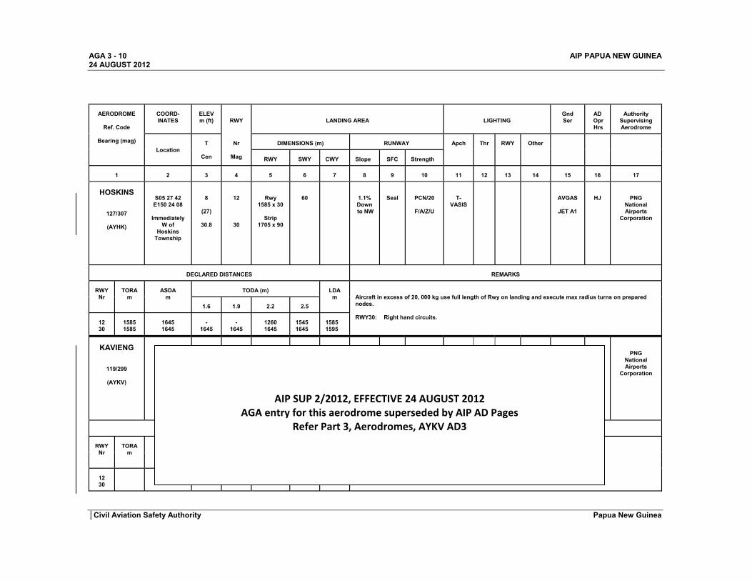
AGA 3 - 10 AIP PAPUA NEW GUINEA 24 AUGUST 2012
AERODROME
Ref. Code
Bearing (mag)
COORD- INATES
ELEV m (ft)
RWY
LANDING AREA
LIGHTING
Gnd Ser
AD Opr Hrs
Authority Supervising Aerodrome
Location
T
Cen
Nr
Mag
DIMENSIONS (m) RUNWAY Apch Thr RWY Other
RWY SWY CWY Slope SFC Strength
1
2
3
4 5 6 7 8 9 10
11 12 13 14 15 16 17
HOSKINS
127/307
(AYHK)
S05 27 42 E150 24 08
Immediately
W of Hoskins
Township
8
(27)
30.8
12
30
Rwy
1585 x 30
Strip 1705 x 90
60
1.1% Down to NW
Seal
PCN/20
F/A/Z/U
T-VASIS
AVGAS
JET A1
HJ
PNG
National Airports
Corporation
DECLARED DISTANCES REMARKS RWY
Nr
TORA
m
ASDA
m
TODA (m) LDA
m
Aircraft in excess of 20, 000 kg use full length of Rwy on landing and execute max radius turns on prepared nodes. RWY30: Right hand circuits.
1.6
1.9 2.2 2.5
12 30
1585 1585
1645 1645
-
1645
-
1645 1260 1645
1545 1645
1585 1595
KAVIENG
119/299
(AYKV)
PNG National Airports
Corporation
DECLARED DISTANCES REMARKS RWY
Nr
TORA
m
ASDA
m
TODA (m) LDA
m
CAUTION: BIRD HAZARD.
1.6
1.9 2.2 2.5
12 30
AIP SUP 2/2012, EFFECTIVE 24 AUGUST 2012 AGA entry for this aerodrome superseded by AIP AD Pages
Refer Part 3, Aerodromes, AYKV AD3
│Civil Aviation Safety Authority Papua New Guinea

AIP AD 3 - 1 Papua New Guinea 24 AUG 2012
AYKV AD 3.1 AERODROME LOCATION INDICATOR AND NAME
AYKV - KAVIENG
AYKV AD 3.2 AERODROME GEOGRAPHICAL AND ADMINISTRATIVE DATA
1
ARP coordinates
Ref. Point: Lat: 02 34 44.34 S Long: 150 48 26.74 E
2
Direction and distance from (city)
Adjacent to Kavieng Township
3
Elevation/Reference temperature
13FT (3.96M) / 30.4°C
4
Geoid undulation at AD ELEV
Not AVBL
5
MAG VAR/Annual Change
5.9°E (2012) / 2.14° W
6
AD Administration
National Airports Corporation (NAC) P.O.Box 684 Boroko, NCD Papua New Guinea Tel: +675 3244451 Fax: + 675 3259015 Email: Web: www.nac.com.pg Kavieng – Safety Officer Tel/Fax: +675 984 2462
7
Type of Traffic Permitted
IFR/VFR
8
Remarks
WGS 84 AD may not be planned as ALTN for NGT OPS unless agent approved to OPR AD LGT is in attendance.
AYKV AD 3.3 OPERATIONAL HOUR
1 AD Administration
HJ and otherwise for pre-planned ARR and DEP
2
AIS Briefing Office
H24 (NOF)
3
MET Briefing Office
1900 -1930
4
ATS
1900 - 0900
5
Fuelling
Nil
6
Handling
Nil
7
Remarks
AYKV AD 3.4 HANDLING SERVICES AND FACILITIES
1
Cargo handling facilities
2
Fuel/oil types
AVGAS, JET A1
3
Fuelling facilities/capacity
4
Remarks
Civil Aviation Safety Authority Edition 1

AIP AD 3 - 2 Papua New Guinea 24 AUG 2012
AYKV AD 3.5 PASSENGER FACILITIES
1
Hotels
Several in Kavieng Township
2
Restaurants
See Hotels
3
Transportation
Hire Cars by prior arrangement
4
Medical facilities
Kavieng Township
5
Bank and Post Office
Kavieng Township
6
Tourist Office
Nil
7
Remarks
Nil
AYKV AD 3.6 RESCUE AND FIRE FIGHTING FACILITIES
1
Aerodrome category for fire fighting Nil
2
Rescue equipment Nil
3
Capability for removal of disabled aircraft Nil
4
Remarks
AYKV AD 3.7 SEASONAL AVAILABILITY - CLEARING
1
Type of clearing equipment
Nil
2
Clearing priorities
Nil
3
Remarks
Nil
AYKV AD 3.8 APRONS, TAXIWAYS AND CHECK LOCATIONS DATA
1
Apron surface and strength SEAL AND PCN 20
2
Taxiway width, surface and strength 15M, SEAL AND PCN 20
3
ACL location and elevation Nil
4
VOR/INS checkpoints Nil
5
Remarks
AYKV AD 3.9 SURFACE MOVEMENT GUIDANCE AND CONTROL SYSTEM AND MARKINGS
1
Markings
TDZ, RWY, THR, Edge, Centreline, Runway End and Turning Nodes, as appropriate.
2
Remarks
AYKV AD 3.10 AERODROME OBSTACLES
IN APPROACH/TKOF AREAS IN CIRCLING AREA AND AT AD
Remarks
1 2 3
Rwy Nr & Area affected
Obstacle type
Elevation Markings/LGT
Coordinates
Obstacle type Elevation Markings/LGT
Coordinates
a
b
c a b
12
30
Civil Aviation Safety Authority Edition 1

AIP AD 3 - 3 Papua New Guinea 24 AUG 2012
AYKV AD 3.11 METEOROLOGICAL INFORMATION PROVIDED
1
Associated MET Office PORT MORESBY
2
Hours of service H24
3
Office responsible for TAF preparation Periods of validity
Port Moresby MWO
4
Type of landing forecast, Interval of issuance
5 Briefing/consultation provided Telephone/NAIPS
6
Flight documentation Language(s) used English
7
Charts and other information available for briefing or consultation
8
Additional information (limitation of service, etc)
9
Observations
10
Remarks Area Forecasts, 2000/0800, 0200/1100
AYKV AD 3.12 RUNWAY PHYSICAL CHARACTERISTICS
Designations RWY NR
TRUE &
MAG BRG
Dimensions (m)
of RWY
Strength (PCN) and
Surface of RWY
Slope of
RWY
Coordinates a) of THR
b) of RWY End
Elevation a) THR
b) RWY End c) Highest Elev
TDZ Prec APCH RWY
Geoid Undulationa) at THR b) at RWY
End
1 2 3 4 5 6 7 8
12 125 T 119
1702 x 30
PCN/20/F/B/Y/U SEAL *
LEVEL THR/RWY End: 02 34 29.92 S
150 48 06.31 E
THR/RWY End: 12FT
Not AVBL
30 305 T 299
1702 x 30
PCN/20/F/B/Y/U SEAL *
LEVEL THR/RWY End: 02 35 01.74 S
150 48 51.41 E
THR/RWY End: 15FT
Not AVBL
Designations RWY NR
SWY Dimensions
(m)
CWY Dimensions
(m) RWY-CWY
Slope Strip Dimensions
(m) RESA
Dimensions (m) OFZ
1 9 10 10 11 12 13
12 60
90 NIL 1702 x 90 SUPP 150
Not AVBL NIL
30 Not AVBL 60 NIL 1702 x 90 SUPP 150
Not AVBL NIL
Remarks 14 *1/ RESTR: ACFT ABV 20,00KG (44902LB) are required to use full length of RWY when LDG and execute MAX radius turns on THR or prepared turning nodes. 2/ Bird Hazard.
Civil Aviation Safety Authority Edition 1

AIP AD 3.4 Papua New Guinea 24 AUG 2012
AYKV AD 3.13 DECLARED DISTANCES
1 2 3 4 5
RWY Designator
TORA
m
ASDA
m TODA m
LDA
m 1.6 1.9 2.2 2.5 3.3 5.0
12 30
1702 1702
1762 1702
-
1290 -
1421 980 1518
1113 1592
1352 1728
1596 1762
1702 1702
Remarks 6 Reduced TODA due to 80FT AGL Breadfruit tree 98m left of track, 274m (0.2NM) from RWY 30 end, at edge of TKOF splay If avoided by TKOF TRK 1° right of RWY CL, operators may add 250m to TODA/ASDA
AYKV AD 3.14 APPROACH AND RUNWAY LIGHTING
RWY Designator
APCH LGT type LEN
VASIS
(MEHT) PAPI
TDZ, LGT
RWY Centre
Line LGT
RWY THR LGT
Remarks
1
2
3
4 5 6
7
12 30
Stage 2
T-VASIS
X T-VASIS two stage. Range 5 NM Day and
NGT but during this short twilight period the range is 2 NM due ambient light
AYKV AD 3.15 OTHER LIGHTING, SECONDARY POWER 1
Other lighting
WDI PAL 125.8 TWY
2
Remarks
AYKV AD 3.16 HELICOPTER LANDING AREA
Nil
AYKV AD 3.17 ATS AIRSPACE
MORESBY FLIGHT INFORMATION AREA - SECTOR 9.
AYKV AD 3.18 ATS COMMUNICATION FACILITIES
Service Designation
Call sign Frequency Hours of
operation
Remarks
1
2 3 4
5
FIS
Moresby 127.1
5565 8861
1900 - 0900
Civil Aviation Safety Authority Edition 1

AIP AD 3.5 Papua New Guinea 24 AUG 2012
AYKV AD 3.19 RADIO NAVIGATION AND LANDING AIDS
Type of aid
Ident
Frequency
Hours of operation
Site of transmitting
antenna coordinates
Elevation of DME
transmitting antenna
Remarks 1 2 3 4 5 6 7
VOR/DME
KVG
117.1/CH118X H24
02 36.234 S 150 50.206 E
23FT (7m) AGL
Remote Lighting
125.8 H24
PAL: RWY Lights & T-VASIS
AYKV AD 3.20 LOCAL TRAFFIC REGULATION
AYKV AD 3.21 NOISE ABATEMENT PROCEDURES
AYKV AD 3.22 FLIGHT PROCEDURES
1. Refer: AIP Flight Supplement, INSTRUMENT APPROACH AND LANDING CHARTS (IAL) - DME or GNSS Arrival (New) - GPS RWY 12 (Amended)
- VOR/DME RWY 12 (New) - Aerodrome Chart (Amended) - DME or GNSS Departure (New)
AYKV AD 3.23 ADDITIONAL INFORMATION
Refer to AD AYKV 3.2 – Night Operations
AYKV AD 3.24 CHARTS RELATED TO KAVIENG AIRPORT
1. Radio Navigation Chart 1 (RNC) dated 30 November 2004, Refer to Page 2, paragraph 5 of AIP SUP (Summary of Revised Tracks).
2. Refer: AIP Flight Supplement, INSTRUMENT APPROACH AND LANDING CHARTS (IAL) - DME or GNSS Arrival - GPS RWY 12 - VOR/DME RWY 12 - Aerodrome Chart - DME or GNSS Departure
Civil Aviation Safety Authority Edition 1