Embed Size (px)
Citation preview

•••
ECOCLIMATIC REGIONS OF CANADA
E'lvironment Canada
Ecological Land Classification Series, No. 23
Environnemenl
Canada
Canadian Wildlife Service canaclien
Service de la faune
Canada

CONTENTS Page
Preface. . . . . . . . . . . . . . . . . . . . . . . . . . . . . . . . . . . . . . . . . . . . . . . . . . . . . . . . . . . . . . . . . . . . . . . . . . . . . . . . .. 11 i
Introduction. . . . . . . . . . . . . . . . . . . . . . . . . . . . . . . . . . . . . . . . . . . . . . . . . . . . . . . . . . . . . . . . . . . . . . . . . . . . . 1
Summa� of Ecoclimatic Regions of Canada................................................. 3 •
Acknowledgements. . • . . • . . . . . . . . . . . . . . . . . . . . . . . . . . . . . . . . . . . . . . . . . . . . . . . . . . . . . . . . . . . . . . . . . . . 6
1. Arctic Ecoclimatic Province.......................................................... 7
Ecoclimatic Regions :
1.1 HAo 1.2 HA
1.3 MA
1.4 LA 1.5 LAm
Oceanic High Arctic. . . . . . .. . . . . . . . . . . . . . . . . . . . . . . . . . . . . . . . . . . . . . . . . . . . . . . 9 High Arctic . . . . . . . . . . . . . . . . . . . . . . . . . . . . . . . . . . . . . . . . . . . . . . . . . . . . . . . . . . . . . . 10
Mid-Arctic . . . . . . . . . . . . . . . . . . . . . . . . . . . . . . . . . . . . . . . . . . . . . . . . . . . . . . . . . . . . . . . 11
Low Arctic . . . . . . . . . . . . . . . . . . . . . . . . . . . . . . . . . . . . . . . . . . . . . . . . . . . . . . . . . . . . . . . 12 Mois t Low Arc tic. • • • . • • • • • • • • . • • • . . • . . • • • • • . • • • • • . • • • . • • • • • • • • • • • . . • • • • • • 13
2. Subarctic EcocliDLatic Province....................................................... 15
Ecoclimatic Regions :
2.1 HS
2.2 MS 2.3 MSm
2.4 LS 2.5 LSa
High Subarc tic . . . . . . . . . . . . . . . . . . . . . . . . . . . . . . . . . . . . . . . . . . . . . . . . . . . . . . . . . . . 17
Mid-Subarctic . . . . . . . . . . . ..... . ...... ... . . .... ..... . .... ....... .. ...... ... 18 Maritime Mid-Subarctic. . . . . . . . . . . . . . . . . . . . . . . . . . . . . . . . . . . . . . . . . . . . . . . . . . . 19
Low Subarctic . . . . . . . . . . . . . . . . . • . . . . . . . . . . . . . . . . o • • • • • • • • 0" 00 • • • • • • • • • •• • • • 20 Atlantic Low Subarctic . . . . . . . . 0 0 . . . . . . . . . . . . . 0 . . . . . . . . . . . . . . . . . . . . . . . . . . . 21
3. Boreal Ecoclimatic Province . . . . . . . . . . . . . . . . . . . . . . . . . . . . . . . . . . . . . • . . . . . . . . . . 0 . . . . . . . .. 23
Ecoclimatic Regions :
3.1 lIBa 3.2 IIBh 3.3 IIBm 3.4 lIBo 3.5 IIBp 3.6 IIBs 3.7 IIBx
3.8 MBa 3.9 MBh 3.10 MBm 3.11 MBa 3.12 MBp 3.13 MBs 3.14 MBx
Atlantic High BoreaL . . . . . . . . . . . . . . . . . . . . . . . . . . . . . . . . . . . . . . . . . . . . . . . . . . . . 25 Humid High BoreaL . . . . . . . .. . . . . . . . . . . . . . . . . . .. . . . . . . . . . . . . . . . . . . . . . . . . . . . 26 Maritime High Boreal . . . . . . . . . . . . . . . . . . . . . . . . . . . . . . . . . . . . . . . . . . . . . . . . . . . . . 27 Oceanic High Boreal . . . . . . . . . . . . . . . . . . . . . . . . . . . . . . . . . . . . . . . . . . . . . . . . . . . . . . 28 Perhumid High BoreaL . . . . . . . . . . . . . . . . . . . . . . . . . . . . . . . . . . . . . . . . . . . . . . . . . . . . 29 Subhumid High Boreal . . . . . . . . . . . . . . . . . . . . . . . . . . . . . . . . . . . . . . . . . . . . . . . . . . . . . 30 Moist High BoreaL . . . . . . . . . . . . . . . . . . . . . . . . . . . . . . . . . . . . . . . . . . . . . . . . . . . . . . . 31
Atlantic Mid-Boreal . . . . . . . . . . . . • •• . . . . . . • . . . . 0 ... . ... ..... .. . ..... . ..... .. 33 Humid Mid-BoreaL . . . . . . . . . . . . . . . . . . . . . . . . . . . . . . . . . . . . . . . . . . . . . . . . . . . . . . . . 34 Maritime Mid-BoreaL . . . . . . . . . . . . . . . . . . . . . . . . . . . . . . . . . . . . . . . . . . . . . . . . . . . . . 35 Oceanic Mid-Boreal . . . . . . . . . . . . . . . . . . . . . . . . . . . . . . . . . . . . . . . . . . . . . . . . . . . . . . . 36 Perhumid Mid-BoreaL . . . . . . . . . . . . . . . . . . . . . . . . . . . . . . . . . . . . . . . . . . . . . . . . . . . . . 37 Subhumid Mid-BoreaL . . . . . . . . . . . . . . . . . . . . . . . . . . . . . . . . . . . . . . . . . . . . . . . . . . . . . 38 Moist Mid-Boreal . • . • . . . . . . . . . . 0 . . . . . . . . . . . . . . . . . . . . . . . . . . 0 . . . . . . . . . 0 . . . . . 39

3.15 LBa 3.16 LBh 3.17 LBm 3.18 LBn 3.19 LBo 3.20 LBp, 3.21 LBs 3.22 LBst 3.23 LBt 3.24 LBx
vi
Page
Atlantic Low Boreal . . . . . . . . . . . . . . . . . . . . . . . . . . . . . . . . . . . .. . . . . . . . . . . . . . . . . . . . 41 Humid Low- Boreal • • • . . • • • • . • • • . . . • • • . • . . • • . • . . • • • • . • • • • . • • . • . . . • • . • . • • • . • . . 42 Mari time Low Boreal • • • . • • • • • • . . • • • • • • . • • • • • . • . • • • • . . • . • • • • • . • -�- . • • • • . . • • • • • 43 Oceanic Low Boreal • . • • • • . • . • • • • . . • • • • . • • . • • • • . • • • • • . . . . . • • • . • • . . . . . . • • • . • • 44 Exposed Oceanic Low Boreal • . • • • . . • . • • • • . . • • • • • . . . • • . • • • . . . • • • • . • . . • • • • • . . . 45 Perhumid Low Boreal. . . . . . . . . . . . . . . . . . . . . .. . . . . . . . . . . . . . . . . . . . . . . . . . . . . . . . . 46 Subhumid Low Boreal • • • . . • • • • . . . . • • • • • • . . • • • . • • • • • • . . . . . . • • • • . . . • • • • • . . . . • . 47 Subhumid Transitional Low Boreal • • • • • • • • • • • • • . . • • • • • • • • • • • • • • • • • • • • • • • • • . • 48 Transi tional Low Boreal • • • • . • • • • • • • . . • • • • • • • • • • • • • • • • • . • • • • . • • • • . . . • • • • • • • 49 Moist Low Boreal • . • • • • . . • • • • • • . • • • • • • . • • • • • • • • • • • • • • . . • • • . • • • • . . • • • • • • . . . • 50
4. Cool Temperate Ecoclimatic Province • • . • • • • • . • • . . • • • • • • . . • • . . . • • . . . • • • . . • • . • . • • • • • • • . • . • • 51
Ecoclimatic Regions :
4.1 4.2 4.3
4.4 4.5
HCTa HCTh HCTt
MCTa MCTh
Atlantic High Cool Temperate • . . • • • • • . • • • • • . • • • . . • • . • . • • • • • • • • . • • • • . • • • • • • • 53 Humid High Cool Temperate • . . • • . . • • • • • • • • • • • . • • • • • • • . • • • • . • • • . . • • • • • • • • • • • • 54 Transitional High Cool Temperate • . . • • • • . • • . • • . • • • • • • • • . • • • • • . • • • • • . • • • • . • • 55
Atlantic Mid-Cool Temperate • • • • • • . • • • • • • • • • • • • • • • • • • • • • • • . • • • • . . . • • • • • . . • • 56 Humid Mid-Cool Temperate • • • • • • • • • • • . • • • • . . . • • . . • • • . • • • . . • • • • • . . . • • • • . • • • • • 57
5. Moderate Temperate Ecoclimatic Province • . . • • • • • • . • . • • • • • • . . • • • • • • • . • • • • . • • • . • • . • • . . • • • . . 59
Ecoclimatic Region:
5.1 IMTh Humid High Moderate Temperate • • • • • • . . • • • • • . • • . . • • • • • • • • • • • • • • • • . • • • . • . • • • • 61
6. Grassland. Ecoclimatic Province • • • • • . . • • • • • • • • • • • . • • • • • • • • . . • • • . • • • . . • . • • . . • • . . . . • • • • . • • • 63
Ecoclimatic Regions :
6.1 Gt 6.2 Gs 6.3 Ga
Transitional Grassland • • . . . . • • • • • • • • • • • . . . • • . • • . • • • . . • • • • • . • • • • • • . . • • • • • • • 65 Subhumid Grassland ......................................................... 66 Arid Grassland • . • • • • • • • • • • . . . . . . • • • • • • . • • • • • • . • • • . • • • • . . . • • • • • . • • • • • • • • . • • 67
7. Subarctic Cordilleran Ecoclimatic Province • • • • • • • • • • • • • . . . • • • • . • • • • . . • • • • • • . • • • • . • . . • • • • 69
Ecoclimatic Regions :
7.1 NSCa 7.2 NSCs
Alpine Northern Subarctic Cordilleran • • . . . • • • • • • • • • • . • • • • . . . • • • • • . • • • • • • • • 71 Subalpine Northern Subarctic Cordilleran • • • . • • • • • • • • • • • • • • . • • • • • • • • • • • • • • • 72
8. Cordilleran I!coclimatic Province • • • • • • • • • • • • • • • • • • • • • • • • • • • • • • • • • • • • • • • • • • • • • • • • • • • • • • • • 73
Ecoclimatic Regions :
8.1 8.2 8.3
8.4 8.5 8.6
NCa NCB NCb
MCa MCs MCb
Alpine Northern Cordilleran • . . • • • • • . . • • • . • • . . • • • . • • • . • • • • . . . • • • • • • . . • • • . • . 75 Subalpine Northern Cordilleran • • • • • • • • • • . • • • • • • • • • • • . • • • • • • . • • • • • • • • • • • • • • 76 Boreal Northern Cordilleran • • • • • • . • • • • • . • • . • • . • • • • • . • • • • • . • • • • • • • • • • • • • • • • 77
Alpine Mid-Cordilleran • • • • • • • • • • • • • • • • • • • • • • • • • • • • • • • • • • • • • • • • • • • • • • • • • • • • 79 Subalpine Mid-Cordilleran • • • • • • • • • • • • • • • • • • • • • • • • • • • • • • • • • • • • • • • • • • • • • • • • • 80 Boreal Mid-Cordilleran • • • • . • • • • • • • • . • • • • . • • • . • • • • . • • • • • • . • • • • • • . • • • • • • . • • • 81

8 . 7 8 . 8 8 . 9 8.10 8 . 1 1
SCa SCs. SCb SCm SCm+
vii
Page
Alpine Southern Cordilleran . . . . . . . . . . . . • . . . • . . . . . . . . . . . . . . . . . . . . . . . . . . . . . . 83 Subalpine Southern Cordilleran • • • • • • • • • . • • • • • . • . • • • . • • • • . • • • • • . • • • . . • • • • . • 84 Boreal Southern Cordilleran • • • • • . . • • . . • • • • • . • • • • • • • • • • . • • • • . • • • • • . . • • • • • . • 85 Montane Southern Cordilleran . • • • • • . • • • • . . • • • . • . . • • • • • • • • • . • . • • • • • • • • • . • • • • 86 Moist Montane Southern Cordilleran • • . • • . . . . . . . • . . . • • • • • • • • • • • • • • . • • • • . . . . • 87
9. Interior Cord�11eran Ecocl�t�c Province • • . • • • • . . • • • • . • • . • . . . • • . . . • • • • . • • • • • . • • • . • • • • 89
Ecoclimatic Regions :
9 . 1 lCb
*ICv
9 . 2 lCa 9 . 3 lCs 9 . 4 lCn 9 . 5 lCm 9.6 lCm-9 . 7 lCp
Boreal Interior Cordilleran . . . . . . . . . . . . . . . . . . . . . . . . . . • . . . . . . . . . . . . . . . . . . . . 91
Ecoclimatic Regions of the Vertically Stratified Interior Cordilleran Map Unit • • • • . . . . • . • • • . • • • • • • • . . • • • • • • • • • . • • • • . • • • • • • . 92 Alpine Interior Cordilleran • • • • • • • • • . • • • • . • • • • • • • • • . • • • • • . • • • . • • • • • • • • • • • . 93 Subalpine Interior Cordilleran • • • • . • • • • • . . • • • . • • • • • . • • • . • • • • • • • . . • • • . . • . • • 94 Subalpine Transitional Interior Cordilleran • • • . • • • • • • • • • • . • • • • • . • • • • . • • • • • 95 Montane Interior Cordilleran • • . . • • • . . . . . . • • • . . . . • • . . • • • • • • • • . • • . • • • • • . • • • • 96 Subhumid Montane Interior Cordilleran • • • . • • • . . • • • • • . • . • . . . . • . • . • • • • • • • • • • • 97 Grassland Interior Cordilleran • • • • • • • • • • . • • • • . • • • • • . • • . • • . • • • • • . • • • • . • • • • • 98
10. Paeifie Cordilleran Eeoelimatie Province • • • • • • • • • • • • • • • • • • • • • • • • • • • • • • • • • • • • • • • • • • • • • • 99
Ecoclimatic Regions :
10.1 10.2 10 . 3 10.4
10 . 5 10.6 10.7 10.8 10.9
NPg NPa NPs NPm
SPa SPs SPm SPo SPc
Glacierized North Pacific Cordilleran • • • . • • • • . • • • • . . . . . . . . . . . . . • • • • . • . . • • • l01 Alpine North Pacific Cordilleran • • • • • • • • • • • . • • • • • • • • • • • • • • • • • . • . • • . . • • . . • • 102 Subalpine North Pacific Cordilleran • • . • • • • . . . . • • • • • • . • • • • • • • • • • . • . . • • . • • • • 103 Mari time North Pacific Cordilleran • • • • • • • • -• • • • • • . • • • • . • • • • • . • • • • . • • • • • • • • • 104
Alpine South Pacific Cordilleran • • • • • • • • • • • • . . • . • . • • . • . . • • . • • • • • • • • • • • . • • • 106 Subalpine South Pacific Cordilleran • • . • • . • • • • . • • • . • • • . • • • • • • • • • • • • • • • • . • . • 107 Maritime South Pacific Cordilleran • • • • • • • • • • • • • • • . • • • . . • • • • . . • • • • . . • . . . . . . 108 Oceanic South Pacific Cordilleran • • • . • • . . • • . . • • . • . • . • • . . • • • • . • • • • • • • • • • • • • !O9 Coastal South Pacific Cordilleran • • • • • . • • • • • . • • • • • • • • • . • • • • • • . • • • . • • • • . • . . !!0
Spee1es List • • • • • • • • • • • • • • • • • • • • • • • • • • • • • • • • • • • • • • • • • • • • • • • • • • • • • • • • • • • • • • • • • • • • • • • • • • • • • • 111
Seleeted Bibliography • • • • • • • • • • • • • • • • • • • • • • • • • • • • • • • • • • • • • • • • • • • • • • • • • • • • • • • • • • • • • • • • • • • • • 114

1
INTRODUCTION Ecoclimatic regions are typically broad areas on the earth ' s surface characterized by distinctive ecological responses to climate , as expressed by vegetation and reflected in soils, wildlife, and water. Within ecoclimatic regions, the ecologically effective climate will result in the development of similar trends in vegetation succession on similar soils occurring on similar parent materials and positions on the landscape.
Climatic factors provide the incoming energy available to plants and to a great extent determine the amount of moisture available to the vegetation. Such factors as the distribution of oceans and continents, their configuration, the tilt of the earth in relation to the sun, and large-scale airmass circulation influence the broad climatic patterns that provide the basic necessities for life: energy and water.
Vegetative life, however, also requires soil, which develops on various 'soil parent materials having a variety of surface forms . Vegetation will develop on the abiotic base (climate, parent material , surface form) , with particular species composition for each soil parent material (e . g . , sand or clay, nutrientpoor or nutrient-rich) , each soil moisture regime , and each local climate , as modified by the landform or the vegetation itself. A further complication is vegetation succession -- i . e . , the fact that the present vegetation is generally only one link in a long chain of vegetation communities. In nature, setbacks often occur (e . g . , a fire can destroy the living vegetation and modify the upper part of the soil ) . Initially, species present will be those which are adapted to such ' pioneering' conditions ; these species will be replaced later by other plants as the environment for the maturing community changes. Theoretically, the ecosystem could reach a ' steady state ' , in which the vegetation community could renew itself indefinitely, without change. In most instances, however, this state is seldom reached, as disturbances will re-set the cycle to a new beginning.
Within a broad framework of climate, local influences will result in a multitude of ecosystems, each with its developmental sequence. However, similar ecosystems will develop on similar soils and landforms in the same area. A small difference in climate may
not produce a recognizable difference in the composition or growth of the ecosystem, but a pronounced difference may result in a considerable effect on the vegetation composition. Similarly, if the vegetation of the same landform, soil, and parent material is examined in a somewhat different climate , a subtle difference will be noticed. The greater the differences in the climate of two areas, the greater will be the differences in the ecosystems occurring there. This fact forms the basis for ecoclimatic regionsl•
This report presents the broad ecoclimatic regions of Canada. Not all possible ecosystems on all landforms, soils, and parent materials can be possibly described: we lack both the knowledge and the time. As a shortcut , we have attempted to characterize each ecoclimatic region on the basis of 'normal ' sites. Normal sites are represented by deep loamy SOils, with neither a lack nor an excess of soil nutrients, and are located in well-drained positions in the landscape which, are neither protected from nor exposed to local climatic extremes. In this manner, when the vegetation development of normal sites on widely separated areas is compared, the local effects of soil or landform differences are eliminated. Consequently, any differences in the vegetation chronosequence should be due to the ecologically effective regional climate.
In the following descriptions, each ecoclimatic region is characterized by a brief description of the vegetation and soils on normal sites, drier-than-normal sites, and wetter-than-normal
IThe term ' ecoclimatic regions' requires explanation. The delineation of ' regions ' is based on ecological relationships between the living and non-living components of the environment. They are thus ' ecoregions ' . There are several ways of recognizing ecoregions: total landscape ecoregions (physiographyvegetation) , habitat ecoregions (wildlife habitat-vegetation-physiography) , soil ecoregions (soil-vegetation) , etc. We have chosen gradients of ecologically effective macroclimate (as expressed by vegetation) as the defining criteria. The term should be ' ecoclimatic ecoregions ' , which can be abbreviated to 'ecoclimatic regions' or ' climatic ecoregions ' . We have elected to use ' ecoclimatic regions ' .

sites, along with some climatic information from a representative climate station. Notes on wildlife characteristic to the ecoclimatic region and land uses affecting the natural resources are also provided. Figure 1 summarizes the types of information provided in each climate diagram, as taken from published records ( 5 , 6 , 7 ) . Where several alternatives were available, the climatic stations were chosen to be as representative as possible of the entire ecocllmatic region.
Throughout the report, the descriptions are organized within 'ecoclimatic provinces ' , which are groupings of ecoclimatic regions . The ecoclimatic provinces , being more generalized, include more variations within their borders than the ecoclimatic regions . Nevertheless, there is a resemblance in the vegetation development within ecoclimatic provinces that makes them different from the neighbouring provinces. These generalized relationships give the ecoclimatic provinces an ecological meaning which is useful at a global scale of detail. The table provides a brief characterization of ecoclimatic provinces:
Figure 1 : Key to climate diagrams :
A B C
D E
F G
H I J K
L
M
N
D
p
Q
ecoclimatic region; name of climate station; elevation of climate station above sea level (m); mean annual temperature (OC); number of observation years (where two figures are given, the first indicates temperature and the second precipitation ) ; mean annual precipitation (mm) ; mean daily minimum temperature of coldest month (OC); lowest recorded temperature (OC); curve of mean monthly temperature (OC); curve of mean monthly precipitation (mm ) ; period of relative drought (dotted pattern ) ; period of relatively humid climate (vertical pattern ) ; mean monthly precipitation, scale reduced to I/IOth for values greater than 100 mm per month (shown in solid black) ; months with mean daily temperature below DOC ( shown in solid black ) ; months with mean daily temperatures above aoc but mean daily minimum temperatures below O °C (diagonal pattern); months with mean daily temperatures above O°C; and �lAltd� ,�JV\. � a�e oC) (PfM) division of the year (January through December, left to right, respectively; monthly temperature and precipitation means are noted at the mid-point of the 'bar' for the respective �onth) .
"
2
Table: Ecoclimatic Provinces
Arctic
Subarctic
Boreal
Cool Temperate Moderate Temperate
Grassland
Subarctic Cordifferan
Cordilleran
Interior Cordilleran
Pacific Cordilleran
A B (e) [E]
Vegetation development
Treeless, with tundra, polar semi-desert, or polar desert
Open-canopied conifer woodlands, with tundra patches
Closed-canopied forests of conifer or mixed conifer-hardwood
Mixed forests of shade-tolerant hardwood-conifer
Deciduous forests
Grassland with or without small groves of hardwood trees
Open-canopied conifer woodland and alpine tundra in elevational zones
Closed-canopied conifer or mixedwood forests, open-canopied conifer woodland, and alpine tundra in elevational zones
Grassland (with or without scattered trees), closed-canopied conifer or mixedwood forest, open-canopied conifer woodland, and alpine tundra in elevational and rain shadow zones
Closed-canopied conifer forest, open-canopied conifer woodland, and alpine tundra in elevational zones
p

3
SUMMARY OF ECOCLIMATIC REGIONS OF CANADA Several broad trends can be identified from the vegetation and climate descriptions of each ecoclimatic region, when studied in conjunction with the map. Firstly, significant changes in vegetation occur along a transect from south to north. On normal sites, the hardwood forests of southern Ontario and Quebec (Moderate Temperate Ecoclimatic Province and Cool Temperate Ecoclimatic Province) grade to forests composed of trembling aspen, white spruce, and black spruce (Boreal Ecoclimatic Province) , and eventually to woodlands dominated by black spruce ( Subarctic Ecoclimatic Province ) with a further increase in latitude. These woodlands become more open and stunted northward , and are eventually replaced by communities of shrubs that decrease in height until they occur as dwarf individuals (Arctic Ecoclimatic Province) . On normal sites in these areas , vascular plant cover becomes discontinuous to sparse, although moss and lichen remain prominent components of the landscape. Total cover and plant stature continue to decrease in a northward direction, until they are almost non-existent .
Changes can also be seen in the climatic data from south to north. For example , the summers are warm and relatively long in the Moderate Temperate Ecoclimatic Province , but they become continuously shorter and cooler as the Arctic Ecoclimatic Province is approached . Table 1 illustrates such changes in climatic conditions via a transect from London, Ontario, in the Humid High Moderate Temperate Ecoclimatic Region (HMTh) to Resolute, Northwest Territories , in the High Arctic Ecoclimatic Region (RA). The extreme cold of northern Canada is well illustrated when directly compared with the temperatures of southern Canada. The mean daily maximum temperatures for January and February in the Arctic Ecoclimatic Province are approximately 20-30°c lower than the mean daily minimum temperatures in southern Ontario or the Prairie provinces during the same period. Furthermore , the growing season, frost-free period, and total precipitation decrease northward . The general reduction in temperatures can be attributed mainly to reduced insolation relative to more southerly locations , whereas reduced precipitation
Table 1 : A climatic transect from the Moderate Temperate Ecoclimatic Province to the Arctic Ecoclimatic Province.
Ecoclimatic Re2ion a, IIMTh RCTh MBs RBs RS HA
Mean annual temperature ( °C) +7 .3 +4 . 2 -0.6 -2 .7 -9 . 8 -16.6
Length of period with temperatures above O°C (months) 9 8 7 6 4 2
Mean frost-free period (days) 147 117 1 14 99 51 9
Mean daily maximum temperature of warmest month (OC) 26.4 25 . 1 23.2 21.0 19 . 4 6 . 8
Mean daily temperature of coldest month (OC) -10.5 -18 .8 -27. 5 -30. 2 -34.4 -36 . 8
Mean daily temperature of, warmest month (OC) 20.3 18 . 7 1 7 . 7 15 .6 13 .6 4 . 1
Mean total annual precipitation (mm) 909 796 454 414 266 131
Latitude (ON) 43 45 54 57 68 74
a See climate graphs for station names. b Source for climatic data: Atmospheric Environment Service ( 1982 ) .

" II I,
II Ii !I i[
I I I, Ii Ii ! ! , ,
I II
4
results from the increased influence of cold arctic air masses which contain minimal amounts of moisture. This fact is in part why the High Arctic and Oceanic High Arctic ecoclimatic regions (RA and HAo) are referred to as ' cold deserts ' .
Similar vegetation and climatic trends occur extensively within the mountainous regions of western Canada, where they are associated more with increasing elevation and location than with increasing latitude . Table 2 illustrates such changes in climatic conditions by a transect from Victoria on Vancouver Island to the intermountainous Interior Plateau of southern British Columbia. Coniferous trees predominate on normal sites throughout the transect, except in the Alpine South Pacific Cordilleran Ecoclimatic Region ( SPa) , where low-growing shrub and herb vegetation predominate .
Mountains have other effects on climatic conditions and their associated vegetation. For example, as moist air from over the Pacific Ocean rises to cross the Coast Mountains, it cools, the moisture condenses,
and precipitation occurs. The results of these orographic processes and increasing elevation are illustrated in Table 2 , which is based on a transect from Victoria in the Coastal South Pacific Cordilleran Ecoclimatic Region ( SPc) to the upper elevations of the Coasf-Mountains , in the Maritime , Subalpine , and Alpine South Pacific Cordilleran ecoclimatic regions ( SPm, SPs , and SPa ) . In fact, locations along the western slope of the Coast Mountains receive more precipitation than anywhere else in Canada. After passing over the mountains , however, the air is warm�d due to compression as it descends. When air warms , its water-holding capacity increases , which results in an air mass that has a greater capacity for evaporating water than for producing precipitation. The climatic result is a ' rainshadow' . Such areas occur on the east side of Vancouver Island (SPc) and the intermountainous Interior Plateau of southern British Columbia (ICm, ICm-, and ICP ) . They also occur on the plains east of the Rocky Mountains (Grassland Ecoclimatic Province ) ; the warm winds in these areas are referred to as ' chinooks ' . These rainshadow areas are some of the most arid in Canada .
Table 2 : A climatic transect from Victoria to the interior of British Columbia.
Windward Slope Areas
Ecoclimatic Re�ion a,b SPc SPm SPs SPa
Mean annual temperature (Oe) +9.5 +9.2 +5 .0 +0 . 1
Length of period with temperatures above OoC (months) 1 2 1 2 4 -
Mean frost-free period (days) 201 198 126 -
Mean daily maximum temperature of warmest month 2 1 . 7 22 .6 18 .5 -
Mean daily minimum temperature of coldest month (Oe) +0 . 1 -1 . 2 -5. 1 -
Mean daily temperature of warmest month (Oe) 1 6 . 3 1 6 . 8 13 .2 10 .4
Mean total annual precipitation (mm) 873 2140 2954 1 749
Elevation (m) 19 143 951 1902
a See climate graphs for station names . b Source for climatic data: Atmospheric Environment Service ( 1982 ) .
Lee Slope Areas
rem rem rep
+7 . 1 +8.3 +10.0
4 9 10
124 149 168
28.0 28.8 30. 1
-9 . 6 -9. 8 -6 . 3
19 . 1 20.8 22.4
457 256 304
375 346 297

The extreme variations in ecoclimate induced by mountain ranges made it necessary to map some areas as complexes of several ecoclimatic regions . Although the component ecoclimatic regions are discernible in the field, they often occupy small , disjunct areas that cannot be mapped at our scale of mapping. In such cases , the component ecoclimatic regions are identified in the symbol, in order of decreasing areas extent . In most cases , two or three ecoclimatic regions are included in the (Vertically Stratified Interior Cordilleran map uni t ) , six ecoclimatic regions occur within the map unit .
The onshore movement of oceanic air masses during summer, which results from low pressure cells created by heating of the land surface, also leads to an increase in precipitation in coastal areas relative to interior locations . This maritime influence in Altantic Canada tends to distribute precipitation more evenly throughout the year, as is the case for the Oceanic Mid-Boreal Ecoclimatic Region (MBa) , and ameliorate temperature extremes relative to continental sites , as is the situation for the Atlantic Mid-Boreal Ecoclimatic Region (MBa) . Strong winds and fog are also important environmental factors in a maritime climate . In contrast , climates of interior, continental locations tend to be characterized by mid-summer peaks in both temperature and precipitation; much of this precipitation is a result of either convectional or frontal storms. The Subhumid Low Boreal, Subhumid
5
Mid-Boreal , and Subhumid High Boreal ecoclimatic regions (LBs, MEs, and RBs) are examples of climates subject to the effects of continentality.
In summary, broad climatic trends across Canada influence the distribution and type of vegetation found in various locations . The most obvious changes, as one proceeds from warmer to colder climates , are a decrease in deciduous species and a corresponding increase in conifers and ericads as well as the increased importance of nonvasculars (e .g . , moss and lichen) on normal sites . Furthermore, vegetation types common to non-normal sites ( e . g . , warmer/drier than normal or colder/moister than normal) often represent the normal vegetation of adjacent ecoclimatic regions , which are either warmer or cooler, respectively.
The potential application of ecoclimatic regions lies in the premise that- they are ecologically based regions in which the plant succession and rate of growth are similar on similar sites (soil, parent material, and landform ) . Thus, experiences gained in land managementO ( e . g . , forestry, agriculture , and wildlife} can be applied within the same ecoclimatic region. Yields and vegetation responses to 'treatments ' are expected to be similar on comparable soils within the same ecoclimatic region. Ecoclimatic regions can serve as a broad framework for land use and management decisions.

6
ACKNOWLEDGEMENTS The concept of ecoclimatic regions is based on the pioneering studies of a number of eminent Canadian ecologists, including G.A. Hills, V .J . Kraj ina, and M. Jurdant . Their ideas , although different in form or emphasis, were similar in essence. The Ecoregions Working Group, a body created by the Canada Committee on Ecological Land Classification in 1979, was organized on the basis of two interlocking tiers, one working at the national level and one working at the level of the province or geographic region.
1 . The National Working Group consisted of :
s.c. Zoltai (Chairman)
R.M. Annas (British Columbia) D. Burger (Ontario) G. Gilbert (Ouebec) H. Hirvonen (Maritimes) A . Kabzems ( Saskatchewan) W.J. Meades (Newfoundland) G.F. Mills (Manitoba) E . Oswald (Yukon Territory) W.W. Pettapiece (Alberta) C . Tarnocai (national soil survey specialist) E .B . Wiken (Northwest Territories)
These individuals are collectively responsible for the final content of this report .
2 . Each regional specialist on the National Working Group organized a Regional Working Group whose views were presented to the national group. The following individuals served on regional working groups or were consulted through the years, freely contributing their time and expertise:
P. Achuff (Alberta) · C .J. Acton (Ontario) R.E . Bailey (Nova Scotia) J .L. Belair (Quebec) T . Braumandl (British Columbia) J. Bursey (Newfoundland) M. Cahill (Newfoundland) R. Coupe (British Columbia) W. Erickson (British Columbia) l .R. Goudie (Newfoundland) E . Hamilton (British Columbia) W.C. Harris ( Saskatchewan) G. Ironside (Northwest Territories) R.K. Jones (Ontario) M. Ketcheson (British Columbia) K. Klinka (British Columbia) W.H . Koonz (Manitoba) A.L. Kosowan ( Saskatchewan) G. Krumlik (Alberta) K.R. Leggat (Alberta) D.C. MacIver (Ontario) K.L. McInnes (Northwest Territories) D. Meidinger (British Columbia) W. Mitchell (British Columbia) A. Nicholson (British Columbia) T. Pierce (Northwest Territories) G. Pierpoint (Ontario ) J . Pojar (British Columbia) J . S . Rowe ( Saskatchewan) J.P. Senyk (Yukon Territory) I . Sneddon (Northwest Territories ) J .M. Stewart (Manitoba) W.L. Strong (Alberta) G. Utzig (British Columbia) B. van den Broek (Ontario) H . Van Groenewoud (New Brunswick) H . Veldhuis (Manitoba) W. Weatherall (Northwest Territories) G.M. Wickware (Ontario) D. Wotton (Manitoba)
The climate diagrams and the compilation of the final descriptions were prepared by W.L. Strong.

7
1 . ARCTIC ECOCLIMATIC PROVINCE

8
ARcrIC ECOCLIllATIC EEGIONS
Clumps of dryads at the foot of a glacier in the polar desert on Bylot Island, Northwest Teritories (HAo ) . Photo by S. C . Zoltai.
Dwarf willows and dryads on a gentle slope in the polar semi-desert on Banks Island , Northwest Territories (MA). Photo by S .C . Zoltai.
Scattered saxifrage and dryads in the polar desert of northern Ellesmere Island , Northwest Territories (HA). Photo by S.C. Zaltai.
A slope well vegetated with northern Labrador tea, dryad , and mosses in the tundra at Anderson River, Northwest Territories (LA). Photo by S.C. Zoltai.

1.1 Oceanic High Arctic Ecoclimatic Region (HAo)
Species diversity is low and vegetation cover is generally discontinuous to sparse (20) . Normal sites are dominated by moss, lichen, and cold-hardy vascular plants such as sedge and cottongrass, with a total cover of less than 75%; cover of vascular plants seldom exceeds 5%, with sedge and cottongrass comprising the largest proportion (77 , 7 8 ) . Dwarf willow (less than 1 0 em tall) and dryads occur infrequently. Wet sites are dominated by a discontinuous to continuous cover of sedge and cottongrass, with an understory of moss. Dry sites have a sparse cover of purple saxifrage, wood rush, alpine foxtail, and alkali grass . Soils are Cryosols.
Summers are short and cold, whereas winters are long and extremely cold (see Mould Bay Airport climate diagram) . Only July and August have mean daily temperatures greater than O°C . Total mean annual precipitation averages less than 100 mm, although it is much higher (up to 650 mm at Cape Dyer) along Baffin Bay. Glaciers and icefields are common at upper elevations and higher latitudes (86) .
Characteristic wildlife includes arctic hare , arctic fox, lemming, caribou, bearded seal, polar bear, walrus , rock ptarmigan, and king eider (65) . Land use activities are limited to oil and gas exploration and some coastal marine mammal hunting by local Inuit.
9
.,
HAo MOULD BAY AIRPORT, NWT (15m)
[30]

1.2 High Artie Eeoelimatie Region (HA)
10
Vegetation cover is sparse and discontinuous ( 20) . Normal sites are typified by a sparse cover (up to 15%) of mixed communities of low-growing (less than 10 em) herbs and shrubs , consisting of purple saxifrage, dryas , willow, kobresia, sedge , and arctic poppy ( 7 7 , 7 8 ) . Dry sites have a sparser cover, whereas wet sites can develop a discontinuous cover ( greater than 25%) of wood rush, wire rush, and saxifrage , along with a nearly continuous (75-90% cover) moss stratum (82). Soils are Cryosols.
Summers are short and cold, whereas winters are long and extremely cold. Mean daily temperatures exceed O°C only in July and August (see Resolute Airport climate diagram) . Daily winter temperatures average less than -30°C. The climate is commonly described as 'polar desert ' , ' cold desert ' , or ' arctic desert ' , since mean annual precipitation is less than 200 mm. Small glaciers and icefields occur loeally (86) .
Muskox, arctic hare , arctic fox, ringed seal, snow goose, gyrfalcon, ruddy turnstone, and seabirds are notable wildlife (65 , 82 ) . Land use activities are-limited to mineral exploration and extraction, as well as some coastal marine mammal hunting by local Inuit .
H A AIRPORT. NWT {67m} _16.6·
[30] 131mm
·c

11
1.3 Hid-Arctic Ecoclimatic Region (HA)
Normal sites are characterized by a 40-60% vegetation cover, dominated by purple saxIfrage , dryas, and dwarf willow (78 , 80 , 85) , along with alpine foxtail, wood rush, and other saxifrages (77 ) . Dry sites are sparsely vegetated (less than 15% cover) , whereas wet sites have a continuous cover of sedge, cottongras s , saxifrage , and moss . Soils are Cryosols.
Summers are short and cold, with mean daily temperatures greater than O°C only in July and August, while winters are long and extremely cold (see Hall Beach Airport climate diagram) . Precipitation is less than 300 mm per year. Persistent snow cover usually lasts from September to June, but snow can fall during any month.
Caribou, polar bear, muskox, arctic fox, arctic hare, snowy owl, long-tailed jaeger, and snow goose are characteristic terrestrial wildlife ; seals, walrus , and white whale are characteristic of the adjacent marine environment. Human activities are l�mited to low-intensity native hunting, mineral exploration and extraction (especially in the eastern portion) , and marine transportation.
3
20
-40
MA HALL BEACH AIRPORT, NWT (8m)
[23] -14.4° 218mm
500
400
300
200
100
80
MM
60
40

1.4 Low Arctic Ecocli .. tic Region (LA)
12
Normal sites are characterized by a nearly continuous cover of dwarf tundra vegetation (usually less than 30 em tall), consistIng of dwarf birch, willow, northern Labrador tea, dryas, and vaccinium (77 ,78 ,84) . Tall (up to 2 m high) dwarf birch, willow, and alder occur on warm, dry sitesj poorly drained sites are dominated by willow and sedge, which may reach a height of 50 em. Cryosols predominate, but Brunisols can be found on well-draIned, coarse-textured substrates.
Summers are cool and moist and about four months long, whereas winters are long and extremely cold (see Baker Lake climate diagram) . Total annual precipitation is usually less than 300 mm. Frost is common during summer.
This ecocllmatic region, the largest in canada, provides important summer range and calving grounds for caribou, and nesting and molting habitat for snow goose, Canada goose, and other waterfowl (84 ) . Other wildlife includes grizzly bear ( in the lower continental portions) , polar bear (in coastal areas ) , wolf, arctic fox, and lemming (65) .. Common land use activities include oil and gas exploration and extraction (in the western section) and moderate- to high-intensity local hunting and trapping.
LA BAKER LAKE. NWT (12m)
[30]
-36.4°01-. •• , ... -5o.l J F
-1
-20
-40
-12.2° 500 235mm 400
300
200
100
80
M M
60
40
20
0

1.5 Moist Low Arctic Ecoclimatic Region (LAm)
Normal sites are characterized by a sparse cover of lichen and moss, with inclusions of arctic sedge, grass , and forb. Shrubs have limited Cover or are absent, although sheltered slopes support alder and willow. Soils are Cryosols.
13
Summers are relatively short , cool, and moist , while winters are long and extremely cold. Total annual precipitation probably occurs within the 600 to 800 mm range, with most falling in summer. The Labrador Sea and local topography strongly influence local climatic conditions.
Characteristic wildlife may include caribou in the uplands and polar bear in coastal areas. Mineral exploration and limited hunting and fishing occur.

i i , .
I I I I � I: I!
1,1,
i i , .
I
I
I I ~ I: I!

15
2. SUBARCTIC ECOCLIMATIC PROVINCE

16
SUBARCTIC ECOCLIKArIC REGIONS
Open stands of white spruce alternating with tundra at the tree line near Parsons Lake, Northwest Territories (HS) . Photo by S.C. Zoltai.
Treeless hillside , with stunted trees in the sheltered valley in the Mealy Mountains , Labrador (MSm) . Photo by H . Hirvonen.
Open stand of white spruce in the Anderson River area, Northwest Territories (HS ) . Photo by S . C . Zoltai.
A low, open stand of black spruce in the Mackenzie Valley, Northwest Territories (LS ) . Photo b y S . C . Zo1tai.
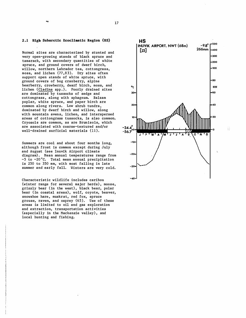
2.1 High Subarctic Ecoclimatic Region (HS)
17
Normal sites are characterized by stunted and very open-growing stands of black spruce and tamarack, with secondary quantities of white spruce, and ground covers of dwarf birch, willow, northern Labrador tea, cottongrass, moss, and lichen (77 , 8 3 ) . Dry sites often support open stands of white spruce, with ground covers of bog cranberry, alpine bearberry, crowberry, dwarf birch , moss, and lichen (Cladina spp . ) . Poorly drained sites are dominated by tussocks of sedge and cottongrass , along with sphagnum. Balsam poplar, white spruce, and paper birch are common along rivers. Low shrub tundra , dominated by dwarf birch and willow, along with mountain avens, lichen, and interspersed areas of cottongrass tussocks, is also commOTI. Cryoso-ls are common, as are Brunisols, which are associated with coarse-textured and/or well-drained surficial materials ( 1 1 ) .
Summers are cool and about four months long, although frost is common except during July and August (see Inuvik Airport climate diagram) . Mean annual temperatures range from -5 to -20QC. Total mean annual precipitation is 250 to 350 mm, with most falling in late summer and early fall. Winters are very cold.
Characteristic wildlife includes caribou (winter range for several major herds) , moose, grizzly bear ( in the west) , black bear, polar bear ( in coastal areas) , wolf, coyote, beaver, snowshoe hare , muskrat, red fox, spruce grouse, raven, and osprey (65 ) . Use of these areas is limited to oil and gas exploration and extraction, transportation activities (especially in the Mackenzie valley) , and local hunting and fishing.
30
20
10
-34.4:' -56.7
-10
-20
-30
-40
HS INUVIK AIRPORT. NWT (68m) [23]
s
-9.8° 266mm
500
400
300
200
100
80
MM
60
40
20
0

18
2.2 Kid-Subarctic Ecocliaatic Region (K5)
Normal sites are dominated by open stands of black spruce (less than 50% cover) , dwarf birch, northern Labrador tea, and lichen (Cladina spp. ) . with the shrub component generally having a 50% ground cover. Tree and shrub cover are reduced on dry sites. Poo�ly drained topography is vegetated by northern Labrador tea, sedge, and sphagnum, often in the form of string bog-fen complexes. Cryosols are limited to deep, poorly drained organiC deposits. Dystric Brunisols occur on moderately well- and well-drained mineral soils.
Summers are cool and about five months long, whereas winters are very cold and snowy (see Poste-de-la-Baleine Airport climate diagram) . Annual precipitation averages 500 to 700 mm, about half of which is snow.
Moose, black bear, caribou, beaver, snowshoe hare , red fox, and arctic fox are probably characteristic wildlife. Few natural resources have been developed ; thus, the area is relatively inaccessible and virtually unknown.
·30-
MS � POSTE-DE-LA-BALEINE A. QUE (18m) -4.:1'-[27] 637mm .00
-300
-200
-100
-80

2.3 Maritime Kid-Subarctic Ecoc1imatic Region (KSm)
19
Normal sites are rare in this bedrockdominated upland ecoclimatic region. Where present, the vegetation is composed of prostrate dwarf birch, Newfoundland shrub birch (mostly associated with wetlands) , heath, moss, and lichen. Somewhat protected areas are characterized by open stands of stunted black ,spruce and balsam fir, with an understory of Labrador tea, The bedrock areas are largely bare of vegetation, except for crustose lichen along with alpine bearberry and other ericads. Depressions may contain sedge fens, with shallow peat accumulation. Palsas occur in some of these peaty depressions. The highest elevations are covered with snow throughout the year. Glaciofluvial deposits and local lateral moraines along with colluvium form much of the soil base along the valleys . Ferro-Humic Podzols may be found on moderately well- to well-drained soils. Other common soils are HUmic Podzols, Regosols, and Folisols associated with rocklands.
Although there are no climatic stations within the ecoclimatic region, some climatic parameters can be extrapolated from neighbouring stations (29 ) . Summers are cool, with an annual frost-free period of about 50 days. The average number of growing degree days (above 5°C) are very low at 500. Winters are cold, with a mean January temperature of -24°C. Mean annual precipitation is approximately 1 100 mm, about half of which falls as rain.
This ecoclimatic region has few natural resources. Although caribou use the area as summer range , it is not considered as a critical habitat for ungulates . Ptarmigan are common. The scenic values of the landscape, with cascading streams and broad vistas, provide recreational possibilities.

2.4 Lov Subarctic Ecoclimatic Region (LS)
20
Normal sites are dominated by open stands of black spruce, with understories of dwarf birch, Labrador tea, ltchen (Cladlna spp . ) , and moss (21 , 77 ) . The main distinction between this ecoclimatic region and the High Subarctic Ecoclimatic Region (HS) is that trees are larger and grow more densely. Following fire, paper birch and/or black spruce can become abundant , but black spruce is the climatic climax species. Drier sites can be dominated by open stands of white spruce and paper birch, with a discontinuous understory of bearberry, bog cranberry, and species typical of normal sites. White spruce , paper birch, and trembling aspen also occur on protected, warm sites. Bog-fen sequences, composed of black spruce, Labrador tea, vaccinium, bog rosemary, and cloudberry, dominate poorly drained topography. Dystric Brunisols occur on upland sites, while Organic Cryosols are typical of wetlands.
SUmmers are cool and four to five months long, with maximum precipitation occurring from July through September (see Nitchequon climate diagram) . Winters are very cold and snowy.
Characteristic wildlife includes caribou (portions of this ecoclimatic region are part of their winter range) , moose, black bear, red fox, arctic fox, snowshoe hare, spruce grouse, osprey, and raven ; whistling swan, snow goose, and canada goose are common in the eastern portion. Land uses include transportation and transmission line corridors and localized recreation, hunting, sport fishing, and mining .
20-
LS NITCHEQUON. QUE (S36m)' [30]
-28.9:01 ....... � -49.4 llF.M .
-10
·20 -
·30
4 0 -500 - .1 783mm _400
-300 -200 _100
-80 MM
-60
-20

2.5 Atlantic Low Subarctic Ecoclimatic Region (L5a)
21
Normal sites are commonly dominated by forests of white spruce with a moss understory. Drier sites also have forests of white spruce, but with a lichen understory. Frequent fires commonly reduce forest vegetation to scrub lands dominated by alder, dwarf birch, and Labrador tea. A moss-lichen cover typifies exposed bedrock. Bogs develop in poorly drained depressions, and salt marshes occur along the coast. Mineral soils are typically Brunisols and Podzols, while OrganIcs (and sometimes Cryosols) occur in poorly drained depressions.
Summers are warm, with temperatures above DoC extending from mid-May to late October (see Hopedale climate diagram) . Winters are cold, although warmer than adjacent inland locations due to the maritime effect of the Atlantic Ocean. Precipitation is distributed throughout the year, with a slight peak in mid-summer.
There are few notable wildlife species, although this ecoclimatic region does lie along the Atlantic migratory flyway. Coastal areas host Atlantic puffin (40) and Canada goose. Seals, polar bear, and whales characterize the marine environment . Commercial development has been limited to oil and mineral exploration and small coastal fishing settlements.
30-
20-
10-
-20_
-30-
-40-
LSa HOPEDALE, NFLD (12m) [30]
_2.00 -500.
807mm -400
-300
-200
_100
-80
MM
-60
-40
-20

i I
23
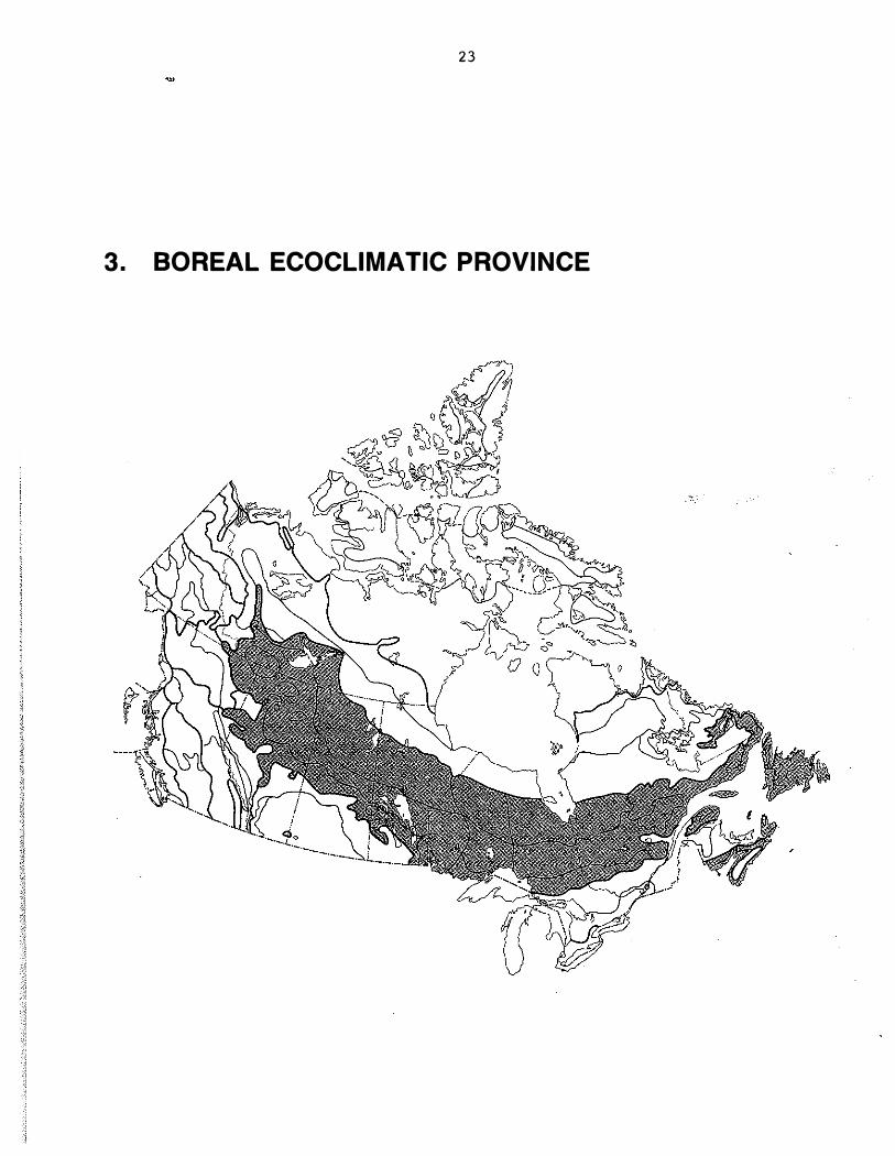
3. BOREAL ECOCLIMATIC PROVINCE

24
81GB BORBA!. ECOCLDlAr1C RBGIOIIS
Closed scrub forest of wind-shaped white spruce and balsam fir in Gros Morne National Park, Newfoundland (HBa) . Photo by R. Hirvonen.
Stand of mature white spruce on a mesic site near Fort Simpson , Northwest Territories (HBs ) . Photo by S.C. Zoltai.
A white spruce-balsam fir stand on alluvial soil In the Lake Melville area, Labrador (HBp) • Photo by H . Hirvonen .
Mixed white birch-spruce stand on south-facing slope and black spruce on north slopes In" the Willowlake River valley, Northwest Territories (HBs ) . Photo by S .C . Zoltai.

3 . 1 Atlantic Higb Boreal Eeoclimatic Region (DBa)
25
Balsam fir is the dominant tree species on normal sites, but black spruce becomes an important co-dominant at higher elevations ( 19) . Black spruce is also prominent immediately adjacent to poorly drained depressions, which are commonly dominated by kalmIa heath communities. Wind-exposed rocky outcrops are commonly vegetated by dwarf shrubs and open stands of black spruce . Soils of normal sites are Podzols, while Organics and Gleysols occur in poorly drained depressions.
Summers are cool and winters are mild ( see Daniells Harbour climate diagram) . Mean daily temperatures above oOe extend from mid-April to late November. Precipitation generally ranges from 80 t o 100 mm per month, except during March through May when it is lower. Wind and fog are important environmental influences .
Wildlife includes moose , black bear, lynx, snowshoe hare, and most other boreal mammals; in addition, caribou calve in the ecotone between forest and upland tundra. Forestry and fishing communities are the most common land uses.
HBa DANIE�S HARBOUR, NFLD (20m) [30-27]
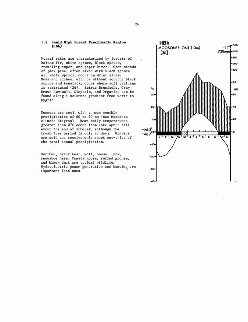
3.2 Huaid High Boreal Ecoclimatic Region (HBh)
26
Normal sites are characterized by forests of balsam fir, white spruce, black spruce, trembling aspen, and paper birch. Open stands of jack pine, often mixed with black spruce and white �pruce, occur on drier sites. Moss and lichen, with or without scrubby black spruce and tamarack, occur where soil drainage Is restricted (26). Eutrie Brunisols, Gray Brown LuvisoIs, Gleyso�s , and Organics can be found along a moisture gradient from xeric to hygric.
Summers are cool, with a mean monthly precIpitation of 60 to 90 mm (see Moosonee climate diagram) . Mean dally temperatures greater than aoc occur from late April till about the end of October, although the frost-free perIod Is only 70 days. Winters are cold and receive only about one-third of the total annual precipitation.
Caribou , black bear, wolf , moose, lynx, snowshoe hare, canada goose, ruffed grouse, and black duck are typical wildlife. Hydroelectric power generation and hunting are important land uses .
.0-
.40-
HBh MOOSONEE. ONT (10m)
[30]
_1.10 1""500 728mm 1-400
1-300 1-200 1-100 1-80
MM foeo 1-40

3.3 IIaritime High Boreal Reoelimatie Region (1IlIIo)
Normal sites , which are often protected by snow during winter, are characterized by communities of dwarfed kalmia. Krummholz thickets (less than 1 m tall) , composed of black spruce , commonly occupy snowbed sites, whereas forests occur only in sheltered valleys . Exposed positions are typified by diapensla, alpine azalea, and thamnolia, while willow, alpine timothy, and dwarf bilberry occur downslope of melting snow patches ( 1 9 ) . Podzols and Dystric Brunisols are found on upland sites , whereas Gleysols and Organics occur where drainage is restricted.
No long-term climate data are available; however, summers are probably cool and winters cold. Precipitation probably ranges from 75 to 100 mm each month, for an annual total of approximately 1000 Mm. Winters may receive more precipitation than summers .
Caribou (winter range) , arctic hare, and rock ptarmigan are characteristic wildlife species. Hunting is the only notable land use .
27

3.4 Oceanic High Boreal Ecoclimatic Region (HHo)
Normal and imperfectly drained sites are typified by stands of black spruce, sometimes with balsam fir, and under stories of feathermoss. White spruce and paper birch frequently accompany the conifers on moister sites. Bogs, consisting of moss , ericad, and scattered black spruce , occur where drainage is restricted. Exposed slopes at high elevations commonly develop stunted forests and krummholz vegetation composed of spruce, balsam fir, willow, and ericad . Podzols and well-developed Dystric Brunisols occur on upland sites, while Gleysols and Organics develop in poorly drained depressions.
This region has cool, rainy summers and
28
mildly cold winters ( see Harrington Harbour climate diagram) . Monthly precipitation ranges from 75 mm in early summer to more than 110 mm during the winter months , for an annual total of approximately 1200 mm. The frost-free period extends from late May to early October, for a total of 134 days.
Moose, seals, and seabirds are characteristic wildlife. Land use consists mostly of small fishing villages , but also includes hunting and trapping.
30-
20-
10·
HBo HARRINGTON HARBOUR, QUE (8m) 1.3° -500
[22] 1233mm -400
-300
_200
.Af"""'ti-'OO -00
MM
-60
-40
-20
-15.5° o-����������:;������Io -38.3° I J ' F '/ A M J J A S O N \.0 .'0. � \
-20.
·30-
-40-

3.5 Perhumid ru.gh Boreal Ecocllmatic Region (RBp)
Normal, rapidly drained , and poorly drained sites are dominated by black spruce and lesser quantities of balsam fir. Black spruce has generally been perpetuated by fires (40 ) , while balsam fir represents a climatic climax tree species. Open stands of white spruce with lichen and paper birch occur occasionally on normal sites . Feathermoss is a common ground cover on normal sites , while sphagnum occurs in poorly drained depressions. Podzols are common on upland sites , whereas Organics predominate in poorly drained depressions.
Summers are cool , rainy, and humid , whereas winters are cold and snowy (see Goose Airport climate diagram) . Mean daily temperatures greater than O°C extend from late April to early November. Total monthly precipitation ranges from 60 to 1 10 mm. Temperature and precipitation maximums occur in mid-summer.
Characteristic wildlife includes caribou and moose (winter range for both) . Land use activities include forestry, hydroelectric power generation, and trapping. There is also the potential for sport fishing.
29
30
20
10
HBp GOOSE AIRPORT, NFLD (49m)
[301 0.0°
946mm 500
400
300
200
100
80
MM
60
40
20
-20.9° 0il.�W.IiW::;;:::::��:;::���� __ to -39.4°
I J F M A M J J A 5 0 D
-10
-20
-30
-40

3.6 Subhuaid Higb Boreal Ecoclimatic Region (BBs)
Normal sites are characterized by forests of black spruce and jack pine, as well as some paper birch, with understories of feathermoss, bog cranberry, blueberry , Labrador tea, and lichen (Cladina spp . ) ( 10) . White spruce, balsam fir, and trembling aspen are mainly restricted to warmer and moister sites (25 ) . Drier sites have stands of black spruce and jack pine which are more open than on normal sites ( 1 2 ) . Black spruce is the clima�ic climax specie s , although frequent fires have restricted its abundance. Bedrock exposures have few trees and are dominated by rock and ground lichens. Bog-fen sequences, composed of black spruce, Labrador tea, vaccinium, bog rosemary, and cloudberry, dominate poorly drained topography. Brunisols and Luvisols occur on uplands, while Organics and Organic Cryosols are associated with wetlands.
SUmmers are cool and about five months long, with moderate (300-500 mm) precipitation ( see Cree Lake climate diagram) . Winters are very cold, with persistent snow cover.
Characteristic wildlife includes caribou ( important wintering range) (84) , moose, lynx, black bear, wolf, snowshoe hare , spruce grouse , ruffed grouse, and Canada goose. Land uses include localized hunting, recreation, and oil/gas extraction. Mining is important in portions of the Canadian Shield.
30
HBs CREE LAKE. SASK (497m) �ij
3
20
-30
-40
_2.7° 500
414mm 400
300
200
100
80
MM
60
40
20
0

3.7 Hoist High Boreal Ecoclimatic Region (HBx)
31
Normal sites are characterized by closed forests of black spruce , along with some white spruce , balsam fir, and trembling aspen. Drier sites are typified by open stands of jack pine, trembling aspen, and paper birch, with some black spruce and white spruce. Open stands of black spruce and tamarack, with understories of moss, are associated with poorly drained terrain (26). Gray Luvisols and Gray Brown Luvisols are typical of normal sites, and Humo-Ferric Podzols occur on better-drained, coarse-textured substrates. Gleysols and Organics develop on poorly drained sites.
Summers are cool and approximately six months long (see Lansdowne House climate diagram) . Winters are very cold, with moderate snowfall . Precipitation values peak during July and are triple those of the mid-winter months.
Caribou, black bear, wolf, moose, lynx, snowshoe hare, Canada goose , sharp-tailed grouse, and black duck are typical wildlife. Forestry, mining, and hunting are the main land uses .
., 30-
20-
10'
-28.0· 0 -47.8·
'10·
-20_
-30'
-40-
HBx 500 LANSDOWNE HOUSE, ONT (256m) -1.6·
[30] 666mm f.400
J F M
�300 �200 1-,00
1-80 MM
1-80
1-40
1-20

32
MID-BOREAL ECOCLIHATIC REGIONS
Forest dominated mainly by black spruce on poorly drained lacustrine clay sediments of former glacial Lake Barlow-Ojibway in northern Ontario (MBh ) . Photo by G.M. Wickware .
A mixedwood stand of trembling aspen and white spruce on a mesic slope near Riding Mountain, Manitoba (MBs ) . Photo by S .C . Zoltai.
Uplands dominated by conifers near Gander, Newfoundland (MBm) . Photo by S .C . Zoltai.
A b lack spruce stand on moist loamy moraine near Beardmore, Ontario (MBx) . Photo by S . C . Zoltai .

3.8 Atlantic Mid-Boreal Ecoclimatic Region (MBa)
33
Normal sites are characterized by forests of black spruce and/or balsam fir, with an understory of feathermoss . Repeated fires result in the development of low-growing heath communities, typified by kalmia and moss . Poorly drained localities are also dominated by kalmia heath, but with open stands of black spruce and tamarack and an understory of sphagnum. Alder occurs where drainage is restricted ( 19 ,68). Podzols occur on well-drained sites , whereas Gleysols and Organics typify poorly drained areas.
Summers are cool and winters are mild (see Fogo climate diagram) . Precipitation is highest from early fall to early winter (80 mm) and declines to 50 mm or less during April and May, for an annual total of less than 800 mm. Temperatures greater than O°C last for approximate.ly eight months , starting in late March. Spring climatic conditions are severely influenced by ice flows from the north, which shorten the growing season relative to more continental parts of insular Newfoundland.
The primary wildlife are seabirds , especially murre, eider, and tern. One of North America ' s most important seabird sanctuaries , the Funk Islands, is located along this coast. Mining, forestry, and fishing are the primary activities.
30-
20-
10-
MBa FOGO, NFLD (15m)
[7-6] 4.60 _500
779mm -400
-300
_200
f-100
-so
MM
f-60
-9.2° _30.0°
0 __ �::;:::;::::;:;:;��d"o �I A M J J A S O N D ';c,',
·10·
-20-
·30-
-40-

3.9 Hu.id Hid-Boreal Ecoclimatic Region (HBh)
34
Normal sites are characterized by stands of white spruce, balsam fir, paper birch, and trembling aspen, the last of which often forms pure stands. Drier sites may have either pure stands of jack pine or stands mixed with paper "birch and trembling aspen. Black spruce and balsam fir are characteristic of wet sites, while tamarack occurs on colder sites . The understory in most coniferous stands is moss, whereas moss and lichen are typical of cold and wet terrain. Luvisols are associated with most upland sites, Podzols occur on sandy substrate s , and Gleysols and Organics develop in poorly drained depressions (28 ) .
SUmmers are warm and winters are cold (see Taschereau climate diagram) . Average daily temperatures greater than O°C last for approximately seven months, although frosts are common except ,from mid-June to early September (75 days) . Summer rainfall averages 100 mm per month (June to September) , whereas winter precipitation is about half that.
Characteristic wildlife includes moose, black bear, lynx, snowshoe hare, caribou, wolf, coyote, sharp-tailed grouse, black duck, wood duck, hooded merganser, and pileated woodpecker. Land uses include forestry, mining, hydroelectric power generation, and beef ranching.
0,
30-
20·
10·
-25.2°0 -48.3°
MBh TASCHEREAU, QUE (310m) [25-17]
0.60 r500
874mm 1-400
1-300
1-200
1-100
1-80
M M
1-60
1-40
_wtt::���.0
I J'F 'JA M ' J ' J ' A . ' 0 �D .,o.y \ -20-
-30·
-40

3 . 10 Maritime Mid-Boreal Ecoclimatic Region (HBm)
35
Normal site s , which are rare , are dominated by stands of balsam fir and black spruce, with under stories of feathermoss . Areas of extensive surface bedrock and shallow soils are dominated by stands of black spruce, with a ground cover of kalmia, bl'ueberry, lichen , and moss ( 1 9 , 40) . Dry sites are characterized by woodlands of black spruce and lichen. Black spruce also occurs in poorly drained depressions. Paper birch, trembling aspen, and black spruce are typical of disturbed sites, particularly after fire. Raised bogs are common. Upland soils are typically Podzols, while Organics predominate in poorly drained depressions .
SUmmers are warm and winters are mild (see Grand Falls climate diagram) . Mean temperatures above O°C last for approximately eight months. Mean monthly precipitation exceeds 60 mm, and mean annual precipitation is roughly 1000 mm.
Characteristic wildlife includes moose, lynx, black bear, red fox, and caribou. Forestry is the most common land use.
30-
20·
MBm GRAND FALLS, NFLD (60m) [22] 4.60
500
991mm 1-400
�300
�200
1-,00
1-60
MM
1-60
1-40
I-20
-12.3° o'i�'���::;;:���::;:::;���M -34.4' � A ' M J J A 5 , 0 N D •...
o
-10'
-20-
-30-
-40

3 . 11 Oceanic Mid-Boreal Ecoclimatic Region (MHo)
36
Normal sites are dominated by nearly pure forests of balsam fir. Anthropogenic fire has caused widespread destruction of forests and the subsequent replacement of them by dwarf shrub heath (42) . As a result, kalmia, rhodora , vaccinium, moss, and lichen, with scattered black spruce , balsam fir, and tamarack, represent the vegetation of well-to imperfectly drained site s . Dense stands of stunted balsam fir, black spruce, and white spruce occur among large tracts of bog vegetated with kalmia and sphagnum (19) . Podzols and Organics are typical soils (18 , 29 ) .
Summers are cool and winters are relatively mild along coastal areas but more severe at higher elevations and at greater distances from the coast (see St. John ' s Airport climate diagram) . Annual precipitation is generally about 1500 mm. The frost-free period is approximately 130 days along the coast, but is less inland and at higher elevations.
Wildlife is characterized by caribou (winter range) . Characteristic activities include forestry, hydroelectric development, fishing and related activities, and recreation.
20-
10-
-10-
-20-
-30-
-40-
MBo ST. JOHN'S AIRPORT. NFLD (140m) 4.80,-
500
(30) 1514mm 1-400
1-300
�200
100
1-80
MM
1-60
1-40
20
o

3 . 12 Perhumid Kid-Boreal Ecoclimatic Region (lIBp)
37
Normal sites are typified by closed forests of black spruce, often with balsam fir, and an understory of moss . Paper birch and trembling aspen occur sporadically, as invaders of disturbed areas . Jack pine occurs on xeric sites. Podzols are the dominant upland soils, with Gleysols and Organics common in poorly drained depressions.
SUmmers are cool and rainy (over 100 mm per month in- the June to September period) and winters are cold, with the highest snowfalls in December (see Manicouagan Airport climate diagram) , The frost-free period extends from the end of May to early October.
Characteristic wildlife includes moose , caribou, black bear, wolf, lynx, snowshoe hare , ruffed grouse, black duck, wood duck, and pileated woodpecker. Forestry is an important land use.
20-
MBp MANICOUAGAN A. QUE (406m) [9]
-2.3Q r-500
962mml-400
1-300
1-200
1-100
1-60
MM
.. 60
-28.80 °i�'w..jW��:::�::;::�����to -51.10 I
V
. ' M " ' M J ' J A ' S .. O\.D . -10
-20·
-30·
-40

3.13 Subhumid Hid-Boreal Ecoclimatic Region (MBs)
Normal sites support forests of trembling aspen and balsam poplar, with white spruce, balsam fir , and black spruce occurring in late-successional stages throughout much of this ecoclimatic region. Deciduous species, however, tend to be less abundant in the eastern portions. Deciduous stands have diverse herb and shrub understories, although the invasion of spruce and balsam fir suppresses this vegetation and promotes feathermoss. Toposequences are similar to those ·of -the Low Boreal Subhumid Region, although jack pine and black spruce are more common on moderately well- and imperfectly drained soils (32) . Cold sites and poorly drained topography are covered by fens and bogs , with the latter dominated by black spruce. They may have localized permafrost. Gray Luvisols are asso�iated with medium- and fine-textured substrates, while Eutric and Dystric Brunisols occur on sandy sites.
38
SUmmers are warm and moist, while winters are very cold and snowy (see The Pas Airport climate diagram) . Average annual precipitation is about 400 to 460 mm. Maximum precipitation and the highest monthly temperatures occur in July. The frost-free period ranges from 80 to 120 days.
Moose , black bear, beaver, and muskrat are common wildlife. Wood b ison are resident, while white pelican, sandhill crane , and whooping crane nest in the central and western parts of this ecoclimatic region. Forestry, .hydrocarbon exploration, and localized recreation (hunting, fishing, and camping) are the main land uses.
°c 30
20
10
MBs THE PAS AIRPORT. MAN (271m) [30]
_0.6° 454mm
500
400
300
200
100
80
MM
60
40
20
-27.5°0 -49 .. t
J F __ ���_o M J J A S O
-10
-20
-30
-40
3.14 Hoist Hid-Boreal Eeoellmatie Region (HBx)
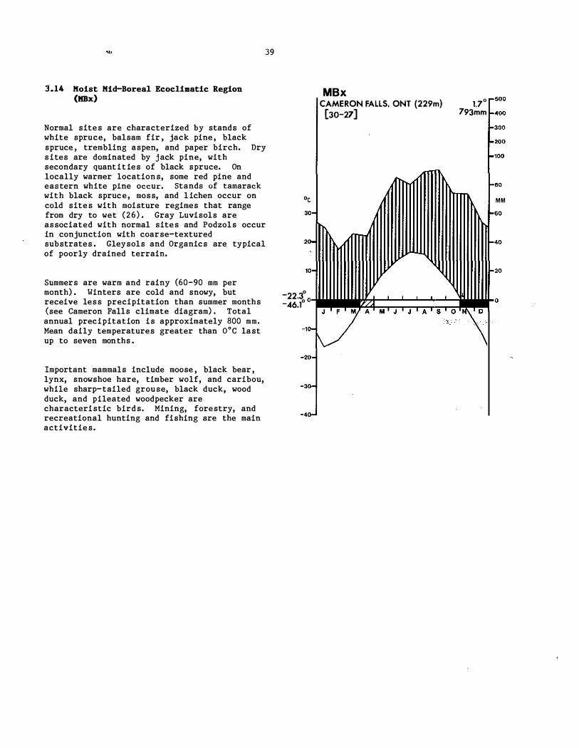
39
Normal sites are characterized by stands of white spruce, balsam fir , jack pine, black spruce , trembling aspen, and paper birch. Dry sites are dominated by jack pine, with secondary quantities of black spruce. On locally warmer locations, some red pine and eastern white pine occur. Stands of tamarack with black spruce, moss, and lichen occur on cold sites with moisture regimes that range from dry to wet (26) . Gray Luvisols are associated with normal sites and Podzols occur in conjunction with coarse-textured substrates . Gleysols and Organics are typical of poorly drained terrain.
SUmmers are warm and rainy (60-90 mm per month) . Winters are cold and snowy, but receive less precipitation than summer months (see Cameron Falls climate diagram) . Total annual precipitation is approximately 800 mm. Mean daily temperatures greater than O°C last up to seven months .
Important mammals include moose , black bear, lynx, snowshoe hare, timber wolf, and caribou, while sharp-tailed grouse, black duck, wood duck, and pi lea ted woodpecker are characteristic birds. Mining, forestry, and recreational hunting and fishing are the main activities.
30-
20-.. 10-
MBx CAMERON FALLS, ONT (229m) [30-27]
1.70 r500
793mm 1-400
r300
1.200
-100
1-60
MM
-40
-22.3° 0il.'.�?;I::;:;::::;�;::::��:::;;:J..'to -46.1° I
J ' F 'I A M J ' J A ' S,.
O '�D •. -10 \/ \ ·20-
·30-
-40-

40
LOW BOREAL ECOCLIMNrIC BEGIONS
Mature j ack pine and trembling aspen, with white spruce , black spruce , and balsam fir understory near Chapleau, Ontario (LBh ) . Photo by Z . Chrosciewicz.
Balsam fir-white birch forest on a mesic slope in the Laurentide Park, Quebec (LBp ) . Photo by S .C . Zoltai.
Mixedwood stand of red spruce, balsam fir, and red maple on a mesic site near St . Stephen, New Brunswick (LBn) . Photo by S .C . Zoltai.
Mixedwood stand of white spruce, j ack pine, and trembling aspen on a mesic site near Dryden, Ontario (LBst) . Photo by S .C . Zoltai.

3'.15 Atlantic Low Boreal Ecoclimatic Region (LBa)
Normal sites are dominated by coniferous forests of white spruce, balsam fir, and black spruce, with an understory of feathermoss. Paper birch is also common during early stand development . Moist sites are colonized by eastern red cedar, while black spruce and tamarack occur where drainage is poor. Eastern white pine, yellow birch, and balsam fir can be found on xeric substrates ( 6 8 ) . Podzols are the dominant soils on normal sites .
Summers are warm, while winters are cold (see Gaspe climate diagram) . Temperatures above OoC occur from April to November, and the average length of the growing season is 140-160 days, depending on elevation. Precipitation ranges from 60 to more than 90 mm per month, with distinct peaks in the summer and winter months . Total annual precipitation averages about 1000 mm.
Characteristic wildlife includes moose, black bear, red fox, lynx, eastern chipmunk, snowshoe hare, ruffed grouse, spruce grouse, and black duck. Forestry, wood processing, commercial fishing and related activities, mining, and metal smelting are common activities .
41
·c
30
20·
10·
LBa GASPE, QUE (30m) [20,25[
3.5" - 500 968mm - 400
- 300
200
- 100
- 80
MM - 60
- 40
- 20
- 15.3" - 41.7" o ••• ��:::=::=��� ..
F M A M A 5 0 N "'Z 0
-10 '-
�. ',,' -20·
-30
-40 -

3 . 16 Humid Low Boreal Ecoclimatic Region (LBh)
42
Representative trees of normal sites include white spruce, balsam fir, and eastern white pine, along with some red pine , paper birch, and trembling aspen. Hardwoods, such as sugar maple, red maple, and yellow birch, occur only on warmer sites, while white pine, red pine, and jack pine occur on drier terrain. Black spruce, tamarack, and eastern white cedar dominate poorly drained and colder areas, with stands becoming increasingly more open as drainage becomes more restricted (26 , 68 ) . Luvisols are the typical soils of upland sites, while Gleysols and Organics occur in poorly drained areas.
Summers are warm and winters are cold (see Earlton Airport climate diagram) . Monthly precipitation ranges from 50 to 100 mm, with maximums occurring in summer. The frost-free period extends from May to mid-September, while temperatures greater than oOe last approximately seven months.
Important mammals include moose, black bear, lynx, snowshoe hare , timber wolf, white-tailed deer, and coyote ; black duck, wood duck, hooded merganser, and pileated woodpecker are characteristic birds. Forestry, mining, hydroelectric power generation, and recreation are prominent land uses.
30
20
10
-20
-30
-40
LBh EARLTON AIRPORT. ONT (243m)
[30] 2.00
822mm 500
400
300
200
100
80
M M
60
40
20
o

3 . 17 Maritime Low Boreal Ecoclimatic Region (LB_)
43
Normal sites are dominated by forests of balsam fir with an understory of feathermoss (Hylocomium spp . ) (19) . Black spruce occurs in poorly drained areas. Communities of balsam fir and moss are restricted to steep, rocky slopes, while krummholz occurs on exposed ridges . Mountain maple thickets occur on seepage sites and alluvial plains, while bog/fen complexes are associated with sites having restricted drainage. HUmo-Ferric Podzols are the soils of normal sites , while Gleysols and Organics are associated with fens and bogs.
Summers are warm and winters are mild (see Stephenville Airport climate diagram) . Precipitation ranges from 100 to 115 mm/month, except during the February to May period, when it is lower (as low as 60 mm in April ) . Temperatures above O°C begin in early April and continue until late November.
Moose, black bear, caribou (in summer) , marten, red fox, and lynx are typical wildlife. Forestry, wood processing, and activities related to fishing are the most common land uses.
30-
20-
10-
-20·
-30·
-40
LBm 0 STEPHENVILLE AIRPORT, NFLD (26m) 4.80 ,.'0
[30-12] 1166mm f.400 r-300
�200
f.l00
80
M M
1-60
f.40
1-20

3 . 18 Oceanic Low Boreal Ecoclimatic Region (LBn)
44
Normal sites are characterized by coniferous forests dominated by balsam fir, white spruce, and black spruce . Salt spray tends to limit the growth of black spruce , whereas white spruce (tolerant to the spray) is conspicuous in exposed areas along the coast. Red spruce, although characteristic of much of the Maritimes, is generally absent. Red maple, paper birch, and yellow birch are associated species . Sphagnum bogs are common where drainage is poor. Humo-Ferric Podzols occur on upland sites, while Organics develop in bogs (29 , 4 1 , 68 ) .
.
Summer are warm and rainy, whereas winters are mild and wet (see Yarmouth Airport climate diagram) . Precipitation in mid-summer is approximately half that of the winter months. Fog is a frequent and significant feature . Temperatures greater than aoc extend from mid-March to early ,December (271 days) , with winter temperatures seldom averaging below -4°C . These data reflect the strong and direct influence of the Atlantic Ocean and Bay of Fundy on this coastal unit .
Salt marshes and tidal flats provide food and habitat for a myriad of shorebirds. Common seabirds include cormorants, scoters , phalaropes , terns, gulls , and guillemots. Recreational salmon- fishing is common on many of the rivers flowing through this ecoclimatic region. Fishing, forestry, farming, cottaging, and tourism are the principal activities.
30 ,.
20 ,.
10 ,.
·10 ,.
-20 ,.
-30 ,.
,. -40
LBn YARMOUTH AIRPORT, NS (43m) 6.90 r-500
[30] 1282mm � 400
� 300
� 200
"" 100
I-80
M M
I-60
I-40
I-20
o J F M A M J ' J A ' S O ' N D

3 . 19 Exposed Oceanic Low Boreal Ecoclimatic Region (LBo)
45
Normal sites are typified by a dense carpet of moss (Rhacomitrium spp . ) and frutleose lichen along with low growing shrubs such as crowberry, bilberry, and bog cranberry. The moss heaths of this ecoclimatic region cannot be found elsewhere in North America, but have strong affinities to similar vegetation in northern Scotland, Iceland, and ,Jan Mayen Island (42) . Stunted krummholz of balsam fir can occur on upland sites. Blanket bogs are common and are dominated by sedge, bog bilberry, and lichen ( 19) . Podzols occur on uplands and Organics are common in poorly drained depressions.
Summers are cool, while winters are mild and rainy (see Gape Race climate diagram) . Total precipitation ranges from 80 t o 150 mm per month, with lower amounts occurring during early summer. Mean daily temperatures greater than O°C extend from late March to early December. Wind and fog are important environmental factors.
Wildlife is characterized by caribou, willow ptarmigan, and seabirds. · One of the world ' s largest gannet colonies occurs at Cape S t . Mary ' s Seabird Sanctuary. Fishing and related work are the main activitie s .
30-20· 10·
-7.0° -26.1" 0
·10·
-20· -30 ·40
LBo CAPE RACE (AUT), NFLD (28m)
[12] 4.30
500 1379mm -400
r300 r200
A"''I'fI''''''�'''i-'00 roo
1 1 1 11 1 1 1 '1 1 1 1 1 1 1 1 1 1 1 11 1 1 1 11 1 1 1 1 1 1 1 1 1 1 11 1 1 1 11 1 1 1 1 1 1 1 1 111 M M -60
1-40 1-20
J ����-'-�:'��' ��-'����iO F-' M ' A M · J J ' A S O N ' D

3.20 Perhumid Low Boreal Ecoclimatic Region (LBp)
Normal sites and shallow mineral soils are dominated by black spruce and balsam fir, with a moss ground cover; paper birch also occurs and is most abundant after fires or logging. Exposed summits are treeless and composed of e�icaceous shrubs, moss, sedge, and lichen (68 ) . Well-drained upland soils have Ferro-Humic and Humo-Ferric Podzols, while poorly drained lowlands have Organics .
Summers are warm and rainy, while winters are cold and snowy, (see Murdochville climate diagram) . Freezing temperatures commonly occur from November to May . The length of the growing season is about 150 days. Total annual precipitation averages roughly 1000 mm, with peak precipitation periods during the winter and summer months .
Characteristic wildlife includes moose, black bear, red fox, lynx, eastern chipmunk, snowshoe hare, ruffed grouse, spruce grouse, and black duck. Recreation, hydroelectric power generation, and forestry are the main land uses .
46
., 30-
20-
10-
-20-
-30-
-40-
LBp MURDOCHVILLE. QUE (575m)
[26] 1.30 500
I034mm 1-400
1-300
1-200
1-100
1-80
M M
1-60
. ���_o M J J A S O '\

3.21 Subhuaid Low Boreal Ecoclimatic Region (LBa)
Normal sites are dominated by deciduous forests composed of trembling aspen, with secondary quantities of balsam poplar, and understories of mixed herb and shrub. White spruce and balsam fir are the climatic climax species, but are not well represented due to the frequent occurrence of fire. Gray Luvisols are associated with normal sites. Open stands of jack pine occur on dry sites , with Eutric and Dystric Brunisols (64) . Water-filled depressions and poorly drained topography are vegetated by sedge', willow, and/or black spruce (32 , 67 ) , and the associated soils are Gleysols and Organics . Black spruce represents an important edaphic climax species in these wetlands.
47
Summers are warm, with maximum precipitation occurring during July ( see Athabasca climate diagram) . The frost-free period extends up to 120 days. Winters are cold and snowy.
Moose are characteristic wildlife , but are not abundant, whereas black bear, beaver, ducks, and ruffed grouse are widespread and abundant. Grain and mixed farming, livestock and forage production, and forestry are common land uses.
30-
20·
'0·
LBs ATHABASCA 2, ALTA (610m) [21-25]
-22.9°0
V
-46.1° J F A
-'0·
,
M J J A
-20·
-30·
-40,
1.40 ,.500
493mm 1-400
�300
1-200
1-'00
1-80
M M
1-60
1-40
1-20
o

3.22 Subbumid Trans�t�onal Low Boreal Eeoe�mat�e Reg�on (LBst)
Vegetation succession on normal sites leads from trembling aspen, paper birch, and jack pine to white spruce, black spruce, balsam fir, and some eastern white pine . Warmer sites support red pine, eastern white pine, and, in the southwest corner, bur oak and red ash; with increasing soil moisture, the quantity of eastern white cedar, black ash, and white elm increases ( 1 8 , 2 7 , 44 ) . This is the westernmost ecoclimatic region having red pine and eastern white pine. Cooler and wetter sites support black spruce and tamarack. Soils vary from Eutrie and Dystric Brunisols and Gray Luvisols on dry sites to Organics on wet site s .
Summers are warm and relatively dry, with maximum temperatures in July and maximum precipitation occurring during June through August ( see Dryden climate diagram ) . Temperatures greater than O°C extend from early April to November. Winters are cold and receive less precipitation than summers .
Characteristic wildlife includes moose, black bear, wolf , lynx, snowshoe hare , woodchuck, hooded merganser, and pileated woodpecker . Primary land uses include forestry, mining, trapping, tourism, and mixed farming ( particularly in the Dryden and Fort Frances clay belts ) .
48
30
20
10
-24.4° -46.7"0
-10
-20
-30
-40
LBst DRYDEN. ONT (372 m)
[30-27]
M J
1.6° 500 697mm 400
300 200 100
60 MM 60
40
20
0 J A S 0

3.23 Transitional Low Boreal Ecoclimatic Begion (LBt)
Mixedwood forests of sugar maple , yellow birch, red maple, white spruce, red spruce, and balsam fir occur on normal sites. Warmer and moister sites are occupied by sugar maple and beech, while drier terrain is commonly dominated by eastern white pine. Areas with impeded drainage may be vegetated by species that range from black spruce , tamarack, and eastern white cedar (concentrated on the calcareous soils of New Brunswick) to black ash and red maple . The upland soils are largely HUma-Ferric Podzols, while poorly drained sites develop shallow Organics or peaty Gleysols (29 , 4 1 , 68 ) .
Summers are warm and rainy and winters are mild and snowy ( see Sussex climate diagram) . Total annual precipitation exceeds 1000 mm, with a range of 70 to 120 mm per month. The higher values occur from October to February, inclusive.
White-tailed deer are common, and other typical wildlife includes moose, black bear, snowshoe hare, and porcupine . Land uses include farming, forestry, coal mining ( Cape Breton Island ) , and maple syrup harvesting ( Cobequid Mountains) . Aquaculture (oyster farming) is practiced on Bras d ' Or Lake .
49
LBt SUSSEX. NB (21m)
[30] 5 .. 4"
1063mm
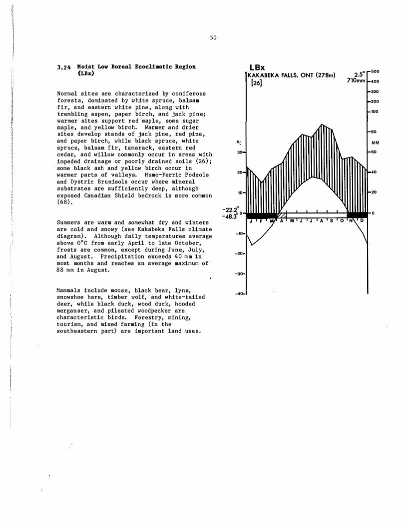
I
3.24 Hoist Low Boreal Ecoclimatic Region (LBx)
50
Normal sites are characterized by coniferous forests, dominated by white spruce, balsam fir, and eastern white pine , along with trembling aspen, paper birch, and jack pine; warmer sites support red maple, some sugar maple, and yellow birch. Warmer and drier sites develop stands of jack pine , red pine , and paper birch, while black spruce, white spruce, balsam fir, tamarack, eastern red cedar, and willow commonly occur in areas with impeded drainage or poorly drained soils (26) ; some black ash and yellow birch occur in warmer parts of valleys. HUmo-Ferric Podzols and Dystric Brunisols occur where mineral substrates are sufficiently deep , although exposed Canadian Shield bedrock is more common (68) •
Summers are warm and somewhat dry and winters are cold and snowy (see Kakabeka Falls climate diagram) . Although daily temperatures average above O°C from early April to late October, frosts are common, except during June, July, and August. Precipitation exceeds 40 mm in most months and reaches an average maximum of 88 mm in August.
Mammals include moose, black bear, lynx, snowshoe hare, timber wolf, and white-tailed deer, while black duck, wood duck, hooded merganser, and pileated woodpecker are characteristic birds. Forestry, mining, tourism, and mixed farming (in the southeastern part) are important land uses.
30
20
10
-22.200 -48.30
-10
-20
-30
-40
LBx KAKABEKA FALLS. ONT (27Bm) [26]
2.50 710mm
J F A M J J A S O N
500
400
300
200
100
80
M M
60
40
20
o

51
4. COOL TEMPERATE ECOCLIMATIC PROVINCE

52
COOL TEllPERA7E ECOCLDlATIC REGIONS
A mixed forest of sugar maple, beech, white birch, red spruce, ·and white pine near Halifax, Nova Scotia (HeTa) . Photo by H . Hirvonen.
A maple-spruce forest near Fredericton, New Brunswick (MCTa) . Photo by S .C . Zoltai.
A mixed forest of sugar maple, yellow birch, white pine , and white spruce in the Batchawana Mountain area of central Ontario (HCTh) . Photo by G.M. Wickware .
A mixed forest of trembling aspen, eastern white cedar, balsam fir, and white birch on a flat limestone plain of the Bruce Peninsula in Ontario (MCTh) . Photo by G.M. Wickware .

4.1 Atlantic High Cool Temperate Ecoclimatic Region (HCTa)
53
Normal sites are characterized by mixedwood forests of red spruce, eastern white pine, red oak, and red maple. Large tracts of this region, particularly in eastern New· Brunswick, have blankets of poorly drained moraine which support stands of black spruce and balsam fir along with extensive areas of bog. The potato lands of Prince Edward Island were historically covered mostly by hardwoods such as red oak, beech, and sugar maple. Few such sites remain. Abandoned fields are reverting to forests of white spruce and red spruce, a common transition stage throughout the Maritimes (29 , 41) . Fire has played a key role in southwestern Nova Scotia and, as a result, much of the terrain is covered by low shrubs . Humo-Ferric Podzols are COmmon on well- and moderately well-drained land. Dystric Brunisols are common on valley outwash. Local pockets of Luvisols occur on fine-textured marine deposits (29 , 4 1 , 66) .
Summers are warm and winters are typically mild and snowy (see Summers ide Airport climate diagram) . Total annual precipitation generally ranges between 1000 and 1400 mm, with an average frost-free period between 110 and 140 days. Mean daily temperatures below OoC occur during the December to late March period, while the frost-free period extends from early May to late October. Summer temperatures are accentuated within the Annapolis Valley of Nova Scotia, which is partly sheltered from direct coastal influences.
Common mammals include white-tailed deer, snowshoe hare, porcupine, and furbearers, such as raccoon, marten, fisher, red fox, and beaver; moose are scarce. Shorebirds and seabirds inhabit salt marshes. The Northumberland Shore-Prince Edward Island component of this ecoclimatic region has the best developed sand dUne and beach systems in Atlantic Canada which, coupled with the relatively warm ocean waters , are intensively used for recreation. Farming (especially apple orchards in the Annapolis Valley) , forestry, and mining are other common land uses (66 ) .
°0 30·
20-
'0
HCTa 00 SUMMERSIDE AIRPORT. PEl (24m) sf -5
[30] 1039mm -400
-300
-200
_ .......... '00
-80
MM
f.60
-11.3° 0 �F �Ac:t:;�����:;;:t�.o -27.2° � M J J A S O N '''\
':� � : ·10-
-20·
-30·
-40-

4.2 Humid High Cool Te.perate Ecoelimatie Region (HCTh)
54
Mixedwood forests of sugar maple , yellow birch', eastern hemlock, and eastern white pine form the most stable vegetation on normal site s ; beech occurs on warmer sites. Dry sites develop forests dominated by red pine , eastern white pine, and red oak, while wetter substrates support red maple , black ash, white spruce, tamarack, and eastern white cedar (57) . HUmo-Ferric Podzols are associated with dry substrates , whereas Gray Brown Luvisols and Melanic Brunisols occur on normal sites. Gleysols with shallow peat accumulations and Organics can be found in poorly drained depressions.
SUmmers are warm with mean daily temperatures above oOe from late March to December (see Combermere climate diagram) . Winters are cold and snowy, although precipitation is lower than in the summer. Maximum mean monthly precipitation occurs in late summer.
Typical wildlife includes white-tailed deer, black bear, moose, wolf, snowshoe hare, chipmunk, coyote, lynx, black duck, wood duck, hooded merganser, pileated woodpecker, mourning dove , cardinal, and wood thrush. Forestry, hydroelectric power generation, tourism, and mixed farming are important land use s .
HCTh COMBERMERE, ONT {287m} [20]

4.3 Transitional High Cool Temperate Ecoc1imatic Region (HCTt)
55
This area is transitional between the Atlantic High Cool Temperate and Humid High Cool Temperate ecoclimatic regions (HeTa and HeTh) . Mixedwood forests of sugar maple , beech, and yellow birch are conspicuous on ridges , while eastern hemlock, balsam fir, eastern white pine, and white spruce prevail in valleys. Trembling aspen characterizes stands with a fire origin. Eastern white cedar and black spruce are �ssociated with wetlands. The upland ' soils are primarily Humo-Ferric Podzols, whereas sites with restricted drainage commonly develop Humic Gleysols.
Summers are warm and moist , while winters are cold (see Bagotville Airport climate diagram) . Total annual precipitation averages between 900 and 1400 mm, depending on exposure and elevation. Temperatures above O°C occur from late March to early November, with the frost-free period approximately 70 to 80 days long (24) .
Typical wildlife includes white-tailed deer, black bear, snowshoe hare, raccoon, beaver, and red fox. Land uses consist of hydroelectric power generation, forestry, and wood processing ( 1 8 , 2 9 ) .
20-
10'
-30-
-40-
Hen BAGOTVILLE AIRPORT, QUE (159m) 2.30 _500
[30] 922mm ,..400
"-300
,..200
�100
1-00 M M
1-60
1-40
1-20

4.4 Atlantic Mid-Cool Temperate Ecoclimatic Region (MCTa)
56
This sheltered enclave of temperate forest is located in the middle and upper portions of the Saint John River Valley and adjacent lands. Tolerant hardwood forests of sugar maple , yellow birch, and beech generally predominate, and the sparse presence of white ash, butternut , ironwood, and basswood distinguishes this unit from adjacent ecoclimatic regions. Black ash occurs on poorly drained substrates. Red spruce, red maple , balsam fir, and eastern hemlock occur sporadically. Humo-Ferric Podzols and Dystric Brunisols occur throughout the area. Regosols and Gleysols occupy alluvial bottomlands (29 ,41) .
Summers are warm and moist , while winters are mild to cold and snowy (see Woodstock climate diagram) . Monthly precipitation values range from 70 to 95 mm, with greater amounts occurring during winter. The frost-free period lasts approximately 120 days and starts in late May.
Characteristic wildlife includes white-tailed deer, moose, black bear, snowshoe hare , beaver, muskrat , and gray partridge . Agriculture, including some orchards, and forestry are the typical land uses.
30-
20-
10-
-20-
-30-
-40-
MeTa WOODSTOCK. NB (55m) [22-12]
5.00 -500
945mm -400
-300
-200
-100
80
M M
-60
20
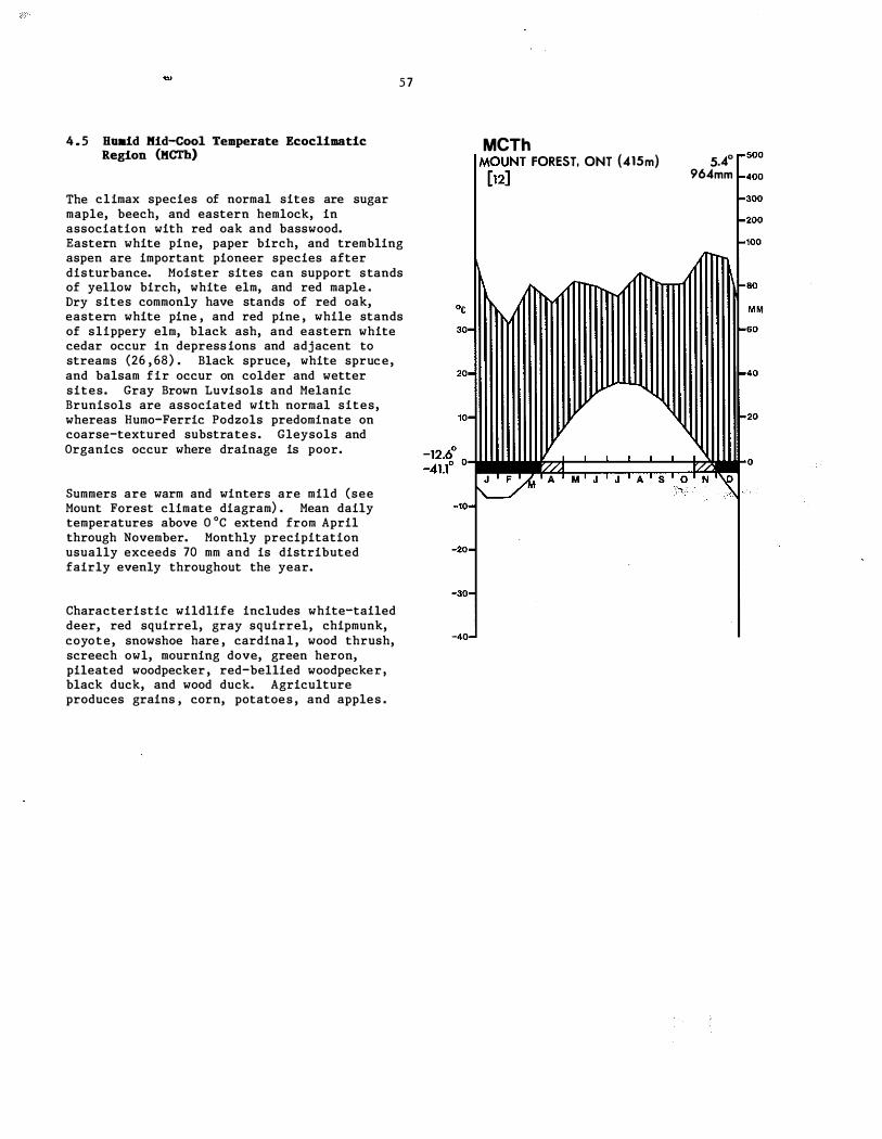
4 . 5 Hoald Kid-Cool Temperate Ecocllmatlc Region (KCTh)
The climax species of normal sites are sugar maple, beech, and eastern hemlock, in association with red oak and basswood.
57
Eastern white pine, paper birch, and trembling aspen are important pioneer species after disturbance. Moister sites can support stands of yellow birch, white elm, and red maple . Dry sites commonly have stands of red oak, eastern white pine , and red pine , while stands of slippery elm, black ash, and eastern white cedar occur in depressions and adjacent to streams (26 , 68) . Black spruce, white spruce, and balsam fir occur on colder and wetter sites. Gray Brown Luvisols and Melanic Brunisols are associated with normal sites, whereas Humo-Ferric Podzols predominate on coarse-textured substrates. Gleysols and Organics occur where drainage is poor.
Summers are warm and winters are mild (see Mount Forest climate diagram) . Mean daily temperatures above O oC extend from April through November. Monthly precipitation usually exceeds 70 mm and is distributed fairly evenly throughout the year.
Characteristic wildlife includes white-tailed deer, red squirrel, gray squirrel, chipmunk, coyote, snowshoe hare , cardinal, wood thrush, screech owl, mourning dove, green heron, pileated woodpecker, red-bellied woodpecker, black duck, and wood duck. Agriculture produces grains , corn, potatoes, and apples .
MCTh IM()U�H FOREST, ONT (415m) 5.40
964mm


59
5. MODERATE TEMPERATE ECOCLIMATIC PROVINCE

60
MODERATE TEMPERATE ECOCLIMATIC EEGIONS
A mixed maple-beech-tulip tree forest near Lake Erie, Ontario (HMTh) . Photo by S .C . Zoltai.
A moist site dominated by red maple near Brantford, Ontario (HMTh) . Photo by S.C. Zoltai.
Agricultural lands with scattered woodlots in south-central Ontario (HMTh) . Photo by G .M. Wickware .
A large chestnut tree, killed by chestnut blight in 1985 but with new sprouts appearing near the base , near Lake Erie, Ontario (HMTh) . Photo by S.C. Zoltai.

61
5 . 1 Hu.id High Moderate Temperate Ecoclimatic Region (HKTh)
Climax or the most ' stable vegetation on normal sites is a mixture o:f sugar maple , beech, white oak, red oak, and shagbark hickory, as well as black walnut and butternut. Wetter sites are typified by elm, eastern cottonwood, balsam poplar, red ash, black ash, and silver maple. Warmer and drier sites support black oak, chestnut oak, and chinquapin oak. Tulip tree, sycamore, and bitternut hickory occur on moist slopes with good air circulation (26 ,68 ) . Gray Brown Luvisols typify normal and somewhat wetter sites, while Gleysols and Organics occur where drainage is restricted.
Summers are humid and warm to hot, and mean daily temperatures can remain above O°C for eight to nine months (April through November) . Winters are mild and snowy, with monthly precipitation averaging 75 mm (see London Airport climate diagram) .
Characteristic wildlife includes white-tailed deer, gray squirrel , red squirrel, chipmunk, cardinal, wood thrush, screech owl, mourning dove, green heron, pileated woodpecker, red-bellied woodpecker, and wild turkey. Agriculture (grains, corn, tobacco, grapes , peaches, and pears) , forestry, and extensive urbanization are common land uses.
30-
20-
10'
·20-
-30-
'40
HMTh LONDON AIRPORT. ONT ( 278m) 7.30 ,..500
[30] 909mm ,.400
�300
_200
-100
-80
MM
-60
-40
-20

'I
i
I

63
6. GRASSLAND ECOCLIMATIC PROVINCE

64
GRASSlAND ECOCLIKATIC REGIONS
Aspen parkland with sloughs (ponds) near Saskatoon, Saskatchewan (Gt ) . Photo by S.C. Zoltai.
Mixed grass prairie in southern Alberta (Gs ) . Photo by W . Strong.
Aspen parkland in central Alberta (Gt ) . Photo by W . Strong .
Short grass prairie in southeastern Alberta (Ga ) . Photo by W . Strong.

65
6 . 1 Transitional Grassland Ecoclimatic RegIon (Gt)
A mosaic of trembling aspen groves and rough fescue grassland form a transition zone between semiarid prairie and moister boreal and cordilleran forests. Trembling aspen occurs on moist sites, while shrub (bur oak in Manitoba) and grassland communities occupy increasingly drier sites. Shrub communities are dominated by saskatoon, silverberry, rose, and snowberry. In trembling aspen stands , the understory consists of saskatoon, red-osier dogwood, rose, reed grass, and bedstraw (49) . Black Chernozems occur on most moderately well-drained, upland sites. Imperfectly to poorly drained sites are covered by willow and sedge communities on Gleysols .
Summers are cool and winters are long and cold, with continuous snow cover (see Edmonton International Airport climate diagram) . Summer evaporation and precipitation rates are almost equal, which minimizes the potential severity of the late summer moisture deficit .
Characteristic wildlife includes white-tailed deer, coyote, snowshoe hare , Franklin ' s ground squirrel, thirteen-lined ground squirrel, mallard, pintail, and shoveler (the last three nesting in the numerous potholes) . Agriculture is extensive , with grain farming dominant over large areas.
30
20
10
Gt EDMONTON INT'L A . ALTA (715m) 1.6° [20] 467mm
-22.0° 01l.�"�?4::;;:::;::;:;::::;:::;:�� -48.3° I J M J J A S
-10
-20
-30
-40
500
400
300
200
100
80
M M
60
40
20
o

6 . 2 Subhumid Grassland Ecoclimatic Region (Gs)
66
Normal sites in this grassland ecosystem are dominated by rough fescue, with secondary quantities of Parry oat grass, june grass, and wheat grass (48 , 49 ,50) . Forbs are abundant and often include yellow bean, sticky geranium, bedstraw, and chickweed. The soils are typically Black Chernozems. Drier sites have an increased abundance of porcupine grass and needle-and-thread grass , and Dark Brown Chernozems prevail. Moist sites, such as along stream banks, north-facing slopes, and seepage sites , support shrub communities dominated by snowberry, rose, saskatoon, and silverberry. Intensive agricultural development has destroyed or at least severely modified most of the native vegetation.
Summers are warm and dry, and a significant late summer moisture deficit causes most plants to become dormant (see Cardston climate diagram) . Winters are cold, although frequent chinooks ameliorate temperatures and reduce snow cover (73 ) .
Characteristic wildlife includes white-tailed deer, pronghorn, coyote, snowshoe hare , Franklin ' s ground squirrel, thirteen-lined ground squirrel, sage grouse, mallard , pintail, shoveler , short-horned lizard, and western rattlesnake. Intensive agriculture is the predominant land use.
30-
Gs CARDSTON, ALTA (1154m) [27]
20-tm 10-
4.80 r-5OO
550m m �400
1-300
1-200
1-100
1-80
M M
'-60
1-40
1-20
�
A ' S O ' N � -14.5°
0 �2?:t:;�::;:���;:;;::::;;:li!Wj!t -41.7° III J ' F. , ' A M J ' J
0
·10-
·20-
·30-
·40

6 . 3 Arid Grassland Ecoclimatic Region (Ga)
67
Needle-and-thread grass, blue grama grass, wheat grass, and june grass are the most characteristic species on normal sites ( 1 6 , 1 7 ) . Blue grama grass predominates on xeric sites, such as coarse salls, steep southerly aspects, and in south-central portions where soil moisture is most limiting (49) . Pasture sage and moss phlox are common forbs. Dark Brown and Brown Chernozems are associated soils. Shrub communitie s , dominated by stlverberry, cherry, and snowberry, occur along streams and in ravines, while cottonwood and box-elder (Saskatchewan portion ) , often with willow and water birch, occur on river terraces.
Summers are warm and semiarid, whereas winters are cold, with limited snOw cover due to wind redistribution and reduced snowfall (see Kindersley KY climate diagram) . A late summer moisture deficit, caused by low precipitation and high evapotranspiration, is the most striking climatic feature.
Pronghorn, sage grouse, short-horned lizard, and western rattlesnake are characteristic wildlife. Most grassland areas have been altered by grazing and till-cropping.
3
20
10
-22.6:0 -45.0
-10
-20
-30
-40
Ga KINDERSLEY KY, SASK (683m)
[22]
M J
2.4° 317mm
500
400
300
200
100
80 M M
60
40
20
0


69
7. SUBARCTIC CORDILLERAN ECOCLIMATIC PROVINCE

70
NOIl7BRRN SUllARCIIC CORDIU.llRAN ECOCLDlATIC RJ!GIONS
Alpine tundra with bare frostboils in the Richardson Mountains, Yukon (NSCa ) . Photo by S .C . Zoltai.
Open woodland with low white spruce 1n the subalpine area of the Richardson Mountains , Yukon (NSCs ) . Photo by S .C . Zoltai.
Alpine area sparsely vegetated with dryads 1n the Richardson Mountains , Yukon (NSCa) . Photo by S .C .' Zoltai.
Wildfire 1n the open white spruce woodland in subalpine areas of the Richardson Mountains , Yukon (NSCs) . Photo by S.C. Zoltai.

7.1 Alpine Northern Subarctic Cordilleran Ecoclimatic Eegion (NSCa)
Normal sites are typified by alpine tundra vegetation, consisting of crustose lichen, mountain avena , decumbent willow, and dwarf ericad. On slightly warmer sites, willow, dwarf birch, alder, ericad, moss, and frutleose lichen are common. Sedge and cottongrass are largely associated with wetter sites ( 53 ) . Barren talus-covered slopes are common. Permafrost is widespread to continuous. Regosols and Turbic and Static Cryosols predominate. This ecoclimatic region is composed of mountainous terrain at elevations extending from 900 to more than 2200 m .
Published meteorological data do not exist . June, July, and August are probably the
71
warmest months, with maximum precipitation occurring from June to October. Annual total precipitation probably ranges from about 300 to 450 mm. Mean annual temperatures possibly range between -5 and -10°C. Due to the local relief, summers are cold and winter temperatures are modified by occasional atmospheric inversions.
This ecoclimatic region is used extensively by caribou for calving, and represents general range for grizzly bear and Dall sheep . Wolf , arctic fox, arctic ground squirrel, and moose are also present. There has been very little land use.
.;�

; 72
7.2 Subalpine Northern Subarctic Cordilleran Ecoelimatic Region (NSCs)
Normal sites at lower elevations are typified by discontinuous, open stands of stunted white spruce in a matrix of willow, dwarf birch (0 .5 to 1 .5 m in height ) , and northern Labrador tea, with a ground cover of moss and lichen. Paper birch, balsam poplar, and trembling aspen occur on warm exposures with adequate soil drainage. Sedge , cottongrass , sphagnum, and moss occur in wet locations . South- and west-facing scree slopes are sparsely vegetated with white spruce, shrubs, and moss . Brunisols, Turbic Cryosols , and Static Cryosols are the common soils. This ecoclimatic region consists of valleys and lower slopes at elevations predominantly between 600 and 1000 m.
Annual total precipitation ranges from about 250 to 400 mm, with mean annual temperatures probably in the range of -5 to -lOGe. June, July, and August are the warmest months , and maximum precipitation occurs during the June to October period. Frosts are probably common during the cool summers . Winters may be extremely cold for long periods. Periods of daylight are very short during winter but can be continuous during summer in northern portions.
Wildlife includes caribou , moose , black bear , grizzly bear, beaver , muskrat , gyrfalcon, golden eagle , rock ptarmigan, and willow ptarmigan. Scattered recreation (hunting and fishing) and mineral exploration are the most common land uses.

73
8 . CORDILLERAN ECOCLIMATIC PROVINCE

i
I I
74
NORTIIERN CORDILLI!RAN ECOCLlIIArIC EEGIONS
Sparsely vegetated alpine area of the Mackenzie Mountains , Northwest Territories (NCa) • Photo by s. c . Zoltai.
Trembling aspen-white spruce forest near Dawson, Yukon (NCb ) . Photo by s.c. Zoltai.
Open white spruce-shrub birch woodland in the subalpine area of the Dawson Range , Yukon (NCs) . Photo by s. c . Zoltai.
Tembling aspen-white spruce forest on upper slopes, and open black spruce on permafrostaffected lower slope in the Klondike River valley, Yukon (NCb ) . Photo by s . c . Zoltai.

8 . 1 Alpine Northern Cordilleran Eeoclimatic Region (NCa)
75
Mountain avens, decumbent willow, bog bilberry, forb, grass, and lichen constitute the main vegetation. Graminoid vegetation predominates in wetter depressions. With decreasing elevation, willow, shrub birch , Labrador tea, and crowberry with moss and/or lichen are common on normal sites, and increase in size downslope. Grass, sedge, cottongrass , and occasionally sphagnum predominate on wetter sites, with heather abundant in snow catchments (53 ) . Regosols, Brunisols, and Cryosols with infrequent Podzols are the common soils. This ecoclimatic region consists of high-elevation, mountainous terrain above 1350 m. The higher elevations are sparsely vegetated or barren, with numerous bedrock exposures and occasional alpine glaciers and icefields.
Summers are cold, and frost can occur during any month. Annual total precipitation is in the range of 500 to more than 700 mm, with most falling from June through August.
Moose, wolverine, snowshoe hare , marmot, black bear, and grizzly bear are characteristic wildlife. Mining and outfitting camps are the main land uses.
� . .

8.2 Subalpine Northern Cordilleran Ecocli8atic Region (NCs)
Normal sites are dominated by shrub birch and willow, with an understory of moss and
76
lichen, and a scattered cover of stunted trees , mainly white spruce, lodgepole pine, and alpine fir (53 ) . With decreasing elevation, tree stature improves , shrub birch and willow remain abundant (except under closed tree cover) , while crowberry, bog cranberry, bilberry, alder, and Labrador tea become more common ; moss often forms thick mats and lichen cover declines. White spruce is prominent throughout , whereas alpine fir is common except in the northwestern portion. At upper elevations , wet sites are dominated by graminoid species where water is free-flowing, or by shrubs and moss where water is restricted. Mid- and low slopes are dominated by stands of black spruce with understories of Labrador tea, cottongrass, sedge, mos s , and lichen. Drier mid- to low subalpine sites may support trembling aspen, balsam poplar, and lodgepole pine , with understories of bearberry, grass, moss , and lichen. Soils are predominantly Brunisols, with Cryosols in depressions , in organic deposits , and on northern exposures . Podzols occur infrequently at the higher elevations. This ecoclimatic region occupies low to mid-elevations (900 to 1500 m) in mountainous terrain.
Summers are cool and winters are very cold (see Tungsten climate diagram) . Total mean annual precipitation averages 400 to 600 mm, with June through August being the wettest months.
Moose, wolverine , snowshoe hare , black bear , and grizzly bear occur throughout. Mining and hunting are the main activities .
°c 30-
20-
10-
-29.3° 0 -56.0°
-10-
-20_
-30
-40
NCs TUNGSTEN. NWT (1143m) [10-8]
J F ' M
_5.7° ,...500 645mm �400
�300 �200 1-100
foBO M M
fo60
�40
fo20

8.3 Boreal Northern Cordilleran Ecoc1imatic Region (NCb)
Normal sites support communities of white spruce and feathermoss, which constitute the climax vegetation of the area. Drier sites support seral stands of lodgepole pine and trembling aspen, with understories of grass , lichen, Labrador tea, and bearberry . Black spruce, willow, Labrador tea, shrub birch, and moss (Aulacomnium spp . , Hylocomium spp . ) are associated with poorly drained areas . Alluvial sites support stands of white spruce and balsam poplar, with understories of horsetail, rose, and alder. Salls of normal sites are Eutric and Dystric Brunisols, with inclusions of Luvisols. Cryosols occur sporadically and are primarily associated with organic deposits, northerly aspects, and clay substrates; Regosols occur on alluvial materials . This ecoclimatic region usually occupies lower slopes and valley bottoms .
Summers are cool and short, whereas winters are long and very cold (see Whitehorse Airport climate diagram ) . The frost-free period is generally 40 to 60 days (some valley bottom stations report 70 to 90 days) , although frost can occur in any month. Mean annual temperatures range from about 0 to -SoC. Precipitation is in the range of 250 to 500 mm per year, with June, July, and August being the wettest months .
Moose , black bear, beaver , and caribou are common wildlife species. Forestry, mineral exploration and extraction, and recreational pursuits occur to a limited extent .
77
30
20
10
-10
-20
-30
-40
NCb WHITEHORSE AIRPORT, VT (703m)
[30] _1.2°
261mm 500
400
300
200
100
80
M M
60
40
ITTlT'ITnrtJI-20

78
MID-CORDILLl!RAN ECOCLllIATIC REGIONS
Dryad/lichen alpine vegetation on a ridge, with shrub birch and willow on lower slopes, and trees in valleys, northern Cassiar Mountains, Yukon (Mea ) . Photo by E .T . Oswald.
Forest of white spruce with some lodgepole pine on ridges at Watson Lake, Yukon (MCb) . Photo by E.T . Oswald.
Alpine fir with some white spruce dominating the subalpine forests in the northern Cassiar Mountains, Yukon (Mes) . Photo by E .T . Oswald .
White spruce stand with a dense carpet of feather mosses near Watson Lake, Yukon (MCb) . Photo by E.T. Oswald.

79
8.4 Alpine Hid-Cordilleran Eeoclimatic Region (HCa)
Normal sites are characterized by dwarf shrubs , such as willow and dwarf birch (63 ) . Heather predominates in snow catchment areas . Bent reed grass, polar grass, sedge, wood rush, and wire rush prevail on wet sites, while rough fescue , wild rye, wheat grass, purple reed grass, kobresia, and sedge occur on dry slopes ( e . g . , exposed, steep, southerly and westerly aspects ) . Dryas and mountain avens are restricted to windswept ridges. Rock lichens or no vegetation occur at the uppermost elevations and where rock rubble is present. Regosols and Humic Regosols are the common soils, although Brunisols occur. This alpine zone occurs at elevations above 1400 to 1700 m.
No meteorological data are available for this ecoclimatic region. Summers are expected to be cold, mOist, and subject to frequent frosts, which limit the frost-free period to one month or less. Winters are probably very cold and snowy with some snow persisting into June. Total mean annual precipitation may be in the range of 500 to 700 mm with the higher and lower amounts occurring in July and April, respectively.
Characteristic wildlife includes mountain goat, Dall sheep, Stone ' s sheep, caribou, moose, grizzly bear, marmot , arctic ground squirrel , lemming, and ptarmigan. Use of the land is limited due to poor access.
',,;:: .'

8.5 Subalpine Kid-Cordilleran Ecoclimatic Region (KCs)
80
Normal sites are dominated by forests and woodlands of white spruce and alpine fir which occur in a matrix of dwarf birch and willow (60) ; crowberry, twinflower, bog cranberry, vaccinium, moss , and lichen can occur beneath the shrub layer. Dry sites, such as steep south-facing slopes , develop grasslands composed of fowl blue grass, rough fescue , wheat grass, wild rye, sedge, and pasture sage. Willow, dwarf birch, sedge, and moss (e .g . , Aulacomnium palustre ) occur where drainage is poor to very poor. Brunisols are associated with most upland sites, while sites with restricted drainage develop Organics and Gleysols. Topographically, this ecoclimatic region occurs between 1000 and 1700 m in the south and 900 and 1500 m in the north.
Summers are cool, moist, and approximately three to four months long, while winters are cold and snowy (see Dease Lake climate diagram) . Mean monthly precipitation ranges from 10 to 60 mm, with the lowest values occurring in spring. The frost-free period is usually one to two months long. Total annual precipitation ranges from 200 to 500 mm.
Moose and various furbearers are the most notable wildlife, although deer, elk, and caribou do occur. The principal land uses include guiding, outfitting, and forestry.
'c
-30
-4
MCs DEASE LAKE, Be (816m) [30]
80
MM
60
40

8.6 Boreal Hid-Cordilleran Ecoclimatic Region (HCb)
81
Normal sites are characterized by closedcanopied forests of lodgepole pine, with understories of alder, huckleberry, rose, low-growing herbs, dwarf evergreen shrubs, and feathermoss ( 2 , 63) . White spruce (cross Engelmann) , and to a limited extent ·black spruce, with an understory of feathermoss, represent the climatic climax vegetation. Dry sites support lodgepole pine with blueberry, bog cranberry, bearberry, and lichen. Black spruce and white spruce, with understories of Labrador tea, horsetail, and moss, are associated with poorly drained terrain. Normal sites develop Gray LuvisoIs, while coarse-textured substrates form Dystric Brunisols. Organics and sometimes Cryosols are associated with poorly drained depressions. This ecoclimatic region generally occupies the lower portions of valleys between 350 and 1200 m.
Summers are cool and moist, whereas winters are cold and snowy (see Watson Lake Airport climate diagram) . Mean monthly precipitation ranges from 15 to 60 mm, with the lowest amounts during the February to May period. Total annual precipitation averages between 400 and 500 mm. The frost-free period extends from early June to early September.
Typical wildlife includes moose and various furbearers. Forestry, some forage production, and outfitting are the basic land uses.
30
20
10
-30
-40
MCb WATSON LAKE AIRPORT. VT (689m) -3.3°
[30] 425mm 500
400
300
200
100
80
MM
60
40
20
o

82
SOUTIIERN CORDILlERAN ECOCLIKATIC REGIONS
Alpine tundra of sedges and mountain avens near Banff , Albe'rta (Sea) . Photo by s . c . Zoltai.
A lodgepole pine stand , originated by fire, with white spruce understory in the foothills of the Rocky Mountains near Nordegg, Alberta ( SCb). Photo by J.D. Johnson.
Stand of white spruce and alpine fir near Grande Cache, Alberta (SGs ) . Photo by l .G.W. Corns .
Grassland on the exposed slope and open Douglas fir on the protected site near Banff, Alberta ( SCm) . Photo by I . G .W. Corns .

8.7 Alpine Southern Cordilleran Ecoclimatic Region (sea)
83
This ecoclimatic region is characterized by low-growing vegetat�on, particularly heather heaths , which occurs· above the elevationa! treeline. Poorly drained areas commonly develop willow and/or sedge . Where soils are deep enough and temperatures are warm, grasslands develop, while a discontinuous cover of mountain avens and kobresia develop on shallow soil. Total vegetation cover decreases with increasing elevation (52) . Soils vary from Regosols to Melanic Brunisols. The alpine zone occurs above about 2150 m in southern Alberta , but declines to roughly 2000 m at its northern limit ( 14) .
Both summers and winters are cold (see Columbia Icefield climate diagram) . Frosts are common throughout summer. Wind and aspect significantly influence soil moisture availability and control plant development. Precipitation is greatest during winter.
Typical wildlife includes bighorn sheep, mountain goat, grizzly bear, wolverine, cougar , and pika. Much of the land occurs within national parks and is therefore protected (4) .
3
20
10
·20
·30
-40
sea COLUMBIA ICEFIELD, ALTA (1981m) [5] -2f
930mm 500
400
300
200
100
80
MM 60
40
20

I i
8.8 Subalpine Southern Cordilleran Ecoclimatic Region (SCs)
84
Normal sites are characterized by closed-canopied forests of lodgepole pine , which developed after fire ( 3 , 1 4 , 7 3 ) . Evergreen and cold-hardy species such as grouse berry, bog cranberry, wintergreen, and moss typify the understory vegetation (30 , 39 ) . Engelmann spruce and alpine fir, the climatic climax species, are most common in late-successional stands and at higher elevations (51) , with understories of white rhododendron, false azalea, and huckleberry. Brunisols and Podzolic Gray Luvisols develop beneath these forests. At upper elevations, open stands of wind-deformed alpine fir, alpine larch, white bark pine, and limber pine occur. This subalpine ecoclimatic region occurs at elevations of about 1200 to 2150 m in the south and 1400 to 2000 m in the north.
SUmmers are cool, showery, and prone to frosts, while winters are cold and snowy ( see Lake Louise climate diagram) . Monthly precipitation usually exceeds 40 mm, with December and January values exceeding 80 mm.
Characteristic wildlife includes elk, bighor� sheep, cougar, wolverine, grizzly bear, Steller' s jay, red-breasted nuthatch, and Clarkl s nutcracker. Forestry and watershed management are important land uses.
30-
20-
10-
SCs LAKE LOUISE, ALTA {1524m} [30]
_0.40 1500
684mm 1-400 1-300
1-200
r100
1-80
MM 1-60
�20
-22.0° o-".�" __ �t:;::::;::::;:���
'ij��lt
0 -52.8°
V
'. ' M A M ' J ' J A ' S O,\ ' D
·10· """ -20'
'30
·40

8.9 Boreal Southern Cordilleran Ecoclimatic Region (SCb)
85
This ecoclimatic region represents a transition zone between boreal and cordilleran vegetation on the lower slopes of the Rocky Mountains and eastern slopes of the Coast Mountains. Mixed forests of trembling aspen, balsam poplar, paper birch, lodgepole pine, white spruce , black spruce , and balsam fir occur on normal sites. Trembling aspen and open stands of lodgepole pine occur on dry sites , and closed forests of lodgepole pine and white spruce occur at higher elevations. Black spruce and tamarack are_ associated with poorly drained depressions. White spruce, black spruce, -and balsam fir are climatic climax species on upland sites ( 14) ; black spruce and balsam fir are edaphic climax trees on poorly drained sites . Mid- and late-successional stands commonly have understories of feathermoss (Hylocomium spp . , Pleurozium spp . ) . Gray Luvisols and Brunisols are the dominant soils of normal sites.
Summers are rainy and cool, with a frost-free period ranging from 50 to 100 days (see Rocky Mountain House climate diagram) . Winters are very cold, with severe temperatures moderated by frequent chinooks (73 ) . Annual total precipitation ranges from 400 to 600 mm.
Representative wildlife includes moose, deer, elk, woodland caribou, black bear, beaver , mink, wolf, red fox, marten, hare, spruce grouse, and ruffed grouse . Tree harvesting, forage production (at the lowest elevations) , and petroleum extraction are common land uses.
0,
30-
20-
10-
S C b ROCKY MT. HOUSE, ALTA (1015m)
[27] 2.60 -500
556mm -400
-300
_200
-'00
1-80
MM 1-60
1-40
m 1-20
-18.5° o'ill!/II'.�?4::;;:��·�:::;::::;;· :tz?J. __ " 0 -43.9°
-,o-V
A M J J A $ ;,.0 .. � -20·
-30·
-40-

8.10 Montane Southern Cordilleran Ecocliaatic Region (sea)
Normal sites are usually dominated by trembling aspen, lodgepole pine, Engelmann spruce, and white spruce. Open stands of Douglas-fir are typical on warm, dry aspects and on coarse-textured soils in cooler localities. Dry sites are vegetated by grasslands (72) , while limber pine can be found on rock outcrops. Black Chernozems and Eutric Brunisols are characteristic soils.
86
Summers are cool and winters are cold, but less severe than adjacent areas due to frequent chinooks (73) (see Banff climate diagram) . Summer precipitation maximums occur in June and August and winter precipitation maximums occur in December and January.
This ecoclimatic region, in the main valleys and eastern foothill areas of the Rocky Mountains, provides important winter range for elk, mule deer, and bighorn sheep. Land uses include recreation (e .g . , Banff National Park ) , travel corridors, and domestic grazing. Hydroelectric development is common along most rivers.
30-
20-
10-
SCm BANFF, ALTA (1397m) [30]
2.50 500
471mm -400
-300
-200
1-100
'. rao
MM 1-60
1-40
1-20
o -16.4 0il.���?4::;;::��;::::������to -51.10
I J '� A ' M J ' J ' A S 0 '",,0
-10 V " -20
-30
-40

8.11 Hoist Montane Sonthern Cordilleran Ecoclimatic Region (So.+)
87
Normal sites are characterized by successionally mature forests of western hemlock and western red cedar, and seral stands of Douglas-fir, western white pine, and western larch ( 3 , 33) . Understories in mature closed-canopied stands are dominated by feathermoss, while open and immature stands and drier parts of the ecoclimatic region support vaccinium. Drier sites are commonly vegetated by open stands of Douglas-fir and various pines. In contrast, western red cedar and western hemlock become increasingly abundant on poorly drained soils and seepage sites. The soils of normal -sites are usually Humo-Ferric Podzols. Dystric Brunisols are typical of dry sites , whereas Gleysols characterize poorly drained areas.
Summers are warm, while winters are mild (see Revelstoke Airport climate diagram) . Mean temperatures above DoC extend from early March to mid-November. Maximum precipitation occurs during winter, with a peak in December. Total annual precipitation ranges from about 700 to 1100 mm. This ecoclimatic region usually occurs in the lower portions of valleys below 1200 m (33, 37) .
Characteristic wildlife includes wintering moose and mule deer as well as year-round caribou and mountain goat. Forestry, recreation, and mining are common activities.
30-
20-
10-
- 9.S0 _29.4°0
·10-
·20-
·30-
-40-
SCm+ REVELSTOKE AIRPORT, Be (443m) [12]
6.60 r500
947mm 1-400
1-300
1-200
-100
80
MM -60
-20
���' �����o .!:'F M A M J ' J ' A ' S '.,� . N ' �

89
9. INTERIOR CORDILLERAN ECOCLIMATIC PROVINCE

i i
90
INTERIOR CORDII.LERAN ECOCLDlATIC REGIONS
Boreal forest of white spruce , with some trembling aspen and Douglas fir near Williams Lake, British Columbia (1Cb) . Photo by E.T . Oswald .
An open ponderosa pine stand and bunchgrass near Kamloops, British Columbia (ICm-) . Photo by E . T . Oswald • .
Montane forest of lodgepole pine and Douglas fir near Williams Lake, British Columbia (1Cm) • Photo by E . T . Oswald .
Grassland in the Okanagan Valley, British Columbia (1Cp ) . Photo by E .T . Oswald.

9 . 1 Boreal Interior Cordilleran Ecocllmatic Region (ICb)
91
Normal sites are typified by lodgepole pine , trembling aspen, paper birch, and Douglas-fir, with understories of thimbleberry, low-bush cranberry, vaccinlum, bunchberry, and feathermoss (3 , 43) . Drier sites support open-growing lodgepole pine, with understories of bearberry, blueberry, and lichen. Wetter sites support stands of white spruce and alpine fIr, with understories of oak fern, thimbleberry, bracted honeysuckle, and moss. Poorly drained depressions develop open-growing spruce and alpine fir. White spruce and alpine fir are climatic climax species and black spruce is the edaphlc climax species. Brunlso11c Gray Luvisols and Dystric Brunlso1s are the soils associated with upland sites.
Summers are warm and six to seven months long, whereas �inters are cold (see Quesnel Airport climate diagram) . Frosts are rare from June to mid-September. Total annual precipitation ranges from about 500 to 600 mm and is distributed throughout the year, although a reduction occurs during spring.
Characteristic wildlife includes moose, mule deer, caribou, wolf, grizzly bear, and black bear. Tree harvesting and ranching are common activities.
ICb QUESNEl AIRPORT, Be (54Sm) [30)
.� . ..

Ecoclimatic Regions of the Vertically Stratified Interior Cordilleran Map Unit (I()V)
Extensive -vertical stratification of vegetation exists in south-central British Columbia on a scale too large to present on the map accompanying this report. Thus, it was qecessary to designate this area as a complex of ecoclimatic regions rather than as a single map unit. This diversity of climate and associated vegetation and soils is created in part by:
1 ) the topography , which consists of alternating mountain ridges and valleys; and
2 ) the position of the ecoclimatic region on the leeward side of the Coast Mountains.
The following sections describe the ecoclimatic regions found in this area according to their relative positions, from highest to lowest elevations : o
o
o
o
o
o
Alpine Interior Cordilleran Ecoclimatic Region (ICa ) ; Subalpine Interior Cordilleran Ecoclimatic Region (ICs ) ; Subalpine Transitional Interior Cordilleran Ecoclimatic Region(ICn); Montane Interior Cordilleran Ecoclimatic Region(ICm); Subhumid Montane Interior Cordilleran Ecoclimatic Regions (ICm-) ; and Grassland Interior Cordilleran Ecoclimatic Region (ICp ) .
92
9.2 Alpine Interior Cordilleran Ecoclimatic Region (lea)
93
Normal sites are characterized by grass and dry-land sedge and forb (especially of the families Compositae and Ranunculaceae) (58 ) . Wet depressions and seepage sites are commonly dominated by grass and sedge (23 , 58 ) . A large percentage of the landscape is unvegetated due to bedrock exposures and unstable substrates, such as colluvium. Where soils have developed, they can include Humo-Ferric Podzols , BrunisoIs, and Regosols. Seepage sites and poorly drained depressions have Humic Regosols. The lower limit of this ecoclimatic region occurs between 2000 and 2250 m ( 3 , 23 ) , which corresponds to the upper limit of normal tree growth.
Long-term meteorological data are not available. However, the climate is probably comparable to that of other alpine areas, such as the Alpine Southern Cordilleran Ecoclimatic Region (Sea ) : short, cold summers with widely fluctuating diurnal temperatures , and cold winters with abundant precipitation.
The ecoclimatic region provides summer range for mule deer and year-round range for mountain goat and bighorn sheep. Land uses include mineral exploration, recreation, big game hunting, and livestock grazing.
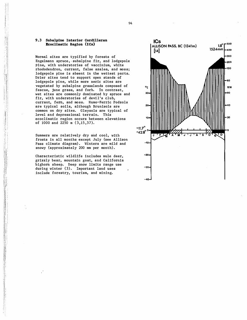
9.3 Subalpine Interior Cordilleran Ecoclimatic Region (ICa)
94
Normal sites are typified by forests of Engelmann spruce , - subalpine fir, and lodgepole pine, with understories of vaccinium, white rhododendron, currant, false azalea, and moss ; lodgepole pine is absent in the wettest parts. Drier sites tend to support open stands of lodgepole pine, while more xeric sites are vegetated by subalpine grasslands composed of 0c fescue, june grass, and forb. In contrast, wet sites are commonly dominated by spruce and fir, with understories of devi l ' s club, currant, fern, and moss. Humo-Ferric Podzols are typical soils, although Brunisols are common on dry sites. Gleysols are typical of level and depressional terrain. This ecoclimatic region occurs between elevations of 1000 and 2250 m ( 3 , 15 ,3 7 ) .
Summers are relatively dry and cool, with frosts in all months except July (see Allison Pass climate diagram) . Winters are mild and snowy (approximately 200 mm per month) .
Characteristic wildlife includes mule deer, grizzly bear, mountain goat, and California bighorn sheep. Deep snow limits range use during winter (3) . Important land uses include forestry, tourism, and mining.
ICs I AL'''''<;'''' PASS, Be (1341m)

9.4 Subalpine Transitional Interior Cordilleran Ecoclimatic Region (ICn)
Normal, sites are commonly vegetated by lodgepole pine , with an understory of pine grass and shade-intolerant forb ; trembling aspen is also an important seraI species .
95
Late successional and mature stands on normal sites can develop forests of Engelmann spruce (cross white) , alpine fir, lodgepole pine, and Douglas-fir, with understories of mountain-box, bilberry, red twinberry, twinflower, and prince ' s pine . Dry sites are vegetated by Douglas-fir, ground juniper, and bearberry, while poorly drained areas are typified by ope� stands :of spruce and fir, with an understory of glandular Labrador tea, sphagnum, and horsetail. Dystric Brunisols are typical soils of upland sites, while Gleysols and Organics characterize poorly drained sites. This ecoclimatic. re'gion is transitional between the Subalpine Interior Cordilleran Ecoclimatic Region (ICs) an9 the Montane Interior Cordilleran Ecoclimatic Regions (ICm) (45 ) .
No climatic data are available for this ecoclimatic region. However, summers are probably cool and relatively dry, whereas winters are mild with more precipitation than during summer months. Total annual precipitation is probably low compared to the Subalpine Interior Cordilleran Ecoclimatic Region ( ICs) .
Wildlife probably includes California bighorn sheep, mule deer, white-tailed deer, grizzly bear, ruffed grouse, blue grouse , and sharp-tailed grouse. Forestry and mining are important land uses.

9.5 Montane Interior Cordilleran lIc:oclimatic: Region (ICa)
96
Normal sites are dominated by forests of Douglas-fir, with an understory of snowberry, bu£faloberry, saskatoon, showy aster, and pine grass. Dry sites are characterized by opengrowing ponderosa pine along with Douglas-fir, with understories of blue bunch wheat grass , Idaho fescue , and saskatoon. Moister sites develop mixed stands of white spruce, Douglasfir, and Douglas maple , while wetter stands have a reduced content of Douglas-fir. Lodgepole pi"ne stands are an important and widespread seral stage. Gray Luvisols and Eutric Brunisols typify normal sites ( 3 , 23,47) , whereas Melanic and Eutric Brunisols develop on dry sites. Topographically, this region occurs below the Subalpine Interior Cordilleran Ecoclimatic Region and the Subalpine Transitional Interior Cordilleran Ecoclimatic Region (ICs and lCn), but above the Subhumid Montane Interior Cordilleran Ecoclimatic Region Montane (ICm-) .
Summers are warm and semi-arid (less than 50 mm per month precipitation ) t whereas winters are mild and approximately three to four months long ( see Armstrong climate diagram ) . Maximum precipitation occurs during mid-winter as snow and represents approximately half of all precipitation.
This ecoclimatic region provides winter range for California bighorn sheep, white-tailed deer, mule deer, and sometimes elk, whereas ruffed grouse, blue grouse, and sharp-tailed grouse are common year-round . Domestic grazing, forestry, recreation, hunting, and ranching are common land uses.
10
-10
-20
-30
-40
lem ARMSTRONG. BC (375m)
[27] 7.1 "
457mm 500
400
300
200
100
80
MM 60
40
20
o

9.6 Subhumid Montane Interior Cordilleran Eeoelimatie Region (IC.-)
97
Normal sites are characterized by savanna to parkland composed of scattered ponderosa pine in a matrix of bluebunch wheat grass and sagebrush ( 3 7 , 46) . Drier sites support open-growing ponderosa pine, with an understory of bearberry and blue bunch wheat grass. Moister sites commonly have Douglasfir, with an understory of snowberry, saskatoon, wheat grass, and pine grass. Balsam poplar, trembling aspen, western red cedar, and water birch occur along rivers . Forested sites are usually associated with Eutric Brunisols, although Melanic Brunisols and sometimes Dark Gray Chernozems can occur on drier sites (23 , 46 ) . Chernozems are characteristic of grasslands. Topographically, this ecoclimatic region occupies the lower slopes and bottoms of maj or valleys.
Summers are warm, with temperatures above O°C for approximately nine months and a frost-free period of 130 to 250 days (38) (see Kamloops Airport climate diagram) . Winters are mild. Monthly precipitation generally averages between 10 and 30 rom, with the lowest values occurring in spring and fall. Total mean annual precipitation is 200 to 350 mm. Some of the warmest temperatures and most arid summer conditions in Canada occur in this ecoclimatic region.
Characteristic wildlife include California bighorn sheep, elk, mule deer, and white-tailed deer. Domestic grazing, orchards , and some logging are common activities (38 ) .
30
-'0
-20
-30
-40
ICm-KAMLOOPS AIRPORT. Be (346m) [30]
8.30 256mm
500
400
300
200
,00
80
MM 60

9 . 7 Grassland Interior Cordilleran Ecoclimatic Region (ICp)
98
Normal sites are characterized by grasslands dominated by bluebunch wheat grass, with secondary quantities of blue grass , june grass, sagebrush, rabbitbush, and Antelope-bush (22 ,46) . Drier sites support red three-awn, dropseed, and needle grass. In contrast, moist grasslands consist of rough fescue and Idaho fescue. Dark Brown Chernozems and Brown Chernozems represent the soils of normal sites. Topographically, this ecoclimatic region usually represents low-elevation valley bottoms, such as along the Okanagan, Thompson, and Fraser rivers, as far north as Williams Lake ( 9 , 31 ) .
Summers are dry and warm, with mean maximum temperatures of up to 30°C (see Osoyoos \Vest climate diagram) . Winters are mild, with temperatures below O°C for only two months of the year. Total annual precipitation averages less than 350 mm, with a moderate peak during winter.
Wildlife includes mule deer, white-tailed deer, California bighorn sheep (during winter) , rattlesnake , chukar, sharp-tailed grouse, waterfowl, and long-billed curlew. Irrigated fruit and vineyards farming, domestic grazing, and urban development are characteristic land uses. The many lakes of this ecoclimatic region are prime recreational areas .
30
20
'0
ICp OSOYOOS WEST, Be (297m) [12]
10.0° 304mm
500
400
300
200
'00
80
MM 60
40
20
-6.3° 0i.�¢���::::;:�dw..l. -26.10 0 J F M A M J J A S O N D
" 0
·20
'30
·40

9 9
1 0 . PACIFIC CORDILLERAN ECOCLIMATIC PROVINCE

100
NORTH PACIFIC ECOCLIKA7IC REGIONS
Alpine tundra dominated by low shrubs in the Kusawa River area, Yukon (NPa) . Photo by E .T . Oswald.
Subalpine forest near the tree line, composed mainly of alpine fir and shrub birch near Teslin, Yukon (NPs) . Photo by E.T. Oswald.
Alpine meadow of cottongrass, sedges, and dryads in the north Coast Mountains , Yukon (NPa) • Photo by E .T . Oswald.
Subalpine forest dominated by alpine fir in the White Pas s , Yukon (NPs ) . Photo by E .T . Oswald.
10.1 Glacierized North Pacific Cordilleran Ecoclimatic Region (BPg)
101
Permanent ice and snowfields cover most of the landscape, with only minor bedrock, frost-shattered bedrock, and rubbly deposits exposed. Exposed ground is predominantly unvegetated (54 , 55 ) , although scattered rock lichen and moss may occur. Where soils occur, they are typically Regosols and Cryosols. This ecoclimatic region represents a large reservoir of fresh water and the source area for local streams and rivers . Topographically, this ecoclimatic region is composed of extremely rugged mountains, with elevations ranging from 1500 to over 6000 m.
No meteorological data are available, but summers are probably short and cold, whereas winters are cold to very cold, long, and snowy. Total annual precipitation, which is largely in the form of snow, probably ranges from 500 mm on lee slopes to over 1800 mm along the southern Yukon-Alaska border. Mean annual temperatures are probably in the range of -7 . 5 to -15°C. Extensive cloud and strong winds are common ( 76 ) . The mountains form a major barrier to the intrusion of moist Pacific air into the Yukon interior.
Caribou, Dall sheep, and mountain goat frequent these areas during summer. Occasional research and recreation are the principal activities.

102
10.2 Alpine North Pacific Cordilleran Ecoclimatic Region (NPa)
Normal sites are typified by low-growing heather, dwarf birch, willow, grass , and lichen. Wet sites support cottongrass and sedge (53 , 54 , 63) . Soils are Bruniso1s , Podzols, and Regosols on better drained sites, and Gleysols where drainage is restricted. Cryosols may occur in scattered sites throughout . This ecoclimatic region occupies an elevational range from about 1000 m to the point of contact with permanent ice and snowfields, at approximately 1500 to 1600 m, in parts of the rugged Coast Mountains and St . Elias Mountains.
Summers are cold, short , and moist, while winters are cold, long, and snowy (see Mule Creek climate diagram) . Total annual precipitation ranges from about 500 to 1000 mm, with maximums during the October to December period. Mean annual temperatures range from -7 . 5 to DoC. Frost is common throughout the summer and winds are generally strong ( 7 6 ) .
Characteristic wildlife includes grizzly bear, black bear, Dall sheep, Stone ' s sheep, mountain goat , pika , wolf , wolverine , and willow ptarmigan. Limited access to this remote area restricts land use to hunting and recreation.
30
20
10
-20
-30
-40
NPa MULE CREEK, BC (884m) [5-7]
-2.7° 722mm
500
400
300
200
100
60
M M
60
40
20
0

10.3 Subalpine Borth Pacific Cordilleran Ecoclimatic Region (BPs)
103
Normal sites are dominated by closed forests of mountain hemlock and some Sitka spruce, with understories of blueberry, huckleberry, devil ' . club, and white rhododendron (63 ) . At higher elevations, mountain hemlock and alpine fir are common. Sitka spruce and alpine fir are important along streams where draInage can be poor. Soils of normal sites are Podzols. This region occupies elevations of 400 to 1 100 m .
Summers are probably cool, short, and showery, and winters cold and snowy. Total annual precipitation probably exceeds 700 mm, with most falling in winter.
Moose, mountain goat , grizzly bear, wolf, and spruce grouse are characteristic wildlife. Land uses include mineral exploration, mining, and occasional hiking and recreational hunting.

10.4 Maritime North Pacific Cordilleran Eeoclimatic Region (RPm)
104
Normal sites are dominated by closed forests of western hemlock and some Sitka spruce, with understories of blueberry, huckleberry, devil' s-club, and white rhododendron (63 ) . Humo-Ferric Podzols are the common soils of normal sites (54 , 70 , 7 4 , 75 ) .
Summers are cool and moist and winters are mild and snowy. Monthly precipitation probably ranges from 60 to over 300 mm, with the lesser amounts falling during spring to mid-summer. Temperatures below O°C occur during December through February. Mean annual temperatures are probably 2 to 6°C.
Black-tailed deer, mountain goat , black bear, grizzly bear, and wolf are characteristic wildlife. Forestry and precious metal exploration are common land uses.

105
SOUTH PACIFIC ECOCLIHA7IC REGIONS
Alpine tundra of willow and sedges on Moresby Island, British Columbia (SPa) . Photo by S .C . Zoltai.
Montane forest of western hemlock, amabilis fir, and Douglas fir with a moss-covered forest floor on Vancouver Island, British Columbia ( SPm) . Photo by E .T . Oswald.
Subalpine forest of amabilis fir, western hemlock, and mountain hemlock on Mount Arrowsmith, Vancouver Island, British Columbia (SPs ) . Photo by E .T . Oswald.
Coastal forest of Douglas fir, western hemlock and amabil1s fir, with an understory of sala! and moss on Vancouver Island, British Columbia ( SPc) . Photo by E .T. Oswald.

I '··
.1 ' ,: ' ! ! : : 1 "
10.5 Alpine South Pacific Cordilleran Ecoclimatic Region (SPa)
106
Normal sites are characterized by low-growing willow and short-awned sedge (58 ) . Dry mineral soils tend to develop mixed communities of fescue and forb, while sites with limited amounts of mineral soils develop a scattered cover of mountain avens , blackish locoweed, moss campion, and lichen. In contrast, wet sites can be vegetated by a dense cover of willow, forb, and moss ; such sites are usually associated with slight topographic depressions or are downslope of snowbanks which persist throughout most of the summer. Much of this ecoclimatic region is unvegetated due to the frequent occurrence of unstable surficial materials and bedrock exposures (35 ) . Total vegetation cover generally decreases with increasing elevation and increased climatic harshness. The typical soils are Regosols and Brunisols (35 ) . This ecoclimatic region occurs 'above 1800 m in southern portions and above 1000 m in northern portions.
Summers are short (less than four months ) with widely fluctuating diurnal temperature s , whereas winters are mild and snowy (see Whistler Roundhouse climate diagram) . Monthly precipitation is in the range of 150 to 250 mm per month, except during summer when values decline to less than 100 mm per month. Winds significantly influence the growth and development of vegetation through desiccation and mechanical abrasion.
Wildlife includes grizzly bear, mountain goat , mule deer, blue grouse, and white-tailed ptarmigan. Land use is mostly limited to recreation in the Vancouver area.
'c
SPa WHISTLER ROUNDHOUSE, Be (1902m) 0.10
[3] 1749mm
s 0

10.6 Subalpine South Pacific Cordilleran Ecoclimatic Region (SPo)
107
Normal sites are dominated by forests of mountain hemlock, with understories of blueberry, huckleberry, false azalea, sa1al, and moss (35 , 36 , 62) . Mountain hemlock and amabilis fir are the climatic climax species. Dry sites are dominated by open-growing mountain hemlock, with subdominant yellow cedar and amabilis fir. Wet sites are characterized by western hemlock, amabilis fir, and yellow cedar, with under stories of vaccinium, fern, and moss. Humo-Ferric Podzols are the soils associated with upland s.ites, whereas Organics and Gleysols occur in poorly drained areas . This ecocl1matic region occupies an elevational position ( greater than 900 m elevation) between the forests of the Maritime South Pacific Cordilleran Ecoclimatic Region (SPm) and the alpine tundra of the Alpine South Pacific Cordilleran Ecoclimatic Region (SPa ) .
Summers are cool and wet (see Hollyburn Ridge climate diagram) . Winters are mild with much rain and snow (approximately 350 to 450 mm per month) . Total annual precipitation exceeds 2500 mm. Frost can occur from October through May.
Black bear, grizzly bear, wolf, black-tailed deer, mountain goat ( locally ) , and blue grouse winter in this ecoclimatic region. Land uses include lu'mbering, wood processing ( pulp and lumber) , production of hydroelectric power, and tourism.
SPs HOLLYBURN RIDGE, Be (951 m)
[12-27]

10.7 Maritime South Paeifie Cordilleran Ecoelimatie Region (SPa)
Normal sites are vegetated by semi-open western hemlock and amabilis fir, with understories of sa1al, vaccinium, and moss (61 ) . Drier sites support open stands of western hemlock and western red cedar, with understories of sa1al, Oregon grape, and
108
moss. Wet terrain develops open stands of western hemlock and amabilis fir, with understories of vaccinium and moss. Podzols are the predominant soils, often with a poorly decomposed mar layer. Nutrients contained in this surface organic matter are important in maintaining the productivity of the land. This ecoclimatic region generally occurs between sea level and 900 m.
Summers are warm and moist, whereas winters are warm and wet (see Haney UBC RF Admin climate diagram) . Maximum monthly precipitation occurs during October through March, with values ranging from 200 to 350 mm per month ; summers have less than 100 mm per month. Frosts are common during winter.
Elk, black-tailed deer, wolf, black bear, mink, and river otter are characteristic wildlife. Important land uses include forestry, recreation, and tourism.
SPm HANEY UBe RF ADMIN, Be (143m) 9.2°
D � ��mm

10.8 Oceanic South Pacific Cordilleran Ecoclimatic Region (SPo)
109
Normal sites support stunted, open-growing western red cedar, yellow cedar, and western hemlock, with understories of sa1al, vaccinium, and moss (22 , 59 ) . Submesic sites support complexes of western hemlock, western red cedar, and Sitka spruce ( 13) , with moderately well-developed understories of vaccinium, false azalea, fern, and moss . Dry sites tend to develop stands of dwarf shore pine, with secondary quantities of western red cedar, yellow cedar, western hemlock, and mountain hemlock, and under stories of ground juniper and sweet gale. Red alder is a common colonizer of disturbed sites , particularly after logging. Bog forests dominate the landscape even on slopes up to 60% . Podzols and Dystric Brunisols are typical of well-drained sites, whereas Organics dominate poorly drained terrain. This ecoclimatic region occurs immediately adjacent to the Pacific Ocean.
Summers are cool and wet , whereas winters are warm and very wet ( see Prince Rupert Airport climate diagram) . Maximum precipitation occurs during September through April, primarily as rain (more than 200 mm per month) . Total annual precipitation exceeds 2500 mm. Frosts occur during winter, but prolonged temperatures below O°C are infrequent . Onshore winds are an important climatic factor.
Characteristic wildlife includes black-tailed deer, wolf, black bear, mink, river otter, pelagic birds (colonies on selected sites) , and waterfowl (wintering on estuaries ) . Forestry is an important land use.
SPo PRINCE RUPERT AIRPORT, BC {34m}
[12]

10.9 Coastal South Pacific Cordilleran Ecoclimatic Region (SPc)
110
Normal sites are typified by stands of Douglas-fir, with understories of sa1al, Oregon grape, and moss (34 ) . Drier sites usually support stands of Douglas-fir and lodgepole pine; however, Garry oak, western flowering dogwood, and arbutus are common in the 'rain shadow' areas of this ecoclimatic region. Wet sites support communities of Douglas-fir and western red cedar, with understories of foamflower, sword fern, and skunk cabbage; Douglas-fir decreases in abundance as drainage deteriorates. Dystric Brunisols and Humo-Ferric Podzols are the typical soils of normal sites, while Sombric Brunisols and Black Chernozems can be found on the driest sites. Peaty Gleysols and Dystric Brunisols occur where drainage is impeded (31 ) .
Both summers and winters are warm, with mean daily temperatures below 5°C in December through February (see Victoria International Airport climate diagram) . However, frost can occur from November to mid-April. Maximum precipitation falls during winter, with less than 10% occurring as snow. Less than 20% of annual precipitation falls between May and September.
Black-tailed deer, elk, black bear , wolf, and blue grouse are characteristic wildlife. The estuaries provide winter habitat for a variety of water birds. Common land uses include vegetable , dairy, and forage farming, recreation, urban development, and heavy industrial activities.
30
20
10
SPc VICTORIA INn AIRPORT, BC (19m) 9.50 [30] 873mm
500
400
300
200
JI'I��100
80
M M
60
40
20
0.10 -15.60 °t�:;:::::;;��:;;::::;:�;::::���;:;:��to
J F M A M J J A S O N D
·10
·20
-30
-40

Plants (69)
Alder Alkali Grass Alpine Azalea Alpine Bearberry Alpine Fir Alpine Foxtail Alpine Larch Alpine Timothy Amabilis Fir Anemone Antelope-hush Arbutus (Madrone) Arctic Poppy Aspen Balsam Fir Balsam Poplar Basswood Bearberry Bedstraw Beech Bent Reed Grass
Bilberry Bitternut Hickory Black Ash Black Spruce Black Walnut Blackish Locoweed Blue Grama Grass Blue Grass Blueberry Bluebunch Wheat Grass Bog Bilberry Bog Cranberry Bog Rosemary Box-elder
(Manitoba Maple) Bracted Honeysuckle
(Black Twinberry) Buffaloberry Bunchberry Bur Oak Butternut Cherry Chestnut Oak Chickweed Chinquapin Oak Claudberry Composite Cottongrass Cottonwood Crowberry Currant Devil 's-club Diapensia Douglas-fir
111
SPECIES LIST
Alnus spp. �nellia spp. Loiseleuria procumbens ArctostaphYlos alpina � lasiocarpa Alopecurus alpinus � IyaIlii Phleum alpinum Abies amabilis �ne spp. Purshia tridentata Arbutus menzies!! Papaver radicatum Populus grandiderttata Abies balsamea �us balsamifera Tilla americana �staphYlos uva-ursi Callum bore ale � grandifolia Calamagrostis
lapponica Vaccinium spp . Carya cordiformis Fraxinus nigra Picea mariana 'JU'gIans nigra Oxytropis nigrescens Bouteloua gracilis Poa spp. vaccinium myrtilloides Agropyron spicatum Vaccinium uliginosum Vaccinium vitts ldaea Andromeda palifolia � negundo
Lonicera involucrata
Shepherdia canadensis Carnus canadensis Ouercus macrocarpa Juglans cinerea Prunus spp . Quercus prinus Stellaria spp. Quercus prinoides Rubus chamaemorus Family Compositae Erio1horum spp . Popu us spp . Empetrum nigrum Ribes spp . opiO;panax horridus Diapensia lapponica Pseudotsuga menziesii
Douglas Maple
Dropseed Dryas Dwarf Bilberry Dwarf Birch Eastern Cottonwood Eastern Hemlock Eastern Red-cedar Eastern White Cedar Eastern White Pine Elm Engelmann Spruce Ericad
False Azalea Feathermoss
Fern
Fescue Fir Flowering Dogwood Foamflower Forb
Fowl Blue Grass Garry Oak Glandular Labrador
Tea Grass
Ground Juniper Grouseberry Heather
Hemlock Horsetail Huckleberry Idaho Fescue Indian Paintbrush Ironwood
Jack Pine June Grass Kalmia Kobresia Labrador Tea Lichen
� glabrum var. douglasii
Sporobolus cryptandrus Dryas integrifolia Vaccinium caespitosum Betula glandulosa Populus deltoides Tsuga canadensis Juniperus virginiana Thuja occidentalis Pinus strobus Ulmus SEP. � engelmanii Various genera and
species of the Family Ericaceae
Menziesia ferruginea Hylocomium,:�,pp. alld ,
other genera , ana species
Various genera and species , especially of" the Family Polypodiaceae
Festuca spp. Abies spp . 'C'O'TIi\i"s flo ri da Tiarella spp . Various non-graminoid
herbaceous genera and species
� glauca Quercus garryana Ledum glandulosum
Various genera and species of the Family Gramineae
Juniperus communis Vaccinium scoparium Phyllodoce spp. and
Cassiope spp. Tsuga spp . Equisetum spp . Vaccinium spp. Festuca occidental is Castilleja spp. Carpinus caroliniana/
Ostrya virginiana Pinus banksiana KDeIeria cristata Kalmia angustifolia Kobresia spp . � groenlandicum Various genera and
species, , including

Limber Pine Lodgepole Pine
Low-bush Cranberry Lupine Maple Meadow Sweet Moss
Moss Campion Moss Phlox Mountain Avens Mountain-box
(False-box, Mountain Lover)
Mountain Hemlock
Mountain Maple Needle Grass Needle-and-thread
Grass Newfoundland Shrub
Birch Northern Labrador
Tea Oak Fern Oregon Grape
(Barberry) Oxalis (Wood Sorrel ) Paper Birch Parry Oat Grass Pasture Sage Pine Grass Polar Grass Ponderosa Pine Porcupine Grass Prince ' s Pine Purple Reed Grass
Purple Saxifrage Rabbitbrush Red Alder Red Ash Red Maple Red Oak Red Pine Red Spruce Red Three-awn Red Twinberry Red-osier Dogwood Reed Grass
Rhodora Rocky Mountain
JU)1iper Rose Rough Fescue Rush Sagebrush Salal Saskatoon
Cladina spp. and £etraria spp .
� flexilis Pinus contorta var. --ratifolia Viburnum edule Lupinus spp. Acer spp . spiraea spp. Various genera and
species Silene acaulis � hoodib Dryas octopetala Pachistima myrsinites
Tsuga mertensiana
� spicatum Sripa spp. Stipa comata
Betula michauxii
� palustre
Gymnocarpium dryopteris Berberis - nervosa
Oxalis oregana Betula papyrifera Danthonia parryi Artemisia frigida Calamagrostis rubescens Arctagrostis latifolia Pinus ponderosa Stipa spartea Chimaphil5 umbel lata Calamagrostis
purpurascens Saxifraga oppositifolia Chrysothamnus nauseosus Alnus rubra �nus pennsylvanica Acer rubrum QUercus rubra Pinus resinosa P"fC'e'a rubens AriStida longiseta Lonicera utahe'nsis Cornus stolonifera Calamagrostis
canadensis Rhododendron canadense Juniperu& scopulorum
Rosa spp. FeStuea scabrella Juneus trifidus Artemisia tridentata Gaultheria shallon Amelanchier alnifolia
112
Saxifrage Sedge Shagbark Hickory Shield Fern Shore Pine
Short-awned Sedge Showy Aster Shrubby Cinquefoil Silver Maple Silverberry Si tka Spruce Skunk Cabbage Slippery Elm Snowberry
Sphagnum Spruce Sticky Geranium Sugar Maple Sweet Gale Sword Fern Sycamore Tamarac'k. Thamnolia Thimbleberry Trembling Aspen Twinflower Tulip Tree Vaccinium Water Birch Western Flowering
Dogwood Western Hemlock Western Larch Western Red Cedar Western White Pine Wheat Grass White Ash White Elm White Oak White Rhododendron White Spruce Whiteb'ark Pine Wild Rye Willow Wintergreen Wire Rush Wood Rush Yellow Bean Yellow Birch Yellow Cedar
Yew
Mammals (8)
Arctic Fox Arctic Ground
Squirrel Arctic Hare Bearded Seal
Saxifrafa spp . Carex spp . Carya � Dyopteris spp. � contorta var .
contorta Carex microchaeta � conspicuus Potentilla fruticosa Acer saccharinum ETieagnus commutata Picea sitchensis �hitum amerieanum Ulmus rubra 'SYiD;jjho�pos
occidentalis Sphagnum spp . Picea spp . Geranium viscosissimum Acer saccharum MY'dca gale Polystichum munitum Platanus occidental is Larix laricina �olia spp. � parviflorus Populus tremuloides Linnaea borealis Liriodendron tulipifera Vaccinium spp . Betula occidental is Cornus nuttallii
Tsuga heterophylla Larix occidental is Thuja plicata Pinus monticola AjfrOi?yron spp . Fraxinus americana Ulmus americana QUe'r'Cus alba Rhododen� albiflorum Picea glauca Pinus albicaulis �s innovatus Salix spp . 'Py"i;OTa spp. Juncus spp. Luzula spp . Thermopsis rhombifolia Betula lutea ChamaecYj?'i'rIs
nootkatensis � brevifolia
Alopex lagopus Spermophilus parryii
Lepus arcticus Erignathus barbatus

Beaver Bighorn Sheep Black Bear Black-tailed Deer
California Bighorn Sheep
Caribou Chipmunk Cougar Coyote Dall Sheep Deer Elk Fisher Franklin' s Ground
Squirrel Gray Squirrel Grizzly Bear Hare Lemming Lynx Mamot Marten Mink Moose Mountain Goat Mule Deer Muskox Muskrat Pika Polar Bear Porcupine Pronghorn Raccoon Red Fox Red Squirrel Ringed Seal River Otter Snowshoe Hare St one 's Sheep Thirteen-lined
Ground Squirrel Walrus White Whale White-tailed Deer Wolf Wolverine Wood Bison Woodchuck
Reptiles (71)
Rattlesnake Short-horned Lizard Western Rattlesnake
Birds (1,56)
Arctic Tern Black Duck
Castor canadensis Ovis canadensis �s americanus �ileus hemionus
columbianus Ovis canadensis --C:;liforniana Rangifer tarandus Eutamias spp. Felis concolor Ca'ii'rS Iatrans Ovis dalli 'O'CiOc'oI'i"e"US spp. Cervus elaphus Martes pennant! Spermophilus franklinii
Sciurus carolinensis Ursus arctos Lepus spp . Lemmus spp.
113
Lynx lynx (Lynx canadensis) Marmota spp. Martes americana Musteia vison Alces aices �n�ericanus Odocoileu� hemionus Ovibos moschatus Ondatra zibethicus O�hotona princeps Ursus maritimus Eret"hizon dorsatum Antilocapra americana Procyon .!2.E2.E. Vulpes fulva Tamiasciurus hudsonicus Phoca hispida Lutra canadensis Lepus americanus Ovis daIIi stonei VrmOj?hII"us
tridecemlineatus Odobenus rosmarus Delphinapterus leucas Odocoileus virginianus � lupus � � Bison bison 'M'.ir.iiOtaIiiOriax
Crotalus spp. Phrynosoma douglassi Crotalus viridis
Sterna paradisaea � rubripes
Blue Grouse Canada Goose Cardinal Chukar Clark' s Nutcracker Cormorant Eagle (Bald Eagle)
Eider Gannet Golden Eagle Gray Partridge Green Heron
Guillemot Gull Gyrfalcon Hooded Merganser King Eider Long-billed Curlew Long-tailed Jaeger
Mallard Mourning Dove Murre Osprey Peregrine Falcon Phalarope Pileated Woodpecker Pintail Ptamigan Puffin (Common) Raven (Conunon) Red-bellied
Woodpecker Red-breasted
Nuthatch Rock Ptarmigan Ruddy Turnstone Ruffed Grouse Sage Grouse
Sandhill Crane Scoter Screech Owl Sharp-tailed Grouse
Shoveler (Northern) Snow Goose Snowy Owl
Spruce Grouse Steller' s Jay Tern Whistling Swan White Pelican
White-tailed Ptarmigan
Whooping Crane Wild Turkey Willow Ptarmigan Wood Duck Wood Thrush
Dendragapus obscurus Branta canadensis Cardinal is cardinalis Alectoris graeca Nucifraga columbiana Phalacrocorax spp. Haliaeetus
leuC:ocephalus Somateria spp . Morus bassanus �a chrysaetos Perdix perdix Butorides virescens
(striatus) Cepphus spp . Larus spp. Falco rusticolus Lophodytes cucullatus Somateria spectabilis Numenius americanus Stercorarius
longicaudus � platyrhynchos Zenaida macroura � spp . ';�.� ,: . Pandion haliaetti's Falco peregrinus Phalaropus spp. Dryocopus pileatus Anas acuta LagOpus spp. Fratercula arctica Corvus corax Melanerpes carolinus
� canadensis
Lagopus � Arenaria interpres Bonasa umbeIIus Centro cercus
urophasianus Grus canadensis Melanitta spp . Otus asio "TYDiP a'iUiCiiu s
phasianellus � clypeata Chen caerulescens �ea scandiaca Canachites canadensis Cyanocitta stelleri Sterna spp. Dlor columbianus Pelecanus
erythrorhynchos Lagopus leucurus
Grus americana MeIeagris gallopavo Lagopus la-gopus � sponsa Hylocichla mustelina

, i i [ 1 i l I I I' ·Ii i i , i ,
114
SELECTED BIBLIOGRAPHY ( 1 ) American Ornithologists ' Union. 1983.
Check-list of North Ameri�an birds, sixth edition. Allen Press, Inc. , Lawrence , Kansas .
(2) Annas, R.M. 1977. Boreal ecosystems of the Fort Nelson area of northeastern British Columbia. Ph.D. Dissertation, University of British Columbia, Vancouver, British Columbia .
( 3 ) Annas , R.M. , R. Coupe , J . Pinkerton, A. Vyse, J. Hilton, and M. Beets. 1979. Biogeoclimatic zones and subzones of the eariboD forest region. Ministry of Forests, Victoria, British Columbia.
(4) Anonymous. 1984 . A policy for resource management of the Eastern Slopes . Alberta Energy and Natural Resources, Edmonton, Alberta. ENR Number T/38.
(5) Atmospheric Environment Service . 1970-1982. Monthly records, meteorological observations in Canada. Environment Canada, Downsview, Ontario.
(6) 1981-82 . Supplementary precipitation data. Environment Canada, Downsview, Ontario .
( 7 ) 1982. Canadian climatic normals . Environment Canada, Downsview, Ontario.
(8) Banfield, A.W.F . 1974. The mammals of Canada. National Museums of Canada , National Museum of Natural Sciences . University of Toronto Press, Toronto, Ontario.
(9) Benson, L. 1959. Plant classification. D.C. Heath and Company, Lexington, Massachusetts .
( 10) Bradley, S.W. , J . S. Rowe, and C . Tarnocai . 1982 . An ecological land survey of the Lockhart River map area, Northwest Territories . Lands Directorate, Environment Canada, Ottawa, Ontario. Ecological Land Cl.assification Series, No. 1 6 .
( 1 1 ) Brown, R.J.E. 1969 . Permafrost in Canada. Map compiled for Hydrological Atlas of Canada, Inland Waters Branch, Environment Canada, Ottawa, Ontario .
(12) Carroll, S .B. and L . C . Bliss. 1982 . Jack pine-lichen woodland on sandy soils in northern Saskatchewan and northeastern Alberta. Canadian Journal of Botany 60: 2270-2282.
(13) Cordes, L.D. 1972. An ecological study of the Sitka spruce forests on the west coast of Vancouver Island. Ph.D. Dissertation, University of British Columbia, Vancouver, British Columbia.
( 14) Corns , I .G.W. 1983 . Forest communitytypes of west-central Alberta in relation to selected environmental factors. Canadian Journal of Forest Research 13: 995-1010.
(15) Coupe, R. 1983. Engelmann sprucesubalpine fir zone, p .273-277 in: Watts, S .B . (Editor), Forestry handbook for British Columbia, fourth edition. Faculty of Forestry, University of British Columbia, Vancouver , British Columbia.
( 16) Coupland , R.T . 1950. Ecology of mixed prairie in Canada. Ecological Monographs 20: 272-3 1 5 .
( 1 7 ) 1961 . A reconsideration of grassland classification in the northern Great Plains of North America. Journal of Ecology 49: 136-167 .
( 1 8 ) Damman, A.W.H. 1964. Some forest types of central Newfoundland and their relation to environmental factors. Canada Department of Forestry, Forest Research Branch Contribution No. 596, Forest Science Monograph No . 8 .
( 19) 1983. An ecological subdivision of the island of Newfoundland , p . 1 63-206 in: South, G.R. (Editor) , Biogeography and ecology of the island of Newfoundland . Junk Publishers, The Hague, Netherlands .
(20) Edlund , S.A. 1983 . Bioclimatic zonation in a high arctic region: Central Queen Elizabeth Islands . Geological Survey of Canada, Paper 83-1A, p .381-390.
( 2 1 ) Foster, D.R. 1985. Vegetation development following fire in Picea mariana (black spruce)-Pleuroz� forests of southeastern Labrador , Canada. Journal of Ecology 73 :517-534.

(22) Franklin, J . F . and C . T . Dyrness . 1973. Natural vegetation of Oregon and Washington. Pacific Northwest Forest and Range Experiment Station, USDA Forest Service, Portland, Oregon. General Technical Report PNW-8 .
115
(23) Green, A.J. and T.M. Lord. 1979. Soils of the Princeton area of British Columbia. British Columbia Soil Survey, Agriculture Canada, Report No. 14.
( 24) Groenewoud, H . van. 1983. Summary of climatic data pertaining to the climatic regions of New Brunswick. Maritimes Forest Research Centre , Canadian Forestry Service, Fredericton , New Brunswick. Information Report M-X-14b.
(25) Harris, W .C . , A. Kabzems , A.L. Kosowan, G .A. Padbury, and J . S . Rowe. 1983. Ecological regions of Saskatchewan. Forestry Division, Saskatchewan Parks and Renewable Resources . Technical Bulletin 10.
( 26) Hills, G .A. 1960. Regional site research. Forestry Chronicle 36:401-423.
(27) 196 1 . The ecological basis for land use planning. Ontario Department of Lands and Forests , Research Report 46.
(Z8) Hills , G.A. and A.N. Boissonneau. 1960. Landforms of the Glackmeyer Development Area, p . 1 1 2-210 in: Hills , G .A . and R. Portelance, A mUltiple land-use plan for the Glackmeyer Development Area. Ontario Department of Lands and Forests , Toronto , Ontario.
(29) Hirvonen, H .E . 1984 . The Atlantic region of Canada: An ecological perspective. Lands Directorate , Environment Canada , Dartmouth, Nova Scotia.
(30) Holland, W.D. and G.M. Coen (Editors) . 1983. Ecological (biophysical) land classification of Banff and Jasper national parks. Prepared for Parks Canada by Alberta Institute of Pedology, Edmonton, Alberta. Publication No . M83/2.
(31) Jones , R.K. and R .M . Annas . 1978. Vegetation, p . 35-45, in: Valentine, K.W.G . , P . N . Sprout , T .E . Baker, and L.M. Lavkulich, The soil landscape of British Columbia. Agriculture Canada and Ministry of Environment (Province of British Columbia) , Victoria, British Columbia.
(32) Kabzems , A. , A.L . Kosowan, and W . C . Harris. 1976. Mixed-wood section in an ecological perspective, Saskatchewan. Forestry Branch, Department of Tourism and Renewable Resources , Technical Report No. 8 .
( 33) Ketcheson, M .V . , T .F . Braumandl , and G. Utzig. 1983 . Interior cedarhemlock zone , p . 277-281 in: Watt s , S . B . (Editor) , Forestry handbook for British Columbia, fourth edition. Faculty of Forestry, University of British Columbia, Vancouver, British Columbia .
(34) Klinka, K. 1983. Coastal,Doug:j.as-fir zone , p.263-267 in: Watt s , S . B . (Editor), Forestry handbook for British Columbia , fourth edition. Faculty of Forestry, University of British Columbia, Vancouver, British Columbia.
(35) Klinka, K. , F .C . Nuszdorfer, and L. Skoda. 1979. Biogeoclimatic units of central and southern Vancouver Island. Ministry of Forestry (Province of British Columbia) , Victoria, British Columbia.
(36) Kraj ina, V.J. 1965 . Biogeoclimatic zones and classification of British Columbia. Ecology of North America 1 : 1-l7.
( 37 ) 1973. Biogeoclimatic zones of British Columbia. Drawn by J. I . Svoboda , scale 1 : 1 900 800. Published by the B . C. Ecological Reserves Committee, Department of Lands , Forests, and Water Resources (Province of British Columbia) , Victoria, British Columbia.
(38) 1976. Biogeoclimatic zones of British Columbia. Prepared for MacMillan Bloedel, British Columbia.
(39) La ROi , G .H . and R.J. Hnatiuk. 1980. The Pinus contorta forests of Banff and Jaspernational parks : A study in comparative synecology and syntaxonomy. Ecological Monographs 50: 1-29.

lii II ,il
I , i i '
(40) Lopoukhine, N . , N.A. Prout , and H . E . Hirvonen. 1978. The ecological land classification of Labrador; A reconnaissance. Lands Directorate, Environment Canada , Ottawa, Ontario. Ecological Land Classification Series, No. 4 .
(41) Loucks , O .L . 1962. A forest classification for the Maritime Provinces. Canada Department of Forestry, Forest Research Branch. Proceedings of the Nova Scotian Institute of Science 25 :86-167.
116
(42) Meades , W.J. 1983 . Heathlands, p .267-318 in: South, G .R . (Editor) , Biogeography and ecology of the island of Newfoundland. Junk Publishers, The Hague, Netherlands .
(43) Meidinger, D . and J . Pojar. 1983. SUb-boreal spruce zone , p . 306-311 in: Watts, S . B . (Editor) , Forestry handbook for British Columbia , fourth edition. Faculty of Forestry, University of British Columbia, Vancouver, British Columbia.
(44) Mills, G . F . , H. Veldhuis, J.M. Stewart , D. Wotton, and W. Koonz. 1985 . Ecoclimatic Regions of Manitoba. Manitoba Ecoclimatic Region Working Group, Winnipeg, Manitoba (Unpublished) .
(45) Mitchell , W.R. 1983. Montane spruce zone, p . 288-291 in: Watts, S . B . (Editor) , Forestry handbook for British Columbia, fourth edition. Faculty of Forestry, University of British Columbia, Vancouver, British Columbia.
(46) Mitchell, W.R. and W.R. Erickson. 1983. Ponderosa pine-bunchgrass zone, p . 296-300 in: Watts, S .B . (Editor) , Forestry handbook for British Columbia, fourth edition. Faculty of Forestry, University of British Columbia, Vancouver, British Columbia.
(47) 1983. Interior Douglas-fir zone, p.282-287 in: Watts, S . B . (Editor) , Forestry handbook for British Columbia, fourth edition. Faculty of Forestry, University of British
, .Columbia , Vancouver, British Columbia.
(48) Moss, E.H. 1944. The prairie and associated vegetation of southwestern Alberta. Canadian Journal of Research (C) 22 : 1 1-31.
(49) 1955. The vegetation of Alberta. Botanical Review 21 :493-567 .
( 50) Moss, E .H. and J . A. Campbell. 1947 . The fescue grassland of Alberta. Canadian Journal of Research (C) 25 :209-227.
(51) Ogilvie, R.T. 1962. Ecology of spruce forests on the east slopes of the Rocky Mountains of Alberta. Ph.D. Dissertation, Washington State University, Pullman, Washington.
( 52 ) 1976. The alpine and subalpine in the Rocky Mountains of Alberta, p . 33-48 in: Luttmerding, H.A. and J . A . Shields, Proceedings o f the Workshop on Alpine and Subalpine Environments. Resource Analysis Branch, Ministry of the Environment (Province of British Columbia), Victoria, British Columbia.
(53) Oswald, E.T. and J . P . Senyk. 1977.
(54)
(55)
Ecoregions of Yukon Territory. Pacific Forest Research Centre , Canadian Forestry Service, Fisheries and Environment Canada , Victoria, British Columbia.
Ouellette, L . G . (Editor) . 1975. Resources of Alaska, a regional summary. A jOint federal-state Land Use Planning Com�ission for Alaska , Anchorage , Alaska .
Peterson, R .T . 1961. A field guide to western birds, second edition. Houghton Mifflin Company, Boston, Massachusetts.
(56) �== 1980. A field guide to the birds east of the Rockies, fourth edition. Houghton Mifflin Company, Boston, Massachusetts.
(57 )
(58)
Pierpoint, G. 1962. Kirkwood Management Department of Lands Research Report No.
The sites of the Unit. Ontario and Forests, 47.
Pojar, J. 1983. Alpine tundra zone, p . 248-253 in: Watts, S . B . (Editor), Forestry handbook for British Columbia, fourth edition. Faculty of Forestry, University of British Columbia, Vancouver, British Columbia.

' (59) 1983 . Coastal cedar-pine-hemlock biogeoclimatic zone (CCPH ) , p .258-263 in: Watts , S .B. (Editor) , Forestry handbook for British Columbia, fourth edition. Faculty of Forestry, University of British Columbia, Vancouver, British Columbia.
(60) 1983. Spruce-willow-birch
117
�one, p.301-306 in: Watts , S.B. (Editor) , Forestry handbook for British
Columbia, fourth edition. Faculty of Forestry, University of British Columbia, Vancouver, British Columbia.
(61 ) Pojar, J. and K. Klinka. 1983. Coastal western hemlock zone , p .268-272 in: Watts, S .B. (Editor) , Forestry handbook for- British Columbia, fourth edition. Faculty of Forestry, University of British Columbia, Vancouver, British Columbia.
(62) 1983 . Mountain hemlock zone , p .292-296 in: Watts, S . B . (Editor ) , Forestry handbook for British Columbia, fourth edition. Faculty of Forestry, University of British Columbia, Vancouver, British Columbia.
(63) Pojar, J . , R. Trowbridge , and T . Lewis . 1982 . Biogeoclimatic zones of the Cassiar Timber Supply area, northwestern British Columbia. Ministry of Forests ( Province of British Columbia) , Prince Rupert Forest Region Research Section, Smithers , British Columbia.
(64) Purchase, J .E . and G.H. La Roi . 1983 . Pinus banksiana forests of the Fort vermilion area, northern Alberta. Canadian Journal of Botany 6 1 :804-824.
(65) Reid, J. and R. Decker. Personal communications regarding widlife and land use classification under the Northern Land Use Information Series ( 1975-1984) , Lands Directorate , Environment Canada, Ottawa, Ontario .
(66) Roland, A.E. 1982 . Geological background and physiography of Nova Scotia. The Nova Scotian Institute of Science, Halifax, Nova Scotia.
(67) Rowe, J . S . 1956 . Vegetation of the southern boreal forest in Saskatchewan and Manitoba. Ph.D. Dissertation, University of Manitoba, Winnipeg, Manitoba.
(68) 1972 . Forest regions of Canada . Canadian Forestry Service, Publication No . 1 300.
(69) Scoggan, H .J . 1978. The flora of Canada, Parts 2-4. National Museums of Canada, National Museum of Natural Sciences . Publications in Botany, No . 7 .
(70) Senyk, J.P . , E . T . Oswald, B.N. Brown, and P.K. King. 1 9 8 1 . Ecological land classification and evaluation of the Kusawa Lake area, Yukon Territory . Prepared for Department of Indian and Northern Affairs by Pacific Forest Research Centre, Victoria, British Columbia.
( 7 1 ) Smith, H .M . and D .M. Dennis . 1982 . A guide to field identification: Reptiles of North America. Western Publishing, Inc . , Racine, Wisconsin.
(72) Stringer, P .W . 1973 . An �cological study of grasslands in Ba'nff, Jasper, and Waterton Lakes national parks . Canadian Journal of Botany 5 1 : 383-4 1 1 .
(73 ) Strong, W.L. and K.R. Leggat. 1981 . Ecoregions of Alberta. Alberta Energy and Natural Resources, Edmonton, Alberta. ENR Technical Report No . T/4 .
(74) Theberge , J .B . (Editor) . 1980 . Kluane pinnacle of the Yukon. Doubleday Canada Limited , Toronto, Ontario .
(75) 1972. Kluane National Park: A perspective from the National and Provincial Parks Association of Canada, Toronto, Ontario .
(76 ) Wahl, H.E. 1982. Climate of Yukon. Unpublished manuscript.
( 7 7 ) Wiken, E . , G. Ironside, C. Rubec, and T . Pierce. Personal communications regarding the ecological land classification conducted under the Northern Land Use Information Series (1975-84 ) . Lands Directorate, Environment Canada, Ottawa, Ontario .
(78) Wiken, E . B . , D.M. Welch, G.R. Ironside, and D.G. Taylor. 198 1 . The northern Yukon: An ecological land survey . Environment Canada, Lands Directorate , Vancouver, British Columbia and Ottawa, Ontario. Ecological Land Classification Series , No . 6 .

(79) Wilton, W.C. 1965. The forests of Labrador. Canada Department of Forestry, Publication No . 1066.
(80) Woo, V . and S.C. Zoltai. 1977.
118
Reconnaissance of the soils and vegetation of Somerset and Prince of Wales island s , N.W.T . Fisheries and Environment Canada, Canadian Forestry Service , Northern Forest Research Centre, Edmonton, Alberta. Information Report NOR-X-186.
(81 ) Zoltai, S.C. 1965. Forest site regions 58 and 4 8 , northwestern Ontario . Ontario Department of Lands and Forests, Research Branch, Research Report No. 65, Volume 1 .
(82) Zoltai, S . C . , P .N. Boothroyd, and G.W. Scotter. 1981 . A natural resource survey of eastern Axel Heiberg Island, Northwest Territories . Prepared for Parks Canada by Canadian Wildlife Service, Edmonton, Alberta.
(83) Zoltai, S .C . and J .D . Johnson. 1978. Vegetation-soil relationships in the Keewatin District . Canadian Forestry Service , Fisheries and Environment Canada, Edmonton, Alberta. E SCOM No . AI-2 5 .
(84) Zoltai , S.C . , D . J . Karasiuk, and
(85)
G.W. Scotter. 1979. A natural resource survey of the Horton-Anderson River area, Northwest Territories . Prepared for Parks Canada by Canadian Wildlife Service, Edmonton, Alberta.
1980. A natural resource survey of the Thomsen River area, Banks Island , Northwest Territories . Prepared for Parks Canada _ by Canadian Wildlife Service , Edmonton, Alberta.
(86) Zoltai, S.C. , K.J. McCormick, and G.W. Scotter. 1983. A natural resource survey of Bylot Island and adj acent Baffin Island, Northwest Territories . Prepared for Parks Canada by Canadian Wildlife Service, Edmonton, Alberta.