Embed Size (px)
Citation preview

LANDFORM REGIONS OF LANDFORM REGIONS OF CANADACANADA
Canada is divided into Canada is divided into seven landform regions:seven landform regions:
Western CordilleraWestern Cordillera Interior PlainsInterior Plains Canadian ShieldCanadian Shield Great Lakes - St.Lawrence Great Lakes - St.Lawrence
LowlandsLowlands AppalachiansAppalachians Arctic and Hudson Bay LowlandsArctic and Hudson Bay Lowlands Innuitian MountainsInnuitian Mountains

The Western CordilleraThe Western Cordillera From West to East, the From West to East, the
Western Cordillera is Western Cordillera is composed of three sub-composed of three sub-regions, each one running regions, each one running from north to southfrom north to south
The The West Coast West Coast MountainsMountains on the Pacific on the Pacific coastcoast
The The Interior PlateauxInterior Plateaux in in the middlethe middle
The The RockiesRockies, bordering and , bordering and crossing in to Albertacrossing in to Alberta

Google Earth Vancouver IslandGoogle Earth Vancouver Island

Coastal MountainsCoastal Mountains

The West Coast MountainsThe West Coast Mountains VERY TALL PEAKSVERY TALL PEAKS VOLCANICVOLCANIC MANY FIORDSMANY FIORDS IN SOME AREAS, THE SEA IN SOME AREAS, THE SEA
OFFERS THE BEST WAY TO OFFERS THE BEST WAY TO GET AROUNDGET AROUND
COMMUNITIES IN VALLEYS COMMUNITIES IN VALLEYS ON SHORELINESON SHORELINES

WEST COAST MOUNTAINSWEST COAST MOUNTAINS Subduction zoneSubduction zone Oceanic plate sliding Oceanic plate sliding
under continental under continental plateplate
Prone to earthquakesProne to earthquakes

WEST COAST MOUNTAINSWEST COAST MOUNTAINS
SOME VOLCANOES SOME VOLCANOES MORE RECENT THAN MORE RECENT THAN OTHERSOTHERS
MOUNTAINS COVERED MOUNTAINS COVERED IN LUSH FORESTSIN LUSH FORESTS

WEST COAST MOUNTAINSWEST COAST MOUNTAINS INDUSTRIES TAKE INDUSTRIES TAKE
ADVANTAGE OF THE ADVANTAGE OF THE RESOURCES AND RESOURCES AND LANDFORMS OF THE LANDFORMS OF THE AREAAREA
WHISTLER ATTRACTS A WHISTLER ATTRACTS A SIGNIFICANT NUMBER SIGNIFICANT NUMBER OF ….OF ….

WEST COAST EXTREMEWEST COAST EXTREME
WHY WOULD EARLY WHY WOULD EARLY SETTLERS HAVE SETTLERS HAVE FOUND THIS REGION FOUND THIS REGION DIFFICULT TO CROSS?DIFFICULT TO CROSS?
WHAT WOULD WHAT WOULD DISCOURAGE DISCOURAGE SETTLERS FROM SETTLERS FROM REMAINING IN THIS REMAINING IN THIS REGION?REGION?

THE INTERIOR PLATEAUXTHE INTERIOR PLATEAUX
A HIGHLAND FLAT A HIGHLAND FLAT AREA AREA
THE INTERIOR OF THE INTERIOR OF BRITISH COLUMBIA IS BRITISH COLUMBIA IS A MIXTURE OF A MIXTURE OF MOUNTAIN RANGES MOUNTAIN RANGES AND HIGH FLATLAND AND HIGH FLATLAND AREASAREAS

INTERIOR PLATEAUSINTERIOR PLATEAUS
DESCRIBE DESCRIBE TWO THINGS TWO THINGS ABOUT THIS ABOUT THIS LANDSCAPE LANDSCAPE USING THE USING THE IMAGE TO IMAGE TO THE LEFTTHE LEFT

The Interior PlateauxThe Interior Plateaux EVEN THOUGH IT IS IN THE EVEN THOUGH IT IS IN THE
MOUNTAINS, THERE ARE A MOUNTAINS, THERE ARE A NUMBER OF WELL KNOWN NUMBER OF WELL KNOWN COMMUNITIES WHERE COMMUNITIES WHERE PEOPLE FARM AND RANCHPEOPLE FARM AND RANCH
PLACES SUCH AS PLACES SUCH AS PENTICTON, KELOWNA PENTICTON, KELOWNA AND GOLDEN BC ARE AND GOLDEN BC ARE IMPORTANT IMPORTANT COMMUNITIESCOMMUNITIES

The Interior PlateauxThe Interior Plateaux
Tourism is a big Tourism is a big industry industry
What types of tourist What types of tourist activities would take activities would take place here?place here?

The RockiesThe Rockies

THE ROCKIESTHE ROCKIES CANADA’S LARGEST CANADA’S LARGEST
MOUNTAINSMOUNTAINS WHAT WOULD YOU TELL A WHAT WOULD YOU TELL A
FRIEND ABOUT ROCKIES’ FRIEND ABOUT ROCKIES’ VEGETATION AND VEGETATION AND CLIMATE?CLIMATE?
IF THE CAMERA POINTS IF THE CAMERA POINTS NORTH, WHAT TIME OF DAY NORTH, WHAT TIME OF DAY IS IT IN THE 2nd PICTURE?IS IT IN THE 2nd PICTURE?

Lake LouiseLake Louise
This is one of Canada’s This is one of Canada’s most favoured tourist most favoured tourist spots - Chateau Lake spots - Chateau Lake LouiseLouise
What is the flat surface in What is the flat surface in the foreground?the foreground?
What are the almost What are the almost straight lines on the straight lines on the mountain slopes? mountain slopes?

Unlike flat regions, mountains are known for fast-flowing rivers Unlike flat regions, mountains are known for fast-flowing rivers which gouge steep valleys in the landscapewhich gouge steep valleys in the landscape

In what ways do the climate and vegetation change as you go up In what ways do the climate and vegetation change as you go up the mountainside?the mountainside?

The Rockies are home to many alpine glaciersThe Rockies are home to many alpine glaciers
A narrow channel of ice A narrow channel of ice which slides down a which slides down a mountain.mountain.
Snow accumulates at the Snow accumulates at the top of the glacier/ melts at top of the glacier/ melts at the bottom the bottom
Where would you expect Where would you expect the deepest ice?the deepest ice?
What season is shown in What season is shown in this image?this image?

Interior PlainsInterior Plains


The Interior Plains (Prairies)The Interior Plains (Prairies)
Once the bed of a huge sea between the Once the bed of a huge sea between the Canadian Shield and the Rockies Canadian Shield and the Rockies
Mostly flat Mostly flat Composed of sedimentary rocksComposed of sedimentary rocks Highly suitable for farming where climate Highly suitable for farming where climate
offers the right conditionsoffers the right conditions

The Interior PlainsThe Interior Plains
A typical huge prairie farm. A typical huge prairie farm.

The PrairiesThe Prairies
Known for its Known for its relatively dry relatively dry climateclimate
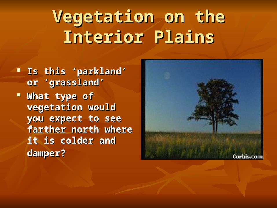
Vegetation on the Interior PlainsVegetation on the Interior Plains
Is this ‘parkland’ or Is this ‘parkland’ or ‘grassland’ ‘grassland’
What type of vegetation What type of vegetation would you expect to see would you expect to see farther north where it is farther north where it is
colder and damper?colder and damper?

The Interior Plains EconomyThe Interior Plains Economy
Agriculture is one of Agriculture is one of the most important the most important activities in the activities in the Interior PlainsInterior Plains
What other major What other major resource activity takes resource activity takes place there?place there?

Transport on the PrairiesTransport on the Prairies
Canada’s wheat basket Canada’s wheat basket requires many requires many kilometers of rail lines kilometers of rail lines to deliver wheat to to deliver wheat to Vancouver, Hudson Vancouver, Hudson Bay and Thunder BayBay and Thunder Bay

Canadian ShieldCanadian Shield

The Canadian ShieldThe Canadian Shield
Largest region in CanadaLargest region in Canada Among the oldest known rocks on the planetAmong the oldest known rocks on the planet Formed by volcanic activity, therefore mostly Formed by volcanic activity, therefore mostly
igneous rockigneous rock Cold winters, warm summers, precipitation all Cold winters, warm summers, precipitation all
year give it a distinctive type of vegetationyear give it a distinctive type of vegetation

CANADIAN SHIELDCANADIAN SHIELD
Stretches from Arctic to Stretches from Arctic to Great Lakes, from Great Lakes, from Mackenzie delta to Mackenzie delta to AtlanticAtlantic
Soils are thin - a poor Soils are thin - a poor choice for agriculture in choice for agriculture in most placesmost places

TYPICAL FEATURES OF THE TYPICAL FEATURES OF THE CANADIAN SHIELDCANADIAN SHIELD What does the What does the
vegetation tell you of vegetation tell you of the location of this part the location of this part of the Shield?of the Shield?
Name two typical Name two typical features of the Shield features of the Shield shown by this pictureshown by this picture

Canadian Shield wildlifeCanadian Shield wildlife

Vegetation Vegetation on the Shieldon the Shield
White patches White patches reveal the reveal the extraction of extraction of resources on the resources on the Shield. Shield.
What resource is What resource is being extracted?being extracted?
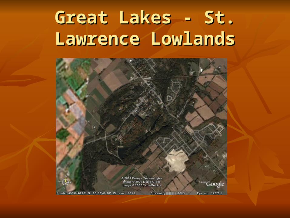
Great Lakes - St. Lawrence Great Lakes - St. Lawrence LowlandsLowlands

Great Lakes St. Lawrence LowlandsGreat Lakes St. Lawrence Lowlands
Most southerly and smallest landform region Most southerly and smallest landform region of Canadaof Canada
Newest landform regionNewest landform region Formed by the action of glaciers scraping Formed by the action of glaciers scraping
away and re-depositing material on the away and re-depositing material on the landscapelandscape
Consists of lakes, valleys and rolling hillsConsists of lakes, valleys and rolling hills

Great Lakes - St. Lawrence Great Lakes - St. Lawrence LowlandsLowlands
Why would landforms of Why would landforms of this region favour large this region favour large scale settlement?scale settlement?
Densely populatedDensely populated Many of Canada’s largest Many of Canada’s largest
citiescities What is meant by the term What is meant by the term
‘high density’?‘high density’?

Gt. Lakes - St. Lawrence Gt. Lakes - St. Lawrence LowlandsLowlands

Southern Ontario FarmingSouthern Ontario Farming
Much of this region is Much of this region is taken up with dairy taken up with dairy farmingfarming
What products are What products are created in dairy created in dairy farming?farming?
Why is dairy farming Why is dairy farming important to this area?important to this area?

Other features of this regionOther features of this region
The image shows a The image shows a popular part of popular part of Southern Ontario.Southern Ontario.
Why is southern Why is southern Ontario a popular Ontario a popular tourist destination?tourist destination?

The AppalachiansThe Appalachians

APPALACHIANSAPPALACHIANS
How would you How would you describe to a friend the describe to a friend the land in this image?land in this image?
This is part of the This is part of the Cabot Trail on Cape Cabot Trail on Cape Breton IslandBreton Island

The MaritimesThe Maritimes
While the Atlantic While the Atlantic provinces have relatively provinces have relatively poor economies, still many poor economies, still many people want to live there. people want to live there.
What features of Atlantic What features of Atlantic life would encourage life would encourage people to live there?people to live there?

Nova ScotiaNova Scotia
The flatter land next The flatter land next to the sea reveals the to the sea reveals the location of the old location of the old shorelineshoreline

New BrunswickNew Brunswick
Compare this Compare this landscape to southern landscape to southern OntarioOntario
What is similar and What is similar and what is different?what is different?

ARCTIC AND HUDSON BAY ARCTIC AND HUDSON BAY LOWLANDSLOWLANDS
Usual to think the Usual to think the Arctic has few if any Arctic has few if any plantsplants
During which two During which two months would you months would you expect to see the most expect to see the most Arctic growth?Arctic growth?
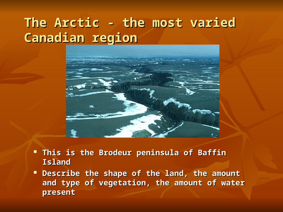
The Arctic - the most varied Canadian The Arctic - the most varied Canadian regionregion
This is the Brodeur peninsula of Baffin IslandThis is the Brodeur peninsula of Baffin Island Describe the shape of the land, the amount and type Describe the shape of the land, the amount and type
of vegetation, the amount of water presentof vegetation, the amount of water present

Brodeur Peninsula - Baffin Brodeur Peninsula - Baffin IslandIsland
These are called These are called HoodoosHoodoos
Do you think these Do you think these were formed by wind, were formed by wind, waves or rivers?waves or rivers?

Baffin Island Greenshield Baffin Island Greenshield GlacierGlacier
Continental glaciers or icefieldsContinental glaciers or icefields

Shark FjordShark Fjord This valley was carved out by a narrow band of This valley was carved out by a narrow band of
glacial ice cutting into the plateau on either glacial ice cutting into the plateau on either sideside

Labrador - Torngat MountainsLabrador - Torngat Mountains

Ayr Lake - Baffin IslandAyr Lake - Baffin Island
Very remote to Very remote to most Canadiansmost Canadians
Some mining Some mining industries are industries are leaving a leaving a permanent mark permanent mark on the landscapeon the landscape

District of MackenzieDistrict of Mackenzie

District of MackenzieDistrict of Mackenzie
What season is this?What season is this? What evidence is What evidence is
there that this area there that this area experiences warm experiences warm summers?summers?
Describe the nature Describe the nature of soil in this regionof soil in this region

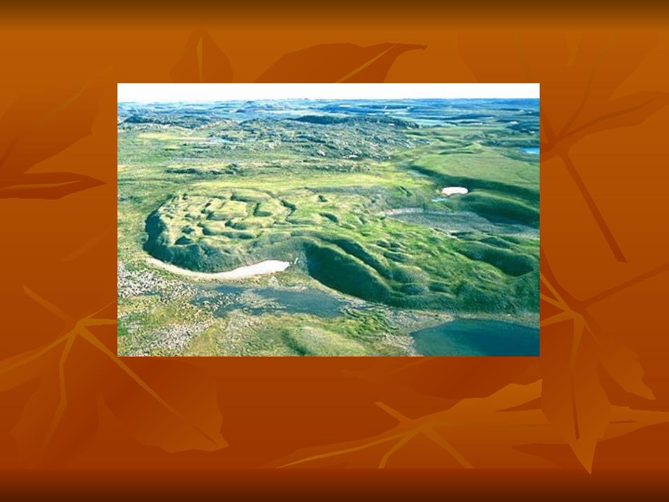
District of MackenzieDistrict of Mackenzie
Why would Why would these features these features be called be called ‘kettles’?‘kettles’?
Where do these Where do these ‘kettles’ drain ‘kettles’ drain out?out?