Embed Size (px)
Citation preview

Electronic Chart Display and Information SystemElectronic Chart Display and Information System
www.furuno.com
FURUNO ELECTRIC CO., LTD.
F r o m 2 0 1 2 o n w a r d s t o 2 0 1 8F r o m 2 0 1 2 o n w a r d s t o 2 0 1 8F r o m 2 0 1 2 o n w a r d s t o 2 0 1 8F r o m 2 0 1 2 o n w a r d s t o 2 0 1 8F r o m 2 0 1 2 o n w a r d s t o 2 0 1 8
P l a n n e d r o u t e
O w n s h i p ’ s i n f o r m a t i o n
A I S i n f o r m a t i o n
ECDISHAND BOOK
Electronic Chart Display and Information System
11113SK Printed in JapanCatalogue No. M-1557

Newly built passenger ships
Newly built tankers
Newly built cargo vessels
Newly built cargo vessels
Existing passenger ships
Existing tankers
Existing cargo vessels
Existing cargo vessels
Existing cargo vessels
2011. 07 2012. 07 2013. 07 2014. 07 2015. 07 2016. 07 2017. 07 2018. 07
> 500 GT
> 3,000 GT
> 10,000 GT
> 3,000 GT
> 500 GT
> 3,000 GT
> 50,000 GT
> 20,000 GT
> 10,000 GT
Transitioning period ECDIS carriage mandatory
Electronic Chart Display and Information System
ECDISHAND BOOK
Electronic Chart Display and Information System
The implementation of ECDIS installation onboard
vessels will need to be type-approved and they have to
issue a certi�cate of compliance which is used by the
classi�cation society, the port state control and vetting
administration to ensure that the vessel is in full
compliance with the requirement to carry type
approved ECDIS with suitable back-up facilities. In
some cases you can expect that port state control or
vetting administration will verify if the crew is properly
trained and has a suf�cient understanding of the
operation of ECDIS.
List of Contents
Implementation schedule for mandatory carriage ECDIS
At the NAV-54 work group assembly in 2008, IMO has decided to make ECDIS mandatory for all IMO vessels > 3,000 GT(passenger vessels > 500 GT) with a transitioning period as shown below. The new carriage requirement is for one ECDIS with suitable back up arranagements, which can be ful�lled either by a type-approved backup ECDIS or of�cial, up-to-date paper charts.
Introduction
General overview of the FURUNO ECDIS
System con�gurations
Chart management
Advantage of FURUNO ECDIS
Future expandability with FMD-3200/FMD-3300
02
03-04
05-08
09-10
11-14
15-16Approval from the Authorities on complianceof mandatory carriage of ECDIS
Introduction
How to get ready for the ECDIS carriage requirement?
The �rst step is to determine the effect on your �eet, when your vessels have to be ready to comply with the new carriage requirement. From 2012 onwards to 2018 all IMO vessels over 10,000 GT on top of other vessel types speci�ed in the table below are requested to install and operate ECDIS. Please refer to the below overview to �nd the implementation schedule for your vessels. Vessels may be exempt from this obligatory carriage of ECDIS if they are taken out of operation in less than two years after the implementation date.
02

Control UnitRCU-018
Route monitoring Route planning
Route monitoring Route planning
Trackball Control UnitRCU-015
Display UnitMU-190/231
Control UnitRCU-024
Trackball Control UnitRCU-026
Display UnitMU-190/231
Features of FURUNO ECDISCompatible with IMO MSC.232(82), IMO A.694(17), IEC 61174 Ed. 3, IEC 61162-1. Ed. 4, IEC 61162-2. Ed.1, IEC 62288 Ed. 1
Navigation data overlay, including ship's position, heading, speed and others to facilitate safe and ef�cient navigation
Radar and AIS overlay Radar TT as well as AIS targets can be displayed for enhanced situation awareness
Route planning applicable both to Mercator's sailing and great-circle sailing
19"/23.1" high resolution SXGA/UXGA color LCD
True Motion and Relative Motion orientations available
FEA-2107 (19”LCD) FEA-2807 (23.1”LCD)
Compatible cartography · IHO/S-57 Edition 3 vector chart (IHO S-63 ENC data protection scheme) · ARCS raster chart · C-MAP ENCNetwork expandability with radar, autopilot and other navigation sensors Up to four radar systems and ECDIS can be networked via 100 Base-TX Ethernet, and navigation sensors and autopilot can be incorporated through LAN adaptors using serial communication.Ergonomically designed control panel provides ease-of-use
FMD-3200 (19”LCD) FMD-3300 (23.1”LCD)
Compatible Cartography · IHO/S-57 Edition 3 vector chart (IHO S-63 ENC data protection scheme) · ARCS raster chart · C-MAP ENC
Multifunction display capability available, featuring ECDIS, conning information display, radar* and alert management system (AMS)** * Radar sensor is to be required.
** Radar and AMS display capability is to be implemented as software update.
FURUNO’s new user interface delivers straightforward operation, very much like PC-based operation schemeInstantaneous chart redraw delivered by FURUNO’s advanced chart-drawing algorithmSimpli�ed cabling in sensor-to-ECDIS interface thanks to Sensor AdaptorInterface with Jeppesen Dynamic Licensing service
FURUNO ECDIS solutions
Electronic Chart Display and Information System
General overview of the FURUNO ECDIS
Besides that ECDIS will become a mandatory system onboard vessels, the implementation and use of ECDIS provides a wide range of advantages. It makes the voyage planning easier by allowing optimization according to time, speed and other parameters, and any modi�cation is accomplished by a simple drag and drop action or by a click and inserting a modi�ed value. It gives a reason for better safety in the voyage planning by taking the ship’s draft into consideration when planning the route and combine this with dangerous areas or areas of special attention. Part of the planning job is the chart management, and this is made easier by using of�cial electronic navigation charts (ENC) or ARCS. Updating charts can be done either from a CD-ROM/DVD received from the chart vendor or via satellite using an intermediate PC onboard or through a direct connection to the ECDIS through Service Gateway. If additional charts are required they can be bought via e-mail or from the internet, while onboard. This all saves time and resources on the bridge, which can be used for other important tasks.
When performing the voyage the navigator can be advised by the ECDIS if he is in his planned track and if he is approaching shallow water and dangerous areas. The ECDIS monitors the data received from the many navigation data sensors connected to the ECDIS and the ECDIS validates the data and emits a warning signal or alarm in case ECDIS detects that navigation data are corrupted. In addition, the ECDIS can be preprogrammed to indicate to the navigator on watch if the vessel has reached a position or area which require special attention by the navigator or planned actions.
The ECDIS logs the navigation data and chart usage during the voyage and this data is available for reporting after the voyage is �nished.
Why choose ECDIS?
FURUNO ECDIS FEA-2107/2807
FURUNO ECDIS FMD-3200/3300
FEA-2107/2807 FMD-3200/3300
NEW
Available from spring 2012
03 04

RCU-015
Display UnitMU-201CE/231CE
Display UnitMU-201CE/231CE
Control Unit
Processor UnitEC-1000C
AutopilotAlarm SystemRoute BackupAnemometer Gyrocompass Water Temp Indicatoretc.
Conning Monitor
Video Switch
RCU-018or
LAN AdapterEC-1010
*Up to two LAN adapters connectable
With 8 ports
RCU-015
Control Unit
Processor UnitEC-1000C
RCU-018or
AIS FA-150
GPS Navigator GP-150
Gyrocompass (Synchro)
Log (200 p/nm)
Alarms
Analog SensorsLAN Adapter
EC-1010
*Up to two LAN adapters connectable
With 8 ports
No. 1 ECDIS Model FEA-2107/FEA-2807
Back-up ECDIS Model FEA-2107/FEA-2807
IMO Radar
FAR-21x7 seriesFAR-28x7 series
IMO Radar
FAR-21x7 seriesFAR-28x7 series
Echo Sounder FE-700
Doppler Speed Log DS-60
HUBHUB-100
B AdapterEC-1020
B AdapterEC-1020
HUBHUB-100
RCU-015
MU-201CE/231CE
Display UnitControl Unit
Processor UnitEC-1000C
HUBHUB-100
Conning Monitor
IMO Radar*
RCU-018or
FAR-21x7 seriesFAR-28x7 series
*Up to four systems can be connected
ECDIS Model FEA-2107/FEA-2807
AutopilotAlarm SystemRoute BackupAnemometer Gyrocompass Water Temp Indicatoretc.
AIS FA-150
GPS Navigator GP-150
Echo Sounder FE-700
Doppler Speed Log DS-60
Gyrocompass (Synchro)
Log (200 p/nm)
Alarms
Analog Sensors
B AdapterEC-1020
LAN AdapterEC-1010
*Up to two LAN adapters connectable
With 8 ports
ECDIS Model FMD3200/FMD-3300
Minimum con�guration
Optional/Connectable equipmentMinimum con�guration
Optional/Connectable equipment
Conning Monitor
ECDIS Control Unit
IMO Radar
ModelsFCR-21x9 seriesFCR-28x9 series
RCU-024or
Display UnitMU-190/MU-231
Processor UnitEC-3000
RCU-026
Intelligent HUBHUB-3000
AutopilotAlarm SystemRoute BackupAnemometer Gyrocompass Water Temp IndicatorLog (200 p/NM)Rudder Indicatoretc.
AIS FA-150
GPS Navigator GP-150
Echo Sounder FE-700
Doppler Speed Log DS-60
Switching HUBHUB-100
Sensor AdaptorMC-3000S/3010A/
3020D/3030D
No. 1 ECDIS Model FMD3200/FMD-3300
Conning Monitor
ECDIS Control Unit
IMO Radar
ModelsFCR-21x9 seriesFCR-28x9 series
IMO Radar
ModelsFCR-21x9 seriesFCR-28x9 series
RCU-024or
Display UnitMU-190/MU-231
Processor UnitEC-3000
RCU-026
No. 2 ECDIS Model FMD3200/FMD-3300
ECDIS Control Unit
RCU-024or
Display UnitMU-190/MU-231
Processor UnitEC-3000
RCU-026
AutopilotAlarm SystemRoute BackupAnemometer Gyrocompass Water Temp IndicatorLog (200 p/NM)Rudder Indicatoretc.
AIS FA-150
GPS Navigator GP-150
Echo Sounder FE-700
Doppler Speed Log DS-60
General Preparation for Mandatory ECDIS
Note 1: Separate power supply should be arranged for all the ECDIS within the system.Note 2: Up to ten units of ECDIS, radar, conning and Alert Management System can be networked in a system.
Up to date paper chart covering the area of operation required For paperless operation
As part of the preparation you will also have to consider the back-up arrangement for ECDIS if you want to have your �eet operate without paper charts. Another possibility is to upgrade your bridge system to include additional functions such as TCS made possible by ECDIS. The installation and operation of ECDIS has to be approved by the �ag register.
The back-up arrangement can be either up-to-date paper chart folio covering the area of operation or an additional ECDIS. When using a back-up ECDIS, it is required to be mounted in the main bridge. By using single or dual ECDIS solution, you can bene t from the easy chart management and update as well as the increased safety provided by the ECDIS. Below system diagrams show the two solutions which have been described.
Electronic Chart Display and Information System
System con�gurations
Diagram for Standalone ECDIS Con�guration Diagram for Dual ECDIS Con�guration
Note:Separate power supply should be arranged for all the ECDIS whithin the system.
Switching HUBHUB-100
Sensor AdaptorMC-3000S/3010A/
3020D/3030D
Sensor AdaptorMC-3000S/3010A/
3020D/3030D
Intelligent HUBHUB-3000
05 06

RCU-015
Display UnitMU-201CE/231CE
Display UnitMU-201CE/231CE
Control Unit
Processor UnitEC-1000C
AutopilotAlarm SystemRoute BackupAnemometer Gyrocompass Water Temp Indicatoretc.
Conning Monitor
Video Switch
RCU-018or
LAN AdapterEC-1010
*Up to two LAN adapters connectable
With 8 ports
RCU-015
Control Unit
Processor UnitEC-1000C
RCU-018or
AIS FA-150
GPS Navigator GP-150
Gyrocompass (Synchro)
Log (200 p/nm)
Alarms
Analog SensorsLAN Adapter
EC-1010
*Up to two LAN adapters connectable
With 8 ports
No. 1 ECDIS Model FEA-2107/FEA-2807
Back-up ECDIS Model FEA-2107/FEA-2807
IMO Radar
FAR-21x7 seriesFAR-28x7 series
IMO Radar
FAR-21x7 seriesFAR-28x7 series
Echo Sounder FE-700
Doppler Speed Log DS-60
HUBHUB-100
B AdapterEC-1020
B AdapterEC-1020
HUBHUB-100
RCU-015
MU-201CE/231CE
Display UnitControl Unit
Processor UnitEC-1000C
HUBHUB-100
Conning Monitor
IMO Radar*
RCU-018or
FAR-21x7 seriesFAR-28x7 series
*Up to four systems can be connected
ECDIS Model FEA-2107/FEA-2807
AutopilotAlarm SystemRoute BackupAnemometer Gyrocompass Water Temp Indicatoretc.
AIS FA-150
GPS Navigator GP-150
Echo Sounder FE-700
Doppler Speed Log DS-60
Gyrocompass (Synchro)
Log (200 p/nm)
Alarms
Analog Sensors
B AdapterEC-1020
LAN AdapterEC-1010
*Up to two LAN adapters connectable
With 8 ports
ECDIS Model FMD3200/FMD-3300
Minimum con�guration
Optional/Connectable equipmentMinimum con�guration
Optional/Connectable equipment
Conning Monitor
ECDIS Control Unit
IMO Radar
ModelsFCR-21x9 seriesFCR-28x9 series
RCU-024or
Display UnitMU-190/MU-231
Processor UnitEC-3000
RCU-026
Intelligent HUBHUB-3000
AutopilotAlarm SystemRoute BackupAnemometer Gyrocompass Water Temp IndicatorLog (200 p/NM)Rudder Indicatoretc.
AIS FA-150
GPS Navigator GP-150
Echo Sounder FE-700
Doppler Speed Log DS-60
Switching HUBHUB-100
Sensor AdaptorMC-3000S/3010A/
3020D/3030D
No. 1 ECDIS Model FMD3200/FMD-3300
Conning Monitor
ECDIS Control Unit
IMO Radar
ModelsFCR-21x9 seriesFCR-28x9 series
IMO Radar
ModelsFCR-21x9 seriesFCR-28x9 series
RCU-024or
Display UnitMU-190/MU-231
Processor UnitEC-3000
RCU-026
No. 2 ECDIS Model FMD3200/FMD-3300
ECDIS Control Unit
RCU-024or
Display UnitMU-190/MU-231
Processor UnitEC-3000
RCU-026
AutopilotAlarm SystemRoute BackupAnemometer Gyrocompass Water Temp IndicatorLog (200 p/NM)Rudder Indicatoretc.
AIS FA-150
GPS Navigator GP-150
Echo Sounder FE-700
Doppler Speed Log DS-60
General Preparation for Mandatory ECDIS
Note 1: Separate power supply should be arranged for all the ECDIS within the system.Note 2: Up to ten units of ECDIS, radar, conning and Alert Management System can be networked in a system.
Up to date paper chart covering the area of operation required For paperless operation
As part of the preparation you will also have to consider the back-up arrangement for ECDIS if you want to have your �eet operate without paper charts. Another possibility is to upgrade your bridge system to include additional functions such as TCS made possible by ECDIS. The installation and operation of ECDIS has to be approved by the �ag register.
The back-up arrangement can be either up-to-date paper chart folio covering the area of operation or an additional ECDIS. When using a back-up ECDIS, it is required to be mounted in the main bridge. By using single or dual ECDIS solution, you can bene t from the easy chart management and update as well as the increased safety provided by the ECDIS. Below system diagrams show the two solutions which have been described.
Electronic Chart Display and Information System
System con�gurations
Diagram for Standalone ECDIS Con�guration Diagram for Dual ECDIS Con�guration
Note:Separate power supply should be arranged for all the ECDIS whithin the system.
Switching HUBHUB-100
Sensor AdaptorMC-3000S/3010A/
3020D/3030D
Sensor AdaptorMC-3000S/3010A/
3020D/3030D
Intelligent HUBHUB-3000
05 06
Voyage planning can be performed using the back-up ECDIS as long as it does not affect or disrupt the navigation performed by the Of�cer of the Watch (OOW). Alternatively, ECDIS for voyage planning can be installed at the voyage planning work station, which allows for voyage planning without disturbing the navigation performed by the OOW. Please note, however, that the back-up arrangement has to be approved by the �ag register.
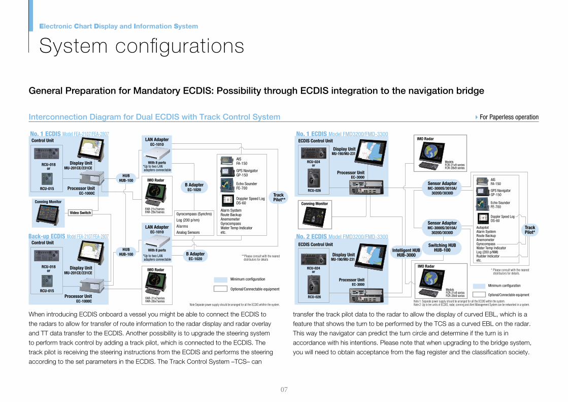
When introducing ECDIS onboard a vessel you might be able to connect the ECDIS to the radars to allow for transfer of route information to the radar display and radar overlay and TT data transfer to the ECDIS. Another possibility is to upgrade the steering system to perform track control by adding a track pilot, which is connected to the ECDIS. The track pilot is receiving the steering instructions from the ECDIS and performs the steering according to the set parameters in the ECDIS. The Track Control System –TCS– can
transfer the track pilot data to the radar to allow the display of curved EBL, which is a feature that shows the turn to be performed by the TCS as a curved EBL on the radar. This way the navigator can predict the turn circle and determine if the turn is in accordance with his intentions. Please note that when upgrading to the bridge system, you will need to obtain acceptance from the �ag register and the classi�cation society.
Electronic Chart Display and Information System
System con�gurations
Interconnection Diagram for Dual ECDIS with Track Control System Interconnection Diagram for Single ECDIS with Route Planning ECDIS
General Preparation for Mandatory ECDIS: Possibility through ECDIS integration to the navigation bridge General Preparation for Mandatory ECDIS: Extended system suggestions using ECDIS
Minimum con�guration
Optional/Connectable equipment
Note:Separate power supply should be arranged for all the ECDIS whithin the system.Note:Separate power supply should be arranged for all the ECDIS whithin the system.
For Paperless operationUp to date paper chart covering the area of operation required For Paperless operation
RCU-015
Display UnitMU-201CE/231CE
Display UnitMU-201CE/231CE
Control Unit
Processor UnitEC-1000C
Alarm SystemRoute BackupAnemometer Gyrocompass Water Temp Indicatoretc.
Conning Monitor
Video Switch
RCU-018or
LAN AdapterEC-1010
*Up to two LAN adapters connectable
With 8 ports
RCU-015
Control Unit
Processor UnitEC-1000C
RCU-018or
AIS FA-150
GPS Navigator GP-150
Gyrocompass (Synchro)
Log (200 p/nm)
Alarms
Analog SensorsLAN Adapter
EC-1010
*Up to two LAN adapters connectable
With 8 ports
No. 1 ECDIS Model FEA-2107/FEA-2807
Back-up ECDIS Model FEA-2107/FEA-2807
IMO Radar
FAR-21x7 seriesFAR-28x7 series
IMO Radar
FAR-21x7 seriesFAR-28x7 series
Echo Sounder FE-700
Doppler Speed Log DS-60
HUBHUB-100
B AdapterEC-1020
B AdapterEC-1020
HUBHUB-100
Track Pilot**
**Please consult with the nearest distributors for details
RCU-015
Display UnitMU-201CE/231CE
Display UnitMU-201CE/231CE
Control Unit
Processor UnitEC-1000C
AutopilotAlarm SystemRoute BackupAnemometer Water Temp IndicatorGyrocompass
RCU-018or
LAN AdapterEC-1010
*Up to two LAN adapters connectable
With 8 ports
RCU-015
Control Unit
Processor UnitEC-1000C
RCU-018or
AIS FA-150
GPS Navigator GP-150
Gyrocompass (Synchro)
Log (200 p/nm)
Alarms
Analog SensorsLAN AdapterEC-1010
*Up to two LAN adapters connectable
With 8 ports
No. 1 ECDIS Model FEA-2107/FEA-2807
Route Planning ECDIS Model FEA-2107/FEA-2807
IMO Radar*
FAR-21x7 seriesFAR-28x7 series
Echo Sounder FE-700
Doppler Speed Log DS-60
HUBHUB-100
B AdapterEC-1020
HUBHUB-100
Conning Monitor
*Up to four systems can be connected
Note 1: Separate power supply should be arranged for all the ECDIS within the system.Note 2: Up to ten units of ECDIS, radar, conning and Alert Management System can be networked in a system.
* Please consult with the nearest distributors for details.
Minimum con�guration
Optional/Connectable equipment
No. 1 ECDIS Model FMD3200/FMD-3300
Conning Monitor
ECDIS Control Unit
IMO Radar
ModelsFCR-21x9 seriesFCR-28x9 series
IMO Radar
ModelsFCR-21x9 seriesFCR-28x9 series
RCU-024or
Display UnitMU-190/MU-231
Processor UnitEC-3000
RCU-026
No. 2 ECDIS Model FMD3200/FMD-3300ECDIS Control Unit
RCU-024or
Display UnitMU-190/MU-231
Processor UnitEC-3000
RCU-026
AutopilotAlarm SystemRoute BackupAnemometer Gyrocompass Water Temp IndicatorLog (200 p/NM)Rudder Indicatoretc.
AIS FA-150
GPS Navigator GP-150
Echo Sounder FE-700
Doppler Speed Log DS-60
Switching HUBHUB-100
Sensor AdaptorMC-3000S/3010A/
3020D/3030D
Sensor AdaptorMC-3000S/3010A/
3020D/3030D
Track Pilot*
Note 1: Separate power supply should be arranged for all the ECDIS within the system.Note 2: Up to ten units of ECDIS, radar, conning and Alert Management System can be networked in a system.
Minimum con�guration
Optional/Connectable equipment
No. 1 ECDIS Model FMD3200/FMD-3300
Conning Monitor
ECDIS Control Unit
IMO Radar
ModelsFCR-21x9 seriesFCR-28x9 series
IMO Radar
ModelsFCR-21x9 seriesFCR-28x9 series
RCU-024or
Display UnitMU-190/MU-231
Processor UnitEC-3000
RCU-026
Route Planning ECDIS Model FMD3200/FMD-3300ECDIS Control Unit
RCU-024or
Display UnitMU-190/MU-231
Processor UnitEC-3000
RCU-026
No. 2 ECDIS Model FMD3200/FMD-3300ECDIS Control Unit
RCU-024or
Display UnitMU-190/MU-231
Processor UnitEC-3000
RCU-026
AutopilotAlarm SystemRoute BackupAnemometer Gyrocompass Water Temp IndicatorLog (200 p/NM)Rudder Indicatoretc.
AIS FA-150
GPS Navigator GP-150
Echo Sounder FE-700
Doppler Speed Log DS-60
Sensor AdaptorMC-3000S/3010A/
3020D/3030D
Sensor AdaptorMC-3000S/3010A/
3020D/3030D
etc.Intelligent HUBHUB-3000
Switching HUBHUB-100
Intelligent HUBHUB-3000
07 08

Voyage planning can be performed using the back-up ECDIS as long as it does not affect or disrupt the navigation performed by the Of�cer of the Watch (OOW). Alternatively, ECDIS for voyage planning can be installed at the voyage planning work station, which allows for voyage planning without disturbing the navigation performed by the OOW. Please note, however, that the back-up arrangement has to be approved by the �ag register.
When introducing ECDIS onboard a vessel you might be able to connect the ECDIS to the radars to allow for transfer of route information to the radar display and radar overlay and TT data transfer to the ECDIS. Another possibility is to upgrade the steering system to perform track control by adding a track pilot, which is connected to the ECDIS. The track pilot is receiving the steering instructions from the ECDIS and performs the steering according to the set parameters in the ECDIS. The Track Control System –TCS– can
transfer the track pilot data to the radar to allow the display of curved EBL, which is a feature that shows the turn to be performed by the TCS as a curved EBL on the radar. This way the navigator can predict the turn circle and determine if the turn is in accordance with his intentions. Please note that when upgrading to the bridge system, you will need to obtain acceptance from the �ag register and the classi�cation society.
Electronic Chart Display and Information System
System con�gurations
Interconnection Diagram for Dual ECDIS with Track Control System Interconnection Diagram for Single ECDIS with Route Planning ECDIS
General Preparation for Mandatory ECDIS: Possibility through ECDIS integration to the navigation bridge General Preparation for Mandatory ECDIS: Extended system suggestions using ECDIS
Minimum con�guration
Optional/Connectable equipment
Note:Separate power supply should be arranged for all the ECDIS whithin the system.Note:Separate power supply should be arranged for all the ECDIS whithin the system.
For Paperless operationUp to date paper chart covering the area of operation required For Paperless operation
RCU-015
Display UnitMU-201CE/231CE
Display UnitMU-201CE/231CE
Control Unit
Processor UnitEC-1000C
Alarm SystemRoute BackupAnemometer Gyrocompass Water Temp Indicatoretc.
Conning Monitor
Video Switch
RCU-018or
LAN AdapterEC-1010
*Up to two LAN adapters connectable
With 8 ports
RCU-015
Control Unit
Processor UnitEC-1000C
RCU-018or
AIS FA-150
GPS Navigator GP-150
Gyrocompass (Synchro)
Log (200 p/nm)
Alarms
Analog SensorsLAN Adapter
EC-1010
*Up to two LAN adapters connectable
With 8 ports
No. 1 ECDIS Model FEA-2107/FEA-2807
Back-up ECDIS Model FEA-2107/FEA-2807
IMO Radar
FAR-21x7 seriesFAR-28x7 series
IMO Radar
FAR-21x7 seriesFAR-28x7 series
Echo Sounder FE-700
Doppler Speed Log DS-60
HUBHUB-100
B AdapterEC-1020
B AdapterEC-1020
HUBHUB-100
Track Pilot**
**Please consult with the nearest distributors for details
RCU-015
Display UnitMU-201CE/231CE
Display UnitMU-201CE/231CE
Control Unit
Processor UnitEC-1000C
AutopilotAlarm SystemRoute BackupAnemometer Water Temp IndicatorGyrocompass
RCU-018or
LAN AdapterEC-1010
*Up to two LAN adapters connectable
With 8 ports
RCU-015
Control Unit
Processor UnitEC-1000C
RCU-018or
AIS FA-150
GPS Navigator GP-150
Gyrocompass (Synchro)
Log (200 p/nm)
Alarms
Analog SensorsLAN AdapterEC-1010
*Up to two LAN adapters connectable
With 8 ports
No. 1 ECDIS Model FEA-2107/FEA-2807
Route Planning ECDIS Model FEA-2107/FEA-2807
IMO Radar*
FAR-21x7 seriesFAR-28x7 series
Echo Sounder FE-700
Doppler Speed Log DS-60
HUBHUB-100
B AdapterEC-1020
HUBHUB-100
Conning Monitor
*Up to four systems can be connected
Note 1: Separate power supply should be arranged for all the ECDIS within the system.Note 2: Up to ten units of ECDIS, radar, conning and Alert Management System can be networked in a system.
* Please consult with the nearest distributors for details.
Minimum con�guration
Optional/Connectable equipment
No. 1 ECDIS Model FMD3200/FMD-3300
Conning Monitor
ECDIS Control Unit
IMO Radar
ModelsFCR-21x9 seriesFCR-28x9 series
IMO Radar
ModelsFCR-21x9 seriesFCR-28x9 series
RCU-024or
Display UnitMU-190/MU-231
Processor UnitEC-3000
RCU-026
No. 2 ECDIS Model FMD3200/FMD-3300ECDIS Control Unit
RCU-024or
Display UnitMU-190/MU-231
Processor UnitEC-3000
RCU-026
AutopilotAlarm SystemRoute BackupAnemometer Gyrocompass Water Temp IndicatorLog (200 p/NM)Rudder Indicatoretc.
AIS FA-150
GPS Navigator GP-150
Echo Sounder FE-700
Doppler Speed Log DS-60
Switching HUBHUB-100
Sensor AdaptorMC-3000S/3010A/
3020D/3030D
Sensor AdaptorMC-3000S/3010A/
3020D/3030D
Track Pilot*
Note 1: Separate power supply should be arranged for all the ECDIS within the system.Note 2: Up to ten units of ECDIS, radar, conning and Alert Management System can be networked in a system.
Minimum con�guration
Optional/Connectable equipment
No. 1 ECDIS Model FMD3200/FMD-3300
Conning Monitor
ECDIS Control Unit
IMO Radar
ModelsFCR-21x9 seriesFCR-28x9 series
IMO Radar
ModelsFCR-21x9 seriesFCR-28x9 series
RCU-024or
Display UnitMU-190/MU-231
Processor UnitEC-3000
RCU-026
Route Planning ECDIS Model FMD3200/FMD-3300ECDIS Control Unit
RCU-024or
Display UnitMU-190/MU-231
Processor UnitEC-3000
RCU-026
No. 2 ECDIS Model FMD3200/FMD-3300ECDIS Control Unit
RCU-024or
Display UnitMU-190/MU-231
Processor UnitEC-3000
RCU-026
AutopilotAlarm SystemRoute BackupAnemometer Gyrocompass Water Temp IndicatorLog (200 p/NM)Rudder Indicatoretc.
AIS FA-150
GPS Navigator GP-150
Echo Sounder FE-700
Doppler Speed Log DS-60
Sensor AdaptorMC-3000S/3010A/
3020D/3030D
Sensor AdaptorMC-3000S/3010A/
3020D/3030D
etc.Intelligent HUBHUB-3000
Switching HUBHUB-100
Intelligent HUBHUB-3000
07 08

FMD-3200/3300FEA-2107/2807
Electronic Navigational Chart Raster Navigational Chart Electronic Navigational Chart Raster Navigational Chart
ECDIS can operate a variety of charts. The ofcial charts are known as Electronic Navigational Charts (ENC) and Admiralty Raster Chart Service (ARCS) . The charts are made and distributed by the hydrographic ofces through a distribution network and the vessel has to subscribe to the chart service. ENC are vector charts, which are provided in the S-57 format. ARCS charts are raster charts and can be considered as being a scanned paper chart.
All �ag registers accept ENC charts, which is not the case with ARCS charts. You, therefore, have to check with your �ag register on what charts they accept. Many ECDIS can, in addition to the ofcial chart materials, operate private charts, which do not comply with the carriage requirement set out by IMO. The private charts are often provided in the ofcial S-57 format. Please consult your �ag register and your chart supplier when you select your electronic charts.
Electronic Chart Display and Information System
Chart management
ECDIS Chart Management Scheme Glossary for Electronic Charts to be used with ECDIS
ENC
RNC
SENC
S-57
S-52
S-63
CM-93Edition 3
Electronic Navigational Chart: Ofcial vector chart containing a database of individual geo-referenced objects taken from Hydrographic Ofces' documentations and record, inclusive of paper charts. It is issued for use with ECDIS on the authority of national hydrographic ofces.
Raster Navigational Chart: Digital copies of paper charts complying with IHO S-61 Product Specications for Raster Navigational Chart, authorised by national hydrographic ofces. Some �ag states allow RNC to be used for back-up purposes in the areas not covered by ENC.
System Electronic Navigational Chart: ENC dataset converted into the system language of the ECDIS, which facilitates rapid chart drawing of the ENC data on the ECDIS.
ENC Chart data format dened by IHO Transfer Standard for Digital Hydrographic Data
IHO dened symbols and colors for chart presentation
IHO Data protection (encryption) scheme for ENC against unautorised amendment or illegal copying
Distribution format for C-MAP electronic charts intended to be used in ECDIS and similar systems.
09 10

Training is required to ensure an ef�cient and safe operation of ECDIS. Implementing ECDIS onboard a vessel is an investment and it is in the interest of the ship owner to bene�t from the advantages provided by ECDIS. This includes less time spent on chart management and voyage planning and the increased safety obtained through the proper setup and operation of the ECDIS, which can remarkably reduce the risk of groundings, etc. This can be accomplished through proper training programs. Training comes in many forms and the crew should undergo both generic training to get the full understanding of the ECDIS as a concept, the rules governing ECDIS and the in�uences on the bridge operation as well as the type speci�c ECDIS training, which helps the operator familiarize themselves with the speci�c ECDIS onboard the vessel.
FURUNO provides both of the aforementioned ECDIS operation training programs with relevant certi�cations at our
training facility FURUNO INS Training Center (INSTC) in Copenhagen. Also, at recently-established INSTC Singapore, local seafarers residing in Asia can receive the 2-day type speci�c ECDIS training course. INSTC offers a wide range of training courses, which can be combined with the ECDIS training.
INSTC Denmark can offer the following training courses with certi�cation in accordance with the relevant IMO model courses:
ECDIS IMO model course 1.27, certi�ed by DNV SeaSkills
INS/IBS IMO model course 1.32, certi�ed by DNV SeaSkills
In addition, INSTC can provide training aimed at the shore staff in relation to ECDIS rules and regulations and technical solutions, which can be of assistance to the purchasers or superintendants in their daily works.
STCW requires that all masters and of�cers in charge of a navigational watch (Of�cer of the Watch: OOW) on a ship �tted with ECDIS shall have completed a generic ECDIS course and hold an ECDIS certi�cate in accordance with IMO model course 1.27.
This ECDIS training provides the trainees with knowledge of the ECDIS as a system, the ECDIS operation, electronic chart materials and practical navigation by using ECDIS. Also, the course includes terms and conditions for implementing paperless navigation. The training course focuses upon many advantages and safety features obtained by operating ECDIS. Also, the limitations of ECDIS are taught throughout this training course.
This training is concluded with 3 compulsory tests, and, if passed, a certi�cate is issued, which con�rms the trainees'
successful completion of the generic ECDIS training in accordance with IMO Model Course 1.27, reviewed by DNV SeaSkills™.
This training course provides the navigators with the knowledge and tools to safely shift from traditional paper chart navigation to electronic chart navigation by use of ECDIS.
This training course complies with the IMO STCW code.
The FURUNO type speci�c ECDIS training provides the trainees with the speci�c knowledge about functionality and effective use of FURUNO ECDIS for navigation onboard.
The training covers the following aspects of FURUNO ECDIS operation:
Familiarisation with available functionsfamiliarisation with the menu structureDisplay setupSetting of the safety valueRecognition of alarm and malfunction indicators and
the actions to be taken
Route planningRoute monitoring Changing over to backup systemsLoading and updating of charts and licencesUpdating software
The training is concluded with a compulsory test. Upon successful completion of the test, the navigators is issued a certi�cate that con�rms the successful completion of the FURUNO type speci�c ECDIS training course.
This training complies with the STCW and ISM Codes, audited and certi�ed by ClassNK.
FURUNO's provision of thoroughgoing ECDIS Training ECDIS Training courses provided by FURUNO INSTC
IMO ECDIS Model Course 1.27 (generic ECDIS training): available at INSTC Denmark Type speci�c ECDIS training course: available both at INSTC Denmark and INSTC Singapore.
Electronic Chart Display and Information System
Advantage of FURUNO ECDIS
11 12

FURUNO can accommodate easy and inexpensive satellite services to your �eet through the SafeComNet satellite service using VSAT and FleetBroadband solutions. FURUNO has our own VSAT and FBB hardware terminals, and, through our broadband service centers located in Copenhagen, Denmark, and Nishinomiya, Japan, FURUNO can assist you with suitable all-inclusive satellite communication solution package, including airtime, hardware and service provision according to the requirement on your vessels. By integrating a cost ef�cient satellite service and a suitable chart subscription Scheme onboard your vessels, you can get easy access to chart purchases and chart updates for your ECDIS.
FURUNO's satellite broadband solution, SafeComNet
Electronic Chart Display and Information System
Advantage of FURUNO ECDIS
Quality and reliability of the products is a vital issue when selecting navigation equipment to be installed onboard your vessels, for the navigation equipment needs to be in proper working conditions throughout lengthy ocean-crossings, and it is undeniably true that equipment failure in the midst of those voyages has negative impact upon safety and ef�ciency at sea. It is often the case that equipment failure stems from two causes: defect in equipment itself and improper equipment installation and setup. FURUNO tackles this issue with a two-tiered approach: thorough product testing before the equipment is installed and thoroughgoing inspection prior to ship’s delivery on whether or not equipment is properly installed.
FURUNO's solid product Quality Assurance Scheme FURUNO's after-sales service and support provision Scheme
Ku-bandSatellites
Internet
Emailing
Video-streaming
Voice communication
InmarsatSatellites
FURUNO European Service Center FURUNO U.S.A.FURUNO
Service Center
Russian Far East and Northeast Asia(South Korea, China, Taiwan, Philippines, Hong Kong)
North America
Central America and South America
Europe
Middle East and Africa
Southeast Asia, West Asia,Oceania
FURUNO Singapore Service Center
Australia
Germany
South Korea
Spain
Japan
U.S.A.
Singapore
UAE Taiwan
South Africa
Hong Kong
Spare parts distribution network
Service centers
Spare parts depots
Service availability in your area of operation is vital to comply with this new carriage requirement, because you are requested to have an operational ECDIS onboard the vessel at all times. When deciding your ECDIS solution, you may consider your area of operation and the service scheme offered by your ECDIS provider in your area of operation. It is important to make sure that you have easy access to skilled service technicians and spare parts at all times. FURUNO provides easy access to skilled service technicians and spare parts through our global service network and continental service centers, which have a huge variety of spare parts in stock for fast delivery to any location around the world. The service technicians receive education through the comprehensive
technical training programs offered by FURUNO. This way the technicians are kept up to date with their technical knowledge. The coordination of services worldwide is made more ef�cient through FURUO's Service Management System (SMS), which is a database and coordination platform that allow for easy transfer of service jobs between the service stations and acquisition of vessel speci�c data covering equipment installation, technical documentation, software versions and service history, which provides the service technician with valuable information for planning the service call to your vessel.
13 14
ServiceRequest
Monitoring
Service Agent
Service Agent
Customers
Ships in operation
▲
Regular log data from the onboard system
▲
Report on alarm/malfunctioning equipment
▲
Remote monitoring environment to be constructed at the FURUNO Service Center
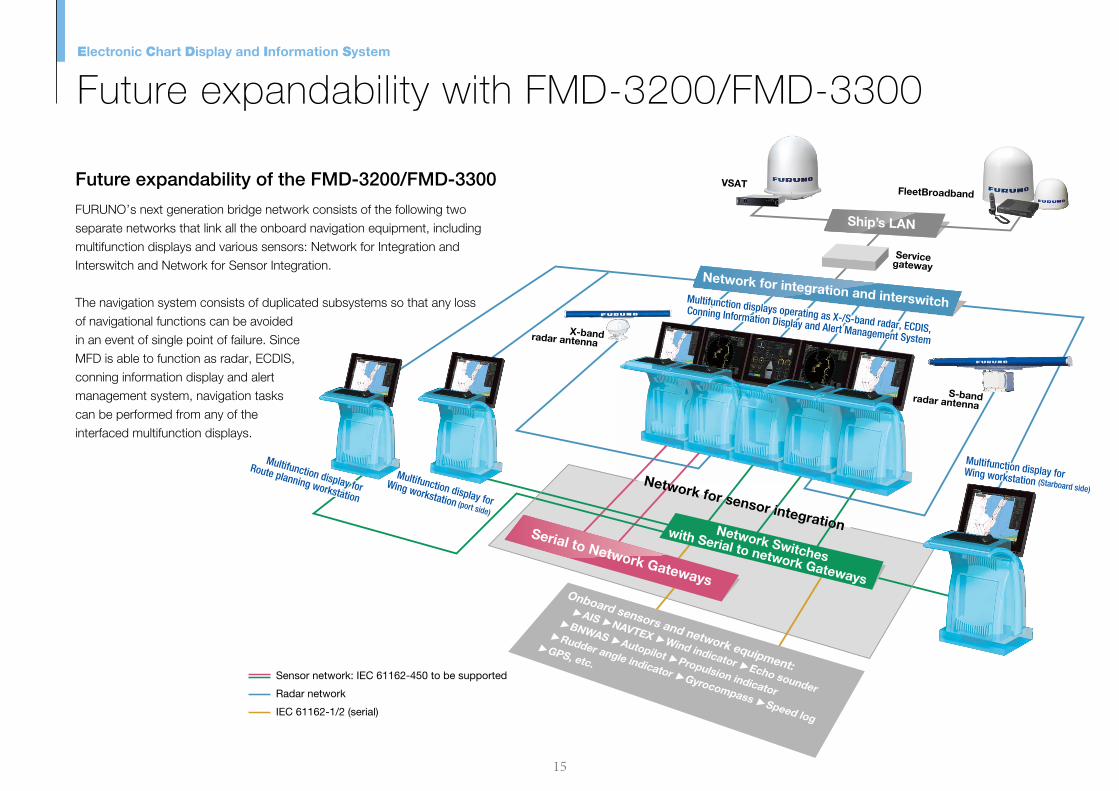
FURUNO’s next generation bridge network consists of the following two separate networks that link all the onboard navigation equipment, including multifunction displays and various sensors: Network for Integration and Interswitch and Network for Sensor Integration.
The navigation system consists of duplicated subsystems so that any loss of navigational functions can be avoided in an event of single point of failure. Since MFD is able to function as radar, ECDIS, conning information display and alert management system, navigation tasks can be performed from any of the interfaced multifunction displays.
Network for Integration and Interswitch (Gigabit Ethernet) is used to communicate the following data:
Radar interswitching
TT and AIS target data
Harmonization of databases (charts, routes, etc.)
Network for Sensor Integration (combination of 100 Base-TX Ethernet & IEC 61162-1/-2) is used to communicate the following data:
Sensor data
FURUNO will shortly start incorporating remote monitoring service into the service provision scheme by which remote onboard monitoring environment will be constructed to enable us to react swiftly to any malfunctioning equipment
reported. This way, we will be able to coordinate and optimize our service provision scheme.
Future expandability of the FMD-3200/FMD-3300 FURUNO Remote Maintenance Service
Electronic Chart Display and Information System
Future expandability with FMD-3200/FMD-3300
Radar network
Sensor network: IEC 61162-450 to be supported
IEC 61162-1/2 (serial)
Network Switches
with Serial to network Gateways
Serial to Network Gateways
Network for integration and interswitch
Ship’s LAN
Multifunction displays operating as X-/S-band radar, ECDIS,
Conning Information Display and Alert Management System
Multifunction displays operating as X-/S-band radar, ECDIS,
Conning Information Display and Alert Management System
Multifunction display for
Wing workstation (port side)
Multifunction display for
Wing workstation (port side)
Multifunction display for
Route planning workstation
Multifunction display for
Route planning workstation
X-bandradar antenna X-bandradar antenna
S-bandradar antenna S-bandradar antenna
Multifunction display forWing workstation (Starboard side)
Multifunction display forWing workstation (Starboard side)Network for sensor integration
Network for sensor integration
VSATVSATFleetBroadbandFleetBroadband
ServicegatewayService
gateway
15 16

ServiceRequest
Monitoring
Service Agent
Service Agent
Customers
Ships in operation
▲
Regular log data from the onboard system
▲
Report on alarm/malfunctioning equipment
▲
Remote monitoring environment to be constructed at the FURUNO Service Center
FURUNO’s next generation bridge network consists of the following two separate networks that link all the onboard navigation equipment, including multifunction displays and various sensors: Network for Integration and Interswitch and Network for Sensor Integration.
The navigation system consists of duplicated subsystems so that any loss of navigational functions can be avoided in an event of single point of failure. Since MFD is able to function as radar, ECDIS, conning information display and alert management system, navigation tasks can be performed from any of the interfaced multifunction displays.
Network for Integration and Interswitch (Gigabit Ethernet) is used to communicate the following data:
Radar interswitching
TT and AIS target data
Harmonization of databases (charts, routes, etc.)
Network for Sensor Integration (combination of 100 Base-TX Ethernet & IEC 61162-1/-2) is used to communicate the following data:
Sensor data
FURUNO will shortly start incorporating remote monitoring service into the service provision scheme by which remote onboard monitoring environment will be constructed to enable us to react swiftly to any malfunctioning equipment
reported. This way, we will be able to coordinate and optimize our service provision scheme.
Future expandability of the FMD-3200/FMD-3300 FURUNO Remote Maintenance Service
Electronic Chart Display and Information System
Future expandability with FMD-3200/FMD-3300
Radar network
Sensor network: IEC 61162-450 to be supported
IEC 61162-1/2 (serial)
Network Switches
with Serial to network Gateways
Serial to Network Gateways
Network for integration and interswitch
Ship’s LAN
Multifunction displays operating as X-/S-band radar, ECDIS,
Conning Information Display and Alert Management System
Multifunction displays operating as X-/S-band radar, ECDIS,
Conning Information Display and Alert Management System
Multifunction display for
Wing workstation (port side)
Multifunction display for
Wing workstation (port side)
Multifunction display for
Route planning workstation
Multifunction display for
Route planning workstation
X-bandradar antenna X-bandradar antenna
S-bandradar antenna S-bandradar antenna
Multifunction display forWing workstation (Starboard side)
Multifunction display forWing workstation (Starboard side)Network for sensor integration
Network for sensor integration
VSATVSATFleetBroadbandFleetBroadband
ServicegatewayService
gateway
15 16

Electronic Chart Display and Information System
Note

Electronic Chart Display and Information System
Note

Electronic Chart Display and Information SystemElectronic Chart Display and Information System
www.furuno.com
FURUNO ELECTRIC CO., LTD.
F r o m 2 0 1 2 o n w a r d s t o 2 0 1 8F r o m 2 0 1 2 o n w a r d s t o 2 0 1 8F r o m 2 0 1 2 o n w a r d s t o 2 0 1 8F r o m 2 0 1 2 o n w a r d s t o 2 0 1 8F r o m 2 0 1 2 o n w a r d s t o 2 0 1 8
P l a n n e d r o u t e
O w n s h i p ’ s i n f o r m a t i o n
A I S i n f o r m a t i o n
ECDISHAND BOOK
Electronic Chart Display and Information System
11113SK Printed in JapanCatalogue No. M-1557