Embed Size (px)
Citation preview

Durham Research Online
Deposited in DRO:
07 September 2016
Version of attached �le:
Accepted Version
Peer-review status of attached �le:
Peer-reviewed
Citation for published item:
Coningham, R.A.E. and Acharya, K.P. and Davis, C.E. and Kunwar, R.B. and Tremblay, J.C. and Simpson,I.A. and Schmidt, A. (2016) 'Preliminary results of post-disaster archaeological investigations at the CharNarayan Temple and within Patan's Durbar Square, Kathmandu Valley UNESCO World Heritage Property(Nepal).', Ancient Nepal., 191-192 . pp. 52-71.
Further information on publisher's website:
http://doa.gov.np/downloads.php?id=22
Publisher's copyright statement:
Additional information:
Use policy
The full-text may be used and/or reproduced, and given to third parties in any format or medium, without prior permission or charge, forpersonal research or study, educational, or not-for-pro�t purposes provided that:
• a full bibliographic reference is made to the original source
• a link is made to the metadata record in DRO
• the full-text is not changed in any way
The full-text must not be sold in any format or medium without the formal permission of the copyright holders.
Please consult the full DRO policy for further details.
Durham University Library, Stockton Road, Durham DH1 3LY, United KingdomTel : +44 (0)191 334 3042 | Fax : +44 (0)191 334 2971
http://dro.dur.ac.uk
FINAL DRAFT ACCEPTED BY ANCIENT NEPAL Number 191-192, Pages 52-71 Preliminary Results of Post-Disaster Archaeological Investigations at the Char Narayan Temple and within Patan’s Durbar Square, Kathmandu Valley UNESCO World Heritage Property (Nepal)
Coningham, R.A.E.1, Acharya, K.P.2, Davis, C.E.1, Kunwar, R.B.3, Tremblay, J.C.1, Simpson, I.A. 4 and Schmidt, A.1
1
Department of Archaeology, Durham University, DH1 3LE, UK
2 Former Director-General of Archaeology, Department of Archaeology, Government of Nepal, Kathmandu,
Nepal
3 Department of Archaeology, Government of Nepal, Kathmandu, Nepal
4 School of Natural Sciences, University of Stirling, FK9 4LA, UK
1. Introduction
The 7.8 Magnitude earthquake that struck Nepal and surrounding regions on the 25th April
2015, not only caused catastrophic loss of life but also the destruction of cultural heritage.
Monuments across Nepal were damaged or destroyed but much media attention was
focused on the destruction of monuments within the UNESCO World Heritage Property of
the Kathmandu Valley. The medieval Durbar Square of Patan was one such area of this
Property adversely affected by the earthquake, an area where many monuments were
damaged and several collapsed. In response, a collaborative team of international and
national experts from the Department of Archaeology, Government of Nepal, Durham
University and the University of Stirling was invited to participate in a UNESCO-sponsored
mission of post-disaster surveys and rescue excavations at earthquake-damaged
monuments and areas within the UNESCO Kathmandu Valley World Heritage Property,
including Patan’s Durbar Square.
2. Earthquake Damaged Monuments in Patan’s Durbar Square

Patan’s main Durbar Square covers an area of some 7,700 square metres, roughly
measuring some 140 metres north to south and between 70 and 40 metres east to west.
Known also as Mangal Bazaar, the majority of the visible monuments of the square were
constructed in the sixteenth and seventeenth centuries and it has been noted that Siddhi
Narasingh (r. 1619-61 CE) and his son Shri Nivas (r. 1661- 84) were responsible for much of
the development of the palace and its surrounding environs (Gellner 1994: 143). Unlike
Hanuman Dhoka with its later development of neo-classical architecture and the reduction
in size of Bhaktapur’s Durbar square from its former extent during that city’s fluorescence, it
has been said that Patan hosts the best preserved Malla period palace and square complex
in the Kathmandu Valley (Slusser 1982: 199).
Several monuments within the square were damaged during the earthquake of the 25th
April 2015 (Figure 1). These include the palace structure, which houses Patan Museum,
where the octagonal Temple of Telgua in the north-east corner of the Mul Chok was
damaged. Damage was sustained to several other monuments in the square, which are now
strengthened through supporting wooden props, such as the Krishna Temple. Monuments
that collapsed included the Mani Mandapa at the top of the steps of the Mani Dhara, or
jewel fountain, which tradition states was consecrated in 1694 CE and renovated in 1701 CE
(Gellner 1994: 144) (Figure 2). The three-storeyed Harishankar Temple, which is stated to
have been constructed in 1706 CE by Rudramati, Yog Narendra Malla’s (r. 1685-1705 CE)
sister (ibid.: 148), also collapsed during the earthquake. Finally, the other major monument
to have collapsed was the Char Narayan Temple (Figure 3). Of these monuments, the Char
Narayan Temple was identified for investigation on two accounts. Firstly, it was generally
considered to be one of the oldest standing monuments in Patan’s Durbar Square and,
secondly, its location afforded the opportunity to excavate a slot trench east-west across
the current brick paved square.
3. Archaeological Excavations at the Char Narayan Temple and Patan’s Durbar Square
The Char Narayan Temple, also known as the Jagannarayan, is located in the middle of
Patan’s Durbar square to the west of the Palace complex (Gellner 1994: 147). Oriented to
the east, it stands on a rectangular plinth with the Krishnan sikhara-style Temple to its north
and the Narayan Temple to the south (Korn 1976: 81). A temple of the four principal forms
of Narayan (Vishnu), the monument has been dated to 1566 CE and attributed to the
patronage one of the city’s pradhana mahapatras or principal nobles, Purandharsingha,
who controlled much of the city of Patan in the sixteenth century (Slusser 1982: 199),
although other scholars favour a seventeenth century construction. Korn has suggested
that the Temple has undergone “only minor alterations” since its construction in 1566 CE
(1976: 102). He has also has provided detailed measurements for the visible parts of the
superstructure and states that the ground floor of the 10.6 metre high temple measures an

area of 6.62 by 6.63 metres (1976: 114). The monument stands on a 2.49 metre high plinth
measuring 13.19 by 13.95 metres (ibid.) and the Temple is accessed by a two flights of short
stairs, the lower of which is flanked by a pair of lions. Little has been written about the
monument’s foundations but Korn notes that the building is constructed of fired brick set in
clay and that the plinths are faced with a brick skin and provided with stone corners and
curbs (Korn 1976: 114).
During our post-disaster archaeological season, three trenches were opened at Patan,
forming a partially-interrupted slot trench east-west across the Durbar Square from the
southern side of the main stairs at the Char Narayan Temple. Trench 1C was located on the
platform that the Char Narayan Temple shares with several other Temples, including the
Narayan Temple, Narasingh Temple and the Krishna Udyan (Gellner 1994: 142). Trench 1A
was located east of this, below the upper platform’s retaining wall and Trench 1B was
located on the lowest level of the current Durbar Square adjacent to the west-facing palace
façade. These three trenches were designated to investigate the foundations of the
collapsed Char Narayan Temple and also the developmental sequence of Patan’s Durbar
Square.
3.1 Trench 1A
Trench 1A was a slot trench measuring one x 10.5 metres running on an east-west
alignment across Patan’s Durbar Square. The surface of the square where this trench was
located is paved with modern brick, laid in several different designs, the majority
conforming to a herring-bone pattern. Within this paving was a small modern posthole.
This had cut through the brickwork and highlights the use of the Durbar square to house
temporary structures in its seemingly vast open spaces. The trench was defined on the east
by a modern drain, which ran on a north-south alignment and formed a baulk between this
trench and Trench 1B. To the west, the trench was defined by the brick wall of the upper
platform edge adjacent to Trench 1C. The upper courses of this wall were constructed from
conserved and repointed brick and were capped by large stones. Adjacent to the wall was a
modern fill, creating a gap between the modern paving and the platform. The brick paving
was removed down to a thin skim of cement, which was prepared over a setting constructed
from modern and reclaimed old bricks, laid for the current paved surface. This brick setting
was laid on top of sand, which covered an earlier tiled surface, which began at the same
depth as the lowest course of the wall of the upper platform edge. Therefore, this wall and
paving may have been constructed at a similar date.
Representing an earlier surface over the Durbar Square, this pavement was formed by a
single regular course of square tiles that individually measured 0.18 by 0.18 by 0.045 metres
(Figure 4). This paving appears to be on a slightly different alignment from that of the

current Durbar Square and suggests a somewhat different configuration to the square in an
earlier period, though this needs further investigation. Similar shaped tiles are recognisable
in Henry Ambrose Oldfield’s paintings of the Durbar Square (Gutschow 2015: 131) and this
feature may well relate to the paved surface of the square dating to the nineteenth century
and earlier. The tiled paving stopped to the east of the trench, where it was defined by row
of modern bricks laid on edge and end-to-end, running north-south, which was located next
to a large section of concrete. Due to time constraints, these modern features were not
removed and became the west facing section of the trench. It would appear that during a
renovation of the square, this area was extended to the east through the placement of
concrete, and then the modern brick paving was set above both the concrete and tiled
paving. The earlier square tiled paving was set on levelling material, which included large
quantities of rubble, including brickbat and broken tile. This levelling also included many
broken ceramic vessels, including oil lamps, as well as terracotta plaques depicting Ganesh,
many of which were attached to oil lamps (Figure 5). Whilst the oil lamps suggest ritual
activity, there is a potential that much of this material is evidence of earlier earthquake
damage, where material from surrounding damaged structures was repurposed for levelling
areas of Patan, reconfiguring the layout of the Durbar Square.
At the east-facing section, a sondage measuring one metre north-south and 0.80 metres
east-west was excavated through various levelling deposits onto a grey silty clay deposit,
which may represent an occupation deposit, comparable with those in the lowest levels of
Trench 1C. Once this material was removed a clean yellow clay surface was identified,
which was believed to be the natural soil. This potential natural was encountered at a
depth of 2.20 metres from the top of the modern brick paving.
3.2 Trench 1B
Trench 1B was a small trench opened to the east of drain that formed the baulk to the east
of Trench 1A. Measuring 3.50 east-west and 1.70 metres north-south Trench 1B was
opened to continue the stratigraphic profile across the Durbar Square. The modern brick
paving, which contained elements of a basket-weave design, was removed onto a silt
deposit that contained cement, which acted as a setting for the paving above. Once this
was removed, another brick paving level, also of basket-weave design, was encountered.
This may have been further setting for the current paved surface of the square or an earlier
paving, which was subsequently covered. The lowest level of brick paving was placed on a
sand setting, which lay over a mottled and mixed material that contained brickbats.
Below this material was a surface of stone cobbles to the east of the trench (Figure 6).
These cobbles may represent an earlier episode of surfacing of the square or may have been
related to an earlier structure. Also at this level were the remains of a brick wall stump,

which survived to two courses (Figure 7). These features were cut by modern pipelines,
running north-south in line with the current thoroughfare through the Durbar Square. As
these features did not cut-through the two levels of brick paving and were sealed by these
surfaces, it would appear that these interventions had occurred before the current paving of
the Durbar square was laid. The stone cobbled surface and brick wall stump clearly
illustrate the presence of archaeological features and surfaces below the current level of
brick paving in the Durbar Square. The pipelines that cut through these features also
highlight the need for future archaeological assessments and archaeological watching briefs
before any intrusive digging across Patan’s Durbar Square.
3.3 Trench 1C
Trench 1C was located on the platform to the west of Trench 1A, which was adjacent to the
Temple foundations of the Char Narayan Temple. This trench measured one metre east-
west and 7.50 metres north-south and was opened to investigate the foundations of the
Char Narayan Temple and to gain a profile across the Durbar square linked to Trenches 1A
and 1B. Unlike the lower levels to the east of the Durbar Square, this surface was formed
from square tiles and these were removed onto a loose sandy setting. The use of squared
tiles, rather than modern brick might be suggestive that this area of paving was laid at an
earlier date to that elsewhere investigated. Like the other areas of the current paving of the
square, this was placed on a setting of bricks but, in this location, constructed entirely out of
reused old bricks. There is a possibility that this setting may have been an earlier paving
surface and, again, suggests a different phase of construction when compared elsewhere in
the square. Such an assertion is made more likely due to the lack of the use of cement in
this construction.
Once this setting was removed, along with a shallow levelling deposit that contained
brickbat, broken tile and pottery, two walls were uncovered. Forming a return, one of these
walls ran north-south at the eastern edge of the trench to the west of the current exposed
facing of the tiled Temple platform, which formed a baulk between Trenches 1A and 1C.
However, although this wall in all probability followed the same alignment as the current
facing, it might be an earlier phasing of walling, though further excavation is required to
ascertain this relationship. In the south-east corner of the trench was the wall return, which
ran on a slight south-west to north-east alignment, different to that of the Char Narayan
Temple (Figure 8). However, though the alignment was slightly different, the wall did
appear to run towards the south-east corner of the foundation platform, which further to
the north formed the east-facing section of Trench 1C.
Further removal of the levelling material revealed a rectangular platform constructed from
clay in the north-west of the trench, laid on a similar alignment to the foundation platforms

of the current Char Narayan Temple (Figure 9). This clay platform suggests that the site of
the Char Narayan Temple had hosted non-durable monumental architecture prior to the
construction of the current brick, stone and timber Temple, or that earlier configurations of
the Temple incorporated such architecture before the square was paved with tiled or brick
surfaces. Several phases of clay platforms were removed on this same alignment and these
were cut by a large semi-circular feature that ran underneath the south-facing section. This
cut, with its fairly firm silty clay fill, which included brickbats and ceramics, was evidence of
a large posthole cut. Most likely for a large timber architectural element, this feature and
associated clay platforms may relate to an earlier Temple footprint, constructed from non-
durable materials. There is also a possibility that is might relate to a non-durable
architectural element associated with the current Temple, perhaps relating to a pavilion or
more temporary shelter located to the east.
However, before we are able to process scientific dating samples, we believe that it is more
likely to represent an earlier phasing of construction as the brick wall of the Char Narayan
Temple in the west-facing section cuts through these platforms, suggesting that the current
Temple is later in date (Figure 10). The foundation wall of the current Temple included a
course of tiles, forming a conservation line below the currently visible conserved and
repointed bricks. Below this course of tiles were seven courses of original brick, which then
sat on top of three visible irregular courses of stone cobbles (Figure 11). The slot that this
wall sat within appeared to be cut through the earlier clay platforms, suggesting the
placement of stone cobbles and the brick courses were a later intervention at the site.
The clay platforms sat on a surface that comprised small brickbat pieces. Once this was
exposed in the entirety of the trench, a small sondage, measuring two metres east-west by
one metre north-south was opened to gain a deep sequence. This was opened 0.5 metres
from the east facing section. Several deposits were removed, with a concentration of
brickbats potentially representing an earlier surface at a depth of c. 0.5 metres from the top
of this sondage (Figure 12). Below this brickbat spread was a greyish silty clay deposit,
which may have related to the deposit found at the base of the sequence in Trench 1A. This
overlaid a very thin deposit of dark charcoal rich silt, which itself covered a very compact
brown material containing small brickbat fragments. Forming a rectangular shape in plan,
this material may represent an early floor surface. Once removed, a yellow sterile clay,
lacking any indication of cultural material, and potentially representing the natural soil, was
reached at a depth of 2.50 metres from the top of the current paved surface of this platform
within the Durbar Square (Figure 13).
4. Ground Penetrating Radar Survey

We investigated four areas of Patan’s Durbar Square with a Ground Penetrating Radar
(GPR): (1) north and east of the Mani Dhara tank; (2) the north-south thoroughfare between
the palace and the main square; (3) the main square west of the thoroughfare, including the
platform abutting east to the Char Narayan Temple (Figures 14, 15 and 16); and (4) the first
step of the Char Narayan Temple. Compared with our surveys in Hanuman Dhoka
(Coningham et al. 2016a) and Bhaktapur (Coningham et al. 2016b), the interpretation of
linear anomalies as modern utilities was less obvious at Patan. However, where the
anomalies are narrow, such attribution has been made. Other anomalies that are located
adjacent to these were preferably interpreted as being also modern and related to these
utilities but not in all cases, for example, where the anomalies’ shapes suggested an
archaeological origin.
In the area next to the tank, some narrow curvilinear utilities can be seen, in addition to
wider curvilinear anomalies for which the interpretation as utilities is uncertain. There is
only one short anomaly visible (running west-east) that seems to relate to the square man-
hole covers from the telecom utilities. This suggests that neither the trenches nor the
telecom cables are easily detectable in this survey. There are several broad areas of
enhanced reflectivity visible, extending over a depth range of 0.8 -1.6 metres and it is likely
that they are destruction debris from older structures. These areas were not outlined in
the interpretation diagrams as they would have swamped the remaining anomalies. One of
them is situated to the north of the survey area, extending west-east on both sides of the
monument. Another extends north-east from the north-east corner of the tank.
The north-south thoroughfare has several narrow linear anomalies that are interpreted as
utilities; some run along the road, others cross at a right angle. They do not form a
consistent network and it is likely that not all sections of buried pipes are represented in the
data. The pipe that was found in Trench 1B only produces a weak signal to the south of the
trench and seems to be ‘missing’ for about five metres north of that trench. It therefore has
to be assumed that not all utilities are clearly visible in the data. There are several wider
linear anomalies (up to 0.7 metres) aligned with the road and these are interpreted as walls
or wall foundations, similar to the one visible in Trench 1B. To the north of Trench 1B, two
walls or their fragments seem to run parallel to each other in a distance of 1.5-2 metres. To
the south of the trench, the separation is around three metres. In the southern part of the
road, there are several rectilinear box-anomalies that are adjacent to both the walls and the
utilities and their interpretation is therefore unclear.
On the main square many anomalies are visible that are most likely of archaeological origin.
As the depth range of these anomalies is very varied, they appear in the summative
interpretation diagram to cover nearly all of the area surveyed. The most interesting is the
set of anomalies in the north-east section of the square, just south of the fenced-off
platform used for offerings. The anomalies resemble the outline of a building of

approximately six metres by two metres. Its strongly varying shape over the full depth
range (0.2-0.8 metres and 1.2-1.6 metres) suggests that it is not consistently preserved. On
the Temple’s platform several north-south trending walls are visible in the data; the eastern
most is the one excavated in Trench 1C. In addition, there is at least another wall running
parallel, c. 0.5 metres further west.
On the temple’s first step, several anomalies are visible between the walls that form the
‘concentric’ platforms of the stepped structure. These anomalies extend to a depth of
about 2.8 metres, down from the level of the step’s platform. Although there are several
wall stumps visible in the data, i.e. extending from the walls into the space that supports the
step, the data do not provide definitive evidence for further cross-walls between the two
walls that would mirror the cross-wall found in the one of the KVPT extraction holes on the
middle platform of the Char Narayan Temple. Further data processing is necessary to clarify
these anomalies in the space between the walls.
5. Provisional Archaeological Risk Map for Patan’s Durbar Square
The archaeological investigations at the Char Narayan Temple and within Patan’s Durbar
Square have illustrated the extent of subsurface heritage at this World Heritage site. The
GPR survey has highlighted areas of potential archaeological features below the current
square and excavations have revealed the character of some of these signatures. What is
clear is that the Durbar Square was not always an open space but has developed over time,
only in the last few centuries reaching its current configuration of standing monuments.
One of the key features identified through GPR survey and excavation were pipelines
running through the Durbar Square, which we have clearly demonstrated have cut through
archaeological stratigraphy and earlier phases of human activity. Such interventions are
therefore a concern as the laying of any infrastructure has the potential to damage and
destroy subsurface heritage of this site of Outstanding Universal Value.
The damage caused by the earthquakes will require reconstruction and also the repair and
laying of amenities in Patan and whilst we do not recommend the suspension of the laying
services and reconstruction we do advocate the mobilisation of rescue archaeology teams
to undertake rescue excavations in advance of interventions (Coningham et al. 2016c). The
Archaeological Risk Map for Patan will provide information for site managers and
stakeholders as to the risks posed to subsurface heritage and help guide future
development (Figure 17). Indeed, from our observations and investigations, we feel there
needs to be a heightened awareness that the cultural heritage of Patan is not restricted to
its standing remains and architectural treasures but that it should extend also to the
foundations of these monuments and to preceding phases of cultural development, which
are found below the current ground level. The Archaeological Risk Maps and our

interventions should facilitate the development of this awareness and protect subsurface
heritage whilst not being of detriment to reconstruction.
6. Discussion and Conclusion
Our archaeological investigations have illustrated the complex development of Patan’s
Durbar Square from its earliest cultural activity through to the current configuration of the
visible monuments in the present. Whilst we can provide a preliminary phasing through
relative stratigraphy, we await the results of the analysis of scientific dating samples to
provide an absolute chronology for the cultural sequence of Patan’s Durbar Square and the
Char Narayan Temple. Due to limited time-frames of access to the site during our field
season in October-November 2015 because of festival activities, we were not able to extract
geoarchaeological samples during that field season. However, it was possible to open the
trench again in February-March 2016 and Professor Ian Simpson of the University of Stirling
was able to take Optically Stimulated Luminescence dating samples from the exposed
stratigraphy as well as kubiena tins for the analysis of soil micromorphology. Once
processed, the results of these analyses will be published in due course.
The GPR survey across the Durbar Square has illustrated several areas where earlier
structures may have been located. From our excavations in Trench 1A, it would appear that
from the quantity of brickbat and broken tile that the raised platform of the Durbar Square
may have been built through the reuse of debris, possibly from earthquake damaged
structures. In future, we hope to undertake further research excavations in the Durbar
Square, guided by the GPR survey results, to identify damaged structures, which may have
later been covered by levelling material to create a new configuration for the monuments of
the Durbar Square. Within the trenches opened, we do have some potential evidence for
these structures, or architectural features, particularly in Trench 1B, where a stump of a
brick wall was uncovered as well as a stone cobbled surface. Later covered by paving, these
features would once have been visible on the surface of the square but may have been
demolished, disused and then sealed below later paving. The excavations here indicated the
damage that modern interventions had inflicted on the subsurface heritage of Patan’s
Durbar Square, as pipelines had cut through these earlier cultural phases, with no record
provided or available for the subsurface archaeology that had been destroyed.
This is especially true across the square where we not only uncovered earlier phases of
paving in the square, specifically the square tiled surface in Trench 1A, but we also
uncovered monumental architecture constructed from non-durable materials. The
successive clay platforms in Trench 1C highlight again the rich sub-surface heritage of
Patan’s Durbar Square (Figures 18 and 19). Rather than heritage being confined to the

footprint of the current Char Narayan Temple, our investigations have shown how earlier
architectural phases may have been located underneath the current square. They also
illustrate how the earlier architecture of the Kathmandu Valley may not have been solely
brick and tile, but in all probability included unfired materials.
Our investigations have also provided the first published indications of how the foundations
of the Char Narayan Temple were configured. Similar to those exposed within the cuttings
undertaken by KVPT on the western platform edges of the Char Narayan Temple, which are
yet to be published (Figure 20) (Coningham et al. 2016c) and those at the Vatsala Temple in
Bhaktapur’s Durbar Square (Coningham et al. 2016b), the brick walls rested on stone cobble
foundations. Preliminary results from the GPR survey indicate wall stumps within this
platform and indications from the subsurface interventions next to the foundations suggest
that the platforms of the temple may have been formed through bracing cross-walls, similar
in plan to those exposed by the rescue excavations at Kasthamandap (Coningham et al.
2016a). However, further processing of the GPR survey data is required as well as further
investigations of the platforms through formal archaeological excavation to fully
substantiate this postulation. However, it must be emphasised again that any subsurface
investigation that is undertaken requires scientific excavation and systematic recording of
the soil and artefacts that are removed as well as the masonry that is exposed.
The complicated archaeological sequence and the evidence of multiple phases of activity
highlights the major threat to archaeological heritage across Patan’s Durbar Square from
subsurface interventions and the necessity for archaeological assessments prior to any
development or construction work at the site. The results suggest the presence of earlier
monumental phases at the Char Narayan Temple site and earlier occupation phases, which
would be best further investigated through the opening of larger excavation trenches.
These would not only provide archaeological sequences but would also illustrate the
character of development of the sub-surface architectural phases of the site, particularly in
the vicinity of Trench 1C. Accompanied by material analysis, the investigations and
archaeological assessment at Char Narayan Temple and across Patan’s Durbar Square could
provide an exemplar for reconstruction and the use of traditional technologies.
7. Acknowledgments
We would like to acknowledge the support of the following individuals and institutions for
their help and expertise in the field and during the archaeological activities:
Siddhi Lal Singh MP, Mr Bhesh Dahal, Mr Bharat Subedi, Mr Christian Manhart, Mr Feng Jing,
Dr Roland Lin, Mr Kai Weise, Mrs Nabha Basnyat-Thapa, Mrs Nipuna Shresta, Thomas

Schrom, David Adolfatto, Mr Chaitya Raj Shakya, Mr Uddhab Rijal, Mr Satya Mohan Joshi,
Ms Anie Joshi, Mr Damodar Gautam, Mr Suresh Suras Shrestha, Mr Bishnu Prasad Pathak,
Mr Mohan Singh Lama, Mr Durbha Adikari, Mrs Chandra Shova Shakya, Mr Ram Govinda
Shrestha, Mr Raj Kumar Banjara, Mr Jagat Bahadur Katuwal, Miss Anita Timilsina, Miss
Shanti Sherma, Miss Sunita Bhadel, Mrs Maiya Kaiti, Mr Bikash Nakarmi, Mr Ranjan Kumar
Dulal, Mrs Sita Phuyal, Mrs Swaraswati Singh, Mrs Bindhaya Karki, Mr Jaya Thapa, Ms Anouk
LaFortune-Bernard, Ms Emilia Smagur, Dr Paolo Forlin and Dr Mark Manuel.
We would like to thank UNESCO for their financial support and the assistance provided by
the UNESCO Kathmandu Field Office, as well as institutional support from Durham
University and the University of Stirling. The Kathmandu Valley Preservation Trust kindly
supported the project with a contribution to labour costs. Finally, we would like to thank
the Municipality and communities of Patan for their support and interest in our mission.
8. References
Coningham, R.A.E., Acharya, K.P., Davis, C.E., Kunwar, R.B., Simpson, I.A., Schmidt, A. and
Tremblay, J.C. 2016a. Preliminary Results of Post-Disaster Archaeological Investigations at
the Kasthamandap and within Hanuman Dhoka, Kathmandu Valley UNESCO World Heritage
Property (Nepal). Ancient Nepal 28-51.
Coningham, R.A.E., Acharya, K.P., Davis, C.E., Kunwar, R.B., Tremblay, J.C., Schmidt, A. and
Simpson, I. 2016b. Preliminary Results of Post-Disaster Archaeological Investigations at the
Vatsala Temple and within Bhaktapur’s Durbar Square, Kathmandu Valley UNESCO World
Heritage Property (Nepal). Ancient Nepal 191-192: 3-27.
Coningham, R.A.E., Acharya, K.P., Davis, C.E., Kunwar, R.B. Tremblay, J.C., Schmidt, A.,
Simpson, I. and LaFortune-Bernard, A. 2016c. Post-Disaster Rescue Archaeological
Investigations, Evaluations and Interpretations in the Kathmandu Valley World Heritage
Property (Nepal): Observations and Recommendations from a UNESCO mission in 2015.
Ancient Nepal 191-192: 72-92.
Gellner, D.N. 1994. Monuments of Lalitpur (Patan). In Hutt, M. (ed.) Nepal: a Guide to the
Art and Architecture of the Kathmandu Valley: 138-169. Stirling: Kiscadale Publications.
Gutschow, N. (ed.) 2015. History of Kings of Nepal: A Buddhist Chronicle. Maps and
Historical Illustrations. Kathmandu: Himal Books.
Korn, W. 1976. The Traditional Architecture of the Kathmandu Valley. Kathmandu: Ratna
Pustak Bhandar

Slusser, M.S. 1982. Nepal Mandala: a cultural study of the Kathmandu Valley. Princeton:
Princeton University Press.

Figures
Figure 1: Damage in Patan’s Durbar Square, including the damaged pillar of the statue of
King Siddhi Narasingh Malla, and the collapsed Harishankar Temple, looking south.

Figure 2: The collapsed Mani Mandapa, looking east.
Figure 3: The collapsed Char Narayan Temple.

Figure 4: Tiled paving surface below the current paved Durbar Square, in Trench 1A.

Figure 5: Terracotta plaque, depicting Ganesh, from an oil lamp, excavated from Trench 1A.
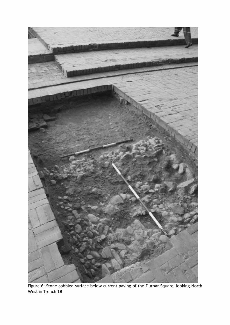
Figure 6: Stone cobbled surface below current paving of the Durbar Square, looking North West in Trench 1B

Figure 7: Brick wall, looking south west, Trench 1B.

Figure 8: Wall alignment below current paving in Trench 1C, looking east.

Figure 9: Earlier clay platform with large posthole, in Trench 1C, looking west.
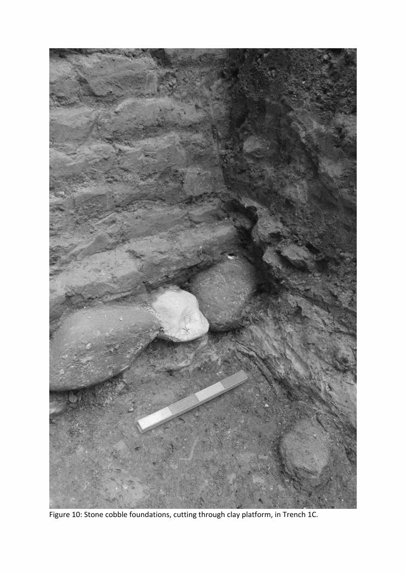
Figure 10: Stone cobble foundations, cutting through clay platform, in Trench 1C.

Figure 11: Stone cobble and brick foundations of Char Narayan Temple in Trench 1C.

Figure 12: Brickbat surface in Trench 1C, looking west.

Figure 13: Possible natural at the base of the sequence of Trench 1C, looking north.
Figure 14: GPR survey in Patan’s Durbar Square.

Figure 15: GPR results from Patan’s Durbar Square at a depth of 1.3 metres.

Figure 16: Interpretation of GPR results at Patan’s Durbar Square.

Figure 17: Provisional Archaeological Risk Map for Patan’s Durbar Square.

Figure 18: East facing section of Trench 1C.

Figure 19: East facing section of Trench 1C, illustrating depth of foundations, with superimposed elevation of the Char Narayan Temple before collapse (Elevation of Char Narayan Temple after Korn 2007).

Figure 20: Stone cobble foundations visible in trench cleaned by the team that was left open by KVPT on the western side of the Char Narayan Temple, looking north.