Embed Size (px)
Citation preview


Dunquin South Site Survey: Natura Impact Screening Statement
Doc Ref: P1188-CTR08-04-02 Page No: iii
Table of Contents
1 Introduction ................................................................................................................................ 1
1.1 Background .............................................................................................................................. 1
1.2 Scope and Objective................................................................................................................. 1
2 The Appropriate Assessment (AA) Process .................................................................................. 2
2.1 Overview .................................................................................................................................. 2
2.2 The AA Screening Stage ........................................................................................................... 3
3 Project Description ..................................................................................................................... 4
3.1 Purpose of Site Survey ............................................................................................................. 4
3.2 Site Survey Location ................................................................................................................. 4
3.3 Description of Site Survey ........................................................................................................ 4
3.4 Description of Potential Environmental Impacts ..................................................................... 6
4 Relevant European Sites ............................................................................................................. 8
5 Identification and Assessment of Likely Significant Effects ....................................................... 13
5.1 Offshore SAC Sites .................................................................................................................. 13
5.2 Coastal SAC Sites .................................................................................................................... 13
5.3 Potential for In Combination Effects ...................................................................................... 18
6 Conclusions ............................................................................................................................... 20
7 References ................................................................................................................................ 21
Appendix A: European Sites Scoped in to the Screening Assessment ............................................... 25
Dunquin South Site Survey: Natura Impact Screening Statement
Doc Ref: P1188-CTR08-04-02 Page No: iv
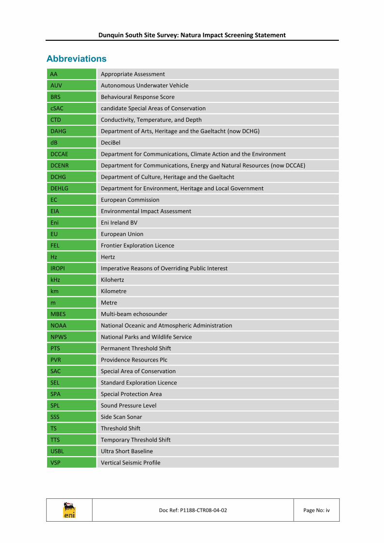
Abbreviations
AA Appropriate Assessment
AUV Autonomous Underwater Vehicle
BRS Behavioural Response Score
cSAC candidate Special Areas of Conservation
CTD Conductivity, Temperature, and Depth
DAHG Department of Arts, Heritage and the Gaeltacht (now DCHG)
dB DeciBel
DCCAE Department for Communications, Climate Action and the Environment
DCENR Department for Communications, Energy and Natural Resources (now DCCAE)
DCHG Department of Culture, Heritage and the Gaeltacht
DEHLG Department for Environment, Heritage and Local Government
EC European Commission
EIA Environmental Impact Assessment
Eni Eni Ireland BV
EU European Union
FEL Frontier Exploration Licence
Hz Hertz
IROPI Imperative Reasons of Overriding Public Interest
kHz Kilohertz
km Kilometre
m Metre
MBES Multi-beam echosounder
NOAA National Oceanic and Atmospheric Administration
NPWS National Parks and Wildlife Service
PTS Permanent Threshold Shift
PVR Providence Resources Plc
SAC Special Area of Conservation
SEL Standard Exploration Licence
SPA Special Protection Area
SPL Sound Pressure Level
SSS Side Scan Sonar
TS Threshold Shift
TTS Temporary Threshold Shift
USBL Ultra Short Baseline
VSP Vertical Seismic Profile

Dunquin South Site Survey: Natura Impact Screening Statement
Doc Ref: P1188-CTR08-04-02 Page No: 1
1 Introduction
1.1 Background
Eni Ireland BV (hereafter referred to as ‘Eni’) is proposing to conduct a debris clearance, environmental baseline and habitat assessment site survey prior to deepwater drilling operations which will target the Dunquin South formation, in Block 44/29; situated in the Porcupine Basin, approximately 150 kilometres (km) off the south west coast of Ireland (refer to Figure 3.1). The site survey is currently scheduled to take place from 15th June 2019, with the survey vessel anticipated to be working on location for up to 14 days. Taking into account an allowance for delayed commencement and significant weather delay, the survey is not likely to continue beyond 30th September 2019.
This Natura Impact (Appropriate Assessment) Screening Statement has been prepared to accompany the Application for Approval to Conduct a Geophysical or other Exploration Survey, Site Survey or Route Survey, as required under Part 2 of the Rules & Procedures Manual for Offshore Petroleum Exploration and Appraisal Operations (DCENR, 2014)1.
1.2 Scope and Objective
This Natura Impact Screening Statement has been prepared with reference to:
Managing Natura 2000 Sites, The provisions of Article 6 of the Habitats Directive 92/43/EEC (European Commission, 2018);
Appropriate Assessment under Article 6 of the Habitats Directive; Guidance for Planning Authorities. Circular NPW 1/10 & PSSP 2/10 (DEHLG, 2010);
Assessment of Plans and Projects Significantly Affecting Natura 2000 Sites. Methodological Guidance on the Provisions of Article 6(3) and (4) of the Habitats Directive 92/43/EEC (European Commission, 2001);
Guidance document on Article 6(4) of the 'Habitats Directive' 92/43/EEC (European Commission, 2007);
Guidance to Manage the Risk to Marine Mammals from Man-made Sound Sources in Irish Waters (DAHG, 2014);
Marine Nature Impact Statements in Irish Special Areas of Conservation: A working document (DAHG, 2012).
It presents a Stage 1 Appropriate Assessment (AA) Screening for the proposed Dunquin South site survey, outlining the information required for the competent authority to screen for appropriate assessment and determine whether the proposed Dunquin South site survey operations, either standalone or in combination with other plans and projects, in view of best scientific knowledge, is likely to have a significant effect on any European site.
European sites in Ireland form part of the Natura 2000 network of marine and onshore nature conservation protected areas that are designated under the EU Habitats Directive (92/43/EEC) and the EU Birds Directive (2009/147/EC) to protect species and habitats of conservation importance. They include Special Areas of Conservation (SACs) and candidate Special Areas of Conservation (cSACs) for the protection of certain habitats (Annex I) and species (Annex II) and Special Protection Areas (SPAs) for the protection of qualifying bird species (particularly breeding or overwintering populations). Specific conservation objectives have been developed for European sites in relation to their qualifying interests (i.e. habitats and/or species).
1 The Rules & Procedures Manual is currently being revised due to legislative changes. This document has been compiled in accordance with the version available at the time of submission (DCENR, 2014). Should the new version become available prior the proposed site survey operations commencing, the screening assessment detailed within this document will be reviewed and revised, if required.

Dunquin South Site Survey: Natura Impact Screening Statement
Doc Ref: P1188-CTR08-04-02 Page No: 2
2 The Appropriate Assessment (AA) Process
2.1 Overview
The EU Birds and Habitats Directives outline Member States’ obligations in relation to nature conservation management, and the management of European sites in particular. A key protection strategy for these sites is to consider the possible implications of any plan or project on the conservation objectives and qualifying features of any European site before a consent can be granted. All plans or projects must therefore take into consideration, whether alone or in combination with other plans or projects, any likely significant effects on the conservation objectives of the site.
The obligation to undertake an AA derives from Article 6(3) of the Habitats Directive, which for the purposes of the application for permission to conduct the Dunquin South site survey is transposed into Irish legislation by the European Communities (Birds and Natural Habitats) Regulations 2011, as amended. Article 6(3) is concerned with the strict protection of sites, while Article 6(4) is the procedure for allowing derogation from this strict protection in certain restricted circumstances. Both involve a number of steps and tests that need to be applied in sequential order.
Article 6(3) of the Habitats Directive states:
“Any plan or project not directly connected with, or necessary to, the management of the site but likely to have a significant effect thereon, either individually or in combination with other plans and projects, shall be subject to appropriate assessment of its implications for the site in view of the site’s conservation objectives. In the light of the conclusions of the assessment of the implications for the site and subject to the provisions of paragraph 4, the competent national authorities shall agree to the plan or project only having ascertained that it will not adversely affect the integrity of the site concerned and if appropriate, after having obtained the opinion of the general public”.
Article 6(4) states:
“If, in spite of a negative assessment of the implications for the site and in the absence of alternative solutions, a plan or project must nevertheless be carried out for imperative reasons of overriding public interest, including those of social or economic nature, the Member State shall take all compensatory measures necessary to ensure that the overall coherence of Natura 2000 is protected. It shall inform the Commission of the compensatory measures adopted.
Where the site concerned hosts a priority natural habitat type and/or a priority species, the only considerations which may be raised are those relating to human health or public safety, to beneficial consequences of primary importance for the environment or, further to an opinion from the Commission, to other imperative reasons of overriding public interest.”
There are four steps or stages in the AA process as follows:
Stage 1 – Appropriate Assessment Screening;
Stage 2 – Appropriate Assessment;
Stage 3 – Alternative Solutions;
Stage 4 – Imperative Reasons of Overriding Public Interest (IROPI).
If it can be demonstrated during the AA screening phase, that the proposed project is not likely to have a significant effect, whether alone or in combination with other plans or projects, on the conservation objectives of a European site, then no further AA (Stage 2) will be required. It is important to note that there is a requirement to apply a precautionary approach to AA screening. Therefore, where effects are possible, certain or unknown at the screening stage, AA will be required. Objective scientific evidence is required in order to screen out the risk of a likely significant effect.
EU and Irish case-law makes it clear that the trigger for AA is a very light one and that the mere probability or risk that a plan or project is likely to have a significant effect is sufficient to make AA mandatory. It is also clear that screening must be carried out in view of the best scientific knowledge.

Dunquin South Site Survey: Natura Impact Screening Statement
Doc Ref: P1188-CTR08-04-02 Page No: 3
In light of a recent European Court of Justice case (People Over Wind and Peter Sweetman v Coillte, case C-323/17), it is not appropriate, at the screening stage, to take account of the measures intended to avoid or reduce the harmful effects of the plan or project on that site.
For the avoidance of doubt, this report is prepared in relation to Stage 1 Appropriate Assessment Screening only.
2.2 The AA Screening Stage
The Stage 1 AA Screening Stage examines the likely significant effects of a plan or project, either alone or in combination with other plans or projects, upon an European site and considers whether, on the basis of objective scientific evidence, it can be concluded, in view of best scientific knowledge and the conservation objectives of relevant European sites, that there are no significant effects or that there are not likely to be significant effects on a European site. This assessment comprises four steps:
Step 1 - Determining whether the project or plan is directly connected with or necessary to the management of the site;
Step 2 - Describing the project or plan and the description and characterisation of other projects or plans that in combination have the potential for having significant effects on the European site;
Step 3 - Identifying the potential effects on the European site;
Step 4 - Assessing the likely significance of any effects on the European site.
It is noted that the proposed site survey is not directly connected with or necessary to the management of any European site, and so is not excluded from the AA Screening process on this basis. The next sections of this document comprise an analysis of whether the proposed Dunquin South site survey satisfies the other three criteria in respect of screening.

Dunquin South Site Survey: Natura Impact Screening Statement
Doc Ref: P1188-CTR08-04-02 Page No: 4
3 Project Description
3.1 Purpose of Site Survey
The key aims of the Dunquin South site survey are to:
Accurately determine water depths, the nature of the seabed material and locate and identify any seabed and sub‐seabed features or obstructions that may impede the emplacement and top‐hole drilling operations at the Dunquin South location or in the relief well locations;
Assess the survey area for potentially important seabed habitats, including habitats listed under Annex I of the EU Habitats Directive (1992) and habitats and species included on the OSPAR list of threatened and/or declining species and habitats (OSPAR, 2008);
Investigate the ‘baseline’ or background condition of the seabed sediments and associated benthic faunal communities at the Dunquin South location to enable accurate measurement of any future impacts from the proposed drilling operations;
Provide information to inform an archaeological assessment of the site.
3.2 Site Survey Location
The site survey will be undertaken within a 2 km by 2 km box (termed the ‘survey area’) situated within the larger 9 km by 9 km box (termed the ‘greater working area’), as illustrated in Figure 3.1.
The proposed survey area lies wholly within Frontier Exploration Licence (FEL) 3/04 in the north east of the Porcupine Basin, approximately 150 km off the south west coast of Ireland (Dursey Island, County Cork). Water depths within the survey area range from around 1,700 to 1,800 m below mean sea level (MSL) (GEBCO, 2014).
The closest international boundaries to the proposed survey area are the Ireland / International Waters median line, which lies approximately 265 km to the northwest and the Ireland / UK median line, which lies approximately 298 km to the southeast.
3.3 Description of Site Survey
The proposed site survey operations are currently scheduled to take place from 15th June 2019, with the survey vessel anticipated to be working on location for up to 14 days (excluding transit, port calls and weather downtime). Taking into account an allowance for delayed commencement and significant weather delay, the survey is not likely to continue beyond 30th September 2019.
The proposed site survey will comprise the following elements:
A geophysical acoustic survey using side scan sonar (SSS), multi-beam echosounder (MBES), chirp sub-bottom profiler and magnetometer mounted onto an autonomous underwater vehicle (AUV). A subsea Ultra Short Baseline (USBL) beacon system will be utilised during the survey to position the AUV and the AUV will also be equipped with a Conductivity, Temperature, and Depth (CTD) sensor;
An environmental baselined survey and habitats assessment. Any potentially sensitive habitats identified from anomalies on the geophysical survey data will be investigated using high-resolution video or camera stills. Seabed samples will also be taken using a box corer, with sampling stations defined by the number of habitats delineated from the geophysical data. These samples will be analysed to provide information on benthic faunal community composition and physico-chemical characteristics of the sediments. Seabed photography shall be undertaken at all seabed sampling stations prior to sampling and analysed to ensure that any potential Annex I habitats are not damaged by the box corer. If there is a risk that sensitive habitats could be damaged the station will be moved or abandoned, as appropriate. A minimum of four replicate samples shall be collected from each sampling station. This will necessitate multiple deployments of the box corer at each sampling station. If more than two “no samples” are acquired at a station, then the station shall be moved up to 50 metres in any direction and the sampling continued. If there are any further “no-samples”, then the station will be abandoned and the reason noted in the survey logs.

Dunquin South Site Survey: Natura Impact Screening Statement
Doc Ref: P1188-CTR08-04-02 Page No: 5
Figure 3.1. Location of the Proposed Dunquin South Site Survey

Dunquin South Site Survey: Natura Impact Screening Statement
Doc Ref: P1188-CTR08-04-02 Page No: 6
A summary of the worst-case noise sources associated with the proposed survey is provided in Table 3.1. It can be seen from this that the greatest noise levels will arise from the MBES and SSS equipment. The majority of the noise sources introduced from the proposed survey, with the exception of vessel noise, are high-frequency sounds, which have a tendency to travel shorter distances compared to low frequency sounds. The USBL beacon system operates at a frequency of between 21 and 31 kHz; but at a very low sound pressure intensity level (SPL is around 172dB re 1uPa @ 1m as quoted in Blueprint Subsea, 2018) compared with, for example, the sub-bottom profiler that operates in a similar range. For this reason the USBL beacon system has been scoped out of the assessment.
Table 3.1. Worst-Case Noise Levels associated with the Proposed Survey Operations
Noise Source Sound Type N1 Frequency Range SPL (extrapolated to 1
metre from the source)N2
Side Scan Sonar Multiple Pulse 100 kHz – > 400 kHz 220 dB re 1 µPa
Multi-Beam Echosounder Multiple Pulse > 240 kHz 223 dB re 1 µPa
Chirp Sub-Bottom Profiler Multiple Pulse 3 kHz – 40 kHz 208 dB re 1 µPa
USBL beacon system Multiple Pulse 21 - 31 kHz 172 dB re 1uPa
Survey Vessel Non-Pulse < 1 kHz 180 dB re 1 µPa
Notes N1 Underwater sound has been categorised by Southall et al. (2007) as single pulse, multiple pulse and non-pulsed. N2 References: Richardson et al. (1995), Wyatt (2008), OSPAR (2009), Genesis (2011) and Blueprint Subsea (2018).
Solid wastes generated onboard the survey vessel will be transported to shore for disposal.
Given the short duration of the operations, helicopter transfers and supply vessel trips are not anticipated to be required.
3.4 Description of Potential Environmental Impacts
Based on a review of the nature and duration of the proposed Dunquin South site survey operations, Table 3.2 outlines those aspects of the survey, which have the potential to result in impacts to the marine environment.
Table 3.2. Potential Environmental Impacts the Proposed Dunquin South Site Survey Operations
Survey Aspect Description
Planned Events
Seabed Disturbance
Localised disturbance from seabed sampling; using a 0.25m2 box corer. Around 14 environmental stations will be sampled; the exact number will be depend on the requirement to investigate any identified features of interest. As a worst case, it is assumed that an area of up to 1m2 will be disturbed at each station, accounting for the potential need for multiple deployments of the box corer at each station (see Section 3.3). In total, an area of approximately 14m2 will be disturbed by seabed sampling, assuming 14 stations are sampled.
Underwater Acoustic Emissions
Underwater acoustic emissions will be generated from the proposed geophysical survey equipment, as well as the survey vessel itself. This results in the greatest spatial extent of impact from the proposed operations. As documented in Section 5 of the Environmental Impact Assessment (EIA) Screening and Environmental Risk Assessment for Annex IV Species Report; high-frequency cetaceans have the greatest zone of impact and could exhibit behavioural responses out to a distance of around 60 km from the SSS source and 15 km from the chirp source. However, it is important to note that not all behavioural responses are considered to represent a significant effect.
Dunquin South Site Survey: Natura Impact Screening Statement
Doc Ref: P1188-CTR08-04-02 Page No: 7
Survey Aspect Description
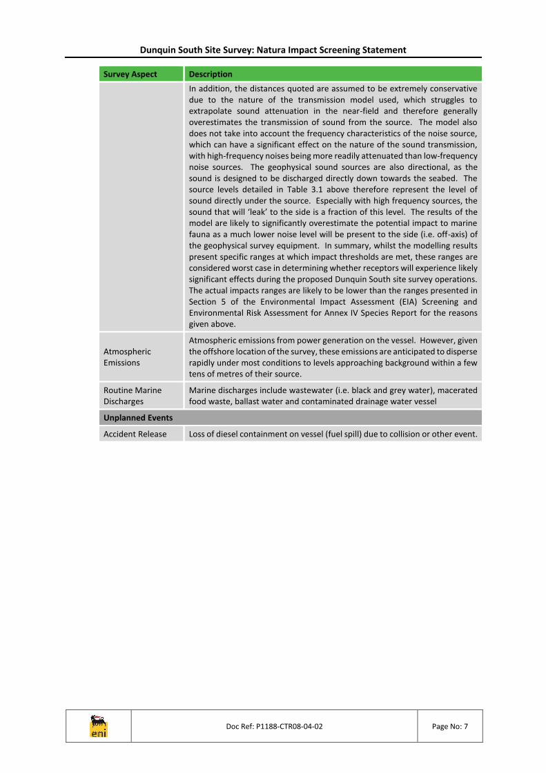
In addition, the distances quoted are assumed to be extremely conservative due to the nature of the transmission model used, which struggles to extrapolate sound attenuation in the near-field and therefore generally overestimates the transmission of sound from the source. The model also does not take into account the frequency characteristics of the noise source, which can have a significant effect on the nature of the sound transmission, with high-frequency noises being more readily attenuated than low-frequency noise sources. The geophysical sound sources are also directional, as the sound is designed to be discharged directly down towards the seabed. The source levels detailed in Table 3.1 above therefore represent the level of sound directly under the source. Especially with high frequency sources, the sound that will ‘leak’ to the side is a fraction of this level. The results of the model are likely to significantly overestimate the potential impact to marine fauna as a much lower noise level will be present to the side (i.e. off-axis) of the geophysical survey equipment. In summary, whilst the modelling results present specific ranges at which impact thresholds are met, these ranges are considered worst case in determining whether receptors will experience likely significant effects during the proposed Dunquin South site survey operations. The actual impacts ranges are likely to be lower than the ranges presented in Section 5 of the Environmental Impact Assessment (EIA) Screening and Environmental Risk Assessment for Annex IV Species Report for the reasons given above.
Atmospheric Emissions
Atmospheric emissions from power generation on the vessel. However, given the offshore location of the survey, these emissions are anticipated to disperse rapidly under most conditions to levels approaching background within a few tens of metres of their source.
Routine Marine Discharges
Marine discharges include wastewater (i.e. black and grey water), macerated food waste, ballast water and contaminated drainage water vessel
Unplanned Events
Accident Release Loss of diesel containment on vessel (fuel spill) due to collision or other event.

Dunquin South Site Survey: Natura Impact Screening Statement
Doc Ref: P1188-CTR08-04-02 Page No: 8
4 Relevant European Sites
A key factor in the consideration as to whether or not a particular European site is likely to be significantly affected by the proposed Dunquin South site survey is its distance from the proposed survey area. The Guidelines for Planning Authorities (DEHLG, 2010) state that the AA process should include:
Any European site within or adjacent to the plan or project area.
Any European site within the likely zone of impact of the plan or project. A distance of 15 km is currently recommended in the case of plans (Scott Wilson et. al., 2006). For projects, the distance can be less than 15 km, and in some cases less than 100 metres. This must be evaluated on a case-by-case basis with reference to the nature, size and location of the project, and the sensitivities of the ecological receptors, and the potential for in combination effects.
In the case of European sites with water dependent habitats or species, it may be necessary to consider the full extent of the upstream and/or downstream catchment. This may exceed 15 km from the plan or project.
The proposed Dunquin South site survey will not be undertaken within or immediately adjacent to any designated or proposed European sites; this is illustrated in Figure 4.1.
The closest offshore European sites to the proposed survey area, the nearest of which is 35 km to the north east of the greater working area, are listed in Table 4.1. These sites have been scoped into the assessment in Section 5 on the basis of that one or more aspects of the proposed site survey operations have the potential to impact the conservation objectives of qualifying interests of these offshore SACs.
A number of European sites are also located along the south west coast of Ireland, as illustrated in Figure 4.1. Although these sites are all located at distances greater than 140 kilometres from the proposed Dunquin South survey area, it is necessary to consider whether the Annex II species which these sites support, namely harbour porpoise (Phocoena phocoena) and bottlenose dolphin (Tursiops truncates), could be significant impacted by underwater acoustic emissions whilst foraging or migrating through offshore waters. As such, the potential for likely significant effects on the conservation objectives of the relevant qualifying interests of the Blasket Islands cSAC, Roaringwater Bay & Islands cSAC and Lower River Shannon cSAC have been assessed in Section 5 (see Table 4.1 for a description of these European sites).
It is also acknowledged that there are European sites along the south west coast of Ireland designed for other Annex II species, i.e. harbour seals (Phoca vitulina) and grey seals (Halichoerus grypus) and migratory fish species.
Harbour seals and grey seals tend to be found predominantly in inshore waters over the Irish Shelf in water depths less than 200 m deep (Wall, 2013). Studies tracking grey seals tagged on the Great Blasket Island (between February and December 2009) and harbour seals tagged in southwest Ireland (between 2006 and 2008) did not record usage of the north east area of the Porcupine Basin by either species (Cronin et al., 2011; Seal Tagging Project, 2017). As such, it is unlikely that grey or harbour seals would be present within the vicinity of the proposed Dunquin South site survey area, therefore, likely significant effects on the conservation objectives of the qualifying interests of coastal European sites designated for Annex II seal species are not predicted.
The nearest European sites with Annex II migratory fish species as a qualifying interest are the Castlemaine Harbour cSAC, located approximately 189 km to the north east of the proposed greater working area, and the Lower Shannon Estuary cSAC, located approximately 208 km to the north east of the greater working area. However, due to the likely migration routes of these fish species only low numbers are likely to pass through the ensonified area during the proposed Dunquin South site survey operations and these individuals will not remain in the area. For fish species, the potential zone of impact from the proposed site survey operations will be limited to a worst case distance of 150m or less from the noise sources. Consequently, any potential effect on diadromous fish would be localised, of short duration and only likely to affect a very small number of individuals. There is also no evidence that any displacement would have any long-term effect on migratory behaviour (DECC, 2011). As such, underwater noise emissions are considered not to be a mechanism for potential likely significant effects

Dunquin South Site Survey: Natura Impact Screening Statement
Doc Ref: P1188-CTR08-04-02 Page No: 9
on migratory fish species and therefore, likely significant effects on the conservation objectives of the qualifying interests of coastal European sites designated for Annex II migratory fish species are not predicted.
Seabirds from nearby coastal SPAs may forage within the proposed survey area and data from the ObSERVE Aerial survey indicates that moderate densities of seabirds may be present within this region of the Porcupine Basin during the summer. The nearest SPA to the proposed survey area is the Skelligs SPA, which lies approximately 135 km to the north east. This SPA holds Ireland’s largest colony of northern gannet, which can forage up to 590 km from their nesting sites (NPWS, 2015h; Thaxter et al., 2012). Other species which may be present in the vicinity of the proposed survey area include Manx shearwater, fulmar and black-backed gulls, as well as low densities of guillemot and Atlantic puffin (Rogan et al., 2018). However, in a worst case scenario, the presence of the survey vessel and equipment could prevent or reduce access to foraging seabirds within an area totalling 81 km2, although it is considered highly unlikely that the entire survey area would be unavailable throughout the duration of the proposed operations, which in themselves are relatively short in duration (14 days). In addition, there is sufficient alternative seabird foraging habitat in the wider area to accommodate any seabirds temporarily displaced from the survey area. There will therefore be no likely significant effects on the qualifying interests of coastal SPAs due to the physical presence of the proposed site survey vessel and equipment.
The risk of underwater impact to diving birds is greater when using intense impulsive noise sources, such as piling, seismic arrays or explosives as diving seabirds are drawn in to feed on disorientated and deceased fish in the vicinity of the source (Gitschlag and Herczeg, 1994; Aguilar de Soto and Knight, 2016). Acoustic emissions such as those generated by the proposed Dunquin South site survey operations are not known to cause fatalities or result in variation in the abundance of birds seen at nesting sites (DCENR, 2015). There is some evidence of noise induced changes in the distribution and behaviour of diving birds in response to impulsive underwater noise, although these have been temporary and may be a direct disturbance or reflect a change in prey distribution during that period (BEIS, 2019). It is therefore possible that plunge-diving birds may avoid foraging within the proposed survey area whilst the proposed site survey operations are ongoing, however, this would only be temporary for the duration of the proposed operations (up to 14 days). In view of the conservation objectives of relevant European sites, no likely significant effects to the qualifying interests of coastal SPAs are predicted due to underwater noise emissions.
Impacts on coastal SPAs have therefore been screened out from assessment in Section 5.
Dunquin South Site Survey: Natura Impact Screening Statement
Doc Ref: P1188-CTR08-04-02 Page No: 10
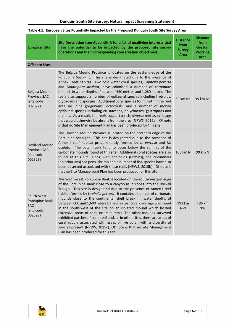
Table 4.1. European Sites Potentially Impacted by the Proposed Dunquin South Site Survey Area
European Site Site Description (see Appendix A for a list of qualifying interests that have the potential to be impacted by the proposed site survey operations and their corresponding conservation objectives)
Distance from
Survey Area
Distance from
Greater Working
Area
Offshore Sites
Belgica Mound Province SAC (site code 002327)
The Belgica Mound Province is located on the eastern edge of the Porcupine Seabight. This site is designated due to the presence of Annex I reef habitat. Two cold water coral species, Lophelia pertusa and Madrepora oculata, have colonised a number of carbonate mounds in water depths of between 550 metres and 1,060 metres. The reefs also support a number of epifaunal species including hydroids, bryozoans and sponges. Additional coral species found within the reef area including gorgonians, octocorals, and a number of mobile epifaunal species including crustaceans, polychaetes, gastropods and urchins. As a result, the reefs support a rich, diverse reef assemblage that would otherwise be absent from the area (NPWS, 2015a). Of note is that no Site Management Plan has been produced for this site.
39 km NE 35 km NE
Hovland Mound Province SAC (site code 002328)
The Hovland Mound Province is located on the northern edge of the Porcupine Seabight. This site is designated due to the presence of Annex I reef habitat predominantly formed by L. pertusa and M. oculata. The patch reefs tend to occur below the summit of the carbonate mounds found at this site. Additional coral species are also found at this site, along with echinoids (urchins), sea cucumbers (holothurians) sea pens, shrimp and a number of fish species have also been observed associated with these reefs (NPWS, 2015b). Of note is that no Site Management Plan has been produced for this site.
103 km N 99 km N
South-West Porcupine Bank SAC (site code 002329)
The South-west Porcupine Bank is located on the south-western edge of the Porcupine Bank close to a canyon as it slopes into the Rockall Trough. This site is designated due to the presence of Annex I reef habitat formed by Lophelia pertusa. It contains a number of carbonate mounds close to the continental shelf break, in water depths of between 600 and 1,600 metres. The greatest coral coverage was found in the south-west of the site on an isolated mound which hosted extensive areas of coral on its summit. The other mounds surveyed exhibited patches of coral reef and, as in other sites, there are areas of coral rubble associated with areas of live coral, with a diversity of species present (NPWS, 2015c). Of note is that no Site Management Plan has been produced for this site.
191 km NW
186 km NW

Dunquin South Site Survey: Natura Impact Screening Statement
Doc Ref: P1188-CTR08-04-02 Page No: 11
European Site Site Description (see Appendix A for a list of qualifying interests that have the potential to be impacted by the proposed site survey operations and their corresponding conservation objectives)
Distance from
Survey Area
Distance from
Greater Working
Area
Porcupine Bank Canyon SAC (site code 003001)
The Porcupine Bank Canyon lies at the continental margin of the north-east Atlantic and slopes into the Rockall Trough (to the west) and Porcupine Seabight (to the east). It is designated due to the presence of Annex I reef habitat, which are mostly geogenic in origin. The fauna observed at this site is highly diverse, particularly amongst the dead coral framework, and included black coral, soft coral (>2 species, including Anthomastus sp.), sea pen (Pennatula sp., on soft ground), gorgonians, encrusting sponges, desmospongia, glass sponges (particularly Aphrocallistes sp.), sea urchins (mainly Cidaris cidaris), anemones (including Phelliactis sp.), starfish, hydroids (stylasterids), fish, galatheids (>1 species and including Chirostylus sp. and Munidae), echiurans (particularly abundant on softer sediment), un-stalked crinoids, stalked crinoids, crabs (Bathynectes sp. and Chaecon sp.), corallimorphs, britle stars and sea cucumbers (NPWS, 2015d). Of note is that no Site Management Plan has been produced for this site.
207 km NW
202 km NW
Coastal Sites
Blasket Islands cSAC (site code 002172)
The Blasket Islands are situated at the end of the Dingle peninsula in Co. Kerry. The site includes all of the islands in the group as well as a substantial area of the surrounding seas. This site has site has high conservation value owing to the occurrence of good examples of several habitats that are listed on Annex I of the Habitats Directive, i.e. vegetated sea cliffs, dry heath, marine caves and reefs, as well as populations of grey seal and harbour porpoise, both species that are listed on Annex II of the Habitats Directive. The site is also one of the most important seabird sites in the country, with the populations of two species present being of international importance and at least a further nine being of national importance (NPWS, 2015e). Of note is that no Site Management Plan has been produced for this site.
147 km NE
143 km NE
Roaringwater Bay & Islands cSAC (site code 000101)
Roaringwater Bay, Co. Cork, is a wide, shallow bay located on the south-west coast of Ireland. The site supports diverse marine and terrestrial habitats, five of which are listed under Annex I the Habitats Directive; large shallow inlets and bays, reefs, vegetated sea cliffs, dry heath, and sea caves. Otter (Lutra lutra), grey seal and harbour porpoise, all mammal species listed on Annex II of the Habitats Directive, occur within the site (NPWS, 2015f). Of note is that no Site Management Plan has been produced for this site.
188 km
NE
185 km
NE
Lower River Shannon cSAC (site code 002165)
Lower River Shannon SAC is designated due to the presence of a number of marine and terrestrial Annex I habitats including: sandbanks, mudflats, coastal lagoons, salt meadows, reefs, vegetated sea cliffs and alluvial forests. In addition, Annex II species that are qualifying species of this site include the freshwater pearl mussel (Margaritifera margaritifera), sea lamprey (Petromyzon marinus), brook lamprey (Lampetra planeri), river lamprey (Lampetra fluviatilis), salmon (Salmo salar), common bottlenose dolphin and otter (NPWS, 2015g). A Site Management Plan for the region has been published.
213 km NE
208 km NE

Dunquin South Site Survey: Natura Impact Screening Statement
Doc Ref: P1188-CTR08-04-02 Page No: 12
Figure 4.1. Location of the Proposed Dunquin South Survey Area and European Sites
Dunquin South Site Survey: Natura Impact Screening Statement
Doc Ref: P1188-CTR08-04-02 Page No: 13
5 Identification and Assessment of Likely Significant Effects
The purpose of this section is to assess whether the proposed Dunquin South site survey, either individually or in combination with other plans and projects, will have any likely significant effects on the European sites identified in Section 4.
5.1 Offshore SAC Sites
All the offshore SAC sites listed in Table 4.1, Section 4 (the closest of which is located approximately 35 km to the north east of the greater working area) have been designated for their Annex I reef habitats.
It has been identified that the qualifying interest feature of these offshore SACs (i.e. reef habitat) could be adversely affected by the following aspects of the proposed site survey operations:
Underwater noise generated from the proposed geophysical survey equipment;
Routine marine discharges;
Loss of diesel containment on vessel (fuel spill) due to collision or other event.
A study on the effects of a 3D seismic survey on a tropical coral reef atoll off the north west coast of Australia found no evidence of long term damage or disturbance to coral assemblages or reef-fish populations from the survey (Battershill et al., 2007). In addition, a desktop study on the effects of 3D seismic on cold water scleractinian (hard) corals, such as those found in the Porcupine Basin, concluded that the anticipated noise levels from seismic surveys are not expected to cause physical or physiological injury or disturbance to cold water corals (Austin et al., 2014). Of note is that the seismic airgun arrays considered during these studies (Battershill et al., 2007; Austin et al., 2014) generate high-energy but low frequency noise that has the ability to travel large distances in the marine environment (Genesis, 2011). An airgun will not be used for the proposed Dunquin South site survey; the overall noise levels from the equipment to be used during the survey operations are low in comparison to seismic airgun arrays. Given this, coupled with the fact that the offshore SAC sites are not located within or immediately adjacent to the proposed survey area, no likely significant effects to the conservation objectives of the qualifying interest of these SACs are predicted as a result of the underwater noise generated from the proposed Dunquin South site survey operations.
Routine marine discharges resulting from the proposed site survey operations will only result in very localised and short term impacts to the marine environment. Given the distance between the survey area and the offshore SACs, no likely significant effects to the conservation objectives of the qualifying interest of these SACs are predicted as a result of routine marine discharges from the proposed Dunquin South site survey operations.
With regards to unplanned events, the potential for a major loss of diesel containment on the survey vessel, due to an event like a collision, is considered very unlikely to occur. Diesel contains a high percentage of low molecular weight hydrocarbon compounds, known as 'light ends' and hence tends to naturally disperse very rapidly in the marine environment via evaporation. Any sheen on the surface is likely to be broken up and reduced by wave action. Given the low likelihood of an accidental hydrocarbon release and the fact that submerged reefs are not generally vulnerable to surface oil pollution, no likely significant effects to the conservation objectives of the qualifying interest of the offshore SACs are predicted.
5.2 Coastal SAC Sites
Potential impacts to the qualifying interests (harbour porpoise and bottlenose dolphin) of the three coastal cSACs identified in Table 4.1 (Section 4) as a result of the underwater noise generated by the proposed Dunquin South site survey operations are discussed below.
5.2.1 Zone of Impact for Cetaceans
Reactions of cetaceans to anthropogenic noise are variable and dependent on the noise intensity and frequency, as well as the individuals hearing thresholds. In addition, newborn and younger individuals

Dunquin South Site Survey: Natura Impact Screening Statement
Doc Ref: P1188-CTR08-04-02 Page No: 14
may have the greatest hearing sensitivity with hearing ability declining over time due to age, exposure to harmful sound levels and disease (DAHG, 2014).
Species will only hear sounds that are within their hearing threshold (DOSITS, 2016) with ability and therefore hearing sensitivity reduced outside a species’ audible frequency range. Research conducted by Southall et al. (2007) and later NOAA (2018) has produced a comprehensive review of the potential impacts of underwater noise on marine mammals and has proposed criteria for assessing the likelihood of injury or behavioural disturbance to certain species based on their hearing ability. Cetaceans have been grouped into functional groups according to their hearing ability as shown in Table 5.1. Harbour porpoises are classed as high-frequency cetaceans and bottlenose dolphin are classed as mid-frequency cetaceans.
Table 5.1. Marine Mammal Hearing Groups and their Estimated Hearing Range (Southall et al., 2007; NOAA, 2016)
Functional Group Estimated Hearing Range
Southall et al. (2007) NOAA (2016)
Low-frequency cetaceans (e.g. baleen whales)
0.007 kHz – 22 kHz 0.007 kHz – 35 kHz
Mid-frequency cetaceans (most toothed whales, dolphins)
0.15 kHz – 160 kHz 0.15 kHz – 160 kHz
High-frequency cetaceans
(certain toothed whales, porpoises) 0.2 kHz – 180 kHz 0.275 kHz -160 kHz
Of the survey equipment to be used during the proposed Dunquin South site survey, the multi-beam echosounder has the highest SPL (refer to Table 3.1 in Section 3); however this operates at a high frequency, beyond the hearing range of any of the marine mammal functional groups. As such, this acoustic source is not anticipated to have a significant effect on either harbour porpoises or bottlenose dolphins as the acoustic emissions will be outside of their hearing ability.
Side scan sonar also operates at a high frequency; however, the operating frequency range may overlap with the auditory hearing range of high frequency cetaceans (i.e. harbour porpoise). The chirp sub bottom profiler operates at comparably lower frequencies than both the multi-beam echosounder and side scan sonar, with its operating frequencies potentially overlapping with the hearing range of all of the functional hearing groups. Vessel noise is also of a low frequency and therefore may be detectable by all of the marine mammal functional hearing groups.
Physiological Impacts
When marine mammals are exposed to intense sound, an elevated hearing threshold may occur, known as a threshold shift (TS). If the hearing threshold returns to the pre-exposure level after a period of time, the TS is known as a temporary threshold shift (TTS). If the threshold does not return to the pre-exposure level, it is known as a permanent threshold shift (PTS) and is considered to result in injury (Finneran et al., 2000; Southall et al., 2007).
According to Southall et al. (2007), the injury SPL threshold for high-frequency cetaceans for all noise types (single, multiple and non-pulsed noise) is 230 dB re 1 μPa. However, in 2016, NOAA, published technical guidance which reports lower PTS onset thresholds than Southall et al. (2007; refer to Table 5.2). Please note, that although the NOAA guidance was revised in April 2018, the thresholds remain the same. As the NOAA (2018) report represents more the most up-to-date thinking by those working in the area, these lower injury thresholds have been used in this assessment.
Table 5.2. NOAA (2018) Injury (PTS Onset) Thresholds (Impulsive Noise)
Hearing Group PTS Onset Level (SPLpeak; dB re 1μPa)
Low‐frequency cetaceans 219 dB
Mid‐frequency cetaceans 230 dB
High‐frequency cetaceans 202 dB

Dunquin South Site Survey: Natura Impact Screening Statement
Doc Ref: P1188-CTR08-04-02 Page No: 15
Of the equipment to be used during the proposed Dunquin South site survey, the multi-beam echosounder and side scan sonar is expected to exceed the NOAA (2018) injury threshold for both high-frequency and low-frequency cetaceans, while the chirp sub-bottom profiler is only expected to exceed the NOAA (2018) injury thresholds for high-frequency cetaceans. The noise generated by the survey vessel is not expected to exceed any of the NOAA (2018) thresholds for injury to cetaceans and is therefore not considered further.
The potential zones where cetaceans could be subject to injury as a result of the proposed Dunquin South site survey are identified in Table 5.3 and have been calculated based on a simple transmission loss model of underwater noise (Richardson et al., 1995), as described in the Dunquin South Site Survey Environmental Risk Assessment (EIA Screening) for Annex IV Species. All potential zones of impact are within close proximity to the source and are a considerable distance from the coastal cSACs (refer to Section 4).
Table 5.3. Worst Case Predicted Impact Ranges for Noise Sources during the Proposed Survey Using NOAA (2018) Injury (PTS Onset) Thresholds
Noise Source SPL (extrapolated to 1 metre from
the source)
Impact Radius for PTS Onset
MF (i.e. bottlenose dolphin
HF (i.e. harbour porpoise)
Side Scan Sonar 220 dB re 1 µPa 0 m 9 m
Multi-Beam Echosounder 223 dB re 1 µPa 0 m 12 m
Chirp Sub-Bottom Profiler 208 dB re 1 µPa 0 m 3 m
Survey Vessel 180 dB re 1 µPa 0 m 0 m
Notes MF = mid-frequency cetaceans; HF = high-frequency cetaceans.
Behavioural Impacts
Table 5.4 details the conservative sound levels that may induce disturbance reactions in cetaceans. It can be seen that all of the geophysical equipment proposed to be used during the Dunquin South site survey, as well as the survey vessel, could have the potential to elicit a behavioural response in cetaceans; however, as the multi-beam echosounder will operate at frequencies beyond the hearing range of all the functional hearing groups (refer to Table 5.1) this noise source has not been considered further in this assessment for behavioural impacts on cetaceans.
Table 5.4. Proposed Southall et al. (2007) Behavioural Response Thresholds for Cetaceans Exposed to Different Sound Types
Functional Group SPL (dB re 1μPa)
Multiple-Pulse Non-Pulse
Low-frequency cetaceans 145 (BRS = 6-7) 120 (BRS = 6-7)
Mid-frequency cetaceans 150 (BRS = 6) 145 (BRS = 5-8)
High-frequency cetaceans 125 (BRS = 6) 1 125 (BRS = 6)
Notes 1 No behavioural response thresholds for high-frequency cetaceans to multiple pulse noise are put forward by Southall et al. (2007). However, it is acknowledged that some pulsed noise sources may produce characteristics of non-pulse noise, particularly with distance from the source. As such, in the absence of defined thresholds, a conservative estimate of 125 dB re 1μPa (as per non-pulse noise) has been used for the assessment of behavioural effects that may be elicited in high-frequency cetaceans in response to non-pulse noise.
The potential zone of impacts where cetaceans could exhibit behavioural responses as a result of the proposed site survey operations are identified in Table 5.5 and have also been calculated based on the simple transmission loss model of underwater noise (Richardson et al., 1995), as described in the

Dunquin South Site Survey: Natura Impact Screening Statement
Doc Ref: P1188-CTR08-04-02 Page No: 16
Dunquin South Site Survey Environmental Risk Assessment (EIA Screening) for Annex IV Species. The zone of impact is the distance at which the behavioural response thresholds shown in Table 5.4 are met or exceeded. However, as explained in Table 3.2, the actual impact ranges are likely to be lower than the ranges presented below.
Table 5.5. Worst Case Predicted Impact Ranges for Noise Sources during the Proposed Survey using Southall et al. (2007) Behavioural Response Thresholds for Marine Mammals
Noise Source SPL (dB re 1 µPa @ 1m)
Impact Radius for Behavioural Response
MF (i.e. bottlenose dolphin)
HF (i.e. harbour porpoise)
Side Scan Sonar 220 3.5 km 60 km
Chirp Sub-Bottom Profiler 208 0.842 km 15 km
Survey Vessel 180 0.06 km 0.6 km
Notes MF = mid-frequency cetaceans; HF = high-frequency cetaceans.
5.2.2 Assessment of Potential Impacts
To determine the likelihood of impact from the underwater noise generated by the proposed Dunquin South site survey operations, the number of animals that may be present within the predicted worst case impact zones at any one time has been calculated using the density and abundance estimates for harbour porpoise and bottlenose dolphin from the ObSERVE Aerial project (Rogan et al., 2018) (see Table 5.6). Of note is that none of the equipment to be used during the proposed Dunquin South site survey operations is expected to exceed the NOAA (2018) injury threshold for mid-frequency cetaceans.
Table 5.6. Estimated number of animals experiencing PTS or behavioural changes as a result of the proposed Dunquin South site survey operations
Species
The Porcupine Seabight (Stratum 3) 1
Management Unit (MU)
Abundance Data
Max number of animals
subject to PTS / Behavioural
Onset 2
Approx. % of reference population potentially
affected
Density -summer (animals per km2)
Abundance – summer
(individuals)
Stratum 3 Data
MU Abundance
Data
PTS Onset
Harbour porpoise 3 0.049 5,015.2 104,695 < 0.00003 0.0000006% 0.00000003%
Behavioural Change Onset
Harbour porpoise 3
0.049 5,015.2 104,695 < 554 11% 0.5%
Bottlenose dolphin 4
0.295 29,602 11,923 < 12 0.04% 0.1%
1 Average density estimates from Rogan et al., 2018 for the S3 stratum (The Porcupine Seabight). 2 Calculated as the density estimate x PTS / behavioural changes onset area (worst case). 3 MU Data: Celtic and Irish Seas MU (IAMMWG, 2015). 4 MU Data: Oceanic Waters MU; this excludes the two inshore groups of bottlenose dolphins in Irish waters, with separate MUs identified for the Shannon Estuary and West Coast of Ireland in the coastal region (IAMMWG, 2015).
It can be concluded that whilst the presence of harbour porpoise in the potential zone of impact at the time the proposed Dunquin South site survey operations cannot be ruled out, the number of individual animals that could experience PTS (i.e. result in an injury) is extremely small, particularly in the context of the percentage of the population in the Porcupine Seabight that may be affected.

Dunquin South Site Survey: Natura Impact Screening Statement
Doc Ref: P1188-CTR08-04-02 Page No: 17
It is acknowledged that a greater number of harbour porpoises, as well as bottlenose dolphins, may exhibit some form of change in behaviour for the period in which they encounter sound from the proposed site survey operations, but for bottlenose dolphin the numbers are still low when compared to the abundance of the species in the Porcupine Seabight. A larger percentage of the population of harbour porpoise in the Porcupine Seabight (based on Rogan et al., 2018 data) could potentially be subject to behavioural changes, however, the predicted maximum impact range of 60 km is likely to be an over-estimation as the model proposed by Richardson et al. (1995) generally overestimates transmission of sound from the source (see explanation in Table 3.2). When compared to the wider population of harbour porpoises in the Oceanic Waters MU (IAMMWG, 2015) a much smaller percentage is impacted (around 0.5%). In addition, harbour porpoise is a predominantly coastal species and tends to be restricted to the continental shelf to the east of the proposed site survey area (Johnston et al., 2005; Sea Watch Foundation, 2012).
The nearest European site to the proposed Dunquin South survey area, designated for the presence of harbour porpoise, is the Blasket Islands cSAC located approximately 147 km to the north east of the survey area (143 km from the greater working area). As the harbour porpoise is a predominantly coastal species and tends to be restricted to the continental shelf (Johnston et al., 2005; Sea Watch Foundation, 2012) it is considered unlikely that they would be subject to significant behavioural impacts as a result of the proposed survey even if migrating and foraging outside of the cSAC boundary. Short-term avoidance to seismic surveys activities has been observed in harbour porpoises, but effects were temporary as individuals returned to the survey area within hours of sound source ceasing (Thompson et al., 2013). In addition, of those individuals that could potentially be present within the zone of impact for behavioural response, there is a very low likelihood of these individuals remaining within this area for the whole duration of the proposed survey operations, which in itself is very short (14 days). It should also be noted that behavioural changes such as moving away from an area for short periods of time, reduced surfacing time, masking of communication signals or echolocation clicks, vocalisation changes and separation of mothers from offspring for short periods, do not necessarily imply that detrimental effects will result for the animals involved (JNCC, 2010).
Harbour porpoise feed on a wide range of fish species, but mainly small shoaling species from demersal or pelagic habitats (Santos and Pierce, 2003). An examination of 73 harbour porpoises revealed that 98% of the stomach contained various species of fish such as herring, mackerel, sprat, pollack, hake, sardines, and sand eels (Rogan, 2009). During the proposed Dunquin South site survey operations there is the potential for indirect effects on harbour porpoises due to changes in prey (fish) species distribution and/or abundance. However, sound propagation modelling predicts that impacts to fish will be in a localised area, in close proximity to the noise sources, therefore no likely significant effects are predicted on the harbour porpoise at a population level due to changes in prey resources.
Mid-frequency cetaceans (i.e. bottlenose dolphins) have a reduced zone of impact; potentially exhibiting behavioural responses out to a maximum distance of 3.5 km from the side scan sonar source (refer to Table 5.5), which is a considerable distance from the nearest European site designated for bottlenose dolphin, the Lower River Shannon cSAC located approximately 213 km to the north east of the proposed survey area (208 km from the greater working area). In addition, although bottlenose dolphin may be present within the vicinity of the survey, it is believed that a separate offshore ecotype of bottlenose dolphin, distinct to the resident inshore species, may exist around Ireland (Wall, 2013). O’Brien et al. (2009) used photo-identification techniques to study the movements of bottlenose dolphins around the Irish coast. No dolphins from the Shannon Estuary were recorded outside that immediate area, suggesting that the dolphins identified from Shannon Estuary do not range far beyond the Lower River Shannon cSAC and do not mix with other, more transient, populations found around the Irish coast.
Bottlenose dolphin primarily feed on inshore bottom dwelling fish, although they will also eat salmon, plaice, eels, small sharks, rays, hermit crabs, shrimps and mullet (Reid et al., 2003; Berrow et al., 2010). During the proposed Dunquin South site survey operations there is the potential for indirect effects on harbour porpoises due to changes in prey (fish) species distribution and/or abundance. However, sound propagation modelling predicts that impacts to fish will be in a localised area, in close proximity to the noise sources, therefore no likely significant effects are predicted on the bottlenose dolphin at a population level due to changes in prey resources.

Dunquin South Site Survey: Natura Impact Screening Statement
Doc Ref: P1188-CTR08-04-02 Page No: 18
Given the above, it is concluded that no likely significant effects to the conservation objectives of the qualifying interest of the Blasket Islands cSAC, Roaringwater Bay & Islands cSAC and Lower River Shannon cSAC are predicted as a result of the underwater noise generated from the proposed Dunquin South site survey operations.
5.3 Potential for In Combination Effects
Eni is aware of the following consented or planned projects which have the potential to have an in-combination or cumulative effect on European sites with the proposed Dunquin South site survey operations:
PSE Kinsale Energy Limited (Kinsale Energy) is preparing for the decommissioning of the Kinsale Area gas fields and facilities, located in the Celtic Sea approximately 280 km from the Dunquin South greater working area. The decommissioning work is scheduled to occur following cessation of production, which is currently anticipated between 2020 and 2021. As the proposed Dunquin South survey operations are planned to occur sometime between June and September 2019, no cumulative likely significant effects on European sites are predicted;
Nexen Petroleum U.K Ltd (Nexen) plans to drill a single exploration well in the Iolar prospect in FEL 3/18 in the Porcupine Basin approximately 74 km from the Dunquin South greater working area. The well will be drilled using a floating drill ship suitable for the deep-water west of Ireland with the earliest start date for drilling operations being April 2019. The total duration of the drilling and suspension/abandonment operations (on location) is expected to be 100 to 150 days and therefore the drilling operations could coincide with the proposed Dunquin South site survey (June – September 2019, inclusive). Concurrent operations have the potential to result in cumulative impacts to the relevant qualifying interests of coastal SACs associated with underwater noise emissions. During the proposed Iolar drilling operations underwater noise will be generated by both the drill ship and a proposed Vertical Seismic Profile (VSP) survey. Nexen (2018) has calculated that the worst case behavioural change impact zones to cetaceans resulting from continuous noise (drilling / drill ship / support vessel) and impulsive noise (VSP) sources are 590 m and 2,795 m respectively. It is noted there is unlikely to be any interaction between the Iolar project and bottlenose dolphins from the Lower River Shannon SAC in terms of underwater noise emissions and very few, if any, harbour porpoise would be affected therefore there is unlikely to be an impact to the integrity of the Blasket Islands and Roaringwater Bay and Islands SACs (Nexen, 2018). Given this, coupled with the fact the zone of impacts associated with the two projects will not overlap and the short duration of both the proposed Dunquin site survey operations (14 days) and the VSP (8 – 12 hours); no cumulative LSE to bottlenose dolphin or harbour porpoise are predicted even if the two projects were ongoing at the same time. No likely significant cumulative effects on the conservation objectives of European sites are therefore predicted.
Exola DAC Limited (a wholly owned subsidiary of PVR) is also planning to conduct a site survey within the Barryroe licence area (SEL 1/11); situated in the North Celtic Basin, approximately 270 km to the northeast of the Dunquin South greater working area. Operations could take place between the 1st April 2019 and 30th November 2019, subject to regulatory approval and vessel availability, and therefore could overlap with the proposed Dunquin South site survey operations. However, given the distance between the two surveys, no cumulative likely significant effects to the conservation objectives of the qualifying interests of European sites are predicted even if the two surveys were ongoing at the same time.
Eni UK Limited is planning to conduct a three dimensional seismic survey within the St George’s Channel region of the Irish Sea, approximately 456 km from the Dunquin South greater working area. The earliest commencement date for the proposed seismic survey operations is 1st June 2019, subject to regulatory approval and vessel availability, with a latest completion date of 30th September 2019 and therefore the proposed survey could overlap with the proposed Dunquin South site survey operations. However, given the distance between the two surveys, no cumulative likely significant effects to the conservation objectives of the qualifying interests of European sites are predicted even if the two surveys were ongoing at the same time.

Dunquin South Site Survey: Natura Impact Screening Statement
Doc Ref: P1188-CTR08-04-02 Page No: 19
Eni do not know of any other offshore work programmes scheduled to take place at the same time as or immediately before or after the proposed Dunquin South survey area that would result in potentially significant in combination effects.

Dunquin South Site Survey: Natura Impact Screening Statement
Doc Ref: P1188-CTR08-04-02 Page No: 20
6 Conclusions
This natura impact screening statement has concluded that there will be no likely significant effects on the conservation objective of any offshore or coastal European site arising from the proposed Dunquin South site survey operations. This was determined on the basis of the best objective, scientific evidence.
Dunquin South Site Survey: Natura Impact Screening Statement
Doc Ref: P1188-CTR08-04-02 Page No: 21
7 References
Aguilar de Soto, N. and Knight, C. (2016) “Physiological effects of noise on aquatic animals,” In: Solan, M. and Whiteley, N.M. (Eds.). Stressors in the Marine Environment. Oxford: Oxford University Press, 135-158.
Austin, M., McPherson, C., O’Neill, C., Warner, G. & Zeddies, D. (2014). Impacts of Seismic Surveys near Coldwater Coral Carbonate Mounds: Acoustic Modelling Study – Offshore Ireland, JASCO Document 00889, Version 1.0. Technical report by JASCO Applied Sciences for Woodside Energy (Ireland) Pty Ltd.
Battershill, C., Cappo, M., Colquhoun, J., Cripps, E., Jorgensen, D., McCorry, D., Stowar, M. & Venables, W. (2007). Environmental Report for Seismic 3‐D effects on deep water corals for Woodside Petroleum and EPA. Scott Reef Australian Institute of Marine Science.
BEIS (2019) Offshore Oil & Gas Licensing 31st Seaward Round. Habitats Regulations Assessment Draft Appropriate Assessment: Moray Firth. February 2019. Available from: https://assets.publishing.service.gov.uk/government/uploads/system/uploads/attachment_data/file/777002/31st_Round_AA_MF_-_Consultation_Draft.pdf [Assessed March 2019].
Berrow, S., Whooley, P., O’Connell, M. and Wall, D. (2010) Irish Cetacean Review (2000-2009). Irish Whale and Dolphin Group, 60pp. ISBN 0-9540552-4-1.
Blueprint Subsea (2018) X150 USBL Transponder Beacon Product Sheet. Available from: https://www.blueprintsubsea.com/pages/product.php?PN=BP00795 [Accessed December 2018].
Cronin, M.A., Jessopp, M.J. and Villar, D.D. (2011) Tracking grey seals on Irelands’ continental shelf. Report to National Parks & Wildlife Service, Department of Arts, Heritage and Gaeltacht. Available from: https://www.npws.ie/sites/default/files/publications/pdf/Tracking%20grey%20seals_Final%20report%202011.pdf [Accessed November 2017].
DAHG (Department of Arts, Heritage and the Gaeltacht) (2012) Marine Natura Impact Statements in Irish Special Areas of Conservation - A Working Document. Prepared by the National Parks & Wildlife Service of the Department of Arts, Heritage & the Gaeltacht. April 2012.
DAHG (Department of Arts, Heritage and the Gaeltacht) (2014) Guidance to Manage the Risk to Marine Mammals from Man-made Sound in Irish Waters. Department of Arts, Heritage and the Gaeltacht. 59 pp.
DCENR (2015) Environmental Report and Annex for IOSEA 5. [Online] Available at: http://www.dccae.gov.ie/natural-resources/en-ie/Oil-Gas-Exploration-Production/Pages/Environmental-Report-and-Annex-for-IOSEA-5.aspx# [Accessed April 2018]
DCENR (2014) Rules and Procedures Manual for Offshore Petroleum Exploration and Appraisal Operations Conducted under an Exploration Licence or other Authorisation. Petroleum Affairs Division (PAD). May 2014, 80 pp.
DECC (2011) Record Of The Appropriate Assessment Undertaken Under Regulation 5 Of The Offshore Petroleum Activities (Conservation Of Habitats) Regulations 2001 (As Amended) - Block 17/4B 2D Seismic Survey. Department of Energy and Climate Change (DECC). Available from: https://assets.publishing.service.gov.uk/government/uploads/system/uploads/attachment_data/file/51740/aa_2212.pdf [Accessed April 2018].
DEHLG (Department for Environment, Heritage and Local Government) (2010) Appropriate Assessment of Plans and Projects in Ireland: Guidance for Planning Authorities. February 2010.
DOSITS (2016) Discovery of Sound in the Sea. University of Rhode Island. [Online] Available at: http://www.dosits.org/
European Commission (2001) Assessment of Plans and Projects Significantly Affecting Natura 2000 Sites. Methodological Guidance on the Provisions of Article 6(3) and (4) of the Habitats Directive 92/43/EEC. November, 2001.

Dunquin South Site Survey: Natura Impact Screening Statement
Doc Ref: P1188-CTR08-04-02 Page No: 22
European Commission (2007) Guidance document on Article 6(4) of the 'Habitats Directive' 92/43/EEC. Clarification of the Concepts of: Alternative Solutions, Imperative Reasons of Overriding Public Interest, Compensatory Measures, Overall Coherence, Opinion of the Commission. January 2007.
Finneran, J.J., Schlundt, C.E., Carder, D.A., Clark, J.A., Young, J.A., Gaspin, J.B. & Ridgway, S.H. (2000) Auditory and behavioural response of bottlenose dolphins (Tursiops truncatus) and a beluga whale (Delphinapterus leucas) to impulsive sounds resembling distant signatures of underwater explosions. Journal of the Acoustical Society of America 108 (1): 417 – 431.
GEBCO (2014) Bathymetry data - GEBCO_2014 Grid. Available from: https://www.gebco.net/data_and_products/gridded_bathymetry_data/ [Accessed February 2018].
Genesis (2011) Review and assessment of underwater sound produced by oil and gas activities and potential reporting requirements under the Marine Strategy Framework Directive, Genesis Oil and Gas Consultants. Report to DECC: J71656-Final Report-G2.
Gitschlag, G. and Herczeg, B.A. (1994) Sea turtle observations at explosive removals of energy structures. Marine Fisheries Review, 56(2), 1-8.
Hammond P. S., Macleod K., Berggren P., Borchers D. L., Burt L., Cañadas A., Desportes G., Donovan G. P., Gilles A., Gillespie D., Gordon J., Hiby L., Kuklik I., Leaper R., Lehnert K., Leopold M., Lovell P., Øien N., Paxton C. G. M., Ridoux V., Rogan E., Samarra F., Scheidat M., Sequeira M., Siebert U., Skov H., Swift R., Tasker M. L., Teilmann J., Van Canneyt O. and Vázquez J. A. (2013) Cetacean abundance and distribution in European Atlantic shelf waters to inform conservation and management. Biological Conservation, 164, 107-122.
IAMMWG (2015) Management Units for Cetaceans in UK Waters (January 2015). Peterborough: Inter-Agency Marine Mammal Working Group, Joint Nature Conservation Committee. Report No. 547.
Johnston, D.W., Westgate, A.J. and Read, A.J. (2005) Effects of fine-scale oceanographic features on the distribution and movements of harbour porpoises Phocoena phocoena in the Bay of Fundy. Marine Ecology Progress Series 295: 279-293.
Nexen, (2018). Iolar Drilling Campaign Environmental Risk Assessment (EIA Screening) Report. Report Number A-100460-S00-REPT-001.
NOAA (2016) Technical Guidance for Assessing the Effects of Anthropogenic Sound on Marine Mammal Hearing: Underwater Acoustic Thresholds for Onset of Permanent and Temporary Threshold Shifts. U.S. Maryland; Department of Commerce, National Oceanic and Atmospheric Administration (NOAA). Report No. NMFS-OPR-55. Available from: http://www.nmfs.noaa.gov/pr/acoustics/guidelines.htm [Accessed February 2018].
NPWS (2011) Conservation Objectives: Roaringwater Bay and Islands SAC 000101. Version 1.0. National Parks and Wildlife Service, Department of Arts, Heritage and the Gaeltacht. Available from: https://www.npws.ie/sites/default/files/protected-sites/conservation_objectives/CO000101.pdf. [Accessed December 2018].
NPWS (2012) Conservation Objectives: Lower River Shannon SAC 002165. Version 1.0. National Parks and Wildlife Service, Department of Arts, Heritage and the Gaeltacht. Available from: https://www.npws.ie/sites/default/files/protected-sites/conservation_objectives/CO002165.pdf. [Accessed December 2018].
NPWS (2014) Conservation Objectives: Blasket Islands SAC 002172. Version 1. National Parks and Wildlife Service, Department of Arts, Heritage and the Gaeltacht. Available from: https://www.npws.ie/sites/default/files/protected-sites/conservation_objectives/CO002172.pdf. [Accessed December 2018].
NPWS (2015a) Belgica Mounds Province SAC Natura 2000 – Standard Data Form. Available from: https://www.npws.ie/protected-sites/sac/002327 [Accessed April 2018].
NPWS (2015b) Hovland Mounds Province SAC Natura 2000 – Standard Data Form. Available from: https://www.npws.ie/protected-sites/sac/002328 [Accessed April 2018].

Dunquin South Site Survey: Natura Impact Screening Statement
Doc Ref: P1188-CTR08-04-02 Page No: 23
NPWS (2015c) South-west Porcupine Bank SAC Natura 2000 – Standard Data Form. Available from: https://www.npws.ie/protected-sites/sac/002329 [Accessed April 2018].
NPWS (2015d) Porcupine Bank Canyon SAC Natura 2000 – Standard Data Form. Available from: https://www.npws.ie/protected-sites/sac/003001 [Accessed April 2018].
NPWS (2015e) Blasket Islands SAC Natura 2000 – Standard Data Form. Available from: https://www.npws.ie/protected-sites/sac/002172 [Accessed April 2018].
NPWS (2015f) Roaringwater Bay & Islands SAC Natura 2000 – Standard Data Form. Available from: https://www.npws.ie/protected-sites/sac/000101 [Accessed April 2018].
NPWS (2015g) Lower River Shannon SAC Natura 2000. Available from: https://www.npws.ie/protected-sites/sac/002165 [Accessed April 2018].
NPWS (2015h) Skelligs SPA – Site Synopsis (004007). Available from: https://www.npws.ie/sites/default/files/protected-sites/synopsis/SY004007.pdf [Accessed April 2018]
NPWS (2018a) Conservation objectives for Belgica Mound Province SAC [002327]. Generic Version 6.0. Department of Culture, Heritage and the Gaeltacht. Available from: https://www.npws.ie/sites/default/files/protected-sites/conservation_objectives/CO002327.pdf. [Accessed December 2018].
NPWS (2018b) Conservation objectives for Hovland Mound Province SAC [002328]. Generic Version 6.0. Department of Culture, Heritage and the Gaeltacht. Available from: https://www.npws.ie/sites/default/files/protected-sites/conservation_objectives/CO002328.pdf. [Accessed December 2018].
NPWS (2018c) Conservation objectives for South-west Porcupine Bank SAC [002329]. Generic Version 6.0. Department of Culture, Heritage and the Gaeltacht. Available from: https://www.npws.ie/sites/default/files/protected-sites/conservation_objectives/CO002329.pdf. [Accessed December 2018].
NPWS (2018d) Conservation objectives for Porcupine Bank Canyon SAC [003001]. Generic Version 6.0. Department of Culture, Heritage and the Gaeltacht. Available from: https://www.npws.ie/sites/default/files/protected-sites/conservation_objectives/CO003001.pdf. [Accessed December 2018].
O’Brien JM, Berrow S., Ryan C and Pádraig Whooley (2009). A note on long-distance matches of bottlenose dolphins (Tursiops truncatus) around the Irish coast using photo-identification. Journal of Cetacean Research and Management 11(1):71-76
OSPAR (2008) Overview of Impact of anthropogenic underwater sound in the marine environment. OSPAR Biodiversity Series, 441.
OSPAR (2009) Overview of Impact of anthropogenic underwater sound in the marine environment. Biodiversity Series, OSPAR Commission, 2009.
Reid, J.B., Evans, P.G.H. and Northridge, S.P. (2003) Atlas of cetacean distribution in north-west European waters. Peterborough: Joint Nature Conservation Committee.
Richardson, W.J., Greene, C.R. Jr., Malme, C.I. & Thomson, D.H. (1995) Marine Mammals and Noise. Academic Press, San Diego.
Rogan, E., Breen, P., Mackey, M., Cañadas, A., Scheidat, M., Gellhoed, S. & Jessopp, M. (2018). Aerial surveys of cetaceans and seabirds in Irish waters: Occurrence, distribution and abundance in 2015-2017. Department of Communications, Climate Action & Environment and National Parks and Wildlife Services (NPMS), Department of Culture, Heritage and the Gaeltacht, Dublin, Ireland. 297pp.
Rogan, E. (2009) What can post-mortems tell us about harbour porpoises in Ireland? Proceedings of the 2nd IWDG International Whale Conference. 19-21 September 2008, Killiney, Co Dublin Irish Whale and Dolphin Group, 40.
Santos, M.B. and Pierce, G.J. (2003) The diet of harbour porpoise (Phocoena phocoena) in the Northeast Atlantic. Oceanography and Marine Biology: an Annual Review 2003, 41, 355–390.

Dunquin South Site Survey: Natura Impact Screening Statement
Doc Ref: P1188-CTR08-04-02 Page No: 24
Scott Wilson, Levett-Therivel Sustainability Consultants, Treweek Environmental Consultants and Land Use Consultants (2006) Appropriate Assessment of plans. http://www.landuse.co.uk/Downloads/AppropriateAG.pdf
Sea Watch Foundation (2012) The harbour porpoise in UK waters. Available from: http://seawatchfoundation.org.uk/wp-content/uploads/2012/07/Harbour_Porpoise.pdf [Accessed April 2018].
Seal Tagging Project (2017) CMRC Seal Track – Seals Data. Available from: http://sealtrack.ucc.ie/?page_id=462 [Accessed November 2017].
Southall, B.L., Bowles, A.E., Ellison, W.T., Finneran, J.J., Gentry, R.L., Greene Jr., C.R., Kastak, D., Ketten, D.R., Miller, J.H., Nachtigall, P.E., Richardson, W.J., Thomas, J.A. & Tyack, P.L. (2007) Marine mammal noise exposure criteria: initial scientific recommendations. Aquatic Mammals 33, 411–521.
Thaxter, C.B., Lascelles, B., Sugar, K., Cook, A.S.C.P., Roos, S., Bolton, M., Langston, R.H.W. and Burton, N,H,K. (2012). Seabird foraging ranges as a tool for identifying candidate Marine Protected Areas. Biological Conservation 156: 53-61
Thompson, P.M., Brookes, K.L., Graham, I.M., Barton, T.R., Needham, K., Bradbury, G. and Merchant, N.D. (2013) Short-term disturbance by a commercial two-dimensional seismic survey does not lead to long-term displacement of harbour porpoises. Proceedings of the Royal Society B: Biological Sciences, 280: 1-8.
Wall, D. (2013) Marine Mammals and Megafauna in Irish Waters – Behaviour, Distribution and Habitat Use. Monitoring Spatial and Temporal Habitat Use and Abundance of Species. Marine Research Sub-Programme. NDP 2007-2013 Series. 200 pp.
Wyatt, R. (2008) Review of existing data on underwater sounds produced by the oil and gas industry. Oil and Gas Producers (OGP) Joint Industry Programme report on Sound and Marine Life.

Dunquin South Site Survey: Natura Impact Screening Statement
Doc Ref: P1188-CTR08-04-02 Page No: 25
Appendix A: European Sites Scoped in to the Screening Assessment
European Site
Distance from
Survey Area
Distance from
Greater Working
Area
Qualifying Interest(s)
Potential for LSE from proposed
site survey operations1
Relevant Conservation Objectives
Offshore Sites
Belgica Mound Province SAC [002327] (NPWS, 2018a)
39 km NE 35 km NE Reefs
Generic Conservation Objective: To maintain or restore the favourable conservation condition of the Annex I habitat. Favourable conservation status of a habitat is achieved when:
Its natural range, and area it covers within that range, are stable or increasing,
The specific structure and functions which are necessary for its long-term maintenance exist and are likely to continue to exist for the foreseeable future,
The conservation status of its typical species is favourable.
Hovland Mound Province SAC [002328] (NPWS, 2018b)
103 km N 99 km N Reefs
South-West Porcupine Bank SAC [002329] (NPWS, 2018c)
191 km NW
186 km NW
Reefs
Porcupine Bank Canyon SAC [003001] (NPWS, 2018d)
207 km NW
202 km NW
Reefs
Coastal Sites
Blasket Islands cSAC [002172] (NPWS, 2014)
147 km NE
143 km NE
Reefs x -
Vegetated sea cliffs of the Atlantic and Baltic coasts
x -
European dry heaths x -
Submerged or partially submerged sea caves
x -

Dunquin South Site Survey: Natura Impact Screening Statement
Doc Ref: P1188-CTR08-04-02 Page No: 26
European Site
Distance from
Survey Area
Distance from
Greater Working
Area
Qualifying Interest(s)
Potential for LSE from proposed
site survey operations1
Relevant Conservation Objectives
Harbour Porpoise
To maintain the favourable conservation condition of harbour porpoise in Blasket Islands SAC, which is defined by the following list of attributes and targets:
Attribute Measure Target
Access to suitable habitat
Number of artificial barriers
Species range within the site should not be restricted by artificial barriers to site use
Disturbance Level of impact
Human activities should occur at levels that do not adversely affect the harbour porpoise community at the site
Grey Seal x -
Roaringwater Bay & Islands cSAC [000101] (NPWS, 2011)
188 km NE
185 km NE
Large shallow inlets and bays x -
Reefs x -
Vegetated sea cliffs of the Atlantic and Baltic coasts
x -
Harbour porpoise
To maintain the favourable conservation condition of harbour porpoise in Roaringwater Bay and Islands SAC, which is defined by the following list of attributes and targets:
Attribute Measure Target
Access to suitable habitat
Number of artificial barriers
Species range within the site should not be restricted by artificial barriers to site use
Disturbance Level of impact
Human activities should occur at levels that do not adversely affect the harbour porpoise community at the site
Otter x -
Grey seal x -

Dunquin South Site Survey: Natura Impact Screening Statement
Doc Ref: P1188-CTR08-04-02 Page No: 27
European Site
Distance from
Survey Area
Distance from
Greater Working
Area
Qualifying Interest(s)
Potential for LSE from proposed
site survey operations1
Relevant Conservation Objectives
European dry heaths x -
Submerged or partly submerged sea caves
x -
Lower River Shannon cSAC [002165] (NPWS, 2012)
213 km NE
208 km NE
Sandbanks which are slightly covered by sea water all the
time x -
Estuaries x -
Mudflats and sandflats not covered by seawater at low
tide x -
Coastal lagoons Large shallow inlets and bays
x -
Reefs x -
Perennial vegetation of stony banks
x -
Vegetated sea cliffs of the Atlantic and Baltic coasts
x -
Salicornia and other annuals colonising mud and sand
x -
Mediterranean salt meadows x -
Water courses of plain to montane levels with the
Ranunculion fluitanis and Callitricho-Batrachion
vegetation
x -
Molinia meadows on calcareous, peaty or clayey-
silt-laden soils x -
Alluvial forests with Alnus glutinosa and Fraxinus
x -

Dunquin South Site Survey: Natura Impact Screening Statement
Doc Ref: P1188-CTR08-04-02 Page No: 28
European Site
Distance from
Survey Area
Distance from
Greater Working
Area
Qualifying Interest(s)
Potential for LSE from proposed
site survey operations1
Relevant Conservation Objectives
excelsior (Alno-Padion, Alnion incanae, Salicion albae)
Margaritifera margaritifera (Freshwater Pearl Mussel)
x -
Petromyzon marinus (Sea Lamprey)
x -
Lampetra planeri (Brook Lamprey)
x -
Lampetra fluviatilis (River Lamprey)
x -
Salmo salar (Salmon) x -
Tursiops truncates (Common Bottlenose Dolphin)
To maintain the favourable conservation condition of bottlenose dolphin in Lower River Shannon SAC, which is defined by the following list of attributes and targets:
Attribute Measure Target
Access to suitable habitat
Number of artificial barriers
Species range within the site should not be restricted by artificial barriers to site use
Habitat use: critical areas
Location and hectares
Critical areas, representing habitat used preferentially by bottlenose dolphin, should be maintained in a natural condition
Disturbance Level of impact
Human activities should occur at levels that do not adversely affect the bottlenose dolphin population at the site
Lutra lutra (Otter) x -
Note 1: refer to Section 4 for justification as to the potential for LSEs.