Embed Size (px)
Citation preview

DTI Strategic Environmental Assessment Area 8, Superficial Seabed Processes
and Hydrocarbon Prospectivity
Channel Coastal Observatory
April 2007


SEA6 GEOLOGY
________________________________________________________________________
BRITISH GEOLOGICAL SURVEY
MARINE, COASTAL AND HYDROCARBONS
COMMISSIONED REPORT CR/07/075
DTI Strategic Environmental Assessment Area 8
Superficial Seabed Processes and Hydrocarbon Prospectivity
By
Tappin1, D R., Mason2, T. and Rocks1, K.
1British Geological Survey 2Channel Coastal Observatory
Keywords
SEA8, strategic environmental assessment, seabed processes, seabed habitats, bathymetric charts, seabed stress, seabed sediments, seabed bedforms, sandwaves, sandbanks, sand transport, bathymetry, seafloor mapping, hydrocarbons prospectivity.
Front cover
Terrain model of the submarine study area. Submarine vertical topography has been exaggerated by 50 times.
Bibliographical reference
TAPPIN, D R., MASON, T. and ROCKS, K., 2007. DTI Strategic Environmental Assessment Area 8, superficial geology and processes. British Geological Survey Commissioned Report, CR/07/075.
This document was produced as part of the UK Department of Trade and Industry’s offshore energy Strategic Environmental Assessment programme. The SEA programme is funded and managed by the DTI and coordinated on their behalf by Geotek Ltd and Hartley Anderson
Ltd.
© Crown Copyright. All rights reserved
Keyworth 2007
Channel Coastal Observatory

April 2007 SEA8 Sediments, Coastal and Hydrocarbons
i
Foreword As part of an ongoing programme, the Department of Trade and Industry is undertaking Strategic Environmental Assessments prior to United Kingdom Continental Shelf licence rounds for oil and gas exploration and production and consents for wind-farm renewable energy developments. Before regional development proceeds, the Department of Trade and Industry (DTI) consults with the full range of stakeholders in order to identify areas of concern and establish best environmental practice. Stakeholders in a Strategic Environmental Assessment (SEA) include the DTI, the general public, Non Governmental Organisations (NGOs) (such as the Royal Society for the Protection of Birds and the Worldwide Fund for Nature), local authorities, government agencies (e.g. the Joint Nature Conservation Committee), experts in the field (universities, commercial consultants etc.), the industries wishing to undertake the development and other marine industries. The SEA process is used for predicting and evaluating the environmental implications of a policy, plan or programme and provides a key input to decision making. A SEA is conducted at a strategic level by the DTI - this contrasts with Environmental Impact Assessment (EIA), which is carried out for a specific development or activity by an operator. An early step is an SEA scoping exercise to obtain external input to help define: • the issues and concerns that the SEA should address • key information sources and the current understanding of the natural environment and how it functions • perceived gaps in understanding of the effects of the activities that would result from oil and gas licensing. This technical report provides a synthesis of the seabed and superficial geology of SEA8, focusing on those aspects relating to the distribution of the superficial seabed sediments and their controlling processes, especially those aspects relating to marine habitats. Long term (geological timescales) and modern seabed processes are then summarized in relation to variations in the seabed and superficial geology. These processes are attributed to variations in the substrate properties of the seabed habitat upon which are superimposed modern tidal processes. One of the key elements of the report is to bring together researches from BGS and the Channel Coastal Observatory and integrate these with results of other recent surveys within the area into one report and supporting GIS. Work undertaken by other groups is included where possible. Additionally, it provides a summary of the hydrocarbons prospectivity of SEA8.
The DTI conducted their first SEA in 1999 / 2000 in the area to the Northwest of Shetland (formerly referred to as the "White Zone"). The figure below shows the general plan for the SEA process where the numbering of the SEA areas indicates an initial order of consultation for the SEA areas.

April 2007 SEA8 Sediments, Coastal and Hydrocarbons
________________________________________________________________________
Setting of SEA8 in relation to other SEA areas

April 2007 SEA8 Sediments, Coastal and Hydrocarbons
iii
Contents
Foreword......................................................................................................................................... i
Contents ........................................................................................................................................ iii
Executive summary....................................................................................................................... 1
1. Introduction............................................................................................................................ 4 1.1 Physiography ..................................................................................................................... 4 1.2 Geology.............................................................................................................................. 6 1.2 Alternative Energy............................................................................................................. 6 1.3 Hydrocarbons..................................................................................................................... 8 1.4 BGS SEA8 Research ......................................................................................................... 8 1.5 Report Structure................................................................................................................. 8
2. Distribution of seabed sediments and bedrock geology ..................................................... 9 2.1 Introduction........................................................................................................................ 9 2.2 Physiography and Oceanography ...................................................................................... 9 2.3 Sediment Sources............................................................................................................. 12 2.4 Bedrock Geology ............................................................................................................. 13 2.5 The Present Sedimentary Regime.................................................................................... 14 2.6 Relict (inactive) Deposits and Features ........................................................................... 15 2.7 Active Sediments and Bedforms...................................................................................... 21
3. Coastal Processes ................................................................................................................. 35 3.1 Coastal Geomorphology .................................................................................................. 35 3.2 Sea Defences.................................................................................................................... 36 3.3 Processes Affecting the Nearshore Region...................................................................... 36 3.4 Nearshore Sediment Pathways......................................................................................... 40 3.5 Sediment Sources and Sinks ............................................................................................ 40 3.6 Ongoing Problems in the Nearshore Region ................................................................... 42
4. Habitats and Seabed Sediment Distribution ..................................................................... 44 4.1 Introduction...................................................................................................................... 44 4.2 Irish Sea Pilot................................................................................................................... 44 4.3 Marine European Seabed Habitats................................................................................... 45 4.4 Habitats in SEA8 ............................................................................................................. 45
5. Hydrocarbons Prospectivity ............................................................................................... 48
April 2007 SEA8 Sediments, Coastal and Hydrocarbons
________________________________________________________________________
5.1 Regional geological and infrastructural setting ............................................................... 48 5.2 Hydrocarbons geology..................................................................................................... 49 5.3 History of exploration and development in sea8 area...................................................... 50 5.4 Prospectivity plays........................................................................................................... 51 5.5 Central English Channel Basin – Wytch Farm Oilfield .................................................. 55
6. Conclusions and Strategic Overview.................................................................................. 60 6.1 Offshore Sedimentary Processes ..................................................................................... 60 6.2 Coastal Processes............................................................................................................. 61 6.3 Integration – offshore and coastal.................................................................................... 62 6.4 Hydrocarbons................................................................................................................... 62 6.5 Development and the environment .................................................................................. 63
7. References............................................................................................................................. 64
8. GIS......................................................................................................................................... 72
9. Glossary of terms ................................................................................................................. 74
Appendix 1 Sediment analyses and seabed-sediment classification ................................. 86
Appendix 2 Sediment waves................................................................................................. 88
Appendix 3................................................................................................................................... 90
FIGURES
Figure 1. Physiography and cultural data of the SEA8 area. .............................................. 5
Figure 2. Thomas Fulljames's own impression of his proposed Barrage (1849)................ 7
Figure 3. An aerial view of the proposed Shoots Barrage (from Parsons Brinckerhoff, Underlying image from Google Earth). ....................................................................... 7
Figure 4. Aerial view of Wytch Farm production area in Poole Bay ................................. 8
Figure 5. Regional seabed physiography of SEA8 viewed from the southwest ............... 10
Figure 6. Peak flow for a mean Spring Tide (From DTI Atlas of UK Marine Renewable Energy Resources)...................................................................................................... 11
Figure 7. Ice margins in Britain during the Anglian (450,000 years BP) and Devensian (20,000 years BP) glaciations..................................................................................... 12
Figure 8. Simplified Bedrock Geology of SEA8 .............................................................. 14
Figure 9. Seabed sediment distribution for SEA8 (For key to sediment type see Figure 37; black regions are exposed bedrock – no sediment.)................................................... 16
Figure 10. Generalised distribution patterns of sub-seabed sediments............................. 18

April 2007 SEA8 Sediments, Coastal and Hydrocarbons
________________________________________________________________________
Figure 11. Relict bedforms in SEA8 (Black – exposed bedrock; Blue lines – drowned cliff lines; Brown lines – tidal sand banks or ridges with sand waves; Red lines tidal sand banks with sand waves). .................................................................................... 19
Figure 12. Palaeovalleys in the English Channel.............................................................. 21
Figure 13. Schematic summary of the observed relationships between mean seabed stress and mobile and static bedforms (From Holmes et al., 2005). .................................... 22
Figure 14. Mean grain size of the sand fraction................................................................ 26
Figure 15. Distribution of carbonate content in the sand fraction of seabed sediment..... 27
Figure 16. Scheme of bedform zones from a tidal sea where sand is abundant, with corresponding mean spring peak near surface tidal currents in cm/sec (Belderson et al 1982)........................................................................................................................... 28
Figure 17. Active Bedforms in SEA8............................................................................... 29
Figure 18. Net sand transport directions and bed load partings........................................ 30
Figure 19. Outer Bristol Channel: isolated sand waves on rock outcrops -bedding at surface ........................................................................................................................ 31
Figure 20 Seabed exposures of a Chalk scarp and underlying Gault-Greensand with a thin sediment cover forming sand waves. ......................................................................... 33
Figure 21. Coastal morphology of the Weymouth area................................................... 35
Figure 22. "Storm calendar" for Milford-on-Sea directional Waverider (storms in 2006 are shown in red). ....................................................................................................... 37
Figure 23. Bi-modal wave spectrum at Boscombe, 28 October 2004 .............................. 38
Figure 24. Near- and offshore sediment transport pathways, West Bay to Portland Bill (Bray et al. 2004)........................................................................................................ 41
Figure 25. Net total load sand transport rates under the action of waves and currents (Bastos and Collins, 2002). ........................................................................................ 42
Figure 26. Simplified seabed sediments distribution map of SEA8 area ........................ 46
Fgure 27 Regional geological setting and hydrocarbons infrastructure (Adapted from DTI 2004)........................................................................................................................... 48
Figure 28. Simplified bedrock geology and main sedimentary Basins in SEA8.............. 49
Figure 29. SEA8 Hydrocarbon Quadrants and Commercial Wells (From DTI website). 50
Figure 30. Cross section across the North Celtic Sea Basin (Location on Figure 24) (From Colin et al., 1992)....................................................................................................... 51
Figure 31. Cross section of the North and South Celtic Sea basins (Location on Figure 24) (From Tappin et al., 1994). .................................................................................. 52
Figure 32. Distribution of Jurassic source rocks in SEA8 area (Derived from DTI, 2004)..................................................................................................................................... 53
April 2007 SEA8 Sediments, Coastal and Hydrocarbons
________________________________________________________________________
Figure 33. Cross section of the Western Approaches Trough (for location see Figure 24) (From Evans, 1990).................................................................................................... 54
Figure 34. Location of Wytch Farm Oilfield and petroleum wells drilled in the area (From Colter and Harvard, 1981)............................................................................... 55
Figure 35. Cross section of the Wytch Farm Oilfield (From Colter and Harvard, 1981).56
Figure 36. Area of exploration offshore of the Wytch Farm Oil Field. (Locate Lulworth Banks)......................................................................................................................... 57
Figure 37 Wentworth grain-size scale used in sediment-size classifications for sediments..................................................................................................................................... 86
Figure 38 Seabed-sediment classification scheme............................................................ 87
Figure 39 a. Generalised geometries and characteristics of sandwaves and tidal sandbanks related to tidal currents b. observed effects of wave-driven processes on tidal sandbanks and sandwaves .......................................................................................... 88
TABLES
Table 1. The extent of marine landscapes in the Irish Sea Pilot study area...................... 45
Table 2. Summary of tentative biological characterisation for each Marine Landscape (biotope complexes after Connor et al., 2003). .......................................................... 47
April 2007 SEA8 Sediments, Coastal and Hydrocarbons
________________________________________________________________________
1
Executive summary The SEA8 area lies along the southern margin of the UK continental shelf, extending from the inner English Channel to the shelf break at ~200 m water depth. The main physiographic areas within SEA8 are the Bristol and English channels, the Western Approaches and the Celtic Sea. The Bristol Channel forms a major re-entrant in the north of the area with water depths up to 50 m. The English Channel extends eastward to the southern margin of the North Sea. The Western Approaches and Celtic Sea are mainly planar and slope gently southwestward, although on their southwest margins below 120 m lie a series of Tidal Sand Ridges (TSR’s) up to 50 m high, oriented orthogonal to the shelf edge.
Sedimentary Processes
The present understanding of the sedimentary processes operating within SEA8 has been developed over decades of research. The area has been relatively stable since the mid-late Tertiary when a period of erosion resulted in a major unconformity surface upon which the later Quaternary sediments were deposited.
During the Quaternary, the area was located on the southern margin of the continental ice sheets that dominated the environment of northwest Europe for the past 1.5 million years. During periods of maximum ice advance, sea level was lowered by up to 120 m, thereby exposing the present seabed to terrestrial conditions. Although the Bristol Channel was ice covered, to the south lay outwash plains on which glaciofluvial sediment was laid down. Major river channels were eroded by the Meuse and Seine as they flowed to the sea. At the end of the glacial periods, as the ice retreated and sealevel rose, the glacial sediments were reworked. On the shelf edge this resulted in the formation of the large tidal sand ridges, 200 km long and up 50 m metres high. Where the sand ridges are absent, winnowing of the (mainly) periglacial sediment resulted in the formation of a coarse-grained residual sediment deposit, termed Layer B.
Once the post glacial sea level had stabilised, the sedimentary regime across most of the area became dominated by tidal induced seabed stress and the present mobile sediment layer, termed Layer A was formed by the winnowing of glacial deposits. On the shelf edge although tidal stresses dominate there is an influence on sedimentation from wind driven waves. The SEA8 area is at present sediment starved, there is little fluvial input. In the most highly stressed seabed environments, exposed bedrock and the unsorted gravelly, sandy and muddy sediments of Layer B are swept clean of their finer grained components. Parts of the seabed in these swept areas may consist of cobbles and boulders. Environments of least seabed stress are characterised by fine-grained muddy sediments.
Where there is active sediment movement, mobile sand bodies have formed. The specific form of the bedforms is due to the tidal velocity in association with the grain size and volume of sediment available for transport. Generally speaking, these areas are located between the areas of extremely high seabed stress and the very low seabed stress represented by the mud belts in the northwest. The sense of regional seabed sediment

April 2007 SEA8 Sediments, Coastal and Hydrocarbons
________________________________________________________________________
2
transfer is from and across areas of high seabed stress to areas of lower seabed stress. Thus we find regions where sediment is swept clear in the inner English and Bristol channels, from where seabed sediment fines westward towards the shelf edge. The only muddy areas are located either in semi-enclosed bays or in the northwest margin of SEA8. The overall sediment starved nature of the area has resulted in a complex interdigitation between the sediments laid down during the post-glacial sealevel rise (TSR’s and Layer B) and those resulting from the present day sedimentation regime (Layer A).
Based on the results from the Irish Sea we have attempted to subdivide the SEA8 area into marine habitats based on sediment grain size, seabed stress (as interpreted from maximum spring tide velocity) and bedform type. This subdivision applies to the largest areas identified but, in the absence of biological data, together with more detailed sedimentary data, does not allow the identification of smaller, and possibly more vulnerable habitats, that may require particular management to ensure survival when development takes place (e.g., as in the Irish Sea). In the coastal regions, the detailed data for habitat classification may be more commonly available, but this needs to be considered in more focussed habitat studies that are beyond the scope of this report.
Coastal
Coastal processes may be considered on the regional scale, but it is the local scale that is important in the context of environmental assessment. General subdivisions maybe made on the regional coastal differences in the SEA8 area, such as those based on the geological control on coastal morphology. In addition to the geological control on the coastal morphology, the coastal morphology influences the type of waves impacting the coast. Sediment movement too reflects broader-scale regionality with, for example, the four sediment cells identified along the south coast. Although our understanding of the processes acting on the coastal zone is good in general it is poor in detail. This reflects the application and scale for which knowledge and understanding are required, i.e, in the human context over shorter timescales. The main requirement is for knowledge of coastal processes that are required to underpin the design of coastal protection.
Integration – offshore and coastal
An important aspect of this project was to bring together the research between the coastal zone and offshore. We have achieved this in the GIS, but it is in the interpretations that is more problematic, especially on the smaller, more local scale. There are significant differences in the processes operating between the two regions, waves versus tidal currents. There are differences in the timescales over which the processes operate; a storm can remodel a beach overnight, whereas in deeper waters on the shelf, significant sediment movement tales place over months if not years and decades. There are differences in the data used.
Hydrocarbons prospectivity
The SEA8 area is not significantly prospective for hydrocarbon; there is only one development, at Wytch Farm in Dorset. The main reasons for the absence of economic quantities of hydrocarbon are the absence of prime quality source rocks and a

April 2007 SEA8 Sediments, Coastal and Hydrocarbons
________________________________________________________________________
3
deformation history that has not allowed the significant accumulation of hydrocarbons, nor for their capture. There are good to moderate quality reservoirs and seals.
Development Activity
The offshore areas in SEA8 area have been subject to minimal development activity. The area is not prospective for hydrocarbons, with only one major development, the Wytch Farm oilfield in Dorset. There is only one prospective wind farm opportunity at present identified, Scarweather Sands in the Bristol Channel. The most significant development opportunity at present is the construction of a tidal barrage in the Bristol Channel, the construction of which would have a significant environmental impact.
In the coastal regions there has been considerable infrastructural development that has had a significant impact on the environment, leading to the construction of sea defences, especially along the eastern parts of the English Channel.

April 2007 SEA8 Sediments, Coastal and Hydrocarbons
________________________________________________________________________
4
1. Introduction The aim of this report is to provide for the DTI SEA8 area a general description of the superficial seabed sediments and their controlling processes, especially those aspects relating to marine habitats. The report also includes a brief review of the hydrocarbon prospectivity of the area, notably describing the only active oil field at Wytch Farm in Dorset. One of the key elements of the project is to bring together research from BGS (BGS) and the Channel Coastal Observatory (CCO) and integrate this with results of other recent surveys within the area. Work undertaken by other groups is included where available.
Together with the report hard copy there is also a supporting Geographical Information System (GIS), including data that are available for release to the public domain. The GIS has been compiled using ArcGIS9 (Version 9.1) and is based on geographical co-ordinate system OSGB 1936 (British National Grid). Where data is not available for inclusion in the GIS, hard copy figures are included in the written report. The data incorporated into the BGS series of published 1:250,000 maps provide much of the seabed information presented in the GIS (and the written report). There are 14 BGS 1:250,000 map sheets that cover the SEA8 area, which has been the subject of three BGS United Kingdom Offshore Regional Offshore Reports. New surveys have been carried out in the Bristol and eastern English channels and data from these has been incorporated. A description of the GIS is provided in Section 9, and a glossary of the technical terms used in the report has been compiled and presented in Section 10.
The format defined by the contract for this report is:
• Executive Summary • Introduction • Distribution of seabed sediments and bedrock geology • Hydrocarbon prospectivity • Conclusions: Strategic overview • References • Appendices
This format has been followed with minor amendments, a separate section has been prepared on the Coastal processes.
1.1 PHYSIOGRAPHY The SEA8 area encompasses a region of varied seabed physiography, from the inner continental shelf, where lie the Bristol and English channels to the, generally planar, shelf region of the Celtic Sea and Western Approaches that terminates at the shelf break (Figure 1). The floor of the eastern English Channel is incised by channels. The Bristol Channel has a complex morphology due to its location at the margin of the . In the north there are incisions created by the southward flowing ice emanating from the continental

April 2007 SEA8 Sediments, Coastal and Hydrocarbons
________________________________________________________________________
5
Figure 1. Physiography and cultural data of the SEA8 area.

April 2007 SEA8 Sediments, Coastal and Hydrocarbons
________________________________________________________________________
6
ice sheets. To the southwest, an almost planar, gently westward dipping seabed is interrupted at the 120 m isobath by northeast trending Tidal Sand Ridges that may be traced to the shelf break.
1.2 GEOLOGY Southern Britain, including the SEA 8 area, has been subject to sedimentation and major tectonic episodes over hundreds of millions of years. Today, mainly Mesozoic and Cainozoic sediments are at outcrop on the seabed or are covered by a relatively thin veneer of superficial sediment. Cainozoic rocks are found in the eastern English Channel, and pass westwards into Mesozoic rocks which are overstepped again towards the shelf edge by the Cainozoic. Over geological time scales, environments have fluctuated between marine and non-marine, resulting in a variety of sedimentary rock types, both clastic (conglomerate, sandstone and mudstone) and carbonate (limestone). There are small exposures of igneous rocks of Cretaceous and Tertiary age.
Scientific research in SEA8 has been ongoing since the 19th century, with a particularly focused period of continuous activity since the 1950’s. The offshore area was one of the first on the UK shelf to be systematically mapped during the 1960’s to 1970’s by both Universities and the BGS. There was an intensive international, investigation of the bedrock geology that was the result of the decision to build the Channel Tunnel, opened in 1994. The idea of a tunnel connecting Britain with mainland Europe had been discussed for nearly 200 years with the final phase, leading to the successful construction, initiated in 1957. Most recent offshore research has been carried out in the exploration for aggregates, for improving the scientific understanding of the area or for environmental reasons. Two major projects with which BGS has been involved are the Outer Bristol Channel Marine Habitat Study, investigating for aggregates and their environmental impact, the Eastern English Channel Habitat Map and Geosynth, a synthesis of the geology in the Dover Strait, this was an international collaboration between France and the UK.
1.2 ALTERNATIVE ENERGY Within SEA8 there is a potential for alternative energy resources, including both wind and wave power. The construction of a barrage across the Bristol Channel has been mooted since the mid-19th century and was first proposed by Thomas Fulljames in 1849 with the site located between Beachley and Aust (now the site of the first Severn crossing), a span of just over a mile (Figure 2).
The idea proposed by Fuljames was based on a crossing point, but subsequently, beginning in 1925, the objective was primarily to build for tidal power. The most recent project (Figure 3) has been proposed by the Severn Tidal Power Group (STPG) and would provide 17 TWh of power per year (about 6% of UK consumption), equivalent to about 18 million tons of coal or 3 nuclear power stations.

April 2007 SEA8 Sediments, Coastal and Hydrocarbons
________________________________________________________________________
7
The cost in 1989 was calculated to be about £8 billion (£12 billion in 2006 money) with running costs of £70 million per year (about the same as 1.5 nuclear reactors). A recent proposal by Gareth Woodman has been costed at £650 million.
Windfarm development has been slow in the SEA8 area, licencing under Round 1 has resulted in one named windfarm site, Scarweather Sands in the Bristol Channel.
Figure 2. Thomas Fulljames's own impression of his proposed Barrage (1849).
Figure 3. An aerial view of the proposed Shoots Barrage (from Parsons Brinckerhoff, Underlying image from Google Earth).
April 2007 SEA8 Sediments, Coastal and Hydrocarbons
________________________________________________________________________
8
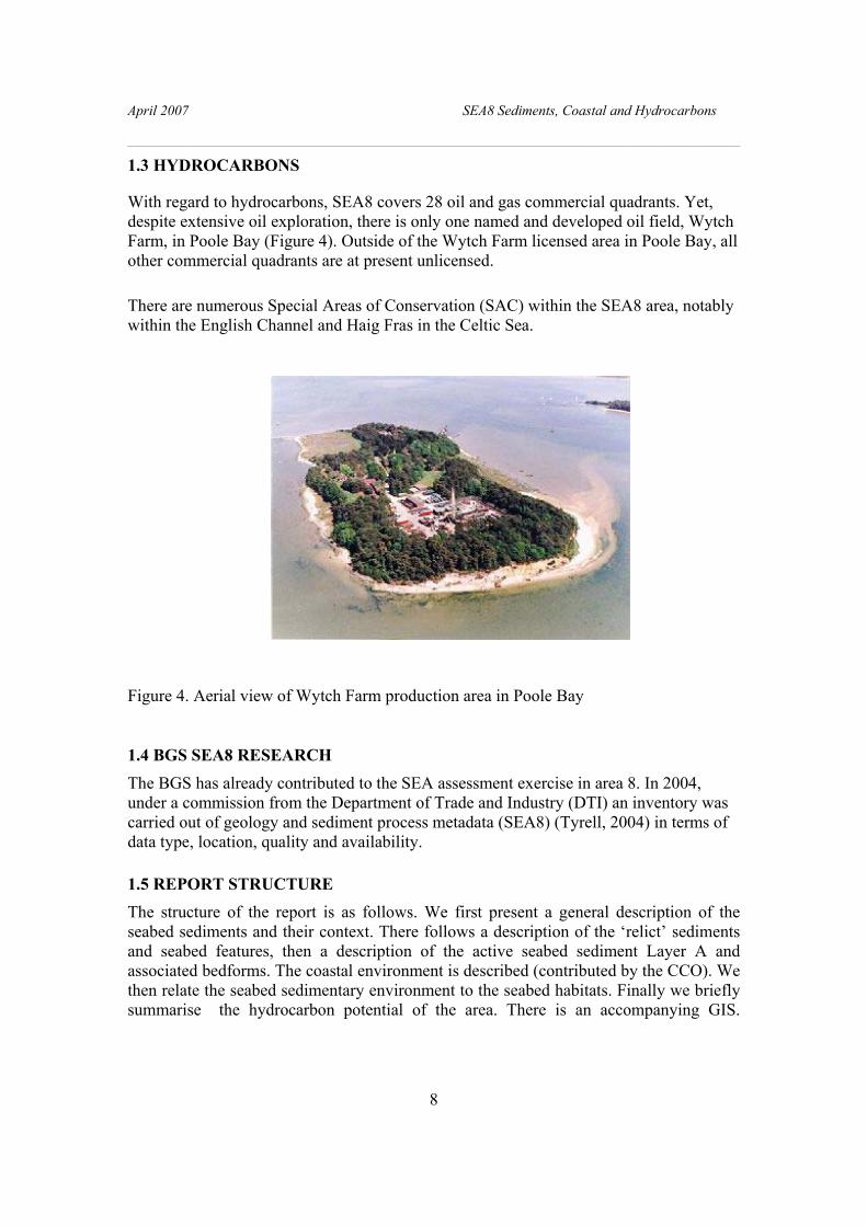
1.3 HYDROCARBONS
With regard to hydrocarbons, SEA8 covers 28 oil and gas commercial quadrants. Yet, despite extensive oil exploration, there is only one named and developed oil field, Wytch Farm, in Poole Bay (Figure 4). Outside of the Wytch Farm licensed area in Poole Bay, all other commercial quadrants are at present unlicensed.
There are numerous Special Areas of Conservation (SAC) within the SEA8 area, notably within the English Channel and Haig Fras in the Celtic Sea.
Figure 4. Aerial view of Wytch Farm production area in Poole Bay
1.4 BGS SEA8 RESEARCH
The BGS has already contributed to the SEA assessment exercise in area 8. In 2004, under a commission from the Department of Trade and Industry (DTI) an inventory was carried out of geology and sediment process metadata (SEA8) (Tyrell, 2004) in terms of data type, location, quality and availability.
1.5 REPORT STRUCTURE The structure of the report is as follows. We first present a general description of the seabed sediments and their context. There follows a description of the ‘relict’ sediments and seabed features, then a description of the active seabed sediment Layer A and associated bedforms. The coastal environment is described (contributed by the CCO). We then relate the seabed sedimentary environment to the seabed habitats. Finally we briefly summarise the hydrocarbon potential of the area. There is an accompanying GIS.

April 2007 SEA8 Sediments, Coastal and Hydrocarbons
________________________________________________________________________
9
2. Distribution of seabed sediments and bedrock geology
2.1 INTRODUCTION
The present distribution of seabed sediment in SEA8 is due to a combination of processes acting over geological time scales. These processes include those acting under the present environment as well as those existing previously, and which may have been markedly different to those of today. In addition, the source(s) of seabed sediment exert a significant control on the sediment available for deposition, as well as affecting how the sediment is transported, both the mechanism of transport as well as the volume. Thus the seabed sediment distribution and bedforms we observe today are a result of both sediment source together with processes that have acted in the past as well as those active at present. Maps of seabed physiography and seabed-sediment properties are separated for clarity of presentation in this report. A summary of some of the procedures and classification schemes used for acquiring and processing seabed samples for seabed-sediment mapping is in Appendix 1. Because of the importance of the active processes operating within the SEA8 area and, to provide a background to regional variations in seabed sediment properties and processes, we introduce this section with a review of the oceanography of the area based on Tyrell (2004).
2.2 PHYSIOGRAPHY AND OCEANOGRAPHY
2.2.1 Physiography
The SEA8 area forms an elongate area of the UK shelf with two large indentations formed by the English Channel in the south and the Bristol Channel in the north (Figures 1 and 5). From their outer inner regions the seabed is generally planar, dipping gently towards the shelf break in the south west, except below the 120 m isobath where there are sand ridges up to 60 m in height that are oriented orthogonal to the shelf margin. The Celtic Sea is a shallow embayment of the eastern North Atlantic with a northern boundary delimited by a line drawn between St. David’s Head in Wales and Carnsore Point in Ireland.
2.2.2 Oceanography
2.2.2.1 TIDES
Circulation in SEA8 is dominated by a semi-diurnal tidal regime. In the Bristol Channel tidal currents are predominantly rectilinear, with speeds generally exceeding 1.5 m/s at springs (Figure 6) and 0.75 m/s at neaps, giving an excursion of up to 25 km during a flood or ebb tide. In the Bristol Channel, tThere is an exceptional tidal range exceeding

April 2007 SEA8 Sediments, Coastal and Hydrocarbons
________________________________________________________________________
10
12 m at Avonmouth during spring tides, that is due to tidal amplification towards the head of the Severn Estuary coupled with a strong resonant oscillation. An amount of shallow water distortion generated by the complex bathymetry causes a stronger, but shorter, flood than ebb, which manifests itself up channel by the formation of a tidal bore of typically 1 m. A high rate of tidal energy dissipation is maintained by the strong tidal flows, and consequently, material is kept in suspension and the water column is vertically well-mixed throughout the year, in contrast to the seasonal thermal stratification which occurs in waters to the west.
Figure 5. Regional seabed physiography of SEA8 viewed from the southwest
In the Celtic Sea, the M2 tidal amplitude ranges from 40 cm/s near the shelf edge to 1 m/s
within St. Georges Channel, and M2 current speeds are in the order of 1 – 1.5 m/s. The deeper areas of the Southwest Celtic Sea become thermally stratified during summer, in contrast to the shallower regions of the English Channel, which remain vertically mixed throughout the year, and these areas are separated by tidal mixing fronts, which vary in space, time and structure.

April 2007 SEA8 Sediments, Coastal and Hydrocarbons
________________________________________________________________________
11
The English Channel is an arm of the Atlantic Ocean, which extends eastwards to the Dover Strait, with a net flow of water towards the North Sea. In the western area of the Channel the tide has the character of a progressive wave, whereas in the east there is more of a standing oscillation. In addition, the Coriolis Force causes cotidal lines to converge towards the Isle of Wight to a degenerate amphidromic point, giving a double high water at Southampton. The tidal wave propagates eastwards, with the time of high water occurring progressively later from Lands End to Dover. Typical tidal current speeds reach approximately 1.8 m/s in the central English Channel, but can reach much higher values off headlands e.g. 4.6 m/s off Portland Bill. The tidal range varies from < 2 m in Poole Bay (due to the degraded amphidromic point near Bournemouth) to ~ 6 m at the eastern and western ends of the English Channel.
Figure 6. Peak flow for a mean Spring Tide (From DTI Atlas of UK Marine Renewable Energy Resources).
2.2.2.2 WAVE ENERGY CLIMATE
The wind drives directional sea-surface and storm surge currents. These in turn drive non-directional rotational near-bed currents, that are generated when wind waves and swell waves interact with the seabed. The effects of swell and wind waves on processes of seabed erosion and seabed sediment transport vary with the wave fetch, seabed gradient and tidal range. In SEA8 winds and waves are predominantly from the southwest, with a significant wave height of between 8 m and 12 m. In addition to the
April 2007 SEA8 Sediments, Coastal and Hydrocarbons
________________________________________________________________________
12
tidal flows, contributions to the overall pattern of circulation result from weak residual currents generated by eddies from headlands and bays, and density gradients from the highly variable outflow of the River Severn, which maintains the salinity of the Bristol Channel below 35 Practical Salinity Units (psu) throughout the year. The water temperature ranges from 7°C in winter to >13°C in summer. Transport of water towards the Irish Sea during summer is enhanced by a strong northward jet on the eastern side of St George’s Channel associated with the Celtic Sea Front.
Exposure of the seabed to waves and wind-driven currents, shifts with the changes in the wind patterns and the shelter provided by land and offshore banks and ridges. In contrast, the seabed exposure to stresses from tidal currents varies more predictably with constrictions to the cyclical flood and ebb tidal streams. One effect of wave interaction with the seabed in shallow water is a tendency to flatten sandwaves and other mobile seabed bedforms that may have been previously built up by the tidal currents (Appendix 2: Figure 39b). This process re-distributes sediments laterally and contributes to widening of banks and ridges on the open shelf and flats in estuaries. If the stresses imposed on the seabed by wind-driven currents and waves prevail from one direction, the stress asymmetry also imparts geometrical asymmetries to seabed banks and ridges.
2.3 SEDIMENT SOURCES
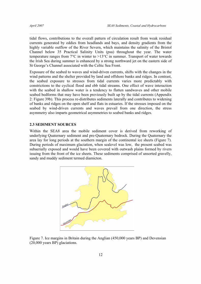
Within the SEA8 area the mobile sediment cover is derived from reworking of underlying Quaternary sediment and pre-Quaternary bedrock. During the Quaternary the area lay for long periods at the southern margin of the continental ice sheets (Figure 7). During periods of maximum glaciation, when sealevel was low, the present seabed was subaerially exposed and would have been covered with outwash plains formed by rivers issuing from the front of the ice sheets. These sediments comprised of unsorted gravelly, sandy and muddy sediment termed diamicton.
Figure 7. Ice margins in Britain during the Anglian (450,000 years BP) and Devensian (20,000 years BP) glaciations.

April 2007 SEA8 Sediments, Coastal and Hydrocarbons
________________________________________________________________________
13
During glacial sealevel lowstands, the great rivers of Europe such as the Seine and the Meuse would have flowed across the area, laying down sediment in their estuaries, but also cutting palaeovalleys, that today are now mainly infilled with sediment (Figure 8). Only in the north of the SEA8 area is there any evidence of direct glaciation, the southern ice limit is tentatively located in the vicinity of the Scilly Islands (Scourse, 2001). Some authors (Kellaway et al., 1975) have suggested that a pre-Devensian glaciation entered the English Channel from the west, but this is unsubstantiated by any convincing evidence. Subaerial exposure of the area during glaciations is mainly attributed to global or eustatic sea levels that were lowered by up to 120-135 m. There has been a suggestion that tectonic uplift took place due to loading of the northern ice mass creating a glacial forebulge, but this again is not generally accepted (Lambeck, 1995, 1996, Lambeck et al., 2001).
During interglacial periods, when the ice melted and withdrew northward, sea level rose. It was during the most recent episode of deglaciation, during the Flandrian transgression, that the glacial sediment at the surface was reworked and a lag deposit laid down. In the southwest, a series of major tidal sand ridges formed (Figures 1 and 5). These sediments and sand ridges are regarded as mainly immobile and are considered to be mainly ‘relict’ or inactive under the processes acting at the present day.
The Quaternary sediment thickness over SEA8 is limited, and is generally less than 50 m over much of the area except where there are palaeovalleys in which locations thicknesses may be up to 90 m. Unlike the North Sea, where the presence of a substantial Quaternary sequence reflects significant subsidence, the SEA8 area remained either relatively stable or was subject to temporary uplift. There is a considerable hiatus beneath the Quaternary, with most of the Neogene missing. The absence of Neogene is interpreted as due either to planation during the Quaternary or to a previous phase of uplift during the late Tertiary Alpine Orogeny (Hamblin et al., 1992). However the large scale of the erosion, with significant thicknesses of sediment removed, suggests that a longer time interval is required than that available during the Quaternary. Thus the erosion is more likely to have taken place during the Neogene.
2.4 BEDROCK GEOLOGY
The bedrock geology of SEA8 mainly comprises Tertiary and Mesozoic sediments, with, in some area, Palaeozoic (Basement) rocks on their margins, notably in the Bristol Channel (Figure 8). Igneous rocks of Cretaceous (Wolf Rock) and Tertiary (Lundy and Haig Fras) age are found in the western English Channel, Bristol Channel and Celtic Sea. In the eastern English Channel there are Cretaceous rocks overlain by Tertiary mudstones and sandstones. In the western English Channel there is Triassic offshore of Cornubia that is overlain to the south by Jurassic and Cretaceous strata. Towards the shelf edge there is a blanket of Tertiary c, mainly Neogene rocks. The Bristol Channel is floored by Jurassic and Triassic rocks with Palaeozoic rocks on the coastal margins. Westward these are overstepped by the Cretaceous Chalk that in turn is buried beneath Tertiary strata. In the southwest part of the area there is a blanket cover of Tertiary (Neogene) rock.
April 2007 SEA8 Sediments, Coastal and Hydrocarbons
________________________________________________________________________
14
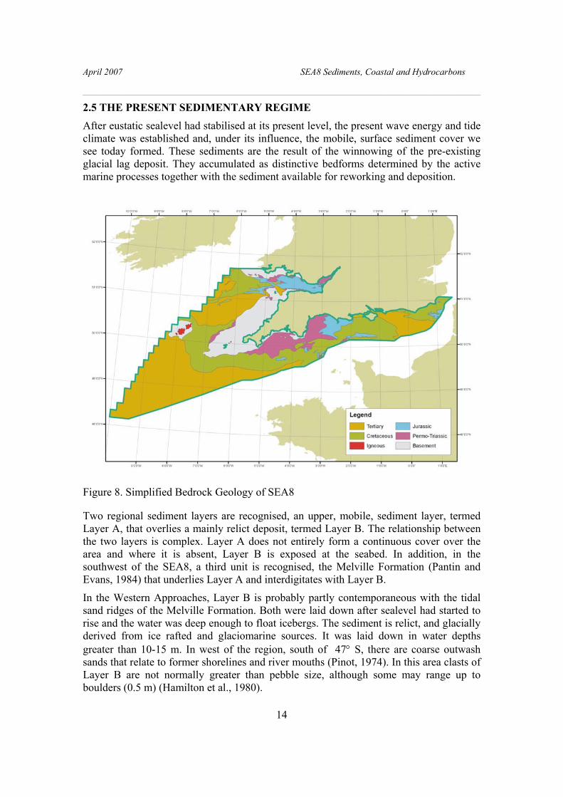
2.5 THE PRESENT SEDIMENTARY REGIME
After eustatic sealevel had stabilised at its present level, the present wave energy and tide climate was established and, under its influence, the mobile, surface sediment cover we see today formed. These sediments are the result of the winnowing of the pre-existing glacial lag deposit. They accumulated as distinctive bedforms determined by the active marine processes together with the sediment available for reworking and deposition.
Figure 8. Simplified Bedrock Geology of SEA8
Two regional sediment layers are recognised, an upper, mobile, sediment layer, termed Layer A, that overlies a mainly relict deposit, termed Layer B. The relationship between the two layers is complex. Layer A does not entirely form a continuous cover over the area and where it is absent, Layer B is exposed at the seabed. In addition, in the southwest of the SEA8, a third unit is recognised, the Melville Formation (Pantin and Evans, 1984) that underlies Layer A and interdigitates with Layer B.
In the Western Approaches, Layer B is probably partly contemporaneous with the tidal sand ridges of the Melville Formation. Both were laid down after sealevel had started to rise and the water was deep enough to float icebergs. The sediment is relict, and glacially derived from ice rafted and glaciomarine sources. It was laid down in water depths greater than 10-15 m. In west of the region, south of 47° S, there are coarse outwash sands that relate to former shorelines and river mouths (Pinot, 1974). In this area clasts of Layer B are not normally greater than pebble size, although some may range up to boulders (0.5 m) (Hamilton et al., 1980).

April 2007 SEA8 Sediments, Coastal and Hydrocarbons
________________________________________________________________________
15
In the discussion presented here, both the Melville Formation and Layer B are regarded as mainly relict deposits, and their sediments for the most part not mobilised under the present current regime. However, where Layer A is absent or less than 50 cm thick, Layer B may be subject to the present day tidal and wave processes and therefore becomes the active layer and subject to reworking.
2.6 RELICT (INACTIVE) DEPOSITS AND FEATURES The seabed in SEA8 is partly composed of outcrops of bedrock and reworked glacigenic sediments that form relict seabed features.
2.6.1 Layer B
Layer B is a lag deposit formed during the late-Devensian, Flandrian, transgression. It is mainly a few decimetres thick and composed of poorly-sorted sandy, shelly gravel and coarse-grained sand. It was formed by the winnowing of fine-grained sediment to leave a relatively coarse, residual deposit.
2.6.1.1 THE ENGLISH CHANNEL
In the eastern English Channel Layer B covers most of the exposed seabed and is composed of gravel and sandy gravel (Figure 9). The maximum grain size reflects local tidal velocities at the time of formation, although the sand and gravel ratio has been modified by current winnowing. For example, in the Dover Strait and south of the Isle of Wight, the sediment is a gravel or sandy gravel, with winnowing leaving a residual sand fraction that is generally coarse-grained (0.5-1.0 mm) with very coarse-grained patches (1-2 mm).
The presence of gravel and sandy gravel reflect the high velocity tidal currents (Figure 6) whereas gravelly sand reflects less vigorous current flow. Gravel thickness is usually less than 0.5 m (Figure 10) but may locally be greater where there is an underlying palaeochannel or an adjacent submerged cliff line, such as at Shingle Bank off Hastings and in an east-west trending strip off the Isle of Wight (Figure 11). In the vicinity of the Isle of Wight the gravel fraction coarsens away from the coast from fine-pebble gravel to coarse-pebble and cobble-gravel. Apart from where the palaeochannels are thickest, there is no overall general relationship between the thickness of Layer B and palaeovalley infill.
Although generally coarse-grained (0.5 to 1.0 mm), Layer B is poorly or moderately sorted, whereas the opposite would be expected in a highly winnowed deposit. The explanation for this anomaly lies in the carbonate content of the sand fraction which has a high content of sand-sized shell debris. This is present because of the strong current

April 2007 SEA8 Sediments, Coastal and Hydrocarbons
________________________________________________________________________
16
Figure 9. Seabed sediment distribution for SEA8 (For key to sediment type see Figure 37; black regions are exposed bedrock – no sediment.)

April 2007 SEA8 Sediments, Coastal and Hydrocarbons
________________________________________________________________________
17
action has broken down shell material to sand grade, thereby reducing the degree of sorting. Where Layer B does comprise less intensively winnowed gravelly sands, the sand fraction is well-sorted and medium-grained (0.5- 0.25 mm), with a low carbonate content. The mud content of Layer B is almost everywhere very low, and in the places where the mud content is significant, this has been incorporated from underlying sources.
Locally, large boulders are present that are still closely associated with their underlying source rock. For example south of the Isle of Wight, a block of glauconitic greensand 83 cm long was recovered from the Lower Greensand outrop at seabed (Hamblin and Harrison, 1990). Site investigation work at the Royal Sovereign Shoals revealed boulders of sideritic, chamosite-oolite ironstone from the Wealden outcrop (Higginbottom, 1973).
Evidence for the stability of Layer B was found from a 3.5 m dredged pit in sandy gravel at Shingle Bank, which in 1971 was left over the winter until 1972 when re-examination showed no sign of infill (Dickson and Lee, 1973). Surfaces of many megaclasts on the seabed are encrusted with serpulids, bryozoa and barnacles, testifying to their lack of mobility.
Megaclasts are predominantly of flint, derived directly from the Chalk. They are often little-worn and with their patinas intact. Where the flints are worn these are interpreted as secondary and derived via Tertiary gravel. Both varieties may be derived by sea bed or cliff erosion, during transgression and by further cliff erosion during the Holocene, or by fluvial erosion during Pleistocene regressions.
Apart from flints other locally derived rock types may make up components of the gravel fraction. South of the Isle of Wight and Beachy Head, chalk clasts constitute 80% of the gravel fraction overlying the Chalk (Hamblin and Harrison, 1990). Gravels overlying the Lower Cretaceous outcrops south-west and south east of the Isle of Wight contain locally derived sandstone, mudstone, ironstone, shelly limestone and grey chert, although flint is dominant. There is little evidence of rocks other than flint being introduced into the area by fluvial transport.
A minor constituent of the lag deposit is an igneous suite derived from the Cornubian granites of Cornwall and Devon. These rocks make up less than 5% of the gravel fraction of the lag deposit (Hamblin and Harrison, 1990). A study of the heavy minerals sand grade has shown tourmaline common as far east as the Isle of Wight (Morton, 1989). Erratics at Chesil Beach are dominated by quartzite, porphyry, and granite from Devon (Arkell, 1947). Dangeard (1929) recovered igneous and metamorphic rocks from the whole length of the English Channel, although they are much less abundant east of 2° W. Martin (1841) recorded that off Ramsgate the fishermen were ‘impeded by masses of granite, serpentine, sandstone, slate….’. These large clasts have most likely been introduced into the area by floating ice, as is the case of the erratic boulders which underlie the Ipswichian raised beach.
2.6.1.2 CELTIC SEA – BRISTOL CHANNEL
In the Celtic Sea-Bristol Channel region of SEA8 Layer B forms a discontinuous, pebbly coquina or shelly gravel, 10 to 20 cm thick. It is poorly-sorted, sandy and coarse-grained. Where gravels at seabed are several metres thick Layer B forms the active depth of

April 2007 SEA8 Sediments, Coastal and Hydrocarbons
________________________________________________________________________
18
reworking. Layers A and B interdigitate and shells and pebbles from Layer B may be incorporated into Layer A. In the Bristol Channel the seabed is largely swept clear of sediment because of the strong tidal current (Figure 9).
Figure 10. Generalised distribution patterns of sub-seabed sediments.
(Based on interpretations of high-resolution seismic reflection-records integrated with core samples in the range of 1 to 5 m or more below seabed. Nominal distribution patterns are simplified from the BGS 1:1 million and 1:250 000 scale regional maps (Holmes et al., 1993, 1994).
2.6.1.3 WESTERN APPROACHES
Over the western Approaches, Belderson and Stride (1996) recognised a basal bed, generally a few decimetres thick and composed of poorly sorted, sandy, shelly gravel and coarse sand. The clasts do not normally exceed pebble size though there are restricted patches of coarser material that are up to boulder size of 0.5 m. South and west of the Scilly Isles and Cornish peninsula, Layer B forms a quartzitic sand layer.
2.6.2 Relict Features
Relict features present in the area include tidal sand ridges, exposed bedrock, drowned cliff lines and palaeovalleys cut at glacially lowered sea levels.
2.6.2.1 TIDAL SAND RIDGES
Located on the outer shelf and inner English Channel are a series of prominent seabed features termed Tidal Sand Ridges (TSRs) (Figures 1, 5 and 11). Those in the east are active bedforms and are described below. Those in the west, on the outer shelf are inactive. In the west the 120 m isobath forms the boundary between the inner and outer shelf and trends cross the shelf with northwest to south-west alignment parallel to the shelf-break. To the southwest of this line, the topography of the shelf is dominated by

April 2007 SEA8 Sediments, Coastal and Hydrocarbons
________________________________________________________________________
19
large tidal sand ridges which terminate in the north-east. Their termination is abrupt and depth controlled. The ridges range up to 60 m in height and 200 km in length, with the spacing of 10 to 15 km; they rest on a smooth, flat, late Pleistocene erosion surface that forms the top of the upper Little Sole Formation. Some of the ridges are asymmetric in profile but there is no regularity in this asymmetry either along individual ridges or across the series. Their profile varies from well rounded with only one high point to highly irregular forms with several crests, and in general the greater relief, the smoother the profile. The general trend of the ridges is 030°, but the axes show gentle curvature. On the outer shelf, the major axes of the tidal velocity ellipse runs approximately parallel to
Figure 11. Relict bedforms in SEA8
(Black – exposed bedrock; Blue lines – drowned cliff lines; Brown lines – tidal sand banks or ridges with sand waves; Red lines tidal sand banks with sand waves).
the ridges, but on the middle shelf the axis runs about 20° clockwise with respect to the ridges.
The origin of the TSRs has been the subject of some controversy, bank growth beinbg attributed to either (1) a channel–levee system preserved both by lateral migration and aggradation of the channels, or (2) a package of large offshore tidal sediment bodies (bar chains and/or giant dunes). Recent geometrical observations of seismic discontinuities within the ridges make the second hypothesis more likely (Marsset et al., 1999).

April 2007 SEA8 Sediments, Coastal and Hydrocarbons
________________________________________________________________________
20
The ridges are moribund (Stride et al, 1982), by which is meant that they were formed during a period when sea level was lower and that they are now in a state of decay. Pantin and Evans (1984) used a model of sand bank formation proposed by Huthnance (1982) to deduce that the present tidal conditions cannot account for the size and spacing of the ridges. However, during the late Devensian the water at the shelf edge was about 60 m and in such conditions the Huthnance model supports the formation of the ridges, although it demands a tidal ellipse running oblique to the shelf edge. Numerical modelling of the semidiurnal (M2) tidal streams in the Celtic Sea with a sea level lowered by 100 m indicates tidal currents twice as strong as those at present (Belderson et al, 1982); such currents would have been sufficient to generate and maintain the tidal sand ridges. The modelling also indicates that the tidal ellipse would have been rotated clockwise during this period, which is in the correct sense for ridge formation. As the Flandrian transgression proceeded, the ridges advanced landward until they reached that part of the shelf where the sediment supply was not sufficient to feed their growth. At this point, approximately equivalent to the 120 m isobath, their landward growth stopped. Evidence of glacial sediments on the ridge flanks indicates that they formed before the final withdrawal of ice from the outer shelf region, and Scourse (2001) proposed that they had achieved their present form as the last ice sheet in the Celtic Sea Deep to the north floated and broke up.
2.6.2.2 ROCK
The largest areas of outcrops of rock, rock and sediment and diamicton occur with rough and very varied seabed topography, usually with seabed gravels, in areas of very high seabed stress and seabed scour (Figures 6, 9, 10 and 11). The largest area of rock outcrop is in the Bristol Channel (Figure 9). Other smaller areas are located at Haig Fras in the Celtic Sea, where the exposed granite bodies cover an area 45 by 15 km. Other rocky areas are offshore of the southern coast of Cornubia. Other shoals are Wolf Rock, Epsom Shoal, Seven Stones and Eddystone Reef, all igneous bodies, that were resistant to planning off of the surrounding seabed.
2.6.2.3 SUBMERGED COASTLINES
Offshore of Devon and Cornwall and in the eastern English Channel, there are a series of cliffs, separated by near-horizontal benches, marking submerged coastlines (Donovan and Stride, 1975) (Figure 11). The benches may have a thin sediment cover, but they not generally masked. Three discontinuous benches are identified at depths of 38 to 49 m, 49 to 58 m and 58 to 69 m below OD, and appear to deepen to the west. The offshore longitudinal profiles of Rias along the south coast of Devon slope down to no lower than the 37 m isobath, which is near the base of the shallowest submerged cliff (Kelland, 1975). These valleys may well have formed during the same period as the upper submerged cliffs, probably during the Neogene.

April 2007 SEA8 Sediments, Coastal and Hydrocarbons
________________________________________________________________________
21
2.6.2.4 PALAEOVALLEYS
In the eastern English Channel there are major palaeovalley systems formed during the lowered sealevels of the Quaternary when the Rhine and Meuse flowed through the SEA8 area (Figure 1, 5 and 12). Rivers draining southern England also cut over deepened valleys at this time. Most sediment infill dates from the late Devensian and early Flandrian, when rising sealevel first laid down estuarine deposits followed by marine sediments as the transgression proceeded. Three major valleys are recognised, the Lobourg Valley in the Dover Strait, St Catherines Deep south of the Isle of Wight and the Northern Palaeovalley (Smith, 1985) which falls southwestward into the Hurd Deep.
Figure 12. Palaeovalleys in the English Channel
2.7 ACTIVE SEDIMENTS AND BEDFORMS
2.7.1 Superficial sediment distribution
Superficial sediment distribution maps of SEA8 have been compiled by the BGS, based on particle size analysis of grab samples classified according to a modified Folk classification scheme (Figure 9) (Folk, 1980; Pantin, 1991). This scheme is designed to classify mobile sediment based on the current strength of deposition. In SEA8 the main active sedimentary unit is termed Layer A, it is a deposit eroded from a pre-Recent substrate and redeposited under the present hydraulic regime (Swift et al., 1971).
In the SEA8 area the seabed sediment grain size generally fines from the inner, confined, channel areas where gravels and sandy gravels predominate, westward towards the shelf edge where there are sands and gravelly sands. In only two areas, on the western margin of the region, in the Celtic Deep and surrounding Haig Fras, are there significant accumulations of muddy sediments. Most of the English Channel, outside of more sheltered bays, is floored by coarse grained sediment including sandy gravel and gravel with sediment generally fining westward into gravelly sands, sands and muddy sands.

April 2007 SEA8 Sediments, Coastal and Hydrocarbons
________________________________________________________________________
22
Sand and gravelly sand predominate in the east, in the Straits of Dover. A similar trend of fining is observed in the Bristol Channel-Celtic Sea and Western Approaches, where the inner areas, again outside of sheltered regions, are actually swept clear of mobile sediment, with gravelly sediments at their western margins passing westwards into sands and gravelly sands.
Transport and deposition of sediment grains is dependent upon the velocity of near-bed currents in relation to the threshold speeds for grain suspension and bedload transport. Thus the grain-size distribution patterns in the area reflect the exposure of the seabed to currents that may be the result of wind-wave, storm surge or tide. Whatever the source, the currents result in seabed stress, and the regional trend is for sediment grains to move across or away from a seabed with higher stress towards a seabed with lower stress (Figure 13). The amount of stress imposed on the seabed, and thus the amount and type of sediment imported into, deposited, or exported out of the study area, varies with both location and time.
Figure 13. Schematic summary of the observed relationships between mean seabed stress and mobile and static bedforms (From Holmes et al., 2005).

April 2007 SEA8 Sediments, Coastal and Hydrocarbons
________________________________________________________________________
23
Except for the region on the shelf edge, over most of the offshore area ofSEA8 there is no evidence to suggest that wind-wave or storm surge contributes to sediment distribution. This interpretation is based on the lack of a clear correlation between water depth and sediment grain size that would support wave entrainment as an important process. It is considered most likely therefore that the present seabed sediment distribution, outside of the shelf edge region and the coastal zone, is a function of bottom stress, which is specifically dependent upon water depth, tidal velocity and seabed roughness. Seabed stress from tidal flow is inversely proportional to water depth, thus stresses are greatest in shallow water, with strong tidal currents, and weakest in deep water with reduced tidal currents. Highest peak flows for mean spring tides are in the central English Channel and Bristol Channel. Peak flows in the English Channel decrease to the east and west. Peak flows in the Bristol Channel also decrease towards the west with lowest flows in the Celtic Deep and on the shelf edge (Figure 6). In the English Channel there are minimum flows in both Bournemouth and Plymouth bays. On the shelf edge the sediments may well have been influenced by deeply penetrating storm surges (Heathershaw et al., 1987). In the coastal zone sedimentary processes are dominated by wave action.
As a result of the active tidal processes, in areas of seabed scour and bedload transport, sediment reworking and redistribution is continuous, although there are end-members that may be considered as (a) bedrock and strongly cohesive unsorted gravel, sand and mud (diamicton) where currents are strong and (b) muddy sediment (see Figure 37 for a definition of the range of grain sizes commonly found in mud), where they are weak. In the most highly stressed seabed environments large areas of exposed rock and diamicton may be swept clean of unconsolidated sand, although perhaps leaving some pebbles, cobbles and boulders (collectively termed gravel). Areas of least seabed stress are characterised by more or less stable fine-grained muddy sediments, significant proportions of which have been deposited from suspension in conditions where there are very low velocity seabed currents (Figure 6).
Although a number of large rivers enter the region, notably the Seine and the Severn, there is little sediment input from these sources, because most sediment is deposited in their estuaries (e.g., Avione et al., 1981). This explains why the present mobile sediment distribution is mainly the result of reworking of glacial and periglacial sediments, laid down during the preceding glaciations, and that took place during the Holocene (Flandrian) transgression (Belderson and Stride, 1966).
2.7.2 Seabed Sediments - Layer A
2.7.2.1 ENGLISH CHANNEL
In the English Channel, mobile sediments locally overlie the lag deposit of Layer B and are thickest off the coast of Devon, immediately south west of the Dover Strait, and in the coastal zone from Beachy Head to Poole Bay, including the Solent. They largely comprise immature sands, dominated by well-rounded quartz grains with a little feldspar, mica, and heavy minerals. The varied sources of sand include seabed and cliff erosion during transgression, later (more recent) cliff erosion, sea-bed winnowing up to the present day and fluvial transport, particularly during Pleistocene periglacial conditions.

April 2007 SEA8 Sediments, Coastal and Hydrocarbons
________________________________________________________________________
24
Contemporary fluvial input is limited, partly because terrestrial erosion is reduced during periods of temperate climate, but mainly because all the largest rivers have drowned estuaries where they deposit all but the finest sediment. There is a great deal of suspended sediment in the English Channel (Curry, 1989) that eventually is transported out of the area.
Layer A is thickest where it forms the mobile Tidal Sand Ridges located in the Dover Strait. These are up to 18 km long and range between 5 and 20 m thick, although individually may be up to 50 m. The sediment forming the ridges is well-sorted to very well-sorted, medium-grained sand with a low carbonate content (<25%); the grain sizes plot at the finer end of the medium-grained sand range. Fine-grained sands are restricted to the nearshore zone either side of Dungeness, and their presence reflects the underlying Lower Cretaceous strata from which the sand is derived. East of the Isle of Wight there are several sand bodies up to 5 m thick. Off Brighton a tidal sand ridge up to 30 m thick lies in 50 m of water, it is composed of black, sulphide-rich medium- to coarse-grained, shelly, very well-sorted sand that is oxidised to a pale or medium brown at the surface.
Recent sedimentation in the Solent and Southampton water has been studied by Dyer (1970a; 1971; 1972). In the West Solent, the seabed is covered with waves of sand and sandy-gravel in which the sands have low shell content. Dune asymmetry and sediment distribution indicate eastward transport, with the sea bed being eroded at the western end. Brambles Bank at the junction of the East and west Solent, is composed of medium-grained sand, whereas sands and muds dominate in Southampton Water and the east Solent, where the shell content is higher. Coastal erosion of the Isle of Wight and Selsey Bill is the main source of sediment which, as a whole, present a bimodal population of flint gravel and medium-grained quartz sand.
Christchurch and Poole bays have been cut by rapid erosion since the Flandrian transgression breached the Chalk ridge between the Isle of Wight and the Isle of Purbeck (Dyer, 1982). The sands derived from the Tertiary strata and the gravels from the Quarternary plateau gravels form Hurst Spit, Shingles Bank and Dolphin Sand; with the latter being 9 km long, 3 km wide and 9 m high (Stride et al, 1972). The sediments in the Bays are sands, sandy gravels and gravels, with some silt in samples from the southern part Christchurch Bay (Dyer, 1970b), and sandy mud, muddy sand and muddy sandy gravel nearshore. The sands are fine- to medium-grained, moderate- to well-sorted, with carbonate contents up to around 5 %.
The mainly fine-grained, grey black, shelly sand of Lime Bay thickens towards the centre of the bay (Dingwall, 1969). Off south-east Devon there is an extensive deposit of muddy sand that rests unconformably upon intertidal gravel. The sand becomes gravelly in the north (Clarke, 1970). This sand formed diachronously as a series of sublittoral sand bodies during the Flandrian transgression. It is moderately- to well-sorted, very fine- to fine-grained and coarsens downward. Much of the quartz has a red haematite coating, indicating derivation from the Pemo-Triassic; lithic grains include granite, slate, mica, schist and volcanic rocks. The carbonate content is low at the surface, but increases downward to become a coarse-grained, shelly, basal deposit.
In Start Bay there are barrier, bay and bank deposits (Kelland and Hails, 1972; Hails, 1975). The barrier deposit is a beach shingle that extends to 200 m beyond the low water

April 2007 SEA8 Sediments, Coastal and Hydrocarbons
________________________________________________________________________
25
mark, and the bay deposits that underlies the rest of the bay comprise medium- to fine-grained sand varying from 1 to 28m in thickness. The bank deposits are coarse-grained shelly sands which overlie the bay deposits around Skerries Bank, which is believed to have been in its present position since the later stages of the Holocene transgression (Robinson, 1961).
Large shingle beaches are found at Dungeness, The Crumbles and Chesil Bank. Dungeness comprises about 500 shingle ridges over a width of 1 km, each ridge being thrown up when storm conditions coincided with high tide (Eddison et al, 1983). This repeated process implies massive longshore drift of shingle from the south-west. In the Eastbourne area (Jennings and Smith, 1987), shoreward movement of sediment, rather than longshore drift, has been dominant, resulting in the formation of The Crumbles as a barrier beach that coarsens upward from a silty clay to sand then gravel, reflecting Holocene accretion. Chesil Bank (Melville and Freshney, 1982), is a 29 km long shingle bank, up to 259 m wide and 12 m high, largely composed of flint pebbles; the size of the pebbles increases eastward onshore, but in the reverse direction offshore. Arkell (1947) thought the bank originated as a bay bar, joining Portland Bill to a lost headland south of Beer Head, which had been pushed northward by advancing seas of the Flandrian transgression.
2.7.2.2 BRISTOL CHANNEL/CELTIC SEA
In the Bristol Channel, Celtic Sea region, Layer A is commonly patchy and less than 30 cm thick, except where there are sand waves, as in the north of the area and in the Bristol Channel, where Layer A increases in thickness. In these giant sand wave fields Layer A may be up to 40 m thick (Wingfield, 1987; James and Wingfield, 1987) and in tidal sand ridges. In the Celtic Deep the sands pass into muddy sands.
2.7.2.3 WESTERN APPROACHES
In the Western Approaches, across much of the inner and middle shelf, layers A and B are usually less than about half a metre thick. In the centre of the eastern part of the area a layer of gravel less than 25 cm thick covers the sea bed and is overlain by sands of Layer A closer to the English coast. Along the coastal zone, especially off headlands and around shoals, there are extensive outcrops of bare rock and gravel. Here sampling and sidescan sonar coverage reveal a sand layer less than 50 cm thick. As far as the shelf edge, the thin gravely sands of Layer B are more uniformly overlain by Layer A sand up to about a metre thick. Currents locally sweep the sand of Layer A into a variety of bedforms to expose the gravely substrate of Layer B. In the northwestern part of the area Layer A becomes muddier and slightly thicker, except around the Haig Fras shoal.
The mean grain size of the sand fraction (Figure 14) shows a similar trend to that displayed by the gross sediment (Figure 9). Coarse-grained sand predominates around the coastal zone, in the central part of the western channel and around Haig Fras. This passes westwards across to the outer shelf into medium- to fine-grained sand. The finest sand is found in the northwestern part of the area, where the bottom stress is least, and correlates with the zone of higher mud content.

April 2007 SEA8 Sediments, Coastal and Hydrocarbons
________________________________________________________________________
26
Figure 14. Mean grain size of the sand fraction.
Sands in the northern part of the area contain irregularly shaped grains of pale to dark green glauconite which infills both the chambers of foraminifera and bored molluscan debris. The glauconite shows no clear relationship with either sediment type or water depth. Some grains have been reworked from Tertiary sediments, but the predominately pale form infilling the modern fauna is of Recent origin, for glauconite darkens on burial.
Carbonate content of the sediment, especially around Cornubia, is rich in bioclastic debris (Figure 15) and there are distinctive faunal assemblages associated with the bedforms described below. Polychaetes, molluscs and bryozoans are mainly responsible for breaking down the shell material which dominates the bioclastic debris across the area (Wilson, 1982). The bioclastic gravel is formed of whole of fragmented bivalves, bryozoans, echinoderms, foraminifera, barnacles, gastropods, serpulids and scaphopods. In the western English Channel, brittle stars are associated with rock outcrops. Bivalves predominate in the northern and central parts of the western English Channel and foraminifera are dominant along the outer shelf (Bouysse et al., 1976).

April 2007 SEA8 Sediments, Coastal and Hydrocarbons
________________________________________________________________________
27
Figure 15. Distribution of carbonate content in the sand fraction of seabed sediment
The distribution of bryozoan debris indicates that the bioclastic component of the mobile sediment is being transported westwards and slightly northwards along the shelf. The bulk of the gravel on the outer shelf is shell debris, although pebbles dominate Layer B and become abundant where Layer A is thin. The coarsest bioclastic debris is found in ripple troughs, and between spreads of better sorted sand on the exposed coarser substrate (Hamilton et al., 1980). The carbonate content of the sand fraction shows limited correlation with its mean grain size, with the highest (>80 %) values found north of the Isles Scilly and Cornish coast, where the sand fraction is coarsest. However the lowest values (< 40%) occur in the medium sands on the outer shelf and south of the Devon coast. Along the outer shelf the highest concentration of carbonate material occurs on the coarse-grained tidal sand ridges. This is due either to locally increased winnowing effects of tidal and possibly wave-induced currents, or to higher biological productivity over the crests (Heathershaw and Codd, 1985).
2.7.3 Active Mobile Bedforms
Active bedforms are dominantly moulded from sand, although some gravelly and muddy bedforms also occur. The type of bedforms present depends on the current velocity and the sediment supply (Stride, 1982). Where there is a low rate of sediment supply, there is

April 2007 SEA8 Sediments, Coastal and Hydrocarbons
________________________________________________________________________
28
a passage along the sediment transport path from furrows and waves in gravel, through isolated, uncommon sand ribbons and sand streaks parallel to the tidal current, to transverse, horned barchan-type, large sand waves, passing into extensive sand patches with small sand waves (here termed megaripples). Where there is abundant sediment supply, there is a different sequence of bedforms, and upon the gravelly sea floor are sand ribbons and elongate patches, changing down-path to a continuous carpet of sand moulded into transverse sand waves, and tidal sand ridges subparallel to the current; farther down-path there are continuous sand wave fields (Figure 16).
Figure 16. Scheme of bedform zones from a tidal sea where sand is abundant, with corresponding mean spring peak near surface tidal currents in cm/sec (Belderson et al 1982).
The most comprehensive review of sand banks in recent times is by Dyer and Huntley (1999). A more recent review undertaken in the context of the SEA in relation to offshore windfarm development is by Kenyon and Cooper (2005). Sand banks are found widely on shallow continental shelves where there is an abundance of sand and where currents are in excess of a certain peak speed. This speed is much stronger than is needed to move sand. For there to be a plentiful supply in such currents there needs to be a local convergence of sand transport paths towards the crest of a bank from both sides or the sand needs to be trapped by the coast, as it is in most estuaries. Tidal sand banks are recognised as being a regular bedform that is characteristic of tidal dominated shelves where there is a plentiful supply of sand and strong tidal currents (Kenyon et al 1981, Johnson et al 1982). To maintain the banks, peak current strength needs to be relatively high. Belderson (1986) showed that the peak currents need to be greater than 90 cm/sec (about 55 cm/sec at 1 m above the bottom in water 30 m deep), which places the banks in the zone of scour or the sand ribbon zone of the widely accepted bedform zone scheme of Belderson et al (1982). In fact banks tied to fixed

April 2007 SEA8 Sediments, Coastal and Hydrocarbons
________________________________________________________________________
29
headlands can be maintained by currents so strong that they are entirely within the scour zone, and sit on bare rock (Kenyon and Cooper, 2005). Tidal sand banks, if there is sufficient water depth and space, can become very large bedforms, perhaps the largest of all bedforms found in water currents. As such they contain very large amounts of sand. There is emphasis by Dyer and Huntley (1999) on the banks being formed at coasts and being left behind as sea-level rises, eventually becoming moribund, a term introduced by Kenyon et al (1981). However, it is agreed with a number of mathematical physicists that the best approach to the consideration of sand banks is to first consider them as a regular bedform that arises from an inherent instability of a seabed subject to tidal flow and bed load transport. At the same time it is recognised that they can go through a cycle from an active to a dying state (moribund) as sea level rises and they are left stranded in weak currents. Observations on the distribution patterns of the mobile sandy bedforms in SEA8 show that they can be related in a generalised manner to the sediment distribution trends identified by Stride (1982) (Figure 16). These relationships can be related to net sediment transport directions and sediment bed load partings (Figure 18).
Figure 17. Active Bedforms in SEA8
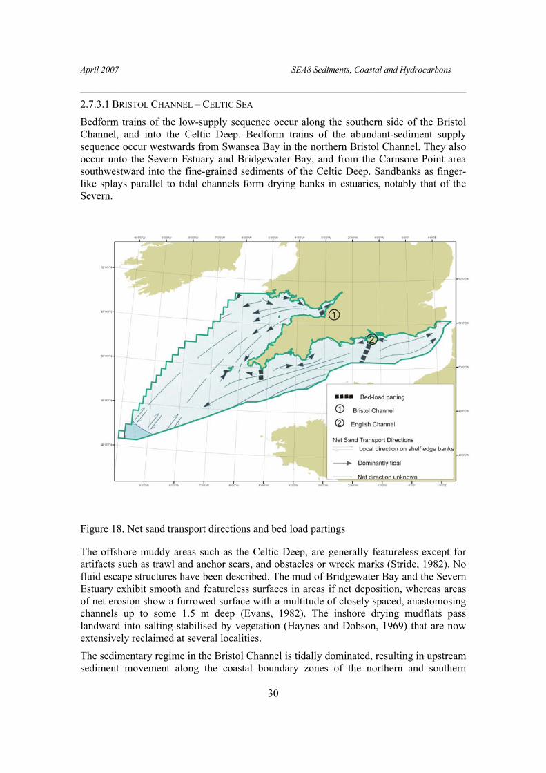
April 2007 SEA8 Sediments, Coastal and Hydrocarbons
________________________________________________________________________
30
2.7.3.1 BRISTOL CHANNEL – CELTIC SEA
Bedform trains of the low-supply sequence occur along the southern side of the Bristol Channel, and into the Celtic Deep. Bedform trains of the abundant-sediment supply sequence occur westwards from Swansea Bay in the northern Bristol Channel. They also occur unto the Severn Estuary and Bridgewater Bay, and from the Carnsore Point area southwestward into the fine-grained sediments of the Celtic Deep. Sandbanks as finger-like splays parallel to tidal channels form drying banks in estuaries, notably that of the Severn.
Figure 18. Net sand transport directions and bed load partings
The offshore muddy areas such as the Celtic Deep, are generally featureless except for artifacts such as trawl and anchor scars, and obstacles or wreck marks (Stride, 1982). No fluid escape structures have been described. The mud of Bridgewater Bay and the Severn Estuary exhibit smooth and featureless surfaces in areas if net deposition, whereas areas of net erosion show a furrowed surface with a multitude of closely spaced, anastomosing channels up to some 1.5 m deep (Evans, 1982). The inshore drying mudflats pass landward into salting stabilised by vegetation (Haynes and Dobson, 1969) that are now extensively reclaimed at several localities.
The sedimentary regime in the Bristol Channel is tidally dominated, resulting in upstream sediment movement along the coastal boundary zones of the northern and southern

April 2007 SEA8 Sediments, Coastal and Hydrocarbons
________________________________________________________________________
31
coastline, enhanced by wave action; the central axis of the Channel is ebb-dominated (Collins, 1987). This results in a scoured central longitudinal region, with exposed bedrock; with sediment thickness increasing to either side but especially to the north, explaining the linear sand banks present along this coastline. The recent Outer Bristol Channel Habitat Study ( Mackie et al., 2006) confirms the model of Collins (1987) proving a northward change in sediment type and bedforms from Lundy Island northward. To the west of Lundy the seabed sediment is coarse grained, gravelly sand and sandy gravel with sand patches, ribbons and waves and isolated sand waves on rock at outcrop (Figure 19). Northward there is sand, that forms sand waves up to 10 m high with westward facing scarps and bifurcating high frequency sand waves.
Figure 19. Outer Bristol Channel: isolated sand waves on rock outcrops -bedding at surface
2.7.3.2 WESTERN APPROACHES
The floor of the central portion of the western English Channel and its extension south-westwards to the shelf edge is covered by sand waves. To the east and along the southern part of the English Channel, the tidal flow is stronger and the sand waves pass into sand ribbons with bare rock exposed near the coast. To the west, and northwards into the Celtic Sea, the tidal stream is weaker and the dominant bedforms are sand patches passing down the sediment transport path into rippled sand sheets. The gross change in bedforms westwards along the English Channel is typical of the variation along a bedload transport path with decreasing velocity of tidal currents (Belderson et al 1982). However, the absence of sand banks in the western English Channel suggests that the supply of sediment has been limited since the start of the late Devensian-Flandrian transgression (Johnson et al.,1982).

April 2007 SEA8 Sediments, Coastal and Hydrocarbons
________________________________________________________________________
32
There are exceptionally large sand waves on the outermost shelf along a band up to 35 km wide parallel to the shelfbreak and down to a water depth of about 200 m. Their crests are up to 5 km long, 1 km apart and 7 m high (Stride, 1963), and their lee slopes have a maximum angle of about 4° (Cartwright and Stride, 1958; Cartwright, 1959). The sand waves are oriented approximately northwest to southeast, parallel to the shelf break, and they occur in broad zones within which their asymmetry and size are variable (Hadley, 1964; Heathershaw and Codd, 1985). Current measurements and seabed photographs show that the tidal currents alone are able to transport sediment un the area, but an internal wave mechanism is necessary to explain the decrease in wavelength of the bedforms away from the shelfbreak (Heathershaw et al, 1987).
Seabed photographs show that sand ripples are ubiquitous (Hamilton et al., 1980; Heathershaw and Codd, 1985). Symmetrical ripples with wavelengths of up to a metre are developed on the shelf to water depths of at least 160 m, and are often buried by sheets of current-rippled sand. The symmetrical nature of the bedforms is attributed to entrainment of the sediment by storm waves (Hamilton et al., 1980; Heathershaw and Codd, 1985).
Where the upper part of the mobile sediment is missing, the thin lag of coarse sand and gravel (Layer B) may be formed into gravel waves with a wave length of about 1.5 m. Well-defined, rounded ‘windows’ 200 to 300 m wide occur near the crests of the tidal sand ridges in otherwise continuous sands sheets. These windows are probably due to severe turbulence on the crests of the tidal sand ridgesions (Pantin and Evans, 1984).
2.7.3.3 ENGLISH CHANNEL
The most striking bedforms in the English Channel are the tidal sand ridges southwest of the Dover Strait. The nearshore banks such as Bassurelle de la Somme have a thin stratified structure inclined from east to west, and have apparently developed as offshore bars by accretion from the west. Lapierre (1975), however demonstrated that the tidal sand ridges farther out to sea, including Vergoyer and Bassure de Baas, have an eastward prograding structure which transverse profiles show to be asymmetric, with steeper eastern faces (Augris et al, 1987); their long axes are orientated at a small oblique angle anticlockwise to the peak tidal flow direction (Stride, 1982).
A characteristic of active tidal sand ridges, including those in this area, is that they carry sand waves on their surface (Belderson et al, 1982). Sand waves are normally aligned perpendicular to peak tidal flow, but when associated with tidal sand ridges their orientation may be more complex (Belderson et al, 1982). The sand waves are asymmetric, with their steeper north or north-east downstream faces inclined at the angle of rest of the sediment of about 6°; upstream faces are only very slightly inclined (Augris et al 1987). Wavelengths are within the range 100 to 480 m, with a maximum amplitude of 15 m. Megaripples with maximum wavelengths of 30 m and amplitudes up to 1 m also occur on both the sand waves and the ridges; these are similarly asymmetric and orientated normal to the current. On the Bassure de Baas, the megaripples have a wavelength of less than 5 m at the bottom of the bank, increasing to 15 m toward the top (Augris et al, 1987).

April 2007 SEA8 Sediments, Coastal and Hydrocarbons
________________________________________________________________________
33
Southwest of the tidal sand ridges, there is little mobile sediment on the seabed, although the rare bedforms presnt reflect the steady rise in tidal velocity towards the zone of bedload parting. In order of increasing velocity (Kenyon, 1970; Belderson et al, 1982), these bedforms are sand waves (both in trains and as arcuate dunes), sand patches, sand ribbons, and gravel furrows. Recent Survey in the eastern channel provide excellent new data on both the bedrock exposures and, in current swept regions, the limited sediment cover (James et al., 2002; 2007).
Figure 20 Seabed exposures of a Chalk scarp and underlying Gault-Greensand with a thin sediment cover forming sand waves.
Isolated arcuate dunes are found scattered over the exposed lag deposit, and trains of sand waves up to 7 m high are found on the tidal sand ridge south of Brighton. There are sand patches, of variable shape, that may be orientated parallel or normal to the current direction, depending on peak tidal flow. Sand ribbons (Stride, 1963; Kenyon, 1970) are thin patches of sand less than 1 m thick, elongated parallel to the current where tidal current velocities exceed 1 m/s; they are essentially straight, with a length:width ratio >40:1, and a width of 5 to 200 m.
Gravel furrows are found over large areas (Figure 18) around the bedload parting zone south of the Isle of Wight, where tidal current velocities are greater than 1.5 m/s, there is a shortage of sand and a relatively smooth sea bed (Stride et al, 1972; Belderson et al, 1988). They are longitudinal erosional features parallel to the current direction, up to 9 km or more in length, and almost straight or slightly sinuous in plan. They are up to 30 m wide and 1 m deep, with steep sides, and are separated by ridges of gravel or sandy gravel some 25 m wide that have flat or rounded tops. Their relief is greatest where currents are strongest, and they converge and unite downstream, passing into sand ribbons which themselves widen and eventually give way to arcuate dunes or fields of sinuous crested sand waves, depending on the supply of sand.
April 2007 SEA8 Sediments, Coastal and Hydrocarbons
________________________________________________________________________
34
Within the Solent, sediment transport is complex. In the West Solent (Dyer , 1971), there are both sand and gravel waves. The sand waves are up to 2 km long, typically, 0.25 to 2 m in height with 5 to 18 m wavelengths but exceptionally 7 m and 120 m respectively (Dyer , 1972; 1998); their asymmetry indicates movement in different directions on opposite sides of the channel. Gravel waves 1 to 2 m high with wavelengths of 10 to 20 m were reported by divers near Egypt Point (Dyer , 1971; 1980). In the East Solent, there are both small, irregular, hummocky, individual sand waves. Within Southampton Water (Dyer, 1970c; Flood, 1981), linear furrows aligned parallel to the tidal flow occur in fine-grained, cohesive, estuarine sediments; these are 0.5 to 15 m wide, up to 1 m deep and up to 4 km long, bifurcating upstream. They appear to be stable features, for they reform after dredging.
In Christchurch Bay, sediment appears to be circulating in a clockwise direction, with sediment originating from cliff erosion at Barton and passing into deeper water via Hurst Spit. Sand is deposited in an arcuate zone south-west of the Needles, and moves westward along Dolphin Sand as a narrow, continuous train of sand waves with an amplitude of about 2 m, to recirculate on to the beaches of Poole and Christchurch Bays.
The pear-shaped Skerrie Bank (Robinson, 1961), off Start Point is a banner bank formed in the shadow of Start Point (Belderson, 1982). Sandwave asymmetry demonstrates that the ebb tide is dominant on the western half of the bank within Start Bay, and the flood tide on the eastern half, off Start Point. The bank has therefore grown as a result of the separation of these paths.

April 2007 SEA8 Sediments, Coastal and Hydrocarbons
________________________________________________________________________
35
3. Coastal Processes
3.1 COASTAL GEOMORPHOLOGY
There are distinct regional differences in the coastal morphology within SEA8 area. The geomorphology of the coastline is included in the GIS compiled as part of this report. Because it is not possible in hard copy to show the fine detail of the variations across the whole area, we illustrate here a small section of the coastline for Weymouth Bay (Figure 21). For the regional differences outlined in this section we refer the reader to the GIS.
Figure 21. Coastal morphology of the Weymouth area
The coastline of the southwest is largely hard rock cliffs, interspersed with large estuarine systems (Exe, Teign, Fal, Taw/Torridge) or pocket beaches. The central English Channel is dominated by soft rock cliffs (the Jurassic Coast of Lyme Bay, Christchurch Bay), and extensive harbours with large tidal prisms flowing through constricted entrances (Poole, Christchurch, Portsmouth, Langstone and Chichester). The eastern English Channel coast is dominated by chalk cliffs, with few tidal inlets.
Beaches in the western English and Bristol Channels are sandy, with the exception of narrow fringing gravel beaches or barriers in North Devon e.g. Porlock. Beaches

April 2007 SEA8 Sediments, Coastal and Hydrocarbons
________________________________________________________________________
36
eastwards from Lyme Bay are lengthy but relatively narrow, composed of either gravel such as Chesil Beach and Dungeness, or mixed sand and gravel of varying proportions e.g. Christchurch Bay. The only extensive sand beaches occur in Poole Bay both as natural (Studland) and replenished (Bournemouth) beaches.
3.2 SEA DEFENCES The southeast coast is heavily managed with extensive sea defences (e.g., see Figure 21) including groyne fields (Bulverhythe), seawalls (Swanage), rock revetments (Barton-on-Sea) and offshore breakwaters (Elmer). Over 100 km of beaches in Kent and east Sussex have a defined Beach Management Plan. Coastal management typically includes a combination of hard defences (e.g. rock groynes) and beach replenishment. Poole Bay was replenished almost in its entirely in 2005/6. In soft cliff areas, the sea defences can form part of cliff stabilization projects (Highcliffe). Sea defences in the southwest generally consist of localised seawalls and revetments, with the addition of harbour defences such as Plymouth Breakwater, but with lengthy stretches of seawall along the Bristol Channel coastline (e.g. Weston-super-Mare).
3.3 PROCESSES AFFECTING THE NEARSHORE REGION
The nearshore region is the area of shallow water where most waves become influenced by the seabed (about 15 m for a 5 s wave). Wave action generally dominates that of tides and the interaction of waves with the seabed leads to significant modification of the wave field. Another description of the nearshore is the “white ribbon” – the area between the inter-tidal zone and the 5-10 m Chart Datum (CD) contour, where very little information is available, being the boundary between land-based and sea-based survey methods.
3.3.1 Importance of bathymetry
Unlike in deeper water, where the distribution of sediments is broadly a response to residual currents and sediment supply, in the nearshore zone there is considerable morpho-dynamic feedback between the sub-tidal and inter-tidal morphology and the nearshore wave field. In intermediate water depths (typically 10-15m), seabed bathymetry has a twofold impact on waves; firstly, transformation of the individual wave form with decreasing water depth. Wavelength and celerity reduce, seabed friction reduces wave height until continued shoaling in shallow water increases wave steepness to force wave breaking in the surf zone. Secondly, by refraction which can produce wave focussing, often around headlands or areas of rarefaction in embayments, and diffraction.
Further shoreward, the sub- and inter-tidal gradients determine directly both the location and type of wave breaking for any given wavelength. The wide, low gradient, sandy beaches of the southwest, e.g. Perranporth, dissipate wave energy across a wide surf zone with several lines of spilling breakers. In contrast, the steeper gravel and mixed sand/gravel beaches prevalent on the central and southeast coast e.g. Chesil Beach, Seaford, experience wave breaking concentrated in a narrow surf/swash zone with one line of plunging breakers close to the shoreline.

April 2007 SEA8 Sediments, Coastal and Hydrocarbons
________________________________________________________________________
37
3.3.2 Waves
The footprint of most wave measuring satellites is too large to derive nearshore wave climate, which is established, therefore, either from in situ measurements or from modelled or satellite-derived measurements offshore (~ 30-50 m water depth), transformed into shallow water. The process of wave transformation to about 15 m water depth is usually reliable, but is particularly difficult to model across irregular offshore bathymetry e.g. The Shingles (Christchurch Bay), The Shambles, Skerries Bank (Start Bay).
The nearshore wave climate is vulnerable to significant differences over small stretches of coastline. Accordingly, a network of shallow water wave buoys was deployed along the eastern English Channel in 2003 and along the western English Channel and Bristol Channel in 2006 by the South East and South West Regional Coastal Monitoring Programmes to provide nearshore wave climate statistics for coastal engineering and management. Significant wave height depends on exposure but, in general, decreases eastwards up the Channels. The longer time series available at several of the sites enables current conditions be set into the context of earlier years and hence an assessment of how "stormy" a year was (Figure 22).
Figure 22. "Storm calendar" for Milford-on-Sea directional Waverider (storms in 2006 are shown in red).
Storms are derived using the Peaks-over-Threshold method, storm threshold is Hs = 3 m. The symbol represents the highest Hs in each storm.
Data from the directional Waveriders has shown that the eastern English Channel regularly experiences bi-modal seas. Although wind wave energy dominates in the central and south-east English Channel, swell waves (10-20 s) can precede the arrival of storm waves by up to 12 hours. These low but long period waves can produce unexpected coastal flooding by overtopping of beaches or structures (which are designed using run-up calculations from wind wave periods). Seas bi-model in both period and

April 2007 SEA8 Sediments, Coastal and Hydrocarbons
________________________________________________________________________
38
direction are not uncommon, when short-fetched south-easterly winds generate wind waves, but with underlying swell waves from the south or southwest (Figure 23). This pattern occurs not infrequently, when a deep depression tracks north-westwards across western Britain or Ireland.
Figure 23. Bi-modal wave spectrum at Boscombe, 28 October 2004
Beaches tend to be in equilibrium with prevailing south-westerly winds and typically require Severe Gale 9 or Storm Force 10 winds to produce significant modification. In contrast, moderate waves from the south-easterly quadrant (~ Force 7 winds) can lead to significant damage to even short-fetched easterly-facing beaches. On exposed southwest beaches, infragravity energy (20-30 s) can be important for equilibrium beach development.
3.3.3 Currents
Tidal currents along most of the English Channel are generally weak nearshore (less than ~1kt), apart from the well-known concentration around headlands and constrictions (e.g. Start Point, Portland Bill, Hurst Narrows). Along the Bristol Channel coast, tidal currents of up to 5 kt can occur. Further inshore, seabed friction can lead to notable differences in both the magnitude and phase of the tidal currents compared to those 1 km offshore. As frictional effects become increasingly important, the maximum tidal current velocity occurs increasingly earlier than the maximum elevation, introducing a standing tidal wave component. The effect is particularly noticeable in wide, shallow bays, such as Swansea Bay, where the tidal wave becomes a standing wave in character, and the sea surface gradient and current are in quadrature i.e. the maximum current occurs at mid-tide (Huntley and Macdonald, 1996). Partial translation has been observed in the eastern English Channel. The process is not included in coastal sediment transport models as yet,

April 2007 SEA8 Sediments, Coastal and Hydrocarbons
________________________________________________________________________
39
although the resultant mean current on beaches can be modified both in strength and direction.
Inshore, wave-induced currents, rather than tidal currents, are the predominant driver for sediment transport. Three quasi-steady currents are generated by wave breaking; the relative importance of each varies with sub- and inter-tidal morphology, which determines both the surf zone width and the type of wave breaking. Longshore currents, generated by waves breaking obliquely to the beach, can reach 1 ms-1 and are responsible for a considerable quantity of sediment transport in the surf zone, but in a steady direction, depending on the prevailing wind/wave conditions. Longshore currents close to the shoreline can also be generated by varying breaker height alongshore, leading to a cell circulation, with semi-regular patterns of strong offshore currents known as rip currents, which extend beyond the breaker zone. The strength and spacing of the cells are directly related to wave breaking conditions. Rip currents can reach 0.5 to 1 ms-1 and the cell circulation system both generates and is controlled by a distinct morphology of shore-normal bars and troughs. Rip cell circulation rarely forms on steep, shingle beaches and therefore is seldom observed on the southeast coast.
Excess onshore radiation stress generated by wave breaking is balanced by an offshore, near-bed current, known as undertow, particularly on low gradient, sandy beaches. The occurrence of undertow is less well documented on steep, shingle beaches, although there are very few measurements of nearbed currents with which to assess its prevalence.
3.3.4 Sediment transport
The stirring effect of breaking waves can mobilise considerable quantities of sediment to be transported subsequently by these nearshore mean currents, which are dependent upon the direction and strength of the wave field, and are therefore relatively constant for a given set of wave/tide conditions only. Significant reversals of direction can occur within a few hours.
The mechanism and phase of sediment transport nearshore can be very different depending on the sediment size. On sandy substrates, most transport occurs in suspension, but as the flow rate reduces and/or as the grain size increases, bedload transport dominates to the extent that gravel (shingle) transport is almost entirely as bedload. Asymmetric orbital velocities mean that net shingle transport is generally in the direction of wave travel, usually onshore. In contrast, wave-induced sand transport has been shown to be offshore by infragravity waves. Bi-modal transport of sand and shingle on mixed beaches can occur, both in mechanism and (sometimes) direction.
Unlike further offshore, where sediment transport tends to be dominated by mean currents, sediment transport in the nearshore region results from the combination of two distinct components: (i) wave-induced, oscillatory currents, where net transport is the small difference between two large, rapidly-reversing bursts of mobilization each wave period; and (ii) wave-induced mean currents concentrated within the surf zone. Tidal currents within the surf zone are usually neglected.
A further, unresolved issue is width of beach which can be considered mobile and which, therefore, should be accounted for in mass balance calculations (also referred to as the

April 2007 SEA8 Sediments, Coastal and Hydrocarbons
________________________________________________________________________
40
depth of closure). In Poole Bay, repeated, coincident topographic and bathymetric profiling has established the depth of closure at approximately 450 m offshore, encompassing an active sub-tidal bar system. Digital Terrain Models of individual topographic or bathymetric surveys can produce misleading results unless both the inter-tidal and sub-tidal regions are included.
3.4 NEARSHORE SEDIMENT PATHWAYS Coastal sediment cells have been defined by Motkya and Brampton (1993) as major stretches of coastline where the sediment transport processes can be considered as self-contained. The cell boundaries are natural, major headlands. Each cell is sub-divided into inshore sub-cells, which are smaller sediment circulation areas, but which may have some sediment movement between them. The SEA8 region encompasses 4 major cells:
Cell 4 Thames estuary to Selsey Bill
Cell 5 Selsey Bill to Portland Bill (including Isle of Wight)
Cell 6 Portland Bill to Land's End
Cell 7 Land's End to Sharpness
Within Cell 5 and part of Cells 4 and 6, net transport pathways have been compiled from published literature (Bray et al., 2004). An example is shown in Figure 24. Although the source data is necessarily limited both spatially and temporally, an assessment of reliability has been attempted. The study has proved to be a valuable resource and could be usefully repeated for other sections of coastline.
Further offshore, net sand transport rates were derived by Bastos and Collins (2002) (Figure 25), leading to a conceptual model of sand movement across the area.
3.5 SEDIMENT SOURCES AND SINKS
Pocket beaches in the southwest are generally in equilibrium with sediment supply, seasonal movement of bar systems accounting for natural variability. Large scale sediment sinks are present along the Bristol Channel coastline in the form of extensive, mobile sandbanks. In contrast, most beaches in the eastern English Channel are in net deficit, since cliff erosion has been either reduced or halted and longshore transport is contained or slowed by groynes. There are few areas of significant sediment buildup. Nearshore banks are generally the source for large scale beach replenishment e.g. Shingles Bank used for borrow for replenishment of Hurst Spit. Small scale, maintenance replenishment sources are spits (North Point for Hurst Spit, Eastoke Spit for Hayling Island) or the downdrift end of planar beaches, where material is regularly recycled to the updrift end (Seaford, Weymouth).
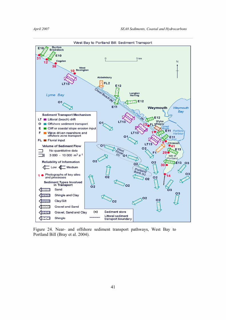
April 2007 SEA8 Sediments, Coastal and Hydrocarbons
________________________________________________________________________
41
Figure 24. Near- and offshore sediment transport pathways, West Bay to Portland Bill (Bray et al. 2004).

April 2007 SEA8 Sediments, Coastal and Hydrocarbons
________________________________________________________________________
42
Figure 25. Net total load sand transport rates under the action of waves and currents (Bastos and Collins, 2002).
3.6 ONGOING PROBLEMS IN THE NEARSHORE REGION
3.6.1 Transformation of wave parameters from offshore
Most coastal engineering applications use modelled offshore wave data for scheme and structure design, but comparison of the measured parameters in ~10 m CD with those predicted by the UK Met Office 25 and 12 km grid models has shown important disparities. Significant wave height is under-predicted at the extremes, but over-predicted in average conditions (Bradbury et al., 2004). Wave period (Tz) is typically over-predicted. This has significant implications, for example, on stability calculations for rock armour where under-prediction of wave height may mean that the size or slope of the structure are under-designed. Conversely, over-prediction of moderate conditions will produce higher modelled sediment transport rates.
Modelled wave conditions at easterly facing beaches in the lee of headlands such as Weymouth suggest that diffraction is not well handled. Sophisticated spectral models should be used, but they are computationally intensive and require detailed and accurate bathymetry and wave and current fields for boundary conditions (not often available). They are run generally for sediment transport predictions and rarely for sufficiently long time periods to derive either extremes or general wave climate parameters.
3.6.2 Lack of long-term measurements for design of structures
In general, one year's worth of wave measurements can be used to predict a 20 year extreme wave height and, therefore, without long-term measurements it is difficult to
360000 370000 380000
7000
080
000
0
0.25
0.5
0.75
1
1.25
1.5
1.75
2
5
10
25
Sand Trasnport Rates(kg/m/tidal cycle)
Sand transport rate (kg/m/tidal cycle)

April 2007 SEA8 Sediments, Coastal and Hydrocarbons
________________________________________________________________________
43
predict with confidence significant wave height return periods for the design life of structures. Even more difficult is the prediction of joint probability of extreme levels due to combination of storm surge, spring tides and high waves near the coast. Both statistics are crucially important for wave impacts on structures e.g. offshore breakwaters, as well as for predicting coastal flooding from overtopping.
3.6.3 Bi-modal seas
No design models for engineering structures or for beach morphology take into account bi-modal sea conditions. The JONSWAP spectrum for fetch-limited seas, which is normally used for the eastern English Channel, requires modification for the presence of bi-modal seas.
3.6.4 Sediment transport measurement and modelling
Even short-term sediment transport is very difficult both to quantify and to predict. A modelled estimate of a longshore sediment transport rate which is within two orders of magnitude of the measured is considered successful; many models do not even predict the net direction of transport correctly, although cross-shore (beach profile) models are generally more successful than longshore. Models for predicting transport rate of shingle-sized sediment (which forms the prevalent beach type in the southeast) are even less successful, although part of the problem may lie in the difficulty of measuring the transport rate, since the most reliable method remains long-term impoundment against a harbour arm (Van Wellen et al., 2000). Reliable measurements of both nearshore waves and shingle transport in high energy conditions are lacking.
The COAST3D research project conducted an extensive field measurement campaign to provide measurements for area numerical model evaluation, as part of the COAST3D project (Soulsby, 2001). Modelling of the complex site at Teignmouth (few km2 encompassing estuary mouth, mixed beaches, seawalls and cyclical sand patch migration proved difficult. Tidal flows were predicted well, although small errors in prediction of combined wave/tidal currents could lead to large errors in transport predictions. Medium-term (decadal), and medium scale (few km) coastal evolution modelling remains uncertain.
The storm surge prediction model works less well in the eastern English Channel and notably in areas where the coastline if poorly represented e.g. The Solent. Surges are generally less than 1m, but onshore south-easterly winds generated a surge of 0.68 m in Poole Bay in October 2004, which lasted 36 hours. Although small by North Sea standards, the surge was equivalent to nearly half of the tidal range and therefore has considerable potential for coastal flooding.
April 2007 SEA8 Sediments, Coastal and Hydrocarbons
________________________________________________________________________
44
4. Habitats and Seabed Sediment Distribution
4.1 INTRODUCTION The concept of marine landscapes was developed for Canadian waters by Roff and Taylor (2000). The objective was to produce a broad-scale classification of the marine environment because of their importance in determining the nature of biological communities. The classification scheme was based both on geophysical features and the physical parameters of the water column such as water temperature, depth/light, and stratification/mixing regime. This approach is potentially well suited for areas away from the coastline where biological information is likely to be lacking, and/or where the regulation of human activity needs to be addressed at the relatively large scale. Physiographic features that influence the distribution and range of species include geology, sediment and morphology of the seabed. For the BGS, a review of the classification schemes available was carried out in 2001 (James, 2001).
4.2 IRISH SEA PILOT To trial the use of geophysical seabed features as a basis for habitat mapping, the Irish Sea Pilot scheme was established in 2002, with the aim of formulating a framework for marine conservation (Laffoley et al., 2000; Lumb et al., 2004), addressing the ecological requirements of marine wildlife at an appropriate range of spatial scales. In doing so, the Irish Sea Pilot has examined the degree to which this framework can contribute to wider sustainable development for the whole of the marine environment. In particular, the trial investigated the manner in which nature conservation objectives could be integrated into the objectives of other marine interest sectors (fisheries, oil and gas, shipping etc.) in practice. The ‘framework for marine conservation’ proposed the use of marine landscapes as part of an ecosystem-based approach to marine conservation. Golding et al., (2004) used a simplified scheme of sediment classification modified after Folk (1980), reducing the number of sediment classes from 15 to six. In addition they used maximum bed stress data. They also identified bedforms such as sediment wave/megaripple fields and sand/gravel banks. Biological characterisation of the coastal and seabed marine landscapes was carried out by linking available biological data to each marine landscape. Of the six sediment classes identified, three seabed sediment definitions were used to define marine landscape types: mud basins, fine sediment plains and coarse sediment plains. Coarse sediment plains were further subdivided using near-bed stress; low bed-stress coarse sediment plains with values from 0-10 Nm-2 and high bed-stress coarse sediment plains with values ≥ 11 Nm-2.
In total, 18 coastal and seabed marine landscapes were identified for the Irish Sea of which 13 were offshore. The offshore landscapes were: photic reef, aphotic reef, (Irish) sea mounds, sand/gravel banks, coastal sediment, shallow-water mud basin, deep-water mud basin, fine sediment plain, sediment wave/megaripple field, low bed-stress coarse sediment plain, high bed-stress coarse sediment plain and, deep-water channel. Of these 13 landscapes five (deep-water mud basin, fine sediment plain,

April 2007 SEA8 Sediments, Coastal and Hydrocarbons
________________________________________________________________________
45
sediment wave/megaripple field, low bed-stress coarse sediment plain, high bed-stress coarse sediment plain) accounted for 86% of the total area covered by the survey (Table 1).
Landscape Percentage area Deep-water mud basin
8.3
Fine sediment plain
21.9
Sediment wave/megaripple field
11.0
Low bed-stress coarse sediment plain
25.1
High bed-stress coarse sediment plain
19.4
Table 1. The extent of marine landscapes in the Irish Sea Pilot study area.
4.3 MARINE EUROPEAN SEABED HABITATS Mapping European Seabed Habitats (MESH), an international marine habitat mapping programme started in spring 2004, with the primary aim of producing seabed habitat maps for north-west Europe. MESH aims to develop international standards and protocols for seabed mapping studies. The end products will be a meta database of mapping studies, a web-delivered geographic information system (GIS) showing the habitat maps, guidance for marine habitat mapping including protocols and standards, a report describing case histories of habitat mapping, a stakeholder database and an international conference with published proceedings.
4.4 HABITATS IN SEA8 Only a few areas of SEA8 have been studied in detail for their marine habitats, with only the Outer Bristol Channel studied in detail (Mackie et al., 2006). Thus, because we do not have detailed biological data for the whole SEA8, to relate the sediment distribution to seabed habitats, we have followed the approach adopted by the Joint Nature Conservancy Council (Golding et al., 2004). By applying this methodology, marine habitat types can be interpreted from variations both in seabed physiography and seabed-sediment properties; parameters that have been derived from seabed-samples, geophysical data and hydrographical data. Maps of seabed physiography and seabed-sediment properties are separated for clarity of presentation in this report (Figures 5 and 9).
In this report our dataset only applies to the offshore areas as it does not extend into shallow coastal waters. We use a simplified scheme based on four main sediment

April 2007 SEA8 Sediments, Coastal and Hydrocarbons
________________________________________________________________________
46
classes (Figure 26). The coarse sediment is gravel, the other classes are as stated. A subjective comparison with the results from the Irish Sea suggest that there are similarities in the sediment and active bedform distribution in this area that may be utilised to provisionally identify seabed habitats in SEA8. These tentatitive correlations are drawn in Table 2 and are based upon the seabed sediment distribution (Figures 4 and 23), the bedforms (Figures 11 and 16) and the peak flow for a mean Spring Tide (Figure 6). The locations of the habitats are as follows. The deep water mud basin correlates with the mud basins in the northwest of SEA8 in the deeper waters in the region of the Celtic Deep. The fine sediment plain lies around the deep water mud basin and extends to the southwest margin the area.The sediment wave/megaripple field lies on the southern margin of SEA8 in the western English Channel and Western Approaches Trough. The high bed stress, coarse sediment plains are located in the eastern English Channel and the inner Bristol Channel. The low bed stress, coarse sediment plains lie in the outer Bristol Channel.
Figure 26. Simplified seabed sediments distribution map of SEA8 area
This attempt to use the marine landscapes is preliminary and lacks any biological control, it has been attempted on many untested assumptions, such as an environmental similarity between SEA8 and the Irish Sea. It should be stressed that this may nor be the case. We know that there are many dissimilarities such as the tide and wind-wave regime operating in the two regions as well as the sediment sources. However, it is a simplification, the available substrate data does not always reflect the actual condition of the seabed, and there is greater variability of seabed characteristics than a straightforward interpretation of the marine landscape map would suggest. The dataset is regional, there are no doubt many smaller marine landscapes (as in the Irish
April 2007 SEA8 Sediments, Coastal and Hydrocarbons
________________________________________________________________________
47
Sea) that have been overlooked. The coastal region, where infrastructure development is most likely to take place (wind farms, sea defences etc) has not been considered.
Landscape Characteristic biology (biotope complexes) Deep-water mud basin Offshore mud; Circalittoral sandy mud:
Fine sediment plain Circalittoral sandy mud; Infralittoral sandy mud; Circalittoral muddy sand; Infralittoral fine sands; Infralittoral muddy sands; Infralittoral coarse sediments
Sediment wave/megaripple field
Circalittoral sandy mud; Circalittoral muddy sand; Infralittoral fine sands; Circalittoral fine sands; Circalittoral coarse sediments; Infralittoral coarse sediments:
Low bed-stress coarse sediment plain
Circalittoral mixed faunal turf; Infralittoral fine sands; Infralittoral muddy sands; Circalittoral coarse sediment; Infralittoral coarse sediment; Circalittoral mixed sediment; Offshore mixedsediment:
High bed-stress coarse sediment plain
Circalittoral mixed faunal turf; Circalittoral Coarse sediments; Offshore mixed sediment
Table 2. Summary of tentative biological characterisation for each Marine Landscape (biotope complexes after Connor et al., 2003).
As noted, the only habitat study we had access to in the SEA8 area has been in the outer Bristol Channel (Mackie et al., 2006). To confirm our cautionary words above, here the area was subdivided into four main physical regions. These comprised areas of low relief sandy seabed, fields of large sand waves (some up to 18 m high), isolated sand waves on a gravelly substrate and rock exposed at seabed. The highest species diversity was associated with the coarse sediments and rock outcrops. Cluster analysis identified five main benthic faunal assemblages, that corresponded to eight infaunal and three epifaunal biotopes. Sediment stability was considered a major control on the fauna.
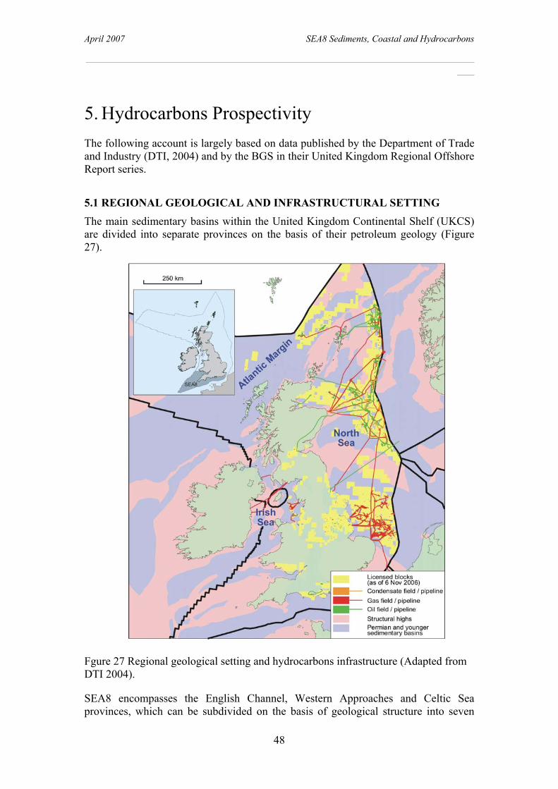
April 2007 SEA8 Sediments, Coastal and Hydrocarbons
________________________________________________________________________
48
5. Hydrocarbons Prospectivity The following account is largely based on data published by the Department of Trade and Industry (DTI, 2004) and by the BGS in their United Kingdom Regional Offshore Report series.
5.1 REGIONAL GEOLOGICAL AND INFRASTRUCTURAL SETTING The main sedimentary basins within the United Kingdom Continental Shelf (UKCS) are divided into separate provinces on the basis of their petroleum geology (Figure 27).
Fgure 27 Regional geological setting and hydrocarbons infrastructure (Adapted from DTI 2004).
SEA8 encompasses the English Channel, Western Approaches and Celtic Sea provinces, which can be subdivided on the basis of geological structure into seven

April 2007 SEA8 Sediments, Coastal and Hydrocarbons
________________________________________________________________________
49
sedimentary basins: South Celtic Sea Basin, Bristol Channel Basin, Plymouth Basin, Western Approaches Trough, Portland-Wight Basin , Wessex Basin and the Hampshire-Dieppe Basin, (Figure 28).
Figure 28. Simplified bedrock geology and main sedimentary Basins in SEA8.
(SCSB – South Celtic Sea Basin; BCB - Bristol Channel Basin; WAT – Western Approaches Trough; PB – Plymouth Basin; PWB – Portland-Wight Basin; WB – Wessex Basin; HDB – Hampshire-Dieppe Basin) and the North Celtic Sea Basin (in Irish waters). To date, discoveries of commercial hydrocarbons have been confined only to oil and in the Portland-Wight sub-basin of the English Channel Basin, where production of oil takes place only at the Wytch Farm oil field.
5.2 HYDROCARBONS GEOLOGY The generation and entrapment of hydrocarbons depends upon a combination of factors which include the deposition of an organic rich source rock, the presence of a reservoir in which a hydrocarbon can accumulate, a cap rock to prevent hydrocarbon escape and a series of tectonic events which allow the hydrocarbon to be generated (burial), to migrate into a reservoir and to be preserved.
The preservation of commercial hydrocarbons requires these events to take place in the most positive of circumstances, circumstances which appear not to be generally present in the SEA 8 region. Source rocks are poor, reservoirs are mainly absent and deformation has either ‘cooked’ and destroyed older source rocks from the Carboniferous or allowed any hydrocarbon formed from later Mesozoic sediments to
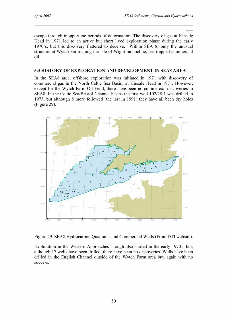
April 2007 SEA8 Sediments, Coastal and Hydrocarbons
________________________________________________________________________
50
escape through inopportune periods of deformation. The discovery of gas at Kinsale Head in 1971 led to an active but short lived exploration phase during the early 1970’s, but this discovery flattered to deceive. Within SEA 8, only the unusual structure at Wytch Farm along the Isle of Wight monocline, has trapped commercial oil.
5.3 HISTORY OF EXPLORATION AND DEVELOPMENT IN SEA8 AREA In the SEA8 area, offshore exploration was initiated in 1971 with discovery of commercial gas in the North Celtic Sea Basin, at Kinsale Head in 1971. However, except for the Wytch Farm Oil Field, there have been no commercial discoveries in SEA8. In the Celtic Sea/Bristol Channel basins the first well 102/28-1 was drilled in 1973, but although 8 more followed (the last in 1991) they have all been dry holes (Figure 29).
Figure 29. SEA8 Hydrocarbon Quadrants and Commercial Wells (From DTI website).
Exploration in the Western Approaches Trough also started in the early 1970’s but, although 17 wells have been drilled, there have been no discoveries. Wells have been drilled in the English Channel outside of the Wytch Farm area but, again with no success.

April 2007 SEA8 Sediments, Coastal and Hydrocarbons
________________________________________________________________________
51
5.4 PROSPECTIVITY PLAYS
5.4.1 North Celtic Sea Basin In the North Celtic Sea Basin (Figures 28, 29, 30 and 31) the gas field at Kinsale Head has been in production since 1979. Gas reserves are estimated to be 1 x 10(12) ft(3) and the field is 13 x 5.5 miles with 47 square miles of closure at the top of the main reservoir (A) sand. The reservoir is in Aptian/Albian channel, beach and shallow marine sandstones which form a simple elongate east-northeast to west-southwest trending anticline formed during inversion in the Palaeogene (Colley et al., 1981). Gault Clays form the cap-rock and the gas is an almost-pure methane which is very dry and with a very light isotopic composition; characteristics which suggest a complex origin for the gas, which is still poorly understood. According to Colley et al. (1981) paraffinic crudes migrated into the Wealden and were subject to fresh-water flushing and biodegradation which produced large volumes of isotopically light methane. This gas subsequently became mixed with thermally generated methane from the Jurassic and migrated into the Albian reservoir.
Figure 30. Cross section across the North Celtic Sea Basin (Location on Figure 24) (From Colin et al., 1992).
Since the discovery of Kinsale Head in 1971 much exploration in the North Celtic Sea Basin has concentrated on identifying similar domal structures, but with limited success: only small, adjacent prospects such as Ballycotton and Seven Heads have been discovered, the former to come onstream in late 1991 (Shannon, 1991). The poor success history of the basin is attributed to poor seismic data quality below the chalk which has masked a complex pre-Cretaceous structural history, hitherto poorly understood. Improved seismic data processing has led to a better understanding of the basin. Source rocks are known to occur in the Early and Late Jurassic and

April 2007 SEA8 Sediments, Coastal and Hydrocarbons
________________________________________________________________________
52
reservoirs in the Permo-Triassic, Upper Jurassic and Early to mid Cretaceous (Shannon, 1991). Further exploration is anticipated to be successful although the reservoirs may well be small and complex.
5.4.2 South Celtic Sea and Bristol Channel Basins In the South Celtic Sea and Bristol Channel basins the prospects are not as good as in the adjacent North Celtic Sea Basin (Figure 27). Seven wells have been drilled, but all have been dry holes (Figure 31). Drilling objectives include sandstones of mid-Cretaceous and Jurassic age. Aptian/Albian sandstones, similar to those in the Kinsale Head gas field, have been encountered but are very thinly developed and Wealden sandstones up to 18 m thick have been penetrated in well 93/2-1. Jurassic sandstones up to 5 m thick have been proved, but are water bearing (Kamerling, 1979). Perhaps the best prospects are the sandstones of the Permo-Triassic Sherwood Sandstone Group and sandstone dominated units over 50 metres thick have been penetrated in well 93/6-1; unfortunately with no hydrocarbon shows.
Figure 31. Cross section of the North and South Celtic Sea basins (Location on Figure 24) (From Tappin et al., 1994).
A major problem with the hydrocarbon prospects is the lack of prime, organic rich source rocks (Figure 32). The drilling results indicate that these are patchily developed and of poor quality. According to Kamerling (1979) the early Cenomanian claystones immediately underlying the chalk offer the best potential but have not reached thermal maturity. Jurassic aged organic rich claystones are major source rocks in the North Celtic Sea and North Sea basins but these are poorly developed. Carboniferous rocks in the North Sea and Irish Sea basins, especially those of Westphalian age, are important source rocks for gas. In Devon, Carboniferous sandstones and mudstones contain vitrinite organic matter, usually of woody stem or bark which were carried into the prodelta and deeper marine environments from the shallower, coal rich environments to the north, in Wales. Shales from north Devon have a total organic carbon content of between 0.49 and 1.34 per cent and contain a dominance of gas-prone kerogen (Cornford et al., 1987). Studies of vitrinite reflectance indicate that the beds were buried to depths of between 4.5 and 7 km and that some low maturity shales could have generated gas on further burial. However no cap rock has been identified and any gas generated

April 2007 SEA8 Sediments, Coastal and Hydrocarbons
________________________________________________________________________
53
would have escaped during the later Variscan deformation. Offshore, the few wells which penetrate the Devonian/Carboniferous indicate the pervasive presence of low grade metamorphic sediments similar to those onshore. Dating of the rocks gives mainly Early to mid Carboniferous ages (Kamerling, 1979).
Figure 32. Distribution of Jurassic source rocks in SEA8 area (Derived from DTI, 2004).
The tectonic history of the two basins may also be unconducive to hydrocarbon accumulation. The basin evolution is similar to that of the North Celtic Sea Basin but the phases of deformation during the mid to Late Jurassic and Early Cretaceous may have been untimely in relation to hydrocarbon generation (Kamerling, 1979). Source rock studies indicate that equal levels of maturity are at different levels at different places indicating post-maturity breakup of the area. The prospects in UK designated areas are therefore regarded as poor.
5.4.3 Western Approaches Trough When exploration for hydrocarbons began in the area in the early 1970’s, the expectation was to find extensive thicknesses of Jurassic sediments, which are the main source rocks for hydrocarbons in the northern North Sea and Southern England. However, Late Jurassic to Early Cretaceous erosion has removed much of the prime sedimentary section, and thick Jurassic and Lower Cretaceous sections are preserved only in the southern part of the trough (Figure 33).
The preserved outliers of Liassic (Lower Jurassic) mudstones in the Melville and Plymouth Basins are the best source rocks in the northern basins of the Western Aproaches Trough. Well 88/2-1 drilled into the eastern part of the Plymouth Bay Basin (Evans et al., 1981), recovered 491 m of Hettangian to Pliensbachian mudstone and shale with limestone intercalations near the base. The total organic carbon values ranged from 3.2 to 11.3 per cent, with the highest values in the Pliensbachian. The samples contain abundant quantities of amorphous (algal) kerogen and sapropelised vascular plant material on an oil-prone nature. Pyrolysis analyses indicate that the Pliensbachian and Sinemurian strata re good potential sources for oil, whereas the lowermost parts of the Lias exhibit moderate potential.

April 2007 SEA8 Sediments, Coastal and Hydrocarbons
________________________________________________________________________
54
Figure 33. Cross section of the Western Approaches Trough (for location see Figure 24) (From Evans, 1990).
The maximum depth of the Jurassic in the wells from the Melville Basin is 2,077 m (73/1-1), though the base of the Jurassic is deeper in the South Celtic Sea Basin. These values relate to the depth below the present surface an do not take into account the extensive uplift that took place in the Late Jurassic to Early Cretaceous and Eocene to Miocene. In parts of the Western Approaches Trough, Liassic rocks may have been buried at sufficient depth to have generated hydrocarbons before uplift, especially in the Brittany Basin. Overall the Western Approaches Trough has yielded disappointing exploration results, with no economic finds being reported even where source rocks are most abundant.

April 2007 SEA8 Sediments, Coastal and Hydrocarbons
________________________________________________________________________
55
5.5 CENTRAL ENGLISH CHANNEL BASIN – WYTCH FARM OILFIELD In the central and eastern English Channel region the exploration history is quite different to the other basins in the SEA8 area. Hydrocarbons in their various forms have been exploited in southern England since at least the Iron Age, when the oil shales of Kimmeridge Bay were burnt as fuel (Galois, 1978). In the 1930’s oil shows were found in the Corallian, Purbeckian and Wealden (Lees and Cox, 1937) followed in 1938 by a programme of exploration. In 1953 exploration began again and during the following 15 years several wells were drilled in Dorset, recording a large number of hydrocarbon shows, of which only a few proved to be economic, due either to complicated structures or to variable porosities and permeabilities in the reservoirs. In 1959, the Kimmeridge 1 well found oil in a fractured marine limestone of the Cornbrash (Middle Jurassic) (Figure 34).
Figure 34. Location of Wytch Farm Oilfield and petroleum wells drilled in the area (From Colter and Harvard, 1981).
The field began producing oil in 1961, since when it has yielded up to 300 barrels of oil per day (BOPD). In 1964 the Wareham 1 Well produced oil from the Inferior Oolite (Middle Jurassic) and the top three metres of the Bridport Sands (Lower Jurassic). The field began production in 1970, but was later abandoned.
In 1972 a review of all data indicated that the Bridport Sands were not as tight as previously believed. The Wytch Farm No 1 was drilled in late 1973 proving the Bridport Sands to be indeed oil bearing. Oil production from the Field began in March 1979, and 2500 BOPD were produced from the Bridport Sands during 1987. In 1976, the Sherwood Sandstone was identified as a potential reservoir with oil sourced from the Jurassic, proved by further drilling in 1977. Development of the Sherwood Sandstone reservoir would increase production to 6000 BOPD. Farther to the north-east during 1980, Carless Exploration discovered oil in an east-west trending, dipping,

April 2007 SEA8 Sediments, Coastal and Hydrocarbons
________________________________________________________________________
56
faulted, horst block at Humbly Grove. The Humbly Grove- 1 well discovered oil in the Great Oolite of some 13 million barrels of oil and 3000 million cubic feet of gas (Hancock and Mithen, 1987).
Figure 35. Cross section of the Wytch Farm Oilfield (From Colter and Harvard, 1981).
5.5.1 Wytch Farm Oilfield The Wytch Farm oilfield is an east –west trending tilted fault block controlled by a fault to the south, with mainly dip closure on the other flanks (Figures 34 and 35). It lies a short distance north of the Portland-Wight Faults (Purbeck Fault Zone). The oil is sourced from the Lower Jurassic, Blue Lias, that lies to the south of these faults from rocks which, in contrast to those to the north, are known from Arreton-2 well on the Isle of Wight to have high source potential and to be mature. A phase of pre-Cretaceous faulting gave rise to the down-to-the-south movement on the Portland-Wight Faults, resulting in deeper burial of the marine source rocks to the south, and erosion of potential Kimmeridge Clay source rocks to the north. Tertiary compression later gave rise to the northward-facing Portland-Wight monoclines along the line of the pre-existing faults; generation, migration and entrapment of oil is assumed to have occurred between the two events.
The main reservoirs are the Sherwood Sandstone and Fullers Earth. There are other minor reservoirs that include the Cornbrash, the Corallian and the Portland Beds. The Bridport Sands near Wytch Farm are composed almost entirely of sandstone; and attain a maximum thickness of 112 m in well 98/11-2, but pass laterally into arenaceous and calcareous siltstones and shales, and are only 43 m thick in well 98/22-2 in mid-channel (Figure 36). This makes it unlikely that the Sands would make a good reservoir any great distance away from the known oil and gas discoveries. The Sherwood Sandstone Group forms the deeper productive horizon both at Wytch Farm and in the wells 98/6-8 and 98/7-2; it thins southwards from 146 m in 98/11-1 to 65 m

April 2007 SEA8 Sediments, Coastal and Hydrocarbons
________________________________________________________________________
57
in mid-Channel, and also thins rapidly eastwards where it id 47 m thick in 99/18-1, 17 m in 99/16-1 and is missing from well 99/2-1. The reservoir quality also deteriorates rapidly away from the area of the discoveries, for the formation passes laterally into silty, clayey and conglomerate beds.
Figure 36. Area of exploration offshore of the Wytch Farm Oil Field.
The lower and upper Lias clays, the Oxford Clay and the Kimmeridge Clay posses the greatest potential for sourcing hydrocarbons in the English Channel, the Lias Clays being the most likely primary sources. The maturity of the clays is highly variable; they are only locally mature, with maximum maturity attained in the axial parts of the Central English Channel Basin, an area largely unaffected by late-Cimmerian uplift and erosion. Major hydrocarbon generation and migration probably occurred in the mid- to late Cretaceous when the Lias of the Central English Channel Basin was buried some 1000 m deeper than the Sherwood Sandstone Group of the Wytch Farm trend. This enabled the accumulation in the post late Cimmerian structures , and allowed traps in the Sherwood Sandstone Group and higher reservoirs to be filled.
Seals to the major reservoirs are provided by the Mercia Mudstone group for the Sherwood Sandstone Group, and by the Fullers Earth for the Bridport Sands. Jurassic clays would provide seals for other possible Jurassic reservoirs.
The oil source rock is the Lower Jurassic, Blue Lias. This is reached at a depth of 2.5 km in the Portland Wight Basin. The source rock in the North Sea is the Kimmeridge formation. In Dorset this has not reached sufficient depth in this area for oil to be formed. Note that although there is a well site at Kimmeridge the source rock is Blue

April 2007 SEA8 Sediments, Coastal and Hydrocarbons
________________________________________________________________________
58
Lias, not Kimmeridge Clay. All along the south coast of Dorset to East Devon all the oil producing source rocks and reservoir rocks are exposed, so can be studied above ground.
The Sherwood Sandstone reservoir has a granitic source from a landmass that extended from the present day Brittany across the English Channel ending at around Sidmouth in Devon. Usually sandstone gives a low radioactivity count but because of its origins, but the Sherwood is unusually high. This radioactivity can coat the metalwork during the extraction so precautions have to be taken. The Bridport Sand reserves have a high hydrogen sulphide content. The gas evolved is trapped in the cellars that surround the wells to prevent direct leakage into the environment. The high iron content of the Sherwood Reservoirs would swiftly have broken down any hydrogen sulphide that may have been passed into it.
The field produces both oil and natural gas and is the largest onshore oil field in Europe. The facility is operated by BP and is located on Wytch Heath on the southern shore of Poole Harbour (Figure 4), two miles north of Corfe Castle. Oil is piped from Wytch Farm to Hamble on Southampton Water about 40 miles away. The field stretches under the eolian clays and sands of Poole Harbour, Poole and Bournemouth, and under the Cretaceous chalk hills and Jurassic limestone and shale of the Isle of Purbeck. Most of the field is protected by various conservation laws, including the Jurassic Coast world heritage site, Purbeck Heritage Coast and a number of sites of special scientific interest, areas of outstanding natural beauty and nature reserves (including Studland and Brownsea Island), so the refinery and most of the pumps are small and well screened by trees. Directional drilling has also contributed to reducing the impact on the local environment, with extended reach drilling attaining distances in excess of 10 km.
Production from the field is currently 3.40 million tonnes per year. One of the "nodding donkey" beam pumps, at Kimmeridge, has been pumping continuously since production began in 1979 and is the oldest continuously pumping well in the world. As of 2002 it is estimated that the field contains 65.40 million tonnes of oil, 4.73 million tonnes of natural gas liquids and 1.42 cubic kilometres of natural gas that will last until 2020 to 2025. There is an annual production of 490 million barrels (35 gallons per barrel/40 gallons US) of oil from the Wytch Farm, Wareham and Kimmeridge fields. The Sherwood Reservoir generates 90% of the production. The reserves at Wytch Farm are projected to run out in 20 years time. In all 110 wells have been drilled, 75 of these are producing oil and 25 are injecting water.
At the injector wells water is pumped into the wells to keep up the pressure and displace the oil as oil is extracted. The water separated in processing the oil with additional seawater is injected. The natural salinity of the water in these reservoirs is very high; three times the salinity of seawater. This highly saline water has the potential of being more environmentally harmful that the oil in the event of a spill as it will soak into the ground unlike the oil. The high salinity is due to the geology of the Sherwood sandstone positioned above the Mercia Mudstones. These formed in a desert lake with subsequent high salt levels. In some locations there is a 30m thick layer of halite above the Sherwood, but not at Wytch Farm.

April 2007 SEA8 Sediments, Coastal and Hydrocarbons
________________________________________________________________________
59
5.5.2 English Channel - Offshore Exploration The first exploration well offshore in the English Channel was Lulworth Banks-1, drilled in 1963 by BP under an onshore licence. It terminated in the Bridport Sands and proved to be dry. Not until the 5th Round of offshore licensing in 1997 did the Department of Energy award exploration licences offshore in the English Channel (Figure 36). Since this time fourteen licenses have been awarded in 7th, 9th, 11th and 12th rounds. Many of the wells drilled have proven to be dry, and many of the licenses relinquished.
In early 1982, the French Government licensed six areas in the English Channel and Western Approaches. To date only one well has been drilled relevant to this report, Well Nautile-1. Thus well was drilled by Elf-Aquitaine to a depth of 1500 m terminating in ?Cretaceous/Jurassic.
The oil and gas discoveries in the English Channel have been all on the Wytch Farm trend. In 1983, British Gas, exploring for and offshore extension to the Wytch Farm field, drilled four wells in Block 98/11. Well 98/11-2, just south of the Wytch Farm trend tested gas from the Sherwood Sandstone at a rate of 9.6 million cubic feet per day; three other wells encountered only minor oil and gas shows. To the east of Wytch Farm, BP drilled well 98/7-2 in 1987 to the north of the Portland-Wight Faults; which yielded oil from the Sherwood Sandstone Group, and was classified as a discovery. In late 1988, BP drilled three offshore appraisal wells (98/6-7, 98/6-8 and 98/6-9) between Wytch Farm and well 98/7-2. The results of these wells strongly indicate that the productive Sherwood Sandstone Group reservoir extends eastwards towards the Isle of Wight. Tilted fault-blocks and faulted anticlines tend to be the dominant trap style.

April 2007 SEA8 Sediments, Coastal and Hydrocarbons
________________________________________________________________________
60
6. Conclusions and Strategic Overview The main aims of this report were to provide for the DTI SEA8 area a general description of the superficial seabed sediments and their controlling processes, especially those aspects relating to marine habitats. A secondary objective was to briefly review the hydrocarbon prospectivity of the area. Key objectives were to bring together research from BGS (BGS) and the Channel Coastal Observatory (CCO) and integrate this with results of other recent surveys within the area, where survey data was available.
For the first time in a SEA we have included an assessment of the coastal zone. Not only are there are significant differences in the controls on sedimentation between the coastal zone and the offshore areas, there are differences in scale as to how these processes are investigated and a more pronounced human impact on the environment that disrupts natural processes to a greater degree than offshore.
By contrast to the SEA8 offshore area, where sedimentation is dominated by the tides, coastal zone sedimentary processes are dominated by wave action. Additionally, data acquisition technologies in the coastal areas may either large scale satellite-based or small-scale measurements, such as by local marine bathymetric surveys or lidar. In shallow water, acquisition of marine data (by contrast to deeper waters) is expensive. Where there are high population densities coastal defences became an important aspect of the natural equilibrium that have to be included in assessing environmental impact. To relate the two regions, offshore and coastal problematic because on the ‘white zone’ an intermediate area where there is a transition in the processes controlling sedimentation and where data is difficult to acquire.
6.1 OFFSHORE SEDIMENTARY PROCESSES Based on the pre-existing body of data, there is a good overall understanding of the offshore sedimentary processes operating in the SEA8 area. There have been some recent controversies, for example over the origin of the Tidal Sand Ridges, but these have been resolved with the older, challenged, interpretations now being accepted. Sedimentation in the SEA8 offshore area is mainly influenced by sediment availability together with the active tidal regime. Only on the shelf edge is there a wave driven influence on sedimentation.
The present sediment distribution is due to a sequence of events following the retreat of the continental glaciers at the end of the last ice age. The glacial sediments laid down during maximum ice advance are the main source of the seabed sediment sediment present today. As the ice sheets melted and eustatic sealevel rose, coastal and nearshore environments migrated across the area. In the southwest of SEA8 the tidal sand ridges were formed, their landward extent controlled by the (present day) 120 m isobath. In shallower waters a coarse-grained sediment (Layer B) was laid down as a result of reworking of the periglacial deposits. When sea level stabilised at its present level, the present tidal regime reworked the fine-grained sediment winnowed from Layer B, leading to the present sediment distribution and bedforms (Layer A). Because there is little sediment coming into the area the result is the

April 2007 SEA8 Sediments, Coastal and Hydrocarbons
________________________________________________________________________
61
complex interdigitation of the three units (TSR’s, Layer B and Layer A) now observed.
In the regions of the highest tidal velocities (Bristol Channel and central English Channel) the seabed is thus either swept clear of sediment or has a thin sediment veneer. Outside of these areas the progressive change of bedforms observed identifies the area as relatively sediment starved. In the English Channel there is a change away from the swept seabed, through gravel furrows, sand streaks, ribbons and longitudinal sand patches, into megaripples overlying a gravel floor (Layer B) and finally a complete megaripple cover. A similar progression, although with a higher sediment input and on a more limited scale is observed in the Bristol Channel and its approaches. In areas of lowest tidal velocity, the dominant modern sediment is fine grained.
It was anticipated that the recently acquired data shown on the GIS would be available for inclusion in the report but, as it transpired, the only new data made available was from the Outer Bristol Channel Marine Habitat and Eastern English Channel surveys. This data validated the existing understanding of sedimentary processes operating in the area. However, the data contributed new images that allow a far more detailed interpretation of the processes in operation. The improvements are because of the higher resolution swath bathymetric data not available when the original interpretations were made. This results in more detailed seabed morphology that in association with biological sampling, allow habitats and biotopes to be established in detail (e.g., the Outer Bristol Channel Survey).
As a result of the methodologies developed in the Irish Sea on the use of geophysical data in interpreting biological habitats we have attempted to subdivide the SEA8 area into marine habitats based on sediment grain size, seabed stress (as interpreted from maximum spring tide velocity) and bedform type. This subdivision applies to the largest areas identified but, in the absence of biological data together with more detailed sedimentary data, does not allow the identification of smaller, and possibly more vulnerable habitats, that may require particular management to ensure survival when development takes place (e.g., as in the Irish Sea). There is also uncertainty in the habitat to be applied the large areas off of Cornubia where there is a significant component of shell in the seabed sediment. In the coastal regions, the detailed data for habitat classification may be more commonly available, but this needs to be considered in more focussed habitat studies that are beyond the scope of this report.
6.2 COASTAL PROCESSES Coastal processes may be considered on the regional scale, but it is the local scale that is important in the context of environmental assessment. General subdivisions maybe made on the regional coastal differences in the SEA8 area, such as those based on the geological control on coastal morphology. For example, there are the hard rock cliffs of the southwest, determined by their mainly Palaeozoic origin, the soft (Jurassic) cliffs of the central English Channel and the more resistant Chalk cliffs farther east. The disposition of these rocks influences the type of coast and its resistance to erosion. In addition to the geological control on the coastal morphology, the coastal morphology influences the type of waves impacting the coast. In the west of the area, the shelving beaches dissipate wave energy making them, in the context of the resistant coastline, less effective as agents of erosion. By contrast, in the central and
April 2007 SEA8 Sediments, Coastal and Hydrocarbons
________________________________________________________________________
62
eastern English Channel, the steeply sloping, gravel and mixed sand and gravel beaches result in plunging breaker waves that are more effective as agents of erosion, especially acting against the less resistant coastal rocks. Sediment movement too reflects broader-scale regionality with, for example, the four sediment cells identified along the south coast.
However, although our understanding of the processes acting on the coastal zone is good in general it is poor in detail. This reflects the application and scale for which knowledge and understanding are required, i.e, in the human context over shorter timescales. The main requirement is for knowledge of coastal processes that are required to underpin the design of coastal protection. Prediction of wave height is important for engineering purposes but generally is inexact, because of disparities between models and measurements. Frequently models are inadequate because offshore data (expensive to acquire) is not available. Data acquisition over the required periods (for engineering purposes ~20 years) may not be available. Quantifying sediment transport rates is difficult and problematic. The variables are complex for any long term prediction.
6.3 INTEGRATION – OFFSHORE AND COASTAL An important aspect of this project was to bring together the research between the coastal zone and offshore. We have achieved this in the GIS, but it is in the interpretations that is more problematic, especially on the smaller, more local scale.. There are significant differences in the processes operating between the two regions, waves versus tidal currents. There are differences in the timescales over which the processes operate; a storm can remodel a beach overnight, whereas in deeper waters on the shelf, significant sediment movement tales place over months if not years and decades. There are differences in the data used. The offshore interpretations tend to be large scale, against the coastal, that are more locally focussed. Here the generalisations made from the large scale offshore datasets need to be integrated with the details from the coastal areas. There are general associations that can be identified, between geology and erosion potential, between the sediment distribution, between the type of waves and the coastal morphology, but it is in the detail of data required for the tasks in hand that is a major stumbling block. One region where there is an ongoing data gap is between the offshore areas where it is ‘cost-effective’ to use swath bathymetry and those onshore. Lidar is increasingly used to bridge this gap, but it is expensive and does not work in all locations.
6.4 HYDROCARBONS Early optimism about the hydrocarbon prospects in the western areas of SEA8 was soon proved false. After gas discoveries in Irish waters exploration in the Celtic Sea and Western Approaches proved that the source rocks of the North Sea such as the Kimmeridge Clay and Westphalian Coal Measures were not present. Later Mesozoic and Tertiary deformation was inopportune and allowed any hydrocarbons present to escape. It was only in the central English Channel, in the Wessex Basin, that an unusual association of source rock, tectonics and reservoir, resulted in an economic discovery. Even so it took over 40 years to find the most productive location at Wytch Farm.

April 2007 SEA8 Sediments, Coastal and Hydrocarbons
________________________________________________________________________
63
6.5 DEVELOPMENT AND THE ENVIRONMENT The SEA8 area has been subject to minimal development activity, except in the coastal zone. The offshore area is not prospective for hydrocarbons, with only one major development, the Wytch Farm oilfield in Dorset, that is onshore, at present there is no indication that the field extends offshore.
There is only one prospective wind farm opportunity at present identified, Scarweather Sands in the Bristol Channel. The most significant development opportunity at present is the construction of a tidal barrage in the Bristol Channel, the construction of which would have a significant environmental impact.
In the coastal regions there has been considerable infrastructural development that has had a significant impact on the environment, leading to the construction of sea defences, especially along the eastern parts of the English Channel.
The SEA8 area is bordered by some of the most densely populated regions in the UK. Along the eastern coast of the English Channel the impact of this population density is a real concern over coastal protection. To address this a better understanding is required about the sedimentation processes operating here, especially the relationship between the on- and offshore.
There has been no focussed habitat study such as that undertaken for the Irish Sea. Export of the methodology applied there to SEA8 indicates that the larger framework may be readily understood but that it is at the smaller (biotope) scale where focussed research may be required. If large-scale disruptions to the natural seabed habitat are to be avoided, the development scenarios should be assessed to identify scenarios that could have a significant impact on the regional distribution patterns of seabed stress and related seabed sediment types.

April 2007 SEA8 Sediments, Coastal and Hydrocarbons
________________________________________________________________________
64
7. References Arkell, W. J., 1947 The geology of the country around Weymouth, Swanage, Corfe and Lulworth. Memoir of the Geological Survey of Great Britain (341, 342, 343). Ashley, G M. 1990. Classification of large-scale subaqueous bedforms: a new look at an old problem. Journal of Sedimentary Petrology, Vol. 60, 160-172. Augris, C., Clabout, P., Dewez, S., Auffret, J-P. and Beck, C., 1987. Carte des sediments superficials au large de Boulogne-sur-Mer. (Boulogne: Ifremer). Avoine, J. and C. Larsonneur (1987). Dynamics and behaviour of suspended sediment in macrotidal estuaries along the south coast of the English Channel.; Dynamics of turbid coastal environments; papers presented at the EBSA 16th annual symposium. Continental Shelf Research 7(11-12): 1301-1305. Bastos, A C, Collins, M, and Kenyon, N H. 2003. Morphology and internal structure of sand shoals and sandbanks off the Dorset coast, English Channel. Sedimentology, Vol. 50, 1105-1122. Bastos, A C, Kenyon, N H, and Collins, M B. 2002. Sedimentary processes, bedforms and facies, associated with a coastal headland: Portland Bill, southern UK. Marine Geology, Vol. 187, 235-258. Bastos, A. and Collins, M. B., 2002. Atlas of seabed mobility and sediment transport pathways: the Dorset inner continental shelf. University of Southampton Report to SCOPAC. Belderson, R. H., Johnson, M. A., and Kenyon, N. H., 1982. Bedforns. 27-57 in Offshore tidal sands - processes and deposits. Stride A. H., (ed) (London: Chapman and Hall). Belderson, R. H. and Stride, A. H., 1966. Tidal current fashioning of a basal bed. Marine Geology. 4. 237-257. Belderson, R.H., Johnson, M.A., Kenyon, N.H. 1982 Bedforms. In Stride, A.H. (ed) Offshore tidal sands. Processes and deposits. Chapman and Hall, London, 27-57. Bouysse, P., R H, F Lapierre and F Le Lann. 1976. Êtude des grands bancs de sable du Sud-est de la mer Celtique. Marine Geology, Vol. 20, 251-275. Bray, M., Carter, D. and Hooke, J., 2004. Coastal Sediment Transport study. Cartwright, D., 1959. On submarine sand waves and tidal lee-waves. Proceedings of the Royal Society, London, 253A, 218-241.

April 2007 SEA8 Sediments, Coastal and Hydrocarbons
________________________________________________________________________
65
Cartwright, D. and Stride, A. H. 1958. Large sand waves near the edge of the Continental Shelf. Nature, London, 181. 41. Cornford, C. Yarnell, L. and Murchison, D. G., 1987. Initial vitrinite reflectance results from the Carboniferous of north Devon and north Cornwall. Proceedings of the Ussher Society. 6. 461-467. Clarke, R. H., 1970. Quaternary sediments off south-east Devon. Quarterly journal of the Geological Society of London. 125. 277-318. Colley, M. G., Mcwilliams, A. S. F. and Myers, R. C., 1981. Geology of the Kinsale Head gas field, celtic Sea, Ireliand. 504-510 in Petroleum Geoogy of the continental shelf of NW Europe. Illing, L. V., and Hobson, G. D. (eds) (London: Heyden and Son). Colter, V. S., D. J. Havard, et al. (1981). The Wytch Farm oil field, Dorset.; Petroleum geology of the continental shelf of North-West Europe; Proceedings of the second conference" 494-503. Connor, D. W., Allen, J. H., Golding, N., Howell, K. L., Lieberknecht, L. M., Northen, K. O. and Reker, J. B., 2004, The Marine Habitat Classification for Britain and Ireland Version 04.05. JNCC, Peterborough ISBN 1 861 07561 8 (internet version) Curry, D. (1989). The rock floor of the English Channel and its significance for the interpretation of marine unconformities.; A celebration of the work of D. Curry and C. W. Wright. Proceedings of the Geologists' Association 100(3): 339-352. Dangeard, L., 1929. Observations de geologique sous-marine et de oceanographic relatives a la Manche. Annales de l'Institute Oceanogrgaphique, 6. 1-295, (In French). Dickson, R. and Lee, A., 1973. Gravel extraction: effects on seabed topography. Offshore Services, 93. 65-90. Dingwall, R. G. (1969). Geology of the central English Channel. Nature (London) 224(5217): 358-359. Donovan, D. T. and Stride, A. H., 1975. Three drowned coastlines of probable Late Tertiary age around Devon and Cornwall. Marine Geology. 19. M35-M40. DTI. 2004. Petroleum Potential of the United Kingdom : Promote United Kingdom 2005. London. DTI, 2006. Atlas of UK Marine Renewable Energy Resources Dyer, K. R., 1970a. Grain size parameters for sandy-gravels. Journal of Sedimentary Petrology 40(2): 616-620. Dyer, K. R 1970b. Sedimentation in Christchurch Bay. Journal of the Marine Biological Association of the United Kingdom. 50. 673-682.

April 2007 SEA8 Sediments, Coastal and Hydrocarbons
________________________________________________________________________
66
Dyer, K. R. 1970c. "Linear erosional furrows in Southampton water." Nature (London) 225(5227): 56-58. Dyer, K. R. (1971). The distribution and movement of sediment in The Solent, southern England. Marine Geology 11(3): 175-187. Dyer, K. R. 1972. Recent sedimentation in the Solent area. Memoires du bureau Recherces Geologiques et Minieres. 79. 271-280. Dyer, K. R., 1980. Sedimentation and sediment transport (in the Solent). NERC Publications, Series C 22, 20-24. Dyer, K. R. (1982). The initiation of sedimentary furrows by standing internal waves. Sedimentology 29(6): 885-889.Dyer, 1998 Dyer, K.R. and Huntley, D.A. 1999 The origin, classification and modelling of sandbanks and ridges. Continental Shelf Research, 19, 1285-1330. Eddison, J., Carr, A. P. and Joliffe, I. P., 1983. Endangered coastlines of geomorphorphological importance. Geographical Journal, 149. 39-75. Evans, C. D. R. (1990). United Kingdom offshore regional reports: the geology of the western English Channel and its western approaches. (London: HMSO for the British Geological Survey) Evans, C. D. R., Lott, G. K., and Warrington, G. (compilers), 1981. The zephyr (1977) wells, Southwestern Approaches and western English Channel. Report of the Institute of Geological Sciences, No 81/8. Evans, C. D. R. and Anonymous (1982). The geology and superficial sediments of the inner Bristol Channel and Severn Estuary.; Severn Barrage; Proceedings of a symposium organized by the Institution of Civil Engineers. 35-42. Flood, R. L., 1981. distribution, morphology and origin of sedimentary furrows un cohesive sediments, Southampton Water. Sedimentology. 28. 511-529.. Folk. R. L., 1980. Petrology of sedimentary rocks. Hemphill Publishing Company, Austin, Texas. Funnel, B M. 1995. Global sea-level and the (pen-) insularity of late Cenozoic Britain. In: Preece, R C (Ed.), Island Britain: a Quaternary perspective. Geological Society Special Publication, Vol. 96, 3-13. Galois, R. W., 1978. What price oil shales? New Scientist. 77. 490-493. Golding, N, Vincent, M A, and Connor, D W. 2004. Irish Sea Pilot: A Marine Landscape classification for the Irish Sea. Joint Nature Conservation

April 2007 SEA8 Sediments, Coastal and Hydrocarbons
________________________________________________________________________
67
Hadley, M. L. (1964). "The continental margin southwest of the English Channel." Deep Sea Research 11(5): 767-779. Hails, J. R., 1975. Offshore morphology and sediment distribution, Start Bay, Devon. Philosophical Transactions of the Royal Society of London, 279A, 221-228. Hamblin, R. J. O. and Harrison, D. J., 1990. The marine sand and gravel resources off the isle of Wight and Beachy Head. BGS Technical Report. WB/89/41C. Hamblin, et al 1992. The Geology of the English Channel. United Kingdom Offshore Regional Report. British Geological Survey. 106 pp. Hamilton, D., Somerville, J. H. and Stanford, P. N., 1980. Bottom currents and shelf sediments, southwest Britain. Sedimentary Geology. 26. 115-138. Hancock, F. R. P. and Mithen, D. P., 1987. The geology of Humbly Grove Oilfield, Hampshire, UK. 161-170 in Petroleum geology of northwest Europe. Brooks, J., and Glennie, K. W. (eds) (London: Graham and Trotman). Haynes, J. and Dobson, M. R., 1969. Physiography, foraminifera and sedimentaion in the Dovey Estuary. Geological Journal. 6. 217-256. Heathershaw, A. D. and Codd, J. M., 1985. Sandwaves internal waves and sediment mobility at the shelf-edge in the Celtic Sea. Oceanologica Acta, 8. 391-402. Heathershaw, A. D., New, A. L. and Edwards, P. D., 1987. Internal tides and sediment transport at the shelf break in the Celtic Sea. Continental Shelf Research. 7. 485-517. Higginbottom, I. E., 1973. A problem designing and building for a structure at sea. Proceedings of the Institution of Civil Engineers. 54. 673-697. Holmes, R, Jeffery, D H, Ruckley, N A, and Wingfield, R T R. 1993. Quaternary geology around the United Kingdom (North Sheet). 1:1 000 000. (Edinburgh: British Geological Survey.) Holmes, R, Jeffery, D H, Ruckley, N A, and Wingfield, R T R. 1994. Quaternary geology around the United Kingdom (South Sheet). 1:1 000 000. (Edinburgh: British Geological Survey.) HOLMES, R, and Tappin, D R. 2005. DTI Strategic Environmental Assessment Area 6, Irish Sea, seabed and surficial geology and processes. British Geological Survey Commissioned Report, CR/05/057.
Huntley, D. A. and Macdonald, N. D., 1996. Steady flows and boundary shear stresses. In: B. A. Huthnance, J. M., 1982. On the mechanism forming linear sand banks. Estuarine and Coastal Shelf Science. 139. 521-531.

April 2007 SEA8 Sediments, Coastal and Hydrocarbons
________________________________________________________________________
68
Hydrographic Department. 1960. West coast of England pilot (10th edition). in. (Taunton: Hydrographer of the Navy.) James, C. J. W. and Wingfield, R. T. W.,1987. Aspects of seabed sediments in the southern Irish Sea. Proceedings of the Geologists Association. 98. 404-406. James, J.W.C., Guennoc, P., Harrison, M., le Bot, S., Philpott, S., Vinchon, C., Bee, E., Simien, F., Janjou, D., Garlan, T., Trentesaux, A., Mahieux, G., Briet, D., Augris, C. 2002. Geosynth: a synthesis of the geology and sediments of the Dover Strait and its hinterland: Geosynth: Synthèse Géologique et Sédimentologique du Pas de Calais et de ses environs. British Geological Survey Commissioned Report, CR/02/078. Cd-rom. 36pp James, J.W.C., Coggan, R.A., Blyth-Skyrme, V.J., Morando, A., Birchenough, S.N.R., Bee, E., Limpenny, D.L., Verling, E., Vanstaen, K., Pearce, B., Johnston, C.M., Rocks, K.F., Philpott, S.L. and Rees, H.L. 2007. The Eastern English Channel Marine Habitat Map. Cefas Science Series Technical Report 139. Cefas, Lowestoft. J.N.C.C. 2004. Irish Sea Pilot. Joint Nature Conservancy Committee Report , Peterborough. Japsen, P. 1997. Regional Neogene exhumation of Britain and the western North Sea. Journal of the Geological Society, London, Vol. 154, 239-247. Johnson, M.A., Kenyon, N. H., Belderson, R. H. and Stride, A. H.,1982. Sand transport - 58-94 in Offshore tidal sands - processes and deposits. Stride A. H (ed) (London: Chapman and Hall). Kamerling, P., 1979. the geology and hydrocarbon habitat of the Bristol Channel Basin. Journal of Petroleum Geology. 2. 75-93. Kellan, N. C., 1975. Submarine geology of Start Bay determined by continuous seismic profiling and core sampling. Journal of the Geological society. 131. 7-17. Kelland, N. C. and Hails, J. R. 1972. Bedrock morphology and structures within overlying sediments . start Bay southwest Eengland, determined by continuous sesmic profiling, side-scan sonar and core sampling. Marine Geology. 13. M19-M26 Kellaway, G. A., Redding, J. H., Shephard-Thorn, E. R. and Destombes, J-P., 1975. The Quaternary history of the English Channel. Philosophical Transactions of the Royal Society of London, Series A: Mathematical and Physical Sciences. 279. pp. 189-218. Kenyon, N.H. 1970 Sand patches in the Celtic sea. Geological Magazine, 107, 389-394. Kenyon, N H, and Cooper, W. 2004. Sand banks, sand transport and offshore wind farms. ABP mer.

April 2007 SEA8 Sediments, Coastal and Hydrocarbons
________________________________________________________________________
69
Laffoley, D d'A, Baxter, J, Bines, T, Bradley, M, Connor, D W, Hill, M, Tasker, M, & Vincent, M A (2000). An implementation framework for conservation, protection and management of nationally important marine wildlife in the UK. Prepared by the statutory nature conservation agencies, EHS and the JNCC for the DETR working group on the Review of Marine Nature Conservation. Peterborough, English Nature Science Report 394. 29pp. Lambeck, K. 1995. Late Devensian and Holocene Shorelines of the British-Isles and North-Sea from Models of Glacio-Hydro-Isostatic Rebound. Journal of the Geological Society, Vol. 152, 437-448. Lambeck, K. 1996. Glaciation and sea-level change for Ireland and the Irish Sea since Late Devensian/Midlandian time. Journal of the Geological Society, Vol. 153, 853-872. Lambeck, K, and Purcell, A P. 2001. Sea-level change in the Irish Sea since the last glacial maximum: constraints from isostatic modelling. Journal of Quaternary Science, Vol. 16, 497-506. Lapierre, F., (1975, Contribution a l'etude geologique et sedimentologiue de la Manche orientale. Philosophical Transactions of the Royal Society of London. 279A. 177-187. [in French] Lees, G. M. and Cox, P. T., 1937. The geological basis of the present seaarch for oil in Great Britain by the D'Arcy Exploration Company Ltd. Quarterly Journal of the Geological Society of London. 93. 156-194. Lumb, C M, Webster, M, Golding, N, Atkins, S & Vincent, M A (2004) The Irish Sea Pilot: Report on collation and mapping of data. Joint Nature Conservation ommittee, Peterborough. Mackie, A.S.Y., James, J.W.C., Rees, E.I.S., Darbyshire, T., Philpott, S.L., Mortimer, K., Jenkins, G.O. and Morando, A. 2006. The Outer Bristol Channel Marine Habitat Study. BIOMOR Reports 4. Amgueddfa Cymru - National Museum Wales, Cardiff. 250 pp Martin, J. B., 1841. Description of bones of the Mammoth found in the deep sea of the Bristol Channel and German Ocean. Transactions of the Geological ociety of London. 2nd Series. 6. 161-163 Marsset, T., Tessier, Reynaud, J-Y, De Batis, Plagnol, C., 1999. The Celtic Sea banks: an example of sand body analysis from very high-resolution seismic data. Marine Geology 158 89–109 Melville, R. V. and Freshney, E. C.,1982. British Regional Geology: the Hampshire Basin and adjoining areas. (4th Edition). (London: HMSO for Institute of Geological Sciences).

April 2007 SEA8 Sediments, Coastal and Hydrocarbons
________________________________________________________________________
70
Morton, A. C., 1989. Heavy minerals in eabed sediments on the southern side parrtof the UK Continental Shelf. British Geological Survey Technical Report, WH/89/190R. Motyka, J. M. and Brampton, A. H., 1993. Coastal Management: Mapping of Littoral Cells. Report SR328, HR Wallingford, UK. O'Connor (Editor), Circulation and sediment Transport around Banks (CSTAB) Handbook, Department of Civil Engineering, University of Liverpool. Pantin, H M. 1991. Seabed sediments around the United Kingdom: their bathymetric and physical environment, grain size, mineral composition and associated bedforms. British Geological Survey Marine Geology Series research report, SB/90/1. Pantin, H. M. and Evans, C. D. R.,1984. the Quartenary history of the central and southwestern Celtic Sea. Marine Geology. 57. 259-293. Pinot, J-P., 1974. The continental margin off Britanny - a geomorphology study. Premiere edition: Etat des traveaux au 1 Novembrte 1972, Lannion, Impram. (In French with English abstract). Pingree, R D. 1978. The formation of the Shambles and other banks by tidal stirring of the seas. J. Marine Biological Association, Vol. 59, 497-513. Robinson, 1961 Robinson, A. H. W., 1961. The hydrography of Start Bay and its relationship to beach changes at Hallands. Geographical Journal. 127. 63-77. Scourse, J.D., and Furze, M. F. A., 2001. A critical review of the glaciomarine model for Irish Sea deglaciation; evidence from southern Britain, the Celtic shelf and adjacent continental slope. In: Lowe, J. J.,McCarroll, D., Knight, J. and Rijsdijk, K. (eds) The glaciation of the Irish Sea Basin. Journal of Quaternary Science. 16. pp. 419-434. Shannon, P.M., 1991. The development of Irish offshore sedimentary basins. The Journal of the Geological Society, Vol. 148, 181-190. Shannon, P M, Haughton, P D W, and Corcoran, D V (editors). Special Publication- Geological Society of London, 188. (Geological Society.) Shannon, 1991 Shennan, I, and Horton, B. 2002. Holocene land and sea-level changes in Great Britain. Journal of Quaternary Science, Vol. 17, 511-526. Signell, R P, and Harris, C K. 2000. Modelling sand bank formation around tidal headlandsof the Proceeding of the 6th International Conference Estuarine and Coastal Modelling, New Orleans, ASCE Press. Smith Alec, J., 1985. A catastrophic origin for the palaeovalley system of the eastern English Channel. Marine Geology 64(1-2): 65-75.
April 2007 SEA8 Sediments, Coastal and Hydrocarbons
________________________________________________________________________
71
Soulsby, R. (2001). Overview of COAST3D Project, Final Volume of summary Papers, Report TR121, HR Wallingford, UK. Stride, 1963) Stride Arthur, H., H. Belderson Robert, et al. (1972). Longitudinal furrows and depositional sand bodies of the English Channel.; Colloque sur la geologie de la Manche. Memoires du B R G M 79: 233-240. Stride, A H. 1982. Offshore tidal sands; processes and deposits. (London: Chapman and Hall.) ISBN 0-412-12970-1 Swift, D. J. P., Stanley, D. J. and Curray, J. R., 1971. Relict sediments on continental shelves, a reconsideration. Journal of Geology. 79. 322-46. Tappin, D R, Chadwick, R A, Jackson, A A, Wingfield, R T R, and Smith, N J P. 1994. United Kingdom offshore regional report: the geology of Cardigan Bay and the Bristol Channel. (London: HMSO for the British Geological Survey.) Tyrell, D (compiler) 2004. DTI Strategic Environmental Assessment Area 8 (SEA8). Geology and sediment processes. http://www.offshore-sea.org.uk/consultations/SEA_8/SEA8_Geology.pdf
Van Wellen, E., Chadwick, A. J. and Mason, T., 2000. A review and assessment of longshore sediment transport equations for coarse-grained beaches. Coastal Engineering, 40; 243-275. Wilson, J. B.,1982. shelly faunas associated with temperate offshore tidal deposits. 126-171 in Offshore tidal sands; processes and deposits. ed. Stride A. H.,(London: Chapman and Hall.) Wingfield, R T R. 1987. Giant sand waves and relict periglacial features on the sea bed west of Anglesey. Proceedings of the Geologists' Association, Vol. 98, 400-404. Wingfield, R T R. 1989. Glacial incisions indicating Middle and Upper Pleistocene ice limits off Britain. Terra Nova, Vol. 1, 538-548.

April 2007 SEA8 Sediments, Coastal and Hydrocarbons
________________________________________________________________________
72
8. GIS The GIS has been developed using both digital and scanned data layers in ArcGIS 9. The map document is uses the British National Grid coordinate system and GCS OSGB 1936 datum. The majority of the datasets are in this coordinate system, unless otherwise stated. SEA8 Area refers to the boundary of the Strategic Environmental Assessment area 8, which is the focus of this technical report. It is southern-most of the eight SEAs that cover the UK continental shelf. Active Bedforms is a group of layers which are based on data from the British Geological Survey (BGS) 1:6000000 mesoscale bedforms inset map on the Sea Bed Sediments around the UK (South Sheet) 1:1,000,000 map, 1987, and updated with survey data from the Bristol Channel Marine Habitat Study, 2006. Included are zones of sand streaks, ribbons and longitudinal sand patches (which may include furrows); transverse sand patches; areas with a high density of furrows; and areas of sand waves or megaripples, both with almost complete cover and separated by gravel floor. Relict Bedforms is a grouping of datasets gathered from the BGS 1:6000000 scale bedforms inset map on the Sea Bed Sediments around the UK (South Sheet) 1:1,000,000 map, 1987, and updated with survey data from the Bristol Channel Marine Habitat Study, 2006. Included in this grouping are layers showing submarine cliffs; and tidal sand banks or ridges (both with and without sand waves). The Sea bed sediments image was created using BGS sea bed sediment data for offshore (DigSBS 250), and follows the Folk classification system. Mean Grain Size of sea bed sediments sand fraction is taken from “The sea-bed sediments around the United Kingdom” research report (Fig. 7B). It ranges from very coarse sand to very fine sand (phi values of -1 to 4). Distribution of Carbonate in sea bed sediments sand fraction is from “The sea-bed sediments around the United Kingdom” research report (Fig. 10). The contours are drawn from the recorded percentage carbonate values. The Quaternary Sediment Deposit type image comes from the BGS 1:1,000,000 Quaternary geology around the United Kingdom (South Sheet) map, 1994. It ranges from depositions of less than 5 metre thickness to undifferentiated deposit, gravel, sand, mud and sand, mud and gravely mud and sand. The Net sand transport directions image is also from “The sea-bed sediments around the United Kingdom” research report (Fig. 5E). The arrows show dominantly tidal transport directions, ticked arrows representing local direction on shelf edge banks, and plain lines signifying where the net direction is unknown. The bed load partings are squares located in the Bristol Channel and along the centre of the English Channel, south of the Isle of Wight.
April 2007 SEA8 Sediments, Coastal and Hydrocarbons
________________________________________________________________________
73
The Peak Flow for a Mean Spring Tide layer comes from the Department of Trade and Industry’s “Atlas of UK Marine Renewable Energy Resources”, 2004. Its is based on peak tidal flow measured in metres per second, from less than 0.10 to greater than 4.01, calculated using daily predictions throughout one year for the upper 50 percent of the water column. CCO Data is provided by the Channel Coastal Observatory, and includes details on sea defence types along most of the SEA 8 coastline and coastal geomorphology types. Under the Areas Surveyed grouping there are layers for notable surveys carried out within the SEA 8 area. These include seven different Maritime and Coastguard Agency hydrographic surveys, and those carried out as part of the Inner and Outer Bristol Channel Marine Habitat Studies and the Eastern English Channel Marine Habitat Mapping (EECMHM) project. The layers show the extent of the areas covered by these surveys. The Bristol Channel surveys are both in British National Grid, while the EECMHM uses the WGS 1984 coordinate system and datum. The three HI 1159 MCA surveys and the Shallow survey also use WGS 1984, while the allcov, HI 1059 and HI 1143 surveys are projected in UTM zone 30 North with the WGS 1984 datum. The Simplified Sea Bed Sediment layer was, likewise, created using UK Sea Map data and the BGS DigSBS 250 dataset, and defines the sediment as coarse; mud or sandy mud; rock or diamicton; and sand or muddy sand. The Simplified Solid Geology layer is derived from the BGS offshore geology dataset and has been classified into six geological definitions – Tertiary, Cretaceous, Igneous, Jurassic, Permo-triassic, and Basement. To give a topographical context, the Basins layer shows in text the locations of the series of major basins and trenches that exist along the southern UK continental shelf.
Within the DEAL Data grouping there are datasets acquired from the UK DEAL (Digital Energy Atlas & Library) internet site. This includes a coastline layer; licence quadrants and blocks, which are the framework grid for UK offshore licence areas; surface infrastructure made up of buoys, FPSO (Floating Production, Storage and Offloading) vessels, and platforms; 3D seismic survey locations; hydrocarbon field locations; and oil wells. Most of the DEAL data is in British National Grid, apart from the coastline dataset, which uses the European 1950 coordinate system and datum.

April 2007 SEA8 Sediments, Coastal and Hydrocarbons
________________________________________________________________________
74
9. Glossary of terms Amphidromic point A point in the sea where there is zero tidal amplitude due to
cancelling of tidal waves. Cotidal lines radiate from an amphidromic point and corange lines encircle it.
Astronomical tide The tide levels and character that would result from the
gravitational effects of the Earth, Sun and Moon without any atmospheric influences
Bathymetry Water depth Bed The bottom of any body of water, e.g. seabed Bedforms Features on the seabed (e.g., sandwaves, ripples) resulting from
the movement of sediment over it, from seabed erosion, from deposition of stable sediment
Bedload Sediment particles that travel near or on the bed Bed-shear stress The way in which waves and currents transfer energy to the
seabed Bioclastic (sediments) Sediments derived by processes of derivation from biota Biogenic Having a biological origin. The biogenic component of seabed
sediments in SEA8 commonly consists of shell fragments that have originated from bivalves
Boulder Rock that is greater than 256 mm in diameter, larger than a
cobble. The Wentworth grain-size scale includes boulders and cobbles within the gravel grain size class (Figure 27)
Clastic (sediments) Sediments mainly composed of non-biogenic sediments that
have been produced by the processes of weathering and erosion of rocks
Clay A fine-grained sediment with a typical grain size of less than
0.004 mm (Figure 27). Clay possesses electromagnetic properties which bind the grains together to give bulk strength or cohesion
Coast A strip of land of indefinite length and width that extends
from the seashore inland to the first major change in terrain features

April 2007 SEA8 Sediments, Coastal and Hydrocarbons
________________________________________________________________________
75
Coastline The line that forms the boundary between the coast and the shore
Cobble Rounded rocks, ranging in diameter from ~64–256 mm (Figure
27) Cohesive Soil that has relatively high shear strength when air-dried or
drained following compression, and has cohesion even when wet, e.g. mud.
Cohesive sediment Sediment containing a significant proportion of clay, the electromagnetic properties of which cause the particles to bind together, e.g., muds, muddy diamictons.
Continental shelf That part of the continental margin that is between the shoreline and the continental slope (or, when there is not a noticeable break with the continental slope, a depth of 200 m). Around the UK it is characterised by its very gentle regional slope of 0.1° or less
Contour line A line connecting on the land or under the sea with points of equal elevation. See also isobath
Crest Highest point on a bedform Crust The outmost layer or shell of the Earth, defined according to
various criteria, including seismic velocity, density and composition.
Current Flow of water generated by a variety of forcing mechanisms
(e.g., waves, tides, winds, storm surges etc)
Datum Any position or element in relation to which others are determined
Deep water Water too deep for waves to be affected by the seabed
(typically taken as half the wavelength) Depth Vertical distance from still water level or other specified datum,
commonly the lowest astronomical tide, to the seabed
Diamicton A general term for an unsorted sediment consisting of gravel, sand and mud. The use of the term diamicton avoids giving an unsorted sediment a name that is based on its origin. Diamictons can originate from sub-glacial, periglacial, subaerial and submarine processes.

April 2007 SEA8 Sediments, Coastal and Hydrocarbons
________________________________________________________________________
76
Direction of current Direction toward which current is flowing Direction of waves Direction from which waves are coming Direction of wind Direction from which wind is blowing Diurnal Having a period of a tidal day 24.84 hours Ebb tide Period of time during which the tidal level is falling Erosion Wearing away of the land or seabed by natural forces (wind,
waves, currents, chemical weathering) Eustatic Pertaining to worldwide changes of sea level that affect all the
oceans. Eustatic changes may have various causes, but the changes dominant in the last few million years were caused by additions of water to, or removal of water from, the continental icecaps
Extreme The value expected to be exceeded in a given (long) period of
time
Facies The sum of features such as sedimentary rock type, mineral content, sedimentary structures, bedding characteristics, fossil content etc, which characterise sediment as having been deposited in a given environment
Fetch Distance over which the wind acts to produce waves
Flood tide The period of time when tide levels are rising
Fluvial Of or pertaining to a river or rivers
Geographical
Information System See GIS below
Geomorphology The investigation of the history of geological changes through the interpretation of topographical forms
GIS Geographical Information System—a system of spatially referencing information, including computer programs that acquire, store, manipulate, analyse and display spatial data
Glacigenic Originating from a glacier or an ice sheet

April 2007 SEA8 Sediments, Coastal and Hydrocarbons
________________________________________________________________________
77
Gravel Loose, usually rounded fragments larger than sand but smaller than cobbles. Material larger than 2 mm (Wentworth scale used in sedimentology) or 5 mm (used in dredging industry). This report uses the Wentworth scale (Figure 27). In isolation, the term is not indicative of mineral or organic composition. Thus around the UK the seabed gravel is commonly mainly rock, but in many areas of SEA6, the gravel fraction in the pebble to granule size range in the seabed sediments commonly consist of 20-100% biogenic carbonate.

April 2007 SEA8 Sediments, Coastal and Hydrocarbons
________________________________________________________________________
78
Highest astronomical tide (HAT)
The highest tide level that can be expected to occur under average meteorological conditions and under any combination of astronomical conditions. HAT is not an extreme level as certain meteorological conditions can cause a higher level (see storm surge)

April 2007 SEA8 Sediments, Coastal and Hydrocarbons
________________________________________________________________________
79
High water Maximum level reached by the rising tide
Holocene A time period which started around 10 000 years ago and extends to the present day. In the temperate latitudes of the northern hemisphere its start is identified on the basis of the latest ongoing interglacial climate period
Hydraulic Pertaining to a fluid in motion, or to movement or action caused by water
Hydrodynamic The aspect of hydromechanics that deals with forces that produce motion
Inshore Areas where waves are transformed by interactions with the seabed
Intercalated Said of layered material that exists or is introduced between layers of a different character; or relatively thin strata of one kind of material that alternate with thicker strata of some other kind, such as beds of former seabed sand that may be intercalated in surficial sediments in a bodies of gravel or mud
Isobath Lines connecting points of equal water depth. Seabed contours Littoral Pertaining to the benthic submarine environment or depth zone
between high water and low water, also pertaining to the biota of that environment
Longshore Parallel and close to the shoreline Longshore current A current located in the surface zone, moving generally parallel to
the shoreline that is generated by waves breaking at an angle with the shoreline
Longshore drift The movement of sediment driven approximately parallel to the
shoreline by waves breaking at an angle with the shoreline Low tide See low water Low water The minimum height reached by a falling tide

April 2007 SEA8 Sediments, Coastal and Hydrocarbons
________________________________________________________________________
80
Lowest astronomical tide (LAT)
The lowest tide level that can be expected to occur under average meteorological conditions and under any combination of astronomical conditions. LAT is not an extreme level as certain meteorological conditions can cause a lower level (see storm surge). Admiralty Charts and the SEA6 STI 2004 survey bathymetric data have been reduced to the LAT datum.
April 2007 SEA8 Sediments, Coastal and Hydrocarbons
________________________________________________________________________
81
Mean sea level The average level of the sea over a period of approximately 12
months, taking account of all tidal effects but excluding surge events
Megaripples Outdated term for bedforms of wavelength approximately 0.6 to
10 m, sometimes more and height approximately 0.1 to 5 m. The term ‘megaripple’ was used for a wide variety of transverse bedforms which which were generally smaller than large sandwaves (10-100 m wavelength) but larger than ripples (<0.6m wavelength). The definitions used in this report for the wavelengths of transverse bedforms is summarised in Figure 29a..
Metadata Text that describes the key points relating to a particular dataset,
paper or report Mineral A naturally occurring inorganic crystalline solid that has a definite
chemical composition and possesses characteristic physical properties.
Morphology (a) The shape of the Earth’s surface geomorphology
(b) The external structure, form and arrangement of rocks in relation to the development of landforms
Mud An unconsolidated sediment consisting of clay and/or silt, together with material of other dimensions (such as sand), mixed with water without connotation as to composition
Neap tide A tide that occurs every 14.8 days at or near the time of half moon and which displays the least positive and negative deviation from mean sea level
Nearshore The zone which extends from the zone where waves break on the shore (sometimes referred to as the swash zone) to the position marking the start of the offshore zone (approximately 15-20 m water depth around the UK continental shelf))
Numerical modelling Refers to the analysis of processes using computational models
Offshore The zone beyond the nearshore zone where wave induced sediment motion effectively ceases and where the influence of the seabed on wave action has usually become small in comparison with the effects of tide

April 2007 SEA8 Sediments, Coastal and Hydrocarbons
________________________________________________________________________
82
Onshore A direction landward from the sea
Outwash Detritus, sometimes stratified, that has been removed or “washed out” from a glacier by meltwater streams and deposited in front or beyond the end moraine or the margin of an active glacier or ice sheet. The coarser material (chiefly sand and gravel) is rapidly deposited nearer the ice front and large quantities of mud may be rapidly deposited further away from the ice front
Overburden The upper part of a sedimentary deposit, compressing and
consolidating the material below
Particle size In dealing with sediments and sedimentary rocks, it is necessary that precise dimensions should be applied to such terms as clay, sand etc. Numerous scales have been developed and the Wentworth scale is widely accepted as an international standard (Figure 27)
Permanent current A current that runs continuously and is independent of the tides or other forcing mechanisms. Permanent currents include large scale ocean circulatory flows and the freshwater discharge from rivers
Quaternary The youngest geological period from approximately 2.6 million
years ago to include the present time
Residual water level The components of water level not attributable to astronomical effects
Ripple Sediment bedform produced by when fluid movement shapes
unconsolidated sediments. Oscillatory currents produce symmetric ripples whereas a well defined current direction produces asymmetric ripples. The crest line of a ripple may be straight or sinuous. The characteristic features of these bedforms depend upon current velocity, particle size and the persistence of current direction. Ripples usually have low amplitudes (~ <0.06 to 0.1m)
Rocks An aggregate of one or more minerals that falls into one of three
categories: igneous rock that is formed from molten material; sedimentary rock that results from the consolidation of loose sediment; and metamorphic rock that has formed from pre-existing rock as a result of heat or pressure or both heat and pressure

April 2007 SEA8 Sediments, Coastal and Hydrocarbons
________________________________________________________________________
83
Sand Sediment particles, with a diameter of between 0.062 mm and 2 mm (Wentworth scale), or less than 5mm (dredging industry). Sand is generally classified as fine-, medium- or coarse-grained (Figure 27). The term is not indicative of particle composition. Thus around the UK the seabed sand is commonly mainly of quartz, but the weight percentages of other minerals and carbonate biogenic grains in the sand fraction of seabed sediments varies considerably in SEA8 (Figure 12)
Sandwave Term used for a bedform, usually asymmetric, with height of up to
approximately1/3 water depth and wavelength greater than ripples (approximately 0.06 to 0.1 m). Asymmetric sandwaves may be used to give an indication of the predominant direction of sediment transport (Figure 29a).
Sediment Particulate matter derived from rock, minerals or biogenic matter Sediment flux The flow of sediment in suspension and as bedload across the
seabed Sediment sink A point or area at which sediment is lost for a significant time from
a coastal cell or transport pathway, such as an estuary, deep channel in the seabed, areas of open shelf with very little seabed stress, or in banks formed in areas of sediment convergence.
Sediment source A point or area from which sediment arises such as an eroding
cliff, seabed itself, or river mouth Sediment transport The movement of a mass of sedimentary material by the forces of
currents and waves. The sediment in motion can comprise fine-grained material (silt and mud), sand and gravel. Potential sediment transport is the full amount of sediment that could be expected to move under a given combination of waves and currents, i.e. not supply limited
Sediment-transport The routes along which net sediment movements occur pathway Semidiurnal Having a period of approximately one half of a tidal day (12.4
hours). The predominating type of tide throughout the world is semidiurnal with two high waters and two low waters each day
Significant wave The average height of the highest one-third of the waves for a height given period of time

April 2007 SEA8 Sediments, Coastal and Hydrocarbons
________________________________________________________________________
84
Silt Sediment particles with a grain size between 0.004 mm and 0.062 mm, i.e. coarser than clay but finer than sand (Figure 27)
Sink A depositional area (estuarine, coastal or offshore) into which
sediment moves and finally settles out (see sediment sink) Slack water The state of the tidal current when its velocity is virtually zero,
particularly when the reversing current changes direction Sorting Process of selection and separation of sediment grains according to
their grain size, grain shape and specific gravity Source An erosional area (cliffs, intertidal or subtidal) from which
sediment is released for sediment transport Spring tide A tide that occurs every 14.8 days at or near the time of the full or
new moon and which displays the greatest positive and negative deviation from mean sea level
Stillwater level The surface of the water if all wave and wind action were to cease Storm surge A positive or negative storm surge occurs respectively with a rise
or fall of water against the shore, positive sometimes produced by strong winds blowing onshore, negative surge sometimes produced by strong winds blowing offshore. These may interact with or be independent of regional atmospheric pressure gradients that also force the sea level to change and generate storm surge. Storm surges may originate internally or externally to an affected area. Storm surges may cause sea level to rise above highest astronomical tide or below lowest astronomical tide and the currents produced by storm surge can predominate over the speeds and directions of the tidal streams and local wind-driven currents
Substrates The substance, or base or the medium, in which an organism lives
and grows, or the surface to which a fixed organism is attached, e.g. soil, rocks. This is usually at seabed but can be below seabed
Surf zone The nearshore zone along which waves become breakers as they
approach the shore
Surge Changes in water level as a result of meteorological forcing (wind, high or low barametric pressure) causing a difference between the recorded water level and that predicted by harmonic analysis. The surge may be positive or negative (see also storm surge)

April 2007 SEA8 Sediments, Coastal and Hydrocarbons
________________________________________________________________________
85
Suspended load The sediment particles that are light enough in weight to remain lifted indefinitely above the bottom by turbulent flows
Terrestrial Occurring on the land or continent in a non-marine environment
Tidal current The alternating horizontal movement of water associated with the
rise and fall of the tide
Tide The periodic rise and fall of the water that results from the gravitational attraction of the moon and sun acting upon the rotating Earth
Till Dominantly unsorted and unstratified sediment, generally
unconsolidated, deposited directly by and underneath a glacier without subsequent reworking by meltwater, and consisting of a heterogeneous mixture of clay, silt, sand and gravel ranging widely in size and shape. The term is used for a diamicton where it is thought that the sub-glacial origin of the diamicton has been firmly established.
Topography The form of the features of the actual surface of the Earth in a
particular region considered collectively
Trough A long and broad submarine depression with gently sloping sides, or trough of a wave or sedimentary feature
Unconformity A break or gap in the geological record where a rock or
unconsolidated unit is overlain by another that is not next in the stratigraphical succession
Unconsolidated Sediment grains packed in a loose arrangement Water level The elevation of a particular point of a body of water above a
specific point or surface, averaged over a given period of time Wave direction The direction from which the waves are propagating Wave height The vertical distance between the crest and the trough Wavelength The horizontal distance between consecutive wave crests Wave period The time it takes for two successive crests (or troughs) to pass a
given point Wind current A current created by the action of the wind on the water surface

April 2007 SEA8 Sediments, Coastal and Hydrocarbons
________________________________________________________________________
86
Appendix 1 Sediment analyses and seabed-sediment classification Sediment analyses have been derived from samples taken from seabed to approximately 10cm below seabed. After laboratory quantitative analysis of dried sediments, the BGS classifies seabed-sediment textures to accord with modified Folk (1954) classes, which are based on weight percentages sediment grains over a range of Wentworth size classes (Figure 8). The values of weight % carbonate in the total sediment and in the sediment size classes are also routinely determined. These values can be interpreted as a measure of the inputs to the sediment from biological sources of calcium carbonate.
1 Grain-size scale
Figure 37 Wentworth grain-size scale used in sediment-size classifications for sediments.

April 2007 SEA8 Sediments, Coastal and Hydrocarbons
________________________________________________________________________
87
2 Outline procedures for particle-size analysis
For the BGS regional surveys, the proportions of mud, sand and gravel were quantified by wet sieving using a 63micron sieve to determine mud (a mixture of silt and clay) and with a 2mm sieve to determine gravel (in the granular gravel to pebble and larger size classes). The results were presented as percentage dry weight with many samples further quantified at ½ phi intervals.
3 Seabed-sediment classification
Figure 38 Seabed-sediment classification scheme.

April 2007 SEA8 Sediments, Coastal and Hydrocarbons
________________________________________________________________________
88
Appendix 2 Sediment waves
Figure 39 a. Generalised geometries and characteristics of sandwaves and tidal sandbanks related to tidal currents b. observed effects of wave-driven processes on tidal sandbanks and sandwaves

April 2007 SEA8 Sediments, Coastal and Hydrocarbons
________________________________________________________________________
89
Transverse sediment sandwave size classes shown on Figure 29a are adapted after (Ashley, 1990).
Features of the open shelf sandwaves and sandbanks in SEA6 are:
• They mainly occur in areas of directed near-bed currents
• There is a natural continuity break between the size ranges of ripples and sandwaves at less than 0.6 m. wavelength, and a continuity break between sandwaves and sandbanks at less than 5km wavelength
• Although sandwaves with distinctly separate wavelength size ranges are often observed in one sandwave field, from the global perspective there is a continuum in the size ranges of sandwaves in the range of 0.6 m to more than 100 m.
• They open shelf sediment waves are most commonly composed of sand
• Mud sediment waves on the continental shelf usually have a smaller range of wavelengths, e.g. less than approximately 5metres in the Irish Sea
• Where they are asymmetric, the facing direction of steepest face is their direction of movement
• The smaller sediment waves move faster so that the sandbanks which are formed sub-parallel to prevailing near-bed currents and the largest transverse sediment waves, are the least mobile
• Migration of sandwaves over and through each other contribute to both the build up and dispersal of sand on sandwaves, sand patches and sandbanks.

April 2007 SEA8 Sediments, Coastal and Hydrocarbons
________________________________________________________________________
90
Appendix 3
SOURCES OF NEARSHORE DATA FOR THE SOUTHEAST AND SOUTHWEST OF ENGLAND
• Bathymetry from the MLWN contour to approximately 1km offshore from the Isle of Grain (Thames estuary) to Portland Bill was surveyed by SBES in 2004 and 2006; similar survey from Portland Bill to Weston-super-Mare is underway (2007), some areas with MBES.
• RTK GPS topographic surveys of accessible beaches, extending to MLWS and including surface sediment composition.
• Inter-tidal and coastal topographic LiDAR of inaccessible beaches, some estuaries, harbours and saltmarshes from the eastern English Channel (2003 – 2007). The southwest coast is being flown in its entirety (including estuaries and sand dunes) in 2006/7, extending to MLWS.
• Ortho-rectified aerial photographs of the southeast coast, extending from approx. 500m inland to MLWN are available for 2001 and 2005, with the southwest coast being flown in 2006/7.
• Archived and real-time wave parameters from 14 directional Waverider buoys in ~10-12m CD, plus non-directional wave parameters from a further 5 shore-based sites (piers or dolphins).
• Archived and real-time tide data from 5 sites. The locations were selected to nest inside the National Network (POL) tide gauges.
• Archived and real-time met parameters at 5 shore-based stations (same locations as the tide gauges).
These data are collected by the Southeast and Southwest Regional Coastal Monitoring Programmes. All the data are freely available, with full metadata, directly from the Channel Coastal Observatory website (www.channelcoast.org).
Real-time and archived tidal data (elevations, residuals, extremes) from the National Network of tide gauges (www.pol.ac.uk/ntslf).
Coastal sediment Transport Study (Bray et al., 2004), undertaken on behalf of the Standing Conference on Problems Associated with the Coastline (SCOPAC); (www.scopac.org.uk)
COAST3D. Experimental data (waves, currents, sediment transport) from extensive field campaigns in Egmond-aan-See, The Netherlands, and Teignmouth, UK
April 2007 SEA8 Sediments, Coastal and Hydrocarbons
________________________________________________________________________
91
(www.hrwallingford.co.uk/projects/COAST3D/COAST3D/index.html)
"Hot Spots" of erosion and deposition were produced as part of the DEFRA-funded Futurecoast project by Halcrow.