Embed Size (px)
Citation preview

Draft
ENVIRONMENTAL ASSESSMENT
BENEFICIAL USE OF SAND
NEW JERSEY INTRACOASTAL WATERWAY
CAPE MAY CANAL
CAPE MAY COUNTY, NEW JERSEY
August 2017
PREPARED BY:
U.S. ARMY CORPS OF ENGINEERS, PHILADELPHIA DISTRICT

2
TABLE OF CONTENTS
1.0 Project Location, Description and Authority 4
2.0 Purpose and Need 6
3.0 Alternatives 7
4.0 Affected Environment 9
4.1 Terrestrial 9
4.2 Aquatic 10
4.2.1 Water Quality 10
4.2.2 Sediment Quality 11
4.2.3 Macroinvertebrates 11
4.2.4 Fish 11
4.2.5 Essential Fish Habitat 12
4.3 Threatened and Endangered Species 18
4.4 Cultural Resources 19
4.5 Air Quality and Noise 20
5.0 Environmental Impacts 21
5.1 Terrestrial 21
5.2 Aquatic 22
5.2.1 Water Quality 22
5.2.2 Sediment Quality 22
5.2.3 Macroinvertebrates 23
5.2.4 Fish 23
5.2.5 Essential Fish Habitat 24
5.3 Threatened and Endangered Species 29
5.4 Cultural Resources 31
5.5 Air Quality and Noise 31
5.6 Environmental Justice 31
5.7 Cumulative Impacts 31
6.0 Coordination 33
7.0 Compliance with Environmental Statutes 33
8.0 References 36
9.0 Clean Water Act Section 404(b)(1) Evaluation 38
Appendix (FONSI and Agency Comment /Response Letters) 48
3
LIST OF TABLES
1 Essential Fish Habitat managed species and their life history stages. 13
2 Habitat utilization of identified EFH species and summary of life
history requirements for 10’x10’ square. 15
3 Direct and indirect impacts of Federally-managed species and EFH
in 10’x10’ square. 25
4 Compliance with environmental quality protection statutes and
Executive Orders. 36
LIST OF FIGURES
1-1 Cape May Canal and Upland Confined Disposal Facility (CDF) Area D. 4
1-2 The Lower Cape May Meadows–Cape May Point (The Meadows)
CSRM/ Environmental Restoration Site. 5
3-1 Four alternative dredged sand placement sites. 7
4-1 Project Area Essential Fish Habitat 10’x10’ square. 12

4
1.0 PROJECT LOCATION, DESCRIPTION, AND AUTHORITY
The New Jersey Intracoastal Waterway (NJIWW) is a sea-level inland waterway that
extends along the New Jersey coast about 117 miles from the Atlantic Ocean at
Manasquan Inlet to the Cape May Canal to the Delaware Bay, about 3 miles north of
Cape May Point. The project location is the Cape May Canal, the southernmost section
of the NJIWW, constructed in 1942 (Figure 1-1). It is maintained to a depth of up to 12
feet mean low water (MLW). The NJIWW project was adopted in 1939 (HD 76-133, 1st
session). The NJIWW provides a safe, reliable and operational inland navigation channel
for commercial, recreational fishing vessels, the Cape May Lewes ferry service, and nine
U.S. Coast Guard stations. The USCG requires a reliable channel to fulfill their
Homeland Security requirements and conduct search and rescue operations. Other
commercial users include head-boats and tour-boats that operate over various portions of
the waterway. The Delaware River and Bay Authority operates a ferry service between
Cape May, New Jersey and Lewes, Delaware and the ferries dock in the Cape May
Canal. Almost 1.5 million passengers are dependent on maintenance dredging to keep
the four vessels operating. The South Jersey economy is heavily dependent on
recreational and commercial fishing and tourism, and these industries rely on the
maintained channels of the NJIWW.
Figure 1-1: Cape May Canal and upland confined disposal facility (CDF) Area D.
In 1998, the U.S. Army Corps of Engineers (USACE), Philadelphia District evaluated the
potential environmental impacts associated with a Coastal Storm Risk Management
(CSRM) and environmental restoration activities at Lower Cape May Meadows (The

5
Meadows)-Cape May Point (Figure 1-2). The project was authorized for construction by
Title I, Section 101 (a)(25) of WRDA 1999. The selected plan for this project included
constructing a protective beach dune and berm restoration along the shoreline extending
from the 3rd Avenue terminal groin in Cape May City to the Central Avenue groin in
Cape May Point. Periodic nourishment occurs every four years. Initial dune and beach
construction was completed in 2007 with the placement of 1,406,000 cubic yards (cy) of
sand. The sand sources were obtained from offshore borrow areas.
Figure 1-2: The Lower Cape May Meadows – Cape May Point (The Meadows)
CSRM/Environmental Restoration site.
As part of the authorized NJIWW project, the Cape May Canal undergoes maintenance
dredging operations annually. The USACE seeks to utilize Regional Sediment
Management and Engineering with Nature principles to modify the past practice of
placing high quality sand in a USACE confined disposal facility (CDF) where capacity is
limited and the sand is removed from the natural marine sediment system. The USACE
proposes to modify the maintenance dredge material placement plan for the Cape May
Canal such that dredged material possessing >90% sand will be placed in the nearshore
zone and within the depth of closure for The Meadows restoration project at the western
end (Cape May Point). The USACE plans to conduct the first such dredging and
placement operation of approximately 5,000-10,000 cubic yards (cy) of >90% sand in the
fall of 2017 within the authorized Meadows beach restoration inshore project area.
The purpose of this Environmental Assessment (EA) is to address the modification to the
disposal plan for annual maintenance dredging of the NJIWW Cape May Canal.

6
Previously, all maintenance material dredged from the Cape May Canal, irrespective of
grain size and quality, has been placed in an adjacent upland confined disposal facility
(CDF) on the southern side of the canal. The USACE proposes this beneficial use of
dredged material from the Cape May Canal possessing greater than 90% clean sand for
maintenance dredging operations. For all future annual maintenance dredging operations
in the canal that entail material tested to contain less than 90% sand, the material will
continue to be placed in the upland CDF.
Previous National Environmental Policy Act (NEPA) reports document updates and
changes made for the applicable project - the proposed new placement area, the Lower
Cape May Meadows – Cape May Point CSRM/Environmental Restoration Project (The
Meadows). The USACE completed a Final Feasibility Report and Final Environmental
Impact Statement (EIS), dated August 1998 for The Meadows project. Additionally,
supplemental Environmental Assessments (EA) was completed in 2002 and 2008 to
address changes in borrow area locations for the project (USACE, 1998, 2002, 2008). In
the interest of brevity, the information contained in these reports is not repeated in this
document and is incorporated by reference. New pertinent information and changes to
the placement plan are addressed in this document.
2.0 PURPOSE AND NEED
As part of the authorized NJIWW project, the USACE conducts maintenance dredging
operations of the Cape May Canal annually to maintain needed depths for navigation. In
the fall 2017, the USACE plans to use the Government Dredge Currituck, a small split
hull hopper dredge to remove 5,000-10,000 cubic yards (cy) of material from the Cape
May entrance channel at the Delaware Bay. The Currituck can transport up to 300 cubic
yards of dredged material per trip to the designated placement site within the nearshore
zone. This equipment is routinely utilized by the USACE, Philadelphia District for
dredging Manasquan, Barnegat, and Cold Spring Inlets, and was used post-Sandy for
dredging in the NJIWW near Long Beach Island.
This report documents the alternative placement locations that were evaluated for
beneficial use of high quality sand obtained through maintenance dredging of the Cape
May Canal navigation channel. Grain size analyses demonstrate that portions of the
canal entrance channel contain >90% sand (see Section 4.2). Continued placement of the
dredged material in the USACE upland CDF utilizes its limited capacity with high
quality clean sand, a valuable resource that can provide a beneficial use for coastal areas
that typically incur storm induced erosion. Limited capacity within the Cape May Canal
CDF (Area D) would be better utilized by reserving the space for dredged materials
containing higher quantities of silt (<90% sand) that is deemed unsuitable as beachfill.

7
3.0 ALTERNATIVES
Four alternative plans were considered in the modification of the Cape May Canal
dredged material disposal plan for beneficial use (Figure 3-1).
Figure 3-1: Four alternative dredged sand placement locations.
Alternative 1: The No Action alternative is to continue to place high quality dredged sand
into the Cape May Canal upland CDF. Maintenance dredging of the Cape May Canal
would continue under the authorized navigation project. The NJIWW provides a safe,
reliable, and operational inland navigation channel for the East Coast’s largest and 5th
most valuable commercial fishing fleet in the U.S. (Cape May/Wildwood) and nine U.S.
Coast Guard (USCG) Stations including the Cape May training base. The USCG
requires a reliable channel to fulfill their Homeland Security requirements as well as
conduct search and rescue operations. The Delaware River and Bay Authority operates a
ferry service between Cape May, NJ and Lewes, DE and the ferries dock in the Cape
May Canal. Discontinued ferry service would result in vehicle detours of up to 183 miles.
The South Jersey economy is heavily dependent on recreational and commercial fishing
and tourism; these industries rely on the maintained channels of the NJIWW.
Alternative 2: The USACE evaluated the placement of Cape May Canal dredged sand
within the nearshore area of the Villas, an unincorporated bayside community in Cape
May County approximately 2-5 miles north of the canal entrance. Erosion has resulted in
a reduction in the height and width of the beachfront, particularly in the northern sections,
and much of the area lacks a continuous dune system. In 1998, the USACE conducted a
study to evaluate the construction of a beach berm using dredged sand for the purpose of
environmental restoration. The USACE released its report in 1999 titled: Delaware Bay

8
Coastline, DE & NJ, Villas and Vicinity, NJ Final Integrated Feasibility Report and
Environmental Assessment. To date, construction for this project has not been funded.
The Villas placement location was not selected due to the greater transport distance,
requiring additional cost and construction period of time needed to complete the work.
Alternative 3: The USACE investigated the option of placing dredged sand from the
Cape May Canal entrance channel in the nearshore area of Higbee Beach, located directly
south of the canal entrance on Delaware Bay. The beach fronts the upland CDF and
Higbee Beach Wildlife Management Area, a 1,100 acre area managed by the state of
New Jersey chiefly for natural habitat and endangered, threatened and nongame wildlife.
This location was not selected due to concerns that the area is not an authorized project
area and has not been extensively evaluated. A natural inlet system occurs just south of
Higbee Beach (Pond Creek) fronting Daveys Lake.
Alternative 4: The preferred plan is to place the dredged sand within the nearshore zone
depth of closure of the authorized and constructed Lower Cape May Meadows-Cape May
Point CSRM/environmental restoration project within water depths of about 8-10 feet
NAVD88. The site is south of Higbee Beach approximately 1.8 miles from the canal
entrance. This beneficial use of dredged material will provide a supplemental sand source
to the beachfill project at Cape May Point, distributed naturally by currents within the
near-field shallow water/intertidal area of the beach fronting the community of Cape May
Point. Only material that has been identified as containing >90% sand will be dredged
and placed within the inshore footprint of the authorized CRSR/restoration project area.
The Meadows beach restoration project was initially constructed in 2005 and provides a
protective vegetated dune and sand beach berm to both the developed community of
Cape May Point and the undeveloped eastern portion, the planting of emergent wetland
vegetation interior to the dune, excavation of drainage ditches to restore freshwater flow
and the creation of ponds provides habitat for migratory and resident species. The
Meadows project has a periodic nourishment schedule every 4 years. The sand would
provide a small supplemental source to the westernmost portion of the beachfill project at
Cape May Point. Historical aerial photography conclusively shows that the direction of
movement of the shoals off Cape May City and the Meadows (1900s to recent) is towards
Cape May Point and the Delaware Bay entrance and then clockwise around the Point.
The wave-induced net longshore transport along the Cape May Meadows shoreline is
towards Cape May Point at about 313,000 cy/year and decreases to an average of about
158,000 cy/year along the Cape May Point groin field.

9
AFFECTED ENVIRONMENT
The southernmost area of the Cape May Peninsula is predominantly comprised of
developed residential communities, recreational and resort beaches on both the Delaware
Bay and the Atlantic Ocean, undeveloped wildlife management areas and the Cape May
Canal inland navigation channel. On the Atlantic Ocean side there are barrier beaches
and a back barrier lagoon system; while the beaches and saltmarshes on the Delaware
Bay side front inland wetlands, intermittent ponds, hardwood and white cedar swamps,
upland forests, and agricultural areas.
4.1 Terrestrial
Native vegetation is minimal on the Atlantic Ocean side of Cape May due to extensive
development in the area. On the bay side, the Villas community have more native
vegetation in and around the community. The dominant dune plant is American
beachgrass (Ammophila breviligulata). Other dune species include seaside goldenrod
(Solidago sempervirens), sea-rocket (Cakile edentula) and beach cocklebur (Xanthium
echinatum).
The vegetation within The Meadows environmental restoration project area as well as the
Higbee Beach Wildlife Management Area is unique in its natural diversity, comprising
several successional communities. Other natural areas include the Nature Conservancy’s
South Cape May Migratory Bird Refuge and Cape May Point State Park. The area is
considered the geographic merging point for many northern and southern species. Plants
typical of this area are those adapted to the dynamic environment of salt air, high winds,
and variable moisture content. Upland vegetation is primarily confined to forested and
old field/scrub shrub areas and include sassafras (Sassafras albidum), common
persimmon (Diospyros virginiana), black oak (Quercus velutina), white oak (Quercus
alba), and red maple (Acer rubrum). Evergreen species found in the area include
American holly (Ilex opaca), eastern red cedar (Juniperus virginiana), and pitch pine
(Pinus rigida).
Understory species and species located in the old field/scrub shrub habitats include sumac
(Rhus sp.), poison ivy (Rhus radicans), briers (Smilax sp.), rose (Rosa sp.), marsh elder
(Iva frutescens), bayberry (Myrica pensylvanica), wax-myrtle (Myrica cerifera), seaside
goldenrod (Solidago sempervirens), sheep sorrel (Rumex acetosella), sweet everlasting
(Gnaphalium obtusifolium), purple vetch (Vicia americana), Japanese honeysuckle
(Lonicera japonica), and Polygonum sp. (Biohabitats, Inc., 1996).
The supralittoral zone lies below the dune and above the intertidal zone and is generally
only covered by water during periods of extremely high tides and large storm waves. It is
sparsely vegetated. The most active invertebrates in this zone are the ghost crab
(Ocypode quadrata, amphipods (Talitridae), predatory and scavenger beetles and other
transient animals may be found in this zone.

10
The southern Cape May Penninsula is considered a birding mecca, one of the top 10
birding “hot spots” in the country with more than 400 species of birds spotted.
Many species of shorebirds inhabit the beach during the spring and fall migrations,
although most are even more likely to be found on more protected sand and mud flats and
tidal marshes than on beaches populated with humans. Migratory shorebird visitors
include sanderling (Calidris alba), dunlin (C. alpina), semipalmated sandpiper (C.
pusilla), western sandpiper (C. mauri), least tern (Sterna antillarum), piping plover
(Charadrius melodus), and willet (Catoptrophorus semipalmatus). Sanderling, dunlin,
and western sandpiper also occur on the beach throughout the winter. Nesting birds such
as common tern (Sterna hirundo), least tern (Sterna antillarum), black skimmer
(Rynchops niger), and American oystercatcher (Haematopus palliatus) are frequent
spring and summer inhabitants on unvegetated dunes and upper beaches within the study
area. Several species of gulls are common along New Jersey's shores, and are attracted to
forage on components of the beach wrack such as carrion and plant parts. These gulls
include the laughing gull (Larus atricilla), herring gull (L. argentatus), and ring-billed
gull (L. delawarensis).
The majority of mammals, with the exception of squirrels, are active at night. Common
mammals include raccoon (Procyon lotor), white-tail deer (Odocoileus virginianus),
cottontail rabbit (Sylvilagus floridanus), muskrat (Ondatra zibethicus), bats
(Lasionycteris noctivagans and Lasiurus borealis), opossum (Didelphis virginiana),
skunk (Mephitis mephitis), and fox (Vulpes vulpes).
4.2 Aquatic
According to New Jersey regulations (N.J.A.C. 7:9B-1.12), the majority of surface waters
in the vicinity of the NJIWW have an NJDEP classification of SE-1 (estuarine). Tidal
water bodies classified as SE-1 are estuarine waters with the designated uses of:
Shellfish harvesting in accordance with N.J.A.C. 7:12;
maintenance, migration and propagation of natural and established biota;
primary and secondary contact recreation; and any other reasonable uses.
4.2.1 Water Quality
Water quality within the coastal waters of New Jersey is comparable to that of similar
coastal water bodies along the New York Bight and is indicative of similar coastal tidal
river and estuary complexes along the Mid-Atlantic coast (USFWS, 1997). The quality
of water in this coastal region is dependent largely on tides, season, ocean current
fluctuations, nutrient enrichment, water depth, biotic communities, and other temporal
and spatial variables.
Studies conducted on the bays and estuaries in the vicinity of the NJIWW indicate that
water quality has historically been impacted by pollutants such as nutrients, pathogens,
11
heavy metals and fecal coliform bacteria. As a result, habitat for fish and wildlife has
been degraded in many areas relative to historical pre-developed conditions
4.2.2 Sediment Quality
To characterize Delaware Estuary sediment chemistry, NOAA's Center for Coastal
Monitoring and Assessment conducted a study (Hartwell et al., 2001) to characterize the
entire system. They found that specific locations within the tidal-fresh portion of the
upper down to below the C&D Canal were contaminated, with chemical concentrations at
stations either high or low for all analyzed constituents. Sediment grain size data for 73
mainstem sites showed varied composition from 73% silt at one upper estuary station to
>99% sand at 9 lower bay sites. Sites with sand components had lower concentrations of
contaminants than sites with a significant proportion of silt/clay. Chemical
concentrations at the lower bay mainstem sites as well as the coastal stations of the bay
proper were basically uncontaminated beyond trace levels.
4.2.3 Macroinvertebrates
The intertidal zone contains shifting fauna that are primarily food-filtering organisms.
Most are rapid burrowers. This zone contains a mixture of herbivores, primary
carnivores, and some high order carnivores such as the mole crab (Emerita sp.). A
number of interstitial animals (meiofauna) are present feeding among the sand grains for
bacteria and unicellular algae, which are important in the beach food chain.
The nearshore coastal zone generally extends seaward and is the primary area of
longshore transport of coastal sediments. This zone is the area of cresting waves and is a
flat zone of variable width where it meets with the offshore zone. Phytoplankton and
zooplankton occur in the nearshore zone. Seasonal shifts in species dominance of
phytoplankton are frequent. Dinoflagellates are generally abundant from summer
through fall, and diatoms are dominant during the winter and early spring. Zooplankton
represent microscopic organisms or early life stages of marine animals adrift in the water
column. Seasonal peaks in abundance of zooplankton distinctly correlate with seasonal
phytoplankton peaks. Macroinvertebrate phyla include Cnidaria (corals, anemones,
jellyfish), Platyhelminthes (flatworms), Nemertinea (ribbon worms), Nematoda
(roundworms), Bryozoa, Mollusca (chitons, clams, mussels), Echinodermata (sea urchins,
sea cucumbers, sand dollars, starfish), the Urochordata (tunicates), and blue crab
(Callinectes sapidus).
4.2.4 Fish
Over 40 species of saltwater fish can be commonly found in the ocean and bay area
around Cape May. Frequent year-round residents include the Atlantic silverside
(Menidia menidia), mummichog (Fundulus heteroclitus), winter flounder
(Pseudopleuronectes americanus), and tidewater silversides (Menidia beryllina). Most
species are seasonal migrants. Winter is a time of low abundance and diversity as most
species leave the area for warmer waters offshore and southward. During the spring,

12
increasing numbers of fish are attracted to the New Jersey Coast, because of its proximity
to several estuaries which are utilized by these fish for spawning and nurseries. Seasonal
species known to utilize backwaters and marshes include summer flounder (Paralichtys
dentatus), sea bass (Centropristis striata), striped bass (Morone saxatilis), weakfish
(Cynoscion regalis), scup (Stenotomus chrysops), white perch (Morone americana),
Atlantic menhaden (Brevoortia tyrannus)and bluefish (Pomatomus saltatrix).
4.2.5 Essential Fish Habitat (EFH)
Under provisions of the reauthorized Magnuson-Stevens Fishery Conservation and
Management Act of 1996, the study area is designated as Essential Fish Habitat (EFH)
for species with Fishery Management Plans (FMPs), and their important prey species.
The National Marine Fisheries Service has identified EFH within 10 minute X 10 minute
squares. The study areas contain EFH for various life stages for 24 species of managed
fish and shellfish (Figure 4-1). Table 1 presents the managed species and their life stage
that EFH is identified for within the corresponding 10 X 10 minute square that cover the
study area. The habitat requirements for identified EFH species and their representative
life stages are provided in Table 2.
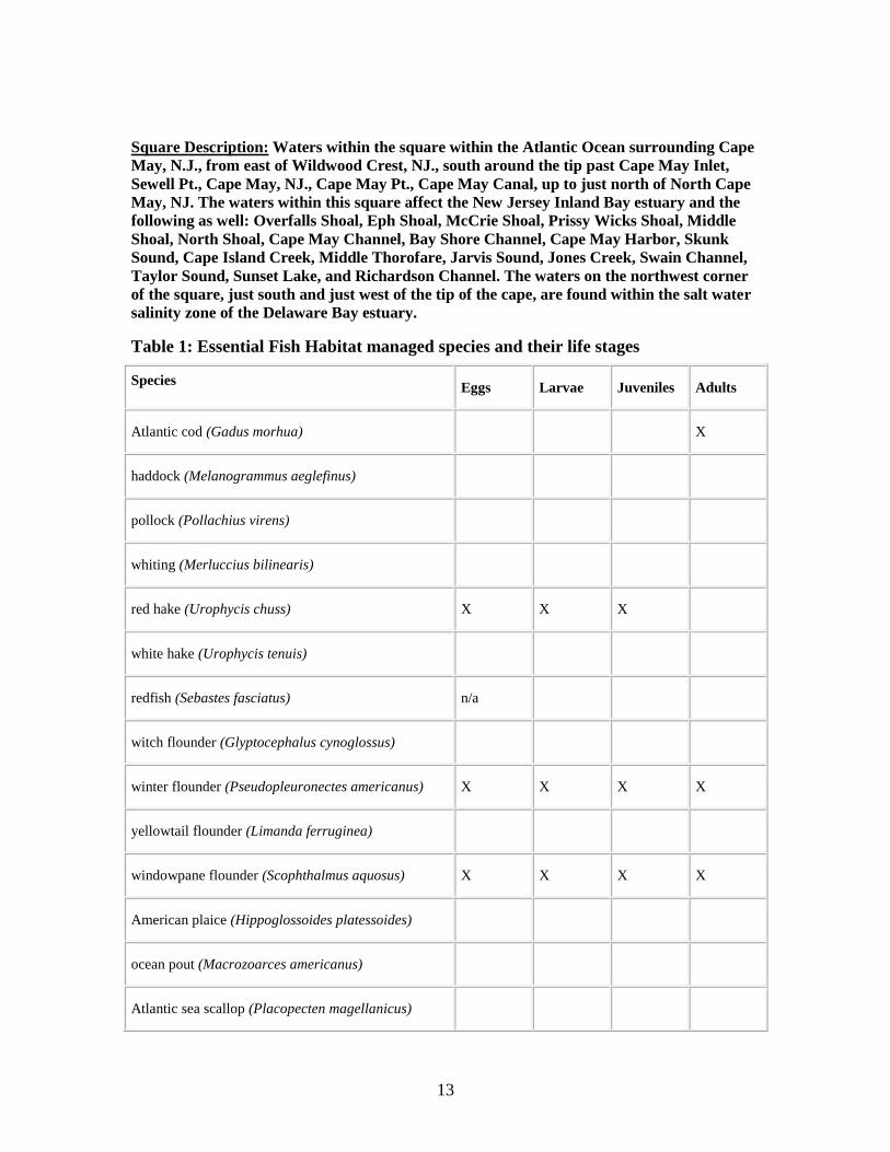
10’ x 10’ Square Coordinates:
Boundary North East South West
Coordinate 39 00.0 N 74 50.0 W 38 50.0 N 75 00.0 W
Figure 4-1: Project area Essential Fish Habitat 10’ x 10’ Square (highlighted).
13
Square Description: Waters within the square within the Atlantic Ocean surrounding Cape
May, N.J., from east of Wildwood Crest, NJ., south around the tip past Cape May Inlet,
Sewell Pt., Cape May, NJ., Cape May Pt., Cape May Canal, up to just north of North Cape
May, NJ. The waters within this square affect the New Jersey Inland Bay estuary and the
following as well: Overfalls Shoal, Eph Shoal, McCrie Shoal, Prissy Wicks Shoal, Middle
Shoal, North Shoal, Cape May Channel, Bay Shore Channel, Cape May Harbor, Skunk
Sound, Cape Island Creek, Middle Thorofare, Jarvis Sound, Jones Creek, Swain Channel,
Taylor Sound, Sunset Lake, and Richardson Channel. The waters on the northwest corner
of the square, just south and just west of the tip of the cape, are found within the salt water
salinity zone of the Delaware Bay estuary.
Table 1: Essential Fish Habitat managed species and their life stages
Species Eggs Larvae Juveniles Adults
Atlantic cod (Gadus morhua) X
haddock (Melanogrammus aeglefinus)
pollock (Pollachius virens)
whiting (Merluccius bilinearis)
red hake (Urophycis chuss) X X X
white hake (Urophycis tenuis)
redfish (Sebastes fasciatus) n/a
witch flounder (Glyptocephalus cynoglossus)
winter flounder (Pseudopleuronectes americanus) X X X X
yellowtail flounder (Limanda ferruginea)
windowpane flounder (Scophthalmus aquosus) X X X X
American plaice (Hippoglossoides platessoides)
ocean pout (Macrozoarces americanus)
Atlantic sea scallop (Placopecten magellanicus)

14
Atlantic sea herring (Clupea harengus) X X
monkfish (Lophius americanus) X X
bluefish (Pomatomus saltatrix) X X
long finned squid (Loligo pealeii) n/a n/a
Atlantic butterfish (Peprilus triacanthus) X X X
Atlantic mackerel (Scomber scombrus)
summer flounder (Paralichthys dentatus) X X X
scup (Stenotomus chrysops) n/a n/a X X
black sea bass (Centropristis striata) n/a X X
surf clam (Spisula solidissima) n/a n/a
ocean quahog (Artica islandica) n/a n/a
spiny dogfish (Squalus acanthias) n/a n/a
tilefish (Lopholatilus chamaeleonticeps)
king mackerel (Scomberomorus cavalla) X X X X
Spanish mackerel (Scomberomorus maculatus) X X X X
cobia (Rachycentron canadum) X X X X
sand tiger shark (Carcharias taurus) X X
Atlantic angel shark (Squatina dumerili) X X X
Atl. sharpnose shark (Rhizopriondon terraenovae) X
dusky shark (Carcharhinus obscurus) X
sandbar shark (Carcharhinus plumbeus) X X X

15
sandbar shark (Carcharhinus plumbeus) HAPC HAPC HAPC
tiger shark (Galeocerdo cuvieri) X
scalloped hammerhead shark (Sphyrna lewini) X
clearnose skate (Raja eglanteria) X X
little skate (Leucoraja erinacea) X X
winter skate (Leucoraja ocellata) X X
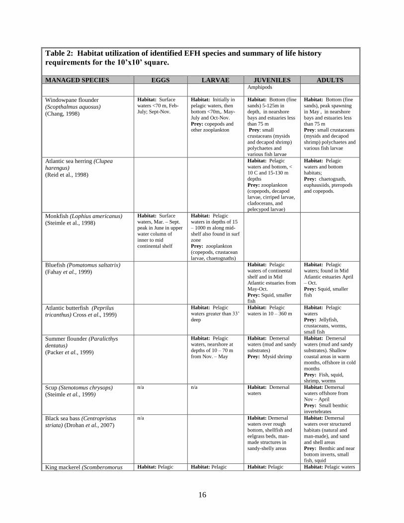
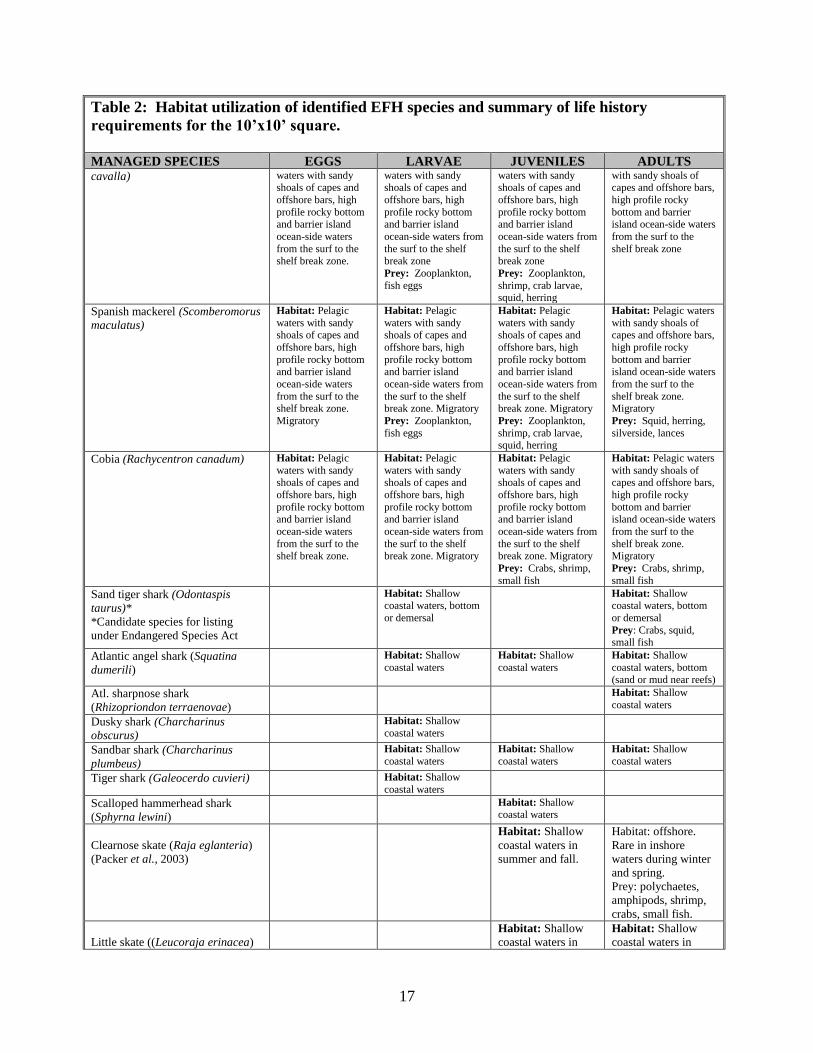
Table 2: Habitat utilization of identified EFH species and summary of life history
requirements for the 10’x10’ square.
MANAGED SPECIES EGGS LARVAE JUVENILES ADULTS Atlantic cod (Gadus morhua)
(Fahay, 1998)
Habitat: Bottom
(rocks, pebbles, or
gravel) winter for Mid-Atlantic
Prey: shellfish, crabs,
and other crustaceans (amphipods) and
polychaetes, squid and
fish (capelin redfish,
herring, plaice,
haddock).
Red hake (Urophycis chuss)
(Steimle et al. 1998)
Habitat: Surface waters, May – Nov.
Habitat: Surface waters, May –Dec.
Abundant in mid-and
outer continental shelf of Mid-Atl. Bight.
Prey: copepods and
other microcrustaceans under floating eelgrass
or algae.
Habitat: Pelagic at 25-30 mm and bottom
at 35-40 mm. Young
inhabit depressions on open seabed. Older
juveniles inhabit
shelter provided by shells and shell
fragments.
Prey: small benthic and pelagic
crustaceans (decapod
shrimp, crabs, mysids, euphasiids, and
amphipods) and
polychaetes).
Winter Flounder
(Pseudopleuronectes americanus)
(Pereira et. al., 1998)
Habitat: Demersal,
nearshore low energy
(primarily inlets and coves) shallows with
sand, muddy sand,
mud and gravel bottoms.
Habitat: Demersal,
nearshore low
(primarily inlets and coves) energy shallows
with sand, muddy
sand, mud and gravel bottoms.
Prey: Nauplii,
invertebrate eggs, Protozoans,
Polychaetes
Habitat: Young of the
year (YOY) are
demersal, nearshore low (primarily inlets
and coves) energy
shallows with sand, muddy sand, mud and
gravel bottoms.
Prey: YOY Amphipods and
annelids JUV – Sand
dollar, Bivalve siphons, Annelids,
Habitat: Demersal
offshore (in spring)
except when spawning where they are in
shallow inshore waters
(fall). Prey: Amphipods,
Polychaetes, Bivalves or
siphons, Capelin eggs, Crustaceans
16
Table 2: Habitat utilization of identified EFH species and summary of life history
requirements for the 10’x10’ square.
MANAGED SPECIES EGGS LARVAE JUVENILES ADULTS
Amphipods
Windowpane flounder
(Scopthalmus aquosus)
(Chang, 1998)
Habitat: Surface
waters <70 m, Feb-July; Sept-Nov.
Habitat: Initially in
pelagic waters, then bottom <70m,. May-
July and Oct-Nov.
Prey: copepods and other zooplankton
Habitat: Bottom (fine
sands) 5-125m in depth, in nearshore
bays and estuaries less
than 75 m Prey: small
crustaceans (mysids
and decapod shrimp) polychaetes and
various fish larvae
Habitat: Bottom (fine
sands), peak spawning in May , in nearshore
bays and estuaries less
than 75 m Prey: small crustaceans
(mysids and decapod
shrimp) polychaetes and various fish larvae
Atlantic sea herring (Clupea
harengus)
(Reid et al., 1998)
Habitat: Pelagic
waters and bottom, <
10 C and 15-130 m
depths
Prey: zooplankton (copepods, decapod
larvae, cirriped larvae,
cladocerans, and pelecypod larvae)
Habitat: Pelagic
waters and bottom
habitats;
Prey: chaetognath,
euphausiids, pteropods and copepods.
Monkfish (Lophius americanus)
(Steimle et al., 1998)
Habitat: Surface
waters, Mar. – Sept. peak in June in upper
water column of
inner to mid continental shelf
Habitat: Pelagic
waters in depths of 15 – 1000 m along mid-
shelf also found in surf
zone Prey: zooplankton
(copepods, crustacean
larvae, chaetognaths)
Bluefish (Pomatomus saltatrix)
(Fahay et al., 1999)
Habitat: Pelagic
waters of continental
shelf and in Mid Atlantic estuaries from
May-Oct.
Prey: Squid, smaller fish
Habitat: Pelagic
waters; found in Mid
Atlantic estuaries April – Oct.
Prey: Squid, smaller
fish
Atlantic butterfish (Peprilus
tricanthus) Cross et al., 1999)
Habitat: Pelagic
waters greater than 33’
deep
Habitat: Pelagic
waters in 10 – 360 m
Habitat: Pelagic
waters
Prey: Jellyfish, crustaceans, worms,
small fish
Summer flounder (Paralicthys
dentatus)
(Packer et al., 1999)
Habitat: Pelagic waters, nearshore at
depths of 10 – 70 m
from Nov. – May
Habitat: Demersal waters (mud and sandy
substrates)
Prey: Mysid shrimp
Habitat: Demersal waters (mud and sandy
substrates). Shallow
coastal areas in warm months, offshore in cold
months
Prey: Fish, squid, shrimp, worms
Scup (Stenotomus chrysops)
(Steimle et al., 1999)
n/a n/a Habitat: Demersal
waters
Habitat: Demersal
waters offshore from
Nov – April
Prey: Small benthic
invertebrates
Black sea bass (Centropristus
striata) (Drohan et al., 2007)
n/a Habitat: Demersal waters over rough
bottom, shellfish and
eelgrass beds, man-made structures in
sandy-shelly areas
Habitat: Demersal waters over structured
habitats (natural and
man-made), and sand and shell areas
Prey: Benthic and near
bottom inverts, small fish, squid
King mackerel (Scomberomorus Habitat: Pelagic Habitat: Pelagic Habitat: Pelagic Habitat: Pelagic waters
17
Table 2: Habitat utilization of identified EFH species and summary of life history
requirements for the 10’x10’ square.
MANAGED SPECIES EGGS LARVAE JUVENILES ADULTS cavalla) waters with sandy
shoals of capes and
offshore bars, high
profile rocky bottom and barrier island
ocean-side waters
from the surf to the shelf break zone.
waters with sandy shoals of capes and
offshore bars, high
profile rocky bottom and barrier island
ocean-side waters from
the surf to the shelf break zone
Prey: Zooplankton,
fish eggs
waters with sandy shoals of capes and
offshore bars, high
profile rocky bottom and barrier island
ocean-side waters from
the surf to the shelf break zone
Prey: Zooplankton,
shrimp, crab larvae, squid, herring
with sandy shoals of capes and offshore bars,
high profile rocky
bottom and barrier island ocean-side waters
from the surf to the
shelf break zone
Spanish mackerel (Scomberomorus
maculatus)
Habitat: Pelagic
waters with sandy shoals of capes and
offshore bars, high
profile rocky bottom and barrier island
ocean-side waters
from the surf to the shelf break zone.
Migratory
Habitat: Pelagic
waters with sandy shoals of capes and
offshore bars, high
profile rocky bottom and barrier island
ocean-side waters from
the surf to the shelf break zone. Migratory
Prey: Zooplankton,
fish eggs
Habitat: Pelagic
waters with sandy shoals of capes and
offshore bars, high
profile rocky bottom and barrier island
ocean-side waters from
the surf to the shelf break zone. Migratory
Prey: Zooplankton,
shrimp, crab larvae, squid, herring
Habitat: Pelagic waters
with sandy shoals of capes and offshore bars,
high profile rocky
bottom and barrier island ocean-side waters
from the surf to the
shelf break zone. Migratory
Prey: Squid, herring,
silverside, lances
Cobia (Rachycentron canadum) Habitat: Pelagic
waters with sandy shoals of capes and
offshore bars, high
profile rocky bottom and barrier island
ocean-side waters
from the surf to the shelf break zone.
Habitat: Pelagic
waters with sandy shoals of capes and
offshore bars, high
profile rocky bottom and barrier island
ocean-side waters from
the surf to the shelf break zone. Migratory
Habitat: Pelagic
waters with sandy shoals of capes and
offshore bars, high
profile rocky bottom and barrier island
ocean-side waters from
the surf to the shelf break zone. Migratory
Prey: Crabs, shrimp,
small fish
Habitat: Pelagic waters
with sandy shoals of capes and offshore bars,
high profile rocky
bottom and barrier island ocean-side waters
from the surf to the
shelf break zone. Migratory
Prey: Crabs, shrimp,
small fish
Sand tiger shark (Odontaspis
taurus)*
*Candidate species for listing
under Endangered Species Act
Habitat: Shallow coastal waters, bottom
or demersal
Habitat: Shallow coastal waters, bottom
or demersal
Prey: Crabs, squid, small fish
Atlantic angel shark (Squatina
dumerili)
Habitat: Shallow
coastal waters
Habitat: Shallow
coastal waters
Habitat: Shallow
coastal waters, bottom (sand or mud near reefs)
Atl. sharpnose shark
(Rhizopriondon terraenovae)
Habitat: Shallow
coastal waters
Dusky shark (Charcharinus
obscurus)
Habitat: Shallow
coastal waters
Sandbar shark (Charcharinus
plumbeus)
Habitat: Shallow
coastal waters
Habitat: Shallow
coastal waters
Habitat: Shallow
coastal waters
Tiger shark (Galeocerdo cuvieri) Habitat: Shallow
coastal waters
Scalloped hammerhead shark
(Sphyrna lewini)
Habitat: Shallow coastal waters
Clearnose skate (Raja eglanteria)
(Packer et al., 2003)
Habitat: Shallow
coastal waters in
summer and fall.
Habitat: offshore.
Rare in inshore
waters during winter
and spring.
Prey: polychaetes,
amphipods, shrimp,
crabs, small fish.
Little skate ((Leucoraja erinacea)
Habitat: Shallow
coastal waters in
Habitat: Shallow
coastal waters in

18
Table 2: Habitat utilization of identified EFH species and summary of life history
requirements for the 10’x10’ square.
MANAGED SPECIES EGGS LARVAE JUVENILES ADULTS (Packer et al., 2003) summer, offshore >
300 m in winter.
summer, offshore up
to 300 m in winter.
Prey: crabs, shrimp,
polychaetes,
amphipods,
ascidians, bivalves,
squid, fishes.
winter skate (Leucoraja ocellata)
Packer et al., 2003)
Habitat: Shallow
coastal waters in
summer, offshore
up to 300 m in
winter.
Habitat: Shallow
coastal waters in
summer, offshore up
to 300 m in winter.
Prey: crabs, shrimp,
polychaetes,
amphipods,
ascidians, bivalves,
squid, fishes
https://www.nefsc.noaa.gov/nefsc/habitat/efh/
4.3 Threatened and Endangered Species
The federally-listed (threatened) and state-listed (endangered) piping plover (Charadrius
melodus) can currently be found nesting within the study area, according to NJDEP and
U.S. Fish and Wildlife Service field surveys. Birds have nested in Cape May City since
1997 and along the Coast Guard beaches since at least 1988. The Meadows project area
had supported nesting plovers since at least 1988 but in the last 3-4 years the number of
nesting plovers has declined. Numbers of nesting plovers at the Cape May National
Wildlife Refuge, the Cape May Coast Guard (LSU) station, and Training Center, the
Nature Conservancy and Cape May Point State park are all likewise down in recent years
to either 1 or no nesting pairs. Piping plovers nest above the high tide line on mainland
coastal beaches, sand flats, and barrier island coastal beaches. Nesting sites are typically
located on gently sloping foredunes, blowout areas behind primary dunes, washover areas
cut into or between dunes, ends of sand spits, and on sites with deposits of suitable
dredged or pumped sand. The nesting season usually begins in March when the birds
arrive and can extend as late as the end of August. Shortly after hatching, the young
leave the nest and begin foraging within the intertidal zone.
The seabeach amaranth (Amaranthus pumilus) is a Federally-listed threatened plant. The
seabeach amaranth is an annual plant, endemic to Atlantic coastal plain beaches, and
primarily occurs on overwash flats at the accreting ends of barrier beach islands and
lower foredunes of non-eroding beaches. The species occasionally establishes small
temporary populations in other areas, including bayside beaches, blowouts in foredunes,
and sand and shell material placed as beachfill. No extant occurrences of the seabeach
amaranth are known within the proposed project area.
The red knot (Calidris canutus rufa) is a Federally-threatened shorebird species that

19
migrates into the area around Cape May during spring and fall. Some birds may also be
found lingering in the area through the early winter. The red knot’s spring migration to
this area is timed with the release of horseshoe crab eggs. This generally abundant food
supply helps the red knot to increase its body weight enough to be able to continue its
migration to the red knot’s arctic breeding grounds.
The National Marine Fisheries Service (NMFS) has jurisdiction over four (4) Federally-
designated sea turtles: the endangered leatherback (Dermochelys coriacea), Kemp's
Ridley (Lepidochelys kempii), and green (Chelonia mydas) sea turtles, and the threatened
loggerhead (Caretta caretta) sea turtle. These sea turtles may be found in New Jersey's
continental shelf waters, inshore bays and estuaries from late spring to mid-fall. Sea
turtles feed primarily on mollusks, crustaceans, sponges and a variety of marine grasses
and seaweeds. The endangered leatherback sea turtle may forage on jellyfish, as well.
The northern diamondback terrapin (Malaclemys terrapin terrapin) is a Federal Category
2 candidate species that occupies shallow bay waters, and nests on the sandy portions of
bay islands as well as the barrier islands themselves. The diamondback terrapin is
considered a candidate species, as its nesting habitat is dwindling.
Federally endangered finback whales (Balaenoptera physalus) are the most common
whales to occur in New Jersey coastal waters. Finback whales increase in relative
abundance in late winter and spring, east of the Delaware peninsula, but may be found in
New Jersey coastal waters in all seasons. The endangered humpback (Megaptera
novaeangliae) and right whales (Eubalaena spp.) are known to occur in the nearshore
waters of the mid-Atlantic on a seasonal basis, and may be found within the vicinity of
the proposed borrow area(s) from late winter through early spring.
4.4 Cultural Resources
The Philadelphia District has conducted several cultural resources investigations in
association with both the Cape May Inlet to Lower Township Storm Damage Reduction
Project and the Lower Cape May Meadows - Cape May Point Environmental Restoration
Project. In 1980, the District evaluated the potential environmental impacts associated
with the construction of the Cape May Inlet to Lower Township Storm Damage
Reduction Project, and prepared a Final Supplement to the Final Environmental Impact
Statement (EIS).
In 1998, the District similarly evaluated the potential environmental impacts associated
with proposed environmental restoration activities at the Lower Cape May Meadows
(The Meadows) and Cape May Point. In preparation for this project, a cultural resource
investigation was conducted in 1997. The findings of this investigation are found in the
report titled, Phase I Submerged and Shoreline Cultural Resources Investigations, Lower
Cape May Meadows, Cape May City, Lower Township and the Borough of Cape May
Point, Cape May County, New Jersey prepared for the USACE by Dolan Research, Inc.
and Hunter Research, Inc.
No evidence of prehistoric terrestrial archaeological resources was noted in the shoreline
survey area, the offshore sand borrow areas or the nearshore sand placement area. By

20
“terrestrial archaeological resources” is meant resources that were originally formed on
land. The potential for such remains is unclear, in part because of the difficulties of
reconstructing the paleo-environment, but the prospect of significant archaeological
survivals is probably quite limited owing to ongoing coastal erosion. If buried resources
do indeed survive within the shoreline survey areas, the beach replenishment process
should serve to enhance resource preservation and protection. No further survey-level
investigation for these types of resources is recommended.
Comprehensive remote sensing of the nearshore area resulted in the identification of nine
anomalies. None of the anomalies exhibited characteristics suggestive of submerged
cultural resources; therefore, no further investigation is justified.
The largest group of historic remains identified by the terrestrial field survey are those
associated with the World War II era fortifications and surface debris associated with the
second Cape May Lighthouse site. These cultural resources are potentially eligible for
listing in the National Register of Historic Places (NRHP); however, the deposition of
sediments within the nearshore areas will not adversely impact these structures, but may
serve to preserve them in place.
4.5 Air Quality and Noise
Cape May County, New Jersey where the proposed Federal action will take place, is
classified as marginal nonattainment for 8-hour ozone (oxides of nitrogen [NOx] and
volatile organic compounds [VOCs]). The project sites are within the Philadelphia-
Wilmington-Atlantic City, PA-NJ-MD-DE nonattainment area. A nonattainment area is
an area that does not meet (or that contributes to ambient air quality in a nearby area that
does not meet) the national ambient air quality standard (NAAQS) for the pollutant.
Locally, the project area is comprised primarily of resort residential homes, marinas, and
surrounding wildlife management areas. Air quality for Cape May Point is recorded as
97.14% good/2.86% moderate (for Jan-May 2017; www.homefacts.com).

21
5.0 ENVIRONMENTAL IMPACTS
The no action alternative would entail the continued practice of disposing of high quality
clean sand in the upland CDF rather than retaining the sand within the intertidal/beach
interface. The Lower Cape May Meadows – Cape May Point Environmental Restoration
project would continue to receive periodic nourishments every four years for the life of
the project. Potential impacts to the nearshore beach placement area are presented in
USACE (1980 and 1998). Temporary elevated turbidity and impacts to benthic resources
within the placement zone would continue to occur with each periodic placement in the
absence of the beneficial use of sand. As a result of initial beachfill placement and
subsequent nourishment cycles, piping plovers have nested fairly consistently along the
beaches of Cape May City and The Meadows for the past several years. The
supplemental sand from the Cape May Canal Entrance Channel, proposed for placement
within the nearshore zone at Cape May Point (i.e. at the westernmost end of The
Meadows authorized project), would supplement the beachfill project and pose no
adverse impacts to piping plover habitat at the undeveloped portion of The Meadows
Environmental Restoration project where plover feeding ponds were established behind
the barrier beachfront.
The environmental impacts associated with modifying the current disposal plan for the
Cape May Canal maintenance dredged sand focus primarily on the inshore shallow water
area, the beach, and the species that inhabit these areas. No impacts are anticipated to
occur to interior wetlands, scrub shrub or forested habitats. The Cape May Canal was
constructed in 1942 and has been dredged approximately annually to the authorized depth
of 12 feet mlw, where shoaling occurs. Impacts resulting from the proposed placement
at the alternative sites, including the No Action alternative (i.e. continued upland CDF
disposal) are evaluated below.
5.1 Terrestrial
Minimal adverse impacts to terrestrial flora and fauna will occur under the No Action
alternative at the upland CDF to continue the existing disposal plan for maintenance
dredge material. The site is predominantly sand with little to no vegetation. The
majority of species that would be expected to occur in the CDF are transient visitors, such
as small mammals and reptiles. Beach nesting birds, such as terns and oyster catchers
favor sites with little to no vegetation however none have been observed congregating or
nesting within the upland CDF. The No Action alternative would not provide any
benefit to nearby beach habitat. No adverse impacts to terrestrial flora and fauna are
expected to occur with the proposal to modify the current disposal plan and place dredged
sand in the nearshore area of any of the alternative locations (i.e. The Villas, Higbee
Beach or the preferred plan The Meadows).
For the TSP, the deposition of high quality sand in the nearshore zone of Cape May Point
would serve as a supplemental source of sand for the beachfill project. Due to placement
within shallow water, most of the sand will remain in the nearshore zone with minimal
natural dispersion by currents. Existing adjacent dune vegetation, adjacent scrub shrub,

22
interior wetlands, or maritime forest, would not be disturbed by the inshore placement
activities and may benefit from the additional sand supply to beaches for additional storm
protection.
5.2 Aquatic
5.2.1 Water Quality
Maintenance dredging of the entrance channel will result is temporary minor localized
turbidity that will be quickly dispersed by currents and tidal flow in and out of the canal.
There would be no impacts to water quality at the placement site under the No Action
plan to continue to place dredged material in the upland CDF. The dredged slurry is
contained within the upland CDF and sediments settle within the confines of the CDF
prior to release of the effluent through a sluice gate back to the canal. The impacts
associated with beneficial use dredged sand with placement within the nearshore zone of
the proposed alternatives is a minor localized and short-term increase in turbidity within
the nearshore zone. The quantity to be placed is small (5,000-10,000 cy) and is large
grained sand material that settles quickly. The placement zone is within the swash zone
where natural turbidity is elevated due to cresting waves. Tidal currents and circulation
would negate any impacts from turbidity. Best Management Practices (BMPs) would be
used, including nosing the hopper dredge as close into the beach as depths allow, thereby
shortening the water column load fall and minimizing turbidity. No long-term adverse
impacts are anticipated.
At the alternative placement sites evaluated, there is concern that longshore transport
within this area has not been evaluated at the nearshore zone of Higbee Beach and may
result in interference of circulation at the Pond Creek inlet. Placement within the
nearshore zone at the Villas was eliminated as an alternative site due to its distance from
the canal, adding time and cost to the annual maintenance program.
5.2.2 Sediment Quality
No impacts would result from the No Action alternative. The dredged clean sand would
continue to be placed in the contained upland CDF with controlled drainage. Materials
with large grain sizes (>90% sand) are typically not contaminated and chemical testing is
not required. The 1998 Inland Testing Manual (EPA-823-B-98-004) provides national
guidance on the evaluation of dredged material under the Clean Water Act. It states that
no chemical analysis is required if there is a “reasonable assurance that the proposed
discharge material is not a carrier of contaminants…. For example, dredged material is
most likely to be free of contaminants if the material is composed primarily of sand,
gravel, or other inert material and is found in areas of high current or wave energy
[230.60(a)].
Placement of clean dredged sand within the nearshore zone of The Meadows authorized
beachfill project or the alternative beach sites would not be expected to pose any impacts

23
to sediment quality or the environment based on the results of recent grain size sediment
testing (Tetra Tech, unpublished data 2014, 2017).
5.2.3 Macroinvertebrates
Under the No Action alternative of continued placement of maintenance dredged material
into the upland CDF, there will be no impacts to marine invertebrate organisms.
Potential minor impacts to benthic organisms under the alternative placement sites,
including the preferred site, would occur in the nearshore and intertidal zones. The
nearshore and intertidal zone is highly dynamic, harsh, and is characterized by great
variations in various abiotic factors. Fauna of the intertidal zone are highly mobile and
respond to stress by displaying large diurnal, tidal, and seasonal fluctuations in
population density (Reilly et al. 1983). Given the small quantities of sand material
placed with each hopper dredge load (250-300 cy), it is unlikely that intertidal benthic
fauna that are resilient in high energy environments will be smothered by the sand
placements within the shallow water area. Most nearshore macroinvertebrates in the
turbulent nearshore zone can migrate through the surface sand layers and is resilient to
this type of disturbance (Parr et al., 1978). Smothering and mortality may occur in lesser
mobile species (e.g. amphipods and polychaetes) within the small area of placement.
Given the shallow water depths of the placement area, the large grain size of the sediment
and the small size of the hopper load, the material will settle quickly (i.e. minutes) within
the interval periods of dredging and transiting time between each deposit. Recovery of
the macrofaunal community may occur within one or two seasons when the placed sand
is compatible with the natural beach sediments (Reilly et al., 1978). Macrofauna recover
quickly due to their short life cycles, high reproductive potential, and planktonic
recruitment from unaffected areas (Hurme and Pullen, 1988).
Primary production in phytoplankton and/or benthic algae may become inhibited from
turbidity. Reilly et.al. (1983) determined that high turbidity could inhibit recruitment by
pelagic larval stocks. Midwater nekton like finfish and mobile benthic invertebrates may
migrate outside of the area where turbidity and deposition occur. The nearshore
environment is a naturally turbid area due to cresting waves. Organisms in the surf zone
are less likely to suffer adverse effects from turbidity because they have already adapted
to these conditions. The amount of turbidity and the duration of its settlement period will
be short due to the large grain size of the material.
5.2.4 Fish
Under the No Action alternative, no fish would be impacted by continued placement of
dredged material into the Cape May Canal CDF. Under the alternative nearshore
placement alternative sites, including the preferred alternative site, adverse impacts
through burial are unlikely as the majority of fish are highly mobile and able to avoid the
sand deposition area turbidity plume. Impacts to fish egg and larval stages may result in
the immediate area of the sand placement sites due to the temporary turbidity levels
within the nearshore water column. Fish eggs and larvae are widespread throughout the
Mid-Atlantic Bight and not expected to be concentrated in the littoral shallow water zone

24
of the alternative beaches (Grosslein and Azarovitz, 1982). The primary impact to
fisheries will be felt from the disturbance of benthic and epibenthic communities. The
loss of benthos and epibenthos smothered during the placement operations will occur in a
small area of placement. This effect is expected to be temporary as these areas become
rapidly recolonized by pioneering benthic and epibenthic species.
5.2.5 Essential Fish Habitat (EFH)
As presented in Section 4.2.5, there are a number of Federally-managed fish species
where essential fish habitat (EFH) was identified for one or more life stages within the
alternative project impact areas. Fish occupation of waters within the project impact
areas is highly variable spatially and temporally. Some of the species are strictly
offshore, while others may occupy both nearshore and offshore waters. In addition, some
species may be suited for the open-ocean or pelagic waters, while others may be more
oriented to bottom or demersal waters. This can also vary between life stages of
Federally-managed species. Also, seasonal abundances are highly variable, as many
species are highly migratory.
In general, adverse impacts to Federally-managed fish species may stem from alterations
of the bottom habitat, which will result in a very limited area within the littoral zone of
the placement site. EFH can be adversely impacted temporarily through water quality
impacts such as increased turbidity and decreased dissolved oxygen content in the water
column, although the littoral zone is typically turbid. These impacts would subside upon
cessation of placement activities. The placement of sand compatible with natural
materials is not expected to result in physical, chemical or compositional changes to
bottom habitat, sediment substrate or prey item benthic species recolonization.
Also, seasonal abundances of fish species are highly variable, as many species are highly
migratory. For most of the fish species in this region of Delaware Bay and Atlantic
Ocean, no adverse effect is anticipated on adults and juveniles because both stages can
move away from the project impact area. Minimal adverse effect on eggs and larvae is
expected as they are demersal at these life stages. The placement of compatible sand
within a sandy bottom habitat would not permanently degrade or destroy the EFH for any
of the managed species. Table 3 provides a description of potential impacts to managed
fish species.

25
Table 3: Direct and indirect impacts on Federally managed species and Essential Fish Habitat in 10’x10’ square (EFH) IN 10 min. x
10 min. square (NOAA, 1999)
MANAGED SPECIES EGGS LARVAE JUVENILES ADULTS 1. Atlantic cod (Gadus morhua) Impact to physical habitat at placement areas is
temporary and similar to pre-placement conditions.
Potential for temporary disruption of benthic food
prey organisms.
2. Red hake (Urophycis chuss) Eggs occur in surface
waters; therefore, no direct
or indirect effects are expected.
Larvae occur in surface waters;
therefore, no direct or indirect effects
are expected.
Impact to physical habitat at placement
areas is temporary and similar to pre-
placement conditions. Temporary disruption of benthic food prey
organisms.
3. Winter flounder (Pseudopleuronectes americanus)
Eggs are demersal in very shallow waters of coves
and inlets in Spring.
Placement areas are in high energy nearshore areas
where eggs are not likely
to be highly concentrated.
Larvae are initially planktonic, but become more bottom-oriented as
they develop. Placement areas are
primarily in high energy inshore areas where larvae are not likely to
be highly concentrated.
Impact to physical habitat in placement areas is temporary. These should remain
basically similar to pre-placement
conditions. Temporary disruption of benthic food prey
organisms
Impact to physical habitat at placement areas is temporary and similar to pre-placement conditions.
Temporary disruption of benthic food prey
organisms.
4. Windowpane flounder (Scopthalmus aquosus)
Eggs occur in surface waters; therefore, no direct
or indirect effects are
expected.
Larvae occur in pelagic waters; therefore, no direct or indirect effects
are expected.
Impact to physical habitat in placement areas is temporary and similar to pre-
placement conditions.
Temporary disruption of benthic food prey
organisms.
Impact to physical habitat in placement areas is temporary and similar to pre-placement conditions.
Temporary disruption of benthic food prey
organisms.
5. Atlantic sea herring (Clupea
harengus)
Occur in pelagic and near bottom. Impact
to physical habitat in placement areas is temporary and similar to pre-placement
conditions.
None, prey items are planktonic
Occur in pelagic and near bottom. Impact to physical
habitat in placement areas is temporary and similar to pre-placement conditions.
None, prey items are primarily planktonic
6. Monkfish (Lophius americanus) Eggs occur in surface
waters with depths greater than 25 m; therefore, no
direct or indirect effects
are expected.
Larvae occur in pelagic waters with
depths greater than 25 m; therefore, no direct or indirect effects are
expected.
7. Bluefish (Pomatomus saltatrix) Juvenile bluefish are pelagic species. No
significant direct effects anticipated.
Likely to leave the area of placement.
Temporary disruption of benthic food prey organisms.
Adult bluefish are pelagic species. No significant
direct effects anticipated. Likely to leave the area of
placement.
Temporary disruption of benthic food prey organisms.
8. Atlantic butterfish (Peprilus
tricanthus)
Larvae occur in pelagic waters. No
impacts are expected.
Juvenile butterfish are pelagic species. No
significant direct effects anticipated.
Adult butterfish are pelagic species. No significant
direct effects anticipated.

26
Table 3: Direct and indirect impacts on Federally managed species and Essential Fish Habitat in 10’x10’ square (EFH) IN 10 min. x
10 min. square (NOAA, 1999)
MANAGED SPECIES EGGS LARVAE JUVENILES ADULTS Temporary disruption of benthic food prey organisms.
Temporary disruption of benthic food prey organisms.
9. Summer flounder (Paralicthys
dentatus)
Larvae occur in pelagic waters;
therefore, no direct or indirect effects
are expected.
Impact to physical habitat in placement
areas is temporary and similar to pre-
placement conditions. Temporary disruption of benthic food prey
organisms.
Impact to physical habitat in placement areas is
temporary and similar to pre-placement conditions.
Temporary disruption of benthic food prey organisms.
10. Scup (Stenotomus chrysops) Impact to physical habitat in placement areas is temporary and similar to pre-
placement conditions.
Temporary disruption of benthic food prey organisms.
Impact to physical habitat in placement areas is temporary and similar to pre-placement conditions.
Temporary disruption of benthic food prey
organisms.
11. Black sea bass (Centropristus
striata)
Impact to physical habitat in placement
areas is temporary and similar to pre-
placement conditions. Juveniles prefer offshore habitat with structure. The
placement sites are sandy bottom habitat.
Temporary disruption of benthic food prey organisms.
Impact to physical habitat in placement areas is
temporary and similar to pre-placement conditions.
Adults prefer offshore habitat with structure. Placement sites are sandy bottom habitat.
Temporary disruption of benthic food prey
organisms.
12. King mackerel (Scomberomorus
cavalla)
Eggs are pelagic, therefore
no adverse impacts are
anticipated.
.
Larvae are pelagic, therefore no
adverse impacts are anticipated.
Juveniles are pelagic, therefore no adverse
impacts are anticipated.
Juveniles are not likely to feed in the
placement areas. No effects on prey items.
Mackerel are highly migratory.
Adults are pelagic and highly migratory, therefore no
adverse impacts are anticipated.
Adults are not expected to occur in the littoral zone.
No effects on prey items.
13. Spanish mackerel
(Scomberomorus maculatus)
Eggs are pelagic, therefore
no adverse impacts are
anticipated.
Larvae are pelagic, therefore no
adverse impacts are anticipated.
Juveniles are pelagic, therefore no adverse
impacts are anticipated.
Juveniles are not likely to feed in the placement areas. No effects on prey items.
Mackerel are highly migratory
Adults are pelagic and highly migratory, therefore no
adverse impacts are anticipated.
Adults are not likely to feed in the placement areas. No effects on prey items. Mackerel are highly
migratory.
14. Cobia (Rachycentron canadum) Eggs are pelagic, therefore
no adverse impacts are anticipated.
Larvae are pelagic, therefore no
adverse impacts are anticipated.
Cobia are pelagic and migratory species.
No significant direct effects anticipated. Juveniles are not likely to feed in the
placement areas. No effects on prey items.
Cobia are pelagic and migratory species. No
significant direct effects anticipated. Adults are not likely to feed in the placement areas.
No effects on prey items.
15. Sand tiger shark (Odontaspis taurus)
Impact to physical habitat in placement areas is temporary and
similar to pre-placement conditions.
Neonates are expected to vacate the area of placement
Temporary disruption of benthic
food prey organisms at placement sites.
Impact to physical habitat in placement areas is temporary and similar to pre-placement conditions.
Adults are expected to vacate the area of placement
Temporary disruption of benthic food prey organisms at placement.

27
Table 3: Direct and indirect impacts on Federally managed species and Essential Fish Habitat in 10’x10’ square (EFH) IN 10 min. x
10 min. square (NOAA, 1999)
MANAGED SPECIES EGGS LARVAE JUVENILES ADULTS 16. Atlantic angel shark (Squatina dumerilli)
Impact to physical habitat in placement areas is temporary and
similar to pre-placement conditions.
Neonates are expected to vacate the area of placement
Temporary disruption of benthic
food prey organisms at placement.
Impact to physical habitat in placement areas is temporary and similar to pre-
placement conditions. Juveniles are
expected to vacate the area of placement Temporary disruption of benthic food prey
organisms at placement sites.
.
Impact to physical habitat in placement areas is temporary and similar to pre-placement conditions.
Adults are expected to vacate the area of placement
Temporary disruption of benthic food prey organisms at placement sites.
17. Atlantic sharpnose shark
(Rhizopriondon terraenovae) Impact to physical habitat in placement areas is
temporary and similar to pre-placement conditions.
Adultss are expected to vacate the area of placement Temporary disruption of benthic food prey organisms
at placement sites.
18. Dusky shark (Charcharinus
obscurus)
Present during summer months.
Impact to physical habitat in
placement areas is temporary and similar to pre-placement conditions.
Neonates are expected to vacate the
area of placement Temporary disruption of benthic
food prey organisms at placement
sites.
19. Sandbar shark (Charcharinus
plumbeus)
Present during summer months.
Impact to physical habitat in
placement areas is temporary and similar to pre-placement conditions.
Neonates are expected to vacate the
area of placement Temporary disruption of benthic
food prey organisms at placement
sites.
Impact to physical habitat in placement
areas is temporary and similar to pre-
placement conditions. Juveniles are expected to vacate the area of placement
Temporary disruption of benthic food prey
organisms at placement sites.
Impact to physical habitat in placement areas is
temporary and similar to pre-placement conditions.
Adults are expected to vacate the area of placement Temporary disruption of benthic food prey organisms
at placement sites
20. Tiger shark (Galeocerdo cuvieri) Impact to physical habitat in placement areas is temporary and
similar to pre-placement conditions.
Juveniles are expected to vacate the area of placement
Temporary disruption of benthic
food prey organisms at placement sites.
21. Scalloped hammerhead shark Impact to physical habitat in placement

28
Table 3: Direct and indirect impacts on Federally managed species and Essential Fish Habitat in 10’x10’ square (EFH) IN 10 min. x
10 min. square (NOAA, 1999)
MANAGED SPECIES EGGS LARVAE JUVENILES ADULTS (Sphyrna lewini) areas is temporary and similar to pre-
placement conditions. Juveniles are
expected to vacate the area of placement
Temporary disruption of benthic food prey organisms at placement sites.
22. Clearnose skate (Raja eglanteria) Impact to physical habitat in placement areas is temporary and similar to pre-
placement conditions. Juveniles are
expected to vacate the area of placement Temporary disruption of benthic food prey
organisms at placement sites
Impact to physical habitat in placement areas is temporary and similar to pre-placement conditions.
Adults are expected to vacate the area of placement
Temporary disruption of benthic food prey organisms at placement sites
23. Little skate (Leucoraja erinacea) Impact to physical habitat in placement areas is temporary and similar to pre-
placement conditions. Juveniles are
expected to vacate the area of placement Temporary disruption of benthic food prey
organisms at placement sites
Impact to physical habitat in placement areas is temporary and similar to pre-placement conditions.
Adults are expected to vacate the area of placement
Temporary disruption of benthic food prey organisms at placement sites
24. Winter skate (Leucoraja ocellata) Impact to physical habitat in placement
areas is temporary and similar to pre-
placement conditions. Juveniles are
expected to vacate the area of placement Temporary disruption of benthic food prey
organisms at placement sites
Impact to physical habitat in placement areas is
temporary and similar to pre-placement conditions.
Adults are expected to vacate the area of placement
Temporary disruption of benthic food prey organisms at placement sites
https://www.greateratlantic.fisheries.noaa.gov/hcd/STATES4/delaware/38507450.html
https://www.greateratlantic.fisheries.noaa.gov/hcd/skateefhmaps.htm
29
5.3 Threatened and Endangered Species
The piping plover, which is State listed as endangered and Federally-listed as threatened,
is a frequent inhabitant of New Jersey's sandy beaches. Plovers have nested in Cape May
and The Meadows for at least the past 11 years although the number of nesting plovers in
the project area have dropped significantly. However, it is expected that plovers will
continue to nest in these areas, especially following beach restoration activities. Plovers
are not known to frequent the upland CDF and would not be expected to incur adverse
impacts under the No Action alternative. Currently, the USACE is conducting plover
monitoring on Cape May beaches, through the New Jersey Department of Environmental
Protection, Division of Fish and Wildlife and the U.S. Fish and Wildlife Service. This
practice will continue throughout the life of Cape May City beach restoration project, or
until such time as the duty is handed over to the local municipalities. Similar monitoring
efforts are taking place, in conjunction with NJDEP and The Nature Conservancy, at The
Meadows project area. In addition, protection measures laid out by NJDEP, Division of
Fish and Wildlife and the U.S. Fish and Wildlife Service will be followed during all
renourishment activities in order to protect the piping plovers from being disturbed.
These measures may include establishing a buffer zone around the nest, and limiting
construction to be conducted outside of the nesting period (15 March - 15 August). The
proposed nearshore bottom placement of dredged sand is not scheduled to occur during
this seasonal nesting period nor is expected to cause indirect impacts to beach foraging at
any of the alternative nearshore sites.
Likewise, the Federally threatened rufa subspecies of the red knot (Calidris canutus) is
not expected to incur adverse impacts as a result of either the No Action alternative or
any of the alternative nearshore aquatic placements. Like piping plovers, red knots
forage along the water’s edge on beaches and are not expected to be in the area during the
proposed placement operations (late September). If any birds are present, they will easily
be able to move away from hopper dredge located in the littoral zone to another portion
of the beach where they will not be disturbed.
The nearshore placement alternatives may pose an indirect impact that entails a
temporary reduction in the quality of forage habitat for piping plover, red knots, and other
shorebirds within the shallow water area and intertidal zone until the area becomes
recolonized by benthic fauna such as polychaete worms, mollusks, and crustaceans. This
impact may be short-lived as the area could become recolonized as early as a few days
after placement through recruitment from adjacent areas and prior to the return of the
birds during the following spring migration.
Although the species has not been identified on beaches in the vicinity of the alternative
nearshore placement areas, the Federally-listed threatened plant, seabeach amaranth
colonizes on sandy overwash flats and accreting ends of coastal barrier beaches and
lower foredunes of non-eroding beaches. It is possible that seabeach amaranth may
become naturally established within the project area since the USACE’s beachfill
projects within the vicinity of Cape May City and The Meadows creates habitat for the

30
seabeach amaranth. To address these issues, the USACE developed a programmatic
Biological Assessment (BA) for the piping plover and seabeach amaranth as part of
formal consultation requirements with the U.S. Fish and Wildlife Service (USFWS)
under Section 7 of the Endangered Species Act. The USFWS reviewed the BA and
subsequently issued a Biological Opinion in December 2005. The requirements outlined
in the Biological Opinion have been adopted in order to comply with this statute. Formal
consultation by the USACE with the USFWS occurs for every beach nourishment project
and was conducted with respect to the proposed in-water sand placement plan. It is
anticipated, that the proposed plan to place 5,000-10,000 cy of sand in the nearshore zone
at any of the alternative sites outside of the migratory and nesting periods will not impact
threatened or endangered species.
From June through November, New Jersey's coastal waters may be inhabited by transient
sea turtles, especially the loggerhead (Federally listed threatened) and the Kemp's ridley
(Federally listed endangered). Endangered whales, such as the highly endangered Right
whale, may also be transient visitors within the project area but are not likely to occur in
the shallow nearshore zone where the placement activities will take place. The harbor
porpoise (Phocoena phocoena), the bottlenose dolphin (Tursiops truncatus) and all
marine mammals including the harbor seal (Phoca vitulina concolor) that visit the area,
are protected under the Marine Mammal Protection Act. The northern diamondback
terrapin (Malaclemys terrapin terrapin), considered a "species of special concern",
occurs in the study area. The diamondback terrapin occupies brackish tidal marshes and
nests on sandy bay beaches.
As with all large vessels, there is a potential for entrainment or collision of the Currituck
with a sea turtle. Coordination with the National Marine Fisheries Service (NMFS) in
accordance with Section 7 of the Endangered Species Act has been undertaken on all
Philadelphia District Corps of Engineers dredging projects that may have impacts to
Federally-threatened or endangered marine species. In accordance with Section 7 of the
Endangered Species Act, a Biological Opinion was provided by the NMFS in November
of 1996 and more recently in 2016. As a term and condition of the incidental take
statement included in this opinion, the NMFS is requiring monitoring of all hopper
dredge operations in areas where sea turtles are present between June and November by
trained endangered species observers. Adherence to the findings of the Biological
Opinion will insure compliance with Section 7 of the Endangered Species Act.
Observers inspect the hopper, skimmer, and draghead after each load looking for signs of
interaction with endangered or threatened species.
For beach nourishment projects using offshore borrow areas, the Philadelphia District
requires dredges to have munition screens on the dragarms. These screens are designed to
keep potentially dangerous ordnance off of public beaches. The Currituck is a small
hopper dredge that works in inlets and the nearshore zone and is not likely to encounter
unexploded ordnance in its operations of a maintained navigation channel. The Currituck
is equipped with intake screens on the draghead. These screens make it more difficult to
monitor the impacts to sea turtles as a result of the dredging operations. For this reason,
NMFS has indicated that turtle monitors will no longer be required for dredging jobs
31
were munitions screens are being used. The Currituck has personnel that are trained in
identifying marine listed species and will have an observer present during operations.
Based on the available information, it has been determined that the proposed project is
not likely to adversely affect the above listed threatened and endangered species. This
determination has been coordinated with the National Marine Fisheries Service and the
U.S. Fish and Wildlife Service.
5.4 Cultural Resources
As a result of our review the District has determined that the implementation of the
selected plan, as detailed in this EA, will have No Adverse Effect on historic properties
eligible for or listed on the NRHP pursuant to 36CFR800.5.a.3.b.
5.5 Air Quality and Noise
Minimal impacts to air and noise quality would result from the No Action alternative-
continued maintenance dredging of the Cape May Canal entrance channel. Minor short-
term impacts to air quality and noise levels would result the Currituck dredging and
transiting to the placement site (i.e. for about 3-4 days). These noises would be partially
masked by the background levels of the surf and coastal winds or dissipated by distance.
Ambient air quality would also be temporarily degraded during operations, and no long-
term impacts are anticipated from the evaluated alternatives. A maintenance dredging
operation is exempt from a General Conformity determination requirement. The project is
not considered regionally significant under 40 CFR 93.153 (i).
5.6 Environmental Justice
All of the alternatives identified in this document, including the No Action alternative,
are expected to comply with Executive Order 12989 – Environmental Justice in Minority
Populations and Low-Income Populations, dated February 11, 1994. The regulation
requires that “each Federal agency make achieving environmental justice part of its
mission by identifying and addressing, as appropriate, disproportionately high and
adverse human health and environmental effects of its programs, policies, and activities
on minority populations and low-income populations.” The proposed plan is not located
in close proximity to a minority or low-income community, and no impacts are expected
to occur to any minority or low-income communities in the area.
5.7 Cumulative Impacts
Cumulative impacts of modifying the disposal plan for the nearshore placement
alternatives are expected to be similar to the No Action plan. Along the Atlantic Coast of
New Jersey, several existing Federal, state, and local municipal beach replenishment
projects have occurred in the recent past or are currently active. Two such ongoing active
Federal projects are located on the lower Cape May peninsula: Lower Cape May
Meadows-Cape May Point Environmental Restoration and Cape May Inlet to Lower
Township. Further up the ocean coast, the state of New Jersey has conducted several
32
beach nourishment projects in the municipalities of Avalon, Stone Harbor, Sea Isle City,
Strathmere, Southern Ocean City, and Brigantine. These beach nourishment projects
utilize offshore sand sources or inlet ebb shoals, resulting in temporary impacts to marine
bottom habitats. These areas would be impacted incrementally over their 50-year project
life with each periodic nourishment cycle. For the preferred placement location, The
Meadows CSRM/environmental restoration beachfill project is periodically nourished
every four years. Benthic invertebrate species recolonize impacted sites. The Cape May
Canal is dredged approximately annually. Benthic recolonization in dynamic marine
nearshore zones are typically characterized by invertebrate species that maximize
reproductive capacity (r-selected species) with short lifespans.
The current proposal to modify the disposal plan to place sand in the nearshore zone at
Cape May Point (The Meadows project) involves sand dredged from an authorized
navigation channel. The aerial extent of the dredged area (1.5 acres) and similarly sized
placement location utilizing a small hopper dredge to place a small quantity (5,000 –
10,000 cy) in small loads (250-300 cy) of high quality sand in shallow nearshore water is
not expected to pose any significant impacts to the environment. Placement operations
can be optimized based on the conditions at the time the work is completed.
The cumulative impacts on Essential Fish Habitat (EFH) are not considered significant.
Like the benthic environment, the impacts to EFH are temporary in nature and do not
result in a permanent loss in EFH. The alternative placement sites do not contain
prominent shoal habitat features, wrecks or reefs, or any known hard bottom features that
would add heterogeneity to the flat sandy bottom. Some minor and temporary impacts
would result in a loss of food source in the affected areas. This impact would affect
demersal or bottom-feeding EFH species such as summer flounder and windowpane
flounder. Coordination with the NMFS has taken place and the USACE has agreed to
delay operations until after September 15th to minimize impacts to sandbar shark habitat.
The proposed modification to a navigation channel dredged material disposal plan from
an upland CDF to the nearshore and intertidal area of a Federal beach restoration project
serves as a beneficial use by providing a supplemental sand source to the littoral zone of
the beachfill zone of closure. Cumulatively, beach restoration projects along the New
Jersey coast result in temporary and minor impacts on resources of concern such as
benthic species, beach dwelling flora and fauna, water quality, and essential fish habitat.
This is due to the fact that flora and fauna associated with beaches, intertidal zones and
nearshore zones are adapted to and resilient to frequent disturbance as is normally
encountered in these highly dynamic and often harsh environments.
The proposed modification to the disposal plan is not expected to have a cumulative
impact to the Federally-listed piping plover, red knot, or seabeach amaranth. Due to the
ability to schedule these efforts during time periods of the year when the species are not
likely to be present, no additional impacts will occur. Through the implementation of
plover management plans and the monitoring program, impacts related to human
activities near beaches will be greatly reduced and in some cases eliminated. The results
of the Ocean City nearshore benthic sampling which was conducted in 2001 indicated

33
that while the abundance of major taxa within the benthic community of the lower
intertidal zone was reduced, 4 months after sand placement the community appeared to
be recovering to pre-placement conditions. Impacts within the upper intertidal area,
where plovers directly feed, were not detected in either the 4 or 6 month sampling
periods.
As a nonmobile species that occurs along the dune toe, no impacts are expected for the
seabeach amaranth. The species has a very patchy distribution within southern New
Jersey. The protection measures in place, in coordination with the USFWS, should
ensure that impacts are avoided and not jeopardize the species.
6.0 COORDINATION
Pubic coordination for the proposed disposal plan modification has been coordinated with
the U.S. Fish and Wildlife Service, the National Marine Fisheries Service, and the New
Jersey Department of Environmental Regulation. This EA was as a draft document to the
aforementioned agencies. In addition, the public was notified of the availability of this
document for public review via a public notice, which was distributed to interested
individuals, organization, and media outlets listed on the Philadelphia District’s coastal
New Jersey mailing list.
7.0 COMPLIANCE WITH ENVIRONMENTAL STATUTES
Compliance with environmental quality protection statutes and other environmental
review requirements is ongoing. Table 4 provides a listing of compliance with
environmental statutes. The project requires State approval pursuant to Section 401 of
the Clean Water Act, Section 307 of the Coastal Zone Management Act and Section 106
of the National Historic Preservation Act. The USACE has applied for these approvals.
All approvals will be obtained prior to initiation of construction.
The proposed plan presented in this EA has been coordinated with the U.S. Fish and
Wildlife Service and the National Marine Fisheries Service regarding issues related to
Section 7 of the Endangered Species Act of 1977 (16 U.S. C. 1531 et seq.). This
Environmental Assessment has been provided to the natural resource agencies for review
and comment. Based on the analysis completed, the USACE has concluded that any
effects to listed species will be insignificant or discountable and the proposed
modification to the placement area is not likely to adversely affect any listed species.
The USACE has requested concurrence from the USFWS and NMFS.
The project has also been coordinated with NMFS regarding Essential Fish Habitat
pursuant to Section 305(b)(2) of the Magnuson-Stevens Fishery Conservation and
Management Act (1996 amendments). The USACE has agreed to postpone operations
until after September 15th, as requested by the NMFS.
This EA concludes that the proposed modification to the existing maintenance dredged
material placement operations for the Cape May Canal is not a major Federal action
34
significantly affecting the human environment. Therefore, it has been determined that
preparation of an Environmental Impact Statement is not warranted for the project as
identified herein, and a Finding of No Significant Impact (FONSI) for the proposed
project is appropriate.
The proposed dredging and maintenance activities comply with, and will be conducted in
a manner consistent with New Jersey’s requirements with regard to the Coastal Zone
Management Act. Coordination with regard to the Coastal Zone Management Act has
been conducted. A Section 404(b)(1) evaluation in compliance with Section 404 of the
Clean Water Act was prepared (Section 9).

35
Table 4: Compliance with environmental quality protection statutes and Executive Orders.
FEDERAL STATUTES COMPLIANCE W/PROPOSED PLAN
Archeological - Resources Protection Act of
1979, as amended
Full
Clean Air Act, as amended Full
Clean Water Act of 1977 partial
Coastal Barrier Resources Act N/A
Coastal Zone Management Act of 1972, as
amended
partial
Endangered Species Act of 1973, as amended partial
Estuary Protection Act Full
Federal Water Project Recreation Act, as
amended
N/A
Fish and Wildlife Coordination Act partial
Land and Water Conservation Fund Act, as
amended
N/A
Marine Protection, Research and Sanctuaries
Act
Full
Magnuson-Stevens Fishery Conservation and
Management Act
partial
National Historic Preservation Act of 1966, as
amended
partial
National Environmental Policy Act, as
amended
partial
Rivers and Harbors Act Full
Watershed Protection and Flood Prevention
Act
N/A
Wild and Scenic River Act N/A
Executive Orders, Memorandums, etc.
EO 11988, Floodplain Management Full
EO 11990, Protection of Wetlands Full
EO12114, Environmental Effects of Major
Federal Actions
Full
EO 12989, Environmental Justice in Minority
Populations and Low-Income Populations
Full
County Land Use Plan Full
Full Compliance - Requirements of the statute, EO, or other environmental requirements
are met for the current stage of review.
Partial Compliance - Some requirements and permits of the statute, E.O., or other policy
and related regulations remain to be met.
Noncompliance - None of the requirements of the statute, E.O., or other policy and
related regulations have been met.
N/A - Statute, E.O. or other policy and related regulations are not applicable.

36
8.0 REFERENCES
Cross, J.N., C.A. Zetlin, P.L. Berrien, D.L. Johnson, C, McBride. 1999. Essential Fish
Habitat Source Document: Atlantic butterfish, Peprilus triacanthus, life history
and habitat characteristics. 1999. NMFS NE 145; 42 p.
Drohan, A.F., J.P. Manderson, D.B. Packer, 2007. Essential Fish Habitat Source
Document: black sea bass, Centropristis striata, life history and habitat
characteristics (2nd Edition). NOAA Tech Memo, NMFS NE 200: 68 p.
Fahay, M.P., P.L. Berrien, D.L. Johnson, W.W. Morse. 1999. Essential Fish Habitat
Document: bluefish, Pomatomus saltatrix, life history and habitat characteristics.
NMFS NE 144: 68 p.
Grosslein, M.D. and T.R. Azarovitz. 1982. Fish, distribution. MESA New York Bight
Atlas monograph 15. New York Sea Grant Institute, Albany, NY. 182 pp.
Hurme, A.K., Pullen, E.J. 1988. "Biological Effects of Marine Sand Mining and Fill
Placement for Beach Replenishment: Lessons for Other Uses". Marine Mining,
Volume 7. pp 123-136.
Packer, D.B., C.A. Zetlin, J.J. Vitaliano. 2003. Essential Fish Habitat Source Document
clearnose skate (Raja eglanteria) life history and habitat characteristics. NOAA
Tech Memo, NMFS NE 174: 50p.
Packer, D.B., C.A. Zetlin, J.J. Vitaliano. 2003. Essential Fish Habitat Source Document
little skate (Leucoraja erinacea) life history and habitat characteristics. NOAA
Tech Memo, NMFS NE 175: 66 p.
Packer, D.B., C.A. Zetlin, J.J. Vitaliano. 2003. Essential Fish Habitat Source Document
winter skate (Leucoraja ocellata) life history and habitat characteristics. NOAA
Tech Memo, NMFS NE 179: 57 p.
Packer, D.B., S.J. Griesbach, P.L. Berrien, C.A. Zetlin, D.L. Johnson, W.W. Morse.
1999. Essential Fish Habitat Source Document: summer flounder, Paralichthys
dentatus, life history and habitat characteristics. 1999. NMFS NE 151; 88p.
Parr, T., E. Diener and S. Lacy. 1978. Effects of Beach Replenishment on the Nearshore
Sand Fauna at Imperial Beach, California. MR 78-4. U.S. Army Corps of
Engineers Coastal Engineering Research Center.
Reilly, Francis J. Jr. and Bellis, Vincent J. 1983. The Ecological Impact of Beach
Nourishment with Dredged Materials on the Intertidal Zone at Bogue Banks,
NC. U. S. Army Corps of Engineers Coastal Engineering Research Center.

37
Steimle, F.W., C.A. Zetlin, P.L. Berrien, D.L. Johnson, S.Chang. 1999. Essential Fish
Habitat Document: scup, Stenotomus chrysops, life history, and habitat
characteristics. NOAA Tech Memo NMFS NE 149: 39 p.
USEPA/USACE 1998. Evaluation of dredged material proposed for discharge in waters
of the U.S. – Testing Manual (Inland Testing Manual). Prepared by the
Environmental Protection Agency Office of Water, Office of Science and
Technology, Washington D.C. and the Department of the Army, United States
Army Corps of Engineers Operations, Construction, and Readiness Division,
Washington D.C.
U.S. Army Corps of Engineers. 1998. Lower Cape May Meadows – Cape May Point
Feasibility Study and Integrated EIS.
U.S. Army Corps of Engineers, 1999. Delaware Bay Coastline, DE & NJ, Villas and
Vicinity, NJ Final Integrated Feasibility Report and Environmental Assessment.
U.S. Army Corps of Engineers, 2002. Alternate Offshore Borrow Areas for the Cape
May Inlet to Lower Township Storm Damage Reduction Project and the Lower
Cape May Meadows-Cape May Point Environmental Restoration Project,
Environmental Assessment (EA)
U.S. Army Corps of Engineers, 2008. Final Environmental Assessment (EA), Alternate
Offshore Borrow Area for the Cape May Inlet to Lower Township Storm Damage
Reduction Project and the Lower Cape May Meadows – Cape May point
Environmental Restoration Project, Cape May County, New Jersey.

38
9.0 Clean Water Act Section 404(b)(1) Evaluation
This evaluation involves the aquatic placement of sand material dredged from the
Cape May Canal, Cape May County, New Jersey. Material possessing >90% sand will
be beneficially used to supplement sand resources within the nearshore depth of closure
zone for the Lower Cape May Meadows-Cape May Point CSRM/Environmental
Restoration project (The Meadows). Previous 404(b)1 evaluations for the placement of
sand at The Meadows project are presented in USACE (1980, 1998, and 2002).
I. PROJECT DESCRIPTION
A. Location
The project location is the Cape May Canal, the southernmost section of the New Jersey
Intracoastal Waterway (NJIWW) in Cape May County, New Jersey. The proposed
placement area is located approximately 1.8 miles south of the Cape May Canal Entrance
Channel at Cape May Point within the depth of closure of the Coastal Storm Risk
Management (CSRM) and environmental restoration project at the Lower Cape May
Meadows (The Meadows)-Cape May Point.
B. General Description
As part of the authorized NJIWW project, the USACE conducts maintenance dredging
operations of the Cape May Canal annually to maintain needed depths for navigation.
The purpose of The Meadows environmental restoration project is to restore the beach
berm to provide both storm erosion protection to both the community of Cape May Point
and to natural habitat and restored freshwater wetlands at Cape May Meadows.
C. Authority and Purpose
The New Jersey Intracoastal Waterway (NJIWW) is a sea-level inland waterway
constructed in 1942 that extends along the New Jersey coast about 117 miles from the
Atlantic Ocean at Manasquan Inlet to the Cape May Canal to the Delaware Bay, about 3
miles north of Cape May Point. It is maintained to a depth of up to 12 feet mean low
water (mlw). The NJIWW project was adopted in 1939 (HD 76-133, 1st session). The
NJIWW provides a safe, reliable and operational inland navigation channel for
commercial, recreational fishing vessels, the Cape May Lewes ferry service, and nine
U.S. Coast Guard stations.
The Lower Cape May Meadows-Cape May Point Environmental Restoration project was
authorized for construction by Title I, Section 101 (a)(25) of WRDA 1999. The selected
plan for this project included constructing a protective beach dune and berm restoration
along the shoreline extending from the 3rd Avenue terminal groin in Cape May City to the
Central Avenue groin in Cape May Point. Periodic nourishment occurs every four years.
Initial dune and beach construction was completed in 2007 with the placement of

39
1,406,000 cubic yards (cy) of sand. The sand sources were obtained from offshore
borrow areas.
D. General Description of Dredged or Fill Material
1. General Characteristics of Material. The proposed borrow material is large
grained sand. Grain size analyses have demonstrated that the borrow material is
comparable to the native beach sand. As such, the borrow material is considered
ideal for berm and dune restoration.
2. Quantity of Material. The estimated quantity of >90% sand to be removed is
5,000 – 10,000 cy.
3. Source of Material. Cape May Canal Entrance Channel.
E. Description of the Proposed Discharge Site
1. Location. The proposed beachfill discharge location is the littoral zone at the
westernmost portion of The Meadows environmental restoration project at
Cape May Point within the depth of closure in approximately 10-12 feet
MLW.
2. Size. The quantity is approximately 5,000 – 10,000 cy of sand.
3. Type of Site. The proposed discharge area is the nearshore zone of The
Meadows beachfill project area.
4.
5. Type(s) of Habitat. The habitat type is marine nearshore open water.
5. Timing and Duration of Discharge.
Placement operations will not begin prior to September 15. No nesting piping
plovers or spawning horseshoe crabs will be present in fall.
F. Description of Discharge Method
A split-hull small hopper dredge would be used to excavate the sandy material
from the entrance channel, transit the 1.8 miles to the nearshore placement location and
deposit the material (250-300 cy/load).
II. FACTUAL DETERMINATION
A. Physical Substrate Determinations
1. The sand will be placed in the water in depths of about 10-12 feet MLW.
Currents will naturally disperse the material within the littoral zone.

40
2. Sediment Type. The sediment type involved would be sandy beachfill
material (90% or greater of fine, medium and coarse sands and gravels).
3. Dredged/Fill Material Movement. The material will be naturally dispersed
within the nearshore swash zone by currents.
4. Physical Effects on Benthos. The proposed marine placement of dredged
sand in 250-300 cy loads may result in initial burial of some nearshore benthic
organisms. Substrate is composed of material that is similar to existing
substrate, which is expected to become recolonized by the same type of
benthos through recruitment from adjacent areas. Maintenance dredging of
the Cape May Canal is conducted approximately annually to maintain the 12
foot authorized depth. Dredging will result in the removal of the benthic
community. Most invertebrate species are adapted to the high energy
environment within both the inlet and nearshore placement zone where waves
break and are capable of migrating through the surficial layers of sand.
Species will rapidly recolonize the area following dredging.
5. Other Effects. Other effects would include a temporary increase in turbidity
but is expected to be minimal due to the short water column of the placement
site. Bathymetric changes in the placement site are unlikely given the small
amount of material to be placed.
6. Actions Taken to Minimize Impacts. Actions taken to minimize impacts
include selection of only fill material that is >90% sand and similar in nature
to the existing substrate and conducting the dredging outside of important
beach bird nesting, foraging and horseshoe crab spawning periods.
B. Water Circulation, Fluctuation, and Salinity Determinations
1. Water. Consider effects on:
a. Salinity - No effect.
b. Water chemistry - No significant effect.
c. Clarity - Minor short-term increase in turbidity during
construction.
d. Color - No effect.
e. Odor - No significant effect.
f. Taste - No effect.
g. Dissolved gas levels - No significant effect.
h. Nutrients - Minor effect.
i. Eutrophication - No effect.
j. Others as appropriate - None.
2. Current patterns and circulation

41
a. Current patterns and flow – Minor to no impacts to circulation
patterns and flow in the nearshore where the existing circulation
pattern will disperse sediments to a natural configuration in the
swash zone.
b. Velocity - No effects on tidal velocity and longshore current
velocity regimes.
c. Stratification - Thermal stratification normally occurs beyond the
mixing region created by the surf zone. The normal pattern should
continue after construction of the proposed project.
d. Hydrologic regime - The regime is largely tidal marine and
oceanic. This will remain the case following construction of the
proposed project.
3. Normal water level fluctuations - The tides are semidiurnal. The mean
tide range is reported to be 4.1 feet in the Tide Tables published annually
by the National Oceanic and Atmospheric Administration (NOAA). The
spring tide range is reported as 5.0 feet. Placement operations within the
nearshore zone would not affect the tidal regime.
4. Salinity gradients - There should be no significant effect on the existing
salinity gradients.
5. Actions that will be taken to minimize impacts- None are required as
the proposed construction will occur outside of important environmental
windows.
C. Suspended Particulate/Turbidity Determinations
1. Expected Changes in Suspended Particulates and Turbidity Levels in
the Vicinity of the nearshore placement site - There would be a short-
term elevation of suspended particulate concentrations during placement
and in the vicinity of the dredging.
2. Effects (degree and duration) on Chemical and Physical Properties of
the Water Column -
a. Light penetration - Short-term, limited reductions would be
expected at the dredge site and discharge site.
b. Dissolved oxygen - There is a potential for a temporary decrease
in dissolved oxygen levels but the anticipated low levels of

42
organics in the borrow material should not generate a high, if any,
oxygen demand.
c. Toxic metals and organics - Because the borrow material is 90%
or more sand, and originates from areas where no known sources
of significant contamination exist, the material is expected to be
free of any significant contamination in accordance with 40 CFR
227.13(b).
d. Pathogens - Pathogenic organisms are not known or expected to
be a problem in the borrow areas. Therefore, nearshore placement
is not expected to significantly increase indicator bacteria levels
above normal conditions.
e. Aesthetics - Construction activities associated with the sand placement
site would result in a minor, short-term degradation of aesthetics. This
is due to the temporary impacts to noise, sight, and smell associated
with the dredge.
3. Effects on Biota
a. Primary production, photosynthesis - Minor, short-term effects
related to turbidity.
b. Suspension/filter feeders - Minor, short-term effects related to
suspended particulates outside the immediate deposition zone.
Sessile organisms would be subject to burial if within the
deposition area.
c. Sight feeders - Minor, short-term effects related to turbidity.
4. Actions taken to minimize impacts include the beneficial use placement
of clean sand with a small fine grain component and a low organic
content. Standard construction practices would also be employed to
minimize turbidity (e.g. nosing the hopper dredge in close to shore to
reduce the water column height and load fall).
D. Contaminant Determinations
The discharge material is not expected to introduce, relocate, or increase
contaminant levels at either the dredging or placement site. This is assumed
based on the characteristics of the sediment dredged nearly annually and no
proximity to sources of contamination, the area's hydrodynamic regime, and
existing water quality. In accordance with 40 CFR 227.13(b), the dredged
material is not expected to contain any significant contamination.

43
E. Aquatic Ecosystem and Organism Determinations
1. Effects on Plankton - The effects on plankton should be minor and
mostly related to light level reduction due to turbidity. Significant
dissolved oxygen level reductions are not anticipated.
2. Effects on Benthos – Removal of benthic invertebrates will occur in the
entrance channel dredging area. The area undergoes maintenance
dredging nearly annually to maintain the authorized -12 foot depth (mlw).
The losses of benthic organisms are somewhat offset by the expected rapid
opportunistic recolonization from adjacent areas that would occur
following cessation of dredging. Some loss of benthic organisms will also
occur at the nearshore placement area. However, sand is placed in 250-300
cy loads in between transit and dredging periods and some benthic
organisms are capable of horizontal migration. Pelagic larval recruitment
will also contribute to recolonization in the nearshore zone.
3. Effects on Nekton - Only a temporary displacement is expected, as the
nekton would probably avoid the active work area.
4. Effects on Aquatic Food Web – Localized minor impacts in the affected
areasdue to loss of benthos as a food source through burial at the
nearshore site and removal at the dredging site. This is expected to be
short-term as highly dynamic coastal nearshore areas recolonize by
benthos within a few days or weeks and the borrow areas within a few
months following the impact.
5. Effects on Special Aquatic Sites - No special aquatic sites such as
sanctuaries and refuges, mud flats, vegetated shallows, coral reefs and
riffle and pool complexes are present within the project area.
7. Threatened and Endangered Species - The piping plover (Charadrius
melodus), a Federal threatened and State endangered species may potentially
utilize adjacent sandy beach habitat in the spring following fall placement
operations, but haven’t since 2014. Monitoring to determine the presence of
piping plover nesting behavior prior to placement operations occurs annually
by the NJDEP to insure that the piping plovers are not impacted by placement
activities.
The red knot (Calidris canutus rufa ssp.) may occur in the project vicinity.
Although red knots can reside along New Jersey’s coast and backbay areas
year-round, they typical migrate through the area in spring and fall. The
District will coordinate with the NJDEP Endangered Nongame Species
Program prior to placement activities.

44
Although not currently present, it is possible that the Federally-threatened
seabeach amaranth (Amaranthus pumilus) could become established within
the vicinity of placement operations. The plant is typically found at the dune
toe and will not be impacted by nearshore sand placement operations.
Several species of threatened and endangered sea turtles may be migrating
through the area. Sea turtles have been known to become entrained by suction
hopper dredges. Use of a hopper dredge during a time of high likely presence
(June – November) in the area could potentially entrain and destroy a sea
turtle(s). Dredges are required to be equipped with intake screens and the
hopper dredge crew possesses a trained observer onboard at all times between
June-November.
7. Other Wildlife - The proposed plan would not significantly affect other
wildlife.
8. Actions to minimize impacts - Impacts to benthic resources will be minimized at
the nearshore placement site through use of the small split-hull hopper dredge that
releases the sand load in smaller quantities (250-300 cy). Dredging and transit time
allows for currents to distribute the material in the nearshore zone and benthic organisms
to migrate horizontally and out of the deposited sand. Since the Currituck hopper dredge
will be used at the Cape May Canal entrance channel between June and November,
measures to avoid or minimize impacts to sea turtles and other listed species will include
UXO screening on the dredge intakes and a turtle monitor (bridge watch) knowledgeable
in listed species identification. The draghead should not be engaged for dredging until it
is resting on the bottom.
F. Proposed Disposal/Discharge (Beachfill Placement) Site Determinations
1. Mixing Zone Determination
a. Depth of water - 6 to-20 feet mean low water
b. Current velocity - Generally less than 3 feet per second
c. Degree of turbulence - Moderate to high
d. Stratification - None
e. Discharge vessel speed and direction - Not applicable
f. Rate of discharge – N/A (250 – 300 cy per load)
g. Dredged material characteristics – medium to coarse sands
h. Number of discharge actions per unit time – approximately 10/
per day for about 4 days depending on weather and equipment
delays.
2. Determination of compliance with applicable water quality standards A Section 401 Water Quality Certificate and consistency concurrence with
the State's Coastal Zone Management Program will be received from the
State of New Jersey.
45
3. Potential Effects on Human Use Characteristics -
a. Municipal and private water supply - No effect
b. Recreational and commercial fisheries - Short-term effect during
construction; there would be a temporary loss of benthic prey items
in a small area within the nearshore zone and dredging area (1.5
acres). No restrictions to beach access for recreational purposes
during construction. No restrictions of canal access during
dredging.
c. Water related recreation - Short-term effect during construction
due to localized elevated turbidity.
d. Aesthetics - Short-term adverse effects to noise sight and smell
during construction are anticipated.
e. Parks, national and historic monuments, national seashores,
wilderness areas, research sites and similar preserves – The
dredging and fill placement is a beneficial use project that will not
adversely impact any national sites.
G. Determination of Cumulative Effects on the Aquatic Ecosystem- Impacts on
benthos and the aquatic ecosystem in general are considered to be temporary and
do not represent a significant loss of habitat. This project, in concert with other
existing or proposed similar actions, may produce measurable temporary
cumulative impacts to benthic resources. However these impacts are short-term.
The project provides a beneficial use of dredged material.
H. Determination of Secondary Effects on the Aquatic Ecosystem – Secondary
impacts such as turbidity on aquatic organisms or temporary loss of food sources
through the burial or removal of the benthos are considered to be of short
duration.
III. FINDINGS OF COMPLIANCE OR NON-COMPLIANCE WITH THE
RESTRICTIONS ON DISCHARGE
A. Adaptation of the Section 404(b)(1) Guidelines to this Evaluation. No
significant adaptation of the Section 404(b)(1) Guidelines were made relative to
this evaluation.
B. Evaluation of Availability of Practicable Alternatives to the Proposed
Discharge Site, Which Would Have Less Adverse Impact on the Aquatic
Ecosystem. The alternative measures considered for accomplishing the project
objectives present differing placement locations for beneficial use of dredged sand
and would result in similar anticipated effects, as described in Section 5 of this
Environmental Assessment. The No Action alternative would entail placement of

46
high quality sand in an upland confined disposal area and would not result in
impacts to the proposed nearshore beneficial use placement site.
C. Compliance with Applicable State Water Quality Standards. This action is
not expected to violate State of New Jersey Water Quality Standards. A Section
401 water quality certificate has been requested from the New Jersey Department
of Environmental Protection and construction will not proceed until it is received.
D. Compliance with Applicable Toxic Effluent Standards or Prohibition Under
Section 307 of the Clean Water Act. The proposed action is not expected to
violate the Toxic Effluent Standards of Section 307 of the Clean Water Act.
E. Compliance with Endangered Species Act. The proposed action will comply
with the Endangered Species Act of 1973 in accordance with the U.S. Fish and
Wildlife Service’s Biological Opinion issued in December 2005, and further Tier
II consultation specific to the proposed plan prior to operations. Formal Section 7
coordination procedures have been completed with respect to the use of hopper
dredges during June – November for the Lower Cape May Meadows – Cape May
Point Environmental Restoration project and the potential effects on threatened
and endangered sea turtles. Procedures with respect to the Biological Opinion
(NMFS, 1996) and subsequent project-specific NLAA verification consultation
will be followed to be in compliance with the Endangered Species Act.
F. Compliance with Specified Protection Measures for Marine Sanctuaries
Designated by the Marine Protection, Research, and Sanctuaries Act of 1972. The proposed action will not violate the protective measures for any Marine
Sanctuaries designated by the Marine Protection, Research, and Sanctuaries Act
of 1972.
G. Evaluation of Extent of Degradation of the Waters of the United States. The
proposed action is not expected to result in permanent significant adverse effects
on human health and welfare, including municipal and private water supplies,
recreation and commercial fishing, plankton, fish, shellfish, wildlife, and special
aquatic sites. Significant adverse effects on life stages of aquatic life and other
wildlife dependent on aquatic ecosystems; aquatic ecosystem diversity,
productivity, and stability; and recreational, aesthetic, and economic values are
not expected to occur or have long-term effects on impacted resources.
H. Appropriate and Practicable Steps Taken to Minimize Potential Adverse
Impacts of the Discharge on the Aquatic Ecosystem. Appropriate steps to
minimize potential adverse impacts of the discharge on aquatic systems include
placement of only high quality sand (>90%) and in small increments/load (300
cy). The material is not expected to be contaminated.
I. On the basis of the guidelines, the proposed placement sites evaluated as
alternatives comply with the requirements of these guidelines, with the inclusion

47
of appropriate and practical conditions to minimize pollution or adverse effects on
the aquatic ecosystem.