Embed Size (px)
Citation preview

December 2009
CITY OF OAKLAND 14th AVENUE STREETSCAPE DESIGN PROJECT
Prepared by the City of Oaklandwith assistance from
Bottomley Associates Urban Design & City Planning
DRAFT

IV. FIRST PHASE PROJECT IMPROVEMENTS ..49
30% Design Layout . . . . . . . . . . . . . . . . . . . . . . . . . 49Traffic Analysis . . . . . . . . . . . . . . . . . . . . . . . . . . . . . 51
V. IMPLEMENTATION ...............................................53
Proposed Phasing Concept . . . . . . . . . . . . . . . . . . . . . 53Estimated Project Costs . . . . . . . . . . . . . . . . . . . . . . 55Capital Projects Funding . . . . . . . . . . . . . . . . . . . . . . 57Next Steps . . . . . . . . . . . . . . . . . . . . . . . . . . . . . . . . . 57
APPENDICES .................................................................60
A: Community Meeting Comments. . . . . . . . . . . . . . 61B: Cost Estimate Tables . . . . . . . . . . . . . . . . . . . . . . . 66C: 30% Plan Drawings . . . . . . . . . . . . . . . . . . . . . . . 70
I. INTRODUCTION ......................................................1
Project Background . . . . . . . . . . . . . . . . . . . . . . . . . . . 1Existing Planning Documents. . . . . . . . . . . . . . . . . . . 1The Design and Planning Process . . . . . . . . . . . . . . . . 3Improvements Overview . . . . . . . . . . . . . . . . . . . . . . . 4
II. EXISTING CONDITIONS ......................................5
Local Context . . . . . . . . . . . . . . . . . . . . . . . . . . . . . . . . 5Streetscape and Infrastructure Conditions . . . . . . . . . 9Traffic Levels and Intersection Operations. . . . . . . . . 18
III. CORRIDOR IMPROVEMENT PLAN ..............21
Basic Concept . . . . . . . . . . . . . . . . . . . . . . . . . . . . . . 21Roadways & Medians . . . . . . . . . . . . . . . . . . . . . . . . 21Sidewalks & Pedestrian Crossings . . . . . . . . . . . . . . . 23Landscaping & Stormwater Management. . . . . . . . . 33Streetscape Design Materials. . . . . . . . . . . . . . . . . . . 34The Green Triangle. . . . . . . . . . . . . . . . . . . . . . . . . . . 3512th Street Improvements . . . . . . . . . . . . . . . . . . . . . 4114th Avenue Extension . . . . . . . . . . . . . . . . . . . . . . . 47
14TH AVENUE STREETSCAPE DESIGN PROJECT
TABLE OF CONTENTS

14TH AVENUE STREETSCAPE DESIGN PROJECT
LIST OF FIGURES
Project Area Map . . . . . . . . . . . . . . . . . . . . . . . . . . . . . . . . . . . . . . . . . . . 2Context Map . . . . . . . . . . . . . . . . . . . . . . . . . . . . . . . . . . . . . . . . . . . . . . 5General Plan and Zoning Map . . . . . . . . . . . . . . . . . . . . . . . . . . . . . . . . 814th Avenue - Existing Conditions Diagram . . . . . . . . . . . . . . . . . . . . . 914th Avenue - Existing Cross Sections . . . . . . . . . . . . . . . . . . . . . . . . . 1112th Street - Existing Conditions Diagram. . . . . . . . . . . . . . . . . . . . . . 1312th Street - Existing Photos and Cross Section . . . . . . . . . . . . . . . . . . 15AC Transit Map . . . . . . . . . . . . . . . . . . . . . . . . . . . . . . . . . . . . . . . . . . . 17Bicycle Plan Map . . . . . . . . . . . . . . . . . . . . . . . . . . . . . . . . . . . . . . . . . . 18Concept Design Plan . . . . . . . . . . . . . . . . . . . . . . . . . . . . . . . . . . . . . . . 21Streetscape Improvement Concept . . . . . . . . . . . . . . . . . . . . . . . . . . . . . 2414th Avenue - Proposed Cross Sections. . . . . . . . . . . . . . . . . . . . . . . . . 25Typical Streetscape Improvements . . . . . . . . . . . . . . . . . . . . . . . . . . . . . 2614th Avenue at International Boulevard: Existing . . . . . . . . . . . . . . . . 3114th Avenue at International Boulevard: Proposed. . . . . . . . . . . . . . . . 32Green Triangle - Existing. . . . . . . . . . . . . . . . . . . . . . . . . . . . . . . . . . . . 35
Green Triangle Alternative I: Neighborhood Park . . . . . . . . . . . . . . . . . 36Green Triangle Alternative 2: Parkway . . . . . . . . . . . . . . . . . . . . . . . . . 37Green Triangle Alternative 3: Expanded Green. . . . . . . . . . . . . . . . . . . 38Green Triangle Mini-Park Concept . . . . . . . . . . . . . . . . . . . . . . . . . . . . 4012th Street Improvement Concept . . . . . . . . . . . . . . . . . . . . . . . . . . . . 4112th Street and 14th Avenue Intersection Improvement Concept. . . . . 4212th Street and 16th Avenue Intersection Improvement Concept. . . . . 43Gateway Park / 12th Street and 14th Avenue Intersection Reconfigura-
tion Concept . . . . . . . . . . . . . . . . . . . . . . . . . . . . . . . . . . . . . . . 4414th Avenue at 12th Street (Facing North): Existing . . . . . . . . . . . . . . 4514th Avenue at 12th Street (Facing North): Proposed. . . . . . . . . . . . . . 4614th Avenue Improvement Concept (19th Street to 27th Street) . . . . . 4730% Layout Concept Plan . . . . . . . . . . . . . . . . . . . . . . . . . . . . . . . . . . . 49Phasing Priorities . . . . . . . . . . . . . . . . . . . . . . . . . . . . . . . . . . . . . . . . . 54Phase I Cost Estimate . . . . . . . . . . . . . . . . . . . . . . . . . . . . . . . . . . . . . . 5514th Avenue Extension Cost Estimate . . . . . . . . . . . . . . . . . . . . . . . . . 56

Chapter I: Introduction
December 2009 - 1 -
I. Introduction
Project Background
The 14th Avenue corridor is located between the San Antonio Dis-trict to the east and the East Lake District to the west. Commercial and residential development is intermixed with underutilized and blighted properties. The corridor lacks the visual appeal associated with nearby historic neighborhoods where building renovations and other investments in recent years have created a dramatic im-provement in district character. 14th Avenue connects Park Boule-vard and the Glenview District to the north with the Oakland wa-terfront and I-880, and is heavily traveled by automobiles, trucks, and buses. Traffic levels, traffic speeds and the design of the street are not supportive of bicycle or pedestrian mobility. The City antic-ipates that traffic will increase over the next couple of decades giv-en new development planned for the waterfront area. Area map...
Central City East Redevelopment AreaThe project area is located within the Central City East Redevel-opment Area, which encompasses parts of the Central and East Oakland Redevelopment Districts. The Central and East Oakland Districts have a higher number of low income households than the rest of the City, with approximately one quarter of the population at the poverty level. The population is primarily black/African-American, and one-third is Hispanic/Latino. One quarter of the population speaks Spanish, and under half speak English as their primary language. The year 2000 population of the area was ap-proximately 92,000.
The Central City East Redevelopment Area offers financing and other tools to promote investment and economic development. The Redevelopment Area consists primarily of single-family resi-dential neighborhoods, along with a few retail areas and a small in-dustrial area along Embarcadero. A variety of programs have been identified to address deteriorating conditions along the commer-cial corridors and surrounding neighborhoods. These programs include Façade Improvement, Tenant Improvement, Streetscape Projects, Homeownership Rehabilitation, the Fruitvale Alive Com-munity Transportation Plan, and Opportunity Site redevelopment. Central City East Redevelopment Area
14th Avenue Streetscape Project AreaThe 14th Avenue corridor is one of several major streetscape proj-ects in the Central City East Redevelopment Area. The Project Area includes the portion of 14th Avenue between East 8th Street and East 19th Street, and East 12th Street between 13th and 16th Ave-nues. East 15th Street separates a commercial area to the west from the residential area to the east. Surrounding neighborhoods are mixed residential, with a high proportion of single-family homes. Primary community issues included the need to improve the area’s appearance, strengthening the identity of surrounding neighbor-hoods, promote waterfront access, and increase pedestrian safety.
The Project Area Map on page 3 illustrates project area boundar-ies, the “Waterfront Gateway”, and “The Green Triangle” subareas. The Project Area is described in more detail in Chapter II.
Existing Planning Documents

Chapter I: Introduction
December 2009- 2 -
Project Area Map

Chapter I: Introduction
December 2009 - 3 -
Several existing documents address the planning and design of the project area. These are described below.
City of Oakland General Plan Land Use & Transportation Element (1998)The Land Use and Transportation Element (LUTE) of the General Plan designates 14th Avenue as an arterial street, intended to carry through-traffic between different parts of the city. The LUTE out-lines key issues and improvement strategies for the San Antonio District. Several policies can be applied to the 14th Avenue corri-dor, which is one of several areas within the San Antonio District identified for growth and change. These include: (1) corridor revi-talization, in the form of business retention and attraction as well as physical streetscape improvements; (2) waterfront connection, including access to the waterfront and waterfront open space op-portunities; and (3) reuse of underdeveloped sites for community and economic development.
City of Oakland Pedestrian Master Plan (2002)The Pedestrian Master Plan contains design guidelines for sidewalks, street crossing treatments, and traffic calming, as well as policies addressing implementation of the guidelines. The Pedestrian Master Plan identifies four types of pedestrian facilities that make up the Oakland Pedestrian Route Network: City, District, Neighborhood, and Walkway. 14th Avenue is designated as a District Route, which helps to establish the character of the district within which it is lo-cated, and has a “more local function as the location of schools, community centers, and smaller scale-shopping.” Potential project components identified for 14th Avenue include pedestrian refuge islands in medians and bulb-outs at major intersections.
City of Oakland Bicycle Master Plan (2007)The Bicycle Master Plan analyzes existing bicycle facility conditions and proposes policies and implementation strategies to improve conditions for bicyclists. The document outlines infrastructure recommendations for accommodating bicyclists, including design guidelines for bikeways as well as related streetscape components such as on-street parking and traffic signals. Existing conditions and specific Bicycle Master Plan recommendations for the project area are discussed further in the next chapter.
The Design and Planning Process
Five community meetings were held between December 2006 and February 2009. Based on community input, an analysis of project area conditions and initial design recommendations were devel-oped by a consultant design team and reviewed by a Technical Ad-visory Committee (TAC) consisting of City of Oakland Redevelop-ment and AC Transit Staff.
Over 200 flyers were distributed for each meeting, and informa-tion related to the meetings was posted on e-mail lists for commu-nity organizations and advertised in community newsletters. The content of the Community Meetings is summarized below, and specific comments recorded at these meetings are contained in Ap-pendix B. Key meeting issues were pedestrian circulation, sidewalk conditions, vehicle movements and speed, travel lane widths, bus stop locations, construction implications, and construction cost as-sumptions.
Community Meeting #1 - December 6th, 2006 - City staff and the design team provided an overview of the project, including the extent of the project area and existing project area conditions. Five primary design and planning issues were identified for the community’s consideration: (1) Traffic calming and pedestrian improvements; (2) Transit use and access; (3) The Green Triangle; (4) The Waterfront Gateway; and (5) Street design character and materials. Examples of how these issues have been addressed in other locations in Oakland and other cities were shown in a slide presentation.
Community Meeting #2 - August 2nd, 2007 - A basic streetscape improvement concept based on comments made in the first com-munity meeting was presented. A variety of reconfiguration op-tions for the Foothill Boulevard / Green Triangle area, as well as a potential reconfiguration for the Waterfront Gateway area, were also shown to participants.
Community Meeting #3 - November 15th, 2007 - The participants were presented with a refined basic improvement concept, includ-ing specific recommendations for sidewalks, street crossings, street

Chapter I: Introduction
December 2009- 4 -
trees and lighting, and median islands. Three design alternatives for the Green Triangle were also proposed. Meeting participants were supportive of all three alternatives, and recommended that a decision on a preferred approach be deferred until disposition of the adjacent East Bay Blueprint site is determined.
Community Meeting #4 - June 2nd, 2008 - The design team reviewed preferred plans and options for streetscape improvements and for the Green Triangle. The presentation then focused on design con-cepts for 12th Street and the Waterfront Gateway area. Streetscape material options were also introduced, including pedestrian-ori-ented street lights and street tree options. Project cost estimates and a potential phasing plan were presented.
Community Meeting #5 - February 23rd, 2009 - During the final community meeting, refined phasing approaches and project cost estimates were further discussed. A Phase I plan consisting of streetscape improvements from 8th Street to 19th Street, along with preliminary Green Triangle modifications, were endorsed in response to community comments at Meeting #4. The design team also presented a proposed project extension, consisting of streetscape improvements along 14th Avenue from 19th Street to 27th Street.
Improvements Overview
Two catagories of improvements are proposed. Basic streetscape improvements are proposed along 14th Avenue from 8th Street to 27th Street, and along 12th Street from 13th Avenue to 16th Av-enue. More substantial changes, in the form of roadway reconfigu-ration and open space improvements are proposed for the Green Triangle Area located along 14th Avenue between Foothill Boule-vard and 19th Street and for the Waterfront Gateway area located along 12th Street north of 14th Avenue. Together, these improve-ments are intended to facilitate pedestrian access and to provide neighborhood destinations in the form of attractive green spaces at the Green Triangle and Waterfront Gateway.
Community Meeting participants established priorities for these recommended corridor improvments. In order of priority, They are:
1. 14th Avenue Streetscape - 8th to 19th Streets This area consists of the portion of 14th Avenue between 8th
Street and 19th Street. Improvements include new street trees and street lights, renovated corner curb medians with pedes-trian refuges, new and improved crosswalks, bulb-outs, and rehabilitated and widened sidewalks. First phase 35% plans for these improvments are included in the Appendix of this docu-ment.
2. 14th Avenue Streetscape - 19th to 27th Streets Improvements consisting of street trees, renovated medians
with pedestrian refuges, and new and improved crosswalks could be extended along 14th Avenue from 19th Street to 27th Street.
3. 12th Street Streetscape Improvements including new street trees and street lights are
recommended along 12th Street from 14th Avenue to 16th Ave-nue. Intersection improvements are recommended at 15th and 16th Avenue intersections.
4. The Green Triangle The Green Triangle area could be rehabilitated to provide
a more inviting green space for neighborhood use with in-creased pedestrian access and park amenities such as a paved area, fountain, and garden. Three options are proposed, featur-ing different roadway configuration and open space program-ming approaches. It is recommended that an improvement ap-proach for this area be determined if and when dispostion of the adjacent East Bay Blueprint site is determined.
5. Waterfront Gateway / 12th Street Reconfiguration 12th Street between 13th Avenue and 14th Avenue should be
considered for reconfiguration as a two-way street to allow for a larger overlook park, which would create a gateway to the waterfront.

Chapter II: Existing Conditions
December 2009 - 5 -
II. Existing Conditions
Local Context
Neighborhood Conditions14th Avenue serves as an arterial roadway, connecting the north and south sides of Oakland. East of the project area, 14th Av-enue connects to I-580 via Beaumont Ave-nue. At the west end of the study area 14th Avenue abuts I-880 and experiences a high level of vehicular traffic. The project area is connected to Lake Merritt and Down-town to the north via 8th Street, Interna-tional Boulevard, Foothill Boulevard, and 18th Street. To the south, International and Foothill Boulevards connect to the Fruit-vale area.
Surrounding neighborhoods are mixed residential with a majority of single-family homes. In a sense, the 14th Avenue corri-dor divides adjacent neighborhoods from one another, with a mix of commercial land uses that is not particularly local serving in nature, and through traffic and visual conditions that deter pedestrian and bi-cycle circulation. Community Meeting par-ticipants strongly expressed the view that the 14th Avenue corridor does not express the historical and architectural qualities associated with adjacent neighborhoods, or create an attractive sense of welcome to these areas that expresses the ongoing investment and improvement efforts that local neighborhood associations have un-dertaken.
Context Map

Chapter II: Existing Conditions
December 2009- 6 -
Top: Older single-family homes and modern apartments. Bottom: One- and two-story commercial buildings.
Land UseThe portion of the 14th Avenue corridor west of 15th Street consists primarily of commer-cial uses, with an emphasis on auto-oriented businesses. East of 15th Street to I-580, land uses are primarily residential, with the excep-tion of Highland Hospital. Much of the resi-dential area consists of single-family homes, although multi-unit structures can also be found, particularly in the areas closest to the commercial uses.
Building StockA variety of building types are located along 14th Avenue. Residential buildings range from single-family homes to four-story apart-ment buildings, and from the traditional to more contemporary in style. Commercial buildings are generally older, one- and two-story sidewalk-fronting structures, with ma-terials a mix of cement stucco, clapboard, and brick. Historically significant buildings in the area include Highland Hospital, built in 1927. The San Antonio neighborhood borders the corridor. It contains an extensive collection of attractive older residences, with one of the largest concentrations of Victorian and tradi-tional shingle style structures in the City.
Streetscape CharacterThere are three main sub-areas within the project area, each with a distinct character. At the southern edge of the project area is the Waterfront Gateway, which is characterized by Vantage Point Park. Directly to the east of the park, a remnant open space is created between 14th Avenue and the north- and south-bound portions of East 12th Street. The remnant unutilized open space, the large set-backs on the Burger King property south of
the park, and the view across the railroad tracks and I-880 to the waterfront and Government Island beyond all contribute to giving this area an open feel.
From East 12th Street to 15th Street, land uses are primarily commercial. There is minimal front-age landscaping, with buildings either built to the property line or with small parking lots in front. Due to the large number of auto-oriented commercial uses, this commercial area is not currently a neighborhood business district.
North of 15th Street, land uses are primarily residential, with a few scattered commercial build-ings, especially along the north side of 14th Avenue. Residential structures are primarily single-

Chapter II: Existing Conditions
December 2009 - 7 -
Highland Hospital
Vantage Point Park
East Bay Blueprint Site
family homes with scattered multi-family homes, especially towards 15th Street. Although this area is significantly resi-dential, its neighborhood feel is diminished by the high-speed traffic along the 14th Avenue one-way couplets cre-ated by the Green Triangle
Landmarks and Activity Points
• Vantage Point Park: Located at the eastern edge of the project area, Vantage Point Park acts as a gateway to the waterfront area. The park is approximately half an acre in area, but is divided in two by the southbound seg-ment of East 12th Street. The park is not programmed for active use, and consists primarily of lawn and min-imal landscaping, along with a short path leading to benches with a view of the waterfront.
• St. Anthony School: St. Anthony School is a private Catholic school serving 145 students in grades K-8. It is located adjacent to the project area, on the block bound by 15th Avenue, 15th Street, 16th Avenue, and Foothill Boulevard.
• East Bay Blueprint Site: Located north of the Green Triangle between 17th Street and 18th Street, this site is currently used for overflow parking by Highland Hos-pital. This site is a primary opportunity for infill devel-opment in the project area, and could be coordinated with the development of the Green Triangle.
• Highland Hospital: Built in 1927 in a Spanish baroque architectural style, Highland Hospital is located east of the project area along the 14th Avenue extension proj-ect. Highland Hospital is a 236-bed acute care hospi-tal, and has the busiest Emergency Department in the county, with some 80,000 visits annually.

Chapter II: Existing Conditions
December 2009- 8 -
General Plan ClassificationAccording to the City of Oakland General Plan (1998), the major-ity of the Project Area is designated “Community Commercial,” intended for use by commercial and institutional operations along major corridors and in shopping districts. Pedestrian-oriented de-sign is encouraged, but Community Commercial areas can also include neighborhood center uses and larger scale auto-oriented retail and commercial uses. Mixed-use and urban residential devel-opment is also considered appropriate in these areas.
South of 15th Avenue, 12th Street is designated “Urban Residen-tial,” which is intended for mid- or high-rise residential structures, with mixed-use buildings encouraged where compatible.
14th Avenue east of 18th Street is designated “Mixed Housing Type Residential,” along with most of the surrounding neighborhood. This classification is intended for residential areas located near major arterials and characterized by a mix of single-family homes, townhouses, small multi-unit buildings. Small-scale civic uses and neighborhood businesses are also acceptable in appropriate loca-tions.
Zoning ClassificationThere are several zoning classifications within the Project Area. These include five commercial zones, one commercial/industrial zone, one residential zone, and one open space zone.
Parcels fronting 14th Avenue to the north are classified “C-20 Shopping Center” between 19th Street to Foothill Boulevard; “C-40 Community Thoroughfare” from Foothill Boulevard to halfway between 15th Street and International Boulevard; and “C-30 Dis-trict Thoroughfare” from halfway between 15th Street and Inter-national Boulevard to 8th Street. The triangular area between 12th Street and 8th Street, south of 13th Avenue, is zoned for “Open Space (Passive Mini-Park).”
Along the south side of 14th Avenue from 19th Street to Marin Way, land is zoned R-36 Small Lot; C-28 Commercial Shopping District from Marin Way to Solano Way; and CIX-2 Commercial Industrial Mix 2 from Solano Way to the western edge of the project area.
Mixed Housing Type ResidentialUrban ResidentialNeighborhood Center Mixed UseCommunity CommercialHousing and Business MixBusiness MixInstitutionalUrban Open SpaceEstuary Plan Area
General Plan DesignationsGeneral Plan (Dec. 2008)
General Plan and Zoning Map
OS (CP) Community ParkOS (PMP) Passive Mini-ParkR-40 Garden Apartment Residential R-50 Medium Density ResidentialC-5 Neighborhood CommercialC-10 Local Retail CommercialC-20 Shopping Center CommercialC-28 Commercial Shopping DistrictC-30 District Thoroughfare CommercialC-40 Community Thoroughfare CommercialC-60 City Service CommercialS-1 Medical CenterS-4 Design Review S-19 Health and Safety Protection Overlay
Zoning DesignationsGeneral Plan (Dec. 2008)

Chapter II: Existing Conditions
December 2009 - 9 -
Streetscape and Infrastructure Conditions
14th Avenue14th Avenue serves as a major thoroughfare for the surrounding community, connecting the waterfront area and I-580 and provid-ing pre-existing and emerging access to one of Oakland’s largest hospitals, Highland Hospital. Along this stretch 14th Avenue is pri-marily a four-lane roadway, increasing to six lanes southwest of International Boulevard. Signalized intersections are located at E. 17th Street (for southwest bound traffic only), Foothill Boulevard
(for northeast bound traffic only), E. 15th Street/Marin Way, Inter-national Boulevard, and E. 12th Street (split intersection with two signals).
The street right-of-way varies between 88 and 100 feet in width, with a street curb-to-curb dimension ranging from approximately 72 to 85 feet. This stretch of 14th Avenue has a small planted me-dian and/or a dedicated left turn lane.
14th Avenue - Existing Conditions Diagram

Chapter II: Existing Conditions
December 2009- 10 -
A large planted island divides traffic along 14th Avenue between Foothill Boulevard and E. 19th Street. Intersections and traffic pat-terns in this area are complicated and generally confusing, due in part to 14th Avenue being split into two-one-way streets and to the number of cross streets that intersect 14th Avenue along this stretch. There are four different access streets through and/or around the island, which create offset intersections and multiple lane crossings.
The street width surrounding the large, planted median and grassy area varies significantly due to the unique and varying width of
the planted median. The street right-of-way, as measured just east of where 15th Avenue merges with 14th Avenue, is approximately 195 feet, with a curb-to-curb dimension of 180 feet. On the west side of E. 19th Avenue the right-of-way is significantly smaller, ap-proximately 104 feet with a curb-to-curb distance of 88 feet.
Street Crossings - Crosswalks at all pedestrian street crossings are standard type crosswalks. West of Foothill Boulevard, pedestrians wishing to cross 14th Avenue must generally cross the whole street at once; the only pedestrian refuge is located at the E 15th Street intersection. East of Foothill Boulevard, the island green provides
One-way traffic, a wide roadway, and large turning radii en-courage speeding along 14th Avenue and create a barrier between the Green Triangle and residential areas to the north and south.

Chapter II: Existing Conditions
December 2009 - 11 -
14th Avenue - Existing Cross Sections
Typical Section without Median
Typical Section with Median

Chapter II: Existing Conditions
December 2009- 12 -
a refuge for pedestrians, but the intersections in this area are as complicated and confusing for pedestrians as they are for vehicles. Furthermore, the large turning radii at E. 17th Street and E. 18th Street allow for high traffic speeds, making crossings more chal-lenging for pedestrians.
The Green TriangleAs discussed above, the island green located between Foothill Bou-
levard and E. 19th Street has one-way through traffic on both sides and several streets cutting through it. The effect of this traffic pat-tern is two-fold: it reduces pedestrian access to the green, and cre-ates several chopped-up greens rather than one large green space. Due to traffic patterns, traffic speeds, difficult pedestrian access, and a lack of amenities, the Green Triangle is underutilized by the community.
Crosswalks to the Green Triangle do not connect across the street.
Several streets intersect the Green Triangle, fragmenting the open space.
Existing sidewalks have few to no street trees.
Existing medians along 14th Avenue are 8 feet wide and concrete-filled.
Mature trees in the main part of the Green Triangle.Complex intersections make it difficult for pedestri-ans to cross 14th Avenue around the Green Triangle.

Chapter II: Existing Conditions
December 2009 - 13 -
12th Street / Waterfront Gateway AreaJust east of 13th Avenue, 12th Street splits from a two-way street into a one-way couplet with fast-moving traffic. The southbound segment of 12th Street bisects Vantage Point Park located at the in-tersection of 12th Street and 14th Avenue into two smaller parks. Similar to conditions at the Green Triangle, this fragmentation of the space leads to underutilization of the area. This area is some-what isolated and there have been reports of gang-related activity and homeless encampments.
South of 14th Avenue, 12th Street continues as two one-way seg-ments. The street has three travel lanes, as well as parallel parking on both sides. There are no street trees and only cobra-head light-ing along 12th Street.
Large amounts of traffic move through the intersection of 12th Street and 16th Avenue due to the 16th Avenue bridge over the adjacent railroad tracks and I-880. The heavy traffic at this inter-section has the potential to be dangerous both to pedestrians and to bicyclists following the proposed bike boulevard along 16th Av-enue.
Infrastructure
• Sidewalk Conditions and Right-of-Way Width: The right-of-way along 14th Avenue allows for 14 foot sidewalks. Many of the sidewalks in the area have been built to the right-of-way line, including 14 foot sidewalks along the eastern side of 14th Avenue from 12th Street to International Boulevard and from Marin Way to 15th Street, and along the western side of 14th Avenue from 15th Street to Foothill Boulevard. Other areas have narrower sidewalks, such as a 6 foot sidewalk on the western side of 14th Avenue between 12th Street and Interna-tional Boulevard, and 8 foot sidewalks on the southeast side of 14th Avenue between International Boulevard and Marin Way, and between 15th Street and Foothill Place. The residential frontage southeast of the island green also has enough space in the right-of-way for 14 foot sidewalks, but current sidewalks are narrower, ranging from 6 feet to 8 feet in width. There are virtually no existing street trees in the sidewalk. 12th Street - Existing Conditions Diagram

Chapter II: Existing Conditions
December 2009- 14 -

Chapter II: Existing Conditions
December 2009 - 15 -
12th Street - Existing Photos and Cross Section
12th Street splits into two one-way segments between 13th and 14th Avenues, bisecting Vantage
Point Park.
12th Street northbound at 14th Avenue. The 16th Avenue overpass connects the project area to the waterfront.

Chapter II: Existing Conditions
December 2009- 16 -
• Paving and Curbs: Sidewalk conditions vary. Some areas are in good condition and well-maintained, while others are over-grown with weeds, have prominent cracks, or are missing patches of pavement where empty tree wells are left unpaved. The portions of the sidewalk along the south side of 14th Ave-nue from E. 15th Avenue to Gleason Way and from Commerce Way to E. 19th Street are in especially poor condition.
Some curbs have settled, leaving a gap between the sidewalk and the curb, and some curb segments are missing. Addition-ally, many of the existing curb returns, ramps, driveways, and sidewalks do not comply with ADA standards and should be updated.
Roadways are primarily well maintained throughout the proj-ect area. Side streets and portions of 14th Avenue in the project area are asphalt, but the 14th Avenue roadway from Interna-tional Boulevard to E. 30th Street is concrete.
• Storm Drainage: Some drain inlets are located within existing crosswalks; these are potential tripping hazards and ADA non-
Empty tree wells. Cracked sidewalks.
compliant. Drain inlets and/or crosswalks should be relocated to eliminate this conflict.
• Medians: Existing medians area approximately 8 feet wide and concrete-filled. Trees in medians are inconsistently planted and of varying size. Medians along 14th Avenue are currently lo-cated between the northbound and southbound segments of 12th Street, and from E. 15th Street to Foothill Boulevard.
• Lighting: The project area is currently illuminated by auto-oriented cobra head light fixtures. These are located approxi-mately every 100 feet throughout the project area. The light fixtures are either free-standing or combined with traffic light poles or electric poles. Pedestrian-scale lighting is not currently provided in the project area.
• Overhead Utilities: Overhead utilities currently extend through most of the project area. Overhead utilities extend from E. 12th Street to 19th Avenue along the north sidezv. Along the south side, overhead utilities extend from Marin Way to 19th Avenue. There are no overhead utilities along E. 12th Street.
Overhead utilities and cobra-head lights.
Unevenly paved sidewalks.

Chapter II: Existing Conditions
December 2009 - 17 -
TransitSeveral AC Transit bus routes pass through the project area. Route 11 travels along 14th Avenue throughout the project area, linking to Fruitvale to the east and to Downtown Oakland and Piedmont to the west and north. Routes that traverse 14th Avenue include Route 14 along 18th and 21st Streets; Routes 40 and 840 along Foot-hill Boulevard/15th Street; and Routes 1, 1R, and 801 along Interna-tional Boulevard. Bus stop conditions are not particularly support-ive of transit use along 14th Avenue, and include narrow sidewalks and a lack of bus shelters and pedestrian lighting.
The nearest BART stations are at Lake Merritt (1.2 miles) and Fruit-vale (1.6 miles).
Existing bus stops along 14th Avenue are unfriendly to pedestrians for a variety of reasons, including cracked and narrow sidewalks
and a lack of bus shelters and pedestrian lighting AC Transit Map
Chapter II: Existing Conditions
December 2009- 18 -
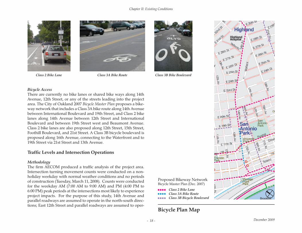
Bicycle AccessThere are currently no bike lanes or shared bike ways along 14th Avenue, 12th Street, or any of the streets leading into the project area. The City of Oakland 2007 Bicycle Master Plan proposes a bike-way network that includes a Class 3A bike route along 14th Avenue between International Boulevard and 19th Street, and Class 2 bike lanes along 14th Avenue between 12th Street and International Boulevard and between 19th Street west and Beaumont Avenue. Class 2 bike lanes are also proposed along 12th Street, 15th Street, Foothill Boulevard, and 21st Street. A Class 3B bicycle boulevard is proposed along 16th Avenue, connecting to the Waterfront and to 19th Street via 21st Street and 13th Avenue.
Traffic Levels and Intersection Operations
Methodology The firm AECOM produced a traffic analysis of the project area. Intersection turning movement counts were conducted on a non-holiday weekday with normal weather conditions and no periods of construction (Tuesday, March 11, 2008). Counts were conducted for the weekday AM (7:00 AM to 9:00 AM) and PM (4:00 PM to 6:00 PM) peak periods at the intersections most likely to experience project impacts. For the purpose of this study, 14th Avenue and parallel roadways are assumed to operate in the north-south direc-tions; East 12th Street and parallel roadways are assumed to oper-
Class 2 Bike LaneClass 3A Bike RouteClass 3B Bicycle Boulevard
Proposed Bikeway NetworkBicycle Master Plan (Dec. 2007)
Bicycle Plan Map
Class 2 Bike Lane Class 3A Bike Route Class 3B Bike Boulevard

Chapter II: Existing Conditions
December 2009 - 19 -
(1) “Downtown” is defined in the Land Use Transportation Element (LUTE) of the General Plan (page 67) as the area generally bound by West Grand Avenue to the north, Lake Merritt and Channel Park to the east, the Oakland estuary to the south and I-980/Brush Street to the west. None of the study intersections lie within the Downtown area. Thus, thresholds relating to Downtown will not be addressed further in this document.
ate in the east-west directions. The following intersections were selected for analysis:
1. 14th Avenue / East 12th Street (EB) (signalized);2. 14th Avenue / East 12th Street (WB) (signalized);3. 14th Avenue / International Boulevard (signalized);4. 14th Avenue / Foothill Place (unsignalized); 5. 14th Avenue (SB) / Foothill Boulevard (signalized);6. 14th Avenue (NB) / Foothill Boulevard (signalized);7. 15th Avenue / East 17th Street (unsignalized);8. 15th Avenue / East 18th Street (unsignalized);9. 14th Avenue / East 17th Street (unsignalized);10. 14th Avenue / East 18th Street (unsignalized); and11. 14th Avenue / East 19th Street (unsignalized).
Intersection operations were analyzed according to the 2000 High-way Capacity Manual (HCM) methodology using Trafficware’s Synchro 7 software package. The 2000 HCM methodology is based on the concept of Level of Service (LOS), a qualitative description of the performance of an intersection based on average delay per vehicle. Intersection Levels of Service range from LOS A, which in-dicates free flow or excellent conditions with short delays, to LOS F, which indicates congested or overloaded conditions with extreme-ly long delays. The City of Oakland considers LOS D or better
acceptable for intersections outside of Downtown Oakland(1), as is the case for all eleven study intersections. The LOS methodology is summarized in Table 1.
For signalized and all-way stop-controlled (AWSC) intersections, the HCM methodology determines LOS based on the combined weighted average delay for the various movements within the intersection. For one-way and two-way stop-controlled (OWSC and TWSC) intersections, the HCM methodology determines LOS based on the worst intersection approach. LOS calculation tables for each intersection have been provided to City of Oakland staff.
The intersection analysis was conducted for the following scenar-ios:
• Existing Conditions• Existing with Project Reconfiguration Conditions.

Chapter II: Existing Conditions
December 2009- 20 -
“Existing with Reconfiguration Conditions” assumes implementation of the proposed project. Since the analysis is being conduct-ed as part of the 30% design submittal, other analysis items typically evaluated in a full Transportation Impact Analysis (TIA)—such as near-term and cumulative future-year analyses, intersection queuing analysis, tran-sit analysis, parking and loading analyses, roadway segment analysis, pedestrian/bicy-cle analysis, and collision analysis—are not included in this memorandum.
Existing ConditionsExisting Conditions intersection operations for the weekday AM and PM peak hours are summarized in Table 2. As shown in Table 2, ten (10) of the eleven (11) study intersections would operate at acceptable conditions (LOS D or better) under Existing Conditions in the weekday AM peak hour. All of the eleven (11) study intersections would operate at ac-ceptable conditions (LOS D or better) under Existing Conditions in the weekday PM peak hour.
• Intersection #10 - 14th Avenue / E. 18th Street (AM) – LOS E - In the weekday AM peak hour the intersection of 14th Av-enue / East 18th Street operates at LOS E in Existing Conditions. The intersection does not meet peak hour warrants as de-tailed in the California supplement to the Manual on Uniform Traffic Control De-vices (MUTCD).


