Embed Size (px)
Citation preview
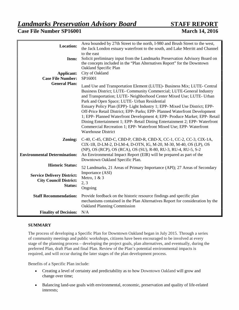
Landmarks Preservation Advisory Board STAFF REPORT Case File Number SP16001 March 14, 2016
SUMMARY
The process of developing a Specific Plan for Downtown Oakland began in July 2015. Through a series of community meetings and public workshops, citizens have been encouraged to be involved at every stage of the planning process – developing the project goals, plan alternatives, and eventually, during the preferred Plan, draft Plan and final Plan. Review of the Plan’s potential environmental impacts is required, and will occur during the later stages of the plan development process. Benefits of a Specific Plan include:
• Creating a level of certainty and predictability as to how Downtown Oakland will grow and change over time;
• Balancing land-use goals with environmental, economic, preservation and quality of life-related interests;
Location:
Area bounded by 27th Street to the north, I-980 and Brush Street to the west, the Jack London estuary waterfront to the south, and Lake Merritt and Channel to the east
Item: Solicit preliminary input from the Landmarks Preservation Advisory Board on the concepts included in the “Plan Alternatives Report” for the Downtown Oakland Specific Plan
Applicant: City of Oakland Case File Number: SP16001
General Plan:
Land Use and Transportation Element (LUTE)- Business Mix; LUTE- Central Business District; LUTE- Community Commercial; LUTE-General Industry and Transportation; LUTE- Neighborhood Center Mixed Use; LUTE- Urban Park and Open Space; LUTE- Urban Residential Estuary Policy Plan (EPP)- Light Industry 1; EPP- Mixed Use District; EPP- Off-Price Retail District; EPP- Parks; EPP- Planned Waterfront Development 1; EPP- Planned Waterfront Development 4; EPP- Produce Market; EPP- Retail Dining Entertainment 1; EPP- Retail Dining Entertainment 2; EPP- Waterfront Commercial Recreation 1; EPP- Waterfront Mixed Use; EPP- Waterfront Warehouse District
Zoning:
C-40, C-45, CBD-C, CBD-P, CBD-R, CBD-X, CC-1, CC-2, CC-3, CIX-1A, CIX-1B, D-LM-2, D-LM-4, D-OTN, IG, M-20, M-30, M-40, OS (LP), OS (NP), OS (RCP), OS (RCA), OS (SU), R-80, RU-3, RU-4, RU-5, S-2
Environmental Determination:
An Environmental Impact Report (EIR) will be prepared as part of the Downtown Oakland Specific Plan.
Historic Status:
Service Delivery District: City Council District:
Status:
52 Landmarks, 21 Areas of Primary Importance (API); 27 Areas of Secondary Importance (ASI) Metro, 1 & 3 2, 3 Ongoing
Staff Recommendation:
Provide feedback on the historic resource findings and specific plan mechanisms contained in the Plan Alternatives Report for consideration by the Oakland Planning Commission
Finality of Decision: N/A
Landmarks Preservation Advisory Board March 14, 2016 Case File Numbers SP16001 Page 2
• Identifying the need for improved infrastructure (utilities, roads, and parks); and
• Providing a certified environmental document which will expedite the entitlements process. The development of a Specific Plan for Downtown Oakland presents a rare opportunity for the City to leverage new investment to propel Downtown toward a future of thriving, diverse, sustainable commerce, culture, entertainment, housing and employment; a place where Oakland's authenticity and varied cultural identities are reflected in the built environment. Clear plans for connecting Oakland's distinct districts, waterfront areas and abundant transit options that prioritize the pedestrian, bicycles and transit, while also accommodating cars, can be detailed, and future investment decisions can rely on these plans. The Plan will is projected to improve Downtown’s role as the economic engine of the City, and thereby support the delivery of services to residents throughout the whole city. Shared prosperity is a central theme to the development of the specific plan for Downtown. Many of the big ideas and themes in the Plan Alternatives Report, the subject of this staff report, call for broad policy changes that would create an improved Downtown. Historically, cities have a reputation for changing, growing, and adapting to the needs of the citizens. A clear plan that documents the way that downtown Oakland should look in the future, coupled with a series of policies and recommendations for implementing the vision, is essential. With a clear plan, when and where growth may occur can become predictable. The Downtown specific plan study area encompasses approximately 900 acres from 27th Street to the north, I-980 and Brush Street to the west, the Jack London estuary waterfront to the south, and Lake Merritt and Channel to the east. The Downtown Specific Plan and related environmental impact report (EIR) will provide a roadmap for how the area develops over the next 20 to 25 years. A planning effort for Downtown Oakland, which has the potential to shape the prospects for the entire city, requires tremendous coordination among City departments, the City administration, City Council, partner agencies and the broader community. The Oakland Bureau of Planning is committed to conducting a transparent, inclusive and empowering planning process. This report presents concepts contained in the Plan Alternatives Report related to historic resources. Staff would like to solicit preliminary input from the Landmarks Preservation Advisory Board on the concepts included in the Plan Alternatives Report. Feedback is also being sought from the Parks and Recreation Advisory Commission, Bicycle and Pedestrian Advisory Commission, Public Art Advisory Committee and Planning Commission. Feedback heard at the advisory body meetings and the Planning Commission will be incorporated into the Preferred Plan which will be publicly vetted. The Draft Specific Plan, based on the Preferred Plan, will once again be presented to the advisory bodies and Planning Commission for comment tentatively scheduled for the winter of 2016. BACKGROUND Downtown Oakland is the cultural, business, government, and entertainment hub of the East Bay with excellent transit service, including three Bay Area Rapid Transit (BART) stations, multiple Alameda County (AC) Transit bus lines, Amtrak train service, and ferry service. The specific plan will help to ensure that Downtown remains a place of continuing growth and revitalization, as well a valuable resource for the larger Oakland community through increased employment, arts, and cultural opportunities. The plan will provide sound policy guidance on land use, transportation, economic development, housing, public spaces, cultural arts, and social equity.

Landmarks Preservation Advisory Board March 14, 2016 Case File Numbers SP16001 Page 3
Initiated in July of 2015, the Downtown specific plan will incorporate recommendations from the recently completed specific plans adjacent to downtown, the Mayor's Housing Cabinet, the Downtown Oakland Parking Supply Study and the Complete Streets Implementation Plan. The Downtown specific planning process will closely coordinate with parallel planning studies including the Alameda County Transportation Commission’s “Freeway Access Project” which will study access to and from Interstate 880; Citywide Impact Fee Nexus Study and Implementation Strategy for transportation, affordable housing, and capital improvements; Broadway Transit Circulator Study; and a State Law SB743 Standard Procedures Update, which removes Level of Service (LOS) as a traffic input analysis methodology from the California Environmental Quality Act (CEQA). Community Engagement The initial centerpiece of the public participation process in the Downtown Specific Plan process was a design charrette held over a 10-day period in October 2015. During the charrette process, a series of tours, stakeholder meetings, surveys, and community workshops were held that provided opportunities for group brainstorming and input. The charrette was advertised in local newspapers, electronic newsletters, and via flyers posted in local businesses, community centers, residential hotels, and other public venues. Well over 200 people attended each of the initial public meetings held before and during the charrette, such as the project kick-off meeting, the hands on design workshop, and the work in progress presentation. During the 10-day charrette, the city and its consultant team welcomed the public into an open studio housed in a temporary storefront on Broadway that allowed community members to have one-on-one conversations with members of the consultant team as draft ideas were being explored. Surveys were available throughout the charrette period, allowing anonymous written feedback for the consultant team. Finally, a virtual “town hall” was created on the Speak Up Oakland website to facilitate participation from anywhere, any time of day. Last fall’s charrette kicked off the specific plan’s public engagement efforts. Community comments from the charrette are available on the project website at www.oaklandnet.com/plandowntownoakland, see the “past meetings,” “charrette” section. The ongoing Specific Plan engagement process has been designed to encourage authentic participation by both traditionally well-organized groups, such as local business improvement districts, property owners, community-based organizations, and developers; as well as traditionally underrepresented lower-income, renter communities, small businesses and arts and culture organizations. A youth engagement component is also underway, with a youth summit scheduled for March 16th. City staff has attended over 10 neighborhood group/coalition meetings (see notes from these meetings available on the project webpage at www.oaklandnet.com/plandowntownoakland, see the “community input” section) and continues to meet with stakeholder groups. General feedback received (via email transmission or hard copy surveys left at the Plan Downtown display in the lobby of the Planning Department) are also available on the project website. Another public workshop was held on February 1, 2016, at the Malonga Casquelourd Center for the Arts to introduce the Plan Alternatives. This public outreach event was attended by over 300 people. In addition to presenting the Plan Alternatives, the new “Streetwyze” public input platform was unveiled. Launching of the web-based Streetwyze application is meant to provide a culturally responsive method for engaging the community, particularly those who would not otherwise engage using traditional processes such as city-sponsored public meetings or city-hosted online survey tools. Community comments from this meeting are available on the project website at www.oaklandnet.com, see the “past meetings” section. The Specific Plan process is also supported by a project Community Advisory Group (CAG) is comprised of professionals from a variety of fields who provide technical knowledge on issues such as urban design and real estate development, feasibility, as well as larger housing organizations and business improvement districts. Additionally, the group includes representatives of the local

Landmarks Preservation Advisory Board March 14, 2016 Case File Numbers SP16001 Page 4
neighborhood groups, artist community, as well as youth, health and advocacy organizations to help direct the policies and decisions of Plan Downtown. Community feedback from each of these avenues has been folded into the Plan Alternatives Report that is the subject of this report. PLAN ALTERNATIVES The Plan Alternatives Report includes a summary of background information, a summary of the community vision for Downtown Oakland (to date), and a series of plan options and scenarios. The plan alternatives are reflective of the community vision and goals that have emerged through a series of small group meetings, large public events, and a 10-day public interactive design charrette. These working concepts and goals are grouped into the following categories:
• Affordability & Equity; • Arts & Cultural Heritage; • Built Environment, Preservation & Housing; • Open Space & Recreation; • Environmental Sustainability; • Connectivity & Access; and • Economic Development.
The Plan Alternatives Report contains the “Big Ideas” that the city and consultant team have heard from the community to date, and are discussed as goals on pages 1.8-1.11 of the Plan Alternatives Report. The big ideas and goals will continue to be refined and edited throughout the planning process. The Vision/Goals specific to the built environment, preservation & housing are as follows:
• Focus intensity of new development in appropriate areas within Downtown Oakland to preserve the character of other neighborhoods;
• Create walkable and bikeable places that complete healthy, livable neighborhoods; • House residents of all incomes and family sizes in a wide range of traditional and innovative
housing types close to transportation, jobs and services; • Help to attract a vibrant mixture of uses in Downtown Oakland to generate activity at all times of
the day.
The entire Plan Alternatives Report, Attachment B to this report, is available on the project webpage: www.oaklandnet.com/plandowntownoakland. Historic Resources are covered in Section 2 (Existing Conditions) on pages 2.14 and 2.15, and Section 4 (Planning Goals) under Built Environment, Preservation & Planning, on pages 4.10 and 4.11.
HISTORIC RESOURCES
The General Plan Historic Preservation Element and the Oakland Cultural Heritage Survey classify and provide policy direction for the preservation of historic buildings of all types and of all degrees of significance. Many individual historic properties have been identified in Downtown, as well as concentrated collections of resources within historic districts that contribute to Downtown’s unique and historic character.
Landmarks Preservation Advisory Board March 14, 2016 Case File Numbers SP16001 Page 5
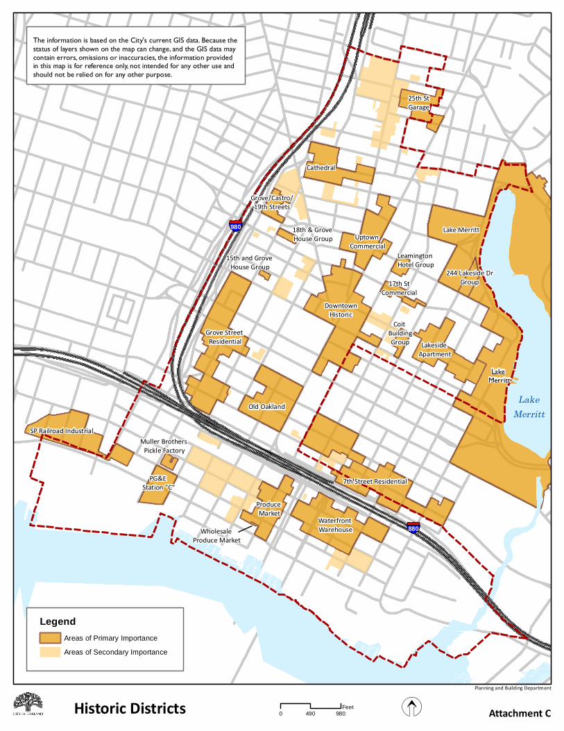
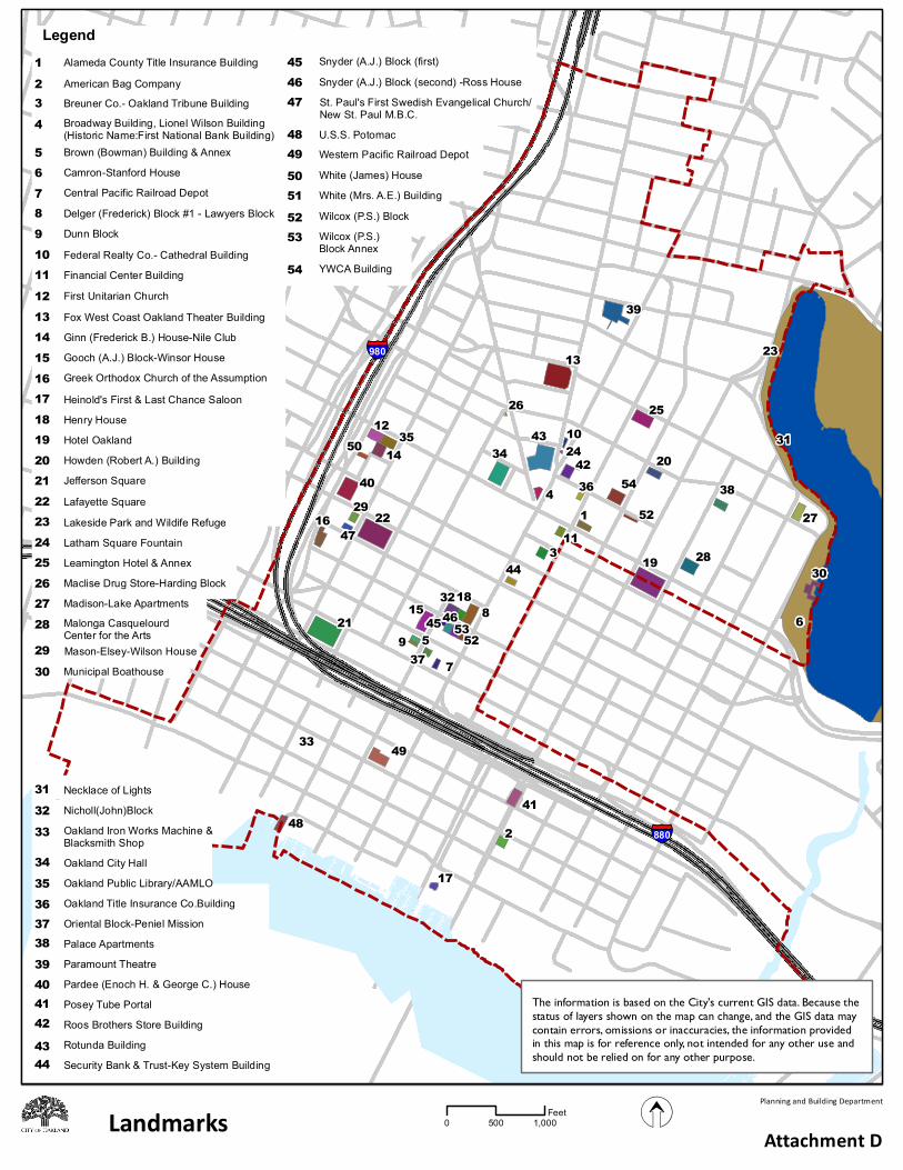
As would be expected in a historic central district that has never been comprehensively redeveloped or abandoned, the plan area contains Oakland’s largest concentration of substantial, ambitious, and architecturally distinguished buildings, and therefore its highest concentration of historic resources. From the earliest U.S. settlement at the foot of Broadway in the 1850s, the original town plat remained a compact and coherent geographical unit, surrounded by the Estuary, the future Lake Merritt, and the West Oakland marshes. The town expanded concentrically from the foot of Broadway but Broadway never lost its primacy as a business center. From the early 20th century, building codes inside the central business district “fire limits” required fireproof and therefore substantial and permanent construction, further insuring the survival of many building from that era. Within the Downtown plan area there are several different types of historic districts, including National Register-listed (Downtown Oakland Historic District, Coit Building Group, Waterfront Warehouse District) as well as locally-designated historic districts (Old Oakland, Preservation Park) and districts identified by the Cultural Heritage Survey. The Survey identifies districts in a two-tiered system, Areas of Primary Importance (API), which are National Register-quality but not necessarily listed, and Areas of Secondary Importance (ASI) or districts of local interest (see map of API and ASI areas in Attachment C). Designated Landmarks The Plan Area contains approximately fifty-two (52) buildings designated as City Landmarks by the Landmarks Board and City Council, as well as two S-7 historic districts. This is Oakland’s highest level of recognition of historic significance. Such properties exhibit extraordinary historical or architectural value and are in most cases clearly eligible for the National Register of Historic Places. Over a third of the city’s designated landmarks are in the plan area, underscoring the area’s long history as Oakland’s original settlement and its commercial and civic center. Landmarks include (see Attachment D for map of Landmarks): Paramount Theatre; Fox West Coast Oakland Theater building; Leamington Hotel and Annex; Maclise Drug Store-Harding Block; First Unitarian Church; Oakland Public Library/AAMLO; Federal Realty Co.-Cathedral building; Ginn (FrederickB.) house-Nile Club; White (James) house; Oakland City Hall; Roos Brothers store building; Howden (RobertA.) Building; Pardee (EnochH.&GeorgeC.) house; Young Women's Christian Assoc. building; Oakland Title Insurance Co. building; Palace Apartments; Madison-Lake Apartments; White(Mrs.A.E.) building; Lafayette Square; Alameda County Title Insurance building; Greek Orthodox Church of the Assumption; Financial Center Building; Breuner Co.-Oakland Tribune building; Hotel Oakland; Delger (Frederick) Block#1-Lawyers Block; Henry House; Jefferson Square; Snyder(A.J.) Block (first); Snyder (A.J.) Block (second)-Ross House; Wilcox (P.S.) Block Annex; Wilcox (P.S.) Block; Brown (Bowman) Building and Annex; Oriental Block-Peniel Mission; Central Pacific Railroad Depot; Western Pacific Railroad Depot; U.S.S. Potomac; Heinold's First and Last Chance Saloon; Security Bank & Trust-Key System building; Camron-Stanford House; Posey Tube Portal; American Bag Company; Latham Square Fountain; Lakeside Park and Wildife Refuge; Oakland Iron Works Machine & Blacksmith Shop; Dunn Block; Gooch (A.J.) Block-Winsor House’ Nicholl (John) Block; Rotunda Building; St. Paul's First Swedish Evangelical Church/New St. Paul M.B.B; Mason-Elsey-Wilson House; Malonga Casquelourd Center for the Arts/Women's City Club/ Alice Arts Center; Broadway Building/Lionel Wilson Building/ First National Bank Building. Two Locally Designated Historic Districts (S-7 Preservation Combining Zone) Preservation Park district Old Oakland district
Landmarks Preservation Advisory Board March 14, 2016 Case File Numbers SP16001 Page 6
Local Register of Historical Resources Formal City Landmark designation or National Register listing requires a lengthy application process and usually occurs only at the request of the property owner. Many more buildings and districts have comparable levels of significance, and most of those have been identified by the Planning Department’s citywide Oakland Cultural Heritage Survey. To insure that Oakland’s most important resources are not left unprotected in the absence of formal designation, Preservation Element Policy 3.8 defines a Local Register of Historical Resources for environmental review under CEQA, eligibility for State Historical Building Code, and similar purposes. In addition to formally designated historic properties, this top-rated group includes buildings with individual ratings of A or B (highest or major importance) and those in Areas of Primary Importance. Local Register properties are about 3% citywide and a much higher proportion in the plan area. Potentially Designated Historic Properties (PDHP) and Areas of Secondary Importance (ASI) In addition to the obvious monuments on the Local Register and landmark lists, the Preservation Element recognizes a broader range of historic and architectural value essential to neighborhood character and context. Buildings and districts of “secondary importance” may be less unique, less pretentious, or more altered than the obvious National or Local Register properties, but are identified and protected by the Element at the local level as Areas of Secondary Importance (ASIs) and Potential Designated Historic Properties (PDHPs) for their importance to neighborhood character (HPE Policies 1.2, 3.1ff). Individual PDHPs and those in ASIs make up about 20% of buildings citywide and a much higher proportion in the plan area. Areas of Primary Importance (API) Approximately 21 Areas of Primary Importance (APIs, districts identified by the Cultural Heritage Survey as appearing eligible for the National Register) and primary building groups, ranging in size from 2 to 100 buildings, are within or partly within the plan area. The Survey documented the most concentrated, intact, and distinctive areas as APIs - potential districts appearing eligible for the National Register. They are identified as significant for their physical integrity and for representing distinct aspects of Oakland’s residential, commercial, and industrial development. These districts are part of larger more or less continuous areas with recognizable historic character: a ring of residential neighborhood fragments along 7th Street, Martin Luther King Jr. Way, and at the Charter Line; the central commercial core running the entire length of Broadway plus its side streets; the industrial and transportation strip south of I-880 along the waterfront and the rail lines on Embarcadero and 3rd Street. The line between primary and secondary is necessarily somewhat arbitrary. All these areas are dense with individual buildings and districts identified as of primary (Local Register) or secondary (local, contextual) significance. 19th Century Residential Neighborhoods: Residential neighborhoods from the 19th and early 20th centuries are still apparent in remarkably solid blocks of 1870s-1900s houses that encircle the Central Business District along 7th Street (Railroad Avenue), Martin Luther King Jr. Way (formerly Grove Street), and 21st Street (the original northern boundary or Charter Line) as well as scattered individual buildings. Except for the Camron-Stanford house, the mansions that once lined Lake Merritt have been replaced by denser 20th century dwellings. A few early workers’ cottages survive in the west part of the waterfront neighborhood.
• Grove Street/Lafayette Square Residential District – the second largest 19th century neighborhood fragment in the plan area, its roughly 82 buildings occupy portions of 15 city blocks bounded by Jefferson Street and the I-980 freeway on either side of Grove Street (now Martin Luther King Jr. Way) and 14th Street and the I-880 freeway at 7th Street (formerly Railroad Avenue). The district is historically significant as a surviving area of early residential development within the original 1852 Town of Oakland, formerly continuous with the West Oakland neighborhoods across I-980. The district includes Jefferson and Lafayette Squares, two
Landmarks Preservation Advisory Board March 14, 2016 Case File Numbers SP16001 Page 7
of the original seven full blocks dedicated as City parks. It also contains Preservation Park, a City-designated S-7 historic district of original and moved-on houses, some saved from the 980 freeway. The Victorian and Colonial Revival houses in the district reflect two major building booms in Oakland’s history, following the arrival of the transcontinental railroad in 1869 and the earthquake of 1906. Several smaller APIs continue the traces of this neighborhood to the north along former Grove Street, as do ASIs and individual buildings.
• 15th and Grove Streets House Group - is a mini-district of three 2-story and raised basement
early 1870s Italianate houses at the southeast corner of 15th Street and Martin Luther King Jr. Way. All three have bracketed cornices, rustic siding, and polygonal bay windows. The group is significant for their early date, central location, high integrity, elegant Italianate style, and representation of the larger middle-class neighborhood of which they were a part.
• 18th and Grove Streets Residential District – eight houses dating from 1883 to 1903, on two
blockfronts forming a continuous late-Victorian streetscape notable for coherence of style and scale. Queen Anne, Stick, and Colonial in style, the houses are set close together on small lots and are 1 or 2 stories over raised basements, with parallel setbacks and steps that unify the streetscape.
• Grove/Castro/19th Streets Residential District – a further northern continuation of the Grove
Street/Lafayette Square neighborhood, this cluster of 18 Italianate, Stick, and Colonial houses and flats occupies portions of two city blocks at the northwest corner of the original town.
• Cathedral District – named for St. Francis de Sales Cathedral that formerly bookended the Grove
Street end of this residential neighborhood at Oakland’s original northern boundary or Charter Line. The district extends east to Telegraph Avenue along 21st and 22nd Streets (where the 1902 First Baptist Church provides the other bookend) and along part of West Grand Avenue. The 35-building district is characterized by 1 and 2 story residences of Queen Anne, Stick, and Colonial styles dating from 1872 to 1916. Following the 1906 earthquake, several houses in this centrally-located district were raised or subdivided to add housing units. The district is notable for its representation of architectural styles of the era as adapted for narrow lots. The St. Francis Rectory, converted to apartments, now bookends the west end of the district’s 21st Street block
• 7th Street/Harrison Square/Chinatown Residential District – the largest 19th-early 20th century
neighborhood fragment, roughly 100 buildings on parts of 11 blocks centered along 7th Street (former Railroad Avenue), running east-west from Harrison to Fallon along 6th (I-880), 7th, and 8th Streets. Buildings are mostly modest 1 and 2 story houses on small lots with minimal setbacks, in the Italianate, Stick, Queen Anne, and Colonial Revival styles, with raised basements, pitched roofs, and the tall floor heights typical of the period. The district includes one of the seven original squares (Harrison) and adjoins one other (Madison).
• Bret Harte Boardwalk – a row of Italianate houses and early commercial buildings on one side of
5th Street facing the I-880 freeway, a rare surviving fragment what was a dense residential neighborhood along the waterfront and rail lines. In the early 1960s the centerpiece Italianates were converted for a pioneering adaptive reuse boutique “boardwalk” project.
Landmarks Preservation Advisory Board March 14, 2016 Case File Numbers SP16001 Page 8
Commercial Districts – Central Business Districts of the 1850s-1930s Broadway has been the commercial spine and the downtown of Oakland since its origins at the waterfront in the 1850s. Broadway and its side streets are still a timeline of Oakland’s development, from a cluster of very old brick buildings on the 100-300 blocks at the waterfront to the Art Deco Uptown and beyond.
• Old Oakland - predominantly 1870s central shopping, office, and hotel district associated with the arrival of the Transcontinental Railroad in 1869. It comprises most of the six square blocks bounded by Broadway, Jefferson, 7th, and 10th Streets. Its 31 contributing buildings are mostly zero-setback rectangular blocks, 1 to 4 stories high, in styles reflecting their dates of 1870s-1910s. “Victorian Row” on 9th Street between Broadway and Washington is a solid block of Italianate commercial structures on both sides of the street, considered on of the most distinguished groups of late-Victorian commercial architecture in the West, and was a pioneering historic rehabilitation project in the 1980s. Old Oakland is a locally-designated S-7 historic district and has been formally determined eligible for the National Register; many of its buildings are also individually designated and on the National Register.
• Downtown Historic District – retail and financial hub of Oakland throughout the 20th century,
the district occupies 17 whole or partial blocks centered on the intersection of 14th and Broadway, City Hall and its plaza, and a series of early 20th century 7 to 18 story skyscrapers along Broadway between 11th and 17th Streets. Smaller commercial buildings between the skyscrapers create a distinctive skyline admired in Werner Hegemann’s 1915 city plan. The buildings in the district constitute a well-preserved sample of commercial architecture in larger American cities in the first part of the 20th century. Buildings are mostly Beaux Arts-inspired, display a general unity of style and scale and use, and represent many of the better-known Bay Area architects of the period. Demolition and civic center construction after the 1989 earthquake separated a group of 1910s hotels west of City Hall from the district; they might now be considered part of a potential thematic group of downtown hotels. The post-1989 Downtown district along and east of Broadway is listed on the National Register, as are several individual buildings.
• Coit Building Group – consists of four 1910s-20s zero-setback, slightly detached 1 to 7 story
brick buildings, the Harrison and Coit Hotels, Harrison Apartments, and a related commercial building. The group displays high architectural quality, and is unified by surface materials, massing, articulation, ornamentation, and height. The group was placed on the National Register in 1996 to qualify for tax credits. The Harrison is part of a ring of 1910s hotels within a few blocks of 14th and Broadway, built partly in anticipation of the 1915 world’s fair, that is a distinctive thematic feature of downtown Oakland.
• 17th Street Commercial District - occupies both sides of the block between Franklin and Webster
Streets, plus the landmark Howden Tile building on the east side of Webster. It is a cohesive and intact group of long, low 1920s commercial buildings on shallow lots, of brick or reinforced concrete construction with glazing covering most of each façade. Most are two stories plus mezzanines. The buildings’ design and uses (small ground floor commercial, offices above), street trees, and period light standards all set the district off as a unified enclave. This block and a similar block of 15th Street were developed on small remainder parcels when these streets were cut through long, formerly residential north-south blocks, as downtown expanded east toward the lake.
• Leamington Hotel Group – consists of two adjoining reinforced concrete structures – a hotel and
an office and assembly building – at the corner of 19th and Franklin Streets, in a cluster of 1920s high-rise financial and medical office buildings. Designed by William Weeks in 1925-26, the
Landmarks Preservation Advisory Board March 14, 2016 Case File Numbers SP16001 Page 9
matching buildings are clad in glazed terra cotta and cement plaster with elaborate cast stone ornament in Spanish baroque idiom. This monumental building group was significant, along with the 1928 Capwell store at 20th and Broadway, in the development of Uptown as a luxury commercial district, while two near-twins of the Leamington to the east, also by Weeks, help establish the character of the Lake Merritt and Lakeside Apartment neighborhoods.
• Uptown Commercial District – continues Broadway corridor development northward in the
1920s-30s as a Deco-era shopping and entertainment district. The main intersection is 20th Street and Broadway, and the district includes the Fox and Paramount Theaters, among other similarly distinguished historic buildings. The 20-building district represents a distinct phase of expansion of the Oakland central business district with luxury shopping anchored by the Capwell store. Architecturally the district offers an important collection of small to medium scale commercial buildings of the 1920s and 1930s, including both historicist brownstone and terra cotta loft buildings and colorful Art Deco terra cotta.
20th Century Urban Residential Districts East of Broadway to the lake, and north of about 15th Street, street and lot patterns were originally less urban and regular, and early development took the form of an elite residential neighborhood of which the Camron-Stanford house museum and the Schilling Garden are the surviving examples. As the central business district expanded east from Broadway after 1900, large lots were gradually redeveloped, with commercial uses closer to Broadway and apartment buildings predominating closer to the lake. Most of the apartment development was of very high quality, and the area is today sometimes called the Gold Coast.
• Lakeside Apartment District – occupies portions of 5 blocks north of 14th Street near Lake Merritt. The district is characterized mainly by 2 to 6-story woodframe or brick apartment buildings from the 1910s and 1920s, built close together with little or no setbacks. The Malonga Casquelourd Arts Center (originally Women’s City Club) is also in the district. Architectural styles are varied; building materials are primarily pressed brick with terra cotta, or stucco with wood or marble trim. Mid-20th century apartments fill in the long blocks north of the district along Alice, Madison, and Jackson Streets, terminating at another early apartment cluster around 19th Street.
• 244 Lakeside Drive Group – facing Lake Merritt and Snow Park as well as its own landscaped
forecourt, the complex includes a 12-story 20-unit apartment building and a two-story 1910 garage, both set in a large garden on 19th Street that partially survives from the August Schilling estate. The complex exemplifies both 1920s luxury apartment buildings and the garden settings of 19th century upper-class homes. Its large scale, distinctive design, and prominent Lake Merritt location make the complex an especially familiar visual landmark in Oakland.
• Lake Merritt District – extends one parcel deep all around Lake Merritt, to recognize the
importance to Oakland of Lake Merritt and its views. The district is significant for both the landscape architecture of the lake and park, and for the high architectural quality of the many apartment and civic buildings constructed around the shore of the lake.
Industrial Districts Early in Oakland’s existence, the waterfront and the railroad determined the industrial character of the area below the tracks. Six districts representing this character have been recorded as APIs. The area also includes numerous ASIs and individual resources, both Local Register and PDHPs.
• PG&E Station C – is located on the Embarcadero and has been devoted to electricity production since its earliest structures were constructed in the 1880s. The complex was constructed

Landmarks Preservation Advisory Board March 14, 2016 Case File Numbers SP16001 Page 10
incrementally through 1938, and maintains a consistent Beaux Arts stylistic character through monumental scale, generously quoined piers, round-headed windows, and a classically derived cornice.
• Southern Pacific Industrial – located primarily in West Oakland, this district lies between the 3rd
Street and Embarcadero tracks and has one building in the downtown plan area. The former Dalziel Warehouse, converted to residential condos as Phoenix Lofts, faces still-active tracks on its south side.
• Muller Brothers Pickle Factory/Marcus Hardware – occupies three-quarters of a block at 3rd
Street and Martin Luther King Jr. Way and is a good example of a large-scale early 20th century food processing plant. The complex was constructed incrementally in the first decades of the 20th century. Buildings are utilitarian in character, rectangular with no setbacks, of red common brick in American bond, with shallow parapets and low-pitched roofs.
• Produce Market District – occupies 7 whole or partial blocks around 3rd and Franklin Streets,
formerly served by the Western Pacific’s 3rd Street tracks. The Produce Market is a commercially and architecturally unique area within the larger warehouse, industrial, and railroading strip along the Oakland Estuary and to some extent still functions as a wholesale produce center for the East Bay. Its historical and architectural centerpiece is the 1916-17 complex of canopied, screen-fronted, stuccoed concrete, produce-specific market buildings developed by the Fruit and Produce Realty Company. Other buildings in the district are a mix of commercial and industrial buildings that were adapted for produce market use by adding openings and canopies like those that define the F&PRCo. buildings.
• Waterfront Warehouse District – occupies portions of nine blocks from 3rd to 5th Streets and
from Webster to Madison, formerly centered on the 3rd Street Western Pacific tracks. Most of the contributing buildings are one to four-story brick or concrete warehouses from the 1910s-20s, generally characterized by raised ground floors at loading dock height, a mix of freight and pedestrian doors, factory sash, flat roofs, slightly ornamented parapets and other geometric details. In recent decades most of the buildings have been converted to residential use, and the district is surrounded by new taller, full-block residential structures. The district is listed on the National Register.
• 25th Street Garage District – centered on 25th Street between Broadway and Telegraph, these
blocks are historically associated with Broadway Auto Row. The majority of the 20-plus contributing buildings were built in the 1920s for auto service or related industrial uses, and are predominantly high one-story brick truss-roofed garages covering their entire lots. Many have finely crafted brickwork and retain period doors, windows, and other details.
KEY ISSUES AND IMPACTS Downtown is a mix of old and new, large-scale and smaller structures, office and housing uses and significant entertainment and retail enterprises. All of these uses occur in both historic and more modern structures, creating a diversity of building type and construction era that gives Downtown a character of its own. Previous preservation strategies, set forward in specific area plans as well as the Historic Preservation Element of Oakland’s General Plan, provide a strong context for the continued use of preservation as an important planning tool to create places for everyone in Oakland. Major concepts that have been expressed to date in the Downtown Plan process regarding preservation and the future of the built environment are described below.

Landmarks Preservation Advisory Board March 14, 2016 Case File Numbers SP16001 Page 11
• Vacant and underutilized historic buildings provide opportunities for adaptive re-use.
• Certain view corridors through Downtown Oakland are significant cultural and design elements within the City’s historic fabric, and should be protected.
• While the boundaries of the Downtown Specific Plan do not include Chinatown because it was included in previous planning efforts, there is a clear connection between Chinatown and the rest of Downtown that requires continued planning and historic preservation practices to ensure the viability of this important cultural component of Oakland, as well as creating a cohesive strategy to address historic resources in the Broadway Valdez District Specific Plan area.
• Downtown Oakland has a wealth of historic structures, the top-rated buildings and APs identified on the Local Historic Register, as well as ASI historic districts and PDHPs..
• In addition to preservation of specific identified buildings/sites, development on adjacent parcels should consider this historic context and be done in a sensitive way.
Industrial Building Issues
• The plan area includes 1.6 million square feet of Production Distribution and Repair (PDR) (industrial) space primarily in historic warehouse buildings and 390,000 square feet of flex space, concentrated in the Jack London and KONO areas.
• Demand for PDR and flex space (requiring warehouse-type footprints) is strong, both within the plan area and Oakland generally; however, attainable rents are much lower than for office and residential uses.
• Jack London District’s industrial buildings are outdated for large traditional manufacturing and
distribution operations, and are instead often targeted for office conversion, arts uses, or leased to small-scale industrial users with unique needs.
• The plan area is experiencing an ongoing loss of industrial space, with buildings transitioning to
arts, retail, and office uses able to support relatively higher rents.
• The historic produce market in the Jack London District provides a useful hub for commerce, but there may be an opportunity to develop a better equipped facility for the produce market in a more appropriate location in Oakland, while taking advantage of the current market’s historic buildings for adaptive reuse.
• KONO’s automobile-related uses are slowly phasing out as buildings are repurposed for arts and retail uses. The existing art galleries in the historic garage district that surrounds 25th Street would like to stay in the area and build on the arts momentum that has already gained Oakland a positive regional and national reputation, but are concerned about displacement due to rising rents.
The specific plan can address historic preservation through the following mechanisms.
• The Specific Plan should consider whether strategies should seek to preserve industrial uses (and thus historic warehouse buildings) and the diversity of jobs they provide, and to determine appropriate means of preserving other businesses, – such as arts uses, that have thrived in industrial buildings yet may be unable to compete with higher rents for office conversions.
• Relate the height, bulk, scale, and massing of new buildings to the important attributes of the existing city pattern, especially when designing in or adjacent to designated City Landmarks and districts, the Downtown Oakland National Register Historic District, and Areas of Primary
Landmarks Preservation Advisory Board March 14, 2016 Case File Numbers SP16001 Page 12
Importance (API) previously identified through the Oakland Cultural Heritage Survey program.
• Encourage adaptive reuse of vacant or underutilized historic buildings by creating an easily available and implemented set of incentives for property owners that may include permit streamlining and fee reductions, application of the California Historic Building Code, adjustments to parking requirements, Transfer of Development Rights, Federal Historic Preservation Tax Credits, and Mills Act Contracts.
• Create additional opportunities for use of the wide range of historic preservation incentives available through local, state, and federal programs.
• Protect Downtown’s most significant view corridors, including views of Lake Merritt, the estuary and waterfront, the Oakland hills, historic and culturally significant buildings, and civic spaces.
• Study, develop, and implement a Transfer of Development Rights (TDR) program to assist in the overall preservation efforts Downtown. TDR programs can be used to exchange additional heights in areas where appropriate, for retaining smaller-scale buildings. This can give owners an incentive to retain, reuse, and rehabilitate lower-scale, historic structures in Downtown.
• Invest in a rehabilitation program for owners of SRO hotels to encourage needed upgrades for safety, health and habitability in these facilities while continuing to provide an affordable housing option within Downtown. The program could include permit streamlining and fee reductions, as well as reduced parking requirements for these types of occupancies.
• Develop recommendations to guide the rehabilitation of buildings within designated and qualified historic districts. Focus on the frequent change that occurs to the lower stories of these structures as merchants change.
NEXT STEPS City staff is currently soliciting feedback from a number of bodies including:
• Landmarks Preservation Advisory Board
• Parks and Recreation Advisory Commission
• Bicycle and Pedestrian Advisory Commission
• Public Art Advisory Committee
• Planning Commission
Based on input from these advisory bodies and Planning Commission the Preferred Plan will be prepared and publicly vetted at a community workshop and meeting of the Community and Economic Development Committee of the City Council. The draft Specific Plan will then be prepared including proposed design standards and guidelines and supportive policies reflective of community and City priorities. Once the draft Specific Plan is prepared, it will be presented to the advisory bodies and Planning Commission for comment (anticipated in winter 2016). The next public workshop will be held in the summer of 2016, when key elements of the Preferred Plan will be presented for public input. The public review draft Specific Plan is anticipated to be circulated in fall/winter 2016 and will be presented to the LPAB and other City advisory bodies, Planning Commission and City Council for review and comment. Development of the EIR will begin after the preferred alternative is selected. Once the Specific Plan and EIR are complete, adoption hearings will be held (anticipated for late 2017).
Landmarks Preservation Advisory Board March 14, 2016 Case File Numbers SP16001 Page 13
RECOMMENDATIONS: Receive comments from interested citizens; and provide comments on the historic resource discussion and specific plan mechanisms contained in the Plan Alternatives Report for consideration by the Oakland Planning Commission.
Prepared by: Alicia Parker
Planner III, Strategic Planning Approved by: ED MANASSE Strategic Planning Manager Approved for forwarding to the Landmarks Preservation Advisory Board: Rachel Flynn Director, Planning and Building Department ATTACHMENTS:
A. Summary of Plan Alternatives Report B. Plan Alternatives Report (available for download at www.oaklandnet.com/plandowntown) C. Map of the Areas of Primary and Secondary Importance within the Downtown Specific Plan
area. D. Map of Designated Landmarks
Attachment A Summary of Plan Alternatives Report
Based on community ideas and feedback to date, a series of draft alternative scenarios for the future of downtown’s neighborhood districts have been created and analyzed. They are intended to illustrate ways to achieve the community’s vision for an improved public realm that serves residents better while accommodating both growth and preservation. Basic circulation improvements are assumed to apply regardless of the specific alternatives chosen that prioritize pedestrians, bicycles, and transit including: all streets are re-designed to be complete streets and traffic calming techniques will be applied where appropriate; working with AC Transit, transit infrastructure is enhanced such as transit shelters/platforms and dedicated transit lanes and signage; policy options that result in two-way restoration of as many downtown streets as is feasible; a strategy to green the streets with bioswales, trees and other natural elements; in partnership with the Downtown Parking Supply Study, a parking strategy will be developed that accommodates current and future demand and balances on-street and off-street options. Additionally, in partnership with the Freeway Access Project, all freeway access points will be evaluated and modified where necessary to ensure that pedestrians and cyclists feel comfortable and safe. This section summarizes the draft ideas and vision statements from each neighborhood with considerations demonstrating how the envisioned concepts could be achieved. For a complete description and analysis of the draft alternatives, see Sections 5 (Illustrating the Downtown Neighborhoods) and 6 (Evaluating Alternatives) on pages 5.2 to 6.17 of the Draft Alternatives Report. The neighborhoods identified below are identified on the map to the right.
Koreatown Northgate (KONO) Urban Design Vision New development in Downtown’s KONO
neighborhood should focus on vacant, surface parking lots and underutilized lots. Preserving the smaller, early 20th century production buildings will help maintain the industrial character of the neighborhood by introducing minimal changes to these buildings: such as openings, awnings, signage and building lighting. Large- to medium-scale building types are envisioned on transit-rich Telegraph Avenue and 27th Street. A network of open spaces such as a mid-block pedestrian paseo connecting the blocks along 24th, 25th, and 26th Streets could be linked by tree-lined streets and rain gardens that filter stormwater. Streets would share the use of curbs for passenger loading zones and mobility hubs that accommodate bike share, on-street car share and ride share. Implementation of the Telegraph Avenue Complete Streets Plan, including a separate cycle track, will provide a comfortable path for cyclists of all experience levels.
Downtown Neighborhoods
1
Development Potential The development potential for the two alternatives is summarized below:
Alternative 1* Alternative 2 Total new residential units 1,368 units 1,721 units Total new commercial space 187,653 square feet 196,465 square feet Total office space -- square feet 261,896 square feet Total new parking area 96,750 square feet 111,150 square feet
*Alternative one would prohibit residential near the core of 25th Street. Getting There: Plan Considerations
An Industrial/Maker designation (that permits work-live spaces while also encouraging or providing incentives for preserving industrial buildings) could be implemented to help preserve existing artist and production spaces, and introduce new artist and maker spaces within the Garage District between Telegraph Ave. and Broadway. Standards and regulations for historic designations may need to be examined and revised to preserve the artists and maker building fabric, as well as potentially identifying any additional buildings to add to the historic building survey. Historic designation can be a tool, by providing eligibility for incentives (Mills Act, historic code, tax credits) that could help make preserving the existing building fabric economically attractive. A Transfer of Development Rights (TDR) program could occur with this area and other properties in Downtown. This would enable needed housing to increase in another neighborhood, while maintaining the historic buildings and uses in KONO and providing incentive for KONO landlords to maintain their properties and provide community benefits. Affordable work/live units could be achieved by implementing a workforce housing policy that incentivizes units that house residents who meet specific income or occupational requirements (such as artists and makers). Alternatively, affordability could also be achieved “by design” with creative housing models. For example, small yet high- quality work-live units could be designed above a shared commercial space at the ground level enabling small businesses to share operational costs.
Uptown Urban Design Vision
The Plan Alternative’s vision for Uptown includes an improved public realm, strategic infill and the re-purposing of underutilized and historic buildings to meet current needs —such as incubator space for small businesses. There are a variety of building types in Uptown, from office towers to Victorian homes, including several parking garages. One idea for the future involves retrofitting parking garages at the ground level into commercial spaces the depth of an individual parking bay. This would add commercial space in Uptown, repair damaged street frontages, and re-purpose underutilized portions of parking structures. Along 20th and 21st Streets, a pedestrian connection is envisioned along this very long city block. A “road diet” (road narrowing) is already being implemented for Telegraph Avenue; the new street design includes separated bike lanes in each direction, narrowed travel lanes, the addition of drought tolerant street trees, and a central street space that accommodates cars and buses which collectively make the center of Uptown more walkable and bikeable to reduce traffic congestion, support business and create a more livable public realm. A redesign of the Uptown section of Broadway could better prioritize pedestrians, cyclists and transit users, and provide better connections to City Center to the south.
2
Development Potential The development potential for Uptown is summarized below:
Alternative 1 Total new residential units 1,228 units Total new commercial space 38,076 square feet Total office space 19,302 square feet Total new parking area 39,404 square feet
Getting There: Plan Considerations
New design guidelines can be implemented to ensure that storefronts are inviting to the pedestrian. For example, minimum transparency on the first floor, signage that is visible to the pedestrian, and the presence of awnings, can result in a more comfortable and inviting experience. Additionally, programs can be implemented that encourage existing blank walls to be transformed by local artists into murals or art installations. This will help to establish continuity between active storefronts. Programs can also be created to encourage incubator spaces and pop-up retail, like shipping containers or food trucks, on underutilized sites. These temporary solutions can catalyze permanent change within a neighborhood.
Height allowances within the Uptown neighborhood already permit tall buildings; buildings in this Plan alternative are at least 7 stories tall, and as tall as 12 to 15 stories along Broadway and Telegraph. This would accommodate at least 689 new housing units, as well as additional retail and office space at the heart of the city. Several options could be pursued to target more affordable housing in this scenario, including the City allocating an impact fee for subsidy and allowing more creative housing models such as “Micro Living Quarters” (very small units which are more affordable by design).
City Center Urban Design Vision
Broadway, the “main street” of downtown Oakland, travels through the core of City Center. Improvements suggested for this historic street in the Plan Alternative Report include the addition of transit-only lanes, bike infrastructure, and street trees to help to connect the Civic Center to Uptown and facilitate successful ground-floor commercial businesses. A distinctive characteristic of Broadway is its many small, well-loved, and unique retail businesses. Improving the sidewalk and street space will encourage pedestrian traffic to support them while making public spaces more comfortable and secure. The restoration of a streetcar system could also energize Broadway by adding another mode of transit to this busy corridor. The return of the streetcar to Oakland would complement other improvements, such as extended bus service along the corridor, the implementation of dedicated bike lanes, and generous sidewalks. These improvements would not preclude car traffic, but would add more and different modes of transportation to Oakland’s iconic “main street.” The City Center could be infilled with mid-sized buildings with retail on the ground floor and residences above to create more activity beyond weekday office hours, boosting safety and the local economy. To improve walkability along streets with exposed parking garages, small retail units could be introduced on the ground floors of parking garages, providing usable space along the street. These “liner” units would face the street, providing activity and security.
3

Development Potential The development potential for the City Center is summarized below:
Alternative 1 Total new residential units 240 units Total new commercial space 10,071 square feet Total office space 12,000 square feet Total new parking area 19,250 square feet
Getting There: Plan Considerations
One of the key concepts for implementing this new vision for City Center is a redesign of Broadway as it travels through the core of Downtown. The envisioned street retrofit includes a transit priority lane to accommodate the forthcoming Bus Rapid Transit route that will pass through Broadway. The proposed street design could include car travel lanes in each direction, dedicated and separated bike lanes, and large sidewalks adjacent to retail storefronts. On street parking could be removed in some areas, and while not recommended for every street, given the importance of this segment of Broadway as a multi-modal center of the City, the benefit of increased bike and transit facilities could outweigh the impact from the lost parking. A program could be implemented that encourages local artists to partner with property owners to add murals to existing large blank walls at the ground level. Adding temporary mural art or other art installations on blank or covered frontages along Broadway will help to establish continuity from Uptown to the City Center and from the City Center to the Jack London neighborhood.
Lake Merritt Office District Urban Design Vision New high-rise towers on vacant, surface parking and underutilized lots are envisioned to join those already located in the Lake Merritt Office District. New high-rises would be encouraged to have “tower” forms, which are more slender and have less impact on views and light. Regularly spaced street trees, rooftop gardens and green roofs would create an urban canopy. Pocket parks, plazas and courtyards would add to the quality of life for new and existing residents. Improvements to the street frontages of existing buildings are also proposed, allowing local businesses to expand and reinvest in the area to provide goods and services to new and current residents and workers, while streets provide pedestrian-oriented places throughout the day and into the night. Connections to Lake Merritt and other downtown districts would be improved as pedestrian and bicycle routes are enhanced and more people commute to work by transit or bicycle. Key connections in this neighborhood include 20th Street and Grand Avenue. 22nd Street could be re-made with decorative paving and special lighting (such as a “necklace of lights”) between Telegraph Avenue and the Kaiser/Cathedral plaza to create an intimate, plaza-like street corridor through Downtown to Lake Merritt. The former section of Valdez Street between 22nd Street and Grand Avenue is also envisioned to re-open to auto traffic to better connect the Lake Merritt Office District to the future retail corridor along Valdez Street north of Grand Avenue. Development Potential
The development potential for the Lake Merritt Office District is summarized below: Alternative 1 Alternative 2 Total new residential units 598 units 1,288 units Total new commercial space 74,512 square feet 104,512 square feet Total office space 1,395,586 square feet 1,565,600 square feet Total new parking area 143,617 square feet 188,617 square feet
4
Getting There: Plan Considerations New development should provide a variety of housing types, including one-, two-, and three- bedroom units. Coupled with an adjusted zoning ordinance that incentivizes a variety of unit types, the Lake Merritt District can offer opportunities for much needed housing supply and affordability. Additionally, policies to incentivize shared office and commercial spaces so that small businesses can share the costs of office and commercial spaces at the ground floor should be included to implement the vision for this district. In both alternatives evaluated, the overall vision is met; however, the second alternative includes no additional parking for the added development. A lower parking requirement in this transit-rich neighborhood would give developers more options to achieve more units with a variety of development types in the same footprint.
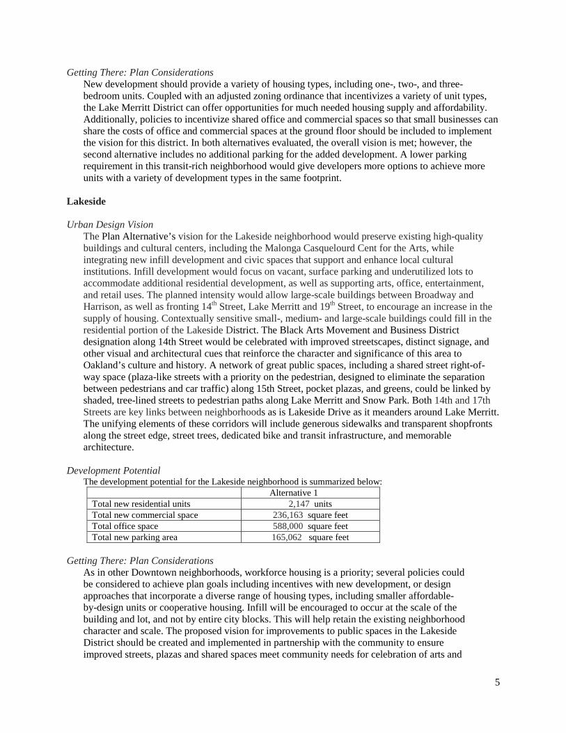
Lakeside Urban Design Vision
The Plan Alternative’s vision for the Lakeside neighborhood would preserve existing high-quality buildings and cultural centers, including the Malonga Casquelourd Cent for the Arts, while integrating new infill development and civic spaces that support and enhance local cultural institutions. Infill development would focus on vacant, surface parking and underutilized lots to accommodate additional residential development, as well as supporting arts, office, entertainment, and retail uses. The planned intensity would allow large-scale buildings between Broadway and Harrison, as well as fronting 14th Street, Lake Merritt and 19th Street, to encourage an increase in the supply of housing. Contextually sensitive small-, medium- and large-scale buildings could fill in the residential portion of the Lakeside District. The Black Arts Movement and Business District designation along 14th Street would be celebrated with improved streetscapes, distinct signage, and other visual and architectural cues that reinforce the character and significance of this area to Oakland’s culture and history. A network of great public spaces, including a shared street right-of-way space (plaza-like streets with a priority on the pedestrian, designed to eliminate the separation between pedestrians and car traffic) along 15th Street, pocket plazas, and greens, could be linked by shaded, tree-lined streets to pedestrian paths along Lake Merritt and Snow Park. Both 14th and 17th Streets are key links between neighborhoods as is Lakeside Drive as it meanders around Lake Merritt. The unifying elements of these corridors will include generous sidewalks and transparent shopfronts along the street edge, street trees, dedicated bike and transit infrastructure, and memorable architecture.
Development Potential
The development potential for the Lakeside neighborhood is summarized below: Alternative 1 Total new residential units 2,147 units Total new commercial space 236,163 square feet Total office space 588,000 square feet Total new parking area 165,062 square feet
Getting There: Plan Considerations
As in other Downtown neighborhoods, workforce housing is a priority; several policies could be considered to achieve plan goals including incentives with new development, or design approaches that incorporate a diverse range of housing types, including smaller affordable-by-design units or cooperative housing. Infill will be encouraged to occur at the scale of the building and lot, and not by entire city blocks. This will help retain the existing neighborhood character and scale. The proposed vision for improvements to public spaces in the Lakeside District should be created and implemented in partnership with the community to ensure improved streets, plazas and shared spaces meet community needs for celebration of arts and
5
cultural heritage. Establishing institutional leadership, such as an arts commission, or partnering with existing community groups, to work in conjunction with the City in establishing priorities, defining specific projects, and detailing designs could be a first step.
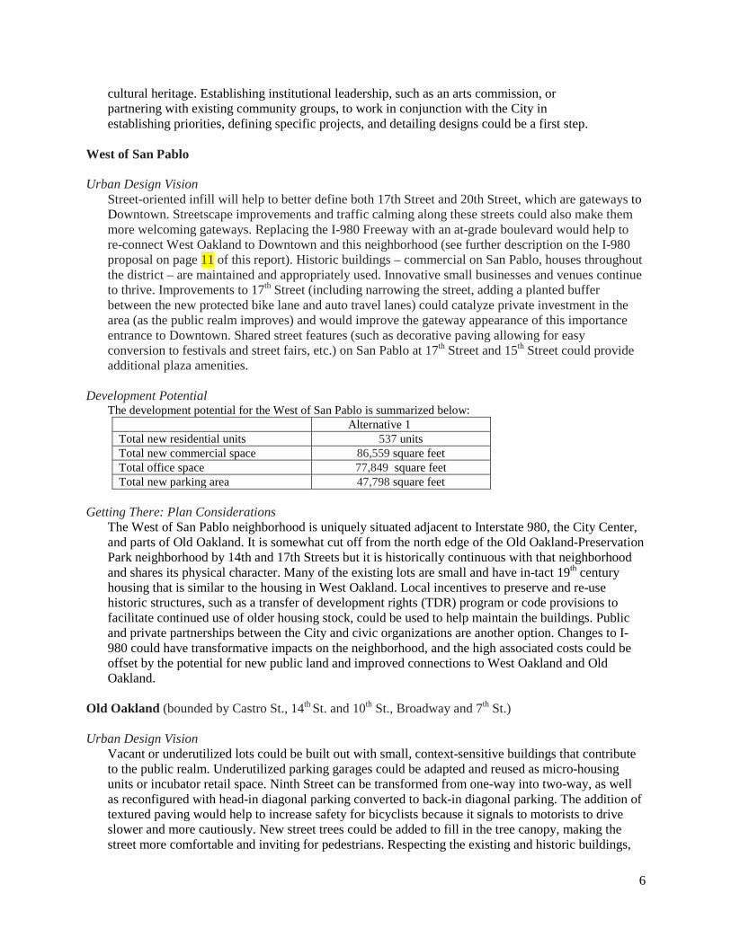
West of San Pablo Urban Design Vision
Street-oriented infill will help to better define both 17th Street and 20th Street, which are gateways to Downtown. Streetscape improvements and traffic calming along these streets could also make them more welcoming gateways. Replacing the I-980 Freeway with an at-grade boulevard would help to re-connect West Oakland to Downtown and this neighborhood (see further description on the I-980 proposal on page 11 of this report). Historic buildings – commercial on San Pablo, houses throughout the district – are maintained and appropriately used. Innovative small businesses and venues continue to thrive. Improvements to 17th Street (including narrowing the street, adding a planted buffer between the new protected bike lane and auto travel lanes) could catalyze private investment in the area (as the public realm improves) and would improve the gateway appearance of this importance entrance to Downtown. Shared street features (such as decorative paving allowing for easy conversion to festivals and street fairs, etc.) on San Pablo at 17th Street and 15th Street could provide additional plaza amenities.
Development Potential
The development potential for the West of San Pablo is summarized below: Alternative 1 Total new residential units 537 units Total new commercial space 86,559 square feet Total office space 77,849 square feet Total new parking area 47,798 square feet
Getting There: Plan Considerations
The West of San Pablo neighborhood is uniquely situated adjacent to Interstate 980, the City Center, and parts of Old Oakland. It is somewhat cut off from the north edge of the Old Oakland-Preservation Park neighborhood by 14th and 17th Streets but it is historically continuous with that neighborhood and shares its physical character. Many of the existing lots are small and have in-tact 19th century housing that is similar to the housing in West Oakland. Local incentives to preserve and re-use historic structures, such as a transfer of development rights (TDR) program or code provisions to facilitate continued use of older housing stock, could be used to help maintain the buildings. Public and private partnerships between the City and civic organizations are another option. Changes to I-980 could have transformative impacts on the neighborhood, and the high associated costs could be offset by the potential for new public land and improved connections to West Oakland and Old Oakland.
Old Oakland (bounded by Castro St., 14th St. and 10th St., Broadway and 7th St.) Urban Design Vision
Vacant or underutilized lots could be built out with small, context-sensitive buildings that contribute to the public realm. Underutilized parking garages could be adapted and reused as micro-housing units or incubator retail space. Ninth Street can be transformed from one-way into two-way, as well as reconfigured with head-in diagonal parking converted to back-in diagonal parking. The addition of textured paving would help to increase safety for bicyclists because it signals to motorists to drive slower and more cautiously. New street trees could be added to fill in the tree canopy, making the street more comfortable and inviting for pedestrians. Respecting the existing and historic buildings,
6
new development can complement the character of Old Oakland. At the west edge, the transformation of I-980 into a surface boulevard enhances the neighborhood by creating a better experience on Castro Street.
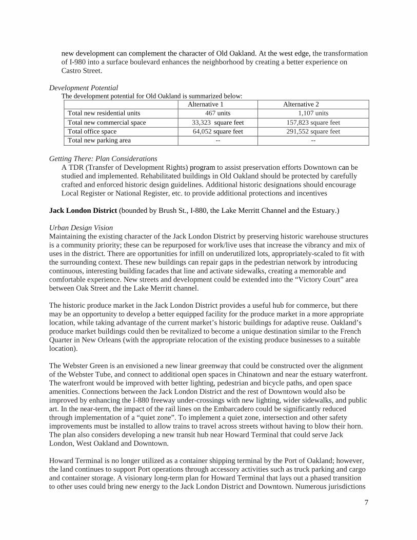
Development Potential The development potential for Old Oakland is summarized below:
Alternative 1 Alternative 2 Total new residential units 467 units 1,107 units Total new commercial space 33,323 square feet 157,823 square feet Total office space 64,052 square feet 291,552 square feet Total new parking area -- --
Getting There: Plan Considerations
A TDR (Transfer of Development Rights) program to assist preservation efforts Downtown can be studied and implemented. Rehabilitated buildings in Old Oakland should be protected by carefully crafted and enforced historic design guidelines. Additional historic designations should encourage Local Register or National Register, etc. to provide additional protections and incentives
Jack London District (bounded by Brush St., I-880, the Lake Merritt Channel and the Estuary.) Urban Design Vision Maintaining the existing character of the Jack London District by preserving historic warehouse structures is a community priority; these can be repurposed for work/live uses that increase the vibrancy and mix of uses in the district. There are opportunities for infill on underutilized lots, appropriately-scaled to fit with the surrounding context. These new buildings can repair gaps in the pedestrian network by introducing continuous, interesting building facades that line and activate sidewalks, creating a memorable and comfortable experience. New streets and development could be extended into the “Victory Court” area between Oak Street and the Lake Merritt channel. The historic produce market in the Jack London District provides a useful hub for commerce, but there may be an opportunity to develop a better equipped facility for the produce market in a more appropriate location, while taking advantage of the current market’s historic buildings for adaptive reuse. Oakland’s produce market buildings could then be revitalized to become a unique destination similar to the French Quarter in New Orleans (with the appropriate relocation of the existing produce businesses to a suitable location). The Webster Green is an envisioned a new linear greenway that could be constructed over the alignment of the Webster Tube, and connect to additional open spaces in Chinatown and near the estuary waterfront. The waterfront would be improved with better lighting, pedestrian and bicycle paths, and open space amenities. Connections between the Jack London District and the rest of Downtown would also be improved by enhancing the I-880 freeway under-crossings with new lighting, wider sidewalks, and public art. In the near-term, the impact of the rail lines on the Embarcadero could be significantly reduced through implementation of a “quiet zone”. To implement a quiet zone, intersection and other safety improvements must be installed to allow trains to travel across streets without having to blow their horn. The plan also considers developing a new transit hub near Howard Terminal that could serve Jack London, West Oakland and Downtown. Howard Terminal is no longer utilized as a container shipping terminal by the Port of Oakland; however, the land continues to support Port operations through accessory activities such as truck parking and cargo and container storage. A visionary long-term plan for Howard Terminal that lays out a phased transition to other uses could bring new energy to the Jack London District and Downtown. Numerous jurisdictions
7
have regulations applicable to the property. Despite the complicated system of approvals, there is still optimism over the range of future development possibilities. The Plan Alternatives Report contains three scenarios for the reuse of the site: stadium scenario,transit oriented development scenario and combined scenario. The development potential of each scenario is presented below. Development Potential
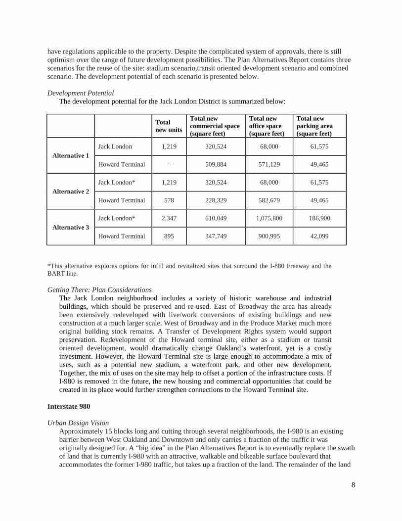
The development potential for the Jack London District is summarized below:
Total new units
Total new commercial space (square feet)
Total new office space (square feet)
Total new parking area (square feet)
Alternative 1 Jack London 1,219 320,524 68,000 61,575
Howard Terminal -- 509,884 571,129 49,465
Alternative 2 Jack London* 1,219 320,524 68,000 61,575
Howard Terminal 578 228,329 582,679 49,465
Alternative 3 Jack London* 2,347 610,049 1,075,800 186,900
Howard Terminal 895 347,749 900,995 42,099
*This alternative explores options for infill and revitalized sites that surround the I-880 Freeway and the BART line. Getting There: Plan Considerations
The Jack London neighborhood includes a variety of historic warehouse and industrial buildings, which should be preserved and re-used. East of Broadway the area has already been extensively redeveloped with live/work conversions of existing buildings and new construction at a much larger scale. West of Broadway and in the Produce Market much more original building stock remains. A Transfer of Development Rights system would support preservation. Redevelopment of the Howard terminal site, either as a stadium or transit oriented development, would dramatically change Oakland’s waterfront, yet is a costly investment. However, the Howard Terminal site is large enough to accommodate a mix of uses, such as a potential new stadium, a waterfront park, and other new development. Together, the mix of uses on the site may help to offset a portion of the infrastructure costs. If I-980 is removed in the future, the new housing and commercial opportunities that could be created in its place would further strengthen connections to the Howard Terminal site.
Interstate 980 Urban Design Vision
Approximately 15 blocks long and cutting through several neighborhoods, the I-980 is an existing barrier between West Oakland and Downtown and only carries a fraction of the traffic it was originally designed for. A “big idea” in the Plan Alternatives Report is to eventually replace the swath of land that is currently I-980 with an attractive, walkable and bikeable surface boulevard that accommodates the former I-980 traffic, but takes up a fraction of the land. The remainder of the land
8
could be used to reconnect the downtown street grid to West Oakland, and thereby create a new set of blocks for both public spaces and appropriately scaled development with a mix of market and affordable housing.
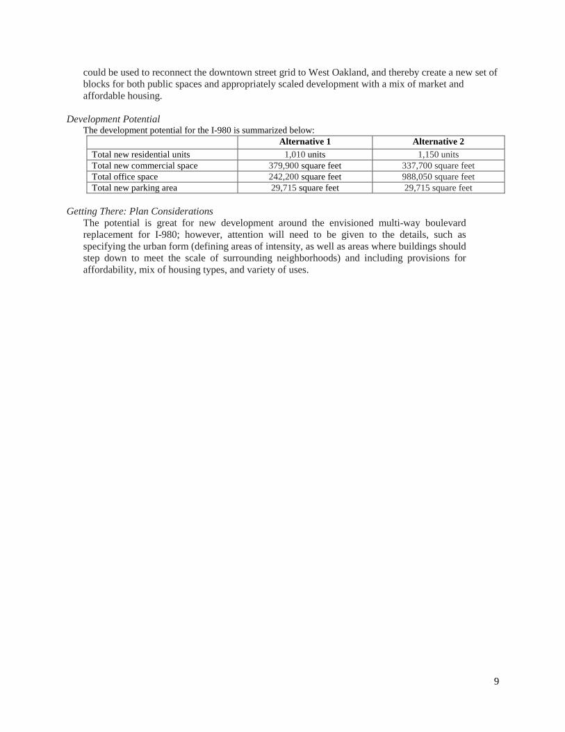
Development Potential
The development potential for the I-980 is summarized below: Alternative 1 Alternative 2 Total new residential units 1,010 units 1,150 units Total new commercial space 379,900 square feet 337,700 square feet Total office space 242,200 square feet 988,050 square feet Total new parking area 29,715 square feet 29,715 square feet
Getting There: Plan Considerations
The potential is great for new development around the envisioned multi-way boulevard replacement for I-980; however, attention will need to be given to the details, such as specifying the urban form (defining areas of intensity, as well as areas where buildings should step down to meet the scale of surrounding neighborhoods) and including provisions for affordability, mix of housing types, and variety of uses.
9

Attachment B
Plan Alternatives Report available online at: www.oaklandnet.com/plandowntownoakland
Lake Merritt
Lake Merritt
Old Oakland
DowntownHistoric
Grove Street Residential
Cathedral
7th Street Residential
Waterfront Warehouse
SP Railroad Industrial
Lakeside Apartment
Uptown Commercial
Produce Market
25th StGarage
PG&E Station "C"
Grove/Castro/19th Streets
17th StCommercial
244 Lakeside DrGroup
Coit BuildingGroup
Leamington Hotel Group
18th & Grove House Group
Muller Brothers Pickle Factory
15th and Grove House Group
Wholesale Produce Market
§̈¦980
§̈¦880
Historic DistrictsPlanning and Building Department
Z0 490 980Feet
LakeMerritt
LegendAreas of Primary Importance
Areas of Secondary Importance
Attachment C
The information is based on the City's current GIS data. Because thestatus of layers shown on the map can change, and the GIS data maycontain errors, omissions or inaccuracies, the information providedin this map is for reference only, not intended for any other use andshould not be relied on for any other purpose.
1
2
3
4
56
7
89
10
11
12
1313
14
15
16
17
1819
20
21
22
23
242526
2728
29
30
31
32
33
3435
36
37
38
39
40
41
4243
44
4546
47
48
49
50
52
53
54
52
§̈¦980
§̈¦880
LandmarksPlanning and Building Department
Z0 500 1,000Feet
LakeMerritt
Legend
Howden (Robert A.) BuildingJefferson SquareLafayette SquareLakeside Park and Wildife Refuge
20212223
Latham Square FountainLeamington Hotel & AnnexMaclise Drug Store-Harding Block
242526
Nicholl(John)Block32
28 Malonga Casquelourd Center for the Arts
Madison-Lake Apartments27
Municipal Boathouse30Mason-Elsey-Wilson House29
31 Necklace of Lights
33 Oakland Iron Works Machine & Blacksmith ShopOakland City HallOakland Public Library/AAMLOOakland Title Insurance Co.BuildingOriental Block-Peniel MissionPalace ApartmentsParamount TheatrePardee (Enoch H. & George C.) House
37
343536383940
Posey Tube PortalRoos Brothers Store BuildingRotunda BuildingSecurity Bank & Trust-Key System Building
41424344
American Bag Company2Alameda County Title Insurance Building1Breuner Co.- Oakland Tribune Building3Broadway Building, Lionel Wilson Building (Historic Name:First National Bank Building)
4Brown (Bowman) Building & Annex5Camron-Stanford House6Central Pacific Railroad Depot7Dunn Block9Financial Center Building11First Unitarian Church12
White (James) House50
Snyder (A.J.) Block (first)45
White (Mrs. A.E.) Building51
Snyder (A.J.) Block (second) -Ross House46
U.S.S. Potomac48Western Pacific Railroad Depot49
Wilcox (P.S.) Block52Wilcox (P.S.) Block Annex
53YWCA Building54
Greek Orthodox Church of the Assumption16Gooch (A.J.) Block-Winsor House15Ginn (Frederick B.) House-Nile Club14Fox West Coast Oakland Theater Building13
Heinold's First & Last Chance Saloon17Henry House18Hotel Oakland19
Federal Realty Co.- Cathedral Building10
St. Paul's First Swedish Evangelical Church/New St. Paul M.B.C.
47
Delger (Frederick) Block #1 - Lawyers Block8
Attachment D
The information is based on the City's current GIS data. Because thestatus of layers shown on the map can change, and the GIS data maycontain errors, omissions or inaccuracies, the information providedin this map is for reference only, not intended for any other use andshould not be relied on for any other purpose.