Embed Size (px)
Citation preview

Resettlement Plan Document Stage: Draft Project Number: 40919 November 2008
NEP: WEST SETI HYDROELECTRIC PROJECT Reservoir Area and Downstream Project Components
Resettlement Planning Document
Prepared by West Seti Hydro Limited for the Asian Development Bank (ADB).
The resettlement plan is a document of the borrower. The views expressed herein do not necessarily represent those of ADB’s Board of Directors, Management, or staff, and may be preliminary in nature.

WEST SETI HYDROELECTRIC PROJECT
ENVIRONMENTAL IMPACT ASSESSMENT
Volume 3
RESETTLEMENT PLAN: RESERVOIR AREA AND DOWNSTREAM PROJECT
COMPONENTS
West Seti Hydro Limited 1611 Lamtangin Marg, Maharajgunj
Kathmandu, Nepal
October 2008 (Revision 4)

WEST SETI HYDROELECTRIC PROJECT RESETTLEMENT PLAN: RESERVOIR AREA AND DOWNSTREAM PROJECT COMPONENTS (Rev-4)
WEST SETI HYDRO LTD. OCTOBER 2008 I
TABLE OF CONTENTS
SUPPORTING DOCUMENTS ............................................................................................................................. V
LIST OF TABLES ..................................................................................................................................................... V
LIST OF FIGURES ................................................................................................................................................ VII
LIST OF PHOTOS ................................................................................................................................................ VII
ABBREVIATIONS ............................................................................................................................................. VIII
GLOSSARY OF LOCAL TERMS ......................................................................................................................... IX
LAND CONVERSIONS AND TERMINOLOGY .............................................................................................. X
EXECUTIVE SUMMARY ...................................................................................................................................... XI
1. INTRODUCTION ........................................................................................................................................ 1-1
1.1 PROJECT BACKGROUND ........................................................................................................................... 1-1 1.2 PROJECT STUDIES ..................................................................................................................................... 1-2 1.3 PROJECT IMPACTS..................................................................................................................................... 1-2 1.4 AIMS OF THE RESETTLEMENT PLAN ........................................................................................................ 1-3 1.5 REPORT LAYOUT ...................................................................................................................................... 1-4
2. METHODOLOGY ........................................................................................................................................ 2-1
2.1 EIA RESEARCH AND DATA COLLECTION ............................................................................................... 2-1 2.2 FOLLOW-UP RESEARCH, DATA COLLECTION AND CONSULTATION ..................................................... 2-2 2.3 CONSTRAINTS AND LIMITATIONS ............................................................................................................ 2-4
3. PROJECT DESCRIPTION .......................................................................................................................... 3-1
3.1 PROJECT COMPONENTS............................................................................................................................ 3-1 3.2 CONSTRUCTION PROGRAMME ................................................................................................................. 3-5
4. THE SOCIAL ENVIRONMENT ................................................................................................................ 4-1
4.1 REGIONAL CONTEXT ................................................................................................................................ 4-1 4.1.1 Population and Demography ............................................................................................................ 4-1 4.1.2 Caste/Ethnicity ................................................................................................................................. 4-2 4.1.3 Development Context ....................................................................................................................... 4-3 4.1.4 Economic Activities and Livelihoods ................................................................................................ 4-3 4.1.5 Poverty .............................................................................................................................................. 4-5
4.2 PROJECT AREA ......................................................................................................................................... 4-6 4.2.1 Settlement Patterns .......................................................................................................................... 4-6 4.2.2 Access and Movement Patterns ........................................................................................................ 4-8 4.2.3 Population and Demography ............................................................................................................ 4-9 4.2.4 Education ........................................................................................................................................ 4-12 4.2.5 Health and Sanitation ..................................................................................................................... 4-14 4.2.6 Land Tenure and Landholdings ...................................................................................................... 4-15 4.2.7 Use of Forest and Other Natural Resources ................................................................................... 4-17 4.2.8 Seti River Use ................................................................................................................................. 4-17 4.2.9 Occupational Patterns and Livelihoods .......................................................................................... 4-18 4.2.10 Income and Expenditure ................................................................................................................. 4-22 4.2.11 Poverty ............................................................................................................................................ 4-25

WEST SETI HYDROELECTRIC PROJECT RESETTLEMENT PLAN: RESERVOIR AREA AND DOWNSTREAM PROJECT COMPONENTS (Rev-4)
WEST SETI HYDRO LTD. OCTOBER 2008 II
4.2.12 Vulnerable Groups/Social Categories ............................................................................................. 4-26
5. SCOPE OF LAND ACQUISITION AND RESETTLEMENT ............................................................... 5-1
5.1 RATIONALE FOR LAND ACQUISITION ..................................................................................................... 5-1 5.1.1 Motivation for the Project................................................................................................................. 5-1 5.1.2 Project Type and Design Alternatives .............................................................................................. 5-1 5.1.3 Efforts to Minimise Land Acquisition and Resettlement ................................................................. 5-2
5.2 PROJECT LAND REQUIREMENT ................................................................................................................ 5-2 5.3 KEY SOCIAL ISSUES AND IMPACTS ........................................................................................................... 5-3 5.4 HOUSEHOLDS AND POPULATION ............................................................................................................ 5-4 5.5 PRIVATE LAND ......................................................................................................................................... 5-8 5.6 POPULATION DISPLACEMENT AND RESETTLEMENT ............................................................................... 5-9 5.7 BUILDINGS/STRUCTURES .......................................................................................................................... 5-9
5.7.1 Houses and Buildings ....................................................................................................................... 5-9 5.7.2 Schools ............................................................................................................................................ 5-11 5.7.3 Other Social Infrastructure ............................................................................................................ 5-12
5.8 TREES ...................................................................................................................................................... 5-14 5.9 FOREST AND RIVER RESOURCES ............................................................................................................ 5-15 5.10 SOCIAL IMPACTS OF ALTERED RIVER FLOWS ........................................................................................ 5-15 5.11 ACCESS AND MOVEMENT ...................................................................................................................... 5-16
6. LEGAL AND POLICY FRAMEWORK ..................................................................................................... 6-1
6.1 NATIONAL CONTEXT ............................................................................................................................... 6-1 6.1.1 Constitutional Guarantees ............................................................................................................... 6-1 6.1.2 Land Acquisition Act, 2034 (1977) .................................................................................................. 6-1 6.1.3 Land Act, 1964 ................................................................................................................................. 6-2 6.1.4 Guthi Corporation Act, 1976 ............................................................................................................ 6-2 6.1.5 National Policy on Land Acquisition, Compensation and Resettlement, 2006 ................................ 6-4 6.1.6 Tenth Plan 2002-2007 ...................................................................................................................... 6-5 6.1.7 Hydropower Development Policy, 2001 ........................................................................................... 6-5 6.1.8 Local Self Governance Regulation, 2000 .......................................................................................... 6-5 6.1.9 Compensation and Resettlement Practices on Hydroelectric Projects in Nepal ............................... 6-5
6.2 ADB POLICY GUIDELINES ....................................................................................................................... 6-8 6.3 WSHEP RESETTLEMENT POLICY ........................................................................................................... 6-10
7. CONSULTATION AND PUBLIC DISCLOSURE .................................................................................. 7-1
7.1 EIA CONSULTATION PROGRAMME (1997-1999) .................................................................................... 7-1 7.1.1 Community Meetings ....................................................................................................................... 7-1 7.1.2 Socio-Economic Survey .................................................................................................................... 7-3 7.1.3 Information Sheets ............................................................................................................................ 7-4 7.1.4 Consultations in Terai Resettlement Districts ................................................................................. 7-4 7.1.5 Consultative Committee ................................................................................................................... 7-4 7.1.6 Public Hearings ................................................................................................................................ 7-5
7.2 CONSULTATION ACTIVITIES IN THE POST-EIA PERIOD (2006-2008) ..................................................... 7-5 7.2.1 Community Meetings ....................................................................................................................... 7-6 7.2.2 Socio-Economic Survey .................................................................................................................... 7-7 7.2.3 Information Sheets and Project Documents ..................................................................................... 7-9 7.2.4 Establishment of Community Consultation Structure ..................................................................... 7-9 7.2.5 Appointment of Consultation Staff ................................................................................................ 7-10 7.2.6 Establishment of Information Centres ............................................................................................ 7-11 7.2.7 Consultations in Terai Resettlement Districts ............................................................................... 7-12
7.3 SUMMARY OF CONSULTATIONS ............................................................................................................. 7-12 7.4 FURTHER CONSULTATION AND DISCLOSURE ....................................................................................... 7-14

WEST SETI HYDROELECTRIC PROJECT RESETTLEMENT PLAN: RESERVOIR AREA AND DOWNSTREAM PROJECT COMPONENTS (Rev-4)
WEST SETI HYDRO LTD. OCTOBER 2008 III
8. RESETTLEMENT FRAMEWORK ............................................................................................................. 8-1
8.1 CONSIDERATIONS ..................................................................................................................................... 8-1 8.1.1 Magnitude of Displacement.............................................................................................................. 8-1 8.1.2 Land-Based Resettlement .................................................................................................................. 8-1 8.1.3 Relocation to the Terai ...................................................................................................................... 8-1 8.1.4 Dispersed Resettlement Pattern ....................................................................................................... 8-2
8.2 RELOCATION OPTIONS AND ELIGIBILITY ................................................................................................ 8-2 8.3 RELOCATION TO THE TERAI ..................................................................................................................... 8-4
8.3.1 Socio-Economic Conditions in Terai Resettlement Districts ............................................................ 8-4 8.3.2 Land Requirement and Availability ................................................................................................. 8-6 8.3.3 Constraints ....................................................................................................................................... 8-8 8.3.4 Site Planning .................................................................................................................................... 8-9 8.3.5 Terai Subsistence Level Landholding ............................................................................................... 8-9 8.3.6 Services and Facilities ..................................................................................................................... 8-10 8.3.7 Consultation Programme ............................................................................................................... 8-10 8.3.8 Programme for Land Purchase and Development .......................................................................... 8-11
8.4 LOCAL RELOCATION .............................................................................................................................. 8-15 8.5 SELF-RELOCATION ................................................................................................................................. 8-16
9. COMPENSATION AND LIVELIHOOD RESTORATION .................................................................. 9-1
9.1 AFFECTED PERSONS AND CATEGORIES OF LOSS ..................................................................................... 9-1 9.2 ASSET VERIFICATION AND COMPENSATION DETERMINATION AND PAYMENT .................................... 9-2 9.3 ENTITLEMENTS ......................................................................................................................................... 9-3
9.3.1 Houses and Other Structures ........................................................................................................... 9-3 9.3.2 Businesses ......................................................................................................................................... 9-4 9.3.3 Land and Other Natural Resources .................................................................................................. 9-4 9.3.4 Compensation for Temporary Land Occupation .............................................................................. 9-8 9.3.5 Trees and Crops ................................................................................................................................ 9-8 9.3.6 Community Facilities and Services .................................................................................................. 9-9 9.3.7 Loss of Communal Resources ........................................................................................................... 9-9 9.3.8 Tenants and Landless Households .................................................................................................... 9-9
9.4 REHABILITATION ALLOWANCES ........................................................................................................... 9-10 9.5 LIVELIHOOD RESTORATION INITIATIVES ............................................................................................... 9-11
9.5.1 Minimum Subsistence Landholding ............................................................................................... 9-11 9.5.2 Terai Orientation Programmes ....................................................................................................... 9-11 9.5.3 Terai Agricultural Support Programme ......................................................................................... 9-11 9.5.4 Construction Skills Training .......................................................................................................... 9-12 9.5.5 Preferential Employment Strategy ................................................................................................. 9-12 9.5.6 Water and Sanitation Programme in the Downstream Riparian Area .......................................... 9-13 9.5.7 Agricultural Programme in the Seti Valley .................................................................................... 9-14 9.5.8 Community Forestry ...................................................................................................................... 9-14 9.5.9 Mitigation Projects for Fish/Fishing .............................................................................................. 9-15 9.5.10 School Assistance Programme ........................................................................................................ 9-15 9.5.11 Health Service Improvement .......................................................................................................... 9-16 9.5.12 Shareholding ................................................................................................................................... 9-16
9.6 PROJECT USE OF LOCAL CONSTRUCTION MATERIALS ......................................................................... 9-16 9.7 TEACHERS AND OTHER GOVERNMENT OFFICIALS ............................................................................... 9-16 9.8 LAND ACQUISITION AND TRANSFER ..................................................................................................... 9-16
10. INSTITUTIONAL AND ORGANISATIONAL ARRANGEMENTS ........................................... 10-1
10.1 WSH RESETTLEMENT AND DEVELOPMENT DIVISION .......................................................................... 10-2 10.1.1 Technical and Field Support Branch .............................................................................................. 10-3

WEST SETI HYDROELECTRIC PROJECT RESETTLEMENT PLAN: RESERVOIR AREA AND DOWNSTREAM PROJECT COMPONENTS (Rev-4)
WEST SETI HYDRO LTD. OCTOBER 2008 IV
10.1.2 Resettlement Field Operations Branch ........................................................................................... 10-6 10.1.3 Resettlement Housing and Special Projects ................................................................................... 10-7
10.2 RESETTLEMENT STEERING COMMITTEE AND DISTRICT COORDINATING COMMITTEES ...................... 10-9 10.3 COMMUNITY PARTICIPATION PROGRAMME ........................................................................................10-10
10.3.1 Community Consultation and Participation Structure ................................................................10-10 10.3.2 Community Liaison Assistants .....................................................................................................10-12 10.3.3 Information Centres .......................................................................................................................10-13
10.4 COORDINATION WITH OTHER AGENCIES ............................................................................................10-14 10.5 GRIEVANCE AND DISPUTE RESOLUTION ..............................................................................................10-14
11. MONITORING AND EVALUATION ............................................................................................... 11-1
11.1 MONITORING FRAMEWORK ................................................................................................................... 11-1 11.2 PERFORMANCE MONITORING................................................................................................................ 11-2 11.3 IMPACT MONITORING ............................................................................................................................ 11-3
11.3.1 Standardised (Quantitative) Monitoring ....................................................................................... 11-3 11.3.2 Participatory (Qualitative) Monitoring ......................................................................................... 11-3
11.4 EVALUATION PANEL .............................................................................................................................. 11-4 11.5 COMPLETION AUDIT .............................................................................................................................. 11-5 11.6 REPORTING ............................................................................................................................................. 11-5
12. IMPLEMENTATION PROGRAMME ................................................................................................ 12-1
12.1 CONSTRUCTION SCHEDULE ................................................................................................................... 12-1 12.2 RESETTLEMENT STAGES ......................................................................................................................... 12-1
12.2.1 Stage 1 Resettlement: Advanced Infrastructure and Construction Areas...................................... 12-4 12.2.2 Stage 2 Resettlement: Partial Inundation (EL 1,130 m) ................................................................ 12-4 12.2.3 Stage 3 Resettlement: Partial Inundation (EL 1,188 m) ................................................................ 12-4 12.2.4 Stage 4 Resettlement: Partial Inundation (EL 1,188 m + 96 m) .................................................... 12-5 12.2.5 Stage 5: Post Inundation ................................................................................................................ 12-5
12.3 RESETTLEMENT SCHEDULE .................................................................................................................... 12-5 12.4 EQUITABLE TREATMENT OF HOUSEHOLDS ........................................................................................... 12-6 12.5 UNCERTAINTIES AND RISKS ................................................................................................................... 12-7
13. RESETTLEMENT BUDGET ................................................................................................................. 13-1
13.1 COMPENSATION FOR BUILDINGS AND STRUCTURES ............................................................................. 13-1 13.2 LAND ACQUISITION AND REPLACEMENT ............................................................................................. 13-1 13.3 LEASING OF TEMPORARILY ACQUIRED LAND....................................................................................... 13-1 13.4 COMPENSATION FOR TREE LOSSES ........................................................................................................ 13-1 13.5 COMMUNITY FACILITIES AND SITE DEVELOPMENT .............................................................................. 13-2 13.6 ALLOWANCES ........................................................................................................................................ 13-2 13.7 EMPLOYMENT AND LOCAL DEVELOPMENT .......................................................................................... 13-2 13.8 MANAGEMENT AND ADMINISTRATION ................................................................................................ 13-2 13.9 CONTINGENCIES ..................................................................................................................................... 13-2
14. REFERENCES .......................................................................................................................................... 14-1
15. APPENDIX 1: ENTITLEMENT MATRIX........................................................................................... 15-1

WEST SETI HYDROELECTRIC PROJECT RESETTLEMENT PLAN: RESERVOIR AREA AND DOWNSTREAM PROJECT COMPONENTS (Rev-4)
WEST SETI HYDRO LTD. OCTOBER 2008 V
S UP P OR T ING DOC UME NT S
The following supporting documents are provided in a separate volume: 1 List of households interviewed for the EIA. 2 Frequency tables from the 1997/98 and 2006 household surveys. 3 Riparian villages between the dam wall and the re-regulation weir. 4 List of nominated community representatives on the LCFs during the EIA study. 5 Information sheets. 6 Buildings recorded in the reservoir area (1997/98). 7 Schools recorded in the reservoir area and periphery (1997/98). 8 Land exchange ratios. 9 Monitoring indicators. 10 Construction workforce. 11 Selected socio-economic indicators for the Terai resettlement districts. 12 List of community committee members (2007-present). 13 Compensation and resettlement resolutions of participating community committees (31 July 2008).
L IS T OF T AB L E S
Table 1-1: Primary Social Issues and Impacts .................................................................................................... 1-2Table 1-2: Households Affected by Reservoir and Downstream Project Components ................................ 1-3Table 3-1: Proposed Access Roads ....................................................................................................................... 3-4Table 3-2: Estimated Construction Workforce ................................................................................................... 3-6Table 4-1: Population Figures and Densities in the Far Western Development Region .............................. 4-2Table 4-2: Caste/Ethnic Composition of the FWDR Population (2001) .......................................................... 4-3Table 4-3: Development Status of Districts in the FWDR (2004) ..................................................................... 4-3Table 4-4: Occupational Status of the Economically Active Population in the FWDR (2001) ..................... 4-4Table 4-5: Household and Per Capita Income in the FWDR (2004) ................................................................ 4-5Table 4-6: Incidence of Poverty by Region ......................................................................................................... 4-5Table 4-7: Villages in the Reservoir Area and Periphery .................................................................................. 4-7Table 4-8: Villages in the Downstream Riparian Area ..................................................................................... 4-8Table 4-9: Households and Population in the Project Area VDCs (1991 and 2001) .................................... 4-10Table 4-10: Age, Gender and Residential Status of the Surveyed Population (1997/98 and 2006) .................. 4-11Table 4-11: Caste/Ethnic Groups in the Reservoir Area (1997/98 and 2006) ................................................ 4-11Table 4-12: Involvement of Women in Decision-Making ............................................................................... 4-12Table 4-13: Literacy/Educational Levels, Population 6 Years and Older (1997/98 and 2006) .................... 4-13Table 4-14: Sources of Water for all Purposes (2006) ...................................................................................... 4-14Table 4-15: Reported Landholding Sizes in the Reservoir Area (1997/98 and 2006) .................................. 4-16Table 4-16: Reported Landholding Sizes in the Reservoir Area (1997/98) ................................................... 4-16Table 4-17: Seti River Use in Riparian Villages (1998) .................................................................................... 4-18Table 4-18: Occupational Status of the Surveyed Population 15 Years and Older (2006) .......................... 4-19Table 4-19: Skills Reported in the Reservoir Area, Population 15 Years and Older (2006) ....................... 4-19Table 4-20: Division of Labour by Sex in the Reservoir Area (2006) ............................................................. 4-20Table 4-21: Selected Agricultural Statistics from the Sample Survey (2006) ................................................ 4-20Table 4-22: Food Sufficiency Status of Surveyed Households (2006) ........................................................... 4-21Table 4-23: Livestock Ownership in the Reservoir Area (1997/98) ............................................................... 4-21Table 4-24: Off-Farm Income Sources in the Reservoir Area (2006) ............................................................. 4-22Table 4-25: Average Annual Household Income (2006) ................................................................................. 4-23Table 4-26: Classification of Households by Income Range (2006) ............................................................... 4-24

WEST SETI HYDROELECTRIC PROJECT RESETTLEMENT PLAN: RESERVOIR AREA AND DOWNSTREAM PROJECT COMPONENTS (Rev-4)
WEST SETI HYDRO LTD. OCTOBER 2008 VI
Table 4-27: Average Annual Expenditure Pattern of Surveyed Households (2006) .................................. 4-24Table 4-28: Distribution of Absolute Poor Households by VDC (2006) ....................................................... 4-25Table 4-29: Absolute Poor Households by Caste and Ethnicity .................................................................... 4-25Table 5-1: Project Land Requirement .................................................................................................................. 5-3Table 5-2: Permanently Required Land by Land Use Type ............................................................................. 5-3Table 5-3: Estimate of Affected Households ...................................................................................................... 5-4Table 5-4: Households in the Reservoir Area (1998 and 2006) ........................................................................ 5-5Table 5-5: Households and Population in the Reservoir Area (2006) ............................................................. 5-6Table 5-6: Households Affected by Other Project Components ...................................................................... 5-7Table 5-7: Cultivation Land in the Reservoir Area and No Habitation Zone ................................................ 5-8Table 5-8: Affected Households by Resettlement Category ............................................................................ 5-9Table 5-9: Buildings in the Reservoir Area (1998) ........................................................................................... 5-10Table 5-10: Schools to be Relocated from the Reservoir Area ........................................................................ 5-11Table 5-11 Temples/Shrines to be Relocated from the Reservoir Area ......................................................... 5-13Table 6-1: Resettlement Principles for the WSHEP ......................................................................................... 6-10Table 7-1: Composition of the Four Consultative Forums in the Project Area (1997/98) ............................. 7-2Table 7-2: Respondents’ Attitude Towards the Project (1997/98) .................................................................... 7-3Table 7-3: Respondents’ Attitude Towards the Project (2006) ......................................................................... 7-7Table 7-4: Response to Key Project Issues (2006) ............................................................................................... 7-8Table 7-5: Compensation Preferences (1997/98 and 2006) ................................................................................ 7-8Table 7-6: Resettlement Preference of Surveyed Households (2006) .............................................................. 7-9Table 7-7: Summary of Consultations and Information Dissemination 1(997-2008) .................................. 7-12Table 8-1: Affected Households by Resettlement Category ............................................................................ 8-4Table 8-2: Resettlement Preference of Surveyed Households ......................................................................... 8-4Table 8-3: Selected Socio-Economic Indicators of the Terai Resettlement Districts ...................................... 8-5Table 8-4: Replacement Land Requirement in the Terai .................................................................................. 8-6Table 8-5: Private Land Available for Purchase in Kailali, Kanchanpur and Bardiya Districts .................. 8-7Table 8-6: Additional Private Land Potentially Available for Purchase ........................................................ 8-8Table 8-7: Minimum Subsistence Land Requirements in Far-Western Terai .............................................. 8-10Table 8-8: Preliminary Programme - Land Identification, Assessment and Purchase ............................... 8-12Table 8-9: Preliminary Programme - Farm Planning ...................................................................................... 8-13Table 8-10: Preliminary Programme - House Design ..................................................................................... 8-14Table 8-11: Preliminary Programme - Farm Development and House Construction ................................ 8-15Table 9-1: Land Exchange Ratios (Seti Valley – Terai) ...................................................................................... 9-5Table 11-1: Monitoring Framework ................................................................................................................... 11-2Table 12-1: Key Project Construction Milestones ............................................................................................ 12-1Table 12-2: Affected Households by Resettlement Stage ............................................................................... 12-2Table 12-3: Villages by Resettlement Stage ...................................................................................................... 12-3Table 13-1: Resettlement Budget ........................................................................................................................ 13-3Table 13-2: Resettlement Staff ............................................................................................................................ 13-4

WEST SETI HYDROELECTRIC PROJECT RESETTLEMENT PLAN: RESERVOIR AREA AND DOWNSTREAM PROJECT COMPONENTS (Rev-4)
WEST SETI HYDRO LTD. OCTOBER 2008 VII
L IS T OF F IG UR E S
Figure 1-1: General Location of the West Seti Hydroelectric Project .............................................................. 1-1Figure 2-1: Example of 1st Page of the Main Household Database ................................................................. 2-3Figure 3-1: General Map of the Project Area ...................................................................................................... 3-1Figure 3-2: General View of the Project Area ..................................................................................................... 3-2Figure 3-3: Power Station Site .............................................................................................................................. 3-3Figure 3-4: Proposed Route of the Transmission Line ...................................................................................... 3-5Figure 4-1: Villages in the Reservoir Area and Periphery ................................................................................ 4-7Figure 5-1: Schematic Layout of Access Road to Toe of Dam Wall ................................................................ 5-7Figure 5-2: Schools in the Reservoir Area and Periphery ............................................................................... 5-12Figure 5-3: Temples in the Reservoir Area and Periphery ............................................................................. 5-13Figure 5-4: Existing and Proposed Footbridges in the Reservoir Area ........................................................ 5-14Figure 6-1: Flowchart of the Land Acquisition Process .................................................................................... 6-3Figure 8-1: Resettlement Districts in the Terai ................................................................................................... 8-5Figure 9-1: Entitlements for Landed Household Relocating to the Terai ...................................................... 9-6Figure 9-2: Entitlements for Landless Household Relocating to the Terai .................................................... 9-7Figure 9-3: Household Communal Resource Entitlement Calculation .......................................................... 9-7Figure 10-1: Overall Social and Environmental Management Structure ..................................................... 10-1Figure 10-2: WSH Resettlement and Development Division ......................................................................... 10-2Figure 10-3: RDD Organisational Setup ........................................................................................................... 10-8Figure 10-4: Community Participation Structure ...........................................................................................10-11Figure 10-5: Grievance Redress Procedure ......................................................................................................10-15Figure 12-1: Implementation Schedule (1) ........................................................................................................ 12-9Figure 12-2: Implementation Schedule (2) .......................................................................................................12-10Figure 12-3: Implementation Schedule (3) .......................................................................................................12-11
L IS T OF P HOT OS
Photo 4-1: A Section of Talara Village ................................................................................................................. 4-6Photo 4-2: Dhungad-Talara Suspension Bridge ................................................................................................ 4-8Photo 4-3: Crossing the Seti River by Rope ........................................................................................................ 4-9Photo 4-4: Ganesh Secondary School, Mohoribagar ....................................................................................... 4-13Photo 4-5: Cultivation Land in the Reservoir Area ......................................................................................... 4-15Photo 5-1: Houses in Dhungad .......................................................................................................................... 5-10Photo 5-2: Deura Market Area ........................................................................................................................... 5-11Photo 7-1: Community Meetings in Deura and Gopghat, 2007 ...................................................................... 7-6Photo 7-2: Dhungad Information Centre .......................................................................................................... 7-11Photo 7-3: Meeting with Downstream Committee at Gopghat Information Centre .................................. 7-11Photo 10-1: Meeting with the West Seti Power Station Concern Committee .............................................10-12Photo 10-2: Moribagar Information Centre, Reservoir Area .........................................................................10-13

WEST SETI HYDROELECTRIC PROJECT RESETTLEMENT PLAN: RESERVOIR AREA AND DOWNSTREAM PROJECT COMPONENTS (Rev-4)
WEST SETI HYDRO LTD. OCTOBER 2008 VIII
AB B R E V IAT IONS
ACRP Acquisition, Compensation and Rehabilitation Plan ADB Asian Development Bank ARMS Acquisition and Resettlement Management System BNI Basic Needs Income BOOT Build Own Operate Transfer CBS Central Bureau of Statistics CDC Compensation Determination Committee CDO Chief District Officer CPI Consumer Price Index DCC District Coordinating Committee DDC District Development Committee EDC Electricity Development Centre EIA Environmental Impact Assessment EL Elevation EMP Environmental Management Plan FGD Focus Group Discussion FSL Full Supply Level FWDR Far-Western Development Region GIS Geographic Information System GoN Government of Nepal GWh Gigawatt hour ha Hectare HDI Human Development Index INGO International Non-Governmental Organisation ISA Initial Social Assessment km Kilometre km2 Square kilometre kV Kilovolt LAA Land Acquisition Act LCF Local Consultative Forum m Metre M&E Monitoring and Evaluation MoEST Ministry of Environment, Science and Technology MOL Minimum Operating Level MoPE Ministry of Population and Environment MoWR Ministry of Water Resources MT Metric Tonne MW Megawatt NEFIN Nepal Federation of Indigenous Nationalities NGO Non-Governmental Organisation NLSS Nepal Living Standards Survey NPC National Planning Commission NRs Nepal Rupee PAF Project Affected Family PDBC Plant Design and Build Contractor PME Participatory Monitoring and Evaluation PPA Power Purchase Agreement

WEST SETI HYDROELECTRIC PROJECT RESETTLEMENT PLAN: RESERVOIR AREA AND DOWNSTREAM PROJECT COMPONENTS (Rev-4)
WEST SETI HYDRO LTD. OCTOBER 2008 IX
PPP Purchasing Power Parity RAP Resettlement Action Plan RDD Resettlement and Development Division RoW Right of Way RP Resettlement Plan RSC Resettlement Steering Committee SCI Shah Consult International (P) Ltd SLC School Leaving Certificate SMEC Snowy Mountain Engineering Corporation SPAF Severely Project Affected Family STD Sexually Transmitted Disease UNDP United Nations Development Programme US$ United States Dollar VCDP Vulnerable Community Development Plan VDC Village Development Committee WB World Bank WSH West Seti Hydro Ltd WSHEP West Seti Hydroelectric Project
G L OS S AR Y OF L OC AL T E R MS
Bari Land used for rainfed crop production Bigha Unit of land measurement; 1 bigha equals 0.6773 ha Doka Basket usually made from bamboo Ghat Cremation site Kharbari Grassland used for harvesting of grasses for thatching, etc Khet Irrigated land (or land that can be easily irrigated), generally situated in valleys Kitta Land plot/parcel number Lal purja Certificate of land ownership Rittha Soap made from the fruit of the rittha tree Ropani Unit of land measurement; 1 ropani equals 0.05087 ha

WEST SETI HYDROELECTRIC PROJECT RESETTLEMENT PLAN: RESERVOIR AREA AND DOWNSTREAM PROJECT COMPONENTS (Rev-4)
WEST SETI HYDRO LTD. OCTOBER 2008 X
L AND C ONV E R S IONS AND T E R MINOL OG Y
Conversions Land in the project area is measured in ropani and smaller units such as ana, paisa and dam, while land in Kailali District (a potential resettlement area in the Terai) is usually measured in bigha and kattha. The various conversion rates used in this document are given below: • 1 Ropani = 16 ana = 64 paisa
= 0.05087 ha • 1 Bigha = 13.3126 ropani = 20 kattha
= 0.6773 ha • 1 Hectare = 19.655 ropani = 1.47645 bigha Terminology Agricultural land in the project area is grouped into different types and classes. These, in turn, form the basis for the calculation of land taxes, with individual landholdings (area and class of land) recorded at District Land Revenue Offices. The main land types are khet, bari and kharbari. Khet is irrigated land (or land that can be easily irrigated), generally situated in valleys and mainly used for paddy rice and wheat production. Since it is mostly situated on hill slopes, Bari is not irrigated and mainly used for rainfed crop production. Kharbari is grassland used for harvesting of grasses for thatching, etc. Another category of rainfed land is Phako. Bari is generally classified as the land close to the house (residential food garden), while Phako is further away from the house. Both khet and bari/phako are subdivided into the following land classes: • Addam - class 1 land • Doyam - class 2 land • Sim - class 3 land • Chahar - class 4 land

WEST SETI HYDROELECTRIC PROJECT RESETTLEMENT PLAN: RESERVOIR AREA AND DOWNSTREAM PROJECT COMPONENTS (Rev-4) EXECUTIVE SUMMARY
WEST SETI HYDRO LTD. OCTOBER 2008 XI
E XE C UT IV E S UMMAR Y
Introduction
The West Seti Hydroelectric Project (WSHEP) is a 750 MW storage scheme proposed on the Seti River in the Far Western Development Region (FWDR) of Nepal by West Seti Hydro Limited (WSH), the project proponent. The dam site is located 67 km upstream of the confluence of the Seti River with the Karnali River. The WSHEP will generate electrical energy (through an underground power station some 19 km downstream of the dam) throughout the year, storing excess wet season river flows in a reservoir and using this water to generate energy during daily peak electricity demand periods. The electricity will be exported to India under a Power Purchase Agreement (PPA), initialled in 2003 with Power Trade Corporation India Ltd (now called PTC India Ltd), and earn considerable export revenue for the project owner and the Government of Nepal (GoN). Power evacuation from the West Seti switchyard will occur via a 400 kV double circuit transmission line to the Atamanda substation in Uttar Pradesh (India), owned and operated by Power Grid Corporation India Ltd, with an estimated 3,636 GWh exported annually. Other project components include a headrace and tailrace tunnel; a re-regulation weir 6 km downstream of the tailrace outlet to regulate river flows and reduce rapid rises/falls in river levels created by power station releases; just over 20 km of permanent access roads; and temporary and permanent construction and operation facilities. Project construction will occur over a period of 5.5 years (66 months), commencing with the construction of access roads to the work sites. Construction will commence after the tender documentation has been approved, the construction contract has been executed, finance is secured and all permits and approvals have been obtained.
Socio-Economic Impacts An Environmental Impact Assessment (EIA) of the project was initiated in 1997 and the EIA report was approved in 2000 by the Government of Nepal’s then Ministry of Population and Environment. This included an Environmental Management Plan (EMP) and a Resettlement Action Plan (RAP). Project activities have recently resumed, following a period of limited in-field project work. A number of additional studies were commissioned by WSH, including: (a) an EIA and Resettlement Plan (RP) for the proposed transmission line, prepared in August 2007; and (b) various studies to update the reservoir area EIA and RAP of 2000. The EIA update studies included a survey of a sample of 230 households in the reservoir area and fieldwork to prepare a Vulnerable Community Development Plan (VCDP) for the project. It also included a revision of the RAP prepared in 2000 to incorporate the results of the update studies, and to reorganise the RAP in line with the requirements and guidelines of the Asian Development Bank (ADB). The primary social issues associated with the WSHEP are land and asset acquisition, population displacement, changes to socio-economic conditions and practices and potential social impacts occurring during the construction phase. Current estimates show that 2,421 households (18,269 persons) will be directly affected by the project as a whole, which includes 296 households that will be affected by construction of the transmission line. The reservoir and downstream developments will affect 2,125 households. Of these, 1,680 will be affected by the reservoir and an estimated 445 by downstream project sites. An estimated 1,393 households will have to be resettled from the reservoir area and downstream project sites.

WEST SETI HYDROELECTRIC PROJECT RESETTLEMENT PLAN: RESERVOIR AREA AND DOWNSTREAM PROJECT COMPONENTS (Rev-4) EXECUTIVE SUMMARY
WEST SETI HYDRO LTD. OCTOBER 2008 XII
A further estimated 11,160 people in the downstream riparian zone between the dam site and the re-regulation weir site, although not directly affected through asset losses, may be affected to varying degrees by a permanent reduction in the flow of the Seti River (between the dam wall and the tailrace outlet) as well as by increases and decreases in the flow of the river flow due to discharges from the power station (between the tailrace outlet and the re-regulation weir). Potential impacts caused by reduced water flows between the dam wall and the tailrace outlet include reduced water quality and impacts on villages relying wholly or partly on the Seti River as a source of domestic/household water. The likely social impacts of altered river flows below the tailrace outlet are largely related to safety. The safety of river users is likely to be affected by the variation in river flows below the outlet. This will be particularly prevalent in the morning during the dry season when the powerhouse commences operation, and large volumes of water begin flowing in the river. At these times, the river will rise and widen over a relatively short time in the 6 km river stretch between the tailrace outlet and the re-regulation weir.
Overview of the Project Area Population The FWDR, which occupies the area of land to the west of the Karnali River, remained relatively isolated from the rest of the country until the opening of the Mahendra (East-West) Highway and the construction of the bridge across the Karnali River. This history of relative isolation has partly contributed to the generally underdeveloped nature of the Region. The FWDR consists of nine districts, located in three ecological zones. The main project activities will occur in the four hill/mountain districts of Doti, Dadeldhura, Baitadi and Bajhang. The districts are further divided into VDCs which together with municipalities form the lowest political-administrative unit of governance. The WSHEP is located in parts of 20 VDCs: four in Baitadi District, five in Bajhang District: one in Dadeldhura District and 10 in Doti District. Fourteen of the VDCs are affected by the dam and reservoir, five by downstream project activities and one by both upstream and downstream activities. The re-regulation weir is also located in a portion of the Dipayal-Silgadhi Municipality area. Settlement Patterns Population concentrations in the reservoir area occur in the main Seti River valley at the settlements of Dhungad and Talara, further upstream at settlements such as Lekham, Deura and Chaudam, and along some of the tributaries (e.g. the settlements of Chamagaun and Nawaghari). Deura and Bagthala (the latter situated above the headwaters of the reservoir on the Kalanga Gad), and to a lesser extent Dhungad, are important market areas. There are numerous other scattered settlements or household clusters in the reservoir area, ranging in size from as small as two houses to more than 30 houses. These settlement arrangements are also evident in the project areas downstream of the dam wall. However, the downstream valley is much more accessible as a result of the Seti Rajmarg which connects Dipayal-Silgadhi (headquarters of Doti District) with Attariya and Dhangadhi in the Terai via the Mahakali Rajmarg. Population The 15 VDCs where the reservoir is located had 10,476 households and a combined population of 55,639 in 2001. Of these, approximately 1,680 households will be directly affected through the acquisition of land and assets. The downstream VDCs and Dipayal-Silgadhi Municipality had an estimated population of 41,395 (7,762 households) in 2001. Dipayal-Silgadhi Municipality accounted for 53.3% of the downstream population. Of the population in the downstream area, an estimated 11,600 people may be affected to varying degrees by changes in the flow of the Seti River. In 1997/98, the project area comprised predominantly Hindu caste groups (high caste Brahmin, Thakuri and Chhetri, the middle caste group and Dalit groups such as the Kami, Damai and Sarki). The same

WEST SETI HYDROELECTRIC PROJECT RESETTLEMENT PLAN: RESERVOIR AREA AND DOWNSTREAM PROJECT COMPONENTS (Rev-4) EXECUTIVE SUMMARY
WEST SETI HYDRO LTD. OCTOBER 2008 XIII
caste and religious patterns were evident during the 2006 sample survey. Among the surveyed households, Chhetri (including Thakuri) and occupational castes (Kami, Damai and Sarki) were the dominant groups, constituting approximately 66.9% and 16.9% of the surveyed households respectively. In 1997/98, 40.9% of the population surveyed in the reservoir area for the EIA study were younger than 15 years, 53.5% were in the economically active age group (15 – 59 years) and 5.7% were in the 60 years and older age group. The 2006 sample survey recorded a slightly different age distribution: 33.6% of the sampled population were younger than 15 years, 59% were in the economically active age cohort and 7.4% in the 60 years and older age group. Livelihoods Subsistence agriculture plays a dominant role in local economic activities and livelihoods. Households also use a wide range of forest resources to meet/supplement their subsistence requirements, including fodder, fuel wood, timber, wild fruit/vegetables and medicinal plants. Most households grow vegetables and herbs in kitchen gardens for household consumption. Fruit is also grown in small household orchards. Land is registered in terms of the Land Act 2021 (and amendments). Owners are issued land certificates (lal purja) and details are retained at district Land Revenue and Survey Offices, along with cadastral maps. The land allocated to the original landowner is mostly inherited and subdivided within the family, although land transactions between non-related persons also occur. District records do not always reflect these changes in ownership. The 1997/98 household survey recorded an average landholding size of 1.37 ha amongst households in the reservoir area, and the 2006 sample survey an average of 1.27 ha, of which approximately 50% was lowland (khet), 31% upland (bari) and 18% grassland (kharbari). The Seti River is used by local communities for a range of purposes. Hinduism requires quite significant reliance on water for religious festivals. In addition, the river is used for a number of "life cycle/rites of passage" ceremonies. Catch fishing occurs throughout the year, particularly during the winter months when flow rates are comparatively low and fish stocks high. While the Seti River provides fish for household consumption, some households in the downstream area rely on fishing for household income generation. Most communities use natural springs or side streams for drinking water, and there is consequently a low reliance on the river as the sole drinking water source. Many persons, though (particularly in the downstream areas), use the river as a secondary source of water during the dry season (March - June). The River is also used for personal and clothes washing. Irrigation water is almost exclusively obtained from the tributaries of the Seti River. The River is used extensively for stock watering. Most households in the reservoir area are engaged in subsistence agriculture/animal husbandry, with a relatively small percentage involved in off-farm activities such as service work, business and wage labour (in Nepal and outside the country). The sample survey undertaken in 2006 shows agriculture as the prime occupation of people 15 years and older (68.1%), followed by service work such as teachers, health workers and other government officials (10.4%), and wage labour (4.9%). Less than 1% was recorded as engaged in business/industry. Many (10.7%) persons in this age category are students. The computed average annual household income of the households surveyed in 2006 was NRs 112,821. Agriculture contributed 46.2% to the average annual household income, livestock farming 13.6% and off-farm income sources 40.2%. The per capita income of the surveyed households (NRs 7,356 or US$ 105) was substantially less than the national average of US$ 290.

WEST SETI HYDROELECTRIC PROJECT RESETTLEMENT PLAN: RESERVOIR AREA AND DOWNSTREAM PROJECT COMPONENTS (Rev-4) EXECUTIVE SUMMARY
WEST SETI HYDRO LTD. OCTOBER 2008 XIV
The Vulnerable Community Development Plan (VCDP) that was prepared for the project shows that Dalits (occupational caste) are the single most vulnerable group in the project area. The total number of Dalit households that would potentially be affected at upstream and downstream project sites is 274. Of these, 28 are headed by females. There are a further eight female-headed households belonging to the Chhetri and Thakuri castes.
Scope of Land Acquisition and Resettlement Land Requirement The land requirement for the construction of the dam and reservoir and for downstream project sites is 2,320 ha. This comprises the reservoir area to be flooded (2,060 ha), a 6 m high flood zone (FSL to FSL+6 m) to cover the probable maximum flood level (106 ha) and other downstream infrastructure/facility sites (154 ha). A further approximately 11 ha of land is to be leased for the duration of the construction period.
Project Land Requirement
Project Component Permanent Acquisition (ha)
Temporary Acquisition
(leasing) (ha) Reservoir (FSL 1,284 m) – excluding dam and spillway sites 2,060 - Reservoir flood zone (1,284-1,290 m) 106 - Dam and spillway sites 36 - Power station area (surface developments) 20 - Re-regulation weir (including inundation area) 62 - Access roads to spillway and dam site 15 - Workforce camp 21 6 Work area* - 5 Total 2,320 11
* Excluding camps, offices and work areas within the reservoir area. Of the 2,166 ha to be acquired for the reservoir area and flood zone, 619 ha is private cultivation land. The 154 ha of land required for the downstream sites consists of 38 ha cultivation land. A ‘no habitation’ zone up to 90 m above the flood zone has also been proposed for safety reasons. This zone encompasses 1,425 ha of land of which approximately 230 ha is cultivation land (some of which belongs to households located below the no habitation zone). The cultivation of land and harvesting of forest resources in the no habitation zone will continue wherever possible but households located in this zone will have to be relocated. Further restrictions on habitation may occur above the ‘no habitation’ zone to ensure that people do not reside in areas of potential landslide hazards. A total of 657 ha of private cultivation land will be acquired, consisting of (a) 619 ha in the reservoir area and flood zone (below FSL+ 6m), which excludes some 9 ha of abandoned land; and (b) 38 ha at downstream project sites. Of the cultivation land below FSL+6 m, 454 ha is irrigated and 165 ha rainfed. Households It is estimated that the reservoir and downstream developments will affect 2,125 households. Of these, 1,680 will be affected by the reservoir and an estimated 445 by downstream project sites. Of the 1,680 households affected by the reservoir, 490 live in nearby settlements above the reservoir no-habitation zone (i.e. above FSL+96 m).

WEST SETI HYDROELECTRIC PROJECT RESETTLEMENT PLAN: RESERVOIR AREA AND DOWNSTREAM PROJECT COMPONENTS (Rev-4) EXECUTIVE SUMMARY
WEST SETI HYDRO LTD. OCTOBER 2008 XV
Estimate of Affected Households
Project Component Affected
Households
Households Requiring
Resettlement Reservoir & Dam Site: - below FSL+6 m 933 933 - between FLS+6 m and FSL+96 m 257 257 - above FSL+96 m 490 122 Dam Access Road (estimate) 40 0 Power Station Site & Access Road 35 21 Work Areas (estimate) 20 0 Workforce Camps/Offices (estimate) 200 30 Re-regulation Weir (estimate) 150 30 Total 2,125 1,393
The 1,680 households affected by the reservoir is an increase of 150 from the 1,530 households recorded in the 1997/98 household survey. This is mainly due to the expansion of the Deura market area (at the headwaters of the reservoir) following construction of the Dadeldhura-Chainpur road. Other areas where fairly substantial household increases occurred are Dhungad VDC, Thalakanda VDC, Dangaji VDC and Belapur VDC. Based on the resettlement principles discussed in the RP, it is estimated that 1,393 (65.5%) of the 2,125 households affected by the reservoir and downstream project sites will be resettled, some of whom are located above FSL+96m. The remaining 732 affected households (34.5%) will not be displaced. The population to be resettled is estimated at 11,866. Of the 1,393 resettled households, it is estimated that 1,202 (86.3%) will qualify for relocation to project sites in the Terai because of severe impacts on their livelihoods, while 191 (13.7%) will relocate locally to allow them continued access to their unaffected land.
Estimate of Affected Households
Resettlement Category
Estimated Number of Households by Project Component
Population Reservoir
Other Project
Components
Total Households Below
FSL+6 m
Between FSL+6 m & FSL+96 m
Above FSL+96 m
Relocate Terai 886 154 122 40 1,202 9,378 Relocate locally 47 103 - 41 191 1,488 Not displaced - - 368 364 732 5,355 Total 933 257 490 445 2,125 16,221 Buildings and Community Services/Facilities In addition to the approximately 1,600 buildings of affected households, eight schools in the reservoir area (five primary and three secondary) will have to be relocated. In addition, a school in Bandungrasen close to the site of the proposed permanent camp may be affected depending on the final location of the camp. Other services and facilities to be relocated include three health sub-posts, a private health post, a VDC office, a police post and 20 temples/shrines. Eight permanent footbridges and two cable slides will be inundated by the reservoir. One of the footbridges was destroyed in the 2000 floods and is currently being replaced. Two temporary wooden bridges erected annually during the dry season will also be inundated. A community hydroelectric scheme (in Ward 6 of Thalakanda VDC) with 225 beneficiaries will also be affected by the reservoir.

WEST SETI HYDROELECTRIC PROJECT RESETTLEMENT PLAN: RESERVOIR AREA AND DOWNSTREAM PROJECT COMPONENTS (Rev-4) EXECUTIVE SUMMARY
WEST SETI HYDRO LTD. OCTOBER 2008 XVI
Trees It is estimated that more than 15,000 privately-owned trees could be affected by reservoir inundation and developments at downstream project sites. The reservoir will also inundate forest and river resources used to supplement household subsistence requirements, and therefore important components of household economies.
Consultation and Disclosure Overview Consultations with affected communities and other interested stakeholders are essential in the design and assessment of a development project, particularly large-scale infrastructure projects such as the WSHEP which involve land acquisition and resettlement. On the WSHEP, formal community consultations occurred during preparation of the EIA (1997-1999), as well as more recently (2006-2007). The EIA consultation programme, which commenced in February 1997, included: (a) community meetings; (b) a socio-economic survey of directly affected households, supplemented with additional qualitative research; (c) periodic distribution of project information sheets; (d) discussions with landholders, district officials and other stakeholders in potential resettlement areas in the Terai; and (e) public hearings to conclude the consultation process. A comprehensive socio-economic survey of 1,683 households living within and around the proposed reservoir area and at other project sites was undertaken in 1997/98 to obtain baseline household data and to provide respondents with the opportunity to express their views about the WSHEP. During the questionnaire survey, respondents were asked to indicate whether they were positive or negative towards the project. Nearly 79% recorded a positive response, 14% registered a negative attitude, with just over 7% not responding to the question. The 2006 sample survey recorded similar responses: nearly 80% of the 230 households were positive towards the project and only 3% negative. During preparation of the EIA, the community consultation process was dominated by one issue, namely demands for specific exchange ratios for replacement land (ranging from three to seven units of replacement land for every one unit lost). The community meetings that were held in November 2006 and April 2007 reconfirmed the communities’ overall acceptance of the project, although these demands were again presented. A negotiation structure (representing WSH, affected communities and relevant regional/district government officials) is currently being established to finalise compensation entitlements. Additional demands/requests included: (a) information about project developments should be made available to affected communities; (b) project agreements should be made in consultation with affected communities; (c) WSH should reduce the size of the reservoir so that Deura market can be saved or justify why a reduction is not feasible; (d) resettlement should be performed in accordance with international standards and principles; (e) there should be sufficient water in the Seti River downstream of the dam wall for people to undertake their normal activities; (f) new facilities should be established in the downstream area to cater for potential population increases; (g) preference should be given to local people for employment on construction jobs; at least one person from each effected household must be employed on the construction works; and (h) the project should provide training to local people to develop their skills for employment; training should be conducted prior to the commencement of construction so that local people can qualify for semi-skilled/skilled employment.
WEST SETI HYDROELECTRIC PROJECT RESETTLEMENT PLAN: RESERVOIR AREA AND DOWNSTREAM PROJECT COMPONENTS (Rev-4) EXECUTIVE SUMMARY
WEST SETI HYDRO LTD. OCTOBER 2008 XVII
Community Consultation Structure The following project-related community committees were established during the course of 2007-2008:
• two committees representing affected communities in the reservoir area (West Seti Concern Committee and West Seti Concern Main Committee);
• one committee representing riparian villages in the area between the dam wall and the power station site (West Seti Downstream Concern Committee); and
• one committee representing affected households at the power station site (West Seti Power Station Concern Committee).
The committees were established at the initiative of the concerned communities. The West Seti Concern Committee was established in March 2007, while the West Seti Concern Main Committee was formed in December 2007 following apparent dissatisfaction with the composition of the former committee. To improve the consultation process, WSH has requested the amalgamation of the two committees or the creation of a coordination mechanism between the committees. Although there is an apparent willingness to interact and cooperate, efforts at combining the two committees or creating a joint forum have thus far been unsuccessful. WSH has had limited contact with the West Seti Concern Committee, mainly because of the Committee’s insistence that their demands are met before any interaction can occur. Very good working relationships have been established with the other three committees and they participate in all relevant project activities. In July 2008, representatives from the three committees, plus some from the West Seti Concern Committee, attended a WSH workshop in Dhangadhi to discuss compensation and resettlement principles. The resolutions tabled by the community representatives (detailed in RP Supporting Document 13) are generally in line with current international resettlement practices. A properly constituted community consultation and participation structure is an important component of the resettlement programme. WSH will continue to work with the established committees and support the creation of further committees at other project sites. Key activities that will be initiated soon are the establishment of institutional mechanisms such as the Resettlement Steering Committee and District Coordinating Committees (DCCs) to ensure proper coordination, appropriate negotiation avenues and the full involvement of affected households in the compensation and resettlement planning process. Consultation Staff Seven Community Liaison Assistants (CLAs) have been appointed from the affected communities during the course of 2008 (with a further 13 to be employed) as part of the project’s consultation programme. An exercise was recently completed for the recruitment of eight Communication and Consultation Officers (CCOs) to manage the project information centres, supervise the CLAs and assist with other consultation activities. The CCOs will be appointed in November 2008. Information Offices Seven information centres have been established during the course of 2008 as part of the project’s communications programme. Four of the centres are in the reservoir area (Dadeldhura, Baitadi and Doti Districts), one in the downstream area (Doti District), and two in the resettlement district of Kailali (Dhangadhi and Attariya). Centres will also be opened in Bajhang District (reservoir area) and in Mahendranagar (transmission line). All relevant project documents are available at the centres, which also function as meeting points for community and project representatives.

WEST SETI HYDROELECTRIC PROJECT RESETTLEMENT PLAN: RESERVOIR AREA AND DOWNSTREAM PROJECT COMPONENTS (Rev-4) EXECUTIVE SUMMARY
WEST SETI HYDRO LTD. OCTOBER 2008 XVIII
Resettlement Principles and Entitlement Matrix The following resettlement principles have been prepared for the project, based on ADB policies and local practice, to guide project preparation and implementation:
• Principle 1: Population displacement and resettlement will be minimised wherever possible. • Principle 2: All project impacts will be identified and all losses properly recorded. • Principle 3: Land acquisition, resettlement planning, budgeting and implementation will be an
integral part of the project. • Principle 4: Ongoing and meaningful public consultation will occur. • Principle 5: Affected persons will be assisted to restore, and ultimately to improve, their
livelihoods. • Principle 6: Vulnerable groups will be specifically catered for. • Principle 7: Host communities will be considered as project-affected parties. • Principle 8: Grievance and monitoring procedures will be in place. • Principle 9: Resettlement planning will take account of the regional socio-economic development
context. • Principle 10: Resettlement planning and implementation will comply with all relevant legal and
policy provisions. These principles have formed the basis for the preparation of the project’s Entitlement Matrix, included in Appendix 1 of the RP.
Resettlement Framework Three broad relocation options will be available on the project: (a) relocation to project sites in the Terai; (b) relocation to local (project area) sites; and (c) self-relocation to an area identified by the household. Household Classification Affected households will initially be grouped into two categories, namely located inside or outside project displacement areas. Through a participatory assessment with the project’s community consultation structure, the resettlement eligibility of each household will be finalised, based on the following considerations:
• Households located in project displacement areas (e.g. reservoir and power station site). These households will either (a) relocate to a project resettlement site or (b) self-relocate to an area of their own choice. The former will entail relocation to project sites in the Terai or to local sites established in the reservoir periphery or downstream area. Eligibility criteria for relocation to Terai sites will include (a) severity of impact on household livelihoods and (b) social considerations. Households whose livelihoods are severely affected by the loss of productive resources will be able to choose between relocation to a Terai resettlement site, a local resettlement site or self-relocation to an area of their own choice. Households who are only marginally affected (e.g. small percentage land loss) will generally be relocated locally but may qualify for the other relocation options because of social considerations (e.g. dependency on households resettled to the Terai).
• Households located outside project displacement areas, consisting of households suffering
permanent or temporary loss of private productive assets. The former will either remain in situ if their livelihoods are marginally affected, or qualify for voluntary resettlement if their livelihoods are severely affected or because of social considerations. Voluntary resettlement may entail relocation to a project resettlement site or self-relocation, depending on the household’s socio-economic circumstances. Households whose private productive assets are temporarily occupied

WEST SETI HYDROELECTRIC PROJECT RESETTLEMENT PLAN: RESERVOIR AREA AND DOWNSTREAM PROJECT COMPONENTS (Rev-4) EXECUTIVE SUMMARY
WEST SETI HYDRO LTD. OCTOBER 2008 XIX
by the project will remain in situ and compensated for production losses according to a formal lease contract. A third group of households in this category consist of households who do not suffer any permanent loss of private assets but who may qualify for voluntary resettlement because of social considerations (e.g. vulnerable households from socially excluded caste groups whose livelihoods are based on socio-economic relationships with resettled households).
Appropriate criteria will be applied for the determination of eligibility for the various relocation options. This will include percentage of cultivation land loss, the size of a household’s landholding after land acquisition and social considerations (e.g. the household’s development cycle, off-farm economic activities and the household’s dependence on displaced households within the community). Relocation to Project Sites in the Terai Terai Land Requirement and Availability Investigations were undertaken during 1997-1998 and again in 2007 to assess the availability of land in the far-western Terai for resettlement purposes. The initial investigations focused mainly only Kailali District, while the recent investigations also included portions of Kanchanpur and Bardiya Districts. Based on the estimated number of households to be resettled to the Terai, as well as the various land entitlements that these households will receive, it is estimated that approximately 2,300 ha of replacement land would be required in the Terai as a ‘total demand scenario’ – i.e. assuming that all the estimated 1,202 household qualifying for relocation to Terai project would exercise this option. A total of 38 VDC areas in Kailali, Kanchanpur and Bardiya Districts were investigated and contact made with more than 200 ‘large’ landowners. Most of these VDCs are in Kailali District. The investigations had the following purpose: (a) to identify owners of larger landholdings willing to sell their land; (b) to briefly assess the physical characteristics of land that is available for purchasing; (c) to establish current land use; (d) to record other pertinent details of the land (e.g. GPS location and names of surrounding or close to the land); and (e) to establish broad land values. During the investigations, approximately 1,954 ha of land was identified as being available for purchasing, 1564.44 ha in Kailali District, 264.43 ha in Kanchanpur District and 125.33 ha in Bardiya District. A further approximately 1,423 ha of land was reported as being available, either telephonically or through visits to the WSH office in Kathmandu by landowners not contacted during the field investigations. This land is mainly located in Bardiya District. Although the investigation has shown that land is available for the establishment of project relocation sites in the far-western Terai, many of the identified land parcels were earlier confiscated during the civil unrest and redistributed. A central-level directive was recently issued for all confiscated land to be handed back to the bona fide owners. A further factor that will have a bearing on the location and establishment of Terai relocation sites is community preferences for sites that are not close to the Indian border or major rivers, and that are large enough to accommodate one community in one place. While these preferences will be accommodated as far as possible, it is unlikely that blocks of land large enough to accommodate a large community will be available. However, to maintain social relations and minimise the impact of relocation, villages will be relocated to adjacent blocks of land or blocks that are in the same vicinity. The most important considerations in the selection of resettlement sites will be the cultivation potential of the land, availability of farming infrastructure such as irrigation and proximity to social infrastructure and services. Because of these requirements, and given the nature of land-use patterns in the Terai, it is unlikely that community preferences can be met in all instances. Some compromises will be necessary, and reservoir area communities will therefore fully participate in the final selection and allocation of sites.

WEST SETI HYDROELECTRIC PROJECT RESETTLEMENT PLAN: RESERVOIR AREA AND DOWNSTREAM PROJECT COMPONENTS (Rev-4) EXECUTIVE SUMMARY
WEST SETI HYDRO LTD. OCTOBER 2008 XX
Terai Land Purchase Procedure The smooth implementation of the resettlement programme will require the purchase of replacement land in the Terai over a relatively short period, so that the land titles of households to be relocated to these sites can be exchanged over a similarly short period. Offers to purchase will be made following detailed feasibility assessments of preferred land blocks/parcels. The procedure for purchasing replacement land will be: (a) expression of interest to sell land; (b) detailed land assessment; (c) purchasing negotiations and agreements; (d) farm/resettlement site planning; and (e) allocation of farming units to households. Terai Subsistence Landholding A key requirement is to ensure that the livelihoods of household relocating to project resettlement sites in the Terai are not compromised. Landowning households relocating to project sites in the Teria whose land entitlement as determined through a set calculation is less than the subsistence land requirement in the Terai, will be allocated a subsistence landholding (amounting to 1.54 ha based on a 50-50 irrigation-rainfed productivity split). An estimated 536 small landholders will benefit from this significant livelihood restoration initiative. The restoration of household subsistence is the most important component of relocation to the Terai. Other resettlement requirements, such as the replacement of and access to schools, depend on the actual areas finally selected for resettlement. In most cases, resettlement areas will be located within/around clusters of existing settlements, most of which have essential services such as schools and health sub-posts. Once resettlement areas are finalised, a full participatory assessment, involving resettler and surrounding communities, will be undertaken of existing community services with the emphasis being on upgrading and extension of these facilities to the benefit of both resettled and local communities. Local Relocation The estimated 191 households that will relocate locally will either move within their existing settlements (as in the case of households at the power station site), to nearby villages (as in the case of some households in the Deura market area) or to a new (project relocation) site. The establishment of new settlement areas, where required, will be undertaken in consultation with the concerned households. Affected community structures will be replaced in areas identified in consultation with affected communities and authorities. Measures will be introduced to restore access around the reservoir in general and access to schools in particular. In addition, funds will be made available to suitable NGOs or community-based organisations to support the general development of settlement areas around the reservoir. Self-Relocation Households will also be offered the opportunity to relocate to areas of their own choice so as to be near relatives, to consolidate existing agricultural or business activities elsewhere or to pursue new livelihood earning activities.
Compensation and Livelihood Restoration Since the WSHEP is a private venture, land and other household assets will be acquired through negotiation. Negotiations will take place within the framework of the principles contained in the RP, which in turn take cognisance of the requirements of the Land Acquisition Act (1977). District Coordinating Committees (DCCs) and a central Resettlement Steering Committee (RSC) will be established to coordinate the negotiation process, promote transparency of procedures and ensure overall compliance to GoN legislation. The DCCs and RSC will assume most of the functions of the Compensation Determination Committees (CDCs) provided for in the Land Acquisition Act.

WEST SETI HYDROELECTRIC PROJECT RESETTLEMENT PLAN: RESERVOIR AREA AND DOWNSTREAM PROJECT COMPONENTS (Rev-4) EXECUTIVE SUMMARY
WEST SETI HYDRO LTD. OCTOBER 2008 XXI
WSH will provide assistance to district land revenue offices to streamline the acquisition process. Furthermore, WSH will establish a Resettlement and Development Division (RDD), with a number of dedicated Units, to manage and coordinate all resettlement-related matters. The RDD’s Land Acquisition Section will work with and support district land revenue officials during the acquisition process. WSH will also contract qualified NGOs to undertake social preparation programmes amongst the affected households, including assistance to land owners to update their ownership papers. An Entitlement Matrix has been prepared for the project, designed to ensure fair and prompt compensation for losses attributed to the project, and to guide livelihood restoration efforts. The Matrix, which is based on the principle of compensation at full replacement cost, describes compensation principles and entitlements for: (a) houses and other structures; (b) land; (c) trees and crops; and (d) community facilities. It also defines resettlement and rehabilitation support measures. The Entitlement Matrix is included in Appendix 1. The key entitlements are summarised below. Residential and Business Structures All houses affected by the project will be valued at full replacement cost. Households can choose between the provision of replacement housing or cash compensation. Other privately-owned buildings and structures such as water mills will be valued at replacement cost and compensated in cash. Owners may salvage reusable materials from all affected buildings and structures with no deduction from the compensation entitlement. Households relocated to project sites in the Terai will be provided with a tube well for domestic water supply and a pit latrine. Where required, households relocated to local relocation sites will be assisted with the establishment of new water supplies. They will also be included in a sanitation programme. Relocated households will additionally be assisted with the construction and installation of improved cooking stoves (ICS). These stoves will be built on site, using local materials and skills. A qualified NGO will be contracted to train local women as ICS builders and technicians, and provide periodic support to, and monitoring of, the ICS programme. Business structures will be compensated in the same manner as residential houses. Compensation for any loss of perishable stock will be based on retail cost prices. In addition, business development plans and viability studies will be undertaken for affected businesses to ensure that they are effectively relocated and re-established. Of particular importance in this regard will be the re-establishment of the existing market area in Deura along the replaced section of the Chainpur road. Land and Other Natural Resources All registered land permanently acquired by the project will be compensated at full replacement cost, with the productivity of land (irrigated or rainfed) recognised in the amount of exchange land provided. Compensation will either be in the form of replacement land or cash. WSH will undertake initiatives (e.g. appointment of suitably qualified NGOs to undertake social preparation programmes; consultation with district land revenue officials) to support the registering of land that is currently unregistered. The entitlements of households relocating to project resettlement sites in the Terai will be as follows:
• In the determination of land exchange ratios, the household’s total landholding, including the homestead/ residential site and other non-cultivation land, will be taken as cultivation land and classed into the appropriate land types (irrigated or rainfed).
• In addition to land exchange based on productivity, landowners will be provided with a further 20% of their landholdings as a direct project benefit.
• Since the homestead residential site will be included as cultivation land, each household will be allocated an additional 300m2 (0.59 ropani) residential plot as a further project benefit.

WEST SETI HYDROELECTRIC PROJECT RESETTLEMENT PLAN: RESERVOIR AREA AND DOWNSTREAM PROJECT COMPONENTS (Rev-4) EXECUTIVE SUMMARY
WEST SETI HYDRO LTD. OCTOBER 2008 XXII
• Each household will receive a land-based entitlement for the loss of access to Seti valley communal resources. Based on a 50-50 irrigation-rainfed productivity split, this entitlement will be 0.47 ha (nearly 14 kattha or 9.237 ropani) of cultivation land.
• Landowning households whose land entitlement as determined in the above calculation is less than the subsistence land requirement in the Terai will be allocated a subsistence landholding (amounting to 1.54 ha based on a 50-50 irrigation-rainfed productivity split).
The entitlements of households relocating to local project resettlement sites or within their existing local community will be as follows:
• Full replacement of the entire landholding or the portion of land acquired, as applicable, including the homestead site, with the productivity of land recognised in the amount of replacement land or compensation provided.
• An additional 20% of the entire landholding or the acquired portion, as applicable, as a direct project benefit.
• Since the homestead residential site is included as cultivation land, each household will be allocated a 300m2 (0.59 ropani) residential plot as an additional project benefit.
The entitlements of households self-relocating to areas of their own choice will be as follows:
• Full replacement of the acquired landholding, with the productivity of land recognised in the compensation provided.
• An additional 20% of the acquired landholding as a direct project benefit. • Compensation will be in the form of cash only.
The entitlements of households who lose land but are not required to relocate will be as follows:
• Full replacement of the portion of land acquired, with the productivity of land recognised in the amount of replacement land or compensation provided.
• An additional 20% of the acquired portion as a direct project benefit. • Payment of a cultivation disruption allowance as detailed in the Entitlement Matrix.
Trees and Crops Compensation will be paid for the permanent loss of private trees based on five years annual net production for fruit trees and three years annual net production for timber/fuelwood trees. All resources from privately-owned trees that are removed (e.g. fruit and wood) will remain the property of the owner. Where crops cannot be harvested or the destruction of crops is unavoidable, cash compensation equal to one season’s yield will be paid based on crop type, cropping intensity and the maximum yield off the affected land. Community Facilities and Services Affected community facilities and infrastructure required by households remaining in the project area will be replaced (e.g. schools, health sub-posts, police stations and footbridges) in areas to be finalised with affected communities and the relevant authorities. The location of replacement schools and footbridges, in particular, will be finalised only after full consultation with affected communities. Replacement of temples and schools for communities being resettled to the Terai will be finalised upon selection of relocation sites. Existing schools in the resettlement areas may need to be upgraded/extended to accommodate the resettled population. New facilities will be constructed only where these are not available in the resettlement areas. The upgrading or construction of new schools will be managed by the appropriate local Government authority. Tenants and Landless Households Registered tenants will receive a percentage of the compensation (in land or cash) paid for the acquired land, according to the provisions of the Land Act, 2021. A tenant household who owns the house it is occupying will receive compensation for the house. Where such a household is a long-standing member

WEST SETI HYDROELECTRIC PROJECT RESETTLEMENT PLAN: RESERVOIR AREA AND DOWNSTREAM PROJECT COMPONENTS (Rev-4) EXECUTIVE SUMMARY
WEST SETI HYDRO LTD. OCTOBER 2008 XXIII
of the community, it will qualify for relocation to the Terai and be able to choose between replacement housing or cash. Furthermore, where such a household is landless, it will, together with the land allocation for the loss of access to communal resources, be allocated a residential plot of 300 m2 to provide for basic housing and subsistence needs. The same entitlements will apply to an unregistered tenant who is long-standing member of the community or who presents a document where the landlord agrees that the tenant is cultivating a particular parcel of land. A landless household who has recently moved into the project area and does not have close relations with the affected community will be entitled to cash compensation if it owns the house it occupies. It will not be eligible for relocation to the Terai. Tenants or landless households who move into the area after the moratorium date will not qualify for any entitlements. Livelihood Restoration/Community Development Initiatives In addition to the compensation and rehabilitation measures described above, a range of displacement and rehabilitation allowances will be made available to the different categories of affected households. Livelihood restoration and community development initiatives will also be introduced. These include: (a) orientation programmes and a one-year farmer support programme in the Terai; (b) construction skills training; (c) the implementation of a preferential employment strategy to enhance the employment of local persons on construction activities; (d) a water and sanitation programme in riparian villages between the dam wall and the re-regulation weir; (e) community forest programmes; and (f) other development initiatives designed in consultation with local communities.
Organisational and Monitoring Arrangements WSH will be directly responsible for the implementation, management and supervision of the project, including environmental and social management. Environmental and social management implementation will occur under the broader WSHEP management structure illustrated below.

WEST SETI HYDROELECTRIC PROJECT RESETTLEMENT PLAN: RESERVOIR AREA AND DOWNSTREAM PROJECT COMPONENTS (Rev-4) EXECUTIVE SUMMARY
WEST SETI HYDRO LTD. OCTOBER 2008 XXIV
WSH Resettlement and Development Division A Resettlement and Development Division (RDD), a component of the Management and Administration Contractor appointed by WSH, will be created at the commencement of the project to execute the resettlement programme, coordinating and managing the day-to-day implementation of resettlement activities. The RDD will consist of a resettlement field operations branch and a technical and field support branch. The RDD’s Technical and Field Support Branch will undertake overall planning and coordination of the project’s resettlement and livelihood restoration programme, in conjunction with the Resettlement Field Offices. This will entail the establishment of operational institutions and uniform procedures and standards, the preparation of plans and schedules, and the coordination and monitoring of implementation activities. Three Resettlement Field Offices will be established, one for each of the project’s main resettlement components (reservoir area, Terai resettlement sites and the transmission line), to manage the project’s day-today consultation and resettlement activities. Headed by Resettlement Managers, the Field Offices will be structured to provide and manage the following services within their areas of operation:
• stakeholder liaison; community consultation and participation; • resettlement planning and management; • compensation planning and management; • livelihoods and social/cultural services; • GIS/information systems.
WSH Resettlement Housing and Special Projects Division A Resettlement Housing and Special Projects Division will be established to oversee the preparation of project relocation sites and the construction of replacement housing and structures, community facilities and other resettlement infrastructure. This Division will work closely with the various Units of the RDD and the Resettlement Field Offices to ensure that resettlement housing and infrastructure are delivered on schedule. District Coordinating Committees District Coordinating Committees (DCCs) will be established for each of the project districts. The DCCs will play an important role in the management and coordination of compensation and resettlement activities within their respective districts, especially those requiring district government inputs. The DCCs will have the following membership:
• president of the District Development Committee (currently Local Development Officer), who will also be the DCC chairperson;
• representatives from the community consultation structures; • the following district officials: Chief District Officer, Land Revenue Officer, District Forest
Officer, District Education Officer, District Health Officer, and an official from the Survey Office; • WSH (secretariat); • other district stakeholders as required (e.g. political parties).
The DCCs will have the following key functions:
• assisting with the coordination of asset verification surveys and land acquisition processes; • assisting with the coordination of land title transfers; • determining/confirming compensation rates; • confirming affected households and their entitlements; • assisting with the coordination of mitigation and development projects in the districts;

WEST SETI HYDROELECTRIC PROJECT RESETTLEMENT PLAN: RESERVOIR AREA AND DOWNSTREAM PROJECT COMPONENTS (Rev-4) EXECUTIVE SUMMARY
WEST SETI HYDRO LTD. OCTOBER 2008 XXV
• assisting with the management of the project area so as to prevent/minimise the possibility of speculative incursions; and
• representing district issues/interests on the RSC. The DCCs will assume many of the functions of the Compensation Determination Committees (CDCs) as provided for by the Land Acquisition Act (1977). In addition, they will play an important supportive role by coordinating district-level inputs required for the implementation of the resettlement programme. Resettlement Steering Committee A Resettlement Steering Committee (RSC) will be created to coordinate the project’s resettlement activities. The RSC will have representation from:
• the community consultation structures; • the District Coordinating Committees (DCCs); • other district/local stakeholders as required (e.g. political parties); • regional/national government; and • WSH (who will act as secretariat).
The RSC will provide an avenue for complementary planning and coordination of resettlement activities, ensuring adherence to the project’s resettlement and compensation policies. The RSC will have the following key functions:
• finalising the project’s compensation and resettlement entitlements; • acting as a mechanism for information exchange, complementary planning and coordination of
implementation activities; • ensuring adherence to the project’s resettlement and compensation policies; • assessing the progress and efficacy of the resettlement programme and suggesting modifications
where necessary; • identifying issues/areas of concern and suggesting corrective measures; • assisting with the identification of socio-economic development opportunities for resettled and
local communities; and • assisting the DCCs and community consultation structures where necessary to explain the
process of compensation and resettlement to their constituencies. The RSC will meet regularly to assist with coordination of all resettlement tasks, and especially with those requiring inputs from government departments. In addition, it is envisaged that RSC Task Groups will be established (some continuing as standing committees for the duration of the project) to investigate and coordinate specific issues/topics. Community Consultation Structure A community consultation and participation structure is required to create a forum for community involvement in the planning and management of compensation, resettlement and livelihood restoration activities. A proposed overall consultation/participation structure for the project as a whole is illustrated below. This structure consists of community committees at the various project sites, organised by district where necessary.

WEST SETI HYDROELECTRIC PROJECT RESETTLEMENT PLAN: RESERVOIR AREA AND DOWNSTREAM PROJECT COMPONENTS (Rev-4) EXECUTIVE SUMMARY
WEST SETI HYDRO LTD. OCTOBER 2008 XXVI
As indicated, the following community committees have already been established during the course of 2007-2008:
• two committees representing affected communities in the reservoir area (West Seti Concern Committee and West Seti Concern Main Committee);
• one committee representing riparian villages in the area between the dam wall and the power station site (West Seti Downstream Concern Committee); and
• one committee representing affected households at the power station site (West Seti Power Station Concern Committee).1
Grievance Redress
A grievance redress procedure is fundamental to achieving transparency in the resettlement process: it is an essential mechanism for people to voice their concerns, for corrective actions to be implemented, and for the overall satisfactory implementation of the resettlement programme. Effective implementation of project-related developments will require the placement of a formal grievance management system on a
1 All four committees have been registered or are in the process of registering at the relevant district offices. See Supporting Document 12 for the names of the members of the four committees.

WEST SETI HYDROELECTRIC PROJECT RESETTLEMENT PLAN: RESERVOIR AREA AND DOWNSTREAM PROJECT COMPONENTS (Rev-4) EXECUTIVE SUMMARY
WEST SETI HYDRO LTD. OCTOBER 2008 XXVII
project level, and access by stakeholders to national institutions. The resolution of all grievances and disputes will be according to applicable national legislation and international requirements. Monitoring and Evaluation Although the GoN will be involved in project activities, WSH will hold overall responsibility for the implementation of compensation and resettlement measures, and for associated monitoring activities. The project’s socio-economic monitoring and evaluation programme will be coordinated by the Monitoring and Evaluation Unit of the RDD and involve consultation structures such as the community committees and RSC, as well as external agencies. An Evaluation Panel (Panel of Experts) will also be appointed to provide guidance to the project’s overall resettlement programme. The overall aim of the monitoring programme will be to measure the extent to which the goals of the RP have been achieved. This will occur through three broad components: (a) performance monitoring; (b) impact monitoring; and (c) a completion audit.
Implementation Programme The civil engineering works and the resettlement activities associated with the WSHEP will be major undertakings requiring proper integration. To facilitate this integration, the RP sets out a phased resettlement programme in response to the key milestones of the provisional construction schedule, while taking cognisance of the existing bonds between different settlements. Stage 1 of the resettlement programme will address the settlements and households (estimated at 295) affected by the access roads, the power station site, work areas and workforce camps. This stage will involve some resettlement/relocation, but the majority of the required land will be leased on a temporary basis. An estimated 51 of the 295 households in this stage will be resettled. The remaining stages of the resettlement programme deal with households affected in the reservoir area and by the re-regulation weir. Stage 2 will involve an estimated 448 households (all to be resettled), Stage 3 an estimated 359 households (all to be resettled), and Stage 4 an estimated 1,023 households (535 to be resettled). As indicated earlier, the investigations undertaken in the far-western Terai during the course of 2007 have confirmed the availability of sufficient private land in Kailali, Kanchanpur and Bardiya for the resettlement programme. Preferred land blocks will be identified through detailed land assessments and offers to purchase made once all aspects of the project, including securing the necessary funds for project implementation, have been finalised. This key set of activities has been scheduled accordingly in the resettlement implementation programme.
Resettlement Cost Estimate The total resettlement cost estimate is US$ 72.3005 million. The budget comprises eight cost items and includes:
• capital costs, comprising compensation for the loss of private assets and for other entitlements; and
• operating costs, comprising costs for WSH’s Resettlement and Development Division (RDD), for support to district land revenue departments, for committees and community liaison, for training programmes, for NGO involvement as well as for monitoring and evaluation.
The estimated unit costs are mainly based on the rates used in the EIA of 2000 and adjusted for inflation. All rates are based-dated June 2007. Rates will be indexed and adjusted annually for inflation. WSH will in all instances ensure that the necessary funds are provided in a timely manner for proper implementation of land acquisition, resettlement and rehabilitation activities.

WEST SETI HYDROELECTRIC PROJECT RESETTLEMENT PLAN: RESERVOIR AREA AND DOWNSTREAM PROJECT COMPONENTS (Rev-4) INTRODUCTION
WEST SETI HYDRO LTD. OCTOBER 2008 1-1
1. INT R ODUC T ION
1.1 P rojec t B ac kground The West Seti Hydroelectric Project (WSHEP) is a 750 MW storage scheme proposed on the Seti River in the Far Western Development Region of Nepal. The dam site is located 67 km upstream of the confluence of the Seti River with the Karnali River (Figure 1-1). The WSHEP will generate electrical energy throughout the year, storing excess wet season river flows in a reservoir and using this water to generate energy during daily peak electricity demand periods. The electricity will be exported to India under a Power Purchase Agreement (PPA), initialled in 2003 with Power Trade Corporation India Ltd (now called PTC India Ltd), and earn considerable export revenue for the project owner and the Government of Nepal (GoN).
Figure 1-1: General Location of the West Seti Hydroelectric Project
Power evacuation from the West Seti switchyard will occur via a 400 kV double circuit transmission line to the Atamanda substation in Uttar Pradesh (India), owned and operated by Power Grid Corporation India Ltd, with an estimated 3,636 GWh exported annually. West Seti Hydro Limited, a company registered in Nepal, is the project proponent: West Seti Hydro Limited 1611 Lamtangin Marg, Maharajgunj Kathmandu, Nepal Post Box No. 3338 Phone: 4720328 Fax: 4720587

WEST SETI HYDROELECTRIC PROJECT RESETTLEMENT PLAN: RESERVOIR AREA AND DOWNSTREAM PROJECT COMPONENTS (Rev-4) INTRODUCTION
WEST SETI HYDRO LTD. OCTOBER 2008 1-2
1.2 P rojec t S tudies An Environmental Impact Assessment (EIA) of the project was initiated in 1997 and the EIA report was approved in 2000 by the Government of Nepal’s then Ministry of Population and Environment. This included an Environmental Management Plan (EMP), a Resettlement Action Plan (RAP) and an initial assessment of the environmental and social impacts associated with a proposed transmission line. In the ensuing period, however, only limited in-field project work was undertaken because of the escalating civil unrest in the country. Project activities have recently resumed following the cessation of hostilities in 2006, and preparatory activities are underway to commence implementation of the project. A number of additional studies have since been commissioned by WSH, including:
• an EIA and Resettlement Plan (RP) for the proposed transmission line, prepared in November 2007; and
• various studies to update the reservoir area EIA and RAP of 2000. The EIA update studies included a survey of a sample of households in the reservoir area and fieldwork to prepare a Vulnerable Community Development Plan (VCDP). It also included a revision of the RAP prepared in 2000 to incorporate the results of the update studies, and to reorganise the RAP in line with the requirements and guidelines of the Asian Development Bank (ADB). 1.3 P rojec t Impac ts The primary social issues associated with the WSHEP are land and asset acquisition, population displacement, changes to socio-economic conditions and practices and potential social impacts occurring during the construction phase.
Table 1-1: Primary Social Issues and Impacts
Primary Social Issue Impact / Benefit Land Acquisition • Permanent and temporary land loss
• Loss of private assets/property on land acquired by the Project
• Impacts on livelihoods Population Displacement • Out-of-area resettlement
• Local resettlement Changes to Socio-Economic Conditions and Practices
• Cultural practices • Subsistence and local economic activities • Access • Services • Institutions • Traditional use of the Seti River • Impact on host communities
Social Impacts During Construction
• Local employment and income generation • Local authorities and services • Labour force impacts
The project as a whole, including the transmission line, will permanently acquire some 2,326 ha of land, composed of private and Government land. The land requirement for the construction of the dam and reservoir and for downstream project sites is 2,320 ha. This comprises the reservoir area to be flooded (2,060 ha) plus a 6 m high flood zone (FSL to FSL+6 m) to cover the probable maximum flood level (106 ha), and other infrastructure/facility sites (154 ha).

WEST SETI HYDROELECTRIC PROJECT RESETTLEMENT PLAN: RESERVOIR AREA AND DOWNSTREAM PROJECT COMPONENTS (Rev-4) INTRODUCTION
WEST SETI HYDRO LTD. OCTOBER 2008 1-3
Of the 2,166 ha to be acquired for the reservoir area and flood zone, 619 ha is private cultivation land. The 154 ha of land required for the downstream sites consists of 38 ha cultivation land. A further approximately 11 ha of land is to be leased for the duration of the construction period. Current estimates show that 2,421 households (18,269 persons) will be directly affected by the project as a whole, which includes 296 households that will be affected by construction of the transmission line. The reservoir and downstream developments will affect 2,125 households. Of these, 1,680 will be affected by the reservoir and 445 by downstream project sites. Of the 1,680 households affected by the reservoir, 490 live in nearby settlements above the reservoir no-habitation zone. It is currently estimated that 1,393 households will have to be resettled from the reservoir area and downstream project sites.
Table 1-2: Households Affected by Reservoir and Downstream Project Components
Project Component Affected Households
Households Requiring
Resettlement Reservoir & Dam Site: - below FSL+6 m 933 933 - between FLS+6 m and FSL+96 m 257 257 - above FSL+96 m 490 122 Dam Access Road (estimate) 40 0 Power Station Site & Access Road 35 21 Work Areas (estimate) 20 0 Workforce Camps/Offices (estimate) 200 30 Re-regulation Weir (estimate) 150 30 Total 2,125 1,393
Note: excluding 296 households affected by the transmission line. A further estimated 11,160 people located in downstream riparian villages between the dam site and a proposed re-regulation weir site, although not directly affected through asset losses, may be affected to varying degrees by a permanent reduction in the flow of the Seti River as well as by increases and decreases in the flow of the river flow due to discharges from the power station.
1.4 Aims of the R es ettlement P lan The updated Resettlement Plan (RP) has been prepared with reference to GoN legislation and to international best practice, as embodied in the involuntary resettlement safeguard policies and guidelines of the ADB. The RP is an update of the RAP that was prepared in 2000. Focussing on the dam site, reservoir area and downstream project components (access roads, power station site, re-regulation weir and camps) it provides the following details:
• revised estimates of households that will be affected by the reservoir and downstream project components;
• a revision of the organisational arrangements for the implementation and management of the resettlement programme;
• revised costs estimates for the resettlement programme; and • an Entitlement Matrix.
The overall aim of the Resettlement Plan (RP) is to ensure that the following project impacts related to the construction of the WSHEP reservoir and appurtenant downstream developments are addressed:

WEST SETI HYDROELECTRIC PROJECT RESETTLEMENT PLAN: RESERVOIR AREA AND DOWNSTREAM PROJECT COMPONENTS (Rev-4) INTRODUCTION
WEST SETI HYDRO LTD. OCTOBER 2008 1-4
• loss of land and other privately-owned assets, and impacts on livelihoods; • population displacement; • loss of community assets and facilities; • collective adverse impacts on groups/social categories who because of their social position may
be vulnerable to changes brought about by Project activities, or who may be excluded from its benefits.
The RP presents:
• details of the affected population and potential asset losses; • compensation principles and the legal framework applicable for mitigation of losses; • an Entitlement Matrix based on the anticipated impacts and losses; and • an institutional framework and budget for the implementation and monitoring of the
resettlement programme. The RP deals mainly with resettlement and livelihood-related impacts. The EIA should be consulted for a description of mitigation measures for other construction and operational activities. As noted earlier, a separate RP has been prepared for the proposed Talkot-Mahendranagar transmission line. 1.5 R eport L ayout Chapter 2 describes the research methods used to prepare the RP; Chapter 3 provides a brief description of the project; Chapter 4 provides and overview of the social environment; Chapter 5 describes the project’s land acquisition and resettlement estimates; Chapter 6 details the legal and policy framework, including the resettlement principles adopted for the project; Chapter 7 summarises consultation activities during the current project phase, as well as planned future consultation and participation activities; Chapter 8 describes the project’s compensation framework, which includes an Entitlement Matrix; Chapter 9 describes the project’s resettlement strategy and framework; Chapter 10 details the institutional and organisational arrangements that will be implemented to manage the resettlement and livelihood restoration process; Chapter 11 summarises the resettlement implementation programme; Chapter 12 describes the measures that will be put into place to monitor progress with resettlement implementation and achievement of objectives; and Chapter 13 provides a summary of resettlement-related cost estimates. The following supporting documentation is provided in a separate volume: 1 List of households interviewed for the EIA. 2 Frequency tables from the 1997/98 and 2006 household surveys. 3 Riparian villages between the dam wall and the re-regulation weir. 4 List of nominated community representatives on the LCFs during the EIA study. 5 Information sheets. 6 Buildings recorded in the reservoir area (1997/98). 7 Schools recorded in the reservoir area and periphery (1997/98). 8 Land exchange ratios. 9 Monitoring indicators. 10 Construction workforce. 11 Selected socio-economic indicators for the Terai resettlement districts. 12 List of community committee members (2007-present). 13 Compensation and resettlement resolutions of participating community committees (31 July 2008).
WEST SETI HYDROELECTRIC PROJECT RESETTLEMENT PLAN: RESERVOIR AREA AND DOWNSTREAM PROJECT COMPONENTS (Rev-4) METHODOLOGY
WEST SETI HYDRO LTD. OCTOBER 2008 2-1
2. ME T HODOL OG Y
The revised RP is based on research and data collection undertaken between June 1997 and August 1999 for the EIA, and on a number of additional studies undertaken between November 2006 and July 2007. 2.1 E IA R es earc h and Data C ollec tion The EIA for the WSHEP was undertaken from June 1997 to August 1999. The EIA was prepared in seven volumes, consisting of a main report (Volume 1), two management plans (Volume 2: EMP and Volume 3: RAP) and four supporting volumes containing subject-specific studies. Volume 6 (Social and Land Use Studies) contains the following reports:
• Socio-Cultural Overview of Communities in the Seti Valley (Report J); • Community Health (Report K); • River use in the Riparian Area (Report L); • Socio-Economic Survey Data (Report M); • Seti Valley Land Use (Report N); • Seti Valley Agricultural Production, Forestry and Natural Resource Use (Report O); • Resettlement Entitlements for Communal Resources (Report P); and • Sustainable Subsistence Landholding Assessment (Report Q), which focuses on minimum
subsistence landholding requirements in the far-western Terai, where the project’s main relocation sites are likely to be.2
Volume 1 (Main Report) and Volume 3 (RAP) as well as the various Volume 6 reports are the main sources of information of the revised RP. Socio-economic baseline conditions where obtained through the following EIA surveys and analyses:
• a questionnaire survey of 1,683 households potentially affected by the reservoir and the power station;
• an analysis of cropping, livestock and other production figures, derived from the above-mentioned survey;
• a survey of all structures/buildings in the reservoir area (below FSL+96 m); • a questionnaire survey of a sample of 153 households in the downstream riparian area between
the dam wall and the re-regulation weir, which represented approximately 10% of the estimated households in this area;
• a questionnaire of 45 small farmers in Kailali District, to gain an understanding of agricultural practices and socio-economic conditions in the Terai;
• an anthropological study of communities in the Seti valley; and • an assessment of existing land use at and around project sites through aerial photograph
interpretation, the preparation of topographic base maps, field assessment and the preparation of a land use geographical information system (GIS).
Preparation of the EIA and RAP entailed extensive consultations with affected communities and other stakeholders. These consultations are documented in Volume 1 and Volume 3, and summarised in Chapter 7 of this RP.
2 All project reports are available on the WSH website (www.wsh.com.np).

WEST SETI HYDROELECTRIC PROJECT RESETTLEMENT PLAN: RESERVOIR AREA AND DOWNSTREAM PROJECT COMPONENTS (Rev-4) METHODOLOGY
WEST SETI HYDRO LTD. OCTOBER 2008 2-2
2.2 F ollow-Up R es earc h, Data C ollec tion and C ons ultation A number of additional/follow-up studies have been initiated by WSH since October 2006, amongst others to assess any socio-economic changes that may have occurred in the reservoir area or in the Terai districts where replacement land for the establishment of relocation sites is likely to be purchased. The results of these additional studies/initiatives, as described below, have been incorporated into the RP. Survey of a Sample of Households in the Reservoir Area This survey was undertaken in November-December 2006 for a sample of 230 households in the reservoir displacement area to assess whether there have been any changes in the socio-economic conditions of affected households. The survey also entailed group discussions in the reservoir area Village Development Committees (VDCs), including separate discussions with women, to gain further qualitative insights into socio-economic conditions and resettlement preferences. A final report was submitted to WSH in June 2007 (SCI 2007a). Vulnerable Community Development Plan (VCDP) The VCDP, submitted to WSH in July 2007, is based on a questionnaire survey of 282 vulnerable households (socially excluded low-caste Dalit households and female-headed households) potentially affected by project developments, and 18 group discussions with men and women from these households (SCI 2007b). Count of Households in the Reservoir Area A count of all affected households in the reservoir area was undertaken in December 2006 to confirm the households that were documented in the EIA study and to record any new ones established subsequently. This entailed a count of households only, not a socio-economic census questionnaire survey or the updating of household structures. The updating of baseline socio-economic information and a full asset verification exercise are important components of effective resettlement and compensation planning, and have been included in the resettlement implementation programme described in Chapter 12 of the RP. Estimates of the number of households that may be affected at downstream project sites (access road to the dam site, Bandungrasen construction camp and re-regulation weir) where also updated. Community Meetings in the Reservoir and Downstream Areas Consultation with affected communities re-commenced at the end of 2006. This involved five community meetings in November 2006 (four in the reservoir area and one in the downstream area) and a further four meetings in April 2007 (three in the reservoir area and one in the downstream area). The aim of the first round of meetings was to reintroduce the project and to inform communities of upcoming socio-economic fieldwork to update the RP. The meetings in April 2007 explained the pre-implementation work to be initiated during the course of 2007 and reiterated the project’s compensation and resettlement proposals and plans. Distribution of New Information Sheets Six project information sheets were distributed in the reservoir and downstream areas between 1997-2000, with the purpose of providing clear information about the project and planning process, especially resettlement and compensation issues, and to respond to the concerns of project-affected people. A further two information sheets were distributed since November 2006, the first to inform communities of upcoming socio-economic update studies in the area, and the second to describe the project’s compensation and resettlement entitlements, as well as the social preparation activities to be undertaken in the initial months of project implementation.3
3 See Supporting Document 5.

WEST SETI HYDROELECTRIC PROJECT RESETTLEMENT PLAN: RESERVOIR AREA AND DOWNSTREAM PROJECT COMPONENTS (Rev-4) METHODOLOGY
WEST SETI HYDRO LTD. OCTOBER 2008 2-3
Further Assessment of the Availability of Replacement Land in the Terai A preliminary assessment was undertaken during the preparation of the original RAP of the availability of replacement land in Kailali and Kanchanpur Districts in the Terai (the preferred relocation area for most displaced households). A more detailed follow-up study, involving discussions with large landowners and physical site investigations, was undertaken between March-May 2007, focussing on Kailali, Kanchanpur and Bardiya Districts. The results of this investigation are described in Chapter 8 of the RP. Establishment of a Community Participation Structure Considerable work has been undertaken since the resumption of in-field activities in 2006 with the establishment of a community consultation structure. As discussed in Chapter 7 and Chapter 10, various community committees have been established in the reservoir and downstream project areas to promote the participation of affected communities in decision-making processes. A number of locally-employed Community Liaison Assistants (CLAs) have also been deployed to support the committees in the execution of their work and to assist with the running of WSH’s information offices. Establishment of Project Information Offices As discussed in Chapter 7 and Chapter 10, seven information offices have been established at various project sites during 2008. The offices have been furnished and project reports, entitlement matrices and maps are available. The offices also function as meeting points for community and project representatives. It is anticipated that a further three offices will be established during the course of 2008. Establishment of Databases of Affected Households Information from the household questionnaire survey undertaken during preparation of the EIA was re-entered into a Microsoft Access database that can be used for subsequent resettlement planning and monitoring purposes (Figure 2-1). Similar databases were developed for the VCDP survey and the sample socio-economic survey.
Figure 2-1: Example of 1st Page of the Main Household Database

WEST SETI HYDROELECTRIC PROJECT RESETTLEMENT PLAN: RESERVOIR AREA AND DOWNSTREAM PROJECT COMPONENTS (Rev-4) METHODOLOGY
WEST SETI HYDRO LTD. OCTOBER 2008 2-4
2.3 C ons traints and L imitations The following constraints and limitations are noted: Community Consultations The 2000 RAP refers to the constraints that were imposed on the community consultation process. This was mainly due to community meetings being dominated by demands for specific exchange ratios for replacement land. Although the community meetings that were held in November 2006 and April 2007 reconfirmed the communities’ overall acceptance of the project, the demands were again presented, confirming the need for a institutional structure (representing WSH, affected communities and relevant regional/district government officials) to finalise compensation and resettlement entitlements at the earliest opportunity. Good progress has been made in this regard since 2008 with the formation of the various community committees (described in Chapter 7 and Chapter 10), as well as through ongoing interactions with relevant district government officials to finalise an appropriate institutional structure. Quantification of Household Impacts This refers to the quantification of impacts on household resources, particularly cultivation land. The 1997/98 survey of households in the reservoir area did not entail actual verification of land parcels but did include the gathering of information on landholdings, as recorded on owners’ Land Certificates or Lal Purja, for comparison with landholding information maintained by the various District Land Survey and Revenue Offices. By transposing the reservoir line (FSL + 10 m) below which all land will be acquired onto district land maps it was possible to fairly accurately determine the impact on household landholdings. Some households, however, could not produce their Land Certificates as these were being held by banks and other money lenders as security for the granting of loans. Some households produced bank receipts, but these often did not contain the necessary information to confirm ownership and landholding size. The reported landholdings of every household were nevertheless recorded, but only those that could be verified by means of Land Certificates were used in the subsequent analysis of household land losses. These results were then used to project the estimated land losses of all households in the reservoir area. As stated earlier, an asset verification exercise has been scheduled to occur in a phased manner before the commencement of the various project construction activities (Chapter 12). Replacement Land for Relocation Sites in the Terai Substantial additional work was undertaken during 2007 to advance the identification of land in the far-western Terai that could be purchased for the establishment of relocation sites. As reported in Chapter 8, this involved investigations in 38 VDC areas in Kailali, Mahendranagar and Bardiya District and consultations with more than 200 ‘large’ landowners. These investigations and consultations focused on the landowners’ willingness to sell some or all of their land and field investigations to verify and briefly inspect the land. The investigations confirmed the availability of land to purchase for the resettlement programme. Many of the land parcels in questions were earlier confiscated during the civil unrest and redistributed. A central-level directive was subsequently issued for all confiscated land to be handed back to the bona fide owners. Offers to purchase will be made following detailed feasibility assessments of preferred land blocks/parcels (see Chapter 12). Project Sites and Construction Schedule The exact locations/configurations/layout of some of the downstream project sites – such as the Bandungresan and Talkot construction camps and the detailed alignment of the dam access road – is still being finalised. Good estimates have been made of the potentially affected households, with the actual households to be confirmed once the required areas have been finalised.

WEST SETI HYDROELECTRIC PROJECT RESETTLEMENT PLAN: RESERVOIR AREA AND DOWNSTREAM PROJECT COMPONENTS (Rev-4) PROJECT DESCRIPTION
WEST SETI HYDRO LTD. OCTOBER 2008 3-1
3. P R OJ E C T DE S C R IP T ION
The WSHEP is a storage type project, with a capacity of 750 MW at rated net head, and average annual energy generation of 3,636 GWh. The project will export large quantities of electrical energy to India under a Power Purchase Agreement with PTC (India) Ltd. The WSHEP is a Build Own Operate Transfer (BOOT) scheme. The WSHEP is located on and adjacent to the Seti River in the Far-Western Development Region (FWDR) of Nepal. Project sites are located in the Middle Mountains, at elevations ranging from 550-920 m above sea level. The power station is located approximately 63 km upstream of the Seti River confluence with the Karnali River, with the dam site a further 19.2 km upstream. The project area lies respectively 82 km due north and 44 km due east of Nepal's southern and western borders with India. The project area is accessed by road via the Mahakali Rajmarg National Highway (H14), a distance of 112 km from Ataria to Syaule, and the Seti Rajmarg National Highway (H15), 27 km from Syaule to Bangara. 3.1 P rojec t C omponents The main features of the project are summarised below (Figure 3-1 to Figure 3-3):4
Figure 3-1: General Map of the Project Area
4 See Volume 1 (Main Report) of the EIA for a detailed description of the project, including project history, analysis of alternatives and project construction and operation.

WEST SETI HYDROELECTRIC PROJECT RESETTLEMENT PLAN: RESERVOIR AREA AND DOWNSTREAM PROJECT COMPONENTS (Rev-4) PROJECT DESCRIPTION
WEST SETI HYDRO LTD. OCTOBER 2008 3-2
Figure 3-2: General View of the Project Area
Storage Dam and Reservoir A 195 m high concrete-faced, rock-fill storage dam, with twin 12.8 m diameter diversion tunnels and a concrete-lined ungated chute spillway, will be constructed on the Seti River, immediately downstream of its confluence with the Chama Gad. Fill material for the dam wall will be obtained from an area up to 6 km upstream from the dam site, along the left and right banks of the Seti River and Saili Gad. A 35 m high coffer dam (situated some 460 m upstream of the dam wall) and the two diversion tunnels will divert the flow of the Seti River during construction of the main dam wall. The reservoir will extend some 25 km along the Seti River and a total of 28 km along five tributaries (Chama Gad, Dhung Gad, Saili Gad, Nawaghar Gad and Kalanga Gad). The full supply level (FSL) of the reservoir is EL 1,284 m. The reservoir, dam site and spillway will acquire approximately 2,202 ha of land. The reservoir area was demarcated into three zones for the EIA:
• below FSL+10 m – covers the reservoir area and the probable maximum flood (PMF) flood level; • between FSL+10 m and FSL+100 m – covers the foreshore area demarcated for no habitation due
to the risk of landslides; and • above FSL+100 m – covers areas in close proximity where households who may own land below
FSL+100 m are located. The reservoir FSL was subsequently raised by 4 m, from EL 1,280 m to EL 1,284 m. The three reservoir zones are now: FSL+6 m, between FSL+6 m and FSL+96 m, and above FSL+96 m. This change does not have any effect on the resettlement programme, since the displacement/no habitation zone (below FSL+96 m) remains the same. Tunnels A 10 m diameter, 6.7 km long headrace tunnel will be constructed. Its intake will be located 5 km upstream of the dam in the Saili Gad valley. The tunnel will lead to a 167 m deep vertical pressure shaft

WEST SETI HYDROELECTRIC PROJECT RESETTLEMENT PLAN: RESERVOIR AREA AND DOWNSTREAM PROJECT COMPONENTS (Rev-4) PROJECT DESCRIPTION
WEST SETI HYDRO LTD. OCTOBER 2008 3-3
and a 365 m long pressure tunnel which branches into five 3 m diameter steel-line pressure conduits (one for each turbine-generator unit). A 620 m long tailrace tunnel will be constructed to discharge the flow from the power station back into the Seti River. Power Station An underground power station at Bausi Gara (some 19 km downstream of the dam wall) comprising a machine hall, transformer hall and switching station, will house all mechanical and electrical plant and equipment required for the production of electric power. It will also contain the plant and equipment for transforming the generated power to transmission line voltage and transmitting this power by high voltage cables to the surface transmission line landing structure.5
Rausy
a Kho
la
Bedkhet
Simar
Ratapad
Boxi
Bhagare
Phaltunde
West Seti Hydroelectric ProjectPower Station Site
Associated surface facilities located on the power station platform next to the Seti River will include the cable yard, a workshop and warehouses and administrative buildings. A water treatment plant and pump house will be located on the hillside above the platform, as well as the headrace surge and access shaft portals.
Figure 3-3: Power Station Site
Re-Regulation Weir A re-regulation weir has been proposed 6 km downstream of the tailrace outlet to regulate river flows and reduce rapid rises/falls in river levels created by power station releases. The weir will attenuate the changes in river flows during starting and stopping of the generators, mitigating the effect of the large and rapid daily power station discharges to a more even flow. The attenuated flow will rise over 4–5 hours, commencing soon after initiation of the power station release. A similar fall will occur after the shutdown of the station. The average flow below the re-regulation weir will briefly drop to a minimum
5 The power station will house four Francis-type vertical shaft turbines connected to four alternators each with an output of 187.5 MW at the rated net head.

WEST SETI HYDROELECTRIC PROJECT RESETTLEMENT PLAN: RESERVOIR AREA AND DOWNSTREAM PROJECT COMPONENTS (Rev-4) PROJECT DESCRIPTION
WEST SETI HYDRO LTD. OCTOBER 2008 3-4
of 50 m3/s if generation occurs only once a day during the 7 months of the year when average total generation is likely to occur for 7.4–9.0 hours per day. Regulated discharges will be made through rectangle outlets at the river level, fitted with a slide gate that can be closed to regulate lower flows. The weir will have a crest spillway capable of passing the full power station release when the storage is full. The surface area of the weir will be in the order of 62 ha at FSL. The weir will be able to safely pass a 1 in 1,000 year flood. Access Roads Some 20.3 km of permanent access roads will be constructed to provide access to project sites. These include roads to the dam site, spillway area and power station.6
Table 3-1: Proposed Access Roads
Access Length (km)
Type Road Size Purpose Additional Works
Bangara (H15 road) to spillway crest
9.8 Permanent Sealed
2 lanes, 7 m wide (6.8 km); 1 lane, 4.5 m wide (2.9km)
Construction & maintenance
30 m Ruwa Khola bridge, 20 m Gillabagar bridge, passing bays every 200-300 m
Timila to dam wall crest
4.7 Permanent Sealed
1 lane, 4.5 m wide Maintenance Passing bays every200-300 m
Talkot (H15 road) to tailrace outlet
1.6 Permanent Sealed
2 lanes, 7.0 m Construction & maintenance
152 m bridge over Seti River
Power station platform to headrace surge shaft
4.2 Permanent All weather gravel
1 lane, 4.5 m Construction & maintenance
Passing bays every300-400 m
Spillway crest to power conduit intake
7.5 Temporary All weather gravel
2 lanes, 6.0 m Construction 60 m Bailley bridge
Workforce Camps, Work Areas and Office Buildings Accommodation will be required in the vicinity of the main project sites for the construction labour force and professional supervising staff, as well as for permanent operation and maintenance staff. The main accommodation requirements are for:
• a temporary labour force of up to 3,150 staff during construction (the total workforce will peak at around 3,400 workers, but some locally employed people will live in their homes); and
• a permanent operation and maintenance camp for 80-100 people (excluding security and other support staff) in the post-construction period.7
The supervising engineers’ camp will be converted to an Operation and Maintenance camp at the end of the construction period.
A number of temporary work areas will be established to serve the various construction sites.
6 Other temporary access roads to borrow areas in the reservoir area, within the first 6 km of Seti River-Saili Gad valley upstream of the dam site, will be located below MOL. Early, temporary low level access will be constructed between Timila and the dam site by grading riverbed sediment along the right bank of the Seti River during the dry season (January-March). Approximately 4 km of the Chainpur road between Bagthala and Rayal will be replaced as it is located below FSL. 7 An estimated 150 security and other support staff will, additionally, be engaged on the project in the operational phase.

WEST SETI HYDROELECTRIC PROJECT RESETTLEMENT PLAN: RESERVOIR AREA AND DOWNSTREAM PROJECT COMPONENTS (Rev-4) PROJECT DESCRIPTION
WEST SETI HYDRO LTD. OCTOBER 2008 3-5
Transmission Line A 400 kV double circuit transmission line will convey energy to the Nepal-India border near Mahendranagar in Kanchanpur District. The line will be extended into India to form a suitable link with the Indian Grid. The proposed route is 132.5 km long in Nepal, running from the Talkot switchyard in Doti District, across Dadelhura, Kailali and Kanchanpur Districts to the Nepal-India border at Mahendranagar (Figure 3-4).8
Figure 3-4: Proposed Route of the Transmission Line
3.2 C ons truc tion P rogramme Project construction will occur over a period of approximately 5.5 years (66 months), commencing with the construction of access roads to the work sites. Construction will commence after the tender documentation has been approved, the construction contract has been executed, finance is secured and all permits and approvals have been obtained. Key construction activity dates are:
• Months 1-6: spillway and tailrace outlet access roads, camps, offices, and workshops.
• Months 7-12: intake site access road, dam site clearing, diversion tunnel excavation, spillway excavation, intake excavation, power station surface works and pilot tunnel.
• Months 13-18: dam foundation excavation, power conduit excavation and intake work, and power station underground excavation.
• Months 19-24: dam foundation grouting, spillway concrete works, riparian outlet, and power conduit intake concrete.
8 The line extends a further 98 km in India from the border to the Atamanda substation, 22 km north of Bareilly.

WEST SETI HYDROELECTRIC PROJECT RESETTLEMENT PLAN: RESERVOIR AREA AND DOWNSTREAM PROJECT COMPONENTS (Rev-4) PROJECT DESCRIPTION
WEST SETI HYDRO LTD. OCTOBER 2008 3-6
• Months 25-30: main coffer dam and river diversion, dam plinth concrete, dam fill placement, and transmission line erection.
• Months 31-36: low level outlet, power station concrete, electrical and mechanical plant installation.
• Months 37-42: surge shaft excavation and lining, and power conduit concrete lining.
• Months 43-48: dam face slab concrete, surge storage concrete, and transformer hall concrete.
• Months 49-54: re-regulation weir construction.
• Months 55-66: completion of works. The project construction workforce is estimated to consist of between approximately 850 to 3,400 people over the 66 month construction period. This will include management, engineering (construction and quality control), technical support, administration and labour (see Supporting Document 10).
Table 3-2: Estimated Construction Workforce
Month 1 7 13 19 25 31 37 43 49 55 Workforce 850 1,540 2,020 2,100 2,470 3,400 2,810 2,070 1,450 870
WEST SETI HYDROELECTRIC PROJECT RESETTLEMENT PLAN: RESERVOIR AREA AND DOWNSTREAM PROJECT COMPONENTS (Rev-4) THE SOCIAL ENVIRONMENT
WEST SETI HYDRO LTD. OCTOBER 2008 4-1
4. T HE S OC IAL E NV IR ONME NT
This section describes the socio-economic and cultural baseline conditions in the project area, with a focus on the reservoir area. 4.1 R egional C ontext The WSHEP is located in the Far Western Development Region (FWDR) of Nepal. This region, which occupies the area of land to the west of the Karnali River, remained relatively isolated from the rest of the country until the opening of the East-West Highway and the construction of the bridge across the Karnali River. This history of relative isolation has partly contributed to the generally underdeveloped nature of the Region. The FWDR consists of nine districts, located in three ecological zones. Three of the districts are located in the Far Western Mountain zone, four in the Far Western Hill zone and two in the Far Western Terai. The main project activities will occur in the four hill/mountain districts of Doti, Dadeldhura, Baitadi and Bajhang. The districts are further divided into VDCs which together with municipalities form the lowest political-administrative unit of governance. The FWDR has few urban areas and social service centres, with administration, economic and social services mainly located in district headquarters. Sanfebagar (Achham District), Dipayal/Silgadhi (Doti District), Amargadhi Municipality (Dadeldhura District) and Dasharath Chand Municipality (Baitadi District) are the primary hill centres in the FWDR and Dhangadhi (Kailali District) and Mahendranagar (Kanchanpur District) the main centres in the Terai. Sanfebagar and Dasharath Chand Municipality are connected by gravel road while the others are connected by asphalt roads. 4.1.1 Population and Demography Population figures, growth rates and densities for the project districts and other districts of the FWDR are given in Table 4-1, based on data from the Population Census of 1981, 1991 and 2001. Projected population estimates for 2006 are also provided. The combined population of the four project districts increased from 542,864 in 1981 to an estimated 812,714 in 2006, which represents approximately 33% of the FWDR’s total estimated 2006 population of 2,473,299. During the period 1991 to 2001, population growth rates in all the project area districts, as well as the other hill/mountain districts, were lower than the national growth rate (2.25%). However, the two Terai districts of Kailali and Kanchanpur had population growth rates more than double the national average. The estimated absolute change in population between 2001 and 2006 is in the range of 10% to 11% in the project districts and other mountain/hill districts and nearly 16% in the two Terai districts.

WEST SETI HYDROELECTRIC PROJECT RESETTLEMENT PLAN: RESERVOIR AREA AND DOWNSTREAM PROJECT COMPONENTS (Rev-4) THE SOCIAL ENVIRONMENT
WEST SETI HYDRO LTD. OCTOBER 2008 4-2
Table 4-1: Population Figures and Densities in the Far Western Development Region
FWDR District
Population Growth Rate
(%) Population Density
(persons/km2) Projected Population
2006
Absolute Change
2001-2006 (%) 1981 1991 2001 ‘81-‘91 ’91-‘01 1991 2001
Project Area
Baitadi 179,136 200,716 234,418 1.86 1.49 132.1 154.0 257,659 9.9 Bajhang 124,010 139,092 167,026 1.15 1.79 40.7 49.0 184,742 10.6 Dadeldhura 86,583 104,647 126,162 1.14 1.83 68.0 82.0 139,669 10.7 Doti 153,135 167,168 207,066 0.88 2.12 82.6 102.0 230,644 11.4 Sub-total 542,864 611,623 734,672 - - - - 812,714 10.6 % of FWDR 41.1 36.4 33.5 - - - - 32.8 - Other Hill/ Mountain
Achham 185,212 198,188 231,285 0.68 1.49 118.0 138.0 254,166 9.9 Bajura 74,649 92,010 108,781 2.00 1.62 42.1 50.0 119,899 10.2 Darchula 90,218 101,683 121,996 1.20 1.78 43.8 53.0 134,910 10.6 Sub-total 350,079 391,881 462,062 - - - - 508,975 10.2 % of FWDR 26.5 23.3 21.1 20.6 - Terai
Kailali 257,905 417,891 616,697 4.83 4.23 129.2 191.0 714,485 15.8 Kanchanpur 168,971 257,906 377,899 4.23 4.14 160.2 235.0 437,125 15.7 Sub-total 426,876 675,797 994,596 - - - - 1,151,610 15.8 % of FWDR 32.3 40.2 45.4 - - - - 46.6 - Total FWDR 1,320,089 1,679,301 2,191,330 - 2.71 85.9 112.2 2,473,299 12.9 Source: CBS/MOPE (2003); figures for 2001 estimated by CBS.
Migration from the hill/mountain areas of Nepal to the Terai is a common demographic feature. The continued movement of hill people to the Terai reflects the growing economic, social and cultural links between the hill and Terai zones. The recent civil unrest in the country may also have contributed to migration from the hill/mountain districts. Regions with the highest levels of out-migration in the country are the Eastern and Western Region hills, with the FWDR hill/mountain zones accounting for 11% of the overall out-migration recorded in the 1991 census. In 2001, 54.6% of the FWDR’s population was resident in the seven hill/mountain districts, down from 59.7% in 1991 and 67.6% in 1981. It is estimated that by 2006 the share of the hill/mountain districts had decreased to just over 53% of the FWDR’s population. The four project districts accounted for less than an estimated 21% of the FWDR’s population in 2006, down from nearly 27% in 1981. Concomitantly, by 2006, the population of the two Terai districts (Kailali and Kanchanpur) accounted for an estimated 47% of the FWDR’s population, up from just over 32% in 1981. 4.1.2 Caste/Ethnicity The Hindu caste groups (e.g. Brahmin, Thakuri, Chhetri, Kami, Damai and Sarki) are generally dominant in the FWDR. Although nearly absent in the hill/mountain districts, indigenous groups such as the Tharu are much more dominant in the Terai (43.7% in Kailali and 23.3% in Kanchanpur Districts). However, continued migration from the hill/mountain districts is bound to change the ethnic picture in the Terai in the future.

WEST SETI HYDROELECTRIC PROJECT RESETTLEMENT PLAN: RESERVOIR AREA AND DOWNSTREAM PROJECT COMPONENTS (Rev-4) THE SOCIAL ENVIRONMENT
WEST SETI HYDRO LTD. OCTOBER 2008 4-3
Table 4-2: Caste/Ethnic Composition of the FWDR Population (2001)
District Ethnic/Caste Group (as Percentage of Total Population) Total Population
Chhetri Brahmin Thakuri Kami Damai Sarki Tharu Other No. % Project Area Baitadi 48.12 20.43 8.23 6.13 1.54 3.17 0.03 12.35 234418 100.00 Bajhang 63.93 10.80 5.61 7.90 2.18 2.77 0.02 6.79 167026 100.00 Dadeldhura 51.33 18.14 3.56 7.66 2.90 5.26 0.05 11.11 126162 100.00 Doti 52.75 9.26 4.24 8.04 5.21 4.35 0.09 16.06 207066 100.00 Other Hill/Mnt Achham 53.22 10.72 3.96 13.45 6.36 2.57 0.05 9.67 231285 100.00 Bajura 55.54 6.89 6.41 9.44 4.00 3.53 0.03 14.15 100626 100.00 Darchula 60.05 18.53 6.60 5.29 0.57 1.80 0.05 7.12 121996 100.00 Terai Kailali 17.42 10.95 2.94 6.21 2.10 1.26 43.70 15.41 616697 100.00 Kanchanpur 27.18 15.51 4.55 4.99 1.76 1.18 23.33 21.50 377899 100.00 FWDR Total 39.20 13.21 4.62 7.24 2.78 2.37 16.41 14.16 2183175 100.00
4.1.3 Development Context Despite continued government commitment for balanced regional development, the FWDR lags behind the eastern, central and western regions of the country in terms of various socio-economic development indicators. In terms of per capita GDP expressed in purchasing power parity (PPP), all the FWDR districts, except Dadeldhura and Kanchanpur, rank below the national average of US$ 1,310 (Table 4-3). In terms of the UNDP’s Human Development Index (HDI), Bajhang is ranked 72nd (i.e. the fourth worst of the country’s districts in terms of the HDI), Doti 60th, Baitadi 52nd and Dadeldhura 49th. All the FWDR districts have an HDI less than the national average HDI (0.471). Similarly, the income indices of all FWDR districts fall below the national average income index.
Table 4-3: Development Status of Districts in the FWDR (2004)
Districts in the FWDR GDP Per Capita (PPP US$)
Income Index HDI 2001 HDI Rank
Nepal Average 1,310 0.429 0.471 Project Districts Baitadi 1,175 0.411 0.424 52 Bajhang 825 0.231 0.352 72 Dadeldhura 1,321 0.431 0.434 49 Doti 945 0.375 0.402 60 Other FWDR Districts Achham 770 0.206 0.341 69 Darchula 1175 0.411 0.424 52 Bajura 907 0.217 0.368 74 Kailali 1184 0.413 0.442 46 Kanchanpur 1341 0.433 0.463 39 Source: Nepal Human Development Report, 2004.
4.1.4 Economic Activities and Livelihoods The occupational status (in 2001) of the economically active population (10 years and older) in the FWDR is summarised in Table 4-4. Although the economy of the FWDR still revolves around subsistence agriculture, shifts are evident in occupational patterns between the 1991 and 2001 Censuses.9
9 The EIA used the results of the 1991 Census.
In 2001, less people were recorded as occupied in the farming sector (skilled and semi-skilled agricultural, forestry

WEST SETI HYDROELECTRIC PROJECT RESETTLEMENT PLAN: RESERVOIR AREA AND DOWNSTREAM PROJECT COMPONENTS (Rev-4) THE SOCIAL ENVIRONMENT
WEST SETI HYDRO LTD. OCTOBER 2008 4-4
and fishery workers) than in 1991, with a concomitant increase in off-farm occupations. In the project districts, farming remains the dominant occupation (ranging from 69.2% in Doti to 78.8% in Baitadi), followed by off-farm occupations such as service workers/shop and market sales workers; elementary occupations; clerks/office assistants; and professionals/ technicians/associate professionals. As expected, livelihood earning opportunities are more diversified in the Terai districts of Kailali and Kanchanpur, but farming remains the dominant occupation here as well (62.2% in Kailali and 68.3% in Kanchanpur).
Table 4-4: Occupational Status of the Economically Active Population in the FWDR (2001)
Area
Occupational Category (% of Population 10 Years and Older)
Tota
l
Legi
slat
ors,
Sen
ior
Off
icia
ls &
Man
ager
s
Prof
essi
onal
s
Tech
nici
ans
&
Ass
ocia
te P
rofe
ssio
nals
Cle
rks/
Off
ice
Ass
ista
nts
Serv
ice
Wor
kers
, Sho
p &
Mar
ket S
ales
W
orke
rs
Skill
ed &
Sem
i-Ski
lled
Agr
icul
tura
l, Fo
rest
ry &
Fi
sher
y W
orke
rs
Cra
ft &
Rel
ated
Tra
de
Wor
kers
Plan
t & M
achi
ne
Ope
rato
rs &
A
ssem
bler
s
Elem
enta
ry
Occ
upat
ions
Not
Sta
ted
FWDR 956,463 0.28 1.63 0.88 1.87 5.41 72.48 6.06 0.52 10.77 0.12 Project Districts
Baitadi 117,942 0.09 1.74 1.05 1.61 3.18 78.77 5.23 0.13 8.10 0.10 Bajhang 95,427 0.10 1.63 0.43 0.65 1.47 72.05 10.96 0.18 12.45 0.07 Dadeldhura 61,456 0.70 2.34 1.49 1.70 4.18 74.38 6.05 0.43 8.67 0.05 Doti 102,617 0.63 1.09 0.71 2.60 11.16 69.22 6.92 0.21 7.32 0.14 Mountain/ Hill Districts
Achham 127,921 0.13 0.83 0.30 0.67 1.47 86.56 3.70 0.00 6.22 0.11 Bajura 61,928 0.04 1.35 0.35 0.36 1.37 83.75 4.49 0.15 8.12 0.03 Darchaula 63,169 0.12 2.19 0.47 1.26 2.23 84.73 3.40 0.13 5.47 0.00 Terai
Kailali 239,466 0.35 1.69 1.00 3.06 7.79 62.64 6.04 0.97 16.26 0.20 Kanchanpur 149,706 0.23 2.30 1.42 2.14 7.49 68.29 5.69 1.16 11.20 0.09 Source: Population Census Report, 2001.
While subsistence farming is the main economic activity in the FWDR, access to alternative sources of income is important for household survival. Accordingly, a range of strategies are employed to secure cash income and to supplement household food production. These include small-scale enterprises such as tea shops and general stores, local employment and labour migration (mainly to India). Remittances have become an important source of income, particularly in the last eight to ten years. As reported in the Nepal Living Standards Survey (NLSS) of 2004, farm income accounted for 54% of household income in the FWDR, down from 62% as reported in the 1996 NLSS. The same pattern is evident by geographic zone, with the percentage share of farm income decreasing from 60% to 49% in the western hill/ mountain zone (rural) between 1996 and 2004, and from 73% to 51% in the western Terai zone (rural). Concomitantly, the contribution of non-farm household incomes has increased from 19% for the FWDR as a whole in 1996 to 28% in 2004. The 2004 NLSS recorded an average household income of NRs 66,294 per annum for the FWDR as a whole, compared to NRs 37,307 reported in the 1996 NLSS. The average per capita income for the FWDR was NRs 11,504 per annum in 2004, compared to NRs 5,928 in 1996. The 2004 household and per capita incomes are respectively 21% and 32% less than the national averages (Table 4-5). Average per annum household incomes are higher in the western Terai (rural) than in the western hills (rural). However, the per capita incomes are lower in the Terai due to larger households.

WEST SETI HYDROELECTRIC PROJECT RESETTLEMENT PLAN: RESERVOIR AREA AND DOWNSTREAM PROJECT COMPONENTS (Rev-4) THE SOCIAL ENVIRONMENT
WEST SETI HYDRO LTD. OCTOBER 2008 4-5
Table 4-5: Household and Per Capita Income in the FWDR (2004)
Geographical Area Average
Household Size
Annual Income in 2003/04 Average
Household Income (NRs.)
Average Per Capita Income
(NRs.) Western Hill/Mountain (rural) 4.7 64667 13662 Western Terai (rural) 6.0 78002 13015 FWDR 5.8 66294 11504 Nepal 5.3 80111 15162
Source: CBS, Nepal Living Standard Survey, 2004. The NLSS data suggests that the increase in household incomes in the western Terai have been higher between the two Surveys than in the western hill/mountain zone. Average per annum household income in the western Terai increased from NRs 39,308 in 1996 to NRs 78,002 in 2004, an absolute increase of more than 98%. In the western hill/mountain zone, the increase was just over 84%, from NRs 35,053 to NRs 64,667. 4.1.5 Poverty Since the beginning of the Eight Plan (1992-1997), poverty reduction has been the most important development objective of the country. Nevertheless, despite a gradual decline in the incidence of poverty (Poverty Trend in Nepal, CBS, 2005) across all development regions, regional disparities are still significant. In the fiscal year 2003/04, the incidence of poverty in the MWDR and FWDR was 44.8% and 41.0%, respectively, which is significantly higher than the national average of 30.8% (Table 4-6). By ecological region, the incidence of poverty is higher in the hill and mountain regions.
Table 4-6: Incidence of Poverty by Region
Region Incidence of Poverty
1995-1996 2003-2004 Development Region Eastern 38.9 29.3 Central 32.5 27.1 Western 38.6 27.1 Mid Western 59.9 44.8 Far Western 63.9 41.0 Nepal 41.8 30.8 Ecological Region Mountain 57.0 32.6 Hill 40.7 34.5 Terai 40.3 27.6 Nepal 41.8 30.8
Source: CBS, Poverty Trends in Nepal, (1995-96 and 2003-04), 2005. In order to alleviate poverty, Government of Nepal has recommended several poverty reduction strategies in the Tenth Plan (2002-2007). The major strategies that have been recommended are: (a) achieving sustained high and broad-based economic growth, focusing particularly on the rural economy; (b) accelerating human development through a renewed emphasis on effective delivery of basic social services and economic infrastructures; (c) ensuring social and economic inclusion of the poor, marginalized groups and backward regions in the development process; and (d) pursuing good governance as a means of delivering better development results and ensuring social and economic justices.

WEST SETI HYDROELECTRIC PROJECT RESETTLEMENT PLAN: RESERVOIR AREA AND DOWNSTREAM PROJECT COMPONENTS (Rev-4) THE SOCIAL ENVIRONMENT
WEST SETI HYDRO LTD. OCTOBER 2008 4-6
4.2 P rojec t Area The WSHEP is located in parts of 20 VDCs: four in Baitadi District, five in Bajhang District: one in Dadeldhura District and 10 in Doti District. Fourteen of the VDCs are affected by the dam and reservoir, five by downstream project activities and one by both upstream and downstream activities. The re-regulation weir is also located in a portion of the Dipayal-Silgadhi Municipality area. Most of the government offices in the reservoir area (VDCs offices, VDC level health posts and sub-health posts) and schools were affected to some degree by the recent civil unrest. During this period, many VDC secretaries vacated their offices and conducted their services from the District Development Committee (DDC) offices of the respective districts. No VDC, DDC or parliamentary elections were held in the last eight-year period. The civil unrest also curtailed development activities that were being planned or implemented by Government agencies, NGOs and INGOs. Since the cessation of hostilities, life in the reservoir area has returned to normal. The VDC secretaries have resumed their activities from their VDC offices, and households that left during the civil unrest have returned to their settlements. 4.2.1 Settlement Patterns Population concentrations in the reservoir area occur in the main Seti River valley at the settlements of Dhungad and Talara, further upstream at settlements such as Lekham, Deura and Chaudam, and along some of the tributaries (e.g. the settlements of Chamagaun and Nawaghari). Deura and Bagthala (the latter situated above the headwaters of the reservoir on the Kalanga Gad), and to a lesser extent Dhungad, are important market areas. There are numerous other scattered settlements or household clusters in the reservoir area, ranging in size from as small as two houses to more than 30 houses (Table 4-7 and Figure 4-1).
Photo 4-1: A Section of Talara Village
The settlement pattern has not changed since the EIA research of 1997/98. A number of houses and fields in Dhungad were damaged or washed away in the floods of 2000, as were some fields and a school hostel in Talara and fields in Lambagar. The houses have been rebuilt but some of the fields are still in disuse. The recent civil unrest has not led to any permanent displacement of households from the area.

WEST SETI HYDROELECTRIC PROJECT RESETTLEMENT PLAN: RESERVOIR AREA AND DOWNSTREAM PROJECT COMPONENTS (Rev-4) THE SOCIAL ENVIRONMENT
WEST SETI HYDRO LTD. OCTOBER 2008 4-7
Table 4-7: Villages in the Reservoir Area and Periphery
District VDC Village Baitadi Dhungad Khadaule; Bashme; Dhungad; Lodebagar; Haradakhani; Chune;
Tundibagar; Lambagar; Banda; Limadkhet; Nakara; Gatipid; Gajeli Bhunwa; Silanju; Ratapad; Khairkot; Manithalo; Gune; Raje
Shivaling Agurali; Bohori; Gadaul; Pargaun; Sangada; Nwaghari Sigas Limod; Raje Thalakanda Lekam; Nakara; Thalakanda; Lekham Basti Bajhang Dangaji Regam; Morayal; Basti; Bedtala; Bhanada; Chuthi; Dhadegade; Motipur;
Pipalkot; Sagnyadi; Simtala Koiralakot Reg, Girba Parakatne Thing Rayal Bilibagar; Purankhet; Deura; Jupalkhet; Chaudam; Kaladhunga; Pathuda;
Jub Sunkuda Dhari
Dadeldhura Belapur Bautada; Chhilla; Jarimbagar; Khadaule; Kokadi; Lademalo; Sajhabata; Chamagaun; Sirod; Thalan; Bhamk; Ratamati
Doti Chhapali Rajino; Ratado; Khanakot; Kusaina; Baitada; Markoirala Dahakalikasthan Guyalano Girichauka Aambagar; Bharsendip; Dumad; Jalkule; Kola; Mutayal; Dhantwoda;
Attola; Babina; Khateda Lamikhal Aati; Amattodo; Basayal; Gadkhet; Ladesimal; Adarya; Baurat;
Khalikhet; Lamikhet; Talara; Jakheda; Samaichimandu; Shyaltadi Mahadevsthan Aadkhet; Birebagar; Bharra; Gautado
Figure 4-1: Villages in the Reservoir Area and Periphery
These settlement arrangements are also evident in the project areas downstream of the dam wall. However, the downstream valley is much more accessible as a result of the Seti Rajmarg which connects Dipayal-Silgadhi (headquarters of Doti District) with Attariya and Dhangadhi and in the Terai via the Mahakali Rajmarg. Most villages in the downstream area now have access to electricity.

WEST SETI HYDROELECTRIC PROJECT RESETTLEMENT PLAN: RESERVOIR AREA AND DOWNSTREAM PROJECT COMPONENTS (Rev-4) THE SOCIAL ENVIRONMENT
WEST SETI HYDRO LTD. OCTOBER 2008 4-8
There are approximately 39 riparian villages in the downstream area from the dam wall to re-regulation weir, located mainly in Doti District.
Table 4-8: Villages in the Downstream Riparian Area
District VDC Village (Ward) Dadeldhura Belapur Timila (4); Gillabagar (4) Doti Barpata Talli Shat; Rathla; Sallisirod; Nali (8); Khiri; Deugada; Syaltada;
Barpata (1,2 & 3); Gopghat Pulpari (3, 4); Balyagada (6); Sumarghar; Lamdwala; Okhalegada; Churephaltunde; Bhakare; Simar; Ratapod (7);
Banlek Bandungrisain; Tudila; Ghodilash; Sharkitol; Amanigaun (1, 2, 3, 4, 7 & 8)
Latamandu Mathbora (8); Gopghat (8); Tiltali (Mallo, Tallo) (9); Luwakhadi (9) Pachnali Talkot (6); Betada (6); Kot (2); Undiwol (1); Mudegaun Kalagad (1); Chukeaam (1, 2) Dipayal Silgadi
Municipality Ghataligaun (12); Sirkholisain (12); Sasamkhola; Motewodar; Bafisain (12, 8)
4.2.2 Access and Movement Patterns The EIA (Volume 1) describes access and movement patterns in terms of access within the Seti River valley and access to areas outside the valley. Valley trails include the main trail running along the right bank of the Seti River from Dhungad to Deura, and secondary trails along each of its five tributaries. The trails are linked by three suspension bridges across the Seti River and five suspension bridges across four of the main tributaries. One suspension bridge near Nakara (Dhungad VDC) across the Seti River was destroyed by the 2000 floods and is in the process of being replaced. As a result, people in this area who own land across the Seti River are faced with significant access/transportation problems and are forced to cross the Seti River either at Deura or Dhungad, some hours’ walk from their settlements.
Photo 4-2: Dhungad-Talara Suspension Bridge
The absence of a bridge at Nakara has also increased the travel time from Shivlinga and Thalakanda VDCs to Gopghat by nearly two hours. As an interim solution, the local people have devised a twine (cable) crossing arrangement to cross the Seti River; however, this arrangement is risky and cannot be used for transporting other items.

WEST SETI HYDROELECTRIC PROJECT RESETTLEMENT PLAN: RESERVOIR AREA AND DOWNSTREAM PROJECT COMPONENTS (Rev-4) THE SOCIAL ENVIRONMENT
WEST SETI HYDRO LTD. OCTOBER 2008 4-9
Photo 4-3: Crossing the Seti River by Rope
With regard to access to areas outside the valley, the only significant change since the preparation of the EIA has been the further construction of the Dadeldhura-Chainpur road at the headwaters of the reservoir. Towards the end of the EIA fieldwork, the road had reached Bagthala (west of Deura). Since then, its construction had progressed past Deura up to Tamail (Bajhang District), and its terminal point (Chainpur, the headquarters of Bajhang District) is expected to be reached by the end of 2007. After the construction of this road, the movement patterns of people residing in Shivaling VDC, in some settlements of Thalakanda VDC (e.g. Lakam Basti) and in five other project VDCs of Bajhang District have changed substantially. Deura Bazaar (Photo 5-2) has become the major trade centre of these VDCs, and buses between Dhangadi and Jhanana (Bajhang District) and several trucks travel on the road daily. 4.2.3 Population and Demography Households and Population The 15 VDCs where the reservoir is located had 10,476 households and a combined population of 55,639 in 2001, up from 8,920 households and 48,293 people in 1991 (Table 4-9). Of these, approximately 1,680 (14,378 people) will be directly affected through the acquisition of land and assets. The downstream VDCs and Dipayal-Silgadhi Municipality had a population of 41,395 (7,762 households) in 2001, compared to a population of 30,579 (5,691 households) in 1991. Dipayal-Silgadhi Municipality accounts for 53.3% of the downstream population. The population of the Municipality increased from 12,360 in 1991 to 22,061 in 2001. Of the population in the downstream area, an estimated 11,600 – 14, 800 may be affected to varying degrees by changes in the flow of the Seti River.

WEST SETI HYDROELECTRIC PROJECT RESETTLEMENT PLAN: RESERVOIR AREA AND DOWNSTREAM PROJECT COMPONENTS (Rev-4) THE SOCIAL ENVIRONMENT
WEST SETI HYDRO LTD. OCTOBER 2008 4-10
Table 4-9: Households and Population in the Project Area VDCs (1991 and 2001)
District VDC Project
Area Location Households and Population, 1991
Households and Population, 2001
Households Population Households Population Baitadi Dhungad Reservoir 322 1 838 408 2 319
Shivaling Reservoir 493 2 900 624 3,522
Sigas Reservoir 514 3 060 651 3 510
Thalakanda Reservoir 374 2 009 474 2 463
Sub-total 1 703 9 807 2 157 8 292
Bajhang Dangaji Reservoir 567 2 987 624 3 482
Koiralakot Reservoir 491 2 762 566 3 219
Parakatne Reservoir 655 3 498 703 3 931
Rayal Reservoir 875 4 776 1 011 6 091
Sunkuda Reservoir 898 4 742 1 033 5 910
Sub-total 3 486 18 765 3 937 22 633 Dadeldhura Belapur Reservoir/downstream 928 5 285 1,173 6 738
Sub-total 928 5 285 1 173 6 738
Doti Chhapali Reservoir 501 2 509 561 2 978
Dahakalikasthan Reservoir 362 1 999 424 2 594
Girichauka Reservoir 616 3 320 665 3 900
Lamikhal Reservoir 661 3 291 800 4 074
Mahadevsthan Reservoir 663 3 317 759 4 430
Banlek Downstream 608 3 812 871 4 322
Latamandu Downstream 838 4 267 984 5 308
Pachnali Downstream 556 2 985 578 3 211
Mudegau Downstream 840 4 263 448 2 585
Barpata Downstream 519 2 892 678 3 908
Dipayal/Silgadhi Downstream 2 330 12 360 4 203 22 061
Sub-total 8 494 45 015 10 971 59 371 Total 14 611 78 872 18 238 97 034 Source: National Population Census Survey of 1991 and 2001. Age and Gender Distribution In 1997/98, 40.9% of the population surveyed in the reservoir area for the EIA study were younger than 15 years, 53.5% were in the economically active age group (15 – 59 years) and 5.7% were in the 60 years and older age group. The sample survey undertaken in December 2006 recorded a somewhat different age distribution: 33.6% of the sampled population were younger than 15 years, 59% were in the economically active age cohort and 7.4% in the 60 years and older age group.

WEST SETI HYDROELECTRIC PROJECT RESETTLEMENT PLAN: RESERVOIR AREA AND DOWNSTREAM PROJECT COMPONENTS (Rev-4) THE SOCIAL ENVIRONMENT
WEST SETI HYDRO LTD. OCTOBER 2008 4-11
Table 4-10: Age, Gender and Residential Status of the Surveyed Population (1997/98 and 2006)
Demographic Characteristic Percentage of Household Population
1997/98 EIA Survey
2006 Sample Survey
Age: 0-6 years 20.9 15.1 7-14 years 20.0 18.5 15-19 years 10.0 10.5 20-29 years 17.6 19.8 30-39 years 10.8 12.1 40-49 years 9.0 9.3 50-59 years 6.1 7.3 60 years and older 5.7 7.4 Gender: Male 50.1 55.2 Female 49.9 44.8 Residential Status: Currently living at home 81.3 90.1 Living in other parts of Nepal 7.6 3.7 Living outside of Nepal 11.1 6.2
Source: 1997/98 household survey; 2006 sample survey. The substantially higher sex ratio recorded in the 2006 sample survey (123 males per 100 females) is notable, and is considerably different from the national ratio of 99 males per 100 females and the FWDR ratio of 98 males per 100 females. The only plausible reason for this could be higher mortality rates amongst females resulting from their high homestead and domestic burdens and poor health facilities in the project area. The sample survey recorded an average household size of 7.7 persons, slightly smaller than the average household size of 8.2 recorded in the EIA study but nevertheless higher than the FWDR average of 5.9 persons per household. Caste In 1997/98, the project area consisted predominantly of Hindu caste groups (high caste Brahmin, Thakuri and Chhetri, the middle caste group and Dalit groups such as the Kami, Damai and Sarki). The same caste and religious patterns were evident during the 2006 sample survey, with no change in caste representation or religious affiliation. Among the households surveyed in 2006, Chhetri (including Thakuri) and occupational castes (Kami, Damai and Sarki) are the dominant groups. They constitute about 66.9% and 16.9% of the surveyed households respectively, with Brahmin (13.9%) and others (2.2%) making up the rest. The latter includes Giri (Nath).
Table 4-11: Caste/Ethnic Groups in the Reservoir Area (1997/98 and 2006)
Caste/Ethnic Group Percentage of Households 1997/98
Percentage of Households 2006
Brahmin 9.0 13.9 Chhetri and Thakuri 70.8 66.9 Occupational Castes 19.5 16.9 Others 0.7 2.2 Total 100.0 100.0
Source: 1997/98 household survey; 2006 sample survey.

WEST SETI HYDROELECTRIC PROJECT RESETTLEMENT PLAN: RESERVOIR AREA AND DOWNSTREAM PROJECT COMPONENTS (Rev-4) THE SOCIAL ENVIRONMENT
WEST SETI HYDRO LTD. OCTOBER 2008 4-12
Exclusion and Disadvantage Groups Due to its hierarchical structure in the project area, the caste system leads to the exclusion of social categories from certain activities, practices and areas. For example, low caste groups such as the Kami, Damai, Sarki and Badi are relegated to specific settlement areas, and were until recently disallowed from using the water sources reserved for other caste groups. Furthermore, low caste groups are often landless or marginal landholders and consequently heavily dependent on high caste groups for their livelihoods. Legislation and the nature of gender relations in the project area show that women, too, experience discrimination and exclusion. The Muluki Ain (Public Law) of 1962 contains a range of provisions that restrict women’s inheritance of property. At the local level, women assume the bulk of household responsibilities, including agricultural work, cattle herding and collection of water, fodder and fuelwood. The results from the 2006 sample survey shows that advice from women is rarely considered on issues related to agriculture, education, shopping, lending and borrowing (Table 4-12). However, their suggestions on childcare, health and hygiene are generally more valued.
Table 4-12: Involvement of Women in Decision-Making
Activities
Decision Maker Total
Respondents Men Women Other
Members No Answer
No. % No. % No. % No. % Agriculture 209 90.8 7 3.0 12 5.2 2 0.8 230 Education 172 74.8 8 3.5 33 14.3 17 7.4 230 Shopping 200 86.9 11 4.8 16 6.9 3 1.3 230 Child care 133 57.8 76 33.0 14 6.1 7 3.1 230 Community dev. work 185 80.4 7 3.0 34 14.8 4 1.7 230 Income generation 189 82.2 5 2.2 32 13.9 4 1.7 230 Health and sanitation 137 59.6 69 30.0 20 8.7 4 1.7 230 Lending/borrowing 197 85.6 5 2.2 23 10.0 5 2.2 230 Social work 190 82.6 15 6.5 22 9.6 3 1.3 230 Source: 2006 sample survey.
Women are, furthermore, excluded from the public domain, even though each VDC Ward is required to have one female representative. Women’s literacy levels are also considerably lower than those of men, reflecting the preference for investing resources in the education of boys. Women seldom venture beyond their immediate surroundings, while younger males often undertake labour migration to the Terai, India and elsewhere. 4.2.4 Education There has been no significant change in terms of educational infrastructure/facilities in the reservoir area, with the socio-economic update survey recording only one new primary school in the reservoir area and periphery (i.e. outside the non-habitation zone) to that identified in the EIA. The schools consist of 14 primary schools and eight lower secondary/secondary schools (see Figure 5-2).

WEST SETI HYDROELECTRIC PROJECT RESETTLEMENT PLAN: RESERVOIR AREA AND DOWNSTREAM PROJECT COMPONENTS (Rev-4) THE SOCIAL ENVIRONMENT
WEST SETI HYDRO LTD. OCTOBER 2008 4-13
Photo 4-4: Ganesh Secondary School, Mohoribagar
The overall literacy status of people aged six years and older that were enumerated in the 2006 sample survey is given in Table 4-13. 32.8% were recorded as illiterate and 67.2% as literate. The literacy rate is greater than the national average of 53.7% (Population Census, 2001). This is probably due to an adequate number of primary and lower secondary schools operating in the various settlements in the reservoir area. Male and female literacy rates were 85.3% and 45.4%, respectively, higher than the national average rates – male 65.1% and female 42.5% (Population Census, 2001). The survey data highlights the disparity in educational levels between males and females, with consistently higher percentages of males progressing through the various educational levels. Drop-out rates are, nevertheless, high for both sexes, with only 7.0% of males and 2.0% of females having passed the intermediate and above examinations.
Table 4-13: Literacy/Educational Levels, Population 6 Years and Older (1997/98 and 2006)
Population
Literacy/Educational Level
Total Illiterate
Able to Read and
Write Primary
Lower Secondary
Secondary and SLC
Inter-mediate
and Above
Male 124 96 301 118 148 59 846 Percent 14.66 11.35 35.58 13.95 17.49 6.97 100.0 Female 383 53 150 49 53 14 702 Percent 54.56 7.55 21.37 6.98 7.55 1.99 100.0 Total 507 149 451 167 201 73 1548 % - 2006 Sample 32.8 9.6 29.1 10.8 13.0 4.7 100.0 % - 1997/98 EIA 51.5 8.9 25.8 7.1 5.1 1.6 100.0
Source: 1997/98 household survey; 2006 sample survey. The literacy rates and educational attainments recorded in 1997/98 are also summarised in Table 4-13. This shows that literacy rates have increased quite significantly over the past eight to nine years, with the overall illiteracy rate decreasing from 51.5% in 1997/98 to 32.8% in 2006. There has also been a substantial increase in the percentage of people who have attained secondary, SLC and intermediate and above educational levels. This increase could be due to an increased awareness of the value of education.

WEST SETI HYDROELECTRIC PROJECT RESETTLEMENT PLAN: RESERVOIR AREA AND DOWNSTREAM PROJECT COMPONENTS (Rev-4) THE SOCIAL ENVIRONMENT
WEST SETI HYDRO LTD. OCTOBER 2008 4-14
4.2.5 Health and Sanitation The EIA describes the general level of community health in the project area as “very low due to a combination of factors, with inadequate medical facilities, a low literacy rate, poor hygiene and poor water quality believed to contribute significantly.” There have been no significant changes in the past seven years in the health and sanitation situation of people in the reservoir area and project VDCs. Neither the number of health service centres nor the number of qualified health workers has changed, and people in the reservoir area remain in the generally vulnerable health position as described in the EIA. This situation persists because of a lack of competent health workers in the formal health centres, inaccessibility of, or lack of transportation to, quality health centres and the low levels of purchasing power in the area. Two hospitals are located within 30 km of the immediate project area, at Silgadhi (Doti District) and Rajpur (near Dipayal), but they are inadequate to meet the needs of the local population. The District Hospital at Silgadhi is poorly staffed and ill-equipped, whilst the Korean financed hospital at Rajpur is also understaffed with only one qualified doctor. Accordingly, many patients go to Tim Hospital at Amargadi Municipality (Dadeldhura District), more than 38 km away, and Dhangadhi Hospital, over 160 km away. A health post is available in each project VDC, but these posts are constrained from providing quality service and care because of a lack of equipment and trained health workers. Sub-health posts are also available in most VDCs, staffed by one Auxiliary Nurse Midwife (ANM) and a non-trained assistant. Mostly these health workers distribute medicine. As stated, the health posts and sub-health posts are often inadequately staffed and experienced to deal with the full range of health issues and cases. Because of a lack of easy access to hospitals and primary health centres, people in the reservoir area rely mainly on the health posts and sub-health posts in the VDCs. About 44.8% of the households in the 2006 sample survey reported that their first point of call for the treatment of illnesses is a health post and health centres. Other commonly accessed services include doctors (29.6% of households) and dhami/jhakri (24.3%).10
Table 4-14: Sources of Water for all Purposes (2006)
Sanitation facilities in the reservoir area are quite poor. Among the 230 surveyed households, only 13.9% households have toilet facilities. Of the remaining households, 56.1% defecate in forests, 10% in open fields and 20% along river banks. Most of the 230 households surveyed in 2006 (58.9%) use piped water for drinking, washing and cleaning purposes (Table 4.14). 21.8% of the households use rivers/streams as their source of water while 11.5% use water from ditches/springs. The remaining people use water from canals and wells.
Sources Number of Households
Percentage
Piped Water 135 58.9 Ditch/Spring 26 11.5 River/Stream 50 21.8 Canal 13 5.6 Well 5 2.2 Total 230 100.0 Source: 2006 sample survey.
10 Dhami and jhakri are traditional healers. The fact that nearly 25% of the surveyed households reported that they consult dhami/jhakri for illnesses is an indication both of the lack access to health centres and of a continued belief in the healing powers of traditional doctors.

WEST SETI HYDROELECTRIC PROJECT RESETTLEMENT PLAN: RESERVOIR AREA AND DOWNSTREAM PROJECT COMPONENTS (Rev-4) THE SOCIAL ENVIRONMENT
WEST SETI HYDRO LTD. OCTOBER 2008 4-15
4.2.6 Land Tenure and Landholdings Subsistence agriculture plays a dominant role in local economic activities and livelihoods. The cultivation of cereals is the most intensive land use activity in the project area. Irrigated cultivation is the predominant form of cultivation in the reservoir area (73%), whilst rainfed (dryland) cultivation makes up the remaining area (27%).11 Cultivation is almost exclusively practiced on private landholdings, although a minor amount of cultivation is illegally occurring on Government land.12 Other major classes of land use are forests and grassland. Households use a wide range of forest resources to supplement their subsistence requirements, including fodder, fuel wood, timber, wild fruit/vegetables and medicinal plants. The main irrigated crops grown are paddy (rice) in the wet season, followed by wheat in the dry season. Maize is an alternative irrigated wet season crop, whilst barley is an alternative irrigated dry season crop. The main rainfed crops grown are paddy, maize and millet in the wet season, with wheat and barley commonly grown in the dry season. Lentil is an alternative rainfed dry season crop. The intercropping of rainfed wheat and barley with mustard, and maize with blackgram/soya bean/beans/pigeon peas, is common. Sugarcane and linseed are also grown as minor crops in the area.
Photo 4-5: Cultivation Land in the Reservoir Area
The 1997/98 household survey recorded an average landholding size of 1.37 ha, and the 2006 sample survey an average of 1.27 ha, of which approximately 50% is lowland (khet), 31% is upland (bari) and 18% is grass land (kharbari). Reported landholdings sizes obtained in the sample survey and during the EIA fieldwork are summarised in Table 4-15. There were no landless households in the sample survey but 233 (15.4%) in the EIA survey. Apart from this, the two surveys recorded a broadly similar distribution of landholding sizes.
11 Irrigated cultivation mainly occurs on valley floors, tars, alluvial fans and lower footslopes, with a small area of irrigated level terraces. Rainfed cultivation is only practiced on terraces and tars, alluvial fans and lower footslopes (EIA, Volume 6, Report N: Seti Valley Land Use). 12 Cultivation land is registered in terms of the Land Act 2021 (and amendments). Owners are issued land certificates (lal purja) and details are retained at district Land Revenue and Survey Offices, along with cadastral maps. The land allocated to the original landowner is mostly inherited and subdivided within the family, although land transactions between non-related persons also occur. District records do not always reflect these changes in ownership.

WEST SETI HYDROELECTRIC PROJECT RESETTLEMENT PLAN: RESERVOIR AREA AND DOWNSTREAM PROJECT COMPONENTS (Rev-4) THE SOCIAL ENVIRONMENT
WEST SETI HYDRO LTD. OCTOBER 2008 4-16
Table 4-15: Reported Landholding Sizes in the Reservoir Area (1997/98 and 2006)
Landholding Size (ha)
EIA (1997/98)
Sample Survey (2006)
Households Percentage Cumulative Percentage
Households Percentage Cumulative Percentage
Landless 233 15.4 15.4 - - - Up to 0.5 286 19.0 34.4 62 27.0 27.0 0.5001 – 0.75 152 10.1 44.5 32 13.9 40.9 0.7501 – 1.00 130 8.6 53.1 23 10.0 50.9 1.0001 – 1.50 269 17.8 70.9 37 16.1 67.0 1.5001 + 439 29.1 100.0 76 33.0 100.0 Total 1,509 100.0 - 230 100.0 -
Twenty-one missing cases in the EIA study excluded from the table; Source: 1997/98 household survey; 2006 sample survey. Table 4-16 provides further details on the reported landholdings of the 1,530 reservoir area households interviewed in 1997/98. Just over 44% of the landowning households had landholdings of 1 ha or smaller. This latter category of households owned only 16.3% of the total reported landholdings. Households with landholdings of between 1 ha and 2.5 ha constituted 42.8% of the affected households, and owned 49.4% of the reported cultivation land, while owners of holdings larger than 2.5 ha constituted 12.7% of the affected households but owned 34.3% of the land.
Table 4-16: Reported Landholding Sizes in the Reservoir Area (1997/98)
Size of Landholding
(ha)
Below FSL+10 m
Between FSL+10 m and
FSL+100 m
Above FSL+100 m
Total
Reported Landholding
(ha) Number % Number % Number % Number % Ave. Total
landless 162 19.8 23 10.3 48 9.8 233 15.2 - - 0.0001-0.2500 74 9.1 6 2.7 47 9.6 127 8.3 0.13 16.41 0.2501-0.5000 77 9.4 20 8.9 62 12.7 159 10.4 0.38 59.64 0.5001-0.7500 79 9.7 23 10.3 50 10.2 152 9.9 0.63 96.38 0.7501-1.0000 55 6.7 27 12.1 48 9.8 130 8.5 0.87 113.48 1.0001-1.5000 127 15.5 54 24.1 88 18.0 269 17.6 1.22 329.28 1.5001-2.0000 77 9.4 28 12.5 58 11.9 163 10.7 1.71 279.29 2.0001-2.5000 69 8.4 14 6.3 31 6.3 114 7.4 2.23 254.65 2.5001-3.0000 34 4.2 6 2.7 18 3.7 58 3.8 2.76 160.08 more than 3.0 51 6.2 20 8.9 33 6.7 104 6.8 4.23 439.74 missing cases 12 1.5 3 1.3 6 1.2 21 1.4 - - Total 817 100 224 100.0 489 100.0 1,530 100.0 1.37 1,748.95
Source: 1997/98 household survey. Of the 230 households surveyed in 2006, 56 households (24.3%) reported that they leased in others’ land, the total area of this land being 246 ropani (12.5 ha). Similarly, 46 households (20%) reported that they leased out a total of 204 ropani (10.4 ha) of land for farming.13
86 (just over 37%) of the 230 households surveyed in 2006 reported owning some land outside the project area, including in the Terai districts of Kailali and Kanchanpur. This is substantially higher than the 195 households (12.7%) who reported owning land outside the project area during the EIA fieldwork.
14
13 See Supporting Document 2. 14 See Supporting Document 2.

WEST SETI HYDROELECTRIC PROJECT RESETTLEMENT PLAN: RESERVOIR AREA AND DOWNSTREAM PROJECT COMPONENTS (Rev-4) THE SOCIAL ENVIRONMENT
WEST SETI HYDRO LTD. OCTOBER 2008 4-17
4.2.7 Use of Forest and Other Natural Resources Forests are utilised extensively in the project area for fuelwood and timber, grazing and fodder, herbs, wild fruits and vegetables. Other local forest uses include the collection of resin from Chir pine forests, the use of Chiuri fruit to make cooking oil and the use of Rittha fruit to make soap. The majority of forests are Government managed, although Community Forests are increasingly being established. In 1997/98, households in the reservoir area reported using an average of 20-25 kg of fuelwood per day (8,200 kg/annum) and 1 m3 of timber per annum. The main species used for house timber are Chir pine (Pinus roxburghii), Sal (Shorea robusta) and Khair (Acacia catechu). The average annual rate of harvesting of other forest products per household were reported to be 323 kg of wild vegetables, 72 kg of wild fruits and 65 kg of medicinal herbs (EIA Volume 1; page 75-77). Most households grow common vegetables and herbs in kitchen gardens for household consumption. Fruit is also grown in small household orchards, primarily for household consumption, with the main fruits being oranges, mandarins, lemons, bananas, mangoes, guava, papaya, apricots, tamarin and pomegranate. In 1997/98, apiculture was practiced by approximately 7% of households in the reservoir area, with 4-8 hives commonly kept. 4.2.8 Seti River Use General The Seti River is used by local communities for a range of purposes. Hinduism requires quite significant reliance on water for religious festivals. Festivals take place throughout the year, with those of high importance (e.g. Swasthai Barta, Maha Shivaratri, Pitri Pakchhe, Dashain, Tihar) occurring between January-March and August-October. In addition, the river is used for a number of "life cycle/rites of passage" ceremonies. Most communities use natural springs or side streams for drinking water, and there is consequently a relatively low reliance on the river as the sole drinking water source. Many persons, though (particularly in the downstream areas), use the river as a secondary source of water during the dry season (March - June). The river is also used for personal and clothes washing. Irrigation water is almost exclusively obtained from the tributaries of the Seti River. Only near Lambagar in the reservoir area is irrigation water sourced from the Seti River. The Seti River provides fish for household consumption, while some households in the downstream area rely on fishing for household income generation. The river is used extensively for stock watering. Downstream Riparian Area Technical and social assessments of water and sanitation needs in the downstream riparian area confirmed the following (EIA Volume 6, Report L)15
• Communities use the Seti River for a range of purposes, including: (a) drinking water; (b) sanitation; (c) religious ceremonies and practices; (d) stock water; (e) fishing; (f) transport; and (g) recreation. Water use as reported by a survey of a sample of 153 households in riparian villages between the dam wall and the re-regulation weir is detailed below:
:
15 See Supporting Document 3.

WEST SETI HYDROELECTRIC PROJECT RESETTLEMENT PLAN: RESERVOIR AREA AND DOWNSTREAM PROJECT COMPONENTS (Rev-4) THE SOCIAL ENVIRONMENT
WEST SETI HYDRO LTD. OCTOBER 2008 4-18
Table 4-17: Seti River Use in Riparian Villages (1998)
Seti River Use Percentage of
Households (n=153) Cremation 100.0 Washing 96.7 Recreation 93.5 Bathing 90.2 Fishing 72.5 Stock watering 54.9 Drinking water (year round) 52.9 Festivals 43.1 Drinking water (part year) 41.8 Transport 19.0 Irrigation 0.0
Source: EIA Volume 1; page 79.
• Primary domestic water sources are unreliable mainly due to a poor seasonal supply of water and inadequate maintenance of supply systems due to the use of inappropriate technology and lack of maintenance incentives. When primary water sources are not operational or unsatisfactory for other reasons, people source drinking water from the Seti River. This mainly occurs during the dry season when the Seti River is used as a secondary source of water.
• Past efforts to improve the water supply and sanitation situation in the valley have largely failed. These failures have mainly occurred due to a lack of participation (particularly by women) and the lack of community development programmes which address the important linkages between water supply and sanitation, and the many other components required for sustained economic and community development. Despite their problems, existing water supply schemes provide the basis upon which to build sustainable alternative water supplies.
• Existing Seti River water quality is poor during periods of low flow (during the dry season). At these times, which coincide with increased reliance upon the Seti River, the incidence of water-borne diseases – particularly, dysentery and diarrhoea – increases.
• Women are mainly responsible for water collection, hygiene, sanitation and caring for the ill and elderly.
• Sanitation and hygiene practices are poor. • Fishing plays a role in the local economy and nutrition/protein intake.
4.2.9 Occupational Patterns and Livelihoods Occupational Status Most of the households in the reservoir area are engaged in subsistence agriculture/animal husbandry, with a relatively small percentage involved in off-farm activities such as service work, business and wage labour (in Nepal and outside the country). Table 4-18 summarises the occupational status of the population (fifteen years and older) enumerated in the sample survey. This confirms that agriculture is the prime occupation of people in the reservoir area (68.1%), followed by service work such as teachers, health workers and other government officials (10.4%), and wage labour (4.9%). Less than 1% was recorded as engaged in business/industry. Many (10.7%) persons in this age category are students. Those unable to work and others cover 2.3% and 2.7%, respectively.

WEST SETI HYDROELECTRIC PROJECT RESETTLEMENT PLAN: RESERVOIR AREA AND DOWNSTREAM PROJECT COMPONENTS (Rev-4) THE SOCIAL ENVIRONMENT
WEST SETI HYDRO LTD. OCTOBER 2008 4-19
Table 4-18: Occupational Status of the Surveyed Population 15 Years and Older (2006)
Occupation Male Female Total
Number % Number % Number % Agriculture 344 55.6 442 82.0 776 68.1 Business and Industry 6 1.0 4 0.7 10 0.9 Service 112 18.6 7 1.3 119 10.4 Labour and Wage 52 8.7 4 0.7 56 4.9 Student 80 13.3 42 7.8 122 10.7 Unable to Work 8 1.3 18 3.3 26 2.3 Others 9 1.5 22 4.1 31 2.7 Total 601 100.0 539 100.0 1,140 100.0
Source: 2006 sample survey. More than 35% of the persons enumerated in the sample survey can be classified as dependent (i.e. those younger than fifteen years), which further underscores the importance of agriculture as a source of livelihood. The distribution of occupational status by sex shows that more than 82% of women were recorded as occupied in agriculture, compared to nearly 56% of men. Just over 18% of men were recorded in the service sector and only 1.3% of women. These disparities are likely to be due to the lack of education among economically-active women and cultural practices that place restrictions on women’s mobility and on their movement outside the domestic sphere. The occupations and livelihood activities of people are generally determined by their skills. These skills are reflected in various forms such as business and trade, agriculture and livestock holdings. A concise analysis of surveyed households under these headings is made in the following sub-sections. Skills and Division of Labour Out of a total of 1,140 adult people (15 years and older) enumerated in the sample survey, 223 (20.4%) reported having skills of different kinds (Table 4-19). The most commonly recorded skills were mason, carpenter, tailor, ironsmith and driver, all of these mainly amongst men. Skills recorded amongst women were tailoring and weaving. Some women also help their male household members with bamboo work and other activities.
Table 4-19: Skills Reported in the Reservoir Area, Population 15 Years and Older (2006)
Skill Type Number of Persons
Total Brahmin Chhetri Others
Mason 3 46 6 55 Carpenter 3 28 10 41 Tailor 0 4 26 30 Ironsmith 0 0 13 13 Shoemaker 0 0 0 0 Weaving 0 6 3 9 Driver 0 9 1 10 Construction 0 3 0 3 Goldsmith 0 1 1 2 Clay work 0 1 2 3 Bamboo work 1 2 1 4 Others 17 27 9 53 Total 24 127 72 223
Source: 2006 sample survey.

WEST SETI HYDROELECTRIC PROJECT RESETTLEMENT PLAN: RESERVOIR AREA AND DOWNSTREAM PROJECT COMPONENTS (Rev-4) THE SOCIAL ENVIRONMENT
WEST SETI HYDRO LTD. OCTOBER 2008 4-20
The division of labour by sex in the reservoir area follows a similar pattern as elsewhere in Nepal. Ploughing and woodwork are mainly the responsibility of men. Domestic chores such as cooking are mainly done by female household members. Other activities such as crop harvesting, fuel-wood collection, collection of water and house construction are generally shared by both sexes.
Table 4-20: Division of Labour by Sex in the Reservoir Area (2006)
Activities Division of Labour (Number of Households)
Men Women Both Did not Answer Total
Ploughing 226 0 0 4 230 Woodwork 215 2 8 5 230 Crop harvesting 6 7 214 3 230 Collection of fuel wood 20 31 175 4 230 Collection of water 7 81 139 3 230 Cooking 5 142 79 4 230 House construction and maintenance 109 17 101 3 230
Source: 2006 sample survey. Agriculture and Crop Production Table 4-21 summarises selected agricultural production figures obtained from the 2006 sample survey.
Table 4-21: Selected Agricultural Statistics from the Sample Survey (2006)
Item Paddy Wheat Maize Millet Pulse Potato Total area (ha) 154.59 107.05 53.19 32.37 46.88 18.89 Khet (ha) 140.03 87.40 13.44 5.70 39.70 15.73 Bari (ha) 14.56 19.65 39.75 26.67 7.18 3.16 Production (MT) 358.70 214.80 90.43 47.10 27.59 32.91 Yield (MT/ha) 2.32 2.01 1.7 1.46 0.59 1.74
Source: 2006 sample survey. Among cereal crops, the total production of paddy is the highest, followed by wheat, maize and millet. Data provided by surveyed households shows an average yield (irrigated and rainfed combined) of 2.32 MT/ha for paddy, 2.01 MT/ha for wheat, 1.7 MT/ha for maize, 1.46 MT/ha for millet, 0.59 MT/ha for pulses and 1.74 MT/ha for potatoes. In the four project districts, however, the average productivity of paddy is 2.38 MT/ha, wheat is 1.36 MT/ha, maize is 1.6 MT/ha and millet is 0.96 MT/ha. Thus, the reservoir area is more fertile than other parts of the project districts, mainly because of greater availability of water and better climate. In the reservoir area, rice and wheat are mostly cultivated in khet (irrigated low land) while maize and millet are mostly grown in bari (upland). However, rice and wheat are also cultivated in the rain-fed uplands. Similarly, maize and millet are cultivated to some extent in khet. Out of the 230 surveyed households, 79.1% reported sufficiency of food throughout the year (Table 4.20). This is not unexpected as the average landholding in the project area is 1.28 ha, half of which is khet. However, 4.3% of the households reported sufficiency of food for less than three months, 7.4% for three to six months and 9.1% for six to nine months.

WEST SETI HYDROELECTRIC PROJECT RESETTLEMENT PLAN: RESERVOIR AREA AND DOWNSTREAM PROJECT COMPONENTS (Rev-4) THE SOCIAL ENVIRONMENT
WEST SETI HYDRO LTD. OCTOBER 2008 4-21
Table 4-22: Food Sufficiency Status of Surveyed Households (2006)
Period of Food Sufficiency
Number of Households Percent
< 3 months 10 4.35 3 – 6 months 17 7.39 7 – 9 months 21 9.13 Year round 182 79.13
Total 230 100.00 Source: 2006 sample survey.
Animal Husbandry An important subsistence activity and source of income in the reservoir area is animal husbandry. Households rear cattle, goats, buffalo, sheep and poultry. Cattle and buffalo are kept for milk, ghee and manure, while goats and sheep are kept for meat and for income generation. Poultry are kept for eggs, meat production and selling. Livestock figures recorded amongst the 1,530 households surveyed in 1997/98 are summarised in Table 4-23. Households mainly keep cattle, goats and water buffalo.
Table 4-23: Livestock Ownership in the Reservoir Area (1997/98)
Livestock Type
Number of Households
Owning
Total Head
Maximum
Head
Average Head
Cattle - bullocks 1,227 3,012 16 2.5 - cows 1,164 2,578 20 2.2 - calves 971 1,830 11 1.9
Water Buffalo - males 120 135 5 1.1 - females 1,120 2,816 15 2.5 - calves 600 921 10 1.5
Goats 1,099 5,821 40 5.3 Sheep 5 43 21 8.6 Pigs 5 56 20 11.2 Total - 17,212 - -
Source: 1997/98 household survey. Off-Farm Activities Off-farm livelihood earning activities include services, trade, cottage industry, pension, labour and wages, remittance, professional services and fishing. As already mentioned (Table 4-18), the 2006 sample survey recorded approximately 10.4% of the enumerated persons older than fifteen years as engaged in the service sector, 4.9% in wage labour (daily and migrant) and 0.9% in trade/business activities. Out of the 230 surveyed households, eight were reported to have cottage industries (e.g. collection and selling of herbs, Doka sewing, making and selling of pickles, iron works, collection, refining and selling of Ritha and water mills). Business activities in the reservoir area are basically small grocery and tea shops. These business activities are mainly found in major settlements and along the major trails. Dhungad, Talara, and Mohoribagar are small trade/market centres. Deura (at the headwaters of the reservoir) is the largest trade/market centre in the reservoir area. It services Thalakanda and Shivalinga VDCs (Baitadi District), Chhapali VDC (Doti District) and Rayal, Dangaji, Parakatne and Sunkuda VDCs (Bajhang District). This centre is connected to the Amargadhi Municipality of Dadeldhura District by an earthen road. The shops in the market area provide a range of goods required for day to day consumption, while the shops at other settlements provide only groceries and other basic goods.

WEST SETI HYDROELECTRIC PROJECT RESETTLEMENT PLAN: RESERVOIR AREA AND DOWNSTREAM PROJECT COMPONENTS (Rev-4) THE SOCIAL ENVIRONMENT
WEST SETI HYDRO LTD. OCTOBER 2008 4-22
Apart from purchasing household goods (e.g. salt, spices and clothes) at these market centres, people in the project area VDCs also sell surplus honey, ghee, bananas and other agricultural products and livestock at the centres. It was reported that some households also trade in non-timber forest products. Most of the enumerated persons recorded as working in the service sector and as wage labourers are employed in the rural and urban areas of Nepal and foreign countries, especially India. Seasonal labour migration to India is a common practice and an important source of livelihood for households in the area. Of the total off-farm income, 74.3% is contributed by the service sector, followed by business (9.2%) and daily wages (7.6%).
Table 4-24: Off-Farm Income Sources in the Reservoir Area (2006)
Activity Income (NRs) Percent Service 8,477,500 74.3 Daily wages 874,000 7.6 Pension 90,000 0.8 Cottage industry 221,000 1.9 Fishing 239,000 2.1 Business 1,053,000 9.2 Other 474,100 4.1 Total 11,428,600 100.0
Source: 2006 sample survey. 4.2.10 Income and Expenditure Income The incomes of households in the reservoir area can be grouped into income from agriculture and animal husbandry – which are the main sources of income and livelihoods – and off-farm income. The main sources of off-farm income are services, trade, wage labour, cottage industries, pension, remittances, professional services and fishing. Average annual incomes from farm and off-farm sources, computed from reported incomes obtained in the 2006 sample survey, are summarised in Table 4-25. Agriculture contributed 46.2% to the average annual household incomes, livestock farming 13.6% and off-farm income sources 40.2%. Income received from seasonal labour migration to India is largely responsible for the large non-agriculture income of the surveyed households.

WEST SETI HYDROELECTRIC PROJECT RESETTLEMENT PLAN: RESERVOIR AREA AND DOWNSTREAM PROJECT COMPONENTS (Rev-4) THE SOCIAL ENVIRONMENT
WEST SETI HYDRO LTD. OCTOBER 2008 4-23
Table 4-25: Average Annual Household Income (2006)
VDC Average Annual Farm and Off-Farm Income (NRs)
Agriculture % Livestock % Off-Farm % Total % Dhungad 64,869 40.47 23,822 14.86 71,609 44.67 160,300 100.0 Shivaling 51,666 38.16 13,775 10.17 69,960 51.67 135,401 100.0 Sigas 70,550 71.21 13,520 13.65 15,000 15.14 99,070 100.0 Thalakanda 42,436 34.19 26,985 21.74 54,694 44.07 124,115 100.0 Dangaji 40,230 40.01 14,309 14.23 46,020 45.76 100,559 100.0 Koiralakot 54,250 44.74 17,000 14.02 50,000 41.24 121,250 100.0 Parakatne 72,000 55.38 18,000 13.85 40,000 30.77 130,000 100.0 Rayal 40,994 48.67 12,288 14.59 30,941 36.74 84,223 100.0 Sunkuda 44,500 51.09 10,600 12.17 32,000 36.74 87,100 100.0 Belapur 35,331 35.72 13,621 13.77 49,953 50.51 98,905 100.0 Chhapali 75,029 60.22 17,671 14.18 31,901 25.6 124,601 100.0 Dahakalikasthan 53,900 36.82 16,500 11.27 76,000 51.91 146,400 100.0 Girichauka 32,418 40.87 17,524 22.09 29,384 37.04 79,326 100.0 Lamikhal 47,976 42.33 9,332 8.23 56,025 49.43 113,333 100.0 Mahadevsthan 55,250 63.28 5,188 5.94 26,875 30.78 87,313 100.0 Total 781,399 - 230,135 - 680,362 - 1,691,896 100.0 Percentage 46.2 - 13.6 - 40.2 - 100.0 100.0 Average Income 112,821
Source: 2006 sample survey. The computed average annual household income of the surveyed households was NRs 112,821. This is much higher than the figure of NRs 66,294 recorded in the 2004 NLSS for the FWDR.16
• Employment of members of Chhetri and Thakuri caste groups in the police and army, employment of members of Brahmin and other caste groups as school teachers and in the government sector as well as seasonal migration to India to complement the household income.
The difference in the average annual household incomes may be explained by the following factors:
• Mode of income calculation. In the 2006 sample survey, all products, such as agricultural and livestock products, of each household were converted to their equivalent monetary value, and their total monetary value was considered as household income. To maintain consistency, all household consumptions were counted as household expenditure.
Notwithstanding the above comparisons, the per capita income of the surveyed households (NRs 7,356 or US$ 105) is considerably less than the national average of US$ 290. Table 4-26 summarises income range for the 230 surveyed households by gender of the household head, which shows that male-headed households have higher average annual income than female-headed households.
16 The EIA recorded an average annual household income of NRs 49,228 or the reservoir area, based on 1997/98 data.

WEST SETI HYDROELECTRIC PROJECT RESETTLEMENT PLAN: RESERVOIR AREA AND DOWNSTREAM PROJECT COMPONENTS (Rev-4) THE SOCIAL ENVIRONMENT
WEST SETI HYDRO LTD. OCTOBER 2008 4-24
Table 4-26: Classification of Households by Income Range (2006)
Income Range (NRs)
Total Households
% Male-
Headed Households
% Female-Headed
Households % Total Income
(NRs)
<25,000 2 0.9 2 0.9 0 0.0 42,260 25,000 - 50,000 22 9.6 19 8.7 3 27.3 852,410 50,000 - 75,000 52 22.6 47 21.5 5 45.5 3,277,768 75,000 – 100,000 42 18.3 41 18.7 1 9.1 3,596,606 100,000 - 125,000 37 16.1 37 16.9 0 0.0 4,107,463 125,000 - 150,000 32 13.9 31 14.2 1 9.1 4,376,090 150,000 - 175,000 15 6.5 14 6.4 1 9.1 2,402,750 175,000 - 200,000 9 3.9 9 4.1 0 0.0 1,687,490 >200,000 19 8.3 19 8.7 0 0.0 5,606,040 Total 230 100.0 219 100.0 11 100.0 25,948,877 Source: 2006 sample survey.
Expenditure The expenditure of the 230 households surveyed in 2006 can be grouped into expenditure on food items and expenditure on non-food items. Non-food expenditure items include energy, medicine, education, clothing and festivities. The annual average expenditure of the surveyed household was NRs 99,740 (Table 4-27), as opposed to an average expenditure of NRs 36,256 reported in the 1997/98 survey. This is attributed to the following factors: (a) in the 2006 sample survey, all household consumption, including those produced by the households (e.g. rice, vegetable, milk, ghee, etc.) was considered as household expenditure and converted to their equivalent monetary value to compute total household expenditure. To maintain consistency, all the self-produced items were also included in the household income; and (b) an increase in expenditure on non-food items by the families whose members are employed in the government service.
Table 4-27: Average Annual Expenditure Pattern of Surveyed Households (2006)
Expenditure Item Total
Expenditure (NRs)
Percent Number of Households
Average Expenditure
(NRs)
Food Items Food 12,134,286 52.9 230 52,757.80 Tea and Spices 1,042,848 4.5 230 4,534.10
Non-food Items
Light and Fuel 639,333 2.8 230 2,779.70 Medicine 1,070,700 4.7 230 4,655.20 Education 2,691,600 11.7 230 11,702.60 Clothing 1,771,600 7.7 230 7,702.60 Festivities 2,225,200 9.7 230 9,674.80 Others 1,364,800 5.9 230 5,933.90
Total 22,940,367 100 230 99,740.70 Source: 2006 sample survey.
The total annual expenditure of the surveyed household consists of 57.4% expenditure on food items and 42.6% on non-food items. The non-food expenditure items include light and fuel (2.8%), medicine (4.7%), education (11.7%), clothing (7.7%), festivities (9.7%) and others (5.9%). The 1997/98 survey recorded a different expenditure pattern: 90.7% on non-food items and only 9.3% on food items. This is a result of the fact that self-produced consumables, such as rice, ghee, milk, vegetables and meat, were not considered as expenses in the EIA.

WEST SETI HYDROELECTRIC PROJECT RESETTLEMENT PLAN: RESERVOIR AREA AND DOWNSTREAM PROJECT COMPONENTS (Rev-4) THE SOCIAL ENVIRONMENT
WEST SETI HYDRO LTD. OCTOBER 2008 4-25
4.2.11 Poverty In order to identify the absolute poor among the 2006 surveyed households, the concept of Basic Needs Income (BNI), developed in 2001 by Nepal’s National Planning Commission (NPC) and adapted by the Tenth Plan (2002-07), was used (NPC 2002). The annual per capita BNI for Nepal for 2007 was estimated at NRs 9,143 by incrementing the published 2001 BNI for Nepal (NRs 6,100) by the Consumer Price Index (Ibid, 2002:26). The BNI for the surveyed households was then calculated by multiplying the estimated 2007 per capita BNI by the average household size. Households with annual incomes below this BNI line were classified as absolute poor. Using this approach, only 27 (11.74%) of the surveyed households were classified as absolute poor (Table 4-28). This figure is far less than the FWDR average of 41.0%, mainly because of the small sample size and the fact that at least one member of most of the surveyed households was employed in service or wage labour in Nepal or India.
Table 4-28: Distribution of Absolute Poor Households by VDC (2006)
VDC Absolute
Poor % Non- Poor % Total
Dhungad 1 2.86 34 97.14 35 Shivaling 3 20.00 12 80.00 15 Sigas 0 0.00 2 100.00 2 Thalakanda 1 5.88 16 94.12 17 Dangaji 4 16.00 21 84.00 25 Koiralakot 0 0.00 1 100.00 1 Parakatne 0 0.00 1 100.00 1 Rayal 4 23.53 13 76.47 17 Sunkuda 0 0.00 2 100.00 2 Belapur 2 6.45 29 93.55 31 Chhapali 1 11.11 8 88.89 9 Dahakalikasthan 0 0.00 1 100.00 1 Girichauka 4 15.38 22 84.62 26 Lamikhal 4 10.00 36 90.00 40 Mahadevsthan 3 37.50 5 62.50 8 Total 27 11.74 203 88.26 230
Source: 2006 sample survey. Analysis of poverty by caste and ethnic background shows a high incidence of poverty among Dalits (Table 4-29). On the other hand, none of the Thakuri households falls below the poverty line.
Table 4-29: Absolute Poor Households by Caste and Ethnicity
Caste Absolute Poor
% Non- Poor
% Total
Brahmin 2 6.25 30 93.75 32 Chhetri 9 6.67 126 93.33 135 Thakuri 0 0.00 19 100.00 19 Giri 0 0.00 5 100.00 5 Damai 4 36.36 7 63.64 11 Kami 9 52.94 8 47.06 17 Sarki 2 20.00 8 80.00 10 Badi 1 100.00 0 0.00 1 Total 27 11.74 203 88.26 230
Source: 2006 sample survey. The higher incidence of poverty among the Dalits is attributed to the small landholdings and low level of literacy among these groups. The lower incidence of poverty among the high caste groups, especially the

WEST SETI HYDROELECTRIC PROJECT RESETTLEMENT PLAN: RESERVOIR AREA AND DOWNSTREAM PROJECT COMPONENTS (Rev-4) THE SOCIAL ENVIRONMENT
WEST SETI HYDRO LTD. OCTOBER 2008 4-26
Thakuri, is a result of their higher income from employment in government service in Nepal and work in India. 4.2.12 Vulnerable Groups/Social Categories A Vulnerable Community Development Plan (VCDP) was prepared for the project in July 2007, focussing on Dalit and female-headed households.17
The Dalits are the single most vulnerable group in the project area. The total number of Dalit households that would potentially be affected at upstream and downstream project sites is 274 (1,981 people). The Dalits are mainly concentrated in Lamikhal, Dhungad, Rayal and Dangaji VDCs. Dalit settlements are mostly located near settlements of the high caste groups. These settlements are normally heterogeneous in nature, with Dalits of different castes living together. Dalit houses are generally clustered around those of relatives related by blood and marriage. Most Dalit households have their own houses, but some stay in houses provided by relatives and landlords. Among the surveyed Dalit population, 56.2% of the people above six years of age were literate. The male literacy rate was 67.1% and the female rate 32.9%. A majority of the Dalit population over 15 years of age was engaged in agriculture (namely 64%). Dalit households in the project area own a reported total of 92.94 ha of land, which includes arable and pasture land. On average, each Dalit household in the project area owns 0.33 ha of land. The average annual income of Dalit households recorded in the survey was NRs. 69,313, while their average annual expenditure was NRs. 64,332. Out of 274 Dalit households, 43.8% were classified as absolute poor. This figure is slightly higher than the average of 41% for the FWDR. This is mainly because the Dalits have smaller landholdings, and their level of literacy is generally lower than that of high caste groups. The total population of the 36 female-headed households likely to be affected at project sites is 211, and their average household size is 6.3. Eight of the female-headed households belong to the Chhetri and Thakuri castes and the remaining 28 are Dalits. Among the female-headed households, 52.1% of the household members were recorded as literate. Thus, the literacy of these families is less than that of Dalit households (56.2%). Just over 60% of the economically-active population of female-headed households were engaged in agriculture, with other major economic activities being wage labour and service. The average annual income of female-headed households was NRs. 64,461.80, and their average annual expenditure NRs. 58,263. Nearly 28% of these households are considered as absolute poor.
17 Other potentially vulnerable groups such as Adivasi/Janajati (indigenous nationalities) and households headed by the physically disabled were not identified among the project-affected population. However, vulnerability is not a given or static condition and, as stated in the VCDP, “the identification, assessment and monitoring of vulnerable households and groups will be an ongoing activity, carried out in conjunction with the project’s community participation structure, throughout the resettlement programme” (WSH 2007b).

WEST SETI HYDROELECTRIC PROJECT RESETTLEMENT PLAN: RESERVOIR AREA AND DOWNSTREAM PROJECT COMPONENTS (Rev-4) SCOPE OF LAND ACQUISITION AND RESETTLEMENT
WEST SETI HYDRO LTD. OCTOBER 2008 5-1
5. S C OP E OF L AND AC QUIS IT ION AND R E S E T T L E ME NT
5.1 R ationale for L and Ac quis ition 5.1.1 Motivation for the Project Nepal has a large, untapped potential for hydropower development, one of the few major development options currently available to the country. The total potential for hydropower development is estimated to be 83,000 MW, of which approximately 43,000 MW are considered economically viable but only 527.5 MW had been installed at the end of the 9th Plan (in 2002). During 2006/07, India faced a peak power deficit of 13.5% and power supply deficit of 9.9%; India’s northern region had a corresponding peak power deficit of 11.3% and power supply deficit of 10.9%. These deficits are set to increase despite a significant increase in installed capacity in India over the last decade. These shortages make hydropower development in the Himalayan region, especially Nepal, an economically viable alternative to additional thermal power development (WSH 2007e). 5.1.2 Project Type and Design Alternatives Different options and design alternatives were considered as part of the project feasibility and design process. Alternatives were assessed on operational, economic, engineering, environmental, and/or safety aspects.18
The annual energy generation of the 360 MW storage scheme was estimated to be 2,083 GWh greater than the 37 MW run-of-river scheme, a more than seven-fold increase representing a significantly more favourable option. The storage scheme was selected as it optimizes energy production and financial
Project Type A storage versus a run-of-river scheme was considered for the project. In 1981, a 37 MW run-of-river scheme was proposed 8 km upstream of the current dam site based on preliminary studies conducted in 1980/81. Three alternative barrage designs were considered and a double-gated barrage arrangement, based on raising the gates for all river flows above 1,000 m3/s to allow the passage of large boulders through the barrage and shutting down the power station, was selected because this design avoided the risk of damage to gate sills, deterioration of the stilling basin, and harm to turbines from grit and pond sedimentation. This would result in the loss of energy generation during all high flows, with annual power generation from this scheme estimated to be 319 GWh. Resettlement and land take required was estimated to be less than 15% of that required for the project, the predicted impact on river hydrology was substantially lower as seasonal river flows would not be altered, but the dewatered length of river would be 31 km (barrage to tailrace outlet) as opposed to 19.2 km for the project. During pre-feasibility investigations in the 1980s, the current dam site was identified for a storage scheme. This site was deemed suitable because the valley narrows between suitable underlying geology, a headrace tunnel could be constructed that was not excessively long across a major bend in the Seti River, and the reservoir capacity was sufficiently large enough to retain a large volume of the annual river flow. Three alternative designs with different dam heights and installed capacities were compared to select the optimum storage scheme, ranging between 147 and 187 m height and 210 and 360 MW (no higher dams were considered due to landform limits). A 360 MW scheme with a 187 m high dam capable of generating an estimated 2,402 GWh per annum was selected due to its higher economic internal rate of return (15.97%).
18 See the project’s Summary Environmental Impact Assessment (WSH 2007e) for details.

WEST SETI HYDROELECTRIC PROJECT RESETTLEMENT PLAN: RESERVOIR AREA AND DOWNSTREAM PROJECT COMPONENTS (Rev-4) SCOPE OF LAND ACQUISITION AND RESETTLEMENT
WEST SETI HYDRO LTD. OCTOBER 2008 5-2
return without a corresponding increase in environmental impacts, and capitalises on this storage site, a limited opportunity in the Himalayas. Project Design and Operation The main project design alternatives considered were dam type, dam height, and reservoir operating range. A concrete face rock-fill dam was selected over a concrete gravity dam and a concrete arch dam based on dam stability and cost. The concrete face rock-fill dam has proven earthquake resistant and can be constructed from locally available materials. A full supply level (FSL) of 1,284 m was selected based on improving project economic viability as the dam height is increased up to the extent of hard rock on the western abutment of the site. A comparison was then made between the extent of resettlement and land acquisition associated with this water level against a 40 m lower level (1,240 m). While the lower FSL would reduce the resettlement estimates by more than 20% and land acquisition by more than 32% it also reduces energy by 884 GWh per annum and the financial return by more than 2% to a level that threatens the project’s economic viability. This energy difference becomes more marked with a 750 MW capacity station, with the lower FSL rendering the project economically unviable. Alternative flow rates for the base environmental release from the dam to supply river water along the 19.2 km section of the Seti River between the dam and tailrace outlet were considered. A constant base flow is required to provide water suitable for existing non-potable uses such as stock water and washing, and to support an aquatic habitat between the dam and tailrace outlet, while minimising the volume of water released to maximize the volume of water available for power generation. A base environmental flow of 4 m3/s was selected to provide sufficient water of acceptable quality for essential non-potable uses and to support a substantially reduced and highly modified aquatic ecosystem, while minimising the reduction in stored water available for generation in the main power station. 5.1.3 Efforts to Minimise Land Acquisition and Resettlement The project’s land acquisition requirements are mainly associated with the creation of the reservoir. As shown above, substantial reductions in land acquisition and involuntary resettlement cannot be achieved without rendering the project economically unviable. WSH is nevertheless committed to minimise land acquisition and involuntary resettlement wherever possible. For instance, the final alignment of the dam access road has been sited so as to (a) avoid residential areas and (b) minimise the acquisition of private land, particularly high value cultivation land. The same approach will be followed in finalising the design/configuration of other project infrastructure. 5.2 P rojec t L and R equirement The land requirement for the construction of the dam and reservoir and for downstream project sites is 2,320 ha. This comprises the reservoir area to be flooded (2,060 ha) plus a 6 m high flood zone (FSL to FSL+6 m) to cover the probable maximum flood level (106 ha), and other downstream infrastructure/ facility sites (154 ha). A further approximately 11 ha of land is to be leased for the duration of the construction period.
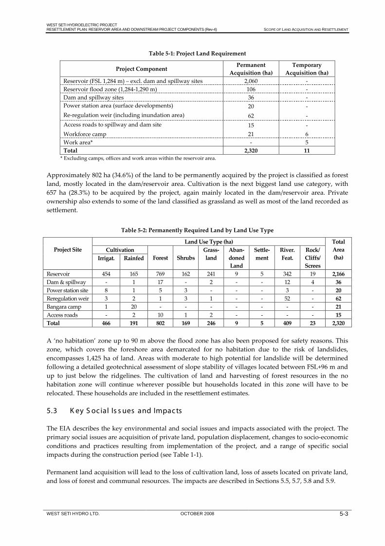
WEST SETI HYDROELECTRIC PROJECT RESETTLEMENT PLAN: RESERVOIR AREA AND DOWNSTREAM PROJECT COMPONENTS (Rev-4) SCOPE OF LAND ACQUISITION AND RESETTLEMENT
WEST SETI HYDRO LTD. OCTOBER 2008 5-3
Table 5-1: Project Land Requirement
Project Component Permanent Acquisition (ha)
Temporary Acquisition (ha)
Reservoir (FSL 1,284 m) – excl. dam and spillway sites 2,060 - Reservoir flood zone (1,284-1,290 m) 106 - Dam and spillway sites 36 - Power station area (surface developments) 20 - Re-regulation weir (including inundation area) 62 - Access roads to spillway and dam site 15 - Workforce camp 21 6 Work area* - 5 Total 2,320 11
* Excluding camps, offices and work areas within the reservoir area. Approximately 802 ha (34.6%) of the land to be permanently acquired by the project is classified as forest land, mostly located in the dam/reservoir area. Cultivation is the next biggest land use category, with 657 ha (28.3%) to be acquired by the project, again mainly located in the dam/reservoir area. Private ownership also extends to some of the land classified as grassland as well as most of the land recorded as settlement.
Table 5-2: Permanently Required Land by Land Use Type
Project Site
Land Use Type (ha) Total Area (ha)
Cultivation Forest
Shrubs
Grass-land
Aban-doned Land
Settle-ment
River. Feat.
Rock/ Cliffs/ Screes
Irrigat. Rainfed
Reservoir 454 165 769 162 241 9 5 342 19 2,166 Dam & spillway - 1 17 - 2 - - 12 4 36 Power station site 8 1 5 3 - - - 3 - 20 Reregulation weir 3 2 1 3 1 - - 52 - 62 Bangara camp 1 20 - - - - - - - 21 Access roads - 2 10 1 2 - - - - 15 Total 466 191 802 169 246 9 5 409 23 2,320 A ‘no habitation’ zone up to 90 m above the flood zone has also been proposed for safety reasons. This zone, which covers the foreshore area demarcated for no habitation due to the risk of landslides, encompasses 1,425 ha of land. Areas with moderate to high potential for landslide will be determined following a detailed geotechnical assessment of slope stability of villages located between FSL+96 m and up to just below the ridgelines. The cultivation of land and harvesting of forest resources in the no habitation zone will continue wherever possible but households located in this zone will have to be relocated. These households are included in the resettlement estimates. 5.3 K ey S oc ial Is s ues and Impac ts The EIA describes the key environmental and social issues and impacts associated with the project. The primary social issues are acquisition of private land, population displacement, changes to socio-economic conditions and practices resulting from implementation of the project, and a range of specific social impacts during the construction period (see Table 1-1). Permanent land acquisition will lead to the loss of cultivation land, loss of assets located on private land, and loss of forest and communal resources. The impacts are described in Sections 5.5, 5.7, 5.8 and 5.9.

WEST SETI HYDROELECTRIC PROJECT RESETTLEMENT PLAN: RESERVOIR AREA AND DOWNSTREAM PROJECT COMPONENTS (Rev-4) SCOPE OF LAND ACQUISITION AND RESETTLEMENT
WEST SETI HYDRO LTD. OCTOBER 2008 5-4
A highly significant impact is the displacement of households for project implementation. As discussed in Section 5.6, this will mainly occur in the reservoir area, although relocation of households will also be required at some of the other project sites. Land acquisition and population displacement will lead to a range of impacts on socio-economic conditions and practices; for instance, impacts on livelihoods, subsistence and local economic activities; impacts on community infrastructure, services and institutions; changes to access and movement patterns; and impacts on traditional uses of the Seti River. These impacts and associated mitigation measures are discussed in the relevant sections below or in the EIA. Social impacts during the construction period include labour force impacts; local employment and income generation; impacts on local authorities and services; and construction-related impacts (noise, dust, etc.). These impacts and associated mitigation measures are discussed in the EIA and Environmental Management Action Plan. 5.4 Hous eholds and P opulation The reservoir and downstream project developments will affect an estimated 2,125 households (Table 5-3). Of these, 1,680 will be affected by the reservoir and 445 by downstream project sites. Of the 1,680 households affected by the reservoir, 490 have land and other assets in the inundation area but live in nearby settlements above the reservoir no-habitation zone (i.e. above FSL+96 m).
Table 5-3: Estimate of Affected Households
Project Component Affected
Households
Households Requiring
Resettlement Reservoir & Dam Site: - below FSL+6 m 933 933 - between FLS+6 m and FSL+96 m 257 257 - above FSL+96 m 490 122 Dam Access Road (estimate) 40 0 Power Station Site & Access Road 35 21 Work Areas (estimate) 20 0 Workforce Camps/Offices (estimate) 200 30 Re-regulation Weir (estimate) 150 30 Total 2,125 1,393 Note: excluding 296 households affected by the transmission line.
Based on the resettlement principles discussed in Chapter 8, 1,393 of the 2,125 affected households will be resettled. The 1,680 households affected by the reservoir is an increase of 150 from the 1,530 households recorded in 1997/98 (Table 5-4). The households in the displacement zone (i.e. those located below FSL+96 m) constitute just below 71% of the total households, up from 68% in 1997/98. This is mainly due to the expansion of the Deura market area in Rayal VDC following construction of the Dadeldhura-Chainpur road, where an increase of more than 95% was recorded. Other areas of fairly substantial household increases are Dhungad VDC (below FSL+6 m), Thalakanda (below FSL+6 m), Dangaji (between FSL+6 m and FSL+96 m) and Belapur (below FSL+6 m). Overall, though, the increases are in line with GoN’s 2001-2006 population projections for the FWDR and project districts. The three most affected VDCs are Rayal, Lamikhal and Dhungad. Together these VDCs (which include the large settlement areas of Dhungad, Talara and Deura) have 49.7% of the affected households. Other VDCs with large numbers of affected households are Dangaji, Girichauka, Belapur, Shivaling and

WEST SETI HYDROELECTRIC PROJECT RESETTLEMENT PLAN: RESERVOIR AREA AND DOWNSTREAM PROJECT COMPONENTS (Rev-4) SCOPE OF LAND ACQUISITION AND RESETTLEMENT
WEST SETI HYDRO LTD. OCTOBER 2008 5-5
Thalakanda (40.8%). Chhapali, Mahadevsthan and Sunkuda VDCs are less seriously affected (8.6%), while Sigas, Koiralakot, Parakatne and Dahakalikasthan VDCs are only marginally affected (less than 1% of the affected households).
Table 5-4: Households in the Reservoir Area (1998 and 2006)
VDC & District Below
FSL+6m Between FSL+6m
and FSL+96m Above
FSL+96m Total
1998 2006 1998 2006 1998 2006 1998 2006 Dhungad 184 201 6 7 45 45 235 253 Shivaling 25 26 39 44 37 37 101 107 Sigas 1 1 3 3 0 0 4 4 Thalakanda 72 78 2 2 14 14 88 94 Baitadi Total
282 306 50 56 96 96 428 458
Dangaji 4 4 33 58 107 107 144 169 Koiralakot 0 0 0 0 2 2 2 2 Parakatne 0 0 0 0 5 5 5 5 Rayal 66 130 81 83 106 106 253 319 Sunkuda 13 13 6 6 15 15 34 34 Bajhang Total 83 147 120 147 235 235 438 529
Belapur 91 107 12 12 43 43 146 162 Dadeldhura Total
91 107 12 12 43 43 146 162
Chhapali 34 38 20 20 10 10 64 68 Dahakalikasthan 0 0 0 0 3 4 3 4 Girichauka 78 79 5 5 70 70 153 154 Lamikhal 232 237 16 16 10 10 258 263 Mahadevsthan 17 19 1 1 22 22 40 42 Doti Total 361 373 42 42 115 116 518 531
Grand Total
817 933 224 257 489 490 1,530 1,680
Table 5-5 shows that some 14,400 people will be affected by the reservoir, of which 9, 968 (just over 69%) are located in the displacement area (below FSL+96 m).

WEST SETI HYDROELECTRIC PROJECT RESETTLEMENT PLAN: RESERVOIR AREA AND DOWNSTREAM PROJECT COMPONENTS (Rev-4) SCOPE OF LAND ACQUISITION AND RESETTLEMENT
WEST SETI HYDRO LTD. OCTOBER 2008 5-6
Table 5-5: Households and Population in the Reservoir Area (2006)
District / VDC
Below FSL+6 m Between FSL+6 m
and FSL+96 m Above FSL+96 m Total
HH Pop HH Pop HH Pop HH Pop Baitadi: Dhungad 201 1 571 7 92 45 329 253 1 992 Shivaling 26 210 44 430 37 338 107 978 Sigas 1 36 3 40 - - 4 76 Thalakanda 78 623 2 18 14 138 94 779 Sub-total 306 2 440 56 580 96 805 458 3 825 Bajhang: Dangaji 4 28 58 476 107 954 169 1 458 Koiralakot - - - - 2 21 2 21 Parakatne - - - - 5 51 5 51 Rayal 130 1 245 83 651 106 948 319 2 844 Sunkuda 13 107 6 67 15 134 34 308 Sub-total 147 1 380 147 1194 235 2 108 529 4 682 Dadeldhura: Belapur 107 1 031 12 81 43 509 162 1 621 Sub-total 107 1 031 12 81 43 509 162 1 621 Doti: Chhapali 38 309 20 123 10 79 68 511 Dahakalikasthan - - - - 4 28 4 28 Girichauka 79 674 5 37 70 606 154 1 317 Lamikhal 237 1 809 16 81 10 94 263 1 984 Mahadevsthan 19 219 1 10 22 181 42 410 Sub-total 373 3 011 42 251 116 988 531 4 250 Total 933 7 862 257 2 106 490 4 410 1 680 14 378 % of Total 55.5 54.7 15.3 14.6 29.2 30.7 100.0 100.0
Other project components with impacts on households are: • the power station and associated infrastructure; • the permanent access roads to the dam site and power station site; • the re-regulation weir; • temporary work areas (for prefabrication of components, workshops and storage facilities, concrete
batching, etc.); and • three workforce camps, one of which will be permanently used during the operation and
maintenance phase. Table 5-6 shows the settlements and estimated number of households affected at these various downstream project sites. Displacement of households will occur at the power station site. The establishment of the permanent operation and maintenance camp and the proposed re-regulation weir may potentially also lead to household displacement. Other permanent land losses (e.g. the spillway access road) and temporary land acquisition are not expected to lead to any displacement of households.

WEST SETI HYDROELECTRIC PROJECT RESETTLEMENT PLAN: RESERVOIR AREA AND DOWNSTREAM PROJECT COMPONENTS (Rev-4) SCOPE OF LAND ACQUISITION AND RESETTLEMENT
WEST SETI HYDRO LTD. OCTOBER 2008 5-7
Table 5-6: Households Affected by Other Project Components
Project Component Settlement (VDC) Size and Type of Land
Acquisition
Est. No. of Affected
Households
Est. No. of Displaced
Households Dam Access Road:
Kalsuta, Gillabagar, Timila, Ratamati (Belapur VDC)
• 12 ha • permanent, some cultivation
40 none
Power Station Site and Access Road:
Bhagare, Bausi Gara, Rata Pahad, Simar, Bedkhet (Barpata VDC)
• 13 ha • permanent, some cultivation
35 21
Work Areas: Power conduit intake Dam site Dam site/access road Dam site/access road Power station Power station access bridge
Khalikhet (Lamikhal VDC) Talara (Lamikhal VDC) Gillabagar (Belapur VDC) Kalsuta (Belapur VDC) Bausi Gara (Barpata VDC) Talkot (Barpata VDC)
• 33 ha (14 ha outside reservoir, 19 ha at Talara and Khalikhet,
20 none
as well as the temporary access road to the power conduit site within the reservoir area)
Workforce Camps: • 42 ha temporary acquisition
(1.5 ha at Khalikhet falls within reservoir area)
Power conduit intake Dam and power station sites
Khalikhet (Lamikhal VDC) Bangara/Bandungresan (Banlek VDC)
200 30
Power station/access bridge Talkot (Barpata VDC) Re-regulation Weir: Kalagad • 62 ha
• permanent, some cultivation 150 30
Total (estimate) 445 81 The actual number of affected households at these project sites will be confirmed for inclusion into final resettlement documentation upon final design/configuration and asset verification exercises. A detailed survey was undertaken in June-July 2008 of the access road to the toe of the dam wall and the initial section of the power station access road. Pegging of the road formation is scheduled to occur in October 2008, after which affected assets and owners will be identified. All households directly affected by any project development will qualify for the entitlements (as applicable) described in the RP and Entitlement Matrix.
Figure 5-1: Schematic Layout of Access Road to Toe of Dam Wall

WEST SETI HYDROELECTRIC PROJECT RESETTLEMENT PLAN: RESERVOIR AREA AND DOWNSTREAM PROJECT COMPONENTS (Rev-4) SCOPE OF LAND ACQUISITION AND RESETTLEMENT
WEST SETI HYDRO LTD. OCTOBER 2008 5-8
The Project’s compensation and livelihood restoration programme is designed to assist affected households to restore and enhance their livelihood earning opportunities. Specific measures have also been included to support the reestablishment of vulnerable social categories such as Dalit and female-headed households. Because Dalit and female-headed households are more prone to poverty they will be especially vulnerable to the changes brought about by involuntary resettlement, both in terms of changes in access to land and natural resources and in changes to livelihood support relationships. The restoration – and ultimately improvement – of their livelihood earning opportunities will be an important focus of the resettlement programme. 5.5 P rivate L and A total of 657 ha of private cultivation land will be acquired, consisting of:
• 619 ha in the reservoir area and flood zone (below FSL+ 6m), which excludes some 9 ha of abandoned land; and
• 38 ha at downstream project sites. Of the cultivation land below FSL+6 m, 454 ha is irrigated and 165 ha is rainfed.
Table 5-7: Cultivation Land in the Reservoir Area and No Habitation Zone
Land Use Category Type
Below FSL+6 m No Habitation Zone
Total Area
Area (ha)
% of Area
Area (ha)
% of Area
Area (ha)
% of Area
Cultivation Irrigated 454 21.0 83 5.9 537 15.0 Rainfed 165 7.6 147 10.4 312 8.7 Abandoned land 9 0.4 0 0.0 9 0.3 Total 628 22.1 230 16.3 858 24.0
A further approximately 230 ha of cultivation land is located in the proposed ‘no habitation’ zone up to 90 m above the flood zone. Some of this land belongs to households located below the no habitation zone, others to households within or above the zone. As indicated, the principle will be to disallow habitation but to allow resource utilisation in this zone. The cultivation of land and harvesting of forest resources in the no habitation zone will therefore continue wherever possible. Cultivation land in the no habitation zone that belongs to households resettled to the Terai will become the property of WSH, since the households would have been compensated for their entire landholdings. Given the premium that will be placed on agricultural land in the post-inundation phase every effort will be made to keep this land in productive use. It is envisaged that the cultivation land owned by WSH in the no-habitation zone could utilised as follows:
• making agricultural land parcels available to households in the vicinity who have lost some land but who are not required to relocate, either as land-based compensation for the loss of their land or through the sale of land to households;
• developing and using the land for community development initiatives such as social forestry or community food plots.
Assessment of the use potential of WSH-owned land in the no-habitation zone will occur as an ongoing activity and in consultation with affected communities and households as the project is implemented.

WEST SETI HYDROELECTRIC PROJECT RESETTLEMENT PLAN: RESERVOIR AREA AND DOWNSTREAM PROJECT COMPONENTS (Rev-4) SCOPE OF LAND ACQUISITION AND RESETTLEMENT
WEST SETI HYDRO LTD. OCTOBER 2008 5-9
The loss of agricultural land will have significant impacts on the livelihoods of most affected households, both in terms of subsistence (food consumption) and the generation of cash income. A range of compensation and livelihood restoration measures have been prepared to assist affected households with the restoration of their livelihoods. An important provision is the option given to households whose livelihoods have been severely affected by project activities of resettling to project relocation sites in the far-western Terai and provided with replacement agricultural land. 5.6 P opulation Dis plac ement and R es ettlement Based on the resettlement principles discussed in Chapter 8, 1,393 (65.5%) of the 2,125 households affected by the reservoir and downstream project sites will be resettled, mainly to project relocation sites in the Terai. Some households located above FSL+96m will qualify for resettlement to the Terai because of severe land losses. The population to be resettled is estimated at 10,866. Of the 1,393 resettled households, 1,202 (86.3%) will qualify for relocation to project sites in the Terai because of severe impacts on their livelihoods, while 191 (13.7%) will relocate locally to allow them continued access to their unaffected cultivation land.
Table 5-8: Affected Households by Resettlement Category
Resettlement Category
Estimated Number of Households by Project Component
Population Reservoir
Other Project
Components
Total Households Below
FSL+6 m
Between FSL+6 m & FSL+96 m
Above FSL+96 m
Relocate Terai 886 154 122 40 1,202 9,378 Relocate locally 47 103 - 41 191 1,488 Not displaced - - 368 364 732 5,355 Total 933 257 490 445 2,125 16,221 Impoverishment is often a key outcome of involuntary resettlement because displaced people are exposed to risks that relate to the loss of capital (natural, manmade, human and social capital) brought about by involuntary displacement; and the loss of opportunities and entitlements that they possessed at their former locations. The measures detailed in the RP are designed to minimise these risks and consciously deal with them so that the livelihoods (physical and social) of displaced persons are re-established as smoothly and quickly as possible. 5.7 B uildings /S truc tures 5.7.1 Houses and Buildings The results of the structures survey undertaken in 1997/98 are summarised in Table 5-9.19
19 See Supporting Document 6.
This shows that a total of 1,208 houses, water mills and tea shops were located in the area below FSL+96 m (i.e. the no habitation zone), with the majority located below FSL+6 m.

WEST SETI HYDROELECTRIC PROJECT RESETTLEMENT PLAN: RESERVOIR AREA AND DOWNSTREAM PROJECT COMPONENTS (Rev-4) SCOPE OF LAND ACQUISITION AND RESETTLEMENT
WEST SETI HYDRO LTD. OCTOBER 2008 5-10
Table 5-9: Buildings in the Reservoir Area (1998)
Area
Structures Below FSL+6 m (1,290 m)
Structures Between 1,290 m – 1,380 m*
House Water Mill
Tea Shop
House Water Mill
Tea Shop
Seti River 615 6 56 18 7 3 Chama Gad 64 6 - 11 - - Dhung Gad 78 3 - 26 1 - Saili Gad 134 1 7 26 - - Nawaghar Gad 22 5 - 40 2 - Kalanga Gad 39 3 1 33 - 1 Total: 952 24 64 154 10 4
Source: 1997/98 EIA field survey. Out of the total of 1,106 residential houses, 952 are located below FSL+6 m and 154 in the FSL+6 m – FSL+96 m zone. An additional 298 houses were mapped between the 1,380 m and (approximately) 1,500 m contours, some of which belong to households losing all/most of their cultivation land. To accommodate these additional houses, the RAP of 2000 estimated that 1,150 houses would be affected. These estimates have subsequently been increased to 1,602 buildings (and 1,325 associated livestock areas) to accommodate the additional 150 households (and in some instances associated businesses) established in the reservoir area since 1999, as well as the revised resettlement estimates at the downstream project sites. Residential houses are mainly constructed of stone with mud mortar, timber beams and pillars, and slate tile or thatch roofs. Houses commonly have two levels, although triple-storey houses are occasionally found in the larger settlements and market areas. The ground floor is generally used for livestock and storage of fuelwood and fodder, while the rooms on the top floor are used as kitchens, sleeping rooms and for grain storage.
Photo 5-1: Houses in Dhungad
Residential houses are often occupied by extended families consisting of a number of nuclear households (e.g. husband and wife and married sons). Although there is some sharing of resources (e.g. livestock and storage areas), each nuclear household has its own allocated space in the house (i.e. sleeping room and kitchen) and generally functions as a separate entity.

WEST SETI HYDROELECTRIC PROJECT RESETTLEMENT PLAN: RESERVOIR AREA AND DOWNSTREAM PROJECT COMPONENTS (Rev-4) SCOPE OF LAND ACQUISITION AND RESETTLEMENT
WEST SETI HYDRO LTD. OCTOBER 2008 5-11
Apart from the 68 tea shops and 34 water mills, the surveyed households reported a further 72 general stores/shops in the 1997/98 survey. These enterprises operate from the residential properties, being located on the ground floors of houses. Since 1997/98 the most significant change that has occurred in business activities in the reservoir area has been the growth of the Deura market at the headwaters of the reservoir, following construction of the Chainpur road. This market now consists of numerous enterprises such as tea shops, restaurants and clothing shops (Photo 5-2).
Photo 5-2: Deura Market Area
The project’s Entitlement Matrix provides measures to ensure that impacts on houses and other household structures are properly addressed. All houses affected by the project will be valued at full replacement cost, with households able to choose between the provision of replacement housing or cash compensation. 5.7.2 Schools Eight schools in the reservoir area (five primary and three secondary) will have to be relocated (Table 5-10 and Figure 5-2).20
Table 5-10: Schools to be Relocated from the Reservoir Area
A school in Bandungrasen close to the site of the proposed permanent camp may be affected depending on the final location of the camp.
Map Ref.
District VDC Village Name of School
S1 Baitadi Dhungad Dhungad Sharada Secondary S6 Doti Lamikhal Talara Bhagawati Secondary S8 Baitadi Dhungad Tunibagar Mahadev Primary S9 Doti Lamikhal Jakhada Durga Primary
S12 Baitadi Thalakanda Mohoribagar Ganesh Secondary S14 Baitadi Shivaling Gadual Bal Krishna Primary S21 Bajhang Rayal Deura Janachetana Primary S22 Baitadi Shivaling Sangada Bhawani Bal Bikash Primary
20 See Supporting Document 7.

WEST SETI HYDROELECTRIC PROJECT RESETTLEMENT PLAN: RESERVOIR AREA AND DOWNSTREAM PROJECT COMPONENTS (Rev-4) SCOPE OF LAND ACQUISITION AND RESETTLEMENT
WEST SETI HYDRO LTD. OCTOBER 2008 5-12
Figure 5-2: Schools in the Reservoir Area and Periphery
The resettlement budget provides for the compensation (at replacement cost) or the physical replacement of the schools at locations identified in consultation with the affected communities and concerned authorities. 5.7.3 Other Social Infrastructure There are three health sub-posts in the reservoir area, two below FSL+96 m (Dhungad and Deura) and one above (Lekham Basti/Thala). There is also a private health post in Dhungad. Other affected buildings include a VDC office in Dhungad and a police post in Deura. Additionally, 20 temples/shrines below FSL+96 m will have to be relocated (Table 5-11 and Figure 5-3).

WEST SETI HYDROELECTRIC PROJECT RESETTLEMENT PLAN: RESERVOIR AREA AND DOWNSTREAM PROJECT COMPONENTS (Rev-4) SCOPE OF LAND ACQUISITION AND RESETTLEMENT
WEST SETI HYDRO LTD. OCTOBER 2008 5-13
Table 5-11 Temples/Shrines to be Relocated from the Reservoir Area
Map Ref. District VDC Ward Name of Temple Elevation T1 Dadeldhura Belapur 7 Chama Shrine 1250 T4 Dadeldhura Belapur 4 Sajhabato Temple 1108 T6 Baitadi Dhungad 7 Dhungad Temple 1115 T7 Doti Lamikhal 5 Talara Temple 1150 T8 Doti Lamikhal 5 Talara Temple 1200 T9 Baitadi Dhungad 8 Chune Shrine 1250
T10 Baitadi Dhungad 9 Lambagar Temple 1180 T11 Doti Lamikhal 5 Samaichimandu 1200 T12 Doti Lamikhal 5 Jakhada Temple 1260 T13 Doti Girichauka 1 Aul Temple 1215 T14 Baitadi Dhungad 9 Nakara Temple 1220 T15 Baitadi Thalakanda 7 Lekam Temple 1230 T16 Baitadi Thalakanda 7 Lekam Temple 1230 T17 Baitadi Thalakanda 7 Lekam Temple 1150 T19 Baitadi Shivaling 8 Beurati Temple 1350 T20 Baitadi Shivaling 9 Boharigaun Temple 1250 T22 Bajhang Dangaji 5 Regam Temple 1270 T23 Bajhang Rayal 3 Deura Temple 1250 T25 Bajhang Dangaji 5 Jaisibagar Temple 1270 T26 Bajhang Rayal 3 Deura Temple 1250
Figure 5-3: Temples in the Reservoir Area and Periphery
In addition to the listed buildings, there are six ghats (cremation sites) in the reservoir area. These are mostly situated at the confluence of the Seti River and its tributaries. There are also ghats downstream of the dam site (e.g. near the settlement of Gillabagar and at the confluence of the Seti River and Ruwa Khola).

WEST SETI HYDROELECTRIC PROJECT RESETTLEMENT PLAN: RESERVOIR AREA AND DOWNSTREAM PROJECT COMPONENTS (Rev-4) SCOPE OF LAND ACQUISITION AND RESETTLEMENT
WEST SETI HYDRO LTD. OCTOBER 2008 5-14
Eight permanent footbridges (three on the Seti River and the remainder on the five main tributaries) and two cable slides (on the Seti River) will be inundated by the reservoir (Figure 5-4). One of the footbridges was destroyed in the 2000 floods and is currently being replaced. Two temporary wooden bridges erected annually during the dry season (on the Seti River and Kalanga Gad) will also be inundated, while one dugout boat service operates on the Seti River between Mohoribagar and Pang/Babina.
Figure 5-4: Existing and Proposed Footbridges in the Reservoir Area
A community hydroelectric scheme was established in April 2006 in Ward 6 of Thalakanda VDC. The scheme, which has 225 beneficiaries and was constructed with the assistance of the UNDP, will be affected by the reservoir. Provision has been made in the resettlement programme for the compensation (at replacement cost) or the physical replacement of these social infrastructure and services. 5.8 T rees Households in the reservoir displacement area and at other project sites will lose private non-fruit trees and fruit trees such as oranges, mandarins, lemons, bananas, mangoes, guava, papaya, apricots, tamarin and pomegranate. Households were asked to indicate ownership of trees in the 1997/98 household survey. It is estimated that more than 15,000 privately-owned trees could be affected by reservoir inundation and developments at downstream project sites. This will be confirmed during the formal asset verification exercise.
WEST SETI HYDROELECTRIC PROJECT RESETTLEMENT PLAN: RESERVOIR AREA AND DOWNSTREAM PROJECT COMPONENTS (Rev-4) SCOPE OF LAND ACQUISITION AND RESETTLEMENT
WEST SETI HYDRO LTD. OCTOBER 2008 5-15
The resettlement budget accounts for affected trees. The numbers of trees actually affected will be determined during the asset verification exercise, with compensation paid to households accordingly (see Section 9.3.5). 5.9 F ores t and R iver R es ourc es As reported in Section 4.2.7 and Section 4.2.8, households in the reservoir area use Seti valley natural resources for a range of purposes. These include:
• forest resources: fuel and timber wood; fodder; chiuri products; ritha (soap nut) products; wild vegetables; medicinal herbs and thatching grass;
• Seti River: stock watering; religious purposes and festivals; fishing for own consumption and income generation; and secondary source of drinking water in the dry season;
• Seti River tributaries, streams and natural springs: water for drinking, cooking and washing. In recognition of the role of communal resources in household livelihoods and because fewer community resources exist on the Terai, households relocated to project sites in the Terai will be provided with additional cultivation land as compensation for the loss of access to Seti valley communal resources. 5.10 S oc ial Impac ts of Altered R iver F lows An estimated 11,160 people in the downstream riparian zone between the dam site and the re-regulation weir site may be affected to varying degrees by a permanent reduction in the flow of the Seti River (up to the tailrace outlet) as well as rapid increases and decreases in River flow due to unregulated discharges from the power station (between the tailrace outlet and the re-regulation weir). Potential impacts caused by reduced water flows between the dam wall and the tailrace outlet include reduced water quality and impacts on villages relying wholly or partly on the Seti River as a source of domestic/household water. As discussed in Section 9.5, a range of mitigation and community development initiatives such as provision of potable water supply in riparian villages between the dam wall and the tailrace outlet will be implemented in consultation with residents of these riparian villages. Some of these programmes will also extend around the reservoir periphery. Additional measures in the area of reduced river flow will include release of an environmental flow through the dam wall to fulfil non-consumptive needs of the riparian villages, and ongoing water quality and volume monitoring. The likely social impacts of altered river flows below the tailrace outlet are largely related to safety. The safety of all river users is likely to be affected by the variation in river flows below the outlet. This will be particularly prevalent in the morning during the dry season when the powerhouse commences operation, and large volumes of water begin flowing in the river. At these times, the river will rise and widen over a relatively short time in the 6 km river stretch between the tailrace outlet and the re-regulation weir. If people are using the river at this time and are unaware of the situation, or if operational routines change without notification, people (in particular children) and animals could be caught in the flow. Mitigation measures in this zone will focus on safety of human and animal life below the tailrace outlet, including education of communities and signposting of the River between the tailrace outlet and re-regulation weir to ensure communities understand the implications, including safety aspects, of altered river flows

WEST SETI HYDROELECTRIC PROJECT RESETTLEMENT PLAN: RESERVOIR AREA AND DOWNSTREAM PROJECT COMPONENTS (Rev-4) SCOPE OF LAND ACQUISITION AND RESETTLEMENT
WEST SETI HYDRO LTD. OCTOBER 2008 5-16
5.11 Ac c es s and Movement Access in the Seti valley will be restricted by the creation of the reservoir. The reservoir will inundate the full length of the main Seti valley trail from Ratamati to Deura, except approximately 600 m above Chune and approximately 300 m south of Aul along a cliff face, as well as eight permanent suspension bridges. The six southern suspension bridges in the reservoir area will be inundated all year round, whilst the Deura bridge over the Seti River and the bridge over the Kalanga Gad will be inundated for approximately five months each year when the reservoir level is above 1,250 m. Accordingly, virtually no foot access will be possible along the main valley trail or along the main tributary access trails. The reservoir along the four southern reservoir tributaries (Chama Gad, Dhung Gad, Saili Gad and Nawaghar Gad) will create a significant obstacle to foot access along and across these valleys. Access out of the Seti valley will also be disrupted by the reservoir at Dhungad, Aul and Deura. Settlements that will be most seriously disrupted are located in the following areas:
• on a ridge between the Chama Gad and Dhung Gad; • on a ridge between the Seti River and Saili Gad; and • between the Dhung Gad and Nawaghar Gad.
The significant reduction in Seti River flows between the dam and the tailrace outlet throughout the year, excluding periods of flooding, will improve cross-river access along this reach of the river. It is likely that small, temporary wooden bridges will be constructed by local riverside communities each year to cross the Seti River between the dam and tailrace outlet. Access will be improved from the dam site to the Seti Rajmarg Highway by the construction of the spillway road. Access will also be improved across the Seti River at Talkot with the construction of the power station bridge. As discussed in Section 5.7.3, access restrictions created by the project will be mitigated by the construction of suspension bridges across the reservoir or set further upstream from the extent of the reservoir, the improvement of existing trails and construction of replacement trails, and the provision of boat access. Where possible, minor trails will be upgraded to establish a major trail down the right and left banks of the reservoir. Where trails do not currently exist, new trails will be established. Bridges will be constructed at 1,290 m or above, out of flood level. Boat transport will be provided from the hillside behind Dhungad to the spillway area below Ratamati. It will also provide transport for the limited number of people who will continue to live on the southern extent of the ridge between the Chama Gad and Dhung Gad. A ferry service operating between the spillway area and Deura (at the headwaters of the reservoir), with a number of en-route stopping points, is also likely to be implemented. Altered river flows below the tailrace outlet are likely to make cross-river transport significantly more difficult in the dry season. Power station releases in the order of 330 m3/s will prevent the safe operation of dugout canoes. If this causes excessive access restrictions between the tailrace outlet and the re-regulation weir, another footbridge will be constructed across this stretch of the river.

WEST SETI HYDROELECTRIC PROJECT RESETTLEMENT PLAN: RESERVOIR AREA AND DOWNSTREAM PROJECT COMPONENTS (Rev-4) LEGAL AND POLICY FRAMEWORK
WEST SETI HYDRO LTD. OCTOBER 2008 6-1
6. L E G AL AND P OL IC Y F R AME WOR K
This Chapter provides a summary of national legislation and policies and international best practice guidelines pertaining to involuntary resettlement. 6.1 National C ontext Nepal does not have legislation that specifically addresses involuntary resettlement. There is legislation covering land acquisition/appropriation and constitutional guarantees to the right to property and the right to compensation for property acquired under the law. Recently, the country’s National Planning Commission (NPC) prepared a policy paper (yet to be approved by GoN) on land acquisition, compensation and resettlement.21
6.1.1 Constitutional Guarantees
Article 19 of the Interim Constitution (2063 (2007)), Right to Property, states that “(1) Every citizen shall, subject to the laws in force, have the right to acquire, own, sell and otherwise dispose of the property. (2) The State shall not, except in the public interest, requisition, acquire, or create any encumbrance on the property of any person. Provided that this clause shall not be applicable on property acquired through illegal means. (3) Compensation shall be provided for any property requisitioned, acquired or encumbered by the State in implementing scientific land reform programme or in public interest in accordance with law. The compensation and basis thereof and operation procedure shall be as prescribed by law.” 6.1.2 Land Acquisition Act, 2034 (1977) The acquisition of land is governed by the Land Acquisition Act, 2034 (1977), first promulgated in 1961 (Land Acquisition Act, 2018). The Act is applicable for the acquisition of land for public purposes or on behalf of diplomatic missions, consulates and international agencies. The Act does not specify procedures for the acquisition of land for private sector projects. Because the WSHEP is a private venture, WSH will acquire all private land and other household assets through negotiation. Negotiations will take place within the framework of the principles contained in the RP and the procedures of the Land Acquisition Act are therefore not directly applicable to the project. The procedures are nevertheless summarised below (and depicted in Figure 6-1). Initial Procedures The Department or Agency requiring the land forwards a proposal for acquisition to its superior Ministry. The proposal must show the location, area of land required, purpose, and maps. Initial approval can take approximately one month. Preliminary Process The Preliminary Process starts with the issuing of a notice (within seven days but up to one month if more than one district is involved) to landowners to inform them of the preliminary investigations by the Project Investigation Officer (PIO). The preliminary investigation can commence three days after the notice had been issued. The PIO is required to submit a report within 15 days of the issuing of the notice. This report must contain all pertinent information, as well as details of the extent of damage caused during the
21 The National Policy on Land Acquisition, Compensation and Resettlement in Development Projects in Nepal (September 2006), which is discussed in Section 6.1.5 of this chapter.

WEST SETI HYDROELECTRIC PROJECT RESETTLEMENT PLAN: RESERVOIR AREA AND DOWNSTREAM PROJECT COMPONENTS (Rev-4) LEGAL AND POLICY FRAMEWORK
WEST SETI HYDRO LTD. OCTOBER 2008 6-2
preliminary investigations and compensation due for these damages. The process is then transferred to the Local Officer (Chief District Officer), who must arrange for the serving of notices at the principal places of public thoroughfare, at local settlement offices and on the door of affected houses. Notice of Acquisition The Local Officer is required to prepare a Notice of Acquisition, which indicates that the assets under consideration are to be acquired. The notice must provide details on the type and location of the required properties. The Local Officer must also advise the District Land Revenue Offices to stop any transactions on the concerned land. The concerned owners are granted at least 15 days from the issuing of the notice to submit an application for compensation (with the necessary supporting documents), or seven days (excluding travelling time to the district office) to submit a letter of complaint/contest. The Ministry of Home Affairs is normally required to make a decision on a complaint within 15 days, unless further information is required, or unless the complaint has to be solved in a court of law (e.g. ownership disputes). The concerned properties can be acquired at any time after the lapse of a period granted for the lodging of complaints, or after a final decision on a complaint has been made. The Local Officer must arrange for the transfer of ownership to GoN within 15 days of taking control of the land. Compensation Determination and Eligibility A Compensation Determination Committee (CDC) is established to assess the list of compensation claims and determine compensation rates for the lost assets. A list of entitled persons is prepared and submitted to the Local Officer for publication. Anyone who disagrees with the list can register a complaint with the Ministry of Home Affairs within 15 days of the issuing of the notice. The Ministry is required to solve any complaints within approximately 15 days, except for those which have to be resolved in a court of law. 6.1.3 Land Act, 1964 The provisions of the Land Act 1964 pertaining to the maximum permitted size of individual landholdings apply to land acquisition since a landowner may not be compensated for more land than he/she is entitled to under the regulations of the Act. The Act also specifies the compensation entitlements of registered tenants on land sold by the owner or acquired for development purposes. The provisions of the Land Acquisition Act are in accordance with those of the Land Act, namely that a registered tenant is entitled to 25% of the compensation. However, the fourth amendment of the Land Act in 1997 increased a tenant’s entitlement to 50%. 6.1.4 Guthi Corporation Act, 1976 Land acquisition must also comply with the provisions of the Guthi Corporation Act, 2033 (1976). Section 42 of this Act states that Guthi (religious trust land) acquired for a development must be replaced with other land, rather than compensated in cash.

WEST SETI HYDROELECTRIC PROJECT RESETTLEMENT PLAN: RESERVOIR AREA AND DOWNSTREAM PROJECT COMPONENTS (Rev-4) LEGAL AND POLICY FRAMEWORK
WEST SETI HYDRO LTD. OCTOBER 2008 6-3
Ministerial Approval
Notice of Preliminary Action
(PA)
Commence PA
Submit PA Conclusion Report
Issue Acquisition Notice
Compensation for Damages
Complaints to CDO
Submit Complaints
Submit Compensation
Claims
MOH decides within 15 days or to Court of Law
Court of Law
Compensation Determination
(CDC)
Publish List of Entitled Persons
Inform GoN of Compensation
Compensation Payments
Complaints to MOH
(within 15 days)
CDO takes Control of Land
§ Notice served within one month if more than one district involved§ Served at public places§ Served at door if house acquired
§ PA can commence three days after issuing of notice
§ Report submitted within 15 days of issuing PA notice§ Process transferred to CDO
§ Served at public places; personal notice where required§ Specify period for claims submission§ Specify evacuation period§ Freeze land transactions§ Complaints submitted within 7 days, excl.
travelling time to district office§ At least 15 days to submit compensation
claims
§ After lapse of complaint period§ After complaint resolution§ Transfer of land titles within 15 days of taking
control of land; owner advised of land transfer§ CDO empowered to hear/decide cases§ Penalties/fines for obstruction of acquisition
process
§ 50% advance payment for house§ No timeframe for other compensation
payments
Figure 6-1: Flowchart of the Land Acquisition Process

WEST SETI HYDROELECTRIC PROJECT RESETTLEMENT PLAN: RESERVOIR AREA AND DOWNSTREAM PROJECT COMPONENTS (Rev-4) LEGAL AND POLICY FRAMEWORK
WEST SETI HYDRO LTD. OCTOBER 2008 6-4
6.1.5 National Policy on Land Acquisition, Compensation and Resettlement, 2006 The National Policy on Land Acquisition, Compensation and Resettlement in Development Projects in Nepal was prepared in September 2006 by the National Planning Commission (NPC) with ADB assistance. The Policy was approved by a ministerial working committee and the NPC but has yet to be approved by Cabinet. The Policy has the following guiding principles:
• “Appropriate and adequate compensation for the loss of assets or income is a fundamental right of all project affected persons. Physically displaced people must be relocated with basic amenities such as school, health posts and other facilities.
• All affected persons should be assisted to restore at least their pre-project income and livelihood sources.
• The absence of legal title to land should not be a bar for compensation, resettlement and rehabilitation assistance.
• Vulnerable groups such as Janajati/Adivasi, Dalits, landless, women, especially women-headed households, differently-abled, poverty groups and senior citizens are entitled to special benefit and assistance packages in addition to compensation and resettlement.”
Drawing upon the provisions of the ADB’s and World Bank’s involuntary resettlement policies, and building on current resettlement practices in the country, the Policy establishes a range of compensation entitlements for people affected by development projects. Amongst others, this includes:
• cash compensation at full market value (equivalent to replacement value) for all acquired land if the provision of replacement land is not feasible; with the stipulation that a person who becomes a marginal landholder as a result of land acquisition should be provided with replacement land of equivalent productivity or value;
• cash compensation at replacement cost for the loss of all structures (residential, business and other structures), with no deduction for depreciation or for salvageable materials; or provision of a replacement house;
• cash compensation for private trees based on the annual value of the produce; • compensation for the loss of income from rented buildings; • cash compensation for the loss of standing crops; and • compensation to registered tenants and sharecroppers, equivalent to 50% of the compensation
for the concerned area of land and lost crops. The Policy states that squatters and non-titled landholders are not entitled to compensation for the land they occupy. However, those who have earned their livelihoods from access to/use of the land for more than three years prior to the project’s compensation cut-off date should, wherever possible, be provided with replacement land on a lease basis. They should also be assisted in their efforts to legalise their tenure in order to qualify for compensation. Rehabilitation measures proposed by the Policy include:
• proper resettlement planning, including developed relocation sites with amenities/easy access to amenities;
• for resettled farming communities, homesteads sites of sufficient size for storage of agricultural produce, keeping of livestock and for kitchen gardens;
• employment on the project, where possible, to at least one member of each affected household, with half of the employment opportunities reserved for women; and
• additional relocation and rehabilitation support measures, particularly to displaced households, severely affected households, women and vulnerable people.
WEST SETI HYDROELECTRIC PROJECT RESETTLEMENT PLAN: RESERVOIR AREA AND DOWNSTREAM PROJECT COMPONENTS (Rev-4) LEGAL AND POLICY FRAMEWORK
WEST SETI HYDRO LTD. OCTOBER 2008 6-5
6.1.6 Tenth Plan 2002-2007 The Tenth Plan 2002-2007 focuses on poverty reduction in Nepal from 38% to 30% of the population through:
• broad based economic growth; • social sector development including human development; • targeted programmes, including social inclusion, in order to bring poor and marginalized groups
into the mainstream of development, together with targeted programmes for the ultra poor, vulnerable and deprived groups; and
• good governance. It targets the supply of electricity to 53%-55% of the country’s population across 2,450-2,600 Village Development Committees (VDCs). Similarly, it aims at providing improved water supply to 83%-85% of the population of Nepal within the five-year period. The targeted literacy rate during the Plan period is between 68%-70%. 6.1.7 Hydropower Development Policy, 2001 The Hydropower Development Policy 2001 emphasises hydropower as an alternative energy source and hydropower development with due consideration to environmental conservation. It stresses on the need for the implementation of mitigation measures in project-affected areas and states that resettlement and rehabilitation works be conducted as required by the approved criteria of the GoN. Section 6.1.2 of the Policy states that the GoN may facilitate the acquisition of requisite houses and land by the project licensee in accordance with the prevailing laws of the country, however all expenses incurred in connection with acquisition must be borne by the licensee. The Policy also provides for lease of Government-owned land to the project licensee for the term of the license. 6.1.8 Local Self Governance Regulation, 2000 The Local Self Governance Regulation 2000 empowers local bodies to coordinate and implement development programmes and to rationally utilise local natural resources. Article 7 (68) of the Regulation empowers VDCs to monitor and supervise development works implemented in the VDC. Under Schedule 26 (4) of the Regulation, half the royalty paid to the GoN by a hydropower project will be used for local development: 12% of the total royalty will be provided to the district where the powerhouse is located (Doti District), with the remaining 38% to be distributed to the other districts in the affected development region. 6.1.9 Compensation and Resettlement Practices on Hydroelectric Projects in Nepal The Kulekhani Hydroelectric Project (situated in central Nepal and completed in 1981) acquired 204 ha of land and affected approximately 500 households. Compensation was paid (according to rates determined by a Compensation Determination Committee) for land, standing crops, houses, community facilities and certain other structures. Fruit trees, fodder trees and other communal resources such as grazing land were not included in the compensation package. Land acquisition and compensation on the Marsyangdi Hydroelectric Project (1985-1990) was also undertaken in accordance with the Land Acquisition Act. The project acquired approximately 84 ha of land. A total of 389 households were affected, including 29 resettled households. A CDC was established and compensation (in cash only) was undertaken in accordance with the Act. The compensation rates

WEST SETI HYDROELECTRIC PROJECT RESETTLEMENT PLAN: RESERVOIR AREA AND DOWNSTREAM PROJECT COMPONENTS (Rev-4) LEGAL AND POLICY FRAMEWORK
WEST SETI HYDRO LTD. OCTOBER 2008 6-6
established by the CDC were adjusted after complaints had been lodged with the Zonal Commissioner (ZC). The ZC also made provision for the compensation of fruit trees and other types of property not previously considered for compensation (IUCN 1995). The Marsyandi project also included an agreement (with the World Bank) for the implementation of a formal resettlement programme. However, the programme was never developed, apparently because the project management assumed most of the affected households would remain in the same area after the acquisition of their land (hence cash compensation only). The evaluation of acquisition and compensation results in 1988 showed that “many individuals were left with uneconomic holdings and … the special assistance recommended [disturbance allowances, priority for employment, agricultural extension … and training] was never provided” (Molnar & Ragsdale 1991). The land acquisition and compensation procedures developed for the Arun III Access Road and Hydroelectric Project were jointly developed by GoN and the World Bank and issued in terms of Sections 16 and 27 of the Land Acquisition Act as the Land Acquisition Guidelines, 2045. Initially applicable to the Access Road Project only, the Guidelines emphasised cash compensation, based on the premise that (a) replacement land is not available and (b) that affected families would not want to leave their ancestral areas. Affected households are grouped into Project Affected Families, or PAFs (any household directly affected by the project) and Severely Project Affected Families, or SPAFs (a household whose livelihood is seriously compromised by the project, e.g. through the loss of all/most of its land holdings or of its residential or business premises). The Guidelines made provision for the establishment of Acquisition and Rehabilitation Committees (ARCs) to assist the project authorities and the Department of Roads with the preparation of compensation statements for each PAF and SPAF. Other important principles established under the Guidelines were:
• that ARCs may acquire land through negotiations, subject to the provision of the Land Acquisition Act;
• Compensation Statements for PAFs included cash compensation for affected assets and a rehabilitation grant, based on household size and other ARC-determined criteria; and
• Compensation Statements for SPAFs included a substitute asset of equal productive potential (identified directly by the SPAF or with the assistance of the project authorities), a rehabilitation grant, provision of employment for at least one SPAF member and provision of training as required.
The Arun III HEP Environmental Addendum recommended the application of the Guidelines for the main project as well. In addition, emphasis was placed on the leasing of temporary acquired land, in contrast to the Access Road where all land occupied for longer than one year was to be acquired permanently. The Environmental Addendum also recommended the inclusion of informal tenants and squatters in the compensation scheme. The Khimti Khola Hydroelectric Project is situated in the Ramechhap and Dolakha Districts of the Central Development Region. The main scheme works required some 12 ha of agricultural land and the relocation of 11 households. Social impact mitigation measures included:
• compensation for permanently acquired land according to prevailing market rates or by the provision of alternative land;
• temporarily acquired land to be purchased, rehabilitated after use and sold back within the local community or returned as forest land to GoN;

WEST SETI HYDROELECTRIC PROJECT RESETTLEMENT PLAN: RESERVOIR AREA AND DOWNSTREAM PROJECT COMPONENTS (Rev-4) LEGAL AND POLICY FRAMEWORK
WEST SETI HYDRO LTD. OCTOBER 2008 6-7
• compensation for houses and other buildings according to an agreed value (private transaction/negotiated agreement), or through the provision of equivalent housing in the project area; GoN acquisition procedures to be invoked only in cases of failure to reach an agreement;
• where possible, affected people to be given priority for jobs on the project; • assistance (to a local company or NGO) with a rural electrification programme, through the
donation of a mini-hydro plant (at the end of the construction period) and funds; • where possible, to improve village water supplies in conjunction with the project works; • a non-formal education programme, focussing on topics such as family planning and health,
nutrition, sanitation, money management and savings and electricity use; • the employment of a Forest Ranger to assist local communities with the preparation and
implementation of forest management plans; and • the employment of a resident Public Relations Officer to manage local consultation.
The Kali Gandaki ‘A’ Hydroelectric Project followed the ADB’s involuntary resettlement guidelines and incorporated many of the social impact management principles developed for Arun III. Approximately 97 ha of land was acquired permanently and 31 ha temporarily. Altogether 284 households were affected by the project, with 50 requiring resettlement. An Acquisition, Compensation and Rehabilitation Plan (ACRP) was developed and implemented (within the parameters of the Land Acquisition Act) to fairly compensate people for the loss of land and income. Social impact mitigation measures recommended for implementation included:
• a choice between replacement land or cash compensation; • provision of job training to members of PAFs and SPAFs (with special emphasis on women), the
identification of wage opportunities for women in the project and the preferential employment of local labour;
• establishment of a micro-enterprise revolving fund to provide capital to affected residents to implement entrepreneurial activities;
• assistance to the Boate community (a low caste group) with the development of irrigation systems so as to reduce the economic disparity between higher and lower castes;
• introduction of agriculture/livestock improvement programmes and the provision of improvements to local farmers at cost;
• establishment of a small nature reserve to offset the loss of forest resources; • development of aquaculture enterprises; and • assistance to VDCs in planning the economic growth associated with the project.
The EIA for the Upper Bhotekhosi Hydroelectric Project also proposed the adoption of the Arun III land acquisition guidelines, with minor modifications. The most important of these were:
• a recommendation to minimise depreciation in the purchasing power of compensation money by disbursing compensation at/before the time of property acquisition, or by basing compensation on replacement cost at the time of project construction and not pre-project valuation figures;
• support to displaced households with the transportation of belongings; • extension of the notice period during which the household had to decide on the form of
compensation from 30 days to three months; and • advance counselling sessions for households on the efficient utilisation of compensation money.
According to the EIA of the Upper Karnali Hydropower Project (situated in the middle mountain region of far-western Nepal), the project will acquire some 184 ha of land (excluding transmission line corridors). Twenty-three households will have to be relocated, while another seven households will lose some property. Main social impact mitigation measures include:

WEST SETI HYDROELECTRIC PROJECT RESETTLEMENT PLAN: RESERVOIR AREA AND DOWNSTREAM PROJECT COMPONENTS (Rev-4) LEGAL AND POLICY FRAMEWORK
WEST SETI HYDRO LTD. OCTOBER 2008 6-8
• adequate compensation for permanent losses (houses, agricultural land, grazing land) and temporary disturbances, through the application of relevant GoN laws and regulations (including the establishment of a Compensation Determination Committee);
• skills training and social advancement programmes for both directly and indirectly affected persons to maximise their potential for employment on the project and their ability to provide project-related goods and services; and
• measures to minimise the social and health impacts associated with the presence of the construction workforce.
The resettlement policy of the Melamchi Water Supply Project was approved by GoN in 2002. The policy contained many of the provisions referred to above, including:
• compensation a market value without depreciation; • representation of affected households/communities on the CDC; • training and employment of at least one member from each severely affected household; and • local consultative groups to be formed to assist with resettlement planning activities.
With regard to transmission line projects, the Kathmandu Valley High Voltage Reinforcement Project (1993-1997), funded by the World Bank, was one of the first projects to supplement the provisions of the Land Acquisition Act with international best practice entitlements (NEA 2004). The project included the following arrangements and entitlements:
• inclusion of representatives from affected communities on the Compensation Determination Committee;
• full compensation (based on market prices) for permanent land acquisition; • cash compensation (10% of the value) for land use restrictions in the RoW, with owners retaining
title over the land; • cash compensation (based on District Forest Office valuation) for trees and crops; • cash compensation (based on district valuation norms) for houses and structures, with owners
entitled to salvageable materials; • an additional 10% of the value of the structures for the transportation of salvaged materials.
Most subsequent transmission line projects have incorporated these provisions, including the Khimti-Bhaktapur-Balaju project, the Lalpur-Gaddahcauki project, the Chilime-Trishuli-Devighat project, the Lower Marsyangdi-Middle Marsyangdi project and the Thankot-Chapagaon-Bhaktapur project (NEA 2004). 6.2 ADB P olic y G uidelines The ADB published its Policy on Involuntary Resettlement in November 1995, with the aim of providing a mechanism for avoiding or minimizing involuntary resettlement on ADB-financed projects. In cases where displacement is unavoidable, the policy requires that affected people be identified, consulted, compensated for lost assets and livelihoods and assisted in relocating and in re-establishing their livelihoods. The ADB has also prepared the following additional policies and tools dealing with involuntary resettlement: Policy on Indigenous Peoples (1998); Handbook on Involuntary Resettlement (1998); and Gender Checklist: Resettlement (2003). The overall objective of the ADB’s policy on Involuntary Resettlement is to ensure that no one is disadvantaged by ADB-financed projects, and that the livelihoods of affected people are restored and

WEST SETI HYDROELECTRIC PROJECT RESETTLEMENT PLAN: RESERVOIR AREA AND DOWNSTREAM PROJECT COMPONENTS (Rev-4) LEGAL AND POLICY FRAMEWORK
WEST SETI HYDRO LTD. OCTOBER 2008 6-9
wherever possible enhance through using resettlement as an opportunity for development. The basic principles of ADB policy are:
• involuntary resettlement should be avoided where feasible; • where population displacement is unavoidable, it should be minimized by exploring all viable
project options; • people unavoidably displaced should be compensated and assisted, so that their economic and
social future would be generally as favourable as it would have been in the absence of the project;
• people affected should be informed fully and consulted on resettlement and compensation options;
• existing social and cultural institutions of resettlers and their hosts should be supported and used to the greatest extent possible, and resettlers should be integrated economically and socially into host communities;
• the absence of a formal legal title to land by some affected groups should not be a bar to compensation. Particular attention should be paid to households headed by women and other vulnerable groups, such as indigenous peoples and ethnic minorities, and appropriate assistance provided to help them improve their status;
• as far as possible, involuntary resettlement should be conceived and executed as a part of a project; and
• the full costs of resettlement and compensation should be included in the presentation of project costs and benefits.
The ADB also requires the borrower to follow good practice in the resettlement planning stage, where the following key elements are required to be incorporated in public sector projects:
• Take all steps to minimise or eliminate involuntary resettlement where feasible by exploring viable alternative design options.
• Define the parameters of likely resettlement at an early Initial Social Assessment (ISA) stage, and include appropriate Terms of Reference for a Project Preparation Technical Assistance (PPTA) feasibility study.
• Conceptualise and implement resettlement measures as development programmes, to be part of all projects, including sector, private sector and co-financed projects, and loans to development finance institutions.
• Complete socioeconomic surveys and census of people affected early in the project preparation to identify all losses from land acquisition and all affected persons and to avoid an influx of outsiders or speculators.
• Involve all stakeholders in a consultative process especially all affected persons, including vulnerable groups.
• Compensate all affected persons, including those without title to land, for all their losses at replacement rates (the costs of resettlement and compensation may be considered for inclusion in bank loan financing for a project);
• Where relocation of housing is required, develop relocation options in consultation with affected persons and host communities, in order to restore living standards. Where income and livelihoods are affected, establish appropriate income restoration programmes with objectives to improve, or at least restore, their productive base.
• Provide a social preparation process for people affected when they are vulnerable, or when there is social tension associated with displacement. Prepare a time-bound Resettlement Plan with appropriate provisions and sources of funding before appraisal, with a summary Resettlement Plan before the management review meeting. Include a summary resettlement plan in the draft report to the president of the Board. Involve specialists in resettlement and social sciences, and people affected, in the planning, implementation, and monitoring of the Resettlement Plan.

WEST SETI HYDROELECTRIC PROJECT RESETTLEMENT PLAN: RESERVOIR AREA AND DOWNSTREAM PROJECT COMPONENTS (Rev-4) LEGAL AND POLICY FRAMEWORK
WEST SETI HYDRO LTD. OCTOBER 2008 6-10
6.3 WS HE P R es ettlement P olic y WSH is committed to ensure that all compensation and resettlement activities associated with the project as a whole are undertaken in compliance with relevant local legislation. WSH also acknowledges the need to incorporate best practice involuntary resettlement guidelines, as embodied in the policies of the ADB, in its resettlement programme to address any gaps/limitations in the local legislation and ensure the proper restoration of affected livelihoods. To this end, a set of resettlement principles have been developed to guide project preparation and implementation. These principles are detailed in Table 6-1.
Table 6-1: Resettlement Principles for the WSHEP
Principle Guideline Principle 1: Population displacement and resettlement will be minimised wherever possible.
a) The project will be guided by the principle to avoid or minimise involuntary resettlement wherever possible.
Principle 2: All Project impacts will be identified and all losses properly recorded.
a) An inventory of project affected assets and resources will be undertaken in full consultation with the concerned households, communities and authorities.
b) Untitled landowners will be assisted in their efforts to obtain Government registration of their land for compensation purposes, provided that their eligibility for such assistance has been confirmed through the community participation structure.
c) A database of all project affected persons will be established which will include for each household: • an inventory of landholdings and non-retrievable improvements (buildings
and structures) to determine fair and reasonable levels of compensation and mitigation;
• census information, detailing household composition and demography; and
• current livelihood earning activities. d) The asset inventories will be used to determine entitlements and to assist with
the identification of severely project affected persons, while the census information will be used to monitor household reestablishment. All information will be entered into the database to facilitate planning, implementation, and monitoring and evaluation.
Principle 3: Land acquisition, resettlement planning, budgeting and implementation will be an integral part of the Project.
a) Land acquisition and involuntary resettlement will be integral components of the project. The following approach will be adopted: • land acquisition and resettlement costs will be built into the overall project
budget as an upfront cost; • an institutional and organisational framework will be established as an
integral part of the project’s management structure. These mechanisms and arrangements will ensure that compensation, resettlement and household re-establishment are carried out promptly and effectively; and
• land acquisition and resettlement schedules will be integrated with the project’s development schedule. Areas required by the project will only be occupied after acquisition and resettlement activities have been successfully completed.
Principle 4: Ongoing and meaningful public consultation will occur.
a) Persons whose livelihoods and standards of living will be adversely affected by project activities - whether through involuntary resettlement, loss of assets or through being deprived of resources - have the right: • to be informed in time of project proposals and implementation schedules; • to be consulted on measures to restore their livelihoods, and to participate
in the final selection and design of such measures; and • to be informed of displacement and land acquisition dates sufficiently in
advance of actual implementation.

WEST SETI HYDROELECTRIC PROJECT RESETTLEMENT PLAN: RESERVOIR AREA AND DOWNSTREAM PROJECT COMPONENTS (Rev-4) LEGAL AND POLICY FRAMEWORK
WEST SETI HYDRO LTD. OCTOBER 2008 6-11
Principle Guideline b) Consultation and participation will occur throughout the project cycle -
preparation, implementation and monitoring/evaluation. c) A project consultation and participation structure will be established. This
structure will: • create avenues for the sharing of information; • build local capacity to assess project impacts and implementation issues,
and to identify remedial/corrective measures; • promote participation in all aspects of the resettlement programme.
Principle 5: Affected persons will be assisted to restore, and ultimately to improve, their livelihoods.
a) The pre-project livelihoods of affected persons will be restored and ultimately improved through the provision of: • fair, equitable and prompt compensation for the loss of assets attributable
to the project; • housing support (cash or replacement housing) and residential site support
(cash or replacement site) where physical relocation is required; • resettlement support measures (e.g. evacuation and displacement
allowances) where physical relocation is required; and • livelihood restoration and community development initiatives.
Principle 6: Vulnerable groups will be specifically catered for.
a) Particular attention will be paid to adverse impacts on vulnerable households/ social categories such as the elderly and physically disabled, female-headed households and indigenous groups who may be vulnerable to changes brought about by project activities or excluded from its benefits. Members of these groups are often not able to make their voice heard effectively, and account will be taken of this in consultation and planning processes, as well as in the establishment of grievance procedures.
Principle 7: Host communities will be considered as Project-affected parties.
• Any communities affected by resettlement activities (host communities) will be considered as project affected groups. They will be represented on the project’s community liaison and participation structure so that they can participate in the planning and implementation of project-related activities in their areas and benefit from developments associated with resettlement activities.
Principle 8: Grievance and monitoring procedures will be in place.
a) Accessible grievance procedures will be implemented, with particular concern for the situation of vulnerable groups.
b) Monitoring procedures will be implemented to assess the effectiveness of land acquisition, compensation, resettlement and livelihood restoration. Monitoring will be an ongoing activity, employing mechanisms such as internal monitoring, quantitative and qualitative socio-economic monitoring and external evaluation.
Principle 9: Resettlement planning will take account of the regional socio-economic development context.
a) Resettlement planning will take account of: • any current/planned government developments in the project and area,
including initiatives to address poverty; and • any current/planned NGO/funding agency initiatives in the region.
Principle 10: Resettlement planning and implementation will comply with all legal and policy provisions.
a) Resettlement planning and implementation will comply with project policies and the provisions of relevant national legislation pertaining to: • environmental management; • public participation and disclosure; • land tenure, occupation, acquisition and compensation; • local government, development and service provision.

WEST SETI HYDROELECTRIC PROJECT RESETTLEMENT PLAN: RESERVOIR AREA AND DOWNSTREAM PROJECT COMPONENTS (Rev-4) CONSULTATION AND PUBLIC DISCLOSURE
WEST SETI HYDRO LTD. OCTOBER 2008 7-1
7. C ONS UL T AT ION AND P UB L IC DIS C L OS UR E
Consultations with affected communities and other interested stakeholders are essential in the design and assessment of a development project, particularly large-scale infrastructure projects such as the WSHEP which involve land acquisition and resettlement. On the WSHEP there had been interaction with affected communities prior to the commencement of the EIA study; however, these consultations, undertaken mainly by hydrological and engineering specialists during field investigations in the project area, were largely of an informal nature. Formal community consultations occurred during preparation of the EIA (1997-1999), as well as more recently (2006-2007). This chapter provides an overview of these consultations as well as community responses to the project. 7.1 E IA C ons ultation P rogramme (1997-1999) The EIA consultation programme commenced in February 1997 and included the following activities:
• community meetings; • a comprehensive socio-economic survey of directly affected households, supplemented with
additional qualitative research; • periodic distribution of project information sheets; • discussions with landholders, district officials and other stakeholders in potential resettlement
areas in the Terai; and • public hearings to conclude the consultation process.
7.1.1 Community Meetings Initial community meetings in the reservoir area were held during October and November 1997. The meetings were designed to introduce the project, the EIA study and team members to the communities. A second round of meetings was held in three of the main villages in the reservoir area in January 1998. The aim of the meetings was to initiate detailed discussions with the Chairpersons of affected VDCs and Wards, as well as with other community leaders. Large numbers of local people attended and participated in the meetings. A further round of community meetings took place in February 1998, during which 114 reservoir area representatives were elected by the affected communities to represent them on three Local Consultative Forums (LCFs). A LCF for downstream riparian villages was established in March 1998 (Table 7-1).22
22 See Supporting Document 4.

WEST SETI HYDROELECTRIC PROJECT RESETTLEMENT PLAN: RESERVOIR AREA AND DOWNSTREAM PROJECT COMPONENTS (Rev-4) CONSULTATION AND PUBLIC DISCLOSURE
WEST SETI HYDRO LTD. OCTOBER 2008 7-2
Table 7-1: Composition of the Four Consultative Forums in the Project Area (1997/98)
Venue VDC District Ward Number of Representatives
Talara/Dhungad Dhungad Baitadi 2, 3, 5, 7, 8, 9
46 Sigas Baitadi 3, 4 Lamikhal Doti 1, 5, 6, 7 Mahadevsthan Doti 9 Belapur Dadeldhura 4, 7 Moribagar Thalakanda Baitadi 6, 7, 8
38 Shivaling Baitadi 7, 8, 9 Girichauka Doti 1, 4, 5, 7 Chhapali Doti 7, 8 Deura Rayal Bajhang 2, 3
30 Sunkuda Bajhang 1 Dangaji Bajhang 5 Gopghat Belapur Dadeldhura 2, 3
14 Banlek Doti 8 Barpata Doti 7
Meetings were held with three of the four LCFs in March 1998, attended by 76 of the 128 elected representatives and observed by many community members. The meetings were held in Mohoribagar, Dhungad and Gopghat and focussed on possible compensation and resettlement entitlements. The meetings focussed on focussed on establishing appropriate agricultural land exchange ratios. A meeting of a local co-ordinating committee, made up of representatives from the LCFs, Chief District Officers (CDOs) and District Development Committee (DDC) Chairpersons, was convened on 20 April 1998 at the Seti Technical College in Dipayal to further discuss local concerns and resettlement options. Following the meeting, 60 community representatives and other Seti valley inhabitants (representing most of the affected Wards) were accompanied to Kailali District for a three-day inspection of potential resettlement areas and agricultural replacement land. A final meeting of the local co-ordinating committee was held in Dipayal on 19 April 1999, to present and discuss the project’s resettlement and compensation proposals. The meeting was attended by 36 community representatives, consisting of 33 Ward representatives and 13 community members. As in previous meetings, the issue of land exchange ratios dominated the discussion, with the demands of community representatives ranging from three units of land to be provided for every unit lost (e.g. three ropani of land for every one ropani lost) to seven units of land for every unit lost. Apart from demands for specific land exchange ratios, additional community demands and requests were submitted. These included: Additional demands/requests included: (a) information about project developments should be made available to affected communities; (b) project agreements should be made in consultation with affected communities; (c) WSH should reduce the size of the reservoir so that Deura market can be saved or justify why a reduction is not feasible; (d) resettlement should be performed in accordance with international standards and principles; (e) there should be sufficient water in the Seti River downstream of the dam wall for people to undertake their normal activities; (f) new facilities should be established in the downstream area to cater for potential population increases; (g) preference should be given to local people for employment on construction jobs; at least one person from each effected household must be employed on the construction works; and (h) the project should provide training to local people to develop their skills for employment; training should be conducted prior to the commencement of construction so that local people can qualify for semi-skilled/skilled employment.

WEST SETI HYDROELECTRIC PROJECT RESETTLEMENT PLAN: RESERVOIR AREA AND DOWNSTREAM PROJECT COMPONENTS (Rev-4) CONSULTATION AND PUBLIC DISCLOSURE
WEST SETI HYDRO LTD. OCTOBER 2008 7-3
Most of these requests and demands, with the exception of the land exchange ratio demands, were incorporated into the RAP of 2000, and subsequently in the updated RP. At the meetings referred to above, as well as through an information sheet, community representatives were informed of requests and demands that were deemed to be unfeasible. Community representatives did not necessarily concur with the explanations given by the project proponent. 7.1.2 Socio-Economic Survey A comprehensive socio-economic survey of 1,683 households living within and around the proposed reservoir area and at other project sites was undertaken to obtain baseline household data and provide respondents with the opportunity to express their views about the WSHEP and possible resettlement and compensation options. Enumerators conducting the survey also answered respondents’ questions regarding project planning and some of the main project features. During the socio-economic survey, the reservoir FSL was marked adjacent to major villages around the proposed reservoir to provide people with an indication of the extent of inundation. During the questionnaire survey, respondents were asked to indicate whether they were positive or negative towards the project. Nearly 79% recorded a positive response, 14% registered a negative attitude, with just over 7% not responding to the question.
Table 7-2: Respondents’ Attitude Towards the Project (1997/98)
VDC Households Positive Negative No Response
Barbata 50 29 21 - Belapur 174 141 31 2 Chhapali 64 57 6 1 Dahakalikasthan 3 2 - 1 Dangaji 158 132 7 19 Dhungad 269 214 46 9 Girichauka 153 119 23 11 Koiralakot 2 1 - 1 Lamikhal 258 175 35 48 Mahadevsthan 48 36 12 - Parakatne 5 4 1 - Rayal 272 224 34 14 Shivaling 101 91 7 3 Sunkuda 38 24 3 11 Thalakanda 88 78 8 2 Total 1683 1327 234 122 Percentage 100.0 78.8 13.9 7.2 Source: 1997/98 household survey.
Participatory Rural Appraisal (PRA) was undertaken as part of the socio-economic survey in three of the main villages in the reservoir area: Dhungad, Talara and Deura. This work sought the views of local people on lifestyle issues and resettlement. Additional social surveys and consultations were undertaken in the riparian area between the dam wall and Kalagad village, located 3 km downstream of the re-regulation weir site. This informed local communities about the project and sought their comments. The data collected was used to identify potential impacts and mitigation measures in this area.

WEST SETI HYDROELECTRIC PROJECT RESETTLEMENT PLAN: RESERVOIR AREA AND DOWNSTREAM PROJECT COMPONENTS (Rev-4) CONSULTATION AND PUBLIC DISCLOSURE
WEST SETI HYDRO LTD. OCTOBER 2008 7-4
7.1.3 Information Sheets An important form of information dissemination to local people living at the project site has been by the distribution of information sheets. Six information sheets were distributed during the EIA study (between February 1997 and May 1999). The primary purpose of these sheets was to provide clear information about the project and planning process, and to respond to the concerns of affected people. The dates of issue and primary content of each information sheet are listed below.
• February 1997: Project and planning introduction; request for comments; • October 1997: EIA introduction; summary of community responses; • December 1997: Detailed project area information; summary of resettlement and compensation
issues; • February 1998: Response to resettlement and compensation requests; • March 1999: Update on EIA planning; • May 1999: Summary of compensation and resettlement proposals in the RAP of 2000.23
Each information sheet was written in Nepali. 20-25 copies of Sheets 1 and 2 were distributed to the four main villages within the reservoir, namely Dhungad, Talara, Lekam and Deura. 50 copies of Sheet 3 were distributed to these villages and some additional villages, whilst 200-300 copies of Sheets 4-6 were distributed to people throughout the reservoir area. Detailed written comments were received from individuals and groups in response to Information Sheets 1-3. These comments listed people’s demands, primarily in regard to resettlement.
7.1.4 Consultations in Terai Resettlement Districts Identification of potential resettlement areas in the Terai commenced in December 1997/January 1998. Initial investigations were limited to Kailali and Kanchanpur Districts, the two preferred resettlement destination districts identified by affected households. Following discussions with key stakeholders in the two districts, subsequent investigations (February-April 1998) concentrated exclusively on Kailali District. Numerous district stakeholders (Government officials and representatives of political parties) and 40 “large” landholders were consulted over this period.24
7.1.5 Consultative Committee
As stated earlier, following the meeting of the local coordinating committee on 20 April 1998, 60 community representatives were accompanied on a three-day inspection of potential resettlement areas in Kailali District.
In February 1998, the project proponent convened a Government/NGO EIA Consultative Committee to provide an on-going review of the EIA and its studies and plans during the preparation phase. The committee consisted of representatives from: Ministry of Agriculture; Ministry of Population and Environment; Ministry of Local Development; Ministry of Water Resources; Electricity Development Centre; Department of Forests; Department of National Parks; IUCN; Nepal Forum of Environmental Journalists; and INHURED International.
23 See Supporting Document 5. 24 See Supporting Document 12.
WEST SETI HYDROELECTRIC PROJECT RESETTLEMENT PLAN: RESERVOIR AREA AND DOWNSTREAM PROJECT COMPONENTS (Rev-4) CONSULTATION AND PUBLIC DISCLOSURE
WEST SETI HYDRO LTD. OCTOBER 2008 7-5
The objectives of committee workshops were to:
• fully introduce the project, the EIA programme and individual studies to Kathmandu-based stakeholders; and
• improve the EIA through discussion of its merits and deficiencies, and identification of potential opportunities.
The Committee met on two occasions, for half-day workshops, covering: project and EIA introduction (17 February 1998), and household survey and resettlement planning (17 June 1998). The workshops provided Government departments and NGOs with the opportunity to gain an understanding of the EIA issues and studies, and the opportunity to identify areas where clarification or additional work was required. This helped to ensure that concerns were addressed in the EIA. Not all Kathmandu stakeholders were represented on the Committee due to the need to keep the group to an effective number, but the principal Government departments attended and a range of different NGOs participated. 7.1.6 Public Hearings Amendments to the Environmental Protection Regulations in April 1999 require that a public hearing is held in project affected areas to “collect advices and recommendations” during the course of EIA preparation. As described above, community consultation undertaken during EIA preparation included a number of community meetings at which local people were requested to provide advice and recommendations in association with the project. Nevertheless, to ensure that all statutory and procedural requirements were satisfied, and to provide the community with a final opportunity to provide comments prior to EIA submission, two public hearings were conducted. A public hearing was held on 17 July 1999 in Gopghat to address issues relating to the main project area, and another was held on Sunday 18 July 1999 in Budar, to address issues relating to the transmission line. To ensure that all interested parties were aware of the Public Hearings, the following initiatives were undertaken:
• Public Notices were placed in two English and two Nepali national newspapers over three days advising of the Public Hearings and requesting written “recommendations and advices”;
• Public Notices were posted on all VDC notice boards within the affected areas; • EIA team members discussed the project, the EIA and the Public Hearings with all VDC
Chairmen individually; and • officials from the EDC, MOWR and the MOPE were advised of the Public Hearings.
Given the level of previous community consultation undertaken during the preparation of the EIA, the recommendations and advice received at the public hearings were completely consistent with those received previously. Accordingly, these issues were addressed in the EIA. Nevertheless, the hearings did provide a completely open public forum for any interested party, whether affected or not, to express any issues about the project. 7.2 C ons ultation Ac tivities in the P os t-E IA P eriod (2006-2008) In the period after the preparation of the EIA only limited in-field project work was undertaken because of escalating hostilities in the country. As stated, project activities have resumed following the cessation of hostilities in 2006, and planning is underway to commence implementation of the project.

WEST SETI HYDROELECTRIC PROJECT RESETTLEMENT PLAN: RESERVOIR AREA AND DOWNSTREAM PROJECT COMPONENTS (Rev-4) CONSULTATION AND PUBLIC DISCLOSURE
WEST SETI HYDRO LTD. OCTOBER 2008 7-6
7.2.1 Community Meetings Consultation re-commenced in 2006 when the Project EIA and RP were updated. This involved five community meetings (four in the reservoir area and one in the downstream area) in November 2006 and a further four community meetings (three in the reservoir area and one in the downstream area) in April 2007. The aim of the first round of meetings (attended by more than 1,000 people) was to reintroduce the project and to inform communities of upcoming socio-economic fieldwork to update the EIA. The meetings in April 2007 (attended by more than 600 people) explained the pre-implementation work to be initiated during the course of 2007 and also reiterated the Project’s compensation and resettlement proposals and plans.
Photo 7-1: Community Meetings in Deura and Gopghat, 2007
The meetings reconfirmed the communities’ overall acceptance of the project, with similar land exchange and resettlement demands presented as during the earlier consultation programme. A negotiation structure (representing WSH, affected communities and relevant regional/district government officials) is currently being established to finalise the compensation entitlements detailed in the Entitlement Framework. Key community demands and requests, in addition to land exchange ratios, are summarised below. General: (a) Information about project developments should be made available to affected communities. (b) Project agreements should be made in consultation with affected communities. (c) WSH should reduce the size of the reservoir so that Deura market can be saved or justify why a reduction is not feasible. (d) The project should play a positive role in uplifting the living standards of affected people. (e) As development funds for the project area are not being provided by the district administration, the project should be implemented as soon as possible. (f) A written resettlement and compensation guarantee should be provided based on agreements reached at a round table meeting between community representatives, government officials, WSH and other stakeholders. (g) Appropriate arrangements should be made for minority groups (Dalits) at resettlement sites, and they should be represented on project committees. Compensation: (a) Compensation for land should be according to specific exchange ratios. (b) WSH should provide fair compensation for assets lost due to implementation of the project. (c) Compensation should be provided to the landless and homeless Dalits. This should include a house and minimum land for their subsistence at the resettlement sites. (d) Compensation should be paid for the loss of natural

WEST SETI HYDROELECTRIC PROJECT RESETTLEMENT PLAN: RESERVOIR AREA AND DOWNSTREAM PROJECT COMPONENTS (Rev-4) CONSULTATION AND PUBLIC DISCLOSURE
WEST SETI HYDRO LTD. OCTOBER 2008 7-7
resources due to project implementation. (e) Affected community facilities (e.g. small hydro schemes) should be properly compensated. Resettlement: (a) Resettlement should be undertaken in accordance with international standards and principles. (b) Resettlement sites in the Terai should meet the criteria of resettler communities. (c) Resettlement sites should have adequate facilities such as water supply, health centres, schools and roads. Downstream Impacts: (a) There should be sufficient water in the Seti River downstream of the dam wall for people to undertake their normal activities. (b) New facilities should be established in the downstream area to cater for population increases. (c) At least two cremation centres should be established in the downstream area. (d) Villagers downstream of the dam wall should be given an assurance that they will be safe. Employment and Training: (a) At least one person from each effected household should be employed during the construction programme. (b) A survey of available manpower in the area should be conducted and an employment action plan prepared. (c) The project should provide training to local people to develop their skills for employment; training should be conducted prior to the commencement of construction so that local people can qualify for semi-skilled/skilled employment. 7.2.2 Socio-Economic Survey As in the 1997/98 household survey, respondents in the 2006 sample survey were asked to indicate whether they were positive or negative towards the project. Nearly 80% of the households were found to be positive towards the project and only 3% registered a negative attitude.
Table 7-3: Respondents’ Attitude Towards the Project (2006)
Attitude No. of
Respondents Percent
Positive 183 79.6 Negative 7 3.0 Neutral 15 6.5 Don’t know / too early to say 25 10.8 Total 230 100.0
Source: 2006 sample survey. In addition, the response of households on six issues associated with the project was solicited. Of the 230 surveyed households, only 20 (8.7%) felt that the project would have a negative effect on their standard of living, although a large number (35.2%) recorded a ‘don’t know’ response to this question (Table 7-4). Similarly, 178 households (77.4%) supported the project because they believed it would lead to the development of the area. A substantial number (63.9%) believed that the project would lead to opportunities to start small businesses, while even more (75.2%) believed that they would be able to improve their livelihoods through employment on construction activities.

WEST SETI HYDROELECTRIC PROJECT RESETTLEMENT PLAN: RESERVOIR AREA AND DOWNSTREAM PROJECT COMPONENTS (Rev-4) CONSULTATION AND PUBLIC DISCLOSURE
WEST SETI HYDRO LTD. OCTOBER 2008 7-8
Table 7-4: Response to Key Project Issues (2006)
Issue Agree Disagree Don’t Know No Response Total
No. % No. % No. % No. % No. % I support the project because it will lead to development of the area.
178 77.4 15 6.5 37 16.1 0 0.0 230 100.0
The project will have a negative effect on my standard of living.
20 8.7 129 56.1 81 35.2 0 0.0 230 100.0
As long as fair compensation is paid for my affected assets, I will support the project.
214 93.0 1 0.4 15 6.5 0 0.0 230 100.0
The project will provide opportunities for me to sell my crops/vegetables.
153 66.5 14 6.1 63 27.4 0 0.0 230 100.0
The project will provide me the opportunity to start a small business.
147 63.9 15 6.5 66 28.7 2 0.9 230 100.0
We will be able to improve our livelihoods by earning money on construction jobs.
173 75.2 4 1.7 51 22.2 2 0.9 230 100.0
Source: 2006 sample survey. The compensation preferences of the sampled households are shown in Table 7-5, together with the preferences obtained in 1997/98. Just over 84% expressed a preference for land-for-land and house-for-house, compared to 89.3% in 1997/98. Preferences for compensation that involves some form of cash payment have increased slightly since the 1997/98 survey: 10% of the sampled households preferred land-for-land and cash for house, compared to 4.6% in 1997/98; and 4.3% opted for cash compensation for all losses as opposed to 2.8% in 1997/98.
Table 7-5: Compensation Preferences (1997/98 and 2006)
Compensation Preference EIA 1997/98 (% of Households)
Sample Survey 2006 (% of Households)
Land for land and house for house 89.3 84.4 Land for land and cash for house 4.6 10.0 Cash payment for all losses 2.8 4.3 Other 3.3 1.3 Total 100.0 100.0
Source: 1997/98 household survey; 2006 sample survey. Among the 230 households surveyed in 2006, 195 (84.8%) indicated their preferences for resettlement areas (Table 7-6). Out of these, the majority preferred resettlement in the Terai districts of Kailali (40.5%) and Kanchanpur (46.2%). Nearly 3% expressed an interest in resettling in their current districts, 8.7% in other Terai districts and 2.1% at other places.

WEST SETI HYDROELECTRIC PROJECT RESETTLEMENT PLAN: RESERVOIR AREA AND DOWNSTREAM PROJECT COMPONENTS (Rev-4) CONSULTATION AND PUBLIC DISCLOSURE
WEST SETI HYDRO LTD. OCTOBER 2008 7-9
Table 7-6: Resettlement Preference of Surveyed Households (2006)
Area Number of Households Percent
Resettlement in current district 5 2.6 Resettlement in Kailali District 79 40.5 Resettlement in Kanchanpur District 90 46.2 Resettlement in other Terai District 17 8.7 Other 4 2.1 Total 195 100.0 Source: 1997/98 household survey; 2006 sample survey.
In order to update the social baseline, a full-scale socio-economic census survey will be undertaken of all affected households. The survey, which will be managed by the Social Baseline Section of WSH’s Resettlement and Development Division (see Section 10.1.1), has been discussed with the committees representing the affected communities. Agreement was reached that the survey will be done with their full involvement and not independently by WSH. In this way affected communities will become partners in the resettlement process, building their capacity and empowering them to have a say in matters that will affect their lives and livelihoods. A number of Community Liaison Assistants (CLAs) have already been employed from the local communities and are being trained on the project and on data gathering methods/protocols, including participating in finalising the survey instrument. The survey is scheduled to commence in October 2008, starting with households affected by the access road to the dam wall and then proceeding to other downstream project sites and the reservoir area. 7.2.3 Information Sheets and Project Documents Two information sheets were distributed in the reservoir and downstream areas, one in November 2006 and one in April 2007. The first information sheet informed affected communities of the fieldwork scheduled as part of the update studies, while the second described the project’s compensation and resettlement entitlements, as well as the social preparation activities to be undertaken in the initial months of project implementation.25
In June 2008, 3,000 Nepali copies of the project’s Summary Environmental Impact Assessment (SEIA) were distributed to households in the reservoir area and in riparian villages between the dam wall and tailrace outlet. The SEIA and other project documents are also available at the project’s information centres (see Sections
7.2.6 and 10.3.3). 7.2.4 Establishment of Community Consultation Structure The following project-related community committees were established during the course of 2007-2008:
• two committees representing affected communities in the reservoir area (West Seti Concern Committee and West Seti Concern Main Committee);
• one committee representing riparian villages in the area between the dam wall and the power station site (West Seti Downstream Concern Committee); and
• one committee representing affected households at the power station site (West Seti Power Station Concern Committee).
The committees were established at the initiative of the concerned communities. The West Seti Concern Committee was established in March 2007, while the West Seti Concern Main Committee was formed in
25 See Supporting Document 5.

WEST SETI HYDROELECTRIC PROJECT RESETTLEMENT PLAN: RESERVOIR AREA AND DOWNSTREAM PROJECT COMPONENTS (Rev-4) CONSULTATION AND PUBLIC DISCLOSURE
WEST SETI HYDRO LTD. OCTOBER 2008 7-10
December 2007 following apparent dissatisfaction with the composition of the former committee. To improve the consultation process, WSH has requested the amalgamation of the two committees or the creation of a coordination mechanism between the committees. Although there is an apparent willingness to interact and cooperate, efforts at combining the two committees or creating a joint forum have thus far been unsuccessful. Contributing factors to this state of affairs could be party political influences, personal differences and opposing objectives. WSH has had limited contact with the West Seti Concern Committee, mainly because of the Committee’s insistence that their demands are met before any interaction can occur. As a result, limited fieldwork and consultation occurred in the Deura area (Bajhang District) - the Committee’s headquarters - during the course of 2007 and 2008. Very good working relationships have been established with the other three committees. Recent project activities in which they participated included:
• assistance with the recruitment of Community Liaison Assistants (CLAs); • assistance with the opening of information offices in the reservoir area; • participation in field surveys to finalise the alignments of the dam access road and power station
access road; • interaction with ADB officials during site investigations of potential resettlement sites in Kailali
District; and • observing the selection interviews of short-listed applicants for the appointment of field-based
Communication and Consultation Officers. On 30-31 July 2008, representatives from the three committees, plus some from the West Seti Concern Committee, attended a WSH workshop in Dhangadhi to discuss compensation and resettlement principles. Their resolutions, which are included in Supporting Document 14 and summarised in Chapter 9, are generally in line with current international resettlement practices. A properly constituted community consultation and participation structure is an important component of the resettlement programme. WSH will continue to work with the established committees and support the creation of further committees at other project sites, in line with the approach described in Section 10.3. Meetings were also held with various district officials and stakeholders (e.g. NGO federations) to discuss the community participation programme and the formation of district support mechanisms such as the proposed District Coordination Committees (DCCs) described in Section 10.2. On 27 August 2008, a workshop was held with the Chief District Officers (CDOs) and Land Revenue Officers (LROs) of Dadeldhura and Doti Districts to discuss asset verification/land acquisition procedures for the access roads to the dam wall and the power station site, as well as the establishment of DCCs in the two districts to assist with the coordination of the asset verification exercises. 7.2.5 Appointment of Consultation Staff As discussed in Section 10.3, Community Liaison Assistants (CLAs) will be employed from the affected communities to support the various committees and strengthen the dissemination of information at household level. Seven CLAs have been appointed during the course of 2008 with a further 13 to be employed. The CLAs are currently assisting with the running of the project’s information centres as well as with field investigations.

WEST SETI HYDROELECTRIC PROJECT RESETTLEMENT PLAN: RESERVOIR AREA AND DOWNSTREAM PROJECT COMPONENTS (Rev-4) CONSULTATION AND PUBLIC DISCLOSURE
WEST SETI HYDRO LTD. OCTOBER 2008 7-11
An exercise was recently completed for the recruitment of eight Communication and Consultation Officers (CCOs) to manage the information centres, supervise the CLAs and assist with other consultation activities. The CCOs will be appointed in November 2008. 7.2.6 Establishment of Information Centres Seven information centres have been established during the course of 2008 as part of the project’s communications programme. Four of the centres are in the reservoir area (Dadeldhura, Baitadi and Doti Districts), one in the downstream area (Doti District), and two in the resettlement district of Kailali (Dhangadhi and Attariya). Centres will also be opened in Bajhang District (reservoir area) and in Mahendranagar (transmission line).
Photo 7-2: Dhungad Information Centre
All relevant project documents (e.g. entitlement matrix and SEIA) are available at the centres, which also function as meeting points for community and project representatives.
Photo 7-3: Meeting with Downstream Committee at Gopghat Information Centre

WEST SETI HYDROELECTRIC PROJECT RESETTLEMENT PLAN: RESERVOIR AREA AND DOWNSTREAM PROJECT COMPONENTS (Rev-4) CONSULTATION AND PUBLIC DISCLOSURE
WEST SETI HYDRO LTD. OCTOBER 2008 7-12
7.2.7 Consultations in Terai Resettlement Districts Further field investigations and consultations were undertaken during 2007 to identify land in the far-western Terai (mainly Kailali and Kanchanpur District) that could be purchased for the establishment of relocation sites. The results of these investigations are presented in Section 8.3. 7.3 S ummary of C ons ultations A summary of the key consultation activities undertaken are summarised in Table 7-7.
Table 7-7: Summary of Consultations and Information Dissemination 1(997-2008)
Date Project Component Consultation/Disclosure Activity 31.8.08 Reservoir & downstream Meeting with representatives of West Seti Concern Main Committee,
Downstream Committee and Power Station Committee to discuss compensation and resettlement principles.
27.8.08 Reservoir Meeting with Dadeldhura and Doti district CDOs and LROs to discuss asset verification/land acquisition for access roads.
6-7.7.08 Terai resettlement sites Site investigations in Kailali District with ADB regarding land availability for resettlement purposes.
6.7.08 Terai resettlement sites Meeting with ADB and 24 Kailali landowners on availability of private land for resettlement purposes.
19-28.6.08 All components Distribution of Summary of Environmental Impact Assessment Report, Nepali Version (3000 copies).
8-12.6.08 Reservoir Establishment of information offices in reservoir area (Talara, Dhungad, Moribagar and Sirod.
28.5-17.6.08 Downstream Consultation / meeting with downstream and power station site community committees and local people during detailed survey and design of access roads to dam site and power station site.
14.3.08 Terai resettlement sites Establishment of Attariya information office, Kailali District. 8.3.08 Downstream Meeting with downstream area community committee at Gopghat, Doti
District. 7.3.08 Reservoir & downstream Meeting with staff of Seti Technical School, Dipayal, Doti District. 7.3.08 Reservoir & downstream Meeting with CDO of Doti District at Silgadhi. 7.3.08 Downstream Meeting with power station area committee at Simar, Doti District. 6.3.08 Reservoir Meeting with reservoir area committee members at Dipayal, Doti District. 6.3.08 Reservoir Meeting with Mr. Harka Bahadur Singh, Former Coordinator, Reservoir
Area Coordination Committee, at Silgadhi of Doti District 12-29.2.08 Reservoir & downstream Consultation and project site visit done by Mr. Sachin Upadhayaya,
Consultant, ADB during his study on status and potentiality of community level structures and resources in the WSHEP area.
4.3.08 Terai resettlement sites Meeting with community representatives of reservoir area residing in different parts of Kailali and Kanchanpur Districts.
16.1.08 Terai resettlement sites Meeting with reservoir area people at Dhangadhi Information Center. 15.1.08 Downstream Meeting with power station area community committee at Simar, Doti
District. 13.1.08 Terai resettlement sites Establishment of Dhangadhi information office, Kailali District. 12.1.08 Downstream Meeting with power station area community committee at Simar, Doti
District. 11.1.08 Reservoir & downstream Meeting with personnel of Radio Nepal, Dipayal Broadcasting Center,
Dipayal, Doti District. 10.1.08 Reservoir & downstream Meeting with media personnel / journalists of Doti District. 10.1.08 Reservoir Meeting with Mr. Harka Bahadur Singh, Coordinator, Reservoir Area
Coordination Committee, at Silgadhi, Doti District. 10.1.08 Reservoir & downstream Meeting with media personnel / journalists of Dadeldhura District. 9.1.08 Downstream Meeting with downstream area community committee at Gopghat of Doti
District. 9.1.08 Downstream Establishment of information office at Gopghat, Doti District. 7.1.08 Terai resettlement sites Meeting with people of reservoir area residing in different parts of Kailali
and Kanchanpur Districts at Malakheti, Kailali District.

WEST SETI HYDROELECTRIC PROJECT RESETTLEMENT PLAN: RESERVOIR AREA AND DOWNSTREAM PROJECT COMPONENTS (Rev-4) CONSULTATION AND PUBLIC DISCLOSURE
WEST SETI HYDRO LTD. OCTOBER 2008 7-13
Date Project Component Consultation/Disclosure Activity 6-7.1.08 Terai resettlement sites Meeting with media personnel / journalists at Dhangadhi of Kailali District. 7.12.07 Terai resettlement sites Meeting with NGO Federation of Kailali District. 6.12.07 Terai resettlement sites Meeting with Tharu Welfare Society (Kailali District) on resettlement
programme. 5.12.07 Terai resettlement sites Meeting with Rural Housing Company, Tribhuwan Basti, Kanchanpur
District. 5.12.07 Terai resettlement sites Meeting with Acting CDO, LDO, DFO and LRO of Kailali District. 4.12.07 Terai resettlement sites Meeting with Conflict Victims and Farmer’s Welfare Society, Dhangadhi,
Kailali District. 4.12.07 Reservoir & downstream Meeting with NGO Federation of Dadeldhura District. 3.12.07 Reservoir & downstream Meeting with Acting CDO of Doti District. 3.12.07 Reservoir & downstream Meeting with NGO Federation of Doti District.
1-2.12.07 Reservoir Meeting with overall reservoir area community committee (in Dhungad and Talara).
29.11.07 Downstream Meeting with downstream area community committee, Gopghat, Doti District.
28.11.07 Reservoir & downstream Meeting with CDO, LDO, DFO, and LRO of Dadeldhura District. 27.11.07 Reservoir & downstream Meeting with NGOs of Doti District. 27.11.07 Downstream Meeting with power station area community committee, power station site. 4.8.07 Downstream Meeting with downstream area committee, Gopghat.
20.4.07 Downstream Community meeting, Gogphat (Barpatta, Banlekh, Pachnali and Latamandu VDCs).
18.4.07 Reservoir Community meeting, Dhungad (Dhungad, Sigas, Belapur, Lamikhal, Mahadevsthan and Dahakalikatshan VDCs).
17.4.07 Reservoir Community meeting, Moribagar (Thalakanda, Shivaling, Girichauka and Chhapali VDCs).
16.4.07 Reservoir Community meeting, Deura (Rayal, Dangaji, Sunkuda, Koiralakot and Parakatne VDCs).
5.3.07-11.5.07 Terai resettlement sites Site investigations in 32 VDCs in Kailali, Kanchanpur and Bardiya districts and contact with more than 200 ‘large’ landowners on purchasing of replacement land.
6-19.2.07 Transmission line Questionnaire survey of affected households. 28.11-15.12.06 Reservoir & downstream 19 group discussions with men, women and vulnerable households. 28.11-15.12.06 Reservoir & downstream Socio-economic survey of 274 vulnerable households in reservoir area and
power station site. 28.11-15.12.06 Reservoir Socio-economic survey of sample of 230 households in reservoir area.
27.11.06 Downstream Community meeting, Gopghat (Barpatta, Banlekh, Pachnali and Latamandu VDCs).
25.11.06 Reservoir Community meeting, Talara (Lamikhal, Mahadevsthan and Dahakalikasthan VDCs).
24.11.06 Reservoir Community meeting, Dhungad (Dhungad, Sigas and Belapur VDCs). 22.11.06 Reservoir Community meeting, Moribagar (Thalakanda, Shivaling, Girichauka and
Chhapali VDCs). 20.11.06 Reservoir Community meeting, Deura (Rayal, Dangaji, Sunkuda, Koiralakot and
Parakatne VDCs). 15.11.06 Reservoir & downstream Distribution of information sheet #8 (300 copies). 17.7.99 Reservoir & downstream Public Hearing in Gopghat for main project area. 3.7.99 Reservoir & downstream Public Notice of proposed Public Hearings published in English and Nepali
national newspapers. 2-9.7.99 Reservoir & downstream Informed affected communities of Public Hearings. 31.5.99 Reservoir & downstream Distribution of resettlement proposals and information sheet # 6 (200 copies). 19.4.99 Reservoir & downstream Meeting with Coordinating LCF in Dipayal to present and discuss final
resettlement proposals. 3-25.3.99 Downstream Village water use survey and checklist in downstream riparian villages. 3-25.3.99 Downstream Sample survey of 153 households in downstream riparian villages. 17.6.98 Overall project Workshop of Project Consultative Committee, Kathmandu.
21-23.4.98 Reservoir & Terai sites Inspection of potential replacement land in Kailali District by community representatives.
20.4.98 Reservoir & downstream Meeting with Coordinating Local Consultative Forum in Dipayal. 10.4.98 Reservoir & downstream Distribution of information sheet #5 (250 copies).
23-24.3.98 Terai resettlement sites Meeting with chairpersons of Hasuliya and Janaki Nagar VDCs (Kailali) on purchasing of resettlement land.

WEST SETI HYDROELECTRIC PROJECT RESETTLEMENT PLAN: RESERVOIR AREA AND DOWNSTREAM PROJECT COMPONENTS (Rev-4) CONSULTATION AND PUBLIC DISCLOSURE
WEST SETI HYDRO LTD. OCTOBER 2008 7-14
Date Project Component Consultation/Disclosure Activity 18.3.98 Downstream Meeting with LCF – Gopghat. 17.3.98 Downstream Establishment of LCF – Gopghat (construction areas/camps, work sites,
power station). 15.3.98 Reservoir Meeting with LCF, Dhungad/Talara; distribution of sheet on land
investigations in Kailali (46). 13.3.98 Reservoir Meeting with LCF, Moribagar; distribution of sheet on land investigations in
Kailali (38). 10.3.98 Terai resettlement sites Discussion on land availability in Kailali (Lamki). 28.2.98 Reservoir & downstream Distribution of information sheet #4 (300 copies).
19.2.98-24.3.98 Terai resettlement sites Meetings with 24 landowners in Kailali and Kanchanpur districts and district officials on purchasing of replacement land.
17.2.98 All components Workshop of Project Consultative Committee, Kathmandu. 14-15.2.98 Reservoir Establishment of LCF – Dhungad/Talara. 12-13.2.98 Reservoir Establishment of LCF – Moribagar. 10-11.2.98 Reservoir Establishment of LCF – Deura.
9.2.98 Downstream Discussions with households affected by power station area developments. 30.1.98 All components Meeting with Director General, Dept. of National Parks and Wildlife
Conservation, Kathmandu. 22.1.98 All components Meeting with Secretary, Commission on Landlessness, Kathmandu. 21.1.98 All components Meeting with Deputy General Manager, Rural Housing Company,
Kathmandu. 13.1.98-14.1.98 Terai resettlement sites Meetings with chairpersons of Udasipur, Masuriya, Darak, Sandepani, Kota
Tulsipur and Dodhara VDC (Kailali) on purchasing of replacement land. 11.1.98 Reservoir Community meeting, Deura. 8.1.98 Reservoir Community meeting, Talara. 7.1.98 Reservoir Community meeting, Dhungad.
30.12.97-3.1.98 Terai resettlement sites Meetings with the following stakeholders/representatives in Kailali and Khancanpur Disricts: CDO, Kailali District; Chairperson, Kailali District Development Committee; Local Development Officer, Kailali District; District Forestry Officer, Kailali District; Commission on Landlessness, Kailali District; Secretary, United Marxist Leninist Party, Seti Zone; Assistant Project Manager, Rural Housing Company, Kailali District; Acting President, Nepali Congress Party, Kailali District; District Chairperson, Rastviya Prajatra Party, Kailali District; Kanchanpur DDC Vice President; Peasant Farmers’ Association, Kanchanpur; Secretary, Commission on Landlessness, Kanchanpur District; Chairperson and Secretary, RPP Kanchanpur District; Nepali Congress Party District Committee, Kanchanpur; Secretary, United Marxist Leninist Party, Kanchanpur District; Vice Chairperson, Tikapur Development Board.
20.12.97 Reservoir & downstream Distribution of information sheet #3 (100 copies). 1.12.97 Reservoir Meeting with Local Development Officer, Bajhang District. 30.11.97 Reservoir Meeting with Acting CDO, Bajhang District. 20.11.97 Terai resettlement sites Meeting with representatives from Rural Housing Company, Kailali District.
5-12.11.97 Reservoir & downstream Discussions with land revenue officials in Doti and Dadeldhura Districts. 25.10-2.11.97 Reservoir Community meetings and discussions in Dhungad, Talara and Deura.
11.97-2.98 Reservoir & downstream Socio-economic survey of reservoir and power station households. 24.10.97 Reservoir & downstream Meeting with CDO, Dadeldhura District. 24.10.97 Reservoir & downstream Meetings with CDO, Doti District.
10.97 Reservoir & downstream Distribution of information sheet #2. 2.97 Reservoir & downstream Distribution of information sheet #1.
7.4 F urther C ons ultation and Dis c los ure Consultation with stakeholders is an ongoing process, and will continue to be conducted throughout the project cycle. Consultation will form a key part of the development, implementation and operation of the project, to be managed through a consultation and participation structure as detailed in Chapter 10. Through the establishment of a Resettlement and Development Division (RDD) WSH will provide qualified personnel and resources to ensure that all resettlement-related activities are effectively implemented and managed.

WEST SETI HYDROELECTRIC PROJECT RESETTLEMENT PLAN: RESERVOIR AREA AND DOWNSTREAM PROJECT COMPONENTS (Rev-4) CONSULTATION AND PUBLIC DISCLOSURE
WEST SETI HYDRO LTD. OCTOBER 2008 7-15
The RDD’s Consultation Unit will be responsible for the management of all matters relating to the consultation programme. Activities of this Unit will include:
• institutional and process development; • liaison and consultation with all Project-affected stakeholders, and engagement protocols; • dissemination of Project-related information; • participatory planning; and • management of a grievance resolution procedure.
The RDD will be supported by contracted NGOs and consultancy groups/individuals, as well as an Evaluation Panel (Panel of Experts) to provide advice and assistance on particular issues. Key consultation activities that will be initiated as soon as possible include:
• the establishment of consultation mechanisms such as the Resettlement Steering Committee and community committees to ensure proper coordination and the full involvement of affected households in the compensation and resettlement planning process.
• the establishment of a negotiation mechanism to secure an overall agreement on resettlement and compensation entitlements, which is a key requirement for the success of the resettlement programme.
The consultation and negotiation process will serve as mechanism for the disclosure of the RP. This will include workshops and meetings, and the preparation of a brochure in Nepali covering all pertinent project issues, including:
• maps/diagrams of the affected areas (as well as physically showing the affected areas to households);
• a timetable when each of the project activities will take place, including estimated start and completion dates;
• expected social, economic and environmental impacts and safeguards; • the project’s Entitlement Matrix, including who will be entitled to compensation, what losses will
be compensated, and what entitlements affected persons will receive; • an outline of relocation and livelihood support measures; and • an outline of how consultation with/participation of affected communities will continue.
In addition, all project reports are posted on the WSH website.26
The RP will also be disclosed on the ADB website. WSH will, additionally, circulate the RP to all relevant local government offices. Further disclosure will occur during project implementation as necessary.
26 The WSH website is found at: www.wsh.com.np.

WEST SETI HYDROELECTRIC PROJECT RESETTLEMENT PLAN: RESERVOIR AREA AND DOWNSTREAM PROJECT COMPONENTS (Rev-4) RESETTLEMENT FRAMEWORK
WEST SETI HYDRO LTD. OCTOBER 2008 8-1
8. R E S E T T L E ME NT F R AME WOR K
This Chapter sets out the resettlement approach that will be followed on the WSHEP. It is based on a combination of relocation to project relocation sites in the Terai and local relocation (within the local communities), with the majority of the displaced households likely to be relocated to the Terai. 8.1 C ons iderations 8.1.1 Magnitude of Displacement The most important practical consideration associated with the WSHEP is the extent of population displacement. This is a result of the nature of the WSHEP and settlement patterns in the reservoir area. Most of the displacement is associated with the reservoir and cannot be avoided or reduced without seriously affecting the economic viability of the project. Measures will be implemented to minimise social impacts at other project sites such as the power station and workforce camps (e.g. by leasing land acquired on a temporary, albeit long-term, basis instead of opting for permanent land acquisition). These steps will nonetheless only marginally decrease the total number of households facing resettlement. 8.1.2 Land-Based Resettlement The WSHEP is situated in an isolated and underdeveloped rural area of Nepal. Nearly all of the households facing displacement practice subsistence farming, with few people skilled in other activities. While labour migration to India and elsewhere in Nepal occurs, many households do not have access to steady streams of cash income. This economic reality and the magnitude of displacement necessitate resettlement and compensation options that would promote the restoration and improvement of livelihoods without compounding the uncertainty created by resettlement. Under these conditions, cash compensation for land losses is not a preferred solution. If affected households do not invest their money in other productive land (or a relatively risk-free enterprise), then the compensation may not adequately offset the loss of a resource that can be used in perpetuity, potentially leading to household impoverishment in the long term. Furthermore, the unconditional payment of cash compensation places the burden of re-establishment on the displaced households. The preferred form of compensation for the loss of agricultural land is therefore the provision of suitable replacement land, with cash compensation available as a secondary or supplementary option. Depending on a household’s socio-economic position, development status and composition, consideration will also be given to converting a portion of the household’s entitlement to other non-land-based forms of compensation. 8.1.3 Relocation to the Terai Replacement agricultural land in the project area is not readily available. In all four project area districts agricultural land is at a premium. Landholdings are generally small and fragmented, precluding the possibility of acquiring sufficient land in a sustainable manner from other landholders in the area. Areas not under cultivation are generally not suitable for crop production due to slope and soil quality. It is therefore impossible to resettle large numbers of displaced households onto other land in the area without seriously affecting their (and other local residents’) subsistence production levels. Out-of-area resettlement to the Terai is consequently the preferred way of providing the majority of households with replacement land and promoting the restoration of their livelihoods. Affected communities are aware of the unavailability of replacement agricultural land in the project area and surrounding hills. Most of them have accordingly indicated a preference for resettlement to the Terai

WEST SETI HYDROELECTRIC PROJECT RESETTLEMENT PLAN: RESERVOIR AREA AND DOWNSTREAM PROJECT COMPONENTS (Rev-4) RESETTLEMENT FRAMEWORK
WEST SETI HYDRO LTD. OCTOBER 2008 8-2
area of far-western Nepal, specifically to Kailali and Kanchanpur Districts. At a general level this preference is a reflection of the growing migration of the country’s population from the mountains and hills to the Terai (mainly to gain access to agricultural land, services and trade opportunities). It is also indicative of the social, cultural and economic links (e.g. relatives, friends, migration corridor to India) that already exist between people from the far-western hills and those from Kailali and Kanchanpur Districts. Resettlement over a relatively large distance, particularly one that involves a move to a geographically divergent area, will alter the way people have been living. However, the already existing socio-economic bonds between displaced households and people in the Terai will assist in easing the trauma normally associated with out-of-area resettlement. A resettlement support programme will nonetheless be implemented to support the re-establishment of displaced households. 8.1.4 Dispersed Resettlement Pattern The Terai investigations concentrated mainly on Kailali and Kanchanpur Districts, the two districts to which most affected households wish to resettle. Investigations focussed primarily on the purchasing of privately-owned land, since the settlement of people onto Government forested land is both environmentally and politically unacceptable. As in other parts of Nepal, subsistence/small-scale farming predominates in the Terai, with many landholdings smaller than 1 ha. There is nevertheless a higher incidence of larger landholdings in Kailali and Kanchanpur Districts than in the four project area districts, and the investigations have shown that it is feasible to purchase replacement cultivation land from the larger landowners in these districts. Land obtained in this manner will nevertheless mostly be in small/medium sized scattered blocks of approximately 12-60 ha. While it may be possible to consolidate some of the blocks of land, the resettlement pattern will generally be dispersed but not over large areas, so that accessibility and social linkages are maintained. Households from one settlement will as far as possible be settled onto land in the same vicinity. The negative effect of this type of resettlement is the potential impact on existing community structures and relations. A positive effect is that resettled households would be more easily integrated into their new areas.
8.2 R eloc ation Options and E ligibility Three broad relocation options will be available on the project:
• relocation to project sites in the Terai; • local relocation; and • self-relocation to an area identified by the household.
Affected households will initially be grouped into two categories, namely located inside or outside project displacement areas. Through a participatory assessment with the project’s community consultation structure and the Resettlement Steering Committee the resettlement eligibility of each household will be determined, based on the following considerations:
• Households located in project displacement areas (e.g. reservoir and power station site). These households will either (a) relocate to a project resettlement site or (b) self-relocate to an area of their own choice. The former will entail relocation to project sites in the Terai or to local sites established in the reservoir periphery or downstream area. Eligibility criteria for relocation to Terai sites will include (a) severity of impact on household livelihoods and (b) social considerations. Households whose livelihoods are severely affected by the loss of productive resources will be able to choose between relocation to a Terai resettlement site, a local resettlement site or self-relocation to an area of their own choice. Households who are only
WEST SETI HYDROELECTRIC PROJECT RESETTLEMENT PLAN: RESERVOIR AREA AND DOWNSTREAM PROJECT COMPONENTS (Rev-4) RESETTLEMENT FRAMEWORK
WEST SETI HYDRO LTD. OCTOBER 2008 8-3
marginally affected (e.g. small percentage land loss) will generally be relocated locally but may qualify for the other relocation options because of social considerations (e.g. vulnerable households from socially excluded groups whose livelihoods are based on socio-economic relationships with households who are relocated to the Terai).
• Households located outside project displacement areas, consisting of households suffering
permanent or temporary loss of private productive assets. The former will either remain in situ if their livelihoods are marginally affected, or qualify for voluntary resettlement if their livelihoods are severely affected or because of social considerations.27
Voluntary resettlement may entail relocation to a project resettlement site or self-relocation, depending on the household’s socio-economic circumstances. Households whose private productive assets are temporarily occupied by the project will remain in situ and compensated for production losses according to a formal lease contract. A third group of households in this category consist of households who do not suffer any permanent loss of private assets but who may qualify for voluntary resettlement because of social considerations (e.g. vulnerable households whose livelihoods are based on dependency relationships with households who are relocated to the Terai).
Appropriate criteria will be applied for the determination of eligibility for the various relocation options. The criterion commonly used to establish resettlement eligibility – namely more than 50% cultivation land loss (or more than 60% income loss) - will be used as an overall guideline, but additional context-specific criteria will be applied to further assess resettlement eligibility. One important factor is the loss of irrigated cultivation, since this land type plays an important role in household agricultural production. Another factor is the size of the household landholding after land acquisition.28
10
Resettlement eligibility will, accordingly, be more properly established by assessing the current total landholding size, mix of cultivation types (irrigated/rainfed), percentage land loss across the two main land types, and the size and mix of the household landholding after acquisition. Additional social criteria that will be used to determine resettlement eligibility include the household’s development cycle, off-farm economic activities and the household’s dependence on displaced households within the community. The final classification of households into the various impact categories will be undertaken as a joint exercise with the various community committees, as discussed in Chapter . Since cultivated land (irrigated land in particular) is concentrated in the base of the valleys and lower footslopes of the Seti River and its tributaries, it is estimated that the majority (95%) of the households located below FSL+6 m will suffer substantial land losses and therefore qualify for relocation to the Terai. The severity of this impact will be less in the two other reservoir zones, but it is nevertheless estimated that 60% of households situated between FLS+6 m – FSL+96 m, and 25% of those located above FSL+96 m will qualify for relocation to the Terai.
27 The term ‘voluntary resettlement’ is used for households located outside project displacement areas whose livelihoods are severely affected or who do not suffer any asset losses but would qualify for resettlement because of social or other livelihood considerations. The term is used to indicate that these households which qualify for resettlement would be free to indicate whether they would be willing to relocate with associated resettlement support from the sponsor. For instance, a household located outside the area required for the power station site but losing all or most of its productive assets, while automatically qualifying for resettlement to relocation sites in the Terai, may wish to remain in situ and use its compensation to invest in alternative livelihood earning opportunities associated with the project. 28 Resettlement eligibility based on as simple 50% cut-off point potentially ignores or simplifies complex socio-economic processes. For example, a household loses 50% of its relatively large landholding and qualifies for preferential resettlement, while a household who loses 40% of its already small landholding does not, even though its remaining landholding is below a viable subsistence level.

WEST SETI HYDROELECTRIC PROJECT RESETTLEMENT PLAN: RESERVOIR AREA AND DOWNSTREAM PROJECT COMPONENTS (Rev-4) RESETTLEMENT FRAMEWORK
WEST SETI HYDRO LTD. OCTOBER 2008 8-4
Table 8-1: Affected Households by Resettlement Category
Resettlement
Category
Estimated Number of Households by Project Component Reservoir
Other Project
Components
Total Below
FSL+6 m
Between FSL+6 m & FSL+96 m
Above FSL+96 m
Relocate Terai 886 154 122 40 1,202 Relocate locally 47 103 - 41 191 Not displaced - - 368 364 732 Total 933 257 490 445 2,125
8.3 R eloc ation to the T erai During the initial fieldwork of 1997/98 most households indicated a preference for relocation to the far-western Terai, especially to Kailali and Kanchanpur Districts. The recent survey of a sample of households in the reservoir area reconfirmed this preference, with more than 95% of the surveyed households indicating a preference for resettlement to the Terai.
Table 8-2: Resettlement Preference of Surveyed Households
Area Number of Households
Percent
Resettlement in current district 5 2.6 Resettlement in Kailali District 79 40.5 Resettlement in Kanchanpur District 90 46.2 Resettlement in other Terai district 17 8.7 Other 4 2.1 Total 195 100.0 Source: 2006 sample survey.
Investigations were undertaken during 1997-1998 and again in 2007 to assess the availability of land in the far-western Terai for resettlement purposes. The focus was initially mainly only Kailali District, while the recent investigations also included portions of Kanchanpur and Bardiya Districts (Figure 8-1). 8.3.1 Socio-Economic Conditions in Terai Resettlement Districts As indicated in Section 4.1, Kailali and Kanchanpur Districts are in the FWDR, while Bardiya District is in the Mid-Western Development Region (MWDR). Most of the land areas of the three districts are located in the Terai ecological region, with some of the land located in the Siwaliks (all three districts) and in the hills (Kailali District).

WEST SETI HYDROELECTRIC PROJECT RESETTLEMENT PLAN: RESERVOIR AREA AND DOWNSTREAM PROJECT COMPONENTS (Rev-4) RESETTLEMENT FRAMEWORK
WEST SETI HYDRO LTD. OCTOBER 2008 8-5
Figure 8-1: Resettlement Districts in the Terai
The three districts had a combined population of 1,377,245 in 2001, which was projected to rise to 1,584,197 in 2006 (Table 8-3). Of the three districts, Kailali has the largest population and the largest surface area. As the smallest district, Kanchanpur has the highest population density. Although the population of the three districts is more heterogeneous than those in the reservoir area districts, the Tharu, Chhetri, Brahmin and Dalit are the dominant groups.29
Table 8-3: Selected Socio-Economic Indicators of the Terai Resettlement Districts
Indicator (2001 unless otherwise indicated)
Bardiya Kailali Kanchanpur
Population 382649 616697 377899 Estimated population 2006 432587 714485 437125 Households 59569 94430 60158 Area in km2 2025 3235 1610 Population density (persons/km2) 189 191 235 Households with small-scale non-agricultural enterprise 18.9% 18.7% 15.8% Population 10 years+ with agriculture/forestry/fisheries as main occupation 57.8% 62.6% 68.3% Households with agricultural land 78.5% 81.2% 88.5% Number of tenants 11093 4477 3694 Source: adapted from CBS, undated. A reported 80,780 ha in Kailali District is agricultural land, of which 11,113 ha (13.7%) was not under cultivation in 2001; Kanchanpur District has 47,370 ha of agricultural land (10.7% not under cultivation);
29 See Supporting Document 11.

WEST SETI HYDROELECTRIC PROJECT RESETTLEMENT PLAN: RESERVOIR AREA AND DOWNSTREAM PROJECT COMPONENTS (Rev-4) RESETTLEMENT FRAMEWORK
WEST SETI HYDRO LTD. OCTOBER 2008 8-6
and Bardiya has 61,936 ha of agricultural land (11.2% not under cultivation) (CBS, undated). As shown in Table 8-3, in all three districts a majority of households own agricultural land: 88.5% in Kanchanpur, 81.2% in Kailali and 78.5% in Bardiya. Of the population aged 10 years and older, 68.3% in Kanchanpur District were mainly involved in agriculture, forestry and fisheries, compared to 62.6% in Kailali District and 57.8% in Bardiya District. 8.3.2 Land Requirement and Availability Based on the estimated number of households to be resettled to the Terai, as well as the various land entitlements that these households will receive, it is estimated that approximately 2,300 ha of replacement land would be required in the Terai as a ‘total demand scenario’ – i.e. assuming that none of the estimated 1,202 household qualifying for relocation to Terai project sites will choose self-relocation or cash compensation for land losses.
Table 8-4: Replacement Land Requirement in the Terai
Item
Number of
Households
Land Requirement
(ha) Land-for-land productivity exchange (households above subsistence requirement) 457 961 20% additional land for households above Kailali subsistence requirement 457 192 Replacement land for households below Kailali subsistence requirement* 536 552 0.47 ha communal resource entitlement 1,202 565 Residential plots for households above subsistence requirement (0.03 ha) 457 14 Residential plots for landless households qualifying for resettlement (0.03 ha) 175 5 Total 2,289
* Based on a Terai subsistence of 1.03 ha (50% irrigation, 50% rainfed; residential plot included), excluding communal resource entitlement. Substantial additional work was undertaken during 2007 to advance the identification of land in the far-western Terai that could be purchased for the establishment of relocation sites. Two types of land were investigated: (a) privately-owned agricultural land and (b) Government land. The second option was only briefly investigated, since current GoN policy is not to allow additional settlement onto forest land. A total of 38 VDC areas in Kailali, Kanchanpur and Bardiya districts were investigated and contact made with more than 200 ‘large’ landowners. The VDCs are mainly located in Kailali District. The investigations had the following purpose:
• to identify owners of larger landholdings willing to sell their land; • to assess the physical characteristics of land available for purchasing; • to establish current land use; • to record other pertinent land details (e.g. GPS location and names of surrounding villages); and • to establish broad land values.
The following broad criteria were used in assessing the land: (i) preference for larger land parcels; (ii) irrigated or high quality rainfed land; and (iii) accessibility and proximity to social infrastructure. Approximately 1,950 ha of land was identified as being available for purchasing, 1564.44 ha in Kailali District, 264.43 ha in Kanchanpur District and 125.33 ha in Bardiya District.30
Table 8-5
This land was physically inspected and a report prepared which provides the following details on each assessed land parcel: district, VDC, Ward, kitta number, land area, land quality (irrigated, non-irrigated), current land use, surrounding villages, prevailing land value, whether the land has been used as security for a loan, and GPS coordinates/map reference number. A summary of the land by district and VDC is provided in
.
30 Only the far-western portion of Bardiya District is currently being considered for resettlement purposes.

WEST SETI HYDROELECTRIC PROJECT RESETTLEMENT PLAN: RESERVOIR AREA AND DOWNSTREAM PROJECT COMPONENTS (Rev-4) RESETTLEMENT FRAMEWORK
WEST SETI HYDRO LTD. OCTOBER 2008 8-7
Table 8-5: Private Land Available for Purchase in Kailali, Kanchanpur and Bardiya Districts
SN District VDC Land Area
Bigha-Katha-Dhur
Hectare
1. Kailali Baliya 44 - 7– 13 34.46 2. Kailali Basauti 58 – 3 – 15 38.79 3. Kailali Bauniya 72 – 7 – 13 52.87 4. Kailali Beladevipur 26 – 2 - 5 23.07 5. Kailali Bhajani 176 – 17 – 9 117.92 6. Kailali Chaumala 130 – 19 – 15 87.33 7. Kailali Chuha 29 – 6 – 10 19.55 8. Kailali Darakh 30 – 8 – 8 20.28 9. Kailali Dhangadhi Municipality 2 – 6 - 16 1.56
10. Kailali Dhansingpur 87 – 4 – 4 58.14 11. Kailali Dododhara 4 – 9 - 3 2.97 12. Kailali Gadariya 8 – 0 – 0 12.44 13. Kailali Godavari-Lalpur 53 – 16 – 0 35.87 14. Kailali Hasuliya 154 – 18 – 13 103.29 15. Kailali Janakinagar 123 – 12 – 18 82.43 16. Kailali Joshipur 65 – 6 – 3 43.54 17. Kailali Khailad 74 – 12 – 12.5 49.75 18. Kailali Kota - Tulsipur 52 – 8 – 15 34.96 19. Kailali Kota – Tulsipur, Chuha, Sadepani 100 – 0 - 0 66.67 20. Kailali Lalbojhi 42 – 5 – 0 28.17 21. Kailali Mahadeuli 32 – 0 – 9 21.35 22. Kailali Mahadevi 37 – 1 - 9 24.72 23. Kailali Malakheti 31 – 7 – 13 20.92 24. Kailali Masuriya 5 – 19 – 0 3.97 25. Kailali Munuwa 66 – 10 – 11 44.35 26. Kailali Narayanpur 163 – 18 – 17 109.30 27. Kailali Pabera 41 – 0 - 15 27.36 28. Kailali Pahalmanpur 62 – 19 – 0 41.97 29. Kailali Pratappur 62 – 7 – 6 41.58 30. Kailali Ramshikhar Jhala 115 – 4 – 10 76.82 31. Kailali Ratanpur 77 – 0 – 0 51.33 32. Kailali Sadepani 50 – 9 – 6 33.66 33. Kailali Shreepur 58 – 6 – 5 42.29 34. Kailali Thapapur 130 – 18 – 7 87.28 35. Kailali Urma 5 – 3 – 0 23.55
Available Land Area in Kailali (A) 2278 – 0 – 10.5 1564.46 36. Kanchanpur Baisa-Bichuwa 20 – 0 - 0 37. Kanchanpur Kalika 50 - 0 - 0 38. Kanchanpur Laxmipur 90 - 10 - 0 39. Kanchanpur Mahendranagar Minicipality 20 – 10 – 0 40. Kanchanpur Pipladi 28 - 10 - 0 41. Kanchanpur Rai Bichuwa 42 – 10 - 0 42. Kanchanpur Shripur 129 – 10 - 0
Available Land Area in Kanchanpur (B) 381 - 10 - 0 264.43 43. Bardiya Badalpur 18 - 0 - 0 44. Bardiya Manpur– Tapara 48 - 0 - 0 45. Bardiya Rajapur 122 - 0 - 0
Available Land Area in Bardiya (C) 188 – 0 – 0 125.33
Total Available Land Area (A+B+C) 2847 – 10 – 10.5 1954.22 Source: Land Purchase Investigation in Kailali, Kanchanpur and Bardiya District (WSH, August 2007).

WEST SETI HYDROELECTRIC PROJECT RESETTLEMENT PLAN: RESERVOIR AREA AND DOWNSTREAM PROJECT COMPONENTS (Rev-4) RESETTLEMENT FRAMEWORK
WEST SETI HYDRO LTD. OCTOBER 2008 8-8
A further approximately 1,420 ha of land was reported as being available, either telephonically or through visits to the WSH office in Kathmandu by landowners not contacted during the field investigations. This land is mainly located in Bardiya District.
Table 8-6: Additional Private Land Potentially Available for Purchase
S.N. District VDCs Land Area
Bigha-Katha-Dhur Total Land Area (Ha)
1. Kailali Basauti 21 – 0 - 0 2. Kailali Chaumala 10 – 0 - 0 3. Kailali Dododhara 10 – 0 - 0 4. Kailali Gadariya 11 – 0 - 0 5. Kailali Geta 20 – 0 - 0 6. Kailali Janaki Nagar 60 – 0 - 0 7. Kailali Shreepur 5 - 0 - 0 8. Kailali Urma 10 – 0 - 0
Additional Available Land in Kailali = A 147 – 0 - 0 98.00 9. Kanchanpur Kalkatta 5 – 0 - 0
10. Kanchanpur Raikarbichuwa 10 – 0 - 0 11. Kanchanpur Shankarpur 30 – 0 - 0
Additional Available Land in Kanchanpur = B 45 – 0 - 0 30.00 12. Bardiya Badalpur 147 – 6 - 19 13. Bardiya Bhimapur 25 – 0 - 0 14. Bardiya Daulatpur 169 – 19 - 13 15. Bardiya Gola 223 – 4 - 7 16. Bardiya Khairi- Chandanpur 129 – 4 - 17 17. Bardiya Manau 243 – 11 - 11 18. Bardiya Manpur - Tapara 296 – 6 - 9 19. Bardiya Motipur 50 – 14 - 0 20. Bardiya Nayagaon 139 – 0 - 10 21. Bardiya Pashupatinagar 40 – 0 - 0 22. Bardiya Patabhar 110 – 0 - 0 23. Bardiya Rajapur 337 – 18 - 19 24. Bardiya Sorahawa 30 – 0 - 0
Additional Available Land in Bardiya = C 1942 – 7 - 5 1294.91
Total additional available land in Kailali, Kanchanpur and Bardiya Districts
1422.91
Source: Land Purchase Investigation in Kailali, Kanchanpur and Bardiya District (WSH, August 2007). 8.3.3 Constraints Although the investigation has shown that land is available for the establishment of project relocation sites in the far-western Terai, many of the identified land parcels were earlier confiscated during the civil unrest and redistributed. A central-level directive was recently issued for all confiscated land to be handed back to the bona fide owners. A further factor that will have a bearing on the location and establishment of Terai relocation sites is a community demand that the sites should not be close to the Indian border or major rivers, and should be large enough to accommodate one community in one place. While these requests will be accommodated as far as possible, it is unlikely that blocks of land large enough to accommodate a large community will be available. However, to maintain social relations and minimise the impact of relocation, villages will be relocated to adjacent blocks of land or blocks that are in the same vicinity.

WEST SETI HYDROELECTRIC PROJECT RESETTLEMENT PLAN: RESERVOIR AREA AND DOWNSTREAM PROJECT COMPONENTS (Rev-4) RESETTLEMENT FRAMEWORK
WEST SETI HYDRO LTD. OCTOBER 2008 8-9
The most important considerations in the selection of resettlement sites will be the cultivation potential of the land, availability of farming infrastructure such as irrigation and proximity to social infrastructure and services. Because of these requirements, and given the nature of land-use patterns in the Terai, it is unlikely that community demands can be met in all instances. Some compromises will be necessary, and reservoir area communities will therefore fully participate in the final selection and allocation of sites. 8.3.4 Site Planning The planning of relocation sites will commence once the necessary land has been identified for purchasing. Planning activities will include:
• detailed farm and residential planning; • identification infrastructure requirements; • demarcation of farm units and residential plots; • participatory assessment, involving resettler and surrounding communities, of existing
community services and facilities, and upgrading/development requirements; • community participation in the allocation of farm units and residential plots; and • tender and award of contracts for the construction of resettlement infrastructure.
A properly staffed and financed Resettlement Site Office will be established in the Terai (most likely in Dhangadhi, Kailali District), as part of the project’s resettlement organisational setup, to manage and implement the Terai resettlement programme (see Chapter 10). 8.3.5 Terai Subsistence Level Landholding A key requirement is to ensure that the livelihoods of household relocating to project resettlement sites in the Terai are not compromised. An investigation into subsistence farming practices in Kailali District (including production potential of the main land types) was therefore undertaken to:
• define a sustainable subsistence landholding size to support a household of eight people, providing sufficient grain for consumption and enough additional production for household necessities, and
• guide the calculation of land exchange ratios.31
Detailed socio-economic and farming information was obtained from a sample of 45 households, resident in 14 VDCs where replacement land was available. The analysis included factors such as calorie requirements, total edible grain requirement, total course grain requirement, landholding size and types, existing cropping patterns, crop productivity, cost of production and risks associated with crop farming in the District. Subsequent computation of minimum subsistence land requirements for a household of eight, involved the determination of calorie requirements, other household expenditure on essential food items, clothing, schooling, health, etc., and areas required for residential and livestock purposes.
The results of the investigation have been organised as follows: Scenario 1 is based on irrigated cultivation only; Scenario 2 is based on irrigated (50%) and rainfed (50%) cultivation; and Scenario 3 is based on rainfed cultivation only. Table 8-7 shows the distribution of subsistence landholding requirements (including residential plots) across the three scenarios, ranging from 1.25 ha in the case of 100% irrigated land to 2.05 ha in the case of 100% rainfed land.
31 See EIA Volume 6 – Q: Sustainable Subsistence Landholding Assessment.

WEST SETI HYDROELECTRIC PROJECT RESETTLEMENT PLAN: RESERVOIR AREA AND DOWNSTREAM PROJECT COMPONENTS (Rev-4) RESETTLEMENT FRAMEWORK
WEST SETI HYDRO LTD. OCTOBER 2008 8-10
Table 8-7: Minimum Subsistence Land Requirements in Far-Western Terai
Scenario Land Requirement (including residential plot) (ha)
Irrigated Rainfed Total Scenario 1: Irrigated Cultivation Only 1.25 - 1.25
Scenario 2: 50% Irrigated, 50% Rainfed 0.74 0.80 1.54
Scenario 3: Rainfed Cultivation Only
- 2.05 2.05
Source: EIA Volume 6-Q. The principle will be to provide each entitled household with a subsistence landholding as detailed above, including eligible households whose landholdings are smaller than the required subsistence landholding in the Terai. Other considerations include:
• Land-cash combination. A household who qualifies for more than the minimum subsistence landholding will have the option of receiving the remainder of its land entitlement in cash or additional replacement land.
• Cash compensation expressly for the purchase of replacement land. Some households may wish
to resettle to areas of their own choice (for example, to be close to relatives). The compensation funds will be released once the project authorities are satisfied with the suitability of the replacement land.
• Direct cash compensation. This option will be available to households who, because of their
access to other forms of income-generation and subsistence (e.g. business interests or other land elsewhere), request cash compensation for both their land and housing.
8.3.6 Services and Facilities The restoration of household subsistence is the most important component of relocation to the Terai. Other resettlement requirements, such as the replacement of and access to schools, depend on the actual areas finally selected for resettlement. In most cases, resettlement areas will be located within/around clusters of existing settlements, most of which have essential services such as schools and health sub-posts. A full participatory assessment will be undertaken of existing community services once resettlement areas are finalised, with the emphasis being on upgrading and extension of these facilities to the benefit of both resettled and local communities. Since resettled households may be unfamiliar with the practical issues of house construction in Kailali District, the emphasis will be on the provision of replacement housing, designed according to local practices.32
8.3.7 Consultation Programme
During the recent investigations into land availability, all the settlements in the vicinity of potentially available land parcels were identified and recorded. These settlements mainly consist of migrants from
32 A residential plot/homestead on the Terai generally consists of a single-level house with porch and attached cooking area, a separate cattle/buffalo shed, and a shed for the storage of farm implements. The latter often attached to the cattle shed. Most households have an oxcart to transport fodder, firewood and crops and their own tube wells for the supply of water.

WEST SETI HYDROELECTRIC PROJECT RESETTLEMENT PLAN: RESERVOIR AREA AND DOWNSTREAM PROJECT COMPONENTS (Rev-4) RESETTLEMENT FRAMEWORK
WEST SETI HYDRO LTD. OCTOBER 2008 8-11
hill districts, including the project areas districts of Doti, Dadeldhura, Baitadi and Bajhang, and of indigenous Tharu communities. The consultation program in the Terai has principally involved discussions with landowners who wish to sell their land and consultations with district stakeholders (e.g. GoN officials, regional representatives of political parties, the business sector, NGOs and community organizations such as the Tharu Welfare Society). Once land parcels for purchasing have been confirmed, a more structured consultation program will be established with adjoining communities. Formal consultation mechanisms involving these communities and relocated communities will be established to promote participation and social integration, and to address any impacts in a sustainable manner. This will include the appointment of Community Liaison Assistants from surrounding communities to ensure proper interaction and information flow. 8.3.8 Programme for Land Purchase and Development The smooth implementation of the resettlement programme will require the purchase of replacement land in the Terai over a relatively short period, so that the land titles of households to be relocated to these sites can be exchanged over a similarly short period. The procedure for purchasing replacement land will be:
• Expression of interest to sell land. An Expression of Interest form will be sent to all owners of ‘large’ landholdings who had indicated their willingness to sell their land. The Expression of Interest will require details on:
o total amount of land for sale; o land distribution - single or multiple blocks; location and size of each block; o type of land and agricultural developments (e.g. type of irrigation, road access); o tenant or sharecropping arrangements on each block of land; and o mortgage details.
• Detailed land assessment. A land assessor will investigate each block of available land,
classifying it according to agricultural productivity and potential for subdivision. This assessment process will be demonstrated to community representatives. Land titles and areas, as well as other details, will be confirmed with the District Land Survey and Revenue Offices.
• Purchasing negotiations and agreements. Offers to purchase will be made for the preferred
landholdings and where agreements are reached the land will be purchased. The purchasing agreements will specify the date by which the land must be evacuated by the seller.
• Farm/resettlement planning. Each block of purchased land will be "farm planned" for
resettlement. This will include the subdivision of blocks into individual landholdings, and the location of residential plots and access ways. This planning process will be demonstrated to community representatives.
• Allocation of farming units to resettled households. The allocation of farm units and the transfer
of land titles will take place before households are resettled. The preliminary programme below provides further details on the purchasing of land and the development resettlement sites.

WEST SETI HYDROELECTRIC PROJECT RESETTLEMENT PLAN: RESERVOIR AREA AND DOWNSTREAM PROJECT COMPONENTS (Rev-4) RESETTLEMENT FRAMEWORK
WEST SETI HYDRO LTD. OCTOBER 2008 8-12
Land Identification, Assessment and Purchase A preliminary programme for the identification, assessment and acquisition of land is provided in Table 8-8, assuming a ‘total demand’ scenario.
Table 8-8: Preliminary Programme - Land Identification, Assessment and Purchase
Task Commence Target 1 Target 2 Target 3 Completion
Land identification Month 0 3,000 ha
(Month 3) 3,600 ha
(Month 4) - 4,000 ha
(Month 5)
Land assessment Month 0 2,000 ha (Month 3)
3,000 ha (Month 5)
- 4,000 ha (Month 6)
Land acquisition Financial close 100 ha
(FC +2 mths) 400 ha
(FC +6 mths) 1,000 ha
(FC +10 mths) Up to 2,400 ha (FC +22 mths)
The programme is based on the assumption that all the households qualifying for relocation to the Terai will opt for land-based compensation (i.e. ‘total demand’ scenario). The land requirement is likely to be less as a relatively large number of households (from the villages of Dhungad and Talara particularly) are likely to request cash compensation, having already established houses and/or businesses in Kailali District. Nevertheless, the aim will be to identify up to 4,000 ha of suitable private land from which the required resettlement land can be purchased. This will involve ongoing communication with the landowners already contacted, plus assessment of the identified (but not yet visited) 1,500 ha of land in Bardiya District as well as miscellaneous areas in other districts, based on the selection criteria listed in Section 8.3.2. A summary of the key activities is provided below:
• A detailed GIS database of identified land and landowners will be developed. This will consist of ownership data linked to GIS mapping of the locations of selected land parcels, using 1:100,000 scale topographic maps.
• A standard capability assessment procedure will be developed, based on resettlement
preferences, minimum cropping productivity and available land attributes. This procedure will be used to conduct a detailed land capability assessment of each block and an overview assessment of relevant off-site features and services (e.g. access/distance to the nearest all-weather road, distance to the East-West Highway and nearest major town, access to local services). The capability assessment will be linked to a broader communications and consultation programme within the District and surrounding communities.
• A simple land class system will be established for selecting land blocks, primarily based on
cropping productivity, but also incorporating other relevant on- and off-site criteria (with the criteria also linked to the preferences of resettlers).
• The selection of preferred blocks of land will commence, based on the land class system and the
preferences/needs of the resettler communities.
• A survey company will be contracted to survey the selected land blocks and verify all land details and the Land Revenue Office prior to purchasing.
• A simple land exchange scale will be developed for the different land classes, primarily based on
land value, agricultural capability and location, and proximity/access to the East-West Highway and key services.
• The findings of the land investigation will be introduced to the community consultation structure (see Section 10.3.1) once approximately 3,000 ha of broadly suitable land has been

WEST SETI HYDROELECTRIC PROJECT RESETTLEMENT PLAN: RESERVOIR AREA AND DOWNSTREAM PROJECT COMPONENTS (Rev-4) RESETTLEMENT FRAMEWORK
WEST SETI HYDRO LTD. OCTOBER 2008 8-13
identified. This will include site inspections by representatives of the coordinating community committee.
• A land compensation exchange scale will be negotiated/confirmed with the coordinating community committee, based on the value of different land types. A ‘preference and ballot’ system for the allocation of land will also be agreed.
• The land site options and the ‘preference and ballot’ land allocation system will be discussed with affected households through village group discussions, involving members of the relevant community committees.
• A procedure will be agreed and implemented to document the resettlement land/site preference of every affected household, using individual forms.
• Negotiations will commence with relevant land owners for the purchase of an initial area of land
(100 ha), including a sufficiently large block or nearby blocks in a single locality for use as a demonstration site/s. This will in all likelihood lead to the signing of letters of intent with the owners for the purchase of land parcels at an agreed price subject to project financial close. The purchasing of selected blocks will commence thereafter.
The allocation of land to resettler households/communities will be a crucial component of the programme. As indicated above, the options for resettlement land types, locations and exchange ratios need to be framed in a simple manner. An extension programme will be run in the various villages that have to be moved to inform all households about these options and the ‘preference and ballot’ system described above. Households and villagers will then be allowed time to indicate their preferences (1st, 2nd, etc.) based on a list of provided options. These preferences will be analysed so that the total areas of cultivation land requested at different localities and for different land classes can be assessed against the available land. The findings of this analysis will then be communicated to the coordinating community committee, amongst others to explain where first preferences cannot be fully met due to land availability, and that compromises are therefore required. The agreed method of land allocation must not disadvantage any resettlers (e.g. people living at Deura who will be resettled last). Land should ideally be allocated as far in advance as possible, to demonstrate that the later resettlers have not been disadvantaged. Farm Planning A preliminary farm planning programme is provided in Table 8-9.
Table 8-9: Preliminary Programme - Farm Planning
Task Commence Target 1 Target 2 Target 3 Completion Farm plan for demonstration block
Month 4 - - - Month 4
Farm plans for acquired land Month 5
100 ha (FC +6 mths)
400 ha (FC +10 mths)
1,000 ha (FC +14 mths)
Up to 2,400 ha (FC +25 mths)
The farm planning programme initially consists of the preparation of demonstration blocks, followed by the progressive preparation of farm plans for blocks of acquired land. A summary of the key activities is provided below:
• A local specialist/consultancy firm will be appointed to manage the farm planning programme. This will include researching typical Terai farm layouts, and adapting these to the

WEST SETI HYDROELECTRIC PROJECT RESETTLEMENT PLAN: RESERVOIR AREA AND DOWNSTREAM PROJECT COMPONENTS (Rev-4) RESETTLEMENT FRAMEWORK
WEST SETI HYDRO LTD. OCTOBER 2008 8-14
provision/requirements of the resettlement programme. An initial budget will also be prepared for farm development works per farm unit.
• A farm planning committee will be established to represent the resettler households.
• A workshop will be convened between WSH management, the farm planner and the farm
planning committee to set the planning terms of reference, inspect existing (established) farm units on the Terai and draft the farm planning design criteria.
• A layout plan will be prepared by the farm planner for multiple farm units on a demonstration site (on the initial land acquired following project financial close), based on the agreed design criteria and covering site layout (e.g. house area, access road, cultivation land) and farm improvements (e.g. house, yard, fence, tube well). A surveying company will lay out (peg) the planned farm units.
• The planned demonstration farms will be reviewed by WSH, the farming committee and the farm planner, and agreement reached on any design changes required.
• With the assistance of the community participation structure and the farming committee, the farm design considerations and land exchange practicalities will be reported to resettler households through village group discussions.
• The surveyors will progressively survey, peg and prepare new subdivision plans (to be lodged with the Land Title Office for registration purposes) for each farm unit.
House Design A preliminary house design programme is provided in Table 8-10.
Table 8-10: Preliminary Programme - House Design
Task Commence Target 1 Target 2 Target 3 Completion
House design & costing Month 3
Prelim. designs (Month 4)
Local consult on designs
(Month 5)
Revised designs (Month 6)
Final design (Month 7)
A local architect will be employed to design and cost four to five standard houses of different sizes and layouts. The architect and WSH will jointly develop house design against criteria, after which the architect will prepare preliminary designs for four to five standard house types. The house designs will be presented to the coordinating community committee for discussion with affected households to obtain their inputs and approval. After obtaining household inputs, the coordinating community committee, WSH and the architect will agree any design modifications required. The architect will finalise and present the house designs to WSH and the coordinating community committee for final approval.

WEST SETI HYDROELECTRIC PROJECT RESETTLEMENT PLAN: RESERVOIR AREA AND DOWNSTREAM PROJECT COMPONENTS (Rev-4) RESETTLEMENT FRAMEWORK
WEST SETI HYDRO LTD. OCTOBER 2008 8-15
Farm Development and House Construction A preliminary farm development and house construction programme is provided in Table 8-11.
Table 8-11: Preliminary Programme - Farm Development and House Construction
Task Commence Target 1 Target 2 Target 3 Completion Demonstration site construction (houses commenced, not necessarily completed)
Month 8 - - - Month 10
Farm development (houses not necessarily completed
Month 5 100 ha (FC +9 mths)
400 ha (FC +15 mths)
1,000 ha (FC +20 mths)
Up to 2,400 ha (FC +30 mths)
The farm development and house construction programme initially consists of the development/ construction of the demonstration sites, followed by the progressive development/construction of the remaining relocation sites/farming units. A fully-developed demonstration site will be established with houses and all agreed improvements. Ideally the site will be within 45 minutes drive from Attariya (see Figure 8-1), at a location and on land generally representative of average replacement land. The community coordinating committee will review the demonstration site works during construction, and identify and request any required design modifications.
WSH’s Terai Resettlement Site Office, headed by an experienced resettlement site manager, will oversee the site development works and house construction. This will amongst others involve the development of tender specifications for the various contracts (e.g. land development, houses, and other resettlement infrastructure), calling for tenders, tender awards and the supervision of construction/development contracts. Contracts for house construction are most likely to be let based on tenders for a specific number of structures. Owner-builder construction will be allowed where the person is suitably qualified, strictly controlling quality. 8.4 L oc al R eloc ation The estimated 191 households that will relocate locally will either move within their existing settlements (as in the case of households at the power station site) or to nearby villages (as in the case of some households in the Deura market area) or to a new (project relocation) site. The establishment of new settlement areas, where required, will be undertaken in consultation with the concerned households. Affected community structures will be replaced in areas identified in consultation with affected communities and authorities. Measures will be introduced to restore access around the reservoir in general and access to schools in particular. In addition, funds will be made available to suitable community-based organisations or NGOs to support the general development of settlement areas around the reservoir. Since households that will relocate locally are familiar with building techniques and practices in the project area, the preference will be for cash compensation (owner-builder) for affected houses and structures. For land losses, households that relocate locally will be compensated in cash, although the provision of replacement land may in some case be possible through the reallocation of unaffected cultivation land acquired from households that have been relocated to the Terai.

WEST SETI HYDROELECTRIC PROJECT RESETTLEMENT PLAN: RESERVOIR AREA AND DOWNSTREAM PROJECT COMPONENTS (Rev-4) RESETTLEMENT FRAMEWORK
WEST SETI HYDRO LTD. OCTOBER 2008 8-16
8.5 S elf-R eloc ation Households will also be offered the opportunity to relocate to areas of their own choice so as to be near relatives, to consolidate existing agricultural or business activities elsewhere or to pursue new livelihood earning activities. For households exercising this choice, all entitlements will be paid in cash.

WEST SETI HYDROELECTRIC PROJECT RESETTLEMENT PLAN: RESERVOIR AREA AND DOWNSTREAM PROJECT COMPONENTS (Rev-4) COMPENSATION AND LIVELIHOOD RESTORATION
WEST SETI HYDRO LTD. OCTOBER 2008 9-1
9. C OMP E NS AT ION AND L IV E L IHOOD R E S T OR AT ION
This chapter describes the compensation and other rehabilitation entitlements that will be made available to affected persons, as detailed in the project’s Entitlement Matrix (see Appendix 1). The specified entitlements and measures are in line with or exceed international best practice, and also satisfy most of the compensation and resettlement resolutions put forward by representatives of the three project area community committees at a WSH compensation workshop held on 30-31 July 2008. Their resolutions (included in Supporting Document 13) make reference to, amongst others, the following:
• compensation determination for land must be done in consultation with the committees and should be based on uniform principles, with land categorised into business and farming land, as well as into sub-groups;
• the Government should deploy survey teams to record and register land omitted in previous surveys;
• houses should be classified into five categories (e.g. pakki, kachhi), with compensation values for each category to be determined in consultation with the committees;33
• compensation for other physical structures should be based on the investment cost of a similar structure;
• compensation for community assets (e.g. schools) should be separately determined and replaced in the appropriate area;
• a resettlement strategy must be adopted that does not disturb social, economic, cultural and religious practices; and
• communities/villages should be resettled at one relocation site in the Terai. Although agreement must still be reached on a number of compensation and resettlement issues, there is broad congruence between community demands/preferences and the compensation and resettlement measures detailed in this chapter and in Chapter 8. The entitlements and measures are regarded as the minimum to be made available under the project, since new opportunities will arise to which the project must be responsive. These opportunities may create additional avenues for the participatory design of entitlements and livelihood restoration measures that are fair to displaced households, appropriate to the local socio-economic context and conducive to broad-based socio-economic development. 9.1 Affec ted P ers ons and C ategories of L os s Through the acquisition of private and community assets, the project will affect property owners, their dependants and community groups. The project’s Entitlement Matrix accordingly specifies compensation and/or rehabilitation measures for two units of entitlement: individuals (i.e. affected individuals and their households) and groups. Individuals This category includes individuals (men and women) who may suffer one or a combination of the following losses:
33 Buildings in Nepal are often grouped into categories according to the type of building materials used: For example, Jhupro is a “rural hut” made of wood, bamboo or stone with mud mortar, and a thatched roof; Kachhi is a “semi-urban structure” made of stone with mud mortar, and clay, timber, slate or corrugated iron roofing; Pakki is a “permanent structure” made of bricks with mud or cement mortar, and slate, corrugated iron or RBC/RCC roofing.

WEST SETI HYDROELECTRIC PROJECT RESETTLEMENT PLAN: RESERVOIR AREA AND DOWNSTREAM PROJECT COMPONENTS (Rev-4) COMPENSATION AND LIVELIHOOD RESTORATION
WEST SETI HYDRO LTD. OCTOBER 2008 9-2
• loss of cultivation land; • loss of buildings and structures (residential, commercial, rented); • loss of access to natural resources (e.g. forestry products, fish); and • loss of income sources.
This category also includes the household members of the person suffering any of the abovementioned losses. For compensation against the loss of privately-held assets and resources, the unit of entitlement will be the titleholder/household head. For rehabilitation assistance, the unit of entitlement will be the affected household. For example, in some cases, household subsistence may be disrupted through the loss of land or business enterprises. In these cases, rehabilitation measures will be extended to all adult household members to support the re-establishment of their former living standards. Groups The project may also have indirect, less-quantifiable or unforeseen impacts. Where these impacts occur, they will be mitigated under the project. Special attention will be given to social categories and groups who, because of their social position, may be vulnerable to the changes brought about by the project, or excluded from its associated benefits.
9.2 As s et V erific ation and C ompens ation Determination and P ayment Since the WSHEP is a private venture, land and other household assets will be acquired through negotiation. Negotiations will take place within the framework of the principles contained in the RP, which in turn take cognisance of the requirements of the Land Acquisition Act (1977). As discussed in Section 10.2, District Coordinating Committees (DCCs) and a central Resettlement Steering Committee (RSC) will be established to coordinate the negotiation process, promote transparency of procedures and ensure overall compliance to GoN legislation. The DCCs and RSC will assume most of the functions of the Compensation Determination Committees (CDCs) provided for in the Land Acquisition Act. Considering the limitations of the land acquisition legislation, improvements will be made to the principles of valuation. The compensation determined by the RSC/DCCs will be at replacement value. To ensure this, compensation rates will be determined through negotiation, taking account of prevailing rates in the local market and information gathered during the preparation of the EIA and RP. The negotiation process will also be used to secure mutually agreed cut-off dates to entitlements, normally the dates of socio-economic census surveys. All affected assets will be properly recorded and verified by the project and delegated Government and community representatives. Census and asset information will be maintained in a computerised database to manage and monitor compensation and resettlement activities. To support the asset verification surveys, WSH will contract qualified NGOs to undertake social preparation programmes amongst the affected households. Apart from assistance to land owners to update their ownership papers, the programmes will focus on:
• awareness-raising campaigns on compensation and rehabilitation entitlements and payment procedures;
• assistance with the opening of bank accounts for the deposit of compensation awards (signature campaigns); and
• assistance with the preparation of paperwork for compensation payments. In addition, WSH will provide assistance, in the form of seconded staff and/or office equipment, to district land revenue offices to streamline the acquisition process. Furthermore, as discussed in Section 8.3, WSH will establish a Resettlement and Development Division (RDD), with a number of dedicated

WEST SETI HYDROELECTRIC PROJECT RESETTLEMENT PLAN: RESERVOIR AREA AND DOWNSTREAM PROJECT COMPONENTS (Rev-4) COMPENSATION AND LIVELIHOOD RESTORATION
WEST SETI HYDRO LTD. OCTOBER 2008 9-3
Units, to manage and coordinate all resettlement-related matters. The RDD’s Land Acquisition Section will work with and support district land revenue officials during the acquisition process, while the Information Systems Unit will assist with the establishment of database programmes and procedures to improve and streamline the acquisition process. Through the consultation structure (see Section 10.3) affected communities will be kept fully informed of the resettlement schedule and relocation dates. In addition, households will be given written notices of evacuation and relocation schedules and dates. WSH will not take possession of any private property prior to the full payment of compensation entitlements and, where applicable, completion of relocation arrangements and rehabilitation measures. In the case of households to be relocated, WSH will ensure that housing and displacement entitlements are disbursed in advance of relocation dates to allow displaced households to construct new houses. To ensure transparency of procedures, payment of compensation will be made in the presence of community committee representatives and other local authorities. These witnesses will ensure that the affected person understands the compensation amount and is informed of the grievance appeal mechanisms available on the project. Certificates of compensation will, in addition, be issued to each entitled person. All government taxes and duties related to the acquisition and registration of affected assets will be the responsibility of the project. 9.3 E ntitlements 9.3.1 Houses and Other Structures All houses affected by the project will be valued at full replacement cost. Households can choose between the provision of replacement housing or cash compensation:
• For households relocated to project sites in the Terai, preference will be given to the provision of replacement housing, designed according to local housing styles and practices.34
Households will have a choice in house design, and may also “trade in” some of the floor area to which they are entitled for additional house fittings. A housing credit will be determined for each household, based on the floor area of the affected house(s). Where nuclear households who occupy a single homestead request relocation to separate residential plots, the housing credit for each nuclear household will be based on the current allotment of rooms to each nuclear household. Only nuclear households who were recorded as such in the socio-economic census survey will qualify for separate residential plots at the resettlement sites.
• For households that relocate locally, preference will be given to cash compensation for their residential houses. The project will provide technical supervision to ensure that owner-built houses are constructed to the required standards. They will also be assisted with the development of appropriate sanitation and water supply at the relocation sites.
• Displaced households who choose not to resettle to any of the project resettlement sites will be
offered the cash option only. 34 A residential plot/homestead on the Terai generally consists of a single-level house with porch and attached cooking area, a separate cattle/buffalo shed, and a shed for the storage of farm implements. The latter often attached to the cattle shed. Most households have an oxcart to transport fodder, firewood and crops, and their own tube wells for the supply of water.

WEST SETI HYDROELECTRIC PROJECT RESETTLEMENT PLAN: RESERVOIR AREA AND DOWNSTREAM PROJECT COMPONENTS (Rev-4) COMPENSATION AND LIVELIHOOD RESTORATION
WEST SETI HYDRO LTD. OCTOBER 2008 9-4
Households relocated to project sites in the Terai will be provided with a tube well for domestic water supply and a pit latrine. Where required, households relocated to local relocation sites will be assisted with the establishment of new water supplies. They will also be included in the sanitation programme described in Section 9.5.6. Relocated households will additionally be assisted with the construction and installation of improved cooking stoves (ICS). These stoves will be built on site, using local materials and skills. A qualified NGO will be contracted to train local women as ICS builders and technicians, and provide periodic support to, and monitoring of, the ICS programme. Other privately-owned buildings and structures such as water mills will be valued at replacement cost and compensated in cash. Reusable materials from all affected buildings and structures may be salvaged by the concerned owners with no deduction from the compensation entitlement. 9.3.2 Businesses Business structures will be compensated in the same manner as residential houses. Compensation for any loss of perishable stock will be based on retail cost prices. In addition, business development plans and viability studies will be undertaken for all affected businesses to ensure that they are effectively relocated and re-established. Of particular importance in this regard will be the re-establishment of the existing market area in Deura along the replaced section of the Chainpur road. 9.3.3 Land and Other Natural Resources The approach adopted for the exchange of land is detailed in Supporting Document 8. Key land exchange principals are:
• landowners will have the productivity of their land recognised in the amount of exchange land/compensation provided;
• landowners will be provided with an additional percentage of their existing landholding and a residential plot as a direct project benefit, in addition to the land exchange/compensation based on productivity;
• households qualifying for relocation to project sites in the Terai will have their existing community resource access/usage rights recognised and be given a set area of cultivation land/compensation to compensate for these lost resources; and
• households who are relocated to project sites in the Terai and who have a land entitlement less than the Terai subsistence level landholding will receive addition land to bring them up to the subsistence landholding requirement.35
Permanent land losses of registered36
35 See Volume 6 of the EIA (Report Q - Sustainable Subsistence Landholding Assessment). 36 WSH will undertake initiatives (e.g. appointment of suitably qualified NGOs to undertake social preparation programmes; consultation with district land revenue officials) to support the registering of land that is currently unregistered.
land will be compensated at full replacement cost, with the productivity of land (irrigated or rainfed) recognised in the amount of exchange land provided. For the purposes of recognising land productivity as the prime determinant of land exchange, two cultivation land types have been identified in the Seti valley, namely “irrigated cultivation” and “rainfed cultivation”. These two land types are commonly termed “paddy” and “maize”, respectively on land titles. On registered land titles, these two land types are divided into four classes under each land type. Consideration was given to basing compensation on these eight classes, but this was seen as

WEST SETI HYDROELECTRIC PROJECT RESETTLEMENT PLAN: RESERVOIR AREA AND DOWNSTREAM PROJECT COMPONENTS (Rev-4) COMPENSATION AND LIVELIHOOD RESTORATION
WEST SETI HYDRO LTD. OCTOBER 2008 9-5
inappropriate given the difficulty in assigning productivity to each class and the debate that would follow regarding the comparative productive potential of each class.37
a) In the determination of land exchange ratios, the household’s total landholding, including the homestead/ residential site and other non-cultivation land, will be taken as cultivation land and classed into the appropriate land types (irrigated or rainfed). A direct comparison of Seti valley cultivation land productivity and Terai cultivation land productivity (Kailali District) has to be made to calculate fair land exchange ratios. Land productivity is primarily a function of yield multiplied by the average number of crops grown each year (the crop index). The productive capacity of resettlement land in the Terai (Kailali District) was investigated by means of interviews with small-scale farmers in the District, as well as by comparison with District yield averages for the VDCs where resettlement is likely.
Compensation will either be in the form of replacement land or cash, at replacement cost. Entitlements for Households Relocating to Project Sites in the Terai The entitlements of households relocating to project resettlement sites in the Terai will be as follows:
38
The irrigated land and rainfed land yields adopted for the Seti valley and Kailali District, and the proposed land exchange ratios for these land types are detailed in Supporting Document 8 (these figures have to be adjusted once the respective crop indices are known). The yields used for the Seti valley were taken directly from the project area VDC yield averages for the five year period preceding the EIA, while those adopted for Kailali District were based on a marginal reduction (4.6-12.1%) in the yields reported by the 45 farmers interviewed (in order to allow for the slightly higher yields that these small-scale farmers achieve over medium-sized landowners due to more labour intensive cultivation).
Benchmark productivity values for resettlement land in the Terai are based on the average yields reported by the farmers. It is recognised that small farmers often obtain good yields from their properties due to high labour inputs, despite the lack of improved seed varieties. Accordingly, the average reported yields by interviewed farmers have been reduced to establish the benchmark productivity values for irrigated and rainfed cultivation land in the District.
Since it will not always be possible to exchange a household’s irrigated or rainfed land for a similar type of land in the Terai, land exchange ratios have also been calculated for irrigated-to-rainfed and rainfed-to-irrigated land exchanges. Table 9-1 lists the recommended land exchange ratios, based on the land exchange yield values shown in Supporting Document 8.
Table 9-1: Land Exchange Ratios (Seti Valley – Terai)
Land Type Exchange Exchange Ratio Irrigated land exchange 1 ha Seti valley = 1 ha Terai/Kailali District Rainfed land exchange 1 ha Seti valley = 0.85 ha Terai/Kailali District Irrigated-to-rainfed land exchange 1 ha Seti valley = 1.35 ha Terai/Kailali District Rainfed-to-irrigated land exchange 1 ha Seti valley = 0.55 ha Terai/Kailali District
b) A primary objective of the project is to ensure that affected households maintain, or improve upon,
their subsistence production levels. In addition to the cultivation land-for-land exchange based on
37 Average paddy and wheat crop yields in the project area VDCs (as obtained from District Agricultural Offices) over the five year period preceding the EIA were used to calculate the relative production value of “irrigated” and “rainfed” land in the Seti valley. Irrigated paddy yields are approximately 66% greater than rainfed paddy yields, while irrigated wheat yields are approximately 96% greater than rainfed wheat yields. These differences are recognised in the land-for-land productivity exchange calculations. 38 EIA Volume 6 - Q: Sustainable Subsistence Landholding Assessment.

WEST SETI HYDROELECTRIC PROJECT RESETTLEMENT PLAN: RESERVOIR AREA AND DOWNSTREAM PROJECT COMPONENTS (Rev-4) COMPENSATION AND LIVELIHOOD RESTORATION
WEST SETI HYDRO LTD. OCTOBER 2008 9-6
productivity, households will receive another 20% of its existing land productivity as cultivation land. This will provide households with a direct project benefit of 20% greater crop production in addition to their existing Seti valley production levels.
c) As most residential plots are not separately registered but are part of the land parcels classed as
“paddy” or “maize” cultivation, the actual residential plot of displaced households will be considered as part of the household’s total cultivation land. A standard size residential plot (including cow shed area and vegetable garden area) of 300 m2 will be provided to households.
d) Most households in the Seti valley utilise some community resources. As a general rule, smaller
landholders have a greater reliance upon community resources, since they derive a greater percentage of their daily requirements or income from these resources. Although this relative reliance is higher, the entitlement and actual quantities of community resources utilised by most households are similar, regardless of the household landholding size. It is recognised that fewer community resources exist on the Terai. Therefore existing community resource use in the Seti valley will be valued and exchanged for cultivation land on the Terai as part of the resettlement package. A set area of cultivation land (amounting to 0.47 ha if 50-50 irrigated-rainfed ) will be added to the cultivation land-for-land exchange entitlement of each household relocated to project resettlement sites in the Terai to cover their loss of community resources. Landless households who qualify for resettlement will also qualify for the communal resource entitlement.39
e) A key requirement is to ensure that households who are relocated to project sites in the Terai maintain, or preferably improve upon, their current subsistence levels and living standards. Accordingly, landowning households whose land entitlement as determined in the above calculation is less than the subsistence land requirement in the Terai will be allocated a subsistence landholding (amounting to 1.54 ha based on a 50-50 irrigation-rainfed productivity split), based on an investigation into subsistence farming practices in Kailali District as detailed in Section 8.3.5.
f) Landless households who qualify for relocation to the Terai will receive, in addition to a residential
plot, land-based compensation for the loss of access to communal resources. These entitlements are depicted in Figure 9-1 to Figure 9-3.
Figure 9-1: Entitlements for Landed Household Relocating to the Terai
39 The production value of this additional land has been assessed to provide equivalent benefits to the value of communal resources forgone due to resettlement (EIA Volume 6 – P: Resettlement Entitlements for Communal Resources).

WEST SETI HYDROELECTRIC PROJECT RESETTLEMENT PLAN: RESERVOIR AREA AND DOWNSTREAM PROJECT COMPONENTS (Rev-4) COMPENSATION AND LIVELIHOOD RESTORATION
WEST SETI HYDRO LTD. OCTOBER 2008 9-7
Figure 9-2: Entitlements for Landless Household Relocating to the Terai
Figure 9-3: Household Communal Resource Entitlement Calculation
Entitlements for Households Relocating to Local Project Sites or Within Existing Local Community The entitlements of households relocating to local project sites will be as follows: a) Full replacement of the entire landholding or the portion of land acquired, as applicable, including
the homestead site, with the productivity of land recognised in the amount of replacement land or compensation provided, as describe above.
b) An additional 20% productivity entitlement (as described above) based on the entire landholding or
the acquired portion, as applicable, as a direct project benefit. c) Since the homestead residential site is included as cultivation land, the household will be allocated a
300m2 (0.59 ropani) residential plot as an additional project benefit. d) Where the access of a locally relocated household to its unaffected cultivated land is severed or
severely restricted, the project will acquire such land and the household will be entitled to compensation for the land. Where the acquisition of such additional land severely affects the household’s agricultural production, the household will be entitled to relocate to a project site in the Terai.
Entitlements for Households Relocating to Areas of Own Choice The entitlements of households relocating to areas of their own choice will be as follows: a) Full replacement of the acquired landholding, with the productivity of land recognised in the
compensation provided, as described above. b) An additional 20% productivity entitlement (as described above) based on the entire landholding or
the acquired portion, as applicable, as a direct project benefit. c) Compensation will be in the form of cash only.

WEST SETI HYDROELECTRIC PROJECT RESETTLEMENT PLAN: RESERVOIR AREA AND DOWNSTREAM PROJECT COMPONENTS (Rev-4) COMPENSATION AND LIVELIHOOD RESTORATION
WEST SETI HYDRO LTD. OCTOBER 2008 9-8
Entitlements for Households not Requiring Relocation The entitlements of households who lose land but are not required to relocate will be as follows: a) Full replacement of the portion of land acquired, with the productivity of land recognised in the
amount of replacement land or compensation provided, as described above. b) An additional 20% productivity entitlement based on the acquired portion of land as a direct project
benefit. c) Payment of a cultivation disruption allowance as detailed in the Entitlement Matrix. Other Considerations All three categories of households (relocation to the Terai, local relocation and non-displaced households) will be able to choose cash compensation instead of replacement land. These include:
• receiving the remainder of its land entitlement in cash where a resettled household qualifies for more than the Terai subsistence landholding;
• cash compensation expressly for the purchase of replacement land; and • direct cash compensation, where a household has access to other forms of income-generation
and subsistence (e.g. business interests or other land elsewhere) in which it wants to invest. Land rates for cash compensation will be determined by a District Coordinating Committee (DCC), consisting of WSH officials, elected community representatives and relevant officials from the concerned district. 9.3.4 Compensation for Temporary Land Occupation For temporary occupation of land during construction, the contractor will be required to sign a temporary occupation contract with the affected landowners. The contract will specify the following:
• period of occupancy; • formula for calculation of production losses (the market value of crops normally produced on the
land) and annual inflation adjustments; • frequency of compensation payment; and • land protection and rehabilitation measures.
9.3.5 Trees and Crops Compensation will be paid for the permanent loss of private trees based on five years annual net production for fruit trees and three years annual net production for timber/fuelwood trees. All resources from privately-owned trees that are removed (e.g. fruit and wood) will remain the property of the owner.
The project will liaise with the Departments of Forestry and Agriculture regarding support to affected owners with the reestablishment of new trees/perennial crops. As far as possible, construction works will be planned to allow the harvesting of perennial and non-perennial crops before land is acquired. Where crops cannot be harvested or the destruction of crops is unavoidable, cash compensation equal to one season’s yield will be paid based on crop type, cropping intensity and the maximum yield off the affected land.

WEST SETI HYDROELECTRIC PROJECT RESETTLEMENT PLAN: RESERVOIR AREA AND DOWNSTREAM PROJECT COMPONENTS (Rev-4) COMPENSATION AND LIVELIHOOD RESTORATION
WEST SETI HYDRO LTD. OCTOBER 2008 9-9
9.3.6 Community Facilities and Services Affected community facilities and infrastructure and required by households remaining in the project area will be replaced (e.g. schools, health sub-posts, police stations and footbridges) in areas to be finalised with affected communities and the relevant authorities, or compensated in cash (e.g. temples). The location of replacement schools and footbridges, in particular, will be finalised in consultation with affected communities once settlement patterns in the reservoir periphery have been confirmed. Replacement of temples and schools for communities being resettled to the Terai will be finalised upon selection of relocation sites. Existing schools in the resettlement areas may need to be upgraded/extended to accommodate the resettled population. New facilities will be constructed only where these are not available in the resettlement areas. The upgrading or construction of new schools will be managed by the appropriate local Government authority. 9.3.7 Loss of Communal Resources Loss of access to communal resources is included in the exchange ratio established for the replacement of cultivated land as described in Section 9.3.3. The communal resource entitlement (for households resettled to the Terai) was established by assessing the cumulative use of communal resources in the Seti valley and calculating the equivalent land or land mix required in Kailali District to compensate for the loss of benefits (end use) from these resources. The range of resources assessed included (a) forest resources (fuelwood, timber, fodder and fruit, vegetables and herbs), (b) communal land resources (grazing, sand/stone/gravel) and (c) water resources (including catch fisheries). By using the same simulation model developed to establish subsistence landholding requirements, a land-based communal resource entitlement was calculated for three scenarios: irrigated land only, rainfed land only, and a mix of irrigated and rainfed land. A communal resource entitlement of 0.47 ha (based on a 50-50 irrigation-rainfed split) is used for budget purposes.40
A number of projects, described in Sections
9.5.6 to 9.5.10, will be introduced to mitigate impacts on communal resources (e.g. fish) and to promote the sustainable use and development of the remaining resource base. 9.3.8 Tenants and Landless Households Registered tenants will receive 50% of the compensation (in land or cash) paid for the acquired land, according to the provisions of the Land Act, 2021, and the owner the remaining 50%. Additionally, the following project guidelines will apply:
• Officially, only registered tenants (with a record of tenancy at the Land Revenue Office) are entitled to the 50% compensation. The approach on the project will be to also make compensation available to a tenant with no such record who presents a document where the landlord agrees that the tenant is cultivating a particular parcel of land. The VDC Chairperson and/or DCC will be requested to certify such documents for the project.
• Where a tenant and landowner have a sharecropping arrangement, the compensation payable will be apportioned according to the arrangement.
• If required, the tenant will be assisted through the community consultation structure with the identification of other potential agricultural production opportunities in the area.”
40 EIA Volume 6 – Report P: Resettlement Entitlements for Communal Resources.

WEST SETI HYDROELECTRIC PROJECT RESETTLEMENT PLAN: RESERVOIR AREA AND DOWNSTREAM PROJECT COMPONENTS (Rev-4) COMPENSATION AND LIVELIHOOD RESTORATION
WEST SETI HYDRO LTD. OCTOBER 2008 9-10
A tenant household who owns the house it is occupying will receive compensation for the house. Where such a household is a long-standing member of the community, it will qualify for relocation to the Terai and be able to choose between replacement housing or cash. Furthermore, where such a household is landless, it will, together with the land allocation for the loss of access to communal resources, be allocated a residential plot of 300 m2 to provide for basic housing and subsistence needs. The same entitlements will apply to unregistered tenants who are long-standing members of the community. A landless household who has recently moved into the project area and does not have close relations with the affected community will be entitled to cash compensation if it owns the house it occupies. It will not be eligible for relocation to the Terai. Tenants or landless households who move into the area after the moratorium date will not qualify for any entitlements. 9.4 R ehabilitation Allowanc es In addition to compensation for asset losses, allowances will be made available to the different categories of affected households. The following allowances, the value of which will be determined by the RSC/DCCs, have been provided for:
• Households who are required to relocate will receive a Housing Displacement Allowance. Titleholders and tenants in own accommodation will be entitled to this allowance, to be paid at the time of compensation payment (provisional budgeted value: US$ 318 for local relocation and US$ 635 for relocation to the Terai).
• Owners of commercial enterprises who are required to relocate will receive a Business Displacement Allowance, paid at the time of compensation payment (provisional budgeted value: US$ 318 for local relocation and US$ 635 for relocation to the Terai).
• Displaced households will receive a shifting/evacuation allowance for the removal of personal, household and business belongings from project areas. The allowance will be paid sufficiently in advance of relocation dates (provisional budgeted value: US$ 100 for local relocation and US$ 200 for relocation to the Terai).
• Non-displaced households who lose cultivation land will receive a Cultivation Disruption Allowance, to be paid at the time of compensation payment (provisional budgeted value: US$ 635).
• Affect households who are classified as vulnerable will receive a Vulnerable Household Rehabilitation Allowance, paid at the time of compensation payment (provisional budgeted value: US$ 500).
• Displaced households of rented accommodation will receive a Rental Stipend, paid at the time of
compensation payment to the house owner (provisional budgeted value: US$ 80). • Provision has been made for the possible loss of wage labour due to an employer being unable to
continue with his/her agricultural or business activities because of project implementation. A grant will be provided to workers whose employment is terminated, valid for persons of working age as established during the census survey and to be assessed on a case by case basis by the community consultation structures and the RSC (provisional budgeted value: US$ 150).

WEST SETI HYDROELECTRIC PROJECT RESETTLEMENT PLAN: RESERVOIR AREA AND DOWNSTREAM PROJECT COMPONENTS (Rev-4) COMPENSATION AND LIVELIHOOD RESTORATION
WEST SETI HYDRO LTD. OCTOBER 2008 9-11
9.5 L ivelihood R es toration Initiatives Compensation and resettlement assistance will provide a basis for the reestablishment of displaced households and businesses. However, in some cases these measures alone may not be sufficient to restore livelihoods; additional initiatives will therefore be required to improve and diversify livelihood-earning opportunities, focussing on:
• land-based livelihoods (e.g. provision of replacement land; agricultural development schemes); • wage-based livelihoods (e.g. skills/vocational training; preferential employment of construction
activities); and • enterprise-based livelihoods (e.g. training for entrepreneurs to expand their businesses and
generate local employment; support to establish new businesses). In addition to compensation and rehabilitation measures, other livelihood restoration measures, as described below, will be funded by WSH to restore the livelihoods of affected people. Qualified local NGOs will be employed to undertake social preparation programmes and implement many of the livelihood restoration and diversification measures described below. The scope of work for the various assignments will be finalised with the NGO federations of the four project districts and the various community committees prior to calling for proposals to ensure that programmes are implemented in a sustainable manner within the context of the local socio-economic environment. The programmes depend on continuing consultations with affected persons to ensure that their needs and preferences are fully recognised. 9.5.1 Minimum Subsistence Landholding As stated in Section 8.3, households that will be relocated to the Terai who have a land entitlement that is smaller than the Terai subsistence level landholding will be allocated additional land to bring them up to a subsistence level landholding. An estimated 536 small landholders will benefit from this significant livelihood restoration and improvement initiative. 9.5.2 Terai Orientation Programmes The successful re-establishment of households that are relocated to the Terai will largely depend on their prompt integration with local communities and socio-economic practices. To facilitate this integration, an orientation will be conducted for households before they are moved and immediately following their relocation to the Terai. The programme will be conducted in conjunction with Terai-based NGOs and concentrate on:
• providing resettled households with an understanding of Terai socio-economic conditions and practices;
• imparting basic skills appropriate to Terai conditions to resettled households; • introductions to households and communities surrounding the resettlement areas; and • descriptions of/visits to social services and facilities in the surrounding areas.
9.5.3 Terai Agricultural Support Programme A farmers’ support/agricultural extension programme will be implemented in the Terai and project area to assist relocated and affected households with their agricultural practices. In the Terai, the overall objective of the programme will be to enable relocated households to function as sustainable subsistence farming enterprises as soon as possible. Specific aims will be:

WEST SETI HYDROELECTRIC PROJECT RESETTLEMENT PLAN: RESERVOIR AREA AND DOWNSTREAM PROJECT COMPONENTS (Rev-4) COMPENSATION AND LIVELIHOOD RESTORATION
WEST SETI HYDRO LTD. OCTOBER 2008 9-12
• to provide advice on local crops and farming practices, including visits by successful local
farmers to resettled farmers and farming demonstration days, where necessary; and • to monitor household adaptation to local farming conditions; and
Relocation to the Terai will enhance access to agricultural marketing facilities. Consideration will be given to the establishment of a committee to manage a Rural-Urban Linkage Programme (RUPE) and promote the sale of surplus agricultural products. Assistance from the District Agricultural Office and Sub-centres will be sought. WSH will coordinate these activities in collaboration with the appropriate agencies. Training programmes on improved agricultural practices will also be offered in the Terai and the project area, providing training in improved agricultural farming and fresh vegetable farming. These programmes will focus on:
• selection of seeds; • nursery management; • use of fertilisers; • integrated pest management; • irrigation techniques; • appropriate cropping patterns; and • methods of harvesting, processing and storage.
The programme will consist of lectures from experts, demonstration of new techniques and dissemination of information. The programme will be undertaken in co-ordination with the Nepal Agricultural Research Council (NARC). 9.5.4 Construction Skills Training Additional to the above programmes, training programmes will be conducted in construction related skills such as electrical wiring, plumbing, automobile maintenance, masonry and welding to enhance the employment opportunities of affected people on construction works. There are households (landless or marginal landholders) who reside above FSL+96 m and do not own any property below FSL+96 m. These households are mostly concentrated above the settlement of Dhungad and along the Dhung Gad, and depend for their livelihood on labouring in the Seti valley. A transparent procedure will be implemented to identify these households and record them for preferential employment, wherever possible, on project construction. A general skills training programme will be conducted for these households to maximise their potential for employment on the project. All training programmes will be managed and coordinated by the Livelihoods and Training Section of WSH’s Resettlement and Development Division (see Section 10.1.1). Training programmes will be prepared and implemented by organisations such as the Seti Technical College in Dipayal and qualified NGOs. 9.5.5 Preferential Employment Strategy A Preferential Employment Policy and Strategy will be developed to achieve the objective of optimising employment for project-affected and local people on project construction activities. The following measures will be implemented:
WEST SETI HYDROELECTRIC PROJECT RESETTLEMENT PLAN: RESERVOIR AREA AND DOWNSTREAM PROJECT COMPONENTS (Rev-4) COMPENSATION AND LIVELIHOOD RESTORATION
WEST SETI HYDRO LTD. OCTOBER 2008 9-13
• The Policy will contain procedures and mechanisms to enhance the employment of project-affected households in unskilled job categories. It will specify (a) recruitment eligibility (people from project-affected settlements, followed by other local residents and Nepalese citizens), (b) age requirements (the minimum age requirement in the public sector, namely 18 years, should be applied), and (c) recruitment and selection procedures to be followed by the contractor and sub-contractors.
• Preferential employment guidelines will be incorporated into tender and contractor documents.
Contractors will be required to follow these guidelines, and all proposals will need to indicate proposed steps to implement a preferential employment policy, including on-the-job training.
• WSH will assist with (a) the establishment of a database of job seekers from the project-affected
households, and (b) the development of job advertising and recruitment procedures.
• To further ensure transparency of recruitment and selection procedures, consideration will be given to the establishment of an Employment Task Group, consisting of WSH officials and representatives from the contractor, affected communities (including vulnerable groups) and other stakeholders. The Task Group will coordinate, review and monitor all matters relating to the implementation of the Preferential Employment Policy.
• To the extent possible, WSH and its contractors will employ and promote the employment of
local job seekers with appropriate educational qualifications in the semi-skilled category. Where local people are employed in these job categories, it will be accompanied by on-the-job training and skills transfer.
• Nepali Information Sheets will be distributed to project-affected and surrounding settlements well in advance of the commencement of construction activities. These Sheets will set out (a) the number of construction jobs available to the local population, (b) the job advertising, recruitment and selection procedures that will be followed and (c) the time frame for the recruitment of job seekers over the course of the construction period. By means of the community consultation strcutures and the distribution of job advertising sheets, local residents will be informed in advance of job opportunities and recruiting dates.
9.5.6 Water and Sanitation Programme in the Downstream Riparian Area Potable water will be supplied year-round in all villages in the riparian area, between the dam and the tailrace outlet.41
The water supply augmentation programme will be based on successful programs in Nepal. These supply systems have to be completed in every affected village at least a year before reservoir filling
Water will either be supplied by improving individual village schemes, constructing new village facilities or by installing a piped reticulation system from the reservoir. This will improve the domestic water supply in most riparian villages as it will replace the need to source water from the Seti River in April, May and June, as commonly occurs at present. A sanitation programme will also be established in all villages within approximately 200 m elevation of the Seti River between the dam wall and the tailrace outlet to improve sanitary conditions and public health, and thereby improve the quality of catchment runoff harvested for village water supply. The programme will consist of sanitation education and training in the construction and maintenance of sanitation facilities.
41 See Supporting Document 3 for a list of riparian villages.

WEST SETI HYDROELECTRIC PROJECT RESETTLEMENT PLAN: RESERVOIR AREA AND DOWNSTREAM PROJECT COMPONENTS (Rev-4) COMPENSATION AND LIVELIHOOD RESTORATION
WEST SETI HYDRO LTD. OCTOBER 2008 9-14
commences to ensure that a reliable supply has been established before river flows are substantially decreased. A water supply and sanitation specialist and a local design company will be contracted to implement the programme. Workshops will be held with the committee representing the downstream riparian villages (see Section 10.3.1) to discuss the aims and scope of the programme and forthcoming field investigations.42
9.5.7 Agricultural Programme in the Seti Valley
The team will conduct detailed field investigations in each village in the riparian area from the dam wall to the tailrace outlet. A detailed report will be prepared on the supply requirements of each village, including supply options and cost estimates. The approved report will be discussed with the community committee in order to obtain consensus on the water supply improvements to be implemented. Following this, detailed designs and cost estimates will be prepared. Implementation will commence by trialling the main type/s of system in selected smaller villages and refining the design as necessary. The programme will then be implemented in all participating villages, which will include the running of training courses on the maintenance of the system. Local assistance and parts will be provided for the ongoing maintenance of the systems for the first two years of operation.
A number of options will be investigated to improve agricultural productivity in the Seti valley. These options will cover both agriculture and horticulture, including:
• irrigation (most likely from the Seti River); • new crop varieties; • alternative crops; and • improved production methods.
A detailed investigation of local needs and feasible improvements will be undertaken by a specialist with a background in small-scale/local irrigation in Asia, with assistance from a local agricultural/irrigation company/research organisation and/or GoN extension officers. The investigation will assess crop production methods and limitations in the front valley and on reservoir slopes above FSL+6m, covering lowland/hillslope and irrigated/dryland techniques. Potential areas for improvement will be identified covering irrigation options, new crop varieties, alternative crops and improved production methods. The potential for economic small-scale irrigation in the front valley based on the proposed river flows during project operation will also be investigated. An extension programme will be developed for implementation, based on local needs and techniques that are most likely to yield major improvements. 9.5.8 Community Forestry A community forestry initiative will be launched, amongst others to protect the forests on the eastern side of the Seti River along the initial 7 km below the dam site where dewatering of the Seti River during project operation will provide easy access to these relatively under-harvested forests.
42 All mitigation and development projects will be managed and coordinated by WSH’s Resettlement and Development Division (see Section 10.1).

WEST SETI HYDROELECTRIC PROJECT RESETTLEMENT PLAN: RESERVOIR AREA AND DOWNSTREAM PROJECT COMPONENTS (Rev-4) COMPENSATION AND LIVELIHOOD RESTORATION
WEST SETI HYDRO LTD. OCTOBER 2008 9-15
A local forester with extensive experience of community forestry and extension will be employed to manage the programme. As part of the planning exercise, all local Government forests between the dam wall and the tailrace outlet within 400 m elevation of the Seti River will be identified. Discussions will then be held with local communities, with the assistance of the downstream community committee, about establishing - with project assistance - community forests in these areas, focussing initially on the forests under greatest threat. Once agreement is reached, the project will facilitate the formation of Community Forest User Groups (CFUGs) and Community Forests. Assistance will be provided with the preparation and implementation of their Plans of Management. Ongoing technical and financial support will be provided for a period of five years. 9.5.9 Mitigation Projects for Fish/Fishing As discussed in the EIA and Volume 5H of the EIA, a fish hatchery will be established at the reservoir within one year of the commencement of reservoir filling. The hatchery will have the dual aims of mitigating the project impact on native fish migration, including the loss of upstream fish stocks, and creating a sustainable fish resource base in the reservoir. Fingerlings raised by the hatchery will be used to stock the open reservoir water and supply caged fish culture enterprises. Trials of cage fish culture in the reservoir using native fish species will be established to assess operational and commercial factors. Market research will be conducted to assess economic viability. If commercially viable, cage fish culture workshops will be run for people living around the reservoir who are interested in fish raising as an income generating opportunity, possibly on a cooperative basis. The harvesting of fish from open water (reservoir) and cage culture, if viable, will offset the lost production from riverine fish species. Options for nutritional programmes for alternative nutrition sources (e.g. vegetables, chickens and eggs) will be assessed with the committee representing the communities between the dam wall and the re-regulation weir. Agreed programmes will be based on the priorities of the communities and supported through the proposed community development plan in partnership with technical agencies of the government and suitable NGOs/CBOs. The purpose of the re-regulation weir is to regulate the fluctuations such that water levels are maintained at historical levels. It is not certain that fish numbers will be reduced below the weir, but if there is a reduction it will adversely affect the livelihoods of full-time fishers as they are likely to get a lower catch, while part-time fishers (the majority of the fishers) would either receive a lower catch or have to spend more time to receive a similar catch. Given the uncertainty of this impact, the fish catch of downstream villagers engaged in fishing will be monitored prior to and over the initial project operation period (one year) to see if the catch is reduced below the re-regulation weir. If a reduction occurs an income restoration programme will be instigated. 9.5.10 School Assistance Programme School assistance will be provided to: (i) improve local facilities; and (ii) provide additional facilities to cater for any children that move into the valley with their families during project construction and operation. This is likely to take the form of:
• provision of equipment and books; • construction of additional classrooms and provision of additional related equipment.

WEST SETI HYDROELECTRIC PROJECT RESETTLEMENT PLAN: RESERVOIR AREA AND DOWNSTREAM PROJECT COMPONENTS (Rev-4) COMPENSATION AND LIVELIHOOD RESTORATION
WEST SETI HYDRO LTD. OCTOBER 2008 9-16
The school assistance programme will cover schools in the defined downstream area and in the immediate reservoir periphery (i.e. schools above the reservoir displacement area that are affected by reservoir impoundment). 9.5.11 Health Service Improvement A health services improvement programme will be linked with the project’s occupational health programme. Additional dispensaries and the provision of equipment and/or improvement of existing facilities will form part of the programme, to be implemented in the front valley and the reservoir periphery. 9.5.12 Shareholding It is currently under consideration for 4% of the project’s equity to be reserved for take-up by residents of the FWDR, with priority given to affected families within the project area. 9.6 P rojec t Us e of L oc al C ons truc tion Materials In accordance with the Project Agreement between GoN and SMEC, and as will be applicable to WSH, the Government will “assist SMEC in discussions with local bodies regarding payment of local taxes for local construction materials such as stone, gravel, sand, clay and the like and tolls for all goods, plant, materials and equipment transported to the Project Area, in order to ensure that the effect of such taxes and tolls is fair and equitable”. 9.7 T eac hers and Other G overnment Offic ials WSH will coordinate with the relevant Government Ministries and Departments regarding the timing of the transfer of teachers and other Government officials whose positions are affected by relocation of local communities. Additionally, Government and community workers (e.g. teachers and health workers) whose positions are relocated due to the project will receive a displacement and evacuation allowance to cover incidental expenses associated with their transfer/move. 9.8 L and Ac quis ition and T rans fer All permanently acquired private land will be registered in the name of WSH. Temporarily acquired land will remain under title of the landowner, who will cede the use of the land to WSH for the period specified in the leasing contract. Under the Project Agreement, land owned by the Government “will be made available on lease with either a reasonable annual rent or such other rent as may be required by applicable Law.”

WEST SETI HYDROELECTRIC PROJECT RESETTLEMENT PLAN: RESERVOIR AREA AND DOWNSTREAM PROJECT COMPONENTS (Rev-4) ORGANISATIONAL ARRANGEMENTS
WEST SETI HYDRO LTD. OCTOBER 2008 10-1
10. INS T IT UT IONAL AND OR G ANIS AT IONAL AR R ANG E ME NT S
WSH will be directly responsible for the implementation, management and supervision of the project, including environmental and social management. The environmental and social components of the project will be managed under the WSHEP management structure illustrated in Figure 10-1. An independent Evaluation Panel will be convened by WSH to ensure that a high standard of implementation is achieved.
Figure 10-1: Overall Social and Environmental Management Structure
The resettlement programme will be managed and coordinated through:
• a Resettlement and Development Division (RDD) within WSH, consisting of three resettlement field offices and a technical support branch;
• a Resettlement Steering Committee and district-level coordinating committees; and • a community participation structure representing affected communities.

WEST SETI HYDROELECTRIC PROJECT RESETTLEMENT PLAN: RESERVOIR AREA AND DOWNSTREAM PROJECT COMPONENTS (Rev-4) ORGANISATIONAL ARRANGEMENTS
WEST SETI HYDRO LTD. OCTOBER 2008 10-2
10.1 WS H R es ettlement and Development Divis ion A Resettlement and Development Division (RDD), a component of the Management and Administration Contractor appointed by WSH, will be created at the commencement43
Figure 10-2
of the project to execute the resettlement programme, coordinating and managing the day-to-day implementation of resettlement activities. The RDD will consist of a resettlement field operations branch and a technical and field support branch ( ).
Figure 10-2: WSH Resettlement and Development Division
An organisational structure has been prepared (Figure 10-3) which details the Units and Sections within the RDD as well as managerial and senior staff positions. All managerial and senior staff will have appropriate tertiary qualifications and experience in subject fields such as land acquisition and resettlement, compensation, consultation/stakeholder liaison, community development, women in development, field surveys, GIS and information systems, and project management. Priority will be given to the appointment of Nepalese, particularly from the Far-Western Development Region. Other specialists and NGOs will be appointed on short-term or contract assignments to assist with the preparation and implementation of specific projects/initiatives in areas such as institutional development, vocational training, agriculture, irrigation, livestock, social forestry, water and sanitation, health/nutrition and small enterprise development.
43 Preliminary resettlement activities will commence during the resettlement programme’s mobilisation phase (running concurrently with the Stage 1 resettlement programme; see Section 12.2 and Figure 12-1 to Figure 12-3). This is set to occur once all project activities have been approved, and will include the establishment of WSH’s Resettlement and Development Division and the RSC, as well as other institutional arrangements.

WEST SETI HYDROELECTRIC PROJECT RESETTLEMENT PLAN: RESERVOIR AREA AND DOWNSTREAM PROJECT COMPONENTS (Rev-4) ORGANISATIONAL ARRANGEMENTS
WEST SETI HYDRO LTD. OCTOBER 2008 10-3
All RDD staff will undergo induction and orientation training at the start of their assignments. Training will occur as staff members are appointed, with the bulk of the training taking place during the mobilisation period. Training focus areas will include:
• international best practice resettlement requirements; • the project’s social context; • the project’s resettlement objectives, principles and procedures; • the project’s compensation framework and entitlement matrix; • land acquisition processes; • project development and resettlement schedules; • livelihood restoration and diversification; and • community participation and development, including women in development and current
approaches and initiatives in Nepal for the development of vulnerable communities such as Dalits and indigenous groups.
10.1.1 Technical and Field Support Branch The Technical and Field Support Branch will undertake overall planning and coordination of the project’s resettlement and livelihood restoration programme, in conjunction with the Resettlement Field Offices. This will entail the establishment of operational institutions and uniform procedures and standards, the preparation of plans and schedules, and the coordination and monitoring of implementation activities. In preparing and coordinating project-wise plans and activities, particular attention will be paid to:
• establishing effective liaison and consultation mechanisms between WSH, affected communities, district and local government and other stakeholders;
• establishing procedures for updating/gathering socio-economic baseline information to the requisite standards for resettlement implementation and subsequent impact monitoring;
• setting up standardised asset verification and land acquisition procedures; • establishing uniform databases of affected persons; • integrating construction, land acquisition and resettlement activities; • establishing systems for prompt and effective delivery of compensation and other resettlement/
rehabilitation entitlements; and • establishing procedures for ongoing internal monitoring and review, and prompt
implementation of corrective actions. The Technical and Field Support Branch will consist of the following Units:
• Consultation and Livelihoods; • Information Systems; • Resettlement and Evacuation Planning; • Mitigation and Development Programmes; and • Finance and Administration.
Consultation and Livelihoods Unit This Unit will coordinate the project’s consultation, livelihood restoration and social/cultural services initiatives. Its Consultation Section will design and coordinate the project’s consultation and participation programme. A collaborative (partnership) approach will be adopted so as to build trust, to improve the quality of decisions and to promote sustainable development. Key focus areas of the Section include:

WEST SETI HYDROELECTRIC PROJECT RESETTLEMENT PLAN: RESERVOIR AREA AND DOWNSTREAM PROJECT COMPONENTS (Rev-4) ORGANISATIONAL ARRANGEMENTS
WEST SETI HYDRO LTD. OCTOBER 2008 10-4
• institutional and process development, and engagement protocols; • stakeholder liaison and consultation programmes; • preparation and dissemination of project information to affected communities and other
stakeholders; • ongoing monitoring of community reactions to project implementation; and • management of the project’s grievance resolution procedure.
The Consultation Section will also provide technical assistance to WSH’s media/communications specialists with the running of the project’s information centres (see Section 10.3.3). The Unit’s Livelihoods and Training Section will plan and coordinate the resettlement programme’s training and livelihood restoration initiatives. This will entail:
• undertaking needs assessments in consultation with the community consultation structures; • planning and coordinating training programmes (vocational, agricultural, nutritional, etc.); • coordinating the preparation and implementation of livelihood restoration projects; • coordinating the appointment and work of contracted NGOs; • liaising with the Mitigation and Development Projects Unit on the preparation of projects to be
implemented by the Unit; • participating in the management of the project’s preferential employment initiatives; • participating in monitoring exercises to gauge the effectiveness of livelihood restoration
initiatives, and preparing plans for the implementation of corrective measures. The Unit’s Social/Cultural Services Section will plan and coordinate the rehabilitation of vulnerable households and groups affected by project implementation (e.g. Dalit households, female-headed households, households from indigenous groups, the elderly). The Section will also coordinate the activities of an envisaged RSC Task Group on vulnerable households and women. Information Systems Unit This Unit will consist of the following Sections: land acquisition, social baseline, GIS/information systems and monitoring and evaluation. The Land Acquisition Section will plan and manage the project’s land acquisition programme. This will entail:
• planning, scheduling and supervision of asset verification activities; • liaison with the project’s engineering and survey staff for the confirmation, survey and pegging
of project affected areas, and integration of the land acquisition programme into the overall project construction schedule;
• ongoing interaction and coordination with relevant district officials to ensure that all legal and procedural requirements are met and land titles are transferred in an efficient and timely manner;
• training and supervision of asset verification field teams; • management and quality control of asset recording methods/procedures; • supervision and coordination of NGOs appointed to assist landowners with updating of land
titles; • assisting the GIS/IS Section in setting up and managing a computerised land ownership and
acquisition database; and • technical assistance to the Terai land purchase teams and other field staff as required.
The Social Baseline Section will plan and coordinate all census/household surveys and related socio-economic data gathering exercises. Key functions will include:

WEST SETI HYDROELECTRIC PROJECT RESETTLEMENT PLAN: RESERVOIR AREA AND DOWNSTREAM PROJECT COMPONENTS (Rev-4) ORGANISATIONAL ARRANGEMENTS
WEST SETI HYDRO LTD. OCTOBER 2008 10-5
• preparation of survey instruments (including pre-testing and translation into Nepali); • training of enumerators/surveyors; • supervision of surveys; • database design and maintenance, in conjunction with the GIS/IS Section; and • supervision of data entry, including quality control.
The GIS/IS Section will be responsible for preparing and managing the project’s resettlement management system, which will consist of:
• a relational database management system to manage all non-spatial data such as household demographics, resettlement packages and compensation payments;
• a geographic information system (GIS) for the storing, analysis and mapping of spatial data and its related attributes (e.g. resettlement sites, location of relocated households and infrastructure mapping); and
• a project management system for programme planning, resource allocation, budgeting and performance monitoring.
Chapter 11 describes the programme that will be instituted to monitor resettlement implementation. It will consist of performance monitoring, impact monitoring and a completion audit. The programme also makes provision for the appointment of an Evaluation Panel to provide guidance to the RDD. The M&E Section will coordinate all matters relating to this programme, including:
• preparation of monthly and quarterly internal monitoring reports; • coordination of qualitative and quantitative impact monitoring studies; • supervision of agencies contracted to undertake specific monitoring tasks; • liaison with the Evaluation Panel; and • establishing and maintaining a computerised monitoring management system, in consultation
with the GIS/IS Section. Resettlement and Evacuation Planning Unit As shown in Chapter 12, the physical evacuation and relocation of displaced households will occur in a number of stages over a period of approximately five years. It will be a major undertaking that will require careful planning, execution and monitoring. The Resettlement and Evacuation Planning Unit will be responsible for the detailed planning of each resettlement stage and the execution and supervision of the physical evacuation programme. The Unit’s Resettlement Planning Section will be responsible for resettlement planning. This will entail:
• preparing and maintaining a detailed resettlement implementation programme and schedule, using the programme outlined in Chapter 12 as a basis;
• undertaking detailed planning of each resettlement stage; • coordinating the allocation of relocation sites to specific communities/villages; • liaising with the Terai Resettlement Office regarding the stage-wise preparation of relocation
sites; • liaising with the Resettlement Housing and Special Projects Division regarding the stage-wise
delivery of resettlement housing and infrastructure; and • preparing relocation and transitional support schedules in conjunction with the Unit’s
Evacuation Planning and Logistics Section.

WEST SETI HYDROELECTRIC PROJECT RESETTLEMENT PLAN: RESERVOIR AREA AND DOWNSTREAM PROJECT COMPONENTS (Rev-4) ORGANISATIONAL ARRANGEMENTS
WEST SETI HYDRO LTD. OCTOBER 2008 10-6
The Evacuation Planning and Logistics Section will be responsible for:
• preparing evacuation and relocation schedules, in conjunction with the community consultation structures;
• announcing and distributing evacuation schedules in the project areas and through the media; • arranging transport and transit requirements (where necessary); • maintaining moveable assets registers where required; and • coordinating and supervising the physical evacuation process.
Mitigation and Development Projects Unit As indicated in Section 9.5, a number of mitigation and development projects will be implemented at the various project sites. Some of these are required for the purposes of impact avoidance or mitigation, while others will be implemented to support local/community development. The Mitigation and Development Projects Unit will plan, coordinate and manage all these initiatives. Two sections will be set up within the Unit, one focussing on the downstream area and reservoir periphery, and the other on the Terai resettlement districts/VDCs and the transmission line. Key functions of the two Sections will include:
• assessing mitigation/development requirements in conjunction with the RDD’s Livelihoods and Training Section, community consultation structures and district government officials;
• preparing detailed descriptions of projects to be implemented; • appointing specialists/contractors and coordinating detailed project planning exercises; • overseeing the implementation of projects in conjunction with WSH’s Resettlement Housing and
Special Projects Division (see Section 10.1.3); and • providing support to communities and their representatives with the running/maintenance of
projects, in conjunction with the Livelihoods and Training Section. Finance and Administration Unit The Finance and Administration Unit will set up and manage the project’s compensation system and provide administrative support to the RDD Units and Field Offices. The Unit will specifically be responsible for:
• establishing and maintaining a computerised compensation management system, in conjunction with the Information Systems Unit;
• ongoing liaison with the District Coordinating Committees, CDCs (where established) and other officials involved in compensation determination;
• ensuring that assistance is provided to affected persons to secure the necessary documentation required to qualify for compensation entitlements;
• ensuring the prompt payment of compensation and other entitlements; and • the issuing of compensation certificates.
10.1.2 Resettlement Field Operations Branch Three Resettlement Field Offices will be established, one for each of the project’s main resettlement components (reservoir area, Terai resettlement sites and the transmission line), to manage the project’s day-today consultation and resettlement activities.

WEST SETI HYDROELECTRIC PROJECT RESETTLEMENT PLAN: RESERVOIR AREA AND DOWNSTREAM PROJECT COMPONENTS (Rev-4) ORGANISATIONAL ARRANGEMENTS
WEST SETI HYDRO LTD. OCTOBER 2008 10-7
Headed by Resettlement Managers, the Field Offices will be structured to provide and manage the following services within their areas of operation (see Figure 10-3):
• stakeholder liaison; community consultation and participation; • resettlement planning and management; • compensation planning and management; • livelihoods and social/cultural services; • GIS/information systems.
The Terai Field Office will also have a Land Assessment and Purchase Section and a Farm Planning and Development Section to manage the establishment of the project’s relocation sites. The Farm Planning and Development Section will liaise closely with WSH’s Resettlement Housing and Special Projects Division regarding the preparation of relocation sites and the construction of replacement houses and other resettlement infrastructure. The Field Offices will be staffed by experienced specialists and support staff and will liaise on an ongoing basis with affected households, community structures, ‘host’ communities, contractors and government officials to ensure proper integration of the project’s construction, resettlement and livelihood restoration/rehabilitation activities. 10.1.3 Resettlement Housing and Special Projects A Resettlement Housing and Special Projects Division will be established to oversee the preparation of project relocation sites and the construction of replacement housing and structures, community facilities and other resettlement infrastructure. This Division will work closely with the various Units of the RDD and the Resettlement Field Offices to ensure that resettlement housing and infrastructure are delivered on schedule. Overall, the Division will be responsible for:
• managing all matters relating to the replacement of affected infrastructure, services, housing and structures, including complementary planning and coordination with the Resettlement Field Offices and relevant Government officials;
• appointing and supervising contractors; and • overseeing the preparation of resettlement sites and the construction of replacement buildings
and structures. To ensure that resettlement sites and replacement structures are completed on schedule and according to agreed standards, the Division will be headed by an experienced Civil Engineer and include appropriate engineers, technicians and support staff. The Section will have requisite knowledge of building standards, guidelines and practices in Nepal.

WEST SETI HYDROELECTRIC PROJECT RESETTLEMENT PLAN: RESERVOIR AREA AND DOWNSTREAM PROJECT COMPONENTS (Rev-4) ORGANISATIONAL ARRANGEMENTS
WEST SETI HYDRO LTD. OCTOBER 2008 10-8
Figure 10-3: RDD Organisational Setup

WEST SETI HYDROELECTRIC PROJECT RESETTLEMENT PLAN: RESERVOIR AREA AND DOWNSTREAM PROJECT COMPONENTS (Rev-4) ORGANISATIONAL ARRANGEMENTS
WEST SETI HYDRO LTD. OCTOBER 2008 10-9
10.2 R es ettlement S teering C ommittee and Dis tric t C oordinating C ommittees A Resettlement Steering Committee (RSC) will be created to coordinate the project’s resettlement activities. The RSC will have representation from:
• the community consultation structures; • the District Coordinating Committees (DCCs); • other district/local stakeholders as required (e.g. political parties); • regional/national government; and • WSH (who will act as secretariat).
The RSC will provide an avenue for complementary planning and coordination of resettlement activities, ensuring adherence to the project’s resettlement and compensation policies. The RSC will have the following key functions:
• finalising the project’s compensation and resettlement entitlements; • acting as a mechanism for information exchange, complementary planning and coordination of
implementation activities; • ensuring adherence to the project’s resettlement and compensation policies; • assessing the progress and efficacy of the resettlement programme and suggesting modifications
where necessary; • identifying issues/areas of concern and suggesting corrective measures; • assisting with the identification of socio-economic development opportunities for resettled and
local communities; and • assisting the DCCs and community consultation structures where necessary to explain the
process of compensation and resettlement to their constituencies. The RSC will meet regularly to assist with coordination of all resettlement tasks, and especially with those requiring inputs from government departments. In addition, it is envisaged that RSC Task Groups will be established (some continuing as standing committees for the duration of the project) to investigate and coordinate the following issues/topics:
• compensation rates and payment procedures; • resettlement eligibility; • livelihood restoration; • vulnerable groups (e.g. Dalits, female-headed and other vulnerable households); and • grievance and dispute resolution.
The Task Groups will consist of delegated RSC members, other community representatives as required (e.g. Dalit and women representatives on the RSC Task Group on vulnerable groups), staff from WSH’s RDD and subject specialists as necessary. District Coordinating Committees (DCCs) will be established for each of the project districts. The DCCs will play an important role in the management and coordination of compensation and resettlement activities within their respective districts, especially those requiring district government inputs. The DCCs will have the following membership:
• president of the District Development Committee (currently Local Development Officer), who will also be the DCC chairperson;
• representatives from the community consultation structures; • the following district officials: Chief District Officer, Land Revenue Officer, District Forest
Officer, District Education Officer, District Health Officer, and an official from the Survey Office;

WEST SETI HYDROELECTRIC PROJECT RESETTLEMENT PLAN: RESERVOIR AREA AND DOWNSTREAM PROJECT COMPONENTS (Rev-4) ORGANISATIONAL ARRANGEMENTS
WEST SETI HYDRO LTD. OCTOBER 2008 10-10
• WSH (secretariat); • other district stakeholders as required (e.g. political parties).
The DCCs will have the following key functions:
• assisting with the coordination of asset verification surveys and land acquisition processes; • assisting with the coordination of land title transfers; • determining/confirming compensation rates; • confirming affected households and their entitlements; • assisting with the coordination of mitigation and development projects in the districts; • assisting with the management of the project area so as to prevent/minimise the possibility of
speculative incursions; and • representing district issues/interests on the RSC.
The DCCs will assume many of the functions of the Compensation Determination Committees (CDCs) as provided for by the Land Acquisition Act (1977). In addition, they will play an important supportive role by coordinating district-level inputs required for the implementation of the resettlement programme. 10.3 C ommunity P artic ipation P rogramme A structured community participation programme is vital to the success of the resettlement programme. The overall objective of the programme is to involve affected communities in the decision-making process, leading to a joint effort between WSH and project communities that would produce better decisions than if each had acted independently. To achieve this objective, the affected communities must be:
• kept informed about project developments; • afforded the opportunity to express their concerns and views; • assured that their concerns, views and suggestions will be taken into account in the planning and
decision making process. The specific aims of the community participation programme are therefore to (a) create avenues for the sharing of information, views and concerns; and (b) build local awareness and capacity to participate in the assessment of impacts, the design of mitigation measures, and the planning and implementation of resettlement activities. 10.3.1 Community Consultation and Participation Structure A community consultation and participation structure is required to create a forum for community involvement in the planning and management of compensation, resettlement and livelihood restoration activities. A proposed overall consultation/participation structure for the project as a whole is illustrated in Figure 10-4. This structure consists of community committees at the various project sites, organised by district where necessary. In the case of the reservoir area, for instance, four district committees would be established, each representing affected households from the concerned VDCs in the particular district. An overall committee for the reservoir area would be formed from representatives from the four district committees. In the downstream area, up to four committees are envisaged: (a) a committee dealing with the mitigation of impacts resulting from a reduced river flow between the dam wall and the tailrace outlet, as well as with the management of impacts associated with construction activities, workforce camps, etc.; (b) a committee representing households/communities affected by the access road to the dam wall; (c) a committee representing households/communities affected at the power station site; and (d) a committee

WEST SETI HYDROELECTRIC PROJECT RESETTLEMENT PLAN: RESERVOIR AREA AND DOWNSTREAM PROJECT COMPONENTS (Rev-4) ORGANISATIONAL ARRANGEMENTS
WEST SETI HYDRO LTD. OCTOBER 2008 10-11
representing households/communities affected by the re-regulation weir. A similar approach would be followed in the formation of consultation structures at the project’s relocation sites in the Terai and for the transmission line.
Figure 10-4: Community Participation Structure
As representatives of the communities in their areas of operation, the committees would have the following key functions:
• negotiating overall agreements on behalf of their ‘constituencies’; • representing their constituencies on other project committees - e.g. District Coordinating
Committees; • advising households of project-related matters (e.g. resettlement schedules and compensation
issues); • assisting with the identification/confirmation of vulnerable households that may require
additional transitional support; • acting as the first point of call for the resolution of grievances and disputes; and • assisting with the planning and coordination of participatory monitoring and evaluation
exercises in their areas of operation.

WEST SETI HYDROELECTRIC PROJECT RESETTLEMENT PLAN: RESERVOIR AREA AND DOWNSTREAM PROJECT COMPONENTS (Rev-4) ORGANISATIONAL ARRANGEMENTS
WEST SETI HYDRO LTD. OCTOBER 2008 10-12
As discussed in Chapter 7, the following community committees have already been established during the course of 2007-2008:
• two committees representing affected communities in the reservoir area (West Seti Concern Committee and West Seti Concern Main Committee);
• one committee representing riparian villages in the area between the dam wall and the power station site (West Seti Downstream Concern Committee); and
• one committee representing affected households at the power station site (West Seti Power Station Concern Committee).44
Photo 10-1: Meeting with the West Seti Power Station Concern Committee
The West Seti Concern Committee was established in March 2007, while the West Seti Concern Main Committee was formed in December 2007 following apparent dissatisfaction with the composition of the former committee. The West Seti Concern Committee has representation from all four reservoir area districts, with strong representation from Bajhang District; the West Seti Concern Main Committee currently has no representation from Bajhang District. Although efforts by members to amalgamate the two committees have thus far been unsuccessful, amongst others because of party political influences, there is a willingness to interact and cooperate on issues of common concern. If amalgamation is not possible, a special forum will be created for meetings and interaction between representatives of the two committees and WSH. 10.3.2 Community Liaison Assistants Community Liaison Assistants (CLAs) will be employed to ensure that information dissemination and consultation occur at household level. The CLAs will be recruited from the local communities and undergo extensive induction and PRA training before being deployed in the field. Their function will be to:
• support the community committees in the execution of their work; • provide affected households with information on all aspects of the resettlement programme; • record grievances, concerns and suggestions of affected households for discussion with the
community committees;
44 All four committees have been registered or are in the process of registering at the relevant district offices. See Supporting Document 12 for the names of the members of the four committees.

WEST SETI HYDROELECTRIC PROJECT RESETTLEMENT PLAN: RESERVOIR AREA AND DOWNSTREAM PROJECT COMPONENTS (Rev-4) ORGANISATIONAL ARRANGEMENTS
WEST SETI HYDRO LTD. OCTOBER 2008 10-13
• meet regularly with the community committees and RDD staff to discuss household concerns, implementation constraints and work plans; and
• assist with data gathering, fieldwork arrangements and meeting arrangements. As indicated in Chapter 7, seven CLAs have already been employed, recruited in consultation with the community committees. They are currently assisting with the running of the project’s information centres as well as with field investigations. A further 13 CLAs are to be employed, one per affected VDC. 10.3.3 Information Centres As reported in Chapter 7, information centres are being established as part of the project’s communications programme. There are currently seven information centres: four in the reservoir area (Dadeldhura, Baitadi and Doti Districts), one in the downstream area (Doti District), and two in the resettlement district of Kailali (Dhangadhi and Attariya). Further centres are scheduled to be opened in Bajhang District (reservoir area) and in Mahendranagar (transmission line). The centres are being progressively developed to provide, amongst others, the following:
• a library of available information, e.g. reports and other articles of interest, and GIS information such as maps;
• presentation of promotional material (e.g. videos, slide shows) on the project, alternative livelihoods and income-generating activities, and other topics of interest;
• a database of project-affected villages, so that affected persons can better understand the impacts of the project and participate in the identification and design of viable livelihood restoration strategies;
• a database of affected households, consisting primarily of non-confidential information collected from surveys;
• a clear indication of project-affected land, particularly in and around the reservoir area; and • information pertaining to the resettlement implementation process and evacuation schedules.
Photo 10-2: Moribagar Information Centre, Reservoir Area
An exercise was recently completed for the recruitment of eight Communication and Consultation Officers (CCOs). Advertisements were placed at the information centres, in newspapers in the Far-Western Development Region and the Kathmandu valley, as well as on the radio. Application forms

WEST SETI HYDROELECTRIC PROJECT RESETTLEMENT PLAN: RESERVOIR AREA AND DOWNSTREAM PROJECT COMPONENTS (Rev-4) ORGANISATIONAL ARRANGEMENTS
WEST SETI HYDRO LTD. OCTOBER 2008 10-14
were posted on the WSH website and at the information offices. Interviews with short-listed applicants were held on 28-29 September 2008 in Dhangadhi and Mahendranagar. Priority was given to the employment of applicants from project affected areas. The interview and selection process was observed by members of the various community committees. The officers, who will manage the information centres and assist with other consultation activities, will be appointed in November 2008. 10.4 C oordination with Other Agenc ies The RDD will develop a programme of complementary planning with relevant government departments and other non-governmental agencies to ensure effective implementation of the resettlement programme. This programme will describe the roles and responsibilities of WSH, government agencies, the community liaison structure and other participating stakeholders in the resettlement process. For each role-player it will detail the required actions (inputs and outputs), the timing of the actions and the resources required to undertake the actions. Key government departments with whom programmes of complementary planning actions will be developed are: (a) the Ministry of Home Affairs (Office of the Chief District Officer); (b) Department of Land Revenue and Surveys; (c) Department of Forestry; (d) Department of Agriculture; and (e) Department of Local Development. The following activities in particular require coordination with these departments:
• formation of District Coordinating Committees and CDCs (where applicable); • finalisation of compensation rates and resettlement entitlements; • verification of affected assets, land acquisition and transfer of land titles; • support to vulnerable households; • rehabilitation and local development.
Suitably qualified NGOs will be involved in aspects of the social preparation, resettlement and rehabilitation activities. These NGOs will provide grassroots expertise and resources to assist with:
• awareness campaigns on compensation/rehabilitation entitlements and payment procedures; • support to land owners to update their ownership papers; • support to affected persons with the preparation of paperwork for compensation payments; • assistance with the assessment and development of alternative income-generating activities; and • participatory monitoring and evaluation exercises.
There is a strong NGO basis in the project districts, with NGOs organised into district-level federations. The NGOs operate in a range of sectors (e.g. water and sanitation, social forestry) and have an extensive pool of expertise and local resources that can be deployed to support project implementation activities. 10.5 G rievanc e and Dis pute R es olution A grievance redress procedure is fundamental to achieving transparency in the resettlement process: it is an essential mechanism for people to voice their concerns, for corrective actions to be implemented, and for the overall satisfactory implementation of the resettlement programme. Effective implementation of project-related developments will require the placement of a formal grievance management system on a project level, and access by stakeholders to national institutions. The resolution of all grievances and disputes will be according to applicable national legislation and international requirements. The following principles will be upheld, essential prerequisites in the management process:
• openness/transparency and accessibility to all stakeholders;

WEST SETI HYDROELECTRIC PROJECT RESETTLEMENT PLAN: RESERVOIR AREA AND DOWNSTREAM PROJECT COMPONENTS (Rev-4) ORGANISATIONAL ARRANGEMENTS
WEST SETI HYDRO LTD. OCTOBER 2008 10-15
• independence and impartiality on the part of any individual or body reviewing grievances or disputes, to foster the trust and confidence of all parties involved; and
• the maintenance of confidentiality – confidentiality of the complainant, if so requested, and to information provided by any of the parties to a complaint.
Responsibility for matters relating to grievance and dispute resolution within WSH will lie with the Consultation Unit of the RDD. As set out in Figure 10-5, the approach will in all instances be to firstly address and resolve grievances through the project organisational structure, commencing at the level of the community committees, and involving local government structures, before proceeding to the RSC Grievance Resolution Task Group, a body that will be set up solely for the purpose of addressing grievances. The main function of the Task Group, which will have representation from the affected communities and local/district authorities, will be:
• to provide a support mechanism to affected persons on land/property acquisition and relocation; • to record, investigate and assess grievances; and • to resolve grievances, in accordance with project policies and applicable local legislation, and
provide prompt feedback to the aggrieved parties. The resolution of all grievances and disputes will be according to applicable legislation. Grievances and disputes that cannot be resolved through project-related mechanisms will have recourse to national law through the judiciary. While the RDD will assist affected persons (through an appointed NGO) to update their land ownership records and to secure the necessary documentation required for compensation, the project’s grievance resolution mechanism will not provide legal advice to persons contesting a decision arrived at under the land acquisition procedures. Contested decisions that seek redress through national legal processes should be advised by appropriate legal representation as such legal advice is not within the mandate of WSH. Throughout the project period, aggrieved persons will have full access to the RDD’s consultation staff for support and advice. A written record of all grievances and disputes will be kept by WSH.
Affected party declares a grievance
Grievance reported to Local Consultative
Forum/Coordinating
Committee
Grievance resolved
If unresolved: grievance sent to
RSC / investigated by RSC Task Group
Grievance resolved
If unresolved: grievance addressed through acceptable mediation channel
If unresolved: recourse to national
legal system
Grievance resolved
Figure 10-5: Grievance Redress Procedure

WEST SETI HYDROELECTRIC PROJECT RESETTLEMENT PLAN: RESERVOIR AREA AND DOWNSTREAM PROJECT COMPONENTS (Rev-4) MONITORING AND EVALUATION
WEST SETI HYDRO LTD. OCTOBER 2008 11-1
11. MONIT OR ING AND E V AL UAT ION
Although the GoN will be involved in project activities (e.g., asset verification exercises and compensation determination), WSH will hold overall responsibility for the implementation of compensation and resettlement measures, and for associated monitoring activities. The project’s socio-economic monitoring and evaluation programme is described in this Chapter. It will be coordinated by the Monitoring and Evaluation Section of WSH’s Resettlement and Development Division and involve consultation structures such as the project committees set up by the various affected communities and RSC, as well as external agencies. An Evaluation Panel (Panel of Experts) will also be appointed to provide guidance to the project’s overall resettlement programme. 11.1 Monitoring F ramework The overall aim of the monitoring programme will be to measure the extent to which the goals of the RP have been achieved. This will be achieved through three broad components:
• performance monitoring; • impact monitoring; and • a completion audit.
Indicators (the variables used to measure progress toward the goals of the RP) and targets (the quantified levels of the indicators to be achieved at a given point in time) will be established in consultation with affected communities and other key stakeholders. The following range of indicators will be established:
• input indicators (to measure the financial, physical and human resources allocated for the attainment of resettlement and livelihood restoration goals);
• output indicators (to measure the services/goods and activities produced by the inputs; e.g.,
compensation disbursements for acquired assets, preparation of resettlement sites and allocation of residential plots and the construction of replacement services/facilities);
• outcome indicators (to measure the extent to which the outputs are accessible and used, and the levels of satisfaction with services and activities produced by the inputs.; e.g. the ways in which compensation was used by recipients, changes to schools enrolment figures in resettlement areas, and changing local attitudes to project implementation);
• impact indicators (to measure the key dimensions of livelihood restoration so as to determine whether the goals of the RP have been achieved; e.g., restoration and diversification of income levels across different social categories, the sustainability of income-generating activities and changes in literacy levels); and
• process indicators (to measure and assess implementation processes; e.g., the functioning of liaison/participation structures, the levels of representation of different social categories and the processes by which conflicts and disputes are resolved)
Supporting Document 9 contains examples of indicators to be established for the monitoring of the resettlement implementation programme. Indicators will also be disaggregated to ensure that geographical and social variables – for example, specific social categories such as vulnerable households – are properly accounted for. The monitoring framework is summarised in Table 11-1.

WEST SETI HYDROELECTRIC PROJECT RESETTLEMENT PLAN: RESERVOIR AREA AND DOWNSTREAM PROJECT COMPONENTS (Rev-4) MONITORING AND EVALUATION
WEST SETI HYDRO LTD. OCTOBER 2008 11-2
Table 11-1: Monitoring Framework
Monitoring Activity
Indicator Type
Overall Responsibility
Frequency
Internal (performance) monitoring
Input, output and process indicators, measuring: • procedures in operation; • physical progress against established
milestones.
WSH • Monthly internal reports
• Formal quarterly/ annual reports
Standardized (quantitative) monitoring
Mainly impact-derived indicators, measuring: • social impact indicators (e.g. demographic
changes; changes to status of women, children and vulnerable groups; changes to land use and tenure patterns);
• economic impact indicators (e.g. employment levels; crop output and production costs; household asset profiles and landholdings; income, expenditure and consumption levels; success of income restoration and development initiatives).
WSH M&E consultant
• Annual
Participatory (qualitative) monitoring
Community-derived indicators, measuring: • attitudes to key implementation and
mitigation issues; • perceptions and suggestions relating to
project impacts, both negative and positive; • disturbances to the social practices and
fabric of local communities; • satisfaction levels regarding the level of
community participation and consultation.
WSH M&E consultant
• Monthly via participation structure
• Annually by external agency
Assessment & Evaluation
Output, impact, process and sustainability indicators, assessing: • procedures in operation and physical
progress against established milestones; • objectives and rationale of mitigation
measures; • success of resettlement and livelihood
restoration measures; • development of unsustainable
dependencies.
PoE • Bi-annually during project start-up, thereafter annually
Completion Audit Mainly output indicators (livelihood restoration, productivity gains and development impact).
External agency • On completion of resettlement programme
11.2 P erformance Monitoring The M&E Section will coordinate the internal performance monitoring system. Performance monitoring will measure progress with resettlement and livelihood restoration against scheduled actions and milestones. Input and output indicators associated with performance milestones will be monitored. Examples of input and output indicators are: • establishment of community consultation structures and required institutional structures; • completion of census and socio-economic surveys; • operation of compensation, grievance and other necessary procedures; • disbursement of compensation payments; • physical relocation of displaced persons; • provision of reestablishment assistance to relocated households;

WEST SETI HYDROELECTRIC PROJECT RESETTLEMENT PLAN: RESERVOIR AREA AND DOWNSTREAM PROJECT COMPONENTS (Rev-4) MONITORING AND EVALUATION
WEST SETI HYDRO LTD. OCTOBER 2008 11-3
• assistance to vulnerable households with the acquisition of alternative land; and • compilation/submission of monitoring and evaluation reports. On-going monitoring of resettlement implementation will occur as a standard activity of the M&E Section. Each RDD Section will regularly produce progress reports against which project implementation will be assessed. The various community committees and the CLAs will also play an important monitoring role by providing feedback on community concerns, grievances and requests. Internal monthly monitoring reports will be compiled by the M&E Section, while formal monitoring reports will be prepared on a quarterly basis for distribution to the RSC and other project committees. 11.3 Impac t Monitoring Impact monitoring will focus on the effectiveness of resettlement and livelihood restoration measures, the identification of constraints and the recommendation of any corrective measures that may be necessary. Data collection will occur at two levels:
• at the level of households, through the use of quantitative (standardised) socio-economic and health survey instruments;
• at group/community level, through the use of qualitative (participatory) monitoring and evaluation techniques.
In both cases, external agencies will be appointed to assist with impact monitoring exercises. 11.3.1 Standardised (Quantitative) Monitoring Quantitative (household questionnaire) surveys will be used to monitor the changing socio-economic status of displaced persons. A number of simple, objectively verifiable quantitative indicators will be established for measuring the impact of physical relocation on the health and welfare of the displaced population. The following are examples of quantitative (impact-related) indicators that will be monitored through the household surveys:
• demographic changes (e.g. movement of people in/out of the household); • education levels (e.g. school enrolment); • changes to status of women, children and vulnerable groups; • changes to land use and tenure patterns, and associated impacts; • employment levels; • household asset profiles; • income and expenditure levels, and consumption patterns; • birth rate, death rate, infant mortality rate; • incidence of communicable and preventable diseases (e.g. diarrhoea, HIV/AIDS); • access to primary and other heath care; • access to potable water; • changes to nutritional status of households.
Socio-economic monitoring will be outsourced to NGOs or similar agencies and conducted on an annual basis, using standardised survey instruments. 11.3.2 Participatory (Qualitative) Monitoring A community-based participatory monitoring and evaluation (PME) programme will be implemented to gauge the effectiveness of resettlement measures in meeting the needs of displaced households.

WEST SETI HYDROELECTRIC PROJECT RESETTLEMENT PLAN: RESERVOIR AREA AND DOWNSTREAM PROJECT COMPONENTS (Rev-4) MONITORING AND EVALUATION
WEST SETI HYDRO LTD. OCTOBER 2008 11-4
Participatory monitoring and evaluation will involve affected persons in the collective examination and assessment of resettlement implementation processes and outcomes. PME is action-oriented and seeks to build local capacity by:
• providing affected persons the opportunity to reflect on the progress with/obstacles in resettlement implementation and livelihood restoration;
• generating knowledge that informs practice and leads to corrective actions; • providing affected persons with the tools to transform their environment (Coupal 1998).
An external agency will be appointed as a facilitator to undertake the PME exercises, scheduled to occur on an annual basis. Through the PME exercises affected communities will be assisted to:
• develop their own criteria for acceptable standards of living; • assess their pre-project (baseline) standard of living in terms of their own criteria; • monitor their own progress towards recovering their pre-project standard of living; • evaluate the effectiveness of mitigation measures; and • develop and communicate their own solutions to outstanding problems.
The outcome of this process would be an assessment of affected persons’ attitudes, perceptions, views and fears regarding both general and specific elements of the resettlement implementation and livelihood restoration process. Given the participatory nature of this type of monitoring, there would be a continual process of learning, with new ideas and concerns incorporated into the implementation process. An inclusive problem-solving approach will be followed, using local experiences and realities as the basis for solutions to implementation problems and constraints. 11.4 E valuation P anel An Evaluation Panel (Panel of Experts) will be appointed to provide guidance to the RDD (and the project’s Environmental Management Unit). The Panel will be comprised of three specialists with expertise in resettlement and development process and practise. It will undertake overall evaluations of the resettlement and livelihood restoration work being undertaken by the project. The Panel will be appointed early in the pre-construction phase. Panel visits will occur every six months during the project start-up period, then annually after this initial period. The scope of work of the Panel will include: • examining internal monitoring reports and quantitative and qualitative socio-economic monitoring
reports; • visiting resettlement sites and consulting relocated and host communities to verify the success of the
resettlement programme; • evaluating project institutions, including capacity and operating constraints; • analysing budgets and expenditure in relation to milestones and site realities; and • advising on any emerging issues and providing recommendations on how to address issues and
improve the resettlement programme. In addition to the various indicators assessed by the other forms of monitoring listed above, the Panel will consider process and sustainability indicators. Examples are:
• commitment and capacity of the Project agency (e.g. funding, staffing, transparency); • capacity of government agencies and NGOs to fulfil their respective roles; • processes used to identify and resolve grievances and disputes; • appropriateness of the consultation and participation process; and • sustainability of livelihood restoration initiatives and the emergence of possible unsustainable
dependencies.

WEST SETI HYDROELECTRIC PROJECT RESETTLEMENT PLAN: RESERVOIR AREA AND DOWNSTREAM PROJECT COMPONENTS (Rev-4) MONITORING AND EVALUATION
WEST SETI HYDRO LTD. OCTOBER 2008 11-5
The Panel will prepare independent final reports for each resettlement stage (or a combination of stages where practical), highlighting the lessons learnt and recommending measure to improve implementation practices. 11.5 C ompletion Audit A completion audit will be undertaken by an independent agency at the end of the resettlement programme. The aim of the audit will be to verify that resettlement and livelihood restoration activities have undertaken in compliance with the objectives and principles of the RP. The audit will specifically:
• confirm that all physical inputs specified in the RP have been delivered; • confirm all outputs achieved under the resettlement programme; and • assess whether the outcomes of the resettlement programme have had the desired beneficial
impacts. An important aim of the audit will be to allow WSH to sign-off its responsibility for compensation, resettlement and livelihood restoration. The audit will therefore also describe any outstanding issues that require attention prior to the closing of the resettlement programme. 11.6 R eporting Monitoring activities and reports are scheduled to occur as follows:
• Internal monitoring: Internal monitoring will be undertaken by the M&E Section. Monthly progress reports will serve a monitoring purpose, while formal resettlement monitoring reports will be produced quarterly.
• Participatory (qualitative) monitoring and evaluation: PME will be coordinated by the M&E
Section and undertaken by external agencies (e.g. NGOs), appointed community facilitators and the community project committees. PME will be undertaken at least annually for the duration of the resettlement programme. Mechanisms will be put into place to promptly address community concerns.
• Standardised (quantitative) monitoring: This will be undertaken by an external agency on an
annual basis, using standardised survey instruments, and would be scheduled to occur at the same time of year to enable meaningful analysis.
• Evaluation Panel: During the early phases of the Project, the Panel will undertake bi-annual site
visits to guide the establishment of the resettlement programme. Visits will thereafter occur on an annual basis for the duration of the resettlement programme.
• Completion audit: This will be undertaken at the end of the resettlement programme to verify
that WSH has complied with the goals, objectives and principles of the RP. Monitoring reports will be submitted to the RSC, community committees and other concerned stakeholders.

WEST SETI HYDROELECTRIC PROJECT RESETTLEMENT PLAN: RESERVOIR AREA AND DOWNSTREAM PROJECT COMPONENTS (Rev-4) IMPLEMENTATION PROGRAMME
WEST SETI HYDRO LTD. OCTOBER 2008 12-1
12. IMP L E ME NT AT ION P R OG R AMME
The civil engineering works and the resettlement activities associated with the WSHEP will be major undertakings requiring proper integration. To facilitate this integration, this Chapter sets out a phased resettlement programme, in response to the key milestones of the provisional construction schedule, while taking cognisance of the existing bonds between different settlements. The phased programme presented here provides the overall framework for the integration of resettlement activities with the construction works. The actual attainment of construction and resettlement milestones will require ongoing complementary planning during project implementation. 12.1 C ons truc tion S c hedule Although construction of the WSHEP will span approximately 5.5 years, a key objective is to generate power as soon as possible. The preliminary construction schedule has therefore been designed to complete the installation of the first generator unit within 51 to 54 months from contract commencement, with the remaining units coming into operation at two-monthly intervals thereafter. Associated with this is the completion of the dam embankment and the start of reservoir filling by month 44.
Table 12-1: Key Project Construction Milestones
Milestone Project Month Completion of dam site access road 3 Completion of power station bridge across Seti River and associated access road 4 Completion of pilot tunnel to power station cavern for final cavern positioning 9 Completion of diversion tunnel no. 1 19 Completion of coffer dam (EL 1,130 m) 25 Completion of power cavern excavation 28 Closure of one diversion tunnel to construct low-level outlet (dam at EL1,200 m) 32 Completion of dam embankment to commence storage 44 First generator unit on line 50 Fifth and final generator unit on line 58
12.2 R es ettlement S tages From the perspective of the resettlement programme, the following are the key construction activities:
• construction of the advanced infrastructure (i.e. roads and bridges) and access to the main construction areas, including workforce camps and borrow areas;
• construction of the coffer dam (month 20-25), inundating all land below EL 1,130 m in the event of a 1:25 year wet season flood;
• closure of one of the diversion tunnels at month 32, inundating all land below EL 1,188 in the event of a 1:200 flood; and
• completion of the dam embankment at month 44 and commencement of reservoir filling. These milestones dictate that a large number of affected households will have to be resettled relatively early in the construction process, especially during the 2nd resettlement stage. Prior to the completion of the coffer dam by month 26, some 448 reservoir-affected households must be moved. An additional 359 households will have to be resettled prior to the closure of the diversion tunnel by month 32. By month 44 the resettlement/relocation of the remaining households in the reservoir inundation area must be completed in preparation for reservoir filling. In addition to the resettlement activities, leasing or

WEST SETI HYDROELECTRIC PROJECT RESETTLEMENT PLAN: RESERVOIR AREA AND DOWNSTREAM PROJECT COMPONENTS (Rev-4) IMPLEMENTATION PROGRAMME
WEST SETI HYDRO LTD. OCTOBER 2008 12-2
compensation agreements must be concluded during various stages of the implementation programme with non-displaced households. The actual resettlement of people must be preceded by the preparation of the various resettlement areas, most of them located some 170 km by road from the project area. This includes purchasing of replacement land, preparation of farms for settlement, allocation of farm units, upgrading of roads (where required) and construction of replacement housing (see Task F1 in Figure 12-1). This is a major undertaking, particularly when viewed against the background of external factors such as difficult terrain, monsoon seasons and distances to resettlement areas. The resettlement programme will therefore require adequate start-up time and resources to avert delays in the later stages. Mobilisation of the RDD and commencement of the stage 1 resettlement programme will therefore start well in advance of project construction. The relocation of households will be undertaken in four stages. Settlements have been assigned to different resettlement stages based on the preliminary project construction programme (Table 12-3). Additional data gathering and local consultation will occur prior to and during resettlement implementation to finalise the settlements and households included in each resettlement stage. It is expected that the assignment of settlements to resettlement stages will change only slightly following confirmation of the interdependency between different settlement clusters. However, the final number of households in each stage qualifying for relocation to the Terai or local relocation requires verification of household land losses. A fifth resettlement stage, running concurrently with project monitoring, has been included for the monitoring of villages above the reservoir no habitation zone and the possible resettlement of households from areas of potential landslide risk.. A summary of the estimated number of households to be resettled in each resettlement stage is shown in Table 12-2.
Table 12-2: Affected Households by Resettlement Stage
Resettlement Stage
Estimated Number of Households by Project Area Reservoir Other
Project Components
Total Below
FSL+10 m Between
FSL+10 m and FSL+100 m
Above FSL+100 m
Stage 1 Relocate-Terai Relocate-Local Remain in situ
- - -
- - -
-
- -
25 26
244
25 26
244
Stage 2 Relocate-Terai Relocate-Local Remain in situ
439
9 -
- - -
- - -
- - -
439
9 -
Stage 3 Relocate-Terai Relocate-Local Remain in situ
346 13 -
- - -
- - -
- - -
346 13 -
Stage 4 Relocate-Terai Relocate-Local Remain in situ
101 25 -
154 103
-
122
- 368
15 15
120
392 143 488
Total 933 257 490 445 2,125

WEST SETI HYDROELECTRIC PROJECT RESETTLEMENT PLAN: RESERVOIR AREA AND DOWNSTREAM PROJECT COMPONENTS (Rev-4) IMPLEMENTATION PROGRAMME
WEST SETI HYDRO LTD. OCTOBER 2008 12-3
Mobilisation will commence eight months prior to the start of construction and run concurrently with Stage 1 Resettlement. This will consist of the establishment of the RDD and a range of other activities necessary for the successful implementation of the resettlement plan. These include:
• establishment of Resettlement Steering Committee; • establishment of Local Consultative Forums (LCFs) and appointment of local Community
Liaison Assistants (CLAs); • negotiate a majority agreement on land exchange ratios and other compensation rates (to be
secured before any land occupation); • commencement of socio-economic census and household asset verification according to
resettlement stages; • establishment of Compensation Determination Committees (CDCs); and • commencement of land purchase negotiations with landowners in the Terai, participatory
assessment of replacement land, and commencement of land purchases and farm planning.
Table 12-3: Villages by Resettlement Stage
Resettlement Stage Settlements/Villages Stage 1: Advanced Infrastructure and Construction Sites
• Dam access road, work areas and camps: Bangara (Bandungrasen), Kalsuta, Gillabagar, Timila, Ratamati.
• Power Station access road and site: Bhagare, Bausi Gara, Rata Phadad (Simar, Bedkhet), Talkot.
Stage 2: Partial Inundation (EL 1,130 m)
• Stage 2a: Dam site work areas, power conduit intake access road: Seti River:Kotgodo, Sajhabata, Dhungad, Talara (incl. Badal, Bali, Bhagthali, Bisaune, Dobra, Doli, Matela, Parmitela, Sanagaun, Taligaun).
• Stage 2b: Power conduit intake site and camps: Saili Gad Amattado, Aanti, Khalikhet, Manetha; possibly also Sahikhet, Lamkhet and Gautado.
• Stage 2c: Chama Gad: Lademalo, Kokadi; Dhung Gad: Chhilla; Saili Gad: Baurad, Samachimanu; Seti River: Lodebagar, Haradakani.
Stage 3: Partial Inundation (EL 1,188 m)
• Chama Gad: Bamk, Jamungada, Bautada; Dhung Gad: Jarimbagar, Bhasme (Barfire), Khadaule, Muskhet; Saili Gad: Adarya, Tallo Jakhada, Kola, Jalkule; Seti River: Chune, Tundibagar, Lambagar, Aaul, Nakara, Lekham.
Stage 4: Full Inundation (EL 1,284 + 96 m)
• Dhung Gad: Limod, Raje; Saili Gad: Dumad, Bhidetta, Jhunda, Bharsanitip, Bharra, Birebagar, Aambagar, Aadkhet, Mutayal, Jakhada, Lamireko Godo; Nawaghar Gad: Sangada, Nwaghari (Selle, Matiyal, Mathillo Matiyal, Permera, Beurati) Pargaun, Gadaul; Kalanga Gad: Jupalkhet, Dhari, Kaladhunga (Khairadi, Kawadigaun); Seti River: Khateda, Mohoribagar (Lekham), Pang, Pauta, Agurali, Kusaina, Bohorigaun, Baitada (Sela), Ratado, Rajino, Markoirala Deura, Regam, Choudam, Bilibagar (Chhinnapani), Pathuda, Morayal.
• Also settlements entirely above FSL+100 m: Gatipid, Gajeli Bhunwa, Khairkot, Manithalo, Gune, Thalakanda, Basti, Bedtala, Bhanada, Chuthi, Dhadegade, Motipur, Pipalkot, Sagnyadi, Simtala, Reg/Girba, Jub, Thing, Chamagaun, Sirod, Thalan, Khanakot, Dhantwoda.
• Villages affected by construction of re-regulation weir. Monitoring • The following settlements will be monitored in the post-inundation
period for possible relocation: Chama Gad: Sirod, Selphako, Timlepani, Kharal, Dhritam; Dhung Gad: Silanjoo, Pisudkhot, Shiradi, Gune; Saili Gad: Guyalana, Sillagaun; Nawaghar Gad: Khalikani; Kalanga Gad: Bijuwa, Mathillo Kawadigaun; Seti River: Mainthala, Gatipid, Pargaun, Kolkate, Khankara, Khateda, Takara, Attola

WEST SETI HYDROELECTRIC PROJECT RESETTLEMENT PLAN: RESERVOIR AREA AND DOWNSTREAM PROJECT COMPONENTS (Rev-4) IMPLEMENTATION PROGRAMME
WEST SETI HYDRO LTD. OCTOBER 2008 12-4
12.2.1 Stage 1 Resettlement: Advanced Infrastructure and Construction Areas Commence : month (-8) End : month 0
Stage 1 Resettlement will address the settlements and households affected by the access roads, the power station site, work areas and workforce camps. This stage will involve some resettlement/relocation, but the majority of the required land will be leased on a temporary basis.
• Estimated number of settlements in Stage 2 (Table 12-3): 12 • Estimated number of households to be resettled: 51 • Estimated number of households with land to be leased: 244
12.2.2 Stage 2 Resettlement: Partial Inundation (EL 1,130 m)
Commence : month 1 End : month 15
Stage 2 Resettlement will address the settlements at the power conduit intake work area, as well as all the households within the coffer dam inundation area. The coffer dam is scheduled for completion by month 26. However, Stage 2 Resettlement needs to be completed well in advance of this month in order to have sufficient time for the resettlement of households in Stage 3. Affected settlements are located in the main Seti River valley up to the confluence with the Saili Gad, as well as along the full lengths of reservoir inundation along the Dhung Gad and Chama Gad. A cluster of settlements further upstream on the Saili Gad around Khalikhet village will also be resettled in preparation for work at the power conduit intake area. Arrangements will be made to keep the two secondary schools in Dhungad and Talara (both located above EL 1,130) operating, since a number of children who reside in the Stage 3 Resettlement area attend these schools.
• Estimated number of settlements in Stage 2 (Table 12-3): 18 • Estimated number of households to be resettled: 448
12.2.3 Stage 3 Resettlement: Partial Inundation (EL 1,188 m)
Commence : month 16 End : month 30
This stage will address households who may be affected by inundation (below EL 1,188) as a result of the closure of one of the diversion tunnels. Households in this stage are located along the Seti River (roughly from the Seti River/Saili Gad confluence upstream to Lekham), as well as on the Chama Gad, Dhung Gad and Saili Gad. Many students from settlements along the Nawaghar Gad and from Lekham attend Mohoribagar school, located at the confluence of the Seti River and Nawaghar Gad. Mohoribagar is included in Stage 4, while households from Lekham will be resettled in Stage 3. This interdependency will be assessed during project implementation, following which the resettlement of households from Mohoribagar and along the Nawaghar Gad may be advanced to Stage 3.
• Estimated number of settlements in Stage 3 (Table 12-3) 17 • Estimated number of households to be resettled 359

WEST SETI HYDROELECTRIC PROJECT RESETTLEMENT PLAN: RESERVOIR AREA AND DOWNSTREAM PROJECT COMPONENTS (Rev-4) IMPLEMENTATION PROGRAMME
WEST SETI HYDRO LTD. OCTOBER 2008 12-5
12.2.4 Stage 4 Resettlement: Partial Inundation (EL 1,188 m + 96 m) Commence : month 31 End : month 60
Stage 4 Resettlement will address (a) the remaining households to be relocated from the FSL+6 m and the FSL+16 m–FSL+96 m zones, (b) households affected by construction of the re-regulation weir and (c) the compensation arrangements of households remaining in situ.
• Estimated number of settlements in Stage 4 (Table 12-3): 59 • Estimated number of households to be resettled: 535 • Estimated number of affected households remaining in situ: 488
12.2.5 Stage 5: Post Inundation
Commence : month 60 End : month 84
This stage will run for a period of two years after completion of construction. The main objectives of this stage will be (a) to monitor the re-establishment of resettled/relocated households, (b) to investigate grievances and take corrective action, and (c) to monitor the position/status of settlements around the reservoir. These settlements include:
• Seti River: Mainthala, Gatipid, Pargaun, Kolkate, Khankara, Khateda, Takara, Attola. • Chama Gad: Sirod, Selphako, Timlepani, Kharal, Dhritam. • Dhung Gad: Silanjoo, Pisudkhot, Shiradi, Gune. • Saili Gad: Guyalana, Sillagaun. • Nawaghar Gad: Khalikani. • Kalanga Gad: Bijuwa, Mathillo Kawadigaun.
12.3 R es ettlement S c hedule A broad resettlement implementation schedule is presented in Figure 12-1 to Figure 12-3. Key preparatory activities to be undertaken during the early stages of the resettlement programme include:
• Mobilisation of RDD staff. WSH’s RDD staff will be appointed to commence the detailed planning and implementation of compensation and resettlement activities. This will include interaction with relevant government departments and agencies and the preparation of a complementary plan of actions with these departments/agencies to ensure proper planning and integration of implementation activities.
• Establishment of consultation structures and grievance procedures. Project communities will
be supported to establish and formalise the various committees so as to ensure the full involvement of affected households in the compensation and resettlement planning process. The required grievance redress mechanisms will be established.
• Agreement on overall resettlement and compensation entitlements. Procedures will be put into
place to secure an overall agreement on resettlement and compensation entitlements, which is a key requirement for the success of the resettlement programme. The Resettlement Steering Committee (RSC), with representation from Government and affected communities, will be established to coordinate this process.
• Baseline data, asset verification and land acquisition process. A socio-economic census will be
initiated to confirm all affected households, commencing with household in the stage 1

WEST SETI HYDROELECTRIC PROJECT RESETTLEMENT PLAN: RESERVOIR AREA AND DOWNSTREAM PROJECT COMPONENTS (Rev-4) IMPLEMENTATION PROGRAMME
WEST SETI HYDRO LTD. OCTOBER 2008 12-6
resettlement programme and continuing to subsequent stages. Asset verification exercises will be initiated for the recording of all project-affected assets. The requisite procedures will be initiated for the acquisition of permanently required land.
• Compensation determination. District-level coordinating committees, comprising
representatives from affected communities, government officials and other district stakeholders, will be established to assist with the coordination of the negotiation process within their districts, and to confirm affected households and their entitlements.
• Purchasing of replacement land in the Terai. A key activity in the resettlement programme will be the timely purchasing of replacement land in the Terai districts of Kailali, Kanchapur and Bardiya for the various resettlement stages. Procedures will be put into place early in the mobilisation phase for the final selection and purchasing of the required land.
• Contracting of NGOs. Qualified NGOs will be appointed to undertake social preparation
programmes with affected households and communities. 12.4 E quitable T reatment of Hous eholds A factor associated with a phased resettlement programme relates to the equitable allocation of resettlement areas/replacement land across the different resettlement stages. This is a highly sensitive issue, raised by all the community representatives. Representatives from settlements such as Lekham and Deura, in particular, were concerned that households resettled in the earlier stages (i.e. from Dhungad and Talara) would be allocated the best resettlement areas in Kailali District. A method for the selection and allocation of replacement land will therefore be developed in close consultation with representatives from the affected communities to address the following issues:
• community involvement in the selection of land to be purchased for resettlement; • community involvement in the allocation of replacement farm units to different settlements; and • procedures for the timely registration of replacement land and the issuing of land titles,
including for households resettled in the later stages. As indicated in Section 8.3.8, a ‘preference and ballot’ system for the allocation of land will be agreed with the community committees. An extension programme will be run in the various villages that have to be moved to inform all households about the options for resettlement land types, locations and exchange ratios and the ‘preference and ballot’ system. Households and villagers will be allowed time to indicate their preferences based on a list of provided options. These preferences will be analysed so that the total areas of cultivation land requested at different localities and for different land classes can be assessed against the available land. The findings of this analysis will then be communicated to the coordinating community committee, amongst others to explain where first preferences cannot be fully met due to land availability, and that compromises are therefore required. The agreed method of land allocation must not disadvantage any resettlers (e.g. people living at Deura who will be resettled last). Land will be allocated as far in advance as possible, to demonstrate that the later resettlers have not been disadvantaged.
WEST SETI HYDROELECTRIC PROJECT RESETTLEMENT PLAN: RESERVOIR AREA AND DOWNSTREAM PROJECT COMPONENTS (Rev-4) IMPLEMENTATION PROGRAMME
WEST SETI HYDRO LTD. OCTOBER 2008 12-7
12.5 Unc ertainties and R is ks Any resettlement programme carries risks since it deals with displaced people and acquisition of their assets. For the WSHEP these include: Agreement on Land Replacement Ratios and Compensation Rates The land and other household assets required for the project will be secured through negotiation with the affected parties. Reference has already been made to current local attitudes and demands, all of which have to be addressed in the process of establishing a negotiated majority agreement. This means that there has to be agreement between WSH and the affected communities on the overall resettlement and compensation framework before selection of options at household level can commence. This process is bound to be time-consuming. Land tenure and Acquisition Agricultural land is registered in terms of the Land Act, 2021. Land ownership details are retained at the District Land Revenue Offices, along with cadastral maps. However, as stated earlier, changes in ownership are not always recorded at the district offices and discrepancies between district and household records will lead to delays in the acquisition process. Appropriate procedures will have to be established to ensure that ownership details are correct well before the date of acquisition. There are also cases of unregistered land in the reservoir area. As stated earlier, the dispute over the boundary between Baitadi District and Dadeldhura District has resulted in some cultivated land along the right bank of the Dhung Gad not being registered. Unregistered land parcels are also found elsewhere in the reservoir area. In terms of the laws of Nepal, compensation is payable for registered land only. Here, as well, steps are required to assess compensation claims for unregistered land and arrange for land registration of bona fide claims prior to land acquisition. Other land arrangements (e.g. mate, an informal loan system whereby the land is held as surety by the money lender until the loan is repaid) may lead to local conflict over compensation payouts and delay occupation of the land. There is also a relatively high incidence of land under formal mortgage, both in the reservoir area and amongst larger landowners in the Terai. Appropriate arrangements with the concerned institutions will be required to facilitate the timely acquisition of these properties. Purchasing and Preparation of Replacement Land in the Terai Potential replacement land areas have been identified in Kailali, Kanchanpur and Baridya Districts. Most of the identified land is private land but no offers to purchase have been made and feasibility assessments of preferred land blocks/parcels must still be undertaken. A number of the land parcels were confiscated during the recent civil unrest and redistributed, although a central-level directive was issued in 2007 for all confiscated land to be handed back to the bona fide owners. A number of planning actions are required before affected households can be resettled onto replacement land. These include detailed assessment of potential replacement land, assessment of host community impacts and the preparation of host/indigenous community development plans, purchasing agreements, the sub-division and development of purchased land for residential settlement and agriculture, allocation of replacement farm units to the various affected communities, and land registration procedures. To ensure the smooth implementation of resettlement activities, representatives of affected communities, as well as small-scale farmers within the host communities, must be involved throughout this process.

WEST SETI HYDROELECTRIC PROJECT RESETTLEMENT PLAN: RESERVOIR AREA AND DOWNSTREAM PROJECT COMPONENTS (Rev-4) IMPLEMENTATION PROGRAMME
WEST SETI HYDRO LTD. OCTOBER 2008 12-8
Construction Employment Opportunities The allocation of construction jobs to local work seekers is a highly sensitive issue that, if not properly managed, could lead to work stoppages and delays. Resettlement Logistics This refers to a variety of issues that may impinge on the implementation of resettlement activities. These include: (a) delays by communities/households in deciding on resettlement site locations; (b) delays in the construction of replacement housing; (c) delays in the transport of household belongings from the project area to the resettlement areas; (d) work stoppages due to the weather (monsoon); and (e) social unrest around local issues, expectations and demands. The resettlement programme will always have an element of uncertainty because it deals with a complex socio-economic system. Emphasis will therefore be placed on the strategic/adaptive management of resettlement activities, monitoring of local actions/reactions and timely implementation of corrective measures.

WEST SETI HYDROELECTRIC PROJECT RESETTLEMENT PLAN: RESERVOIR AREA AND DOWNSTREAM PROJECT COMPONENTS (Rev-4) IMPLEMENTATION PROGRAMME
WEST SETI HYDRO LTD. OCTOBER 2008 12-9
Figure 12-1: Implementation Schedule (1)

WEST SETI HYDROELECTRIC PROJECT RESETTLEMENT PLAN: RESERVOIR AREA AND DOWNSTREAM PROJECT COMPONENTS (Rev-4) IMPLEMENTATION PROGRAMME
WEST SETI HYDRO LTD. OCTOBER 2008 12-10
Figure 12-2: Implementation Schedule (2)

WEST SETI HYDROELECTRIC PROJECT RESETTLEMENT PLAN: RESERVOIR AREA AND DOWNSTREAM PROJECT COMPONENTS (Rev-4) IMPLEMENTATION PROGRAMME
WEST SETI HYDRO LTD. OCTOBER 2008 12-11
Figure 12-3: Implementation Schedule (3)

WEST SETI HYDROELECTRIC PROJECT RESETTLEMENT PLAN: RESERVOIR AREA AND DOWNSTREAM PROJECT COMPONENTS (Rev-4) RESETTLEMENT BUDGET
WEST SETI HYDRO LTD. OCTOBER 2008 13-1
13. R E S E T T L E ME NT B UDG E T
The total resettlement cost estimate, as detailed in Table 13-1, is US$ 72.3005 million. The budget comprises eight cost items and includes:
• capital costs, comprising compensation for the loss of private assets and for other entitlements; and
• operating costs, comprising costs for WSH’s Resettlement and Development Division (RDD), for support to district land revenue departments, for committees and community liaison, for training programmes, for NGO involvement as well as for monitoring and evaluation.
The estimated unit costs are mainly based on the rates used in the RAP of 2000, adjusted for inflation. All rates are based-dated June 2007. Rates will be indexed and adjusted annually for inflation. WSH will in all instances ensure that the necessary funds are provided in a timely manner for proper implementation of land acquisition and resettlement activities. 13.1 C ompens ation for B uildings and S truc tures This cost item covers affected privately-owned structures recorded in the reservoir area 1997/99, as well as allowances for the additional 150 households established subsequently. The cost estimates are for the following items:
• 1,602 houses; • 1,325 other household structures (e.g. livestock sheds); • 68 tea shops; • 25 special value buildings (particularly in the Deura market area); and • 34 water mills.
The estimate for this budget item is US$ 12.6324 million. 13.2 L and Ac quis ition and R eplacement This cost item covers the acquisition of privately-owned replacement cultivation land in Kailali and other resettlement districts and the payment of cash compensation to households who do not wish to take up the replacement land option. It also includes funds for acquisition of severed/inaccessible land parcels and the payment of Government land revenue. The estimate for this budget item is US$ 29.2951 million. 13.3 L eas ing of T emporarily Ac quired L and This item covers the leasing of private land during the construction period. The estimate for this budget item is US$ 0.0206 million. 13.4 C ompens ation for T ree L os s es This item covers compensation for tree losses within the reservoir area and at other project sites. The estimate for this budget item is US$ 4.2500 million.

WEST SETI HYDROELECTRIC PROJECT RESETTLEMENT PLAN: RESERVOIR AREA AND DOWNSTREAM PROJECT COMPONENTS (Rev-4) RESETTLEMENT BUDGET
WEST SETI HYDRO LTD. OCTOBER 2008 13-2
13.5 C ommunity F ac ilities and S ite Development This cost item provides for establishment of relocation sites, as well as for the provision of toilets, cooking stoves and water supply. It also provides for replacement of eight schools and 20 temples, as well as the construction of eight footbridges and compensation for a community hydro scheme in Thalakanda VDC. The estimate for this budget item is US$ 8.3840 million. 13.6 Allowanc es This item covers the payment of the following allowances:
• evacuation/shifting allowance; • displacement allowance; • rehabilitation allowance for vulnerable households; • cultivation disruption allowance for non-displaced households; • rental allowance for tenants; • grant for the permanent loss of labour.
The estimate for this budget item is US$ 1.9135 million. 13.7 E mployment and L oc al Development This item covers the implementation of a construction employment strategy for local job seekers, training programmes and contracted NGOs to assist with social preparation and livelihood restoration activities. The estimate for this budget item is US$ 1.4000 million. A further US$ 8.2800 million has been budgeted in the EIA for a water and sanitation programme in the downstream riparian area (US$ 6.7000 million) and for community development initiatives (US$ 1.5800 million). 13.8 Management and Adminis tration This cost item covers the management and administration of resettlement implementation. It includes the establishment of the RDD and Field Offices, as well as transit arrangements, the evacuation of resettled households from transit areas to Kailali District and costs associated with community participation and monitoring programme. The estimate for this budget item is US$ 14.4049 million. 13.9 C ontingenc ies A 10% contingency for the resettlement programme has been included in the overall project budget.

WEST SETI HYDROELECTRIC PROJECT RESETTLEMENT PLAN: RESERVOIR AREA AND DOWNSTREAM PROJECT COMPONENTS (Rev-4) RESETTLEMENT BUDGET
WEST SETI HYDRO LTD. OCTOBER 2008 13-3
Table 13-1: Resettlement Budget
Resettlement Cost Item Unit Number/
Size
Cost per Unit
(US$)
Total Cost
(US$ M) 1 REPLACEMENT OF PRIVATELY-OWNED BUILDINGS Houses/stores (1,602) m2 78,320 143 11.1998 Livestock area of house (1,325) m2 13,250 48 0.6360 Water mills (34) m2 340 48 0.0163 Tea shops (68) m2 1,360 48 0.0653 Other buildings and relocation of special value enterprises (25) m2 5,000 143 0.7150 Sub-Total 12.6324 2 LAND ACQUISITION AND REPLACEMENT Purchasing of replacement land ha 2,400 10,485 25.1640 Compensation for portion of relocated/in situ households ha 100 10,485 1.0485 Purchasing of severed/inaccessible land parcels ha 40 10,485 0.4194 Government land revenue on acquired land lump sum 2.6632 Sub-Total 29.2951 3 LEASING OF TEMPORARILY ACQUIRED LAND Leasing of cultivation land during construction (5 years) ha 26 794 0.0206 4 PRIVATELY OWNED TREES Compensation for tree losses at project sites no. 21,250 200 4.2500 5 COMMUNITY FACILITIES AND SITE DEVELOPMENT Schools (8) m2 1,200 143 0.1716 Temples (20) m2 400 48 0.0191 Footbridges (incl. destroyed bridge currently being rebuilt) number 8 190,628 1.5250 Upgrading of tracks number 2 23,828 0.0477 Compensation for community hydro-power scheme Lekham 0.0600 Replacement toilets (Terai) number 1,202 159 0.1911 Domestic water supply (Terai) - tube wells number 1,202 159 0.1911 Improved cooking stoves number 1,202 32 0.0385 Infrastructure development - local relocation sites number 20 27,000 0.5400 Infrastructure development - Terai relocation sites number 20 280,000 5.6000 Sub-Total 8.3840 6 ALLOWANCES Household displacement allowance (Terai & self-relocate) household 1,202 635 0.7638 Household displacement allowance (within project area) household 191 318 0.0607 Business displacement allowance business 94 635 0.0597 Shifting allowance (Terai or self-relocate) household 1,202 200 0.2404 Shifting allowance (within project area) household 152 100 0.0152 Cultivation disruption allowance non-displaced households household 732 635 0.4648 Rehabilitation allowance vulnerable households household 274 500 0.1370 Rental allowance - tenants household 274 80 0.0219 Allowance for permanent loss of labour persons 1,000 150 0.1500 Sub-Total 1.9135 7 EMPLOYMENT AND LOCAL DEVELOPMENT Preferential employment and training programme 0.2000 Contracted NGOs, incl. for vulnerable households 1.0000 Community support programmes 0.2000 Sub-Total 1.4000 8 MANAGEMENT AND ADMINISTRATION Staff costs - Resettlement & Development Division 10.5480 Direct costs - R&D Division (15% of staff costs) 1.5822 Support to land revenue offices/asset verification exercise 0.2500 Transit arrangements and transportation to Terai 0.4203 Community participation 0.7044 Monitoring, incl. external and Evaluation Panel 0.9000 Sub-Total 14.4049 9 TOTAL 72.3005

WEST SETI HYDROELECTRIC PROJECT RESETTLEMENT PLAN: RESERVOIR AREA AND DOWNSTREAM PROJECT COMPONENTS (Rev-4) RESETTLEMENT BUDGET
WEST SETI HYDRO LTD. OCTOBER 2008 13-4
Table 13-2: Resettlement Staff
Resettlement Staff Number Period (Months)
Monthly Rate (US$) Total (US$)
Manager - R&D Division 1 68 20,000 1,360,000 Site Manager - Reservoir 1 48 20,000 960,000 Site staff - Reservoir 8 48 1,500 576,000 Site Manager - Terai 1 48 20,000 960,000 Site staff - Terai 8 48 1,500 576,000 Site Manager - Transmission Line 1 24 20,000 480,000 Site staff - Transmission Line 4 24 1,500 144,000 Resettlement Unit Head 1 60 4,000 240,000 Resettlement and LA Staff 2 96 1,500 288,000 Compensation Unit Head 1 48 4,000 192,000 Compensation Staff 2 96 1,500 288,000 Livelihood Restoration Unit Head 1 60 4,000 240,000 Livelihood Restoration Staff 2 96 1,500 288,000 Consultation Unit Head 1 68 4,000 272,000 Consultation Staff 2 96 1,500 288,000 Infrastructure Unit Head 1 48 4,000 192,000 Infrastructure Staff 2 96 1,500 288,000 Logistics Unit Head 1 48 4,000 192,000 Logistics Staff 2 96 1,500 288,000 M&E Unit Head 1 48 4,000 192,000 M&E Staff 2 96 1,500 288,000 IS Unit Head 1 48 4,000 192,000 IS Staff 2 96 1,500 288,000 Short-Term Specialists 48 18,000 864,000 Administrative Staff (local) 6 60 700 252,000 Resettlement/logistics fields staff 20 60 300 360,000 Total 10,548,000

WEST SETI HYDROELECTRIC PROJECT RESETTLEMENT PLAN: RESERVOIR AREA AND DOWNSTREAM PROJECT COMPONENTS (Rev-4)
WEST SETI HYDRO LTD. OCTOBER 2008 14-1
14. R E F E R E NC E S
Asian Development Bank, 1995. Involuntary Resettlement. Asian Development Bank. Manila, Philippines. Asian Development Bank, 1998. Handbook on Resettlement. A Guide to Good Practice. Asian Development Bank. Manila, Philippines. Asian Development Bank, 2000. Policy on Indigenous People. Asian Development Bank. Manila, Philippines. Asian Development Bank, 2003. Gender Checklist – Resettlement. Manila, Philippines. Central Bureau of Statistics (CBS), 2002. Population Census 2001: National Report. CBS, Kathmandu. CBS, 2003. Population Monograph of Nepal (Volume I). CBS, Kathmandu. CBS, 2003. Population Monograph of Nepal (Volume II). CBS, Kathmandu. CBS, 2004. Nepal Living Standards Survey 2003/04: Statistical Report (Volume One). CBS, Kathmandu. CBS, 2004. Nepal Living Standards Survey 2003/04: Statistical Report (Volume Two). CBS, Kathmandu. CBS, 2005. Poverty Trend in Nepal. GoN, Kathmandu. CBS, undated. Nepal District Profiles. CBS, Kathmandu. Coupal, F. 1998. Participatory Monitoring and Evaluation for Community-Driven Projects. U.S. Agency for International Development; The Reengineering Digest, On Track Vol. 3, April 1998. District Development Committee (DDC) Dadeldhura, 2058. District Profile 2058. DDC Kailali, 2059, District Development Plan 059/060 to 063/064, Part-1, District Profile Analysis. DDC Kanchanpur, 2059. District Development Plan 059/060 to 063/064, Part-1. DDC Doti, 2061. District Profile Description and Analysis. DDC Dadeldhura, 2061. District Profile 2061/2062. Secretariat of National Planning Commission, CBS Branch Office. DDC Kanchanpur, 2062. District Profile of Kanchanpur 2062. Secretariat of National Planning Commission, CBS Branch Office. Government of Nepal (GoN), 1977. Land Acquisition Act 2034. GoN, 1990. Constitution of Nepal (2046). GoN, 2007. Interim Constitution of Nepal (2063). Molnar, A. and Ragsdale, T., 1991. Land Acquisition and Resettlement Issues and Procedures in Nepal. Unpublished document.

WEST SETI HYDROELECTRIC PROJECT RESETTLEMENT PLAN: RESERVOIR AREA AND DOWNSTREAM PROJECT COMPONENTS (Rev-4)
WEST SETI HYDRO LTD. OCTOBER 2008 14-2
National Planning Commission (NPC), 2003. Tenth Plan (2002-2007), National Planning Commission, Singh Durbar, Kathmandu. Nepal Electricity Authority (NEA), 2004. Resettlement Plan: Thankot-Chapagaon-Bhaktapur 132 kV Transmission Line Project. Independent Assessment of Acquisition, Compensation and Rehabilitation Plan. Final Report. National Planning Commission (NPC), 2006. Land Acquisition, Compensation and Resettlement in Development Projects. Kathmandu. A report prepared with assistance by the Asian Development Bank (TA-4422-NEP). Nepal Rastra Bank (Central Bank of Nepal), 1993. Rural Credit Review Study 1991/92. SMEC International Pty Ltd, 2000a. West Seti Hydroelectric Project. Environmental Impact Assessment. Volume 1: Main Report. Prepared for SMEC West Seti Hydroelectric Corporation Ltd, Kathmandu, Nepal. SMEC International Pty Ltd, 2000b. West Seti Hydroelectric Project. Environmental Impact Assessment. Volume 3: Resettlement Plan. Prepared for SMEC West Seti Hydroelectric Corporation Ltd, Kathmandu, Nepal. SMEC International Pty Ltd, 2000c. West Seti Hydroelectric Project. Environmental Impact Assessment. Volume 6: Social and Land Use Studies. Prepared for SMEC West Seti Hydroelectric Corporation Ltd, Kathmandu, Nepal. Thapa, D.B.S., 1988. A Study on Legal Aspects of Land Acquisition in Nepal. Legal Research Associates. Kathmandu, Nepal. West Seti Hydro Ltd (WSH), 2007a. West Seti Hydroelectric Project. Report on Socio-Economic Conditions in the Reservoir Area. Kathmandu, Nepal; June 2007. West Seti Hydro Ltd (WSH), 2007b. West Seti Hydroelectric Project. Vulnerable Community Development Plan. Kathmandu, Nepal; July 2007. West Seti Hydro Ltd (WSH), 2007c. Talkot-Mahendranagar 400 KV Transmission Line Environmental Impact Assessment. Kathmandu, Nepal; November 2007. West Seti Hydro Ltd (WSH), 2007d. Talkot-Mahendranagar 400 KV Transmission Line Environmental Impact Assessment: Resettlement Plan. Kathmandu, Nepal; November 2007. West Seti Hydro Ltd (WSH), 2007e. Summary Environmental Impact Assessment: Nepal West Seti Hydroelectric Project. Report prepared for the Asian Development Bank. August 2007.

WEST SETI HYDROELECTRIC PROJECT RESETTLEMENT PLAN: RESERVOIR AREA AND DOWNSTREAM PROJECT COMPONENTS (Rev-4) APPENDIX 1: ENTITLEMENT MATRIX
WEST SETI HYDRO LTD. OCTOBER 2008 15-1
15. AP P E NDIX 1: E NT IT L E ME NT MAT R IX
A. HOUSEHOLD CLASSIFICATION Affected households will be grouped into the following categories through a participatory assessment with the project’s community consultation structure and the RSC: 1. Households located in project displacement areas (e.g. reservoir and power station site). These households will either (a) relocate to a project resettlement site or (b) self-
relocate to an area of their choice. The former will entail relocation to project sites in the Terai (Kailali, Kanchanpur and Bardiya Districts) or to local sites established in the reservoir periphery or downstream area. Eligibility criteria for relocation to Terai sites will include (a) severity of impact on household livelihoods and (b) social considerations. Households whose livelihoods are severely affected by the loss of productive resources will be able to choose between relocation to a Terai resettlement site, a local resettlement site or self-relocation to an area of their own choice. Households who are only marginally affected (e.g. small percentage land loss) will generally be relocated locally but may qualify for the other relocation options because of social considerations.
2. Households located outside project displacement areas, consisting of households suffering permanent or temporary loss of private productive assets. The former will either
remain in situ if their livelihoods are marginally affected, or qualify for voluntary resettlement if their livelihoods are severely affected or because of social considerations. Voluntary resettlement may entail relocation to a project resettlement site or self-relocation, depending on the household’s socio-economic circumstances. Households whose private productive assets are temporarily occupied by the project will remain in situ and compensated for production losses according to a formal lease contract. A third group of households in this category consist of households who do not suffer any permanent loss of private assets but who may qualify for voluntary resettlement because of social considerations (e.g. vulnerable households from socially excluded caste groups whose livelihoods are based on socio-economic relationships with resettled households).

WEST SETI HYDROELECTRIC PROJECT RESETTLEMENT PLAN: RESERVOIR AREA AND DOWNSTREAM PROJECT COMPONENTS (Rev-4) APPENDIX 1: ENTITLEMENT MATRIX
WEST SETI HYDRO LTD. OCTOBER 2008 15-2
B. PRIVATE ASSETS
TYPE OF LOSS UNIT OF ENTITLEMENT DESCRIPTION OF ENTITLEMENTS IMPLEMENTATION GUIDELINES 1. Land 1.1 Permanent loss of private land (agricultural, residential, commercial)
• Titleholder 1. Full replacement of all registered land, with the productivity of land (irrigated or rainfed) recognised in the amount of exchange land provided. Compensation will either be in the form of replacement land or cash, at replacement cost.
2. Households relocating to project resettlement sites in the Terai:
a) In the determination of land exchange ratios, the household’s total landholding, including the homestead/ residential site and other non-cultivation land, will be taken as cultivation land and classed into the appropriate land types (irrigated or rainfed).
b) In addition to land exchange based on productivity, landowners will be provided with a further 20% of their landholdings as a direct project benefit.
c) Since the homestead residential site will be included as cultivation land, each household will be allocated an additional 300m2 (0.59 ropani) residential plot as a further project benefit.
d) Each household will receive a land-based entitlement for the loss of access to Seti valley communal resources. Based on a 50-50 irrigation-rainfed productivity split, this entitlement will be 0.47ha (nearly 14 kattha or 9.237 ropani) of cultivation land.
e) Landowning households whose land entitlement as determined in the above calculation is less than the subsistence land requirement in the Terai, will be allocated a subsistence landholding (amounting to 1.54 ha based on a 50-50 irrigation-rainfed productivity split).
a) WSH will undertake initiatives (e.g. appointment of suitably qualified NGOs to undertake social preparation programmes; consultation with district land revenue officials) to support the registering of land that is currently unregistered.
b) The land and compensation entitlements of each household will be established through negotiation by District Coordinating Committees (DCCs) and coordinated by the Resettlement Steering Committee (RSC). Affected communities will be represented on both institutions.
c) Cultivation land types are classed as irrigated cultivation (often termed ‘paddy’ on land titles) and rainfed cultivation (often termed maize), with each type divided into four classes. The recommended approach will be to simplify the eight land classes on land titles (to the benefit of affected communities) for the exchange calculations. Calculations will be based on two main types of cultivated land in the project area and Terai, namely irrigated and rainfed.
d) Average paddy and wheat crop yields in the project area VDCs (obtained from District Agricultural Offices) for the 5 year period prior to the completion of the EIA were used to calculate the relative production value of “irrigated” and “rainfed” land in the Seti valley. Irrigated paddy yields are approximately 66% greater than rainfed paddy yields, while irrigated wheat yields are approximately 96% greater than rainfed wheat yields. These differences will be recognised in the land-for-land productivity exchange calculations.
e) Since it will not always be possible to exchange a

WEST SETI HYDROELECTRIC PROJECT RESETTLEMENT PLAN: RESERVOIR AREA AND DOWNSTREAM PROJECT COMPONENTS (Rev-4) APPENDIX 1: ENTITLEMENT MATRIX
WEST SETI HYDRO LTD. OCTOBER 2008 15-3
TYPE OF LOSS UNIT OF ENTITLEMENT DESCRIPTION OF ENTITLEMENTS IMPLEMENTATION GUIDELINES 3. Households relocating to local project resettlement sites or
within existing local community:
a) Full replacement of the entire landholding or the portion of land acquired, as applicable, including the homestead site, with the productivity of land recognised in the amount of replacement land or compensation provided.
b) An additional 20% of the entire landholding or the acquired portion, as applicable, as a direct project benefit.
c) Since the homestead residential site is included as cultivation land, each household will be allocated a 300m2 (0.59 ropani) residential plot as an additional project benefit.
4. Households self-relocating to areas of own choice:
a) Full replacement of the acquired landholding, with the productivity of land recognised in the compensation provided.
b) An additional 20% of the acquired landholding as a direct project benefit.
c) Compensation will be in the form of cash only. 5. Households losing land but not requiring relocation:
a) Full replacement of the portion of land acquired, with the productivity of land recognised in the amount of replacement land or compensation provided.
b) An additional 20% of the acquired portion as a direct project benefit.
c) Payment of a cultivation disruption allowance as detailed in Section D.
household’s irrigated or rainfed land for a similar type of land in the Terai, land exchange ratios have also been calculated for irrigated-to-rainfed and rainfed-to-irrigated land exchanges. The recommended land exchange ratios are as follows:
• Irrigated land exchange: 1 ha Seti valley = 1 ha Terai • Rainfed land exchange: 1 ha Seti valley = 0.85 ha
Terai • Irrigated-to-rainfed land exchange: 1 ha Seti valley =
1.35 ha Terai • Rainfed-to-irrigated land exchange: 1 ha Seti valley =
0.55 ha Terai
f) Unaffected land parcels that have been compensated for (e.g. those of households relocating to the Terai) will become the property of WSH for reallocation, wherever possible, to households who lose land but are not required to relocate.
g) All transfer costs and taxes will be the responsibility of the project.
h) Rates will be adjusted for inflation, using the consumer price index.

WEST SETI HYDROELECTRIC PROJECT RESETTLEMENT PLAN: RESERVOIR AREA AND DOWNSTREAM PROJECT COMPONENTS (Rev-4) APPENDIX 1: ENTITLEMENT MATRIX
WEST SETI HYDRO LTD. OCTOBER 2008 15-4
TYPE OF LOSS UNIT OF ENTITLEMENT DESCRIPTION OF ENTITLEMENTS IMPLEMENTATION GUIDELINES 1.2 Temporary occupation of private land
• Titleholder 1. Compensation for production losses for the duration of temporary occupation.
2. Compensation for any other disturbances and damages caused to the land and property.
a) A temporary occupation lease will be signed with the affected landowner, specifying:
• period of occupancy; • formula for the calculation of production losses (the
market value of crops normally produced on the land) and annual inflation adjustments;
• frequency of compensation payment; and • land protection and rehabilitation measures.
1.3 Loss of rented/tenancy land
• Tenant 1. A registered tenant will receive 50 % of the cash compensation for the acquired area cultivated by him/her, while the titleholder will receive the remaining 50 % of the compensation payable.
a) Officially, only registered tenants (with a record of tenancy at the Land Revenue Office) are entitled to this compensation. However, the approach on the project will be to also make compensation available to a tenant who presents a document where the landlord agrees that the tenant is cultivating a particular parcel of land. The VDC Chairperson and/or DCC will be requested to certify such documents for the Project.
b) Where a tenant and landowner have a sharecropping arrangement, the compensation payable will be apportioned according to the arrangement.
c) If required, the tenant will be assisted through the consultation structure with the identification of other potential agricultural production opportunities in the area.
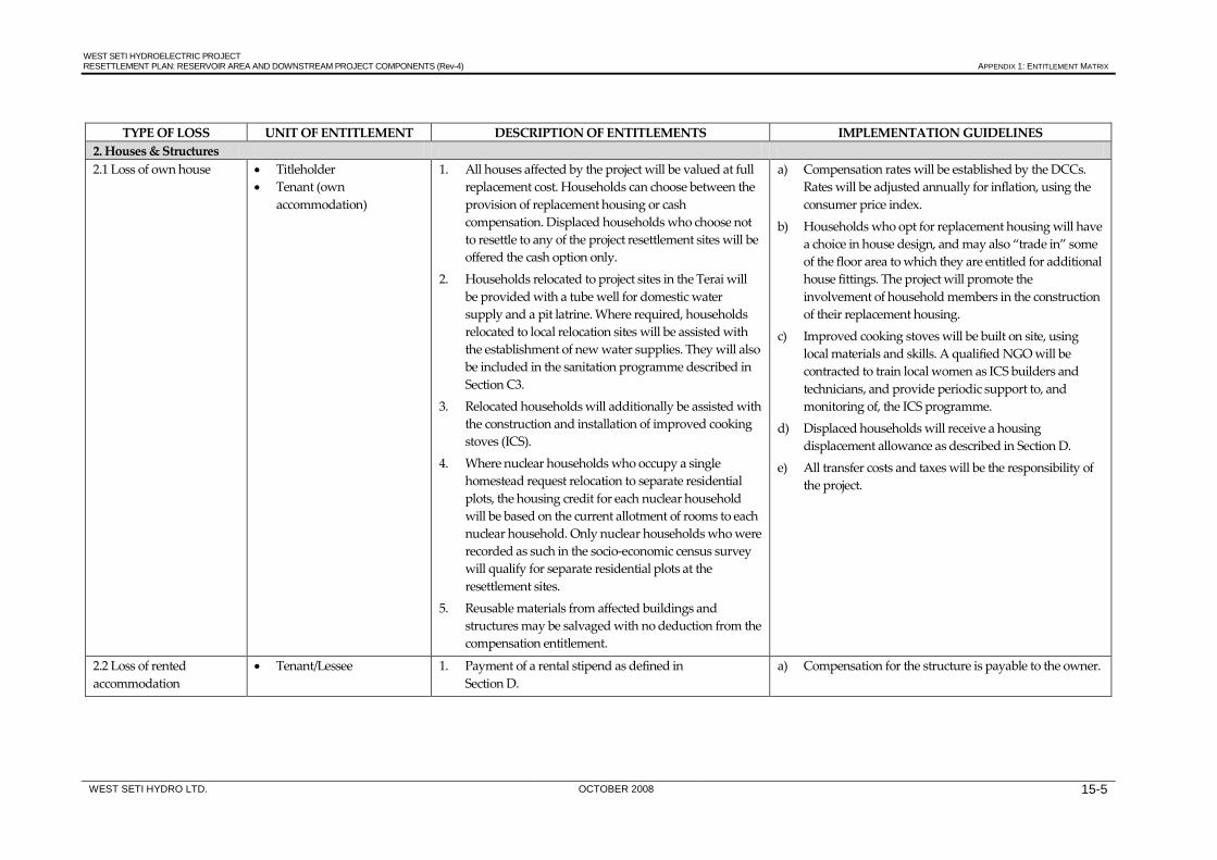
WEST SETI HYDROELECTRIC PROJECT RESETTLEMENT PLAN: RESERVOIR AREA AND DOWNSTREAM PROJECT COMPONENTS (Rev-4) APPENDIX 1: ENTITLEMENT MATRIX
WEST SETI HYDRO LTD. OCTOBER 2008 15-5
TYPE OF LOSS UNIT OF ENTITLEMENT DESCRIPTION OF ENTITLEMENTS IMPLEMENTATION GUIDELINES
2. Houses & Structures 2.1 Loss of own house • Titleholder
• Tenant (own accommodation)
1. All houses affected by the project will be valued at full replacement cost. Households can choose between the provision of replacement housing or cash compensation. Displaced households who choose not to resettle to any of the project resettlement sites will be offered the cash option only.
2. Households relocated to project sites in the Terai will be provided with a tube well for domestic water supply and a pit latrine. Where required, households relocated to local relocation sites will be assisted with the establishment of new water supplies. They will also be included in the sanitation programme described in Section C3.
3. Relocated households will additionally be assisted with the construction and installation of improved cooking stoves (ICS).
4. Where nuclear households who occupy a single homestead request relocation to separate residential plots, the housing credit for each nuclear household will be based on the current allotment of rooms to each nuclear household. Only nuclear households who were recorded as such in the socio-economic census survey will qualify for separate residential plots at the resettlement sites.
5. Reusable materials from affected buildings and structures may be salvaged with no deduction from the compensation entitlement.
a) Compensation rates will be established by the DCCs. Rates will be adjusted annually for inflation, using the consumer price index.
b) Households who opt for replacement housing will have a choice in house design, and may also “trade in” some of the floor area to which they are entitled for additional house fittings. The project will promote the involvement of household members in the construction of their replacement housing.
c) Improved cooking stoves will be built on site, using local materials and skills. A qualified NGO will be contracted to train local women as ICS builders and technicians, and provide periodic support to, and monitoring of, the ICS programme.
d) Displaced households will receive a housing displacement allowance as described in Section D.
e) All transfer costs and taxes will be the responsibility of the project.
2.2 Loss of rented accommodation
• Tenant/Lessee 1. Payment of a rental stipend as defined in Section D.
a) Compensation for the structure is payable to the owner.

WEST SETI HYDROELECTRIC PROJECT RESETTLEMENT PLAN: RESERVOIR AREA AND DOWNSTREAM PROJECT COMPONENTS (Rev-4) APPENDIX 1: ENTITLEMENT MATRIX
WEST SETI HYDRO LTD. OCTOBER 2008 15-6
TYPE OF LOSS UNIT OF ENTITLEMENT DESCRIPTION OF ENTITLEMENTS IMPLEMENTATION GUIDELINES 2.3 Loss of commercial establishment
• Titleholder • Tenant
1. All commercial enterprises affected by the project will be valued at full replacement cost. Owners can choose between the provision of replacement housing or cash compensation. Owners who choose not to resettle to any of the project resettlement sites will be offered the cash option only.
2. Reusable materials may be salvaged with no deduction from the compensation entitlement.
a) Owners of displaced commercial establishments will receive a business displacement allowance as described in Section D.
2.4 Loss of other privately-owned structures
• Titleholder • Tenant (own building)
1. Other privately-owned buildings and structures such as water mills will be valued at replacement cost and compensated in cash.
2. Reusable materials may be salvaged with no deduction from the compensation entitlement.
a) Other structures include: sheds, walls, fences, water mills, etc.
b) Loss of structures other than houses and commercial establishments does not entail payment of a displacement allowance.
3. Other Private Resources 3.1 Loss of non perennial crops
• Person farming the land, whether owner cultivator or tenant/lessee.
1. Construction activities will be timed to avoid damage to or destruction of standing crops as far as possible.
2. Advance notice will be given to harvest crops that are ready for harvesting.
3. Compensation for damaged/lost standing crops will paid based on cultivated area, agreed yield and market price.
a) Crop market values will be determined by the DCCs.
b) Where a tenant/lessee and landowner have a sharecropping arrangement, the compensation payable will be apportioned according to the arrangement.
3.2 Loss of privately-owned trees and perennial crops
• Titleholder; other evidence of ownership
1. Construction activities will be timed to avoid damage to or destruction of perennial crops as far as possible.
2. Advance notice will be given to harvest perennial crops that are ready for harvesting. Crops that cannot be harvested will be compensated for, based on type of crop, agreed yield and market price.
3. Compensation for future production losses, based on five years annual net production for fruit/ fodder trees and three years annual net production for timber/fuelwood trees and other perennial crops.
4. The owner will retain the rights to all other resources from privately-owned perennial crops trees (fruit, timber, fire wood).
a) Crop market values and production losses will be determined by the DCCs.
b) The project will liaise with the Departments of Agriculture and Forestry or suitably qualified NGOs for the provision of assistance to affected owners and communities with the reestablishment of new trees and other perennial crops.

WEST SETI HYDROELECTRIC PROJECT RESETTLEMENT PLAN: RESERVOIR AREA AND DOWNSTREAM PROJECT COMPONENTS (Rev-4) APPENDIX 1: ENTITLEMENT MATRIX
WEST SETI HYDRO LTD. OCTOBER 2008 15-7
C. COMMUNITY ASSETS/RESOURCES
TYPE OF LOSS UNIT OF ENTITLEMENT DESCRIPTION OF ENTITLEMENTS IMPLEMENTATION GUIDELINES 1. Buildings and structures • Local community, owner,
relevant authority 1. Restoration of affected community buildings and
structures to at least previous condition, or replacement in areas identified in consultation with affected communities and relevant authorities.
a) Community buildings and structures include: schools, temples, health posts, trails/foot paths, bridges and cremation sites.
2. Forest resources • Households relocated to project sites in the Terai
1. Each household relocated to project sites in the Terai will receive a land-based entitlement for the loss of access to Seti valley communal resources as described in Section B1.
2. To achieve greater community ownership of forests, and thereby assist in achieving their protection, the promotion of Community Forests will be undertaken as a project initiative. The project will assist in the creation of Community Forests in the project region of influence and provide extension support to forest user groups in order to achieve greater protection of forests prior to and during the operation of the project.
a) While households who relocate locally will lose some natural resources through inundation, they will also benefit from a greatly reduced population base reliant upon local natural resources in the post-construction period. For them and other households only marginally affected by the reservoir, as well as for households who elect to self-relocate to areas of their own choice, the communal resource factor is accordingly not included in the land exchange calculations.
3. Reduced water flow downstream of dam wall
• Riparian villages between dam wall and re-regulation weir
1. Potable water will be supplied year-round in all riparian villages in the riparian area between the dam and the re-regulation weir. Water will either be supplied by improving individual village schemes, constructing new village facilities or by installing a piped reticulation system from the reservoir.
2. A sanitation programme will be established in all riparian area villages to improve sanitary conditions and public health, and thereby improve the quality of catchment runoff harvested for village water supply.

WEST SETI HYDROELECTRIC PROJECT RESETTLEMENT PLAN: RESERVOIR AREA AND DOWNSTREAM PROJECT COMPONENTS (Rev-4) APPENDIX 1: ENTITLEMENT MATRIX
WEST SETI HYDRO LTD. OCTOBER 2008 15-8
D. REHABILITATION ASSISTANCE AND COUNSELLING
ITEM UNIT OF ENTITLEMENT DESCRIPTION IMPLEMENTATION GUIDELINES 1. Shifting allowance • Displaced households 1. Allowance for the removal of personal, household and
business belongings from project areas. a) All allowances will be finalised by the RSC. The
following amounts have been used for budget purposes:
• shifting allowance: USD 100 (local relocation), USD 200 (Terai relocation);
• household displacement allowance: USD 318 (local relocation), USD 635 (Terai relocation);
• business displacement allowance: USD 318 (local relocation), USD 635 (Terai relocation);
• vulnerable household allowance: USD 500; • cultivation disruption allowance: USD 635; • rental stipend: USD 80; • grant for labour loss: USD 150.
b) Allowances will be paid at the time of serving the notice to vacate.
2. Household displacement allowance
• Displaced households 1. Allowance for incidental costs associated with the resettlement.
3. Business displacement allowance
• Displaced businesses 1. Allowance for incidental costs associated with the resettlement.
4. Vulnerable household rehabilitation allowance
• Vulnerable households affected by project
1. Allowance to assist with the rehabilitation of vulnerable households affected by the project.
5. Cultivation disruption allowance
• Non-displaced households suffering permanent cultivation land losses
1. Allowance, in addition to compensation for land loss, to assist with rehabilitation of agricultural activities.
6. Rental stipend • Tenant in rented accommodation acquired by project
1. Rental stipend.
7. Grant for loss of labour • Persons of working age whose employment in farm/non-farm enterprises at project sites is terminated due to project activities
1. Payment of a loss of employment allowance.
8. Other livelihood support measures
• Members (15 years and older) from affected
1. Social preparation programmes.
2. Training and counselling on alternative subsistence and livelihood opportunities.
3. Training programmes to enhance employment on construction works.
4. Preferential employment on construction works to the extent possible.
5. Assistance to gain access to national poverty alleviation and credit programmes.
a) The Project will implement a preferential employment strategy to enhance construction employment for project-affected persons.
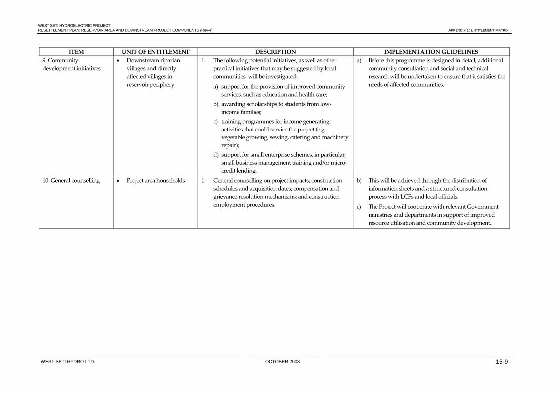
WEST SETI HYDROELECTRIC PROJECT RESETTLEMENT PLAN: RESERVOIR AREA AND DOWNSTREAM PROJECT COMPONENTS (Rev-4) APPENDIX 1: ENTITLEMENT MATRIX
WEST SETI HYDRO LTD. OCTOBER 2008 15-9
ITEM UNIT OF ENTITLEMENT DESCRIPTION IMPLEMENTATION GUIDELINES 9. Community development initiatives
• Downstream riparian villages and directly affected villages in reservoir periphery
1. The following potential initiatives, as well as other practical initiatives that may be suggested by local communities, will be investigated:
a) support for the provision of improved community services, such as education and health care;
b) awarding scholarships to students from low-income families;
c) training programmes for income generating activities that could service the project (e.g. vegetable growing, sewing, catering and machinery repair);
d) support for small enterprise schemes, in particular, small business management training and/or micro-credit lending.
a) Before this programme is designed in detail, additional community consultation and social and technical research will be undertaken to ensure that it satisfies the needs of affected communities.
10. General counselling • Project area households 1. General counselling on project impacts; construction schedules and acquisition dates; compensation and grievance resolution mechanisms; and construction employment procedures.
b) This will be achieved through the distribution of information sheets and a structured consultation process with LCFs and local officials.
c) The Project will cooperate with relevant Government ministries and departments in support of improved resource utilisation and community development.

Resettlement Plan - Supporting Documents Document Stage: Draft Project Number: 40919 November 2008
NEP: WEST SETI HYDROELECTRIC PROJECT Reservoir Area and Downstream Project Components
Resettlement Planning Document
Prepared by West Seti Hydro Limited for the Asian Development Bank (ADB).
The resettlement plan is a document of the borrower. The views expressed herein do not necessarily represent those of ADB’s Board of Directors, Management, or staff, and may be preliminary in nature.

WEST SETI HYDROELECTRIC PROJECT
ENVIRONMENTAL IMPACT ASSESSMENT
Volume 3
RESETTLEMENT PLAN: RESERVOIR AREA AND DOWNSTREAM PROJECT
COMPONENTS
SUPPORTING DOCUMENTS
West Seti Hydro Limited 1611 Lamtangin Marg, Maharajgunj
Kathmandu, Nepal
October 2008

WEST SETI HYDROELECTRIC PROJECT RESETTLEMENT PLAN: RESERVOIR AREA AND DOWNSTREAM PROJECT COMPONENTS (Rev-4) - SUPPORTING DOCUMENTS
WEST SETI HYDRO LTD. OCTOBER 2008
Table of Contents
1. LIST OF HOUSEHOLDS INTERVIEWED FOR THE EIA .................................................................... 1‐1
2. FREQUENCY TABLES FROM THE 1997/98 AND 2006 HOUSEHOLD SURVEYS ........................ 2‐1
3. RIPARIAN VILLAGES BETWEEN THE DAM WALL AND RE‐REGULATION WEIR ............... 3‐1
4. NOMINATED COMMUNITY REPRESENTATIVES ON LCFS DURING THE EIA STUDY ..... 4‐1
5. PROJECT INFORMATION SHEETS ......................................................................................................... 5‐1
6. BUILDINGS IN THE RESERVOIR AREA (1997/98) ............................................................................... 6‐1
7. SCHOOLS IN THE RESERVOIR AREA AND PERIPHERY (1997/98) ............................................... 7‐1
8. PROPOSED LAND EXCHANGE RATIOS ............................................................................................... 8‐1
9. MONITORING INDICATORS ................................................................................................................... 9‐1
10. CONSTRUCTION WORKFORCE ............................................................................................................10‐1
11. SOCIO‐ECONOMIC INDICATORS FOR THE TERAI RESETTLEMENT DISTRICTS .............11‐1
12. LIST OF COMMUNITY COMMITTEE MEMBERS (2007 ‐ PRESENT) ...........................................12‐1
13. COMPENSATION AND RESETTLEMENT RESOLUTIONS OF PARTICIPATING COMMITTEES (2008).............................................................................................................................................13‐1

WEST SETI HYDROELECTRIC PROJECT RESETTLEMENT PLAN: RESERVOIR AREA AND DOWNSTREAM PROJECT COMPONENTS (Rev-4) - SUPPORTING DOCUMENTS SD 1
WEST SETI HYDRO LTD. OCTOBER 2008 1-1
1. LIST OF HOUSEHOLDS INTERVIEWED FOR THE EIA
Project Component
Reservoir Location HH Id. District VDC W Village Household Head Gender Caste
Reservoir 1 2-3F-17,18 Baitadi Dhungad 3 Banja Pathan Dhami M Chhetri Reservoir 1 2-2-D-4 Baitadi Dhungad 3 Barphire Naruwa Dhami M Chhetri Reservoir 1 2-2-D-8 Baitadi Dhungad 3 Barphire Raghubir Singh Dhami M Chhetri Reservoir 1 2-2-D-3A Baitadi Dhungad 3 Bhasme Dhanbir Dhami M Chhetri Reservoir 1 2-2-E-1B Baitadi Dhungad 4 Bhasme Ganga Ram Dhami M Chhetri Reservoir 1 2-2D-1 Baitadi Dhungad 3 Bhasme Ghupare Dhami M Chhetri Reservoir 1 2-3-E-4 Baitadi Dhungad 3 Bhasme Harjeet Dhami M Chhetri Reservoir 1 2-2-E1A Baitadi Dhungad 4 Bhasme Jaybhan Dhami M Chhetri Reservoir 1 2-2-D-3B Baitadi Dhungad 6 Bhasme Kheute Dhami M Chhetri Reservoir 1 2-2-D-9B Baitadi Dhungad 4 Bhasme Mandire Dhami M Chhetri Reservoir 1 2-2-D-9,10 Baitadi Dhungad 4 Bhasme Nanna Dhami M Chhetri Reservoir 1 2-2-D-2 Baitadi Dhungad 3 Bhasme Narjeet Dhami M Chhetri Reservoir 1 2-2-D-7 Baitadi Dhungad 3 Bhasme Naruwa Dhami M Chhetri
Reservoir 1 2-2-D-5, 2-1-G-8,10, 2-3-H-15 Baitadi Dhungad 3 Bhasme Tule Dhami M Chhetri
Reservoir 1 3-4-D-1B Baitadi Dhungad 8 Chune Bhaga Deuka F Badi Reservoir 1 3-5-C-3A Baitadi Dhungad 8 Chune Bir Bd. Saud M Chhetri Reservoir 1 3-4-C-8B Baitadi Dhungad 8 Chune Chandra Bd. Saud M Chhetri Reservoir 1 3-4-C-1 Baitadi Dhungad 8 Chune Dharme Deuka M Badi Reservoir 1 3-4-D-1A Baitadi Dhungad 8 Chune Hari Deuka M Badi Reservoir 1 3-3-D-1A Baitadi Dhungad 8 Chune Kate Deuka M Badi Reservoir 1 3-4-C-11,12,10 Baitadi Dhungad 9 Chune Khaire Saud M Chhetri Reservoir 1 3-5-C-6B Baitadi Dhungad 8 Chune Mani Dhami M Chhetri Reservoir 1 3-3-D-1B Baitadi Dhungad 8 Chune Nain Deuka M Badi Reservoir 1 3-4-C-2,3,4 Baitadi Dhungad 9 Chune Pratap Saud M Chhetri Reservoir 1 3-5-C-6/3-4-C-8A Baitadi Dhungad 8 Chune Ragi Saud M Chhetri Reservoir 1 3-5-C-6A Baitadi Dhungad 8 Chune Rati Dhami M Chhetri Reservoir 1 3-4-C-8B Baitadi Dhungad 8 Chune Tika Dhami M Chhetri Reservoir 2 1-3K4 Baitadi Dhungad 2 Dhaulechiura Ram Singh Dhami M Chhetri Reservoir 1 2-5/6H-8 Baitadi Dhungad 7 Dhungad Amita Lohar F Kami Reservoir 1 2-5/6H-38 Baitadi Dhungad 7 Dhungad Bir Bahadur Chand M Thakuri
Reservoir 1 2-5/6H-17A,64,35,57A,2-4I-1A
Baitadi Dhungad 7 Dhungad Bir Bahadur Chand M Thakuri
Reservoir 1 2-5/6H-14D Baitadi Dhungad 7 Dhungad Bir Bahadur Chand M Thakuri Reservoir 1 2-5/6H-43 Baitadi Dhungad 7 Dhungad Bishna Devi Singh F Thakuri Reservoir 1 2-5G-5 Baitadi Dhungad 7 Dhungad Brata Raj Awasthi M Brahmin Reservoir 1 2-5/6H-41C Baitadi Dhungad 7 Dhungad Chakra Bahadur Chand M Thakuri Reservoir 1 2-5/6H-19 Baitadi Dhungad 7 Dhungad Chandra Lohar M Kami Reservoir 1 2-5/6H-29B Baitadi Dhungad 7 Dhungad Chandra Singh Saud M Chhetri Reservoir 1 2-5/6H-23A Baitadi Dhungad 7 Dhungad Dali Mahara M Chhetri Reservoir 1 2-5/6H-58 Baitadi Dhungad 7 Dhungad Dev Dholi M Damai Reservoir 1 2-5/6H-28 Baitadi Dhungad 7 Dhungad Dev Saud M Chhetri Reservoir 1 2-5/6H-23C Baitadi Dhungad 7 Dhungad Dev Singh Mahara M Chhetri Reservoir 1 5-56H-21 Baitadi Dhungad 7 Dhungad Dhire Lohar M Kami Reservoir 1 2-5/6H-54A Baitadi Dhungad 7 Dhungad Dhirghe Badi M Badi Reservoir 1 2-5/6H-62 Baitadi Dhungad 7 Dhungad Durga Giri F Giri
Reservoir 1 2-5/6H-27,2-4-J-34 Baitadi Dhungad 7 Dhungad Ganesh Bahadur Chand M Thakuri
Reservoir 1 2-5/6H-47 Baitadi Dhungad 7 Dhungad Gokul Badi M Badi
Reservoir 1 2-5/6H-42,2-4J-9B Baitadi Dhungad 7 Dhungad Gopi Chand M Thakuri
Reservoir 1 2-5/6H-3 Baitadi Dhungad 7 Dhungad Harka Bahadur Chand M Thakuri Reservoir 1 2-5/6H-24 Baitadi Dhungad 7 Dhungad Hatto Lohar M Kami Reservoir 1 2-5/6-H-19A Baitadi Dhungad 7 Dhungad Hikmat Chand M Thakuri
Reservoir 1 2-5/6H-15d,2-4-I-4 Baitadi Dhungad 6 Dhungad Hira Chand M Thakuri
Reservoir 1 2-5/6H-51 Baitadi Dhungad 7 Dhungad Jaya Bhan Lohar M Kami Reservoir 1 2-5/6H,7A Baitadi Dhungad 7 Dhungad Jhuse Lohar M Kami Reservoir 1 2-5/6H,7B Baitadi Dhungad 7 Dhungad Junkiri Lohar F Kami Reservoir 1 2-5/6H-14A Baitadi Dhungad 7 Dhungad Kalasa Devi Chand F Thakuri
Reservoir 1 2-5/6H-1,2-5/6H-56 Baitadi Dhungad 7 Dhungad Kalu Chand M Thakuri
Reservoir 1 2-5/6H-11 Baitadi Dhungad 7 Dhungad Kani Lohar F Kami
Reservoir 1 2-5/6H-12A,2-4-J-5 Baitadi Dhungad 7 Dhungad Karna Bahadur Chand M Thakuri
Reservoir 1 2-5/6H-32A Baitadi Dhungad 7 Dhungad Karna Bahadur Saud M Chhetri
Reservoir 1 2-5/6H-15C,2-4J-8,36 Baitadi Dhungad 7 Dhungad Keshav Bahadur Chand M Thakuri

WEST SETI HYDROELECTRIC PROJECT RESETTLEMENT PLAN: RESERVOIR AREA AND DOWNSTREAM PROJECT COMPONENTS (Rev-4) - SUPPORTING DOCUMENTS SD 1
WEST SETI HYDRO LTD. OCTOBER 2008 1-2
Project Component
Reservoir Location HH Id. District VDC W Village Household Head Gender Caste
Reservoir 1 2-5/6H-12B,26,53,2-4-J-10
Baitadi Dhungad 7 Dhungad Khadak Bahadur Chand M Thakuri
Reservoir 1 2-5/6H-15A,2-4J-6 Baitadi Dhungad 7 Dhungad Khadak Bahadur Chand M Thakuri
Reservoir 1 2-5/6H-22B Baitadi Dhungad 7 Dhungad Kide Lohar M Kami Reservoir 1 2-5/6H-65B Baitadi Dhungad 7 Dhungad Lal Bahadur Dholi M Damai Reservoir 1 2-5/6/H-20 Baitadi Dhungad 7 Dhungad Lal Parki M Kami Reservoir 1 2-5/6H-25 Baitadi Dhungad 7 Dhungad Lale Lohar M Kami Reservoir 1 2-5/6H-46A Baitadi Dhungad 7 Dhungad Laluwa Lohar M Kami Reservoir 1 2-5/6H-65D Baitadi Dhungad 7 Dhungad Laxman Dholi M Damai Reservoir 1 2-5/6H-65C Baitadi Dhungad 7 Dhungad Laxmi Damai F Damai Reservoir 1 2-5G-6 Baitadi Dhungad 7 Dhungad Laxmi Dutta Awasthi M Brahmin
Reservoir 1 2-4-J-36 , 2-4-JA-1700 Baitadi Dhungad 7 Dhungad Log Bahadur Chand M Thakuri
Reservoir 1 2-5-G-3 Baitadi Dhungad 7 Dhungad Madan Raj Awasthi M Brahmin Reservoir 1 2-5/6-H-57B Baitadi Dhungad 7 Dhungad Madan Shahi M Thakuri Reservoir 1 2-5/6H-41B Baitadi Dhungad 7 Dhungad Man B. Chand M Thakuri Reservoir 1 2-5/6H-41A Baitadi Dhungad 7 Dhungad Man Bahadur Chand M Thakuri
Reservoir 1 2-5/6H-44 , 2-5/6H-45 Baitadi Dhungad 7 Dhungad Min B. Chand M Thakuri
Reservoir 1 2-5/6H-14C,2-5/6H-67 Baitadi Dhungad 7 Dhungad Min Bahadur Chand M Thakuri
Reservoir 1 2-5/6H-2,38B Baitadi Dhungad 7 Dhungad Nar Bahadur Chand M Thakuri Reservoir 1 2-5/6H-23B,74 Baitadi Dhungad 7 Dhungad Nar Bahadur Mahara M Chhetri Reservoir 1 2-5/6H-52A Baitadi Dhungad 7 Dhungad Nare Lohar M Kami Reservoir 1 2-5/6H-6 Baitadi Dhungad 7 Dhungad Nare Lohar M Kami Reservoir 1 2-5/6H-22A Baitadi Dhungad 7 Dhungad Nari Lohar M Kami Reservoir 1 2-5/6H,4B Baitadi Dhungad 7 Dhungad Naute Lohar M Kami Reservoir 1 2-5/6H-14B Baitadi Dhungad 7 Dhungad Padam Bahadur Chand M Thakuri Reservoir 1 2-5/6H-18 Baitadi Dhungad 7 Dhungad Padma Chunaro F Kami Reservoir 1 2-5/6H-52B Baitadi Dhungad 7 Dhungad Phaure Lohar M Kami Reservoir 1 2-5/6H,4A Baitadi Dhungad 7 Dhungad Pratap Lohar M Kami Reservoir 1 2-5/6H-60A Baitadi Dhungad 7 Dhungad Prate Lohar M Kami
Reservoir 1 2-5/6H-13,55,2-4-J-7 Baitadi Dhungad 7 Dhungad Prem Bahadur Chand M Thakuri
Reservoir 1 2-5/6H-30 Baitadi Dhungad 7 Dhungad Prem Singh Saud M Chhetri Reservoir 1 2-5/6H-22C Baitadi Dhungad 7 Dhungad Puni Lohar F Kami Reservoir 1 2-5G-4B Baitadi Dhungad 7 Dhungad Pushpa Raj Awasthi M Brahmin
Reservoir 1 2-5/6H-17B,2-5/6H-16,2-5/6H-57
Baitadi Dhungad 7 Dhungad Rana Bahadur Chand M Thakuri
Reservoir 1 2-5/6H-29A Baitadi Dhungad 7 Dhungad Rani Saud M Chhetri Reservoir 1 2-5/6H-17B Baitadi Dhungad 7 Dhungad Ratan Sunar M Kami Reservoir 1 2-5/6H-60B Baitadi Dhungad 7 Dhungad Saru Lohar F Kami Reservoir 1 2-5/6H-18A Baitadi Dhungad 7 Dhungad Shopi Chunaro M Kami Reservoir 3 Dependency Baitadi Dhungad 8 Dhungad Siddaraj Awasthi M Brahmin Reservoir 1 2-5/6H-65A Baitadi Dhungad 7 Dhungad Sobi Dholi M Damai Reservoir 1 2-5/6H-51A Baitadi Dhungad 7 Dhungad Sundari Lohar F Kami Reservoir 1 2-5/6H-54B Baitadi Dhungad 7 Dhungad Tek Badi M Badi Reservoir 1 2-5/6H-41B,12 Baitadi Dhungad 7 Dhungad Tek Bahadur Chand M Thakuri Reservoir 1 2-5-G-7 Baitadi Dhungad 7 Dhungad Tek Raj Awasthi M Brahmin Reservoir 1 2-5/6H-50 Baitadi Dhungad 7 Dhungad Tuli Lohar F Kami Reservoir 1 2-5/6H-39,40 Baitadi Dhungad 7 Dhungad Uday Bahadur Chand M Thakuri Reservoir 1 2-5-G-2 Baitadi Dhungad 1 Dobaod Joga Dhami M Chhetri Reservoir 3 2-1-H-7 Baitadi Dhungad 5 Gajeli Bhuwa Birbhan Dhami M Chhetri Reservoir 3 2-1-H-6B Baitadi Dhungad 5 Gajeli Bhuwa Dani Dhami M Chhetri Reservoir 3 2-1-H-5 Baitadi Dhungad 5 Gajeli Bhuwa Dev Singh Dhami M Chhetri Reservoir 3 2-1-G-17 ,2-1-H-1 Baitadi Dhungad 5 Gajeli Bhuwa Mahabir Dhami M Chhetri Reservoir 3 2-1-H-6A Baitadi Dhungad 5 Gajeli Bhuwa Pathan Dhami M Chhetri Reservoir 3 2-1-H-3 Baitadi Dhungad 5 Gajeli Bhuwa Prayak Dhami M Chhetri Reservoir 3 2-1-G-16 Baitadi Dhungad 5 Gajeli Bhuwa Rai Singh Dhami M Chhetri Reservoir 3 2-4-J-26 Baitadi Dhungad 6 Gatapid Lachuwa Lohar M Kami Reservoir 3 2-4-J-24C Baitadi Dhungad 6 Gatipid Chandrawati Devi Lohar F Kami Reservoir 3 2-4-J-19 Baitadi Dhungad 7 Gatipid Diluwa Lohar M Kami Reservoir 3 2-4-J-18 Baitadi Dhungad 6 Gatipid Hari Bhan Dhami M Chhetri Reservoir 3 2-4-J-24D Baitadi Dhungad 6 Gatipid Jaido Lohar M Kami Reservoir 3 2-4-J-22 Baitadi Dhungad 7 Gatipid Jallu Devi Lohar F Kami Reservoir 3 2-4-J-16B Baitadi Dhungad 7 Gatipid Kalibhan Dhami M Chhetri Reservoir 3 2-4-J-25 Baitadi Dhungad 7 Gatipid Kide Lohar M Kami Reservoir 3 2-4-J-20 Baitadi Dhungad 7 Gatipid Muna Devi Lohar F Kami Reservoir 3 2-4-J-23,24A Baitadi Dhungad 6 Gatipid Naute Lohar M Kami Reservoir 3 2-4-J-21 Baitadi Dhungad 7 Gatipid Pudke Lohar M Kami Reservoir 3 2-4-J-2 Baitadi Dhungad 7 Gatipid Ram Singh Dhami M Chhetri Reservoir 1 2-4G-6 Baitadi Dhungad 7 GhattoKhet Dev Singh Dhami M Chhetri Reservoir 3 2-3-G-15 Baitadi Dhungad 5 Gune Birbhan Dhami M Chhetri

WEST SETI HYDROELECTRIC PROJECT RESETTLEMENT PLAN: RESERVOIR AREA AND DOWNSTREAM PROJECT COMPONENTS (Rev-4) - SUPPORTING DOCUMENTS SD 1
WEST SETI HYDRO LTD. OCTOBER 2008 1-3
Project Component
Reservoir Location HH Id. District VDC W Village Household Head Gender Caste
Reservoir 3 2-2-H-1,8 Baitadi Dhungad 5 Gune Dhanna Dhami M Chhetri Reservoir 3 2-3-H-19 Baitadi Dhungad 5 Gune Dhaulya Dhami M Chhetri Reservoir 3 2-3-H-1 Baitadi Dhungad 5 Gune Ganga Singh Dhami M Chhetri Reservoir 3 2-3-H-2A Baitadi Dhungad 5 Gune Gangaram Dhami M Chhetri Reservoir 3 2-3-G-12 Baitadi Dhungad 5 Gune Gopal Dhami M Chhetri Reservoir 3 2-3-H-4 Baitadi Dhungad 5 Gune Jahari Dhami M Chhetri Reservoir 3 2-2-H-3 Baitadi Dhungad 5 Gune Jasbir Air M Chhetri
Reservoir 1 2-3-F-21 , 2-3-G-8 Baitadi Dhungad 5 Gune Joga Singh Dhami M Chhetri
Reservoir 1 2-4-F-4 Baitadi Dhungad 5 Gune Kashi Singh Dhami M Chhetri Reservoir 3 2-3-H-13 Baitadi Dhungad 5 Gune Krishna Lohar M Kami Reservoir 3 2-3-H-11 Baitadi Dhungad 5 Gune Lal Lohar M Kami Reservoir 3 2-2-H-4 Baitadi Dhungad 5 Gune Pare Dhami M Chhetri Reservoir 3 2-3-H-21 Baitadi Dhungad 5 Gune Rame Dhami M Chhetri Reservoir 3 2-3-G-3 Baitadi Dhungad 5 Gune Rangi Dhami M Chhetri Reservoir 3 2-3-H-2B Baitadi Dhungad 5 Gune (Damadi) Rai Singh Dhami M Chhetri Reservoir 3 2-3-G-5 Baitadi Dhungad 6 Gunya Khola Dani Dhami M Chhetri Reservoir 3 2-3-G-9 Baitadi Dhungad 5 Gunya Khola Dev Singh Dhami M Chhetri Reservoir 1 2-3-F-9,10 Baitadi Dhungad 3 Gunya Khola Dhan Bahadur Dhami M Chhetri Reservoir 2 2-3-F-11,19,22 Baitadi Dhungad 3 Gunya Khola Game Dhami M Chhetri Reservoir 1 2-3-F-4 Baitadi Dhungad 4 Gunya Khola Gopal Singh Dhami M Chhetri Reservoir 3 2-3-G-10 Baitadi Dhungad 5 Gunya Khola Gore Dhami M Chhetri Reservoir 1 2-3-F-3B Baitadi Dhungad 4 Gunya Khola Jagi Dhami M Chhetri Reservoir 1 2-3-F-3A Baitadi Dhungad 3 Gunya Khola Jaibhan Dhami M Chhetri Reservoir 1 2-3-F-1 Baitadi Dhungad 3 Gunya khola Jhuse Dhami M Chhetri Reservoir 3 2-3-G-6 Baitadi Dhungad 5 Gunya Khola Karbir Dhami M Chhetri Reservoir 1 2-3-F-3C Baitadi Dhungad 3 Gunya Khola Lal Singh Dhami M Chhetri Reservoir 3 2-1-G-4 Baitadi Dhungad 3 Gunya Khola Man Bir Dhami M Chhetri Reservoir 1 2-3-F-16A Baitadi Dhungad 3 Gunya Khola Manbir Dhami M Chhetri Reservoir 3 2-3-G-7 Baitadi Dhungad 5 Gunya Khola Nar Bahadur Dhami M Chhetri Reservoir 1 2-3-F-15 Baitadi Dhungad 3 Gunya Khola Prem Bahadur Dhami M Chhetri Reservoir 1 2-3-F-6 Baitadi Dhungad 3 Gunya khola Prem Singh Dhami M Chhetri Reservoir 1 2-3F-14 Baitadi Dhungad 4 Gunya Khola Ram Singh Dhami M Chhetri Reservoir 1 2-3-F-20 Baitadi Dhungad 5 Gunya Khola Ratna Bahadur Dhami M Chhetri Reservoir 2 2-3-F-13 Baitadi Dhungad 3 Gunyakhola Kamal Singh Dhami M Chhetri Reservoir 1 3-5-C-1 Baitadi Dhungad 8 Hadarakhani Bhanuwa Dhami M Chhetri Reservoir 1 3-5-C-3A Baitadi Dhungad 8 Hadarakhani Birman Dhami M Chhetri Reservoir 1 3-6-B-3,3-5-B-2 Baitadi Dhungad 8 Hadarakhani Dhanjeet Dhami M Chhetri
Reservoir 1 3-6-B-5B,3-4-C-6B Baitadi Dhungad 8 Hadarakhani Gangaram Dhami M Chhetri
Reservoir 1 3-6-B-4 Baitadi Dhungad 8 Hadarakhani Gangaram Dhami M Chhetri
Reservoir 1 3-5-B-3A,B,3-5-B-4 Baitadi Dhungad 8 Hadarakhani Nature Dhami M Chhetri
Reservoir 1 3-6-B-5A,3-4-C-6A Baitadi Dhungad 8 Hadarakhani Pratap Dhami M Chhetri
Reservoir 1 3-6-B-6 Baitadi Dhungad 8 Haradakhani Joga Singh Dhami M Chhetri Reservoir 1 3-5-B-1 Baitadi Dhungad 8 Haradakhani Joga Singh Dhami M Chhetri Reservoir 1 3-6-B-7 Baitadi Dhungad 8 Haradakhani Mandhire Dhami M Chhetri Reservoir 1 3-5-C-3B,3-6-B-2 Baitadi Dhungad 8 Haradakhani Pratap Singh Dhami M Chhetri Reservoir 1 3-6-B-8 Baitadi Dhungad 8 Haradakhani Ratane Dhami M Chhetri Reservoir 3 Dependency Baitadi Dhungad 8 Kalde Joga Singh Dhami M Chhetri Reservoir 1 3-4-D-2 Baitadi Dhungad 8 Kalde Kani Dhami F Chhetri Reservoir 2 3-4-C-5 Baitadi Dhungad 8 Kalde Pare Dhami M Chhetri Reservoir 3 3-4-B-1 Baitadi Dhungad 8 Kalde Riule Dhami M Chhetri Reservoir 2 1-6-J-3 Baitadi Dhungad 3 Khadaule Birbhan Singh Dhami M Chhetri Reservoir 1 1-6-I-1B Baitadi Dhungad 3 Khadaule Dev Singh Dhami M Chhetri Reservoir 1 1-6-I-4 Baitadi Dhungad 6 Khadaule Jeet Dhami M Chhetri Reservoir 1 1-6-J-2 Baitadi Dhungad 3 Khadaule Karbir Singh Dhami M Chhetri Reservoir 1 1-6-I-1A Baitadi Dhungad 3 Khadaule Ram Singh Dhami M Chhetri Reservoir 2 1-6-I-3 Baitadi Dhungad 3 Khadaule Ranbir Dhami M Chhetri Reservoir 1 1-6-I-2 Baitadi Dhungad 3 Khadaule Rani Dhami M Chhetri Reservoir 1 2-3-E-4 Baitadi Dhungad 4 Khadaule Bagar Harjeet Dhami M Chhetri Reservoir 3 Dependency Baitadi Dhungad 4 Khairkot Arjun Dhami M Chhetri Reservoir 3 Dependency Baitadi Dhungad 3 Khairkot Kamale Dhami M Chhetri Reservoir 3 Dependency Baitadi Dhungad 4 Khairkot Lal Singh Dhami M Chhetri Reservoir 3 Dependency Baitadi Dhungad 4 Khairkot Padam Singh Dhami M Chhetri Reservoir 3 2-3-H-16A Baitadi Dhungad 5 Kolkate Naute Dhami M Chhetri Reservoir 3 2-3-H-14 Baitadi Dhungad 5 Kolkate Salibhan Dhami M Chhetri
Reservoir 3 2-1-G-2, 2-3-H-16B Baitadi Dhungad 5 Kolkate (Silaju) Mandev Dhami M Chhetri
Reservoir 3 2-1-G-3, 2-3-H-17 Baitadi Dhungad 5 Kolkote (Silaju) Paruwa Dhami M Chhetri Reservoir 1 3-4-E-4A,5A,6 Baitadi Dhungad 9 Lambagar Channare Dhami M Chhetri

WEST SETI HYDROELECTRIC PROJECT RESETTLEMENT PLAN: RESERVOIR AREA AND DOWNSTREAM PROJECT COMPONENTS (Rev-4) - SUPPORTING DOCUMENTS SD 1
WEST SETI HYDRO LTD. OCTOBER 2008 1-4
Project Component
Reservoir Location HH Id. District VDC W Village Household Head Gender Caste
Reservoir 1 4-4-A-2A Baitadi Dhungad 9 Lambagar Deuram Khadayat M Chhetri Reservoir 1 3-4-G-2 Baitadi Dhungad 9 Lambagar Dev Singh Khadayat M Chhetri Reservoir 1 4-4-A-1 Baitadi Dhungad 9 Lambagar Dharme Khadayat M Chhetri Reservoir 1 3-4-F-1, 3-5-F-1 Baitadi Dhungad 9 Lambagar Hari Singh Rokaya M Chhetri
Reservoir 1 4-1-C-9, 5-13-E-18 Baitadi Dhungad 9 Lambagar Jay B. Khadayat M Chhetri
Reservoir 1 3-5-G-2A Baitadi Dhungad 9 Lambagar Jaya Khadayat M Chhetri Reservoir 1 3-4-E-4B,5B Baitadi Dhungad 9 Lambagar Jogi Dhami M Chhetri Reservoir 1 3-4-G-4,5 Baitadi Dhungad 9 Lambagar Kalibhan Thapa M Chhetri Reservoir 1 3-5-G-1,7-13G-29 Baitadi Dhungad 9 Lambagar Kalyan Thapa M Chhetri Reservoir 1 4-4-A-2B Baitadi Dhungad 9 Lambagar Kate Khadayat M Chhetri Reservoir 1 3-4-G-7,9B Baitadi Dhungad 9 Lambagar Man Singh Khadayat M Chhetri Reservoir 1 3-4-G-1A Baitadi Dhungad 9 Lambagar Nari B. Khadayat M Chhetri Reservoir 1 3-4-G-7 Baitadi Dhungad 9 Lambagar Padam B. Khadayat M Chhetri Reservoir 1 3-4-G-9A Baitadi Dhungad 9 Lambagar Salibhan Khadayat M Chhetri Reservoir 1 3-4-G-3 Baitadi Dhungad 9 Lambagar Saluwa Khadayat M Chhetri
Reservoir 1 3-4-F-4, 5, 12 Baitadi Dhungad 9 Lambagar (Tudi Bagar) Dhana Bahadur Rokaya M Chhetri
Reservoir 1 1-5I-1,2, 7I1 Baitadi Dhungad 2 Limadkhet Bahadur Dhami M Chhetri Reservoir 2 1-4-J-3 Baitadi Dhungad 2 Limbadkhet Haruwa Dhami M Chhetri Reservoir 2 1-5J-1,2 Baitadi Dhungad 3 Limod Narayan Dhami M Chhetri Reservoir 1 3-6-A-8 Baitadi Dhungad Lodebagar Ajibhan Dhami M Chhetri Reservoir 1 3-6-A-3 Baitadi Dhungad 8 Lodebagar Balbir Dhami M Chhetri Reservoir 1 3-6-A-6, 2-4-J-33 Baitadi Dhungad 8 Lodebagar Dhan Singh Dhami M Chhetri
Reservoir 1 3-6-A-9,2, 2-4-J-3 Baitadi Dhungad 8 Lodebagar Jaybhan Dhami M Chhetri
Reservoir 1 3-6-A-7 Baitadi Dhungad Lodebagar Man B. Dhami M Chhetri Reservoir 1 2-4-J-5,3-6A-5 Baitadi Dhungad 8 Lodebagar Mandhare Dhami M Chhetri Reservoir 1 3-6-A-4, 2-4-J-13 Baitadi Dhungad 8 Lodebagar Nare Dhami M Chhetri Reservoir 1 2-3F-5 Baitadi Dhungad 5 Madhukhet Nanda Lal Dhami M Chhetri Reservoir 1 2-4F-7B Baitadi Dhungad 4 Madhukhet Narjeet Dhami M Chhetri Reservoir 3 2-4-J-42,43 Baitadi Dhungad 6 Mainathalo Dev Chunaro M Kami Reservoir 3 2-4-I-3 Baitadi Dhungad 6 Mainathalo Ganga Ram Chunaro M Kami Reservoir 3 2-4-J-46 Baitadi Dhungad 6 Mainathalo Gopal Chunaro M Kami Reservoir 3 2-4-J-40,39C Baitadi Dhungad 6 Mainathalo Hira Chunaro F Kami Reservoir 3 2-4-J-38 Baitadi Dhungad 6 Mainathalo Pathan Chunaro M Kami Reservoir 1 2-3F3 Baitadi Dhungad 3 Muskhet Ganga Ram Dhami M Chhetri
Reservoir 1 5-13-E-16, 5-12-D-16 Baitadi Dhungad 9 Nakara Dhana Khadayat F Chhetri
Reservoir 1 5-13-E-9 Baitadi Dhungad 9 Nakara Ganesh Khadayat M Chhetri
Reservoir 1 5-12-D-13, 5-13-E-4,5,6,7,14,15,13B
Baitadi Dhungad 9 Nakara Jeet Singh Khadayat M Chhetri
Reservoir 1 5-13-E-13C, 5-12-D-15, 5-13-E-3
Baitadi Dhungad 9 Nakara Kashi Khadayat M Chhetri
Reservoir 1 5-13-E-11B,8, 5-12-D-14 Baitadi Dhungad 9 Nakara Nari Khadayat M Chhetri
Reservoir 1 5-13-E-11A,10 Baitadi Dhungad 9 Nakara Sagare Khadayat M Chhetri Reservoir 3 2-3-H-7 Baitadi Dhungad 5 Piudkot Dani Dhami M Chhetri Reservoir 3 2-3-H-6 Baitadi Dhungad 5 Piudkot Hari Singh Dhami M Chhetri Reservoir 2 1-3-K-1 Baitadi Dhungad 2 Rajhe Dani Dhami M Chhetri Reservoir 2 1-2-K-2,3,4 Baitadi Dhungad 2 Rajhe Durga Devi Dhami F Chhetri Reservoir 2 1-2-K-2A Baitadi Dhungad 4 Rajhe Ganga Singh Dhami M Chhetri Reservoir 2 1-3-K-2 Baitadi Dhungad 2 Rajhe Hari Lal Dhami M Chhetri Reservoir 2 1-2-K-1 Baitadi Dhungad 2 Rajhe Kamale Dhami M Chhetri Reservoir 2 1-3K-3,1-7I-2,3,4 Baitadi Dhungad 2 Rajhe Kauche Dhami M Chhetri Reservoir 3 Dependency Baitadi Dhungad 4 Ratapoda Arjun Dhami M Chhetri Reservoir 3 Dependency Baitadi Dhungad 3 Ratapoda Arjun Saud M Chhetri Reservoir 3 Dependency Baitadi Dhungad 3 Ratapoda Dan Singh Saud M Chhetri Reservoir 3 Dependency Baitadi Dhungad 3 Ratapoda Laxman Singh Saud M Chhetri Reservoir 3 Dependency Baitadi Dhungad 3 Ratopoda Nare Saud M Chhetri Reservoir 1 2-3F-11 Baitadi Dhungad 2 Salpad Lalu Dhami M Chhetri Reservoir 3 2-1-H-4A Baitadi Dhungad 3 Saubagar Manbir Dhami M Chhetri Reservoir 3 2-1-H-4B Baitadi Dhungad 3 Saubagar Nari Dhami M Chhetri Reservoir 3 2-3-G-1 Baitadi Dhungad 5 Shiradi Pathan Singh Dhami M Chhetri Reservoir 3 2-2-G-1 Baitadi Dhungad 5 Shiradi Pratap Singh Dhami M Chhetri Reservoir 3 1-4-J-1,2 Baitadi Dhungad 3 Sigas Naruwa Dhami M Chhetri
Reservoir 3 2-1-G-9,11,6,14,18 Baitadi Dhungad 3 Silaju Jaibhan Dhami M Chhetri
Reservoir 3 Dependency Baitadi Dhungad 6 Thabba Dhan Singh Dhami M Chhetri Reservoir 3 Dependency Baitadi Dhungad 6 Thabba Jasuwa Dhami M Chhetri Reservoir 1 3-4-F-2 Baitadi Dhungad 9 Tundibagar Ajibhan Rokaya M Chhetri Reservoir 1 3-4-F-11 Baitadi Dhungad 9 Tundibagar Bir Bahadur Dhami M Chhetri

WEST SETI HYDROELECTRIC PROJECT RESETTLEMENT PLAN: RESERVOIR AREA AND DOWNSTREAM PROJECT COMPONENTS (Rev-4) - SUPPORTING DOCUMENTS SD 1
WEST SETI HYDRO LTD. OCTOBER 2008 1-5
Project Component
Reservoir Location HH Id. District VDC W Village Household Head Gender Caste
Reservoir 1 3-3-E-1,2 Baitadi Dhungad 9 Tundibagar Dhan Bahadur Dhami M Chhetri Reservoir 1 3-4-F-8 Baitadi Dhungad 9 Tundibagar Dharma Giri F Giri Reservoir 1 3-4-F-3 Baitadi Dhungad 9 Tundibagar Gunje Dhami M Chhetri Reservoir 1 3-4-F-10 Baitadi Dhungad 9 Tundibagar Kaile Rokaya M Chhetri Reservoir 1 3-4-F-9 Baitadi Dhungad 9 Tundibagar Man B. Dhami M Chhetri Reservoir 1 3-4-E-1, 3-3-E-3 Baitadi Dhungad 9 Tundibagar Man Bire Dhami M Chhetri Reservoir 1 3-4-E-3 Baitadi Dhungad 9 Tundibagar Nain Singh Dhami M Chhetri Reservoir 1 3-4-F-6,7 Baitadi Dhungad 9 Tundibagar Raibhan Rokaya M Chhetri Reservoir 1 3-4-E-2 Baitadi Dhungad 9 Tundibagar Ram Dhami M Chhetri Reservoir 3 Dependency Baitadi Dhungad 2 Ukalden Dhani Dhami M Chhetri
Reservoir 1 2-5G-4A Baitadi Dhungad 7 Uskala Brabhapur Shiva Dutta Awasthi M Brahmin
Reservoir 1 5-9-H-1B, 6-8-A-10 Baitadi Shivaling 9 Agurali Amarraj Aawasti M Brahmin
Reservoir 1 5-9-H-1A, 6-8-A-12 Baitadi Shivaling 9 Agurali Narayan Prasad Awasthi M Brahmin
Reservoir 1 5-9-H-2,3 6-8-A-11 Baitadi Shivaling 9 Agurali Ram P Aawasti M Brahmin
Reservoir 1 5-9-G-1,2,3A 5-10-G-10 Baitadi Shivaling 9 Bhautelipata Gopal Bohara M Chhetri
Reservoir 1 5-10-G-7,8,9 , 5-9-G-4,3B Baitadi Shivaling 9 Bhautelipata Kashiram Bohara M Chhetri
Reservoir 3 Dependency Baitadi Shivaling 8 Binalo Birpal Saud M Chhetri Reservoir 3 Dependency Baitadi Shivaling 8 Binalo Dalbir Saud M Chhetri Reservoir 3 Dependency Baitadi Shivaling 8 Binalo Guman Saud M Chhetri
Reservoir 1 6-6-C-5, 6-6-B-2, 6-6-C-11 Baitadi Shivaling 9 Bohori Bir Bd. Bohara M Chhetri
Reservoir 2 6-5-C-1, 6-6-B-1 Baitadi Shivaling 9 Bohori Chana Bohara F Chhetri Reservoir 1 6-6B-9 Baitadi Shivaling 9 Bohori Dal Bd. Bohara M Chhetri
Reservoir 2 7-13G-36,6-6-C-10,6-6-B-3,6-5C-6,5-10H-19B
Baitadi Shivaling 9 Bohori Dharma B. Bohara M Chhetri
Reservoir 1 6-6-B-6,6-6-B-7 Baitadi Shivaling 9 Bohori Jahanta Owd M Kami Reservoir 1 6-6-B-8 Baitadi Shivaling 9 Bohori Kale Khadayat M Chhetri Reservoir 2 6-6C-9-B Baitadi Shivaling 9 Bohori Kashi Bohara M Chhetri
Reservoir 2 6-5-C-1,6-5-C-5,6-1-B-4,6-1-B-5 Baitadi Shivaling 9 Bohori Krishna Bohara M Chhetri
Reservoir 2 6-6-C-9A Baitadi Shivaling 9 Bohori Ram B. Bohara M Chhetri Reservoir 2 6-5-C-1B Baitadi Shivaling 9 Bohori Ram B. Bohara M Chhetri
Reservoir 2 5-2-F-13,15,17,25 Baitadi Shivaling 8 Gadul Birbhan Saud M Chhetri
Reservoir 2 5-3-F-4-B Baitadi Shivaling 8 Gadul Gado Saud M Chhetri Reservoir 3 5-2-F-10 Baitadi Shivaling 8 Gadul Hari Saud M Chhetri Reservoir 2 5-3-F-4A Baitadi Shivaling 8 Gadul Hari Saud M Chhetri Reservoir 2 5-4-G-1,5-3-F-10 Baitadi Shivaling 8 Gadul Harjeet Saud M Chhetri Reservoir 3 5-2-F-16C Baitadi Shivaling 8 Gadul Kale Saud M Chhetri Reservoir 3 5-2-F-22 Baitadi Shivaling 8 Gadul Kale Saud M Chhetri Reservoir 2 5-2-F-4 Baitadi Shivaling 8 Gadul Kale Saud M Chhetri Reservoir 2 5-3-F-5B Baitadi Shivaling 8 Gadul Kaluwa Saud M Chhetri Reservoir 2 5-2-F-11A Baitadi Shivaling 8 Gadul Padme Saud M Chhetri Reservoir 2 5-3-F-5A Baitadi Shivaling 8 Gadul Pudke Saud M Chhetri Reservoir 3 5-2-F-19 Baitadi Shivaling 8 Gadul Salibhan Saud M Chhetri Reservoir 2 5-2-F-18 Baitadi Shivaling 8 Gadul Siddha Saud M Chhetri Reservoir 3 5-2-F-16A Baitadi Shivaling 8 Gadul Tika Saud M Chhetri Reservoir 2 5-3-F-7A Baitadi Shivaling 8 Gadul (Pargaun) Jaidev Saud M Chhetri Reservoir 3 Dependency Baitadi Shivaling 8 Hiunath Pathan Saud M Chhetri Reservoir 3 Dependency Baitadi Shivaling 8 Huinath Bahadure Saud M Chhetri Reservoir 3 Dependency Baitadi Shivaling 8 Minala Raghubir Saud M Chhetri Reservoir 2 5-2-F-11B Baitadi Shivaling 8 Nawaghar Biju Saud M Chhetri Reservoir 2 5-4-G-2 Baitadi Shivaling 8 Nawaghar Birjeet Saud M Chhetri Reservoir 2 5-2-F-6 Baitadi Shivaling 8 Nawaghar Chakra Saud M Chhetri Reservoir 3 Dependency Baitadi Shivaling 8 Nawaghar Dalbire Saud M Chhetri Reservoir 3 5-3-G-3 Baitadi Shivaling 8 Nawaghar Dasi Saud M Chhetri Reservoir 3 5-2-F-23 Baitadi Shivaling 8 Nawaghar Devi Saud M Chhetri Reservoir 2 5-4-G-4 Baitadi Shivaling 8 Nawaghar Dhane Saud M Chhetri Reservoir 2 5-2-F-21 Baitadi Shivaling 8 Nawaghar Dhani Ram Saud M Chhetri
Reservoir 2 5-2-F-1B, 5-2-E-1, 5-1-E-1 Baitadi Shivaling 8 Nawaghar Dhanjeet Saud M Chhetri
Reservoir 3 5-2-F-16B Baitadi Shivaling 8 Nawaghar Ghaite Saud M Chhetri Reservoir 3 Dependency Baitadi Shivaling 8 Nawaghar Gopal Saud M Chhetri Reservoir 3 Dependency Baitadi Shivaling 8 Nawaghar Gopi Saud M Chhetri Reservoir 3 Dependency Baitadi Shivaling 8 Nawaghar Haribhan Saud M Chhetri Reservoir 1 5-4-G-1 Baitadi Shivaling 8 Nawaghar Harjeet B. Saud M Chhetri Reservoir 3 5-4-G-3E Baitadi Shivaling 8 Nawaghar Harjeet Saud M Chhetri Reservoir 2 5-2-F-14 Baitadi Shivaling 8 Nawaghar Jaya B.Saud M Chhetri

WEST SETI HYDROELECTRIC PROJECT RESETTLEMENT PLAN: RESERVOIR AREA AND DOWNSTREAM PROJECT COMPONENTS (Rev-4) - SUPPORTING DOCUMENTS SD 1
WEST SETI HYDRO LTD. OCTOBER 2008 1-6
Project Component
Reservoir Location HH Id. District VDC W Village Household Head Gender Caste
Reservoir 2 5-2-F-4,12 Baitadi Shivaling 8 Nawaghar Kaluwa Saud M Chhetri Reservoir 2 5-2-F-8B Baitadi Shivaling 8 Nawaghar Kalwa Saud M Chhetri Reservoir 2 5-2-F-1A Baitadi Shivaling 9 Nawaghar Kandure Saud M Chhetri Reservoir 2 5-2-E-3 Baitadi Shivaling 8 Nawaghar Kare Dholi M Damai Reservoir 2 5-2-E-2 Baitadi Shivaling 8 Nawaghar Khinare Damai M Damai Reservoir 2 5-3-F-3 Baitadi Shivaling 8 Nawaghar Lal Damai M Damai
Reservoir 3 5-5-G-1,3,5 ,7-13-G-30 Baitadi Shivaling 8 Nawaghar Lal singh Saud M Chhetri
Reservoir 3 Dependency Baitadi Shivaling 8 Nawaghar Mani Saud M Chhetri Reservoir 3 Dependency Baitadi Shivaling 8 Nawaghar Nare Saud M Chhetri Reservoir 3 Dependency Baitadi Shivaling 8 Nawaghar Nari Saud M Chhetri Reservoir 3 Dependency Baitadi Shivaling 8 Nawaghar Naute Saud M Chhetri Reservoir 2 5-2-F-8A Baitadi Shivaling 9 Nawaghar Naute Saud M Chhetri Reservoir 3 Dependency Baitadi Shivaling 4 Nawaghar Padme Saud M Chhetri Reservoir 3 Dependency Baitadi Shivaling 8 Nawaghar Raibhan Saud M Chhetri Reservoir 2 5-3-F-1 Baitadi Shivaling 8 Nawaghar Ram Damai M Damai Reservoir 3 5-2-F-20 Baitadi Shivaling 8 Nawaghar Ram Saud M Chhetri Reservoir 2 5-4-F-1,2,7 Baitadi Shivaling 8 Nawaghar Ram Singh Saud M Chhetri Reservoir 3 Dependency Baitadi Shivaling 8 Nawaghar Salibhan Saud M Chhetri Reservoir 2 5-3-F-7-B Baitadi Shivaling 8 Nawaghar Tek Bahadur Saud M Chhetri Reservoir 2 5-2-F-7 Baitadi Shivaling 8 Nawaghar Tek Bahadur Saud M Chhetri Reservoir 2 5-3-F-2 Baitadi Shivaling 8 Nawaghar Tika Ram Damai M Damai Reservoir 2 5-2-F-3,24 Baitadi Shivaling 8 Nawaghar Tika Saud M Chhetri Reservoir 2 5-3-F-8,9 Baitadi Shivaling 8 Nawaghar Tika Saud M Chhetri Reservoir 2 5-2-F-9A Baitadi Shivaling 8 Nawaghar Tirkhe Lohar M Kami Reservoir 2 5-4-F-3,4,5 Baitadi Shivaling 8 Parimera Dharmananda Saud M Chhetri Reservoir 3 5-4-F-6 Baitadi Shivaling 8 Parimera Dhungre Saud M Chhetri Reservoir 3 5-4-F-8 Baitadi Shivaling 8 Parimera Narayan Singh Saud M Chhetri Reservoir 1 5-7-G-1 Baitadi Shivaling 9 Sangada Mohan Bahadur Chand M Thakuri Reservoir 1 5-7-F-12 Baitadi Shivaling 9 Sangada Ambar Singh Saud M Chhetri Reservoir 3 5-7-F-2 Baitadi Shivaling 9 Sangada Bira Saud M Chhetri Reservoir 1 5-8-G-10 Baitadi Shivaling 9 Sangada Bishnu Bahadur Chand M Thakuri Reservoir 1 5-8-G-6,14 Baitadi Shivaling 9 Sangada Bishnu Dutta Joshi M Brahmin
Reservoir 1 5-7-F-7, 5-7-G-7,5-8-G-7, 5-7-F-8,9
Baitadi Shivaling 9 Sangada Chandra Bahadur Chand M Thakuri
Reservoir 1 5-8-G-9,11 , 5-6-G-1,2 Baitadi Shivaling 9 Sangada Dan Singh Air M Chhetri
Reservoir 3 5-7F-6 Baitadi Shivaling 9 Sangada Gopi Lohar M Kami Reservoir 1 5-8-G-5 Baitadi Shivaling 9 Sangada Jasbire Saud M Chhetri Reservoir 1 5-8-G-4 Baitadi Shivaling 9 Sangada Kari Saud M Chhetri
Reservoir 3 5-7-F-1, 5-8-G-13 Baitadi Shivaling 9 Sangada Khante Air M Chhetri
Reservoir 1 5-8-G-8 Baitadi Shivaling 9 Sangada Man Bahadur Chand M Thakuri Reservoir 2 5-5-G-2 Baitadi Shivaling 9 Sangada Pathan Saud M Chhetri
Reservoir 2 5-7-F-3, 5-8-G-12 Baitadi Shivaling 9 Sangada Pune Air M Chhetri
Reservoir 1 5-7-G-8,9 , 5-8-G-2 Baitadi Shivaling 9 Sangada Putka Air M Chhetri
Reservoir 3 Dependency Baitadi Shivaling 9 Sangada Salibhan Saud M Chhetri
Reservoir 1 5-7-F-5, 5-7-G-13 Baitadi Shivaling 9 Sangada Sher Bahadur Chand M Thakuri
Reservoir 1 5-7-G-4 Baitadi Shivaling 8 Sangada Surendra Bahadur Chand M Thakuri
Reservoir 2 5-8-G-3, 5-9-G-2, 5-8-H-1 Baitadi Shivaling 9 Sangada Tek Bahadur Chand M Thakuri
Reservoir 1 5-7-G-11 Baitadi Shivaling 9 Sangada (Nawaghar) Ganesh Damai M Damai
Reservoir 3 Dependency Baitadi Shivaling Talpade Kalla Saud F Chhetri Reservoir 3 Dependency Baitadi Shivaling 8 Tilari Narjeet Saud M Chhetri Reservoir 1 5-9-D-3 Baitadi Thalakanda 8 Lekam Bahadure Lohar M Kami
Reservoir 1 5-10-D-1, 5-10E-12B, 5-9-G-11 Baitadi Thalakanda 6 Lekam Chakare Saud M Chhetri
Reservoir 1 5-9-E-12 Baitadi Thalakanda 7 Lekam Chuna Devi Saud F Chhetri
Reservoir 1 5-9-E-16A,5-9-F-29,4 Baitadi Thalakanda 7 Lekam Dal B. Saud M Chhetri
Reservoir 1 5-10-D-14A, 16, 17B Baitadi Thalakanda 6 Lekam Dali Saud M Chhetri
Reservoir 1 5-10E-2A,11 Baitadi Thalakanda 6 Lekam Dali Saud M Chhetri
Reservoir 1 5-9-E-14A, 5-4-E-17 Baitadi Thalakanda 7 Lekam Dalwa Saud M Chhetri
Reservoir 1 5-10-D-13 Baitadi Thalakanda 6 Lekam Dev Singh Dhami M Chhetri
Reservoir 1 5-10-D-14-B,17A, 27 Baitadi Thalakanda 6 Lekam Dev Singh Saud M Chhetri
Reservoir 1 5-10-D-8,9 Baitadi Thalakanda 6 Lekam Dhanno Saud M Chhetri
Reservoir 1 5-9-E-1,2,3A.10, 5-9-F-3,5 Baitadi Thalakanda 7 Lekam Dhume Saud M Chhetri

WEST SETI HYDROELECTRIC PROJECT RESETTLEMENT PLAN: RESERVOIR AREA AND DOWNSTREAM PROJECT COMPONENTS (Rev-4) - SUPPORTING DOCUMENTS SD 1
WEST SETI HYDRO LTD. OCTOBER 2008 1-7
Project Component
Reservoir Location HH Id. District VDC W Village Household Head Gender Caste
Reservoir 1 5-10E-16B Baitadi Thalakanda 6 Lekam Gagane Saud M Chhetri Reservoir 1 5-10-C-1 Baitadi Thalakanda 6 Lekam Ganesh Bahadur Saud M Chhetri
Reservoir 1 5-10D-21,255-12-D-5 Baitadi Thalakanda 6 Lekam Ganga Ram Saud M Chhetri
Reservoir 1 5-10-E-7A Baitadi Thalakanda 6 Lekam Ganga Saud F Chhetri Reservoir 3 Dependency Baitadi Thalakanda 8 Lekam Gore Lohar M Sarki Reservoir 1 5-9-E-17B Baitadi Thalakanda 7 Lekam Gyana Devi Saud F Chhetri Reservoir 1 5-10-D-11A Baitadi Thalakanda 6 Lekam Hira Saud F Chhetri Reservoir 1 5-10-D-26 Baitadi Thalakanda 7 Lekam Jaganath Saud M Chhetri Reservoir 1 5-10-E-6 Baitadi Thalakanda 6 Lekam Jaibhan Saud M Chhetri Reservoir 1 5-10-D-23 Baitadi Thalakanda 6 Lekam Jamuna Devi Saud F Chhetri
Reservoir 1 5-9-D-7B, 8-8-D-2B,3 Baitadi Thalakanda 6 Lekam Janake Saud M Chhetri
Reservoir 1 5-10-E-17A Baitadi Thalakanda 6 Lekam Jay Bd Saud M Chhetri Reservoir 1 5-9-E-8, 5-10-E-9 Baitadi Thalakanda 6 Lekam Jaybhan Saud M Chhetri
Reservoir 1 5-10-E-3, 5-10-E-12C Baitadi Thalakanda 6 Lekam Joga Singh Saud M Chhetri
Reservoir 1 5-12-D-1,3,5-9E-5,6 Baitadi Thalakanda 7 Lekam Jogi Saud M Chhetri
Reservoir 1 5-10-E-1B Baitadi Thalakanda 6 Lekam Jogi Saud M Chhetri
Reservoir 1 5-10-D-4, 5-10-C-4 Baitadi Thalakanda 6 Lekam Kaile Saud M Chhetri
Reservoir 3 Dependency Baitadi Thalakanda 8 Lekam Kale Lohar M Kami
Reservoir 1 5-9-E-17C, 5-9-G-5, 5-9-F-5 Baitadi Thalakanda 7 Lekam Kalibhan Saud M Chhetri
Reservoir 1 5-10-E-13 Baitadi Thalakanda 6 Lekam Kalo Saud M Chhetri
Reservoir 1 5-9-E-11-B, 5-10-D-6 Baitadi Thalakanda 6 Lekam Kalu Singh Saud M Chhetri
Reservoir 1 5-9-E-13,18 Baitadi Thalakanda 7 Lekam Kaluwa Saud M Chhetri Reservoir 1 5-10-D-11B Baitadi Thalakanda 7 Lekam Khema Saud F Chhetri Reservoir 1 5-10-E-15 Baitadi Thalakanda 6 Lekam Khima Saud F Chhetri
Reservoir 1 5-10-E-20B, 5-10-E14D Baitadi Thalakanda 6 Lekam Kishan Saud M Chhetri
Reservoir 1 5-12-D-2,5-9E-3B Baitadi Thalakanda 7 Lekam Krishna Saud M Chhetri Reservoir 1 5-10-D-3 Baitadi Thalakanda 6 Lekam Kumali Devi Saud F Chhetri
Reservoir 1 5-9-D-7, 5-10-E-16C Baitadi Thalakanda 6 Lekam Lal Bir Saud M Chhetri
Reservoir 3 Dependency Baitadi Thalakanda 8 Lekam Lale Lohar M Kami Reservoir 2 5-9-D-8 Baitadi Thalakanda 6 Lekam Lale Saud M Chhetri
Reservoir 1 5-9-E-15,16B, 5-8-D-1, 5-9-G-8 Baitadi Thalakanda 7 Lekam Lale Saud M Chhetri
Reservoir 1 5-9-D-1,2,5,8, 5-9-G-14 Baitadi Thalakanda 6 Lekam Lale Saud M Chhetri
Reservoir 3 Dependency Baitadi Thalakanda 8 Lekam Lalmani Lohar M Kami Reservoir 1 5-10-E-18A Baitadi Thalakanda 6 Lekam Laxmi Saud F Chhetri Reservoir 1 5-10-E-16A Baitadi Thalakanda 6 Lekam Maha Saud M Chhetri
Reservoir 1 5-10-E-21B, 5-10-E-14B Baitadi Thalakanda 6 Lekam Mani Saud M Chhetri
Reservoir 1 5-10-D-5, 5-10-D-19 Baitadi Thalakanda 6 Lekam Mune Saud M Chhetri
Reservoir 1 5-10-E-18B,5-9-G-5,7,13 Baitadi Thalakanda 7 Lekam Nar Bd. Saud M Chhetri
Reservoir 1 5-10-E12A, 5-8-D-2 Baitadi Thalakanda 6 Lekam Nare Saud M Chhetri
Reservoir 3 Dependency Baitadi Thalakanda 6 Lekam Nare Saud M Chhetri
Reservoir 1 5-10-E-1D, 5-10-D-2 Baitadi Thalakanda 6 Lekam Narjeet Saud M Chhetri
Reservoir 1 5-10-E-1A Baitadi Thalakanda 6 Lekam Naute Saud M Chhetri Reservoir 3 Dependency Baitadi Thalakanda 8 Lekam Pare Lohar M Kami
Reservoir 2 5-9-E-14B, 5-10-D-22 Baitadi Thalakanda 6 Lekam Parya Devi Saud F Chhetri
Reservoir 1 5-10-E-17B Baitadi Thalakanda 6 Lekam Pratap Saud M Chhetri Reservoir 1 5-10-D-10A Baitadi Thalakanda 6 Lekam Pratap Saud M Chhetri Reservoir 1 5-9-E-17D Baitadi Thalakanda 7 Lekam Ram Singh Saud M Chhetri
Reservoir 1 5-10-E-21, 5-10E-14A, 5-9-E-17D
Baitadi Thalakanda 6 Lekam Ram Singh Saud M Chhetri
Reservoir 1 5-10-E-2B Baitadi Thalakanda 6 Lekam Rami Saud M Chhetri Reservoir 1 5-10-E-10 Baitadi Thalakanda 6 Lekam Sakari Saud M Chhetri Reservoir 1 5-10E-1C Baitadi Thalakanda 6 Lekam Sakari Saud M Chhetri Reservoir 1 5-10-E-19 Baitadi Thalakanda 6 Lekam Sakari Saud M Chhetri Reservoir 1 5-10-D-14C Baitadi Thalakanda 6 Lekam Sher Bd. Saud M Chhetri
Reservoir 1 5-9-E-7, 5-10-C-3, 5-12-D-9,18 Baitadi Thalakanda 7 Lekam Tara Saud F Chhetri

WEST SETI HYDROELECTRIC PROJECT RESETTLEMENT PLAN: RESERVOIR AREA AND DOWNSTREAM PROJECT COMPONENTS (Rev-4) - SUPPORTING DOCUMENTS SD 1
WEST SETI HYDRO LTD. OCTOBER 2008 1-8
Project Component
Reservoir Location HH Id. District VDC W Village Household Head Gender Caste
Reservoir 1 5-12-E-1,5-12-D-9,5-10E-20A Baitadi Thalakanda 6 Lekam Tara Saud (Dali Saud) M Chhetri
Reservoir 1 5-9-E-11a,7, 5-10D-7 Baitadi Thalakanda 6 Lekam Tara Singh Saud M Chhetri
Reservoir 1 5-9-D-6 Baitadi Thalakanda 6 Lekam Thagi Saud M Chhetri
Reservoir 1 5-10-D-18, 5-8-D-1, 5-9-E-15B Baitadi Thalakanda 6 Lekam Uddav Saud M Chhetri
Reservoir 1 5-10-D-10B Baitadi Thalakanda 6 Lekam Uddhav Singh Saud M Chhetri Reservoir 3 Dependency Baitadi Thalakanda 1 Lekam (Kada) Tilak Singh Saud M Chhetri Reservoir 1 5-9-D-4 Baitadi Thalakanda 6 Lekam (Patale) Dhan Bir Chunara M Kami
Reservoir 1 5-10-D-12 Baitadi Thalakanda 6 Lekam (Taulikhel) Tara Dhami F Chhetri
Reservoir 1 5-10E-27, 5-10-E-5, 5-9-G-9,10 Baitadi Thalakanda 6 Lekam Basti Hira Saud F Chhetri
Reservoir 2 5-9-E-4 Baitadi Thalakanda Lekam Basti Kalo Saud M Chhetri Reservoir 3 Dependency Baitadi Thalakanda 8 Lekam Basti Kamali Devi Dholi F Damai Reservoir 1 5-12-D-4,5-9-E-8 Baitadi Thalakanda 6 Nakara Dammar Singh Saud M Chhetri Reservoir 1 5-12-D-7,12 Baitadi Thalakanda 6 Nakara Dev Singh Khadayat M Chhetri Reservoir 1 5-12-D-6,11 Baitadi Thalakanda 6 Nakara Ganga Devi Khadayat F Chhetri Reservoir 1 4-4-A-17 Baitadi Thalakanda 9 Nakara Jeet Singh Rokaya M Chhetri
Reservoir 1 5-12-D-8,17, 5-10-C-3, 5-10D-20,24
Baitadi Thalakanda 6 Nakara Kari Saud M Chhetri
Reservoir 1 5-12-D-10 Baitadi Thalakanda 6 Nakara Lila Saud M Chhetri Reservoir 3 Dependency Baitadi Thalakanda 4 Thala Bhane Kami M Kami Reservoir 3 Dependency Baitadi Thalakanda 3 Thala Chandra Singh Dhami M Chhetri Reservoir 3 Dependency Baitadi Thalakanda 5 Thala Dallo Dhami M Chhetri Reservoir 3 Dependency Baitadi Thalakanda 6 Thala Gobi Saud M Chhetri Reservoir 3 Dependency Baitadi Thalakanda 3 Thala Haruwa Dhami M Chhetri Reservoir 3 5-10D-B9 Baitadi Thalakanda 2 Thalan Harjeet Rokaya M Chhetri Reservoir 3 8-7-C-10A Bajhang Dangaji 4 Basti Datta Ram Joshi M Brahmin Reservoir 3 8-7-C-12A Bajhang Dangaji 2 Basti Dharma Joshi M Brahmin Reservoir 3 8-7-C-1,8A Bajhang Dangaji 4 Basti Dharmaraj Joshi M Brahmin Reservoir 3 8-7-C-15 Bajhang Dangaji 4 Basti Durga Devi Joshi F Brahmin Reservoir 3 8-7-C-16 Bajhang Dangaji 4 Basti Laxmi Raj Joshi M Brahmin Reservoir 3 8-5-B-8-19 Bajhang Dangaji 5 Basti Madan Raj Joshi M Brahmin Reservoir 3 8-7-C-13A Bajhang Dangaji 4 Basti Mani Ram Joshi M Brahmin Reservoir 3 8-7-C-11A Bajhang Dangaji 4 Basti Navaraj Joshi M Brahmin Reservoir 3 8-7-C-8-B Bajhang Dangaji 4 Basti Prem Bahadur Khatri M Chhetri Reservoir 3 8-7C-6C Bajhang Dangaji 4 Basti Tularam Joshi M Brahmin Reservoir 3 8-4-C-4 Bajhang Dangaji 7 Bedtola Ami Tamato M Kami Reservoir 3 8-4-C-6B Bajhang Dangaji 2 Bedtola Bhakta Koirala M Brahmin Reservoir 3 8-4-C-5B,7B Bajhang Dangaji 2 Bedtola Dattaram Koirala M Brahmin Reservoir 3 8-4-C-10B Bajhang Dangaji 2 Bedtola Deve Koirala M Brahmin Reservoir 3 8-4-C-3 Bajhang Dangaji 7 Bedtola Gopi Kami M Kami Reservoir 3 Dependency Bajhang Dangaji 7 Bedtola Jhuse Koirala M Brahmin Reservoir 3 8-4-C-2 Bajhang Dangaji 7 Bedtola Kalche Kami M Kami Reservoir 3 8-4-C-5A,8 Bajhang Dangaji 2 Bedtola Karna Datta Koirala M Brahmin Reservoir 3 8-4-C-9A,10A Bajhang Dangaji 2 Bedtola Krishna Dutta Koirala M Brahmin Reservoir 3 8-4-C-1 Bajhang Dangaji 7 Bedtola Pratap Sunar M Kami Reservoir 3 8-4-C-7A Bajhang Dangaji 2 Bedtola Shivu Koirala M Brahmin Reservoir 3 8-4-B-12A Bajhang Dangaji 5 Chaupadi Kalibhan Oli M Chhetri Reservoir 3 8-4-B-10A,11 Bajhang Dangaji 5 Chaupadi Karan Bahadur Oli M Chhetri Reservoir 3 8-4-B-12B Bajhang Dangaji 5 Chaupadi Khante Oli M Chhetri Reservoir 3 8-7A-2,7E Bajhang Dangaji 5 Chuthi Chani Bohara M Chhetri
Reservoir 3 8-7-3A,7F,10A,11A Bajhang Dangaji 5 Chuthi Dali Bohara M Chhetri
Reservoir 3 8-7-A-7H,10B Bajhang Dangaji 5 Chuthi Deve Bohara M Chhetri Reservoir 3 8-7-A-8B Bajhang Dangaji 5 Chuthi Dhan Bahadur Bohara M Chhetri Reservoir 3 2-7-A-13,7B Bajhang Dangaji 5 Chuthi Dhan Giri Bohara M Chhetri Reservoir 3 8-7-A-7G-11A Bajhang Dangaji 5 Chuthi Dil Bahadur Bohara M Chhetri Reservoir 3 8-7-A-9C Bajhang Dangaji 5 Chuthi Githe Bohara M Chhetri Reservoir 3 8-7-A-8A Bajhang Dangaji 5 Chuthi Jaya B. Bohara M Chhetri Reservoir 3 8-7-A-9B,12 Bajhang Dangaji 5 Chuthi Jhamke Bohara M Chhetri Reservoir 3 8-7-A-5,6,9A,1 Bajhang Dangaji 5 Chuthi Jogmal Bohara M Chhetri Reservoir 3 8-7-A-8C Bajhang Dangaji 5 Chuthi Kalibhan Bohara M Chhetri Reservoir 3 8-7-A-7A Bajhang Dangaji 5 Chuthi Kare Bohara M Chhetri Reservoir 3 8-7-A-3B,7C Bajhang Dangaji 5 Chuthi Padma Bohara F Chhetri
Reservoir 3 8-7-A-3A,7F,10A,11A,8-5-A-13
Bajhang Dangaji 5 Chuthi Pathan Bohara M Chhetri
Reservoir 3 8-7-A-4,7D Bajhang Dangaji 5 Chuthi Rati Bohara M Chhetri
Reservoir 3 8-7-C-2-B, 8-6-C-5 Bajhang Dangaji 2 Dhadegada Antaram Bhatta M Brahmin

WEST SETI HYDROELECTRIC PROJECT RESETTLEMENT PLAN: RESERVOIR AREA AND DOWNSTREAM PROJECT COMPONENTS (Rev-4) - SUPPORTING DOCUMENTS SD 1
WEST SETI HYDRO LTD. OCTOBER 2008 1-9
Project Component
Reservoir Location HH Id. District VDC W Village Household Head Gender Caste
Reservoir 3 8-6-C-3 Bajhang Dangaji 2 Dhadegada Jaya Bhatta M Brahmin Reservoir 3 8-7-C-4C Bajhang Dangaji 2 Dhadegada Madan Raj Bhatta M Brahmin Reservoir 3 8-7-C-3,2A Bajhang Dangaji 2 Dhadegada Prayag Raj Bhatta M Brahmin Reservoir 3 8-7-C-13 Bajhang Dangaji 2 Dhadegada Tularam Bhatta M Brahmin
Reservoir 3 8-6-C-1 Bajhang Dangaji 2 Dhadegada Bhalle Madan Raj Bhatta M Brahmin
Reservoir 3 8-7-C-4E Bajhang Dangaji 2 Dhadegauda Dhanapati Bhatta M Brahmin Reservoir 3 8-7-C-9 Bajhang Dangaji 2 Dhadegauda Krishna Raj Bhatta M Brahmin Reservoir 3 8-7-C-10B Bajhang Dangaji 2 Dhadegauda Tule Bhatta M Brahmin Reservoir 3 8-6-C-4B Bajhang Dangaji 2 Dhadeguada Datta Ram Niraula M Brahmin Reservoir 3 8-7-C-6 Bajhang Dangaji 2 Dhadeguada Dev Bhatta M Brahmin Reservoir 3 8-7-C-12 Bajhang Dangaji 2 Dhadeguada Dhaule Bhatta M Brahmin Reservoir 3 8-6-C-6AB Bajhang Dangaji 2 Dhadeguada Lalu Bhatta M Brahmin Reservoir 3 8-7-C-8 Bajhang Dangaji 2 Dhadeguada Madan Raj Bhatta M Brahmin Reservoir 3 8-7-C-11 Bajhang Dangaji 2 Dhadeguada Mahadev Bhatta M Brahmin Reservoir 3 8-7-C-4A Bajhang Dangaji 2 Dhadeguada Nanda Ram Bhatta M Brahmin Reservoir 3 8-7-C-5 Bajhang Dangaji 2 Dhadeguada Natte Bhatta M Brahmin Reservoir 3 8-7-C-7 Bajhang Dangaji 2 Dhadeguada Piru Bhatta M Brahmin Reservoir 3 8-7C-4D,8-7-C-1 Bajhang Dangaji 2 Dhadeguada Prajapati Bhatta M Brahmin Reservoir 3 8-6-C-2 Bajhang Dangaji 2 Dhadeguada Range Bhatta M Brahmin Reservoir 3 Dependency Bajhang Dangaji 6 Lauda Manmal Thapa M Chhetri Reservoir 2 8-4-D-2B Bajhang Dangaji 5 Marayal Sher Bahadur Khadka M Chhetri Reservoir 2 8-4-D-2A Bajhang Dangaji 5 Morayal Gopal Khadka M Chhetri Reservoir 2 8-4-F-7 Bajhang Dangaji 5 Morayal Jase Khadka M Chhetri Reservoir 2 8-4-D-3B Bajhang Dangaji 5 Morayal Lal Bahadur Khadka M Chhetri Reservoir 1 8-4-0-1 Bajhang Dangaji 5 Morayal Rati Nath M Giri Reservoir 2 8-4-D-3A Bajhang Dangaji 5 Morayal Shankar Bahadur Khadka M Chhetri Reservoir 3 8-6-B-17B Bajhang Dangaji 2 Motipur Dayaram Niraula M Brahmin Reservoir 3 8-6-B-17A Bajhang Dangaji 2 Motipur Devi Ram Niraula M Brahmin Reservoir 3 8-6-B-11 Bajhang Dangaji 2 Motipur Dewa Niraula F Brahmin Reservoir 3 8-6-B-18 Bajhang Dangaji 2 Motipur Dhane Niraula M Brahmin Reservoir 3 8-6-B-6 Bajhang Dangaji 7 Motipur Funge Tamato M Kami Reservoir 3 8-6-B-8 Bajhang Dangaji 2 Motipur Gangaram Niraula M Brahmin Reservoir 3 8-6-B-10,20 Bajhang Dangaji 2 Motipur Giri Niraula M Brahmin Reservoir 3 8-6-B-7 Bajhang Dangaji 2 Motipur Gore Dunde M Damai Reservoir 3 8-6-B-16A Bajhang Dangaji 2 Motipur Hari Dutta Niraula M Brahmin Reservoir 3 8-6-B-12 Bajhang Dangaji 2 Motipur Hari Niraula M Brahmin Reservoir 3 8-6-B-13A Bajhang Dangaji 2 Motipur Lalu Niraula M Brahmin Reservoir 3 8-6-C-4A Bajhang Dangaji 2 Motipur Laxmi Raj Niraula M Brahmin Reservoir 3 8-6-B-15 Bajhang Dangaji 7 Motipur Manbire Owd M Kami Reservoir 3 8-6-B-19 Bajhang Dangaji 2 Motipur Motiram Niraula M Brahmin Reservoir 3 8-6-B-13B Bajhang Dangaji 2 Motipur Nanda Ram Niraula M Brahmin Reservoir 3 8-5-B-19,20 Bajhang Dangaji 2 Motipur Raibhan Thapa M Chhetri Reservoir 3 8-6-B-14 Bajhang Dangaji 7 Motipur Rog Owd M Kami Reservoir 3 7-13-H-5B Bajhang Dangaji 5 Pipalkot Bishna Devi Jaisi F Brahmin Reservoir 3 7-13-H-16A Bajhang Dangaji 5 Pipalkot Chandra Dev Joshi M Brahmin Reservoir 3 7-13-H-2 Bajhang Dangaji 5 Pipalkot Chandra Dev Joshi M Brahmin Reservoir 3 7-13-H-3 Bajhang Dangaji 5 Pipalkot Dutta Ram Jaisi M Brahmin Reservoir 3 7-13-H-15 Bajhang Dangaji 5 Pipalkot Gangaram Joshi M Brahmin Reservoir 3 7-13-H-17A Bajhang Dangaji 5 Pipalkot Harka Raj Joshi M Brahmin Reservoir 3 7-13-H-17C Bajhang Dangaji 5 Pipalkot Ishwori Devi Joshi F Brahmin Reservoir 3 7-13-H-17B Bajhang Dangaji 5 Pipalkot Kali Devi Jaisi F Brahmin Reservoir 3 7-13-H-10 Bajhang Dangaji 5 Pipalkot Keshab Raj Joshi M Brahmin Reservoir 3 7-13-H-8 Bajhang Dangaji 5 Pipalkot Kriparam Joshi M Brahmin Reservoir 3 7-13-H-9 Bajhang Dangaji 5 Pipalkot Krishna Dev Joshi M Brahmin Reservoir 3 7-13-H-14 Bajhang Dangaji 5 Pipalkot Krishna Raj Joshi M Brahmin Reservoir 3 7-13-H-11 Bajhang Dangaji 5 Pipalkot Nawaraj Joshi M Brahmin Reservoir 3 7-13-H-12 Bajhang Dangaji 5 Pipalkot Prem Raj Joshi M Brahmin Reservoir 3 7-13-H-4 Bajhang Dangaji 5 Pipalkot Ram Chandra Jaisi M Brahmin Reservoir 3 7-13-H-16B Bajhang Dangaji 5 Pipalkot Rati Joshi M Brahmin Reservoir 3 7-13-H-7B Bajhang Dangaji 5 Pipalkot Shiva Raj Joshi M Brahmin Reservoir 3 7-13-H-7A Bajhang Dangaji 5 Pipalkot Shiva Ram Jaisi M Brahmin Reservoir 3 7-13-H-8B Bajhang Dangaji 5 Pipalkot tallo Mandhari Devi Joshi F Brahmin Reservoir 2 8-5A-25,24 Bajhang Dangaji 5 Regam Bhumi Raj Joshi M Brahmin Reservoir 3 8-6-A-1B Bajhang Dangaji 5 Regam Birbhadra Joshi M Brahmin Reservoir 2 8-5-A-31 Bajhang Dangaji 5 Regam Birkhamati Nath F Giri Reservoir 2 8-5-A-14 Bajhang Dangaji 5 Regam Biru Giri M Giri Reservoir 2 8-5A-16 Bajhang Dangaji 5 Regam Chandra Giri M Giri Reservoir 2 8-5A-18C,15B Bajhang Dangaji 5 Regam Deumal Giri M Giri Reservoir 1 7-12-G-20 Bajhang Dangaji 5 Regam Dhan Bahadur Khatri M Chhetri Reservoir 2 8-5-A,18A,19 Bajhang Dangaji 5 Regam Gopi Giri M Giri Reservoir 2 8-5A-1 Bajhang Dangaji 5 Regam Gorakh Bahadur Thapa M Chhetri Reservoir 2 8-5-A-5 Bajhang Dangaji 5 Regam Gorkha Damai M Damai Reservoir 2 8-5-A-2 Bajhang Dangaji 5 Regam Gorkha Raj Joshi M Brahmin Reservoir 2 8-5A-26 Bajhang Dangaji 5 Regam Hari Lal Joshi M Brahmin Reservoir 2 8-5A-21 Bajhang Dangaji 5 Regam Harilal Joshi M Brahmin

WEST SETI HYDROELECTRIC PROJECT RESETTLEMENT PLAN: RESERVOIR AREA AND DOWNSTREAM PROJECT COMPONENTS (Rev-4) - SUPPORTING DOCUMENTS SD 1
WEST SETI HYDRO LTD. OCTOBER 2008 1-10
Project Component
Reservoir Location HH Id. District VDC W Village Household Head Gender Caste
Reservoir 1 7-12-G-14 Bajhang Dangaji 5 Regam Hikmat Raj Joshi M Brahmin Reservoir 8-7C-4A Bajhang Dangaji 5 Regam Janak Raj Joshi M Brahmin Reservoir 2 8-5-A-5 Bajhang Dangaji 5 Regam Kal B. Thapa M Chhetri Reservoir 2 8-5A,18D,20 Bajhang Dangaji 5 Regam Kalu Giri M Giri Reservoir 3 8-5A-27A Bajhang Dangaji 5 Regam Lalu Nath M Giri Reservoir 2 8-5A-29 Bajhang Dangaji 5 Regam Laxmi Ram Joshi M Brahmin Reservoir 8-6-A-1 Bajhang Dangaji 5 Regam Madan Raj Joshi M Brahmin Reservoir 2 8-5A-9 Bajhang Dangaji 5 Regam Nagi Nath M Giri Reservoir 2 8-5A-18B,15A Bajhang Dangaji 5 Regam Narendra Giri M Giri Reservoir 2 8-5A-8 Bajhang Dangaji 5 Regam Narpati Nath M Giri Reservoir 2 8-5A-6,7 Bajhang Dangaji 5 Regam Naru Bohora F Chhetri Reservoir 1 6-3-G-2/6-3-E-1 Bajhang Dangaji 5 Regam Piru Thapa M Chhetri Reservoir 3 8-4-B-10B Bajhang Dangaji 5 Regam Prem Bahadur Oli M Chhetri Reservoir 1 7-12-G-18 Bajhang Dangaji 5 Regam Ram B. Khati M Chhetri Reservoir 3 8-5A-27B Bajhang Dangaji 5 Regam Shiva Nath M Giri Reservoir 3 8-7-C-15,16,9B Bajhang Dangaji 2 Regam Udaya Ram Joshi M Brahmin Reservoir 2 8-5A-12 Bajhang Dangaji 5 Regam Ujali Nath F Giri Reservoir 3 8-5-B-15 Bajhang Dangaji 7 Sagnyadi Dabbal Sunar M Kami Reservoir 3 8-B-5-17 Bajhang Dangaji 7 Sagnyadi Deva Sunar F Kami Reservoir 3 8-5-B-14 Bajhang Dangaji 7 Sagnyadi Dhaule Sunar M Kami Reservoir 3 8-5-B-10 Bajhang Dangaji 7 Sagnyadi Jashi Sunar M Kami Reservoir 2 8-5-B-8 Bajhang Dangaji 2 Sagnyadi Lachhi Kami M Kami Reservoir 3 8-5-B-13 Bajhang Dangaji 7 Sagnyadi Piru Kami M Kami Reservoir 3 8-5-B-7B Bajhang Dangaji 7 Simtala Bhim Tamato M Kami Reservoir 3 8-5-B-4-A Bajhang Dangaji 7 Simtala Dali Khadu M Kami Reservoir 3 8-5-B-16B Bajhang Dangaji 6 Simtala Dhan Bahadur Sunar M Kami Reservoir 3 8-5-B-1A Bajhang Dangaji 7 Simtala Haribhan Khadu M Kami Reservoir 3 8-5B-5-B Bajhang Dangaji 7 Simtala Haribhan Sunar M Kami Reservoir 3 8-5-B-5-A Bajhang Dangaji 7 Simtala Jogi Sunar M Kami Reservoir 3 8-5B-16A Bajhang Dangaji 6 Simtala Jogmati Sunar F Kami Reservoir 3 8-5-B-17 Bajhang Dangaji 7 Simtala Kali Kami F Kami Reservoir 3 8-5-B-1B Bajhang Dangaji 7 Simtala Kalibhan Khadu M Kami Reservoir 3 8-5-B-3-B Bajhang Dangaji 7 Simtala Prem Bahadur Tamato M Kami Reservoir 3 8-5-B-7D Bajhang Dangaji 6 Simtala Pyaru Sarki M Sarki Reservoir 3 8-5-B-3-A Bajhang Dangaji 7 Simtala Ram Tamato M Kami Reservoir 3 8-5-B-4-D Bajhang Dangaji 7 Simtala Ruma Devi Khadu F Kami Reservoir 3 8-6-C-7 Bajhang Dangaji 2 Thadegana Giri Bhatta M Brahmin Reservoir 3 Dependency Bajhang Dangaji 3 Vanada Dadhi Kimadi M Chhetri Reservoir 3 Dependency Bajhang Dangaji 4 Vanada Fagire Kimadi M Chhetri Reservoir 3 Dependency Bajhang Dangaji 4 Vanada Giri Kimadi M Chhetri Reservoir 3 Dependency Bajhang Dangaji 3 Vanada Kari Kimadi M Chhetri Reservoir 3 Dependency Bajhang Dangaji 3 Vanada Laxmi Kimadi F Chhetri Reservoir 3 Dependency Bajhang Dangaji 3 Vanada Patuwa Kimadi M Chhetri Reservoir 3 Dependency Bajhang Koiralakot 5 Girbe Ram Bahadur Khatri M Chhetri Reservoir 3 Dependency Bajhang Koiralakot 9 Regam Nar Bahadur Khatri M Chhetri Reservoir 3 Dependency Bajhang Parakatne 5 Thing Devilal Joshi M Brahmin Reservoir 3 Dependency Bajhang Parakatne 5 Thing Jayananda Joshi M Brahmin Reservoir 3 Dependency Bajhang Parakatne 5 Thing Laxmi Devi Joshi F Brahmin Reservoir 3 Dependency Bajhang Parakatne 5 Thing Laxmi Raj Joshi M Brahmin Reservoir 3 Dependency Bajhang Parakatne 5 Thing Umananda Joshi M Brahmin Reservoir 2 7-11-G-4 Bajhang Rayal 3 Bilibagar Anu Devi Bhandari F Chhetri Reservoir 2 7-12-G-2C Bajhang Rayal 3 Bilibagar Bal Bahadur Bhandari M Chhetri Reservoir 2 7-12-G-2E,1B Bajhang Rayal 3 Bilibagar Bhim Bahadur Bhandari M Chhetri Reservoir 2 7-12-G-1A,2D Bajhang Rayal 3 Bilibagar Birjeet Bhandari M Chhetri Reservoir 2 7-11-G-9B Bajhang Rayal 3 Bilibagar Dabu Bhandari M Chhetri Reservoir 2 7-11-G-3 Bajhang Rayal 3 Bilibagar Dhani Bhandari M Chhetri Reservoir 2 7-12-G-1C,2A Bajhang Rayal 3 Bilibagar Ganesh Bhandari M Chhetri Reservoir 2 7-11-G-17 Bajhang Rayal 3 Bilibagar Hari Bhandari M Chhetri
Reservoir 1 8-4A-32, 7-12-G-3-H-1260 ,7-12-G-TS-1,2
Bajhang Rayal 3 Bilibagar Hira Bhandari M Chhetri
Reservoir 2 7-11-G-6 Bajhang Rayal 3 Bilibagar Jhuse Bhandari M Chhetri Reservoir 2 7-11-G-7,8 Bajhang Rayal 3 Bilibagar Krishna Bhandari M Chhetri Reservoir 2 7-11-G-2A Bajhang Rayal 3 Bilibagar Kumbhu Bhandari M Chhetri Reservoir 2 7-12-G-4 Bajhang Rayal 3 Bilibagar Lachhi Bhandari M Chhetri Reservoir 2 7-12-G-16 Bajhang Rayal 3 Bilibagar Maina Devi Nath F Giri Reservoir 1 7-13-G-60 Bajhang Rayal 3 Bilibagar Pitadi Okhada F Kami Reservoir 2 7-11-G-9A Bajhang Rayal 3 Bilibagar Rani Bhandari M Chhetri Reservoir 2 7-12-G-2B Bajhang Rayal 3 Billibagar Dhani Bhandari M Chhetri Reservoir 2 7-11-G-5 Bajhang Rayal 3 Billibagar Kalak Bahadur Bhandari M Chhetri Reservoir 2 8-H-A-37 Bajhang Rayal 3 Chaudam Bhaure Parki M Kami Reservoir 3 8-3-A-23 Bajhang Rayal 2 Chaudam Bhoj Raj Bhandari M Chhetri
Reservoir 3 8-4-A-27-A,25,43A Bajhang Rayal 3 Chaudam Bhuntu Bhandari M Chhetri
Reservoir 3 8-3-A-6A,8-3-A-18A,8-4-B-4B Bajhang Rayal 2 Chaudam Bijaya Bhandari M Chhetri

WEST SETI HYDROELECTRIC PROJECT RESETTLEMENT PLAN: RESERVOIR AREA AND DOWNSTREAM PROJECT COMPONENTS (Rev-4) - SUPPORTING DOCUMENTS SD 1
WEST SETI HYDRO LTD. OCTOBER 2008 1-11
Project Component
Reservoir Location HH Id. District VDC W Village Household Head Gender Caste
Reservoir 2 8-3-A-41B Bajhang Rayal 2 Chaudam Birbhan Bhandari M Chhetri Reservoir 3 8-3-A-26 Bajhang Rayal 2 Chaudam Bire Sarki M Sarki Reservoir 1 8-4-A-42 Bajhang Rayal 2 Chaudam Birendra Bhandari M Chhetri Reservoir 3 8-3A-1 Bajhang Rayal 2 Chaudam Biri Bhandari M Chhetri
Reservoir 3 8-3-A-15, 8-3-B-19 Bajhang Rayal 2 Chaudam Birkhu Bhandari M Chhetri
Reservoir 3 8-4-A-13A Bajhang Rayal 2 Chaudam Birkhu Damai M Damai Reservoir 3 8-3-A-3 Bajhang Rayal 2 Chaudam Birma Devi Okhada F Kami
Reservoir 2 8-4-A40-A,8-4-A-28 Bajhang Rayal 2 Chaudam Birpal Bhandari M Chhetri
Reservoir 3 8-4-A-27B,43B Bajhang Rayal 2 Chaudam Biru Bhandari M Chhetri
Reservoir 3 8-3-A-36A,8-4-A-35A Bajhang Rayal 2 Chaudam Bishna Devi Bhandari F Chhetri
Reservoir 2 8-3-A-40,8-3-B-6 Bajhang Rayal 2 Chaudam Brichit Bhandari M Chhetri
Reservoir 2 8-3-A-39,8-3-B-11 Bajhang Rayal 2 Chaudam Chani Bhandari M Chhetri
Reservoir 3 8-4-A-30 Bajhang Rayal 2 Chaudam Dabal Bhandari M Chhetri Reservoir 3 7-11-H-7 Bajhang Rayal 3 Chaudam Dal Singh Kami M Kami
Reservoir 3 8-3-A-12A,8-3-B-17 Bajhang Rayal 2 Chaudam Dali Bhandari M Chhetri
Reservoir 2 8-3-A-21, 8-3-B-13 Bajhang Rayal 2 Chaudam Dev Singh Bhandari M Chhetri
Reservoir 2 8-3-A-37,20,8-4-B-7A-9 Bajhang Rayal 2 Chaudam Dhan B. Bhandari M Chhetri
Reservoir 3 8-3-A-6B,8-3-A-18B,8-4-B-4A Bajhang Rayal 2 Chaudam Dhan Bd Bhandari M Chhetri
Reservoir 3 8-4-A-12A Bajhang Rayal 2 Chaudam Dhani Damai M Damai
Reservoir 3 8-3-A-19C, 8-4-B-1B, 8-3-B-14B Bajhang Rayal 2 Chaudam Dhoj Bhandari M Chhetri
Reservoir 3 7-10-H-4 Bajhang Rayal 2 Chaudam Dhoj Owd M Kami Reservoir 3 8-4-A-10B Bajhang Rayal 2 Chaudam Dilu Damai M Damai Reservoir 3 8-4-A-15 Bajhang Rayal 2 Chaudam Dilu Parki M Kami
Reservoir 3 8-3-A-16, 8-3-A-12-B, 8-3-B-18 Bajhang Rayal 2 Chaudam Dirga Bahadur Bhandari M Chhetri
Reservoir 2 8-4-A-40-B,8-3-A-33 Bajhang Rayal 2 Chaudam Gade Bhandari M Chhetri
Reservoir 3 8-4-A-3B,8-3-B-8B Bajhang Rayal 2 Chaudam Gagane Bhandari M Chhetri
Reservoir 2 8-3-A-44 Bajhang Rayal 2 Chaudam Gaju Khadka M Chhetri Reservoir 3 8-4-A-11 Bajhang Rayal 2 Chaudam Gambhire Damai M Damai Reservoir 2 8-4-A-34A,B Bajhang Rayal 3 Chaudam Ganesh Bhandari M Chhetri Reservoir 3 8-4-A-10C Bajhang Rayal 2 Chaudam Ganesh Damai M Damai Reservoir 3 7-11-G-11 Bajhang Rayal 3 Chaudam Gobardan Bhandari M Chhetri Reservoir 3 8-3-A-42 Bajhang Rayal 2 Chaudam Gore Bhandari M Chhetri
Reservoir 3 8-3-A-22A, 8-3-A-33 Bajhang Rayal 2 Chaudam Gorkhe Bhandari M Chhetri
Reservoir 3 8-3-A-28 Bajhang Rayal 2 Chaudam Gorkhe Sarki M Sarki Reservoir 3 7-10-H-1 Bajhang Rayal 2 Chaudam Gudhu Owd M Kami Reservoir 2 8-3-B-3,4 Bajhang Rayal 2 Chaudam Gyanu Rawal M Chhetri Reservoir 3 8-4-A-22 Bajhang Rayal 2 Chaudam Higmate Owd M Kami Reservoir 1 8-3-B-10B Bajhang Rayal 2 Chaudam Himkala Devi Bhandari F Chhetri
Reservoir 3 8-3-A-19D,8-4-B-1A Bajhang Rayal 2 Chaudam Indra Bhandari M Chhetri
Reservoir 3 8-3-A-9-10 Bajhang Rayal 2 Chaudam Jagane Bhandari M Chhetri Reservoir 3 8-3-A-4-C,5 Bajhang Rayal 2 Chaudam Jahanta Owd M Kami Reservoir 3 8-4-A-38 Bajhang Rayal 3 Chaudam Jamuna Parki F Kami Reservoir 3 8-4-A-19A Bajhang Rayal 2 Chaudam Janake Parki M Kami Reservoir 3 8-3A-8 Bajhang Rayal 2 Chaudam Jash Bahadur Bhandari M Chhetri Reservoir 3 8-3-A-38 Bajhang Rayal Chaudam Jaya Bd Bista M Chhetri Reservoir 3 8-3-A-41C Bajhang Rayal 2 Chaudam Jayabhan Bhandari M Chhetri
Reservoir 1 8-3-B-8A,8-4-A-29C Bajhang Rayal 2 Chaudam Jayabhan Bhandari M Chhetri
Reservoir 3 8-3-A-19A,8-3-B-9 Bajhang Rayal 2 Chaudam Jeevan Bhandari M Chhetri
Reservoir 3 8-3-A-2 Bajhang Rayal 2 Chaudam Jhankalu Okhada M Kami
Reservoir 1 8-3-A-34, 8-4A-41 Bajhang Rayal 2 Chaudam Jogi Bhandari M Chhetri
Reservoir 3 8-3-A-31 Bajhang Rayal 2 Chaudam Kaire Lohar M Kami Reservoir 3 Dependency Bajhang Rayal 3 Chaudam Kalasa Devi Bhandari F Chhetri Reservoir 3 8-4-A-16 Bajhang Rayal 2 Chaudam Kalasi Lohar F Kami Reservoir 3 8-3-A-19B Bajhang Rayal 2 Chaudam Karna Bd Bhandari M Chhetri Reservoir 3 8-3-A-27 Bajhang Rayal 2 Chaudam Karsinghe Sarki M Sarki
Reservoir 3 8-4-A--12B , 7-13G-49 Bajhang Rayal 2 Chaudam Kirte Damai M Damai

WEST SETI HYDROELECTRIC PROJECT RESETTLEMENT PLAN: RESERVOIR AREA AND DOWNSTREAM PROJECT COMPONENTS (Rev-4) - SUPPORTING DOCUMENTS SD 1
WEST SETI HYDRO LTD. OCTOBER 2008 1-12
Project Component
Reservoir Location HH Id. District VDC W Village Household Head Gender Caste
Reservoir 1 8-3-B-14A Bajhang Rayal 2 Chaudam Kopila Devi Bhandari F Chhetri Reservoir 3 8-4-A-21,7-13-G Bajhang Rayal 4 Chaudam Kulbhan Kami M Kami
Reservoir 3 8-4-A-7B,8-3-B-12A Bajhang Rayal 2 Chaudam Kumli Devi Bhandari F Chhetri
Reservoir 3 8-4-A-19D,23 Bajhang Rayal 2 Chaudam Lade Lohar M Kami
Reservoir 3 8-3-A-24A, 8-4-B-2 Bajhang Rayal 2 Chaudam Lal B. Bhandari M Chhetri
Reservoir 2 7-8-D-2 Bajhang Rayal 5 Chaudam Lal Bd. Rawal M Chhetri Reservoir 3 8-3A-4-A Bajhang Rayal 2 Chaudam Maani Devi Owd F Kami
Reservoir 2 8-3-A-36B,8-4-A-35B Bajhang Rayal 2 Chaudam Mani Bhandari M Chhetri
Reservoir 3 8-3-A-43,41A Bajhang Rayal 2 Chaudam Mani Bhandari M Chhetri Reservoir 3 7-10-H-5 Bajhang Rayal 2 Chaudam Mani Damai M Damai Reservoir 2 7-13-G-27 Bajhang Rayal 9 Chaudam Manu Parki M Kami Reservoir 3 8-4-A-17-B Bajhang Rayal 2 Chaudam Mohan Damai M Damai Reservoir 3 7-11-H-5 Bajhang Rayal 3 Chaudam Mohan Owd M Kami Reservoir 3 8-3-A-25 Bajhang Rayal 2 Chaudam Nakhe Sarki M Sarki Reservoir 3 8-4-A-8A,8-4-B Bajhang Rayal 2 Chaudam Nare Bhandari M Chhetri Reservoir 3 8-4-A-29B Bajhang Rayal 2 Chaudam Narendra B. Bhandari M Chhetri Reservoir 3 8-3-A-13 Bajhang Rayal 2 Chaudam Naru Devi Bhandari F Chhetri Reservoir 3 8-3-A-24B,22B Bajhang Rayal 2 Chaudam Naru Devi Bhandari F Chhetri Reservoir 3 8-3-A-22B Bajhang Rayal 2 Chaudam Narudevi Bhandari F Chhetri Reservoir 3 7-10-H-2 Bajhang Rayal 2 Chaudam Paludevi Lohar F Kami Reservoir 2 8-3-B-1,2,7 Bajhang Rayal 2 Chaudam Parwati Devi Bhandari F Chhetri Reservoir 3 8-4-A-19E Bajhang Rayal 2 Chaudam Patingola Lohar M Kami
Reservoir 2 8-4-A-7-A,8-3-B-12B Bajhang Rayal 2 Chaudam Phunge Bhandari M Chhetri
Reservoir 2 8-4-A-44 Bajhang Rayal 3 Chaudam Piru Parki M Kami
Reservoir 3 8-3-A-20B, 8-4-B-7B Bajhang Rayal 2 Chaudam Prakash Bhandari M Chhetri
Reservoir 3 7-11-H-3A Bajhang Rayal 3 Chaudam Pramate Owd M Kami Reservoir 3 8-3-A-24C Bajhang Rayal 2 Chaudam Prate Bhandari M Chhetri Reservoir 3 8-4-A-17A Bajhang Rayal 2 Chaudam Pyari Damai F Damai Reservoir 3 8-4-A-2,8-3-B-16 Bajhang Rayal 2 Chaudam Pyaru Bhandari M Chhetri Reservoir 3 7-11-H-4 Bajhang Rayal 3 Chaudam Raghunath Owd M Kami Reservoir 3 8-3-A-30 Bajhang Rayal 2 Chaudam Ralu Lohar M Kami
Reservoir 3 8-4-B-5,6,8-3-A-11 Bajhang Rayal 2 Chaudam Ram Bd Bhandari M Chhetri
Reservoir 3 8-4-A4 Bajhang Rayal 2 Chaudam Rana Bhandari M Chhetri Reservoir 3 8-3-A-7 Bajhang Rayal 2 Chaudam Rati Bhandari M Chhetri Reservoir 3 8-3-A-14 Bajhang Rayal 2 Chaudam Shibu Bhandari M Chhetri Reservoir 3 8-4-A-14 Bajhang Rayal 2 Chaudam Siddhu Damai M Damai Reservoir 3 8-3-A-22D Bajhang Rayal 2 Chaudam Suki Devi Bhandari F Chhetri Reservoir 3 8-4-A-29A Bajhang Rayal 3 Chaudam Sunte Bhandari M Chhetri Reservoir 3 7-10-H-6 Bajhang Rayal 3 Chaudam Suryamal Lohar M Kami Reservoir 3 8-4-A-18A Bajhang Rayal 2 Chaudam Tara Damai M Damai Reservoir 2 8-4A-33 Bajhang Rayal 3 Chaudam Bagar Haasu Devi Bhandari F Chhetri
Reservoir 2 7-11-G-12/7-11-G-14A Bajhang Rayal 3 Chinapani Aagi Man Bhandari M Chhetri
Reservoir 3 7-11-G-1B Bajhang Rayal 3 Chinapani Ganga Devi Karki F Chhetri Reservoir 2 7-11-G-21 Bajhang Rayal 3 Chinapani Gore Bhandari M Chhetri Reservoir 2 7-12-G-11,14 Bajhang Rayal 3 Chinapani Harkamati Bhandari F Chhetri Reservoir 2 7-11-G-18 Bajhang Rayal 3 Chinapani Jase Bhandari M Chhetri Reservoir 2 7-11-G-22 Bajhang Rayal 3 Chinapani Jhak B. Bhandari M Chhetri Reservoir 2 7-11-G-18A Bajhang Rayal 3 Chinapani Kalibhan Bhandari M Chhetri Reservoir 2 7-11-G-19 Bajhang Rayal 3 Chinapani Karu Bhandari M Chhetri Reservoir 2 7-11-G-20 Bajhang Rayal 3 Chinapani Kumbha Bhandari M Chhetri Reservoir 2 7-11-G-14B Bajhang Rayal 3 Chinapani Mani Bhandari M Chhetri Reservoir 2 7-11-G-14C Bajhang Rayal 3 Chinapani Raghu Bhandari M Chhetri Reservoir 2 7-11-G-13 Bajhang Rayal 3 Chinapani Siddhu Bhandari M Chhetri Reservoir 1 6-2-F-1 Bajhang Rayal 4 Dansa Bahadur Rawal M Chhetri Reservoir 1 6-2-F-2 Bajhang Rayal 4 Dansa Dhan Bahadur Rawal M Chhetri Reservoir 1 7-13-G-9 Bajhang Rayal 3 Deura Ananta Ram Bhatta M Brahmin Reservoir 1 7-13-G-53 Bajhang Rayal 3 Deura Bahadur Okhada M Kami Reservoir 1 7-13-G-24 Bajhang Rayal 3 Deura Bhakta Bahadur Singh M Thakuri Reservoir 1 6-1-G-67,68 Bajhang Rayal 3 Deura Bhim Sunar M Kami Reservoir 1 6-1-G-66 Bajhang Rayal 3 Deura Bire Sarki M Sarki Reservoir 1 7-13-G-51A Bajhang Rayal 3 Deura Dhani Damai M Damai Reservoir 1 7-13-G-47A Bajhang Rayal 3 Deura Dharmaraj Bhandari M Chhetri Reservoir 1 7-13-G-61 Bajhang Rayal 3 Deura Dhaule Owd M Kami Reservoir 1 7-13-G-35 Bajhang Rayal 3 Deura Dhoj Bhandari M Chhetri Reservoir 1 7-13-G-58 Bajhang Rayal 3 Deura Dillu Kami M Kami Reservoir 1 7-13-G-56 Bajhang Rayal 3 Deura Dubble Lohar M Kami Reservoir 1 7-13-G-15 Bajhang Rayal 3 Deura Dutta Singh Saud M Chhetri

WEST SETI HYDROELECTRIC PROJECT RESETTLEMENT PLAN: RESERVOIR AREA AND DOWNSTREAM PROJECT COMPONENTS (Rev-4) - SUPPORTING DOCUMENTS SD 1
WEST SETI HYDRO LTD. OCTOBER 2008 1-13
Project Component
Reservoir Location HH Id. District VDC W Village Household Head Gender Caste
Reservoir 2 7-13-G-3 Bajhang Rayal 3 Deura Gagan B. Bista M Chhetri Reservoir 1 7-13-G-59A Bajhang Rayal 3 Deura Golme Lohar M Kami Reservoir 1 7-13-G-48C Bajhang Rayal 3 Deura Gothe Lohar M Kami Reservoir 1 7-13-G-46B Bajhang Rayal 3 Deura Hari Chandra Bhandari M Chhetri Reservoir 3 Dependency Bajhang Rayal 3 Deura Harka Bahadur Dhami M Chhetri Reservoir 1 6-1-G-65 Bajhang Rayal 3 Deura Harku Bista M Chhetri Reservoir 1 7-13-G-59B Bajhang Rayal 3 Deura Harku Kami M Kami
Reservoir 1 7-13-G-7,10,11,16,33 Bajhang Rayal 3 Deura Indra Jung Bahadur Singh M Chhetri
Reservoir 1 7-13-G-19 Bajhang Rayal 3 Deura Iswor Jung Bahadur Singh M Chhetri Reservoir 1 7-13-G-28,48B Bajhang Rayal 3 Deura Jayaram Lohar M Kami Reservoir 1 7-13-G-12 Bajhang Rayal 3 Deura Jog Bahadur Bhandari M Chhetri Reservoir 1 7-13-G-4B,47B Bajhang Rayal 3 Deura Jomati Bhandari F Chhetri Reservoir 1 7-13-G-57 Bajhang Rayal 3 Deura Jungi Kami M Kami Reservoir 1 7-12-G-5 Bajhang Rayal 5 Deura Kal Bahadur Edi M Chhetri
Reservoir 1 7-13-G-41,7-13-F-1 Bajhang Rayal 3 Deura Karan Singh Bhandari M Chhetri
Reservoir 1 7-13-G-55 Bajhang Rayal 3 Deura Keshar Okhada M Kami Reservoir 1 7-13-G-49 Bajhang Rayal 3 Deura Kirti Damai M Damai Reservoir 1 7-13-G-50 Bajhang Rayal 3 Deura Mandire Damai M Damai Reservoir 2 7-13-G-37,38,2 Bajhang Rayal 3 Deura Meme Bista M Chhetri Reservoir 1 7-13-G-42,44,45 Bajhang Rayal 3 Deura Mithu Bhandari M Chhetri Reservoir 1 7-13-G-51B Bajhang Rayal 3 Deura Parbati Damai F Damai Reservoir 1 7-13-G-48A Bajhang Rayal 3 Deura Raghu Kami M Kami
Reservoir 2 7-13-G-4,7-13-G-64 Bajhang Rayal 3 Deura Rani Bista M Chhetri
Reservoir 1 7-13-G-7B Bajhang Rayal 3 Deura Rani Negi M Chhetri Reservoir 1 7-13-G-39,46A Bajhang Rayal 3 Deura Ratna Bahadur Bhandari M Chhetri Reservoir 1 7-13-G-6A Bajhang Rayal 3 Deura Rohit Jung Bahadur Singh M Thakuri Reservoir 1 7-13-G-32A Bajhang Rayal 3 Deura Saraswoti Devi Singh F Thakuri Reservoir 1 7-13-G-8 Bajhang Rayal 3 Deura Shanker Bahadur Rawal M Chhetri Reservoir 1 7-13-G-32B Bajhang Rayal 3 Deura Shanti Devi Malla F Thakuri
Reservoir 1 7-13-G-6B, 6-1-G-63 Bajhang Rayal 3 Deura Siddhi Jung Singh M Thakuri
Reservoir 1 7-13-G-38 Bajhang Rayal 3 Deura Surat B. Malla M Thakuri Reservoir 1 7-13-G-47C Bajhang Rayal 3 Deura Tek Bahadur Bhandari M Chhetri Reservoir 1 7-13-G-62 Bajhang Rayal 3 Deura Ujale Parki M Kami Reservoir 2 7-12-G-7 Bajhang Rayal 3 Dhaulam Birpal Bhandari M Chhetri Reservoir 2 7-12-G-9B Bajhang Rayal 3 Dhaulam Dadi Bhandari M Chhetri Reservoir 2 7-12-G-8 Bajhang Rayal 3 Dhaulam Gajbir Bhandari M Chhetri Reservoir 2 7-12-G-6 Bajhang Rayal 3 Dhaulam Jash Bd Bhandari M Chhetri Reservoir 2 7-12-G-10 Bajhang Rayal 3 Dhaulam Maane Bhandari M Chhetri Reservoir 2 7-12-G-9A Bajhang Rayal 3 Dhaulam Rati Bhandari M Chhetri Reservoir 3 Dependency Bajhang Rayal 4 Jubba Bahadur Lohar M Kami Reservoir 3 Dependency Bajhang Rayal 4 Jubba Bahadur Okhada M Kami Reservoir 3 Dependency Bajhang Rayal 4 Jubba Bharat Bahadur Kami M Kami Reservoir 3 Dependency Bajhang Rayal 4 Jubba Bhim Dal Kami M Kami Reservoir 3 Dependency Bajhang Rayal 4 Jubba Dalbire Okhada M Kami Reservoir 3 Dependency Bajhang Rayal 4 Jubba Dhanjeet Damai M Damai Reservoir 3 Dependency Bajhang Rayal 4 Jubba Dhanjeet Okhada M Kami Reservoir 3 Dependency Bajhang Rayal 4 Jubba Ganesh Damai M Damai Reservoir 3 Dependency Bajhang Rayal 4 Jubba Gopi Lohar M Kami Reservoir 3 Dependency Bajhang Rayal 4 Jubba Gorkhe Lohar M Kami Reservoir 3 Dependency Bajhang Rayal 4 Jubba Gyanu Okhada M Kami Reservoir 3 Dependency Bajhang Rayal 4 Jubba Harka Okhada M Kami Reservoir 1 Dependency Bajhang Rayal 4 Jubba Harka Okhada M Kami Reservoir 3 Dependency Bajhang Rayal 4 Jubba Jaibhan Okhada M Kami Reservoir 3 Dependency Bajhang Rayal 4 Jubba Jeetmalla Okhada M Kami Reservoir 3 Dependency Bajhang Rayal 4 Jubba Kalibhan Okhada M Kami Reservoir 3 Dependency Bajhang Rayal 4 Jubba Laxman Lohar M Kami Reservoir 3 Dependency Bajhang Rayal 4 Jubba Mine Damai M Damai Reservoir 3 Dependency Bajhang Rayal 4 Jubba Pampa Devi Okhada F Kami Reservoir 3 Dependency Bajhang Rayal 4 Jubba Pyaru Lohar M Kami Reservoir 3 Dependency Bajhang Rayal 4 Jubba Rajmal Okhada M Kami Reservoir 3 Dependency Bajhang Rayal 4 Jubba Rani Lohar M Kami Reservoir 3 Dependency Bajhang Rayal 4 Jubba Sangram Lohar M Kami Reservoir 3 Dependency Bajhang Rayal 4 Jubba Sangram Okhada M Kami Reservoir 3 Dependency Bajhang Rayal 4 Jubba Thyana Okhada M Kami Reservoir 3 Dependency Bajhang Rayal 4 Jubba Ujala Okhada M Kami Reservoir 2 7-11-F-3 Bajhang Rayal 3 Jupalikhet Bhavraj Bhandari M Chhetri Reservoir 2 7-11-E-8A Bajhang Rayal 3 Jupalikhet Birpal Bhandari M Chhetri Reservoir 8 12F-B Bajhang Rayal 3 Jupalikhet Dhaule Bhandari M Chhetri Reservoir 1 7-12-F-10A Bajhang Rayal 3 Jupalikhet Karjog Bhandari M Chhetri Reservoir 7-12-F-5 Bajhang Rayal 3 Jupalikhet Naute Bhandari M Chhetri Reservoir 2 7-10-E-8B Bajhang Rayal 3 Jupalikhet Rangi Bhandari M Chhetri Reservoir 1 7-11-1A Bajhang Rayal 3 Jupalikhet Sidhu Damai M Damai

WEST SETI HYDROELECTRIC PROJECT RESETTLEMENT PLAN: RESERVOIR AREA AND DOWNSTREAM PROJECT COMPONENTS (Rev-4) - SUPPORTING DOCUMENTS SD 1
WEST SETI HYDRO LTD. OCTOBER 2008 1-14
Project Component
Reservoir Location HH Id. District VDC W Village Household Head Gender Caste
Reservoir 2 7-12-F-13 Bajhang Rayal 3 Kaladhunga Belmati Bhandari F Chhetri Reservoir 3 7-11-F-16 Bajhang Rayal 3 Kaladhunga Kalu Bhandari M Chhetri Reservoir 2 7-11-F-7 Bajhang Rayal 3 Kaladhunga Kalu Devi Bhandari F Chhetri Reservoir 2 7-11-F-18 Bajhang Rayal 3 Kaladhunga Khadga B. Bhandari M Chhetri Reservoir 2 7-12F-4,7-11-F-9 Bajhang Rayal 3 Kaladhunga Pyaru Bhandari M Chhetri Reservoir 3 Dependency Bajhang Rayal 3 Kapadi Dhani Bhandari M Chhetri Reservoir 1 7-12-F-10 Bajhang Rayal 3 Kapadi Harku Bhandari M Chhetri Reservoir 3 7-9-E-2 Bajhang Rayal 3 Kapadi Jayaram Bhandari M Chhetri
Reservoir 1 7,11E-2,3,5 and 6 Bajhang Rayal 3 Kapadi Nandi Bhandari M Chhetri
Reservoir 3 Dependency Bajhang Rayal 3 Kapadi Pyaru Bhandari M Chhetri Reservoir 3 7-10-E-11B Bajhang Rayal 3 Khairadi Birkhu Bhandari M Chhetri Reservoir 3 Dependency Bajhang Rayal 3 Khairadi Dali Bhandari M Chhetri Reservoir 2 7-11F-10 Bajhang Rayal 3 Khairadi Dhani Bhandari M Chhetri Reservoir 3 7-10-E-11A Bajhang Rayal 3 Khairadi Harka Devi Bhandari F Chhetri Reservoir 2 7-10-E-1 Bajhang Rayal 3 Khairadi Joga Devi Bhandari F Chhetri Reservoir 2 7-11-E-9 Bajhang Rayal 3 Khairadi Krishna Bahadur Bhandari M Chhetri Reservoir 2 7-11-F-19 Bajhang Rayal 3 Khairadi Piru Bhandari M Chhetri Reservoir 3 7-10-E-6,7 Bajhang Rayal 3 Lotiniyam Setu Bhandari M Chhetri Reservoir 2 7-10-E-6 Bajhang Rayal 3 Nayabagar Kalu Bhandari M Brahmin
Reservoir 2 7-9-E-1/10-D-12 /10-D-10/10-D-13 Bajhang Rayal 3 Nayaghar Dirkha Raj Bhandari M Chhetri
Reservoir 1 7-10-E-2 Bajhang Rayal 3 Nayaghar Juna Bista F Chhetri
Reservoir 1 7-8-D-1/7-10-D-15,16 Bajhang Rayal 3 Nayaghar Kiru Bhandari M Chhetri
Reservoir 2 8-3-E-16,3 Bajhang Rayal 2 Pathuda Basmati Bhandari F Chhetri Reservoir 2 8-3-E-15B Bajhang Rayal 2 Pathuda Dhan Bahadur Bhandari M Chhetri Reservoir 2 8-4-F-3 Bajhang Rayal 2 Pathuda Gagane Bhandari M Chhetri Reservoir 2 8-3-E-9,18 Bajhang Rayal 2 Pathuda Ganga Ram Bhandari M Chhetri Reservoir 2 8-3-E-13A Bajhang Rayal 2 Pathuda Gomati Bhandari F Chhetri Reservoir 2 8-3-E-6C Bajhang Rayal 2 Pathuda Gore Bhandari M Chhetri Reservoir 2 8-3-E-7A,12 Bajhang Rayal 2 Pathuda Hari Lal Bhandari M Chhetri Reservoir 2 8-3-E-13B Bajhang Rayal 2 Pathuda Harke Bahadur Bhandari M Chhetri Reservoir 2 8-3-E-10B,19B Bajhang Rayal 2 Pathuda Jaya Bahadur Bhandari M Chhetri Reservoir 2 8-4-F-1 Bajhang Rayal 2 Pathuda Jayraj Bhandari M Chhetri Reservoir 2 8-8E-14A Bajhang Rayal 2 Pathuda Jeet Bahadur Bhandari M Chhetri
Reservoir 2 8-3-E-22,8-3-E-13C Bajhang Rayal 2 Pathuda Jogi Bhandari M Chhetri
Reservoir 2 8-4-E-1 Bajhang Rayal 2 Pathuda Kal Singh Bhandari M Chhetri Reservoir 2 8-3-E-4 Bajhang Rayal 2 Pathuda Khante Bhandari M Chhetri Reservoir 2 8-4-E-4 Bajhang Rayal 2 Pathuda Lal B. Bhandari M Chhetri Reservoir 2 8-3-E-14B Bajhang Rayal 2 Pathuda Lal Bahadur Bhandari M Chhetri
Reservoir 2 8-3-F-1, 8-3-E-13D, 8-3-A-32 Bajhang Rayal 2 Pathuda Laxmi Prakash Bhandari M Chhetri
Reservoir 2 8-3-E-1 Bajhang Rayal 2 Pathuda Mahendra Bhandari M Chhetri Reservoir 2 8-4-E-5 Bajhang Rayal 2 Pathuda Mangal B. Bhandari M Chhetri Reservoir 2 8-3-E-15A Bajhang Rayal 2 Pathuda Mohan Bhandari M Chhetri Reservoir 2 8-3-E-5 Bajhang Rayal 2 Pathuda Parbate Bhandari M Chhetri Reservoir 2 8-3-F-2A,3A Bajhang Rayal 2 Pathuda Pathan Rawal M Chhetri Reservoir 2 8-3-E-6B Bajhang Rayal 2 Pathuda Prem B. Bhandari M Chhetri Reservoir 2 8-4-F-2 Bajhang Rayal 2 Pathuda Pyaru Bhandari M Chhetri
Reservoir 2 8-3-E-24,20B,8-3-A-35,8-5-C-1 Bajhang Rayal 2 Pathuda Siddha Raj Bhandari M Chhetri
Reservoir 2 8-4-E-2 Bajhang Rayal 2 Pathuda Bagar Amar Raj Bhandari M Chhetri
Reservoir 2 8-4-F-4, 8-4-E-3 Bajhang Rayal 2 Pathuda Bagar Chani Bhandari M Chhetri
Reservoir 2 8-3-E-10A,19A Bajhang Rayal 2 Pathuda Bagar Dal B. Bhandari M Chhetri
Reservoir 2 8-3-E-8,17 Bajhang Rayal 2 Pathuda Bagar Fagir Bhandari M Chhetri
Reservoir 2 8-3-E-6A Bajhang Rayal 2 Pathuda Bagar Sher B. Bhandari M Chhetri
Reservoir 2 8-3-E-7B,11 Bajhang Rayal 2 Pathuda, Chaudam Gomati Devi Bhandari F Chhetri
Reservoir 2 7-10-E-5 Bajhang Rayal 3 Punakhet Piru Bhandari M Chhetri Reservoir 5-H-11-20 Bajhang Rayal 3 Soral Gaun Nare Bhandari M Chhetri Reservoir 3 Dependency Bajhang Sunkuda 1 Dhari Akbir Bista M Chhetri Reservoir 3 Dependency Bajhang Sunkuda 1 Dhari Arjun Bista M Chhetri Reservoir 3 Dependency Bajhang Sunkuda 1 Dhari Bahadur Bista M Chhetri Reservoir 7-11-D-2 Bajhang Sunkuda 1 Dhari Bahadur Bista M Chhetri Reservoir 3 7-12-D-9 Bajhang Sunkuda 1 Dhari Bir Singh Bista M Chhetri Reservoir 3 Dependency Bajhang Sunkuda 1 Dhari Bire Bista M Chhetri Reservoir 3 Dependency Bajhang Sunkuda 1 Dhari Bire Bista M Chhetri Reservoir 3 Dependency Bajhang Sunkuda 1 Dhari Dambar Bista M Chhetri Reservoir 1 7-12-E-3A Bajhang Sunkuda 1 Dhari Dev Singh Bista M Chhetri Reservoir 2 7-11-E-10 Bajhang Sunkuda 1 Dhari Dev Singh Bista M Chhetri

WEST SETI HYDROELECTRIC PROJECT RESETTLEMENT PLAN: RESERVOIR AREA AND DOWNSTREAM PROJECT COMPONENTS (Rev-4) - SUPPORTING DOCUMENTS SD 1
WEST SETI HYDRO LTD. OCTOBER 2008 1-15
Project Component
Reservoir Location HH Id. District VDC W Village Household Head Gender Caste
Reservoir 1 7-12-F-1 Bajhang Sunkuda 1 Dhari Devi Bista M Chhetri Reservoir 3 Dependency Bajhang Sunkuda 1 Dhari Dhanbir Bista M Chhetri Reservoir 3 Dependency Bajhang Sunkuda 1 Dhari Dhanjeet Bista M Chhetri Reservoir 1 7-12-E-4B Bajhang Sunkuda 1 Dhari Dhaule Bista M Chhetri Reservoir 3 Dependency Bajhang Sunkuda 1 Dhari Gagane Bista M Chhetri Reservoir 7-140-D-5 Bajhang Sunkuda 1 Dhari Gopal Bista M Chhetri Reservoir 3 Dependency Bajhang Sunkuda 1 Dhari Gyane Bista M Chhetri Reservoir 3 Dependency Bajhang Sunkuda 1 Dhari Jase Bista M Chhetri Reservoir 3 Dependency Bajhang Sunkuda 3 Dhari Jasi Bista F Chhetri Reservoir 2 7-9-D-5 Bajhang Sunkuda 1 Dhari Kalo Bista M Chhetri Reservoir 1 7-10-D-4 Bajhang Sunkuda 1 Dhari Kalu Bista M Chhetri Reservoir 1 7-12-E-4A Bajhang Sunkuda 1 Dhari Kaluwa Bista M Chhetri Reservoir 1 7-12-E-5 Bajhang Sunkuda 1 Dhari Khante Bista M Chhetri Reservoir 7-9-D2,3 Bajhang Sunkuda 1 Dhari Lalu Bista M Chhetri Reservoir 1 7-12-E-3B Bajhang Sunkuda 1 Dhari Manbir Bista M Chhetri Reservoir 3 Dependency Bajhang Sunkuda 1 Dhari Nare Bista M Chhetri Reservoir 1 7-12-E-4C Bajhang Sunkuda 1 Dhari Nare Bista M Chhetri Reservoir 3 Dependency Bajhang Sunkuda 1 Dhari Pramale Bista M Chhetri Reservoir 3 Dependency Bajhang Sunkuda 1 Dhari Prate Bista M Chhetri Reservoir 1 7-12-E-1 Bajhang Sunkuda 1 Dhari Prate Sunar M Kami Reservoir 3 Dependency Bajhang Sunkuda 1 Dhari Pravate Bista M Chhetri Reservoir 1 7-10-D-17 Bajhang Sunkuda 1 Dhari Prem Singh Bista M Chhetri Reservoir 3 Dependency Bajhang Sunkuda 1 Dhari Pyaru Bista M Chhetri Reservoir 3 Dependency Bajhang Sunkuda 1 Dhari Salibhan Bista M Chhetri Reservoir 2 7-11E-11A Bajhang Sunkuda 1 Dhari Salibhan Bista M Chhetri Reservoir 1 7-10-D-3 Bajhang Sunkuda 1 Dhari Sani Bista M Chhetri Reservoir 7-11-D-1 Bajhang Sunkuda 1 Dhari Shivu Bista M Chhetri Reservoir 2 7-11E-11B Bajhang Sunkuda 1 Dhari Dowa Dali Bista M Chhetri Reservoir 1 1-6-E-3B Dadeldhura Belapur 7 Agedhunga Chakra Chudamani Awasthi M Brahmin Reservoir 1 1-6-E-3A Dadeldhura Belapur 7 Agedhunga Hari Shankar Awasthi M Brahmin Reservoir 1 1-8-I-9 Dadeldhura Belapur 4 Bautada Bahadure Dholi M Damai Reservoir 1 1-8-I-4 Dadeldhura Belapur 4 Bautada Bhawan Singh Saud M Chhetri Reservoir 1 1-8-I-5 Dadeldhura Belapur 4 Bautada Bhuje Saud M Chhetri Reservoir 1 1-7H-3B Dadeldhura Belapur 4 Bautada Bir Bd. Saud M Chhetri Reservoir 1 1-8-I-3 Dadeldhura Belapur 4 Bautada Bir Bd. Saud M Chhetri Reservoir 1 1-7-H-3A Dadeldhura Belapur 4 Bautada Dan Singh Saud M Chhetri Reservoir 1 1-8-I-7 Dadeldhura Belapur 4 Bautada Gagan Singh Saud M Chhetri Reservoir 1 1-8-I-1A Dadeldhura Belapur 4 Bautada Hari Lal Saud M Chhetri Reservoir 1 1-8-I-8 Dadeldhura Belapur 4 Bautada Karbir Saud M Chhetri Reservoir 1 1-7-H-5 Dadeldhura Belapur 4 Bautada Krishna Singh Saud M Chhetri Reservoir 1 1-8-I-1D Dadeldhura Belapur 4 Bautada Nain Singh Saud M Chhetri Reservoir 1 1-8-I-6 Dadeldhura Belapur 4 Bautada Tek Bd. Saud M Chhetri Reservoir 1 1-8-I-1C Dadeldhura Belapur 4 Bautada Tile Singh Saud M Chhetri Reservoir 1 1-8-I-2 Dadeldhura Belapur 4 Bautada Uday Singh Saud M Chhetri Reservoir 1 1-8-I-1B Dadeldhura Belapur 4 Bautada Uddhab Singh Saud M Chhetri Reservoir 1 1-6-F-3 Dadeldhura Belapur 7 Bhamka Bahadur Singh Bista M Chhetri Reservoir 1 1-7-F-1A Dadeldhura Belapur 7 Bhamka Bhoj Bd. Bista M Chhetri Reservoir 1 1-7-G-3 Dadeldhura Belapur 7 Bhamka Chakra Bd. Bista M Chhetri Reservoir 1 1-7-F-2 Dadeldhura Belapur 7 Bhamka Chandra Singh Bista M Chhetri Reservoir 3 Dependency Dadeldhura Belapur 7 Bhamka Dan Bd. Bista M Chhetri Reservoir 2 1-6-D-3 Dadeldhura Belapur 7 Bhamka Dan Singh Bista M Chhetri Reservoir 1 1-6-G-1A Dadeldhura Belapur 7 Bhamka Dhan Bd. Bista M Chhetri Reservoir 2 1-7G-5 Dadeldhura Belapur 7 Bhamka Harka Bd. Bista M Chhetri Reservoir 3 Dependency Dadeldhura Belapur 7 Bhamka Kamal Singh Bista M Chhetri Reservoir 1 1-7-C-2,1-6-D-4 Dadeldhura Belapur 7 Bhamka Karan Singh Bista M Chhetri Reservoir 1 1-6-G-2B Dadeldhura Belapur 7 Bhamka Keshar Bd. Bista M Chhetri Reservoir 1 1-6-G-3B,1-6-E-5 Dadeldhura Belapur 7 Bhamka Man Bd. Bista M Chhetri Reservoir 1 1-7-G-1,1-6-E-1 Dadeldhura Belapur 7 Bhamka Prem Singh Bista M Chhetri Reservoir 2 1-6-E-1 Dadeldhura Belapur 7 Bhamka Ratan Bd. Bista M Chhetri Reservoir 1 1-7-F-1B Dadeldhura Belapur 7 Bhamka Ratan Singh Bista M Chhetri Reservoir 1 1-7-G-2 Dadeldhura Belapur 7 Bhamka Sher Bd. Bista M Chhetri
Reservoir 1 1-6-G-3A,1-6-E-2A Dadeldhura Belapur 7 Bhamka Tek Bd. Bista M Chhetri
Reservoir 1 1-6-F-2 Dadeldhura Belapur 7 Bhamka Tek Bd. Bista M Chhetri Reservoir 2 1-6-F-1A Dadeldhura Belapur 7 Bhamka Tek Bd. Bista M Chhetri
Reservoir 1 1-7-G-5, 1-6-D-1 Dadeldhura Belapur 7 Bhamka (Chama) Prem Bd. Bista M Chhetri
Reservoir 3 1-6-C-1A Dadeldhura Belapur 7 Bhamka (Ghirtam) Bira Devi Bista F Chhetri
Reservoir 1 1-7-G-7 Dadeldhura Belapur 7 Bhamka (Jamgada) Nar Bd. Bista M Chhetri
Reservoir 2 1-6-B-3 Dadeldhura Belapur 7 Bhirekhet Ram Bd. Bista M Chhetri Reservoir 1 1-7-G-4,1-6-D-5 Dadeldhura Belapur 7 Chama Bahadur Singh Bista M Chhetri Reservoir 1 1-7-H-1,1-6-C-2 Dadeldhura Belapur 7 Chama Bahadur Singh Bista M Chhetri Reservoir 3 1-6-C-1B Dadeldhura Belapur 7 Chama Bal B. Bista M Chhetri

WEST SETI HYDROELECTRIC PROJECT RESETTLEMENT PLAN: RESERVOIR AREA AND DOWNSTREAM PROJECT COMPONENTS (Rev-4) - SUPPORTING DOCUMENTS SD 1
WEST SETI HYDRO LTD. OCTOBER 2008 1-16
Project Component
Reservoir Location HH Id. District VDC W Village Household Head Gender Caste
Reservoir 3 Dependency Dadeldhura Belapur 7 Chama Belu Devi Bista F Chhetri Reservoir 3 Dependency Dadeldhura Belapur 7 Chama Bhim Bd. Bista M Chhetri Reservoir 1 1-6-G-1B Dadeldhura Belapur 7 Chama Dambar Bahadur Bista M Chhetri Reservoir 2 1-6-B-2 Dadeldhura Belapur 7 Chama Dan Singh Bista M Chhetri Reservoir 3 Dependency Dadeldhura Belapur 7 Chama Dharu Nayak F Chhetri Reservoir 3 Dependency Dadeldhura Belapur 7 Chama Hari Singh Bista M Chhetri Reservoir 3 Dependency Dadeldhura Belapur 7 Chama Harka Bahadur Air M Chhetri Reservoir 3 Dependency Dadeldhura Belapur 7 Chama Haruwa Nayak M Chhetri Reservoir 3 Dependency Dadeldhura Belapur 7 Chama Jahare Bista M Chhetri Reservoir 1 1-7-G-8 Dadeldhura Belapur 7 Chama Kishan Singh Bista M Chhetri Reservoir 3 Dependency Dadeldhura Belapur 7 Chama Mahendra Prasad Awasthi M Brahmin Reservoir 1 1-6-G-1C,2A Dadeldhura Belapur 7 Chama Ram Bahadur Bista M Chhetri Reservoir 2 1-6-B-1 Dadeldhura Belapur 7 Chama Rohina Devi Bista F Chhetri Reservoir 3 Dependency Dadeldhura Belapur 7 Chama Sakaram Singh Bista M Chhetri Reservoir 3 Dependency Dadeldhura Belapur 7 Chama Sher Bahadur Bista M Chhetri Reservoir 3 Dependency Dadeldhura Belapur 7 Chama Sher Bahadur Bista M Chhetri Reservoir 3 Dependency Dadeldhura Belapur 7 Chama Ujeet Singh Bista M Chhetri
Reservoir 3 Dependency Dadeldhura Belapur 7 Chama (Dhami Gaun) Ratan Singh Air M Chhetri
Reservoir 3 Dependency Dadeldhura Belapur 8 Chama Siraula Hari Dutta Awasthi M Brahmin Reservoir 3 Dependency Dadeldhura Belapur 8 Chama Sirola Pallav Raj Awasthi M Brahmin Reservoir 1 1-7-H-2 Dadeldhura Belapur 7 Chama+Bhamka Bhan Bd. Bista M Chhetri Reservoir 1 2-4-F-5 Dadeldhura Belapur 4 Chhilla Bhawani Lohar M Kami Reservoir 1 2-4-F-3A,6 Dadeldhura Belapur 4 Chhilla Dali Dhami M Chhetri Reservoir 1 2-3-E-7 Dadeldhura Belapur 4 Chhilla Dev Dhami M Chhetri Reservoir 1 2-4-F-3B Dadeldhura Belapur 4 Chhilla Gopal Dhami M Chhetri Reservoir 1 2-4-F-10D Dadeldhura Belapur 4 Chhilla Ishwora Devi Dhami F Chhetri
Reservoir 1 2-4-F-16,10B,11A,14 Dadeldhura Belapur 4 Chhilla Jaybhan Dhami M Chhetri
Reservoir 1 2-3-E-5,6,3 Dadeldhura Belapur 4 Chhilla Kalo Dhami M Chhetri Reservoir Dependency 1-4-F-1,2 Dadeldhura Belapur 4 Chhilla Kalu Dhami M Chhetri Reservoir 1 1-4G-4A Dadeldhura Belapur 4 Chhilla Kesh Bd. Saud M Chhetri Reservoir 1 2-4-F-13 Dadeldhura Belapur 4 Chhilla Raguwa Dhami M Chhetri
Reservoir 1 2-4-F-10C,11B,12,15 Dadeldhura Belapur 4 Chhilla Ram Singh Dhami M Chhetri
Reservoir 1 2-4G-1,2-5F-4 Dadeldhura Belapur 4 Chhilla Ratan Bd. Saud M Chhetri Reservoir 1 1-4G-4B Dadeldhura Belapur 4 Chhilla Tej Bd. Saud M Chhetri Reservoir 3 Dependency Dadeldhura Belapur 7 Gharwodar Harka Bahadur Bista M Chhetri Reservoir 2 1-7-C-1 Dadeldhura Belapur 7 Hudke Bhoj Raj Awasthi M Brahmin Reservoir 3 Dependency Dadeldhura Belapur 7 Jamunagad Kamal Singh Nayak M Chhetri Reservoir 1 1-7-G-6 Dadeldhura Belapur 7 Jamunagad Nar Bd. Bista M Chhetri Reservoir 1 1-7-F-3 Dadeldhura Belapur 7 Jamunagad Sher Bd. Bista M Chhetri Reservoir 1 2-3-E-2 Dadeldhura Belapur 4 Jarim Bagar Dev Singh Dhami M Chhetri Reservoir 1 2-3-E-1A Dadeldhura Belapur 4 Jarim Bagar Jagdish Dhami M Chhetri Reservoir 1 2-3-E-1B Dadeldhura Belapur 4 Jarim Bagar Jogi Dhami M Chhetri Reservoir 1 2-3-E-3 Dadeldhura Belapur 4 Jarim Bagar Kalo Dhami M Chhetri Reservoir 1 1-7F-4 Dadeldhura Belapur 7 Karchha Lok Bd. Bista M Chhetri Reservoir 1 1-7-J-1 Dadeldhura Belapur Khadaule Muni Dhami M Chhetri Reservoir 1 1-7-I-5 Dadeldhura Belapur 4 Khadaule Ram Saud M Chhetri Reservoir 3 Dependency Dadeldhura Belapur 8 Khani Khola Rami Lohar M Kami Reservoir 1 1-9-I-3, 2-5-B-3 Dadeldhura Belapur 4 Kokadi Bhim Bd. Saud M Chhetri Reservoir 1 2-4-B-6A Dadeldhura Belapur 4 Kokadi Gambhir Singh Saud M Chhetri Reservoir 1 2-4-B-2A Dadeldhura Belapur 4 Kokadi Jogi Dholi M Damai Reservoir 1 1-9-I-7 Dadeldhura Belapur 4 Kokadi Junkadi Saud F Chhetri
Reservoir 1 2-4-B-4B/2-5-C-11C Dadeldhura Belapur 4 Kokadi Kalu Singh Saud M Chhetri
Reservoir 1 1-9-I-6A Dadeldhura Belapur 4 Kokadi Kalu Singh Saud M Chhetri Reservoir 1 1-9-I-5A, 2-3-B-1 Dadeldhura Belapur 4 Kokadi Karan Bd. Saud M Chhetri Reservoir 1 1-9-I-5B Dadeldhura Belapur 4 Kokadi Lal Bd. Saud M Chhetri Reservoir 1 2-4-B-1, 2-5-8-4A Dadeldhura Belapur 4 Kokadi Man Bd. Saud M Chhetri Reservoir 1 1-9-I-1 Dadeldhura Belapur 4 Kokadi Mani Saud M Chhetri Reservoir 1 1-9-I-2, 2-4-B-5 Dadeldhura Belapur 4 Kokadi Naute Saud M Chhetri Reservoir 1 2-4-B-2B, 2-5-B-5 Dadeldhura Belapur 4 Kokadi Ram Singh Dholi M Damai
Reservoir 1 2-4-B-4A, 2-5-C-11B Dadeldhura Belapur 4 Kokadi Ram Singh Saud M Chhetri
Reservoir 1 2-4-B-6B Dadeldhura Belapur 4 Kokadi Ratan Bd. Saud M Chhetri Reservoir 1 1-9-I-4, 2-5-B-4B Dadeldhura Belapur 4 Kokadi Sher Bd. Saud M Chhetri Reservoir 1 1-9-I-6B Dadeldhura Belapur 4 Kokadi Tara Saud F Chhetri
Reservoir 1 2-4-B-3, 2-5-C-11D Dadeldhura Belapur 4 Kokadi Tek Bd. Saud M Chhetri
Reservoir 1 2-4-B-7 Dadeldhura Belapur 4 Kokadi Tula Singh Saud M Chhetri

WEST SETI HYDROELECTRIC PROJECT RESETTLEMENT PLAN: RESERVOIR AREA AND DOWNSTREAM PROJECT COMPONENTS (Rev-4) - SUPPORTING DOCUMENTS SD 1
WEST SETI HYDRO LTD. OCTOBER 2008 1-17
Project Component
Reservoir Location HH Id. District VDC W Village Household Head Gender Caste
Reservoir 1 2-4-C-7 Dadeldhura Belapur 4 Lademalo Gopal Saud M Chhetri Reservoir 1 2-4-C-6,8 Dadeldhura Belapur 4 Lademalo Ishwore Saud M Chhetri Reservoir 1 2-4-C-3 Dadeldhura Belapur 4 Lademalo Kalu Singh Saud M Chhetri Reservoir 1 2-4-C-5 Dadeldhura Belapur 4 Lademalo Man Singh Saud M Chhetri Reservoir 1 2-4-C-2,9 Dadeldhura Belapur 4 Lademalo Nari Saud M Chhetri Reservoir 1 2-4-C-4 Dadeldhura Belapur 4 Lademalo Ram Singh Saud M Chhetri Reservoir 1 2-5-C-10 Dadeldhura Belapur 4 Lademalo Tika Saud M Chhetri Reservoir 1 1-5-I-3,4,5 Dadeldhura Belapur 4 Limadkhet Guje Dhami M Chhetri Reservoir 2 2-5-C-3 Dadeldhura Belapur 4 Ratomate Bahadur Singh Saud M Chhetri Reservoir 2 2-5-C-2 Dadeldhura Belapur 4 Ratomate Hari Saud M Chhetri Reservoir 3 2-5-B-7-B Dadeldhura Belapur 4 Ratomate Hari Singh Saud M Chhetri Reservoir 3 2-5-C-5,8 Dadeldhura Belapur 4 Ratomate Man Bd. Saud M Chhetri Reservoir 3 2-5-C-7A, 2-5-B-2 Dadeldhura Belapur 4 Ratomate Tilak Singh Saud M Chhetri Reservoir 1 2-5-D-1 Dadeldhura Belapur 4 Sajhabata Tek Bd. Saud M Chhetri Reservoir 1 2-6-E-1 Dadeldhura Belapur 4 Sajhabato Chakra Bd. Saud M Chhetri Reservoir 1 2-6-E-2 Dadeldhura Belapur 4 Sajhabato Dambar Bd. Saud M Chhetri Reservoir 1 2-5-D-2,3 Dadeldhura Belapur 4 Sajhabato Gagan Singh Saud M Chhetri Reservoir 1 2-5-G-1 Dadeldhura Belapur 4 Sajhabato Hari Lal Air M Chhetri Reservoir 1 2-5-E-10 Dadeldhura Belapur 4 Sajhabato Jaya Bahadur Saud M Chhetri Reservoir 1 2-5-E-3 Dadeldhura Belapur 4 Sajhabato Jaybhan Saud M Chhetri
Reservoir 1 2-5-E-2, 2-5-E-12C Dadeldhura Belapur 4 Sajhabato Jogi Saud M Chhetri
Reservoir 1 2-5-E-7 Dadeldhura Belapur 4 Sajhabato Khadak Bd. Saud M Chhetri Reservoir 1 2-5-E-5, 2-5-F-1B Dadeldhura Belapur 4 Sajhabato Man Bd. Saud M Chhetri Reservoir 1 2-5-E-9 Dadeldhura Belapur 4 Sajhabato Mani Saud M Chhetri Reservoir 1 2-5-D-5, 2-5-C-12 Dadeldhura Belapur 4 Sajhabato Ram Singh Saud M Chhetri Reservoir 1 2-5-D-4 Dadeldhura Belapur 4 Sajhabato Ratan Singh Saud M Chhetri Reservoir 1 2-5-E-13 Dadeldhura Belapur 4 Sajhabato Sher Bd. Saud M Chhetri Reservoir 1 2-6-D-1 Dadeldhura Belapur 4 Sajhabato Sopan Singh Saud M Chhetri Reservoir 1 2-5-E-14,2-5-F-3 Dadeldhura Belapur 4 Sajhabato Tek Bd. Saud M Chhetri Reservoir 1 2-5-E-8 Dadeldhura Belapur 4 Sajhabato Tek Bd. Saud M Chhetri Reservoir 1 2-6-E-3, 2-5-F-1A Dadeldhura Belapur 4 Sajhabato Thagi Singh Saud M Chhetri Reservoir 1 2-5-E-11A Dadeldhura Belapur 4 Sajhabato Tilak Singh Saud M Chhetri Reservoir 1 2-5-C-9 Dadeldhura Belapur 4 Seragad Ranjeet Saud M Chhetri Reservoir 3 Dependency Dadeldhura Belapur 4 Sirod Chandra Bd. Saud M Chhetri Reservoir 3 Dependency Dadeldhura Belapur 4 Sirod Chandra Bd. Saud M Chhetri Reservoir 3 Dependency Dadeldhura Belapur 4 Sirod Chandre Saud M Chhetri Reservoir 3 Dependency Dadeldhura Belapur 4 Sirod Chandre Saud M Chhetri Reservoir 2 2-6-C-2 Dadeldhura Belapur 4 Sirod Dambar Singh Saud M Chhetri Reservoir 3 Dependency Dadeldhura Belapur 4 Sirod Dhan Bd. Saud M Chhetri Reservoir 3 Dependency Dadeldhura Belapur 4 Sirod Dhan Bd. Saud M Chhetri Reservoir 3 Dependency Dadeldhura Belapur 4 Sirod Khagendra Saud M Chhetri Reservoir 3 Dependency Dadeldhura Belapur 4 Sirod Khagendra Saud M Chhetri Reservoir 3 Dependency Dadeldhura Belapur 4 Sirod Khagendra Singh Saud M Chhetri Reservoir 3 2-5-C-6 Dadeldhura Belapur 4 Sirod Khimi Saud F Chhetri Reservoir 3 Dependency Dadeldhura Belapur 4 Sirod Khimuwa Saud M Chhetri Reservoir 3 Dependency Dadeldhura Belapur 4 Sirod Khimuwa Saud M Chhetri Reservoir 2 2-6-C-1 Dadeldhura Belapur 4 Sirod Kitthe Saud M Chhetri Reservoir 3 Dependency Dadeldhura Belapur 4 Sirod Parbate Lohar M Kami Reservoir 3 Dependency Dadeldhura Belapur 4 Sirod Parbate Lohar M Kami Reservoir 3 Dependency Dadeldhura Belapur 4 Sirod Pari Saud M Chhetri Reservoir 3 Dependency Dadeldhura Belapur 4 Sirod Pari Saud M Chhetri Reservoir 2 2-5-C-1 Dadeldhura Belapur 4 Sirod Rahebhan Saud M Chhetri Reservoir 1 2-6-D-2 Dadeldhura Belapur 4 Sirod Ratan Bahadur Saud M Chhetri Reservoir 3 Dependency Dadeldhura Belapur 4 Sirod Sali Lohar M Kami Reservoir 3 Dependency Dadeldhura Belapur 4 Sirod Sali Lohar M Kami Reservoir 3 Dependency Dadeldhura Belapur 4 Sirod Tek Bd. Saud M Chhetri Reservoir 3 Dependency Dadeldhura Belapur 4 Sirod Tek Bd. Saud M Chhetri Reservoir 3 Dependency Dadeldhura Belapur 4 Sirod Thagi Lohar M Kami Reservoir 3 Dependency Dadeldhura Belapur 4 Sirod Thagi Lohar M Kami Reservoir 3 Dependency Dadeldhura Belapur 4 Thala Bhim Singh Saud M Chhetri Reservoir 3 Dependency Dadeldhura Belapur 4 Thala Dhan Bd. Saud M Chhetri Reservoir 3 Dependency Dadeldhura Belapur 4 Thala Khagendra Saud M Chhetri Reservoir 3 Dependency Dadeldhura Belapur 4 Thala Narayan Saud M Chhetri Reservoir 3 Dependency Dadeldhura Belapur 4 Thala Tej Bd. Saud M Chhetri Reservoir 3 Dependency Dadeldhura Belapur 4 Thala Tej Bd. Saud M Chhetri Reservoir 1 1-6-E-4 Dadeldhura Belapur 4 Tudna Kasi Nath Awasthi M Brahmin Power station Dependency Doti Barbata 6 Amdora Baji Balayar M Chhetri
Power station 9-2-B-18,19, 9-3-B-17,18 Doti Barbata 7 Amdora Bhim Bahadur Balayar M Chhetri
Power station Dependency Doti Barbata 7 Amdora Bhim Balayar M Chhetri Power station Dependency Doti Barbata 6 Amdora Chanuwa Balayar M Chhetri
WEST SETI HYDROELECTRIC PROJECT RESETTLEMENT PLAN: RESERVOIR AREA AND DOWNSTREAM PROJECT COMPONENTS (Rev-4) - SUPPORTING DOCUMENTS SD 1
WEST SETI HYDRO LTD. OCTOBER 2008 1-18
Project Component
Reservoir Location HH Id. District VDC W Village Household Head Gender Caste
Power station Dependency Doti Barbata 7 Amdora Dal Bahadur Balayar M Chhetri Power station Dependency Doti Barbata 6 Amdora Deumani Balayar M Chhetri Power station Dependency Doti Barbata 5 Amdora Deumani Balayar M Chhetri Power station Dependency Doti Barbata 7 Amdora Dirgha Bahadur Balayar M Chhetri Power station 9-2-B-17 Doti Barbata 7 Amdora Dumre Balayar M Chhetri Power station 9-3-B-16 Doti Barbata 7 Amdora Ganga Devi Balayar F Chhetri Power station Dependency Doti Barbata 7 Amdora Gore Balayar M Chhetri Power station Dependency Doti Barbata 6 Amdora Jang Bahadur Bista M Chhetri Power station 9-2-A-8 Doti Barbata 5 Amdora Kashi Balayar M Chhetri Power station Dependency Doti Barbata 5 Amdora Kate Balayar M Chhetri Power station 9-3-B-5D Doti Barbata 7 Amdora Mahabir Balayar M Chhetri Power station 9-3-B-11 Doti Barbata 7 Amdora Narayan Balayar M Chhetri Power station 9-3-B-19 Doti Barbata 7 Amdora Nari Balayar M Chhetri Power station 9-2A-9 Doti Barbata 7 Amdora Naute Balayar M Chhetri Power station Dependency Doti Barbata 5 Amdora Padam Bahadur Balayar M Chhetri Power station 9-2-A-4 Doti Barbata 7 Amdora Pashya Balayar M Chhetri Power station 9-3B-21 Doti Barbata 7 Amdora Ram Bahadur Balayar M Chhetri Power station Dependency Doti Barbata 4 Amdora Sopan Balayar M Chhetri Power station Dependency Doti Barbata 4 Bagadi Dali Balayar M Chhetri Power station Dependency Doti Barbata 6 Balyagada Abhi Balayar M Chhetri Power station Dependency Doti Barbata 6 Balyagada Tularam Balayar M Chhetri Power station 9-3-B-2 Doti Barbata 7 Bhagare Dhanuwa Balayar M Chhetri Power station 9-2-B-2A Doti Barbata 5 Bhagare Jangi Balayar M Chhetri Power station 9-3-B-3,4 Doti Barbata 7 Bhagare Naute Balayar M Chhetri Power station 9-2-B-2B Doti Barbata 7 Bhagare Tika Balayar M Chhetri Power station Dependency Doti Barbata 7 Mandora Lalmani Balayar M Chhetri Power station Dependency Doti Barbata 7 Okhalegada Bishwonath Balayar M Chhetri Power station 9-3-B-5 Doti Barbata 7 Okhalegada Gotte Balayar M Chhetri
Power station 9-3-B-25, 9-2-B-25 Doti Barbata 7 Ratapad Bhagi Balayar M Chhetri
Power station 9-2-B-21C, 9-3-B-24 Doti Barbata 7 Ratapad Dharma Balayar F Chhetri
Power station 9-2-B-21B Doti Barbata 7 Ratapad Gore Balayar M Chhetri Power station 9-2-B-22A Doti Barbata 7 Ratapad Jamuna Balayar F Chhetri Power station 9-3-B-23 Doti Barbata 4 Ratapad Jange Balayar M Chhetri
Power station 9-2-B-21-3, 9-3-B-22 Doti Barbata 7 Ratapad Khadke Balayar M Chhetri
Power station 9-2-B-26,27, 9-3-B-26 Doti Barbata 7 Ratapad Mane Balayar M Chhetri
Power station 9-2-B-23,1 Doti Barbata 7 Ratapad Mani Balayar M Chhetri
Power station 9-3-B-27 9-3-B-22B Doti Barbata 7 Ratapad Rame Balayar M Chhetri
Power station 9-2-B-24, 9-3-B-12 Doti Barbata 7 Ratapad Shiva Bahadur Balayar M Chhetri
Power station 9-2-B-7A Doti Barbata 7 Simar Bhakte Balayar M Chhetri Power station 9-2-B-16 Doti Barbata 7 Simar Dhani Balayar M Chhetri Power station 9-2-B-4 Doti Barbata 7 Simar Jyoti Balayar M Chhetri Power station 9-2B-9 Doti Barbata 7 Simar Man Bahadur Balayar M Chhetri Power station 9-2B-5 Doti Barbata 7 Simar Narpata Balayar F Chhetri Power station 9-2-B-7B Doti Barbata 7 Simar Naru Balayar F Chhetri Power station 9-3-B-13,14,15 Doti Barbata 7 Simar Padame Balayar M Chhetri
Power station 9-2A-5,6,7, 9-2-B-20 Doti Barbata 7 Simar Sindha Bahadur Balayar M Chhetri
Reservoir 1 6-3-E-3,6-3-F-2 Doti Chhapali 7 Baitada Gambhir Thapa M Chhetri Reservoir 1 6-3-E-4 Doti Chhapali 7 Baitada Kali Devi Thapa F Chhetri Reservoir 1 6-3-E-2 Doti Chhapali 7 Baitada Kari Thapa M Chhetri Reservoir 1 6-3-F-3A Doti Chhapali 7 Baitada (Sella) Dali Thapa M Chhetri
Reservoir 1 6-3-F-1 Doti Chhapali 7 Baitada (Sella) Kali Devi Thapa F Chhetri
Reservoir 1 6-3-F-3B Doti Chhapali 7 Baitada (Sella) Kalibhan Thapa M Chhetri Reservoir 1 6-7-B2/5-10-H-8 Doti Chhapali 8 Dharmaghar Nari Thapa M Chhetri Reservoir 1 6-8-A-7 Doti Chhapali 8 Gogan Kauche Thapa M Chhetri Reservoir 1 6-5-D-3 Doti Chhapali 7 Khanakot Chani Thapa M Chhetri Reservoir 3 Dependency Doti Chhapali 7 Khanakot Dharu Thapa F Chhetri Reservoir 1 6-7-B-6 Doti Chhapali 7 Khanakot Jaya Thapa M Chhetri Reservoir 3 Dependency Doti Chhapali 7 Khanakot Kalibhan Thapa M Chhetri Reservoir 3 Dependency Doti Chhapali 7 Khanakot Muni Thapa M Chhetri Reservoir 1 6-7-B-7 Doti Chhapali 7 Khanakot Piru Thapa M Chhetri Reservoir 3 Dependency Doti Chhapali 7 Khanakot Prem Bahadur Thapa M Chhetri Reservoir 3 Dependency Doti Chhapali 7 Khanakot Ramesh Bahadur Thapa M Chhetri Reservoir 1 6-8-A-2-C,D,E Doti Chhapali 8 Kusino Dali Thapa M Chhetri Reservoir 2 6-8-B-3 Doti Chhapali 8 Kusino Hari Thapa M Chhetri Reservoir 3 6-8-B-8 Doti Chhapali 8 Kusino Jung B. Thapa M Chhetri Reservoir 2 6-8-B-4A Doti Chhapali 8 Kusino Kalibhan Thapa M Chhetri

WEST SETI HYDROELECTRIC PROJECT RESETTLEMENT PLAN: RESERVOIR AREA AND DOWNSTREAM PROJECT COMPONENTS (Rev-4) - SUPPORTING DOCUMENTS SD 1
WEST SETI HYDRO LTD. OCTOBER 2008 1-19
Project Component
Reservoir Location HH Id. District VDC W Village Household Head Gender Caste
Reservoir 1 6-8-A-4 Doti Chhapali 8 Kusino Kalibhan Thapa M Chhetri Reservoir 1 6-8-A-2F Doti Chhapali 8 Kusino Nar Bahadur Thapa M Chhetri Reservoir 1 6-8-A-2A Doti Chhapali 8 Kusino Praje Thapa M Chhetri Reservoir 1 6-7-B-3 Doti Chhapali 8 Kusino Praje Thapa M Chhetri Reservoir 1 6-7-A-1C Doti Chhapali 8 Kusino Rame Khadayat M Chhetri Reservoir 1 6-8-A-2B Doti Chhapali 8 Kusino Saluwa Thapa M Chhetri Reservoir 1 6-5-D-4B Doti Chhapali 7 Mallo Aaul Bahadur Thapa M Chhetri Reservoir 1 6-5-D-2 Doti Chhapali 7 Mallo Aaul Dali Thapa M Chhetri Reservoir 1 6-5-D-4A Doti Chhapali 7 Mallo Aaul Dharu Thapa F Chhetri Reservoir 1 6-5-D-5 Doti Chhapali 7 Mallo Aaul Manu Thapa F Chhetri Reservoir 1 6-5-D-1,6-3-E-1 Doti Chhapali 7 Mallo Aaul Piru Thapa M Chhetri Reservoir 1 6-5-D-6 Doti Chhapali 7 Mallo Aaul Rinari Thapa M Chhetri Reservoir 2 6-3-G-4B Doti Chhapali 7 Markoirala Bali Thapa M Chhetri Reservoir 3 6-3-G-4,7 Doti Chhapali 7 Markoirala Dhan B. Thapa M Chhetri Reservoir 2 6-3-G-2 Doti Chhapali 7 Markoirala Hashu Thapa F Chhetri Reservoir 3 6-3-G-3 Doti Chhapali 7 Markoirala Hira Thapa F Chhetri Reservoir 2 6-3-G-1 Doti Chhapali 7 Markoirala Jagmal Thapa M Chhetri Reservoir 3 6-3-G-5,6 Doti Chhapali 7 Markoirala Kalu Thapa M Chhetri Reservoir 2 6-8-A-8 Doti Chhapali 8 Pauta Dhan Ram Thapa M Chhetri Reservoir 1 6-8-A-5 Doti Chhapali 8 Pauta Dharme Thapa M Chhetri Reservoir 1 6-7-B-4 Doti Chhapali 8 Pauta Gopi Thapa M Chhetri Reservoir 2 6-8-A-3 Doti Chhapali 8 Pauta Nari Silla M Chhetri Reservoir 1 6-7-B-5 Doti Chhapali 8 Pauta Piru Bohara M Chhetri Reservoir 1 6-6-C-1 Doti Chhapali 7 Potagado Kalo Thapa M Chhetri Reservoir 1 6-6-C-4 Doti Chhapali 7 Potebagar Ram Thapa M Chhetri Reservoir 1 6-6-C-2 Doti Chhapali 7 Potegado Gopi Thapa M Chhetri Reservoir 1 6-6-C-3 Doti Chhapali 7 Potegado Phure Thapa M Chhetri Reservoir 2 6-7-C-4 Doti Chhapali 7 Rajino Amita Thapa F Chhetri Reservoir 2 6-7-C-1A Doti Chhapali 7 Rajino Biri Thapa M Chhetri Reservoir 2 6-7-C-1C Doti Chhapali 7 Rajino Dhan Bir Thapa M Chhetri Reservoir 2 6-7-C-1D Doti Chhapali 7 Rajino Kalibhan Thapa M Chhetri Reservoir 2 6-7-C-5 Doti Chhapali 7 Rajino Kari Thapa M Chhetri Reservoir 2 6-7-C-3 Doti Chhapali 7 Rajino Mahabir Thapa M Chhetri Reservoir 2 6-7-C-2B Doti Chhapali 7 Rajino Mahante Thapa M Chhetri Reservoir 2 6-7-C-2A Doti Chhapali 7 Rajino Sali Thapa M Chhetri Reservoir 1 6-7-C-1B Doti Chhapali 7 Rajino Shalibhan Thapa M Chhetri Reservoir 3 6-8-B-6 Doti Chhapali 8 Ratada Bhagi Thapa M Chhetri Reservoir 3 6-9-A-1 Doti Chhapali 8 Ratada Ghope Thapa M Chhetri Reservoir 2 6-8-B-1,9 Doti Chhapali 8 Ratada Mane Thapa M Chhetri Reservoir 3 6-8-B-7 Doti Chhapali 8 Ratada Pari Thapa M Chhetri Reservoir 2 6-8-B-2 Doti Chhapali 8 Ratada Sher B. Thapa M Chhetri Reservoir 2 6-8-B-5 Doti Chhapali 8 Ratada Tiru Khadka M Chhetri Reservoir 2 6-8-A-9, 6-7-B-1 Doti Chhapali 8 Simar Bhim B. Thapa M Chhetri Reservoir 2 6-7-A-1A Doti Chhapali 8 Tallo Bagar Dhanbire Khadayat M Chhetri Reservoir 3 4-6-F-1,2 Doti Dahakalikasthan 2 Guelana Dhane Adhikari M Chhetri Reservoir 2 4-6-F-4 Doti Dahakalikasthan 2 Guelana Kalo Adhikari M Chhetri Reservoir 3 4-6-F-3 Doti Dahakalikasthan 2 Guelano Gore Adhikari M Chhetri Reservoir 1 3-9-D-15,4-6-B-4 Doti Girichauka 7 Aambagar Bali Adhikari M Chhetri Reservoir 1 4-6-B-3,5 Doti Girichauka 7 Aambagar Devi Adhikari M Chhetri Reservoir 1 4-6-B-12 Doti Girichauka 7 Aambagar Dhauli Adhikari F Chhetri Reservoir 1 4-6-B-6A Doti Girichauka 7 Aambagar Hari Adhikari M Chhetri Reservoir 1 4-6-B-9 ,3-8-D-6 Doti Girichauka 7 Aambagar Haruwa Adhikari M Chhetri Reservoir 1 4-6-B-8 Doti Girichauka 7 Aambagar Kate Adhikari M Chhetri Reservoir 1 4-6-B-13 Doti Girichauka 7 Aambagar Kidi Adhikari F Chhetri
Reservoir 1 4-7-A-7, 4-6-B-1,7 Doti Girichauka 7 Aambagar Nari Adhikari M Chhetri
Reservoir 1 4-6-B-2,6B Doti Girichauka 7 Aambagar Pari Adhikari M Chhetri
Reservoir 1 4-6-B-11 Doti Girichauka 7 Aambagar,Saili gaon Mahabire Adhikari M Chhetri
Reservoir 1 5-10-H-19A,5-10-G-2 Doti Girichauka 1 Aaul Jasu Bohora F Chhetri
Reservoir 1 5-10-H-20 Doti Girichauka 1 Aaul Lal Bahadur Bohora M Chhetri Reservoir 1 4-1-B-5B Doti Girichauka 5 Aaul Rati Khadayat M Chhetri Reservoir 3 4-2-C-8 Doti Girichauka 5 Attola Biruwa Khadayat M Chhetri Reservoir 3 Dependency Doti Girichauka 5 Attola Deu Singh Khadayat M Chhetri Reservoir 3 4-2-C-4B,4-2-C-1 Doti Girichauka 5 Attola Dharu Khadayat F Chhetri
Reservoir 3 4-2-C-3,4-2C-5B Doti Girichauka 5 Attola Hari Khadayat M Chhetri
Reservoir 3 4-2-C-5A, 4-1-C-3 Doti Girichauka 5 Attola Kalu Khadayat M Chhetri
Reservoir 3 4-2-C-7 Doti Girichauka 5 Attola Lal Bahadur Khadayat M Chhetri
Reservoir 3 4-2-C-5C,9,6,4-2-C-24B Doti Girichauka 5 Attola Lale Khadayat M Chhetri
Reservoir 3 Dependency Doti Girichauka 5 Attola Mane Khadayat M Chhetri

WEST SETI HYDROELECTRIC PROJECT RESETTLEMENT PLAN: RESERVOIR AREA AND DOWNSTREAM PROJECT COMPONENTS (Rev-4) - SUPPORTING DOCUMENTS SD 1
WEST SETI HYDRO LTD. OCTOBER 2008 1-20
Project Component
Reservoir Location HH Id. District VDC W Village Household Head Gender Caste
Reservoir 3 4-2-C-4A Doti Girichauka 5 Attola Nari Khadayat M Chhetri Reservoir 1 3-7-G-3 Doti Girichauka 7 Bharsinghdeep Moti Adhikari M Chhetri
Reservoir 1 3-7-G-9 Doti Girichauka 7 Bharsinghdeep Nari Adhikari M Chhetri Reservoir 3 Dependency Doti Girichauka 3 Dhantbada Bali Dhant M Chhetri Reservoir 3 Dependency Doti Girichauka 3 Dhantbada Biri Dhant M Chhetri Reservoir 3 Dependency Doti Girichauka 3 Dhantbada Dhan Bd. Dhant M Chhetri Reservoir 3 Dependency Doti Girichauka 3 Dhantbada Dharma Bd. Dhant M Chhetri Reservoir 3 Dependency Doti Girichauka 3 Dhantbada Dharme Dhant M Chhetri Reservoir 3 Dependency Doti Girichauka 3 Dhantbada Gorakh Bd. Dhant M Chhetri Reservoir 3 Dependency Doti Girichauka 3 Dhantbada Gore Dhant M Chhetri Reservoir 3 Dependency Doti Girichauka 3 Dhantbada Jairam Dhant M Chhetri Reservoir 3 Dependency Doti Girichauka 3 Dhantbada Jeet Dhant M Chhetri Reservoir 3 Dependency Doti Girichauka 3 Dhantbada Man Bd. Dhant M Chhetri Reservoir 3 Dependency Doti Girichauka 3 Dhantbada Rame Dhant M Chhetri Reservoir 3 Dependency Doti Girichauka 3 Dhantbada Ramuwa Dhant M Chhetri Reservoir 3 Dependency Doti Girichauka 3 Dhantbada Rati Dhant M Chhetri Reservoir 3 Dependency Doti Girichauka 3 Dhantbada Saluwa Dhant M Chhetri Reservoir 1 3-8-D-2, 4-7-B-3 Doti Girichauka 4 Dumad Jeet Adhikari M Chhetri
Reservoir 1 4-7-B-1, 3-8-D-1,7 Doti Girichauka 4 Dumad Kalo Adhikari M Chhetri
Reservoir 1 3-8-D-8, 4-7-B-2 Doti Girichauka 4 Dumad Paruwa Adhikari M Chhetri Reservoir 1 3-8-E-1 Doti Girichauka 4 Jalkule Dali Rokaya M Chhetri Reservoir 1 3-8-E-5,6 Doti Girichauka 4 Jalkule Dambar Bd. Rokaya M Chhetri Reservoir 1 3-8-E-4 Doti Girichauka 4 Jalkule Karna Bd. Rokaya M Chhetri Reservoir 1 3-8-E-7 Doti Girichauka 4 Jalkule Kate Rokaya M Chhetri Reservoir 1 3-8-F-1B Doti Girichauka 4 Jalkule Kirti Rokaya M Chhetri Reservoir 1 3-8-E-8 Doti Girichauka 4 Jalkule Navaraj Rokaya M Chhetri Reservoir 1 3-8-F-1A Doti Girichauka 4 Jalkule Ran Bd. Rokaya M Chhetri Reservoir 3 4-3-B-6,20 Doti Girichauka 5 Khateda Anjane Dholi M Damai Reservoir 1 4-2B-2,4-2-C-17 Doti Girichauka 5 Khateda Bir Bd Khadayat M Chhetri Reservoir 1 4-3-B-3,5,3-4-E-9 Doti Girichauka 5 Khateda Chandra Dev Ojha M Brahmin Reservoir 1 4-1-B-3 Doti Girichauka 4 Khateda Dali Khadayat M Chhetri Reservoir 3 4-3-C-3 Doti Girichauka 5 Khateda Dev Khadayat M Chhetri Reservoir 1 4-1-C-7 Doti Girichauka 5 Khateda Dhani Khadayat M Chhetri Reservoir 3 Dependency Doti Girichauka 4 Khateda Dharme Dholi M Damai Reservoir 3 4-4-B-4 Doti Girichauka 4 Khateda Dharme Khadayat M Chhetri
Reservoir 1 4-4-B-8,9,4-2-B-1C Doti Girichauka 5 Khateda Dhaule Khadayat M Chhetri
Reservoir 1 3-4-E-7 Doti Girichauka 5 Khateda Dirgha Raj Ojha M Brahmin Reservoir 3 4-4-B-1,4-1-B-5 Doti Girichauka 5 Khateda Ganga Khadayat M Chhetri Reservoir 3 4-3-B-1,2 Doti Girichauka 5 Khateda Giri Khadayat M Chhetri Reservoir 3 4-3C-2 Doti Girichauka 5 Khateda Gopi Khadayat M Chhetri
Reservoir 1 4-4-B-6A,7,4-4-A-1,4-2-B-1A Doti Girichauka 5 Khateda Gopi Khadayat M Chhetri
Reservoir 3 Dependency Doti Girichauka 5 Khateda Gore Khadayat M Chhetri Reservoir 1 4-1-B-6 Doti Girichauka 5 Khateda Gore Khadayat M Chhetri Reservoir 3 4-3-B-15D Doti Girichauka 5 Khateda Gore Thapa M Chhetri Reservoir 1 4-1-B-8,4-3-C-3C Doti Girichauka 5 Khateda Gyanu Khadayat M Chhetri
Reservoir 1 4-4-B-6B,4-2-B-1B Doti Girichauka 5 Khateda Hari Khadayat M Chhetri
Reservoir 3 4-3-B-11,12 Doti Girichauka 5 Khateda Hari Thapa M Chhetri Reservoir 3 4-3-B-10 Doti Girichauka 5 Khateda Hari Thapa M Chhetri Reservoir 1 4-2-C-25 Doti Girichauka 4 Khateda Indra Khadayat M Chhetri Reservoir 3 Dependency Doti Girichauka 5 Khateda Jaganath Khadayat M Chhetri Reservoir 3 Dependency Doti Girichauka 4 Khateda Jay Bahadur Thapa M Chhetri Reservoir 3 4-3-C-1 Doti Girichauka 5 Khateda Jay Khadayat M Chhetri Reservoir 3 4-1-C-2,5-13-E-3 Doti Girichauka 4 Khateda Jay Ram Khadayat M Chhetri Reservoir 3 4-2-C-15 Doti Girichauka 5 Khateda Jaya Khadayat M Chhetri
Reservoir 3 4-2-C-13,14,4-1-C-6 Doti Girichauka 5 Khateda Jaya Khadayat M Chhetri
Reservoir 3 4-3B-15A Doti Girichauka 5 Khateda Jaybhan Thapa M Chhetri Reservoir 3 4-3-B-8 Doti Girichauka 5 Khateda Jeet Bahadur Thapa M Chhetri Reservoir 3 4-4-B-3 Doti Girichauka 5 Khateda Jogi Khadayat M Chhetri Reservoir 3 4-3-B-13 Doti Girichauka 5 Khateda Jogi Thapa M Chhetri Reservoir 3 4-3-B-15E,1,8 Doti Girichauka 5 Khateda Kalibhan Thapa M Chhetri Reservoir 1 4-1-C-7C Doti Girichauka 5 Khateda Kari Khadayat M Chhetri Reservoir 3 4-3-B-16 Doti Girichauka 5 Khateda Lachi Thapa M Chhetri Reservoir 1 4-1-C-1,5-13-E-1 Doti Girichauka 4 Khateda Lal Khadayat M Chhetri Reservoir 3 4-2-C-19 Doti Girichauka 5 Khateda Mani Khadayat M Chhetri Reservoir 1 4-4-B-10 Doti Girichauka 5 Khateda Nar Bahadur Khadayat M Chhetri Reservoir 3 4-3-B-9 Doti Girichauka Khateda Narayan Thapa M Chhetri Reservoir 3 4-3-B-15C Doti Girichauka 4 Khateda Narayan Thapa M Chhetri

WEST SETI HYDROELECTRIC PROJECT RESETTLEMENT PLAN: RESERVOIR AREA AND DOWNSTREAM PROJECT COMPONENTS (Rev-4) - SUPPORTING DOCUMENTS SD 1
WEST SETI HYDRO LTD. OCTOBER 2008 1-21
Project Component
Reservoir Location HH Id. District VDC W Village Household Head Gender Caste
Reservoir 1 4-1-B-1 Doti Girichauka 5 Khateda Nari Khadayat M Chhetri Reservoir 3 Dependency Doti Girichauka 4 Khateda Nari Thapa M Chhetri Reservoir 3 4-3-B-14 Doti Girichauka 7 Khateda Naru Thapa F Chhetri Reservoir 3 Dependency Doti Girichauka 5 Khateda Prakash Khadayat M Chhetri
Reservoir 1 4-2-C-11,12,4-1C-7B Doti Girichauka 5 Khateda Pratap Singh Khadayat M Chhetri
Reservoir 1 4-3-B-4,22,5-10-H-24 Doti Girichauka 5 Khateda Prayag Raj Ojha M Brahmin
Reservoir 1 4-3-B-7,4-2-B-3 Doti Girichauka 5 Khateda Raghu Khadayat M Chhetri Reservoir 3 Dependency Doti Girichauka 5 Khateda Raibhan Khadayat M Chhetri Reservoir 3 Dependency Doti Girichauka 5 Khateda Ram Khadayat M Chhetri Reservoir 3 Dependency Doti Girichauka 4 Khateda Saluwa Khadayat M Chhetri Reservoir 3 Dependency Doti Girichauka 4 Khateda Saluwa Khadayat M Chhetri
Reservoir 3 4-2-C-20,4-1-C-7C Doti Girichauka 5 Khuma Jeet Khadayat M Chhetri
Reservoir 1 3-9-C-1 Doti Girichauka 4 Kola Bahadure Adhikari M Chhetri Reservoir 1 3-9-C-4 Doti Girichauka 4 Kola Kari Dholi M Damai Reservoir 1 3-9-C-2 Doti Girichauka 4 Kola Kashi Ram Jaisi M Brahmin Reservoir 1 3-9-C-6B Doti Girichauka 4 Kola Kate Bhul M Sarki Reservoir 1 3-9-C-3A Doti Girichauka 4 Kola Narayan Dutta Joshi M Brahmin Reservoir 1 3-9-C-6A Doti Girichauka 4 kola Nari Bhul M Sarki Reservoir 1 3-9-C-3B Doti Girichauka 4 Kola Padam Joshi M Brahmin Reservoir 1 3-9-C-8,9,10,11,7 Doti Girichauka 4 Kola Piru Lohar M Kami Reservoir 1 4-6-E-1B Doti Girichauka 7 Mattyal Harjeet Adhikari M Chhetri Reservoir 1 4-6-E-5 Doti Girichauka 7 Mattyal Mahabir Adhikari M Chhetri Reservoir 1 4-6-E-2 Doti Girichauka 7 Mattyal Nari Adhikari M Chhetri Reservoir 1 4-6-E-1A Doti Girichauka 7 Mattyal Saluwa Adhikari M Chhetri Reservoir 1 4-5-D-1 Doti Girichauka 7 Mattyal Thaguwa Adhikari M Chhetri Reservoir 1 5-10-H-13,15 Doti Girichauka 1 Pang Batuwa Badi M Badi Reservoir 1 5-10-G-1B Doti Girichauka 1 Pang Bhakta Bahadur Bohora M Chhetri Reservoir 1 5-10-H-6 Doti Girichauka 1 Pang Biri Adhikari M Chhetri Reservoir 1 5-10-H-22A Doti Girichauka 1 Pang Chanuba Bohora M Chhetri Reservoir 1 5-10-G-4,5 Doti Girichauka 1 Pang Dal Bahadur Bohora M Chhetri Reservoir 1 5-10-H-18A,27,28 Doti Girichauka 1 Pang Dambar Bahadur Bohara M Chhetri Reservoir 1 5-10H-3,23 Doti Girichauka 1 Pang Deva Bohora F Chhetri Reservoir 1 5-10-G-1A Doti Girichauka 1 Pang Dhan Bahadur Bohora M Chhetri Reservoir 1 5-10-G-6B Doti Girichauka 1 Pang Hari Singh Bohora M Chhetri
Reservoir 1 5-10-H-18B,16 ,7-11-E-1 Doti Girichauka 1 Pang Jagatra Bohora F Chhetri
Reservoir 1 5-10-H-14 Doti Girichauka 1 Pang Jagu Lohar F Kami Reservoir 1 5-10-H-7 Doti Girichauka 1 Pang Jaita Thapa M Chhetri Reservoir 1 5-10-H-17 Doti Girichauka 1 Pang Jaya Bahadur Bohora M Chhetri Reservoir 1 5-10-H24 Doti Girichauka 1 Pang Jogi Badi M Badi Reservoir 3 5-10-H-25B Doti Girichauka 1 Pang Kalo Bohora M Chhetri Reservoir 1 5-10-H-5 Doti Girichauka 2 Pang Kalo Thapa M Chhetri
Reservoir 1 5-10-G-6A, 5-9-F-1 Doti Girichauka 1 Pang Karna Bahadur Bohora M Chhetri
Reservoir 1 5-10-H-11 Doti Girichauka 1 Pang Lale Bohora M Chhetri
Reservoir 1 5-10-G-6C ,5-9-F-1 Doti Girichauka 1 Pang Man Bahadur Bohora M Chhetri
Reservoir 1 5-10-H-9 Doti Girichauka 1 Pang Nar Bahadur Bohora M Chhetri Reservoir 1 5-10-H-19C Doti Girichauka 1 Pang Parsuram Bohora M Chhetri Reservoir 1 5-10-H-2 Doti Girichauka 1 Pang Paunu Thapa M Chhetri Reservoir 1 5-10-H-22B Doti Girichauka 1 Pang Prem Bahadur Bohora M Chhetri Reservoir 1 5-10-H-21 Doti Girichauka 1 Pang Rai Mati Bohora F Chhetri Reservoir 1 5-10-H-12 Doti Girichauka 1 Pang Ram Lohar M Kami Reservoir 1 5-10-H-4 Doti Girichauka 1 Pang Ram Thapa M Chhetri Reservoir 1 5-10-H-10 Doti Girichauka 1 Pang Ramesh Bohora M Chhetri Reservoir 1 5-10-H-25 Doti Girichauka 1 Pang Sangram Bohora M Chhetri Reservoir 3 Dependency Doti Girichauka 7 Silla Dali Silla M Chhetri Reservoir 3 Dependency Doti Girichauka 7 Silla Deuram Adhikari M Chhetri Reservoir 3 Dependency Doti Girichauka 7 Silla Gore Adhikari M Chhetri Reservoir 3 Dependency Doti Girichauka 7 Silla Kalibhan Adhikari M Chhetri Reservoir 3 Dependency Doti Girichauka 7 Silla Mane Adhikari M Chhetri Reservoir 3 Dependency Doti Girichauka 6 Totipilla Dev Jaisi M Brahmin Reservoir 3 Dependency Doti Girichauka 6 Totipilla Gangaram Jaisi M Brahmin Reservoir 3 Dependency Doti Girichauka 6 Totipilla Kido Jaisi M Brahmin Reservoir 3 Dependency Doti Girichauka 6 Totipilla Mane Jaisi M Brahmin Reservoir 3 Dependency Doti Girichauka 6 Totipilla Mani Jaisi M Brahmin Reservoir 3 Dependency Doti Girichauka 6 Totpilla Biruwa Jaishi M Brahmin Reservoir 3 Dependency Doti Girichauka 6 Totpilla Kashi Ram Jaishi M Brahmin Reservoir 1 3-9-B-1 Doti Lamikhal 5 Aadkha Jeet Adhikari M Chhetri Reservoir 1 3-9-B-8 Doti Lamikhal 5 Aadkha Tuli Rokaya F Chhetri
Reservoir 1 3-9-C-15, 3-9-D-16 Doti Lamikhal 1 Aanti Gopal Lohar M Kami

WEST SETI HYDROELECTRIC PROJECT RESETTLEMENT PLAN: RESERVOIR AREA AND DOWNSTREAM PROJECT COMPONENTS (Rev-4) - SUPPORTING DOCUMENTS SD 1
WEST SETI HYDRO LTD. OCTOBER 2008 1-22
Project Component
Reservoir Location HH Id. District VDC W Village Household Head Gender Caste
Reservoir 1 3-9-C-15 Doti Lamikhal 1 Aanti Padam Lohar M Kami Reservoir 1 3-9-C-25 Doti Lamikhal 1 Aanti Rayaman Lohar M Kami Reservoir 1 3-9-C-26 Doti Lamikhal 1 Aanti Sher Bahadur Bista M Chhetri Reservoir 1 3-9-C-15d Doti Lamikhal 1 Aanti Shiva Lohar M Kami Reservoir 1 3-9-B-6 Doti Lamikhal 5 Adarya Ambar Raj Ojha M Brahmin Reservoir 1 3-9-B-2B Doti Lamikhal 5 Adarya Dharme Bhul M Sarki Reservoir 1 3-9-B-3 Doti Lamikhal 5 Adarya Jayaram Bhul M Sarki Reservoir 1 3-9-B-5 Doti Lamikhal 5 Adarya Kali Bhul F Sarki Reservoir 1 3-9-B-4 Doti Lamikhal 5 Adarya Saluwa Bhul M Sarki Reservoir 1 3-9-B-7 Doti Lamikhal 5 Adarya Saluwa Bhul M Sarki Reservoir 1 3-9-D-1 Doti Lamikhal 1 Ammattado Bahadur Air M Chhetri Reservoir 1 3-9-D-2B Doti Lamikhal 1 Ammattado Bir Singh Air M Chhetri Reservoir 1 3-9-D-3B Doti Lamikhal 1 Ammattado Hari Air M Chhetri Reservoir 1 3-9-D-3F Doti Lamikhal 1 Ammattado Kalu Air M Chhetri Reservoir 1 3-9-D-3C Doti Lamikhal 1 Ammattado Lachhi Air M Chhetri Reservoir 1 3-9-D-3A Doti Lamikhal 1 Ammattado Naute Air M Chhetri
Reservoir 1 3-9-D-2A ,3-8-E-2 Doti Lamikhal 1 Ammattado Patuwa Air M Chhetri
Reservoir 1 3-9-D-3D Doti Lamikhal 1 Ammattado Pauna Air M Chhetri Reservoir 1 3-9-D-3E Doti Lamikhal 1 Ammattado Raibhan Air M Chhetri Reservoir 1 2-6-J-45B Doti Lamikhal 7 Badal Devi Singh F Thakuri Reservoir 1 2-6-K-4 Doti Lamikhal 7 Badal Jeetendra Bahadur Shahi M Thakuri
Reservoir 1 2-7-K-10-B, 2-6-K-3 Doti Lamikhal 5 Badal Tek Bd. Singh M Thakuri
Reservoir 1 2-6-J-13,17,50 Doti Lamikhal 6 Bali Talara Ajuwa Bhul M Sarki Reservoir 1 2-6-J-10 Doti Lamikhal 6 Bali Talara Bahadur Bhul M Sarki Reservoir 1 2-6-J-8B Doti Lamikhal 6 Bali Talara Bahadur Owd M Kami Reservoir 1 2-6-J-28 Doti Lamikhal 7 Bali Talara Baji Dunde M Damai Reservoir 1 26-J-42 Doti Lamikhal 6 Bali Talara Baji Owd M Kami Reservoir 1 2-6-J-36-C Doti Lamikhal 7 Bali Talara Bella Lohar F Kami Reservoir 1 2-6-J-8A Doti Lamikhal 6 Bali Talara Bhagi Owd M Kami Reservoir 1 2-6-J-46B Doti Lamikhal 7 Bali Talara Bhim Bdr Owd M Kami Reservoir 1 2-6-J-14B Doti Lamikhal 6 Bali Talara Bhumi Bhul M Sarki Reservoir 1 2-6-J-47 Doti Lamikhal 7 Bali Talara Biruwa Aauji M Damai Reservoir 1 2-6-J-36B Doti Lamikhal 6 Bali Talara Dani Sunar M Kami Reservoir 1 2-6-J-35 Doti Lamikhal 7 Bali Talara Deu Sara Lohar F Kami Reservoir 1 2-6-J-25 Doti Lamikhal 6 Bali Talara Dharme Sarki M Sarki
Reservoir 1 2-7-K-7A ,2-6-J-44B Doti Lamikhal 7 Bali Talara Dhoj Bdr Singh M Thakuri
Reservoir 1 2-6-J-21B Doti Lamikhal 6 Bali Talara Dhoj Lohar M Kami
Reservoir 1 2-6-J-44A,2-7-K-7B,2-7-K-9D Doti Lamikhal 7 Bali Talara Dhurba Bdr Singh M Thakuri
Reservoir 1 2-6-J-34 Doti Lamikhal 7 Bali Talara Gade Sarki M Sarki Reservoir 1 2-6-J-4B Doti Lamikhal 6 Bali Talara Gore Lohar M Kami
Reservoir 1 2-6-J-22A ,2-6-G-1 Doti Lamikhal 6 Bali Talara Haruwa Lohar M Kami
Reservoir 1 2-6-J-3B Doti Lamikhal 6 Bali Talara Hatawa Lohar M Kami Reservoir 1 2-6-J-48 Doti Lamikhal 7 Bali Talara Janja Aauji M Damai Reservoir 1 2-6-G-2A Doti Lamikhal 7 Bali Talara Jaya Dunde M Damai Reservoir 1 2-6-J-5B Doti Lamikhal 6 Bali Talara Jaya Sunar M Kami Reservoir 1 2-6-J-6 Doti Lamikhal 6 Bali Talara Jayamati Bhul F Sarki Reservoir 1 2-6-J-7 Doti Lamikhal 6 Bali Talara Jogi Bhul M Sarki Reservoir 1 2-6-J-1B Doti Lamikhal 6 Bali Talara Jogi Owd M Kami Reservoir 1 2-6-J-36A Doti Lamikhal 1 Bali Talara Kala Sunar M Kami Reservoir 1 2-6-J-21A Doti Lamikhal 6 Bali Talara Kale Lohar M Kami Reservoir 1 2-6-J-26 Doti Lamikhal 6 Bali Talara Kale Owd M Kami Reservoir 1 2-6-J-22C Doti Lamikhal 6 Bali Talara Kamali Lohar F Kami Reservoir 1 2-6-J-22D Doti Lamikhal 6 Bali Talara Kari Lohar M Kami Reservoir 1 2-6-J-1A Doti Lamikhal 6 Bali Talara Kari Owd M Kami Reservoir 1 2-6-J-12A Doti Lamikhal 6 Bali Talara Kashi Bhul M Sarki Reservoir 1 2-6-J-20A Doti Lamikhal 6 Bali Talara Man Bahadur Sarki M Sarki Reservoir 1 2-6-J-3A Doti Lamikhal 6 Bali Talara Man Bdr Lohar M Kami
Reservoir 1 2-6-J-45A,2-7-K-9D Doti Lamikhal 7 Bali Talara Muna Devi Singh F Thakuri
Reservoir 1 2-6-J-11 Doti Lamikhal 6 Bali Talara Nari Bhul M Sarki Reservoir 1 2-6-J-18 Doti Lamikhal 6 Bali Talara Nari Lohar M Kami Reservoir 1 2-6-J-5A Doti Lamikhal 6 Bali Talara Nari Owd M Kami Reservoir 1 2-6-J-43 Doti Lamikhal 7 Bali Talara Naule Lohar M Kami Reservoir 1 2-6-J-41 Doti Lamikhal 7 Bali Talara Naute Dholi M Damai Reservoir 1 2-6-J-40 Doti Lamikhal 7 Bali Talara Pashupati Owd F Kami Reservoir 1 2-6-J-23B Doti Lamikhal 6 Bali Talara Raghu Tamato M Kami Reservoir 1 2-6-J-2,4A Doti Lamikhal 6 Bali Talara Ragi Lohar M Kami Reservoir 1 2-6-J-15 Doti Lamikhal 6 Bali Talara Raju Bhul M Sarki Reservoir 1 2-6-J-14A Doti Lamikhal 6 Bali Talara Ram Bhul M Sarki Reservoir 1 2-6-J-12B Doti Lamikhal 6 Bali Talara Ram Bhul M Sarki Reservoir 1 2-6-J-22B Doti Lamikhal 6 Bali Talara Ram Lohar M Kami

WEST SETI HYDROELECTRIC PROJECT RESETTLEMENT PLAN: RESERVOIR AREA AND DOWNSTREAM PROJECT COMPONENTS (Rev-4) - SUPPORTING DOCUMENTS SD 1
WEST SETI HYDRO LTD. OCTOBER 2008 1-23
Project Component
Reservoir Location HH Id. District VDC W Village Household Head Gender Caste
Reservoir 1 2-6-J-37 Doti Lamikhal 7 Bali Talara Ram Singh Owd M Kami Reservoir 1 2-6-J-24 Doti Lamikhal 6 Bali Talara Rangi Mahara M Chhetri Reservoir 1 2-6-J-23A Doti Lamikhal 6 Bali Talara Shivi Tomata M Kami Reservoir 1 2-6-J-33,38 Doti Lamikhal 7 Bali Talara Tika Owd M Kami Reservoir 1 2-6-J-32A Doti Lamikhal 7 Bali Talara Tule Damai M Damai Reservoir 1 2-6-J-32, 39 Doti Lamikhal 7 Bali, Talara Birma Lohar F Kami Reservoir 1 2-7-L-10A Doti Lamikhal 5 Baurat Deuram Adhikari M Chhetri Reservoir 1 2-7-L-10D Doti Lamikhal 5 Baurat Dev Singh Adhikari M Chhetri Reservoir 1 2-7-L-10B Doti Lamikhal 5 Baurat Dhani Adhikari M Chhetri Reservoir 1 2-7-L-15 Doti Lamikhal 5 Baurat Gopal Dhant M Chhetri Reservoir 1 2-7-L-13 Doti Lamikhal 5 Baurat Kalibhan Sarki M Sarki Reservoir 1 2-7-L-11,12,14 Doti Lamikhal 5 Baurat Khadi Adhikari M Chhetri Reservoir 3 Dependency Doti Lamikhal 5 Baurat Saluwa Dholi M Damai Reservoir 1 2-7-J-13,14 Doti Lamikhal 6 Bhagtadi Bharat Dholi M Damai Reservoir 1 2-7-J-12 Doti Lamikhal 6 Bhagtadi Chakra Bahadur Bhat M Chhetri Reservoir 1 2-7-J-18A,19 Doti Lamikhal 6 Bhagtadi Dambar Bd. Bhat M Chhetri Reservoir 1 2-7-J-6 Doti Lamikhal 6 Bhagtadi Dharma Bhattarai M Chhetri Reservoir 1 2-7-J-10C Doti Lamikhal 6 Bhagtadi Gagan Bd. Bhattarai M Chhetri Reservoir 1 2-7-J-21 Doti Lamikhal 6 Bhagtadi Gopal Dutt Bhattarai M Chhetri Reservoir 1 2-7-J-1 Doti Lamikhal 6 Bhagtadi Guman Rokaya M Chhetri Reservoir 1 2-7-J-23B Doti Lamikhal 6 Bhagtadi Hari Lal Bhat M Chhetri Reservoir 1 2-7-J-11 Doti Lamikhal 6 Bhagtadi Hikmat Bhattarai M Chhetri Reservoir 1 2-7-J-17 Doti Lamikhal 6 Bhagtadi Jaya Bd. Bhat M Chhetri Reservoir 1 2-7-J-6-E Doti Lamikhal 6 Bhagtadi Jaya Bd. Bhattarai M Chhetri Reservoir 1 2-7-J-10B Doti Lamikhal 6 Bhagtadi Jeet Bd. Bhattarai M Chhetri Reservoir 1 2-7-J-2,3 Doti Lamikhal 6 Bhagtadi Kailash Giri F Giri Reservoir 1 2-6-G-2 Doti Lamikhal 6 Bhagtadi Krishna Bd. Sunar M Kami Reservoir 1 2-7-J-16 Doti Lamikhal 6 Bhagtadi Laxmi Devi Bhat F Chhetri Reservoir 1 2-7-J-24,28 Doti Lamikhal 6 Bhagtadi Man Bahadur Bhat M Chhetri Reservoir 1 2-7-J-18B Doti Lamikhal 6 Bhagtadi Man Bahadur Bhat M Chhetri Reservoir 1 2-7-J-5 Doti Lamikhal 6 Bhagtadi Man Bd. Bhattarai M Chhetri Reservoir 1 2-7-J-20C Doti Lamikhal 6 Bhagtadi Raghu Bir Bhattarai M Chhetri Reservoir 1 2-7-J-25A Doti Lamikhal 6 Bhagtadi Ram Bd. Khatri M Chhetri Reservoir 1 2-7-J-15 Doti Lamikhal 6 Bhagtadi Tika Dutt Bhattarai M Chhetri Reservoir 1 2-7-J-4 Doti Lamikhal 6 Bhagtadi Uddav Bd. Khadka M Chhetri
Reservoir 1 2-6-H-2,2-7-J-20D Doti Lamikhal 6 Bhagtadi
(Talara) Birmal Bhattarai M Chhetri
Reservoir 1 2-6-H-4 Doti Lamikhal 6 Bhagtadi (Talara) Dhan Bd. Bhattarai M Chhetri
Reservoir 1 2-7-J-25B Doti Lamikhal 6 Bhagtadi (Talara) Dharma Bd. Khatri M Chhetri
Reservoir 1 2-7-J-9A, 2-6-H-3B Doti Lamikhal 6 Bhagtadi
(Talara) Karna Bd. Bhattarai M Chhetri
Reservoir 1 2-7-J-10A Doti Lamikhal 6 Bhagtadi (Talara) Lal Bd. Bhattarai M Chhetri
Reservoir 1 2-7-J-22,23A Doti Lamikhal 6 Bhagtadi (Talara) Mahabir Bhat M Chhetri
Reservoir 1 2-7-J-7,8, 2-6-H-3A Doti Lamikhal 6 Bhagtadi
(Talara) Ram Bhat M Chhetri
Reservoir 1 2-7-J-20A Doti Lamikhal 6 Bhagtadi (Talara) Sher Bd. Bhattarai M Chhetri
Reservoir 1 2-6-L-1B Doti Lamikhal 5 Bisauni Ganesh Bd. Singh M Thakuri
Reservoir 1 2-6-L-1A, 2-7K-11A Doti Lamikhal 5 Bisauni Padam Bd. Singh M Thakuri
Reservoir 1 2-6-K-8A,2-7-J-45 Doti Lamikhal 7 Dobara Krishna Bahadur Singh M Thakuri
Reservoir 1 2-6-K-8B Doti Lamikhal 7 Dobara Mahendra Bahadur Singh M Thakuri Reservoir 1 2-6-K-7 Doti Lamikhal 7 Dobara Uttam Bahadur Singh M Thakuri
Reservoir 1 2-7-J-31B,32A,2-6-K-9,10,2-6-L-2 Doti Lamikhal 7 Dobara Talara Mohan Bahadur Singh M Thakuri
Reservoir 1 2-6-K-6 Doti Lamikhal 7 Doli Gagan Bahadur Singh M Thakuri Reservoir 1 2-7-J-44 Doti Lamikhal 7 Doli Harka Bahadur Singh M Thakuri Reservoir 1 2-7-J-42 Doti Lamikhal 7 Doli Rana Bikram Shahi M Thakuri
Reservoir 1 2-7-K-11B,2-7-J-40 Doti Lamikhal 7 Doli (Talara) Man Bahadur Singh M Thakuri
Reservoir 1 2-7-J-42,41,43A,2-6-J-27,2-6-L-3
Doti Lamikhal 7 Doli (Talara) Sher Bahadur Singh M Thakuri
Reservoir 1 2-7-J-43B Doti Lamikhal 7 Doli(Talara) Chakra Bd Singh M Thakuri Reservoir 1 3-9-B-2A Doti Lamikhal 5 Gadkhet Raghu Bhul M Sarki Reservoir 1 3-8-A-9 Doti Lamikhal 5 Gadkhet Tej Bahadur Malla M Thakuri Reservoir 3 Dependency Doti Lamikhal 6 Gognadi Bhakta Bd Bhat M Chhetri Reservoir 1 3-8-A-5B Doti Lamikhal 5 Jakhada Ajane Dholi M Damai Reservoir 1 3-8-A-5A Doti Lamikhal 5 Jakhada Bahadure Dholi M Damai Reservoir 2 3-7-B-6 Doti Lamikhal 5 Jakhada Bhumi Adhikari M Chhetri Reservoir 2 3-7-B-5 Doti Lamikhal 5 Jakhada Bishna Adhikari F Chhetri

WEST SETI HYDROELECTRIC PROJECT RESETTLEMENT PLAN: RESERVOIR AREA AND DOWNSTREAM PROJECT COMPONENTS (Rev-4) - SUPPORTING DOCUMENTS SD 1
WEST SETI HYDRO LTD. OCTOBER 2008 1-24
Project Component
Reservoir Location HH Id. District VDC W Village Household Head Gender Caste
Reservoir 1 3-8-A-2 Doti Lamikhal 5 Jakhada Chandra Man Adhikari M Chhetri Reservoir 1 3-8-A-3, 3-5-C-4B Doti Lamikhal 5 Jakhada Dev Adhikari M Chhetri Reservoir 3 3-7-B-8 Doti Lamikhal 5 Jakhada Dev Adhikari M Chhetri Reservoir 1 3-8-A-8 Doti Lamikhal 5 Jakhada Gajendra Raj Joshi M Brahmin Reservoir 1 3-8-A-7A Doti Lamikhal 5 Jakhada Govinda Raj Joshi M Brahmin Reservoir 1 3-7-B-13A Doti Lamikhal 5 Jakhada Jagi Adhikari M Chhetri Reservoir 2 3-7-B-3 Doti Lamikhal 5 Jakhada Jayram Adhikari M Chhetri Reservoir 1 3-8-A-1,3-5C-4A Doti Lamikhal 5 Jakhada Kalu Adhikari M Chhetri Reservoir 1 3-7-B-13B Doti Lamikhal 5 Jakhada Lal Adhikari M Chhetri Reservoir 1 3-8-A-6,2-7-L-9 Doti Lamikhal 5 Jakhada Lal Bahadur Adhikari M Chhetri Reservoir 1 3-7-A-10A Doti Lamikhal 5 Jakhada Mandhari Devi Shilla F Chhetri Reservoir 2 3-7-B-14,9 Doti Lamikhal 5 Jakhada Nari Adhikari M Chhetri Reservoir 2 3-7-B-1 Doti Lamikhal 5 Jakhada Nari Adhikari M Chhetri
Reservoir 1 3-8-A-4,3-7-A-10B Doti Lamikhal 5 Jakhada Pari Silla M Chhetri
Reservoir 1 3-8-A-7B Doti Lamikhal 5 Jakhada Ram Chandra Joshi M Brahmin Reservoir 2 3-7-A-15,3-8-B-4 Doti Lamikhal 5 Jakhada Ram Silla M Chhetri Reservoir 2 3-7-B-4 Doti Lamikhal 5 Jakhada Saluwa Adhikari M Chhetri Reservoir 1 3-7-A-16B,2,3 Doti Lamikhal 5 Jakhada Sarpe Silla M Chhetri Reservoir 2 3-7-B-2 Doti Lamikhal 5 Jakhada(Tallo) Dharme Adhikari M Chhetri Reservoir 1 2-7-L-4, 2-6-E-4 Doti Lamikhal 6 Kotgado Shivaraj Awasthi M Brahmin Reservoir 1 3-9-D-9 Doti Lamikhal 1 Ladesimal Dani Lohar M Kami Reservoir 1 3-9-D-17C Doti Lamikhal 1 Ladesimal Dirga Raj Bhattarai M Chhetri Reservoir 1 3-9-D-10 Doti Lamikhal 1 Ladesimal Ganesh Lohar M Kami Reservoir 1 3-9-D-8,17B Doti Lamikhal 1 Ladesimal Padam Raj Bhattarai M Chhetri Reservoir 1 3-9-D-17D,18 Doti Lamikhal 1 Ladesimal Tara Bhattarai M Chhetri Reservoir 1 3-9-D-17A Doti Lamikhal 1 Ladesimal Tika Bhattarai M Chhetri
Reservoir 1 3-9-E-29,3 3-10-F-9B Doti Lamikhal 1 Lamikhet Bir Bahadur Shahi M Thakuri
Reservoir 1 3-9-E-7C, 3-10-F-4,5 Doti Lamikhal 1 Lamikhet Bir Bdr Shahi M Thakuri
Reservoir 1 3-9-E-2B, 3-10-F-9A Doti Lamikhal 1 Lamikhet Chakra Bdr Shahi M Thakuri
Reservoir 3 Dependency Doti Lamikhal 1 Lamikhet Dabal Bdr. Chand M Thakuri
Reservoir 1 3-9-E-7A, 3-10-F-2A Doti Lamikhal 1 Lamikhet Dev Bdr Shahi M Thakuri
Reservoir 1 3-9-E-8 Doti Lamikhal 1 Lamikhet Dhir Bdr Shahi M Thakuri
Reservoir 1 3-9-E-2C,3-9F-2 ,3-10F-9D Doti Lamikhal 1 Lamikhet Jaya Bahadur Shahi M Thakuri
Reservoir 1 3-9-E-1, 3-10-F-7A Doti Lamikhal 1 Lamikhet Jaya Bdr Malla M Thakuri
Reservoir 3 Dependency Doti Lamikhal 1 Lamikhet Khadak Bahadur Lohar M Kami Reservoir 1 3-9-E-2D,3-9-F-1 Doti Lamikhal 1 Lamikhet Nar Bahadur Shahi M Thakuri Reservoir 2 3-8-B-3 Doti Lamikhal 5 Lamirekogodo Dev Silla M Chhetri Reservoir 2 3-8-B-2 Doti Lamikhal 5 Lamirekogodo Rati Silla M Chhetri Reservoir 1 2-6-H-1 Doti Lamikhal 6 Maljada Dal Bahadur Dhami M Chhetri
Reservoir 1 3-7-A-8A,9A, 3-7-B-17A Doti Lamikhal 5 Mallojakhada Jaggi Adhikari M Chhetri
Reservoir 2 3-9-D-5B,6B Doti Lamikhal 1 Manetha Goma Thapa F Chhetri Reservoir 2 3-9-F-5D Doti Lamikhal 1 Manetha Hari Thapa M Chhetri Reservoir 2 3-9-D-5A,6A Doti Lamikhal 1 Manetha Lal Thapa M Chhetri Reservoir 1 3-9-D-7, 3-8-D-5 Doti Lamikhal 1 Manetha Mahabir Adhikari M Chhetri Reservoir 2 3-9-D-4 Doti Lamikhal 1 Manetha Ram Thapa M Chhetri Reservoir 1 2-7-L-3A Doti Lamikhal 5 Matela Dhan Bdr. Singh M Thakuri Reservoir 1 2-7-L-1 Doti Lamikhal 5 Matela Dhudaki Devi Jaishi F Brahmin Reservoir 1 2-7-K-2B Doti Lamikhal 5 Matela Harjeet Thapa M Chhetri Reservoir 1 2-7-L-6C Doti Lamikhal 5 Matela Man Bdr.Singh M Thakuri
Reservoir 1 2-7-K-3,4,5,2-7-L-1 Doti Lamikhal 5 Matela Prem Bahadur Singh M Thakuri
Reservoir 1 2-7-L-2 Doti Lamikhal 5 Matela Rinuwa Ojha M Brahmin Reservoir 1 2-7-K-6 Doti Lamikhal 5 Matela Talara Bhumi Ojha M Brahmin Reservoir 1 2-6-J-31C Doti Lamikhal 7 Ollobali Biruwa Lohar M Kami Reservoir 1 2-6-J-30 Doti Lamikhal 7 Ollobali Jayaram Owd M Kami Reservoir 1 2-6-J-16A Doti Lamikhal 6 Ollobali Padma Sarki M Sarki Reservoir 1 2-6-J-31A Doti Lamikhal 7 Ollobali Pune Lohar M Kami Reservoir 1 2-6-J-16C Doti Lamikhal 6 Ollobali (Talara) Gopal Sarki M Sarki
Reservoir 1 2-6-J-16D Doti Lamikhal 6 Ollobali (Talara) Padma Devi Sarki F Sarki
Reservoir 1 2-6-J-46A,2-6-I-1 Doti Lamikhal 7 Ollobali ,Talar Mani Owd M Kami
Reservoir 1 2-6-J-42 Doti Lamikhal 7 OlloBali ,Talara Bishwo Owd M Kami

WEST SETI HYDROELECTRIC PROJECT RESETTLEMENT PLAN: RESERVOIR AREA AND DOWNSTREAM PROJECT COMPONENTS (Rev-4) - SUPPORTING DOCUMENTS SD 1
WEST SETI HYDRO LTD. OCTOBER 2008 1-25
Project Component
Reservoir Location HH Id. District VDC W Village Household Head Gender Caste
Reservoir 1 2-6-J-19 Doti Lamikhal 6 Ollobali ,Talara Putali Devi Sarki F Sarki
Reservoir 1 2-6-J-16B Doti Lamikhal 6 Ollobali Talara Kancho Sarki M Sarki
Reservoir 1 2-6-J-31b Doti Lamikhal 7 Ollobali Talara Thaguwa Lohar M Kami
Reservoir 1 2-6-J-46C Doti Lamikhal 7 Ollobali,Talara Jaya Bdr Owd M Kami Reservoir 1 2-7-L-3B Doti Lamikhal 5 Parmitela Deepak Bahadur Singh M Thakuri Reservoir 1 2-7-L-6D Doti Lamikhal 5 Parmitela Jung Bahadur Singh M Thakuri Reservoir 1 2-7-L-5,6A Doti Lamikhal 5 Parmitela Nar B. Singh M Thakuri Reservoir 1 2-7-L-6B,7 Doti Lamikhal 5 Parmitela Padam Bahadur Singh M Thakuri Reservoir 3 Dependency Doti Lamikhal 1 Posayan Khadak Bdr Lohar M Kami Reservoir 1 2-7-K-2A Doti Lamikhal 5 Ritha Khola Abi Thapa M Chhetri
Reservoir 1 3-9-D-11B,12,13,14,3-8-B-5
Doti Lamikhal 1 Saikhet Dhan Bahdur Rokaya M Chhetri
Reservoir 1 3-9-D-11-A Doti Lamikhal 1 Saikhet Paunu Rokaya M Chhetri Reservoir 2 3-7-A-5,6,16A Doti Lamikhal 5 Sallegada Mahabir Silla M Chhetri Reservoir 2 3-7-A-14B Doti Lamikhal 5 Samachimandu Paunu Silla M Chhetri
Reservoir 1 3-7-A-13 Doti Lamikhal 5 Samaichimandu Deuram Silla M Chhetri
Reservoir 2 3-7-A-7,12 Doti Lamikhal 5 Samaichimandu Gore Silla M Chhetri
Reservoir 1 3-7-A-14A ,3-8-B-1 Doti Lamikhal 5 Samaichimandu Gore Silla M Chhetri
Reservoir 1 3-7-A-16C Doti Lamikhal 5 Samaichimandu Kalo Silla M Chhetri
Reservoir 1 3-7-A-11 Doti Lamikhal 5 Samaichimandu Raguwa Silla M Chhetri Reservoir 1 2-7-J-34 Doti Lamikhal 7 Sanagaun Bhaguwa Dhami M Chhetri Reservoir 1 2-7-J-35B Doti Lamikhal 7 Sanagaun Dan Bd. Singh M Thakuri
Reservoir 1 2-7-J-38B, 2-7-K-1B Doti Lamikhal 7 Sanagaun Dharma Bd. Singh M Thakuri
Reservoir 1 2-7-J-30 Doti Lamikhal 7 Sanagaun Hari Lal Ojha M Brahmin Reservoir 1 2-7-J-32B Doti Lamikhal 7 Sanagaun Jaya Bd. Singh M Thakuri Reservoir 1 2-7-J-38C Doti Lamikhal 7 Sanagaun Karna Bd. Singh M Thakuri Reservoir 1 2-7-J-38D,39 Doti Lamikhal 7 Sanagaun Khadak Bd. Singh M Thakuri
Reservoir 1 2-7-J-38A, 2-7-K-1A, 2-7-J-37 Doti Lamikhal 7 Sanagaun Lal Bd. Singh M Thakuri
Reservoir 1 2-7-J-35D Doti Lamikhal 7 Sanagaun Parbati Devi Singh F Thakuri Reservoir 1 2-7-J-36B Doti Lamikhal 7 Sanagaun Tara Ram Dhami M Chhetri Reservoir 1 2-7-J-33 Doti Lamikhal 7 Sanagaun Tilak Bd. Singh M Thakuri Reservoir 1 2-7-J-35C Doti Lamikhal 7 Sanagaun Uddav B. Singh M Thakuri
Reservoir 1 2-7-J-2A Doti Lamikhal 7 Sanagaun, Talara Gopal Dhami M Chhetri
Reservoir 1 2-6-K-5, 2-7-J-35A Doti Lamikhal 7 Sanagaun,
Talara Prem B. Singh M Thakuri
Reservoir 1 2-7-J-31A, 2-J-J-36 Doti Lamikhal 7 Sanugaun Bhim Bd. Singh M Thakuri
Reservoir 1 2-6-K-6B Doti Lamikhal 7 Sera Doli Mani Ram Joshi M Brahmin Reservoir 1 3-9-C-19A Doti Lamikhal 1 Sherabagar Birbhan Bhul M Sarki
Reservoir 1 3-9-C-17A,18,14C ,3-10B-2D
Doti Lamikhal 1 Sherabagar Deuram Bhul M Sarki
Reservoir 1 3-9-C-16 Doti Lamikhal 1 Sherabagar Dhani Bhul M Sarki Reservoir 1 3-9-C-17B Doti Lamikhal 5 Sherabagar Gore Bhul M Sarki Reservoir 1 3-9-C-22 Doti Lamikhal 1 Sherabagar Jhuse Lohar M Kami Reservoir 1 3-9-C-14B Doti Lamikhal 1 Sherabagar Kale Bhul M Sarki Reservoir 1 3-9-C-5,19B Doti Lamikhal 1 Sherabagar Lal Bhul M Sarki Reservoir 1 3-9-C-23,24 Doti Lamikhal 1 Sherabagar Nanna Lohar M Kami Reservoir 1 3-9-C-20B Doti Lamikhal 1 Sherabagar Pratap Lohar M Kami
Reservoir 2 3-9-C-14A ,3-10B-2B Doti Lamikhal 1 Sherabagar Rai Singh Bhul M Sarki
Reservoir 1 3-9-C-21 Doti Lamikhal 1 Sherabagar Saluwa Lohar M Kami Reservoir 1 3-9-C-20A,12,13 Doti Lamikhal 1 Sherabagar Sarpe Lohar M Kami Reservoir 1 3-7-B-16B,10 Doti Lamikhal 5 Shyaltadi Deuram Adhikari M Chhetri Reservoir 1 3-7-B-15B Doti Lamikhal 5 Shyaltadi Harjeet Adhikari M Chhetri Reservoir 1 3-6-B10 Doti Lamikhal 5 Shyaltadi Kalibhan Adhikari M Chhetri
Reservoir 1 3-7-A-8B,9B, 3-7-B-17B Doti Lamikhal 5 Shyaltadi Kashi Adhikari M Chhetri
Reservoir 1 3-6-B-11B, 4-6-B-10A Doti Lamikhal 5 Shyaltadi Kashi Adhikari M Chhetri
Reservoir 1 3-7-B-7,11 ,3-7-A-1 Doti Lamikhal 5 Shyaltadi Mandara Adhikari F Chhetri
Reservoir 1 3-7-B-18 ,3-6-B-9 Doti Lamikhal 5 Shyaltadi Mandhire Adhikari M Chhetri

WEST SETI HYDROELECTRIC PROJECT RESETTLEMENT PLAN: RESERVOIR AREA AND DOWNSTREAM PROJECT COMPONENTS (Rev-4) - SUPPORTING DOCUMENTS SD 1
WEST SETI HYDRO LTD. OCTOBER 2008 1-26
Project Component
Reservoir Location HH Id. District VDC W Village Household Head Gender Caste
Reservoir 1 3-6-B-13 ,4-6-B-10B Doti Lamikhal 5 Shyaltadi Manshi Adhikari M Chhetri
Reservoir 1 3-6-B-11A ,4-6-B-10C Doti Lamikhal 5 Shyaltadi Padam Bahadur Adhikari M Chhetri
Reservoir 1 3-7-B-16 Doti Lamikhal 5 Shyaltadi Ram Adhikari M Chhetri Reservoir 1 2-7-K-7B Doti Lamikhal 5 Taligaun Dev Lal Jaisi M Brahmin
Reservoir 1 2-7-K-9A ,2-6-K-1,2 Doti Lamikhal 5 Taligaun Gagan Bahadur Singh M Thakuri
Reservoir 1 2-7-K-9C Doti Lamikhal 5 Taligaun Janaki Devi Singh F Thakuri Reservoir 1 2-7-K-10A Doti Lamikhal 5 Taligaun Kesh Bahadur Singh M Thakuri
Reservoir 1 2-7-K-9B, 2-6-J-49 Doti Lamikhal 5 Taligaun Sher Bahadur Singh M Thakuri
Reservoir 3 Dependency Doti Lamikhal 7 Wosayal Kari Thapa M Chhetri Reservoir 3 Dependency Doti Mahadevsthan 9 Aadhkhet Bishwo Nath Ojha M Brahmin Reservoir 1 4-6-D-2 Doti Mahadevsthan Aadhkhet Chanu Dev Ojha M Brahmin Reservoir 1 4-6D-3 Doti Mahadevsthan 9 Aadhkhet Dharma Dev Joshi M Brahmin Reservoir 3 Dependency Doti Mahadevsthan 9 Aadhkhet Ganga Ram Joshi M Brahmin Reservoir 1 4-6-E-4 Doti Mahadevsthan 9 Aadhkhet Gopi Joshi M Brahmin Reservoir 3 Dependency Doti Mahadevsthan 9 Aadhkhet Janak Raj Ojha M Brahmin Reservoir 3 Dependency Doti Mahadevsthan 9 Aadhkhet Khagendra Ojha M Brahmin Reservoir 3 Dependency Doti Mahadevsthan 9 Aadhkhet Krishna Dutt Ojha M Brahmin Reservoir 3 Dependency Doti Mahadevsthan 9 Aadhkhet Mani Ram Ojha M Brahmin Reservoir 3 Dependency Doti Mahadevsthan 9 Aadhkhet Ram Prasad Ojha M Brahmin Reservoir 1 4-6-D-1 Doti Mahadevsthan 9 Aandkhet Jay Raj Ojha M Brahmin Reservoir 3 Dependency Doti Mahadevsthan 9 Ahgar Dhaule Air M Chhetri Reservoir 1 4-7-A-4A Doti Mahadevsthan 9 Bharra Bhagi Air M Chhetri Reservoir 1 4-7-A-1, 3-8-E-3 Doti Mahadevsthan 9 Bharra Bhagi Air M Chhetri Reservoir 1 4-7-A-5 Doti Mahadevsthan 9 Bharra Dev Air M Chhetri Reservoir 1 4-7-A-3A Doti Mahadevsthan 9 Bharra Gopi Air M Chhetri Reservoir 1 4-7-A-6 Doti Mahadevsthan 9 Bharra Govinda B Air M Chhetri Reservoir 1 4-7-A-3B Doti Mahadevsthan 9 Bharra Hari Air M Chhetri Reservoir 1 4-7-A-2 Doti Mahadevsthan 9 Bharra Katak K. Air M Chhetri Reservoir 1 4-7-A-4B Doti Mahadevsthan 9 Bharra Nara Bahadur Air M Chhetri Reservoir 2 3-9-F-4,6 Doti Mahadevsthan 9 Bhidta Lal Lohar M Kami Reservoir 1 4-7-B-4A,3-8-D-3 Doti Mahadevsthan 9 Bire Bagaar Prem Adhikari M Chhetri
Reservoir 1 4-7-B-4B,3-8-D-4,3-7-G-4 Doti Mahadevsthan 9 Bire Bagar Madane Adhikari M Chhetri
Reservoir 1 3-9-E-13,14,15,9,10 Doti Mahadevsthan 9 Gautada Dhaule Lohar M Kami
Reservoir 1 3-9-E-11,12 Doti Mahadevsthan 9 Gautada Lal Sarki M Sarki Reservoir 3 Dependency Doti Mahadevsthan 9 Jhunda Bhim Bd Malla M Thakuri Reservoir 3 3-10-F-10 Doti Mahadevsthan 9 Jhunda Bhumi Lohar M Kami Reservoir 3 3-9-F-12 Doti Mahadevsthan 9 Jhunda Birmal Giri M Giri Reservoir 3 3-10-F-1A,3-9F-5 Doti Mahadevsthan 9 Jhunda Dambar Bd Shahi M Thakuri Reservoir 3 3-9-F-10 Doti Mahadevsthan 9 Jhunda Giri Rokaya M Chhetri Reservoir 3 3-9-F-8 Doti Mahadevsthan 9 Jhunda Gorakh Bahadur Rokaya M Chhetri Reservoir 3 3-9-F-7 Doti Mahadevsthan 9 Jhunda Gore Rokaya M Chhetri Reservoir 3 Dependency Doti Mahadevsthan 9 Jhunda Janaki Devi Malla F Thakuri Reservoir 3 3-10-F-11 Doti Mahadevsthan 9 Jhunda Jay Bd. Bhul M Sarki
Reservoir 1 3-9-E-7B,3-10-F-2B Doti Mahadevsthan 9 Jhunda Lal Bd Shahi M Thakuri
Reservoir 3 3-10-F-7B Doti Mahadevsthan 9 Jhunda Man Bd Malla M Thakuri Reservoir 3 3-10-F-1 Doti Mahadevsthan 9 Jhunda Nari Lohar M Kami Reservoir 3 3-10-F-6 Doti Mahadevsthan 9 Jhunda Padme Dholi M Damai Reservoir 3 3-10-F-3 Doti Mahadevsthan 9 Jhunda Pratap Malla M Thakuri Reservoir 3 Dependency Doti Mahadevsthan 9 Jhunda Prem Singh Rokaya M Chhetri Reservoir 3 3-9-F-9 Doti Mahadevsthan 9 Jhunda Ram Rokaya M Chhetri Reservoir 3 3-10F-8 Doti Mahadevsthan 9 Jhunda Saraswoti Shahi F Thakuri Reservoir 3 Dependency Doti Mahadevsthan 8 Kaandi Deumati Rokaya F Chhetri Reservoir 3 Dependency Doti Mahadevsthan 8 Kaandi Dev Rokaya M Chhetri Reservoir 3 Dependency Doti Mahadevsthan 8 Kaandi Gorakh Bd Rokaya M Chhetri Reservoir 3 Dependency Doti Mahadevsthan 8 Kaandi Pratap Rokaya M Chhetri Reservoir 3 Dependency Doti Mahadevsthan 8 Kaandi Sher Bd Rokaya M Chhetri Reservoir 1 3-8-F-2 Doti Mahadevsthan 9 Naltude Mahabire Adhikari M Chhetri

WEST SETI HYDROELECTRIC PROJECT RESETTLEMENT PLAN: RESERVOIR AREA AND DOWNSTREAM PROJECT COMPONENTS (Rev-4) - SUPPORTING DOCUMENTS SD 2
WEST SETI HYDRO LTD. OCTOBER 2008 2-1
2. FREQUENCY TABLES FROM THE 1997/98 AND 2006 HOUSEHOLD SURVEYS
1997/98 Survey
Household Caste/Ethnic Group Caste/Ethnic Group Number Percentage Brahmin 137 9 Chhetri 986 64.4 Thakuri 98 6.4 Giri 10 0.7 Sarki 35 2.3 Damai 46 3 Kami 175 11.4 Badi 5 0.3 Other low caste 38 2.5 Total 1,530 100
Households and Population
District / VDC
Below FSL+10 m Between FSL+10 m and FSL+100 m
Above FSL+100 m Total*
HH Pop. HH Pop. HH Pop. HH Pop. Baitadi: Dhungad 184 1,438 6 79 45 329 235 1,846 Shivaling 25 202 39 381 37 338 101 921 Sigas 1 36 3 40 ‐ ‐ 4 76 Thalakanda 72 575 2 18 14 138 88 731 Sub‐total 282 2,251 50 518 96 805 428 3,574 Bajhang: Dangaji 4 28 33 271 107 954 144 1,253 Koiralakot ‐ ‐ ‐ ‐ 2 21 2 21 Parakatne ‐ ‐ ‐ ‐ 5 51 5 51 Rayal 66 632 81 635 106 948 253 2,215 Sunkuda 13 107 6 67 15 134 34 308 Sub‐total 83 767 120 973 235 2,108 438 3,848 Dadeldhura: Belapur 91 877 12 81 43 509 146 1,467 Sub‐total 91 877 12 81 43 509 146 1,467Doti: Chhapali 34 276 20 123 10 79 64 478 Dahakalikasthan ‐ ‐ ‐ ‐ 3 21 3 21 Girichauka 78 666 5 37 70 606 153 1,309 Lamikhal 232 1,771 16 81 10 94 258 1,946 Mahadevsthan 17 196 1 10 22 181 40 387 Sub‐total 361 2,909 42 251 115 981 518 4,141 Grand Total 817 6,804 224 1,823 489 4,403 1,530 13,030 % of Grand Total 53.4 52.2 14.6 14 32 33.8 100 100
Excluding population from six households not enumerated.

WEST SETI HYDROELECTRIC PROJECT RESETTLEMENT PLAN: RESERVOIR AREA AND DOWNSTREAM PROJECT COMPONENTS (Rev-4) - SUPPORTING DOCUMENTS SD 2
WEST SETI HYDRO LTD. OCTOBER 2008 2-2
Distribution of Household Sizes Household Size Number* Percentage 3 and smaller 133 8.7 4 to 5 292 19.2 6 to 7 367 24.1 8 to 9 248 16.3 10 to 15 346 22.7 16 and larger 138 9 Total 1,524 100 * No information on household size for six households.
Basic Demographic Characteristics of the Reservoir Area Population Demographic Characteristic Percentage Demographic Characteristic Percentage Age: Skills:0‐6 years 20.9 None 90.1 7‐14 years 20 Masonry 1.8 15‐19 hears 10 Taylor 1.8 20‐29 years 17.6 Carpenter 1.1 30‐39 years 10.8 Blacksmith/Goldsmith/Metalworker 1.3 40‐49 years 9 Shoemaker 0.1 50‐59 years 6.1 Weaver 0.8 60 years and older 5.7 Driver 0.2 Gender: Construction 0.1 Male 50.1 Clay worker 0.1 Female 49.9 Bamboo worker 0.3 Marital Status: Other 1.5 Single 49 Occupation: Married 47.3 Agriculture/animal husbandry 70.9 Widow/widower 3.6 Domestic work 5.1 Divorced/separated 0.1 Dependent student 16.1 Residential Status: Fishing 0.1 Currently living at home 81.2 Porter 0.1 Living in other parts of Nepal 7.7 Wage labour/services in Nepal 1.2 Living outside of Nepal 11.1 Wage labour/services outside Nepal 5.1 Education (6 years and older): Own business (e.g. store, teashop) 0.6 Illiterate 51.5 Other 0.8 No schooling but literate 8.9 Grade 1‐5 25.8 Grade 6‐8 7.1 Grade 9‐10 3.8 SLC 1.3 Intermediate and above 1.6
Households with Salary/Wage Earners
Salary/Wage Income During the Survey Year Number %
Number of households indicating salary/wage earners for all or part of year
800 52.3
Number of households indicating no salary/wage earners during the year
715 47.7
No response 15 1 Total 1,530 100

WEST SETI HYDROELECTRIC PROJECT RESETTLEMENT PLAN: RESERVOIR AREA AND DOWNSTREAM PROJECT COMPONENTS (Rev-4) - SUPPORTING DOCUMENTS SD 2
WEST SETI HYDRO LTD. OCTOBER 2008 2-3
Absent Household Members
Reason for Absence
Below FSL+10 m Between FSL+10 m and FSL+100m Above FSL+100 m Total
Nepal Outside Nepal Nepal Outside
Nepal Nepal Outside Nepal Nepal Outside
Nepal Agriculture 224 220 24 65 130 168 378 453 Student 188 48 11 41 45 45 244 134 Own business 7 4 ‐ ‐ 8 5 15 9 Labour/service 100 307 6 125 44 256 150 688 Other 124 55 11 30 78 80 213 165 Total 643 634 52 261 305 554 1,000 1,449
Distribution of Students by Reservoir Zone
Residential Status
Below FSL+10 m
Between FSL+10 m and FSL+100m
Above FSL+100 m
Total
Number % Number % Number % Number %
Home 957 80.3 202 79.8 555 86 1,714 82 Other Nepal 187 15.7 11 4.3 45 7 243 11.6 Outside Nepal 48 4 40 15.8 45 7 133 6.4 Total 1,192 100 253 100 645 100 2,090 100
Landholdings Below FSL+10 m, by District
District Area Below FSL+10 m Total Landholding
Area as Reported by Respondents (ha)
Total Area as Identified on
District Cadastral Maps and Records
(ha) *
Number of Kittas (Private Land) on Cadastral Maps Below FSL+10 m
No. of Kittas Matched to SMEC
Database
Baitadi 369.42 170.33 1,645 695 Bajhang 96.94 141.95 1,729 1,061 Dadeldhura 72.24 80.18 454 302 Doti 361.2 267.59 2,150 1,364 Total 899.8 660.05 5,978 3,422
* 20 ha allowance made for Dadelhura area not covered by cadastral maps.
Asset Ownership Outside the Seti Valley
District
Households With Land Outside Valley Households With Buildings Outside Valley
Number % of Affected Households Number
% of Affected Households
Baitadi 92 21.5 32 7.5 Bajhang 44 10 26 5.9 Dadeldhura 7 4.8 2 1.4 Doti 52 10 47 9 Total 195 12.7 107 7
Land Ownership in the Seti Valley by Absent Relatives
District Households With Absent Landowning Relatives
Number % of Affected Households Baitadi 33 7.7 Bajhang 24 5.5 Dadeldhura 3 2.1 Doti 12 2.3 Total 72 4.7

WEST SETI HYDROELECTRIC PROJECT RESETTLEMENT PLAN: RESERVOIR AREA AND DOWNSTREAM PROJECT COMPONENTS (Rev-4) - SUPPORTING DOCUMENTS SD 2
WEST SETI HYDRO LTD. OCTOBER 2008 2-4
Leasing of Land in the Seti Valley
District Number of Households Who Lease Land
% of Affected Households
Baitadi 91 21.3 Bajhang 183 41.8 Dadeldhura 41 28.1 Doti 228 44 Total 543 35.5
Land Sales in the Seti Valley
District Number of Households
Total Area Sold (Ropani)
Total Sales (in NRs) Number % of Affected
Households Baitadi 14 3.3 41.63 257,000 Bajhang 25 5.7 62.49 251,800 Dadeldhura 3 2.1 7.68 43,000 Doti 3 0.6 15.64 26,500 Total 45 2.9 127.44 578,300
Livestock Ownership by Affected Households
Livestock Type
Livestock Type
Number of Households
Total Head
Maximum Head
Average Head
Cattle
Bullocks 1,227 3,012 16 2.5 Cows 1,164 2,578 20 2.2
cows in milk 832 1,164 9 1.4 Calves 971 1,830 11 1.9
Water Buffalo
Males 120 135 5 1.1 Females 1,120 2,816 15 2.5 females in
milk 810 1,092 10 1.3
Calves 600 921 10 1.5 Goats Goats 1,099 5,821 40 5.3 Sheep Sheep 5 43 21 8.6 Pigs Pigs 5 56 20 11.2 Total Total ‐ 17,212 ‐ ‐
Cattle Ownership by District and Reservoir Zone
District
Below FSL+10 m
Between FSL+10 m and FSL+100m
Above FSL+100 m Total
No. % No. % No. % No. Baitadi 249 34.4 50 23.1 88 19.5 387 Bajhang 78 10.8 114 52.8 225 49.9 417 Dadeldhura 89 12.3 12 5.6 37 8.2 138 Doti 307 42.5 40 18.5 101 22.4 448 Total 723 100 216 100 451 100 1,390

WEST SETI HYDROELECTRIC PROJECT RESETTLEMENT PLAN: RESERVOIR AREA AND DOWNSTREAM PROJECT COMPONENTS (Rev-4) - SUPPORTING DOCUMENTS SD 2
WEST SETI HYDRO LTD. OCTOBER 2008 2-5
Buffalo Ownership by District and Reservoir Zone
District
Below FSL+10 m
Between FSL+10 m and FSL+100m
Above FSL+100 m
Total
No. % No. % No. % No. Baitadi 227 37.7 48 27.3 87 21.8 362 Bajhang 60 10 84 47.7 192 48 336 Dadeldhura 88 14.6 12 6.8 38 9.5 138 Doti 227 37.7 32 18.2 83 20.7 342 Total 602 100 176 100 400 100 1,178
Tenants in the Reservoir Area
District
Below FSL+10 m
Between FSL+10 m and FSL+100m
Above FSL+100 m Total
No. % No. % No. % No. Baitadi 23 23.2 3 10.7 11 16.2 37 Bajhang 3 3 19 67.9 21 30.9 43 Dadeldhura 4 4 1 3.6 3 4.4 8 Doti 69 69.7 5 17.8 33 48.5 107 Total 99 100 28 100 68 100 195
Income Sources Reported in the Reservoir Area Income Source Number of Households Percentage of Households
Bullocks 1,226 80.1 Cows 1,168 76.3 Calves 971 63.5 Male buffaloes 129 8.4 Female buffaloes 1,121 73.3 Buffalo calves 601 39.3 Goats 1,103 72.1 Sheep 5 0.3 Pigs 5 0.3 Poultry / fish 447 29.2 Sugarcane 25 1.6 Chiuri ghee 219 14.3 Bee‐keeping 154 10.1 General store /tea shop 69 4.5 Metal work 15 1 Sewing 10 0.6 Handicraft 6 0.4 Ritha (soap) 2 0.1
Enterprises Recorded in the Reservoir Area
Enterprise
Number of Households Total
Below FSL+10 m
FSL+10 m to FSL+ 100 m
Above FSL+100 m
Chiuri Vegetable Oil 174 37 80 291 Bee‐keeping 79 24 51 154 General Store 30 11 17 58 Sugarcane 4 7 14 25 Metal Work 8 ‐ 7 15 Tea Shop/Restaurant 8 1 2 11 Sewing 2 1 7 10 Handicraft 6 ‐ ‐ 6 Poultry/Fish ‐ 1 2 3 Ritha (soap) ‐ ‐ 2 2 Other 17 1 5 23 Total 328 83 187 598

WEST SETI HYDROELECTRIC PROJECT RESETTLEMENT PLAN: RESERVOIR AREA AND DOWNSTREAM PROJECT COMPONENTS (Rev-4) - SUPPORTING DOCUMENTS SD 2
WEST SETI HYDRO LTD. OCTOBER 2008 2-6
Average Annual Income from Source in the Reservoir Area
Income Source Number of Households
% of Households
Avg. p.a. Income From Source (NRs)
Wage labour elsewhere in Nepal 20 1.3 63,000 Service holder 444 29.1 54,860 Income from own business 122 8 7,400 Porter 9 0.6 37,872 Sale of agricultural products 774 50.8 20,238 Income from trade/cottage industry 447 29.3 3,912 Sale of livestock products 862 56.5 6,939 Pension 12 0.8 39,900 Local wage labour 99 6.5 62,284 Wage labour outside Nepal 228 15 46,624
Mean Annual Expenditure by Reservoir Zone and District
District Mean Annual Expenditure (NRs)
Below FSL+10 m Between FSL+10 m and FSL+100 m Above FSL+100 m
Baitadi 36,684 36,334 34,173 Bajhang 65,434 41,402 45,906 Dadeldhura 30,376 20,084 32,233 Doti 28,003 24,139 28,488 Average by Zone 35,099 35,845 38,368
Expenditure by Reservoir Zone and Type
District
Mean Annual Expenditure (NRs)
Below FSL+10 m Between FSL+10 m and
FSL+100 m Above FSL+100 m
Mean % of Total Mean % of Total Mean % of Total Food 3,065 9 3,098 8.8 3,681 9.9 Fire wood 79 0.2 108 0.3 41 0.1 Kerosene 971 2.9 1,158 3.3 1,167 3.2 Education 3,737 11 2,585 7.3 2,051 5.5 Health 5,619 16.6 6,289 17.8 5,961 16.1 Clothing 11,858 34.9 13,100 37 13,982 37.8 Transportation 2,037 6 1,871 5.3 1,554 4.2 Fertiliser 183 0.5 210 0.6 205 0.5 Tax 33 0.1 31 0.1 28 0.1 Hiring of labour 899 2.6 755 2.1 592 1.6 Festival/marriage 4,106 12.1 5,026 14.2 6,319 17.1 Other items 1,343 4 1,130 3.2 1,453 3.9 Mean 33,930 100 35,361 100 37,034 100

WEST SETI HYDROELECTRIC PROJECT RESETTLEMENT PLAN: RESERVOIR AREA AND DOWNSTREAM PROJECT COMPONENTS (Rev-4) - SUPPORTING DOCUMENTS SD 2
WEST SETI HYDRO LTD. OCTOBER 2008 2-7
Loans in the Reservoir Area Number of Households With Loans
% of Affected Households
Minimum Loan (NRs)
Maximum Loan (NRs)
Average Loan (NRs)
Total Loan Amount (NRs)
593 38.8 150 330,000 18,833 11,017,256
Use of Seti River Water
Use
Below FSL+10 m
Between FSL+10 m and FSL+100m
Above FSL+100 m Total
% of Total Reservoir Households (1530)
No. % No. % No. % No. Drinking 344 75.1 57 12.4 57 12.4 458 29.9 Recreation 502 64 108 13.8 174 22.2 784 51.2 Religious 737 54.5 202 14.9 413 30.5 1,352 88.4 Washing 471 66.3 102 14.4 137 19.3 710 46.4 Irrigation 186 53.4 70 20.1 92 26.4 348 22.7 Fishing 445 63.7 106 15.2 148 21.2 699 45.7 Transportation 10 76.9 3 23.1 ‐ ‐ 13 0.8 Other 23 76.7 6 20 1 3.3 30 2
Collection of Drinking Water
Household Member
Below FSL+10 m
Between FSL+10 m and FSL+100m
Above FSL+100 m Total
No. % No. % No. % No.
All members 668 81.8 182 81.3 389 79.6 1,239 Adult males 37 4.5 12 5.3 15 3.1 64 Adult females 68 8.3 23 10.3 53 10.8 144 Children 3 0.4 1 0.4 3 0.6 7 No response 41 5 6 2.7 29 5.9 76 Total 817 100 224 100 489 100 1,530
Purification of Drinking Water
Water Purified?
Below FSL+10 m
Between FSL+10 m and FSL+100m
Above FSL+100 m Total
No. % No. % No. % No. Yes 61 7.5 13 5.9 18 3.7 92 No 743 90.9 208 92.8 466 95.3 1,417 No response 13 1.6 3 1.3 5 1 21 Total 817 100 224 100 489 100 1,530
Method of Water Purification
Method of Purification
Below FSL+10 m
Between FSL+10 m and FSL+100m
Above FSL+100 m
Total
No. % No. % No. % No.Boil water 18 32.7 1 9.1 3 20 22 Filter water 16 29.1 6 54.5 9 60 31 Boil and filter 10 18.2 3 27.3 2 13.3 15 Other 11 20 1 9.1 1 6.7 13 No response ‐ ‐ ‐ ‐ ‐ ‐ 11 Total 55 100 11 100 15 100 92

WEST SETI HYDROELECTRIC PROJECT RESETTLEMENT PLAN: RESERVOIR AREA AND DOWNSTREAM PROJECT COMPONENTS (Rev-4) - SUPPORTING DOCUMENTS SD 2
WEST SETI HYDRO LTD. OCTOBER 2008 2-8
Time Spent on Catch Fishing in the Reservoir Area
Fishing Activity
Below FSL+10 m
Between FSL+10 m and FSL+100m
Above FSL+100 m
Total
No. % No. % No. % No. Length of Time Fishing 0‐1 year 5 0.6 2 0.9 1 0.2 8 2‐5 years 9 1.1 4 1.8 7 1.4 20 > 5 years 431 52.8 100 44.6 140 28.6 671 No response 372 45.5 118 52.7 341 69.7 831 Total 817 100 224 100 489 100 1,530 Time Devoted to Fishing Full Time 26 3.2 4 1.8 8 1.6 38 Part Time 245 30 64 28.6 101 20.7 410 Recreational 7 0.9 1 0.4 6 1.2 14 Seldom 167 20.4 37 16.5 33 6.7 237 No response 372 45.5 118 52.7 341 69.7 831 Total 817 100 224 100 489 100 1,530
Catch Fishing Quantities Reported in the Reservoir Area
Quantity
Below FSL+10 m
Between FSL+10 m and FSL+100m
Above FSL+100 m Total
House holds House
holds Total Kg. House
holds Total Kg. House
holds Total Kg.
Fish collected weekly 445 3,699 106 802 148 1,138 699 Fish consumed weekly 445 2,345 106 474 148 694 699 Fish sold weekly 445 1,186 106 269 148 368 699
Adequacy of Health Services Are Health Services
in the Area Adequate?
Below FSL+10 m
Between FSL+10 m and FSL+100m
Above FSL+100 m
Total
No. % No. % No. % No. Yes 504 61.7 123 54.9 278 56.9 905 No 305 37.3 97 43.3 211 43.1 613 No response 8 1 4 1.8 ‐ ‐ 12 Total 817 100 224 100 489 100 1,530
Consultation for Health Problems
Number Indicating Consulting:
Below FSL+10 m
Between FSL+10 m and FSL+100m
Above FSL+100 m Total
% of Total Reservoir Households (1530)
No. % No. % No. % No. Doctor 133 56.6 26 11.1 76 32.3 235 15.4 Healthpost /worker
662 53.4 185 14.9 392 31.6 1,239 81
Vaidya 408 52.2 109 14 264 33.8 781 51 Witch doctor 670 52.3 193 15 419 32.7 1,282 83.8 Other 211 56.6 48 12.9 114 30.6 373 24.4

WEST SETI HYDROELECTRIC PROJECT RESETTLEMENT PLAN: RESERVOIR AREA AND DOWNSTREAM PROJECT COMPONENTS (Rev-4) - SUPPORTING DOCUMENTS SD 2
WEST SETI HYDRO LTD. OCTOBER 2008 2-9
Preferred Compensation Options by District
Option
Percentage of Households in Favour of Option Baitadi District
Bajhang District
Dadeldhura District
Doti District
Land for land, house for house 87.1 89.8 93.8 86.4 Land for land, cash for house 6.4 2.3 3.4 6.3 Cash payment for land and house 1.4 4.2 2.1 3.5 Other 5 3.7 0.7 3.8 Total 100 100 100 100
2006 Sample Survey
Household Caste/Ethnic Group Caste/Ethnic Group Number Percentage Brahmin 32 13.91 Chhetri 135 58.7 Thakuri 19 8.26 Giri 5 2.17 Sarki 10 4.35 Damai 11 4.78 Kami 17 7.39 Badi 1 0.43 Other low caste 0 0 Total 230 100
Households and Population
District / VDC
Below FSL+10 m
Between FSL+10 m and FSL+100 m
Above FSL+100 m Total*
HH Pop. HH Pop. HH Pop. HH Pop. Baitadi: Dhungad 24 191 2 12 9 68 35 271 Shivaling 5 50 6 68 4 45 15 163 Sigas 1 6 1 6 2 12 Thalakanda 12 95 1 13 4 34 17 142 Sub‐total 42 342 10 99 17 147 69 588Bajhang: Dangaji 1 7 4 30 20 164 25 201 Koiralakot 0 0 0 0 1 12 1 12 Parakatne 0 0 0 0 1 7 1 7 Rayal 14 81 0 0 3 16 17 97 Sunkuda 1 8 0 0 1 6 2 14 Sub‐total 16 96 4 30 26 205 46 331 Dadeldhura: Belapur 20 164 2 9 9 60 31 233 Sub‐total 20 164 2 9 9 60 31 233 Doti: Chhapali 6 60 2 27 1 6 9 93 Dahakalikasthan 0 0 0 0 1 10 1 10 Girichauka 14 96 3 18 9 60 26 174 Lamikhal 36 256 3 13 1 9 40 278 Mahadevsthan 2 19 1 12 5 34 8 65 Sub‐total 58 431 9 70 17 119 84 620Grand Total 136 1,033 25 208 69 531 230 1,772 % of Grand Total 59.13 58.3 10.87 11.74 30 29.97 100 100
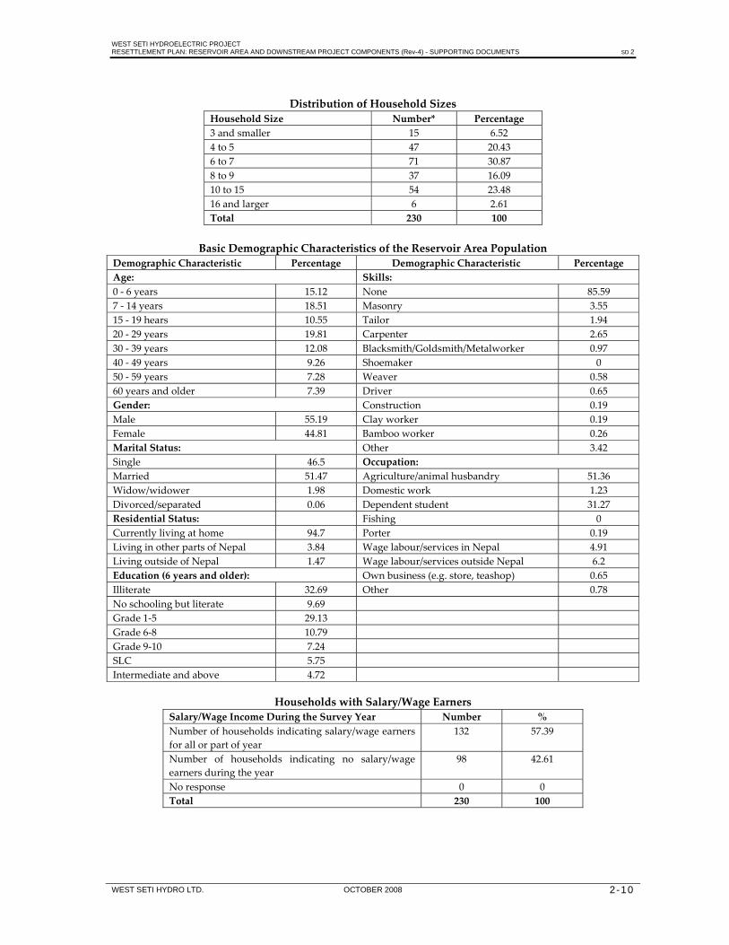
WEST SETI HYDROELECTRIC PROJECT RESETTLEMENT PLAN: RESERVOIR AREA AND DOWNSTREAM PROJECT COMPONENTS (Rev-4) - SUPPORTING DOCUMENTS SD 2
WEST SETI HYDRO LTD. OCTOBER 2008 2-10
Distribution of Household Sizes
Household Size Number* Percentage 3 and smaller 15 6.52 4 to 5 47 20.43 6 to 7 71 30.87 8 to 9 37 16.09 10 to 15 54 23.48 16 and larger 6 2.61 Total 230 100
Basic Demographic Characteristics of the Reservoir Area Population
Demographic Characteristic Percentage Demographic Characteristic Percentage Age: Skills:0 ‐ 6 years 15.12 None 85.59 7 ‐ 14 years 18.51 Masonry 3.55 15 ‐ 19 hears 10.55 Tailor 1.94 20 ‐ 29 years 19.81 Carpenter 2.65 30 ‐ 39 years 12.08 Blacksmith/Goldsmith/Metalworker 0.97 40 ‐ 49 years 9.26 Shoemaker 0 50 ‐ 59 years 7.28 Weaver 0.58 60 years and older 7.39 Driver 0.65 Gender: Construction 0.19 Male 55.19 Clay worker 0.19 Female 44.81 Bamboo worker 0.26 Marital Status: Other 3.42 Single 46.5 Occupation: Married 51.47 Agriculture/animal husbandry 51.36 Widow/widower 1.98 Domestic work 1.23 Divorced/separated 0.06 Dependent student 31.27 Residential Status: Fishing 0 Currently living at home 94.7 Porter 0.19 Living in other parts of Nepal 3.84 Wage labour/services in Nepal 4.91 Living outside of Nepal 1.47 Wage labour/services outside Nepal 6.2 Education (6 years and older): Own business (e.g. store, teashop) 0.65 Illiterate 32.69 Other 0.78 No schooling but literate 9.69 Grade 1‐5 29.13 Grade 6‐8 10.79 Grade 9‐10 7.24 SLC 5.75 Intermediate and above 4.72
Households with Salary/Wage Earners
Salary/Wage Income During the Survey Year Number % Number of households indicating salary/wage earners for all or part of year
132 57.39
Number of households indicating no salary/wage earners during the year
98 42.61
No response 0 0 Total 230 100

WEST SETI HYDROELECTRIC PROJECT RESETTLEMENT PLAN: RESERVOIR AREA AND DOWNSTREAM PROJECT COMPONENTS (Rev-4) - SUPPORTING DOCUMENTS SD 2
WEST SETI HYDRO LTD. OCTOBER 2008 2-11
Distribution of Students by Reservoir Zone Residential Status
Below FSL+10 m
Between FSL+10 m and FSL+100m
Above FSL+100 m
Total
Number % Number % Number % Number % Home 270 76.49 46 85.19 138 92 454 81.51 Other Nepal 82 23.23 8 14.81 12 8 102 18.31 Outside Nepal 1 0.28 0 0 0 0 1 0.18 Total 353 100 54 100 150 100 557 100
Asset Ownership Outside the Seti Valley
District
Households With Land Outside Valley
Households With Buildings Outside Valley
Number % of Affected Households Number % of Affected
Households Baitadi 27 39.13 18 26.09 Bajhang 10 21.74 12 26.09 Dadeldhura 4 12.9 10 32.26 Doti 24 28.57 20 23.81 Total 65 28.26 60 26.09
Leasing of Land in the Seti Valley
District No. of Households Who Lease Land
% of Affected Households
Baitadi 9 13.04 Bajhang 7 15.22 Dadeldhura 3 9.68 Doti 22 26.19 Total 41 17.83
Land Sales in the Seti Valley
District
Number of Households Total Area Sold (Ropani)
Total Sales (in NRs) Number % of Affected
Households Baitadi 2 2.9 39 1,560,000 Bajhang 4 8.7 15 1,010,000 Dadeldhura 2 6.45 8 124,800 Doti 18 21.43 54 1,710,000 Total 26 11.3 116 4,404,800
Livestock Ownership by Affected Households
Livestock Type Livestock Type Number of Households
TotalHead
Maximum Head
AverageHead
Cattle
Bullocks 168 370 6 2.2 Cows 150 247 4 1.65
cows in milk 131 140 3 1.07
Water Buffalo Males 32 37 3 1.16 Females 122 221 7 1.81
females in milk 134 159 4 1.19 Goats Goats 189 1,104 30 5.84 Pigs Pigs 7 12 3 1.71 Hens Hens 66 454 20 6.88 Total Total 2,744

WEST SETI HYDROELECTRIC PROJECT RESETTLEMENT PLAN: RESERVOIR AREA AND DOWNSTREAM PROJECT COMPONENTS (Rev-4) - SUPPORTING DOCUMENTS SD 2
WEST SETI HYDRO LTD. OCTOBER 2008 2-12
Cattle Ownership by District and Reservoir Zone
District
Below FSL+10 m
Between FSL+10 m and FSL+100m
Above FSL+100 m
Total
No. % No. % No. % No. % Baitadi 34 33.66 9 50 14 27.45 57 33.53 Bajhang 10 9.9 2 11.11 14 27.45 26 15.29 Dadeldhura 18 17.82 2 11.11 9 17.65 29 17.06 Doti 39 38.61 5 27.78 14 27.45 58 34.12 Total 101 100 18 100 51 100 170 100
Buffalo Ownership by District and Reservoir Zone
District
Below FSL+10 m
Between FSL+10 m and FSL+100m
Above FSL+100 m Total
No. % No. % No. % No. % Baitadi 29 35.8 9 52.94 13 27.08 51 34.93 Bajhang 7 8.64 2 11.76 18 37.5 27 18.49 Dadeldhura 18 22.22 2 11.76 8 16.67 28 19.18 Doti 27 33.33 4 23.53 9 18.75 40 27.4 Total 81 100 17 100 48 100 146 100
Income Sources Reported in the Reservoir Area Income Source Number of
Households Percentage of Households
Bullocks 13 5.65 Cows 19 8.26 Male buffaloes 2 0.87 Female buffaloes 17 7.39 Sheeps / Goats 144 62.61 Pigs 6 2.61 Poultry/fish 40 17.39 Sugarcane 1 0.43 Chiuri ghee 0 Bee‐keeping 0 General store/tea shop/restaurant
45 19.57
Metal work 2 0.87 Sewing 1 0.43 Handicraft 0 Ritha (soap) 1 0.43
Enterprises Recorded in the Reservoir Area
Enterprise
Number of Households Total
Below FSL+10 m
FSL+10 m to FSL+ 100 m
Above FSL+100 m
Chiuri Vegetable Oil 0 Bee‐keeping 0 General Store 10 1 8 19 Sugarcane 1 1 Metal Work 1 1 2 Tea Shop/Restaurant 4 5 2 11 Sewing 1 1 Handicraft 0 Poultry/Fish 30 4 6 40 Ritha (soap) 1 1 Other 7 1 3 11 Total 53 12 21 86

WEST SETI HYDROELECTRIC PROJECT RESETTLEMENT PLAN: RESERVOIR AREA AND DOWNSTREAM PROJECT COMPONENTS (Rev-4) - SUPPORTING DOCUMENTS SD 2
WEST SETI HYDRO LTD. OCTOBER 2008 2-13
Average Annual Income from Source in the Reservoir Area
Income Source Number of Households
% of Households
Avg. p.a. Income From Source (NRs)
Wage labour elsewhere in Nepal 8 15,750 Service holder 55 80,311 Income from own business 28 37,607 Porter 39 22,410 Sale of agricultural products 108 2,799 Income from trade/cottage industry 9 24,556 Sale of livestock products 216 16,746 Pension 2 45,000 Local wage labour 2 15,000 Wage labour outside Nepal 27 33,600
Mean Annual Expenditure by Reservoir Zone and District
District
Mean Annual Expenditure (Rs)Below
FSL+10 m Between FSL+10 m and
FSL+100 m Above
FSL+100 m Baitadi 126,479 115,468 84,778 Bajhang 88,768 82,031 89,263 Dadeldhura 105,605 63,560 73,339 Doti 100,557 97,997 85,735 Average by Zone 107,918 99,676 85,211
Expenditure by Reservoir Zone and Type
District
Mean Annual Expenditure (NRs)
Below FSL+10 m Between FSL+10 m and FSL+100 m
Above FSL+100 m
Mean % of Total Mean % of Total Mean % of Total Food 5,589 7.11 5,011 6.49 4,419 7.37 Fire wood 9,011 11.47 1,800 2.33 375 0.63 Kerosene 2,085 2.65 1,737 2.25 1,577 2.63 Education 15,782 20.08 9,391 12.16 8,103 13.52 Health 5,304 6.75 4,400 5.7 4,221 7.04 Clothing 8,282 10.54 7,720 10 6,435 10.74 Transportation Fertilizer Tax Hiring of labour Festival/marriage 10,226 13.01 10,340 13.39 8,496 14.18 Other items 21,174 26.94 35,571 46.06 25,663 42.82 Electricity 1,136 1.45 1,250 1.62 648 1.08 Mean 78,589 100 77,220 100 59,937 100
Loans in the Reservoir Area Number of Households With Loans
% of Affected Households
Minimum Loan (NRs)
Maximum Loan (NRs)
Average Loan (NRS)
Total Loan Amount (NRs)
30 13.04 1,500 50,000 13,883 416,500

WEST SETI HYDROELECTRIC PROJECT RESETTLEMENT PLAN: RESERVOIR AREA AND DOWNSTREAM PROJECT COMPONENTS (Rev-4) - SUPPORTING DOCUMENTS SD 2
WEST SETI HYDRO LTD. OCTOBER 2008 2-14
Use of Seti River Water
Use
Below FSL+10 m
Between FSL+10 m and FSL+100m
Above FSL+100 m
Total
No. % No. % No. % No. % Drinking 91 68.42 17 12.78 25 18.8 133 100 Recreation 104 65.82 19 12.03 35 22.15 158 100 Religious 129 62.32 21 10.14 57 27.54 207 100 Washing 99 71.74 16 11.59 23 16.67 138 100 Irrigation 65 60.75 18 16.82 24 22.43 107 100 Fishing 93 70.99 16 12.21 22 16.79 131 100 Transportation 18 58.06 5 16.13 8 25.81 31 100
Collection of Drinking Water
Household Member
Below FSL+10 m
Between FSL+10 m and FSL+100m
Above FSL+100 m
Total
No. % No. % No. % No. %All members 118 86.76 23 92 55 79.71 196 85.22 Adult males 3 2.21 0 0 4 5.8 7 3.04 Adult females 15 11.03 2 8 10 14.49 27 11.74 Total 136 100 25 100 69 100 230 100
Purification of Drinking Water
Water Purified?
Below FSL+10 m
Between FSL+10 m and FSL+100m
Above FSL+100 m Total
No. % No. % No. % No. % Yes 59 43.38 12 48 13 18.84 84 36.52 No 77 56.62 13 52 56 81.16 146 63.48 Total 136 100 25 100 69 100 230 100
Time Spent on Catching Fish in the Reservoir Area Fishing Activity
Below FSL+10 m
Between FSL+10 m and FSL+100m
Above FSL+100 m
Total
No. % No. % No. % No. % Length of Time Fishing
0‐1 year 0 0 0 0 0 0 0 0 2‐5 years 1 0.74 4 5.8 5 2.17 More than 5 years 11 8.09 3 12 3 4.35 17 7.39 Generation to generation
81 59.56 12 48 17 24.64 110 47.83
No response 43 31.62 10 40 45 65.22 98 42.61 Total 136 100 25 100 69 100 230 100 Time Devoted to Fishing
Full Time 1 0.74 1 0.43 Part Time 43 31.62 8 32 11 15.94 62 26.96 Recreational 1 0.74 1 0.43 Seldom 48 35.29 7 28 13 18.84 68 29.57 No response 43 31.62 10 40 45 65.22 98 42.61 Total 136 100 25 100 69 100 230 100

WEST SETI HYDROELECTRIC PROJECT RESETTLEMENT PLAN: RESERVOIR AREA AND DOWNSTREAM PROJECT COMPONENTS (Rev-4) - SUPPORTING DOCUMENTS SD 2
WEST SETI HYDRO LTD. OCTOBER 2008 2-15
Catch Fishing Quantities Reported in the Reservoir Area
Quantity
Below FSL+10 m
Between FSL+10 m and FSL+100m
Above FSL+100 m Total
House holds
Total Kg.
Households
Total Kg.
Households
Total Kg.
House holds
Total Kg.
Fish collected weekly 93 396 15 70 24 88 132 554 Fish consumed weekly 93 278 15 43 24 62 132 383 Fish sold weekly 30 108 7 27 8 23 45 158
Adequacy of Health Services Are Health
Services in the Area Adequate?
Below FSL+10 m
Between FSL+10 m and FSL+100m
Above FSL+100 m Total
No. % No. % No. % No. % Yes 46 33.82 12 48 30 43.48 88 38.26 No 90 66.18 13 52 39 56.52 142 61.74 No response 0 0 0 0 0 0 0 0 Total 136 100 25 100 69 100 230 100
Consultation for Health Problems Number Indicating Consulting:
Below FSL+10 m
Between FSL+10 m and FSL+100m
Above FSL+100 m
Total
No. % No. % No. % No. %
Doctor 34 25 10 40 24 34.78 68 29.57 Health post/worker 69 50.74 10 40 24 34.78 103 44.78 Vaidya 2 1.47 0 0 1 1.45 3 1.3 Witch doctor 31 22.79 5 20 20 28.99 56 24.35 Other 136 100 25 100 69 100 230 100
Preferred Compensation Options by District
Option
Percentage of Households in Favour of Option Baitadi District
Bajhang District
Dadeldhura District
Doti District
Land for land, house for house 53 41 30 70 Land for land, cash for house 11 2 0 10 Cash payment for land and house 4 3 1 2 Other 1 0 0 2 Total 69 46 31 84

WEST SETI HYDROELECTRIC PROJECT RESETTLEMENT PLAN: RESERVOIR AREA AND DOWNSTREAM PROJECT COMPONENTS (Rev-4) - SUPPORTING DOCUMENTS SD 3
WEST SETI HYDRO LTD. OCTOBER 2008 3-1
3. RIPARIAN VILLAGES BETWEEN THE DAM WALL AND RE-REGULATION WEIR
Common Seti River Uses Communities along the Seti River use water for a number of common purposes and recognize a number of common benefits. The Seti River is used for washing, bathing, and swimming by all the villages along this section of the river. Seti River water is also preferred by many people over side stream water during summer as it is cooler. Livestock use the river for water. All communities consider the Seti River to be holy. River water is used for worshiping Gods and Goddesses. Dead bodies are cremated on the river bank and the burnt remains are placed into the river. Local people believe that the river provides a milder local climate in summer. There is also a common belief among the villagers that the local environment will be adversely affected if there are no river flows. It is important to note that the Seti River is not used for irrigation along this section of the river. Where riverside land is irrigated, water is sourced from side streams. Village Use of the Seti River and other Water Sources The supply of drinking and irrigationwater and the extent of secondary Seti River uses differed for each village within the riparian zone (information collected in 1998), as described below: 1. Timila Village
Balapur VDC ward no. 4, Dadeldhura District Estimated population 90 Total houses 11 Total families 13
Drinking Water: Drinking water is sourced from a small river near the village. The Seti River is only used for drinking in summer. Irrigation: Fields in Timila are irrigated with water derived from the Jamad Khola via a small cannel. Fishing: Fishing is a part time profession of some households.

WEST SETI HYDROELECTRIC PROJECT RESETTLEMENT PLAN: RESERVOIR AREA AND DOWNSTREAM PROJECT COMPONENTS (Rev-4) - SUPPORTING DOCUMENTS SD 3
WEST SETI HYDRO LTD. OCTOBER 2008 3-2
2. Gillabagar Village Belapur VDC ward no. 2 and 3, Dadeldhura district Estimated population 850 Total houses 83 Total families 150 Drinking Water: drinking water is mainly sourced from a small stream near the village A water tank is used. For two months of the year, the village totally depends upon the Seti River for its potable water supply due to a water shorttage from the small stream. Irrigation: Irrigation water is derieved from the Jamad Khola for the irrigation of upper Gilla Bagar, whilst water from the Daude Khola and Ghatale Khola is used to irrigate lower Gillabagar below the village. Fishing: Fishing is a part time profession of some households, with a lot of fish sold in local markets. 3. Shat, Sallisirod, Nali and Rathhla Villages Barbata VDC ward no. 8, Doti District Estimated population 1,000 Total houses 151 Total families 160 People who live in Shat also have temporary houses associated with agricultural land in Sallisirod, Nali and Rathhla. Farmers live in Sallisirid, Nali and Ratthala when harvesting, planting and tending their crops, then return to shat once they have completed this work. Drinking Water: Drinking water is sourced from the Seti River, Gobre Khola and Sayaldada Khola. Approximately 20 families are depend on the Seti River for their year‐round drinking water supply. The remaining village families are depended upon drinking water from the Seti River for two months of the year. Irrigation: Irrigation water is sourced from the Gobre Khola and Sayaldada Khola during the monsoon season only. Lands in Sallisirod, Rathhla and Nali are unirrigated. Fishing: Ten families in the village undertake fishing as their main profession. Religious Festival: Bhunwa Mela is celebrated twice a year. Many people from Baitadi and Dadeldhura come to celebrate this festival with the local people.

WEST SETI HYDROELECTRIC PROJECT RESETTLEMENT PLAN: RESERVOIR AREA AND DOWNSTREAM PROJECT COMPONENTS (Rev-4) - SUPPORTING DOCUMENTS SD 3
WEST SETI HYDRO LTD. OCTOBER 2008 3-3
4. Barbata, Syaltada and Khiri Village Barbata VDC ward no. 1, 2 & 3, Doti District Estimated population 1280 Total houses 92 Total families 169 Drinking Water: Drinking water is derived from the Hadya Khola, Ruwa Khola and Shimkholi Khola. Barbata village has 6 water taps for drinking water. About 30 families are depend upon Seti River for their year round drinking water supply, whilst other households only use river water during summer. Irrigation: Irrigation water is sourced from the Ruwa Khola, Hadya Khola and Shimkholi Khola , but it is inadequate for their entire crops. Fishing: About 15 families depend upon fishing as their main profession, selling a lot of fish in local markets. Religious Festivals: The festivals of Laxmi Puja and Dipawali are celebrated. Many people from Latamandu and Lamikhal join these celebrations. One disadvantage of the Seti River is that floods during the monsoon season damage the cultivated land. 5. Amdora, Gopghat Pulpari Village Barbata VDC ward no.3 and 4, Doti District Estimated population 200 Total houses 30 Total families 29 Drinking Water: Drinking water is sourced from the Seti River and the Dhamma Gad. This village has 6 drinking water taps supplied from the Dhamma Gad. Approximately 6 families depend upon the Seti River for their year‐round drinking water supply. The remaining villagers use the Seti River for drinking water in summer. Irrigation: Irrigation water is sourced from the the Dhamma Gad. Fishing: Fishing is a part time profession for some villagers, with fish selling in Gopghat. Religious Festival: Deuti Puja is celebrated.

WEST SETI HYDROELECTRIC PROJECT RESETTLEMENT PLAN: RESERVOIR AREA AND DOWNSTREAM PROJECT COMPONENTS (Rev-4) - SUPPORTING DOCUMENTS SD 3
WEST SETI HYDRO LTD. OCTOBER 2008 3-4
6. Balyagada Village Barbata VDC ward no. 6, Doti District Estimated population 200 Total houses 30 Total families 45 Drinking Water: Drinking water is sourced from the Seti River for all villagers. Irrigation: There is no facility of irrigation. Fishing: Fishing is a part time profession for some villagers. 7. Power Station Area (Sumarghar, Lamdwala, Okhalegada, Churephaltude, Bhakare, Simar,
Ratapod) Barbata VDC ward no.7, Doti District Estimated population 400 Total houses 54 Total families 60
Drinking Water: drinking water is souced from the Seti River and Simar Khola. Approximately 30 families depend upon the Seti River. Irrigation: Irrigation water is derived from the Simar Khola, but is insufficient for their crops. Fishing: Fishing is a part time profession of many villagers, most of whom fish all year round. Religious Festivals: Sidhhanath and Masani are celebrated. 8. Bandungrisain (Tudila, Ghodilash, Sharkitol, Amanigaun) Banlek VDC ward Nos. 1, 2, 3, 4, & 7, Doti District Estimated population 3,530 Total houses 306 Total families 520 Drinking Water: Drinking water is sourced from Seti River and the Kuni Khola Gad. Water from the Kuni Khola Gad is insufficient to meet local demand with approximately 450 families rely upon the Seti River for the water supply. Irrigation: Irrigation water is sourced from the Sakayal Khola and Golma Gad, but it is insufficient for their crops. Fishing: 40 families practice fishing as a profession. They sell fish in Gopghat, Dipayal, Dadeldhura, Mahendranagar and Dhangadhi. Religious Festivals: Gahanan Mela is celebrated on Maghe Sakranti. Around 25,000 people from many districts come to celebrate this festival. Other Uses: The local school with 530 students and 10 teachers are dependent in Seti River for drinking water.

WEST SETI HYDROELECTRIC PROJECT RESETTLEMENT PLAN: RESERVOIR AREA AND DOWNSTREAM PROJECT COMPONENTS (Rev-4) - SUPPORTING DOCUMENTS SD 3
WEST SETI HYDRO LTD. OCTOBER 2008 3-5
9. Lohakhadi Village Latamandu VDC ward no. 9, Doti District Estimated population 102 Total houses 9 Total families 11 Drinking water: Drinking water is sourced from the Seti River and Lohakhadi Gad. Water from the Lohakhadi Gad is sufficient to meet the year‐round village demand for water, but people bring water from the Seti River during summer because it is cooler and more refreshing. Irrigation: Irrigation water is derived from the Lohakhadi Gad, but it is insufficient for their crops. Religious Festivals: Kartik Purnima is celebrated, with many people come from neighboring villages. 10. Mathpora Village
Latamandu VDC ward no. 8, Doti District Estimated population 550 Total houses 72 Total families 107 Drinking water: Drinking water is sourced from the Golma Gad. Irrigation: Golma Gad is not used for irrigation. Religious Festivals: Shiva Ratri Mela and Kartik Purnima is celebrated. 11. Mallo Tiltali Latamandu VDC ward no. 9, Doti District Estimated population 700 Total houses 76 Total families 152 Drinking Water: Drinking water is sourced from the Seti River and Golma Gad. Water from Golma Gad supplies 8 village taps. Approximately 50 families are depending upon the Seti River for their year‐round water supply. Other families only use the Seti River for drinking water in summer. Irrigation: No irrigation facility. Fishing: Fishing is a part‐time activity. Religious Festivals: Local people celebrate Masani and Laxmi Puja.

WEST SETI HYDROELECTRIC PROJECT RESETTLEMENT PLAN: RESERVOIR AREA AND DOWNSTREAM PROJECT COMPONENTS (Rev-4) - SUPPORTING DOCUMENTS SD 3
WEST SETI HYDRO LTD. OCTOBER 2008 3-6
12. Tallo Tiltali Village Latamandu VDC ward no. 9, Doti District Estimated population 500 Total houses 79 Total families 140 Drinking Water: The village is totally dependent upon Seti River for drinking water. Irrigation: No local Gad is currently used for irrigation, but a plan has been developed for irrigation from Lohakhadi Gad. Fishing: Most of the villagers undertake fishing profession on full time basis. Religious Festivals: Devi Puja is celebrated. 13. Gopghat Village Latamandu VDC ward no. 8, Doti District Estimated population 450 Total houses 48 Total families 80 Drinking Water: Seti River is main source of drinking water for the Gopghat people. There are 10 water taps constructed but water supply is not running. Irrigation: Golma Gad is used for irrigation but it is not sufficient. Fishing: Fishing is part time profession of the local people. They sale the fish in the local market. Religious Festival: Kartik Purnima and Mashani Puja are celebrated. 14. Betada Village Pachnali VDC ward No. 6, Doti District Estimated population 300 Total houses 30 Total families 45 Drinking Water: Drinking water is sourced from Lohakhadi Gad. Seti River is not used for drinking water. Irrigation: Land of Betada is unirrigated and there is no any plan for irrigation. Religious Festivals: Kartik Purnima is celebrated, with many people also coming from neighbor villages. Fishing: Few people are involved in fishing activities for their own use. Other Uses: They used sand from Seti River in construction work.

WEST SETI HYDROELECTRIC PROJECT RESETTLEMENT PLAN: RESERVOIR AREA AND DOWNSTREAM PROJECT COMPONENTS (Rev-4) - SUPPORTING DOCUMENTS SD 3
WEST SETI HYDRO LTD. OCTOBER 2008 3-7
15. Talkot Village Pachnali VDC ward no. 6, Doti District Estimated population 1500 Total houses 75 Total families 180 Drinking Water: Drinking water is sourced from Seti River. The village has eight drinking water taps but the water supply is stopped since 7 years. All villagers are dependent on Seti River for drinking water. Irrigation: All the land of Talkot village is irrigated by Cannel derived Luhakhadi Gad. Fishing: Fishing is part time activity of 20 families. Religious Festivals: Kartik Purnima is celebrated, with many people also coming from neighboring villages. Other Uses: The source of drinking water is Seti River for the local school with 300 students and10 teachers. Seti River is used for bathing, swimming, boating, recreation and water for livestock. Fuel wood collection from Seti River in summer. 16. Ghataligaun Village Dipayal Silgadi Municipality ward no. 12, Doti District Estimated population 700 Total houses 55 Total families 80 Drinking Water: Drinking water is sourced from Seti River for all villagers. Irrigation: Water for irrigation is derived from Deulyam Khola via a small canal, but is insufficient for their crops and there is not any plan for irrigation. Fishing: Few are involved in fishing activity. Religious Festivals: Kartik Purnima is celebrated. Other Uses: Seti River is used for bathing, washing, swimming, and water for livestock.

WEST SETI HYDROELECTRIC PROJECT RESETTLEMENT PLAN: RESERVOIR AREA AND DOWNSTREAM PROJECT COMPONENTS (Rev-4) - SUPPORTING DOCUMENTS SD 3
WEST SETI HYDRO LTD. OCTOBER 2008 3-8
17. Kot Village Pachnali VDC ward no. 2, Doti District Estimated population 350 Total houses 40 Total families 45 Drinking Water: Drinking water source is Pani Khola near the village. Seti River is not used for drinking water. Irrigation: The field of Kot village is unirrigated and there is not any plan for irrigation. Fishing: Fishing is part time activity of few people. Other Uses: Seti River is used for bathing, washing, swimming, and water for livestock. 18. Undiwol Village Pachnali VDC ward no. 1, Doti District Estimated population 300 Total houses 34 Total families 40 Drinking Water: Drinking water is sourced from Seti River. Irrigation: Irrigation water is derived from Thulakhola via a cannel but it is insufficient for their crops. Fishing: Fishing is part time profession of 10 families. They earned about Rs. 500 per family per month. Other Usage: Seti River is used for bathing, washing, swimming, and water for livestock. 19. Sirkholisain Village Dipayal Silgadhi Municipality ward no. 12, Doti District Estimated population 1200 Total houses 70 Total families 150 Drinking Water: Drinking water is sourced from Seti River for all villagers. Local school with 250 students and 4 teachers are dependent on Seti River for drinking water. Irrigation: Water for irrigation is derived from Buda Khola via a small canal, but it is insufficient for their crops. Large canal is under construction derived from Buda Khola and being constructed by the government. Fishing: Twenty families are involved in part time fishing activity. They sell fish in Dipayal and earned about Rs. 1,000 per family per month. Religious Festivals: Ganga Dashara and Astami are celebrated. Other Uses: Seti River is used for bathing, washing, swimming, and water for livestock and fuel wood collection in summer.20. Sasamkhola, Motewodar and Banfisain
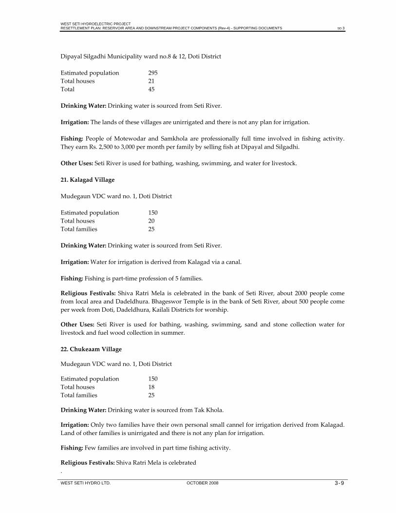
WEST SETI HYDROELECTRIC PROJECT RESETTLEMENT PLAN: RESERVOIR AREA AND DOWNSTREAM PROJECT COMPONENTS (Rev-4) - SUPPORTING DOCUMENTS SD 3
WEST SETI HYDRO LTD. OCTOBER 2008 3-9
Dipayal Silgadhi Municipality ward no.8 & 12, Doti District Estimated population 295 Total houses 21 Total 45 Drinking Water: Drinking water is sourced from Seti River. Irrigation: The lands of these villages are unirrigated and there is not any plan for irrigation. Fishing: People of Motewodar and Samkhola are professionally full time involved in fishing activity. They earn Rs. 2,500 to 3,000 per month per family by selling fish at Dipayal and Silgadhi. Other Uses: Seti River is used for bathing, washing, swimming, and water for livestock. 21. Kalagad Village Mudegaun VDC ward no. 1, Doti District Estimated population 150 Total houses 20 Total families 25 Drinking Water: Drinking water is sourced from Seti River. Irrigation: Water for irrigation is derived from Kalagad via a canal. Fishing: Fishing is part‐time profession of 5 families. Religious Festivals: Shiva Ratri Mela is celebrated in the bank of Seti River, about 2000 people come from local area and Dadeldhura. Bhageswor Temple is in the bank of Seti River, about 500 people come per week from Doti, Dadeldhura, Kailali Districts for worship. Other Uses: Seti River is used for bathing, washing, swimming, sand and stone collection water for livestock and fuel wood collection in summer. 22. Chukeaam Village Mudegaun VDC ward no. 1, Doti District Estimated population 150 Total houses 18 Total families 25 Drinking Water: Drinking water is sourced from Tak Khola. Irrigation: Only two families have their own personal small cannel for irrigation derived from Kalagad. Land of other families is unirrigated and there is not any plan for irrigation. Fishing: Few families are involved in part time fishing activity. Religious Festivals: Shiva Ratri Mela is celebrated .

WEST SETI HYDROELECTRIC PROJECT RESETTLEMENT PLAN: RESERVOIR AREA AND DOWNSTREAM PROJECT COMPONENTS (Rev-4) - SUPPORTING DOCUMENTS SD 4
WEST SETI HYDRO LTD. OCTOBER 2008 4-1
4. NOMINATED COMMUNITY REPRESENTATIVES ON LCFs DURING THE EIA STUDY
List of Nominated Representatives from Deura, Bajhang District S. No
Representative Name VDC Ward No.
Position Address
1 2 3 4 5 6 7 8 9 10 11 12 13 14 15 16 17 18 19 20 21 22 23 24 25 26 27 28 29 30
Mr. Birendra Bdr. Bhandari
Mr. L.B. Rawal Mr. Indra Bdr. Bhandari Mr. Dev Jung Bdr. Singh Mr. Nar Bdr. Bhandari Mr. Gorakh Raj Joshi Mr. Gopi Lal Jaisi Mr. Dhana Giri Mr. Shanker Khadka Mr. Mithu Bhandari Mr. Indra Jung Bdr. Singh Mr. Ratan Bhandari Mr. Mimi Bista Mr. Kumar Jung Bdr. Singh Mr. Nandi Bhandari Mr. Balaji Bhandari Mr. Ananta Ram Bhatta Mr. Dirgha Bdr. Bhandari Mr. Dhan Bdr. Bhandari Mr. Nare Bhandari Mr. Lal Bahadur Bhandari Mrs. Sushila Devi Bhandari Mr. Prem Raj Joshi Mr. Jayaram Kami Mr. Gyanu Bista Mr. Jaya Bista Mr. Bir Man Bohara Mrs. Hashu Devi Joshi Mr. Gangaram Joshi Mr. Aaji Man Bhandari
Rayal Rayal Rayal Rayal Rayal Rayal Dhangaji Dhangaji Rayal Rayal Rayal Rayal Rayal Rayal Rayal Rayal Dhangaji Rayal Rayal Rayal Rayal Rayal Dhangaji Rayal Sunkuda Sunkuda Dhangaji Dhangaji Dhangaji Rayal
2 2 1 1 3
DDC Member DDC Member VDC Chairman Political Representative Ward Chairman Ex‐DDC Member Ward Chairman Ex‐Vice Chairman Teacher Social worker Social worker Social worker Social worker Social worker Social worker Social worker Social worker Social worker Social worker Social worker Social worker Female Representative Social worker Social worker
Social worker Social worker Social worker Female Representative Social worker Social worker
‐ ‐ Deura Deura Deura Deura Dhangaji Dhangaji Garjepani H. S. Deura Deura Deura Deura Deura Deura Deura Dhangaji Chaudam Chaudam Chaudam Chaudam Deura Dhangaji Jup Dhari Dhari Chuthi Pipalkot Pipalkot Deura

WEST SETI HYDROELECTRIC PROJECT RESETTLEMENT PLAN: RESERVOIR AREA AND DOWNSTREAM PROJECT COMPONENTS (Rev-4) - SUPPORTING DOCUMENTS SD 4
WEST SETI HYDRO LTD. OCTOBER 2008 4-2
List of Nominated Representatives from Moribagar S. No
Representative Name VDC Ward No.
Position Address
1 2 3 4 5 6 7 8 9 10 11 12 13 14 15 16 17 18 19 20 21 22 23 24 25 26 27 28 29 30 31 32 33 34 35 36 37 38
Mr. Hari Singh Dhami Mr. Joga Singh Saud
Mr. Dali Saud Mr. Ram Singh Saud Mr. Krishna Singh Saud Mrs. Gaumati Saud Mr. Dhum Singh Saud Mr. Tara Singh Saud Mr. Dal Bdr. Saud Mr. Tilak Singh Dhami Mr. Chandra Singh Saud Mr. Ram Singh Saud Mr. Dhan Singh Saud Mr. Chandra Bdr. Chand Mr. Dharam Bdr. Bohara Mr. Narayan Prasad Awasthi Mr. Amar Singh Yer Mrs. Jamuna Devi Chand Mr. Lok Ram Awasthi Mr. Harka Bdr. Thapa Mr. Muni Thapa Mr. Bhim Bdr. Thapa Mrs. Mandhri Devi Shilla Mr. Jaya Bdr. Khadayat Mr. Parja Thapa Mr. Bahadur Saud Mr. Dambar Oli Mr. Man Bdr. Bohara Mr. Lek Bdr. Bohara Mr. Parshuram Bdr. Bohara Mr. Mohan Bdr. Bohara Mrs. Shiva Devi Bohara Mr. Sagari Mijari Mr. Nar Bdr. Khadayat Mr. Prayag Raj Ojha Mr. Ram Bdr. Khadayat Mr. Moti Adhikari Mr. Nari Adhikari
Thalakanda Thalakanda Thalakanda Thalakanda Thalakanda Thalakanda Thalakanda Thalakanda Thalakanda Thalakanda Thalakanda Shivaling Shivaling Shivaling Shivaling Shivaling Shivaling Shivaling Shivaling Chhapali Chhapali Chhapali Chhapali Chhapali Chhapali Chhapali Girichauka Girichauka Girichauka Girichauka Girichauka Girichauka Girichauka Girichauka Girichauka Girichauka Girichauka Girichauka
6 6 6 6 7 7 7 8 8 8 8 9 9 9 9 9 9 7 7 8 8 8 8 8 1 1 1 1 1 4 5 5 5 7 7
DDC Member VDC Chairman Mukhiya Ward Chairman Ward Member School Teacher Social worker Social worker Ward Member Ward Chairman Teacher Social worker Ward Chairman Ex‐Chairman Ex‐Member Ward Chairman Ward Chairman Female Representative VDC Chairman Teacher Ward Member Ward Member Female Representative Social worker Social worker DDC Member VDC Chairman Social worker Ward Member Ward Chairman Social worker Ward Member Ward Chairman Teacher Ward Member Ward Chairman Ward Chairman Social worker
Khairkot Lekam Lekam Lekam Lekam Lekam Lekam Lekam Lekam Kheti Basti Nwaghari Nwaghari Sanga Bori Aagarali Sanga Sanga Lek Siradi Malli Aaul Malli Aaul Pauto Pauto Pauto Pauto ‐ Saukhola Babina, Pang Pang Pang ‐ Babina Khateda Khateda Khateda Khateda Silla Ambagar, Silla

WEST SETI HYDROELECTRIC PROJECT RESETTLEMENT PLAN: RESERVOIR AREA AND DOWNSTREAM PROJECT COMPONENTS (Rev-4) - SUPPORTING DOCUMENTS SD 4
WEST SETI HYDRO LTD. OCTOBER 2008 4-3
List of Nominated Representatives from Dhungad/Talara S. No
Representative Name VDC Ward No.
Position Address
1 2 3 4 5 6 7 8 9 10 11 12 13 14 15 16 17 18 19 20 21 22 23 24 25 26 27 28 29 30 31 32 33 34 35 36 37 38 39 40 41 42 43 44 45 46
Mr. Laxman Bdr. Singh Mr. Dambar Bdr. Singh Mr. Sarpe Lohar
Mr. Gagan Bdr. Singh Mr. Ram Bdr. Adhikari Mr. Govinda Bhattarai Mr. Gore Lohar Mr. Mohan Bdr. Singh Mr. Nar Bdr. Singh Mr. Ran Bdr. Singh Mrs. Kumari Tara Singh Mr. Ganesh Doli Mr. Dev Bdr. Shahi Mr. Chakra Bdr. Shahi Mr. Navaraj Malla Mr. Jaya Bdr. Yer Mr. Dani Lohar Mr. Ratan Bdr. Saud Mr. Man Bdr. Saud Mr. Dambar Bdr. Saud Mrs. Gohi Saud Mr. Tek Bdr. Bista Mr. Ganga Ram Bista Mr. Dani Dhami Mr. Dhane Dhami Mr. Ganga Ram Dhami Mr. Ram Dhami Mr. Gopal Dhami Mr. Sher Saud Mr. Dambar Bdr. Saud Mr. Bir Bdr. Chand Mr. Jogi Dhami Mr. Kide Dhami Mr. Tek Raj Awasthi Mr. Karna Bdr. Chand Mr. Dali Mahara Mr. Min Bdr. Chand Mr. Ragi Saud Mr. Lal Singh Dhami Mr. Chandra Singh Dhami Mr. Mani Dhami Mr. Khadak Singh Rokaya Mr. Udhab Singh Dhami Mr. Chandra Singh Dhami Mr. Hari Jeet Dhami Mrs. Laxmi Devi Awasthi
Lamikhal Lamikhal Lamikhal Lamikhal Lamikhal Lamikhal Lamikhal Lamikhal Lamikhal Lamikhal Lamikhal Lamikhal Mahadevsthan Mahadevsthan Mahadevsthan Mahadevsthan Mahadevsthan Belapur Belapur Belapur Belapur Belapur Belapur Sigas Sigas Sigas Sigas Sigas Sigas Belapur Dhungad Dhungad Dhungad Dhungad Dhungad Dhungad Dhungad Dhungad Dhungad Dhungad Dhungad Dhungad Dhungad Dhungad Dhungad Dhungad
‐ 1 1 5 5 6 6 7 7 7 7 7 9 9 9 9 9 4 4 4 4 7 7 4 4 4 3 3 3 4 7 5 5 5 7 7 7 8 8 9 2 9 2 3 3 7
VDC Chairman Ward Member Social worker Social worker Ward Chairman Social worker Ward Chairman Teacher Teacher Ward Chairman Female Representative Social worker Ward Chairman Social worker Social worker Teacher Social worker Ex‐Member Ex‐Member Ward Member Female Member Ward Chairman Ward Member Social worker Social worker Social worker Social worker Social worker Ward Chairman Ex‐Ward Chairman VDC Chairman Social worker Social worker Social worker Ward Chairman Social worker Teacher VDC Vice Chairman Ward Chairman Social worker Ward Member Social worker Ward member Social worker Social worker Female Representative
Talara Lamikhal Gadkhet Badal Jakheda Bhagtadi Wollo Bali Dobara Doli Sanagaun Doli Pallo Bali Jhuda Jhuda Jhuda Aagar Gautada Sirod Sirod Sirod Sirod Chamagaun Chamagaun Raksam Raksam Raksam Raksam Raksam Mainala Sirod Dhungad ‐ ‐ ‐ Dhungad Dhungad Dhungad ‐ ‐ ‐ ‐ ‐ ‐ ‐ ‐ ‐

WEST SETI HYDROELECTRIC PROJECT RESETTLEMENT PLAN: RESERVOIR AREA AND DOWNSTREAM PROJECT COMPONENTS (Rev-4) - SUPPORTING DOCUMENTS SD 4
WEST SETI HYDRO LTD. OCTOBER 2008 4-4
List of Nominated Representatives from Gopghat
S. No
Representative Name VDC Ward No.
Position
1 2 3 4 5 6 7 8 9 10 11 12 13 14
Dambar Bahadur Bista Tej Bahadur Bista
Jai Bahadur Bista Dharma Singh Bista Kalu Singh Saud Mandev Dharma Dambar Bahadur Balayar Mahadev Balayar Man Bahadur Balayar Dharma Bahadur Balayar Mane Bahadur Balayar Dal Bahadur Balayar Bir Bahadur Balayar Ram Bahadur Balayar
Belapur Belapur Belapur Belapur Belapur Banlekh Banlekh Banlekh Banlekh Barpata Barpata Barpata Barpata Barpata
2 3 2 3 4 8 8 8 8 7 7 7 7 7
Ward Chairman Member Ex‐Chairman Member Member Vice‐chairman Asst. Technician Volunteer Volunteer Member Ex‐chairman Social worker Social worker Chairman

WEST SETI HYDROELECTRIC PROJECT RESETTLEMENT PLAN: RESERVOIR AREA AND DOWNSTREAM PROJECT COMPONENTS (Rev-4) - SUPPORTING DOCUMENTS SD 5
WEST SETI HYDRO LTD. OCTOBER 2008 5-1
5. PROJECT INFORMATION SHEETS
Six Information Sheets (in Nepali) were distributed to affected communities. The initial sheet was distributed in February 1997 and called for comments on the issues to be covered in the EIA. The other five sheets were distributed as part of the EIA, and contained the following: • Information Sheet 2 (distributed in October 1997) briefly commented on community responses that
had been received, as well as the EIA fieldwork schedule; • Information Sheet 3 (distributed in December 1997) provided a summary of project impacts
(including a list of potentially affected villages) and an outline of compensation and resettlement principles under consideration;
• Information Sheet 4 (distributed in late February – early March 1998) consisted of a detailed response
to community submissions and demands received, as well as further clarification of resettlement and compensation principles;
• Information Sheet 5 (distributed in March 1999) informed people of the current stage of project
planning and the course of EIA assessment by the Government. It also introduced the proposed Community Consultative Committee meeting in Dipayal in April.
• Information Sheet 6 (distributed in early June 1999) provided a summary of the Resettlement Action
Plan resettlement package, as presented at the April meeting in Dipayal. Two Information Sheets (in Nepali) were distributed during 2007‐2007: • Information Sheet 7 (distributed in November 2006) informed communities of the status of the
project and uncoming studies to update the EIA and Resettlement Plan. • Information Sheet 8 (distributed in April 2007) informed communities of preliminary work to be
undertaken in preparation for project implementation, and reiterated the project’s proposed compensation and resettlement entitlements

WEST SETI HYDROELECTRIC PROJECT RESETTLEMENT PLAN: RESERVOIR AREA AND DOWNSTREAM PROJECT COMPONENTS (Rev-4) - SUPPORTING DOCUMENTS SD 5
WEST SETI HYDRO LTD. OCTOBER 2008 5-2
West Seti Hydroelectric Project Information Sheet No. 1 ‐ February 1997
The Project The West Seti Hydro‐Electric Project has been proposed to generate electricity. This electricity will be sold to India and used in Nepal. An Australian company, SMEC, is proposing and designing the project. This includes a full assessment of all the issues related to the project, including potential effects on the local community and the environment. The project will only be constructed if it is feasible and does not disadvantage the local people of Deura, Lekham, Dhungad and surrounding areas. The proposal involves: • A 196 m high dam wall located 2 km below Dhungad; • A reservoir from the dam wall stretching up past Deura in the wet season; • A powerstation at Boshyo Garo below Gopghat; • A road between the Seti‐Rajmarg road and the dam wall; • A power line between Boshyo Garo and the Indian border. The water level in the reservoir will rise and fall during the year. The dam will fill in the wet season and be drained through a tunnel leading to the power station to generate power. The reservoir will flood along the lower parts of the Chama Gad, Dhung Gad and Sani Gad all year. It will flood along part of the Nawaghar Gad for most of the year, and along the Kalanga Gad and past Deura in September, October, November and December. Top water level will then drop to around the area where the Nawaghar Gad meets the Seti River, below which point it will be flooded all year round. The villages of Dhungad, Thalara and Lekham will be flooded all year, whilst Deura will be flooded for most of the year. Planning The project is in the planning phase. The design of the dam and other planning work will take over a year to complete. HMG Nepal will determine if the project is constructed. The Government’s decision will be based on a full assessment of the likely adverse and beneficial impacts on the local people, the environment and Nepal. This will involve discussions with you and others from the community to assess all impacts. If the project proceeds it will affect people living in the valley and it will affect the Seti River. People in Deura, Lekham and Dhungad will have to be resettled onto productive agricultural land and provided with all the schools and facilities that currently exist. A formal consultation process will be commenced in the near future to provide regular meetings during the design of the project. In the mean time, please write to me with the attached envelopes if you wish to offer your comments directly.

WEST SETI HYDROELECTRIC PROJECT RESETTLEMENT PLAN: RESERVOIR AREA AND DOWNSTREAM PROJECT COMPONENTS (Rev-4) - SUPPORTING DOCUMENTS SD 5
WEST SETI HYDRO LTD. OCTOBER 2008 5-3
Information We recognise that you have a major interest in the outcome of this project and must be informed about it. This Information Sheet is the first in a series of sheets that will be sent to you about the project. Update sheets will be sent to you approximately every four months. The project must be openly planned. It will include input from you, private Nepalese organisations, HMG Nepal and international organisations. The project will only be built if you have had the opportunity to have your say and HMG Nepal is satisfied that its benefits will be greater than its impacts.
WEST SETI HYDROELECTRIC PROJECT RESETTLEMENT PLAN: RESERVOIR AREA AND DOWNSTREAM PROJECT COMPONENTS (Rev-4) - SUPPORTING DOCUMENTS SD 5
WEST SETI HYDRO LTD. OCTOBER 2008 5-4
West Seti Hydroelectric Project Information Sheet No. 2 ‐ October 1997 This information sheet is the second in a series of sheets that will be sent to communities in the proposed West Seti Hydroelectric Project development area. These sheets provide information on the project and the development programme. The project is currently being planned. This stage will be completed in September 1998 when His Majesty’s Government of Nepal finalises its review of the Environmental Impact Assessment of the project prepared by SMEC. Previous Comments Thank you for your submissions following the distribution of Information Sheet No. 1. Eight letters were received from 6 VDC Wards and some individuals, representing a total of 454 people. The letters stated the type of land and facilities that are wanted to replace land and facilities that may be taken by the project. The main comments involved: • resettlement location; • type of replacement land including irrigation and drainage; • replacement of other production (forests, grazing, etc.); • the provision of facilities (houses, schools, hospitals, power, telephone, banking, etc); and • employment on the project. The attached page outlines from whom the submissions were received. This process of discussion about your development and resettlement preferences and requirements has only just commenced. In early November I will visit the village headmen in the main villages of Dhungad, Talara, Lekham and Deura to introduce myself and discuss this further. Programme The West Seti project is currently being planned. Planning will involve inspections of the project site by small groups of specialists over the next 10 months and the preparation of reports to be submitted to HMGN. These reports will include a Detailed Engineering Report and the Environmental Impact Assessment. The main areas that will be visited will be the dam site (2 km downstream from Dhungad), the reservoir area (from Dhungad to just above Deura) and Bosho Garo. This work will include discussions with people in the valley, including Village Development Units. This work will not disturb your land or daily activities. Social Survey Initially there will be a social survey of all people who will be affected by the reservoir. This will be conducted between November and January. Prior to the commencement of the survey the project Sociologist will introduce himself to the village headmen. All people likely to be affected by the project will be interviewed at a place convenient to them. This will be done by one or two people asking about

WEST SETI HYDROELECTRIC PROJECT RESETTLEMENT PLAN: RESERVOIR AREA AND DOWNSTREAM PROJECT COMPONENTS (Rev-4) - SUPPORTING DOCUMENTS SD 5
WEST SETI HYDRO LTD. OCTOBER 2008 5-5
land ownership, agriculture and forestry practices and local facilities in the valley. From this information a picture of the effect of the project on all people will be developed. Project Design The design of the main parts of the project will be finalised in November. We will then visit villages to fully explain the project and to mark out the top water level of the reservoir. Project Approval If the project is approved by HMGN in September 1998 construction will commence some time after this date. This will mean people living in the valley at Dhungad, Talara, Lekham and Deura, as well as other local areas, will be resettled. Resettlement of affected people will occur over a number of seasons to ensure that new land and facilities are well established before people move. I look forward to meeting village representatives in late October and answer any questions that you have. Matt Corbett Project Manager West Seti Environmental Impact Assessment

WEST SETI HYDROELECTRIC PROJECT RESETTLEMENT PLAN: RESERVOIR AREA AND DOWNSTREAM PROJECT COMPONENTS (Rev-4) - SUPPORTING DOCUMENTS SD 5
WEST SETI HYDRO LTD. OCTOBER 2008 5-6
West Seti Hydroelectric Project Information Sheet No. 3 ‐ December 1997
Summary of Social Impacts and Resettlement Issues 1. Purpose of this Information Sheet This information sheet is the third in a series of sheets that are being distributed to communities in the proposed West Seti Hydroelectric Project development area. The sheets are also being sent to other interested parties. Provisional information is provided in this sheet on: • the impact of the project on communities and households in the area; and • the resettlement and compensation actions necessary to effectively address these impacts. This information will be refined as the study progresses. 2. Anticipated Social Impacts 2.1 Project Summary The dam wall will be constructed on the Seti River, just downstream of the confluence with the Chama Gad and close to the village of Shirod. The reservoir will inundate land along the Seti River and five tributaries (Chama Gad, Dhung Gad, Sani (Saili) Gad, Nawaghar Gad and Kalanga Gad). The reservoir will extend approximately 25 kilometers along the Seti River, from the dam wall to about 3.5 km beyond the bridge at Deura. It will extend for the following approximate distances up the five tributaries: • Chama Gad : 6.3 km • Dhung Gad : 5.8 km • Sani (Saili) Gad : 8.0 km • Nawaghar Gad : 4.5 km • Kalanga Gad : 3.4 km A map of the reservoir area is being produced, showing the different districts and villages affected by the project. Copies of the map will be left in Dhungad, Talara, Lekham and Deura, and at the SMEC office in Gopghat in January. 2.2 Affected VDCs, Wards and Villages The reservoir will be located in the districts of Dadeldhura, Baitadi, Doti and Bajhang. The provisional list below shows the VDCs and Wards where land and houses will be flooded. There may also be people in other areas around the reservoir who may be affected by the project. Some villages may have their most direct access to large towns and markets, like Dipayal, cut off by the reservoir. It is important to take all of these impacts into account and to develop acceptable solutions. You will have the opportunity throughout the course of the study to assist in refining the list of impacts and affected villages.

WEST SETI HYDROELECTRIC PROJECT RESETTLEMENT PLAN: RESERVOIR AREA AND DOWNSTREAM PROJECT COMPONENTS (Rev-4) - SUPPORTING DOCUMENTS SD 5
WEST SETI HYDRO LTD. OCTOBER 2008 5-7
District VDC Ward Villages Dadeldhura Belapur 4, 7 Shirod, Timila (Timalgaun), Sajabata, Chamagaun Sikhas 3, 4 Limod, Raje Baitadi Dhungad 2, 3, 5, 7, 8, 9 Dhaulchiura, Gunyakhola, Madukhet, Musikhet, Nakate,
Dhungad, Lude, Harada Khani, Chhune, Jabad, Lambagar, Tunibagar, Bedubagar, Nakraghat
Thalakanda 6, 7, 8 Nakaro, Lekham, Moribagar, Bagari, Polechuro, Basti Shivalinga 7, 8, 9 Bagali, Toted, Bhawateli Patel, Sangada, Nawaghar Doti Lamikhal 1, 5, 6, 7 Gadhiket, (including Khalikhet, Saikhet, Bourat, Adare,
Khota, Koireli Amtadagaun and Jalukule), Talara (including Badal, Sanagaon, Doli and Pallobari), Bhagtali, Samarkhal, Jamanari, Jakharo, Jakhada
Girichouka 1, 4, 5, 7 Basar, Besikhola, Pang, Aaul/Atola, Pasighat, Mahari, Shaltari, Khagara, Rol, Dumod, Jhundo
Chhapali 7, 8 Aaul, Potebagar, Rajeno, Selo, Baitado, Thoregoth, Pouta Mahadevsthan 9 Gautada, Khadeni, Bharrakhet, Bairekhet, Aarikhet Bajhang Rayal 2, 3, Deura, Bilibagar, Chaudambagar, Jupalkhet, Nayabagar Sunkuda 1 Dharibagar, Chhotebagar Dangaji 5 Pipalkot, Regam, Moryalbagar, Joshibagar Dadeldhura District The reservoir wall will be situated in the districts of Dadeldhura and Doti. The impact in Dadeldhura will mainly be limited to villages along the Chama Gad and Dhung Gad. • The dam wall will be situated near the village of Shirod and the households from this village would
probably have to be resettled. Affected villages along the Chama Gad and Dhung Gad include Sajabata, Chamagaun, Limod and Raje.
Baitadi District Most of the reservoir is situated in the districts of Baitadi and Doti. In Baitadi District villages along the Seti River, the Dhung Gad and the Nawaghar Gad will be affected: • Affected villages along the Seti River include Dhungad, Lude, Harada Khani, Chhune, Lambagar,
Tunibagar, Bedubagar, Nakaro, Lekham, Moribagar and Bhawateli Patel. Most of the houses in these villages, as well as village fields, will be flooded.
• On the Dhung Gad, the reservoir will affect the villages of Madukhet, Musikhet and Dhaulchiura. • On the Nawaghar Gad, water will extend to just below the village of Nawaghar. The houses in this
village will not be inundated, but some of the low‐lying houses will be close to the water and some low‐lying fields will be affected. Further downstream, all of the low‐lying houses and fields in the village of Sangada will be inundated. Villages higher up on the Nawaghar Gad (e.g. Bagali) will not be affected.
Doti District Affected villages in Doti District are situated along the Seti River and the Sani (Saili) Gad.

WEST SETI HYDROELECTRIC PROJECT RESETTLEMENT PLAN: RESERVOIR AREA AND DOWNSTREAM PROJECT COMPONENTS (Rev-4) - SUPPORTING DOCUMENTS SD 5
WEST SETI HYDRO LTD. OCTOBER 2008 5-8
• On the Seti River, villages such Jamanari, Samarkhal, Bhagtali, Talara, Jakhada, Aaul/Atola, Besikhola, Pang, Thoregoth, Pouta, Potebagar, Aaul, Baitado and Selo will be inundated, together with low‐lying agricultural fields.
• On the Sani (Saili) Gad, water will extend slightly beyond Khadeni and Bharrakhet All of the low‐
lying houses and agricultural fields in the villages of Gadhiket, Khalikhet, Saikhet, Bourat, Adare, Khota, Koireli Amtadagaun, Dumod, Jhundo and Jalukule will be flooded.
Bajhang District The end of the reservoir will extend into Bajhang District. Villages along the Seti River and the Kalanga Gad will be affected. • On the Seti River, water will extend to just below Morayalbagar. The houses in this village will not
be inundated, although some of the low‐lying fields may be affected. Villages further upstream from Morayalbagar (e.g. Phatudabagar, Udgadibagar, Digrayal, Gurje Pani and Simarbagar) will not be affected. All houses in Deura will be inundated, as well as low‐lying houses in Bilibagar and Chaudambagar. Houses in Regam will be situated closely to the water, while those in Pipalkot will be slightly further above the water. Many of the agricultural fields along the Seti River near Deura will be inundated.
• On the Kalanga Gad, water will go to just beyond the village of Nayabagar. The low‐lying houses in
this village and other downstream villages such as Jupalkhet and Dharibagar will be inundated. Fields along the river will be inundated. Villages further upstream (e.g. Bajuwabagar and Bagthala) will not be affected.
2.2.1 Other Project Impacts Other villages below the reservoir wall in Dadeldhura and Doti Districts will also be affected to some extent. For example, there will be reduced flows in the first 19 km of the Seti River below the reservoir, and access roads and the powerhouse will be constructed in this area. These developments, which will affect villages such as Bandedugrisain, Gopghat and Talkot, will be reported on in a future information sheet. 3. Resettlement and Compensation Issues Before a discussion of the major resettlement and compensation issues can occur it is important to understand the aims of the environmental assessment. The EIA must identify the social impacts, people’s concerns about the project, and resettlement and compensation guidelines to be followed if the project is implemented. The EIA must establish what resources will be lost and indicate what these losses will mean to affected communities. The EIA will establish the number of houses and fields owned by affected households but will not undertake detailed measurements of these assets. The measurement of household assets and the development of resettlement and compensation packages for each affected household will only commence if the project is approved. 3.1 Loss of Household Assets and Resources The main impact of the project will arise from the flooding of a large number of houses and fields. Households should be compensated for all their assets affected by the project. This would include houses and buildings, agricultural fields and other resources such as churi and fruit trees.

WEST SETI HYDROELECTRIC PROJECT RESETTLEMENT PLAN: RESERVOIR AREA AND DOWNSTREAM PROJECT COMPONENTS (Rev-4) - SUPPORTING DOCUMENTS SD 5
WEST SETI HYDRO LTD. OCTOBER 2008 5-9
Compensation for inundated houses and other structures is relatively easy. For inundated houses it is proposed that households be compensated with replacement houses, although in some cases the payment of cash compensation may be necessary. Households should also be assisted during the physical move to the new residential site. Compensation for the loss of agricultural land is more difficult. It is proposed that the preferred form of compensation be the replacement of land with land of a similar quality and quantity. If affected households can be given acceptable replacement land, it will be easier for them to maintain their current living standards. Cash for the loss of land, on the other hand, does not automatically guarantee the upkeep of these standards. The difficulty with replacement land lies in finding land of a similar quality and quantity. Unused land is not readily available in Nepal. In addition, affected households should be satisfied with the location of the resettlement area. A preference has been expressed for resettlement to the Terai, specifically to Kailali and Kanchanpur Districts. Initial investigations have commenced in these districts. Community representatives will be asked to take part in the assessment of resettlement areas as the investigation proceeds. In some instances the payment of cash for the loss of land will be an option, specifically for those households who lose a small area of their production land. The formula for establishing the cash value of land should be acceptable to all concerned parties. 3.2 Loss of Community Resources It is appreciated that households also rely on other natural resources in the area. For example, firewood is collected, grass is cut for fodder and building materials are also obtained locally. The proposed principle here is that communities are fairly compensated for any communal resources they lose. Communities will be consulted on the form that this compensation should take, since there are a number of options that can be considered. 3.3 Loss of Community Facilities and Infrastructure The same principle used for the loss of housing should apply for the loss of community facilities and infrastructure. It is proposed that all affected facilities and services such as schools and temples are replaced at acceptable locations. In the project area, where the dam seriously constrains the movement of people to other areas/villages, access should be restored in the most cost‐effective way. 3.4 Resettlement Planning and Implementation All of the above impacts will be included in a resettlement plan. This plan will be discussed and formulated with community representatives. It will address the following types of issues: • Different resettlement and compensation options should be developed for the different categories of
affected households: Some households will lose their houses and all their fields and will have to be resettled. Other households may lose all their fields but not their houses, while others may lose only portions of their fields. As well, some households may lose no assets, but may be situated in a dangerous position in relation to the reservoir. Only some households in these last three categories may have to be resettled. The resettlement plan will aim to minimise the need for resettlement, while at the same time ensuring that households are better off after the completion of the project.
• The resettlement plan will support the development of affected communities, both those facing resettlement and those affected by the project but not resettling. Households should be encouraged

WEST SETI HYDROELECTRIC PROJECT RESETTLEMENT PLAN: RESERVOIR AREA AND DOWNSTREAM PROJECT COMPONENTS (Rev-4) - SUPPORTING DOCUMENTS SD 5
WEST SETI HYDRO LTD. OCTOBER 2008 5-10
to resettle together (as communities) so that community facilities and services can be effectively provided. The provision of additional facilities to affected communities will also be investigated. Resource‐poor households (e.g. households with no agricultural land) should receive special attention.
• The resettlement plan will address how resettled households can be harmoniously integrated with host communities.
• Arrangements will be made for the effective management of resettlement activities should the project proceed. A resettlement implementation schedule will be drawn up, showing when activities should take place, who will be responsible for them, and how the activities should be monitored. The plan will also recommend how SMEC, HMGN and community representatives should participate in the management and implementation of the resettlement plan.
3.4.1 Future Actions Starting in January 1998, regular meetings will be held with the Chairmen from affected VDCs and Wards and other community representatives. These meetings will aim to further assess the impacts and develop the options discussed above. Community representatives attending the meetings will be requested to thoroughly discuss all impacts and resettlement and compensation options with affected communities. Information sheets detailing the progress with the various resettlement and compensation options will also be distributed to all the affected communities on a regular basis. Matt Corbett Project Manager West Seti Environmental Impact Assessment

WEST SETI HYDROELECTRIC PROJECT RESETTLEMENT PLAN: RESERVOIR AREA AND DOWNSTREAM PROJECT COMPONENTS (Rev-4) - SUPPORTING DOCUMENTS SD 5
WEST SETI HYDRO LTD. OCTOBER 2008 5-11
West Seti Hydroelectric Project INFORMATION SHEET NO. 4 – FEBRUARY 1998
Response to Requests Submitted by Community Representatives
This information sheet is the fourth in a series of sheets that are being distributed to communities in the proposed West Seti Hydroelectric Project development area. The sheets are also being sent to Government officials and other interested parties. 1. PURPOSE OF THIS INFORMATION SHEET SMEC is currently preparing a Resettlement Action Plan (RAP) for the West Seti Hydroelectric Project. To ensure that the RAP recognises local concerns and requests, consultation with local communities is occurring at the project site. During January 1998 a SMEC representative attended three community meetings, held in Dhungad, Talara and Deura, to further discuss resettlement issues with local communities. At these meetings, community representatives submitted lists of compensation and resettlement demands. Some of these demands, as well as other issues, were broadly discussed at the meetings. The main purpose of this information sheet is to respond in more detail to the full range of local demands received to date.
2. OVERALL COMPENSATION AND RESETTLEMENT PRINCIPLES
SMEC’s approach to resettlement and compensation was described in Information Sheet No. 3 (distributed early in January 1998). Given the range of demands received, it is nevertheless useful to restate the most important principles embraced by SMEC: (a) Ongoing community consultation should occur to ensure that people’s views, concerns and
suggestions are satisfactorily incorporated into the environmental reports and resettlement plan to be submitted to His Majesty’s Government (HMGN).
(b) There must be fair compensation for all household assets and community resources affected by the project. Compensation for lost assets and resources should be fair to affected households (i.e. they should not be worse off after the project) and fair to SMEC (i.e. the company should not pay inflated or unrealistic compensation). The project budget is not unlimited.
(c) Resettlement of households should, as far as possible, be minimised. Acceptable criteria should be
developed to determine who would qualify for resettlement. (d) The development of resettlement options should be based on people’s preferences provided they are
practical and achievable. (e) Compensation and resettlement planning should take account of the range of different social groups
in the area and their economic means. 3. RESPONSE TO COMMUNITY DEMANDS AND REQUESTS The various community demands and requests that have been received since August 1996 have been grouped into three categories: (i) requests that are fair (ii) requests that are acceptable in principle but require further discussion; and (iii) requests that are unrealistic. Each group of demands (printed in italic) is discussed separately below.

WEST SETI HYDROELECTRIC PROJECT RESETTLEMENT PLAN: RESERVOIR AREA AND DOWNSTREAM PROJECT COMPONENTS (Rev-4) - SUPPORTING DOCUMENTS SD 5
WEST SETI HYDRO LTD. OCTOBER 2008 5-12
3.1 Requests That Are Fair 3.1.1 Community participation Nearly all the community submissions referred to the need for community involvement. Below are some examples taken from the submissions: (a) People should be kept well informed about the project, both during the current study and the implementation of
the project. (b) Affected communities and households should be involved in the identification of potential resettlement sites. (c) All project information and agreements with affected communities should be in Nepali. (d) A compensation determination committee should be established. This committee should consist of
representatives from the affected communities, Government, SMEC and neutral people. SMEC is sympathetic to all of these requests, including the need for practical and regular formal consultation with representatives from affected communities. Regular meetings will be held (approximately every six weeks) in Talara/Dhungad, Moribagar and Deura with community representatives. A single, co‐ordinating committee is also a good idea, but this committee can only be established once detailed information on affected households is available. 3.1.2 Resettlement sites Reasonable requests regarding resettlement sites and the resettlement process included the following: (a) The project should bear the costs related to the search for, and assessment of, resettlement areas. (b) The project should meet the costs of transporting household belongings to the resettlement areas. (c) People should be insured against accidents/death during the move to the resettlement areas. These requests are fair, although the details (for example, the amount and period of insurance) can only be finalised once the project is approved. 3.1.3 Replacement housing and other buildings With regard to the replacement of houses and other buildings, the following reasonable requests were made: (a) Replacement housing should be of at least the same quality as current houses. (b) Households facing resettlement who currently own more than one house should be given the option of receiving
cash (at market value) for their additional houses. (c) Ownership of replacement houses should be transferred to resettled households as soon as they take occupation
of their new houses. (d) Inundated temples should not to be demolished; new temples should be constructed at the resettlement areas. SMEC sees these requests as reasonable. Replacement housing must be of an acceptable quality and appropriate to climatic conditions in the resettlement areas. Partial compensation for partly constructed houses is also reasonable.
3.1.4 Land and other natural resources The following requests are viewed as fair:

WEST SETI HYDROELECTRIC PROJECT RESETTLEMENT PLAN: RESERVOIR AREA AND DOWNSTREAM PROJECT COMPONENTS (Rev-4) - SUPPORTING DOCUMENTS SD 5
WEST SETI HYDRO LTD. OCTOBER 2008 5-13
(a) Cultivation land must be replaced with arable land. (b) People should be allowed to use their affected agricultural fields for as long as possible (e.g. people should be
allowed to cultivate their fields until inundation is imminent). (c) Compensation should be given for the loss of other household and natural resources (e.g. trees, herbs and
medicinal plants). People should be allowed to use their affected land for as long as possible, provided that their safety and the project construction schedule are not compromised. 3.1.5 Employment of local people/skills development The following statements all refer to employment on the construction works and training in income‐generation: (a) Preference should be given to the employment of local people on the construction works. (b) Affected people should be given training in income‐generation and other skills. (c) Women should be provided with training in income‐generation. (d) Children should not be exploited. SMEC has given a commitment in the Project Agreement with HMGN to use local skills and labour as much as possible for the development and operation of the project. It has also made a commitment to provide systematic job‐related training to local personnel engaged by SMEC. SMEC will recommend that the contractors appointed to build the dam, access roads, tunnel and power station give preference to the employment of local people in unskilled and, where possible, semi‐skilled jobs. Employment should take place according to international guidelines so that children from the project area are not exploited by contractors. It is important to remember that there will only be a limited number of jobs (not everyone can be employed) and that the interests of the contractor must also be protected (he will be required to complete the work according to certain standards in a given period of time). Training cannot be given to everyone in the project area. However, SMEC will consider a programme of skills development for the most seriously affected and the very poor households (e.g. landless households), designed to assist them in re‐establishing themselves in their new areas. 3.1.6 The area surrounding the reservoir (a) Severed access should be restored for those people who will continue to live around the reservoir. SMEC supports this request. The company is committed to ensuring that equivalent necessary access is provided for the people who will continue to live around the reservoir. This will be achieved by replacing the major inundated tracks with new tracks and the construction of footbridges. 3.1.7 Other issues
(a) The resettlement and compensation of people should fall under international law. SMEC is basing the current study – including resettlement and compensation planning ‐ on internationally accepted methods and procedures.

WEST SETI HYDROELECTRIC PROJECT RESETTLEMENT PLAN: RESERVOIR AREA AND DOWNSTREAM PROJECT COMPONENTS (Rev-4) - SUPPORTING DOCUMENTS SD 5
WEST SETI HYDRO LTD. OCTOBER 2008 5-14
3.2 Requests That Require Further Consultation The following requests require further discussion between SMEC and community representatives, since the company does not agree with some of the details listed. 3.2.1 Replacement of agricultural land; value of inundated agricultural land (a) Affected agricultural land should be replaced to the ratio of 1:3, 1:6 or 1:7. (b) Compensation should also be paid for unregistered agricultural fields. Compensation for the loss of the agricultural land (whether by means of replacement land or a cash payment) is undoubtedly the most important issue to address, and considerable discussion will have to take place between SMEC and community representatives to satisfactorily resolve this matter. The principle is to compensate people fairly for the productive potential of their lost agricultural fields (this will take into account such factors as soil quality and irrigation), as well as for their other natural resources. The replacement of each ropani of land acquired by the project with up to seven ropanis of land is unrealistic and unfair. The principle is to ensure that people are better off (and to support the general development of affected communities) without being unfair to SMEC and the company who will fund the project. If the project is approved, agreement will have to be reached on the system of land valuation to be used for determining the exchange value of affected agricultural fields, as well as the agricultural potential of resettlement areas. This could include making use of the land records kept at the District Land Revenue and Survey Offices, detailed surveys of affected fields, and the establishment of a representative compensation determination committee. With regard to the demand for compensation for unregistered land, SMEC must operate within the laws of Nepal. Under these laws, SMEC can only compensate for titled properties (as recorded by the Land Revenue Office). It is therefore up to the concerned people to have their properties registered by the Government. 3.2.2 Resettlement areas and facilities The following statements regarding resettlement areas and facilities will have to be discussed in detail with community representatives, since a number of the details regarding the size and extent of these demands appear to be either impractical or dependent on the resettlement sites. (a) Resettlement areas should be in Kailali and Kanchanpur Districts, and should not be close to the Indian border,
national parks or floodplain areas. (b) Affected households should be resettled as communities. Consideration should be given to cultural, social and
religious factors. (c) Resettlement areas should be properly planned and have the following facilities: water, electricity, telephones,
bank, post office, veterinary clinic, hospital, police station, cremation site, community meeting area, primary, lower primary and secondary schools, school hostel, playground, recreational park/reserve, market place, bus stop, etc.
(d) Agricultural land should be close to the residential areas. (e) People should be able to continue bee keeping. (f) An area should be set aside for grazing and the collection of fodder and firewood.
Most of these requirements depend on the actual areas identified and agreed upon for resettlement. To start with, it would be impossible to resettle large numbers of households to one resettlement area,

WEST SETI HYDROELECTRIC PROJECT RESETTLEMENT PLAN: RESERVOIR AREA AND DOWNSTREAM PROJECT COMPONENTS (Rev-4) - SUPPORTING DOCUMENTS SD 5
WEST SETI HYDRO LTD. OCTOBER 2008 5-15
simply because a large block of land is not going to be available on the Terai. The resettlement of smaller numbers of households to different resettlement areas would appear to be more practical. These resettlement areas should ideally be situated fairly close to, or in, existing towns (e.g. Tikapur) so that people have access to the range of facilities requested. Many of the requests relate to services that are, or should be, provided by the Government (e.g. hospitals and police stations). SMEC should ensure that inundated community facilities are replaced, or that people have access to similar facilities in the resettlement areas, but the company will not take over basic Government services or build large facilities that will inadequately staffed and funded by the Government. 3.2.3 Replacement housing (a) Each replacement house should have improvements such as a smokeless stove, toilet and bathroom. (b) Residential plots should measure approximately 3 katha (2 ropanis). Resettlement should ensure that household sanitation is good. The resettlement plan should ensure that households have adequate access to water, sanitation and energy facilities. However, agreement on the exact type and number of household facilities can only be finalised once resettlement areas have been identified and assessed. The area of replacement residential plots will be similar to existing household areas.
3.2.4 Other requests and statements The following additional requests are noted. SMEC will discuss and clarify these further with community representatives: (a) On their arrival at the new residential areas, resettled people should be given grain until they harvest their first
crops. (b) Resettlement areas should be linked by a good quality road to existing main roads in the area/district. (c) Royalties should be paid to the appropriate VDCs for the use of gravel, stone, sand, etc. for construction
purposes. (d) Villages downstream of the dam wall (e.g. Gillabagar) should be given an assurance that they will be safe. (e) Villages downstream of the dam wall (e.g. Gillabagar) may lose potential future irrigation from the Seti River.
Water from the dam should be made available for future irrigation development. (f) A video programme should be made of the project and resettlement activities. (g) There should be project‐funded visits by community representatives to similar projects in Nepal. Community
representatives should be given the opportunity to speak to people affected by these projects.
3.3 Requests That Are Impractical or Unrealistic For the reasons given below, the following requests are not acceptable because they are either impractical or unrealistic, or not within SMEC’s area of authority:
(a) People in the vicinity of Deura requested a reduction in the size of the dam. The design of the dam is based on cost‐effective power generation. A smaller reservoir would be economically unfeasible and a reduction in the size of the reservoir is therefore not possible.
(b) Agricultural land acquired by the project should be replaced to the ratio of 1:3, 1:6 or 1:7. Different communities are requesting different amounts of compensation for their agricultural fields. Some are requesting three ropanis for every one ropani acquired by the project, while others want up to six and seven times the amount of land lost. SMEC is committed to compensating people fairly for all their lost resources, including communal resources that will be inundated. Compensation for

WEST SETI HYDROELECTRIC PROJECT RESETTLEMENT PLAN: RESERVOIR AREA AND DOWNSTREAM PROJECT COMPONENTS (Rev-4) - SUPPORTING DOCUMENTS SD 5
WEST SETI HYDRO LTD. OCTOBER 2008 5-16
agricultural fields should be based on productive potential and improvements. Given this land valuation approach, and given that compensation will be provided for other affected natural resources, it is clearly unfair and unrealistic to expect three times to seven times the amount of agricultural land lost.
(c) Agricultural fields should be separated by 10 feet wide roads. This request is impractical, given the shortage of agricultural land in Nepal.
(d) Resettlement areas should be ready for occupation before any construction work on the project commences. A properly designed resettlement action plan will be necessary to ensure that the resettlement proceeds smoothly. This plan must show the different resettlement phases and ensure that replacement houses are constructed on time. For example, households in the immediate vicinity of the construction areas (i.e. the dam wall) would have to be moved first, while eligible households from places like Deura would only need to be resettled some three to five years later. It would be impractical to delay construction of the dam until all the replacement houses (i.e. those required in all the different resettlement phases) are built. What is important is that people should not be moved to their new areas until their replacement houses are ready.
(e) A ring‐road should be constructed around the entire reservoir. This is impossible because of the mountainous environment and the high cost of such a road. However, as stated earlier, major access ways will be restored for people remaining behind.
(f) All project‐affected people should have free electricity for life. The energy requirements of affected households (e.g. for the preparation of food and lighting and heating) should be addressed if the project is approved, however the provision of free electricity is not a consideration.
(g) All resettled people should have access to free medical services for a period of one year after their resettlement. This falls outside the authority and control of SMEC.
(h) Suitable employment should be given to all the people of the inundated area. As stated earlier, SMEC will recommend that contractors give preference to the employment of local people in unskilled and, where possible, semi‐skilled jobs during the construction of the project. Even so, only a limited number of construction jobs will be available, therefore, it is impractical to provide employment for all the people.
(i) Children of affected households should be provided with free education. All project‐affected schools should be replaced. In the resettlement areas, children should have access to at least the same educational facilities they enjoyed prior to being resettled. The Government already provides free education up to Grade 7. Additional free education to be provided by SMEC is not acceptable.
(j) SMEC should guarantee that land and houses currently unregistered are registered for compensation purposes. As stated earlier, it is up to the concerned people to have their properties registered by the Government.
(k) SMEC should guarantee the repayment of small debts incurred by people facing resettlement (e.g. to local shop owners). This falls outside the authority and control of SMEC.
(l) SMEC should provide loans, or guarantee easy access to loans, in the new residential areas. The provision of loans, or a guarantee that people will get easy access to loans, falls outside the authority and control of SMEC.
(m) Office staff and teachers should also be transferred to the resettlement areas. This statement refers to local government employees. Their transfers to the resettlement areas are the responsibility of relevant Government Ministries, not SMEC.
(n) Preference should be given to the employment of local people in future activities such as boating, fisheries and tourism. Also, 5% of any future income generated from these activities should be set aside for the development of the local area and people. SMEC agrees that local people should benefit from future developments associated with the reservoir, and will make recommendations to this effect in the EIA report. These

WEST SETI HYDROELECTRIC PROJECT RESETTLEMENT PLAN: RESERVOIR AREA AND DOWNSTREAM PROJECT COMPONENTS (Rev-4) - SUPPORTING DOCUMENTS SD 5
WEST SETI HYDRO LTD. OCTOBER 2008 5-17
developments, however, fall outside the authority of SMEC and can therefore not be guaranteed by the company.
4. ACTIONS DURING FEBRUARY AND MARCH SMEC’s resettlement and land use specialists visited the project area during February to discuss the establishment of consultative committees in Dhungad/Talara, Moribagar and Deura. In March they will again visit the area with several other project staff to discuss the community requests covered in this Information Sheet, particularly those requests that require further consultation. Matt Corbett Project Manager Environmental Impact Assessment

WEST SETI HYDROELECTRIC PROJECT RESETTLEMENT PLAN: RESERVOIR AREA AND DOWNSTREAM PROJECT COMPONENTS (Rev-4) - SUPPORTING DOCUMENTS SD 5
WEST SETI HYDRO LTD. OCTOBER 2008 5-18
West Seti Hydroelectric Project INFORMATION SHEET NO. 5 – MARCH 1999
This information sheet is the fifth in a series of sheets that are being distributed to communities in the proposed West Seti Hydroelectric Project development area. The sheets are also being sent to Government officials and other interested parties. West Seti project environment planning is continuing and will be completed in June this year. This work includes completing all studies and plans, including the proposals for resettlement. In April, another consultation meeting with the representatives on the Community Consultative Committee will be organised in Dipayal to discuss resettlement proposals. Invitations to the meeting will be distributed within the next three weeks and it is hoped that all 39 Ward representative can attend. Following this meeting, the Environmental Impact Assessment and Resettlement Action Plan will be finalised and submitted to His Majestyʹs Government in June, along with all other environmental planning reports. Following the submission of the Environmental Impact Assessment to the Electricity Development Centre, the report will be sent the Ministry of Population and Environment. The Ministry will review the document and seek comments from interested people and organisations. This will include the public display of the document. Before making a decision on the project, HMGN will conduct public hearings to seek comment on the project proposal. A public hearing/s will be held at the project site, giving you the opportunity to have further input into the decision making. I look forward to having discussions with Ward representatives on the Community Consultative Committee in April to ensure that the project, if approved, brings real benefits to the people who will be resettled and the people who will continue to live around the project. Matt Corbett Project Manager Environmental Impact Assessment

WEST SETI HYDROELECTRIC PROJECT RESETTLEMENT PLAN: RESERVOIR AREA AND DOWNSTREAM PROJECT COMPONENTS (Rev-4) - SUPPORTING DOCUMENTS SD 5
WEST SETI HYDRO LTD. OCTOBER 2008 5-19
West Seti Hydroelectric Project INFORMATION SHEET NO. 6 – MAY 1999
This information sheet is the sixth in a series of sheets that are being distributed to communities in the proposed West Seti Hydroelectric Project development area. The sheets are also being sent to Government officials and other interested parties. West Seti Hydroelectric Project environmental planning is now being concluded, and the Environmental Impact Assessment (EIA) will go to HMGN in July. Please find attached a summary of the resettlement and compensation proposal that was discussed at the April 19 meeting of the Community Consultative Committee in Dipayal. This proposal will be presented to the Government as part of the EIA in July. The proposal provides real benefits to all people who will be resettled by the project if it goes ahead, particularly small landowners. It is based on the households recorded during the household survey in the Seti valley, as well as land title information sourced from the Land Title Office. This information will be used as the basis for resettlement entitlement, therefore if households sizes or household land titles change this will not be automatically recognised. Small land owners will be entitled to a subsistence landholding on the Terai, but this entitlement is based on an average family size of over 8 people. If households are split into smaller numbers to try to claim additional subsistence land, this will not be given and it could jeoparadise other households entitlement. Yours sincerely, Matt Corbett Project Manager Environmental Impact Assessment 30 May, 1999

WEST SETI HYDROELECTRIC PROJECT RESETTLEMENT PLAN: RESERVOIR AREA AND DOWNSTREAM PROJECT COMPONENTS (Rev-4) - SUPPORTING DOCUMENTS SD 5
WEST SETI HYDRO LTD. OCTOBER 2008 5-20
WEST SETI HYDRO LIMITED WEST SETI HYDROELECTRIC PROJECT
INFORMATION SHEET NO. 7
3 November 2006 This information sheet is a follow‐up on the information sheets that were produced during the preparation of the Environmental Impact Assessment between 1997 and 2000. The information sheets are distributed to project‐affected communities, as well as to Government officials and other interested parties. 1 Project Status The EIA of the West Seti Hydroelectric Project was approved by the Government of Nepal in October 2000. Due to the unfavourable political climate in the country only limited additional project work and consultations were carried out during the last five years. Because of the current congenial political atmosphere, project activities have gained momentum and organisations such as the Asian Development Bank, CMEC of China and Chinese banks have shown a considerable amount of interest to participate in the project. 2 Additional Studies to Update the EIA Additional studies are required by the Asian Development Bank to update the EIA that was approved by the Government in 2000. The following studies and field activities will be undertaken in December 2006:
• Socio‐economic questionnaire survey. This survey will be undertaken amongst a sample of 200 households in the West Seti reservoir area to identify and assess any socio‐economic changes that may have occurred in the last seven to eight years. As indicated, it will not be necessary to interview all the households, only a sample.
• Study of minority groups in the reservoir area. This study will be undertaken to assess the
impacts that the project could have on groups such as the Sarki, Damai, Kami and Badi, and to identify measures to mitigate these impacts.
• Group discussions at key settlements in the reservoir area. Group discussions will be held at a
number of settlements in the reservoir area where people can discuss (a) socio‐economic conditions in the area, (b) project impacts on households and communities, and (c) resettlement and compensation measures.
3 Meetings to Discuss the Project and Upcoming Fieldwork As shown below, four meetings will be held in the reservoir area from 20 – 26 November 2006. The purpose of the meetings will be to discuss the status of the project and the aims and scheduling of the upcoming fieldwork activities.

WEST SETI HYDROELECTRIC PROJECT RESETTLEMENT PLAN: RESERVOIR AREA AND DOWNSTREAM PROJECT COMPONENTS (Rev-4) - SUPPORTING DOCUMENTS SD 5
WEST SETI HYDRO LTD. OCTOBER 2008 5-21
Meeting Venue VDC Date
Deura • Rayal • Dhangaji • Sunkuda • Koiralakot • Parakatne
20 November
Moribagar • Thalakanda • Shivaling • Girichauka (villages on right‐side of river) • Chhapali
22 November
Dhungad • Dhungad • Sigas • Belapur
24 November
Talara • Lamikhal • Mahadevsthan • Dahakalikasthan • Girichauka (villages on left‐side of river)
25 November
Gopghat • Barpata • Banlekh • Belapur (mostly downstream) • Latamandu
after 27 November (if required)
I thank you for you cooperation and participation in the upcoming fieldwork activities. I trust that WSH Limited and communities in the project area will establish positive and lasting relationships. Yours sincerely Himalaya Pande

WEST SETI HYDROELECTRIC PROJECT RESETTLEMENT PLAN: RESERVOIR AREA AND DOWNSTREAM PROJECT COMPONENTS (Rev-4) - SUPPORTING DOCUMENTS SD 5
WEST SETI HYDRO LTD. OCTOBER 2008 5-22
WEST SETI HYDRO LIMITED WEST SETI HYDROELECTRIC PROJECT
INFORMATION SHEET NO. 8
10 April 2007 1 PROJECT STATUS
West Seti Hydro (WSH) is proceeding with the planning of the West Seti Hydroelectric Project, in accordance with the environmental and social requirements of the Government of Nepal and the Asian Development Bank. It is hoped that all aspects of the project, including securing the necessary funds for construction of the project, will be approved during the course of this year (2007) so that initial construction works can start towards the end of the year. 1.1 Project Design
During the initial EIA study, as well as more recently, a concern was raised by people from the Deura area about the height of the dam wall and the size of the reservoir. Submissions from this community state that the dam height should be reduced to avoid the inundation of the Deura area. Justification is required if the dam height can not be reduced. Various dam height options were considered by SOGREAH, the company that initially investigated the project, and the current dam height was found to be the most economical from the point of view of costs and benefits. During the EIA the current reservoir full supply level (1,280 m) was compared to a smaller reservoir (1,240 m). It was found that the smaller reservoir would reduce the acquisition of cultivation land by some 27% and resettlement by an estimated 19%. However, by reducing the total firm energy by 884 GWH (gigawatt hour), the smaller reservoir would threaten the project’s economic viability. With a 750 MW capacity power station the smaller reservoir would make the project economically unviable. 1.2 Project Benefits
A shown in the EIA, the project has important social and environmental impacts but these can all be effectively mitigated. The project also has important benefits for the country as a whole and for the districts where the project is located. During the first 15 years the Government of Nepal will get revenue of US$ 19 million (equivalent NRs. 133 Crore) per year, out of which US$ 3.2 million (equivalent NRs. 22 Crore 40 Lakh) is royalties. As per the electricity act, 50% of the royalty is to be given to the districts where the project is located. From the 16th to 25th year of project operation the Government will receive an annual royalty of approximately US$ 16 million (equivalent NRs. 112 Crore) out of which 50% will be given to the project‐affected districts. Over and above the royalty, the Government will get revenue of around US$ 16 million (equivalent 112 Crore) per year. Once the project is handed over to the Government after the licence period is over, which is after 30 years of operation, the Government will be earning revenue of US$ 160 million (equivalent NRs. 1120 Crore) annually. As shown below, there will also be additional direct economic benefits for households affected by the project. For example, households who lose land will receive an additional 20% on top of their compensation entitlements. Households who resettle to the Terai will receive a communal resource entitlement ranging from 7.86 ropani of land (if only irrigated land is provided) to 10.42 ropani (if only rainfed land is provided). Furthermore, resettler households who have a land entitlement that is smaller than the Kailali subsistence level landholding will be allocated additional land to bring them up to a subsistence level landholding. An estimated 381 small landholders will benefit from this important project provision. A preferential employment strategy will also be implemented to support the employment of affected people in construction jobs.

WEST SETI HYDROELECTRIC PROJECT RESETTLEMENT PLAN: RESERVOIR AREA AND DOWNSTREAM PROJECT COMPONENTS (Rev-4) - SUPPORTING DOCUMENTS SD 5
WEST SETI HYDRO LTD. OCTOBER 2008 5-23
2 ACTIVITIES TO BE INITIATED DURING THE NEXT EIGHT MONTHS
A number of studies have recently been undertaken to update information on the socio‐economic conditions in the reservoir area. This included a questionnaire survey of a sample of 200 households and a study of vulnerable groups in the reservoir area (e.g. Dalits and households headed by females). Additional studies and activities are now required to ensure that the planning and implementation of the project proceeds properly. With the participation of the affected communities, WSH wishes to:
• start detailed resettlement planning work with the first group of households to be affected by the project (Stage 1 households);
• update the socio‐economic information of affected households; • start a survey to record all the assets (e.g. land, buildings and trees) of affected households; • assist households to update their land ownership records; • identify and start with the design of resettlement sites in the Terai and project area; • establish a consultation structure and programme to coordinate interactions between WSH,
affected communities and their representatives, and other project stakeholders; and • establish a Compensation Fixation Committee (CFC) to finalise compensation and resettlement
entitlements; and 2.1 Detailed Planning with Stage 1 Households
During preparation of the Resettlement Action Plan (RAP), affected settlements were grouped into four compensation/resettlement stages, based on the project’s construction schedule. The grouped settlements are shown in Attachment 1 at the end of this information sheet. Stage 1 consists of households who will be affected by the access road to the dam wall, the power station site and access road, and the construction camp and work areas. These households are located in the following settlements:
• Dam access road, work areas and camps: Bangara (Bandungrasen), Kalsuta, Gillabagar, Timila, Ratamati.
• Power Station access road and site: Bhagare, Bausi Gara, Rata Phadad (Simar, Bedkhet), Talkot. Not all of the households in these Stage 1 settlements will be directly affected by the project: some will have to be relocated, others will not have to be moved but the project will require some of their land permanently or temporarily, while others will not be affected at all. WSH wishes to start detailed consultation and planning work with all the households affected by Stage 1 project activities so that their compensation and/or resettlement plans and any other support measures are in place by the time the project commences. The same programme of participatory planning will subsequently be conducted for Stage 2, Stage 3 and Stage 4 households. 2.2 Update of Household Socio‐Economic Information
For planning and management purposes, it will be necessary to update the household information collected during the EIA. Starting soon, a detailed questionnaire will be completed for each household affected by the project, both in the reservoir and downstream areas. The household survey will start in the Stage 1 settlements and then proceed to the Stage 2, Stage 3 and Stage 4 settlements. Qualified persons from the settlements will be employed on a temporary basis to assist with the work. 2.3 Recording of Affected Assets
In addition to updating the socio‐economic information of households, all the assets of affected households needs to be recorded in detail. This information is especially important for the determination of compensation and resettlement entitlements. An asset recording and verification exercise will therefore be initiated. The survey will be coordinated by WSH but will require the full involvement of

WEST SETI HYDROELECTRIC PROJECT RESETTLEMENT PLAN: RESERVOIR AREA AND DOWNSTREAM PROJECT COMPONENTS (Rev-4) - SUPPORTING DOCUMENTS SD 5
WEST SETI HYDRO LTD. OCTOBER 2008 5-24
affected households, VDC officials and concerned District officials. Qualified persons from the affected settlements will be employed on a temporary basis to work on the survey. The survey will start in the Stage 1 settlements and then proceed to the Stage 2, Stage 3 and Stage 4 settlements. 2.4 Update of Land Ownership Records
For compensation purposes it is important that the land ownership records of all affected households are updated. WSH wishes to start a social preparation programme as soon as possible, initially to assist landowners to update their ownership records. The programme will be prioritised so that the land records of Stage 1 households are first updated. Support will also be provided to the district land revenue offices to ensure that land records are promptly updated. Through the employment of qualified local NGOs and persons, the social preparation programme will eventually also offer other support to affected households. This would include awareness‐raising campaigns on compensation entitlements and payment procedures; on household rehabilitation support measures; and assistance with the preparation of paperwork for compensation payments. 2.5 Identification of Resettlement Sites
Resettlement sites will be required for households to be resettled to the Terai (mainly Kailali District) as well as for households to be resettled within the project area (Doti, Dadeldhura, Baitadi and Bajhang Districts):
• Terai Resettlement Sites. Potential resettlement areas in Kailali District were identified during the EIA study. WSH has recently initiated a follow‐up study in Kailali and adjoining districts. This investigation is ongoing and further discussed in paragraph 4 below.
• Project Area Resettlement Sites. It will be necessary to identify suitable sites in the project area for
affected households who will not be resettled to the Terai. Resettlement sites are required in the downstream area where the power station and construction camps will be built, as well as around the reservoir area. WSH wants to start this investigation as soon as possible, with the full participation of the concerned households and communities. The investigation will initially focus on the Stage 1 households (as shown in the table at the end of this fact sheet) but all the affected settlements will be covered as soon as possible.
2.6 Establishment of a Consultation Structure and Programme
The success of the project will depend on the working relationships established between WSH and the affected communities. Without the full participation and support of the communities the project cannot be successfully implemented. WSH is committed to ensure that affected people have easy access to all relevant project information and that they participate fully in the planning and management of activities that will have an impact on their lives and livelihoods. To ensure proper consultation and interaction between WSH and affected communities, WSH wishes to establish a committee structure that would represent communities in the reservoir and downstream areas. The committee structure will help to structure and strengthen communication between affected communities and WSH, and ensure that affected communities and local government structures are involved in the planning and execution of resettlement activities. Because of the large area, WSH proposes four or five committees at community/settlement level and a coordinating committee where the community/settlement committees, WSH and other stakeholders are represented. The committees can be formed on the basis of district or according to the geographical location of settlements. A proposed structure is shown below which WSH would like to discuss and finalise with the communities over the next few months.

WEST SETI HYDROELECTRIC PROJECT RESETTLEMENT PLAN: RESERVOIR AREA AND DOWNSTREAM PROJECT COMPONENTS (Rev-4) - SUPPORTING DOCUMENTS SD 5
WEST SETI HYDRO LTD. OCTOBER 2008 5-25
West Seti Coordinating Committee
Representatives from:‐ Community Committees‐ VDCs and Districts‐ WSH‐ Other project stakeholders
BajhangCommunity Committee
DadeldhuraCommunity Committee
Baitadi Community Committee
DotiCommunity Committee
DhungadSigasThalakandaShivaling
RayalSunkudaDangajiParakatneKoiralakot
Belapur LamikhalMahadevsthanDahakalikasthanGirichaukaChhapaliBanlekBarpata
2.7 Establishment of Compensation Fixation Committee
In addition to the formation of consultative committees, there is a need for the establishment of a Compensation Fixation Committee (CFC) as required by the country’s legislation. With the assistance of the affected communities, VDC and District officials, WSH would like to proceed as soon as possible with the formation of the CFC. It is envisaged that the CFC will be composed of:
• community representatives (e.g. from the Community Committees, VDCs, etc.); • the Chief District Officers from the four project area districts; • the Land Revenue Officers from the four project area districts; • other Government and non‐government officials/representatives as required; and • WSH officials.
While the project’s overall compensation and resettlement entitlements are described in the Resettlement Action Plan, the CFC is required to manage and coordinate the final negotiation process, to confirm affected households and their compensation and resettlement entitlements, to ensure that compensation and resettlement negotiations are undertaken openly and professionally, and to make certain that all relevant Government legislation is complied with. 3 COMPENSATION AND RESETTLEMENT ISSUES
Compensation and resettlement are probably the two most important project issues. At the start of the EIA study a number of compensation and resettlement requests/demands were submitted by communities in the reservoir area. These demands were discussed at community meetings in the reservoir area and SMEC‐WSH subsequently prepared a project entitlement framework (part of the Resettlement Action Plan) that describes the compensation and resettlement entitlements of the various categories of affected households. The entitlement framework is based on internationally accepted principles of compensation and resettlement planning, and addresses many of the requests/demands raised by the communities. With the resumption of consultation activities in November 2006, the reservoir area communities again made submissions, which are generally very similar to those made during the EIA. With a few exceptions, the differences between the community submissions and the WSH entitlement framework are mainly on compensation/resettlement details not underlying principles. WSH is therefore confident that outstanding issues will be successfully resolved through the ongoing consultation programme and the Compensation Fixation Committee.

WEST SETI HYDROELECTRIC PROJECT RESETTLEMENT PLAN: RESERVOIR AREA AND DOWNSTREAM PROJECT COMPONENTS (Rev-4) - SUPPORTING DOCUMENTS SD 5
WEST SETI HYDRO LTD. OCTOBER 2008 5-26
The key compensation and resettlement issues are briefly discussed below to show the similarities and differences between the community submissions and the project’s entitlement framework. 3.1 Compensation for Land Losses
In the recent community submissions, demands for land exchange ratios of 1:3, 1:5 and 1:7 have been repeated, while one submission stated that replacement land should be provided as per international law and standards. This is currently the biggest difference between the community submissions and the project’s entitlement framework, which states that there will be full replacement of land, with the productivity of land (irrigated or rainfed) recognised in the amount of exchange land provided. The entitlement framework also specifies the following:
• landowners will be provided with a further 20% of their landholdings, or 20% of the acquired portion if the entire landholding is not acquired, as a direct project benefit;
• for the benefit of households, their residential sites will be included as cultivation land for land exchange calculations, and each household will be allocated a 300m2 (0.59 ropani) residential plot as an additional project benefit;
• households resettling to the Terai will also receive an additional 0.47 ha (nearly 14 kattha or 9.23 ropani) of cultivation land (based on a 50‐50 irrigation‐rainfed split) as compensation for the loss of access to Seti valley communal resources.
In order to ensure that the livelihoods of resettled households are restored, a study of agricultural practices in Kailali District was conducted during the EIA to determine subsistence landholding requirement. This study provided a minimum subsistence agriculture landholding (excluding the residential plot) of 1.98ha (2.92 bigha or 38.92 ropani) if the landholding consists only of rainfed land or 1.18ha (1.74 bigha or 23.19 ropani) if the landholding consists only of irrigated land. The entitlement framework specifies that a household resettling to the Terai whose land entitlement is less than the subsistence landholding requirement in Kailali District will be allocated a subsistence landholding. Approximately 38% of the households who will resettle to the Terai have land entitlements that are lower than the subsistence landholding requirement and will therefore be given additional land to bring them up to a subsistence landholding. This is a very significant project benefit. Further details on the entitlement framework’s land replacement specifications as well as land exchange examples are provided in Attachments 2, 3 and 4. 3.2 Compensation for Loss of Access to Communal Resources
Another important loss that has to be mitigated is the loss of access to Seti valley communal resources that households resettling to the Terai will experience. Since the same range of communal resources is not available on the Terai, the project’s entitlement specifies that all households resettling to the Terai, including eligible landless households, will receive cultivation land to compensate for this loss. A study was conducted during the EIA to determine the communal resource entitlements of households resettling to the Terai. This study determined that 0.53 ha (10.42 ropani) of compensatory land would be required per household for the loss of the user value of Seti valley communal resources if the land was rainfed, or 0.40 ha (7.86 ropani) if the land was irrigated. There were various community submissions around the loss of access to Seti valley communal resources. One demanded 10 kattha (0.34 ha or 6.66 ropani) per household; another stated that appropriate compensation should be paid based on a proper evaluation of natural and cultural heritage loss; and a third submission stated that 60% additional facilities should to be provided at the resettlement sites in lieu of communal resource loss.

WEST SETI HYDROELECTRIC PROJECT RESETTLEMENT PLAN: RESERVOIR AREA AND DOWNSTREAM PROJECT COMPONENTS (Rev-4) - SUPPORTING DOCUMENTS SD 5
WEST SETI HYDRO LTD. OCTOBER 2008 5-27
3.3 Resettlement Sites and Measures
With regard to resettlement sites in the Terai, the recent community submissions repeat most of the statements made earlier during preparation of the EIA. In summary, the recent submissions state that resettlement sites should:
• not be close to the Indian border or major rivers; • be large enough to accommodate one community in one place; • have arable and fertile soils (that should be scientifically tested); and • have irrigation facilities.
Potential resettlement sites are currently being identified (see paragraph 4 below). Community representatives will definitely be taken to inspect and participate in the selection of sites that are considered to be suitable for resettlement purposes. The most important considerations in the selection of resettlement sites will be the cultivation potential of the land, availability of farming infrastructure such as irrigation and proximity to social infrastructure and services. Because of these requirements, and given the nature of land‐use patterns in the Kailali District, it is unlikely that criteria such as “not close to the Indian border” and “large enough to accommodate one community in one place” can be met in all instances. Some compromises will therefore be necessary, and that is why it is important for the reservoir area communities to fully participate in the selection of sites. The community submissions also state that resettlement sites should:
• have all necessary facilities, e.g. electricity, health facilities, markets, water supplies, communications, public play grounds, schools, police stations and banks; and
• be developed one year before dam construction commences. WSH is committed to ensure that resettlement sites are properly planned and developed – households cannot be put into a position that is worse than what they experienced in the Seti valley. Furthermore, WSH will strive to bring development benefits to households who are resettled as well as to host communities surrounding the resettlement sites. Resettled people will have access to proper water supply and sanitation facilities and WSH will ensure that inundated community facilities are replaced or that people have access to similar facilities in the resettlement areas. As far as possible, resettlement sites should be located close to settlement areas where facilities such as schools, clinics and police stations are already available. Where necessary, existing facilities (e.g. schools) in surrounding settlements will be upgraded to the benefit of both the resettler and host communities. This approach will also help with the integration of resettler and host communities. It must be repeated, though, that WSH cannot take over basic Government services or build large facilities that will be inadequately staffed and funded by Government. Once there is community and household/family agreement on the sites to be selected for resettlement, the purchasing, planning and preparation of the sites will begin, according to the project’s resettlement schedule. However, because of the project’s financing and contracting agreements it will not be possible to develop all the resettlement sites one year before the commencement of dam construction. The community submissions also state that the project should:
• meet the costs of moving people and their belongings from the reservoir area to the resettlement sites; and
• provide insurance cover for people and livestock during the move to the resettlement areas. The project’s entitlement framework specifies that households will receive an allowance for evacuation from the reservoir area, as well as an allowance to help them settle into their new places (e.g. to purchase

WEST SETI HYDROELECTRIC PROJECT RESETTLEMENT PLAN: RESERVOIR AREA AND DOWNSTREAM PROJECT COMPONENTS (Rev-4) - SUPPORTING DOCUMENTS SD 5
WEST SETI HYDRO LTD. OCTOBER 2008 5-28
an ox‐cart). WSH will also provide transport for the move to the resettlement areas and will take out appropriate accident insurance to cover people and livestock during the move. 3.4 Compensation for Loss of Buildings and Structures
There is little difference between the community submissions and the WSH entitlement framework with regard to the replacement of houses and other structures. Communities have indicated that they want strong replacement houses, constructed according to the sizes of their current houses and town planning requirements. WSH’s position is that all houses affected by the project must be valued at full replacement cost. Furthermore, the construction of replacement houses will comply with all building and town planning requirements. Households with more than one house can choose between having the same number of replacement houses constructed or to have one house constructed and to receive cash compensation for the remaining houses. It must be remembered that all houses compensated for by the project will become the property of WSH, although households will be allowed to salvage any reusable materials. Other household structures (e.g. water mills) will be valued at replacement cost and compensated in cash. Each household resettled to the Terai will also be provided with a tube well for domestic water as well as a pit latrine. WSH will also assist, at project cost, resettled households with the construction and installation of improved cooking stoves (ICS). The aim is to have these stoves built on‐site, using local materials and skills. A qualified NGO will be contracted to train women as ICS builders and to provide support to the women for the duration of the ISC construction programme. 3.5 Employment and Training
The possibility of employment on project construction activities is a potentially big benefit of the project. Reservoir area communities, also, have indicated that affected people should be given the opportunity to work on the construction. They also would like to see skills training programmes to help people secure construction jobs. WSH would like to repeat what was stated in Information Sheet No. 4: A commitment has been given in the project agreement with the Government of Nepal for WSH/SMEC to use local skills and labour as much as possible for the development and operation of the project. A commitment has also been made to provide systematic job‐related training to local staff engaged by WSH. WSH will also recommend that project contractors give preference to the employment of local people in unskilled and where possible semi‐skilled jobs. Employment should take place according to international guidelines to prevent the exploitation of children from the project area. However, even though there will be a preferential employment policy, there will only be a limited number of jobs available. Furthermore, the interests of the contractor should also be taken into consideration, since he will be contractually required to complete the work according to certain standards in a given period of time. A programme of awareness‐raising, capacity‐building and general skills training will be conducted amongst project‐affected people, particularly vulnerable households such as Dalits, landless households and the very poor, to assist them in their attempts to diversify and improve their livelihoods.
WEST SETI HYDROELECTRIC PROJECT RESETTLEMENT PLAN: RESERVOIR AREA AND DOWNSTREAM PROJECT COMPONENTS (Rev-4) - SUPPORTING DOCUMENTS SD 5
WEST SETI HYDRO LTD. OCTOBER 2008 5-29
3.6 Vulnerable Households
The reservoir area communities have expressed a concern over the potential impact of the project on Dalit households and landless people. WSH fully agrees with this concern and have recently completed a study of these vulnerable households. A “Vulnerable Community Development Plan” is currently being finalised and will be discussed with communities in the near future. 4 TERAI REPLACEMENT LAND INVESTIGATIONS
During the EIA/resettlement study, preliminary investigations were undertaken to identify possible replacement land in Kailali and Kanchanpur Districts. New investigations have recently started, since the results from the earlier studies are now old. The current investigations are mainly focussing on Kailali District, but also include Kanchanpur. The following information is recorded for each site that is potentially available for resettlement: VDC, name of owner, village, land type and available area, current use of land, and availability of roads and services. The following VDCs in Kailali District have up to now been visited: Bhajani, Khailad, Darakha, Chuwa, Sadepani, Kota, Tulsipur, Dododhara, Urma, Hasuliya, Basauti, Chaumala, Pahalmanpur, Joshipur, Ratanpur, Ramshikharjhala, Pratapur and Gadariya. It is important to note that there are no large blocks of land available for purchasing in the Terai. It will therefore not be possible in all instances to resettle large communities together at one single place, as was demanded by people during the EIA study as well as in recent consultations and submissions. WSH understands the importance of maintaining community relationships and will, together with all communities, ensure that impacts on these relationships are minimised as far as possible. One way of doing this, for example, would be to allocate a number of smaller resettlement sites in one area to a specific community so that relationships can be maintained. As stated earlier, all communities will be fully involved in the allocation of resettlement sites. As in the earlier study, community representatives will be taken to inspect the sites that are considered to be suitable for resettlement purposes. Once there is agreement on the sites, the purchasing, planning and preparation of the sites can begin, according to the project’s resettlement schedule. 5 CONCLUSION
In conclusion, WSH wishes to confirm its commitment to ensure that all affected households are fairly and promptly compensated for their losses and that their livelihoods are restored. WSH is also committed to assist affected households to diversify and improve their livelihoods. Himalaya Pande Director

WEST SETI HYDROELECTRIC PROJECT RESETTLEMENT PLAN: RESERVOIR AREA AND DOWNSTREAM PROJECT COMPONENTS (Rev-4) - SUPPORTING DOCUMENTS SD 5
WEST SETI HYDRO LTD. OCTOBER 2008 5-30
Attachment : Compensation for Loss of Land
Community Demands/ Submissions
• Exchange ratios of 1:3, 1:5 and 1:7.
WSH Entitlement Framework
• Full replacement, with the productivity of land (irrigated or rainfed) recognised in the amount of exchange land provided.
• Landowning households resettling to the Terai: o In the determination of land exchange ratios, the household’s total landholding, including homestead site, will be taken as cultivation land and classed as irrigated, rainfed or a combination of irrigated and rainfed.
o In addition to land exchange based on productivity, landowners will be provided with a further 20% of their landholdings as a direct project benefit.
o Since the homestead residential site is included as cultivation land, each household will be allocated a 300m2 (0.59 ropani) residential plot as an additional project benefit.
o An additional 0.47ha (nearly 14 kattha or 9.237 ropani) of cultivation land (based on a 50‐50 irrigation‐rainfed split) as compensation for loss of access to Seti valley communal resources.
o Landowning households whose land entitlement as determined in the above calculation is less than the subsistence land requirement in Kailali District, will be allocated a subsistence landholding.
• Landowning households resettling locally: o Full replacement of the portion of land acquired, including the homestead site, with the productivity of land recognised in the amount of replacement land or compensation provided.
o An additional 20% of the acquired portion as a direct project benefit. o Since the homestead residential site is included as cultivation land, each household will be allocated a 300m2 (0.59 ropani) residential plot as an additional project benefit.
• Households losing land but not requiring relocation: o Full replacement of the portion of land acquired, with the productivity of land recognised in the amount of replacement land or compensation provided.
o An additional 20% of the acquired portion as a direct project benefit. • Households whose land is required for temporary occupation during construction of the project:
o Leasing of land based on a formal leasing contract which will specify: the lease period, the formula for the calculation of rent, the form and frequency of payments, and that the land will be returned to the owner at the end of the lease period in its original condition.
Land Exchange Ratios from Seti Valley to Terai/Kailali District
The following ratios are used when exchanging rainfed and irrigated land in the Seti valley for rainfed or irrigated land in the Terai/Kailali District.
Land Type Exchange Ratio Irrigated land exchange 1 ha (19.65 ropani) Seti valley = 1 ha (19.65 ropani)
Terai/Kailali District Rainfed land exchange 1 ha (19.65 ropani) Seti valley = 0.85 ha (16.70 ropani)
Terai/Kailali District Irrigated‐to‐rainfed land exchange 1 ha (19.65 ropani) Seti valley = 1.35 ha (26.53 ropani)
Terai/Kailali District Rainfed‐to‐irrigated land exchange 1 ha (19.65 ropani) Seti valley = 0.55 ha (10.81 ropani)
Terai/Kailali District
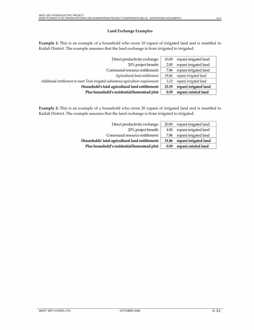
WEST SETI HYDROELECTRIC PROJECT RESETTLEMENT PLAN: RESERVOIR AREA AND DOWNSTREAM PROJECT COMPONENTS (Rev-4) - SUPPORTING DOCUMENTS SD 5
WEST SETI HYDRO LTD. OCTOBER 2008 5-31
Land Exchange Examples
Example 1: This is an example of a household who owns 10 ropani of irrigated land and is resettled to Kailali District. The example assumes that the land exchange is from irrigated to irrigated.
Direct productivity exchange: 10.00 ropani irrigated land 20% project benefit: 2.00 ropani irrigated land
Communal resource entitlement: 7.86 ropani irrigated land Agricultural land entitlement: 19.86 ropani irrigated land
Additional entitlement to meet Terai irrigated subsistence agriculture requirement: 3.33 ropani irrigated land Household’s total agricultural land entitlement: 23.19 ropani irrigated landPlus household’s residential/homestead plot: 0.59 ropani rainfed land
Example 2: This is an example of a household who owns 20 ropani of irrigated land and is resettled to Kailali District. The example assumes that the land exchange is from irrigated to irrigated.
Direct productivity exchange: 20.00 ropani irrigated land 20% project benefit: 4.00 ropani irrigated land
Communal resource entitlement: 7.86 ropani irrigated land Households’ total agricultural land entitlement: 31.86 ropani irrigated landPlus household’s residential/homestead plot: 0.59 ropani rainfed land

WEST SETI HYDROELECTRIC PROJECT RESETTLEMENT PLAN: RESERVOIR AREA AND DOWNSTREAM PROJECT COMPONENTS (Rev-4) - SUPPORTING DOCUMENTS SD 6
WEST SETI HYDRO LTD. OCTOBER 2008 6-1
6. BUILDINGS IN THE RESERVOIR AREA (1997/98)
SUMMARY OF BUILDINGS IN THE RESERVOIR AREA
Area/Village
Structures Below FSL+10 m (1290 m)
Structures Between FSL+10 m – FSL+100 m (1291 m – 1380 m)
Houses Temples Water Mills
Schools Tea Shops
Hostels/Offices
Houses Temples Water Mills
Schools Tea Shops
Hostels/Offices
Seti River 615 15 6 4 56 5 18 1 7 1 3 ‐ Chama Gad 64 1 6 ‐ ‐ ‐ 11 ‐ ‐ ‐ ‐ ‐ Dhung Gad 78 ‐ 3 ‐ ‐ ‐ 26 ‐ 1 ‐ ‐ ‐ Saili Gad 134 2 1 1 7 ‐ 26 ‐ ‐ ‐ ‐ ‐ Nawaghar Gad 22 1 5 ‐ ‐ ‐ 40 ‐ 2 ‐ ‐ ‐ Kalanga Gad 39 ‐ 3 ‐ 1 ‐ 33 ‐ ‐ ‐ 1 ‐ Total: 952 19 24 5 64 5 154 1 10 1 4 ‐
BUILDINGS BY RIVER/TRIBUTARY
Area/Village
Structures Below FSL+10 m (1290 m)
Structures Between FSL+10 m – FSL+100 m (1291 m – 1380 m)
Houses Temples Water Mills
Schools Tea Shops
Hostels/Offices
Houses Temples Water Mills
Schools Tea Shops
Hostels/Offices
Seti River: Sajhabato 18 1 ‐ ‐ ‐ ‐ ‐ ‐ ‐ ‐ ‐ ‐ Kotgado 4 ‐ ‐ ‐ ‐ ‐ ‐ ‐ ‐ ‐ ‐ ‐ Talara * 130 3 2 ‐ ‐ 2 ‐ ‐ ‐ 1 ‐ ‐ Dhungad 72 1 ‐ 1 ‐ 1 ‐ ‐ ‐ ‐ ‐ ‐ Sayaltadi 14 ‐ ‐ ‐ ‐ ‐ ‐ ‐ ‐ ‐ ‐ ‐ Lodebagar 9 ‐ ‐ ‐ ‐ ‐ ‐ ‐ ‐ ‐ ‐ ‐ Harada Khani 15 ‐ ‐ ‐ ‐ ‐ ‐ ‐ ‐ ‐ ‐ ‐ Chune 10 ‐ ‐ ‐ ‐ ‐ ‐ ‐ ‐ ‐ ‐ ‐ Japad 4 ‐ ‐ ‐ ‐ ‐ ‐ ‐ ‐ ‐ ‐ ‐ Mohoribagar (Girichauka) 3 ‐ ‐ ‐ ‐ ‐ ‐ ‐ ‐ ‐ ‐ ‐ Tundibagar 21 ‐ ‐ 1 1 ‐ ‐ ‐ ‐ ‐ ‐ ‐

WEST SETI HYDROELECTRIC PROJECT RESETTLEMENT PLAN: RESERVOIR AREA AND DOWNSTREAM PROJECT COMPONENTS (Rev-4) - SUPPORTING DOCUMENTS SD 6
WEST SETI HYDRO LTD. OCTOBER 2008 6-2
Area/Village
Structures Below FSL+10 m (1290 m)
Structures Between FSL+10 m – FSL+100 m(1291 m – 1380 m)
Houses Temples Water Mills
Schools Tea Shops
Hostels/Offices
Houses Temples Water Mills
Schools Tea Shops
Hostels/Offices
Lambagar 15 1 ‐ ‐ 1 ‐ ‐ ‐ ‐ ‐ ‐ ‐ Attola 6 ‐ ‐ ‐ 1 ‐ 6 ‐ ‐ ‐ ‐ ‐ Aul 11 1 ‐ ‐ 1 ‐ ‐ ‐ ‐ ‐ ‐ ‐ Nakra 25 1 ‐ ‐ 6 ‐ 2 ‐ ‐ ‐ ‐ ‐ Lekam 72 3 2 ‐ ‐ ‐ 2 ‐ ‐ ‐ ‐ ‐ Mohoribagar (Lekham) 12 ‐ ‐ 1 11 1 ‐ ‐ ‐ ‐ ‐ ‐ Pang (Babina) 25 ‐ 1 ‐ ‐ ‐ 5 ‐ ‐ ‐ ‐ ‐ Agurali 6 ‐ ‐ ‐ 1 ‐ ‐ ‐ ‐ ‐ ‐ ‐ Pauta 16 ‐ ‐ ‐ ‐ ‐ ‐ ‐ ‐ ‐ ‐ ‐ Potegada (Kusaina) 4 ‐ ‐ ‐ ‐ ‐ ‐ ‐ ‐ ‐ ‐ ‐ Mallo Aul 6 ‐ ‐ ‐ ‐ ‐ ‐ ‐ ‐ ‐ ‐ ‐ Boharigaun 11 ‐ ‐ ‐ 2 ‐ 9 1 ‐ ‐ ‐ ‐ Baitada 4 ‐ ‐ ‐ ‐ ‐ ‐ ‐ ‐ ‐ ‐ ‐ Selle 3 ‐ ‐ ‐ ‐ ‐ ‐ ‐ ‐ ‐ ‐ ‐ Dansa 2 ‐ ‐ ‐ ‐ ‐ ‐ ‐ ‐ ‐ ‐ ‐ Deura 63 1 ‐ 1 5 1 ‐ ‐ ‐ ‐ ‐ ‐ Deurapulpari ‐ 1 ‐ ‐ 20 ‐ ‐ ‐ ‐ ‐ ‐ ‐ Chhinapani 5 ‐ ‐ ‐ 3 ‐ 30 ‐ ‐ ‐ ‐ ‐ Chaudambagar 24 ‐ 1 ‐ ‐ ‐ 20 ‐ ‐ ‐ ‐ ‐ Jaisibagar 5 2 ‐ ‐ 4 ‐ Mathlek ‐ ‐ ‐ ‐ ‐ ‐ 3 ‐ ‐ ‐ ‐ ‐ Mallo Jakhada ‐ ‐ ‐ ‐ ‐ ‐ 13 ‐ ‐ ‐ ‐ ‐ Kalde ‐ ‐ ‐ ‐ ‐ ‐ 2 ‐ ‐ ‐ ‐ ‐ Khankara ‐ ‐ ‐ ‐ ‐ ‐ 1 ‐ ‐ ‐ ‐ ‐ Ratada ‐ ‐ ‐ ‐ ‐ ‐ 6 ‐ ‐ ‐ ‐ ‐ Rajino ‐ ‐ ‐ ‐ ‐ ‐ 5 ‐ ‐ ‐ ‐ ‐ Markoirala ‐ ‐ ‐ ‐ ‐ ‐ 4 ‐ ‐ ‐ ‐ ‐ Regam ‐ ‐ ‐ ‐ ‐ ‐ 37 ‐ 7 ‐ 1 Simtala (Bedtala) ‐ ‐ ‐ ‐ ‐ ‐ 7 ‐ ‐ ‐ ‐ ‐ Morayal ‐ ‐ ‐ ‐ ‐ ‐ 5 ‐ ‐ ‐ 2 ‐ Pathudabagar ‐ ‐ ‐ ‐ ‐ ‐ 28 ‐ ‐ ‐ ‐ ‐ Total: 615 15 6 4 56 5 185 1 7 1 3 ‐

WEST SETI HYDROELECTRIC PROJECT RESETTLEMENT PLAN: RESERVOIR AREA AND DOWNSTREAM PROJECT COMPONENTS (Rev-4) - SUPPORTING DOCUMENTS SD 6
WEST SETI HYDRO LTD. OCTOBER 2008 6-3
Area/Village
Structures Below FSL+10 m (1290 m)
Structures Between FSL+10 m – FSL+100 m(1291 m – 1380 m)
Houses Temples Water Mills
Schools Tea Shops
Hostels/Offices
Houses Temples Water Mills
Schools Tea Shops
Hostels/Offices
Kalanga Gad Dhari 14 ‐ 1 ‐ ‐ ‐ 9 ‐ ‐ ‐ ‐ ‐ Jupalkhet 17 ‐ ‐ ‐ 1 ‐ ‐ ‐ ‐ ‐ ‐ ‐ Kabadigaun (Nayabagar) 8 ‐ 2 ‐ ‐ ‐ 9 ‐ ‐ ‐ 1 ‐ Kaladhunga ‐ ‐ ‐ ‐ ‐ ‐ 9 ‐ ‐ ‐ ‐ ‐ Khairadi ‐ ‐ ‐ ‐ ‐ ‐ 6 ‐ ‐ ‐ ‐ ‐ Total: 39 ‐ 3 ‐ 1 ‐ 33 ‐ ‐ ‐ 1 ‐ Nawaghar Gad Sangada (Selle) 20 ‐ 3 ‐ ‐ ‐ 12 ‐ 2 ‐ ‐ ‐ Beureti ‐ 1 1 ‐ ‐ ‐ 4 ‐ ‐ ‐ ‐ ‐ Pargaun 2 ‐ 1 ‐ ‐ ‐ 10 ‐ ‐ ‐ ‐ ‐ Parimera ‐ ‐ ‐ ‐ ‐ ‐ 5 ‐ ‐ ‐ ‐ ‐ Gadual ‐ ‐ ‐ ‐ ‐ ‐ 9 ‐ ‐ ‐ ‐ ‐ Total: 22 1 5 ‐ ‐ ‐ 40 ‐ 2 ‐ ‐ ‐Saili Gad Samachimandu 7 1 ‐ ‐ ‐ ‐ ‐ ‐ ‐ ‐ ‐ ‐ Tallo Jakhada 8 1 ‐ 1 ‐ ‐ 6 ‐ ‐ ‐ ‐ ‐ Baurad 10 ‐ ‐ ‐ ‐ ‐ ‐ ‐ ‐ ‐ ‐ ‐ Adarya 8 ‐ ‐ ‐ ‐ ‐ ‐ ‐ ‐ ‐ ‐ ‐ Koireli Khola 2 ‐ ‐ ‐ ‐ ‐ 2 ‐ ‐ ‐ ‐ ‐ Kola 11 ‐ ‐ ‐ ‐ ‐ ‐ ‐ ‐ ‐ ‐ ‐ Khalikhet 10 ‐ ‐ ‐ ‐ ‐ ‐ ‐ ‐ ‐ ‐ ‐ Aanti 3 ‐ ‐ ‐ ‐ ‐ ‐ ‐ ‐ ‐ ‐ ‐ Amattado 5 ‐ ‐ ‐ ‐ ‐ ‐ ‐ ‐ ‐ ‐ ‐ Shahikhet 7 ‐ ‐ ‐ ‐ ‐ ‐ ‐ ‐ ‐ ‐ ‐ Lamkhet 7 ‐ 1 ‐ ‐ ‐ ‐ ‐ ‐ ‐ ‐ ‐ Gautado 6 ‐ ‐ ‐ 2 ‐ ‐ ‐ ‐ ‐ ‐ ‐ Dumad 7 ‐ ‐ ‐ ‐ ‐ 2 ‐ ‐ ‐ ‐ ‐ Jalkule 9 ‐ ‐ ‐ ‐ ‐ ‐ ‐ ‐ ‐ ‐ ‐ Bharsendip 4 ‐ ‐ ‐ 5 ‐ ‐ ‐ ‐ ‐ ‐ ‐ Bharra 6 ‐ ‐ ‐ ‐ ‐ ‐ ‐ ‐ ‐ ‐ ‐ Biurebagar 4 ‐ ‐ ‐ ‐ ‐ ‐ ‐ ‐ ‐ ‐ ‐

WEST SETI HYDROELECTRIC PROJECT RESETTLEMENT PLAN: RESERVOIR AREA AND DOWNSTREAM PROJECT COMPONENTS (Rev-4) - SUPPORTING DOCUMENTS SD 6
WEST SETI HYDRO LTD. OCTOBER 2008 6-4
Area/Village
Structures Below FSL+10 m (1290 m)
Structures Between FSL+10 m – FSL+100 m(1291 m – 1380 m)
Houses Temples Water Mills
Schools Tea Shops
Hostels/Offices
Houses Temples Water Mills
Schools Tea Shops
Hostels/Offices
Aaambagar 13 ‐ ‐ ‐ ‐ ‐ ‐ ‐ ‐ ‐ ‐ ‐ Aad Khet 2 ‐ ‐ ‐ ‐ ‐ ‐ ‐ ‐ ‐ ‐ ‐ Mattyal 5 ‐ ‐ ‐ ‐ ‐ ‐ ‐ ‐ ‐ ‐ ‐ Lamarakogodo ‐ ‐ ‐ ‐ ‐ ‐ 4 ‐ ‐ ‐ ‐ ‐ Manetha ‐ ‐ ‐ ‐ ‐ ‐ 3 ‐ ‐ ‐ ‐ ‐ Bhidetta ‐ ‐ ‐ ‐ ‐ ‐ 8 ‐ ‐ ‐ ‐ ‐ Guyalano ‐ ‐ ‐ ‐ ‐ ‐ 1 ‐ ‐ ‐ ‐ ‐ Total: 134 2 1 1 7 ‐ 26 ‐ ‐ ‐ ‐ ‐ Dhung Gad Chhilla 23 ‐ 2 ‐ ‐ ‐ ‐ ‐ ‐ ‐ ‐ ‐ Mushkhet 20 ‐ ‐ ‐ ‐ ‐ ‐ ‐ ‐ ‐ ‐ Jarimbagar 3 ‐ ‐ ‐ ‐ ‐ ‐ ‐ ‐ ‐ ‐ ‐ Gunya Khola 4 ‐ ‐ ‐ ‐ ‐ 2 ‐ ‐ ‐ ‐ ‐ Bashme (Barfire) 11 ‐ ‐ ‐ ‐ ‐ ‐ ‐ ‐ ‐ ‐ ‐ Khadaule 11 ‐ 1 ‐ ‐ ‐ ‐ ‐ ‐ ‐ ‐ ‐ Limod 5 ‐ ‐ ‐ ‐ ‐ 5 ‐ ‐ ‐ ‐ ‐ Rajje (Dhaulechiura) 1 ‐ ‐ ‐ ‐ ‐ 10 ‐ ‐ ‐ ‐ ‐ Shiradi ‐ ‐ ‐ ‐ ‐ ‐ ‐ ‐ 1 ‐ ‐ ‐ Selpakho ‐ ‐ ‐ ‐ ‐ ‐ 9 ‐ ‐ ‐ ‐ ‐ Total: 78 ‐ 3 ‐ ‐ ‐ 26 ‐ 1 ‐ ‐ ‐Chama Gad Ratmate 8 ‐ 1 ‐ ‐ ‐ 7 ‐ ‐ ‐ ‐ ‐ Lademalo 11 ‐ ‐ ‐ ‐ ‐ ‐ ‐ ‐ ‐ ‐ ‐ Bhamk 12 ‐ 1 ‐ ‐ ‐ ‐ ‐ ‐ ‐ ‐ ‐ Jamangada 9 ‐ ‐ ‐ ‐ ‐ 1 ‐ ‐ ‐ ‐ ‐ Dotari 3 1 1 ‐ ‐ ‐ ‐ ‐ ‐ ‐ ‐ ‐ Dhritam ‐ ‐ 1 ‐ ‐ ‐ 3 ‐ ‐ ‐ ‐ ‐ Kokadi 13 ‐ 2 ‐ ‐ ‐ ‐ ‐ ‐ ‐ ‐ ‐ Bautada 8 ‐ ‐ ‐ ‐ ‐ ‐ ‐ ‐ ‐ ‐ ‐ Total: 64 1 6 ‐ ‐ ‐ 11 ‐ ‐ ‐ ‐ ‐
* ‐ Talara includes Bhagtadi, Sanagaun, Taligaun, Dobra, Badal, Matela, Parmitela and Sera Bali.

WEST SETI HYDROELECTRIC PROJECT RESETTLEMENT PLAN: RESERVOIR AREA AND DOWNSTREAM PROJECT COMPONENTS (Rev-4) - SUPPORTING DOCUMENTS SD 7
WEST SETI HYDRO LTD. OCTOBER 2008 7-1
7. SCHOOLS IN THE RESERVOIR AREA AND PERIPHERY (1997/98) Fig. Ref. No.
Name of School
Location
No. of
Teachers
No. of
Students
Class‐rooms
School Catchment Areas
Settlements in FSL+100 m Other Settlements
1 Sharada Secondary School Dhungad, Dhungad VDC, Ward 7
below FSL 10 250 11 Children from Dhungad, Lodebagar, Haradakhani, Chune, Tundibagar, Lambagar (Dhungad VDC); Sajhabata, Chilla, Jarimbagar, Bautada, Bamk, Jamangada (Belapur VDC)
Children from Gune, Kolkate, Pisudkot, Paragaun, Gatipid, Manithala (all situated above Dhungad); also Gajeli Bhunwa, Silajoo, Muskhet, Khairkot, Bhasme, Khadaule, Limod, Raje and Ratamati (Dhungad and Belapur VDCs)
2 Kailpad Primary School (1‐3) Gune , Dhungad VDC, Ward 5
above FSL+100 m
Children from Gune, and Gajeli Bhunwa, etc. (Dhungad VDC)
3 Sigas Lower Secondary School Kotili, Sigas VDC
above FSL+100 m
Children from Sigas VDC
4 Bijasaini Secondary School Chama, Belapur VDC, Ward 7
above FSL+100 m
Children from Belapur VDC
5 Janak Primary School Sirod , Belapur VDC, Ward 7
above FSL+100 m
Children from Sirod, Ratamati and other proximate villages (Belapur VDC)
6 Bhagwati Secondary School Talara, Lamikhal VDC, Ward 5
FSL+100 m 11 172 16 Children from Talara, Jakhada, Samachimanu, Gairikhet, Kola, Khalikhet, etc. (Lamikhal VDC); Guatado, Bharro, Birebagar, Bharsanitip (Mahadevsthan VDC); Jalkule, Sannu (Girichauka VDC)
Children from Bhideta (Mahadevsthan VDC); Guyalano, Thalo, Sillagaun (Girichauka and Dahakalikasthan VDCs)
7 Jhunda Primary School Jhunda, Lamikhal VDC, Ward 5
above FSL+100 m
3 101 5 Children from Bhideta and surrounding villages (Mahadevsthan VDC)
8 Mahadev Primary School Tundibagar Dhungad VDC, Ward 9
below FSL 3 100 5 Children from Tundibagar Chune, Lambagar (Dhungad VDC)
9 Dhurga Primary School Jakhada, Lamikhal VDC, Ward 5
below FSL 2 55 3 Children from Samachimanu (Lamikhal VDC) Children from Jakhada (Lamikhal VDC)
10 Primary School Tanaghat Girichauka VDC, Ward 4
above FSL+100 m
Children from Tanaghat and surrounding villages (Dahakalikasthan VDC)
11 Bhawani Primary School Khateda, Girichauka VDC, Ward 5
above FSL+100 m
2 97 5 Children from Khankara, Khateda and surrounding villages (Girichauka VDC)

WEST SETI HYDROELECTRIC PROJECT RESETTLEMENT PLAN: RESERVOIR AREA AND DOWNSTREAM PROJECT COMPONENTS (Rev-4) - SUPPORTING DOCUMENTS SD 7
WEST SETI HYDRO LTD. OCTOBER 2008 7-2
Fig. Ref. No.
Name of School
Location
No.of
Teachers
No.of
Students Class‐rooms
School Catchment Areas
Settlements in FSL+100 m Other Settlements
12 Ganesh Secondary School (recently upgraded to SS) Mohoribagar/Lekham Thalakanda VDC, Ward 7
below FSL 11 250 8 Children from Lekham, Mohoribagar, Nakara (Thalakanda VDC); Sangada, Martiyal (Shivaling VDC); also from Pang (Girichauka VDC), Pauta, Dharmagadha, Kusaina, etc. (Chhapali VDC)
Children from Kalikhani, Nwaghari and other villages in upper reaches of Nawaghar Gad; also from Bohorigaun (Shivaling VDC)
13 Babina Primary School Babina, Girichauka VDC, Ward 1
above FSL+100 m
3 125 5 Children from Pang (Girichauka VDC); Kusaina, Pauta (Chhapali VDC)
Children from Babina and other villages in Girichauka and Chhapali VDCs
14 Balkrishna Primary School Bagali, Shivaling VDC, Ward 8l
above FSL+100 m
5 200 7 Chidlren from villages in the upper reaches of the Nawaghar Gad (Shivaling VDC)
15 Kalika Primary School Pipalkot, Dangaji VDC, Ward 5
above FSL+100 m
2 42 3 Children from Pipalkot and Chuthi (Dangaji VDC)
16 Laxmi Primary School Motipur, Dangaji VDC
above FSL+100 m
3 143 4 Children Motipur, Simtola, Sagnyadi, etc. (Dangaji VDC)
17 Garjepani Secondary School Rayal, Rayal VDC
above FSL+100 m
13 143 18 Children from Dangaji, Rayal and Sunkuda VDCs
Children from Parakatne VDC; also from Rayal and Dangaji VDCs
18 Ratipani Lower Secondary School (to be upgraded) Chaudam, Rayal VDC, Ward 3
above FSL+100 m
8 350 Children from Deura, Chaudambagar, Bilibagar, Regam, Regam Jiulo, Jaisibagar, Jupalkhet, etc. (Rayal and Dangaji VDCs)
Children from Choudam, Basti, Bedtala, etc, (Rayal and Dangaji VDCs)
19 Dhari Primary School Dhari, Sunkuda VDC, Ward 1
above FSL+100 m
Children from Dharibagar, Nayanbagar (Sunkuda and Rayal VDCs)
Children from villages in Sunkuda VDC
20 Shree Sunkuda Secondary School Sunkuda, Sunkuda VDC, Ward 2
above FSL+100 m
14 299 32 Children from Sunkuda, etc. (Sunkuda VDC)
21 Janchetana Primary School Deura, Rayal VDC, Ward 3
below FSL 1 44 4 Children from Deura (Rayal VDC)
22 Betal Lower Secondary School Chaudam, Rayal VDC
above FSL+100 m
11 249 10
Totals Below FSL+100 m 28 728 28 Between FSL+10 m and FSL+100 m 10 200 11 Above FSL+100 m

WEST SETI HYDROELECTRIC PROJECT RESETTLEMENT PLAN: RESERVOIR AREA AND DOWNSTREAM PROJECT COMPONENTS (Rev-4) - SUPPORTING DOCUMENTS SD 8
WEST SETI HYDRO LTD. OCTOBER 2008 8-1
8. PROPOSED LAND EXCHANGE RATIOS
1. INTRODUCTION The principals of land exchange with landowners to be resettled are: • landowners will have the productivity of their land recognised in the amount of exchange land
provided; • landowners will be provided with an additional 10% of their existing landholding productivity and a
residential plot as a direct project benefit, in addition to the land exchange based on productivity; • landowners will have their existing community resource access/usage recognised and be given a set
area of land to compensate for the lost user benefits received from these resources (as recommended by APROSC, 1998); and
• landowners who, once the above calculations have been made, are only entitled to a smaller than subsistence‐level landholding on the Terai (as recommended by APROSC, 1998), will receive a subsistence‐level landholding on the Terai.
2. RECOGNITION OF EXISTING CULTIVATION LAND PRODUCTIVITY For the purposes of recognising land productivity as the prime determinant of land exchange, two cultivation land types have been identified in the Seti valley, namely “irrigated cultivation” and “rainfed cultivation”. These two land types are commonly termed “paddy” and “maize” respectively on land titles. On registered land titles, these two land types are divided into four classes under each land type. Consideration was given to basing compensation on these eight classes, but this was seen as inappropriate given the difficulty in assigning productivity to each class and the inevitable debate that would follow regarding the comparative productive potential of each of the eight classes. The following average crop yields (taken over the last five years), from project area VDCs for the two main crops (paddy and wheat), have been used to calculate the relative production value of “irrigated” and “rainfed” land in the Seti valley.
Table 1: Average Crop Yields of Project Area VDCs, 1992/93 ‐ 1996/97
Land Type Yield (T/ha) Paddy Wheat
Irrigated 3.28 2.59 Rainfed 1.98 1.32
Irrigated paddy yields are approximately 66% greater than rainfed paddy yields, while irrigated wheat yields are approximately 96% greater than rainfed wheat yields. These differences in productivity are recognised in the land‐for‐land productivity exchange calculations. 3. RECOGNITION OF NON‐CULTIVATION LAND PRODUCTIVITY Registered private land parcels classed as other than “paddy” and “maize” cultivation land, such as “house and land” or “thatch grass”, will also be recognised as part of the total household cultivation landholding. These other land classes of generally low productivity land will be recognised as rainfed or “maize” cultivation, thus assigning a higher production value to these land parcels.

WEST SETI HYDROELECTRIC PROJECT RESETTLEMENT PLAN: RESERVOIR AREA AND DOWNSTREAM PROJECT COMPONENTS (Rev-4) - SUPPORTING DOCUMENTS SD 8
WEST SETI HYDRO LTD. OCTOBER 2008 8-2
As most residential plots are not separately registered, but are part of the land parcels classed as “paddy” or “maize” cultivation, the actual residential plot will be included in the total of household cultivation land. A standard size residential plot (including cow shed area and vegetable garden area) will be provided on the Terai in addition to the total landholding exchange (see Section 4). Shops will be recognised as “special value” holdings, with compensation calculated on an individual basis. Shopkeepers in Deura will be given the option of cash compensation or moving to premises alongside the replaced section of road. 4. ADDITIONAL LAND A primary objective of the project is to ensure that people directly affected by the project are either better off, or at least no worse off, as a result of project development. To ensure that households facing resettlement receive a real benefit from the project, two measures will be incorporated into the land exchange. • Provision of a residential plot. A 300 m² residential plot will be provided to all landowners who will be
resettled (in addition to the cultivation land‐for‐land exchange for each householdʹs total land area)1. • Provision of additional cultivation land. In addition to the cultivation land‐for‐land exchange based on
productivity (as well as the provision of a 300 m² residential plot and the exchange of Seti valley community resource use for cultivation land), another 10% of the existing household land productivity will also be provided as cultivation land. This will provide households with a direct project benefit of 10% greater crop production on top of their existing Seti valley production levels.
5. RECOGNITION OF EXISTING COMMUNITY RESOURCE USE Nearly all households in the Seti valley utilise some community resources. As a general rule, smaller landholders have a greater reliance upon community resources in regard to the percentage of daily requirements or income that they derive from these resources. Although this relative reliance is higher, the actual quantities of community resources utilised by most households are similar, regardless of the household landholding size. Individual households have equal entitlement to the use of these resources regardless of their landholding size. It is recognised that fewer community resources exist on the Terai, therefore average existing community resource use in the Seti valley has been valued and will exchanged for cultivation land on the Terai as part of the resettlement package. Accordingly, 0.47 ha of cultivation land, based on a 50/50 mix of irrigated and rainfed land, will be added to each household’s cultivation land‐for‐land exchange entitlement to cover their loss of community resources (APROSC, 1998). The production value of this additional land area is equivalent to the rupee value required by the average household to replace those lost communal resource user benefits on the Terai (APROSC, 1998). Detailed below is the communal resource exchange basis, based on are the main community resources used by Seti valley households, together with the average use per household for the total 1,530 households interviewed. 1 The average residential plot size of small landholders interviewed on the Terai was recorded as 680 m² (APROSC 1998). Despite this, a 300 m² residential plot will be provided, based on SMEC observations.

WEST SETI HYDROELECTRIC PROJECT RESETTLEMENT PLAN: RESERVOIR AREA AND DOWNSTREAM PROJECT COMPONENTS (Rev-4) - SUPPORTING DOCUMENTS SD 8
WEST SETI HYDRO LTD. OCTOBER 2008 8-3
Table 2: Communal Resource Exchange
Seti Valley Terai
Communal Resource End Use Equivalent End Use Need • Stone/sand/gravel • Earth • Shale/thatch grass • Timber
• Building construction • Building maintenance
• House construction and maintenance
Replaced over 35 years. Annual maintenance.
• Timber • Farm implements • Farm implements Replaced over 10 years • Furniture • Furniture Replaced over 10 years • Fuelwood • Cooking fuel
• Light • Heat
• Cooking fuel • Light
Annual fuelwood for a fuel‐efficient stove.
• Fodder • Ploughing • Milk • Meat
• Ploughing • Milk • Meat
A reduced quantity.
• Animal bedding • Manure • Livestock • Fertiliser
• Manure • Livestock • Fertiliser
Equal equivalent value.
• Wild fruits / vegetables
• Food • Food Rs. for fruit/vegetables.
• Apiculture • Food • Food Only approximately 40% of Seti valley production.
• Chuiri products • Cooling oil • Other
• Cooking oil Rs. ‐ Seti valley value.
• Ritha • Soap • Other products
Rs. ‐ Seti valley value.
• Medicinal herbs • Medicines • Medicines Rs. ‐ Seti valley value. • Fish • Food (high protein) • Food (high protein) Rs. for protein. The required quantity of grain to meet these user benefits directly (diet) or indirectly (income) was calculated, then converted to a Terai cultivation land area based on the standard land type productivity contained in Section 5. 6. TERAI CULTIVATION LAND PRODUCTIVITY In order to calculate land exchange, the productive capacity of resettlement land was quantified. This has been primarily done through farmer interviews in Kailali District (APROSC, 1998), as well as by comparison with Kailali District yield averages for VDCs where resettlement is likely (see Tables 3 and 4). The average yields reported by 45 small farmers interviewed by APROSC in 14 Kailali District VDCs where resettlement is likely are detailed in Table 3. These yields are believed to be relatively accurate as harvested grain is stored in large clay containers of a known volume. The farm size of the interviewed farmers ranged from 0.14‐2.95 ha, with the average farm size being 1.31 ha.

WEST SETI HYDROELECTRIC PROJECT RESETTLEMENT PLAN: RESERVOIR AREA AND DOWNSTREAM PROJECT COMPONENTS (Rev-4) - SUPPORTING DOCUMENTS SD 8
WEST SETI HYDRO LTD. OCTOBER 2008 8-4
Table 3: Terai Crop Yields (for major crops)
Land Type Yield (T/ha) Paddy Wheat
Irrigated 3.67 2.63 Rainfed 2.72 1.57
Source: Farmer interviews. The average crop yields over the past 5 years for 10 VDCs in Kailali District where resettlement is likely, for both irrigated and rainfed cultivation land types, are detailed in Table 4. These yields are not specific for either irrigated or rainfed cultivation, therefore they only provide an indication of yield.
Table 4: Crop Yields for Selected VDCs in Kailali District
Land Type Yield (T/ha) Paddy Wheat
Irrigated and rainfed combined
2.11 1.64
Source: DADO, Kailali. Benchmark productivity values for terai resettlement land have been based on the average yields reported by the 45 interviewed farmers. It is recognised that small farmers often obtain good yields from their properties due to high labour inputs, despite the lack of improved seed varieties. Accordingly, the average reported yields by interviewed farmers have been reduced to establish the benchmark productivity values for irrigated and rainfed cultivation land in Kailali District, as detailed in Table 5. 7. LAND‐FOR‐LAND PRODUCTIVITY EXCHANGE A direct comparison of Seti valley cultivation land productivity and Terai cultivation land productivity in Kailali District has to be made to calculate fair land exchange ratios. Land productivity is primarily a function of yield multiplied by the average number of crops grown each year. The crop index or crop intensity factor for the Far‐Western Development Region Middle Hills and Terai are almost identical, at 1.85 and 1.84 respectively (LRMP, 1986), therefore no adjustment has been made for this. The irrigated land and rainfed land yields adopted for the Seti valley and the Terai, and the proposed land exchange ratios for these land types, are summarised in Tables 5 and 6. The yields used for the Seti valley are taken directly from the project area VDC yield averages for the past 5 years (Table 1, Section 1). The yields adopted for Kailali District land are based on a marginal reduction (4.6‐12.1%) in the yields reported by the 45 farmers interviewed in Kailali District in order to allow for the slightly higher yields that they achieve over medium‐sized landowners due to more labour intensive cultivation.
Table 5: Irrigated Land Exchange Yield Values
Crop
Average Yield (T/ha) % Yield Difference
Land Exchange Ratio
Likely Terai Yield (T/ha) Seti
Valley Kailali District
Paddy 3.28 3.50 + 6.7 1 ha Seti valley = 1 ha Terai 3.50 Wheat 2.59 2.50 ‐ 3.6 2.50
Given that the additional paddy yield on the terai (+6.7%) more than offsets the reduction in wheat yield (‐3.6%), a 1:1 irrigated land exchange will occur.

WEST SETI HYDROELECTRIC PROJECT RESETTLEMENT PLAN: RESERVOIR AREA AND DOWNSTREAM PROJECT COMPONENTS (Rev-4) - SUPPORTING DOCUMENTS SD 8
WEST SETI HYDRO LTD. OCTOBER 2008 8-5
Table 6: Rainfed Land Exchange Yield Values
Crop
Average Yield (T/ha) % Yield Difference
Land Exchange Ratio
Likely Terai Yield (T/ha)
Seti Valley
Kailali District
Paddy 1.98 2.60 + 31.3 1 ha Seti valley = 0.85 ha Terai 2.21 Wheat 1.32 1.40 + 6.1 1.19 The average increase in rainfed paddy and wheat yields on the terai is 18%, which translates to a 1:0.85 land exchange. It will not always be possible to exchange a household’s irrigated or rainfed land for a similar type of land on the terai. Accordingly, land exchange ratios have been calculated for irrigated‐to‐rainfed and rainfed‐to‐irrigated land exchanges.
Table 7: Irrigated‐to‐Rainfed Land Exchange Yield Values
Crop
Average Yield (T/ha) % Yield
Difference Land Exchange Ratio
Likely Terai Yield (T/ha) Seti
Irrigated Kailali Rainfed
Paddy 3.28 2.60 ‐ 20.7 1 ha Seti valley = 1.35 ha Terai 3.77 Wheat 2.59 1.40 ‐ 45.9 2.03
Table 8: Rainfed‐to‐Irrigated Land Exchange Yield Values
Crop
Average Yield (T/ha)
% Yield Difference
Land Exchange Ratio
Likely Terai Yield (T/ha) Seti Rainfed Kailali
Irrigated Paddy 1.98 3.50 + 76.8 1 ha Seti valley = 0.55 ha Terai 1.92 Wheat 1.32 2.50 + 89.4 1.38
Example The total land exchange entitlement for a household owning 2.0 ha of irrigated land in the Seti
valley is:
Direct productivity exchange 2.0 ha irrigated 10% benefit 0.2 ha irrigated Residential plot 0.03 ha rainfed Community resource land 0.47 ha (50/50 irrigated and rainfed) Total entitlement 2.435 ha irrigated + 0.265 ha rainfed
8. PROVISION OF SUBSISTENCE LANDHOLDINGS Utilising the land exchange ratios and compensation rates described above in Sections 2‐7, a number of landowners to be resettled from the Seti valley will only be entitled to a landholding smaller than the estimated sustainable subsistence landhold size for the Kailali District Terai. APROSC (1998) calculated subsistence landholding sizes for Kailali District Terai land, based on meeting the requirements of a household of 8 people, including food requirements and household expenditure. The recommended subsistence landholding sizes, including residential plot/yard, for three different land types are:
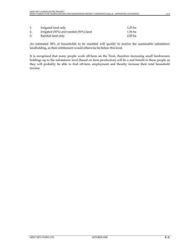
WEST SETI HYDROELECTRIC PROJECT RESETTLEMENT PLAN: RESERVOIR AREA AND DOWNSTREAM PROJECT COMPONENTS (Rev-4) - SUPPORTING DOCUMENTS SD 8
WEST SETI HYDRO LTD. OCTOBER 2008 8-6
1. Irrigated land only 1.25 ha 2. Irrigated (50%) and rainfed (50%) land 1.56 ha 3. Rainfed land only 2.05 ha An estimated 38% of households to be resettled will qualify to receive the sustainable subsistence landholding, as their entitlement would otherwise be below this level. It is recognised that many people work off‐farm on the Terai, therefore increasing small landowners holdings up to the subsistence level (based on farm production) will be a real benefit to these people as they will probably be able to find off‐farm employment and thereby increase their total household income.

WEST SETI HYDROELECTRIC PROJECT RESETTLEMENT PLAN: RESERVOIR AREA AND DOWNSTREAM PROJECT COMPONENTS (Rev-4) - SUPPORTING DOCUMENTS SD 9
WEST SETI HYDRO LTD. OCTOBER 2008 9-1
9. MONITORING INDICATORS Subject Indicator Variable
Land Acquisition of land • Area of cultivation land acquired for project developments • Area of communal land acquired for project developments • Area of government land acquired for project developments
Buildings/ Structures
Acquisition of buildings
• Number, type and size of private buildings acquired • Number, type and size of community buildings acquired • Number, type and size of government buildings acquired
Acquisition of other structures
• Number, type and size of other private structures acquired • Number, type and size of other community structures acquired
Trees and Crops Acquisition of trees • Number and type of private trees acquired Destruction of crops • Crops destroyed by area, type and ownership
Compensation, Re‐establishment and Rehabilitation
Compensation and re‐establishment of affected owners/individuals
• Number of households affected (buildings, land, trees, crops) • Number of owners compensated by type of loss • Amount compensated by type and owner • Number of replacement houses constructed • Size, construction, durability and environmental suitability of
replacement houses • Water supply and sanitation access • Number of replacement businesses constructed
Re‐establishment of community resources
• Number of community buildings replaced • Success of mitigation activities
Hazards and Disturbances
Introduction of nuisance factors
• Number of households affected by hazards and disturbances from project construction and operation (noise levels, blasting, increased traffic levels)
Social/ Demographic
Changes to household structure
• Household size (births, deaths, migration in and out) • Age distribution • Gender distribution • Marital status • Relationship to household head • Status of vulnerable households
Population migration • Residential status of household members • Movement in and out of the homestead (place and residence of
homestead members) Changes to access • Distance/travel time to nearest school, health centre, place of religious
worship, market areas Changes to health status
• Nutritional status of resettled household members • Number of people with disease, by type • Mortality rates • Access to health care services (distance to nearest facility, cost of services,
quality of services) • Utilisation of health care services • Disease prevention strategies • Extent of educational programmes • Sanitation provision at schools
Changes to educational status
• Literacy and educational attainment of household members • School attendance rates (age, gender) • Number, type of educational establishments
Changes to status of women
• Participation in training programmes • Use of credit facilities • Landholding status • Participation in project‐related activities and enterprises

WEST SETI HYDROELECTRIC PROJECT RESETTLEMENT PLAN: RESERVOIR AREA AND DOWNSTREAM PROJECT COMPONENTS (Rev-4) - SUPPORTING DOCUMENTS SD 9
WEST SETI HYDRO LTD. OCTOBER 2008 9-2
Subject Indicator VariableHousehold earning capacity
• Ownership of capital assets • Ownership of equipment and machinery • Landholding size, area cultivated and production volume/value, by
crop (cash and subsistence crops) • Landholding status (tenure) • Redistribution of cultivation land • Changes to livestock ownership: pre‐ and post disturbance • Value of livestock sales • Consumption of own livestock production • Employment status of economically active members • Skills of household members • Earnings/income by source, separating compensation payments • Changes to income‐earning activities (agriculture) – pre‐ and post
disturbance • Changes to income‐earning activities (off‐farm) – pre‐ and post
disturbance • Amount and balance of income and expenditure • Possession of consumer durables • Realisation of household income restoration • Possession of bank and savings accounts • Access to income‐generating natural resource base (e.g. forest products,
fish products) Changes in social organisation
• Organisational membership of household members • Leadership positions held by household members
Population influx • Growth in number and size of settlements, formal and informal • Growth in market areas • Influx of people into project area
Consultation Consultation programme operation
• Number of local committees (LCFs) established • Number and dates of LCF meetings • Type of issues raised at local committee meetings • Involvement of local committees in project planning • Number of participating NGOs
Grievances resolved • Number of grievances registered, by type • Number of grievances resolved • Number of cases referred to court
Training Operation of training programme
• Number of LCF members trained • Number of affected population trained in project‐related training
courses Management Staffing • Number of WSH resettlement and development staff by function
• Number of NGO staff working on the project • Number of government land officials available • Number of office and field equipment, by type
Procedures in operation
• Census and asset verification/quantification procedures in place • Effectiveness of compensation delivery system • Number of land transfers effected • Co‐ordination between WSH, community structures, government
agencies and NGOs

WEST SETI HYDROELECTRIC PROJECT RESETTLEMENT PLAN: RESERVOIR AREA AND DOWNSTREAM PROJECT COMPONENTS (Rev-4) - SUPPORTING DOCUMENTS SD 10
WEST SETI HYDRO LTD. OCTOBER 2008 10-1
10. CONSTRUCTION WORKFORCE Period Construction
Activity Total
Workforce Workforce Composition
Prof. Skilled Semi‐skilled
Unskilled
Months 1‐6 i. Access roads 700 50 200 250 200 ii. Camps, offices, workshops Months 7‐12 i. Access roads 1,350 110 470 370 400 ii. Camps, offices, workshops iii. Dam site clearing iv. Diversion tunnel excavation v. Spillway excavation vi. Intake excavation vii. Power station surface works and pilot
tunnel
Months 13‐18 i. Access roads 2,100 170 740 660 530 ii. Diversion tunnels iii. Dam foundation excavation iv. Spillway excavation v. Power conduit excav. and intake work vi. Power station underground excavation Months 19‐24 i. Access roads 2,400 200 960 690 550 ii. Diversion tunnels iii. Dam foundation excavation/grouting iv. Spillway excavation and concrete v. Power conduit intake concrete vi. Power conduit excavation vii. Power station underground excavation viii. Riparian outlet Months 25‐30 i. Coffer dam and river diversion 2,700 210 1,010 810 670 ii. Dam foundation excavation iii. Plinth concrete iv. Foundation grouting v. Dam fill placement vi. Spillway concrete vii. Riparian outlet viii. Power conduit excavation ix. Power station underground excavation x. Transmission line erection Months 31‐36 i. Dam foundation excavation 3,400 240 1,290 1,020 850 ii. Plinth concrete, foundation grouting iii. Dam fill placement iv. Spillway concrete v. Low level outlet vi. Power conduit excavation vii. Power station underground excavation viii. Power station concrete ix. Transmission line erection x. E+M plant installation Months 37‐42 i. Dam foundation excavation 3,200 240 1,210 950 800 ii. Plinth concrete, foundation grouting iii. Dam fill placement iv. Spillway concrete v. Low level outlet vi. Power station underground excavation vii. Power station concrete viii. Transmission line erection ix. E+M plant installation x. Surge shaft excavation and lining xi. Power conduit concrete lining Months 43‐48 i. Plinth concrete, foundation grouting 2,600 200 1,000 800 600 ii. Dam face slab concrete

WEST SETI HYDROELECTRIC PROJECT RESETTLEMENT PLAN: RESERVOIR AREA AND DOWNSTREAM PROJECT COMPONENTS (Rev-4) - SUPPORTING DOCUMENTS SD 10
WEST SETI HYDRO LTD. OCTOBER 2008 10-2
Period Construction Activity
Total Workforce
Workforce Composition Prof. Skilled Semi‐
skilled Unskilled
iii. Power conduit and surge storage concrete
iv. Power station, transformer hall concrete
v. E+M plant installation vi. Transmission line erection Months 49‐54 i. Dam face slab concrete 1,600 100 800 500 200 ii. Power station concrete iii E+M plant installation iv. Re‐regulation weir Months 55‐60 i. E+M plant installation 500 50 250 100 100 Months 1‐60 Supervising engineer staff 200
(150‐200) 40 90 40 30
Skill Definitions
Skill Level Positions Skill Level Positions Professional Engineers ‐ office and site Skilled Plant operators Accountants Electricians Quantity surveyors Drillers Senior administration staff Mechanics Surveyors Welders Geologists Plumbers Doctor Supervisors Teacher Carpenters Draftsman Purchasing officer Senior technicians Personnel officer Senior storekeepers Senior miners Senior foreman Senior secretarial and clerical staff Nurses Chefs Semi‐skilled Junior secretarial and clerical staff Unskilled Labourers Drivers Cleaners Laboratory staff Gardeners Store keepers Watchman Medical assistants Steel fixers Security guards Chairmen Miners Foreman Leading hands Drillerʹs assistants Riggers Concrete workers/masons Painters Grouting/shotcrete technicians Powder men Oilers and greasers Pump and generator attendants Spotters

WEST SETI HYDROELECTRIC PROJECT RESETTLEMENT PLAN: RESERVOIR AREA AND DOWNSTREAM PROJECT COMPONENTS (Rev-4) - SUPPORTING DOCUMENTS SD 11
WEST SETI HYDRO LTD. OCTOBER 2008 11-1
11. SOCIO-ECONOMIC INDICATORS FOR THE TERAI RESETTLEMENT DISTRICTS
Population in Kailali District by Caste/Ethnic Group, 2001 (Land available for purchasing in shaded VDCs)
VDC Caste/
Ethnic Group No. Caste/ Ethnic Group No. Caste/
Ethnic Group No. Caste/ Ethnic Group No. Caste/
Ethnic Group No.
Baliya Chhetri 7190 Brahman - Hill 6444 Magar 1584 Tharu 7257 Tamang 22 Newar 143 Muslim 186 Kami 2905 Yadav 14 Rai 30 Gurung 88 Damai/Dholi 1107 Limbu 15 Thakuri 1496 Sarki 315 Teli 28 Chamar/ Harijan/ Ram 14 Koiri 2 Sanyasi 261 Sherpa 17 Sonar 368 Brahman - Tarai 36 Baniya 29 Gharti/Bhujel 2 Kumal 2 Hajam/Thakur 3 Rajbansi 1 Sunuwar 12 Sudhi 7 Lohar 58 Majhi 35 Chepang (Praja) 3 Rajput 38 Kayastha 4 Badhae 38 Marwadi 11 Santhal/ Sattar 26 Nurang 39 Thakali 1 Gaine 5 Adibasi/ Janajati 4 Badi 5 Raji 1 Unidentified Dalit 720 Unidentified Caste 1285 Basauti Chhetri 402 Brahman - Hill 191 Tharu 5199 Kami 115 Yadav 5 Gurung 5 Damai/Dholi 42 Thakuri 32 Sarki 125 Teli 1 Dusadh/Paswan/Pasi 1 Sonar 30 Gharti/Bhujel 2 Sudhi 4 Unidentified Dalit 21 Unidentified Caste 66 0 0 0 0 Beladevipur Chhetri 916 Brahman - Hill 842 Magar 1409 Tharu 2213 Newar 10 Kami 467 Yadav 6 Damai/Dholi 115 Limbu 33 Thakuri 37 Sarki 93 Teli 6 Koiri 11 Kurmi 19 Sanyasi 52 Sonar 17 Brahman - Tarai 10 Lohar 5 Tatma 5 Kumhar 5 Rajput 1186 Kayastha 29 Barae 2 Dhimal 14 Nurang 7 Unidentified Dalit 68 Unidentified Caste 472 0 0 0 Bhajani Chhetri 1067 Brahman - Hill 576 Magar 7 Tharu 5301 Tamang 4 Newar 37 Muslim 230 Kami 862 Yadav 15 Rai 6 Gurung 5 Damai/Dholi 44 Thakuri 158 Sarki 1 Teli 18 Koiri 6 Kurmi 3 Musahar 1 Sonar 29 Baniya 5 Kumal 79 Lohar 7 Dhobi 1 Kumhar 2 Kayastha 15 Dhimal 1 Nurang 2081 Bangali 1 Churaute 1 Punjabi/Sikh 36 Unidentified Dalit 407 Unidentified Caste 312 0 0 0 Boniya Chhetri 1718 Brahman - Hill 492 Magar 21 Tharu 9309 Tamang 1 Newar 39 Muslim 225 Kami 298 Yadav 17 Rai 2 Damai/Dholi 323 Thakuri 384 Sarki 84 Teli 3 Koiri 1 Sanyasi 9 Sonar 83 Brahman - Tarai 4 Kumal 22 Sunuwar 3 Sudhi 5 Lohar 13 Kayastha 4 Thami 1 Bangali 4 Badi 1 Raji 1 Unidentified Dalit 79 Unidentified Caste 119 0 Chauha Chhetri 3974 Brahman - Hill 1815 Magar 389 Tharu 6248 Tamang 7 Newar 11 Muslim 64 Kami 1351 Rai 6 Gurung 4 Damai/Dholi 625 Limbu 1 Thakuri 415 Sarki 525 Teli 20 Sanyasi 252 Musahar 1 Sherpa 4 Sonar 139 Mallah 8 Rajbansi 34 Sunuwar 33 Lohar 78 Tatma 108 Majhi 5 Chepang (Praja) 19 Rajput 1 Santhal/ Sattar 7 Bantar 20 Gangai 1 Dhimal 3 Bhote 4 Bangali 3 Unidentified Dalit 30 Unidentified Caste 187 Chaumala Chhetri 5293 Brahman - Hill 3064 Magar 253 Tharu 5375 Tamang 4 Newar 70 Muslim 19 Kami 1379 Yadav 7 Rai 13 Gurung 56 Damai/Dholi 558 Limbu 2 Thakuri 552 Sarki 392 Teli 108 Koiri 3 Kurmi 19 Sanyasi 60 Sherpa 41 Sonar 34 Brahman - Tarai 115 Baniya 1 Gharti/Bhujel 17 Kalwar 1 Sunuwar 52 Majhi 15 Haluwai 1 Rajput 266 Kayastha 3 Badhae 6 Nurang 30 Mali 1 Bote 2 Brahmu/ Baramu 55 Halkhor 6 Raji 139 Unidentified Dalit 266 Unidentified Caste 420 0 Dansinhapur Chhetri 3156 Brahman - Hill 88 Magar 65 Tharu 3038 Newar 50 Muslim 24 Kami 449 Yadav 1 Damai/Dholi 385 Limbu 13 Thakuri 70 Sarki 17 Teli 18 Koiri 5 Sonar 225 Brahman - Tarai 1 Kumal 13 Kanu 1 Lohar 934 Majhi 191 Bhote 4 Bote 2 Adibasi/ Janajati 1 Churaute 1 Badi 161 Unidentified Dalit 519 Unidentified Caste 203 0 0 0 Darakh Chhetri 1454 Brahman - Hill 1437 Magar 129 Tharu 4761 Tamang 8 Muslim 51 Kami 506 Yadav 13 Rai 11 Gurung 38 Damai/Dholi 95 Thakuri 341 Sarki 30 Teli 1 Chamar/ Harijan/ Ram 1 Koiri 1 Sanyasi 39 Sherpa 9 Sonar 24 Brahman - Tarai 235 Rajput 9 Marwadi 1550 Bantar 18 Bangali 1 Brahmu/ Baramu 1 Adibasi/ Janajati 6 Halkhor 2 Unidentified Dalit 336 Unidentified Caste 1064 0 DhangadhiN.P. Chhetri 13242 Brahman - Hill 12211 Magar 939 Tharu 21174 Tamang 563 Newar 1365 Muslim 1104 Kami 1570 Yadav 292 Rai 276 Gurung 429 Damai/Dholi 586 Limbu 67 Thakuri 3436 Sarki 164 Teli 100 Chamar/ Harijan/ Ram 2 Koiri 53 Kurmi 53 Sanyasi 244 Dhanuk 66 Dusadh/Paswan/Pasi 15 Sherpa 145 Sonar 508 Kewat 8 Brahman - Tarai 595 Baniya 465 Gharti/Bhujel 38 Mallah 57 Kalwar 29 Kumal 23 Hajam/Thakur 128 Rajbansi 3 Sunuwar 9 Sudhi 34 Lohar 376 Khatwe 1 Dhobi 53 Nuniya 5 Kumhar 16 Danuwar 1 Haluwai 1 Rajput 132 Kayastha 121 Badhae 203 Marwadi 115 Santhal/ Sattar 7 Jhagar/ Dhagar 1 Rajbhar 16 Dhimal 1 Bhote 25 Bing/ Binda 2 Nurang 90 Yakkha 2 Thakali 52 Mali 3 Bangali 18 Bote 2 Jirel 1 Adibasi/ Janajati 1 Dura 4 Halkhor 1 Punjabi/Sikh 11 Jaine 11 Unidentified Dalit 3593 Unidentified Caste 2589 0 0 0 0

WEST SETI HYDROELECTRIC PROJECT RESETTLEMENT PLAN: RESERVOIR AREA AND DOWNSTREAM PROJECT COMPONENTS (Rev-4) - SUPPORTING DOCUMENTS SD 11
WEST SETI HYDRO LTD. OCTOBER 2008 11-2
Dododhara Chhetri 2488 Brahman - Hill 1155 Magar 371 Tharu 5641 Tamang 1 Newar 6 Muslim 7 Kami 1249 Rai 1 Gurung 19 Damai/Dholi 293 Thakuri 652 Sarki 189 Teli 2 Koiri 5 Sanyasi 49 Sherpa 6 Sonar 160 Brahman - Tarai 41 Gharti/Bhujel 3 Kalwar 4 Lohar 11 Dhobi 1 Chepang (Praja) 2 Kayastha 315 Badhae 189 Marwadi 6 Bote 1 Gaine 1 Punjabi/Sikh 8 Unidentified Dalit 1630 Unidentified Caste 93 0 0 0 Durgauli Chhetri 934 Brahman - Hill 1140 Magar 51 Tharu 8850 Newar 6 Muslim 12 Kami 753 Yadav 2 Damai/Dholi 200 Thakuri 376 Sarki 396 Teli 4 Kurmi 48 Sanyasi 166 Sonar 43 Brahman - Tarai 8 Baniya 4 Gharti/Bhujel 4 Hajam/Thakur 24 Sudhi 11 Lohar 140 Rajput 1 Bantar 13 Kusunda 3 Unidentified Dalit 76 Unidentified Caste 26 0 0 0 0 Gadariya Chhetri 185 Brahman - Hill 133 Magar 92 Tharu 9338 Newar 21 Muslim 9 Kami 32 Yadav 19 Damai/Dholi 66 Limbu 4 Thakuri 146 Sarki 32 Teli 3 Koiri 1 Kurmi 2 Brahman - Tarai 4 Baniya 2 Gharti/Bhujel 1 Kalwar 1 Kumal 3 Lohar 9 Dhobi 1 Kumhar 1 Haluwai 1 Rajput 228 Kayastha 1 Santhal/ Sattar 1 Dhimal 5 Raji 1 Koche 1 Unidentified Dalit 37 Unidentified Caste 11 0 0 0 Geta Chhetri 1707 Brahman - Hill 2519 Magar 1729 Tharu 3253 Tamang 49 Newar 38 Muslim 12 Kami 320 Yadav 42 Rai 18 Gurung 38 Damai/Dholi 197 Limbu 4 Thakuri 257 Sarki 62 Teli 56 Koiri 9 Kurmi 12 Sanyasi 74 Dhanuk 7 Sonar 19 Brahman - Tarai 32 Baniya 7 Gharti/Bhujel 1 Kumal 11 Hajam/Thakur 28 Sudhi 2 Lohar 7 Kumhar 36 Danuwar 1 Rajput 29 Kayastha 22 Badhae 14 Dhimal 1 Nurang 46 Yakkha 7 Pahari 7 Mali 5 Meche 1 Lepcha 1 Jaine 1 Unidentified Dalit 720 Unidentified Caste 823 0 0 Godawari Chhetri 4493 Brahman - Hill 622 Magar 741 Tharu 27 Tamang 97 Newar 23 Kami 4899 Yadav 3 Rai 35 Gurung 45 Damai/Dholi 1343 Thakuri 103 Sarki 134 Koiri 1 Sanyasi 156 Sherpa 14 Sonar 427 Kewat 2 Brahman - Tarai 26 Kumal 9 Rajbansi 1 Lohar 141 Tatma 12 Dhobi 1 Kumhar 1 Chepang (Praja) 1 Kayastha 12 Badhae 20 Santhal/ Sattar 21 Barae 1 Dhimal 3 Halkhor 1 Raji 2 Kusunda 1 Unidentified Dalit 79 Unidentified Caste 236 0 0 0 0 Hasuliya Chhetri 562 Brahman - Hill 279 Magar 34 Tharu 11528 Newar 7 Muslim 14 Kami 635 Yadav 27 Rai 6 Gurung 24 Damai/Dholi 197 Thakuri 6 Sarki 340 Chamar/ Harijan/ Ram 4 Koiri 3 Sanyasi 30 Sonar 189 Brahman - Tarai 2 Baniya 2 Kumal 18 Hajam/Thakur 7 Sunuwar 17 Majhi 13 Chepang (Praja) 1 Kayastha 1 Gangai 1 Dhimal 2 Nurang 5 Adibasi/ Janajati 1 Raji 14 Unidentified Dalit 11 Unidentified Caste 60 0 0 0 Janakinagar Chhetri 235 Brahman - Hill 591 Magar 352 Tharu 3158 Muslim 61 Kami 122 Yadav 2 Rai 2 Gurung 15 Damai/Dholi 51 Thakuri 353 Sarki 59 Sonar 29 Gharti/Bhujel 3 Badhae 19 Unidentified Caste 97 0 0 0 0 Joshipur Chhetri 769 Brahman - Hill 557 Magar 53 Tharu 16522 Newar 18 Muslim 110 Kami 369 Yadav 10 Rai 6 Damai/Dholi 180 Limbu 5 Thakuri 175 Sarki 148 Teli 13 Koiri 2 Sanyasi 8 Sherpa 4 Sonar 56 Kewat 6 Brahman - Tarai 25 Baniya 13 Gharti/Bhujel 2 Hajam/Thakur 2 Lohar 21 Danuwar 5 Kayastha 14 Badhae 5 Marwadi 3 Santhal/ Sattar 4 Dhimal 7 Nurang 5 Bangali 2 Unidentified Dalit 14 Unidentified Caste 173 0 Khailad Chhetri 484 Brahman - Hill 332 Magar 447 Tharu 7779 Newar 10 Muslim 1 Kami 446 Yadav 3 Rai 1 Gurung 5 Damai/Dholi 38 Thakuri 197 Sarki 148 Teli 9 Chamar/ Harijan/ Ram 1 Sanyasi 53 Sherpa 1 Sonar 39 Mallah 10 Kalwar 1 Nuniya 1 Kayastha 1 Marwadi 3 Tajpuriya 1 Raji 15 Unidentified Dalit 25 Unidentified Caste 14 0 0 0 Khairala Chhetri 746 Brahman - Hill 205 Magar 1717 Kami 299 Yadav 6 Gurung 63 Damai/Dholi 113 Thakuri 187 Sarki 84 Teli 7 Sanyasi 26 Sherpa 65 Kalwar 5 Lohar 6 Unidentified Dalit 22 Unidentified Caste 483 0 0 0 0 KotaTulsipur Chhetri 1171 Brahman - Hill 275 Magar 146 Tharu 6293 Tamang 9 Muslim 54 Kami 480 Yadav 32 Damai/Dholi 95 Thakuri 549 Sarki 307 Teli 2 Sherpa 4 Sonar 40 Kumhar 1 Marwadi 1 Thami 2 Dhimal 1 Mali 1 Bote 1 Raji 6 Unidentified Dalit 590 Unidentified Caste 111 0 0 Lalbojhi Chhetri 2847 Brahman - Hill 440 Magar 120 Tharu 4934 Tamang 7 Newar 7 Muslim 152 Kami 407 Yadav 222 Gurung 15 Damai/Dholi 182 Thakuri 119 Sarki 18 Chamar/ Harijan/ Ram 138 Koiri 1 Sanyasi 35 Dusadh/Paswan/Pasi 81 Sonar 88 Baniya 6 Mallah 11 Kumal 61 Hajam/Thakur 475 Lohar 94 Dhobi 83 Rajput 12 Kayastha 4 Badhae 19 Marwadi 8 Bote 23 Brahmu/ Baramu 7 Kisan 36 Unidentified Dalit 91 Unidentified Caste 83 0 0 Malakheti Chhetri 5476 Brahman - Hill 3303 Magar 60 Tharu 2237 Tamang 21 Newar 180 Muslim 8 Kami 1148 Yadav 20 Rai 21 Gurung 28 Damai/Dholi 353 Thakuri 171 Sarki 125 Koiri 5 Sanyasi 93 Sonar 34 Brahman - Tarai 7 Baniya 55 Gharti/Bhujel 4 Lohar 45 Kayastha 3 Nurang 58 Mali 1 Badi 5 Raji 1 Unidentified Dalit 1827 Unidentified Caste 322 0 0 Masuriya Chhetri 2800 Brahman - Hill 1639 Magar 976 Tharu 5957 Tamang 2 Newar 36 Muslim 16 Kami 2505 Yadav 8 Gurung 10 Damai/Dholi 539 Thakuri 513 Sarki 231 Teli 9 Koiri 10 Kurmi 12 Sanyasi 303 Dusadh/Paswan/Pasi 1 Sherpa 9 Sonar 116

WEST SETI HYDROELECTRIC PROJECT RESETTLEMENT PLAN: RESERVOIR AREA AND DOWNSTREAM PROJECT COMPONENTS (Rev-4) - SUPPORTING DOCUMENTS SD 11
WEST SETI HYDRO LTD. OCTOBER 2008 11-3
Brahman - Tarai 14 Baniya 1 Gharti/Bhujel 5 Hajam/Thakur 115 Lohar 40 Tatma 47 Majhi 16 Kumhar 1 Haluwai 1 Rajput 8 Kayastha 4 Badhae 8 Santhal/ Sattar 10 Rajbhar 1 Thami 1 Bhote 4 Nurang 4 Bote 1 Lepcha 1 Unidentified Dalit 38 Unidentified Caste 204 0 0 0 0 Mohanyal Chhetri 784 Brahman - Hill 53 Magar 2100 Kami 508 Rai 1 Damai/Dholi 48 Thakuri 269 Sarki 305 Teli 9 Koiri 1 Sanyasi 13 Sonar 26 Unidentified Dalit 178 Unidentified Caste 88 0 Munuwa Chhetri 396 Brahman - Hill 551 Magar 154 Tharu 9679 Newar 14 Muslim 78 Kami 293 Yadav 13 Damai/Dholi 99 Thakuri 140 Sarki 89 Teli 1 Kurmi 7 Sanyasi 41 Sonar 4 Brahman - Tarai 1 Baniya 21 Kumal 20 Kumhar 2 Rajput 37 Kayastha 23 Santhal/ Sattar 1 Nurang 4 Darai 1 Bangali 2 Churaute 7 Badi 11 Unidentified Dalit 16 Unidentified Caste 234 0 Narayanpur Chhetri 2232 Brahman - Hill 1000 Magar 577 Tharu 5501 Tamang 17 Newar 164 Muslim 65 Kami 145 Yadav 13 Rai 20 Gurung 5 Damai/Dholi 333 Limbu 19 Thakuri 241 Teli 35 Koiri 7 Sanyasi 40 Dusadh/Paswan/Pasi 5 Sonar 132 Kewat 13 Baniya 12 Lohar 700 Haluwai 6 Kayastha 17 Badhae 25 Marwadi 29 Rajbhar 7 Bhote 14 Bote 13 Churaute 70 Unidentified Dalit 10 Unidentified Caste 93 0 0 0 Nigali Chhetri 2267 Brahman - Hill 734 Magar 913 Muslim 1 Kami 353 Damai/Dholi 65 Thakuri 522 Sarki 285 Teli 3 Koiri 7 Sonar 10 Gharti/Bhujel 4 Thami 1 Mali 4 Unidentified Dalit 278 Unidentified Caste 20 0 0 0 0 Pahalmanpur Chhetri 1130 Brahman - Hill 1127 Magar 57 Tharu 8460 Newar 17 Muslim 61 Kami 212 Yadav 2 Gurung 8 Damai/Dholi 157 Limbu 3 Thakuri 491 Sarki 5 Teli 5 Sanyasi 14 Sherpa 3 Sonar 25 Baniya 3 Hajam/Thakur 3 Sunuwar 32 Sudhi 6 Lohar 18 Kayastha 1 Marwadi 6 Unidentified Dalit 5 Unidentified Caste 41 0 0 0 0 Pandaun Chhetri 1042 Brahman - Hill 250 Magar 1374 Tharu 1 Tamang 16 Kami 343 Yadav 1 Rai 8 Gurung 6 Damai/Dholi 127 Thakuri 364 Sarki 50 Teli 2 Sanyasi 69 Sonar 118 Gharti/Bhujel 35 Kayastha 1 Badhae 3 Bhote 1 Raji 5 Unidentified Dalit 2 Unidentified Caste 12 0 0 0 Pathariya Chhetri 2867 Brahman - Hill 2004 Magar 195 Tharu 7478 Tamang 1 Newar 41 Muslim 169 Kami 3206 Yadav 48 Rai 1 Gurung 34 Damai/Dholi 747 Thakuri 495 Sarki 205 Teli 13 Koiri 32 Kurmi 79 Sanyasi 120 Sonar 155 Brahman - Tarai 24 Kumal 7 Rajbansi 15 Lohar 395 Tatma 6 Rajput 17 Badhae 55 Nurang 75 Darai 1 Bote 1 Badi 1 Raji 57 Byangsi 4 Unidentified Dalit 147 Unidentified Caste 1040 0 Pawera Chhetri 48 Brahman - Hill 49 Tharu 5803 Tamang 1 Newar 5 Kami 25 Yadav 7 Rai 6 Gurung 7 Damai/Dholi 23 Thakuri 7 Teli 6 Kurmi 11 Kumal 126 Kayastha 4 Unidentified Caste 88 0 0 0 0 Phulwari Chhetri 3125 Brahman - Hill 3380 Magar 913 Tharu 5886 Tamang 440 Newar 71 Muslim 2 Kami 1388 Yadav 10 Rai 17 Gurung 121 Damai/Dholi 440 Limbu 18 Thakuri 350 Sarki 364 Teli 3 Koiri 6 Sanyasi 165 Sherpa 70 Sonar 123 Brahman - Tarai 22 Baniya 10 Gharti/Bhujel 8 Kanu 1 Lohar 17 Majhi 28 Nuniya 1 Marwadi 1 Dhimal 2 Raji 4 Unidentified Dalit 407 Unidentified Caste 1627 0 0 0 Pratapapur Chhetri 677 Brahman - Hill 2137 Magar 44 Tharu 7411 Newar 1 Muslim 77 Kami 494 Yadav 22 Gurung 5 Damai/Dholi 270 Limbu 3 Thakuri 425 Sarki 924 Teli 10 Koiri 1 Sanyasi 52 Sonar 27 Baniya 5 Gharti/Bhujel 6 Kumal 5 Lohar 35 Nuniya 2 Kumhar 1 Kayastha 2 Santhal/ Sattar 1 Nurang 10 Badi 1 Unidentified Dalit 115 Unidentified Caste 68 0 RamsikharJhala Chhetri 5063 Brahman - Hill 1079 Magar 556 Tharu 4565 Tamang 4 Newar 10 Kami 575 Yadav 10 Gurung 5 Damai/Dholi 182 Thakuri 457 Sarki 368 Teli 12 Koiri 5 Sanyasi 78 Sherpa 1 Sonar 36 Brahman - Tarai 13 Gharti/Bhujel 18 Rajbansi 16 Sudhi 1 Lohar 51 Kumhar 2 Kayastha 2 Marwadi 39 Dhimal 1 Nurang 11 Bote 1 Unidentified Dalit 285 Unidentified Caste 114 Ratanpur Chhetri 48 Brahman - Hill 91 Magar 39 Tharu 6570 Newar 5 Muslim 16 Kami 60 Yadav 4 Thakuri 23 Teli 1 Sanyasi 20 Sonar 9 Brahman - Tarai 5 Baniya 1 Haluwai 1 Unidentified Caste 33 0 0 0 0 Sadepani Chhetri 4174 Brahman - Hill 1739 Magar 328 Tharu 5858 Tamang 18 Newar 13 Muslim 22 Kami 265 Yadav 63 Gurung 106 Damai/Dholi 263 Thakuri 781 Sarki 26 Teli 4 Koiri 24 Kurmi 2 Sanyasi 36 Dhanuk 2 Sherpa 4 Sonar 100 Brahman - Tarai 11 Mallah 6 Kalwar 6 Kumal 16 Sunuwar 18 Lohar 19 Tatma 6 Danuwar 2 Rajput 4 Kayastha 14 Santhal/ Sattar 5 Thami 16 Nurang 13 Thakali 3 Raji 71 Byangsi 1 Raute 16 Unidentified Dalit 1773 Unidentified Caste 2128 0 Sahajpur Chhetri 2883 Brahman - Hill 1264 Magar 1456 Tharu 16 Tamang 43 Newar 10 Muslim 6 Kami 195 Yadav 42 Rai 16 Gurung 129 Damai/Dholi 62 Limbu 1 Thakuri 102 Sarki 85 Teli 2 Koiri 2 Sanyasi 65 Sherpa 3 Brahman - Tarai 16 Baniya 49 Hajam/Thakur 2 Sudhi 7 Jhagar/ Dhagar 3 Gangai 1 Thami 7 Bhote 7 Unidentified Dalit 464 Unidentified Caste 213 0 Sreepur Chhetri 3330 Brahman - Hill 1380 Magar 266 Tharu 5315 Tamang 3 Newar 65 Kami 437 Yadav 17 Rai 7 Gurung 42 Damai/Dholi 674 Limbu 15 Thakuri 203 Sarki 209 Teli 1

WEST SETI HYDROELECTRIC PROJECT RESETTLEMENT PLAN: RESERVOIR AREA AND DOWNSTREAM PROJECT COMPONENTS (Rev-4) - SUPPORTING DOCUMENTS SD 11
WEST SETI HYDRO LTD. OCTOBER 2008 11-4
Koiri 1 Sanyasi 11 Sonar 52 Brahman - Tarai 1 Gharti/Bhujel 1 Rajbansi 1 Lohar 36 Rajput 196 Kayastha 1 Badi 17 Unidentified Dalit 1066 Unidentified Caste 165 0 0 0 Sugarkhal Chhetri 3238 Brahman - Hill 2781 Magar 1552 Tharu 86 Tamang 2 Newar 34 Muslim 6 Kami 2076 Rai 1 Gurung 6 Damai/Dholi 759 Thakuri 539 Sarki 330 Teli 24 Chamar/ Harijan/ Ram 1 Koiri 1 Sanyasi 219 Sonar 159 Baniya 17 Lohar 16 Majhi 1 Badhae 9 Bhote 1 Yakkha 1 Adibasi/ Janajati 1 Badi 1 Unidentified Dalit 196 Unidentified Caste 705 0 0 Thapapur Chhetri 497 Brahman - Hill 637 Magar 31 Tharu 11274 Tamang 4 Newar 8 Muslim 172 Kami 198 Yadav 2 Damai/Dholi 89 Thakuri 251 Sarki 14 Teli 1 Sanyasi 5 Sherpa 10 Baniya 7 Lohar 66 Rajput 8 Unidentified Dalit 11 Unidentified Caste 274 TikapurN.P. Chhetri 6911 Brahman - Hill 4397 Magar 1327 Tharu 16321 Tamang 13 Newar 118 Muslim 292 Kami 3715 Yadav 26 Rai 8 Gurung 54 Damai/Dholi 844 Limbu 1 Thakuri 1556 Sarki 215 Teli 43 Chamar/ Harijan/ Ram 17 Koiri 21 Kurmi 16 Sanyasi 358 Dhanuk 1 Sonar 318 Brahman - Tarai 77 Baniya 76 Gharti/Bhujel 1 Mallah 6 Kalwar 6 Kumal 22 Hajam/Thakur 15 Rajbansi 22 Sudhi 9 Lohar 352 Khatwe 1 Dhobi 2 Kumhar 3 Haluwai 4 Kayastha 17 Badhae 69 Marwadi 4 Rajbhar 1 Thami 1 Dhimal 1 Darai 2 Thakali 88 Pahari 6 Meche 1 Raji 54 Unidentified Dalit 194 Unidentified Caste 1116 0 Udasipur Chhetri 1217 Brahman - Hill 323 Magar 10 Tharu 5575 Newar 8 Muslim 23 Kami 30 Yadav 10 Damai/Dholi 19 Thakuri 11 Sarki 171 Koiri 5 Kurmi 92 Sanyasi 8 Gharti/Bhujel 18 Hajam/Thakur 21 Rajbansi 10 Lohar 12 Kayastha 7 Tajpuriya 15 Unidentified Dalit 141 Unidentified Caste 151 0 0 0 Urma Chhetri 1232 Brahman - Hill 593 Magar 217 Tharu 8179 Newar 14 Muslim 1 Kami 155 Yadav 2 Rai 5 Gurung 10 Damai/Dholi 22 Thakuri 85 Sarki 110 Teli 3 Koiri 2 Sanyasi 20 Brahman - Tarai 6 Baniya 1 Hajam/Thakur 13 Sudhi 26 Kumhar 1 Haluwai 1 Rajput 8 Kayastha 4 Unidentified Dalit 335 Unidentified Caste 25 0 0 0 0
Population in Kanchanpur District by Caste/Ethnic Group, 2001
(Land available for purchasing in shaded VDCs) VDC Caste/
Ethnic Group No. Caste/ Ethnic Group No. Caste/
Ethnic Group No. Caste/ Ethnic Group No. Caste/
Ethnic Group No.
BaisiBichawa Chhetri 1465 Brahman - Hill 684 Magar 169 Tharu 4639 Tamang 432 Newar 34 Muslim 12 Kami 716 Yadav 7 Gurung 265 Damai/Dholi 262 Thakuri 168 Sarki 134 Teli 8 Koiri 4 Kurmi 15 Sanyasi 6 Sonar 125 Brahman - Tarai 20 Baniya 15 Gharti/Bhujel 1 Kumhar 1 Rajput 1044 Kayastha 5 Dhimal 1 Unidentified Dalit 38 Unidentified Caste 1220 0 0 0 Beldandi Chhetri 4654 Brahman - Hill 2049 Magar 84 Tharu 1171 Tamang 1759 Newar 6 Muslim 8 Kami 595 Yadav 852 Rai 186 Gurung 12 Damai/Dholi 651 Thakuri 381 Sarki 197 Teli 4 Koiri 8 Sanyasi 365 Sherpa 10 Sonar 414 Kewat 1 Baniya 1 Gharti/Bhujel 4 Kalwar 1 Sunuwar 16 Kumhar 8 Rajput 12 Kayastha 5 Nurang 17 Thakali 9 Bote 3 Badi 10 Meche 1 Walung 4 Unidentified Dalit 329 Unidentified Caste 988 Chandani Chhetri 5447 Brahman - Hill 2372 Magar 359 Tharu 5 Newar 36 Muslim 5 Kami 910 Yadav 1 Rai 3 Gurung 5 Damai/Dholi 406 Thakuri 1284 Sarki 69 Teli 1 Koiri 10 Sanyasi 410 Sonar 1686 Kewat 2 Baniya 5 Sunuwar 83 Lohar 77 Dhobi 1 Kumhar 17 Rajput 126 Kayastha 16 Badhae 33 Nurang 361 Unidentified Dalit 2726 Unidentified Caste 391 0 Daijee Chhetri 6759 Brahman - Hill 4280 Magar 655 Tharu 2718 Tamang 7 Newar 5 Muslim 23 Kami 1997 Yadav 54 Gurung 55 Damai/Dholi 476 Limbu 5 Thakuri 1253 Sarki 311 Teli 2 Koiri 3 Sanyasi 393 Dhanuk 13 Sonar 75 Brahman - Tarai 19 Lohar 199 Kumhar 2 Chepang (Praja) 1 Rajput 1055 Badhae 19 Bhote 1 Raji 1 Koche 1 Unidentified Dalit 1613 Unidentified Caste 686 Dekhatbhuli Chhetri 3467 Brahman - Hill 1193 Magar 490 Tharu 9507 Tamang 2 Newar 17 Muslim 1 Kami 201 Yadav 29 Damai/Dholi 132 Limbu 4 Thakuri 211 Sarki 71 Teli 10 Chamar/ Harijan/ Ram 16 Koiri 3 Sanyasi 293 Dusadh/Paswan/Pasi 1 Sonar 132 Brahman - Tarai 137 Baniya 7 Gharti/Bhujel 3 Hajam/Thakur 10 Lohar 103 Majhi 5 Kumhar 1 Kayastha 4 Bhote 15 Adibasi/ Janajati 89 Raute 1 Unidentified Dalit 75 Unidentified Caste 291 0 0 0 Dodhara Chhetri 5875 Brahman - Hill 834 Magar 2814 Tharu 11 Tamang 13 Newar 123 Muslim 13 Kami 1502 Yadav 11 Rai 70 Gurung 567 Damai/Dholi 421 Limbu 5 Thakuri 702 Sarki 132 Teli 27 Sanyasi 169 Sonar 1491 Brahman - Tarai 20 Baniya 5 Kumal 11 Sunuwar 9 Lohar 11 Nuniya 8 Kayastha 1 Bhote 42 Thakali 8 Hayu 1 Unidentified Dalit 3192 Unidentified Caste 468 Jhalari Chhetri 6081 Brahman - Hill 2092 Magar 2 Tharu 3140 Newar 8 Muslim 1 Kami 646 Yadav 4 Gurung 1 Damai/Dholi 221 Limbu 1 Thakuri 360 Sarki 199 Teli 4 Koiri 16 Sanyasi 97 Sonar 270 Brahman - Tarai 1 Lohar 99 Kumhar 2 Rajput 2 Kayastha 1 Nurang 143 Brahmu/ Baramu 2 Lepcha 1 Unidentified Dalit 1034 Unidentified Caste 1498 0 0 0 Kalika Chhetri 1436 Brahman - Hill 689 Magar 139 Tharu 3719 Tamang 3621

WEST SETI HYDROELECTRIC PROJECT RESETTLEMENT PLAN: RESERVOIR AREA AND DOWNSTREAM PROJECT COMPONENTS (Rev-4) - SUPPORTING DOCUMENTS SD 11
WEST SETI HYDRO LTD. OCTOBER 2008 11-5
Newar 4 Muslim 11 Kami 477 Yadav 1 Rai 19 Gurung 89 Damai/Dholi 68 Thakuri 482 Sarki 551 Teli 3 Chamar/ Harijan/ Ram 1 Koiri 2 Sanyasi 70 Sherpa 5 Sonar 135 Gharti/Bhujel 4 Sudhi 3 Majhi 1 Kumhar 12 Thakali 4 Unidentified Dalit 1211 Unidentified Caste 245 0 0 0 Krishnapur Chhetri 8931 Brahman - Hill 3378 Magar 547 Tharu 7413 Tamang 1 Newar 29 Kami 1638 Yadav 1 Rai 1 Gurung 26 Damai/Dholi 256 Limbu 15 Thakuri 548 Sarki 317 Koiri 9 Kurmi 7 Sanyasi 422 Sonar 60 Brahman - Tarai 51 Baniya 25 Kumal 46 Hajam/Thakur 3 Sunuwar 4 Lohar 66 Rajput 45 Kayastha 6 Badhae 86 Thami 4 Bhote 21 Adibasi/ Janajati 147 Raji 25 Unidentified Dalit 831 Unidentified Caste 483 0 0 Laxmipur Chhetri 1998 Brahman - Hill 886 Magar 141 Tharu 4718 Tamang 2 Newar 5 Muslim 19 Kami 678 Yadav 19 Rai 1 Gurung 73 Damai/Dholi 198 Limbu 1 Thakuri 1044 Sarki 103 Teli 9 Koiri 10 Sanyasi 166 Musahar 1 Sonar 224 Brahman - Tarai 1 Baniya 6 Kalwar 10 Kumal 15 Hajam/Thakur 109 Sudhi 21 Rajput 1160 Kayastha 1 Bote 8 Gaine 24 Unidentified Dalit 40 Unidentified Caste 76 0 0 0 Mahendranagar Chhetri 26955 Brahman - Hill 20540 Magar 656 Tharu 5698 Tamang 42 Newar 486 Muslim 249 Kami 3408 Yadav 68 Rai 25 Gurung 331 Damai/Dholi 1917 Limbu 14 Thakuri 5947 Sarki 933 Teli 48 Chamar/ Harijan/ Ram 13 Koiri 116 Kurmi 68 Sanyasi 1709 Dhanuk 21 Dusadh/Paswan/Pasi 36 Sherpa 9 Sonar 1251 Kewat 4 Brahman - Tarai 118 Baniya 369 Mallah 13 Kalwar 32 Kumal 23 Hajam/Thakur 136 Rajbansi 2 Sunuwar 68 Sudhi 11 Lohar 1871 Tatma 9 Khatwe 20 Majhi 19 Haluwai 4 Rajput 110 Kayastha 16 Badhae 52 Marwadi 63 Santhal/ Sattar 5 Jhagar/ Dhagar 106 Gangai 1 Rajbhar 4 Thami 1 Dhimal 1 Bhote 11 Nurang 25 Darai 1 Pahari 7 Bangali 37 Bote 29 Gaine 1 Adibasi/ Janajati 426 Badi 38 Punjabi/Sikh 8 Byangsi 4 Kusunda 1 Unidentified Dalit 4665 Unidentified Caste 1988 0 0 Parasan Chhetri 3275 Brahman - Hill 1299 Magar 143 Tharu 1971 Tamang 1261 Newar 25 Muslim 1 Kami 1025 Yadav 3 Rai 7 Gurung 58 Damai/Dholi 560 Thakuri 427 Sarki 252 Teli 5 Koiri 3 Sanyasi 41 Sherpa 41 Sonar 1058 Baniya 12 Gharti/Bhujel 1 Kalwar 170 Lohar 104 Dhobi 9 Rajput 26 Badhae 5 Jhagar/ Dhagar 4 Nurang 7 Meche 7 Unidentified Dalit 1626 Unidentified Caste 97 0 0 0 0 Pipaladi Chhetri 5816 Brahman - Hill 3815 Tharu 6910 Newar 6 Muslim 8 Kami 483 Yadav 6 Gurung 1 Damai/Dholi 116 Thakuri 431 Sarki 109 Teli 1 Koiri 19 Sanyasi 189 Sonar 43 Brahman - Tarai 2 Kumal 21 Lohar 231 Kumhar 1 Danuwar 1 Rajput 33 Kayastha 7 Badhae 13 Thami 1 Bangali 11 Bote 19 Unidentified Dalit 939 Unidentified Caste 502 0 0 RaikawarBichawa Chhetri 2844 Brahman - Hill 1818 Magar 94 Tharu 6273 Newar 64 Kami 542 Yadav 14 Damai/Dholi 157 Thakuri 174 Sarki 207 Teli 9 Sonar 23 Baniya 1 Sudhi 1 Dhobi 1 Kumhar 2 Rajput 833 Badhae 32 Marwadi 563 Thami 2 Darai 1 Raji 11 Unidentified Dalit 738 Unidentified Caste 160 0 RampurBilaspur Chhetri 1442 Brahman - Hill 1675 Magar 35 Tharu 9674 Muslim 2 Kami 366 Yadav 17 Gurung 25 Damai/Dholi 186 Limbu 4 Thakuri 1051 Sarki 23 Koiri 10 Sonar 382 Brahman - Tarai 3 Baniya 5 Kalwar 1 Kumal 44 Hajam/Thakur 32 Lohar 55 Kumhar 15 Kayastha 2 Nurang 1 Raute 4 Unidentified Dalit 348 Unidentified Caste 82 0 0 0 0 RauteliBichawa Chhetri 3367 Brahman - Hill 974 Magar 1 Tharu 3132 Newar 1 Kami 126 Yadav 12 Rai 1 Gurung 5 Damai/Dholi 46 Thakuri 509 Sarki 87 Teli 1 Koiri 1 Sanyasi 19 Sonar 39 Baniya 1 Rajbansi 1 Lohar 33 Kumhar 1 Kayastha 4 Unidentified Dalit 745 Unidentified Caste 850 0 0 Sankarpur Chhetri 263 Brahman - Hill 236 Tharu 2976 Muslim 3 Kami 49 Yadav 3 Thakuri 52 Sarki 32 Teli 1 Koiri 1 Kurmi 1 Hajam/Thakur 208 Rajput 2062 Rajbhar 7 Dhimal 1 Raute 3 Unidentified Dalit 65 Unidentified Caste 575 0 0 Sreepur Chhetri 2671 Brahman - Hill 2881 Magar 117 Tharu 9547 Tamang 4 Newar 125 Muslim 5 Kami 228 Yadav 15 Rai 17 Gurung 66 Damai/Dholi 19 Thakuri 506 Sarki 53 Koiri 9 Sanyasi 115 Sonar 137 Brahman - Tarai 1 Baniya 37 Kalwar 6 Hajam/Thakur 104 Rajput 1366 Marwadi 133 Unidentified Dalit 319 Unidentified Caste 137 Suda Chhetri 5760 Brahman - Hill 4073 Magar 307 Tharu 3712 Newar 5 Muslim 14 Kami 844 Yadav 16 Gurung 5 Damai/Dholi 227 Thakuri 1204 Sarki 313 Teli 4 Koiri 1 Sanyasi 383 Sonar 61 Brahman - Tarai 11 Gharti/Bhujel 1 Hajam/Thakur 1 Sunuwar 4 Sudhi 238 Lohar 40 Kayastha 2 Bhote 1 Bangali 8 Punjabi/Sikh 10 Raji 25 Koche 2 Unidentified Dalit 480 Unidentified Caste 309 Tribhuwanbast Chhetri 3677 Brahman - Hill 2291 Magar 203 Tharu 1187 Tamang 502 Newar 294 Muslim 18 Kami 2396 Yadav 5 Rai 2 Gurung 280 Damai/Dholi 334 Limbu 1 Thakuri 366 Sarki 374 Teli 1 Koiri 11 Sanyasi 146 Baniya 4 Gharti/Bhujel 14 Sunuwar 278 Lohar 5 Chepang (Praja) 1 Nurang 70 Gaine 19 Badi 11 Kisan 1 Raji 2 Unidentified Dalit 14 0

WEST SETI HYDROELECTRIC PROJECT RESETTLEMENT PLAN: RESERVOIR AREA AND DOWNSTREAM PROJECT COMPONENTS (Rev-4) - SUPPORTING DOCUMENTS SD 11
WEST SETI HYDRO LTD. OCTOBER 2008 11-6
Population in Bardiya District by Caste/Ethnic Group, 2001 (Land available for purchasing in shaded VDCs)
VDC Caste/
Ethnic Group No. Caste/ Ethnic Group No. Caste/
Ethnic Group No. Caste/ Ethnic Group No. Caste/
Ethnic Group No.
Badalpur Chhetri 59 Brahman - Hill 678 Magar 29 Tharu 5451 Muslim 44 Kami 26 Yadav 5 Rai 5 Gurung 8 Damai/Dholi 99 Thakuri 44 Sarki 139 Teli 1 Kurmi 2 Sanyasi 32 Sonar 37 Baniya 5 Gharti/Bhujel 1 Lohar 56 Dhobi 1 Kayastha 5 Badi 7 Unidentified Dalit 4 0 0 Baganaha Chhetri 1071 Brahman - Hill 1218 Magar 188 Tharu 8312 Tamang 1 Newar 97 Muslim 1 Kami 122 Yadav 10 Gurung 15 Damai/Dholi 122 Thakuri 428 Sarki 6 Teli 1 Kurmi 1 Sanyasi 56 Sonar 14 Rajbansi 1 Kayastha 1 Nurang 7 Badi 32 Unidentified Dalit 22 Unidentified Caste 2 0 0 Baniyabhar Chhetri 716 Brahman - Hill 343 Magar 296 Tharu 12538 Tamang 6 Newar 28 Kami 245 Yadav 5 Gurung 79 Damai/Dholi 271 Thakuri 80 Sarki 4 Teli 2 Sanyasi 32 Sonar 10 Brahman - Tarai 9 Gharti/Bhujel 8 Kumal 41 Kumhar 1 Rajbhar 1 Badi 26 Raji 39 Unidentified Dalit 13 Unidentified Caste 5 0 Belawa Chhetri 2694 Brahman - Hill 385 Magar 275 Tharu 5564 Tamang 9 Newar 20 Muslim 304 Kami 839 Yadav 10 Gurung 57 Damai/Dholi 340 Thakuri 1180 Sarki 55 Koiri 3 Sanyasi 9 Sonar 257 Brahman - Tarai 40 Baniya 1 Gharti/Bhujel 4 Mallah 1 Kumal 19 Rajbansi 4 Lohar 28 Kumhar 1 Kayastha 1 Adibasi/ Janajati 29 Badi 20 Lepcha 1 Halkhor 1 Unidentified Dalit 9 Unidentified Caste 74 0 0 0 0 Bhimapur Chhetri 563 Brahman - Hill 673 Magar 425 Tharu 6783 Tamang 5 Newar 114 Muslim 71 Kami 378 Yadav 32 Rai 4 Gurung 215 Damai/Dholi 199 Thakuri 105 Sarki 124 Koiri 6 Sanyasi 67 Sonar 43 Kewat 38 Brahman - Tarai 7 Mallah 8 Kumal 13 Lohar 12 Rajput 23 Nurang 1 Gaine 11 Badi 21 Unidentified Dalit 26 Unidentified Caste 1 0 0 Daulatpur Chhetri 451 Brahman - Hill 377 Magar 16 Tharu 5790 Tamang 7 Newar 1 Kami 57 Yadav 18 Damai/Dholi 39 Thakuri 205 Teli 1 Sanyasi 1 Sonar 18 Kewat 1 Brahman - Tarai 6 Kanu 1 Lohar 7 Kumhar 2 Kayastha 2 Jhagar/ Dhagar 1 Nurang 8 Bote 7 Badi 2 Unidentified Dalit 159 Unidentified Caste 69 Deudakala Chhetri 2665 Brahman - Hill 2304 Magar 527 Tharu 7923 Newar 24 Muslim 146 Kami 528 Yadav 592 Rai 11 Gurung 33 Damai/Dholi 375 Thakuri 919 Sarki 37 Teli 9 Chamar/ Harijan/ Ram 11 Sanyasi 134 Sonar 201 Brahman - Tarai 8 Baniya 6 Gharti/Bhujel 7 Kumal 4 Rajput 4 Dhimal 1 Nurang 67 Darai 13 Gaine 8 Adibasi/ Janajati 4 Badi 2 Raji 43 Unidentified Dalit 349 Unidentified Caste 40 0 0 0 0 Dhadhawar Chhetri 1185 Brahman - Hill 1156 Magar 313 Tharu 13653 Tamang 24 Newar 43 Muslim 30 Kami 210 Yadav 10 Gurung 6 Damai/Dholi 316 Thakuri 168 Sarki 239 Teli 11 Sanyasi 108 Sonar 32 Kumal 9 Lohar 29 Majhi 3 Haluwai 1 Badi 12 Raji 54 Unidentified Dalit 43 Unidentified Caste 24 0 Dhodhari Chhetri 384 Brahman - Hill 503 Magar 209 Tharu 7319 Tamang 7 Newar 30 Muslim 36 Kami 198 Yadav 18 Rai 20 Gurung 20 Damai/Dholi 112 Limbu 4 Thakuri 92 Teli 11 Kurmi 9 Sanyasi 37 Sonar 9 Brahman - Tarai 6 Gharti/Bhujel 4 Kalwar 7 Kumal 17 Hajam/Thakur 8 Lohar 15 Haluwai 7 Dhimal 1 Badi 15 Raji 7 Unidentified Caste 4 0 Gola Chhetri 1064 Brahman - Hill 938 Magar 33 Tharu 3786 Muslim 16 Kami 276 Gurung 48 Damai/Dholi 215 Thakuri 160 Sarki 10 Sonar 53 Lohar 37 Dhimal 1 Badi 34 Unidentified Caste 8 GulariyaN.P. Chhetri 3562 Brahman - Hill 3454 Magar 732 Tharu 9341 Tamang 43 Newar 420 Muslim 4836 Kami 963 Yadav 4465 Rai 15 Gurung 200 Damai/Dholi 404 Limbu 12 Thakuri 489 Sarki 70 Teli 366 Chamar/ Harijan/ Ram 1572 Koiri 64 Kurmi 415 Sanyasi 324 Dhanuk 10 Dusadh/Paswan/Pasi 930 Sherpa 14 Sonar 587 Kewat 118 Brahman - Tarai 2681 Baniya 720 Gharti/Bhujel 159 Mallah 725 Kalwar 73 Kumal 40 Hajam/Thakur 133 Kanu 7 Sunuwar 2 Sudhi 9 Lohar 97 Dhobi 250 Majhi 22 Nuniya 390 Kumhar 33 Danuwar 5 Haluwai 1 Rajput 186 Kayastha 195 Badhae 17 Marwadi 17 Santhal/ Sattar 6 Jhagar/ Dhagar 6 Barae 69 Kahar 35 Gangai 1 Lodha 1657 Rajbhar 48 Thami 1 Dhimal 14 Bhediyar/ Gaderi 400 Nurang 44 Chidimar 3439 Dom 1 Gaine 10 Jirel 6 Meche 1 Halkhor 1 Punjabi/Sikh 1 Raji 51 Raute 14 Unidentified Dalit 800 Unidentified Caste 238 0 0 Jamuni Chhetri 2546 Brahman - Hill 2084 Magar 1389 Tharu 119 Tamang 135 Newar 172 Muslim 10 Kami 963 Yadav 48 Rai 34 Gurung 327 Damai/Dholi 303 Limbu 8 Thakuri 938 Sarki 122 Teli 5 Chamar/ Harijan/ Ram 121 Koiri 4 Kurmi 23 Sanyasi 139 Dusadh/Paswan/Pasi 10 Sonar 1427 Gharti/Bhujel 5 Mallah 15 Kalwar 51 Hajam/Thakur 99 Sudhi 9 Majhi 48 Kumhar 12 Rajput 1 Kayastha 60 Gangai 1 Chhantel 1 Bote 1 Unidentified Dalit 293 Unidentified Caste 35 0 0 0 0 Kalika Chhetri 1825 Brahman - Hill 2020 Magar 529 Tharu 2654 Tamang 55 Newar 314 Muslim 118 Kami 456 Yadav 90 Rai 12 Gurung 182 Damai/Dholi 365 Limbu 1 Thakuri 166 Sarki 322 Chamar/ Harijan/ Ram 97 Kurmi 23 Sanyasi 61 Sherpa 64 Sonar 323

WEST SETI HYDROELECTRIC PROJECT RESETTLEMENT PLAN: RESERVOIR AREA AND DOWNSTREAM PROJECT COMPONENTS (Rev-4) - SUPPORTING DOCUMENTS SD 11
WEST SETI HYDRO LTD. OCTOBER 2008 11-7
Brahman - Tarai 7 Baniya 20 Gharti/Bhujel 100 Kumal 20 Hajam/Thakur 24 Majhi 40 Rajput 5 Darai 16 Bote 4 Badi 6 Unidentified Dalit 10 Unidentified Caste 21 0 0 0 KhairiChandanpur Chhetri 345 Brahman - Hill 423 Magar 164 Tharu 4912 Newar 16 Muslim 18 Kami 347 Yadav 13 Gurung 5 Damai/Dholi 138 Thakuri 217 Teli 25 Chamar/ Harijan/ Ram 1 Kurmi 5 Sanyasi 49 Sonar 96 Baniya 5 Kalwar 5 Kumal 22 Rajput 6 Kayastha 28 Marwadi 7 Barae 1 Badi 16 Unidentified Dalit 12 Unidentified Caste 25 0 0 0 0 Magaragadi Chhetri 2691 Brahman - Hill 2273 Magar 722 Tharu 10966 Tamang 1 Newar 29 Muslim 7 Kami 175 Yadav 21 Rai 1 Gurung 54 Damai/Dholi 289 Thakuri 417 Sarki 31 Teli 2 Chamar/ Harijan/ Ram 5 Koiri 5 Sanyasi 469 Dhanuk 6 Sherpa 4 Sonar 77 Baniya 6 Gharti/Bhujel 4 Hajam/Thakur 6 Lohar 6 Badi 37 Kisan 7 Raji 18 Unidentified Dalit 339 Unidentified Caste 13 Mahamadpur Chhetri 333 Brahman - Hill 164 Magar 145 Tharu 3677 Newar 10 Muslim 2848 Kami 438 Yadav 621 Gurung 2 Damai/Dholi 126 Limbu 4 Thakuri 10 Sarki 1 Teli 6 Chamar/ Harijan/ Ram 959 Koiri 4 Kurmi 451 Sanyasi 26 Dhanuk 1 Dusadh/Paswan/Pasi 5 Brahman - Tarai 110 Baniya 49 Gharti/Bhujel 27 Mallah 123 Kalwar 7 Kumal 30 Hajam/Thakur 33 Lohar 13 Dhobi 72 Nuniya 1 Kumhar 8 Haluwai 2 Rajput 38 Kayastha 45 Barae 18 Lodha 23 Rajbhar 15 Dhimal 1 Yakkha 1 Chidimar 55 Bote 1 Kuswadiya/ Patharkat 15 Unidentified Caste 3 0 0 Manau Chhetri 531 Brahman - Hill 594 Magar 207 Tharu 4113 Newar 119 Muslim 9 Kami 586 Yadav 1 Damai/Dholi 173 Thakuri 625 Sarki 36 Koiri 1 Sanyasi 7 Sonar 27 Brahman - Tarai 1 Mallah 1 Kumal 15 Hajam/Thakur 6 Rajput 1 Unidentified Caste 1 Manpur Chhetri 250 Brahman - Hill 1220 Magar 155 Tharu 5701 Tamang 3 Mainapokhar Newar 16 Muslim 176 Kami 130 Yadav 205 Gurung 21 Damai/Dholi 68 Thakuri 18 Teli 14 Chamar/ Harijan/ Ram 256 Sanyasi 103 Dusadh/Paswan/Pasi 46 Sonar 21 Brahman - Tarai 15 Gharti/Bhujel 5 Kanu 32 Marwadi 2 Bhote 11 Unidentified Dalit 35 Unidentified Caste 7 0 ManpurTapara Chhetri 377 Brahman - Hill 415 Magar 54 Tharu 7754 Newar 11 Kami 149 Yadav 21 Gurung 3 Damai/Dholi 125 Thakuri 162 Sarki 45 Kurmi 25 Sanyasi 12 Sonar 43 Brahman - Tarai 26 Baniya 18 Gharti/Bhujel 5 Hajam/Thakur 21 Kanu 3 Lohar 184 Rajput 11 Kayastha 6 Badi 7 Unidentified Dalit 1 Unidentified Caste 17 Motipur Chhetri 2276 Brahman - Hill 2515 Magar 733 Tharu 10409 Tamang 98 Newar 159 Muslim 240 Kami 511 Yadav 20 Rai 83 Gurung 183 Damai/Dholi 327 Thakuri 295 Sarki 119 Teli 2 Koiri 4 Kurmi 9 Sanyasi 347 Sherpa 15 Sonar 595 Brahman - Tarai 5 Baniya 9 Gharti/Bhujel 59 Mallah 2 Hajam/Thakur 2 Kanu 4 Rajbansi 16 Sudhi 7 Chepang (Praja) 35 Haluwai 5 Rajput 39 Kayastha 10 Darai 53 Bangali 1 Unidentified Dalit 196 Unidentified Caste 5 0 0 0 0 NayaGaun Chhetri 70 Brahman - Hill 77 Magar 10 Tharu 5428 Newar 7 Muslim 18 Kami 31 Yadav 6 Gurung 1 Damai/Dholi 65 Thakuri 70 Kurmi 3 Sanyasi 6 Sonar 12 Haluwai 1 Kayastha 9 Unidentified Dalit 1 0 0 0 Neulapur Chhetri 917 Brahman - Hill 1875 Magar 360 Tharu 6427 Tamang 7 Newar 48 Muslim 54 Kami 430 Yadav 4 Rai 9 Gurung 36 Damai/Dholi 117 Limbu 5 Thakuri 262 Sarki 9 Teli 22 Koiri 1 Sanyasi 259 Sonar 141 Brahman - Tarai 5 Gharti/Bhujel 5 Kumal 11 Hajam/Thakur 172 Rajbansi 291 Lohar 38 Danuwar 14 Haluwai 1 Rajput 5 Kayastha 23 Thami 2 Dhimal 2 Badi 13 Unidentified Dalit 141 Unidentified Caste 24 0 Padanaha Chhetri 160 Brahman - Hill 539 Magar 31 Tharu 7330 Tamang 3 Newar 10 Muslim 84 Kami 106 Yadav 44 Gurung 13 Damai/Dholi 110 Thakuri 9 Sarki 1 Teli 24 Kurmi 14 Sanyasi 12 Sherpa 5 Baniya 1 Gharti/Bhujel 8 Kalwar 4 Hajam/Thakur 3 Kayastha 5 Badi 63 0 0 Pasupatinagar Chhetri 1009 Brahman - Hill 726 Magar 18 Tharu 3476 Newar 15 Kami 108 Damai/Dholi 72 Thakuri 593 Sarki 31 Kurmi 9 Sanyasi 2 Sonar 42 Gharti/Bhujel 1 Kumal 24 Lohar 5 Unidentified Dalit 119 0 0 0 0 Patabhar Chhetri 1675 Brahman - Hill 987 Magar 60 Tharu 9876 Tamang 3 Newar 31 Muslim 7 Kami 341 Yadav 19 Damai/Dholi 193 Thakuri 351 Sarki 13 Kurmi 1 Sanyasi 115 Sonar 250 Brahman - Tarai 5 Baniya 13 Gharti/Bhujel 2 Kalwar 1 Kumal 9 Hajam/Thakur 4 Sudhi 1 Lohar 26 Kumhar 1 Kayastha 2 Rajbhar 4 Dhimal 1 Bhote 1 Nurang 13 Badi 24 Unidentified Dalit 73 Unidentified Caste 3 0 0 0 Rajapur Chhetri 469 Brahman - Hill 1416 Magar 136 Tharu 7519 Tamang 3 Newar 161 Muslim 1157 Kami 94 Yadav 30 Gurung 42 Damai/Dholi 124 Limbu 1 Thakuri 227 Sarki 52 Teli 6 Kurmi 34 Sanyasi 43 Dusadh/Paswan/Pasi 21 Sherpa 9 Sonar 64 Kewat 17 Brahman - Tarai 118 Baniya 239 Gharti/Bhujel 26 Mallah 2 Kalwar 101 Hajam/Thakur 19 Sunuwar 2 Sudhi 6 Lohar 30 Dhobi 13 Majhi 4 Kumhar 1 Rajput 1 Kayastha 6 Badhae 1 Marwadi 2 Barae 5 Kahar 12 Dhimal 1 Bhote 4 Bhediyar/ Gaderi 1 Nurang 187 Chidimar 2 Mali 1 Badi 117 Raji 1 Unidentified Dalit 99 Unidentified Caste 31 0 Sanashree Chhetri 5118 Brahman - Hill 1648 Magar 1542 Tharu 1762 Tamang 40 Newar 165 Muslim 216 Kami 1148 Yadav 3 Rai 4 Gurung 922 Damai/Dholi 491 Limbu 4 Thakuri 568 Sarki 414 Teli 25 Koiri 2 Sanyasi 221 Sherpa 27 Sonar 757

WEST SETI HYDROELECTRIC PROJECT RESETTLEMENT PLAN: RESERVOIR AREA AND DOWNSTREAM PROJECT COMPONENTS (Rev-4) - SUPPORTING DOCUMENTS SD 11
WEST SETI HYDRO LTD. OCTOBER 2008 11-8
Brahman - Tarai 239 Baniya 17 Gharti/Bhujel 12 Kalwar 6 Kumal 49 Majhi 5 Chepang (Praja) 1 Kayastha 1 Marwadi 10 Gangai 7 Thami 1 Dhimal 1 Bote 2 Gaine 15 Badi 49 Raji 272 Unidentified Dalit 6 Unidentified Caste 12 0 0 Sivapur Chhetri 1255 Brahman - Hill 897 Magar 96 Tharu 4008 Newar 9 Kami 263 Yadav 3 Gurung 3 Damai/Dholi 93 Thakuri 105 Sarki 29 Sanyasi 172 Sonar 400 Baniya 2 Lohar 22 Unidentified Dalit 57 Unidentified Caste 9 0 0 0 Sorhawa Chhetri 641 Brahman - Hill 1665 Magar 370 Tharu 5495 Tamang 24 Newar 40 Muslim 1100 Kami 947 Yadav 473 Gurung 112 Damai/Dholi 270 Limbu 1 Thakuri 71 Sarki 63 Teli 42 Chamar/ Harijan/ Ram 17 Kurmi 246 Sanyasi 76 Dusadh/Paswan/Pasi 226 Sonar 237 Brahman - Tarai 25 Baniya 7 Gharti/Bhujel 18 Kalwar 6 Hajam/Thakur 1 Sunuwar 3 Lohar 26 Dhobi 82 Haluwai 7 Kayastha 3 Santhal/ Sattar 1 Barae 20 Lodha 8 Rajbhar 14 Bote 1 Gaine 169 Unidentified Dalit 199 Unidentified Caste 168 0 0 Suryapatawa Chhetri 730 Brahman - Hill 357 Magar 280 Tharu 6786 Tamang 1 Muslim 16 Kami 168 Yadav 52 Gurung 26 Damai/Dholi 281 Thakuri 146 Teli 3 Koiri 3 Sanyasi 111 Sonar 75 Kumal 15 Rajbansi 2 Lohar 32 Rajput 1 Badi 9 Unidentified Dalit 90 Unidentified Caste 7 0 0 0 Taratal Chhetri 1636 Brahman - Hill 1437 Magar 459 Tharu 1409 Tamang 514 Newar 295 Kami 1500 Yadav 9 Gurung 427 Damai/Dholi 187 Thakuri 66 Sarki 319 Teli 1 Koiri 5 Sanyasi 50 Sonar 1 Brahman - Tarai 1 Gharti/Bhujel 19 Kalwar 1 Kumal 12 Rajbansi 3 Majhi 9 Rajput 6 Kayastha 38 Gangai 2 Thami 1 Gaine 104 Unidentified Dalit 5 Unidentified Caste 8 0 Thakudwara Chhetri 1054 Brahman - Hill 725 Magar 193 Tharu 4936 Tamang 3 Newar 20 Kami 122 Yadav 15 Rai 4 Gurung 14 Damai/Dholi 135 Thakuri 150 Sarki 4 Teli 7 Koiri 2 Kurmi 2 Sanyasi 69 Sonar 95 Kumal 4 Rajbansi 1 Lohar 3 Dhobi 5 Majhi 3 Kumhar 1 Rajput 1 Kayastha 1 Badi 5 Lepcha 1 Unidentified Dalit 134 Unidentified Caste 11

WEST SETI HYDROELECTRIC PROJECT RESETTLEMENT PLAN: RESERVOIR AREA AND DOWNSTREAM PROJECT COMPONENTS (Rev-4) - SUPPORTING DOCUMENTS SD 11
WEST SETI HYDRO LTD. OCTOBER 2008 11-9
Households by Land and Livestock Ownership in Kailali District, 2001
(Land available for purchasing in shaded VDCs)
VDC/ Nagarpalika
Total Households
Households With:
Agricultural Land Only
Livestock Only
Poultry Only
Land and Livestock
Land and
Poultry
Livestock and
Poultry
Land, Livestock and
Poultry
None at All
Baliya 5870 743 176 355 1087 286 194 2084 945 Basauti 802 28 12 12 114 7 22 585 22 Beladevipur 1145 77 28 2 636 8 9 341 44 Bhajani 1635 175 69 31 212 48 94 806 200 Boniya 1800 99 3 25 169 170 31 1257 46 Chauha 2419 289 22 25 579 110 56 1195 143 Chaumala 2958 233 34 28 961 32 39 1419 212 Dansinhapur 1518 94 85 42 188 17 128 786 178 Darakh 1694 142 19 9 366 52 45 973 88 Dhangadhi N.P. 11738 1730 486 76 3280 141 108 2136 3781 Dododhara 2178 351 4 4 772 71 4 919 53 Durgauli 2192 147 77 159 188 92 260 902 367 Gadariya 1162 50 1 4 101 24 12 945 25 Geta 1903 267 44 9 853 27 26 394 283 Godawari 2473 211 67 4 1082 17 50 933 109 Hasuliya 1880 169 9 8 246 68 15 1302 63 Janakinagar 792 52 19 45 64 24 70 419 99 Joshipur 2559 297 10 26 142 204 44 1682 154 Khailad 1365 209 11 13 136 63 65 815 53 Khairala 663 18 4 1 92 7 3 523 15 KotaTulsipur 1342 203 2 11 197 66 5 829 29 Lalbojhi 1940 110 54 44 261 102 86 761 522 Malakheti 2532 373 60 10 1313 13 11 537 215 Masuriya 2398 261 45 10 818 42 86 963 173 Mohanyal 732 27 13 5 73 11 56 511 36 Munuwa 1699 68 21 196 90 128 144 886 166 Narayanpur 1800 113 41 67 191 55 145 892 296 Nigali 908 45 8 2 399 10 6 417 21 Pahalmanpur 1707 86 74 17 228 68 103 979 152 Pandaun 655 25 3 5 71 10 32 494 15 Pathariya 2946 314 35 82 384 212 126 1555 238 Pawera 769 17 12 2 91 15 64 560 8 Phulwari 3226 362 51 5 1361 34 26 1250 137 Pratapapur 1895 141 28 77 251 82 90 1045 181 RamsikharJhala 1824 98 6 2 383 44 19 1226 46 Ratanpur 822 17 7 7 87 13 15 656 20 Sadepani 2592 288 20 14 759 47 44 1278 142 Sahajpur 1162 53 30 9 563 2 33 378 94 Sreepur 2035 197 34 5 843 31 20 839 66 Sugarkhal 2136 129 21 12 616 24 51 1222 61 Thapapur 1888 123 44 23 309 68 76 925 320 Tikapur N.P. 6287 716 365 151 1134 206 353 2212 1150 Udasipur 967 25 12 2 293 24 15 550 46 Urma 1387 99 2 2 391 18 2 857 16
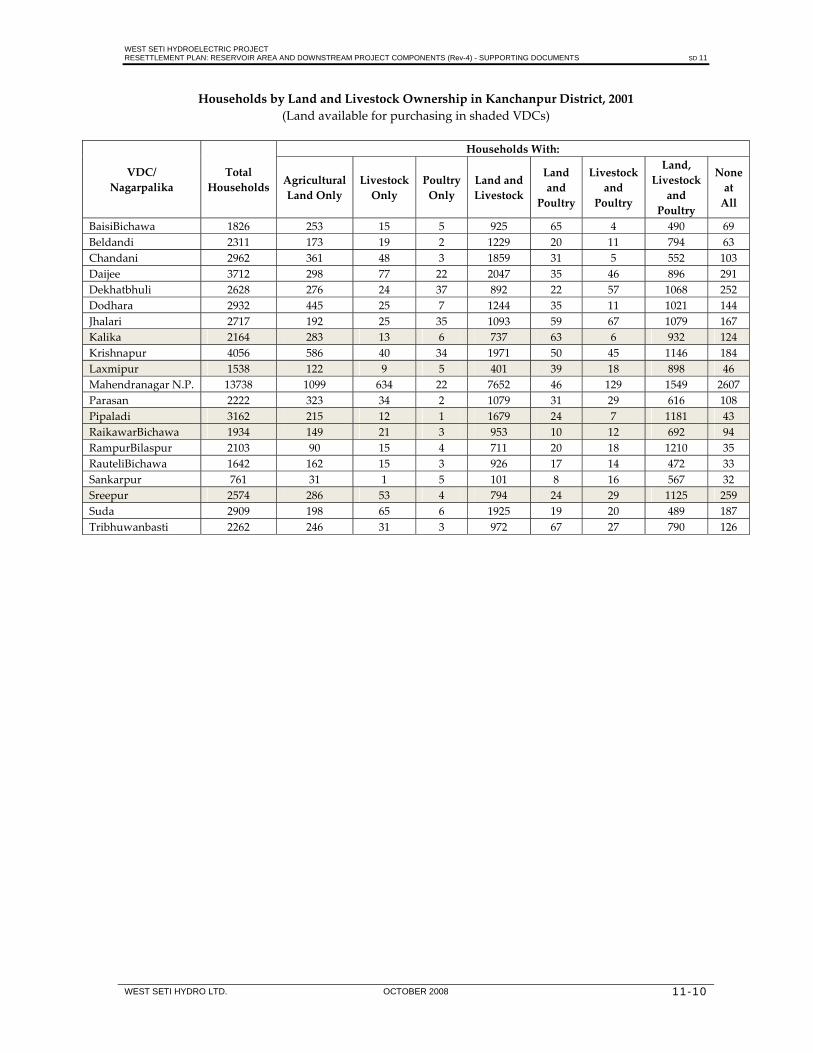
WEST SETI HYDROELECTRIC PROJECT RESETTLEMENT PLAN: RESERVOIR AREA AND DOWNSTREAM PROJECT COMPONENTS (Rev-4) - SUPPORTING DOCUMENTS SD 11
WEST SETI HYDRO LTD. OCTOBER 2008 11-10
Households by Land and Livestock Ownership in Kanchanpur District, 2001 (Land available for purchasing in shaded VDCs)
VDC/ Nagarpalika
Total Households
Households With:
Agricultural Land Only
Livestock Only
Poultry Only
Land and Livestock
Land and
Poultry
Livestock and
Poultry
Land, Livestock and
Poultry
None at All
BaisiBichawa 1826 253 15 5 925 65 4 490 69 Beldandi 2311 173 19 2 1229 20 11 794 63 Chandani 2962 361 48 3 1859 31 5 552 103 Daijee 3712 298 77 22 2047 35 46 896 291 Dekhatbhuli 2628 276 24 37 892 22 57 1068 252 Dodhara 2932 445 25 7 1244 35 11 1021 144 Jhalari 2717 192 25 35 1093 59 67 1079 167 Kalika 2164 283 13 6 737 63 6 932 124 Krishnapur 4056 586 40 34 1971 50 45 1146 184 Laxmipur 1538 122 9 5 401 39 18 898 46 Mahendranagar N.P. 13738 1099 634 22 7652 46 129 1549 2607 Parasan 2222 323 34 2 1079 31 29 616 108 Pipaladi 3162 215 12 1 1679 24 7 1181 43 RaikawarBichawa 1934 149 21 3 953 10 12 692 94 RampurBilaspur 2103 90 15 4 711 20 18 1210 35 RauteliBichawa 1642 162 15 3 926 17 14 472 33 Sankarpur 761 31 1 5 101 8 16 567 32 Sreepur 2574 286 53 4 794 24 29 1125 259 Suda 2909 198 65 6 1925 19 20 489 187 Tribhuwanbasti 2262 246 31 3 972 67 27 790 126

WEST SETI HYDROELECTRIC PROJECT RESETTLEMENT PLAN: RESERVOIR AREA AND DOWNSTREAM PROJECT COMPONENTS (Rev-4) - SUPPORTING DOCUMENTS SD 11
WEST SETI HYDRO LTD. OCTOBER 2008 11-11
Households by Land and Livestock Ownership in Bardiya District, 2001 (Land available for purchasing in shaded VDCs)
VDC/ Nagarpalika
Total Households
Households With:
Agricultural Land Only
Livestock Only
Poultry Only
Land and Livestock
Land and
Poultry
Livestock and Poutry
Land, Livestock and
Poultry
None at All
Badalpur 978 31 26 35 38 24 142 602 80 Baganaha 1645 108 31 39 109 58 176 930 194 Baniyabhar 1908 93 13 44 96 106 106 1362 88 Belawa 2015 230 11 4 477 61 32 1124 76 Bhimapur 1360 52 60 70 187 32 157 621 181 Daulatpur 1085 52 7 71 89 34 147 559 126 Deudakala 2751 274 10 16 721 98 10 1537 85 Dhadhawar 2588 143 27 27 281 105 75 1549 381 Dhodhari 1381 110 52 66 157 35 124 601 236 Gola 918 50 6 9 47 25 27 717 37 Gulariya N.P. 7939 1302 496 31 2792 108 117 1477 1616 Jamuni 2173 289 24 2 1117 25 10 632 74 Kalika 1812 232 61 12 699 24 36 531 217 KhairiChandanpur 1034 107 14 11 168 16 20 593 105 Magaragadi 2877 241 51 96 350 146 157 1674 162 Mahamadpur 1562 147 77 4 585 25 26 511 187 Manau 1080 28 12 43 54 43 74 788 38 ManpurMainapokhar 1374 147 35 6 474 54 14 488 156 ManpurTapara 1307 50 27 31 80 44 121 835 119 Motipur 3146 321 62 32 712 89 68 1568 294 NayaGaun 768 88 5 20 164 13 61 352 65 Neulapur 1756 63 51 55 158 48 173 909 299 Padanaha 1127 3 52 94 82 8 254 533 101 Pasupatinagar 967 29 24 24 92 17 119 546 116 Patabhar 1930 45 36 102 69 54 306 1190 128 Rajapur 1876 90 109 54 103 38 147 636 699 Sanashree 2973 396 87 10 890 88 27 1126 349 Sivapur 988 36 14 13 145 38 27 663 52 Sorhawa 2207 277 19 10 788 73 16 869 155 Suryapatawa 1234 38 11 35 52 36 154 852 56 Taratal 1536 227 23 0 738 11 8 467 62 Thakudwara 1220 45 83 44 104 43 141 606 154

WEST SETI HYDROELECTRIC PROJECT RESETTLEMENT PLAN: RESERVOIR AREA AND DOWNSTREAM PROJECT COMPONENTS (Rev-4) - SUPPORTING DOCUMENTS SD 12
WEST SETI HYDRO LTD. OCTOBER 2008 12-1
12. LIST OF COMMUNITY COMMITTEE MEMBERS (2007 - PRESENT)
West Seti Concern Main Committee Name Position District VDC Village1 Mr. Ratan Bahadur Saud Chairman Dadeldhura Belapur Sirod 2 Mr. Nar Bahadur Khadayat Vice‐Chairman Doti Girichauka Khateda 3 Mr. Dhan Bahadur Saud Vice‐Chairman Baitadi Thalakanda Lekam 4 Mr. Bahadur Singh Yir Vice‐Chairman Dadeldhura Belapur Chama 5 …………………………… Vice‐Chairman Vacant for Bajhang District 6 Mr. Bishnu Kumar Chand General‐Secretary Baitadi Dhungad Dhungad 7 Mr. Ganesh Bahadur Damai Secretary Doti Lamikhal Talara 8 Mr. Ram Bahadur Adhikari Treasure Doti Girichauka Jakhada 9 Mr. Narendra Bahadur Singh Member Doti Lamikhal Talara 10 Mr. Nar Bahadur Dhat Member Doti Girichauka Girichauka 11 Mr. Laxman Bahadur Singh Member Doti Lamikhal Talara 12 Mr. Bishwo Oad Member Doti Lamikhal Talara 13 Mr. Dev Bahadur Oad Member Doti Lamikhal Talara 14 Mr. Tilak Bahadur Singh Member Doti Lamikhal Talara 15 Mr. Hark Bahadur Thapa Member Doti Girichauka Sailigad 16 Mr. Bhakta Bahadur Adhikari Member Doti Girichauka Jakhada 17 Mr. Prem Bahadur Bohara Member Doti Girichauka Sailigad 18 Mr. Tek Bahadur Shahi Member 19 Mr. Bir Bahadur Bhat Member Doti Lamikhal Talara 20 Mr. Raju Bhattarai Member Doti Lamikhal Talara 21 Mr. Ravindra Pratap Singh Member Doti Lamikhal Talara 22 Mr. Upendra Awasthi Member Baitadi Dhungad Dhungad 23 Mrs. Dharma Devi Singh Member Doti Lamikhal Talara 24 Mr. Pallav Raj Awasthi Member Dadeldhura Belapur Chama 25 Mr. Kalu Singh Saud Member Dadeldhura Belapur Sirod 26 Mr. Khadak Bahadur Saud Member Dadeldhura Belapur Chama 27 Mr. Jaya Bahadur Saud Member Dadeldhura Belapur Sirod 28 Mr. Baji Lohar Member Dadeldhura Belapur Sirod 29 Mr. Dammar Bahadur Saud Member Dadeldhura Belapur Sajhbata 30 Mr. Gore Lohar Member Baitadi Dhungad Dhungad 31 Mr. Hari Singh Dhami Member Baitadi Sigas Khadaule 32 Mr. Dev Bahadur Chunara Member Baitadi Dhungad Dhungad 33 Mr. Tilak Singh Dhami Member Baitadi Thalakanda Lekam 34 Mr. Deep Raj Awasthi Member Baitadi Dhungad Dhungad 35 Mr. Narendra Bahadur Chand Member Baitadi Dhungad Dhungad 36 Mr. Padam Bahadur Khadayat Member Baitadi Dhungad Lambagar 37 Mr. Joga Singh Saud Member Baitadi Thalakanda Lekam 38 Mrs. Bhagawati Chand Member Baitadi Dhungad Dhungad 39 Mr. Tej Bahadur Saud Member Baitadi Thalakanda Lekam 40 Mr. Kasi Singh Dhami Member Baitadi Dhungad Gunekhola 41 Mr. Dev Singh Dhami Member Baitadi Dhungad Gunekhola

WEST SETI HYDROELECTRIC PROJECT RESETTLEMENT PLAN: RESERVOIR AREA AND DOWNSTREAM PROJECT COMPONENTS (Rev-4) - SUPPORTING DOCUMENTS SD 12
WEST SETI HYDRO LTD. OCTOBER 2008 12-2
West Seti Concern Downstream Committee
SN Name Position District VDC Ward No.
Village
1 Mr. Tej Bahadur Balayar Chairman Doti Latamandu 9 Tiltali
2 Mr. Prem Bahadur Balayar Vice‐Chairman Doti Barpata 7 Simar
3 Mr. Murali Dhar Bhatta Secretary Doti Latamandu 9 Tiltali 4 Mr. Dal Bahadur Malla Treasure Doti Pachnali 6 Talkot
5 Mr. Bharat Bahadur Bohara Member Doti Pachnali 6 Talkot
6 Mr. Arjun Kumar Balayar Member Doti Latamandu 9 Gopghat
7 Mr. Sher Bahadur Bohara Member Doti Barpata 8 Tallisat
8 Mrs. Tulashi Devi Rokaya Member Doti Banlekh 1 Bandungrisain
9 Mr. Giri Rokaya Member Doti Barpata 2 Barpata
10 Mr. Ram Bahadur Damai Member Doti Latamandu 8 Gopghat
11 Mrs. Dhauli Devi Balayar Member Doti Latamandu 9 Tiltali
12 Mr. Sher Bahadur Bhattarai Coordinator Doti Banlek 1 Bandungrisain
13 Mr. Ram Singh Kami Member Doti Banlek 4 Bandungrisain
14 Mr. Surya Bahadur Balayar Member Doti Barpata 4 Gopghat
15 Mr. Ram Chandra Ojha Member Doti Barpata 1 Barpata
16 Mr. Krishna Bahadur Bista Member Dadeldhura Belapur 2 Gillabagar
West Seti Concern Power Station Committee SN Name Position District VDC Ward No. Village1 Mr. Dal Bdr. Balayar Chairman Doti Barpata 7 Simar
2 Mr. Bir Bdr. Balayar Vice‐Chairperson Doti Barpata 7 Simar
3 Mr. Dal Bdr. Balayar Treasure Doti Barpata 7 Simar
4 Mr. Prem Bdr. Balayar Secretary Doti Barpata 7 Simar
5 Mr. Jung Bdr. Balayar Member Doti Barpata 7 Simar
6 Mrs. Sunita Balayar Member Doti Barpata 7 Simar
7 Mr. Tula Ram Damai Member Doti Barpata 7 Simar
8 Mr. Krishna Bdr. Balayar Member Doti Barpata 7 Simar
9 Mr. Padam Bdr. Balayar Member Doti Barpata 7 Simar
10 Mr. Maniram Balayar Advisor Doti Barpata 7 Simar
11 Mr. Deuram Balayar Member Doti Barpata 7 Simar
12 Mr. Man Bdr. Balayar Member Doti Barpata 7 Simar
13 Mr. Sher Bdr. Balayar Member Doti Barpata 7 Simar

WEST SETI HYDROELECTRIC PROJECT RESETTLEMENT PLAN: RESERVOIR AREA AND DOWNSTREAM PROJECT COMPONENTS (Rev-4) - SUPPORTING DOCUMENTS SD 13
WEST SETI HYDRO LTD. OCTOBER 2008 13-1
13. COMPENSATION AND RESETTLEMENT RESOLUTIONS OF PARTICIPATING COMMITTEES (2008)
A meeting of representatives on July 31, 2008, whose name list attached along with this, from the entire project‐affected region, has approved the following points for seeking approval from the cabinet of Government of Nepal
1. The categorization of communities of the project site will be done in two ways:‐
a) Displaced community or household
Displaced community or household will be defined according to constitutions of West Seti Main Concern Committee, West Seti Power Station Site Displaced and Affected Committee, and West Seti Downstream Site Committee.
b) Affected community or household
Affected community or household will be defined according to constitutions of West Seti Main Concern Committee, West Seti Power Station Site Displaced and Affected Committee, and West Seti Downstream Site Committee.
c) Compensation will be determined following four guidelines
a) Determination of compensation for lands For fulfilling basic needs of displaced households, coordination with West Seti Main Concern Committee will be done while determining compensations of lands belonging to displaced households based on the principle of equality, and additional land they get based on the principle of equity. The compensation will be based on uniform principle, and lands will be categorized into two groups‐ business land and productive land and further into sub‐groups scientifically.
b) Determination of compensation for houses: While determining compensation, all displaced houses will be divided into five grades on the basis of area of the house. Compensation of each grade will be determined in coordination with West Seti Main Concern Committee and other concern committees.
c) Compensations for environmental, ecological and natural heritages, cultural sites and other areas will be determined in negotiations with both affected and displaced communities based on the principle of equality.
d) Regarding other physical infrastructures
Compensation for private infrastructures like mill, water mill, wall, rural hydro electricity, rural energy, solar power will be determined based on current cost for a new installation.
Compensation for community institutions like school building, health post, sub‐health post, sub‐agriculture center, sub veterinary center, VDC building, post office,

WEST SETI HYDROELECTRIC PROJECT RESETTLEMENT PLAN: RESERVOIR AREA AND DOWNSTREAM PROJECT COMPONENTS (Rev-4) - SUPPORTING DOCUMENTS SD 13
WEST SETI HYDRO LTD. OCTOBER 2008 13-2
temples, local club building, etc. will be separately determined and rehabilitated in affected area.
Compensation for remaining assets will be finalized in coordination and negotiation with concern committees, Project and Government of Nepal.
3 Regarding resettlement
a) All households or community displaced due to the Project will be resettled in same phase in coordination with West Seti Main Concern Committee
b) For making resettlement program scientific, well‐managed and forming in assured‐manner, various management committees and sub‐committees in resettling areas will be formed in coordination with West Seti Main Concern Committee on participation basis.
c) During resettlement, services of all employed workforce will be restored by the Government of Nepal, and the company will negotiate for compensations with various other service holders.
d) The resettlement plan of action, which doesn’t disturb social, economic, cultural and religious as well as other similar aspects, will be adopted.
4) All opportunities created due to the Project will be assured to eligible displaced and affected people based on the principle that affected and displaced people must have more privilege. Also, the company will assist the locals for skill development schemes.
5) Formation of various committees related to West Seti Hydroelectric Project will be done in coordination with different stakeholders.
6) Displaced community will be facilitated along with those affected. Following extensive discussions with affected communities, policies on various programs will be adopted. The affected communities will accordingly be coordinated for their implementation.
7) Consultation with the local organizations will be done for implementing various programs on human development of displaced and affected people.
8) A guideline for confirming and registering ownership of land segments, missed in the previous survey, will be adopted before taking the detail survey, and Government of Nepal will accordingly deploy a team for this.
9) All other activities will be finalized based on negotiation and coordination between the Government of Nepal, concern committee and West Seti Hydroelectric Project.


![Download [1.10 MB]](https://img.dokumen.tips/doc/110x75/589f1bfb1a28ab9f498c3b83/download-110-mb.jpg)