Embed Size (px)
Citation preview

DOVER TO KINGSDOWN CLIFFS
OS Grid Reference: TR242365–TR316402 and TR339422–TR381478
Introduction
The Folkestone to Kingsdown site forms the classic White Chalk cliffs of England and has twodistinct parts. Part 1: Folkestone–Dover, incorporates ‘The Warren' and Shakespeare Cliff inthe Grey Chalk Subgroup and the lower part of the White Chalk Subgroup (Plenus MarlsMember and the Holywell Nodular Chalk, New Pit Chalk and lower Lewes Nodular Chalkformations) at Aker's Steps and Shakespeare Cliff. Part 2: Dover–Kingsdown, includes EastCliff, Dover, St Margaret's Bay and the sections north of the South Foreland. This second partis entirely in the White Chalk Subgroup (Lewes Nodular Chalk Formation, Seaford ChalkFormation and basal Margate Chalk Member).
The exposures in these cliffs are some of the most studied Upper Cretaceous rocks in theBritish Isles and essential to the historical development of the stratigraphy of the Chalk.Phillips' (1818, 1819) remarkably detailed description of the strata can be fairly regarded asthe first attempt to produce a lithostratigraphical classification of part of the English Chalk. Thechalks are generally softer than those farther south and west in the Southern Province becausethe site is located on the southern edge of the Anglo-Brabant Massif (Figure 1.8, Chapter 1).As a result, the Dover sections are famous for their fossils, primarily because of their excellentpreservation in soft chalk. The standard French macrofossil zones of the Chalk of the ParisBasin were first applied to the English Chalk by Hébert (1874) and Barrois (1876) at Dover. Inaddition, these sections have provided many type and figured specimens, notably the holotypeof the international inoceramid bivalve index fossil Inoceramus lamarcki Parkinson. It was herethat the medical doctor, Arthur Rowe of Margate, carried out the work that led to his stillclassic evolutionary study (Rowe, 1899) of the Chalk echinoid Micraster, and laid thefoundations, together with Charles Sherborn, for his series of equally important papers(1900–1908) on ‘ The Zones of the White Chalk of the English coast '.
Extracted from the Geological Conservation ReviewYou can view an introduction to this volumeat http://www.jncc.gov.uk/page-2731© JNCC 1980–2007
Volume 23: British Upper Cretaceous StratigraphyChapter 3: Southern Province, England
Site: DOVER TO KINGSDOWN CLIFFS (GCR ID: 213)
1

Figure 1.8: Broad structural features affecting sedimentation of the Upper Cretaceousdeposits in the British Isles. (Based on British Geological Survey 1:1 000 000 maps of theGeology of the UK, Ireland and Continental Shelf, North and South Sheets.)
Part 1: Folkestone–Dover, includes one of the most important Cenomanian successions inthe UK, which, because it is the most complete, is generally regarded as the standard Britishsuccession for the stage (Kennedy, 1969; Gale, 1989, 1995; Robaszynski et al., 1998). It alsoexposes a highly condensed Holywell Nodular Chalk Formation at Shakespeare Cliff, which hasyielded Lower Turonian ammonites of biostratigraphical importance, including the zonal indexfossils Fagesia catinus (Mantell) and Mammites nodosoides (Schlotheim). It is also a keycomponent in establishing the link from the expanded successions on the south coast to thecondensed successions in the Transitional Province.
The 7 km of sea cliffs from Dover–Kingsdown (Part 2), are the classic ‘White Cliffs ofDover'. Much of the White Chalk Subgroup stratigraphy here, can be correlated in detail withthe standard succession in the Southern Province. One of the most conspicuous features ofthese cliffs is the so-called ‘Basal Complex', the succession of exceptionally large flints and marlseams that was formerly taken by the British Geological Survey to mark the base of theSternotaxis plana Zone and hence of the traditional Upper Chalk. The ‘Basal Complex' isoverlain by beds of highly fossiliferous nodular chalks which are known as the ‘Dover ChalkRock' and represent a condensed and, in some aspects, a more fossiliferous development ofthe Kingston Nodular Beds of Sussex. These beds contain Upper Turonian ammonites andinoceramid bivalves that are critical for international correlation. Dover is one of the fewlocalities in the Southern Province where the succession of these ammonites established inexpanded successions in Germany can be recognized. Condensation at this level also results inloss of some biostratigraphy, particularly the species of Micraster found elsewhere.
The stratigraphy of the Folkestone to Kingsdown sections has been important since Napoleonictimes when attempts to construct a link to mainland Europe began seriously, and the geology
Extracted from the Geological Conservation ReviewYou can view an introduction to this volumeat http://www.jncc.gov.uk/page-2731© JNCC 1980–2007
Volume 23: British Upper Cretaceous StratigraphyChapter 3: Southern Province, England
Site: DOVER TO KINGSDOWN CLIFFS (GCR ID: 213)
2

was paramount to route selection and method of construction. Both onshore and offshoreexploration identified the continuity of the strata across the English Channel and, from the veryearliest proposals, the Lower Chalk (i.e. Grey Chalk Subgroup) was considered the bestmedium for tunnelling. The knowledge of the stratigraphy of the Folkestone sections wascritical to correlation of boreholes, geological interpretation and understanding the constructionproblems encountered during building of the Channel Tunnel (1988–1992; see papers in Harriset al., 1996a).
Description
The Folkestone–Dover cliffs (Figure 3.118) expose continuous sections from the WestMelbury Marly Chalk Formation of the Grey Chalk Subgroup up to and including the lower bedsof the Lewes Nodular Chalk Formation of the White Chalk Subgroup. Near Folkestone, thehighest beds exposed in the cliff belong to the Holywell Nodular Chalk Formation. Farther east,the gentle easterly dip brings the Plenus Marls Member at the base of the Holywell NodularChalk Formation to the foot of Shakespeare Cliff, on the west side of Dover.
Figure 3.118: The Folkestone to Kingsdown GCR site; Folkestone–Dover cliffs including‘The Warren', Abbot's Cliff, Shakespeare Cliff and Aycliff.
At the western end of the Folkestone–Dover cliffs in East Wear Bay (Figure 3.118), betweenCopt Point, on the east side of Folkestone, and the western end of Abbot's Cliff, the Gaultmudstones beneath the Chalk Group are exposed at and above sea level. Landslip failure in theGault mudstones has led to the development of a vast, and now extensively overgrown, areaof rotated slipped blocks of Grey and White Subgroup chalks, which is known as ‘The Warren'.From Abbot's Cliff eastwards, the dip takes the Gault below sea level, and consequently thesame beds are exposed in near-vertical cliffs, up to 50 m high. Apart from exposures at beachlevel, these sections are accessible only at the back of areas of stabilized rock falls, or in thoseplaces where zig-zag paths down the face of the cliff provide air-weathered exposures.
The Folkestone to Shakespeare Cliff sections collectively constitute the type succession for thedivision by Jukes-Browne and Hill (1903) of the traditional Lower Chalk into nine componentbeds, of which Jukes-Browne Bed 7, the White Bed (Bed 8) and the Plenus Marls (Bed 9) stillform part of the modern lithostratigraphical scheme (Figure 3.119). The section at the base ofAbbot's Cliff (Gale and Friedrich, 1989) provides the only uncondensed succession through thebasal part of the Cenomanian Stage in the Southern Province. Folkestone, in conjunction withSoutherham Grey Pit, provides one of the standard sections for the orbitally controlledcyclostratigraphy of the Cenomanian succession of northern Europe (Gale, 1995). Themacrofossil and microfossil biostratigraphy, stable isotope stratigraphy and cylostratigraphy ofthe Middle Cenomanian strata at Folkestone have been studied in minute detail (Paul et al.,
Extracted from the Geological Conservation ReviewYou can view an introduction to this volumeat http://www.jncc.gov.uk/page-2731© JNCC 1980–2007
Volume 23: British Upper Cretaceous StratigraphyChapter 3: Southern Province, England
Site: DOVER TO KINGSDOWN CLIFFS (GCR ID: 213)
3

1994; Mitchell and Carr, 1998). Despite being greatly condensed compared with Eastbourne,the Plenus Marls Member at Shakespeare Cliff has been subject to more intense study thanelsewhere (Jarvis et al., 1988b; Jeans et al., 1991; Lamolda et al., 1994).
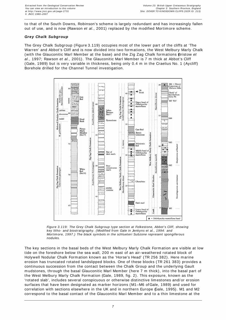
Figure 3.119: The Grey Chalk Subgroup type section at Folkestone, Abbot's Cliff, showingkey litho- and biostratigraphy. (Modified from Gale in Jenkyns et al., 1994: andMortimore, 1997.) The black symbols in the schlueteri Subzone represent spongiferousnodules.
From Dover–Kingsdown (Figure 3.120) there are four key sections. East Cliff (1) andLangdon Stairs (2), Dover, expose beds from near the base of the Lewes Nodular ChalkFormation to beds up to Whitaker's 3-inch Flint Band in the Seaford Chalk Formation. Theaccessible sections at the base of the cliffs from Langdon Stairs to the South Foreland (3), areprimarily cut in the lower beds of the Lewes Nodular Chalk Formation. The inaccessible parts ofthe cliff expose the upper beds of the Lewes Nodular Chalk Formation and the Seaford ChalkFormation with its conspicuous marker flint bands. The highest points in these cliffs are cappedby a small thickness of Margate Chalk Member. The cliff line is broken at St Margaret's Bay,which forms a natural divide; just to the south, the cliff direction changes at the SouthForeland, and trends northwards to Kingsdown (4). This is the down-dip direction, and higherbeds in the Lewes Nodular Chalk and Seaford Chalk formations, up to the Bedwell's ColumnarFlint Band, are progressively brought down to accessible levels in a northerly direction.
Extracted from the Geological Conservation ReviewYou can view an introduction to this volumeat http://www.jncc.gov.uk/page-2731© JNCC 1980–2007
Volume 23: British Upper Cretaceous StratigraphyChapter 3: Southern Province, England
Site: DOVER TO KINGSDOWN CLIFFS (GCR ID: 213)
4

Figure 3.120: The Folkestone to Kingsdown GCR site from Langdon Cliffs to Kingsdown.For a description of localities (1)–(4) see text.
Lithostratigraphy
As in Sussex, the first records of the geology of these cliffs were published early in the 19thcentury. Phillips (1818, 1819) was the first to describe the sections. He divided the Chalk(republished in Conybeare and Phillips, 1822) on the basis of the presence, absence or relativeabundance of flints and of ‘organic remains'. As noted by Whitaker (1872), the ‘organicremains' probably included nodularity of the chalk as well as fossils. Whitaker (1865a, 1872)and Dowker (1870) followed Phillips' divisions, but gave some of them local geographicalnames taken from the Thanet Coast and Dover coast. Whitaker (1872) also provided somesupplementary descriptive notes. In descending order, Phillip's divisions (and their subsequentmodifications) are provided in Table 3.2.
The highest (flintless) Chalk in the Isle of Thanet was separated by Whitaker (1865a), followedby Dowker (1870), and subsequent workers (Whitaker, 1872; Mortimore 1983, 1986a;Robinson, 1986; Bristow et al., 1997), as the Margate Chalk.
Jukes-Browne and Hill (1904, p. 2) did not regard the divisions of Phillips, Whitaker andDowker as correlatable or mappable horizons and concentrated instead on identifyingmacrofossil zones within their threefold framework of Lower, Middle and Upper Chalk.
Whitaker (1872) considered that Phillips' ‘Grey Chalk' included beds that should properly beincluded in the Chalk Marl. He noted that ‘near the top there was a massive bed, about 8 ft(3.4 m) thick, which at Hay Cliff has small hard projections, some being pyrites, some fossilsand others stony lumps'. He also commented that the bed of ‘soft marl' recorded by Phillips atthe top of his overlying unit was about 6 ft (1.8 m) thick and contained belemnites. Price(1877) attempted a revision of the Phillips classification and proposed a complex subdivisionbased on a combination of lithostratigraphical and biostratigraphical criteria. As noted byJukes-Browne and Hill (1903), this new scheme was unsatisfactory. Instead, following areassessment of the section by Hill, they established a standard succession of nine beds, of
Extracted from the Geological Conservation ReviewYou can view an introduction to this volumeat http://www.jncc.gov.uk/page-2731© JNCC 1980–2007
Volume 23: British Upper Cretaceous StratigraphyChapter 3: Southern Province, England
Site: DOVER TO KINGSDOWN CLIFFS (GCR ID: 213)
5

which Beds 1–5 were assigned to the Chalk Marl, Bed 6 and Bed 7 (the bed with stony lumps)to the Grey Chalk, Bed 8 (which they termed the ‘White Bed') corresponded to Phillips' ‘Chalkwithout flints and few organic remains', and Bed 9 (their ‘Belemnite marl') equated with the‘soft marl with belemnites', the Plenus Marls Member of the modern classification.
Kennedy (1969) divided the Lower Chalk of Folkestone (excluding the Plenus Marls) into 14‘bands' and described the lithostratigraphy in detail, providing a graphic log (his fig. 2) and gridreferences for localities at which the various bands could be examined. He drew particularattention to two prominent limestones at the top of his Band 6, a unit (Band 9) with abundantspecimens of the rhynchonellid brachiopod Orbirhynchia mantelliana (J. de C. Sowerby), whichhe named the ‘ Orbirhynchia mantelliana Band', and additionally noted that Jukes-Browne Bed7 (Band 13) was characterized by abundant ‘laminated structures'.
Robinson (1986) introduced a formal lithostratigraphical scheme for the Lower Chalk fromFolkestone–Dover, in which he recognized three formations. He assigned the successionbelow Jukes-Browne Bed 7 to the East Wear Bay Chalk Formation, distinguishing the basalGlauconitic Marl as a member. The overlying Abbot's Cliff Chalk Formation comprised twomembers, the Hay Cliff Member (Jukes-Browne Bed 7) and the Capel-le-Ferne Member (theWhite Bed). These were followed by the Plenus Marls Formation. This scheme has not met withgeneral acceptance and is not used today.
Gale (1989, 1995, and in Jenkyns et al., 1994, fig. 13a) revised Kennedy's stratigraphy and,from better exposures, documented (Gale, 1989, figs 3, 4) additional strata at the base of thesuccession, above the Glauconitic Marl. Gale (1989) showed that the lower of Kennedy's(1969) two prominent limestones was underlain by a bed of dark fossiliferous marl, and thatthe higher limestone was overlain by the bed of silty marl that Price (1877) had named the‘Cast Bed' in view of the abundance in it of composite moulds (‘casts') of gastropods. He alsodemonstrated that Kennedy's Orbirhynchia mantelliana Band was the highest of three similarbands. The higher of the two limestones marks the top of the West Melbury Marly ChalkFormation (Bristow et al., 1997). This limestone is named the ‘Tenuis Limestone' from theoccurrence in it, at the Southerham Grey Pit GCR site, of the inoceramid bivalveActinoceramus tenuis (Mantell). It also marks the boundary between the ‘Craie Bleue' and the‘Craie Grise' units used for the French side of the Channel Tunnel site investigation. Galesubdivided the Lower Chalk into three traditional units, the Chalk Marl, Grey Chalk and PlenusMarls. He drew the lower boundary of his Grey Chalk at a level, c. 10 m above the base of theZig Zag Chalk Formation, where rhythms (couplets) of thick marls and thin limestones gaveway to couplets comprising thin marls and thicker limestones. This level also corresponded toan up-section change in carbonate content to values over 80% (Destombes and Shephard-Thorn, 1971). Although Gale and Hancock (1999) argued convincingly for the validity of thisboundary, it is nevertheless incapable of being mapped (Bristow et al., 1999).
Mortimore (1983, 1986a,b) developed a formal lithostratigraphical scheme for the traditionalMiddle and Upper Chalk (subdivisions) of the South Downs and Southern Province, which isdirectly applicable to the post-Plenus Marls succession of the Folkestone to Kingsdown site. Thescheme has been progressively modified (Mortimore and Pomerol, 1987, 1996; Bristow et al.,1997; Rawson et al., 2001) and it is this modified scheme that is used in this account. Thesuccession comprises the White Chalk Subgroup divided into the Holywell Nodular Chalk, NewPit Chalk, Lewes Nodular Chalk and Seaford Chalk formations, with a thin capping of MargateChalk Member. The (flintless) Margate Chalk Member, previously recognized by Whitaker(1865a) and subsequent workers, equates with the flinty and marl-rich Newhaven ChalkFormation of the standard Southern Province succession.
Robinson (1986) introduced a formal lithostratigraphy for the traditional Middle and UpperChalk of the North Downs, which, with the exception of the highest beds, was based on thecoast sections between Folkestone and Kingsdown. He replaced the existing informalsubdivisions by two formations, each divided into three members, and gave new names to allof the marker horizons (particularly marl seams) that had already been established in theSouth Downs by Mortimore (1983, 1986a,b). He used the same geographical names asWhitaker (1865a, 1872) and Dowker (1870) for some of his units, but chose different intervalsof rock and different lithological concepts (see discussion by Mortimore, 1987, 1988; Bristow etal., 1999). Since the lithostratigraphical succession, except in small details, is virtually identical
Extracted from the Geological Conservation ReviewYou can view an introduction to this volumeat http://www.jncc.gov.uk/page-2731© JNCC 1980–2007
Volume 23: British Upper Cretaceous StratigraphyChapter 3: Southern Province, England
Site: DOVER TO KINGSDOWN CLIFFS (GCR ID: 213)
6
to that of the South Downs, Robinson's scheme is largely redundant and has increasingly fallenout of use, and is now (Rawson et al., 2001) replaced by the modified Mortimore scheme.
Grey Chalk Subgroup
The Grey Chalk Subgroup (Figure 3.119) occupies most of the lower part of the cliffs at ‘TheWarren' and Abbot's Cliff and is now divided into two formations, the West Melbury Marly Chalk(with the Glauconitic Marl Member at the base) and the Zig Zag Chalk formations (Bristow etal., 1997; Rawson et al., 2001). The Glauconitic Marl Member is 7 m thick at Abbot's Cliff(Gale, 1989) but is very variable in thickness, being only 0.4 m in the Craelius No. 1 (Aycliff)Borehole drilled for the Channel Tunnel investigation.
Figure 3.119: The Grey Chalk Subgroup type section at Folkestone, Abbot's Cliff, showingkey litho- and biostratigraphy. (Modified from Gale in Jenkyns et al., 1994: andMortimore, 1997.) The black symbols in the schlueteri Subzone represent spongiferousnodules.
The key sections in the basal beds of the West Melbury Marly Chalk Formation are visible at lowtide on the foreshore below the sea wall, 200 m east of an air-weathered rotated block ofHolywell Nodular Chalk Formation known as the ‘Horse's Head' (TR 256 382). Here marineerosion has truncated rotated landslipped blocks. One of these blocks (TR 261 383) provides acontinuous succession from the contact between the Chalk Group and the underlying Gaultmudstones, through the basal Glauconitic Marl Member (here 7 m thick), into the basal part ofthe West Melbury Marly Chalk Formation (Gale, 1989, fig. 2). This exposure, known as the‘rotated slab', includes several conspicuous or otherwise distinctive limestones and/or erosionsurfaces that have been designated as marker horizons (M1–M6 of Gale, 1989) and used forcorrelation with sections elsewhere in the UK and in northern Europe (Gale, 1995). M1 and M2correspond to the basal contact of the Glauconitic Marl Member and to a thin limestone at the
Extracted from the Geological Conservation ReviewYou can view an introduction to this volumeat http://www.jncc.gov.uk/page-2731© JNCC 1980–2007
Volume 23: British Upper Cretaceous StratigraphyChapter 3: Southern Province, England
Site: DOVER TO KINGSDOWN CLIFFS (GCR ID: 213)
7

top of the member respectively. M3 is a massive, burrowed limestone containing three-dimensional ammonites and inoceramid bivalves. M4 is a dark, silty marl containing smallphosphate intraclasts. It rests on pale marly chalk with conspicuous colour-contrastingThalassinoides burrows. M5 is a thin limestone equating with ‘The Rib' of Southerham GreyPit GCR site, and M6 comprises a closely spaced pair of thin spongiferous limestones at the topof the equivalent of ‘The Bank' of the same locality, and the Dixoni Limestone of the ChilternHills (see p. 301, Chapter 4). The rotated slab is faulted to the east against the highlyfossiliferous basal beds of the Zig Zag Chalk Formation.
An even better section of the basal beds of the West Melbury Marly Chalk Formation, beginningimmediately above the Glauconitic Marl Member, and terminating in the massive burrowedlimestone, M3, is intermittently exposed at low tide on the foreshore at the foot of the easternend of the sea wall below Abbot's Cliff (TR 269 384). This section, which is part of the in-situsuccession on the far side of the back-wall fault of ‘The Warren' landslip, is highly fossiliferousand exposes the best section in the UK through the Sharpeiceras schlueteri ammonite Subzone(Gale and Friedrich, 1989, fig. 4; and below).
The upward continuation of this section, beginning with the spongiferous limestones (M6), wasformerly exposed at the foot of Abbot's Cliff, immediately to the east, but this section (1999) iscurrently largely buried beneath an extensive cliff-fall that took place in 1989. The brachiopod-rich marly chalks above M6 (Orbirhynchia mantelliana Band 1), and the overlying darkrecessing marl from which water flows (Gale, 1995, fig. 3), are exposed beside the top of thesea wall to the east of the adit leading to the Beaumont Tunnel.
Between Abbot's Cliff (TR 271 385) and Lydden Spout (TR 279 386), the easterly dip brings thebeds of the West Melbury Marly Chalk Formation progressively down to the base of the cliff.There are accessible exposures of the highest beds and the lower part of the Zig Zag ChalkFormation above the western end of a plateau-like area of long-stabilized cliff-fall. Here there isan air-weathered section (Gale, 1995, fig. 7B) of the remainder of the Grey Chalk Subgroupand the overlying Plenus Marls Member, which clearly shows the sedimentary rhythmicity. Thecoarse-grained Jukes-Browne Bed 7 weathers slightly proud, and the overall green colorationof the Plenus Marls Member contrasts with the underlying chalks of the White Bed (Jukes-Browne Bed 8) and with the pale coloured, indurated Holywell Nodular Chalk Formationlimestones. Wave-washed exposures showing the sedimentary details of the highest beds ofthe West Melbury Marly Chalk are found near Lydden Spout, on the far side of the same fall(see Gale, 1995, fig. 8).
There was never a clear division between the traditional Chalk Marl and Grey Chalk atFolkestone, because the marl–limestone rhythms continue up to the base of Jukes-Browne Bed7. Nevertheless, there is a change from ‘Chalk Marl' to ‘Grey Chalk' type rhythms c. 10 mabove the Tenuis Limestone. The Tenuis Limestone and overlying ‘Cast Bed' of Price (1874)are, however, easy to identify. Within the Zig Zag Chalk Formation, the numbered bedsrecognized by Jukes-Browne and Hill (1903), particularly Jukes-Browne Bed 7, the ‘Bed oflaminated structures' of Kennedy, (1969), and the White Bed (Bed 8), are widely employed.Their Bed 9 is always now referred to as the Plenus Marls Member. These higher beds areexposed at Abbot's Cliff and farther to the east, on Aker's Steps and at Shakespeare Cliff.
White Chalk Subgroup
The Plenus Marls Member, and the air-weathered ‘Grit Beds' constituting the condensedHolywell Nodular Chalk Formation, are exposed above the sea wall at the eastern end ofShakespeare Cliff (TR 307 398). The Plenus Marls are not as thick (about 2 m compared to 11m at Eastbourne) nor conspicuously rhythmic as they are in Sussex. Nevertheless, Jefferies(1962, 1963) recognized all of his eight numbered beds here. A slipped block at the back of thesea wall (TR 263 384), provides an air-weathered section through the Plenus Marls Member inwhich the individual beds can be clearly seen. This is a better section than the one exposedabove the sea wall at the foot of Shakespeare Cliff.
The Holywell Nodular Chalk Formation: Phillips' (1818, 1819) ‘Chalk without flints but withmany thin beds of organic remains' corresponds to the Holywell Nodular Chalk Formation, butmay include the lower part of the overlying New Pit Chalk Formation, which here is slightly
Extracted from the Geological Conservation ReviewYou can view an introduction to this volumeat http://www.jncc.gov.uk/page-2731© JNCC 1980–2007
Volume 23: British Upper Cretaceous StratigraphyChapter 3: Southern Province, England
Site: DOVER TO KINGSDOWN CLIFFS (GCR ID: 213)
8

nodular. The Holywell Nodular Chalk Formation was referred to as the ‘Melbourn Rock' by theBritish Geological Survey (Shephard-Thorn, 1988) and as the ‘Melbourn Rock Beds' byRobinson (1986). Strictly, the Melbourn Rock in its type area of Cambridgeshire does notinclude the shell-debris beds typical of the higher part of the Holywell Nodular Chalk Formation.At Dover, the lowest part of the formation is nodular and very hard, but without shell-debris,as is typical elsewhere. (This corresponds to the Melbourn Rock as defined in Sussex byMortimore (1986a); Gale (1996) named this unit the ‘Ballard Head Member').
The condensed nature of the Holywell Nodular Chalk Formation at Shakespeare Cliff hasresulted in the loss of the many marker beds recognized in this unit in Sussex. Because of this,there are spectacular concentrations of Mytiloides shell-debris bands in the air-weatheredsections on the Lydden Spout track, at Aker's Steps and Shakespeare Cliff. Theseconcentrations gave rise to the descriptive term ‘Grit Bed' in the earlier literature. Thecondensation also results in a sharp break with the smoother, softer New Pit Chalk Formationabove. This lithological change is well exposed and accessible only on the Aker's Steps andLydden Spout cliff paths.
The Gun Gardens Main Marl (Mortimore, 1983, 1986a; Mortimore and Pomerol, 1987, 1996)(the ‘Lulworth Marl' of Gale, 1996) is taken as the boundary between the Holywell NodularChalk and New Pit Chalk formations. Marker marl seams characterize the New Pit Chalk,including New Pit Marls 1 and 2 and the Glynde Marls (the ‘Maxton Marls' of Robinson, 1986).These marker beds have been correlated through field sections and on geophysical boreholelogs throughout the North Downs (Mortimore and Pomerol, 1987).
Air-weathered sections in the Holywell Nodular Chalk and New Pit Chalk formations are foundon steep, and now rather dangerous, paths from the cliff top down to beach level at Abbot'sCliff (TR 268 385), Lydden Spout (TR 283 387), and Aker's Steps (TR 297 393). The mosteasterly of these paths (Aker's Steps) additionally exposes the basal beds of the Lewes NodularChalk Formation, providing the link with the Athol Terrace and Langdon Bay sections to theeast of Dover. This is also the standard section for the foraminiferal zonation of the Turonianstrata of southern England and for the stable isotope stratigraphy (Jenkyns et al., 1994, figs 3,4).
Lewes Nodular Chalk Formation: The base of the Lewes Nodular Chalk Formation is takenat the entry of nodular chalk, which occurs above the Glynde Marls,and is best exposed in theAker's Steps section. Regular flint bands also enter the rock column in this interval. The whiteChalk cliffs beneath Dover Castle (Figure 3.11) expose a magnificent, air-weathered sectionfrom the Glynde Marls, through the Lewes Nodular Chalk Formation, up to the Belle Tout Bedsat the base of the Seaford Chalk Formation. In these cliffs the Lewes Nodular Chalk formsconspicuous layers of red-stained rough nodular chalk and the basal nodular beds are exposedalong Athol Terrace at the eastern end of this cliff. The Athol Terrace exposures arestratigraphically below those in the cliffs at the base of Langdon Stairs and in Langdon Bayand, with the Aker's Steps section, illustrate the entry of nodular chalk and flint well below the‘Basal Complex'.
Extracted from the Geological Conservation ReviewYou can view an introduction to this volumeat http://www.jncc.gov.uk/page-2731© JNCC 1980–2007
Volume 23: British Upper Cretaceous StratigraphyChapter 3: Southern Province, England
Site: DOVER TO KINGSDOWN CLIFFS (GCR ID: 213)
9

Figure 3.11: Hooken Cliff and the Twin Pillars at Beer Head; pinnacles of Lewes NodularChalk Formation exposing the succession from below the Annis' Knob Flint, through theLewes Marl and Navigation Marl to a horizon around the Hope Gap Hardgroundequivalent. The first sheet-flints were used by Rowe (1903) for correlation. (Photo: R.N.Mortimore.)
At beach level in Langdon Bay, between Langdon Stairs and the Eastern Arm of Dover Harbour(Figures 3.121 and 3.122), the two Southerham Marls and underlying Southerham TubularFlints are exposed. Southerham Marl 1 is a conspicuous, plastic marl, and the underlying flintsretain their Sussex features of mixed small tubular and large nodular flint character. Beneaththese flints, iron-stained nodular sponge beds indicate the presence of nodular chalks in theGlynde Beds in the Lewes Nodular Chalk.
Extracted from the Geological Conservation ReviewYou can view an introduction to this volumeat http://www.jncc.gov.uk/page-2731© JNCC 1980–2007
Volume 23: British Upper Cretaceous StratigraphyChapter 3: Southern Province, England
Site: DOVER TO KINGSDOWN CLIFFS (GCR ID: 213)
10

Figure 3.121: The lowest sections on Langdon Stairs including the Dover Chalk Rock andBasal Complex. (Based on Mortimore, 1997.)
Extracted from the Geological Conservation ReviewYou can view an introduction to this volumeat http://www.jncc.gov.uk/page-2731© JNCC 1980–2007
Volume 23: British Upper Cretaceous StratigraphyChapter 3: Southern Province, England
Site: DOVER TO KINGSDOWN CLIFFS (GCR ID: 213)
11

Figure 3.122: East Cliff, Dover. (a) Looking west from Fan Bay across Langdon Bay to theeast wall of Dover Harbour. (b) Lower part of the Lewes Nodular Chalk Formation in FanBay (scale given by Dr Silke Voigt). (Photos: R.N. Mortimore.)
Langdon Stairs (TR 345 425) is a narrow zig-zag cliff path leading down to Langdon Bay thatexposes an air-weathered 50 m section, from the Caburn Marl, in the lower Lewes NodularChalk Formation, up to just above the Seven Sisters Flint Band in the Belle Tout Beds of theSeaford Chalk Formation (Figure 3.123). The Caburn Marl, with the underlying Caburn SpongeBed and flints, is present on the lowest bench on Langdon Stairs (Figure 3.7; Mortimore,1997). The flints between the marl and the tough, nodular Caburn Sponge Bed are small, pinkand characteristically carious, retaining the detail also present in Sussex.
Extracted from the Geological Conservation ReviewYou can view an introduction to this volumeat http://www.jncc.gov.uk/page-2731© JNCC 1980–2007
Volume 23: British Upper Cretaceous StratigraphyChapter 3: Southern Province, England
Site: DOVER TO KINGSDOWN CLIFFS (GCR ID: 213)
12

Figure 3.123: The upper sections on the Langdon Stairs exposure, Dover showing theDover Top Rock and upper Lewes Nodular Chalk Formation. Inoceramid bivalve zones areinferred from expanded sections in Germany and are subject to review.
Figure 3.7: Part of the Chalk cliffs at Dover above Athol Terrace exposing the entireLewes Nodular Chalk Formation and the basal Seaford Chalk Formation. (Photomosaic:R.N. Mortimore.)
In the lower part of the cliff in Langdon Bay (Figure 3.7) and at the foot of the cliffs in theadjacent Fan Bay (Figure 3.122), the most conspicuous feature is the ‘Dover Chalk Rock' andits underlying ‘Basal Complex' of Bridgewick Marls and the associated Bridgewick and Bopeepflints (Jukes-Browne and Hill, 1903, fig. 18; 1904, fig. 45; Mortimore and Wood, 1986, fig.2.2). The Bridgewick Marls and Bridgewick Flints were taken by the British Geological Survey tomap the base of the former Upper Chalk in the North Downs (Holmes, pers. comm., inMortimore, 1987; Mortimore and Wood, 1986). Jukes-Browne and Hill (1903, fig. 68; 1904, fig.
Extracted from the Geological Conservation ReviewYou can view an introduction to this volumeat http://www.jncc.gov.uk/page-2731© JNCC 1980–2007
Volume 23: British Upper Cretaceous StratigraphyChapter 3: Southern Province, England
Site: DOVER TO KINGSDOWN CLIFFS (GCR ID: 213)
13

45) used the section in Fan Bay to illustrate this succession. Their ‘two marls 4 feet apart'(their Bed 12) are the Southerham Marls, the ‘seam of grey marl forming an open crevice'(Bed 10) is the Caburn Marl, and the ‘seam of grey marl' (Bed 6) is Bridgewick Marl 1.Bridgewick Marl 2 is in their Bed 3, ‘a band of smooth chalk with a marl in the middle'.
The ‘Dover Chalk Rock' comprises a series of nodular chalks separated by softer layers abovethe Bridgewick Marls, with the lower nodular beds, in particular, containing ammonites. AtDover, this represents a condensation of the Kingston Beds and the beds immediately abovethe Lewes Marl. The Lewes Marl is occluded but the characteristic Lewes Tubular Flints are stillpresent. It is informally called the ‘Dover Chalk Rock' because these beds represent only thetop hardground suite of the complete Chalk Rock succession of the type area inBerkshire–Wiltshire (Bromley and Gale, 1982; see Charnage Down Chalk Pit, FognamQuarry, and Kensworth Quarry GCR site reports, this volume).
Exposed on the first corner from the bottom on Langdon Stairs is a conspicuous horizon ofZoophycos streaky chalk seen below the Navigation Hardgrounds. This is the Cuilfail Zoophycosof the Sussex sections (Figure 3.10a). The Navigation Hardgrounds are represented by the so-called ‘Dover Top Rock' (Mortimore, 1983; Bailey et al., 1983, 1984). The section on LangdonStairs from the Cuilfail Zoophycos upward is outstanding, particularly for sedimentologicaldetail. Each one of the hardground complexes of the upper Lewes Nodular Chalk of thestandard succession in the Cuckmere to Seaford and Southerham Pit GCR sites, and theirassociated flints, can be readily identified. The Cliffe, Hope Gap and Beeding hardgrounds andthe large Cliffe and Hope Gap flints are conspicuous features (Figure 3.123). The Light PointHardground is particularly well developed here, with a glauconitized surface overlain by a lag ofglauconitized pebbles. This aspect of the hardground is even better seen at beach level on thenorth side of St Margaret's Bay. The Beachy Head Sponge Beds also develop nodular chalkbands, and the soft chalks between are packed with spectacular Zoophycos. These sameBeachy Head Zoophycos Beds are accessible above the sea wall on the north side of StMargaret's Bay. The Shoreham Tubular Flints between the Shoreham Marls are very stronglydeveloped (Figure 3.10b).
Extracted from the Geological Conservation ReviewYou can view an introduction to this volumeat http://www.jncc.gov.uk/page-2731© JNCC 1980–2007
Volume 23: British Upper Cretaceous StratigraphyChapter 3: Southern Province, England
Site: DOVER TO KINGSDOWN CLIFFS (GCR ID: 213)
14

Figure 3.10: Chalk adjacent to St Margaret's Bay, Dover. (a) South side of St Margaret'sBay beyond the South Foreland, showing the Cuilfail Zoophycos in the topmost Turonianstrata. (b) North side of St Margaret's Bay, showing the topmost Lewes Nodular Chalkand basal Seaford Chalk formations. (Photos: R.N. Mortimore.)
Between Langdon Bay and Frenchman's Fall, there are excellent, partly sea-washed and partlyair-weathered sections through the Basal Complex and ‘Dover Chalk Rock'. The BridgewickMarl cuts out locally on a hardground between Fan Bay and Frenchman's Fall. NearFrenchman's Fall, the individual beds of nodular Chalk Rock, and the associated Lewes TubularFlints (Phillips, 1819, p. 46), can be clearly seen. Eastwards, towards the South Foreland, thesedimentological details of the Cuilfail Zoophycos chalks and the overlying NavigationHardgrounds can be examined in long wave-washed sections. These are probably the bestexposures of this interval in the Southern Province. Fallen flints on the beach include giantparamoudras from Bedwell's Columnar Flint Band in the Seaford Chalk Formation.
The wave-cut platform on the south side of St Margaret's Bay is formed along the surface ofthe Navigation Hardgrounds above which there are exposures rich in the rhynchonellid
Extracted from the Geological Conservation ReviewYou can view an introduction to this volumeat http://www.jncc.gov.uk/page-2731© JNCC 1980–2007
Volume 23: British Upper Cretaceous StratigraphyChapter 3: Southern Province, England
Site: DOVER TO KINGSDOWN CLIFFS (GCR ID: 213)
15

brachiopod Cretirhynchia subplicata (Mantell) up to the Hope Gap Hardground. The Hope GapHardground, with its distinctive overlying sheet-flint is also clearly seen.
Seaford Chalk Formation: As in Sussex, there is a marked upward change in lithology fromcoarse, rough chalk with regular beds of nodular chalk (Lewes Nodular Chalk Formation) to thesmooth, pure white Seaford Chalk with conspicuous large flint bands (Figure 3.124). This is theclassic ‘White Chalk' of authors. The Belle Tout Beds, from the Shoreham Marl 2 to the SevenSisters Flint Band, contain three conspicuous groups of marls, the Belle Tout Marls, associatedwith abundant inoceramid bivalve shell debris. Shell debris horizons are present from 3.5 mabove the Shoreham Marl 2, to the two Cuckmere Flint Bands, 2 m above the Seven SistersFlint band. The semi-continuous Seven Sisters Flint Band (the ‘East Cliff Semi-Tabular Flint' ofGale and Smith, 1982; and the ‘Oldstairs Bay Flint' of Robinson, 1986), 17 m above theShoreham Marls, is conspicuous in an air-weathered section on the top flight of Langdon Stairsand in the East Cliff section.
Figure 3.124: Seaford Chalk Formation on Langdon Stairs, Langdon Cliff and East Cliff,Dover, showing key marker beds.
To the north of St Margaret's Bay (Figure 3.9b), there are long, wave-washed exposuresthrough the Belle Tout Beds at the base of the Seaford Chalk Formation around Hope Point(Figure 3.124) and up to the Seven Sisters Flint Band. The Cuckmere Beds, with the SevenSisters Flint Band and Cuckmere Flints at their base, and the Michel Dean Flint at the top, canalso be examined in the East Cliff section, but are inaccessible in the cliffs between Langdonand St Margaret's Bay. At Kingsdown, higher beds in the Seaford Chalk (e.g. the CuckmereBeds) are exposed in the cliffs behind the old Army range where they can be reached using aladder. These beds are largely barren of macrofossils (hence the designation ‘Barren Beds' byMortimore, 1997) but they contain horizons rich in trace fossils, some possibly related tounsilicified Bathichnus sp., and two iron-stained sponge beds.
Extracted from the Geological Conservation ReviewYou can view an introduction to this volumeat http://www.jncc.gov.uk/page-2731© JNCC 1980–2007
Volume 23: British Upper Cretaceous StratigraphyChapter 3: Southern Province, England
Site: DOVER TO KINGSDOWN CLIFFS (GCR ID: 213)
16
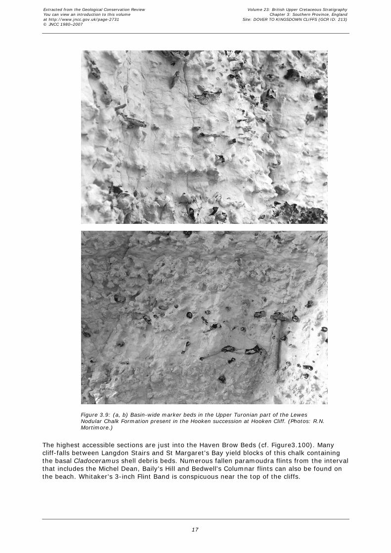
Figure 3.9: (a, b) Basin-wide marker beds in the Upper Turonian part of the LewesNodular Chalk Formation present in the Hooken succession at Hooken Cliff. (Photos: R.N.Mortimore.)
The highest accessible sections are just into the Haven Brow Beds (cf. Figure 3.100). Manycliff-falls between Langdon Stairs and St Margaret's Bay yield blocks of this chalk containingthe basal Cladoceramus shell debris beds. Numerous fallen paramoudra flints from the intervalthat includes the Michel Dean, Baily's Hill and Bedwell's Columnar flints can also be found onthe beach. Whitaker's 3-inch Flint Band is conspicuous near the top of the cliffs.
Extracted from the Geological Conservation ReviewYou can view an introduction to this volumeat http://www.jncc.gov.uk/page-2731© JNCC 1980–2007
Volume 23: British Upper Cretaceous StratigraphyChapter 3: Southern Province, England
Site: DOVER TO KINGSDOWN CLIFFS (GCR ID: 213)
17

Figure 3.100: Seaford Head: the Coniacian–Santonian boundary and the higher part ofthe Seaford Chalk Formation.
Margate Chalk Member: The (flintless) Margate Chalk Member is present only in the highestparts of the cliff between Dover–Kingsdown. The base is marked by a yellow sponge bed(the Barrois' Sponge Bed of the Thanet Coast), a short distance above the conspicuousWhitaker's 3-inch Flint Band. Apart from poor exposures in the shallow cutting for the oldconstruction railway near Langdon Hole, the Margate Chalk is inaccessible, and details of thestratigraphy are given in the Thanet Coast GCR site report, this volume.
Biostratigraphy
The biostratigraphy of the site is essentially that of the standard Southern Provincesuccessions. There are huge collections of fossils from these cliffs held by the British GeologicalSurvey (Keyworth) and the Natural History Museum, London. The British Geological Surveyalso holds comprehensive bed-by-bed collections of brachiopods, echinoids (notably Micraster),inoceramid bivalves and belemnites from the White Chalk Subgroup. The old collections containnumerous rare fossils, including rudists and reptile bones. Rowe (1899, 1900), investigated thedetailed palaeontology of the ‘White Chalk' zones.
Cenomanian Stage
The burrowed contact between the Upper Albian Gault mudstones and the lowest beds of theWest Melbury Marly Chalk Formation is exposed on the faulted wave-cut platform at theeastern end of the groynes in East Wear Bay (TR 261 383). These exposures, described byGale (1989, Locality 3), take the Cenomanian stratigraphy below levels exposed at theSoutherham Grey Pit. Here the locally thick Glauconitic Marl Member contains commonsponges, including the former zonal index sponge, Stauronema carteri Sollas, andindeterminate inoceramid bivalve hinges. The terminal thin limestone, M2, has yielded a single
Extracted from the Geological Conservation ReviewYou can view an introduction to this volumeat http://www.jncc.gov.uk/page-2731© JNCC 1980–2007
Volume 23: British Upper Cretaceous StratigraphyChapter 3: Southern Province, England
Site: DOVER TO KINGSDOWN CLIFFS (GCR ID: 213)
18

specimen of Neostlingoceras carcitanense (Matheron), the basal Cenomanian subzonal indexspecies (Gale, 1989). Where the Glauconitic Marl is thin, for example in the Channel TunnelCraelius No. 1 (Aycliff) Borehole it contains well-preserved specimens of the thin-shelledbivalve Aucellina (illustrated in Morter and Wood, 1983), indicative of the Neohibolitesultimus/Aucellina gryphaeoides event of European event stratigraphy (Ernst et al., 1983).
The section at the base of Abbot's Cliff (Gale and Friedrich, 1989) is the most important sectionof the Lower Cenomanian Sharpeiceras schlueteri Subzone of the Mantelliceras mantelli Zonein Europe. The 3 m section of marl–limestone rhythms above the Glauconitic Marl is extremelyfossiliferous and has yielded a rich S. schlueteri subzonal ammonite assemblage. Thiscomprises the large ammonites Sharpeiceras schlueteri Hyatt, S. laticlavium and Utaturicerasvicinale (Stoliczka) (illustrated by Wright and Kennedy, 1996), which are not found at otherhorizons in the Cenomanian succession, together with large, inflated Mantelliceras andheteromorphs such as Hypoturrilites. Utaturiceras, originally described from India, has notbeen found elsewhere in Britain. These ammonites are associated with large ornate oysterswith a zig-zag commissure (Rastellum colubrinum (Lamarck)) and common large terebratulids(Tropeothyris carteri (Davidson) and related forms) which are likewise restricted to this level.This is also the inferred type horizon of Inoceramus crippsi Mantell, which is common at thislevel, but was originally described from the Hamsey pits near Lewes by Mantell (1822). Thesubzone terminates in the prominent massive M3 limestone, which contains abundant three-dimensionally preserved specimens of the former zonal index ammonite Schloenbachia varians(J. Sowerby). This is the inferred correlative of the Doolittle Limestone of the Chiltern Hills (seep. 300, Chapter 4).
The next section east (Abbot's Cliff to Lydden Spout) is one of the most important for thebiostratigraphy of the Middle Cenomanian Substage in England, complementing that atSoutherham Grey Pit (Kennedy, 1969; Gale, 1989, 1995; Gale, in Jenkyns et al., 1994; Paulet al., 1994; Mitchell and Carr, 1998).
The basal Middle Cenomanian index ammonite, Cunningtoniceras inerme (Pervinquière) entersslightly below the middle of the three Orbirhynchia mantelliana bands (Gale, 1995). The darkmarl below the lower of the two prominent limestones in this section is extremely fossiliferous.It is named the Arlesiensis Bed after the restricted occurrence in it of the small pectinaceanbivalve Lyropecten (Aequipecten) arlesiensis (Woods) together with a diverse fauna includingserpulids, a flood occurrence of the small bivalve Oxytoma seminudum Dames and theinoceramid bivalve Inoceramus schoendorfi Heinz. The second of the Middle Cenomanian zonalindex ammonites, Acanthoceras rhotomagense (Brongniart), enters in the higher of the twoprominent limestones. This latter limestone is the correlative of the Tenuis Limestone ofSoutherham Grey Pit.
The Cast Bed of Price (1877) contains an abundant, diverse assemblage of small brachiopods,including Grasirhynchia grasiana (d'Orbigny), G. martini (Mantell), Kingena concinna Owen andModestella geinitzi (Schloenbach), the latter being restricted to this bed. The associated fossilsinclude sporadic small corals, (Micrabacia coronula (Goldfuss)), the smooth pectinacian bivalveEntolium orbiculare (J. Sowerby) and a second flood abundance of Oxytoma seminudum. A keyelement of the fauna is the belemnite Praeactinocamax primus; rare occurrences (threespecimens) from here compare with two finds at Southerham Grey Pit (Paul et al., 1994)and provide evidence for the primus event of European event stratigraphy (Ernst et al., 1983;Christensen, 1990, Figure 2.8, Chapter 2).
Extracted from the Geological Conservation ReviewYou can view an introduction to this volumeat http://www.jncc.gov.uk/page-2731© JNCC 1980–2007
Volume 23: British Upper Cretaceous StratigraphyChapter 3: Southern Province, England
Site: DOVER TO KINGSDOWN CLIFFS (GCR ID: 213)
19

Figure 2.8: Cenomanian stratigraphy for the onshore UK based on Southerham, Asham,Beachy Head and Folkestone. M2, M4 and M5 are Marker Beds of Gale (1995).
The range of Orbirhynchia mantelliana (J. de C. Sowerby) in the upper of the three bands isgreater here than elsewhere (Gale, 1990). Above this upper band of O. mantelliana there is asuccession of nine, more or less equally developed, 0.12–0.2 m thick, conspicuous limestonebands. The lowermost two limestones are formed from discontinuous concentrations ofsponges. On the upper surface of the eighth band the small coral Micrabacia coronula is againabundant: this is the Micrabacia Band (Band 11 of Kennedy, 1969). The terebratulidbrachiopod Concinnithyris subundata (J. Sowerby) is also abundant throughout this intervaland above the Micrabacia band. The occurrence of this brachiopod provides a useful markerthroughout the Southern and Transitional provinces.
An integrated biostratigraphical study of the Cenomanian–Turonian boundary succession (withparticular reference to the Plenus Marls Member) on the Abbot's Cliff path using nannofossils,foraminifera, ostracods, dinoflagellates within a stable isotope stratigraphical framework wasundertaken by Jarvis et al. (1988b). A quantitative study of nannofossil changes across thePlenus Marls was carried out by Lamolda et al. (1994). These studies relate to mass extinctionsand the recovery of faunas and floras across the OAE II.
Turonian Stage
The extremely condensed Lower Turonian Holywell Nodular Chalk succession is particularlyimportant as a source of ammonites that can be used for international correlation. The HolywellMarl 2/3 interval contains Fagesia catinus (Mantell) and Lewesiceras peramplum (Mantell)indicating the presence of the Fagesia catinus Zone in Britain. The sediment of this interval iscomposed of comminuted debris from the microcrinoid genus Roveacrinus, constituting thelower of two microcrinoid events in the Turonian succession. A specimen of Pseudaspidocerascf. footeanum (Stoliczka), the only one known from Britain, found loose on the beach here andillustrated by Wright and Kennedy (1981, pl. 21, fig. 3), came from this horizon.
The higher part of the Holywell Nodular Chalk Formation is a grit bed, characterized byabundant bivalve shell debris. Mytiloides shells encrusted by the serpulid Filograna avita (J.Sowerby), are found at the at the top of the maximum abundance of Mytiloides shell detritus,constituting the Filograna avita event.
An ammonite bed in the upper part of the Holywell Nodular Chalk Formation, a few coupletsabove the Filograna avita event, has yielded specimens of the large ammonites Mammitesnodosoides (Schlotheim), Morrowites wingi (Morrow) and Metasigaloceras rusticum (J.Sowerby). Thus, even in this highly condensed succession it is possible to recognize some of
Extracted from the Geological Conservation ReviewYou can view an introduction to this volumeat http://www.jncc.gov.uk/page-2731© JNCC 1980–2007
Volume 23: British Upper Cretaceous StratigraphyChapter 3: Southern Province, England
Site: DOVER TO KINGSDOWN CLIFFS (GCR ID: 213)
20

the key biostratigraphical marker horizons in the Lower Turonian succession. The limestoneimmediately overlying the Gun Gardens Main Marl (the ‘Lulworth Marl' of Gale, 1996) iscomposed of Roveacrinus debris and constitutes the higher of the two microcrinoid events.
The Aker's Steps section is used as the standard reference section for the foraminiferalbiostratigraphy of the Turonian Stage in the UK. Unfortunately, the published logs (Hart, 1982,figs 1, 2; Hart et al., 1989), which are based on an unpublished PhD thesis (M. Owen, 1970),are seriously incorrect and hence difficult to interpret. Because of failure to take account of afault in the middle of the section, some 3 m of strata are repeated in the New Pit Marl2–Glynde Marls interval. Nevertheless, some of the key planktonic foraminiferal events can beinterpreted with a degree of confidence. Marginotruncana sigali (Reichel) enters at the MallingStreet Marl 1 (Round Down Marl of Robinson (1986)) and ranges up to a level within theGlynde Marls. M. pseudolinneiana Pessagno (Figure 2.41, Chapter 2) enters 3 m above New PitMarl 2, and M. coronata (Bolli) in the Glynde Marls–Southerham Marl 1 interval, c. 4 m abovethe Lydden Spout Flint. These entry levels define the bases of the sigali (UKP6),pseudolinneiana (UKP7) and coronata (UKP8) planktonic foraminiferal zones respectively.
Figure 2.41: Turonian and Coniacian foraminifera (see page 77 for details).
Inoceramid bivalves of the Inoceramus lamarcki Parkinson group are common in the nodularsponge beds below Southerham Marl 1 in Langdon Bay. This is the type locality for theEuropean inoceramid zonal index fossil I. lamarcki sensu stricto. The holotype (now in theNatural History Museum, London) was collected (Parkinson, 1819) from a flint below theSoutherham Marls, probably from the big nodular Southerham Flints. The ammoniteSubprionocyclus hitchinensis (Billinghurst) was found here in the Southerham Marl 1–Marl 2interval (Gale, 1996). Micraster corbovis Forbes of lata Zone type (Stokes, 1975), thin-shelledSternotaxis plana (Mantell) and terebratulid brachiopods are also present above and below the
Extracted from the Geological Conservation ReviewYou can view an introduction to this volumeat http://www.jncc.gov.uk/page-2731© JNCC 1980–2007
Volume 23: British Upper Cretaceous StratigraphyChapter 3: Southern Province, England
Site: DOVER TO KINGSDOWN CLIFFS (GCR ID: 213)
21

Southerham marls. The surface beneath the Caburn Marl has yielded Micraster michelini(Agassiz), the same level as the Caburn Pit examples in Sussex (Mortimore, 1986a). So far,unlike in Sussex, no specimens of the international zonal index ammonite, Romanicerasdeverianum (d'Orbigny ) have been collected at this level at Dover.
The boundary between the conventional Terebratulina lata Zone and the Sternotaxis (formerlyHolaster) plana Zone was taken by Jukes-Browne and Hill (1903, 1904) at the base of theBasal Complex of nodular chalks, marl seams and large flints. This level corresponds to thelowest Bridgewick Flint Band in the Ringmer Beds of Sussex. In the Bridgewick Flints echinoidsare common, including Micraster michelini, M. corbovis of lata Zone type and S. plana. Rowe(1900), on the other hand, took the base of his Holaster planus Zone at Bridgewick Marl 1,which is the horizon of the last occurrence of Terebratulina lata R. Etheridge (it is abundant inthis marl seam). The Basal Complex above this level is characterized by common specimens ofthe rhynchonellid brachiopod Orbirhynchia dispansa Pettitt and the regular echinoid Gauthieriaradiata (Sorignet). The rhynchonellid brachiopod genus Cretirhynchia enters above BridgewickMarl 3.
Each of the nodular chalks of the Dover Chalk Rock contains a specific Upper Turonianammonite and inoceramid bivalve assemblage. The bottom nodular layer contains a lowdiversity assemblage comprising the inoceramid bivalves Inoceramus perplexus Whitfield andMytiloides costellatus (Woods), together with Subprionocyclus hitchinensis and Yezoitesbladenensis (Schlüter), but without Hyphantoceras reussianum (d'Orbigny). This is the‘allocrioceratid and collignoniceratid ammonite fauna' of the Hyphantoceras Event complex ofnorthern Germany (Kaplan and Kennedy, 1996). Nodular beds 2 and 3 contain the higherdiversity, ‘nostoceratid ammonite fauna' (Kaplan and Kennedy, 1996), including Hyphantocerasreussianum, Eubostrychoceras saxonicum (Schlüter) and Scaphites geinitzii d'Orbigny, but notSubprionocyclus. These beds also contain many small bivalves and gastropods and typicalChalk Rock brachiopods including Orbirhynchia reedensis (R. Etheridge), Cretirhynchiacuneiformis Pettitt, C. minor Pettitt and Gibbithyris subrotunda (J. Sowerby). The beds with thecharacteristic Lewes Tubular Flints contain the echinoid Micraster leskei Desmoulins as well asthe inoceramid bivalves Mytiloides striatoconcentricus (Gümbel) and M. incertus (Jimbo),marking the position of the ‘desmoceratid ammonite fauna' of the German succession, butwithout the characteristic ammonites. Each of these assemblages enables correlation to theexpanded Sussex sections and to the more condensed Chalk Rock sections of the Chiltern Hills(see Kensworth Quarry GCR site report, this volume) and Marlborough Downs (see FognamQuarry GCR site report, this volume). Dover is the one place in England where the successionof distinct ammonite faunas found in the German ‘Scaphiten-Schichten' can be demonstrated.
Beds above the Chalk Rock contain Micraster that are already more advanced than theM.praecursor sensu Drummond assemblages of Sussex, indicating further condensation here.The soft chalks of the Cuilfail Zoophycos contain large, inflated specimens of the thin-testedechinoid Sternotaxis placenta (Agassiz) associated with Micraster normanniae Bucaille. Withinthese highest beds below the Navigation Hardground, Rowe (1900) took his boundary of the S.plana and Micraster cortestudinarium zones.
Coniacian Stage
The boundary between the Turonian and Coniacian stages is currently taken along the topsurface of the Navigation Hardground. A juvenile ammonite, questionably identified asForresteria petrocoriensis, was found inside a broken echinoid on this surface at Langdon Stairs(Gale and Woodroof, 1981). The only unequivocal record of the biostratigraphically significant(Turonian–Coniacian boundary transition) thin-shelled bivalve Didymotis from the SouthernProvince was from soft chalk within the Navigation Hardground complex at the South Foreland.The basal index taxon for the Coniacian Stage, the inoceramid bivalve Cremnoceramusdeformis erectus (Meek) occurs together with C. waltersdorfensis (Andert) in a shell-rich bed0.7 m above the Navigation Marls at East Cliff, Dover. This compares with the occurrence ofthese species in the lower Navigation Marl at Upper Beeding Quarry, Shoreham Cement Works,Sussex. The small rhynchonellid brachiopod Cretirhynchia subplicata (Mantell) is particularlycommon between the Cliffe and Hope Gap hardgrounds. The Hope Gap Hardground is wellcemented and contains moulds of small, originally aragonite-shelled, bivalves and gastropods.Large, poorly preserved, unidentified ammonites occur in this hardground at the South
Extracted from the Geological Conservation ReviewYou can view an introduction to this volumeat http://www.jncc.gov.uk/page-2731© JNCC 1980–2007
Volume 23: British Upper Cretaceous StratigraphyChapter 3: Southern Province, England
Site: DOVER TO KINGSDOWN CLIFFS (GCR ID: 213)
22
Foreland.
The beds above the Hope Gap Hardground contain larger inoceramid bivalves (Cremnoceramusspp.) and large specimens of the inoceramid zonal index fossil C. crassus crassus (Petrascheck)are a particular feature of the interval from the Light Point Hardground to the Beachy HeadSponge Beds. Micraster decipiens (Bayle) (i.e. M. cortestudinarium (Goldfuss)) occurs inseveral bands: on the Hope Gap Hardground, in the Beeding Hardgrounds and in the LightPoint Hardground. Large specimens of Micraster turonensis (Bayle) characterize the BeachyHead Sponge Beds. The boundary between the traditional Micraster cortestudinarium and M.coranguinum zones was taken by Rowe (1900) at a sponge bed above Shoreham Marl 2 onLangdon Stairs (Figure 3.124), but lower down, at a sponge bed below Shoreham Marl 1 at StMargaret's Bay.
The basal Middle Coniacian zonal index inoceramid bivalve, Volviceramus koeneni (Müller), hasbeen collected from the calcarenite 2.7 m above Shoreham Marl 2 at East Cliff (Figure 3.124).The lowest specimens of Platyceramus mantelli were also noted at this horizon. Abundant shellfragments of Platyceramus (Figure 2.20, Chapter 2) are characteristic throughout the BelleTout Beds and up to the Cuckmere Flints. These shells are abundant in the Belle Tout Marls.There are also several bands of Volviceramus ex gr. involutus (J. de C. Sowerby) in these beds(Figure 3.124; Figure 2.20, Chapter 2). The Seven Sisters Flint Band has the same associationof Platyceramus and Volviceramus below, in and above as in the Cuckmere to Seaford site,Birling Gap and Tarring Neville Quarry. The echinoid Conulus raulini (d'Orbigny) occurs in theBelle Tout Beds in the Kent sections, but has not been found in Sussex.
Extracted from the Geological Conservation ReviewYou can view an introduction to this volumeat http://www.jncc.gov.uk/page-2731© JNCC 1980–2007
Volume 23: British Upper Cretaceous StratigraphyChapter 3: Southern Province, England
Site: DOVER TO KINGSDOWN CLIFFS (GCR ID: 213)
23

Extracted from the Geological Conservation ReviewYou can view an introduction to this volumeat http://www.jncc.gov.uk/page-2731© JNCC 1980–2007
Volume 23: British Upper Cretaceous StratigraphyChapter 3: Southern Province, England
Site: DOVER TO KINGSDOWN CLIFFS (GCR ID: 213)
24
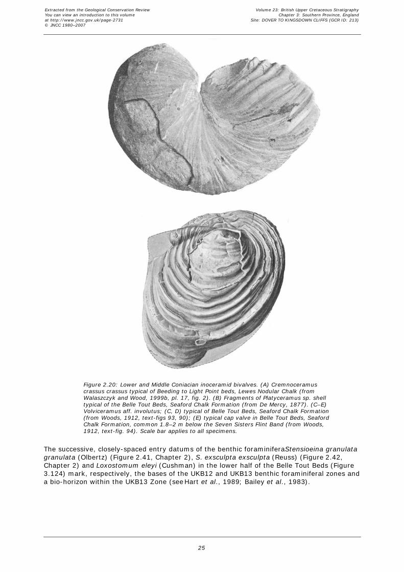
Figure 2.20: Lower and Middle Coniacian inoceramid bivalves. (A) Cremnoceramuscrassus crassus typical of Beeding to Light Point beds, Lewes Nodular Chalk (fromWalaszczyk and Wood, 1999b, pl. 17, fig. 2). (B) Fragments of Platyceramus sp. shelltypical of the Belle Tout Beds, Seaford Chalk Formation (from De Mercy, 1877). (C–E)Volviceramus aff. involutus; (C, D) typical of Belle Tout Beds, Seaford Chalk Formation(from Woods, 1912, text-figs 93, 90); (E) typical cap valve in Belle Tout Beds, SeafordChalk Formation, common 1.8–2 m below the Seven Sisters Flint Band (from Woods,1912, text-fig. 94). Scale bar applies to all specimens.
The successive, closely-spaced entry datums of the benthic foraminifera Stensioeina granulatagranulata (Olbertz) (Figure 2.41, Chapter 2), S. exsculpta exsculpta (Reuss) (Figure 2.42,Chapter 2) and Loxostomum eleyi (Cushman) in the lower half of the Belle Tout Beds (Figure3.124) mark, respectively, the bases of the UKB12 and UKB13 benthic foraminiferal zones anda bio-horizon within the UKB13 Zone (see Hart et al., 1989; Bailey et al., 1983).
Extracted from the Geological Conservation ReviewYou can view an introduction to this volumeat http://www.jncc.gov.uk/page-2731© JNCC 1980–2007
Volume 23: British Upper Cretaceous StratigraphyChapter 3: Southern Province, England
Site: DOVER TO KINGSDOWN CLIFFS (GCR ID: 213)
25

Figure 2.42: Santonian foraminifera (see page 77 for details).
Interpretation
The Folkestone–Dover section is usually considered to be the standard section for theCenomanian Stage in the UK. The most complete Lower Cenomanian succession in England ispresent here, but the Mantelliceras saxbii flood-event seen at Southerham Grey Pit, Sussex,is missing either because of erosion or to non-preservation. The marker horizon M4, theerosion surface at the base of the M. dixoni Zone, passes laterally into phosphates in Sussex(Eastbourne) and the Isle of Wight (i.e. it becomes a much more developed erosion surfacecompared to the burrowed surface at Folkestone). The highly fossiliferous limestone of coupletB24 of Gale (1995) at Southerham Grey Pit (the possible equivalent of Bed h of Kennedy,1969) is barely cemented and inconspicuous at Folkestone. Consequently the rich and well-preserved three-dimensional ammonite and inoceramid fauna is not represented in theFolkestone sections.
The White Bed at the top of the Grey Chalk Subgroup is more homogeneous, less obviouslyrhythmically bedded and thinner compared to its development at Southerham Grey Pit andat Beachy Head. This is probably due to its position on the margin of the Anglo-Brabant Massif(Figure 1.8, Chapter 1) compared to the more basinal Sussex sections.
In the Turonian strata, the highly condensed nature of the Holywell Nodular Chalk Formationhas resulted in the loss of numerous marker beds. The marl seams of the expanded successionare represented here merely by thin, marl-coated wavy surfaces. This condensation continuesacross the Anglo-Brabant Massif into the southern Chiltern Hills. Despite this condensation, thepresence of some regional markers such as the Filograna avita event (Gale, 1996), has alloweda correlation to be established in the upper part of the shell-detrital layers. The Filograna avitaevent is found throughout the Southern Province and in the southern Chiltern Hills, where it
Extracted from the Geological Conservation ReviewYou can view an introduction to this volumeat http://www.jncc.gov.uk/page-2731© JNCC 1980–2007
Volume 23: British Upper Cretaceous StratigraphyChapter 3: Southern Province, England
Site: DOVER TO KINGSDOWN CLIFFS (GCR ID: 213)
26

has been traced as far north as Pitstone Quarry. There are fewer ammonite horizons in theLower Turonian Holywell Nodular Chalk Formation at Dover compared with Sussex. Because ofthe extreme condensation of the basal beds of the Holywell Nodular Chalk Formation(equivalent of the Melbourn Rock of Sussex) the rich Neocardioceras juddii Zone ammoniteassemblage of the expanded Eastbourne sections is represented only by occurrences ofSciponoceras.
The extreme condensation at Dover continues into the base of the New Pit Chalk Formation,which here is still nodular but does not contain the shell detritus of the Holywell Nodular ChalkFormation below. The Glyndebourne Flints are missing in the Aker's Steps section but arepresent elsewhere in the North Downs (e.g. Halling Pit, Mortimore, 1990). Some of the nodularbeds may represent the Glyndebourne Hardgrounds of Sussex (see Southerham Pit GCR sitereport, this volume).
The Dover–Kingsdown section of the Folkestone to Kingsdown GCR site is a link in the NewPit Chalk and Lewes Nodular Chalk formations between the main basinal sections of Sussexand Hampshire and the Transitional Province sections such as Fognam Quarry, KensworthQuarry and the sections in East Anglia, including Grimes Graves, near Brandon. It is critical tothe development of a lithostratigraphy for the Transitional Province. This is particularly thecase with the Chalk Rock because the nodular ‘Dover Chalk Rock' succession is intermediatebetween the highly condensed Chalk Rock sensu stricto of Fognam Quarry and CharnageDown Chalk Pit and the expanded Kingston Beds of Sussex.
The interval between the top of the ‘Dover Chalk Rock' and the Navigation Hardgrounds is alsocondensed compared with that in the Southerham Pit, Lewes. There are more species ofMicraster at Lewes, and current evidence suggests that there are also more Late Turonianinoceramid bivalves in this expanded section. However, the only basal Coniacian ammonite tobe found so far in the Chalk of the UK came from the Navigation Hardground at LangdonStairs.
The Aker's Steps section has provided a detailed isotope stratigraphy for the Turonian Stage ofthe Southern Province, the upward continuation being taken from the Langdon Bay–LangdonStairs composite section (see Jenkyns et al., 1994, figs 3, 4 for the *13C and *18O curvesrespectively). The remainder of the stable isotope stratigraphy up to the top of the preservedChalk on Thanet was based on the cliff sections south of Kingsdown and in the Isle of Thanet.
The Turonian *13C curve from the Dover sections has been extensively used for long-rangecorrelation to reference sections in Lower Saxony and Saxony (Germany) and to the cliffs nearSantander in northern Spain. In all of these sections, several *13C positive ‘spikes' serve ascorrelative marker horizons (Voigt and Hilbrecht, 1997, figs 6, 7). These have been givennumbers in relation to the point on the curve with the minimum *13C value (the datum or zero– see Wiese, 1999, figs 4, 5). The most prominent of the four ‘spikes' below the datum (–4 orthe Pewsey event) is inferred (Gale, 1996) to correlate with the Pewsey Hardground in thebottom hardground suite of the stratotypic Chalk Rock (see Fognam Quarry GCR site report,this volume). At Dover, this peak falls low in the Lewes Nodular Chalk Formation, c. 4 m abovethe Lydden Spout Flint and immediately below the entry of the planktonic foraminiferMarginotruncana coronata at the base of the UKP8 planktonic foraminiferal Zone. The inceptionof this species may relate to a transgressive episode. Peaks –3, –2 and –1 (in ascending order)correspond respectively to the Southerham Flints below Southerham Marl 1; to a level c. 1 mabove the Southerham Marls; and to the Caburn Flints below the Caburn Marl. This latter level,which yields the Upper Turonian zonal index ammonite, Romaniceras deverianum, in both theSouthern and Transitional provinces, can be equated, using stable isotope stratigraphy, withthe costellatus/ plana event of European event stratigraphy and the provisional marker for thebase of the Upper Turonian Substage. However, the entry of Subprionocyclus hitchinensis atDover between the Southerham Marls, and the lowest ocurrence of S. neptuni (Geinitz) a shortdistance beneath the inferred equivalent of Southerham Marl 1 at Fognam Quarry, suggeststhat the base of the Upper Turonian Substage in the UK should be shifted significantlydownwards (see also Appendix, this volume).
Conclusions
Extracted from the Geological Conservation ReviewYou can view an introduction to this volumeat http://www.jncc.gov.uk/page-2731© JNCC 1980–2007
Volume 23: British Upper Cretaceous StratigraphyChapter 3: Southern Province, England
Site: DOVER TO KINGSDOWN CLIFFS (GCR ID: 213)
27

The Folkestone to Kingsdown Upper Cretaceous Chalk cliffs are ideally situated on the northernflanks of the Southern Province, providing a link to the Transitional Province and on into theNorth Sea and German sections. Detailed correlations have also been made with northernFrance. These cliffs provide the standard reference section for the Cenomanian Stage of theSouthern Province. The Albian–Cenomanian boundary is better developed here than elsewherein the Southern Province, with an expanded, lithologically differentiated and fossiliferousGlauconitic Marl Member at the base of the Chalk Group. This is also the best section in Europeof the Mantelliceras schlueteri ammonite Subzone. It is one of the standard reference sections,with Southerham Grey Pit and Compton Bay, for the marl–limestone coupletcyclostratigraphy of the Cenomanian Stage. The sections illustrate the stratigraphical andsedimentological impacts of condensation in the ‘Melbourn Rock' (Holywell Nodular ChalkFormation) and Chalk Rock. Many type specimens of Upper Cretaceous macrofossils come fromthese cliffs. It is only in the ‘Dover Chalk Rock' that it is possible to demonstrate the successionof Upper Turonian ammonite faunas known from expanded sections in Germany. The richinoceramid bivalve faunas enable correlation between the traditional macrofossil zones and thestandard inoceramid zonal scheme. The site also includes several of the reference sections forthe microfossil (foraminiferal) zonal scheme of the UK.
Together with the Sussex sections, the Folkestone to Kingsdown cliffs provide standardreference sections for the trace element and rare earth geochemistry of the Turonian marlseams. Closely spaced chalk samples collected from this and the Thanet Coast GCR site wereused to establish the lowest part of the continuous stable isotope curve for theCenomanian–Upper Santonian interval in the Southern Province.
Reference list
Bailey, H.W., Gale, A.S., Mortimore, R.N., Swiecicki, A.and Wood, C.J. (1983) TheConiacian–Maastrichtian Stages in the United Kingdom, with particular reference to southernEngland. Newsletters on Stratigraphy, 12, 19–42.
Bailey, H.W., Gale, A.S., Mortimore, R.N., Swiecicki, A. and Wood, C.J. (1984)Biostratigraphical criteria for recognition of the Coniacian to Maastrichtian stage boundaries inthe Chalk of north-west Europe, with particular reference to southern England. Bulletin of theGeological Society of Denmark, 33, 31–9.
Barrois, C. (1876) Recherches sur le terrain Crétacé Supérieur de l'Angleterre et de l'Irlande,Mémoire de la Société Géologique du Nord, 232 pp.
Bristow, C.R., Mortimore, R.N. and Wood, C.J. (1997) Lithostratigraphy for mapping the Chalkof southern England. Proceedings of the Geologists' Association, 108, 293–315.
Bristow, C.R., Barton, C.M., Westhead, R.K., Freshney, E.C., Cox, B.M. and Woods, M.A.(1999) The Wincanton District – a Concise Account of the Geology, Memoir of the BritishGeological Survey (England and Wales), Sheet 297, The Stationery Office, for the BritishGeological Survey, London, 110 pp.
Bromley, R.G. and Gale, A.S. (1982) The lithostratigraphy of the English Chalk Rock.Cretaceous Research, 3, 273–306.
Christensen, W.K. (1990) Actinocamax primus Arkhangelsky (Belemnitellidae; UpperCretaceous). Biometry, comparison and biostratigraphy. Paläontologische Zeitschrift, 64,75–90.
Conybeare, W.D. and Phillips, W. (1822) Outlines of the Geology of England and Wales, Phillips,London.
Destombes, J.P. and Shephard-Thorn, E.R. (1971) Geological results of the Channel Tunnel siteinvestigation 1964–65. Report of the Institute of Geological Sciences, 71/11, 12 pp.
Dowker, G. (1870) On the Chalk of Thanet, Kent, and its connection with the Chalk of eastKent. Geological Magazine, New Series, Decade II, 7, 466–72.
Ernst, G., Schmid, F. and Seibertz, E. (1983) Event-Stratigraphie im Cenoman und Turon vonNW-Deutschland. Zitteliana, 10, 531–54.
Gale, A.S. (1989) Field meeting at Folkestone Warren, 29th November, 1987. Proceedings ofthe Geologists' Association, 100, 73–80.
Gale, A.S. (1995) Cyclostratigraphy and correlation of the Cenomanian Stage in WesternEurope. In Orbital Forcing Timescales and Cyclostratigraphy, (eds M.R. House and A.S. Gale),Geological Society of London, Special Publication, No. 85, pp. 177–97.
Gale, A.S. (1996) Turonian correlation and sequence stratigraphy of the Chalk in southern
Extracted from the Geological Conservation ReviewYou can view an introduction to this volumeat http://www.jncc.gov.uk/page-2731© JNCC 1980–2007
Volume 23: British Upper Cretaceous StratigraphyChapter 3: Southern Province, England
Site: DOVER TO KINGSDOWN CLIFFS (GCR ID: 213)
28

England. In Sequence Stratigraphy in British Geology, (eds S.P. Hesselbo and D.N.Parkinson), Geological Society of London, Special Publication, No. 103, pp. 177–95.
Gale, A.S. and Friedrich, S. (1989) Occurrence of the ammonite Sharpeiceras in the LowerCenomanian Chalk Marl of Folkestone. Proceedings of the Geologists' Association, 100, 80–2.
Gale, A.S and Hancock, J.M. (1999) Discussion on ‘Lithostratigraphy for mapping the Chalk ofsouthern England'. Proceedings of the Geologists' Association, 110, 65–8.
Gale, A.S. and Smith, A.B. (1982) The palaeobiology of the Cretaceous irregular echinoidsInfulaster and Hagenowia. Palaeontology, 25, 11–42.
Gale, A.S. and Woodroof, P.B. (1981) A Coniacian ammonite from the ‘Top Rock' in the Chalkof Kent. Geological Magazine, 118, 557–60.
Hébert, E. (1874) Comparison de la craie des côte d'Angleterre avec celle de la France. Bulletinde la Société géologique de France, 3rd series, 2, 416–28.
Harris, C.S., Hart, M.B., Varley, P.M. and Warren, C.D. (eds) (1996a) Engineering Geology ofthe Channel Tunnel, Thomas Telford, London, 526 pp.
Hart, M.B. (1982) Turonian foraminiferal biostratigraphy of Southern England. Mémoires duMuseum national d'Histoire Naturelle Nouvel Series, 49, 203–7.
Hart, M.B., Bailey, H.W., Crittenden, S., Fletcher, B.N., Price, R.J. and Swiecicki, A. (1989)Chapter 7. Cretaceous. In Stratigraphical Atlas of Fossil Foraminifera, 2nd edn, (eds D.G.Jenkins and J.W. Murray), Ellis Horwood Ltd, Chichester, pp. 273–371.
Jarvis, I., Carson, G.A., Cooper, M.K.E., Hart, M.B., Leary, P.N., Tocher, B.A., Horne, D. andRosenfeld, A. (1988b) Microfossil Assemblages and the Cenomanian–Turonian (lateCretaceous) Oceanic Anoxic Event. Cretaceous Research, 9, 3–103.
Jeans, C.V., Long, D., Hall, M.A., Bland, D.J. and Cornford, C. (1991) The geochemistry of thePlenus Marls at Dover, England: evidence of fluctuating oceanographic conditions and glacialcontrol during the development of the Cenomanian–Turonian *13C anomaly. GeologicalMagazine, 128, 603–32.
Jefferies, R.P.S. (1962) The palaeoecology of the Actinocamax plenus Subzone (lowestTuronian) in the Anglo-Paris Basin. Palaeontology, 4, 609–47.
Jefferies, R.P.S. (1963) The stratigraphy of the Actinocamax plenus Subzone (Turonian) in theAnglo-Paris Basin. Proceedings of the Geologists' Association, 74, 1–33.
Jenkyns, H.C, Gale, A.S. and Corfield, R.M (1994) Carbon- and oxygen-isotope stratigraphy ofthe English Chalk and Italian Scaglia and its palaeoclimatic significance. Geological Magazine,131, 1–34.
Jukes-Browne, A.J. and Hill, W. (1903) The Cretaceous Rocks of Britain, volume 2: The Lowerand Middle Chalk of England, Memoir of the Geological Survey of the United Kingdom, HMSO,London, 568 pp.
Jukes-Browne, A.J. and Hill, W. (1904) The Cretaceous Rocks of Britain, volume 3: The UpperChalk of England, Memoir of the Geological Survey of the United Kingdom, HMSO, London,566 pp.
Kaplan, U. and Kennedy, W.J. (1996) Upper Turonian and Coniacian ammonite stratigraphy ofWestphalia, NW-Germany. Acta Geologica Polonica, 46, 305–52.
Kennedy, W.J. (1969) The correlation of the Lower Chalk of south-east England. Proceedings ofthe Geologists' Association, 80, 459–551.
Lamolda, M.A., Gorostidi, A. and Paul, C.R.C. (1994) Quantitative estimates of calcareousnannofossil changes across the Plenus Marls (latest Cenomanian), Dover, England:implications for the generation of the Cenomanian–Turonian Boundary Event. CretaceousResearch, 15, 143–64.
Mantell, G.A. (1822) The Fossils of the South Downs or Illustrations of the Geology of Sussex,Lepton Relfe, London, 327 pp.
Mitchell, S.F. and Carr, I.T. (1998) Foraminiferal response to mid-Cenomanian (UpperCretaceous) palaeoceanographic events in the Anglo-Paris Basin (Northwest Europe).Palaeogeography, Palaeoclimatology, Palaeoecology, 137, 103–25.
Morter, A.A. and Wood, C.J. (1983) The biostratigraphy of Upper Albian–Lower CenomanianAucellina in Europe. Zitteliana, 10, 515–29.
Mortimore, R.N. (1983). The stratigraphy and sedimentation of the Turonian–Campanian in theSouthern Province of England. Zitteliana, 10, 27–41.
Mortimore, R.N. (1986a) Stratigraphy of the Upper Cretaceous White Chalk of Sussex.Proceedings of the Geologists' Association, 97, 97–139.
Mortimore, R.N. (1987) Upper Cretaceous White Chalk in the North and South Downs,England: a correlation. Proceedings of the Geologists' Association, 98, 77–86.
Extracted from the Geological Conservation ReviewYou can view an introduction to this volumeat http://www.jncc.gov.uk/page-2731© JNCC 1980–2007
Volume 23: British Upper Cretaceous StratigraphyChapter 3: Southern Province, England
Site: DOVER TO KINGSDOWN CLIFFS (GCR ID: 213)
29

Mortimore, R.N. (1988) Upper Cretaceous Chalk in the Anglo-Paris Basin: a discussion oflithostratigraphical units. Proceedings of the Geologists' Association, 99, 67–70.
Mortimore, R.N. (1990) Chalk or chalk. In Chalk, (eds J.B. Burland, R.N. Mortimore, L.D.Roberts, D.L. Jones and B.O. Corbett), Thomas Telford, London, pp. 15–46.
Mortimore, R.N. (1997) The Chalk of Sussex and Kent, Geologists' Association Field Guide No.57, Geologists' Association, London, 193 pp.
Mortimore, R.N. and Pomerol, B. (1987) Correlation of the Upper Cretaceous White Chalk(Turonian to Campanian) in the Anglo-Paris Basin. Proceedings of the Geologists' Association,98, 97–143.
Mortimore, R.N. and Pomerol, B. (1996) A revision of Turonian litho- and biostratigraphy in theAnglo-Paris Basin. Mitteilungen aus dem Geologisch-Paläontologischen Institut der UniversitätHamburg, 77, 423–41.
Mortimore, R.N. and Wood, C.J. (1986) The distribution of flint in the English Chalk, withparticular reference to the ‘Brandon Flint Series' and the high Turonian flint maximum. In TheScientific Study of Flint and Chert, (eds G. de G. Sieveking and M.B. Hart), CambridgeUniversity Press, Cambridge, pp. 7–20.
Owen, E.F. (1970) A revision of the brachiopod subfamily Kingeninae Elliott. Bulletin of theBritish Museum (Natural History). Geology Series, 19, 27–83.
Parkinson, J. (1819) Remarks on the Fossils collected by Mr. William Phillips, near Dover andFolkstone. Transactions of the Geological Society, 5, 52–9.
Paul, C.R.C., Mitchell, S.F, Marshall, J.D., Leary, P.N., Gale, A.S., Duane, A.M. and Ditchfield,P.W. (1994) Palaeoceanographic events in the Middle Cenomanian of Northwest Europe.Cretaceous Research, 15, 707–38.
Phillips, W. (1818) A Selection of Facts from the Best Authorities Arranged so as to form anOutline of the Geology of England and Wales, William Phillips, London, 240 pp.
Phillips, W. (1819) Remarks on the Chalk Cliffs in the neighbourhood of Dover, and on the BlueMarle covering the Green Sand near Folkstone. Transactions of the Geological Society, 5,16–47.
Price, F.G.H. (1874) On the Gault of Folkestone. Quarterly Journal of the Geological Society ofLondon, 30, 342–66.
Price, F.G.H. (1877) On the beds between the Gault and the Upper Chalk near Folkestone.Quarterly Journal of the Geological Society of London, 33, 431–48.
Rawson, P.F., Allen, P. and Gale, A.S. (2001) The Chalk Group – a revised lithostratigraphy.Geoscientist, 11, 21.
Robaszynski, F., Gale, A.S., Juignet, P., Amédro, F. and Hardenbol, J. (1998) Sequencestratigraphy in the Upper Cretaceous Series of the Anglo-Paris Basin: exemplified by theCenomanian Stage. In Mesozoic and Cenozoic Sequence Stratigraphy of European Basins,(eds J. Hardenbol, J. Thierry, M.B. Farley, Th. Jaquin, P.-C. de Graciansky and P.R. Vail),Society of Economic Paleontologists and Mineralogists Special Publication, No. 60, pp. 363–86.
Robinson, N.D. (1986) Lithostratigraphy of the Chalk Group of the North Downs, southeastEngland. Proceedings of the Geologists' Association, 97, 141–70.
Rowe, A.W. (1899) An analysis of the genus Micraster, as determined by rigorous zonalcollecting from the Zone of Rhynchonella cuvieri to that of Micraster coranguinum. QuarterlyJournal of the Geological Society of London, 55, 494–547.
Rowe, A.W. (1900) The Zones of the White Chalk of the English Coast. I. Kent and Sussex.Proceedings of the Geologists' Association, 16, 289–368.
Shephard-Thorn, E.R. (1988) Geology of the Country around Ramsgate and Dover, Memoir ofthe British Geological Survey New Series, Sheets 274 and 290, HMSO, London.
Stokes, R.B. (1975) Royaumes et provinces faunistiques du Crétacéétablis sur la base d'uneétude systématique du genre Micraster. Memoire du Museum national d'Histoire naturelle,Series C, 31, 94 pp.
Voigt, S. and Hilbrecht, H. (1997) Late Cretaceous carbon isotope stratigraphy in Europe:Correlation and relations with sea level and sediment stability. Palaeogeography,Palaeoclimatology, Palaeoecology, 134, 39–59.
Whitaker, W. (1865a) On the Chalk of the Isle of Thanet. Quarterly Journal of the GeologicalSociety of London, 21, 395–8.
Whitaker W. (1872) The Geology of the London Basin: Part 1 The Chalk and Eocene Beds ofthe Southern and Western Tracts, Memoir of the Geological Survey of Great Britain and of theMuseum of Practical Geology, HMSO, London, 619 pp.
Wiese, F. (1999) Stable isotope data (*13C, *18O) from the Middle and Upper Turonian (Upper
Extracted from the Geological Conservation ReviewYou can view an introduction to this volumeat http://www.jncc.gov.uk/page-2731© JNCC 1980–2007
Volume 23: British Upper Cretaceous StratigraphyChapter 3: Southern Province, England
Site: DOVER TO KINGSDOWN CLIFFS (GCR ID: 213)
30

Cretaceous) of Liencres (Cantabria, northern Spain) with a comparison to northern Germany(Söhlde and Salzgitter-Salder). Newsletters on Stratigraphy, 37, 37–62.
Wright, C.W and Kennedy, W.J. (1981) The Ammonoidea of the Plenus Marls and the MiddleChalk, Monograph of the Palaeontographical Society, London, 148 pp.
Wright, C. W. and Kennedy, W. J. (1996) The Ammonoidea of the Lower Chalk: Part 5,Monograph of the Palaeontographical Society, London, pp. 320–403.
Extracted from the Geological Conservation ReviewYou can view an introduction to this volumeat http://www.jncc.gov.uk/page-2731© JNCC 1980–2007
Volume 23: British Upper Cretaceous StratigraphyChapter 3: Southern Province, England
Site: DOVER TO KINGSDOWN CLIFFS (GCR ID: 213)
31J S Publications - creating expert information resources - http://www.jspubs.com/xp