Embed Size (px)
Citation preview

QuickTime™ and aTIFF (Uncompressed) decompressor
are needed to see this picture.QuickTime™ and a
TIFF (Uncompressed) decompressorare needed to see this picture.
DORIS Analysis Strategies:
Analysis Coordination and steps required towards generation of IDS Products
F.G.Lemoine1, P. Willis2,3, J.J. Valette4, L. Soudarin4
1 NASA Goddard Space Flight Center, Greenbelt, Maryland, USA2Jet Propulsion Laboratory, California Institute of Technology, Pasadena, California, USA3Institut Géographique Nationale, LAREG, Marne-la-Vallée, FRANCE4Collecte Localisation Satellite, Ramonville-Saint-Agne, FRANCE
IDS Workshop, March 13-15, 2006

QuickTime™ and aTIFF (Uncompressed) decompressor
are needed to see this picture.QuickTime™ and a
TIFF (Uncompressed) decompressorare needed to see this picture.
Outline
• Introduction: Presentation of Position Paper• Availability of DORIS Products: Review• Action items from May 2004 IDS Workshop: Status.• Recommendations for 2006 e.g. Analysis campaigns,Refinements to analysis procedures.• Conclusion
IDS Workshop, March 13-15, 2006

QuickTime™ and aTIFF (Uncompressed) decompressor
are needed to see this picture.QuickTime™ and a
TIFF (Uncompressed) decompressorare needed to see this picture.
Introduction• IDS accepted as service of the IAG (July 2003).• Station renovation is nearing completion (Fagard, this workshop).• Multiple groups contribute products on a regular basis:IGN/JPL, INASAN, LEGOS/CLS, SSALTO.• New Analysis Centers: Pecny/CODE; Geoscience Australia.• Contribution to ITRF2005.• Special Issue: Journal of Geodesy: 18 papers submitted (Oct. 2005- Feb. 2006).• DORIS has reached a level of maturity and is at a crossroads.
Our challenge is continue to improve the geodetic products and transition to routine delivery of IDS products.
IDS Workshop, March 13-15, 2006

Current IDS Products (March 2006)
NoSSALTOIonosphere
NoLEGOSOrbits
NoINASANLEGOS/CLSIGN/JPLEOP
NoLEGOS/CLSIGN/JPLINASAN
Geocenter
NoGeosciences AustraliaIAA
IGN/JPLINASANLEGOS/CLSSSALTO
Monthly series
NoGeoscience AustraliaIAAPecny/CODE
SODGSFC (1 yr)
IGN/JPLINASANLEGOS/CLSSSALTO
Weekly series
NoINASANGeoscience AustraliaIAA
IGN/JPLLEGOS/CLS*
Cumulative solutions(positions/velocities)
Combined product
Proposed ACPrevious AC(no recent solution)
Present ACProduct
* Not at CDDIS.

QuickTime™ and aTIFF (Uncompressed) decompressor
are needed to see this picture.QuickTime™ and a
TIFF (Uncompressed) decompressorare needed to see this picture.

QuickTime™ and aTIFF (Uncompressed) decompressor
are needed to see this picture.QuickTime™ and a
TIFF (Uncompressed) decompressorare needed to see this picture.
QuickTime™ and aTIFF (Uncompressed) decompressor
are needed to see this picture.QuickTime™ and a
TIFF (Uncompressed) decompressorare needed to see this picture.
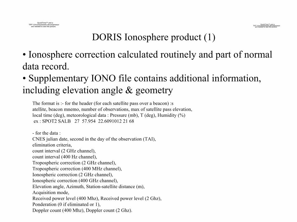
DORIS Ionosphere product (1)
• Ionosphere correction calculated routinely and part of normal data record.• Supplementary IONO file contains additional information, including elevation angle & geometry
The format is :- for the header (for each satellite pass over a beacon) :satellite, beacon mnemo, number of observations, max of satellite pass elevation,local time (deg), meteorological data : Pressure (mb), T (deg), Humidity (%)ex : SPOT2 SALB 27 57.954 22.6091012 21 68
- for the data :CNES julian date, second in the day of the observation (TAI),elimination criteria,count interval (2 GHz channel),count interval (400 Hz channel), Tropospheric correction (2 GHz channel),Tropospheric correction (400 MHz channel),Ionospheric correction (2 GHz channel),Ionospheric correction (400 GHz channel),Elevation angle, Azimuth, Station-satellite distance (m),Acquisition mode, Received power level (400 Mhz), Received power level (2 Ghz),Ponderation (0 if eliminated or 1),Doppler count (400 Mhz), Doppler count (2 Ghz).

QuickTime™ and aTIFF (Uncompressed) decompressor
are needed to see this picture.QuickTime™ and a
TIFF (Uncompressed) decompressorare needed to see this picture.
DORIS Ionosphere product (2)
IONO Files Available:Jason-1: from Aug. 2002.Spot2/4: from Jan. 2001.Spot5: from May 2004.Topex: Jan. 2001- Nov. 2004.
Figure 2: Comparison of DORIS derived vertical total electron content (VTEC) forJASON in 2004 with VTEC results from different IGS analysis centers. The displayindicates the RMS difference between each IGS center and DORIS for 2004. The unitsare TEC units (TECU). At the Jason altimeter frequency of 13.6 Ghz, 1 c m of rangecorresponds to 4.6 TECU. (from M. Pajares, April 2004-2005, IGS working group report)

QuickTime™ and aTIFF (Uncompressed) decompressor
are needed to see this picture.
Station Coordinate Differences (STCD)QuickTime™ and a
TIFF (Uncompressed) decompressorare needed to see this picture.

Station Position Residuals (STCD)(accessed from http://ids.cls.fr/html/doris/ids-station-series.php3)
QuickTime™ and aTIFF (Uncompressed) decompressor
are needed to see this picture.
QuickTime™ and aTIFF (Uncompressed) decompressor
are needed to see this picture.
QuickTime™ and aTIFF (Uncompressed) decompressor
are needed to see this picture.
DORIS (IGN/JPL, 2006/0303)Weekly series
ftp://cddis.gsfc.nasa.gov/pub/doris/products/stcd/ign03wd01/ign03wd01.stcd.paqb.gif- Updated weekly.
DORIS (LCA 2005.0603)Monthly series
ftp://cddis.gsfc.nasa.gov/pub/doris/products/stcd/lca05md01/lca05md01.stcd.paqb.gif. Last updated 2005.0603

QuickTime™ and aTIFF (Uncompressed) decompressor
are needed to see this picture. QuickTime™ and aTIFF (Uncompressed) decompressor
are needed to see this picture.
GPS (Heflin, 2004.0)http://sideshow.jpl.nasa.gov/mbh/series.htmlNot updated since MBH left JPL.
QuickTime™ and aTIFF (Uncompressed) decompressor
are needed to see this picture.
Station Coordinate Differences (STCD)(PAQB comparison with GPS for
collocated site, THTI, Tahiti)
-0.47 ± 0.21 mm/yr
2.4 mm/yr
-1.9 mm/yr
Height
-66.78 ± 0.10 mm/yr
33.40 ± 0.04 mm/yr
GPS Heflin 2004.0
-69.3 mm/yr35.1 mm/yrLCAlca05md01
-63.5 mm/yr37.5 mm/yrIGN/JPLign03wd01
LongitudeLatitudeSeries

QuickTime™ and aTIFF (Uncompressed) decompressor
are needed to see this picture.
DORIS Data Delivery to NASA CDDIS
QuickTime™ and aTIFF (Uncompressed) decompressor
are needed to see this picture.

QuickTime™ and aTIFF (Uncompressed) decompressor
are needed to see this picture.QuickTime™ and a
TIFF (Uncompressed) decompressorare needed to see this picture.
DORIS Product Delivery to NASA CDDIS

QuickTime™ and aTIFF (Uncompressed) decompressor
are needed to see this picture.
DORIS Data Downloads by Sourceftp://cddis.gsfc.nasa.gov/pub/doris/data
QuickTime™ and aTIFF (Uncompressed) decompressor
are needed to see this picture.

QuickTime™ and aTIFF (Uncompressed) decompressor
are needed to see this picture.
DORIS Product Downloads by Sourceftp://cddis.gsfc.nasa.gov/pub/doris/products
QuickTime™ and aTIFF (Uncompressed) decompressor
are needed to see this picture.

QuickTime™ and aTIFF (Uncompressed) decompressor
are needed to see this picture.
QuickTime™ and aTIFF (Uncompressed) decompressor
are needed to see this picture.
DORIS Evolution from TOPEX analysis

QuickTime™ and aTIFF (Uncompressed) decompressor
are needed to see this picture.
DORIS Evolution from Spot2 analysis
QuickTime™ and aTIFF (Uncompressed) decompressor
are needed to see this picture.

QuickTime™ and aTIFF (Uncompressed) decompressor
are needed to see this picture.QuickTime™ and a
TIFF (Uncompressed) decompressorare needed to see this picture.
DORIS Evolution from Analysis of SINEX Weekly Series
Figure 9. Weighted RMS of the individual week ly time series combinations (Tavernier etal., 2006) .

QuickTime™ and aTIFF (Uncompressed) decompressor
are needed to see this picture.QuickTime™ and a
TIFF (Uncompressed) decompressorare needed to see this picture.
DORIS TRF Scale Differences
Weekly scale factor determination towards ITRF2000 using multi-satellite SINEX solutions. GSFC (circles); IGN/JPL(squares); LEGOS/CLS (crosses), Jan. - Dec. 2004. Left (all satellites); Right (Spot5 only). (Willis et al., 2006 in press; presented at Cairns IAG, August 2005).
QuickTime™ and aTIFF (Uncompressed) decompressor
are needed to see this picture.QuickTime™ and a
TIFF (Uncompressed) decompressorare needed to see this picture.
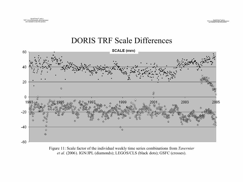
DORIS TRF Scale Differences
Figure 11: Scale factor of the individual weekly time series combinations from Tavernieret al. (2006). IGN/JPL (diamonds); LEGOS/CLS (black dots); GSFC (crosses).

QuickTime™ and aTIFF (Uncompressed) decompressor
are needed to see this picture.QuickTime™ and a
TIFF (Uncompressed) decompressorare needed to see this picture.
DORIS constellation evolution

DORIS Special Issue -Journal of Geodesy
(status report, March 10, 2006)
QuickTime™ and aTIFF (Uncompressed) decompressor
are needed to see this picture.QuickTime™ and a
TIFF (Uncompressed) decompressorare needed to see this picture.
Guest Editor: P. Willis (+ W. Featherstone when co-author)
18 papers submitted in total (Oct 2005 - Feb 2006.)
3 with a decision: 2 accepted (soon on Springer Website with DOI)1 refused
15 currently in review:6 in 1st review cycle8 sent back to authors for corrections1 in 2nd review cycle
Expected end of edition = May - June 2006
Authors from 8 different countriesReviewers from +9 different countries

QuickTime™ and aTIFF (Uncompressed) decompressor
are needed to see this picture.QuickTime™ and a
TIFF (Uncompressed) decompressorare needed to see this picture.Status of 2004 IDS Workshop
Recommendations Action Status Comment2.1. Survey of current uses of IDS products Open Rejected during meeting.2.2 Define procedure to accept an IDS product Open2.3 Split DORISMail and createDORISReports
Closed
2.4 Understand why some AC’s have stopped Open3.1 Request data delivery < 6 weeks Closed.3.2 Change to backup DORIS receiver onJason
Closed Done, but SAA problemremains.
3.3 List of IDS Stations (network +campaigns)
Open
3.4 Test data delivery for campaign stations Open3.5 Define new format (rawer data) Open3.6 Request data from Pleiades (+NPOESS) Open Done, but unsuccessful.4.1 Improve products but keep continuity. Open4,2 Compare AC’s analysis strategies. Open Some documentation online.4.3 Investigate TRF scale bias Open Some tests done. Willis et al.
(2006, in press) Cairns/IAG4.4 Investigate TZ 1998 (Spot4 data) Closed Willis et al. J. Geod. (2006 )5.1 Define validation procedures Open

QuickTime™ and aTIFF (Uncompressed) decompressor
are needed to see this picture.
QuickTime™ and aTIFF (Uncompressed) decompressor
are needed to see this picture. 2006 IDS Workshop Recommendations(to be discussed & decided during workshop)
Recommendation 2006.1.0: (1) Request Release of Pleiades satellite data; (2) Seek other missions of opportunity.
Recommendation 2006.2.0: Conduct measurement and force model inventory. Ascertain if AC’s can follow IERS2003 recommendations.
Recommendation 2006.2.1: Analysis centers should update their analysis desciption forms on file at the CDDIS, IGN data centers.
Recommendation 2006.3.0: New POD Standards for the IDS. Form subcommittee to examine standards used for GRACE, Topex, Jason, Envisat, and recommend models IDS might/should use. Be up to date but not arbitrary (e.g. Use Grace gravity models, but do not specify exact one to use).

QuickTime™ and aTIFF (Uncompressed) decompressor
are needed to see this picture.
QuickTime™ and aTIFF (Uncompressed) decompressor
are needed to see this picture. 2006 IDS Workshop Recommendations(to be discussed & decided during workshop)
Recommendation 2006.4.0: Decide orbit format for analysis campaigns. (sp1, sp3, POE).
Recommendation 2006.4.1: Conduct analysis campaigns for TRF scale and geocenter. Use updated common standards (from previous recommendations). Perform single-satellite and multi-satellite solutions as well as multi-technique solutions; Compare where possible with external data (SLR, Altimeter Crossovers). Systematically compare orbits produced by AC’s for this campaign as well as final products. 1-2 years (2003-2004?).
Recommendation 2006.5.0: Analysis campaign to validate SAA model (JM Lemoine and Capdeville, this workshop). What is impact on orbits, stations, EOP, scale?

QuickTime™ and aTIFF (Uncompressed) decompressor
are needed to see this picture.
QuickTime™ and aTIFF (Uncompressed) decompressor
are needed to see this picture. 2006 IDS Workshop Recommendations(to be discussed & decided during workshop)
Recommendation 2006.6.0: Evolve IDS to an operational service. Request AC’s to submit solutions within X weeks of receipt of data. Request combination center to perform combination with Y weeks of receipt of AC solutions.
Recommendation 2006.7.0: Request submision of ionosphere files for years prior to 2000-2001.
Recommendation 2006.7.1: Publicize availability of ionosphere data.
Recommendation 2006.8.0: Ask analysis centers to define arcs so that overlaps are available. Conduct overlap analyses on a routine basis and make results available to IDS on routine basis in tabular and plot form.
Comment: Orbit overlaps are a vital statistic to measure internal consistency and should be available for analysis (like the IGS).
Recommendation 2006.8.1: Submit orbits to IDS so all AC orbits can be intercompared on a routine basis on same schedule as in Rec. 2006.6.0.

QuickTime™ and aTIFF (Uncompressed) decompressor
are needed to see this picture.
QuickTime™ and aTIFF (Uncompressed) decompressor
are needed to see this picture. 2006 IDS Workshop Recommendations(to be discussed & decided during workshop)
Recommendation 2006.9.0: Harmonize a priori positions in all STCD files.
Recommendation 2006.9.1: Ensure that all AC’s can create STCD files and associated plots. Update web site to include results from all AC’s.
Recommendation 2006.9.2: Publicize availability of STCD files and plots in geophysics community (e.g., IGSMAIL, SLRMAIL, other means).

QuickTime™ and aTIFF (Uncompressed) decompressor
are needed to see this picture.QuickTime™ and a
TIFF (Uncompressed) decompressorare needed to see this picture.
Other Issues
• Analysis campaign for time-variable gravity estimation.
• EOP & EOP-rates (proposal of P. Willis).
• Do we continue monthly series or only do weekly series?
• International Polar Year.
• Encouragement of new AC’s.

QuickTime™ and aTIFF (Uncompressed) decompressor
are needed to see this picture.QuickTime™ and a
TIFF (Uncompressed) decompressorare needed to see this picture.
Conclusion
DORIS as a geodetic observing system is at a crossroads. It has achieved a level of maturity in the quality of the products that it produces. We must focus on the technical issues (e.g. modelling differences between centers) and operational issues in order to continue to refine and improve the contribution DORIS makes to satellite geodesy.