Embed Size (px)
Citation preview

land
Article
Anthropogenic Influences in Land Use/Land CoverChanges in Mediterranean Forest Landscapes in Sicily
Donato S. La Mela Veca, Sebastiano Cullotta, Sebastiano Sferlazza * and Federico G. Maetzke
Università Degli Studi di Palermo, Dipartimento Scienze Agrarie e Forestali, Viale delle Scienze, Edificio 4,Ingresso H, 90128 Palermo, Italy; [email protected] (D.S.L.M.V.); [email protected] (S.C.);[email protected] (F.G.M.)* Correspondence: [email protected]; Tel.: +39-3297372613
Academic Editors: Eduardo S. Brondizio, Jane Southworth and Andrew MillingtonReceived: 27 October 2015; Accepted: 19 January 2016; Published: 26 January 2016
Abstract: This paper analyzes and quantifies the land use/land cover changes of the main forest andsemi-natural landscape types in Sicily between 1955 and 2012. We analyzed seven representativeforest and shrubland landscapes in Sicily. These study areas were chosen for their importance inthe Sicilian forest panorama. We carried out a diachronic survey on historical and current aerialphotos; all the aerial images used to survey the land use/land cover changes were digitalized andgeoreferenced in the UTM WGS84 system. In order to classify land use, the Regional Forest Inventory2010 legend was adopted for the more recent images, and the CORINE Land Cover III level used forthe older, lower resolution images. This study quantifies forest landscape dynamics; our results showfor almost all study areas an increase of forest cover and expansion, whereas a regressive dynamic isfound in rural areas due to intensive agricultural and pasturage uses. Understanding the dynamicsof forest landscapes could enhance the role of forestry policy as a tool for landscape management andregional planning.
Keywords: land use/land cover changes; landscape dynamics; climate changes; human-dominatedlandscape; socioeconomic factors; forest management models
1. Introduction
A landscape is a structural, perceptible and functional layout of an area that results fromthe complex interaction between its environmental and sociocultural assets. On the one hand,geomorphology, lithology, climate and soil have deeply influenced the entire territory of our countries;on the other hand, so have human activities related to forestry, agriculture, and wild and anthropicfires [1,2]. Land use/land cover (LULC) change, as a consequence of the human influence on thelandscape, derived from significant modifications in ecosystems at local, regional and global scales andhas consequently influenced global change [3–5], especially through its effects on temperature [6,7] andrainfall [8]. In light of the increasing awareness of such themes, recent international climate agreementsstressed the importance of land use and land use change of forest ecosystems as a focal point forunderstanding the changes on global productions, harvested areas and prices of major crops, whichare ultimately also taken into account by economists [9,10].
The entire Mediterranean basin is characterized by landscape patterns with compositions resultingfrom countless, long and complicated cultural and historical processes that developed in complex andvaried environments [2,11,12]. Sicily, which is the largest island of the Mediterranean basin and thebroader region of Italy (25,711 km2), is characterized by huge variability in geological, climatic andbiological assets, and was subjected to hundreds of years of human activities carried out by variouscultures and people that shaped the local landscapes and maintained extraordinary vegetal biodiversity.The current typical Sicilian landscape is characterized mainly by agriculture [13], including extensive
Land 2016, 5, 3; doi:10.3390/land5010003 www.mdpi.com/journal/land

Land 2016, 5, 3 2 of 13
active or abandoned farms, shrublands, pastures and grasslands. In Sicily, forests form a discontinuouspatchwork mainly located along the slopes and at the top of the main northern and northeasternmountain ranges. They are also dispersed across territories now encompassed by regional naturalparks (Mt. Etna, Madonie, Nebrodi and Sicani Mts.). Thus, forest and shrubland species compositionand stand structure are typical of Mediterranean landscapes and exhibit a very high variability due tonatural and anthropogenic influences [14,15]. In addition to these semi-natural forests, shrublands andwoodlands, there are widespread reforested lands that are generally comprised of non-native species,such as conifer and eucalypt plantations.
The near-term projections of climate change for 2016–2035 in southern Europe, and Sicily inparticular, from the Intergovernmental Panel on Climatic Change (IPCC), forecast a persistent changein the climate with an increase in mean seasonal temperature of up to 1.2 ˝C in summer and 0.9 ˝Cin winter. Mean seasonal precipitation is expected to increase by up to 25% in summer, but drop byup to 20% in winter. Changes in the frequency, intensity, and duration of extreme events are likely toresult in greater numbers of hot days, heat waves, and heavy precipitation events in addition to fewercold days [16]. These last events may weaken or reduce forest and semi-natural ecosystems as well asexacerbate the potential desertification risk in Sicily, one of the Italian regions most threatened by thisland degradation [17].
The aim of our study is to quantify and analyze the land use/land cover change of the mainforest and semi-natural landscape types in Sicily between 1955 and 2012 using a diachronic surveyand comparison, conducted through the interpretation of various historical and current aerial photos.
2. Materials and Methods
2.1. Study Areas
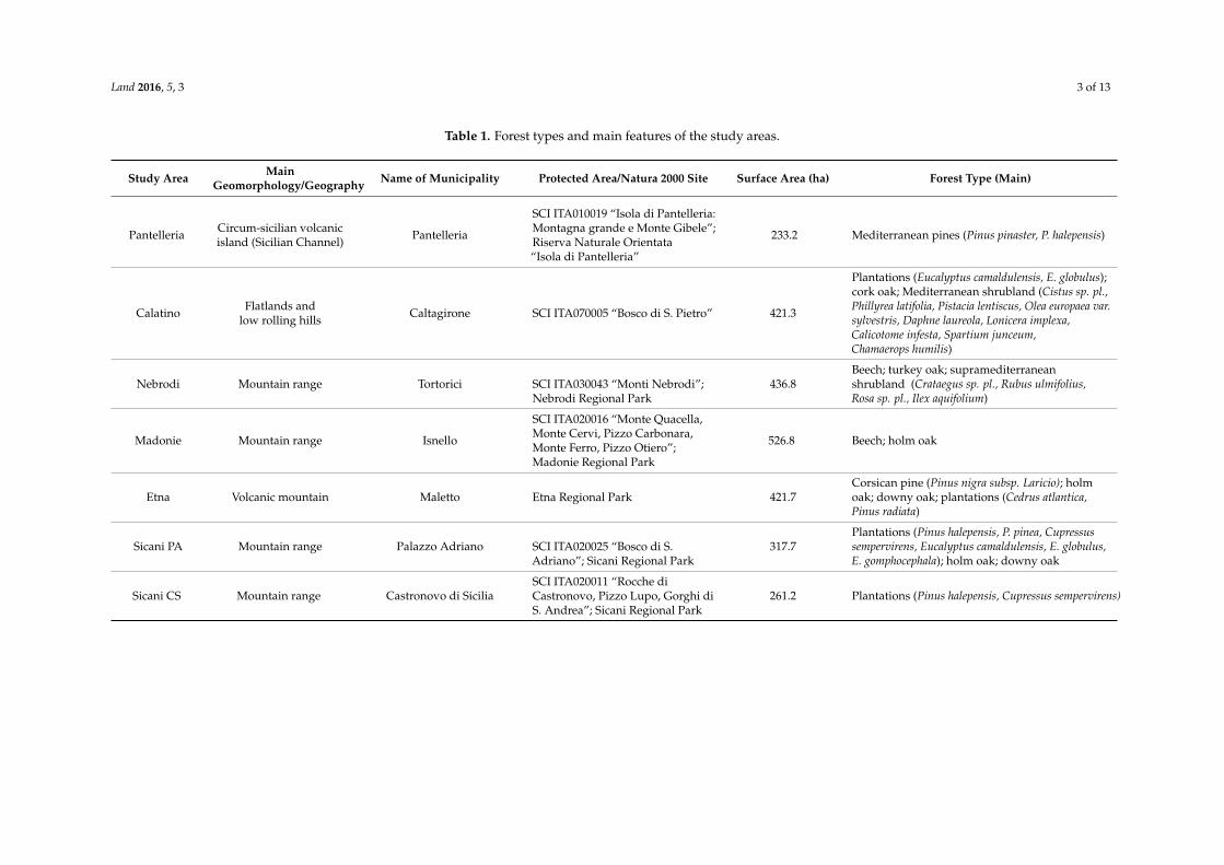
The study analysis was carried out in six forest territories (the Sicani, Madonie, Nebrodi mountainsand Mount Etna, the Calatino area and Pantelleria Island) (Figure 1) that are considered to berepresentative of the main ecological and sociocultural variations of the entire island, includingSicily’s most representative forest and woodland forest types (approximately 60% of the whole forestcover) [18]. The sample areas were chosen using the following criteria: (1) encompassed in a protectedarea; (2) articulate sample of regional forest types; and (3) include the presence of selected silviculturalpractices. On this basis, one or two sample areas for each territory (Table 1) were chosen in holm oak,cork oak, downy oak, turkey oak, corsican pine, beech and Mediterranean pine forests, as well asMediterranean shrubland and plantations.
Figure 1. Geophysical map of Sicily with detail of the study areas.
Land 2016, 5, 3 3 of 13
Table 1. Forest types and main features of the study areas.
Study Area MainGeomorphology/Geography Name of Municipality Protected Area/Natura 2000 Site Surface Area (ha) Forest Type (Main)
Pantelleria Circum-sicilian volcanicisland (Sicilian Channel) Pantelleria
SCI ITA010019 “Isola di Pantelleria:Montagna grande e Monte Gibele”;Riserva Naturale Orientata“Isola di Pantelleria”
233.2 Mediterranean pines (Pinus pinaster, P. halepensis)
Calatino Flatlands andlow rolling hills Caltagirone SCI ITA070005 “Bosco di S. Pietro” 421.3
Plantations (Eucalyptus camaldulensis, E. globulus);cork oak; Mediterranean shrubland (Cistus sp. pl.,Phillyrea latifolia, Pistacia lentiscus, Olea europaea var.sylvestris, Daphne laureola, Lonicera implexa,Calicotome infesta, Spartium junceum,Chamaerops humilis)
Nebrodi Mountain range Tortorici SCI ITA030043 “Monti Nebrodi”;Nebrodi Regional Park
436.8Beech; turkey oak; supramediterraneanshrubland (Crataegus sp. pl., Rubus ulmifolius,Rosa sp. pl., Ilex aquifolium)
Madonie Mountain range Isnello
SCI ITA020016 “Monte Quacella,Monte Cervi, Pizzo Carbonara,Monte Ferro, Pizzo Otiero”;Madonie Regional Park
526.8 Beech; holm oak
Etna Volcanic mountain Maletto Etna Regional Park 421.7Corsican pine (Pinus nigra subsp. Laricio); holmoak; downy oak; plantations (Cedrus atlantica,Pinus radiata)
Sicani PA Mountain range Palazzo Adriano SCI ITA020025 “Bosco di S.Adriano”; Sicani Regional Park
317.7Plantations (Pinus halepensis, P. pinea, Cupressussempervirens, Eucalyptus camaldulensis, E. globulus,E. gomphocephala); holm oak; downy oak
Sicani CS Mountain range Castronovo di SiciliaSCI ITA020011 “Rocche diCastronovo, Pizzo Lupo, Gorghi diS. Andrea”; Sicani Regional Park
261.2 Plantations (Pinus halepensis, Cupressus sempervirens)

Land 2016, 5, 3 4 of 13
The study areas (Pantelleria; Calatino; Nebrodi; Madonie; Etna; Sicani PA, abbreviation of PalazzoAdriano; Sicani CS, abbreviation of Castronovo di Sicilia) fall within seven municipalities: six villages(Pantelleria, Tortorici, Isnello, Maletto, Palazzo Adriano and Castronovo di Sicilia) and one town(Caltagirone) (Table 1).
2.2. Data Processing and Analysis
In order to examine the anthropogenic influences on our forest landscapes, the two mainanthropogenic activities of the last few decades—demographic trends and forest harvesting—wereanalyzed. Afterwards, given that landscape change studies can be only carried out on a long-termbasis [19,20], especially in the central Mediterranean basin [14], the diachronic analysis was performedin a Geographic Information System (GIS) by interpreting aerial photos collected over a 57-yearperiod (1955–2012), specifically from: 1955, 1968, 1988 and 2012. The 1955 and 1968 surveys werecarried out by the Italian Military Geographic Institute (IGMI) using black and white film; the 1988survey was carried out by the Sicily Regional Territory Service with orthoimages; and the 2012 imageswere obtained from free satellite remote sensing imagery (Bing Maps, Microsoft Corp.). To integratethese different sources, all the aerial images were digitalized and georeferenced in the UTM WGS84system. The image interpretation and the following processing were conducted in a GIS environmentas follows:
‚ clipping of the study areas and allocation of land use using the Sicily Regional Forest Map [21];‚ labeling the non-woodlands not included in the Sicily Regional Forest Map, following the CORINE
Land Cover III lev. legend;‚ classifying historical land use (LU) using aerial photo interpretation of the 1955, 1968 and 1988
images and updating it to the 2012 layer;‚ quantifying land cover (LC) for 1955, 1968, 1988 and 2012;‚ map overlaying for the diachronic analysis of LULC changes for the whole period (1955–2012)
and the sub-periods (1955 to 1968, 1968 to 1988, 1988 to 2012).
To classify land use, the Regional Forest Inventory 2010 legend [22] was adopted for 1988 and2012 with the exception of the category “plantation,” which was reclassified into two more categories(“exotic deciduous plantations” and “coniferous plantations”) to permit comparison with anteriordates and to enlighten the importance of reforestation activities. Because of the low graphic resolutionof the 1955 and 1968 images (flights IGMI GAI, panchromatic b/w, average flight height 5000 m,average image scale 1:33,000), only the CORINE Land Cover III lev. legend was suitable for use as apossible thematic relation with the Regional Forest Inventory 2010 legend, adapting even in this casethe category “plantation” and implementing two categories (“deciduous plantations” and “ConiferousPlantations”) (Table 2). The capacity to distinguish between plantations and forests is very significantbecause the plantations represent 36% of Sicilian forests [22] and their renaturalization is key forrestoring Mediterranean forests.
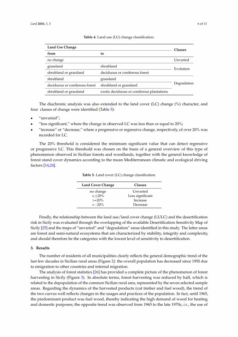
To quantify the land cover (LC) (%), a special tool called the “Neighbor analysis plot” wasused [23]. This tool was constructed from a 50 ˆ 50-meter square frame with a 10-meter regular gridof superimposed points; by placing this mask on the images, the percentage of coverage was easilycalculated by counting the number of points that fell on a tree or shrub canopy, and their absolutepercentages were calculated by checking the value in a dedicated table (Table 3).
Land 2016, 5, 3 5 of 13
Table 2. Thematic relation between the Regional Forest Inventory 2010 legend and Corine Land CoverIII-level legend.
Regional Forest Inventory 2010, legend [22] Corine LC, III-level legend
Beech forest
Deciduous forests (311)
Chestnut forestTurkey oak forestDowny oak forest
Cork oak forestHolm oak forest
Orno-ostrietum forestRiparian vegetation
Other deciduous forestsPioneer vegetation
Corsican pine forestConiferous forests (312)Mediterranean pine forest
Supramediterranean shrublandShrubland (323)Mediterranean shrubland
Plantationsexotic deciduous plantations Deciduous plantations
coniferous plantations Coniferous plantations
Natural grasslands and pastures Natural grasslands and pastures (321)
Table 3. Neighbor analysis plot design for the estimation of land cover (LC) (%) and relatedconversion table.
LC (%) Number Points
<5% 15%–10% 2–3
11%–20% 4–721%–50% 8–1851%–80% 19–2881%–100% 29–36
Landscape changes were analyzed and quantified through the diachronic analysis of the LULCchanges: each study area was compared to the LULC maps by identifying the changes in the studyareas over time by considering the whole period (1955–2012) and sub-periods (1955 to 1968, 1968 to1988, 1988 to 2012).
With regard to the LU, thee ad hoc classes were identified to reclassify the changes: “unvaried,”“evolution,” and “degradation” (Table 4). The first one (“unvaried”) was assigned to the areas whereno change had occurred in the considered time span; “evolution” was assigned to the areas wheresuccessional dynamics resulted in a more complex structure or composition of the forest type; and theclass “degradation” encompassed regressive dynamic cases with a clear simplification of structure andcomposition of the forest and shrubland landscapes. This classification did not include the plantationsin which the former LU could not be positively identified.
Land 2016, 5, 3 6 of 13
Table 4. Land use (LU) change classification.
Land Use ChangeClasses
from to
no change Unvaried
grassland shrublandEvolution
shrubland or grassland deciduous or coniferous forest
shrubland grasslandDegradationdeciduous or coniferous forest shrubland or grassland
shrubland or grassland exotic deciduous or coniferous plantations
The diachronic analysis was also extended to the land cover (LC) change (%) character, andfour classes of change were identified (Table 5):
‚ “unvaried”;‚ “less significant,” where the change in observed LC was less than or equal to 20%;‚ “increase” or “decrease,” where a progressive or regressive change, respectively, of over 20% was
recorded for LC.
The 20% threshold is considered the minimum significant value that can detect regressiveor progressive LC. This threshold was chosen on the basis of a general overview of this type ofphenomenon observed in Sicilian forests and woodlands, together with the general knowledge offorest stand cover dynamics according to the mean Mediterranean climatic and ecological drivingfactors [14,24].
Table 5. Land cover (LC) change classification.
Land Cover Change Classes
no change Unvariedď˘20% Less significant>+20% Increase>´20% Decrease
Finally, the relationship between the land use/land cover change (LULC) and the desertificationrisk in Sicily was evaluated through the overlapping of the available Desertification Sensitivity Map ofSicily [25] and the maps of “unvaried” and “degradation” areas identified in this study. The latter areasare forest and semi-natural ecosystems that are characterized by stability, integrity and complexity,and should therefore be the categories with the lowest level of sensitivity to desertification.
3. Results
The number of residents of all municipalities clearly reflects the general demographic trend of thelast few decades in Sicilian rural areas (Figure 2): the overall population has decreased since 1950 dueto emigration to other countries and internal migration.
The analysis of forest statistics [26] has provided a complete picture of the phenomenon of forestharvesting in Sicily (Figure 3). In absolute terms, forest harvesting was reduced by half, which isrelated to the depopulation of the common Sicilian rural area, represented by the seven selected sampleareas. Regarding the dynamics of the harvested products (cut timber and fuel wood), the trend ofthe two curves well reflects changes in the usages and practices of the population. In fact, until 1965,the predominant product was fuel wood, thereby indicating the high demand of wood for heatingand domestic purposes; the opposite trend was observed from 1965 to the late 1970s, i.e., the use of

Land 2016, 5, 3 7 of 13
fuel wood reached a minimum because it was replaced by gas and electricity. Since 1980, an increasein the production of fuel wood has been observed, due to the growing demand for wood fuels andinnovative alternatives to traditional products (e.g., biomass, pellets).
The combined use of historical aerial images and current remote sensing images in a specific GISenvironment was used to trace the land use and land cover changes from 1955 until the present, byexamining seven significant forest and shrubland landscapes in Sicily. With reference to land use,the most important variations were observed in the Mount Etna, Calatino and Sicani areas, while inthe remaining study areas, less significant changes were recorded (Figure 4). Specifically, the landuse changes observed in the Etna area is driven by the successional dynamics of natural vegetation,whereas they are related to plantation activities in the Sicani and Calatino areas. This result clarifiesthe ongoing natural processes on Mount Etna, one on the most important natural sites in Sicily and therecipient of widespread human intervention for increasing the forest cover of the island. For the sakeof synthesis, in this work, the most representative results for only the Etna and Sicani-CS study areasare presented (Figure 5; Supplement 1, Tables S1–S9). Across the study areas, land cover increaseswere observed in all forest types. Remarkable increases in land cover were observed in the PantelleriaIsland pine forest on Mount Etna and in the Sicani and Madonie forests, with density increases greaterthan 50%. The only reduction in land cover, was a loss of 25% recorded in the Calatino area (Figure 6;Supplement 1, Table S9).
Figure 2. Number of residents of the municipalities over which the study areas extend (Source:processing of data from ISTAT) [26]. Data for the six villages are plotted on the primary y-axis; data forthe town (Caltagirone) are plotted on the secondary y-axis.

Land 2016, 5, 3 8 of 13
Figure 3. Dynamics of forest harvesting and products in Sicily (Source: processing of data fromISTAT) [26].
Figure 4. Dynamics of land use (LU) change (%) in the seven study areas for the period 1955–2012.

Land 2016, 5, 3 9 of 13
Figure 5. Land use classifications for 1955 and 2012 of the most significant areas: Etna and Sicani-CS.

Land 2016, 5, 3 10 of 13
Figure 6. Dynamics of the land cover (LC) change classes (%) in the study areas from 1955 to 2012.
Specifically, on Mount Etna, the surface of grasslands and shrublands decreased, whilebroadleaved woodlands, holm oak, beech and deciduous oak forests increased, as did mountainconifer plantations. The area of Corsican pine (Pinus nigra spp. laricio) did not vary during theconsidered time span (Figure 4). With regard to the LC, there was a general increase for both plantationactivities and shrubland expansion. It is remarkable that in 1955, the latter had less than 10% coverageand was therefore not classified as “other wooded land” (OWL) under the FRA 2010 standard [27].
In 1955, the Calatino landscape was mainly characterized by Mediterranean shrublands(65% coverage) and cork oak (Quercus suber) forest. Currently, the landscape pattern is clearlydiversified given the widespread plantations and, to a lesser extent, the increase in the cork woodlandarea. Eucalyptus plantations were established on grassland (3.5%) and mainly on Mediterraneanshrubland (34%). In this study area, the LC remained largely the same or increased slightly in someparts. In many nearby areas, however, a reduction in LC occurred due to wildfires (see the values inFigure 6). Regardless, this area is strongly characterized by heavy human influence as the introductionof uncontrolled grazing cattle, human-caused wildfires due to social tensions, and illegal removal ofcork from the cork oaks.
On the Nebrodi mountains, from 1968 until now, the shrubland, turkey oak (Quercus cerris) andbeech (Fagus sylvatica) woodland areas increased, occupying former grassland, and the LC increasedacross the entire study area (by an average of 38%).
The landscape of the Sicani-PA mountains original study area (Palazzo Adriano) was mainlycharacterized by holm oak (Quercus ilex) and deciduous oak (Quercus pubescens) woodlands (46% ofthe whole surface) and conifer plantations (i.e., Pinus halepensis, Pinus pinea) (37%). Here, over the1955–1968 time span, a deciduous oak woodland expansion on grazing land was observed, due tothe general abandonment of Sicily’s marginal areas by its inhabitant. However, over the 1968 to 2012time span, widespread (65% increase in surface area) plantation activity deeply changed the layoutof the local landscape. Furthermore, in the other Sicani-CS study area (Castronovo di Sicilia), similarwidespread reforestation activities from 1955 to 1986 were conducted in former grazing, grasslandand shrubland areas (85% increase in terms of surface), mainly through the planting of Mediterranean

Land 2016, 5, 3 11 of 13
conifers (Pinus halepensis, Pinus pinea, Cupressus sempervirens). This caused a consequent LC increase(Figure 6) in the area.
With regard to the “unvaried” areas and the woodlands where no variation of LULC wasobserved, and the few “degradation” areas where the LULC is degraded, their intersection with theDesertification Risk Sensitivity Map of Sicily showed that these woodlands are generally categorizedas having no or low sensitivity to desertification, i.e., they fall within the first risk classes (unaffected,potential, fragile 1), which confirms the efficiency and resilience of forest and semi-natural ecosystems(Figure 7).
Figure 7. Distribution of “unvaried” and “degradation” areas for classes of desertification risk. Datanot available for Pantelleria because the Desertification Risk Sensitivity Map of Sicily does not includethe smaller islands.
4. Discussion
The study results mainly highlight two different trends observed in the studied areas: first,the strengthening and expansion of forests in many of the study areas (Etna, Sicani, Madonie andPantelleria), and second, a clear reduction or degradation in the woodland area (example given,Calatino). With regard to the first change type, increasing cover and complexity processes wereobserved in the forest and shrubland stands situated in the Mount Etna, Sicani and Madonie areas,as well as on Pantelleria Island, where significant increases in the structural complexity, compositionand canopy coverage have been proved. Such events can be interpreted as a result of historicalsocioeconomic problems of the Italian south and inner mountain territories. After World War II,widespread emigration, the use of new energy sources (gas, electricity) and the consequent reduction incutting activities in the forest areas fostered the natural evolutionary dynamics of forest and shrubland,thus causing a decline in pasture and grassland. These latter open habitats are extremely importantfor the preservation of rare plants and the feeding habitats of many birds, and the maintenance ofbiodiversity and landscape diversity. Moreover, the growing awareness of the importance of forests asecological assets of a territory and the establishment of protected areas that generally encompass themost important forest territories of the island entailed a further reduction in wood logging. In addition,about one fourth of the forest area of the region is owned by the regional authority and managed inorder to foster renaturalization of conifer stands and natural forest complexity. Furthermore, in the

Land 2016, 5, 3 12 of 13
Sicani areas, widespread reforestation, which was conducted on abandoned pastureland, increasedthe local wood asset. In the Mount Etna area, a large part of the forest area has been designateda regional natural park, resulting in a substantial increase of forest density due to the reduction orsuspension of logging activities and the increase of shrublands and woodlands due to the abandonmentof agricultural activities over large areas.
In the Calatino territory, however, intense human activities, such as the expansion of pasture andagriculture, as well as the abandonment of cork production and logging, caused a general reductionin the extent of the cork oak woodlands. Furthermore, the dry and hot climate combined with socialtension resulted in an increase in wildfire events with a consequent loss of complexity and diversity, inaddition to the decrease in the forest surface area.
In conclusion, this work highlights the consolidated trend of successional processes across almostall of the Sicilian forest case studies considered. The majority of the forest and other woodlands in thestudy areas are increasing in structural complexity as a result of complex socioeconomic and ecologicalfactors that foster these evolutionary trends.
Acknowledgments: This study was supported by grants of the Project LIFE11+ ENV IT 000215Resilformed—Climate change resilience of Mediterranean forests (http://www.resilformed.eu). All authorscontributed to analyzing and discussing the results and wrote the manuscript.
Author Contributions: All authors contributed to analyze the results and to write the paper.
Conflicts of Interest: The authors declare no conflict of interest.
References
1. Barbera, G.; Cullotta, S.; Rossi-Doria, I.; Ruhl, J.; Rossi-Doria, B. I paesaggi a Terrazze in Sicilia. Metodologia perl'analisi, la Tutela e la Valorizzazione; Collana Studi e Ricerche dell’ARPA Sicilia: Palermo, Italy, 2010; p. 214.
2. Grove, A.T.; Rackham, O. The Nature of Mediterranean Europe: An Ecological History; Yale University Press:New Haven, CT, USA, 2001; p. 384. Available online: http://doi.org/10.1002/ldr.475 (accessed on 10March 2015).
3. Feddema, J.J.; Oleson, K.W.; Bonan, G.B.; Mearns, L.O.; Buja, L.E.; Meehl, G.A.; Washington, W.M.The importance of land-cover change in simulating future climates. Science 2005, 310, 1674–1678. [CrossRef][PubMed]
4. Foley, J.A.; DeFries, R.; Asner, G.P.; Barford, C.; Bonan, G.; Carpenter, S.R.; Chapin, F.S.; Coe, M.T.; Daily, G.C.;Gibbs, H.K.; et al. Global consequences of land use. Science 2005, 309, 570–574. [CrossRef] [PubMed]
5. Kueppers, L.M.; Snyder, M.A. Influence of irrigated agriculture on diurnal surface energy and water fluxes,surface climate, and atmospheric circulation in California. Clim. Dyn. 2012, 38, 1017–1029. [CrossRef]
6. IPCC. Mitigation of Climate Change: Contribution of Working Group III to the Fourth Assessment Report of theInter-governmental Panel on Climate Change; Metz, B., Davidson, O.R., Bosch, P.R., Dave, R., Meyer, L.A., Eds.;Cambridge University Press: Cambridge, UK, New York, NY, USA, 2007; p. 863.
7. Wang, M.; Yan, X.; Liu, J.; Zhang, X. The contribution of urbanization to recent extreme heat events and apotential mitigation strategy in the Beijing-Tianjin-Hebei metropolitan area. Theor. Appl. Climatol. 2013, 114,407–416. [CrossRef]
8. Woldemichael, A.T.; Hossain, F.; Pielke, R.; Beltrán-Przekurat, A. Understanding the impact of dam-triggeredland use/land cover change on the modification of extreme precipitation. Water Resour. Res. 2012, 48, 1–16.[CrossRef]
9. Avetisyan, M.; Baldos, U.; Hertel, T. Development of the GTAP version 7 land use data base. GTAP Res. Memo.2011, 19, 1–17.
10. Hertel, T.W.; Rose, S.K.; Tol, R.S.J. Economic Analysis of Land Use in Global Climate Change Policy; RoutledgeExplorations in Environmental Economics, Taylor & Francis Group: New York, NY, USA, 2009; p. 343.Available online: http://www.routledge.com/books/details/9780415773089/ (accessed on 06 April 2015).
11. Barbera, G.; Cullotta, S. The Halaesa landscape (III B.C.) as ancient example of the complex and bio-diversetraditional Mediterranean polycultural landscape. Landsc. Hist. 2014, 35, 53–66. [CrossRef]
12. Braudel, F. Civiltà e imperi del Mediterraneo nell’età di Filippo II; Einaudi: Torino, Italy, 1986; Volume 1.

Land 2016, 5, 3 13 of 13
13. Barbera, G.; Cullotta, S. An inventory approach to the assessment of main traditional landscapes in Sicily(Central Mediterranean Basin). Landsc. Res. 2012, 37, 539–569. [CrossRef]
14. Mazzoleni, S.; di Pasquale, G.; Mulligan, M.; di Martino, P.; Rego, F. Recent Dinamics of the MediterraneanVegetation and Landscape; John Wiley & Sons Ltd.: West Sussex, UK, 2004; p. 320.
15. Ruhl, J.; Chiavetta, U.; La Mantia, T.; La Mela Veca, D.S.; Pasta, S. Land cover change in the Nature Reserve“Sughereta di Niscemi” (SE Sicily) in the 20th century. In Remote Sensing & GIS for Environmental Studies;Erasmi, S., Cyffka, B., Kappas, M., Eds.; Gottinger Geographische Abhandlungen: Gottingen, Germany, 2005;Volume 113, pp. 54–62.
16. Kirtman, B., Power, S.B., Adedoyin, J.A., Boer, G.J., Bojariu, R., Camilloni, I., Doblas-Reyes, F.J., Fiore, A.M.,Kimoto, M., Meehl, G.A., et al, Eds.; Near-term climate change: Projections and predictability. In ClimateChange 2013: The Physical Science Basis; Contribution of Working Group I to the Fifth Assessment Report of theIntergovernmental Panel on Climate Change; Cambridge University Press: Cambridge, UK; New York, NY,USA, 2013; pp. 953–1028. Available online: http://doi.org/10.1017/CBO9781107415324.023 (accessed on 16September 2014).
17. Costantini, E.A.C.; Urbano, F.; Bonati, G.; Nino, P.; Fais, A. Atlante Nazionale Delle aree a Rischio diDesertificazione; INEA: Roma, Italy, 2007; p. 108.
18. Camerano, P.; Cullotta, S.; Varese, P. Strumenti Conoscitivi per la Gestione delle Risorse Forestali Della Sicilia.Tipi Forestali; Regione Siciliana: Palermo, Italy, 2011; p. 192.
19. Foster, D.R.; Motzkin, G.; Slater, B. Land-use history as long-term disturbance: Regional forest dynamics inCentral New England. Ecosystems 1998, 1, 96–119. [CrossRef]
20. Vos, W.; Stortelde, A.H.F. Vanishing Tuscan Landscapes: Landscape Ecology of A Sub-Mediterranean-Montane Area(Solano Basin, Tuscany, Italy), 2nd ed.; Pudoc Scientific Publishers: Wageningen, The Netherlands, 1992.
21. Regione Siciliana. Carta Delle Categorie Forestali Della Regione Sicilia; Assessorato Territorio eAmbiente, Comando del Corpo Forestale Della Regione Sicilia: Palermo, Italy, 2011; Available online:http://sif.regione.sicilia.it (accessed on 23 September 2013).
22. Hofmann, A.; Cibella, R.; Bertani, R.; Miozzo, M.; Fantoni, I.; Luppi, S. Strumenti Conoscitivi per la GestioneDelle Risorse Forestali Della Sicilia. Sistema Informativo Forestale Regionale; Assessorato Territorio e Ambiente,Regione Siciliana: Palermo, Italy, 2011; p. 208.
23. AA VV. Sistema Informativo Forestale Della Regione Siciliana; Istruzioni per il Rilievo Degli Attributi di SecondaFase: Palermo, Italy, 2008; p. 261.
24. Quézel, P.; Médail, F. Ecologie et Biogéographie des Forêts du Bassin Méditerranéen; Elsevier, CollectionEnvironnement: Paris, France, 2003; p. 573.
25. Regione Siciliana. Carta Della Sensibilità Alla Desertificazione Della Regione Sicilia; Assessorato Territorio eAmbiente: Palermo, Italy, 2011; Available online: http://www.artasicilia.eu/old_site/web/desertificazione(accessed on 23 September 2013).
26. ISTAT. Istituto Nazionale di Statistica, Roma. Available online: http://istat.it (accessed on 09 March 2015).27. FAO. Global Forest Resources Assessment. Terms and Definitions; Forest Resources Assessment Programme,
Working Paper 144/E; FAO: Rome, Italy, 2010; p. 27.
© 2016 by the authors; licensee MDPI, Basel, Switzerland. This article is an open accessarticle distributed under the terms and conditions of the Creative Commons by Attribution(CC-BY) license (http://creativecommons.org/licenses/by/4.0/).


