Embed Size (px)
Citation preview

Domestic campsites and cyberlandscapes in the Rocky MountainsLaura L. Scheiber1 & Judson Byrd Finley2
The dwellings of prehistoric Native NorthAmericans are amongst the hardest archae-ological structures to find and characterise –they leave only a shallow ring of stones. But theauthors show that, when recorded to modernlevels of precision, these tipi-stances containa wealth of information. The stone rings aremapped in detail by hand, and located byGPS, their hearths are located by fluxgatesurvey and sampled for radiocarbon dating,and the results displayed in layered maps onGIS. Different social groups had different floorplans, so that, even where artefacts are missing,the movement of peoples can be dated andmapped. The results also bring to the fore thegreat cultural value of these, the dominant
monument types of Bighorn Canyon National Recreational Area.
Keywords: North American Plains, Central Rocky Mountains, GIS, GPS, stone circles,architecture, multi-scalar, households, technology, landscape, hunter-gatherers, contractarchaeology, Section 106 compliance
Stone circles on the Northwestern Plains
‘You have perhaps noticed on the northwestern plains, circles of stones or small boulders,varying in size from twelve to twenty and more feet in diameter. They were used toweight down the lower edges of lodge skins, to prevent the structure being blown overby a hard wind, and when camp was moved they were simply rolled off the leather’(Schultz 1907: 63).
Stone circles, or tipi rings, are recognised as one of the only forms of preserved nativedomestic architecture on the North American Plains. Prior to the historic use of wooden
1 Department of Anthropology, Student Building 130, Indiana University, Bloomington, IN 47405, USA (email:[email protected])
2 Department of Earth Sciences, University of Memphis, Memphis, TN 38152, USA (email:[email protected])
Received: 17 October 2008; Revised: 20 April 2009; Accepted: 7 June 2009
ANTIQUITY 84 (2010): 114–130 http://antiquity.ac.uk/ant/84/ant840114.htm
114
Res
earc
h
Laura L. Scheiber & Judson Byrd Finley
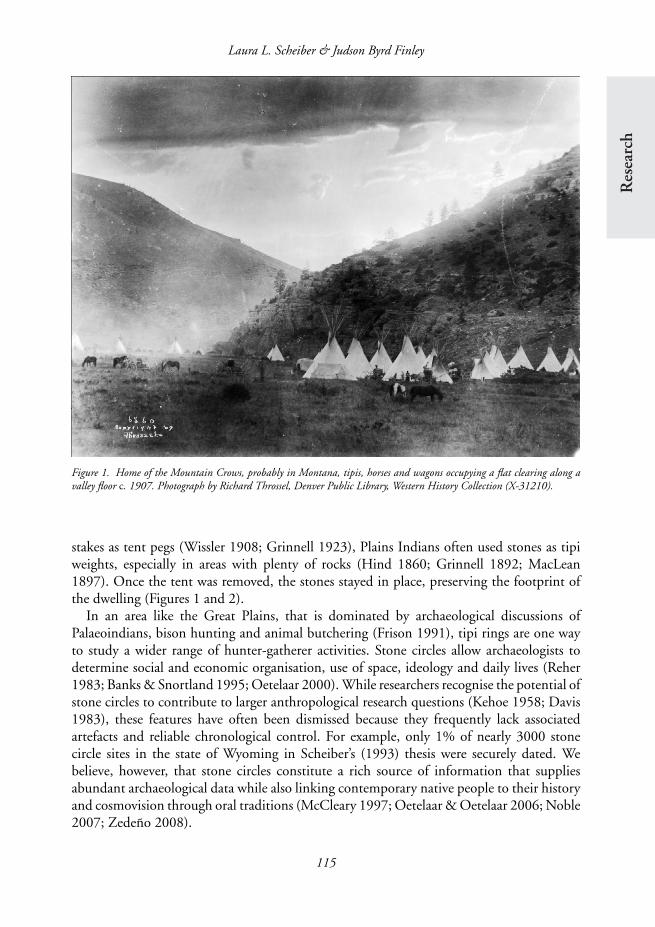
Figure 1. Home of the Mountain Crows, probably in Montana, tipis, horses and wagons occupying a flat clearing along avalley floor c. 1907. Photograph by Richard Throssel, Denver Public Library, Western History Collection (X-31210).
stakes as tent pegs (Wissler 1908; Grinnell 1923), Plains Indians often used stones as tipiweights, especially in areas with plenty of rocks (Hind 1860; Grinnell 1892; MacLean1897). Once the tent was removed, the stones stayed in place, preserving the footprint ofthe dwelling (Figures 1 and 2).
In an area like the Great Plains, that is dominated by archaeological discussions ofPalaeoindians, bison hunting and animal butchering (Frison 1991), tipi rings are one wayto study a wider range of hunter-gatherer activities. Stone circles allow archaeologists todetermine social and economic organisation, use of space, ideology and daily lives (Reher1983; Banks & Snortland 1995; Oetelaar 2000). While researchers recognise the potential ofstone circles to contribute to larger anthropological research questions (Kehoe 1958; Davis1983), these features have often been dismissed because they frequently lack associatedartefacts and reliable chronological control. For example, only 1% of nearly 3000 stonecircle sites in the state of Wyoming in Scheiber’s (1993) thesis were securely dated. Webelieve, however, that stone circles constitute a rich source of information that suppliesabundant archaeological data while also linking contemporary native people to their historyand cosmovision through oral traditions (McCleary 1997; Oetelaar & Oetelaar 2006; Noble2007; Zedeno 2008).
115
Domestic campsites and cyber landscapes in the Rocky Mountains
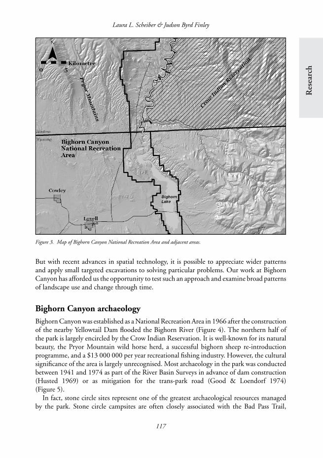
In this paper, we present a case study from the high-altitude desert at the western edgeof the North American Plains (Figure 3). Nomadic hunter-gatherers occupied this region
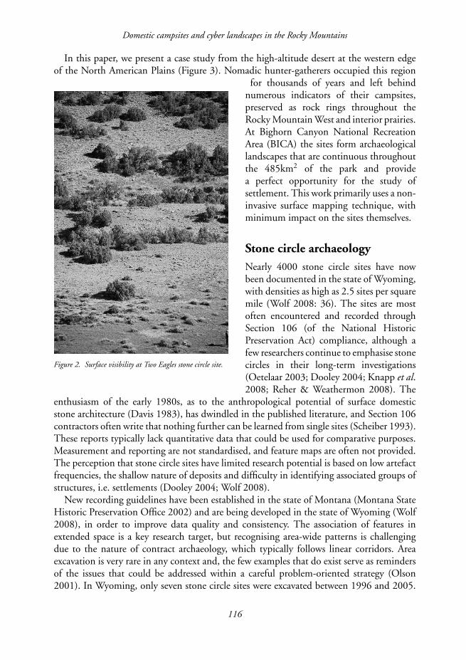
Figure 2. Surface visibility at Two Eagles stone circle site.
for thousands of years and left behindnumerous indicators of their campsites,preserved as rock rings throughout theRocky Mountain West and interior prairies.At Bighorn Canyon National RecreationArea (BICA) the sites form archaeologicallandscapes that are continuous throughoutthe 485km2 of the park and providea perfect opportunity for the study ofsettlement. This work primarily uses a non-invasive surface mapping technique, withminimum impact on the sites themselves.
Stone circle archaeologyNearly 4000 stone circle sites have nowbeen documented in the state of Wyoming,with densities as high as 2.5 sites per squaremile (Wolf 2008: 36). The sites are mostoften encountered and recorded throughSection 106 (of the National HistoricPreservation Act) compliance, although afew researchers continue to emphasise stonecircles in their long-term investigations(Oetelaar 2003; Dooley 2004; Knapp et al.2008; Reher & Weathermon 2008). The
enthusiasm of the early 1980s, as to the anthropological potential of surface domesticstone architecture (Davis 1983), has dwindled in the published literature, and Section 106contractors often write that nothing further can be learned from single sites (Scheiber 1993).These reports typically lack quantitative data that could be used for comparative purposes.Measurement and reporting are not standardised, and feature maps are often not provided.The perception that stone circle sites have limited research potential is based on low artefactfrequencies, the shallow nature of deposits and difficulty in identifying associated groups ofstructures, i.e. settlements (Dooley 2004; Wolf 2008).
New recording guidelines have been established in the state of Montana (Montana StateHistoric Preservation Office 2002) and are being developed in the state of Wyoming (Wolf2008), in order to improve data quality and consistency. The association of features inextended space is a key research target, but recognising area-wide patterns is challengingdue to the nature of contract archaeology, which typically follows linear corridors. Areaexcavation is very rare in any context and, the few examples that do exist serve as remindersof the issues that could be addressed within a careful problem-oriented strategy (Olson2001). In Wyoming, only seven stone circle sites were excavated between 1996 and 2005.
116
Res
earc
h
Laura L. Scheiber & Judson Byrd Finley
Figure 3. Map of Bighorn Canyon National Recreation Area and adjacent areas.
But with recent advances in spatial technology, it is possible to appreciate wider patternsand apply small targeted excavations to solving particular problems. Our work at BighornCanyon has afforded us the opportunity to test such an approach and examine broad patternsof landscape use and change through time.
Bighorn Canyon archaeologyBighorn Canyon was established as a National Recreation Area in 1966 after the constructionof the nearby Yellowtail Dam flooded the Bighorn River (Figure 4). The northern half ofthe park is largely encircled by the Crow Indian Reservation. It is well-known for its naturalbeauty, the Pryor Mountain wild horse herd, a successful bighorn sheep re-introductionprogramme, and a $13 000 000 per year recreational fishing industry. However, the culturalsignificance of the area is largely unrecognised. Most archaeology in the park was conductedbetween 1941 and 1974 as part of the River Basin Surveys in advance of dam construction(Husted 1969) or as mitigation for the trans-park road (Good & Loendorf 1974)(Figure 5).
In fact, stone circle sites represent one of the greatest archaeological resources managedby the park. Stone circle campsites are often closely associated with the Bad Pass Trail,
117

Domestic campsites and cyber landscapes in the Rocky Mountains
Figure 4. Overview of Bighorn Canyon.
Figure 5. Stone circle campsite located adjacent to the trans-park road.
118

Res
earc
h
Laura L. Scheiber & Judson Byrd Finley
an important prehistoric and historic travel corridor between the Bighorn Basin and HighPlains to the south and the unglaciated Missouri Plateau to the north (Loendorf & Brownell1980). Just over 19km (12 miles) of the Bad Pass Trail have been documented in the parkwith over 500 stone cairn markers (Wisehart 2005) (Figure 6).
Between 1968 and 1974, more than 120 stone circle sites were documented in the vicinityof Bighorn Canyon (Loendorf & Weston 1983), totalling more than 1800 individual
Figure 6. Cairns on the Bad Pass Trail.
rings. Loendorf and Weston (1983) exca-vated stone circles at two sites but obtainedno chronological data. They attributedsparse or absent artefact assemblages at sitesalong travel corridors to brief occupations.Because modern travel routes follow aborig-inal ones, we propose instead that the varia-tion is a product of a century of recreationalartefact collection and not aboriginalpractice. We have documented numerouscollectors’ piles, left by individuals whocollected all visible surface artefacts, culledthose that were desirable, and deposited therest in random piles. While earlier studiesillustrate the magnitude of the task faced byarchaeologists in documenting stone circleswithin the park, the results from the early1980s do not accurately reflect the kinds ofquestions that can be answered through anintegrated research agenda using multiplescales of analysis.
DesignWe designed a methodology for recording stone circles at Bighorn Canyon with the intentof addressing several research questions and management concerns. Using GIS, we createda cyber landscape consisting of stone circles, artefacts and other features. Although partof our methodology is a standard practice of field recording in some areas of the world(i.e. on-site use of computers and GPS devices) (McPherron et al. 2008), it is not standardor typical in much of North America, especially at shallow surface sites not dominatedby monumental architecture, and certainly not at this scale of precision (sub-centimetreaccuracy of individual stones).
Data collection is first aimed at addressing research questions regarding Plains Indiandomestic life, household organisation and landscape formation. The late prehistory andhistory (c . AD 1500-1900) of the Central Rocky Mountains and Northwestern Plains wasa socially dynamic era, with tribes such as the Crow and Shoshone migrating into the area
119
Domestic campsites and cyber landscapes in the Rocky Mountains
and claiming new territories as their traditional homelands (Nabokov & Loendorf 2004).We specifically question how migrant communities create a sense of place (Basso 1996)and how ethnic groups maintain their social identities during times of change, especiallyduring increased contact with Europeans and Americans and continuing into enforcedreservation settlement. These broad social issues should be manifested at the local anddomestic level, preserved materially by stone circle architecture and related archaeologicalsignatures. Bighorn Canyon is in the middle of the traditional Crow homeland as definedin the mid-nineteenth century.
Secondly, the project also addresses management concerns by collecting data that will bedirectly transferred to the current park GIS and by creating a database that includes spatialdatasets along with individual attribute data on features and artefacts. This work establishesprotocols for documenting stone circles throughout the park and region. Since stone circlesites are the primary archaeological resource at Bighorn Canyon, standardised data collectionprotocols are particularly relevant as the park prepares for large-scale data recovery projectsdesigned to mitigate the imminent impacts of development. Our work at Bighorn Canyonis also part of a joint Indiana University (Bloomington, IN) and Northwest College (Powell,WY) archaeological field school that provides student training.
MethodMapping
Since 2005, the authors have developed and implemented a multi-stage data collectionmethodology that allows us to conduct analysis at complementary levels. First, recordersdraw accurate plans of each stone circle (Figure 7). Making individual feature maps isquick and efficient with the ‘tipi-quick’ method: a painted protractor on a board set in themiddle of the ring, together with a tape give angle and distance for each individually-drawnstone. Although some archaeologists have eliminated hand-drawn plans from their recordingsystems, we believe it is both an essential skill for students to master and that it capturesinformation that cannot be duplicated with digital equipment or photography alone.
We then use Magellan (formerly Thales) ProMark 3 single-frequency Global PositioningSystem (GPS) receivers to locate the individual stones, features and artefacts (Scheiber et al.2008). We average 6mm accuracy vertically and horizontally (post-processed) with this datarecovery system. We thus bring the precision already established for excavation at bonebedsand rockshelters of the North American Plains and Europe to surface architecture andactivity areas. Locational data are uploaded on-site to ESRI ArcGIS software on a laptopcomputer.
One of the biggest advantages of GPS is the sub-centimetre precision of data points, withco-ordinates tied directly into the UTM system not just to local site grids. One of the biggestdisadvantages is that the data from base and rover receivers must be reconciled and merged,although the use of dual-frequency RTK systems eliminates the need to post-process. Inaddition, the fixed base station co-ordinate data must be corrected against continuouslyoperating reference stations (CORS), accessible via the Internet and only available with asatellite uplink in remote field camps.
120

Res
earc
h
Laura L. Scheiber & Judson Byrd Finley
Figure 7. Visual representations of a tipi ring (BICA 08-02-SC1): photograph (top left), plan view map (top right), andelectronic representations representing each rock (bottom left: unscaled circles; bottom middle: scaled circles based on graduatedsymbols of maximum length classified into four classes; bottom right: scaled rock shapes based on maximum length and rotatedby rock orientation).
Attribute data (context and feature)
Team members record descriptive information for each rock, feature and artefact usinghand-held Personal Data Assistants (PDAs) (Dell Axim X51v). PDA data recording is anefficient, high-speed process that reduces human transcription error and provides immediatecompatibility with software programs like Microsoft Access. The Windows Mobile version ofAccess (Data on the Run) allows researchers to create drop-down menus to record qualitativedata such as artefact type, which again reduces typing errors. PDA attribute collection coversa wide range of descriptive and quantitative data for each stone circle, including diameters,orientations and the presence or absence of doorway openings and associated features suchas cooking hearths (Table 1). The attribute and coordinate data for each object are latermerged into one database. In addition to traditional visual representations of stone circlesthrough photographs and hand-drawn maps, the electronic data can be manipulated tohighlight different attributes of the circle (Figure 7), depending on choice of scale andorientation.
121

Domestic campsites and cyber landscapes in the Rocky Mountains
Table 1. Major data categories recorded in each level of analysis.
Individual rock data (ROCK)Log number Feature numberSite number Maximum length (cm)UTM easting Maximum width (cm)UTM northing Long axis orientation (1-180◦)Elevation Material
Individual stone circle data (STONE CIRCLE)Log number Number of coursesSite number Opening (present/absent)UTM easting (centre of feature) Opening orientation (1-360◦)UTM northing (centre of feature) Opening width (cm)Elevation (centre of feature) Internal architecture (present/absent)∗
Feature number Internal architecture typeMaximum diameter (cm) External architecture (present/absent)∗
Minimum diameter (cm) External architecture typeLong axis orientation (1-180◦) Percentage of buried stonesShort axis orientation (1-180◦)
Individual artefact data (ARTEFACT)Log number Maximum length (cm) (tools)Site number Maximum width (cm) (tools)UTM easting Maximum thickness (tools)UTM northing Platform (present/absent)Elevation Platform type (plain, bevelled, faceted)Artefact class (chipped stone, fauna, etc.) Dorsal scars (number)Lithic type (projectile point, flake, tool) Historic artefact typeLithic material Animal taxaLithic size grade Animal element
∗This variable set is repeated as necessary to account for multiple types of internal/external architecturepresent.
Remote sensing
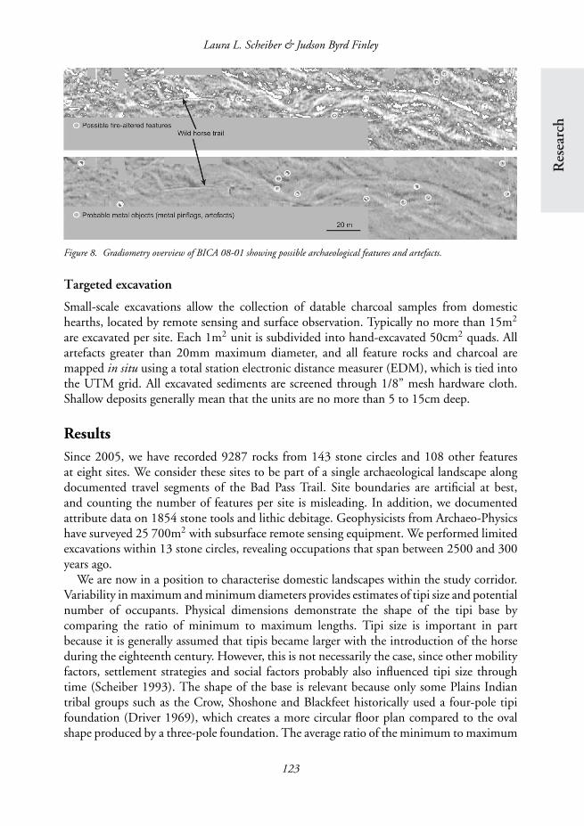
Geophysical survey provides an important window into subsurface deposits and has becomea low-cost alternative for identifying archaeological signatures without area excavations.Contracted geophysical specialists conduct gradiometry surveys using a fluxgate gradiometer.Data are collected in 0.5m transects, with eight samples collected per linear metre foran overall data sample density of 16 samples per square metre. This step is particularlyinformative for guiding excavation decisions as it measures the differential magneticproperties of cultural features (stone circles and fire hearths) buried within unmodifiedgeological matrices (Jones & Munson 2005). Subtle differences in properties of the alluvialsediments, bedrock and stones used for tipi rings make differentiating hearths and otherfeatures difficult, but overall this is a critical step in the program (Figure 8). We have alsoexperimented with ground penetrating radar and electric resistivity at more deeply buriedsites.
122
Res
earc
h
Laura L. Scheiber & Judson Byrd Finley
Figure 8. Gradiometry overview of BICA 08-01 showing possible archaeological features and artefacts.
Targeted excavation
Small-scale excavations allow the collection of datable charcoal samples from domestichearths, located by remote sensing and surface observation. Typically no more than 15m2
are excavated per site. Each 1m2 unit is subdivided into hand-excavated 50cm2 quads. Allartefacts greater than 20mm maximum diameter, and all feature rocks and charcoal aremapped in situ using a total station electronic distance measurer (EDM), which is tied intothe UTM grid. All excavated sediments are screened through 1/8” mesh hardware cloth.Shallow deposits generally mean that the units are no more than 5 to 15cm deep.
ResultsSince 2005, we have recorded 9287 rocks from 143 stone circles and 108 other featuresat eight sites. We consider these sites to be part of a single archaeological landscape alongdocumented travel segments of the Bad Pass Trail. Site boundaries are artificial at best,and counting the number of features per site is misleading. In addition, we documentedattribute data on 1854 stone tools and lithic debitage. Geophysicists from Archaeo-Physicshave surveyed 25 700m2 with subsurface remote sensing equipment. We performed limitedexcavations within 13 stone circles, revealing occupations that span between 2500 and 300years ago.
We are now in a position to characterise domestic landscapes within the study corridor.Variability in maximum and minimum diameters provides estimates of tipi size and potentialnumber of occupants. Physical dimensions demonstrate the shape of the tipi base bycomparing the ratio of minimum to maximum lengths. Tipi size is important in partbecause it is generally assumed that tipis became larger with the introduction of the horseduring the eighteenth century. However, this is not necessarily the case, since other mobilityfactors, settlement strategies and social factors probably also influenced tipi size throughtime (Scheiber 1993). The shape of the base is relevant because only some Plains Indiantribal groups such as the Crow, Shoshone and Blackfeet historically used a four-pole tipifoundation (Driver 1969), which creates a more circular floor plan compared to the ovalshape produced by a three-pole foundation. The average ratio of the minimum to maximum
123

Domestic campsites and cyber landscapes in the Rocky Mountains
diameters (shape) is 96%, which suggests a more circular than oval floor plan consistent withfour-pole foundations. This variable is one way to explore ethnic identity at Plains hunter-gatherer campsites. The four poles of the Crow tipi symbolically represent the boundaries oftheir traditional homeland, further cementing the everyday relationship between domesticlife and cosmology.
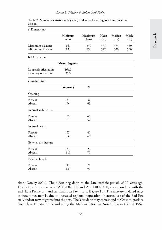
The Bighorn Canyon tipi rings show considerable variation, with maximum diametersranging from 160 to 854cm (Table 2). Minimum diameters range from 130 to 790cm.Smaller sizes may have served as the bases for structures that functioned as other thanprimary residences, such as sweat lodges, children’s tipis and dog tipis. Some of the larger ringsmay represent ceremonial and community structures. The mean maximum and minimumdiameters for the 143 analysed tipi rings are 577 and 522cm, respectively. Historic tipis,as recorded by early ethnographers during the nineteenth and early twentieth centuries,generally ranged from 14 to 16 feet (426 to 488cm) in diameter (Scheiber 1993). Futurestudies will examine temporal changes in stone circle size.
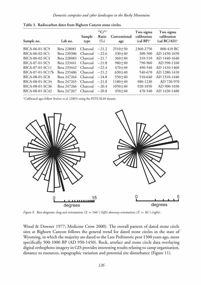
Data for the long axis and doorway orientations are explored through the use of rosediagrams, which display variance within radial data sets (Mardia 1972; McPherron &Dibble 2007) (Figure 9). The average long axis of all recorded stone circles is 166◦, asouth-south-east direction, most closely aligned with the midwinter sunrise. This patternmay be due to prevailing north-westerly winds, maximising sun warmth, camp orientation(facing inside a camp circle), topography (facing along a ridge or stream), ethnic affiliationand structure type. The orientations of the aggregated data set (n = 144) is only slightlysignificant (p = 0.04). As a point of comparison, Neolithic communal tombs often face themidsummer sunrise (Hoskin 2008) and Neolithic long houses are sometimes oriented tothe geographic area of that community’s origins (Bradley 2001). The recognisable doorwaysare commonly positioned perpendicular to the long axis, although only 37% of the ringshave definite openings. The average doorway is located at 36◦, a north-east direction.This orientation most closely represents the midsummer sunrise. The orientation of therecognisable doorways (n = 54) is highly significant (p<0.01).
Internal architecture is present in 43% (n = 62) of stone circles. Fire hearths are the mostcommon form of internal architecture with 57 of the 62 documented architectural elementsconsisting of hearths. Hearths are less common outside of stone circles, constituting only9% of the total external architecture. Stone alignments and cairns, thought to representmeat drying racks, are the most common type of external architecture.
Dating
Beta Analytic Laboratory dated charcoal from internal features at ten rings (Table 3). Everysite under investigation is represented by at least one date. Although our sample is small,through decisions based on the integrated application of detailed surface mapping andremote sensing, we have dated 77% (10 of 13) of the stone circles tested through limitedexcavations. This is an unprecedented record of tipi campsite use by native peoples onthe Plains, especially given the extremely low number (1%) of securely dated stone circlesites for the entire state of Wyoming. Multiple temporal assessments at single sites furtherdemonstrate that these areas were probably occupied sequentially as opposed to at the same
124
Res
earc
h
Laura L. Scheiber & Judson Byrd Finley
Table 2. Summary statistics of key analytical variables of Bighorn Canyon stonecircles.
a. Dimensions
Minimum Maximum Mean Median Mode(cm) (cm) (cm) (cm) (cm)
Maximum diameter 160 854 577 575 560Minimum diameter 130 790 522 530 550
b. Orientations
Mean (degrees)
Long axis orientation 166.2Doorway orientation 35.5
c. Architecture
Frequency %
Opening
Present 53 37Absent 90 63
Internal architecture
Present 62 43Absent 81 57
Internal hearth
Present 57 40Absent 86 60
External architecture
Present 33 23Absent 110 77
External hearth
Present 13 9Absent 130 91
time (Dooley 2004). The oldest ring dates to the Late Archaic period, 2500 years ago.Distinct patterns emerge at AD 700-1000 and AD 1300-1500, corresponding with theearly Late Prehistoric and terminal Late Prehistoric (Figure 10). The increase in dated ringsat these times may be due to increased regional population, increased use of the Bad Passtrail, and/or new migrants into the area. The later dates may correspond to Crow migrationsfrom their Hidatsa homeland along the Missouri River in North Dakota (Frison 1967;
125
Domestic campsites and cyber landscapes in the Rocky Mountains
Table 3. Radiocarbon dates from Bighorn Canyon stone circles.
13C/12 Two sigma Two sigmaSample Ratio Conventional calibration calibration
Sample no. Lab no. type (‰) age (cal BP)∗ (cal BC/AD)∗
BICA-06-01-SC9 Beta 228081 Charcoal −21.2 2510+−50 2360-2750 800-410 BCBICA-06-02-SC1 Beta 230306 Charcoal −22.6 330+−40 300-500 AD 1450-1650BICA-06-02-SC3 Beta 228083 Charcoal −21.7 360+−40 310-510 AD 1440-1640BICA-07-01-SC5 Beta 233441 Charcoal −21.8 980+−40 790-960 AD 990-1160BICA-07-01-SC11 Beta 233442 Charcoal −22.4 470+−40 490-540 AD 1410-1460BICA-07-01-SC17b Beta 235406 Charcoal −21.2 630+−40 540-670 AD 1280-1410BICA-08-01-SC8 Beta 247264 Charcoal −24.8 550+−40 510-640 AD 1310-1440BICA-08-01-SC34 Beta 247265 Charcoal −21.8 1180+−40 980-1230 AD 720-970BICA-08-01-SC36 Beta 247266 Charcoal −20.4 1050+−40 920-1050 AD 900-1030BICA-08-01-SC42 Beta 247267 Charcoal −20.8 450+−40 470-540 AD 1420-1480
∗Calibrated ages follow Stuiver et al. (2005) using the INTCAL04 dataset.
Figure 9. Rose diagrams: long axis orientations (X = 166◦) (left); doorway orientations (X = 36◦) (right).
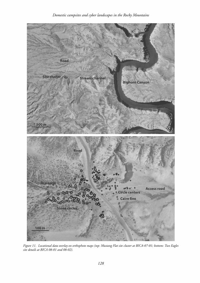
Wood & Downer 1977; Medicine Crow 2000). The overall pattern of dated stone circlesites at Bighorn Canyon follows the general trend for dated stone circles in the state ofWyoming, in which the majority are dated to the Late Prehistoric post 1500 years ago, morespecifically 500-1000 BP (AD 950-1450). Rock, artefact and stone circle data overlayingdigital orthophoto imagery in GIS provides interesting results relating to camp organisation,distance to resources, topographic variation and potential site disturbance (Figure 11).
126

Res
earc
h
Laura L. Scheiber & Judson Byrd Finley
Figure 10. Radiocarbon-age bar chart.
Discussion and conclusionsWhile stone circles have been a topic of archaeological research in the western NorthAmerican Great Plains since the 1950s, the passing decades have seen few advancesin methodological applications and, subsequently, no refinements of interpretations. Weshow that applications of high-resolution mapping and surveying techniques combinedwith geophysical survey are capable of providing many of the baseline data required inarchaeological interpretations that have been historically viewed as absent in stone circlesites. In particular, we show that it is possible to build occupational chronologies withwhich diachronic analyses of basic attribute data become more relevant. This ability isespecially important at ephemeral sites like mobile hunter-gatherer campsites (see Seymour2009). Tipi rings at Bighorn Canyon are primarily an early Late Prehistoric and terminalLate Prehistoric phenomenon, the latter likely associated with the Crow migration intothe mountains and western plains of Wyoming and Montana. Most tipi rings are circular,reflecting the four-pole foundation used only by the Crow, Blackfeet and Shoshone. Whilewe cannot conclusively assign these sites to a Crow ethnic affiliation, they figure centrallyin notions of modern Crow social history and social geography.
We argue that domestic life in nomadic tipi camps is critical to the developmentand maintenance of social landscapes and identity, particularly among recent migrantcommunities such as the Crow. For example, the Crow word for prehistory, or somethingthat happened in the past, is Biiaakashissihipee, translated as ‘when we used stones to weighdown our lodges’ (Tim McCleary pers. comm.). In Crow oral tradition, an individual namedUuwatisee or ‘Big Metal’ brought wood stakes to the people, thus signalling the beginningof a new era – the transition from stone to steel technology, and ultimately the end of a
127
Domestic campsites and cyber landscapes in the Rocky Mountains
Figure 11. Locational data overlay on orthophoto maps (top: Mustang Flat site cluster at BICA-07-01; bottom: Two Eaglessite details at BICA 08-01 and 08-02).
128

Res
earc
h
Laura L. Scheiber & Judson Byrd Finley
traditionally nomadic lifestyle (Old Coyote 1985). Stone circles act as mnemonic devices thatlink descendants to ancestors across space and time. Such actions, recounted through oralhistories, are critical to modern notions of tribal identity. Although many of the stone circlesat Bighorn Canyon may pre-date Crow migrations into the area, Crow ancestors certainlyoccupied some of the campsites. All of the circles in the park are at least metaphoricallyassociated with the Crow, as the park is solidly part of their homeland.
AcknowledgementsThe authors thank Chris Finley, the cultural resource manager at Bighorn Canyon NRA, for inviting us tobuild our research programme at the park. We also thank our collaborators Maureen Boyle, Kelly Branam, TimMcCleary, Christopher Nicholson and David Maki as well as the IU/NWC field school students. Attributedatasheets were originally developed by Charles Reher at the High Plains Archaeology Project in Pine Bluffs,Wyoming. Funding was provided by the US National Park Service, the Western National Parks Association, andIndiana University’s Office of the Vice Provost for Research (partially supported by Indiana University’s NewFrontiers in the Arts & Humanities Program, funded by the Lilly Endowment and administered by the Officeof the Vice Provost for Research). We also thank Matthew Bandy, David Wheatley, Martin Carver, Byron Olsonand Judy Wolf for their suggestions and assistance.
ReferencesBANKS, K.M. & J.S. SNORTLAND. 1995. Every picture
tells a story: historic images, tipi camps, andarchaeology. Plains Anthropologist 40(152): 125-44.
BASSO, K.H. 1996. Wisdom sits in places: landscape andlanguage among the Western Apache. Albuquerque(NM): University of New Mexico Press.
BRADLEY, R. 2001. Orientations and origins: a symbolicdimension to the long house in Neolithic Europe.Antiquity 75: 50-56.
DAVIS, L.B. (ed.) 1983. From microcosm to macrocosm:advances in tipi ring investigation and interpretation.Plains Anthropologist Memoir 19, Vol. 28(102, Pt.2): 1-377.
DOOLEY, M.A. 2004. Long-term hunter-gatherer landuse in central North Dakota: an environmentalanalysis. Plains Anthropologist 49(190): 105-27.
DRIVER, H.E. 1969. Indians of North America. Chicago(IL): University of Chicago Press.
FRISON, G.C. 1967. Archaeological evidence of theCrow Indians in northern Wyoming: a study of lateprehistoric period buffalo economy. UnpublishedPhD Dissertation, University of Michigan.
– 1991. Prehistoric hunters of the High Plains. Secondedition. New York: Academic Press.
GOOD. K.N. & L.L. LOENDORF. 1974. The results ofarchaeological survey in the Grapevine Creek area,Bighorn Canyon National Recreation Area, 1972field season. Contract number 4970P20444, anarchaeological project conducted under cooperativeagreement between the United States Departmentof Interior, the National Park Service and theUniversity of North Dakota.
GRINNELL, G.B. 1892. Blackfoot Lodge tales: the story ofa prairie people. New York: Charles Scribner’s Sons.
– 1923. The Cheyenne Indians: their history and ways oflife. New Haven (CT): Yale University Press.
HIND, H.Y. 1860. Narrative of the Canadian Red RiverExploring Expedition of 1857 and of the Assinniboineand Saskatchewan Exploring Expedition of 1858.London: Longman, Green, Longman, and Roberts.
HOSKIN, M. 2008. Orientations of dolmens of westernEurope. Journal for the History of Astonomy 39:507-14.
HUSTED, W.M. 1969. Bighorn Canyon archaeology(Publications in Salvage Archaeology 12). Lincoln(NE): Smithsonian River Basin Surveys.
JONES, G. & G. MUNSON. 2005. Geophysical survey asan approach to the ephemeral campsite problem:case studies from the Northern Plains. PlainsAnthropologist 50(193): 31-43.
KEHOE, T.F. 1958. Tipi rings: the ‘direct ethnological’approach applied to an archeological problem.American Anthropologist 60(5): 861-73.
KNAPP, A., J. LABELLE & S. RICHINGS-GERMAIN. 2008.75 Years of the sporadic study of stone circle sites innorthern colorado. Paper presented at the 66thAnnual Plains Anthropological Conference, 1-5October, Laramie, Wyoming.
LOENDORF, L.L. & J.L. BROWNELL. 1980. The Bad PassTrail. Archaeology in Montana 21(3): 11-101.
LOENDORF, L.L. & L.O. WESTON. 1983. Examinationof tipi rings in the Bighorn Canyon-PryorMountain area, in L.B. Davis (ed.) From microcosmto macrocosm: advances in tipi ring investigation andinterpretation: 147-55. Plains AnthropologistMemoir 19, Vol. 28(102, Pt. 2).
129
Domestic campsites and cyber landscapes in the Rocky Mountains
MACLEAN, J. 1897. Canadian savage folk – the nativetribes of Canada. Toronto (ON): William Briggs.
MARDIA, K.V. 1972. Statistics of directional data. NewYork: Academic Press.
MCCLEARY, T.P. 1997. The stars we know: Crow Indianastronomy and lifeways. Long Grove (IL): WavelandPress.
MCPHERRON, S.P. & H.A. DIBBLE. 2007. Artifactorientations from total station proveniences, in A.Figueiredo & G. Velho (ed.) The world is in youreyes: CAA2005: computer applications andquantitative methods in archaeology. Proceedings ofthe 33rd Conference, Tomar, March 2005: 161-6.Tomar: CAAPortugal.
MCPHERRON, S.P., H.A. DIBBLE & D. OLSZWESKI.2008. GPS Surveying and on-site stone toolanalysis: equipping teams for landscape analysis inthe Egyptian high desert, in A. Posluschny, K.Lambers & I. Herzog (ed.) Layers of perception.Proceedings of the 35th International Conference onComputer Applications and Quantitative Methods inArchaeology (CAA), Berlin, Germany, 2-6 April2007 : 1-6. Bonn: Habelt.
MEDICINE CROW, J. 2000. From the heart of the Crowcountry: the Crow Indians’ own stories. Lincoln (NE):Bison Books.
MONTANA STATE HISTORIC PRESERVATION OFFICE.2002. Recordation standards and evaluationguidelines for stone circle sites (Planning Bulletin 22).Helena (MT): Montana State Historic PreservationOffice and Montana Historical Society.
NABOKOV, P. & L.L. LOENDORF. 2004. Restoring apresence: American Indians and Yellowstone NationalPark. Norman (OK): University of Oklahoma Press.
NOBLE, B. 2007. Justice, transaction, translation:Blackfoot tipi transfers and WIPO’s search for thefacts of traditional knowledge exchange. AmericanAnthropologist 109(2): 338-49.
OETELAAR, G.A. 2000. Beyond activity areas: structureand symbolism in the organization and use of spaceinside tipis. Plains Anthropologist 45(171): 35-61.
– 2003. Tipi rings and Alberta archaeology: a briefoverview, in J.W. Brink & J.F. Dormaar (ed.)Archaeology in Alberta: a view from the newmillennium: 104-30. Medicine Hat (AB): TheArchaeological Society of Alberta.
OETELAAR, G.A. & D.J. OETELAAR. 2006. People,places and paths: the Cypress Hills and theNiitsitapi landscape of southern Alberta. PlainsAnthropologist 51(199): 375-97.
OLD COYOTE, H. 1985. Uuwatisee/Big Metal. CrowAgency (MT): Bilingual Materials DevelopmentCenter.
OLSON, B. 2001. The Lorenz and Buffalo Hill Sitwa:mitigation of two stone circle sites along the DakotaGasification Co. pipeline, Dunn and Mercercounties, North Dakota. Report Submitted toENSR Consulting and Engineering Inc. Preparedby Bilcatt Archaeology, Bismarck, North Dakota.
REHER, C.A. 1983. Analysis of spatial structure in stonecircle sites, in L.B. Davis (ed.) From microcosm tomacrocosm: advances in tipi ring investigation andinterpretation: 193-222. Plains AnthropologistMemoir 19, Vol. 28(102, Pt. 2).
REHER, C.A. & R. WEATHERMON. 2008. Stone circleson the High plains. Paper presented at the 66thAnnual Plains Anthropological Conference, 1-5October, Laramie, Wyoming.
SCHEIBER, L.L. 1993. Prehistoric domestic architectureon the northwestern High Plains: a temporalanalysis of stone circles in Wyoming. UnpublishedMA dissertation, University of Wyoming.
SCHEIBER, L.L., J.B. FINLEY & M.P. BOYLE. 2008. BadPass archaeology. American Surveyor 5(4): 12-23.
SCHULTZ, J.J. 1907. My life as an Indian: the story of ared woman and a white man in the lodges of theBlackfeet. New York: Doubleday, Page & Company.
SEYMOUR, D.J. 2009. Nineteenth-century Apachewickiups: historically documented models forarchaeological signatures of the dwellings of mobilepeople. Antiquity 83: 157-64.
STUIVER, M., P.J. REIMER & R.W. REIMER. 2005.CALIB 5.0. Electronic program anddocumentation. Available at: http://calib.qub.ac.uk/calib/, accessed 1 October 2008.
WISEHART, A. 2005. A cultural study of the Bad PassTrail in the Pryor Mountains, Montana andWyoming. Unpublished MA dissertation,University of Montana.
WISSLER, C. 1908. Types of dwellings and theirdistribution in Central North America. Proceedingsof the International Congress of Americanists 16(2):477-87.
WOLF, J.K. 2008. Stone circle sites in Wyoming:historic context study. Draft report prepared by theState Historic Preservation Office, Laramie,Wyoming.
WOOD, W.R. & A.S. DOWNER. 1977. Notes on theCrow-Hidatsa schism, in W.R. Wood (ed.) Trendsin Middle Missouri prehistory: 83-100. PlainsAnthropologist Memoir 13, Vol. 22(78).
ZEDENO, M.N. 2008. Traditional knowledge, ritualbehavior, and contemporary interpretations of thearchaeological record – an Ojibwa perspective, inK.A. Hays-Gilpin & D.S. Whitley (ed.) Belief in thepast: theoretical approaches to the archaeology ofreligion: 259-74. Walnut Creek (CA): Lost CoastPress.
130