Embed Size (px)
Citation preview

Society and Natural Disaster
133
UDC: 626.81/.85„2007” DOI: 10.2298/IJGI1303133M
INUNDATIONS IN THE DELTA OF THE NORTHERN DVINA RIVER
Dmitry Magritsky*1, Serafima Lebedeva*, Vadim Polonsky**, Elena Skripnik*** *Lomonosov Moscow State University, Faculty of Geography, Moscow, Russian Federation, **State Oceanographic Institute, Moscow, Russian Federation, ***Arkhangelsk CHMS, Arkhangelsk, Russian Federation Received 13 September 2013; reviewed 10 September 2013; accepted 01 October 2013 Abstract: This paper provides information about the types, factors and features of ice dam and storm surge inundations in the Northern Dvina River delta, new methods and results of their research, changing the situation with inundations for a long time-period. This article contains data on current structure and regime of the Northern Dvina delta, changes of hydrological factors in XX-XXI centuries
Key words: delta, inundations, ice dams, surges
Introduction
River deltas, as well as seashores, have not only geographical and economic advantages, but also are exposed to a number of natural hazards and processes. They represent a real or potential threat to the population, economic activities and artificial objects. Among all the natural disasters of different origin inundations form the largest socio-economic and environmental damages. Northern Dvina River delta is not an exception. The first information about the severe floods in the delta dates back to XVII-XVIII centuries. However, despite the long history of the studying the factors and characteristics of inundations in the delta, and applied measures of fight against them, the inundations in the delta occur periodically and cause large damage to the population and economy of the delta.
Structure and natural conditions of the delta of the Northern Dvina River
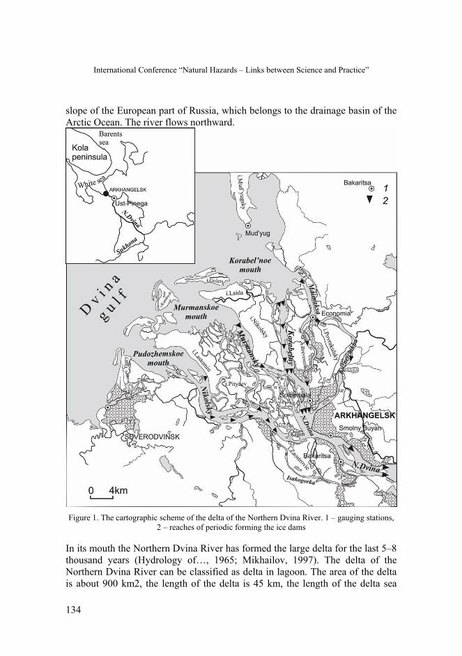
The Northern Dvina River flows into the Dvina Bay of the White Sea (Figure 1). The length of the river is 1,302 km (from the source of the Sukhona River); the basin area is 357,000 km2. The river basin is located entirely on the northern
1 Correspondence to: [email protected]
International Conference “Natural Hazards – Links between Science and Practice”
134
slope of the European part of Russia, which belongs to the drainage basin of the Arctic Ocean. The river flows northward.
Figure 1. The cartographic scheme of the delta of the Northern Dvina River. 1 – gauging stations,
2 – reaches of periodic forming the ice dams
In its mouth the Northern Dvina River has formed the large delta for the last 5–8 thousand years (Hydrology of…, 1965; Mikhailov, 1997). The delta of the Northern Dvina River can be classified as delta in lagoon. The area of the delta is about 900 km2, the length of the delta is 45 km, the length of the delta sea

Society and Natural Disaster
135
edge is 50 km, the average elevation of delta land above the sea is from 0.5 up to 4 m, number of relatively large watercourses in the delta is about 36. The main delta branches are Nikol’sky (length 40 km; average width 1.5–2 km), Murmansky (30 km; width from 1–2 up to 5–7 km), Korabel’ny (35 km; average width 1–1.5 km), Maimaksa (it is navigable branch; its mean width is 0.2–0.6 km) and Kuznechikha (25 km; width 0.3–0.5 km) (Figure 1). There are many swamps in the delta. Major islands in the delta are Kegoh, Lasomin, Nikol’sky, Laida, Yagry, Povrakul’sky, Brevennik, Pityaev, Golets and others. The islands occupy about 55% of the total area of the delta.
The delta is situated in a northern part of temperate climatic zones. The climate of the delta is characterized by the relatively cool summer and cold winter. The average annual air temperature is +0.8...+1.0°C, the average temperatures in January and July are respectively –13оС and +15...+16оС. The mean duration of the period with air temperatures below 0oC is equal 180 days. Annual precipitation is about 640 mm. Winds in the deltas have monsoon character. In the cold period of the year the winds from the South blow mainly, during a warm period the northern winds dominate. Delta is located in the north-taiga plant subzone. Grass and grass-moss swamps, delta watercourses, ox-bow lakes, meadow vegetation, shrubs and sparse forests cover the delta. The delta of the Northern Dvina River has no permafrost.
By XXI century men significantly have changed the natural landscape shape of the delta. Arkhangelsk and Severodvinsk cities, agricultural lands occupy a significant part of the territory of the delta (Figure 1). Arkhangelsk is a large railway, river and sea transport hub, with the developed industry. Current population and population density in the delta are, respectively, equal to approximately 550,000 people and 610 persons/1km2.
In the course of natural resource use there appeared complex environmental and water-related problems. Primorsky, Mud’yugsky and Unsky wildlife areas help to minimize the negative human impact on the deltaic natural systems and preserve unique and vulnerable deltaic ecosystems from degradation.
Hydrological regime of the delta
Annual water runoff of the Northern Dvina River in the delta head is about 104 km3 (1881–2011), or 3,310 m3/sec. About 2 km3/yr flow into the sea due to rain waters with the delta surface and catchment area of the delta. Water management activities in the basin and delta of the Northern Dvina River don’t almost influence the value and intra-annual regime of the water runoff (Magritsky, 2008).

International Conference “Natural Hazards – Links between Science and Practice”
136
The main part of water runoff (60% of annual runoff) flows into the delta during the spring flood. The average dates of the beginning and the end of high water period are April 21 and July 7, respectively. Maximum water discharges and water levels are observed during this period. Mean value (for the long-term period) of maximum water discharges is equal 21,600 m3/sec (Ust-Pinega post). The highest maximum water discharge was in 1953 (Q=36,200 m3/sec). The months with most low water are February (2.1% of the annual runoff) and March (1.9%).
In the delta the water runoff of the Northern Dvina River is distributed among the Nikol’sky (32.2%), Murmansky (18.2%), Korabel’ny (21.5%), Maimaksa (18.4%), Kuznechikha (5.4%) and Rybolovka (4.3%) branches (Polonsky, Kuz'mina, 1986; Mikhailov, 1997). In winter, the percentage of water flow of the Murmansky and Korabel’ny branches usually increases, and, on the contrary, the relative runoff of Maimaksa branch decreases.
Tides, storm surges and negative water setout significantly influence the distribution of water flow among the delta branches, the water levels in the branches and the river. Tides at the mouth near shore zone of the Northern Dvina are non-symmetrical (shallow) and semi-diurnal. The maximum value of the tidal level variation (in spring tide) amounts 1.3–1.5 m. The maximum value of storm surges is 1.9 m, value of negative water setout is 0.9 m. Tidal and surge level fluctuations penetrate into the delta and the Northern Dvina River at a distance of 135 km from the sea. Together with them, and in conditions of Q<10,000 m3/sec, marine waters begin to penetrate into the delta branches (at a maximum distance of 45 km from the sea).
The delta of the Northern Dvina has severe ice conditions. Mean dates of the beginning and the end of the period with ice phenomena are October 21 and May 9, respectively; the freeze-up period begins on November 11 and ends on May 2. The average duration of the periods with ice phenomena and freezing-up is 192 and 170 days, respectively. During spring ice drift, which accompanies the spring flood, strong and dangerous ice dams occur frequently.
The main posts of hydrological observations in the mouth of the Northern Dvina are Ust-Pinega (in the head of the mouth reach and in 135 km from the sea), Bakaritsa and Smol’ny Buyan (in the delta head; in 47 and 42 km), Solombala and Economia (in the delta; in 35 km), Mud’yug and Severodvinsk (the marine edge of the delta) (Figure 1). The hydrometrical station Ust-Pinega is one of the oldest in Russia. It has been functioning since 1881.
Society and Natural Disaster
137
Inundations in the delta of the Northern Dvina River, methods and results of their study
High water discharges in the river, intensive ice drift and strong ice dams, storm surges with the tides can lead to flooding in the delta of the Northern Dvina River. The first information about great inundations in the delta dates back to XVII–XVIII centuries.
Modern methods of flood control in the delta of Northern Dvina are developed both due to new technologies and techniques, and due to permanent monitoring on the gauging stations and results of analysis of these data, observations and measurements during numerous expeditions, remote sensing data of the Earth, numerical simulations and other alternative sources of information. The leading role in studying danger hydrological processes belongs to the Arkhangelsk Hydro-Meteorological Service and State Oceanographic Institute.
In recent years the specialists of the Faculty of Geography of Moscow State University and RDC ScanEx take an active part in the study of factors and features of inundations at the mouth of the Northern Dvina River. For example, in 2012 the specialists of MSU have created the database "Inundations in the mouths of the large rivers of the European part of Russia" (RELRMI; http://www.nral.org/). This is a unique database, the world analogues of which are information resources of the Global Flood Detection System (GDACS 2.0; http://www.gdacs.org/flooddetection/) and the Centre for Research on the Epidemiology of Disasters (CRED; http://www.emdat.be/). But, unlike these information resources, database includes events since XVIII century, contains much more information about the events, its factors and consequences, as well as a variety of illustrations, flood maps, satellite images, hydrometeorological data, and so on. Concerning the delta of the Northern Dvina River database includes information about 75 events from 1750 up to 2011.
Ice dams in the delta branches during the spring flood period form the most dangerous inundations. They lead to a significant and rapid increase in the water level and flooding by river waters the river floodplain (the reach upstream the delta head) and delta plains (usually in the upper and middle parts of the delta). Sometimes intensive ice drift and pileup of ice on the banks cause mechanical and additional damage to river and branch banks, artificial objects on the banks.
Long-term frequency of ice-dam formations (in vivo) exceeds 60%; the average duration comes up to 60–100 hours. The strongest ice dams are usually formed after a very cold and long winter, and in the conditions of a rapid spring flood-

International Conference “Natural Hazards – Links between Science and Practice”
138
wave formation. Wind and timber rafting aggravate processes of the ice-dam formation.
Large ice-dam floods were at the mouth of the Northern Dvina in 1750, 1761, 1763, 1767, 1779, 1784, 1785, 1788, 1801, 1802, 1805–1808, 1811, 1815, 1818, 1832, 1834, 1835, 1838, 1843, 1847, 1853, 1854, 1858, 1859, 1864–1867, 1872–1875, 1881, 1884, 1893, 1895, 1903, 1914, 1917, 1920, 1924, 1926, 1927, 1929, 1931, 1934, 1946, 1947, 1953, 1957, 1961, 1966, 1974, 1985, 1994 and 1999. Thus, frequency of large ice-dam floods until the mid-XX century was approximately 1 once in 4 years, while the frequency of occurrence of small floods and danger overflowing was higher (almost 1 time for 1–2 years).
All ice-dam floods were observed in April and May, that is, during break-up and peak of spring high water. It isn't casual. During flood-wave the water level in the river and delta branches greatly rises (ΔHwr) due to an increase of water discharges (Figure 2). In conditions of intensive ice drift and ice-dam formation the water level rises higher due to backwater component ΔHij. That is why, the most maximum levels in the delta of the Northern Dvina and their critical values were observed (for a long period) in years of ice-dam formation. At the mouth of the Northern Dvina average ΔHij is equal to 1.5–2 m, maximum ΔHij is 3–4 m. During ice dams the maximum rate of increase of water level in the river and in the delta branches can reach 1–1.5 m/day.
Figure 2. Chart of fluctuations of water level (1) and water discharge (2) on the Ust-Pinega
hydrological station in spring of 1985 with an example of selection of component ΔHij
The main factors and reaches of ice-dam formation in the delta of Northern Dvina are known (Figure 1), and effective measures of control too (Hydrology of..., 1965; Catalogue of..., 1976; Vasiliev, 2006). The struggle against ice jams, ice dams and ice-dam floods is carried out since 1915 and especially since the

Society and Natural Disaster
139
1950s. The key measures are radiation-chemical, mechanical and pyrotechnic weakening and destruction of the ice cover, the destruction of ice dams, building the protective dams on the banks and other methods. These measures and warm waters of the city heat power plant have led to a positive effect. First, the frequency of ice-dam formation and their capacity has decreased. Especially, the significant reduction has been noticed at the reach of the main fairway. Here, the frequency of occurrence of ice dams decreased from 30% in 1939–1961 to 1% in 1962–2004, the average duration of ice dams decreased in 10 times (from 62 to 6 hours) (Vasiliev, 2006). Secondly, maximum water levels of spring high water period dropped at 0.5 m, the average maximum water levels of ice drift fell at 0.7 m (Figure 3). As a result, the frequency of relatively large ice-dam floods reduced in 2–3 times.
Figure 3. Diagrams of the maximum water levels in the Northern Dvina River (a; Ust-Pinega
station) and Korabel’ny branch (b; Solombala). 1 – linear trend, 2 – adverse elevation, 3 – danger elevation. Water levels are given in centimeters above the station zero
On the station Smolny Buyan 75% (or 9 years for 1976–2011) of the critical maximum levels (>300 cm) were measured during intensive ice drift, whereas

International Conference “Natural Hazards – Links between Science and Practice”
140
ice dams led to only 25% critical levels (3 years). On the station Solombala these values are respectively equal to 62.5% (8 years) and 37.5% (3 years) (Figure 3b). The duration of critical standing the levels varies from 2 to 4 days.
Nowadays residential and industrial districts of the Arkhangelsk city, situated on the low-lying parts of the Khabarka, Brevennik, Kegoh, Solombala, Krasnoflotsky and Pavrakulsky islands, in the Isakogorka neighborhood, periodically are affected by inundations. The Severodvinsk city, Mud’yug isle and other seaside delta islands are exposed to surge inundations. Flooding depth varies from 0.5 to 1 m.
In recent years the study of the possibility of real-time monitoring of processes of ice breaking and ice dam formation in spring, flooding (Figure 4) with using the remote sensing data of the Earth has been performed. They gave good results, especially in radar range of imagery (Lupachev et al., 2010). Previously (before the 1990s), such monitoring had been conducted with airplanes.
Figure 4. Location of flooded areas on the islands of the Northern Dvina River delta. Left-hand side — April 28, right-hand side — April 29. Fragments of the images RADARSAT-1, imagery
dates 28.04.2010, 04:03 UTC and 29.04.2010, 03:38 UTC (© CSA, MDA, SCANEX, 2010)
The second type of the inundations in the delta of the Northern Dvina associates with the storm surges at the mouth nearshore zone. During storms sea waters flood low-lying sites of the seaside delta islands, and backed river waters of the delta branches flood low-lying banks and islands in the inner part of delta. The duration and scales of surge inundations are usually significantly less than for ice-dam inundations. But the damage from the surge inundations can be great. For example, in 2011 a significant damage to the economy and population of the

Society and Natural Disaster
141
delta was inflicted by the catastrophic storm surge. The storm surge had begun 3 days before neap tide and had 1% probability. For information, adverse and danger elevations for storm surges are below the unfavorable spring-flood elevations (250–270 cm at the Solombala station and 230 cm at the Smolny Buyan station) (Figure 5). Storm winds and waves, currents form an additional damage.
Large surge inundations were at the mouth of the Northern Dvina in 1908, 1910, 1922, 1923, 1928, 1949, 1955, 1957, 1958, 1962, 1985, 2010 and 2011. Several major storm surges can happen during one year. More often (75% of cases) significant surge level rising was observed in autumn.
Dangerous storm surges at the mouth nearshore zone of the Northern Dvina are generated when a powerful cyclone passes over the Barents sea (from the Northern coast of the Scandinavian Peninsula along the Kola Peninsula to the Northern Urals) and strong Northern and North-Western winds bring Barents Sea waters into the Dvina Bay (Hydrology of..., 1965). The value of water-level rising increases if a storm surges coincides with the tide, especially with the spring tide. For example, it happened on November 6, 2010. If surge develops for a long time, it is imposed both upon tide (or tides) and ebb (or ebbs). In this case, changes of total level (low flow conditions) include surge and ebb-tide components (Figure 5–6).
Figure 5. Graphs of water level fluctuations on the hydrological stations during the catastrophic
storm surge on November 14–16, 2011. 1 – Solombala station, 2 –Economia station

International Conference “Natural Hazards – Links between Science and Practice”
142
Critical level rising in the river, delta branches and at the mouth nearshore zone lead to erosion and destruction of banks, dams, cultivated lands, industrial objects, roads, settlements and to other serious and negative consequences. Permanent threat of inundation limits the development of the territories within the danger zone. Nowadays, only the dams, embankments, artificial destruction of ice cover are insufficient measures. It is necessary to create a comprehensive system of fight with floods and minimize the damage from inundations. Hydrodynamic computer model of flooding at different water discharges in the river and at different sea levels could be an important element of this system. In addition, it could be used in operational forecasts.
The creation of a hydrodynamic model for the Northern Dvina River delta is a difficult task. The main problems include flat terrain and the absence of large-scale maps, a significant number of man-made objects, the complex interaction of water flow, ice dams, tides and storm surges.
Figure 6. Changes of total level (1), of ebb-tide (2) and surge (3) level components on the station
Solombala during surge on June 2, 1962 (Hydrology of..., 1965)
Modeling has been carried out on the basis of program complex MIKE 21, which was created by the Danish Hydraulic Institute (DHI). The mathematical basis of the model is two-dimensional equation of Saint-Venant and its boundary conditions. The boundary conditions include water discharges of the Northern Dvina River in the delta head (Ust-Pinega station), water levels on the marine edge of the delta (Mud’yug and Severodvinsk stations), the relief of the branch channels and the delta floodplain. Digital elevation model of the delta of the Northern Dvina has been created due the soft ArcView GIS 3.2 on the basis of

Society and Natural Disaster
143
topographic maps (with a scale from 1:50 000 to 1:100 000), pilot charts and data of channel measurements. Interpolation of elevation marks was carried out on both a regular rectangular grid (for riverbeds of major delta branches) and triangular grid (for floodplains). The water flow velocity field, field of depths and water levels, the border of flooding zone and other information are the results of hydrodynamic simulation (Figure 7).
The results of the simulation have shown the applicability of this software complex for the solution of the previously listed tasks and in relation to such a complex object. The main reason for existing variations is insufficient detail of cartographic materials.
Expected changes of the hydrological regime and inundation situation in future
In future the situation with inundations in the delta of Northern Dvina River will change. The following factors will help it. First, it is the change of parameters of spring high water period (spring flood). The simulation results on the basis of the hydrological basin model ECOMAG, climate scenario CMIP3 and 12 AOGCM (CCSM3, CGCM3.1, CNRM-CM3, CSIRO-Mk3.0, ECHAM5/MPI-OM, GFDL-CM2.0, GFDL-CM2.1, MIROC3.2, MRI-CGCM2.3.2А, PCM, IPSL CM4, MIUB ECHO G), performed by Elena Antokhina (Lomonosov MSU) in 2012, showed that the duration of spring flood period in the Northern Dvina mouth by the middle of XXI century will increase in 1.5 times, the volume of spring flood-wave will increase in 1,4 times (the relative error of the forecast is 26.7%). The mean water discharges will increase in 1.1 times, the maximum water discharges can also increase. In recent decades some directed changes of regime and water has already been marked (Magritsky et al., 2013). Secondly, it is the change in the characteristics of the ice regime. For example, at the beginning of the XXI century, some softening ice conditions has been observed in the mouth of the Northern Dvina (Geoecological..., 2007). The duration of the ice cover period has decreased by 7 days. According to B.Ginzburg, the continuation of this trend can be expected in the future. Thirdly, there are changes in the average level of the sea, the wind regime over the White and the Barents Sea, the maximum levels at the mouth nearshore zone of the Northern Dvina. According to the data of measurements the sea levels on the Severodvinsk station since the second half of the 1980s some increase in the maximum water levels of the Dvina Bay has been fixed. It has not exceeded the values in the similar period in 1940s–1960s yet.

International Conference “Natural Hazards – Links between Science and Practice”
144
Figure 7. The depths of the flooding and water flow velocity in the channels and on the floodplain in the delta of the Northern Dvina River. The calculation is based on the model MIKE 21, with a
maximum water discharge in the river 21,500 m3/sec
Conclusion
In the delta of the Northern Dvina ice-dam and surge inundations, intensive ice drift and pileup of ice on the banks, storm winds and waves lead to significant social and economic damages. Protective measures of the negative effects of these natural hazards are taken only with respect to ice dams and critical water level rising. They have led to the reduction of the frequency and scales of ice jams and ice dams, ice-dam inundations, decrease of scale of flooding during storm surges. But these measures have not totally removed their appearing. For other hazards only accurate and operative forecast, local protection and strengthening the man-made objects and banks, removal of dangerous objects from the danger zone, timely evacuation of the population and other actions can

Society and Natural Disaster
145
minimize damages. In this struggle, author’s research and their positive results can play a positive role.
Research was carried out due to the financial support of the Ministry of education and science of the Russian Federation (the contract № 11.G34.31.0007 dated 30.11.2010).
References
Catalogue of ice-dam and ice-jam reaches of the rivers of the USSR (1976) Hydrometeoizdat, Leningrad, Russia, 1. 260.
Geoecological state of the Arctic coast of Russia and safety of environmental management (2007) (ed. by N.I. Alekseevsky), Moscow State University, Moscow, Russia, 585.
Hydrology of the Severnaya Dvina River mouth area (1965) (ed. by M.I.Zotin & V.N.Mikhailov),. State Oceanographic Institute, Moscow, Russia, 376.
Lupachev, Yu.V., Skripnik, E.N. & Kucheiko, A.A. (2010) The Experience of Space Monitoring of the Spring Seasonal Flood on the Northern Dvina River in 2010. Earth from Space 6, 57–68
Magritsky, D.V. Mikhailov, V.N., Korotaev, V.N. & Babich, D.B. (2013) Changes in hydrological regime and morphology of river deltas in the Russian Arctic. Proc. of HP1, IAHS-IAPSO-IASPEI Assembly 358 (Deltas: Landforms, Ecosystems and Human Activities), 67–79.
Magritsky, D.V. (2008) Anthropogenic impacts on a runoff of the rivers flowing into the seas of the Russian Arctic. Water resources, 35(1), 1–14.
Mikhailov, V.N. (1997) The mouths of the rivers of Russia and adjacent countries: past, present and future, Moscow State University, Moscow, Russia, 413.
Polonsky, V.F. & Kuz'mina, V.L. (1986) About distribution runoff in the Severnaya Dvina River delta. Proc. of SOI 179, 49–56.
Vasiliev, L.Yu. (2006) Spring inundation and ice-dam control measures in the mouth area of the Northern Dvina. Reports of the VI All-Russia Hydrological Congress Section 2, 223–229.