Embed Size (px)
Citation preview

Digital Imaging and Remote Sensing Laboratory
ALGE Modeling and Data NeedsALGE Modeling and Data Needs
Dr. Anthony VodacekNina Raqueno
Yan Li
Center for Imaging ScienceRochester Institute of Technology
Digital Imaging and Remote Sensing Laboratory
Remote imagery and ground truth
ObjectiveObjective
3DHydrodynamic
Model
Spatial dataModel output
Geo-referenced site specific•Bathymetry•Hourly weather data•Inflow and outflow
Digital Imaging and Remote Sensing Laboratory
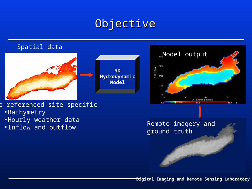
Bathymetry Grid for Conesus LakeBathymetry Grid for Conesus Lake
•Coarse bathymetry will be used for full lake model•But improved resolution will be needed for each study site

Digital Imaging and Remote Sensing Laboratory
Bathymetry MapperBathymetry MapperInexpensive method to map nearshore bathymetryInexpensive method to map nearshore bathymetry
•GPS
•FishFinder
•RIT Datalogger
Digital Imaging and Remote Sensing Laboratory
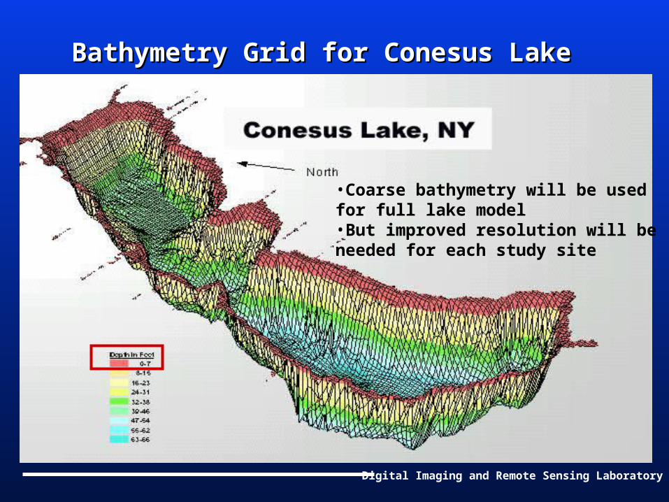
Bathymetry MapperBathymetry Mapper Test Site Test Site
Old Orchard Cove
meters

Digital Imaging and Remote Sensing Laboratory
Nearshore bathymetry Nearshore bathymetry contourscontours meters

Digital Imaging and Remote Sensing Laboratory
Previous Study of the Niagara PlumePrevious Study of the Niagara Plume
6 hours 12 hours 18 hours 24 hours

Digital Imaging and Remote Sensing Laboratory
Future Work
• Data Needs
• Modeling Work

Digital Imaging and Remote Sensing Laboratory
Data NeedsData Needs
• Key sites• Sedimentation rates• Macrophyte canopy• Weather (winds, solar irradiance, etc.)• High resolution bathymetry (lake level) • Water temperatures (shelf vs. open lake)• GIS data format (compatibility) and layers• Stream inflows and outflows• Radiosonde data (best station)

Digital Imaging and Remote Sensing Laboratory
Modeling WorkModeling Work- Modification of the models- Modification of the models
• Macrophyte - affect on flow direction and velocity • Sediment transportation - sediment rates
Digital Imaging and Remote Sensing Laboratory
Physical Resuspension, Deposition, and Physical Resuspension, Deposition, and Settling of SedimentsSettling of Sediments
Mechanisms of sediment dispersion include:
• Convection and turbulent diffusion• Stream loading• Gravitational settling• Physical resuspension and disposition at the sediment-water interface.
Digital Imaging and Remote Sensing Laboratory
Physical Resuspension, Deposition, and Physical Resuspension, Deposition, and Settling of SedimentsSettling of Sediments
The sedimentation rates are dependent on:
• The bottom shear stress due to the combined action of waves and currents
• Sediment composition and water content
Digital Imaging and Remote Sensing Laboratory
ReferencesReferences
1. Alfred J. Garrett, John M. Irvine, and Amy D. King, Application of Multispectral Imagery to Assessment of a Hydrodynamic Simulation of an Effluent Stream Entering the Clinch River, Photogrammetric Engineering & Remote Sensing, Vol. 66, No. 3
2. Richard L.Miller, and James F. Cruise, Effects of Suspended Sediments on Coral Growth: Evidence
from Remote Sensing and Hydrologic Modeling, Remote Sensing Environment, 53:177 – 187 (1995)
Digital Imaging and Remote Sensing Laboratory
References (Continued)References (Continued)
3. T. Fischer-Antze, T. Stoesser, and N.R.B. Olsen, 3D numerical modeling of open-channel flow with submerged vegetation
4. Y. Peter Sheng, W.Lick, The Transport and Resuspension of Sediments in a Shallow Lake, Journal of Geophysical Research, Vol. 84, NO. C4