Embed Size (px)
Citation preview

0
Devon Birds - South Huish Nature Reserve Management Plan 2017-2021, Version 1.0, December 2016
Published by Devon Birds
www.devonbirds.org
Registered Charity 228966
© 2017 Devon Birds

1
Devon Birds - South Huish Nature Reserve Management Plan 2017-2021, Version 1.0, December 2016
“The future of life on earth depends on our ability to take action. Many individuals are
doing what they can, but real success can only come if there's a change in our societies
and our economics and in our politics. . . . . Surely we have a responsibility to leave for
future generations a planet that is healthy, inhabitable by all species.”
David Attenborough.

2
Devon Birds - South Huish Nature Reserve Management Plan 2017-2021, Version 1.0, December 2016
i. Foreword
Devon Birds was formed in 1928 as the County bird conservation organisation and was known as Devon
Birdwatching & Preservation Society until 2014. Its constitution includes the objective “to further the study
of birds in the field and to assist in their conservation” and to support the latter it has been purchasing
small areas of land of conservation value since 1976. To date the number of reserves owned or managed
by Devon Birds has increased to nine and covers a total of 64ha.
South Huish Nature Reserve is a small coastal grazing marsh, which regularly floods in winter and supports
a diverse community of passage and wintering birds and a smaller number of breeding species. It has been
managed informally by Devon Birds since 1980 and formally, by agreement with successive landowners,
since 1995. During that time, the variety of species and number of birds recorded annually using the
reserve has more than doubled. The total number of species recorded at the site now stands at an
impressive 206 and the reserve has become increasingly popular with both local and visiting bird-watchers,
many of whom will be unaware of the historical improvements and ongoing management required to
achieve the current diversity.
The first management plan was drawn up and agreed in 1995 and formed the basis of developing the
reserve for the conservation of birds and other wildlife. This new plan goes further by drawing together all
of the reports and documents produced in hard copy since then to provide a much more detailed
description of the reserve’s history, development and current features. The Management Objectives and
Annual Work Plan sections set out the guiding principles to ensure that the reserve is managed responsibly
and monitored appropriately and will be in regular use for many years to come.
The plan recognises and celebrates successes within the reserve and clearly sets out the challenges for the
future and how they will be overcome. Whilst the conservation of habitat must remain the top priority, the
aspirations of bird-watchers for improved viewpoints and the potential that the site has for positive
engagement with the wider public have not been ignored in the document and both are included as
objectives for discussion with the current landowners. The green spaces of Devon are vital for everyone
and it is important that we are not complacent about our cherished nature reserves but continue to strive
to conserve and improve them.
Kevin Cox (Chairman)
Devon Birds
June 2017
3
Devon Birds - South Huish Nature Reserve Management Plan 2017-2021, Version 1.0, December 2016
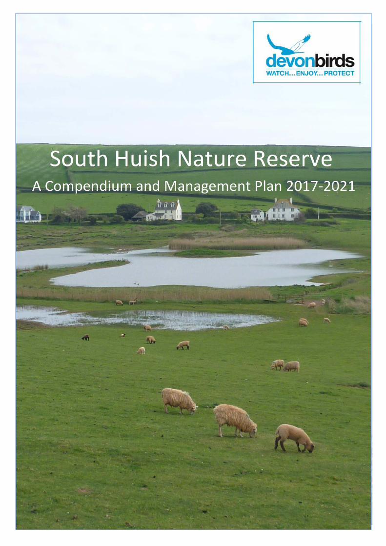
ii. Introduction
South Huish Nature Reserve contains an area of coastal and floodplain grazing marsh, a scarce habitat in
Devon, and is of particular importance for its community of wintering birds and for the variety of species
using the site on passage. Its proximity to the sea is unique in south Devon and frequently keeps the marsh
ice-free in severe winters, providing a welcome refuge for wildfowl and waders, when similar habitat,
associated with the estuaries or floodplains of the larger rivers in the county, is frozen. The second largest
of the three nature reserves owned or managed by Devon Birds in the South Hams, the reserve has been
administered by them since 1994 and is currently managed by agreement with the National Trust, who
own the site and adjacent farmland.
Coastal and floodplain grazing marsh is an entirely man-made habitat and, as such, requires continued
management to achieve a balance of water levels, drainage and grazing by livestock to prevent a natural
succession through reed swamp and scrub and ultimately to wet woodland. When wildlife interest is the
primary objective, constant fine adjustments are required to maintain the site in optimum condition
throughout the year.
The original management plan for this site was drafted in 1995 by Peter Stevens and was designed to assist
managers in prioritising and executing the tasks required both to maintain and to improve the habitats
within the reserve. It is of credit to Peter that his original protocols for grazing, drainage and water levels
remain largely unchanged, although refined through experience.
This updated plan details current management practices and the rationale behind them and aims to
provide the focus and direction of management of the site for nature conservation and public engagement
for the next five-year period, 2017-2021. The original plan contained background details, which are still
relevant today and the 1995 plan remains an essential reference document.
A complete re-write of the plan could have excluded much of this information and still provided a
management plan fit for purpose, leaving the original data and information as an archived document.
However, much of the material referred to in the first plan has become increasingly difficult to locate and
access, so this updated plan, together with a digital library of reference material, will enable the original
document to form the backbone of a valuable one-stop resource of information about the site and its
history and past management.
The first plan was relatively compact but information and observations, made in subsequent years, have
resulted in a lengthier document. Those readers whose principal interest is in the management objectives,
rationales and annual work plan should proceed directly to Chapter 8, which is also available as a separate
summary plan.
I am grateful to Vic Tucker, Mike Passman, Alan Doidge and Arthur Livett, who scrutinised the bird species
lists and made corrections and additions, and also to Emma Reece, National Trust Ranger for the site, who
provided copies of relevant National Trust documents. Finally, I am indebted to Bob Burridge, Vic Tucker
and Nick Townsend for providing a wealth of historical information, both hard copy and anecdotal, without
which my task would have been much more difficult if not impossible.
Alan Pomroy, April 2017

4
Devon Birds - South Huish Nature Reserve Management Plan 2017-2021, Version 1.0, December 2016
Contents
i. Foreword 2
ii. Introduction ....................................................................................................................................... 3
1. Plan summary .................................................................................................................................... 7
2. Legislation & policy ............................................................................................................................ 8
2.1 Legislation .................................................................................................................................. 8
2.2 Policies ........................................................................................................................................ 8
3. Description 9
3.1 Site location & relevant authorities ........................................................................................... 9
3.2 Statutory, planning & other designations ................................................................................ 11
3.3 Floral zones .............................................................................................................................. 11
3.4 Tenure ...................................................................................................................................... 12
3.5 Status of the site ...................................................................................................................... 12
3.6 Relationships with any other plans or strategies ..................................................................... 12
3.6.1 UK Biodiversity Action Plan (BAP) ..................................................................................... 12
3.6.2 Natural Environment and Rural Communities (NERC) Act 2006 ...................................... 13
3.6.3 Devon Biodiversity and Geodiversity Action Plan ............................................................ 13
3.6.4 Areas of Outstanding Natural Beauty ............................................................................... 13
3.6.5 The South West Coast Path National Trail ........................................................................ 13
4. Management and organisational infrastructure ............................................................................. 14
4.1 Site infrastructure .................................................................................................................... 14
4.2 Map coverage ........................................................................................................................... 16
4.3 Photographic coverage ............................................................................................................ 16
5. Environmental information ............................................................................................................. 18
5.1 Physical ..................................................................................................................................... 18
5.2 Climate ..................................................................................................................................... 18
5.3 Geology and geomorphology ................................................................................................... 18
5.4 Hydrology /drainage................................................................................................................. 21
5.6 Water balance .......................................................................................................................... 22
5.7 Biological .................................................................................................................................. 23
5.7.1 Flora .................................................................................................................................. 23
5.7.2 Fungi .................................................................................................................................. 27
5.7.3 Fauna ................................................................................................................................. 27
5.7.4 Alien / invasive pest species ............................................................................................. 42

5
Devon Birds - South Huish Nature Reserve Management Plan 2017-2021, Version 1.0, December 2016
5.8 Cultural ..................................................................................................................................... 42
5.8.1 Archaeology ...................................................................................................................... 42
5.8.1.3 Post Medieval Period ................................................................................................... 43
5.8.2 Past land use ..................................................................................................................... 44
5.8.3 Present land use ................................................................................................................ 46
6. Past management for nature conservation .................................................................................... 49
6.1 The chronology of major management and other events ....................................................... 51
7. Access and current use .................................................................................................................... 61
7.1. Access to the site ...................................................................................................................... 61
7.2 Access within the site ............................................................................................................... 61
7.3 The reasons why people visit the site ...................................................................................... 62
7.3.1 Wildlife attractions ........................................................................................................... 62
7.3.2 Other features that attract people ................................................................................... 62
7.4 Interpretation provisions ......................................................................................................... 62
7.5 Educational use ........................................................................................................................ 62
7.6 Academic research ................................................................................................................... 63
8. Management plan 2017-2021 ......................................................................................................... 64
8.1 Site evaluation .......................................................................................................................... 64
8.1.1 Identification of Important Features ................................................................................ 64
8.1.2 Summary description of Important Features ................................................................... 64
8.2 Site ideal management outcomes ........................................................................................... 66
8.3 Objectives and rationale .......................................................................................................... 67
8.3.1 Objective 1 - Ditches ......................................................................................................... 67
8.3.2 Objective 2 - Water levels ................................................................................................. 69
8.3.3 Objective 3 - Grazing ......................................................................................................... 70
8.3.4 Objective 4 - Scrapes ......................................................................................................... 73
8.3.5 Objective 5 - Water Voles ................................................................................................. 75
8.3.6 Objective 6 - Infrastructure............................................................................................... 77
8.3.7 Objective 7 - Disturbance.................................................................................................. 77
8.3.8 Objective 8 - Viewing points ............................................................................................. 80
8.3.9 Objective 9 - Public engagement ...................................................................................... 81
8.3.10 Objective 10 - Monitoring ................................................................................................. 82
8.3.11 Objective 11 - Data storage and retrieval ......................................................................... 82
8.4 Constraints ............................................................................................................................... 83

6
Devon Birds - South Huish Nature Reserve Management Plan 2017-2021, Version 1.0, December 2016
8.5 Annual work plan ..................................................................................................................... 84
8.5.1 Habitat conservation and protection................................................................................ 84
8.5.2 Reserve infrastructure ...................................................................................................... 86
8.5.3 Disturbance ....................................................................................................................... 86
8.5.4 Viewing points................................................................................................................... 86
8.5.5 Public engagement ........................................................................................................... 86
8.5.6 Monitoring and research .................................................................................................. 87
8.5.7 Administration and data recording ................................................................................... 87
8.5.8 Ditch and scrape maintenance protocol ........................................................................... 88
8.5.9 Water level management protocol ................................................................................... 90
8.5.10 Grazing protocol................................................................................................................ 92
9. References 93
10. Abbreviations ................................................................................................................................. 100
11. Glossary 101
Appendix 1 Birds ............................................................................................................................ 103
Appendix 1.1 Species List ............................................................................................................... 103
Appendix 1.2 Birds of Conservation Concern ................................................................................ 108
Appendix 1.3 WeBS Data ............................................................................................................... 111
Appendix 2 Vascular plants ........................................................................................................... 114
Appendix 2.1 Cryptograms ............................................................................................................ 114
Appendix 2.2 Dicotyledons ............................................................................................................ 114
Appendix 2.3 Monocotyledons ...................................................................................................... 117
Appendix 3 Climate change projections ........................................................................................ 119
Appendix 4 Sluice Design and Operation ....................................................................................... 122

7
Devon Birds - South Huish Nature Reserve Management Plan 2017-2021, Version 1.0, December 2016
1. Plan summary
Summary of management plan 2017-2021
Site: South Huish Nature Reserve Grid reference: SX678418
Locality: South Devon, 30km south-east of Plymouth. South Huish Nature Reserve lies in a shallow
valley running east from the sea at South Milton Sands. It is separated from the sea by sand dunes,
which have been subject to considerable erosion following storm events in recent years.
Owned by: The National Trust since 2011, (Registered charity number: 205846)
Managed by: Devon Birds, (Registered charity number: 228966)
Conservation Officer (South): N. Townsend
Site Manager: V. Tucker
Area: 6.5 ha1
(16.0 acres)
Description: A coastal and floodplain grazing marsh, subject to winter flooding, with ditches, pools
and scrapes of particular value for its wintering bird community and for the variety of birds using the
site on passage. Consisting principally of improved pasture, there are areas of coastal grassland, wet
grassland, brackish ditches and scrub with tall herbs, which combine to form an area of high wildlife
value.
Objectives: To achieve favourable conservation status for all land within the reserve with the area
and quality of habitat and features of conservation importance being maintained or increased in the
long term by positive management and with all factors that affect the habitat, including its typical
species, under control.
Prescription: To maintain and improve the health of the marsh by means of a seasonal grazing
regime, supplemented by occasional mowing, together with the maintenance of drainage systems
and the management of water levels to provide optimum conditions throughout the year.
Plan prepared by: Date:
Agreed by: Date:
Approved by: Date:
1The hectare (symbol ha) is a metric unit of area equal to a square with 100m sides (10,000m
2). An acre is about 0.4047
hectares and one hectare contains about 2.47 acres. South Huish Nature Reserve has a total area of 6.5 acres.

8
Devon Birds - South Huish Nature Reserve Management Plan 2017-2021, Version 1.0, December 2016
2. Legislation & policy
2.1 Legislation
The following pieces of legislation should be understood by anyone attempting to make land
management decisions affecting South Huish Nature Reserve. For more information contact the
relevant authorities.
• Health and Safety at Work Act, 1974
• Wildlife and Countryside Act, 1981
• Occupiers Liability Act, 1984
• European Community Habitats Directive, 1992
• Conservation (Natural Habitats) Regulations, 1994
• Countryside and Rights of Way Act, 2000
2.2 Policies
Devon Birds was formed in 1928 as the Devon Bird Watching and Preservation Society. The objectives
of the society include “to further the study of birds in the field and to assist in their conservation” and
in furtherance of these purposes to publish an annual bird report, to promote a wider interest in
birds, habitats and their conservation. If bird populations are to survive in the long term, Devon Birds
recognises that it is essential to protect habitats and all other species of wildlife both up and down
the food chain.
Devon Birds believes that co-operation between all biodiversity interest groups is therefore essential
and supports and works closely with many other organisations, both locally and nationally. The
Society has representatives on most biodiversity forums and has direct links with other local societies
and groups, both as an organisation and through its membership.

9
Devon Birds - South Huish Nature Reserve Management Plan 2017-2021, Version 1.0, December 2016
3. Description
South Huish Nature Reserve is located on the coast of the South Hams of Devon, 30 km south-east of
Plymouth and 9 km to the west of Kingsbridge (Figure 3.1). Occupying the seaward end of a shallow
valley 200-250 metres wide, running west-east for 1.5 km from the coast at South Milton Sands
(Figure 3.2), from which it is separated by a sand dune barrier, the reserve is a coastal and floodplain
grazing marsh traversed by drainage channels and containing several pools and two scrapes. Its
proximity to the sea ensures that the site remains relatively ice-free even during severe winter
weather.
3.1 Site location & relevant authorities
Figure 3.1: Location of South Huish Nature Reserve

10
Devon Birds - South Huish Nature Reserve Management Plan 2017-2021, Version 1.0, December 2016
Figure 3.2: Location of South Huish Nature Reserve. Image courtesy of Ordnance Survey.
Site name South Huish Nature Reserve
Total area of valley (ha) 32.9 ha
Area of reserve 6.5 ha
Area outside reserve 24.9 ha1
Grid ref (centre of reserve) SX 685422
County Council Devon
District Council South Hams
Parish Council South Huish
Parliamentary Constituency Totnes
Local Environment Agency office Manley House, Kestrel Way, Exeter, EX2 7LQ
Local Natural England Office Yarner Wood, Bovey Tracey, Devon, TQ13 9LJ
Drainage Authority None
Airport Safeguarding zone No
Table 3.1: Relevant Authorities.
1 The total area of coastal and floodplain grazing marsh within the valley is 32.9 ha

11
Devon Birds - South Huish Nature Reserve Management Plan 2017-2021, Version 1.0, December 2016
3.2 Statutory, planning & other designations
Designation All or part of site Name & other details
Area of Outstanding Natural Beauty,
(coastal preservation area) All South Devon AONB, 1960
Heritage Coast All South Devon HC, 1984
Table 3.2: Statutory, planning & other designations.
3.3 Floral zones
Surveys of the flora at South Huish Nature Reserve by the Devon Wildlife Trust (DWT) in 1992, Roger
Smith, the Royal Botanical Society’s official recorder for South Devon, in 2007, Lynne Kenderdine,
DWT’s County Wildlife Site Officer in 2009 and, most recently, the National Trust National
Consultancy in 2012, identified four principal vegetation zones within the reserve (Kenderdine, 2009).
The borders between some of these zones may have shifted slightly over the ensuing years due to
natural processes and active management but the descriptions still hold true today and form the
basis for current management practices.
The current boundaries of the four vegetation zones identified during the surveys detailed above are
illustrated in Figure 3.3 and the habitats are summarised in Table 3.3. Section 5.7.1.1 contains a
detailed description of the flora of each of these zones.
Figure 3.3: Principal vegetation zones at South Huish Nature Reserve. (Map data: Google, 2016)

12
Devon Birds - South Huish Nature Reserve Management Plan 2017-2021, Version 1.0, December 2016
Zone Description
1
Lower marsh. The pasture between the marsh and the car park is
improved/semi-improved grassland, graded G3 of low botanical diversity and
maintained by summer grazing and occasional mowing. Parts of the grassland
are subject to periodic inundation when the water levels are high or after storm
events.
2
Upper marsh. Much of the area in between the ditches is marshy grassland
although there are also tall stands of ‘fen type’ vegetation. Parts of this zone
are also subject to periodic inundation when the water levels are high.
3
Southern Marsh. A diverse area of marshy grassland with Common Cottongrass
(Eriophorum angustifolium), Ragged Robin (Lychnis flos-cuculi), Common Bird’s-
foot Trefoil (Lotus corniculatus), Marsh Marigold (Caltha palustris), Lesser
Spearwort (Ranunculus flammula), Common Sedge (Carex nigra), Jointed Rush
(Juncus articulates), Hard Rush (J. inflexus) and Soft Rush (J. effusus).
4
Ditches. A series of ditches run south to north across the reserve. Some are
choked with a dense growth of Soft Hornwort (Ceratophyllum submersum),
others are more open with occasional Common Duckweed (Lemna minor,
and/or filamentous algae. Emergent vegetation includes some dense stands of
Common Reed (Phragmites australis), with stretches along the ditches only
having a sparse cover, such as occasional Branched Bur-reed (Sparganium
erectum). Hemlock Water-dropwort (Oenanthe croccata) is frequent along the
main ditch, which is just outside the reserve boundary.
Table 3.3: Principal vegetation zones at South Huish Nature Reserve
3.4 Tenure
The freehold of the reserve is owned by the National Trust.
3.5 Status of the site
South Huish Nature Reserve is afforded no special protection under law.
3.6 Relationships with any other plans or strategies
3.6.1 UK Biodiversity Action Plan (BAP)
Coastal and floodplain grazing marshes are a priority UK Biodiversity Action Plan habitat, (Maddock,
2008). Grazing marsh is defined as periodically inundated pasture, or meadow with ditches which
maintain the water levels, containing standing brackish or fresh water. The ditches are especially rich
in plants and invertebrates. Almost all areas are grazed and some are cut for hay or silage. Sites may
contain seasonal water-filled hollows and permanent ponds with emergent swamp communities, but
not extensive areas of tall fen species like reeds; although they may abut with fen and reed swamp
communities.
They can be particularly important for the numbers of waders such as Snipe (Gallinago gallinago),
Lapwing (Vanellus vanellus) and Curlew (Numenius arquata) they support. Internationally important
populations of wintering wildfowl can also occur including Bewick’s Swans (Cygnus bewickii) and
Whooper Swans (Cygnus Cygnus). A number of UK Red Data Book invertebrates are also closely
associated with coastal and floodplain grazing marshes (Buglife, 2016).

13
Devon Birds - South Huish Nature Reserve Management Plan 2017-2021, Version 1.0, December 2016
3.6.2 Natural Environment and Rural Communities (NERC) Act 2006
The following species reported from South Huish Nature Reserve are listed in Section 41 of the NERC
Act, Habitats and Species of Principal Importance in England.
Common name Taxon name
Tubular Water Dropwort Oenanthe fistulosa
Slow-worm Anguis fragilis
Grass Snake Natrix natrix
Common Lizard Zootoca vivipara
Lapwing Vanellus vanellus
Skylark Alauda arvensis
Dunnock Prunella modularis
Yellow Wagtail Motacilla flava
Grasshopper Warbler Locustella naevia
Linnet Carduelis cannabina
Yellowhammer Emberiza citrinella
Cirl Bunting Emberiza cirlus
Reed Bunting Emberiza schoeniclus
Hedgehog Erinaceus europaeus
Otter Lutra lutra
Table 3.4: Species of principal importance at South Huish Nature Reserve
3.6.3 Devon Biodiversity and Geodiversity Action Plan
Grazing marsh has always been of limited extent in Devon, especially when compared to other parts
of Britain, like Somerset or East Anglia for example, because the natural geography of Devon’s
riverine floodplains, coasts and estuaries does not lend itself to the formation of this habitat. It is
estimated that there are c.600 hectares of the habitat in the County, principally located in the
floodplains and beside the estuaries of the major rivers. Objectives in the Devon BAP include
maintaining the area and quality of existing grazing marshes and to expand the habitat when the
opportunity arises.
3.6.4 Areas of Outstanding Natural Beauty
Areas of Outstanding Natural Beauty (AONB) are statutory designations. South Devon AONB is one of
a family of protected landscapes in the UK. It covers 60 miles of coastline, estuaries and countryside
between Plymouth and Torbay and was designated by government in 1960. All of South Huish Nature
Reserve falls within the South Devon AONB.
3.6.5 The South West Coast Path National Trail
Rated as one of the top walks to be found anywhere in the world by “Lonely Planet” and voted best
walking route by the readers of “Walk” magazine, the Coast Path is a designated National Trail,
largely funded by Natural England. It was created in stages, with its final section, Somerset and North
Devon, opening in 1978. The Trail passes outside the perimeter of the western edge of the reserve.

14
Devon Birds - South Huish Nature Reserve Management Plan 2017-2021, Version 1.0, December 2016
4. Management and organisational infrastructure
Management of the site is undertaken by volunteers and hired contractors, overseen and
coordinated by the Reserve Manager in collaboration with the Conservation Officer (South) and other
co-opted members of the management team. Regular meetings are held jointly with the National
Trust to discuss progress, future projects and proposals.
4.1 Site infrastructure
The following infrastructural assets, owned and managed by Devon Birds, are installed on site:
• Two sluices, (Figure 4.1)
There are four transverse drainage ditches, maintained by Devon Birds, which are essential to sustain
water levels within the reserve (Figure 4.1). The main drainage channel, running from East to West
across land owned by the National Trust, is just outside the northern boundary of the reserve but is
included in Devon Birds ongoing ditch maintenance program with funding from the National Trust.
Figure 4.1: Schematic of principal drainage features at South Huish Nature Reserve. (Map data: Google 2016)
1 = Main drain. Water drains from the reserve via a pipe under the dune system at this point;
2, and 3 = location of sluices; MD = Main ditch.

15
Devon Birds - South Huish Nature Reserve Management Plan 2017-2021, Version 1.0, December 2016
Ph
oto
: A
lan
Po
mro
y
Figure 4.2: Entrance of the main drainage pipe running from the reserve and under South Milton Sands.
Ph
oto
: A
lan
Po
mro
y
Figure 4.3: One of the sluices enabling fine control of water levels within the reserve.
A diagram showing details of the sluice design is included in Appendix 4.

16
Devon Birds - South Huish Nature Reserve Management Plan 2017-2021, Version 1.0, December 2016
4.2 Map coverage
A selection of Ordnance Survey maps dating from 1886 to the present day is included in Section 5.8.2,
“Past land use”, together with an analysis of changes.
4.3 Photographic coverage
There are a limited number of photographs of the reserve available, mostly taken from the National
Trust car park to the west perimeter of the reserve but only three aerial photographs, taken in 1943
and the 1990’s, have been located (Figures 4.4 to 4.6). Other images, both contemporary and
historical, have been used throughout this document. Devon Birds is grateful to all those who have
allowed their photographs to be included.
Figure 4.4: Aerial view of South Huish Marsh (bottom) and South Milton Ley (top) prior to the establishment of
either reserve, taken by a Luftwaffe recognisance aircraft in 1943, (Current reserve boundaries are highlighted
in red).

17
Devon Birds - South Huish Nature Reserve Management Plan 2017-2021, Version 1.0, December 2016
Figure 4.5: Aerial view of most of South Huish Nature Reserve in the 1990’s looking north towards the adjacent
South Milton Ley Nature Reserve. Taken prior to the establishment of South Huish Nature Reserve, (Current
reserve boundaries are highlighted in blue).
Ph
oto
: ©
Sa
vil
ls p
lc
Figure 4.6: View of South Huish Nature Reserve, taken in July 2016, looking north-west across Bigbury Bay.

18
Devon Birds - South Huish Nature Reserve Management Plan 2017-2021, Version 1.0, December 2016
5. Environmental information
5.1 Physical
The entire reserve lies at the coastal end a shallow valley running from west to east at an elevation of
less than 10 m above the high water mark, with a shallow gradient along its 1.5 km length, rising from
sea level at South Milton Sands to an elevation of eight metres at South Huish Farm.
5.2 Climate
The climate of south-west England is classed as oceanic according to the Köppen1 climate
classification. The oceanic climate is typified by cool winters with warmer summers and precipitation
all year round, with more experienced in winter. Annual rainfall is about 1,000 mm and up to 2,000
mm on higher ground. Summer maxima averages range from 18 °C (64 °F) to 22 °C (72 °F) and winter
minima averages range from 1 °C (34 °F) to 4 °C (39 °F) across the south-west. It is the second
windiest area of the United Kingdom, the majority of winds coming from the south-west and north-
east. Government organisations predict the area will experience a rise in temperature and become
the hottest region in the United Kingdom.
In comparison to inland areas, the coast experiences high minimum temperatures, especially in
winter, and slightly lower maximum temperatures during the summer. Rainfall is lowest at the coast
and snowfall there is rarer than the rest of the region. Coastal areas are the windiest parts of the
peninsula and they receive the most sunshine. The general coastal climate becomes more prevalent
further south-west into the region. Thirty year averages of temperature, air frost days, rainfall,
sunshine, mean wind speed and number of days of gales together with a ten year average of wind
speed and direction are presented in Appendix 8 of the South Milton Ley Management Plan,
(Pomroy, 2016). The microclimate at South Huish Nature Reserve gives rise to lower annual rainfall
figures and a lower incidence of frost than neighbouring areas.
Although climate change is taking place at a rate which significantly exceeds the lifespan of this
management plan, detailed climate change projections for the Southwest region from 2020 to 2080
are included in Appendix 9 of the South Milton Ley Management Plan, (Pomroy, 2016). The
implications for coastal grazing marsh habitats are also detailed in Appendix 3 of this document
(Natural England, 2014).
5.3 Geology and geomorphology
The marsh at South Huish is situated in a pre-Holocene2 valley barred by the beach and dune system
of South Milton Sands. The geology of the area is typical of the Southwest and the local valley fill is
known to be Devensian head deposit. Dawson (2012), in a study comparing South Huish Marsh with
South Milton Ley, concluded that the marsh is similar to but considerably older than the Ley, aged by
C14
dating at 1,619±35 and 439±35 years before present (BP) respectively. At South Huish nine
1 The Köppen Climate Classification System is the most widely used system for classifying the world's climates. Its
categories are based on the annual and monthly averages of temperature and precipitation. 2 Holocene is the more recent of the two epochs of the Quaternary Period, beginning at the end of the last major Ice Age,
about 10,000 years ago.

19
Devon Birds - South Huish Nature Reserve Management Plan 2017-2021, Version 1.0, December 2016
suitable samples were retrieved for radiocarbon dating and reveal that a basal salt marsh existed at
0.56 – 1.54 m Ordnance datum (OD)1 at 1,600 calendar years BP.
During much of the Mesolithic2 period the sea level was much lower with the coastline considered to
be c.3km offshore from its present location around 9,500 years BP, (Hails, 1975; Clarke, 1970). The
data also show that relative sea level rose by about 10m between 9,000 and 7,000 years BP and a
further 8m in the last 7,000 years. In the last 2000 years relative sea level has risen on average by
0.9mm/year. The coast is also currently subsiding by 1.1mm/year due to ongoing glacial isostatic
adjustment3, (Gehrels et al., 2011).
The rising sea levels resulted in a transition from a woodland environment with open freshwater
pools to more waterlogged open fen with increasing signs of pastoral grassland. There is evidence of
woodland clearance and a developing pastoral landscape from the early/middle Bronze Age4, (Reed
and Whitton 1999). There was no evidence of a marine environment suggesting that the area was not
subject to coastal flooding at this time (Blaylock and Neophytou, 2004).
A study at South Huish Marsh identified the deepest valley fill to be Pleistocene5 head deposits
(Figure 5.1) containing a mixture of clay and weathered local bedrock (quartz and schist). In deeper
cores a sharp transition to a sand-gravel unit is found and this was also identified in a previous study
(Taylor, 2004). Overlying the head and gravel is an organic basal silt unit, containing estuarine silts
and clays and the sequence is capped by freshwater peat, (Dawson, 2012).
Figure 5.1: Stratigraphic cross section at South Huish Marsh. Source: Gehrels et al (2011)
1 Ordnance datum is the mean sea level as defined for Ordnance Survey
2 The Mesolithic period (or 'Middle Stone Age') in Britain dates from just after the end of the Pleistocene ('Ice Age')
approximately 11,600 years ago, to the beginning of the Neolithic period about 4000 calibrated years BC 3 Glacial isostatic adjustment is the rise of land masses that were depressed by the huge weight of ice sheets during the
last glacial period, through a process known as isostasy. Rising land in the north of the UK is causing the south to sink. 4 Bronze Age Britain refers to the period of British history that spanned from c. 2500 until c. 800 BC
5 Pleistocene is the geological epoch which lasted from about 2,588,000 to 11,700 years ago, spanning the world's recent
period of repeated glaciations.

20
Devon Birds - South Huish Nature Reserve Management Plan 2017-2021, Version 1.0, December 2016
The stratigraphy at South Huish (peat overlying minerogenic deposits) indicates that the site was
once an open estuary tidal salt marsh until the beach barrier cut off the system from tidal exchange.
The shallow position of the salt-marsh sediments suggests that this has happened relatively recently,
probably in the last 2,000 years, (Dawson, 2012). An undergraduate study (Taylor, 2004) identified
foraminiferal1 assemblages that are characteristic of a salt-marsh environment at the transition
between the minerogenic sediments and the organic-rich peat (Figure 5.2).
A number of other observations support this. Firstly, the lithostratigraphy2 at the two sites show a
gradual transition from estuarine silts and clays to more organic (terrestrial) peat units, and this
indicates a reduction in marine influence. Secondly, the biostratigraphical transition from ca. 1.0 - 1.5
m OD indicates a regressive contact3 between the units, where low salt marsh
4 species Miliammina
fusca and Trochammina inflata are replaced by the dominance of high salt marsh5 species
Balticammina pseudomacrescens and Jadammina macrescens (see Figure 5.2). This indicates a
decrease in tidal influence at the site and the development of high marsh conditions. Quantitative
work by Massey et al., (2006) in south Devon estuaries indicates that Jadammina macrescens
typically dominates the highest marsh zone.
Figure 5.2: Foraminiferal stratigraphy across the silt-peat transition from two cores at South Huish marsh.
Sourced from Gehrels et al. (2011) and adapted from Taylor (2004).
1 Foraminifera are single-celled planktonic animal with a perforated chalky shell through which slender protrusions of
protoplasm extend. Most kinds are marine, and when they die thick ocean-floor sediments are formed from their shells. 2 Lithostratigraphy is a sub-discipline of stratigraphy, the geological science associated with the study of strata or rock
layers. Major focuses include geochronology, comparative geology, and petrology. In general a stratum will be primarily
igneous or sedimentary relating to how the rock was formed. 3 Regressive contact is a geological process occurring when areas of submerged seafloor are exposed above the surface.
4 Low salt marsh forms along the coast in protected bays, along rivers, and behind barrier beaches, sand bars, and rocky
spits. The term “low” refers to the height of the land, not the vegetation. 5 High salt marsh is the most common salt marsh community. It is strongly dominated by salt-meadow cordgrass
(Spartina patens), and occurs within the reach of higher than average high tides (including spring tides and storm surges).

21
Devon Birds - South Huish Nature Reserve Management Plan 2017-2021, Version 1.0, December 2016
Previous studies in the region also give evidence of wide spread barrier closure during the Holocene
(e.g., Hails, 1975; Morey, 1976; 1983; Massey et al., 2008). Throughout the late Holocene the sand
dunes of the neighbouring valley at Bigbury Bay (Bantham Sands) gained height and extent along the
coastline. This was due to transgression of the barrier system that increased sedimentation rates and
eventually blocked the estuary mouth, (Massey et al., 2008). It is highly likely a similar process
occurred at Thurlestone and the dates from the samples collected at South Huish indicate that the
barrier closure happened relatively recently, probably in the last 2,000 years.
5.4 Hydrology /drainage
This is a freshwater grazing marsh, subject to occasional saline incursions, which also receives diffuse1
inputs of nutrients from surrounding farmland. The hydrology of the reserve consists of a
combination of systems which operate independently but which interact in order to create effects
which are both seasonal and sporadic. In particular, periods of high precipitation can quickly cause
flooding throughout the lower reserve (Figure 5.3) and high tides above 4.5m lead to saline
incursions via the main drainage pipe, especially when in combination with south-westerly gales.
Ph
oto
: M
ike
Bro
ok
ing
Figure 5.3: Extensive flooding across the whole of South Huish Nature Reserve and beyond its northern
boundary in February 2016.
The main freshwater inputs are two springs, which merge to form a stream at New Burleigh, 3 km to
the east (SX706410). The stream drains the entire catchment and flows west for 2.8 km across
agricultural land, entering South Huish Nature Reserve along its north-eastern edge. The catchment
of South Huish Nature Reserve covers 4.8 km2
(Figure 5.4).
1Diffuse sources are the result of rainfall, soil infiltration and surface runoff leaching into surface waters and
groundwater.

22
Devon Birds - South Huish Nature Reserve Management Plan 2017-2021, Version 1.0, December 2016
Figure 5.4: The catchment of South Huish Nature Reserve.
Further sources of water to the reserve include lateral springs and seepage zones through the
underlying slates and shales. Only one spring can be clearly identified.
South Milton Sands, at the coastal end of the reserve, is a west facing storm beach backed by an area
of unstable sand dunes, which form a barrier between the sea and the reserve’s western boundary.
The dunes have suffered from significant erosion during storm events, particularly in the winters of
1990 and 2012, despite considerable investment in their defences by the National Trust in the
intervening period. Outflow from South Huish Nature Reserve is piped under the car park and dune
system and discharges towards the bottom of the beach.
5.6 Water balance
The stream originating at New Burleigh conveys the largest input of water to the reserve and is a
dredged drainage channel in its lower reaches. Field drains also help to maintain a baseflow. In terms
of water volume, the habitat is maintained by an east to west flow, but for water level, the near
surface local flow from north to south and south to north is also important in preserving the
character of the wetland.
Seepages from the Lower Devonian slates and shales are classified as minor aquifers by the
Environment Agency and therefore volumetrically can only contribute a minor part of the total water
flux in the reserve, but in the summer they may help considerably in maintaining a semi-constant
head. Incursions of saline water, which occur when high tides exceed 4.5m, also influence both the
water volume held within the reserve and maintenance of its present trophic state.
23
Devon Birds - South Huish Nature Reserve Management Plan 2017-2021, Version 1.0, December 2016
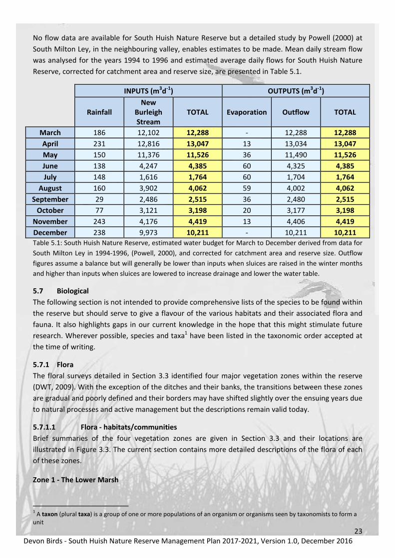
No flow data are available for South Huish Nature Reserve but a detailed study by Powell (2000) at
South Milton Ley, in the neighbouring valley, enables estimates to be made. Mean daily stream flow
was analysed for the years 1994 to 1996 and estimated average daily flows for South Huish Nature
Reserve, corrected for catchment area and reserve size, are presented in Table 5.1.
INPUTS (m3d
-1) OUTPUTS (m
3d
-1)
Rainfall
New
Burleigh
Stream
TOTAL Evaporation Outflow TOTAL
March 186 12,102 12,288 - 12,288 12,288
April 231 12,816 13,047 13 13,034 13,047
May 150 11,376 11,526 36 11,490 11,526
June 138 4,247 4,385 60 4,325 4,385
July 148 1,616 1,764 60 1,704 1,764
August 160 3,902 4,062 59 4,002 4,062
September 29 2,486 2,515 36 2,480 2,515
October 77 3,121 3,198 20 3,177 3,198
November 243 4,176 4,419 13 4,406 4,419
December 238 9,973 10,211 - 10,211 10,211
Table 5.1: South Huish Nature Reserve, estimated water budget for March to December derived from data for
South Milton Ley in 1994-1996, (Powell, 2000), and corrected for catchment area and reserve size. Outflow
figures assume a balance but will generally be lower than inputs when sluices are raised in the winter months
and higher than inputs when sluices are lowered to increase drainage and lower the water table.
5.7 Biological
The following section is not intended to provide comprehensive lists of the species to be found within
the reserve but should serve to give a flavour of the various habitats and their associated flora and
fauna. It also highlights gaps in our current knowledge in the hope that this might stimulate future
research. Wherever possible, species and taxa1 have been listed in the taxonomic order accepted at
the time of writing.
5.7.1 Flora
The floral surveys detailed in Section 3.3 identified four major vegetation zones within the reserve
(DWT, 2009). With the exception of the ditches and their banks, the transitions between these zones
are gradual and poorly defined and their borders may have shifted slightly over the ensuing years due
to natural processes and active management but the descriptions remain valid today.
5.7.1.1 Flora - habitats/communities
Brief summaries of the four vegetation zones are given in Section 3.3 and their locations are
illustrated in Figure 3.3. The current section contains more detailed descriptions of the flora of each
of these zones.
Zone 1 - The Lower Marsh
1 A taxon (plural taxa) is a group of one or more populations of an organism or organisms seen by taxonomists to form a
unit

24
Devon Birds - South Huish Nature Reserve Management Plan 2017-2021, Version 1.0, December 2016
Ph
oto
: A
lan
Po
mro
y
Figure 5.5: A view looking eastwards across the semi-improved grassland on the north side of Zone 1 in July
2016.
Zone 1, between the National Trust car park and the first transverse ditch, consists of improved/semi-
improved grassland maintained by summer grazing and occasional mowing. It is graded G31,
(National Trust, 2009), with abundant Perennial Rye-grass (Lolium perenne), Creeping Buttercup
(Ranunculus repens), White Clover (Trifolium repens) and Yorkshire Fog (Holcus lanatus) with
Common Nettle (Urtica dioica) and thistles including Musk Thistle (Carduus nutans) throughout. It has
elements of maritime grassland within it as the soil becomes increasingly sandy towards the north-
eastern corner (too small to map), containing Creeping Cinquefoil (Potentilla reptens), Lady’s
Bedstraw (Galium verum), Common Bird’s-foot Trefoil (Lotus corniculatus) and Common Restharrow
(Ononis repens). Parts of the grassland are subject to periodic inundation when the water levels are
high.
Ph
oto
: D
av
id M
itch
ell
Figure 5.6: An aerial view looking southwards across Zone 1 showing the adjacent National Trust car park and
dune system.
1 The National Trust’s Biological Survey Team uses a simple grassland classification system based on floral diversity with
G1 being the most diverse and G4 the least.

25
Devon Birds - South Huish Nature Reserve Management Plan 2017-2021, Version 1.0, December 2016
Zone 2 - The Higher Marsh
Ph
oto
: A
lan
Po
mro
y
Figure 5.7: A view of Zone 2 in July 2016 showing the diverse and luxuriant plant community.
This zone is located between the transverse ditches. Much of the area is marshy grassland with
abundant Creeping Bent (Agrostis stolonifera), Floating Sweet-grass (Glyceria fluitans), frequent Soft
Rush (Juncus effusus), Redshank (Persicaria maculosa) and Silverweed (Potentilla anserina), though
there are also tall stands of ‘fen type’ vegetation which includes frequent Common Reed (Phragmites
australis), Great Willowherb (Epilobium hirsutum), Gypsywort (Lycopus europaeus), Water Mint
(Mentha aquatica), occasional Tubular Water-dropwort (Oenanthe fistulosa), Marsh Bedstraw
(Galium palustre), and Purple Loosestrife (Lythrum salicaria) rarely. Parts of this zone are also subject
to periodic inundation when the water levels are high and the vegetation is maintained by summer
grazing.
Zone 3 - Southern Marsh
Ph
oto
: A
lan
Po
mro
y
Figure 5.8: A view southwards across Zone 3 in July 2016.

26
Devon Birds - South Huish Nature Reserve Management Plan 2017-2021, Version 1.0, December 2016
A species-rich area of marshy grassland containing a diverse flora including Common Cottongrass
(Eriophorum angustifolium), Ragged Robin (Lychnis flos-cuculi), Common Bird’s-foot Trefoil (Lotus
corniculatus), Marsh Marigold (Caltha palustris), Lesser Spearwort (Ranunculus flammula), Common
Sedge (Carex nigra), Jointed Rush (Juncus articulatus), Hard Rush (J. inflexus) and Soft Rush (J.
effusus). Southern Marsh-orchid (Dactylorhiza praetermissa), Yellow Flag-iris (Iris pseudacorus),
Redshank (Persicaria maculosa), Purple Loosestrife (Lythrum salicaria), Angelica (Angelica sylvestris),
Meadowsweet (Filipendula ulmaria) and Grey Club-rush (Schoenoplectus tabernaemontani) are also
present.
Zone 4 - Ditches
Ph
oto
: A
lan
Po
mro
y
Figure 5.9: A view along one of the transverse ditches in Zone 4 in July 2016.
The ditches and banks, which traverse the site, are rich in aquatic and emergent vegetation including
Water Horsetail (Equisetum fluviatile), Greater Spearwort (Ranunculus lingua), Reed Canary-grass
(Phalaris arundinacea), Greater Tussock-sedge (Carex paniculata), False Fox-sedge (Carex otrubae),
Soft Rush (Juncus effusus) and Marsh Marigold (Caltha palustris). The banks are dominated in places
by Common Reed (Phragmites australis), in association with Water Mint (Mentha aquatica), Water
Figwort (Scrophularia auriculata), Sea Club-rush (Bolboschoenus maritimus) and Grey Club-rush
(Schoenoplectus tabernaemontani).
27
Devon Birds - South Huish Nature Reserve Management Plan 2017-2021, Version 1.0, December 2016
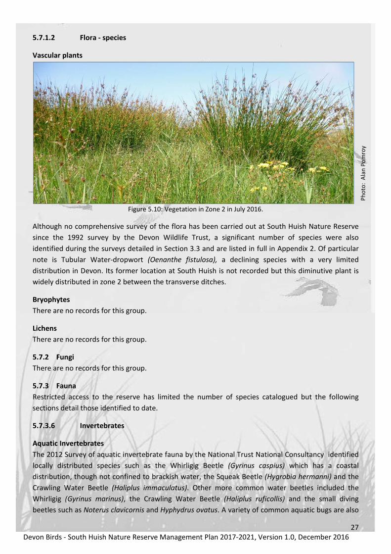
5.7.1.2 Flora - species
Vascular plants
Ph
oto
: A
lan
Po
mro
y
Figure 5.10: Vegetation in Zone 2 in July 2016.
Although no comprehensive survey of the flora has been carried out at South Huish Nature Reserve
since the 1992 survey by the Devon Wildlife Trust, a significant number of species were also
identified during the surveys detailed in Section 3.3 and are listed in full in Appendix 2. Of particular
note is Tubular Water-dropwort (Oenanthe fistulosa), a declining species with a very limited
distribution in Devon. Its former location at South Huish is not recorded but this diminutive plant is
widely distributed in zone 2 between the transverse ditches.
Bryophytes
There are no records for this group.
Lichens
There are no records for this group.
5.7.2 Fungi
There are no records for this group.
5.7.3 Fauna
Restricted access to the reserve has limited the number of species catalogued but the following
sections detail those identified to date.
5.7.3.6 Invertebrates
Aquatic Invertebrates
The 2012 Survey of aquatic invertebrate fauna by the National Trust National Consultancy identified
locally distributed species such as the Whirligig Beetle (Gyrinus caspius) which has a coastal
distribution, though not confined to brackish water, the Squeak Beetle (Hygrobia hermanni) and the
Crawling Water Beetle (Haliplus immaculatus). Other more common water beetles included the
Whirligig (Gyrinus marinus), the Crawling Water Beetle (Haliplus ruficollis) and the small diving
beetles such as Noterus clavicornis and Hyphydrus ovatus. A variety of common aquatic bugs are also

28
Devon Birds - South Huish Nature Reserve Management Plan 2017-2021, Version 1.0, December 2016
present including Saucer Bug (Ilyocoris cimicioides), the Small Water Bug (Plea atomaria) and the
Small Water Cricket (Microvelia reticulata).
Terrestrial Invertebrates
Insects
Insects associated with the wet margins of the ditches and open areas of mud include a variety wetland
species that are predators on other small invertebrates such as fly larvae. Examples include the ground
beetle (Dyschirius globosus), the shore bug (Chartoscirta cincta), and the rove beetles (Paederus riparius,
Stenus rogeri, S. pallitarsus and S. boops). The locally distributed snail-killing fly (Dichetophora obliterate)
was also present – this has larvae that feed on a variety of wetland snails. Other wetland insects, primarily
associated with the tall stands of wetland vegetation, include the Water Ladybird (Anisosticta 19-
punctata).
Damselflies and dragonflies
Ph
oto
: G
eo
ff F
oa
le
Figure 5.11: Azure Damselfly
Damselflies and dragonflies of the order Odonata have been little studied at South Huish Nature
Reserve, due to the restricted access, combined with fluctuating water levels, which are not
conducive to their breeding. However, the larger ditches support several of the commoner and more
adaptable species and those identified to-date are listed in Table 5.2 (below).
Species Common Name Status
Coenagrionidae
Coenagrion puella Azure Damselfly RB
Ischnura elegans Blue-tailed Damselfly RB
Pyrrhosoma nymphula Large Red Damselfly RB

29
Devon Birds - South Huish Nature Reserve Management Plan 2017-2021, Version 1.0, December 2016
Species Common Name Status
Aeshnidae
Aeshna cyanea Southern Hawker RB
Aeshna mixta Migrant Hawker RB
Anax imperator Emperor RB*
Libellulidae
Libellula quadrimaculata Four-spotted Chaser RB
Orthetrum cancellatum Black-tailed Skimmer RB
Sympetrum fonscolombei Red-veined Darter MB*
Sympetrum striolatum Common Darter RB
Table 5.2: Damselfly and dragonfly species recorded at South Huish Nature Reserve.
Key: M=migrant, R=resident, B=breeding (* Breeding status uncertain)
Butterflies
There are no records for this group.
Moths
There are no records for this group.
Arachnids
A spider list provided by the British Arachnological Society on the NBN Gateway includes common
wetland species such as Marsh Knob-head (Hypomma bituberculatum) and Reed Sac-spider (Clubiona
phragmitidis), along with species regarded as scarce (but not necessarily restricted to wetlands) such as
Oedothorax apicatus and Taranucnus setosus.
5.7.3.3 Reptiles
Ph
oto
: W
ikim
ed
ia C
om
mo
ns
Figure 5.12: Grass Snake (Natrix natrix)
Three species of reptile have been identified within the reserve, Grass Snake (Natrix natrix), Slow-
worm (Anguis fragilis) and Common Lizard (Zootoca vivipara).

30
Devon Birds - South Huish Nature Reserve Management Plan 2017-2021, Version 1.0, December 2016
5.7.3.4 Amphibians
Ph
oto
: A
lan
Po
mro
y
Figure 5.13: Common Frog, (Rana temporaria)
Three species of amphibian have been seen within the reserve, Common Toad (Bufo bufo), Common
Frog (Rana temporaria) and an unidentified newt, (Lissotriton sp.), probably Smooth Newt (Lissotriton
vulgaris).
5.7.3.5 Fish
Although no surveys of the fish species present have been undertaken at South Huish Nature
Reserve, Michael Loates, co-author of the Collins Pocket Guide - Fish of Britain and Europe, has
commented that the following are almost certain to be present: Nine-spined Stickleback (Pungitius
pungitius), Three-spined Stickleback (Gasterosteus aculeatus) and Common Eel (Anguilla Anguilla). In
addition, he suggested that Thick-lipped Mullet (Chelon labrosus) will occur and that Thin-lipped
Mullet (Liza ramada) and Golden Mullet (L. aurata) are also likely. The Mullet species all spawn at sea
but the young fish naturally head into the brackish sections of rivers and channels for protection
during the first two years of their lives, prior to becoming mature enough to head back out to sea. It
is likely that these species enter and leave South Huish Nature Reserve via the main drainage pipe to
the sea during high spring tides. Similarly, it is probable that juvenile Flounder (Platichthys flesus) also
find their way into the more saline ditch, closest to the sea, (Loates, pers. comm.). It is hoped that a
fish survey will be completed in the spring of 2017, before the seasonal growth of aquatic and
emergent vegetation makes sampling impractical.

31
Devon Birds - South Huish Nature Reserve Management Plan 2017-2021, Version 1.0, December 2016
5.7.3.2 Birds
Ph
oto
: A
lan
Do
idg
e
Figure 5.14: Glossy Ibis at South Huish Reserve in September 2013.
The assemblages of birds visiting South Huish Nature Reserve are the principal reason for Devon Birds
long association with and subsequent management of the site. The reserve supports a diverse
community of passage and wintering birds and a smaller number of breeding species.
For the purposes of this document the recording area includes all of the land and airspace easily
observable from the National Trust car park, which forms part of the western boundary. The roads
from South Milton Sands to Southdown Farm and towards South Huish Farm form the northern and
southern boundaries respectively and Southdown Farm also represents the eastern limit of the
recording area, which includes all of South Huish Nature Reserve and much of the valley beyond,
(Figure 5.15). Birds recorded on South Milton Sands or in Thurlestone Bay have been excluded from
the tables.
Historical data relating to species currently included in the British Trust for Ornithology’s (BTO)
Wetland Birds Survey (WeBS) have been compiled from Devon Bird’s annual reports from 1994
onwards, (Appendix 1.3, Tables 1.3 and 1.4). However, many of the wildfowl and wader counts
available relate to the wider Thurlestone area, which includes South Huish Nature Reserve, South
Milton Ley Nature Reserve and Thurlestone Marsh and, in recent Devon Birds’ annual reports, figures
from WeBS have only been included in the species accounts for principal sites. Fortunately, the BTO
has provided comprehensive WeBS data specifically for South Huish Nature Reserve for the years
1993-2015. These counts take place at monthly intervals and enable useful inter-annual comparisons
to be made. However, at a site where passage birds are frequently present for limited periods of
time, their presence does not always coincide with a WeBS count date. Consequently the data have
been supplemented with figures from Devon Birds’ annual reports, The Harrier, (Devon Birds’
newsletter), and from the Thurlestone Bay Birds website to present as complete a picture as possible.

32
Devon Birds - South Huish Nature Reserve Management Plan 2017-2021, Version 1.0, December 2016
Figure 5.15: South Huish Nature Reserve bird recording area used in this document. (Map data: Google, 2016)
For its relatively small size South Huish Nature Reserve has recorded a significant variety of birds,
with the accepted total at the end of 2016 standing at 206 species recorded since 1969. Tucker
(2007) mentions an additional three species, Black Stork (Ciconia nigra), Black Kite (Milvus migrans)
and Whiskered Tern (Chlidonias hybrida) “identified since the early 1970’s” but these undated
records were attributed to Thurlestone, Thurlestone and Slapton area and South Milton Ley
respectively in the relevant British Birds Rarities Committee annual reports. Consequently, these
species are excluded from the total. A complete bird list for the reserve from 1969 to 2016 is
presented in Appendix 1.1, Table A1.1.
Careful management of the water levels, drainage and vegetation within the reserve, together with
the coastal location, which is ideally suited to attract passage migrants, has contributed towards this
extensive species list. The total includes 40 species or subspecies that are currently red-listed as
species of conservation concern and a further 72 amber-listed species, (Appendix 1.2, Table A1.2).
Whilst some of these are rare or occasional visitors to the reserve, many are annual with some in
significant numbers and all serve to emphasise the value of the habitat and the positive impact of the
current management practices. The significant increase in both the numbers and variety of species
using South Huish Nature Reserve since Devon Birds assumed management responsibility in 1994 is
clearly illustrated in Figure 5.16.
The most recent data on the habitat and dietary requirements of the principal bird species using the
South Huish Nature Reserve are included in Section 8.3 and have been used as an aid to establishing
the management priorities and protocols.

33
Devon Birds - South Huish Nature Reserve Management Plan 2017-2021, Version 1.0, December 2016
Figure 5.16: Changes in the maximum number of WeBS species and number of birds reported annually at
South Huish before and after the commencement of management by Devon Birds in 1994.
Passage birds
Ph
oto
: A
lan
Do
idg
e
Figure 5.17: Little Stint at South Huish Nature Reserve.
The reserve provides a valuable staging and feeding area for a wide variety of wetland birds on
passage, principally waders, with 25 species being recorded during WeBS counts, (Appendix 1.3,
Tables 1.3 and 1.4). Migrants with a preference for fresh or brackish marshes, such as Little Ringed
Plover (Charadrius dubius), Curlew Sandpiper (Calidris ferruginea), Little Stint (C. minuta), Green
Sandpiper (Tringa ochropus) and Wood Sandpiper (T. glareola), have all been recorded annually in
recent years, either on the scrapes or the margins of ditches and small numbers of Garganey (Anas
0
10
20
30
40
50
60
70
80
0
200
400
600
800
1000
1200
1400
1600N
um
be
r of sp
ecie
s rep
orte
dNu
mb
er
of
bir
ds
re
po
rte
dTotals
Species

34
Devon Birds - South Huish Nature Reserve Management Plan 2017-2021, Version 1.0, December 2016
querquedula) are regular in most springs. Winds from an easterly direction help to drift migrants
across to the English side of the Western Approaches, occasionally resulting in unexpectedly high
numbers, such as 14 Little Ringed Plover in April 2013.
Passage visitors are not confined to waterbirds and the short sward of the lower marsh attracts a
variety of passerines in spring and autumn, such as Wheatear (Oenanthe oenanthe), Whinchat
(Saxicola rubetra) and Yellow (Motacilla flava), Pied (M. alba yarelli) and White Wagtails (M. alba
alba). The presence of livestock and their associated droppings during the autumn months is
particularly attractive to wagtails, which congregate and feed at South Huish Nature Reserve before
roosting in the reedbed at nearby South Milton Ley. Large numbers of hirundines also gather to rest
and refuel before continuing their journeys, frequently proving attractive to passage Hobbys (Falco
Subbuteo).
Ph
oto
: A
lan
Do
idg
e
Figure 5.18: Whinchat at South Huish Nature Reserve.
Winter birds
Ph
oto
: B
ruce
Ch
urc
h
Figure 5.19: Hen Harrier chasing a Snipe at South Huish Nature Reserve in November 2013.

35
Devon Birds - South Huish Nature Reserve Management Plan 2017-2021, Version 1.0, December 2016
Dabbling and grazing duck species such as Mallard (Anas platyrhynchos), Teal (A. crecca), Wigeon (A.
penelope) and Canada Goose (Branta canadensis) are attracted by the availability of suitable pasture
and the security of elevated water levels and dominate the winter bird assemblages at South Huish
Nature Reserve together with small numbers of Shoveler (Anas clypeata), Pintail (A. acuta) and
Gadwall (A. strepera). Snipe (Gallinago gallinago) are also frequently present in good numbers
together with lower numbers of Lapwing (Vanellus vanellus). A wide variety of other species have
been recorded, (Tables A1.3 and A1.4), occasionally including an elusive Jack Snipe (Lymnocryptes
minimus) or other less common species.
An important feature of these coastal grazing meadows is that during severe winter weather,
especially when other areas of the UK or the near continent are adversely affected, the oceanic
influence means they often remain relatively snow and ice-free. At such times the reserve provides a
safe haven for wetland species during their cold weather movements and can result in exceptionally
high numbers being recorded, such as the 2,600 Wigeon and 256 Snipe, which passed through during
particularly cold snaps in the winters of 1982 and 2010 respectively.
The presence of such large numbers of potential prey species inevitably attracts raptors including
Peregrine (Falco peregrinus), Sparrowhawk (Accipiter nisus) and Kestrel (F. tinnunculus) whilst other
avian predators such as Merlin (F. columbarius), Hen Harrier (Circus cyaneus), Marsh Harrier (C.
aeruginosus) and Short-eared Owls (Asio flammeus) are less frequent.
Winter passerines include Pied Wagtails (Motacilla alba yarellii), Meadow (Anthus pratensis) and
Rock Pipits (A. petrosus) together with Stonechat (Saxicola rubicola) and the occasional Black
Redstart (Phoenicurus phoenicurus). These species can frequently be found foraging for insects and
crustaceans amongst the weed along the strand line on the adjacent South Milton Sands but retreat
to the reserve when disturbance levels are too high on the beach. Water Pipits (Anthus spinoletta)
are uncommon but regular winter and passage visitors, which prefer the short sward of the lower
marsh, as do Pied Wagtails, gathering in significant numbers in the late afternoons before flying to
roost at South Milton Ley.
Ph
oto
: D
av
id P
ak
es
Figure 5.20: White-fronted Goose at South Huish Nature Reserve in February 2015.

36
Devon Birds - South Huish Nature Reserve Management Plan 2017-2021, Version 1.0, December 2016
Breeding birds
Ph
oto
: G
reg
Bra
db
ury
Figure 5.21: Shelduck and young.
Twelve species of bird have been confirmed as breeding within the boundaries of South Huish Nature
Reserve between 1969 and 2016, four of which are currently amber listed as Birds of Conservation
Concern in a national context, (Eaton et al., 2015). These are detailed in Table 5.3 (below). With the
exception of Pheasant, all of the species have an association with freshwater and its margins. The
habitats at South Huish, coupled with an absence of trees and shrubs are not suitable for the majority
of passerines although many feed within the reserve but nest elsewhere.
Common name Taxon name Breeding Status
Mute Swan Cygnus olor Occasional
Shelduck Tadorna tadorna Annual in recent years
Canada Goose Branta canadensis Annual
Mallard Anas platyrhynchos Annual
Pheasant Phasianus colchicus Occasional
Moorhen Gallinula chloropus Annual
Coot Fulica atra Occasional
Cetti’s Warbler Cettia cetti Occasional
Sedge Warbler Acrocephalus schoenobaenus Annual
Reed Warbler Acrocephalus scirpaceus Annual
Pied Wagtail Motacilla alba Occasional
Reed Bunting Emberiza schoeniclus Annual
Table 5.3: Breeding birds at South Huish Nature Reserve, 1969-2016. Species currently amber listed as Birds of
Conservation Concern, (Eaton et al., 2015), are highlighted. (Species order follows BOU 2016 and subsequent
changes to the list included in BOURC reports).

37
Devon Birds - South Huish Nature Reserve Management Plan 2017-2021, Version 1.0, December 2016
Scarce migrants and vagrants
Ph
oto
: A
lan
Do
idg
e
Figure 5.22: Common Crane (Grus grus) at South Huish Nature Reserve in December 2014.
In addition to those species of bird detailed above, the habitats at South Huish Nature Reserve and its
proximity to the coast have proved attractive to a variety of rarer migrants and vagrants over the
years. A selection of these records occurring between 1969 and the present, which have been
accepted by either Devon Birds or the British Birds Rarities Committee, are included in Table 5.10
(below). This document does not attempt to produce a list of all species recorded, due to the
difficulties in determining the exact location of some historical records, particularly as earlier
sightings were frequently attributed to the greater Thurlestone area.
Common name Taxon name Comments
Bewicks Swan Cygnus columbianus 1981, 2005
Whooper Swan Cygnus cygnus 2003
Bean Goose Anser fabalis 1995
Ruddy Shelduck Tadorna ferruginea 1999, 2014, 2015 and 2016
American Wigeon Anas americana Two in 1983
Scaup Aythya marila 1982
Bittern Botaurus stellaris 2011 and 2012
Squacco Heron Ardeola ralloides 1983
Cattle Egret Bubulcus ibis Four records of up to three birds in 2008,
2009, 2012 and 2016
Great White Eget Ardea alba 2014 and 2016
Purple Heron Ardea purpurea 2014 with two birds together in 2016

38
Devon Birds - South Huish Nature Reserve Management Plan 2017-2021, Version 1.0, December 2016
Ph
oto
: A
lan
Do
idg
e
Figure 5.23: Purple Heron (Ardea purpurea) at South Huish Nature Reserve in May 2016.
White Stork Ciconia ciconia 1980
Glossy Ibis Plegadis falcinellus 2008, 2009, 2014, 2015, 2016 with
9 birds together in 2013
Spoonbill Platalea leucorodia 2007, 2008, 2014 with three birds
together in 2013
Spotted Crake Porzana porzana 2005
Common Crane Grus grus 2014
Great Bustard Otis tarda 2011, (from the Salibury Plain
reintroduction scheme)
Ph
oto
: A
lan
Do
idg
e
Figure 5.24: Great Bustard (Otis tarda) at South Huish Nature Reserve in November 2011.

39
Devon Birds - South Huish Nature Reserve Management Plan 2017-2021, Version 1.0, December 2016
Black-winged Stilt Himantopus himantopus Two in 1995, four in 2002 and one
in 2006
Kentish Plover Anarhynchus alexandrinus 1996
Pectoral Sandpiper Calidris melanotos 2002, 2012 and 2014
Red-necked Phalarope Phalaropus lobatus 2003
Pomarine Skua Stercorarius pomarinus 2016
Ring-billed Gull Larus delawarensis 2015
Iceland Gull Larus glaucoides glaucoides* 1983, 1996, 2014 and 2015
Kumlien's Gull Larus glaucoides kumlieni* 2015
Glaucous Gull Larus hyperboreus 1981, 1983, 2001, 2005, 2008,
2009 and four singles in 2014
Ph
oto
: A
lan
Do
idg
e
Figure 5.25: Glaucous Gull (Larus hyperboreus) at South Huish Nature Reserve in February 2014.
Isabelline Shrike Lanius isabellinus 2015
Ph
oto
: S
tev
e H
op
pe
r
Figure 5.26: Isabelline Shrike (Lanius isabellinus) at South Huish Nature Reserve in October 2015.
Red-backed Shrike Lanius collurio 2015

40
Devon Birds - South Huish Nature Reserve Management Plan 2017-2021, Version 1.0, December 2016
Great Grey Shrike Lanius excubitor 2011
Woodchat Shrike Lanius senator 1980
Bearded Tit Panurus biarmicus Two in 2013
Red-rumped Swallow Cecropis daurica 1996, 2006 and 2012
Yellow-browed Warbler Phylloscopus inornatus 2015
Rose-coloured Starling Pastor roseus Three in 2002
Desert Wheatear Oenanthe deserti 2016
Black-headed Wagtail Motacilla flava feldegg* 2005
Ph
oto
: Jo
hn
Le
e
Figure 5.27: Black-headed Wagtail (Motacilla flava feldegg), August 2005.
Blue-headed Wagtail Motacilla flava flava* 2010, 2011, 2013, 2015 and 2016
Common Rosefinch Erythrina erythrina 1996
Lapland Bunting Calcarius lapponicus 2012
Snow Bunting Plectrophenax nivalis Two in 2011
Table 5.4: Rare and scarce birds recorded at South Huish Nature Reserve, 1969-2016. All records refer to single
birds unless otherwise stated. (Species order follows BOU 2016 and subsequent changes to the list included in
BOURC reports). Subspecies are marked *.
5.7.3.1 Mammals
Ph
oto
: T
err
y W
hit
tak
er
Figure 5.28: Water Vole (Arvicola amphibius).

41
Devon Birds - South Huish Nature Reserve Management Plan 2017-2021, Version 1.0, December 2016
No formal studies have been undertaken of the mammals at South Huish and the following list (Table
5.11) is based on casual observations over many years. The principal species of conservation concern
are the European Otter (Lutra lutra), an occasional visitor, and the Water Vole (Arvicola amphibius),
which was re-introduced to the site by the former owner in 2010. Its current status there is unknown.
Order Common name Taxon name
Rodentia Wood Mouse Apodemus sylvaticus
Rodentia Bank Vole Myodes glareolus
Rodentia Field Vole Microtus agrestis
Rodentia Water Vole* Arvicola amphibius
Rodentia Brown Rat Rattus norvegicus
Rodentia Grey Squirrel Sciurus carolinensis
Insectivora Common Shrew Sorex araneus
Insectivora European Mole Talpa europaea
Insectivora Eurasian Hedgehog Erinaceus europaeus
Lagomorpha European Rabbit Oryctolagus cuniculus
Lagomorpha Brown Hare Lepus europaeus
Carnivora Red Fox Vulpes vulpes crucigera
Carnivora European Badger Meles meles
Carnivora European Otter Lutra lutra
Carnivora American Mink Neovison vison
Carnivora Stoat Mustela erminea
Carnivora Weasel Mustela nivalis
Artiodactyla Roe Deer Capreolus capreolus
Table 5.5: Mammals of South Huish Nature Reserve. Species order is taken from The Mammal Society
full species list. (*re-introduced in 2010. Current status unknown).
No bat breeding or roosting sites have been identified within the reserve and although several
species feed there during the summer months there are no records for this group (Source Devon
Mammal Group webpages - www.devonmammalgroup.org).
European Otter (Lutra lutra)
Conservation/protected status
• International: IUCN status: 2008 classification as Near Threatened
• European: The Otter is a European Protected Species under the Convention on the Conservation
of European Wildlife and Natural Habitats (Bern Convention) Appendix II (special protection for
listed animal species and their habitats) and the Directive on the Conservation of Natural
Habitats and of Wild Fauna and Flora (Habitats & Species Directive) Annex IIa and IIIa
• National:
o In 1978 the connection was made between the decline in Otter populations and the
widespread use of organochlorine pesticides in farming. As a result, Otters were given full
legal protection under Schedule 5 of the Wildlife and Countryside Act 1981 (as amended by
the Countryside and Rights of Way Act 2000).
o The Otter is listed as a Species of Principal Importance under the NERC Act 2006 and on the
UK Biodiversity Action Plan as a priority species (one that is globally threatened and rapidly

42
Devon Birds - South Huish Nature Reserve Management Plan 2017-2021, Version 1.0, December 2016
declining in the UK) and has a Species Action Plan. It has also been identified as a species of
key conservation concern in Devon and has a Devon Biodiversity Action Plan and also in
Local BAPs in Dartmoor, Exeter, Teignbridge and others.
Water Vole (Arvicola amphibius)
Conservation/protected status
• National:
o The Water Vole received limited legal protection in April 1998 through its inclusion in
Schedule 5 of the Wildlife & Countryside Act 1981 (as amended) for some offences. This
protection has recently been extended (6th April 2008), so the Water Vole is now fully
protected under Section 9. Legal protection makes it an offence to:
o - intentionally kill, injure or take (capture) a Water Vole;
o - possess or control a live or dead Water Vole, or any part of a Water Vole;
o - intentionally or recklessly damage, destroy or obstruct access to any structure or place
which Water Voles use for shelter or protection or disturb Water Voles while they are using
such a place;
A number of historical management committee minutes reported that Water Voles might have been
reintroduced at South Huish Nature Reserve by the previous owner although neither Devon Birds nor
the National Trust were informed of any release. No sightings of Water Voles had been reported to
either organisation up to 18 January 2013. A freedom of Information request to Natural England
confirmed that they also have no record of a release at South Huish. However, there have been
recent reports, from contractors working on the marsh, suggesting there may be a healthy
population within the reserve at least during the drier summer months.
Research conducted for this document has discovered that the former owner, Peter Stafford,
financed the release of captive-bred Water Voles in 2010, following a mink monitoring and control
program under the guidance of independent consultants. The animals were provided by and the
project overseen by Derek J Gow Consultancy Ltd., who specialise in Water Vole mitigation,
reintroduction and development-led translocation projects. A survey to determine the current status
of the species within the reserve is recommended in Section 8.3, Objectives and Rationale, as a
continued presence would require re-evaluation of current ditch maintenance protocols. In the UK,
Water Voles and their habitat are fully protected by law under the Wildlife and Countryside Act
(1981) as detailed above.
5.7.4 Alien / invasive pest species
No significant alien invasive plant species have been recorded within the reserve. An alien animal
introduction, generally regarded as a pest species, the American Mink (Mustela vision), has been
observed, and poses a significant threat to breeding birds, small mammals and amphibians.
5.8 Cultural
5.8.1 Archaeology
No archaeological finds have been made within the boundaries of the reserve. However, a number of
significant discoveries from just outside the reserve on South Milton Sands and Leas Foot Beach are
documented in Appendix 6 of the South Milton Ley Management Plan (Pomroy, 2016).

43
Devon Birds - South Huish Nature Reserve Management Plan 2017-2021, Version 1.0, December 2016
5.8.1.1 Bronze Age1
A small excavation of the intertidal peat in 1998 returned a radiocarbon date of 3,910-3,640 years
before present (BP) from the base of the deposit, and 3,790-3,530 BP from the top of the peat
(spread c. 190 mm), (Reed and Whitton, 1999). This suggests that the deposit may have accumulated
within a relatively short time span and over a maximum period of 380 years. This is supported by
palaeoenvironmental analysis, which indicated a wet fen situation and rapid peat growth. Pollen
analysis showed evidence of transition from a woodland environment with open freshwater pools to
more waterlogged open fen with increasing signs of pastoral grassland.
Macrofossil analysis suggests a development from deep open freshwater dominated by aquatic
plants to reed swamp and alder/oak woodland. There is clear evidence for woodland clearance and a
developing pastoral landscape from the early/middle Bronze Age, (Reed and Whitton, 1999). Pollen,
plant macrofossils and insects indicated open grazed pasture close to the wet fen vegetation. There
was no evidence of a marine environment suggesting that the area was not subject to coastal
flooding at this time (Blaylock and Neophytou, 2004). The peat was of Late Bronze Age date, which is
unusual for an intertidal deposit and suggests very rapid coastal change in the area. Severe coastal
erosion is evident today and is clearly not a recent phenomenon (Webster, 2007).
5.8.1.2 Medieval Period2
The land in this area was clearly divided into holdings and was part of a large estate by the Anglo-
Saxon period3, (part of the South Hams granted by King Aethelwulf to himself in a charter of 847,
(Hooke, 1994)). South Milton and South Huish are Domesday Manors and the parish boundary
between them follows the stream west from South Huish to Thurlestone Rock. It is not clear when
the land was enclosed, possibly in the medieval period, although South Huish retained areas of
subdivided arable land (open field system) until the 17th
century, (Fox, 1975). In the medieval period
the region was predominantly arable, with little woodland. The decline in the value of arable land
and in population numbers in the 15th
century may have led to the enclosure of land units to be
farmed by a single tenant, rather than the open field system, this being more usual by c.1500, (Fox,
1975). At the time of the Tithe Map the land is predominantly arable with pasture only in the valley
bottom.
5.8.1.3 Post Medieval Period
The earliest reference to the Parish of South Huish is in “The Exeter Book” of 1806, when the owner
of the area was shown as Judhel of Totnes. In “The Survey of Devon”, (Risdon, 1811) it was reported
that, before Judhel, the land was “owned by an Englishman named Algar” and after by William Fitz-
stephens. The land remained in the Fitz-stephens family for four generations. In the reign of Edward
III South Huish was owned by Lord Walter Manny and by the 19th
century by Lord Viscount
Courtenay, (Polwhele, 1806). During the majority of the 20th
century it was in the ownership of the
Darke family before its purchase in 1989 by Peter Stafford, who subsequently gifted the land to the
National Trust in 2011.
1 Bronze Age Britain refers to the period of British history that spanned from c. 2500 until c. 800 BC
2 The medieval period lasted from the 5
th to the 15
th century.
3 The Anglo-Saxon period stretched over 600 years from 410 to 1066.

44
Devon Birds - South Huish Nature Reserve Management Plan 2017-2021, Version 1.0, December 2016
5.8.2 Past land use
Ph
oto
: Ja
me
s B
ass
The earliest available land plans of the valley show that a drained meadow system existed from at
least 1724, described as marshy ground and bearing the legend “Liable to floods” (Burridge, 1992).
The present ditches were dug in the early 20th century, (Stevens, 1995) although D’Urban and
Mathew (1892) commented that: “Huish Ley by recent successful drainage is now converted into a
marsh and is a favourite nesting-place for the Lapwing” indicating that the drainage was initially
improved in the late 19th
century. Reference has also been made to South Huish being “enclosed with
hedges planted with thorns, except towards the sea where they are of stone”, (Polwhele, 1806). The
water meadow system was practiced until at least the middle of the last century and in drought years
produced some of the only summer grazing in the area, (D. Darke, pers. comm.). The land has
continued to be used as summer grazing for livestock up until the present day. Historical maps for
1886, 1906 and 1952 show little change over the years, (Figures 5.29 to 5.31), and contain no
indication of the series of transverse drainage ditches, which now run from south to north across the
valley.
Figure 5.29: South Huish Ordnance Survey map 1886

45
Devon Birds - South Huish Nature Reserve Management Plan 2017-2021, Version 1.0, December 2016
Figure 5.30: South Huish Ordnance Survey map 1906
Figure 5.31: South Huish Ordnance Survey map 1952

46
Devon Birds - South Huish Nature Reserve Management Plan 2017-2021, Version 1.0, December 2016
The presence of a relatively small bore and inefficient outlet pipe, draining the site into the sea, led to
regular winter flooding between November and March and occasional flash floods at other times of
the year. However, in 1981, after a prolonged period of flooding in the winter of 1980, the landowner
installed a drainage pipe with a larger bore, resulting in much lower water levels with little flooding
except for short periods in the winter. At the same time the ditches were deepened and cleared and
the land was ploughed and reseeded with a commercial grass mix, (Tucker, 2007). Fertiliser was
applied between 1981 and 1993 and there was some spraying of herbicides. The site continued to be
grazed by cattle until 1995, (Stevens, 1995). Although the increased area of improved pasture proved
temporarily attractive to numbers of herbivorous wildfowl, this was followed by a significant
reduction in the number and variety of birds using the site, which remained the case until Devon
Birds assumed management responsibility (Figure 5.32).
Figure 5.32: Changes in the maximum number of birds and variety of WeBS species reported annually at South
Huish before and after draining and reseeding in 1981
5.8.3 Present land use
The current drainage ditches, both within the reserve and further up the valley, are illustrated clearly
in the latest Ordnance Survey map, (Figure 5.33). Above the reserve on the valley slopes the land
today is a mixture of arable, improved and semi-improved grassland. Some of the arable fields
receive fertiliser and pesticide treatments and some of the improved grasslands receive fertiliser
applications. The National Trust now owns Southdown Farm to the north of the reserve and
completed a nature conservation evaluation of the farm and South Huish Nature Reserve in 2012.
Current land use on the farm is detailed in Figure 5.34. The land within South Huish Nature Reserve is
still grazed by cattle, sheep and ponies during the summer and autumn months, principally to
maintain a short, healthy sward and prevent the spread of rushes and other invasive perennial plants.
0
5
10
15
20
25
30
35
40
45
0
500
1000
1500
2000
2500
3000
3500
4000
4500
1978 1979 1980 1981 1982 1983 1984 1985 1986 1987 1988 1989 1990 1991 1992 1993
Nu
mb
er o
f spe
cies re
po
rtedN
um
be
r o
f b
ird
s r
ep
ort
ed
TotalNumber of species

47
Devon Birds - South Huish Nature Reserve Management Plan 2017-2021, Version 1.0, December 2016
Management requires achieving a balance between providing optimum conditions for birds and
maintaining sufficient pasture for economically viable grazing.
Figure 5.33: South Huish Ordnance Survey map 2016.
Figure 5.34: South Huish Nature Reserve and Southdown Farm, current land use, (National Trust, 2012).
The National Trust’s nature conservation evaluation of the reserve and Southdown Farm made a
number of recommendations, which will be of benefit to the ecology of the reserve and are
reproduced in Table 5.6 below.

48
Devon Birds - South Huish Nature Reserve Management Plan 2017-2021, Version 1.0, December 2016
Wetland
• Ideally catchment management should aim to minimize siltation and nutrient inputs into the
wetland - the whole catchment should be managed under an appropriate low intensity agricultural
system.
• It is desirable that fields within the catchment should be managed as permanent vegetation, not
ploughed and reseeded, or used for arable, at least on the steeper sloping fields where ground
should be left unploughed.
• Maintain good water quality, without excessive nutrients, especially nitrates and phosphates –
fertilisers, herbicides and pesticides should not be applied within 10m of watercourses or the
marsh, and ideally not at all within the fields bordering the marsh – link to management of the
farmland (see below).
Farmland
• A long-term vision should be to link the management of the farmland with that of the wetland. In
order to guide this, a Land Capability Assessment should be undertaken in order to assess options
for meeting objectives of preventing pollution of the marsh etc. - when/if the opportunity arises to
influence the management of the land above.
• As outlined above it is particularly important to keep nutrient levels low in the vicinity of
watercourses and the marsh in the valley, but this also applies to the hedgebanks.
• Ideally manage the farm under a minimum input, permanent pasture system in order to minimise
adverse effects of run-off, siltation and enrichment.
• However, if arable is to be included within the farm system then manage the arable in a way
sympathetic to wildlife, and locate the arable fields away from the marsh on the higher ground.
and on land that is not on steep slopes.
• Suitable arable management should include:
o Some spring sown crops with winter stubbles to provide a food source for birds, and some
stubbles could be left undisturbed for late flowering arable plants, or even longer as fallow –
leaving some fields as fallow can have wildlife benefits.
o Unsprayed and unfertilised cultivated headlands of at least one boom’s-width should be
incorporated along some of the field margins. These will provide opportunities for arable
plants and help protect hedgebanks from enrichment or pollution.
• Avoid stock feeding in the field behind the café, especially on the steeper, more species rich
slopes, in order to minimise enrichment and damage through vehicle disturbance.
Table 5.6: South Huish Nature Reserve and Southdown Farm, recommendations of the nature conservation
evaluation, (National Trust, 2012).
Is not currently known whether these recommendations have been implemented by the National
Trust.

49
Devon Birds - South Huish Nature Reserve Management Plan 2017-2021, Version 1.0, December 2016
6. Past management for nature conservation
Ph
oto
: B
ob
Bu
rrid
ge
Figure 6.1: Ditching works and scrape creation in 1994.
There had been no consideration of nature conservation at South Huish prior to its purchase by Peter
Stafford in 1988 with previous management targeted at maximising the availability of pasture for grazing.
Devon Birds’ first involvement with the site in 1994 pre-dated the signing of a formal management
agreement with the owner in 1995. It falls outside the scope of this plan to list all of the past efforts to
maintain and improve the habitats and infrastructure within the reserve but the investment of the society,
its officers and members over the years has been considerable.
Vic Tucker in particular, together with Bob Burridge, has driven many of the improvements within the
reserve in collaboration with a succession of Devon Birds’ conservation officers, both official and honorary,
including John Avon, Wal Towler, Peter Stevens, Nik Ward, Jim Bennett and Nick Townsend. Each of these
individuals contributed immense enthusiasm and particular strengths and specialisms without which the
reserve would be much the poorer today.
A great deal of the work has been undertaken by small bands of interested and willing members and
volunteers, who have assisted in a variety of tasks both practical and hands-on or behind the scenes.
Devon Birds recognises that their efforts, often unsung, have made an invaluable contribution to the
success of the reserve. A comprehensive survey of site levels within the reserve was undertaken by Devon
Birds’ member and civil engineer Peter Hopkin in 1995 and the resulting data were essential in enabling
the precise excavation of scrapes in natural low spots. The excavations, using heavy plant were assisted by
a laser-guided levelling system, which was innovative technology at the time.
The tasks undertaken have ranged from one-offs, such as mechanical mowing, sluice construction and
major drainage works and annual events such as administering the grazing regime, to the regular
maintenance of the infrastructure within the reserve and adjustments of the water levels in response to
the prevailing environmental conditions. It is a credit to the quiet efficiency of those involved over the
years that, with the exception of occasional but essential ditch and scrape maintenance, much of this work
goes unnoticed by the casual visitor. Local emergencies, such as the unexpected flooding of the reserve
following storms or unseasonally high precipitation, have all been dealt with quickly and effectively.

50
Devon Birds - South Huish Nature Reserve Management Plan 2017-2021, Version 1.0, December 2016
Ph
oto
s: A
lan
Po
mro
y
Figure 6.2: Ditch 2 (left) in July 2016, prior to clearance works and Ditch 1 (right) at the same time, following
clearance of the channel and one bank in 2015.
Ph
oto
: A
lan
Po
mro
y
Figure 6.3: The main scrape in July 2016, immediately after draining to allow re-profiling and clearance of the
encroaching rushes

51
Devon Birds - South Huish Nature Reserve Management Plan 2017-2021, Version 1.0, December 2016
Ph
oto
: A
lan
Po
mro
y
Figure 6.4: The main scrape in April 2017, eight months after re-profiling and clearance of encroaching rushes
Not all of the management actions have proved successful despite taking the best advice available at the
time. Difficulties have been experienced in establishing and enforcing an appropriate grazing regime.
Stocking densities and unsuitable livestock breeds, coupled with conflicting interests between previous
landowners, graziers and conservation requirements, have led to the occasional need for intervention and
mechanical cutting to prevent the spread of rushes and coarse perennials. These events have helped to
refine the grazing protocols detailed later in this document.
Current best practice requires that the impacts of major management activities are monitored and
assessed against baseline data. Whilst there is no doubt that the habitats and biodiversity of South Huish
Reserve have benefited from Devon Birds’ involvement, much of the data are qualitative rather than
quantitative and this is a weakness which is addressed later in this plan. This also presents an excellent
opportunity to engage with members and a wider audience in other conservation bodies and to make best
use of their enthusiasm and experience.
The following section outlines the history of major events and Devon Birds’ activities at South Huish
Nature Reserve from 1968 to the present day. The list is not comprehensive as documentation of some
past events is incomplete. Full details of current and proposed management activities are included later in
the Objectives and Annual work plan (Sections 8.3 and 8.5).
6.1 The chronology of major management and other events
1968: Recognition of the potential value of the site by Bob Burridge, (Tucker, 2007).

52
Devon Birds - South Huish Nature Reserve Management Plan 2017-2021, Version 1.0, December 2016
1980: Informal agreement reached with the landowner David Darke to establish South Huish as a society
reserve, (Devon Birds, 1980).
1981: Small bore drainage pipe replaced with a significantly larger bore by the landowner. Land re-
ditched, ploughed and re-seeded with a commercial grass mix resulting in less flooding and a
significant decline in water birds, (Tucker, 2007).
1988: Peter Stafford purchases the land at the seaward end of the valley and begins a dialogue with
Devon Birds about management of the site, (Stafford pers. comm.).
1990: The National Trust constructs a wooden piling sea defence at South Milton Sands to protect the
dune system and the land behind from erosion. A new car park provided an elevated view across
the reserve.
1992: Preliminary report detailing possible management options produced, (Burridge, 1992).
1992: Botanical Survey completed by the Devon Wildlife Trust.
1992: The National Rivers Authority confirms that it has no objections from a land drainage or
conservation point of view in relation to proposed changes to drainage regime.
1994: First ditch management plan drafted, (Stevens, 1994)
1995: Formal management agreement signed with Devon Birds setting up a 20-year joint venture to
create a freshwater meadowland for the benefit of flora and fauna by means of controlled flooding,
(Tucker, 2007).
1995: First reserve management plan written, (Stevens, 1995).
1995: Comprehensive survey of site levels within the reserve undertaken by Devon Bird’s member Peter
Hopkin, (Tucker, 2007).
1995: Major improvements including the excavation of scrapes, the enlargement of drainage ditches,
reprofiling of their banks and the installation of sluices allowing precise control over water depths
across the reserve, (Tucker, 2007).

53
Devon Birds - South Huish Nature Reserve Management Plan 2017-2021, Version 1.0, December 2016
Ph
oto
: B
ob
Bu
rrid
ge
Figure 6.5: Excavation of the scrape in 1995.
Ph
oto
s: B
ob
Bu
rrid
ge
Figure 6.6: Pumping water from the transverse ditches to fill the scrape in 1995.

54
Devon Birds - South Huish Nature Reserve Management Plan 2017-2021, Version 1.0, December 2016
Ph
oto
: B
ob
Bu
rrid
ge
Figure 6.7: Ditching works and installation of drainage sluices in 1995.
1999: Advice given by the RSPB on appropriate water levels for waders and wildfowl and the control of
invasive rushes, (Davies, 1999)
2001: No grazing possible due the restrictions imposed during the foot and mouth disease outbreak,
(Tucker, 2007).
2002: Mechanical clearance of invasive plants and overgrowth resulting from the absence of grazing.
2003: R. Rogers assumes responsibility for grazing within the reserve, (Ward, 2003).
2005: Water level management calendar and timing and draining plan for individual sectors completed.
2007: Second botanical survey completed, (Smith, 2007).
2007: Advice given by the Devon Farming and Wildlife Advisory Group confirms the suitability of
management processes in place and the need for continued access restrictions, (Johnson, 2007).
2009: The National Trust regenerated the dune system immediately to the west of the reserve, which
they hoped would flex and adjust with rising sea levels and coastal change. Rotten timber pilings
and many tons of rubble and waste were removed and new parking and access created.
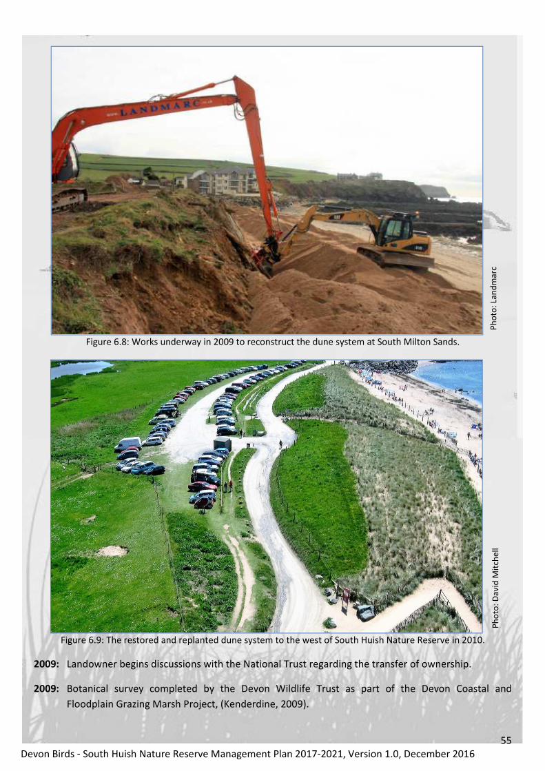
55
Devon Birds - South Huish Nature Reserve Management Plan 2017-2021, Version 1.0, December 2016
Ph
oto
: La
nd
ma
rc
Figure 6.8: Works underway in 2009 to reconstruct the dune system at South Milton Sands.
Ph
oto
: D
av
id M
itch
ell
Figure 6.9: The restored and replanted dune system to the west of South Huish Nature Reserve in 2010.
2009: Landowner begins discussions with the National Trust regarding the transfer of ownership.
2009: Botanical survey completed by the Devon Wildlife Trust as part of the Devon Coastal and
Floodplain Grazing Marsh Project, (Kenderdine, 2009).

56
Devon Birds - South Huish Nature Reserve Management Plan 2017-2021, Version 1.0, December 2016
Ph
oto
: Ly
nn
e K
en
de
rdin
e
Figure 6.10: Devon Wildlife Trust’s botanical survey of 2009.
2009: Drainage management plan updated.
2010: Water voles reintroduced to the site, (Stafford, pers. comm.)
2011: Ownership of the reserve ceded to the National Trust.
2011: First meeting with the National Trust to discuss current and future management of the reserve,
(Townsend, 2011).
2012: RNLI lifeguards rescue sheep stranded on the reserve by flash flooding.
Ph
oto
: Is
la R
ey
no
lds,
RN
LI
Figure 6.11: RNLI lifeguards rescuing sheep in July 2012.

57
Devon Birds - South Huish Nature Reserve Management Plan 2017-2021, Version 1.0, December 2016
2012: Nature Conservation Evaluation Survey completed, (National Trust, 2012).
2012: Reserve drained to allow the mechanical clearance of invasive plants and habitat restoration,
resulting from insufficient grazing and inappropriate livestock breeds, (Devon Birds, 2012).
Ph
oto
: N
ick
To
wn
sen
d
Figure 6.12: Mechanical clearance of invasive rushes and reeds in 2012.
2013: Introduction of Highland cattle and ponies to control invasive plants by grazing and to maintain a
sward of appropriate length for wildfowl and waders, (Devon Birds, 2013).
Ph
oto
: Jo
hn
Kir
kh
qa
m
Figure 6.13: Highland cattle on South Huish Nature Reserve in the summer of 2015.

58
Devon Birds - South Huish Nature Reserve Management Plan 2017-2021, Version 1.0, December 2016
2014: Two thirds of the sand dune system at South Milton Sands, which protects the reserve from the
sea, washed away during winter storms.
Ph
oto
: C
hri
stin
e A
nd
ers
on
Figure 6.14: Waves battering the dune system to the west of South Huish Nature Reserve on the 5th
February 2014.
Ph
oto
: T
he
Na
tio
na
l T
rust
Figure 6.15: Resultant storm damage and erosion of the dune system in February 2014 taken from the same
viewpoint.
2014: Four-year ditch maintenance and widening programme commences.

59
Devon Birds - South Huish Nature Reserve Management Plan 2017-2021, Version 1.0, December 2016
Ph
oto
: R
ory
Sa
nd
ers
Figure 6.16: Ditch maintenance and restoration in 2014.
2015: Completion of the second stage of the ditching program and provision of additional protection
around the sluices (these had been damaged by the Highland cattle and horses).
Ph
oto
: A
lan
Po
mro
y
Figure 6.17: Sluice 1 showing the protection required to prevent damage by cattle and horses.
2015: Formal ten-year management agreement with the National Trust signed.

60
Devon Birds - South Huish Nature Reserve Management Plan 2017-2021, Version 1.0, December 2016
2016: Ditch maintenance programme continued including re-profiling of both scrapes and removal of two
hundred tonnes of spoil and rush roots.
Figure 6.18: A view west across the scrape in July 2016, drained prior to reprofiling and clearance of
invasive rushes. Ph
oto
: A
lan
Po
mro
y
Ph
oto
: K
ev
in C
ox
Figure 6.19: Reprofiling and clearance of one of the scrape margins during September 2016.

61
Devon Birds - South Huish Nature Reserve Management Plan 2017-2021, Version 1.0, December 2016
7. Access and current use
7.1. Access to the site
The reserve is located just inland of South Milton Sands and about 100m from Thurlestone Bay and can be
reached either through the villages of South Milton, South Huish or via Galmpton. The South Milton route
is the most direct and leads to National Trust car parks on the dunes separating the reserve from South
Milton Sands. The lower car park overlooks the reserve and the smaller, upper car park Thurlestone Bay.
The car parks are very busy in summer and on sunny days can be full well before noon. The Beachhouse
café next to the upper car park is open all year and is especially busy during school holidays and the
summer months. For those prepared to walk a little further, the reserve can also be accessed through the
village of Thurlestone. This route leads to a private car park on the north side of South Milton Ley Nature
Reserve with an elevated view of Thurlestone Bay. A short (400m) walk south across the public footbridge,
forming part of the South West Coast Path, leads directly to South Huish Nature Reserve and also presents
the opportunity to view the western end of the reedbed at South Milton Ley.
Both car parks and the South West Coast Path are marked on the map in Figure 3.2.
7.2 Access within the site
No public access is permitted within the reserve in order to minimise disturbance. The scrape nearest the
sea can be viewed from the lower car park, although reeds do obscure some views, but the best location
to observe both scrapes and the whole of the reserve is the bank adjacent to the café. Thurlestone Bay can
also be seen from the same place, providing the best of both worlds. The ditches draining the upper part
of the reserve are best viewed from the lane running past the houses along its south side, a short walk
from the lower car park. The field immediately behind the café is always worth a scan as is the small copse
on the opposite side of the lane from beachfront properties at South Milton Sands.
Figure 7.1: Principal viewing points across South Huish Nature Reserve, (Map data: Google, 2016).

62
Devon Birds - South Huish Nature Reserve Management Plan 2017-2021, Version 1.0, December 2016
7.3 The reasons why people visit the site
South Huish Nature Reserve is important for both people and wildlife and contains natural features that
are special within the local context and provide opportunities for environmental education or research and
the simple enjoyment of nature in wild, unspoilt habitat. With access to the reserve restricted, in order to
minimise disturbance, the principal reason for many visitors is the opportunity to observe species of birds
associated with coastal grazing marshes, a relatively rare habitat in the south-west of England and, for
some, the possibility of seeing rare or uncommon species.
The majority of the public first encounter the reserve from the National Trust car park at South Milton
Sands or as they use the South West Coast Path outside its western boundary. The South Hams Life into
Landscape1 Visitor Survey 2005/06 identified that 69% of visitors to the area were walkers. Relaxation
(26%) and the natural environment (30%) were the two factors considered to be of highest importance
when choosing to visit the South Hams. Devon Birds and the National Trust are to discuss the installation
of interpretation boards and viewing facilities in order to enhance the visitor experience.
7.3.1 Wildlife attractions
The principal wildlife attractions are those species of bird which occupy the reserve as migrants on spring
and autumn passage or as winter visitors. Whilst these may require some perseverance to see due to the
dense nature of the vegetation in places, the western perimeter of the reserve affords vantage points from
which, with a little patience, good views can be obtained. Water Voles may still breed within the reserve
and Otters and other mammals are occasionally seen.
7.3.2 Other features that attract people
This coastal grazing marsh with some areas of standing water, confined within a shallow valley and with
sand dunes at the seaward end, provides an extensive natural landscape within a popular coastal location.
The adjacent public footpath allows excellent views over the reserve and the surrounding countryside.
Visitors appreciate the landscape or simply enjoy the peace and quiet, which adds to the quality of life of
the people of Devon in ways which are beyond financial measure.
7.4 Interpretation provisions
At present there is no signage to indicate that the marsh is managed as a nature reserve and there are no
interpretation boards. This is an issue which this management plan seeks to address with the long-term
objective of producing a comprehensive public engagement plan, in partnership with the National Trust,
including interpretation boards, viewing facilities and one-off events.
7.5 Educational use
Protected areas are a valuable resource for education and awareness raising activities as they provide
opportunities for people to experience the natural environment first hand. The type of activities
undertaken will vary from site to site depending on location, accessibility, proximity to centres of
population, the size and complexity of the site, conservation interest etc. The previous management plan
considered the development and implementation of an education programme, primarily for local
schoolchildren, to raise awareness and understanding of the diversity, importance and conservation of the
reserve’s wildlife and habitats. However, in practice, restricted access coupled with a lack of resources to
1 Life into Landscape is a partnership of local authorities and conservation organisations throughout South Devon who have
joined forces to implement ten programmes of work that contribute to the enhancement of the natural and cultural landscape
heritage of the area and people’s enjoyment of it.
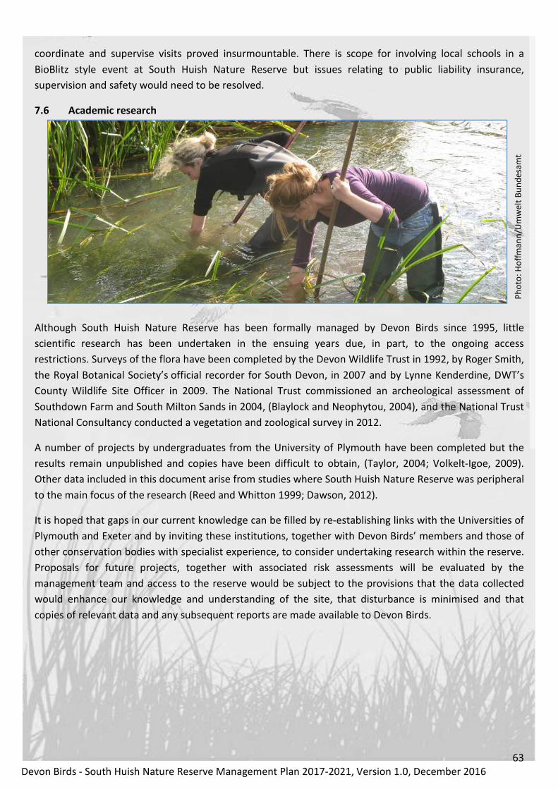
63
Devon Birds - South Huish Nature Reserve Management Plan 2017-2021, Version 1.0, December 2016
coordinate and supervise visits proved insurmountable. There is scope for involving local schools in a
BioBlitz style event at South Huish Nature Reserve but issues relating to public liability insurance,
supervision and safety would need to be resolved.
7.6 Academic research
Ph
oto
: H
off
ma
nn
/Um
we
lt B
un
de
sam
t
Although South Huish Nature Reserve has been formally managed by Devon Birds since 1995, little
scientific research has been undertaken in the ensuing years due, in part, to the ongoing access
restrictions. Surveys of the flora have been completed by the Devon Wildlife Trust in 1992, by Roger Smith,
the Royal Botanical Society’s official recorder for South Devon, in 2007 and by Lynne Kenderdine, DWT’s
County Wildlife Site Officer in 2009. The National Trust commissioned an archeological assessment of
Southdown Farm and South Milton Sands in 2004, (Blaylock and Neophytou, 2004), and the National Trust
National Consultancy conducted a vegetation and zoological survey in 2012.
A number of projects by undergraduates from the University of Plymouth have been completed but the
results remain unpublished and copies have been difficult to obtain, (Taylor, 2004; Volkelt-Igoe, 2009).
Other data included in this document arise from studies where South Huish Nature Reserve was peripheral
to the main focus of the research (Reed and Whitton 1999; Dawson, 2012).
It is hoped that gaps in our current knowledge can be filled by re-establishing links with the Universities of
Plymouth and Exeter and by inviting these institutions, together with Devon Birds’ members and those of
other conservation bodies with specialist experience, to consider undertaking research within the reserve.
Proposals for future projects, together with associated risk assessments will be evaluated by the
management team and access to the reserve would be subject to the provisions that the data collected
would enhance our knowledge and understanding of the site, that disturbance is minimised and that
copies of relevant data and any subsequent reports are made available to Devon Birds.

64
Devon Birds - South Huish Nature Reserve Management Plan 2017-2021, Version 1.0, December 2016
8. Management plan 2017-2021
8.1 Site evaluation
The following evaluation follows the formats currently recommended by Scottish Natural Heritage (2007)
and Natural England (2010a) as detailed in Alexander (2010).
8.1.1 Identification of Important Features
Feature
UK Biodiversity Action
Plan priority
habitat/species
Higher Level
Stewardship Scheme
supported habitat
Local Biodiversity
Action Plan priority
habitat/species
Coastal and floodplain
grazing marsh Yes Yes Yes
Ditches Yes
Ponds and scrapes Yes
Table 8.1: Important features at South Huish Nature Reserve.
8.1.2 Summary description of Important Features
8.1.2.1 Coastal and floodplain grazing marsh
Coastal and floodplain grazing marsh is periodically inundated pasture, or meadow with ditches to
maintain the water levels containing standing brackish or fresh water. These ditches are especially rich in
plants and invertebrates. Grazing marsh frequently becomes flooded in winter and spring and this keeps
the land temperature warmer than it would otherwise be. This creates ideal feeding conditions for a range
of over-wintering bird species which feed in the soft mud and on plant material. In the spring grass growth
begins early providing valuable early grazing as water levels are lowered. Almost all areas are grazed and
some are cut for hay or silage. Sites may contain seasonal water-filled hollows and permanent ponds with
emergent swamp communities, but not extensive areas of tall fen species like reeds.
The exact extent of grazing marsh in the UK is not known but it is possible that there may be a total of
300,000 ha. England holds the largest proportion with an estimate in 1994 of 200,000 ha. However, only a
small proportion of this grassland is semi-natural supporting a high diversity of native plant species (5,000
ha in England, an estimated 10,000 ha in the UK), (Maddock, 2008). Coastal and floodplain grazing marsh is
a priority habitat under the UK Biodiversity Action Plan.
Grazing marshes are particularly important for the populations of wintering wildfowl they support,
including Internationally important populations of wintering wildfowl such as Bewick’s Swans (Cygnus
bewickii) and Whooper Swans (Cygnus cygnus). Amphibians are characteristic of grazing marshes, which at
certain times of the year are an important component of an Otter’s diet. Sites may contain seasonal water-
filled hollows and permanent ponds with emergent swamp communities, but not extensive areas of tall
fen species like reeds. The ditch systems of grazing marshes provide extremely important habitats for
assemblages of submerged, floating, emergent and bank-side plants; as well as aquatic invertebrates.
Much of the UK’s grazing marsh has been lost in the past century, especially via conversion of fields to
cereal production, entailing over-deepening of ditches and inevitable eutrophication from fertiliser run-off.
Only a small proportion of the remaining grassland is unimproved, supporting a high diversity of native
plant species, (Buglife, 2013a; Palmer et al., 2013).

65
Devon Birds - South Huish Nature Reserve Management Plan 2017-2021, Version 1.0, December 2016
8.1.2.2 Ditches
Grazing marsh ditch systems are found mainly in coastal areas of England and Wales, although some occur
in inland areas once occupied by fens and in river valleys. Many of these coastal grazing marsh systems
display a transition from fresh to saline water, which is an important factor in maintaining their
biodiversity. The ditch systems of grazing marshes are of great importance for biodiversity, and are
especially rich in aquatic invertebrates and plants. These networks of channels, although artificial, often
act as a refuge for communities typical of previously extensive natural wetland systems and have a critical
role in maintaining an elevated water table during periods of low rainfall.
Coastal grazing marshes ditches support a very rich and special flora and invertebrate fauna and are the
national stronghold for a number of rare and threatened species. They are threatened by climate change.
Brackish ditches are restricted geographically and are an important and distinctive element of the grazing
marsh habitat, especially in the east of England. In order to maintain maximum diversity of flora and
fauna, the complete spectrum of stable brackish and freshwater ditches represented in a marsh or a
geographical area should be retained. Invertebrate and plant assemblages of ditches are strongly
interrelated. In order to maximise the biological potential of a marsh, all stages in the hydrosere1 should
be represented, (Drake et al., 2010).
The environmental variables with the most influence on invertebrate community composition are salinity,
geographical location, vegetation structure (principally hydroseral stage), ditch dimensions, water depth
and grazing by cattle. Vegetation composition is also heavily influenced by salinity, together with water
depth and substrate type. Grazing marshes are the British stronghold for Frogbit (Hydrocharis morsus-
ranae), Tubular Water-dropwort (Oenanthe fistulosa), Sharp-leaved Pondweed (Potamogeton acutifolius)
and Water Soldier (Stratiotes aloides) and numerous Biodiversity Action Plan priority species (e.g. the
Lesser Silver Water Beetle (Hydrochara caraboides), the Little Whirlpool Ram’s-horn Snail (Anisus
vorticulus), Sharp-leaved Pondweed (Potamogeton acutifolius) and Tubular Water-dropwort (Oenanthe
fistulosa) are associated with ditch systems although not all of these species are present at South Huish.
Despite the fact that many of the most important grazing marshes are SSSIs or lie within Environmentally
Sensitive Areas, the flora and fauna of ditch systems is thought to be threatened by agricultural pollution,
unsuitable management, erratic water supply and rising sea levels. Wholesale mechanical ditch clearance,
as practised routinely in some areas and steep ditch profiles are thought to have a detrimental effect on
ditch faunas and vegetation, but evidence has been hard to come by. In order to conserve the biodiversity
of these ditch systems it is important to establish whether recent deterioration (or improvement) has
occurred and to understand better what constitutes the optimum management regime for the ditches
themselves and their immediate catchment areas.
8.1.2.3 Ponds and scrapes
Ponds and scrapes provide important feeding areas for wading birds and wildfowl, which find lots of
invertebrate food in and around the wet muddy edges. Other farmland birds such as Pied (Motacilla alba
yarelli) and Yellow Wagtails (M. flava) may also benefit from these insect-rich areas. They support a wide
variety of aquatic, terrestrial and aerial invertebrates, such as beetles, bugs and molluscs, some of which
can be rare and of conservation importance.
1 Hydrosere: the succession of vegetation types whereby open water develops via fen to forest or bog

66
Devon Birds - South Huish Nature Reserve Management Plan 2017-2021, Version 1.0, December 2016
In the UK Biodiversity Action Plan (BAP), ponds are defined as small, permanent or seasonal water bodies
that are up to two hectares in size. Ponds support an immense number of plants and animals – more than
100 UK BAP priority species are associated with them. They are particularly good for invertebrates
including the Large Red Damselfly (Pyrrhosoma nymphula), Common Darter (Sympetrum striolatum) and
Broad-bodied Chaser (Libellula depressa) dragonflies.
The vegetation in ponds varies according to depth. Plants like Spiked Water-milfoil (Myriophyllum
spicatum), Water-starwort (Callitriche stagnalis) and Yellow Water-lily (Nuphar lutea) are typical of deeper
water, while Soft Rush (Juncus effusus), Creeping Bent (Agrostis stolonifera), Greater Pond Sedge (Carex
riparia) and Yellow Iris (Iris pseudacorus) are more characteristic of marginal areas.
Ponds provide important homes for amphibians including the Common Toad (Bufo bufo), Smooth Newt
(Lissotriton vulgaris) and Palmate Newt (L. helveticus). They are also home to Water Voles (Arvicola
amphibius) which burrow into soft banks and Grass Snakes (Natrix natrix) which hunt among the
vegetation. Waterbirds such as Mute Swan (Cygnus olor), Moorhen (Gallinula chloropus) and ducks rely on
ponds for feeding and nesting, while waders like Lapwing (Vanellus vanellus) and Snipe (Gallinago
gallinago) probe the muddy margins for invertebrates. Ponds provide stepping-stones between isolated
patches of habitat, linking up the countryside and allowing species to move about freely.
Scrapes are shallow ponds of less than 1m depth which hold water seasonally and which remain damp for
much of the year. They are shallow depressions with gently sloping edges which create obvious water
features in fields. They can make a significant difference to wildlife and can be created in areas of damp or
floodplain grassland, arable reversion or set aside land. A wader scrape can provide invaluable food and
refuges for a wide range of wetland wildlife. They support a wide variety of invertebrates and can provide
important feeding areas for wading birds.
Wildlife benefits if a scrape is seasonally wet and dry, and the weather is often too unpredictable to be too
prescriptive. As a rule of thumb however, for wading birds the ideal is for a scrape to hold water from
March to late June, allowing water levels to recede naturally as the weather becomes drier. If a scrape
dries out after this there is no problem, (Sussex Wildlife Trust, 2013). In winter, scrapes may occasionally
be completely submerged.
Grazing and poaching1 is the best management for a scrape as long as it is not too intensive. Extensive
grazing, particularly by cattle is ideal. This helps create a varied vegetation structure with scattered rushes,
tussocks and patches of bare, open ground. Occasional mowing of rushes and tussocks may be necessary
around a wader scrape, to keep some of the sward open and grazeable. During the bird breeding season
(usually around February to July), stock numbers should be kept to a minimum to limit disturbance to birds
and the potential trampling of nests, (Sussex Wildlife Trust, 2013).
8.2 Site ideal management outcomes
To achieve favourable conservation status for all land within the reserve with the area and quality of
habitat and features of conservation importance being maintained or increased in the long term by
positive management and with all factors that affect the habitat, including its typical species, under
control.
1 Poaching is the physical breakdown of soil structure under load, for example from the passage of heavy animals or vehicles.

67
Devon Birds - South Huish Nature Reserve Management Plan 2017-2021, Version 1.0, December 2016
8.3 Objectives and rationale
8.3.1 Objective 1 - Ditches
Ph
oto
: R
ory
Sa
nd
ers
Figure 8.1: Ditch restoration at South Huish Nature Reserve in 2014.
To maintain the functionality and optimise the biodiversity of the drainage ditches and their banks.
Rationale. The drainage of wetland areas and the claiming of land from the sea have occurred in
England for two millennia but the scale and rate of wetland drainage accelerated from the 17th Century
with technical advances in the ability to control and pump water. It has been estimated that by the 1930s
only a quarter of the historic extent of floodplain wetlands remained in England, mainly in the form of
periodically flooded grassland and grazing marsh. There was another step-change in the post-war era with
further advances in drainage technology and increased availability of financial resources for the
combination of in-field drainage and the improvement of the arterial drainage system. These largely
publicly financed, drainage improvements in the post-war period resulted in significant losses of wetland
wildlife, (Buisson et al., 2008).
Coastal and floodplain grazing marsh is a priority habitat under the UK Biodiversity Action Plan and
numerous Biodiversity Action Plan priority species are associated with its ditch systems, (Drake et al.,
2010). The ditch systems of grazing marshes, which act as linear ponds, are of great importance for
biodiversity, and are especially rich in aquatic invertebrates and plants. These networks of channels,
although artificial, often act as a refuge for communities typical of previously extensive natural wetland
systems. This habitat is very important for brackish invertebrate faunas, as well as freshwater ones. The
ditches at South Huish have two critical functions; the removal of water during periods of inundation and
equally importantly, helping to maintain a high water table and refuge for aquatic species during drier
periods. Over-management of ditches, including over-deepening, has impoverished many areas of
floodplain habitat, so getting the management formula right is critical.
Flooding resulting from inadequate maintenance can have adverse effects on nature conservation
interests and these arise under specific circumstances, including:
• The season of the flooding – summer floods can wash away nests and for some birds this will be
the end to their only breeding attempt that year.
• The duration of flooding – extended flooding in warm weather can lead to de-oxygenation of the
water and the risk of fish kills on site. Prolonged inundation can kill many grasses and lead to a
dense growth of rushes, which are unpalatable to cattle.

68
Devon Birds - South Huish Nature Reserve Management Plan 2017-2021, Version 1.0, December 2016
• The nutrient content of the water – nutrients deposited by flooding can raise soil nutrient levels
leading to changes in the vegetation, frequently an increased dominance of robust grasses over
rarer flowering plants.
• The sediment content of the water – erosion of channel banks and adjacent land introduces
sediment within the system, which is then redistributed. This can both create new habitat and
damage existing habitat.
• The presence of invasive species – flooding can spread plants and animals from one part of the
drainage area to another, e.g. fish fry, seeds and other plant propagules, (Buisson et al., 2008).
Drainage ditches require management otherwise they silt up and become choked with vegetation.
However, all stages in this process support interesting invertebrate communities, so it is important to
have a good rotational management plan to ensure that there is continuity of habitat and some areas of
wetland habitat are kept undisturbed for wildlife. Good practice requires ditches to be stagger cleared so
that only short sections are affected in any one year, which allows cleared areas to be re-colonised from
adjacent sections, as many invertebrates such as molluscs have limited mobility. Another option is to clear
only one side of a ditch at a time, (Buglife, 2013a). In particular, the high value for invertebrates of ditches
that have reached a late successional stage and become choked should be recognised, (Buglife, 2016).
Management interventions will typically cause a ditch’s flora to change in composition and the vegetation
will then slowly return towards the plant community initially present. Such operations include occasional
weed cutting or dredging to remove accumulated silt. As a ditch passes through this floral succession, the
plants present at each stage produce seeds which accumulate in the sediment where they remain in a
dormant state, creating a seed bank. After dredging, species may re-appear after many years of absence.
The plants in drainage channels are generally well adapted to surviving the successional process. At any
one time only a proportion of the species present in the ditch and its sediment will be visible. Having plant
species present, but lying dormant waiting for suitable conditions, encourages long-term stability in the
plant communities of the drainage network, (Buglife, 2011).
At South Huish the ditches closest to the sea are often brackish due to incursions of seawater, particularly
when high spring tides coincide with low-pressure storm events. There are a number of specialist species
associated with brackish water that would disappear if control structures were modified to prevent salt
water entering ditch systems.
The following best practice guidance, (Environment Agency, 2003), has been incorporated into the ditch
and scrape maintenance protocol presented in Section 8.5.8:
● When vegetation clearing or de-silting, leave parts of the ditch undisturbed to ensure some refuge
habitat is kept, enabling wildlife to re-colonise areas disturbed through management.
● Manage ditches in an upstream direction, to help wildlife return to the disturbed length
downstream.
● Work from one bank only, avoiding damage to the working bank by careful operation of a machine
that is appropriate to the channel size.
● Ditch management in late summer/early autumn avoids disturbance to wildlife whilst access is
generally easier because of the drier ground conditions.
● If removing aquatic vegetation, leave cut material adjacent to the watercourse for several hours so

69
Devon Birds - South Huish Nature Reserve Management Plan 2017-2021, Version 1.0, December 2016
wildlife can return to the water. But avoid leaving large amounts of decomposing weed on the
banks because the liquor could pollute the water (keep livestock away from dredgings that might
contain poisonous plants such as Hemlock, Hemlock Water-dropwort or iris), (Environment
Agency, 2003).
● Maintain on a 5-6 year rotation (15-20% per year). Restore over 2-3 years.
● Re-profile ditch banks to gentle gradients (maximum 45 degrees) to provide shallow water fringes
for aquatic plants and wildlife.
● Leave one bank and channel margin intact throughout, or leave blocks of ditch habitat undisturbed
(approximately 8-10m).
● With appropriate stocking density and suitably profiled banks, fences are unnecessary. Livestock
grazing will prevent scrub and coarser vegetation becoming established.
● Create shallow water shelves (berms) to increase diversity and maintain the capacity of the ditch.
● Avoid producing or adding to a raised spoil bank (levee), previously created through repeated de-
silting works. Levees can be removed at intervals (or entirely) to re-connect the ditch to the flood
plain.
● Excavate shallow, scalloped, drinking bays for livestock. This helps limit erosion and increases
habitat diversity.
● Do not fill in wetland features with spoil from ditch works.
8.3.2 Objective 2 - Water levels
Figure 8.2: Summer flooding at South Huish Reserve in July 2012.
To maintain a water level management regime that is consistent with the ecological requirements of
the reserve.
Rationale. The objective for a water level management plan is to maintain water levels that are
consistent with the ecological requirements of the interest features of the reserve, (Buisson, 2008). As
with other aspects of the management plan, compromises have to be made between conditions most
suited to birds throughout the year and the need to provide sufficient grazing for livestock to maintain the
diversity and integrity of habitats.
At South Huish Nature Reserve water drains through a pipe, which passes under the western perimeter
and discharges into the bay. Sluices at the ends of the two western ditches allow fine control of the depth
of the water table and water levels within the ditches, pond and scrapes. In principal, the aim is to ensure
that water levels in the ditches and associated waterways are reasonably high (close to field level)
throughout the year. This may drop in summer through natural evaporation or lack of rainfall but
fluctuating water levels need not be detrimental to the invertebrates present, as long as the change is not

70
Devon Birds - South Huish Nature Reserve Management Plan 2017-2021, Version 1.0, December 2016
too rapid, (Buglife, 2013b). The maintenance of a water table 25-30cm below the soil surface throughout
the summer months encourages an abundance of earthworms and other invertebrates, whilst raising the
water level to the soil surface between November and March creates standing water in the pools and
scrapes most suited to feeding and roosting wildfowl.
Other benefits arising from fine control of water levels include:
• Ease of management - in general it is far easier and safer to carry out management tasks when a
wetland is drained. Intricate re-profiling is much easier to achieve when the bed of a wetland is
clearly visible and the materials relatively dry.
• Exposure of feeding sites for birds - fluctuating water levels influence the availability of food
resources to birds. Waders, for example, feed mainly on invertebrates found along exposed
shorelines; by gradually lowering the water level, fresh areas are continually exposed for these
birds.
• Maintaining areas of water during periods of drought - the retention of water can be extremely
useful where the supply is unpredictable. Some species, such as many dragonflies, benefit from
fairly constant water levels, while other species require standing water at particular times of the
year. The ability to block off outflows if a need arises may be of great benefit, (Merritt, 1994).
Conversely prolonged inundation can have adverse effects on nature conservation interests, as detailed in
the preceding objective – Ditches. The water level management protocol and calendar (Section 8.5.9) take
into account recommendations for lowland plant communities (Wheeler et al., 2004), wading birds (RSPB,
2005) and the need for sufficient pasture to sustain economically viable grazing.
8.3.3 Objective 3 - Grazing
Figure 8.3: Highland cow and calf at South Huish Nature Reserve in July 2014.
To use grazing to maintain and enhance existing habitats while ensuring there is minimal conflict with
the wider nature conservation objectives of the site.
Rationale. Managed pastures can be valuable sources of invertebrate prey for declining birds. Where
they are found, sympathetically grazed pastures can make a big difference to breeding success and winter
survival. Small birds hunt most efficiently in swards with a complex, patchy structure. There, plentiful
insect prey within tall, dense patches, are made available to birds that can only use adjacent shorter grass
to gain access. Producing suitable swards tends to be easiest with extensive cattle grazing, but even then
it is necessary to balance the conflicting requirements of birds, their prey and the need to maintain
agricultural outputs at profitable levels, (DEFRA, 2013).

71
Devon Birds - South Huish Nature Reserve Management Plan 2017-2021, Version 1.0, December 2016
In the absence of grazing by livestock, coastal grazing marsh would rapidly undergo a series of
vegetational successions from wet grassland to reedbed and ultimately through scrub to wet woodland.
The habitat was originally created for agricutural use and its survival as grazing marsh is dependant on
continued human intervention. Livestock have a crucial role in maintaining a suitable sward and
preventing the spread of undesirable, invasive, perrenial plants as well as creating microhabitats for
invertebrates through trampling and poaching. There is sometimes a conflict between the desire to
increase areas of open water within a marsh and the need to retain sufficient good-quality sward for
grazing to be economically viable. It is therefore important to recognise that, without grazing, vegetation
would have to be mechanically cleared annually, at considerable expense, with an unacceptably high
carbon footprint and none of the benefits detailed below.
Invertebrates - Grassland with a complete range of successional stages and vegetation structures, from
bare ground through to scrub, short-grazed grass through to taller grassland with tussocks, is likely to
support the widest range of invertebrates (Kirby, 1992). In general, taller vegetation supports a more
diverse and abundant invertebrate fauna than short-grazed grassland. However, many specialist species
require a mosaic of vegetation of different heights for different stages of their life cycle, or may require
somewhat more homogeneous habitat, such as fairly large areas of very short-grazed turf. If grassland
vegetation is left unmanaged for as little as one or two years the structural diversity, and eventually the
botanical diversity, is likely to decrease, with a corresponding reduction in the abundance and diversity of
invertebrates (e.g. Crofts & Jefferson, 1999).
Maintenance of a heterogeneous sward structure throughout the year is vital in the conservation of a
diverse invertebrate fauna; components of the sward such as dead stems and flower heads are ideal
habitats for many insects (Miles & Sokoloff, 1999), for example, the picture-wing flies. Features such as
these illustrate the importance of maintaining a varied sward structure throughout the year.
Birds - The group of birds which has received greatest attention with regard to winter sward requirements
is wildfowl and waders; Great Britain supports internationally important wintering populations of several
species therefore their conservation and the appropriate management of their habitat is a priority. In
general, this group has three broad requirements of wintering sites. These are suitable feeding
conditions, lack of disturbance and suitable roost sites (RSPB et al., 1997). While extensive shallow
flooding may be the most important factor in site selection, the condition of the sward is also very
important.
Grazing wildfowl such as swans, geese and Wigeon generally prefer a short, 5cm-15cm (RSPB et al. 1997),
even sward of relatively soft, palatable grasses, often with a high proportion of white clover (Owen, 1973),
with the bulk of the vegetation at the lower end of this range (Summers and Critchley, 1990). A negative
relationship between sward height and pecking rate has been clearly established for grazing Wigeon,
(Durant and Fritz, 2006). Bean Geese, however, have shown a preference for longer swards, often cattle
or horse grazed (Allport, 1989). These species also require areas of open water as safe disturbance and
predator-free roost sites.
Surface-feeding or dabbling ducks (e.g. Teal, Shoveler, Pintail) require shallow, open water in pools and
ditches and as a result of flooding (generally <25cm), in close proximity to, or around, seed-bearing plant
species such as rushes, sedges and docks. It is important, therefore, that such species are allowed to

72
Devon Birds - South Huish Nature Reserve Management Plan 2017-2021, Version 1.0, December 2016
flower and set seed, (Natural England, 1999). This requires the management of the site to allow a
heterogeneous sward structure to develop throughout the season, with areas of taller vegetation and
rush/sedge tussocks where flowering and seed set can occur.
Wintering and passage waders (e.g. Lapwing, Golden Plover, Snipe) feed on soil-dwelling invertebrates
especially earthworms and require high water tables which provides soft, damp soil together with areas of
shallow, open water where species such as Redshank forage at the water’s edge. Islands of non-flooded
grassland are used as secure roosting sites. Sward heights of <10cm are generally preferred although
snipe will forage in taller vegetation for concealment. Larger fields lacking tall boundary features and
away from human disturbance are preferred (Milsom et al, 1998; Natural England, 1999). The structure is
good for Snipe where tussocks 50-80 cm tall cover between 60-70% of the area, a short sward between 5-
15 cm tall covers between 30-40% of the area, bare ground is less than 10% and standing water covers
less than 60% of the area, (Natural England, 2011)
Yellow Wagtails, a summer migrant, breeding primarily on wet grassland, appear to favour tussocky, cattle
grazed swards during the breeding season. Their distribution is positively correlated with tussock or clump
size, rather than frequency (Milsom et al. 2000). Nests are concealed in long, tussocky vegetation, (RSPB
et al., 1997).
From the grazier’s point of view, the objective is to maximise the production of animal biomass and this
can lead to conflict with conservation objectives. There have been difficulties in the past at South Huish
with stock levels, grazing periods and the selection of inappropriate breeds all causing problems. These
issues have been resolved both by dialogue and through experience and, with the cooperation of the
current grazier, Highland cattle were introduced to the site in 2013 and have proved particularly effective
at maintaining the sward and controlling invasive perennials and are happy to stand in water to do so. The
cattle are supplemented on the drier pasture areas by ponies with similar varied diets and sheep on
occasions.
With targeted marketing a grazier can offset the relatively low stocking density required at South Huish
with the added value of naturally fed beef and lamb. Consumers prefer the image of meat produced
extensively on grass, (RSPB, 2006). Levels of Omega-3 fatty acids and vitamin E, which are beneficial in the
human diet, are found in a much higher proportion in grass fed beef as opposed to concentrate fed beef
and colour saturation (the depth of red colour) is retained better in steaks from the naturally fed animals,
(Warren et al., 2008). Consumers also prefer the taste and texture of salt marsh lamb which can command
premium prices.
The positive effects of cattle have been listed by a Buglife project, which showed that grazing with cattle is
of more benefit to aquatic invertebrate populations than grazing with sheep or no grazing. This is because
poaching creates shallow water in which many invertebrate species thrive. Cattle also help to maintain a
varied vegetation structure and minimise shading. Recommended management measures are to:
● Stock fields adjacent to ditches with low to moderate numbers of cattle to allow some poaching of
margins and to create unevenly grazed marginal vegetation
● Leave at least some ditches unfenced to give cattle access to ditch margins, (Buglife, 2011).
Mild poaching by cattle at ditch margins is beneficial to many of the invertebrates found in this habitat, as
poaching produces patches of bare mud or peat and provides uneven surfaces with mini-pools. Critically,

73
Devon Birds - South Huish Nature Reserve Management Plan 2017-2021, Version 1.0, December 2016
cattle trampling results in the formation of a berm at about summer water level, and it is this feature that
supports many of the specialised water-transition invertebrates (sheep are not heavy enough to create a
berm). Providing stock levels are not excessive, taller water margin plants should flourish along the ditch
margins. Fencing to exclude cattle from ditch margins prevents this and should not be widely adopted
across a whole site. Wherever possible, such fencing should be removed, although some areas of denser
marginal vegetation along fenced stretches will be beneficial to invertebrates such as spiders, (Buglife,
2013b).
The grazing regime is dependent on the conservation objectives for the site, with light grazing preferred
as this is closer to a natural un-grazed system and provides structural diversity, whilst still allowing grazing
intolerant plants to persist. Stocking levels should be 0.7 LSU1/ha/yr (approx. 2-3 sheep and 0.7-1 cattle)
through April-October. Areas grazed can be rotated by the use of electric fencing to prevent too much
soil compaction and poaching. Eroded areas need to be fenced off from grazing, as erosion will increase
rapidly if not managed. Supplementary feeding should be avoided to prevent localised poaching and
nutrient enrichment, (Buglife, 2016). Stocking densities should be monitored as environmental conditions
will vary from year to year. With too high a stocking rate species richness can decrease and sedimentation
can be reduced. With too low a stocking rate species of invasive perennials may spread and different
vegetation patterns can develop, (Gwent Wildlife Trust, 2013).
Heavy grazing from late summer onwards restores the required sward heights for the following year. If
grazing is not possible, cutting will be essential. Cutting should be timed for suitably dry periods after the
end of the breeding season, usually between August and October. Expect to cut at least twice per year if
grazing is not possible, (White, 2002). Where re-wetting takes place on naturally damp land, rushes may
increase rapidly. A limited rush cover is beneficial but in excess will have an adverse impact. The aim is for
no more than 20-30% scattered rush cover managed by grazing and topping when cover increases beyond
this. Most livestock have to be hard pressed before they will make an impact on Soft Rush (Juncus effusus)
and will lose condition. Cattle are preferential with the following breeds proving most suitable, Belted
Galloway, Galloway, Herefords, Highland cattle, Longhorns and Red Polls. Galloway and Highland cattle
like water for wallowing and to cool down, (RSPB, 2006; Rannapp, 2005).
8.3.4 Objective 4 - Scrapes
Ph
oto
: K
ev
on
Co
x
Figure 8.4: Scrape restoration at South Huish Nature Reserve in August 2016.
To maintain the extent and depth of scapes by periodic reprofiling and removal of marginal vegetation.
1 LSU, the livestock unit facilitates the aggregation of livestock from various species and age. 1 LSU is the grazing equivalent
of one adult dairy cow producing 3,000 kg of milk annually, without additional concentrated foodstuffs.

74
Devon Birds - South Huish Nature Reserve Management Plan 2017-2021, Version 1.0, December 2016
Rationale. Scrapes are pools and ribbons of shallow water that dry slowly over the spring and
summer. When water levels in ditches are raised such ponds often form in natural depressions or in relict
drains or rills. Where this does not occur naturally a scrape is an ideal alternative. In the spring and
summer, as the water retreats, the warm margins and wet mud provide conditions for plants to seed and
for invertebrates to bask and feed. In turn, this attracts a variety of passage birds which feed by probing
both mud and water. In winter a scrape may continue to host wading birds and also to attract Teal,
Wigeon and other dabbling ducks, (Natural England, 2010b).
The scrapes at South Huish Nature Reserve are the largest the site can sustain without adversely affecting
the economic viability of grazing and require ongoing management to counter a loss of depth by
sedimentation and a loss of area through encroachment of vegetation at the margins. The occasional
incursions of saline water at South Huish have two benefits in that the greatest species diversity tends to
be associated with fresh or slightly brackish scrapes, and vegetation growth, and hence the need for
management, is reduced by salinity, (Merritt, 1994). Research has shown that sedimentation can reduce
the depth of a scrape by as much as 30-50% in as little as two years, (DEFRA, 2007), and the growth rate of
rushes around the scrapes at South Huish exceeds the capacity of livestock to prevent their spread.
Consequently the scrape needs to be re-profiled and its margins cleared of vegetation at regular intervals.
Experience at South Huish has established that this activity is best and most economically completed in
the final year of the rotational ditch maintenance plan, (Section 8.5.8). Best practice guidance requires
management in early autumn to minimise disturbance to wildlife whilst access is generally easier because
of the drier ground conditions, (Environment Agency, 2003), and combining the two activities significantly
reduces both the cost and disturbance on site. Whilst the lowering of water levels during late summer in
order to facilitate access by heavy plant, usually 7-8 weeks prior to the commencement of works,
inevitably impacts negatively on some passage migrants, failure to do so would ultimately lead to the loss
of the scrape.
Re-flooding in winter, following summer/autumn management will kill colonising perennial vegetation
such as grass. Annual weeds, which germinate each year on the muddy margins as the water retreats, are
important as they provide a large supply of seeds for dabbling duck as well as number of passerines such
as Yellowhammer, Reed Bunting and Linnet, (RSPB, 2003).
It has been suggested that an island could be constructed in the larger scrape, principally for loafing birds.
Guidance from Natural England (2010b) states that islands are not appropriate for scrapes and current
Countryside Stewardship Grant guidance, (Natural England, 2016), also specifically prohibits the creation
of islands within scrapes. The shallow water offers no protection against mammalian predators,
maintenance costs are high and access can be difficult, requiring annual draining in some cases.
Sedimentation, following winter inundations, promotes vigorous growth of vegetation which has to be
cleared annually. Accumulations of droppings from larger birds such as Canada Geese and gulls further
encourage plant growth and also require regular clearance to prevent an increase in the parasitic load.
Devon Birds is currently of the opinion that the case for an island is not sufficiently strong to outweigh the
associated increase in workload required to maintain it but will seriously consider the installation of a
gravel/shingle bank on one margin of the scrape. This would not reduce the maintenance requirements
but access would be easier and draining of the scrape would be avoided. If constructed with an

75
Devon Birds - South Huish Nature Reserve Management Plan 2017-2021, Version 1.0, December 2016
impermeable plastic membrane at its base, management would involve the removal of vegetation in the
early spring and in the autumn, combined, where possible, with flooding over winter. Resurfacing the
bank will be required if it is to remain attractive for birds. This task should take no longer than 15-30
minutes. Hand weeding or raking should be sufficient, (RSPB, 2016a).
8.3.5 Objective 5 - Water Voles
Ph
oto
: ©
Ch
ris
Go
me
rsa
ll
To determine the presence, number and distribution of Water Voles within the reserve and, if present,
to adapt management procedures to accommodate their requirements and statutory protection.
Rationale. The current status of Water Voles at South Huish Nature Reserve is unclear. It has been
confirmed that the species was reintroduced by the previous landowner in 2010 and there is evidence
from contractors and the reserve manager that animals are still present. It is recommended that a survey
be commissioned to determine the current situation. If a population survives within the reserve, this
should be celebrated as the last major Water Vole survey carried out by Devon Wildlife Trust in 2002
returned no positive results at 100 sites in Devon with around 50km of waterways surveyed. Animals
arising from a reintroduction scheme in the Lower Axe Valley currently represent the only known
population in the County.
If a survey confirms the continued presence of Water Voles at South Huish there are implications for the
ditch maintenance protocols. In the UK, Water Voles and their habitat are fully protected by law under the
Wildlife and Countryside Act (1981). It is therefore an offence to:
• intentionally or recklessly damage, destroy or obstruct access to any structure or place used by a
Water Vole for shelter or protection.
• intentionally or recklessly disturb Water Voles whilst occupying a structure or place used for that
purpose, (Environment Agency, 2011).
The law in practice: It is clearly not the intention of the law to prevent all management or maintenance
works in areas used by Water Voles. However, legal protection does require that due attention is paid to
their presence and appropriate actions are taken to avoid committing offences. If it can be demonstrated
that any action that would otherwise have been an offence was the ‘incidental result of a lawful operation
and could not reasonably have been avoided’, this constitutes a defence against prosecution under the
Act. This defence thus provides for the carrying out of works that intentionally but incidentally commit
offences, such as damaging Water Vole burrows, but requires that reasonable steps are taken to avoid
any unnecessary damage, (Natural England, 2008). Landowners wishing to alter areas used by Water

76
Devon Birds - South Huish Nature Reserve Management Plan 2017-2021, Version 1.0, December 2016
Voles must ensure that all reasonable steps are taken to minimise impacts on the animals or their
burrows. Offences under Section 9 of the Wildlife and Countryside Act carry a maximum penalty of a fine
not exceeding Level 5 on the standard scale (currently £5000), imprisonment for up to six months, or
both. In addition, the courts may order the forfeiture of any vehicle or other thing that was used to
commit the offence, (Gloucester Wildlife Trust, 2008).
It is also important to recognise that when a watercourse is too overgrown, it can eventually provide poor
habitat for Water Voles. Bank maintenance is therefore essential in conserving this legally-protected
habitat, provided it is not too intensive and it avoids the end of March through until August. This is an
important time for breeding Water Voles and other species protected by law, such as spawning fish and
nesting birds, (Environment Agency, 2011).
In practice, the management protocols already in place at South Huish Nature Reserve have been
designed to be as ecologically sensitive as possible and would require only minor modification to
accommodate the presence of Water Voles. No changes to the water level management calendar are
envisaged as this already maintains suitable levels throughout the Water Vole breeding season. If the
animals are still present in the reserve then they have demonstrated that they are well adapted to deal
with seasonal and other sporadic flooding events. Existing ditch management protocols already
incorporate most of the recommendations applicable to Water Vole conservation but the following
additional recommendations will also have to be taken into consideration, (Arnott, 2001; Environment
Agency, 2011; Dean et al., 2015).
• Works to remove silt and weed from a watercourse must also take care not to damage the banks as
this could harm Water Voles and is likely to expose their burrows, making them more vulnerable to
predators.
• Heavy machinery should not be driven onto banks.
• Operations take place from one bank only.
• Vegetation next to the bank should be retained, with weed and silt taken from the middle of the
channel.
• Silt and weed should be deposited at least 5m away from the top of the bank to avoid smothering
burrows and damaging important habitats.
• Refuge zones are left as often as practicable, up to 20m in width, leaving about one third of the ditch
untouched.
• Where slubbed1 vegetation and silt material is to be placed onto banks, known Water Vole sites are
avoided and alternate banks are used at 50m intervals (but avoid using both banks for operations).
• Vegetation is not removed or cut back, but if this has to be carried out then the bank face vegetation,
a continuous strip of marginal vegetation and as much of the bank top vegetation should remain.
An idealised ditch management protocol incorporating the legal constraints if Water Voles are present on
the reserve and current best practice is presented in Section 8.5.8.
1 Slubbing out removes the sediment and vegetation from the bottom and sides of the ditches and starts a new cycle of plant
growth.

77
Devon Birds - South Huish Nature Reserve Management Plan 2017-2021, Version 1.0, December 2016
8.3.6 Objective 6 - Infrastructure
Ph
oto
: A
lan
Po
mro
y
Figure 8.5: Sluice at South Huish Nature Reserve in August 2016.
To monitor and maintain the reserve infrastructure.
Rationale. The importance of maintaining the reserve infrastructure equals that of the land
management tasks. Changes to the hydrology caused by blocked drains or damaged sluices could have
serious consequences. Regular monitoring and maintenance keeps costs down and enables potential
issues to be identified, planned and budgeted for. The maintenance of the perimeter fencing and gates
remains the responsibility of the National Trust.
8.3.7 Objective 7 - Disturbance
Ph
oto
: D
EF
RA
To consider construction of a low Devon bank along the western perimeter of the reserve to reduce
levels of disturbance, particularly by dogs.
Rationale. Disturbance to birds is defined as any human activity inducing unusual behaviour. Any
deviations from normal behaviour, but particularly escape responses from the disturbed site, are bound
to result in extra energy expenditure. These extra costs have to be compensated for by an increase in food
intake, achieved either by longer foraging bouts or by more efficient foraging. Birds disturbed suffer loss
of foraging time which should also be compensated for. Because of this extra food consumption the
carrying capacity of sites for waterbirds, as expressed by the available food resources, is likely to be
reduced in frequently disturbed areas. If the birds do not grow accustomed to human disturbance,

78
Devon Birds - South Huish Nature Reserve Management Plan 2017-2021, Version 1.0, December 2016
repeated disturbances of areas will result in a lowering of their carrying capacity for waterbirds or in a
decrease in body condition of the birds. Both these effects may lead to increased adult mortality,
emigration and/or decreased reproductive success and therefore, to negative effects on population sizes,
(Platteeuw et al. 1997).
Birds typically respond when people are within 100m, although responses have been recorded up to
170m, (Liley et al. 2015). A review of 50 unpublished and peer-reviewed, published studies that examined
the effects of human disturbance on waterfowl, diving duck, wading birds, and shorebird species found
that human-caused disturbances impacted the study species in 86% of cases. Human-caused disturbances
such as boating and walking were shown to alter waterbird behaviour, diverting time and energy away
other essential behaviours such as feeding. Responses to disturbance varied significantly among species,
types of disturbance, body condition, food availability, and frequency of disturbance. However 57% of the
studies reviewed reported birds taking flight in response to a human caused disturbance, (Borgmann,
2011). In a separate study Burger et al. (2004) found that birds flew away and did not return to forage in
response to 58% of human disruptions.
Disturbance at South Huish is unintentional and a consequence of the lack of screening between the
reserve and the adjacent car park. Human activity and dogs both cause disturbance there, whereas at
similar reserves in the Southwest, such as RSPB Bowling Green Marsh, with screened car parking, access
tracks and viewing positions, birds are more confiding and allow closer views. The impact at South Huish is
hard to quantify but there is no doubt that the proximity of the National Trust car park to the reserve
boundary and the increasing popularity of the beach and nearby café has led to birds avoiding the
western end of the reserve.
The only data available for use of the car park, (Table 8.1), were collected in 2005 for a planning
application for improved coastal defences, (National Trust, 2008). This document concluded with “There
are no plans to increase the number of parking spaces and thus no rise in vehicular movements is
envisaged”. In reality the number of vehicles has increased considerably since then, frequently reaching
capacity on fine summer days, (see Figure 8.6), and requiring the use of an adjacent field as an overflow.
The bay is also increasingly popular with the developing watersports of wind and kite surfing especially
during the winter months.
March April May June July August September October
233 172 538 996 2105 3886 470 70
Table 8.1: The number of cars using South Milton Sands car park each month between March and October 2005,
(National Trust 2008).

79
Devon Birds - South Huish Nature Reserve Management Plan 2017-2021, Version 1.0, December 2016
Figure 8.6: Traffic queues leading to
South Milton Sands on Bank Holiday
Monday, 29th
August 2016 when 750
vehicles tried to use the car park,
(South Milton Newsletter, 2016).
Dog walking is the principal activity associated with disturbance at South Huish. Whilst many arctic-
breeding species, particularly juvenile birds, can be remarkably tolerant of humans, dogs are always
regarded as potential predators. In a study at Chesil Beach in Dorset over half (58%) of all the major flights
(flights of more than 50m) and 83% of all the disturbance recorded were linked to dog walking or dogs off
leads, (Liley et al., 2015). Uncontrolled dogs have also entered the reserve and worried the livestock
grazing there on several occasions, (Tucker, 2007). Dog ownership in the UK has increased considerably
since the establishment of the reserve, from an estimated 6.9 million animals in 1994 up to 8.5 million in
2016, (Source: Pet Food Manufacturers Association webpages).
The following recommendation was made in the first management plan “A dry-stone wall to the west
boundary of the site would be a return to the definition of the boundary noted in the early 19th
century. It
would offer a good degree of screening for wildlife from the intensively used South Milton Sands. It would
create further habitat diversity, whilst being traditional in construction and in keeping with the site”,
(Stevens, 1995). In practice, the cost of construction, coupled with uncertainties about the duration of
Devon Birds’ involvement with the site and subsequent changes in ownership, prevented this
recommendation from being progressed.
It is proposed that the construction of a turf-faced Devon bank along the western boundary of the reserve
be considered. This is a lower cost option than a dry-stone wall and a bank of 1.5m height, with a ditch
along its inner face would provide both screening and additional stockproofing when compared to the
existing fence. The ditch would provide some of the material for the bank, (Devon Hedge Group, 2016a),
with spoil, currently located along the northern perimeter of the reserve, supplying the remainder.
Maintenance requirements would be significantly lower than a dry-stone wall, (Devon Hedge Group,
2016b). Siting the bank along the line of the previous boundary would minimise any possible landscape
impact, (Natural England, 2008b), both within the South Devon AONB and from the South West Coast
Path, and still allow unimpeded views along and across the valley.

80
Devon Birds - South Huish Nature Reserve Management Plan 2017-2021, Version 1.0, December 2016
8.3.8 Objective 8 - Viewing points
Ph
oto
: R
SP
B
Figure 8.8: Sand Martin hide at Nottinghamshire Wildlife Trust’s Attenborough Nature Reserve.
To consider the construction of a hide or viewing blind to enhance the visitor experience.
Rationale The possible installation of a hide at South Huish Nature Reserve was proposed by Burridge,
(1992), and included in the first management plan, (Stevens, 1995), but, as with the Devon Bank proposal,
the cost of construction, uncertainties about the duration of Devon Birds’ involvement with the site and
subsequent changes in ownership, prevented this recommendation from being progressed. The lack of
viewing facilities is frequently raised by members who visit the site and Devon Birds has considered four
options for the location of a hide; on the higher ground in the north-west corner between the café and the
toilet block, on the high ground at either end of the lower car park and on the northern boundary of the
reserve opposite the scrapes. The last option was favoured as it would provide the best views, (National
Trust, 2013). It would, however, be facing directly into the sun, particularly during the winter months, and
require screened access. The good and evolving relationship between Devon Birds and the National Trust
provides an opportunity to re-visit this proposal in combination with other efforts to reduce disturbance
and increase public engagement at the site.
The primary purpose of a hide is to enable the observer to get closer to his objective than could otherwise
have been achieved, and to allow observation without alarming the subject. It is therefore necessary for
the observer to blend in with the environment as much as possible. Hides are concerned with more than
keeping the observer out of sight; it is equally important that the birds or animals are not alarmed by
sounds such as voices, shuffling of the observers, the sound of camera shutters or flapping of fabric
coverings. A telescope will assist viewing from a greater distance, (Shanks, 1998). Blinds can support a
site’s educational efforts, offering new experiences and perspectives to school groups, recreational
learners and the wider public. Interpretive media in blind settings can enhance visitor knowledge and
appreciation. Blinds may serve “double-duty” as shelter from snow, cold, rain, heat or insects – assuring
more enjoyable wildlife watching, (Oberbillig, 2013). In locations where vandalism and security may be
issues, an open design is best, with the blind open to the approach so that it can be viewed by staff and
passing visitors. All facilities where children are common users should be open to view and equal
consideration given to access for those with mobility issues, (Croft Consultants, 2010).
The ideal location for a wildlife observation blind or hide is on the south-east, south or south-west side of
a water body. The allows the sun to shine directly on to the subject for most of the year. A blind could be

81
Devon Birds - South Huish Nature Reserve Management Plan 2017-2021, Version 1.0, December 2016
situated on the north side of a water body , but viewing and photographing would not be ideal, except in
summer, due to the angle of the sun. In addition, wildlife tends to be more active at dawn and dusk, when
the lighting is from the south-east and south-west. (Croft Consultants, 2010). The location should allow a
clear view of a place that is inhabited or regularly visited by many birds. Permanent hides are sometimes
sited within metres of the edge of wetlands, ponds or lakes, so that birds approach the viewing position
very closely. They soon accept a building near their territory. Migratory birds coming to use the area
temporarily may not so readily accept an indication of human presence. If birds frequent a very open
position, placing a hide there may pose problems. In an exposed location it is almost impossible to avoid
detection of persons entering and leaving the hide, (Shanks, 1998). A further consideration at South Huish
Nature Reserve is that the location selected should be above the water level during flooding events.
There is a wealth of guidance available on the options for the location, design and construction of hides,
blinds and their approaches, (Oberbillig, 2013; Rewilding Europe, 2014; Shanks, 1998) and guidelines for
the provision of birdwatching facilities in areas of outstanding natural beauty, (Wood, 2002). These offer a
variety of potential solutions suitable for use at South Huish if a decision to proceed is reached. It has also
been suggested that a viewing position might also present an opportunity to construct a Sand Martin
bank, either underneath an elevated platform or alongside as an integral component of the screened
approaches. This would normally require excavation of a pool at its base to reduce the threat from
mammalian predators, (Hopkins, 2001; RSPB, 2016b). A few pairs of Sand Martins breed each year in the
dunes behind South Milton Sands and the species is a common and regular visitor to the reserve and can
be attracted to artificial nesting sites.
8.3.9 Objective 9 - Public engagement
Ph
oto
: Jo
n C
raig
Ph
oto
gra
ph
y
To establish a program, in collaboration with the National Trust, to increase engagement with members
of both organisations and the wider public.
Rationale. In the first management plan for South Huish Nature Reserve Peter Stevens, (1995),
concluded that, “The combination of a site of excellent integrity, with its proximity to a very popular public
area, gives potential for development of the site as an interpretive resource”. A recent review of all of their

82
Devon Birds - South Huish Nature Reserve Management Plan 2017-2021, Version 1.0, December 2016
reserves, commissioned by Devon Birds also concluded that the site has “great potential for people
engagement and membership recruitment,” (Townend, 2015).
The latter report used the example of the Spurn Migration Festival but the presence of birds cannot be
guaranteed at South Huish and it is considered that the reserve would be better suited to a BioBlitz style
event, which has the potential both to engage members, local schools and the public with interests beyond
the avian fauna and to provide valuable additional information on the biodiversity of the reserve.
Successful events have already been held in Devon at Mothecombe and Wembury. There is a substantial
amount of literature and guidance available to support the planning and execution of a BioBlitz and an
event held over a weekend in late summer, after the breeding season and before the bulk of autumn
passage, has the capacity to attract significant participation.
At present there is no signage at South Huish to indicate that the area is managed as a nature reserve or by
whom and, although this has been discussed over several years, no progress has been made to date. The
National Forest Company, (2016), has prepared guidance on the construction and installation of
information boards and interpretation panels and it is recommended that this is addressed as a priority in
conjunction with objectives 7 and 8, the reduction of disturbance and possible installation of a hide or
viewing blind, and a comprehensive plan for improved and continued public engagement is agreed with
the National Trust.
8.3.10 Objective 10 - Monitoring
To establish a program to monitor and record the completion and impact of management actions.
Inviting Devon Birds’ members and other conservation organisations to assist with monitoring tasks and
to undertake research relating to the flora and fauna of the reserve.
Rationale. Monitoring is an essential and integral component of management planning: there can be
no planning without monitoring. The adaptive planning process and all other functional management-
planning processes are entirely dependent on an assessment of the status of the features, and this is
obtained through monitoring.
This management plan highlights a number of areas where data on the flora and fauna of the reserve are
inadequate or lacking and presents an opportunity to involve Devon Birds’ members and those of other
conservation bodies with specialist experience, in undertaking surveys within the reserve and to
contribute to our understanding of the reserve’s ecology. All of the management objectives detailed in
this plan require a monitoring element both to ensure tasks are completed and to assess their
effectiveness. Proposals for future projects, together with associated risk assessments will be evaluated
by the management team and access to the reserve would be subject to the condition that relevant data
and any subsequent reports are made available to Devon Birds.
8.3.11 Objective 11 - Data storage and retrieval
To introduce an internet based system for the storage, retrieval and updating of the management
plan and associated documents and to develop, in parallel, systems for the recording, monitoring
and evaluation of management actions by making a permanent and accessible record of significant

83
Devon Birds - South Huish Nature Reserve Management Plan 2017-2021, Version 1.0, December 2016
activities (including management), events and anything else that has relevance to the site.
Rationale. The concept of an integrated recording, reporting and planning system for
conservation management is not new. Unfortunately, managers rarely place a sufficiently high
priority on this aspect of their work. This is quite surprising, because the collection of information
about wildlife is the first activity that engages many individuals who eventually become conservation
management professionals. They bring into the profession a ‘recording ethic’, but relevant
information is not always recorded.
Recording management activities must be given the highest priority: if something is worth doing it
must be worth recording. One of the most irritating problems that reserve managers have to face is
knowing that, at some time or other, some form of management actions were taken but they don’t
know when or what. They may be aware of the results, but where these are favourable the
management cannot be repeated, and if they are unfavourable there is a danger that the same
mistakes will be made again.
When management activities are carried out by a third party, as the consequence of a management
agreement, for example, the work must be recorded. This is sometimes called ‘compliance
monitoring’. It is a means of checking that planned work is actually completed. The maintenance of
records on a site is occasionally a legal requirement, for example, compliance with health and safety
legislation. The advent of a litigious society has placed a considerable burden on the managers of all
public access sites. Safety checks have become routine, and these activities must be recorded.
Whenever a management activity is planned a system for recording the work must also be
established. This will ensure that nothing of significance goes unrecorded.
The establishment of an accessible system for data recording and storage will facilitate execution of
the annual work plan by ensuring relevant information is available to all members of the
management team and should ensure continuity in the event of unforeseen changes to the team.
Access will be limited to Council members, the management team and invited members.
8.4 Constraints
As with any relatively small conservation organisation, the principal constraints on meeting the objectives
within this management plan are both financial and manpower. The progress made to date towards
achieving favourable conservation status is the result of considerable investment by Devon Birds and the
tireless efforts and vision of a small group of dedicated volunteers without whose contribution much less
would have been accomplished. A continuing commitment, coupled with constructive dialogue with the
National Trust, will be required to fulfil all of the current objectives.

84
Devon Birds - South Huish Nature Reserve Management Plan 2017-2021, Version 1.0, December 2016
8.5 Annual work plan
Ph
oto
: k
ev
in C
ox
Figure 8.9: Scrape maintenance at South Huish Nature Reserve in September 2016.
This section details the management activities required over the next five years in order to meet the
current objectives. Each action has been prioritised in the columns on the right according to the following
criteria:
Priority 1: Essential actions. Actions which the site is legally bound to undertake; actions required to
achieve or maintain species or habitats in favourable condition; essential habitat management which
would lead to immediate deterioration of the habitat if not undertaken.
Priority 2: Important actions. Actions important for the routine management of the site including habitat
management, which could be missed for one year without immediate deterioration of the key
conservation interest.
Priority 3: Desirable actions. Actions, which could be undertaken after all priority 1 and 2 actions are
complete, and if time and other resources become available.
8.5.1 Habitat conservation and protection
Objective 1
To maintain the functionality and optimise the biodiversity of the drainage ditches and their
banks.
Activity Brief description 2017 2018 2019 2020 2021
1.1
Monitor the condition of ditches and banks in
relation to erosion, silting and the growth of
emergent and aquatic vegetation.
1 1 1 1 1
1.2
Maintain on rotation, when required, non-adjacent
sections of the ditches over a three or four-year
cycle in accordance with the ditch and scrape
maintenance protocol.
1 n/a n/a n/a *
* The most recent four-year ditch and scrape maintenance cycle will be completed in 2017. Local conditions
will determine when the next cycle commences.

85
Devon Birds - South Huish Nature Reserve Management Plan 2017-2021, Version 1.0, December 2016
Objective 2
To maintain a water level management regime that is consistent with the ecological requirements
of the reserve.
Activity Brief description 2017 2018 2019 2020 2021
2.1 To adjust water levels in accordance with the water
level management protocol and calendar. 1 1 1 1 1
2.2
To record the impact of combinations of sluice
heights on water levels following completion of
ditch and scrape maintenance or other work, which
might affect the topography of the site.
2 2 2 2 2
Objective 3
To use grazing to maintain and enhance existing habitats while ensuring there is minimal conflict
with the wider nature conservation objectives of the site.
Activity Brief description 2017 2018 2019 2020 2021
3.1
To monitor the implementation of the grazing
protocol and adjust in response to local
environmental conditions.
1 1 1 1 1
3.2
To use mechanical topping of rushes and other
invasive perennials if grazing is insufficient to
control their spread.
2 2 2 2 2
Objective 4
To maintain the extent and depth of scapes by periodic reprofiling and removal of marginal
vegetation.
Activity Brief description 2017 2018 2019 2020 2021
3.1 To monitor the area and depth of scrapes and the
encroachment of vegetation at their margins. 1 1 1 1 1
3.2
Maintain on rotation, when required, over a three-
year cycle in accordance with the ditch and scrape
maintenance protocol.
n/a n/a n/a n/a *
3.3 To consider the installation of a gravel or shingle
bank at the rear of the main scrape. 3 3 3 3 3
* The most recent ditch and scrape maintenance cycle will be completed in 2017. Local conditions will determine
when the next cycle commences.
Objective 5
To determine the number and distribution of Water Voles within the reserve and, if present, to
adapt management procedures to accommodate their requirements and statutory protection.
Activity Brief description 2017 2018 2019 2020 2021
3.1 To discuss with the National Trust the
commissioning of a Water Vole survey. 1
3.2
If present, to adapt management procedures to
accommodate their requirements and statutory
protection.*
1
3.3
To consider if the habitat can be improved for Water
Voles without detriment to the avian features of
interest.
3 3 3 3 3

86
Devon Birds - South Huish Nature Reserve Management Plan 2017-2021, Version 1.0, December 2016
* Management protocols already incorporate current best practice guidelines but some options may become
mandatory if Water Voles are present.
8.5.2 Reserve infrastructure
Objective 6
To monitor and maintain the reserve infrastructure.
Activity Brief description 2017 2018 2019 2020 2021
5.1 Inspect ditches and sluices annually. 1 1 1 1 1
5.2 Inspect boundary fencing and gates every 6 months
and report defects to the National Trust as required. 1 1 1 1 1
8.5.3 Disturbance
Objective 7
To consider construction of a low Devon bank along the western perimeter of the reserve to
reduce levels of disturbance, particularly by dogs.
Activity Brief description 2017 2018 2019 2020 2021
6.1
To discuss with the National Trust the construction
of a low Devon bank along the western perimeter of
the reserve.
3 3 3 3 3
8.5.4 Viewing points
Objective 8
To consider the construction of a hide or viewing blinds to enhance the visitor experience.
Activity Brief description 2017 2018 2019 2020 2021
6.1
To discuss with the National Trust the construction
of a hide or viewing blind with a screened approach
along the northern perimeter of the reserve.
3 3 3 3 3
6.2
To consider incorporation of a Sand Martin bank as
part of the screened approach to a hide or viewing
blind.
3 3 3 3 3
8.5.5 Public engagement
Objective 9
To establish a program, in collaboration with the National Trust, to increase engagement with
members of both organisations and the wider public.
Activity Brief description 2017 2018 2019 2020 2021
6.1
To discuss with the National Trust the location,
wording and installation of signage and
interpretation boards.
3 3 3 3 3
6.2 To discuss with the National Trust the practicalities
of a BioBlitz type of event. 3 3 3 3 3
6.3
To develop a program, in collaboration with the
National Trust, to increase engagement with
members of both organisations and the wider
public.
3 3 3 3 3

87
Devon Birds - South Huish Nature Reserve Management Plan 2017-2021, Version 1.0, December 2016
8.5.6 Monitoring and research
Objective 10
To establish a program to monitor and record the completion and impact of management actions.
Inviting Devon Birds’ members and other conservation organisations to assist with monitoring
tasks and to undertake research relating to the flora, fauna, hydrography and chemistry of the
reserve.
Activity Brief description 2017 2018 2019 2020 2021
7.1 Identify gaps in current knowledge and attempt to
develop a program to rectify shortcomings. 3
7.2 Invite Devon Birds’ members to contribute to a
research and monitoring program. 3 3 3 3 3
7.3
Invite other groups and individuals with specialist
knowledge to contribute to a research and
monitoring program.
3 3 3 3 3
8.5.7 Administration and data recording
Objective 11
To introduce an internet-based system for the storage, retrieval and updating of the management
plan and associated documents and to develop, in parallel, systems for the recording, monitoring
and evaluation of management actions.
Activity Brief description 2017 2018 2019 2020 2021
11.1 Establish an internet-based data and document
storage facility. 3
11.2
Produce timetables, protocols and datasheets to
facilitate and monitor the progress of the annual
work plan.
3 3 3 3 3

88
Devon Birds - South Huish Nature Reserve Management Plan 2017-2021, Version 1.0, December 2016
8.5.8 Ditch and scrape maintenance protocol
The idealised three-year maintenance calendar and plan in Table 8.2 and Figure 8.10 incorporates the best
practice recommendations listed underneath. In practice the reserve management team will determine
annual priorities, sequences and which banks to operate from after assessing conditions across the
reserve. The frequency and duration of maintenance operations will be dependent on the condition of the
ditches and scrapes and rates of sedimentation and vegetation growth but will be on the longest practical
rotation. In 2014 a four-year maintenance program was initiated and this longer cycle may be adopted in
the future if it proves less disruptive to the site’s ecology.
Calendar
Year Ditch and associated bank number
1 1 4
2 2 3 5
3 1 2 3 4 5 Scrapes
and pools
Table 8.2. Annual ditch and bank maintenance calendar associated with an idealised 3-year plan.
Figure 8.10. Idealised 3-year ditch and scrape maintenance schematic incorporating current best practice and taking
into account the legal constraints if Water Voles are present.

89
Devon Birds - South Huish Nature Reserve Management Plan 2017-2021, Version 1.0, December 2016
Although the majority were already practiced, the following best practice principals, (Environment Agency,
2003), have been incorporated into the protocol:
● When vegetation clearing or de-silting, leave parts of the ditch undisturbed to ensure some refuge
habitat is kept, enabling wildlife to re-colonise areas disturbed through management.
● Manage ditches in an upstream direction, to help wildlife return to the disturbed length downstream.
● Work from one bank only, avoiding damage to the working bank by careful operation of a machine that
is appropriate to the channel size.
● Ditch management in late summer/early autumn avoids disturbance to wildlife whilst access is generally
easier because of the drier ground conditions.
● If removing aquatic vegetation, leave cut material adjacent to the watercourse for several hours so
wildlife can return to the water. But avoid leaving large amounts of decomposing weed on the banks
because the liquor could pollute the water (keep livestock away from dredgings that might contain
poisonous plants such as Hemlock, Hemlock Water-dropwort or iris), (Environment Agency, 2003).
● Maintain on a 5-6 year rotation (15-20% per year). Restore over 2-3 years.
● Re-profile ditch banks to gentle gradients (maximum 45 degrees) to provide shallow water fringes for
aquatic plants and wildlife.
● Leave one bank and channel margin intact throughout, or leave blocks of ditch habitat undisturbed
(approximately 8-10m).
● Create shallow water shelves (berms) to increase diversity and maintain the capacity of the ditch.
● Avoid producing or adding to a raised spoil bank (levee), previously created through repeated de-silting
works. Levees can be removed at intervals (or entirely) to re-connect the ditch to the flood plain.
● Excavate shallow, scalloped, drinking bays for livestock. This helps limit erosion and increases habitat
diversity.
● Do not fill in wetland features with spoil from ditch works.
The following additional constraints will require incorporation into protocols if surveys confirm the
presence of Water Voles:
● Works to remove silt and weed from a watercourse must also take care not to damage the banks as this
could harm Water Voles and is likely to expose their burrows, making them more vulnerable to predators.
● Vegetation next to the bank should be retained, with weed and silt taken from the middle of the
channel.
● Silt and weed should be deposited at least 5m away from the top of the bank to avoid smothering
burrows and damaging important habitats.
● Refuge zones are left as often as practicable, up to 20m in width, leaving about one third of the ditch
untouched.
● Where slubbed vegetation and silt material is to be placed onto banks, known Water Vole sites are
avoided and alternate banks are used at 50m intervals (but avoid using both banks for operations).
● Vegetation is not removed or cut back, but if this has to be carried out then the bank face vegetation, a
continuous strip of marginal vegetation and as much of the bank top vegetation should remain.

90
Devon Birds - South Huish Nature Reserve Management Plan 2017-2021, Version 1.0, December 2016
8.5.9 Water level management protocol
Although the topography of the site was meticulously mapped by Peter Hopkin in 1995 to enable
excavation of the scrapes, it has not been practical to monitor the subsequent impacts of scrape
enlargement, reprofiling and the deposition of spoil from ditch maintenance operations. Therefore, for
the purposes of management, ground level is per individual sector not the site as a whole and is judged by
assessing the water level over the greater land area in a sector. At ground level the soil should be just wet
at the surface and therefore, to lower the water table by 10cm, drains should be set at 10cm below this
ground level.
8.5.9.1 Water level calendar
Month Activity Rationale
January - March Maintain the water table at least to
ground level datum
April
Start to lower the water table to
20cm below ground level datum over
a period of 15 days starting after the
middle of the month, to leave the
ground wet with some surface water
in the lowest areas.
Removes any extensive shallow
flooding and prevents anoxic soil
conditions and death of soil
invertebrates.
May - June
Maintain the water table at 20cm
below ground level datum except for
Sector 1
Soil dwelling invertebrates will
remain close to the surface making
them available to wading birds.
Maintains soft surface soil to aid
probing by waders.
July By mid-month lower the water table
to 50cm below ground level datum
Depth of pools decrease providing
areas of mud and shallow water as
feeding habitat for wading birds.
August - September Maintain the water table at 50cm
below ground level datum.
As pools continue to dry they become
available to migrating waders.
October Allow water levels to rise naturally.
Brings invertebrates closer to the soil
surface making them available to
waders.
November
Raise the water table to above
ground level datum to reintroduce
surface wetness with standing water
in low lying areas.
Creates areas suitable for grazing and
roosting waterfowl.
December Maintain the water table at least to
ground level datum

91
Devon Birds - South Huish Nature Reserve Management Plan 2017-2021, Version 1.0, December 2016
8.5.9.2 Drainage by Sector
For the purposes of water level management, Stevens, (1995) partitioned the reserve into four sectors with
Sector 1 being the wettest, seaward sector, including the scrapes and pool, and sectors 2 to 4 corresponding
to the land between each of transverse ditches moving from west to east (see Figure 8.1). Experience has
demonstrated that small adjustments to the height of sluices at 2 and 3 will have significant impacts on
subsequent water levels.
Sector Timing Rationale
Sector 1
• Do not commence draining
before 25th-30th April.
• Drain only 50% of water to
below ground level by lowering
the drain to c.10cm.
• Draining may not be necessary
every spring.
• Draining too early is disruptive to
birds using the sector and is
detrimental to the flora and
fauna.
• This is the most difficult sector in
which to influence summer water
levels due to the shallowness of
the scrapes and the porous
substrate of the seaward scrape.
• Natural drying out of the first
scrape by mid June – mid-July is
acceptable as this facilitates the
grazing or mowing of excess
vegetation.
Sector 2
• Commence draining around 25th
April by lowering the drain to 15-
20cm below ground level datum.
• If required, lower the drain by a
further 10cm around 25th
June
after monitoring levels of
standing surface water.
• This complements the regime in
Sector 1.
• This sector also includes the
scrapes and wet flushes which
should remain wet whilst the rest
of the sector should not retain
significant surface water after the
25th
April.
Sector 3
• Commence draining around 25th
April by lowering the drain to 10-
15cm below ground level datum.
• If water levels remain too high,
lower the drain to >20cm around
25th
June and increase to 50cm
in mid-July if required.
• This regime assists in maintaining
a tussocky, medium quality sward
Sector 4
• Since 2009, this sector has been
set on permanent full drain.
• This allows development of a
good quality, grazing sward.
• Little or no standing water early
in the growing season is essential
to achieve this aim.

92
Devon Birds - South Huish Nature Reserve Management Plan 2017-2021, Version 1.0, December 2016
8.5.10 Grazing protocol
Ph
oto
: Jo
hn
Kir
kh
qa
m
Flexibility is the keyword and the timing of the introduction of livestock to the site will be dependent on
weather, water levels and the subsequent length of the growing season. It is important that the grazier has an
understanding of the conservation requirements of the site and cooperates to achieve these.
In a dry spring, with early growth of the sward, cattle may be introduced as early as the first week of May and
can remain on site for 20-26 weeks, normally being removed from the wet marsh at the end of October or
mid- November at the latest when the reserve is re-flooded. The semi-improved grassland including the front
scrape and running to the western boundary can be grazed all year if required.
Experience gained with various breeds over the years has demonstrated that the Highland cattle currently
used are particularly well suited to the relatively wet environment at South Huish and are effective at
controlling most invasive perennial plants. A maximum stock level of 12 adult cattle, occasionally
supplemented with ponies is the most the site can sustain. Stocking rates for Highland cattle or larger horses
should be the same as their rates of food consumption are similar.
The aim is to maintain the sward height at c.15cm with a diverse structure. Sheep may also be used in the
drier grassland areas of Sector 1 to assist in maintaining a shorter sward there of c.7.5cm. Other areas of the
reserve are too wet for sheep to be used effectively.

93
Devon Birds - South Huish Nature Reserve Management Plan 2017-2021, Version 1.0, December 2016
9. References
Alexander, M., (2010). A guide to management planning. CMS Consortium, Talgarth, Wales, UK
Allport, G., (1989). The effect of grazing on the distribution and feeding efficiency of the western
taiga bean goose Anser fabalis in the Yare Valley. PhD thesis, University of East Anglia.
Arnott, D., (2001). Water Vole mitigation techniques. English Nature. Peterborough, UK
Blaylock, S. and Neophytou, M., (2004). South Milton Sands and Southdown Farm: Initial
Archaeological Assessment, The National Trust, Hyder Consulting Ltd, Plymouth UK
Borgmann, K., (2011). A Review of Human Disturbance Impacts on Waterbirds. Audubon, California,
USA
British Ornithologists Union, (2016). The British List, 30 June 2016.
Buglife, (2011). Grazing Marsh Ditches - Sheet 2: Creation and restoration for invertebrates, Buglife,
Peterborough, UK
Buglife, (2013a). Promoting Habitat Mosaics for Invertebrates; Coastal Grazing Marsh, Buglife,
Peterborough, UK
Buglife, (2013b). Coastal and floodplain grazing marsh. Published on Buglife website
(www.buglife.org.uk)
Buglife, (2016). Notable invertebrates associated with coastal and floodplain grazing marsh. Buglife,
Peterborough, UK
Buisson, R., Wade, P., Cathcart, R., Hemmings, S., Manning, C. and Mayer, L. (2008). The Drainage
Channel Biodiversity Manual: Integrating Wildlife and Flood Risk Management. Association of
Drainage Authorities and Natural England, Peterborough, UK
Burger, J., Jeitner, C., Clark, K. and Niles, L., (2004). The effect of human activities on migrant
shorebirds: successful adaptive management. Environmental Conservation, 31: 283-288
Burridge, R., (1992). South Huish Reserve – Preliminary Report. Devon Birds unpublished.
Clarke, R., (1970). Quaternary sediments off south-east Devon. Quarterly Journal of the Geological
Society, London, 125, 277-381
Crofts, A. and Jefferson, R., (1999). The Lowland Grassland Management Handbook: 2nd edition.
English Nature/The Wildlife Trusts, Peterborough, UK
Croft Consultants, (2010). Country Viewpoints and Blinds. Factsheet for Carmarthenshire Disabled
Access Group.

94
Devon Birds - South Huish Nature Reserve Management Plan 2017-2021, Version 1.0, December 2016
Davies, M., (1999). South Huish Water Meadows – RSPB site visit and rush control advice.
Unpublished.
Dawson, D., (2012). The Impact of sea level rise on the London-Penzance railway line. Unpublished
PhD thesis, University of Plymouth, UK
Dean, M., Strachan, R., Gow, D. and Andrews, R., (2016). The Water Vole Mitigation Handbook (The
Mammal Society Mitigation Series). Eds Fiona Mathews and Paul Chanin, The Mammal Society
London, UK
DEFRA, (2007). Wetting up farmland for birds and other diversity. Research Project Final Report.
DEFRA, (2013). Extensive cattle grazing: what is the best approach to improve species-poor pastures
for birds and invertebrates? Two page summary.
Devon Birds, (1980). The Devon Bird Report 1980
Devon Birds, (2012). The Harrier, August 2012, No. 4
Devon Birds, (2013). The Harrier, August 2013, No. 4
Devon Hedge Group, (2016a). Devon hedge creation: new turf faced banks and planting.
Devon Hedge Group, (2016b). Devon hedge management 1: maintaining and repairing turf and stone
facing.
Devon Wildlife Trust, (1992). South Huish Marsh Botanical Survey.
Drake, C., Stewart, N., Palmer, M. and Kindemba, V., (2010). The ecological status of ditch systems -
An investigation into the current status of the aquatic invertebrate and plant communities of grazing
marsh ditch systems in England and Wales, Technical Report Volume 1: Summary of methods and
major findings, Buglife, Peterborough, UK
Durant, D. and Fritz, H., (2006). Variation of pecking rate with sward height in wild wigeon Anas
Penelope. Journal of Ornithology (2006) 147: 367–370
D'Urban, W. and Matthew, M., (1895). The Birds of Devon. 2nd edition. London
Eaton, M., Aebischer, N., Brown, A., Hearn, R., Lock, L., Musgrove, A., Noble, D., Stroud, D. and
Gregory, R., (2015). Birds of Conservation Concern 4: the population status of birds in the UK,
Channel Islands and Isle of Man. British Birds, Vol 108, 708–746.
Environment Agency, (2003). Ditch Management.
Environment Agency, (2011). Water Vole Habitat Maintenance
Food and Agriculture Organization of the United Nations, (1980). FAO training series: Simple
Methods for Aquaculture – Pond Construction, Food and Agriculture Organization of the United
Nations, Rome

95
Devon Birds - South Huish Nature Reserve Management Plan 2017-2021, Version 1.0, December 2016
Fox, H., (1975). The Chronology of Enclosure and Economic Development in Medieval Devon, XXVIII.
2:181-202
Gardiner, S., Hanson, S., Nicholls, R., Zhang, Z., Jude, S., Jones, A., Richards, J., Williams, A.,
Spencer, T., Cope, S., Gorczynska, M., Bradbury, A., McInnes, R., Ingleby, A. & Dalton, H. (2007).
The Habitats Directive, Coastal Habitats and Climate Change - Case Studies from the South Coast of
the UK. Tyndall Centre for Climate Change Research Working Paper 108.
Gehrels, W., Dawson, D., Shaw, D. and Marshall, W., (2011). Using Holocene relative sea-level data
to inform future sea-level predictions: An example from southwest England. Global and Planetary
Change, 78, 116-126
Gloucester Wildlife Trust, (2008). Managing land for Water Voles. Gloucester, UK.
Hails, J., (1975). Sediment distribution and Quaternary history of Start Bay, Devon. Journal of the
Geological Society, London, 131, 19-35.
Gwent Wildlife Trust, (2013). Land management Toolkit No 9: Saltmarsh and Coastal Grazing Marsh.
Hooke, D., (1994). The Pre-Conquest Charter-bounds of Devon and Cornwall. Boydell Press,
Woodbridge.
Hopkins, L., (2001). Best Practice Guidelines: Artificial Bank Creation for Sand Martins and
Kingfishers. Environment Agency, London, UK
Johnson, S., (2007). Recommendations arising from the Farming and Wildlife Advisory Group visit to
South Milton Marshes, April 2007, unpublished.
Kenderdine, L., (2009). Devon Coastal and Floodplain Grazing Marsh Project: South Huish Marsh
Botanical Survey.
Kirby, P. (1992). Habitat Management for Invertebrates: a practical handbook. RSPB, Sandy, UK
Liley, D., Underhill-Day, J. and Gartshore, N., (2015). The Fleet Bird Disturbance Survey. Unpublished
Report to Natural England, Footprint Ecology, Wareham.
Maddock, A., (2008). UK Biodiversity Action Plan; Priority Habitat Descriptions. BRIG
Massey, A., Gehrels, W., Charman, D. and White, S. (2006). An intertidal foraminifera-based transfer
function for reconstructing Holocene sea-level change in the southwest England. Journal of
Foraminiferal Research 36 (3), 215-232.
Massey, A., Gehrels, W., Charman, D., Milne, G., Peltier, R., Lambeck, K., and Selby, K. (2008).
Relative sea-level change and postglacial isostatic adjustment the coast of south Devon, UK. Journal
of Quaternary Science 23 (5), 415-433
Merritt, A., (1994). Wetlands, Industry and Wildlife: a manual of principles and practices. Wildfowl &
Wetlands Trust, Slimbridge, UK

96
Devon Birds - South Huish Nature Reserve Management Plan 2017-2021, Version 1.0, December 2016
Miles and Sokoloff. (1999). The Lowland Grassland Management Handbook: 2nd edition. Eds. Crofts,
A. and Jefferson, R., English Nature/The Wildlife Trusts, Peterborough, UK
Milsom, T., Ennis, D., Haskell, D., Langton, S. & Mcvay, H., (1998). Design of grassland feeding areas
for waders during winter: The relative importance of sward, landscape factors and human
disturbance. Biological Conservation 84: 119-129.
Milsom, T., Langton, S., Parkin, W., Peel, S, Bishop, J. Hart, J. and Moore, N., (2000). Habitat models
of bird species’ distribution: an aid to the management of coastal grazing marshes. Journal of Applied
Ecology 37: 706-727.
Mooij, W., Hülsmann, S., De Senerpont Domis, L., Nolet, B., Bodelier, P., Boers, P., Dionisio Pires,
M., Gons, H., Ibelings, B., Noordhuis, R., Portielje,R., Wolfstein, K. and Lammens, E., (2005). The
impact of climate change on lakes in the Netherlands: a review. Aquatic Ecology 39: 381–400.
Morey, C., (1976), The natural history of Slapton Ley Nature Reserve, IX. The morphology and history
of the lake basins. Field Studies, 4, 353–68.
Morey, C., (1983), The evolution of a barrier-lagoon system – a case study from Start Bay.
Proceedings of the Ussher Society, 5, 454–9
Moss, B., Kosten, S., Meerhoff, M., Battarbee, R.W., Jeppesen, E., Mazzeo, N., Havens, K., Lacerot,
G., Liu, Z., de Meester, L., Paerl, H., & Scheffer, M. (2011). Allied attack: climate change and
eutrophication. Inland Waters 1, 101-105.
National Trust, (2008). South Milton Sands Planning Application: Design and Access Statement,
Hyder Consulting, Plymouth, UK
National Trust, (2009). The National Trust Book of the Countryside, National Trust Books, London.
(ISBN: 9781905400690)
National Trust, (2012). National Consultancy: Nature Conservation Evaluation, South Milton, Devon.
National Trust, (2013). South Huish Management Committee minutes, 18 January 2013.
Natural England, (1999). The management of lowland wet grassland for birds
Natural England, (2008a). Water voles – the law in practice, Guidance for planners and developers
Natural England, (2008b). Technical Information Note TIN039: Devon field boundaries: restoration
standards for agri-environment schemes.
Natural England, (2010a). Local Nature reserves in England: A guide to their selection and
declaration.
Natural England, (2010b). Illustrated guide to ponds and scrapes
Natural England,(2011). Natural England Technical Information Note TIN089: Illustrated guide to
managing lowland wet grassland for snipe

97
Devon Birds - South Huish Nature Reserve Management Plan 2017-2021, Version 1.0, December 2016
Natural England and RSPB, (2014). Climate Change Adaptation Manual, Chapter 22, Coastal
Floodplain and Grazing Marsh.
Natural England, (2016). Countryside Stewardship: Higher tier options, supplements and capital-
items, May 2016.
Oberbillig, D., (2013). A Guide to Wildlife Viewing and Photography Blinds, Colorado Division of
Wildlife, Denver, USA.
Owen, M. (1973). The management of grassland for wintering geese. Wildfowl, 24: 123–130.
Palmer, M., Drake, M. and Stewart, N., (2013). A manual for the survey and evaluation of the aquatic
plant and invertebrate assemblages of grazing marsh ditch systems, Version 6. Buglife, Peterborough,
UK
Platteeuw, M. and Henkens, R., (1997). Possible Impacts of Disturbance to Waterbirds: Individuals,
Carrying Capacity and Populations. Wildfowl, 48: 225-236
Polwhele, R., (1806). The History of Devonshire. Exeter: Printed by Trewman and Son, for Cadell,
Johnson and Dilly, London, UK.
Pomroy, A., (2016). South Milton Ley Nature Reserve, A Compendium and Management Plan, Devon
Birds.
Powell, P., (2000). The effects of hydrology and nutrient inputs at South Milton Ley on the ecology of
the common reed Phragmites australis (Cav. Trin. ex Steudal). Unpublished PhD thesis, University of
Plymouth, UK
Rannapp, R., Briggs, L., Lotman, K., Lepik, I. and Rannap, V., (eds), (2005). Coastal meadow
management : best practice guidelines. Ministry of the environment of the Republic of Estonia, Tallin,
Estonia
Reed, S. and Whitton, C., (1999). Archaeological Recording and Palaeoenvironmental Assessment of
an intertidal peat deposit, Thurlestone Sands, South Devon, 1998, Exeter Archaeology, Report No.
99.89
Rewilding Europe, (2014). Wildlife Watching Hides: A Practical Guide 2.1, Nijmegen, The Netherlands
Risdon, T., (1811). Chorographical description or survey of the County of Devon, Rees and Curtis,
London
RSPB, (2003). Information and Advice Note: Creating wader scrapes and flashes on farmland.
RSPB, (2005). Wet Grassland Practical Manual: Breeding Waders
RSPB, (2006). SE RSPB grazing group / Grazing Animals Project - joint meeting with Defra RDS, Sussex,
UK
RSPB, (2008). Technical Case Study Series – Water management Structures for Conservation.
RSPB (2016a). Artificial Islands. RSPB webpages.

98
Devon Birds - South Huish Nature Reserve Management Plan 2017-2021, Version 1.0, December 2016
RSPB (2016b). Management and creation of sand martin nest sites. RSPB webpages.
RSPB, English Nature and Institute of Terrestrial Ecology (1997). The Wet Grassland Guide:
Managing floodplain and coastal wet grasslands for wildlife. RSPB, Sandy.
Scottish Natural Heritage (2007). Local Nature Reserve Management Planning Guidance: The Process
and the Plan
Shanks, B., (1998). Bird Hides and Boardwalks, Bird Observers Club of Australia, Report No 8, Victoria,
Australia
Smith, R., (2007). South Huish Ley Botanical Survey.
Stevens, P., (1994). Dyke Management South Huish 1994-1999, Devon Birds, unpublished.
Stevens, P., (1995). South Huish Watermeadows Management Plan 1995-2000, Devon Birds,
unpublished.
Summers, R. and Critchley, C., (1990). Use of grassland and field selection by Brent Geese. Journal of
Applied Ecology, 27: 834–846.
Sussex Wildlife Trust, (2013). Wader Scrapes - What Are They and How Do I Make One?
Taylor, M., (2004). A late Holocene palaeoenvironmental reconstruction of the coastal marsh at
Thurlestone sands, South Huish valley, Devon, with implications for crustal subsidence data.
Unpublished BSc (Hons) Dissertation. Department of Geography, University of Plymouth, Devon, UK
The National Forest, (2016). Good Practice Guide: Information Boards & Interpretation Panels. The
National Forest Company, Derbyshire, UK
Toogood, S., Joyce, C. and Waite, S., (2008). Response of floodplain grassland plant communities to
altered water regimes, Plant Ecology 197: 285-298.
Townend, C., (2015). An Assessment of Bird Reserves Owned or Managed by Devon Birds, Devon
Birds, unpublished.
Townsend, N., (2011), Notes on meeting with the National Trust to discuss Devon Birds Lease and
management of Meadowlands, Devon Birds, unpublished.
Tucker, V., (2007). South Huish Water Meadows – The first decade of a reserve created from scratch.
Devon Birds, Vol 60:1, 21-25.
Volkelt-Igoe, B., (2009). Intertidal Foraminifera in south Devon and their use as sea-level indicators.
Unpublished BSc dissertation, University of Plymouth, UK
Ward, N., (2003). Minutes of the South Huish Reserve Management Committee, 9th
March 2003,
(unpublished)
Warren, H., Scollan, N., Nute, R., Hughes, S., Wood, J. and Richardson, R., (2008). Effects of breed
and a concentrate or grass silage diet on beef quality in cattle of 3 ages. II: Meat stability and flavour.
Meat Science, 78, 270–278

99
Devon Birds - South Huish Nature Reserve Management Plan 2017-2021, Version 1.0, December 2016
Webster, C., (ed.), (2007). The Archaeology of South West England, Somerset County Council
Wheeler, B., Gowing, D., Shaw, S., Mountford, J. and Money, R., (2004). Ecohydrological Guidelines
for Lowland Wetland Plant Communities (Eds. A.W. Brooks, P.V. Jose, and M.I. Whiteman,).
Environment Agency (Anglian Region).
White, G., (2002). Re-wetting grassland to benefit birds, RSPB
Wood, M., (2002). Guidelines for the Provision of Birdwatching Facilities in the Norfolk Coast Area of
Outstanding Natural Beauty, Norfolk Coast AONB Team, Fakenham, UK

100
Devon Birds - South Huish Nature Reserve Management Plan 2017-2021, Version 1.0, December 2016
10. Abbreviations
AONB Area of Outstanding Natural Beauty
BAP Biodiversity Action Plan
BOU British Ornithologist’s Union
BOURC British Ornithologist’s Union Records Committee
BP Before present
BTO British Trust for Ornithology
DWT Devon Wildlife Trust
IUCN International Union for Conservation of Nature
NERC Natural Environment and Rural Communities Act 2006
RSPB Royal Society for the Protection of Birds
WeBS Wetland Birds Survey

101
Devon Birds - South Huish Nature Reserve Management Plan 2017-2021, Version 1.0, December 2016
11. Glossary
Anglo-Saxon period stretched over 600 years from 410 to 1066.
Bronze Age Britain refers to the period of British history that spanned from c. 2500 until c. 800 BC.
Diffuse sources are the result of rainfall, soil infiltration and surface runoff leaching into surface
waters and groundwater.
Foraminifera are single-celled planktonic animal with a perforated chalky shell through which slender
protrusions of protoplasm extend. Most kinds are marine and when they die thick ocean-floor
sediments are formed from their shells.
Glacial isostatic adjustment is the rise of land masses that were depressed by the huge weight of ice
sheets during the last glacial period, through a process known as isostasy. Rising land in the north of
the UK is causing the south to sink.
High Salt Marsh is the most common salt marsh community. It is strongly dominated by salt-meadow
cordgrass (Spartina patens), and occurs within the reach of higher than average high tides (including
spring tides and storm surges).
Holocene is the more recent of the two epochs of the Quaternary Period, beginning at the end of the
last major Ice Age, about 10,000 years ago.
Köppen Climate Classification System is the most widely used system for classifying the world's
climates. Its categories are based on the annual and monthly averages of temperature and
precipitation.
Lithostratigraphy is a sub-discipline of stratigraphy, the geological science associated with the study
of strata or rock layers. Major focuses include geochronology, comparative geology, and petrology. In
general a stratum will be primarily igneous or sedimentary relating to how the rock was formed.
Low Salt Marsh forms along the coast in protected bays, along rivers, and behind barrier beaches,
sand bars, and rocky spits. The term “low” refers to the height of the land, not the vegetation.
Medieval period lasted from the 5th
to the 15th
century.
Mesolithic period (or 'Middle Stone Age') in Britain dates from just after the end of the Pleistocene
('Ice Age') approximately 11,600 years ago, to the beginning of the Neolithic period about 4000
calibrated years BC.
Ordnance datum is the mean sea level as defined for Ordnance Survey.
Pleistocene is the geological epoch which lasted from about 2,588,000 to 11,700 years ago, spanning
the world's recent period of repeated glaciations.
Poaching is the physical breakdown of soil structure under load, for example from the passage of
heavy animals or vehicles.

102
Devon Birds - South Huish Nature Reserve Management Plan 2017-2021, Version 1.0, December 2016
Regressive Contact is a geological process occurring when areas of submerged seafloor are exposed
above the surface.
UK Red Data Books assign conservation status to our flora and fauna using internationally approved
International Union for Conservation of Nature (IUCN) criteria.

103
Devon Birds - South Huish Nature Reserve Management Plan 2017-2021, Version 1.0, December 2016
Appendix 1 Birds
Appendix 1.1 Species List
English name Scientific name BOU Category
Mute Swan Cygnus olor AC2
Bewick’s Swan Cygnus columbianus AE
Whooper Swan Cygnus cygnus AE
Bean Goose Anser fabalis AE
Pink-footed Goose Anser brachyrhynchus AE
White-fronted Goose (Eurasian race)* Anser albifrons albifrons AE
White-fronted Goose (Greenland race)* Anser albifrons flavirostris AE
Greylag Goose Anser anser AC2C4E
Canada Goose Branta canadensis C2E
Barnacle Goose Branta leucopsis AC2E
Brent Goose (dark-bellied race)* Branta bernicla bernicla AE
Brent Goose (pale-bellied race)* Branta bernicla hrota AE
Egyptian Goose Alopochen aegyptiaca C1E
Ruddy Shelduck Tadorna ferruginea BDE
Shelduck Tadorna tadorna A
Eurasian Wigeon Anas penelope AE
American Wigeon Anas americana AE
Gadwall Anas strepera AC2
Eurasian Teal Anas crecca A
Mallard Anas platyrhynchos AC2C4E
Northern Pintail Anas acuta AE
Garganey Anas querquedula A
Northern Shoveler Anas clypeata A
Greater Scaup Aythya marila A
Common Pochard Aythya ferina AE
Tufted Duck Aythya fuligula A
Common Goldeneye Bucephala clangula AE
Smew Mergellus albellus A
Goosander Mergus merganser A
Ruddy Duck Oxyura jamaicensis C1E
Common Quail Coturnix coturnix A
Red-legged Partridge Alectoris rufa C1E
Pheasant Phasianus colchicus C1E
Great Northern Diver Gavia immer A
Little Grebe Tachybaptus ruficollis A
Great Crested Grebe Podiceps cristatus A
White Stork Ciconia ciconia AE
Glossy Ibis Plegadis falcinellus AE
Spoonbill Platalea leucorodia AE
Bittern Botaurus stellaris A
Squacco Heron Ardeola ralloides A
Cattle Egret Bubulcus ibis AE

104
Devon Birds - South Huish Nature Reserve Management Plan 2017-2021, Version 1.0, December 2016
English name Scientific name BOU Category
Grey Heron Ardea cinerea A
Purple Heron Ardea purpurea A
Great White Egret Ardea alba A
Little Egret Egretta garzetta A
Shag Phalacrocorax aristotelis A
Cormorant Phalacrocorax carbo A
Red Kite Milvus milvus AC3E
Marsh Harrier Circus aeruginosus A
Hen Harrier Circus cyaneus A
Sparrowhawk Accipiter nisus A
Common Buzzard Buteo buteo A
Osprey Pandion haliaetus AE
Kestrel Falco tinnunculus A
Merlin Falco columbarius A
Hobby Falco subbuteo A
Peregrine Falcon Falco peregrinus AE
Water Rail Rallus aquaticus A
Spotted Crake Porzana porzana A
Moorhen Gallinula chloropus A
Coot Fulica atra A
Common Crane Grus grus A
Great Bustard Otis tarda AE
Oystercatcher Haematopus ostralegus A
Black-winged Stilt Himantopus himantopus A
Avocet Recurvirostra avosetta A
Little Ringed Plover Charadrius dubius A
Ringed Plover Charadrius hiaticula A
Kentish Plover Anarhynchus alexandrinus A
European Golden Plover Pluvialis apricaria A
Grey Plover Pluvialis squatarola A
Northern Lapwing Vanellus vanellus A
Knot Calidris canutus A
Sanderling Calidris alba A
Little Stint Calidris minuta A
Pectoral Sandpiper Calidris melanotos A
Curlew Sandpiper Calidris ferruginea A
Dunlin Calidris alpina A
Ruff Philomachus pugnax A
Jack Snipe Lymnocryptes minimus A
Common Snipe Gallinago gallinago A
Woodcock Scolopax rusticola A
Black-tailed Godwit Limosa limosa A
Bar-tailed Godwit Limosa lapponica A
Eurasian Whimbrel Numenius phaeopus A
Eurasian Curlew Numenius arquata A
Common Sandpiper Actitis hypoleucos A
Green Sandpiper Tringa ochropus A

105
Devon Birds - South Huish Nature Reserve Management Plan 2017-2021, Version 1.0, December 2016
English name Scientific name BOU Category
Spotted Redshank Tringa erythropus A
Greenshank Tringa nebularia A
Wood Sandpiper Tringa glareola A
Common Redshank Tringa totanus A
Turnstone Arenaria interpres A
Grey Phalarope Phalaropus fulicarius A
Red-necked Phalarope Phalaropus lobatus A
Pomarine Skua Stercorarius pomarinus A
Arctic Skua Stercorarius parasiticus A
Great Skua Stercorarius skua A
Kittiwake Rissa tridactyla A
Black-headed Gull Chroicocephalus ridibundus A
Little Gull Hydrocoloeus minutus A
Mediterranean Gull Larus melanocephalus A
Common Gull Larus canus A
Ring-billed Gull Larus delawarensis A
Lesser Black-backed Gull Larus fuscus A
Herring Gull Larus argentatus A
Yellow-legged Gull Larus michahellis A
Iceland Gull* Larus glaucoides glaucoides A
Kumlien's Gull* Larus glaucoides kumlieni A
Glaucous Gull Larus hyperboreus A
Great Black-backed Gull Larus marinus A
Black Tern Chlidonias niger A
Sandwich Tern Sterna sandvicensis A
Common Tern Sterna hirundo A
Arctic Tern Sterna paradisaea A
Common Guillemot Uria aalge A
Razorbill Alca torda A
Little Auk Alle alle A
Stock Dove Columba oenas A
Woodpigeon Columba palumbus A
Collared Dove Streptopelia decaocto A
European Turtle Dove Streptopelia turtur A
Common Cuckoo Cuculus canorus A
Barn Owl Tyto alba AE
Little Owl Athene noctua C1
Tawny Owl Strix aluco A
Short-eared Owl Asio flammeus A
Common Swift Apus apus A
Kingfisher Alcedo atthis A
Hoopoe Upupa epops AE
Green Woodpecker Picus viridis A
Isabelline Shrike Lanius isabellinus A
Red-backed Shrike Lanius collurio A
Great Grey Shrike Lanius excubitor A
Woodchat Shrike Lanius senator A
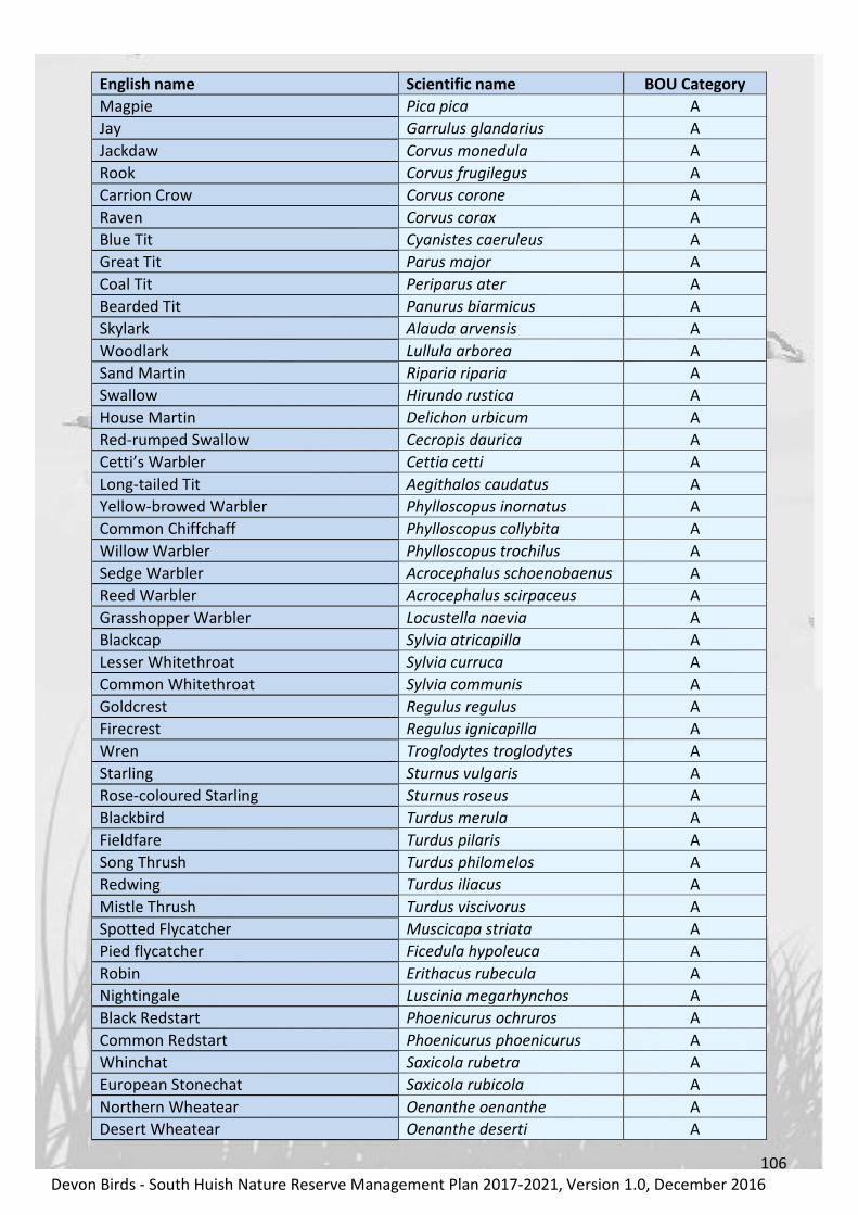
106
Devon Birds - South Huish Nature Reserve Management Plan 2017-2021, Version 1.0, December 2016
English name Scientific name BOU Category
Magpie Pica pica A
Jay Garrulus glandarius A
Jackdaw Corvus monedula A
Rook Corvus frugilegus A
Carrion Crow Corvus corone A
Raven Corvus corax A
Blue Tit Cyanistes caeruleus A
Great Tit Parus major A
Coal Tit Periparus ater A
Bearded Tit Panurus biarmicus A
Skylark Alauda arvensis A
Woodlark Lullula arborea A
Sand Martin Riparia riparia A
Swallow Hirundo rustica A
House Martin Delichon urbicum A
Red-rumped Swallow Cecropis daurica A
Cetti’s Warbler Cettia cetti A
Long-tailed Tit Aegithalos caudatus A
Yellow-browed Warbler Phylloscopus inornatus A
Common Chiffchaff Phylloscopus collybita A
Willow Warbler Phylloscopus trochilus A
Sedge Warbler Acrocephalus schoenobaenus A
Reed Warbler Acrocephalus scirpaceus A
Grasshopper Warbler Locustella naevia A
Blackcap Sylvia atricapilla A
Lesser Whitethroat Sylvia curruca A
Common Whitethroat Sylvia communis A
Goldcrest Regulus regulus A
Firecrest Regulus ignicapilla A
Wren Troglodytes troglodytes A
Starling Sturnus vulgaris A
Rose-coloured Starling Sturnus roseus A
Blackbird Turdus merula A
Fieldfare Turdus pilaris A
Song Thrush Turdus philomelos A
Redwing Turdus iliacus A
Mistle Thrush Turdus viscivorus A
Spotted Flycatcher Muscicapa striata A
Pied flycatcher Ficedula hypoleuca A
Robin Erithacus rubecula A
Nightingale Luscinia megarhynchos A
Black Redstart Phoenicurus ochruros A
Common Redstart Phoenicurus phoenicurus A
Whinchat Saxicola rubetra A
European Stonechat Saxicola rubicola A
Northern Wheatear Oenanthe oenanthe A
Desert Wheatear Oenanthe deserti A

107
Devon Birds - South Huish Nature Reserve Management Plan 2017-2021, Version 1.0, December 2016
English name Scientific name BOU Category
Dunnock Prunella modularis A
House Sparrow Passer domesticus A
Yellow Wagtail (UK race)* Motacilla flava flavissima A
Blue-headed Wagtail* Motacilla flava flava A
Black-headed Wagtail* Motacilla flava feldegg A
Ashy-headed Wagtail* Motacilla flava cinereocapilla A
Grey Wagtail Motacilla cinerea A
Pied Wagtail* Motacilla alba yarelli A
White Wagtail* Motacilla alba alba A
Tree Pipit Anthus trivialis A
Meadow Pipit Anthus pratensis A
Rock Pipit Anthus petrosus A
Water Pipit Anthus spinoletta A
Richard’s Pipit Anthus richardi A
Chaffinch Fringilla coelebs AE
Brambling Fringilla montifringilla A
Greenfinch Chloris chloris AE
Goldfinch Carduelis carduelis A
Siskin Spinus spinus A
Linnet Linaria cannabina A
Lesser Redpoll Acanthis cabaret A
Common Crossbill Loxia curvirostra A
Common Rosefinch Erythrina erythrina A
Bullfinch Pyrrhula pyrrhula A
Snow Bunting Plectrophenax nivalis A
Lapland Bunting Calcarius lapponicus A
Yellowhammer Emberiza citrinella A
Cirl Bunting Emberiza cirlus A
Reed Bunting Emberiza schoeniclus A
Corn Bunting Emberiza calandra A
Table A1.1: List of species seen within the South Huish Nature Reserve recording area between 1969 and 2016
(see Figure: X for details) The taxonomic order is taken from the eighth edition of the British List, (BOU, 2014)
Ibis155: 635-676 and subsequent changes to the list included in BOURC reports. Birds marked with * are
subspecies
Each species on the BOU list is placed in one or more categories denoting its status on the List.
Category A Species recorded in an apparently natural state at least once since 1 January 1950.
Category B Species recorded in an apparently natural state at least once between 1 January 1800
and 31 December 1949, but have not been recorded subsequently.
Category C Species that, although introduced, now derive from the resulting self-sustaining
populations.
• C1 – Naturalized introduced species - species that have occurred only as a result of introduction,
e.g. Egyptian Goose (Alopochen aegyptiacus).
• C2 – Naturalized established species – species with established populations resulting from
introduction by Man, but which also occur in an apparently natural state, e.g. Greylag Goose
(Anser anser).

108
Devon Birds - South Huish Nature Reserve Management Plan 2017-2021, Version 1.0, December 2016
• C3 – Naturalized re-established species – species with populations successfully re-established by
Man in areas of former occurrence, e.g. Red Kite (Milvus milvus).
• C4 – Naturalized feral species – domesticated species with populations established in the wild,
e.g. Rock Pigeon (Dove)/Feral Pigeon (Columba livia).
Category D Species that would otherwise appear in Category A except that there is reasonable
doubt that they have ever occurred in a natural state. Species placed in Category D only form no part
of the British List, and are not included in the species totals.
Category E Species recorded as introductions, human-assisted transportees or escapees from
captivity, and whose breeding populations (if any) are thought not to be self-sustaining. Species in
Category E that have bred in the wild in Britain are designated as E*. Category E species form no part
of the British List (unless already included within Categories A, B or C).
Appendix 1.2 Birds of Conservation Concern
Common name Taxon name Status
Mute Swan Cygnus olor Annual
Bewick’s Swan Cygnus columbianus Occasional
Whooper Swan Cygnus cygnus Occasional
Taiga Bean Goose Anser fabalis Occasional
Pink-footed Goose Anser brachyrhynchus Occasional
White-fronted Goose (Eurasian race)* Anser albifrons albifrons Occasional
White-fronted Goose (Greenland race)* Anser albifrons flavirostris Occasional
Greylag Goose Anser anser Occasional
Barnacle Goose Branta leucopsis Occasional
Brent Goose (dark-bellied race)* Branta bernicla bernicla Occasional
Brent Goose (pale-bellied race)* Branta bernicla hrota Occasional
Shelduck Tadorna tadorna Annual, breeds
Eurasian Wigeon Anas penelope Annual
Gadwall Anas strepera Regular
Eurasian Teal Anas crecca Annual
Mallard Anas platyrhynchos Annual, breeds
Northern Pintail Anas acuta Occasional
Garganey Anas querquedula Regular
Northern Shoveler Anas clypeata Regular
Common Pochard Aythya ferina Occasional
Greater Scaup Aythya marila Occasional
Common Goldeneye Bucephala clangula Occasional
Smew Mergellus albellus Occasional
Common Quail Coturnix coturnix Occasional
Great Northern Diver Gavia immer Occasional
Shag Phalacrocorax aristotelis Occasional
Bittern Botaurus stellaris Occasional
Spoonbill Platalea leucorodia Occasional
Marsh Harrier Circus aeruginosus Regular
Hen Harrier Circus cyaneus Occasional
Osprey Pandion haliaetus Occasional

109
Devon Birds - South Huish Nature Reserve Management Plan 2017-2021, Version 1.0, December 2016
Common name Taxon name Status
Spotted Crake Porzana porzana Occasional
Common Crane Grus grus Occasional
Avocet Recurvirostra avosetta Occasional
Oystercatcher Haematopus ostralegus Occasional
Grey Plover Pluvialis squatarola Occasional
Northern Lapwing Vanellus vanellus Annual
Ringed Plover Charadrius hiaticula Regular
Eurasian Whimbrel Numenius phaeopus Regular
Black-tailed Godwit Limosa limosa Regular
Bar-tailed Godwit Limosa lapponica Occasional
Knot Calidris canutus Occasional
Ruff Philomachus pugnax Regular
Curlew Sandpiper Calidris ferruginea Occasional
Sanderling Calidris alba Occasional
Dunlin Calidris alpina Regular
Common Sandpiper Actitis hypoleucos Annual
Green Sandpiper Tringa ochropus Regular
Spotted Redshank Tringa erythropus Occasional
Greenshank Tringa nebularia Occasional
Wood Sandpiper Tringa glareola Regular
Common Redshank Tringa totanus Occasional
Woodcock Scolopax rusticola Occasional
Common Snipe Gallinago gallinago Annual
Great Skua Stercorarius skua Occasional
Common Guillemot Uria aalge Occasional
Sandwich Tern Sterna sandvicensis Occasional
Common Tern Sterna hirundo Occasional
Arctic Tern Sterna paradisaea Occasional
Kittiwake Rissa tridactyla Occasional
Black-headed Gull Chroicocephalus ridibundus Annual
Mediterranean Gull Larus melanocephalus Regular
Common Gull Larus canus Occasional
Lesser Black-backed Gull Larus fuscus Annual
Herring Gull Larus argentatus Annual
Yellow-legged Gull Larus michahellis Occasional
Iceland Gull* Larus glaucoides glaucoides Occasional
Glaucous Gull Larus hyperboreus Occasional
Great Black-backed Gull Larus marinus Annual
Stock Dove Columba oenas Regular
European Turtle Dove Streptopelia turtur Occasional
Common Cuckoo Cuculus canorus Occasional
Tawny Owl Strix aluco Regular
Short-eared Owl Asio flammeus Occasional
Common Swift Apus apus Annual

110
Devon Birds - South Huish Nature Reserve Management Plan 2017-2021, Version 1.0, December 2016
Common name Taxon name Status
Kingfisher Alcedo atthis Regular
Kestrel Falco tinnunculus Annual
Merlin Falco columbarius Occasional
Red-backed Shrike Lanius collurio Occasional
Skylark Alauda arvensis Annual
House Martin Delichon urbicum Annual
Willow Warbler Phylloscopus trochilus Annual
Grasshopper Warbler Locustella naevia Regular
Starling Sturnus vulgaris Annual
Fieldfare Turdus pilaris Annual
Song Thrush Turdus philomelos Annual
Redwing Turdus iliacus Annual
Mistle Thrush Turdus viscivorus Annual
Spotted Flycatcher Muscicapa striata Occasional
Nightingale Luscinia megarhynchos Occasional
Pied flycatcher Ficedula hypoleuca Occasional
Black Redstart Phoenicurus ochruros Occasional
Common Redstart Phoenicurus phoenicurus Occasional
Whinchat Saxicola rubetra Regular
Dunnock Prunella modularis Annual
House Sparrow Passer domesticus Annual
Yellow Wagtail (UK race)* Motacilla flava flavissima Annual
Grey Wagtail Motacilla cinerea Regular
Tree Pipit Anthus trivialis Regular
Meadow Pipit Anthus pratensis Annual
Water Pipit Anthus spinoletta Occasional
Bullfinch Pyrrhula pyrrhula Occasional
Linnet Linaria cannabina Annual
Lesser Redpoll Acanthis cabaret Occasional
Snow Bunting Plectrophenax nivalis Occasional
Lapland Bunting Calcarius lapponicus Occasional
Yellowhammer Emberiza citrinella Regular
Cirl Bunting Emberiza cirlus Regular
Reed Bunting Emberiza schoeniclus Annual
Corn Bunting Emberiza calandra Occasional
Table A1.2: Species currently red or amber listed as Birds of Conservation Concern, (Eaton et al., 2015),
recorded at South Huish Nature Reserve, 1969-2015. (Species order follows BOU 2016 and subsequent
changes to the list included in BOURC reports). Species with Regular status have been reported in 4 or more
of the 10 years prior to 2016 and those with Occasional status in 3 or less years respectively.

111
Devon Birds - South Huish Nature Reserve Management Plan 2017-2021, Version 1.0, December 2016
Appendix 1.3 WeBS Data
Species 1994 1995 1996 1997 1998 1999 2000 2001 2002 2003 2004
Mute Swan 8 2 2 2 1
Black Swan 1
Whooper Swan 1
Pink-footed Goose
White-fronted Goose 3 6 1
Greylag Goose 2 2
Canada Goose 32 25 120 49 117 200 187 262 130 273 356
Barnacle Goose 26 5 2 1 3 1
Bar-headed Goose 1
Brent Goose (Dark-bellied) 3 13 4 2 6 1 1 2
Egyptian Goose 1
Shelduck 1 3 2 7 2 12 3 5
Eurasian Wigeon 10 7 37 18 90 128 137 158 95 262 71
Gadwall 15 8 9 2 3 2 4 2
Eurasian Teal 28 22 37 10 41 36 94 47 69 62
Mallard 50 29 21 25 50 56 78 72 46 38 32
Northern Pintail 2 1
Garganey 7 3 2 3
Northern Shoveler 4 18 50 14 26 12 14 8 5 12 13
Common Pochard 18 28 2
Tufted Duck 11
Common Goldeneye 1
Cormorant 1
Little Egret 1 3 1 1 1 2 2 2 3 3
Grey Heron 1 1 3 3 2 1 3 1 2 2 1
Little Grebe 2 1 2 2 2 1 1 2
Spotted Crake
Moorhen 1 6 1 13 8 12 9 4 6 11 8
Coot 15 3 6 4 4 6 11
Oystercatcher 23 46 5 17 31 3 38 25 4 19 6
European Golden Plover
Grey Plover 1 1
Northern Lapwing 3 10 16 9 14 1 4 1 1
Little Ringed Plover 3 3 1 2 2 2 1 1
Ringed Plover 12 1 1 1 2 1
Eurasian Whimbrel 1 30 1 1 137 3
Eurasian Curlew 1 1 1 1 1 2
Black-tailed Godwit 2 14 1 1 2 1 7 1
Bar-tailed Godwit 1 2 1 14 1
Knot 3 1
Ruff 17 10 1 4 1 1 1 4 1
Curlew Sandpiper 3 1
Sanderling 4 1
Dunlin 1 1 3 3 24 5 12 7
Little Stint 2 27 1

112
Devon Birds - South Huish Nature Reserve Management Plan 2017-2021, Version 1.0, December 2016
Species 1994 1995 1996 1997 1998 1999 2000 2001 2002 2003 2004
Grey Phalarope
Common Sandpiper 2 1
Green Sandpiper 4 1 5 1
Spotted Redshank 1 1 1
Greenshank 1 1 1
Wood Sandpiper 1 1 1 1 1 1 3 1
Common Redshank 1 1
Jack Snipe 2 1
Common Snipe 1 1 35 1 2 2 3
Arctic Tern 1
Kittiwake 1 2 7
Black-headed Gull 24 74 55 82 20 89 220 125 5 84 58
Mediterranean Gull 1 1 1 1
Common Gull 1 1 10
Lesser Black-backed Gull 200 6 9 3 3 50 12 46 8
Herring Gull 116 39 144 124 150 47 300 65 13 61 103
Yellow-legged Gull
Glaucous Gull
Great Black-backed Gull 6 32 8 7 23 7 95 6 5 3
Kingfisher 1
Table A1.3: Maximum number of each WeBS species recorded at South Huish Nature Reserve annually
between 1994 and 2004 (see Figure: X for details). The taxonomic order is taken from the eighth edition of the
British List, (BOU, 2014) Ibis155: 635-676 and subsequent changes to the list included in BOURC reports.
Species 2005 2006 2007 2008 2009 2010 2011 2012 2013 2014 2015
Mute Swan 2 5 3 2 2 2 2 2 6 3
Black Swan
Whooper Swan 6 3
Pink-footed Goose 1
White-fronted Goose 4 4 2
Greylag Goose 1 2 2 1 1 3
Canada Goose 279 419 432 436 181 220 177 254 162 335 210
Barnacle Goose 1 1 1 1
Bar-headed Goose 1
Brent Goose (Dark-bellied) 6 3 12
Egyptian Goose 2 4
Shelduck 4 4 2 2 4 2 2 6 17 27
Eurasian Wigeon 98 121 118 37 53 179 12 110 130 122 50
Gadwall 2 1 20 4 4 4 3 11 7 6
Eurasian Teal 48 145 14 57 148 94 45 110 170 150 150
Mallard 37 27 18 38 36 33 19 85 85 120 35
Northern Pintail 2 8 5 1
Garganey 5 2 1 2 1 2
Northern Shoveler 7 4 9 5 4 11 6 22 17 6
Common Pochard 1
Tufted Duck 3 2 1 2 1 2 1
Common Goldeneye 1 1

113
Devon Birds - South Huish Nature Reserve Management Plan 2017-2021, Version 1.0, December 2016
Species 2005 2006 2007 2008 2009 2010 2011 2012 2013 2014 2015
Cormorant 1 1 1 1 2 1 1
Little Egret 1 1 1 2 3 2 8 5 2 6 6
Grey Heron 3 4 2 2 3 2 2 2 2 2
Little Grebe 1 2
Great Crested Grebe 1
Spotted Crake 1
Moorhen 6 4 8 8 14 8 7 12 15 6 15
Coot 4 4 3 2 2 6 3 1 3
Oystercatcher 1 3 40
European Golden Plover 250 31 2 30
Grey Plover 3 1 3
Northern Lapwing 1 29 2 19 125 35 110
Little Ringed Plover 1 1 1 14 1 4
Ringed Plover 2 23 26 4
Eurasian Whimbrel 3 1 90 30 36
Eurasian Curlew 1 2 3
Black-tailed Godwit 14 22 8 4 14 6 26
Bar-tailed Godwit 7 21
Knot 1 1 1 1 1
Ruff 1 1 2 1 3 5
Curlew Sandpiper 2 1 2 1
Sanderling 2 4
Dunlin 32 3 1 4 1 2 7 38 30 51
Little Stint 1 2 4 1
Grey Phalarope 1 1
Common Sandpiper 4 1
Green Sandpiper 1 4 10 1 6 1 3
Spotted Redshank 1
Greenshank 1 1 1 1 1
Wood Sandpiper 1 1 1 1 1 3 1 3
Common Redshank 1 1 1 2
Jack Snipe 1 1 1 1
Common Snipe 1 1 54 2 75 125 50 120
Arctic Tern
Kittiwake 30
Black-headed Gull 40 8 6 54 62 36 25 300 130 250 250
Mediterranean Gull 8 2 5 2
Common Gull 2 1 10 4
Lesser Black-backed Gull 24 5 6 11 1 3 1 2 25 10 50
Herring Gull 228 144 125 156 18 49 100 29 30 61 150
Yellow-legged Gull 1 1 1 1 1
Glaucous Gull 1
Great Black-backed Gull 23 10 8 3 3 2 3 1 30 40 15
Kingfisher 1 1 1 1 1
Table A1.4: Maximum number of each WeBS species recorded at South Huish Nature Reserve annually
between 2005 and 2015 (see Figure: X for details). The taxonomic order is taken from the eighth edition of the
British List, (BOU, 2014) Ibis155: 635-676 and subsequent changes to the list included in BOURC reports.

114
Devon Birds - South Huish Nature Reserve Management Plan 2017-2021, Version 1.0, December 2016
Appendix 2 Vascular plants
Surveys of the flora at South Huish Nature Reserve by the Devon Wildlife Trust (DWT) in 1992, by
Roger Smith, the Royal Botanical Society’s official recorder for South Devon in 2007, by Lynne
Kenderdine, DWT’s County Wildlife Site Officer in 2009 and, most recently, by the National Trust
National Consultancy in 2012 identified a significant number of species which are listed below.
Appendix 2.1 Cryptograms
Ph
oto
: W
ikim
ed
ia C
om
mo
ns
Figure A2.1: Water Horsetail, (Equisetum fluviatile).
Family Common Name Latin Name
Equisetaceae Field Horsetail Equisetum arvense
Equisetaceae Water Horsetail Equisetum fluviatile
Equisetaceae Marsh Horsetail Equisetum palustre
Appendix 2.2 Dicotyledons
Ph
oto
: W
ikim
ed
ia C
om
mo
ns
Figure A2.2: Tubular Water Dropwort, (Oenanthe fistulosa)

115
Devon Birds - South Huish Nature Reserve Management Plan 2017-2021, Version 1.0, December 2016
Family Common Name Latin Name
Araliaceae Marsh Pennywort Hydrocotyle vulgaris
Brassicaceae Black Mustard Brassica nigra
Brassicaceae Wavy Bitter-cress Cardamine flexuosa
Brassicaceae Hairy Bitter-cress Cardamine hirsuta
Brassicaceae Cuckoo Flower Cardamine pratensis
Brassicaceae Common Whitlowgrass Erophila vernaa
Brassicaceae Lesser Swine-cress Lepidium didymum
Brassicaceae Water-cress Rorippa nasturtium-aquaticum
Caryophyllaceae Sea Mouse-ear Cerastium diffusum
Caryophyllaceae Common Mouse-ear Cerastium fontanum
Caryophyllaceae Ragged Robin Lychnis flos-cuculi
Caryophyllaceae Procumbent Pearlwort Sagina procumbens
Caryophyllaceae Red Campion Silene dioica
Caryophyllaceae Sea Spurry Spergularia marina
Caryophyllaceae Rock Sea-Spurry Spergularia rupicola
Caryophyllaceae Bog Stitchwort Stellaria alsine
Caryophyllaceae Lesser Stitchwort Stellaria graminea
Ceratopyllaceae Soft Hornwort Ceratopyllum submersum
Lythraceae Purple Loosestrife Lythrum salicaria
Amaranthaceae Spear-leaved Orache Atriplex prostrata
Amaranthaceae Sea Beet Beta vulgaris
Caprifoliaceae Devil’s-Bit Scabious Succisa pratensis
Primulaceae Bog Pimpernel Anagallis tenella
Primulaceae Cowslip Primula veris
Geraniaceae Cut-leaved Crane’s-bill Geranium dissectum
Geraniaceae Dove’s-foot Crane’s-bill Geranium molle
Geraniaceae Herb Robert Geranium robertianum
Orobanchaceae Yellow Rattle Rhinanthus minor
Malvaceae Common Mallow Malva sylvestris
Fabaceae Meadow Vetchling Lathyrus pratensis
Fabaceae Common Bird’s-foot Trefoil Lotus corniculatus
Fabaceae Greater Bird’s-foot trefoil Lotus pedunculatus
Fabaceae Spotted Medick Medicago arabica
Fabaceae Common Restharrow Ononis repens
Fabaceae Lesser Trefoil Trifolium dubium
Fabaceae Red Clover Trifolium pratense
Fabaceae White Clover Trifolium repens
Fabaceae Tufted Vetch Vicia cracca
Hypericaceae Square-stalked St John’s-wort Hypericum tetrapterum
Rosaceae Hawthorn Crataegus monogyna
Rosaceae Meadowsweet Filipendula ulmaria
Rosaceae Silverweed Potentilla anserina
Rosaceae Creeping Cinquefoil Potentilla reptens
Rosaceae Blackthorn Prunus spinosa
Rosaceae Bramble Rubus fruticosus
Onagraceae Great Willowherb Epilobium hirsutum
Apiaceae Angelica Angelica sylvestris
Apiaceae Cow Parsley Anthriscus sylvestris

116
Devon Birds - South Huish Nature Reserve Management Plan 2017-2021, Version 1.0, December 2016
Family Common Name Latin Name
Apiaceae Fool’s Water cress Apium nodiflorum
Apiaceae Wild Carrot Daucus carota
Apiaceae Hogweed Heracleum sphondylium
Apiaceae Hemlock Water Dropwort Oenanthe crocata
Apiaceae Tubular Water Dropwort Oenanthe fistulosa
Apiaceae Alexanders Smyrnium olusatrum
Ranunculacea Marsh Marigold Caltha palustris
Ranunculacea Meadow Buttercup Ranunculus acris
Ranunculacea Bulbous Buttercup Ranunculus bulbosus
Ranunculacea Lesser Celandine Ranunculus ficaria
Ranunculacea Lesser Spearwort Ranunculus flammula
Ranunculacea Greater Spearwort Ranunculus lingua
Ranunculacea Creeping Buttercup Ranunculus repens
Ranunculacea Celery-leaved Buttercup Ranunculus sceleratus
Polygonaceae Amphibious Bistort Persicaria amphibia
Polygonaceae Pale Persicaria Persicaria lapathifolium
Polygonaceae Redshank Persicaria maculosa
Polygonaceae Common Sorrel Rumex acetosa
Polygonaceae Curled Dock Rumex crispus
Polygonaceae Broad-leaved Dock Rumex obtusifolius
Urticacea Common Nettle Urtica dioica
Betulaceae Hazel Corylus avellana
Boraginaceae Changing Forget-me-not Myosotis discolor
Boraginaceae Tufted Forget-me-not Myosotis laxa
Boraginaceae Water Forget-me-not Myosotis scorpiodes
Convolvulaceae Hedge Bindweed Calystegia sepium
Convolvulaceae Field Bindweed Convolvulus arvensis
Solanaceae Bittersweet Solanum dulcamara
Solanaceae Black Nightshade Solanum nigrum
Scrophulariaceae Water Figwort Scrophularia auriculata
Lamiaceae Gipsywort Lycopus europaeus
Lamiaceae Water Mint Mentha aquatica
Lamiaceae Marsh Woundwort Stachys palustris
Lamiaceae Hedge Woundwort Stachys sylvaticca
Plantaginaceae Water-starwort Callitriche aggregate
Plantaginaceae Foxglove Digitalis purpurea
Plantaginaceae Buck’s-horn Plantain Plantago coronopus
Plantaginaceae Ribwort Plantain Plantago lanceolata
Plantaginaceae Greater Plantain Plantago major
Plantaginaceae Wall Speedwell Veronica arvensis
Plantaginaceae Brooklime Veronica beccabunga
Rubiaceae Cleavers Galium aparine
Rubiaceae Slender Marsh Bedstraw Galium debile
Rubiaceae Hedge Bedstraw Galium mollugo
Rubiaceae Common Marsh Bedstraw Galium palustre
Rubiaceae Lady’s Bedstraw Galium verum
Asteraceae Yarrow Achillea millefolium
Asteraceae Lesser Burdock Arctium minus

117
Devon Birds - South Huish Nature Reserve Management Plan 2017-2021, Version 1.0, December 2016
Family Common Name Latin Name
Asteraceae Mugwort Artemisia vulgaris
Asteraceae Daisy Bellis perennis
Asteraceae Musk Thistle Carduus nutans
Asteraceae Slender Thistle Carduus tenuiflorus
Asteraceae Common Knapweed Centauria nigra
Asteraceae Creeping Thistle Cirsium arvense
Asteraceae Marsh Thistle Cirsium palustre
Asteraceae Spear Thistle Cirsium vulgare
Asteraceae Beaked Hawk’s-beard Crepis vesicaria
Asteraceae Cat’s-ear Hypochaeris radicata
Asteraceae Nipplewort Lapsana communis
Asteraceae Lesser Hawkbit Leontodon saxatilis
Asteraceae Oxeye Daisy Leucanthemum vulgaris
Asteraceae Pineapple Weed Matricaria discoidea
Asteraceae Bristly Ox-tongue Picris echioides
Asteraceae Common Fleabane Pulicaria dysenterica
Asteraceae Marsh Ragwort Senecio aquaticus
Asteraceae Common Ragwort Senecio jacobaea
Asteraceae Prickly Sowthistle Sonchus asper
Asteraceae Smooth Sowthistle Sonchus oleraceus
Asteraceae Dandelion Taraxacum aggregate
Alismataceae Water Plantain Alisma plantago-aquatica
Appendix 2.3 Monocotyledons
Ph
oto
: W
ikim
ed
ia C
om
mo
ns
Figure A2.3: Jointed Rush, (Juncus articulatus)
Family Common Name Latin Name
Juncaceae Sharp-flowered Rush Juncus acutiflorus
Juncaceae Jointed Rush Juncus articulatus

118
Devon Birds - South Huish Nature Reserve Management Plan 2017-2021, Version 1.0, December 2016
Family Common Name Latin Name
Juncaceae Toad Rush Juncus bufonius
Juncaceae Soft Rush Juncus effusus
Juncaceae Hard Rush Juncus inflexus
Orchidaceae Southern Marsh-orchid Dactylorhiza praetermissa
Iridaceae Yellow Iris Iris pseudacorus
Araceae Common Duckweed Lemna minor
Typhaceae Branched Bur-reed Sparganium erectum
Cyperaceae Sea Club-rush Bolboschoenus maritimus
Cyperaceae Sand Sedge Carex arenaria
Cyperaceae Hairy Sedge Carex hirta
Cyperaceae Common Sedge Carex nigra
Cyperaceae False Fox-sedge Carex otrubae
Cyperaceae Carnation Sedge Carex panicea
Cyperaceae Greater Tussock-sedge Carex paniculata
Cyperaceae Common Spike-rush Eleocharis palustris
Cyperaceae Common Cottongrass Eriophorum angustifolium
Cyperaceae Grey Club-rush Schoenoplectus tabernaemontani
Gramineae Soft Brome Bromus hordeaceus
Poaceae Creeping Bent Agrostis stolonifera
Poaceae Marsh Foxtail Alopecurus geniculatus
Poaceae Meadow Foxtail Alopecurus pratensis
Poaceae False Brome Brachypodium sylvaticum
Poaceae Crested Dog’s-tail Cynosurus cristatus
Poaceae Cock’s-foot Dactylis glomerata
Poaceae Bearded Couch Elymus caninus
Poaceae Common Couch Elymus repens
Poaceae Tall Fescue Festuca arundinacea
Poaceae Red Fescue Festuca rubra
Poaceae Floating Sweet-grass Glyceria fluitans
Poaceae Yorkshire Fog Holcus lanatus
Poaceae Perennial Rye-grass Lolium perenne
Poaceae Reed Canary-grass Phalaris arundinacea
Poaceae Timothy-grass Phleum pratense subs. Pratense
Poaceae Common Reed Phragmites australis
Poaceae Spreading Meadow-Grass Poa humulis
Poaceae Smooth Meadow-Grass Poa pratensis
Poaceae Rough Meadow-grass Poa trivialis
Table A2.1: Vascular plants of South Huish Nature Reserve, from Devon Wildlife Trust (1992 and
2009), Smith (2007) and National Trust (2012) surveys. Family order is taken from the British
Museum of Natural History webpages. Species within families are listed alphabetically by Latin Name.

119
Devon Birds - South Huish Nature Reserve Management Plan 2017-2021, Version 1.0, December 2016
Appendix 3 Climate change projections
Natural England and the RSPB published a Climate Change Adaptation Manual in 2014, which
includes the following table detailing the possible impacts of climate change on coastal floodplain
and grazing marsh habitats:
Cause Consequence Implications
Hotter summers Longer growing season.
■ Phenology may change significantly,
with flowering and seed setting occurring
earlier in the season.
■ The earlier onset of the growing season
may lead to less favourable conditions for
ground nesting birds that require a short
sward.
Drier summers Drought.
■ Drier conditions will favour stress
tolerant (e.g. deep-rooted) and ruderal
species.
■ Food availability for ground nesting birds
in late spring and summer could be
reduced.
■ In peat rich areas, dryer conditions could
cause damage to soil structure and
increase erosion.
■ Any increase in water abstraction could
lower water tables and reduce water
availability, and potentially lead to
increased saline intrusion on coastal sites.
Wetter winters
Winter flooding.
Higher winter water
table.
■ Changes to inundation patterns on
wetter sites could lead to changes in
floodplain wetland plant communities and
affect suitability for over-wintering water
birds.
■ Higher spring soil moisture levels
(combined with higher spring
temperatures) may boost total biomass
and favour more competitive species.
■ Wetter ground conditions may create
difficulties for grazing.

120
Devon Birds - South Huish Nature Reserve Management Plan 2017-2021, Version 1.0, December 2016
Cause Consequence Implications
Altered seasonal
rainfall patterns
Altered flow regimes.
Greater fluctuation of
water tables.
■ Plant communities on wetter sites may
change as specialist wetland species are
outcompeted by more generalist species
adapted to drier and/ or fluctuating
conditions (Toogood et al. 2008).
Floodplain wetlands dependant on
marked flow peak and snow melt are
especially sensitive.
■ Increased disturbance could increase
susceptibility to the spread of invasive
species.
More extreme events Flooding
■ More frequent flooding will increase the
risk of pollution run-off.
■ Flooding of brackish water bodies and
sites with fresh water could lead to the
loss of specialist species.
Sea level rise
Altered coastal
dynamics
Saline Intrusion
Increased frequency of
saline inundation
Managed realignment,
or
unmanaged realignment
following the
abandonment of coastal
defence structures
■ Sea level rise could result in the loss of
intertidal habitats, increasing the threat of
inundation and erosion of adjacent
grazing marsh.
■ Saline intrusion will lead to a change in
community structure on freshwater sites
close to the coast and estuaries, with a
shift from freshwater to brackish
communities.
■ More frequent inundation could
increase the area of exposed mud, making
marshes more susceptible to invasive
plants and erosion.
■ Coastal realignment could lead to the
loss of both coastal and floodplain grazing
marsh (Gardiner et al 2007).

121
Devon Birds - South Huish Nature Reserve Management Plan 2017-2021, Version 1.0, December 2016
Cause Consequence Implications
In combination Increased pollution and
nutrient loading
■ Increased mineralisation at higher
temperatures, combined with reduced
dilution due to lower flows, could lead to
increase nitrogen loading in water
courses, which could contribute to the
eutrophication of ditch networks and
watercourses (Mooij et al 2005, Moss et
al. 2011).
Table A3.1: The potential impacts of climate change on floodplain and grazing marsh, (Natural England and
RSPB, 2014)

122
Devon Birds - South Huish Nature Reserve Management Plan 2017-2021, Version 1.0, December 2016
Appendix 4 Sluice Design and Operation
The sluice design at South Huish Reserve is a variation of a widely used and well-described low-cost
water control method based on the raising and lowering of either a flexible or right-angled pipe,
connecting to a drain, (FAO, 1980; Merritt, 1992; RSPB, 2008). The design has proved both reliable
and durable but has not been documented previously and is included here for reference.
The sluices installed at South Huish consist of a robust, vertical, wooden post through which passes,
at an angle, an adjustable, wooden control rod, which is attached at its lower end to a length of
flexible pipe connecting to a drain, (Figure A4.1). The control rod can be raised or lowered and is
secured in place by a retaining pin pushed through one of a series of holes. This system requires only
one person to operate and enables fine control of the water table within the reserve.
Damage by livestock, which find the structures attractive as scratching posts, has required minor
repairs and increasing levels of protection over time (Figures A4.2 and A4.3) but the system has
proved effective in the long term.
Figure A4.1: Front and Side view diagram of the water control mechanisms installed at South Huish Reserve.
A = Adjustable Control Rod; B = Wooden Post with an angled slot for the control rod; C = Retaining pin pushed
through one of a series of holes; D = Flexible piping connecting to the drain and attached to the control rod.

123
Devon Birds - South Huish Nature Reserve Management Plan 2017-2021, Version 1.0, December 2016

124
Devon Birds - South Huish Nature Reserve Management Plan 2017-2021, Version 1.0, December 2016
Figure A4.2-4.4: Water control mechanisms installed at South Huish Reserve.
Sluice operation
The following record provides an insight into adjustment of the sluices at South Huish to achieve
partial or complete drainage of the scrapes. Adjustments to the levels were made with the saddle of
the control arm close to the rope attached to the end of the pipe (see Figure A4.8).
Figure A4.5: Front scrape about 60% covered by water, 11 July 2016

125
Devon Birds - South Huish Nature Reserve Management Plan 2017-2021, Version 1.0, December 2016
Figure A4.6: Back scrape about 80% covered by water, 11 July 2016.
Figure A4.7: Both sluices were set with five holes visible, 11 July 2016.
Figure A4.8: Both sluices were just spilling, 11 July 2016.

126
Devon Birds - South Huish Nature Reserve Management Plan 2017-2021, Version 1.0, December 2016
At 12:30pm the back sluice was lowered by one hole (four holes visible). This resulted in the pipe
being lowered by around 75mm
Figure A4.9: Back sluice set with four holes visible, 12:30pm, 11 July 2016.
The sluices were not adjusted on 12 July and the water in the scrapes reduced marginally to 50% on
front scrape and 70% on back scrape. The level in the ditch drained by the back sluice reduced to
below the level of the channel into the back scrape.
On 13 July the back sluice was lowered by one hole (three holes visible) and by 14 July the water level
had dropped in the ditch drained by the back sluice by around 50mm. This will provide some margin
for water to drain from this ditch without overflowing into the back scrape. The invert of the sluice
was still about 50mm below the water level in the ditch but there appeared to be little/no outflow,
probably due to water backing up from the main channel which was clogged with reeds.
On 13 July the front sluice was also lowered by one hole (four holes visible) which lowered the sluice
by about 50mm. By 14 July, the front scrape was completely drained and the back scrape was still
about 10% covered by water. The scrapes were still being drained as the sluice was still flowing – the
water level in the ditch/scrapes was about 20mm above the invert of the pipe.

127
Devon Birds - South Huish Nature Reserve Management Plan 2017-2021, Version 1.0, December 2016
Published by Devon Birds
www.devonbirds.org
Registered Charity 228966
© 2017 Devon Birds