Embed Size (px)
Citation preview

Deschutes Ground Water Mitigation Program:
House Bill 3494 Report
January 2009
State of Oregon Water Resources Department

2
Deschutes River Basin and Ground Water Study Area.

3
TABLE OF CONTENTS
Executive Summary 4 1. Introduction 9 2. Program Implementation and Operation 12 3. Progress on Restoring Streamflows for Anadromous Fish 18 4. Deschutes Group Results 21 Successful Elements of Program 21 Primary Issues of Concern 23 Zone of Impact 25 What is Counted under the 200 cfs Cap 31 Offset and Incremental Mitigation 35 Water Quality 38 Non-Irrigation Season Mitigation 42 7(j) Conditioned Permits 45 5. Conclusions 49 6. References 50 Appendices 51
Special Thanks to All of the Members of the Deschutes Group for their Valuable Input and Cooperative Efforts on this Review

4
Deschutes Ground Water Mitigation Program: House Bill 3494 Report
Executive Summary Background House Bill 3494 (Chapter 669, 2005 Oregon Laws) directs the Oregon Water Resources Department (OWRD) to report to the 75th Legislative Assembly, no later than January 31, 2009, on the implementation and operation of the Deschutes River Basin Ground Water Mitigation and Mitigation Bank Programs. In the Deschutes Basin above Lake Billy Chinook, a US Geological Survey (USGS) study conducted in cooperation with OWRD and others indicated there is a hydraulic connection between ground water and surface water within the Deschutes Ground Water Study Area. Because of this connection, ground water withdrawals within this area are anticipated to affect surface water. Since scenic waterway flows and instream water rights in the Deschutes Basin are not always met, OWRD may not approve new ground water permits unless the impacts are mitigated with a similar amount of water being put instream. The Deschutes Mitigation Program provides a set of tools that applicants for new ground water permits within the study area can use to establish mitigation and, thereby, obtain new permits from OWRD. These programs are implemented under Oregon Administrative Rules (OAR) Chapter 690, Divisions 505 and 521. The amount of new ground water use that can be approved under the program is limited to a total of 200 cubic feet per second (cfs). Since adoption of the Deschutes Mitigation rules in September 2002, OWRD has issued 67 new ground water permits with associated mitigation, totaling 52 cfs of water. In addition to the 52 cfs allocated, there is approximately 148 cfs in pending applications and approved final orders. Assuming all pending applications and final orders move forward as proposed, the 200 cfs “cap” will be met and no additional permits can be issued without the Water Resources Commission modifying its rules and adjusting the cap. The Department maintains an accounting record of new ground water permits and associated mitigation with links between the ground water permits and their source of mitigation. Overall, for each year the program has been in place, there has been sufficient mitigation water available to meet the needs of the ground water permits issued under the program. However, there may not be sufficient supplies of mitigation water available to satisfy the mitigation needs of all currently pending ground water use requests. Additionally, there are areas of the basin where mitigation has not been available. To date, much of the mitigation water is temporary in nature (in the form of annual instream leases of existing

5
irrigation water rights). However, the amount of permanent mitigation water available has increased steadily each year of the program. Deschutes Group To assist with development of this report to the Legislative Assembly, in May 2008 the Department convened the Deschutes Group, a broad range of water users and organizations with an interest in water use in the Basin. This group was convened to review the implementation and operation of the Deschutes Mitigation Program. The Group met four times over five months. The Group identified where the program was being successfully implemented and where members of the group believed the program could be modified or improved. In the first meeting the Group generally agreed that the Deschutes Mitigation Program is working and brainstormed a list of successes including:
• Transactions are occurring – OWRD has issued mitigation credits and water has been put back into the Middle Deschutes reach.
• All interests are aligned around an instream flow purpose. Everybody has to think about the river in terms of how new water rights can be acquired and what mitigation has to occur in order to provide for those new rights.
• Very few places in the West have capped consumptive use. Overall consumptive use in the Basin is neutral.
• The program has made a good strong start in achieving the goals of mitigation in the Basin. People want to keep improving it, but do not want the program eliminated or compromised.
In subsequent meetings, the Group focused their discussions on the following six issue areas:
• The zones of impact in which mitigation is provided; • What is counted under the 200 cfs allocation cap on new ground water
uses in the Deschutes Basin; • Offset of impacts on surface water flows resulting in reduced mitigation
requirements and incremental mitigation provided by municipal and quasi-municipal ground water permit holders;
• Potential water quality impacts of the Mitigation Program; • Non-irrigation season mitigation and; • Water right permits that were issued prior to rule adoption with a condition
on their use to allow regulation to protect scenic waterway flows (called “7(j) conditioned water right permits”).
Small work groups defined or “framed” these issues between meetings to provide context and background so that the Group could have an informed discussion of the issues at subsequent meetings.

6
The following is a brief summary of each issue area and the recommendations developed by the Group. Zones of Impact Issue Statement: Some stakeholders are concerned about OWRD requiring mitigation only in the “primary” zone of impact when groundwater pumping may impact more than one zone of impact.
Recommendation: Recommend that the Department improve their analytical tools to be able to better assess the zones of impact.
What is Counted Under the 200 cfs Allocation Cap
Issue Statement: A requirement to count all final orders issued under the mitigation rules (even those with zero mitigation obligation, non-consumptive, and offset) appears to be an unintended consequence of the current rules. The issue is whether zero mitigation obligation or non-consumptive uses, such as a closed loop heat exchange, or permits issued under an offset, (defined in OAR 690-505.0610 (8)) should be counted under the 200 cfs cap.
Recommendation: Water allocated under the 200 cfs cap should be restored to the cap if the amount of water use authorized in the permit or final certificate is less than the amount originally approved in the final order.
Offset and Incremental Mitigation Issue Statement: The mitigation rules allow municipal or quasi-municipal permit holders to meet a mitigation obligation by incrementally obtaining and providing mitigation using a combination of current and future instream leases, permanent instream transfers and the purchase of mitigation credits to satisfy the required mitigation over time. However, as currently written, the incremental mitigation rules do not cross-reference the offset provision, and therefore the rules currently do not allow for the use of “offset” as part of an incremental mitigation plan.
Recommendation: The rules should be modified so that the use of an offset as defined under the current rules would not be counted under the cap. Recommendation: Recommend that the Mitigation Rules be modified so that offsets, as defined under the current rules, can be used in an incremental mitigation plan.

7
Water Quality Issue Statement: Springs and ground water inflow to surface water have an impact on water quality, including temperature. However, the current mitigation program addresses only the water quantity impacts of proposed new ground water uses. In addition, there is no current process for tracking or addressing the potential cumulative impacts on water quality of the mitigation program in combination with other programs in the basin. The key issue is whether there may be a "tipping point" where reduced spring and ground water inflow resulting from all water programs will cumulatively have a negative impact on water quality in the future.
Recommendation: No recommendation was reached by the Group on water quality; however the group did agree that more work is needed to address water quality in the context of an integrated water management plan for the Deschutes Basin. The group also agreed to continue discussions about water quality and the need for an integrated water management plan.
Non-Irrigation Season Mitigation Issue Statement: Under the Deschutes Mitigation Rules, mitigation is calculated on the basis of the annual volume of consumptive use, rather than on a cubic foot per second basis. While the annualized volumetric approach in the rules addresses the volume of consumptive use, the rules do not address OWRD’s estimate that ground water pumping impacts are uniformly distributed over all months of the year. Thus far, all mitigation water has been returned to the system during the irrigation season. While the additional flow to the system during the summer months is a positive effect, some have raised concerns about ground water pumping impacts on streamflow during the non-irrigation season.
Recommendation: While no consensus agreement could be reached, the group agreed that this issue should be addressed in a broader planning process. The group agreed to continue a dialogue about this issue beyond the forum convened for this report.
7(j) Conditioned Permits Issue Statement: The term “7(j)” refers to a condition required by statute to be included in certain water right permits and certificates in the Deschutes Basin that were issued during the time period after Senate Bill 1033 was enacted in 1995 (amending the Scenic Waterway Act), but before the initial ground water study results were available in 1998. In the absence of technical information to determine whether a proposed use would "measurably reduce" scenic waterway flows, the statute allowed a new ground water permit to be

8
issued with the condition that provided the ground water use could be regulated in the future if analysis of data available after permit issuance discloses the use will measurably reduce the protected scenic waterway flows. Studies completed in 2001 show a connection between ground water and surface water and, as a result, all new ground water right permits are now required to mitigate for the impacts of their use under the rules. The issue is whether the 7(j) condition has been triggered and, if so, how it should be implemented.
Recommendation: No consensus could be reached on this issue.
Conclusions The Deschutes Basin Ground Water Mitigation program has been successful in meeting the key goals of the program: (1) to maintain flows for the Deschutes Scenic Waterway and instream water rights; (2) to facilitate restoration of flows in the middle reach of the Deschutes River below Bend; and (3) to accommodate growth through new ground water development. Since implementation of the program, the Department has issued new ground water permits while mitigating impacts to scenic waterway flows and instream water rights. In each year that the program has been in place, sufficient mitigation has been available to meet the needs of new ground water permits. And, the amount of mitigation available, overall, has increased annually. Through mitigation, scenic waterway and instream water right flows have been maintained and, in some areas, have been improved. The benefits of the program have been significant in some areas, such as the flows restored in the Deschutes River below Bend. Overall, as a result of the program, more than 39 cubic feet per second of instream flow has been restored to the Deschutes River and its tributaries. The mitigation program is working well but, like all regulatory programs, has room for improvement. The Deschutes Group has identified a variety of opportunities to keep improving the program through rulemaking and by making new investments in the science that guides the program. The water management issues in the Deschutes Basin are complex – municipal, instream, irrigation, and recreation interests all have a stake in successful outcomes. The Department’s mitigation program is a small but important piece of overall Basin water management. As the recommendations of the Deschutes Group demonstrate, there is significant opportunity to resolve these complex water management issues in a larger basin water management context. This will require continued commitment and effort locally and investments by the State in supporting these efforts.

9
1. Introduction
Background on the Deschutes Ground Water Mitigation Program
The Oregon Water Resources Commission adopted the Deschutes Ground
Water Mitigation Rules (OAR Chapter 690, Division 505) and the Deschutes
Basin Mitigation Bank and Mitigation Credit Rules (OAR Chapter 690, Division
521) in September 2002. The rules implement Senate Bill 1033 (1995,
Legislative Assembly) codified as ORS 390.835 to provide for mitigation of
impacts to scenic waterway flows and senior water rights while allowing
additional qualifying appropriations of ground water within the Deschutes Ground
Water Study Area (OAR 690-505-0600).
The goals of the Ground Water Mitigation Program are to:
• Maintain flows for Scenic Waterways and senior water rights, including
instream water rights;
• Facilitate restoration of flows in the middle reach of the Deschutes River
and related tributaries; and
• Sustain existing water uses and accommodate growth through new
ground water development (OWRD, 2008).
The Mitigation Program has five basic elements:
• Requires mitigation for all new ground water permits in the Deschutes
Ground Water Study Area;
• Identifies tools for providing mitigation water through either a mitigation
project or by obtaining mitigation credits from an established mitigation
project;
• Establishes a system of mitigation credits, which may be used to mitigate
for new ground water permits;
• Provides the process to establish mitigation banks; and

10
• Provides for adaptive management through annual evaluations and review
of the Program every five years (OWRD, 2008).
House Bill 3494 Requirements
House Bill 3494 (Chapter 669, 2005 Oregon Laws) directs the Oregon Water
Resources Department (OWRD) to report to the 75th Legislative Assembly, no
later than January 31, 2009, on the implementation and operation of the
Deschutes River Basin Ground Water Mitigation and Mitigation Bank Programs.
The 2005 act requires that the report include a summary of:
• The cumulative rate of water appropriated under all ground water permits
approved in the Deschutes River Basin after the effective date of the 2005
act;
• The volume of water, in acre-feet, provided for mitigation; and
• The measured stream flow of the Deschutes River and its major
tributaries.
The report may also include information on the progress on restoring streamflows
in the Deschutes River Basin to support anadromous fish and any statutory
changes needed to accomplish needed streamflow restoration.
Deschutes Group
To assist with development of the report, in May 2008 the Department convened
the Deschutes Group (Group), a broad range of water users and organizations
with on-the-ground experience and an interest in water use in the Basin. This
group was convened to review the implementation and operation of the
Deschutes River Basin Ground Water Mitigation and Mitigation Bank Programs
(Program). This review included identifying and discussing successful elements
of the existing Program, opportunities to improve the Program in the future, and
legislative or rule changes necessary to implement these improvements. Prior to
the first meeting of the Group, interviews were conducted with each participant to

11
gather a range of perspectives about the Program. The summary of these pre-
meeting interviews is located in Appendix A.
The Group met four times over five months. In addition, subcommittees met
between meetings to “frame” issues for discussion with the broader Group at
each meeting. Approved agendas for each of the four meetings are located in
Appendix B, and approved summaries of each of the meetings are located in
Appendix C. This report provides a synthesis of the work and recommendations
of the Deschutes Group. On December 10, 2008, the Department also hosted a
public meeting in Bend to present the results of the draft report.
Deschutes Group members included:
• Robert Brunoe, The Confederated Tribes of the Warm Springs Reservation of Oregon;
• Tod Heisler, Deschutes River Conservancy; • Steve Johnson, Central Oregon Irrigation
District; • Rick Kepler, Oregon Department of Fish and
Wildlife; • Michelle McSwain, U.S. Bureau of Land
Management, Prineville District Office; • Martha Pagel, Schwabe, Williamson, Wyatt; • Kimberley Priestley, WaterWatch of Oregon; • John Short, Deschutes Irrigation LLC; • Adam Sussman, GSI Water Solutions, Inc.;
and • Jan Wick, Avion Water Company
In addition to the participants listed above, two
alternates were appointed to the Deschutes
Group: Jan Houck (Oregon Parks & Recreation
Department) as an alternate for Rick Kepler,
and Patrick Griffiths (City of Bend) as an
alternate for Adam Sussman. OWRD
representatives Debbie Colbert and Kyle
Gorman also participated in the Deschutes

12
Group meetings that were facilitated by Paul Hoobyar and Joanne Richter of
Watershed Professionals Network (WPN).
2. Program Implementation and Operation
In addition to the data provided in this section, the WRC is required to evaluate
the effectiveness of the Deschutes Mitigation Program every five years. Results
from the most recent evaluation which was completed in February 2008 are
available at:
http://www1.wrd.state.or.us/pdfs/Deschutes_Mitigation_5_Year_Review_Final_R
eport.pdf
Cumulative Rate of Water Appropriated in the Basin
Since adoption of the rules in September 2002, 67 new ground water permits
with associated mitigation have been issued, totaling 52 cubic feet per second
(cfs) of water (Figure 1). The quantity of water allocated to new permits and
requested for new uses have been predominantly for municipal and quasi-
municipal uses (Figure 2). The majority of permits, however, have been for
irrigation use.
0
10
20
30
40
50
60
2003 2004 2005 2006 2007 2008Data for 2008 is provisional
Qua
ntity
in C
FS
Figure 1. Cumulative amount of water issued under new ground water permits
by year.

13
0
10
20
30
40
50
60
70
80
Irriga
tion/A
g
Munici
pal
Quasi-
Muni
Pond U
se
Group D
om
Commerc
ial
Indus
trial
Mining
Qua
ntity
in C
FS
Permits IssuedApplications Pending
Figure 2. Quantity of water requested or permitted by type of use through
September 2008.
Volume of Water Provided for Mitigation
The Department maintains an accounting record of new ground water permits
and mitigation projects and mitigation credits with links between the ground water
permits and their associated source of mitigation. Figure 3 shows the amount of
mitigation available and the amount of mitigation used each year. Overall, there
has been sufficient mitigation to meet the needs of ground water permits issued
under the program.
While the program overall has had sufficient mitigation water for the permits
issued, much of the mitigation is temporary in nature (in the form of annual
instream leases of existing irrigation water right). Moreover, there are areas of
the basin where mitigation has not been available or where there may not be
sufficient supplies of mitigation to satisfy the mitigation needs of all currently

14
0
5001000
15002000
2500
30003500
40004500
5000
2003 2004 2005 2006 2007 2008
Acr
e-Fe
et
Mitigation AvailableMitigation Used (including credits held in reserve by mitigation banks)
Figure 3. Total mitigation available and used by ground water permits and as
bank “reserves” by year.
pending ground water use requests. As shown in Figure 4 below, the Metolius
River zone of impact has no mitigation available, and to date no mitigation
projects have been proposed in this zone. In addition, in the Upper Deschutes,
Little Deschutes, Crooked River, and Whychus Creek zones of impact the
amount of mitigation needed for pending ground water applications exceeds the
amount of mitigation water presently available in each of these zones. The
source of mitigation currently available in these zones is predominately through
temporary mitigation (as described above) with no permanent mitigation
presently available, except some in the Crooked River zone of impact. However,
in each year that the program has been in place, the amount of mitigation water
made available has generally increased.

15
0
500
1000
1500
2000
2500
3000
3500
4000
4500
5000
General Zone MiddleDeschutes
Crooked River WhychusCreek
LittleDeschutes
River
UpperDeschutes
Metolius River
Num
ber o
f Cre
dits
Figure 4. Mitigation credits remaining by zone of impact for 2007.
Sources of mitigation water have been primarily through conversion of existing
irrigation rights to instream use through permanent instream transfers and
instream leases. As shown in Figure 5, mitigation water has been largely
provided through short term instream leases. However, the amount of
permanent water provided through instream transfers has been steadily
increasing each year.

16
3710, 81%
848, 19%
Instream LeasesInstream Transfers
Figure 5. Distribution of mitigation water between instream leases and instream
transfers with acre-feet and percent for each type shown.
Summary of Measured Stream Flow in the Deschutes River and
Its Major Tributaries
OWRD and the U.S. Geological Survey operate 61 stream, canal, and reservoir
gages in the Deschutes Basin. All but eight of those stations are within the
Deschutes Ground Water Study Area. Tables of mean monthly flow in cubic feet
per second for ten key stations are included in Appendix D. These key stations
represent the flow of the Deschutes River and its major tributaries within the
study area.
OWRD primarily uses a database and streamflow model to monitor the
effectiveness of the mitigation program. Because of annual weather cycles,
changes in climatic conditions, and other variables, measured streamflow data
does not provide sufficient information on how the system is responding in the
short period of time the program has been in place. It is not possible to correct
real-time data for effects of year–to-year changes in weather (or other variables)
with sufficient accuracy. In addition, it may be years before the effects of
mitigation activities and ground water use reach equilibrium. For example, in
848 ac-ft 19%
3710 ac-ft 81%

17
many cases mitigation water is provided years ahead of consumptive use being
initiated. Because of the system variability streamflow records will not be able to
detect changes due to mitigation activities. The exception is the Deschutes River
below Bend where a combination of mitigation, conservation, and flow
restoration, and changes in water management are detectable (Figure 6).
Mitigation Effects on Stream Flow below Bend
0
100
200
300
400
500
600
700
10/1 10/31 12/1 12/31 1/31 3/2 4/2 5/2 6/2 7/2 8/2 9/1
Date
Mea
n D
aily
Str
eam
Flo
w (
cfs)
Historic Median Mitigated Stream Flow Instream Requirements
Figure 6. Historical median flows (base period flows) and mitigated streamflow in
cubic feet per second on the Deschutes River below Bend compared to instream
requirements.
To mathematically estimate impact of new ground water permits and mitigation
on scenic waterway flow and instream water rights, OWRD developed a model
using historic streamflow data. The model calculates the effects of new
permitted ground water use and mitigation projects on streamflows. Table 1
shows a summary of the model results through mid-2007 for all gaging stations
used in the model. Monthly calculations for these stations are reported in
Appendix E. With only one exception, on an annual basis, it is calculated that

18
instream requirements were met or improved compared to baseline conditions
(base period from 1966 to 1995).
Table 1. Modeled results showing baseline and changes in the percent of time
instream requirements are met. The annual changes in streamflow are based on
mitigation water and new ground water permits issued under the mitigation
program.
Gage Site
Base Line % Time Instream
Requirements are met
Change in Percent of Time Instream Requirements are
Met
Annual change in streamflow
(cfs)
Deschutes River at Mouth 96.2 +0.02 1.17 Deschutes River below Pelton Dam 69.3 +0.59 1.17 Deschutes River Downstream of Bend 28.6 -0.36 15.2 Deschutes River Upstream of Bend 22.7 +2.34 27.3 Little Deschutes River at mouth 45.3 +3.55 8.74 Deschutes River below Fall River 63.5 0 0 Deschutes River below Wickiup 58.7 0 0 Metolius River at Lake Billy Chinook 99.7 0 0
3. Progress on Restoring Streamflows to Support Anadromous Fish
Anadromous Fish Reintroduction An evaluation of streamflow restoration in the Deschutes Basin to support
anadromous fish is not available at this time. Recent efforts have been focused
on fish passage and reintroduction of anadromous fish to streams they once
inhabited above the Pelton Round-Butte Hydroelectric Project (PRB). The
Deschutes River Basin above Pelton Round-Butte was once home to native runs

19
of summer steelhead, Chinook salmon, sockeye salmon, and Pacific lamprey.
Efforts were made to provide fish passage and sustain the upper basin’s salmon
and summer steelhead runs when the hydroelectric project was constructed, but
the efforts failed and were abandoned in 1969. There has long been an interest
in reestablishing anadromous fish runs in the upper Deschutes River subbasin.
The relicensing of PRB provided the opportunity to implement recent
technological innovations in order to attempt to reestablish anadromous fish runs
upstream. The Federal Energy Regulatory Commission (FERC) license includes
mandatory conditions from the U.S. Fish and Wildlife Service (“USFWS”) and the
National Marine Fisheries Service (“NOAA Fisheries”) to implement a fish
passage plan to reinitiate fish passage through PRB.
In conjunction with these efforts, in 2008, Oregon Department of Fish and Wildlife
and the Confederated Tribes of the Warm Springs Reservation published the
“Reintroduction and Conservation Plan for Anadromous Fish In the Upper
Deschutes River Sub-basin, Oregon.” This Reintroduction Plan is intended to
contribute to a successful reintroduction effort by identifying key fish
management issues and how they will be resolved in an adaptive fashion. It
discusses species and stocks to be reintroduced to areas above PRB where
these species had originally inhabited, and provides general guidance on
methods, release locations, numbers, timing, and adjustments in hatchery
supplementation as populations become re-established. The goal of
reintroduction is to restore self-sustaining and harvestable populations of native
summer steelhead, Chinook salmon, and sockeye salmon in areas where they
had originally inhabited in the Deschutes River and its tributaries upstream from
PRB, and to reconnect native resident fish populations that are currently
fragmented by PRB.
These reintroduction efforts are well underway with releases of steelhead fry in
both 2007 and 2008 and chinook in 2008. Increased releases of fry as well as
smolts are planned for spring 2009. The new selective water withdrawal and fish
20
collection facility are scheduled to be completed and operational by May 2009.
Full scale monitoring and evaluation of these facilities will likely take place in the
spring of 2010. The earliest returns of adults expected at the Pelton trap and
potentially being transported upstream would be 2011, but most likely 2012.
Adults known to originate from upper basin releases will only be passed
upstream once the 50% reservoir passage efficiency is met.
In addition to these efforts, the Deschutes Basin Board of Control (DBBC),
Confederated Tribes of Warm Springs (CTWS), and others have been scoping a
proposed multi-species Habitat Conservation Plan (HCP). They are currently
trying to secure additional funds through US Fish and Wildlife Service and
Congress to move forward with the next steps. Draft forms of the HCP are
scheduled to be completed by 2011/2012 with the final HCP approved and
released in 2014.
Efforts to Improve Streamflows Over the past decade many organizations and agencies have been working in
the Deschutes River Basin to restore natural stream flows and to improve water
quality and aquatic habitat in the river and its main tributaries. As part of this
ongoing work, the Deschutes Water Alliance (DWA) was formed in 2004 by the
Deschutes River Conservancy (DRC), the Deschutes Basin Board of Control
(DBBC; an association of irrigation districts), the Confederated Tribes of Warm
Springs (CTWS), and the Central Oregon Cities Organization (COCO). The
DWA’s mission has three elements:
• Move stream flows toward a more natural hydrograph while securing and
maintaining improved instream flows and water quality to support fish and
wildlife;
• Secure and maintain a reliable and affordable supply of water to sustain
agriculture in the Basin; and

21
• Secure a safe, affordable, and high quality water supply for urban
communities (DWA, 2006).
In addition, the DRC, the Upper Deschutes Watershed Council (UDWC), the
Crooked River Watershed Council (CRWC), and the Deschutes Land Trust (DLT)
have created a strategic alliance to implement projects in the Middle Deschutes
River, Metolius River, Lower Crooked River, and Whychus Creek to improve
instream flows, water quality, and aquatic, riparian and upland habitat in these
key subbasins where anadromous fish are being reintroduced. These
collaborative efforts will take many years to implement, but ultimately will lead to
healthier ecosystems and anadromous fish populations in the Basin.
4. Deschutes Group Results The following is a summary of discussions and outcomes from each of the four
meetings of the Deschutes Group held in July, September, October and
November, 2008. The approved agendas from each of these meetings can be
found in Appendix B, and the approved meeting summaries can be found in
Appendix C of this report. Issue framing papers developed by Group
subcommittees are included in the body of this report; attachments to issue
framing papers are either provided in Appendix E or available on the OWRD
website at www.wrd.state.or.us. The following description reflects the range of
comments and perspectives shared by Group members at each meeting.
Successful Elements of the Ground Water Mitigation Program as
Identified by the Deschutes Group
Below is a summary of what Deschutes Group members identified as the
successful elements of the Ground Water Mitigation Program. These are
comments captured during the meetings:
• Transactions are occurring – OWRD has issued credits and water has
been put back into the Middle Deschutes reach.

22
• Cities support having the regulatory program because it provides
definitions and sideboards.
• The program has allowed municipalities and quasi-municipalities to
mitigate incrementally, which has been very helpful.
• All interests are aligned around an instream flow purpose. Everybody has
to think about the river in terms of how new water rights can be acquired
and what mitigation has to occur in order to provide for those new rights.
• The program has helped educate the public about water issues in the
Basin. Everybody is more knowledgeable about this water issue.
• The program has helped create a roadmap for the mitigation process,
which is useful to all water users.
• The program provides a pilot project and creative solutions for water
management in other basins (though concerns were expressed that
details of the program may not be transferrable and only the concept and
approach may be transferable).
• Using instream leases as a bridge to permanent mitigation is working well.
• Instream leasing can provide a stable source of mitigation credits, but we
need to be cautious to not rely too much on temporary leases.
• OWRD can track transactions well (in terms of what mitigation is occurring
and where the uses are located).
• OWRD has started doing a more robust review of the applications (making
sure speculation is not happening).
• There are now market-based (market pricing, supply and demand
oriented) solutions in the basin, and the market can respond quickly to
changes.
• Very few places in the West have capped consumptive use. Overall
consumptive use in the Basin is neutral.
• There is more water instream in the Middle Deschutes River in the
summertime.
• The water banks and mitigation credits are linked with flows.

23
• The program has made a good strong start in achieving the goals of
mitigation in the Basin. People want to keep improving it, but don’t want
the program eliminated or compromised.
Primary Issues of Concern as Identified by the Deschutes Group
At their first meeting the Deschutes Group discussed key issues of concern
about the implementation and operation of the Program, as well as bigger picture
water issues in the Deschutes Basin.
The Deschutes Group brainstormed the following list of opportunities to improve
the program:
• How applications are “counted” under the 200 cfs allocation cap ;
• Zones of impact determination;
• Non-irrigation season mitigation;
• 7(j) conditioned ground water rights;
• Need to improve analytical monitoring tools used by the Program;
• Program sunset dates;
• Net consumptive use in the basin;
• Need to shorten the length of time to process new ground water and
mitigation project applications;
• Need to evaluate how transferable the program is;
• Need for monthly accounting of instream flows to be part of any report or
analysis of the Program;
• The changing environment of the program;
• Location of mitigation (where water is actually transferred back instream);
• The need to address or develop ways to extend or improve alternative
mitigation options;
• Limitations due to mitigation water not being available in all areas.
24
OWRD staff and Deschutes Group members also brainstormed the following “big
picture” water issues in the basin:
• Water quality impacts including potential impacts to springs;
• Other basin efforts such as the ongoing Habitat Conservation Planning
(HCP) process;
• Broader restoration efforts and actions;
• Need to investigate ground water (aquifer) declines in certain areas in the
basin;
• Need to determine net consumptive use in the basin;
• Understanding the impact of exempt wells;
• Winter flow restoration efforts and opportunities;
• Need to evaluate the sustainability of the Deschutes Water Alliance
(DWA) Water Bank.
From the issues that the Group brainstormed above, the Group focused their
discussions on the following six issue areas:
• The zones of impact in which mitigation is provided;
• What is counted under the 200 cfs allocation cap on new ground water
uses in the Deschutes Basin;
• Offset of impacts on surface water flows resulting in reduced mitigation
requirements and incremental mitigation provided by municipal and quasi-
municipal ground water permit holders;
• Potential water quality impacts of the mitigation program;
• Non-irrigation season mitigation and;
• Water right permits that were issued prior to rule adoption with a condition
on their use to allow regulation to protect scenic waterway flows (called
“7(j) conditioned water right permits”).
Small work groups defined or “framed” these issues between meetings to provide
context and background so that the Group could have an informed discussion of

25
the issues at subsequent meetings. The remaining issues were not discussed
further by the Group because of time constraints for reporting on the program.
The following sections on each focus issue are organized with a statement of the
issue; recommendations agreed upon by the Group that address some aspect of
the issue; the issue framing paper developed by the small work groups; and the
range of discussion by the Group on each focus issue. Not all discussion points
raised in the issue framing papers were discussed by the Group.
Zones of Impact
Issue Statement: Some stakeholders are concerned about the Department
requiring mitigation only in the “primary” zone of impact when ground water
pumping may impact more than one zone of impact.
Recommendation #1: Recommend that the Department improve their
analytical tools to be able to better assess the zones
of impact.
Issue Framing Paper
Background
The Deschutes Mitigation Rules adopted by the WRC require mitigation be
provided within the zone of impact identified by the Department. The rules divide
the required location of mitigation into two areas – (1) those in general zone and
(2) those in local zones. The concept is that those in the general zone are
developing water in the “regional aquifer” and their potential groundwater
pumping impacts would be on the regional confluence areas of the Deschutes,
Crooked and Metolius Rivers, hence they need only provide mitigation anywhere
above the Madras gage on the Lower Deschutes River. For those wells
determined by the Department to have a localized impact on surface water,
mitigation must be provided in the local zone of impact. The local zones are

26
generally described by rule as anywhere within the impacted subbasin of the
Deschutes River as identified by the Department. The initial local zones of
impact identified by the Department were the Middle Deschutes, Crooked River,
Whychus Creek, Upper Deschutes River, Little Deschutes River, and Metolius
River.
In its determination of local zones of impact, the Department considered
subbasin boundaries, locations where instream water rights or scenic waterway
flows were not being met, general ground water flow information, and other
hydrogeologic information, including identification of where stream reaches were
influenced by groundwater discharge.
Once the local zones were identified, the Department pinpointed the lower
boundary within each local zone by one of two means: (1) the lower boundary of
the zone being located below the lowest groundwater discharge area, and (2) the
lower boundary of the zone being within the groundwater discharge area where
instream requirements are not met above that point
(http://www1.wrd.state.or.us/pdfs/Deschutes_Mitigation_5_Year_Review_Final_
Report.pdf: see page 20 of 5-year evaluation report).
The rules require the Commission to review the general zones of impact
identified by the Department every five years.
Issue Framing
Issues raised by stakeholders about the zones of impact, as they relate to the
implementation and operation of the mitigation program, are described below.
A. Primary/Secondary Impact: This issue is highlighted in the October 31, 2007
letter from Director Ward (see Appendix E1). In short, some stakeholders have
raised concerns with regards to the Department requiring mitigation only in the
“primary” zone of impact when groundwater pumping may impact more than one
zone of impact. This issue may raise the following discussion points.

27
• Is OWRD’s approach to the primary/secondary impact issue consistent
with its rules?
• What is the extent of the primary/secondary issue? (i.e. how many
applications have been approved/are in the queue that may impact more
than one zone of impact? How does the OWRD determine the primary
zone of impact when there may be more than one zone?
• What are the implications for senior surface water rights and scenic
waterway flows on any “secondary impact” streams?
• Is OWRD’s current approach a problem?
• What is being done/can be done to monitor potential primary/secondary
impacts?
• What can or should be done?
• Does the available information and scale of the program lend itself to a
primary/secondary impact approach?
• Would a more detailed approach (multiple zones of impact) lend itself to a
program that can be administered by OWRD?
• What are the implications of a primary/secondary approach?
B. Location of Mitigation Within a Local Zone: Again, focusing on location of
impact vs. mitigation, some stakeholders would like more information regarding
the potential impact from groundwater pumping vs. the location of mitigation
being provided within a local zone. This issue may raise the following discussion
points.
• Is mitigation being provided at or above the point of impact?
• Does the Department track, on a case-by-case basis how mitigation and
potential impact match-up in the local zones as it indicated it could in a
2003 monitoring plan provided to the Commission?
• Can this issue be monitored for future review?
• Do changes need to be made?
• Should the Department refine the local zones of impact? (i.e. Tumalo
Creek, Indian Ford Creek)

28
• What are the implications of a different approach?
• How is the program working for local impacts on tributaries within a local
zone? (i.e. Indian Ford Creek and Tumalo Creek)
• Is the Department undertaking identical injury determinations for senior
consumptive and instream water rights? C. Availability of Mitigation: As described in the Department’s 5-year review
report, not all zones of impact have mitigation water available and some that do
may only have limited amounts of year-to-year temporary mitigation.
Stakeholders have raised concerns about the “lumpy” supply of mitigation in
some zones and the lack of mitigation altogether in others. This issue may raise
the following discussion points.
• What are the implications for the program if mitigation is not available in a
particular zone?
• Are there ways to facilitate the development of mitigation where no or little
mitigation is available today?
• What are the implications of the Fort Vannoy case on the availability of
mitigation, if any?
• Others?
Discussion
The following represents the range of perspectives discussed by the Group on
this focus issue. OWRD staff explained that the Department currently identifies
only one zone of impact based on where most of the impact will occur using the
Department’s conceptual understanding of the ground water flow system (based
on the USGS-OWRD Deschutes Basin Ground Water Study) and well
construction information provided by the applicant (e.g., well depth, water table
elevation). This information is then assessed in relation to regional ground water
flow direction, areas of ground water discharge, and the proximity of the
proposed well to those discharge zones.

29
The Department’s ground water permit review involves three separate findings:
under Oregon Administrative Rules (OAR) Division 690-08, Division 690-09, and
the Scenic Waterway. The Division 8 (groundwater availability) and Division 9
(groundwater / surface water interference) findings are recorded on a form called
the "Public Interest Review for Ground Water Applications.” Staff may identify
specific stream reaches that would likely be impacted by the proposed ground
water use on this form. Those stream reaches may or may not be in another
"zone of impact". A "zone of impact" finding is strictly related to a scenic
waterway review in the upper Deschutes Basin.
When the Department was moving forward with implementing the program,
considerable thought focused on how to balance using the best information
without making the review and process so complex as to overwhelm staff and
applicants. The Department subsequently chose to use the conceptual approach
instead of the regional flow model to make zone of impact findings in order to
achieve a balance between the needed information and staff/applicant resources
and capacities.
The Group raised questions about how precise / accurate the Department’s
conceptual approach is, and what physical (scientific) factors such as well depth
and geology may influence the zone of impact decisions. Improving the analytical
tools used by the Department to determine zones of impact, so that the best
possible analysis can be made, was also discussed. The Group reached
consensus agreement on this issue (see Recommendation #1 above).
Discussion of Splitting Zones of Impact
The Group discussed whether the Department should consider splitting zones of
impact (and require mitigation in more than one zone) if their analysis shows
significant impacts in more than one zone. Department staff clarified that in some
cases the Department may be able to identify impacts in more than one zone.
However, splitting by zone using the numerical model would be constrained by

30
available staff resources and model uncertainty. Other group members also
stated that because of its limitations, the existing model should not be used to
determine quantitative splits of impacts into more than one zone. Other
participants said that if the analytical tools could be improved, that it would be
good to split out impacts into multiple zones. Another suggestion was to split
impacts and mitigate in multiple zones if the analytical tools allow for this, subject
to the availability of mitigation credits. Others did not like this suggestion that
requiring mitigation in more than one zone would be subject to availability.
No consensus was reached on the proposal
Discussion of Unavailability of Mitigation in Some Areas
The Group discussed the lack of availability of mitigation water in all zones of
impact. Participants pointed out that there is a perception that because the
Program is in place, mitigation credits are available in every zone of impact.
However, the general public and elected officials do not appear to understand
that certain areas in the Basin currently have no known source of mitigation. The
Group discussed whether the Department should identify those areas in the
Basin where no mitigation is currently available so as to raise awareness, to
educate and inform communities, and create better understanding of the issue.
Discussion noted that the intent of the proposal was to inform the Legislature that
the Program cannot function in certain areas in the Basin because no mitigation
is available in certain zones.
The Group agreed on the need to clarify in this report that mitigation is not
currently available in all zones.
Discussion of Proposal to Look for Alternatives if No Mitigation Water is Available Another suggestion discussed by the Group was whether alternative forms of
mitigation should be considered if no mitigation water is available in a zone as
long as flows are not impaired. Some suggested that there needs to be a

31
reasonable approach to determine if there are any other creative options to
enhance flows that could be applied in those zones where permanent mitigation
is not available. Others did not support this idea because it represented a
fundamental change in the Program that currently takes a “bucket for bucket”
approach to mitigation.
No consensus was reached on this proposal.
What is Counted Under the 200 cfs Cap Issue Statement: A requirement to count all final orders issued under the
mitigation rules (even zero mitigation obligation, non-consumptive, and offset)
appears to be an unintended consequence of the current rules. The issue is
whether zero mitigation obligation or non-consumptive uses, such as a closed
loop heat exchange, or permits issued under an offset, should be counted under
the 200 cfs cap.
Recommendation #2: Water allocated under the 200 cfs cap should be restored to the cap if the amount of water use authorized in the permit or final certificate is less than the amount originally approved in the final order.
Issue Framing Paper
Background
The Deschutes Mitigation Rules adopted by the WRC established a 200 cfs cap
under OAR 690-505-0500(1). The purpose of the cap was to establish a check-in
point for the Commission to evaluate the mitigation program and rules. The cap
rule reads as follows:

32
(1) Except for a cumulative total of 200 cubic feet per second (cfs)
maximum rate for final orders approving ground water permit
applications issued after the effective date of these rules, ground water in
the Deschutes Ground Water Study Area is closed to further
appropriation.
The Department’s interpretation of this rule is that it applies to all groundwater
permits issued in the Study Area – even those that are for a non-consumptive
use or those that might be using the offset provision under OAR 690-505-
0610(8). The offset provision reads as follows:
(8) Notwithstanding section (1) of this rule, if the impact of use under a
ground water permit application is completely offset by a proposed
voluntary cancellation of an existing ground water use subject to transfer,
such that impact on surface waters from the new ground water use is the
same as, or less than, impact on surface waters from the existing ground
water use subject to transfer, the ground water permit application may be
approved without additional mitigation once the proposed voluntary
cancellation is complete.
Issue Framing
A requirement to count all permits issued under the mitigation rules (even non-
consumptive or offset) appears to be an unintended result. The specific issue
here is whether it makes sense to count non-consumptive uses, such as a closed
loop heat exchange, or permits issued under an offset against the cap, and if not
how can this be remedied?
According to the Department, to date, only one non-consumptive use permit for
0.22 cfs (heat exchange) has been issued. However, in the queue under the 200
cfs cap there is a pending permit for 15 cfs by Three Sisters Irrigation District for
non-consumptive flow augmentation as part of a surface water/groundwater
exchange.

33
According to the Department, to date, no permits have been issued under the
offset provision; however, one application in the queue is proposing a small
amount of offset. In addition, applications in the queue where mitigation is not
readily available (Crooked and Little Deschutes Zones of Impact for example)
may ultimately use the offset provision when it is time to respond to the mitigation
obligation calculated by OWRD.
Additional issues/questions as they relate to the implementation and operation of
the mitigation program are described below.
• Does it make sense to have the cap based on rate (cfs) when the
mitigation program is based on annual volume of consumptive use? This
is particularly true for large rate permits with small volume authorizations.
• How does the offset provision get incorporated into the opportunity for
municipal and quasi-municipal water providers to provide incremental
mitigation?
Discussion
The Department’s interpretation of the cap rule is that it applies to all final orders
approving ground water permit applications issued in the Study Area – even
those that are for a non-consumptive use, or those that might be using the offset
provision under OAR 690-505-0610(8). The offset provision allows for a ground
water use to be “completely offset by a proposed voluntary cancellation of an
existing ground water use” so that the impact on stream flows from the new
ground water use is the same, or less, than the impact on stream flows from the
existing ground water use. See focus issue “Offset and Incremental Mitigation”
section below.

34
Discussion of Non-consumptive Uses under the Cap
The Group discussed whether non-consumptive uses that have no mitigation
obligation should be counted under the 200 cfs cap. Specifically, the group
considered the following proposal: If a final order for a new ground water
application has no mitigation obligation, it should not be counted under the 200
cfs cap. Some were concerned that non-consumptive uses could have an impact
on stream flows in the non-irrigation season. Members noted that details
regarding this proposal would likely be resolved during the rule making process,
if the Department chose to bring this proposal forward.
The Group agreed in concept that those uses with zero mitigation obligation
should not be counted under the 200 cfs cap. However, the Group could
not agree on the types of uses that would fall in this category.
The Group also discussed whether offset provisions and incremental mitigation
used by municipal and quasi-municipal water purveyors to meet their long-term
water supply commitments should be counted under the 200 cfs cap. Certain
members felt that the rules need to be modified to clarify that offset can be used
in an incremental mitigation plan (see “Offset and Incremental Mitigation” section
below).
Discussion of Rate versus Volume
The Group discussed whether it made sense to base the cap on rate (cubic feet
per second) versus volume (acre-feet) of water used. Members of the Group had
varying opinions about this issue. A number supported the change, while others
expressed concern about making decisions based on flows that are averaged
over the water year (annualized volumes). Some expressed concern that flows in
the Deschutes River vary considerably over the year, and others expressed
concerns that low flows are getting lower in the river. Concern was also
expressed that the Program may ultimately result in less flow in the winter
because instream transfers do not occur outside of the irrigation season.

35
No consensus was reached on this topic.
Discussion of Cap based on Final Orders or Applications
A final question addressed by the group was whether the 200 cfs cap should be
based on final orders that are not developed or fully developed by the applicant.
The Group reached consensus agreement on this issue (see Recommendation
#2 above).
Offset and Incremental Mitigation
Issue Statement: The mitigation rules allow municipal or quasi-municipal
permit holders to meet a mitigation obligation by incrementally obtaining and
providing mitigation using a combination of current and future instream leases,
permanent instream transfers, and the purchase of mitigation credits to satisfy
the required mitigation over time. However, as currently written, the incremental
mitigation rules do not cross-reference the offset provision, and therefore the
rules currently do not allow for the use of “offset” as part of an incremental
mitigation plan.
Recommendation #3: The rules should be modified so that the use of an
offset, as defined under the current rules, should
not be counted under the cap.
Recommendation #4: Recommend that the Mitigation Rules be modified so
that offsets, as defined under the current rules, can
be used in an incremental mitigation plan.
Issue Framing Paper
Introduction
At its September 5, 2008 meeting the HB 3494 work group discussed the “offset”
provision under OAR 690-505-0610(8) and whether the offset rate included in the
associated permit should be counted under the 200 cfs cap. There appears to

36
be consensus that the associated permit rate should not be considered under the
cap. There was also a brief discussion regarding the use of the offset provision
in the context of incremental mitigation by a municipal or quasi-municipal water
provider. This memorandum provides some additional background on these two
topics.
Background
A. Offset Provision: If additional water supply is needed, a good option (in lieu of
obtaining a new water right permit) may be the transfer of an existing water right.
However, such a transfer may not be feasible or the amount of water in the
transfer may only be a portion of what is needed for a new water supply. To
provide for additional flexibility in addressing impact from “new” groundwater use,
the Department incorporated the “offset” provision into the mitigation rules at
OAR 690-505-0610(8).
(8) Notwithstanding section (1) of this rule, if the impact of use under a
ground water permit application is completely offset by a proposed
voluntary cancellation of an existing ground water use subject to transfer,
such that impact on surface waters from the new ground water use is the
same as, or less than, impact on surface waters from the existing ground
water use subject to transfer, the ground water permit application may be
approved without additional mitigation once the proposed voluntary
cancellation is complete.
The following example describes how this provision could be used. Two distinct
wells (A and B) appropriate water from different sources (aquifers), such as an
alluvial aquifer and a basalt aquifer, but still have the same zone of impact
designation. The water right at well A cannot be transferred to well B because
the Department would determine such a transfer is a change in the source of
water and is prohibited. However, under the offset provision, it may be possible
to voluntarily cancel the water right at well A and use this offset to obtain a “new”

37
permit at well B for the amount of water previously authorized at well A. Of
course, such a transaction must be deemed by the Department to meet the rule
requirements. This example and other uses of the offset provision provided
needed flexibility, especially where mitigation is not readily available.
B. Incremental Mitigation and Offset: The mitigation rules at OAR 690-505-0625
allow municipal or quasi-municipal permit holders to meet a mitigation obligation
by incrementally obtaining and providing mitigation. Under the incremental
mitigation rule, the mitigation provided must meet specific criteria outlined in OAR
690-505-0610(2)-(5). Typically, an incremental mitigation plan describes how a
combination of current and future instream leases, permanent instream transfers
and the purchase of mitigation credits will satisfy the required mitigation over
time.
Unfortunately, as written, the incremental mitigation rules do not cross-reference
the offset provision, and the Department has preliminarily indicated that the
incremental mitigation rules do not allow for the use of “offset” as part of an
incremental mitigation plan. This means that the offset provision is only available
for use (one time) at the time of permit application processing.
Municipal and quasi-municipal water providers are authorized to develop their
permits over long periods of time. Incremental mitigation provides needed
flexibility; however, the current rules do not appear to provide a way to include
future offset opportunities into the water providers’ long-term plan for mitigation
and permit development
Issues/Options:
• Should the incremental mitigation rules be modified to allow offset as part
of an incremental mitigation plan?

38
Discussion
The Group discussed whether the use of an offset in an incremental mitigation
plan should be counted under the cap. It was clarified that there are limits to
transferability and that the offset provision only applies to ground water permits.
The Group reached consensus agreement on this issue (see Recommendation
#3 above). Clarification was also provided that if an offset was used by a water
provider as incremental mitigation later in time, it would be subtracted from the
cap at that later date. OWRD staff also clarified that the Department would not
rebate the offset until there was voluntary cancellation of the water right
proposed as the offset. The Group reached consensus agreement on this issue
(see Recommendation #4 above).
Water Quality
Issue Statement: Springs and ground water have an impact on water quality,
including temperature; however, the current mitigation program addresses only
the water quantity impacts of proposed new ground water uses. In addition, there
is no current process for tracking or addressing the potential cumulative impacts
on water quality of the mitigation program in combination with other programs in
the basin. The key issue is whether there may be a "tipping point" where reduced
spring and ground water inflow resulting from all water programs will cumulatively
have a negative impact on water quality in the future.
Issue Framing Paper
Framework
• Potential impacts to water quality – including temperature – as a result of
reduced spring and groundwater flow, are not considered in the Mitigation
Program.
• Currently, there is no data that illustrates the effects of reduced spring and
groundwater flow on water quality. However, water quality data collected
by the ODEQ and BLM in the Middle Deschutes River, Lower Crooked

39
River, and Whychus Cr. indicate that springs and groundwater inflow to
these streams reduce water temperature and change chemical
constituents in the rivers and creek.
• Other water programs operating in the basin, such as the Conserved
Water Program that allows for lining and piping of canals, could also
contribute to water quality impacts due to diminishment of groundwater
discharge at springs.
• Currently, there is no coordinated mechanism for tracking potential
impacts to water quality as a result of reduced inflow from groundwater
discharges and springs due to new groundwater development and other
water management programs.
• Although the current Mitigation Program may provide some water quality
benefits by improving stream flows in severely impaired areas such as the
Middle Deschutes River, there may be a “tipping point” where reduced
spring and groundwater inflow resulting from all water programs will
cumulatively have a negative impact on water quality in the future.
• More information is needed to identify whether or when such a “tipping
point” will be reached, and how potentially negative impacts can be
averted.
Issues
• There is a need to better understand the contributions of the springs and
groundwater to water quality of the river, and how the chemical make-up
and temperature of those sources affect aquatic life and other resource
values.
• There is a need to better understand what level of development is
acceptable and at what level of reduced spring and groundwater inflow will
result in reduced water quality in the Deschutes River and tributaries,
including the Lower Crooked River.

40
• The OWRD and partner agencies should construct and maintain a broader
evaluation of how the different water programs, not just the Mitigation
Program, affects groundwater and spring flows to the streams.
• Explore the possibility of using the USGS groundwater model to estimate
changes to key chemical constituents and water temperature from springs
and groundwater sources.
• Consider options for funding – from a variety of sources -- for spring and
groundwater studies, including the broader evaluation by OWRD of
impacts to springs and groundwater flows resulting from implementing all
water programs (i.e. Mitigation Program, conserved water program, etc.).
• Consider allowing applicants to satisfy part of their mitigation obligation
through cash contributions or projects to address water quality.
Discussion
The group discussed potential water quality impacts related to implementation of
the Program. It was generally agreed that more time, money and technical
expertise is needed to better understand the Program’s potential impact on water
quality. It appears that spring inputs into the Middle Deschutes and Crooked
Rivers are important, but not enough is known about the implications of this or
how it relates to the Mitigation Program. Several Group members noted that the
science needed to analyze effects on spring inputs is beyond the scope of the
Program, and outside of the Department’s general area of expertise. Others
noted that the Program is not set up to solve this question, but that the
Department could help leverage a better understanding of the issue by seeking
funding to engage with other partner agencies in the Basin to look more closely
at water quality issues.
It was also suggested that the USGS model could be used in a different capacity
to help analyze the Program’s impacts on water quality. In addition, the other
activities in the basin that have effects on local ground water recharge (i.e. canal
lining, piping, and other conservation measures) have an impact on springs.

41
Further and more robust analysis to determine the causal relationships are
outside of the scope of this review.
Another area of discussion concerned the apparent disconnect between the
Program and other water quality issues related to the Clean Water Act such as
303(d) listings and the pending TMDL(s) for the Deschutes Basin. These need to
be connected with other issues related to Program implementation.
It was also discussed that the current Program is not set up to address water
quality issues in the Basin because it is regulatory / statutory by design and not
conducive to taking a bigger picture look. However, the Group could recommend
funding for a bigger picture scientific look at water quality to better understand
water quality impacts. Several Group members agreed that the State needs to
take a comprehensive look at the issues and begin to address impacts that are
occurring in the streams today. Several Group members agreed that a
comprehensive water management plan needs to be developed to better
understand bigger picture water quality and water quantity issues in the Basin,
including those related to the Clean Water Act. The Program could be left as it is,
but integrated into this bigger picture of water management analysis.
No recommendation was reached by the Group on water quality.
However, the group agreed that more work is needed to address water
quality in the context of a water management plan for the Basin. The
group also agreed to continue discussions about water quality and the
need for an integrated water management plan.
A separate but related discussion took place around the limitations of the
Mitigation Program in addressing the bigger picture of restoration needs in the
Basin. Each mitigation request does not necessarily relate to bigger picture
issues, but it may be possible to use the Program to fund bigger restoration
efforts in the Basin using existing mechanisms like the Deschutes Water Alliance

42
(DWA). Some members suggested that cash contributions to fund larger
restoration efforts could possibly be set aside as part of the mitigation obligation.
However, several members of the Group were not comfortable with the notion of
cash contributions in lieu of flow mitigation and no agreement could be reached
on this issue.
Non-Irrigation Season Mitigation
Issue Statement: Under the Deschutes Mitigation Rules, mitigation is
calculated on the basis of the annual volume of consumptive use, rather than on
a cubic foot per second basis. While the annualized volumetric approach in the
rules addresses the volume of consumptive use, the rules do not address the
OWRD’s estimate that ground water pumping impacts are uniformly distributed
over all months of the year. Thus far, all mitigation water has been returned to
the system during the irrigation season. While the additional flow to the system
during the summer months is a positive effect, some have raised concerns about
ground water pumping impacts on streamflow during the non-irrigation season.
Issue Framing Paper
Background
The Scenic Waterway Act prohibits issuance of new ground water rights if the
Department has determined that the new use will “measurably reduce” scenic
waterway flows unless mitigation is provided to ensure the maintenance of the
free-flowing character of the scenic waterway in quantities necessary for
recreation, fish and wildlife. ORS 390.835(9). Under the Deschutes Basin
Ground Water Mitigation Rules, mitigation is calculated on the basis of the
annual volume of consumptive use, rather than on a cubic foot per second basis.
OAR 690-505-0605(11) & (13). While the annualized volumetric approach in the
rules addresses the volume of consumptive use, the rules do not address the
Department’s estimate that ground water pumping impacts are uniformly
distributed over all months of the year, as described below. This annualized

43
volumetric approach was among the issues raised by WaterWatch in challenging
the legal sufficiency of the rules. (WaterWatch of Oregon, Inc. v Water
Resources Commission, 199 Or App 59). In ruling for Water Watch on this issue,
the Court of Appeals found that maintaining flows in quantities necessary for fish,
recreation and wildlife uses is different from maintaining a certain yearly average
volume of water in a system. Id. at p. 614.
In response to the Court of Appeals’ May 2005 ruling, in July 2005 the
Legislature passed HB 3494 that mandates that for the purposes of mitigation in
the Deschutes Basin, the rules satisfy “requirements relating to mitigation” under
the Scenic Waterway Act, the Instream Water Rights Act and the ground water
permitting statutes. As a result, the annualized volumetric approach to mitigation
has been approved in the current rules. However HB 3494 calls for rules to
sunset in 2014. Water Watch and others have expressed continuing concerns
about the fact that the rules do not address potential year-round impacts.
As noted in the Department’s Deschutes Ground Water Mitigation Program Five-
year Evaluation Report, as of February 2008, the OWRD had issued 66 new
groundwater permits, totaling 52 cfs of water. The Department has developed a
numeric model to estimate the effects of the consumptive use of these
groundwater withdrawals, as well as associated mitigation projects. The DRAFT
report outlining the numeric model and associated assumptions is Attachment 2
to the Department’s staff report dated February 29, 2008 (Assessing the Impact
of Mitigation on Stream Flow in the Deschutes Basin). To date, the DRAFT report
has been reviewed internally at OWRD and peer reviewed by one staff person at
the USGS.1
1 Since this issue framing paper was originally developed by the subgroup, the Department has finalized this report. The full report, Assessing the Impact of Mitigation on Stream Flow in the Deschutes Basin, is available at http://www1.wrd.state.or.us/pdfs/DeschutesMitigationReport.pdf.

44
Included in the Department’s numeric modeling is a calculation of the “change in
stream flow” by month (see tables in Appendix E). As the Five-year Report and
the DRAFT numeric model report describe, the numeric model uses a uniform
time series for ground water discharge – meaning effects from ground water
pumping are uniformly distributed over all months of the year. Based on the
current modeling approach, and as depicted in the Five-year Report tables
mitigation debits (i.e. consumptive use of ground water) produce a decrease in
streamflow that is uniformly distributed over all months of the year, while
mitigation credits (i.e. instream leases, transfers, etc.) generally increase
streamflow only during the irrigation season. Specifically, model results estimate
monthly stream flows have generally increased from May to October, and have
decreased from November to March.
From a legal standpoint, instream water rights and scenic waterway flows are set
and protected, by month. While the additional flow to the system during the
summer months is a positive effect, the potential negative impacts during the off-
irrigation season raise concerns for those interested in protecting year-round
scenic waterway flows and instream water rights. An additional concern raised
by WaterWatch relates to the fact that the amount of impact during the non-
irrigation season is not reflected in the OWRD model for determining water
availability which could exacerbate the problem of impacts during the non-
irrigation season by setting the stage for new water rights to be issued for
storage projects on the basis of an inaccurate reflection of stream flows.
Issues
• Whether the mitigation rules should be changed to require year-round
mitigation.
• Whether the existing data and magnitude of potential impact warrant
changes to the mitigation rules at this time.
• Whether other actions should be taken to address estimated impacts
outside of the irrigation season.

45
• Whether OWRD water availability data should reflect mitigation deficits
during the non-irrigation season.
• Assuming stored water from the upper basin was available to address this
issue, what is the impact of the Pelton Round-Butte project.
Discussion
The group discussed aspects of this issue related to the accuracy of the models
and stream gages used to measure flow in the Deschutes River below the Pelton
Round Butte Complex. Some believe that the impact of mitigation credits and
debits relative to river flows is small. Therefore, for most areas, stream gages
currently used to measure flow in the Program area cannot measure the impact
of the Program on stream flows in the Lower Deschutes River and therefore need
to be “calculated” based on a model with a number of assumptions. Several
members felt that this reduction in winter flow should be addressed before the
200 cfs cap is changed. A concern was also expressed that low winter flows
being lowered further would be detrimental to aquatic species, and some
members believed that this showed a trend.
While no consensus agreement could be reached, the group agreed that
this issue should be addressed in a broader planning process. The group
agreed to continue a dialogue about this issue beyond the forum
convened for this report.
7(j) Conditioned Permits
Issue Statement: The term “7(j)” refers to a condition required by statute to
be included in certain water right permits and certificates in the
Deschutes Basin that were issued during the time period after SB 1033 was
enacted in 1995, but before the ground water study results were available in
1998. In the absence of technical information to determine whether a
proposed use would "measurably reduce" surface water flows, the statute
allowed a new ground water permit to be issued with the condition that

46
provided the ground water use could be regulated in the future if analysis
of data available after permit issuance discloses the use will measurably
reduce the protected scenic waterway flows. Studies completed in 2001 show
a connection between ground water and surface water and, as a result, all
new ground water rights are now required to mitigate their use under the
rules. The issue is whether the 7(j) condition has been triggered and, if so,
how it should be implemented.
Issue Framing Paper
Background
The term “7(j)” refers to a condition required to be included in water right permits
and certificates issued for ground water use in the Deschutes Basin under
provisions of SB 1033. The bill required the Department to review ground water
applications and make a finding on whether proposed use will “measurably
reduce” the flows necessary to maintain the free-flowing character of a scenic
waterway in quantities necessary for recreation, fish and wildlife. A ground water
use “measurably reduces” if it individually or cumulatively reduces streamflow by
1% of average daily flow or 1 cfs, whichever is less. If the measurable reduction
standard is triggered, the statute requires the state to deny the application unless
the applicant provides mitigation. If measurable reduction cannot be determined
at the time the application is reviewed, the statute requires conditioning of
permits to allow for regulation in the future if the “measurably reduce” standard is
triggered. The “7(j)” or “Scenic Waterway Condition” reads:
Use of water under authority of this permit may be regulated if analysis of
data available after the permit is issued discloses that the appropriation
will measurably reduce surface water flows necessary to maintain the
free-flowing character of scenic waterways in the quantities necessary for
recreation, fish and wildlife in effect as of the priority date of the right or as
those quantities may be subsequently reduced.

47
From 1995 to 1998, the Department issued 187 permits/certificates for a total of
188.5 cfs that are conditioned with the 7(j) condition.
In 1998, based upon preliminary information developed for the USGS Study, the
Department found that the ground water in the Deschutes Groundwater Study
Area had the potential for substantial interference with surface water and that the
measurably reduce standard had been triggered. New ground water applications
were put on hold and the Department convened the Deschutes Basin Steering
Committee develop a ground water mitigation plan for the Deschutes Basin. This
group met from 1999 to 2001.
In 2001, the Department prepared, with the assistance and input of from the
Deschutes Basin Steering Committee, a public review draft of the report “Ground
Water Mitigation Strategy for the Deschutes Basin.” In this draft report, the
Department indicated that mitigation was required for: 1) existing ground water
permits and their subsequent certificates issued since 1995 that include the
“Scenic Waterway Condition”; 2) applications for new ground water permits
currently pending before the Water Resources Department; and 3) future
applications for new ground water permits.
The draft report stated:
A number of ground water permits have been issued by the Department
since the Scenic Waterway Law change in 1995 and are thus subject to
mitigation requirements. In most cases, these permits contain the Scenic
Waterway Condition which alerts them to the possibility of future
regulation. With the substantial completion of the Ground Water Study
Area, the Department has clear evidence of the extent to which any given
ground water use under such permits will “measurably reduce the surface
water flows necessary to maintain the free-flowing character of [the]
scenic waterway in quantities necessary for recreation, fish and wildlife.”
ORS 390.835(9)(a). This, in turn, triggers the requirement for mitigation
by holders of existing permits with the Scenic Waterway condition.

48
This draft report was never finalized. Instead, the Department, moved into a
rulemaking process. During the rulemaking process, implementation of the 7(j)
condition was one of several issues that became somewhat controversial. The
final rules addressed the 7(j) conditioned water rights with the following provision:
Holders of existing ground water permits and associated certificates in the
Deschutes Ground Water Study Area issue after July 19, 1995, with
priority dates after April 19, 1991, that are specifically conditioned to allow
regulation for measurable reduction of a state scenic waterway and that
choose to provide mitigation meeting the standards of these rules shall not
be subject to regulation for scenic waterway flows pursuant to ORS
390.835(9). A ground water permit or certificate for which a mitigation
project has been approved by the Department prior to the effective date of
these rules shall not be subject to regulation for scenic waterway flows
pursuant to ORS 390.835(9).
OAR 690-505-0600(4).
Before the rules were completed, four 7(j) applicants provided mitigation that was
approved by the WRD and thus, per the above rule language, are not subject to
regulation. However, none of the other 183 permit/certificate holders has
provided mitigation for their use. Thus far, the Department has not curtailed
these water right holders’ use nor informed them that mitigation is required.
Issue
• Has the 7(j) conditioned been triggered?
Associated Issues
• If 7(j) has been triggered, how should it be implemented?
• If 7(j) has not been triggered, when and how would it be triggered?
• If triggered, is there sufficient mitigation water available to meet the
consumptive use of the 7j conditioned water permits/certificates (permitted
amount of 188 cfs)?

49
• How do these outstanding 7(j) conditioned permits/certificates impact
discussions regarding any amendments to the 200 cfs cap?
Discussion
The key question discussed by the Group was whether the 7(j) condition had
been triggered, and if so, how will the Department implement the rule and what
would the mitigation look like? Department staff clarified that if the 7(j)
conditioned permits provide mitigation (through the existing rules) then OWRD
would not regulate these permits. The Group discussed whether there might be
some other way for a 7(j) permit holder to create mitigation and still avoid
regulation.
No consensus could be reached on this issue.
5. Conclusions The Deschutes Basin Ground Water Mitigation program has been successful in
meeting the key goals of the program: (1) to maintain flows for the Deschutes
Scenic Waterway and instream water rights; (2) to facilitate restoration of flows in
the middle reach of the Deschutes River below Bend; and (3) to accommodate
growth through new ground water development. Since implementation of the
program, the Department has issued new ground water permits while mitigating
impacts to scenic waterway flows and instream water rights. In each year that the
program has been in place, sufficient mitigation has been available to meet the
needs of new ground water permits. And, the amount of mitigation available,
overall, has increased annually. Through mitigation, scenic waterway and
instream water right flows have been maintained and, in some areas, have been
improved. The benefits of the program have been significant in some areas, such
as the flows restored in the Deschutes River below Bend. Overall, as a result of
the program, more than 39 cubic feet per second of instream flow has been
restored to the Deschutes River and its tributaries.

50
The mitigation program is working well but, like all regulatory programs, has room
for improvement. The Deschutes Group has identified a variety of opportunities
to keep improving the program through rulemaking and by making new
investments in the science that guides the program.
The water management issues in the Deschutes Basin are complex – municipal,
instream, irrigation, and recreation interests all have a stake in successful
outcomes. The Department’s mitigation program is a small but important piece of
overall Basin water management. As the recommendations of the Deschutes
Group demonstrate, there is significant opportunity to resolve these complex
water management issues in a larger basin water management context. This will
require continued commitment and effort locally and investments by the State in
supporting these efforts.
6. References
Oregon Water Resources Department. 2008. Deschutes Ground Water
Mitigation Program, Five-Year Program Evaluation Report, February 29,
2008. Available at
http://www1.wrd.state.or.us/pdfs/Deschutes_Mitigation_5_Year_Review_Fin
al_Report.pdf
R.M. Cooper, Assessing the Impact of Mitigation on Stream Flow in the
Deschutes Basin. November 2008. Available at
http://www1.wrd.state.or.us/pdfs/DeschutesMitigationReport.pdf

51
Appendix A
Summary of Pre-Meeting Interviews
In order to gain better insight and understanding of the range of perceptions that different stakeholder representatives hold about the Ground Water Mitigation and Mitigation Bank Programs (Program), what issues would be most controversial, and where agreement may exist among these constituent groups, the WPN consultants conducted interviews of the stakeholder representatives as one of the first official tasks under the contract. The list of interview questions was developed in concert with OWRD staff to ensure that the Department was supportive of the interview questions, and supported the role and intent of the interviews. These confidential interviews were conducted in person or by telephone, and a summary of generalized responses was prepared as follows. Has the Ground Water Mitigation Program been successful?
• Deschutes Group members defined success in many ways. Multiple participants said that more protected water has been put back into the Middle Deschutes which helps improve fisheries habitat.
• Multiple participants said that they’ve seen an increase in knowledge, focus and involvement in water related issues in the Basin, as well as increased planning and collaboration among Basin water users.
• Multiple participants said that the Program has helped educate water users that new water rights require mitigation, shown them how to get additional water supplies, and thus has provided for economic growth in the Basin.
• Several participants said the Program has created an alignment of development and environmental interests around understanding the importance of river restoration.
What are the greatest benefits from the Program?
• Multiple participants said the Program has established a structure and framework to acquire water rights, which has helped maintain a reasonable cost for mitigation, and help avert “chaos” in the Basin.
• Several participants said the Program helped spark development of the Deschutes Water Alliance, which has helped reallocate irrigation water for municipal / residential uses.
• Several participants said the Program is protecting the aquifer and has “capped” consumptive use in the Basin.
What aspects of the Program need improvement?
• Multiple participants mentioned procedure “tweaks” they’d like to see made to the Program including standardizing and streamlining the application process; spending less time on processing temporary leases; modifying the way mitigation credits could be created; allowing for a

52
refund of credits if more were purchased than needed; and creating more certainty for acquiring mitigation credits for new projects.
• Multiple participants said the 200 cfs cap and the 2014 Rule sunset date are creating too much risk for applicants, creating problems for long-term water supply planning, and leading to speculation.
• Multiple participants had concerns about how the primary and secondary Zones of Impact have been defined; whether mitigation water is available within all of the Zones; and whether there may be greater impacts in certain zones, or sub-areas of certain zones, than in others.
• Several participants said they would like to see a more strategic watershed approach to mitigation with clear instream targets for Scenic Waterways and fish needs, and greater flexibility to “move water around.”
• Several participants expressed concerned that many permanent, long-term ground water rights are mitigated for by temporary water leasing in the summer months, and that we need to identify a source for year-round mitigation.
• Several participants said that OWRD needs to improve the analysis of Program impacts, review the Program more frequently, and use improved analytical tools to evaluate the Program.
• Several participants were concerned about the cumulative effects from the Program including a possible net increase in the consumptive use of water in the Basin.
What are the greatest challenges and shortcomings of the Program?
• Many responses repeated those issues brought up in the previous question including: concerns about the 200 cfs cap, the 2014 sunset date, the year-round mitigation issue, lack of certainty regarding availability of mitigation credits, Zones of Impact issues, and leases versus permanent water rights.
• Several participants expressed concern that the potential water quantity and water quality impacts of the Program can’t be accurately measured at this point because the Program is a broad scale approach to regulatory requirements, and it’s difficult to rely on models to manage the Program at the stream gage level.
What can OWRD do to enhance the success of the Program?
• Multiple participants mentioned administrative changes such as streamlining the application process, increasing the efficiency of the transactions, improving the paperwork flow, and cutting down on processing time.
• Several participants suggested that OWRD should show more leadership, be “at the table” as an advocate for the Program, and be more involved in doing more education and outreach about the Program.
• Several participants said that the Zone of Impact map needs to be improved, and that OWRD needs to be more transparent about the land use and market implications of the Zone of Impact map.

53
• Several participants suggested that OWRD should work to improve analytical Program assessment tools, and invest in tracking and analyzing the program more frequently than every five years (on-going analysis needed).
• Several participants suggested that OWRD fund a regional water governance group that would help change the focus from just looking at instream rights to a more holistic, Basin-wide approach.
• Several participants suggested that conservation (canal lining) and piping efficiency issues need to be addressed in the context of mitigation. The rules say lining and piping projects are an acceptable form of mitigation, but no projects of this type have been brought forward. Should they be allowed to generate mitigation credits?
Other issues of concern with the Program:
• Multiple participants expressed concern that the Program is vulnerable to being used in a larger political land use debate, that mitigation banks are vulnerable to market manipulation, and that proposed destination resorts could have impacts on the Program and water use in the Basin.
• Several participants brought up 7(j) conditioned water right permits as an issue.
• Several participants suggested that the question of whether the Program should establish priority water rights for municipal and quasi-municipal uses needs to be assessed.
Other “Big Picture” water issues in the Basin:
• Multiple participants expressed concern about the reintroduction of endangered species into Basin, and how ESA, TMDLs, and stormwater issues may come into play.
• Multiple participants talked about the need to look at how ground water withdrawals authorized under the Program may be affecting cold water spring discharge and water quality (temperature) in the Middle Deschutes.
• Several participants expressed concern about water management / mismanagement in the Basin: how water reservoir management practices (winter storage) can create artificial scarcities; that we need to create incentives for the agricultural community to use less water or use water more efficiently; that we need to look for ways to “move water around” to increase instream flows; and that we need to look at using flood-event flows to recharge ground water supplies.
• Several participants said that we need to have a better understanding of Basin hydrology: how much water is actually being used for consumptive purposes in the Basin (including exempt wells), and how much is available for continued development and instream needs.

54
Appendix B1
OWRD Ground Water Mitigation Stakeholder Group
Agenda First Meeting—July 17th, 10:00 am-2:00 pm
Meeting Place: City of Bend Public Works Facility 62975 Boyd Acres Road (see attached map)
This Draft agenda has been developed on the assumption that the group will meet four times over the course of approximately three months. Please review the proposed agenda and bring any suggestions for changes to the first meeting. Time Introductions/Welcome 30 min
• Brief introductions and affiliations from all participants • Purpose of the stakeholder process • Purpose of today’s meeting and what we hope to accomplish in future meetings
Process Overview / Meeting Mechanics 60 min
• Agenda review/approval • Meeting agreements • Meeting process
o What decision-making process will be used? o How will the media be addressed? o How will “Issues Bin” tool be used? o Process for taking public comments at end of meetings o Time management / role of facilitators
• Questions and answers
LUNCH (working lunch with a short break) 15 min Synopsis of Pre-Meeting Interviews with Participants 35 min
• Major issues identified through interviews • Other issues that need to be addressed? • Questions and answers
Setting the Context for the HB 3494 Report 45 min
• OWRD staff overview o HB 3494 requirements o Sideboards for discussion in these meetings o Other issues / topics to address outside of this process
• Questions and answers

55
HB 3494 Part 1: Discussion of Mitigation Program 30 min
• Program implementation successes (what’s working) Public Comments 10 min Next Steps 15 min
• Issues Bin review / decisions / items for the next agenda • Process check in with group • Number and schedule of meetings (bring your calendars!) • Homework /check in with constituents
Adjourn
56
Appendix B2 OWRD Ground Water Mitigation Stakeholder Group
Agenda Second Meeting—September 5th, 10:00 am-2:00 pm
Meeting Place: City of Bend Public Works Facility 62975 Boyd Acres Road
This Draft agenda has been developed based on the discussion and decisions reached at our first Deschutes Group meeting. Please review the proposed agenda and bring any suggestions for changes to the September 5th meeting. Time Introductions/Welcome 45 min
• Brief introductions and affiliations from all participants • Purpose of today’s meeting; review and approve agenda • Review Meeting Agreements • Discuss suggested changes to Draft Meeting Summary from the July 17th meeting • Approve summary from the July 17th meeting • Media contact check-in
Public Comment Period 5 min Issue Framing Discussions 70 min
• Zones of Impact • 7(j) Conditioned Water Right Permits
LUNCH (working lunch with a short break) 15 min Continuation of Issue Framing Discussions 70 min
• Applications Counted under 200 cfs Cap • Potential Water Quality Impacts from the Program
Public Comment Period 5 min Next Steps 30 min
• Issues Bin review / decisions / items for the next agenda • Process check in with group • Schedule for future • Homework /check in with constituents
Adjourn

57
Appendix B3
OWRD Ground Water Mitigation Stakeholder Group Agenda
Third Meeting—October 22, 10:00 am-2:00 pm Meeting Place: City of Bend Public Works Facility
62975 Boyd Acres Road
This Draft agenda has been developed based on the discussion and decisions reached at our first Deschutes Group meeting. Please review the proposed agenda and bring any suggestions for changes to the October 22nd meeting. Time Introductions/Welcome 45 min
• Brief introductions and affiliations from all participants • Purpose of today’s meeting; review and approve agenda • Review Meeting Agreements • Discuss suggested changes to Draft Meeting Summary from the September 5th
meeting • Approve summary from the September 5th meeting • Media contact check-in
Public Comment Period 5 min Issue Framing Discussions (follow-up from last meeting) 60 min
• Offset / Incremental Mitigation • Potential Water Quality Impacts from the Program
LUNCH (working lunch with a short break) 20 min Continuation of Issue Framing Discussions 65 min
• Follow-up on proposals tabled at last meeting • Non-irrigation Season Mitigation • Other outstanding issues?
Discussion elements of Draft Final Report and Sequence for Report Production 20 min Public Comment Period 5 min Next Steps 20 min
• Issues Bin review / decisions / items for the next agenda • Process check in with group • Schedule for last meeting (need to move November 14th meeting) • Schedule date for public meeting in December • Homework /check in with constituents
Adjourn

58
Appendix B4 OWRD Ground Water Mitigation Stakeholder Group
Agenda Final Meeting—November 14th, 10:00 am-2:00 pm
Meeting Place: City of Bend Public Works Facility 62975 Boyd Acres Road (see attached map)
This Draft agenda has been developed based on the discussion and decisions reached at our previous Deschutes Group meeting. Please review the proposed agenda and bring any suggestions for changes to the November 14th meeting. Time Introductions/Welcome 40 min
• Brief introductions and affiliations from all participants • Purpose of today’s meeting • Approve draft Agenda • Review Meeting Agreements • Approve Meeting Summary from the October 22nd meeting • Media contact check-in
Public Comment Period 5 min Legislative Concept Discussion 30 min
• Review Washington State Watershed Assessment document (forwarded by Tod) as a model for a Legislative Concept of a proposed Water Management Plan
• Discussion Review of Draft Summary Report 45 min
• Review/discuss Draft Summary Report (especially Section #4 that summarizes Group meetings/discussions/recommendations)
LUNCH (working lunch with a short break) 15 min Review of Draft Summary Report (cont’d) 45 min Public Meeting Design 30 min
• Discussion on design, format, roles of public meeting to be held December 10th from 6:30-8:30 in Bend
Public Comments 5 min Next Steps 25 min
• Issues Bin review / decisions • Draft edits/next steps • Schedule public meeting and group member involvement
Adjourn

59
Appendix C1
OWRD GROUND WATER MITIGATION PROJECT SUMMARY OF JULY 17, 2008
DESCHUTES GROUP MEETING (As approved at the September 5, 2008 meeting)
Deschutes Group Members Present: Debbie Colbert, Kyle Gorman, Tod Heisler, Steve Johnson, Rick Kepler, Michelle McSwain, Martha Pagel, Kimberley Priestley, John Short, and Adam Sussman Deschutes Group Members Absent: Jan Wick, Robert Brunoe Guests Present: Mary Meloy (State Water Resources Commissioner), Jeremy Giffin (OWRD Water Master), Patrick Griffiths (City of Bend) Meeting Facilitators: Paul Hoobyar and Joanne Richter, Watershed Professionals Network After group introductions, Paul Hoobyar gave an explanation of the stakeholder process, discussed the purpose of the meeting, and what OWRD and members of the group had indicated as goals for future meetings. After approval of the agenda, Paul provided an overview and led discussions of specific meeting mechanics including suggested Meeting Agreements, the decision-making process, the “Issues Bin,” public comments, time management, and the role of the facilitators. Following are specific procedures the group agreed to. Meeting Agreements: The group approved the following Meeting Agreements:
• Honor the agenda and only change by agreement from the group. • Stay focused on issues, not on people or personalities. • Listen carefully to speakers. • Avoid interruptions of speakers. • Monitor speaking time. • Be recognized before speaking. • Avoid side conversations. • Respect differing opinions.
Decision Making: The group agreed that they would strive for consensus, but if that can’t be reached they would fall back to having a vote. No decision was reached as to whether the group would employ a simple majority (51%) or a super majority (66-75%) voting process. If consensus cannot be reached on an issue, a request was made to present both the majority and minority opinions in the final report to the Legislature.

60
Media: The group agreed to a number of specifics in responding to media requests including:
• Kyle Gorman was nominated as the primary media spokesman for the Deschutes Group. If requested by the media, he will explain the purpose of the stakeholder review process, background information on the Deschutes Ground Water Mitigation Program, and HB 3494 requirements.
• If other members of the group are contacted by the media, they may refer the caller to Kyle, or share their own view of the issues but not represent anyone else’s views.
• The group agreed to not discuss with the media the specific content of what is discussed in the meetings.
Public Comments: Public comments will be taken both at the beginning and end of the meeting. The time allowed for public comments may vary depending on the number of people who show up at the meetings. Generally five minutes at the beginning and end of the meeting will be reserved for public comment. Pre-Meeting Interview Summary: Joanne Richter provided a synthesis of comments collected by the facilitators during the Pre-Meeting Interviews, including comments on the following:
• Whether the Ground Water Mitigation Program has been successful. • What the greatest benefits provided by the Program. • What aspects of the Program need improvement. • What are the greatest challenges and shortcomings of the Program. • What can OWRD do to enhance the success of the Program. • Other issues of concern with the Program. • Other “big picture” water issues in the Basin.
Group members identified issues discussed with the facilitators but not captured in the Summary document. Otherwise the group thought the Summary of Pre-Meeting Interviews handout, with the noted amendments, adequately reflected the comments made to the facilitators during the interviews. OWRD Staff Role: Debbie Colbert and Kyle Gorman identified their role as providing technical support and being advocates for completing the required five-year evaluation of the Program. They showed a brief Power Point presentation that outlined HB 3494 requirements and the goals of the Ground Water Mitigation Program, and provided summary data related to implementation of the Program. Issues of concern related to the Program, and other “big picture” water management issues were also discussed, and group members added a few more items to Debbie and Kyle’s list of issues. Program Successes: The facilitators led a discussion of the Mitigation Program successes (i.e. what the group perceived as working with the Program). Participants’

61
comments clarified those recorded during the Pre-Meeting Interviews, and will be included in the draft report. Primary Issues of Concern: The group discussed some of the issues of concern that OWRD staff had identified in their Power Point presentation, and developed an agenda of items for the next meeting based on these, as well as the additional issues identified by the group. Small work groups agreed to help define or frame the following issues by the end of August (prior to the next Deschutes Group meeting on September 5th). The next agenda will include the following:
• How applications are counted under the 200 cfs cap (Adam Sussman to frame). • Further discussion of the Zones of Impact (Kimberley Priestley, John Short and
Adam Sussman to frame). • Issues related to the 7J Conditioned ground water rights (Kimberley Priestley and
Martha Pagel to frame). • Potential water quality impacts from the Program (Tod Heisler, Rick Kepler,
Michelle McSwain and Martha Pagel to frame). • Discussion of non-irrigation season (winter) mitigation (full group).
Issues Bin: Other issues of concern raised by the group include the following:
• Revisit 200 cfs cap and Program sunset dates. • Need to improve analytical Program monitoring tools. • Improve length of time to process applications. • Need to evaluate how transferable the Program is. • Need for monthly accounting of instream flows to be part of any report or analysis
of the Program. • Need to investigate aquifer declines in the Basin. • Evaluate potential impacts to springs. • Determine net consumptive use in the Basin. • Look at exempt wells and what can / should be done with them. • Need to evaluate sustainability of DWA Water Bank.
Future Meeting Dates: September 5th, October 10th and November 14th. The October 10th meeting date may need to be revisited because Jan Wick will be unable to attend that day.
62
Appendix C2 OWRD GROUND WATER MITIGATION PROJECT
SUMMARY OF SEPTEMBER 5, 2008 DESCHUTES GROUP MEETING
(As approved at the October 22, 2008 meeting)
Deschutes Group Members Present: Debbie Colbert, Kyle Gorman, Tod Heisler, Steve Johnson, Rick Kepler, Michelle McSwain, Martha Pagel, Kimberley Priestley, Adam Sussman, and Jan Wick Deschutes Group Members Absent: Robert Brunoe and John Short Guests Present: Mary Meloy (State Water Resources Commissioner), Jeremy Giffin (OWRD Water Master), Ken Lite (OWRD Hydrologist), Patrick Griffiths (City of Bend), and Mark Yinger (consultant) Meeting Facilitators: Paul Hoobyar and Joanne Richter, Watershed Professionals Network After group introductions, Paul Hoobyar discussed the purpose of the meeting, the group approved the agenda, and Paul reviewed the Meeting Agreements with the group and asked whether there had been any media contacts (there were none). The group then discussed proposed changes to the Draft Meeting Summary from the July 17th meeting, and approved those changes. Zone of Impact Issue Framing Discussion: Kimberley presented an overview of the issue framing paper that she, Adam and John had worked on. Adam added a key question they were concerned about: How does the Department interpret their own rules regarding zone of impact determinations? Ken Lite discussed in some detail how he makes zone of impact findings and clarified technical issues for the group. Main questions raised by the group, Ken’s responses, and additional information provided by the Department after the meeting are shown below:
• How does Ken pick the primary zone of impact? Response: OWRD currently identifies one zone of impact based on where most of the impact is going to occur. To identify the primary zone of impact, Ken uses the Department’s conceptual understanding of the ground water flow system (based on the USGS-OWRD Deschutes Basin Ground Water Study) and well construction information provided by the applicant (e.g., well depth, water table elevation). He relates that to regional ground water flow direction, areas of ground water discharge, and the proximity of the proposed well to those discharge zones.
• Does the Department account for possible impacts in other zones? Response:
Ken’s review of an application for a groundwater permit involves three separate findings: under Division 690-08, Division 690-09, and the Scenic Waterway.

63
The Division 8 (groundwater availability) and Division 9 (groundwater / surface water interference) findings are recorded on a form called the "Public Interest Review for Ground Water Applications.” There is a place on that form where Ken may identify specific stream reaches that would likely be impacted by the proposed ground water use. Those stream reaches may or may not be in another "zone of impact". A "zone of impact" finding is strictly related to a scenic waterway review in the upper Deschutes Basin.
• Why does the Department use a conceptual understanding of the system instead
of the regional flow model to make zone of impact findings? Response: When the Department was moving forward with implementing the program, there was considerable thought about how to balance using the best information without making the review and process so complex as to overwhelm staff and applicant. That is why the Department chose to go with the conceptual approach to making these findings.
• Does the Department think its zone of impact implementation is consistent with
the rules? Response: Yes • Based on input from its AG, can the Department require mitigation in more than
one mitigation zone? Response: Based on the rules, the Department could require mitigation in more than one zone.
Proposal (agreed upon by DG): Request that the Legislature give the Department funding to develop and refine the analytical tools used to determine the Program’s impact in the Basin, including the development of a water budget for the Basin. This might include funding to run simulations of the ground water flow model that could be compared to the findings developed using the conceptual approach. Proposal (tabled by DG): If OWRD’s analysis shows a significant impact in more than one zone, the Department should look at splitting zones of impact and requiring mitigation in more than one zone. Staff indicated that in some cases the Department may be able to identify impacts in more than one zone. However, the Department noted that splitting by zone using the numerical model would be constrained by available staff resources and, in some cases, model uncertainty. This proposal was tabled for now because several members stated that the existing model should not be used to determine quantitative splits of impacts into more than one zone. The Group also discussed the availability (or lack thereof) of mitigation in all zones of impact. The general public and elected officials don’t seem to understand that mitigation water for new ground water permits is not available everywhere in the Basin. Proposal (tabled by DG): Identify areas in the Basin where no permanent mitigation is currently available (Whychus, Metolius, Crooked River) so as to raise awareness and create better understanding of the issue. The proposal was tabled for now, but a request was made that the Final Report clarify that the mitigation available in all zones (shown in

64
Five Year Report) is based on the availability of temporary water rights, not permanent mitigation. Proposal (tabled by DG): Look at other alternatives for mitigation if no mitigation water is available in certain zones of impact. The proposal was tabled for now so that the group could have more discussion about the range of mitigation options that might be available and acceptable to them. Several members of the Group wanted to discuss issues related to the location of mitigation (where water is actually transferred back instream), but agreed to table the discussion until the next meeting. 7(j) Conditioned Permits Issue Framing Discussion: Kimberley presented an overview of the issue framing paper that she and Martha had worked on. A key question is whether 7(j) has been triggered, and if so how will the Department implement the rule and what would the mitigation look like? OWRD staff stated that if 7(j) conditioned permit holders can provide mitigation through the existing rules than the Department won’t regulate them. Another key question is whether different types of mitigation could be applied to 7(j) conditioned permits? Proposal (agreed upon by DG): Table the discussion of this issue for now, and move on to other issues that the Group may be able to positively affect. What is Counted under the 200 cfs Cap Issue Framing Discussion: Adam presented an overview of the issue framing paper he had prepared. The cap is based on water right permits issued, not on perfected water rights. The cap also includes non-consumptive uses and uses that have been offset. The group discussed whether these should be included against the cap. Another key question is whether it makes sense to base the cap on rate instead of volume? Also, how do incremental mitigation and offset provisions used by municipal and quasi-municipal water providers to meet their long-term water supply commitments fit under the 200 cfs cap? Proposal (tabled by DG): Modify the rule so that final orders for non-consumptive uses and uses associated with offsets are not counted under the cap and have no mitigation obligation. The proposal was tabled for now because members needed more discussion of what non-consumptive use really means. Adam agreed to further clarify offset provisions and why he believes they could be used for incremental mitigation. Proposal (agreed upon by DG): Water allocated under the 200 cfs cap can be restored to the cap if not perfected under the permit. Proposal (tabled by DG): Cap overall demand in terms of volume, not rate (cfs). This proposal was tabled for now because members felt that low flow periods are important for fish, and you need to look at more than just an averaged volume. Concern was also expressed that the Program may ultimately result in less flow in the winter because instream transfers do not occur outside of the irrigation season.

65
Topics for Next Meeting: The Group agreed that the following topics should be discussed at the next DG meeting:
• Water quality issue framing paper (discuss existing paper). • Offset / incremental mitigation. Adam agreed to frame this issue by October 3rd. • Non-irrigation season mitigation (winter flow restoration). Martha, Kimberley,
Adam and Steve agreed to work on framing this issue by October 3rd. They will also try to tie in discussions of rate versus volume and timing of impacts.
• Kimberley offered to frame the net consumptive use issue. Martha agreed to help frame this issue. The group recognized they may not have time to discuss this topic given the other items that still need to be discussed.
• Follow up on proposals (above) that were tabled by the Group and needed further discussion.
• Discuss what the draft final report should contain / consist of. Issues Bin: Additional issues of concern raised by the group include the following:
• Need to address or develop ways to extend or improve alternative mitigation options.
• Location of Zones of Impacts and availability of mitigation water need to be addressed.
Future Meeting Dates: October 22nd and November 14th

66
Appendix C3 OWRD GROUND WATER MITIGATION PROJECT
SUMMARY OF THE OCTOBER 22, 2008 DESCHUTES GROUP MEETING
(As approved at the November 14, 2008 meeting)
Deschutes Group Members Present: Debbie Colbert, Kyle Gorman, Tod Heisler, Steve Johnson, Rick Kepler, Michelle McSwain, Martha Pagel, Kimberley Priestley, John Short, Adam Sussman, and Jan Wick Deschutes Group Members Absent: Robert Brunoe Guests Present: Gary Eder (Basin resident), Jeremy Giffin (OWRD Water Master), Nunzie Gould (Basin resident), Patrick Griffiths (City of Bend), Sandy Lonsdale (Basin resident), Jack Remington (Basin resident), Don Southern (Basin resident), and Mark Yinger (consultant) Meeting Facilitators: Paul Hoobyar and Joanne Richter, Watershed Professionals Network After group introductions, Paul Hoobyar discussed the purpose of the meeting and the group approved the agenda. The group then discussed proposed changes to the Draft Meeting Summary from the September 5th meeting, and approved those changes. Paul reiterated the Meeting Agreements with the group, and asked whether there had been any media contacts (there had been none). Paul also asked the group whether they would like to see the approved meeting summaries posted on the Department’s web site. There was agreement that the approved summaries should be posted. Offset and Incremental Mitigation Issue Framing Discussion: Adam provided an overview of the background and issue framing paper that he had prepared. The group first discussed details of the offset provision as it is defined in the current Mitigation Rules, and Adam’s suggestion that use of the offset should not be counted under the 200 cfs cap. It was clarified that there are limits to transferability and that the offset provision only applies to canceling the existing or qualifying ground water rights. Following discussion, the group agreed to the following proposal: Proposal (approved by DG): The rules should be modified so that the use of an offset as defined under the current rules should not be counted under the cap. The group also discussed the use of incremental mitigation as defined in the Rules, and specifically whether offset should be allowed as part of an incremental mitigation plan. After some discussion the group agreed to the following proposal:

67
Proposal (approved by DG; Rick Kepler not present for the vote): Recommend that the Mitigation Rules be modified so that offset can be used in an incremental mitigation plan. Water Quality Issue Framing Discussion: Michelle provided an overview of the water quality issue paper prepared by Martha, Tod and herself. She also showed a brief Power Point presentation illustrating the importance of spring inputs into the Crooked and Middle Deschutes Rivers above the Pelton Round Butte complex. There is a need to better understand the contributions of springs and ground water to water quality in the rivers, though existing data show that flows are substantially increased and river temperatures decreased from spring inputs. Water quality parameters also appear to be influenced by spring discharge. The group had a long discussion about the issue, with the general consensus being that more time, money and technical expertise is needed to better understand the Program’s potential affect on water quality; that currently there’s a disconnect between the Program and other water quality issues related to the Clean Water Act such as 303(d) listings and the pending TMDL(s) for the Deschutes Basin; that the Program is not set up to address bigger water quality issues in the Basin; and that a comprehensive water management plan needs to be developed to better understand water quality and quantity issues in the Basin, including those related to the Clean Water Act. The group agreed to the following proposal: Proposal (approved by DG): Recommend to the Legislature that funding be provided to State Agencies and their Basin partners, in coordination with affected stakeholders, to develop an Integrated Water Management Plan for the Deschutes Basin that would address water quality and quantity issues, with the goal of finishing the plan by 2012. Follow-up on Proposals Tabled at the September 5th Meeting: The group revisited each of the proposals that were tabled at the last DG meeting. The discussion on each proposal is summarized as follows:
• Proposal from September meeting: If OWRD’s analysis shows a significant impact in more than one zone, the Department should look at splitting zones of impact and requiring mitigation in more than one zone. Some members of the group thought that the Department should split the impacts into more than one zone, to the extent that that’s possible given the limitation of the analytical tools. However, no consensus was reached on the proposal and it was permanently tabled. The draft final report will present the range of perspectives that were discussed by the group on this issue.
• Proposal from September meeting: Identify areas in the Basin where no
permanent mitigation is currently available (Whychus, Metolius, Crooked River) so as to raise awareness and create better understanding of the issue. The group discussed that the intent of the proposal was to inform the Legislature that the

68
Program cannot function in certain areas in the Basin because no mitigation is available in certain zones. The conversation then shifted to the question of whether alternative forms of mitigation should be considered in those zones where no permanent mitigation water is available. No consensus could be reached, but the draft final report will present the range of perspectives that were discussed by the group on this issue.
• Proposal from September meeting: Look at other alternatives for mitigation if no
mitigation water is available in certain zones of impact. This proposal was addressed by the group in the previous discussion and no consensus could be reached.
• Proposal from September meeting: Modify the rule so that final orders for non-
consumptive uses, and uses with no mitigation obligation, are not counted under the cap. A proposal was put forth, and the group discussed whether non-consumptive uses that don’t require mitigation (zero mitigation obligation) should be counted under the cap or not. Specifically, the group considered the following proposal: If a final order for a new ground water application has no mitigation obligation, it should not be counted under the 200 cfs cap. Most members of the group supported this proposal, but consensus agreement could not be reached because several members needed to understand the details of the proposal better. The draft final report will present the range of perspectives that were discussed by the group on this issue, and suggest that details regarding this proposal could be resolved during rule making.
• Proposal from September meeting: Cap overall demand in terms of volume, not
rate(cfs). This tabled proposal was not discussed further due to lack of time.
Non-Irrigation Season Mitigation Issue Framing Discussion: Kimberley presented information that was contained in the issue framing paper prepared by herself, Adam, Martha and Steve. After accounting for the mitigation program, OWRD modeled results estimate monthly stream flows have generally increased from May to October, and have decreased from November to March. There was a concern expressed that low winter flows being lowered further would be detrimental to aquatic species.
The group discussed aspects of this issue related to the accuracy of the models and stream gages that are used to measure flow in the Deschutes River below the Pelton Round Butte Complex. A range of perspectives were discussed, including that the issue of flow depletion during the non-irrigation season needs to be addressed before the 200 cfs cap is changed. No consensus could be reached, but the draft final report will present the range of perspectives that were discussed by the group on this issue. Public Comments: Nunzie Gould (Basin resident) commented on the role science plays in supporting this type of program and in evaluating the limits of the program.

69
Issues Bin Review: At the September 5th meeting several members of the group wanted to discuss issues related to the location of mitigation (where water is actually transferred back instream), and whether the Department should be refining the zone of impact analysis to look at sub-zone or local zone impacts. It was agreed to table that discussion until the October 22nd meeting, but the group again ran out of time to discuss this issue. However, it was agreed that the topic may be partially addressed by the proposal (approved at the September meeting) to recommend development of more refined analytical tools that can be used to determine the Program’s impact in the Basin. Topic for Final DG Meeting: The Group will review a draft of the final project report, as well as a Legislative Concept for a proposed Water Management Plan for the Deschutes Basin that will be prepared by Adam, Kimberley, Martha and Tod.
Next Meeting Date: November 14th, 10 am – 2 pm, City of Bend Boyd Acres Facility

70
Appendix C4 OWRD GROUND WATER MITIGATION PROJECT
SUMMARY OF THE NOVEMBER 14, 2008 DESCHUTES GROUP MEETING
(This summary has been reviewed but not approved by the Deschutes Group due to lack of time)
Deschutes Group Members Present: Debbie Colbert, Kyle Gorman, Tod Heisler, Steve Johnson, Rick Kepler, Michelle McSwain, Martha Pagel, Kimberley Priestley, John Short, Adam Sussman, and Jan Wick Deschutes Group Members Absent: Robert Brunoe Guests Present: Patrick Griffiths (City of Bend) and Mary Meloy (Water Resources Commissioner) Meeting Facilitators: Paul Hoobyar and Joanne Richter, Watershed Professionals Network After group introductions, Paul Hoobyar discussed the purpose of the meeting and the group approved the agenda. The group then discussed proposed changes to the Draft Meeting Summary from the October 22nd meeting, and approved those changes. Paul reiterated the Meeting Agreements with the group, and asked whether there had been any media contacts (there had been none). Legislative Concept for Water Management Plan: The Group discussed a possible concept for the integrated water management plan that had been proposed at the October 22nd Deschutes Group meeting. It was generally agreed that this plan should be as comprehensive as possible, and focus on current and pending water management challenges in the Basin related to water quality and quantity, endangered fish populations, reservoir storage, increased water demands from population growth, and projected land use actions. It was also generally agreed that this planning process should be led by a task force of public and private stakeholders; that it should establish priorities and plans for water management in the Basin; and that it be coordinated with other on-going planning processes in the Basin. The Group also discussed where funding might come from to sustain the work of the task force, and agreed that it was imperative to get city and county elected officials appointed to, and involved in, the task force. Mary Meloy agreed to facilitate a subgroup consisting of Tod Heisler, Steve Johnson, Martha Pagel, Adam Sussman and Jan Wick who agreed to explore and refine how a water management planning process for the Basin might be developed and possibly funded. General Comments on Section 4 of the Draft Report: There was general agreement that Section 4 needed to be reorganized so that each focus issue discussion include:
• A brief introduction of the issue; • Any consensus recommendation approved by the Group;

71
• The issue framing paper prepared by the subgroup; and • The range of perspectives discussed by the Group on that issue.
It was also suggested that the focus issues discussed in Section 4 be reordered to put those that the Group had recommendations for first in the section. The Group also agreed that a two to three page Executive Summary be developed for legislative review that would include a brief introduction of each focus issue discussed by the group, followed by the consensus recommendations approved by the Group. It was also suggested that this summary include a brief discussion of those issues not addressed by the Group (e.g. the 200 cfs cap), and how the Department might pursue these issues and other potential changes to the Mitigation Program. Changes to Recommendations in Draft Report: The Group discussed consensus recommendations that had been approved in previous meetings, and made the following changes to those recommendations that are listed in Section 5 of the draft report:
• Recommendation #1 was changed to: Recommend that the Department improve their analytical tools to be able to better assess the zones of impact.
• Recommendation #2 was changed to: Water allocated under the 200 cfs cap
should be restored to the cap if the amount of water use authorized in the permit or final certificate is less than the amount originally approved in the final order.
• Recommendation #3 was changed to: The rules should be modified so that the
use of an offset, as defined under the current rules, should not be counted under the cap.
• Recommendation #4 was changed to: Recommend that the Mitigation Rules be
modified so that offsets, as defined under the current rules, can be used in an incremental mitigation plan.
• Recommendation # 5 was eliminated because no consensus could be reached
regarding a proposed water management plan for the Basin that would address water quality and quantity issues. However, the Group was interested in pursuing this concept outside the context of the Ground Water Mitigation Program review, as discussed above under Legislative Concept for Water Management Plan.
Other Changes to Section 4 of the Draft Report: The Group discussed the remainder of Section 4, and suggested specific language changes that will be reflected in the final draft report that will be submitted to the Department for their review by December 1, 2008. Design of December 10th Public Meeting: The Group discussed in general a design for the December 10th Public Meeting that will be held in the Deschutes County Services Building in Bend. It was suggested that the Department begin with an overview of the Ground Water Mitigation Program followed by a short (20 minute) question and answer

72
session facilitated by Paul Hoobyar. The Group then discussed two other possible formats for the meeting: 1) having an open house format with Department staff available at several stations where the public could get more information about the Program (from maps, charts, etc.); or 2) having a panel discussion where members of the Deschutes Group could field questions from the public. No agreement could be reached by the Group on either approach, but the Department will continue to work on a meeting design. It was clarified that the draft report will be made available to the public at the December 10th public meeting.

73
Appendix D Mean Monthly Flows at Key Deschutes Basin Gages
*”Instream requirement” indicates flows associated with an instream water right, a scenic waterway, or a treaty with the Warm Springs tribes – whichever is largest for that month at that location.
Note that 2008 data is preliminary and subject to review: Data users are cautioned to consider carefully the nature of the information before using it for decisions that concern personal or public safety or the conduct of business that involves substantial monetary or operational consequences.
Oct Nov Dec Jan Feb Mar Apr May Jun Jul Aug Sep2002 3,935 4,375 4,473 4,842 4,480 4,302 4,268 3,934 4,238 3,895 3,796 3,8272003 4,090 4,209 4,391 4,500 4,755 4,386 4,330 3,812 3,890 3,709 3,677 3,7392004 4,066 4,143 4,682 4,716 4,699 5,481 4,892 4,438 4,208 3,923 3,900 3,9092005 4,144 4,286 4,525 4,329 4,161 4,203 4,177 4,725 3,916 3,717 3,711 3,8022006 4,132 4,360 4,710 7,670 5,845 5,300 7,436 5,356 4,898 4,162 3,879 3,9142007 4,210 4,753 5,297 5,570 5,047 5,442 4,711 4,183 4,105 3,886 3,843 4,1292008 4,649 4,654 4,724 4,387 4,399 4,655 4,607 4,985 4,656 4,172 3,946 3,958
Mean 4,175 4,397 4,686 5,145 4,769 4,824 4,917 4,490 4,273 3,923 3,822 3,897Max 4,649 4,753 5,297 7,670 5,845 5,481 7,436 5,356 4,898 4,172 3,946 4,129Min 3,935 4,143 4,391 4,329 4,161 4,203 4,177 3,812 3,890 3,709 3,677 3,739
Instream Requirements 3,800 3,800 3800/4500 4,500 4,500 4500/4000 4,000 4,000 4,000 4,000 3,500 3500/3800
Oct Nov Dec Jan Feb Mar Apr May Jun Jul Aug Sep2002 4,414 4,889 5,399 6,065 5,249 5,222 6,204 5,473 5,548 4,615 4,272 4,3002003 4,587 4,710 4,982 5,732 6,311 5,804 5,602 4,651 4,558 4,240 4,127 4,1102004 4,439 4,579 5,294 6,143 6,836 7,170 6,382 5,512 5,157 4,650 4,467 4,4062005 4,600 4,670 5,037 4,933 4,760 4,891 4,992 5,731 4,491 4,231 4,151 4,3102006 4,790 5,177 6,451 12,240 8,113 6,484 9,675 7,305 5,868 4,684 4,392 4,4212007 4,739 5,760 7,072 7,671 6,531 7,133 5,923 5,095 4,915 4,528 4,362 4,668
Mean 4,590 4,960 5,710 7,130 6,300 6,120 6,460 5,630 5,090 4,490 4,300 4,370Max 4,790 5,760 7,072 12,240 8,113 7,170 9,675 7,305 5,868 4,684 4,467 4,668Min 4,414 4,579 4,982 4,933 4,760 4,891 4,992 4,651 4,491 4,231 4,127 4,110
Instream Requirements 3,800 3,800 3800/4500 4,500 4,500 4500/4000 4,000 4,000 4,000 4,000 3,500 3500/3800
Oct Nov Dec Jan Feb Mar Apr May Jun Jul Aug Sep2002 730.8 960.9 995.3 1,051 952.6 985.8 796.9 514.3 637 480.2 470.5 483.42003 706.6 873.1 903.1 1,032 1,087 1,007 865.8 536.8 568.7 504.4 501.5 502.12004 732.4 894.4 980 924.1 949.1 951.5 713.7 543.6 580.8 535.6 534.4 521.82005 785.6 856.4 987.5 940.7 869.4 916.8 621.2 642.9 541.5 515.3 507.7 526.22006 761.8 883.7 930.7 1,298 1,091 1,023 983.9 709.6 835.7 659.6 550.3 558.62007 780.1 1,139 1,334 1,322 1,300 1,403 805.1 565.9 596.4 542.6 546.9 558.1
Mean 750 935 1,020 1,090 1,040 1,050 798 586 627 540 519 525Max 786 1,139 1,334 1,322 1,300 1,403 984 710 836 660 550 559Min 707 856 903 924 869 917 621 514 542 480 471 483
Instream Requirements 250/500 500 500 500 500 500 500/250 250 250 250 250 250
YEAR
Deschutes River at Moody, Discharge, cubic feet per second,Monthly mean in cfs
YEAR
Deschutes River near Madras, Discharge, cubic feet per second,Monthly mean in cfs
Monthly mean in cfs Deschutes River near Culver, Discharge, cubic feet per second,
YEAR
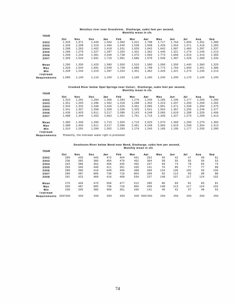
74
Oct Nov Dec Jan Feb Mar Apr May Jun Jul Aug Sep2002 1,329 1,371 1,449 1,504 1,360 1,421 1,798 1,717 1,764 1,600 1,451 1,3862003 1,328 1,298 1,319 1,494 1,540 1,538 1,508 1,426 1,453 1,371 1,316 1,2832004 1,268 1,263 1,402 1,418 1,531 1,635 1,642 1,642 1,587 1,465 1,397 1,3372005 1,289 1,275 1,327 1,287 1,254 1,301 1,362 1,445 1,321 1,274 1,245 1,2132006 1,209 1,244 1,361 2,049 1,738 1,470 1,593 1,773 1,694 1,515 1,410 1,3552007 1,309 1,544 1,691 1,716 1,581 1,686 1,579 1,546 1,487 1,426 1,369 1,334
Mean 1,290 1,330 1,420 1,580 1,500 1,510 1,580 1,590 1,550 1,440 1,360 1,320Max 1,329 1,544 1,691 2,049 1,738 1,686 1,798 1,773 1,764 1,600 1,451 1,386Min 1,209 1,244 1,319 1,287 1,254 1,301 1,362 1,426 1,321 1,274 1,245 1,213
Instream Requirements 1,080 1,140 1,110 1,150 1,150 1,160 1,160 1,240 1,200 1,170 1,140 1,100
Oct Nov Dec Jan Feb Mar Apr May Jun Jul Aug Sep2002 1,310 1,291 1,284 1,306 1,283 1,276 1,245 1,185 1,195 1,177 1,205 1,2802003 1,351 1,293 1,286 1,302 1,318 1,288 1,302 1,223 1,207 1,200 1,206 1,2822004 1,334 1,332 1,348 1,426 1,525 2,461 2,085 1,691 1,471 1,339 1,354 1,3752005 1,341 1,357 1,358 1,359 1,336 1,325 1,541 1,934 1,367 1,255 1,246 1,3772006 1,436 1,403 1,611 3,217 2,086 2,143 4,248 2,065 1,619 1,288 1,326 1,4062007 1,488 1,344 1,453 1,663 1,451 1,751 1,715 1,335 1,327 1,274 1,269 1,413
Mean 1,380 1,340 1,390 1,710 1,500 1,710 2,020 1,570 1,360 1,260 1,270 1,360Max 1,488 1,403 1,611 3,217 2,086 2,461 4,248 2,065 1,619 1,339 1,354 1,413Min 1,310 1,291 1,284 1,302 1,283 1,276 1,245 1,185 1,195 1,177 1,205 1,280
Instream Requirements
Oct Nov Dec Jan Feb Mar Apr May Jun Jul Aug Sep2002 269 435 445 472 404 441 252 45 42 47 48 612003 236 365 380 454 479 452 364 58 55 55 56 532004 243 386 452 406 430 455 247 59 73 78 84 732005 293 345 446 411 351 430 141 70 85 77 77 882006 289 390 416 649 490 468 459 134 106 100 93 1002007 266 487 685 736 716 804 269 92 113 93 98 882008 291 423 469 416 469 534 227 148 107 117 124 102
Mean 270 404 470 506 477 512 280 86 83 81 83 81Max 293 487 685 736 716 804 459 148 113 117 124 102Min 236 345 380 406 351 430 141 45 42 47 48 53
Instream Requirements 250/500 500 500 500 500 500 500/250 250 250 250 250 250
Crooked River below Opal Springs near Culver, Discharge, cubic feet per second,Monthly mean in cfs
YEAR
Deschutes River below Bend near Bend, Discharge, cubic feet per second,Monthly mean in cfs
YEAR
Monthly mean in cfs YEAR
Metolius river near Grandview, Discharge, cubic feet per second,
Presently, the instream water right is protested

75
Oct Nov Dec Jan Feb Mar Apr May Jun Jul Aug Sep2002 335 30 33 35 30 29 466 1,118 1,254 1,495 1,401 1,1142003 293 29 31 32 29 35 301 1,078 1,347 1,461 1,266 1,0632004 387 36 40 44 38 30 448 1,063 1,286 1,474 1,368 1,0922005 466 37 33 30 30 32 466 679 1,275 1,439 1,469 1,1422006 234 31 31 30 31 32 203 860 939 1,375 1,427 1,1522007 375 101 190 290 309 350 658 1,421 1,331 1,563 1,515 1,1412008 242 40 47 70 127 137 549 990 1,015 1,466 1,391 1,256
Mean 333 43 58 76 85 92 441 1,030 1,207 1,467 1,405 1,137Max 466 101 190 290 309 350 658 1,421 1,347 1,563 1,515 1,256Min 234 29 31 30 29 29 203 679 939 1,375 1,266 1,063
Instream Requirements 500 400 400 400 400 400 500 500 500 500 500 500
Oct Nov Dec Jan Feb Mar Apr May Jun Jul Aug Sep2002 34 58 84 108 78 108 341 204 141 83 132 1082003 39 52 66 121 183 182 217 184 118 81 145 1022004 31 48 91 72 95 151 223 230 150 99 127 982005 49 53 111 73 62 90 109 148 86 119 106 902006 35 79 78 191 149 154 295 567 319 113 111 942007 40 107 132 101 123 194 232 165 112 117 125 1002008 69 107 92 72 73 112 146 485 376 154 146 86
Mean 42 72 93 105 109 142 223 283 186 109 127 97Max 69 107 132 191 183 194 341 567 376 154 146 108Min 31 48 66 72 62 90 109 148 86 81 106 86
Instream Requirements 116 164 196 200 200 236 240 240 200 126 75 92
Oct Nov Dec Jan Feb Mar Apr May Jun Jul Aug Sep2002 22 39 54 66 45 39 39 29 95 12 3 32003 26 36 43 89 81 53 25 14 25 9 5 42004 29 47 53 48 48 37 11 33 48 18 12 92005 35 43 58 61 38 38 19 54 12 8 7 72006 25 47 69 122 66 35 23 70 153 81 15 142007 43 109 122 100 83 66 34 20 26 17 13 132008 38 100 94 52 47 32 17 58 99 87 20 11
Mean 31 60 70 77 58 43 24 40 65 33 11 9Max 43 109 122 122 83 66 39 70 153 87 20 14Min 22 36 43 48 38 32 11 14 12 8 3 3
Instream Requirements 50 30 30 30 20 20 20 20 20 20 20 20/30
Oct Nov Dec Jan Feb Mar Apr May Jun Jul Aug Sep2002 823 501 529 551 510 535 1,165 1,747 1,788 1,908 1,835 1,6192003 791 497 511 579 635 618 912 1,618 1,808 1,906 1,748 1,4892004 818 451 517 502 539 399 1,001 1,674 1,755 1,901 1,808 1,4792005 894 447 509 468 453 480 955 1,212 1,697 1,848 1,854 1,5892006 690 480 478 723 604 596 892 1,789 1,650 1,849 1,888 1,6572007 863 614 763 855 856 975 1,281 1,940 1,879 1,971 1,898 1,6072008 763 538 521 523 608 701 1,119 1,864 1,785 1,968 1,909 1,729
Mean 806 504 547 600 601 615 1,046 1,692 1,766 1,907 1,849 1,596Max 894 614 763 855 856 975 1,281 1,940 1,879 1,971 1,909 1,729Min 690 447 478 468 453 399 892 1,212 1,650 1,848 1,748 1,479
Instream Requirements 1,000 660 660 660 660 1,000 1,000 1,600 1,600 1,600 1,600 1,600
Whychus Creek at Sisters, Discharge, cubic feet per second,
Monthly mean in cfsYear
Deschutes River below Wickiup Reservoir, near Lapine, Discharge, cubic feet per second,
Little Deschutes River near Lapine, Discharge, cubic feet per second,
Deschutes River at Benham Falls near Lapine, Discharge, cubic feet per second,
Monthly mean in cfsYEAR
Monthly mean in cfsYEAR
Monthly mean in cfsYear
76
Appendix E – Issue Framing Attachment

77

78
Appendix E – Issue Paper Attachment Change in Stream Flow Tables - Modeled2
For September, 2007 To monitor the impact of new ground water permits and mitigation on scenic waterway flows and instream water right flows, the Department developed a streamflow monitoring model using historic streamflow data. The streamflow model was constructed using a base period of flows from 1966 to 1995 at selected gaging stations around the basin. This base period represents river flows during a period of time after all of the dams were constructed and before the Scenic Waterway Act was amended to include consideration of ground water impacts. The model considers the effects of new permitted ground water use and mitigation projects on streamflows. The following tables show the monthly model results through mid-2007 for all gaging station sites most closely representing each zone of impact and areas of special interest. With only one exception, instream requirements are met or improved compared to base line conditions when averaged annually. Based on modeled results, streamflow overall has improved by as much as 27 cfs in some areas due to mitigation. This document includes tables for the following locations: Deschutes River at the Mouth – Station #14103000 Deschutes River below Pelton Dam – Station #14092500 Metolius River at Lake Billy Chinook – Station #14091500 Deschutes River downstream of Bend – Station #14070500 Deschutes River upstream of Bend – Station #14070500 + four canals Little Deschutes River at mouth – Station #14063000 Deschutes River below Fall River – Station #14056500 and 14057500 Deschutes River below Wickiup Dam – Station #14056500
2 September 2007 data based on R.M. Cooper, Assessing the Impact of Mitigation on Stream Flow in the Deschutes Basin. November 2008. Available at www.wrd.state.or.us
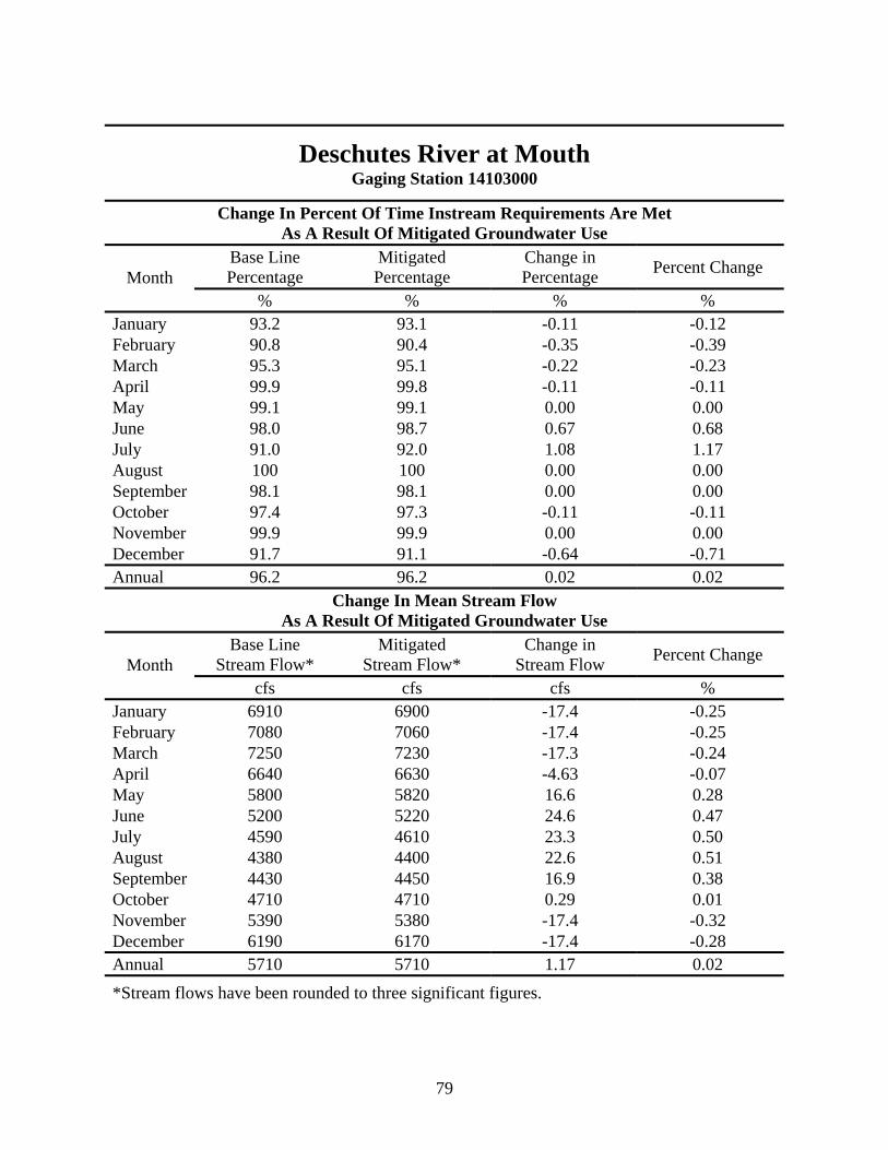
79
Deschutes River at Mouth Gaging Station 14103000
Change In Percent Of Time Instream Requirements Are Met As A Result Of Mitigated Groundwater Use
Base Line Percentage
Mitigated Percentage
Change in Percentage Percent Change Month
% % % % January 93.2 93.1 -0.11 -0.12 February 90.8 90.4 -0.35 -0.39 March 95.3 95.1 -0.22 -0.23 April 99.9 99.8 -0.11 -0.11 May 99.1 99.1 0.00 0.00 June 98.0 98.7 0.67 0.68 July 91.0 92.0 1.08 1.17 August 100 100 0.00 0.00 September 98.1 98.1 0.00 0.00 October 97.4 97.3 -0.11 -0.11 November 99.9 99.9 0.00 0.00 December 91.7 91.1 -0.64 -0.71 Annual 96.2 96.2 0.02 0.02
Change In Mean Stream Flow As A Result Of Mitigated Groundwater Use
Base Line Stream Flow*
Mitigated Stream Flow*
Change in Stream Flow Percent Change Month
cfs cfs cfs % January 6910 6900 -17.4 -0.25 February 7080 7060 -17.4 -0.25 March 7250 7230 -17.3 -0.24 April 6640 6630 -4.63 -0.07 May 5800 5820 16.6 0.28 June 5200 5220 24.6 0.47 July 4590 4610 23.3 0.50 August 4380 4400 22.6 0.51 September 4430 4450 16.9 0.38 October 4710 4710 0.29 0.01 November 5390 5380 -17.4 -0.32 December 6190 6170 -17.4 -0.28 Annual 5710 5710 1.17 0.02 *Stream flows have been rounded to three significant figures.

80
Deschutes River below Pelton Dam Gaging Station 14092500
Change In Percent Of Time Instream Requirements Are Met As A Result Of Mitigated Groundwater Use
Base Line Percentage
Mitigated Percentage
Change in Percentage Percent Change Month
% % % % January 64.7 64.1 -0.64 -1.01 February 63.0 62.2 -0.83 -1.33 March 67.8 66.9 -0.97 -1.45 April 71.4 71.3 -0.11 -0.16 May 58.8 62.9 4.09 6.50 June 55.6 59.1 3.56 6.02 July 41.0 42.7 1.72 4.03 August 98.2 99.0 0.86 0.87 September 66.8 67.6 0.78 1.15 October 81.1 80.3 -0.75 -0.94 November 97.2 97.2 0.00 0.00 December 66.1 65.5 -0.64 -0.99 Annual 69.3 69.9 0.59 0.85
Change In Mean Stream Flow As A Result Of Mitigated Groundwater Use
Base Line Stream Flow*
Mitigated Stream Flow*
Change in Stream Flow Percent Change Month
cfs cfs cfs % January 5240 5230 -17.4 -0.33 February 5190 5180 -17.4 -0.34 March 5520 5500 -17.3 -0.31 April 5130 5130 -4.63 -0.09 May 4420 4440 16.6 0.37 June 4230 4250 24.6 0.58 July 4020 4040 23.3 0.58 August 3940 3960 22.6 0.57 September 3980 3990 16.9 0.42 October 4190 4190 0.290 0.01 November 4680 4670 -17.4 -0.37 December 5030 5010 -17.4 -0.35 Annual 4630 4630 1.17 0.03 *Stream flows have been rounded to three significant figures.
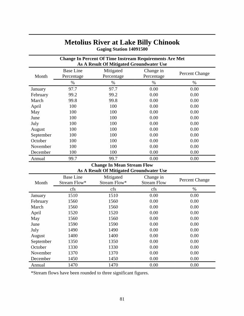
81
Metolius River at Lake Billy Chinook Gaging Station 14091500
Change In Percent Of Time Instream Requirements Are Met As A Result Of Mitigated Groundwater Use
Base Line Percentage
Mitigated Percentage
Change in Percentage Percent Change Month
% % % % January 97.7 97.7 0.00 0.00 February 99.2 99.2 0.00 0.00 March 99.8 99.8 0.00 0.00 April 100 100 0.00 0.00 May 100 100 0.00 0.00 June 100 100 0.00 0.00 July 100 100 0.00 0.00 August 100 100 0.00 0.00 September 100 100 0.00 0.00 October 100 100 0.00 0.00 November 100 100 0.00 0.00 December 100 100 0.00 0.00 Annual 99.7 99.7 0.00 0.00
Change In Mean Stream Flow As A Result Of Mitigated Groundwater Use
Base Line Stream Flow*
Mitigated Stream Flow*
Change in Stream Flow Percent Change Month
cfs cfs cfs % January 1510 1510 0.00 0.00 February 1560 1560 0.00 0.00 March 1560 1560 0.00 0.00 April 1520 1520 0.00 0.00 May 1560 1560 0.00 0.00 June 1590 1590 0.00 0.00 July 1490 1490 0.00 0.00 August 1400 1400 0.00 0.00 September 1350 1350 0.00 0.00 October 1330 1330 0.00 0.00 November 1370 1370 0.00 0.00 December 1450 1450 0.00 0.00 Annual 1470 1470 0.00 0.00 *Stream flows have been rounded to three significant figures.

82
Deschutes River Downstream of Bend Gaging Station 14070500
Change In Percent Of Time Instream Requirements Are Met As A Result Of Mitigated Groundwater Use
Base Line Percentage
Mitigated Percentage
Change in Percentage Percent Change Month
% % % % January 60.5 58.7 -1.83 -3.11 February 63.8 62.1 -1.65 -2.66 March 68.3 67.7 -0.54 -0.79 April 23.6 23.8 0.22 0.94 May 1.29 1.40 0.11 7.69 June 2.11 3.11 1.00 32.1 July 0.11 0.54 0.43 80.0 August 0.86 1.40 0.54 38.5 September 3.67 4.11 0.44 10.8 October 13.0 13.5 0.54 3.97 November 52.2 50.4 -1.78 -3.52 December 56.3 54.5 -1.83 -3.35 Annual 28.6 28.3 -0.36 -1.26
Change In Mean Stream Flow As A Result Of Mitigated Groundwater Use
Base Line Stream Flow*
Mitigated Stream Flow*
Change in Stream Flow Percent Change Month
cfs cfs cfs % January 683 679 -4.03 -0.59 February 705 701 -4.03 -0.57 March 714 710 -4.03 -0.57 April 299 306 7.32 2.39 May 51.2 83.1 31.9 38.4 June 50.5 88.9 38.4 43.2 July 42.6 80.9 38.4 47.4 August 46.2 84.4 38.2 45.3 September 61.0 93.5 32.5 34.8 October 222 236 14.2 6.01 November 551 547 -4.03 -0.74 December 614 610 -4.03 -0.66 Annual 335 350 15.2 4.33 *Stream flows have been rounded to three significant figures.

83
Deschutes River Upstream of Bend Gaging Station 14070500 + 4 Canals*
Change In Percent Of Time Instream Requirements Are Met As A Result Of Mitigated Groundwater Use
Base Line Percentage
Mitigated Percentage
Change in Percentage Percent Change Month
% % % % January 37.3 37.3 0.00 0.00 February 40.0 40.0 0.00 0.00 March 24.8 24.8 0.00 0.00 April 33.3 33.7 0.33 0.99 May 6.45 8.92 2.47 27.7 June 17.7 24.3 6.67 27.4 July 27.1 35.2 8.06 22.9 August 4.95 12.0 7.10 58.9 September 1.78 3.78 2.00 52.9 October 15.2 16.3 1.18 7.24 November 29.0 29.0 0.00 0.00 December 35.7 35.7 0.00 0.00 Annual 22.7 25.0 2.34 9.34
Change In Mean Stream Flow As A Result Of Mitigated Groundwater Use
Base Line Stream Flow**
Mitigated Stream Flow**
Change in Stream Flow Percent Change Month
cfs cfs cfs % January 712 712 -0.118 -0.02 February 738 738 -0.118 -0.02 March 781 780 -0.118 -0.02 April 877 885 8.37 0.95 May 1180 1230 54.5 4.42 June 1360 1420 61.0 4.30 July 1440 1500 61.0 4.08 August 1290 1350 60.9 4.51 September 1090 1150 55.5 4.85 October 721 746 24.8 3.33 November 590 590 -0.118 -0.02 December 650 650 -0.118 -0.02 Annual 953 980 27.3 2.78 * The four canals are the DCMID (14068500), the North Unit Main (14069000), the North (14069500), and the Swalley (14070000). **Stream flows have been rounded to three significant figures.

84
Little Deschutes River at mouth Gaging Station 14063000
Change In Percent Of Time Instream Requirements Are Met As A Result Of Mitigated Groundwater Use
Base Line Percentage
Mitigated Percentage
Change in Percentage Percent Change Month
% % % % January 22.9 22.9 0.00 0.00 February 37.3 37.3 0.00 0.00 March 27.4 27.4 0.00 0.00 April 45.2 45.2 0.00 0.00 May 55.9 57.3 1.40 2.44 June 56.6 67.9 11.3 16.7 July 85.1 98 12.9 13.2 August 93.9 96.1 2.26 2.35 September 72 79.7 7.67 9.62 October 11.6 18.5 6.88 37.2 November 14.7 14.7 0.00 0.00 December 20.3 20.3 0.00 0.00 Annual 45.3 48.8 3.55 7.27
Change In Mean Stream Flow As A Result Of Mitigated Groundwater Use
Base Line Stream Flow*
Mitigated Stream Flow*
Change in Stream Flow Percent Change Month
cfs cfs cfs % January 162 162 -0.038 -0.02 February 183 183 -0.038 -0.02 March 219 219 -0.038 -0.02 April 262 262 -0.038 -0.01 May 329 334 4.89 1.46 June 298 323 25.3 7.82 July 230 256 25.3 9.90 August 200 222 21.8 9.85 September 144 162 18.6 11.5 October 76.7 85.4 8.69 10.2 November 108 108 -0.038 -0.04 December 142 142 -0.038 -0.03 Annual 196 205 8.74 4.26 *Stream flows have been rounded to three significant figures.

85
Deschutes River below Fall River Gaging Stations 14056500 + 14057500
Change In Percent Of Time Instream Requirements Are Met As A Result Of Mitigated Groundwater Use
Base Line Percentage
Mitigated Percentage
Change in Percentage Percent Change Month
% % % % January 29.7 29.7 0.00 0.00 February 30.1 30.1 0.00 0.00 March 33.5 33.5 0.00 0.00 April 68.4 68.4 0.00 0.00 May 97.8 97.8 0.00 0.00 June 98.8 98.8 0.00 0.00 July 100 100 0.00 0.00 August 100 100 0.00 0.00 September 99.8 99.8 0.00 0.00 October 56.8 56.8 0.00 0.00 November 20.9 20.9 0.00 0.00 December 24.7 24.7 0.00 0.00 Annual 63.5 63.5 0.00 0.00
Change In Mean Stream Flow As A Result Of Mitigated Groundwater Use
Base Line Stream Flow*
Mitigated Stream Flow*
Change in Stream Flow Percent Change Month
cfs cfs cfs % January 329 329 0.00 0.00 February 331 331 0.00 0.00 March 319 319 0.00 0.00 April 654 654 0.00 0.00 May 1220 1220 0.00 0.00 June 1500 1500 0.00 0.00 July 1690 1690 0.00 0.00 August 1530 1530 0.00 0.00 September 1260 1260 0.00 0.00 October 561 561 0.00 0.00 November 246 246 0.00 0.00 December 280 280 0.00 0.00 Annual 829 829 0.00 0.00 *Stream flows have been rounded to three significant figures.

86
Deschutes River below Wickiup Dam Gaging Station 14056500
Change In Percent Of Time Instream Requirements Are Met As A Result Of Mitigated Groundwater Use
Base Line Percentage
Mitigated Percentage
Change in Percentage Percent Change Month
% % % % January 26.0 26.0 0.00 0.00 February 27.6 27.6 0.00 0.00 March 22.8 22.8 0.00 0.00 April 57.3 57.3 0.00 0.00 May 95.9 95.9 0.00 0.00 June 98.2 98.2 0.00 0.00 July 99.8 99.8 0.00 0.00 August 100 100 0.00 0.00 September 99.2 99.2 0.00 0.00 October 47.0 47.0 0.00 0.00 November 10.1 10.1 0.00 0.00 December 18.6 18.6 0.00 0.00 Annual 58.7 58.7 0.00 0.00
Change In Mean Stream Flow As A Result Of Mitigated Groundwater Use
Base Line Stream Flow*
Mitigated Stream Flow*
Change in Stream Flow Percent Change Month
cfs cfs cfs % January 201 201 0.00 0.00 February 204 204 0.00 0.00 March 189 189 0.00 0.00 April 518 518 0.00 0.00 May 1080 1080 0.00 0.00 June 1360 1360 0.00 0.00 July 1550 1550 0.00 0.00 August 1400 1400 0.00 0.00 September 1130 1130 0.00 0.00 October 428 428 0.00 0.00 November 115 115 0.00 0.00 December 151 151 0.00 0.00 Annual 696 696 0.00 0.00 *Stream flows have been rounded to three significant figures.