Embed Size (px)
Citation preview

Shifting Sands in Changing Communities: The Neighborhoods,
Social Services, and Cultural Organizations of North Adams,
Massachusetts
Kay Oehler Stephen C. Sheppard
Blair Benjamin Lily Li
C3D Report NA2.2006 Copyright 2006
1

Shifting Sands in Changing Communities: The Neighborhoods, Social Services, and Cultural Organizations of North Adams, Massachusetts
Neighborhoods that have experienced economic decline and regeneration can experience the shifting sands of community change at two critical junctures. The first is during the process of economic dislocation. In the case of North Adams, MA, this happened in 1985 when Sprague Electric, the town’s main employer, closed its doors. Younger workers and their families moved out of town in search of jobs, leaving a population that was poorer, less educated, and more at risk for social services needs. The existing social structure of the town crumbled, leaving residents unsure of where they fit into the scheme of things. A community in the throes of an abrupt or even a more gradual economic decline will typically face “shifting sands” issues. Of more pressing concern today for many communities is the second juncture at which neighborhoods are particularly exposed to shifting sands issues. This is during the period of regeneration or attempted regeneration. As a neighborhood attempts to re-form itself (or is re-formed by external forces) it must be proactive in working to prevent the displacement of its poorer residents and to encourage positive social and economic integration and identity-building. As economic conditions improve, an awareness of changing social forces along with the implementation of far-sighted social policy can help assure that the next point in the neighborhood’s history will be built on solid ground and work in concert with economic development policy. This report is one of a series of papers on the city of North Adams, Massachusetts and the creation of MASS MoCA. In additional reports we address the historical context of the development of MASS MoCA1, and the economic impact of MASS MoCA on North Adams.2 The present paper presents a brief history of the neighborhoods of North Adams, the social issues identified by North Adams residents as problems, and the social service organizations in North Adams. MASS MoCA is playing an important role in regenerating a stable social structure in town, but it is not working in isolation. This report is meant to provide social context to our additional report in which we analyze social indicators before and after the opening of MASS MoCA in North Adams. This research is part of a larger project examining the effects that cultural organizations have on communities as they attempt to regenerate. Our partner communities and cultural organizations include MASS MoCA in North Adams, MA; Dia:Beacon in Beacon, NY; Real Art Ways (RAW) in Hartford, CT; Swamp Gravy in Colquitt, GA; and the Mexican Fine Arts Center Museum (MFACM) in Chicago. While studying cultural organizations with varying missions, we are
1 Kay Oehler, Stephen C. Sheppard, and Blair Benjamin. 2006. “Mill town, factory town, cultural economic engine: North Adams in context.” C3D Report NA1.2006. 2 Stephen C. Sheppard, Kay Oehler, Blair Benjamin, and Ari Kessler. 2005. “Culture and revitalization: The economic effects of MASS MoCA on its community.” C3D Report NA3.2005.
2

developing examples of successful strategies in specific situations that contribute to a stable social structure upon which the community can build. It should not be expected that the addition of a single cultural organization such as MASS MoCA can do all the ‘hard work’ of regenerating a community. In what follows, we explore the social context of North Adams in terms of its many neighborhoods, their history, and their current state of social stability. While we hope to see the beginning of improvement in social indicators since the opening of MASS MoCA in 1999, social regeneration is neither a quick process nor a foregone conclusion. The revitalization we see occurring in North Adams is the result of the efforts of many organizations, as well as improvements in the economy brought about by the opening of MASS MoCA. North Adams is a town of many neighborhoods. What follows is only a partial listing of neighborhood histories from around North Adams. Most of the data were taken from Neighborhood Expo tapes, filmed at the Masonic Temple from the years 1998 – 20043, and information from Northern Berkshire Community Coalition grants.4
Map 1 Town of North Adams, Western Edge
To Williamstown To central North Adams
3 The Neighborhood Expo, hosted every November at the Masonicdiscuss issues and insights concerning North Adams. 4 Additional sources are placed in footnotes at the bottom of the temaps are from http://maps.yahoo.com .
3
North Adams Neighborhoods from west to east
Brown – Blackinton Turquoise – Greylock Light Blue – Brayton Hill Red – Marion Avenue
Temple, brings together neighborhood leaders to
xt. Town maps are from MapQuest; neighborhood

Map 1 and Map 2 combined show the town of North Adams. Map 1 is of the western part of the town. If coming from Williamstown in the west, this is the entry into North Adams. In terms of residential or built-up areas, this part of town is long and narrow. Map 2, which overlaps with Map 1, shows, for the most part, the rest of North Adams, particularly the residential parts. Heading north out of town takes you through Clarksburg, MA and then to Stamford, VT. Driving east on Route 2 (the Mohawk Trail) takes you through a series of small towns and then to Greenfield. Taking Route 8 south out of town leads through Adams and on towards Pittsfield.
Map 2 Town of North Adams, central
To Clarksburg ↑
To Williamstown
To Greenfield
Thneibacovehav“nechuloshas 5 A
Central North Adams Neighborhoods
Green – UNO Neighborhoods Orange – Maple St. Neighborhood Blue – Neighborhood Connection Violet – East Main/Pleasant St. Pink – Mohawk Forest
To Adams and Pittsfield ↓
e definition of “neighborhood” is very subjective. Some of the areas are based around ghborhood schools, recent neighborhood groups, or common historical, ethnic, or geographic kground. Considering the small size and closeness of North Adams, a lot of the history rlaps, and many families, especially those in Greylock, Brayton Hill, and Mohawk Forest, e moved around the city a great deal. Looking at general trends, there were many tight-knit ighborhoods” in the early 1900s when streets had their own convenience stores, schools, and rches. When many of these closed during the 1950s – 1980s, many “neighborhoods” were
t. Only in the past decade, through efforts by residents and Northern Berkshire Neighbors5, the concept of “neighborhood” been revived. section of the Northern Berkshire Community Coalition
4

Map 3 The Neighborhood of Blackinton
Blackinton is located west of North Adams on the neighboring mountain range. A historically disputed area between North Adams and Williamstown, the neighborhood is set apart from the rest of North Adams in terms of its unique history. Many residents, past and present, consider themselves residents of Blackinton – referring to North Adams as a distinctly different entity. Sanford Blackinton, the namesake for the neighborhood, was a famous entrepreneur in the textile industry, and made Blackinton Company one of the largest and most reputable woolen manufacturers in Western Massachusetts. This allowed the residents to build and prosper, forming their own little community.6 In the early 1900s, Blackinton had its own school, jail, stores, post office, library, and fire department. Youth and adults gathered at the churches, the library, and the numerous youth clubs that dotted the area. The community was diverse, consisting of mill workers, businessmen, and old and young families. There was even a Welsh community around the Blackinton cemetery, complete with windmills built by materials imported from Wales. Many were first-generation immigrants who arrived speaking only Gaelic. Although Blackinton was distinct from North Adams, the neighborhood was not isolated from the rest of the city or the state. There was a bus to North Adams every half an hour and Blackinton had its own station on the railroad route. The train was very important for everyone, and it served as a gathering place for businessmen, visiting families, and even WWII troops, bringing in a constant and diverse flow of people. Blackinton mill closed in 1950, and the railroad and school disappeared as well. Today, most of the traffic passes by on Route 2. Many residents mourn the loss of the mill, but even more so the neighborhood schools. During the 1970s and 1980s, many students were shuffled around Brayton and Greylock elementary schools, and the neighborhood lost some of its cohesiveness. Compared to other neighborhoods, however, residents are still close to one another and very friendly. The place has retained its heritage. This may be because many of the families have been there all their lives, and most newcomers stay for a long time. In 1998, the Blackinton Neighbors Association was formed to maintain the culture of the area by beautifying historic sites, conducting reunions, and hosting school tours of Blackinton. 6 See “Sanford Blackinton – The Village and the Mill” by the North Adams Historical Society Inc.
5

Map 4 Greylock
Hoosic River
The Greylock community is located west of North Adams and is roughly bounded by the Stop & Shop grocery store and the Harriman Airport on the west, and Price Chopper/ Roberts Dr. on the east. The neighborhood can be divided into two different sections consisting of the original veterans’ complex and the Greylock housing complex. Historically, Greylock has always been in flux, with local residents continuously switching homes within the neighborhood and out to the rest of North Adams. A small textile mill has existed at 506-510 State Rd. (Route 2) since 1846. At this time virtually no French Canadians lived in North Adams. In the 1870s, McLellan, Hunter and Company built the beginnings of the mill buildings that remain today. The complex became known as the Greylock Mills. Additional mill buildings were constructed throughout the next forty years.7 By 1909, 25% of North Adams residents were French Canadians who had been attracted by work in the mills.8 Many of them chose to live in the Greylock neighborhood. The initial, majority-French Canadian population in Greylock was very tight-knit, with mothers taking care of each other’s children, families meeting at the skating rink, and neighbors going to the same predominantly French Canadian church. However, these families rarely stayed for too long. Beginning with the veteran’s complex in the 1950s, families customarily switched to larger homes every few years as families grew in size. This would then open up new placements for small or single parent families to move in. Many residents in and around North Adams had their start in the Greylock project as they began new families. The Greylock veterans’ complex had its beginnings in the 1950s, when veterans returned from World War II to North Adams looking for a cheap place to live for themselves and their families. Many of the residents had grown up in nearby neighborhoods, especially Braytonville to the east. 7 In recent years the mill buildings have housed a variety of businesses, including the Parker Machine and Novtek factories. Today it is owned by Cariddi Sales. 8 A History of French Canadians in North Adams, Williamstown: Williams College, unpublished History thesis. While 25% of North Adams residents claimed French ancestry on the 2000 U.S. Census long-form, historical records make clear that these ancestors came to North Adams via Canada.
6

The veterans built their homes amidst undeveloped land and cheap dirt roads, forming a square along what are now Mead Ave, Catherine, Bonair, and Barbour St. Each family brought in their own building supplies, and added personal touches to their houses. During the early 1960s, the city built the Greylock Housing Complex in order to provide affordable homes to families. Greylock expanded eastwards into Angeli, Isbeli, and Sullivan St. to form a new community with a soccer field and a playground. As the children met and played together, these streets developed their own sense of community separate from that of the original Greylock veterans’ complex. Today the community is composed of families of varying sizes, with parents working in a variety of occupations such as the city works, the schools, and the police and fire departments. With the continuous change in residents, Greylock lost some of its unity and community feeling. The population, though still largely French Canadian, has few residents regularly attending the same church. Children now go to daycare and school-based activities instead of other children’s backyards. Children still attend the same school, and neighbors remain friendly, but not as close as in former decades. In 1997, the North Adams police opened a sub-station on Angeli St. and provided a room for community meetings and activities. The Greylock Housing Coalition was formed to discuss issues of neighborhood unity, and bring parents closer to the activities of their children. Though the police no longer remain at the sub-station, the Housing Coalition is still present, organizing community events and addressing neighborhood problems. The community is considered very safe for families and children, yet even with all the neighborhood activities of the Housing Coalition, the frequent turnover of people keeps most residents to themselves.
Map 5
Brayton Hill
Brayton Hill is a newer housing project that is part of the larger Braytonville community. It is located off Route 2 on Barbour St and Brickyard Ct., west of North Adams, and is right behind Brayton Elementary School and the playground. Originally a brickyard (people sometimes still dig up bricks in their backyard), the area was eventually converted into a 95 unit housing complex throughout the 1970s and 1980s.
7

The construction of Brayton Hill began in 1972 as part of an affordable housing initiative. At first, the place was named Brickyard Terrace and had only three buildings, the rest of the area being covered with mud. The remaining buildings were completed in 1986, each one consisting of a mixture of four single-residency apartments and two-storey family units. Many of the original residents came from the Greylock veteran’s project. Like Greylock, the neighborhood has a high turnover rate – only four families have remained since its construction in 19729. Although Brayton was predominantly French Canadian at first, some black and Hispanic families have moved in and decided to stay. The large turnover rate and arrival of new ethnic groups have caused tensions in the area, and have made it difficult for adults to come together and find common ground on neighborhood issues. In 1994, community police and the apartment complex management encouraged residents to organize the neighborhood, and in 1997, the Brayton Hill Neighborhood Group was formed. The Group is based in the community office building, and holds meetings and events to educate and beautify Brayton Hill. The efforts have brought many of the children together in games and activities, but there is still a very low turnout at meetings, and many adults are still reticent about participating in the neighborhood.
Map 6 Marion Ave
Marion Ave is located west of North Adams and off of Route 2. It is just east of Brayton Hill and is part of historic Braytonville. The area once was the private property of A.C. Weber, the owners of the respected Weber Brothers Shoe Company located on Marshall and Holden Street.10 They built the first house in 1896 with two rooms and a bathroom, with an adjacent tennis court that was later torn down to build a second house. 9 As of 1998 (Neighborhood Expo tape) 10 See North Adam, Massachusetts, Old Home Week: September 5-11, 1909 reprinted by Diane Wohl, Adams Specialty and Printing Co, March 1987
8

Today the neighborhood consists of a mix of families that includes those who arrived from Maine after the Weber family sold the land and it was developed, and Jewish, Italian, and French Canadian families. The neighborhood in the past was like an extended family for everyone who lived there. Residents hosted Halloween celebrations, Christmas parties, and other gatherings throughout the year. The environment maintained constant until the 1980s, when the community started dwindling and drug and crime rates increased. People lost touch with each other in the neighborhood and no longer attended community events. The neighborhood has stabilized and is now a very safe place for children and their families. Most of the residents there are descendants or relatives of the original inhabitants, and currently the neighborhood is undergoing its third generation of small children. This continuity ensures that neighbors will recognize each other and stay close, but the original feeling of an extended family has been lost.
Map 7
United Neighborhoods Organization (UNO)11
UNO consists of Bracewell Ave, River St., Hall St, Liberty St, Chase Ave, Freeman Ave, Houghton St., North Holden, Grove St., Chase Hill, Brook Terrace, Eagle St., all neighborhoods close to and/or part of the North Adams downtown. In the past, this district was very well respected, and one of the nicest in North Adams. Originally, it was named Freeman Grove, after the Freeman Manufacturing Company that was located there. Row houses were for the mill workers from the company, while very nice, spacious Victorian-style homes housed the business class. Today, the homes are still present, and retain some of their majesty and grandeur. The neighborhood went through a particularly rough time in the 1980s, however. Ramshackle housing, litter, vandalism, alcoholism, drugs, and absentee landlords were a common problem in the area. On October 1, 1990, 60 residents, Al Bashevkin of the Community Coalition, three city councilors, members of the city’s Community Development Corps, and representatives of other social organizations met to form an action plan to restore the neighborhood to its past state. The residents met again, and decided to name themselves ‘UNO’ (United Neighborhood 11 See Davis, Shirley A. “United Neighborhood Organization 1990-2004: 14 Years of Building a Healthy Neighborhood”
9

Organization). The goals of UNO were to increase respect for the neighborhood, improve the environment, and educate residents about drug and alcohol prevention. In 1994, a Community Policing program began as an effort to have police and communities work together. Police attended monthly meetings and took note of the concerns that residents had. 1998 saw another positive change as funding from the Mayor’s office brought in a new playground. Some older, unsafe buildings were torn down to make room, and the playground was built by the efforts of many people, including a Williamstown construction team from the International Institute for Cooperation and Development, volunteers from the Massachusetts College of Liberal Arts (MCLA), and local residents. The Porches Inn, built in 2001, had a dramatic impact on the community. The Porches Inn was seen as a building that could spruce-up the neighborhood, but it also created controversy among the residents. Some consider the building an unwanted intrusion that has bulldozed former homes and done little to improve the homes in the surrounding area, while others view it as a welcome addition to the community, returning some of the former richness and beauty to the area. Shirley Davis, the UNO organizer, considers the Porches Inn a “wonderful addition to the UNO neighborhood.” UNO can be further broken down into three different areas:
Map 8 The Freeman Park area of the UNO Neighborhood
Freeman Park consists of the area boxed in by Eagle Street, Bracewell Ave, North Holden St., and River St. In the early 1900s, Freeman Park was a very close community that contained many rich business families, as Eagle Street housed many company names such as Buckley, Cologne, Brown (of the Berkshire Grain and Coal Company), and Clark (of H. W. Clark Biscuit Co). Although these families often had upper-class lifestyles, they never failed to be an intimate part of the community. The neighborhood was centered on the playground and Freeman School, and many residents have fond memories of their time at the playground and in the classroom. However, during the economic downturn of the 1970s and 1980s, the neighborhood climate deteriorated significantly. Both the playground and the school were torn-down, and many of the richer households left,
10

leaving behind empty, ill-kempt homes. During this time, there was a “breakdown of leadership” in the community and among the youth. Parents no longer dared to send their children outside for fear of their safety, as the entire UNO neighborhood worsened. Many residents now are optimistic about the changes that UNO is bringing to their area, but those who have lived in Freeman Park for many years miss the environment of its past.
Map 9 The River Street area of the UNO Neighborhood
River Street was once much like Freeman Park with its Victorian style housing and rich community life. The area was often flooded, as water would run down the street from the river. Today, many of the old buildings either are vacated or have been torn down, and flood control (put into place during urban renewal) now prevents the water from rising. The most prominent building is now Porches Inn.
Map 10 The State Street/ Lower Bracewell/ Big Y area of the UNO Neighborhood
11

This area extends from the middle of the UNO neighborhood (Houghton St. and Lower Bracewell), south past the railroad tracks, east towards Holden St.12 The community is historically composed of Lebanese and Italian families, and although many of the Italians have remained, most of the original Lebanese families have moved away from North Adams. In the past, the Lebanese and Italians housed large extended families under one roof. The neighborhood was very close, as relatives, by blood or through marriage, all lived next door or down the street. In the mid-1900s, this was a thriving community. Many were first-generation families who built their own houses and started small businesses from scratch. Bracewell Ave, Houghton, and Holden Street were dotted with Italian convenience stores, fish stores, pizza places, and bakeries, while State St. had a Lebanese convenience store at every corner. Houghton Street was a diverse area, with people of different nationalities always passing through. There was tremendous activity and traffic, and up until the 1960s, residents would always see each other on the streets delivering milk, bleach, cheese, etc. There were many social activities in the neighborhood to bring people together. The playground played the role of arts center, featuring annual carnivals as well as band competitions that hosted performers from all over the state. Houghton Street also contained another branch of the North Adams library13. The more active families participated in a softball team during the summer and during the winter there was a skating rink. Much like the rest of North Adams, small businesses left during the 1970s and 1980s, partially due to the influx of larger stores such as the Big Y grocery store, the exodus of manufacturing companies, and the increased regulation of businesses. The area is now devoid of bustling activity, and only a few small businesses remain. Many of the residents still know each other and have a sense of community, but there is less interaction between neighbors.
Map 11 Amity Square
12 Apart from Houghton St., this area extends outside of the UNO. However, the community has experienced much of the same changes. 13 Closed in 1977, see http://www.naplibrary.com/history2.htm
12

Amity Square, also known as the Johnson School Area, surrounds Johnson School along Williams, North, Cady, and School Street. The houses were first built in the early 1900s around the Berkshire Hills Sanatorium. Originally, the neighborhood also had a brook running through its entire length, but the brook disappeared once storm sewers were put into place during the 1970s. In this neighborhood, Johnson School was very important – children would go all summer long to the playground, with teenagers supervising games and activities. It was the last neighborhood school to close in North Adams, and many residents still regret its loss. Today the facility houses the Head Start Program and the Community Transition Program for the North Adams Public Schools (alternative education models). Amity Square is an area with long-term residents. The neighborhood frequently goes through cycles of new, younger families, to a more elderly population. In recent years, a large number of relatives and families moved back to Amity Square to live with their families or in nearby residences, and currently there is an aging population. The lack of children makes it difficult for families to intermingle, but the neighborhood remains friendly. In 1994, homeowner Chris St. John began the Amity Square Neighborhood as part of the Northern Berkshire Neighbors program that was starting up in the area. To connect people in her area, Chris conducted household meeting with other residents and friends. Currently the group has completed a neighborhood leadership program, conducted activities to beautify and clean the neighborhood, and has created a phone network for a neighborhood watch program. The group continues to this day and can often be seen helping with chores or caring for common spaces.
Map 12 Maple Street
Maple Street and the surrounding area are located in the Northeast of North Adams and are bordered by Franklin Street, Glen Avenue, and the river. The land used to belong to the Hoosic Cotton Mill, until 1933 when it was auctioned off to the Elder family (now on Franklin Street). In 1950, the father in the Elder family died and the houses were sold off to form a new neighborhood.
13

Residents fondly call the area Blueberry Hill, due to the large number of blueberry bushes in the area. Much like Amity Square, this is an older neighborhood with many residents who have been there all their lives. There are few young children, although the quiet neighborhood is attracting more people to return and start families. There is little change in the area, and residents are more isolated from teen drug/ violence as compared to neighborhoods such as Freeman Park. Neighbors know one another very well, and have many opportunities to interact.
Map 13 The Neighborhood Connection
The Neighborhood Connection is comprised of Church St., from the library to Davenport St., Montana St., Blackinton St., Ashland St., Washington Ave, South St., Spring St., Chestnut St, and the surrounding area. This neighborhood group encompasses some of the oldest and most beautiful streets in North Adams and contains a mixture of residential properties and large apartments. Church Street is perhaps one of the most famous and richest streets in North Adams. Home to the Masonic Temple and the library, this area was once called the “Fine Residential District,” and was praised by Nathaniel Hawthorne.14 The homes lining the street near the library carry placards naming the times they were built and the famous business names once resided there.
14 See North Adam, Massachusetts, Old Home Week: September 5-11, 1909 reprinted by Diane Wohl, Adams Specialty and Printing Co, March 1987 Hawthorne – “Often it would seem a wonder how our road was to continue, the mountains rose so abruptly on either side, and stood so directly a wall across our onward course; while looking behind it would be an equal mystery how we had gotten thither, through the huge base of the mountain that seemed to have reared itself erect after our passage. Between the mountains there were gorges that led the imagination away into new scenes of wildness. I have never driven through such romantic scenery, where there was such a variety and boldness of mountain shapes as this, and though it was a bright, sunny day, the mountains diversified the view with sunshine and shadow, and glory and gloom.”
14

Close to Church Street, and in the centre of this neighborhood is Spring Street, Washington Ave, and South Street. This was once, and still is, a diverse community composed of Jewish, French, and Italian families. Mark Hopkins School was the place where all of the children and families intermingled; it was right across from the Jewish synagogue and became a gathering place for people of different ethnicities in the neighborhood. They affectionately termed the area “The Swamp” (due to constant flooding), built their homes, erected numerous neighborhood stores, and conducted social events. During the 1970s and 1980s, like most of the other neighborhoods, the downturn in the economy caused a drastic change in the community. Urban renewal removed much of the downtown south of main street and reduced foot traffic in the area, while the closing of Mark Hopkins School removed a lot of the cohesiveness in the neighborhood. Church Street kept its gorgeous homes, but lost many of its rich residents. The Jewish community west of Church Street also suffered when most of its neighborhood stores closed down. The 1990s served as a period of revival in the area, and today, Church Street and the surrounding streets are slowly coming together as a community. Although there still are distinct differences in income levels, efforts have been made to connect students from nearby MCLA, families from the entire neighborhood, and residents from Ashland and Spring Park Senior Housing Apartments (“High Rise”). This initiative began in 1992 when MCLA students formed a compact to become more involved with children in the neighborhood. In 1997, Neighborhood Connection was formed, dedicated to improving community relations, and addressing concerns of housing, safety, and neighborhood improvement. The group has built a new playground, developed a neighborhood charter (“Statement of Standards”), organized neighborhood events, and worked with landlords to clean up the area. Neighborhood Connection hosts ‘National Night Out’, an event celebrating community building and neighborhood safety, every August at the Masonic Temple on Church Street. Once a block event, National Night Out has become a citywide celebration that draws people from all neighborhoods in North Adams.
Map 14
East Main/ Pleasant St
15

The East Main/Pleasant Street neighborhood, just east of Church Street, is a mix of old and new. The streets have always been residential and predominantly composed of homeowners, with ‘mom and pop’ stores being the only businesses present. Most of the residents were originally employed by the mills and businesses downtown. This location was an ideal spot since it was within walking distance to work, close to other facilities like schools and churches, yet removed from downtown by the steeply sloped hills. Cherry, Pleasant, Holbrook, and Wall Street are composed of older, large, Victorian homes that once housed the richer members of the community. Wall Street, for example, was once completely owned by the Wall Streeter Shoe Company, complete with a large mansion and empty lots surrounding the home. Meadow, Holbrook, and Yale Street, just to the east, consist of comparatively poorer homes that once were owned by working class residents. Much of the business class vacated this area during the economic downturn, but in the past decade, residents, such as MCLA college professors, have bought the homes and renovated them. Cherry Street and Pleasant Street still have many families who have lived there for generations, but recent years have seen the transformation of some of the larger houses into apartments. Currently the neighborhood is still residential, and has an eclectic mix of families from different ethnic groups and generations.
Map 15 Mohawk Forest
Mohawk Forest, a 195-unit housing complex on Mohawk Trail, lies just east of North Adams on Route 2. This community is located in an almost idyllic spot, amidst the trees and near a lake, yet very close to the North Adams downtown. At present, the families have neighborhood events, summer camps for the kids, and a community center for all ages. Yet, despite the apparent
16

tranquility of this place, the history of Mohawk Forest shows the difficulties that the neighborhood faced in trying to maintain housing that was hospitable yet affordable. Mohawk Forest began in 1973 and was originally financed by the US Department of Housing and Urban Development. The 190-unit apartment project was started in order to provide a large quantity of inexpensive housing for North Adams residents. About half of the apartments contained 1-2 bedroom units, with the remainder being three bedroom units. The price scale was $139, $169, $189/ month15 for 1, 2, and 3 bedroom units respectively, with most 1-2 bedroom housing the elderly while larger 3 bedroom units house families. The majority of the family homes are run by single parents.16
In the 1980’s, residents of Mohawk Forest began to fear a rise in rent rates. The housing contracts for Mohawk Forest would end soon, and there was a discussion at the state level about converting the housing to market rates. To prevent rent hikes, the Mohawk Forest Housing Development (MFHD), a group of concerned residents and activists, petitioned the mayor and state legislators, and in 1990 legislation was enacted to extend the contract for Mohawk Forest. Although the neighborhood continued to be affordable, by the 1990s the quality of life in the area had decreased. The neighborhood, once tight-knit, now had an influx of strangers who were loosely associated. The neighborhood playground that had been a highlight of the area now had residents complaining of its rundown nature and unsafe environment. As a result, the Mohawk Forest Neighborhood Group was formed in 1997 to address issues facing children and their families. In 1999, Mohawk Forest was bought by The Caleb Foundation, an inter-faith, non-profit organization dedicated to improving the quality of low-income housing. Through the efforts of the neighborhood group, Mass Housing, and Mayor John Barrett, Mohawk Forest won a $5.75 million state loan and $250,000 additional grant to renovate and improve units. This money was used to build a new playground and community center, as well as provide funding for summer camps, computers, and neighborhood events. Today, Mohawk forest is an orderly, quiet place where 90% of the housing is still considered affordable. The residents are not as closely connected as they were in 1973, and tension is still present between strangers; however, a glance at the community center, annual events, and neighborhood meetings shows a much warmer and friendlier environment than a decade ago. Individuals in the Berkshires have concerns about their neighborhood and their communities. In 2002 the Berkshire United Way issued a survey to households in “high-risk” census tracks in order to identify human service needs based on public responses. High-risk was defined as female heads of households with children, and single elderly. The county was divided into six distinct regions, one of which was North Adams and the neighboring small towns of Clarksburg and Florida. While single parent households had the lowest response rate, they were most likely to voice concerns about the full
15 Information posted at the community center 16 www.thecalebfoundation.org
17

spectrum of social issues.17 North Adams residents were the most concerned of any region, citing numerous issues as important to them. Eleven issues were identified as ‘major’ or ‘moderate’ issues by 25% or more of the 1,639 countywide residents who returned the survey. 18 In decreasing order of responses they are:
• Shortage of affordable housing (43.6%) • Lack of affordable medical care (38.1%) • Shortage of recreation facilities (36.2%) • Noise or other pollution (34.3%) • Inadequate public transportation (32.1%) • Lack of jobs (31.8%) • Lack of affordable care for children (31.5%) • Anxiety, stress, depression (31.0%) • Substance abuse (29.2%) • Unemployment or underemployment (28.6%) • Water or air pollution (28.0%)
North Adams was a standout in relation to the other communities in that 29 issues were identified as ‘major’ or ‘moderate’ concerns by 25% or more of respondents from North Adams. Their level of concern was also high. Of the eleven issues listed above, more than 45% of respondents in North Adams identified each as moderate or major concerns.19
In spite of attempts to reach the “high risk” population of the county, 40.8% of the respondents had income of $50,000 or greater.20 As a result a supplemental questionnaire was sent to fuel assistance recipients by the Berkshire Community Action Council (BCAC) under the auspices of the Berkshire United Way. There were 802 respondents to the Berkshire United Way supplemental survey. While the residents came from throughout the Berkshire area, the majority were from Pittsfield, Adams, and North Adams. The survey first asked for basic demographic information, moved on to broader questions about the attractiveness of the neighborhood, and finally questioned respondents’ beliefs about household issues. There was a much larger percentage of female respondents (approximately two-thirds), with ages generally spread out in the 35+ range. A few respondents were between the ages of 20 and 34, with no respondents being under 20. Many who took part in the survey were individuals or families who received support from the Berkshire United Way and its member organizations (e.g. fuel subsidies). This is reflected in the
17 Berkshire United Way. 2003. “Lodestar II: A needs assessment of Berkshire County, Final Survey Report,” p. 3. 18 Ibid. p.4 19 Ibid. p.27 20 Ibid. p.3
18

fact that the per-capita income of most respondents is under $12,650, with approximately 3/8 renting their homes, and many without their own cars. Table 1 reveals that five neighborhood issues were perceived to be major problems by 20% or more of the respondents: shortage of affordable housing (28%); lack of jobs (27%); lack of affordable medical care (25%); shortage of recreational facilities (21%); and inadequate public transportation (20%). Seven additional neighborhood issues were identified as moderate problem in that 33% or more of respondents identified them as either moderate or major problems. These issues are lack of affordable childcare (48% moderate or major problem); poverty (48%); crime (41%); alcohol or drug abuse (39%); water, air, noise, or other pollution (39%); teen pregnancy (38%); and overcrowded housing (34%).
Table 1 Perceived Severity of Neighborhood Problems
Neighborhood Problems % Not a
Problem % Moderate Problem
% Major Problem
Shortage of affordable housing 39% 34% 28% Lack of jobs 37% 36% 27% Lack of affordable medical care 41% 34% 25% Shortage of recreational facilities 46% 33% 21% Inadequate public transportation 51% 29% 20% Lack of affordable childcare 52% 34% 14% Alcohol / Drug Abuse 61% 26% 13% Crime 59% 31% 10% Teen pregnancy 63% 28% 10% Overcrowded housing 66% 24% 10% Water, air, noise, or other pollution 61% 30% 9% Poverty 52% 40% 8% Mental illness / emotional issues 68% 26% 6% Violence and/or abuse of family members
68% 25% 6%
Racial or ethnic discrimination 77% 17% 6% Gangs 83% 14% 4% Unsafe school environment 78% 19% 3% Table 2 shows the problems that were perceived as issues for the household (as opposed to for the neighborhood). Major issues in the household are those labeled by at least 20% of respondents as major. These problems include lack of money to cover medical expenses (26%); not enough money to afford recreational activities (23%); and not enough money to afford legal help (21%). Moderate issues in the household are those identified by at least 33% of respondents as moderate or major issues for their household. These problems include lack of money for clothing and shoes (54% major or moderate problem); anxiety, stress, depression in the household (54%); lack
19
of money for food (51%); not enough money to pay for housing (44%); not able to find work (38%); and inadequate public transportation (37%). A common theme of the results of household problems is a lack of economic resources.
Table 2 Perceived Severity of Household Problems
Household Problems %Not a
Problem %Moderate
Problem % Major Problem
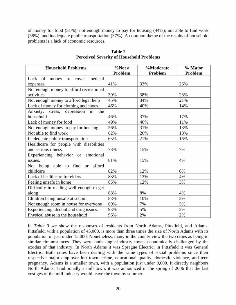
Lack of money to cover medical expenses 41% 33% 26% Not enough money to afford recreational activities 39% 38% 23% Not enough money to afford legal help 45% 34% 21% Lack of money for clothing and shoes 46% 40% 14% Anxiety, stress, depression in the household 46% 37% 17% Lack of money for food 49% 40% 11% Not enough money to pay for housing 56% 31% 13% Not able to find work 62% 20% 18% Inadequate public transportation 63% 21% 16% Healthcare for people with disabilities and serious illness 78% 15% 7% Experiencing behavior or emotional issues. 81% 15% 4% Not being able to find or afford childcare 82% 12% 6% Lack of healthcare for elders 83% 13% 4% Feeling unsafe in home 85% 12% 3% Difficulty in reading well enough to get along 88% 8% 4% Children being unsafe at school 88% 10% 2% Not enough room in house for everyone 89% 7% 3% Experiencing alcohol and drug issues. 93% 5% 2% Physical abuse in the household 96% 2% 2% In Table 3 we show the responses of residents from North Adams, Pittsfield, and Adams. Pittsfield, with a population of 45,000, is more than three times the size of North Adams with its population of just under 15,000. Nonetheless, many in the county view the two cities as being in similar circumstances. They were both single-industry towns economically challenged by the exodus of that industry. In North Adams it was Sprague Electric; in Pittsfield it was General Electric. Both cities have been dealing with the same types of social problems since their respective major employer left town: crime, educational quality, domestic violence, and teen pregnancy. Adams is a smaller town, with a population just under 9,000. It directly neighbors North Adams. Traditionally a mill town, it was announced in the spring of 2006 that the last vestiges of the mill industry would leave the town by summer.
20
Table 3 shows responses based on town for those issues identified as a moderate or major problem by a majority of respondents in at least one of the towns.
Table 3 Issues Identified as Problems by a Majority of Respondents in the towns of Pittsfield,
Adams, and North Adams
Issue Pittsfield Adams North Adams % Major or
moderate problem % Major or
moderate problem % Major or
moderate problem Lack of jobs 61% 77% 72% Lack of affordable medical care
61% 63% 64%
Lack of money to cover medical expenses
58% 78% 55%
Crime 58% 45% 55% Shortage of recreational facilities
55% 58% 64%
Alcohol/drug abuse 52% 39% 47% Six issues are identified as problems by at least half of the residents in one of the towns. These problems are lack of jobs; lack of affordable medical are; lack of money to cover medical expenses; crime; shortage of recreational facilities; and alcohol and drug abuse. If we examine responses by town we see that a greater percentage of residents of Adams identified lack of jobs and lack of money to cover medical expenses as problems than residents of Pittsfield and North Adams. Residents of Pittsfield identified crime and alcohol and drug abuse more frequently than residents of the other two towns. And residents of North Adams identified lack of affordable medical care and shortage of recreational facilities as problems more frequently than residents of Pittsfield and Adams. North Adams is a city filled with a variety of social organizations dedicated to improving the well-being of its citizens. These organizations focus on a wide range of tasks, but due to the small population of North Adams and the Berkshire area, there is a focus on collaboration among the different services. Unlike other places where organizations focus on specific communities, the entire population can access most of the services offered in North Adams, and more often than not, the services offered here are part of a larger network of services throughout the Berkshires. The Northern Berkshire Community Coalition (NBCC) is an umbrella organization for many of the different agencies in North Adams and the Berkshires. Three components (that often overlap) of the organization are the Core, Northern Berkshire Neighbors, and Unity. By examining its various functions, one can gain a glimpse of how the various social organizations interact with each other and the community.
21

The Coalition Core can be thought of as a center for the residential leaders, political figures, and social and economic organizational leaders of North Adams and the other Berkshire towns of Adams, Williamstown, Savoy, Cheshire, Florida, and Clarksburg. Through monthly forums, meetings, a newsletter, TV show, and other special events, the Core is able to bring together all of these people to discuss problems facing the area, highlight events, and develop strategies to address these issues. An important part of the Core is the staff. Coalition members such as Al Bashevkin, Kathy Keeser and other long-time residents of the area are immersed in the community. They speak to families and residents directly, and after gauging their difficulties, relate these concerns to agency staff at the Core events. The Core has helped develop the Family Life Support Center for the homeless and at-risk families, Ecu-Health Care that offers access to health care for the uninsured, and an office of Big Brothers and Big Sisters in North Adams. Community task forces have been created including the Northern Berkshire Collaborative for Non-Violence, Northern Berkshire Youth Collaborative, the Community Wellness Advisory Board, the Family Economic Self Sufficiency Task Force, and the Transportation Association of Northern Berkshire The history of the Transportation Association of Northern Berkshire (TANB) is a good example of how the Core functions. In the 1990s, many complaints surfaced over the poor public transportation system, from the lack of routes to the inadequate scheduling. According to a NBCC study, approximately 5-10% of workforce had to commute to work at times when buses did not run.21 Many residents did not own their own car, and so had difficulties working variable hours or even getting to work if they lived far from a bus route. The NBCC approached US Congressman John Olver at a coalition meeting in May 2000. With help from Congressman Olver, TANB was created along with a Board of Directors and a not-for-profit organization overseeing its progress. In its first 11 months of service, over 35,000 employment-related rides were given to residents.22 North Adams is still far from solving its many transportation-related problems, in addition to its other needs. However, the creation of the TANB is an example of how the Core uses a collaborative planning model that is critical in the decision-making processes that occur in North Adams and the Berkshire area. Northern Berkshire Neighbors (NBN)23 is a sector of the coalition that is more specific to neighborhood/ community development. It seeks to resolve conflict and heighten awareness among residents of different generations, incomes, and interests who often share the same street or neighborhood. To do this, NBN offers many different programs to all of North Adams, but generally focuses on low-income neighborhoods such as Brayton Hill, Greylock Housing Coalition, Greylock Neighbors, Mohawk Forest, and United Neighborhood Organization (UNO). Some of the programs include: 21 From Pathways to Collaboration, NBCC 22 Ibid 23 From United Way Grant Proposal, NBCC
22

• Neighborhood activities or programs: These recreational activities bring children and parents together. Held during the summer and school year, they involve scavenger hunts, movie nights, water festivals, or other activities that residents or volunteers decide upon.
• Neighborhood Summits: Forums are provided for residents to discuss concerns about the
neighborhood and find peaceful means of resolving conflict.
• Neighborhood to Community Linkages/ Neighborhood Connectors: In order to ensure that a community is thriving, residents need to be able to find the services to meet their needs, whether they need help for teen pregnancy or funding for fuel assistance. NBN can refer residents to services and resources in the area, but it is also designed to help residents help themselves instead of relying on organizations like the NBCC. NBN works in collaboration with the Berkshire Center for Children and Families, the North Adams Public School Parent Liaison, the Mohawk Forest resident Service Coordinator, the Brayton Hill Manager, the MCLA Center for Service, and other neighborhood leaders to provide staff support and formal leadership training to residents.
• Outreach and information distribution: NBN provides the Northern Berkshire Resource
guide on its website at www.nbccoalition.org, a list of contact information for all the service agencies in the area. Also, since many families do not have access to the news, The Talk of the Town neighborhood newsletter is sent to over 550 households containing pertinent neighborhood information.
• Community wide events: These events include annual recognition of community
members, The Annual Neighborhood EXPO, National Night Out, and the Downtown Celebration Children’s Area. All of these events are coordinated with and sponsored by local businesses, the police authority, and residential leaders.
Unity is a part of NBCC that is devoted to youth development and expression. It is comprised of numerous services and programs designed to keep youth and teens away from substance abuse, crime, and unplanned pregnancy and towards creative outlets such as music, art, and writing. In addition, Unity provides a means by which youth provide input on issues in the community. In order to gather data on youth and risky behavior, information is gathered from data collected from Lodestar and the North Berkshire Student Health Survey (NBSHS). The NBSHS is a very important resource that is used in collaboration with local health authorities. Students respond to numerous questions related to recent substance abuse, sexual activity, risk factors, and perceptions on the acceptability of risky behavior in the home, family, and community domain. With this data, Unity and other youth organizations (as part of the Northern Berkshire Youth Collaborative) hold monthly meetings to coordinate activities and programs to target specific issues. Some of the programs involved are:
• Safe Homes Program: Families pledge to provide safe, drug and alcohol-free places for youth.
23

• The Inter-School Forum Program: Students from area Northern Berkshire middle and
high schools participate in forums that discuss community and prevention issues. The talks are led by representatives of each school, who meet on a regular basis to plan youth and community discussions and events.
• CommUnity Arts Program: Unity sponsors public art projects, a substance free
coffeehouse (The Grooove) featuring local teen artists, songwriting lessons, and a writing workshop that publishes teen pieces. They are part of the YouthReach initiative of the Massachusetts Cultural Council.
It would be impossible to list and describe all the other agencies that serve North Adams. Some are important to note, however, as they provide funding and direction to numerous organizations including the NBCC. The Northern Berkshire United Way (NBUW)24, of which NBCC is a member, is another organization that provides referrals and information to residents. Like the NBCC, the Northern Berkshire United Way is an umbrella organization, bringing together residents, leaders, and agencies in order to encourage collaboration and improve community life. In addition, the NBUW is a funding center for its member agencies as it collects a variety of donations from businesses, charities, and private individuals. A community-based board of directors allocates the money to services and programs in the northern Berkshires that it feels are a necessity for the community. With its 25 member agencies, local Board of Directors, and community funding, the Northern Berkshire United Way has a distinct guiding hand on the services and activities of the northern Berkshires. As a final note, some other groups that provide support and funding to numerous agencies include: the Berkshire United Way,25 MA Department of Social Services, MA Cultural Council, US Substance Abuse and Mental Health Services Administration, MA Department of Public Health, Bureau of Substance Abuse Services, and the City of North Adams. Cultural organizations can be part of a collaborative process for rebuilding human capital and social stability in the community. We have discussed the social problems of North Adams in order to provide the social context within which MASS MoCA, the primary cultural organization in town, is operating. In the section on the neighborhoods of North Adams, a common theme was that individual neighborhoods in the past had been comfortable spaces for the residents, where neighbors knew one another and interacted with each other on a regular basis. Many neighborhoods experienced a decline from the mid-1980s to mid-1990s. It is notable that neighborhoods organized and improvements were made in the late 1990s in many neighborhoods, as the entire city waited expectantly for the opening of MASS MoCA in
24 For more information, visit http://bcn.net/~noberkuw/ 25 www.berkshireunitedway.com This is a distinct organization from the Northern Berkshire United Way.
24

1999. The Blackinton neighborhood association was formed in 1998; the Greylock Housing Coalition in 1997; the Brayton Hill Community Group in 1997; the Amity Square Neighborhood in 1994; Neighborhood Connection in 1997; and the Mohawk Forest Community Group in 1997. While these groups were organized by the hard work of specific individuals, they also follow a pattern we have seen whereby a more positive outlook about the community because of the growth of a cultural organization leads to more positive social structures being formed in the community. Thus, we argue that the promise of the opening of MASS MoCA (which was conceived of and proposed as early as 1987 and was under construction by 1995) changed individuals’ attitudes about the ability to improve their neighborhoods and encouraged them to join newly formed neighborhood associations. There are several reasons why we have discussed the numerous social service organizations serving the city. One is to provide a further understanding of the social challenges faced by North Adams, based on the number of social service agencies that exist and the problems they hope to ameliorate. Another reason is to reveal the abundant and collaborative mix of social service organizations, demonstrating a very functional aspect of the social structure of North Adams even as it is faced with continuing social problems. MASS MoCA, as a contemporary art museum, is also working to strengthen the community. One way this happens is through educational outreach programs and curriculum development for the schools. The North Adams school system and MASS MoCA have developed a close working relationship that allows art education to occur both in the schools and in the museum. In the smaller neighboring communities that have been added to MASS MoCA’s core educational outreach area, at least one school district has eliminated all in-school art education due to continuing budget constraints. This makes the MASS MoCA education program the only arts education for children in that school district. In addition to the ways that cultural organizations directly contribute to education, there are ways in which they contribute to the general educational environment. We have identified two areas of change in North Adams that might be linked to a more future-oriented outlook brought about, in part, by the creation of MASS MoCA. One is that the percentage of high school seniors reporting the intention of continuing their education has steadily increased since the opening of MASS MoCA. The second is that the percentage rate of increase of residents with a high school degree since the opening of MASS MoCA has been greater in North Adams than in the city of Pittsfield, the state of Massachusetts, and the U.S. as a whole. Given that North Adams has not experienced significant residential turnover, this is a sign of a population gradually increasing its human capital, with some of the credit due to MASS MoCA. In our economic analysis, we have also found that museum expenditures have a significant effect on the education sector. In the case of MASS MoCA, for instance, we found that a $1000 expenditure by the museum, as it is re-spent throughout the local economy, results in a $180 increase in expenditures on educational services, making it one of the most highly impacted sectors of the economy. MASS MoCA also contributes to the social stability of the community when it participates in existing programs. One such example is the participation of MASS MoCA and C3D directors in
25

the Neighborhood Expo. The town of North Adams has been actively working on developing a structure to acknowledge and give voice to all groups in the community. It sponsors an annual Neighborhood Expo that includes participants from all the neighborhoods of North Adams, social service organizations, state and local political representatives, business leaders, members of the college community,26 and employees of MASS MoCA. There are a variety of break-out sessions during the day to discuss topics of particular concern in the community. All of the sessions are videotaped. The session at the 2001 Neighborhood Expo titled “Artists and the Changing Community” provides an excellent example of the indirect ways in which cultural organizations help to stabilize their community. Most of the participants in this panel came to or returned to North Adams from other areas, some as far away as California. What brought them all to North Adams was MASS MoCA and the new opportunities it provided for exhibitions, studio work, and collaboration with other artists. All the artists foresaw MASS MoCA as a “creative cluster” that would continuously bring in more people. Although MASS MoCA was the original draw to North Adams, it was not what kept the artists in town. One artist was inspired by the landscape and architecture, while a gallery owner was moved by the unconventional, non-pop-culture style of the area. All the artists felt that it was very important to have a connection to the local community. There has been an increase in the local talent base, and the number of personal connections that this small community fosters is very useful for publicizing artwork and gaining sales. All of the participants worked in multiple capacities – at home, in a business, as part of a neighborhood board, and in a subset of the many networks in and around the area. As a result of the growth of both the dot.com and art industries in North Adams in the 1990s, more people are combining the two mediums, whether they are in web pages, media presentations, or elsewhere. Cultural organizations can effectively use public space to achieve community goals. We have been studying the extent to which and the ways that the cultural organization takes on the role of public open space. This public space aspect of cultural organizations has been highlighted in the case of MASS MoCA in two very different ways. The first can be symbolized by the North Adams townsperson who came to MASS MoCA in order to see inside the buildings. When it was Sprague Electric, he explained, no one who was not employed at the plant was allowed through the gates onto the property. This simple desire highlighted a significant difference between industrial use and cultural use of property. Even though the galleries at MASS MoCA generally require an admission fee27, significant portions of the property are available as public space. It is possible to see the ways in which the public space aspects of cultural organizations play a role in rebuilding a functioning social structure in the community. One way is by creating a physical space that allows for community interactions that surpass the functional mission of the
26 Professors and administrations from both the Massachusetts College of Liberal Arts (MCLA) in North Adams and Williams College in neighboring Williamstown participate in the Neighborhood Expo. 27 Berkshire County residents can visit the museum galleries free of charge by making use of passes available at public libraries.
26

cultural organization. This role of the cultural organization is more nebulous than economic regeneration, but it is at work in the case of North Adams. MASS MoCA has become the symbol of economic hope in North Adams. When a press conference is held regarding a significant community development project, it is often held at MASS MoCA, even when the museum plays no direct role in the project. One recent notable example is the press conference on the Berkshire Wireless Initiative announcing the launch of a long-term effort to bring advanced technology-based learning to the North Adams schools. At the same time that scholars and community development practitioners are beginning to develop a coherent vision of the role that cultural institutions play in local community development, important policy changes have emerged. Primary among these changes is the dramatic decline in public sector funding for cultural organizations during the past two decades. In response to the cuts in public support, cultural organizations have identified the need to better understand and portray the social and economic role they play in their communities and to present their catalytic presence as an argument for support from state and local government as well as from private sources. The study of the role of MASS MoCA in the regeneration of North Adams has demonstrated the economic and social benefits cultural organizations can bring to their communities. This paper has provided the social context of North Adams, discussing its neighborhoods, social problems, social service organizations, and MASS MoCA, its primary cultural organization. In a separate paper we analyze crime, education, and voting data to further understand the impacts of MASS MoCA on the social functioning of North Adams.
27