Embed Size (px)
Citation preview

AL HAJARIssued By Geological Society of Oman
22nd Edition
Deep Inside the Mountain
Gsooman www.gso-oman.org Gsooman

2
Editting
Translation
Auditing Arabic Articles
Auditing English Articles
Designing
Dr. Aisha Ali Al Hajri - PDO
Ahmed Musallam Al Yaqoobi - PDOHusam Salim Al Rawahi - PDODr. Aisha Ali Al Hajri - PDODr. Ali Ibrahim Al Lazki - PDO
Dr. Ibrahim Yahiya Al Ismaili - Vision Advanced Petroleum Solutions
Ahmed Ibrahim Al Hadhrami - OrpicMohammed Hamed Al Amri - PDO
Bushra Mohammed Al Touqi - Occidental Oman
30
GSO Photo Gallery
6
Modern Geophysical
Techniques in Petroleum Industry

3
Contents
03
814
15
Deep Inside the Mountain
G.M. Lees (Abu’l jabal) : A
Pioneering Geologist in Oman
The First Meeting of the Gulf
Geosciences Societies
This issue is sponsored by:

4
President’s Address
Dr. Ali Ibrahim Al-Lazki
President of the Geological Society of Oman
It gives me a great pleasure to welcome you to the first Al Hajar issue for this year, 2016. The
Geological Society of Oman (GSO) invests its time and effort to deliver the monthly talks and
fieldtrips in the best way its members can benefit from. The GSO also strives to diversify its ac-
tivities to include more programs which are directed towards the general public. From this pro-
spective, the GSO has launched this year a campaign entitled ”Geology around Oman” to deliver
general geological talks in different Governorates of the Sultanate. Our first general geological talk
took place in Al-Rustaq, in collaboration with Al-Misfah Culture and Sports Club and Al-Rustaq
Sports Club, on March 4th, 2016.
On another note, the GSO hosted the first Arabian Gulf Geosciences Societies’ Meeting, which
was held in Muscat on May 27th, 2016. The organization of this meeting was done in collab-
oration with the Geosciences Societies from the Kingdom of Saudi Arabia, the United Arab Emir-
ates, Qatar and Kuwait. The meeting was held under the auspices of His Excellency Honorable Dr.
Al-Khattab Bin Ghalib Al-Hinai, the Deputy Chairman of the Oman State Council.
As part of its geology around Oman’s campaign, the GSO will continue its endeavor to run the
geological talks, for the public in the Governorates of Al-Dakhiliah, Al-Batinah, Musandam,
Dhofar, Al-Sharqiyah, and Al-Dhahirah. Therefore, the GSO welcomes participation of its mem-
bers who would like to be part of the teams organizing the talks, either for their own governorate
or any other governorates of their interest. May Allah help us all to that which brings good and
prosperity for our beloved Oman.

5
Editor’s Note
It is a great pleasure to introduce the 22nd edition of Al Hajar. In this edition, we have a wide
range of interesting topics. You probably heard about the newly discovered caves in Al Jabal
Al Akhdar. Well, the Al Hajar’s team is bringing to you the full story, told by Dr. Mohammed
Al Kindy, the man of the mission who led the group that made these discoveries. Alan Heward is
also unfolding to you, in this edition, the untold story of a pioneering geologist in Oman known as
“Abu’l jabal”. A geologist who contributed significantly to understanding the geology of Oman,
particularly the Hawasina sedimentary rocks and Semail ophiolite as thrust and allochthonous.
Since the last edition of Al Hajar, the GSO ran a number of fieldtrips, talks, teaching activities,
including Geo-Kids and Geo-challengers as well as the Annual General Meeting (AGM). All these
events are summarised in this edition in the form of a photo gallery. The GSO was honoured to
host the first GCC Geological Societies’ Meeting, that was aimed to initiate collaboration among
these societies, and the summary of the meeting is provided in this edition. One of the widely dis-
cussed issues in the recent years is the natural, technical and human risks that can evolve from
working in the oil and gas sector. One of the major risks is the petroleum and chemical leakage in
the oil fields that might cause severe impact for the environment in the long term. Therefore, the
implications of modern geophysical techniques that can help creating safer environment are also
discussed in this edition.
I hope you will enjoy reading through this edition
Have a great time
Dr. Aisha Al Hajri
GSO Editor

6
Modern Geophysical Techniques
in the Petroleum Industry Towards Safer Environment
T he nature of work in the oil and gas sector could involve natural, tech-
nical and human risks. One of the major risks in such sector is the pe-
troleum and chemical leakage in the oil fields. Solving such problems
might be trivial once the possible causes are identified. However, what about the
subsequent effects of those leakages that might cause severe impact, in the long
term, for the surrounding environment, the groundwater and the atmosphere?
Mixing one or more petroleum or chemical
elements with the soil or underground lay-
ers, causes changes in the physical properties
of that soil as oppose to the unaffected sur-
rounding areas. Therefore, field studies are
very important to determine the prevalence
of those factors that negatively affect the soil
and the underground layers in order to contain
and prevent the spread of such elements. The
procedure taken by many companies is to drill
small wells in the suspected areas affected by
pollution of this kind, so that a good under-
standing of the spread could be established.
However, drilling wells costs a lot of money let
alone the drilling hazards and the possible pol-
lution caused by drilling equipment.
By Sultan Mohammed Al Habsi

7
In addition, information collected from the
wells is not sufficient to identify the extent of
the spread of pollutants in the areas between
the wells. On the other hand, modern geophys-
ical techniques are more cost-effective and they
can provide more information to study such
problems.
Among modern geophysical methods used
in Oman, which is provided by the Na-
tional Rocks for Geophysical Exploration Com-
pany (NRGE), is the 2D electrical resistance
technology. This method is primarily used to
explore for water and metallic minerals as well
as used in soil testing services. The method re-
lies on the fact that different materials and el-
ements vary in their electrical conductivity. In
other words, some of the materials or elements
are characterized by high resistance to electri-
cal current, such as some types of rocks, while
others have high potential to conduct electricity
like water in general and salty water in particu-
lar. Along the same line comes the intermixing
of rocks with depositions of petroleum or chem-
ical elements, which in turn change the physical
properties of the original rocks to become ei-
ther more or less resistant to electrical current.
One of the most important features of this 2D
electrical resistance method is that it can read
360 points at 16 levels down to a depth of about
40 m. Those readings are taken continuously,
making the extraction process of the data and
their analysis more rational. A practical exam-
ple of using this method was carried out during
an investigation of a surface water leak in an
industrial compound. The geophysical devices
were able to detect low resistivity values caused
by the water leak in the area. Such water leaks
could otherwise affect the stability of the infra-
structure of that industrial area, especially if
limestone rocks are present in the area as this
type of rocks can dissolve when reacting with
water.
The technique has also been used to in-
vestigate the spread of a chemical sub-
stance beneath an oil field. On that investiga-
tion, the clean underground layers were found
more conductive than those contaminated with
chemicals. This electrical resistance technol-
ogy can also be used as a time-laps method in
which repeated measurements of electrical re-
sistance are taken at different times. time-laps,
4D method could help in identifying how fast
a spread of a leaked material can be or if a leak
is still happening. The 2D electrical resistance
technology can help oil and gas companies, as
well as other sectors, to find effective and faster
solutions to the petroleum and chemical leaks
by identifying the places of the leaks, determin-
ing the size of affected areas, and assessing the
current methods used to solve such problems.

By Husam Salim Al Rawahi
Deep Inside the Mountain
The Sultanate of Oman consists of unique geological heritage with hundreds of geologi-
cal sites to visit and explore, making it a natural geological museum. Many of these geo-
logical sites are still hidden somewhere waiting for passionate explorers to bring them
to light. Among these geological sites are two new caves which were discovered in Al Jabal Al Akh-
dar (i.e. the green mountain) area recently created a buzz in the media. These two caves are char-
acterized by the presence of thick limestones that were deposited millions of years ago. These
rocks were deposited in marine settings that covered this part of Oman during the Mesozoic time.
The quick trend of the news about the discovered
caves in the media started via Twitter from geolo-
gist Dr. Mohammed Al Kindy, ex-president of the
Geological Society of Oman and the CEO of Geo-
logical Consultancy Company, who challenged him-
self to descend to the two caves to explore and study
them. Dr. Al Kindy didn’t expect that the discovery
of the caves will create this interest among the pub-
lic, especially that caves do exist in many places
in Oman. Examples of these caves are the famous
cave of Majlis Al Jinn, which is located in Salma
Plateau in the Wilayt of Quraiyat in Muscat Gov-
ernorate, and Al Marneef and Taiq Caves in Dhofar
Governorate. Caves are cavities that can be formed
in different ways and usually occur in limestones,
which are made of calcium carbonates. The calcium
carbonates can be subjected to dissolution when they
react with rain/ground water that flows through the
cracks and vertical fissures within the limestones,
resulting in the formation of caves as time passes.
8

The names that were given to the discovered caves
are “Khaslat Hail Al Diyar” and “Khaslat Hail Al
Ruwais”, based on the nearest two villages to these
caves. I asked Dr. Al Kindy about the meaning of
the word “Khaslat” and its origin. “It is a local word
from the language spoken by residences of Al Jabal
Al Akhdar,” he explained. It
means a cavity in the rocks
or the long tube with un-
seen bottom. The word is
derivated from the Arabic
word “Khashla” which is
a concave area that looks
like an egg. Similar to many
countries in the world, these
ancient pits have been used to get rid of unwant-
ed items, including old clothes and dead animals.
“The presence of Al Alila Jabal Akhdar Hotel in
the mountain, helped to encourage the search of
new touristic places to inlcude them into the tour-
ist attraction list,” said Al Kindy. The management
of Al Alila Hotel called one of the famous English
cave explorers named Steve Jones. People of the
Jabal led Steve to the location of one of the holes
in which Steve descended to discover that it leads
to a new cave. When Al Kindy heard about the new
cave, he decided to go inside the cave to study it
and to take high resolution
photos of it. He asked two
other persons to join him
in this adventure; Andreas
Woolf, a professional cave
excavator, and Matthias
Korya who is an adven-
turer, a geologist, and a
lecturer at GUtech. The
three of them had an initial plan to explore “Al
Kaadi” cave in Yiti in Muscat Governorate, but the
plan changed when they heard about the new cave.
“Khaslat” It is a local
word from the language
spoken by residences of
Al Jabal Al Akhdar that
means a cavity in rocks
9

10
Khaslat Hail Al Diyar cave can be divided into four
main areas, according to Al Kindy: the outside cham-
ber, the upper corridor leading to the cave which is
the only section that links the cave to the surface, the
small chamber, the upper corridor leading to the big
chamber, and the big chamber. The overall length of
the cave is about 100 meters (m), while the height to
the ceiling may be more than 15 m. To access the big
chamber and its corridor, the person must bend crawl-
ing for five meters to see the beautiful sculptures sur-
rounding the roof and walls of the big chamber.
The descent into the cave started on Friday, from
11 am to 4 pm. “The adventure requires fitness and
strong will to survive the unknown and also crawling
on bats’ leftovers which can cause sensitivity when
inhaled by humans,” said Al Kindy.
The diameter of the top entry point of the cave is
around 1 m, and it is in thick solid limestones, which
gives it a stability not to collapse. Whereas, the verti-
cal to oblique corridor that leads to the cave is about
50 m long and it fits only one person at a time.
At the bottom of the corridor, a 10 m x 5 m flat area
is located besides the two cave chambers (i.e. the
big chamber and the small chamber). The area of the
small chamber is about 60 m2 and it contains simple
sculptures, but it is not the main feature of the cave.
The corridor towards the large chamber contains two
sections: external and internal sections separated by
low area that requires 5 m of crawling through it. The
internal section has various cave deposits in its wall.
The big chamber of Khaslat Hail Al Diyar is the main
feature of the cave, which is decorated by a mix of
amazing textures and formations on the walls and the
ceiling of the chamber. The chamber is circular to
square in shape. The total area of the big chamber is
400 m2, while the maximum height is up to 15 m. The
chamber contains different shapes of stalagmites and
stalactites that show remarkably different colors when
illuminated with different sources of light. The cham-
ber contains small corridors that exhibit metallic, tiny,
needle-like formations as well. The chamber seems to
have only one passage and the presence of other entries
is unlikely due to the absence of light or air currents in
the cave. The chamber is isolated from the upper corri-
dor, thus, isolated from noise too.

11
The floor of the cave still retains its natural origin
that has not been exposed to human intervention yet.
Thus, it maintains the scientific details that will help
to study how the cave and its sculptures formed. The
floor contains dripped down hole, which may have
formed by falling stalactites that fell from the top of
the cave, and this shows the necessity of wearing a
helmet when visiting the cave. The floor is composed
of mud deposits, which were probably deposited by
the seasonal heavy rains on Al Jabal Al Akdhar that
formed small pools inside the cave. “With no doubts
this will increase the chances to develop the cave as
tourists attraction,” said Al Kindy.
Neither Mohammed Al Kindy nor his team encoun-
tered any attacks from snakes or scorpions when
they stepped into the cave, but he said that a small
spider passed under his feet. He also saw a skull of a
donkey and skeletons of two dogs, at a distance from
the main entry, which indicate that these dogs didn’t
die immediately when they fell down the cave, but
had the chance to walk inside the cave before they
died. In addition, boxes of old clothes were found
inside the cave that were thrown by people.
Al Kindy described the clothes as beautiful clothes
and continued his words before I got the chance to
ask him by saying “I didn’t take any of these cloths. I
wanted to keep the cave as it is, until a comprehen-
sive study is initiated later”.
Mohammed Al Kindy used Nikon DSLR camera to
capture photos of the cave, using a long exposure, and
he used illuminations from different sources such as
helmets lamps, hand torch and phones. “The pictures
are the reason why the news about the cave went vi-
ral,” said al Kindy. He added “The magnificent and
beautiful limestones formations and the sculptures are
attractive to anyone, not only geologists”.
After the first day of exploring Khaslat Hail Al Diyar,
Mohammed Al Kindy posted the photos on Twitter,
which went viral and reached to the newspapers. Dr.
Mohammed Al Kindy decided to explore another hole
discovered by a young Omani student in the twelfth
grade from Al Jabal Al Akhdar (Aqabt al Boyoot),
named Asaad Al Jamodi. Asaad was looking after his
sheeps and stumbled on the entry of the Khaslat Hayl
Al Ruwais cave.

12
Asaad told his teachers who in return told Mohammed Al Kindy about it. “The distinguished teachers of
Abu Zaid Al Riyami School of Al Jabal Al Akhdar communicated with me and told me about this cave and
other caves. I knew them from the lecture I presented in the school few months ago. Here comes the benefit
of building relationships between scientists and the public, which spreads the benefit of exploration. Those
teachers were great examples of those who care to discover the elements of the nature with curiosity and en-
thusiasm,” explained Al Kindy. The descent to Khaslat Hayl Al Ruwais cave is not as difficult as the Khaslat
Hayl Al Diyar cave as Mohammed Al Kindy told me. The height of the former is 20 m and it contains calcite
formations similar to those in Khaslat Hayl Al Diyar cave, but less elegant.
The team that Al Kindy has formed, which is made of geologists, cave explorers,experts, as well as the
teachers of Abu Zaid Al Riyami School, are searching for new slots in Al Jabal Al Akhdar. After few days of
discovering the two caves mentioned in the article, a new cave called Khaslat Hayl Al Hadb was discovered.
There are many signs that more caves can be found in the area.


The First Meeting of the Gulf Geosciences Societies
The Geological Society of Oman sought to
join hand and collaborate with its sisters in
the Gulf Cooperation Council (GCC) in or-
der to increase the number of people who can benefit
from the services and activities provided by these so-
cieties. With Allah’s help this effort culminated with
the first meeting of Gulf Geosciences Societies held
in Muscat on Friday 27th of July, 2016.
This meeting was coordinated with the heads of the
geological societies in the Kingdom of Saudi Ara-
bia, the United Arab Emirates, Qatar, and Kuwait.
The meeting was attended by Dr. Mohammed Hu-
sein, representing Dhahran Geoscience Society in
the Kingdom of Saudi Arabia, and Dr. Khaled Al-Be-
lushi, the president of Geological Society of Emir-
ates. Apologies were accepted from Mr. Saeed
Al-Kawari, representative of Qatar Geo-
logical Society, and Dr. Fawzia
Abdullah, representative
of the Geological
Society of
Ku-
wait,
who could
not attend the meet-
ing for emergency reasons.
The meeting was honored by the
participation of his Excellency, honorable,
Dr. Al-Khattab bin Ghalib Al-Hinai, Deputy Chair-
man of State Council of the Sultanate of Oman.
The First Gulf Geosciences Societies (GGS) meet-
ing aimed initially to agree on joint activities that
can be carried out by these societies together. The
meeting was planned to run for the whole day. The
morning session included three introductory presen-
tations from the societies of the Kingdom of Saudi
Arabia, the United Arab Emirates, and the Sultanate
of Oman. The remaining part of the morning and the
afternoon were dedicated for the discussion sessions,
which focused on potential joint activities that can
be carried out by the participating societies in the re-
mainder of 2016 and the near years to come. Many
proposals were discussed in these sessions, including
a proposal of “Exploration fieldtrips in the Arabian
Peninsula”, which was adopted by the Geological
Society of Oman. Dhahran Geoscience Society ad-
opted the “Distinguished Lecturer” proposal, through
which a number of distinguished lecturers will be se-
lected to give a series of technical talks in different
GCC countries throughout the year. The Geological
Society of Emirates adopted the “Geophysics Winter
Field Camp” proposal, which will be organized for
undergraduate students from different universities in
the region. Complete preparation and documentation
of these proposals will be carried out in the second
meeting of the (GGS), which will be held in the Unit-
ed Arab Emirates in September, 2016.
By Dr. Ali Ibrahim Al Lazki
14

15
Edition Paper
G.M. Lees (Abu’L jAbAL): A PioneerinG GeoLoGist
in oMAn paper by :Alan Heward ([email protected])
Malvern, U.K.
George Martin Lees came to Oman in the winter of 1925-1926 looking for oil. His contributions to Oman’s
geology, geography and archaeology are not well known apart from, perhaps, his early geological map, that
he undertook the first Ph.D. on Oman’s geology, and that he correctly interpreted the Hawasina sedimentary
rocks and Semail ophiolite as thrust and allochthonous and continued to argue this even though at the time
their origins were far from understood.
Prelude
Lees did not have a traditional university education in geology. His background was in the military and, after
the World War I, the political administration of Iraq. In his early 20s, he established a reputation among the
tribes on the borders of Iraq, Turkey and Iran for his fair administration, humour and physical fitness. Flying
with the Royal Air Corps and the scenery of Kurdistan sparked an interest in geology. In 1921 he disagreed
with the direction of the British administration of Iraq and resigned from the Political Service. A few months
later, he took a job as an assistant geologist with the oil company, Anglo-Persian (APOC). He followed a
number of courses at Imperial College, London (IC), but much of his geology was learnt accompanying
others, particularly Professor Hugo de Böckh, a larger-than-life Hungarian adviser to APOC’s explorers
and management. De Böckh was energetic and enthusiastic and brought experience, a broad approach,
and knowledge of Tethyan faunas, stratigraphy and tectonics. He recognised zones in the Zagros similar to
those known from the Alps (foreland, foreland folded belt, nappe and thrust belt, median mass; Fig. 1 ,1ˊ2).
This concept found support from an early regional gravity profile, a geophysical technique he introduced to
APOC. Whilst attending a course at IC, Lees was encouraged to join a Geologists’ Association (GA) field
trip to the Alps held in Switzerland in August 1926 3. All this provided the background to Lees’ confident
recognition of thrusts, nappes and klippe in the Oman Mountains, and a foreland setting in Dhofar.

16
Fig. 1. From Lees (1940)1, illustrating the concept.
Lees took part in the winter 1924-1925 tour of Persia with
De Böckh, Lister James (the Chief Geologist of APOC),
and Richardson. It was during this tour that Lees found
the first trilobites (Ptychoparia sp.) in shaley dolomites
brought up by the Al Buza salt dome that indicated the
Hormuz (Ara) Salt was older than Middle Cambrian
in age (Al Buza, now known as Moallem, near Bandar
Lengeh; Fig. 2)2.
The D’Arcy Expedition to Oman
In Oman there were regular rumours of oil seeps near
Masirah Bay and another possibly at Raisut. Oil slicks
had also been reported near Halul Island, offshore Qatar 4.
On 18 May 1925, the D’Arcy Exploration Company, the
exploration arm of APOC, signed an oil concession for
Muscat and Oman that had a two-year exploratory phase
and a 55-year mining lease for up to ten selected blocks.
Not that APOC really needed more oil with what they
had already discovered in Iran, but a rival company was
busy in Bahrain seeking an oil concession and they did
not want to lose out to a competitor without having had a
look first. In the winter of 1925-1926, De Böckh was part
of the group due to examine the prospects of Kurdistan
for the Turkish Petroleum Company (TPC, later the Iraq
Petroleum Company, IPC)5 . Lees was also intended to be
part of this group, made up of participants from the share-
holder companies of TPC. However, Sir John Cadman,
the MD of APOC, decided that Lees would instead make
a geological reconnaissance of Oman and Qatar. Another
geologist, K. Washington Gray, who was based in Per-
sia, would accompany him. There was lots of preparation
to do ahead of the visit to try to ensure areas of interest
in Oman were accessible, to contact people with influ-
ence who might accompany and facilitate the visits and
to arrange supplies and transport. There was a request for
surveyors from the Government of India as there were no
detailed topographic maps of Oman outside the Muscat
area.
_____________________________________________1. G.M. Lees, 1940. The search for Oil. Geographical Journal, v. 95, p. 1-18.
2. H. De Böckh, G.M. Lees and F.D.S. Richardson, 1929. Con-tribution to the stratigraphy and tectonics of the Iranian ranges. In: J.W. Gregory (Ed.), The Structure of Asia, Methuen, p. 58-176, (incl. Oman section by Lees).
3. R.W. Ferrier, 1973. Makers of BP, No. 7: Dr G. M. Lees. BP Shield International, April 1973, p. 18-21.
4. G.E. Pilgrim, 1908. The geology of the Persian Gulf and the adjoining portions of Persia and Arabia. Mems Geol. Surv. In-dia, v. 34, pt. 4, 177p.
5. E.W. Owen, 1975. The Trek of the Oil Finders: A History of Exploration for Petroleum. Chapter 18, pt. 1. The Iran story. American Assoc. Pet. Geol. (AAPG) Mem. 6, p. 1252-77

17
Lees, Gray and Haji Abdullah Williamson (an Ar-
abic-speaking facilitator with a good reputation
through the region) set out from Abadan on 10th
October 1925 on an APOC oil-product carrier S.S.
Khuzistan . They called at Bushire (Persia) to dis-
cuss their plans with the Political Resident for the
Gulf and then headed for Bahrain. In Bahrain, they
did some tourism and some covert geology, but their
guide could not locate the bitumen seepage described
by Pilgrim4. They then sailed to Sharjah to pick up
a local political agent (Khan Bahadur Isa), before
heading to Ras al Khaimah (Fig. 2).
Lees and Gray managed about five days in the
field in Ras al Khaimah and Musandam, around
Shamal, Khasab and Khor ash Sham, making
observations, recording general sections and
collecting what fossils they could collect to help
them determine the ages of the rocks. They en-
countered difficulties with some of the tribes
limiting what they could achieve. Lees noted
that none of the igneous and sedimentary rocks
that occurred in rafts in the salt domes in south-
ern Iran and the Gulf islands were present, sug-
gesting that the sequences in Musandam were
younger. They then sailed on via Khor Habalayn
(Malcolm Inlet) to Muscat, where Lees and Gray
examined the geology of the Muscat - Ruwi area
while Haji was finalising political arrangements
of where they could visit along the Batinah and
in the mountains.
The geologists hoped to visit al Jabal al Akdhar,
but to do so required the consent of Sheikh Isa
bin Salih and the Imam.
They were joined at this stage by a botanist, Jo-
seph Fernandez, who was taken-on by APOC for
three months to record and make collections of
Oman’s flora and fauna7 .
Fig. 2. Map showing the route followed by the D’Ar-cy’s expedition to Oman9 , with added detail.Does not include the landings made in Dhofar, Sireir (near Duqm) and on Masirah Island.

18
Six crossings of the Oman Mountains
Capt. G.J. Eccles, the Commanding Officer of the
Muscat Levies, based at Bait al Falaj, also joined
the party for the next two months of travels in the
northern Oman Mountains. He wrote a ‘social and
political’ account of the journey and gave an illus-
trated talk about it to the Royal Central Asian So-
ciety in London a few months later8 . Photos from
four of his lantern slides are reproduced in figure 4.
The party left Bait al Falaj on 4th November 1925.
They journeyed by camel to Bausher, Barka, Ras
Suwadi and up the Batinah to Khaburah, making
direct geological observations where they could
and also recording distant views of e.g. the wave-
cut platform along the mountain front north of
Wattayah (850’ terrace) and the structure of Jabal
Nakhl. From Khaburah, they went inland up Wadi
Hawasina. The request for surveyors from the In-
dian Survey had been lost in the system and Lees
and Gray set-to making a topographic and geolog-
ical map of the area through which they travelled.
The topographic map was made by plane table and
prismatic compass; a survey technique Lees had
used to effect in Kurdistan mapped the Shahr-i-Zur
valley.
Fig. 3. Sketch from Lees (1928)9 (with Jabal Misht also obvious). Some details he added later and after the identification of fossils they had collected. From the view sketched, Jabal al Qal’at seems to be a peak south-east of Jabal Rais. _____________________________
6.William Richard Williamson converted to Islam in Aden and took the names Abdullah Fadhil. His biography ‘Arabian Adventur-er: The story of Haji Williamson’ was written, based in interviews, by W.E. Stanton Hope in 1951. Chapter 31, Through the Oman Wilds, p. 303-9 is an account of the first parts of the D’Arcy Exploration Company expedition to Oman. (A report of photos by A.F. Williamson, file 127428, BP archive, Warwick Univ. suggests Haji was present in later parts also).
7. Fernandez, through no fault of his own, was out of work from the Agriculture Dept. of Iraq. His temporary employment as a clerk and collector for the expedition was as a personal favour by Sir Arnold Wilson (Director of D’Arcy Exploration Company) to a friend in a Basra trading company (file 70452, BP archive).
8. G.J. Eccles, 1927. The Sultanate of Muscat and ‘Oman: With a description of a journey into the interior undertaken in 1925. J. Central Asian Soc. v. 14, p. 19-42. (35 prints from B&W lantern slides are present in file RSAA/L/6 of the Royal Central Asian So-ciety, and in file 13086 of the BP archive there is a more comprehensive account of the journey that contains more of the problems and illnesses they faced, some gems like the Abu’l jabal incident, and an appendix by Fernandez of plants they encountered and crops being cultivated).
9. G.M. Lees, 1928. The geology and tectonics of Oman and parts of south-eastern Arabia. Quart. J. Geol. Soc. Lond. (QJGS), v. 84, p. 585-670.

19
Their topographic map of the Batinah and northern
Al Hajar is included in Eccles’ paper8 and forms the
base for their 1 inch to 4 mile (1:250,000) geological
map of the Wadi Hawasina to Wadi Hatta area (plate
IV of their company report)10 . Mapping meant
climbing jabals to observe the lay-of-the-land and
to take bearings on other jabals and features in view.
It appears that Lees took few field photographs and
liked to sketch instead and, by doing so, to under-
stand the geology (Fig. 3).
They were guided along the northern flank of Jabal
Rais and down the Al Naqs gorge leading to Wadi
Bani Umar. On a tricky descent in the gorge, most of
the party followed the advice of the local guides and
used the chain that had been provided by a benevo-
lent sheikh some years previously (often referred to
today as Lees’ chain). Eccles chose to do otherwise
and had to be rescued (Fig. 4c)6ˊ8. On a day of sever-
al disasters, Gray spilt ink over the plane table map,
potentially ruining a fortnight’s work. Fortunately,
when the ink dried it could be scraped off and the
detail could be traced onto a new clean sheet. The
party then progressively worked their way back to-
wards the Batinah.
They were then invited by Sheikh Muhammad bin
Hilal of the Bani Ali to visit his brother Khalifah,
the paramount sheikh, in Yanqul and made their way
there by Wadi Ahin. The geologists found what ap-
peared to be films of oil on pools of water emerging
from the ophiolite and Lees surmised that there must
be a shale series beneath the ophiolite. An elderly
woodcutter tried to stop Lees climbing a jabal and
threw stones at him, only to be chased by a tall and
athletic Lees waving his geological hammer and lat-
er jailed in Yanqul for discourtesy to the sheikh’s
guests8. Above Wuqbah, the geologists first encoun-
tered magnetic disturbance of their compass needles
due to the presence of iron minerals in the ophiolite.
‘This magnetic effect is a sad thorn in the flesh of
the wearied topographer who, having clambered up
several thousand feet to a commanding view point,
is apt to find himself deprived of the fruits of his
toil by an apparently inebriated compass needle’10.
‘These effects are often so local that we have found
a difference of 45° between sights taken standing
and lying’ .
They established camp for several days at Al Row-
dhah, near Yanqul and after a courtesy visit to Sheikh
Khalifah, Lees and Gray began examining the geol-
ogy and extending their maps. The geologists not-
ed the commanding peak of Jabal Yanqul and must
have also been impressed by the contortions of the
Hawasina lithologies. They climbed, made a sub-
stantial collection of Cretaceous fossils and mapped
from Jabal Abyad, above their campsite (Fig. 4d).
Haji and Eccles spent much time in Yanqul, discuss-
ing local politics, the advance of Sheikh Isa bin Sa-
lih’s forces along the Dahirah and the recent fall of
Ibri to his supporters.

This polarisation of tribal allegiances, in response to
a heightened Wahhabi threat to Buraimi, prevented
the geologists from visiting some of the areas they
would like to have done. On the return journey to the
Batinah, Lees collected samples of copper ore from
diorites near the village of Maydan in Wadi Ahin that
were used by a committee of the British Association
to identify Oman as the probable source for the cop-
per (with a high nickel and arsenic content) used by
early civilisations in Mesopotamia12 . Lees and Gray
re-examined the iridescent films on pools of water in
the ophiolites and concluded that these were proba-
bly due to carbonate rather than oil.
Fig. 4. Slides from the October 1926 lecture by Eccles8. a) A well-known photograph of the party, location unrecorded, L-R, Haji Williamson, in Arab dress, Washington Gray, un-named sheikh, Lees, tall, in shorts and with a battered panama hat, and Fernandez. The dog is identified as Skinny Liz. b) Capt. Eccles in Arab dress, location unrecorded. c) Al Naqs gorge, the chain location? Eccles, who did not follow advice and used the chain, being rescued by local people6. Inset, the chain from below in the 1980s from a PDO News article, 1985 (1), p. 11-13. d) The expedition campsite at Al Rowdhah, 10 km west northwest of Yanqul and at the foot of the scarp face of Jabal Abyad. Lees? in shorts and Eccles? seated.
20

21
A chance meeting, over lunch near Sohar, provided
an opportunity for the party to travel to Mahadah,
via Wadi Hatta. Gray was sick with fever and tooth-
ache for several days during this part of the journey.
A page from Lees’ typed up field-notes shows the
detail of his notes and field sketches (Fig. 5)13 . On
14th December 1925, Lees decided on the name
Hawasina for the strongly deformed unfossilifer-
ous sequence they kept finding that included radi-
olarites. ‘This group deserves a name as it looks as
if its exact age limits can never be determined. I
propose to call it the Hawasina series since we first
met it in that wadi’13. Lees made a large collection
of fossils, ‘in only about an hour’, from a prolif-
ic outcrop of Simsima Formation in Wadi Sharm
(Jabal Malih14 , 51 species of which 14 were new
species or variants)9. He also made a small archae-
ological collection of worked flints from the desert
plain nearby11. Lees wondered about the source of
the red sand for the dunes he encountered here at
the edge of the desert, was it re-worked from out-
crops of Palaeozoic sandstones that they had not
yet encountered (like the red Cambro-Ordovician
sandstones of Jordan)9. From the top of Jabal Ma-
hadah he obtained good views and bearings on the
villages of Buraimi, and Jabal Hafit that he estimat-
ed to rise 4000 feet above the desert plain (possi-
bly using techniques he learned in training for the
Royal Artillery). A local guide challenged Lees to a
race from the top of Jabal Mahadah back to the ma-
jlis at Bait al Nad. Lees won, arriving a full 30 min-
utes before the guide. As a consequence of this feat,
Sheikh Salim bin Diyan Al-Kaabi gave Lees the ti-
tle Abu’l jabal8. The party received an invitation to
visit Buraimi, but due to lack of time, they decided
to head back, via Wadi al Jizi, and arrived in Sohar
on 22nd December. By this time, they had been in
the field for seven weeks and had crossed the Oman
Mountains six times by five different routes (Fig.
2). Most of the group then took a dhow to Mus-
cat and the mail boat on to India for some rest and
recuperation. Eccles returned by camel along the
Batinah to Bait al Falaj.
Fig. 5. Typical page from Lees’ typed up field notes with a field sketch of Jabal Rawdah and a rare mention of a photo13. Reproduced with permission of the BP Archive.

Dhofar, the South-eastern coast and Saih Hatat
The next phase of their exploration of Oman was
from on-board a naval yacht, H.M.S. Triad (Fig. 6a).
The yacht sailed from Bombay on 15th January 1926
with members of the party. Some of the details of
this phase of their travels are sketchy, but they ap-
pear to have sailed back to Muscat and picked up
Bertram Thomas (Financial Adviser to the Sultan)
who joined them for the journey down the
coast to Dhofar (Fig. 2) and helped in liai-
son with the leaders of the tribes15.
It is not clear how many days the group
spent in Dhofar as the details of the visit
are not recorded in the typed field notes
or papers by Lees or Thomas. We can
reconstruct that they visited Mirbat and observed
dikes cutting the basement and climbed Jabal Sam-
han with a barometer to estimate its height16. They
probably sought evidence of the oil seep rumoured
to be near Raisut. Lees made another small collec-
tion of archaeological flints between Al Balad and
Taqah11, and one of freshwater gastropods from an
unknown Dhofar locality17. The sketch section of
figure 7 demonstrates Lees’ ability to simplify and
pick out the important elements (when compared
with similar sketches by Carter 1852 and Fox 1947).
The overall thinness of succession in Dhofar and the
absence of the Jurassic Arab reservoir would be con-
sidered condemning by the later IPC explorers in the
area. On the journey back up the coast, Lees made
observations of Ras Madrakah from the sea and the
party made a landing at Serier (Nafun), opposite to
Nafun Island, on 27th January. They were hoping to
investigate the oil seepage reported in the vicinity. In
Lees’ words ‘The natives of this delectable coast-line
are so jealous of their independence, and so fearful
of the possibility of our peaceful penetration, that no
amount of persuasion or argument could elicit any
information whatsoever from them regarding the
natural features of the country, or even place-names.
_________________________________________10. G.M. Lees and K. Washington Gray, 1926. The geology of Oman and adjoining portions of south-eastern Arabia. D’Arcy Exploration Company Report GML21, KWG10, September 1926 (file 13086, BP archive, Warwick Univ.).
11. G.M. Lees, 1928. The physical geography of south-eastern Arabia. Geographical Journal, v. 71, p. 441-70. 12. H. Peake, 1928. The copper mountain of Magan. Antiquity, v. 8, 452-7. Sir Arnold Wilson (Director of D’Arcy Exploration Company) obtained samples of copper from various parts of the Middle East for analysis by the committee of the British Association examining the possible sources of copper used by the Sumeri-ans in Mesopotamia. Lees would have been aware of this effort, hence probably his sampling.
13. File 13086/1 BP Archive, Warwick Univ. contains Lees’ typed up field notes of localities in Oman, but not the 2 or 3 days they spent in Dhofar. They don’t include any field notes by Washington Gray either. This seemed a little strange, un-til coming across correspondence in file 44065 that suggests they were typed up in 1949, to assist IPC geologists who were beginning their exploration field work in Oman. The Dhofar localities were probably omitted as IPC, of which Anglo-Ira-nian (formerly Anglo-Persian) was a shareholder, was already planning to relinquish Dhofar as unpromising.
Fig. 6. a) Photo from Haji Williamson’s report of the expe-dition6. Reproduced with permission of the BP Archive. b) The echinoid Conulus triadis (Lees 1928), from the Samhan Fm, Serier (Nafun, near Duqm). ‘I have named this species after the flagship of the British Persian Gulf Squadron, H.M.S. Triad. Without the cordial co-operation of Capt. Leir and the officers of that ship, a visit to this inhospitable coast would have been quite impossible’ 9.
22

Mr. Thomas had made previous arrangements for
our landing here, and we were met on arrival by
Shaikh Mansur and about 150 wild and gaunt Jan-
nabah tribesmen’11. Thomas, when describing a lat-
er journey, adds ‘Here at the bottom lay the plain
opposite the island of Hamar Nafur, where oil seep-
ages had once been reported, and where I recalled
that two years before a geological party had landed
and was greeted by a hail of stones’18. Whilst they
failed in their primary objective of investigating the
reported oil seep, they climbed up onto the Nafun
dolomites (500’ terrace) and could see no higher hills
inland, they measured a section through the Upper
Cretaceous Samhan and Fiqa Formations collecting
a number of echinoid species, and they observed peb-
bles in the wadi of purple and greenish shaly sand-
stone ‘with an older appearance’13 It is clear they
did not travel many kilometres inland as there the
purple and greenish sediments of the Shuram Forma-
tion outcrop and Lees could not have failed to notice
the numerous trilith monuments that line the edge of
the wadi.
Two days later, they landed on Masirah Island to in-
vestigate the ophiolites, lavas, radiolarites and over-
lying Tertiary. They also made a landing at Qalhat,
to follow up visits and faunas recorded by earlier
geologists von Krafft and Pilgrim. They examined
the basement and the overlying Upper Cretaceous
sequence containing the large benthic foraminifera
Loftusia which they were familiar with from Persia.
Lees correctly interpreted the 30 m basalt lava flow,
with its chilled base, was unrelated to the Semail and
more comparable with the lava flows of Sind9. They
arrived back in Muscat on 3rd February and were
accommodated at Bait al Falaj for the final phase of
their geological investigations of Oman (Fig. 2).
Lees and Gray managed a number of short visits to
the Saih Hatat area interspersed with bouts of sick-
ness. They visited Bandar Al Jissa, Yiti, Wadi Maih,
Wadi Aday, Saih Hatat and up through the Amdeh
Quartzites of Wadi Qahza to the watershed (Jabal
Biadh). They made a geological sketch map of the
Muscat-Qurayat area using a 1906 base from the
Indian Topographic Survey (Plate V in Lees and
Washington Gray, 1926)10. Lees left Oman on 17th
February on the mail boat S.S. Barpeta to make a
reconnaissance of the oil prospects of Qatar. Gray
remained behind in Oman in the hope that they might
still receive permission to visit Jabal al Akdhar.
When that hope proved futile, and having missed the
weekly mail boat, Lees suggested Gray examine the
Wadi Daiqa section inland from Qurayat. In Bahrain,
Lees hired a small launch from APOC’s agent and
was almost shipwrecked trying to reach the report-
ed oil seep off Halul Island. However, with Haji’s
assistance, Lees managed to obtain an 18-month oil
exploration concession for Qatar. Lees, Gray, Haji
Williamson and Eccles (who was going on leave to
the U.K.) all arrived back in Abadan around 20th
March 1926.
23

Reporting, Ph.D. and Publications
Lees wrote up their 1926 report in London over the
summer months10. He concluded that rumours of oil
seepages in Oman, with one exception that could not
be checked, were without foundation and that with
the nature of the geology there was no hope of oil in
Muscat. To extend their work to the Sharqiyah would
possibly require another concession to be negotiated
(with Sheikh Isa bin Salih). The Muscat and Oman
concession had another year to run and it was re-
tained pending an investigation of the coast of Gwa-
dar where gas seepages were known to occur. There
is no evidence that a visit to Gwadar took place in
that year and the D’Arcy concession for Muscat and
Oman lapsed in May 1927. Lees spent much of 1927
on study leave at the University of Vienna where he
attended lectures by prominent European geologists
of the time (Suess, Kober and others), described and
identified fossils collected in Oman at the Natural
History Museum (NHM) in Vienna and others at
the NHM in London. He wrote up his Oman work
in a 58-page thesis, in German, for which he was
awarded a Ph.D. During 1927 Lees also prepared
two scientific papers which he presented in January
and March 1928 and which were published later that
year9΄11.
Lees’ 1928 geological work on Oman is the best
known of these papers and includes a map of the ge-
ology of the known areas of Oman, Qatar and Bah-
rain (Fig. 8). It also includes five structural sections
across the mountains (three of which are included
in Fig. 8b). There are many interesting observations
and deductions in the paper, such as, the probable
deep-water origins of the Hawasina radiolarites and
the possible sea-level implications of inter-beds of
shallower-water carbonates and clastics (this was
before any understanding of turbidity currents). He
never lost sight of trying to discover the age of the
Hawasina radiolarites, as we will see later.
Fig. 7. Lees sketch-section of the thin ‘foreland’ succession in Dhofar9.
_____________________________14. Lees mentions in his field notes that the name refers to a thin bed of salt, but his local guide did not know where it was. Lees sug-gests it might be the gypsiferous cement in the basal conglomerate of the U. Cretaceous.15. Payments totalling 2000 rupees were made by Thomas (funded by APOC) to the Amir of Ja’allan and Sheikh of Masirah to enable access to their territories. Correspondence in file 70454, B.P. Archive. This was a substantial sum of money. By comparison, a present worth about 1000 rupees secured an 18-month exploration option for an oil concession in Qatar. See discussion about ‘having to pay your way’ by Sir Percy Cox in Lees11.
24

The second part of his 1928 paper is palaeontolog-
ical and is easy to overlook9. Listing out his fossil
finds provides several interesting insights. There
were eight locations where they collected significant
faunas; four from the Late Cretaceous (J. Malih, J.
Abyad, Sirier and Qalhat). Lees described and iden-
tified the bivalves, gastropods and echinoids him-
self, while brachiopods, corals, rudists and foramin-
ifera were passed to others to work on9΄19, . Of the
more than 100 different species collected, 20 were
new species or new variants of species. Members or
aspects of the expedition are recorded in the names
of several of the new species (Praeradiolites? leesi,
Trochus grayi, Conulus triadis, ‘Echinanthus’ pumi-
lus var. abiadensis).
Chief Geologist of APOC/AIOC
Lees was clearly an excellent geologist, good com-
municator, an independent broad thinker and an
energetic leader and in November 1930, aged only
32 years, he was appointed Chief Geologist of An-
glo-Persian. These were the depression years, and
the number of staff was small, but as activity picked
up Lees guided the worldwide exploration efforts
of Anglo-Iranian (AIOC), the forerunner of BP, for
more than 20 years3.
Lees’ last paper on Oman is a short note from 1937
highlighting the discovery of source rock conditions
on the modern continental shelves20. In 1944 Lees
accompanied De Golyer on the Iranian leg of his
fact-finding tour of oilfields in the Middle East that
predicted the importance of the region to the future
supply of the world’s oil.
______________________________________
16. Jabal Samhan is actually 5974 feet (1821 m). Their barome-ter can’t have been accurate at this stage or else there is an error in the figure and should have been 5700 feet. 17. M.P. Pallary, 1928. Mollusques continentaux du Sud de l’Arabie collectés en 1926 par M. Lees. Proc. Malacol. Soc. Lond., v. 18, p. 39-42. Describes collections of gastropods made in Dhofar (including a new species Euryptyxis leesi) and at Kalhat. 18. B. Thomas, 1929. The south-eastern borderlands of Rub’ Al Khali. Geographical Journal, v. 73, p. 193-215. Includes a few paragraphs on the geology of Oman (based on Lees) and mentions the discovery of red and purple slates at Jabal Hamr, near Sereir. See also Lees9, p. 615. (Probably also Shuram Fm).
19. O. Kuhn, 1929. Beiträge zur palaeontologie und stratigra-phie von Oman (Ost-Arabien). Ann. Naturhist. Museum, Wien, v. 43, p. 13-33. G.M. Lees, 1937. “Black Sea” conditions in the Arabian Sea. AAPG Bull., v. 21, p. 1579-82.
Fig. 8a. Geological map of Oman, Qatar and Bahrain9.
25

26
Fig. 8b. Three of Lees’ sections across the Oman Mountains: Jabal Hafit to Sohar, SW of Yanqul to Khabu-rah, Jabal Biadh to Muttrah9.
In 1943 Lees was awarded the Bigsby medal of the
Geological Society of London for his pioneering ef-
forts in worldwide geological exploration. ‘His work
in the forbidding mountains of Oman was a test of
endurance as well as a demonstration of skilful map-
ping and sound deduction’. In 1948 he was the first
geologist from the oil industry to be elected to the
prestigious Royal Society, and in 1951-1952 he be-
came President of the Geological Society of London,
again the first from industry to be so appointed3.
He continued to be active regarding Oman pro-
viding partner input to the exploration activities
of IPC, though there was rivalry between IPC and
AIOC, and IPC’s geological experts did not agree
with Lees’ conclusions on the Hawasina and Semail.
‘It is an extremely difficult problem, and I am quite
aware of the difficulty of accepting the consequences
of my ideas, but I think there are even greater dif-
ficulties in any alternative explanation’21. Lees ini-
tiated work on radiolarites in AIOC, including the
investigation of samples of Hawasina from near Bait
al Falaj in Ruwi, which yielded a probable Late Ju-
rassic-Early Cretaceous age22 . Lees noted that ‘this
result fitted his ideas but would cause discomfort to
IPC colleagues’21. He was active in the discussions
of lectures in London by Wilfred Thesiger on his
1949-1950 journeys in Oman (where his dry sense
of humour is in evidence), and IPC’s R.G.S. Hudson
on the geology of the Jabals Hagab and Qamar areas
of the northern Oman Mountains23 .
_________________________________________20. G.M. Lees, 1937. “Black Sea” conditions in the Arabian Sea. AAPG Bull., v. 21, p. 1579-82.
21. Correspondence Lees to Kitchen (IPC) and Davis 16 and 18 March 1949, file 44065 BP Archive, Warwick Univ.
22. A.G. Davis, 1950. The radiolarian of the Hawasina series of Oman. Proc. Geol. Assoc., v. 61, p. 206-17.
23. Discussions of Thesiger, 1950, Geographical Journal, v. 114, p. 170-71; Hudson et al., 1953 (publ. 1954), J. Hagab, QJGS, v. 110, p. 146-152; Hudson et al., 1954, J. Qamar, Proc. Geol. Soc. Lond., no. 1513, p. ci-civ.
24. Dauka-1 would show a greatly expanded section com-pared to the ‘foreland’ sequence at Jabal Samhan in Dhofar, just as several of Lees’ exploration wells in the U.K. showed away from the outcrops (Dauka-1 preceded Fahud-1 by several months).

Unfortunately, the demanding and sometimes un-
healthy conditions of fieldwork in his earlier years
and hard work throughout his career took its toll. Ill
health forced him to retire from AIOC in 1953 and
he died in 1955 (aged 56), just a few months be-
fore Dauka-1, the first exploration well seeking oil
in Oman, was spudded by Cities Service 24.
Lees be-
lieved in
observa-
tion and deduction rather than speculation. He was
sufficiently confident in his observations to defend
his ideas against the general tide of geological think-
ing, like the allochthonous origin of the Hawasina
and Semail and the likelihood of oil being found in
the U.K. He continued to be intrigued by the geolog-
ical world around him, by fold-belts and particular-
ly by mountain chains and what happened to them
when they reached the sea (this was the era before
plate tectonics). He believed in publishing oil in-
dustry findings for the benefit of the geological com-
munity at large. His work showed ‘the essentially
unity of pure and applied science’25 . Lees’ legacy
and example, shaped by the inspirational geology of
Oman, can live on.
______________________________________
25. Geology Division of the Anglo-Iranian Oil Co., Ltd., 1954. Dr G.M. Lees, F.R.S., Nature, No. 4403, March 20th 1954, p. 523.
Fig. 9. Dr. George Martin Lees, M.C., D.F.C., F.R.S. Reproduced with permission of the BP Archive.
I am grateful for permission to reproduce figures and photographs from the BP Archive, the Geological Society of Lon-don, the Royal Geographical Society and the Royal Society of Asian Affairs and to staff in these organisations who have provided access to archive materials, in particular Peter Housego, Rosie Llewellyn-Jones and Briony Wat-son. Mohammed Al-Kindi, Quentin Morton, Jan Schreurs and Mike Searle kindly read drafts of this article and provid-ed comments that helped guide its final form. Willie Quizon of Petrogas is thanked for draughting the additions to figure 2.
27

The information contained in this Newsletter is not, nor is it held out to be, a solicitation of any per-
son to take any form of investment decision. The content of the GSO Newsletter does not constitute
advice or a recommendation by GSO and should not be relied upon in making (or refraining from
making) any decision relating to investments or any other matters. Although the GSO does not in-
tend to publish or circulate any article, advertisement or leaflet containing inaccurate or misleading
information, the Society cannot accept responsibility for information contained in the Newsletter
or any accompanying leaflets that are published and distributed in good faith by the GSO. Items
contained in this Newsletter are contributed by individuals and organizations and do not necessarily
express the opinions of the GSO, unless explicitly indicated. The GSO does not accept responsibility
for items, articles or any information contained in or distributed with the Newsletter. Under no cir-
cumstances shall GSO be liable for any damages whatsoever, including, without limitation, direct,
special, indirect, consequential, or incidental damages, or damages for lost profits, loss of revenue,
or loss of use, arising out of or related to the Newsletter or the information contained in it, whether
such damages arise in contract, negligence, tort, under statute, in equity, at law or otherwise. All
rights reserved to the Geological Society of Oman © 2016. No reproduction, copying or transmission
of this publication may be made by any means possible, current or future, without written permis-
sion of the President, Geological Society of Oman. No paragraph of this publication may be repro-
duced, copied or transmitted unless with written permission or in accordance with international
copyright law or under the terms of any license permitting limited copying issued by a legitimate
Copyright Licensing Agency. All effort has been made to trace copyright holders of material in this
publication, if any rights have been omitted the Geological Society of Oman offers its apologies.
Disclaimer
28
إجتماع جمعيات علوم األرض الخليجية األول
كتبه: الدكتور عيل بن إبراهيم اللزيك
16
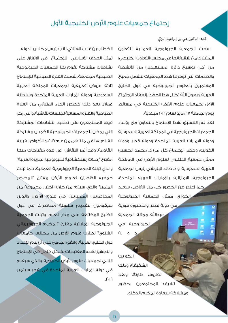
للتعاون العمانية الجيولوجية الجمعية سعت
المشترك مع شقيقاتها في مجلس التعاون الخليجي؛
األنشطة من المستفيدين دائرة توسيع أجل من
والخدمات التي توفرها هذه الجمعيات لتشمل جميع
الخليج دول في الجيولوجية بالعلوم المهتميين
العربية. وبعون اهلل تكلل هذا الجهد بإنعقاد اإلجتماع
مسقط في الخليجية األرض علوم لجمعيات األول
يوم الجمعة 27 مايو لعام 2016 ميالدية.
رؤساء مع بالتعاون اإلجتماع لهذا التنسيق تم لقد
الجمعيات الجيولوجية في المملكة العربية السعودية
ودولة قطر ودولة المتحدة العربية اإلمارات ودولة
الحسين محمد د. من كل اإلجتماع وحضر الكويت،
المملكة في األرض لعلوم الظهران جمعية ممثل
العربية السعودية، و د. خالد البلوشي رئيس الجمعية
المتحدة، العربية باإلمارات اإلماراتية الجيولوجية
سعيد الفاضل من كل الحضور عن إعتذر كما
الجيولوجية الجمعية ممثل الكواري
فوزية والدكتورة قطر، دولة في
الجمعية ممثلة عبداهلل
في الجيولوجية
لة و د
يت لكو ا
وذلك الشقيقة؛
ولقد طارئة. لظروف
بحضور المجتمعون تشرف
ومشاركة سعادة المكرم الدكتور
الخطاب بن غالب الهنائي نائب رئيس مجلس الدولة.
على اإلتفاق في لإلجتماع األساسي الهدف تمثل
الجيولوجية الجمعيات بها تقوم مشتركة نشاطات
الخليجية مجتمعة. شملت الفترة الصباحية لإلجتماع
العربية المملكة لجمعيات تعريفية عروض ثالثة
وسلطنة المتحدة العربية اإلمارات ودولة السعودية
الفترة من المتبقي الجزء خصص ذلك بعد عمان.
الصباحية والفترة المسائية لجلسات نقاشية، والتي ركز
المشتركة النشاطات تحديد على المجتمعون فيها
الجيولوجية الخمس مشتركة التي يمكن للجمعيات
القيام بها في ما تبقى من عام 2016، و األعوام القريبة
منها مقترحات عدة عن النقاش أثمر وقد القادمة.
مقترح "رحالت إستكشافية لجيولوجيا الجزيرة العربية"
تبنت العمانية، كما الجيولوجية الجمعية تبنته والذي
"المحاضر مقترح األرض لعلوم الظهران جمعية
من مجموعة اختيار خالله من سيتم والذي المتميز"
والذين األرض، علوم في المتميزيين المحاضريين
دول في محاضرات سلسلة بتقديم سيقومون
الجمعية وتبنت العام. مدار على المختلفة الخليج
الجيوفيزيائي "المخيم مقترح اإلماراتية الجيولوجية
جامعات مختلف من األرض علوم لطالب الشتوي"
دول الخليج العربية. واتفق الجميع على أن يتم اإلعداد
والتجهيز لهذه المقترحات بشكل كامل في اإلجتماع
الثاني لجمعيات علوم األرض الخليجية، والذي سيقام
سبتمبر شهر في المتحدة العربية اإلمارات دولة في
.2016

15
ديينمتح
ال
جينجيولو
ال
GeoChal
lenger
s
ة إلىحل
ر
ط النف
عالم
Trip t
o Oil W
orld ة إلى
حل ر
الزالزلعالم
Trip to
earth
quakes
world
الرحالت
دانيةمي
ال
Fieldtr
ips

14
ة إلىحل
ر
الزالزلعالم
Trip to
earth
quakes
world
الرحالت
دانيةمي
ال
Fieldtr
ips
ضراتحا
الم
Talks
مراتالمؤت
Confere
nces
جياجيولو
ال
مانحول ع
Geology
aroun
d
Oman
العمانية الجيولوجية الجمعية صور معرض
Geological Society of Oman Photo Gallery

بعد اليوم األول من المغامرة في خسلة حيل الديار ، قام الكندي بنشر الخبر في التويتر و تم تداول
التغريدات ، التغريدة بعد االخرى ، ليصل في اليوم الثاني إلى الجرائد و الصحف. لم يكتف الكندي بهذه
الحفرة فقط ، بل قرر النزول إلى حفرة أخرى إكتشفها شاب عماني من الجبل األخضر في الصف الثاني
عشر إسمه أسعد الجامودي من قرية عقبة البيوت خالل رعيه للغنم بعد ما كاد أن يتعثر عليها. قام
أسعد بإخبار معلميه و هم بدورهم أخبروا الكندي عن الحفرة. يقول الكندي: “المعلمون األفاضل من
الجبل األخضر وبالتحديد من مدرسة أبو زيد الريامي تواصلوا مشكورين معي إلخباري عن هذه الحفرة
وحفر أخرى. كنت قد تعرفت عليهم بسبب محاضرة أقمتها في المدرسة قبل عدة أشهر، وهنا تأتي
فائدة بناء العالقات ومد جسور التواصل مع الناس، ونشر ثقافة اإلستكشاف. لقد كان هؤالء المعلمون
مثاال رائعا حقا لمن يهتم بإستكشاف مقومات أرضه الطبيعية بكل جهد ونشاط”. نزول خسلة الرويس
ليس بصعوبة الحفرة االولى كما قال الكندي لي. فهي بإرتفاع ٢٠ مترا، و نزولها أسهل بكثير من خسلة
حيل الديار، وتتكون من تشكيالت كلسية مماثلة في الشكل مع خسلة حيل الديار لكنها أقل رونقا.
زيد أبو مدرسة ومعلمي الكهوف إستكشاف خبراء من الكندي شكله الذي الفريق زال وما
األخضر. الجبل في أخرى كهفية فتحات إلستكشاف بجهد يبحثون األخضر الجبل في الريامي
فتحة على المقال في المذكورين الكهفين إكتشاف من قليلة أيام بعد الكندي عثر وقد
الكهوف. من المزيد على للعثور إيجابية مؤشرات وهناك الحدب، حيل خسلة أسمها جديدة
13

أبرز الديار حيل خسلة لكهف الكبيرة الغرفة تعد
من باهر بمزيج مزينة وهي الكهف، مقومات
على الرائعة الكهفية والترسبات التشكيالت
إلى دائرية والغرفة سقفها، وفي الجانبية جدرانها
مربعة الشكل. وتبلغ مساحتها اإلجمالية في حدود
400 متر مربع تقريبا، في حين أن أقصى إرتفاع لها قد
يصل إلى نحو 20 مترا. وهي تحتوي على مجموعة
مختلفة من الصواعد والهوابط يمكن إنارتها بطرق
وفي باهرة. بطرق المختلفة ألوانها إلبراز مختلفة;
التي الصغيرة المداخل من مجموعة أيضا الغرفة
معدنية وخيوط دقيقة تشكيالت على تحتوي
فحسب، واحد مدخل يبدو فيما وللغرفة صغيرة.
مداخل لها كانت إن الدقة وجه على يعلم وال
لعدم مستبعد; أمر وهذا السقف، جهة من أخرى
الغرفة أن كما بها. هوائية تيارات أو ضوء أي وجود
المؤدي العلوي الممر عن تماما بإنعزالها تمتاز
أيضا. الضوضاء عن معزولة بذلك وهي للكهف
تحتفظ فإنها الديار حيل خسلة ألرضية بالنسبة
بطبيعتها األصلية التي لم تتعرض حتى اآلن لتدخل
اإلنسان، وهي تحتفظ بذلك بتفاصيل علمية يمكن
الكهف تكون طريقة على التعرف خاللها من
حفر على تحتوي كما فيه. المختلفة والترسبات
صغيرة ربما تكون آثارا لبعض الهوابط التي سقطت
خوذة لبس ضرورة يبين وهذا الكهف، أعلى من
الرأس عند زيارة الغرفة. وأرضية الكهف طينية بسبب
عمان شمال على سقطت التي الغزيرة األمطار
الماضية، األيام في خصوصا األخضر والجبل عموما
صغيرة بركا يشكل الماء أن إلى يشير ربما وهذا
الكندي يتعرض لم الكهف. داخل عميقة وغير
عند عقارب أو ثعابين أي من هجمات ألي فريقه وال
عنكبوتا رأى أنه ذكر لكنه الكهف، إلى نزولهم
حمار جمجمة ورأى قدميه، تحت من يمر واحدا
وهياكل عظمية لكلبين على مسافة من الفتحة
بعد إال حتفهما يلقيا لم أنهما على داللة العلوية،
وباإلضافة الكهف. أنحاء في به قاما بسيط تجول
الصناديق من مجموعة الكندي رأى ذلك إلى
الملئية بالمالبس القديمة، والتي رميت من األعلى
جدا، الجميلة بالمالبس ووصفها منها، للتخلص
وتابع كالمه قبل أن أساله أنه لما يأخذ أي شي منها،
وأبقاها في مكانها مثلها مثل بقية األشياء األخرى؛
للحفاظ على الكهف بنفس الهيئة التي عثر عليها
بعد. فيما للكهف شاملة دراسة تقام حتى فيه،
بتعريض نيكون كاميرات الكندي إستخدم
وإستخدموا للكهف، الرائعة الصور إللتقاط طويل
الخوذ مصابيح مثل مختلفة مصادر من إضاءات
أكسب ما هي “الصور والهواتف. والكشافات
ما مثل خبرها” تداول سرعة الكهوف هذه
الكلسية “التشكالت : قائال وتابع الكندي، قال
ومختلفة جميلة ألوان ذات والتكوينات الرائعة
غيره”. أو جيولوجيا كان سواء شخص ألي جذابة
12

11
يمكن تقسيم كهف خسلة حيل الديار إلى أربعة
محمد ذكره ما حسب على أساسية أقسام
الكندي: الفتحة الخارجية والممر العلوي المؤدي
توصل التي الوحيدة الفتحة وهي للكهف،
والغرفة النزول ومنطقة الخارجي، السطح إلى
الكبيرة، الغرفة إلى المؤدي والممر الصغيرة،
نحو إجماال الكهف طول ويبلغ الكبيرة. والغرفة
الكبيرة الغرفة سقف إرتفاع أن حين في متر، 100
قد يصل إلى أكثر من 15 متر في أقصى إرتفاع له.
وللدخول إلى الغرفة الكبيرة والممر المؤدي لها ،
ال بد لإلنسان أن ينحني زاحفا لمسافة خمسة أمتار
تكوينات على بعدها الكهف ينفتح ثم تقريبا،
جميلة جدا تحيط بسقفه وجدرانه الجانبية.
بدأت رحلة النزول إلى خسلة حيل الديار في الساعة
11 صباحا من يوم الجمعة إلى الساعة الرابعة عصرا
من نفس اليوم. يتطلب لعمل مثل هذه المغامرة
لما نظرا ; ، وقوة تحمل كبيرة عالية بدنية لياقة
المجهول إلى التوغل من المستكشف يواجهه
ومخلفات الخفافيش، التي قد تسبب حساسية
يستنشقها قد التي الغبار كمية بسبب قوية
اإلنسان.
يصل قطر الفتحة الخارجية للكهف إلى متر تقريبا،
من وسميكة صلبة طبقات في موجودة وهي
الصخور الجيرية، ولذلك فإنها تبدو آمنة من اإلنهيار.
ويصل بها، المحيطة المنطقة تطوير ويمكن
طول الممر المؤدي إلى الكهف إلى 40 متر تقريبا
الممر أن كما واحد. لشخص يتسع وهو أقل، أو
إلى شبه له جدران صلبة، وهو عمودي بأن يتميز
عمودي في أغلب أجزاءه.
منبسطة منطقة توجد النزول ممر أسفل في
أمتار، 5 وعرضها تقريبا أمتار 10 طولها يبلغ
الكهف غرفتا توجد المنطقة هذه جانبي وعلى
، الصغيرة الغرفة وتحتوي والكبيرة. الصغيرة
على مربعا، مترا 60 نحو مساحتها تبلغ والتي
كانت وإن وهي . بسيطة كهفية تشكيالت
جميلة لكنها ال تشكل المكون األساسي للكهف.
الكبيرة الغرفة إلى المؤدي الممر يحتوي
بينهما تفصل وداخلي، خارجي قسمين: على
لمسافة الزحف تتطلب منخفضة منطقة
ويحتوي خاللها. للمرور تقريبا أمتار خمسة
منطقة بعد الواقع للممر الداخلي القسم
ومتنوعة. رائعة كهفية ترسبات على الزحف

هما الرويس”، “خسلة و الديار” حيل “خسلة
اللذان أطلقا على هذين الكهفين، و قد اإلسمان
إلى نسبة اإلسم بهذا الديار حيل خسلة ي سم
األخضر كما هو بالجبل الديار قربه من قرية حيل
سمي والذي الرويس خسلة إلى بالنسبة الحال
بسبب الكهف. بها يقع التي المنطقة بإسم
معنى عن الكندي سألت خسلة كلمة تكرار
هذه الكلمة و مصدرها، وهنا بدأ
الكندي بشرح الكلمة ومعناها،
شرح معلم اللغة العربية لطالبه،
إذ ذكر أن كلمة خسلة في لهجة
أهل الجبل تعني الهوة في الصخر
يرى ال الذي المغلق األنبوب أو
مستوحا عربي أصل ولها قعره،
عن عبارة وهي )بالشين(، خشلة كلمة من
البيضة. وكما هو التي تشبه المقعرة المنطقة
الحال في كثير من بلدان العالم، كانت الحفرتان
الغير األغراض بعض من للتخلص تستخدمان
الحيوانات من للتخلص وأحيانا فيها، المرغوب
الميتة أو المالبس القديمة. ذكر الكندي أن وجود
فندق العليلة في الجبل ساهم بشكل كبير في
تشجيع البحث عن أماكن سياحية جديدة إلدراجها
وحتى بالمنطقة. السياحية األماكن قائمة في
بها، ليستمتعوا إليها السائحيين أخذ يتسنى
استعانت إدارة فندق العليلة بمسكتشف كهوف
معروف هو اإلنجليزي ستيف جونز. وقد قاد سكان
الذي و الفتحات، هذه أحد إلى ستيف المنطقة
قام بدوره بالنزول إلى هذه الفتحة، وأثمر ذلك عن
إكتشافه كهفا جديدا. عند سماعه خبر إكتشاف
الكندي قرر الجديد، الكهف
و الحفرة هذه الى النزول
بمعدات مسحها و دراستها
شخصين فأخبر التصوير،
المغامرة، آخرين شاركاه في
، وولف أندرياس وهما
ألماني كهوف مستكشف
ا، وهو جيولوجي محب خبير، واآلخر ماتياس كوري
األلمانية الجامعة للمغامرة يعمل كمحاضر في
للتكنولوجيا. كان لهؤالء الثالثة خطة أولية وهي
الكعدي” في يتي بمحافظة إستكشاف “كهف
عن سماعهم عند تغيرت الخطة لكن مسقط.
الكهف الجديد.
“خسلة:يف لهجة أهل الجبل الهوة يف الصخر
أو األنبوب املغلق الذي
ال يرى قعره ”
10

كتبه: حسام بن سامل الرواحي
تتمتـع سـلطنة عمـان بطبيعـة جيولوجيـة فريـدة مـن نوعهـا ممـا جعلهـا بحـق متحفـا جيولوجيـا طبيعيا يحتوي على مئات المواقع الجيولوجية التي تسـتحق الزيارة واإلستكشـاف. كثير من هذه الموروثـات الطبيعيـة مـا زالـت قابعـة فـي مـكان ما تنتظـر رفع اللثـام عنهـا. وليـس أدل على هذا مـن اإلكتشـاف الرائـع الذي أحـدث ضجة في وسـائل التواصل اإلجتماعي وانتشـر بسـرعة كبيرة في مختلف وسـائل اإلعالم. كان اإلكتشـاف هو العثور على كهفين جديدين في منطقة الجبل االخضر الـذي يتميـز بوجـود طبقـات سـميكة مـن الصخـور الجيريـة التـي ترسـبت قبـل مالييـن عديـدة مـن السـنين. هـذه الصخور ترسـب أغلبها في بحـار ضحلة غمرت هذا الجانب من عمـان في تلك الفترة.
يعـــود الفضـــل إلنتشـــار هـــذا الخبـــر في وســـائل
اإلعالم إلـــى الجيولوجي الدكتـــور محمد الكندي
العمانية الجيولوجيـــة الســـابق للجمعية الرئيس
اإلستشـــارات لشـــركة التنفيـــذي الرئيـــس و
نفســـه مـــع التحـــدي قبـــل الـــذي الجيولوجيـــة
و إكتشـــافهما و الكهفيـــن إلـــى وقررالنـــزول
دراســـتهما. لـــم يكن لـــدى الكندي أدنـــى فكرة
بأن هذا اإلكتشـــاف ســـيلقى صدا قويا بين الناس
الســـيما أن الكهوف منتشـــرة كثيـــرا في الصخور
الجيريـــة العمانيـــة. مـــن هـــذه الكهـــوف الكهف
المشـــهور كهف “مجلـــس الجن” الـــذي يقع قي
ســـلماه هضبة
بواليـــة قريات بمحافظة مســـقط والكهوف األخرى
فـــي محافظـــة ظفـــار مثـــل “كهـــف المرنيف” و
“طيق”. تعـــرف الكهوف بأنها عبـــارة عن تجويفات
صخريـــة تتكون بطـــرق مختلفة، وعادة تنشـــأ في
الصخـــور الجيريـــة التـــي تتكـــون مـــن مركبـــات
كربونـــات الكالســـيوم. هذه المركبـــات تتعرض
لإلذابـــة عنـــد تفاعلها مـــع ميـــاه األمطـــار والمياه
الجوفيـــة; إذ تجـــري هـــذه الميـــاه في التشـــققات
ن مـــع مـــرور الوقـــت والصـــدوع العموديـــة لتكـــو
غرفـــا كهفيـــة تتســـع تدريجيا بمـــرور الوقت.
التوغل إلى باطن الجبليس الرو وخسلة الديار حيل خسلة
9


7
لذا تعتبر التقنيات الجيوفيزيائية الحديثة من أكثر
الطرق فعالية في تتبع مثل هذه المشكالت، حيث
أنها ال تزيد من كمية البيانات المستخرجة فحسب
من والوقت. والجهد المال من الكثير توفر بل
ضمن التقنيات الجيوفيزيائية الحديثة المستخدمة
حاليا في سلطنة عمان، والتي تستخدمها شركة
الجيوفيزيائي، هي لإلستكشاف الوطنية الصخور
)2D( األبعاد ثنائية الكهربائية المقاومة تقنية
المياة والمعادن التنقيب عن والتي تستخدم في
إلستكشاف التربة فحص وخدمات الفلزية
مدى ومعرفة والكيميائية البترولية التسريبات
أن حقيقة على التقنية هذه تعتمد إنتشارها.
المواد والعناصر المختلفة تتفاوت في قدرتها على
التوصيل الكهربائي؛ بمعنى آخر فإن بعض المواد
أو العناصر تتميز بمقاومة عالية للتيار الكهربائي
اآلخر البعض أن حين في الصخور أنواع بعض مثل
الماء مثل الكهرباء توصيل على عالية قدرة له
الصخور إختالط أن كما ذائبة. أمالح من فيه بما
من يغير الكيميائية أو البترولية بالترسيبات
أكثر فتصبح األصلية للصخور الفيزيائية الخصائص
التفريق يمكن وعليه للكهرباء. مقاومة أقل أو
تباين حسب على المختلفة والمواد العناصر بين
إن الكهربائي. التوصيل أو المقاومة على قدرتها
ثنائية الكهربائية المقاومة تقنية يميز ما أهم
الوطنية الصخور شركة تستخدمها التي األبعاد
بقراءة تقوم أنها هو الجيوفيزيائي لإلستكشاف
أعماق على متوزعة مرحلة 16 على نقطة 360
مختلفة تصل إلى 40 متر. يتم تسجيل هذه القراءات
بشكل متواصل وفي خط ثابت مما يجعل عملية
إستخالص التحليالت ومن ثم اإلستنتاجات من هذه
على األمثلة ومن منطقية. أكثر عملية القراءات
ذلك قامت الشركة بإستخدام هذه التقنية للبحث
فوق مائي حوض من الماء تسريب مكان عن
ألحدى الصناعية المرفقات إحدى في األرض سطح
الجيوفيزيائية األجهزة إستطاعت حيث الشركات،
الحوض حول منخفظة مقاومة ذات قراءات رصد
ناتجة عن وجود الماء المتسرب الموصل للكهرباء
المائي. التسرب فيها حدث التي المنطقة في
مثل هذه التسربات المائية من شأنها التأثير على
ثبات البنية التحتية للمرفقات الصناعية خاصة في
المناطق التي تتواجد فيها الصخور الجيرية القابلة
تم آخر وكمثال المياة. مع تفاعلها عند للذوبان
مادة إنتشار مدى لتقصي التقنية هذه إستخدام
الحقول إحدى في األرض سطح تحت كيميائية
كانت النظيفة األرض طبقات أن حيث النفطية،
بالمواد الملوثة تلك من للكهرباء توصيال أكثر
الكيميائية . كما يمكن إستخدام تقنية المقاومة
الكهربائية في أربعة أبعاد )4D( ، والتي هي عبارة
عن تكرار لقياس المقاومة الكهربائية ثنائية األبعاد
اإلنتشار سرعة مدى لمعرفة مختلفة أوقات في
مستمر التسريب زال ما إذا أو المتسربة للمواد
عبر فترات زمنية متباعدة.
سوف األبعاد ثنائية الكهربائية المقاومة تقنية إن
وغيرها والغاز النفط شركات من الكثير تساعد
البترولية التسريبات لمشاكل حلول إيجاد في
خالل من وذلك النفط حقول في والكيميائية
إنتشار مدى وتحديد التسريب أماكن معرفة
الطرق تقييم خالل من وأيضا المتسربة المواد
المتبعة حاليا لعالج هذه المشاكل.

6
حديثة يائية جيوفيز تقنيات النفطي: قطاعنا في
أمانا أكثر بيئة نحو
وتعتبر طبيعية، أو تقنية أو بشرية أخطاء من تخلو ال النفط حقول في العمل طبيعة إن هذه عن الناتجة المشكالت أهم من النفط حقول في والكيميائية البترولية التسريبات التأثيرات عن ماذا ولكن إكتشافها عند بسيطة المشكالت هذه حلول تبدو وقد األخطاء، ؟ الجوي والغالف الجوفية والمياة البيئة من كل على البعيد المدى على تظهر قد التي
أو البترولية العناصر من عنصر إختالط يؤدي
الطبقات أو التربة بمساحة معينة من الكيميائية
األرضية إلى تغير خواصها الفيزيائية مقارنة بطبيعة
بقية مع تجانس على كانت وإن حولها من االرض
الميدانية مهمة الدراسات المكونات. ولذلك تعتبر
سلبا المؤثرة العناصر إنتشار مدى لمعرفة جدا
حتى األرضية؛ والطبقات التربة خصائص على
من والحد إلحتوائها المناسبة الخطط وضع يتم
إنتشارها. تقوم معظم المؤسسات بإنشاء العديد
بتلوث تأثرها يشتبه التي المناطق في الحفر من
مدى توضح تقريبية خارطة لرسم النوع؛ هذا من
إنتشار هذه الملوثات وهذا بدوره يكلف الكثير من
تلوثا تسبب قد نفسها الحفر آالت أن كما األموال.
الحفر أنابيب طريق عن كان سواء للمنطقة آخر
ناهيك غيرها، أو الجو في المنطلقة اإلنبعاثات أو
إنتشار مدى عن كافية معلومات توفر عدم عن
الملوثات في المساحات الواقعة بين اآلبار المحفورة.
كتبه: سلطان بن محمد الحبيس

5
عن نبذة لكم أقدم أن سروري دواعي لمن إنه
الحجر، مجلة من والعشرين الثاني العدد محتوى
المتنوعة المواضيع من العديد يتضمن والذي
سمعتم قد تكونوا لربما اهلل. بإذن والمفيدة
باألخبار المتداولة في الفترة األخيرة عن سلسلة من
اإلستكشافات لكهوف في الجبل األخضر، ونحن هنا
في مجلة الحجر أرتأينا أن نسرد القصة الكاملة عن
هذه اإلستكشافات المثيرة كما أخبرنا بها الدكتور
اإلستكشافات. رحلة قاد والذي الكندي محمد
العديد العمانية الجيولوجية الجمعية نظمت كما
العلمية، والمحاضرات الميدانية، الرحالت من
مسابقتي فيها بما للطالب التعليمية واألنشطة
الصغار، والجيولوجيين الجيولوجيين المتحديين
ونحن الجمعية، ألعضاء العام السنوي واإلجتماع
لجميع مصورا ملخصا لكم نعرض العدد هذا في
بإستضافة الجمعية تشرفت لقد الفعاليات. هذه
مجلس بدول الجيولوجية للجمعيات األول اإلجتماع
سبل مناقشة إلى هدف والذي الخليجية، التعاون
هذا في تجدون الجمعيات. بين المشترك التعاون
أهم أحد ومخرجاته. اإلجتماع لهذا ملخصا العدد
العامة، خصوصا إهتمام تستقطب التي المواضيع
الناتجة البيئية األخطار هي األخيرة، السنوات في
والبشرية التقنية واألخطاء الطبيعية، العوامل عن
الحاصلة في قطاع النفط والغاز. من أهم هذه األخطار
تسريبات المنتجات البترولية والكيميائية في حقول
النفط، والتي قد ينشأ عنها أضرار بيئية جسيمة على
المدى البعيد. في هذا العدد نسلط الضوء على دور
التقنيات الجيوفيزيائية الحديثة في التقليل من هذه
األخطار وخلق بيئة أكثر أمانا. أخيرا أتمنى لكم قراءة
ممتعة، و إن كان لديكم أي تعليقات أو كنتم تودون
المشاركة في األعداد القادمة من مجلة الحجر، وذلك
التردد نرجوا منكم عدم بنشر أي موضوع علمي،
في التواصل معي عن طريق بريدي اإللكتروني.
المحررة رسالة
د. عائشة الحجرية
محررة مجلة الحجر

4
الجمعية رئيس كلمة
د. علي بن إبراهيم اللزكي
رئيس الجمعية الجيولوجية العمانية
الجيولوجية الجمعية العام 2016 ميالدية. تبذل األول لهذا الحجر أرحب بكم في عدد أن يسرني ويسعدني
العمانية جهدا ملموسا لتقديم نشاطاتها الشهرية من محاضرات ورحالت ميدانية تعليمية ألعضائها الكرام
على أكمل وجه، وباإلضافة الى ذلك دأبت الجمعية الجيولوجية العمانية إلى تنويع نشاطاتها؛ وذلك حتى
توسع من دائرة المستفيدين من المعرفة التي توفرها الجمعية لتشمل العامة من المواطنين والمقيمين
في أرض السلطنة، ومن هذا المنطلق، أطلقت الجمعية الجيولوجية العمانية حملة الجيولوجيا حول عمان
والتي تهدف إلى تقديم المحاضرات الجيولوجية التوعوية للعامة في مختلف واليات السلطنة، حيث بدأت
أولى هذة المحاضرات في والية الرستاق، والتي تم تنظيمها بالتعاون مع فريق المسفاة الرياضي الثقافي،
ونادي الرستاق الرياضي في الرابع من مارس لهذا العام 2016 ميالدية.
في أقيم والذي األول، الخليجية الجيولوجية الجمعيات إجتماع بخبر إعالمكم سروري دواعي لمن وإنه
الجمعيات رؤساء بالتعاون مع اإلجتماع لهذا التنظيم تم 2016 ميالدية. العام لهذا مايو بتاريخ 27 مسقط
الكويت، ودولة قطر ودولة المتحدة العربية اإلمارات ودولة السعودية العربية المملكة في الجيولوجية
وتشرف المجتمعون بحضورالمكرم الدكتور الخطاب بن غالب الهنائي نائب رئيس مجلس الدولة. المزيد
من تفاصيل عن هذا اإلجتماع ستجدونه في هذا العدد من مجلة الحجر.
وإذ تسعى الجمعية الجيولوجية العمانية إلى نشر الثقافة الجيولوجية في المجتمع العماني عامة، ستواصل
الجمعية تنظيم المحاضرات للعامة ضمن حملة الجيولوجيا حول عمان في عدد من واليات السلطنة بحيث
تشمل في هذه السنة بإذن اهلل محافظات الداخلية والباطنة ومسندم وظفار والشرقية والظاهرة، على أن
يتم التنسيق لهذه المحاضرات مع ممثلي الشورى والمجالس البلدية في الوالية المزمع عقد المحاضرة
فيها. ومن هذا المنطلق تفتح الجمعية الجيولوجية العمانية باب المشاركة ألعضائها الكرام للمساهمة
في التنظيم كل في واليته أو لمن أراد المشاركة في والية أخرى.
وفقنا اهلل وأياكم لما فية الخير والنماء لعماننا الحبيبة.

3
المحتوى
6
14
ض صور الجمعية معر
حديثةجيوفيزيائية
تقنيات
في قطاعنا النفطي
هذا العدد برعاية

2
03
03
تحرير
6
03
تصميم
ترجمة
تدقيق المقاالت باللغة العربية
تدقيق المقاالت باللغة اإلنجليزية
الدكتورة عائشة بنت علي الحجري - تنمية نفط عمان
أحمد بن مسلم اليعقوبي - تنمية نفط عمانحسام بن سالم الرواحي - تنمية نفط عمان
الدكتورة عائشة بنت علي الحجري - تنمية نفط عمان الدكتور علي بن إبراهيم اللزكي - تنمية نفط عمان
الدكتور إبراهيم بن يحيى اإلسماعيلي - الرؤية للحلول النفطية المتقدمة
أحمد بن إبراهيم الحضرمي - شركة النفط العمانية للمصافي والصناعات البتروليةمحمد بن حمد العامري - تنمية نفط عمان
بشرى بنت محمد الطوقي - أوكسيدنتال عمان
9
16
التوغل إلى باطن الجبل
ض إجتماع جمعيات علوم األر
الخليجية األول

مجلة الحجر
التوغل إلى باطن الجبل
ين والعشر الثاني العدد
تصدر عن الجمعية الجيولوجية العامنية
Gsooman www.gso-oman.org Gsooman


![Al Jabal Al Akhdar Initiative 2004 - 2007: A post project analysis [Reginald Victor]](https://img.dokumen.tips/doc/110x75/555563bcb4c90530208b54fc/al-jabal-al-akhdar-initiative-2004-2007-a-post-project-analysis-reginald-victor.jpg)


