Embed Size (px)
Citation preview

Land Art Generator Initiative
Santa Monica
l�PRESTEL I
Robert Ferry & Elizabeth Monoian (Editors)December 01, 2016Hardcover, 240 pages, 23,0 x 28,0 cm, 300 color illustrationsISBN: 978-3-7913-5550-4

28 29
los Angeles Aqueductsheds and energysheds
Barry Lehrman
eSSAY
HIstOrY OF POWer trANsMIssION IN CAlIFOrNIA
Southern california was a center of innovation in the development
of electrical power and long distance transmission at the end of
the 19th century. The gold mining industry had already cultivated
expertise in high-pressure hydraulic engineering, and cities were
located in relatively close proximity to viable hydropower locations.
NOtABle FIrsts
1886
highgrove hydroelectric Plant, redlands, california (64 miles east
of Los Angeles) was the first direct current electrical power plant
built in Southern california.
1891
The world’s first high-voltage single-phase alternating current
(10 kV) line connected 14 miles between Pomona Powerhouse
(on San Antonio creek in the San Gabriel Mountains) to Pomona,
california (30 miles east of Los Angeles) to run refrigeration
equipment in the citrus packing houses. california historic Marker
#514 is located on an overlook above the powerhouse’s location n
34° 12.735’, w 117° 40.564’.
1935 southern California edison
Image courtesy of david rumsey Map
collection, www.davidrumsey.com
1893
Mill creek Plant no. 1 in riverside, california used the world’s
first three-phase alternating current generators (built by General
electric) and the first three-phase power lines covering 7 ½ miles to
redlands, cA. Plant no. 1 and the power line were designed by A.w.
decker, the engineer of the Pomona Powerhouse and powerline.
1905
nevada Power Mining and Milling company built a 113-mile power
line from Bishop creek (Inyo county, california) to mines in nevada.
1912
The first 220 kV transmission lines were built to connect the
hydropower Big creek Plant (near Fresno, california) 241 miles to
the eagle rock Substation in Los Angeles.
1947 southern California edison
Image courtesy of david rumsey Map
collection, www.davidrumsey.com

30 31
Historic Powershed of los Angeles
Image courtesy of Barry Lehrman
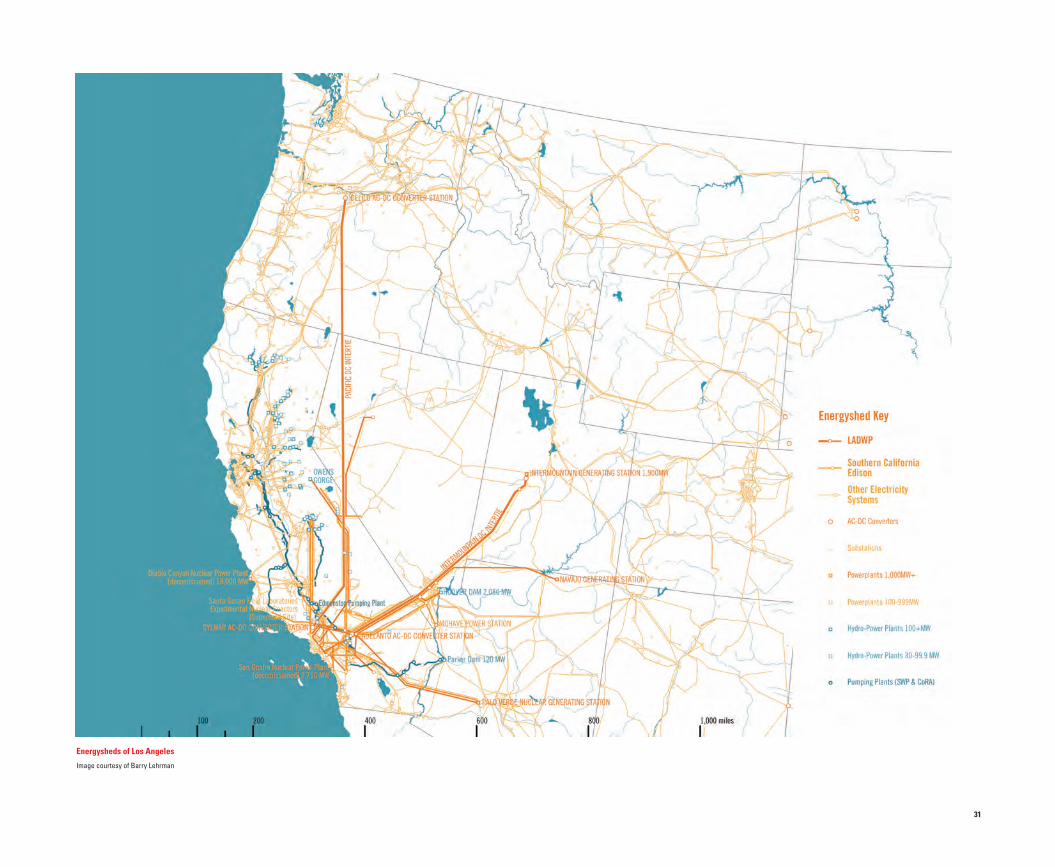
energysheds of los Angeles
Image courtesy of Barry Lehrman
POWersHeD OF lOs ANGeles
Los Angeles was connected to hydropower in the Sierra nevada
Mountains before construction on the Los Angeles Aqueduct
began. Today, the electrical power supply system that is owned and
operated by the Los Angeles department of Power and water and
Southern california edison encompasses a greater territory than
the aqueductshed for metropolitan Los Angeles (even if you ignore
the entire western Area Power Administration’s power grid that
covers all of the contiguous states west of the rocky Mountains).
30 31
Historic Powershed of los Angeles
Image courtesy of Barry Lehrman
energysheds of los Angeles
Image courtesy of Barry Lehrman
POWersHeD OF lOs ANGeles
Los Angeles was connected to hydropower in the Sierra nevada
Mountains before construction on the Los Angeles Aqueduct
began. Today, the electrical power supply system that is owned and
operated by the Los Angeles department of Power and water and
Southern california edison encompasses a greater territory than
the aqueductshed for metropolitan Los Angeles (even if you ignore
the entire western Area Power Administration’s power grid that
covers all of the contiguous states west of the rocky Mountains).

32 33
1932 leuschner’s Greater
los Angeles Birdseye
Image courtesy of Library of congress
santa Monica sheet
1888 Hammond Irrigation Map
Image courtesy of david rumsey Map
collection, www.davidrumsey.com
los Angeles sheet
1888 Hammond Irrigation Map
Image courtesy of david rumsey Map
collection, www.davidrumsey.com

34 35
AqUeDUCtsHeD OF lOs ANGeles MAP
As Los Angeles boomed from the extraction of oil and real estate
speculation at the beginning of the 20th century, the city’s elites
started prospecting for a new water source to quench the insatiable
demands of development. In 1907 the city chose to build an
aqueduct 200 miles north to the owens Valley (where Mayor Fred
eaton owned over 20,000 acres, which he then sold to the city) over
nearer sources such as Malibu creek and the Mojave river (which
didn’t have enough water), and the kern river and San Gabriel river
(where too many people already lived).
In 1939, the colorado river Aqueduct (built by the newly formed
Metropolitan water district of Southern california) began providing
imported water to the eastern suburbs. It was the Mwd that first
defined the Los Angeles Metropolis as encompassing all of Southern
california from oxnard down to San diego. Los Angeles continued
to expand the extraction of water from the eastern Sierras with a
tunnel connecting the owens river to the Mono Basin in 1941, and
a second “barrel” to the aqueduct, which was completed in 1970.
california began dreaming of building an aqueduct to export the
plentiful water from northern california’s Feather river into the arid
San Joaquin Valley and Southern california before world war II,
but it wasn’t until the 1950s when the legislation and funding to
create the State water Project were passed. with help from federal
funding for the central Valley Project, construction began in the mid
1960s. The first water deliveries to Los Angeles arrived in 1974, with
substantial completion of the west Branch to Santa Barbara and
the east Branch down to San diego occurring in 1997. 1916 Hamlin’s los Angeles
Annexation
Image courtesy of Library of congress
Aqueductsheds of los Angeles
Image courtesy of Barry Lehrman

36 37
lOs ANGeles WAter CYCle
The water supply for the city of Los Angeles is an intertwined mix
of imported and local water. This Sankey diagram reveals critical
opportunities to improve the resilience of the local water supply
by enhancing runoff capture and recycling water for direct reuse
and indirect groundwater recharge. If every available drop of water
was recycled, the region would gain 502 million gallons of water a
day, enough to slake the thirst of at least 5.5 million people (and
enough to retire the Los Angeles Aqueduct). currently, there is a
system of purple pipes distributing a small amount of non-potable
recycled water to industrial and municipal users, but no large-scale
recycling of water in Los Angeles county.
capturing precipitation and runoff is more challenging due
to the intermittent and highly variable nature of rain in Southern
california—but distributed small-scale efforts (such as rain barrels
and rain gardens) are starting to make a substantial difference.
note: quantities have been converted from acre-feet into million
gallons. data utilized was a mix of water year, fiscal year, or
calendar year—so quantities may not total 100%. one u.S. liquid
gallon equals 3.78541 liters.
sOUrCes: HIstOrY OF POWer trANsMIssION IN CAlIFOrNIA
Ronald Burgess, “Redlands Powers the World—How the San Bernardino Valley Developed Modern Electric Power First.” (The Fortnightly Club of Redlands, California, 2007), http://www.redlandsfortnightly.org/papers/burgessron07.htm.
“Santa Ana River Hydroelectric System: Written Historical and Descriptive Data.” (Historic American Engineering Record, HAER No. CA-130, 1992), https://cdn.loc.gov/master/pnp/habshaer/ca/ca3700/ca3707/data/ca3707data.pdf.
“Mill Creek 2 and 3 Hydroelectric Systems: Written Historical and Descriptive Data.” (Historic American Engineering Record, HAER CA-2272, 2010), https://cdn.loc.gov/master/pnp/habshaer/ca/ca3700/ca3714/data/ca3714data.pdf.
“Big Creek Hydroelectric System East & West Transmission Line: Written Historical and Descriptive Data.” (Historic American Engineering Record, HAER No. CA-167, 2012), http://lcweb2.loc.gov/master/pnp/habshaer/ca/ca3900/ca3976/data/ca3976data.pdf.
Laurence Shoup, “The Hardest Working Water in the World: a history and significance evaluation of the Big Creek Hydroelectric System.” (Southern California Edison, 1988), http://www.cpuc.ca.gov/environment/info/esa/sjxvl/sCe_Drs/Dr6/Dr6_attachment.pdf.
A Brief Outline of California’s Great Community Electrical Enterprise (Southern California Edison. 1935), http://www.davidrumsey.com/luna/servlet/detail/rUMseY~8~1~274153~90047929:text--A-Brief-Outline-of-California.
Pictorial Map of the Edison Electrical Service System in Central and Southern California (Southern California Edison, 1935), http://www.davidrumsey.com/luna/servlet/detail/rUMseY~8~1~274154~90047930:A-Pictorial-Map-ofthe-edison-elect.
Electrical Generation Stations and Major Transmission Systems in Central and Southern California (Southern California Edison. 1947), http://www.davidrumsey.com/luna/servlet/detail/rUMseY~8~1~271932~90045781:southern-California-edison-Company-.
Thomas Taylor, “Santa Ana River No. 1: A Pioneer in Hydro Generation, Power Transmission.” Hydro Review, August, 1999, http://www.hydroworld.com/content/dam/hydroworld/siteimages/1805_HallofFame.pdf.
W.G. Vincent, Jr., “Interconnected Transmission System of California.” Journal of Electricity. Vol. 54, No. 12 (1925), https://ia800702.us.archive.org/23/items/journalofele541151925sanf/journalofele541151925sanf.pdf.
James C. Williams, Energy and the Making of Modern California (Akron, OH: University of Akron Press, 1997).
sOUrCes: POWersHeD OF lOs ANGeles
California State Water Project (SWP) Facilities, (California Department of Water Resources, N.D.), http://water.ca.gov/swp/docs/sWPmap.pdf.
California’s Electric Transmission Lines, (California Energy Commission, 2012), http://energy.ca.gov/maps/infrastructure/transmission_lines.pdf.
Solar Power Plant Licensing Projects, (California Energy Commission, 2014), http://energy.ca.gov/maps/renewable/solar_Power_Plant_licensing_Projects.pdf.
2012–2016 California’s ISO’s Electricity Road Map, (California Independent System Operators, 2012), https://www.caiso.com/Documents/2012-2016strategicPlanelectricityroadMap.pdf.
LADWP Sources of Power-By Plant & Type of Generation, (City of Los Angeles Information Technology Agency, Los Angeles Department of Water and Power, 2014), https://data.lacity.org/A-livable-and-sustainable-City/lADWPsources-of-Power-By-Plant-type/gyz8-bf3p.
“2015 Briefing Book, Putting Customers First.” (Los Angeles Department of Water and Power, 2015), http://www.ladwpnews.com/external/content/document/1475/2606574/1/2015%20Briefing%20Book%2002-26-2015lr.pdf.
Colorado River Aqueduct Profile and Map (Unknown Author, N.D.), http://www.ecommcode.com/hoover/hooveronline/hoover_dam/before/read/010l.jpg.
sOUrCes: AqUeDUCtsHeDs
Barry Lehrman, Jonathan Linkus, and Cal Poly Pomona Students, Aqueduct Futures Project (2013).
Aqueduct Futures Exhibition, http://www.aqueductfutures.com.
Barry Lehrman and Cal Poly Pomona Students, After the Aqueduct Exhibition, Aqueduct Futures Project (2015).
Michael Bostok, US Rivers (2013), https://github.com/mbostock/us-rivers & https://bost.ocks.org/mike/us-rivers.png.
Matthew Heberger and Peter Gleick, American Rivers, (Pacific Institute, 2013), http://www2.pacinst.org/wp-content/uploads/2013/06/pacinst-americas-rivers-creativecommons.jpg.
“Owens Valley Land Management Plan.” (Los Angeles Department of Water and Power, and Ecosystem Sciences, April 28, 2010), http://inyo-monowater.org/wp-content/uploads/2011/09/ladwp013763_OV_land-Managment-Plan_final.pdf.
Service Area Map (Metropolitan Water District of Southern California, N.D.), http://www.mwdh2o.com/PDF_In_the_Community/3.3_service_area_map.pdf.
Groundwater Basins in Southern California (Metropolitan Water District, N.D.), http://www.wwdh20.org.
Nelson Minar, Map of American Rivers (2013), https://www.flickr.com/photos/nelsonminar/sets/72157633504361549.
W. Mulholland, “Complete Report on Construction of the Los Angeles Aqueduct.” (Los Angeles, CA: Department of Public Service of the City of Los Angeles, 1916), https://books.google.com/books?id=xlA_AqAAMAAJ.
W. Mulholland and Lippencott & Parker Consulting Engineers, “Water Commissioners’ Report for the Year Ending November 30, 1905.” (Los Angeles, California, 1906), https://books.google.com/books?id=DlFKAqAAMAAJ.
Robert A. Sauder, “Patenting an Arid Frontier: Use and Abuse of the Public Land Laws in Owens Valley, California.” Annals of the Association of American Geographers, 79(4), 544–569, 1989, http://www.jstor.org/stable/2563647.
Californian Rivers and Lakes (US Geologic Survey, 2004), http://nationalmap.gov/small_scale/printable/images/pdf/outline/rivers_lakes(u).pdf.
California Precipitation Map (US Geologic Survey, 2005), http://nationalmap.gov/small_scale/printable/images/pdf/precip/pageprecip_ca3.pdf.
Watershed Boundary Dataset (US Geologic Survey, N.D.), http://water.usgs.gov/maps.html.
sOUrCes FOr lOs ANGeles WAter CYCle
Miscellaneous data and documents regarding the California Aqueduct (California Department of Water Resources, N.D.), http://www.water.ca.gov.
Reference Evapotranspiration (California Department of Water Resources. N.D.), http://www.cimis.water.ca.gov/App_themes/images/etozonemap.jpg.
Barry Lehrman, Recharge City. Dry Futures Competition, Los Angeles, CA (Archinect.com, and Arid Lands Institute, Woodbury University, 2015), http://archinect.com/news/article/136734973/ recharge-city-3rd-place-winner-in-dry-futurespragmatic-category.
Sewer Maintenance Districts of Los Angeles County (Los Angeles County Public Works, 2013), https://dpw.lacounty.gov/smd/smd/ssmp.pdf.
“Twenty-Fifth Annual Status Report on Recycled Water, Fiscal Year 2013–14.” (Los Angeles County Sanitation District, 2015), http://www.lacsd.org/civicax/filebank/blobdload.aspx?blobid=10780.
“2015 Briefing Book, Putting Customers First.” (Los Angeles Department of Water and Power, 2015), http://www.ladwpnews.com/external/content/document/1475/2606574/1/2015%20Briefing%20Book%2002-26-2015lr.pdf.
Water Main Break Data (Los Angeles Department of Water and Power, 2015), https://data.lacity.org/A-livable-and-sustainable-City/DWP-Water-Main-Breaks-quarterly-/khdk-aiwb.
LADWP Water Supply in Acre Feet (Los Angeles Department of Water and Power, 2015), https://data.lacity.org/A-livable-and-sustainable-City/lADWP-Water-supply-in-Acre-Feet/qyvz-diiw.
Urban Water Management Plan (Los Angeles Department of Water and Power, 2015), http://www.ladwp.com/uwmp.
Stormwater Capture Master Plan (Los Angeles Department of Water and Power, August 2015), https://www.ladwp.com/ladwp/faces/wcnav_externalId/a-w-stormwatercapturemp.
Sewer System Management Plan (Los Angeles Sanitation Department, February 2015), https://www.lacitysan.org/cs/groups/public/documents/document/y250/mdey/~edisp/cnt012545.pdf.
Integrated Resource Plan (Metropolitan Water District of Southern California, 2015), http://mwdh2o.com/reports/2.4.1_Integrated_resources_Plan.pdf.
Miscellaneous data and documents about groundwater in the San Fernando Valley (Upper Los Angeles River Watermaster, N.D.), http://ularawatermaster.com.
Miscellaneous data and documents related to groundwater in the LA Basin (Water Replenishment District of Southern California, N.D.), http://www.wrd.org.
Water Cycle of los Angeles
Image courtesy of Barry Lehrman