Embed Size (px)
Citation preview

GOVERNMENT OF ANOHRA PRADESH DEPARTMENT OF MINES & GEOLOGY
From To J>. Raja &bu, M.Se (Tech), M/s. Sai Tcja Stone CrusfH~I"$,
Prop: S ri C. S riuivas R:1() Deputy Direclor of Mines & Geology, KURNOOL. S/o. Late Gangadham Ram a Roo,
JIJ'3Sbanti Nilayan•,
Sir,
V•dya Nagar, Airport Road, Cantonment Bcllal)1 Kru nataka State
Lelteo· No. 3773/MP-ATP/2017 dt: 11 -1 -20 7
Sub:- l\1.incs & Quarries -. Approval of Mining Plau (includi 1g Progressive Mine Closure Plan) fo•· a period of two years for f\o::ld Metal and Building Stone over an exrent of 6.000 Hectares in Sy.No.253, Nemkal Village. Bommanah~l MAndai, Ananropuramu Oislrict in favour of M/s. Sai Tcja Stone Cn1shcr:s, PnJp: Sri C. Srinil'aS Rao, prepared by Sri G. Eswar Reddy, M.Sc., I). I,.., R-Q-P. - Mining Plan - Approl'cd -Regarding.
Ref:- I) G.O.Ms.No: 56, Ind.&. Conlon. (M.II) Dept., dated: 30.04.2016. 2) Prodgs.No: 28594/J>.RQP/2001, dt: 13.05.2016 oflbc Directo r of Mines and
Geology, Hydembad. 3) Prodgs No.S980IQ31RM/2007, dt: 22.03.2017 of lbe Assistant Director of
Mioes & Geology. Anantapurrunu. 4) Letter Daled: I 1.09.2017, alongwilh dc•n Mining Plan from lbc applicant
received in this office on 13.09.2017. 5) Lr. No.3773/MP-ATPI2017, dt: 19.09.2017 to tltc R.QJ•. / Applicant of the
Deputy Director of Mll1<S & Geology. Kumool. 1 •
* *,., *
6) Letter Dated: 10.10.2017. alongwJth five sets of fair }pies <>f minong pl•n from the RQP/apphcanl received in lhis oniccon 16.1 .2017.
In exercise of the powcos confcned as per amended Rule 7 A (1), II), ,111) and (I'<') of APMMC Rules, 1966 read wilh Proceedings No: 28594/P.RQP/2001, t· 13.05.2016 of tltc Direclor of Mines and Geology, GoAP, Hydcrabad and O.G.Ms.No: 56, Ind. & Conuu. (M.II) Dept.. dated: 30.04.2016, f hcrt'.by appm1·~ tire Mining Pl:'m (induding Progressh•e Mine Closure Plan) for a period of Cwo years for Road Metal and Building Stone over :111 cxteut
of 6.000 Hectares in Sy.No.253, Ncmka.l Vilfngc, Bomm:annhal Mandai, AnantapU1'111llU
District in favour of M/!1. Sai Tcja Stone Crushers, Prop: Sri C. Srinivas Rao.
This approval is subject to the following condhions. 1. This · Mining Plan (including Prog1-essive Mine Closure Plan) is app-roved withoUI
prejt•dice to any other laws applicable to the mine O.l'eil rrol'n time to time whether made by the Central Government Stnte Government Ol' any other authority.
2. 1t is clarified that this approval of the Mining Plan (including Prog1-essive Mine Closure Plan) does not in nny way imply the opproval of the Government in tcnns of noy other provisions of the Mines ond Minerals (Development and RegulnLi n) Amendment Act. 2015 nnd tmy other· Jaws including the Forest Conservation Act 1980 and APMMC Rules, 1966.
3. rhe uppro,•al authority does not owe responsibility with regard o recovery fnctQr or Road Metal & Building StO(le und assessment of reserves, any c neous certification made by the R.Q.P. if any. since d1c evaluation is done on random b. sis.
4. TI1e Mining Plan (including Progressive Mine Closure Plan) is approved subject to strictly adhering to the relevant Regulations of MMR, 1961 and obtaining prior permission from the Director General Mines Safety whenever mKl ,.,.·hcrcvcr it is required.
5. The opplicantllessee sha ll safeguard the structures. public buildings, road~. railway line. clecujc line and \\oter bodies exjsts if any as per regulations 109 & 127 of:MMR, 1961.
Coutd ... 2

·1-,
-2-
6. The approval of Mining Plan (including Progressi\'C Mine CIO>iun: Plan) shall be subjected to vocation of prohibitory orders or notices or determination orders etc., if any issucd_by the competent authority.
1 If rut)1hing is found to be concealed as required by the Mines Act in the contents of the approved Mming Plan 3Jld the proposal for rectification has not been made or if at Inter stage the information furuished in the document to be incorrect or misrepresentation of facts, the approval shall be revoked with immediate effect.
8 This i'-1ining Plan was approved as per the quarry lease executive sketch of Lhe subject area. Any deviation found later. appro\'al authority does not owe responsibility. •
9. The approval authority docs not owe responsibility with regard to etneous certification made by the R.Q.P if any and approval is tentative subject to 1 odification of new findings at a Inter date as per the pro,~sions of Rules inforce, since c evaluation is d'onc on random basis. ·
Yours f.~ithfully, Encl: (2 copies of A.M.P.)
Deputy Di
Copy submitted to the Dit'CCtor of Mines nnd Geology. Govt of A.P along w1
Copy submitted to the Zonal Joint Director of Mines and Geology, Kadapa for favour of kind information.
Copy to Sri G. Eswar Reddy, RQP/Geologist, D.No.IJ-2-155-1, Shirdi Nagar, A11antapuramu 515001 for infomtation.
Copy to the Regional Contro}ler of Mines, IBM. Sultan·Bazar. llydcrabad.
Copy subrrutted to the Director of Mines Safety, Belial} for fa"our of kind infonnation.
Copy to the Assl Director of Mines~ Geology, Anantapurnmu along wit1 A.M.P.

(
MINING PLAN
OVER AN EXTENT [ ldlJJJ, 253 OF NEMKAL (V),
BOMMAN~(U;!:l'(IJ -~~rA~ r~~J~MU DISTRICT,
TE.
OTHER THAN FULLY MECHANIZED OPEN CAST QUARRY 'B' CATEGORY
GOVT. REVENUE LAND
(Under Rule 7(A) of A.P.M.M.C.R., 1966)
' APPR<WED FOR
M/s.Sal Tej a Stone Crushers, Prop:Sri.C.Srinivas Rao,
S/o.Srl.late Gangadhara Rama Rao, Prasanthl Nllayam,
Vidya Nagar,Air Port Road, Cantonment Bellary,
Bellary District, Karnataka State.
Contact No. 9980551491
Prepared by
G.ESWAR REDDY M.Sc., 8 L., RQP /Geologist,
RQP/DMG/AP/07 /2014, RQP/HYD/302/20 13/A'
D.No.l3-2·155-l, Shirdi Nagar,
ANANTAPURAMU A.P. 515001. Moblle:09849132789.Phone No:08554 222737.
Email:[email protected] [email protected]
OCTOBER· 201 7
l
(
l
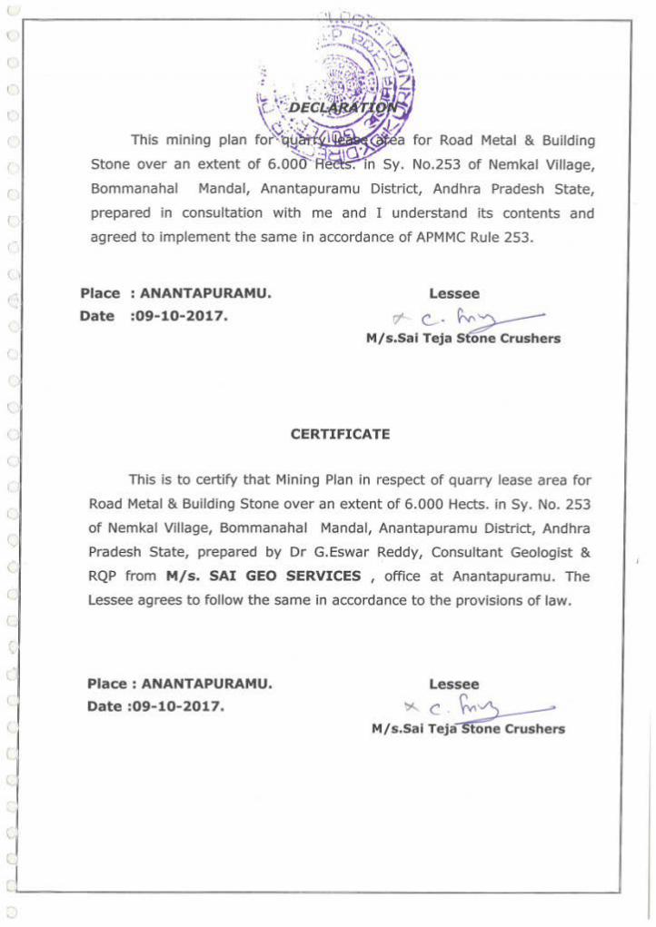
Sy. No.253 of Nemkal Village,
Bommanahal Mandai, Anantapuramu District, Andhra Pradesh State,
prepared in consultation with me and I understand its contents and
agreed to implement the same in accordance of APMMC Rule 253.
Place : ANANTAPURAMU.
Date :09-10-2017.
Lessee
rr c_. . ~~ M/s.Sai Teja st'(lne Crushers
CERTIFICATE
This is to certify that Mining Plan in respect of quarry lease area for
Road Metal & Building Stone over an extent of 6.000 Hects. in Sy. No. 253
of Nemkal Village, Bommanahal Mandai, Anantapuramu District, Andhra
Pradesh State, prepared by Dr G.Eswar Reddy, Consultant Geologist &
RQP from M/s. SAI GEO SERVICES , office at Anantapuramu. The
Lessee agrees to follow the same in accordance to the provisions of Jaw.
Place : ANANTAPURAMU.
Date :09-10-2017.
Lessee
"' c . \'v.') ... M/s.Sal Teja Stone Crushers

(
. I I
The provisions of Granite Conservation and Development Rules 1999 &
APMMC Rule 28 observed In preparation of Mining Plan for quarry lease
area for Road Metal & Building Stone over an extent of 6.000 Hects. in
Sy. No. 253 of Nemkal Village, Bommanahal Mandai, Anantapuramu
District, Andhra Pradesh State.
Wherever specific permissions are required the Lessee will approach the
concerned authorities.
Certified that the information provided in the mining plan is correct to the
best of my knowledge.
Date :09- 10-2017.
PLACE: ANANTAPURAMU.
SIGNA7URE OF TI-lE RQP
: :s ~,~ ( G.ESWAR REDDY)
G. £W!AII REDDY, M.So .• a.L. Ph.D
Recogmsed Geologist IP'A/RQPIHYD/302/2013/A
RQPiDMG/AP/07/2014
(
(
(
l
\
(.
(
(. I
l I
II
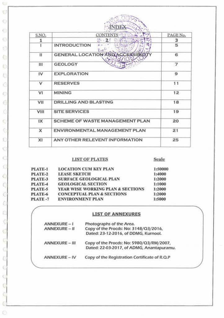
GEOLOGY
VI Ml
VII
PLATE-I PLATE-1 PLATE-3 PLATE-4 PLATE-S PLATE-6 PLATE-7
DRILLING AND BLASTING
LIST OF PLAIES
LOCATION CUl\t KEY PLAN LEASE SKETCH SURFACE GEOLOGICAL PLAN GEOLOGICAL SECTION YEAR WISE WORKING PLAN & SECTIONS CONCEPTUAL PLAN & SECTIONS ENVIRONMENT PLAN
LIST OF ANNEXURES
Photographs of the Area.
1:50000 1:4000 1:2000 1:1000 1:1000 1:2000 1:5000
ANNEXURE-I ANNEXURE - II Copy of the Procds: No: 3148/03/2016,
Dated: 23·12·20 16, of DDMG, Kurnool.
7
9
18
ANNEXURE - Ill Copy of the Procds: No: 5980/03/RM/2007, Dated: 22~3-2017, of ADMG, Anantapuramu.
ANNEXURE - IV Copy of the Registration Certificate of R.O.P

l
I '
(
(
(
(
(
{
r
(
MI NI NG PLAN FOR ROAO. M~T.AL & BUILDING STONE ·"' ' . - \ I • \ .... .... •
OVER AN EXTENT OF 6 .000 t.t8£t .. t.;OC_ATE~N SY. NO. 253, NEMA KAL
VILLAGE, BOMMANAHAL MAND~l?,··.·Al. NA'1t._. _tH;rj~RAMU DISTRICT, ANDHRA PRADE~~!~ T~' "7
~~- ··.\ '' \'-' Introduction ' · , ·:!~ , ,. :-;,;\~ !':1.
, • •· '!- r:-m . ' The Deputy Director of f11ines,,&-~a; ' - ool originally granted Q.L.
' . ' .. ............._,_..,_;' ~
for Road Metal and Building\Stpn~· ::1r'l~). J;i ent of 12.000 hectares in Sy. '..V( .~ .• c: ./
No.253 of Nemkal village, Bomma~R~~ai'idal, Anantapuramu District for a
period of 10 years in favour of Smt. T. Vijaya lakshmi , Vide Procds: No.
5980/QL/2007, dated: 11-06-2008, DDMG, Kurnool and the QL deed was
executed vide ADMG, Anantapuramu Vide Procds: No. 5980/QL/2007,
dated:19 08 2008 and the same has been valid up to 18-08-2018.
Further Smt. T. Vijaya Lakshmi has applied for two part transfers of
Q.L. over an extent of 6.000 hectares each in Sy. No.253 of Nemkal vi llage,
Bommanahal Mandai, Anantapuramu District which was held in t he name of
Smt. T. Vijaya Lakshmi over an extent of 12.000 hectares in Sy. No.253 of
Nemkal village, Bommanahal Mandai, Anantapuramu District in favour of M/s
Datta Stone Crushers, Mg.Part:Srl G.Palakshi Reddy and M/ s.
Adibasaveswara Mineral Traders, Mg. Part: Sri B. N. Prasad. for the
unexpired portion of lease period i.e., up to 18-08-2018 and same was
executed by ADM&G, Ananatapur Vide Procds: No. 2010/Q2/RM/2009,
dated :18-06-2009 ADM&G, Anantapur.
Further the Asst. Director of Mines & Geology, Anantapuramu has
recommended for transfer of Quarry lease for Road Metal & Building Stone
over an extent of 6.000 hectares in Sy. No.253 of Nemkal village, Bommanahal
Mandai, Anantapuramu District , which was held in the name of M/ s Datta
Stone Crushers, Mg.Part:Sri G.Palakshl Reddy in favour of M/ s . Sai Teja
Stone Crushers, Part:Sri C.Srinivas Rao for the unexpired portion of lease
period i.e., up to 18-08-2018.
I n the above circumstances Deputy Director of Mines & Geology, Kurnool,
have given permission to transfer Road Metal & Building Stone over an extent
of 6.000 hectares in Sy. No.253 of Nemkal village, Bommanahal Mandai,
Anantapuramu District in favour of M/s. Sal Tej a Stone Crushers, Part:Sri
I C.Srinivas Rao for the unexpired portion of lea~- period i.e., up to 18-08-18
.............. ~od...,cdtoiloi •
• t .- S . dmriJI'd•~~- I ................... ~.t~~·~'i\>l "J.d':/-....... ;.:rJ~t'2<!:l\";f- LO/
" t ... '"'-~
1

(
(
r r
--~ ·''·:~-~
under Rule 13 (1) of APMMC Rule~·-~?~~~~~~ect to satisfaction of the
terms and conditions laid dow~'~i·~-" P~1i\' .''s~\·1:?~66. Vide Procds: No. '''1-"l .. , ~<O.'i'7·1J F;· · · I 3148/Q3/2016, dated:23-12-20 B! .~MG[.~\l'r.-!# !.'~ ·,. '_'the same was executed
by ADM&G, Ananatapur VIde Pro2®~,..~~'2,~~~f.RMi2007, dated:22-03-2017 v, ~/>-'3 ' . . ,.
ADM&G, Anantapuramu. ~ .lo..: ~·" . ........ ~ ru.:) -:..
.... -.. - ··
Now submission of Approved Mining Plan is mandatory along with
consent for Establishment from A.P.Pollution Control Board & Environmental
Clearance from Ministry of Environment & Forest as per Environment Impact
( Assessment Notification through S.0.1533, dated: 14-09-2006.
\_
l
l
(
c..
l
l
\.
l
I.
l
l (._
(
In this ronnection it ic; c;ubmittPd that as envisaged in the Environment
Impact Assessment (EIA ) Notification, 14111 September, 2006, t he mining
projects with lease area of SHa and above irrespective of the mineral ( major or
minor) to obtain prior environment clearance under the provisions thereof.
Further all Category A and Category Bl projects shall under take public
consultation in accordance to EIA Notification, 2006. Further the Government
of India, Ministry of Environment & Forest vide office memorandum No. L-
11011/47/2011-IA.II(M), Dated: 18th May, 2012 in order to ensure compliance
of the Honourable Supreme Court Dated:27.02.2012 in I.A.12-13 of 2011 In
SLP( c) No. 196253-19629 of 2009, instruction were issued that all the mining
projects of minor minerals including their renewal, irrespective of the size of the
lease would hence forth require prior environment clearance.
The Government of India vide Notification No. 141(E), Dt: 15.01.2016
notified guidelines for construction of District Level Environment Impact
Assessment Authorities and other guidelines for issue of Environmental
clearances for minor mineral leases for an extent of less than 5.00 hec. etc.,
accordingly, mining plan become a pre-requisite for obtaining Environmental
clearance. Hence a Provision to the effect that quarry operations for minor
minerals shall be conducted In accordance with the approved mining plan has to
be incorporated by the State Government vide G .. O.Ms. No. 56, Inds.& Comm.
(M.II) Department, Dated:30.04.2016.
M/s. Sai Teja Stone Crushers, ,approached Dr.G.Eswar Reddy,
Consultant Geologist & RQP to prepare the Mining Plan following the guidelines
... 2

( . r (
(
(
(
f
f
1..
(
(
(
(
(
[
\.
l (
1...
(
(
and hence this Mining Plan is prE!pai-~j~up~~ of APMMC'1966 and
submitted.
I GENERAL
1-l------------~~~~~~~ Crushers, nivas Rao,
Gangadhara Rama Rao, Prasanthl Nliayam,
1.1 Name and Address of the Lessee Vidya Nagar,Air Port Road, cantonment Beliary, Beliary District, Karnatal<a State. Contact No. 9980551491
of the Lessee (Individual/ 1
•2
Private Company/ Firm) Individual
are 1
·3
the Letter of Intent
1.4 Name and Details of employed for preparing Plan
1.5 E-Mail & Website
in ROAD METAL & BUILDING STONE
RQP /Geologist, RQP/DMG/ AP/07/2014,
person RQP/HYD/302/2013/A, Mining D.No.13-2-155-l,
Shlrdi Nagar, ANANTHAPURAMU. A.P. 515001. Mobile: 09849132789. Phone No:08554 222737.
1.6 RQP Registration No. & Validity RQP/HYD/302/2013/ A'
Valid Up to Dec-2024
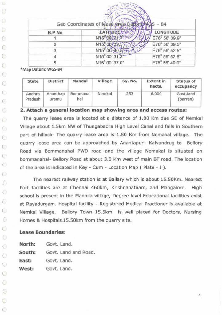
II. LOCATION AND ACCESSIBILITY:
1. Toposheet No. with latitude and longitude of all corner
boundary pillars: The Quarry lease area falls on SOl Toposheet No. 57
N16(Scale 1 : 50,000) and the Geo Co-ordinates of the boundary pillars are
tabulated below:
Table- GPS READINGS OF BOUNDARY POINTS
3
(
(
r r
t
l
(
{
(
l
(
3 4 5
*Map Datum: WGS-84
State District
Andhra Ananthap Pradesh uramu
Mandai
Bommana hal
VIllage Sy. No. Extent In Status of hects. occupancy
Nemkal 253 6.000 Govt.land (barren)
2. Attach a general location map showing area and access routes:
The quarry lease area is located at a distance of 1.00 Km due SE of Nemkal
Village about l.Skm NW of Thungabadra High Level Canal and falls In Southern
part of hillock- The quarry lease area is 1.50 Km from Nemakal village. The
quarry lease area can be approached by Anantapur- Kalyandrug to Bellory
Road via Bommanahal PWD road and the village Nemakal is situated on
bommanahal- Bellory Road at about 3.0 Km west of main BT road. The location
of the area is indicated in Key - Cum - Location Map ( Plate - I ).
The nearest railway station is at Ballary which is about 15.50Km. Nearest
Port facilities are at Chennai 460km, Krishnapatnam, and Mangalore. High
school is present in the Mannila village, Degree level Educational facilities exist
at Rayadurgam. Hospital facility - Registered Medical Practioner is available at
Nemkal Village. Bellory Town lS.Skm is well placed for Doctors, Nursing
Homes & Hospitals.lS.SOkm from the quarry site.
Lease Boundaries:
North: Govt. Land.
South: Govt. Land and Road.
East: Govt. Land.
West: Govt. Land.
4

l
(
(
(
(
(
(
(
~ '\ •, 'b ...... ·• . ~,..., .... -,_; .. Ill DETAILS OF APPROVED MINING PLAN s' ~0 • lNG ANY ;.-;.',. c;.-- ~ .. .....,"" :- .,,./.
Not applicable- since Road Me~~*l!i~:A~~~ Quarries dint have
the r~quirement for mining plan in~~~~~~~h~!Js)~"i~st Mining plan being
subm1tted. \·~-*-~,-. ·- .:::<. f·S· ~~'·"1•,. ··-. ~.., ,~· r:jj~·~;~~9~'/ ~~ ·
1. General details of the area:
Physiography I Topography:
Topographically the Q.L. area is a plain land gently slopes towards
South East directions. Generally it is low lying plain land with an average
altitude of 468 to 558 m above M.S.L. and dendritic to sub dendritic drainage
is observed. The area is elevated towards North East of the Q.L. area and
sloping towards SW directions. The area is devoid of any forest or tree cover.
It comprises big size Boulders and shrubs only. The subject area covers the
part of the Pediment comprising negligible soli cover along the depressions of
the big size Boulders & sheet rock exposed over the subject area. The
l drainage pattern is dendritic to sub-dendritic. The lease area belongs to rocky
t terrain it does not have much vegetation. The climate is tropical with
temperatures ranging from 253 °C to 38 °C in the summer and 18 °C to
20 °C in the winter. The average annual rainfall is about 581.0 mm and
618.2 mm in the year 2009-10.
2. GEOLOGY AND EXPLORATION:
a) Regional Geology:
The Geological formations in the Ananthapuramu District can broadly be divided
in two distinct and well marked groups and older group of Metamorphic rocks
belonging to Archean and Younger group of Sedimentary rocks belonging to the
t Proterozoic age the later cover part of Gondwana block. The remaining parts of
District are occupied by Archean Rocks which consist of Schist, Gneisses,
t
(
~
l (.
(.
Quartz veins and basic dykes. The Archean rocks have suffered considerable
degree of tectonic disturbances, as a result of which the rocks have been
metamorphosed and recrystallized.
Stratigraphic Sequences established In the area Is as follows:-Geological age Litho logy Recent Alluvium
5

.l
(
' l
(
(
(
(
l
l
(
(
{
l (._
(
(
(
Peninsular gneissic complex (Migmatlte group)
Archean
b) Local Geo logy:
veins,
Nebulltlc to homophonous biotite granite
Nebulltlc to homophonous Hornblende Granite and Leuco Hornblende granite Biotite Granite Gneiss, Hornblende Granite Gneiss, Porphyritic Hornblende Granite.
The subject area is Granitoid gneiss belonging to Peninsular Gneissic Complex
of Archaean age. The outcrop exhibits multiple sets of joints both closely
spaced and widely spaced as such It Is most suitable for quarrying Road metal
and Building stone (Piate-3).
c) Details of the Quarry License Holder:
d) Details of the Prospecting carried out: Not applicable to Road Metal Quarries.
M/s.Sal Teja Stone Crushers, Prop:Sri.C.Srtnlvas Rao, S/o.Sri.Late Gangadhara Rama Rao, Prasanthl Nllayam, Vldya Nagar,Air Port Road, Cantonment Bellary, Bellary District, Karnataka State. Contact No.9980551491
e ) Surface Plan area on 1:2000 scale: The surface cum Geological Plan and
Cross Sections of the Q.L. area Is prepared on 1:2000 scale and Is enclosed as
Plat es-3 & 4 .
f) Geo log ical plan is enclosed as Plate-3.
g ) Geo logical cross sections have been shown on Plate-4.
6
-
(
(
(.
l
\
(
<.
l
t
{
1..
1..
(
l (
(
(
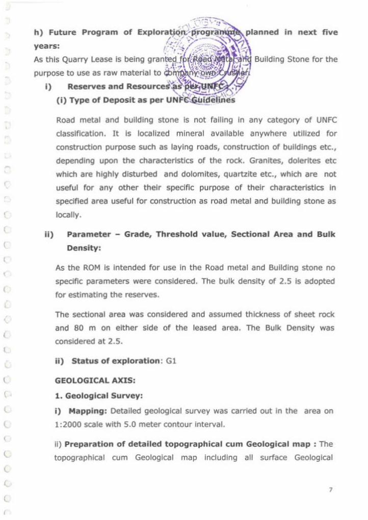
Road metal and building stone is not falling in any category of UNFC
classification. It is localized mineral available anywhere utilized for
construction purpose such as laying roads, construction of buildings etc.,
depending upon the characteristics of the rock. Granites, dolerites etc
which are highly disturbed and dolomites, quartzite etc., which are not
useful for any other their specific purpose of their characteristics in
specified area useful for construction as road metal and building stone as
locally.
ll) Parameter - Grade, Threshold value, Sectional Area and Bulk
Density:
As the ROM Is Intended for use In the Road metal and Building stone no
specific parameters were considered. The bulk density of 2.5 Is adopted
for estimating the reserves.
The sectional area was considered and assumed thickness of sheet rock
and 80 m on either side of the leased area. The Bulk Density was
considered at 2.5.
ii) Status of exploration : Gl
GEOLOGICAL AXIS:
1. Geological Survey:
i) Mapping: Detailed geological survey was carried out In the area on
1:2000 scale with 5.0 meter contour interval.
II) Preparation of detailed topographical cum Geological map : The
topographical cum Geological map including all surface Geological
7
(
r
r r (
r (
(
r l
(
r
(
(
(
l
I . (
l
l (,
L
L l
L
l
(
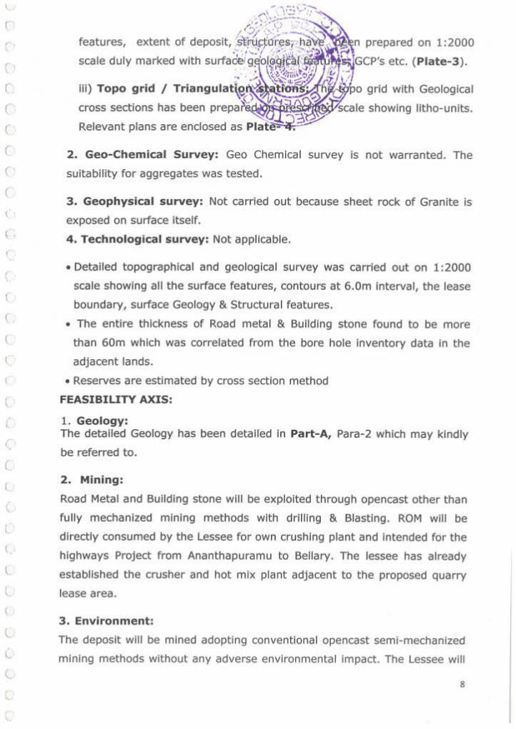
2 . Geo-Chemical Survey: Geo Chemical survey is not warranted. The
suitabi lity for aggregates was tested.
3 . Geophysical survey: Not carried out because sheet rock of Granite is
exposed on surface itself.
4 . Technological survey: Not applicable.
• Detailed topographical and geological survey was carried out on 1:2000
scale showing all the surface features, contours at 6.0m interval, the lease
boundary, surface Geology & Structural features.
• The entire thickness of Road metal & Building stone found to be more
than 60m which was correlated from the bore hole inventory data in the
adjacent lands.
• Reserves are estimated by cross section method
FEASIBILITY AXIS:
1. Geology: The detailed Geology has been detailed In Part-A, Para-2 which may kindly
be referred to.
2 . Mining:
Road Metal and Building stone will be exploited through opencast other than
fully mechanized mining methods with drilling & Blasting. ROM will be
directly consumed by the Lessee for own crushing plant and intended for the
highways Project from Ananthapuramu to Bellary. The lessee has already
established t he crusher and hot mix plant adjacent to the proposed quarry
lease area.
3. Environment:
The deposit will be mined adopting conventional opencast semi-mechanized
mining methods without any adverse environmental impact. The Lessee will
8

(
(
(
(
(
(
(
(
(
(
(
(
(
(
(
(
t
(
l
l
l
\.
l (
1..
l.
l
L
(.
(
l
4. Processing:
After blasting the ROM will be fed directly on to the crusher for crushing in to desired sizes of aggregates. The crusher Is already In place outside the quarry lease area
Mining operations will be carried out by deploying the following machinery:
S.No Type of machine Nos Dia ofhole Size/ Make Motive power H.P (Inches) capacity
1 Excavator / JCB 2 . 1.2cu m L&T Diesel 200
2 Tippers 6 . 17 tons . Diesel 60 3 Drilling machines 1 3" Diesel
4 Tractor mounted 2 2" Diesel 3 compressors
5 Water Tankers 2
6 Loaders 2 3 cum
5. Infrastructure: The entire necessary Infrastructure such as offtce, rest
shelter, magazine, explosive van, water tankers, power connection etc., will
be provided once the mining plan is approved. The Q.L. area is connected
with roads to the Bommanahal Mandai and District headquarters.
6. Costing: The cost of production of Road Metal & Building Stone works out
to be Rs. 250/· per ton.
7. Marketing: Road Metal and Building stone is not intended for outside
sale. It is for captive purpose for the crusher and Hot mix plant
established for use in the Highways road project from Rayadurgam
to Bellary in Ananthapuramu District.
8. Economic Viability: As the proposed quarry lease is in the near vicinity
and captive use it is surely economic and viable.
9. Other factors: Relevant clearances shall be obtained for continuing the
mining operations in the QL area.
9
\
(
(
(
(
(
(
(
(
(
(
(
(
(
' (
(
(.
\ (
(
(
(
1..
l
l. (
(
l
(..
l (.,
(.
(
(
ECONOMIC AXIS:
1) Detailed exploration:
·('' \ ...... --~ -.~ .... t;, ~-· •" '"":, .. ,~·-,
/".•.' /, . ,. "::'-~ . . . • .. ,- ' ---... :..;..._.. - ~ I ,, .. ,., ~ .. ~ . .., ,,~
··• · r ........_ .... ,.,r.,~ L"" ·; -• .. r· .. :.:.-- .... ~ff'"'' ~ - , ... ,IJ,'Cj <'.:,.r;.._., ':·, 4,. ·~· ._, •.-~ -l !• .. : • • ..... . ·' ·' .,j.Ji ;.· ~ t •. t• r ., '· "' . i<.~ "'•.s .... ,·- t ,\.H~."'~:.::'l7, .... : · .. ,r.-. .·.·t~~- \;"<. '- ·;.~~ .... 7.~· ( r__,·~· .
. ,.... \ • .;:.:'-""'.:.· ' f ,;:f .'.Pi \.V'~ ,,~ / f·:/'. ~f
Detailed topographic survey and g.e !itsann~_etr(g~othe Q.L. area was ' .., ':!.-... 37\. C"::Y-.., ,.'7 . subjected to detailed exploration by' -·,;ey~~ ' nd well inventory data. .. .._.;~·--The depth of sheet rock is assessed by the o log observed in the boreholes
of agricultural lands.
2) Mining Reports/Mining Plan
This is the first Mining plan being submitted.
3) Specific end-use grades of reserves (above economic cutoff grade)
ROM is intended for crushing to use in the aggregates for roads.
4) Specific knowledge of forest/non-forest and other land use data
The entire Q.L. area Is covered by Government lands. Mincher! Reserve
Forest Boundary is 1.50 km North of the Q.L area. The interstate boundary
between Andhra Pradesh and Karnataka Is 1.5 Kms North West of the Quarry
lease area. Hence, considering the above parameters discussed reserves 1 resources are categorized as E-1 Axis.
(j) Feasibility Report along with financial analysis per economic
viability of the deposit: The cost of production of road metal and building
stone is arrived at Rs250/- per ton Inclusive of taxes and royalty. The entire
ROM Is for only captive purpose as such It Is surely economic and profit
oriented.
( k) RESERVES
(I) Mode of Mining, recovery Factor, Mining Losses, Processing Losses etc.,
Road Metal and Building stone will be mining by open cast other than fu lly
mechanized method with drilling and blasting. The recovery factor is
considered as 95% with 5% Interstitia l voids and fractures. There will not be
any mining losses excepting handling loss which will be again recovered
during further loading.
10

(
(
(
(
(
(
(
(
(
(
(
(
(
c {
~
(_
(
(
(
\..
l
(.
(
l
l (.
l
(
(
(.
(
/. ~tt:!~~~\ (ii) Cut off grade and Ultimate ~~~~·~f~:ti&-.e··,~., cut off grade as the
ROM will be put to use for road met ,. i~®r.~~t .._ UPL will be 108m at ·. • Z, \'t~ ~~\ 0~ lu -
the south Eastern portion of the Qt::· ·i:ritt;t_ ·vJ year of th is mining . ·:-e ;.'' . -- ~ Q plan penod. '"-A~ 5;:13;\0 ().);
VO,.J..::J"?J"-0.'1. (iii) Mineral blocked due to the prese~e of"/ maintenance of benches,
barriers, internal roads, electrical lines etc,: The mineral will be blocked
in 7.5m safety barrier zone, Roads, Benches which is computed separately
and tabulated In the succeeding paragraphs.
(iv) Total Mineral reserves:
The reserves are estimated basing f1eld traverses and the litho log ot the well
inventory in the adjacent agricultural fields and cross sections drawn on the
ore body. The area of the influence and the cross sections were taken at 30 m
on an average i.e. 25 m on either side of the Cross section. The occurrence of
the Granitoid gneiss is more than 50.0 m BGL. Based on the field traverses
and correlated data from the boreholes in the adjacent agricultural lands to a
depth of lSO.Om, the estimated reserves are considered as Proved reserves.
The cross sections A-A' & B-B' are considered for computation of reserves.
The present area which is explored is considered for computation of reserves
under G-1 category.
Table-2
D•~Ao "'''
Sectional Deposit Volume Rock category SECTIONS Height OF OF Area m' AGGREGATE AGGREGATE Waste@ In m
@I 9~;- IN @ 2.5/m' IN 5% in m3
Tons 0 0 0 -- --- ---
Proved A-A' 31641 45 '" 11<;'"~3 11R1fi12 71192 1.4?.,.A.40: 3381632 71192
0 0 0 --Proved B-B' 28359 36 1020924 969878 ?LI?LII';Q~ 51046
1 !4 "''""010 7.47.4f:QO: 51046 Total 2 ...... , .,, ,.,.,.,0:.,.1 <:Anf:126 1???"'A
AFTER Rll~~FR ZONE i9 ~~uuu~u ·~"' 103163
AFTER SLOPE DEDUCTION 1582211 1503100 3757751 79111
11

l
(
'
(
r r (
(
r
; r:.:\.•'"' .. Co ·::""~ I~~'".:,....-..-- .I ' ,,::......:"\ \2.,"""" .
Reserves Blocked Under 7.5 M Buff~:z~~~~~~~~ Reserves Blocked Under Safety Slopes :-_:( /~G'i.'~ ;~ r ~\
No reserves will be blocked under 1~\~~~?.·.~ . 1 .~ ; :;f RESERVES IN UNFC CODE · . . \.':."~~}' lr';f-... : .. .! .... . L!''i .
5. No. Category of Reserves ' . .:..~ '/.~ ~?· 'b{.!!§J1@ {\ i"; eserves In Cu.mts. -:::::~ .,_,-~
1 Proved ~~ -- 1503100
TOTAL 1503100
Reserves of the buffer zone: Area of buffer zone x average depth x recovery factor
J = 1256 X 7.5X 40.5= 381510x 0.95= 362435m
Total Mine able Reserves= Total Geological Reserves- Reserves
Blocked under buffer zone i.e. = 2322531-362435= 1960096 m J
( Reserves Blocked under Bench Slope = 383X 1256 = 481048x0.95 = 456995.6m J
(
(
(
(
(
(
\.
(
(
(
l
l
l
l (
l
l (
l
Total Mineable Reserves = 1960096· 456995.6 = 15031oom
Total Mined/ excavated Reserves of Road Metal in Q L Area 3
= 94063m
Net Mineable Reserves of Road Metal & Building Stone In Q L. area
J
3 = 1503100-94063=1409037m
Total Mineral waste available in Q L. area
{v) Mineable Reserves and Life of the Quarry:
3 = 79111m
I nitially, the total quant ity of mineable reserves is considered as {economic)
marketable reserves. In this way a total mineable reserves of 1409037 m' are
available in this Q.L. area. The production Is proposed to obtain 53258 m3 per year. At
this rate of production, the expected life of the quarry is calculated as given below.
(vi) Life of the Quarry: Mineable Reserves I Average Annual production =
1409037 /53258=26.45 Year s.
3 .0 MINING
(i) OPEN CAST MINING METHOD (Mining Carried out)
i) This is a running Quarry. The mining are carried out by opencast other than
fully mechanized mining method with d rilling and blasting. The ROM will be
sized and sorted in the crusher established outside the quarry lease area and
12
l
(
•. ·:. ·,G ~ ·,:: '·"' .'.>-->~ ·c ~ ·, , . .. ~ ~ ~~ ... .. ~
loaded on to t ippers and tractors usin~jJ?f~~"\\~~arrled out by formation
of bench of height 6 mts. The det~~s :~1d~.f~1~.,tJ1~ficted on Plate-s. ~ . :~~ ·~~,.~.;; / ,, ,. ,: I ... S~'· .~-a="':...t.. ·.:. ·.,
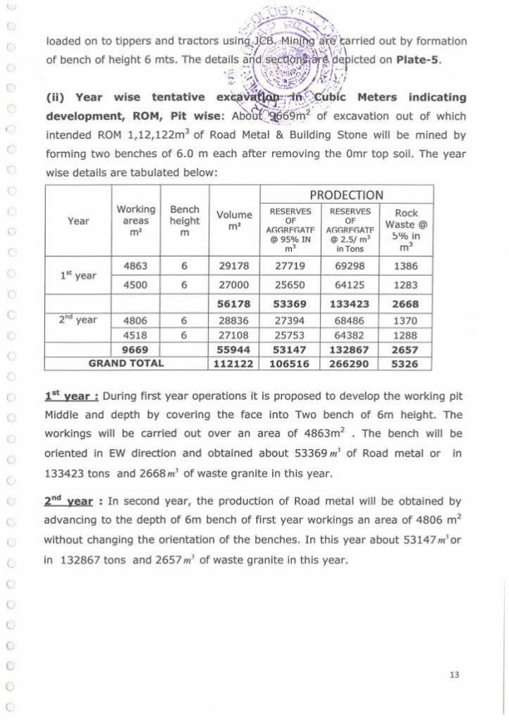
(ii) Year wise tentative ex~~~~~~bfc Meters indicating
development, ROM, Pit wise: Abo~69m2 of excavation out of which
intended ROM 1,12,122m3 of Road Metal & Building Stone will be mined by
forming two benches of 6.0 m each after removing the Omr top soil. The year
wise details are tabulated below:
PRODECTION Working Bench Volume RESERVES RESERVES Rock
Year areas height m• OF OF Waste@ m• m A(;(;Rf(;ATF A(;(;Rf(;ATF
!:>%In @95% IN l§l 2. 5/ m1 m' in Tons m3
4863 6 29178 27719 69298 1386 1" year
4500 6 27000 25650 64125 1283
56178 53369 133423 2668
2"" year 4806 6 28836 27394 68486 1370
4518 6 27108 25753 64382 1288
9669 55944 53147 132867 2657 GRAND TOTAL 112122 106516 266290 5326
( 1st vear ; During first year operations it is proposed to develop the working pit
Middle and depth by covering the face into Two bench of 6m height. The
workings will be carried out over an area of 4863m2 • The bench will be
oriented In EW direction and obtained about 53369 m' of Road metal or In
( 133423 tons and 2668m' of waste granite In this year.
2 "d year ; In second year, the production of Road metal will be obtained by
advancing to the depth of 6m bench of first year workings an area of 4806 m2
t without changing the orientation of the benches. In this year about 53147 m' or
( in 132867 tons and 2657m' of waste granite in this year.
(
(
(
(
(
(
(
13

l
l
(
(
(
(
I ,~;·~~~5 ~ ~~~")~>. (iii) Dump Management: There i~--?~f~;,~g~<i~·: Yard. .
Lay out of Mine Workings, pits, ro11c;l&1 ~Jc,~~·~fl ~f: The Lessee Intends to extract Road M~"1.~- ·-:~-(~~!\>~~ ·;~;ne production to the
3 --~- :0, ;-=: , .) / tune of ROM 1,12,122m of road me~~ 1 ~~-.>:!- ;;tone during the Mining
Plan period. ~-4..--.:.~~~ During this period, it is proposed to exploit the road metal from the total area
of 9669m2 to an average depth up to 12 m over the lease area from East to
West Rl 518 to Rl 508 m as shown on Plate 5.
There is no problem In the quality of Road Metal & Building Stone which
confirms to the specifications Aggregates.
The Lessee proposes to carry out mining by opencast other than fully
mechanized method with drilling and blasting. The mineral will be sized and
sorted in crusher for desired size separation. Trucks I tippers will be deployed
for transportation Plate- 5.
1.1 Drilling and Blasting: 1.2 Drilling and blasting plays an important role for extraction Rom of Road metal and building stone. The primary drilling is done with Crawler drills of 4.5 n diameter and secondary drilling is done with jackhammers and compressor. The compressor attached to the wagon drill has 450 CFM capacity and compressor attached to jacks can cater needs of 2 jackhammers. Tippers are of 20 T capacity will be utilized for transportation from the leased area to crusher. Broad parameters of blasting:
H = Height of bench = 10 m l = Length of drill hole = 11 m B = Burden = 3.0 m s = Spacing = 3.5 m D = Diameter of the blast hole = 100 mm VR = Vol., of broken Rock = B * S * l = 3.5 * 3 * 10 = 105 m3 Volume of rock generated from one hole= 105 x 2.5 sg = 262.5 T
After blasting the rock, the excavator is used for loading rocks. The oversize buildings are dealt with secondary blasting. The material thus transported is fed to 250 TPH capacity crushing plant. The products are stored separately from where they are dispatched to customers. Explosive consumption :
Taking on powder factor basis, with a PF of 4 total explosive needed per year is
10,00,000/4 = 250 Tons.
14
l
l
(
t
. U';J r.: -..· -.~,:;,.~ -~
·.Y""• ">I" - '1.."' '\ •l .:.ij· .... ;'~ ~':.'\,_)-~
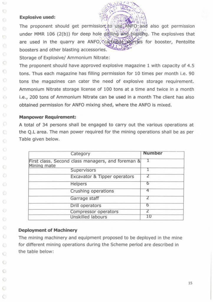
Explosi-ve used· ·1~!'(' ·1?::~ .. ,.,.., .)\!-• t t:.J I · ··• ;;Ji...:;: • X'> \"'
The proponent should get permisslo~~c>'·.~~~\ :-9';~~ also got permission
under MMR 106 (2(b)) for deep hor~ .~~lD~:~~f ·.~ibg. The explosives that
are used in the quarry are ANFO;~ .. c'i!.t. e"l. rtJes for booster, Pentollte ~Q ~ -
boosters and other blasting accessories. J..:l - ·
Storage of Explosive/ Ammonium Nitrate:
The proponent should have approved explosive magazine 1 with capacity of 4.5
tons. Thus each magazine has fi lling permission for 10 times per month i.e. 90
tons the magazines can cater the need of explosive storage requirement.
Ammonium Nitrate storage license of 100 tons at a time and twice In a month
I.e., 200 tons of Ammonium Nitrate can be used in a month The client has also
obtained permission for ANFO mixing shed, where the ANFO Is mixed.
Manpower Requirement:
A total of 34 persons shall be engaged to carry out the various operations at
the Q.L area. The man power required for the mining operations shall be as per
Table given below.
Category Numoer
First class. Second class managers, and foreman & .1
Mlnlno mate Supervisors l
Excavator & Tipper operators L.
Helpers 0
Crushing operations '+
Garrage staff L.
Drill operators b
Compressor operators ~
UnsKilled labours .lU
Deployment of Machinery
The mining machinery and equipment proposed to be deployed in the mine
for different mining operations during the Scheme period are described In
the table below:
15
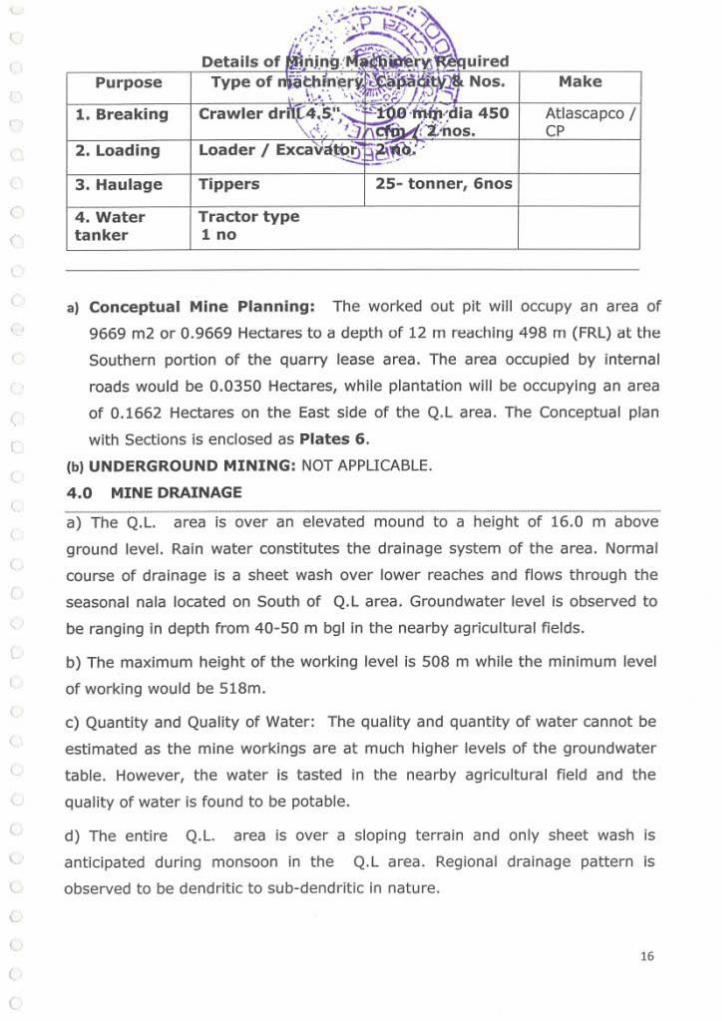
Purpose
1. Breaking
2. Loading
3. Haulage
4. Water tanker
Details of
Crawler
Loader I
Tippers
Tractor type 1 no
Atlascapco
25- tonner, 6nos
a) conceptual Mine Planning: The worked out pit will occupy an area of
9669 m2 or 0.9669 Hectares to a depth of 12m reaching 498 m (FRL) at the
Southern portion of the quarry lease area. The area occupied by internal
roads would be 0.0350 Hectares, while plantation will be occupying an area
of 0.1662 Hectares on the East side of the Q.L area. The Conceptual plan
with Sections is enclosed as Plates 6 .
(b) UNDERGROUND MINING: NOT APPLICABLE.
4.0 MINE DRAINAGE
a) The Q.L. area is over an elevated mound to a height of 16.0 m above
ground level. Rain water constitutes the drainage system of the area. Normal
course of drainage is a sheet wash over lower reaches and flows through the
seasonal nala located on South of Q.L area. Groundwater level Is observed to
be ranging in depth from 40-50 m bgl In the nearby agricultural fields.
b) The maximum height of the working level is 508 m while the minimum level
of working would be 518m.
c) Quantity and Quality of Water: The quality and quantity of water cannot be
estimated as the mine workings are at much higher levels of the groundwater
table. However, the water is tasted In the nearby agricultural field and the
quality of water is found to be potable.
d) The entire Q.L. area is over a sloping terrain and only sheet wash is
~ anticipated during monsoon in the Q. L area. Regional drainage pattern is
l. observed to be dendritic to sub-dendritic in nature.
l
16 (
(

There is no mineral reject or su . However, about
5% interstitial voids and interca which is computed
separately. This will be utilized for th~~~~~!~i~E~®(t~i~ha roads and balance
utilized to form a barrier all along the 7. ·buffer zone of the QL area to a
height of 2.0m.
6.0 USE OF MINERAL & MINERAL REJECTS
The ROM will be fed in to the crusher established outside the QL area
where it will be crushed to desired sizes and utilized for the State & National
Highway projects from Ananthapuramu to Bellary. Entire ROM Is Intended to
use for crushers.
7.0 PROCESSING OF ROM & MINERAL REJECTS
In this area ROM will be sized and sorted in crusher for road metal and
input to hot mix plant. There is no Mineral Reject from this Quarry.
8.0 OTHERS
a) SITE SERVICES: Site services such as office Room cum First Aid, Separate
Shelter and toilets for Gents & Ladies wi ll be proposed to provide at the QL
area.
17
l
MCDR' 1988
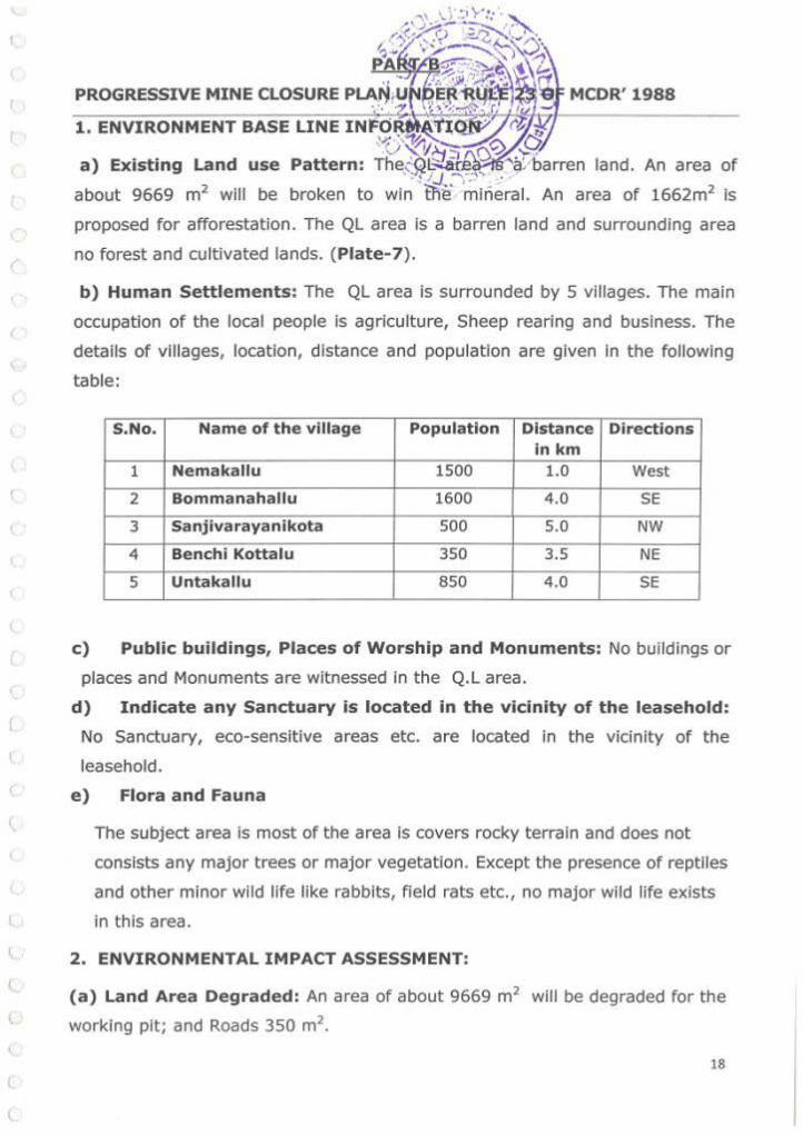
proposed for afforestation. The QL area is a barren land and surrounding area
no forest and cultivated lands. (Piate- 7).
b) Human Settlements: The QL area is surrounded by 5 villages. The main
occupat ion of the local people is agriculture, Sheep rearing and business. The
details of villages, location, distance and population are given in the following
table:
S.No. Name of the village Population Distance Directions inkm
1 Nemakallu 1500 1.0 West
2 Bommanahallu 1600 4.0 SE
3 Sanjivarayanikota 500 5.0 NW
4 Benchi Kottalu 350 3.5 NE
5 Untakallu 850 4.0 SE
c) Public buildings, Places of Worship and Monuments: No buildings or
places and Monuments are witnessed in the Q.L area.
d) Indicate any Sanctuary is located in the vicinity of the leasehold:
No Sanctuary, eco-sensltive areas etc. are located in the vicinity of the
leasehold.
e) Flora and Fauna
The subject area is most of the area is covers rocky terrain and does not
consists any major trees or major vegetation. Except the presence of reptiles
and other minor wild life like rabbits, field rats etc., no major wild life exists
in this area.
\.. 2. ENVIRONMENTAL IMPACT ASSESSMENT:
t
l
(
(
(a) Land Area Degraded: An area of about 9669 m2 will be degraded for the
working pit; and Roads 350 m2.
18
,
(
\
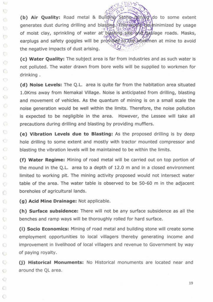
( b) Air Quality: Road metal & BtJ irr.r-:K!W:S.Sl)!f~
generates dust during drilling and bla~t~
of moist clay, sprinkling of water
some extent
earplugs and safety goggles will be nrl'l</ il~f. .. t1;';1;l~l(.olcllfl1en at mine to avoid
the negative impacts of dust arising.
(c ) Water Quality: The subject area is fa r from indust ries and as such water is
not polluted. The water drawn from bore wells will be supplied to workmen for
drinking .
(d) Noise Levels: The Q.L. area Is quite far from the habitation area situated
l.OKms away from Nemakal Village. Noise is anticipated from drill ing, blasting
and movement of vehicles. As the quantum of mining Is on a small scale the
noise generation would be well within the limits. Therefore, the noise pollution
is expected to be negligible In the area. However, the Lessee will take all
precautions during drill ing and blasting by providing mufflers.
(e) Vibration Levels due to Blasting: As the proposed drilling Is by deep
hole drill ing to some extent and mostly with tractor mounted compressor and
blasting the vibration levels will be maintained to be within the limits.
(f) Water Regime: Mining of road metal will be carried out on top portion of
the mound In the Q.L. area to a depth of 12.0 m and in a closed environment
limited to working pit. The mining activity proposed would not intersect water
table of the area. The water table is observed to be 50-60 m In the adjacent
( boreholes of agricultural lands.
(g) Acid Mine Drainage: Not applicable.
(h) Surface subsidence: There will not be any surface subsidence as all the
l benches and ramp ways will be thoroughly rolled for hard surface.
(i) Socio Economics: Mining of road metal and building stone will create some
employment opportunities to local villagers thereby generating Income and
l improvement in livelihood of local villagers and revenue to Government by way
~ of paying royalty.
l U) Historical Monuments: No Historical monuments are located near and
( around the QL area.
\..
( 19

\.
\
(
l
l.
l
l
(.
(
(
Progressive reclamation Is not studied and wi ll be planned in the first scheme of
mining.
4 . Mined out Land: No mined out land will be formed during this Plan period
as mineral is existing much below the proposed workings during this plan
period.
The land that will be broken in the successive conceptual periods (the Ute of the quarry Is ant icipated to be 5.6 years as of present).
LAND USE
The on-going mining and the downstream activities have covered the lease hold for about 1.9886 Hectares as detailed below:
1) Working Pit 9642+9669 mz 1.9311 Ha
2) Buildings 225m2 0.0225 Ha
3) Ramp Area, Internal
350 m2 0.0350 Ha Road Ways
Total 19886 mz 1.9886 Ha
Proposed for reclamation of land affected by quarrying activity during
and at the end of mining
No reclamation Is envisaged in the life of the quarry as there are adjacent
quarries that are operation. This point will be dealt while the cluster guidelines are
received. Hence, no reclamation proposals are made.
Plantation Programme :
The quarry lease area is scanty suitable for plantation as most of area Is rocky.
There are chances of tree growing in the South side of the quarry lease area.
However It is proposed to plant a few trees In the South side of the buffer zone of
quanry lease area. It is also proposed to plant a few trees nearby village area In the
20

f
r
(
(
(
" \
(
(
(
(
\.
\
t,
\
l
t
t (
(.
(
,·:· : -~ -- ··:· )"" place shown by the village panchayat .. - . ·- -·-~( p~~:ia plantation are shown
. . \ '\ •;.;·,·~ i'f ' ... ~~~ below.
' ' . . - -·; .. ' Details of
Year Planned
Remarks Plantation
1st Year 10 or Mango,
vil lage or road sides or Peepal
2"" Year 10 Five in buffer & Five in Neem, or Mango, village or road sides or Peepal
3"' Year 10 Five In buffer & Five In Neem, or Mango, village or road sides or Peepal 50% of
survival is 4"' Year 10
Five in buffer & Five In Neem, or Mango, envisaged. village or road sides or Peepal
5 th Year 10 Five in buffer & Five in Neem, or Mango, village or road sides or Peepal
Total so Five in buffer & Five in Neem, or Mango, village or road sides or Peepal
All the quarry that is In zone of 7. 5 meters as per AP
PCB and MOEF rules, around the quarry attempts will be made to grow plants with
local arran::~ement of drums filled with mud. Thus It Is envisaged that around 10
plants wi ll be planted and taken care of In one year. Thus the area available around
the periphery will be sufficient for around 10 years.
Although the area in general is fertile the location where the quarry Is situated Is
totally rocky. Expect for some wild growing medium sized plants that grow in the
cracks of boulders; there are no notable species In the area. However trees like
Neem, Ashoka, Mango, and local species Peepal are found in and around. Therefore
these thnee species are planned for plantation. Maintenance of these plants that are
grown in the buffer zone will be taken care by the quarry management. The plants
that will be grown In the village will be taken care by the management, In
coordination with the panchayat members.
5 . Top Soli Management: There Is no top soil generation from the QL area as
such management does not arise.
6. Tailing Dam Management: No tailing dam is required.
21

(
'
(
(
(
(
\
l
<,
l
l
\
t
l
(.
take the
M/s.Sal Teja Stone Crushers, Prop:Sri.C.Srinivas Rao, 5/o.Sri.l.ate Gangadhara Rama Rao, Prasanthl Nilayam, Vldya Nagar,Air Port Road, Cantonment Bellary, Bellary District, Karnataka State. Contact No.9980551491
8 . Care and M11intennnr.P. during temporary discontinuance:
An emergency plan to deal with the situation of temporary discontinuance
or Incomplete programme due to court order I due to statutory requirements or
any other unforeseen circumstance will be drawn by the technical and
managerial person to suit the specific situation of this mine. This would be
reviewed and modified to suit changing conditions and needs. This would take
care of preventing of access to dangerous places, pits and prevent accidental
fall In to the water logged pit of animals and men. Security Is also to be looked
In to the safety measures placed at various places like firefighting equipment,
main switches etc. Security to be deployed at Explosive storage.
The mining is yet to commence. As mining continues tlll then the question of
discontinuance does not arise. However, any untoward incidence happens the
safety of the mining area will not be disturbed. Security 1 Watchmen wil l be
posted at the mine site for watch and ward.
22
(
(
(
(
(
(
(
(.
(
(
(
\.
\
l (
\
l
(
<.. (
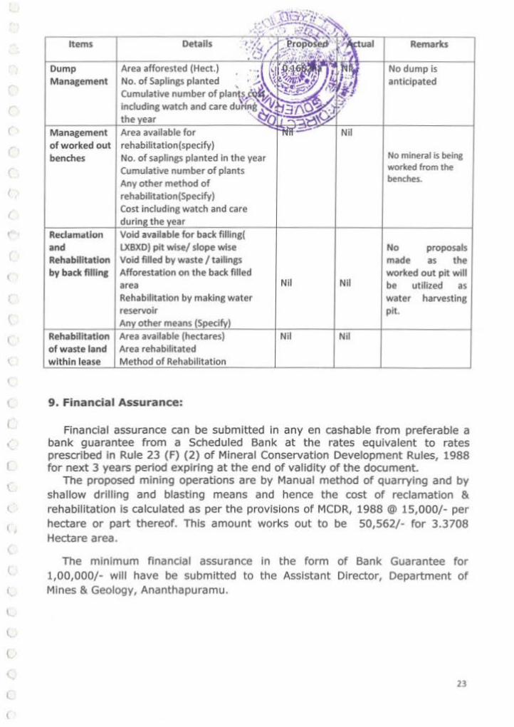
Items Details
Dump Area Management No. of Saplings planted
Cumulative number ofv••'"\~.~'<" Including watch and care ~j~~~)/.J_~ the
Management Area of worked out rehabllitatlon(specify) benches No. of saplings planted In the year
Cumulative number of plants
Redama\lon and Rehabilitation by back fllllna
Rehabilitation of waste land within
Any other method of rehabilitation(Specify) Cost including watch and care
the
LXBXD) pit wise/slope wise Void filled by waste I tailings Afforestation on the back filled area Rehabilitation by making water reservoir
Area available (hectares) Area rehabilitated
9. Financial Assurance:
Nil Nil
Nil Nil
Remarks
No dump is anticipated
No mineral is being worted from the benches.
No proposals made as the worked out pit will be utilized as water harvesting pit.
Financial assurance can be submitted in any en cashable from preferable a bank guarantee from a Scheduled Bank at the rates equivalent to rates prescribed In Rule 23 (F) (2) of Mineral Conservation Development Rules, 1988 for next 3 years period expiring at the end of validity of the document.
The proposed mining operations are by Manual method of quarrying and by shallow drilling and blasting means and hence the cost of reclamation & rehabilitation Is calculated as per the provisions of MCDR, 1988 @ 15,000/- per hectare or part thereof. This amount works out to be 50,562/- for 3.3708 Hectare area.
The minimum financial assurance in the form of Bank Guarantee for 1,00,000/- will have be submitted to the Assistant Director, Department of Mines & Geology, Ananthapuramu.
23

\
(
r ,
{ '
(
(
(
(
(
(
(
(
(.
l
(
(
\.
(
(
(
\.
(
l
1..
10.0
S.No.
1
1
2
3
4
5
6
7
8
9
10
11
12
13
Head
2
Area undet t.inlllg
SIOrage lo< Top Soli
Ov«burden I Dump
Mineral Sto<age
lnrrastruchKe (Workshop,
Admlnlslr3tive Bl.ik:ling
etc..,)
RO<Ids (W;Ihln the pits)
Railways
Green Ben
Tail ing Pond
BeneficiatiOn Plant
Mineral Separation Plant
T O'M'\Shlp Area
Retaining WaJ
Others Fencing aroood
lho pit (included
quarry area)
GRAND TOTAL
Area put
on use at
lhe start
of plen
(in Ha.}
3
0.9642
-
-
0.0150
-
-
U792
for financial assurance
Additional Area con•ldered
as fully Net area
requirement Totat considered
during tho reclaimed and
(In Ha.) rth.abllltattd for calculaUon
plan period
(In Ha.) (In Ha.)
(In Ha.)
4 5 6 7
0.9669 1.9311 nil 1.9311
0.0000 0.0000 -
-- - - -
0.0150 0.0150
- ·-0.1662 0 .1662 0 .1662
.
-- - · - -
1.1331 2.1123 -- 2.1123
24

\
(
(
(
(
(
I
(
(
(
(
(
\
(
(
(
(
(
(
l
(,_
l
C.
l
(
Andhra Pradesh.
All statutory organizations, courts etc. have been taken into consideration
and wherever any specific permission is required the Lessee will approach
the concerned authorities.
All the measures proposed in this Mining Plan will be implemented in a time
bound manner as proposed.
10.1 Plan, Section etc,
Plans and Sections are submitted along with Mining Plan.
Date :09-10-2017
Place : Ananthapuramu.
Lessee
(M/s.Sai Teja Stone Crushers)
RQP & Consultant Geologist
::ss ~'-----~~ (G.Eswar Reddy)
G. ESWAR RfDOY, ot.:t. .. 8.l. ••.o Recogn1sed GeologiSt
IBM/RQP/HY0/302/2013/A RQP/OMG/AP/07/2014
25

(
(
(
(
'
{
c \
(
(
(
' ( (
c..
c (
PROPOSED WORKING AREA
26

(
(
(
(
(
(
(
(
(
(
(
(
t
(
(
(
(
l
l
(
(
(
l
1 . ,, l_..~l""
¥''
Quarry t.easo htld bv M/ .. !O&t ta Stone Cruthers, Hy.Pt: St1 c;.. Plilakshl Reckfy tor ltliii'.l'.:;;;.stf=--
Widlnt stone t:Ne~ .., extent d '000 Htctates .., sy.No. 2'Sl o1 Nemottll (Vl; Bommtnt\htl (M),
Ma~ramu 015trtct In ta,\'OW' of M/~. S.l Tej,li Stone Cnnhen, Prop: Sfi c. StlnNu a.o b d•
un~ pordon d ~ease: PtftOd I.e., upto l~OJ8 and the transfer quany lease epptc:,Uon was
- h blo olftoo, on u,\,2-2010. •
"'""tile 31, the AOH&.G, A~n,u hal repo~·ltd U\Ot, the les~ M/1. D~ttD · :\ ,·y stone Crushers, Mg.Pt: $tl G. Pal1.kShl Reddy het _... tor nnsttr ol quzwyy ~ ~ 'l\\ ~tled arridlvlt dated: 1)..01·2016 Rettng; U\Ot he hat decldod ond wiling to transfer tt1e quony lei:lse
\' tn tdYO#I r:1 M/t. Sol T.,J SlOne OUStler, PlOP: Sf(. C. Srt'*ea. R40 fvr thl rcmllli'*'O Ptf1od d the ~ \' I • '? \-v quo..y ~<•se I.e ..... ,.~ ',•;:·2.018 rn lho~rnert<t or mineral deYe-t as 1,. !' u.-.,""""'" tho
fl,t'i!;V ~ wt10..,.. to PfOCLft acme go ••••••• a'ld ~worts and~ PGN~ men Mid
~ \lite.st mochlncwv and aUSh1er ltld ce(»b1e of rvnnlng tho Cf1*1Y tNJe succrsstuty. ~. the ttansrm>f
~ ~ ~ ,., -....,...,.. ..-<.n ... -"' Pll'l,. dues U .... ...., h""',...... ol MI._ O.lta soo ... ';1- CrusNta, t4g.Pt: Sri G. Pat.aJcsni Recl<fy. Furd'llt, he .RMed tNt he has thO pa;W'ADft l"''d toe~~ ~ to the ~ and u-. ~ amou:tt r •nv round tn exceu stta• be cadJUS:ted In the name of t-1/t'.
~/ StiTejiJI r.tone (I~ Prop: Sf-1 C. Sl1nfvas ft.lo, 'ThiNk no ~ot ~Is~., thh
/ tr~ CJCC11Ft eoh~eoon or en lftliOUtlt or Rs.to.oo,ODO/· t~ ~iturt to'Jflleh Nve been 1pent bV tim fn tiling ond e?CII:CUbng lhl QWn"Y IMse find! tinelr requeiUd ~ ~ '*n ;o nnster the
qu.Jny lease 1ft fOYOUI' ot f.Vs. Sal T~ja Stone 01.6~ ProQ: Sit C. SMIVN ltbo.
The tr.nsferft M/s. s.t TeJ• Stona 0\I.Jhort., Prop: Sri C. Srfnlv•• R.to \'tOt hb ~
•"~ doted: 09-02-2016 hits 51-.ted U\ltt. they ore wiling toto the QuD"Y leo~ from MJs, Dfltta SlaM
"""- 1'19"'' sn G. ...,..., -on - lor - HtC.lO a e.--.g SOone- on .-ol '•.oon Heaar~ ., sv.No: ·253 or Noftllk.ll Vlllo9f, eomm~not\llt Mbntl~l. AI'ICIM.he~u Oi$tricl tor the
....,....., - otlho .._ -·~- lt-011-201& ....,._, __ lloev.,.......,., por r otl)'l't."~Otlt.Ml duK held 'n tho n~ ot M/S. DittOS Stone Ovshltn. Mg,pt; Sri Cf Palabhi RedcJy on N .
i)b'esllcf quarry l£me et1d ¥ ... ~ 15 In tJUSS Jn the NMe d '"Vli- O•U.. Stoi'IO 0-ufhtfl, Mg.PI '
Stl G P61ilkshl P.eddY. the SOJnt amount lholl be In ti'Je ~ d His. S. T$ Stone O'ul:hets, A'OCX: Sri C. SrirWM Rao. Nr\htf. ~ tiONfuec hes st.M:od tNt. thert b ro speculaUon Is lnvotvod ~ thb transt•
e- coml- d As.lO,OO.OOOI• (Rupee Tlon """' onlr) - ......... _,. - f!Oog a ~'9 tM: QI.IOnY leMc by the trliOSferor.
Fur1;her, \he AOM6G~ Anlntapwamu hm tf:P0'110d tt-.;,t ltwough IN~~ dL 02·11
2016, tho re!fi\Mw.g 1 (Eight) p&rtrterJ Of M/t. O.tto Ston'l Oushers I'I.'IS s:t1.1ted thol they 1\eVC no
""~""""· t die .,.nog~ng _, sn c; ,._ ._ ... - d ..,... o.ua Slone c.w.... 10
b-.lSIIf \he quarr;' \elM pert.oink1g \0 \1'lc RoleS me~ <d bl.ild~ $\.OM' and ~ their C.'Oftlltl\t a1")d
11::0 p-ombed tNt t,.,. ... lllrdlor lhe-.
I rurthor, the AOM&.G. A~1t11puromu 1'10' tt"POtltd \hllol lhe tr~~fcr ol QU.)ri'Y le:.s~ ai)CI<!d at~ was. fn:IIIXCI.ed by him .nd 5UfW)'t!d bv the~ d tMif ~on ~16 en present~~ ol bOCh
tr~,,c;teror ilndl van~f~M.
'
•
I 27
(
(
(
(
(
(
(
(
(
(
(
{
(
(
(
(
(
(
(
(
\
(
l
l
l {
(
•V
'
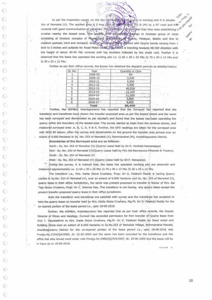
As .., the lmpedton ·~ on."" <Wf.:ilfj.WJ>I Km ol """".., (V). Tho _... 1'"' "
- ..... good-"!'!.!!~:""' --.... --. ~ "' - """"""" Cl 11 l !ll<lled ....-n Quwtz bands ~no rrom 1
lnCII to 5- ond ~ble for Rood Is~~ HE-SW-With
the helgtlt ol •boUt 30o.40 Hts ~ Wfth big boUlders r~ by the shM rOCk. l'utt.het l ts Obter'¥od ttlellhe Ieise tiM O()Cfa(ed the work.I"!J pits I.e. l) 60 X )0 X 2S M1$ 2.) 70 X-«) X 12 Mt$ et'ICf
J:) )0 X 2!) )( 12 Mts.
Further .s pet their otnce retOrds, the ~ Ns o~Nd the ~td' permits as det.~ IJelow;
I I
-............ ...,..,....,.,. ....
..._,_and~~ shown tN tnn11er ~ eree es pef' the leecsecf ~ onc1 the ,... -- - · - r· t . • tw1 t.r suw:yed ...s demao •' as per aouttar1 lind lolMd thll the 1es.see bas! be!!n OPeliidltD lhl --the boundotyo( lhe......, oreo.--Nn1d os- '""" lhe""""""' ......... and ~ surveved arw .A., 9, C. 0, E a A. F\ln.har, the GPS t..cir'9 are taken t« the s~ .,.. will\ wcfs 81 d.tum .. Aiter ~ $Utve'f ancl ~lOft on the Orovnd the tr~nsfcr orc1;a~ OW!t •n exten~ ot 6.000 Hectllres Jn SV~ No: 2Sl ot Nen\&UI (V), 8ofnm.Nhll (M), Ananthapuramu o.st•'fet.
I ,~nd•rt•• or the SurYeyed art• .,.. •• ronow11 N<:-lth ~ sv. NO: 253 or Nc."mOJ~I CV.) (Qu~rry L .. M held bV Sr1 R. vcnkbta R,m¥"~appe)
Eest .. Sy. No: 2S3 of Nema,kal (V)(Qu.oiTV Leon hold by Mta Adl Oa.sYesvora t•linerots a na.dcts)
South • Sy. No: 251 of NemakDJ (V)
w ... • sy. No: 253 o1 Nemakal (V) (QuOI"f t.e•se llttd by 5~ P. NMoyona).
... pu.tno the .lUrVeY, it b noUc:ed ttt.t:, the IH.H 1111 QPtttted working p~ arv observid a.l'd
tnel~ •~yle. 1)60x 30)( U,..,. 2) 70• 40 IC 12 Hts3) lOx 2Sx 12Mb.
The transferor I.e •• MIL Datta Stone Crushen., Prop: Sft G. Palakshi Redctf Is hiwtng Qu¥ry
Leeia .. Sy.Ho: '2S3 ol Nemata~ (V). O¥!r.., «<lt8tl o/6.000 l'tecliWts ~ Sy. Ho;-253 d Hematal M ~10M In tte oMot ~ tne ,..,.,... ww .,._. ~ to ~ tn hwour ol Wt. Sat
Toja- ch..t.....- s.t c_----.,....-,.-- _,qo...-y luse- lt>o PNIU'It ~ pn;1pOIIQd q.amy ll:oJC' Jn ""* omr;e ~
8oth u. transferor and transteree are MUifteCt With ~ .net tne tr-.n:st~ has acapted ao W. the QU1nY ltt:te on transfer held by M/s.. O.n. Stone 0\lihtrl,. Mg.pt Sri G. P~ R.cr:dcly fgr the
un Ol*Od porUon d the tease pet1od I.e., upto 11-0&-2018.
Further, the AOM&G,. AnantaJ)Ur'llnl.l hu re:I)OIUd thlt H per ttldr ottlce rec:onts, the Ocpuly
~roaot ot Mlnef ond Goology, Kurnoof hils: ~econ.1td ponniJSIOn tor P1rt tranSfer or: -Quarry INse rrom
Smt T. Jljoyalokhml to M/s. Oattn Stone Cr\1'hott's,. Mg Pt: $rl C. P8toksh, A.eddy -'~ Roed metD' end
tk.dtdlng Stone oo;er en extent or 6.000 hect6tcs Itt Sy.No.253 or Nei'I"WW~I vrclege, Bofnmen.eilbl Mondtlf.
Anoi1ttt.t&unwnu Ofs.Utc:t for the un"'t!Xplred pOtuon or U'lt" !rUse pefiOd t.e., upo; 18-o$·201~ vide ' Pri)(JOS.N9.21S4/Q'f./l009, dt: 22·05-2009 ond lho ttmo N• bePn f'I((Qited by the transferee oncf U"s
otnCe I'I•S et:so lssu«:t wort~ ~ Vidcl Ptodgs..Ho.S08CVQ2/RM/2007,. dt 29-06 .. 2009 b(ld the ~ wrJ be
In tc.~~tc up to t8·08· 20L8. ... .. _ .....
28

'
(
(
(
(
(
(
l
(
(
(
l
(
(.
(
(
l
(
(
' (
• • . r - '-~"" .. '))" ,- : ... .. ,~ -... ~ I ~:"'€•.,.., \ ·~:i\ '\ ... , ' ;.· , /·:~ .... ,,,,, \.. ,, ,~
' .... ~, '3· . ',• ¥f!'~t1'.· - :-"'\,._ 'f' s..b><q_.,.,oM ___ IO<CTonsf.l.C(I1~-A$' H/S.s.ITO)oS<onc
':_' .,...,._...,Prop: Stf C. $1trWDs R.ao fa~ un-o:pirec: ~\ot ~~l,JS6' ~ - &o J8.oQ8.:lDJ8 .,ong
'"""............ ~-· ., , ,. "'1 -' ~ ................... _.,__ .. "f'~~--.. klr-... 01 ,, "
quatoy loose tO, 1\ood Mel<ll ~ Building Stono hcolcf 'r::itf:!_~t o crushers, Mg,l>t: Srf G.
P•lakfnl Reddy oYet an cxc.nt ol 6.000 Hoc.'ttw'es k'l Sy.No. or Nenl.lkal (V), Uomn~nahal
(H), Anantapunmu District in ,f6VO.JT of M/a. Sal Teje Stone Crushert, Prop: Srl c. Si1nlvas
ftolo tOt the une:Kplte!d portion ol the lo•se period I.e., tlpto 18-08-2-018
Jn *"" d the ~ lltMtd ~ and biMd on the ~ndetions ot the ADM6G,
Ananblpummu, the pem1lnioo 11 he~ by ~ tor- transfer of Quarry lease held b'( Ml•·
D<~t.t3 SI'One CI'Uihet'S, Mg.Pt: Srt G. Pol•k.tll Reddy ror exttoctlo•~ ot 1\oad Motftl & Oulldlng
$\one OVOtr.., ~ ot 6.0oo He<Uru In Sy.Ho. 253 of Hemaka(VUiag-, Bomn\•n•h&l M•ndal,
Anant .. pummu Olttrlct •r favour of M/s. S.f Teja Stone crushon, Prop1 Srf c. St'htlvas ftllo tot the unexpired PI)IUOn ot tM lease petfOd I.e., up to 18•08 .. 2.018 under Rula: 12(1) &.. 31{1X) or APMMC
RtAes.. 1966. s:ubJKt to ~roducs:Jon or vaJkt M.o.c.c by the trllnsreror and t.raNt..-.e botore
execution or the tran~tcf quarry lease dH<I, JUbject eo the sa.ttJr6CUOn otlhe: terms and ~aons
&aid down In APMiMt.. ku...,. .1966 &. "' utl1« Govt. fnstruetlono; C~Jncl Elc«utM! lnstnlt'ttnn" fSsued f101n
- .. -.-...... ~·--...r.-· 1, J!/:;fl:'%/~!;J!':';{f::{;·I'.C C. !lOu etc wrtfua SiK<W 2. Tho orentee ~ y Vle folllr:M4ng amounts before cxccutJon 01 quany ~ deed
•> ONd Rent : R:s..SO,OOO/• pw ~.,.,-annum. b) land A:uessrner : At Che rae. fbced by the Rev. •uthotttles. c) <:tis on L.A. : Rs..0.37 per !'\'POO on LAnd A.ssesosment. d) SOcutlt)' Orecxtsl : Eq ufvalent to On.e year Dreod Rent.
3. 1'he prarae shOUld -.I!CUte the lcoJe deed bcfofe the Aut..OirectDr ot Hlnef .net Geology c.oucwmed within~ (ntnety) days from the d~t• or theM wcten.
41. Thl Dead Rent, LD(ld Assessmen(, Cess on LA •• should be paid t>erore ·1• Moreh or twWY VCQr tn ldVar'lce tiOr •ucceeiilno reor, foiUng which U'IO leaN wfll be term1n.al.ed.
5:. The~~ PitY t~ s.p.. tee 0 tt..75/· per Cbm OR Rs.SO/• perM. T..,. whkM·w•r fJ. htehcr.
6. 111e Seignk!Qge ree or Dead Rent. wh~r IS hlghor st11tl be a~ on tho minor mfnefal ~ Of consUmod from the demised lind every veor. .
1. ,_ Go..e~N•w:o•t mer .,..,..,. me rac:es o1 ~- ree. t:Jead Rent etc. •• , tn.e t.me durtnGI the JUbSt.ance ot the teose periOd. T1'tc: lessM lhoufd poy and crilcto•oe d w enhlnoed ~ rei'Q; rates, essessrnentJ what ~ betng d\btged (tOm tlmo to tlmo.
• a. The gn.ntee 5hoiJti:f produce lf'War1el)ly •• the accounts, l'Ogtttors:, documtnts:, bOOM, records ., ..... .,..,_., ...,), the quoNY - held by S" """' ol __, year befO<e the AssUlW'eclor 01 1
Mines and GooloVII<ooao•IOd, - formolr --and coled I«"' noc. 9f SP£CIAb CONQIDONS: .
The tes.see .,.. noc. wot'k wlhln ~5 mctors ol any talhvay ltne or of eny pubiC works or of •ny -,.-or~ or ol-pe,,,..,,.,.-.. per _..tlon 109 ot-..w..ous Mines HottlOnbll ~ d ' IS tl"'eten from ether bilnk ot e fUver or Canill ot ham U'le boundoties of toke. Tank rK othtor surl&ce reservoirs AS per R.eg\Ao:ltl~ 111 d M.M A.~ 1961 lnd also with reoatd to the safety margins to be Salt to lhe hlghways 1nd other Vlltoe roacts. l:UliJi: The~>'" is...,.. tor~ s:hoUkf It be round twas orosstr lnequltDbty 01 was mode \ltll6er ~ ot t.a or owing to~~ or l'twck 01.,. ft0!5S oiOIA:horty.
To . ' ~DIR~$'•~~'(i/c), t) M~•· Sal Teja Stone Crushers, Propl Sri C. Sf1nlvaa RQO, S/o. L.te Gomg~hara Alma Aao, ~ N.irlyarn, \'tdyaMglr, s-' 0'01$, AJr Port R.old, C.ntonment 8tllary- SUl HM, Uellary Olsttlcl
l) M/•· Datta Stone~ Mg.Pb Sri G. PelakshJ R.ctdoi, O.Ho: 15·1·8,.·~ ~ Opp. c;pvt..P"""'Co1Jo90, Re)'Odi.WU- 51's 865, ............... -V"'toPV lOQether with JtOe tt 5ent to U'l4l ADM a a, Anane..punmu wfth 1 reque$\ to taU further «ton In
the mldef' f1Ait otta!IWW • ~ld ..rf'ldelltll frOm u- Gttntee WllJI regard to U.e A:Hd.l as pc!f' lhe lnltrualorw 01 U. Df48G. ttyd.. ~ t6....,... No. 21212/~ ck.t7-9_,.1nd .. 10 ONiert ~ c.ntk:"at:t. t U'lt retJH a~ *'»Ck .,..rc~ ot ~ ~ .ut.lbon d ,,.. QU~try ••u• deed. ~ u. ADkaG • ~ ~ ~lid quarry tn1e deed & WOfk ORMr ~loiiCel'r' M'U!f qutllfl' lcue eQIICution. Furttlow, h oAOr-&&<i IS t lto requn(ed to obtain v.lkt H.O.C.C from dlC v.n51'cror otnt:S tr~~nsrer" berore e~o:«;ution 01 tl'lt transfer QIJMfY teeM deed. ..._._ to rr. ~ e1 Hhu il"d ~. oAP. H'*'at.d b Dwour ol Worm.uun _..... • .----:-: ... ·- ...... . - ~-,.., ....,_ IIO'Id ~~. ~ re. ,~ ol ~
•
29

\
(
(
(
(
(
(
(
(
(
{
(
(
(
(
(
(
(
(
{
\..
(
I.
l (
(
l
(
l (.
l (
QBliUI
'llvouglllhe Nf!-~ 1• eilod Sml T. ~-ml hao ,_, two """"''"• lor - ol Quany lease for Road olal & Bullcling SlOne in S Ho.253 ol Nemltllf M. BonwnanaNI (M), Anlntll'\lf Oislrid lorlhe u • por1lon ollhe lo- pe<lod Lt., 14' 11> 18-al·20181n (....,... ol Mls"Oallt Slone CI\IS'* and Mia aM- Tratloft t1tt1 an IJION ol 6.000 '-es """'-
The Aosl ol Minos and Geology, Ananlai>U< Ylde ret•ll <ited has oubrnlllod fl'opoiOI$ on lhe -tier d Sml T ~ flod CMK lhe g'*>IOd •ea. • Is ...... "''>>f11d 11\01 O<\Oinolly the quany leaf\' lor Road Metal & Buldng SlOne_, lnd exton~ ol12 000 heel- in SyJio-253 ol Nomllal M. Bommaj\lllal (M), Atlan-r Olst was granted in faVOU< ol Smt T. Vl*Yal•kshml vide ~Ho 59110/l:ltJfll dalodll««ollhioolicoardlhe-WOIIOJ<OCUIOd-~ No5980102107 dOled 19-08-06 olhoo oltica ard as auchlhe loose,. be in .,...14'11> 111-08-201&. Tho Le .. eellas cioaoed a1 ~· Mineral Revenue Anearslncluding ADR '"' 2009-10.
Tho Ass! o..- ol Minos and Geology, """"'- hal '-""! 1\01 ht • .,...... ord lransfe<e .. heve 10bmiUod •llldavlls exp<essing 11e1r ..tl'llgnenlor lhe vansr., and lot ta~ing tho pans o1 Qnny lnM ~-The_.,_, .. ., .-1na1 slit ~ pi<w>nlng lor better de-.lopmonl ol Quarry lea• in saendc and Syslemado- lnd 1\uS ... - I-in Mls 0ano Slono Q:vohor ard
• W• Adlbasavnwara Min.,.,. Tredt11, ..!lo were hiving ....., and moehiM<y 11 ' "'" dliposat lnd ..,. eipinonoe In ~lelif. SO-sho WOIJid ll<e 10 Vansler I part ol OJINT'f leaso O'IOf on olden I ol M!)C) !>Jdlllw on ,...,... ol Mia Oolla Slono ~ n ......, part ol Q'"l')' lo- ..., an _,. al GiOOOitectarosln f:lvour al Mii/ial>ifa-,........,.1!.,.111 Tr~<~onso • 11> enatilt lnlmiO-'< ht quany ;; satnullc and oysiemlllc manner and for bel!tr .,...lopmtnl of the qu,..Y which moy .ln'4>r<M their - ard 10 -In....,.,.,. al OC<lOUtiU. --al-10"" -nod dop-~ and 10--tiC., lnd Nquesled lhe A-10 tln<11r aa:onl pet.,...,., lor-al Qu"l')' h.e.!" ~ ravour Of 'ttfJS 0J1\I §;tone Cru:shor IWld Mia Adibas1wswar.~ M.nenlb trlders.
: Furlher ht ...... Dire<IOr d - & Geolovf, ANnliput ~ l>al lhe .-a has been lnspocltd by tho Roya"y lnspoelor ~ wi1li lht Surwyor ol hlo ollicol on 24-()3.(19 & 27*00 risl>ocholy In prnen0o al tho 'Ofl'OJOfl- ol both Transferor and ~~ Tt8Nfer..._ AI por lbt lnspocton repctl. on lit dll' ol•-·· lho ,_, os not -'<ing. Tho ,.,....,_ ollle ...,.....,. ;;..,. informed 11atthey are es1llbllshlng cruShers nearby tho loosed 0111 and 11>t WOI1< Is lrlder pn>gress. $- ollor itt - lhey.,.-'< lht qU1try Wid ob4oln dispalCII pormjts regulaoty. The Sumyor "''>>f11d ...... -. _,olng quon)'- ... - olllt loosed ....
(Conld .. 2)
30

l
(
(
(
l
t
(
(
l
l
(.
<..
(.
(
(.
(
{
. ~ ·-:-· '\ "\. ,,~ '- .
,, \\: .,j\
'•, ~ \ . 2_:t:~~~! 2 . ./' 1\ · .j~ ;{.T J · · ..P
-lJwowlN -- "JII Cllod tie T~~ $ Cr~Nws, Managrg P•lo. ~· G.Poiakl!ll Reddy has """'"".a""' .,_.I<Jia ...., ~.nse 1e • .,_., J 6 000 hicuns·ln S No= or Nemkil (V), Bo!nma (M r (D), AP OJ lhoy oro h11'111'9 .(/' expe~leoletd men Md oullic*t "~at . • · .,. wort Md -P tho qJatr'f' syslemalle end scienbr~e manne<. ~-.::...~I (
Tlwough the--~ dlod 110 Tr_.- t.l.'s ~ Ninenls Tr-.. t.laf1'9'19 Partoor, Sn B.N. Prahtad has ••pressed his wllllngneoslo ta1<e part or 110 Quarry tAasol.o., «>* ;w, • •lint o1 &.000 lleclare<ln SJ'Io.2S3 of Ntmkal {V), Bommanahal (M), Ananlap<lr (D), AP as they are hamg woll ·~ men Md su!f'dont -nnery at .,.. lfsp>sol and ..,. - lind dow"P d>e qJarry ., syslemalic end sclcm~flc mannllf .
• ...., flo Assl Dnetor oiiAines Md Geology, An.,lopur hot oe<>oliiraidedlor pon oansllt ol 6.000 he<!Artl ol .... Quarry lea .. In '"""" ol Mls Dalla Sl<o'IO CMher """ ....... pall or 6 000 r.a..s ollhe Quarry least In r.wout ol ".!'- Adii>JSa-ara Mioerals Traders lor lho un-exporod portion olt>ele- pe<'ood . . .. up to 1~2018 .... to ....... ,. ... ol APWdC lUes.,. and ... _ ocdofs of lhe Govcmmonl from llnl KJ lime.
In._., .......... permlnran is lloreby OOCOtdod to-Slrol T V'~PTalak>hrri lor lr..-..lef of• pon of the ()llrfy 1 .... .,.., an eXlenl of 6.000 hectares in mour of Mlo Dafta Slone Crusher ond ....... '*' ol ... au...., leaso ...... txlerll of 6 000 hedares In '"""" oA Mlo AdibeSDYO!IWI)'O Mjnorab Tr-. in S.No 253 of - M. --(M). AMirUpK Cion:~ lor Road Nelal w B\ll<llng SIOnt lor tile untr~~ of tile 16ase period I.e, up to 1~18, s.JC>ject to 111o OQOdiJoiS .,....,,.. in 11o · endolod to IIIIo order and olllo< lermS lind coodilion$ oii\PMMC Rlllft. 1~ lind ouboequor14 Go.,.,.,.,,,.,.,.,. onde-.U..tnmdonsislued"""' ime to-
To
I ) Sml T Vijeyolol!ihml, W/o Sn T l.4aiUrjurla • 4• Marr Rood. Siddartha Colony. 1!61ary.-583 103.
~· Mil. Oa'• Stone Cl\rsl>ers, MQ Pamer Sn G.PoiGhlii Rody,
• D.l'lo. l5-1-8(1)hnlkol Rood, : Rayodt.rg, An•r<apur o..n;~ foP
3) I MISAdlJosf'•..-•-Trodtro, 1 Mg. Pilllntr, Sri8.NP111Nd, . 21/8, Sadri Corr\pound, fort, -,sslt02.
f?.ai(Q:I DEPUTY DIRE~ ci;;.; & GEOLOGY,
KURNOOL
/~ ..., tie ......., ol MtiJitY is sent lo t>e Asst. Dnclor o4 Mines & Geology, Ananlaj)Ur wllh o -t>ta•oklrlhe<aclonlnlho..-~-.sta_A_ ........ _ond ltel\llerees wl1h roger<! to IM Anoll as per 111t lnsrrucborls ot lilt ~ector of r.Gne> end Gr>Giogy, H)dor- contained in ........ No 2•2t2!PPC.298. dll7.09-96 and tlso Oeelors Regloltaion Corb ... ll, W lllty arv N<fng ,_ yards before tAeQJ!Ion of"'-deed
Coc>y otbnliltd t> h OrreciOr ollll-& Geology. H)dorabad lor 1.....-of informolion
~py $Ubm•Ued 10 11\t Zonal Joint O.-eeb' of Minos & Geology, KldepeiQr f3'10ut d inlotmetiOn.
ANNEXURE-Ill
31

(
( '
(
c
r
(
(
(
l
\.
l
(
(
(
(
(
(
(
r
' I 'Jr. ~.... . ...... ;._; ; .. · ... :. .... - - ... .:-' -·· ... . ~'\ ,~ ···""',.· ·. .. . ............... ~ r /!' ~ '.'; .·· •-' '"'~ ~., ,.. I ,. ··~ ~ ; '-' .~ ~ 0
'I 1(- ._:,., \l ~\ _;> C'; • ,.-~ .(
·~~·-. ~,; ·)·;~·A·· :r .~' Of/'":;-:~ .,.-__ i\.-, ~· ' . ,:<>.;,, ,.;{t;. ~'"*/ \'C ·~:· • ·~ /.;:' ' .:J/ GOVERNMENT OF AHOHRA PRADESH \, \ :'~~I ~ ASST.OJRfCTOR OF MINES loJIO GEOLOGY, ANAHT>W'IJRAMU ~~ . .._.,}I\~"' ,.. ... Present: Sri K. Venkata Rao, M.sc .. -nt Dfrecu>r)
~: .3 .r;" -~ ~ ' N0.5980/Q3/RH/2007 O..TEO 22"' MAACH, 2017
sub:· Mlnn oncl Quam..- ~nv leose '"' Road ~ ond 8uldi"9 Stone over an oxwnt of 6.000 he<:tares In sy.No.253 of Nemkal IIIII•, Bommat\lhal Mandl1, Ananthlpuramu otwict - Lease held by M/s. Datta Stx>nc en. ....... Mg.Ptr.Sri G. PololcShl R.eddy - Transfet'I'Od In favour of MJs. s.1 T$ Stone 0\nt>ers, Prop. Sri c. SmNH R<K> to.- ..,._.., portion of the lease period l.e.1 up to 18-08·2011 - Tnnsfer of Quarry ltl.ase deed- Executed -work orcs:er- Issued.
R<{;· .. ..._.No.31481Ql/2016, dl.23·l2·2016 ot the Oy.Oorector ol Mi..,. ..,., Geology,~-
Z.Thls ofllcol.r.No.S980/Q3/RMf2007, dt.12.01·2017. 3.Letter dated 21·03·201? from Sc1 C. Sr1ntvas Reo, Prop . Or MJs. Sal T$ Stone CNIMnl.
OfiOER:
Through tho rererence t• dted. the Deputy Director of ...unes and ~ogv, Kumool hu ecc:orded pennlsslon for tr.nst'er of Qu.rry ~ Mold by M/S. Dotr:o stone en.-, Mg.Po'.Srt G. PalalcsN R.eddy fbr lload Mecll A 8uildl"9 SlOneen -. ol 6.000 '-res In ..sy.No.253 ol - ~. - -~ Ana ntfl.epuramu drstrtct ln favour ot M/1. Sll Tejl Stone O'Ushers~ Prop. 51'1 C. $11ntvas ~o tor u,....x.plred portion ot the lease periocl l.e., up to 1&-0&-2018. Through ttlt rtr. 1"' dte<t - otnc:e hu ..- the .,...,.,....., to ottend thlt ot11ce to execute tho -QUilTy--·-wtlh-- and d>obns. ~. m. ITOnsf.,.. """' rot. Y" dted 110s submitted tho - c~c>c:umentS and arlgln61 pOid challens peyab&e to tht Government and requested tc execute the traMfcr quarry lease dead.
In the light ol the ~ sb>ted ebaw, tho tr.onsfer ~nv-. deed IS ececuted fn favour of M/t.. Sal Teja Stone Crvstlers, Prop. Stt C. Srtnlvu Rao ~ hereby permitted to commence the Quarrying operations for Rood Metal and Bulld.ng Stone CN« an extent ot 6.000 hoc""..area In Sy.No.2S3 of Nemk.tl VIllage, Bommenehaf -· ANnlhOpunomu dlslrict to< un-ecplrad portion ot the leose period l.e., up tD 18· 08-2018, $WJect to MUsf6cdon of cocdtioltt lllld down In the proc;::eed".ngs 1• cited and a ppendbc endosed to U.. teue OMd, sub)Kt to tne Adstecuon of orders luued tr1 the Gcwemment from time to time and subject to condttton t:h< the IH5ee shoufd submk the Mining ....., consent to< -ment (CFE) and oonsent for operation (CFO) r""" A.P. __, CloniJ'Ol -.s one! enw .. .,.,.QI Oearllnc:e fnom the-ot India OS per S.0.15)J, dt.l4·~2006 within six (06) moncl>s fnom the date ot ITOnsfer ol quony k!awo.
The ....._ 5houkl alto malnt.ltn 1111 the rec:ord$ and ecc:ounts In the forms , __ by - Gooo ....... « fnom - to elmo. The lessee - tronsPott tho m,.... by....-. -.an the llml<s ~- by tho tronspOrt _, and o!oo submit neceuary returns to the Director cl Mines and Geology, lbro.himpatnam, Deputy Director of Mfnes Md Geology, I<UmoOI and AS.st.Oirector ol Mines and Geology, ~ torQuorterty, HolfYuriy ond Annually os per~. ,--
AUI.Oi end Geology, nthepuramu.
To M/s. SOl Tojo Stone CN&hers, I'Y'op. Sri c. SrtnMos Rao, S/o. Slll.lte Gan9o<1wa Ra<no Rao, Prasanltol Nloyom, l/ldyan&9••· Nr Port Road. Oontotwnent Bellooy, Bellooy Oos<rlcL Copy along wlth Qu• ay lfoM" dNrd sutwnitn>d cp: The Olred:of of Mines ltld Geoiogy, lbl.hlmplltN for f....out or intorm.tlon. The OepJty ~ ol Mines and Geology. Kt.wnoo& for ta'I'OUI' Of tnfon'l\aliOn. Cqpy '*-¥! db 'k'm 'A. '!be AQt.Dir«:ttr vr Mlntl end Geotoo't' (VIgiiOnot). Gooty fo, Wor'm4'to'l The T~llclal. OOml'l'\anal\61 for lnlormouon. The Otief ln~PKtor, Mine$ Safety, Oh.f'lbad fOIIrlormatlOn.
32
(.
(
l
(
(
l
l
(
l
(
(
l
(
l
'
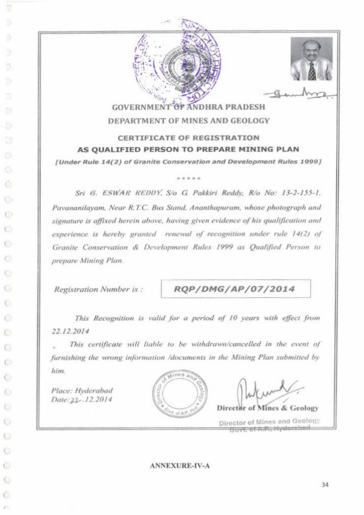
CERTIFICATE OF REGISTRATION
AS QUALIFIEO PERSON TO PREPARE MINING PLAN
{Und•r Rut• 14(2) of Gr•nlte Conservlftlon and Development Rules 1999}
••••
Sn 6 I:<;~•:.!R HIIJIJY. S!o G Pakkiri Retl</1. Rio No· 13-2-155- 1.
Pmvmaniloyam. Near R. 7 C. Bus Stand. Anantlwpuram. "hose phutuKraph mttl
slgtwlllt-e is aOh.-tl herein uhu•-e. having ~:iven l!l'idl'IIC<' of his qnalifica!lon ami
<'\[l<'rience i.1 hcn·by f!.rtmtnl n-11eunl u( recogmtwn under ,.,It! /4(21 a/
Granite Conret-.·atioll & l>ew.fopmeflf Rules 1999 "' Qutdified Pers<m to
prrpare Minill,'l Plan
Re,t:istrarion Number ts . RQP/DMG/ AP/07/2014 .:J 1J1is Rcco~11ilion iJ mlid }or a period of /0 years ~<ith ejfl'CI from
22. 12.2014
This cenif/cate will lwble tu be witlulrawllktmt•elled ill the <'' '""' oj
fumllhing tht' uronK informaliun 'documents in the Mining Plan \llbmmed 111
hint
Place.· Hyderabad Dw< ).~.12.2014
ANNEXURE-IV-A
0 1 , c tor of Min n<l Geolc

l
(
(
(
l
(_
(
l
(
,, (
(
(
\
(
(
(
l
(
(
(
(
(
(
l
l
l (
(
(
. '
. •
~ 'ttUIN ~~ SJ FCNTCF !lOA 'WPiW Tll lliiWCWA a ~ w.:•MOOI,..PI UUOI'-ES
at~dl'lf'<f ~ 16 ~ 1l 'flrqdf 1JlW1J If?! (~ ftlll1lll P-Mou'l<'ll. "*' ,. fli'IPI zztll ~ rn;CI)
l
OERTIFICATE OFAECOONITION ASQUAUREO PERSON (liM« Rille 22C of ...... Con; I Ilion RuiN, 11601
~ qufi•N -mom t His~ m:anberil>
35

0.0 krn I.Oion 2.0kon 3.0 ion 40km
PLATE NO -I
~ Signa1uoe ol R.Q.P
G. nwa.l(, lfttoot ~t.M .• e.t.. •~<JL Recogn1~ GeologJst
ISMIAOP/HV0/302120131A ROP10MGIAPJQ112014
tw$ 1$ TO CERJlFV lWil TJoC ~liON ll!ol J'tiiS lUTE If TI'IIJE .U.OCOI'II'IlCf tO 1H1 -sr OJ IIHOWUDOC ....st:O U" ON ~.lAM: loW' AIIIWCHflCAli!D 8Y STATE OOYEfllii,EWl'

·' \ot •5~ .,T
DISTRICT AW.NTAPURJJI.U- -;.-" MANDAL BOMMANHAL VILLAGE : NEMAKALLU
Q.L area hold by Mls.OA n A STONE CRUSHER an exlenl or e.ooo Hectares ,lull extent~tatosle< in faVOU< of Mls SAl TEJA STONE CRUSHER Prop:Sn C.Srill!Vasa Rao on extent of 6.000 Hectares tn S.No.253 of Nemakallu (V).Bommanohal (M).Anonrapuramu (Dt)
VILLAGE NO: 15 FIELD NO :253
l J 0 l. .. d$1lG~ .... ..._.dt000HIIacf-.
o ...... u,.~..., • .-.dos:D....._ [D o~,._.,.._". ,..., .. ....,..,,051~ rn o l ..... Sri, v.a ................ , ao "**""~ 0 l .. d..,. JrM:111 AM0C1Me OWif .,. -....11 fJ( I 000 tfee:lotel
(]] 0 I. ... 01 Ill .... H~ ........... O.Oel' 11nUIIIntol2 000...,_.
(1] 0 I. • •M 01 &n ft~ ~ O¥tr an edltnt ol1 OOOHKtotM
(l) 0 I. ... Of $n DW!yl~..., • Ill._,. d 1 StO Hldcle
GJ 0 l-fii&IR~IIta•tlfl*...,lll\...,.011)1$...._.. o ...... .,SI'IP,._,_..., .. ...,..,,ooo~ o ...... ~~.,.......,.,.....,.,_,...,...,owrt..--.
[!J o ~.. .. - .... ..,..~ ....... ..-.,os....,_ o ...... ..,.. ....... .._ __ ._.... •• ooo......, 0 L ... ofSI'iT &ww.iukl Htld11 0.. -~~~~· 351 ~
\Q L ... « Sll ~10...., en....,.of 1 OOC>Hec'-
) 0 \./tid ol $NH Rf~IW)'IptiM!oildOI'tl ... lintol2 000 HeCiore
t ~ 0 lflf .. oiSI'i~o.w""e:f(lll'llld1:186~
IO L••of&IM.~O.II'e...,.dtOOO...,_
Ol..,..,flliMiil~: ... :•:,.:·~,.=--ClWIW ..,.. .,.....,...,,.~ Ol..,.t/1.,_PS •• ..., ....... t/11100....,_ [: Q l._e1$nPS .,....,. ....... dtt»D~
o t. ... «s..~ ... .,. ........ ,ooo~ iO .......... r v s ...., .. GW<~ ""....,.. 018 eoo .....,_ 10 L .,, .. fll SfiMSWr...,•r-o .. an .. ._.. ot t.ooo Hldol ..
(" )0 l.,.. d Sll P ~d fNeiM lliiM 01 t 000 H«*)re J 0 l .,.. d &t T V S Kan1N1a0 tMt M e'l11111C 01 1 000 HICI!ol't
1 10 t.-ofSn~-.,.....,..or••~,..fiiiO ... I 0 L •• Gf 1o1o's Sit,.,.,_,.._,.,_,.~ a\~ d 4..10 ...,_
•
..... ,. __ -TRANSFEREE
; .......... ....,.... O,~to.ln __. 1 -·' lloO \o
-. • • • '
.... _...,. - -.. ._ ..... -·· t .. ,. • .,. -·· .. ,. .. ..... ,.,
-·~ ..... -·-..
•
:: r;. ··~
. ..
..
•
PLAT!. No.2
• ®
t --
___ .... ·~---
-
rl $sl Ill ..,._..... ............ AMLD~tl~·""*"'
...__ .. ~========~===~=-= .. ======~=====~==·==--===6-="========c-~==--===~====·=MNo==o.='=,~==~==~========~====~==========~~==~==================~--=~=~==-=·=_.==,==''~HM;;,=r==::U ~IJIVIUIIIV.
- ......... - ~ .. ~'·"' ·~'' ..... .... • ~ ...... .t c t..O. ............. ..
·-"*" 'Q ... t;lf ..

TOPOGRAPHICAL CUM GEOLOGICAL PLAN
iMPROVED H300tr----r----.--..------,--- -r---r----,---
,_, I !
N150
N100
N50
A
E50 E 100 E150 E250 E400
Geo Coordinates of lease area Datum WGS-84
POINTS LATITUDE LONGITUDE
A Nt5' 00' 3t.r E76' 56' 39.11"
8 N15' 00' 39.5"" E76' 56' 39 5"
c Nts• 00' .w.s· E76" 56' 52.5"
D NtS' 00' 31 .3" E76' 56' 52.8'
E Nt5' 00' 37.0' E76' 56' 49.0'
N
·<+>· PLATE - Ill
MINHJ PLAN FOR R()fd) METAl. I. 6\.fiii..OIHO STOtE
MIS.SAI TEJA STONE CRUSHERS I~ S.F.No.2M. Exl 8.000, NM'NI (V).
Bom!Ntllth ru DIMtlet MdiY~WI.
TOPOGRAPHICAL CUM GEOLOGICAL PLAN
- MIS.SAJ TEJA STONE CRUSHERS PJco;SilC.~ RIO.
~.~--,......,.,...~.
MPwlAoed.C • .....,. --
~· ----A-ciR,Q.P
G. nwu ttOC\ ......... ... . R~Ooclo;..C
l~,.l.iRQPIHV01l021201 )fA. F.OPJOMGIAP1'07120\• n.a• fOCERTIFYT*TTHE N"CINrAATIOHWTMI"""TI
• ~ AHO COMfCT TO THE BEST o,-JI(NOM,.IDQI_IASIEO U' OH l.fASE MAP A.UTHEHTICATEO IV SrAfl ~

GEOLOGICAL CROSS SECTIONS
, • •
. ............................. 11. ... - ................. ..
• • • • • • • •
• • • • • • • • • • • • • • • • • • • • •
• • • ~ ~ ~ . .
• •
• •
B'
A' 530
• • • •
PLATE - IV
INOEX
~ TOPSOIL
AOMMI!lAL
- IUff'f!IIZONI _..,...
~~~ G. UWAilfDO\ ... ........_ -. •
Aeeognooed Goologoot 18MIAOPIHYDI'J02J201:VA
ROP/OMG/AP/0712014
THII II fO CERTFY TH4T fHI! INrn.:IMATIOH IN THIS P\Afl • 1ltUE AHO CORReCT TO THE IEIT 01 KHOWlAOOIIA.S£0 UP ON LEASE MAP NJTHEHTlCAt(D 8V IYA11! 00\.'CRNMOO.
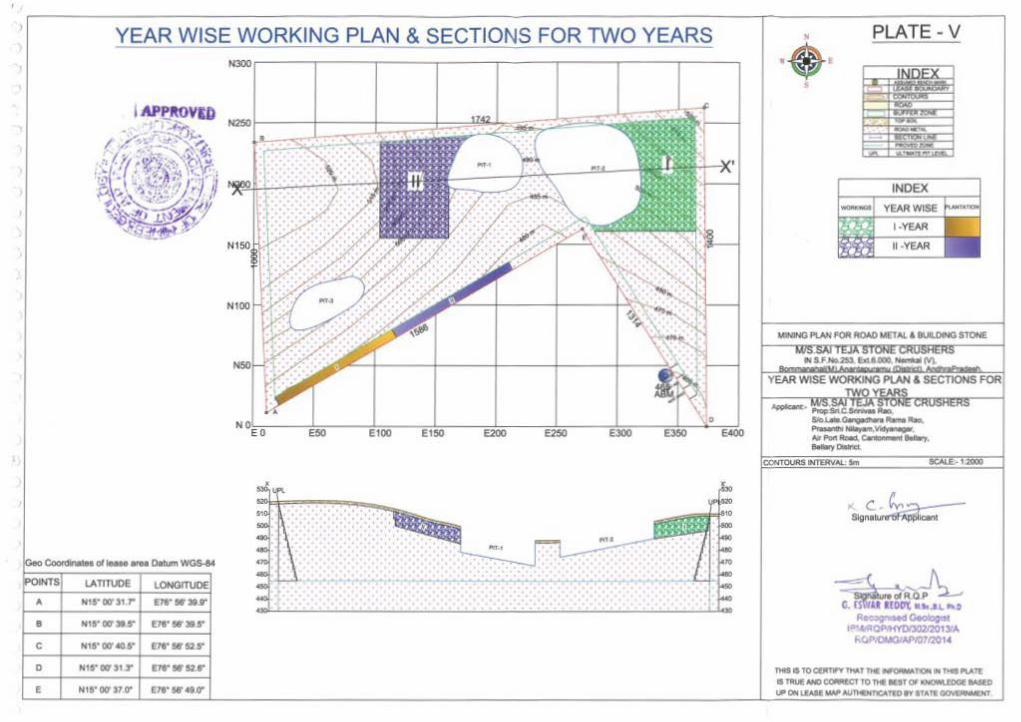
YEAR WISE WORKING PLAN & SECTIONS FOR TWO YEARS N&Or-----;------r----~-----,------r-----;------r-----
"''
8 N15"00'31F f1&"51'315"
c
0
E N15" 00' )1 V vt• W49tr
PLATE- V
lr.eiiNG PLAN FOA ROAD ~ETAL & 8UILOINO STONE
'MS liS TO CUt'TI'V """"T TH1 N()IIIJIM noN N ~ """Tt IS TlltUE NID COMfC'T fO Ml .. r 01 liCNO"" mae IMlD .... .,.

CONCEPTUAL PLAN AND SECTIONS
N~r-----,-----,------r-----,------r-----,-----,------,
. AI'Pft8Vm
• E50 EIOO Et 50 E200 E250 E300 E360 E400
·. Coonlnal .. ol ..... ..... O.tum WGS-14
_ .... lATITUDE LONGITVOE
A w1s·ocrS1 r E7rW3t.r
• Nts•w•r VI"WliiS
c Nt$• 00' 40 5' m·wou·
0 Nts-017313'" vrwsu·
E Hts~ 011 S1 v m•w.-to-
N
·<+>
CONCEPTUAl PLAN AHO SECTIONS
- · MIS SAl TEJA STONE CRUSHERS _..__ ~ ................. -...-. --»Pat~ .... ~..., --CONTOURS INfEftYAL &n
~--~ -oi~OP G. !IWU IIDD't • .._.~ ,..
Rr ,.-Oeolog0$1 r'-«<P.wvtWJ02120tliA
r.QPI()I,4QIAPIQ712014
. ' """'
fHIS IS TO ctlt'nFY f*T TH1 WC!Mioll noN .. nt1 "-ATt l$1"fll..,lf_N40COAR£CT TO nt1 ltiTQr I<NCM\.lOGIIASID t.PON I.QII...., AIJ'ftoCHT'ICATID rt llAfl ~
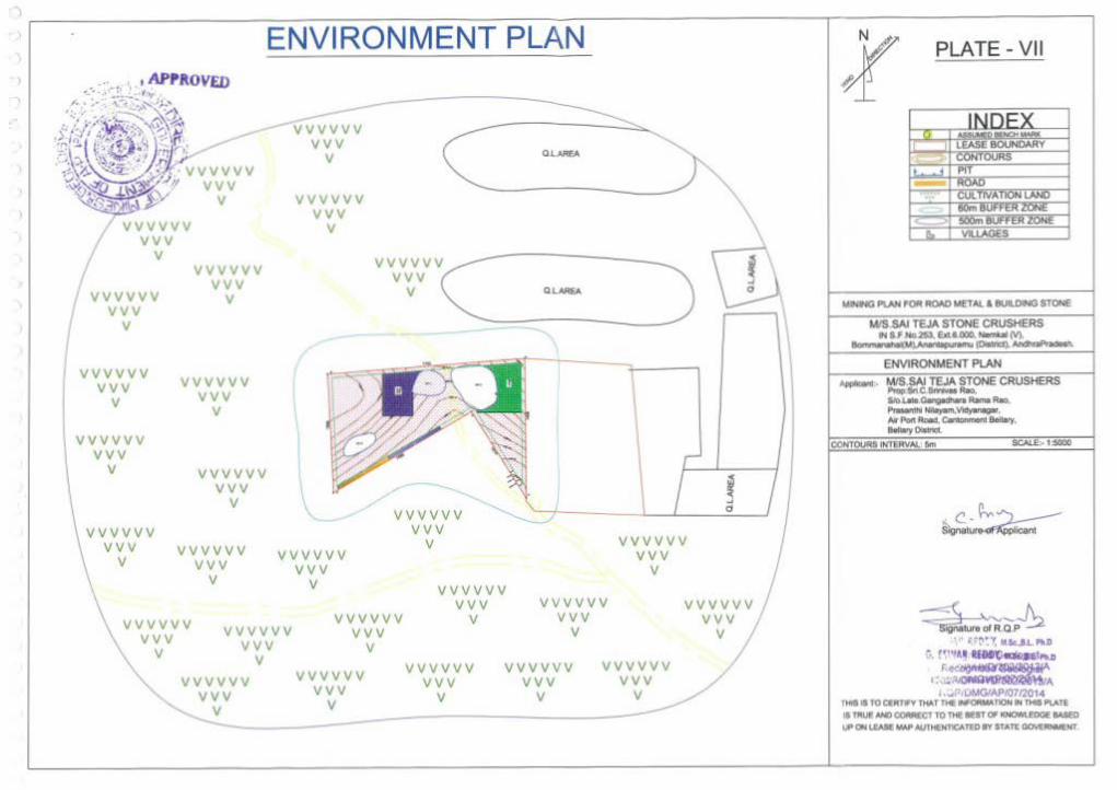
) ~-----------=~~~~~~~~-------------r~----------1 ENVIRONMENT PLAN l
vvvvvv vvv
v
vvvvvv vvv
v
vvvvvv vvv
v
vvvvvv vvv
v
vvvvvv vvv
v
vvvvvv vvv
v
vvvvvv vvv
v
vvvvvv vvv
v
vvv vvv vv v
v
\
vvvvvv vvv
v
vvvvvv vvv
v
vvvvvv vvv
v
vvvvvv vvv
vvvvvv vvv
v
\L
vvvvvv vvv vvvvvv
vvv vvvvvv
vvv v
vvvvvv vvv
v
vvvvvv vvv
v v
vvvvvv vvv
v
v vvvvvv
vv v v
v vvvvvv
vvv v
vvvvvv vvv
v
vvvvvv vvv
v
\ I - ·
PLATE- VII
EHVIRONMENT PlAN
SCALE:- t:!IOOO
-::fk;~vr. 'c~'R.O P~ ' . .-.~(1 ·--r, M..Sc.,I.L PU)
~. !f'''•• ·ltfll'(1..,_.,..,0 r .• .,.,.._~.
"·"·~ ~ ... i . ..,P,IJMGIAPJ0712014
THIIIITOQMINl*T fiC~r'IOM 1H OGPI.ATE II TM.If N1J OOIWCT TO nte lEtT 0* ICNOWI..EDQE lASED "Qlrrl LIAM W# MmtlNT1CA1'tD 1'1' 5TATE OOV£~