Embed Size (px)
DESCRIPTION
Danube National Roadmap
Citation preview

Fairway Rehabilitation and Maintenance Master Plan for the
Danube and its navigable tributaries:
NATIONAL ROADMAPS
EU Strategy for the Danube Region,
Priority Area 1a – To improve mobility and multimodality: inland waterways
Final version 24th July 2015
Disclaimer
This document was prepared within the framework of the EU Strategy for the Danube Region,
Priority Area 1a on Inland Waterways and in cooperation with the NEWADA duo project (co-
funded by the South-East Europe Transnational Cooperation Programme). The compilation and
analysis of the data was performed by the PA1a Technical Secretariat, in close coordination with
both the PA1a Steering Group Members and the NEWADA duo project partners.
This is a technical document and does not constitute international law. In its implementation,
international law as well as EU and national legislation have to be respected. Graphical
presentations (maps) and written descriptions regarding the borders are made exclusively for the
purpose of this document as information and this document shall not affect in any way the
determination and marking of state borders.
2
Contents
1 Executive summary ........................................................................................................................ 6
2 Introduction ..................................................................................................................................... 7
3 Germany ........................................................................................................................................ 10
3.1 DE | Status report on main critical locations 2012-2014 ................................................. 10
3.2 DE | Hydrological conditions on main critical locations 2012-2014 ................................ 11
3.3 DE | Water level information on main critical locations 2012-2014 ............................... 11
3.4 DE | Water level prognoses for critical locations ............................................................... 12
3.5 DE | Time from surveying to action: maintenance philosophy .......................................... 12
3.6 DE | Key issues and related activities 2014 ...................................................................... 14
3.7 DE | Review of rehabilitation and maintenance activities 2014 ...................................... 14
3.8 DE | Operational and investment costs .............................................................................. 16
3.9 DE | Outlook: planned actions, milestones and funding sources ..................................... 18
4 Austria ........................................................................................................................................... 19
4.1 AT | Status report on main critical locations 2012-2014 ................................................. 19
4.2 AT | Hydrological conditions on main critical locations 2012-2014 ................................ 21
4.3 AT | Water level information on main critical locations 2012-2014 ................................ 21
4.4 AT | Water level prognoses for critical locations ................................................................ 23
4.5 AT | Time from surveying to action: maintenance philosophy .......................................... 23
4.6 AT | Key issues and related activities 2014 ...................................................................... 24
4.7 AT | Review of rehabilitation and maintenance activities 2014 ....................................... 25
4.8 AT | Operational and investment costs .............................................................................. 27
4.9 AT | Outlook: planned actions, milestones and funding sources ..................................... 29
5 Slovakia ......................................................................................................................................... 30
5.1 SK | Status report on main critical locations 2012-2014 ................................................. 30
5.2 SK | Hydrological conditions on main critical locations 2012-2014 ................................ 33
5.3 SK | Water level information on main critical locations 2012-2014 ............................... 33
5.4 SK | Time from surveying to action: maintenance philosophy .......................................... 34
5.5 SK | Key issues and related activities 2014 ...................................................................... 36
5.6 SK | Review of rehabilitation and maintenance activities 2014 ...................................... 37
5.7 SK | Operational and investment costs .............................................................................. 39
5.8 SK | Outlook: planned actions, milestones and funding sources ..................................... 40
6 Hungary ......................................................................................................................................... 43

3
6.1 HU | Status report on main critical locations 2012-2014 ................................................ 43
6.2 HU | Hydrological conditions on main critical locations 2012-2014 ............................... 46
6.3 HU | Water level information on main critical locations 2012-2014 ............................... 46
6.4 HU | Water level prognoses for critical locations ............................................................... 48
6.5 HU | Time from surveying to action: maintenance philosophy ......................................... 51
6.6 HU | Key issues and related activities 2014 ...................................................................... 51
6.7 HU | Review of rehabilitation and maintenance activities 2014 ...................................... 52
6.8 HU | Operational and investment costs ............................................................................. 53
6.9 HU | Outlook: planned actions, milestones and funding sources .................................... 54
7 Croatia ........................................................................................................................................... 55
7.1 HR | Status report on main critical locations 2012-2014 ................................................ 55
7.2 HR | Hydrological conditions on main critical locations 2012-2014 ............................... 59
7.3 HR | Water level information on main critical locations 2012-2014 ............................... 59
7.4 HR | Water level prognoses for critical locations ............................................................... 61
7.5 HR | Time from surveying to action: maintenance philosophy ......................................... 61
7.6 HR | Key issues and related activities 2014...................................................................... 63
7.7 HR | Review of rehabilitation and maintenance activities 2014 ...................................... 64
7.8 HR | Operational and investment costs ............................................................................. 65
7.9 HR | Outlook: planned actions, milestones and funding sources .................................... 66
8 Serbia ............................................................................................................................................ 69
8.1 RS | Status report on main critical locations 2012-2014 ................................................. 69
8.2 RS | Hydrological conditions on main critical locations 2012-2014 ................................ 76
8.3 RS | Water level information on main critical locations 2012-2014 ............................... 76
8.4 RS | Water level prognoses for critical locations ............................................................... 78
8.5 RS | Time from surveying to action: maintenance philosophy .......................................... 78
8.6 RS | Key issues and related activities 2014 ...................................................................... 79
8.7 RS | Review of rehabilitation and maintenance activities 2014 ...................................... 80
8.8 RS | Operational and investment costs .............................................................................. 81
8.9 RS | Outlook: planned actions, milestones and funding sources ..................................... 82
9 Bosnia and Herzegovina .............................................................................................................. 83
9.1 BA | Status report on main critical locations 2012-2014 ................................................. 83
9.2 BA | Hydrological conditions on main critical locations 2012-2014 ................................ 84
9.3 BA | Water level information on main critical locations 2012-2014 ................................ 84
4
9.4 BA | Water level prognoses for critical locations ............................................................... 84
9.5 BA | Time from surveying to action: maintenance philosophy .......................................... 84
9.6 BA | Key issues and related activities 2014 ...................................................................... 84
9.7 BA | Review of rehabilitation and maintenance activities 2014 ...................................... 85
9.8 BA | Operational and investment costs .............................................................................. 85
9.9 BA | Outlook: planned actions, milestones and funding sources ..................................... 86
10 Romania .................................................................................................................................... 87
10.1 RO | Status report on main critical locations 2012-2014 ................................................ 87
10.2 RO | Hydrological conditions on main critical locations 2012-2014................................ 89
10.3 RO | Water level information on main critical locations 2012-2014 ............................... 89
10.4 RO | Water level prognoses for critical locations ............................................................... 89
10.5 RO | Time from surveying to action: maintenance philosophy ......................................... 90
10.6 RO | Key issues and related activities 2014 ...................................................................... 90
10.7 RO | Review of rehabilitation and maintenance activities 2014 ...................................... 94
10.8 RO | Operational and investment costs ............................................................................. 97
10.9 RO | Outlook: planned actions, milestones and funding sources .................................... 99
11 Bulgaria .................................................................................................................................. 104
11.1 BG | Status report on main critical locations 2012-2014 ............................................. 104
11.2 BG | Hydrological conditions on main critical locations 2012-2014 ............................ 104
11.3 BG | Water level information on main critical locations 2012-2014 ............................ 105
11.4 BG | Water level prognoses for critical location .............................................................. 105
11.5 BG | Time from surveying to action: maintenance philosophy ...................................... 105
11.6 BG | Key issues and related activities 2014................................................................... 105
11.7 BG | Review of rehabilitation and maintenance activities 2014 ................................... 107
11.8 BG | Operational and investment costs .......................................................................... 108
11.9 BG | Outlook: planned actions, milestones and funding sources ................................. 110
12 Moldova .................................................................................................................................. 112
12.1 MD | Status report on main critical locations 2012-2014............................................. 112
12.2 MD | Hydrological conditions on main critical locations 2012-2014 ............................ 112
12.3 MD | Water level information on main critical locations 2012-2014 ........................... 112
12.4 MD | Water level prognoses for critical locations ........................................................... 112
12.5 MD | Time from surveying to action: maintenance philosophy...................................... 112
12.6 MD | Review of rehabilitation and maintenance activities 2014 .................................. 112

5
12.7 MD | Operational and investment costs .......................................................................... 113
12.8 MD | Outlook: planned actions, milestones and funding sources ................................. 114
13 Ukraine ................................................................................................................................... 115
13.1 UA | Status report on main critical locations 2012-2014 .............................................. 115
13.2 UA | Hydrological conditions on main critical locations 2012-2014 ............................. 115
13.3 UA | Water level information on main critical locations 2012-2014 ............................. 116
13.4 UA | Water level prognoses for critical locations ............................................................ 116
13.5 UA | Time from surveying to action: maintenance philosophy ....................................... 117
13.6 UA | Key issues and related activities 2014 ................................................................... 118
13.7 UA | Review of rehabilitation and maintenance activities 2014 ................................... 118
13.8 UA | Operational and investment costs ........................................................................... 119
13.9 UA | Outlook: planned actions, milestones and funding sources .................................. 120
14 Synthesis and conclusions ................................................................................................... 122
6
Introduction
1 Executive summary
This roadmap report illustrates the status and planned next steps for rehabilitation and
maintenance activities in the Danube riparian countries. It is based on the Fairway Rehabilitation
and Maintenance Master Plan for the Danube and its navigable tributaries as it was endorsed by
the Danube Transport Ministers in December 2014. By means of the roadmaps at hand, the
implementation of the Master Plan shall be monitored once a year.
In 2014 in total, 1.569.601 m³ were dredged along the Danube and Drava rivers. Fairway
conditions were generally good in 2014, with the exception of the Upper Danube (Germany,
Austria). The fairway conditions on the Middle and Lower Danube were good. This was however
mainly due to the favourable hydrological conditions, as water levels hardly fell below the low
navigable water level.
Available operational budgets for maintenance activities largely differed among the Danube
riparian states in 2014. Especially on the Lower Danube, operational budgets appear to be too
low to cover basic maintenance activities (surveying, marking, dredging). The same goes for
required investments: Taking the available national data into account, partly secured budgets are
available for only for 13% of the required investments as identified in the Fairway Rehabilitation
and Maintenance Master Plan of 2014. Even this proportion is for a main part dependent on the
FAIRway projects, as proposed for funding within the Connecting Europe Facility. In total, an
amount of 75.732.766 EUR (87%) for required investments is not yet covered by secured
budgets in the respective countries.
Regarding the financing gap for operational costs (secured budgets 2015 compared to actually
needed financial means), especially the budget situation in Bulgaria seems to be precarious, as
1.219.991 EUR for operational costs would be lacking in the year 2015.

7
Introduction
2 Introduction
Purpose of roadmap reports
In their conclusions of 3rd December 2014 regarding the Fairway Rehabilitation and Maintenance
Master Plan for the Danube and its Navigable Tributaries, the Danube Transport Ministers agreed
to “establish (...) national roadmaps which identify individual actions, responsibilities, funding
resources and intermediate milestones for the implementation of these measures and to
communicate these roadmaps by 30th June 2015 to the relevant coordinating bodies”. This is in
line with Regulation (EU) No 1315/2013 of the European Parliament and of the Council of 11
December 2013 on Union guidelines for the development of the trans-European transport
network, obliging EU Member States to preserve a good navigation status, while respecting the
applicable environmental law. In the Danube Region the “Joint Statement on Guiding Principles
for the Development of Inland Navigation and Environmental Protection in the Danube Basin”,
endorsed in 2007 by the ICPDR (International Commission for the Protection of the Danube
River), Danube Commission and the International Sava River Basin Commission (ISRBC), thereby
is a key tool providing guidance for the planning and implementation of waterway projects.
Scope of roadmap reports
Based on the ministerial conclusions of December 2014, PA1a of the EU Strategy for the Danube
Region initiated the elaboration of national roadmaps in spring 2015. They follow a harmonized
structure, in order to produce comparable results for the Danube region. This document therefore
contains a systematic analysis of main critical locations in the years 2012 to 2014, the
hydrological conditions, maintenance activities in the year 2014, the status of operational and
investment costs, as well as an outlook on planned actions, milestones and funding sources.
The document by and large focuses on the most critical sections, which had been identified by a
sample of 24 important shipping organisations in December 2014. In sum, following stretches
clearly stood out from the remaining critical locations, which had been identified in the Master
Plan.

8
Introduction
From the user perspective, the locations and stretches listed below cause the biggest
navigational problems and should consequently be treated with the highest priority.
location and length (km) right bank /
left bank name of sector or location
river-km (from - to) length
2,321.70 2,312.20 9,50 DE / DE Straubing (lock)–Straubing-Sand (port)
2,312.20 2,282.50 29,70 DE / DE Straubing-Sand (port)–Deggendorf
2,282.50 2250,00 32,50 DE / DE Deggendorf – Vilshofen
(backwater Kachlet)
2,230.40 2229,30 1,10 DE / DE Tailwater Kachlet and Auerbacher Eck
2,014.00 2,013.50 0,50 AT / AT Weißenkirchen
2,010.20 2,008.90 1,30 AT / AT Dürnstein
1,888.40 1,887.60 0,80 AT / AT Treuschütt
1,884.70 1,883.50 1,20 AT / AT Hainburg
1,735.50 1,733.70 1,80 HU / SK Nyergesújfalu
1,698.00 1,697.00 1,00 HU / HU Dömös
1,638.40 1,637.40 1,00 HU / HU Budafok
1,559.80 1,559.70 0,10 HU / HU Dunaföldvár
1,558.50 1,557.50 1,00 HU / HU Solt
1,408.20 1,400.00 8,20 HR / RS Apatin
309,00 308,00 1,00 RO / RO Cochirleni
568,20 567,80 0,40 BG / RO Milka Island
567,00 566,70 0,30 BG / RO Belene Island
562,00 561,50 0,50 BG / RO Coundur Island
541,60 541,00 0,60 BG / RO Vardim Island
538,50 537,00 1,50 BG / RO Giska Island
425,90 425,20 0,70 BG / RO Kosui Island
Recommended Levels of Service
Notwithstanding the provisions of the "European Agreement on Main Inland Waterways of
International Importance" (AGN) and the "Recommendations on Minimum Requirements for
Standard Fairway Parameters, Hydrotechnical and Other Improvements on the Danube" published
by the Danube Commission, the waterway management experts represented in NEWADA duo
recommended different minimum Levels of Service for the different phases in the waterway
maintenance cycle. The recommended minimum Level of Service related to fairway depth was
thereby defined as 2.50 m at Low Navigable Water Level (LNWL or ENR / Etiage navigable et de
regularisation), i.e. on 94% (343 days) of the year, calculated on the basis of the discharge
observed over a period of 30 years with the exception of ice periods. It should however be noted
that these minimum Levels of Service only apply to the countries participating in NEWADA duo.
9
Introduction
With few exceptions (e.g.in German1 and Hungarian Danube), this level of service should normally
be achievable with maintenance measures (ranging from surveying, fairway marking/relocation to
dredging), that is, without structural infrastructural interventions. The overall aim is to reduce the
need for physical interventions by gaining more targeted information on the actual status of
critical waterway locations. Thereby, costs needed for maintenance activities should be
optimised, environmental impacts reduced, while achieving the recommended levels of service at
the same time. This consolidated roadmap report for the first time provides a solid and
transparent data basis for a more targeted maintenance strategy in the Danube Region.
1 Germany is not partner of the NEWADA duo project and consequently has not agreed on the minimum
Levels of Service developed in this project
10
National Roadmap: Germany
3 Germany
The Federal Waterways and Shipping Administration (WSV) is responsible for fairway
maintenance.
3.1 DE | Status report on main critical locations 2012-2014
Number of days with fairway depths above 2.00 m (target value2) for main critical locations
Critical location 2012 2013 2014
Lock Straubing–
Port Straubing-Sand 352 362 335
Port Straubing-Sand–
Deggendorf 332 359 320
Deggendorf–Vilshofen 352 330 272
Auerbacher Eck
Tailwater lock Kachlet
Here are no limitations in terms of fairway depths (bedrock) but this a
bottleneck concerning fairway width (location to be omitted next report)
Status of critical sections 2012–2014
During 2012–2014 there was no critical sedimentation in the first section from lock Straubing to
port Straubing-Sand. That is why the number of days with fairway depths above 2.00 m (target
value1) is equal to the number of days with available water levels above LNWL (cf. 2.3).
Regarding the section from port Straubing-Sand up to the city of Deggendorf dredging activities
had to be undertaken above all in the (late) summer of 2012. Sedimentation formed an obstacle
above all in the low water period end of July. In 2013 existing sedimentation do not yield fairway
limitations due to sufficient available water levels (sole exception: few days in August). The main
reasons for not meeting the target value1 of 2.00 m below LNWL in 2014 lied in the combination
of required dredging works and low water levels in April and June.
In section Deggendorf–Vilshofen in 2012 sedimentation lead to fairway limitations only for a
couple of days in August, combined with particularly low water levels. 2013 was characterized by
massive disturbing sedimentation in August and September due to the recent flood event. In
2014 the fairway still was restricted above all in March, April and June followed by short periods
in August and September.
2 In the free flowing section between Straubing and Vilshofen a fairway depth of 2.50 m as defined by
NEWADA duo is neither developable nor maintainable. In this section the objective is to maintain the
fairway depth of 2.00 m related to LNWL (in Germany: RNW).

11
National Roadmap: Germany
3.2 DE | Hydrological conditions on main critical locations 2012-2014
Number of days with water levels above multiannual average flow discharge (MW)
Critical location Reference
gauge
No. of days above MW
2012 2013 2014
Lock Straubing–
Port Straubing-Sand Pfelling 157 219 51
Port Straubing-Sand–
Deggendorf Pfelling 157 219 51
Deggendorf–Vilshofen Hofkirchen 185 224 59
Auerbacher Eck
Tailwater lock Kachlet Passau 204 175 83
3.3 DE | Water level information on main critical locations 2012-2014
Number of days with water levels above LNWL (in Germany: RNW)
Critical location Reference
gauge
No. of days above LNWL (RNW)
2012 2013 2014
Lock Straubing–
Port Straubing-Sand Pfelling 352 362 335
Port Straubing-Sand–
Deggendorf Pfelling 352 362 335
Deggendorf–Vilshofen Hofkirchen 360 365 351
Auerbacher Eck
Tailwater lock Kachlet Passau 365 365 354
150
200
250
300
350
400
450
500
550
600
650
700
01.01. 01.02. 01.03. 01.04. 01.05. 01.06. 01.07. 01.08. 01.09. 01.10. 01.11. 01.12.
Wa
ter
lev
el [c
m]
Water level gauge Hofkirchen 2012-2014
2012 2013 2014
RNW MW HSW
HSW = 480 cm
MW = 298 cm
RNW = 207 cm
31.12

12
National Roadmap: Germany
Status of critical sections 2012–2014
From a hydrological point of view, 2013 was a wet year for the German Danube, which also
includes a flood event in June 2013 (cf. 2.2), which is only likely to occur approximately every 40
years (reference gauge Hofkirchen: upstream effects from dike break in Deggendorf and
confluence river Isar). While there were few low water periods in 2012, there were remarkable low
water periods in 2014 above all for the section Straubing–Deggendorf (upstream confluence
Isar).
3.4 DE | Water level prognoses for critical locations
Current water levels (1x/hour for flood events) and 48–72 h forecasts (floods: provision by
Bavaria, low water: provision by WSV) for 9 automatic gauge stations along the German Danube
are available online: https://www.pegelonline.wsv.de, http://www.hochwasserzentralen.de and
www.elwis.de. Data is transferred regularly via landline (back-up: GPRS). The water level forecast
for the critical locations within the section Straubing–Vilshofen (gauges Pfelling, Deggendorf and
Hofkirchen) are provided online in order to facilitate early recognition of low water periods (cf.
example figure gauge station Hofkirchen).
3.5 DE | Time from surveying to action: maintenance philosophy
For a better understanding of relevant operation, maintenance and administration processes
(including reporting channels), it is essential to briefly describe the organisational structure of the
Federal Waterways and Shipping Administration (WSV) which is a subordinate body of the Federal
Ministry of transport and Digital Infrastructure (BMVI). For the southern district the responsible
authority at intermediate level is the branch office of the Directorate-General for waterways and
shipping (GDWS) located in Würzburg. More than 1,500 employees at different locations are
engaged in issues concerning the federal waterways Main, Main-Danube-channel and Danube.
The Waterways and Shipping Office in Regensburg (more than 300 employees) is the authority at
lower level which is responsible for operation and maintenance of the Danube. That includes four
13
National Roadmap: Germany
local branch offices (operating centres in Regensburg, Straubing, Deggendorf and Passau) as well
as a construction depot in Passau.
The WSV has nationwide implemented regional sounding concepts each taking into account
specific local boundary conditions and constraints in terms of techniques and processes. Updates
in a concept are conducted dependent on requirements while each year all concepts are subject
to a performance review by the BMVI. Concepts contain determination as regards staff (capacity,
skills), equipment, techniques, and frequency of measurements. Moreover, there are
organisational specifications (TQM, operating times, goal realisation level, standardisation) and
the assessment of future need for action (meeting standards, acquisition/provision, training
concept). Each year dredging statistics and charts are prepared ex-post for documentation
purposes and to set up the future sediment management (lessons learned, identification of
critical locations).
Sedimentation and corresponding fairway limitations are reported to the responsible branch
office within 2 days (in case of imminent danger on the very same day) after surveying.
Sometimes, branch offices execute additional soundings to determine the extent or cubature of a
deposit. Dredging companies are ordered via tendering procedure based on the edited data
(preparation, post-processing). The whole process (detection of an obstacle beginning of
required dredging works on site) lasts 3 weeks on average. In uncritical situations where the
regulation of shipping traffic is initially sufficient, dredging is postponed until several measures
can be tendered as one cluster.
After receiving information from the branch office the Shipping Office announces relevant fairway
depths/limitations on the very same day (the next day at latest) via Notices to skippers.
Announcements include entries for the whole German Danube with highlighted current changes.
Publication is done via ELWIS (www.elwis.de), apps for smartphones, e-mail news service and at
locks (score board, display panel). IENCs are available and updated every 4 years (including
fairway information, but no bathymetric IENCs).
Additional information (no key issue of maintenance): Generally, knowledge of the reach
Straubing–Vilshofen is postulated for the skippers including possible locations for two-way traffic.
In case of special incidents or imminent danger (e.g. floods, naval accidents, limitations of certain
vessel combination, closures, one-way traffic, prohibition of downstream navigation) separate
Directives are issued. Sometimes river police and branch office staff have to be on site in order to
warn inland navigation (sharp lookout). Besides, also the dredging activities are announced via
Directive.

14
National Roadmap: Germany
3.6 DE | Key issues and related activities 2014
Activities performed related to the key issues illustrated in the Fairway Rehabilitation and
Maintenance Master Plan (version: December 2014):
3.7 DE | Review of rehabilitation and maintenance activities 2014
The following activities relate to the entire German Federal Waterway Danube.
Surveying activities 2014
Monitoring of the fairway is conducted annually. Every two years the navigable water beyond the
fairway is recorded. These measurements (survey for several purposes) are performed by the
sounding vessel “Kepler” via trifold multibeam echosounder (each producing a swath of depth
readings from a single ping). Furthermore, the free flowing section Straubing–Vilshofen is
measured each year to safeguard safety and ease of shipping by means of multiple single beams
mounted on a frame (sounding vessel “Tangens”). Additional surveying is executed after special
incidents (e.g. floods, naval accidents). The following table exclusively contains scheduled
interregional soundings. Additional local soundings which are conducted by the branch offices
(see 2.3) are neither projectable nor calculable. Surveying activities in the context of new
constructions or upgrading measures are also not included.
River-km (from-to) Frequency of surveying Type of survey (single/multibeam)
2201,7 – 2247,0 Once p.a. Trifold Multibeam echosounder
2247,0 – 2327,5 Twice p.a. Trifold Multibeam echosounder (1x)
Multiple single beams mounted on a frame (1x)
2327,5 – 2414,7 Once p.a. Trifold Multibeam echosounder
Key issues Need for action Activities performed 2014
DE
01
20% of dredging works may
be conducted by WSV itself,
while 80% are tendered
(providing sufficient
available capacity)
Preserve a certain percentage of
execution by the authority itself to
keep professional expertise,
equipment, skilled staff, autonomy,
and the capacity to act in special
market or emergency situations
Dredging activities overall:
125.935 m³
Thereof government-
operated: 0 m³
DE
02
Enhancing the information
on water levels
Implementation of an hourly push-
mode
(currently pull-mode via modem)
Planning, design and
preparation works but no
realisation

15
National Roadmap: Germany
Fairway relocation activities 2014
Not relevant in Germany in 2014: Due to the geometrical and hydraulic boundary conditions at
the German Danube (e.g. small width, narrow curves, small discharges) there is rarely opportunity
to relocate the fairway.
Dredging activities 2014
The following fairway dredging measures for commercial navigation were conducted on the
German Danube.
In total 125.935 m³ were dredged for commercial navigation in 2014.
Designation of assignment Dredging site
(river-km)
Dumping or placement
site (river-km)
Beginning and end of service Material Quantity
m³
Erlau (reservoir Jochenstein) 2214,650 - 2214,400 2213,800 - 2213,200 23.11.2013 - 03.12.2013 Sand / Gravel 9.792,20
Passau (tailwater Kachlet) 2222,280 - 2222,080 2221,000 - 2219,000 25.11.2013 - 04.02.2014 Sand / Gravel 13.828,20
2228,400 - 2228,200 2225,000 - 2224,000 16.12.2013 - 17.12.2013 Sand / Gravel 1.630,90
2228,400 - 2228,200 2225,000 - 2224,000 17.12.2013 - 19.12.2013 Sand / Gravel 4.473,00
2230,872 - 2230,780 2231,200 S - 2231,100 S 10.01.2014 - 04.02.2014 Sand / Gravel 23.521,40
2256,555 - 2256,155 2230,872 - 2230,780 24.03.2014 - 17.04.2014 Sand / Gravel 23.836,00
2256,555 - 2256,155 2268,150 - 2268,150 13.05.2014 - 28.05.2014 Sand / Gravel 11.257,20
2284,450 - 2283,980 2282,400 - 2282,250 20.01.2014 - 22.01.2014 Sand / Gravel 4.560,40
2285,850 - 2285,650 2282,400 - 2282,250 12.03.2014 - 17.03.2014 Sand / Gravel 250,00
2285,925 - 2285,875 2282,400 - 2282,250 12.03.2014 - 17.03.2014 Sand / Gravel 83,50
Straubing - Vilshofen 2285,800 - 2285,650 2282,400 - 2282,250 18.03.2014 Sand / Gravel 250,00
(free flowing section) 2266,475 - 2266,050 2278,000 - 2277,200 18.03.2014 Sand / Gravel 1.563,90
2267,400 - 2267,250 2278,000 - 2277,200 18.03.2014 Sand / Gravel 417,20
2263,400 - 2263,025 2261,900 - 2261,600 20.03.2014 - 21.03.2014 Sand / Gravel 2.178,20
2261,175 - 2260,850 2261,900 - 2261,600 24.03.2014 - 26.03.2014 Sand / Gravel 1.750,00
2259,325 - 2258,750 2261,900 - 2261,600 09.04.2014 - 16.04.2014 Sand / Gravel 2.785,20
2349,000 - 2348,700 2348,740 - 2348,375 01.07.2013 - 06.05.2014 Sand / Gravel 5.585,80
2349,000 - 2348,700 2350,840 - 2350,400 01.07.2013 - 06.05.2014 Sand / Gravel 5.994,50
Pfatter (tailwater Straubing) 2351,200 - 2350,400 2352,125 - 2351,685 01.07.2013 - 06.05.2014 Sand / Gravel 1.226,10
2351,200 - 2350,400 2352,800 - 2352,625 01.07.2013 - 06.05.2014 Sand / Gravel 817,40
2349,000 - 2348,700 2348,740 - 2348,375 01.07.2013 - 06.05.2014 Sand / Gravel 3.108,59
2267,250 - 2267,200 Removal 18.08.2014 - 26.08.2014 Sand / Gravel 1.202,00
Straubing - Vilshofen 2256,150 - 2255,000 Removal 20.08.2014 - 26.08.2014 Sand / Gravel 4.151,60
(free flowing section) 2309,100 - 2308,825 Removal 27.08.2014 - 01.09.2014 Sand / Gravel 1.671,90
16
National Roadmap: Germany
3.8 DE | Operational and investment costs
Operational costs 2014
Operation and maintenance works are mandatory tasks (sovereign duties) of the Federal
Waterways and Shipping Administration (WSV). Due to in-house efforts a complete assignment of
tangible costs per need area is not possible. The sum (see below) only comprises all definable
costs. Therefore, it is in fact substantially larger due to the intangible in-house expenses.
Need areas Actual costs 2014 (Euro)
Minimum fairway parameters (dredging, cf. 2.5) 1.171.730
Surveying of the riverbed (cf. 2.5) 185.000 (scheduled interregional soundings)
plus intangible in-house expenses
Water level gauges (cf. 2.3) 25.000 (material costs + external services)
plus intangible in-house expenses
Marking of the fairway Intangible in-house expenses
Availability of locks / lock chambers Intangible in-house expenses
Information on water levels and forecasts
Co-operation with Free State of Bavaria
+ German Federal institute of hydrology (BfG)
+ German Weather Service (DWD)
Intangible in-house expenses
Information on fairway depths
Information on marking plans
Meteorological information
Other needs -
Sum (only definable costs) 1.381.730
Secured operational budget 2015
Data currently not available and in general not tangible (cf. 2014).
17
National Roadmap: Germany
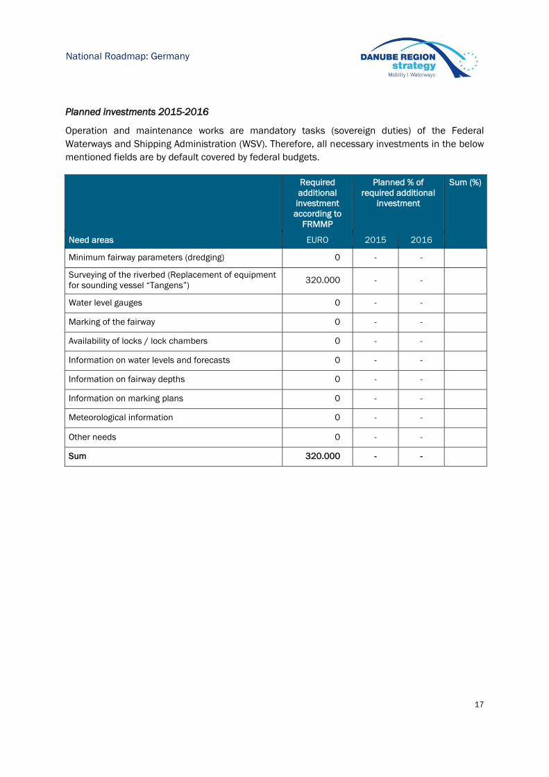
Planned investments 2015-2016
Operation and maintenance works are mandatory tasks (sovereign duties) of the Federal
Waterways and Shipping Administration (WSV). Therefore, all necessary investments in the below
mentioned fields are by default covered by federal budgets.
Required
additional
investment
according to
FRMMP
Planned % of
required additional
investment
Sum (%)
Need areas EURO 2015 2016
Minimum fairway parameters (dredging) 0 - -
Surveying of the riverbed (Replacement of equipment
for sounding vessel “Tangens”) 320.000 - -
Water level gauges 0 - -
Marking of the fairway 0 - -
Availability of locks / lock chambers 0 - -
Information on water levels and forecasts 0 - -
Information on fairway depths 0 - -
Information on marking plans 0 - -
Meteorological information 0 - -
Other needs 0 - -
Sum 320.000 - -

18
National Roadmap: Germany
3.9 DE | Outlook: planned actions, milestones and funding sources
DE 01: 20% of dredging works may be conducted by WSV itself (providing sufficient available capacity
for government-operation)
Planned activities: Continuous training (personnel), maintenance and repair
(gear) to provide skilled operational staff and appropriate
equipment
Current shortcomings: No current shortcomings identified
Possible funding: Budget availability 2015/2016: Sufficient national funding
is available
Next steps: Market Observation (current dredging prices), monitoring
waterway (safety and ease of shipping)
permanent
DE 02: Improved water level information
Planned activities: Provision of hardware
Implementation of an hourly push-mode
Current shortcomings: No current shortcomings identified
Possible funding: Budget availability 2015/2016: National Funding is
assured
Next steps: Improvement of central EDP systems in terms of availability
including redundancy
until 12/16

19
National Roadmap: Austria
4 Austria
viadonau– Österreichische Wasserstraßen-Gesellschaft mbH (state owned) is responsible for
fairway maintenance.
4.1 AT | Status report on main critical locations 2012-2014
Number of days with fairway depths >2,50 m on main critical locations
Critical location 2012 2013 2014
Wachau 366 359 352
East of Vienna 318 315 222
Status of critical locations 2013
In the first half of 2013 both free-flowing stretches of the Danube in Austria recorded the
availability of consistent water depths of more than 2.5 metres in the main channel. This was also
the case during the months of October and November, which are normally characterised by low
water levels. The high waters in June caused sedimentation of approximately 1.3 million m3 of
gravel and fine sediment in the fairway leading to restrictions on the availability of fairway depths
to the east of Vienna during the following months of July and August when water levels fell. By the
end of 2013 dredging carried out by viadonau had resulted in approximately 470,000 m3 of
aggradation sediment being removed from the fairway.
The impact of the high water in June 2013 on the stretch east of Vienna was drastic. Decreasing
water levels during the months of July and August led to a minimum water depth of 2.5 metres on
just 36% of days. With average daily water levels of just 30 cm above low navigable water level
(LNWL 2010) recorded at the Wildungsmauer reference gauge in the second half of the month of
20
National Roadmap: Austria
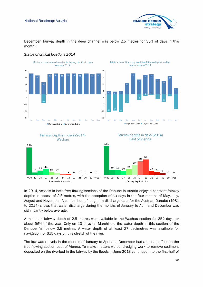
December, fairway depth in the deep channel was below 2.5 metres for 35% of days in this
month.
Status of critical locations 2014
In 2014, vessels in both free flowing sections of the Danube in Austria enjoyed constant fairway
depths in excess of 2.5 metres, with the exception of six days in the four months of May, July,
August and November. A comparison of long-term discharge data for the Austrian Danube (1981
to 2014) shows that water discharge during the months of January to April and December was
significantly below average.
A minimum fairway depth of 2.5 metres was available in the Wachau section for 352 days, or
about 96% of the year. Only on 13 days (in March) did the water depth in this section of the
Danube fall below 2.5 metres. A water depth of at least 27 decimetres was available for
navigation for 315 days on this stretch of the river.
The low water levels in the months of January to April and December had a drastic effect on the
free-flowing section east of Vienna. To make matters worse, dredging work to remove sediment
deposited on the riverbed in the fairway by the floods in June 2013 continued into the first half of

21
National Roadmap: Austria
2014. Four significantly shallow sections of the river still had a total of about 100,000 m3 of
sediments to be removed. The section east of Vienna therefore only had a minimum fairway
depth of 2.5 metres for 222 days, or about 61% of the year. However, a water depth of 23 and 24
decimetres meant that navigation could still use this section for a further 111 days. In 2014, the
navigable depth of the fairway was only less than 23 decimetres on 32 days.
4.2 AT | Hydrological conditions on main critical locations 2012-2014
The following table contains information about the number of days with a flow discharge (m3/s)
above multiannual average flow discharge for the main critical locations as identified by the
Danube waterway users in a survey concluded in December 2014. For the Austrian section of the
Danube, these main critical locations are Weißenkirchen and Dürnstein in the Wachau valley and
Treuschütt and Hainburg in the section east of Vienna. The reference gauge station for critical
locations in the Wachau valley is Kienstock (river-km 2015.21), for those in the section east of
Vienna it is Wildungsmauer (river-km 1894.72).
Calculations for discharge values in days as given in the following table were performed on the
following assumptions:
1) "Multiannual" refers to the years 1981–2010 which is the period on which the latest
calculation of characteristic water levels for the Austrian section of the Danube (i.e. KWD
2010) was based.
2) "Average flow discharge" refers to Mean Water Level 2010 (MW 2010) as the water level
which corresponds to the arithmetic mean of the mean annual discharge for the years
1981–2010.
Critical location 2012 2013 2014
Wachau 199 162 83
East of Vienna 187 155 95
4.3 AT | Water level information on main critical locations 2012-2014
Critical location Reference gauges No of days ≥ LNWL
2012 2013 2014
Wachau Kienstock +
Dürnstein 366 365 365
East of Vienna Wildungsmauer +
Thebenerstraßl 366 365 355
Relevant data for nine automatic gauging stations along the Austrian Danube are published
online via www.doris.bmvit.gv.at/en/fairway-information/water-levels/. Gauging data are
refreshed online once per hour.

22
National Roadmap: Austria
In hydrological terms, the years 2012 and 2013 saw very good fairway conditions along the free-
flowing sections of the Austrian Danube (Wachau and east of Vienna). The average daily water
level at the gauging station Wildungsmauer (reference gauge for the river stretch east of Vienna)
was 316 cm in 2013, a level of just over 40 cm higher than during the previous four years. On no
single day of the years 2012-2013 did water levels fall below the low navigable water level (LNWL
2010). Water levels exceeded the average water level (AWL 2010) for around 42% of the period.
June 2013 was characterised by a high-water event which — depending on the section of the
Danube — is only likely to occur every 100 to 300 years. Maximum discharge rates of between
9,500 and 11,500 m3 per second were recorded and were consistently higher than even the high-
water event in August 2002. The flood caused sedimentation of approximately 1.3 million m3 of
gravel and fine sediment in the fairway. This, along with falling water levels in August, had a
detrimental effect on available fairway depths.
In 2014, The average water levels at the Wildungsmauer gauge (reference gauge for the river
east of Vienna) was 255 cm – the lowest figure since 2011. Although water levels only fell to the
minimum water level (RNW 2010) on ten days of the year in 2014, navigation had to cope with
particularly unusual and difficult fairway conditions at various periods throughout the year (e.g. in
March, April and June). Low water levels characterised the winter months of January, February
and December, with average daily water levels at the Wildungsmauer gauge approximately 1
metre below those of 2013. In March the water level (daily average) fell below the minimum water
level (RNW 2010) on ten occasions. In contrast, average daily water levels in the traditional low
water months of September to November were 12 centimetres higher than in 2013.
Water level gauge East of Vienna 1981 -2014

23
National Roadmap: Austria
4.4 AT | Water level prognoses for critical locations
Low water level forecasts are provided online at www.doris.bmvit.gv.at/en/fairway-
information/water-levels/ for the two Austrian critical locations Wachau (gauge Kienstock) and
east of Vienna (gauge Wildungsmauer). Forecasts range from 24 hours to 72 hours in advance.
The calculated forecast water level is displayed together with a confidence interval.
These low water level forecasts were developed under the scientific guidance of the Technical
University of Vienna and are generated by automated computer-aided model calculations. The
accuracy of the 72 hour forecast ranges between +/- 10 cm with an 80% probability. Accuracy
levels largely depend on the quality of the underlying meteorological prognoses. The prognosis
simulates the natural discharge of the river and does not display short-term influences and
variations (e.g. as caused by operation of hydroelectric power stations).
4.5 AT | Time from surveying to action: maintenance philosophy
In 2012, viadonau's customer-oriented waterway management – based on the pillars of
monitoring, planning, implementation and informing – was integrated into the company’s process
map and several key services for inland navigation were revised and improved. The key principle
of viadonau's maintenance philosophy is proactive waterway management, i.e. to provide the
continuity of the fairway before the beginning of the annual low water period, which usually lasts
from October until February. This means that dredging interventions at critical locations in both
free-flowing sections of the Austrian Danube are performed starting with the beginning of
September. As an immediate measure, the most critical locations are dredged in a sequential
manner according to prioritisation and only at a minimum width of the fairway in order to
safeguard the continuity of the fairway. From a user point of view, it is more effective to provide a
minimum fairway depth at a minimum fairway width than to dredge the entire width of the fairway
at the most critical locations at the expense of available fairway depths.
Actual/measured water level
Forecast
water level Confidence
interval
Gauging station Kienstock (Wachau)

24
National Roadmap: Austria
As viadonau does not dispose of in-house dredging equipment, these services have to be
contracted on the market which entails a certain lead time for tendering. To cut down on lead
times, after public tendering viadonau has concluded multi-annual framework contracts for 50%
of the planned dredging measures, including a response time of maximum three weeks between
the time of order and start of the maintenance works on site.
In addition to lead times necessitated by procurement procedures, dredging interventions have to
be approved according to Austrian water, nature protection (including EU Natura2000 and Water
Framework Directive), navigation and national park laws (the latter east of Vienna in case of
dredging beyond the limits of the fairway). Public tendering of dredging measures can only be
performed after the official legal notifications have been received by the competent authorities.
To decrease the time for receiving official notifications (which might take up to six months
according to Austrian law), viadonau strives to obtain multi-annual notifications which are valid for
different dredging areas.
In the light of all these aspects, the minimum time from riverbed surveying (which is performed in-
house at viadonau) to action (start of dredging works which have to be tendered on the market)
amounts to around three weeks, but only in case that all official legal notifications (water, nature
protection, navigation and – for the free-flowing section east of Vienna – national park law) are
available and the works can be performed on call based on a valid framework contract with the
contractor. In all other cases, the time from surveying to action is dependent on the lead time for
obtaining (an) official legal notification(s) and for procurement procedures.
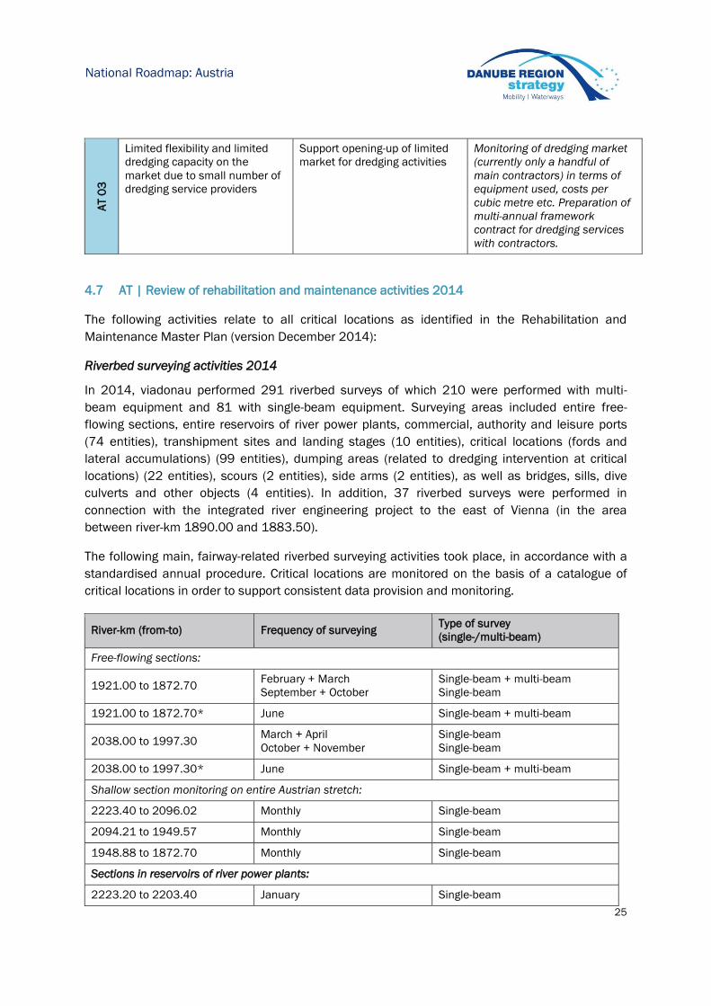
4.6 AT | Key issues and related activities 2014
Related to the key issues illustrated in the Fairway Rehabilitation and Maintenance Master Plan
(version: December 2014):
Key issues Need for action Activities performed 2014
AT 0
1
Maintaining water level
measurements during extreme
weather events
Establishment of back-up
energy supply systems at
automatic gauging stations
Equipping most important
water gauging stations with
high-capacity batteries in
combination with solar panels
to keep gauges running as
stand-alone systems
AT0
2
Maintaining technical
equipment of gauging stations
to avoid data errors and gaps
Staff for weekly or even daily
on-site checks
Inventory of existing gauging
stations and classification
regarding priority, identification
of human and financial
resources
25
National Roadmap: Austria
4.7 AT | Review of rehabilitation and maintenance activities 2014
The following activities relate to all critical locations as identified in the Rehabilitation and
Maintenance Master Plan (version December 2014):
Riverbed surveying activities 2014
In 2014, viadonau performed 291 riverbed surveys of which 210 were performed with multi-
beam equipment and 81 with single-beam equipment. Surveying areas included entire free-
flowing sections, entire reservoirs of river power plants, commercial, authority and leisure ports
(74 entities), transhipment sites and landing stages (10 entities), critical locations (fords and
lateral accumulations) (99 entities), dumping areas (related to dredging intervention at critical
locations) (22 entities), scours (2 entities), side arms (2 entities), as well as bridges, sills, dive
culverts and other objects (4 entities). In addition, 37 riverbed surveys were performed in
connection with the integrated river engineering project to the east of Vienna (in the area
between river-km 1890.00 and 1883.50).
The following main, fairway-related riverbed surveying activities took place, in accordance with a
standardised annual procedure. Critical locations are monitored on the basis of a catalogue of
critical locations in order to support consistent data provision and monitoring.
River-km (from-to) Frequency of surveying Type of survey
(single-/multi-beam)
Free-flowing sections:
1921.00 to 1872.70 February + March
September + October
Single-beam + multi-beam
Single-beam
1921.00 to 1872.70* June Single-beam + multi-beam
2038.00 to 1997.30 March + April
October + November
Single-beam
Single-beam
2038.00 to 1997.30* June Single-beam + multi-beam
Shallow section monitoring on entire Austrian stretch:
2223.40 to 2096.02 Monthly Single-beam
2094.21 to 1949.57 Monthly Single-beam
1948.88 to 1872.70 Monthly Single-beam
Sections in reservoirs of river power plants:
2223.20 to 2203.40 January Single-beam
AT 0
3
Limited flexibility and limited
dredging capacity on the
market due to small number of
dredging service providers
Support opening-up of limited
market for dredging activities
Monitoring of dredging market
(currently only a handful of
main contractors) in terms of
equipment used, costs per
cubic metre etc. Preparation of
multi-annual framework
contract for dredging services
with contractors.
26
National Roadmap: Austria
2146.60 to 2119.70 January Single-beam
2060.10 to 2038.50 May Multi-beam
1998.00 to 1980.50 May Single-beam
2162.60 to 2147.40 July Multi-beam
1979.80 to 1949.40 July Single-beam
* only critical locations according to catalogue of critical locations
Fairway relocation activities 2014
Due to the very limited cross-section of the Austrian section of the Danube, fairway relocation is
usually no option for fairway maintenance at viadonau. In 2014, the width of the fairway in the
area of Dürnstein (Wachau valley, river-km 2010.20 to 2008.90) was narrowed from 180 m to
150 m in order to reduce future maintenance efforts (dredging of lateral sediment). The safety of
navigation in this area is not affected by this measure.
Dredging activities 2014
The following fairway dredging measures for commercial navigation were implemented on the
Austrian Danube:
In total, 566.642 m3 were dredged for commercial navigation in 2014.
Beginning of End of m3
from river-km to river-km from river-km to river-km service service
Schlögener Schlinge 2.186,50 2.186,20 2.181,90 2.181,30 22.05.2014 05.06.2014 Fine sediment Dumping 11.508,00
Inzeller Scheibe - Kleinmaßnahme 2.185,00 2.184,80 2.181,90 2.181,30 02.06.2014 03.06.2014 Fine sediment Dumping 3.200,00
Ennshafen - Restarbeiten FS 2.112,00 2.112,00 2.111,80 2.111,00 17.10.2014 27.11.2014 Fine sediment Dumping 33.280,20
Ennshafen - Restarbeiten Kies 2.112,00 2.112,00 2.115,00 2.115,00 06.10.2014 16.10.2014 Gravel Dumping 10.191,24
Hochau/Dornach, Hößgang/Struden 2.085,70 2.077,40 2.088,40 2.085,10 04.02.2014 24.03.2014 Gravel Dumping 71.074,66
Haufenrand Aggsbach 2.027,80 2.027,50 2.029,10 2.028,50 10.11.2014 27.11.2014 Gravel Bank structuring 1.965,16
Furt Hinterhaus 2.020,10 2.019,40 2.029,10 2.028,50 10.11.2014 20.11.2014 Gravel Bank structuring 20.392,93
Furt Hofarnsdorf 2.019,40 2.018,60 2.029,75 2.028,50 01.04.2014 28.04.2014 Gravel Bank structuring 23.529,78
Furt Weißenkirchen 2.014,60 2.013,50 2.023,40 2022,80 06.11.2013 05.02.2014 Gravel Bank structuring 89.730,79
Haufenrand Dürnstein 2.010,30 2.009,20 2.029,10 2.028,50 10.09.2014 29.09.2014 Gravel Bank structuring 21.139,65
Furt Rothenhof 2.005,90 2.005,00 2.023,20 2.022,80 13.10.2014 28.10.2014 Gravel Bank structuring 20.472,00
Lände Hollenburg 1.993,90 1.993,60 1.993,50 1.993,10 11.02.2014 12.02.2014 Fine sediment Dumping 1.647,80
Ölhafen Theiss 1.993,50 1.993,10 1.993,00 1.992,50 13.02.2014 26.02.2014 Fine sediment Dumping 7.572,50
Havarieabsetzplatz Wien 1.930,31 1.930,16 1.931,00 1.930,50 03.12.2014 04.12.2014 Fine sediment Dumping 864,26
Hafeneinfahrt Albern 1.918,40 1.918,10 1.914,90 1.914,00 24.11.2014 26.11.2014 Gravel Dumping 3.706,57
Hafeneinfahrt Lobau 1.917,30 1.916,25 1.913,40 1.912,80 04.11.2014 18.11.2014 Gravel Dumping 20.022,78
Hafen Lobau 1.917,30 1.916,30 1.914,90 1.912,80 23.01.2014 19.02.2014 Gravel Dumping 16.977,00
Furt Regelsbrunn 1.898,30 1.897,90 1.898,60 1.897,80 03.03.2014 11.04.2014 Gravel Dumping 29.645,30
Furt Rote Werd 1.896,65 1.895,75 1.901,80 1.900,80 26.02.2014 15.04.2014 Gravel Dumping 30.542,00
Furt Rote Werd 1.896,45 1.895,95 1.901,80 1.900,80 08.09.2014 26.09.2014 Gravel Dumping 30.542,59
Furt Treuschütt 1.888,40 1.887,70 1.891,00 1.890,40 27.08.2014 05.10.2014 Gravel Dumping 44.434,95
Furt Bad Deutsch-Altenburg 1.886,90 1.886,10 1.889,90 1.889,00 06.10.2014 09.12.2015 Gravel Dumping 41.258,29
Haufenrand Hainburg 1.884,50 1.884,00 1.884,00 1.883,50 22.04.2014 09.05.2014 Gravel Dumping 12.942,58
Furt Käsmacher 1.875,74 1.875,27 1.884,00 1.883,50 01.12.2014 15.12.2014 Gravel Dumping 20.001,59
UtilisationMaterialDumping or placement site
Designation of assignmentDredging site

27
National Roadmap: Austria
4.8 AT | Operational and investment costs
Actual operational costs 2014
Need areas Actual costs 2014*(Euro)
Minimum fairway parameters (width/depth) 5.689.414
Surveying of the riverbed 1.300.027
Water level gauges 1.183.339
Marking of the fairway -
Availability of locks / lock chambers -
Information on water levels and forecasts -
Information on fairway depths -
Information on marking plans -
Meteorological information -
Other needs -
Sum 8.172.780
*provisional data
Secured operational budget 2015
Need areas
Operational
costs
2014
Additional
yearly need
(Masterplan
)
Operational
budget
2015
Remaining
financing
gap 2015
Minimum fairway parameters (width/depth) 5.689.414 - 6.382.733 0
Surveying of the riverbed 1.300.027 - 989.969 0
Water level gauges 1.183.339 40.400 1.184.903 0
Marking of the fairway - - - -
Availability of locks / lock chambers - - - -
Information on water levels and forecasts - - - -
Information on fairway depths - - - -
Information on marking plans - - - -
Meteorological information - - - -
Other needs - - - -
Sum 8.172.780 8.557.605 0
*provisional data
28
National Roadmap: Austria
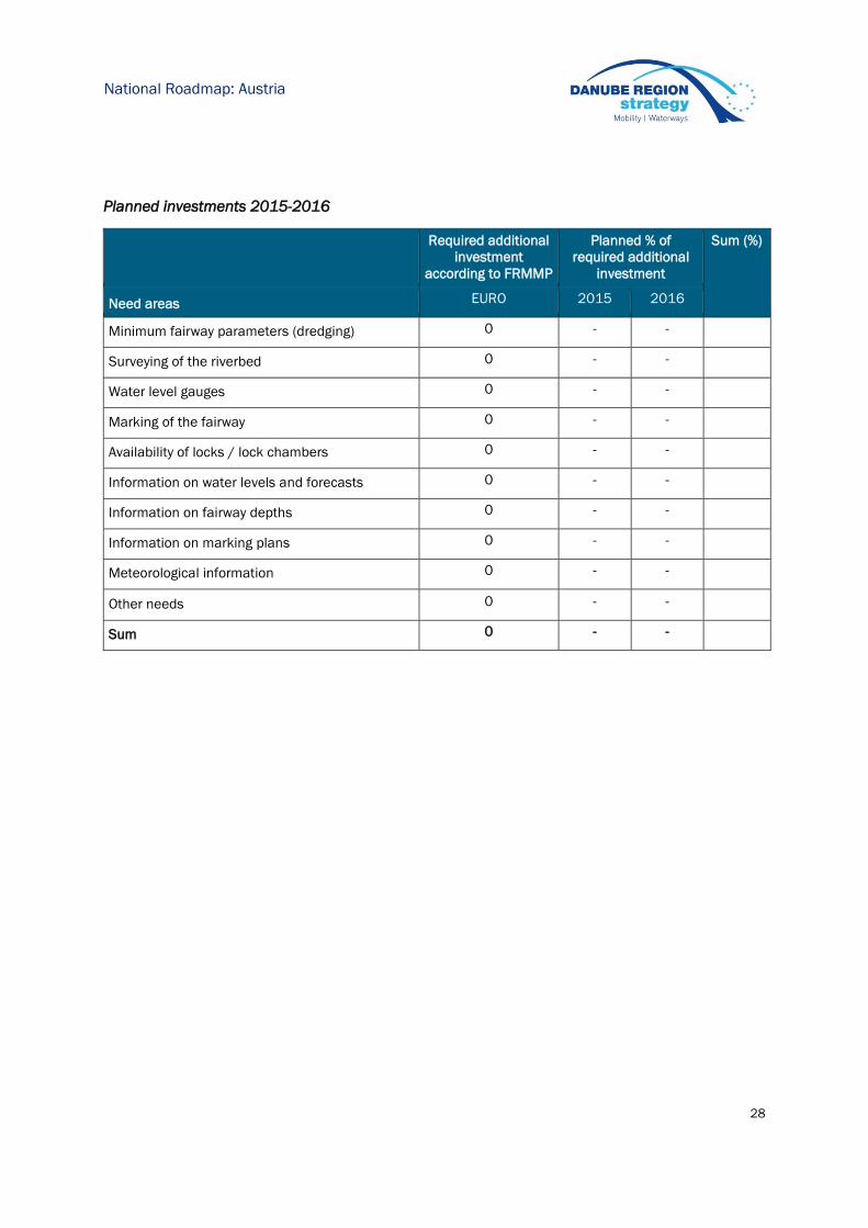
Planned investments 2015-2016
Required additional
investment
according to FRMMP
Planned % of
required additional
investment
Sum (%)
Need areas EURO 2015 2016
Minimum fairway parameters (dredging) 0 - -
Surveying of the riverbed 0 - -
Water level gauges 0 - -
Marking of the fairway 0 - -
Availability of locks / lock chambers 0 - -
Information on water levels and forecasts 0 - -
Information on fairway depths 0 - -
Information on marking plans 0 - -
Meteorological information 0 - -
Other needs 0 - -
Sum 0 - -
29
National Roadmap: Austria
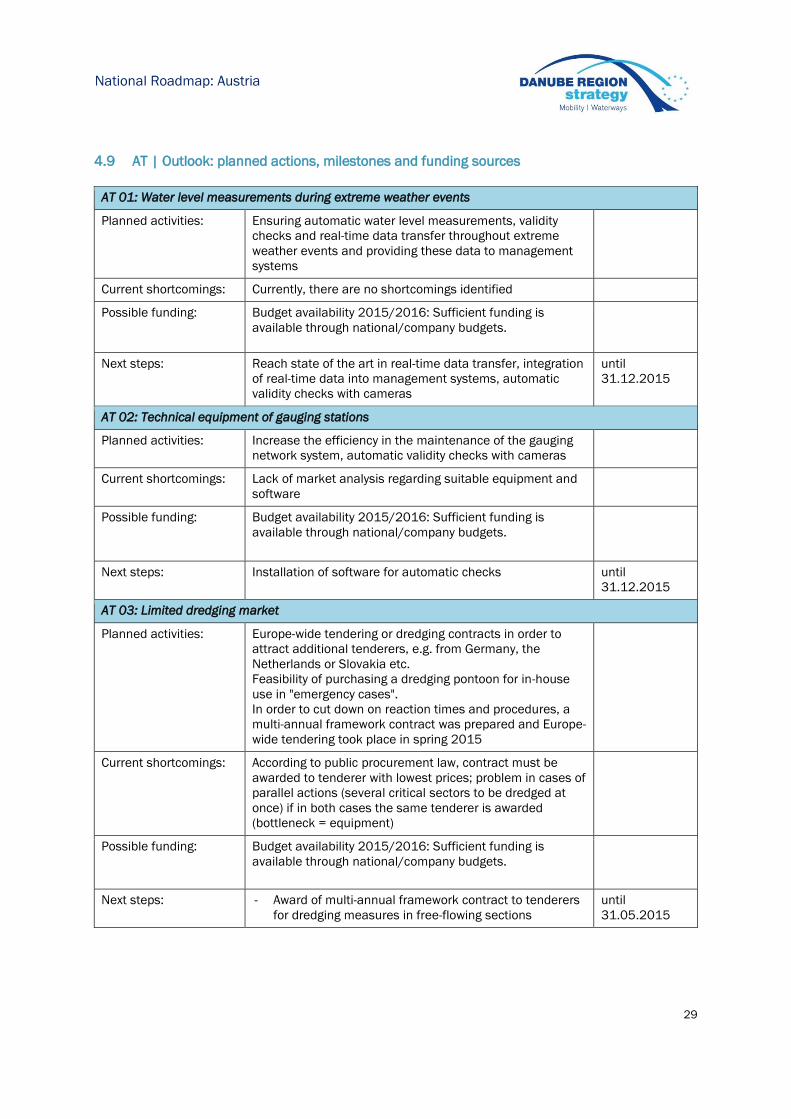
4.9 AT | Outlook: planned actions, milestones and funding sources
AT 01: Water level measurements during extreme weather events
Planned activities: Ensuring automatic water level measurements, validity
checks and real-time data transfer throughout extreme
weather events and providing these data to management
systems
Current shortcomings: Currently, there are no shortcomings identified
Possible funding: Budget availability 2015/2016: Sufficient funding is
available through national/company budgets.
Next steps: Reach state of the art in real-time data transfer, integration
of real-time data into management systems, automatic
validity checks with cameras
until
31.12.2015
AT 02: Technical equipment of gauging stations
Planned activities: Increase the efficiency in the maintenance of the gauging
network system, automatic validity checks with cameras
Current shortcomings: Lack of market analysis regarding suitable equipment and
software
Possible funding: Budget availability 2015/2016: Sufficient funding is
available through national/company budgets.
Next steps: Installation of software for automatic checks until
31.12.2015
AT 03: Limited dredging market
Planned activities: Europe-wide tendering or dredging contracts in order to
attract additional tenderers, e.g. from Germany, the
Netherlands or Slovakia etc.
Feasibility of purchasing a dredging pontoon for in-house
use in "emergency cases".
In order to cut down on reaction times and procedures, a
multi-annual framework contract was prepared and Europe-
wide tendering took place in spring 2015
Current shortcomings: According to public procurement law, contract must be
awarded to tenderer with lowest prices; problem in cases of
parallel actions (several critical sectors to be dredged at
once) if in both cases the same tenderer is awarded
(bottleneck = equipment)
Possible funding: Budget availability 2015/2016: Sufficient funding is
available through national/company budgets.
Next steps: - Award of multi-annual framework contract to tenderers
for dredging measures in free-flowing sections
until
31.05.2015

30
National Roadmap: Slovakia
5 Slovakia
SVP - Slovak Water Management Enterprise (state owned) is responsible for fairway maintenance.
5.1 SK | Status report on main critical locations 2012-2014
Number of days with fairway depths > 2.5m on main critical locations
Critical location 2012 2013 2014
part I.
(rkm 1880 – 1868) 366 365 365
part II.
(rkm 1810 – 1785) 360 341 359
part III.
(rkm 1740 – 1710) 303 324 300
Status of critical locations 2012
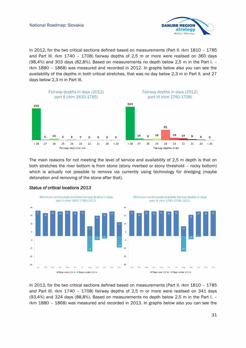
31
National Roadmap: Slovakia
In 2012, for the two critical sections defined based on measurements (Part II. rkm 1810 – 1785
and Part III. rkm 1740 – 1708) fairway depths of 2,5 m or more were realised on 360 days
(98,4%) and 303 days (82,8%). Based on measurements no depth below 2,5 m in the Part I. –
rkm 1880 – 1868) was measured and recorded in 2012. In graphs below also you can see the
availability of the depths in both critical stretches, that was no day below 2,3 m in Part II. and 27
days below 2,3 m in Part III.
The main reasons for not meeting the level of service and availability of 2,5 m depth is that on
both stretches the river bottom is from stone (stony riverbed or stony threshold – rocky bottom)
which is actually not possible to remove via currently using technology for dredging (maybe
detonation and removing of the stone after that).
Status of critical locations 2013
In 2013, for the two critical sections defined based on measurements (Part II. rkm 1810 – 1785
and Part III. rkm 1740 – 1708) fairway depths of 2,5 m or more were realised on 341 days
(93,4%) and 324 days (88,8%). Based on measurements no depth below 2,5 m in the Part I. –
rkm 1880 – 1868) was measured and recorded in 2013. In graphs below also you can see the

32
National Roadmap: Slovakia
availability of the depths in both critical stretches, that only 9 days was below 2,3 m in Part II. and
14 days below 2,3 m in Part III.
The main reasons for not meeting the level of service and availability of 2,5 m depth is that on
both stretches the river bottom is from stone (stony riverbed or stony threshold – rocky bottom)
which is actually not possible to remove via currently using technology for dredging (maybe
detonation and removing of the stone after that). Comparing to the year before and after the
2013 was characterised by a high-water event which occurs every 100 years.
Status of critical locations 2014
In 2014, for the two critical sections defined based on measurements (Part II. rkm 1810 – 1785
and Part III. rkm 1740 – 1708) fairway depths of 2,5 m or more were realised on 359 days
(98,3%) and 300 days (82,2%). Based on measurements no depth below 2,5 m in the Part I. –
rkm 1880 – 1868) was measured and recorded in 2014. In graphs below also you can see the
availability of the depths in both critical stretches, that only 1 day was below 2,3 m in Part II. and
22 days below 2,3 m in Part III. (1 day of 1,9 m of depth).
33
National Roadmap: Slovakia
The main reasons for not meeting the level of service and availability of 2,5 m depth is that on
both stretches the river bottom is from stone (stony riverbed or stony threshold – rocky bottom)
which is actually not possible to remove via currently using technology for dredging (maybe
detonation and removing of the stone after that).
5.2 SK | Hydrological conditions on main critical locations 2012-2014
Number of days with flow discharge above multiannual average flow discharge for the main
critical locations.
Critical location 2012 2013 2014
part I.
(rkm 1880 – 1868)
reference gauge - Devin
183 163 88
part II.
(rkm 1810 – 1785)
reference gauge Medveďov
191 168 86
part III.
(rkm 1740 – 1710)
reference gauge Štúrovo
170 191 88
5.3 SK | Water level information on main critical locations 2012-2014
Critical location Reference gauge No of days above LNWL
2012 2013 2014
part I. (rkm 1880 – 1868) Devin 366 362 349
part II. (rkm 1810 – 1785) Medvedov / Gonyu 366 362 348
part III. (rkm 1740 – 1710) Sturovo / Komarom 319 334 292
34
National Roadmap: Slovakia
5.4 SK | Time from surveying to action: maintenance philosophy
Surveying of the entire Danube River has been done 1x per year by single beam (common and
national stretches). Based on results from the measurement the maintenance activities are
planned. The performance of the dredging itself is done based on the “Project of dredging”, which
has been elaborated every two years and approved on Transboundary Water Commission (TWC)
Level for the common stretches with Austria and Hungary. SVP is using the own fleet of dredgers
and therefore there is no need of having public procurement for the execution of works. Costs
spent for dredging on common stretches are shared between the partners based on agreement
on TWC.
Monitoring of the fairway has been done on weekly basis. Each week two marking vessels are
navigating on the Danube and controlling the position of the buoys and shoreline signs. Also the
monitoring of the critical section is done by marking vessels in parallel with fairway monitoring
activities. Critical section information has been provided daily based on information from the
Hungarian partner Eduvizig and SVP Branch Gabcikovo. Information from both branches is
collected by SVP Dispatching in Bratislava which informs the Transport Authority, Division of
Inland Navigation. The Transport Authority is the organisation responsible for the providing of the
daily status of critical section on entire stretch of Danube (rkm 1880-1708). The web service for
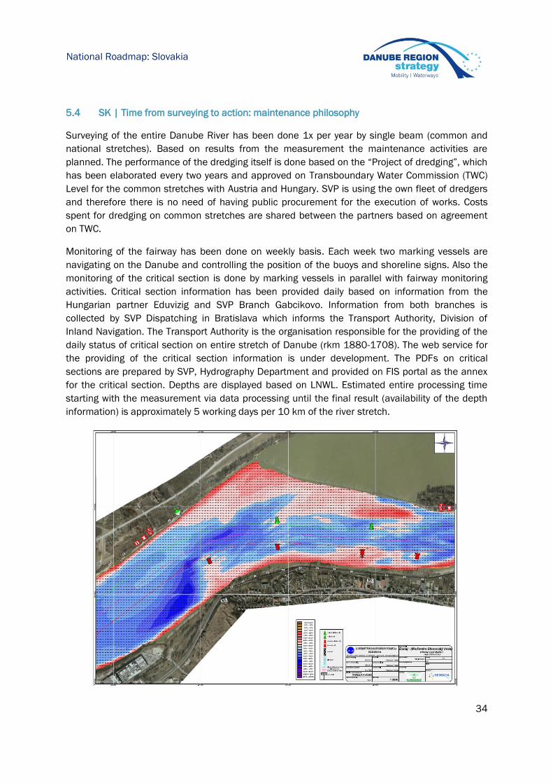
the providing of the critical section information is under development. The PDFs on critical
sections are prepared by SVP, Hydrography Department and provided on FIS portal as the annex
for the critical section. Depths are displayed based on LNWL. Estimated entire processing time
starting with the measurement via data processing until the final result (availability of the depth
information) is approximately 5 working days per 10 km of the river stretch.
35
National Roadmap: Slovakia
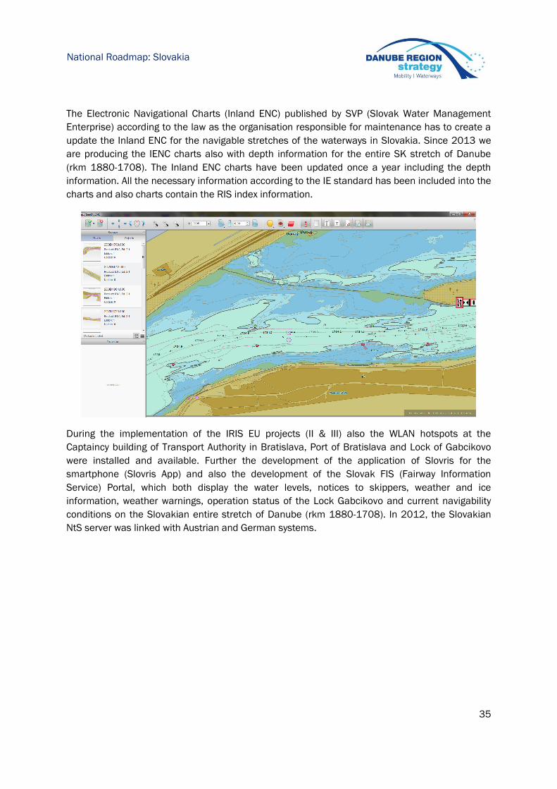
The Electronic Navigational Charts (Inland ENC) published by SVP (Slovak Water Management
Enterprise) according to the law as the organisation responsible for maintenance has to create a
update the Inland ENC for the navigable stretches of the waterways in Slovakia. Since 2013 we
are producing the IENC charts also with depth information for the entire SK stretch of Danube
(rkm 1880-1708). The Inland ENC charts have been updated once a year including the depth
information. All the necessary information according to the IE standard has been included into the
charts and also charts contain the RIS index information.
During the implementation of the IRIS EU projects (II & III) also the WLAN hotspots at the
Captaincy building of Transport Authority in Bratislava, Port of Bratislava and Lock of Gabcikovo
were installed and available. Further the development of the application of Slovris for the
smartphone (Slovris App) and also the development of the Slovak FIS (Fairway Information
Service) Portal, which both display the water levels, notices to skippers, weather and ice
information, weather warnings, operation status of the Lock Gabcikovo and current navigability
conditions on the Slovakian entire stretch of Danube (rkm 1880-1708). In 2012, the Slovakian
NtS server was linked with Austrian and German systems.

36
National Roadmap: Slovakia
5.5 SK | Key issues and related activities 2014
Related to the key issues illustrated in the Fairway Rehabilitation and Maintenance Master Plan
(version: December 2014):
Key issues Need for action Activities performed 2014
SK
01
Level of detail of monitoring
data is suboptimal for exact
and cost-effective planning of
dredging interventions
Support acquisition of up-to-
date multi-beam sounding
vessels, equipment and
software
Definition of the action within
the proposed FAIRway Project
SK
02
Out-of-date information
technology, missing database
for monitoring data
Support establishment of
Fairway Management System
Definition of the action within
the proposed FAIRway Project
SK
03
Insufficient number of skilled
staff to monitor of the fairway
Secure education and
provision of well-trained staff in
the short, medium and long
term
Action will be partly done by
project FAIRway, partly
national company budget
SK
04
Different departments
performing the monitoring
as an impediment to
efficient planning
Support coordination of
interfaces and
establishment of common
database for planning of
interventions
Harmonisation of the
activities and
measurements, exchange
of the information
37
National Roadmap: Slovakia
SK
05
Different coordinate
systems used for
measurements in border
stretches as an impediment
to efficient planning
Support cross-border
harmonisation of monitoring
standards
Data exchange will be
done in UTM format based
on TWC experts agreement
SK
06
Old and dredging and
marking fleet and
equipment
Support acquisition of up-to-
date dredging and marking
vessels and equipment
Definition of types of the
new dredgers – topic for
investment project (follow-
up FAIRway)
SK
07
Lack of staff and resulting
missing flexibility in case of
urgencies (related to
dredging activities).
Secure education and
provision of well-trained
staff in the short, medium
and long term
Actually staff well-trained,
but closely to retirement,
new staff in parallel with
acquisition of new
dredgers
SK
08
Frequent need to adjust
fairway marking as
substitution for dredging
activities
Support implementation of
semi-automated marking
plans based on a common
Fairway Management
System
Coordination between
marking and maintenance
department done, actions
maintained by Branch
Danube
5.6 SK | Review of rehabilitation and maintenance activities 2014
The following activities relate to all critical locations as identified in the Rehabilitation and
Maintenance Master Plan (version December 2014):
Surveying activities 2014
The following river bed surveying activities (listed below in table) took place according to the
annual procedure. Critical locations are monitored within the entire measurement but since 2015
we are planning of doing extra measurements of the critical sections besides the entire stretch
measurement. Based on agreement on the Transboundary Water Commission SK-HU in 2014 the
not the entire common stretch SK-HU was measured, only the agreed part, and the part of rkm
1736 – 1775 is missing in the 2014 measurement. In 2015 all the measurements of the entire
stretch will be done according to the plan.
River-km (from-to) Frequency of surveying Type of survey
(single/multibeam)
1872 – 1853 1x per year (done in 5-6/2014) Single beam
1880 – 1872 2x per year (done in 5 and 10/2014) Single beam
1736 – 1708 1x per year (done in 9/2014) Single beam
8,3 – 25,7 (inflow canal Gabcikovo) 1x per year (done in 6-7/2014) Single beam
26,0 – 1856 (reservoir Hrusov) 1x per year Single beam
0,0 – 0,8 (outflow canal Gabcikovo) 1x per year Single beam
38
National Roadmap: Slovakia
Fairway relocation activities 2014
The fairway monitoring and marking has been done on weekly basis in Slovakia based on the
approved Project of the Marking of the fairway. The changes of the fairway have not been done on
the regular basis. The changes of the fairway were done in the area of the Old Bridge in Bratislava
according to the NtS published from Transport Authority. If any changes of the fairway are
required, then they are done within the annual budget for monitoring and marking of the fairway.
River-km (from-to) Frequency of relocation
interventions Comments
Old Bridge in Bratislava
rkm 1868,14
2014 Relocation of the fairway due
to bridge reconstruction
Dredging activities 2014
Designation
of
assignment
Dredging site Placement site Begin-
ning of
service
End of
service
Mate-
rial
Utilisa-
tion m3
from
river-km to river-km
from
river-km
to river-
km
dredging of
Danube at
junction
with Vah 1 766,00 1 765,30 1 765,50 1 762,50
02.06.
2014
11.11.
2014
gravel
-sand
Storage
on the
bank
147
826
regulation
dredging 1 865,50 1 864,35
basin of gravel pit
Gravelslovex
08.04.
2014
11.11.
2014
gravel
-sand storage
98
344
regulation
dredging 1 732,55 1 732,15 1 733,00 1 733,00
19.11.
2014
26.11.
2014
gravel
-sand
Storage
on the
bank 8 405
In total, 254.575 m3 were dredged for commercial navigation in 2014.

39
National Roadmap: Slovakia
5.7 SK | Operational and investment costs
Actual operational costs 2014
Need areas Actual costs 2014 (Euro)
Minimum fairway parameters (dredging) 2.423.978
Surveying of the riverbed 52.160
Water level gauges
Marking of the fairway (annual budget for marking) 465.990
Availability of locks / lock chambers
Information on water levels and forecasts
Information on fairway depths
Information on marking plans
Meteorological information
Other needs
Sum 2.476.138
(without marking annual budget)
2.942.128
(annual marking budget included)
Secured operational budget 2015
Need areas
Operational
Cost
2014
Additional
yearly need
(Masterplan)
Operational
Budget 2015
Remaining
financing gap
2015
Minimum fairway parameters (depth /
width) 2.423.978 632.000 2.000.000 -
Surveying of the riverbed 52.160 260.000 100.000 160.000
Water level gauges 0 -
Marking of the fairway 465.990 610.000 510.000 100.000
Availability of locks / lock chambers 0 -
Information on water levels and forecasts 0 -
Information on fairway depths 0 -
Information on marking plans 0 -
Meteorological information 0 -
Other needs 0 -
Sum 2.942.128 1.502.000 3.510.000 260.000

40
National Roadmap: Slovakia
Planned investments 2015-2016
Required
additional
investment
according to
FRMMP
Planned % of
required additional
investment*
Sum (%)
Need areas EURO 2015 2016
Minimum fairway parameters (dredging) 6.100.000 - -
Surveying of the riverbed 450.000 - -
Water level gauges 0 - -
Marking of the fairway 1.510.000 - -
Availability of locks / lock chambers 0 - -
Information on water levels and forecasts 0 - -
Information on fairway depths 20.000 - -
Information on marking plans 0 - -
Meteorological information 0 - -
Other needs 0 - -
Sum 8.080.000 - -
* Investment budgets are not secured on national level as yet. Depending on the approval and
start of the CEF-project FAIRway investments could start in 2016.
5.8 SK | Outlook: planned actions, milestones and funding sources
SK 01: Level of detail of monitoring data is suboptimal for exact and cost-effective planning of
dredging interventions
Planned activities: Support acquisition of up-to-date multi-beam sounding
vessels, equipment and software, managing of the
purchasing
Current shortcomings: Missing of the multi-beam sounding vessel
Possible funding: Budget availability 2015/2016: Funding through Project
FAIRway (CEF)
Next steps: If project approved, then definition of the condition for the
public procurement, competition itself, purchasing of the
vessel with all requested devices, starting of the using
(measurements)
Until 2017
41
National Roadmap: Slovakia
SK 02: Out-of-date information technology, missing database for monitoring data
Planned activities: Support establishment of Fairway Management System,
Establishment, development and installation of the
management system is planned within the
implementation of the FAIRway Slovakia project
Current shortcomings: Missing system actually
Possible funding: Budget availability 2015/2016: Funding through Project
FAIRway (CEF)
Next steps: Fairway Management System installation Until
2017-2018
SK 03: Insufficient number of skilled staff to monitor of the fairway
Planned activities: Actually only experienced staff available (closely to
retirement), securing of the well-trained staff after
purchasing of the new marking vessel (from the project
FAIRway Slovakia)
Current shortcomings: Lack of new experienced staff due to company budget
limitation (budget depending on Ministry annual budget)
Possible funding: Budget availability 2015/2016: Funding through Project
FAIRway (CEF) and company budget
Next steps: New marking vessel, needs of having new trained staff Until
2017-2018
SK 04: Different departments performing the monitoring as an impediment to efficient planning
Planned activities: Development and installation of the common database,
monitoring done by hydromorphology department (single
beam) & by Branch Danube (before and after dredging
intervention)
Current shortcomings: Missing common database
Possible funding: Budget availability 2015/2016: Funding through Project
FAIRway (CEF)
Next steps: Definition of the structure and content of the database
(based on NEWADA duo database task result)
until
2017-2018
SK 05: Different coordinate systems used for measurements in border stretches as an impediment to
efficient planning
Planned activities: Actually exchanging of the data are based on UTM
coordinate system and all cross-border partners
exchange the data according to the agreements done on
TWC level
Current shortcomings: A little bit complicated exchange process
Possible funding: Budget availability 2015/2016: Funding through
company budget, CBC funds
Next steps: Definition of the problems, possible solutions, proposals
on TWC level
in progress
42
National Roadmap: Slovakia
SK 06: Old and dredging and marking fleet and equipment
Planned activities: Acquisition of the new marking vessel, modernisation and
purchasing of new dredgers later in next investment
project
Current shortcomings: Old fleet of dredgers (high maintenance fee), old marking
vessels, modernisation and acquisition requested
Possible funding: Budget availability 2015/2016: Project FAIRway (CEF) for
marking vessel (multioperational vessel), for dredgers –
follow up investments funds
Next steps: Acquisition of marking vessel until 2017
SK 07: Lack of staff and resulting missing flexibility in case of urgencies (related to dredging activities)
Planned activities: Ensuring of the well-trained and educated staff in parallel
with purchasing of the new dredgers
Current shortcomings: Old fleet of dredgers (high maintenance fee)
Possible funding: Budget availability 2015/2016: Investments funds
Next steps: Definition of the possible projects until 2018-
2019
SK 08: Frequent need to adjust fairway marking as substitution for dredging activities
Planned activities: Installation of the Fairway Management System (planning
in following project NEWADA III), harmonisation with
marking department (marking trips done on weekly basis)
Current shortcomings: Missing Management system or common database
Possible funding: Budget availability 2015/2016: Funding through Danube
Transnational Programme (NEWADA III project), FAIRway
Project
Next steps: Definition of the structure of the database (possibility of
using existing database structure developed within
NEWADA duo – Marking plans task)
until 2018

43
National Roadmap: Hungary
6 Hungary
The General Directorate of Water Management is responsible for fairway maintenance. It has three
subordinated regional organizations (Water Directorate, VIZIG) for waterway maintenance on the
Danube:
North-Transdanubean Water Directorate (1,811-1,708 rkm)
Middle-Danube-Valley Water Directorate (1,708-1,560 rkm)
Lower-Danube-Valley Water Directorate (1,560-1,433 rkm)
6.1 HU | Status report on main critical locations 2012-2014
Number of days with fairway depths > 2.5m on main critical locations (as identified by the
Danube waterway users in a survey by PA1a concluded in December 2014)
1,811 - 1,708 rkm
Critical location 2012 2013 2014
Nyergesújfalu critical
location with 60 meters
wide fairway
304 314 307
Nyergesújfalu critical
location with 100 meters
wide fairway
286 304 256
Fairway width (range of values accounts for different curve radii): 60 to 100 m in Slovakia and
Slovak - Hungarian border section, 80 to 120 m in Hungarian Danube (rkm 1708-1433) section
based on Fairway Rehabilitation and Maintenance Master Plan.
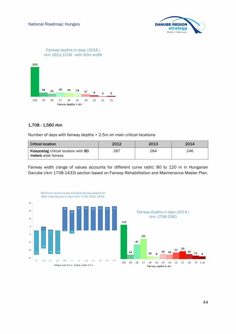
44
National Roadmap: Hungary
1,708 - 1,560 rkm
Number of days with fairway depths > 2.5m on main critical locations
Critical location 2012 2013 2014
Kisapostag critical location with 80
meters wide fairway
287 284 246
Fairway width (range of values accounts for different curve radii): 80 to 120 m in Hungarian
Danube (rkm 1708-1433) section based on Fairway Rehabilitation and Maintenance Master Plan.

45
National Roadmap: Hungary
1,560 - 1,433 rkm
Number of days with fairway depths > 2.5m on main critical locations
Critical location 2012 2013 2014
Solt critical location with 60 meters wide
fairway
365 365 360
Solt critical location with 100 meters wide
fairway
293 318 232
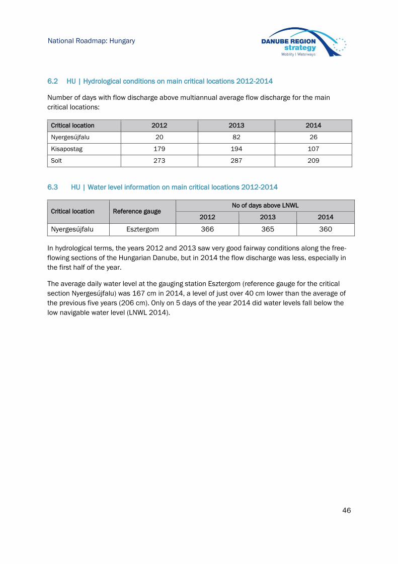
46
National Roadmap: Hungary
6.2 HU | Hydrological conditions on main critical locations 2012-2014
Number of days with flow discharge above multiannual average flow discharge for the main
critical locations:
Critical location 2012 2013 2014
Nyergesújfalu 20 82 26
Kisapostag 179 194 107
Solt 273 287 209
6.3 HU | Water level information on main critical locations 2012-2014
Critical location Reference gauge No of days above LNWL
2012 2013 2014
Nyergesújfalu Esztergom 366 365 360
In hydrological terms, the years 2012 and 2013 saw very good fairway conditions along the free-
flowing sections of the Hungarian Danube, but in 2014 the flow discharge was less, especially in
the first half of the year.
The average daily water level at the gauging station Esztergom (reference gauge for the critical
section Nyergesújfalu) was 167 cm in 2014, a level of just over 40 cm lower than the average of
the previous five years (206 cm). Only on 5 days of the year 2014 did water levels fall below the
low navigable water level (LNWL 2014).
47
National Roadmap: Hungary
Critical location Reference gauge No of days above LNWL
2012 2013 2014
Kisapostag Dunaföldvár 366 364 357
In hydrological terms, the years 2012, 2013 and 2014 saw very good fairway conditions along
the Danube section of 1708 - 1506 rkm. The daily water levels at the gauging station Dunaföldvár
exceeded the average water level (AWL 1981-2014) for around 40-20 % of the period.
Critical location Reference gauge No of days above LNWL
2012 2013 2014
Solt Dunaföldvár 366 364 357
In hydrological terms, the years 2012 - 2014 saw very good fairway conditions along the Danube
section of 1506 - 1433 rkm. No single day of the year 2012 did water levels fall below the low
navigable water level (LNWL 2010) and water levels are only 2 days below LNWL in 2013 and 8
days in 2014.
0
100
200
300
400
500
600
700
800
900
01
.01
01
.11
01
.21
01
.31
02
.10
02
.20
03
.02
03
.12
03
.22
04
.01
04
.11
04
.21
05
.01
05
.11
05
.21
05
.31
06
.10
06
.20
06
.30
07
.10
07
.20
07
.30
08
.09
08
.19
08
.29
09
.08
09
.18
09
.28
10
.08
10
.18
10
.28
11
.07
11
.17
11
.27
12
.07
12
.17
12
.27
Wa
ter
leve
l in
cm
Water level gauge of Esztergom 2013-2014
Median
2013
2014
HNWL
LNWL
48
National Roadmap: Hungary
June 2013 was characterised by a high-water event which — depending on the section of the
Danube — is only likely to occur every 100 to 300 years. Maximum discharge rates of between
9,500 and 11,500 m3 per second were recorded and were consistently higher than even the high-
water event in 1965.
6.4 HU | Water level prognoses for critical locations
The water level forecasts have been developed under the scientific guidance of the OVF and are
generated by automated computer-aided model calculations. The own developed operative
hydrological forecasting system of Hungarian Hydrological Forecasting Service (HHFS) is a
complex tool containing snow accumulation and snowmelt, soil frost, effective rainfall, runoff,
flood routing and backwater effect modules, extended with statistical error correction modules
The forecasting system of HHFS prepares and disseminates water level forecasts with 6-day lead
time once a day for Danube (and also Tisza, Drava) rivers and their tributaries. The forecast
process is based on modelling rainfall/runoff processes along the entire Danube basin until
Almjas (Croatia). In case of floods or other unexpected events, four forecasts can be reasonably
made and also disseminated per day. The accuracy of the 72 hour forecast ranges between +/-
10 cm with 80% probability. Accuracy levels largely depend on the quality of the underlying
meteorological prognoses. The prognosis simulates the natural discharge of the river and does
not display short term influences and variations (e.g. as caused by operation of hydroelectric
power stations).
-200
-100
0
100
200
300
400
500
600
700
800
01
.01
01
.12
01
.23
02
.03
02
.14
02
.25
03
.08
03
.19
03
.30
04
.10
04
.21
05
.02
05
.13
05
.24
06
.04
06
.15
06
.26
07
.07
07
.18
07
.29
08
.09
08
.20
08
.31
09
.11
09
.22
10
.03
10
.14
10
.25
11
.05
11
.16
11
.27
12
.08
12
.19
12
.30
Wa
ter
leve
l in
cm
Water level gauge of Dunaföldvár 2013 - 2014
Median
2013
2014
HNWL
LNWL
49
National Roadmap: Hungary
HHFS produces water level forecasts for fifteen gauging stations along the whole Hungarian
Danube not only for critical locations. However, equivalent water-levels methods can be used to
estimate water level forecasts at critical locations. Relevant data are published online via
www.hydroinfo.hu. Gauging data are refreshed online daily. Also data for all Danube gauge
stations are published online via www.vizugy.hu and the Directorate webpages refreshed online
every hour.
The forecasts are available both Hungarian and English language as well on the web page.
English version of the water level forecasts for the fifteen gauging stations of the Hungarian
Danube section is published online on www.hydroinfo.hu/en/hidelo/hidelo_graf_duna.html.
Water levels at www.vizugy.hu – OVF web page
50
National Roadmap: Hungary
Water levels prognosis www.hydroinfo.hu – Hungarian Hydrological Forecasting Service (OVF web
page – Hungarian and English language)
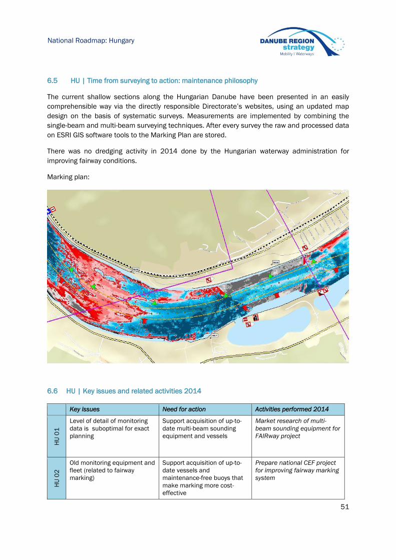
51
National Roadmap: Hungary
6.5 HU | Time from surveying to action: maintenance philosophy
The current shallow sections along the Hungarian Danube have been presented in an easily
comprehensible way via the directly responsible Directorate’s websites, using an updated map
design on the basis of systematic surveys. Measurements are implemented by combining the
single-beam and multi-beam surveying techniques. After every survey the raw and processed data
on ESRI GIS software tools to the Marking Plan are stored.
There was no dredging activity in 2014 done by the Hungarian waterway administration for
improving fairway conditions.
Marking plan:
6.6 HU | Key issues and related activities 2014
Key issues Need for action Activities performed 2014
HU
01
Level of detail of monitoring
data is suboptimal for exact
planning
Support acquisition of up-to-
date multi-beam sounding
equipment and vessels
Market research of multi-
beam sounding equipment for
FAIRway project
HU
02
Old monitoring equipment and
fleet (related to fairway
marking)
Support acquisition of up-to-
date vessels and
maintenance-free buoys that
make marking more cost-
effective
Prepare national CEF project
for improving fairway marking
system

52
National Roadmap: Hungary
6.7 HU | Review of rehabilitation and maintenance activities 2014
The following activities relate to all critical locations as identified in the Rehabilitation and
Maintenance Master Plan (version December 2014)
Surveying activities 2014
River-km (from-to) Frequency of surveying Type of survey (single/multi beam)
1811–1775 1 Single beam
1657 - 1637 1 Multi beam
1611 - 1560 1 Multi beam
1538 - 1512 1 Single beam
1488 - 1484 5 Single beam
1559.8 - 1559.7 1 Multi beam
1558.5 - 1557.5 1 Multi beam
1555.8 - 1554.6 1 Multi beam
1552.0 - 1551.0 1 Multi beam
1493.5 - 1492.5 1 Multi beam
1483.5 - 1482.5 1 Multi beam
1480.1 - 1479.1 1 Multi beam
1472.5 - 1471.5 1 Multi beam
Fairway relocation activities 2014
River-km (from-to) Frequency of relocation interventions Comments
1480.32-1480.12 2 Bridge reconstruction
Fairway marking activities 2014
River-km (from-to) Frequency of fairway marking activities Comments
1811 – 1708 Two time a week from 1811 to 1791
Every second week from 1791 to 1708
Fairway marking is done by
ÉDU VIZIG together with Slovak
SVP
1708 - 1560 Every week from 1708 to 1560 Fairway marking is done by
KDV VIZIG
1560 - 1433 Every week from 1560 to 1433 Fairway marking is done by
ADU VIZIG
Dredging activities 2014
The following fairway dredging measures for commercial navigation were implemented:
In total, 0 m3 were dredged for commercial navigation in 2014 (no dredging activities).
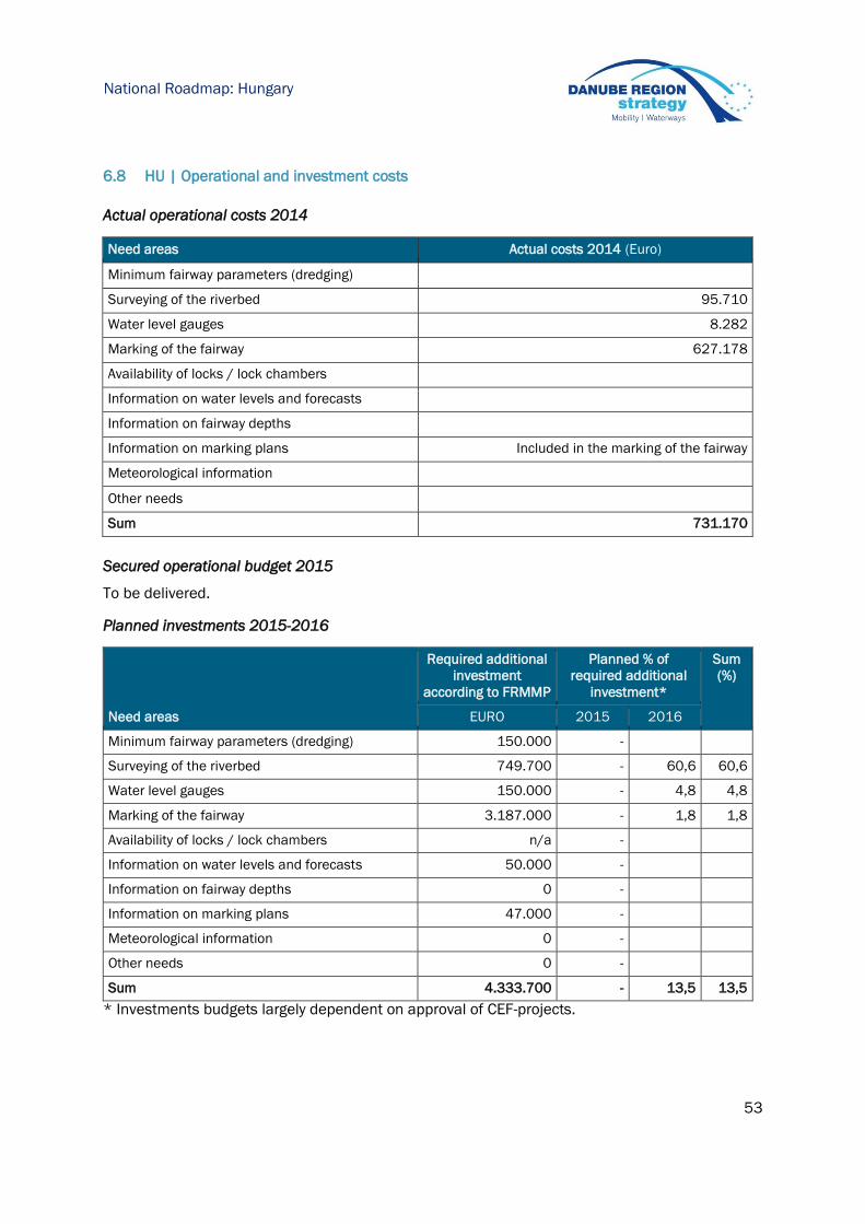
53
National Roadmap: Hungary
6.8 HU | Operational and investment costs
Actual operational costs 2014
Need areas Actual costs 2014 (Euro)
Minimum fairway parameters (dredging)
Surveying of the riverbed 95.710
Water level gauges 8.282
Marking of the fairway 627.178
Availability of locks / lock chambers
Information on water levels and forecasts
Information on fairway depths
Information on marking plans Included in the marking of the fairway
Meteorological information
Other needs
Sum 731.170
Secured operational budget 2015
To be delivered.
Planned investments 2015-2016
Need areas
Required additional
investment
according to FRMMP
Planned % of
required additional
investment*
Sum
(%)
EURO 2015 2016
Minimum fairway parameters (dredging) 150.000 -
Surveying of the riverbed 749.700 - 60,6 60,6
Water level gauges 150.000 - 4,8 4,8
Marking of the fairway 3.187.000 - 1,8 1,8
Availability of locks / lock chambers n/a -
Information on water levels and forecasts 50.000 -
Information on fairway depths 0 -
Information on marking plans 47.000 -
Meteorological information 0 -
Other needs 0 -
Sum 4.333.700 - 13,5 13,5
* Investments budgets largely dependent on approval of CEF-projects.
54
National Roadmap: Hungary
6.9 HU | Outlook: planned actions, milestones and funding sources
HU 01: Level of detail of monitoring data
Planned activities: Purchasing multi-beam sounding equipment and
surveying vessel within FAIRway project
Current shortcomings: Currently, there are no shortcomings identified
Possible funding: CEF 85%, National budget 15%
Next steps: Preparing NIF – OVF agreement on FAIRway project.
Preparing public procurement documentation for the time
FAIRway project is approved
30.07.2015
HU 02: Old monitoring equipment and fleet (related to fairway marking)
Planned activities: Purchasing equipment within national CEF project called
“Improving fairway marking on the Hungarian section of
the Danube in the Rhine-Danube corridor”
Fairway marking vessels - 3 pcs
High-speed patrol boats - 3 pcs
Intelligent light buoys - 115 pcs
New floating unlighted buoys - 210 pcs
Light bank markers - 55 pcs
New bank marks and navigation control marks - 300
pcs
New river km marks - 400 pcs
Current shortcomings: Currently, there are no shortcomings identified
Possible funding: CEF 85%, National budget 15%
Next steps: Preparing NIF – OVF agreement on CEF fairway marking
project
Preparing public procurement documentation for the
marking vessels and patrol boat for time CEF fairway
marking project is approved
30.07.2015

55
National Roadmap: Croatia
7 Croatia
AVP - Agency for Inland Waterways (within the Ministry of Maritime Affairs, Transport and
Infrastructure) is responsible for fairway maintenance.
7.1 HR | Status report on main critical locations 2012-2014
Number of days with fairway depths > 2.5m on main critical locations
Danube
Critical location 2012 2013 2014
Apatin sector 366* 365** 365***
The Danube stretch in Croatia is characterized with sufficient depths therefore the envisaged
level of service was achieved, but due to river morphology (large number of sandbars and islands)
required fairway width is not always fulfilled. The tables above show the number of days that do
not meet the fairway dimensions in terms of width.
The Apatin sector is characterised with unstable riverbed, where the flow direction during the low
water period is highly subject to changes. Therefore, the available depth during the same water
level may not have the same values. Compared to 2011, when frequent changes were present,
the situation in 2012, 2013 and 2014 is stabilized and there was no reallocation of the fairway
as the most favourable depth was held throughout the year within the fairway limits. Here applies
the general conclusion that for water levels lower than +130 at Apatin gauge, often can lead to
interferences in navigation.
In 2012 interference in navigation was present for the water levels lower than +90 at Apatin
gauge; in 2013 interference in navigation was present for the water levels lower than +100 at
Apatin and in 2014 there was no interference in navigation due to favourable water levels.

56
National Roadmap: Croatia
Status of critical locations in 2012
Number of days < 200/150/120m width
*
Crtitical sector in 2012 200 x 2,5 150 x 2,5 120 x 2,5 100 x 2,5
Apatin 364 171 95 0
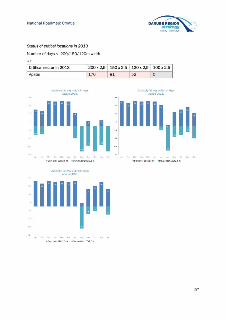
57
National Roadmap: Croatia
Status of critical locations in 2013
Number of days < 200/150/120m width
**
Crtitical sector in 2013 200 x 2,5 150 x 2,5 120 x 2,5 100 x 2,5
Apatin 176 81 52 0
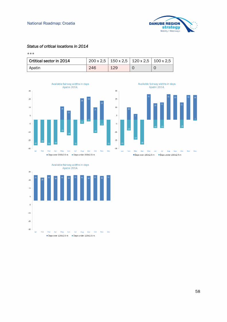
58
National Roadmap: Croatia
Status of critical locations in 2014
***
Crtitical sector in 2014 200 x 2,5 150 x 2,5 120 x 2,5 100 x 2,5
Apatin 246 129 0 0
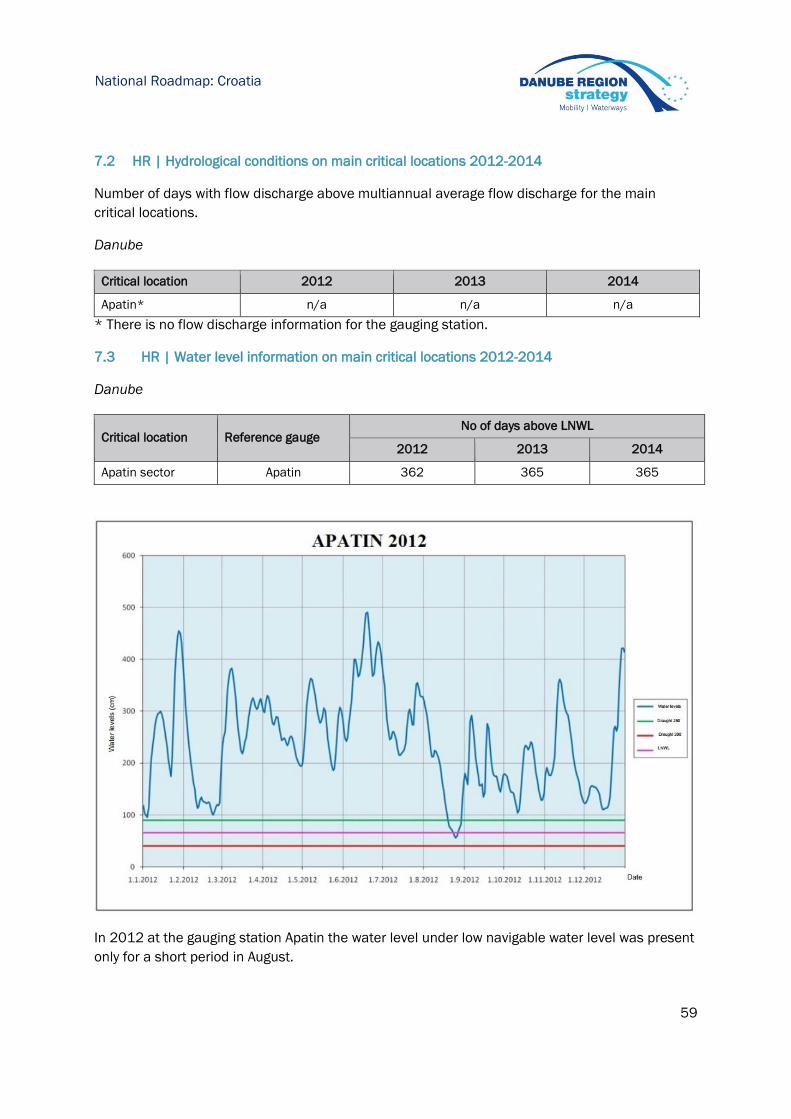
59
National Roadmap: Croatia
7.2 HR | Hydrological conditions on main critical locations 2012-2014
Number of days with flow discharge above multiannual average flow discharge for the main
critical locations.
Danube
Critical location 2012 2013 2014
Apatin* n/a n/a n/a
* There is no flow discharge information for the gauging station.
7.3 HR | Water level information on main critical locations 2012-2014
Danube
Critical location Reference gauge No of days above LNWL
2012 2013 2014
Apatin sector Apatin 362 365 365
In 2012 at the gauging station Apatin the water level under low navigable water level was present
only for a short period in August.

60
National Roadmap: Croatia
The years 2013 and 2014 were very good in hydrological terms and there was no single day that
water levels fell below the low navigable water level.

61
National Roadmap: Croatia
7.4 HR | Water level prognoses for critical locations
The only identified critical location on Croatian/Serbian part of the Danube is sector Apatin (on
Serbian side). Relevant data for Apatin gauge station is published online via the Republic
Hydrometeorologial Service of Serbia (RHMZ). Gauging data are refreshed every day. Four-day
forecasts are available daily online at http://www.hidmet.gov.rs.
Regarding activities in Croatia, the hydrological forecasts modelling project for the Sava river in
Croatia started in year 2014, using MIKE 11 software tools which is cooperation between
meteorological and hydrological service and Croatian Waters.
Within the FAIRway project the installation of 4 new gauging stations is planned together with
water level forecast until 2020 on the Danube river on most critical locations.
7.5 HR | Time from surveying to action: maintenance philosophy
Activities of technical maintenance of inland waterways in Croatia are prescribed by the
Regulation on technical maintenance of inland waterways and they are consisting of the following
activities:
1. Preparation of technical maintenance,
2. Riverbed surveying and preparation of adequate technical documentation,
3. Maintaining the adequate waterways depth,
4. Maintenance the of aids to navigation for the technical improvement of navigation conditions,
5. Waterway marking,
6. Maintenance of equipment and devices (hardware and software) used for RIS,
7. Removal of floating and sunken objects from the fairway that threaten the safety of navigation,
8. Intervention maintenance of the fairway by order of inspections for safety navigation on inland
waterways,
9. Regular maintenance of local waters and aids to navigation in the port area.
Fairway monitoring is done according to an Annual work plan. To be able to know the fairway
conditions we need to perform a surveying which is done according to annual surveying plan. This
plan consists of annual surveying of all national waterways with main surveying of critical
locations and waterway objects on which the maintenance works are planned. Plan also contains
surveying of fairway locations for production of geodetic and morphological surfaces in order to
update the technical documentation. It also contains processing of recorded data and
preparation of technical maintenance documentation for each river stretch and individual
waterway objects.

62
National Roadmap: Croatia
Permanent locations are annually monitored (locations that are already defined). Based on the
annual plan decision is made on the method, the type of equipment and the vessel which will be
used for monitoring. On our disposal are single-beam and multi-beam - depending on the location
type monitoring staff determines the equipment that will be used.
Monitoring operations are done regularly in a form of hydrographical surveys, and are done by
AVP staff. Post-monitoring is not a practice in AVP but our experts are performing the comparison
of surveying results with last year surveying results. If it is established that the surveying results
are not satisfying the surveying activities are performed once again.
After AVP receives specific notification that requires our staff to make surveying of river stretch
hydrographical crew is ready next day to go surveying (if the river conditions are favourable to
make a surveying). For short sections (1 -1,5 km) surveying takes app 1 day. Processing and
publication of the data takes 2 day after surveying.
Above is shown graphical map of Apatin sector (2014 survey). According to good practice, maps
consist of two-dimensional representation of depth figures – blue contour lines represent more
than 2.5 metres in relation to low navigable water level and red contour lines less than 2.5
metres in relation to low navigable water level. AVP is planning to disseminate shallow section
information for all shallow sections online once per year and if necessary often whenever problem
arrives.
63
National Roadmap: Croatia
When the need for dredging arises and the surveying data is processed and all necessary
documentation is done – dredging companies have satisfaction response time of max 2-3 weeks
due to framework contracts that are signed for period of three years.
7.6 HR | Key issues and related activities 2014
Key issues Need for action Activities performed 2014
HR
01
Old monitoring fleet and
equipment
Support retrofit and
acquisition of up-to-date
single-beam sounding
equipment, software and
vessels
AVP participated together with partner
countries in preparation of the FAIRway
project where the purchase of new
equipment is envisaged
HR
02
Insufficient number of
skilled staff
Secure education and
provision of well-trained
staff in the short, medium
and long term
No activities performed in this field duo
lack of budget especially regarding the
restriction in public sector for the inability
of employment
HR
03
The number and the
accuracy of gauging
stations should be raised
Support increasing the
number and quality of
gauging stations
DHMZ performed regular maintaining of
existed gauging stations.
Together with AVP participated in
preparation of the FAIRway project where
the purchase of new equipment (gauging
stations) is envisaged
HR
04
Insufficient and hardly
predictable financial
backings
Secure predictable and
sufficient financial means
for waterway maintenance
No activities performed in this field. Main
problem is financial backup and we are
trying to get additional financial
resources. Lesser intensity of bilateral
cooperation with Serbian side
HR
05
Deterioration of
equipment of dredging
companies
Support acquisition of
modern vessels at AVP or
dredging companies
AVP does not perform the dredging
activities directly –dredging firms are
subcontracted
HR
06
Cumbersome procurement
procedures for dredging
activities
Support simplification of
procedures for
procurement and allow
concessions
Preparation of documentation that will
enable the concessions for dredging
activities
HR
07
Not enough vessels
available with AVP to
provide quick reaction on
needed marking
interventions; equipment
and vessel malfunctions
Support acquisition of
modern maintenance and
marking vessels
AVP participated together with partner
countries in the preparation of the
FAIRway project where the purchase of
new equipment and marking vessel is
envisaged
HR
08
Inefficient procedures,
suboptimal link between
surveying and marking
department, insufficient
data storage and analysis
facilities.
Support development and
harmonisation of
adequate IT tools
No activities performed in this field due to
not enough adequate staff. The part of
needs will be resolved within the FAIRway
project – IT tool that will be developed
within the project- waterway asset
management system (It enables
availability calculations, planning and
optimization of rehabilitation measures
up to an assessment of budgeting needs
for different levels of service)

64
National Roadmap: Croatia
HR
09
The low number and the
accuracy of gauging
stations; non-existence of
water level forecasts
Support cooperation
between actors involved in
water level information
and increase the number
of additional gauging
stations
The hydrological forecasts modelling
project started in year 2014, using MIKE
11 software tools, and in cooperation with
Croatian Waters (Sava river).
Established great communication
between AVP and DHMZ – together
participated in planning of FAIRway
project where the installation of (4) new
gauging stations is planned together with
water level forecast until 2020 on the
Danube river
7.7 HR | Review of rehabilitation and maintenance activities 2014
The following activities relate to all critical locations as identified in the Rehabilitation and
Maintenance Master Plan (version December 2014).
Surveying activities 2014
The river bed surveying is done according to annual surveying plan. This plan consists of annual
surveying of whole Danube sector (SB) with main surveying of critical locations and waterway
objects on which the maintenance works are planned. The plan also contains surveying of fairway
locations for production of geodetic and morphological surfaces in order to update the technical
documentation.
River-km (from-to) Frequency of surveying Type of survey
(single/multibeam)
1.433,10-1295,50 Once per year together with detailed
survey of all critical locations*
Single-beam
1.311,40-1.307,60 Once Multi-beam
Sava, rkm 321-329 Once Single-beam
Drava, rkm 0-12 Once Single-beam
* 17 critical sectors in joint Danube sector with Republic of Serbia.
Fairway relocation activities 2014
None – due to sufficient depths there was no need for fairway relocation only narrowing the
fairway due to insufficient width. The fairway width of 100m was provided on the entire Danube
stretch.
Dredging activities 2014
The following fairway dredging measures for commercial navigation were implemented:

65
National Roadmap: Croatia
Designation
of
assignment
Dredging site Placement site Beginni
ng of
service
End of
service
Materi
al
Utilisa
tion m3
from
river-km to river-km
from
river-km
to river-
km
Drava river
– Nemetin
port
13+200 13+450 8+600 10+600 28.03.
2014.
10.05.
2014.
Fine
sedi-
ment
Dump
-ing
16.14
2,00
Drava river
– Nemetin
port
13+025 13+435 8+500 10+000 17.10.
2014.
31.12.
2014.
Fine
sedi-
ment
Dump
-ing
34.68
7,80
In total, 50.829,8 m3 were dredged for commercial navigation in 2014 (Drava river).
7.8 HR | Operational and investment costs
Actual operational costs 2014
Need areas Actual costs 2014 (Euro)
Minimum fairway parameters (dredging) 338.000 EUR
Surveying of the riverbed
Surveying activities are under AVP budget (state
budget). Only project development is made by external
contractors. During 2014 43.000 EUR was spent
Water level gauges
Marking of the fairway 560.000 EUR
Availability of locks / lock chambers
Information on water levels and forecasts
Information on fairway depths
Information on marking plans
Meteorological information
Other needs
Sum 941.000
Secured operational budget 2015
To be delivered.

66
National Roadmap: Croatia
Planned investments 2015-2016
Required additional
investment
according to FRMMP
Planned % of
required additional
investment
Sum (%)
Need areas EURO 2015 2016
Minimum fairway parameters (depth / width) 1.000.000* N/A N/A
Surveying of the riverbed 241.000** - 50 50
Water level gauges 57.000** - 50 50
Marking of the fairway 3.230.000*** - 15 15
Availability of locks / lock chambers n/a - -
Information on water levels and forecasts 0 - -
Information on fairway depths 60.000 - -
Information on marking plans 0 - -
Meteorological information 0 - -
Other needs 0 - -
Sum 4.588.000 0 13,8 13,8
* In the period 2015-2017 dredging activities on Drava river will be performed (via concessions)
in total value of cca 4.2 mil€. Total % of investments per year is uncertain for now. Concessions
are carried out under the Ministry of agriculture - directorate for water management.
** Investment regarding surveying equipment and water level gauges will be achieved via
FAIRway project (100% of investment by the end of project in 2020).
*** Investment regarding marking of the fairway will be achieved via FAIRway project (28% of
investment by the end of project in 2020).
7.9 HR | Outlook: planned actions, milestones and funding sources
HR 01: Old monitoring fleet and equipment
Planned activities: Preparation of projects for purchasing needed equipment
and vessels (financed from EU funds)
Current shortcomings: Lack of qualified staff needed for project implementation,
not enough budget
Possible funding: Budget availability 2015/2016: EU funds/national
budget

67
National Roadmap: Croatia
Next steps: Application for EU co-financing Until 2020
HR 02: Insufficient number of skilled staff
Planned activities: We are planning to have additional education of our staff
in future, but still do not know exact start time
Current shortcomings: National restrictions of hiring new staff doe to a lack of
national funds/budget for additional staff
Possible funding: Budget availability 2015/2016: National fund
Next steps: We hope that the purchase of new equipment/vessels
will open the possibility of hiring new workers and
additional education
tbd
HR 03: The number and the accuracy of gauging stations should be raised
Planned activities: DHMZ plans the activities for the whole hydrological
stations network on yearly basis. Within the FAIRway
project it is planned installation of 4 new gauging stations
and modernisation of existing gauging stations
Current shortcomings: The uncertainty of funding
Possible funding: Budget availability 2015/2016: EU funds/national
budget
Next steps: To plan the achievable activities in year 2015, depending
on available funding
Until 2017
HR 04: Insufficient and hardly predictable financial backings
Planned activities: Planning of projects that could help us provide additional
funds for waterway maintenance
Current shortcomings: Insufficient communication between all relevant
institutions
Possible funding: Budget availability 2015/2016: EU funds/national
budget
Next steps: Planning of projects that could help us provide additional
funds for waterway maintenance
tbd
HR 05: Deterioration of equipment of dredging companies
Planned activities: No planned activities
Current shortcomings: Not enough funds/budget
Possible funding: Budget availability 2015/2016: EU funds/privat budget
Next steps: N/A tbd
HR 06: Cumbersome procurement procedures for dredging activities
Planned activities: Start of tendering procedures for concessions - waterway
will be maintained more efficiently – no more time waste
on a time consuming procedures
Current shortcomings: Time consuming procedures
Possible funding: Budget availability 2015/2016: national budget
68
National Roadmap: Croatia
Next steps: Concession procedures for Sava, Drava and Danube tbd
HR 07: Not enough vessels available with AVP to provide quick reaction on needed marking
interventions; equipment and vessel malfunctions
Planned activities: Preparation of projects for purchasing needed equipment
and vessels (financed from EU funds)
Current shortcomings: Lack of staff needed to research the current needs, not
enough budget
Possible funding: Budget availability 2015/2016: EU funds/national
budget
Next steps: Approval of FAIRway project (second quarter of 2015) Until 2020
HR 08: Inefficient procedures, suboptimal link between surveying and marking department,
insufficient data storage and analysis facilities
Planned activities: The part of needs will be resolved within the FAIRway
project – IT tool that will be developed within the project-
waterway asset management system
Current shortcomings: With enough funds for future operation we would be able
to plan activities that would improve current status quo
Possible funding: Budget availability 2015/2016: EU funds/national
budget
Next steps: Improve link between surveying and marking department
using IT tool developed within FAIRway project
Until 2020
HR 09: The low number and the accuracy of gauging stations; non-existence of water level forecasts
Planned activities: Hydrological forecasts modelling
Current shortcomings: The project started with modelling the Kupa river and a
part of the Sava river from Slovenian border to Sisak. The
model will be expanded to Danube river
Possible funding: Budget availability 2015/2016: The funding of the project
is national at the moment, but DHMZ is going to apply for
EU funds
Next steps: To continue with the modelling. To increase the number
of gauging stations where needed
Until 2020
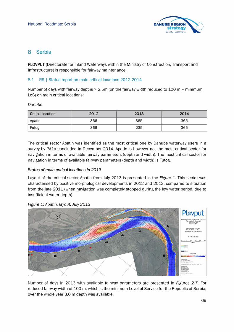
69
National Roadmap: Serbia
8 Serbia
PLOVPUT (Directorate for Inland Waterways within the Ministry of Construction, Transport and
Infrastructure) is responsible for fairway maintenance.
8.1 RS | Status report on main critical locations 2012-2014
Number of days with fairway depths > 2.5m (on the fairway width reduced to 100 m – minimum
LoS) on main critical locations:
Danube
Critical location 2012 2013 2014
Apatin 366 365 365
Futog 366 235 365
The critical sector Apatin was identified as the most critical one by Danube waterway users in a
survey by PA1a concluded in December 2014. Apatin is however not the most critical sector for
navigation in terms of available fairway parameters (depth and width). The most critical sector for
navigation in terms of available fairway parameters (depth and width) is Futog.
Status of main critical locations in 2013
Layout of the critical sector Apatin from July 2013 is presented in the Figure 1. This sector was
characterised by positive morphological developments in 2012 and 2013, compared to situation
from the late 2011 (when navigation was completely stopped during the low water period, due to
insufficient water depth).
Figure 1: Apatin, layout, July 2013
Number of days in 2013 with available fairway parameters are presented in Figures 2-7. For
reduced fairway width of 100 m, which is the minimum Level of Service for the Republic of Serbia,
over the whole year 3.0 m depth was available.

70
National Roadmap: Serbia

71
National Roadmap: Serbia
Layout of the critical sector Futog from December 2013 is presented at the Figure 8.
Figure 8: Futog, layout, December 2013
Even with the relatively favourable hydrological conditions which prevailed in 2013, fairway width
at the critical sector Futog needed to be reduced from comfortable 200 m to 100 m, which is the
defined minimum Level of Service in the Republic of Serbia, due to intensive morphological
developments. From Figures 9-14, it can be observed that maximum fairway width was not
achieved for most of the year. Situation was better if taken into account reduction of the fairway
width. With the reduced fairway width up to 100 m, 2.5 m depth was available for 282 days.
Further reduction of the fairway width to 80 m would not have any major impact on the available
depth, due to specific morphological characteristics of this critical sector, which is the reason why
this sector is the most critical one for navigation, in terms of available fairway parameters.

72
National Roadmap: Serbia

73
National Roadmap: Serbia
Status of main critical locations in 2014
Layout of the critical sector Apatin from May 2014 is presented in the Figure 15. This sector was
characterised by positive morphological developments in 2012, 2013 and 2014, compared to
situation from the late 2011 (when navigation was completely stopped during the low water
period, due to insufficient water depth).
Figure 15: Apatin, layout, May 2014
Number of days in 2014 with available fairway parameters is presented in Figure 16-18. For
reduced fairway width of 120 m, which is above the minimum Level of Service for the Republic of
Serbia, over the whole year 3m depth was available. This confirms that Apatin is not the most
critical sector for navigation in Serbia, in terms of available fairway depth and width.

74
National Roadmap: Serbia
Layout of the critical sector Futog from August 2014 is presented at the Figure 19.
Figure 19: Futog, layout, August 2014
Situation on the critical sector Futog was better in 2014 compared to 2013, having in mind
available fairway depth and width. Fairway width is still reduced to the minimum Level of Service,
which is 100 m, but fairway depth of 2.5 m was achieved throughout the whole year (365 days),
while 2.5 m depth on 120 m width was available for 337 days. Data for 2014 are presented at
Figures 20-25, while comparison of data from 2014 and 2013 is given at the Figure 26.
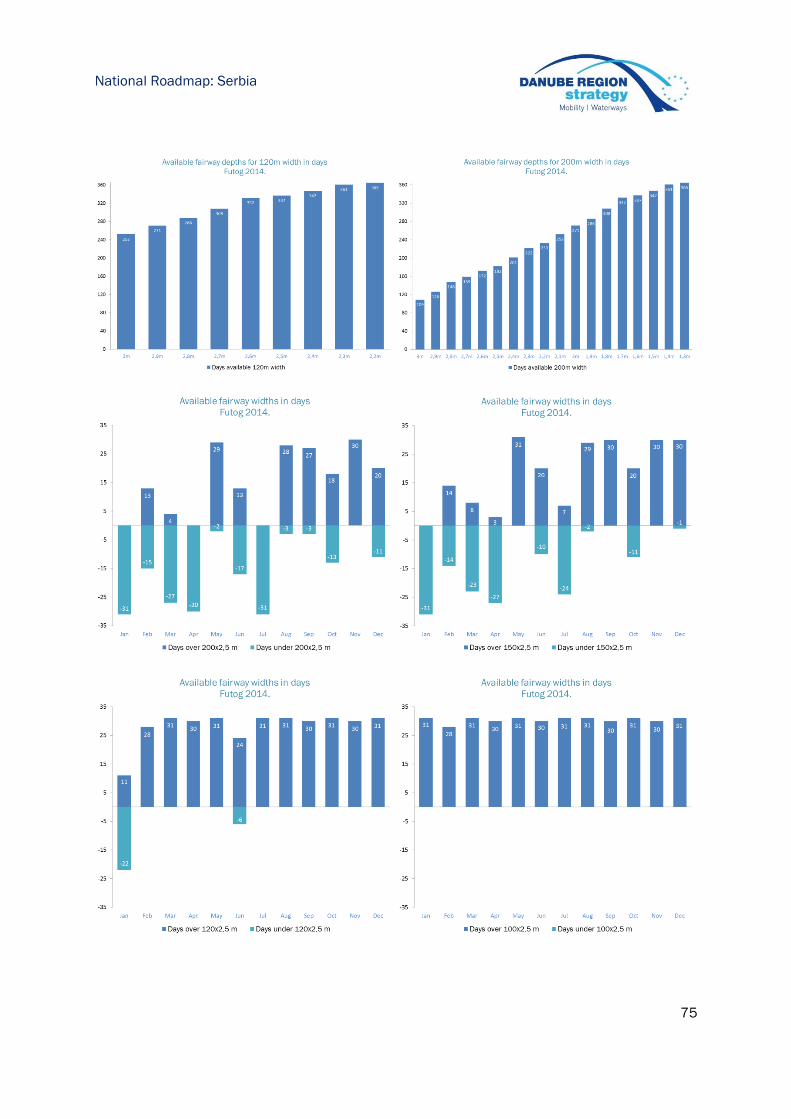
75
National Roadmap: Serbia
76
National Roadmap: Serbia
Sava River
Number of days with fairway depths > 2.5m (on fairway width 750 m) on main critical locations:
Critical location 2012* 2013* 2014
Sabac n/a n/a 306
Kamicak n/a n/a 346
*Not available due to lack of budgetary means for surveying
8.2 RS | Hydrological conditions on main critical locations 2012-2014
Please provide information about number of days with flow discharge above multiannual average
flow discharge for the main critical locations (as identified by the Danube waterway users in a
survey concluded in December 2014).
Danube
Critical location 2012 2013 2014
Apatin 151 217 134
Futog 128 213 163
8.3 RS | Water level information on main critical locations 2012-2014
Please, provide information about main critical locations - water level information (reference
gauge, number of days) above LNWL.
Danube
Critical location Reference gauge No of days above LNWL
2012 2013 2014
Apatin Apatin 366 365 365
Futog Novi sad 366 363 365
Water level data for the gauging station Apatin are presented in the Figure 27.
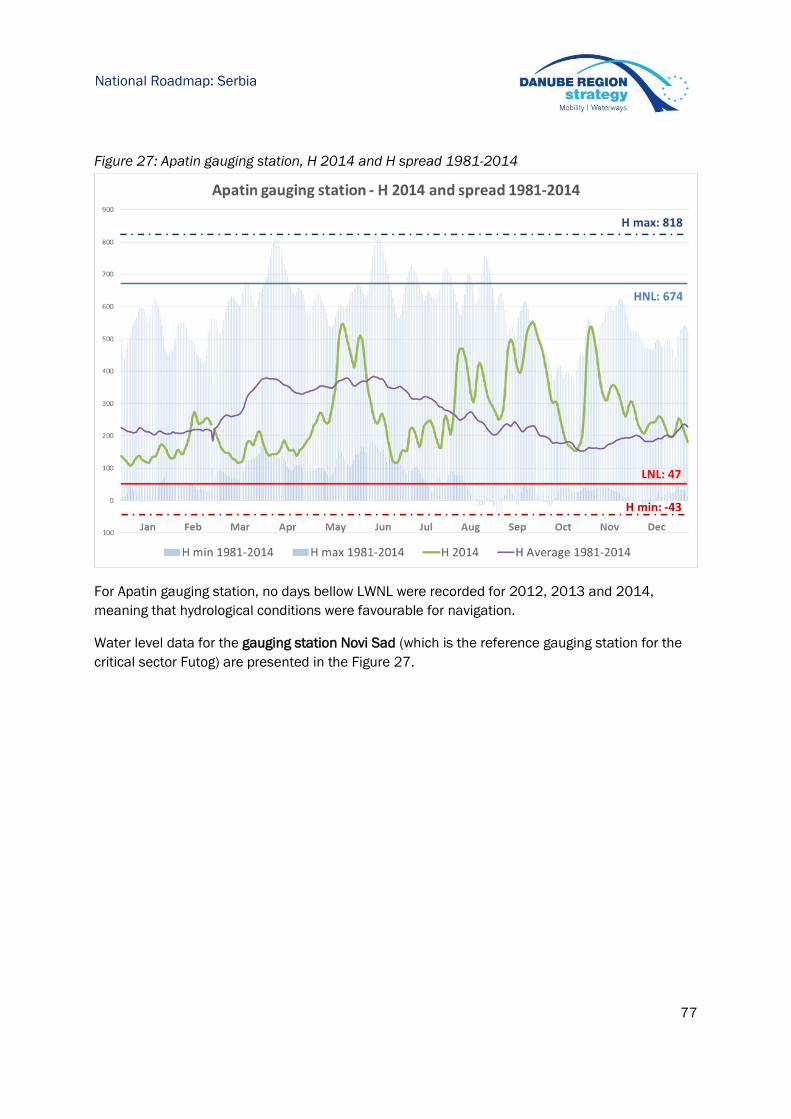
77
National Roadmap: Serbia
Figure 27: Apatin gauging station, H 2014 and H spread 1981-2014
For Apatin gauging station, no days bellow LWNL were recorded for 2012, 2013 and 2014,
meaning that hydrological conditions were favourable for navigation.
Water level data for the gauging station Novi Sad (which is the reference gauging station for the
critical sector Futog) are presented in the Figure 27.

78
National Roadmap: Serbia
Figure 28: Novi Sad gauging station, H 2014 and H spread 1981-2014
For Novi Sad gauging station, no days bellow LNL were recorded for 2012 and 2014, while only 2
days bellow LNL were recorded in 2013, confirming that hydrological conditions were favourable
for navigation.
8.4 RS | Water level prognoses for critical locations
Water level forecast are available for gauging stations, for the period of 2-4 days.
8.5 RS | Time from surveying to action: maintenance philosophy
Not available at the moment.
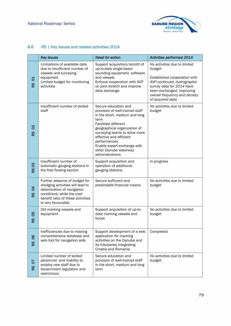
79
National Roadmap: Serbia
8.6 RS | Key issues and related activities 2014
Key issues Need for action Activities performed 2014
RS
0
1
Limitations of available data
due to insufficient number of
vessels and surveying
equipment
Limited budget for monitoring
activities
Support acquisition/retrofit of
up-to-date single-beam
sounding equipment, software
and vessels
Enforce cooperation with AVP
on joint stretch and improve
data exchange
No activities due to limited
budget
Established cooperation with
AVP continued, hydrographic
survey data for 2014 have
been exchanged, improving
overall frequency and density
of acquired data
RS
0
2
Insufficient number of skilled
staff
Secure education and
provision of well-trained staff
in the short, medium and long
term
Facilitate different
geographical organization of
surveying teams to allow more
effective and efficient
performances
Enable expert exchange with
other Danube waterway
administrations
No activities due to limited
budget
RS
03
Insufficient number of
automatic gauging stations in
the free flowing section
Support acquisition and
operation of additional
gauging stations.
In progress
RS
0
4
Further absence of budget for
dredging activities will lead to
deterioration of navigation
conditions, while the cost-
benefit ratio of these activities
is very favourable.
Secure sufficient and
predictable financial means
No activities due to limited
budget
RS
0
5 Old marking vessels and
equipment
Support acquisition of up-to-
date marking vessels and
buoys
No activities due to limited
budget
RS
0
6
Inefficiencies due to missing
comprehensive database and
web tool for navigation aids
Support development of a web
application for marking
activities on the Danube and
its tributaries integrating
Croatia and Romania
Completed
RS
0
7
Limited number of skilled
personnel and inability to
employ new staff due to
Government regulation and
restrictions
Secure education and
provision of well-trained staff
in the short, medium and long
term
No activities due to limited
budget

80
National Roadmap: Serbia
RS
08
The low number of gauging
stations results in incomplete
water level information and
lead to inaccurate forecasts.
Support acquisition and
operation of additional
gauging stations.
No activities due to limited
budget
Oth
er
Provision of dynamic fairway
information to users
Lunching of Navigational
Bulletin, an on-line fairway
information services portal for
the Republic of Serbia
(Danube, Sava and Tisza
Rivers)
The following dynamic, daily
updated data are being
published: water levels,
forecasts of water levels, wind
data, active Notices to
Skippers, active status of the
marking system, available
fairway depth and width at
critical locations, available
vertical clearances at bridges,
availability of locks, availability
of RIS services, contact
information of relevant
authorities.
8.7 RS | Review of rehabilitation and maintenance activities 2014
The following activities relate to all critical locations as identified in the Rehabilitation and
Maintenance Master Plan (version December 2014):
Surveying activities 2014
Danube
River-km (from-to) Frequency of
surveying
Type of survey (single/multibeam)
1.433 – 1.299 1 Singlebeam (CRO survey data) – 50 m cross-sections for
critical sectors
1.299 – 1.170 1-2 Singlebeam - 50 m cross-sections for critical sectors
1.170 – 865 1 Singlebeam – no critical sectors
865 – 845 1 Singlebeam – no critical sectors
Sava River
River-km (from-to) Frequency of surveying Type of survey (single/multibeam)
Remark Due to flood in May 2014,
measurements of flooded areas have
been performed
Singlebeam

81
National Roadmap: Serbia
Fairway relocation activities 2014
Danube
River-km (from-to) Frequency of relocation
interventions
Comments
1.267 – 1.261 3 Realignment of the fairway at the critical sector Futog
due to dynamic morphological developments
Dredging activities 2014
The following fairway dredging measures for commercial navigation were implemented:
Dredging of sediment from entrances to winter ports and from winter ports on the Danube
River (Novi Sad, Ivanovo and Kovin)
In total, 60.000 m3 of sediment from entrances to winter ports and winter ports were dredged for
commercial navigation in 2014 (Danube).
No dredged for commercial navigation have been performed in 2014 on the Sava River.
8.8 RS | Operational and investment costs
Actual operational costs 2014
Need areas Actual costs 2014 (Euro)
Minimum fairway parameters (dredging) 200.000
Surveying of the riverbed 200.000
Water level gauges -
Marking of the fairway 650.000
Availability of locks / lock chambers Not applicable
Information on water levels and forecasts 500
Information on fairway depths 1.000
Information on marking plans 500
Meteorological information 500
River Information Services 130.000
Sum 1.182.500
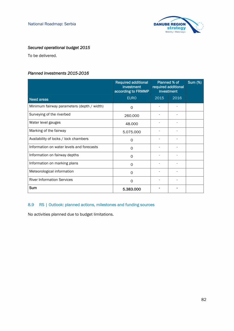
82
National Roadmap: Serbia
Secured operational budget 2015
To be delivered.
Planned investments 2015-2016
Required additional
investment
according to FRMMP
Planned % of
required additional
investment
Sum (%)
Need areas EURO 2015 2016
Minimum fairway parameters (depth / width) 0 - -
Surveying of the riverbed 260.000 - -
Water level gauges 48.000 - -
Marking of the fairway 5.075.000 - -
Availability of locks / lock chambers 0 - -
Information on water levels and forecasts 0 - -
Information on fairway depths 0 - -
Information on marking plans 0 - -
Meteorological information 0 - -
River Information Services 0 - -
Sum 5.383.000 - -
8.9 RS | Outlook: planned actions, milestones and funding sources
No activities planned due to budget limitations.

83
National Roadmap: Bosnia and Herzegovina
9 Bosnia and Herzegovina
Currently there is no agency on state level which is responsible for maintenance.
9.1 BA | Status report on main critical locations 2012-2014
Number of days with fairway depths > 2.5m on main critical locations (as identified by the
Danube waterway users in a survey by PA1a concluded in December 2014):
Critical location 2012 2013 2014
From rkm 69,7
To rkm 72,9
From rkm 79,9
To rkm 85,8
From rkm 88,3
To rkm 101,9
From rkm 103,5
To rkm 109,8
From rkm 173,8
To rkm 176,6
From rkm 177,8
To rkm 187,4
From rkm 189,2
To rkm 202,5
From rkm 202,5
To rkm 225,1
From rkm 225,1
To rkm 260,7
From rkm 260,7
To rkm 306,8
From rkm 306,8
To rkm 331,5
From rkm 364,4
To rkm 395,5
From rkm 417,1
To rkm 445,7
From rkm 445,7
To rkm 459,9
From rkm 459,9
To rkm 480,4
From rkm 480,4
To rkm 511,8
84
National Roadmap: Bosnia and Herzegovina
The main reasons for not meeting the level of service are the following:
The Sava river waterway needs huge and comprehensive rehabilitation and reconstruction works
in order to ensure considerable and fully usage of the waterway. The rehabilitation and
reconstruction works should also ensure necessary conditions for safe navigation along the Sava
river, which concedes afterwards regular maintenance works of the navigation path. Sava river
waterway is included in the core transport network in Bosnia and Herzegovina, and its
rehabilitation is one of the priorities in the transport sector in the country. Bosnia and
Herzegovina shall again apply for EU funds for preparation of necessary study and technical
documentation needed for further execution of construction works. Once the works are
completed and fairway infrastructure parameters are harmonised with the appropriate
parameters along the Danube fairway, the regular maintenance works shall be established,
following the principles and guidelines from the Fairway Maintenance Master Plan (cycle of
monitoring, planning, execution, information), including usage of best practices and experience of
other countries in the Danube region in this respect.
Bosnia and Herzegovina currently maintains the fairway signalling system of the Sava river
fairway from rkm 343 to rkm 211 on BiH and Croatian fairway/river banks, and from rkm 211 to
rkm 178 for BiH part of the fairway/river bank, according to the Agreement between the
Government of the Republic of Croatia and the Council of ministers of Bosnia and Herzegovina on
inland waterways navigation, its signalling and maintenance.
9.2 BA | Hydrological conditions on main critical locations 2012-2014
Not applicable (please see the explanation given above).
9.3 BA | Water level information on main critical locations 2012-2014
Not applicable (please see the explanation given above).
9.4 BA | Water level prognoses for critical locations
Not applicable (please see the explanation given above).
9.5 BA | Time from surveying to action: maintenance philosophy
Not applicable (please see the explanation given above).
9.6 BA | Key issues and related activities 2014
In the Fairway Rehabilitation and Maintenance Master Plan (version December 2014), no key
issues were identified.

85
National Roadmap: Bosnia and Herzegovina
9.7 BA | Review of rehabilitation and maintenance activities 2014
Surveying activities 2014
No surveying activity has been performed in 2014 (please see explanation above).
Fairway relocation activities 2014
No relocation activities have been performed in 2014.
Dredging activities 2014
No dredging activities have been performed in 2014.
9.8 BA | Operational and investment costs
Actual operational costs 2014
Need areas Actual costs 2014 (Euro)
Minimum fairway parameters (dredging)
Surveying of the riverbed
Water level gauges
Marking of the fairway / maintenance of the
marking system 100.000
Availability of locks / lock chambers
Information on water levels and forecasts
Information on fairway depths
Information on marking plans
Meteorological information
Other needs
Sum 100.000
Secured operational budget 2015
To be delivered.
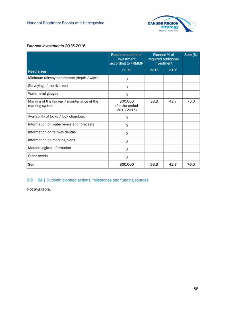
86
National Roadmap: Bosnia and Herzegovina
Planned investments 2015-2016
Required additional
investment
according to FRMMP
Planned % of
required additional
investment
Sum (%)
Need areas EURO 2015 2016
Minimum fairway parameters (depth / width) 0
Surveying of the riverbed 0
Water level gauges 0
Marking of the fairway / maintenance of the
marking system
300.000
(for the period
2013-2015)
33,3 42,7 76,0
Availability of locks / lock chambers 0
Information on water levels and forecasts 0
Information on fairway depths 0
Information on marking plans 0
Meteorological information 0
Other needs 0
Sum 300.000 33,3 42,7 76,0
9.9 BA | Outlook: planned actions, milestones and funding sources
Not available.

87
National Roadmap: Romania
10 Romania
The Administration of the Lower Danube (AFDJ) and the Administration of the Navigable Canals
(ACN) are responsible for fairway maintenance.
10.1 RO | Status report on main critical locations 2012-2014
Number of days with fairway depths > 2.5m on main critical locations
Danube
Critical location 2012 2013 2014
Bechet 355 327 365
Corabia 348 335 365
Turcescu 281 297 345
Seimeni 323 329 365
Status of critical locations 2013
In the first half of the year 2013, no depths below 2.5m were registered. Depths below 2,5 only
occurred during July - October when levels fall, which is usually the period with the lowest levels of
the year and requiring calibration works for the fairway.
In 2013, the navigation problems were met in the downstream area of Calarasi where frequent
accumulations of sediment occurred, which required dredging works to ensure the fairway
depths, resulting in a volume of 370,000 m³ of material.
88
National Roadmap: Romania
Status of critical locations 2014
For most critical areas, the level of service was met in 2014, with water depths more than 2.5m
in the fairway area, due to favourable hydrological situation. The minimum water level was higher
than low navigable water level, creating the conditions for positive navigation conditions.
Danube-Black Sea Canal
In the years 2012-2014 fairway depths were over 2.5 m on the Danube-BlackSea Canal for the
whole year:
Critical location 2012 2013 2014
confluence with the Danube
river km 64-65 - DBSC 365 365 365
Port Medgidia km 37- DBSC 365 365 365
Downstream Navodari lock –
CPAMN 365 365 365
Port Luminita – river branch
Luminita 365 365 365
89
National Roadmap: Romania
10.2 RO | Hydrological conditions on main critical locations 2012-2014
Number of days with flow discharge above multi-annual average flow discharge for the main
critical locations.
Critical location 2012 2013 2014
Bechet 105 211 233
Corabia 108 171 218
Turcescu 137 202 236
Seimeni 51 156 199
The table shows that the 2014 year is much better, regarding the hydrological point of view.
Usually the low water period is in August-October, which represents 25% of the year.
10.3 RO | Water level information on main critical locations 2012-2014
Please, provide information about main critical locations - water level information (reference
gauge, number of days) above LNWL.
Critical location Reference gauge No of days above LNWL
2012 2013 2014
Bechet Bechet 332 329 365
Corabia Corabia 328 325 365
Turcescu Calarasi 319 325 365
Seimeni Cernavoda 331 325 365
Analyzing the water level information for the Romanian sector of the Danube from a hydrological
point of view, one sees that in the year 2014 conditions were much better than in previous years.
This was decisive in ensuring that the navigation conditions were favourable, with fairway depths
more than 2.5m.
The average daily water level was 311cm in Bechet and 266cm in Calarasi, with about 30cm -
40cm higher than previous years and the minimum water levels were over the low navigable
water level value.
10.4 RO | Water level prognoses for critical locations
Water level information is transmitted on a daily basis from a total of 23 gauge stations, on
www.afdj.ro web site and forecast for three gauge stations with a range of 48 hours. On the
administration web site, daily data are provided about actual real depths for the critical locations
including a drawing for every location. The water level forecasts take into consideration the
information from the water level sensors (every 15 minutes) near critical locations and the
information from gauge station forecasts.
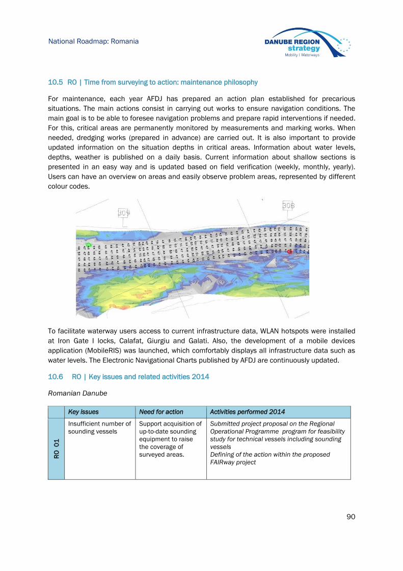
90
National Roadmap: Romania
10.5 RO | Time from surveying to action: maintenance philosophy
For maintenance, each year AFDJ has prepared an action plan established for precarious
situations. The main actions consist in carrying out works to ensure navigation conditions. The
main goal is to be able to foresee navigation problems and prepare rapid interventions if needed.
For this, critical areas are permanently monitored by measurements and marking works. When
needed, dredging works (prepared in advance) are carried out. It is also important to provide
updated information on the situation depths in critical areas. Information about water levels,
depths, weather is published on a daily basis. Current information about shallow sections is
presented in an easy way and is updated based on field verification (weekly, monthly, yearly).
Users can have an overview on areas and easily observe problem areas, represented by different
colour codes.
To facilitate waterway users access to current infrastructure data, WLAN hotspots were installed
at Iron Gate I locks, Calafat, Giurgiu and Galati. Also, the development of a mobile devices
application (MobileRIS) was launched, which comfortably displays all infrastructure data such as
water levels. The Electronic Navigational Charts published by AFDJ are continuously updated.
10.6 RO | Key issues and related activities 2014
Romanian Danube
Key issues Need for action Activities performed 2014
RO
0
1
Insufficient number of
sounding vessels
Support acquisition of
up-to-date sounding
equipment to raise
the coverage of
surveyed areas.
Submitted project proposal on the Regional
Operational Programme program for feasibility
study for technical vessels including sounding
vessels
Defining of the action within the proposed
FAIRway project
91
National Roadmap: Romania
RO
0
2
Insufficient number of
automatic gauging
stations.
Support acquisition of
additional automatic
gauging stations,
especially for critical
sections.
Submitted project proposal on the Regional
Operational Programme for feasibility study for
rehabilitating and extending the network of
hydrometric stations on the Romanian sector of
Danube
Defining of the action within the proposed
FAIRway project
RO
03
Lack of dredging
equipment,
specialized personnel
and deficiency of
investments in river
regulation
Support acquisition of
dredging equipment
performance to
increase the
efficiency of working
problem areas and
the possibility of
intervention at any
time where it is
needed
Ensuring the enough budget for dredging works
for 2014
Submitted project proposal on the Regional
Operational Programme for feasibility study for
technical vessels including dredger
Defining of the action within the proposed
PATTERN project - Pilot Activities to Develop the
Technical and Operational Capacity for Danube
Fairway Rehabilitation including dredging
equipment acquisition
Submitted project proposal on the Regional
Operational Programme for feasibility study for
riverbank protection on the Sulina Canal
Submitted project proposal on the Regional
Operational Programme for feasibility study for
improving the navigation condition on the
Danube between Calarasi – Braila – DUNARE 1
Defining of the action within the proposed FAST
Danube project for the feasibility study for
review the technical solution for improving the
navigation condition on the Romanian -
Bulgarian Danube common sector and
complementary study
RO
0
4
Inefficient
procedures. The
documentation to
draw up a contract for
dredging is time
consuming.
Support
standardization and
simplification of
documentation
procedures.
-
RO
0
5
Lack of efficient
vessels and special
equipment for
marking.
Support acquisition of
vessels equipped with
advanced machines
to perform operations
board assembly /
disassembly floating
signals.
Submitted project proposal on the Regional
Operational Programme for feasibility study for
technical vessels including marking vessels
Defining of the action within the proposed
FAIRway project
Defining of the action within the proposed
PATTERN project - Pilot Activities to Develop the
Technical and Operational Capacity for Danube
Fairway Rehabilitation, including marking
vessel acquisition

92
National Roadmap: Romania
RO
0
6
Insufficient number of
buoys and position
monitoring
equipment.
Unavailable
automated system for
the transmission of
information on the
buoys. The
disseminationofinfor
mationcouldbeimprov
ed.
Support acquisition of
buoys and monitoring
equipment.
Support
establishment of an
automated monitoring
system and improve
the provision of
information on
fairway marks.
Purchased 65 de buoys equipped with
monitoring equipment
In NEWADA duo project was implementing the
monitoring system for marking
RO
0
7
Unavailable forecast
for water levels.
Support
establishment of a
water level forecast
Submitted project proposal on the Regional
Operational Programme for feasibility study for
rehabilitating and extending the network of
hydrometric stations on the Romanian sector of
Danube- HyQ project
AFDJ developed a geodesic network of support
within the project BORD, financed on Regional
Operational Programme
IRIS Europe 3 project has developed a
mathematical model for the water level on the
selected pilot sector (Corabia-Bechet)
RO
08
Information could be
provided customer-
friendly using
established river
information portals.
Support customer-
friendly processing
and dissemination of
information.
AFDJ developed a new version of the AFDJ site
AFDJ forwarded the information to the FIS
PORTAL
RO
09
Unavailable digital
terrain models for
shallow sections.
Support set-up of
digital terrain models
for shallow sections.
IRIS Europe 3 project has developed a DTM on
the selected pilot sector (Corabia-Bechet)
RO
10
Insufficient number
and quality of weather
stations.
Support improvement
of meteorological
information.
Submitted project proposal on the Regional
Operational Programme for feasibility study for
rehabilitating and expanding the network of
hydrometric stations on the Romanian sector of
Danube – HyQ project
RO
11
Missing
interconnection with
databases of other
waterway
administrations to
exchange data.
Support
interconnection
between databases of
different waterway
administrations.
In the NEWADA duo project was developed a
centralized database between 4 waterway
administrations RO/BG/SR/HR for signalling
scheme

93
National Roadmap: Romania
Danube Black Sea Canal
Key issues Need for action Activities performed 2014
RO
0
1 Insufficient number of
sounding vessels
Support acquisition of up-to-
date sounding equipment to
raise the coverage of surveyed
areas.
-
RO
0
2
Insufficient number of
automatic gauging stations.
Support acquisition of
additional automatic gauging
stations, especially for critical
sections.
DBSC: ACN has an ongoing
project through which will be
acquisition a new automatic
gauging system.
RO
03
Lack of dredging equipment,
specialized personnel and
deficiency of investments in
river regulation
Support acquisition
ofdredgingequipmentperforma
ncetoincrease the efficiency
ofworkinproblem areas andthe
possibilityof interventionat any
timewhere it is needed
DBSC: ACN performed
dredging works by contracting
a specialized company
RO
0
4
Inefficient procedures. The
documentation to draw up a
contract for dredging is time
consuming.
Support standardization and
simplification of
documentation procedures.
DBSC: In the process of
contracting companies that do
dredging ACN follows the
national legislation and
internal procedures regarding
acquisitions
RO
0
5
Lack of efficient vessels and
special equipment for
marking.
Support acquisition of vessels
equipped with advanced
machines to perform
operations board assembly /
disassembly floating signals.
DBSC: No acquisitions have
been made during 2014
RO
0
6
Insufficient number of buoys
and position monitoring
equipment.
Unavailable automated
system for the transmission of
information on the buoys. The
dissemination of information
could be improved
Support acquisition of buoys
and monitoring equipment.
Support establishment of an
automated monitoring system
and improve the provision of
information on fairway marks.
DBSC: No acquisitions have
been made during 2014
RO
0
7 Unavailable forecast for water
levels.
Support establishment of a
water level forecast
-
RO
08
Information could be provided
customer-friendly using
established river information
portals.
Support customer-friendly
processing and dissemination
of information.
-
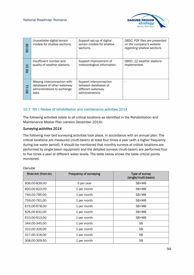
94
National Roadmap: Romania
RO
09
Unavailable digital terrain
models for shallow sections.
Support set-up of digital
terrain models for shallow
sections.
DBSC: PDF files are presented
on the company’s website
regarding shallow sections
RO
10
Insufficient number and
quality of weather stations.
Support improvement of
meteorological information.
DBSC: 12 weather stations
implemented.
RO
11
Missing interconnection with
databases of other waterway
administrations to exchange
data.
Support interconnection
between databases of
different waterway
administrations.
-
10.7 RO | Review of rehabilitation and maintenance activities 2014
The following activities relate to all critical locations as identified in the Rehabilitation and
Maintenance Master Plan (version December 2014):
Surveying activities 2014
The following river bed surveying activities took place, in accordance with an annual plan. The
critical locations are measured (multi-beam) at least four times a year (with a higher frequency
during low water period). It should be mentioned that monthly surveys at critical locations are
performed by single-beam equipment and the detailed surveys (multi-beam) are performed four
to five times a year at different water levels. The table below shows the table critical points
monitored.
Danube
River-km (from-to) Frequency of surveying Type of survey
(single/multi-beam)
836,00-839,00 5 per year SB+MB
820,00-823,00 1 per month SB+MB
783,00-785,00 1 per month SB+MB
759,00-761,00 1 per month SB+MB
675,00-678,00 1 per month SB+MB
626,00-632,00 1 per month SB+MB
610,00-613,00 1 per month SB+MB
344,00-345,00 1 per month SB
322,00-326,00 1 per month SB
317,00-318,00 1 per month SB
308,00-309,50 1 per month SB
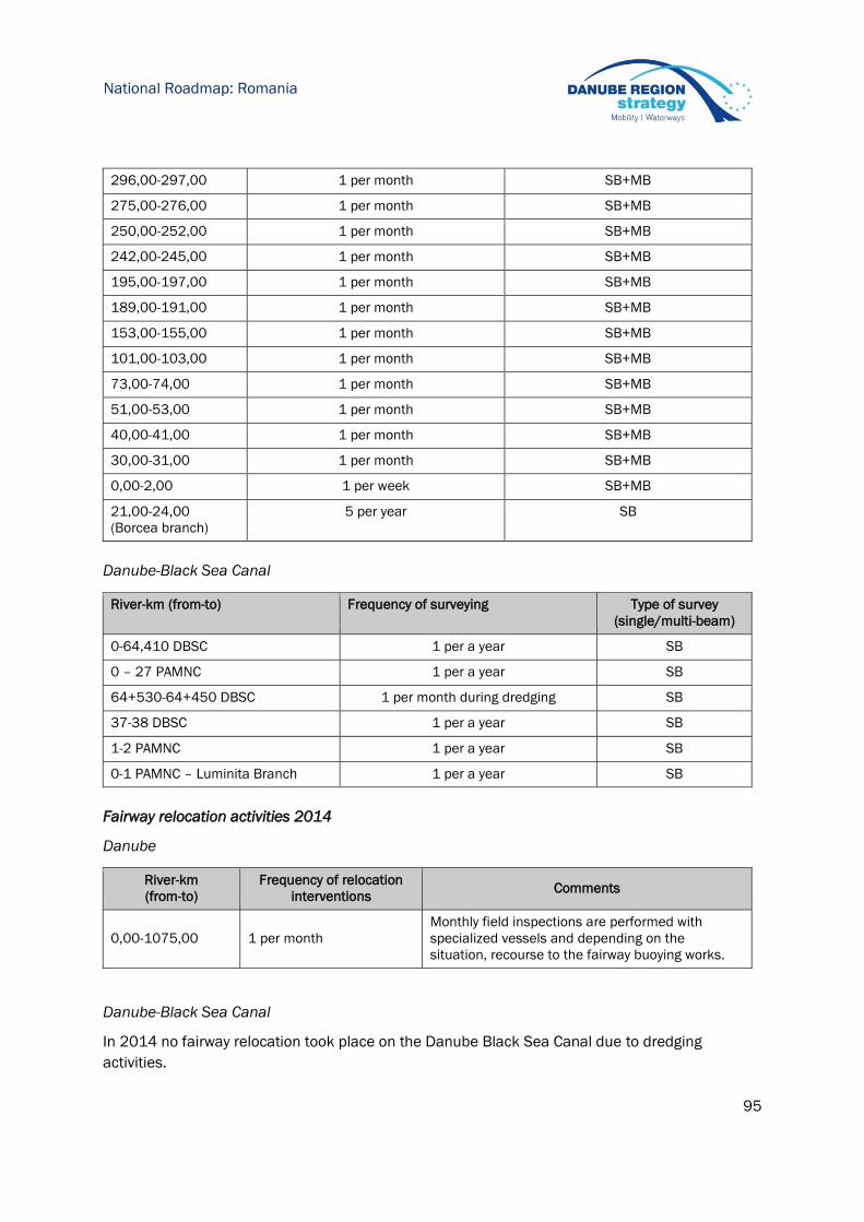
95
National Roadmap: Romania
296,00-297,00 1 per month SB+MB
275,00-276,00 1 per month SB+MB
250,00-252,00 1 per month SB+MB
242,00-245,00 1 per month SB+MB
195,00-197,00 1 per month SB+MB
189,00-191,00 1 per month SB+MB
153,00-155,00 1 per month SB+MB
101,00-103,00 1 per month SB+MB
73,00-74,00 1 per month SB+MB
51,00-53,00 1 per month SB+MB
40,00-41,00 1 per month SB+MB
30,00-31,00 1 per month SB+MB
0,00-2,00 1 per week SB+MB
21,00-24,00
(Borcea branch)
5 per year SB
Danube-Black Sea Canal
River-km (from-to) Frequency of surveying Type of survey
(single/multi-beam)
0-64,410 DBSC 1 per a year SB
0 – 27 PAMNC 1 per a year SB
64+530-64+450 DBSC 1 per month during dredging SB
37-38 DBSC 1 per a year SB
1-2 PAMNC 1 per a year SB
0-1 PAMNC – Luminita Branch 1 per a year SB
Fairway relocation activities 2014
Danube
River-km
(from-to)
Frequency of relocation
interventions Comments
0,00-1075,00
1 per month
Monthly field inspections are performed with
specialized vessels and depending on the
situation, recourse to the fairway buoying works.
Danube-Black Sea Canal
In 2014 no fairway relocation took place on the Danube Black Sea Canal due to dredging
activities.

96
National Roadmap: Romania
River-km (from-to) Frequency of relocation
interventions
Comments
- n/a On the Danube Black Sea Canal fairway relocation
activities are executed only during low water levels
and during 2014 there was no need for this kind of
activities.
Dredging activities 2014
Danube
The following fairway dredging measures for navigation conditions insurance were implemented
on the Romanian Danube:
Location Dredging site (river-km) Beginning of
service End of
service
Material m³
From To
Bechet 676.50 677.00 12.12.2014 14.12.2014 Fine sediment 1,513.00
Cochirleni 304.00 305.00 05.11.2014 18.11.2014 Fine sediment 10,290.00
Seimeni 289.00 292.00 01.09.2014 30.12.2014 Fine sediment 89,382.00
Albanesti 275.00 276.00 02.10.2014 30.12.2014 Fine sediment 55,421.00
Harsova 249.00 251.00 05.09.2014 30.12.2014 Fine sediment 97,639.00
On the river Danube the 254.245 m³ were dredged with the third parties to ensure navigation
conditions in 2014. For the maritime Danube, a volume of 169.680 m³ was dredged in 2014 with
own resources. For 2014, a total volume of 423.925 m³ was dredged to ensure navigation
conditions.
Danube-Black Sea Canal
River-km (from-to) Dredging months Cubic metre dredged
64+530-64+450 January 32.285
February 26.655
March 28.755
In total 87.695 m3 were dredged for commercial navigation on the Danube Black Sea Canal in
2014.
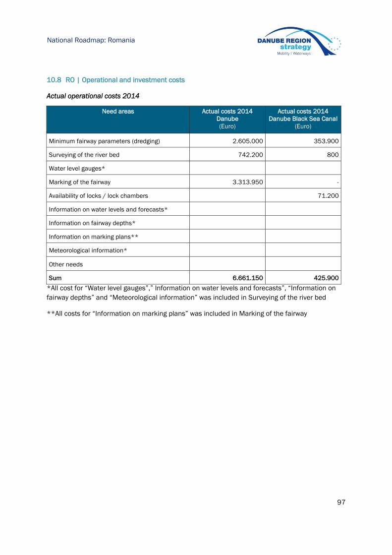
97
National Roadmap: Romania
10.8 RO | Operational and investment costs
Actual operational costs 2014
Need areas Actual costs 2014
Danube
(Euro)
Actual costs 2014
Danube Black Sea Canal
(Euro)
Minimum fairway parameters (dredging) 2.605.000 353.900
Surveying of the river bed 742.200 800
Water level gauges*
Marking of the fairway 3.313.950 -
Availability of locks / lock chambers 71.200
Information on water levels and forecasts*
Information on fairway depths*
Information on marking plans**
Meteorological information*
Other needs
Sum 6.661.150 425.900
*All cost for “Water level gauges”,” Information on water levels and forecasts”, “Information on
fairway depths” and “Meteorological information” was included in Surveying of the river bed
**All costs for “Information on marking plans” was included in Marking of the fairway
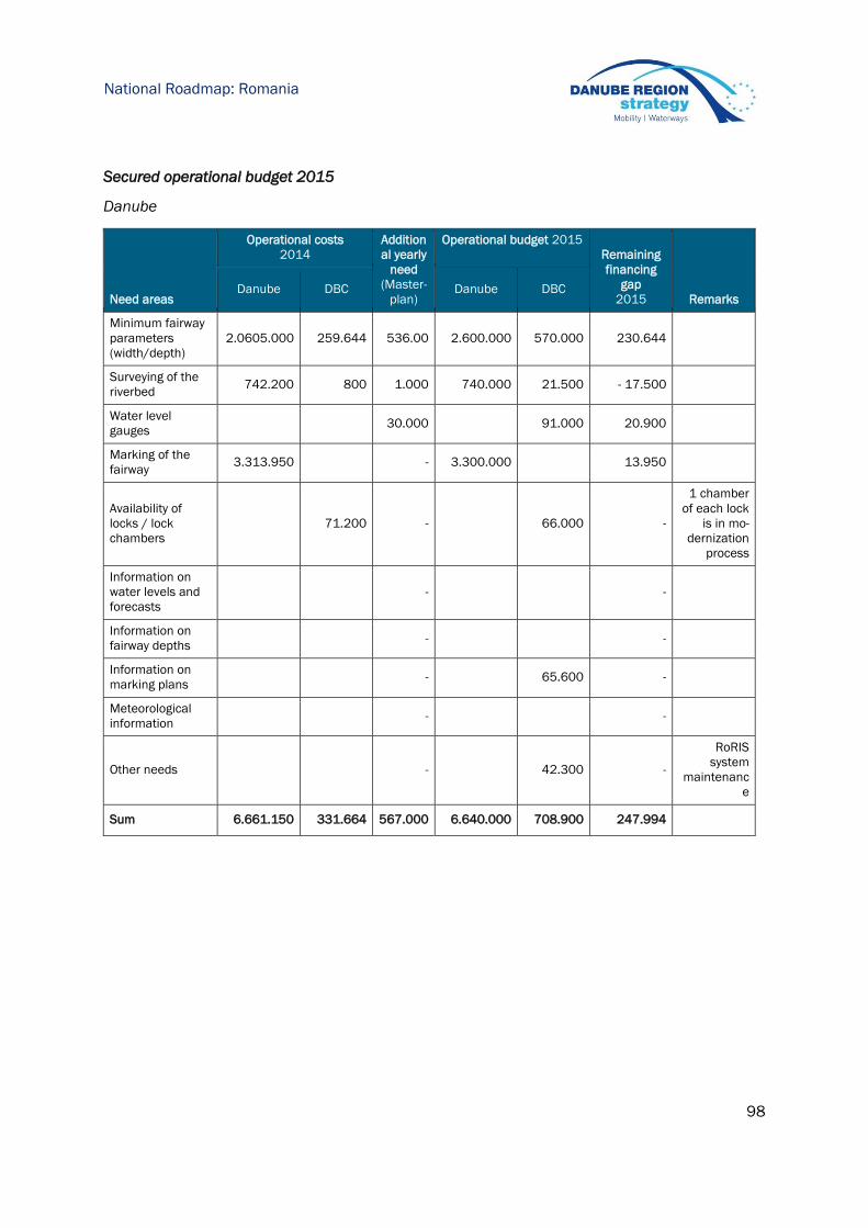
98
National Roadmap: Romania
Secured operational budget 2015
Danube
Need areas
Operational costs
2014
Addition
al yearly
need
(Master-
plan)
Operational budget 2015
Remaining
financing
gap
2015 Remarks Danube DBC Danube DBC
Minimum fairway
parameters
(width/depth)
2.0605.000 259.644 536.00 2.600.000 570.000 230.644
Surveying of the
riverbed 742.200 800 1.000 740.000 21.500 - 17.500
Water level
gauges 30.000 91.000 20.900
Marking of the
fairway 3.313.950 - 3.300.000 13.950
Availability of
locks / lock
chambers
71.200 - 66.000 -
1 chamber
of each lock
is in mo-
dernization
process
Information on
water levels and
forecasts
- -
Information on
fairway depths - -
Information on
marking plans - 65.600 -
Meteorological
information - -
Other needs - 42.300 -
RoRIS
system
maintenanc
e
Sum 6.661.150 331.664 567.000 6.640.000 708.900 247.994

99
National Roadmap: Romania
Planned investments 2015-2016
Required additional
investment
according to FRMMP
Planned % of required
additional investment
Sum (%)
Need areas EURO 2015 2016
Minimum fairway parameters (depth / width) 23.500.000 1,28 1,06 2,34
Surveying of the riverbed 5.433.000 4,60 4,23 8,83
Water level gauges 300.000 130,33 15,00 145,33
Marking of the fairway 10.274.000 2,77 0,97 3,75
Availability of locks / lock chambers 400.000 0,00 0,00 0,00
Information on water levels and forecasts 206.000 14,56 9,71 24,27
Information on fairway depths 400.000 10,00 15,00 25,00
Information on marking plans 80.000 12,50 25,00 37,50
Meteorological information 365.000 2,74 2,74 5,48
Other needs 100.000 0,00 0,00 0,00
Sum 41.058.000 3,21 1,79 5,00
10.9 RO | Outlook: planned actions, milestones and funding sources
Danube
RO 01: Insufficient number of sounding vessels
Planned activities: Support acquisition of up-to-date sounding equipment to
raise the coverage of surveyed areas managing of the
purchasing
Current shortcomings: Insufficient of the up-to-date sounding vessels and
equipment, modernisation and acquisition requested
Possible funding: Budget availability 2015/2016: Funding through
Regional Operational Programme – feasibility study for
technical vessels
CEF Programme – FAIRway project
Next steps: Finalisation the feasibility study for sounding vessels
Acquisition of sounding vessels and equipments
Until 2017

100
National Roadmap: Romania
RO 02: Insufficient number of automatic gauging stations.
Planned activities: Support acquisition of additional automatic gauging
stations, especially for critical sections.
Current shortcomings: Insufficient number of automatic gauging stations ,
especially for critical sections
Possible funding: Budget availability 2015/2016: Funding through Regional
Operational Programme – HyQ Project/ CEF Programme
– FAIRway project /next call of CEF Programme or next
Operational Programme
Next steps: Finalisation the feasibility study for rehabilitating and
extending the network of hydrometric stations
Organising the tender for automatic gauging station for
installation automatic gauging station in a selected pilot
areas
Installation automatic gauging station in a selected pilot
areas
Submitting the proposal for rehabilitating and extending
the network of hydrometric stations
Organising the tender and implementing the gauging
network system
Until 2018
RO 03: Lack of dredging equipment, specialized personnel and deficiency of investments in river
regulation
Planned activities: Support acquisition of dredging equipment performance
to increase the efficiency of working problem areas and
the possibility of intervention at any time where it is
needed
Current shortcomings: Limited national dredging market, missing dredging
equipment for river sector problem areas and the
possibility of intervention at any time where it is needed
Lack of new specialized personnel due to the restrictions
of national legislation
Low level waterway infrastructure
Possible funding: Budget availability 2015/2016: Funding through CEF
Programme – PATTERN project and ensure enough
budget for dredging works and personnel training
through state budget/AFDJ budget
ROP – feasibility study for for riverbank protection on the
Sulina Canal
ROP – feasibility study for improving the navigation
condition on the Danube between Calarasi – Braila –
DUNARE 1
Next ROP for feasibility study for review the technical
solution for improving the navigation condition on the
Romanian - Bulgarian Danube common sector and
complementary study – FAST DANUBE
Next steps: Finalisation the feasibility study for dredging vessels
Acquisition of dredging equipment
New dredging equipment needs of having new specialized
personnel – training will be made
End of 2018

101
National Roadmap: Romania
Finalisation feasibility study for riverbank protection on
the Sulina Canal
Finalisation feasibility study for improving the navigation
condition on the Danube between Calarasi – Braila –
DUNARE 1
Finalisation feasibility study for review the technical
solution for improving the navigation condition on the
Romanian - Bulgarian Danube common sector and
complementary study – FAST DANUBE
River engineering works for improving waterway
infrastructure on the Sulina Canal, Calarasi – Braila,
Romanian - Bulgarian Danube common sector
Until 2017
RO 04: Inefficient procedures. The documentation to draw up a contract for dredging is time-consuming.
Planned activities: Support standardization and simplification of
documentation procedures.
Current shortcomings: Inefficient procedures
Possible funding: Budget availability 2015/2016: Funding through AFDJ
budget/state budget
Next steps: Preparing specific documentation for the efficient
procedures concerning with existing standards and
national legislation
Until 2015
RO 05: Lack of efficient vessels and special equipment for marking.
Planned activities: Support acquisition of vessels equipped with advanced
machines to perform operations board assembly /
disassembly floating signals.
Current shortcomings: Missing the efficient vessels and special equipment for
marking
Possible funding: Budget availability 2015/2016: Funding through Regional
Operational Programme – Feasibility study for technical
vessels/ CEF Programme – FAIRway project and PATTERN
project
Next steps: Finalisation the feasibility study for marking vessels
Organising the tender and purchasing the vessels
Until 2017
RO 06: Insufficient number of buoys and position monitoring equipment.
Unavailable automated system for the transmission of information on the buoys. The dissemination of
information could be improved
Planned activities: Support acquisition of buoys and monitoring equipment.
Support establishment of an automated monitoring
system and improve the provision of information on
fairway marks.
Current shortcomings: Insufficient number of buoys and position monitoring
equipment
Possible funding: Budget availability 2015/2016: Funding through CEF
Programme – FAIRway project
AFDJ budget/state budget
Next steps: Preparing the technical specification for public acquisition Until 2016
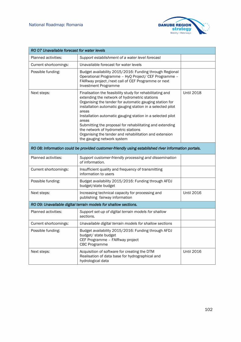
102
National Roadmap: Romania
RO 07 Unavailable forecast for water levels
Planned activities: Support establishment of a water level forecast
Current shortcomings: Unavailable forecast for water levels
Possible funding: Budget availability 2015/2016: Funding through Regional
Operational Programme – HyQ Project/ CEF Programme –
FAIRway project /next call of CEF Programme or next
Investment Programme
Next steps: Finalisation the feasibility study for rehabilitating and
extending the network of hydrometric stations
Organising the tender for automatic gauging station for
installation automatic gauging station in a selected pilot
areas
Installation automatic gauging station in a selected pilot
areas
Submitting the proposal for rehabilitating and extending
the network of hydrometric stations
Organising the tender and rehabilitation and extension
the gauging network system
Until 2018
RO 08: Information could be provided customer-friendly using established river information portals.
Planned activities: Support customer-friendly processing and dissemination
of information.
Current shortcomings: Insufficient quality and frequency of transmitting
information to users
Possible funding: Budget availability 2015/2016: Funding through AFDJ
budget/state budget
Next steps: Increasing technical capacity for processing and
publishing fairway information
Until 2016
RO 09: Unavailable digital terrain models for shallow sections.
Planned activities: Support set-up of digital terrain models for shallow
sections.
Current shortcomings: Unavailable digital terrain models for shallow sections
Possible funding: Budget availability 2015/2016: Funding through AFDJ
budget/ state budget
CEF Programme – FAIRway project
CBC Programme
Next steps: Acquisition of software for creating the DTM
Realisation of data base for hydrographical and
hydrological data
Until 2016
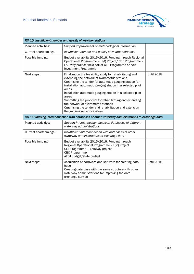
103
National Roadmap: Romania
RO 10: Insufficient number and quality of weather stations.
Planned activities: Support improvement of meteorological information.
Current shortcomings: Insufficient number and quality of weather stations.
Possible funding: Budget availability 2015/2016: Funding through Regional
Operational Programme – HyQ Project/ CEF Programme –
FAIRway project /next call of CEF Programme or next
Investment Programme
Next steps: Finalisation the feasibility study for rehabilitating and
extending the network of hydrometric stations
Organising the tender for automatic gauging station for
installation automatic gauging station in a selected pilot
areas
Installation automatic gauging station in a selected pilot
areas
Submitting the proposal for rehabilitating and extending
the network of hydrometric stations
Organising the tender and rehabilitation and extension
the gauging network system
Until 2018
RO 11: Missing interconnection with databases of other waterway administrations to exchange data
Planned activities: Support interconnection between databases of different
waterway administrations.
Current shortcomings: Insufficient interconnection with databases of other
waterway administrations to exchange data
Possible funding: Budget availability 2015/2016: Funding through
Regional Operational Programme – HyQ Project
CEF Programme – FAIRway project
CBC Programme
AFDJ budget/state budget
Next steps: Acquisition of hardware and software for creating data
base
Creating data base with the same structure with other
waterway administrations for improving the data
exchange service
Until 2016

104
National Roadmap: Bulgaria
11 Bulgaria
EAEMDR – Executive Agency "Exploration and Maintenance of the Danube River" (public authority
within Ministry of Transport) is responsible for fairway maintenance.
11.1 BG | Status report on main critical locations 2012-2014
Number of days with fairway depths > 2.5m on main critical locations (as identified by the
Danube waterway users in a survey concluded in December 2014):
Critical location 2012 2013 2014
km 610 - km 607 318 327 365
km 591 - km 584 345 346 365
km 569 - km 561 283 275 337
km 548 - km 540 292 309 360
km 540 - km 536 316 317 360
km 525 - km 520 339 314 352
km 476 - km 472 337 326 365
km 463 - km 460 366 365 365
km 458 - km 455 341 365 365
km 441 - km 435 366 365 365
km 426 - km 420 332 354 365
km 414 - km 410 345 341 365
km 408 - km 399 342 365 365
km 395 - km 390 345 365 365
km 386 - km 382 346 358 365
11.2 BG | Hydrological conditions on main critical locations 2012-2014
Number of days with flow discharge above multiannual average flow discharge for the main
critical locations.
Critical location 2012 2013 2014
Svishtov km 554.300 78 168 205
Ruse km 495.600 84 176 211
Silistra km 375.500 75 165 210
* In the critical locations flow discharge measurements are not performed with the necessary
frequency. In order number of days with flow discharge above multiannual average flow discharge
to be calculated additional data is needed. The data used as a base for the above table is
collected in gauging stations near critical sections.

105
National Roadmap: Bulgaria
11.3 BG | Water level information on main critical locations 2012-2014
Critical location Reference gauge No of days above LNWL
2012 2013 2014
567.00-566.70 – Belene island
562.00-561.50 – Coundur island
541.60-541.00 – Vardim island
Svishtov km 554.300 337 326 365
523.80-523.20 – Batin island
475.70-475.30 – Gostin island
Ruse km 495.600 341 329 365
391.60-391.10 – Vetren island
383.50-382.50 – Chaika island
Silistra km 375.500 325 326 365
11.4 BG | Water level prognoses for critical location
On the basis of the collected data daily, monthly, annual and multi-annual prognosis are
prepared. Daily forecasting of the expected water levels is done for Ruse and Silistra. These are
short term forecasts – concerning the next two days. Every Wednesday a weekly forecast is done
for the expected tendency in water levels change and the expected highest and lowest water
levels for Ruse and Silistra.
11.5 BG | Time from surveying to action: maintenance philosophy
N/A
11.6 BG | Key issues and related activities 2014
Key issues Need for action Activities performed 2014
BG
01
Old or insufficient
measuring equipment
Support acquisition of up-
to-date (renewed single-
beam and additional
multi-beam) sounding
equipment
Preparation of Fairway project under
CEF
BG
02
Limited number of skilled
personnel
Secure education and
provision of well-trained
staff in the short, medium
and long term
A training course on AutoCAD Civil 3D
and ArcGIS Desktop, applicable for
free-flowing river sections, was
performed during the summer of
2014; several EAEMDR employees
were trained
BG
03
To a large extend,
interventions are planned
on short term due to
rapidly changing fairway
conditions
Support improvement of
monitoring procedures,
data basics and methods
for analysis and planning
of interventions
Preparation of Fairway project under
CEF – Waterway Asset Management
System
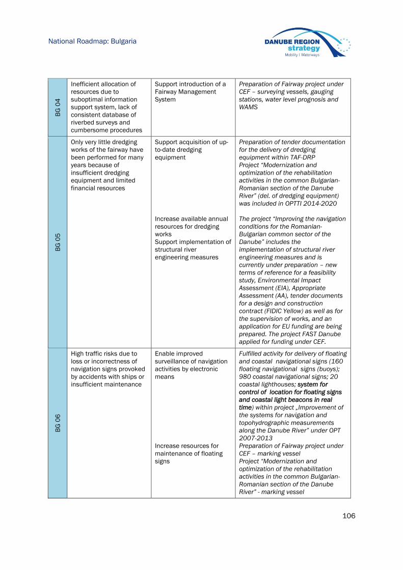
106
National Roadmap: Bulgaria
BG
04
Inefficient allocation of
resources due to
suboptimal information
support system, lack of
consistent database of
riverbed surveys and
cumbersome procedures
Support introduction of a
Fairway Management
System
Preparation of Fairway project under
CEF – surveying vessels, gauging
stations, water level prognosis and
WAMS
BG
05
Only very little dredging
works of the fairway have
been performed for many
years because of
insufficient dredging
equipment and limited
financial resources
Support acquisition of up-
to-date dredging
equipment
Increase available annual
resources for dredging
works
Support implementation of
structural river
engineering measures
Preparation of tender documentation
for the delivery of dredging
equipment within TAF-DRP
Project “Modernization and
optimization of the rehabilitation
activities in the common Bulgarian-
Romanian section of the Danube
River” (del. of dredging equipment)
was included in OPTTI 2014-2020
The project “Improving the navigation
conditions for the Romanian-
Bulgarian common sector of the
Danube” includes the
implementation of structural river
engineering measures and is
currently under preparation – new
terms of reference for a feasibility
study, Environmental Impact
Assessment (EIA), Appropriate
Assessment (AA), tender documents
for a design and construction
contract (FIDIC Yellow) as well as for
the supervision of works, and an
application for EU funding are being
prepared. The project FAST Danube
applied for funding under CEF.
BG
06
High traffic risks due to
loss or incorrectness of
navigation signs provoked
by accidents with ships or
insufficient maintenance
Enable improved
surveillance of navigation
activities by electronic
means
Increase resources for
maintenance of floating
signs
Fulfilled activity for delivery of floating
and coastal navigational signs (160
floating navigational signs (buoys);
980 coastal navigational signs; 20
coastal lighthouses; system for
control of location for floating signs
and coastal light beacons in real
time) within project „Improvement of
the systems for navigation and
topohydrographic measurements
along the Danube River” under OPT
2007-2013
Preparation of Fairway project under
CEF – marking vessel
Project “Modernization and
optimization of the rehabilitation
activities in the common Bulgarian-
Romanian section of the Danube
River” - marking vessel

107
National Roadmap: Bulgaria
BG
07
Insufficient marking
equipment
Support acquisition of
monitoring and marking
equipment
Preparation of Fairway project under
CEF and preparation of project
Modernization and optimization of
the rehabilitation activities in the
common BG-RO section of the
Danube River under OPTTI 20014-
2020
BG
08
Limited number of skilled
personnel (regarding
fairway marking)
Secure education and
provision of well-trained
staff in the short, medium
and long term
-
11.7 BG | Review of rehabilitation and maintenance activities 2014
The following activities relate to all critical locations as identified in the Rehabilitation and
Maintenance Master Plan (version December 2014)
Surveying activities 2014
River-km (from-to) Frequency of surveying Type of survey (single/multibeam)
км 491 – км 491.600 2 times for 2014 Single beam
km 488.700 5 times for 2014 Single beam
km 514 – km 499 1 time for 2014 Single beam
km 530 – km 514
km 518 – km 517
1 time for 2014
1 time for 2014
Single beam
km 536 – km 530 1 time for 2014 Single beam
km 547 – km 536 1 time for 2014 Single beam
km 571 – km 559
km 569 – km 566
km 563 – km 561
1 time for 2014
1 time for 2014
1 time for 2014
Single beam
km 558 – km 548 1 time for 2014 Single beam
km 429 - km 422 2 times for 2014 Single beam
km 387 – km 382 1 time for 2014 Single beam
Fairway relocation activities 2014
During 2014 no relocation interventions of the fairway trajectory were performed. The only
changes with regard to the navigational channel were connected with mounting and dismounting
of damaged or accidentally moved by convoys buoys (41 times).

108
National Roadmap: Bulgaria
Dredging activities 2014
No dredging activities on the fairway were performed during 2014. In-house dredging activities for
deepening the entrance of EAEMDR’s specialized port of total volume of 4700 m3 was performed
during the year. The main reason for not performing dredging on the fairway is that EAEMDR do
not possess suitable dredging equipment to perform on the fairway. The extremely limited
financial sources additionally hamper the execution of dredging works.
11.8 BG | Operational and investment costs
Actual operational costs 2014
Need areas Actual costs 2014* (Euro)
Minimum fairway parameters (dredging) -
Surveying of the riverbed 10.669
Water level gauges -
Marking of the fairway 145.322
Availability of locks / lock chambers -
Information on water levels and forecasts -
Information on fairway depths -
Information on marking plans -
Meteorological information -
Other needs -
Sum 155.991
* The total budget of EAEMDR for 2014 was 1.269.333 € and was distributed as follows:
- Staff costs: 689.418
- Operational costs: 415.273
- Taxes: 6.987
- Membership due/fees: 128.793
- Capital costs: 28.859
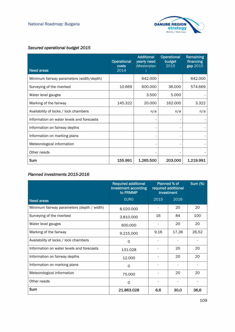
109
National Roadmap: Bulgaria
Secured operational budget 2015
Need areas
Operational
costs
2014
Additional
yearly need
(Masterplan
)
Operational
budget
2015
Remaining
financing
gap 2015
Minimum fairway parameters (width/depth) 642.000 - 642.000
Surveying of the riverbed 10.669 600.000 36.000 574.669
Water level gauges 3.500 5.000 -
Marking of the fairway 145.322 20.000 162.000 3.322
Availability of locks / lock chambers n/a n/a n/a
Information on water levels and forecasts - - -
Information on fairway depths - - -
Information on marking plans - - -
Meteorological information - - -
Other needs - - -
Sum 155.991 1.265.500 203.000 1.219.991
Planned investments 2015-2016
Required additional
investment according
to FRMMP
Planned % of
required additional
investment
Sum (%)
Need areas EURO 2015 2016
Minimum fairway parameters (depth / width) 8.020.000 - 20 20
Surveying of the riverbed 3.810.000 16 84 100
Water level gauges 600.000 - 20 20
Marking of the fairway 9.215.000 9,16 17,36 26,52
Availability of locks / lock chambers 0 - - -
Information on water levels and forecasts 131.028 - 20 20
Information on fairway depths 12.000 - 20 20
Information on marking plans 0 - - -
Meteorological information 75.000 - 20 20
Other needs 0 - - -
Sum 21.863.028 6,6 30,0 36,6

110
National Roadmap: Bulgaria
11.9 BG | Outlook: planned actions, milestones and funding sources
BG 01: Old or insufficient measuring equipment
Planned activities: One of the project "Improvement of the systems for
navigation and topo-hydrographic measurements along the
Danube River" components is delivery of a hydrographic
surveying vessel which will be equipped with a multi-beam
echo sounder
Current shortcomings: The delivery of the vessel was postponed for the next
operational programme on Transport and transport
infrastructure 2014-2020
Possible funding: OPTTI 2014-2020
Next steps: Project "Improvement of the systems for navigation and
topo-hydrographic measurements along the Danube River"
will be implemented into two stages. The second one -
delivery of a hydrographic surveying vessel will be financed
under OPTTI 2014-2020.
The implementation of the project “Modernization and
optimization of the rehabilitation activities in the common
Bulgarian-Romanian section of the Danube River” is in its
preparatory phase. Delivery of marking vessels, equipped
with a multi-beam echo sounder is foreseen.
Within FAIRWAY project supply of equipment is foreseen –
a multifunctional marking vessel and a small surveying
vessel. The surveying vessel should be equipped for
sounding (incl.multi-beam), hydrological and hydrographical
surveys, sediment sampling, etc.
2013-2015
2015-2017
BG 02: Education and skilled staff
Planned activities: Sufficient training for personnel to operate the delivered
equipment, requirements are included in the terms of
reference. A project for improving the administrative
capacity of the Agency is foreseen.
Current shortcomings: None identified
Possible funding: Operational Programme "Good governance" 2014-2020
Budget availability 2015/2016: Funding through national
budget
Next steps: Application of a project proposal under the Operational
Programme "Good governance" 2014-2020,
Implementation of activity 5.5 – enrich the knowledge base
of waterway administrations within FAIRWAY project
-
2015-2020

111
National Roadmap: Bulgaria
BG03: Improved monitoring procedures, data quality and analyses
Planned activities: Currently EAEMDR operates 9 automatic hydrological and 9
automatic meteorological stations, delivered within project
"Improvement of the systems for navigation and topo-
hydrographic measurements along the Danube River",
OPT2007-2013
Delivery of additional number of gauging stations, surveying
vessel and integration of WAMS is foreseen in project
FAIRWAY.
A common project idea for harmonization of administrative
procedures (incl. fairway maintenance) is currently under
discussion with AFDJ – Galati.
Current shortcomings: Insufficient data available and non-state-of-the-art methods
of gathering of fairway information (multi beam)
Possible funding: CEF
CBC Ro-Bg 2014-2020
Next steps: Implementation of FAIRWAY project and preparation of
application for CBC Ro-Bg 2014-2020
2020

112
National Roadmap: Moldova
aa
12 Moldova
Fairway administration and maintenance of the Danube waterway in Moldova is carried out by the
Romanian AFDJ on the basis of a bilateral agreement.
12.1 MD | Status report on main critical locations 2012-2014
According to the Fairway Rehabilitation and Maintenance Master Plan (version December 2014),
there are no critical locations.
12.2 MD | Hydrological conditions on main critical locations 2012-2014
Not relevant.
12.3 MD | Water level information on main critical locations 2012-2014
Not relevant.
12.4 MD | Water level prognoses for critical locations
Not available.
12.5 MD | Time from surveying to action: maintenance philosophy
Not available.
12.6 MD | Review of rehabilitation and maintenance activities 2014
According to the Fairway Rehabilitation and Maintenance Master Plan (version December 2014),
no rehabilitation and maintenance activities were implemented.
Key issues and related activities 2014
In the Fairway Rehabilitation and Maintenance Master Plan (version December 2014), no key
issues were identified.

113
National Roadmap: Moldova
aa
12.7 MD | Operational and investment costs
Actual operational costs 2014
Need areas Actual costs 2014 (Euro)
Minimum fairway parameters (dredging) n/a
Surveying of the riverbed n/a
Water level gauges n/a
Marking of the fairway n/a
Availability of locks / lock chambers n/a
Information on water levels and forecasts n/a
Information on fairway depths n/a
Information on marking plans n/a
Meteorological information n/a
Other needs n/a
Sum n/a
Secured operational budget 2015
Planned investments 2015-2016
Required additional
investment
according to FRMMP
Planned % of
required additional
investment
Sum (%)
Need areas EURO 2015 2016
Minimum fairway parameters (depth / width) -
Surveying of the riverbed -
Water level gauges -
Marking of the fairway -
Availability of locks / lock chambers -
Information on water levels and forecasts -
Information on fairway depths -
Information on marking plans -
Meteorological information -
Other needs -
Sum -

114
National Roadmap: Moldova
aa
12.8 MD | Outlook: planned actions, milestones and funding sources
Not relevant.

115
National Roadmap: Ukraine
13 Ukraine
Responsible for fairway maintenance:
The State Enterprise «Ukrainian Sea Ports Authority» of the Ministry of Infrastructure of Ukraine.
13.1 UA | Status report on main critical locations 2012-2014
Status report on main critical locations 2012-2014 According to the list of Main Inland Waterways
of Europe ("Blue Book") of the UNECE, the strech of the Danube river from 0 to 116 km Chilia
branch, on which the Danube-Black Sea Deep Navigation Route (hereinafter - DNR Danube -
Black Sea) runs, is defined as waterway E80 -09 with planned sediments of vehicles – up to 7,2m
("Blue Book" developed under the European Agreement on Main Inland Waterways of
International Importance (Decree of the President of Ukraine dated 28.09.2009 № 767/2009
«On accession of Ukraine to the European Agreement on Main Inland Waterways of International
Importance (AGN)").
Number of days with fairway depths > 2.5m on main critical locations
Critical location 2012 2013 2014
0 - 60 km 366 365 365
60 – 116 km 366 365 365
44 – 72 mile 366 365 365
13.2 UA | Hydrological conditions on main critical locations 2012-2014
Number of days with flow discharge above multiannual average flow discharge for the main
critical locations.
Critical location 2012 2013 2014
0 – 60 km 91 173 222
60 - 116 km 91 173 222
44 – 72 mile 91 173 222
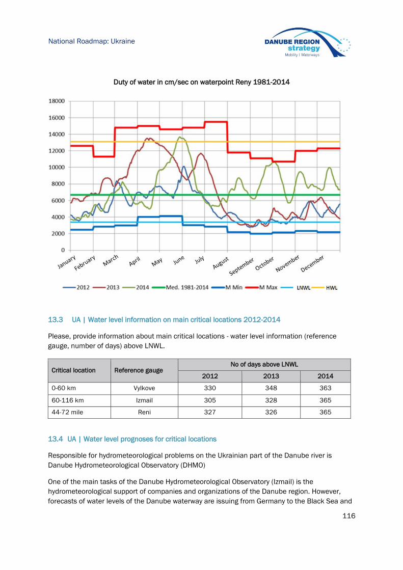
116
National Roadmap: Ukraine
Duty of water in cm/sec on waterpoint Reny 1981-2014
13.3 UA | Water level information on main critical locations 2012-2014
Please, provide information about main critical locations - water level information (reference
gauge, number of days) above LNWL.
Critical location Reference gauge No of days above LNWL
2012 2013 2014
0-60 km Vylkove 330 348 363
60-116 km Izmail 305 328 365
44-72 mile Reni 327 326 365
13.4 UA | Water level prognoses for critical locations
Responsible for hydrometeorological problems on the Ukrainian part of the Danube river is
Danube Hydrometeorological Observatory (DHMO)
One of the main tasks of the Danube Hydrometeorological Observatory (Izmail) is the
hydrometeorological support of companies and organizations of the Danube region. However,
forecasts of water levels of the Danube waterway are issuing from Germany to the Black Sea and

117
National Roadmap: Ukraine
have different earliness. Forecasts with periodicity of 24 to 72 hours and 17 items produced
daily. Once a decade, forecasts of water levels characteristic (average, minimum and maximum)
per decade (11 points) and once a month – forecast of characteristic of water levels of the
Danube in the coming month are produced.
Forecasts of water levels of the Danube are transmitted to marine economy enterprises, and are
placed on the websites of the Danube Hydrometeorological Observatory (www.dhmo.org.ua) and
the River Information Service of Ukraine (http://ukrris.com.ua/).
Reliability of hydrological forecasts for the period 2012-2014 was:
- 97-98% (daily);
- 92-96% (ten-day);
- 76-85% (monthly).
To improve the accuracy of forecasting methods of tiered regime of navigation on the Danube,
above all – for a month, experts of Ukrainian Hydrometeorological Institute (Kyiv), based on
processing a large volume of initial information, using the method of appropriate daily increases
in water levels, daily forecasting methods have been developed, and characteristic of ten days
and monthly water levels. These methods are underlying the computer program "analytical and
expert system prediction of navigable water level of the Danube" which is passed for testing to the
Danube Hydrometeorological Observatory.
Preliminary test results show that forecasts of water levels of the Danube that are based on
developed techniques have high enough justification. The use of computer technology in the
Danube Hydrometeorological Observatory for hydrological forecasting opens up new opportunities
to improve the quality of customer service.
13.5 UA | Time from surveying to action: maintenance philosophy
The hydrometeorological regime and its variability is one of the main factors determining the
possibilities of Danube navigation.
Difficulties for shipping in the Ukrainian part of the Danube occur in the following situations:
- The minimum water levels in the summer-autumn low-flow period;
- Maximum water levels during the spring and summer flooding;
- The sharp reduction of depth in the limiting areas of river as a consequence of sediment
deposits after climbing flood or flooding rain;
- Periods of ice phenomena of high intensity (thick ice drifting, ice jams, ice formations).
Therefore, a key principle of providing services to shipping companies consists in presenting daily
in time operational hydrological information and forecasts on actual and expected characteristics
of the hydrological regime of the Danube.
Long-term hydrological monitoring, conducted at the Ukrainian part of the Danube, revealed
certain trends in changes in the hydrological regime affecting shipping conditions.

118
National Roadmap: Ukraine
In the future, a permanent mathematical model of the Danube Delta should be created, which
will perform a variety of calculations of expected changes in morphology and hydrological
processes in the delta, taking into account possible climate change scenarios, water flow and
sediments of the Danube, Black Sea level and planned hydro-technical measures.
13.6 UA | Key issues and related activities 2014
Key issues Need for action Activities performed 2014
UA
01
Maintenance of the waterway Ensuring compliance with the
international environmental
conventions and bilateral
agreements with Romania
Maintenance of onshore
navigation facilities – 355,
incl .: leading – 2, luminous –
54, informative – 128,
kilometer (miles)– 171.
Modernized - installed on a
plastic base – 23 informative
and luminous signs. Floating
navigation facilities - 45.
13.7 UA | Review of rehabilitation and maintenance activities 2014
The following activities relate to all critical locations as identified in the Rehabilitation and
Maintenance Master Plan (version December 2014)
Surveying activities 2014
River-km (from-to) Frequency of surveying Type of survey (single/multibeam)
Sea approach channel Bystre 2 times per year multibeam
64,0-65,8 km 1 time per year single
Fairway relocation activities 2014
River-km (from-to) Frequency of relocation
interventions
Comments
64,0-65,8 km 1 per year moving of staff marking of the fairway and the
establishment of additional Floating safety sings
through the shift of natural fairway toward the left
bank of 50-70 m.
Dredging activities 2014
Currently the Ministry of Infrastructure of Ukraine provides implementation of operational
dredging and support to navigation depths exclusively on sea approach channel, the DNRW
Danube - Black Sea (3,4 km from the entire length of the track (172 km) of the DNR Danube -
Black Sea).

119
National Roadmap: Ukraine
On the river side of the DNR Danube - Black Sea, the dredging on the shallows is partly
implemented. Since 2005, work on the project at the site of the River Danube from the Black Sea
to Reni is not being performed.
Works on the section of the Danube River - namely dredging river shallow sections (sections
located along the state border with Romania) - are carried out as works in transboundary waters,
which are regulated by the bilateral agreements between the Governments of Ukraine and
Romania on the Ukrainian-Romanian State Border Cooperation and Mutual Assistance on Border
Issues (signed on 17.06.2003, entered in force on 12.05.2004) and the Agreement between the
Government of Ukraine and the Government of Romania on Cooperation in the Field of Water
Management in Transboundary Waters (signed on 30.09.1997, entered in force on 28.01.1999)
and are to be agreed with the Romanian side.
13.8 UA | Operational and investment costs
Actual operational costs 2014
Need areas Actual costs 2014 (Euro)
Minimum fairway parameters (dredging works on
the DNR Danube – Black Sea) 7.770
Surveying of the riverbed -
Water level gauges 46.200
Marking of the fairway -
Availability of locks / lock chambers -
Information on water levels and forecasts 30.600
Information on fairway depths -
Information on marking plans -
Meteorological information 51.500
Other needs 53.400
Sum 181.700
Secured operational budget 2015
n/a
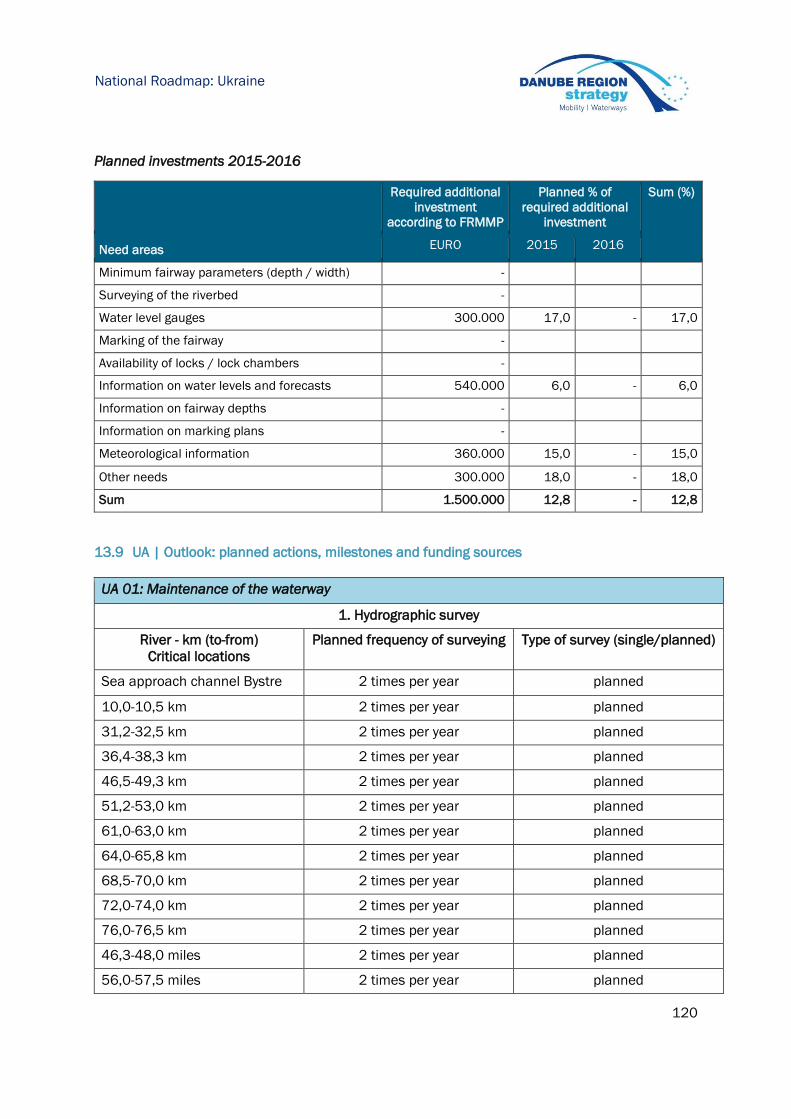
120
National Roadmap: Ukraine
Planned investments 2015-2016
Required additional
investment
according to FRMMP
Planned % of
required additional
investment
Sum (%)
Need areas EURO 2015 2016
Minimum fairway parameters (depth / width) -
Surveying of the riverbed -
Water level gauges 300.000 17,0 - 17,0
Marking of the fairway -
Availability of locks / lock chambers -
Information on water levels and forecasts 540.000 6,0 - 6,0
Information on fairway depths -
Information on marking plans -
Meteorological information 360.000 15,0 - 15,0
Other needs 300.000 18,0 - 18,0
Sum 1.500.000 12,8 - 12,8
13.9 UA | Outlook: planned actions, milestones and funding sources
UA 01: Maintenance of the waterway
1. Hydrographic survey
River - km (to-from)
Critical locations
Planned frequency of surveying Type of survey (single/planned)
Sea approach channel Bystre 2 times per year planned
10,0-10,5 km 2 times per year planned
31,2-32,5 km 2 times per year planned
36,4-38,3 km 2 times per year planned
46,5-49,3 km 2 times per year planned
51,2-53,0 km 2 times per year planned
61,0-63,0 km 2 times per year planned
64,0-65,8 km 2 times per year planned
68,5-70,0 km 2 times per year planned
72,0-74,0 km 2 times per year planned
76,0-76,5 km 2 times per year planned
46,3-48,0 miles 2 times per year planned
56,0-57,5 miles 2 times per year planned

121
National Roadmap: Ukraine
Fairway 0-116 kм 1 time per year planned
Fairway 44-72 mile 1 time per year planned
Ruk Solomoniv 0-12 km 1 time per year planned
Ruk Ivanesht’ 0-13 km 1 time per year planned
2. Modernization and development of navigation facilities
Location Planned activity Number
0-60 km Introduction of plastic shore
signs
6 pieces
0-116 km Introduction of new type of
buoys
10 pieces
Possible financing: Implemented by funds under
the SItate Institution
“Derzhhydrigraphiya” costs for
navigation – hydrographic
safety navigation provision,
according to the annual
financial plans approved by the
Ministry of Infrastructure of
Ukraine

122
Synthesis and Conclusions
14 Synthesis and conclusions
This report illustrated the 2014 status and planned next steps for rehabilitation and maintenance
activities in the Danube riparian countries. It is based on the Fairway Rehabilitation and
Maintenance Master Plan for the Danube and its navigable tributaries as it was endorsed by the
Danube Transport Ministers in December 2014. By means of the roadmaps at hand, the
implementation of the Master Plan shall be monitored once a year.
In 2014, in total 1.569.601 m3 were dredged along the Danube and Drava rivers. Fairway
conditions were generally good in 2014 especially on the middle and lower Danube. This was
however mainly due to the favourable hydrological conditions, as water levels hardly fell below the
low navigable water level.
Total number of
crit ical
locations of
high priority on
national stretch
Total length of
crit ical
locations on
national stretch
(km)
Operational
expenditures
2014 (EUR)
m3 dredged
(2014)
4 72,8 1.381.730 125.935
19 15,7 8.172.780 566.642
15 13,6 2.942.128 254.575
43 36,6 731.170 -
29 108,0 941.000 50.829
28 161,6 1.182.500 60.000
n/a n/a 100.000 -
Danube 31 60,0 6.661.150 423.925
Danube-Black Sea Canal - - 425.900 87.695
22 17,5 155.991 -
- - n/a n/a
17 37,0 181.700 n/a
208 522,8 22.876.049 1.569.601
HR - Croatia (Danube, Sava, Drava)
DE - Germany
AT - Austria
SK - Slovakia
HU - Hungary
Sum
RS - Serbia (Danube, Sava)
BA - Bosnia and Herzegovina
BG - Bulgaria
RO - Romania
MD - Moldova
UA - Ukraine
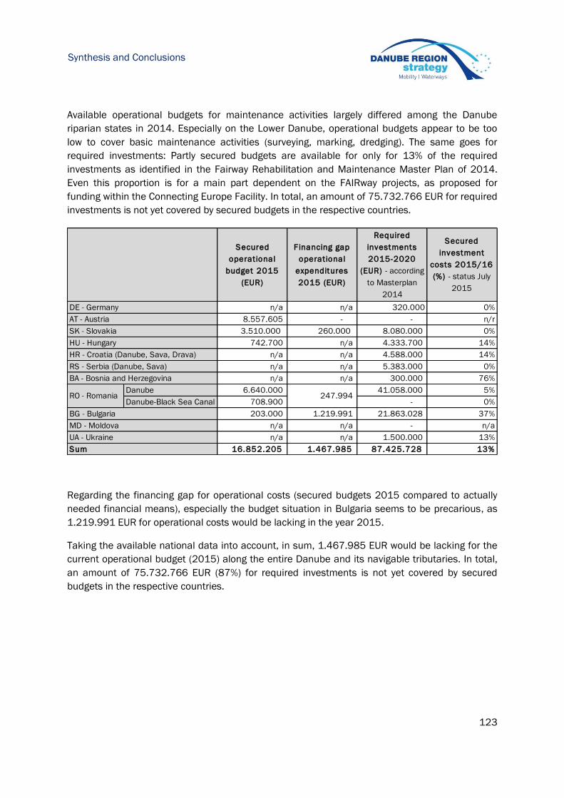
123
Synthesis and Conclusions
Available operational budgets for maintenance activities largely differed among the Danube
riparian states in 2014. Especially on the Lower Danube, operational budgets appear to be too
low to cover basic maintenance activities (surveying, marking, dredging). The same goes for
required investments: Partly secured budgets are available for only for 13% of the required
investments as identified in the Fairway Rehabilitation and Maintenance Master Plan of 2014.
Even this proportion is for a main part dependent on the FAIRway projects, as proposed for
funding within the Connecting Europe Facility. In total, an amount of 75.732.766 EUR for required
investments is not yet covered by secured budgets in the respective countries.
Regarding the financing gap for operational costs (secured budgets 2015 compared to actually
needed financial means), especially the budget situation in Bulgaria seems to be precarious, as
1.219.991 EUR for operational costs would be lacking in the year 2015.
Taking the available national data into account, in sum, 1.467.985 EUR would be lacking for the
current operational budget (2015) along the entire Danube and its navigable tributaries. In total,
an amount of 75.732.766 EUR (87%) for required investments is not yet covered by secured
budgets in the respective countries.
Secured
operational
budget 2015
(EUR)
Financing gap
operational
expenditures
2015 (EUR)
Required
investments
2015-2020
(EUR) - according
to Masterplan
2014
Secured
investment
costs 2015/16
(%) - status July
2015
n/a n/a 320.000 0%
8.557.605 - - n/r
3.510.000 260.000 8.080.000 0%
742.700 n/a 4.333.700 14%
n/a n/a 4.588.000 14%
n/a n/a 5.383.000 0%
n/a n/a 300.000 76%
Danube 6.640.000 41.058.000 5%
Danube-Black Sea Canal 708.900 - 0%
203.000 1.219.991 21.863.028 37%
n/a n/a - n/a
n/a n/a 1.500.000 13%
16.852.205 1.467.985 87.425.728 13%
HR - Croatia (Danube, Sava, Drava)
DE - Germany
AT - Austria
SK - Slovakia
HU - Hungary
247.994
Sum
RS - Serbia (Danube, Sava)
BA - Bosnia and Herzegovina
BG - Bulgaria
RO - Romania
MD - Moldova
UA - Ukraine

![[Presentation title] [Speaker’s name] · 4/18/2018 · 7. Danube Delta National Institute – RO 8. Association of Cross Border Cooperation „Lower Danube” – RO 9. Danube](https://img.dokumen.tips/doc/110x75/6027c7cebe371935887f1734/presentation-title-speakeras-name-4182018-7-danube-delta-national-institute.jpg)